Embed Size (px)
Citation preview

0
Making a Planning Application –
A Guide for Applicants
September 2021
Department of Environment, Food and Agriculture Planning and Building Control Directorate Murray House

1
CONTENTS Page No.
Introduction 2 The Planning Process 4 The Application Form 6 Plans and Supporting Information 11
Flood Risk Assessments 13 Highways, trees, level changes and minerals/waste information 15
For more information see www.gov.im/planningapply
Last Updated: 22.09.21
2
INTRODUCTION The Purpose of this Guidance The Town and Country Planning (Development Procedure) Order 2019 (hereafter ‘The Order’) sets out the information to be included within a planning application. This guidance is intended to help explain these requirements. If an application does not have the information required it cannot be validated (accepted for processing). This guidance relates to planning applications, it may not be relevant for applications for the following types of application. Please note that for works to a Registered Building or involving an advert a relevant consent may be required in addition to planning approval.
• Registered Building Consent • Advertisement Consent • Certificates of Lawfulness • Minor Changes to a Planning Application (Article 21 of the Order)
What is Planning Approval? Planning approval is required in order to legally carry out ‘development’. Development can be physical building works or a change in the use of land or a building. Some forms of development are granted a blanket approval, sometimes called ‘Permitted Development’ and this is set out in various Development Orders. The Department has produced an interactive house to explain the most commonly used forms of Permitted Development for domestic properties. See www.myhouse.im/ If you wish to carry out development which is outside Permitted Development, you will need to submit a specific planning application, which seeks approval from the Department (of Environment, Food and Agriculture) to carry out the development.
Any development undertaken before any approval is reached, is done so at the developers own risk. For more information see www.gov.im/planningenforcement
How long does it take? The Department works to deal with Planning Applications as quickly as possible, but the time taken varies from case to case. All applications must be properly processed and assessed, including being advertised. If your application is complex or controversial the process will take longer. If there are problems with an application, and those problems could potentially be easily overcome by making changes to the proposal or supply additional information, the Planning Officer may advise you of this, so you can consider whether you could submit an amendment to the proposal. However, amended plans may need to be being re-advertised, which will mean the application will take longer to determine. Who Can Apply for Planning Approval? Anybody. A landowner of a site does NOT need to be the applicant, nor is land ownership a material consideration in planning terms. Applicants, if they are not the landowner, are encouraged to notify and liaise with the land owner in any submission as the granting of approval does not allow or authorise the development of land outside of an applicant’s ownership or control. An appointed agent (architect, planning consultant or surveyor) may submit a planning application and act on behalf of the applicant.
3
If there is sufficient information will my application be approved? Not necessarily. It is important that the Department has sufficient information to understand the proposal. Without this, the proposal cannot be assessed. However, there is a difference between the amount/quality of information required and whether the development described by that information is acceptable. The Department must make three considerations:
• Does the application contain the correct information to be validated? • Does the application contain the correct information to be determined? • Should that determination be a planning approval or refusal?
This guidance focuses on ensuring there is the correct type/amount of information (the first consideration). The validation of a planning application does not preclude a request for further information prior to determination (see below) and having sufficient information to determine does not mean planning approval will be granted. Can there be requests for further information? The Department can require such additional information as it requires to be able to understand, assess and determine the application (this is not the same as amended information which the applicant choses to submit to address issues). Such a request must give a date by which the information is required (at least 21 days) and if the information is not provided by that date, the Department may treat the application as withdrawn. Separate guidance is available in relation to amending applications after they have been submitted, which also applies where additional information is provided. See: www.gov.im/planningamends What do I need to think about before making an application? It is recommended that you try to ensure your application contains not only the information required to meet the minimum standards for validation, but any other information, to avoid unnecessary delays (or possibly refusal) post-validation. Material Considerations Planning Applications are assessed against Material Considerations and you are therefore advised to consider these in putting together your application. See www.gov.im/materialconsiderations Policy & Guidance A key material consideration is whether or not the proposal is in accordance with planning policy, including the land use zoning in the relevant Local or Area Plan. See www.gov.im/developmentplan. Regard will also be had to the characteristics of the site, other relevant strategies and evidence base, and other material considerations, such as the Residential Design Guide (see www.gov.im/rdg) for residential developments. Examples of information that may be required in light of these include:
• Design Statements; • Protected Species Survey; • Heritage Information (for example if in/adjacent to a Conservation Area or relating to a
Registered Building); and
• Structural Report (for conversion of older buildings). Building Control If planning approval is granted, then the development must take place in accordance with the approved plans. Many people choose to apply for Building Control (BC) approval after gaining planning approval, as BC plans are often more detailed. This is perfectly reasonable, however it is important to consider how you will build the development to avoid issues arising at the BC stage which result in plans needing to be changed, which will normally mean either fully re-applying for planning approval or potentially a Minor Change Application (See: www.gov.im/planningamends).
4
In particular, it should be noted that the Building (Amendment) Regulations 2019 that came in to force on 31 December 2019 included a requirement that applications for new dwellings (and extensions over a certain size) be accompanied by a Standard Assessment Procedure calculation. Known as a SAP calculation, this procedure assesses the energy performance rate of the proposal (see https://www.manxsap.im/). Sustainable Construction In light of the above, it is helpful to consider at the planning stage any specific design choices or approaches that are necessary to achieve the relevant SAP score. Such considerations can be detailed in design statements or other supporting information as they may be relevant for explaining how a development complies with requirements for energy efficiency (Strategic Plan General Policy 2(n) or, for larger developments, the Energy Impact Assessment (Strategic Plan Energy Policy 5). Section 2 of the Residential Design Guide gives more information in relation to Energy Impact Assessments and also wider elements of Sustainable Construction. Can I seek pre-application advice? Pre-application advice can be sought by writing or emailing the Planning Office explaining your proposals. Officers will provide advice on the likely planning issues and what information may be required as part of an application. It is not the purpose of pre-application advice to give certainty as to the outcome of an application because the only means by which a proposal can be properly tested is through the planning application process itself. See www.gov.im/planningpreapp The Department recommends that you also consider advising your neighbours of the proposed development by your application and take the opportunity to overcome and/or resolve any concerns they may have which you may not be aware of prior to any submission. It is also encouraged that an applicant takes the opportunity to speak to any utility providers (gas, water, electricity, telecom etc.) which may be involved should your proposal be approved. Are there any manhole covers on the site? Is the site within a flood risk area? Are overhead or underground electric cabling nearby? Will you need a new phone line or water supply? If so, contact the relevant Authority prior to making your finished application. Does this guide apply to resubmitted applications? Planning approvals are normally subject to a condition that they must be commenced within 4 years. If a proposal has previously been approved but that approval has not been implemented within the relevant time period, a fresh application is required. If that time period is reaching an end, but has not yet expired, an application to vary the condition may normally be submitted. In either case, the application must contain the information set out in the current order, even if the previous application did not.
5
THE PLANNING PROCESS The main stages in the process are set out below.
• Preparing the application, including seeking pre-application advice • Submission of the application • Validation • Consultation • Case Officer Consideration • Determination • Appeal (if relevant)
More information is set out below in relation to the stages from validation onwards Validation Once an application is submitted, it is checked by Technical Officers to ensure all required forms, fees, plans and information is included and accurate as presented. Only after this process has been completed will the application be formally validated for publication. The Department strives to validate and acknowledge (in writing) a planning application within 5 working days of receipt. If an application is deemed invalid it will be returned to the applicant/agent with an explanation of the information required for the application to be considered valid. If the application is not correctly resubmitted within 30 days a refund (if necessary) will be authorised. Consultation All validated planning applications are published. See www.gov.im/viewapplications As part of the publicity, the Department will issue the applicant (or their agent) at least one Site Notice which must be displayed at the development site for the required notice period. In cases of larger developments, additional copies will be provided for affixing at different locations on public highways bounding the site. Should it be found that the Site Notice has not been properly displayed for the required period there may be delays and further time applied to the consideration, extending the consultation period. Placement of site notices are verified by Officers where site visits are made (see below). From the date of publication of the application on the website (the publication date) until the application is determined, any member of the public may make written comment. The Department must allow for at least 21 days of publicity before determining any application. See www.gov.im/planningcomment Case Officer Consideration After validation the application will be assigned to a Case Officer who will assess the application and any comments received. They will consider whether any additional information is required or whether it is appropriate to invite any amendment in response to issues raised. As part of their assessment, the Case Officer will normally visit the site. They will then make a written recommendation as to whether the application should be approved (including any conditions) or whether it should be refused (and the reasons for this). They will also make a recommendation as to who should be afforded Interested Person Status. See www.gov.im/interestedperson
6
Determination Most planning applications are determined by a senior officer with delegated powers. About 1 in 5 applications are referred to the Planning Committee. The criteria for referral are set out in the Planning Committees Standing Orders. See www.gov.im/planningcommittee A planning decision is issued by way of a decision notice to the applicant (or their agent) and all those who have commented within 10 days of a decision being made. Where an email address has been provided the notice will be issued in electronic form ONLY. The decision notice will set out the reasons for the decision. If the application is approved subject to conditions, the notice will set these out. Decision notices sent to third parties will state whether or not they have been afforded Interested Person Status. Where decisions are made under delegated powers, Officer reports and the decision notice will be published on line the working day following the issue of the decision. Where applications are determined by the Planning Committee, decision notices will be issued as soon as the administration has been concluded. Minutes will be available on-line once endorsed by the Members at the subsequent meeting. Appeals If your application has been refused, or you disagree with conditions that have been attached to an approval, you can appeal the decision. See www.gov.im/planningappeal
7
THE APPLICATION FORM The following guidance notes correspond with the numbering on the application form PA 20.1 which can be downloaded from our website. Unless you apply online, the following numbers of hard copies are required.
• Replacement windows and/or doors – 3 copies
• Where the Department owns the land or may have a vested interest – 5 copies • All other applications – 4 copies
Please ensure that all questions are answered accurately and fully (unless specifically indicated as optional). Incomplete or inaccurate forms may lead to your application being returned as invalid, or delays in dealing with it. Question 1 - Site Address Address or Description of the site to be developed Write the full address of the property or field reference number where the development is proposed. Question 2 - Local Authority Write the name of the Local Authority where the application site is located. If you are unsure please contact the Department who will advise you accordingly. Question 3 - Types of Applications
a) Full approval. The most common type of application. This applies for new building works, alterations and extensions to buildings and any engineering operations.
b) Change of Use. Relevant for applications for the change of use or uses of a building where no building or engineering work is required. Whilst a change of use may be applied for and approved, if that use is not exercised the ‘old’ use will remain valid. Where a change of use also entails building work that would constitute development, this should be a FULL application.
c) Approval in principle. This applies only if you wish to establish the principle of development of land for the erection, alteration or extension of buildings before full details are given. Please indicate which elements of the principle you wish to be considered within this application and in doing so provide as much detail as possible to assist with the assessment. Details not submitted at this stage are termed ‘Reserved Matters’, which would be submitted for later consideration should an approval in principle be granted (using section d).
d) Approval of matters reserved from a previous application. A reserved matters application can only be made if there is a valid approval in principle on the site and the conditions attached to that approval have been met. All matters reserved from the consideration of the approval in principle should be submitted within this application and indicated accordingly using the check boxes. The reference number in relation to the principle application must be quoted. Failure to include the previous application reference number will result in your application being returned as invalid. If the application is under types c or d please make sure you indicate the criteria which is being considered by circling them
e) Variation of a condition. Where a valid planning approval is already in place and the developer is seeking to vary a condition of that approval. This category includes application for the extension to the duration of an approval (an extension of time) specifically to review a condition where time constraint has been applied. In all instances the original planning application reference and numbered condition to be varied should be noted.
8
Question 4 If the application relates to works already undertaken, state when the works were started and completed. Please also provide the planning enforcement enquiry reference if there is one. Question 5 The full name of the applicant is required in this section, even where an agent has been appointed. In the case of a limited company the full details of the business or company name, as recorded at the company registry. Question 6 The full contact address of the applicant is required. Provision of a telephone number and/or email address can assist toward a more expedient process should the Department need to contact you to resolve any queries. Please be aware scanned copies of this application and its content are published and available via the Governments’ website. Redaction can be applied on request when the decision is final. Please be aware that any decision notice will be issued to this email address UNLESS an agent has been appointed. Agents, where there is one, will be sent the notice to their address or email address if provided. Question 7 The Applicant’s interest in the site. If there are obligations that may require access onto land outside of the applicants control these will need to be addressed. If DEFA has (or could be deemed to have) an interest in the appreciation or site (for example DEFA owns the site), please highlight and clarify this as part of your answer. Question 8 a) Agent name Full name or business name of agent (if any) b) Address of Agent If using an agent, all correspondence concerning the application, including the decision notice will be sent to them rather than the applicant – PLEASE see c) below. Provision of a phone number or email address will assist the Case Officer should any queries arise during their consideration. c) If using an agent, please indicate whether the acknowledgement letter and site are to go to the Agent OR to the Applicant. The recipient of these documents will be responsible for affixing the site notice as soon as practically possible. Where the agent indicates that the applicant is to affix the site notice, an acknowledgement will be issued to the agent confirming that the paperwork has been sent to the client and informing them of the planning reference number. Question 9 – please describe clearly the works proposed. Please describe clearly what the application is for or the nature of the development, for example, “Two storey rear extension to a detached house”. The description of the development must be clear as it will form the basis of the publication and will appear on any decision notice. It is important that this is completed as fully as possible as any omissions from the description may result in the need for amended information and re-publicity. If the works are in any way retrospective, this must be clearly indicated. Continue on a separate sheet if necessary.
9
Question 10 – Existing Use of Site/Proposed Use of Site a) Give details of the existing use of the site, i.e. residential, office, retail etc. b) And the proposed use if it should differ. Note: It is helpful to consider which Use Class the existing and proposed uses fall into. Please refer to the Town and Country Planning (Use Classes) Order 2019. Question 11. Development within a Conservation Area – if you are unsure whether your site is located within a Conservation Area, check prior to submitting your application with staff of the Department or via the Departments website. Note: Separate consent is required for works to Registered Buildings (including internal alterations) and all demolition works within a Conservation Area (this is the same process as Registered Building Consent). Question 12 – Relevant Fee enclosed – where required. Please state the fee accompanying the application and which is enclosed. If advice is needed please telephone the Department. Contact details at the back of this document. Cheques should be made payable to the IOM Government. Without the appropriate fee the Department will not validate the application. Where the Department returns an application as invalid and the information remains outstanding 30 days later, any fee already remitted will be refunded. Please note that where the works are within a Conservation Area, and would have been permitted development had they been outside of such, there is no fee chargeable. Where the fee is calculated on floor area, please state the floor area used for the calculation in the box provided. If the applicant is claiming exemption as a registered charity, please state the Registered Charity Number. Question 13. Alterations to an Access This section must be completed if alterations are proposed to a vehicular and/or pedestrian access. Such alterations must be clearly indicated in the submitted drawings (see guidance in relation to plans). Should such alterations be proposed (including dropped kerbs) it is always advisable to consult with the Department of Infrastructure, Highways Services prior to any submission. The numbers of parking spaces available or provided by the development, where appropriate, must be indicated. Further guidance is provided later in this document in relation to plans and supporting information. Question 14 – Site levels If your proposal is going to affect the level of the site, a cross section of the ground levels must be provided. These must show clearly both the existing and proposed levels to demonstrate any potential change. If you are to alter ground levels by importation or exportation of any materials the detail of the quantities expected must be stated. Further guidance is provided later in this document in relation to plans and supporting information. Note: Consultation and pre application advice for mineral movement and extraction should be directed to the Minerals Officer, DEFA as a separate license may be required as well as any planning approval.
10
Question 15- New or Amended Supplies to Utilities Give details of any amendments to supplies in order that the statutory bodies may assess the implications of the proposal (water, gas electricity, telecoms). It would benefit the applicant to approach all the relevant utility providers, a) to d), prior to submitting the application to assess whether there are any issues relating to works on the site, for example overhead/underground electricity cables. Question 16 – Foul and Surface Water Drainage Although to some extent covered by the Building Control process, the planning application process can include consideration of whether the proposed development can be suitably drained. Therefore, details should be supplied in relation to surface water treatment and foul drainage. Note: Where it may be proposed to discharge septic tank or bio disc effluent into a watercourse, a licence to discharge such effluent must be applied for and obtained from Department of the Environment Food and Agriculture, Environmental Protection Unit (DEFA, EPU). Advice may be sought respectively from:
• the Building Control Authority (dependent on locality of the site please contact IOM Government 685902, Douglas 696375 or Onchan 624967);
• for Storm or foul water drainage, consult with the Manx Utilities - Drainage Tel 693513; and • DEFA, Environmental Protection Unit Tel 685894 for a licence to discharge into a
river/watercourse or Building Control for septic tank drainage into a field. Question 17- Trees Please confirm whether there are there any trees or large shrubs or hedges on the site and, if so, whether the proposal might have an impact on them. Further guidance is provided later in this document in relation to plans and supporting information. Note: It is a punishable offence to damage a tree recklessly by careless manoeuvring of plant or machinery or by partial destruction of root systems through thoughtless excavation or alteration of ground levels. Problems arising from such activities may lead to prosecution. Question 18 – Proximity to a river? Is/Are the proposed work(s) within 9 metres of any watercourse (river, ditch or drain)? Notes:
• Development will not normally be allowed within 9 metres of any watercourse in order to protect the aquatic and bankside habitat and species.
• In addition to requiring planning approval, any works likely to impact on a watercourse, e.g. bank repairs, erection of structures such as bridges, culverts also require the consent of the Manx Utility Authority’s Land Drainage Engineers. If the watercourse is a designated Main River, consent is required for planting of trees and shrubs or erection of any structure within 9m (30’) of either bank. Please Telephone 695949 for further information.
• A separate form may be required by DEFA Fisheries for Development within 8m of a Watercourse. To avoid delays, it is helpful to confirm if this form is required prior to submission and include it with your application if required. Contact DEFA Fisheries by telephoning 685857 for advice.
Question 19 It is helpful if the applicant confirms whether opportunity was taken to discuss the application and seek advice from the Department prior to its submission. Please indicate yes or no and state the name of the Officer who provided the advice and the date of that correspondence.
11
Question 20 – Building Control. Building Regulations are a separate requirement to planning approval and are a legal obligation where the technical aspect of a build is controlled/monitored. More information about Building Control is available from our website. Complete this section if you are making an application for building regulation approval at the same time as your planning application. There are three Building Authorities serving the Island
• Department of Environment, Food and Agriculture, Planning and Building Control (alongside the planning service),
• Onchan Commissioners; and • Douglas Borough Council.
You do not have to apply for building regulation consideration at the same time as your planning application, and may wish to await a positive outcome to your planning application before making a submission. Please note that DEFA makes comparison where possible between planning and building control applications, ensuring consistency in the plans between both functions. Question 21 Do you wish to provide any additional information which may assist the Case Officer in the consideration of the application? Any statement, justification in support of your application should be provided and continued onto a separate sheet where necessary. However, this detail makes up part of the formal application. The information will be available to members of the public who wish to inspect the application. If development is approved, conditions may be attached that it is carried out in strict accordance with any supporting information submitted. The application in its entirety will be available at the Department’s public counter AND via the Government’s online services facility. General Data Protection Regulations notice Question 22 –– Statement The applicant must read the statement, sign and date the application. If you are signing on behalf of a company your relationship to that company MUST be clearly stated, i.e. Secretary, Director etc.
12
PLANS AND SUPPORTING INFORMATION The various plans/drawings/information required is set out below. A plan referred to in this paragraph must be presented on paper of such a size to make its contents clear to the Department without the need for clarification or explanation. All plans should be named and numbered in a logical manner (e.g. “Drawing 01 – Location Plan”). Applications must include a drawing register which lists everything submitted as part of the application in addition to the application form. This is to ensure that anyone reviewing or commenting on the application is aware of everything they may need to look at, which is particularly important for on-line submissions.
Failure to submit all required plans and detail sufficient to clarify and validate the proposal will result in your application being returned.
1. Location Plan All applications must include an accurate and up-to-date site location plan to a standard scale showing:
• a clearly marked North point; • red line boundary (application site); • blue line boundary (other land controlled by the applicant); and
• the relationship of the site to adjoining land and buildings, to any highway serving the site, and to the nearest settlement or other familiar point of reference.
Any plan must be presented at a scale to make its contents clear to the Department without the need for clarification or explanation. Any plan provided in response to the fourth bullet above may consist of a separate plan not exceeding a metric scale of 1:10,000. 2. Flood Risk Assessment All applications within an area identified as at risk of flooding which seek approval for a new building or a change of use must include a flood risk assessment. 3. Site Plan All applications except those for approval in principle, change of use or replacement door/window in a Conservation Area must include a site plan to a metric scale of not less than 1:500 on which are indicated accurately:
• the position of all buildings, both existing and proposed; • the position of any driveways and vehicular access, both existing and proposed; • the position of all proposed engineering operations and any proposed fences or walls; • the position, and extent, of any proposed visibility splay where the proposed development
includes any works to create or materially alter a vehicular access;
• the position and extent of any area for the parking and or storage of vehicles (motor cars, motor cycles or goods or passenger vehicles) and pedal cycles;
• the position and extent of all existing trees where the proposed development includes any works within the vicinity of such trees;
• where changes are proposed to site levels, existing and proposed levels; and • the position and nature of all proposed landscaping.
4. Plans, Elevations and Sections All applications except those for approval in principle, change of use or replacement door/window in a Conservation Area must include plans, elevations and sections of all proposed buildings and structures both existing and proposed to a metric scale of not less than 1:100, fully dimensional using metric units and annotated so as to specify:
• the material and nature of all external finishes; and • floor or base levels relative to a fixed datum outside the site plan.
13
The submission of photographs of the site is almost always of assistance and may help speed up the consideration of the application. Photomontage images are useful to indicate a proposal, but they are not a substitute for scaled elevation plans which should always be submitted. 5. Minerals & Waste All applications except those for approval in principle, change of use or replacement door/window in Conservation Area must include details of any anticipated incidental removal of minerals from the site or the importation/removal of waste to/from the site. Additional guidance in relation to Building Control and Demolition is available on the website. For the purposes of this guidance, minerals are materials in or under land of a kind ordinarily worked for removal by underground or surface working. Waste is an eliminated or discarded material which is no longer useful to, or required by, the person who owns it. 6. Change of Use An application for planning approval consisting only of a change in the use of a building and not involving external building or engineering operations must include dimensioned floor lay-out plans of the existing and proposed use that clearly show both the existing and proposed:
• arrangement of the rooms in the building; and • means of access and egress from the building.
7. Reserved matters Every application for such approval must include details:
• of the approval in principle to which the application relates; and • as required by the condition of that approval with which the application seeks to comply.
8. Replacement windows and doors in Conservation Area An application for planning approval consisting only of a replacement of a window or door of a building in a Conservation Area must include details, both existing and proposed, of the size, shape and construction of the window or door which is the subject of the application and:
• a clear photographic representation of that window or door; and/or • a scale drawing of it.
14
FLOOD RISK ASSESSMENTS What is a Flood Risk Assessment (FRA)? A FRA is, “A document which assesses the likelihood of flooding in a particular area, so that judgements can be made about the feasibility of flood mitigation measures and whether development should be allowed or not 1”. For some developments an FRA will be a technical document including supporting information. For smaller developments a statement may suffice, as long as it addresses the scope. When is a FRA required? Manx Utilities have published maps (www.manxutilities.im/your-home/watercourses-and-flooding/flood-maps/ ) showing areas at high risk of flooding from river or tidal flooding. The Order indicates that planning applications for new buildings or changes of use within a building or on land must be accompanied by a FRA. If technical information can demonstrate that an area is not in an area at risk of flooding (ignoring the presence of any defences) then no further information will be required in order to validate the application. However in such circumstances the application must include confirmation from Manx Utilities that they have accepted the technical information. What is the policy background? The Order builds on an established legal/policy framework.
• Section 68 of the Flood Risk Management Act 2013 makes flooding a material planning consideration in the determination of applications.
• The Strategic Plan2 (www.gov.im/strategicplanning) contains relevant policies, including requiring flood risk assessments and details of mitigation measures. Appendix 4 sets out information required as part of a flood risk assessment for particular sites.
• In 2009 a draft Flooding Planning Policy Statement (www.gov.im/pps) was produced and consulted on, although this has not been finalised or formally approved
What does a FRA need to show? In broad terms, the purpose of an FRA is to demonstrate that the applicant has:
• considered the presence and level of flood risk; • identified any existing flood risk defences/mitigation and any residual risk3; • considered any actions to reduce the likelihood or impact of flooding occurring and identified
any proposed actions within the application details; and
• considered whether the development is likely to increase the likelihood or impact of flooding on other properties.
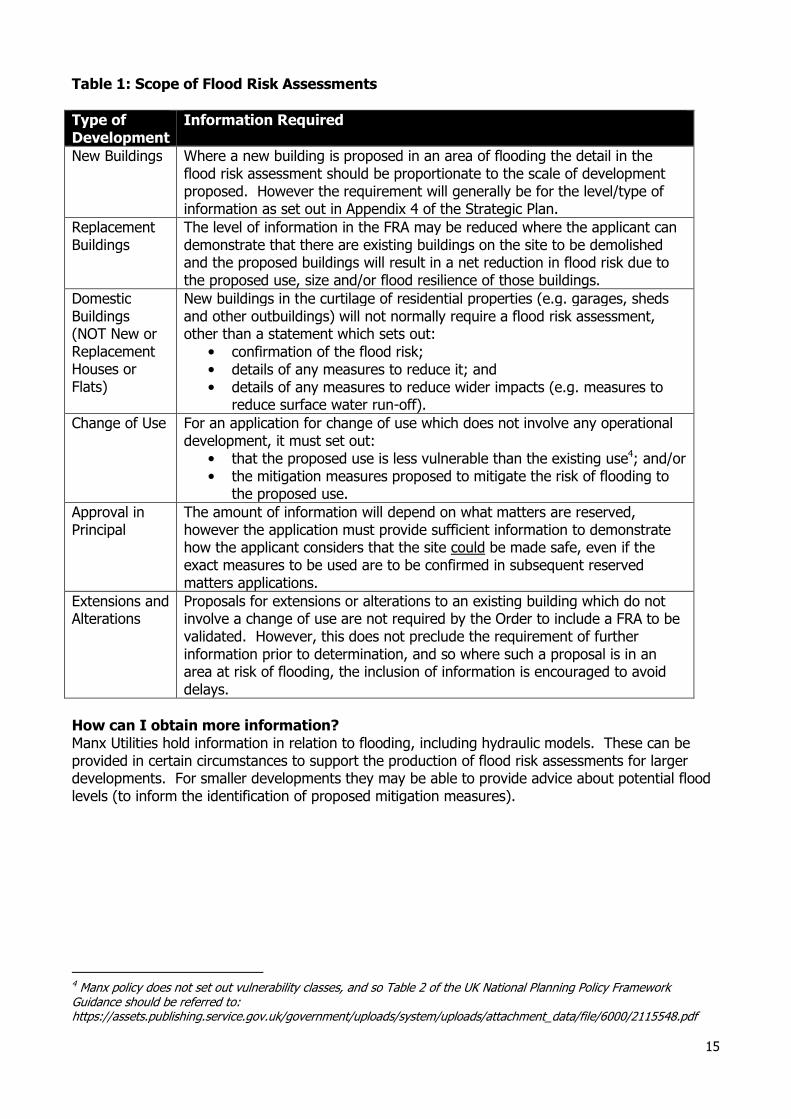
See Table 1 for information on the requirements for different types of development.
1 Strategic Plan 2016 appendix 1 2 Originally published 2007. The latest version was adopted in 2016, although only the housing numbers were updated. 3 The risks left over after the actions to mitigate/defend against flood risk (e.g. the failure of flood management
infrastructure such as a breach of a raised flood defence).
15
Table 1: Scope of Flood Risk Assessments
Type of Development
Information Required
New Buildings Where a new building is proposed in an area of flooding the detail in the flood risk assessment should be proportionate to the scale of development proposed. However the requirement will generally be for the level/type of information as set out in Appendix 4 of the Strategic Plan.
Replacement Buildings
The level of information in the FRA may be reduced where the applicant can demonstrate that there are existing buildings on the site to be demolished and the proposed buildings will result in a net reduction in flood risk due to the proposed use, size and/or flood resilience of those buildings.
Domestic Buildings (NOT New or Replacement Houses or Flats)
New buildings in the curtilage of residential properties (e.g. garages, sheds and other outbuildings) will not normally require a flood risk assessment, other than a statement which sets out:
• confirmation of the flood risk; • details of any measures to reduce it; and • details of any measures to reduce wider impacts (e.g. measures to
reduce surface water run-off).
Change of Use
For an application for change of use which does not involve any operational development, it must set out:
• that the proposed use is less vulnerable than the existing use4; and/or • the mitigation measures proposed to mitigate the risk of flooding to
the proposed use.
Approval in Principal
The amount of information will depend on what matters are reserved, however the application must provide sufficient information to demonstrate how the applicant considers that the site could be made safe, even if the exact measures to be used are to be confirmed in subsequent reserved matters applications.
Extensions and Alterations
Proposals for extensions or alterations to an existing building which do not involve a change of use are not required by the Order to include a FRA to be validated. However, this does not preclude the requirement of further information prior to determination, and so where such a proposal is in an area at risk of flooding, the inclusion of information is encouraged to avoid delays.
How can I obtain more information? Manx Utilities hold information in relation to flooding, including hydraulic models. These can be provided in certain circumstances to support the production of flood risk assessments for larger developments. For smaller developments they may be able to provide advice about potential flood levels (to inform the identification of proposed mitigation measures).
4 Manx policy does not set out vulnerability classes, and so Table 2 of the UK National Planning Policy Framework Guidance should be referred to: https://assets.publishing.service.gov.uk/government/uploads/system/uploads/attachment_data/file/6000/2115548.pdf
16
HIGHWAYS, TREES, LEVEL CHANGES AND MINERALS/WASTE
INFORMATION This section applies to all planning applications other than:
• Approvals in Principle; • Change of Use not involving operational development; or • Replacement Door/Window applications
Highways Applications must contain details of the position of any driveways and vehicular access (existing and proposed). Where an application proposes to create or alter a vehicular access it must show the extent of the visibility splay5. Supplementary Guidance on Highway Issues is available on the website. There is no requirement for an application to contain parking/storage areas in order to be validated. However, where such areas are proposed for motor vehicles (for motor cars, motor cycles or goods or passenger vehicles) and/or pedal cycles the areas should be shown on the relevant plans. UK Guidance on the design of such parking is available and it is envisaged that guidance will be included in the next iteration of the Manual for Manx Roads. Trees and Landscaping Applications must show:
• the position and extent of all existing trees where the proposed development includes any works within the vicinity of such trees; and
• the position and nature of all proposed landscaping. The Department’s Supplementary Guidance on Trees (June 2019) remains relevant. Level Changes Where a proposal involves changes to site levels (for example where a proposal is on a sloping site and so part of the site is to be excavated or raised up), it must show existing and proposed site levels. All proposals for building must show the site levels relative to a fixed datum outside the site. Minerals and Waste All proposals must set out details of:
• any incidental removal of minerals from the site (e.g. the excavation of material to be sold); • any waste to be removed from the site (e.g. from demolished structures or excavated
material which is to be disposed of);
• and any waste to be brought onto the site (e.g. the importation of inert waste to raise levels).
The Isle of Man has a limited number of facilities to deal with waste, and it is important that consideration is given as early as possible in the designing of a project. The validation requirements only require an estimate of the type and nature of the waste(s) which may result from a development and require off-site management (including disposal). For larger applications, it may be appropriate to consider a Site Waste Management Plan6.
5 Applications which proposed increased use of an existing access may require such information prior to determination, however this is not a legal requirement at the validation stage. 6 This is not a requirement of the order in terms of minimum information for validation. The States of Guernsey have produced helpful guidance in relation to this www.gov.gg/CHttpHandler.ashx?id=113558&p=0