Embed Size (px)
Citation preview


MAJOR STREETS AND
ROUTES PLAN
Amended by the
Mayor and Council November 15, 1982
Resolution No. 12045

City of Tucson Major Streets and Routes Plan History
of Amendments and Updates January 20, 2016 – Resolution 22518 (effective February 20, 2016). Amending page 24 and map of the MS&R Plan to reflect the alignment approved by the Mayor and Council on January 20, 2016 for Broadway Boulevard, between Euclid Avenue and Country Club Road (Resolution # 22518).
March 17, 2015 – Resolution 22369 (effective April 17, 2015). Amending page 24 and map of the MS&R Plan to reflect the alignment approved by the Mayor and Council on January 13, 2009 for Grant Road, between Oracle and Swan Road (Resolution # 21190).
April 24, 2007 -Ordinance 10392 (effective on July 7, 2007). Updating and amending the Major Streets and Routes (MS&R) Plan Map by extending the alignment of Los Reales Road as a designated arterial from Craycroft Road to Wilmot Road, with a right-of-way width of 90 feet; removal of Kenyon Drive, Sarnoff Drive, Wingate. Drive, Limberlost Drive between Oracle Road and First Avenue as designated collectors; and setting an effective date. July 6, 2005 -Ordinance 10177 (effective on August 6, 2005). Updating and amending the Major Streets and Routes (MS&R) Plan Map updating street classification and right-of-way for those streets affected by recent annexations and approved arterial changes including portions of River Road, Houghton Road, Drexel Road, Los Reales Road, Rita Road, Hughes Access Road, Nogales Old Vail Extension, Wilmot Road, Kolb Road, Alvernon Way, Nexus Road, Voyager Road, Pantano Road, and Science Park Drive; and setting an effective date. October 7, 2002 -Resolution 19362. Updating and amending the Major Streets and Routes (MS&R) Plan Map to facilitate the redevelopment of the Downtown/Rio Nuevo Area by removing the note (star) on the MS&R Map and associated reference in the Mission Road alignment; removing the Valley Road and Greasewood Road alignments from the Plan Map to facilitate infill development in these areas; and declaring an emergency. January 14, 2002 -Ordinance 9659. Amending the Major Streets and Routes Plan Map by reducing the total right-of-way of Stone Avenue between Drachman Street and Wetmore Road from 100 feet to 90 feet. October 1, 2001 -Ordinance 9615. Establishing original city zoning for approximately 17,285.79 acres generally located East of Nogales Highway, West of Houghton Road, and North of the Pima Road/Andrada Road alignment which was annexed to the City of Tucson by Ordinance No. 9527, adopted on April 9, 2001; designating Old Nogales Highway and Houghton Road in the annexed area as scenic routes under the Major Streets and Routes Plan; designating the Cuprite Wash, Fagan Wash, Flato Wash, Franco Wash, Petty Ranch Wash, Summit Wash, Thomas Sousa Wash and their major tributaries in the annexed area as subject to the environmental resource zone. April 23, 2001 -Ordinance 9543. Establishing original city zoning for approximately 162.84 acres generally located between Swan Road and the Craycroft alignment South of Hermans Road, which was annexed into the city of Tucson by ordinance no. 9473, adopted on November 20, 2000: and

extending the Major Streets and Routes Plan designating Hermans Road, Swan Road, and Alvernon Way as arterial streets; designating a portion of the property as an environmental resource zone (ERZ).

June 26, 2000 -Ordinance 9413. Establishing original city zoning for approximately 11.61 acres generally located in an area south of River Road and approximately Y4 mile east of Campbell Avenue which was annexed to the City of Tucson by ordinance No. 9375, adopted May 1, 2000; and extending the scenic route designation for River Road within the annexation area. May 22, 2000 -Ordinance 9389. Updating and amending the Major Streets and Routes Plan Map by deleting a portion of Roger Road and Tucson Boulevard and reducing the right-of-way of Prudence Road between 22nd Street and Escalante Road.
March 20, 2000 -Ordinance 9363. Establishing original city zoning for approximately 45.79 acres generally located in an area north of Tanque Verde Road, west of Houghton Road, and east of Tomahawk Trail, which was annexed to the City of Tucson by ordinance no. 9326, adopted December 13, 1999; and extending the scenic route designation for Houghton Road and Tanque Verde Road. February 7, 2000 -Ordinance 9256. Extending and increasing the corporate limits of the City of Tucson, Pima County, Arizona pursuant to the provisions of Title 9, Chapter 4, Arizona Revised Statutes, by annexing thereto certain portions of sections 17, 20, and 29, T. 13 So, R. 13 E., G. & S.R.B.& M., Pima County, Arizona, more particularly described in the body of this ordinance. January 10, 2000 -Ordinance 9340. Updating and amending the Major Streets and Routes Plan Map to reconfigure the major street grid in the southeast section of the City located generally south of Bilby Road and east of Houghton; to provide a policy and implementation techniques to identify appropriate major street locations in the southeast section. March 22, 1999 -Ordinance 9213. Amending the Tucson Code Chapter 23, the Land Use Code, designating all of Houghton Road within the City Limits as a Scenic Route on the Major Streets and Routes Plan. March 22, 1999 -Ordinance 9212. Amending the Tucson Code Chapter 23, the Land Use Code, designating a portion of Old Spanish Trail as a Scenic Route on the Major Streets and Routes Plan. January 11, 1999 -Ordinance 9193. Updating and amending the Major Streets and Routes Plan Map to reclassify a portion of Mission Road from a Gateway Route to a Scenic Route December 14, 1998 -Ordinance 9176. Updating and amending the Major Streets and Routes Plan Map and text to identify major streets recently annexed. November 2, 1998 -Ordinance 9122. Extending and increasing the corporate limits of the City of Tucson, Pima County, Arizona pursuant to the provisions of Title 9, Chapter 4, Arizona Revised Statutes, by annexing thereto certain portions of sections 19 and 20, T13S, R14E, G & S.R.B. & M, Pima County, Arizona, more particularly described in the body of this ordinance. July 6, 1998 - Ordinance 9048. Extending and increasing the corporate limits of the City of Tucson, Pima County, Arizona pursuant to the provisions of Title 9, Chapter 4, Arizona Revised Statutes, by annexing thereto certain portions of section 24, T.13S., R.13.E., and Section 19, T.13.S., R.14.E., G. & S.R.B. & M., Pima County, Arizona, more particularly described in the body of this ordinance.

February 2, 1998 -Ordinance 9009. Establishing original SH (restricted), SR, RX-I (restricted) and RX-I City zoning for approximately 32S acres generally located south of 22nd Street, west of Melpomene Way, east of Houghton Road, and north of Old Spanish Trail, which was annexed to the City of Tucson by ordinance No. 818, adopted on September 8, 1997; extending the scenic route designation for Old Spanish Trail, and extending the Hillside Development Zone (HDZ), the Environmental Resource Zone (ERZ), and the Watercourse Amenities Safety and Habitat (WASH) ordinance within the annexation area. February 3, 1997 – Ordinance 8815 (effective March 6, 1997). Establishing original City zoning for approximately 122.8 acres generally located east and west of First Avenue and north of River Road, which was annexed to the City of Tucson by Ordinance No. 8758 adopted on October 7, 1996; extending a Scenic Route designation for River Road; establishing a Scenic Route designation for First Avenue; establishing the Environmental Resource Zone for Racetrack Wash; and establishing the Hillside Development Zone within the annexation area; specifying an effective date. January 27, 1997 - Ordinance 8792. Extending and increasing the corporate limits of the City of Tucson, Pima County, Arizona pursuant to the provisions of Title 9, Chapter 4, Arizona Revised Statutes, by annexing thereto certain portions of section 1, T. 15.S., R.15.E., and sections 5, 6, and 7, T.15.S., R.16E., G. & S.R.B. & M., Pima County, Arizona, more particularly described in the body of this ordinance. October 14, 1996 - Ordinance 8764. Updating and amending the Major Streets and Routes Plan Map to classify Bear Canyon Road within the City Limits and Speedway Boulevard with the City Limits east of Houghton Road and Sabino Canyon Road from Tanque Verde Road to Tanque Verde Creek as Scenic Routes. September 9, 1996 - Ordinance 8754. Amending the Major Streets and Routes Map showing street setback lines by reclassifying Campbell Avenue between 36th collector to a local.
Street and Fairland Stravenue from a
July 10, 1995 - Ordinance 8542. Amending the Major Streets and Routes Plan and Map by amending required notice provisions for changes in route classification or right-of-way (Policy 3); deleting reference to 5th / 6th Street as being a commuter arterial street; reclassifying 5th / 6th Street; extending and reducing the right-of-way for a portion of 36th Street; reducing the right-of-way for portions of Bear Canyon Road and Starr Pass Boulevard; updating certain streets to reflect annexations. December 12, 1994 - Ordinance 8422. Amending the Major Streets and Routes Plan by removing a portion of Oaktree Drive between Midvale Park Road northeasterly to Irvington Road. May 11, 1992 - Resolution 15988. Amending the Major Streets and Routes Plan by amending the policies to reflect changes in the regional transportation plan; adding a new policy establishing the comprehensive arterial redevelopment and enhancement team process as part of the street planning process: deleting outdated policies and the references to completed or superseded road improvement projects in appendices Band C; amending the MS&R Map to reflect new development, annexations, current corridor studies and Mayor and Council direction concerning the classification of certain city streets.
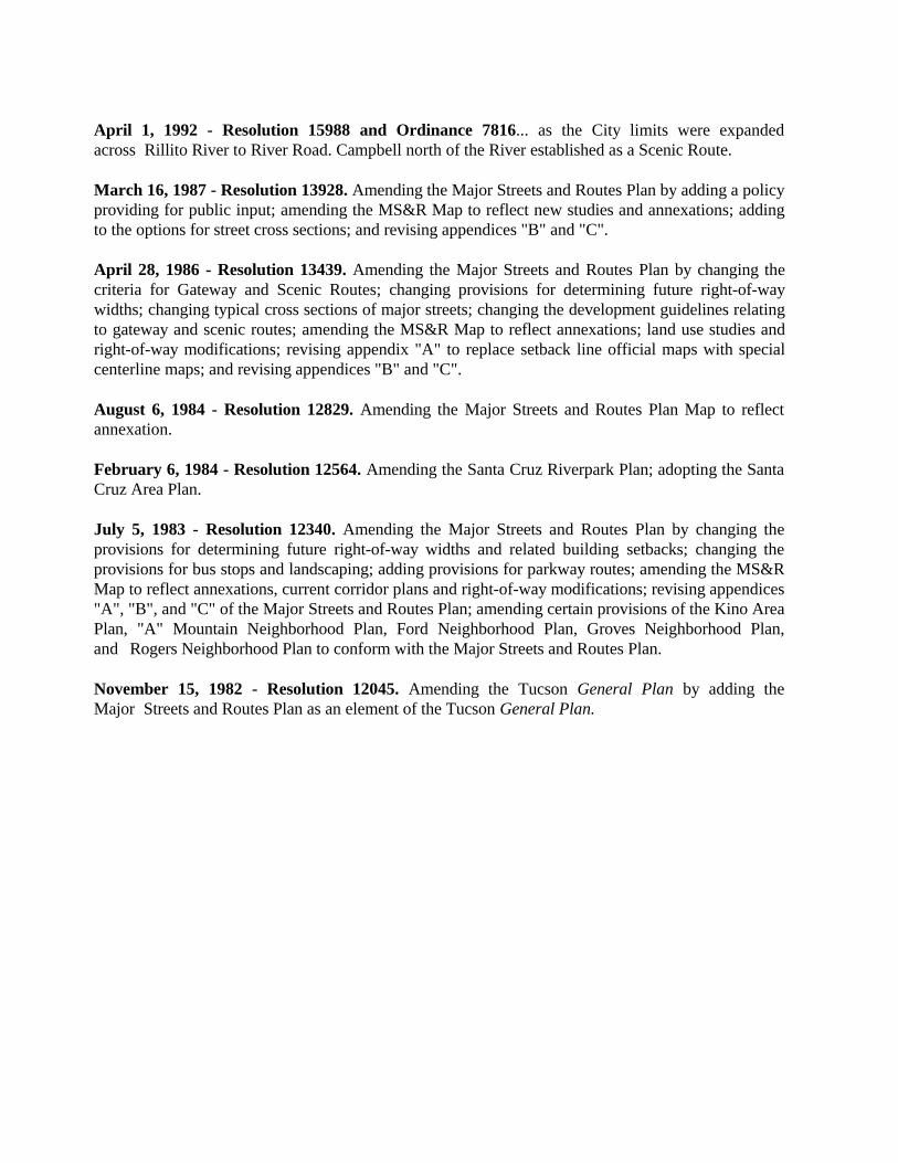
April 1, 1992 - Resolution 15988 and Ordinance 7816... as the City limits were expanded across Rillito River to River Road. Campbell north of the River established as a Scenic Route. March 16, 1987 - Resolution 13928. Amending the Major Streets and Routes Plan by adding a policy providing for public input; amending the MS&R Map to reflect new studies and annexations; adding to the options for street cross sections; and revising appendices "B" and "C". April 28, 1986 - Resolution 13439. Amending the Major Streets and Routes Plan by changing the criteria for Gateway and Scenic Routes; changing provisions for determining future right-of-way widths; changing typical cross sections of major streets; changing the development guidelines relating to gateway and scenic routes; amending the MS&R Map to reflect annexations; land use studies and right-of-way modifications; revising appendix "A" to replace setback line official maps with special centerline maps; and revising appendices "B" and "C". August 6, 1984 - Resolution 12829. Amending the Major Streets and Routes Plan Map to reflect annexation. February 6, 1984 - Resolution 12564. Amending the Santa Cruz Riverpark Plan; adopting the Santa Cruz Area Plan. July 5, 1983 - Resolution 12340. Amending the Major Streets and Routes Plan by changing the provisions for determining future right-of-way widths and related building setbacks; changing the provisions for bus stops and landscaping; adding provisions for parkway routes; amending the MS&R Map to reflect annexations, current corridor plans and right-of-way modifications; revising appendices "A", "B", and "C" of the Major Streets and Routes Plan; amending certain provisions of the Kino Area Plan, "A" Mountain Neighborhood Plan, Ford Neighborhood Plan, Groves Neighborhood Plan, and Rogers Neighborhood Plan to conform with the Major Streets and Routes Plan. November 15, 1982 - Resolution 12045. Amending the Tucson General Plan by adding the Major Streets and Routes Plan as an element of the Tucson General Plan.

Major Streets and Routes Plan
November 15, 1982
MAYOR AND COUNCIL
George Miller, Mayor Michael J. Crawford Jose J. Ibarra Steve Leal
Janet Marcus Molly McKasson Shirley C. Scott
CITIZEN ADVISORY PLANNING COMMITTEE
Mark Mayer, Chairperson Bruce Cannon Charles B. Deans Rodney George
Jack Kelly Larry Lucero Bob Morgan Greg Shinn Leo Pilachowski Phillip E. Swaim
Mitch Sternberg Elizabeth Upham
CITY MANAGER Michael F. Brown
Planning Department
Department of Transportation
William D. Vasko, Director Benny J. Young, Director John F. Siry, Assistant Director James W. Glock, Deputy Director Roger Schneider, Principal Planner Bob Brumbaugh, Drafting Supervisor
Albert Elias, Transportation Planning Administrator
Karol Cruz, Drafting Technician III G. Dewayne Tripp, City Engineer William Balak, Drafting Technician III Gary Oakes, Assistant Traffic Engineer Robin Migliore, Engineering Manager Louis Allen, Senior Engineering Assoc.
Este documento se publica en inglés solamente. Los ciudadanos de habla híspana pueden llamar al Departamento de Planificación Municipal de Tucsón para pedir ayuda en la traducción de este documento. Favor de hablar al 791-4505, o pase al Departamento de Planificación Municípal en el tercer píso del ayuntamiento municipal, 255 oeste de la calle Alameda.

TABLE OF CONTENTS
Page OVERVIEW ............................................................................................................ 1 GENERAL POLICIES AND RECOMMENDATIONS .......................................................... 4 Policy 1 Plan and Develop a Safe and Efficient Traffic Circulation System Throughout the Community ............................................................ 5 Policy 2 Establish Guidelines for the Design and Development of Major Streets and Routes ......................................................................... 8 A. Right-of-Way and Setback Guidelines ............................................... 8 B. General Design and Development Guidelines .................................. 11 C. Arterial Street Design Guidelines ..................................................... 12 D. Collector Street Design Guidelines .................................................. 14 Policy 3 Establish a Procedure to Ensure Meaningful Public Input in Major Street and Route Decisions .......................................................... 18 SPECIAL ROUTES .......................................................................................................... 19 Policy 4 Provide a Street Network that Meets the Needs of the Community in the Southeast Sector and that is Sensitive to the Topography and Natural Environment .................................................................................. 20 Policy 5 Further the Goals for Scenic and Gateway Routes Through Public Actions and Monitoring of Development Regulations ................... 20 A. Development Guidelines for Public Improvements of Gateway Routes ..................................................................................... 20 B. Development Guidelines for Properties along Gateway Routes .......................................................................................... 22 C. Development Guidelines for Public Improvements of Scenic Routes ............................................................................................. 22 D. Development Guidelines for Development Along Scenic Routes ............................................................................................. 23 E. Annexation Policy ...................................................................................... 23 APPENDIX .......................................................................................................... 24 MAJOR STREETS AND ROUTES MAP

This page intentionally left blank

Major Streets and Routes Plan
1
OVERVIEW
The Long Range Regional Transportation Plan focuses on the fact that as Tucson's population grows, so will multi-modal travel needs. The transportation policies in the General Plan∗ (GP, Section 10) call for providing necessary services and facilities to satisfy travel needs. The solution chosen to deal with future trips has been the concentration of additional capacity in improvements of major streets, with roadway, transit, bicycle, and pedestrian features. The Major Streets and Routes Plan (MS&R), recognizes that the transportation system is already in place, as is the present grid pattern of the City's development. Drastic changes in land use configuration and travel modes are not likely in the next few decades. Therefore, the Plan proposed is essentially a conservative one, balancing the need to minimize disruption to the existing land uses while safely and efficiently providing the necessary additional capacity to our streets. The major purposes of the Major Streets and Routes Plan are to identify street classifications, the width of public rights-of-way, to designate special routes, and to guide land use decisions. General Plan policies stipulate that planning and developing new transportation facilities be accomplished by identifying rights-of-way in the Major Streets and Routes Plan. The policies also aim to encourage bicycle and pedestrian travel, "minimize disruption of the environment," and "coordinate land use patterns with transportation plans" (GP, Section 10, Policy 1, B and N) by using the street classification as a guide to land use decisions. Plan Contents The Major Streets and Routes Plan has two components: the map and a set of related policies. Below is a brief explanation of the elements contained on the map. Following this section, the policies are presented. Street Classification The first step in preparing the Major Streets and Routes Plan is to identify which streets are clearly major--that is, which serve the entire City or a large portion of it. All roads fall into a hierarchy of importance based on how they serve through rather than local travel. This hierarchy is called functional classification, because each type has its own function or purpose. At the top of the hierarchy are freeways, followed by arterials, then collectors. These categories provide the major routes through a city and are included in this Plan. Local streets are not included in the Plan, since their purpose is to provide access to property, not through movement. Streets which are identified as arterials carry high levels of traffic, serving over 12,000 vehicles per day. These streets connect with bridges, freeway interchanges, or other ∗ The General Plan was originally adopted as the "Comprehensive Plan" pursuant to the Tucson Zoning Code and, subsequently, the Tucson Land Use Code. The term "Comprehensive Plan (CP)" was changed to the "General Plan" by Ordinance 9517, which was adopted by Mayor and Council on February 12, 2001. This change in title does not affect the content of the Plan.

Major Streets and Routes Plan
2
arterials and provide continuity through the City. High intensity land uses usually choose to locate along such streets. The next category of streets is collectors. These are usually shorter in length, have lower traffic volumes, from 2,500 to 12,000, and therefore, fewer lanes. Their purpose is to funnel traffic from an area or neighborhood to the nearest arterial. The land uses along collectors are generally residential with limited office and commercial services. The purpose of classifying streets is threefold. First, it alerts the public to streets which have been chosen as the main traffic carriers and thus provides direction in matching land use locations with street character and capacity. Second, it serves as a guide for future street improvements, since each right-of-way allows for the needed number of lanes plus other elements, such as medians. Third, it also determines the type of cost sharing between property owners and the City in improvement districts. Right-of-Way Displayed with each street on the MS&R map are mid-block right-of-way numbers. These represent the number of feet required to accommodate the necessary number of lanes. Right-of-way widths in the vicinity of intersections are discussed in Policy 2A. For planning purposes, the right-of-way needed was computed on the basis that generally 6,000 vehicles per day can be accommodated in a travel lane at Level of Service C. Level of service defines the ease of traffic flow versus congestion. Level A represents high speed with no interference, while Level E consists of unstable flow, stoppage, and significant congestion. Level C is the minimum desirable because it allows for stable flow and little congestion.∗ The traffic volumes used to arrive at the needed number of lanes were year 2005 projections, unless existing volumes were larger. Traffic volumes used were based on anticipated population growth and other factors. These volumes were assigned to various street segments based on expected destinations, employment concentrations, and activity centers. There are some exceptions to the normal calculation of the needed right-of-way widths based on volumes. In some cases, a greater amount of right-of-way is already present, and the street is already built. The map merely acknowledges this. In other cases, a greater amount of right-of-way is needed for very high traffic volumes, bike lanes, a high percentage of trucks, or a special express bus route. In some cases, existing city owned right-of-way on some streets is presently greater than is called for on the map. The third exception is related to terrain. Where the topography is hilly, for example, a 120-foot right-of-way may be needed to construct a street cross-section which typically requires only 90 feet.
∗ Policy on Design of Urban Highways and Arterial Streets, AASHO, 1973.

Major Streets and Routes Plan
3
Zoning setbacks are established so that building construction does not occur within the future MS&R right-of-way area. This approach permits the City to acquire the necessary rights-of-way without demolishing structures or the loss of viability of use. The rights-of-way, which might be acquired through dedication of land at the time of rezoning or subdivision or purchased at the time of street improvements, allow the City to improve streets, to add lanes as traffic increases, and to match older segments with modern cross-sections to prevent bottlenecks. Scenic and Gateway Routes Another element of the Major Streets and Routes Plan is the identification of scenic and gateway routes. Scenic routes may be rural in nature, where the intent is to preserve vistas and natural vegetation, or urbanized routes, called gateways, where the intent is to upgrade the developed streetscape. Gateways are routes undergoing both street improvements and land use development and which are heavily traveled by residents and visitors alike. As such, their appearance, in contributing to a pleasant driving experience, is important to the overall image of Tucson. Summary In summary, the Major Streets and Routes Plan provides the planning framework for the implementation of improvement plans for arterial and collector streets. As conditions change and annexations occur, the Plan will need amendment. As provided in Section 11, Policy 10 of the General Plan, this Plan should be reexamined periodically to reflect current conditions, to include completed corridor projects, and to amend, add, and delete street segments. NOTE: Several of the policies and guidelines presented in the MS&R Plan contain references which indicate that the particular policy cited is consistent with previously adopted General Plan policies. These are referred to by the abbreviation (GP).

Major Streets and Routes Plan
4
GENERAL POLICIES AND RECOMMENDATIONS
Tucson's rapid population growth coincided with a period of national expansion in auto use and single-family home ownership. These factors pushed the City boundaries in all directions. In order to keep pace with the need for access to newly developing land parcels, it seemed logical and efficient to extend the newly existing section line roads outward. This process resulted in the section line grid pattern which dominates Tucson's street network today. As the extent of the growth became apparent, roads were constructed with wider rights-of-way to accommodate the increasing traffic. The fine-grained pattern of small-scale streets in the historic barrios reflect a different era than the spacious streets of the City's newer east side. Attempts to reconcile the differences in street scale, by widenings and other improvements, sometimes created surprise and consternation among owners of adjacent homes and businesses and often disrupted established uses. The purpose of the Major Streets and Routes Plan is to facilitate future street widening, to inform the public about which streets are the main thoroughfares, so that land use decisions can be based accordingly, and to reduce the disruption of existing uses on a property. By stipulating the required right-of-way, new development can be located so as to prepare for planned street improvements without demolition of buildings or loss of necessary parking. The policies presented here attempt to balance between the need to provide additional street capacity and the need to protect land uses.

Major Streets and Routes Plan
5
POLICY 1 Plan and develop a safe and efficient traffic circulation system throughout the community (GP, Section 10, Policy 1, E, F, G). IMPLEMENTATION A. The Major Streets and Routes Plan map shall display the designated streets and routes
and identify these classifications as follows:
1. Major streets designated on the map shall be classified as either arterial or collector streets.
a. One or more of the following conditions apply to the classification of
arterial streets:
• service to major centers of activity
• continuity and length for crosstown trips
• average daily volumes generally exceed 12,000 vehicles
• normally spaced one mile apart
• access to existing or planned freeway interchanges, other arterials, or rural highways
• projected as future high volume routes
b. One or more of the following conditions apply to the classification of
collector streets:
• funnel traffic from neighborhoods to arterials
• average daily volumes generally between 2,500 to 12,000 vehicles
• generally located halfway between arterial streets
• continuity and length of more than one mile
2. Major streets designated on the map may also be designated as gateway or scenic routes as appropriate.
a. At least two of the following conditions apply for the designation of
gateway routes:

Major Streets and Routes Plan
6
• identified as a regional corridor
• identified for future street improvement and adjacent development
• used by visitors to reach transportation terminals, hotels, resorts, and recreational facilities
• average daily volumes generally over 30,000
b. Both of the following conditions shall apply to parkway routes which are a
special type of gateway route:
• qualifies as a gateway route
• planned as a modified limited access roadway and incorporates, as an integral part of its design and operation, extensive landscaping and noise reduction measures
c. For designation of a scenic route, the first and at least two additional
conditions apply:
• a route to recreation areas or a route driven for its own enjoyment
• a route which provides vistas of nearby mountains, foothills, the City, or mountains across the valley (GP, Section 3, Policy 3, D)
• a route which has a significant quantity or quality of existing native
vegetation
• a route which has significant geological formations
• a route which has important archaeologic, historic, or cultural features
• a route which has a roadway conforming to the topography 3. State and Federal highways and routes are to be identified on the map.
B. The Plan shall also identify right-of-way requirements, building setback standards, and
policies for general street design and development (GP, Section 10, Policy 1, E and F). C. The Plan shall be reviewed and amended periodically to reflect change in the PAG
Regional Transportation Plan and Tucson General Plan, including the completion of transportation corridor projects and designation of new routes. The Plan shall also be amended to include new streets and routes added as part of annexations, except that rights-of-way of the scenic highways leading to the Tucson Mountain Park and the Saguaro National Monument East are not to be reduced on annexation or thereafter.

Major Streets and Routes Plan
7
D. Corridor projects with special centerlines are listed in the Appendix and shown on the MS&R Map. Such projects have undergone a study as outlined in the City's Roadway Development Policies.
E. Construction of grade-separated intersections may be called for where arterial
intersection traffic volumes exceed 80,000 vehicles per day. Special setbacks, frontage roads, access limitations and other traffic control measures may also be required to increase capacity and safety.

Major Streets and Routes Plan
8
POLICY 2 Establish guidelines for the design and development of Major Streets and Routes. IMPLEMENTATION A. Right-of-Way and Setback Guidelines The Planning Department shall prepare a Major Streets and Routes Map (MS&R Map) for adoption by the Major and Council as an ordinance. Upon adoption, the MS&R Map establishes the Major Streets and Routes (MS&R) right-of-way setback lines for the MS&R Setback Zone and provides guidance for the imposition, where applicable, of right-of-way dedication requirements in the case of applications for rezoning and subdivision approval by the Mayor and Council.
1. Right-of-way widths are identified on the MS&R Map for all designated arterial and collector streets. The right-of-way widths are measured at mid-block. The right-of-way widths identified on the MS&R Map are used to establish the future right-of-way line locations in the Major Streets and Routes Setback Zone, Division 26 of the Zoning Code.
2. The right-of-way widths may be exceeded:
a. Within 600 feet of any intersection of two major streets as shown in Figure 1.
b. At the location of a change of right-of-way width, where the taper for
transition may extend 600 feet from the point of change.
c. In locations where the prevailing existing City-owned right-of-way along the block or section is greater than shown on the MS&R Map.
3. Except as provided below, the future right-of-way area (Figure 2) is generally
measured midblock from the survey centerline of the street. It is generally equal to one-half the right-of-way width designated for that street on the MS&R Plan.
4. The mid-block right-of-way widths and centerline locations may be modified by
corridor study maps and street right-of-way/improvement plans on file with the Department of Transportation (see Appendix). For such maps or plans, the right-of-way setback is measured from the future right-of-way line as shown on the corridor study maps or street right-of-way/improvement plans.

Major Streets and Routes Plan
9
RIGHT-OF-WAY WIDENING AT INTERSECTIONS
FOR STREETS ON MS&R MAP
“A” equals mid-block width. The City Engineer will determine values B, C, and D when necessary for mid-block widths not in the following table (e.g., “A” equals 110).
A B C D
64 90 200 200
76 100 300 200
80 100 300 200
90 120 300 300
100 130 300 300
120 150 300 300
150 150 N/A N/A
200 200 N/A N/A
Figure 1. This figure illustrates right-of-way requirements in the vicinity of all major
intersections shown on the MS&R map. The City Engineer will determine requirements for other right-of-way combinations.

Major Streets and Routes Plan
10
Figure 2. This figure illustrates how the future right-of-way area will be measured.

Major Streets and Routes Plan
11
5. Under the provision of the MS&R Setback Zone, no structure, off-street parking, vehicular circulation, off-street loading, or maneuvering space, landscaping, or screening improvements required by the Zoning Code, may be constructed, erected, placed, or extended in the future half right-of-way area unless specifically allowed. The future right-of-way area that is not publicly owned may be included in the site coverage calculation and used to meet landscaping requirements or reduce required parking.
6. In compliance with the requirement of the MS&R Setback Zone, plans submitted
for the issuance of building permits and development plans and tentative plats submitted for review must show the applicable setback from the future right-of-way line as a condition of approval. In cases of hardship, a variance may be requested from the MS&R Setback Zone requirements.
7. Future changes in planned right-of-way widths shall be incorporated by
amendment to the MS&R Map. B. General Design and Development Guidelines
The following provisions apply to the overall design and development of major streets identified in the Plan.
1. Improvement of major streets shall include provisions for pedestrian ways.
Sidewalks shall be located on both sides of all major streets as regulated by the Street Development Standards and the Uniform Building Code, including both sides of bridges, overpasses, and underpasses.
2. Bus stops shall be placed every one-fourth mile except where demand warrants
otherwise. Where possible, bus stops shall be located at activity nodes. Shelters and benches shall be set back at least four feet from the curb.
3. To provide for safe use by bicyclists, major streets shall be designed with 17-foot
outside lanes to provide five-foot striped bike lanes, where feasible.
4. Wherever possible, utility easements and rights-of-way shall be incorporated into the public rights-of-way (GP Section 3, Policy 1, F5).
5. Street furniture design shall be compatible with the overall street design and shall
be functional and attractive (GP, Section 3, Policy 1, F3). It shall also be compatible with special district (historic, downtown, etc.) guidelines.
6. On-street parking is discouraged on all major streets to maintain capacity and to
ensure the safety of free flowing traffic. The Mayor and Council will determine where on-street parking may be appropriate.

Major Streets and Routes Plan
12
7. In some cases, right-of-way requirements are increased for purposes of topography, matching existing right-of-way, or scenic designation. The pavement width may be less than the right-of-way would indicate. In such cases, a smaller cross section design would be used. For example, five lanes might be planned on a 150-foot route.
8. Special access restrictions may be required on major routes in order to improve
traffic flow and minimize conflict points for safety. 9. Effects on neighborhoods and historic districts shall be considered in determining
the impacts of street widenings, new transportation routes, and reclassification of streets. Such projects shall be sensitive to and compatible with the specific neighborhoods and historic districts they pass through and serve (GP, Section 3, Policy 4.B. and Section 10, Policy 1, N).
10. The Comprehensive Arterial Redevelopment and Enhancement Team (CARET)
shall utilize a multi-disciplinary approach in examining engineering design and land use alternatives prior to preparation of roadway improvement plans. Business and neighborhood representatives shall also participate in determining optimal land use development and a cross-section which promotes appropriate arterial frontage opportunities as part of the Roadway Development Policies process.
C. Arterial Street Design Guidelines
1. Typical mid-block cross sections for arterial streets shall consist of variations of those shown in Figures 3, 4, 5, and 6. The actual design and right-of-way requirements of arterial streets shall be sensitive to and compatible with the specific area they pass through and serve (GP Section 3, Policy 1, F1 and Section 10, Policy 1N). These cross sections are the basis for the design of gateway routes with the inclusion of the design guidelines contained in Policy 4A. Scenic routes are to be designed in accordance with the development guidelines contained in Policy 4C.
2. The maximum width of an arterial street shall be no more than six lanes in the
mid-block, except where the additional lanes are designated for buses, bicycles, and high-occupancy vehicles. Where traffic volumes create the need for additional capacity, intersection modifications should be pursued prior to further widening.
3. A curbed median of no less than 20 feet shall be included in the design of all
arterial streets where the curb to curb width exceeds 75 feet. Street landscaping shall consist of drought-resistant vegetation as regulated in the Street Development Standards and Zoning Code (GP Section 3, Policy 4, C1).

Major Streets and Routes Plan
13
90 FOOT RIGHT-OF-WAY
Figure 3. This figure shows an example of a typical 90-foot cross section consisting of four travel lanes, a continuous turn lane, and areas on each side for sidewalks, utilities, and street furniture, such as bus shelters. The outside travel lane has been allotted 17 feet to allow space for bicycle traffic next to the curb.
100 FOOT RIGHT-OF-WAY
Figure 4. This figure shows an example of a typical 100-foot cross section consisting of four travel lanes, a raised median, and areas on each side for sidewalks, utilities, and street furniture. The outside travel lane has been allotted 17 feet to allow space for bicycle traffic next to the curb.
NOTE: See Figure 9 for general building setback information.
Major Streets and Routes Plan
14
4. Median openings shall be spaced to match collector and arterial intersections. Requests for additional median openings may be considered only if conforming to standard minimum spacing requirements.
5. Installation of traffic signals should be limited to regularly spaced intervals of at
least one mile. Where accident or traffic volumes warrant traffic signals at other than the minimum spacing, other methods, such as traffic interception and channelization, shall be pursued.
6. Individual driveway openings onto arterials shall be designed to eliminate backing
movements onto the street. D. Collector Street Design Guidelines
1. Typical mid-block cross sections for collector streets shall consist of variations of those shown in Figures 3, 7, and 8. A curbed, landscaped median of no less than 20 feet may be included in the design of four-lane (see Figure 4 for cross-section) collector streets. The actual design and right-of-way requirements of collector streets shall be sensitive to and compatible with the specific neighborhood or area they pass through and serve (GP Section 3, Policy 4, B and Section 10, Policy 1, N).
2. Generally, streets designated as collectors are to be designed using a 64-foot
right-of-way unless traffic volumes or truck traffic warrant the larger cross section.
3. Individual driveway openings onto collectors shall be designed to eliminate
backing movements onto the street.
Major Streets and Routes Plan
15
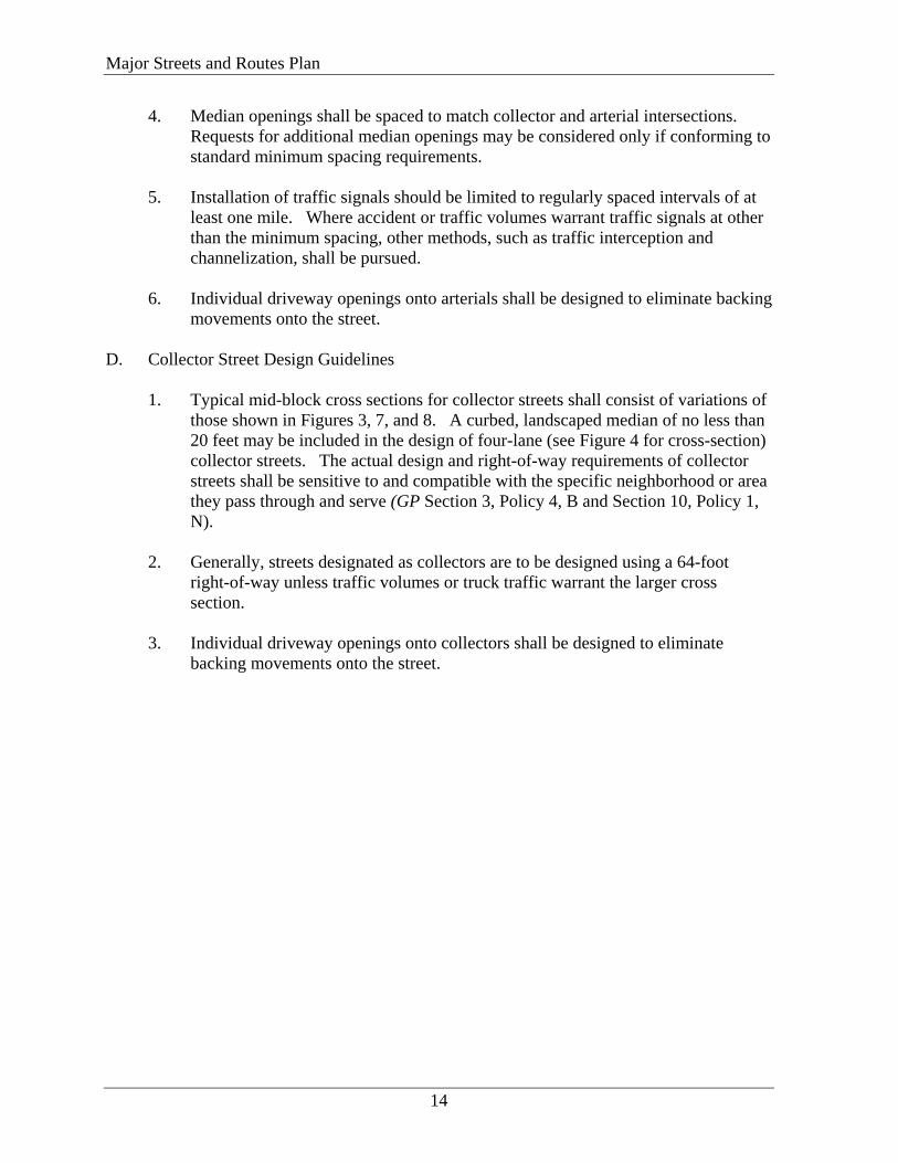
120 FOOT RIGHT-OF-WAY
Figure 5. A typical high volume arterial cross section is shown in this figure, consisting of
six travel lanes, a raised median with storage for turning vehicles and areas on each side for sidewalks, utilities, and street furniture. Seventeen feet has been allotted to the outside travel lane to allow adequate space for bicycle traffic next to the curb.
150 FOOT RIGHT-OF-WAY
Figure 6. This figure shows how an exclusive bus, bicycle, and high occupancy vehicle lane
could be included in a six-lane cross section. In this case, the sidewalk, utility, and street furniture areas are expanded to facilitate pedestrian traffic.
NOTE: See Figure 9 for general building setback information.
Major Streets and Routes Plan
16
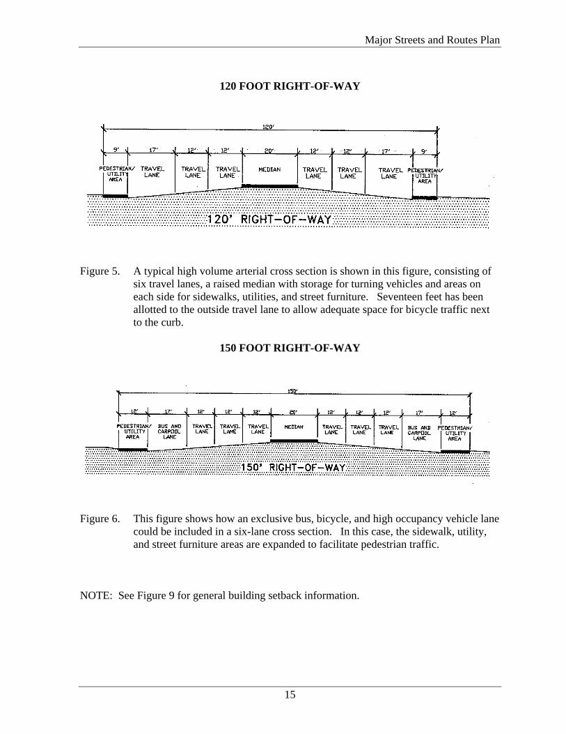
64 FOOT RIGHT-OF-WAY
Figure 7. This three-lane example shows a standard collector street. The continuous turn lane allows the travel lanes to provide improved through traffic service. Adequate bicycling space is provided in each 17-foot travel lane.
76 FOOT RIGHT-OF-WAY
Figure 8. This four-lane version typifies the higher volume collector or the collector with
significant truck traffic. Adequate space is provided in the outside lanes for bicycle traffic.
NOTE: See Figure 9 for general building setback information.

Major Streets and Routes Plan
17
BUILDING SETBACK AREA
Figure 9. Typical cross-section between the curb and building on a 90-foot MS&R right-of-
way street. This area contains provisions for pedestrians, utilities, drainage, landscaping, building setbacks and sight-visibility along both sides of the street. For details, refer to the Tucson Zoning Code and the City's Development Standards. Along Major Streets and Routes the building setback line is measured from the MS&R back of curb lines as required in the Zoning Code.

Major Streets and Routes Plan
18
POLICY 3 Establish a procedure to ensure meaningful public input in major street and route decisions. IMPLEMENTATION A. When a change in classification or total right-of-way is proposed, all property owners
abutting the affected street segment, and any registered homeowner and neighborhood associations adjacent to or within one mile of the proposed changes will be notified at least 15 days prior to the Planning Commission public hearing.
B Exceptions to this policy are when the change is in right-of-way only and (1) is the
result of a study involving considerable public input, (i.e., Regional Transportation Plan, a corridor study) or (2) the change in future right-of-way is not more than 10 feet, or (3) the change is for isolated/limited locations for the improvements, such as bus bays, intersections, activity nodes requiring more than 10 feet of right-of-way, or (4) the change in right-of-way is to the prevailing existing City owned right-of-way, or (5) the change involves reducing the right-of-way identified on the MS&R Plan map. Also exempt is the addition of a street due to annexation where the street classification is not changed and the right-of-way is the same as or less than the right-of-way shown in the Pima County Major Streets and Routes Plan and special route designation is not proposed.
SOUTHEAST SECTOR While the MS&R Map identifies a street network, street locations are shown as general in concept. Implementation techniques of Policy 4 provide guidelines to determine the actual siting of roadways.

Major Streets and Routes Plan
19
SPECIAL ROUTES
Tucson has a unique physical setting and climate which are major-factors in attracting visitors and residents. Their key image of the City is derived from the views along major routes. Streets which are heavily traveled, those that lead from transportation terminals to hotels and resorts, and those that lead to recreational facilities are routes which provide the basic impression of Tucson's character. The Mayor and Council, in recent area and neighborhood plans, have recognized the necessity of taking measures to improve the streetscape and directed staff to develop recommendations for the establishment of scenic routes. The PAG Regional Council, in adopting the Long Range Transportation Plan in 1981, also stated, (1) "To the maximum extent feasible, new roadways will be constructed as scenic routes." (2) "New arterial roadways will be constructed as a positive aesthetic element and in such a manner as to respect and be integrated with existing land use, natural topography, and vegetation." The study done by the Urban Land Institute and American Institute of Architects in 1984 also recognized the necessity of special design standards for key arterials. While the term "scenic routes" generally implies natural terrain, many of the streets within the Tucson City limits serve urban development. Therefore, the approach adopted in the MS&R Plan has been the establishment of two types of routes, scenic and gateway, each with its own set of development standards. Gateway routes are routes to major employment centers, shopping areas, recreational areas, and transportation centers which are used regularly by large numbers of residents and visitors. The purpose of this designation is to improve the appearance of the built environment through the use of standards for the design and landscaping of the roadway and adjacent developments. These standards are not to be applied retroactively but to guide new construction, so that over a period of years the appearance of the streetscape is improved. Parkway routes are special types of gateway routes which are planned as modified limited access roadways and incorporate, as an integral part of their design and operation, extensive landscaping and noise reduction measures. These routes will require special design within the right-of-way and additional standards for development of nearby properties. Scenic routes are generally still somewhat rural in character with varied topography, native vegetation, or scenic vistas. The set of development guidelines for these routes will preserve the visual appearance from the roadway while allowing a range of uses and densities.

Major Streets and Routes Plan
20
POLICY 4 Provide a street network that meets the needs of the community in the southeast sector and that is sensitive to the topography and natural environment. IMPLEMENTATION A. Align major streets in a manner that limits wash crossings. B. Approve wash crossings on a case by case basis to assure minimal impacts and proper
mitigation. C. Align Vail Vista Road as close to the top of the ridge of the Pantano Wash bluffs to
ensure sufficient width for the planned Pantano Riverpark identified in the Parks, Recreation, Open Space, and Trails element of the City’s General Plan and the Eastern Pima County Trail System Master Plan.
D. Condition rezonings to limit wash crossing to arterial streets. E. Assure continuity and coordination of City and County MS&R Plans. F. Connect Vail Vista Road with Poorman Road and Rocket Road. G. Align Old Vail Road east from Houghton Road to Vail Valley Ranch with the existing
wastewater easement. POLICY 5 Further the goals for scenic and gateway routes through public actions and monitoring of development regulations. IMPLEMENTATION A. Development Guidelines for Public Improvements of Gateway Routes
All improvements within the public right-of-way should comply with the following guidelines:
1. Landscaping of gateway routes should be required using the following guidelines:
a. Landscaped medians shall be provided on routes of more than four through
lanes, except where the route passes through or adjacent to a historic area and the width of the roadway would intrude on the character of historic structures, or at bridges, grade separations, or other structures where a landscaped median is not feasible.

Major Streets and Routes Plan
21
b. Landscaping, compatible with pedestrian safety, drainage and sight distance shall be required in the area between the existing/future shoulder or curb and the property line. Maintenance of the landscaping shall be the responsibility of the abutting owner.
c. Vegetation should be drought-tolerant (GP Section 3, Policy 4, C1).
2. Information devices (both public and private) and street furniture both within and
outside of the right-of-way should be coordinated and aesthetically pleasing (GP Section 3, Policy 4, C2). Coordinated designs should be developed for each route to create a consistent approach to the selection of landscaping, signage, light standards, bus shelters and benches.
3. Facilities for convenient and pleasant transit use should be encouraged. This
would include pedestrianways between bus stops and abutting structures and the provision of bus benches and shelters.
4. Utilities in the right-of-way or visible from the street should be placed
underground, wherever possible.
5. Parkways are gateway routes which are planned as modified limited access roadways and incorporate, as an integral part of their design and operation, extensive landscaping and noise reduction measures. These routes will require special design within the right-of-way.

Major Streets and Routes Plan
22
6. When the City of Tucson develops projects along gateway routes, it should abide by gateway route guidelines and, as feasible, the City shall bring its existing development into compliance.
B. Development Guidelines for Properties along Gateway Routes
1. All properties along gateway routes are subject to gateway routes requirements in the Zoning Code.
2. In addition to applicable regulations, development proposals including
subdivisions, rezonings, planned area developments, and area and neighborhood plans along gateway routes shall include with the following provisions:
a. A drought-tolerant landscape buffer along the gateway frontage.
b. The preferred location of parking is at the side or rear. When parking is in
front, it should be screened and additional landscaping provided. In the case of small parcels, parking should be consolidated with other parcels if possible.
c. Screening for outdoor storage, industrial operations, storage of large
vehicles or equipment, loading spaces, solid waste facilities, and major utility facilities.
3. Special sign regulations should be developed for gateway routes. C. Development Guidelines of Public Improvements of Scenic Routes
1. Road design should not distract from the character of the scenic route.
a. Scenic routes should be kept curvilinear and designed for low speeds wherever not overridden by safety requirements.
b. The design of the road shall be determined on a case-by-case basis with the
purpose of minimizing grading and cut and fill sections.
c. To control drainage or vehicular access, a variety of materials, aside from concrete curbing, should be considered.
d. Design of these routes should provide for pedestrian and bicycle use. Paved
shoulders or separate pathways may be appropriate in place of or in addition to conventional sidewalks.
e. Reservation or preservation of greater than normal right-of-ways may be
required to improve roadway design.

Major Streets and Routes Plan
23
f. Where possible, informational signs and other street furniture should be designed to blend with the surrounding natural environment (GP Section 3, Policy 4, C2).
g. Whenever possible, new utilities or relocated utilities in the right-of-way or
adjacent easements should be placed underground (GP Section 3, Policy 3, C).
2. When the City of Tucson develops projects along scenic routes, it should abide by scenic route guidelines and, as feasible, the City shall bring its existing development into compliance.
D. Development Guidelines for Development along Scenic Routes
1. All properties along scenic routes are subject to the requirements of the Scenic Corridor Zone.
2. In addition to applicable regulations, development proposals including
subdivisions, rezonings, planned area developments, and area and neighborhood plans along scenic routes shall include the following provisions:
a. Preservation of views of prominent mountain ridge lines that form the limits
of scenic viewsheds and provide a natural backdrop for sensitively designed development.
b. Preservation of viewsheds which provide the observer with a visual perspective
of the area in terms of foreground, middle ground, and background.
c. Preservation of the scenic quality of the desert and mountain environment through the retention of native vegetation and natural topography.
d. Preservation of view windows through an aesthetic screening or siting of
developmental elements that are incompatible with the natural qualities of the surrounding area.
3. Methods to be considered in preserving foreground and distant views shall
include, but not be limited to: setbacks, height restrictions, building orientation, provision of view windows, and location of development in areas which are less visible from the roadway.
E. Annexation Policy
If a street has gateway or scenic route designation in the Major Streets and Routes Plan, an extension of that street should receive such designation on an interim basis upon annexation, except that all initial special route designations east of Houghton
Road shall be scenic. This interim designation shall apply only until the area containing the segment is added to the Major Streets and Routes Plan through the amendment process.

Major Streets and Routes Plan
24
APPENDIX
Corridor Study Maps Corridor studies have been prepared for the following street segments. Contact the Engineering Division for special centerline information. Street Segment Several corridor studies have been initiated and completed by the City of Tucson. One which is on hold by direction of the Mayor and Council, is a study of the Mission Road alignment south of Congress Street. However, as other formal studies are initiated, they will be listed in this section of the Plan in the next MS&R update. Barraza - Aviation Parkway Corridor Study - Broadway to Interstate 10.
Specific Engineering Plans The following street segments are indicated on the map with SP, having engineering plans on file with the Engineering Division, who should be contacted for right-of-way information. Streets Segment Map No. Broadway Boulevard Country Club Road to Kolb Road R-89-05 Broadway Boulevard Euclid Avenue to Country Club Road R-2015-001 Campbell Avenue Glenn to Water Street R-82-04 Campbell Avenue Water Street to Elm Street R-94-03 Grant Road Oracle Road to Swan Road R-2014-004 Greasewood Road 22nd Street to 36th Street R-80-04 Kino Parkway 36th Street to Benson Hwy. R-82-03 Speedway Boulevard Alvernon Way to Tucson Blvd. R-88-05 Speedway Boulevard Tucson Blvd to Euclid Ave. R-87-04 Speedway Boulevard Euclid Avenue to Stone Ave. R-90-12 SR 210 Alvernon Way to Benson Hwy. Valley Road Ajo Way to Mission Road 1st Avenue at Prince Intersection R-87-12 Prince at Flowing Wells Intersection R-88-02