Embed Size (px)
Citation preview

MajorProjects&EIRSection
CityHall•200N.SpringStreet,Room750•LosAngeles,CA90012
INITIALSTUDYHOLLYWOODCOMMUNITYPLANAREA
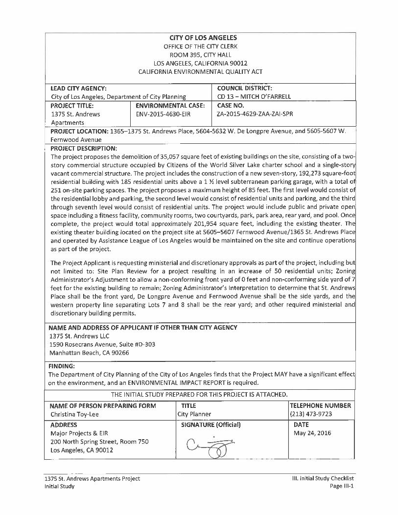
1375St.AndrewsApartmentsProjectCaseNo.ENV-2015-4630-EIRZA-2015-4629-ZAA-ZAI-SPR
CouncilDistrictNo.13
ProjectAddress:
1365–1375St.AndrewsPlace,5604-32WDeLongpreAvenue,and5605-5607W.FernwoodAvenue,LosAngeles,CA90028
ProjectDescription:Theprojectproposesthedemolitionof35,057squarefeetofexistingbuildingsonthesite,consistingofatwo-story commercial structure occupied by Citizens of theWorld Silver Lake charter school and a single-storyvacantcommercialstructure.Theprojectincludestheconstructionofanewseven-story,192,273square-footresidentialbuildingwith185residentialunitsabovea1½levelsubterraneanparkinggarage,withatotalof251on-siteparkingspaces.Theprojectproposesamaximumheightof85feet.Thefirstlevelwouldconsistoftheresidential lobby andparking, the second levelwould consist of residential units andparking, and the thirdthrough seventh levelwould consist of residential units. The projectwould include public and private openspaceincludingafitnessfacility,communityrooms,twocourtyards,park,parkarea,rearyard,andpool.Oncecomplete, the project would total approximately 201,954 square feet, including the existing theater. Theexistingtheaterbuilding locatedontheprojectsiteat5605–5607FernwoodAvenue/1365St.AndrewsPlaceandoperatedbyAssistanceLeagueofLosAngeleswouldbemaintainedonthesiteandcontinueoperationsaspartof theproject.Theprojectwouldrequirevariousapprovals,andtheProjectApplicant is requestingSitePlan Review; Zoning Administrator’s Adjustment to allow a non-conforming front yard of 0 feet and non-conforming side yard of 7 feet for the existing building to remain; Zoning Administrator’s Interpretation todeterminethatSt.AndrewsPlaceshallbethefrontyard,DeLongpreAvenueandFernwoodAvenueshallbethesideyards,andthewesternpropertylineseparatingLots7and8shallbetherearyard;andotherrequiredministerialanddiscretionarybuildingpermits.
APPLICANT:1375St.AndrewsLLC
PREPAREDBY:
EcoTierraConsulting,Inc.
May2016

1375 St. Andrews Apartments Project Table of Contents Initial Study Page i
TABLE OF CONTENTS
Page
I. INTRODUCTION ......................................................................................................................... I‐1
II. PROJECT DESCRIPTION ............................................................................................................ II‐1
III. INITIAL STUDY CHECKLIST ..................................................................................................... III‐1
IV. ENVIRONMENTAL IMPACT ANALYSIS ................................................................................... IV‐1
1. Aesthetics ................................................................................................................ IV‐1
2. Agriculture and Forestry Resources ........................................................................ IV‐4
3. Air Quality ............................................................................................................... IV‐7
4. Biological Resources .............................................................................................. IV‐10
5. Cultural Resources ................................................................................................ IV‐13
6. Geology and Soils .................................................................................................. IV‐15
7. Greenhouse Gas Emissions ................................................................................... IV‐19
8. Hazards and Hazardous Materials ........................................................................ IV‐21
9. Hydrology and Water Quality ............................................................................... IV‐24
10. Land Use and Planning .......................................................................................... IV‐31
11. Mineral Resources ................................................................................................ IV‐33
12. Noise ..................................................................................................................... IV‐34
13. Population and Housing ........................................................................................ IV‐37
14. Public Services ....................................................................................................... IV‐38
15. Recreation ............................................................................................................. IV‐41
16. Transportation and Traffic .................................................................................... IV‐41
17. Utilities and Service Systems ................................................................................ IV‐43
18. Mandatory Findings of Significance ...................................................................... IV‐48
V. PREPARERS .............................................................................................................................. V‐1
VI. ACRONYMS AND ABBREVIATIONS ........................................................................................ VI‐1
PRELIMINARY WORKING DRAFT City of Los Angeles April 2016
1375 St. Andrews Apartments Project Table of Contents Initial Study Page ii
List of Figures
Page
Figure II‐1: Regional Vicinity and Project Location ...................................................................... II‐3
Figure II‐2: Aerial View of the Project Site and Vicinity ............................................................... II‐4
Figure II‐3: Photos of Surrounding Land Uses, Views 1, 2, and 3 ................................................ II‐5
Figure II‐4: Photos of Surrounding Land Uses, Views 4, 5, and 6 ................................................ II‐6
Figure II‐5: Photos of Existing Land Uses, Views 7, 8, and 9 ........................................................ II‐7
Figure II‐6: Photos of Existing Land Uses, Views 10, 11, and 12 .................................................. II‐8
Figure II‐7: Conceptual Site Plan ................................................................................................ II‐12
Figure II‐8: Basement Conceptual Plan ...................................................................................... II‐13
Figure II‐9: First Floor Conceptual Site Plan ............................................................................... II‐14
Figure II‐10: Second Floor Conceptual Site Plan ........................................................................ II‐15
Figure II‐11: Third Floor Conceptual Site Plan ........................................................................... II‐16
Figure II‐12: Fourth Floor Conceptual Site Plan ......................................................................... II‐17
Figure II‐13: Fifth Floor Conceptual Site Plan ............................................................................ II‐18
Figure II‐14: Sixth Floor Conceptual Site Plan ............................................................................ II‐19
Figure II‐15: Seventh Floor Conceptual Site Plan ....................................................................... II‐20
Figure II‐16: Landscaping Plan ................................................................................................... II‐21
Figure II‐17: Residential Building Perspective ........................................................................... II‐22
Figure II‐18: Residential Building Elevations .............................................................................. II‐23
Figure II‐19: Residential Building Cross‐Sections ....................................................................... II‐24
List of Tables
Page
Table II‐1: Existing Land Uses ....................................................................................................... II‐9
Table II‐2: Project Development Summary ................................................................................ II‐10

1375 St. Andrews Apartments Project I. Introduction Initial Study Page I‐1
I. INTRODUCTION
The subject of this Initial Study is the proposed 1375 St. Andrews Apartments Project. The project
proposes the demolition of 35,057 square feet of existing buildings on the site, consisting of a two‐story
commercial structure occupied by Citizens of the World Silver Lake charter school and a single‐story
vacant commercial structure. The project includes the construction of a new seven‐story, 192,273
square‐foot residential building with 185 residential units above a 1 ½ level subterranean parking
garage, with a total of 251 on‐site parking spaces. The project proposes a maximum height of 85 feet.
The first level would consist of the residential lobby and parking, the second level would consist of
residential units and parking, and the third through seventh level would consist of residential units. The
project would include public and private open space including a fitness facility, community rooms, two
courtyards, park, park area, rear yard, and pool. Once complete, the project would total approximately
201,954 square feet, including the existing theater. The existing theater building located on the project
site at 5605–5607 Fernwood Avenue/1365 St. Andrews Place and operated by Assistance League of Los
Angeles would be maintained on the site and continue operations as part of the project.
The project is located within the Hollywood Community Plan Area of the City of Los Angeles. The City of
Los Angeles Department of City Planning is the Lead Agency under the California Environmental Quality
Act (CEQA).
PROJECT INFORMATION
Project Title: 1375 St. Andrews Apartments Project
Project Location: 1365–1375 St. Andrews Place, 5604‐5632 W. De Longpre Avenue, and 5605‐5607 W.
Fernwood Avenue
Los Angeles, CA 90028
Project Applicant: 1375 St. Andrews LLC
1590 Rosecrans Avenue, Suite #D‐303
Manhattan Beach, CA 90266
Lead Agency: City of Los Angeles Department of City Planning
200 N. Spring St., Room 750
Los Angeles, CA 90012
ORGANIZATION OF INITIAL STUDY
This Initial Study is organized into four primary sections as follows:
Introduction: This section provides introductory information such as the project title, the project
applicant and the lead agency for the project.

PRELIMINARY WORKING DRAFT City of Los Angeles May 2016
1375 St. Andrews Apartments Project I. Introduction Initial Study Page I‐2
Project Description: This section provides a description of the environmental setting and the project,
including project characteristics and environmental review requirements.
Initial Study Checklist: This section contains the completed City of Los Angeles Initial Study Checklist.
Environmental Impact Analysis: Each environmental issue identified in the Initial Study Checklist
contains an assessment and discussion of impacts associated with each subject area. When the
evaluation identifies potentially significant effects, as identified in the Initial Study Checklist, mitigation
measures are provided to reduce such impacts to less than significant levels.

1375 St. Andrews Apartments Project II. Project Description Initial Study Page II‐1
II. PROJECT DESCRIPTION
1. PROJECT APPLICANT
The Applicant for the 1375 St. Andrews Apartments Project (the “project”) is 1375 St. Andrews LLC (the “Applicant”). The project is located at 1365–1375 St. Andrews Place, 5604‐3562 W. De Longpre Avenue, and W. 5605‐5607 Fernwood Avenue in Hollywood, 90028 (the “project site”).
2. PROJECT LOCATION
A. Project Site
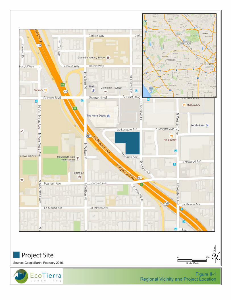
The project site consists of an L shaped lot comprising approximately 1.7 acres at the southwest corner of the intersection of St. Andrews Place and W. De Longpre Avenue in Hollywood. The project site fronts approximately 330 feet along the west side of St. Andrews Place, 350 feet along the south side of De Longpre Avenue, and 100 feet along the north side of Fernwood Avenue (see Figure II‐1, Regional Vicinity and Project Location). The project site is composed of two parcels, seven legal lots along De Longpre Avenue and to two legal lots fronting on Fernwood Avenue. The nine (9) parcels are legally described as Lots 1 through 7, 29, and 30, Block 3, of the Lemona Tract and include Assessor Parcel Numbers 554‐403‐0052 and 554‐403‐0059.
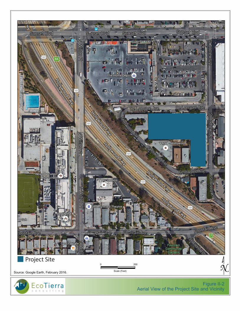
The project site is relatively flat and is currently occupied by a charter school with a pool and concrete sports areas, a vacant building and asphalt play areas formerly used as a child care center, and an operating theater (see Figure II‐2, Aerial View of Project Site and Vicinity). These existing buildings total approximately 44,738 square feet of floor area.
B. Surrounding Land Uses
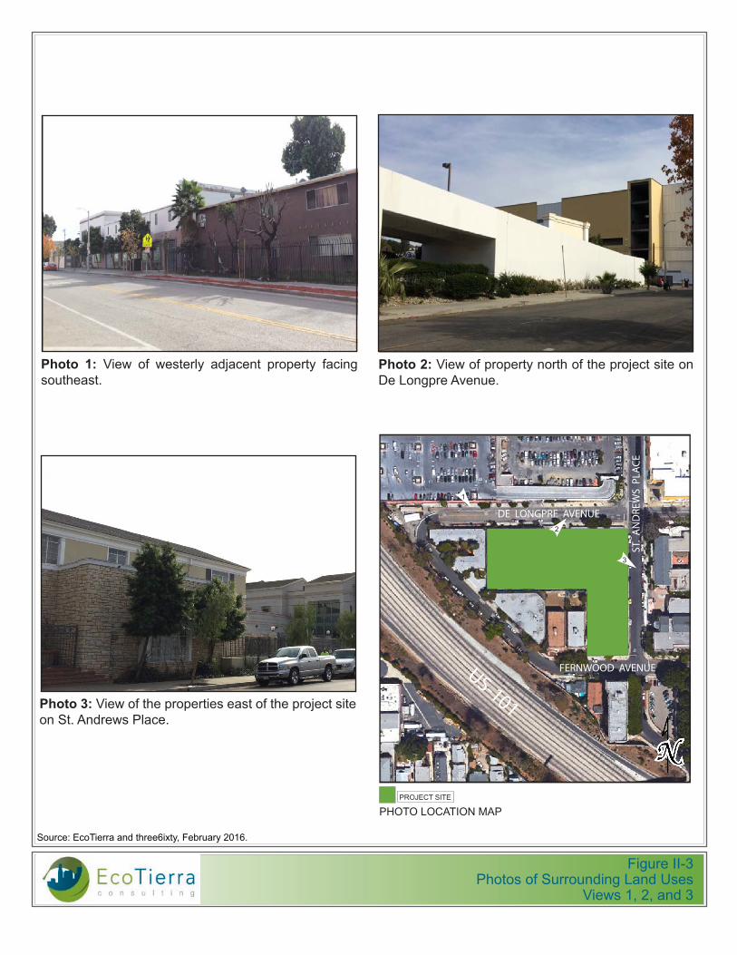
The land uses proximate to the project site are characterized by a mix of low‐ to high‐intensity commercial, institutional, and residential uses, which vary widely in building style and period of construction. Nearby vicinity land uses include the Hollywood Freeway (US‐101) to the west, a Home Depot to the north, a partially completed Target building to the northeast, buildings that previously housed the Assistance League of Los Angeles and are now vacant to the east, and multi‐family residential development to the south.
Surface parking for the Home Depot is located directly north of the project site, across De Longpre Avenue. The partially completed Target is located directly northeast of the project site at the intersection of De Longpre Avenue and St. Andrews Place. Two‐story buildings that previously housed the Assistance League of Los Angeles are located to the east, across St. Andrews Place. Two multi‐family residential buildings and a single‐family residence are located directly south of the project site, across Fernwood Avenue. A surface parking lot used by the Children’s Theater is located on the southeast corner of the intersection of St. Andrews Place and Fernwood Avenue. Figures II‐3 and II‐4, Photos of Surrounding Land Uses, show key surrounding land uses in the general vicinity of the project site.
The general area surrounding the project site is relatively flat and is developed with a variety of commercial land uses, including retail and hotel uses along Sunset Boulevard, with surface parking areas and structures. The western edge of the project site is located approximately 90 feet from US‐101. The project site is located to the southeast of the KTLA Studios and Helen Bernstein High School along Sunset Boulevard.
PRELIMINARY WORKING DRAFT City of Los Angeles May 2016
1375 St. Andrews Apartments Project II. Project Description Initial Study Page II‐2
Los Angeles County Metropolitan Transportation Authority (“Metro”) buses run along Sunset Boulevard and Western Avenue. The project is well served by nearby transit including the Metro Red Line (Hollywood/Western Station), Hollywood Dash Lines 2/302, Metro Rapid Lines 757 and 780, and Metro Local Lines 207, 217, 206, 180, and 181.1 The nearest Metro rail line station (Hollywood/Western) is located at Hollywood Boulevard and Western Avenue, which is approximately one‐half mile northeast of the project site.
Commercial amenities in the project area include the nearby Home Depot, coffee shops, restaurants, and retail uses along Sunset Boulevard, a grocery store along De Longpre Avenue west of Western Avenue.
C. Land Use Plans and Zoning
The project site is located in the Hollywood Community Plan Area, the Hollywood Redevelopment Project Area, and is zoned as R4‐2 (Multiple Dwelling Zone‐Unlimited Height District). The zone permits a 6:1 Floor Area Ratio (FAR). However, the FAR on the project site is limited to a maximum of 4.5:1 by the Hollywood Community Plan.
The project site is designated as High Density Residential in the Hollywood Community Plan. The project is located within a Los Angeles State Enterprise Zone. The project site is located near, but not within, the Vermont‐Western Transit Oriented District Station Neighborhood Area Plan (SNAP). The project site is located within a City of Los Angeles Transit Priority Area (TPA).
3. EXISTING LAND USES
The project site is currently developed with a two story commercial structure leased to the charter school Citizens of the World Silver Lake (CWSL), a vacant single‐story commercial structure, and a children’s playhouse/theater building operated under a long‐term lease by Assistance League of Los Angeles. The children’s playhouse/theater building would be retained as part of the project. CWSL plans to vacate the premises at the close of the 2015/2016 school year, and will be relocating to another facility for the 2016/2017 school year. Once the CWSL relocates, the building will be vacant and remain vacant until commencement of the project.
Existing land uses within the project site include three buildings totaling approximately 44,738 square feet of floor area, a pool, and concrete and asphalt outdoor areas. There are eight (8) lemon and other unprotected tree types on the project site. The existing land uses are summarized in Table II‐1, Existing Land Uses. Photos of the existing land uses on the project site are presented in Figures II‐5 and II‐6, Photos of Existing Land Uses.
1 Metro Bus and Rail System Map, accessed at http://media.metro.net/riding_metro/maps/images/system_map.pdf.
Source: GoogleEarth, February 2016.
Figure II-1Regional Vicinity and Project Location
Project Site
PROJECT SITE
Scale (Feet)
0 400
Source: Google Earth, February 2016.
Figure II-2Aerial View of the Project Site and Vicinity
Project Site
Scale (Feet)
0 200
56
04
– 5
63
2 W
. D
E L
ON
GP
RE
AV
EN
UE
, LO
S A
NG
EL
ES
, C
AL
IFO
RN
IA 9
00
28
S
ITE
PH
OT
OG
RA
PH
IC S
UR
VE
Y
DE
CE
MB
ER
21,
20
15 |
P
AG
E 1
OF
2
!"#$%$&$'()$!"#$*$ !"#$+$&$,(-."/$0.(1$23$4567(89$#-2#(-9)$":;$(:0.-2:4$
2!
<.=5-($%$&$>.(1$23$?567(89$@-2#(-9)$3-2A$B($C2:=#-($,0(:5($3"8.:=$4259D$ <.=5-($E$&$>.(1$23$?567(89$@-2#(-9)$3-2A$B($C2:=#-($,0(:5($3"8.:=$4259D1(49$<.=5-($+$&$>.(1$23$?567(89$@-2#(-9)$3-2A$B($C2:=#-($,0(:5($3"8.:=$4259D1(49$
<.=5-($F$&$>.(1$23$?567(89$@-2#(-9)$3-2A$B($C2:=#-($,0(:5($3"8.:=$4259D1(49$
G$
&$*:;.8"9(4$/28"H2:$23$#D292$#!
ST. A
ND
RE
WS
PL
AC
E
%IJE$
<.=5-($K$&$>.(1$23$?567(89$@-2#(-9)$3-2A$B($C2:=#-($,0(:5($3"8.:=$4259D1(49$ <.=5-($L$&$>.(1$23$1(49(-/)$";7"8(:9$#-2#(-9)$3"8.:=$4259D("49$
6!
SUBJECT PROPERTY
DE LONGPRE AVENUE
FERNWOOD AVENUE
G$
ST. A
ND
RE
WS
PL
AC
E
SUBJECT PROPERTY
DE LONGPRE AVENUE
FERNWOOD AVENUE
!"#$E$&$MN.-;4()(O$0.(1$23$?567(89$@-2#(-9)$":;$(:0.-2:4P$3"8.:=$4259D$
G$
SUBJECT PROPERTY
1 2 3
4 5 6
1!
3!4!5!
Figure II-3Photos of Surrounding Land Uses
Views 1, 2, and 3
560
4 –
56
32 W
. DE
LO
NG
PR
E A
VE
NU
E, L
OS
AN
GE
LES
, CA
LIF
OR
NIA
90
028
S
ITE
PH
OTO
GR
AP
HIC
SU
RV
EY
D
EC
EM
BE
R 2
1, 2
015
|
PA
GE
2 O
F 2
!"#$%$&$'()$!"#$**$
G$
&$*:;.8"9(4$/28"H2:$23$#D292$#!
ST. AN
DR
EW
S P
LAC
E
SUBJECT PROPERTY
DE LONGPRE AVENUE
FERNWOOD AVENUE
F$
9
7
<.=5-($%E$&$>.(1$23$#-2#(-H(4$("49$23$?567(89$@-2#(-9)$2:$?9Q$,:;-(14$@/"8($
<.=5-($%+$&$>.(1$23$#-2#(-9)$:2-9D$23$?567(89$@-2#(-9)$2:$B($C2:=#-($,0(:5($
<.=5-($%F$&$>.(1$23$#-2#(-9)$4259D$23$?567(89$@-2#(-9)$2:$<(-:122;$,0(:5($
8
9 10 11
12 13 15 14
<.=5-($R$&$>.(1$23$(S.4H:=$9D("9-($92$-(A".:$":;$4259D1(49(-/)$";7"8(:9$#-2#(-9)$3-2A$<(-:122;$,0(:5(P$3"8.:=$:2-9D1(49$
<.=5-($I$&$>.(1$23$(S.4H:=$9D("9-($92$-(A".:$3-2A$<(-:122;$,0(:5(P$3"8.:=$:2-9D("49$
<.=5-($T$&$>.(1$23$(S.4H:=$9D("9-($92$-(A".:$3-2A$?9Q$,:;-(14$@/"8(P$3"8.:=$1(49$ <.=5-($%J$&$>.(1$23$(S.4H:=$9D("9-($92$-(A".:$3-2A$?9Q$,:;-(14$@/"8(P$3"8.:=$1(49$ <.=5-($%%$&$>.(1$23$?567(89$@-2#(-9)$92$-(A".:$3-2A$?9Q$,:;-(14$@/P$3"8.:=$1(49$
<.=5-($%K$&$>.(1$23$#-2#(-9)$4259D("49$23$?567(89$@-2#(-9)$":;$?9Q$,:;-(14$@/"8($":;$<(-:122;$,0(:5($
8 7
10
11
12
13
14 15
56
04
– 5
63
2 W
. D
E L
ON
GP
RE
AV
EN
UE
, LO
S A
NG
EL
ES
, C
AL
IFO
RN
IA 9
00
28
S
ITE
PH
OT
OG
RA
PH
IC S
UR
VE
Y
DE
CE
MB
ER
21,
20
15 |
P
AG
E 2
OF
2
!"#$%$&$'()$!"#$**$
G$
&$*:;.8"9(4$/28"H2:$23$#D292$#!
ST. A
ND
RE
WS
PL
AC
E
SUBJECT PROPERTY
DE LONGPRE AVENUE
FERNWOOD AVENUE
F$
9
7
<.=5-($%E$&$>.(1$23$#-2#(-H(4$("49$23$?567(89$@-2#(-9)$2:$?9Q$,:;-(14$@/"8($
<.=5-($%+$&$>.(1$23$#-2#(-9)$:2-9D$23$?567(89$@-2#(-9)$2:$B($C2:=#-($,0(:5($
<.=5-($%F$&$>.(1$23$#-2#(-9)$4259D$23$?567(89$@-2#(-9)$2:$<(-:122;$,0(:5($
8
9 10 11
12 13 15 14
<.=5-($R$&$>.(1$23$(S.4H:=$9D("9-($92$-(A".:$":;$4259D1(49(-/)$";7"8(:9$#-2#(-9)$3-2A$<(-:122;$,0(:5(P$3"8.:=$:2-9D1(49$
<.=5-($I$&$>.(1$23$(S.4H:=$9D("9-($92$-(A".:$3-2A$<(-:122;$,0(:5(P$3"8.:=$:2-9D("49$
<.=5-($T$&$>.(1$23$(S.4H:=$9D("9-($92$-(A".:$3-2A$?9Q$,:;-(14$@/"8(P$3"8.:=$1(49$ <.=5-($%J$&$>.(1$23$(S.4H:=$9D("9-($92$-(A".:$3-2A$?9Q$,:;-(14$@/"8(P$3"8.:=$1(49$ <.=5-($%%$&$>.(1$23$?567(89$@-2#(-9)$92$-(A".:$3-2A$?9Q$,:;-(14$@/P$3"8.:=$1(49$
<.=5-($%K$&$>.(1$23$#-2#(-9)$4259D("49$23$?567(89$@-2#(-9)$":;$?9Q$,:;-(14$@/"8($":;$<(-:122;$,0(:5($
8 7
10
11
12
13
14 15
Photo 1: View of westerly adjacent property facing southeast.
Photo 2: View of property north of the project site on De Longpre Avenue.
PHOTO LOCATION MAPPROJECT SITE
ST.
AN
DRE
WS
PLA
CE
DE LONGPRE AVENUE
1
Photo 3: View of the properties east of the project site on St. Andrews Place.
FERNWOOD AVENUEUS-101
2
3
Source: EcoTierra and three6ixty, February 2016.

Figure II-4Photos of Surrounding Land Uses
Views 4, 5, and 6
56
04
– 5
63
2 W
. D
E L
ON
GP
RE
AV
EN
UE
, LO
S A
NG
EL
ES
, C
AL
IFO
RN
IA 9
00
28
S
ITE
PH
OT
OG
RA
PH
IC S
UR
VE
Y
DE
CE
MB
ER
21,
20
15 |
P
AG
E 2
OF
2
!"#$%$&$'()$!"#$**$
G$
&$*:;.8"9(4$/28"H2:$23$#D292$#!
ST. A
ND
RE
WS
PL
AC
E
SUBJECT PROPERTY
DE LONGPRE AVENUE
FERNWOOD AVENUE
F$
9
7
<.=5-($%E$&$>.(1$23$#-2#(-H(4$("49$23$?567(89$@-2#(-9)$2:$?9Q$,:;-(14$@/"8($
<.=5-($%+$&$>.(1$23$#-2#(-9)$:2-9D$23$?567(89$@-2#(-9)$2:$B($C2:=#-($,0(:5($
<.=5-($%F$&$>.(1$23$#-2#(-9)$4259D$23$?567(89$@-2#(-9)$2:$<(-:122;$,0(:5($
8
9 10 11
12 13 15 14
<.=5-($R$&$>.(1$23$(S.4H:=$9D("9-($92$-(A".:$":;$4259D1(49(-/)$";7"8(:9$#-2#(-9)$3-2A$<(-:122;$,0(:5(P$3"8.:=$:2-9D1(49$
<.=5-($I$&$>.(1$23$(S.4H:=$9D("9-($92$-(A".:$3-2A$<(-:122;$,0(:5(P$3"8.:=$:2-9D("49$
<.=5-($T$&$>.(1$23$(S.4H:=$9D("9-($92$-(A".:$3-2A$?9Q$,:;-(14$@/"8(P$3"8.:=$1(49$ <.=5-($%J$&$>.(1$23$(S.4H:=$9D("9-($92$-(A".:$3-2A$?9Q$,:;-(14$@/"8(P$3"8.:=$1(49$ <.=5-($%%$&$>.(1$23$?567(89$@-2#(-9)$92$-(A".:$3-2A$?9Q$,:;-(14$@/P$3"8.:=$1(49$
<.=5-($%K$&$>.(1$23$#-2#(-9)$4259D("49$23$?567(89$@-2#(-9)$":;$?9Q$,:;-(14$@/"8($":;$<(-:122;$,0(:5($
8 7
10
11
12
13
14 15
560
4 –
56
32 W
. DE
LO
NG
PR
E A
VE
NU
E, L
OS
AN
GE
LES,
CA
LIF
OR
NIA
90
028
SI
TE
PH
OTO
GR
AP
HIC
SU
RV
EY
D
EC
EM
BE
R 2
1, 2
015
|
PA
GE
2 O
F 2
!"#$%$&$'()$!"#$**$
G$
&$*:;.8"9(4$/28"H2:$23$#D292$#!
ST. AN
DR
EW
S PLA
CE
SUBJECT PROPERTY
DE LONGPRE AVENUE
FERNWOOD AVENUE
F$
9
7
<.=5-($%E$&$>.(1$23$#-2#(-H(4$("49$23$?567(89$@-2#(-9)$2:$?9Q$,:;-(14$@/"8($
<.=5-($%+$&$>.(1$23$#-2#(-9)$:2-9D$23$?567(89$@-2#(-9)$2:$B($C2:=#-($,0(:5($
<.=5-($%F$&$>.(1$23$#-2#(-9)$4259D$23$?567(89$@-2#(-9)$2:$<(-:122;$,0(:5($
8
9 10 11
12 13 15 14
<.=5-($R$&$>.(1$23$(S.4H:=$9D("9-($92$-(A".:$":;$4259D1(49(-/)$";7"8(:9$#-2#(-9)$3-2A$<(-:122;$,0(:5(P$3"8.:=$:2-9D1(49$
<.=5-($I$&$>.(1$23$(S.4H:=$9D("9-($92$-(A".:$3-2A$<(-:122;$,0(:5(P$3"8.:=$:2-9D("49$
<.=5-($T$&$>.(1$23$(S.4H:=$9D("9-($92$-(A".:$3-2A$?9Q$,:;-(14$@/"8(P$3"8.:=$1(49$ <.=5-($%J$&$>.(1$23$(S.4H:=$9D("9-($92$-(A".:$3-2A$?9Q$,:;-(14$@/"8(P$3"8.:=$1(49$ <.=5-($%%$&$>.(1$23$?567(89$@-2#(-9)$92$-(A".:$3-2A$?9Q$,:;-(14$@/P$3"8.:=$1(49$
<.=5-($%K$&$>.(1$23$#-2#(-9)$4259D("49$23$?567(89$@-2#(-9)$":;$?9Q$,:;-(14$@/"8($":;$<(-:122;$,0(:5($
8 7
10
11
12
13
14 15
Photo 4: View of property southeast of the project site and St. Andrews Place and Fernwood Avenue.
Photo 5: View of property south of the project site onFernwood Avenue.
PHOTO LOCATION MAPPROJECT SITE
ST.
AN
DRE
WS
PLA
CE
DE LONGPRE AVENUE
Photo 6: View of existing theatre to remain and south-westerly adjacent property from Fernwood Avenue, facing northwest.
FERNWOOD AVENUEUS-101
5
6
4
Source: EcoTierra and three6ixty, February 2016.

Figure II-5Photos of Existing Land Uses
Views 7, 8, and 9
56
04
– 5
63
2 W
. D
E L
ON
GP
RE
AV
EN
UE
, LO
S A
NG
EL
ES
, C
AL
IFO
RN
IA 9
00
28
S
ITE
PH
OT
OG
RA
PH
IC S
UR
VE
Y
DE
CE
MB
ER
21,
20
15
|
PA
GE
1 O
F 2
!"#$%$&$'()$!"#$*$ !"#$+$&$,(-."/$0.(1$23$4567(89$#-2#(-9)$":;$(:0.-2:4$
2!
<.=5-($%$&$>.(1$23$?567(89$@-2#(-9)$3-2A$B($C2:=#-($,0(:5($3"8.:=$4259D$ <.=5-($E$&$>.(1$23$?567(89$@-2#(-9)$3-2A$B($C2:=#-($,0(:5($3"8.:=$4259D1(49$<.=5-($+$&$>.(1$23$?567(89$@-2#(-9)$3-2A$B($C2:=#-($,0(:5($3"8.:=$4259D1(49$
<.=5-($F$&$>.(1$23$?567(89$@-2#(-9)$3-2A$B($C2:=#-($,0(:5($3"8.:=$4259D1(49$
G$
&$*:;.8"9(4$/28"H2:$23$#D292$#!
ST. A
ND
RE
WS
PL
AC
E
%IJE$
<.=5-($K$&$>.(1$23$?567(89$@-2#(-9)$3-2A$B($C2:=#-($,0(:5($3"8.:=$4259D1(49$ <.=5-($L$&$>.(1$23$1(49(-/)$";7"8(:9$#-2#(-9)$3"8.:=$4259D("49$
6!
SUBJECT PROPERTY
DE LONGPRE AVENUE
FERNWOOD AVENUE
G$
ST. A
ND
RE
WS
PL
AC
E
SUBJECT PROPERTY
DE LONGPRE AVENUE
FERNWOOD AVENUE
!"#$E$&$MN.-;4()(O$0.(1$23$?567(89$@-2#(-9)$":;$(:0.-2:4P$3"8.:=$4259D$
G$
SUBJECT PROPERTY
1 2 3
4 5 6
1!
3!4!5!
56
04
– 5
63
2 W
. D
E L
ON
GP
RE
AV
EN
UE
, LO
S A
NG
EL
ES
, C
AL
IFO
RN
IA 9
00
28
S
ITE
PH
OT
OG
RA
PH
IC S
UR
VE
Y
DE
CE
MB
ER
21,
20
15 |
P
AG
E 1
OF
2
!"#$%$&$'()$!"#$*$ !"#$+$&$,(-."/$0.(1$23$4567(89$#-2#(-9)$":;$(:0.-2:4$
2!
<.=5-($%$&$>.(1$23$?567(89$@-2#(-9)$3-2A$B($C2:=#-($,0(:5($3"8.:=$4259D$ <.=5-($E$&$>.(1$23$?567(89$@-2#(-9)$3-2A$B($C2:=#-($,0(:5($3"8.:=$4259D1(49$<.=5-($+$&$>.(1$23$?567(89$@-2#(-9)$3-2A$B($C2:=#-($,0(:5($3"8.:=$4259D1(49$
<.=5-($F$&$>.(1$23$?567(89$@-2#(-9)$3-2A$B($C2:=#-($,0(:5($3"8.:=$4259D1(49$
G$
&$*:;.8"9(4$/28"H2:$23$#D292$#!
ST. A
ND
RE
WS
PL
AC
E
%IJE$
<.=5-($K$&$>.(1$23$?567(89$@-2#(-9)$3-2A$B($C2:=#-($,0(:5($3"8.:=$4259D1(49$ <.=5-($L$&$>.(1$23$1(49(-/)$";7"8(:9$#-2#(-9)$3"8.:=$4259D("49$
6!
SUBJECT PROPERTY
DE LONGPRE AVENUE
FERNWOOD AVENUE
G$
ST. A
ND
RE
WS
PL
AC
E
SUBJECT PROPERTY
DE LONGPRE AVENUE
FERNWOOD AVENUE
!"#$E$&$MN.-;4()(O$0.(1$23$?567(89$@-2#(-9)$":;$(:0.-2:4P$3"8.:=$4259D$
G$
SUBJECT PROPERTY
1 2 3
4 5 6
1!
3!4!5!
56
04
– 5
63
2 W
. D
E L
ON
GP
RE
AV
EN
UE
, LO
S A
NG
EL
ES
, C
AL
IFO
RN
IA 9
00
28
S
ITE
PH
OT
OG
RA
PH
IC S
UR
VE
Y
DE
CE
MB
ER
21,
20
15
|
PA
GE
1 O
F 2
!"#$%$&$'()$!"#$*$ !"#$+$&$,(-."/$0.(1$23$4567(89$#-2#(-9)$":;$(:0.-2:4$
2!
<.=5-($%$&$>.(1$23$?567(89$@-2#(-9)$3-2A$B($C2:=#-($,0(:5($3"8.:=$4259D$ <.=5-($E$&$>.(1$23$?567(89$@-2#(-9)$3-2A$B($C2:=#-($,0(:5($3"8.:=$4259D1(49$<.=5-($+$&$>.(1$23$?567(89$@-2#(-9)$3-2A$B($C2:=#-($,0(:5($3"8.:=$4259D1(49$
<.=5-($F$&$>.(1$23$?567(89$@-2#(-9)$3-2A$B($C2:=#-($,0(:5($3"8.:=$4259D1(49$
G$
&$*:;.8"9(4$/28"H2:$23$#D292$#!
ST. A
ND
RE
WS
PL
AC
E
%IJE$
<.=5-($K$&$>.(1$23$?567(89$@-2#(-9)$3-2A$B($C2:=#-($,0(:5($3"8.:=$4259D1(49$ <.=5-($L$&$>.(1$23$1(49(-/)$";7"8(:9$#-2#(-9)$3"8.:=$4259D("49$
6!
SUBJECT PROPERTY
DE LONGPRE AVENUE
FERNWOOD AVENUE
G$
ST. A
ND
RE
WS
PL
AC
E
SUBJECT PROPERTY
DE LONGPRE AVENUE
FERNWOOD AVENUE
!"#$E$&$MN.-;4()(O$0.(1$23$?567(89$@-2#(-9)$":;$(:0.-2:4P$3"8.:=$4259D$
G$
SUBJECT PROPERTY
1 2 3
4 5 6
1!
3!4!5!
Photo 7: View of project site from De Longpre Avenue facing south.
Photo 8: View of project site from De Longpre Avenue facing southwest.
PHOTO LOCATION MAPPROJECT SITE
ST.
AN
DRE
WS
PLA
CE
DE LONGPRE AVENUE
Photo 9: View of project site from De Longpre Avenue facing southwest.
FERNWOOD AVENUEUS-101
7
9 8
Source: EcoTierra and three6ixty, February 2016.
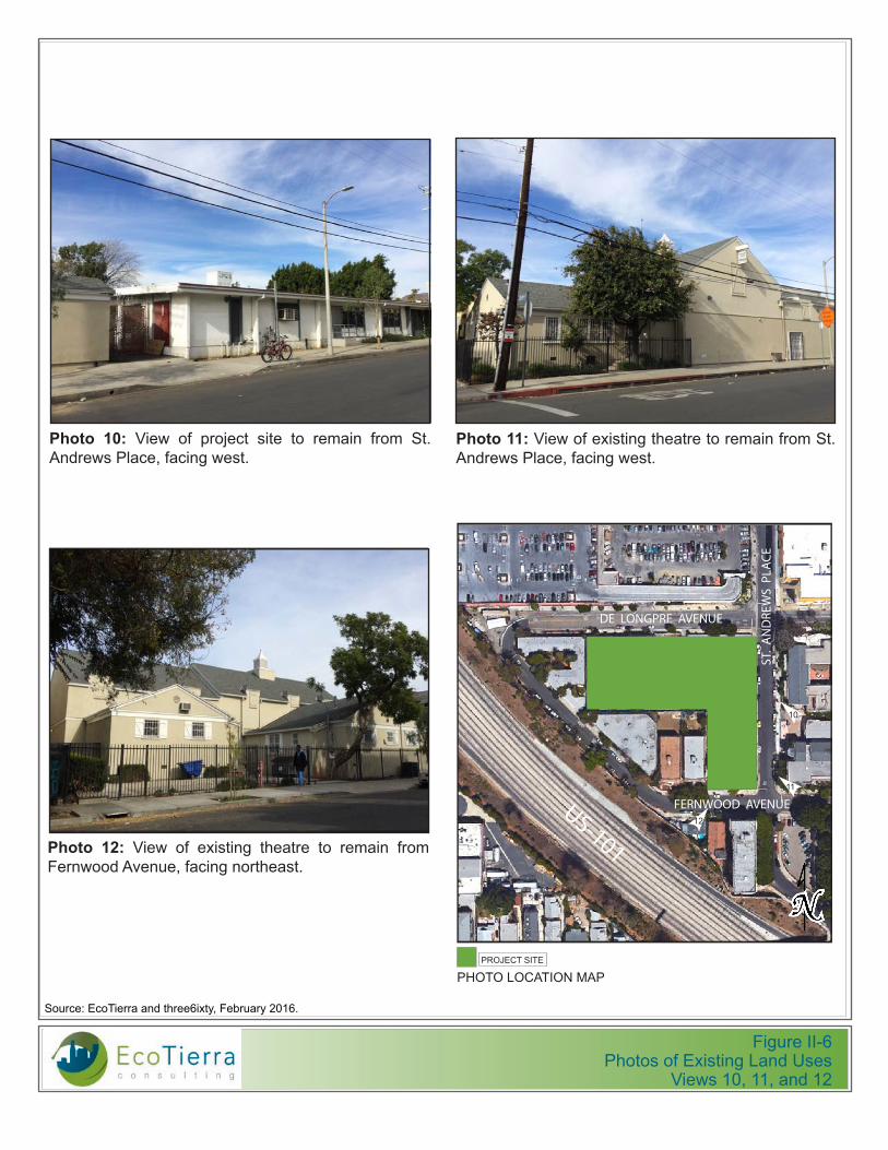
Figure II-6Photos of Existing Land Uses
Views 10, 11, and 12
560
4 –
563
2 W
. DE
LON
GPR
E A
VEN
UE,
LO
S A
NG
ELES
, CA
LIFO
RN
IA 9
00
28
SITE
PH
OTO
GR
APH
IC S
UR
VEY
D
ECEM
BER
21,
2015
|
PA
GE
2 O
F 2
!"#$%$&$'()$!"#$**$
G$
&$*:;.8"9(4$/28"H2:$23$#D292$#!
ST. AN
DR
EWS PLA
CE
SUBJECT PROPERTY
DE LONGPRE AVENUE
FERNWOOD AVENUE
F$
9
7
<.=5-($%E$&$>.(1$23$#-2#(-H(4$("49$23$?567(89$@-2#(-9)$2:$?9Q$,:;-(14$@/"8($
<.=5-($%+$&$>.(1$23$#-2#(-9)$:2-9D$23$?567(89$@-2#(-9)$2:$B($C2:=#-($,0(:5($
<.=5-($%F$&$>.(1$23$#-2#(-9)$4259D$23$?567(89$@-2#(-9)$2:$<(-:122;$,0(:5($
8
9 10 11
12 13 15 14
<.=5-($R$&$>.(1$23$(S.4H:=$9D("9-($92$-(A".:$":;$4259D1(49(-/)$";7"8(:9$#-2#(-9)$3-2A$<(-:122;$,0(:5(P$3"8.:=$:2-9D1(49$
<.=5-($I$&$>.(1$23$(S.4H:=$9D("9-($92$-(A".:$3-2A$<(-:122;$,0(:5(P$3"8.:=$:2-9D("49$
<.=5-($T$&$>.(1$23$(S.4H:=$9D("9-($92$-(A".:$3-2A$?9Q$,:;-(14$@/"8(P$3"8.:=$1(49$ <.=5-($%J$&$>.(1$23$(S.4H:=$9D("9-($92$-(A".:$3-2A$?9Q$,:;-(14$@/"8(P$3"8.:=$1(49$ <.=5-($%%$&$>.(1$23$?567(89$@-2#(-9)$92$-(A".:$3-2A$?9Q$,:;-(14$@/P$3"8.:=$1(49$
<.=5-($%K$&$>.(1$23$#-2#(-9)$4259D("49$23$?567(89$@-2#(-9)$":;$?9Q$,:;-(14$@/"8($":;$<(-:122;$,0(:5($
8 7
10
11
12
13
14 15
560
4 –
56
32 W
. DE
LO
NG
PR
E A
VE
NU
E, L
OS
AN
GE
LES,
CA
LIF
OR
NIA
90
028
SI
TE
PH
OTO
GR
AP
HIC
SU
RV
EY
D
EC
EM
BE
R 2
1, 2
015
|
PA
GE
2 O
F 2
!"#$%$&$'()$!"#$**$
G$
&$*:;.8"9(4$/28"H2:$23$#D292$#!
ST. AN
DR
EW
S PLA
CE
SUBJECT PROPERTY
DE LONGPRE AVENUE
FERNWOOD AVENUE
F$
9
7
<.=5-($%E$&$>.(1$23$#-2#(-H(4$("49$23$?567(89$@-2#(-9)$2:$?9Q$,:;-(14$@/"8($
<.=5-($%+$&$>.(1$23$#-2#(-9)$:2-9D$23$?567(89$@-2#(-9)$2:$B($C2:=#-($,0(:5($
<.=5-($%F$&$>.(1$23$#-2#(-9)$4259D$23$?567(89$@-2#(-9)$2:$<(-:122;$,0(:5($
8
9 10 11
12 13 15 14
<.=5-($R$&$>.(1$23$(S.4H:=$9D("9-($92$-(A".:$":;$4259D1(49(-/)$";7"8(:9$#-2#(-9)$3-2A$<(-:122;$,0(:5(P$3"8.:=$:2-9D1(49$
<.=5-($I$&$>.(1$23$(S.4H:=$9D("9-($92$-(A".:$3-2A$<(-:122;$,0(:5(P$3"8.:=$:2-9D("49$
<.=5-($T$&$>.(1$23$(S.4H:=$9D("9-($92$-(A".:$3-2A$?9Q$,:;-(14$@/"8(P$3"8.:=$1(49$ <.=5-($%J$&$>.(1$23$(S.4H:=$9D("9-($92$-(A".:$3-2A$?9Q$,:;-(14$@/"8(P$3"8.:=$1(49$ <.=5-($%%$&$>.(1$23$?567(89$@-2#(-9)$92$-(A".:$3-2A$?9Q$,:;-(14$@/P$3"8.:=$1(49$
<.=5-($%K$&$>.(1$23$#-2#(-9)$4259D("49$23$?567(89$@-2#(-9)$":;$?9Q$,:;-(14$@/"8($":;$<(-:122;$,0(:5($
8 7
10
11
12
13
14 15
56
04
– 5
63
2 W
. D
E L
ON
GP
RE
AV
EN
UE
, LO
S A
NG
EL
ES
, C
AL
IFO
RN
IA 9
00
28
S
ITE
PH
OT
OG
RA
PH
IC S
UR
VE
Y
DE
CE
MB
ER
21,
20
15 |
P
AG
E 2
OF
2
!"#$%$&$'()$!"#$**$
G$
&$*:;.8"9(4$/28"H2:$23$#D292$#!
ST. A
ND
RE
WS
PL
AC
E
SUBJECT PROPERTY
DE LONGPRE AVENUE
FERNWOOD AVENUE
F$
9
7
<.=5-($%E$&$>.(1$23$#-2#(-H(4$("49$23$?567(89$@-2#(-9)$2:$?9Q$,:;-(14$@/"8($
<.=5-($%+$&$>.(1$23$#-2#(-9)$:2-9D$23$?567(89$@-2#(-9)$2:$B($C2:=#-($,0(:5($
<.=5-($%F$&$>.(1$23$#-2#(-9)$4259D$23$?567(89$@-2#(-9)$2:$<(-:122;$,0(:5($
8
9 10 11
12 13 15 14
<.=5-($R$&$>.(1$23$(S.4H:=$9D("9-($92$-(A".:$":;$4259D1(49(-/)$";7"8(:9$#-2#(-9)$3-2A$<(-:122;$,0(:5(P$3"8.:=$:2-9D1(49$
<.=5-($I$&$>.(1$23$(S.4H:=$9D("9-($92$-(A".:$3-2A$<(-:122;$,0(:5(P$3"8.:=$:2-9D("49$
<.=5-($T$&$>.(1$23$(S.4H:=$9D("9-($92$-(A".:$3-2A$?9Q$,:;-(14$@/"8(P$3"8.:=$1(49$ <.=5-($%J$&$>.(1$23$(S.4H:=$9D("9-($92$-(A".:$3-2A$?9Q$,:;-(14$@/"8(P$3"8.:=$1(49$ <.=5-($%%$&$>.(1$23$?567(89$@-2#(-9)$92$-(A".:$3-2A$?9Q$,:;-(14$@/P$3"8.:=$1(49$
<.=5-($%K$&$>.(1$23$#-2#(-9)$4259D("49$23$?567(89$@-2#(-9)$":;$?9Q$,:;-(14$@/"8($":;$<(-:122;$,0(:5($
8 7
10
11
12
13
14 15
Photo 10: View of project site to remain from St. Andrews Place, facing west.
Photo 11: View of existing theatre to remain from St. Andrews Place, facing west.
PHOTO LOCATION MAPPROJECT SITE
ST.
AN
DRE
WS
PLA
CE
DE LONGPRE AVENUE
Photo 12: View of existing theatre to remain from Fernwood Avenue, facing northeast.
FERNWOOD AVENUEUS-101
10
12
11
Source: EcoTierra and three6ixty, February 2016.

PRELIMINARY WORKING DRAFT City of Los Angeles May 2016
1375 St. Andrews Apartments Project II. Project Description Initial Study Page II‐9
Table II‐1
Existing Land Uses
Building Address Land Use Floor Area
1367, 1375 St. Andrews Place Vacant 10,382
5604‐32 De Longpre Avenue Charter School 24,675
1365 St. Andrews, 5605‐07 Fernwood Avenue Children’s Theater 9,681
Total 44,738 sf
sf = square feet Source: City of Los Angeles ZIMAS, 2015.
4. PROJECT CHARACTERISTICS
The project proposes the demolition of the two story structure occupied by CWSL and the single story vacant commercial structure (35,057 square feet); and the construction of a new 192,273 square‐foot residential building with 185 residential units and 251 on‐site parking spaces. The existing theater building located on the project site at 5605–5607 Fernwood Avenue/1365 St. Andrews Place and operated by Assistance League of Los Angeles would be maintained on the site and continue operations as part of the project pursuant to a long term lease with an initial term that expires in 2030. No changes are proposed to the interior or exterior of the existing theater building. Once completed, the project would total approximately 201,954 square feet, including the existing theater.
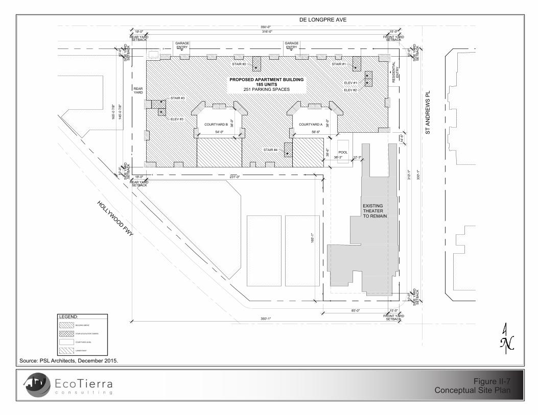
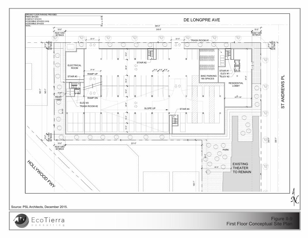
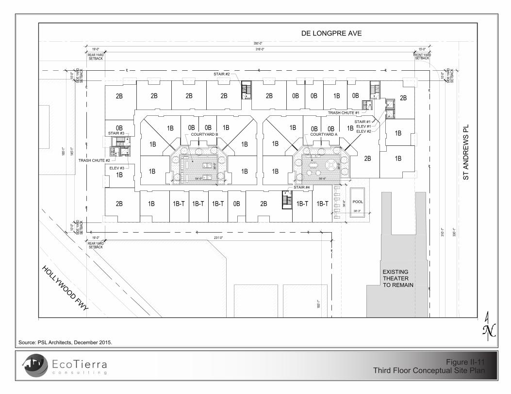
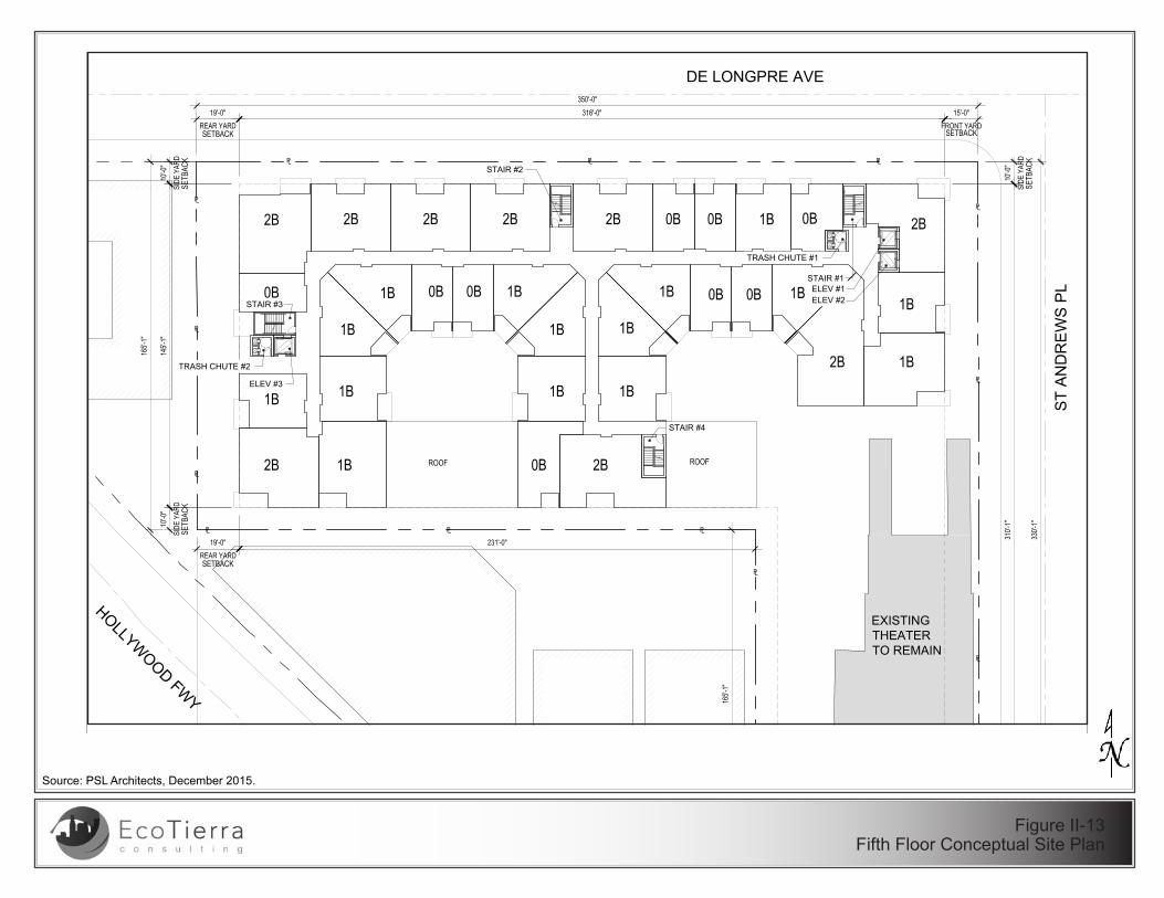
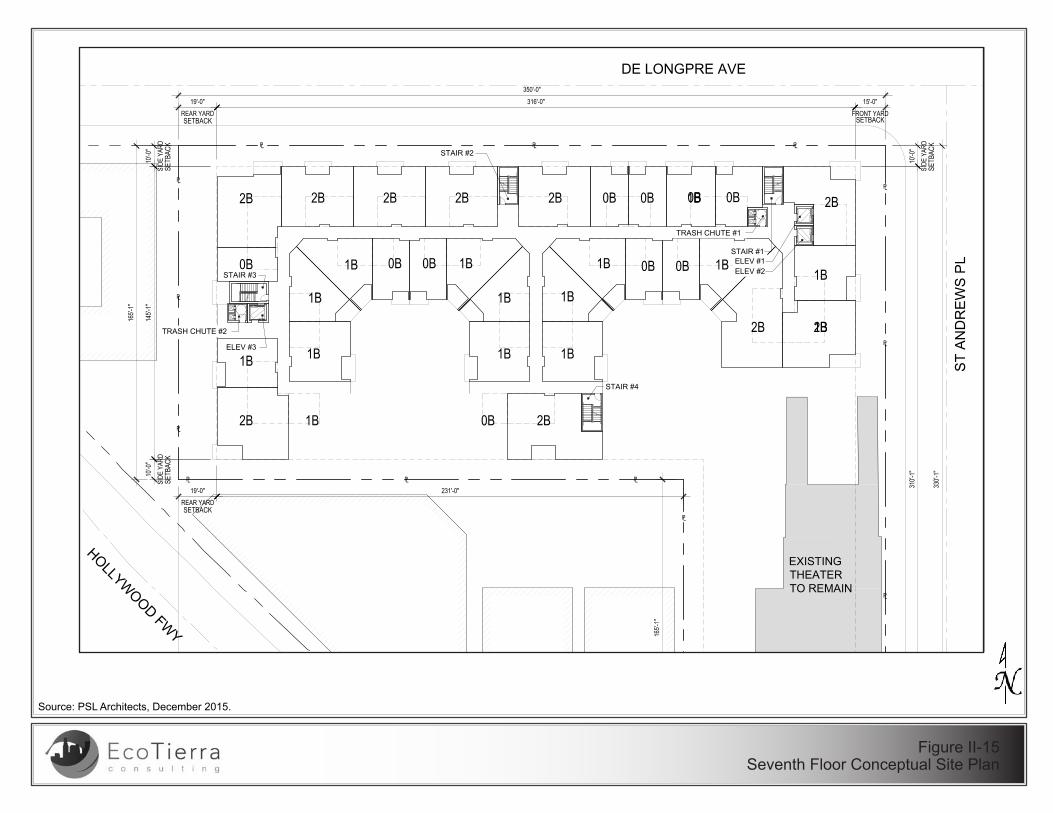
The project proposes the construction of a seven‐story building consisting of 185 apartments units and 251 parking spaces, above a 1 ½ level subterranean parking garage. The first level would consist of the residential lobby and parking, the second level would consist of residential units and parking, and the third through seventh level would consist of residential units. Figure II‐7, Conceptual Site Plan, shows the overall site plan. Conceptual site plans for the subterranean parking garage through seventh story are shown in Figures II‐8 through ‐15.
The project proposes a total of 185 residential units, including 46 studio apartments, 92 one‐bedroom apartments, and 47 two‐bedroom apartments. The units range in size from 527 square feet (studio) to 1,549 square feet (two‐bedroom apartment).
The project would include public and private open space including community rooms (with a fitness facility included in a portion), two courtyards, park area, rear yard, and pool. Two furnished and landscaped courtyards would be located in the center of the apartments on the 3rd floor, one of which would be connected to a pool. The project would also provide a rear yard on the west side of the building and an at‐grade park near the southeast corner of the residential building (see Figure II‐16, Landscaping Plan).
The proposed project development is summarized in Table II‐2, Project Development Summary.

PRELIMINARY WORKING DRAFT City of Los Angeles May 2016
1375 St. Andrews Apartments Project II. Project Description Initial Study Page II‐10
Table II‐2
Project Development Summary
Size Total (Units)
Residential Units
Studio 46
1 Bedroom 92
2 Bedroom 47
Total Units 185
Parking Spaces
Basement 97
Ground/1st Floor 83
2nd Floor 71
Total Parking Spaces 251
Bicycle Storage (Resident‐Interior) 185
Bicycle Storage (Guest‐Sidewalk) 19
Total Bicycle Storage 204
Open Space
Community Room 3,404
Courtyard A 3,705
Courtyard B 2,019
Park 3,000
Rear Yard 2,000
Total Common Open Space 14,128
Private Balconies 5,750
Total Common and Private Open Space 19,878
Project Square Footages
Proposed Residential Building SF 192,273
Children’s Theater (Existing, to remain) 9,681
Total Project Square Footage 201,954Source: PSL Architects, 2015.
A. Design and Architectural Features
The project is located at the border between Central Hollywood and East Hollywood, with a wide range of architectural design. In accordance with the Hollywood Community Plan and Citywide Design Guidelines, the façade would include a mix of materials, colors, and planes to add visual interest along a corridor that hosts a mix of architectural styles among both residential and institutional buildings.
The ground/1st floor and 2nd floor would be treated with transparent glass along St. Andrews Place (See Figure II‐17, Residential Building Perspective, Figure II‐18, Residential Building Elevation, and Figure II‐19, Residential Building Cross‐Sections).
The building is designed to front St. Andrews Place in order to preserve the existing theater on‐site and minimize any impact to that resource. The project would provide an articulated building elevation along De Longpre Avenue, with a sizable 19‐foot rear yard setback adjacent to the existing multi‐family residential property to the west.

PRELIMINARY WORKING DRAFT City of Los Angeles May 2016
1375 St. Andrews Apartments Project II. Project Description Initial Study Page II‐11
The project’s material palette includes accent color and darker material variations. Variations in materials, planes, and balconies would provide articulation and visual interest. A vertical corner feature would serve to break up the massing.
All parking, trash, loading, and other back‐of‐house uses would be located within the interior parking structure, out of sight from residents and visitors of the community, and from neighboring properties. Any rooftop equipment would be screened.
Glass treatment on the 1st and 2nd floors would provide transparency at the St. Andrews Place and De Longpre Avenue intersection. The entry lobby and 2nd floor community rooms is located at the northeastern corner. The 2nd story along De Longpre Avenue would include residential units. Landscaping would surround the residential portion of the project site to enhance the pedestrian and ground floor experience along St. Andrews Place and De Longpre Avenue.
B. Access and Parking
Parking would be provided in the subterranean parking level, Level 1 (at grade), and Level 2 . LAMC 12.21 A.4(a) requires one space for each unit with less than three habitable rooms (i.e. studios), 1.5 spaces for each unit with three habitable rooms (i.e. one‐bedroom apartments) and two spaces for units with more than three habitable rooms (i.e. two‐bedroom apartments), resulting in the need for 278 required parking spaces. However, because the project would be eligible for a 10 percent parking reduction by providing bicycle parking. Therefore, the project would provide 251 parking spaces.
As required, the project would provide 185 long‐term bicycle parking spaces in a secure room on the first at‐grade level as well as 19 short‐term parking spaces in the public right‐of‐way, for a total of 204 bike parking spaces.
The subterranean level would serve as vehicle parking and storage. Vehicular access to the parking garage would be provided via two driveways off of De Longpre Avenue. The subterranean level would be accessed by a ramp on De Longpre Avenue, with the first level of at‐grade parking accessed by a second ramp off De Longpre Avenue. An interior ramp would provide vehicular access to the second level of parking.
Pedestrian access to the residential portions of the building would be provided by a street‐level lobby entrance on St. Andrews Place, in close proximity to transit, bikeways, and neighborhood‐serving commercial amenities. The project would include replacing, but not widening of any sidewalks, and the installation of new streetlights as needed to accommodate the new site plan.
DE LONGPRE AVE
ST
AN
DR
EW
S P
L
HOLLYWOOD FW
Y
EXISTINGTHEATERTO REMAIN
COURTYARD B COURTYARD A
PROPOSED APARTMENT BUILDING185 UNITS
251 PARKING SPACES
STAIR #1STAIR #2
STAIR #4
STAIR #3
ELEV #3
ELEV #1
ELEV #2
145'
-0 7
/8"
10'-0
"
SID
E Y
AR
D
SE
TBA
CK
10'-0
"
SID
E Y
AR
D
316'-0" 15'-0"
FRONT YARDSETBACK
19'-0"
REAR YARDSETBACK
350'-0"
330'
-1"
10'-0
"
SID
E Y
AR
D
10'-0
"
SID
E Y
AR
D
SE
TBA
CK
310'
-1"
231'-0"19'-0"
REAR YARD
350'-1"
15'-0"
FRONT YARDSETBACK
85'-0"
165'
-0 7
/8"
165'
-1"
SE
TBA
CK
SETBACK
SE
TBA
CK
PL PL
PL
PL
PL
PLPL
PL
PL
PLPL
PL
PL
54'-0" 56'-6"
38'-0
"
38'-0
"
38'-6
"
38'-3"
14'-6
"
12'-3"
REARYARD
LEGEND:
BUILDING ABOVE
STAIR & ELEVATOR TOWERS
COURTYARD LEVEL
LOWER ROOF
SITE PLANREVIEW
1590 ROSECRANS AVE, #D-303MANHATTAN BEACH | CA,90266
1375 ST ANDREWSLLC
1375 ST ANDREWS PL5605-5607 FERNWOOD AVE
ST ANDREWSAPARTMENTS
N
1657 Alvira Street | 2nd FloorLos Angeles | CA 90035
323.954.9996
www.pslarchitects.com
LOS ANGELES | CA 90028
DECEMBER 19, 2015PROJECT NO. 15004
A0.00
PLOT PLAN
Source: PSL Architects, December 2015.
Figure II-7Conceptual Site Plan

Source: PSL Architects, December 2015.
Figure II-8Basement Conceptual Plan
DE LONGPRE AVE
ST
AN
DR
EW
S P
L
HOLLYWOOD FW
Y
EXISTINGTHEATERTO REMAIN
8'-8" 8'-8" 8'-8"
18'-0
"26
'-8"
18'-0
"15
'-0"
STORAGE
RAMP UP
SLOPE UP
STORAGE
26'-8
"18
'-0"
18'-0
"
18'-0"26'-10" 15'-0"
3'-0"
27'-8"
STAIR #1
STAIR #2
STAIR #4
STAIR #3
ELEV #3
ELEV #1ELEV #2
SITE PLANREVIEW
1590 ROSECRANS AVE, #D-303MANHATTAN BEACH | CA,90266
1375 ST ANDREWSLLC
1375 ST ANDREWS PL5605-5607 FERNWOOD AVE
ST ANDREWSAPARTMENTS
N
1657 Alvira Street | 2nd FloorLos Angeles | CA 90035
323.954.9996
www.pslarchitects.com
LOS ANGELES | CA 90028
DECEMBER 19, 2015PROJECT NO. 15004
A1.00
BASEMENT PLAN
Source: PSL Architects, December 2015.
Figure II-9First Floor Conceptual Site Plan
DE LONGPRE AVE
ST
AN
DR
EW
S P
L
HOLLYWOOD FW
Y
EXISTINGTHEATERTO REMAIN
RESIDENTIALLOBBY
ELECTRICALROOM
RAMP DN
BIKE PARKING185 SPACES
RAMP UP
SLOPE UP
8'-8" 8'-8" 8'-8"
18'-0
"26
'-8"
18'-0
"15
'-0"
26'-8
"18
'-0"
18'-0
"
REARYARD
97'-1
0"
19'-0"
49'-5"
54'-0
"
PARK
97'-8
"
45'-1 1/8"
27'-8"
22'-0" 22'-0"
STAIR #1
STAIR #2
STAIR #4
STAIR #3
ELEV #3
ELEV #1ELEV #2
TRASH ROOM #1
TRASH ROOM #2
SITE PLANREVIEW
1590 ROSECRANS AVE, #D-303MANHATTAN BEACH | CA,90266
1375 ST ANDREWSLLC
1375 ST ANDREWS PL5605-5607 FERNWOOD AVE
ST ANDREWSAPARTMENTS
N
1657 Alvira Street | 2nd FloorLos Angeles | CA 90035
323.954.9996
www.pslarchitects.com
LOS ANGELES | CA 90028
DECEMBER 19, 2015PROJECT NO. 15004
A1.10
FIRST FLOOR PLAN

Source: PSL Architects, December 2015.
DE LONGPRE AVE
ST
AN
DR
EW
S P
L
HOLLYWOOD FW
Y
EXISTINGTHEATERTO REMAIN
COMMUNITYROOM
RAMP DN
SLOPE UP
8'-8" 8'-8" 8'-8"
18'-0
"26
'-8"
18'-0
"15
'-0"
15'-0
"
POOLABOVE
59'-2
"
52'-4"
27'-8"
STORAGE
OPEN TOBELOW
STAIR #1
STAIR #2
STAIR #4
STAIR #3
ELEV #3
ELEV #1ELEV #2
TRASH CHUTE #1
TRASH CHUTE #2
SITE PLANREVIEW
1590 ROSECRANS AVE, #D-303MANHATTAN BEACH | CA,90266
1375 ST ANDREWSLLC
1375 ST ANDREWS PL5605-5607 FERNWOOD AVE
ST ANDREWSAPARTMENTS
N
1657 Alvira Street | 2nd FloorLos Angeles | CA 90035
323.954.9996
www.pslarchitects.com
LOS ANGELES | CA 90028
DECEMBER 19, 2015PROJECT NO. 15004
A1.20
SECOND FLOOR PLAN
Figure II-10Second Floor Conceptual Site Plan
Source: PSL Architects, December 2015.
DE LONGPRE AVE
ST
AN
DR
EW
S P
L
HOLLYWOOD FW
Y
EXISTINGTHEATERTO REMAIN
POOL
54'-0" 56'-6"
38'-0
"
38'-0
"
38'-6
"
38'-3"
STAIR #1
STAIR #2
STAIR #4
STAIR #3
ELEV #3
ELEV #1ELEV #2
COURTYARD B COURTYARD A
TRASH CHUTE #1
TRASH CHUTE #2
SITE PLANREVIEW
1590 ROSECRANS AVE, #D-303MANHATTAN BEACH | CA,90266
1375 ST ANDREWSLLC
1375 ST ANDREWS PL5605-5607 FERNWOOD AVE
ST ANDREWSAPARTMENTS
N
1657 Alvira Street | 2nd FloorLos Angeles | CA 90035
323.954.9996
www.pslarchitects.com
LOS ANGELES | CA 90028
DECEMBER 19, 2015PROJECT NO. 15004
A1.30
THIRD FLOOR PLAN
Figure II-11Third Floor Conceptual Site Plan

Source: PSL Architects, December 2015.
DE LONGPRE AVE
ST
AN
DR
EW
S P
L
HOLLYWOOD FW
Y
EXISTINGTHEATERTO REMAIN
STAIR #1
STAIR #2
STAIR #4
STAIR #3
ELEV #3
ELEV #1ELEV #2
TRASH CHUTE #1
TRASH CHUTE #2
SITE PLANREVIEW
1590 ROSECRANS AVE, #D-303MANHATTAN BEACH | CA,90266
1375 ST ANDREWSLLC
1375 ST ANDREWS PL5605-5607 FERNWOOD AVE
ST ANDREWSAPARTMENTS
N
1657 Alvira Street | 2nd FloorLos Angeles | CA 90035
323.954.9996
www.pslarchitects.com
LOS ANGELES | CA 90028
DECEMBER 19, 2015PROJECT NO. 15004
A1.40
FOURTH FLOOR PLAN
Figure II-12Fourth Floor Conceptual Site Plan
Source: PSL Architects, December 2015.
DE LONGPRE AVE
ST
AN
DR
EW
S P
L
HOLLYWOOD FW
Y
EXISTINGTHEATERTO REMAIN
STAIR #1
STAIR #2
STAIR #4
STAIR #3
ELEV #3
ELEV #1ELEV #2
TRASH CHUTE #1
TRASH CHUTE #2
SITE PLANREVIEW
1590 ROSECRANS AVE, #D-303MANHATTAN BEACH | CA,90266
1375 ST ANDREWSLLC
1375 ST ANDREWS PL5605-5607 FERNWOOD AVE
ST ANDREWSAPARTMENTS
N
1657 Alvira Street | 2nd FloorLos Angeles | CA 90035
323.954.9996
www.pslarchitects.com
LOS ANGELES | CA 90028
DECEMBER 19, 2015PROJECT NO. 15004
A1.50
FIFTH FLOOR PLAN
Figure II-13Fifth Floor Conceptual Site Plan

Source: PSL Architects, December 2015.
DE LONGPRE AVE
ST
AN
DR
EW
S P
L
HOLLYWOOD FW
Y
EXISTINGTHEATERTO REMAIN
STAIR #1
STAIR #2
STAIR #4
STAIR #3
ELEV #3
ELEV #1ELEV #2
TRASH CHUTE #1
TRASH CHUTE #2
SITE PLANREVIEW
1590 ROSECRANS AVE, #D-303MANHATTAN BEACH | CA,90266
1375 ST ANDREWSLLC
1375 ST ANDREWS PL5605-5607 FERNWOOD AVE
ST ANDREWSAPARTMENTS
N
1657 Alvira Street | 2nd FloorLos Angeles | CA 90035
323.954.9996
www.pslarchitects.com
LOS ANGELES | CA 90028
DECEMBER 19, 2015PROJECT NO. 15004
A1.60
SIXTH FLOOR PLAN
Figure II-14Sixth Floor Conceptual Site Plan
Source: PSL Architects, December 2015.
DE LONGPRE AVE
ST
AN
DR
EW
S P
L
HOLLYWOOD FW
Y
EXISTINGTHEATERTO REMAIN
STAIR #1
STAIR #2
STAIR #4
STAIR #3
ELEV #3
ELEV #1ELEV #2
TRASH CHUTE #1
TRASH CHUTE #2
SITE PLANREVIEW
1590 ROSECRANS AVE, #D-303MANHATTAN BEACH | CA,90266
1375 ST ANDREWSLLC
1375 ST ANDREWS PL5605-5607 FERNWOOD AVE
ST ANDREWSAPARTMENTS
N
1657 Alvira Street | 2nd FloorLos Angeles | CA 90035
323.954.9996
www.pslarchitects.com
LOS ANGELES | CA 90028
DECEMBER 19, 2015PROJECT NO. 15004
A1.70
SEVENTH FLOOR PLAN
Figure II-15Seventh Floor Conceptual Site Plan

OPEN SPACE:REQUIRED OPEN SPACE:< 3 HABITABLE ROOMS (0-BED) 100 SF 46 4,600< 3 HABITABLE ROOMS (1-BED) 100 SF 92 9,200= 3 HABITABLE ROOMS (2-BED) 125 SF 47 5,875> 3 HABITABLE ROOMS (3-BED) 175 SF 0 -REQUIRED OPEN SPACE: 19,675
PROVIDED OPEN SPACE:COMMUNITY ROOM 3,404
COURTYARD A 3,705COURTYARD B 2,019
PARK 3,000REAR YARD 2,000
HARDSCAPE SF 8,034(25% MIN) LANDSCAPE SF 2,690 25%
(1 per 4 Units) TREES - 24" Box Min 46TOTAL COMMON OPEN SPACE: 14,128
PRIVATE BALCONIES (Balconies x 50SF) 115 UNITS W/ BALCONY 5,750TOTAL PRIVATE OPEN SPACE: 5,750
TOTAL PROPOSED USABLE OPEN SPACE 19,878
Source: PSL Architects, December 2015.
Figure II-16Landscaping Plan

SITE PLANREVIEW
1590 ROSECRANS AVE, #D-303MANHATTAN BEACH | CA,90266
1375 ST ANDREWSLLC
1375 ST ANDREWS PL5605-5607 FERNWOOD AVE
ST ANDREWSAPARTMENTS
N
1657 Alvira Street | 2nd FloorLos Angeles | CA 90035
323.954.9996
www.pslarchitects.com
LOS ANGELES | CA 90028
DECEMBER 19, 2015PROJECT NO. 15004
A2.00
PERSPECTIVE
Source: PSL Architects, December 2015.
Figure II-17Residential Building Perspective

Source: PSL Architects, December 2015.
SECOND FLR
FIRST FLR
T.O. ROOFT.O. PARAPET
THIRD FLR
FOURTH FLR
FIFTH FLR
SIXTH FLR
SEVENTH FLR
10'-0" SIDE YARD
10'-0" SIDE YARD
15'-0"
FRONT YARD
19'-0"
REAR YARD
ST ANDREWS PL
PL
PL
PL
11'-0
"11
'-6"
5'-0
"
85'-0
"
10'-3
"
MEZZANINE
10'-3
"10
'-3"
10'-3
"10
'-3"
10'-3
"1'
-0"
AVG GRADE
19'-0"
REAR YARD
PL
15'-0"
FRONT YARD
PL
ST ANDREWS PL
SECOND FLR
FIRST FLR
T.O. ROOFT.O. PARAPET
THIRD FLR
FOURTH FLR
FIFTH FLR
SIXTH FLR
SEVENTH FLR
11'-0
"11
'-6"
5'-0
"
85'-0
"
10'-3
"
MEZZANINE
10'-3
"10
'-3"
10'-3
"10
'-3"
10'-3
"1'
-0"
AVG GRADE
SECOND FLR
FIRST FLR
T.O. ROOFT.O. PARAPET
THIRD FLR
FOURTH FLR
FIFTH FLR
SIXTH FLR
SEVENTH FLR
11'-0
"11
'-6"
5'-0
"
85'-0
"
10'-3
"
MEZZANINE
10'-3
"10
'-3"
10'-3
"10
'-3"
10'-3
"1'
-0"
AVG GRADEDE LONGPRE AVE
10'-0" SIDE YARD
10'-0" SIDE YARD
PL
SECOND FLR
FIRST FLR
T.O. ROOFT.O. PARAPET
THIRD FLR
FOURTH FLR
FIFTH FLR
SIXTH FLR
SEVENTH FLR
11'-0
"11
'-6"
5'-0
"
85'-0
"
10'-3
"
MEZZANINE
10'-3
"10
'-3"
10'-3
"10
'-3"
10'-3
"1'
-0"
AVG GRADEDE LONGPRE AVE
SITE PLANREVIEW
1590 ROSECRANS AVE, #D-303MANHATTAN BEACH | CA,90266
1375 ST ANDREWSLLC
1375 ST ANDREWS PL5605-5607 FERNWOOD AVE
ST ANDREWSAPARTMENTS
N
1657 Alvira Street | 2nd FloorLos Angeles | CA 90035
323.954.9996
www.pslarchitects.com
LOS ANGELES | CA 90028
DECEMBER 19, 2015PROJECT NO. 15004
A2.01
BUILDING ELEVATIONS
Figure II-18Residential Building Elevations

Source: PSL Architects, December 2015.
Figure II-19Residential Building Cross-Sections
SETBACK
10'-0" SIDE YARD
15'-0"
FRONT YARD
ST ANDREWS PL
PLPL
PL
19'-0"
REAR YARD
PL
SECOND FLR
FIRST FLR
T.O. ROOF
T.O. PARAPET
THIRD FLR
FOURTH FLR
FIFTH FLR
SIXTH FLR
SEVENTH FLR
11'-0
"11
'-6"
5'-0
"10
'-3"
MEZZANINE
10'-3
"10
'-3"
10'-3
"10
'-3"
10'-3
"
PARKING GARAGE
10'-0
"
BASEMENT
SECOND FLR
FIRST FLR
T.O. ROOF
T.O. PARAPET
THIRD FLR
FOURTH FLR
FIFTH FLR
SIXTH FLR
SEVENTH FLR
11'-0
"11
'-6"
5'-0
"10
'-3"
10'-3
"10
'-3"
10'-3
"10
'-0"
BASEMENT
COURTYARD B
UNIT
UNIT
UNIT
UNIT
10'-3
"10
'-3"
DE LONGPRE AVE
MEZZANINE
PARKING GARAGE
PARKING GARAGE
COURTYARD ACOURTYARD B
PARKING GARAGE
STORAGE
MEZZANINE
TOWNHOUSE UNIT
TOWNHOUSE UNIT
UNIT
UNIT
UNIT
UNIT
UNIT
UNIT
MEZZANINE
UNIT
UNIT
UNIT
UNIT
UNIT
MEZZANINE
UNIT
UNIT
UNIT
UNIT
UNIT
MEZZANINE
UNIT
UNIT
UNIT
UNIT
UNIT
MEZZANINE
UNIT
UNIT
UNIT
UNIT
UNIT
MEZZANINE
UNIT
UNIT
UNIT
UNIT
UNIT
MEZZANINE
UNIT
UNIT
UNIT
UNIT
UNIT
MEZZANINE
UNIT
COMMUNITY ROOM
RESIDENTIAL LOBBY
STORAGE
PARKING GARAGE
PARKING GARAGE PARKING GARAGE
PARKING GARAGE
SITE PLANREVIEW
1590 ROSECRANS AVE, #D-303MANHATTAN BEACH | CA,90266
1375 ST ANDREWSLLC
1375 ST ANDREWS PL5605-5607 FERNWOOD AVE
ST ANDREWSAPARTMENTS
N
1657 Alvira Street | 2nd FloorLos Angeles | CA 90035
323.954.9996
www.pslarchitects.com
LOS ANGELES | CA 90028
DECEMBER 19, 2015PROJECT NO. 15004
A3.01
BUILDING SECTIONS

PRELIMINARY WORKING DRAFT City of Los Angeles May 2016
1375 St. Andrews Apartments Project II. Project Description Initial Study Page II‐25
C. Open Space and Landscaping
Open space would be provided in accordance with LAMC 12.21 G.2, which requires 100 square feet for each unit with less than three habitable rooms (i.e. studios and one‐bedrooms), 125 square feet for each unit with three habitable rooms (i.e. two‐bedroom apartments) and 175 square feet for units with more than three habitable rooms (i.e. three‐bedroom apartments or larger). Including private balconies, the project would provide a total of 19,878 square feet of open space.2 Per LAMC 12.21 G.2(a)(iv), 50 percent of the total required open space, or 9,837.5 square feet, must be common open space. Common open space would be provided in the form of an indoor community room (3,404 sf), two central courtyards (2,019 sf and 3,705 sf), a rear yard (2,000 sf) and an at‐grade park (3,000 sf). Of the outdoor common open space (10,724 sf), a minimum of 25 percent would be landscaped with a variety of drought‐tolerant plant species (2,690 sf).
The proposed landscaping plan would provide a mix of ground cover and trees to compliment the architecture. Plant material have been selected for temperature hardiness and low water use (see Figure II‐16, Landscaping Plan). The project would remove seven (7) of the eight (8) existing trees (lemon and other unprotected tree types) on the project site.
D. Land Use Plans/Zoning
The project site is located in the Hollywood Community Plan Area, the Hollywood Redevelopment Project Area, and is zoned as R4‐2 (Multiple Dwelling Zone‐Unlimited Height District). The zone permits a 6:1 Floor Area Ratio (FAR). However, the FAR on the project site is limited to a maximum of 4.5:1 by the Hollywood Community Plan. The project site is located in Height District 2, which allows unlimited building heights.
Including the 9,681 square‐foot existing theater building and the 192,273 square feet of new floor area, the project would result in a total floor area of 201,954 square feet and a total FAR of 3.2 to 1. No General Plan land use designation or zoning amendments are proposed and the project would be consistent with the existing General Plan land use and zoning designations.
The project includes a Site Plan Review for a project resulting in an increase of 50 residential units; a Zoning Administrator’s Adjustment to allow a non‐conforming front yard of 0 feet and non‐conforming side yard of 7 feet for the existing theater building to remain; and a Zoning Administrator’s Interpretation to determine that St. Andrews Place shall be the front yard, De Longpre Avenue and Fernwood Avenue shall be the side yards, and the western property line separating Lots 7 and 8 shall be the rear yard. See the Discretionary Actions and Approvals discussion below for more information regarding the discretionary requests that are part of the project.
E. Lighting
The project would provide illumination at street level for security. All lighting on the upper levels would be shielded and focused on the project site and directed away from the neighboring land uses. The project would include architectural features and facades with a low level of reflectivity.
2 The project is required to provide a minimum of 19,675 square feet of open space.

PRELIMINARY WORKING DRAFT City of Los Angeles May 2016
1375 St. Andrews Apartments Project II. Project Description Initial Study Page II‐26
F. Green Building and Sustainability
The building would include sustainable design to meet or exceed all City of Los Angeles current building code and Title 24 requirements. As such, the development would incorporate eco‐friendly building materials, systems, and features wherever feasible, including Energy Star appliances, water saving and low‐flow fixtures, non‐VOC paints and adhesives, drought tolerant planting, and high performance building envelopment. The building would also be designed to accommodate solar photovoltaic panels and on‐site electric vehicle chargers.
In addition, the project, which is located in the dense Hollywood community, where bus and rail transit is readily available, would support fewer vehicle trips. There are several major bus routes running along Sunset Boulevard, Hollywood Boulevard, and Western Avenue. Additionally, the project is less than one‐half mile from the Hollywood/Western Station of the Metro Red Line. The project’s proximity to US‐101, Sunset Boulevard, and Western Avenue would also ensure adequate access to arterials roads and freeways for regional vehicular travel.
G. Construction, Grading, and Phasing
The project would be constructed over approximately 22 months, starting in 2018. Major construction phases would be as follows:
Demolition ‐ 1 month
Garage Excavation ‐ 6 months
Framing ‐ 10 months
Finishing ‐ 5 months
The project would require a haul route permit and would require the net export of approximately 23,264 cubic yards of material and approximately 7,292 cubic yards of demolition debris from the project site. The likely outbound haul routes for the project would be via St. Andrews Place and Sunset Boulevard to the southbound US‐101 freeway, and De Longpre Avenue and Western Avenue to the northbound US‐101 freeway. Exported materials would be disposed at the Puente Hills landfill in Whittier and Bradley Landfill and Recycling Center in Sun Valley.
5. PROJECT OBJECTIVES
Section 15124(b) of the State CEQA Guidelines requires that a Project Description contain “a statement of the objectives sought by the proposed project.” The objectives of the project are as follows:
1) To provide for the efficient and functional development of a partially underutilized site, which is designated to allow for residential development by‐right up to 4.5:1 FAR, through the development of new housing and other uses to meet anticipated community and regional demands;
2) To establish complementary land uses that would revitalize underutilized urban property and foster local housing development;
3) To serve the needs of the community and complement surrounding development;
4) To retain the children’s playhouse/theater on‐site and develop the property around the theater; and
5) To create new housing stock to address the unmet regional demand.

PRELIMINARY WORKING DRAFT City of Los Angeles May 2016
1375 St. Andrews Apartments Project II. Project Description Initial Study Page II‐27
6. DISCRETIONARY ACTIONS AND APPROVALS
The City of Los Angeles, Department of City Planning is the lead agency for the project. In order to permit development of the project, the City may require approval of one or more of the following discretionary actions:
Site Plan Review for a project resulting in an increase of 50 residential units;
Zoning Administrator’s Adjustment to allow a non‐conforming front yard of 0 feet and non‐conforming side yard of 7 feet for the existing building to remain;
Zoning Administrator’s Interpretation to determine that St. Andrews Place shall be the front yard, De Longpre Avenue and Fernwood Avenue shall be the side yards, and the western property line separating Lots 7 and 8 shall be the rear yard;
A haul route permit;
Demolition, grading, excavation, and building permits;
Tree removal permit; and
Other permits, ministerial or discretionary, may be necessary in order to execute and implement the project including landscaping approvals, exterior approvals, permits for driveway curb cuts, storm water discharge permits, and installation and hookup approvals for public utilities and related permits.
Federal, state, and regional agencies that may have jurisdiction over some aspect the project include, but are not limited to:
Regional Water Quality Board; and
South Coast Air Quality Management District.

1375 St. Andrews Apartments Project III. Initial Study Checklist Initial Study Page III‐2
CITY OF LOS ANGELES OFFICE OF THE CITY CLERK ROOM 395, CITY HALL
LOS ANGELES, CALIFORNIA 90012 CALIFORNIA ENVIRONMENTAL QUALITY ACT
INITIAL STUDY and CHECKLIST (CEQA Guidelines Section 15063)
LEAD CITY AGENCY: City of Los Angeles
COUNCIL DISTRICT: CD 13 – MITCH O’FARRELL
DATE: May 24, 2016
RESPONSIBLE AGENCIES: Department of City Planning
ENVIRONMENTAL CASE: ENV‐2015‐4630‐EIR
RELATED CASES: ZA‐2015‐4629‐ZAA‐ZAI‐SPR
PREVIOUS ACTIONS CASE NO. ZA‐2012‐3201‐ZV‐ZAA; ZA‐1994‐886‐ZV‐YV; ZA‐1992‐170‐ZV; ZA‐1992‐169‐ZV;
DOES have significant changes from previous actions. DOES NOT have significant changes from previous
actions.
PROJECT DESCRIPTION: Site Plan Review; Zoning Administrator’s Adjustment to allow a non‐conforming front yard of 0 feet and non‐conforming side yard of 7 feet for the existing building to remain; Zoning Administrator’s Interpretation todetermine that St. Andrews Place shall be the front yard, De Longpre Avenue and Fernwood Avenue shall bethe side yards, and the western property line separating Lots 7 and 8 shall be the rear yard; and other requiredministerial and discretionary building permits.
ENV PROJECT DESCRIPTION: The project proposes the demolition of 35,057 square feet of existing buildings on the site, consisting of a two‐story commercial structure occupied by Citizens of the World Silver Lake charter school and a single‐story vacantcommercial structure. The project includes the construction of a new seven‐story, 192,273 square‐footresidential building with 185 residential units above a 1 ½ level subterranean parking garage, with a total of 251on‐site parking spaces. The project proposes a maximum height of 85 feet. The first level would consist of theresidential lobby and parking, the second level would consist of residential units and parking, and the thirdthrough seventh level would consist of residential units. The project would include public and private open spaceincluding a fitness facility, community rooms, two courtyards, park, park area, rear yard, and pool. Oncecomplete, the project would total approximately 201,954 square feet, including the existing theater. The existingtheater building located on the project site at 5605–5607 Fernwood Avenue/1365 St. Andrews Place andoperated by Assistance League of Los Angeles would be maintained on the site and continue operations as partof the project.
ENVIRONMENTAL SETTING: The project site consists of a L shaped lot comprising approximately 1.7 acres at the southwest corner of theintersection of St. Andrews Place and W. De Longpre Avenue in Hollywood. The project site fronts approximately330 feet along the west side of St. Andrews Place, 350 feet along the south side of De Longpre Avenue, and 100feet along the north side of Fernwood Avenue. The project site is currently occupied by a charter school with apool and concrete sports areas, a vacant building and asphalt play areas (formerly used as a childcare center),and an operating theater. Nearby vicinity land uses include the Hollywood Freeway (US‐101) to the west, aHome Depot and a partially completed Target building to the north and northeast, vacant buildings thatpreviously housed the Assistance League of Los Angeles to the east, and multi‐family residential developmentto the south.
PROJECT LOCATION: 1367–1375 St. Andrews Place, 5604‐5632 W De Longpre Avenue, and 5605‐5607Fernwood Avenue
COMMUNITY PLAN AREA: Hollywood STATUS: Preliminary Proposed
Does Conform to Plan Does NOT Conform to Plan
AREA PLANNING COMMISSION: Central
CERTFIED NEIGHBORHOOD COUNCIL: Hollywood Studio District


1375 St. Andrews Apartments Project III. Initial Study Checklist Initial Study Page III‐4
The lead agency must describe the mitigation measures, and briefly explain how they reduce the effect to a less than significant level (mitigation measures from “Earlier Analysis,” as described in (5) below, may be cross referenced).
5. Earlier analysis must be used where, pursuant to the tiering, program EIR, or other CEQA process, an effect has been adequately analyzed in an earlier EIR, or negative declaration. Section 15063 (c)(3)(D). In this case, a brief discussion should identify the following:
a. Earlier Analysis Used. Identify and state where they are available for review.
b. Impacts Adequately Addressed. Identify which effects from the above checklist were within the scope of and adequately analyzed in an earlier document pursuant to applicable legal standards, and state whether such effects were addressed by mitigation measures based on the earlier analysis.
c. Mitigation Measures. For effects that are “Less Than Significant With Mitigation Measures Incorporated,” describe the mitigation measures which were incorporated or refined from the earlier document and the extent to which they address site‐specific conditions for the project.
6. Lead agencies are encouraged to incorporate into the checklist references to information sources for potential impacts (e.g., general plans, zoning ordinances). Reference to a previously prepared or outside document should, where appropriate, include a reference to the page or pages where the statement is substantiated
7. Supporting Information Sources: A sources list should be attached, and other sources used or individuals contacted should be cited in the discussion.
8. This is only a suggested form, and lead agencies are free to use different formats; however, lead agencies should normally address the questions from this checklist that are relevant to a project’s environmental effects in whichever format is selected.
9. The explanation of each issue should identify:
a. The significance criteria or threshold, if any, used to evaluate each question; and
b. The mitigation measure identified, if any, to reduce the impact to less than significant.

1375 St. Andrews Apartments Project III. Initial Study Checklist Initial Study Page III‐5
Environmental Factors Potentially Affected:The environmental factors checked below would be potentially affected by this project, involving at least one impact that is a “Potentially Significant Impact” as indicated by the checklist on the following pages.
AESTHETICS AGRICULTURE AND
FOREST RESOURCES AIR QUALITY BIOLOGICAL RESOURCES CULTURAL RESOURCES GEOLOGY AND SOILS
GREENHOUSE GAS EMISSIONS HAZARDS AND HAZARDOUS
MATERIALS HYDROLOGY AND WATER
QUALITY LAND USE AND PLANNING MINERAL RESOURCES NOISE
POPULATION AND HOUSINGPUBLIC SERVICES RECREATION TRANSPORTATION/CIRCULATION UTILITIES MANDATORY FINDINGS OF
SIGNIFICANCE
INITIAL STUDY CHECKLIST (To be completed by the Lead City Agency)
Background
PROPONENT NAME: 1375 St. Andrews LLC
PHONE NUMBER: 310‐213‐6560
APPLICANT ADDRESS: 1590 Rosecrans Avenue, Suite #D‐303 Manhattan Beach, CA 90266 AGENCY REQUIRING CHECKLIST: Department of City Planning
DATE SUBMITTED: February 24, 2016
PROPOSAL NAME (If Applicable): 1375 St. Andrews Apartment Project

1375 St. Andrews Apartments Project III. Initial Study Checklist Initial Study Page III‐6
Potentially Significant Impact
Less Than Significant
with Mitigation
Incorporated
Less Than Significant Impact
No Impact
I. AESTHETICS. Would the project:
a. HAVE A SUBSTANTIAL ADVERSE EFFECT ON A SCENIC VISTA?
b. SUBSTANTIALLY DAMAGE SCENIC RESOURCES, INCLUDING, BUT NOT LIMITED TO, TREES, ROCK OUTCROPPINGS, AND HISTORIC BUILDINGS, OR OTHER LOCALLY RECOGNIZED DESIRABLE AESTHETIC NATURAL FEATURE WITHIN A CITY‐DESIGNATED SCENIC HIGHWAY?
c. SUBSTANTIALLY DEGRADE THE EXISTING VISUAL CHARACTER OR QUALITY OF THE SITE AND ITS SURROUNDINGS?
d. CREATE A NEW SOURCE OF SUBSTANTIAL LIGHT OR GLARE WHICH WOULD ADVERSELY AFFECT DAY OR NIGHTTIME VIEWS IN THE AREA?
II. AGRICULTURE AND FOREST RESOURCES. In determining whether impacts to agricultural resources are significant environmental effects, lead agencies may refer to the California Agricultural Land Evaluation and Site Assessment Model (1997) prepared by the California Dept. of Conservation as an optional model to use in assessing impacts on agriculture and farmland. In determining whether impacts to forest resources, including timberland, are significant environmental effects, lead agencies may refer to information compiled by the California Department of Forestry and Fire Protection regarding the state’s inventory of forest land, including the Forest and Range Assessment Project and the Forest Legacy Assessment project; and forest carbon measurement methodology provided in Forest Protocols adopted by the California Air Resources Board. Would the project:
a. CONVERT PRIME FARMLAND, UNIQUE FARMLAND, OR FARMLAND OF STATEWIDE IMPORTANCE, AS SHOWN ON THE MAPS PREPARED PURSUANT TO THE FARMLAND MAPPING AND MONITORING PROGRAM OF THE CALIFORNIA RESOURCES AGENCY, TO NON‐AGRICULTURAL USE?
b. CONFLICT WITH EXISTING ZONING FOR AGRICULTURAL USE, OR A WILLIAMSON ACT CONTRACT?
c. CONFLICT WITH EXISTING ZONING FOR, OR CAUSE REZONING OF, FOREST LAND (AS DEFINED IN PUBLIC RESOURCES CODE SECTION 1220(G)), TIMBERLAND (AS DEFINED BY PUBLIC RESOURCES CODE SECTION 4526), OR TIMBERLAND ZONED TIMBERLAND PRODUCTION (AS DEFINED BY GOVERNMENT CODE SECTION 51104(G))?
d. RESULT IN THE LOSS OF FOREST LAND OR CONVERSION OF FOREST LAND TO NON‐FOREST USE?
e. INVOLVE OTHER CHANGES IN THE EXISTING ENVIRONMENT WHICH, DUE TO THEIR LOCATION OR NATURE, COULD RESULT IN CONVERSION OF FARMLAND, TO NON‐AGRICULTURAL USE OR CONVERSION OF FOREST LAND TO NON‐FOREST USE?
III. AIR QUALITY. Where available, the significance criteria established by the applicable air quality management or air pollution control district may be relied upon to make the following determinations. Would the project:
a. CONFLICT WITH OR OBSTRUCT IMPLEMENTATION OF THE SCAQMD OR CONGESTION MANAGEMENT PLAN?
b. VIOLATE ANY AIR QUALITY STANDARD OR CONTRIBUTE SUBSTANTIALLY TO AN EXISTING OR PROJECTED AIR QUALITY VIOLATION?
c. RESULT IN A CUMULATIVELY CONSIDERABLE NET INCREASE OF ANY CRITERIA POLLUTANT FOR WHICH THE AIR BASIN IS NON‐ATTAINMENT (OZONE, CARBON MONOXIDE, & PM 10) UNDER AN APPLICABLE FEDERAL OR STATE AMBIENT AIR QUALITY STANDARD?
d. EXPOSE SENSITIVE RECEPTORS TO SUBSTANTIAL POLLUTANT CONCENTRATIONS?

1375 St. Andrews Apartments Project III. Initial Study Checklist Initial Study Page III‐7
Potentially Significant Impact
Less Than Significant
with Mitigation
Incorporated
Less Than Significant Impact
No Impact
e. CREATE OBJECTIONABLE ODORS AFFECTING A SUBSTANTIAL NUMBER OF PEOPLE?
IV. BIOLOGICAL RESOURCES. Would the project:
a. HAVE A SUBSTANTIAL ADVERSE EFFECT, EITHER DIRECTLY OR THROUGH HABITAT MODIFICATION, ON ANY SPECIES IDENTIFIED AS A CANDIDATE, SENSITIVE, OR SPECIAL STATUS SPECIES IN LOCAL OR REGIONAL PLANS, POLICIES, OR REGULATIONS BY THE CALIFORNIA DEPARTMENT OF FISH AND GAME OR U.S. FISH AND WILDLIFE SERVICE?
b. HAVE A SUBSTANTIAL ADVERSE EFFECT ON ANY RIPARIAN HABITAT OR OTHER SENSITIVE NATURAL COMMUNITY IDENTIFIED IN THE CITY OR REGIONAL PLANS, POLICIES, REGULATIONS BY THE CALIFORNIA DEPARTMENT OF FISH AND GAME OR U.S. FISH AND WILDLIFE SERVICE?
c. HAVE A SUBSTANTIAL ADVERSE EFFECT ON FEDERALLY PROTECTED WETLANDS AS DEFINED BY SECTION 404 OF THE CLEAN WATER ACT (INCLUDING, BUT NOT LIMITED TO, MARSH VERNAL POOL, COASTAL, ETC.) THROUGH DIRECT REMOVAL, FILLING, HYDROLOGICAL INTERRUPTION, OR OTHER MEANS?
d. INTERFERE SUBSTANTIALLY WITH THE MOVEMENT OF ANY NATIVE RESIDENT OR MIGRATORY FISH OR WILDLIFE SPECIES OR WITH ESTABLISHED NATIVE RESIDENT OR MIGRATORY WILDLIFE CORRIDORS, OR IMPEDE THE USE OF NATIVE WILDLIFE NURSERY SITES?
e. CONFLICT WITH ANY LOCAL POLICIES OR ORDINANCES PROTECTING BIOLOGICAL RESOURCES, SUCH AS TREE PRESERVATION POLICY OR ORDINANCE (E.G., OAK TREES OR CALIFORNIA WALNUT WOODLANDS)?
f. CONFLICT WITH THE PROVISIONS OF AN ADOPTED HABITAT CONSERVATION PLAN, NATURAL COMMUNITY CONSERVATION PLAN, OR OTHER APPROVED LOCAL, REGIONAL, OR STATE HABITAT CONSERVATION PLAN?
V. CULTURAL RESOURCES. Would the project:
a. CAUSE A SUBSTANTIAL ADVERSE CHANGE IN SIGNIFICANCE OF A HISTORICAL RESOURCE AS DEFINED IN STATE CEQA SECTION 15064.5?
b. CAUSE A SUBSTANTIAL ADVERSE CHANGE IN SIGNIFICANCE OF AN ARCHAEOLOGICAL RESOURCE PURSUANT TO STATE CEQA SECTION 15064.5?
c. DIRECTLY OR INDIRECTLY DESTROY A UNIQUE PALEONTOLOGICAL RESOURCE OR SITE OR UNIQUE GEOLOGIC FEATURE?
d. DISTURB ANY HUMAN REMAINS, INCLUDING THOSE INTERRED OUTSIDE OF FORMAL CEMETERIES?
VI. GEOLOGY AND SOILS. Would the project:
a. EXPOSURE OF PEOPLE OR STRUCTURES TO POTENTIAL SUBSTANTIAL ADVERSE EFFECTS, INCLUDING THE RISK OF LOSS, INJURY OR DEATH INVOLVING:
i. RUPTURE OF A KNOWN EARTHQUAKE FAULT, AS DELINEATED ON THE MOST RECENT ALQUIST‐PRIOLO EARTHQUAKE FAULT ZONING MAP ISSUED BY THE STATE GEOLOGIST FOR THE AREA OR BASED ON

1375 St. Andrews Apartments Project III. Initial Study Checklist Initial Study Page III‐8
Potentially Significant Impact
Less Than Significant
with Mitigation
Incorporated
Less Than Significant Impact
No Impact
OTHER SUBSTANTIAL EVIDENCE OF A KNOWN FAULT? REFER TO DIVISION OF MINES AND GEOLOGY SPECIAL PUBLICATION 42.
ii. STRONG SEISMIC GROUND SHAKING?
iii. SEISMIC‐RELATED GROUND FAILURE, INCLUDING LIQUEFACTION?
iv. LANDSLIDES?
b. RESULT IN SUBSTANTIAL SOIL EROSION OR THE LOSS OF TOPSOIL?
c. BE LOCATED ON A GEOLOGIC UNIT OR SOIL THAT IS UNSTABLE, OR THAT WOULD BECOME UNSTABLE AS A RESULT OF THE PROJECT, AND POTENTIAL RESULT IN ON‐ OR OFF‐SITE LANDSLIDE, LATERAL SPREADING, SUBSIDENCE, LIQUEFACTION, OR COLLAPSE?
d. BE LOCATED ON EXPANSIVE SOIL, AS DEFINED IN TABLE 18‐1‐B OF THE UNIFORM BUILDING CODE (1994), CREATING SUBSTANTIAL RISKS TO LIFE OR PROPERTY?
e. HAVE SOILS INCAPABLE OF ADEQUATELY SUPPORTING THE USE OF SEPTIC TANKS OR ALTERNATIVE WASTE WATER DISPOSAL SYSTEMS WHERE SEWERS ARE NOT AVAILABLE FOR THE DISPOSAL OF WASTE WATER?
VII. GREENHOUSE GAS EMISSIONS. Would the project:
a. GENERATE GREENHOUSE GAS EMISSIONS, EITHER DIRECTLY OR INDIRECTLY, THAT MAY HAVE A SIGNIFICANT IMPACT ON THE ENVIRONMENT?
b. CONFLICT WITH AN APPLICABLE PLAN, POLICY OR REGULATION ADOPTED FOR THE PURPOSE OF REDUCING THE EMISSIONS OF GREENHOUSE GASES?
VIII. HAZARDS AND HAZARDOUS MATERIALS. Would the project:
a. CREATE A SIGNIFICANT HAZARD TO THE PUBLIC OR THE ENVIRONMENT THROUGH THE ROUTINE TRANSPORT, USE, OR DISPOSAL OF HAZARDOUS MATERIALS
b. CREATE A SIGNIFICANT HAZARD TO THE PUBLIC OR THE ENVIRONMENT THROUGH REASONABLY FORESEEABLE UPSET AND ACCIDENT CONDITIONS INVOLVING THE RELEASE OF HAZARDOUS MATERIALS INTO THE ENVIRONMENT?
c. EMIT HAZARDOUS EMISSIONS OR HANDLE HAZARDOUS OR ACUTELY HAZARDOUS MATERIALS, SUBSTANCES, OR WASTE WITHIN ONE‐QUARTER MILE OF AN EXISTING OR PROPOSED SCHOOL?
d. BE LOCATED ON A SITE WHICH IS INCLUDED ON A LIST OF HAZARDOUS MATERIALS SITES COMPILED PURSUANT TO GOVERNMENT CODE SECTION 65962.5 AND, AS A RESULT, WOULD IT CREATE A SIGNIFICANT HAZARD TO THE PUBLIC OR THE ENVIRONMENT?
e. FOR A PROJECT LOCATED WITHIN AN AIRPORT LAND USE PLAN OR, WHERE SUCH A PLAN HAS NOT BEEN ADOPTED, WITHIN TWO MILES OF A PUBLIC AIRPORT OR PUBLIC USE AIRPORT, WOULD THE PROJECT RESULT IN A SAFETY HAZARD FOR PEOPLE RESIDING OR WORKING IN THE PROJECT AREA?
f. FOR A PROJECT WITHIN THE VICINITY OF A PRIVATE AIRSTRIP, WOULD THE PROJECT RESULT IN A SAFETY HAZARD FOR THE PEOPLE RESIDING OR WORKING IN THE AREA?
1375 St. Andrews Apartments Project III. Initial Study Checklist Initial Study Page III‐9
Potentially Significant Impact
Less Than Significant
with Mitigation
Incorporated
Less Than Significant Impact
No Impact
g. IMPAIR IMPLEMENTATION OF OR PHYSICALLY INTERFERE WITH AN ADOPTED EMERGENCY RESPONSE PLAN OR EMERGENCY EVACUATION PLAN?
h. EXPOSE PEOPLE OR STRUCTURES TO A SIGNIFICANT RISK OF LOSS, INJURY OR DEATH INVOLVING WILDLAND FIRES, INCLUDING WHERE WILDLANDS ARE ADJACENT TO URBANIZED AREAS OR WHERE RESIDENCES ARE INTERMIXED WITH WILDLANDS?
IX. HYDROLOGY AND WATER QUALITY. Would the project:
a. VIOLATE ANY WATER QUALITY STANDARDS OR WASTE DISCHARGE REQUIREMENTS?
b. SUBSTANTIALLY DEPLETE GROUNDWATER SUPPLIES OR INTERFERE WITH GROUNDWATER RECHARGE SUCH THAT THERE WOULD BE A NET DEFICIT IN AQUIFER VOLUME OR A LOWERING OF THE LOCAL GROUNDWATER TABLE LEVEL (E.G., THE PRODUCTION RATE OF PRE‐EXISTING NEARBY WELLS WOULD DROP TO A LEVEL WHICH WOULD NOT SUPPORT EXISTING LAND USES OR PLANNED LAND USES FOR WHICH PERMITS HAVE BEEN GRANTED)?
c. SUBSTANTIALLY ALTER THE EXISTING DRAINAGE PATTERN OF THE SITE OR AREA, INCLUDING THROUGH THE ALTERATION OF THE COURSE OF A STREAM OR RIVER, IN A MANNER WHICH WOULD RESULT IN SUBSTANTIAL EROSION OR SILTATION ON‐ OR OFF‐SITE?
d. SUBSTANTIALLY ALTER THE EXISTING DRAINAGE PATTERN OF THE SITE OR AREA, INCLUDING THROUGH THE ALTERATION OF THE COURSE OF A STREAM OR RIVER, OR SUBSTANTIALLY INCREASE THE RATE OR AMOUNT OF SURFACE RUNOFF IN AN MANNER WHICH WOULD RESULT IN FLOODING ON‐ OR OFF SITE?
e. CREATE OR CONTRIBUTE RUNOFF WATER WHICH WOULD EXCEED THE CAPACITY OF EXISTING OR PLANNED STORMWATER DRAINAGE SYSTEMS OR PROVIDE SUBSTANTIAL ADDITIONAL SOURCES OF POLLUTED RUNOFF?
f. OTHERWISE SUBSTANTIALLY DEGRADE WATER QUALITY?
g. PLACE HOUSING WITHIN A 100‐YEAR FLOOD PLAIN AS MAPPED ON FEDERAL FLOOD HAZARD BOUNDARY OR FLOOD INSURANCE RATE MAP OR OTHER FLOOD HAZARD DELINEATION MAP?
h. PLACE WITHIN A 100‐YEAR FLOOD PLAIN STRUCTURES WHICH WOULD IMPEDE OR REDIRECT FLOOD FLOWS?
i. EXPOSE PEOPLE OR STRUCTURES TO A SIGNIFICANT RISK OF LOSS, INJURY OR DEATH INVOLVING FLOODING, INCLUDING FLOODING AS A RESULT OF THE FAILURE OF A LEVEE OR DAM?
j. INUNDATION BY SEICHE, TSUNAMI, OR MUDFLOW?
X. LAND USE AND PLANNING. Would the project:
a. PHYSICALLY DIVIDE AN ESTABLISHED COMMUNITY?
b. CONFLICT WITH APPLICABLE LAND USE PLAN, POLICY OR REGULATION OF AN AGENCY WITH JURISDICTION OVER THE PROJECT (INCLUDING BUT NOT LIMITED TO THE GENERAL PLAN, SPECIFIC PLAN, COASTAL PROGRAM, OR ZONING ORDINANCE) ADOPTED FOR THE PURPOSE OF AVOIDING OR MITIGATING AN ENVIRONMENTAL EFFECT?
c. CONFLICT WITH ANY APPLICABLE HABITAT CONSERVATION PLAN OR NATURAL COMMUNITY CONSERVATION PLAN?

1375 St. Andrews Apartments Project III. Initial Study Checklist Initial Study Page III‐10
Potentially Significant Impact
Less Than Significant
with Mitigation
Incorporated
Less Than Significant Impact
No Impact
XI. MINERAL RESOURCES. Would the project:
a. RESULT IN THE LOSS OF AVAILABILITY OF A KNOWN MINERAL RESOURCE THAT WOULD BE OF VALUE TO THE REGION AND THE RESIDENTS OF THE STATE?
b. RESULT IN THE LOSS OF AVAILABILITY OF A LOCALLY‐IMPORTANT MINERAL RESOURCE RECOVERY SITE DELINEATED ON A LOCAL GENERAL PLAN, SPECIFIC PLAN, OR OTHER LAND USE PLAN?
XII. NOISE. Would the project result in:
a. EXPOSURE OF PERSONS TO OR GENERATION OF NOISE IN LEVEL IN EXCESS OF STANDARDS ESTABLISHED IN THE LOCAL GENERAL PLAN OR NOISE ORDINANCE, OR APPLICABLE STANDARDS OF OTHER AGENCIES?
b. EXPOSURE OF PEOPLE TO OR GENERATION OF EXCESSIVE GROUNDBORNE VIBRATION OR GROUNDBORNE NOISE LEVELS?
c. A SUBSTANTIAL PERMANENT INCREASE IN AMBIENT NOISE LEVELS IN THE PROJECT VICINITY ABOVE LEVELS EXISTING WITHOUT THE PROJECT?
d. A SUBSTANTIAL TEMPORARY OR PERIODIC INCREASE IN AMBIENT NOISE LEVELS IN THE PROJECT VICINITY ABOVE LEVELS EXISTING WITHOUT THE PROJECT?
e. FOR A PROJECT LOCATED WITHIN AN AIRPORT LAND USE PLAN OR, WHERE SUCH A PLAN HAS NOT BEEN ADOPTED, WITHIN TWO MILES OF A PUBLIC AIRPORT OR PUBLIC USE AIRPORT, WOULD THE PROJECT EXPOSE PEOPLE RESIDING OR WORKING IN THE PROJECT AREA TO EXCESSIVE NOISE LEVELS?
f. FOR A PROJECT WITHIN THE VICINITY OF A PRIVATE AIRSTRIP, WOULD THE PROJECT EXPOSE PEOPLE RESIDING OR WORKING IN THE PROJECT AREA TO EXCESSIVE NOISE LEVELS?
XIII. POPULATION AND HOUSING. Would the project:
a. INDUCE SUBSTANTIAL POPULATION GROWTH IN AN AREA EITHER DIRECTLY (FOR EXAMPLE, BY PROPOSING NEW HOMES AND BUSINESSES) OR INDIRECTLY (FOR EXAMPLE, THROUGH EXTENSION OF ROADS OR OTHER INFRASTRUCTURE)?
b. DISPLACE SUBSTANTIAL NUMBERS OF EXISTING HOUSING NECESSITATING THE CONSTRUCTION OF REPLACEMENT HOUSING ELSEWHERE?
c. DISPLACE SUBSTANTIAL NUMBERS OF PEOPLE NECESSITATING THE CONSTRUCTION OF REPLACEMENT HOUSING ELSEWHERE?
XIV. PUBLIC SERVICES. Would the project result in substantial adverse physical impacts associated with the provision of new or physically altered governmental facilities, need for new or physically altered governmental facilities, the construction of which could cause significant environmental impacts, in order to maintain acceptable service ratios, response times or other performance objectives for any of the public services:
a. FIRE PROTECTION?
b. POLICE PROTECTION?
c. SCHOOLS?
d. PARKS?
e. OTHER PUBLIC FACILITIES?
XV. RECREATION
1375 St. Andrews Apartments Project III. Initial Study Checklist Initial Study Page III‐11
Potentially Significant Impact
Less Than Significant
with Mitigation
Incorporated
Less Than Significant Impact
No Impact
a. WOULD THE PROJECT INCREASE THE USE OF EXISTING NEIGHBORHOOD AND REGIONAL PARKS OR OTHER RECREATIONAL FACILITIES SUCH THAT SUBSTANTIAL PHYSICAL DETERIORATION OF THE FACILITY WOULD OCCUR OR BE ACCELERATED?
b. DOES THE PROJECT INCLUDE RECREATIONAL FACILITIES OR REQUIRE THE CONSTRUCTION OR EXPANSION OF RECREATIONAL FACILITIES WHICH MIGHT HAVE AN ADVERSE PHYSICAL EFFECT ON THE ENVIRONMENT?
XVI. TRANSPORTATION/CIRCULATION. Would the project:
a. CONFLICT WITH AN APPLICABLE PLAN, ORDINANCE OR POLICY ESTABLISHING MEASURES OF EFFECTIVENESS FOR THE PERFORMANCE OF THE CIRCULATION SYSTEM, TAKING INTO ACCOUNT ALL MODES OF TRANSPORTATION INCLUDING MASS TRANSIT AND NON‐MOTORIZED TRAVEL AND RELEVANT COMPONENTS OF THE CIRCULATION SYSTEM, INCLUDING BUT NOT LIMITED TO INTERSECTIONS, STREETS, HIGHWAYS AND FREEWAYS, PEDESTRIAN AND BICYCLE PATHS AND MASS TRANSIT?
b. CONFLICT WITH AN APPLICABLE CONGESTION MANAGEMENT PROGRAM, INCLUDING BUT NOT LIMITED TO LEVEL OF SERVICE STANDARDS AND TRAVEL DEMAND MEASURES, OR OTHER STANDARDS ESTABLISHED BY THE COUNTY CONGESTION MANAGEMENT AGENCY FOR DESIGNATED ROADS OR HIGHWAYS?
c. RESULT IN A CHANGE IN AIR TRAFFIC PATTERNS, INCLUDING EITHER AN INCREASE IN TRAFFIC LEVELS OR A CHANGE IN LOCATION THAT RESULTS IN SUBSTANTIAL SAFETY RISKS?
d. SUBSTANTIALLY INCREASE HAZARDS TO A DESIGN FEATURE (E.G., SHARP CURVES OR DANGEROUS INTERSECTIONS) OR INCOMPATIBLE USES (E.G., FARM EQUIPMENT)?
e. RESULT IN INADEQUATE EMERGENCY ACCESS?
f. CONFLICT WITH ADOPTED POLICIES, PLANS OR PROGRAMS REGARDING PUBLIC TRANSIT, BICYCLE, OR PEDESTRIAN FACILITIES, OR OTHERWISE DECREASE THE PERFORMANCE OR SAFETY OF SUCH FACILITIES?
XVII. UTILITIES. Would the project:
a. EXCEED WASTEWATER TREATMENT REQUIREMENTS OF THE APPLICABLE REGIONAL WATER QUALITY CONTROL BOARD?
b. REQUIRE OR RESULT IN THE CONSTRUCTION OF NEW WATER OR WASTEWATER TREATMENT FACILITIES OR EXPANSION OF EXISTING FACILITIES, THE CONSTRUCTION OF WHICH COULD CAUSE SIGNIFICANT ENVIRONMENTAL EFFECTS?
c. REQUIRE OR RESULT IN THE CONSTRUCTION OF NEW STORMWATER DRAINAGE FACILITIES OR EXPANSION OF EXISTING FACILITIES, THE CONSTRUCTION OF WHICH COULD CAUSE SIGNIFICANT ENVIRONMENTAL EFFECTS?
d. HAVE SUFFICIENT WATER SUPPLIES AVAILABLE TO SERVE THE PROJECT FROM EXISTING ENTITLEMENTS AND RESOURCE, OR ARE NEW OR EXPANDED ENTITLEMENTS NEEDED?
e. RESULT IN A DETERMINATION BY THE WASTEWATER TREATMENT PROVIDER WHICH SERVES OR MAY SERVE THE PROJECT THAT IT HAS ADEQUATE CAPACITY TO SERVE THE PROJECT’S PROJECTED
1375 St. Andrews Apartments Project III. Initial Study Checklist Initial Study Page III‐12
Potentially Significant Impact
Less Than Significant
with Mitigation
Incorporated
Less Than Significant Impact
No Impact
DEMAND IN ADDITION TO THE PROVIDER’S EXISTING COMMITMENTS?
f. BE SERVED BY A LANDFILL WITH SUFFICIENT PERMITTED CAPACITY TO ACCOMMODATE THE PROJECT’S SOLID WASTE DISPOSAL NEEDS?
g. COMPLY WITH FEDERAL, STATE, AND LOCAL STATUTES AND REGULATIONS RELATED TO SOLID WASTE?
XVIII. MANDATORY FINDINGS OF SIGNIFICANCE
a. DOES THE PROJECT HAVE THE POTENTIAL TO DEGRADE THE QUALITY OF THE ENVIRONMENT, SUBSTANTIALLY REDUCE THE HABITAT OF FISH OR WILDLIFE SPECIES, CAUSE A FISH OR WILDLIFE POPULATION TO DROP BELOW SELF‐SUSTAINING LEVELS, THREATEN TO ELIMINATE A PLANT OR ANIMAL COMMUNITY, REDUCE THE NUMBER OR RESTRICT THE RANGE OF A RARE OR ENDANGERED PLANT OR ANIMAL OR ELIMINATE IMPORTANT EXAMPLES OF THE MAJOR PERIODS OF CALIFORNIA HISTORY OR PREHISTORY?
b. DOES THE PROJECT HAVE IMPACTS WHICH ARE INDIVIDUALLY LIMITED, BUT CUMULATIVELY CONSIDERABLE? (”CUMULATIVELY CONSIDERABLE” MEANS THAT THE INCREMENTAL EFFECTS OF AN INDIVIDUAL PROJECT ARE CONSIDERABLE WHEN VIEWED IN CONNECTION WITH THE EFFECTS OF PAST PROJECTS, THE EFFECTS OF OTHER CURRENT PROJECTS, AND THE EFFECTS OF PROBABLE FUTURE PROJECTS).
c. DOES THE PROJECT HAVE ENVIRONMENTAL EFFECTS WHICH CAUSE SUBSTANTIAL ADVERSE EFFECTS ON HUMAN BEINGS, EITHER DIRECTLY OR INDIRECTLY?

1375 St. Andrews Apartments Project IV. Environmental Impact Analysis Initial Study Page IV‐1
IV. ENVIRONMENTAL IMPACT ANALYSIS
INTRODUCTION
This section of the Initial Study contains an assessment and discussion of impacts associated with each
environmental issue and subject area identified in the Initial Study Checklist. The thresholds of significance
are based on the practices of the City of Los Angeles, the L.A. CEQA Thresholds Guide 2006, and other
sources as noted.
IMPACT ANALYSIS
1. AESTHETICS. Would the project:
a) Have a substantial adverse effect on a scenic vista?
No Impact. For the purpose of this Initial Study, a significant impact may occur if a project introduces
incompatible visual elements within a field of view containing a scenic vista or substantially blocks views
of a scenic vista. Scenic vistas are generally described in two ways: panoramic views (visual access to a
large geographic area, for which the field of view can be wide and extend into the distance) and focal
views (visual access to a particular object, scene, or feature of interest). Based on the City of Los Angeles
L.A. CEQA Thresholds Guide 2006, the determination of whether a project results in a significant impact
on a scenic vista shall be made considering the following factors:
The nature and quality of recognized or valued views (such as natural topography, settings, man‐
made or natural features of visual interest, and resources such as mountains or ocean);
Whether a project affects views from a designated scenic highway, corridor, or parkway;
The extent of obstruction (e.g., total blockage, partial interruption, or minor diminishment); and
The extent to which a project affects recognized views available from a length of a public roadway,
bike path, or trail, as opposed to a single, fixed vantage point.
The project site is located within a City of Los Angeles Transit Priority Area (TPA). “Transit priority area” is
defined as an area within one‐half mile of a major transit stop that is existing or planned. Section 21064.3
of the Public Resources Code (PRC) defines a “major transit stop" as a site containing an existing rail transit
station, a ferry terminal served by either a bus or rail transit service, or the intersection of two or more
major bus routes with a frequency of service interval of 15 minutes or less during the morning and
afternoon peak commute periods. For purposes of Section 21099 of the PRC, a transit priority area also
includes major transit stops in the City of Los Angeles that are scheduled to be completed within the
planning horizon of the Southern California Association of Governments (SCAG) Regional Transportation
Plan / Sustainable Community Strategy (RTP/SCS). Public Resources Code (PRC) Section 21099 (d)(1) states

PRELIMINARY WORKING DRAFT City of Los Angeles May 2016
1375 St. Andrews Apartments Project IV. Environmental Impact Analysis Initial Study Page IV‐2
that a project’s aesthetic and parking impacts shall not be considered a significant impact on the
environment if:
1. The project is a residential, mixed‐use residential, or employment center project, and
2. The project is located on an infill site within a transit priority area.
Since the project is a residential project, located on an infill site, and is located within a City TPA, there
would be no impact and no further analysis is required.
b) Substantially damage scenic resources, including, but not limited to, trees, rock outcroppings, and
historic buildings within a city‐designated scenic highway?
No Impact. Based on the City of Los Angeles L.A. CEQA Thresholds Guide 2006, a significant impact would
occur only if scenic resources within a city‐designated scenic highway would be damaged and/or removed
by development of a project.
The nearest city‐designated scenic highway is Los Feliz Boulevard,1 which is approximately 0.75 miles from
the project site. Due to distance and intervening urban development, the project site is not visible from
Los Feliz Boulevard. Therefore, there is no potential to damage scenic resources within a city‐designated
scenic highway and no impact would occur and further analysis of this issue is not required.
c) Substantially degrade the existing visual character or quality of the site and its surroundings?
No Impact. For the purpose of this Initial Study, a significant impact may occur if the project introduced
incompatible visual elements on the project site or visual elements that would be incompatible with the
character of the area surrounding the project site.
General Character Significance Methodology
Based on the City of Los Angeles L.A. CEQA Thresholds Guide 2006, the determination of whether the
project results in a significant aesthetic impact shall be made considering the following factors:
The amount or relative proportion of existing features or elements that substantially contribute
to the valued visual character or image of a neighborhood, community, or localized area, which
would be removed, altered or demolished;
The amount of natural open space to be graded or developed;
1 City of Los Angeles, Department of City Planning, Transportation Element of the General Plan, Scenic Highways,
Map E, September, 1999. Website: http://planning.lacity.org/cwd/gnlpln/TransElt/TEMaps/E_Scnc.gif. Accessed
April 3, 2016.

PRELIMINARY WORKING DRAFT City of Los Angeles May 2016
1375 St. Andrews Apartments Project IV. Environmental Impact Analysis Initial Study Page IV‐3
The degree to which proposed structures in natural open space areas would be effectively
integrated into the aesthetics of the site, through appropriate design, etc.
The degree of contrast between proposed features and existing features that represent the area’s
valued aesthetic image;
The degree to which the project would contribute to the area’s aesthetic value; and
Applicable guidelines and regulations.
Since the project is a residential project, located on an infill site, and is located within a City TPA, there
would be no impact and no further analysis is required.
d) Create a new source of substantial light or glare which would adversely affect day or nighttime
views in the area?
No Impact. For the purpose of this Initial Study, a significant impact may occur if the project introduces
new sources of light or glare on or from the project site which would be incompatible with the areas
surrounding the project site, or which pose a safety hazard to motorists utilizing adjacent streets. Based
on the City of Los Angeles L.A. CEQA Thresholds Guide 2006, the determination of whether the project
results in a significant nighttime illumination impact shall be made considering the following factors:
The change in ambient illumination levels as a result of project sources; and
The extent to which project lighting would spill off the project site and effect adjacent light‐
sensitive areas.
Since the project is located within a City TPA, there would be no impact and no further analysis is required.
Shade and Shadow Thresholds of Significance
Based on the City of Los Angeles L.A. CEQA Thresholds Guide 2006, a project shading impact would
normally be considered significant if shadow‐sensitive uses would be shaded by project‐related structures
for more than three hours between the hours of 9:00 AM and 3:00 PM Pacific Standard Time between the
first Sunday in November and the second Sunday in March, or for more than four hours between the
hours of 9:00 AM and 5:00 PM Pacific Daylight Time between the second Sunday in March and the first
Sunday in November.
Since the project is located within a City TPA, there would be no impact and no further analysis is required.

PRELIMINARY WORKING DRAFT City of Los Angeles May 2016
1375 St. Andrews Apartments Project IV. Environmental Impact Analysis Initial Study Page IV‐4
Cumulative Impacts
The project site is located within a City of Los Angeles TPA. The City’s TPA map shows that the communities
of Hollywood, Wilshire, Silver Lake‐Echo Park‐Elysian Valley, Westlake, Central City, Central City North,
and Boyle Heights and large areas of other surrounding communities are located in TPA areas. Therefore,
aesthetics changes resulting from any of the related projects would not be considered as significant
impacts. Therefore, development of the project in combination with the related projects would not result
in impacts to aesthetics and no further analysis is required.
2. AGRICULTURE AND FORESTRY RESOURCES. In determining whether impacts to agricultural resources
are significant environmental effects, lead agencies may refer to the California Agricultural Land
Evaluation and Site Assessment Model (1997) prepared by the California Dept. of Conservation as an
optional model to use in assessing impacts on agriculture and farmland. In determining whether
impacts to forest resources, including timberland, are significant environmental effects, lead agencies
may refer to information compiled by the California Department of Forestry and Fire Protection
regarding the state’s inventory of forest land, including the Forest and Range Assessment Project and
the Forest Legacy Assessment project; and forest carbon measurement methodology provided in
Forest Protocols adopted by the California Air Resources Board. Would the project:
a) Convert Prime Farmland, Unique Farmland, or Farmland of Statewide Importance (Farmland), as
shown on the maps prepared pursuant to the Farmland Mapping and Monitoring Program of the
California Resources Agency, to non‐agricultural use?
No Impact. Although not specified in the City of Los Angeles L.A. CEQA Thresholds Guide 2006, a significant
impact may occur if the project were to result in the conversion of state‐designated agricultural land from
agricultural use to another non‐agricultural use.
The project site is currently developed with buildings occupied by a charter school with a pool and
concrete sports areas, a vacant building and asphalt play areas (formerly used as a childcare center), and
an operating theater. No farmland or agricultural activity exists on or in the vicinity of the project site.
According to the Soil Candidate Listing for Prime Farmland of Statewide Importance, Los Angeles County,
which was prepared by the U.S. Department of Agriculture Natural Resources Conservation Service
(NRCS), the soils at the project site are not candidates for listing as Prime Farmland, Unique Farmland, or
Farmland of Statewide Importance. In addition, the project site has not been mapped pursuant to the
Farmland Mapping and Monitoring Program of the California Resources Agency. 2 Therefore, no impact
would occur and further analysis of this issue is not required.
2 Source: State of California Department of Conservation, Division of Land Resource Protection, Farmland Mapping and Monitoring Program, Los Angeles County Important Farmland 2012 Map. Website: ftp://ftp.consrv.ca.gov/pub/Dlrp/FMMP/pdf/2012/los12.pdf. Accessed April 3, 2016.

PRELIMINARY WORKING DRAFT City of Los Angeles May 2016
1375 St. Andrews Apartments Project IV. Environmental Impact Analysis Initial Study Page IV‐5
b) Conflict with existing zoning for agricultural use, or a Williamson Act Contract?
No Impact. Although not specified in the City of Los Angeles L.A. CEQA Thresholds Guide 2006, a significant
impact may occur if the project were to result in the conversion of land zoned for agricultural use or under
a Williamson Act contract from agricultural use to another non‐agricultural use.
The project site is located within the jurisdiction of the City of Los Angeles and is, therefore, subject to the
applicable land use and zoning requirements in the Los Angeles Municipal Code (LAMC), particularly
Chapter 1, General Provisions and Zoning (City of Los Angeles Planning and Zoning Code). The Zoning Code
includes development standards for the various districts in the City of Los Angeles. The project site is
currently zoned R4‐2 (Multiple Dwelling Zone‐Height District 2‐Unlimited) and has a land use designation
of High Density Residential in the Hollywood Community Plan. The project site is not zoned for agricultural
production, and there is no farmland at the project site. Therefore, no Williamson Act Contracts could be
in effect for the project site3 and no impact would occur and further analysis of this issue is not required.
c) Conflict with existing zoning for, or cause rezoning of, forest land (as defined in Public Resources
Code section 12222(g)), timberland (as defined by Public Resources Code section 4526), or
timberland zoned Timberland Production (as defined by Government Code section 51104(g))?
No Impact. Although not specified in the City of Los Angeles L.A. CEQA Thresholds Guide 2006, a significant
impact may occur if a project were to result in the conversion of land zoned for, or cause rezoning of,
forest land (as defined in Public Resources Code section 12220(g)), timberland (as defined by Public
Resources Code section 4526), or timberland zoned Timberland Production (as defined by Government
Code section 51104(g)).
The project site is occupied by a charter school with a pool and concrete sports areas, a vacant building
and asphalt play areas (formerly used as a childcare center), and an operating theater and is located within
the jurisdiction of the City of Los Angeles and is, therefore, subject to the applicable land use and zoning
requirements in the LAMC, particularly Chapter 1, General Provisions and Zoning (City of Los Angeles
Planning and Zoning Code). The Zoning Code includes development standards for the various districts in
the City of Los Angeles. The project site is currently zoned R4‐2 and has a land use designation of High
Density Residential in the Hollywood Community Plan. The project site is not zoned as forest land or
timberland, and there is no Timberland Production at the project site. Therefore, no impact would occur
and further analysis of this issue is not required.
3 Ibid.
PRELIMINARY WORKING DRAFT City of Los Angeles May 2016
1375 St. Andrews Apartments Project IV. Environmental Impact Analysis Initial Study Page IV‐6
d) Result in the loss of forest land or conversion of forest land to non‐forest use?
No Impact. Although not specified in the City of Los Angeles L.A. CEQA Thresholds Guide 2006, a significant
impact may occur if a project were to result in the loss of forest land or conversion of forest land to non‐
forest use.
The project site is currently developed with buildings occupied by a charter school with a pool and
concrete sports areas, a vacant building and asphalt play areas (formerly used as a childcare center), and
an operating theater. No forest land exists on or in the vicinity of the project site. Therefore, no impact
would occur and further analysis of this issue is not required.
e) Involve other changes in the existing environment which, due to their location or nature, could
result in conversion of Farmland, to non‐agricultural use or conversion of forest land to non‐forest
use?
No Impact. Although not specified in the City of Los Angeles L.A. CEQA Thresholds Guide 2006, a significant
impact may occur if a project results in the conversion of farmland to non‐agricultural use or conversion
of forest land to non‐forest use.
The project site is currently developed with buildings occupied by a charter school with a pool and
concrete sports areas, a vacant building and asphalt play areas (formerly used as a childcare center), and
an operating theater. Neither the project site, nor nearby properties, are currently utilized for agricultural
or forestry uses and, as discussed above (Section 2(a)), the project site is not classified in any “Farmland”
category designated by the State of California. According to the City General Plan Conservation Element
Exhibit B2,4 the project site is not located near or in any significant farmland area (i.e., a significant
commercial crop or animal producing site). Therefore, no impact would occur.
Cumulative Impacts
No Impact. The Extent of Important Farmland Map Coverage maintained by the Division of Land
Protection indicates that the project site and the surrounding area are not included in the Important
Farmland category.5 The project site and the related projects are located in an urbanized area in the City
and do not include any State‐designated agricultural lands or forest uses. Development of the project in
combination with the related projects would not result in the conversion of State‐designated agricultural
land from agricultural use to a non‐agricultural use nor result in the loss of forest land or conversion of
forest land to non‐forest use. Therefore, no cumulative impact would occur.
4 City of Los Angeles Conservation Element. Website: http://planning.lacity.org/cwd/gnlpln/consvelt.pdf. Accessed
April 3, 2016. 5 Ibid.

PRELIMINARY WORKING DRAFT City of Los Angeles May 2016
1375 St. Andrews Apartments Project IV. Environmental Impact Analysis Initial Study Page IV‐7
3. AIR QUALITY. Where available, the significance criteria established by the applicable air quality
management or air pollution control district may be relied upon to make the following
determinations. Would the project:
a) Conflict with or obstruct implementation of the SCAQMD or congestion management plan?
Potentially Significant Impact. A significant impact may occur if the project is not consistent with the
applicable air quality plan or would in some way represent a substantial hindrance to employing the
policies or obtaining the goals of that plan. In the case of projects proposed within the City of Los Angeles
or elsewhere in the South Coast Air Basin (Basin), the applicable plan is the Air Quality Management Plan
(AQMP) that is prepared by the South Coast Air Management District (SCAQMD). The SCAQMD is directly
responsible for reducing emissions from stationary (area and point), mobile, and indirect sources to meet
federal and State ambient air quality standards. It has responded to this requirement by preparing a series
of AQMPs. The most recent of these was adopted by the Governing Board of the SCAQMD on December
7, 2012. This AQMP, referred to as the 2012 AQMP, was prepared to comply with the federal and State
Clean Air Acts and amendments, to accommodate growth, to reduce the high levels of pollutants in the
Basin, to meet federal and State air quality standards, and to minimize the fiscal impact that pollution
control measures have on the local economy. The 2012 AQMP identifies the control measures that will be
implemented over a 20‐year horizon to reduce major sources of pollutants. Implementation of control
measures established in the previous AQMPs has substantially decreased the population’s exposure to
unhealthful levels of pollutants, even while substantial population growth has occurred within the Basin.
The future air quality levels projected in the 2012 AQMP are based on several assumptions. For example,
the SCAQMD assumes that general new development within the Basin will occur in accordance with
population growth and transportation projections identified by the Southern California Association of
Governments (SCAG) in its most current version of the Regional Transportation Plan/Sustainable
Communities Strategy (RTP/SCS), which was adopted on April 4, 2012. The 2012 AQMP also assumes that
general development projects will include strategies (mitigation measures) to reduce emissions generated
during construction and operation in accordance with SCAQMD and local jurisdiction regulations, which
are designed to address air quality impacts and pollution control measures.
For development projects, the SCAQMD recommends that consistency with the current AQMP be
determined by comparing the population generated by the project to the population projections used in
the development of the AQMP. Projects that are consistent with SCAG’s applicable growth projections
would not interfere with air quality attainment because this growth is included in the projections utilized
in the formulation of the 2012 AQMP. This potential impact shall be evaluated in an EIR.
b) Violate any air quality standard or contribute substantially to an existing or projected air quality
violation?
Potentially Significant Impact. A project may have a significant impact where project‐related emissions
would exceed federal, state or regional standards or thresholds, or where project‐related emissions would
PRELIMINARY WORKING DRAFT City of Los Angeles May 2016
1375 St. Andrews Apartments Project IV. Environmental Impact Analysis Initial Study Page IV‐8
substantially contribute to an existing or projected air quality violation. The City of Los Angeles utilizes the
following thresholds for the environmental review of plans and development proposals within its
jurisdiction.
Construction Period Emissions – Daily Mass Emissions of CO, VOC, NOx, SOx, and PM10
The SCAQMD currently recommends that projects with construction‐related emissions that exceed any of
the following emissions thresholds should be considered significant:
550 pounds per day of carbon monoxide (CO)
75 pounds per day of volatile organic compounds (VOC)
100 pounds per day of nitrogen oxides (NOx)
150 pounds per day of sulfur oxides (SOx)
150 pounds per day of respirable particulate matter (PM10)
Operational Emission Thresholds – Daily Mass Emissions of CO, VOC, NOx, SOx, and PM10
The SCAQMD currently recommends that projects with operational emissions that exceed any of the
following emissions thresholds should be considered significant:
550 pounds per day of CO
55 pounds per day of VOC
55 pounds per day of NOx
150 pounds per day of SOx
150 pounds per day of PM10
Ambient Air Quality Levels of CO, NOx, and PM10
The SCAQMD recommends that projects that generate emissions within the project site that cause the
state ambient air quality standards for CO and nitrogen dioxide (NO2) to be exceeded at nearby receptors
should be considered significant. Emissions associated with project‐generated vehicles that cause
localized levels of CO near roadways and intersections to exceed state standards for this pollutant should
also be considered significant. Because the Basin is not in attainment of the state ambient air quality
standard for PM10, the SCAQMD recommends that projects that generate emissions within the project
site that cause a substantial increase in 24‐hour PM10 levels at nearby sensitive receptors (receptors where
people would be expected to reside for 24 consecutive hours) should be considered significant. The
SCAQMD currently defines a substantial increase in local PM10 levels as 10.4 g/m3 during construction
and 2.5 g/m3 during operation of the project.
PRELIMINARY WORKING DRAFT City of Los Angeles May 2016
1375 St. Andrews Apartments Project IV. Environmental Impact Analysis Initial Study Page IV‐9
Toxic Air Contaminants Thresholds
The SCAQMD also recommends that projects that could emit carcinogenic or toxic air contaminants that
exceed the maximum individual cancer risk of 10 in one million be considered significant and cumulatively
considerable.
These potential impacts shall be evaluated in an EIR.
c) Result in a cumulatively considerable net increase of any criteria pollutant for which the project
region is non‐attainment under an applicable federal or state ambient air quality standard
(including releasing emissions, which exceed quantitative threshold for ozone precursors)?
Potentially Significant Impact. A significant impact may occur if a project would add a considerable
cumulative contribution to federal or state non‐attainment pollutant. As discussed in 3b), the project
would result in an increase in air emissions from construction activities and operation traffic in the Basin,
an air quality management area currently in non‐attainment of Federal and State air quality standards for
O3, PM10, and PM2.5. Therefore, implementation of the project would potentially contribute to air quality
impacts, which would create a cumulative impact when combined with other existing and future
emissions sources in the Basin. This potential impact shall be evaluated in an EIR.
d) Expose sensitive receptors to substantial pollutant concentrations?
Potentially Significant Impact. A significant impact may occur where a project would generate pollutant
concentrations to a degree that would significantly affect sensitive receptors. The SCAQMD currently
recommends that impacts to sensitive receptors be considered significant when emissions generated at
a project site causes localized CO and NO2 levels to exceed state ambient air quality standards at sensitive
receptors or where a project causes an increase in local PM10 levels of 10.4 g/m3 during construction and
2.5 g/m3 during operation of the project. A significant impact may also occur where a project would cause
concentrations at sensitive receptors located near congested intersections to exceed the national or state
ambient air quality standards and the traffic generated by the project contributes at least 1.0 parts per
million (ppm) to the 1‐hour concentrations or 0.45 ppm to the 8‐hour concentrations. The project site is
located approximately 90 feet from US‐101, which could be a source of substantial pollutant
concentrations. This potential impact shall be evaluated in an EIR.
e) Create objectionable odors affecting a substantial number of people?
Less Than Significant Impact. Although not specified in the City of Los Angeles L.A. CEQA Thresholds Guide
2006, a project‐related significant adverse effect could occur if construction or operation of the project
would result in generation of odors that would be perceptible in adjacent sensitive areas.
Odors are typically associated with industrial projects involving the use of chemicals, solvents, petroleum
products, and other strong‐smelling elements used in manufacturing processes, as well as sewage

PRELIMINARY WORKING DRAFT City of Los Angeles May 2016
1375 St. Andrews Apartments Project IV. Environmental Impact Analysis Initial Study Page IV‐10
treatment facilities and landfills. The project would include residential uses and would not contain any of
the above‐listed odor producing uses. Odors associated with project operation would be limited to those
associated with on‐site solid waste generation and disposal (e.g., garbage receptacles, dumpsters).
However, the project would require the use of construction equipment. Potential sources that may emit
odors during construction activities include equipment exhaust. Odors from these sources would be
localized and generally confined to the immediate area surrounding the project. The project would use
typical construction techniques, and the odors would be typical of most construction sites and temporary
in nature. Therefore, construction of the project would result in less‐than‐significant impacts related to
odors.
4. BIOLOGICAL RESOURCES. Would the project:
a) Have a substantial adverse effect, either directly or through habitat modifications, on any species
identified as a candidate, sensitive, or special status species in local or regional plans, policies, or
regulation, or by the California Department of Fish and Wildlife or U.S. Fish and Wildlife Service?
Less Than Significant Impact. Based upon the criteria established in the City of Los Angeles L.A. CEQA
Thresholds Guide 2006, a project would normally have a significant impact on biological resources if it
could result in:
The loss of individuals, or the reduction of existing habitat, of a state or federal listed endangered,
threatened, rare, protected, candidate, or sensitive species or a Species of Special Concern;
The loss of individuals or the reduction of existing habitat of a locally designated species or a
reduction in a locally designated natural habitat or plant community; or
Interference with habitat such that normal species behaviors are disturbed (e.g., from the
introduction of noise, light) to a degree that may diminish the chances for long‐term survival of a
sensitive species.
The project site is fully developed with buildings occupied by a charter school with a pool and concrete
sports areas, a vacant building and asphalt play areas (formerly used as a childcare center), and an
operating theater and is located in a heavily urbanized area of the City of Los Angeles. There are no
protected trees as defined by the City of Los Angeles Protected Tree Ordinance No. 177,404 (i.e., native
oaks [Quercus sp.], western sycamore [Platanus racemosa], Southern California black walnut [Juglans
californica] and California bay [Umbellularia californica], which measure four inches or more in cumulative
diameter, four and one‐half feet above the ground level at the base of the tree) on the project site. The
only vegetation on the project site consists of approximately eight (8) existing trees (lemon and other
unprotected tree types), in varying health and aesthetic condition. These trees vary in trunk diameter
ranging from 6 to 24 inches. However, because of the urbanized nature of the project site and project
vicinity, the project site does not contain any habitat capable of sustaining any species identified as a
candidate, sensitive, or special status species in local or regional plans, policies, or regulations, or by the
PRELIMINARY WORKING DRAFT City of Los Angeles May 2016
1375 St. Andrews Apartments Project IV. Environmental Impact Analysis Initial Study Page IV‐11
California Department of Fish and Game or U.S. Fish and Wildlife Service. In addition, there are no known
locally designated natural communities at the project site or in the project vicinity. Therefore, the project
would have no impact on sensitive biological species or habitat and further analysis of this issue is not
required.
b) Have a substantial adverse effect on any riparian habitat or other sensitive natural community
identified in local or regional plans, policies, and regulations or by the California Department of Fish
and Wildlife or U.S. Fish and Wildlife Service?
No Impact. Based upon the criteria established in the City of Los Angeles L.A. CEQA Thresholds Guide 2006,
a project would normally have a significant impact on biological resources if it could result in:
The loss of individuals, or the reduction of existing habitat, of a state or federal listed endangered,
threatened, rare, protected, candidate, or sensitive species or a Species of Special Concern;
The loss of individuals or the reduction of existing habitat of a locally designated species or a
reduction in a locally designated natural habitat or plant community;
The alternation of an existing wetland habitat; or
Interference with habitat such that normal species behaviors are disturbed (e.g., from the
introduction of noise, light) to a degree that may diminish the chances for long‐term survival of a
sensitive species.
The project site is fully developed with buildings occupied by a charter school with a pool and concrete
sports areas, a vacant building and asphalt play areas (formerly used as a childcare center), and an
operating theater. There are no streams or drainages near the project site and no riparian areas. The
project site is in a highly urbanized area surrounded by development, roadways, and freeways and there
are no sensitive habitat areas located on or adjacent to the project site. Implementation of the project
would not result in any adverse impacts to riparian habitat or other sensitive natural communities,
including through the loss of individuals or reduction of existing habitat, alteration of existing wetlands,
or interference with the use of habitat and further analysis of this issue is not required.
c) Have a substantial adverse effect on federally protected wetlands as defined by Section 404 of the
Clean Water Act (including, but not limited to, marsh, vernal pool, coastal, etc.) through direct
removal, filling, hydrological interruption, or other means?
No Impact. Based upon the criteria established in the City of Los Angeles L.A. CEQA Thresholds Guide 2006,
a project would normally have a significant impact on biological resources if it could result in:
The alteration of an existing wetland habitat.

PRELIMINARY WORKING DRAFT City of Los Angeles May 2016
1375 St. Andrews Apartments Project IV. Environmental Impact Analysis Initial Study Page IV‐12
The project site is currently developed with buildings occupied by a charter school with a pool and
concrete sports areas, a vacant building and asphalt play areas (formerly used as a childcare center), and
an operating theater and paved surfaces. The surrounding area is developed with buildings and roadways
and is urban in nature. Review of the National Wetlands Inventory identified no protected wetlands in the
project area.6 Therefore, the project site does not support any riparian or wetland habitat, as defined by
Section 404 of the Clean Water Act (see Section 4(b), above) and no impacts to riparian or wetland habitats
would occur with implementation of the project and further analysis of this issue is not required.
d) Interfere substantially with the movement of any native resident or migratory fish or wildlife
species or with established native resident or migratory wildlife corridors, or impede the use of
native wildlife nursery sites?
No Impact. Based upon the criteria established in the City of Los Angeles L.A. CEQA Thresholds Guide 2006,
a project would normally have a significant impact on biological resources if it could result in:
Interference with wildlife movement/migration corridors that may diminish the chances for long‐
term survival of a sensitive species.
As discussed in Section 4(a), the project site is located in an area that has been previously developed in a
heavily urbanized area of the City of Los Angeles. The project site is in a highly urbanized area surrounded
by development, roadways, and freeways and there are no wildlife corridors or native wildlife nursery
sites in the project vicinity. The project would comply with the Federal Migratory Bird Treaty Act (MBTA)
of 1918 (50 CFR Section 10.13). Sections 3503, 3503.5 and 3513 of the California Fish and Game Code,
which prohibits take of all birds and their active nests including raptors and other migratory nongame
birds (as listed under the Federal MBTA). Therefore, the project would not interfere with the movement
of any resident or migratory fish or wildlife species and further analysis of this issue is not required.
e) Conflict with any local policies or ordinances protecting biological resources, such as a tree
preservation policy or ordinance (e.g., oak trees or California walnut woodlands)?
Potentially Significant Impact. For the purpose of this Initial Study, a project‐related significant adverse
effect could occur if the project would cause an impact which is inconsistent with local regulations
pertaining to biological resources, e.g the City of Los Angeles Protected Tree Ordinance No. 177,404. In
addition to the Protected Tree Ordinance, it is the City’s policy that all mature trees (at least eight‐inches
in diameter at breast height) that are removed at development sites as part of project implementation be
replaced at a 1:1 ratio and the removal of any trees in the public right‐of‐way be approved by the Board
of Public Works.
6 National Wetlands Inventory, U.S. Fish & Wildlife Service, February 8, 2016. Website: http://www.fws.gov/wetlands/Data/Mapper.html. Accessed April 3, 2016.

PRELIMINARY WORKING DRAFT City of Los Angeles May 2016
1375 St. Andrews Apartments Project IV. Environmental Impact Analysis Initial Study Page IV‐13
The only vegetation on the project site consists of approximately eight (8) existing trees (lemon and other
unprotected tree types), in varying health and aesthetic condition. The trunks of these trees range in size
from 6 to 24 inches in diameter. Protected tree species are defined by the City of Los Angeles Protected
Tree Ordinance No. 177,404 (i.e., native oaks [Quercus sp.], western sycamore [Platanus racemosa],
Southern California black walnut [Juglans californica] and California bay [Umbellularia californica], which
measure four inches or more in cumulative diameter, four and one‐half feet above the ground level at the
base of the tree) on the project site. Trees may be removed within the public right‐of‐way, which would
require replacement at the required ratio. Trees on the project site will be documented as to species type
and size in an Arborist’s Report for the project.
This potential impact shall be evaluated in an EIR.
f) Conflict with the provisions of an adopted Habitat Conservation Plan, Natural Community
Conservation Plan, or other approved local, regional, or state habitat conservation plan?
No Impact. Although not specified in the City of Los Angeles L.A. CEQA Thresholds Guide 2006, a significant
impact would occur if the project would be inconsistent with mapping or policies in any conservation plans
of the types cited.
The project site and its vicinity are not part of any draft or adopted Habitat Conservation Plan, Natural
Community Conservation Plan, or other approved local, regional or state habitat conservation plan.
Therefore, no impact would occur with implementation of the project and further analysis of this issue is
not required.
Cumulative Impacts
The project site and the related projects are located in an urbanized area in the City and do not include
any sensitive habitat, riparian areas, wetlands, or areas within an adopted habitat conservation plan. The
related projects would be located in similar urban locations. Development of the project in combination
with the related projects would not result in significant impacts to biological resources. Therefore, no
cumulative impact would occur.
5. CULTURAL RESOURCES. Would the project:
a) Cause a substantial adverse change in the significance of a historical resource as defined in
§15064.5?
Potentially Significant Impact. Based upon the criteria established in the City of Los Angeles L.A. CEQA
Thresholds Guide 2006, a significant impact may occur if a project would disturb historic resources which
presently exist within the project site. Section 15064.5 the State CEQA Guidelines defines an historical
resource as: 1) a resource listed in or determined to be eligible by the State Historical Resources
Commission, for listing in the California Register of Historical Resources; 2) a resource listed in a local
PRELIMINARY WORKING DRAFT City of Los Angeles May 2016
1375 St. Andrews Apartments Project IV. Environmental Impact Analysis Initial Study Page IV‐14
register of historical resources or identified as significant in an historical resource survey meeting certain
state guidelines; or 3) an object, building, structure, site, area, place, record or manuscript which a lead
agency determines to be significant in the architectural, engineering, scientific, economic, agricultural,
educational, social, political, military, or cultural annals of California, provided that the lead agency’s
determination is supported by substantial evidence in light of the whole record. A significant adverse
effect would occur if a project were to adversely affect an historical resource meeting one of the above
definitions. A substantial adverse change in the significance of a historic resource means demolition,
destruction, relocation, or alteration of the resource or its immediate surroundings such that the
significance of a historical resource would be materially impaired.
A historic architecture report will be prepared to determine if buildings on the site are eligible resources.
No changes are proposed to the interior or exterior of the existing theater building; however, other
buildings on the site would be demolished. Since the project site contains buildings on the site, including
a children’s playhouse/theater building that may be an eligible resource, a historic architecture report
shall be prepared to assess impacts to historic resources through demolition of existing buildings or
alteration of surrounding buildings near the children’s playhouse/theater. This potential impact shall be
evaluated in an EIR.
b) Cause a substantial adverse change in the significance of an archaeological resource pursuant to
§15064.5?
Potentially Significant Impact. Based upon the criteria established in the City of Los Angeles L.A. CEQA
Thresholds Guide 2006, a significant impact may occur if grading or excavation activities associated with
a project would disturb archaeological resources which presently exist within the project site. Although
the site is previously developed, excavation on the site for subterranean parking levels and other grading
and excavation activities, have the potential to disturb existing undiscovered archaeological resources.
Therefore, the potential for the discovery of and significance of impacts to archaeological resources shall
be evaluated in an EIR.
c) Directly or indirectly destroy a unique paleontological resource or site or unique geologic feature?
Potentially Significant Impact. A significant impact could occur if grading or excavation activities
associated with a project would disturb paleontological resources or geologic features which presently
exist within the project site. Although the site is previously developed, excavation on the site for
subterranean parking levels and other grading and excavation activities, have the potential to disturb
existing unique paleontological resources or geologic features.
This potential impact shall be evaluated in an EIR.

PRELIMINARY WORKING DRAFT City of Los Angeles May 2016
1375 St. Andrews Apartments Project IV. Environmental Impact Analysis Initial Study Page IV‐15
d) Disturb any human remains, including those interred outside of formal cemeteries?
Potentially Significant Impact. A significant adverse impact could occur if grading or excavation activities
associated with a project were to disturb previously interred human remains. The project site is currently
developed with buildings occupied by a charter school with a pool and concrete sports areas, a vacant
building and asphalt play areas (formerly used as a childcare center), and an operating theater and paved
surfaces. The surrounding area is developed with buildings and roadways and is urban in nature and there
are no cemeteries on the site. Although the site is previously developed, excavation on the site for
subterranean parking levels and other grading and excavation activities, have the potential to disturb
unknown human remains.
This potential impact shall be evaluated in an EIR.
6. GEOLOGY AND SOILS. Would the project:
a) Expose people or structures to potential substantial adverse effects, including the risk of loss, injury,
or death involving:
(i) Rupture of a known earthquake fault, as delineated on the most recent Alquist‐Priolo
Earthquake Fault Zoning Map issued by the State Geologist for the area or based on other
substantial evidence of a known fault? Refer to Division of Mines and Geology Special
Publication 42.
Less Than Significant Impact. Based upon the criteria established in the City of Los Angeles L.A. CEQA
Thresholds Guide 2006, a project would normally have a significant geologic hazard impact if it would
cause or accelerate geologic hazards which would result in substantial damage to structures or
infrastructure, or expose people to substantial risk of injury. For the purpose of this specific issue, a
significant impact may occur if a project site is located within a state‐designated Alquist‐Priolo Zone7 or
other designated fault zone, and appropriate building practices are not employed. The project site is not
located within an Alquist‐Priolo Zone or Preliminary Fault Rupture Study Area. The closest fault is the
Hollywood Fault, located approximately 1.5 miles to the north of the project site, with the nearest fault
trace located 0.63 miles to the north.8 The findings and project‐specific recommendations of the
Geotechnical Investigation would be reviewed and approved by the City, including design parameters
7 State of California, California Geological Survey, Earthquake Zones of Required Investigation, Hollywood
Quadrangle. Website:
http://gmw.consrv.ca.gov/SHMP/download/quad/HOLLYWOOD/maps/Hollywood_EZRIM/Hollywood_EZRIM.pdf.
Accessed April 3, 2016.
8 City of Los Angeles Department of City Planning, Zone Information and Map Access System, 1375 St. Andrews Place
and 5616‐20 De Longpre Avenue and Geotechnical Engineering Investigation, Proposed Residential Structure, 5604‐
32 DeLongpre Avenue (Parcel A and A‐1), Los Angeles, California, Geotechnologies, Inc. July 15, 2015.

PRELIMINARY WORKING DRAFT City of Los Angeles May 2016
1375 St. Andrews Apartments Project IV. Environmental Impact Analysis Initial Study Page IV‐16
conforming to the California Building Code (CBC) as approved by the City of Los Angeles Department of
Building and Safety. Therefore, there is an extremely low probability that the project would be located
within a fault zone and impacts related to ground rupture from known earthquake faults would be less
than significant and further analysis of this issue is not required.
(ii) Strong seismic ground shaking?
Potentially Significant Impact. Based upon the criteria established in the City of Los Angeles L.A. CEQA
Thresholds Guide 2006, a project would normally have a significant geologic hazard impact if it would
cause or accelerate geologic hazards that would result in substantial damage to structures or
infrastructure, or expose people to substantial risk of injury. For the purpose of this specific issue, a
significant impact may occur if a proposed project represents an increased risk to public safety or
destruction of property by exposing people, property or infrastructure to seismically induced ground
shaking hazards that are greater than the average risk associated with locations in the southern California
region. The Geotechnical Study will determine the project’s risk from strong seismic ground shaking and
will include design recommendations based on site‐specific conditions and building plans.
This information will be used to analyze the potential impact from strong seismic ground shaking in an
EIR.
(iii) Seismic‐related ground failure, including liquefaction?
Less Than Significant Impact. Based upon the criteria established in the City of Los Angeles L.A. CEQA
Thresholds Guide 2006, a project would normally have a significant geologic hazard impact if it would
cause or accelerate geologic hazards which would result in substantial damage to structures or
infrastructure, or expose people to substantial risk of injury. For the purpose of this specific issue, a
significant impact may occur if the project is located in an area identified as having a high risk of
liquefaction and mitigation measures required within such designated areas are not incorporated into the
project. According to City of Los Angeles Department of Planning, Zone Information and Map Access
System, City of Los Angeles Safety Element, and State of California, California Geological Survey,
Earthquake Zones of Required Investigation, Hollywood Quadrangle,9 the site is not located within an area
identified as having potential for liquefaction. The testing conducted as part of the Geotechnical
Engineering Investigation indicated that project site soils would not be subject to liquefaction during the
9 City of Los Angeles Department of City Planning, Zone Information and Map Access System, 1375 St. Andrews
Place and 5616‐20 De Longpre Avenue, State of California, California Geological Survey, Earthquake Zones of
Required Investigation, Hollywood Quadrangle. Website: Website:
http://gmw.consrv.ca.gov/SHMP/download/quad/HOLLYWOOD/maps/Hollywood_EZRIM/Hollywood_EZRIM.pdf.
City of Los Angeles Safety Element, Exhibit B. Website: http://planning.lacity.org/cwd/gnlpln/saftyelt.pdf. Accessed
April 3, 2016.
PRELIMINARY WORKING DRAFT City of Los Angeles May 2016
1375 St. Andrews Apartments Project IV. Environmental Impact Analysis Initial Study Page IV‐17
ground motion expected during the design‐based seismic event. 10 Therefore, impacts from liquefaction
would be less than significant and further analysis of this issue is not required.
(iv) Landslides?
No Impact. Based upon the criteria established in the City of Los Angeles L.A. CEQA Thresholds Guide 2006,
a project would normally have a significant geologic hazard impact if it would cause or accelerate geologic
hazards which would result in substantial damage to structures or infrastructure, or expose people to
substantial risk of injury. For the purpose of this specific issue, a project‐related significant adverse effect
may occur if the project is located in a hillside area with soil conditions that would suggest a high potential
for sliding.
Elevations across the site range from 355 on the north to 352 above mean sea level on the south.
Therefore, the site is relatively flat and level. The surrounding project vicinity is relatively flat and level.
According to City of Los Angeles Department of Planning, Zone Information and Map Access System and
the Geotechnical Engineering Investigation,11 the site is not located within an area identified as having
potential for landslides. In addition, according to the City of Los Angeles General Plan, Safety Element
(1996)12, the site is not located within an area identified as having potential for landslides.
The project site is in a densely developed area of the City and there are no known landslides near the site,
nor is the site in the path of any known or potential landslides. As the probability of landslides, including
seismically induced landslides, is considered to be very low at the project site, no impact would occur and
further analysis of this issue is not required.
b) Result in substantial soil erosion or the loss of topsoil?
Less Than Significant Impact. A significant impact may occur if a project exposes large areas to the
erosional effects of wind or water for a protracted period of time. The project site is currently developed
with buildings and other impervious site improvements. The majority of the area surrounding the project
site is completely developed and would not be susceptible to indirect erosional processes (e.g.,
uncontrolled runoff) caused by the project. During construction, grading and excavation would expose
minimal amounts of soils for a limited time, allowing for possible erosion. All grading activities require
10 Geotechnical Engineering Investigation, Proposed Residential Structure, 5604‐32 DeLongpre Avenue (Parcel A and
A‐1), Los Angeles, California, Geotechnologies, Inc. July 15, 2015. 11 City of Los Angeles Department of City Planning, Zone Information and Map Access System, 1375 St. Andrews Place
and 5616‐20 De Longpre Avenue and Geotechnical Engineering Investigation, Proposed Residential Structure, 5604‐
32 DeLongpre Avenue (Parcel A and A‐1), Los Angeles, California, Geotechnologies, Inc. July 15, 2015. 12 City of Los Angeles Department of City Planning, Environmental and Public Facilities Maps: Safety Element Exhibit C: Landslide Inventory and Hillside Areas in the City of Los Angeles, May 1995. Website: http://planning.lacity.org/cwd/gnlpln/saftyelt.pdf. Accessed April 3, 2016.

PRELIMINARY WORKING DRAFT City of Los Angeles May 2016
1375 St. Andrews Apartments Project IV. Environmental Impact Analysis Initial Study Page IV‐18
grading permits from the Department of Building and Safety. All grading on the site would be required to
be comply with the provisions of Chapter IX, Division 70 of the Los Angeles Municipal Code that addresses
grading, excavations, and fills. The permits typically require that grading work in excess of 200 cubic yards
(cy) that would occur between November 1 and April 15 (the "rainy season") must include an erosion
control system approved by the Department of Building and Safety. If excavation and grading activities
must be scheduled during the rainy season, a Wet Weather Erosion Control Plan (WWECP) must be
prepared pursuant to the “Manual and Guidelines for Temporary and Emergency Erosion Control,”
adopted by the Los Angeles Board of Public Works. However, due to the temporary nature of the soil
exposure during the grading and excavation processes, no substantial erosion would occur. Furthermore,
during this period, the project would be required to prevent the transport of sediments from the project
site by stormwater runoff and winds through the use of appropriate Best Management Practices
(“BMPs”). These BMPs would be detailed in a Stormwater Pollution Prevent Program (“SWPPP”), which
must be acceptable to the City and in compliance with the latest National Pollutant Discharge Elimination
System (“NPDES”) Stormwater Regulations.
Long‐term operation of the project would not result in substantial soil erosion or loss of topsoil as the
majority of the project site would be covered by the structure and paving, while the remaining portions
of the project site would be covered with irrigated landscaping. No exposed areas subject to erosion would
be created or affected by the project and this impact would be less than significant and further analysis
of this issue is not required.
c) Be located on a geologic unit or soil that is unstable, or that would become unstable as a result of
the project, and potentially result in on‐ or off‐site landslide, lateral spreading, subsidence,
liquefaction or collapse?
Potentially Significant Impact. A significant impact may occur if a project is built in an unstable area
without proper site preparation or design features to provide adequate foundations for proposed
buildings, thus posing a hazard to life and property.
This potential impact shall be evaluated in an EIR.
d) Be located on expansive soil, as identified in Table 18‐1‐B of the Uniform Building Code (1994),
creating substantial risks to life or property?
Potentially Significant Impact. A significant impact may occur if the project is built on expansive soils
without proper site preparation or design features to provide adequate foundations for project buildings,
thus, posing a hazard to life and property.
This potential impact shall be evaluated in an EIR.

PRELIMINARY WORKING DRAFT City of Los Angeles May 2016
1375 St. Andrews Apartments Project IV. Environmental Impact Analysis Initial Study Page IV‐19
e) Have soils incapable of adequately supporting the use of septic tanks or alternative wastewater
disposal systems where sewers are not available for the disposal of wastewater?
No Impact. Although not specified in the City of Los Angeles L.A. CEQA Thresholds Guide 2006, this
question would apply to the project only if it was located in an area not served by an existing sewer
system.
The project site is located in a developed area of the City of Los Angeles, which is served by a wastewater
collection, conveyance and treatment system operated by the City of Los Angeles. No septic tanks or
alternative disposal systems are necessary, nor are they proposed. No impact would occur and further
analysis of this issue is not required.
7. GREENHOUSE GAS EMISSIONS. Would the project:
a) Generate greenhouse gas emissions, either directly or indirectly, that may have a significant
impact on the environment?
Potentially Significant Impact. Construction and operation (i.e., use of the residences by occupants and
mobile emissions associated with such use) of the project would generate greenhouse gas emissions.
Generally, the evaluation of an impact under CEQA requires measuring data from a project against a
“threshold of significance.”13 Furthermore, “when adopting thresholds of significance, a lead agency may
consider thresholds of significance previously adopted or recommended by other public agencies or
recommended by experts, provided the decision of the lead agency to adopt such thresholds is supported
by substantial evidence.”14 For greenhouse gas emissions and global warming, there is not, at this time,
one established, universally agreed‐upon “threshold of significance” by which to measure an impact.
Section 15064.4 of the revised CEQA Guidelines that became effective on March 18, 2010 states:
(b) A lead agency should consider the following factors, among others, when assessing the
significance of greenhouse gas emissions on the environment:
(1) The extent to which the project may increase or reduce greenhouse gas emissions as
compared to the existing environmental setting;
(2) Whether the project emissions exceed a threshold of significance that the lead agency
determines applies to the project; and
(3) The extent to which the project complies with regulations or requirements adopted to
implement a statewide, regional, or local plan for the reduction or mitigation of
greenhouse gas emissions. Such requirements must be adopted by the relevant public
13 CEQA Guidelines Section 15064.7.
14 CEQA Guidelines Section 15064.7(c).

PRELIMINARY WORKING DRAFT City of Los Angeles May 2016
1375 St. Andrews Apartments Project IV. Environmental Impact Analysis Initial Study Page IV‐20
agency through a public review process and must reduce or mitigate the project’s
incremental contribution of greenhouse gas emissions. If there is substantial evidence
that the possible effects of a particular project are still cumulatively considerable
notwithstanding compliance with the adopted regulations or requirements, an EIR must
be prepared for the project.
According to Appendix G of the CEQA Guidelines, as revised on March 18, 2010, a project could have a
significant environmental impact if it would:
Generate greenhouse gas emissions, either directly or indirectly, that may have a
significant impact on the environment; or
Conflict with an applicable plan, policy, or regulation adopted for the purpose of reducing
the emissions of greenhouse gases.
The project would generate GHGs from construction activities and would generate vehicle trips during
operation that would contribute to the emissions of GHS. These emissions from construction equipment,
vehicle trips, electricity and natural gas usage, and water conveyance will be quantified in the EIR. The
potential for project significant impacts with respect to GHG emissions and global climate change and
conflict with the provisions of Section 15064.4(b) of the State CEQA Guidelines or Appendix G to the CEQA
Guidelines shall be evaluated in an EIR.
b) Conflict with an applicable plan, policy or regulation adopted for the purpose of reducing the
emissions of greenhouse gases?
Potentially Significant Impact. A significant air quality impact may occur if a project is not consistent with
the AB 32 Scoping Plan or other applicable plans designed to reduce greenhouse gas emissions such as a
Climate Action Plan, or would in some way represent a substantial hindrance to employing the policies or
obtaining the goals of such a plan. The project’s consistency with GHG reduction strategies, including
compliance with the Los Angeles Green Building Code and CALGreen Code, and the project’s design and
urban location in a TPA will be analyzed for consistency with local and statewide goals and policies aimed
at reducing the generation of GHGs, including SAB 32, SB 375, and the RTP/SCS.
This potential impact shall be evaluated in an EIR.
Cumulative Impacts
This potential impact shall be evaluated in an EIR.
PRELIMINARY WORKING DRAFT City of Los Angeles May 2016
1375 St. Andrews Apartments Project IV. Environmental Impact Analysis Initial Study Page IV‐21
8. HAZARDS AND HAZARDOUS MATERIALS. Would the project:
a) Create a significant hazard to the public or the environment through the routine transport, use,
or disposal of hazardous materials?
Less Than Significant Impact. Based upon the criteria established in the City of Los Angeles L.A. CEQA
Thresholds Guide 2006, a project would normally have a significant impact to hazards and hazardous
materials if it routinely transported, used, or disposed of hazardous materials. Construction of the project
would also involve the temporary use of potentially hazardous materials, including vehicle fuels, paints,
oils, and transmission fluids. The storage and handling of these materials would be managed in accordance
with applicable state and federal laws for safe handling of hazardous substances, which include
developing project‐specific hazardous materials management and spill control plans, storing incompatible
hazardous materials separately, using secondary containment for hazardous materials storage, requiring
the contractor to use trained personnel for hazardous materials handling, and keeping spill clean‐up kits
available on‐site. The project is a residential use and does not propose any uses that would routinely
transport, use, or dispose of hazardous materials. Impacts would be less than significant and further
analysis of this issue is not required.
b) Create significant hazard to the public or the environment through reasonably foreseeable
upset and accident conditions involving the release of hazardous materials into the
environment?
Potentially Significant Impact. Based upon the criteria established in the City of Los Angeles L.A. CEQA
Thresholds Guide 2006, a project would normally have a significant impact to hazards and hazardous
materials if:
A project involved a risk of accidental explosion or release of hazardous substances (including, but
not limited to oil, pesticides, chemicals or radiation); or
A project involved the creation of any health hazard or potential health hazard.
The project site is developed with buildings occupied by a charter school with a pool and concrete sports
areas, a vacant building and asphalt play areas (formerly used as a childcare center), and an operating
theater and is located in a heavily urbanized area of the City of Los Angeles. The project site is not located
within a Methane Zone.15 A Phase I Environmental Site Assessment will be prepared for the project. The
Phase I will include information describing past uses on the site, the status of regulatory listings related
15 City of Los Angeles Department of Planning, Zone Information and Map Access System, 1375 St. Andrews Place
and 5616‐20 De Longpre Avenue.

PRELIMINARY WORKING DRAFT City of Los Angeles May 2016
1375 St. Andrews Apartments Project IV. Environmental Impact Analysis Initial Study Page IV‐22
to the project site, current conditions on the site related to hazardous materials, and recommend
mitigation measures as required for the handling of hazardous materials.
This potential impact shall be evaluated in an EIR.
c) Emit hazardous emissions or handle hazardous or acutely hazardous materials, substances, or
waste within one‐quarter mile of an existing or proposed school?
Less Than Significant Impact. Based upon the criteria established in the City of Los Angeles L.A. CEQA
Thresholds Guide 2006, a project would normally have a significant impact to hazards and hazardous
materials if emit hazardous emissions or handle hazardous or acutely hazardous materials, substances, or
waste within one‐quarter mile of an existing or proposed school. Grant Elementary School (1530 N. Wilton
Place) is located approximately .3‐miles to the west north of the project site. Helen Bernstein High School
(1309 N. Wilton Place), is located approximately 3 ‐miles to the west of the project site. Joseph La Conte
Junior and Citizens of the World Charter School (1316 N. Bronson Avenue) is located approximately .7‐
miles to the west of the project site. However, the project would construct a residential use. Construction
of the project would involve the temporary use of potentially hazardous materials, including vehicle fuels,
paints, oils, and transmission fluids. The storage and handling of these materials would be managed in
accordance with applicable state and federal laws for safe handling of hazardous substances, which
include developing project‐specific hazardous materials management and spill control plans, storing
incompatible hazardous materials separately, using secondary containment for hazardous materials
storage, requiring the contractor to use trained personnel for hazardous materials handling, and keeping
spill clean‐up kits available on‐site. The project is a residential use and does not propose any uses that
would emit hazardous emissions or handle hazardous or acutely hazardous materials, substances, or
waste. Impacts would be less than significant and further analysis of this issue is not required.
d) Be located on a site which is included on a list of hazardous materials sites compiled pursuant
to Government Code Section 65962.5 and, as a result, would it create a significant hazard to the
public or the environment?
Potentially Significant Impact. California Government Code Section 65962.5 requires various State
agencies to compile lists of hazardous waste disposal facilities, unauthorized releases from underground
storage tanks, contaminated drinking water wells and solid waste facilities where there is known
migration of hazardous waste and submit such information to the Secretary for Environmental Protection
on at least an annual basis. A significant impact may occur if a project site is included on any of the above
lists and poses an environmental hazard to surrounding sensitive uses. The project site is developed with
buildings occupied by a charter school with a pool and concrete sports areas, a vacant building and asphalt
play areas (formerly used as a childcare center), and an operating theater and is located in a heavily
urbanized area of the City of Los Angeles. Although the project site is not included on any list of hazardous
materials sites, there are other listed sites in the area. A Phase I Environmental Site Assessment will be
prepared for the project. The Phase I will include information describing past uses on the site, the status

PRELIMINARY WORKING DRAFT City of Los Angeles May 2016
1375 St. Andrews Apartments Project IV. Environmental Impact Analysis Initial Study Page IV‐23
of regulatory listings related to the project site, current conditions on the site related to hazardous
materials, and recommend mitigation measures as required for the handling of hazardous materials.
This potential impact shall be evaluated in an EIR.
e) For a project located within an airport land use plan or, where such a plan has not been adopted,
within two miles of a public airport or public use airport, would the project result in a safety
hazard for people residing or working in the project area?
No Impact. A significant impact may occur if a project is located within a public airport land use plan area,
or within two miles of a public airport, and subject to a safety hazard. The closest public airports to the
project site are the Burbank Airport (8 miles), Santa Monica Airport (10 miles) and the Los Angeles
International Airport (LAX) (12 miles). However, these airports are not located within two miles of the
project site. Furthermore, the project site is not in an airport hazard area.16 Therefore, no impact would
occur and further analysis of this issue is not required.
f) For a project within the vicinity of a private airstrip, would the project result in a safety hazard
for people residing or working in the project area?
No Impact. This question would apply to a project only if it were in the vicinity of a private airstrip and
would subject area residents and workers to a safety hazard. The project site is not located in the vicinity
of a private airstrip. Therefore, no impact would occur and further analysis of this issue is not required.
g) Impair implementation of or physically interfere with an adopted emergency response plan or
emergency evacuation plan?
Less Than Significant Impact. Based upon the criteria established in the City of Los Angeles L.A. CEQA
Thresholds Guide 2006, a project would normally have a significant impact to hazards and hazardous
materials if:
A project involved possible interference with an emergency response plan or emergency
evacuation plan.
According to the City of Los Angeles L.A. CEQA Thresholds Guide 2006, the determination of significance
shall be made on a case‐by‐case basis considering the following factors:
The degree to which a project may require a new, or interfere with an existing emergency
response or evacuation plan, and the severity of the consequences.
16 City of Los Angeles Department of Planning, Zone Information and Map Access System, 1375 St. Andrews Place
and 5616‐20 De Longpre Avenue.

PRELIMINARY WORKING DRAFT City of Los Angeles May 2016
1375 St. Andrews Apartments Project IV. Environmental Impact Analysis Initial Study Page IV‐24
The proposed project is located near US‐101, an adopted emergency response or evacuation
route.17 However, US‐101 is a limited access highway, and the project is not located immediately
adjacent or on this route. The proposed project would not cause permanent alterations to
vehicular circulation routes and patterns, impede public access or travel upon public rights‐of‐
way. The project would comply with all City of Los Angeles Fire Department (LAFD) regulations
related to emergency access and evacuation. Therefore, the proposed project would not interfere
with any adopted emergency response plan or emergency evacuation plan, and impacts would
be less than significant.
h) Expose people or structures to a significant risk of loss, injury or death involving wildland fires,
including where wildlands are adjacent to urbanized areas or where residences are intermixed
with wildlands?
No Impact. Although not specified in the City of Los Angeles L.A. CEQA Thresholds Guide 2006, a significant
impact would occur if the project site is located in proximity to wildland areas and poses a significant fire
hazard, which could affect persons or structures in the areas in the event of a fire.
The project site is located in a highly urbanized area of Los Angeles and does not include wildlands or high
fire hazard terrain or vegetation. The project site is not located in a Fire High Fire Hazard Severity Zone
(VHFHSZ).18 The proposed project would include installation of fire sprinkler alarm systems that would be
connected to a supervised National Fire Protection Agency (NFPA)‐13 automatic fire sprinkler system and
would include irrigated landscaped areas. Therefore, no impacts from wildland fires would occur and
further analysis of this issue is not required.
9. HYDROLOGY AND WATER QUALITY. Would the project:
a) Violate any water quality standards or waste discharge requirements?
Less Than Significant Impact. Based upon the criteria established in the City of Los Angeles L.A. CEQA
Thresholds Guide 2006, a project would normally have a significant impact on surface water quality if
discharges associated with a project would create pollution, contamination, or nuisance as defined in
Section 13050 of the California Water Code (CWC) or that cause regulatory standards to be violated, as
17 City of Los Angeles Department of City Planning, Environmental and Public Facilities Maps: Safety Element
Exhibit H Critical Facilities & Lifeline Systems in the City of Los Angeles, April 1995. Website:
http://planning.lacity.org/cwd/gnlpln/saftyelt.pdf. Accessed April 3, 2016.
18 City of Los Angeles Department of Planning, Zone Information and Map Access System, 1375 St. Andrews Place
and 5616‐20 De Longpre Avenue. City of Los Angeles Department of City Planning, Environmental and Public
Facilities Maps: Safety Element Exhibit D Select Wildfire Hazard Areas in the City of Los Angeles, May 1995.
Website: http://planning.lacity.org/cwd/gnlpln/saftyelt.pdf. Accessed April 3, 2016.

PRELIMINARY WORKING DRAFT City of Los Angeles May 2016
1375 St. Andrews Apartments Project IV. Environmental Impact Analysis Initial Study Page IV‐25
defined in the applicable National Pollution Discharge Elimination System (NPDES) stormwater permit or
Water Quality Control Plan for the receiving water body. For the purpose of this specific issue, a significant
impact may occur if a project would discharge water that does not meet the quality standards of agencies
which regulate surface water quality and water discharge into stormwater drainage systems. Significant
impacts would also occur if a project does not comply with all applicable regulations with regard to surface
water quality as governed by the State Water Resources Control Board (SWRCB). These regulations
include compliance with the Standard Urban Storm Water Mitigation Plan (SUSMP) requirements to
reduce potential water quality impacts.
The Los Angeles Regional Water Quality Control Board (LARWQCB) issued a Municipal Storm Water NPDES
Permit (No. CAS004001) in December 2001 that requires new development and redevelopment projects
to incorporate storm water mitigation measures. Under the Municipal Storm Water NPDES Permit,
redevelopment is defined as any land‐disturbing activity that “results in the creation, addition, or
replacement of 5,000 sf or more of impervious surface area on an already developed site.”19 Depending
on the type of project, either a SUSMP or a Site Specific Mitigation Plan is required to reduce the quantity
and improve the quality of rainfall runoff that leaves the project site. SUSMPs are required for the
following uses:
Single‐Family Hillside Residences over one acre
Housing developments (including single‐family homes, multi‐family homes, condominiums, and
apartments) of ten or more units
Industrial/Commercial developments of one acre or more of impervious surface area
Automotive service facilities (SIC 5013, 5014, 5541, 7532‐7534, and 7536‐7539)
Retail gasoline outlets
Restaurants (SIC 5812)
Parking lots with 5,000 square feet or more of surface area, including accessory driveways, or with
25 or more parking spaces
Projects located in, adjacent to, or discharging directly to a designated Environmentally Sensitive
Area (ESA)
Site Specific Mitigation Plans are only required for the following uses: vehicle or equipment fueling,
maintenance, washing, and repair areas; commercial or industrial waste handling or storage; outdoor
handling or storage of hazardous materials; outdoor manufacturing areas; outdoor food handling or
processing; outdoor animal care, confinement, or slaughter; outdoor horticultural activities; and major
transportation projects. The proposed project would not involve any of these uses. Therefore, although
19 Development Planning for Storm Water Management: A Manual for the Standard Urban Storm Water Mitigation
Plan (SUSMP). Los Angeles County Department of Public Works. September 2002 website:
http://dpw.lacounty.gov/wmd/npdes/SUSMP_MANUAL.pdf, accessed May 1, 2014.
PRELIMINARY WORKING DRAFT City of Los Angeles May 2016
1375 St. Andrews Apartments Project IV. Environmental Impact Analysis Initial Study Page IV‐26
the proposed project would be required to implement a SUSMP and a Site Specific Mitigation Plan would
not be required.20
The proposed project does not include any point‐source discharge (discharge of polluted water from a
single point such as a sewage‐outflow pipe). Additionally for construction activities, the Applicant would
be required to prepare and implement a SUSMP, in accordance with Chapter IX, Division 70 of the LAMC
and the NPDES General Permit for Discharges of Storm Water Associated with Construction Activity. The
SUSMP would detail the treatment measures and Best Management Practices (BMPs) to control
pollutants and an erosion control plan that outlines erosion and sediment control measures that would
be implemented during the construction and post‐construction phases of project development.
Construction‐phase housekeeping measures for control of contaminants such as petroleum products,
paints and solvents, detergents, fertilizers, and pesticides would be contained within the project Storm
Water Pollution Prevention (SWPP) Plan. The SWPP Plan would contain BMPs to minimize primarily
construction‐related water quality impacts, but also contains some permanent BMPs. The SUSMP consists
of structural BMPs built into the project for ongoing water quality purposes over the life of the project.
This impact would be less than significant and further analysis of this issue is not required.
b) Substantially deplete groundwater supplies or interfere substantially with groundwater
recharge such that there would be a net deficit in aquifer volume or a lowering of the local groundwater
table level (e.g., the production rate of pre‐existing nearby wells would drop to a level which would not
support existing land uses or planned uses for which permits have been granted)?
Less Than Significant Impact. The City of Los Angeles Department of Water and Power (LADWP) currently
supplies water to the project site. The LADWP is responsible for ensuring that water demand within the
City is met and that State and federal water quality standards are achieved. Water is supplied from three
primary sources including water supplied by the Metropolitan Water District’s Colorado River and Feather
River supplies (53 percent, 45 percent from the Bay Delta and 8 percent from the Colorado River),
snowmelt from the Eastern Sierra Nevada Mountains via the Los Angeles Aqueduct (34 percent), local San
Fernando groundwater (12 percent) and recycled water (1 percent). The project does not involve the
extraction of groundwater and it would not result in a reduction in aquifer volume or lower the local
groundwater table. The historically highest groundwater in the project area is estimated to be 42 to 45
feet below the ground surface.21 As such, it is unlikely that dewatering (i.e., removal of groundwater)
during construction would be necessary. Operation of the project would not interfere with groundwater
recharge. The project site is currently developed with buildings occupied by a charter school with a pool
20 City of Los Angeles, Development Best Management Practices Handbook, Low Impact Development Manual, Part
B Planning Activities, 4th Edition June 2011. Website http://www.lastormwater.org/wp‐
content/files_mf/lidhandbookfinal62212.pdf. Accessed April 4, 2016. 21 Geotechnical Engineering Investigation, Proposed Residential Structure, 5604‐32 DeLongpre Avenue (Parcel A and
A‐1), Los Angeles, California, Geotechnologies, Inc. July 15, 2015.

PRELIMINARY WORKING DRAFT City of Los Angeles May 2016
1375 St. Andrews Apartments Project IV. Environmental Impact Analysis Initial Study Page IV‐27
and concrete sports areas, a vacant building and asphalt play areas (formerly used as a childcare center),
and an operating theater and paved surfaces. Therefore, the degree to which surface water infiltration
and groundwater recharge currently occurs on‐site is negligible.
The project would be required to implement City of Los Angeles Low‐Impact Development (LID) and
SUSMP requirements and would improve the amount of permeable surface area over existing conditions.
As such, construction and operation of the project would not substantially affect groundwater levels
beneath the project site, including depleting groundwater supplies or resulting in a substantial net deficit
in the aquifer volume or lowering of the local groundwater table. Impacts would be less than significant
and further analysis of this issue is not required
c) Substantially alter the existing drainage pattern of the site or area, including through the alteration
of the course of a stream or river, in a manner, which would result in substantial erosion or siltation
on‐ or off‐site?
Less Than Significant Impact. A significant impact may occur if a project would substantially alter drainage
patterns resulting in a significant increase in erosion or siltation during construction or operation of a
project. The project site is relatively flat and is currently developed with buildings occupied by a charter
school with a pool and concrete sports areas, a vacant building and asphalt play areas (formerly used as a
childcare center), an operating theater, and other impervious site improvements. The project site is not
located adjacent to a stream or river. The project site and vicinity are served by existing storm drains that
empty into 7‐inch pipes along De Longpre Avenue, ultimately connecting to 6‐ and 8‐inch pipes in the
area.22 The majority of the area surrounding the project site is completely developed and would not be
susceptible to indirect erosional processes (e.g., uncontrolled runoff) caused by the project. The project
site is relatively flat and grading on the site would not alter existing landforms and drainage patterns.
During construction, grading and excavation would expose limited amounts of soils for a limited time,
allowing for possible erosion. However, due to the temporary nature of the soil exposure during the
grading and excavation processes, no substantial erosion would occur. Furthermore, during this period,
the project would be required to prevent the transport of sediments from the project site by stormwater
runoff and winds through the use of appropriate BMPs. These BMPs would be detailed in a SWPPP, which
must be acceptable to the City and in compliance with the NPDES Stormwater Regulations.
Long‐term operation of the project would not result in substantial soil erosion or loss of topsoil as the
majority of the project site would be covered by the structure and paving, while the remaining portions
of the project site would be covered with irrigated landscaping. No exposed areas subject to erosion would
be created or affected by the project. This impact would be less than significant and further analysis of
this issue is not required.
22 Navigate LA. Website http://navigatela.lacity.org/navigatela/. Accessed May 5, 2016.
PRELIMINARY WORKING DRAFT City of Los Angeles May 2016
1375 St. Andrews Apartments Project IV. Environmental Impact Analysis Initial Study Page IV‐28
d) Substantially alter the existing drainage pattern of the site or area, including through the alteration
of the course of a stream or river, or substantially increase the rate or amount of surface runoff in
a manner which would result in flooding on‐ or off‐site?
Less Than Significant Impact. Based upon the criteria established in the City of Los Angeles L.A. CEQA
Thresholds Guide 2006, a project would normally have a significant impact on surface water hydrology if
it would:
Result in a permanent, adverse change to the movement of surface water sufficient to produce a
substantial change in the current or direction of water flow.
The project site is relatively flat and is currently developed with buildings occupied by a charter school
with a pool and concrete sports areas, a vacant building and asphalt play areas (formerly used as a
childcare center), an operating theater, and other impervious site improvements. The project site is not
located adjacent to a stream or river. The majority of the area surrounding the project site is completely
developed and would not be susceptible to indirect erosional processes (e.g., uncontrolled runoff) caused
by the project. The project site and vicinity are served by existing storm drains that empty into 7‐inch
pipes along De Longpre Avenue, ultimately connecting to 6‐ and 8‐inch pipes in the area.23
During construction, a SUSMP implemented in accordance with Chapter IX, Division 70 of the LAMC and
the NPDES General Permit for Discharges of Storm Water Associated with Construction Activity would
control the rate and amount of surface runoff from the site. The SUSMP would detail the treatment
measures and BMPs to control pollutants and an erosion control plan that outlines erosion and sediment
control measures that would be implemented during the construction and post‐construction phases of
project development. Construction‐phase housekeeping measures for control of contaminants such as
petroleum products, paints and solvents, detergents, fertilizers, and pesticides would be contained within
the project SWPP Plan. The SWPP Plan would contain BMPs to minimize primarily construction‐related
water quality impacts, but also contains some permanent BMPs.
The project would be required to comply with the City’s LID Ordinance and the project SUSMP. The SUSMP
consists of structural BMPs built into the project for ongoing water quality purposes over the life of the
project. During operation, the proposed project would be required to control stormwater runoff using
best management practices, including site specific measures incorporated into the final project plans,
which would be reviewed by the Bureau of Engineering (BOE) prior to issuance of grading and building
permits. This impact would be less than significant and further analysis of this issue is not required.
23 Ibid.

PRELIMINARY WORKING DRAFT City of Los Angeles May 2016
1375 St. Andrews Apartments Project IV. Environmental Impact Analysis Initial Study Page IV‐29
e) Create or contribute runoff water which would exceed the capacity of existing or planned
stormwater drainage systems or provide substantial additional sources of polluted runoff?
Less Than Significant Impact. Based upon the criteria established in the City of Los Angeles L.A. CEQA
Thresholds Guide 2006, a project would normally have a significant impact on surface water quality if
discharges associated with a project would create pollution, contamination, or nuisance as defined in
Section 13050 of the California Water Code (CWC) or that cause regulatory standards to be violated, as
defined in the applicable NPDES stormwater permit or Water Quality Control Plan for the receiving water
body. For the purpose of this specific issue, a significant impact may occur if the volume of storm water
runoff from the project site were to increase to a level which exceeds the capacity of the storm drain
system serving the project site or if the project would substantially increase the probability that polluted
runoff would reach the storm drain system.
As discussed in 9a) and d), the proposed project would be required to control stormwater runoff using
best management practices, including site specific measures incorporated into the final project plans,
which would be reviewed by BOE prior to issuance of grading and building permits. Final plan check by
BOE would ensure that adequate capacity is available in the storm drain system prior to project approval.
Stormwater runoff would continue to drain into the existing City storm drain system. The project site and
vicinity are served by existing storm drains that empty into 7‐inch pipes along De Longpre Avenue,
ultimately connecting to 6‐ and 8‐inch pipes in the area. The Applicant would be responsible for providing
the necessary storm drain infrastructure improvements to connect with the existing drainage system. This
impact would be less than significant and further analysis of this issue is not required.
f) Otherwise substantially degrade water quality?
Less Than Significant Impact. Although not specified in the City of Los Angeles LA CEQA Thresholds Guide
2006, a significant impact may occur if a project includes potential sources of water pollutants that would
have the potential to substantially degrade water quality.
The project site is relatively flat and is currently developed with buildings occupied by a charter school
with a pool and concrete sports areas, a vacant building and asphalt play areas (formerly used as a
childcare center), an operating theater, and other impervious site improvements. As discussed in 9a) and
d), the proposed project would be required to control stormwater runoff using best management
practices, including site specific measures incorporated into the final project plans, which would be
reviewed by BOE prior to issuance of grading and building permits for the project. Final plan check by BOE
would ensure that the project would implement BMPs to capture and treat first flush stormwater flows
in accordance with the City’s LID and SUSMP, which would at a minimum maintain the volume of first
flush stormwater flows and pollutants as under existing conditions. The Applicant would be responsible
for providing the necessary storm drain infrastructure improvements to connect with the existing

PRELIMINARY WORKING DRAFT City of Los Angeles May 2016
1375 St. Andrews Apartments Project IV. Environmental Impact Analysis Initial Study Page IV‐30
drainage system. Stormwater runoff would continue to drain into the existing City storm drain system.
This impact would be less than significant and further analysis of this issue is not required.
g) Place housing within a 100‐year flood hazard area as mapped on a federal Flood Hazard Boundary
or Flood Insurance Rate Map or other flood hazard delineation map?
No Impact. This question would apply to the project only if it were placing housing in a 100‐year flood
zone. The project site is not in an area designated as a 100‐year flood hazard area.24 Therefore, the project
would not have risk of flooding. No impact would occur and further analysis of this issue is not required.
h) Place within a 100‐year flood hazard area structures which would impede or redirect flood flows?
No Impact. Although not specified in the City of Los Angeles LA CEQA Thresholds Guide 2006, a significant
impact may occur if the project was located within a 100‐year flood zone, which would impede or redirect
flood flows.
As mentioned in Section 8(g), the project site is not in an area designated as a 100‐year flood hazard
area.25 The project site is located in a highly urbanized area and would not have the potential to impede
or redirect floodwater flows. No impact would occur and further analysis of this issue is not required.
i) Expose people or structures to a significant risk of loss, injury or death involving flooding, including
flooding as a result of the failure of a levee or dam?
Less Than Significant Impact. Although not specified in the City of Los Angeles L.A. CEQA Thresholds Guide
2006, a significant impact may occur if a project exposes people or structures to a significant risk of loss
or death caused by the failure of a levee or dam, including but not limited to a seismically‐induced seiche,
which is a surface wave created when a body of water is shaken, which could result in a water storage
facility failure. The project site is located within a dam inundation area for the Mulholland Dam.26
However, these areas (including all dams and levees), as with other reservoirs and dams in California, are
continually monitored by various governmental agencies (such as the State of California Division of Safety
and Dams and the US Army Corps of Engineers) to guard against the threat of dam and reservoir failure.
24 City of Los Angeles Department of Planning, Zone Information and Map Access System, 1375 St. Andrews Place and 5616‐20 De Longpre Avenue. City of Los Angeles Department of City Planning, Environmental and Public Facilities Maps: Safety Element Exhibit F 100‐Year & 500‐Year Flood Plains in the City of Los Angeles, March 1994. Website: http://planning.lacity.org/cwd/gnlpln/saftyelt.pdf. FEMA Flood Map #06037C1610F. Website: https://msc.fema.gov/portal/search#searchresultsanchor. Accessed April 4, 2016.
25 Ibid.
26 City of Los Angeles Department of Planning, Zone Information and Map Access System, 1375 St. Andrews Place
and 5616‐20 De Longpre Avenue. and City of Los Angeles Department of City Planning, Environmental and Public
Facilities Maps: Safety Element Exhibit G: Inundation & Tsunami Hazard Areas in the City of Los Angeles, May 1995.
Website: http://planning.lacity.org/cwd/gnlpln/saftyelt.pdf. Accessed April 4, 2016.

PRELIMINARY WORKING DRAFT City of Los Angeles May 2016
1375 St. Andrews Apartments Project IV. Environmental Impact Analysis Initial Study Page IV‐31
Current design and construction practices and ongoing programs of review, modification, or total
reconstruction of existing dams and reservoirs are intended to ensure that all dams and reservoirs are
capable of withstanding the maximum credible earthquake for the site. The project would be shielded
from inundation by many intervening structures, including US‐101, a major freeway. Therefore, the
minimal risk of flooding from potential dam or levee failure would not be exacerbated by the development
of the project. As mentioned in Section 8 g) and h), the project site is not in an area designated as a 100‐
year flood hazard area.27
This potential impact shall be evaluated in an EIR.
j) Inundation by seiche, tsunami, or mudflow?
No Impact. Although not specified in the City of Los Angeles L.A. CEQA Thresholds Guide 2006, a significant
impact may occur if a project site is sufficiently close to the ocean or other water body to be potentially
at risk of the effects of seismically‐induced tidal phenomena (i.e., seiche and tsunami), or if the project
site is located adjacent to a hillside area with soil characteristics that would indicate potential
susceptibility to mudslides or mudflows.
The project site is located at least 12 miles from the Pacific Ocean and is not in the vicinity of any other
major water bodies; therefore, there would be no risks associated with seiches or tsunamis at the project
site. Furthermore, the project site is located in the highly urbanized Hollywood community of the City, in
a level area. Therefore, there would be no impacts related to risk of loss, injury, or death by mudflow.
10. LAND USE AND PLANNING. Would the project:
a) Physically divide an established community?
Less Than Significant Impact. The project site is located in an urbanized setting surrounded by dense
urban development that characterizes the Hollywood community of Los Angeles. The project vicinity is
developed with a mix of residential, office, and retail land uses. The US‐101 Freeway is located 90 feet
from the western edge of the project site.
The project would not cause any permanent street closures or block access to any surrounding land use.
The project would result in minor changes to vehicles accessing the site, however the traffic in the
surrounding community will continue to use the existing street grid system. Since the project would be
developed within a long‐established urban area, the project would not physically divide an established
community by creating new streets or by blocking or changing the existing street grid pattern. Since the
27 Ibid.
PRELIMINARY WORKING DRAFT City of Los Angeles May 2016
1375 St. Andrews Apartments Project IV. Environmental Impact Analysis Initial Study Page IV‐32
project would not physically disrupt or divide the surrounding established community, no impact would
occur and further analysis of this issue is not required.
b) Conflict with any applicable land use plan, policy, or regulation of an agency with jurisdiction over
the project (including, but not limited to the general plan, specific plan, local coastal program, or
zoning ordinance) adopted for the purpose of avoiding or mitigating an environmental effect?
Potentially Significant Impact. A significant impact may occur if the project is inconsistent with the
General Plan or zoning designations currently applicable to the project site and would cause adverse
environmental effects, which the General Plan and zoning ordinance are designed to avoid or mitigate.
According to the City of Los Angeles L.A. CEQA Thresholds Guide 2006, the determination of significance
shall be made on a case‐by‐case basis considering the following factors:
Whether the proposal is inconsistent with the adopted land use/density designation in the
Community Plan, redevelopment plan or specific plan for the site;
Whether the proposal is inconsistent with the General Plan or adopted environmental goals or
policies contained in other applicable plans;
The project site is located in the Hollywood Community Plan Area, the Hollywood Redevelopment Project
Area, and is zoned as R4‐2 (Multiple Dwelling Zone‐Height District 2‐Unlimited). The zone permits a 6:1
Floor Area Ratio (FAR). However, the FAR on the project site is limited to a maximum of 4.5:1 by the
Hollywood Community Plan. The project site is designated as High Density Residential in the Hollywood
Community Plan. The project is located within a Los Angeles State Enterprise Zone. The project site is
located near, but not within, the Vermont‐Western Transit Oriented District Station Neighborhood Area
Plan (SNAP). The project site is located within a City of Los Angeles Transit Priority Area (TPA).
The project would require various approvals, and the Project Applicant is requesting Site Plan Review;
Zoning Administrator’s Adjustment to allow a non‐conforming front yard of 0 feet and non‐conforming
side yard of 7 feet for the existing building to remain; Zoning Administrator’s Interpretation to determine
that St. Andrews Place shall be the front yard, De Longpre Avenue and Fernwood Avenue shall be the side
yards, and the western property line separating Lots 7 and 8 shall be the rear yard; and other required
ministerial and discretionary building permits.
At the local level, the Hollywood Community Plan implements land use policies for the project site and
vicinity. Other applicable City plans include the General Plan Framework. The LAMC governs land use at
the project site through development and building standards. At the regional level, the Southern California
Association of Government (SCAG) has prepared a Regional Comprehensive Plan and Guide (RCPG) that
is a framework for decision‐making with respect to regional growth and through its Growth Management
policies addresses land use within a broader context. The consistency of the proposed project with the
applicable policies of each of the aforementioned plans will be evaluated in an EIR.

PRELIMINARY WORKING DRAFT City of Los Angeles May 2016
1375 St. Andrews Apartments Project IV. Environmental Impact Analysis Initial Study Page IV‐33
c) Conflict with any applicable habitat conservation plan or natural community conservation plan?
No Impact. Although not specified in the City of Los Angeles LA CEQA Thresholds Guide 2006, a project‐
related significant adverse effect could occur if the project site were located within an area governed by
a habitat conservation plan or natural community conservation plan.
As discussed in Section 4(f) above, no such plans presently exist which govern any portion of the project
site. Further, the project site is located in an area which has been previously developed with commercial
uses, and is also within a heavily urbanized area of Los Angeles. Therefore, the project would not have the
potential to cause such effects and further analysis of this issue is not required.
11. MINERAL RESOURCES. Would the project:
a) Result in the loss of availability of a known mineral resource that would be of value to the region
and the residents of the state?
No Impact. Although not specified in the City of Los Angeles LA CEQA Thresholds Guide 2006, a significant
impact may occur if the project site is located in an area used or available for extraction of a regionally‐
important mineral resource, or if the project development would convert an existing or future regionally‐
important mineral extraction use to another use, or if the project development would affect access to a
site used or potentially available for regionally‐important mineral resource extraction. According to the
City of Los Angeles L.A. CEQA Thresholds Guide 2006, the determination of significance shall be made on
a case‐by‐case basis considering the following factors:
Whether, or the degree to which, the project might result in the permanent loss of, or loss of
access to, a mineral resource that is located in a State Mining and Geology Board Mineral Resource
Zone MRZ‐2 zone or other known or potential mineral resource area, and
Whether the mineral resource is of regional or statewide significance, or is noted in the
Conservation Element as being of local importance.
The project site is fully developed and no oil wells are present on the project site.28 According to the Los
Angeles City General Plan Safety Element Exhibit E, Oil Field and Oil Drilling Areas,29 the project site is not
located within the boundary of any State‐designated oil fields or major drilling areas. Additionally,
28 City of Los Angeles Department of Planning, Zone Information and Map Access System, 1375 St. Andrews Place
and 5616‐20 De Longpre Avenue. 29 City of Los Angeles Department of City Planning, Environmental and Public Facilities Maps: Safety Element Exhibit
E: Oil Field and Drilling Areas in the City of Los Angeles, May 1995. City of Los Angeles General Plan Safety Element.
http://planning.lacity.org/cwd/gnlpln/saftyelt.pdf. Accessed April 3, 2016.

PRELIMINARY WORKING DRAFT City of Los Angeles May 2016
1375 St. Andrews Apartments Project IV. Environmental Impact Analysis Initial Study Page IV‐34
according to the City General Plan Conservation Element Exhibit A,30 the project site is not located within
a mineral resources zone. The project would not involve mineral extraction activities, nor are any such
activities presently occurring on or in the vicinity of the project site. Therefore, there would be no impact
to the loss of availability of a mineral resource and further analysis of this issue is not required.
b) Result in the loss of availability of a locally‐important mineral resource recovery site delineated on
a local general plan, specific plan or other land use plan?
No Impact. The project site is zoned as R4‐2 (Multiple Dwelling Zone‐Height District 2‐Unlimited),
designated as High Density Residential, and is not designated for mineral extraction uses. There are no oil
extraction operations and drilling or mining of mineral resources at the project site. Therefore,
development of the project would not result in the loss of availability of a mineral resource that would be
of value to the residents of the state or a locally‐important mineral resource, or mineral resource recovery
site, as delineated on a local general plan, specific plan, or land use plan. Therefore, no impact associated
with mineral resources would occur and further analysis of this issue is not required.
Cumulative Impacts
No Impact. As discussed above, the project would not have significant impacts on mineral resources. It is
not known if any related projects would result in the loss of availability of known mineral resources.
Regardless, because the project would have no incremental contribution to the potential cumulative
impact on mineral resources, the project would have no cumulative impact on such resources.
12. NOISE. Would the project result in:
a) Exposure of persons to or generation of noise levels in excess of standards established in the local
general plan or noise ordinance, or applicable standards of other agencies?
Potentially Significant Impact. Although not specified in the City of Los Angeles LA CEQA Thresholds Guide
2006, a significant impact may occur where a project would not comply with the City of Los Angeles
General Plan Land Use Compatibility Standards for Noise or the City of Los Angeles Noise Ordinance
(Municipal Code Ordinance No. 144,331).
Construction of the project would require the use of heavy equipment for demolition, grading, excavation
and foundation preparation, the installation of utilities, paving, and building construction. During each
construction phase there would be a different mix of equipment operating and noise levels would vary
based on the amount of equipment in operation and the location of each activity. Upon completion and
30 City of Los Angeles Conservation Element, Exhibit A Mineral Resources. Website:
http://planning.lacity.org/cwd/gnlpln/consvelt.pdf. Accessed April 3, 2016.

PRELIMINARY WORKING DRAFT City of Los Angeles May 2016
1375 St. Andrews Apartments Project IV. Environmental Impact Analysis Initial Study Page IV‐35
operation of the project, on‐site operational noise would be generated by heating, ventilation, and air
conditioning (HVAC) equipment installed for the new structures.
Therefore, implementation of the project has the potential to result in an increase in ambient noise levels
during both construction and operation. The EIR will describe the existing noise environment, and the
potential increases in the project area from construction equipment including peak estimated
construction noise levels that could occur at the nearest sensitive uses during construction of the project,
and from operation of the project including created by onsite equipment or increase in traffic.
This potential impact shall be evaluated in an EIR.
b) Exposure of persons to or generation of excessive groundborne vibration or groundborne noise
levels?
Potentially Significant Impact. Vibration is sound radiated through the ground. The rumbling sound
caused by the vibration of room surfaces is called groundborne noise. The ground motion caused by
vibration is measured as particle velocity in inches per second and in the U.S. is referenced as vibration
decibels (VdB).
The project proposes residential uses. Therefore, operation of the project, including use of the parking
garage by vehicles, is not anticipated to result in the creation of vibration. However, construction activities
for the project have the potential to generate low levels of groundborne vibration. The operation of
construction equipment generates vibrations that propagate though the ground and diminishes in
intensity with distance from the source. The EIR will describe the existing vibration environment and
estimate vibration created by project construction. The City of Los Angeles has not adopted any thresholds
for groundborne vibration impacts. Therefore, the analysis will use the Federal Railway Administration’s
vibration impact thresholds for sensitive buildings and human annoyance to evaluate the vibration
created during construction.
This potential impact from construction shall be evaluated in an EIR.
c) A substantial permanent increase in ambient noise levels in the project vicinity above levels existing
without the project?
Potentially Significant Impact. A significant impact may occur if the project were to result in a substantial
permanent increase in ambient noise levels above existing ambient noise levels without the project. Based
upon the criteria established in the City of Los Angeles’ Draft L.A. CEQA Thresholds Guide, a project would
typically have a significant impact on noise levels from project operations if the project would increase
the ambient noise levels by 3 dBA CNEL at the property line of homes where the resulting noise level
would be at least 70 dBA CNEL or at the property line of commercial buildings where the resulting noise
level is at least 75 dBA CNEL. In addition, any long‐term increase of 5 dBA CNEL or more is considered to
cause a significant impact.

PRELIMINARY WORKING DRAFT City of Los Angeles May 2016
1375 St. Andrews Apartments Project IV. Environmental Impact Analysis Initial Study Page IV‐36
The project proposes the construction of a seven‐story building consisting of 185 apartments units and
251 parking spaces, above a 1 ½ level subterranean parking garage. The project would include the
operation of HVAC systems, vehicles in the parking garage, an outdoor pool, and outdoor courtyards.
Operation of the project has the potential to generate a permanent increase in noise in the project vicinity.
The EIR will describe the existing noise environment and estimate the increase in noise that would be
potentially created by project operation.
This potential impact shall be evaluated in an EIR.
d) A substantial temporary or periodic increase in ambient noise levels in the project vicinity above
levels existing without the project?
Potentially Significant Impact. A significant impact may occur if the project were to result in a substantial
temporary or periodic increase in ambient noise levels above existing ambient noise levels without the
project. Based upon the criteria established in the City of Los Angeles L.A. CEQA Thresholds Guide 2006, a
project would normally have a significant impact noise levels from construction if:
Construction activities lasting more than one day would exceed existing ambient exterior noise
levels by 10 dBA [CNEL] or more at a noise sensitive use;
Construction activities lasting more than 10 days in a three month period would exceed existing
ambient exterior noise levels by 5 dBA [CNEL] or more at a noise sensitive use; or
Construction activities would exceed the ambient noise level by 5dBA [CNEL] at a noise sensitive
use between the hours of 9:00 PM and 7:00 AM Monday through Friday, before 8:00 AM or after
6:00 PM on Saturday, or at any time on Sunday.
The project proposes the construction of a seven‐story building consisting of 185 apartments units and
251 parking spaces, above a 1 ½ level subterranean parking garage. The project would include the
operation of HVAC systems, vehicles in the parking garage, an outdoor pool, and outdoor courtyards.
Operation of the project has the potential to generate a permanent increase in noise in the project vicinity.
The EIR will describe the existing noise environment and estimate the increase in noise that would be
potentially created by project operation.
This potential impact shall be evaluated in an EIR.
e) For a project located within an airport land use plan or, where such a plan has not been adopted,
within two miles of a public airport or public use airport, would the project expose people residing
or working in the project area to excessive noise levels?
No Impact. Based upon the criteria established in the City of Los Angeles L.A. CEQA Thresholds Guide 2006,
a significant impact on ambient noise levels would normally occur if noise levels at a noise sensitive use

PRELIMINARY WORKING DRAFT City of Los Angeles May 2016
1375 St. Andrews Apartments Project IV. Environmental Impact Analysis Initial Study Page IV‐37
attributable to airport operations exceed 65 dBA CNEL and the project increases ambient noise levels by
1.5 dBA CNEL or greater.
The closest public airports to the project site are the Burbank Airport (8 miles), Santa Monica Airport (10
miles), and the Los Angeles International Airport (LAX) (12 miles). Therefore, the project site is not located
within two miles of a public airport and furthermore, the project site is not in an airport land use plan
area.31 Therefore, no impact would occur and further analysis of this issue is not required.
f) For a project within the vicinity of a private airstrip, would the project expose people residing or
working in the project area to excessive noise levels?
No Impact. Based upon the criteria established in the City of Los Angeles L.A. CEQA Thresholds Guide 2006,
a significant impact on ambient noise levels would normally occur if noise levels at a noise sensitive use
attributable to airport operations exceed 65 dBA CNEL and the project increases ambient noise levels by
1.5 dBA CNEL or greater. This question would apply to a project only if the project site were in the vicinity
of a private airstrip and would subject area residents and workers to substantial noise levels from aircraft
operations.
The project site is not located in the vicinity of a private airstrip. No such facilities are located in the vicinity
of the project site. As such, no impact would occur and further analysis of this issue is not required.
13. POPULATION AND HOUSING. Would the project:
a) Induce substantial population growth in an area, either directly (for example, by proposing new
homes and businesses) or indirectly (for example, through extension of roads or other
infrastructure)?
Potentially Significant Impact. A significant impact may occur if a project were to locate new development
such as homes, businesses, or infrastructure, with the effect of substantially inducing population growth
that would otherwise not have occurred as rapidly or in as great a magnitude.
The project would be located on a previously developed site in the City of Los Angeles, surrounded by
existing development. The project would be considered as infill development and would connect to
existing roadways and utility infrastructure. The project would result in an increase in population on the
site. The project site is within the jurisdiction of SCAG, which has prepared a Regional Comprehensive Plan
and Guide (RCPG) to serve as a framework for decision‐making with respect to regional growth and
31 City of Los Angeles Department of Planning, Zone Information and Map Access System, 1375 St. Andrews Place
and 5616‐20 De Longpre Avenue. Los Angeles County Airport Land Use Plan, Los Angeles Airport Land Use
Commission, Department of Regional Planning, December 1, 2004. Website:
http://planning.lacounty.gov/assets/upl/data/pd_alup.pdf. Accessed April 4, 2016.

PRELIMINARY WORKING DRAFT City of Los Angeles May 2016
1375 St. Andrews Apartments Project IV. Environmental Impact Analysis Initial Study Page IV‐38
through its Growth Management policies addresses land use and population growth within a broader
context. The EIR will considered whether in light of the RCPG, it would create a substantial increase in
population or employment in the area, and whether these increases are within the anticipated SCAG
forecast for population and employment.
This potential impact shall be evaluated in an EIR.
b) Displace substantial numbers of existing housing, necessitating the construction of replacement
housing elsewhere?
No Impact. A significant impact may occur if a project would result in the displacement of existing housing,
necessitating construction of replacement housing elsewhere. The project site is currently developed with
buildings used as a charter school, a vacant commercial building, and a children’s playhouse/theater
building operated by Assistance League of Los Angeles. The project site does not contain any existing
housing; therefore, development of the project would not displace any existing housing and would not
require construction of replacement housing. No impact would occur and further analysis of this issue is
not required.
c) Displace substantial numbers of people, necessitating the construction of replacement housing
elsewhere?
No Impact. A significant impact may occur if a project would result in the displacement of existing
residents, necessitating the construction of replacement housing elsewhere. Based on the existing on‐site
uses, there are no residents living on the project site. Therefore, no people would be displaced by the
project and no impact would occur and further analysis of this issue is not required.
14. PUBLIC SERVICES
a) Would the project result in substantial adverse physical impacts associated with the provision of
new or physically altered government facilities, need for new or physically altered governmental
facilities, the construction of which could cause significant environmental impacts, in order to
maintain acceptable service ratios, response times or other performance objective for any of the
following public services:
(i) Fire protection?
Potentially Significant Impact. Based on the City of Los Angeles L.A. CEQA Thresholds Guide 2006, a
project would normally have a significant impact on fire protection if it requires the addition of a new fire
station or the expansion, consolidation or relocation of an existing facility to maintain service. The City of
Los Angeles Fire Department (LAFD) considers fire protection services for a project adequate if a project
is within the maximum response distance for the land use proposed. Pursuant to Section 57.507.3.3 of
the LAMC, the maximum response distance between residential land uses and a LAFD fire station that

PRELIMINARY WORKING DRAFT City of Los Angeles May 2016
1375 St. Andrews Apartments Project IV. Environmental Impact Analysis Initial Study Page IV‐39
houses an engine or truck company is 1.5 or 2 miles, respectively. The project site is under the West
Bureau, within the service area of LAFD Division 3, Battalion 5, 32 which covers the communities of
Hollywood, Los Feliz, and Griffith Park. The project site would be served by Fire Station 82,33 located at
5769 Hollywood Boulevard, approximately 0.6 miles northwest of the project site. Other stations
potentially responding at the site include Fire Station 56 located at 2759 Rowena Avenue, approximately
3.5 miles east of the project site; Fire Station 27 located at 1327 North Cole Avenue, approximately 1.4
miles west of the project site; Fire Station 35 located at 1601 North Hillhurst Avenue, approximately 1.8
miles east of the project site; and Fire Station 52 located 4957 Melrose Avenue, approximately 1 miles
south of the project site. 34 Because the project would result in an increased number of residents on the
project site, it could result in greater demand on LAFD fire protection and emergency services. The EIR
will describe existing LAFD response times and capacity and analyze the project’s potential to create
impact to fire protection and emergency services. This potential impact shall be evaluated in an EIR.
(ii) Police protection?
Potentially Significant Impact. For the purpose of this Initial Study, a significant impact may occur if the
City of Los Angeles Police Department (LAPD) could not adequately serve a project, necessitating a new
or physically altered station. Based on the City of Los Angeles L.A. CEQA Thresholds Guide 2006, the
determination of whether the project results in a significant impact on police protection shall be made
considering the following factors:
The population increase resulting from the proposed project, based on the net increase of
residential units or square footage of non‐residential floor area;
The demand for police services anticipated at the time of project buildout compared to the
expected level of service available. Consider, as applicable, scheduled improvements to LAPD
services (facilities, equipment, and officers) and the project’s proportional contribution to the
demand; and
Whether the project includes security and/or design features that would reduce the demand for
police services.
The project is within the West Bureau, Hollywood Division. The closest Police Station is the Hollywood
Community Police Station located at 1358 N. Wilcox Avenue, approximately 1.4 miles west of the project
32 City of Los Angeles Department of Planning, Zone Information and Map Access System, 1375 St. Andrews Place
and 5616‐20 De Longpre Avenue. 33 City of Los Angeles Department of Planning, Zone Information and Map Access System, 1375 St. Andrews Place
and 5616‐20 De Longpre Avenue and Los Angeles Fire Department Map 105, January 12, 2015. City of Los Angeles
Department of City Planning. 34 http://www.lafd.org/fire‐stations/station‐results?st=556&address=1375%20st%20andrews%20place%2090028

PRELIMINARY WORKING DRAFT City of Los Angeles May 2016
1375 St. Andrews Apartments Project IV. Environmental Impact Analysis Initial Study Page IV‐40
site. Because the project would result in an increased number of residents on the project site, it could
result in greater demand on LAPD services. The EIR will describe existing LAPD response times and capacity
and analyze the project’s potential to create impact to police services.
This potential impact shall be evaluated in an EIR.
(iii) Schools?
Potentially Significant Impact. A significant impact may occur if a project includes substantial
employment or population growth, which could generate demand for school facilities that exceeds the
capacity of the schools serving the project site. The project is in an area that is currently served by several
Los Angeles Unified School District (LAUSD) public schools, as well as several private schools and after‐
school programs.
This potential impact shall be evaluated in an EIR.
(iv) Parks?
Potentially Significant Impact. A significant impact to parks may occur if implementation of a project
includes a new or physically altered park or creates the need for a new or physically altered park, the
construction of which could cause substantial adverse physical impacts.
This potential impact shall be evaluated in an EIR.
(v) Other public facilities?
Potentially Significant Impact. A significant impact may occur if a project includes substantial
employment or population growth that could generate a demand for other public facilities (such as
libraries), which would exceed the capacity available to serve the project site, necessitating a new or
physically altered library, the construction of which would have significant physical impacts on the
environment.
The closest libraries to the project site are the Frances Howard Goldwyn‐Hollywood Regional Branch
Library located at 1623 N. Ivar Avenue approximately 1.3 miles east of the project site; the Will and Ariel
Durant Branch Library located at 7140 W. Sunset Boulevard approximately 2.1 miles west of the project
site; the John C. Fremont Branch Library located at 6121 Melrose Avenue approximately 2.3 miles west of
the project site; the Cahuenga Branch Library located at 4591 Santa Monica Boulevard approximately 1.6
miles west of the project site; the Los Feliz Branch Library located at 1874 Hillburst Avenue approximately
1.7 miles west of the project site; the Fairfax Branch Library located at 161 S. Gardner Street approximately
4.2 miles west of the project site; and the Wilshire Branch Library located at 149 N. St. Andrews Place
approximately 2.2 miles south of the project site.
PRELIMINARY WORKING DRAFT City of Los Angeles May 2016
1375 St. Andrews Apartments Project IV. Environmental Impact Analysis Initial Study Page IV‐41
The EIR will estimate the net population increase resulting from a project and analyze the demand for
library services anticipated at the time of project buildout compared to the expected level of service
available.
This potential impact shall be evaluated in an EIR.
15. RECREATION
a) Would the project increase the use of existing neighborhood and regional parks or other
recreational facilities such that substantial physical deterioration of the facility would occur or be
accelerated?
Potentially Significant Impact. A significant impact may occur if a project would include substantial
employment or population growth which could generate an increased demand for park or recreational
facilities that would exceed the capacity of existing parks and causes premature deterioration of the park
facilities.
This potential impact shall be evaluated in an EIR.
b) Does the project include recreational facilities or require the construction or expansion of
recreational facilities which might have an adverse physical effect on the environment?
No Impact. A significant impact may occur if a project includes the construction or expansion of park
facilities, the construction of which would have a significant adverse effect on the environment.
The project does not include nor would it necessitate a park or recreational facility component, the
construction of which could have an adverse environmental impact. Therefore, no impact would occur
with respect to the construction or expansion of recreational facilities. No mitigation measures would be
required and no further analysis of this issue in an environmental impact report is necessary.
16. TRANSPORTATION AND TRAFFIC. Would the project:
a) Conflict with an applicable plan, ordinance or policy establishing measures of effectiveness for the
performance of the circulation system, taking into account all modes of transportation including
mass transit and non‐motorized travel and relevant components of the circulation system,
including but not limited to intersections, streets, highways and freeways, pedestrian and bicycle
paths, and mass transit?
Potentially Significant Impact. The project proposes construction of a new 192,273 square foot residential
building with 185 units and 251 on‐site parking spaces. These uses would add traffic to local and regional
transportation systems. As such, operation of the project could adversely affect the existing capacity of
the street system or exceed and established standard. Construction of the project would also result in a

PRELIMINARY WORKING DRAFT City of Los Angeles May 2016
1375 St. Andrews Apartments Project IV. Environmental Impact Analysis Initial Study Page IV‐42
temporary increase in traffic due to construction‐related truck trips. The project’s increase in traffic would
have the potential to create significant impacts.
This potential impact shall be evaluated in an EIR.
b) Conflict with an applicable congestion management program, including, but not limited to level of
service standards and travel demand measures, or other standards established by the county
congestion management agency for designated roads or highways?
Potentially Significant Impact. A significant impact may occur if the project would cause a substantial
change in freeway conditions or Congestion Management Program (CMP)‐designated surface streets
when compared to conditions without the project. The CMP is a State‐mandated program enacted by the
State legislature to address the impacts that urban congestion has on local communities and the region
as a whole. Metro is the local agency responsible for implementing the requirement of the CMP. New
projects located in the City of Los Angeles must comply with the requirements set forth in Metro’s CMP.
The CMP requires that a Traffic Impact Analysis (TIA) be performed (1) for all CMP arterial monitoring
intersections where a project would add 50 or more trips during either the morning or afternoon weekday
peak hours and (2) all mainline freeway monitoring locations where a project would add 150 or more trips
(in either direction) during the morning or afternoon weekday peak hours.
This potential impact shall be evaluated in an EIR.
c) Result in a change in air traffic patterns, including either an increase in traffic levels or a change in
location that results in substantial safety risks?
No impact. This question would apply to the project only if it involved an aviation‐related use or would
influence changes to existing flight paths.
The project does not include any aviation‐related uses and would have no airport impact. It would also
not require any modification of flight paths for the existing airports in the Los Angeles Basin. The closest
airports to the project site are the Burbank Airport (8 miles), Santa Monica Airport (10 miles), and the Los
Angeles International Airport (LAX) (12 miles). Therefore, no impact would occur and further analysis of
this issue is not required.
d) Substantially increase hazards due to a design feature (e.g., sharp curves or dangerous
intersections) or incompatible uses (e.g., farm equipment)?
Potentially Significant Impact. For the purpose of this Initial Study, a significant impact may occur if a
project included new roadway design or introduced a new land use or features into an area with specific
transportation requirements and characteristics that have not been previously experienced in that area,
or if project site access or other features were designed in such a way as to create hazard conditions.
PRELIMINARY WORKING DRAFT City of Los Angeles May 2016
1375 St. Andrews Apartments Project IV. Environmental Impact Analysis Initial Study Page IV‐43
The EIR will analyze project construction roadway and sidewalk closures, and project access, including
driveway location and design to ensure that City standards regarding sight lines and turning movements
that provide for safe access for the project and surrounding uses are implemented.
This potential impact shall be evaluated in an EIR.
e) Result in inadequate emergency access?
Potentially Significant Impact. For the purpose of this Initial Study, a significant impact may occur if the
project design would not provide emergency access meeting the requirements of the LAFD, or in any other
way threatened the ability of emergency vehicles to access and serve the project site or adjacent uses.
The EIR will describe proximity to adopted emergency response or evacuation plan routes, and analyze
impacts to emergency access created during construction and operation, including through interference
with emergency response or evacuation plan routes or from hazardous design features that could impede
emergency access.
This potential impact shall be evaluated in an EIR.
f) Conflict with adopted polices, plans or programs regarding public transit, bicycle, or pedestrian
facilities, or otherwise decrease the performance or safety of such facilities?
Potentially Significant Impact. For the purpose of this Initial Study, a significant impact may occur if the
project would conflict with adopted polices or involve modification of existing alternative transportation
facilities located on‐ or off‐site.
This potential impact shall be evaluated in an EIR.
17. UTILITIES AND SERVICE SYSTEMS. Would the project:
a) Exceed wastewater treatment requirements of the applicable Regional Water Quality Control
Board?
Less Than Significant Impact. For the purpose of this Initial Study, a significant impact may occur if a
project would discharge wastewater, whose content exceeds the regulatory limits established by the
governing agency.
This question would typically apply to properties served by private sewage disposal systems, such as septic
tanks. Section 13260 of the California Water Code states that persons discharging or proposing to
discharge waste that could affect the quality of the waters of the State, other than into a community
sewer system, shall file a Report of Waste Discharge (ROWD) containing information which may be
required by the appropriate Regional Water Quality Control Board (RWQCB). The RWQCB then authorizes

PRELIMINARY WORKING DRAFT City of Los Angeles May 2016
1375 St. Andrews Apartments Project IV. Environmental Impact Analysis Initial Study Page IV‐44
a National Pollutant Discharge Elimination System (NPDES) permit that ensures compliance with
wastewater treatment and discharge requirements.
The Los Angeles RWQCB enforces wastewater treatment and discharge requirements for properties in the
project area. The Project would convey wastewater via municipal sewage infrastructure maintained by
the Los Angeles Bureau of Sanitation to the Hyperion Treatment Plant. The Hyperion Treatment Plant is a
public facility, and, therefore, is subject to the state’s wastewater treatment requirements. As such,
wastewater from the implementation of the project would be treated according to the wastewater
treatment requirements enforced by the Los Angeles RWQCB. Therefore, impacts would be less than
significant and further analysis of this issue is not required.
b) Require or result in the construction of new water or wastewater treatment facilities or expansion
of existing facilities, the construction of which could cause significant environmental effects?
Potentially Significant Impact. For the purpose of this Initial Study, a significant impact may occur if a
project would increase water consumption or wastewater generation to such a degree that the capacity
of facilities currently serving the project site would be exceeded. Based on the City of Los Angeles L.A.
CEQA Thresholds Guide 2006, the determination of whether the project results in a significant impact on
water shall be made considering the following factors:
The total estimated water demand for the project;
Whether sufficient capacity exists in the water infrastructure that would serve the project, taking
into account the anticipated conditions at project buildout;
The amount by which the project would cause the projected growth in population, housing or
employment for the Community Plan area to be exceeded in the year of the project completion;
and
The degree to which scheduled water infrastructure improvements or project design features
would reduce or offset service impacts.
Based upon the criteria established in the City of Los Angeles L.A. CEQA Thresholds Guide 2006, a project
would normally have a significant wastewater impact if:
The project would cause a measurable increase in wastewater flows to a point where, and a time
when, a sewer’s capacity is already constrained or that would cause a sewer’s capacity to become
constrained; or
The project’s additional wastewater flows would substantially or incrementally exceed the future
scheduled capacity of any one treatment plant by generating flows greater than those anticipated
in the Wastewater Facilities Plan or General plan and its elements.

PRELIMINARY WORKING DRAFT City of Los Angeles May 2016
1375 St. Andrews Apartments Project IV. Environmental Impact Analysis Initial Study Page IV‐45
The EIR will describe the existing demand and treatment capacity of the City’s water and wastewater
infrastructure and analyze the project’s potential to increase water consumption or wastewater
generation to such a degree that the capacity of facilities currently serving the project site would be
exceeded.
This potential impact shall be evaluated in an EIR.
c) Require or result in the construction of new stormwater drainage facilities or expansion of existing
facilities, the construction of which could cause significant environmental effects?
Potentially Significant Impact. For the purpose of this Initial Study, a significant impact may occur if the
volume of stormwater runoff would increase to a level exceeding the capacity of the storm drain system
serving a project site, resulting in the construction of new stormwater drainage facilities.
The project proposes the construction of a seven‐story building consisting of 185 apartments units and
251 parking spaces, above a 1 ½ level subterranean parking garage. The site is currently connected to the
City’s storm drain system. The Applicant would be responsible for providing the necessary storm drain
infrastructure improvements to connect with the existing drainage system and stormwater runoff from
the project would continue to drain into the existing City storm drain system. The EIR will analyze impacts
to storm drainage facilities that the project would connect to determine if project stormwater runoff
would create a significant impact.
This potential impact shall be evaluated in an EIR.
d) Have significant water supplies available to serve the project from existing entitlements and
resources, or are new or expanded entitlements needed?
Potentially Significant Impact. For the purpose of this Initial Study, a significant impact may occur if a
project would increase water consumption to such a degree that new water sources would need to be
identified. Based on the City of Los Angeles L.A. CEQA Thresholds Guide 2006, the determination of
whether the project results in a significant impact on water shall be made considering the following
factors:
The total estimated water demand for the project;
Whether sufficient capacity exists in the water infrastructure that would serve the project, taking
into account the anticipated conditions at project buildout;
The amount by which the project would cause the projected growth in population, housing or
employment for the Community Plan area to be exceeded in the year of the project completion;
and
PRELIMINARY WORKING DRAFT City of Los Angeles May 2016
1375 St. Andrews Apartments Project IV. Environmental Impact Analysis Initial Study Page IV‐46
The degree to which scheduled water infrastructure improvements or project design features
would reduce or offset service impacts.
The City of Los Angeles Department of Water and Power (LADWP) currently supplies water to the project
site. Water is supplied from three primary sources including water supplied by the Metropolitan Water
District’s Colorado River and Feather River supplies (53 percent, 45 percent from the Bay Delta and 8
percent from the Colorado River), snowmelt from the Eastern Sierra Nevada Mountains via the Los
Angeles Aqueduct (34 percent), local San Fernando groundwater (12 percent) and recycled water (1
percent). The EIR will evaluate the project increase in population against the Department of Water and
Power’s most current water management plan, which examines water demand based on population and
economic growth; existing facilities; conservation regulations, system wide improvements and technology
(existing and proposed), and implementation results; existing and proposed water supply; and conclusions
on future water supply.
This potential impact shall be evaluated in an EIR.
e) Result in a determination by the wastewater treatment provider which serves or may serve the
project that it has adequate capacity to serve the project’s projected demand in addition to the
provider’s existing commitments?
Potentially Significant Impact. Based upon the criteria established in the City of Los Angeles L.A. CEQA
Thresholds Guide 2006, a project would normally have a significant wastewater impact if:
The project would cause a measurable increase in wastewater flows to a point where, and a time
when, a sewer’s capacity is already constrained or that would cause a sewer’s capacity to become
constrained; or
The project’s additional wastewater flows would substantially or incrementally exceed the future
scheduled capacity of any one treatment plant by generating flows greater than those anticipated
in the Wastewater Facilities Plan or General plan and its elements.
The Los Angeles Bureau of Sanitation provides sewer service to the project area. Sewage from the project
site would be conveyed via sewer infrastructure to the Hyperion Treatment Plant (HTP). The EIR will
estimate the project’s increase in wastewater generation and analyze the HTP capacity to treat the
increase in wastewater.
This potential impact shall be evaluated in an EIR.
f) Be served by a landfill with sufficient permitted capacity to accommodate the project’s solid waste
disposal needs?
Potentially Significant Impact. For the purpose of this Initial Study, a significant impact may occur if a
project were to increase solid waste generation to a degree such that the existing and projected landfill

PRELIMINARY WORKING DRAFT City of Los Angeles May 2016
1375 St. Andrews Apartments Project IV. Environmental Impact Analysis Initial Study Page IV‐47
capacity would be insufficient to accommodate the additional solid waste. Based on the City of Los
Angeles L.A. CEQA Thresholds Guide 2006, the determination of whether the project results in a significant
impact on solid waste shall be made considering the following factors:
Amount of projected waste generation, diversion, and disposal during demolition, construction,
and operation of the project, considering proposed design and operational features that could
reduce typical waste generation rates;
Need for additional solid waste collection route, or recycling or disposal facility to adequately
handle project‐generated waste; and
Whether the project conflicts with solid waste policies and objectives in the Source Reduction and
Recycling Element (SRRE) or its updates, the Solid Waste Management Policy Plan (CiSWMPP),
Framework Element of the Curbside Recycling Program, including consideration of the land use‐
specific waste diversion goals contained in Volume 4 of the SRRE.
Construction (including demolition) and operation of the project would result in the generation of
demolition materials, construction materials waste, and operational solid waste. The EIR will estimate the
project’s contribution of solid waste to the waste stream, including during project operation. The EIR will
analyze the increase in solid waste and the availability of landfills that would serve the project to
accommodate the solid waste.
This potential impact shall be evaluated in an EIR.
g) Comply with federal, state, and local statutes and regulations related to solid waste?
Potentially Significant Impact. A significant impact may occur if a project would generate solid waste that
was not disposed of in accordance with applicable regulations.
The California Integrated Waste Management Act of 1989 (“AB 939”) was enacted to reduce, recycle, and
reuse solid waste generated in the state to the maximum extent feasible. Specifically, AB 939 required
cities and counties to identify an implementation schedule to divert 50 percent of the total waste stream
from landfill disposal by 2000. In 2001, the City adopted a 70 percent diversion rate goal by the year 2020.
During his term of office, Mayor Antonio Villaraigosa revised the diversion rate goal to 75 percent by 2013,
and the City adopted a new goal of “Zero Waste” by the year 2025. Los Angeles Bureau of Sanitation’s
Solid Resources Citywide Recycling Division develops and implements source reduction, recycling, and
PRELIMINARY WORKING DRAFT City of Los Angeles May 2016
1375 St. Andrews Apartments Project IV. Environmental Impact Analysis Initial Study Page IV‐48
reuse programs in the City.35 The EIR will analyze the projects compliance with federal, state, and local
statutes and regulations related to solid waste.
This potential impact shall be evaluated in an EIR.
18. MANDATORY FINDINGS OF SIGNIFICANCE
a) Does the project have the potential to degrade the quality of the environment, substantially reduce
the habitat of a fish or wildlife species, cause a fish or wildlife population to drop below self‐
sustaining levels, threaten to eliminate a plant or animal community, reduce the number or restrict
the range of a rare or endangered plant or animal or eliminate important examples of the major
periods of California history or prehistory?
Potentially Significant Impact. For the purpose of this Initial Study, a significant impact may occur only if
a project would have an identified potentially significant impact for any of the above issues, as discussed
in the preceding sections.
As discussed previously in Checklist Question 4, the project would not substantially reduce the habitat of
a fish or wildlife species, cause a fish or wildlife population to drop below self‐sustaining levels, threaten
to eliminate a plant or animal community, reduce the number or restrict the range of a rare or endangered
plant or animal. As discussed within this Initial Study, the project could result in impacts with the potential
to degrade the quality of the environment related to Air Quality, Cultural Resources, Geology and Soils,
Hazards and Hazardous Materials, Land Use, Noise, Population and Housing, Public Services, Recreation,
Transportation and Traffic, and Utilities.
The potential for these cumulative impacts shall be evaluated in an EIR.
b) Does the project have impacts that are individually limited, but cumulatively considerable?
(“Cumulatively considerable” means that the incremental effects of a project are considerable
when viewed in connection with the effects of past projects, the effects of other current projects,
and the effects of probable future projects)?
Potentially Significant Impact. The potential for cumulative impacts occurs when a project’s possible
environmental effects, although individually limited, may be cumulatively considerable. “Cumulatively
considerable” means that the incremental effects of an individual project are significant when viewed in
connection with the effects of past projects, the effects of other current projects, and the effects of
probable future projects.
35 Los Angeles Bureau of Sanitation, Construction and Demolition Recycling Guide, website:
https://www.lacitysan.org/san/faces/home, accessed: April 28, 2016.

PRELIMINARY WORKING DRAFT City of Los Angeles May 2016
1375 St. Andrews Apartments Project IV. Environmental Impact Analysis Initial Study Page IV‐49
Each of the topics determined to have the potential for significant impact within this Initial Study will be
subject to further evaluation in an EIR, including evaluation of the potential for cumulatively significant
impacts. Topics for which the Initial Study determined were “No Impact” or “Less Than Significant Impact”
have been determined to not have the potential for significant impacts and are discussed below.
With respect to agricultural and mineral resources, the project is located in an urbanized area and on
previously developed land not zoned for agricultural or mineral extraction uses. There are no sensitive
biological resources on the site and the project would be located on an urban infill site in an already
densely developed area. Therefore, the potential for cumulative impacts to agricultural, mineral, and
biological resources would be less than significant and no mitigation measures are required.
With respect to aesthetics, the project site is located within a City of Los Angeles Transit Priority Area
(TPA). “Transit priority area” means an area within one‐half mile of a major transit stop that is existing or
planned. Public Resources Code (PRC) Section 21099 (d)(1) states that a project’s aesthetic impacts shall
not be considered a significant impact on the environment if the project is a residential, mixed‐use
residential, or employment center project, and the project is located on an infill site within a transit
priority area. Since the project is a residential project, located on an infill site, and is located within a City
TPA, the potential for cumulative impacts to aesthetics would be less than significant and no mitigation
measures are required.
With respect to hydrology and water quality, similar to all development projects that include ground‐
disturbing activities and have the potential to increase or decrease impervious surfaces on the site, the
project would be subject to various permit requirements for construction and operation that would
reduce impacts to hydrology and water quality. These requirements include compliance with NPDES
permit requirements for construction and operation, preparation and development of a SWPPP for
construction projects greater than one acre, preparation of compliance with project‐specific SUSMP
requirements during operation, and compliance with the City ordinances related to hydrology and water
quality. All related projects would be required to comply with these regulations and the potential for
cumulative impacts to hydrology and water quality would be less than significant and no mitigation
measures are required.
As discussed within this Initial Study, the project could result in impacts with the potential to result in
cumulatively considerable impacts related to Air Quality, Cultural Resources, Geology and Soils, Hazards
and Hazardous Materials, Land Use, Noise, Population and Housing, Public Services, Recreation,
Transportation and Traffic, and Utilities. The potential for cumulatively considerable impacts to these
environmental resources shall be evaluated in an EIR.
c) Does the project have environmental effects, which would cause substantial adverse effects on
human beings, either directly or indirectly?
Potentially Significant Impact. As discussed within this Initial Study, the project could result in impacts
with the potential to create substantial adverse effects, either directly or indirectly, related to Air Quality,

PRELIMINARY WORKING DRAFT City of Los Angeles May 2016
1375 St. Andrews Apartments Project IV. Environmental Impact Analysis Initial Study Page IV‐50
Cultural Resources, Geology and Soils, Hazards and Hazardous Materials, Land Use, Noise, Population and
Housing, Public Services, Recreation, Transportation and Traffic, and Utilities.
The potential for substantial adverse effects on human beings shall be evaluated in an EIR.

1375 St. Andrews Apartments Project V. Preparers of the Initial Study Initial Study Page V‐1
V. PREPARERS OF THE INITIAL STUDY
Lead Agency
City of Los Angeles Department of City Planning 200 North Spring Street, Room 750 Los Angeles, CA 90012 Christina Toy‐Lee, City Planner
Project Applicant
Fred Shaffer 1375 St. Andrews LLC 1590 Rosecrans Avenue, Suite #D‐303 Manhattan Beach, CA 90266
Environmental Consultant
EcoTierra Consulting, Inc. 555 W. 5th Street, 31st Floor Los Angeles, CA 90013 (213) 235‐4770 Craig Fajnor, Principal
Katrina Hardt‐Holoch, Sr. Project Manager

1375 St. Andrews Apartments Project VI. Acronyms & Abbreviations Initial Study Page VI‐1
VI. ACRONYMS & ABBREVIATIONS
AB Assembly Bill
ARB California Air Resources Board
ASTM American Society for Testing Materials
AQMD Air Quality Management District
AQMP Air Quality Management Plan
APN Assessor Parcel Number
bgs Below ground surface
BID Business Improvement District
BMPs Best Management Practices
CAPCOA California Air Pollution Control Officer’s Association
CALGreen California Green Building Standards
Caltrans California Department of Transportation
CAT Climate Action Team
CCR California Code of Regulations
CDFW California Department of Fish and Wildlife
CEQA California Environmental Quality Act
CH4 Methane
CMP Congestion Management Program
CO2 Carbon Dioxide
CORTESE California Hazardous Waste and Substances
cy Cubic yards
dBA A‐weighted decibel
du Dwelling unit
EPA Environmental Protection Agency (see also USEPA)
ESA Environmental Site Assessment
FAR Floor Area Ratio
gpd Gallons per day

PRELIMINARY WORKING DRAFT City of Los Angeles May 2016
1375 St. Andrews Apartments Project VI. Acronyms & Abbreviations Initial Study Page VI‐2
GFA Gross floor area
GHG Greenhouse gas
gpm Gallons per minute
HFC Hydrofluorocarbons
H2O Water Vapor
HTP Hyperion Treatment Plant
IS Initial Study
LADRP City of Los Angeles Department of Recreation and Parks
LAFD City of Los Angeles Fire Department
LAMC Los Angeles Municipal Code
LAPD City of Los Angeles Police Department
LARWQCB Los Angeles Regional Water Quality Control Board
LAUSD Los Angeles Unified School District
LAX Los Angeles International Airport
lbs Pounds
LOS Level of Service
LST Localized Significance Threshold
LUST Leaking Underground Storage Tank
mgd Million gallons per day
MRZ‐2 Mineral Resource Zone 2
MTA Los Angeles County Metropolitan Transit Authority
NAHC Native American Heritage Commission
N2O Nitrous Oxide
NPDES National Pollution Discharge Elimination System
PFC Perfluorocarbon
PSI Pounds per square inch
RCPG Regional Comprehensive Plan and Guide
RCRA Resource Compensation and Recovery Act

PRELIMINARY WORKING DRAFT City of Los Angeles May 2016
1375 St. Andrews Apartments Project VI. Acronyms & Abbreviations Initial Study Page VI‐3
RD Reporting District
ROWD Report of Waste Discharge
RWQCB Regional Water Quality Control Board
SB Senate Bill
SCAB South Coast Air Basin
SCAG Southern California Association of Governments
SCAQMD South Coast Air Quality Management District
sf Square foot
SF6 Sulfur Hexafluoride
SOPA Society of Professional Archaeologists
SRA Source Receptor Area
SUSMP Standard Urban Stormwater Mitigation Plan
SWPPP Stormwater Pollution Prevention Plan
T‐FAR Transfer of Floor Area
TPA Transit Priority Area
USEPA United States Environmental Protection Agency (see also EPA)
USFWS U.S. Fish and Wildlife Service
UST Underground Storage Tank
V/C Volume/capacity
VOC Volatile Organic Compound