Embed Size (px)
Citation preview
Shoreline Vegetation Maps of Some Major Herring Spawning Localities on the West Coast of Vancouver Island: Nuchatlitz, Nootka Sound, Hesquiat Harbour and Barkley Sound
Carl W. Haegele and Mary Jo Hamey
Research and Resource Services Pacific Biological Station Nanaimo, B.C. V9R 5K7
September 1977
Fisheries & Marine Service Manuscript Report No. 1430
Fisheries and Environment Peches et Environnement Canada Canada
Fisheries Service des peches and Marine Service et de la mer
Fisheries and Marine Service Manuscript Reports
These reports contain scientific and technical information that represents an important contribution to existing knowledge but which for some reason may not be appropriate for primary scientific (i.e. Journal) publication. They differ from Technical Reports in terms of subject scope and potential audience: Manuscript Reports deal primarily with national or regional problems and distribution is generally restricted to institutions or individuals located in particular regions of Canada. No restriction is placed on subject matter and the series reflects the broad interests and policies of the Fisheries and Marine Service, namely, fisheries management, technology and development, ocean sciences and aquatic environ-ments relevant to Canada.
Manuscript Reports may be cited as full publications. The correct citation appears above the abstract of each report. Each report will be abstracted by Aquatic Sciences and Fisheries Abstracts and will be indexed annually in the Service's index to scientific and technical publications.
Numbers 1-900 in this series were issued as Manuscript Reports (Biological Series) of the Biological Board of Canada, and subsequent to 1937 when the name of the Board was changed by Act of Parliament, as Manuscript Reports (Biological Series) of the Fisheries Research Board of Canada. Numbers 901-1425 were issued as Manuscript Reports of the Fisheries Research Board of Canada. The series name was changed with report number 1426.
Details on the availability of Manuscript Reports in hard copy may be obtained from the issuing establishment indicated on the front cover.
Service des peches et des sciences de la mer Manuscrits
Ces rapports contiennent des renseignements scientifiques et techniques qui constituent une contribution importante aux connaissances actuelles mais qui, pour une raison ou pour une autre, ne semblent pas appropries pour la publication dans un journal scientifique. Its se distinguent des Rapports techniques par la port& du sujet et le lecteur vise; en effet, ils s'attachent principalement a des problemes d'ordre national ou regional et la distribution en est generalement limitee aux organismes et aux personnel de regions particulieres du Canada. II n'y a aucune restriction quant au sujet; de fait, la serie reflete la vaste gamme des interets et des politiques du Service des peches et de la mer, notamment gestion des peches; techniques et developpement, sciences oceaniques et environnements aquatiques, au Canada.
Les Manuscrits peuvent etre consideres comme des publications completes. Le titre exact parait au haut du résumé de chaque rapport, qui sera publie dans la revue Aquatic Sciences and Fisheries Abstracts et qui figuera dans ('index annuel des publications scientifiques et techniques du Service.
Les numeros de 1 a 900 de cette serie ont ete publies it titre de manuscrits (Serie biologique) de l'Office de biologie du Canada, et apres le changement de la designation de cet organisme par decret du Parlement, en 1937, ont eta classes en tant que manuscrits (Serie biologique) de l'Office des recherches sur les pecheries du Canada. Les numeros allant de 901 a 1425 ont eta publies a titre de manuscrits de l'Office des recherches sur les pecheries du Canada. Le nom de la serie a ete change a partir du rapport numero 1426.
La page couverture porte le nom de fetablissement auteur oit l'on peut se procurer les rapports sous couverture cartonnee.
•Cover design by Christine Rusk

Fisheries and Marine Service
Manuscript Report 1430
SHORELINE VEGETATION MAPS OF SOME MAJOR HERRING SPAWNING
LOCALITIES ON THE WEST COAST OF VANCOUVER ISLAND:
NUCHATLITZ, NOOTKA SOUND, HESQUIAT HARBOUR,
AND BARKLEY SOUND
by
Carl W, Haegele and Mary Jo Harney
Pacific Biological Station
Fisheries and Marine Service
Department of Fisheries and the Environment
Nanaimo, British Columbia V9R 5K6

- ii -
(c) Minister of Supply and Services Canada 1977
Cat. no. Fs 97-4/1430 ISSN 0701-7618

- iii -
ABSTRACT
Haegele, Carl w., and Mary Jo Harney. 1977. Shoreline vegetation maps of some: major herring spawning localities on the west coast of Vancouver Island: Nuchatlitz, Nootka Sound, Hesquiat Harbour, and Barkley Sound. Fish. Mar. Serv. MS Rep. 1430: 41 p.
Maps of shoreline vegetation for the purpose of recording and assessing herring spawnings were prepared for the Nuchatlitz area including Port Langford, the western portion of the entrance to Nootka Sound, all of Hesquiat Harbour, and the western coastline of Barkley Sound. The vegetation was mapped by five major types as identified from their spectral reflective characteristics on large format vertical aerial colour infrared and colour photographs: sea grasses, rockweed, red algae, brown algae, and green algae. Each of the 15 charts were reduced from photoscales between 1:6000 and 1:3600 to page size at scales between 1:22000-1:9000.
Key words: shoreline vegetation, aerial photography.
~ ,. RESUME
Haegele, Carl w., and Mary Jo Harney. 1977. Shoreline vegetation maps of some major herring spawning localities on the west coast of Vancouver Island: Nuchatlitz, Nootka Sound, Hesquiat Harbour, and Barkley Sound. Fish. Mar. Serv. MS Rep. 1430: 41 p.
Pour reconnaitre les frayeres de harengs, les auteurs ont dresse des cartes de la vegetation littorale de la zone de Nuchatlitz, qui comprend le port de Langford, la partie ouest de !'entree de la baie de Nootka, le havre de Hesquiat en son entier et le littoral ouest de la baie de Barkley. La vegetation a ete classee en cinq grandes cat~gories caracterisees par leurs spectres d'emission captes sur des photographies aeriennes de grand format sensibles a la couleur ou a l'infrarouge, Ce sont: les zosteres, les fucus, les algues rouges les algues brunes et les algues vertes. Chacune des quinze
, ' ..... , 6 " ,.. , cartes tiree de photographies a l'echelle du 1:6000 au 1:3 00, a ete rapportee , " a la dimension d'une page par une reduction du 1:22 000 au 1:9000.
Mots-cles: vegetation littorale, photographie aerienne.

INTRODUCTION
Pacific herring spawn mostly on rooted algae and sea grasses in the intertidal and upper subtidal zones. The ability to accurately record and assess these spawnings depends to a considerable degree on a knowledge of the spawn substrate. Vegetation maps of herring spawning grounds have been prepared for this purpose from large format aerial photographs. This is a continuing project and charts for some Strait of Georgia localities have been published (Haegele and Ramey 1976). The charts presented here are for some west coast of Vancouver Island herring spawning localities and while they are primarily intended for herring spawn assessment, they may be of value to others whose studies include consideration of these nearshore habitats.
METHODS
Mapping of the shoreline vegetation was accomplished from 23 X 23-cm format transparencies. The coastlines were photographed with Kodak Aerochrome Infrared No. 2443 film with a medium yellow (Wratter No. 9) filter and Kodak Ektochrome MS Aerographic No. 2448 film.
Vertical aerial photographs for the west shore of Barkley Sound were obtained on July 21, 1974. The Nuchatlitz area, the west shore of Nootka Sound and Hesquiat Harbour were photographed on May 19, 1976. There was 60% forward overlap between adjacent frames and 20% overlap between parallel flight lines. Other photographic details were as follows:
Predicted Time of low tide photography
(PST) Time Height Photo No. of
Locality (PST) (m) Film type Begin End scale exposures
Nuchatlitz 1050 0.5 Infrared 0957 1013 1:6000 55 Ektachrome 0935 0950 1:6000 50
Nootka Sd. 1050 0.5 Infrared 1018 1022 1:4800 28 Ektachrome 0924 0930 1:4800 25
Hesquiat Hbr. 1050 0.5 Infrared 1032 1050 1:4800 78 Ektachrome 0850 0915 1:4800 70
Barkley Sd. 0745 o.o Infrared 0750 0835 1:3600 57 Ektachrome 0700 0740 1:3600 57

- 2 -
Vegetation maps were prepared at the scale of photography using standard photogrammetric techniques. Vegetation was identified from infrared photographs using a colour key previously developed (Haegele 1975). For vegetation submerged at the time of photography, identification was by colour and texture from the colour photographs. The vegetation was charted by five major typesa
1. Sea grasses - mainly Zostera marina but also Phyllospadix sp. in exposed areas.
2. Rockweed - mainly Fucus sp. but occasionally Pelvetiopsis sp.
3. Red algae - a large variety of species. In herring spawn samples and vegetation samples obtained in Barkley sound in 1975 (Humphreys and Haegele 1976), 1976 (Haegele and Humphreys 1976), and 1977 (unpublished), 37 species of red algae were encountered. The more common species, in order of frequency of occurrence in samples were:
Pikea sp. Rhodomela larix Calliarthron sp. corallina sp. Gelidium sp. Gracilariopsis sjoestedtii Polysiphonia hendryi Neoagardhiella baileyi
4. Brown algae - mostly kelps such as Laminaria sp., Agarum sp., Macrocystis integrifolia and the japweed Sargassum muticum.
5. Green algae - mostly Enteromorpha sp. and Ulva sp.
The outer vegetation boundaries were determined from the colour photographs. Fathom contours were included in the charts and were obtained by enlarging marine charts to photo scale on a reflecting projector. These large scale charts were photographically reduced to page size.
RESULTS
The Nuchatlitz region, including Port Langford, is a very complex, exposed coastline with large areas of very shallow water (Fig. 1). Including land masses, which account for about 40% of the area, 22 km2 involving 24 km of coastline were mapped on three charts. The scale of the page-size charts (Fig. 2, 3, 4) is 1:21000,
In Nootka Sound, the western portion of the entrance from seaward of Friendly Cove to Marvinas Bay, including McKay Passage and Saavedra Islands was mapped (Fig. 5). The vegetation along 16 km of coastline was charted on two charts. The scale of the page-size maps (Fig. 6, 7) is 1:22000.

- 3 -
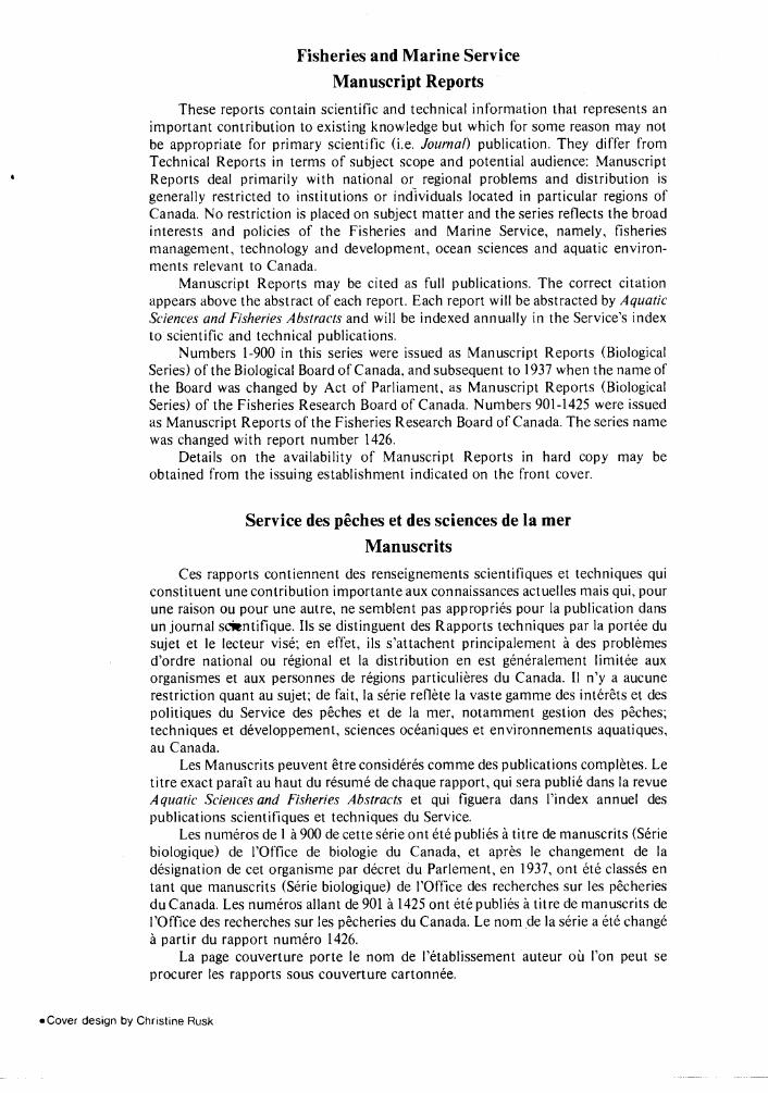
Hesquiat Harbour was mapped in its entirety on five charts covering 26 km of coastline (Fig. 8). The scale of the page-size maps (Fig. 9-13) is 1:21000. From observations made in 1974 during herring spawn sample collections, it was noted that the sea-grass beds at the eastern entrance are mostly Phyllospadix sp. rather than the more prevalent Zostera marina.
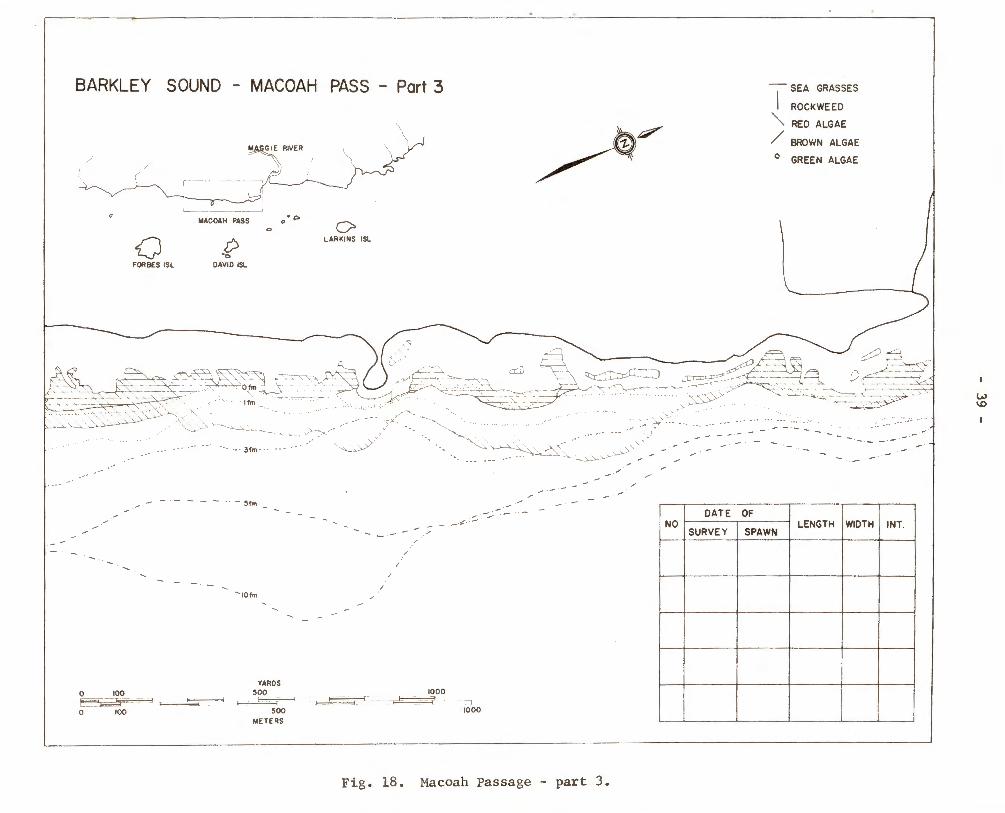
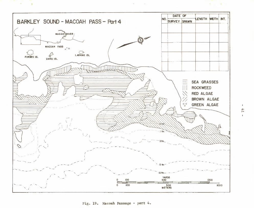
In Barkley Sound, the western coastline from Twin Rivers to Toquart Bay, a distance of 14 km, was mapped on five charts (Fig. 14). The scale of the page-size maps (Fig. 15-19) ranges from 1:9000-1:13000. A diving survey in 1975 (Haegele 1975) in the section seaward of Maggie River (Fig. 17) showed that the aerial map was mostly correct. The exception was a sparse red algae band with percent cover of less than 25% that extended to the 5 fm contour. From the photographs red algae were identified only to the 3 fm contour.
DISCUSSION
The vegetation charts for Barkley Sound were used for the first time for the 1976 herring spawn survey by Fisheries and Marine Service personnel. From our observations of spawnings in that area by diving surveys in 1975 and 1977, the general impression is that the accuracy of the spawn reports was markedly improved. While the average widths of spawnings reported for here from 1971-1975 was 40 yd, the 1976 average width was 110 yd, probably a more realistic figure.
ACKNOWLEDGEMENT
We wish to thank the personnel of Pacific Survey Corporation for obtaining, under contract, the aerial photographs from which the vegetation charts were drawn.
REFERENCES
Haegele, c. w. 1975. Vegetation mapping of herring spawning grounds in British Columbia. Ocean 75 Record. IEEE Publication 75 CHO 995-1 OEC. New York, N.Y. p. 840-844.
Haegele, c. w., and M. J. Harney. 1976. Shoreline vegetation maps of Nanoose and Ganges herring management units. Fish. Res. Board Can. MS Rep. 1408: 43 p.
Haegele, c. w., and R. D. Humphreys. 1976. vegetation and herring spawn studies. 87 p.
Data record for 1976 shoreline Fish. Mar. Serv. Data Rec. 15:
Humphreys, R. D., and c. w. Haegele. 1976. An evaluation of herring spawn survey techniques used in British Columbia. Fish. Mar. Serv. Res. Dev. Tech. Rep. 613: 140 p.


- 5 -
-0
NOOTKA I. 0
NUCHATLITZ - Shoreline Vegetation Charts
I. INNER NUCHATLITZ 2. OUTER NUCHATLITZ 3. PORT LANGFORD
Fig. 1. Shoreline vegetation charts for Nuchatlitz.
I() I()
0 (0 (\J
~ -~


SEA GRASSES
Ill ROCKWEED
~ RED ALGAE
~ BROWN ALGAE 0 0 GREEN ALGAE 0
INNER
. ~ . ·· ' ' . -....10.~'. -
:_ ~~··.·~~~--.-~:·-, -~E)&q·.
201m
(}
t:Jifm
NUCHATLITZ
~ -t=!-
\ ,
' .. ·. / ·' ...
10f1m 1, e3tm' 5fm ' _ .. , . ;
·' ·' .' \ ,. ""' , · , .
,· ' · . ,
' YA j_; \.'\.'\.'\.~ -,T ~'3..~~ . ._
- . -
:' ~ .......... ,
Fig. 2. Inner Nuchatlitz.
NOOTKA
ISLAND
'• ' . '
-
' ' '
Olllf' .. ATI IT7·-~;] '-.1


\()
,·
/.
(f) ' ' .
· ~. @ ' · -· \. - . ..... , ·. - ,·
OUTER NUCHATLITZ ' - ®
SEA GRASSES
YARDS 0 100 500 1000 HO;C"'*3 --=-- ;;g-o Ei!$$F i¥$$$7 0 100 50 0 1000
~ Ill ROCKWEED
-f=l- ~ RED ALGAE
\ '/'; BROWN ALGAE 0 0
GREEN ALGAE 0
METERS
Fi g. 3 . Outer Nuchatlitz.


NOOTKA
IS L AND
Fig. 4.
ISLET
--
'·
5 fm \ I
IOf m
·,
' .
' ~
PORT LANGFORD
-. -.
' · -. -.
... coLwooo'·
<~": . : ~
I . - . ' I
~
\ YAR DS
-.
Ill ~ /; 00
0
' . . ~
/ . . ... · ,
SEA GRASSES
ROCKWEED
RED ALGAE
BROWN AL GAE
GREEN ALGAE
0 100 500 1000 --= :m nn m m m
0 100 500 1000 M E TE RS
Port Langford.
1-' 1-'


- 13 -
:.,\, ~ ~ :\,
WEST NOOTKA - Shoreline Ve~-~tation Charts
I. MARVINAS BAY
2. McKAY PASSAGE
0 .;t 0
lD N
·:-:·
Fig. 5. Shoreline vegetation charts for West Nootka.
0
lD N
.o


- 15 -
WEST NOOTKA - MARVINAS BAY
NOOTKA ISLAND
.,
0 100 500 METE IllS
· .. ~ .... -. ···50f.-:n
'· , ..
SE A GRAS SE S
Ill ROCK WEED
~ RED ALGAE
~ BROWN ALGAE
?:¢To
00° GREEN ALGAE
NO
I 1000
DATE OF
SURVEY SPAWN LENGTH
Fig. 6. Marvinas Bay.
:· .,
WIDTH LAYERS


NOOTKA ISLAND
SANTA
COVE
"'20 1m
~Oim INDIAN RESERVE
.,
·,' ~ ,·
17
WEST NOOTKA - Me KAY PASSAGE
SEA GRASSES
Ill ROCKWEED
~ RED ALGAE
/j BROWN ALGAE 0 0
GREEN ALGAE 0
DATE OF NO SURVEY SPAWN LENGTH WIDTH LAYERS
YAROS
EJd~~bFQ 1000 a 1
0 100 500 1000
METERS
Fig. 7. McKay Passage.


- 19 -
~----4---49°30'-----------------
-0 f() 0 w (\,1
PT.
HESQUIAT HARBOUR
0 (\,1 0 w (\,1
Shoreline Vegetation Charts··:~.~;:~~ .. • • •• t ~
I. EAST SHORE - Entrance ·.:-.:;::.
2. EAST SHORE -Head 3. WEST SHORE - Head 4. WEST SHORE - Middle 5.WEST SHORE- Entrance
~----4----49°20'----------------------------------~----~
Fig. 8. Shoreline vegetation charts for Hesquiat Harbour.


- 21 -
TO RONDEAULT POINT
31m lim O fm
I)
HESQUIAT HARBOUR- EAST SHORE --
ENTRANCE
DATE OF NO
SUR VEY SPAWN LENGTH WIDT H L AYERS
SEA GRAS SE S
Ill ROCK WE ED
~ RED ALGAE
~ BROWN A LG AE 00 GREEN A LG AE 0
Fig. 9. Hesquiat Harbour - east shore - entrance.


DATE OF NO SURVEY SPAWN
SEA GRASSES
Ill ROCKWEED
~ RED ALGAE
~ BROWN ALGAE
·.· GREEN ALGAE
LENGTH WIDTH
- 23 -
RAE LAKE
LAYERS
H ESQUIAT HARBOUR - EAST SHORE
HEAD
.... 31m
Fig. 10. Hesquiat Harbour - east shore - head.
"m
RAE BASIN


- 25 -
''"' 3fm
·-
HESQUIAT HARBOUR- WEST SHORE- HEAD
SEA GRA SS E S ~ Ill ROC KWEED _p-
~ RE D ALGAE \ ~ BROWN AL GAE 0 0 GREEN ALGAE 0
DATE OF N O
SURVE Y SPAW N LENGTH WIDTH LAYER S
Fig. 11. Hesquiat Harbour - west shore - head.


HESOUIAT
PENINSULA
DATE OF NO
SURVEY SPAWN
Ill ~ ~ .. .
- 27 -
.... LECLAIRE POINT
. . ! . .
~ .· -~ .
: .'
....
SEA GRASSES
ROCKWEED
RED ALGAE
BROWN ALGAE
GREEN ALGAE
. ''"' 1 11ft ,
.. , ·
HESQUIAT HARBOUR- WEST SHORE -MIDDLE
I
1 YAROS
o 100 eoo 1000 . Pit=~ E-..--. ;:;g ilr sao
a I 1000
ME TER S
ANTONS SPIT
LENGTH WIDTH LAYE RS
Fig. 12. Hesquiat Harbour - west shore - middle.

HESQUIAT PENINSULA
PURDON CREEK
Fig. 13.
- 29 -
HESQUIAT HARBOUR- WEST SHORE
ENTRANCE
I
l
YAROS 0 100 500
f50F"3 a=' e=t"' f¥? 0 100 500
METERS
DATE OF NO
SUR VEY
1000
@ I 1000
SPAWN
SEA GRA SS E S
Ill ROCK WE ED
~ RED ALGAE
~ BROWN ALGAE 0 0
GREEN ALGAE 0
LENGTH WID TH LAYERS
Hesquiat Harbour - west shore - entrance.

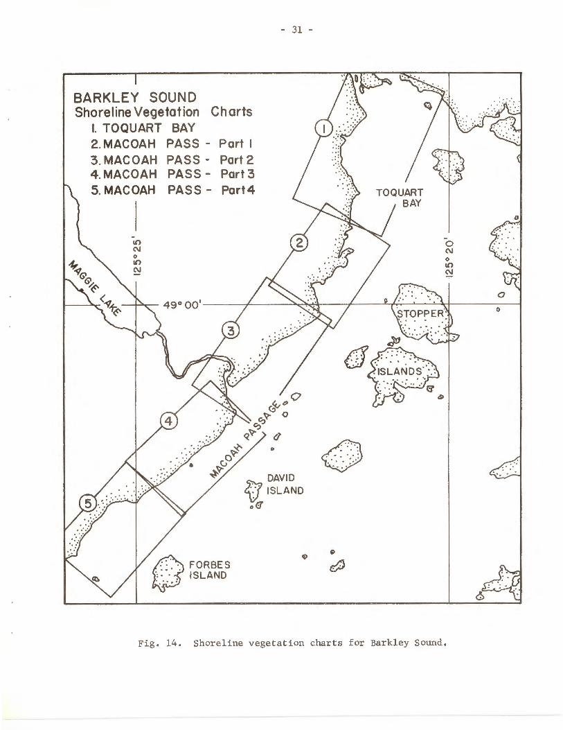
BARKLEY SOUND Shoreline Vegetation Charts
I. TOQUART BAY 2. MACOAH PASS - Part I 3. MACOAH PASS- Part 2 4. MACOAH PASS - Port 3 5. MACOAH PASS - Part4
-10
"' 0 10
"'
- 31 -
0
DAVID 2{1 ISLAND
o<:f
A FORBES ~ISLAND
0 . . . .
Fig. 14. Shoreline vegetation charts for Barkley Sound.


BARKLEY SOUND - TOQUART BAY
NO DATE ~ . ~URVEY SPAWN
1-ENGTH
I !
I
l
p;Q'', ""' "" ~ ~ i1 .. ~- ~ ::_:;·;·~- :. :_
--./ -.. I I
\ j \
' \
'I + I
twtor H INT.l
l
l ~
I I
I l
I l
STOq iLE
~ ~ + '
r' ' -
.·/ .··/
, '
- '
YAROS 1000
500 ~~ - r=----:::-R~:===fooo 0 100 500
0 100 "ETERS
---10~
------5fm- -
I (
Jl ~ _/ I
...... ................ - \ IOfm 1 ,-~ + POPE_.., ROCKS
\I
Fig. 15. Toquart Bay.
SEA GRASSES -Il l ROCKWEED
~ RED ALGAE
/: BROWN ALGAE 0 0 GREEN ALGAE 0
TOQUART RIVER
I 0
GRASSES
0 1J
:;;;'/~/---~. '•, _,'
t~ (!jo -=-- ~ --- ---
w w


BARKLEY SOUND - MACOAH PASS - Part I
MACOAH PASS 0. c,
.<5 0 0
DAVID ISL LARKINS ISL
<::!)
... CS8 _~
-~ - --
-- /
/ - ·- -· .--- ' - -· /
_....... .. I . ..- - 10fm - \ / / \ -
DATE OF NO . SURVEY SPAWN-
SEA GRASSES -Il l ROCKWEED
~ RED ALGAE /j BROWN ALGAE 0 0 GREEN ALGAE 0
1---- -·
YARDS 0 100 500 1000 - -~~-
0 10 0 500 1000 METERS
Fi g . 16. Macoah Passage - part 1.
\ -
LENGTH
-
---1
I
/
WIDT HINT .
/" ·, I \
'\ ./
1--------
' \
'
w Vl


I
BARKLEY SOUND - MACOAH PASS - Part 2
--
~ "---' FORBES ISL
~
·"l~ DAVID ISL
lw C' -~
c.._-, LARKINS ISL
--...._
NO _ DATE OF . -,-. SURVEY SPAWN - LENGTH WIDTf-1 INT
' '
~ ---- -
l~ I
j I
L- J
--------~~
' '
' s fm - _
101m
_ SEA GRASSES
I : I ROCKWEED
0:: RED ALGAE
~~ BROWN ALGAE GREEN ALGAE 0 0
0
YARDS 0 100 500 1000 r---".....___.. _[ ~ g;;;;;;_2 - ~--=::::::J 0 100 500 1000
METERS
Fig. 17. Macoah Passage- part 2.
--- --- -----
w '-1

BARKLEY SOUND - MACOAH
/
0 FORBES ISL
~RIVER
MACOAH PASS •e> 0
.{? OAVIO ISL
PASS - Part 3
\ ~~ '\
0 LARKINS ISL
-, _·, ..... .._ __ --.:.,. ~ . --;..,._ "--....
·· · 31m ··· ···
_ - - - - - - - 51m
·--101m
0 100 ~.__,______. ~
YAROS 500 ~
500 METERS
0 100
' ---~;::..-" -~--~--~;
- - :C -/
1000 . - - I
1000
... ___ ,._...:::."
Fig. 18. Macoah Passage - part 3.
~ ..... -
-
1
- SEA GRASSES
ROCK WEED
"' RED ALGAE
/ BROWN ALGAE 0 GREEN ALGAE
/i ..c.:::l, ~---- ==-~-.
.--~-~ / _ _ ---~--'1
INT.
w \0

DATE OF
BARKLEY SOUND - MACOAH PASS - Part 4 NO. bURVEY !sPAWN ~ ITH I INT.
MACOAH PASS
Q FORBES ISL
',\] ' ··C'- ....
·y ..... ~/'
' '
/ .....
' ' .
-- - ........ . /
·- ·-·-
/ ~
\. ....... .. /
D •o
DAVID ISL
I'
' /
".c.
: ...... ' ... ...
/
r ·
0 LARKINS ISL
,'
/ - - -- -
. ~
__.-"
.....
' .- ./ · ~
~~
_ SEA GRASSES
Ill ROCKWEED
~ RED ALGAE
~ BROWN ALGAE
- --- - - ---3fm __
·, ,' .....
' ' - -- ·- - · - - ·- ·--
5fm - ·- - -·· -
/ .--·
IOfm- - · - ··
~ROO 0 100 500 1000
0 ~0 500 ~00 METERS
Fig. 19. Macoah Passage - part 4.
+"!-"