Embed Size (px)
Citation preview
Luas Finglas – Park & Ride Options Paper
Report LFIN-PKW-0001 Version 01 Date 19-Oct-2018
1
Luas Finglas
Park & Ride
Options Paper
LFIN-PKW-0001
October 2018

Luas Finglas – Park & Ride Options Paper
Report LFIN-PKW-0001 Version 01 Date 19-Oct-2018
2
DOCUMENT HISTORY LOG
Version Date Description Prepared Reviewed Approved QA
01 19-Oct-2018 Original Issue M. Corsi D. Keenan
H. Foroughi P. Carbone L. Zepa

Luas Finglas – Park & Ride Options Paper
Report LFIN-PKW-0001 Version 01 Date 19-Oct-2018
3
CONTENTS
1 INTRODUCTION ........................................................................................................................................... 1
1.1 Scope of this Report ............................................................................................................................ 2
1.2 Main Objectives of the P&R and Assessment Criteria......................................................................... 2
1.3 Main demand for Luas Finglas P&R ..................................................................................................... 3
1.4 Local Authorities Development Plans ................................................................................................. 4
1.5 Conclusion ........................................................................................................................................... 7
2 LUAS FINGLAS P&R OPTIONS....................................................................................................................... 7
2.1 Option 1 – South East Quadrant .......................................................................................................... 8
2.2 Option 2 – South East Quadrant 1 ..................................................................................................... 10
2.3 Option 3 – South West Quadrant 2 ................................................................................................... 11
2.4 Option 4 – North East Quadrant 4 ..................................................................................................... 12
2.5 Option 5 – North West Quadrant 3 ................................................................................................... 14
3 CONCLUSIONS ........................................................................................................................................... 17
4 RECOMMENDATIONS ................................................................................................................................ 17

Luas Finglas – Park & Ride Options Paper
Report LFIN-PKW-0001 Version 01 Date 19-Oct-2018
4
FIGURES
Figure 1 Luas Finglas Study Area and P&R indicative location ............................................................. 1
Figure 2 Luas Finglas P&R – extracts from 2015 “P&R Report - Draft Transport Strategy for the Greater Dublin Area” by NTA .............................................................................................................................. 2
Figure 3 Luas Finglas P&R – likelihood of traffic demand flows towards the P&R ............................... 3
Figure 4 Luas Finglas P&R – four quadrants of M50 junction with the N2........................................... 4
Figure 5 Luas Finglas P&R – Screenshot extract from FCC Development Plan 2017-2023 Viewer ...... 5
Figure 6 Luas Finglas P&R – Screenshot extract from Dublin City Development Plan 2016-2022 ....... 6
Figure 7 Luas Finglas P&R – General map of Options 1-2-3-4-5 ........................................................... 7
Figure 8 Luas Finglas P&R – Option 1 and access routes from M50 and N2 ........................................ 8
Figure 9 Luas Finglas P&R – Option 1 main traffic flows through Charlestown Place junction access routes from M50 and N2 ....................................................................................................................... 9
Figure 10 Luas Finglas P&R – Option 2 and access routes from M50 and N2 .................................... 10
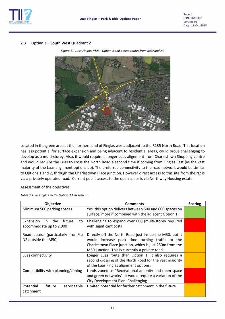
Figure 11 Luas Finglas P&R – Option 3 and access routes from M50 and N2 .................................... 11
Figure 12 Luas Finglas P&R – Option 4 and access routes from M50 and N2 via St.Margaret’s Road ............................................................................................................................................................. 12
Figure 13 Luas Finglas P&R – Option 4 and access routes from N2 north via junction 2 ................... 12
Figure 14 Luas Finglas P&R – Option 4 and access routes N2 – Google routes and runtimes off-peak ............................................................................................................................................................. 13
Figure 15 Luas Finglas P&R – Option 5 and access routes from M50 and N2 .................................... 14
Figure 16 Luas Finglas P&R – Option 5 and access routes from M50 and N2. Google routes and runtimes off-peak ................................................................................................................................ 15
TABLES
Table 1 Luas Finglas P&R – Option 1 Assessment ................................................................................. 9
Table 2 Luas Finglas P&R – Option 2 Assessment ............................................................................... 10
Table 3 Luas Finglas P&R – Option 3 Assessment ............................................................................... 11
Table 4 Luas Finglas P&R – Option 4 Assessment ............................................................................... 14
Table 5 Luas Finglas P&R – Option 5 Assessment ............................................................................... 15

Luas Finglas – Park & Ride Options Paper
Report LFIN-PKW-0001 Version 01 Date 19-Oct-2018
1
1 INTRODUCTION
Luas Finglas is a proposed extension to the Luas Green Line from the existing terminus at Broombridge to the
area north of Finglas, in the vicinity of the N2/M50 interchange.
Various policy documents advocate the need for a Park & Ride (P&R) facility in the vicinity of the N2/M50
junction or the Finglas area. Indeed, the need for a P&R is mentioned specifically in the following documents:
• Project Ireland 2040: National Development Plan 2018-2027 – mentions the need for a strategic P&R
within an overall P&R Programme at a number of rail, bus and Luas locations including Finglas;
• NTA Transport Strategy for the Greater Dublin Area 2016-2035 – indicates a Luas service ‘with a
strategic park and ride site at the N2/M50 junction’ at the northern terminus of the line;
• A supporting study to the NTA Transport Strategy, the Park and Ride Report - Draft Transport Strategy
for the Greater Dublin Area produced by the NTA and Jacobs Engineering Ireland Ltd. in 2015, also
explored the potential for P&R in the area. In this report, “a strategic P&R facility has been identified
along the North Road (N2), Charlestown, to complement this future service (i.e. Luas Finglas)”.
Figure 1 Luas Finglas Study Area and P&R indicative location
P&R

Luas Finglas – Park & Ride Options Paper
Report LFIN-PKW-0001 Version 01 Date 19-Oct-2018
2
Within the same Park and Ride Report, some additional indicative details are also given in relation to the
potential P&R facility at Charlestown, as shown in the following report extracts:
Figure 2 Luas Finglas P&R – extracts from 2015 “P&R Report - Draft Transport Strategy for the Greater Dublin Area” by NTA
The report indicates a potential location for a P&R facility located south of the M50 in the vicinity of the
Charlestown area; and that despite its strategic ranking will only provide 150 car park spaces.
In more recent discussions with the NTA (September 2018), the ultimate P&R capacity has been raised up to
over 1,000 spaces.
As a reference, existing Luas P&Rs provide the following capacity:
• Red Cow 730
• Cheeverstown 310
• Tallaght 450
• Balally 420
• Stillorgan 340
• Sandyford 50
• Carrickmines 352
1.1 Scope of this Report
The scope of this report is to determine the optimum location/s for the Luas Finglas P&R, in terms of
addressing the objectives outlined below.
1.2 Main Objectives of the P&R and Assessment Criteria
The main objectives of the Luas Finglas P&R will be:

Luas Finglas – Park & Ride Options Paper
Report LFIN-PKW-0001 Version 01 Date 19-Oct-2018
3
1. To provide a minimum of 500 parking spaces,
2. Allow the potential for expansion in the future, to accommodate up to over 1,000 spaces,
3. Ease of access from the primary road network particularly from the N2 to the north of the M50,
4. Ease of connectivity with Luas Finglas,
5. Compliance/compatibility with planning/zoning,
6. Potential future serviceable catchment (for example potential for residential development).
These will also be adopted as assessment criteria against which to score the P&R options.
1.3 Main demand for Luas Finglas P&R
At this early stage, and pending a more detailed assessment of the demand, it is reasonable to assume that
the Luas Finglas P&R will most likely be serving the demand coming from the N2 north of the M50, with some
limited demand coming from the M50 Northbound. Demand from the M50 Southbound and the R135 (south
of the M50) are both expected to have a negligible contribution.
Figure 3 Luas Finglas P&R – likelihood of traffic demand flows towards the P&R
Therefore, it is important that the location of the P&R is optimised in terms of connectivity with the strategic
road network, with priority given to the connection from/to the N2 outside the M50.
Most likely
demand

Luas Finglas – Park & Ride Options Paper
Report LFIN-PKW-0001 Version 01 Date 19-Oct-2018
4
1.4 Local Authorities Development Plans
This report looks at the 4 quadrants centred on the N2/M50 Junction 5. The general character of this area
can be described as large scale industrial uses north of the M50; and to the south a mix of existing
residential and employment land uses, with the emerging town centre of Charlestown/Meakstown and
existing communities of Finglas to the west.
Figure 4 Luas Finglas P&R – four quadrants of M50 junction with the N2
The study area falls within two different Local Authorities’ boundaries; Dublin City Council and Fingal County
Council. Quadrants 1, 3 and 4 are located in Fingal County Council’s jurisdiction; while Quadrant 2 is mainly
located within Dublin City Council’s functional area.
1.4.1 Fingal County Council Development Plan 2017-2023
The location of the study is generally included in the Fingal South area of the Fingal County Council
Development Plan.
Within the area south of the M50, it should be noted that, the Strategic Policy of Fingal County Council aims
to “Develop a strategy to promote and deliver an enhanced identity and link with Fingal for the wider
communities of Meakstown/Charlestown, Finglas and Lanesborough.” The details of policy objectives for the
urban area are included in the appendix.
4
1
3
2

Luas Finglas – Park & Ride Options Paper
Report LFIN-PKW-0001 Version 01 Date 19-Oct-2018
5
The Fingal County Council Development Plan 2017-2023 zoning map is shown below:
Figure 5 Luas Finglas P&R – Screenshot extract from FCC Development Plan 2017-2023 Viewer
Two zonings objectives are predominant “GE- General Employment and TC-Town and District Centre.” The
zoning objectives are described as follows:
“GE- General Employment” - purple
Objective: Provide opportunities for general enterprise and employment.
Vision: Facilitate opportunities for compatible industry and general employment uses, logistics and
Warehousing activity in a good quality physical environment. General Employment areas should be
Highly accessible, well designed, permeable and legible.
“TC-Town and District Centre – red/orange stripes
Objective: Protect and enhance the special physical and social character of town and district centres and
provide and/or improve urban facilities.
Vision: Maintain and build on the accessibility, vitality and viability of the existing Urban Centres in the
County. Develop and consolidate these Centres with an appropriate mix of commercial, recreational, cultural,
leisure and residential uses, and to enhance and develop the urban fabric of these Centres in accordance with
the principles of urban design, conservation and sustainable development. Retail provision will be in
accordance with the County Retail Strategy, enhance and develop the existing urban fabric, emphasise urban
conservation, and ensure priority for public transport, pedestrians and cyclists while minimising the impact of
private car based traffic. In order to deliver this vision and to provide a framework for sustainable
development, Urban Centre Strategies will be prepared for centres in accordance with the Urban Fingal
Chapter objectives.
The TC zoning objective includes for uses such as; “Public Transport Station” and “Carpark - Non-Ancillary” to
be permitted in principle.
In both zonings however, the explicit provision of a park and ride facility is not listed, as either ‘Permitted in
Principle’ nor ‘Not Permitted’. The development plan indicates that uses which are neither listed as
‘Permitted in Principle’ nor ‘Not Permitted’; will be assessed in terms of their contribution towards the

Luas Finglas – Park & Ride Options Paper
Report LFIN-PKW-0001 Version 01 Date 19-Oct-2018
6
achievement of the Zoning Objective and Vision and their compliance and consistency with the policies and
objectives of the Development Plan.
The Fingal Development Plan does however indicate a policy objective on Park and Ride facilities under
Objective MT35 to “Promote and support the provision of Park and Ride facilities at suitable locations near
high capacity public transport stations/stops.”
1.4.2 Dublin City Development Plan 2016-2022
Dublin City Development Plan 2016-2022 map of the area (inside the M50 only) is shown below:
Figure 6 Luas Finglas P&R – Screenshot extract from Dublin City Development Plan 2016-2022
The predominant zoning objective (green) for this area within Dublin City’s jurisdiction is Land-Use Zoning Objective Z9 Amenity/Open Space Lands/Green: To preserve, provide and improve recreational amenity and open space and green networks. Public service installation which would not be detrimental to the amenity of Z9 zoned lands are a Permissible Use. Public service installation in the development plan is defined as follows: “A building, or part thereof, a roadway or land used for the provision of public services. Public services include all service installations necessary for electricity, gas, telephone, radio, telecommunications, television, data transmission, drainage, including wastewater treatment plants and other statutory undertakers: bring centres, green waste composting centres, public libraries, public lavatories, public telephone boxes, bus shelters, etc. but does not include incinerators/waste to energy plants. The offices of such undertakers and companies involved in service installations are not included in this definition.” It is unclear, if a public transport station and/or a park or ride would be covered by this definition. Parts of the land are covered by zoning objective Z6 Employment/enterprise zoned lands (purple) ‘To provide for the creation and protection of enterprise and facilitate opportunities for employment creation.’ Park and ride facility uses are permitted in this zone.

Luas Finglas – Park & Ride Options Paper
Report LFIN-PKW-0001 Version 01 Date 19-Oct-2018
7
1.5 Conclusion
Quadrants 1, 3 and 4 zonings in Fingal do not preclude the provision of a park and ride. The development plan
indicates that uses which are neither ‘Permitted in Principle’ nor ‘Not Permitted’ will be assessed in terms of
their contribution towards the achievement of the Zoning Objective and Vision and their compliance and
consistency with the policies and objectives of the Development Plan.
However, the TC zoning objective includes for uses “Public Transport Station” and “Carpark - Non-Ancillary”
to be permitted in principle.
The majority of Dublin City’s lands in Quadrant 2, are covered by Land-Use Zoning Objective Z9 Amenity/Open Space Lands/Green. From examination of the zoning objective, it would appear that a variation to the City Development Plan would be required for a park and ride facility (if deemed a suitable site). However, clarification should be sought for the interpretation of the objective by the City Council with regard to the definition of public service installation. Park and ride facility uses are permitted in the zoning objective Z6 Employment/enterprise zoned lands.
2 LUAS FINGLAS P&R OPTIONS
The P&R for Luas Finglas shall be located in close proximity to the Luas terminus or one of its stops, while also
being within reasonable proximity to the strategic road network to ensure easy and direct access from both
the N2 and M50.
By looking at the four quadrants formed by the N2-M50 interchange and the available areas within those
lands, five options have been developed, as shown in the following map:
Figure 7 Luas Finglas P&R – General map of Options 1-2-3-4-5

Luas Finglas – Park & Ride Options Paper
Report LFIN-PKW-0001 Version 01 Date 19-Oct-2018
8
2.1 Option 1 – South East Quadrant
Figure 8 Luas Finglas P&R – Option 1 and access routes from M50 and N2
This option is located within the boundaries of the current Charlestown Shopping Centre overflow surface
carpark and its adjacent areas. The existing facility is a surface car park with 567 spaces and has a good access
from both M50 and N2 via the M50 Junction 5 interchange, the R135 North Road and Charlestown Place. It
could be developed into a larger surface carpark occupying the surrounding lands (no more than 1,000 spaces
indicatively), or into a multi-storey, providing up to 2,000 spaces in possibly 5 storeys, subject to a more
detailed analysis.
The current surface carpark is a temporary facility, the permission for which has been recently extended to
2021, after which date it is expected that the new Phase 2B of the Charlestown residential/retail development
will be completed and enough car spaces will be provided in its basements.
It is also noted that the area south of this surface carpark is currently occupied by sporting fields and planning
permission has been recently granted (2017) for its upgrade to Multi-Use All Weather Surface Games area.

Luas Finglas – Park & Ride Options Paper
Report LFIN-PKW-0001 Version 01 Date 19-Oct-2018
9
Assessment of the objectives:
Table 1 Luas Finglas P&R – Option 1 Assessment
Objective Comments Scoring
Minimum 500 parking spaces Yes, this option delivers between 500 and 1,000 spaces on surface.
Expansion in the future, to accommodate up to 2,000
Easily expandable to 1,000, challenging to expand over 1,000 (multi-storey required with significant cost).
Road access (particularly from/to N2 outside the M50)
Directly off the North Road just inside the M50, but it would increase peak time turning traffic to the Charlestown Place junction, which is just 250m from the M50 junction.
Luas connectivity High quality Luas connectivity and shortest Luas route.
Compatibility with planning/zoning Land is zoned as TC-Town and District Centre.
Potential future serviceable catchment
There is significant potential for further catchment in the future. An additional 220 apartments are currently being built and several others may come in the future.
Figure 9 Luas Finglas P&R – Option 1 main traffic flows through Charlestown Place junction access routes from M50 and N2

Luas Finglas – Park & Ride Options Paper
Report LFIN-PKW-0001 Version 01 Date 19-Oct-2018
10
2.2 Option 2 – South East Quadrant 1
Figure 10 Luas Finglas P&R – Option 2 and access routes from M50 and N2
A potential site located adjacent to Option 1 and to the existing Charlestown Shopping Centre overflow
carpark. This site also has reasonable access from both M50 and N2 via the interchange, North Road and
Charlestown Place. As said in Option 1 this land could be combined with the existing overflow carpark to
deliver approx. 1,000 spaces surface carpark.
This land is currently unoccupied and there does not appear to be any planning application pending, subject
to a more detailed search.
Assessment of the objectives:
Table 2 Luas Finglas P&R – Option 2 Assessment
Objective Comments Scoring
Minimum 500 parking spaces Yes, this option delivers between 500 and 600 spaces on surface, and more if combined with the adjacent Option 1.
Expansion in the future, to accommodate up to 2,000
Challenging to expand over 600 (multi-storey required with significant cost)
Road access (particularly from/to N2 outside the M50)
Directly off the North Road just inside the M50, but it would increase peak time turning traffic to the Charlestown Place junction, which is just 250m from the M50 junction
Luas connectivity High quality Luas connectivity but slightly longer Luas route than Option 1
Compatibility with planning/zoning Lands zoned as GE-General Employment and TC-Town and District Centre
Potential future serviceable catchment
There is significant potential for further catchment in the future. Additional 220 apartments are currently being built and several others may come in the future.
Luas Finglas – Park & Ride Options Paper
Report LFIN-PKW-0001 Version 01 Date 19-Oct-2018
11
2.3 Option 3 – South West Quadrant 2
Figure 11 Luas Finglas P&R – Option 3 and access routes from M50 and N2
Located in the green area at the northern end of Finglas west, adjacent to the R135 North Road. This location
has less potential for surface expansion and being adjacent to residential areas, could prove challenging to
develop as a multi-storey. Also, it would require a longer Luas alignment from Charlestown Shopping centre
and would require the Luas to cross the North Road a second time if coming from Finglas East (as the vast
majority of the Luas alignment options do). The preferred connectivity to the road network would be similar
to Options 1 and 2, through the Charlestown Place junction. However direct access to this site from the N2 is
via a privately operated road. Current public access to the open space is via Northway Housing estate.
Assessment of the objectives:
Table 3 Luas Finglas P&R – Option 3 Assessment
Objective Comments Scoring
Minimum 500 parking spaces Yes, this option delivers between 500 and 600 spaces on surface, more if combined with the adjacent Option 1.
Expansion in the future, to accommodate up to 2,000
Challenging to expand over 600 (multi-storey required with significant cost)
Road access (particularly from/to N2 outside the M50)
Directly off the North Road just inside the M50, but it would increase peak time turning traffic to the Charlestown Place junction, which is just 250m from the M50 junction. This is currently a private road.
Luas connectivity Longer Luas route than Option 1, it also requires a second crossing of the North Road for the vast majority of the Luas Finglas alignment options.
Compatibility with planning/zoning Lands zoned as “Recreational amenity and open space and green networks”. It would require a variation of the City Development Plan. Challenging.
Potential future serviceable catchment
Limited potential for further catchment in the future.

Luas Finglas – Park & Ride Options Paper
Report LFIN-PKW-0001 Version 01 Date 19-Oct-2018
12
2.4 Option 4 – North East Quadrant 4
Connections to/from the strategic road network to Option 4 would be less direct.
One potential route to the strategic road network is indicated below in the map, making use of the existing
St. Margaret’s Road and bridge over the M50. This route appears to be very convoluted and indirect,
particularly from the N2 north of the M50 and is considered to be disadvantageous.
Figure 12 Luas Finglas P&R – Option 4 and access routes from M50 and N2 via St. Margaret’s Road
From the N2 north, other access routes would be possible from N2 Junction 2, located some 4km north of the
M50, via the R135 and St. Margaret’s Road. This is also a very convoluted route, with approximately 5.7km off
the primary road network and several local junctions.
Figure 13 Luas Finglas P&R – Option 4 and access routes from N2 north via junction 2

Luas Finglas – Park & Ride Options Paper
Report LFIN-PKW-0001 Version 01 Date 19-Oct-2018
13
Figure 14 Luas Finglas P&R – Option 4 and access routes N2 – Google routes and runtimes off-peak
Option 4 would possibly require the construction of a new N2 junction or derivative access arrangement,
located in close proximity to the M50, which would provide direct access to the P&R. The construction of a
new junction in close proximity to the M50 junction could prove challenging and its technical feasibility would
remain to be demonstrated.
Within this quadrant, there is a significant portion of currently unoccupied lands, generally zoned for industrial
and employment creation.
An increase in activity, in terms of industrial/ logistics land uses are anticipated in this area, with Dublin Port
currently preparing a planning application for an Inland Port to the north of the site. The proposed Greater
Dublin Drainage Project transitions in close proximity to this area (https://www.water.ie/planning-
sites/greater-dublin-drainage/docs/planning-documents/planning-reports/SID-Planning-Report.pdf). The
rural cluster of Dubber Cross is also located directly to the east. Therefore, there is limited potential for
providing future Luas catchment.
The option indicated below has been selected for its proximity to St. Margaret’s Road which would give access
from the existing bridge over the M50, but other areas closer to the N2 could also be considered in the same
quadrant. This location has large potential for surface expansion but it would also require a longer Luas
alignment from Charlestown Shopping centre and the Luas to cross the M50 on a new bridge.

Luas Finglas – Park & Ride Options Paper
Report LFIN-PKW-0001 Version 01 Date 19-Oct-2018
14
Assessment of the objectives:
Table 4 Luas Finglas P&R – Option 4 Assessment
Objective Comments Scoring
Minimum 500 parking spaces Yes, this option can easily deliver in excess of 500 spaces.
Expansion in the future, to accommodate up to 2,000
Yes, this option can easily deliver up to 2,000 spaces, either surface or multi-storey.
Road access (particularly from/to N2 outside the M50)
Existing connections are very poor, possible future direct connection would require construction of new junction off N2.
Luas connectivity Longer Luas route than Option 1 and 2, it also requires a new bridge over the M50.
Compatibility with planning/zoning Lands zoned as “GE-General Employment - Facilitate opportunities for compatible industry and general employment uses, logistics and warehousing”. P&R would be compatible with this.
Potential future serviceable catchment
Limited potential for further catchment in the future, given the absence of residential or office development plans.
2.5 Option 5 – North West Quadrant 3
Figure 15 Luas Finglas P&R – Option 5 and access routes from M50 and N2

Luas Finglas – Park & Ride Options Paper
Report LFIN-PKW-0001 Version 01 Date 19-Oct-2018
15
The option indicated has been selected for its proximity to the M50, in order to reduce the Luas corridor
length. This location has significant potential for surface extension but it would require a significantly longer
Luas alignment from Charlestown Shopping centre (approx. 1.1km delta length compared to Options 1-2) and
would require the Luas to cross the North Road a second time and to underpass the M50 with a 110m long
cut and cover structure (subject to a more detailed design). Connection to the strategic road network would
also be very convoluted from the N2, although more direct than Option 4.
Option 5 could possibly require the construction of a new N2 junction, located in close proximity to the M50,
as mentioned previously.
Figure 16 Luas Finglas P&R – Option 5 and access routes from M50 and N2. Google routes and runtimes off-peak
This quadrant is partly occupied by the following: Finglas electrical 220kV substation; Roadstone Huntstown
production plant and quarry; and Huntstown power station. While there is a significant quantity of currently
unoccupied lands, generally zoned for industrial and employment creation, the National Planning Framework
encourages the removal of industrial land extensive uses to locations outside the M50. In this area a number
of proposals are emerging to meet this objective. Therefore, the likelihood of ever achieving a serviceable light
rail residential catchment in this area is very limited.
Assessment of the objectives:
Table 5 Luas Finglas P&R – Option 5 Assessment
Objective Comments Scoring
Minimum 500 parking spaces Yes, this option can easily deliver in excess of 500 spaces.
Expansion in the future, to accommodate up to 2,000
Yes, this option can easily deliver up to 2,000 spaces, either surface or multi-storey.
Road access (particularly from/to N2 outside the M50)
Existing connections are very poor, possible future direct connection would require construction of new junction off N2.

Luas Finglas – Park & Ride Options Paper
Report LFIN-PKW-0001 Version 01 Date 19-Oct-2018
16
Luas connectivity The longest Luas route, it also requires a new long underpass of the M50.
Compatibility with planning/zoning Lands zoned as “GE-General Employment - Facilitate opportunities for compatible industry and general employment uses, logistics and warehousing”. P&R would be compatible with this.
Potential future serviceable catchment
Very limited potential for further catchment in the future, given the absence of residential or office development plans and the heavy industrial vocation of the area.

Luas Finglas – Park & Ride Options Paper
Report LFIN-PKW-0001 Version 01 Date 19-Oct-2018
17
3 CONCLUSIONS
Objective Option 1 Option 2 Option 3 Option 4 Option 5
500 parking spaces
Future expansion 2,000
Road access
Luas connectivity
Planning/zoning
Future catchment
Options 1 and 2 provide a very good connection with the Luas to the south of the M50 (shortest Luas route)
but may prove challenging: from a planning viewpoint within a “Town and district centre” zoning; and are
landlocked with a maximum surface capacity of approximately 1,000 spaces (combined, subject to further
detailed analysis). Their connectivity with the strategic road network is good, but the location will potentially
add turning traffic movements at the Charlestown Place junction whose impacts remain to be assessed.
Both Options 1 and 2 are considered optimum options with a few drawbacks, to be investigated further,
provided that an early engagement with FCC and the relevant land owners prove successful in delivering a
coordinated development. Ideally, the coordinated mixed development should consist of a combined Luas
terminus, P&R and retail/office/residential developments. A scenario where the Luas terminus is embedded
in the development, with the P&R built within the basements of the mixed development (Balally type) could
be very positive for all stakeholders involved. As an example, the current development of the Cherrywood
Town Centre, with integrated permanent P&R just off the M50 should be considered.
Option 3 provides a relatively poor connection with the Luas, while also impacting on lands zoned for
recreational amenity and green networks. It is also a landlocked area, with little capacity to expand over 500
spaces as a surface carpark and would have a similar traffic impact on the Charlestown Place junction. It is not
considered a favourable option and should not be progressed further.
Option 4 provides a possible alternative should Options 1 and 2 prove difficult, although it would possibly
require the construction of a new N2 junction in close proximity to M50 Junction 5, which may prove very
problematic. It is expected that the cost of Option 4 could be higher than Options 1-2, particularly if the new
junction is factored in. In fact, it involves a significantly longer Luas route (approx. 600m delta length), and a
new bridge over the M50, with an indicative span of 65m (unless the existing road bridge is shared).
Option 5 is not considered a viable option on account of the very poor connectivity with the Luas (requiring
1.1km longer route than Options 1-2 including a new M50 underpass of about 110m (cut and cover), and a
challenging road network connection. It also scores low in relation to the permeability of the area south of the
M50 (currently industrial/retail/leisure use), and unlikely to have a future residential catchment, given the
presence of high voltage electrical facilities, quarries and processing plants. Option 5 should not be progressed
further.
4 RECOMMENDATIONS
It is recommended that Options 1-2 (separately or combined) and Option 4 are brought forward for more
detailed analysis, with Options 1-2 being preferred from Luas and strategic road connections viewpoint, and
Option 4 being more suitable in terms of land use and unconstrained development. Options 3 and 5 should
not be progressed further.

Luas Finglas – Park & Ride Options Paper
Report LFIN-PKW-0001 Version 01 Date 19-Oct-2018
18
As Options 1-2 and 4 are located on the east side of the M50-N2 junction, the Luas Finglas alignment study
could be progressed up to the common point located at the junction between St. Margaret’s Road and
Charlestown Place, after which point the P&R final location will dictate the last section of Luas Finglas
alignment, which will be common to all options.