Embed Size (px)
Citation preview
COASTAL
FRONTIERS
Coastal Frontiers Corporation
882A Patriot Drive Moorpark, CA 93021-3544
(818) 341-8133 www.coastalfrontiers.com
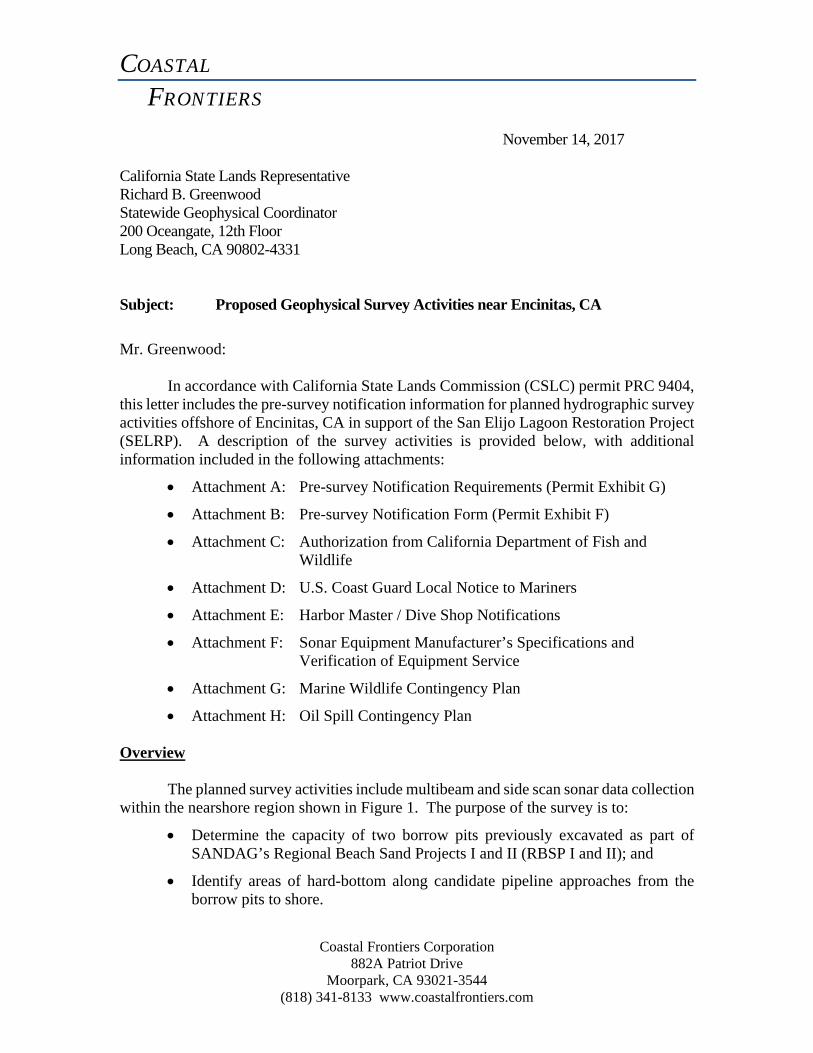
November 14, 2017 California State Lands Representative Richard B. Greenwood Statewide Geophysical Coordinator 200 Oceangate, 12th Floor Long Beach, CA 90802-4331 Subject: Proposed Geophysical Survey Activities near Encinitas, CA
Mr. Greenwood:
In accordance with California State Lands Commission (CSLC) permit PRC 9404, this letter includes the pre-survey notification information for planned hydrographic survey activities offshore of Encinitas, CA in support of the San Elijo Lagoon Restoration Project (SELRP). A description of the survey activities is provided below, with additional information included in the following attachments:
Attachment A: Pre-survey Notification Requirements (Permit Exhibit G)
Attachment B: Pre-survey Notification Form (Permit Exhibit F)
Attachment C: Authorization from California Department of Fish and Wildlife
Attachment D: U.S. Coast Guard Local Notice to Mariners
Attachment E: Harbor Master / Dive Shop Notifications
Attachment F: Sonar Equipment Manufacturer’s Specifications and Verification of Equipment Service
Attachment G: Marine Wildlife Contingency Plan
Attachment H: Oil Spill Contingency Plan
Overview The planned survey activities include multibeam and side scan sonar data collection
within the nearshore region shown in Figure 1. The purpose of the survey is to:
Determine the capacity of two borrow pits previously excavated as part of SANDAG’s Regional Beach Sand Projects I and II (RBSP I and II); and
Identify areas of hard-bottom along candidate pipeline approaches from the borrow pits to shore.
Pre-Survey Notification, Geophysical Survey Activities near Encinitas, CA November 14, 2017 Page 2
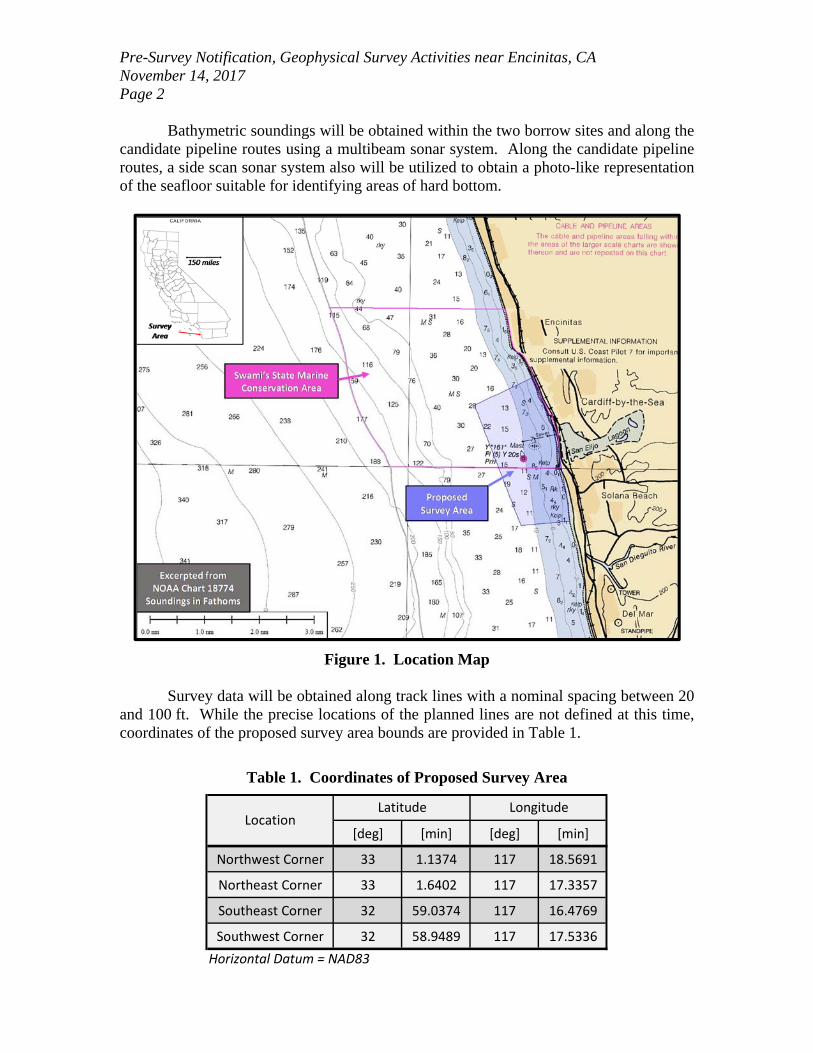
Bathymetric soundings will be obtained within the two borrow sites and along the candidate pipeline routes using a multibeam sonar system. Along the candidate pipeline routes, a side scan sonar system also will be utilized to obtain a photo-like representation of the seafloor suitable for identifying areas of hard bottom.
Figure 1. Location Map Survey data will be obtained along track lines with a nominal spacing between 20
and 100 ft. While the precise locations of the planned lines are not defined at this time, coordinates of the proposed survey area bounds are provided in Table 1.
Table 1. Coordinates of Proposed Survey Area
[deg] [min] [deg] [min]
Northwest Corner 33 1.1374 117 18.5691
Northeast Corner 33 1.6402 117 17.3357
Southeast Corner 32 59.0374 117 16.4769
Southwest Corner 32 58.9489 117 17.5336
Horizontal Datum = NAD83
Latitude LongitudeLocation
Pre-Survey Notification, Geophysical Survey Activities near Encinitas, CA November 14, 2017 Page 3 Activities within Swami’s State Marine Conservation Area
As illustrated in Figure 1, portions of the survey area lie within Swami’s State
Marine Conservation Area. Approval to conduct the proposed activities was obtained from Robert Win at the California Department of Fish and Wildlife on November 13, 2017. A copy of the approval is provided in Attachment C. Prior to conducting the survey, Coastal Frontiers is required to notify Mr. Win of the planned survey date. Schedule
Pending approval from CSLC, the survey activities are planned to occur sometime
in December 2017. It is anticipated that the work will require up to 4 days to complete. Survey operations will only be conducted during daylight hours. Should weather or other delays impact the schedule, the work could be conducted as late as January 31, 2018.
Notices
The following agencies have been notified of the planned activities:
U.S. Coast Guard, Local Notice to Mariners Oceanside Harbor Master North County Scuba
Copies of the notifications are provided in Attachments D and E.
Survey Vessel
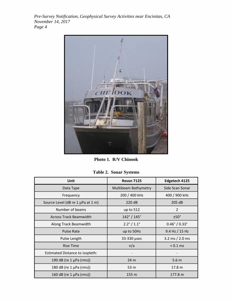
Survey activities will be conducted from the 34-ft aluminum catamaran R/V
Chinook, operated by Zephyr Marine (Photo 1). The vessel is fitted with twin 250 HP Honda gas-powered outboard engines (exempt from California Air Resources Board Tier 2 Certified Engine Requirement). During data collection, the survey vessel speed will range between 3-6 kts. The vessel captain will be Ryan Braget. The vessel will be launched from Oceanside Harbor. Sonar Equipment
The sonar equipment to be used as part of the survey is delineated in Table 2. The primary components consist of a Reson 7125 multibeam echosounder and Edgetech 4125 Side Scan Sonar System. The multibeam echosounder will be fixed on an over-the-side mount, with the bottom of the transducer located approximately 2-3 ft below the waterline. The side scan unit will be towed from either the bow or the stern of the vessel, depending on the sea state at the time of the survey. The length of the tow cable will range between approximately 10 and 30 ft.
As is shown in Table 2, all sonar equipment will be operated at frequencies greater than or equal to 200 kHz. Manufacturer’s specification sheets and recent service records for both systems are provided in Attachment F.
Pre-Survey Notification, Geophysical Survey Activities near Encinitas, CA November 14, 2017 Page 4
Photo 1. R/V Chinook
Table 2. Sonar Systems
Unit Reson 7125 Edgetech 4125
Data Type Multibeam Bathymetry Side Scan Sonar
Frequency 200 / 400 kHz 400 / 900 kHz
Source Level (dB re 1 μPa at 1 m) 220 dB 205 dB
Number of beams up to 512 2
Across Track Beamwidth 142° / 145° ±50°
Along Track Beamwidth 2.2° / 1.1° 0.46° / 0.33°
Pulse Rate up to 50Hz 9.4 Hz / 15 Hz
Pulse Length 33‐330 μsec 3.2 ms / 2.0 ms
Rise Time n/a < 0.1 ms
Estimated Distance to isopleth: ‐ ‐
190 dB (re 1 μPa (rms)) 24 m 5.6 m
180 dB (re 1 μPa (rms)) 53 m 17.8 m
160 dB (re 1 μPa (rms)) 155 m 177.8 m
Pre-Survey Notification, Geophysical Survey Activities near Encinitas, CA November 14, 2017 Page 5 Marine Wildlife Contingency Plan
A Marine Wildlife Contingency Plan is provided in Attachment G. As specified in
the plan, a Marine Wildlife Monitor (MWM) will be stationed on the vessel during data collection activities and during transit to and from the survey area. The MWM will have the authority to stop or re-direct vessel and survey operations when necessary to avoid wildlife disturbances. As noted previously, all survey equipment will be operated at frequencies greater than or equal to 200 kHz; therefore, only one MWM is required. The MWM will be provided by Frank Orth and Associates. Resumes for MWMs that may participate in the project are included in Attachment G.
It is important to note that survey data will not be obtained in areas encumbered
with kelp, or in water depths shallower than approximately 10 ft (MLLW). The Coastal Frontiers crew members, MWM and vessel captain shall be responsible for monitoring the area for kelp to ensure that the vessel and side scan towfish do not enter areas with dense kelp.
No known pinniped haul out sites are located within 300 m of the survey location. The nearest pinniped haul-out site is at Children’s Cove in La Jolla, CA (approximately 8.5 nm south of the survey location).
Oil Spill Contingency Plan
An Oil Spill Contingency Plan is provided in Attachment H.
We sincerely appreciate your assistance with approval of the proposed survey
activities. Please do not hesitate to contact us if you have any questions or require additional information. Sincerely, Coastal Frontiers Corporation
Christopher Scott, P.E Enclosures: Attachment A: Pre-survey Notification Requirements (Permit Exhibit G) Attachment B: Pre-survey Notification Form (Permit Exhibit F) Attachment C: Authorization from California Department of Fish and Wildlife Attachment D: U.S. Coast Guard Local Notice to Mariners

Pre-Survey Notification, Geophysical Survey Activities near Encinitas, CA November 14, 2017 Page 6 Attachment E: Harbormaster / Dive Shop Notifications Attachment F: Sonar Equipment Manufacturers Specifications and Verification of Equipment Service Attachment G: Marine Wildlife Contingency Plan Attachment H: Oil Spill Contingency Plan
ATTACHMENT A
PRE-SURVEY NOTIFICATION REQUIREMENTS (Permit Exhibit G)
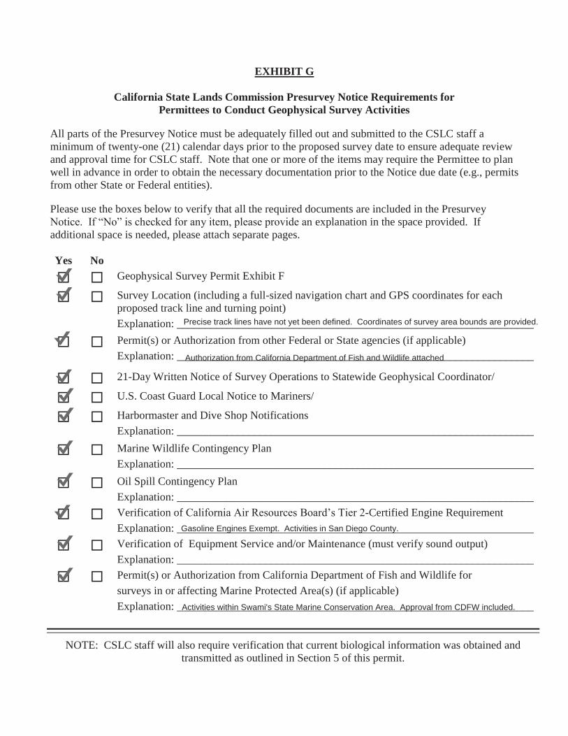
EXHIBIT G
California State Lands Commission Presurvey Notice Requirements for Permittees to Conduct Geophysical Survey Activities
All parts of the Presurvey Notice must be adequately filled out and submitted to the CSLC staff a minimum of twenty-one (21) calendar days prior to the proposed survey date to ensure adequate review and approval time for CSLC staff. Note that one or more of the items may require the Permittee to plan well in advance in order to obtain the necessary documentation prior to the Notice due date (e.g., permits from other State or Federal entities).
Please use the boxes below to verify that all the required documents are included in the Presurvey Notice. If “No” is checked for any item, please provide an explanation in the space provided. If additional space is needed, please attach separate pages. Yes No
Geophysical Survey Permit Exhibit F
Survey Location (including a full-sized navigation chart and GPS coordinates for each proposed track line and turning point)
Explanation: ________________________________________________________________
Permit(s) or Authorization from other Federal or State agencies (if applicable)
Explanation: ________________________________________________________________
21-Day Written Notice of Survey Operations to Statewide Geophysical Coordinator/
U.S. Coast Guard Local Notice to Mariners/
Harbormaster and Dive Shop Notifications
Explanation: ________________________________________________________________
Marine Wildlife Contingency Plan
Explanation: ________________________________________________________________
Oil Spill Contingency Plan
Explanation: ________________________________________________________________
Verification of California Air Resources Board’s Tier 2-Certified Engine Requirement
Explanation: ________________________________________________________________
Verification of Equipment Service and/or Maintenance (must verify sound output)
Explanation: ________________________________________________________________
Permit(s) or Authorization from California Department of Fish and Wildlife for
surveys in or affecting Marine Protected Area(s) (if applicable)
Explanation: ________________________________________________________________
NOTE: CSLC staff will also require verification that current biological information was obtained and transmitted as outlined in Section 5 of this permit.
Authorization from California Department of Fish and Wildlife attached
Gasoline Engines Exempt. Activities in San Diego County.
Activities within Swami's State Marine Conservation Area. Approval from CDFW included.
Precise track lines have not yet been defined. Coordinates of survey area bounds are provided.
ATTACHMENT B
PRE-SURVEY NOTIFICATION FORM (Permit Exhibit F)
-19-
EXHIBIT F
PRESURVEY NOTIFICATION FORM
Applicant/Permittee’s Mailing Address Date: Jurisdiction: Federal State Both If State: Permit #PRC Region: Area:
GEOPHYSICAL SURVEY PERMIT
Check one: New survey Time extension of a previous survey (Applicant/Permittee) will conduct a geophysical survey offshore California in the survey area outlined on the accompanying navigation chart segment. If you foresee potential interference with commercial fishing or other activities, please contact the person(s) listed below:
FEDERAL WATERS (outside 3 nautical miles) 1) Applicant’s representative 2) Federal representative (e.g., Bureau of Ocean Energy Management [BOEM] or National
Science Foundation [NSF]) NOTE: Any comments regarding potential conflicts in Federal waters must be received by the
Applicant’s Representative and lead Federal agency within ten (10) days of the receipt of this notice.
STATE WATERS (Inside 3 nautical miles)
1) Permittee’s representative 2) CSLC representative NOTE: Any comments regarding potential conflicts in State waters should be received as soon as possible by the Permittee’s representative, no more than fifteen (15) days after the receipt of this notice.
1. Expected Date of Operation
2. Hours of Operation
3. Vessel Name
4. Vessel Official Number
5. Vessel Radio Call Sign
6. Vessel Captain’s Name
7. Vessel will monitor Radio Channel(s)
8. Vessel Navigation System
Coastal Frontiers Corporation882A Patriot DriveMoorpark, CA 93021
x
November 14, 2017
IEncinitas, CA to Solana Beach, CA
9404
x
Coastal Frontiers Corp.
December 5, 2017 - January 31, 2018 (4 survey days within given window)
Daylight Hours (~0600 - 1800)
R/V Chinook
Ryan Braget
VHF 16
N/A
Differential GPS
AK 8018 AG
-20-
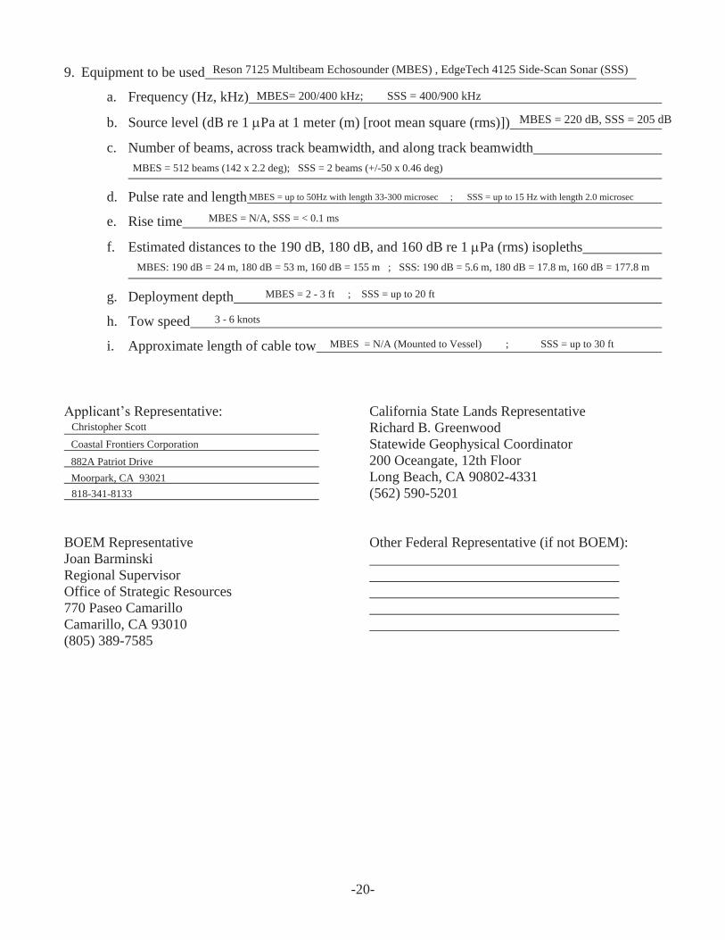
9. Equipment to be used
a. Frequency (Hz, kHz)
b. Source level (dB re 1 Pa at 1 meter (m) [root mean square (rms)])
c. Number of beams, across track beamwidth, and along track beamwidth
d. Pulse rate and length
e. Rise time
f. Estimated distances to the 190 dB, 180 dB, and 160 dB re 1 Pa (rms) isopleths
g. Deployment depth
h. Tow speed
i. Approximate length of cable tow
Applicant’s Representative:
California State Lands Representative Richard B. Greenwood Statewide Geophysical Coordinator 200 Oceangate, 12th Floor Long Beach, CA 90802-4331 (562) 590-5201
BOEM Representative Joan Barminski Regional Supervisor Office of Strategic Resources 770 Paseo Camarillo Camarillo, CA 93010 (805) 389-7585
Other Federal Representative (if not BOEM):
Reson 7125 Multibeam Echosounder (MBES) , EdgeTech 4125 Side-Scan Sonar (SSS)
MBES= 200/400 kHz; SSS = 400/900 kHz
MBES = 220 dB, SSS = 205 dB
MBES = 512 beams (142 x 2.2 deg); SSS = 2 beams (+/-50 x 0.46 deg)
MBES = N/A (Mounted to Vessel) ; SSS = up to 30 ft
3 - 6 knots
MBES = 2 - 3 ft ; SSS = up to 20 ft
MBES = up to 50Hz with length 33-300 microsec ; SSS = up to 15 Hz with length 2.0 microsec
MBES = N/A, SSS = < 0.1 ms
Christopher Scott
Coastal Frontiers Corporation
882A Patriot Drive
Moorpark, CA 93021
818-341-8133
MBES: 190 dB = 24 m, 180 dB = 53 m, 160 dB = 155 m ; SSS: 190 dB = 5.6 m, 180 dB = 17.8 m, 160 dB = 177.8 m
ATTACHMENT C
AUTHORIZATION FROM CALIFORNIA DEPARTMENT OF FISH AND WILDLIFE
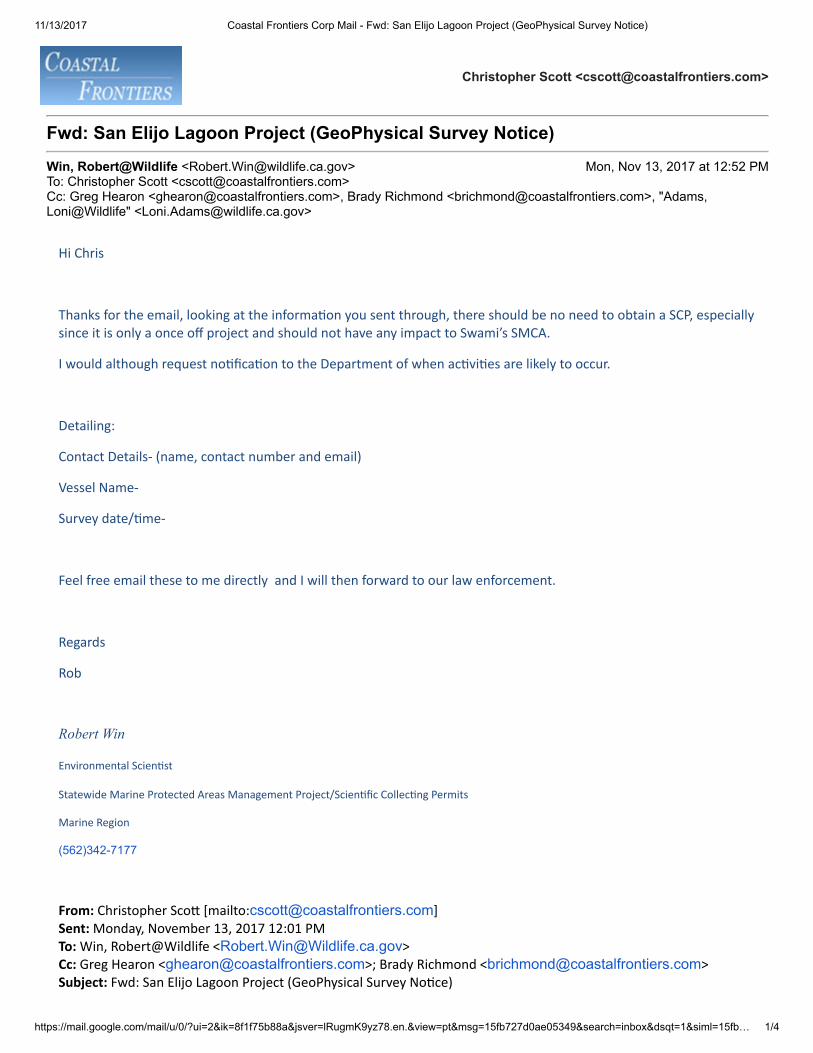
11/13/2017 Coastal Frontiers Corp Mail - Fwd: San Elijo Lagoon Project (GeoPhysical Survey Notice)
https://mail.google.com/mail/u/0/?ui=2&ik=8f1f75b88a&jsver=lRugmK9yz78.en.&view=pt&msg=15fb727d0ae05349&search=inbox&dsqt=1&siml=15fb… 1/4
Christopher Scott <[email protected]>
Fwd: San Elijo Lagoon Project (GeoPhysical Survey Notice)
Win, Robert@Wildlife <[email protected]> Mon, Nov 13, 2017 at 12:52 PMTo: Christopher Scott <[email protected]>Cc: Greg Hearon <[email protected]>, Brady Richmond <[email protected]>, "Adams,Loni@Wildlife" <[email protected]>
Hi Chris
Thanks for the email, looking at the informa�on you sent through, there should be no need to obtain a SCP, especiallysince it is only a once off project and should not have any impact to Swami’s SMCA.
I would although request no�fica�on to the Department of when ac�vi�es are likely to occur.
Detailing:
Contact Details- (name, contact number and email)
Vessel Name-
Survey date/�me-
Feel free email these to me directly and I will then forward to our law enforcement.
Regards
Rob
Robert Win
Environmental Scien�st
Statewide Marine Protected Areas Management Project/Scien�fic Collec�ng Permits
Marine Region
(562)342-7177
From: Christopher Sco� [mailto:[email protected]] Sent: Monday, November 13, 2017 12:01 PM To: Win, Robert@Wildlife <[email protected]> Cc: Greg Hearon <[email protected]>; Brady Richmond <[email protected]> Subject: Fwd: San Elijo Lagoon Project (GeoPhysical Survey No�ce)

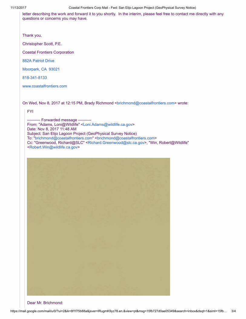
11/13/2017 Coastal Frontiers Corp Mail - Fwd: San Elijo Lagoon Project (GeoPhysical Survey Notice)
https://mail.google.com/mail/u/0/?ui=2&ik=8f1f75b88a&jsver=lRugmK9yz78.en.&view=pt&msg=15fb727d0ae05349&search=inbox&dsqt=1&siml=15fb… 2/4
Hi Robert,
It was great talking with you this morning. As we discussed, the multibeam and side-scan survey described in the letterprovided previously is a one-time survey in support of the San Elijo Lagoon Restoration Project (SELRP). No othermultibeam/side-scan surveys are currently planned in support of the project. Once we have a survey date in mind, I willsend you a notification via email that you can pass along to your wardens in the area. Thanks again for all your help,
Christopher Scott, P.E.
Coastal Frontiers Corporation
882A Patriot Drive
Moorpark, CA 93021
818-341-8133
www.coastalfrontiers.com
---------- Forwarded message ---------- From: Christopher Scott <[email protected]> Date: Thu, Nov 9, 2017 at 10:42 AM Subject: Re: San Elijo Lagoon Project (GeoPhysical Survey Notice) To: [email protected] Cc: Brady Richmond <[email protected]>, [email protected], [email protected],Greg Hearon <[email protected]>
Hi Loni,
As requested, I have attached a letter summarizing the proposed survey activities near Encinitas, CA. The letter includesa description of the survey location, vessel, and sonar equipment to be used. Specification sheets for the sonarequipment and Oil Spill and Marine Wildlife Contingency Plans are provided as attachments. Pending approval fromCDFW, we will submit a similar letter to CSLC as part of our pre-survey notifications. Please let me know if you have anyquestions or need any additional information.
Thank you for your assistance,
Christopher Scott, P.E.
Coastal Frontiers Corporation
882A Patriot Drive
Moorpark, CA 93021
818-341-8133
www.coastalfrontiers.com
On Wed, Nov 8, 2017 at 12:54 PM, Christopher Scott <[email protected]> wrote:
Hi Loni,
My colleague, Brady Richmond, forwarded me your email requesting additional information regarding our plannedhydrographic survey activities near Encinitas, CA. This morning, I spoke with Simona Altman at CDFW regarding thework and she mentioned that she would be passing our information along to the Marine Region. I will prepare a brief
11/13/2017 Coastal Frontiers Corp Mail - Fwd: San Elijo Lagoon Project (GeoPhysical Survey Notice)
https://mail.google.com/mail/u/0/?ui=2&ik=8f1f75b88a&jsver=lRugmK9yz78.en.&view=pt&msg=15fb727d0ae05349&search=inbox&dsqt=1&siml=15fb… 3/4
letter describing the work and forward it to you shortly. In the interim, please feel free to contact me directly with anyquestions or concerns you may have.
Thank you,
Christopher Scott, P.E.
Coastal Frontiers Corporation
882A Patriot Drive
Moorpark, CA 93021
818-341-8133
www.coastalfrontiers.com
On Wed, Nov 8, 2017 at 12:15 PM, Brady Richmond <[email protected]> wrote:
FYI
---------- Forwarded message ---------- From: "Adams, Loni@Wildlife" <[email protected]> Date: Nov 8, 2017 11:48 AM Subject: San Elijo Lagoon Project (GeoPhysical Survey Notice) To: "[email protected]" <[email protected]> Cc: "Greenwood, Richard@SLC" <[email protected]>, "Win, Robert@Wildlife"<[email protected]>
Dear Mr. Brichmond:
11/13/2017 Coastal Frontiers Corp Mail - Fwd: San Elijo Lagoon Project (GeoPhysical Survey Notice)
https://mail.google.com/mail/u/0/?ui=2&ik=8f1f75b88a&jsver=lRugmK9yz78.en.&view=pt&msg=15fb727d0ae05349&search=inbox&dsqt=1&siml=15fb… 4/4
Thank you for contacting the Department regarding the impending geophysical survey proposal. The Department ofFish and Wildlife (Department) Marine Region is reviewing your email requesting our approval for your geophysicalsurvey. I will be taking the lead on this marine related proposal as I am in the Marine Region. The Departmentrequests more information such as a plan describing the type of equipment you will be using and any biologicalmonitoring and mitigation plans. Depending on the type of equipment, you may be required to obtain a scientificcollecting permit. Specifically, will you be using any type of equipment that is towed underwater?
I look forward to reviewing the additional information documents.
Sincerely,
Loni Adams
Marine Environmental Scientist
California Department of Fish and Wildlife
Marine Region
3883 Ruffin Rd.
San Diego, CA 92123
858-627-3985 office
858-627-3984 Marine FAX
COASTAL
FRONTIERS
Coastal Frontiers Corporation
882A Patriot Drive Moorpark, CA 93021-3544
(818) 341-8133 www.coastalfrontiers.com
November 9, 2017
Loni Adams Marine Environmental Scientist California Department of Fish and Wildlife Marine Region 3883 Ruffin Rd. San Diego, CA 92123 Subject: Request for Approval, Geophysical Survey Activities near Encinitas, CA
Ms. Adams:
Coastal Frontiers has been contracted to conduct a hydrographic survey offshore of Encinitas, CA in support of the San Elijo Lagoon Restoration Project (SELRP). A portion of the proposed survey area lies within Swami's State Marine Conservation Area. As a result, we are seeking California Department of Fish and Wildlife (CDFW) approval for the proposed activities prior to submitting a pre-survey notification to the California State Lands Commission (CSLC) under permit PRC 9404.
This letter summarizes the proposed survey activities, including the survey
location, vessel, and sonar equipment to be used. Specification sheets for the sonar equipment are provided in Attachment A. Oil Spill and Marine Wildlife Contingency Plans are included in Attachments B and C, respectively. Proposed Survey Activities
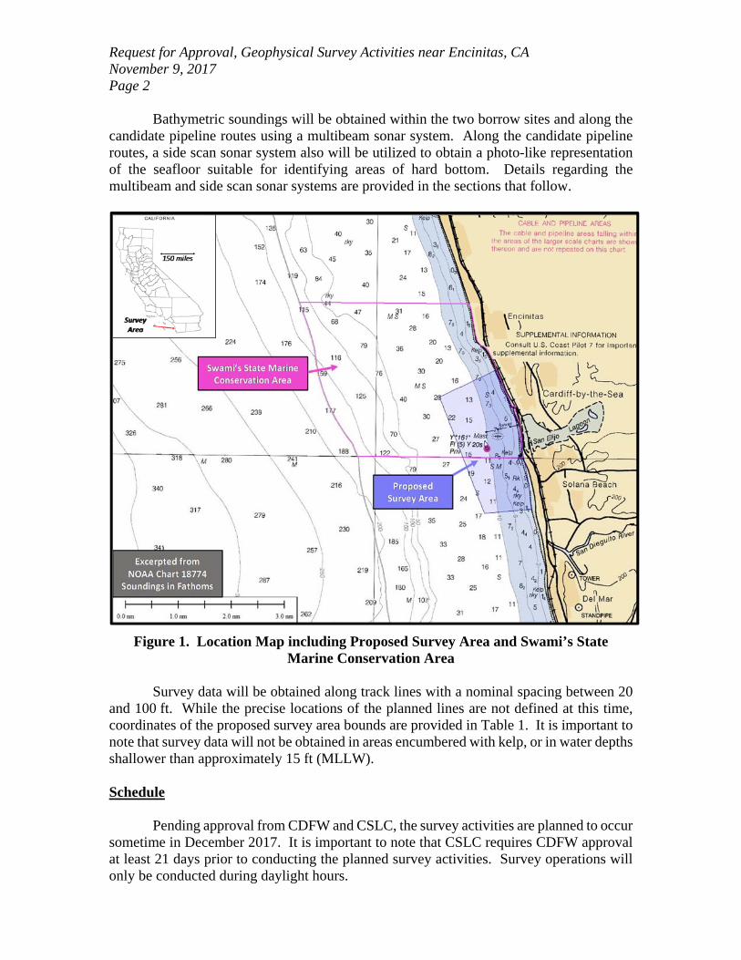
The proposed survey activities include multibeam and side scan sonar data
collection within the nearshore region shown in Figure 1. As is shown in the figure, a portion of the survey area lies within the Swami’s State Marine Conservation Area. The purpose of the survey is to:
Determine the capacity of two borrow pits previously excavated as part of SANDAG’s Regional Beach Sand Projects I and II (RBSP I and II); and
Identify areas of hard-bottom along candidate pipeline approaches from the borrow pits to shore.
Request for Approval, Geophysical Survey Activities near Encinitas, CA November 9, 2017 Page 2
Bathymetric soundings will be obtained within the two borrow sites and along the candidate pipeline routes using a multibeam sonar system. Along the candidate pipeline routes, a side scan sonar system also will be utilized to obtain a photo-like representation of the seafloor suitable for identifying areas of hard bottom. Details regarding the multibeam and side scan sonar systems are provided in the sections that follow.
Figure 1. Location Map including Proposed Survey Area and Swami’s State Marine Conservation Area
Survey data will be obtained along track lines with a nominal spacing between 20
and 100 ft. While the precise locations of the planned lines are not defined at this time, coordinates of the proposed survey area bounds are provided in Table 1. It is important to note that survey data will not be obtained in areas encumbered with kelp, or in water depths shallower than approximately 15 ft (MLLW).
Schedule
Pending approval from CDFW and CSLC, the survey activities are planned to occur
sometime in December 2017. It is important to note that CSLC requires CDFW approval at least 21 days prior to conducting the planned survey activities. Survey operations will only be conducted during daylight hours.
Request for Approval, Geophysical Survey Activities near Encinitas, CA November 9, 2017 Page 3
Table 1. Coordinates of Proposed Survey Area
Survey Vessel
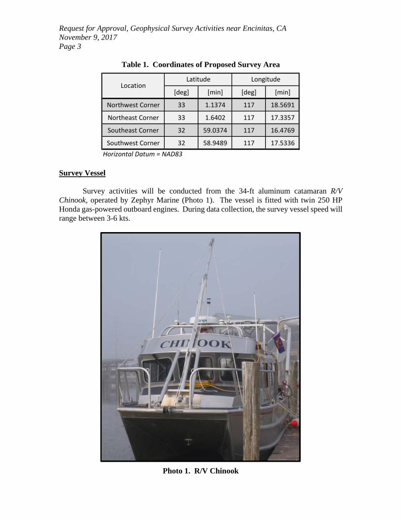
Survey activities will be conducted from the 34-ft aluminum catamaran R/V
Chinook, operated by Zephyr Marine (Photo 1). The vessel is fitted with twin 250 HP Honda gas-powered outboard engines. During data collection, the survey vessel speed will range between 3-6 kts.
Photo 1. R/V Chinook
[deg] [min] [deg] [min]
Northwest Corner 33 1.1374 117 18.5691
Northeast Corner 33 1.6402 117 17.3357
Southeast Corner 32 59.0374 117 16.4769
Southwest Corner 32 58.9489 117 17.5336
Horizontal Datum = NAD83
Latitude LongitudeLocation
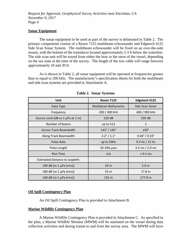
Request for Approval, Geophysical Survey Activities near Encinitas, CA November 9, 2017 Page 4 Sonar Equipment
The sonar equipment to be used as part of the survey is delineated in Table 2. The primary components consist of a Reson 7125 multibeam echosounder and Edgetech 4125 Side Scan Sonar System. The multibeam echosounder will be fixed on an over-the-side mount, with the bottom of the transducer located approximately 2-3 ft below the waterline. The side scan unit will be towed from either the bow or the stern of the vessel, depending on the sea state at the time of the survey. The length of the tow cable will range between approximately 10 and 30 ft.
As is shown in Table 2, all sonar equipment will be operated at frequencies greater
than or equal to 200 kHz. The manufacturer’s specification sheets for both the multibeam and side scan systems are provided in Attachment A.
Table 2. Sonar Systems
Oil Spill Contingency Plan
An Oil Spill Contingency Plan is provided in Attachment B.
Marine Wildlife Contingency Plan A Marine Wildlife Contingency Plan is provided in Attachment C. As specified in
the plan, a Marine Wildlife Monitor (MWM) will be stationed on the vessel during data collection activities and during transit to and from the survey area. The MWM will have
Unit Reson 7125 Edgetech 4125
Data Type Multibeam Bathymetry Side Scan Sonar
Frequency 200 / 400 kHz 400 / 900 kHz
Source Level (dB re 1 μPa at 1 m) 220 dB 205 dB
Number of beams up to 512 2
Across Track Beamwidth 142° / 145° ±50°
Along Track Beamwidth 2.2° / 1.1° 0.46° / 0.33°
Pulse Rate up to 50Hz 9.4 Hz / 15 Hz
Pulse Length 33‐330 μsec 3.2 ms / 2.0 ms
Rise Time n/a < 0.1 ms
Estimated Distance to isopleth: ‐ ‐
190 dB (re 1 μPa (rms)) 24 m 5.6 m
180 dB (re 1 μPa (rms)) 53 m 17.8 m
160 dB (re 1 μPa (rms)) 155 m 177.8 m
Request for Approval, Geophysical Survey Activities near Encinitas, CA November 9, 2017 Page 5 the authority to stop or re-direct vessel and survey operations when necessary to avoid wildlife disturbances. As noted previously, all survey equipment will be operated at frequencies greater than or equal to 200 kHz; therefore, only one MWM is required. Resumes for MWM that may participate in the project are included in Appendix C.
It is important to note that survey data will not be obtained in areas encumbered
with kelp, or in water depths shallower than approximately 10 ft (MLLW). The Coastal Frontiers crew members, MWM and vessel captain shall be responsible for monitoring the area for kelp to ensure that the vessel and side scan towfish do not enter areas with dense kelp.
We sincerely appreciate your assistance with approval of the proposed survey activities. Please do not hesitate to contact us if you have any questions or require additional information. Sincerely, Coastal Frontiers Corporation
Christopher Scott, P.E Enclosures: Attachment A – Sonar Specification Sheets Attachment B – Oil Spill Contingency Plan Attachment C – Marine Wildlife Contingency Plan
ATTACHMENT D
U.S. COAST GUARD LOCAL NOTICE TO MARINERS
11/13/2017 Coastal Frontiers Corp Mail - Request for Local Notice to Mariners - Hydrographic Survey
https://mail.google.com/mail/u/0/?ui=2&ik=8f1f75b88a&jsver=lRugmK9yz78.en.&view=pt&msg=15fb822464e35b89&search=sent&siml=15fb822464e3… 1/1
Christopher Scott <[email protected]>
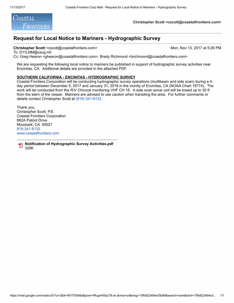
Request for Local Notice to Mariners - Hydrographic Survey
Christopher Scott <[email protected]> Mon, Nov 13, 2017 at 5:26 PMTo: [email protected]: Greg Hearon <[email protected]>, Brady Richmond <[email protected]>
We are requesting the following local notice to mariners be published in support of hydrographic survey activities nearEncinitas, CA. Additional details are provided in the attached PDF.
SOUTHERN CALIFORNIA - ENCINITAS - HYDROGRAPHIC SURVEYCoastal Frontiers Corporation will be conducting hydrographic survey operations (multibeam and side scan) during a 4-day period between December 5, 2017 and January 31, 2018 in the vicinity of Encinitas, CA (NOAA Chart 18774). Thework will be conducted from the R/V Chinook monitoring VHF CH 16. A side scan sonar unit will be towed up to 30 ftfrom the stern of the vessel. Mariners are advised to use caution when transiting the area. For further comments ordetails contact Christopher Scott at (818) 341-8133.
Thank you, Christopher Scott, P.E.Coastal Frontiers Corporation882A Patriot DriveMoorpark, CA 93021818-341-8133www.coastalfrontiers.com
Notification of Hydrographic Survey Activities.pdf 329K

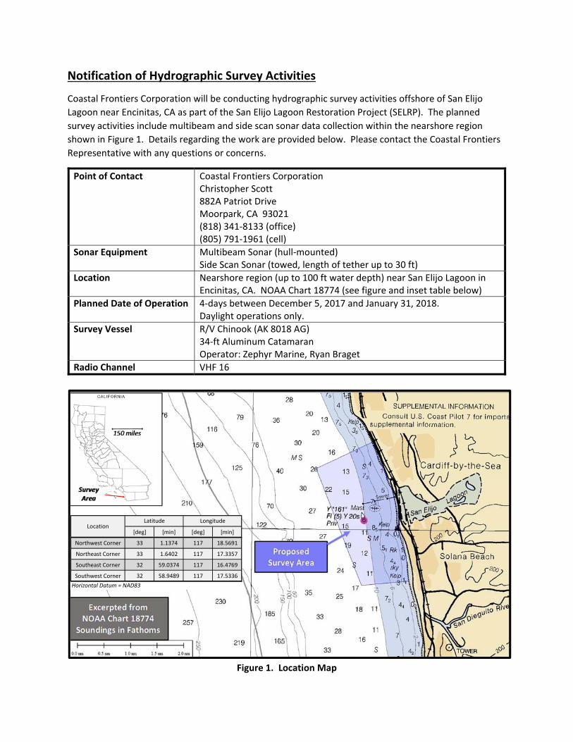
Notification of Hydrographic Survey Activities
Coastal Frontiers Corporation will be conducting hydrographic survey activities offshore of San Elijo
Lagoon near Encinitas, CA as part of the San Elijo Lagoon Restoration Project (SELRP). The planned
survey activities include multibeam and side scan sonar data collection within the nearshore region
shown in Figure 1. Details regarding the work are provided below. Please contact the Coastal Frontiers
Representative with any questions or concerns.
Point of Contact Coastal Frontiers Corporation Christopher Scott 882A Patriot Drive Moorpark, CA 93021 (818) 341‐8133 (office) (805) 791‐1961 (cell)
Sonar Equipment Multibeam Sonar (hull‐mounted) Side Scan Sonar (towed, length of tether up to 30 ft)
Location Nearshore region (up to 100 ft water depth) near San Elijo Lagoon in Encinitas, CA. NOAA Chart 18774 (see figure and inset table below)
Planned Date of Operation 4‐days between December 5, 2017 and January 31, 2018. Daylight operations only.
Survey Vessel R/V Chinook (AK 8018 AG) 34‐ft Aluminum Catamaran Operator: Zephyr Marine, Ryan Braget
Radio Channel VHF 16
Figure 1. Location Map
[deg] [min] [deg] [min]
Northwest Corner 33 1.1374 117 18.5691
Northeast Corner 33 1.6402 117 17.3357
Southeast Corner 32 59.0374 117 16.4769
Southwest Corner 32 58.9489 117 17.5336
Horizontal Datum = NAD83
Latitude LongitudeLocation
ATTACHMENT E
HARBOR MASTER AND DIVE SHOP NOTIFICATIONS
11/13/2017 Coastal Frontiers Corp Mail - Notification of Hydrographic Survey Activities - Encinitas, CA
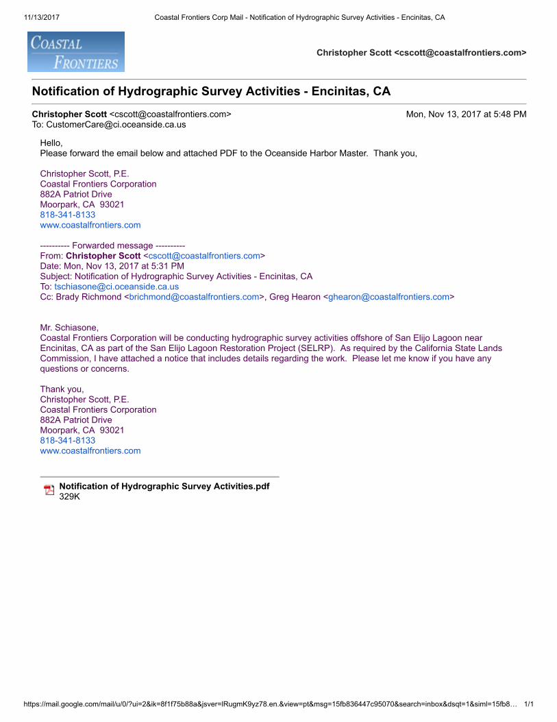
https://mail.google.com/mail/u/0/?ui=2&ik=8f1f75b88a&jsver=lRugmK9yz78.en.&view=pt&msg=15fb836447c95070&search=inbox&dsqt=1&siml=15fb8… 1/1
Christopher Scott <[email protected]>
Notification of Hydrographic Survey Activities - Encinitas, CA
Christopher Scott <[email protected]> Mon, Nov 13, 2017 at 5:48 PMTo: [email protected]
Hello,Please forward the email below and attached PDF to the Oceanside Harbor Master. Thank you,
Christopher Scott, P.E.Coastal Frontiers Corporation882A Patriot DriveMoorpark, CA 93021818-341-8133www.coastalfrontiers.com
---------- Forwarded message ---------- From: Christopher Scott <[email protected]> Date: Mon, Nov 13, 2017 at 5:31 PM Subject: Notification of Hydrographic Survey Activities - Encinitas, CA To: [email protected] Cc: Brady Richmond <[email protected]>, Greg Hearon <[email protected]>
Mr. Schiasone,Coastal Frontiers Corporation will be conducting hydrographic survey activities offshore of San Elijo Lagoon nearEncinitas, CA as part of the San Elijo Lagoon Restoration Project (SELRP). As required by the California State LandsCommission, I have attached a notice that includes details regarding the work. Please let me know if you have anyquestions or concerns.
Thank you,Christopher Scott, P.E.Coastal Frontiers Corporation882A Patriot DriveMoorpark, CA 93021818-341-8133www.coastalfrontiers.com
Notification of Hydrographic Survey Activities.pdf 329K
11/13/2017 Coastal Frontiers Corp Mail - Notification of Hydrographic Survey Activities - Encinitas, CA
https://mail.google.com/mail/u/0/?ui=2&ik=8f1f75b88a&jsver=lRugmK9yz78.en.&view=pt&msg=15fb82a6affa0e56&search=sent&siml=15fb82a6affa0e56 1/1
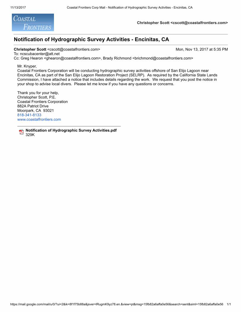
Christopher Scott <[email protected]>
Notification of Hydrographic Survey Activities - Encinitas, CA
Christopher Scott <[email protected]> Mon, Nov 13, 2017 at 5:35 PMTo: [email protected]: Greg Hearon <[email protected]>, Brady Richmond <[email protected]>
Mr. Knyper,Coastal Frontiers Corporation will be conducting hydrographic survey activities offshore of San Elijo Lagoon nearEncinitas, CA as part of the San Elijo Lagoon Restoration Project (SELRP). As required by the California State LandsCommission, I have attached a notice that includes details regarding the work. We request that you post the notice inyour shop to advise local divers. Please let me know if you have any questions or concerns.
Thank you for your help,Christopher Scott, P.E.Coastal Frontiers Corporation882A Patriot DriveMoorpark, CA 93021818-341-8133www.coastalfrontiers.com
Notification of Hydrographic Survey Activities.pdf 329K
Notification of Hydrographic Survey Activities
Coastal Frontiers Corporation will be conducting hydrographic survey activities offshore of San Elijo
Lagoon near Encinitas, CA as part of the San Elijo Lagoon Restoration Project (SELRP). The planned
survey activities include multibeam and side scan sonar data collection within the nearshore region
shown in Figure 1. Details regarding the work are provided below. Please contact the Coastal Frontiers
Representative with any questions or concerns.
Point of Contact Coastal Frontiers Corporation Christopher Scott 882A Patriot Drive Moorpark, CA 93021 (818) 341‐8133 (office) (805) 791‐1961 (cell)
Sonar Equipment Multibeam Sonar (hull‐mounted) Side Scan Sonar (towed, length of tether up to 30 ft)
Location Nearshore region (up to 100 ft water depth) near San Elijo Lagoon in Encinitas, CA. NOAA Chart 18774 (see figure and inset table below)
Planned Date of Operation 4‐days between December 5, 2017 and January 31, 2018. Daylight operations only.
Survey Vessel R/V Chinook (AK 8018 AG) 34‐ft Aluminum Catamaran Operator: Zephyr Marine, Ryan Braget
Radio Channel VHF 16
Figure 1. Location Map
[deg] [min] [deg] [min]
Northwest Corner 33 1.1374 117 18.5691
Northeast Corner 33 1.6402 117 17.3357
Southeast Corner 32 59.0374 117 16.4769
Southwest Corner 32 58.9489 117 17.5336
Horizontal Datum = NAD83
Latitude LongitudeLocation
ATTACHMENT F
SONAR SPECIFICATION SHEETS AND VERIFICATION OF SERVICE
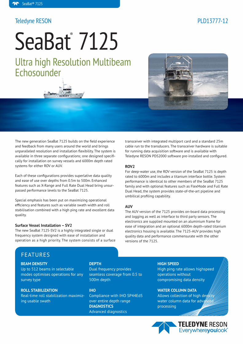
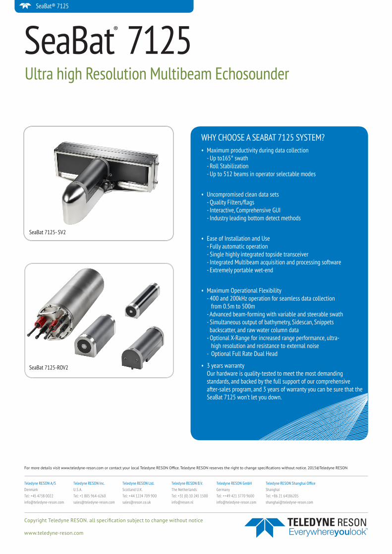
The new generation SeaBat 7125 builds on the field experience and feedback from many users around the world and brings unparalleled resolution and installation flexibility. The system is available in three separate configurations; one designed specifi-cally for installation on survey vessels and 6000m depth rated systems for either ROV or AUV.
Each of these configurations provides superlative data quality and ease of use over depths from 0.5m to 500m. Enhanced features such as X-Range and Full Rate Dual Head bring unsur-passed performance levels to the SeaBat 7125.
Special emphasis has been put on maximizing operational efficiency and features such as variable swath width and roll stabilisation combined with a high ping rate and excellent data quality.
Surface Vessel Installation – SV2The new SeaBat 7125-SV2 is a highly integrated single or dual frequency system designed with ease of installation and operation as a high priority. The system consists of a surface
transceiver with integrated multiport card and a standard 25m cable run to the transducers. The transceiver hardware is suitable for running data acquisition software and is available with Teledyne RESON PDS2000 software pre-installed and configured.
ROV2For deep-water use, the ROV version of the SeaBat 7125 is depth rated to 6000m and includes a titanium interface bottle. System performance is identical to other members of the SeaBat 7125 family and with optional features such as FlexMode and Full Rate Dual Head, the system provides state-of-the-art pipeline and umbilical profiling capability.
AUVThe AUV version of the 7125 provides on-board data processing and logging as well as interface to third party sensors. The electronics are supplied mounted on an aluminium frame for ease of integration and an optional 6000m depth-rated titanium electronics housing is available. The 7125-AUV provides high quality data and performance commensurate with the other versions of the 7125.
SeaBat® 7125Ultra high Resolution Multibeam Echosounder
Teledyne RESON PLD13777-12
SeaBat® 7125
FEATURESBEAM DENSITYUp to 512 beams in selectable modes optimises operations for any survey type
ROLL STABILIZATIONReal-time roll stabilization maximiz-ing usable swath
DEPTHDual frequency providesseamless coverage from 0.5 to500m depth
IHOCompliance with IHO SP44Ed5over entire depth rangeDIAGNOSTICSAdvanced diagnostics
HIGH SPEEDHigh ping rate allows highspeed operations withoutcompromising data density
WATER COLUMN DATAAllows collection of high density water column data for advanced processing
SeaBat® 7125
SeaBat® 7125SEABAT 7125 SYSTEM SPECIFICATIONS
7125 SV2 7125 ROV2 7125 AUVPower requirement Typical: 110-220 VAC, 50/60
Hz, 250 W.
Max: 110-220 VAC, 50/60 Hz, 700 W.
Processor Typical: 110-220 VAC, 50/60 Hz, 110 W.
Processor Max: 110-220 VAC, 50/60 Hz, 400 W.
Wet end Typical: 48 VDC (+/- 10%), 115 W.
Wet end Max: 48 VDC (+/- 10%) 250 W.
Power requirements when Wet-ends are powered from sonar processor: 110-220 VAC, 50/60 Hz, 700 W.
48V DC (± 10%)
Transducer cable length 25m standard 3m standard 10m optional 3m standard 10m optionalLCU to processor cable length N/A 25m (st), 3 m N/ASystem depth rating 25m 6000m 6000m optional
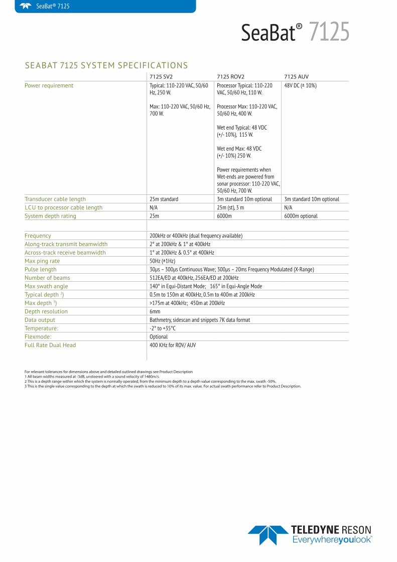
Frequency 200kHz or 400kHz (dual frequency available)Along-track transmit beamwidth 2° at 200kHz & 1° at 400kHz Across-track receive beamwidth 1° at 200kHz & 0.5° at 400kHzMax ping rate 50Hz (±1Hz)Pulse length 30µs – 300µs Continuous Wave; 300µs – 20ms Frequency Modulated (X-Range)Number of beams 512EA/ED at 400kHz, 256EA/ED at 200kHzMax swath angle 140° in Equi-Distant Mode; 165° in Equi-Angle ModeTypical depth 2) 0.5m to 150m at 400kHz, 0.5m to 400m at 200kHzMax depth 3) >175m at 400kHz; 450m at 200kHzDepth resolution 6mmData output Bathmetry, sidescan and snippets 7K data formatTemperature: -2° to +35°CFlexmode: OptionalFull Rate Dual Head 400 KHz for ROV/ AUV
For relevant tolerances for dimensions above and detailed outlined drawings see Product Description 1 All beam widths measured at -3dB, unsteered with a sound velocity of 1480m/s.2 This is a depth range within which the system is normally operated, from the minimum depth to a depth value corresponding to the max. swath -50%.3 This is the single value corresponding to the depth at which the swath is reduced to 10% of its max. value. For actual swath performance refer to Product Description.
SeaBat® 7125
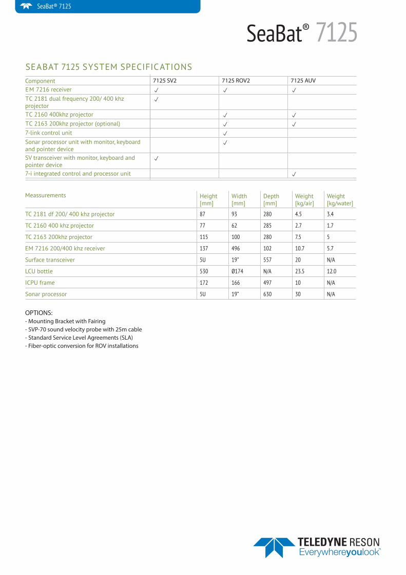
SeaBat® 7125SEABAT 7125 SYSTEM SPECIFICATIONSComponent 7125 SV2 7125 ROV2 7125 AUVEM 7216 receiver p p p
TC 2181 dual frequency 200/ 400 khz projector
p
TC 2160 400khz projector p p
TC 2163 200khz projector (optional) p p
7-link control unit p
Sonar processor unit with monitor, keyboard and pointer device
p
SV transceiver with monitor, keyboard and pointer device
p
7-i integrated control and processor unit p
Meassurements Height [mm]
Width [mm]
Depth [mm]
Weight [kg/air]
Weight [kg/water]
TC 2181 df 200/ 400 khz projector 87 93 280 4.5 3.4
TC 2160 400 khz projector 77 62 285 2.7 1.7
TC 2163 200khz projector 115 100 280 7.5 5
EM 7216 200/400 khz receiver 137 496 102 10.7 5.7
Surface transceiver 5U 19” 557 20 N/A
LCU bottle 530 Ø174 N/A 23.5 12.0
ICPU frame 172 166 497 10 N/A
Sonar processor 5U 19” 630 30 N/A
OPTIONS:- Mounting Bracket with Fairing- SVP-70 sound velocity probe with 25m cable- Standard Service Level Agreements (SLA)- Fiber-optic conversion for ROV installations
Copyright Teledyne RESON. all specifi cation subject to change without notice
www.teledyne-reson.com
Teledyne RESON A/SDenmarkTel: +45 4738 [email protected]
Teledyne RESON Inc.U.S.A.Tel: +1 805 [email protected]
Teledyne RESON Ltd.Scotland U.K.Tel: +44 1224 709 [email protected]
Teledyne RESON B.V.The NetherlandsTel: +31 (0) 10 245 [email protected]
Teledyne RESON Shanghai O� ceShanghaiTel: +86 21 [email protected]
For more details visit www.teledyne-reson.com or contact your local Teledyne RESON O� ce. Teledyne RESON reserves the right to change specifi cations without notice. 2015©Teledyne RESON
Teledyne RESON GmbHGermanyTel: ++49 421 3770 [email protected]
SeaBat® 7125
WHY CHOOSE A SEABAT 7125 SYSTEM?• Maximum productivity during data collection
- Up to165° swath - Roll Stabilization - Up to 512 beams in operator selectable modes
• Uncompromised clean data sets - Quality Filters/flags - Interactive, Comprehensive GUI - Industry leading bottom detect methods
• Ease of Installation and Use - Fully automatic operation - Single highly integrated topside transceiver - Integrated Multibeam acquisition and processing software - Extremely portable wet-end
• Maximum Operational Flexibility - 400 and 200kHz operation for seamless data collection from 0.5m to 500m - Advanced beam-forming with variable and steerable swath - Simultaneous output of bathymetry, Sidescan, Snippets backscatter, and raw water column data - Optional X-Range for increased range performance, ultra- high resolution and resistance to external noise - Optional Full Rate Dual Head
• 3 years warranty Our hardware is quality-tested to meet the most demanding standards, and backed by the full support of our comprehensive after-sales program, and 3 years of warranty you can be sure that the SeaBat 7125 won’t let you down.
SeaBat 7125- SV2
SeaBat 7125-ROV2
SeaBat® 7125Ultra high Resolution Multibeam Echosounder
Post-Hire Inspection Record
Page 1 of 8
Customer
Order Number HOF004989A
Work order FWO031802 Status: Created
Asset H126516
LCD Monitor (W007016-R)
Go to Kit Contents
Post-Hire Inspection checks Completed Reading Technician
Ensure you have read & understood manufacturers instructions
Implement any safety requirements & use PPE where required
Check unit for Physical Damage
PAT test unit
Record Make and Model of Monitor
(Required for FCC in US)
Check label for correct asset number and serial number
Cycle through different inputs and test that the ports work.
(Component (HD), HDMI,VGA, Composite (SD), DVI)
Check all buttons function correctly
Confirm equipment photo added to order header
(Pre-Mob Only - Do not release equipment without first adding images to AX and DropBox as directed in attached guide.)
All the Above Checks completed by:
Fail?-complete this WO, result to Yes & raise new repair WO
(Change result to Yes if the unit fails any test, complete this work order & raise a new work order.)
Work Order: FWO031802 - Status: Created
Check method: Monitor Checklist
Authorised By:
Date Inspected:
Post-Hire Inspection Record
Page 1 of 8
Customer
Order Number HOF004989A
Work order FWO031316 Status: Completed
Asset S219347
Reson 7101 Seabat Processor (W022014-R)
Go to Kit Contents
Post-Hire Inspection checks Completed Reading Technician
Ensure you have read & understood manufacturers instructions
Implement any safety requirements & use PPE where required.
Check for physical damage
PAT test processor and monitor
Check continuity & insulation breakdown of all subsea cables
Check length of all cables & tail for damage
Check connectors for damage
Clean processor fan filters
Connect Subsea equipment to processor via supplied decklead
Attach 2 monitors to Processor to test video card
On power up ensure Transmit power is set to zero
Check operation of mouse and keyboard
Check BITE menu ensuring no errors or alarms
Check processor has had MOXA card update Yes Alex Iglesias
(Instructions and Excel file with updated list are avalable on sharepoint link. Install new Moxa card if required.)
Check operation of all RS232 ports
(checking 8 port moxa card is installed correctly in device manager)
Check operation of all Ethernet ports
Check operation of all USB ports
Ensure PPS is accepted
Check operation as dual head setup (if for dual head hire) Yes Alex Iglesias
Post-Hire Inspection Record
Page 1 of 8
Check software (FP) version is current. Record version: G4 Alex Iglesias
(latest feature pack (FP):
G4 Processor: 3.1.(SV2: 3.7) G5 Processor: 4.0)
Record if flexmode or FRDH are licensed features Flexmode Alex Iglesias
Record 7K Center Version G4 Alex Iglesias
(found in "about seabat". G4 Processor: Latest: 5.3.9.6 (SV2 5.3.10.4)
G5 processor: Latest: 6.1.0.13)
Record 7K UI Version G4 Alex Iglesias
(Found in "about seabat".
G4 Processor: Latest: 5.3.6.11 G5 processor: Latest: 6.1.0.13)
Record 7K IO Version G4 Alex Iglesias
(found in "about seabat". G4 Processor: Latest: 4.0.0.10 G5 processor: Latest: 4.2.0.5 (SV: 4.10.10))
Check for non standard software - uninstall as necessary
Ensure 7k loader firmware 60 is installed Yes Alex Iglesias
Clean unit and transit case
Ensure all system labels are in good condition
Ensure manual supplied is correct revision
Confirm equipment photo added to order header No Alex Iglesias
(Pre-Mob Only - Do not release equipment without first adding images to AX and DropBox as directed in attached guide.)
All above checks completed by: Alex Iglesias
Fail?-complete this WO, result to Yes & raise new repair WO
(Change result to Yes if the unit fails any test, complete this work order & raise a new work order.)
Work Order: FWO031316 - Status: Completed
Check method: Reson 7125-P Processor Checklist
Authorised By: Alex Iglesias
Date Inspected: 12/10/2017
Post-Hire Inspection Record
Page 1 of 8
Customer
Order Number HOF004989A
Work order FWO031315 Status: Completed
Asset S219349
Reson 7101 100m Seabat Head (W022028-R)
Go to Kit Contents
Post-Hire Inspection checks Completed Reading Technician
Ensure you have read & understood manufacturers instructions
Implement any safety requirements & use PPE where required.
Check for physical damage to Receive array (complete 360deg) Yes Alex Iglesias
Check for physical damage to Transmit transducer Yes Alex Iglesias
Check for physical damage to bulkhead connector Yes Alex Iglesias
Remove connector protection plate & check for delamination
ALU heads only: Check condition of anodes-clean/replace Yes Alex Iglesias
Check fairing & insulation kits are complete & undamaged Yes Alex Iglesias
Connect head to processor via supplied decklead
Ensure head is successfully calibrated
On power on ensure Transmit power is set to zero
Ensure no leak alarm is present in software
Check BITE for any RED/Yellow channels - advise supervisor Yes Alex Iglesias
Photograph BITE menu showing channels
Check TX operation - Do not transmit in air longer than 1min
Perform 'rub test' ensuring array responds uniformly
Wet test sonarhead in tank
Clean unit and transit case
Ensure all system labels are in good condition
Post-Hire Inspection Record
Page 1 of 8
Confirm equipment photo added to order header No Alex Iglesias
(Pre-Mob Only - Do not release equipment without first adding images to AX and DropBox as directed in
attached guide.)
All above checks completed by: Alex Iglesias
Fail?-complete this WO, result to Yes & raise new repair WO No Alex Iglesias
(Change result to Yes if the unit fails any test, complete this work order & raise a new work order.)
Work Order: FWO031315 - Status: Completed
Check method: Reson 8101 Seabat head checklist
Authorised By: Alex Iglesias
Date Inspected: 12/10/2017
Post-Hire Inspection Record
Page 1 of 8
Customer
Order Number HOF004989A
Work order FWO031317 Status: Completed
Asset S219351
Reson 50m Seabat Cable (W022063-R)
Go to Kit Contents
Post-Hire Inspection checks Completed Reading Technician
Ensure you have read & understood manufacturers instructions
Implement any safety requirements & use PPE where required.
Check Reel/drum for physical damage
(If applicable)
Run out entire length of cable
Record length in meters 50.0000 Alex Iglesias
Check cable is fitted correctly to drum
(NOTE: Normally Male end - Top, Female end - Bottom. If applicable)
Ensure sufficient access to top end connector
(if applicable)
Check entire length of cable for damage
Clean entire length of cable
Spool cable back onto reel/drum neatly
(If applicable)
Clean reel/drum
(If applicable)
Meter & megger cable. Ensure >999MΩ 999.000 Alex Iglesias
Ensure cable is discharged fully after meggering Yes Alex Iglesias
(WARNING: Failure to do so may result in damage to equipment when cable is plugged.)
Test cable with complete system and confirm functional Yes Alex Iglesias
Ensure connectors are protected from moisture during transit
Ensure connectors are secure to avoid damage during transit
Ensure all system labels are in good condition
Confirm equipment photo added to order header No Alex Iglesias
(Pre-Mob Only - Do not release equipment without first adding images to AX and DropBox as directed in attached guide.)
Post-Hire Inspection Record
Page 1 of 8
All above checks completed by: Alex Iglesias
Fail?-complete this WO, result to Yes & raise new repair WO No Alex Iglesias
(Change result to Yes if the unit fails any test, complete this work order & raise a new work order.)
Work Order: FWO031317 - Status: Completed
Check method: Umbilical checklist
Authorised By: Alex Iglesias
Date Inspected: 12/10/2017
Post-Hire Inspection Record
Page 1 of 8
Customer
Order Number HOF004989A
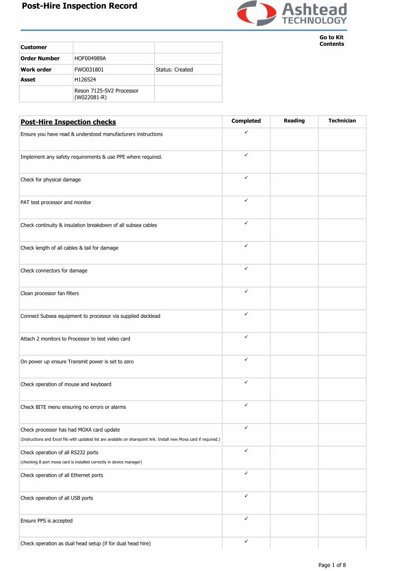
Work order FWO031801 Status: Created
Asset H126524
Reson 7125-SV2 Processor (W022081-R)
Go to Kit Contents
Post-Hire Inspection checks Completed Reading Technician
Ensure you have read & understood manufacturers instructions
Implement any safety requirements & use PPE where required.
Check for physical damage
PAT test processor and monitor
Check continuity & insulation breakdown of all subsea cables
Check length of all cables & tail for damage
Check connectors for damage
Clean processor fan filters
Connect Subsea equipment to processor via supplied decklead
Attach 2 monitors to Processor to test video card
On power up ensure Transmit power is set to zero
Check operation of mouse and keyboard
Check BITE menu ensuring no errors or alarms
Check processor has had MOXA card update
(Instructions and Excel file with updated list are avalable on sharepoint link. Install new Moxa card if required.)
Check operation of all RS232 ports
(checking 8 port moxa card is installed correctly in device manager)
Check operation of all Ethernet ports
Check operation of all USB ports
Ensure PPS is accepted
Check operation as dual head setup (if for dual head hire)
Post-Hire Inspection Record
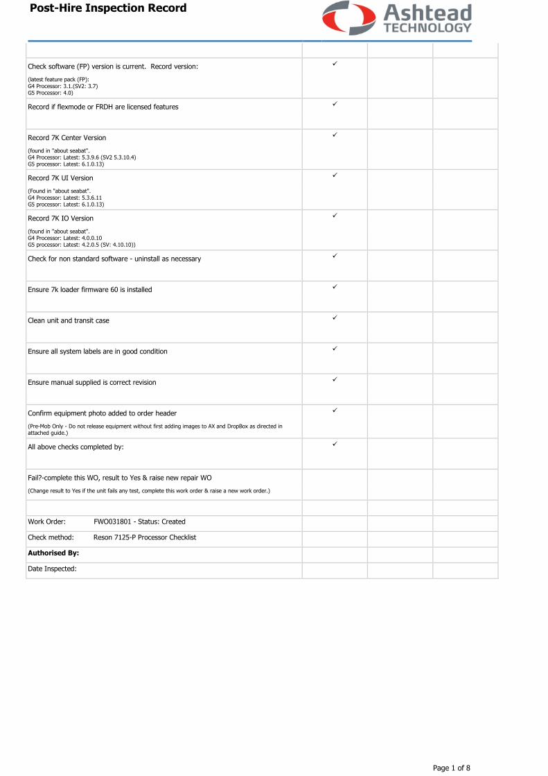
Page 1 of 8
Check software (FP) version is current. Record version:
(latest feature pack (FP):
G4 Processor: 3.1.(SV2: 3.7) G5 Processor: 4.0)
Record if flexmode or FRDH are licensed features
Record 7K Center Version
(found in "about seabat". G4 Processor: Latest: 5.3.9.6 (SV2 5.3.10.4)
G5 processor: Latest: 6.1.0.13)
Record 7K UI Version
(Found in "about seabat".
G4 Processor: Latest: 5.3.6.11 G5 processor: Latest: 6.1.0.13)
Record 7K IO Version
(found in "about seabat". G4 Processor: Latest: 4.0.0.10 G5 processor: Latest: 4.2.0.5 (SV: 4.10.10))
Check for non standard software - uninstall as necessary
Ensure 7k loader firmware 60 is installed
Clean unit and transit case
Ensure all system labels are in good condition
Ensure manual supplied is correct revision
Confirm equipment photo added to order header
(Pre-Mob Only - Do not release equipment without first adding images to AX and DropBox as directed in attached guide.)
All above checks completed by:
Fail?-complete this WO, result to Yes & raise new repair WO
(Change result to Yes if the unit fails any test, complete this work order & raise a new work order.)
Work Order: FWO031801 - Status: Created
Check method: Reson 7125-P Processor Checklist
Authorised By:
Date Inspected:
Post-Hire Inspection Record
Page 1 of 8
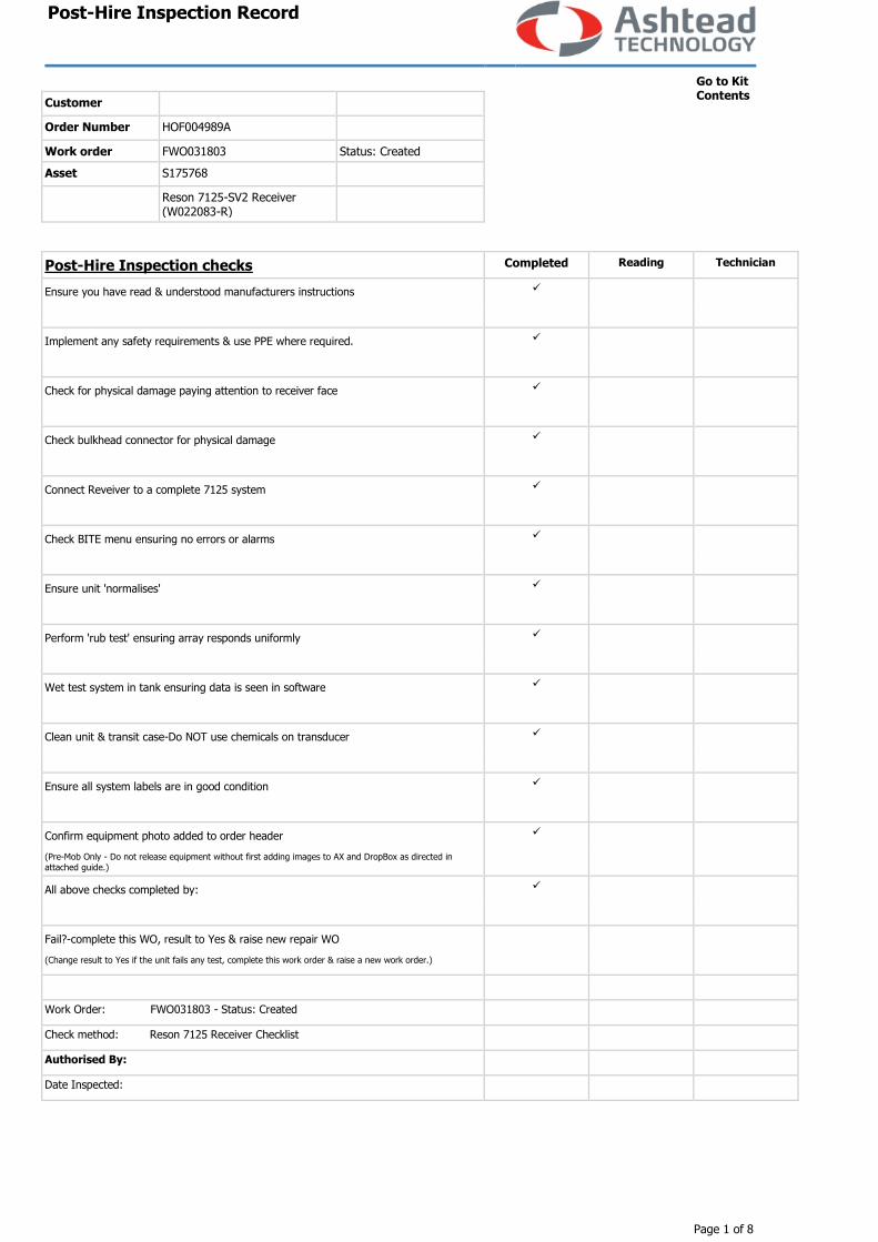
Customer
Order Number HOF004989A
Work order FWO031803 Status: Created
Asset S175768
Reson 7125-SV2 Receiver (W022083-R)
Go to Kit Contents
Post-Hire Inspection checks Completed Reading Technician
Ensure you have read & understood manufacturers instructions
Implement any safety requirements & use PPE where required.
Check for physical damage paying attention to receiver face
Check bulkhead connector for physical damage
Connect Reveiver to a complete 7125 system
Check BITE menu ensuring no errors or alarms
Ensure unit 'normalises'
Perform 'rub test' ensuring array responds uniformly
Wet test system in tank ensuring data is seen in software
Clean unit & transit case-Do NOT use chemicals on transducer
Ensure all system labels are in good condition
Confirm equipment photo added to order header
(Pre-Mob Only - Do not release equipment without first adding images to AX and DropBox as directed in attached guide.)
All above checks completed by:
Fail?-complete this WO, result to Yes & raise new repair WO
(Change result to Yes if the unit fails any test, complete this work order & raise a new work order.)
Work Order: FWO031803 - Status: Created
Check method: Reson 7125 Receiver Checklist
Authorised By:
Date Inspected:
Post-Hire Inspection Record
Page 1 of 8
Customer
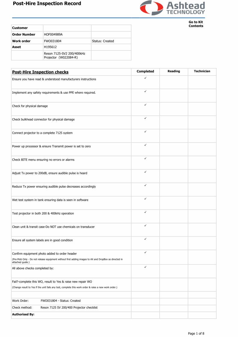
Order Number HOF004989A
Work order FWO031804 Status: Created
Asset H195612
Reson 7125-SV2 200/400kHz Projector (W022084-R)
Go to Kit Contents
Post-Hire Inspection checks Completed Reading Technician
Ensure you have read & understood manufacturers instructions
Implement any safety requirements & use PPE where required.
Check for physical damage
Check bulkhead connector for physical damage
Connect projector to a complete 7125 system
Power up processor & ensure Transmit power is set to zero
Check BITE menu ensuring no errors or alarms
Adjust Tx power to 200dB, ensure audible pulse is heard
Reduce Tx power ensuring audible pulse decreases accordingly
Wet test system in tank ensuring data is seen in software
Test projector in both 200 & 400kHz operation
Clean unit & transit case-Do NOT use chemicals on transducer
Ensure all system labels are in good condition
Confirm equipment photo added to order header
(Pre-Mob Only - Do not release equipment without first adding images to AX and DropBox as directed in
attached guide.)
All above checks completed by:
Fail?-complete this WO, result to Yes & raise new repair WO
(Change result to Yes if the unit fails any test, complete this work order & raise a new work order.)
Work Order: FWO031804 - Status: Created
Check method: Reson 7125 SV 200/400 Projector checklist
Authorised By:
Post-Hire Inspection Record
Page 1 of 8
Date Inspected:

Post-Hire Inspection Record
Page 1 of 8
Customer
Order Number HOF004989A
Work order FWO031805 Status: Created
Asset S12333
Valeport MiniSVS 100mm (W028034-R)
Go to Kit Contents
Post-Hire Inspection checks Completed Reading Technician
Ensure you have read & understood manufacturers instructions
Implement any safety requirements & use PPE where required.
Check for physical damage - paying attention to bulkhead
Check calibration validity - Record cal date
(Valid 2 years)
Meter & Megger supplied tail & test lead
Test unit using Hyperterminal
Ensure data string & output rate can be changed
Set Baud rate to 19200
Check Unit S/N matches housing and Asset label, #034
Set ouput rate to 1 Hz
Set output format to Alternative #3. #082;3 command
Check speed of sound in test tank. Ensure is stable. 0.00000
Where possible compare result to second unit
(Results should be within ±0.3m/s)
If being supplied with Reson 81-P set string to #082;csv
Fit Ashtead tamper evident sticker to endcap
Clean unit & transit case
Ensure all system labels are in good condition
Confirm equipment photo added to order header
(Pre-Mob Only - Do not release equipment without first adding images to AX and DropBox as directed in attached guide.)
All above checks completed by:
Post-Hire Inspection Record
Page 1 of 8
Fail?-complete this WO, result to Yes & raise new repair WO
(Change result to Yes if the unit fails any test, complete this work order & raise a new work order.)
Work Order: FWO031805 - Status: Created
Check method: Valeport mini SVS checklist
Authorised By:
Date Inspected:
[email protected] | USA 1.508.291.0057
For more information please visit EdgeTech.com
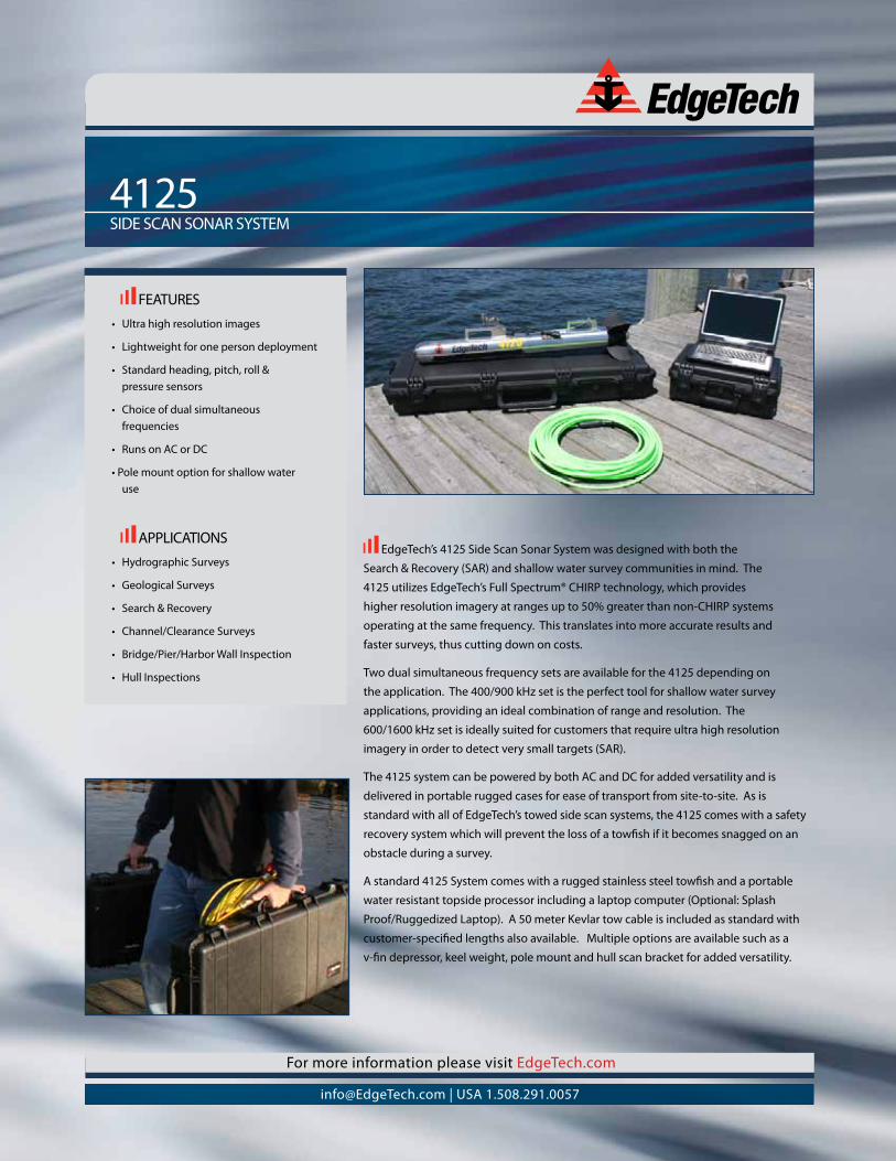
4125SIDE SCAN SONAR SYSTEM
EdgeTech’s 4125 Side Scan Sonar System was designed with both the
Search & Recovery (SAR) and shallow water survey communities in mind. The
4125 utilizes EdgeTech’s Full Spectrum® CHIRP technology, which provides
higher resolution imagery at ranges up to 50% greater than non-CHIRP systems
operating at the same frequency. This translates into more accurate results and
faster surveys, thus cutting down on costs.
Two dual simultaneous frequency sets are available for the 4125 depending on
the application. The 400/900 kHz set is the perfect tool for shallow water survey
applications, providing an ideal combination of range and resolution. The
600/1600 kHz set is ideally suited for customers that require ultra high resolution
imagery in order to detect very small targets (SAR).
The 4125 system can be powered by both AC and DC for added versatility and is
delivered in portable rugged cases for ease of transport from site-to-site. As is
standard with all of EdgeTech’s towed side scan systems, the 4125 comes with a safety
recovery system which will prevent the loss of a towfish if it becomes snagged on an
obstacle during a survey.
A standard 4125 System comes with a rugged stainless steel towfish and a portable
water resistant topside processor including a laptop computer (Optional: Splash
Proof/Ruggedized Laptop). A 50 meter Kevlar tow cable is included as standard with
customer-specified lengths also available. Multiple options are available such as a
v-fin depressor, keel weight, pole mount and hull scan bracket for added versatility.
FEATURES• Ultrahighresolutionimages
• Lightweightforonepersondeployment
• Standardheading,pitch,roll&pressure sensors
• Choiceofdualsimultaneousfrequencies
• RunsonACorDC
•Polemountoptionforshallowwateruse
APPLICATIONS• HydrographicSurveys
• GeologicalSurveys
• Search&Recovery
• Channel/ClearanceSurveys
• Bridge/Pier/HarborWallInspection
• HullInspections
[email protected] | USA 1.508.291.0057
For more information please visit EdgeTech.com
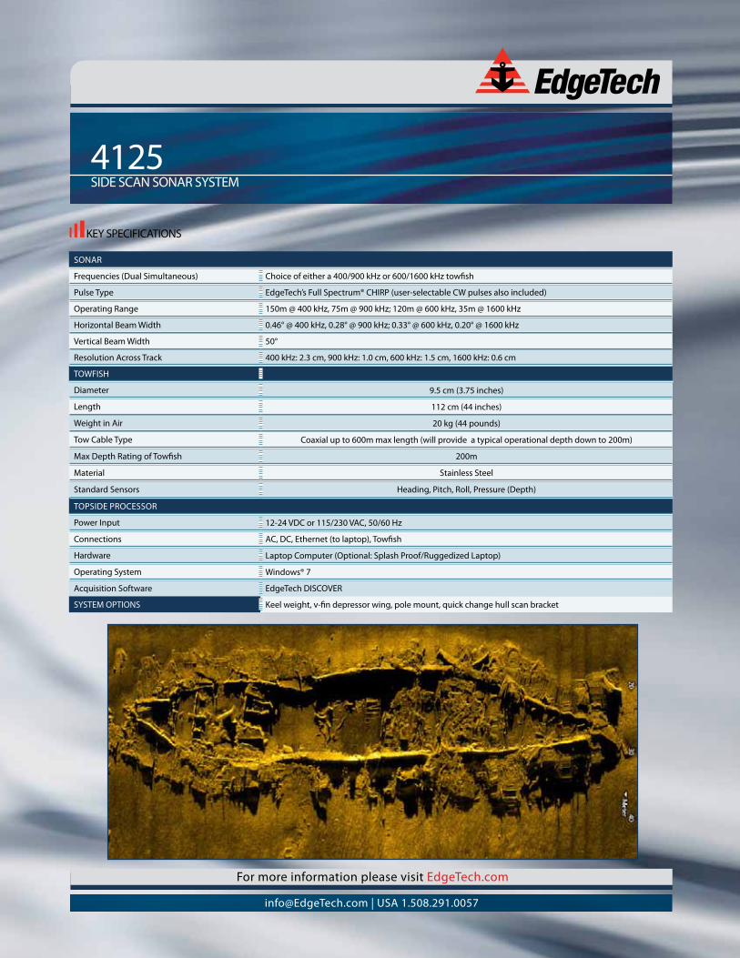
KEY SPECIFICATIONS
4125SIDE SCAN SONAR SYSTEM
SONAR
Frequencies (Dual Simultaneous) Choice of either a 400/900 kHz or 600/1600 kHz towfish
Pulse Type EdgeTech’sFullSpectrum®CHIRP(user-selectableCWpulsesalsoincluded)
Operating Range 150m @ 400 kHz, 75m @ 900 kHz; 120m @ 600 kHz, 35m @ 1600 kHz
HorizontalBeamWidth 0.46° @ 400 kHz, 0.28° @ 900 kHz; 0.33° @ 600 kHz, 0.20° @ 1600 kHz
VerticalBeamWidth 50°
Resolution Across Track 400 kHz: 2.3 cm, 900 kHz: 1.0 cm, 600 kHz: 1.5 cm, 1600 kHz: 0.6 cm
TOWFISH
Diameter 9.5 cm (3.75 inches)
Length 112 cm (44 inches)
WeightinAir 20 kg (44 pounds)
Tow Cable Type Coaxial up to 600m max length (will provide a typical operational depth down to 200m)
Max Depth Rating of Towfish 200m
Material Stainless Steel
Standard Sensors Heading, Pitch, Roll, Pressure (Depth)
TOPSIDE PROCESSOR
Power Input 12-24 VDC or 115/230 VAC, 50/60 Hz
Connections AC, DC, Ethernet (to laptop), Towfish
Hardware Laptop Computer (Optional: Splash Proof/Ruggedized Laptop)
Operating System Windows®7
Acquisition Software EdgeTech DISCOVER
SYSTEM OPTIONS Keel weight, v-fin depressor wing, pole mount, quick change hull scan bracket
ATTACHMENT G
MARINE WILDLIFE CONTINGENCY PLAN WITH MWM RESUMES
COASTAL
FRONTIERS
MARINE WILDLIFE CONTINGENCY PLAN DURING GEOPHYSICAL SURVEYS
Prepared for California State Lands Commission
Prepared by Coastal Frontiers Corporation
November 2017
1
MARINE WILDLIFE CONTINGENCY PLAN DURING GEOPHYSICAL SURVEYS
Coastal Frontiers Corporation
November 8, 2017
1. Overview
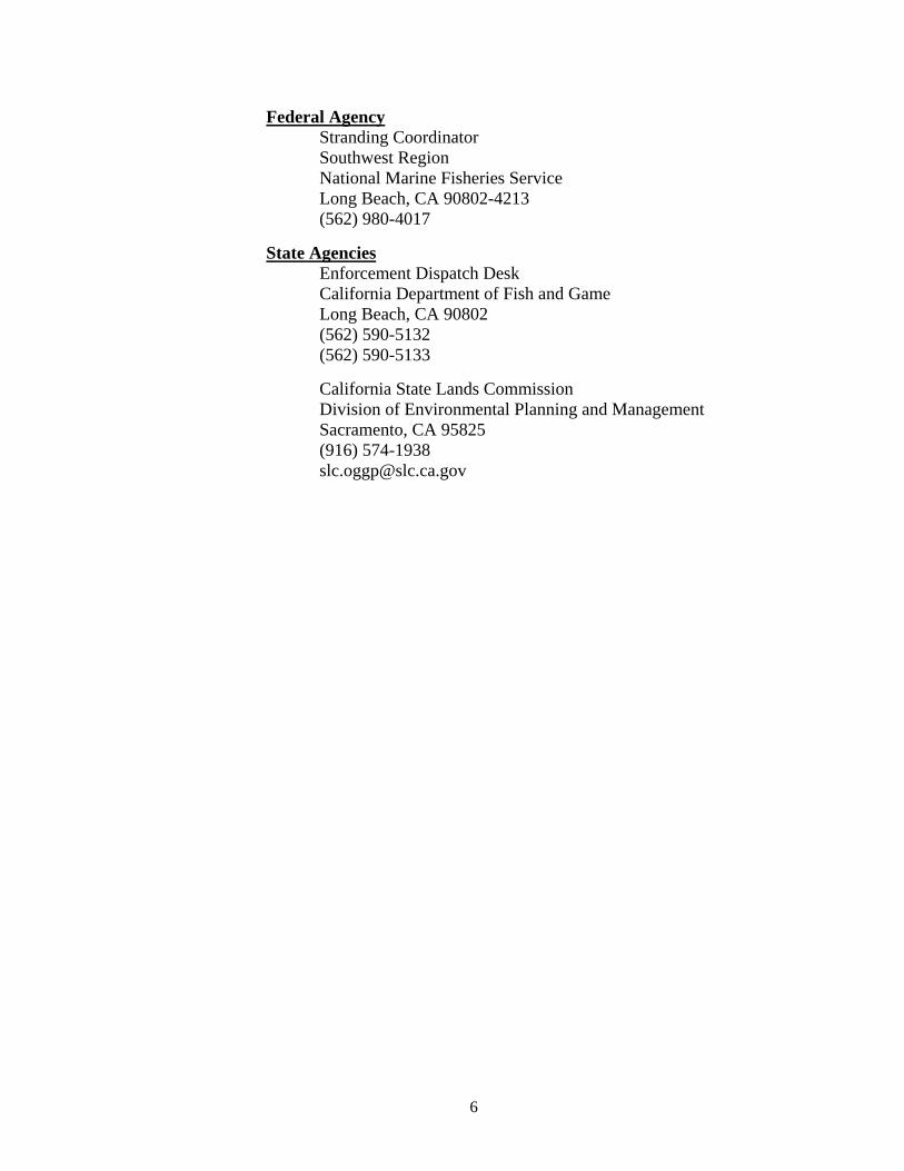
This Marine Wildlife Contingency Plan (MWCP) has been prepared as a general guide for geophysical marine survey operations conducted by Coastal Frontiers Corporation under California State Lands Commission (CSLC) permit PRC 9404. The work will include bathymetric surveys using both single-beam and multi-beam echosounders, side scan sonar, and sub-bottom profiling equipment. The precise work plan and locations will be defined in the future as projects become available. Figure 1 presents a map of the State showing offshore work areas I, II, III, and IV. The survey limits will be bounded by the Mean High Tide Line (MHTL) and the 3 mile limit of State waters. Geophysical surveys will only be conducted during daylight hours. The surveys could occur during any month of the year and presently have unspecified durations.
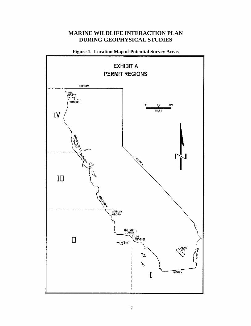
2. Potential Marine Wildlife of Concern
The list of marine mammals and reptiles that inhabit California coastal waters is extensive. A list is included in Table 1 that includes whales, dolphins, porpoises, seals, sea lions, and sea turtles.
3. Sound Source Summary
The acoustic energy sources that may be deployed as part of geophysical survey operations are expected to include single beam bathymetric sonar, multibeam bathymetric sonar, side scan sonar, and a sub-bottom profiler. Prior to each survey effort, a table delineating the acoustic characteristics of the equipment planned for use will be submitted with the CSLC pre-survey notification.
4. Marine Protected Areas
Prior to commencement of survey activities in or potentially affecting Marine Protected Areas (MPAs), coordination with CLSC staff, California Department of Fish & Wildlife (CDFW), and any other appropriate permitting agency will be conducted regarding proposed operations within MPAs.
2
5. Marine Wildlife Monitoring Methods
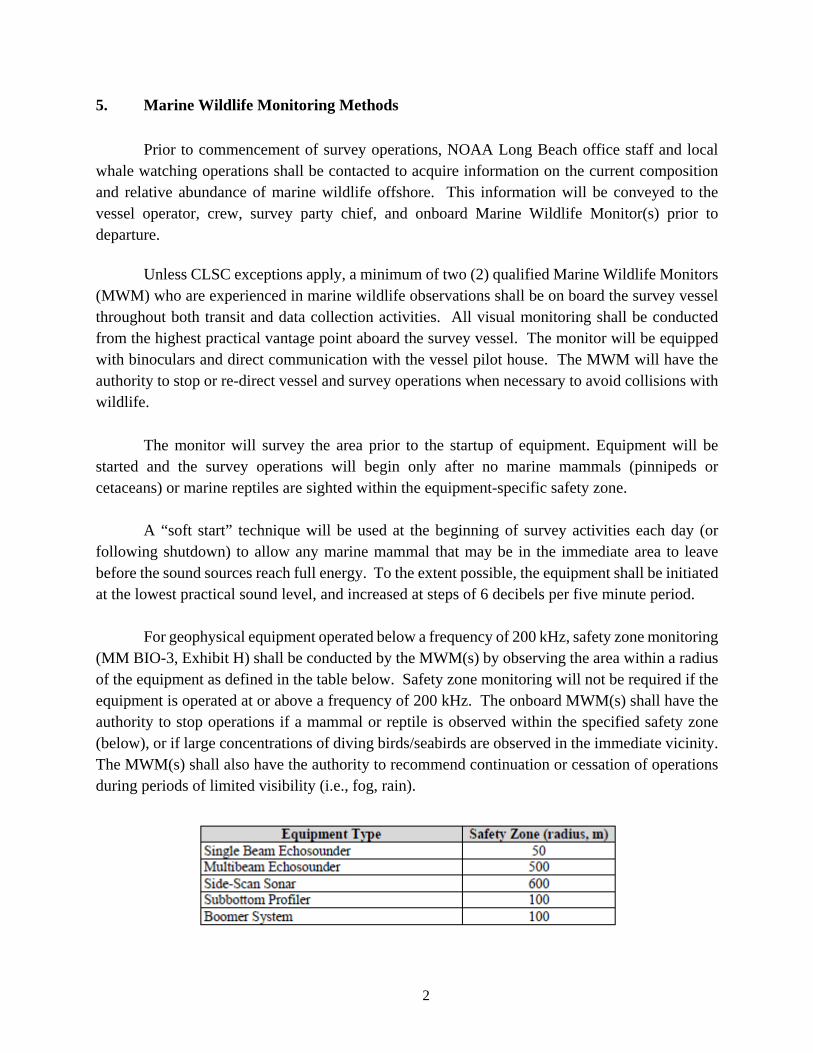
Prior to commencement of survey operations, NOAA Long Beach office staff and local whale watching operations shall be contacted to acquire information on the current composition and relative abundance of marine wildlife offshore. This information will be conveyed to the vessel operator, crew, survey party chief, and onboard Marine Wildlife Monitor(s) prior to departure. Unless CLSC exceptions apply, a minimum of two (2) qualified Marine Wildlife Monitors (MWM) who are experienced in marine wildlife observations shall be on board the survey vessel throughout both transit and data collection activities. All visual monitoring shall be conducted from the highest practical vantage point aboard the survey vessel. The monitor will be equipped with binoculars and direct communication with the vessel pilot house. The MWM will have the authority to stop or re-direct vessel and survey operations when necessary to avoid collisions with wildlife. The monitor will survey the area prior to the startup of equipment. Equipment will be started and the survey operations will begin only after no marine mammals (pinnipeds or cetaceans) or marine reptiles are sighted within the equipment-specific safety zone. A “soft start” technique will be used at the beginning of survey activities each day (or following shutdown) to allow any marine mammal that may be in the immediate area to leave before the sound sources reach full energy. To the extent possible, the equipment shall be initiated at the lowest practical sound level, and increased at steps of 6 decibels per five minute period. For geophysical equipment operated below a frequency of 200 kHz, safety zone monitoring (MM BIO-3, Exhibit H) shall be conducted by the MWM(s) by observing the area within a radius of the equipment as defined in the table below. Safety zone monitoring will not be required if the equipment is operated at or above a frequency of 200 kHz. The onboard MWM(s) shall have the authority to stop operations if a mammal or reptile is observed within the specified safety zone (below), or if large concentrations of diving birds/seabirds are observed in the immediate vicinity. The MWM(s) shall also have the authority to recommend continuation or cessation of operations during periods of limited visibility (i.e., fog, rain).
3
For surveys within 300 meters of a pinniped haul-out site, the survey vessel shall not approach within 91m, consistent with National Marine Fisheries Service (NMFS) guidelines. Survey activities close to haul-out sites shall be conducted in an expedited manner to minimize the potential for disturbance of pinnipeds on land, and MWMs shall monitor pinniped activity onshore as the vessel approaches, observing and reporting on the number of pinnipeds potentially disturbed (e.g., head lifting, flushing into the water). If a marine mammal or sea turtle is observed within or is about to enter the specified safety zone, the MWM(s) shall notify the vessel captain and crew to immediately shut down the geophysical equipment.
i. If a marine mammal and/or sea turtle’s actions are observed to be irregular, the MWM(s) shall have the authority to recommend that all geophysical equipment be shut down.
ii. If the geophysical equipment is shut down, the equipment shall not be restarted and ramped up to full power until the animal(s) is/are outside of the safety zone or have not been observed for 15 minutes. Geophysical equipment shall not be ramped up from a shut down if the safety zone cannot be observed.
If a whale is observed within the project area and/or is observed proximal to the vessel during transit/survey periods, the vessel captain shall:
i. Maintain a minimum distance of 100 meters (330 feet) from the sighted whale(s);
ii. Refrain from crossing directly in front of or across the path of sighted whales; iii. Transit parallel to the whale and maintain a constant speed that is not faster than the whale’s
speed; iv. Not use the vessel to herd or drive whales; and
v. If a whale engages in evasive or defensive action, slow the vessel and move away from the
animal until the animal calms or moves out of the area. If a marine mammal or sea turtle is sighted within the equipment safety zone prior to start-
up of the geophysical equipment, the monitor will observe for another 15 minute period. After a 15 minute period with no sightings, the monitor will report to the pilot house and the survey team that operations may begin. The monitor will continue to make observations throughout the survey operations. If a marine mammal or sea turtle is sighted in the safety zone during survey data collection, the observer will instruct the survey operations crew to cease operations and not resume
4
surveys until the zone is clear from marine mammals and sea turtles for at least 15 minutes. Marine mammal and sea turtle observations made during the survey will be recorded on daily observation data sheets and included in each final project report. While collecting geophysical data, the survey vessel will travel at approximately 3 knots (~3.5 miles/hour) along each transect line. The length of time for each survey period will vary depending on the total length of the survey lines. Geophysical data will be collected during straight-line transects and also during vessel turns. The vessel will begin slowly prior to coming up to survey speed. The longest survey periods will encompass the entire day on site, in order to maximize data collection. It is likely that the survey activity will be terminated periodically for various operational needs. Acoustic pulse-generating equipment shall be operated for no more than ten (10) hours total each survey day. The survey equipment will be started and stopped at different times, have different signal pulse rates, and will operate at different sound frequencies. Therefore, the various survey equipment systems (bathymetry, side-scan sonar, sub-bottom profiler) will not emit signals simultaneously. The speed of travel to and from the offshore working grounds will be specific to the survey vessel, likely to vary between 10 and 15 knots. During the transit time, the marine wildlife monitor will be stationed on the vessel bridge or on the bow to monitor any marine mammals or sea turtles that are seen in the area. Communication of the monitor with the pilot house will be required to ensure that collisions or interactions between marine mammals/sea turtles and the vessel are avoided. To minimize interaction with fishing gear that may be present in the survey area, the vessel shall inspect the proposed survey corridor prior to commencing survey operations to note and record the presences, type, and location of deployed fishing gear (i.e., buoys). No survey lines within 30m (100 ft) of observed fishing gear shall be conducted. The survey crew shall not remove or relocate any fishing gear.
6. Reporting
The marine wildlife monitor will document each distinct marine mammal or sea turtle species observed during each geophysical survey, both during the operation of the survey equipment and during transit to and from port. Daily observation sheets will include the following:
Date and time of individual observations;
Species observed;
Overall numbers of individuals observed;
5
Distance from survey vessel;
Direction of movement of observed marine mammals or sea turtles;
Behavior exhibited;
Any marine mammal behavioral changes that could be due to the geophysical surveys;
Actions taken to modify vessel/survey operations when an animal is observed within the equipment safety zone of the vessel;
Results of actions taken. Based on these observations and actions, the findings of the monitor will be included in the final monitoring report. This report will be prepared by the observer and submitted to the California State Lands Commission (CSLC) within 30 days of completion of the geophysical survey operations and will include copies of the onboard monitor’s daily observation records. If a collision with marine wildlife occurs, the vessel operator will document the conditions under which the accident occurred, including the following:
Location of the vessel when the collision occurred (latitude and longitude);
Date and time of collision;
Speed and heading of the vessel at the time of collision;
Observation conditions (e.g., wind speed and direction, swell height, visibility in miles or kilometers, and presence of rain or fog);
Species of marine wildlife contacted;
Whether an observer was observing for marine wildlife at the time of the collision;
Name of vessel, operator (company), and captain or officer in charge of the vessel at the time of accident.
Collisions or other project-resulting impacts with marine wildlife will be reported promptly to the NOAA Fisheries Stranding Coordinator. From the report, the Stranding Coordinator will coordinate subsequent action, including enlisting the aid of marine mammal rescue organizations, if appropriate. Although NOAA Fisheries has primary responsibility for marine mammals in both state and federal waters, the California Department of Fish and Game (CDFG) should also be advised that an incident has occurred in state waters affecting a protected species. Reports should be communicated to the federal and state agencies listed below:
6
Federal Agency Stranding Coordinator Southwest Region National Marine Fisheries Service Long Beach, CA 90802-4213 (562) 980-4017
State Agencies Enforcement Dispatch Desk California Department of Fish and Game Long Beach, CA 90802 (562) 590-5132 (562) 590-5133
California State Lands Commission Division of Environmental Planning and Management Sacramento, CA 95825 (916) 574-1938 [email protected]
7
MARINE WILDLIFE INTERACTION PLAN DURING GEOPHYSICAL STUDIES
Figure 1. Location Map of Potential Survey Areas
8
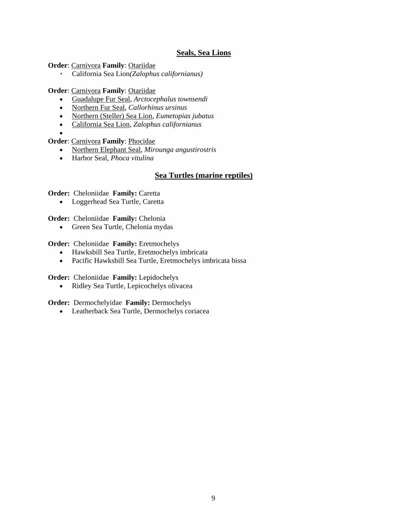
TABLE 1 MARINE MAMMALS AND REPTILES OF CALIFORNIA COASTAL WATERS
Whales, Dolphins, Porpoises
Order: Cetacea Family: Eschrichtiidae Gray Whale, Eschrichtius robustus (migrant)
Order: Cetacea Family: Balaenopteridae Minke Whale, Balaenoptera acutorostrata (vagrant) Sei Whale, Balaenoptera borealis (vagrant) Blue Whale, Balaenoptera musculus (vagrant) Fin Whale, Balaenoptera physalus (vagrant) Humpback Whale, Megaptera novaeangliae (vagrant)
Order: Cetacea Family: Balaenidae North Pacific Right Whale - Eubalaena japonica (vagrant)
Order: Cetacea Family: Delphinidae Short-beaked Common Dolphin, Delphinus delphis [3] Long-beaked Common Dolphin, Delphinus capensis [4] Short-finned Pilot Whale, Globicephala macrorhynchus Grampus, Grampus griseus White-sided Dolphin, Lagenorhynchus obliquidens Northern Right Whale Dolphin, Lissodelphis borealis Killer Whale, Orcinus orca False Killer Whale, Pseudorca crassidens Pantropical Spotted Dolphin, Stenella attenuata Striped Dolphin, Stenella coeruleoalba Rough-toothed Dolphin, Steno bredanensis Bottlenose Dolphin, Tursiops truncatus
Order: Cetacea Family: Phocoenidae Dall's Porpoise - Phocoenoides dalli Harbour Porpoise - Phocoena
Order: Cetacea Family: Physeteridae Pygmy Sperm Whale - Kogia breviceps Dwarf Sperm Whale - Kogia simus Sperm Whale - Physeter macrocephalus
Order: Cetacea Family: Ziphiidae
North Pacific Bottle-nosed Whale, Berardius bairdii Moore's Beaked Whale, Mesoplodon carlhubbsi Dense-beaked Whale, Mesoplodon densirostris Ginkgo-toothed Beaked Whale, Mesoplodon ginkgodens Perrin's Beaked Whale, Mesoplodon perrini North Pacific Beaked Whale, Mesoplodon stejnegeri Goose-beaked Whale, Ziphius cavirostris
9
Seals, Sea Lions
Order: Carnivora Family: Otariidae • California Sea Lion(Zalophus californianus)
Order: Carnivora Family: Otariidae
Guadalupe Fur Seal, Arctocephalus townsendi Northern Fur Seal, Callorhinus ursinus Northern (Steller) Sea Lion, Eumetopias jubatus California Sea Lion, Zalophus californianus
Order: Carnivora Family: Phocidae Northern Elephant Seal, Mirounga angustirostris Harbor Seal, Phoca vitulina
Sea Turtles (marine reptiles)
Order: Cheloniidae Family: Caretta
Loggerhead Sea Turtle, Caretta Order: Cheloniidae Family: Chelonia
Green Sea Turtle, Chelonia mydas
Order: Cheloniidae Family: Eretmochelys Hawksbill Sea Turtle, Eretmochelys imbricata Pacific Hawksbill Sea Turtle, Eretmochelys imbricata bissa
Order: Cheloniidae Family: Lepidochelys
Ridley Sea Turtle, Lepicochelys olivacea Order: Dermochelyidae Family: Dermochelys
Leatherback Sea Turtle, Dermochelys coriacea
SUMMARY
HIGHLIGHTS
ACCOMPLISHMENTS
EXPERIENCE
CHRISTOPHER J. LACK2764 Piantino Circle, San Diego, Ca. 92108 | C: (714) 925-4730 | [email protected]
Extensive background in biological sciences and research. Knowledge in archaeological methods, terminology and surveymethodologies. Six years of environmental surveying, three years of archaeological experience in the field, and eleven yearsof extensive biological studies.
Thoroughness at analyzing andrecording specimen information.Knowledge of regulations andordinances.Communication skillsExcellent written and verbal skills
Strong background and experience inoutdoor work and crew support.Able to work long hours under deadlinepressure.Principles of geography
Project ManagementHeld supervisory role at excavation of archaeological resources of the historic period.Publications and research- Evaluation and Assessment of the Merits, Challenges,Successes, and Failures of the Deployment of Wireless Technology in Archaeology: TheCarmel Mission Archaeological Project (2004)
07/2006 to Current FISHERIES BIOLOGISTFrank Orth & Associates ‐ Long Beach, CA
Worked as a Pacific Drift Gillnet and Longline Fisheries Biologist and Federal Observer.Conducted tissue and organ collection for Southwest Fisheries Science Center in SanDiego.Performed catch tally information on different fish and mammal species.
10/2004 to 05/2006 CIVIL ENGINEERTait & Associates Inc. Santa Ana, CA, & DRC Inc ‐ Anaheim, CA
Designed construction plans for finish grades of soil, curb lines, floors, and topographicalsurveys.Installation and operation of surveying equipment (levels, laser and mirror sighting andplacement).
01/2001 to 06/2002 LAND SURVEYORCSU Monterey Bay ‐ Monterey Bay, CA
Used handheld GPS units and GIS to map topography to create complete comprehensivetrail guide on former Fort Ord military base in California for hikers and cyclists.Surveyed site by defining lines and grades, topography, underground facilities, cut andfill.Verified location by establishing positions and property boundaries.Assisted survey crew chief by providing maps, calculations, documentation, andillustrations.
EDUCATION
AFFILIATIONS
SKILLS
Provided reference information by developing and maintaining survey databases and dataentry.
05/1999 to 01/2001 SOILS ENGINEERSo. Cal. Geotechnical ‐ Anaheim, CA
Worked as a soils tester on construction sites.Determined moisture and materials content for soil compaction tests.
2004 Bachelor of Arts: ArchaeologyCALIFORNIA STATE UNIVERSITY MONTEREY‐ Seaside, CA, US
Surfrider Foundation
Certification and experience in Arc GIS and GPS. Data entry, databases, documentation,research, geographical surveys.

HeatherColley,USCitizen824DeniseLane,ElCajon,CA,92020(619)‐760‐[email protected]
ObjectiveToobtainapositionasamarinebiologist,assistingwiththecollection,processing,andintegrationofresearchdatacollectedinthemarineenvironment
EducationB.S.EnvironmentalSystems:Ecology,BehaviorandEvolution;EmphasisonMarineBiologyUniversityofCalifornia,SanDiego June2013
Skills/Competencies ‐PriorexperienceaboardNOAAShipReubenLaskerandNOAAShipDavidStarrJordan
‐Reliableandaccuratedatacollector,proveninfieldandatseaasaFisheriesObserveraboardcommercialfishingvessels‐ProficientinWinCruise;experiencedwithotheroceanographic,acoustic,andbathymetricequipment‐PreviousexperienceusingCTDequipment,marineacousticmonitoringequipment,performingbongotows,andvisualmarinemammalwatchesaboardNOAAvessels‐Abilitytoliveandworkcomfortablyatsea,proveninroughweatherforextended,multipleweekandmonthlongcruises,maintainingcomposureduringdifficultconditions‐Extensiveknowledgeofcetaceantaxonomy,abletoidentifyPacificcetaceansbysight‐Provenandthoroughanimaltrainer,exceptionalcomprehensionofanimalbehavior,communicationandhusbandry
‐Extremelystrongwritingskills(technically/grammatically),compellingpublicspeaker‐Bilingual;educatedinSpanishforeightyears‐Excellentinterpersonalskills;successfulteamworkabilities,opencommunicator ‐Flexible,reliable,independenthard‐workerwithhighworkethic,easilyadaptabletofluctuationsinresponsibilities/workenvironment‐Totaltimeatsea:310days
WorkExperienceFrankOrthandAssociates
FisheriesObserver September2013‐January2017‐Independentlydissectedandperformedfullnecropsiesatseaonvariouslargesharkspecies,cetaceansandpinnipedsduringextended,multipleweektripstosea‐Collectedbiopsies,organsamplesandlifehistorydataonmanyspecimenssuccessfullyaboardcommercialfishingvessels‐Performedextendedmarinemammalwatchesaboardcommercialdrift‐netfishingvessels
NOAA’sSouthwestFisheryScienceCenter‐ProtectedResourceDivisionVolunteerat‐SeaMarineMammalObserver CLAWSArcticLargeWhaleSurvey NOAAShipReubenLasker,July2015‐August2015
‐Stoodformarinemammalwatchesontheflyingbridgemultipletimesdaily‐Workedinthesmallboatduringcloseapproachestolargecetaceansforbiopsyoperationandindividualidentification
‐CompletedbiopsyanalysisforgeneticsamplesofvariouslargecetaceansNOAA’sSouthwestFisheryScienceCenter‐FisheryResourceDivisionVolunteerat‐SeaScienceTechnician CalCOFISpringandSummerCruises NOAAShipDavidStarrJordan,April2014‐August2014
‐Performednightlypopulationassessmenttrawls,CTDscans,bongotowsaimedtodeterminesardine/anchovypresenceoffcoastalCA
‐Sexedandassessedmaturitylevelsofvariousfishspecies ‐IdentifiedvariousinvertebratesandfishspecimensbroughtupintrawlNOAA’sSouthwestFisheryScienceCenter‐ProtectedResourceDivisionVolunteerMarineMammalObserver EasternNorthPacificGreyWhaleStockAssessment May2013,2014,2015,2016 ‐Performeddailywatchescloselymonitoringthegreywhalemigration
‐Assessedanddeterminedsex,groupsize,andmaturityofallnorthboundwhales ‐QuicklyandefficientlycollecteddatainfieldNOAA’sSouthwestFisheryScienceCenter‐ProtectedResourceDivisionInternship September2011‐Present
‐Fullydissectedvariousspeciesofcetaceansandpinnipedsduringnecropsyassistance‐IndependentlycompletedanalysesofstomachcontentfordietassessmentoflargeSouthernCaliforniaBightpredators‐Sampledliver,kidney,blubber,gonads,andskintissueforchemicalanalysisoffrozenandfreshsamples ‐Curatedteethandcreatedadigitaldatabaseforinventoryingteeth
Heather'sHouseandPetSitting PetSitter June2005‐Present
‐Independentlycultivatedthrivingpersonalbusinesswithlargeclientelebaseand100%returnclientrate‐Developedstrongmanagement,organizationalandfinancialskills,leadingtopositivecustomerrelations‐Superiorfull‐timecareandmaintenanceofgroupsofpetsoverextendedperiods‐Innatesenseofindividualanimalneeds,abletorespondandsuccessfullyimplementaffirmingtrainingtechniques
CareandComfortVeterinaryHospitalVeterinaryTechnician'sAssistant September2005‐December2009
‐Prepareddailymedicationsforin‐housepatients,includingpropercalculationofanestheticdosagesfor upcomingsurgeries‐Collectedblood,fecalandurinesamples,performedin‐houselabwork,andanalyzedmicroscopeslidesofsamplestoprovideaccuratediagnosis‐Sterilizedandpreparedbothsurgicalsuiteandpatientforsurgery,observedandassistedwithinvasiveoperations‐Cleanedfacilitiesandenclosuresdaily,includingcages,litterboxesandlargeanimalruns
LargeAnimalVeterinaryAssociatesHospitalLargeAnimalVolunteer January2006‐January2007 ‐Administeredvaccines(largeanimals)
‐Assistedwithlivestockhousecallprocedures,suchasabscessremoval,dentalwork,andinjuryassessment
‐Stabilizedweightoflargeanimalsduringon‐sitesurgicalproceduresCareandComfortVeterinaryHospital SmallAnimal/ExoticsVolunteer June2003‐September2005
‐Performedadministrativework,includingfiling,dataentry,phonehandlingandcustomerservice‐Executedbasicprocedures,suchasdentalcleanings,vaccinations(smallanimals),castsettings,foxtailremovalandearcleanings
‐PresentedandexplainedfiscalestimatesofveterinaryprocedurestoclientsAchievementsandInvolvementDanceMentorwiththeCityofElCajonRecreationDepartmentMarch2003‐April2008MemberofUCSD’sCompetitiveDanceTeam September2008‐January2013ReferencesWaynePerryman,LeaderofMarineMammalandTurtleDivison,CetaceanHealthandLifeHistoryProgram;858‐546‐7014AnnetteHenry,Sea‐goingBiologistandFisheryBiologist;(858)546‐5672AntonellaPreti,ResearchFisheriesBiologist;(858)546‐5640
Tyler Jack 410 W Islay St � Santa Barbara, CA 93101 Phone: (408) 482-4479 � E-Mail: [email protected]
Education
M.S. Biology July 2012
University of California San Diego (UCSD), GPA: 4.0
B.S. Ecology, Behavior and Evolution Sept. 2010
University of California San Diego (UCSD), GPA: 3.5
Experience
Frank Orth & Associates, a contractor for National Marine Fisheries Service (Long Beach, CA) Fisheries Observer Aug. 2013 – Present
Collected data aboard longline and driftnet fishing vessels off the coast of California and Mexico. Sampled catches for species composition, including the incidence of federal and state-listed sensitive species. Collected biological information such as size frequencies and sex ratios. Dissected and extracted biological samples from various species of fish, shark, and marine mammals. Assembled and synthesized data pertaining to biological issues addressed in conservation management legislation such as the MMPA. Responsible for data entry, transmission, and management. U.S. Fish and Wildlife Service (Vancouver, WA) Biological Science Technician Feb.2013 – June 2013
Worked in accordance with state, tribal, and other federal agencies to restore anadromous fish populations in the Columbia River Basin impacted by the development and operation of the Columbia River hydropower system and by other human activities. Conducted field investigations for habitat analysis. Worked on species and habitat restoration projects. Operated electrofishing equipment, seine and nets to conduct stream and fish surveys. Identified, measured, and PIT-tagged salmonids. Performed redd counts for federal and state listed sensitive species. Used kick net sampling techniques to collect benthic macroinvertebrates from river and stream habitats. Used microscopes and dichotomous keys to sort and identify aquatic invertebrates to class, order, and family for all specimens including larval and nymph stages. Assisted in conducting marking/tagging operations at field locations including State and Federal hatcheries. Performed bio sampling of returning adult fish and analyzed scales for age determination. Assisted in running and maintaining automated marking and tagging trailers. Utilized technical equipment such as GPS units, electrofishers, microscopes, tag detection equipment, data loggers, electronic data collectors, water quality sampling and survey equipment to conduct field surveys. Performed the majority of field work in remote locations only accessible by backpacking. TechSea International, a contractor for National Marine Fisheries Service (Seattle, WA) Fisheries Observer Feb.2013 – June 2013
Worked aboard longline, crabber, and trawler fishing vessels out of Alaska collecting scientific data for the purpose of in-season management and to establish future fishing quotas for the Alaskan groundfish and crab fishery. Assisted the company American Seafoods with adjusting their fishing practices to comply with state and federal legislation. Monitored for seabird, turtle, and marine mammal interactions under the Marine Mammal
2
Protection Act and Endangered Species Act. Processed biological samples recording weight, size, Page2 sex, and maturity of multiple species of fish and invertebrates. Worked odd-hours, on deck, in adverse and inclement weather conditions.
El Colegio del Frontura Sur, (Tapachula, Mexico) Research Assistant Aug. 2012 – Nov. 2012
Primary investigator, researching the cleptoparasitic behavior of the stingless bee Lestrimelitta Niitkib. Developed the study's methods and protocol. Conducted field research, performed data entry and analysis. Trained and led field crews.
Masters of Biology Thesis, UC San Diego June 2010 – July 2012
Created multiple novel protocols and experiments. Trained and managed 19 volunteers who assisted with trials. Published as a primary author in the scientific journal Animal Behavior after compiling, interpreting, and analyzing data. Presented and discussed scientific findings to multiple types of audiences.
Graduate Teaching Assistant, UC San Diego Sep. 2011 – July 2012
Ecology Lab where I assisted students with surveying techniques as well as developing ecological experiments. For the course Animal Behavior and Communication, I developed lesson plans and lectured two hours a week for 56 students. Organized and managed 9 other teaching assistants.
Volunteer Research Assistant, UC San Diego Jan. 2010 – June 2010
Performed both field and lab experiments under the supervision of the primary investigator.
Publications
Animal Behaviour October 23, 2015 Honey bees tune excitatory and inhibitory recruitment signaling to resource value and predation risk
Certifications
CPR/First Aid/AED
ATTACHMENT H
OIL SPILL CONTINGENCY PLAN
COASTAL
FRONTIERS
OIL SPILL CONTINGENCY PLAN
DURING GEOPHYSICAL SURVEYS
Prepared for California State Lands Commission
Prepared by Coastal Frontiers Corporation
November 2017

1
OIL SPILL CONTINGENCY PLAN DURING GEOPHYSICAL SURVEYS
Coastal Frontiers Corporation
November 8, 2017
1. Introduction
This Oil Spill Contingency Plan (OSCP) has been prepared as a general guide for geophysical marine survey operations conducted by Coastal Frontiers Corporation under California State Lands Commission permit PRC 9404. The work will be conducted from survey vessels operating within ports, marinas, and the coastal waters of California. The purpose of this OSCP is to present the procedures and protocols that will be utilized in the event of an oil (fuel) spill resulting from survey vessel operations.
2. Spill Definition – Minor and Major
For purposes of this OSCP, a minor spill is defined as 5 barrels or less and a major spill is defined as more than 5 barrels.
3. Potential Spill Sources
Potential spill sources of hydrocarbons are limited to fueling operations, leakage or spillage of fuel or lubricants from the survey vessel or equipment operating on the vessel deck during mooring, survey operations, and transit to the offshore working grounds.
3.1 Marine Equipment Sources
Unspecified survey vessel(s) will be used to support the marine survey operations. The vessel will contain fuel or lubrication fluids in integral tankage built into the vessel’s hulls. While all vessels are considered potential spill sources, the likelihood of a spill is maximized during fueling operations. During fueling, all connections will be monitored for leaks. Particular care must be taken when hoses are disconnected. Containment and sorbent pads will be placed appropriately in order to capture any drips or leaks. Fueling will require at least two individuals: one at each end of the hose to monitor the transfer continuously. Fueling will cease if any fuel leaks are seen. Vessel fueling shall only occur at an approved docking facility or land-based location. No cross vessel fueling shall be allowed (see General Permit Exhibit H, MM HAZ-2). Other major losses of fuel from a vessel would be considered remote because a spill could only occur if the hull of a vessel is breached in the area of the tankage, or if the vessel sinks. Under such catastrophic circumstances, radio communications will be initiated immediately to request assistance from the U.S. Coast Guard and nearby vessels.
2
Another marine equipment source of hydrocarbon spillage at the site may be leakage or spillage of fuel or lubricants from the deck equipment used to support the marine operations. Specifically, equipment items aboard the survey vessels (e.g., compressors, generators, pumps, welding machines, etc.) have small-size, dedicated tanks containing fuel. To prevent such spillage, all deck equipment will be equipped with drip pans to contain fuel spillage or equipment leakage. Marine work crews will be directed to monitor the deck equipment for leakage and if observed, will cease equipment operation and correct any leakage that might occur. All hydrocarbon-based fluids stored onboard the work vessels will also be required to have a double containment system. All equipment or fuel storage containers will be adequately secured to the deck prior to leaving the dock.
4. Oil Spill Response Team
Prior to the launching of the vessel for any activities, all captain and crew members on the vessel will have read the Oil Spill Contingency Plan, understand procedures to be implemented in the event of an oil spill, and know where the oil spill kit is located on the vessel. The vessel crew and survey team will address prevention and clean-up of minor spills during survey operations. This onsite response team is responsible for reporting, containment, and clean up of any small spills using onsite equipment and procedures. The onsite team will be supervised by the survey vessel master and will consist of any and all personnel working on the vessel at the time of the spill.
Prior to beginning operations each day, an HSE (Health Safety Environment) meeting will be held on the vessel. All individuals aboard the vessel will be required to participate. Topics of each daily meeting will include the planned survey activities, vessel safety, spill prevention and response actions and plans, potential hazards and mitigation measures. The OSCP will be presented to everyone on the vessel prior to commencing operations. The OSCP will be prominently displayed on the bridge of the vessel. Important emergency contact information (Table 1) for those agencies requiring notification in case of a marine spill will be provided. Procedural checklists (Table 2) will also be available.
5. Onsite Response Equipment
Permittee typically contracts a vessel and operator to support data collection efforts. The vessel utilized depends on survey location, scope and availability. The vessel captain shall be responsible for making sure the appropriate spill response equipment is onboard prior to launching of the vessel for any activities. The Coastal Frontiers Project Representative shall verify that the appropriate equipment is onboard. The onsite spill response team will have access to an appropriate quantity of sorbent pads and disposal bags for small spill clean-up. Clean-up will
3
commence immediately once the spill is identified. Absorbent boom will be aboard the survey vessel.
6. Notification
An important step in the response procedure is notification to others of an incident. Notification is essential to activate the response organizations, alert company management, obtain assistance and cooperation of agencies, mobilize resources, and comply with local, state, and federal regulations. The order of notification is based on the premise that those parties who can render assistance in controlling or minimizing the impacts of an incident should be notified before those that are remote from the incident. The notification process encompasses the following categories:
Emergency agency notification Company notification/onsite spill response team activation Cleanup contractors (if required) Notification of other interested parties Periodic progress updates and reports (if necessary) Table 1 provides the list of agencies requiring notification.
The Lempert-Keene Seastrand Oil Spill Prevention and Response Act (SB 2040) requires notification of the California Office of Emergency Services when oil spills occur or threaten to occur from facilities, vessels, or pipelines into California marine waters. The California Code of Regulations implementing SB 2040 requires that the specific information shown in Table 2 be given to the agencies when making notifications. All actions, including agency notification, should be recorded on the Vessel Log. A regulatory agency address directory is provided in Table 3. Essential agency notifications are further assured by the California Office of Emergency Services and the National Response Center, since they will notify related state and federal agencies. If a spill impacts navigable waters, notification of the National Response Center is mandatory and normally results in simultaneous notification of the U.S. Coast Guard. However, it is recommended that a call be made to the local U.S. Coast Guard office as listed in Table 1. Based on the spill trajectory analysis, if the spill is a threat to the shoreline, the appropriate fire department should also be contacted. This would not normally be an immediate notification.
4
7. Company Notification
Coastal Frontiers requires that all emergencies be brought to the attention of its management. The Coastal Frontiers representative onboard the survey vessel will notify by radio or telephone the appropriate Coastal Frontiers management with an initial assessment of the extent and nature of the spill, and will activate additional company resources if necessary.
Coastal Frontiers Management
Name Office Home Cell
Craig B. Leidersdorf 818-341-8133 805-496-1287 805-750-8133
Greg E. Hearon 818-341-8133 805-493-4828 805-796-1209
8. Marine Spill Scenarios and Response Procedures
8.1 Minor Marine Spills
This scenario consists of minor spillage of oil or oily water (less than 5 barrels) from a marine support vessel or deck equipment. Response will consist of deployment of an absorbent boom and sorbent pads that are stored on the survey vessel. Table 4 lists the response procedures for a minor marine spill.
8.2 Major Marine Spills
For purposes of this OSCP, a major spill is defined as any spill greater than 5 barrels. There are no realistic spill sources on the survey vessel capable of yielding a major spill, with the exception of the fuel tanks of the vessel. Loss of large volumes of fuel to the sea would only occur in the case of a vessel grounding or collision with another ship or structure. Under these extreme conditions, an emergency call to the U.S. Coast Guard would be initiated via marine radio. The response to such a catastrophic event would not likely be capably performed by the vessel crew alone and outside assistance would be requested.
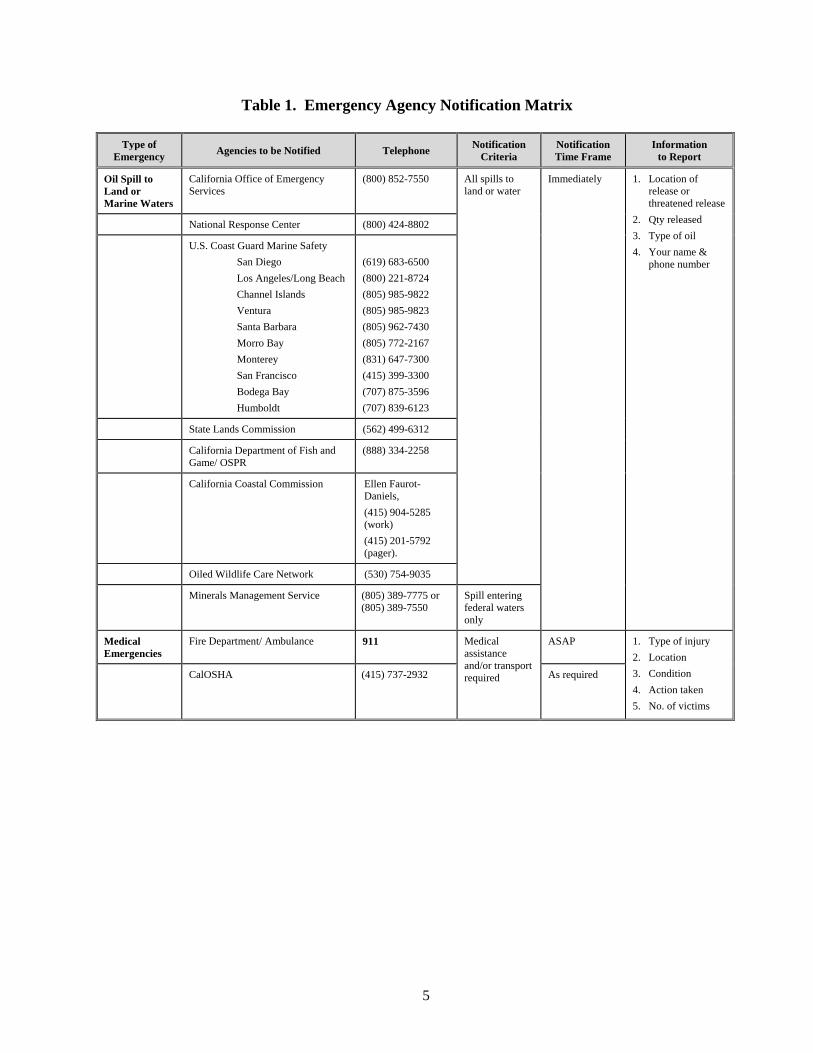
5
Table 1. Emergency Agency Notification Matrix
Type of Emergency
Agencies to be Notified Telephone Notification
Criteria Notification Time Frame
Information to Report
Oil Spill to Land or Marine Waters
California Office of Emergency Services
(800) 852-7550 All spills to land or water
Immediately 1. Location of release or threatened release
2. Qty released
3. Type of oil
4. Your name & phone number
National Response Center (800) 424-8802
U.S. Coast Guard Marine Safety
San Diego
Los Angeles/Long Beach
Channel Islands
Ventura
Santa Barbara
Morro Bay
Monterey
San Francisco
Bodega Bay
Humboldt
(619) 683-6500
(800) 221-8724
(805) 985-9822
(805) 985-9823
(805) 962-7430
(805) 772-2167
(831) 647-7300
(415) 399-3300
(707) 875-3596
(707) 839-6123
State Lands Commission (562) 499-6312
California Department of Fish and Game/ OSPR
(888) 334-2258
California Coastal Commission Ellen Faurot-Daniels,
(415) 904-5285 (work)
(415) 201-5792 (pager).
Oiled Wildlife Care Network (530) 754-9035
Minerals Management Service (805) 389-7775 or (805) 389-7550
Spill entering federal waters only
Medical Emergencies
Fire Department/ Ambulance 911 Medical assistance and/or transport required
ASAP 1. Type of injury
2. Location
3. Condition
4. Action taken
5. No. of victims
CalOSHA (415) 737-2932 As required
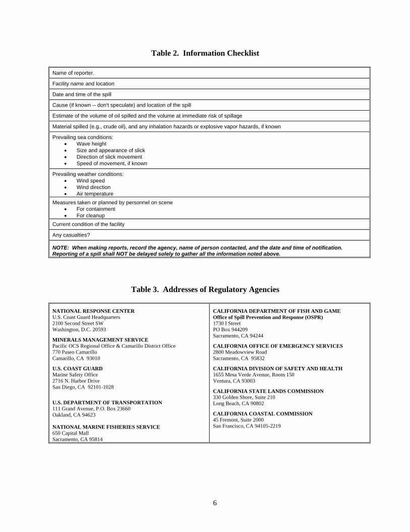
6
Table 2. Information Checklist
Name of reporter.
Facility name and location
Date and time of the spill
Cause (if known -- don't speculate) and location of the spill
Estimate of the volume of oil spilled and the volume at immediate risk of spillage
Material spilled (e.g., crude oil), and any inhalation hazards or explosive vapor hazards, if known
Prevailing sea conditions: Wave height Size and appearance of slick Direction of slick movement Speed of movement, if known
Prevailing weather conditions: Wind speed Wind direction Air temperature
Measures taken or planned by personnel on scene For containment For cleanup
Current condition of the facility
Any casualties?
NOTE: When making reports, record the agency, name of person contacted, and the date and time of notification. Reporting of a spill shall NOT be delayed solely to gather all the information noted above.
Table 3. Addresses of Regulatory Agencies
NATIONAL RESPONSE CENTER U.S. Coast Guard Headquarters 2100 Second Street SW Washington, D.C. 20593
MINERALS MANAGEMENT SERVICE Pacific OCS Regional Office & Camarillo District Office 770 Paseo Camarillo Camarillo, CA 93010
U.S. COAST GUARD Marine Safety Office 2716 N. Harbor Drive San Diego, CA 92101-1028
U.S. DEPARTMENT OF TRANSPORTATION 111 Grand Avenue, P.O. Box 23660 Oakland, CA 94623
NATIONAL MARINE FISHERIES SERVICE 650 Capital Mall Sacramento, CA 95814
CALIFORNIA DEPARTMENT OF FISH AND GAME Office of Spill Prevention and Response (OSPR) 1730 I Street PO Box 944209 Sacramento, CA 94244
CALIFORNIA OFFICE OF EMERGENCY SERVICES 2800 Meadowview Road Sacramento, CA 95832
CALIFORNIA DIVISION OF SAFETY AND HEALTH 1655 Mesa Verde Avenue, Room 150 Ventura, CA 93003
CALIFORNIA STATE LANDS COMMISSION 330 Golden Shore, Suite 210 Long Beach, CA 90802
CALIFORNIA COASTAL COMMISSION 45 Fremont, Suite 2000 San Francisco, CA 94105-2219
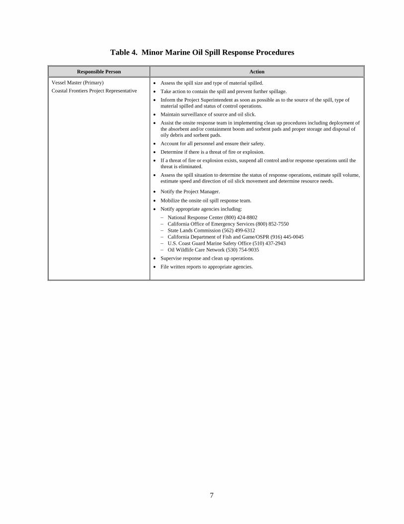
7
Table 4. Minor Marine Oil Spill Response Procedures
Responsible Person Action
Vessel Master (Primary)
Coastal Frontiers Project Representative
Assess the spill size and type of material spilled.
Take action to contain the spill and prevent further spillage.
Inform the Project Superintendent as soon as possible as to the source of the spill, type of material spilled and status of control operations.
Maintain surveillance of source and oil slick.
Assist the onsite response team in implementing clean up procedures including deployment of the absorbent and/or containment boom and sorbent pads and proper storage and disposal of oily debris and sorbent pads.
Account for all personnel and ensure their safety.
Determine if there is a threat of fire or explosion.
If a threat of fire or explosion exists, suspend all control and/or response operations until the threat is eliminated.
Assess the spill situation to determine the status of response operations, estimate spill volume, estimate speed and direction of oil slick movement and determine resource needs.
Notify the Project Manager.
Mobilize the onsite oil spill response team.
Notify appropriate agencies including:
National Response Center (800) 424-8802 California Office of Emergency Services (800) 852-7550 State Lands Commission (562) 499-6312 California Department of Fish and Game/OSPR (916) 445-0045 U.S. Coast Guard Marine Safety Office (510) 437-2943 Oil Wildlife Care Network (530) 754-9035
Supervise response and clean up operations.
File written reports to appropriate agencies.
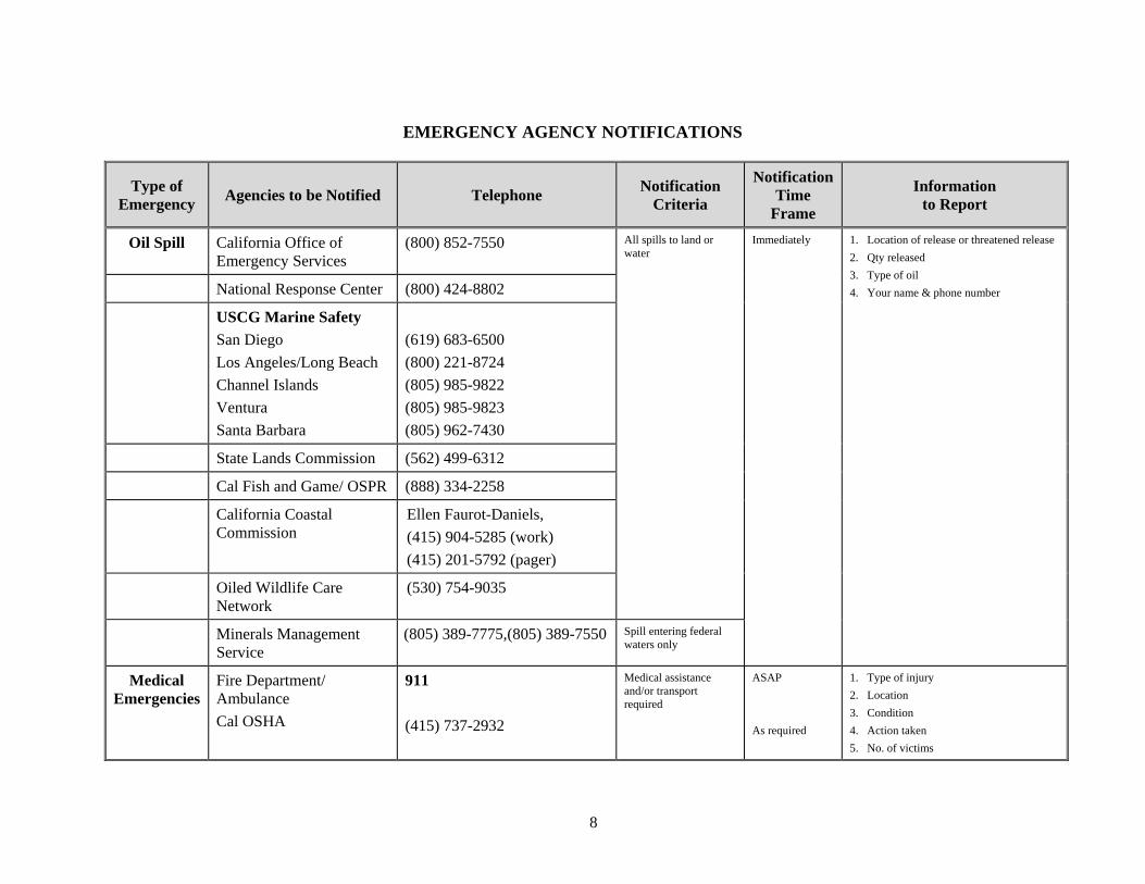
8
EMERGENCY AGENCY NOTIFICATIONS
Type of Emergency
Agencies to be Notified Telephone Notification
Criteria
NotificationTime
Frame
Information to Report
Oil Spill California Office of Emergency Services
(800) 852-7550 All spills to land or water
Immediately 1. Location of release or threatened release
2. Qty released
3. Type of oil
4. Your name & phone number National Response Center (800) 424-8802
USCG Marine Safety
San Diego
Los Angeles/Long Beach
Channel Islands
Ventura
Santa Barbara
(619) 683-6500
(800) 221-8724
(805) 985-9822
(805) 985-9823
(805) 962-7430
State Lands Commission (562) 499-6312
Cal Fish and Game/ OSPR (888) 334-2258
California Coastal Commission
Ellen Faurot-Daniels,
(415) 904-5285 (work)
(415) 201-5792 (pager)
Oiled Wildlife Care Network
(530) 754-9035
Minerals Management Service
(805) 389-7775,(805) 389-7550 Spill entering federal waters only
Medical Emergencies
Fire Department/ Ambulance
Cal OSHA
911
(415) 737-2932
Medical assistance and/or transport required
ASAP
As required
1. Type of injury
2. Location
3. Condition
4. Action taken
5. No. of victims