Embed Size (px)
Citation preview
Low Flows 2000TM in Scotland: The estimation of Natural Flow Statistics
Wallingford HydroSolutions Ltd
Low Flows 2000TM in Scotland:
The Estimation of Natural Flow Statistics
Date: 20th November 2006
Maclean Building
Crowmarsh Gifford
Wallingford
OX10 8BB
www.hydrosolutions.co.uk
Low Flows 2000TM in Scotland: The estimation of Natural Flow Statistics
Copyright © Wallingford HydroSolutions Ltd .2006
All rights reserved. No part of this publication may be reproduced or transmitted
in any form or by any means, electronic or mechanical, including, without
limitation, photocopy, scanning, recording or any information storage and
retrieval system, without permission in writing from Wallingford HydroSolutions
Limited.
This document has been prepared by Wallingford HydroSolutions with all
reasonable skill, care and diligence on behalf of, but not under contract to the
Scottish Environment Protection Agency. This document has been prepared with
the purpose of enabling the Scottish Environment Protection Agency to
disseminate information regarding Low Flow estimation within Scotland to You.
You are responsible for the interpretation of the information presented within this
report and formal training in the use of the estimation methods is strongly
recommended. In no event will Wallingford HydroSolutions be liable to you for
any damages, including lost profits, lost savings or other incidental or
consequential damages arising on your use of the information in this document
even if we have been advised of the possibility of such damages.
Low Flows 2000TM in Scotland: The estimation of Natural Flow Statistics
Contents
1 Introduction ........................................................................1
2 Background to Low Flows 2000..............................................1
3 Background to Low Flow Estimation within Scotland.................3
4 Estimation of the annual flow statistics ...................................4
4.1 Overview ........................................................................................ 4
4.2 The methods ................................................................................... 5
4.3 The estimation of annual mean flow ................................................. 10
4.4 The predictive performance of the methods....................................... 11
5 Estimation of Monthly Statistics ...........................................12
5.1 Estimation of Monthly Mean Flow ..................................................... 13
5.2 Monthly and Reconstructed Annual Flow Duration Curves .................... 17
5.2.1 The estimation of standardised monthly flow duration curves......... 18
5.2.2 Reconstruction of Annual Flow Duration Curves ............................ 19
6 Estimation of Base Flow Index.............................................20
7 Considerations for use........................................................20
8 References........................................................................22

Low Flows 2000TM in Scotland: The estimation of Natural Flow Statistics
Low Flows 2000TM in Scotland: The estimation of Natural Flow Statistics
1
1 Introduction
This technical report describes the hydrological models deployed within the
version of the Low Flows 2000TM software system in operational use with the
Scottish Environment Protection Agency.
The purpose of the report is to provide background information on the derivation
of natural flow estimates within Low Flows 2000. The software also incorporates
methods for addressing the impact of artificial influences on natural flows. These
methods are fully documented within the literature and the reader is directed to
(Young et al. 2003) for further information. The document provides an overview
of estimation methods and hence does not represent formal guidance. The
estimation of flow regimes within ungauged catchments is not straightforward
and it is strongly recommended that the interpretation of results from Low Flows
2000 should be undertaken by a competent hydrologist who has received
appropriate training. Please contact Wallingford HydroSolutions for more
information on appropriate training courses.
2 Background to Low Flows 2000
Consents to discharge, planning approvals, environmental impact statements,
abstraction licences applications, reservoir planning and the assessment of
hydropower potential are all examples of projects that require information on
river flows. However, there is little or no measurement of river flow for the
majority of river reaches within the UK.
In lieu of site specific observed data hydrologists are faced with the problem of
estimating flows. The Low Flows 2000 software system was developed within the
Centre for Ecology and Hydrology (CEH) to meet this challenge by integrating
within a GIS framework the latest regionalised models for predicting for the
estimation of natural and artificially influenced river-flows, as represented by flow
duration statistics, within ungauged catchments.
The Low Flows 2000 software system is the standard software system used by
both the Environment Agency and the Scottish Environment Protection Agency for
providing estimates of river flows within ungauged catchments.

Low Flows 2000TM in Scotland: The estimation of Natural Flow Statistics
2
Wallingford HydroSolutions (WHS) is the sole appointed developer and distributor
of the Low Flows 2000 system. The software is currently available for purchase
parties as two versions; LowFlows TM and LowFlows Enterprise TM. LowFlows
provides for the estimation of natural flows following the import of a catchment
boundary whilst the Enterprise edition allows for automatic boundary definition
and facilitates the incorporation of the impact of artificial influences within the
estimation methods. In addition to these software options, WHS also provide a
retrievals service for the low volume user, or the user without experience in the
estimation of river flows within ungauged catchments. The reader is also
reminded that Low Flow estimation science continues to improve and thus this
report represents a snapshot of the operational estimation methods as at the
date of publication.
WHS is an environmental and information technology consultancy established by
the Natural Environment Research Council. WHS was founded in 2004 as a
specialist technology transfer company located at the Wallingford Site of the
Centre for Ecology and Hydrology (CEH). In addition to modelling software, WHS
also provides a wide range of hydrological, water quality and aquatic habitat
consultancy services with a focus on the assessment of resource availability, the
potential impacts of development and the derivation of cost effective, mitigation
measures. For further information on WHS, or LowFlows products please visit our
website www.hydrosolutions.co.uk.
Low Flows 2000TM in Scotland: The estimation of Natural Flow Statistics
3
3 Background to Low Flow Estimation within
Scotland
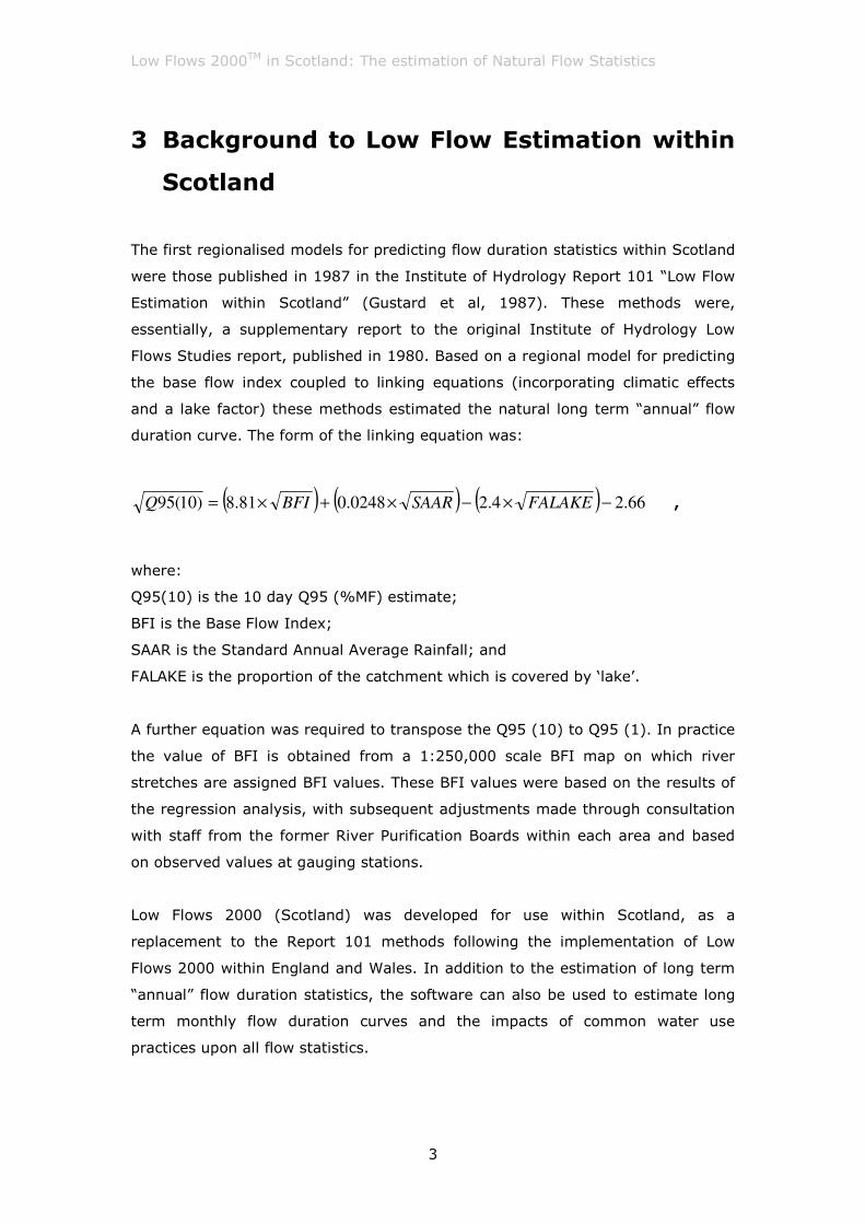
The first regionalised models for predicting flow duration statistics within Scotland
were those published in 1987 in the Institute of Hydrology Report 101 “Low Flow
Estimation within Scotland” (Gustard et al, 1987). These methods were,
essentially, a supplementary report to the original Institute of Hydrology Low
Flows Studies report, published in 1980. Based on a regional model for predicting
the base flow index coupled to linking equations (incorporating climatic effects
and a lake factor) these methods estimated the natural long term “annual” flow
duration curve. The form of the linking equation was:
( ) ( ) ( ) 66.24.20248.081.8)10(95 −×−×+×= FALAKESAARBFIQ ,
where:
Q95(10) is the 10 day Q95 (%MF) estimate;
BFI is the Base Flow Index;
SAAR is the Standard Annual Average Rainfall; and
FALAKE is the proportion of the catchment which is covered by ‘lake’.
A further equation was required to transpose the Q95 (10) to Q95 (1). In practice
the value of BFI is obtained from a 1:250,000 scale BFI map on which river
stretches are assigned BFI values. These BFI values were based on the results of
the regression analysis, with subsequent adjustments made through consultation
with staff from the former River Purification Boards within each area and based
on observed values at gauging stations.
Low Flows 2000 (Scotland) was developed for use within Scotland, as a
replacement to the Report 101 methods following the implementation of Low
Flows 2000 within England and Wales. In addition to the estimation of long term
“annual” flow duration statistics, the software can also be used to estimate long
term monthly flow duration curves and the impacts of common water use
practices upon all flow statistics.
Low Flows 2000TM in Scotland: The estimation of Natural Flow Statistics
4
This software incorporates the same functionality as Low Flows 2000 within
England and Wales, which has been fully published within the scientific literature
(Holmes et al, 2002a,b&c; Young et al, 2003). However, the methodology used to
estimate the standardised flow duration curve has been modified to take account
of the importance of surface water bodies within Scotland and the strong East -
West rainfall gradient across the country.
4 Estimation of the annual flow statistics
4.1 Overview
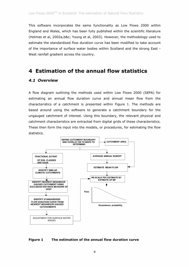
A flow diagram outlining the methods used within Low Flows 2000 (SEPA) for
estimating an annual flow duration curve and annual mean flow from the
characteristics of a catchment is presented within Figure 1. The methods are
based around using the software to generate a catchment boundary for the
ungauged catchment of interest. Using this boundary, the relevant physical and
catchment characteristics are extracted from digital grids of these characteristics.
These then form the input into the models, or procedures, for estimating the flow
statistics.
IDENTIFY SIMILAR CLIMATIC CATCHMENTS
DEFINE CATCHMENT BOUNDARY AND OVERLAY ON TO MAPS TO
DETERMINE:
FRACTIONAL EXTENT
OF SOIL CLASSES AND SAAR
AVERAGE ANNUAL RUNOFF
IDENTIFY STANDARDISED FLOW DURATION CURVE FROM
NEAREST NEIGHBOUR GAUGED CATCHCMENTS
IDENTIFY NEAREST NEIGHBOUR GAUGED CATCHMENT USING
EUCLIDEAN DISTANCE MEASURE OF HOST
CATCHMENT AREA
ESTIMATE MEAN FLOW
RE-SCALE FDC ESTIMATE BY ESTIMATE OF MF
Exceedence probability
Flow
ADJUSTMENT FOR SURFACE WATER
BODIES
Figure 1 The estimation of the annual flow duration curve
Low Flows 2000TM in Scotland: The estimation of Natural Flow Statistics
5
4.2 The methods
An assumption central to the estimation procedures is that when low flows are
expressed as a percentage of the long-term mean flow (standardised), the
dependencies on the climatic variability across the country and the effect of
catchment area are minimised. As a result, the estimation of standardised flow
duration curves is largely dependent on the hydro-geological and soils
characteristics of the catchment. Within Low Flows 2000 the Hydrology of Soil
Types (HOST) classification of soils (Boorman et al, 1995) is used to represent
these characteristics. However, in Scotland the strong east - west rainfall gradient
also influences the duration of stream flow recessions for a given catchment type
and hence within Scotland the base methods for estimating the standardised flow
duration curve are based on both the hydrogeological and climatological
characteristics of the catchment.
There are over 13000 surface water bodies within Scotland. Whilst almost 800 of
these are associated with dams (and hence should be treated explicitly within Low
Flows 2000 as a water use feature) natural surface water bodies (lochs, wetlands,
etc) also have an influence on the variance of the flow regime of a catchment and
hence the shape of the flow duration curves. A model to account for the influence
of surface water bodies within a catchment is also included within the methods in
Scotland.
The model used to estimate the flow duration curve within Low Flows 2000
(Scotland) is a multi step procedure, incorporating a similarity of climate measure
within a Region Of Influence (ROI) regionalisation approach and the optional
inclusion of the model for adjusting the estimates for the presence of natural
surface water bodies within a catchment.
The ROI approach to regionalisation is an approach that is used both within the
Flood Estimation handbook (FEH) statistical methods (in which pools of self
similar catchments are derived based upon catchment area, SAAR and BFIHOST)
and in Low Flows 2000 within England and Wales (based on hydrogeological
similarity). The ROI approach develops an estimate of a flow statistic or
hydrologic parameter at an ungauged ‘target’ catchment from observed values of
that flow statistic or hydrologic parameter made at number of gauged catchments
which are considered to be ‘similar’ to the ungauged catchment. Similarity is

Low Flows 2000TM in Scotland: The estimation of Natural Flow Statistics
6
measured by catchment characteristics that can be obtained for any ungauged
catchment in the UK.
The ROI based model seeks to reduce the variability of the dependent variable
within the data set by reducing it to a much smaller ‘region’ of catchments that
are ‘similar’ to the target catchment. Within Low Flows 2000 (Scotland) the ROI
approach of Low Flows 2000 (England and Wales) has been extended by
introducing a nested ROI approach including climatic similarity in addition to
hydrogeological similarity. In application to a catchment, the methods can be
summarised as the following steps:
1. Catchments which are climatically similar to the target catchment
are selected from a station pool of all natural gauged catchments
within Scotland to form a climatically similar “region” of catchments.
2. Catchment similarity is subsequently assessed by calculating a
weighted Euclidean distance, in HOST space, between the target
catchment and the catchments within the climatically similar pool.
3. A “region” is formed around the target catchment by ranking all of
the catchments in the data pool by their weighted Euclidean distance
in HOST space and selecting the five catchments that are closest to
the target catchment.
4. A standardised annual flow duration curve is estimated for the
ungauged site by taking a weighted combination of the standardised
flow duration curves for the gauged catchments within the region.
5. The derived flow statistics can then optionally be adjusted to account
for the presence of lakes within the catchment.
Low Flows 2000TM in Scotland: The estimation of Natural Flow Statistics
7
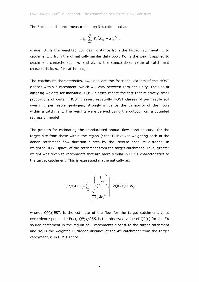
The Euclidean distance measure in step 3 is calculated as:
( )∑=
−M
m
mtmimit XXW=de1
2,
where; die is the weighted Euclidean distance from the target catchment, t, to
catchment, i, from the climatically similar data pool; Wm is the weight applied to
catchment characteristic, m, and Xmi is the standardised value of catchment
characteristic, m, for catchment, i.
The catchment characteristics, Xm, used are the fractional extents of the HOST
classes within a catchment, which will vary between zero and unity. The use of
differing weights for individual HOST classes reflect the fact that relatively small
proportions of certain HOST classes, especially HOST classes of permeable soil
overlying permeable geologies, strongly influence the variability of the flows
within a catchment. The weights were derived using the output from a bounded
regression model
The process for estimating the standardised annual flow duration curve for the
target site from those within the region (Step 4) involves weighting each of the
donor catchment flow duration curves by the inverse absolute distance, in
weighted HOST space, of the catchment from the target catchment. Thus, greater
weight was given to catchments that are more similar in HOST characteristics to
the target catchment. This is expressed mathematically as:
i
n
1in
1j5.0
j
5.0
i
t OBS)x(QP
de
1
de
1
=EST)x(QP ×
∑∑
=
=
,
where: QP(x)ESTt is the estimate of the flow for the target catchment, t, at
exceedence percentile P(x); QP(x)OBSi is the observed value of QP(x) for the ith
source catchment in the region of 5 catchments closest to the target catchment
and dei is the weighted Euclidean distance of the ith catchment from the target
catchment, t, in HOST space.
Low Flows 2000TM in Scotland: The estimation of Natural Flow Statistics
8
As with all models, there is a tendency for prediction bias at the extremes of the
range of catchment types for which the model estimates. This is largely removed
by applying the following adjustment factor to all estimated flows below Q80 (as
at higher flows the systematic error is negligible).
( )( )[ ][ ] QxQxQxmadjQx x ++−×−= *0471.0796.17_ .
The parameter mx is a function of the target flow percentile.
The optional method for incorporating the influence of natural surface water
bodies (lochs and lakes) involves three stages once the number and extent of
surface water bodies within a target catchment is identified:
1. The calculation of the influence adjustment at Q95 flow
2. Calculation of the influence adjustment at the Q5 flow
3. Calculation of the influence adjustment at other flow percentiles.
For all stages the influence adjustment is weighted by the position of the surface
water body within the ungauged catchment of interest.
In stage 1 the influence at Q95 (%MF) is estimated using the variance
attenuation potential of each surface water body as represented by the ratio of
the lake catchment area (LCarea) to the surface water body surface area
(LSarea).
If LCarea/LSarea is less than 2 then the influence at Q95 (IMPACTQ95) is equal to
50, that is, the Q95 would increased by a factor of 1.5. If LCarea/LSarea is
greater than 100 then the influence at Q95 is taken to be zero as if the catchment
area is much larger than the surface water body surface area the attenuation
potential of the surface water body will be low (the surface area is used as a
surrogate for loch volume which is not readily available). For any other case the
influence at the Q95 flow is estimated as:
IMPACTQ95 = (56.03 * Exp(-0.0863 * LCarea/LSarea).
Low Flows 2000TM in Scotland: The estimation of Natural Flow Statistics
9
In practice the lakes lie upstream of unguaged point of estimation and thus the
influence of incremental catchment are between a lake outlet and the point of
estimation needs to be accounted for. This is accounted for using the following
reduction factor:
IMPACTQ95= IMPACTLQ95 * CTArea / UGArea,
where UGArea is the catchment area above the point of estimation.
This process is repeated for all (n) lakes and the total adjustment is derived by
taking the sum of the n individual adjustment factors.
Stage 2 involves the estimation of the relationship between the influence of the
surface water bodies at Q5 and at Q95 using:
5
95
5
5
Q
IMPACTQf
Q
QIMPACT= .
In practice:
056.1195
951201.01
5
5+
+
×−=+
NQ
IMPACTQ
NQ
IMPACTQ.
Based on this the influence on Q5 can be calculated using the influence at Q95
and the base estimates of Q5 and Q95 for the catchment.
Stage 3 of the procedure involves the linear interpolation of the influence to other
percentile points based around a point of inflexion at Q30.
The standard error of estimate for the estimation of Q95%MF estimation is 48%.
This estimate is derived via jack knife sampling by sequentially removing gauging
stations from the pool and predicting the flow statistics at the gauged site based
upon the remaining gauging stations within the pool. This process yields an
estimate of the prediction error for each gauging station within the pool.
However, the uncertainty derived using this approach includes both model
uncertainty (including structure and parameterisation error and catchment
Low Flows 2000TM in Scotland: The estimation of Natural Flow Statistics
10
characteristic error) and gauging station measurement uncertainty. The criteria
used to accept gauging stations (Institute of Hydrology, 1992) into the pool of
Low Flows 2000 gauging stations considered hydrometric accuracy and
imprecision and the degree of artificial influence on the flow record. The likely
measurement error at the Q95 flow for the gauging stations within the pool
ranges from approximately 15% for the highest quality stations to between 30-
40% for the lowest quality stations. It is important to note that the lowest quality
stations are still regarded by measuring authorities as representing an acceptable
measurement of low flows. Taking this into account indicates that the true
predictive uncertainty of Low Flows 2000 is likely to be significantly less than
48%.
4.3 The estimation of annual mean flow
The estimation of Mean Flow is based on a grid of long term average annual
runoff developed by CEH. This was derived using the outputs from a deterministic
water balance model using observed data from over 500 gauged catchments. The
development of this grid is described in detail by (Holmes et al., 2002a).
The long-term mean flow is used to scale the flow duration curve so that the
range of flows can be expressed in cubic metres per second (m3s-l). The mean
flow can be estimated from the average annual runoff depth (RO) in mm over the
whole catchment (AREA in km2) using the equation:
CONSTAREA x x RO MF = .
The performance of this model was assessed at 167 gauging stations across
Scotland by calculating the factorial standard error (f.s.e) of a logarithmic
regression of estimated runoff against gauged runoff (calculated by dividing the
observed mean flow by the gauged catchment area). This indicated that the 68%
predictive uncertainty for the estimation of runoff and hence Mean Flow using this
runoff grid within Scotland is approximately +/- 11%.
Low Flows 2000TM in Scotland: The estimation of Natural Flow Statistics
11
4.4 The predictive performance of the methods
A key question to be answered within the development of the Low Flows 2000
methods in Scotland was how does the method compare with the R101 methods?
The estimation of Mean Flows within The Low Flows 2000 estimates of Q95 were
compared with those from Report 101 across 167 gauged catchments. To ensure
a fair test and to realistically emulate the predictive performance at ungauged
sites jack-knifed Low Flows 2000 estimates were estimated for each site.
Similarly, the R101 estimates were derived based on predicted BFI estimates at
the gauged locations rather than the estimates derived directly from the gauged
records.
The two sets of estimates were compared using RMSE and BIAS statistics. The
RMSE was computed as:
∑=
−=
n
i
i
iQQ
nRMSE
1
2^
95951
,
where Q95I is the observed Q95 value for catchment i,
i
Q^
95 is the estimated
Q95 value for catchment i and n is the total number of catchments in the data set
considered. The RMSE was calculated for both the standardised estimates of Q95
and those once rescaled by the catchment estimate of mean flow. For the latter
the Q95 values (m3s-1) were expressed in units of l-1s-1km-1 by dividing through
by the catchment area. This formulation removes the influence of catchment size
on the analysis. The RMSE statistics provide an assessment of the random error
within the model. The BIAS statistic was calculated as:
∑=
−
=n
ii
i
i
Q
nBIAS
1
^
95
95951.
Low Flows 2000TM in Scotland: The estimation of Natural Flow Statistics
12
BIAS will be negative for a systematic tendency to over-predict and positive for a
systematic tendency to under-predict.
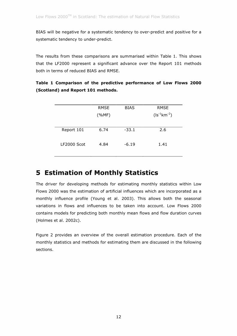
The results from these comparisons are summarised within Table 1. This shows
that the LF2000 represent a significant advance over the Report 101 methods
both in terms of reduced BIAS and RMSE.
Table 1 Comparison of the predictive performance of Low Flows 2000
(Scotland) and Report 101 methods.
RMSE
(%MF)
BIAS RMSE
(ls-1km-2)
Report 101
6.74 -33.1 2.6
LF2000 Scot
4.84 -6.19 1.41
5 Estimation of Monthly Statistics
The driver for developing methods for estimating monthly statistics within Low
Flows 2000 was the estimation of artificial influences which are incorporated as a
monthly influence profile (Young et al. 2003). This allows both the seasonal
variations in flows and influences to be taken into account. Low Flows 2000
contains models for predicting both monthly mean flows and flow duration curves
(Holmes et al. 2002c).
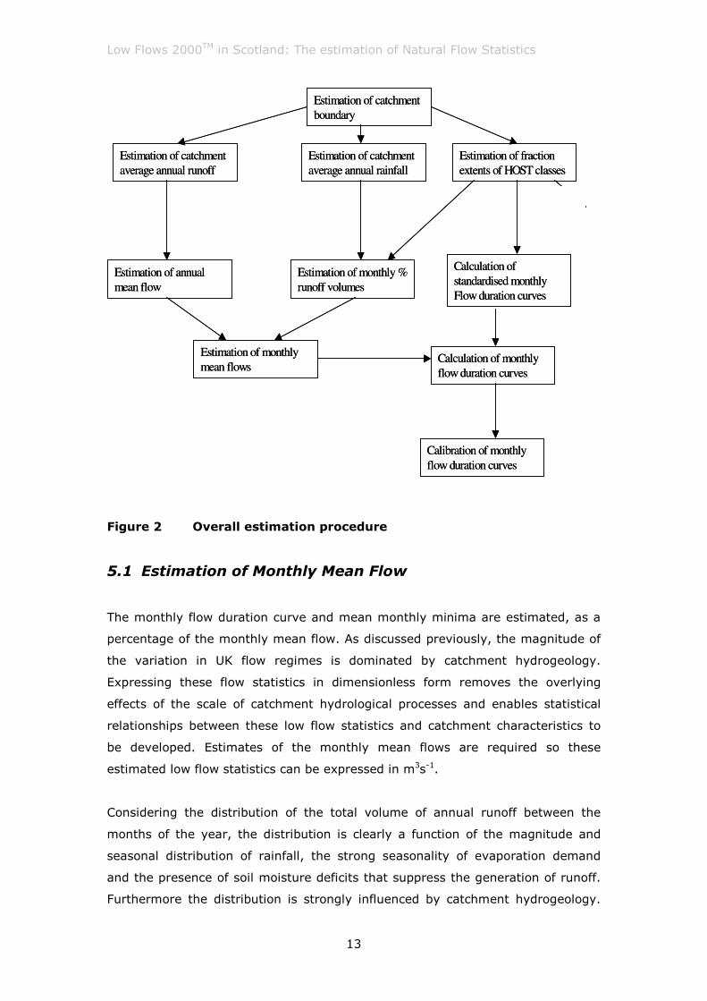
Figure 2 provides an overview of the overall estimation procedure. Each of the
monthly statistics and methods for estimating them are discussed in the following
sections.
Low Flows 2000TM in Scotland: The estimation of Natural Flow Statistics
13
Figure 2 Overall estimation procedure
5.1 Estimation of Monthly Mean Flow
The monthly flow duration curve and mean monthly minima are estimated, as a
percentage of the monthly mean flow. As discussed previously, the magnitude of
the variation in UK flow regimes is dominated by catchment hydrogeology.
Expressing these flow statistics in dimensionless form removes the overlying
effects of the scale of catchment hydrological processes and enables statistical
relationships between these low flow statistics and catchment characteristics to
be developed. Estimates of the monthly mean flows are required so these
estimated low flow statistics can be expressed in m3s-1.
Considering the distribution of the total volume of annual runoff between the
months of the year, the distribution is clearly a function of the magnitude and
seasonal distribution of rainfall, the strong seasonality of evaporation demand
and the presence of soil moisture deficits that suppress the generation of runoff.
Furthermore the distribution is strongly influenced by catchment hydrogeology.
Estimation of annual
mean flow
Estimation of catchment
average annual runoff
Estimation of monthly
mean flows
Estimation of monthly %
runoff volumes
Estimation of catchment
boundary
Calculation of
standardised monthly
Flow duration curves
Estimation of fraction
extents of HOST classes
Calculation of monthly
flow duration curves
Calibration of monthly
flow duration curves
Estimation of catchment
average annual rainfall
Low Flows 2000TM in Scotland: The estimation of Natural Flow Statistics
14
For example, the lowest flows in groundwater fed catchments will typically occur
in the autumn when groundwater levels are at their lowest, whilst the lowest
flows in low storage impermeable catchments will typically occur in the summer
months when evaporation demand is highest. The distribution of annual runoff
within dry impermeable catchments will tend to be more skewed towards the
winter months than in wet impermeable catchments. This is a function of the
enhanced role that soil moisture deficits will play in suppressing summer runoff
within dryer catchments.
Three stages are required for the derivation of the monthly mean flows as
illustrated in Figure 3. The first is the estimation of the long-term annual mean
flow (as previously described). The second is the estimation of the percentage of
the annual runoff volume that occurs within each month, termed the Monthly
Runoff Volume (MRV). The third is the conversion of the monthly runoff volume to
monthly mean flow.
Estimation of monthly runoff volume (MRV)
Estimation of mean flow (MF)
Calculation of monthly mean flow
(MMF) from MF & MRV
Figure 3 Stages in the estimation of monthly mean flow
The monthly runoff volumes are estimated using a region of influence approach.
In this approach a region of “nearest neighbour” gauged catchments to the
ungauged catchment is formed. The monthly runoff volumes for the ungauged
catchment are then estimated as a weighted average of those for the gauged
catchments forming the region. The method for estimating MRV at an ungauged
“target” catchment in the UK involves four steps;
1. Catchment similarity is assessed by calculating the weighted
Euclidean distance, in HOST space, between the target catchment
Low Flows 2000TM in Scotland: The estimation of Natural Flow Statistics
15
and every other catchment in the “data pool” of potential candidate
catchments using
( )∑=
−M
m
mtmimit XXW=de1
2,
where, deit is the weighted Euclidean distance from the target
catchment t to catchment i from the data pool; Wm is the weight
applied to catchment characteristic m; Xmi is the standardised value
of catchment characteristic m for catchment i. The catchment
characteristics Xm used were the fractional extents of the 30 HOST
classes within a catchment. The weights, Wm, to assess catchment
similarity are those used in the estimation of the flow duration curve.
2. A “region” of 10 catchments is formed around a target catchment by
ranking all of the catchments in the data pool by their weighted
Euclidean distance in HOST space and selecting the 10 catchments
closest to that target catchment. The modulus of the difference (ds)
in average annual rainfall between the target catchment and each
catchment in the pool is calculated.
3. An estimate of the MRV for the target catchment is calculated from a
weighted average of the observed MRVs for the 10 catchments in the
region using
ij
n
in
k S
S
tj OBSMRV
d
d=MRV %
1
1
%1
1
×
∑∑
=
=
,
where:
MRVtj = the estimate of MRV for month j for target catchment t;
MRVOBSij = the observed MRV for month j for the ith catchment in
the region of n catchments closest to the target
catchment;
Low Flows 2000TM in Scotland: The estimation of Natural Flow Statistics
16
dSt = the absolute difference in average annual rainfall of the
target catchment t and the ith catchment.
The predictive uncertainty of the ROI MRV model was assessed using a log-log
regression of the predicted values of MRV on the observed values of MRV for each
month in the year.
The factorial standard errors (f.s.e.) for each month are presented in Table 2. The
results indicate that the estimation of MRV in the dry summer months is more
uncertain than the estimates for MRV during wet winter months. The results of
the regression show that the uncertainty in the estimate of a MRV varies between
approximately ±13% for the wetter winter months to ±33% for the drier summer
months. When expressed as the MMF the uncertainty in estimates of MMF varies
between ±20% and ±36%.
The final step in the estimation of monthly mean flows is to re-scale the
estimated MRV by the estimate of annual mean flow. Remembering that the MRV
for a month is the percentage of the total annual runoff volume occurring within
that month the Monthly Mean Flow (MMF) for the month is estimated using:
)12/100(
MRVxMFMMF = .
Assuming a 68%ile prediction interval of ±14% in the estimate of annual MF a
predictive uncertainty in the estimation of MMF for each month can be estimated
by pooling the predictive uncertainties for the estimation of MRV for the month
and MF.
The results indicate that the estimation of MRV in the dry summer months is
more uncertain than the estimates for MRV during wet winter months. The results
of the regression show that the uncertainty in the estimate of a MRV varies
between approximately ±13% for the wetter winter months to ±33% for the drier
summer months. When expressed as the MMF the uncertainty in estimates of
MMF varies between ±20% and ±36%.
Low Flows 2000TM in Scotland: The estimation of Natural Flow Statistics
17
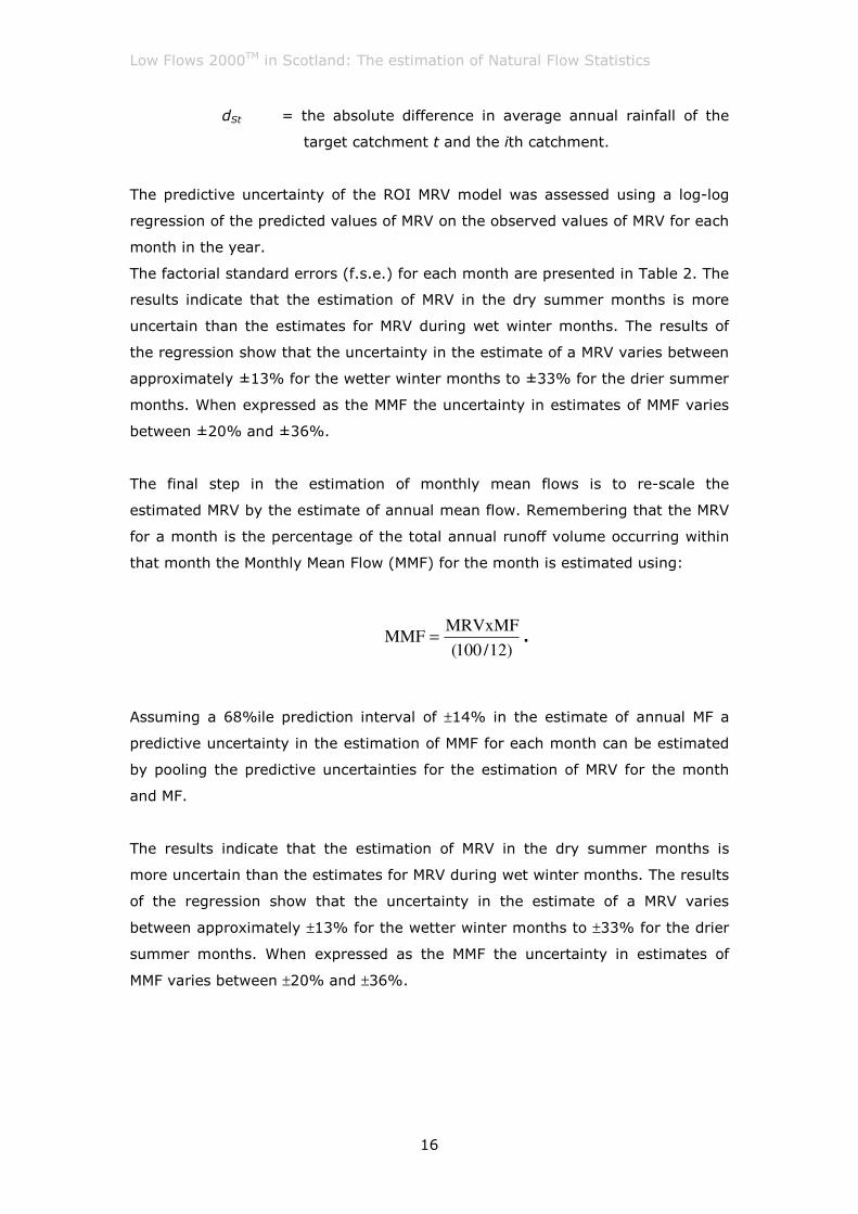
Table 2 Predictive uncertainties for estimating MMV and MMF by
month
Month f.s.e. for ROI
predictions of MMV
68% confidence level
predictive uncertainty in the
estimation of MMF (m3s-1)
January 1.13 21%
February 1.15 22%
March 1.12 20%
April 1.14 21%
May 1.20 26%
June 1.24 29%
July 1.33 36%
August 1.32 36%
September 1.29 33%
October 1.17 24%
November 1.14 22%
December 1.13 21%
The fact that the ROI model predicts winter mean flows more accurately than it
predicts summer mean flows is a consequence of the complex relationships
between rainfall, soil moisture deficits, evaporation demand and runoff during the
summer months. The impact will also be exacerbated by the fact that summer
flows are lower than winter flows, and thus a given volumetric error will represent
a larger percentage error for summer flows.
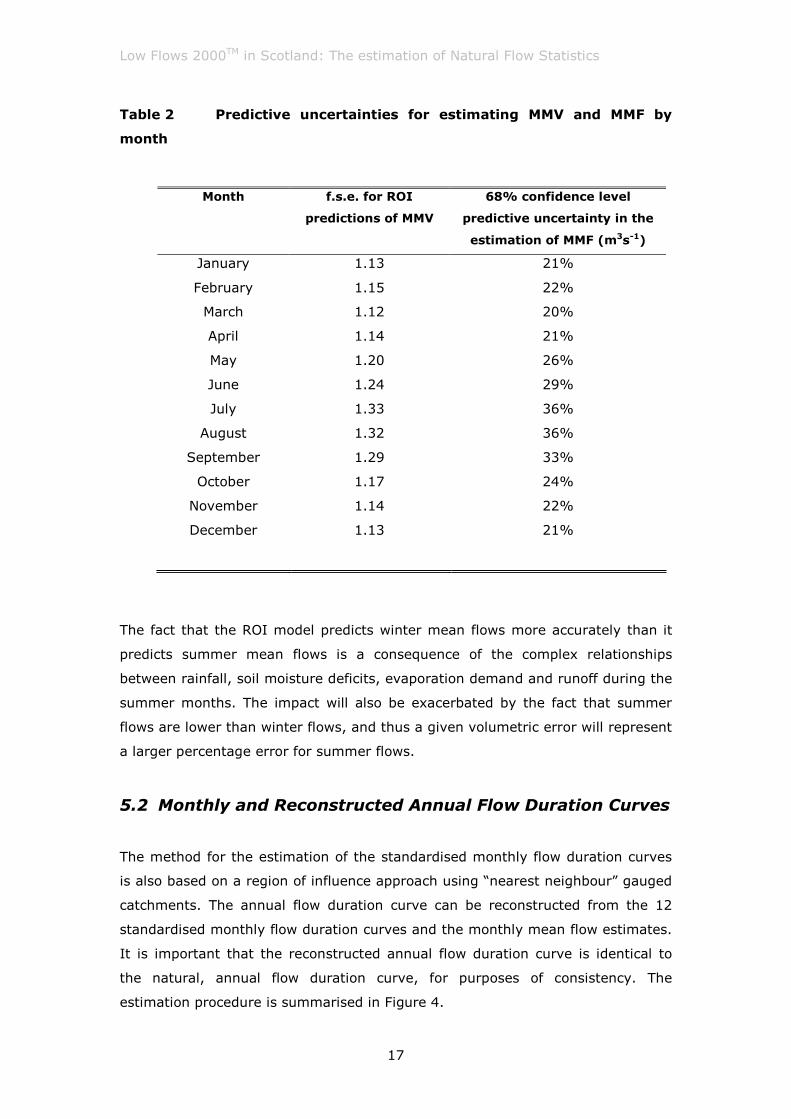
5.2 Monthly and Reconstructed Annual Flow Duration Curves
The method for the estimation of the standardised monthly flow duration curves
is also based on a region of influence approach using “nearest neighbour” gauged
catchments. The annual flow duration curve can be reconstructed from the 12
standardised monthly flow duration curves and the monthly mean flow estimates.
It is important that the reconstructed annual flow duration curve is identical to
the natural, annual flow duration curve, for purposes of consistency. The
estimation procedure is summarised in Figure 4.
Low Flows 2000TM in Scotland: The estimation of Natural Flow Statistics
18
Estimation of monthly flow duration curves
Estimation of monthly mean flow(MMF)
Calibration of monthly flow duration curves
Figure 4 Stages in the estimation of monthly flow duration curves
5.2.1 The estimation of standardised monthly flow duration curves
In the UK, periods of high flows are typically experienced in the winter months
and periods of low flows in the summer months, when the evaporation demand is
highest. The hydrogeology of a catchment, as with the annual FDC, also has a
strong influence of the variability of flows within a month.
The region of catchments identified using the ROI approach for estimating the
annual flow duration curve within an ungauged catchment are also used to
estimate the monthly flow duration curves for the ungauged catchment. The
monthly flow duration curves for the ungauged site are estimated by taking a
weighted average of the observed monthly flow duration curves (standardised by
the relevant monthly mean flows). In the weighting procedure the observed
monthly FDC points for the individual catchments in regions are weighted by
absolute distance in weighted HOST space.
Analysis of the predictive performance of the estimation of standardised monthly
flow duration has demonstrated that, overall the predictive performance of this
model is also higher for winter months than summer months.
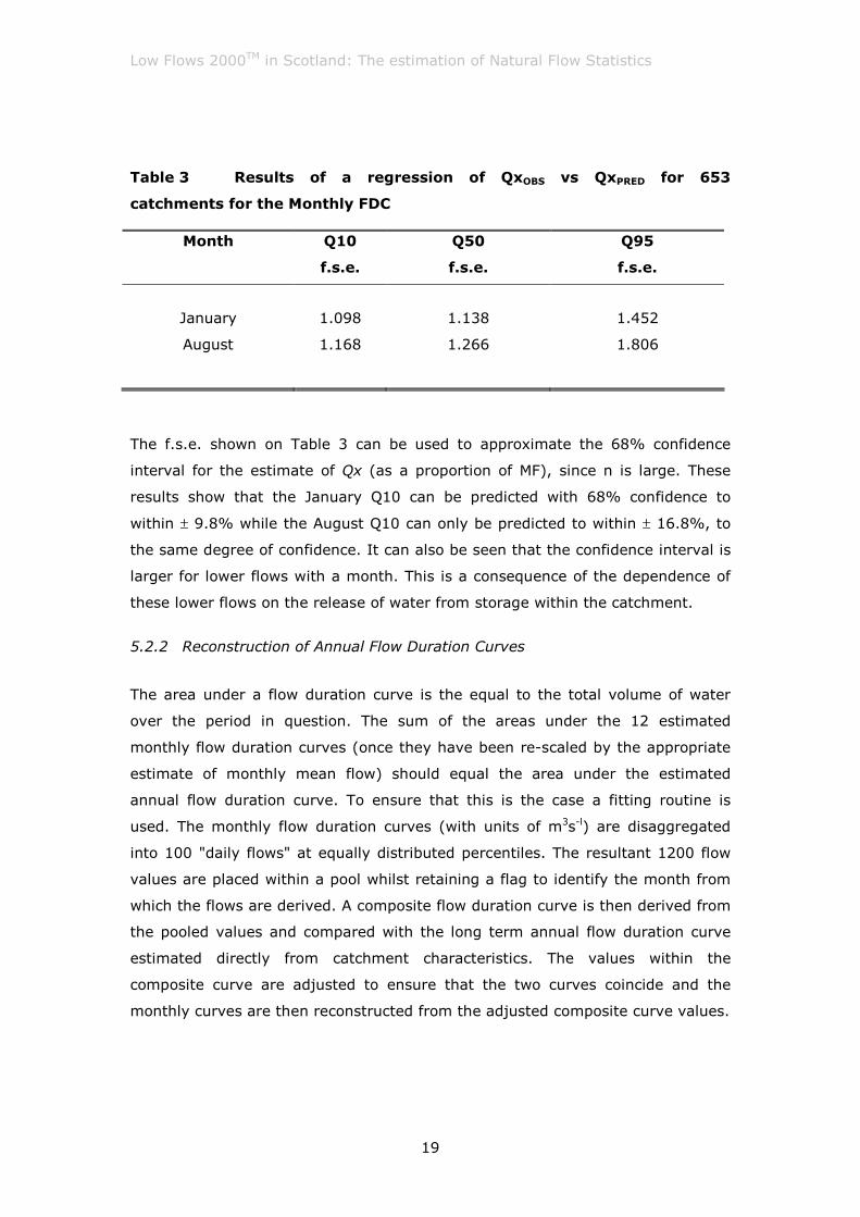
For illustration, factorial standard errors are presented within Table 3 for the
prediction of three percentile points for January and August monthly flow duration
curves (over 653 catchments covering the whole of GB). The three percentile
points presented cover high, median, and low flows within the month.
Low Flows 2000TM in Scotland: The estimation of Natural Flow Statistics
19
Table 3 Results of a regression of QxOBS vs QxPRED for 653
catchments for the Monthly FDC
Month
Q10
f.s.e.
Q50
f.s.e.
Q95
f.s.e.
January 1.098 1.138 1.452
August 1.168 1.266 1.806
The f.s.e. shown on Table 3 can be used to approximate the 68% confidence
interval for the estimate of Qx (as a proportion of MF), since n is large. These
results show that the January Q10 can be predicted with 68% confidence to
within ± 9.8% while the August Q10 can only be predicted to within ± 16.8%, to
the same degree of confidence. It can also be seen that the confidence interval is
larger for lower flows with a month. This is a consequence of the dependence of
these lower flows on the release of water from storage within the catchment.
5.2.2 Reconstruction of Annual Flow Duration Curves
The area under a flow duration curve is the equal to the total volume of water
over the period in question. The sum of the areas under the 12 estimated
monthly flow duration curves (once they have been re-scaled by the appropriate
estimate of monthly mean flow) should equal the area under the estimated
annual flow duration curve. To ensure that this is the case a fitting routine is
used. The monthly flow duration curves (with units of m3s-l) are disaggregated
into 100 "daily flows" at equally distributed percentiles. The resultant 1200 flow
values are placed within a pool whilst retaining a flag to identify the month from
which the flows are derived. A composite flow duration curve is then derived from
the pooled values and compared with the long term annual flow duration curve
estimated directly from catchment characteristics. The values within the
composite curve are adjusted to ensure that the two curves coincide and the
monthly curves are then reconstructed from the adjusted composite curve values.
Low Flows 2000TM in Scotland: The estimation of Natural Flow Statistics
20
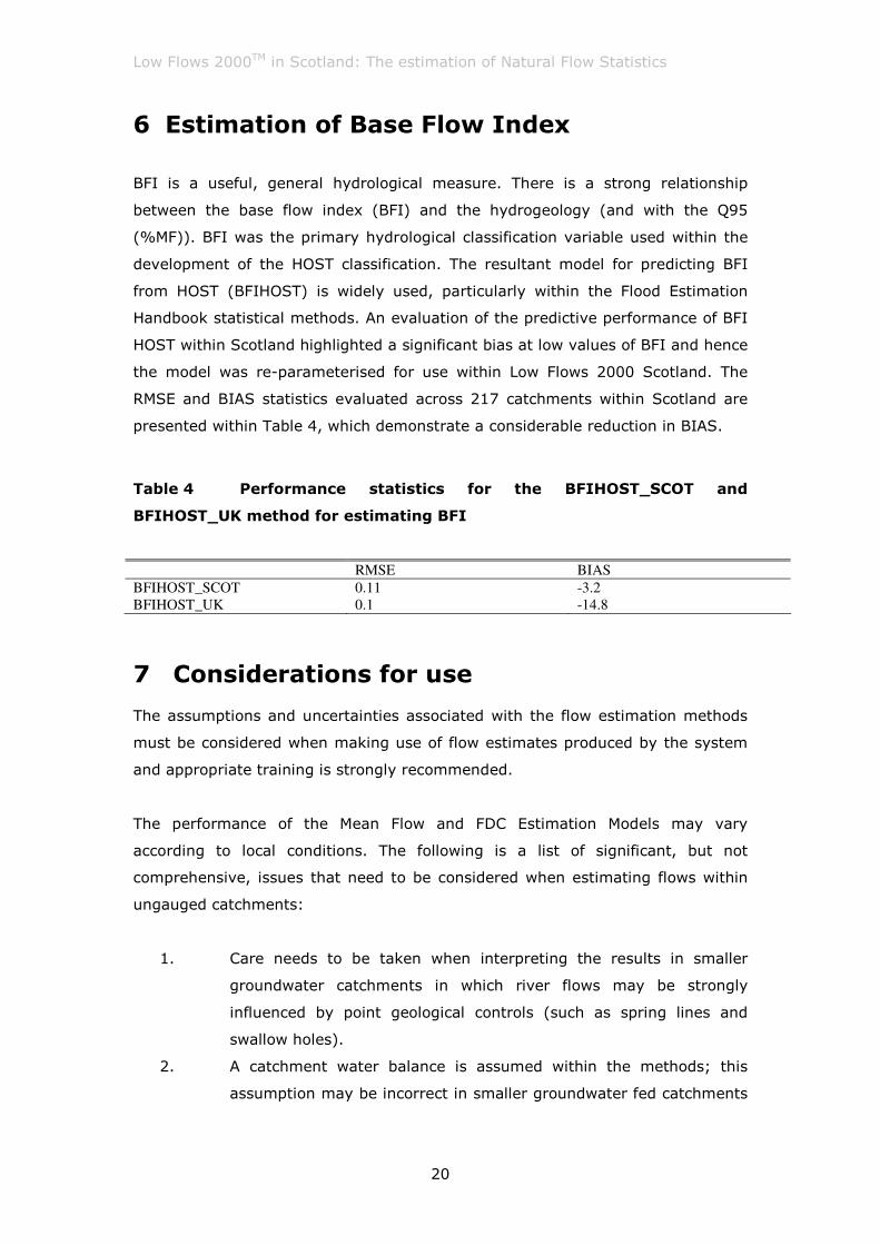
6 Estimation of Base Flow Index
BFI is a useful, general hydrological measure. There is a strong relationship
between the base flow index (BFI) and the hydrogeology (and with the Q95
(%MF)). BFI was the primary hydrological classification variable used within the
development of the HOST classification. The resultant model for predicting BFI
from HOST (BFIHOST) is widely used, particularly within the Flood Estimation
Handbook statistical methods. An evaluation of the predictive performance of BFI
HOST within Scotland highlighted a significant bias at low values of BFI and hence
the model was re-parameterised for use within Low Flows 2000 Scotland. The
RMSE and BIAS statistics evaluated across 217 catchments within Scotland are
presented within Table 4, which demonstrate a considerable reduction in BIAS.
Table 4 Performance statistics for the BFIHOST_SCOT and
BFIHOST_UK method for estimating BFI
RMSE BIAS
BFIHOST_SCOT 0.11 -3.2
BFIHOST_UK 0.1 -14.8
7 Considerations for use
The assumptions and uncertainties associated with the flow estimation methods
must be considered when making use of flow estimates produced by the system
and appropriate training is strongly recommended.
The performance of the Mean Flow and FDC Estimation Models may vary
according to local conditions. The following is a list of significant, but not
comprehensive, issues that need to be considered when estimating flows within
ungauged catchments:
1. Care needs to be taken when interpreting the results in smaller
groundwater catchments in which river flows may be strongly
influenced by point geological controls (such as spring lines and
swallow holes).
2. A catchment water balance is assumed within the methods; this
assumption may be incorrect in smaller groundwater fed catchments

Low Flows 2000TM in Scotland: The estimation of Natural Flow Statistics
21
where part of the regional groundwater flow bypasses the surface
water catchment.
3. The estimation of Mean Flow is based on a grid of long term average
annual runoff developed by CEH. This was derived using the outputs
from a deterministic water balance model using observed data from
over 500 gauged catchments. The predictive performance of the
model may therefore be reduced in areas of low rainfall gauge
density.
4. Care needs to be taken when interpreting the results in very small
catchments as the size of the catchment approaches the spatial
resolution of the underlying catchment characteristic datasets within
Low Flows 2000 (1km2)
5. Where available, local measured flow data should be used to
corroborate the Low Flows software estimates. This is good practice
when using any generalised hydrological model. However, careful
judgement should be exercised as many of the methods for
incorporating local data are subject to many of the same issues that
might limit the predictive performance of the models within Low
Flows 2000.
Low Flows 2000TM in Scotland: The estimation of Natural Flow Statistics
22
8 References
Boorman, D. B., Hollis, J. M. and Lilly, A. (1995). Hydrology of soil types: a
hydrologically-based classification of the soils of the United Kingdom. Report 126.
Institute of Hydrology. Wallingford.
Gustard, A., Marshall, D. C. W. and Sutcliffe, M. F. (1987). Low flow estimation in
Scotland. Report 101. Institute of Hydrology. Wallingford.
Holmes, M.G.R., Young, A.R., Gustard, A.G. and Grew, R. (2002a). A new
approach to estimating Mean Flow in the United Kingdom. Hydrology and Earth
System Sciences. 6(4) 709-720.
Holmes, M.G.R., Young, A.R., Gustard, A.G. and Grew, R. (2002b). A Region of
Influence approach to predicting Flow Duration Curves within ungauged
catchments. Hydrology and Earth System Sciences. 6(4) 721-731.
Holmes, M.G.R. and Young, A.R. (2002c). Estimating seasonal low flow statistics
in ungauged catchments. In Proc. British Hydrological Society 8th National
Symposium - Birmingham, 2002, 97-102.
Institute of Hydrology (1992). Low Flows Estimation within the United Kingdom,
Report 108. Institute of Hydrology, Wallingford.
Young A. R., Grew R. and Holmes M.G.R. (2003). Low Flows 2000: A national
water resources assessment and decision support. Water Science and
Technology, 48 (10).