Embed Size (px)
Citation preview
LOWER DUWAMISH WATERWAY SLIP 4 EARLY ACTION AREA
LONG-TERM MONITORING DATA REPORT YEAR 3 (2015)
Submitted to U.S. Environmental Protection Agency
1200 Sixth Avenue Seattle, WA 98101
Submitted by City of Seattle
Prepared by
719 2nd Avenue
Suite 700 Seattle, WA 98104
December 24, 2015
Slip 4 Early Action Area Long-Term Monitoring Data Report – Year 3 (2015) December 24, 2015
Integral Consulting Inc. ii
CONTENTS LIST OF FIGURES .................................................................................................................................... v
LIST OF TABLES ..................................................................................................................................... vi
ACRONYMS AND ABBREVIATIONS............................................................................................. vii
REPORT CERTIFICATION ................................................................................................................... ix
1 INTRODUCTION ........................................................................................................................... 1-1
1.1 SEDIMENT CLEANUP ACTION ..................................................................................... 1-1 1.2 SOURCE CONTROL ACTIONS ....................................................................................... 1-2 1.3 MONITORING OBJECTIVES ............................................................................................ 1-4 1.4 SUMMARY OF LONG-TERM MONITORING .............................................................. 1-5 1.5 REPORT ORGANIZATION ............................................................................................... 1-6
2 MONITORING ACTIVITIES ....................................................................................................... 2-1
2.1 STORM FLOW MONITORING......................................................................................... 2-1 2.2 VISUAL INSPECTION ....................................................................................................... 2-1
2.2.1 Site Inspection ......................................................................................................... 2-2 2.2.2 Field Deviations ...................................................................................................... 2-2
2.3 SEDIMENT SAMPLING .................................................................................................... 2-3 2.3.1 Sample Collection ................................................................................................... 2-3 2.3.2 Sample Processing .................................................................................................. 2-4 2.3.3 Chain-of-Custody, Sample Packaging, and Transport ..................................... 2-5 2.3.4 Investigation-Derived Waste ................................................................................ 2-6 2.3.5 Field Deviations ...................................................................................................... 2-6
2.4 INSTITUTIONAL CONTROLS ......................................................................................... 2-9 2.5 YEAR 3 OTHER INVESTIGATIONS ................................................................................ 2-9
3 LABORATORY ANALYSIS .......................................................................................................... 3-1
3.1 SAMPLE ANALYSIS........................................................................................................... 3-1 3.2 ANALYTICAL METHODS ................................................................................................ 3-1 3.3 LABORATORY DEVIATIONS .......................................................................................... 3-1
4 DATA MANAGEMENT AND QUALITY ASSESSMENT ..................................................... 4-1
4.1 DATA MANAGEMENT .................................................................................................... 4-1 4.2 DATA QUALITY ASSESSMENT ...................................................................................... 4-1
4.2.1 Sample Receipt, Preservation, and Holding Times ........................................... 4-2
Slip 4 Early Action Area Long-Term Monitoring Data Report – Year 3 (2015) December 24, 2015
Integral Consulting Inc. iii
4.2.2 Field Quality Control Samples ............................................................................. 4-2 4.2.3 Surrogate Compounds ........................................................................................... 4-2 4.2.4 Laboratory Control Samples ................................................................................. 4-3 4.2.5 Matrix Spike/Matrix Spike Duplicates ................................................................ 4-3 4.2.6 Field Duplicates ...................................................................................................... 4-3 4.2.7 Compound Identification ...................................................................................... 4-3 4.2.8 Reporting Limits ..................................................................................................... 4-4
5 RESULTS AND CONCLUSIONS ................................................................................................ 5-1
5.1 PHYSICAL CHARACTERISTICS ..................................................................................... 5-1 5.2 CHEMICAL CHARACTERISTICS ................................................................................... 5-4
5.2.1 PCBs ......................................................................................................................... 5-6 5.2.2 Zinc ........................................................................................................................... 5-6 5.2.3 Benzyl Alcohol ........................................................................................................ 5-6 5.2.4 BEHP and Butylbenzyl Phthalate ........................................................................ 5-7
5.3 OTHER INVESTIGATIONS ............................................................................................... 5-8 5.3.1 NBF RI/FS ................................................................................................................ 5-8 5.3.2 NBF LTST ................................................................................................................ 5-8 5.3.3 Boeing Plant 2 DSOA Corrective Measure ......................................................... 5-8 5.3.4 DeNovo Property ................................................................................................... 5-9 5.3.5 Emerald Services .................................................................................................. 5-13
5.4 ASSESSMENT OF LONG-TERM MONITORING OBJECTIVES ............................... 5-14 5.5 CONCLUSIONS AND RECOMMENDATIONS FOR FUTURE
MONITORING .................................................................................................................. 5-15
6 REFERENCES ................................................................................................................................... 6-1
Appendix A. Rain Gauge and Tide Data
Appendix B. Visual Inspection Field Forms
Appendix C. Visual Inspection Photographs
Appendix C1. Year 3 Site Photographs, July 2, 2015 Appendix C2. Year 2 Site Photographs, July 12, 2014 Appendix C3. Year 1 (July 22, 2013) and Baseline Site Photographs Appendix C4. Year 3 (2015) Photographs in JPEG Format (on CD only)
Appendix D. Surface Sediment Field Forms and Copies of Logbook Pages
Slip 4 Early Action Area Long-Term Monitoring Data Report – Year 3 (2015) December 24, 2015
Integral Consulting Inc. iv
Appendix E. Surface Sediment Photographs
Appendix F. Laboratory Analytical Report
Appendix G. Validation Report
Appendix H. Other Investigations—Boeing Plant 2 DSOA
Appendix I. Other Investigations—DeNovo Property
Appendix I1. Waste Management NPDES Inspection Sampling Results Appendix I2. Remedial Investigation—Second Phase, Preliminary Sediment
Results Summary
Appendix J. Other Investigations—Emerald Services NPDES Inspection Sampling Results
Slip 4 Early Action Area Long-Term Monitoring Data Report – Year 3 (2015) December 24, 2015
Integral Consulting Inc. v
LIST OF FIGURES Figure 1-1. Vicinity Map
Figure 1-2. Sediment Cap and Soil Cover Design
Figure 1-3. Long-Term Monitoring Sampling Stations
Figure 2-1. Visual Monitoring Photo Station Locations
Figure 2-2. 2015 Sediment Sampling Locations
Figure 2-3. WC-3 Sample Photographs Excerpt from Year 1 Long-Term Monitoring Report
Figure 2-4. WC-3 Sample Photograph
Figure 5-1. Thickness of Accumulated Sediment on Top of Cap, Long-Term Monitoring Sampling Locations
Figure 5-2. Year 3 (2015), Year 1 (2013) and Baseline (2012) Concentrations of Select Compounds
Figure 5-3. Total PCB and TOC Concentrations for Slip 4 Surface Sediment Samples, 2012–2015
Slip 4 Early Action Area Long-Term Monitoring Data Report – Year 3 (2015) December 24, 2015
Integral Consulting Inc. vi
LIST OF TABLES Table 1-1. Long-Term Monitoring Study Questions and Informational Inputs
Table 1-2. Long-Term Monitoring Schedule
Table 1-3. Target Analyte List for Slip 4 Early Action Area Long-Term Monitoring
Table 2-1. Photo Log for Year 3 Visual Monitoring
Table 2-2. Visual Inspection Summary, Year 3 Monitoring
Table 2-3. Station Coordinates for Sediment Sampling, Year 3 Monitoring
Table 2-4. Sample Collection Summary—Baseline, Year 1, and Year 3 Monitoring
Table 2-5. Slip 4 EAA Institutional Controls
Table 4-1. Year 3 Monitoring Field Quality Control Sample Results
Table 5-1. Validated Analytical Results for Slip 4 Cap Samples (0 to 10 cm)—Confirmation (2012) versus Year 1 (2013) and Year 3 (2015) Monitoring
Table 5-2. Concentrations of Select Contaminants in Subareas of Slip 4, Post-Construction Samples
Slip 4 Early Action Area Long-Term Monitoring Data Report – Year 3 (2015) December 24, 2015
Integral Consulting Inc. vii
ACRONYMS AND ABBREVIATIONS 2,3,7,8-TCDD 2,3,7,8-tetrachlorodibenzo-p-dioxin
2LAET second-lowest apparent effects threshold
BEHP bis(2-ethylhexyl)phthalate
Boeing The Boeing Company
City City of Seattle
COC chain of custody
Crowley Crowley Marine Services Inc.
CSL cleanup screening level
DeNovo DeNovo Seattle Inc. LLC
dioxin/furan dibenzo-p-dioxin and polychlorinated dibenzofuran
DSOA Duwamish Sediment Other Area
EAA Early Action Area
Ecology Washington State Department of Ecology
EE/CA engineering evaluation and cost analysis
EPA U.S. Environmental Protection Agency
GPS global positioning system
GTSP Georgetown Steam Plant
Integral Integral Consulting Inc.
LDW Lower Duwamish Waterway
LAET lowest apparent effects threshold
LCS laboratory control sample
LTMRP Long-Term Monitoring and Reporting Plan
LTST long-term stormwater treatment
mg/kg OC mg/kg organic carbon–normalized
MLLW mean lower low water
MS/MSD matrix spike/matrix spike duplicate
MTCA Model Toxics Control Act
NBF North Boeing Field
Slip 4 Early Action Area Long-Term Monitoring Data Report – Year 3 (2015) December 24, 2015
Integral Consulting Inc. viii
NPDES National Pollutant Discharge Elimination System
NRWQC National Recommended Water Quality Criteria
NTR WQC National Toxics Rule Water Quality Criteria
OC-normalized organic carbon–normalized
PAH polycyclic aromatic hydrocarbon
PCB polychlorinated biphenyl
PLP potentially liable party
QAPP quality assurance project plan
RACR Removal Action Completion Report
RAL remedial action level
RAO removal action objective
RI/FS remedial investigation and feasibility study
RNA Regulated Navigation Area
RPD relative percent difference
SMS Sediment Management Standards
SOP standard operating procedure
SQS Sediment Quality Standards
SVOC semivolatile organic compound
SWPPP stormwater pollution prevention plan
TEQ toxicity equivalent
TOC total organic carbon
TPH total petroleum hydrocarbons
VOC volatile organic compound
Waste Management Waste Management National Services
Slip 4 Early Action Area Long-Term Monitoring Data Report - Year 3 (2015) December 24, 2015
REPORT CERTIFICATION
The following certification is provided pursuant to the Administrative Settlement Agreement and Order on Consent for Removal Action, Appendix A, Statement of Work, Task 5 -Long-Term Monitoring and Reporting Plan.
CITY OF SEATTLE-PROJECT MANAGER CERTIFICATION
I, Allison Crowley, City of Seattle Project Manager for the long-term monitoring work conducted at the Slip 4 Early Action Area, Lower Duwamish Waterway Superfund site, hereby provide the following certification:
Under penalty of perjury under the laws of the United States, I certify that to the best of my knowledge, after appropriate inquiries of all relevant persons involved in the preparation of this report, the information submitted is true, accurate, and complete. I am aware that there are significant penalties for submitting false information, including the possibility of fine and imprisonment.
Allison Crowley Project Manager City of Seattle
Integral Consulting Inc.
Date
ix
Slip 4 Early Action Area Long-Term Monitoring Data Report – Year 3 (2015) December 24, 2015
Integral Consulting Inc. 1-1
1 INTRODUCTION
This report describes the activities and results associated with the Year 3 (2015) monitoring of long-term effectiveness of the Slip 4 Early Action Area (EAA) cleanup within the Lower Duwamish Waterway (LDW) Superfund site in Seattle, Washington (Figure 1-1). All Year 3 monitoring activities were carried out by Integral Consulting Inc. (Integral) in accordance with the Long-Term Monitoring and Reporting Plan (LTMRP; Integral 2013a), which was prepared in accordance with the requirements set forth in the Slip 4 EAA Administrative Settlement Agreement and Order on Consent and associated Scope of Work (Comprehensive Environmental Response, Compensation, and Liability Act Docket No. 10-2006-0364) and Action Memorandum (USEPA 2006).
Slip 4 is a 6.4-acre navigational slip located 3 miles upstream from the northern boundary of the LDW, which is located at the southern end of Harbor Island. It is one of five priority early action sites identified within the 5.5-mile-long LDW Superfund site. The EAA comprises 3.58 acres within the slip in which sediments were contaminated with polychlorinated biphenyls (PCBs), metals, organic compounds, and petroleum products.
1.1 SEDIMENT CLEANUP ACTION
The City of Seattle (City) completed a non-time-critical removal action to address contaminated sediment at the Slip 4 EAA on February 7, 2012 (Integral 2012). The primary objective of the Slip 4 removal action was to reduce the concentrations of PCBs and other chemicals in the post-cleanup surface sediments to below the Sediment Quality Standards (SQS) incorporated in Washington State’s Sediment Management Standards (SMS) rule (Chapter 173-204, Washington Administrative Code). The primary design and construction elements included:
• Dredging and excavation of approximately 10,256 cubic yards of contaminated bottom sediment and bank soil
• Transloading and disposal of 17,334 tons of soil, sediment, and debris in a Subtitle D landfill, including approximately 130 tons of creosote-treated timbers and piles
• Demolition of 20,019 ft2 of concrete pier structure
• Recycling of 3,278 tons of concrete and 79 tons of steel
• Construction of stable slopes, sediment caps, and slope caps over 3.43 acres, using 53,006 tons of clean material
• Construction of engineered soil covers and expanded habitat in former upland areas.
The construction of sediment and slope caps following the removal of contaminated sediment and soil, in conjunction with the engineered soil covers and habitat enhancements, resulted in
Slip 4 Early Action Area Long-Term Monitoring Data Report – Year 3 (2015) December 24, 2015
Integral Consulting Inc. 1-2
clean material placement over all remaining contaminated soils and sediments within the Slip 4 EAA (Figure 1-2). Overall, the cleanup resulted in a net gain of more than an acre of shallow and riparian habitat for threatened Puget Sound Chinook and Coastal/Puget Sound bull trout.
The 2012 post-construction surface sediment confirmation sampling results from the slope and waterway cap areas verified that surface sediment characteristics within the Slip 4 EAA met the removal action objective (RAO) after construction (Integral 2012). However, post-construction sampling outside of the Slip 4 EAA (within the boundary area; Figure 1-2) revealed that surface sediment PCB concentrations had increased within the boundary area during the course of construction activity. The U.S. Environmental Protection Agency (EPA)–approved response was the placement of a 9-inch nominal lift of waterway cap material (referred to as “boundary area material”) over the boundary area sediments. Subsequent sampling was performed to document surface conditions following boundary area material placement. The results indicated that, after placement of the boundary area material, PCB concentrations within the surface sediment met the RAO. Details of the construction activities are summarized in the Removal Action Completion Report (RACR; Integral 2012), approved by EPA in July 2012.
The 2012 post-boundary area material placement sampling results and 2012 Slip 4 EAA post-construction confirmation sampling results represent the baseline conditions for the Slip 4 EAA long-term monitoring program, which is designed to identify potential concerns with the long-term performance of the remedy in the Slip 4 EAA. Hereinafter, any reference to 2012 post-boundary area material placement and post-construction confirmation sampling data will be referred to as “baseline” in this report.
1.2 SOURCE CONTROL ACTIONS
Potential sources of chemicals to Slip 4 were evaluated in the Slip 4 engineering evaluation and cost analysis (EE/CA; Integral 2006), including bank erosion and stormwater outfalls. The EE/CA addressed bank erosion by including actions to stabilize and contain the banks as part of the Slip 4 remedy. Potentially significant ongoing sources of PCBs and phthalates to Slip 4 were identified in upland drainage systems discharging to Slip 4.
A number of actions were undertaken following the EE/CA and prior to the Slip 4 EAA cleanup to reduce the potential for stormwater to result in recontamination of the Slip 4 sediment surface. Actions included the following:
1. The Georgetown Steam Plant (GTSP) flume was removed in 2009 and replaced with a 12-inch closed pipe. A small area of the property, primarily consisting of the main building roof, drains to this new pipe that discharges to Slip 4. Numerous side connections to the flume were disconnected during installation of the new storm drain pipe. As part of the flume removal, sediments from within the flume and
Slip 4 Early Action Area Long-Term Monitoring Data Report – Year 3 (2015) December 24, 2015
Integral Consulting Inc. 1-3
PCB-contaminated soils immediately surrounding the flume were removed and disposed offsite.
2. Soil containing elevated concentrations of PCBs was excavated from the North Boeing Field (NBF) and GTSP properties. Soil with elevated concentrations of total petroleum hydrocarbons was also removed from the GTSP property. Site restoration activities completed at GTSP following these removal actions have minimized offsite runoff from GTSP, with the majority of site stormwater now managed through onsite infiltration (Integral 2011).
3. The majority of stormwater generated on NBF is treated via a long-term stormwater treatment (LTST) system (built by The Boeing Company [Boeing] in 2011) prior to discharge to Slip 4. The design of the LTST is such that very small particles may pass through the LTST and be discharged to Slip 4, although particles of this size are not expected to settle in Slip 4 (Landau 2013). Also, during significant rainfall events, some stormwater bypasses the LTST and discharges directly to Slip 4. An update of the performance of the LTST is provided in Section 3.2.2.
Source control actions following the Slip 4 EAA 2012 cleanup have included:
• The initiation of a remedial investigation and feasibility study (RI/FS) at the NBF/GTSP Model Toxics Control Act (MTCA) site
• Dredging associated with the Boeing Plant 2 Duwamish Sediment Other Area (DSOA) corrective measure in the LDW, immediately upriver from and within parts of outer Slip 4
• The initiation of Phase 2 of a MTCA RI/FS at the DeNovo Seattle LLC (DeNovo) property on the southwestern boundary of the slip:
– This property is undergoing an RI/FS under an Agreed Order (No. DE 6721) with the Washington State Department of Ecology (Ecology) (SLR 2014a).1 The site, formerly owned by Crowley Marine Services Inc. (Crowley), was transferred to 8th Avenue Terminals, Inc. in 2008 and was sold to DeNovo in April 2014. The Agreed Order was amended on September 19, 2014, to add DeNovo as a party (Ecology 2014a,b).
• National Pollutant Discharge Elimination System (NPDES) inspections and sampling by Ecology at the Waste Management National Services (Waste Management) and Emerald Services facilities adjacent to Slip 4.
Updates on these projects are provided in Section 5.3.
1 Ecology’s Crowley Marine Services Inc. (8th Avenue South) site, facility site ID 1940187.
Slip 4 Early Action Area Long-Term Monitoring Data Report – Year 3 (2015) December 24, 2015
Integral Consulting Inc. 1-4
1.3 MONITORING OBJECTIVES
Hazardous substances remain onsite in Slip 4 EAA sediments and soils at levels greater than those that allow for unrestricted use or unlimited exposure. These remaining hazardous substances are physically and chemically isolated beneath an engineered sediment cap and soil cap. Long-term monitoring is being performed to verify that the remedy at the Slip 4 EAA remains protective of human health and the environment.
The long-term success of the sediment removal action for the Slip 4 EAA will be verified by monitoring endpoints that directly relate to the RAO for the cleanup. The RAO for Slip 4 is to reduce the concentration of contaminants in post-cleanup surface sediments (biologically active zone [0 to 10 cm]) to below the Washington State SQS for total PCB Aroclors2 and other chemicals of interest, thereby reducing risks to human health and the environment resulting from potential exposure to contaminants in the Slip 4 EAA sediments (USEPA 2006). While the removal boundary for the early action in Slip 4 was established to include sediments exceeding the SQS (USEPA 2006), the entire EAA (including soil banks and sediments, and areas that did not exceed the SQS) was capped with clean material.
The Slip 4 removal action design included dredging and excavation to target elevations to remove the most highly contaminated sediments, create stable slopes, and improve and expand habitat. The removal action was not designed to remove all sediment exceeding the SQS. Accordingly, the design called for placement of engineered sediment and soil caps to physically and chemically isolate contaminants that may have been left behind. Cap material thickness varies from 24 to 33 inches for slope cap and soil cover areas, and from 30 to 60 inches for waterway cap areas. Sediment/soil removal areas and cap placement designs are shown in Figure 1-2.
Specific study questions to be answered by the monitoring program are as follows:
• Are contaminant concentrations in Slip 4 EAA surface sediments (0 to 10 cm) below the SQS?
• Is the physical integrity of the cap in the Slip 4 EAA being maintained such that the sediment cap continues to isolate contaminants in underlying sediments from marine biota?
• Do the institutional controls associated with the Slip 4 EAA remedy remain in place and continue to work effectively?
2 The SQS for total PCB Aroclors is 12 mg/kg organic carbon–normalized (mg/kg OC) when the total organic carbon (TOC) content is between 0.5 and 4.0 percent. Similarly, the Washington State cleanup screening level (CSL) for total PCB Aroclors is 65 mg/kg OC. When TOC is less than 0.5 percent or greater than 4.0 percent, regulatory comparisons are made to the lowest apparent effects threshold (LAET) concentration (130 µg/kg dry weight) and the CSL established for the LDW site-wide cleanup (1,300 µg/kg dry weight).
Slip 4 Early Action Area Long-Term Monitoring Data Report – Year 3 (2015) December 24, 2015
Integral Consulting Inc. 1-5
• Are physical changes occurring related to sediment erosion and sediment deposition in the Slip 4 EAA?
Informational inputs designed to address these specific study questions are provided in Table 1-1.
In accordance with the long-term monitoring schedule (Table 1-2), Year 3 monitoring included the following:
• Storm flow monitoring—a summary of 100-year storm events during the Year 3 monitoring period (July 2, 2014, through July 2, 2015)
• Visual inspection
• Sediment sample collection from the slope cap and waterway cap for the target parameters listed in Table 1-3
• Institutional control updates
• Review of construction activities and investigations performed by other parties.
Sediment and soil sampling stations for long-term monitoring in the Slip 4 EAA are shown on Figure 1-3.
1.4 SUMMARY OF LONG-TERM MONITORING
Results of the first three years of long-term monitoring (i.e., 2013, 2014, and 2015) indicate that the sediment and slope caps throughout the Slip 4 EAA are performing as designed, isolating underlying contaminated sediments. During Year 1 (2013), fine sediment accumulated on the sediment cap in most of the EAA except near the head of the slip, with accumulations ranging from 0 to 8 cm in the EAA and up to 10 cm between the EAA and the mouth of the slip (Integral 2014a). Physical conditions observed during Year 2 (2014) and Year 3 (2015) monitoring were similar to those found in Year 1. Monitoring indicated that the sediment cap and backfill remain structurally stable and intact, and sediment has continued to accumulate on top of the cap. Overall, fine sediment deposits observed were generally on the order of 1 mm across most of the exposed intertidal slope cap, but areas of accumulations of 1 cm or more were observed in the sediment cap areas. The thickest accumulations were generally observed in the armored outfall slough. The areal extent of fines deposition near the northwestern corner of the head of the slip, near the north riprap slough, appeared to be slightly larger than in 2014.
There were two minor SQS exceedances within the waterway cap area during Year 1 monitoring. The total PCB concentration at station WC-3 and the bis(2-ethylhexyl)phthalate (BEHP) concentration at WC-1 were slightly above the SQS criteria (Integral 2014a). No sediment samples were collected as part of Year 2 monitoring. During Year 3 monitoring,
Slip 4 Early Action Area Long-Term Monitoring Data Report – Year 3 (2015) December 24, 2015
Integral Consulting Inc. 1-6
samples from five stations exceeded one or more SQS or cleanup screening level (CSL) values. These included WC-1 (total PCBs, zinc, and butylbenzyl phthalate concentrations above dry weight lowest apparent effects threshold (LAET)/SQS criteria3 and BEHP and benzyl alcohol concentrations above the second-lowest apparent effects level [2LAET]/CSL–equivalent SMS dry weight criteria), WC-3 (BEHP concentration above the SQS criterion), WC-4 (BEHP concentration above the SQS criterion), and WC-7 and WC-8 (both with benzyl alcohol concentrations above the CSL criterion).
Based on observations from the visual survey, evaluation of potential sources of depositional sediments, and data collected in Slip 4 and in the LDW by others, the most likely potential sources of fine sediments that deposited on the cap are resuspended sediments from beyond the Slip 4 EAA, and/or contributions from outfalls discharging to the slip.
1.5 REPORT ORGANIZATION
The remainder of this report is organized as follows:
• Section 2. Monitoring Activities
• Section 3. Laboratory Analysis
• Section 4. Data Management and Quality Assessment
• Section 5. Results and Conclusions
• Section 6. References.
Figures and tables summarizing each monitoring element are presented at the end of the text. Appendices provide supporting project documentation and are organized as follows:
• Appendix A. Rain Gauge and Tide Data
• Appendix B. Visual Inspection Field Forms
• Appendix C. Visual Inspection Photographs
– Appendix C1. Year 3 Site Photographs, July 2, 2015
– Appendix C2. Year 2 Site Photographs, July 12, 2014
– Appendix C3. Year 1 (July 22, 2013) and Baseline Site Photographs
– Appendix C4. Year 3 (2015) Photographs in JPEG Format (on CD)
• Appendix D. Surface Sediment Field Forms and Copies of Logbook Pages 3 The TOC value at WC-1 is an estimated 6.92 percent, which is outside the TOC range for comparison to OC-normalized criteria.
Slip 4 Early Action Area Long-Term Monitoring Data Report – Year 3 (2015) December 24, 2015
Integral Consulting Inc. 1-7
• Appendix E. Surface Sediment Photographs
• Appendix F. Laboratory Analytical Report
• Appendix G. Validation Report
• Appendix H. Other Investigations—Boeing Plant 2 DSOA
• Appendix I. Other Investigations—DeNovo Property
– Appendix I1. Waste Management NPDES Inspection Sampling Results
– Appendix I2. Remedial Investigation—Second Phase, Preliminary Sediment Results Summary
• Appendix J. Other Investigations—Emerald Services NPDES Inspection Sampling Results.
Slip 4 Early Action Area Long-Term Monitoring Data Report – Year 3 (2015) December 24, 2015
Integral Consulting Inc. 2-1
2 MONITORING ACTIVITIES
2.1 STORM FLOW MONITORING
The Slip 4 LTMRP requires an evaluation of rainfall to estimate whether resulting stormwater flows have the potential to erode the Slip 4 EAA cap. Erosion of the cap is not expected to result from peak river flows or stormwater discharge into the slip. The water level of the LDW is controlled by the Howard A. Hanson Dam, and thus the LDW does not flood during high flow events. Further, Slip 4 is an off-channel feature of the LDW, and currents within the EAA are not expected to be significantly affected by changes in river flow. In addition, the cap and associated armoring was conservatively sized to accommodate unimpeded flow from outfalls within the slip from a 100-year storm event during an extreme low tide.
For the project site area, the 100-year storm event corresponds to 3.85 inches of rainfall within a 24-hour period as measured from the Seattle Public Utility rain gauge (Station 45-S016, Metro King County, East Marginal Way). If rainfall meeting a 100-year storm event were to occur during the monitoring period, then the occurrence of tidal elevations below 5.2 ft mean lower low water (MLLW)4 would be documented and summarized for the 48-hour period following the storm event to evaluate whether storm-related outfall discharge might have had the potential to impact the cap during low tide conditions.
Rain gauge data for Station 45-S016 for the period of July 2, 2014–July 2, 2015 was obtained from Seattle Public Utilities (Peck 2015, pers. comm.) and reviewed. These rain gauge measurements and predicted tide data (NOAA 2015) from July 2014 through September 2015 are provided in Appendix A. Based on a review of the rainfall data, no 100-year storm events occurred within the Slip 4 EAA Year 3 monitoring period. The maximum daily total rainfall was 2.37 inches recorded on March 15, 2015 (Appendix A). Consequently, no further evaluation of potential stormwater-induced erosion to the cap was performed.
2.2 VISUAL INSPECTION
The visual inspection is performed to document the general condition of the cap, identify any obvious changes in bathymetry/topography resulting from erosion or sedimentation processes, identify any visible breaches of the cap integrity, and note the condition of the constructed habitat features (e.g., integrity of anchored woody debris).
4 Based on predicted tide data for the Duwamish Waterway, 8th Avenue South tide station 9447029. This is a subordinate station referencing the Seattle (Madison St.), Elliott Bay station (ID: 9447130). No observed data are available from the 8th Avenue South tide station.
Slip 4 Early Action Area Long-Term Monitoring Data Report – Year 3 (2015) December 24, 2015
Integral Consulting Inc. 2-2
2.2.1 Site Inspection
The visual inspection for the Year 3 monitoring was conducted in accordance with the quality assurance project plan (QAPP; LTMRP, Appendix A, Integral 2013a), and included still color photographs of the Slip 4 EAA sediments exposed during the extreme low tide on July 2, 2015. The tide level over the time period that the photos were taken is estimated to have ranged from –0.5 to 2.5 ft MLLW, based on the predicted tide curve for the 8th Avenue South tide station (#9447029). Photographs were taken from vantage points consistent with those used to document post-capping conditions, using a 14 megapixel digital camera with a 5x wide-angle zoom lens with a focal length of 5 to 25.0 mm (Olympus Stylus Tough 8010). The locations of the photo stations are shown on Figure 2-1 and are listed along with their target coordinates, photo azimuth, photo numbers, and target areas in Table 2-1. Station locations were marked using rebar stakes during the Year 1 inspection. Most stakes at the photo stations were still standing upright. Exceptions were the stake at station E, which was standing but tilted, and the stake at station F, which was lying on its side. The stake at station E was readjusted upright, and the stake at station F was repositioned upright at the target location using a global positioning system (GPS) unit. The stake at station I was relocated because the vegetation nearby had grown to the extent that a photo showing the target area could not be obtained from the original stake location. The new locations of the station F and I stakes were recorded with a GPS unit, and are included in Table 2-1. All photo station stakes were repainted by field personnel.
Visual inspection forms were used to record observations of conditions in the areas represented by the photographs and are provided in Appendix B, along with the site map used during monitoring.
Year 3 visual inspection photographs (Appendix C1) were compared with photographs taken from similar vantage points documenting 2014 Year 2 (Appendix C2), 2013 Year 1, and 2012 post-capping baseline conditions following completion of the EAA remedy (Appendix C3). An additional photograph was taken of the upland northeast pocket beach for comparison with future monitoring events, and is included in Appendix C1. All photographs taken during the 2015 visual monitoring site visit are included on CD in Appendix C4.
Year 3 cap observations are summarized in Table 2-2 and discussed in Section 3.
2.2.2 Field Deviations
Only one deviation from the QAPP was noted during the Year 3 visual monitoring event. The orientation for Photo J1 taken during the visual monitoring survey on July 2 was incorrect. The photo at J1 using the correct orientation (Appendix C1) was taken on July 31.
Slip 4 Early Action Area Long-Term Monitoring Data Report – Year 3 (2015) December 24, 2015
Integral Consulting Inc. 2-3
2.3 SEDIMENT SAMPLING
The purpose of the sediment sampling is to document surface sediment (0 to 10 cm) quality within the Slip 4 EAA. Year 3 sediment sampling included collection of surface sediments from two slope cap and six waterway cap locations within the Slip 4 EAA. In accordance with the long-term monitoring schedule (Table 1-2) surface sediments in the boundary area located just outside the Slip 4 EAA were not collected. Descriptions of the samples collected and analyses performed are presented below.
The physical characteristics of each sediment sample were recorded on sediment sample log sheets. Any vegetation or debris on the surface of the sediment/soil was removed prior to sampling and noted on the field log sheets. In addition, the presence of aquatic organisms and/or terrestrial wildlife, if observed, was noted on the sample log sheet or in the field notebook. Field log sheets and copies of pages from the field notebook are provided in Appendix D. Photographs were taken of each sediment sample and are provided in Appendix E.
2.3.1 Sample Collection
All sediment samples were collected in accordance with the QAPP (LTMRP, Appendix A, Integral 2013a) except as noted in the following sections. Sample station locations are shown on Figure 2-2. Station coordinates are presented in Table 2-3. The station target locations correspond to the locations sampled for baseline cap verification as described in the RACR (Integral 2012), except for the discrete samples that contributed to the slope cap composite subsamples (Table 2-3). The target coordinates for these samples are the actual locations from the 2013 (Year 1) sampling. Surface sediment sampling was conducted by hand or by boat as indicated below. Sediment samples below the waterline were obtained using the sampling vessel R/V Mazama, operated by Mr. Mike Duffield of Gravity Environmental LLC. The R/V Mazama is an aluminum, flat deck, 24-foot-long monohull vessel equipped with an A-frame and variable speed winch. The vessel is also equipped with a differential global positioning system and a depth sounder.
Sample collection field notes for the July 2015 monitoring samples, along with those for the baseline and Year 1 samples, are summarized in Table 2-4.
2.3.1.1 Slope Cap Samples
A three-point composite of surface sediment (0 to 10 cm) was collected on July 2, 2015 from two bank (slope cap) sampling stations designated SC-2 and SC-3, as shown on Figure 1-3. Bank locations were accessed on foot, and sediments were collected by hand at low tide using a stainless steel trowel, spoon, and bowl as described in the QAPP.
Slip 4 Early Action Area Long-Term Monitoring Data Report – Year 3 (2015) December 24, 2015
Integral Consulting Inc. 2-4
The QAPP specified that the three-point composite samples for each location were to be collected at approximately +2, +8, and +12 ft MLLW. During post-construction confirmation sampling it was noted that sediment from the +2 ft MLLW elevation was located within the waterway cap area and did not represent slope cap material. The RACR noted that the sediment location at +2 MLLW elevation was revised to +4 MLLW during post-construction confirmation sampling. Since this deviation was corrected prior to the collection of the post-construction confirmation sampling, it does not impact the interpretation of the data. As in the Year 1 monitoring sampling, slope cap material for the three-point composite was collected from approximately +4, +8, and +12 ft MLLW (Figure 2-2). As mentioned above, the actual slope cap sampling coordinates from the 2013 subsampling locations were used as target locations in 2015.
2.3.1.2 Waterway Cap Samples
Six discrete waterway cap surface sediment (0 to 10 cm) samples (WC-1 through WC-4, WC-7, and WC-8) were collected on July 2, 2015, at the locations shown on Figure 2-2. Locations WC-1, WC-2, and WC-4 were accessed on foot, and sediments were collected by hand at low tide using a stainless steel spoon and bowl as described in the QAPP. Locations WC-3, WC-7, and WC-8 were accessed from the sampling vessel using a hydraulic power grab sampler in accordance with procedures referenced in the QAPP.
2.3.2 Sample Processing
Sample processing occurred in the field and followed procedures presented in the QAPP (LTMRP, Appendix A; Integral 2013a). At each of the sampling locations, the top 10 cm of sediment were collected.
For each slope cap sample, approximately equal volumes of sediment were collected from each of the three elevations (+4, +8, and +12 ft MLLW) and were composited into a single sediment sample for that location. For waterway cap and boundary area samples, discrete sediment samples were collected from each location.
Each sediment sample was placed into a decontaminated, stainless-steel mixing bowl and thoroughly homogenized using a stainless-steel spoon until the sediment attained a visually uniform color and texture. Aliquots of the homogenized sediment were then placed into labeled, certified clean laboratory sample containers with Teflon-lined lids, and were placed on ice in coolers.
2.3.2.1 Field Equipment Decontamination
All sampling equipment that came into contact with the samples (e.g., grab sampler; and stainless-steel bowls, spoons, trowels, and ruler) were decontaminated prior to use and between
Slip 4 Early Action Area Long-Term Monitoring Data Report – Year 3 (2015) December 24, 2015
Integral Consulting Inc. 2-5
each station. All field equipment decontamination followed the procedures outlined in the QAPP and was consistent with the procedures as outlined in standard operating procedure SD-01 (LTMRP, Appendix A, Attachment A3; Integral 2013a).
2.3.2.2 Field Quality Control Samples
Field quality control samples were used to assess sediment sample variability, evaluate potential sources of sample contamination, and to determine if samples were maintained at the proper temperature during shipping. All field quality control samples were collected at the appropriate frequency and in accordance with the procedures referenced in the QAPP (LTMRP, Appendix A; Integral 2013a). The following field quality control samples were collected in the field and analyzed by the analytical laboratory:
• One split sample was collected in the field at station WC-1 and analyzed for PCBs, semivolatile organic compounds (SVOCs), and metals to assess the variability associated with field sample processing and laboratory analysis. The split sample was assigned a unique number and was not identified as a field split to the laboratory. The parent sample and split sample results are discussed in Section 4.
• One equipment filter wipe sample was collected to help identify possible contamination from the sampling environment or from the sampling equipment (e.g., stainless-steel trowel, bowls, and spoons). The filter wipe sample was analyzed for PCBs, select SVOCs, and metals. Filter wipe sample results are discussed in Section 4.
• One filter blank was collected for each type of filter wipe used to evaluate potential background concentrations in the equipment filter wipe sample. If the equipment filter wipe sample results indicate a potential issue with cross-contamination (i.e., detected chemical concentrations at levels that may impact sediment samples), then the filter blank results would be used to separate out potential filter wipe background concentrations from potential cross contamination from the equipment used.
Temperature blanks were transported unopened to and from the field in the cooler with the sample containers. The blanks were submitted to the laboratory with the field samples to verify the temperature of the samples upon receipt at the testing laboratory; however, the laboratory no longer uses temperature blanks for this purpose, relying on the use of an infrared thermometer to determine cooler temperatures upon delivery in accordance with their standard operating procedure (SOP) (Appendix F).
2.3.3 Chain-of-Custody, Sample Packaging, and Transport
Chain-of-custody (COC) and sample packaging procedures were in accordance with the QAPP (LTMRP, Appendix A; Integral 2013a). COC forms were used to track sample custody from the
Slip 4 Early Action Area Long-Term Monitoring Data Report – Year 3 (2015) December 24, 2015
Integral Consulting Inc. 2-6
time of collection through transfer to the analytical laboratory. Completed COC forms are located within the laboratory data package (see Section 3).
Individual sample jars were filled with sediment, labeled and placed into plastic bags and sealed. Samples were then packed into a cooler. Glass jars were placed in a manner to prevent breakage and separated in the cooler by bubble wrap. Ice was placed in the cooler for sample storage during sampling and for transport to the analytical laboratory. Field personnel transported and transferred custody of the samples directly to the analytical laboratory at the end of the sampling event.
2.3.4 Investigation-Derived Waste
All investigation-derived waste was handled in accordance with the QAPP (LTMRP, Appendix A; Integral 2013a). Any excess water or sediment remaining after processing was returned to the slip in the vicinity of the collection site. Any water or sediment spilled on the deck of the sampling vessel was washed into the surface waters at the collection site before proceeding to the next station.
All disposable materials used in sample collection and processing, such as paper towels and disposable coveralls and gloves, were placed in heavyweight garbage bags or other appropriate containers. Disposable supplies were removed from the site by sampling personnel and placed in a normal refuse container for disposal at a solid waste landfill. Phosphate-free detergent-bearing liquid waste from decontamination of the sampling equipment was washed overboard or disposed in the sanitary sewer system.
2.3.5 Field Deviations
With the following exceptions, all sample collection, processing, and handling were conducted in accordance with the LTMRP (Integral 2013a) and subsequent modifications documented in the Year 1 long-term monitoring report (Integral 2014a):
• Sampling locations – Due to navigational error, the actual sampling locations for stations WC-8, SC2-4, WC-3, and WC-7 were approximately 11, 12, 23, and 32 ft from the target locations, respectively, which is beyond the ± 2 meter tolerance stated in the QAPP (Table 2-3). Recommendations for preventing location deviations in future monitoring events, and additional evaluation of the location of the WC-3 sample, are discussed below.
• Field split sample – The field split sample was submitted and analyzed for chemical and conventional parameters. The QAPP specifies that the field split be analyzed for chemical parameters only.
Slip 4 Early Action Area Long-Term Monitoring Data Report – Year 3 (2015) December 24, 2015
Integral Consulting Inc. 2-7
• Filter wipes – The analytical laboratory did not provide a lot number for the filters used for the filter wipe and filter blank samples. Only the time of collection for these samples was noted in the field logbook.
• Packaging for transport – The two sample coolers were not labeled or packaged for transport via an independent shipper, but were transported directly to the laboratory by field personnel after completing sample collection. This deviation did not impact the quality of the data, as the samples were delivered directly and the COC was transferred in person along with the samples.
• Cooler temperature – The temperature in one of the two sample coolers was 1.4˚C upon arrival at the analytical laboratory, which is slightly below the temperature range specified in the QAPP (4 ± 2˚C). This slight deviation in cooler temperature did not affect the data usability.
2.3.5.1 FIELD SAMPLING LOCATION QA
The QAPP states that samples will be collected from within ± 2 meters (6.5 ft) of the locations specified in Table A-5 of the QAPP. Slope cap samples are composite samples with material collected from three separate locations (subsamples) to generate the composite. During the Year 3 sampling event, subsample locations were based on coordinates gathered during the Year 1 event.
During the Year 3 sampling event, three samples in the waterway cap and one subsample of a slope cap composite sample were collected at distances greater than 2 meters from their target locations. Possible explanations for this discrepancy include lack of experience on the part of the boat captain; lack of communication between the boat captain and the sampling team, regarding actual sampling distances from target stations; and, in the case of the slope cap subsample, lack of accurate, handheld GPS locations due to poor satellite alignment. In order to avoid these errors in future sampling events, all locations will be confirmed in the field. Recommendations for confirming locations include the following:
• Samples accessed by boat – For samples collected from boats using vessel-based navigation, the sampling team must verbally confirm with the vessel operator the vessel’s position relative to the target location. The field sampling forms must state the acceptable target location tolerance (± 2 meters) and include documentation of this confirmation.
• Samples accessed by land – Mark intertidal sampling locations with rebar stakes placed by a surveyor. Also mark at least two permanent shoreline reference locations near each set of stakes and document the distance between the reference locations and the stakes. During subsequent sampling efforts, distance measurements taken by tape measures may be used to locate the correct sampling stations if the rebar stakes cannot be located.
Slip 4 Early Action Area Long-Term Monitoring Data Report – Year 3 (2015) December 24, 2015
Integral Consulting Inc. 2-8
2.3.5.2 WC-3 STATION CONFIRMATION
EPA expressed concern that the sample collected at station WC-3 was not collected within the waterway cap area (RA5, Figure 1-2) but rather within the unarmored outfall area cap (RA4, Figure 1-2). Although both caps consist of waterway cap material (well-graded sandy gravel containing 15 to 25 percent sands), the cap in RA4 also contains a layer of granular activated carbon (GAC) 4 to 5 ft below the surface. RA4 is also bisected by an armored outfall cap “channel” that extends slightly into RA5. Figure 1-2 provides details of the cap within each area.
The most important reason for collecting samples in the same location over time is to document long-term trends (or lack thereof) in the performance of the cap. Therefore, determining whether station WC-3 is within the waterway cap area is important for comparison to previous samples and documentation of long-term trends. Several lines of evidence were reviewed to verify the location of station WC-3 in 2015.
First, the coordinates obtained from the vessel-based GPS placed the sample within the waterway cap area (RA5). Although the vessel was not correctly positioned to the target location, there is no reason to believe that the vessel-based GPS system was not accurate. The Trimble real-time kinematic (RTK) GPS system used on the sampling vessel has a rated accuracy of 10 cm.
Second, the composition of the sample collected in 2015 was compared to the composition of the designed cap (Figure 1-2). As there was no armor material within the sample, we know that the sample was not collected from with the armored outfall cap channel.
Third, the physical composition of the sample collected in 2015 was compared to the sample collected during 2013 (Year 1 sample event) using both field documentation and photographs taken in each year. Physical descriptions of samples collected at station WC-3 in 2013 and 2015 are similar indicating a similar habitat/depositional environment was sampled in both years (Table 2-4). The 2015 sample was described as having a surface layer of fines 8 cm thick on top of gravel cap material. Gravel with attached barnacles was observed at the surface as an isolated piece(s) in the 2015 grab sample. During 2013 monitoring, two grabs were collected for the sample at WC-3 because this station was designated for the collection of extra volume for lab QA/QC requirements. While the first grab had only 2 cm of surface fines (along with gravel and sand indicating cap material), the second grab had 8 cm of fines (along with gravel and sand), similar to the 2015 sample. This variability indicates small scale patchiness in patterns of overall sediment accumulation.
Sample photographs are available for the first grab collected in 2013 and the 2015 sample grab. Sample photographs from 2013 show 1) gravel with fines in the sampler from the first grab, and 2) the material in the sampling bowl (Figure 2-3). The field notes for the 2013 sample mention that gravel was removed from the sampled material prior to sample jars being filled. The photo
Slip 4 Early Action Area Long-Term Monitoring Data Report – Year 3 (2015) December 24, 2015
Integral Consulting Inc. 2-9
from the 2015 sample shows the material in the sampler having a surface deposit of fines (as noted in the sample description) (Figure 2-4). Differences in appearance are in keeping with the sample descriptions discussed above. The sediments sampled in 2015 at WC-3 were within the range of field heterogeneity observed in 2013.
2.4 INSTITUTIONAL CONTROLS
Institutional controls are required at the Slip 4 EAA because some hazardous substances remain onsite at levels that do not allow for unrestricted use of the property (USEPA 2006). An institutional control implementation plan was presented in the final design analysis report (Integral 2010) and further developed in the RACR (Integral 2012).
Table 2-5 summarizes the current status of the institutional controls for the Slip 4 EAA. Implementation of institutional controls was completed on November 20, 2014 with the finalization of the notification signs at the boundaries of the Regulated Navigation Area (RNA) in the EAA (Integral 2014b). The notification signs were observed during the Year 3 long-term monitoring field event, and appear to be in good condition. The U.S. Coast Guard has received no reports of violations of the RNA as of August 17, 2015 (Griffin 2015, pers. comm.). Based on available information, the Slip 4 EAA institutional controls continue to be in place and appear to be effective in protecting the integrity of the EAA remedy.
2.5 YEAR 3 OTHER INVESTIGATIONS
In accordance with the LTMRP, investigations and construction activities controlled by others within the vicinity of Slip 4 that took place within the Year 3 monitoring period (August 2014 through July 2015) were reviewed to further evaluate the performance of the Slip 4 EAA remedy. The following projects, potentially affecting the EAA, are summarized in Section 5.3:
• NBF RI/FS
• NBF LTST operation
• Boeing Plant 2 DSOA Corrective Measure
• Ecology’s NPDES inspection at the Waste Management facility on the DeNovo property
• Phase 2 MTCA RI/FS at the DeNovo property
• Ecology’s NPDES inspection at the Emerald Services facility.
Slip 4 Early Action Area Long-Term Monitoring Data Report – Year 3 (2015) December 24, 2015
Integral Consulting Inc. 3-1
3 LABORATORY ANALYSIS
Samples collected for the Year 3 monitoring of Slip 4 were analyzed by Analytical Resources, Inc., in Tukwila, Washington. Samples were analyzed for chemical constituents and conventional parameters as described in Section 2.3 of the QAPP (LTMRP, Appendix A; Integral 2013a) and listed in Table 1-3.
3.1 SAMPLE ANALYSIS
Slope cap (SC-2 and SC-3) and waterway cap (WC-1 through WC-4, WC-7, and WC-8) samples were analyzed for conventional parameters (total solids, grain size, and TOC), metals (arsenic, cadmium, chromium, copper, lead, mercury, silver, and zinc), PCB Aroclors, and select SVOCs (Table 1-3). The laboratory analytical report is presented in Appendix F.
3.2 ANALYTICAL METHODS
All samples were analyzed in accordance with the analytical methods referenced in Table A-1 of the QAPP (LTMRP, Appendix A; Integral 2013a), except for total solids, which is discussed in the following section.
3.3 LABORATORY DEVIATIONS
All laboratory procedures for sample handling, analysis, and reporting followed the methods and procedures identified in the QAPP (LTMRP, Appendix A; Integral 2013a), except for the analytical method used for the determination of total solids.
Total solids were analyzed in accordance with Standard Method 2540G (SM2540G, APHA et al. 1997) rather than the Puget Sound Estuary Program (PSEP) method (USEPA 1986) referenced in the QAPP. According to the laboratory, the SM2540-G method and the PSEP method are identical and interchangeable. The laboratory defaults to the SM2540-G method for which they are accredited. Both methods utilize a drying temperature of 103˚C, and are considered comparable for the determination of total solids in sediments; thus, the deviation did not adversely impact the quality or representativeness of the total solids results. It is recommended that the QAPP be amended to allow either method.
Slip 4 Early Action Area Long-Term Monitoring Data Report – Year 3 (2015) December 24, 2015
Integral Consulting Inc. 4-1
4 DATA MANAGEMENT AND QUALITY ASSESSMENT
Field and laboratory data management and validation were conducted in accordance with the QAPP (LTMRP, Appendix A; Integral 2013a) as described in the following sections.
4.1 DATA MANAGEMENT
Documentation of field sampling was completed in accordance with the guidelines for entry of information (Section 1.9 of the QAPP; LTMRP, Appendix A; Integral 2013a). Following the field sampling event, hard copy notes and forms were scanned to create an electronic record for use in creating appendices to this report. Information on sampling locations, dates, depths, equipment, and other conditions, and sample identifiers, were entered into the project database managed by Integral. One hundred percent of hand-entered data were verified based on hard copy records. Electronic QA checks to identify anomalous values were conducted following data entry.
The analytical laboratory submitted data in electronic format. Quality assurance checks of format and consistency were conducted on electronic documents received from the laboratory. No inconsistencies or issues were found during the quality assurance check of the laboratory electronic deliverables, and data were loaded into the project database. Each data set loaded into the database was linked to the electronic document of the relevant laboratory data package. A complete laboratory data deliverable was produced in an electronic format for use by data validators. Validators returned an edited version of this data deliverable, and the edits were incorporated into the database in accordance with the QAPP (LTMRP, Appendix A; Integral 2013a).
Within five business days of EPA’s approval of this monitoring report, the project data will be submitted to Ecology for incorporation into the State’s Environmental Information Management database, and written notification of the data upload will be sent to EPA, per Section 5.1 of the LTMRP (Integral 2013a).
4.2 DATA QUALITY ASSESSMENT
Field data were verified during preparation of samples and COC forms, which were reviewed by the field lead. Data verification and validation of laboratory data were conducted by EcoChem, located in Seattle, Washington, in accordance with the QAPP. A total of 518 results were reviewed and validated. Twenty-two results (4.2 percent) were restated as estimated (J qualified), two results (<1 percent) were restated as undetected (U qualified), and four results (<1 percent) were rejected (R qualified). The rejected data were measurements of benzyl alcohol. With the exception of the rejected data, all remaining data are considered acceptable
Slip 4 Early Action Area Long-Term Monitoring Data Report – Year 3 (2015) December 24, 2015
Integral Consulting Inc. 4-2
for their intended use, as qualified. The data validation report, which includes a summary of the restated data qualifiers, is presented in Appendix G.
4.2.1 Sample Receipt, Preservation, and Holding Times
All samples were received in good condition, met temperature requirements, and were analyzed within the recommended holding times except for those noted below.
All sediment samples were re-extracted outside of the 14 day hold time specified in the QAPP (Appendix A; Integral 2013a) for PCB Aroclors. The samples were frozen after the initial extraction (12 days from collection). Because National Functional Guidelines (USEPA 2014) has extended the holding time for sample extraction to one year, no data were qualified based on the extraction date.
4.2.2 Field Quality Control Samples
Field quality control samples were used to assess sample variability and evaluate potential sources of contamination. Field quality control samples analyzed included one field split sample, one equipment filter wipe, and one filter blank as described in Section 2.3.2.2.
The field split sample was collected at station WC-1; results are presented in Table 4-1. In accordance with Section 4 of the QAPP, results for field splits are evaluated against a relative percent difference (RPD) control limit of 50. The RPD values for fine sand, coarse silt, and very fine silt were greater than the control limit. In accordance with the QAPP, no data were qualified as a result of the split sample results.
Two field blanks were submitted for chemical analysis (Table 4-1). The filter blank sample (FB0901) was used to evaluate the results for the equipment filter wipe sample (FW0901).
BEHP and benzo(g,h,i)perylene were detected in FB0901. There were no positive results for FW0901. No data for the field samples were qualified based on the field blanks.
Chromium, copper, and zinc were detected in FB0901. The positive results for copper and zinc in sample FW0901 were less than the action level of 5x the blank concentration and were U qualified during data validation. After qualification based on the result for FB0901, no positive results remained for FW0901. No qualification of field samples was necessary based on the wipe blank results.
4.2.3 Surrogate Compounds
Surrogates were added to all samples for applicable analyses and met percent recovery control limits except for those instances noted below.
Slip 4 Early Action Area Long-Term Monitoring Data Report – Year 3 (2015) December 24, 2015
Integral Consulting Inc. 4-3
The laboratory analyzed four acid fraction surrogates with each sample. The percent recovery values for 2,4,6-tribromophenol were greater than the upper control limit in samples SD0113, SD0115, SD0116, SD0117, SD0118, the method blank, the matrix spike, and matrix spike duplicate. No data were qualified based on the single outliers.
4.2.4 Laboratory Control Samples
Laboratory control samples (LCSs) were analyzed at the proper frequency and met project control limits except for those instances noted below.
Benzyl alcohol was not recovered in the LCS associated with the sediment samples, indicating a potential low bias. Positive results in the associated samples were estimated (J qualified) and nondetect results were rejected (R qualified).
4.2.5 Matrix Spike/Matrix Spike Duplicates
Matrix spike/matrix spike duplicates (MS/MSDs) were analyzed at the proper frequency and met project control limits except for those instances noted below.
All TOC results were assigned J qualifiers during data validation due to a matrix spike recovery value above the project control limit, indicating a potential high bias.
The SVOC MS/MSD analyses were performed using sample SD0111. Results for chrysene, fluoranthene, and pyrene in sample SD0111 were assigned J qualifiers during data validation due to matrix spike recovery values above the project control limit, indicating a potential high bias. The RPD values for benzo(b)fluoranthene, benzo(k)fluoranthene, di-n-octyl phthalate, and n-nitrosodiphenylamine were greater than the project control limit. Detected results for benzo(b)fluoranthene, benzo(k)fluoranthene, and di-n-octyl phthalate in sample SD0111 were assigned J qualifiers during data validation; n-nitrosodiphenylamine was not detected and so no qualification was necessary for this analyte.
The PCB Aroclor MS/MSD analyses were performed using sample SD0111. The RPD value for Aroclor 1260 was greater than the control limit. The result for Aroclor 1260 in sample SD0111 was assigned a J qualifier during data validation.
4.2.6 Field Duplicates
One set of field duplicates, SD0111 and SD0112, was submitted. Field precision was acceptable.
4.2.7 Compound Identification
The percent difference between the two analytical columns was greater than 40 percent for Aroclor 1248 in sample SD0113. This result was J qualified during data validation.
Slip 4 Early Action Area Long-Term Monitoring Data Report – Year 3 (2015) December 24, 2015
Integral Consulting Inc. 4-4
4.2.8 Reporting Limits
Reporting limits for several analytes in most samples were elevated based on reduced sample volume, high moisture content and/or dilutions.
Slip 4 Early Action Area Long-Term Monitoring Data Report – Year 3 (2015) December 24, 2015
Integral Consulting Inc. 5-1
5 RESULTS AND CONCLUSIONS
Long-term monitoring data for the Slip 4 EAA were evaluated by analyzing spatial and temporal trends in the physical and chemical characteristics of the sediments and shoreline soils. The 2012 post-construction data compiled in the RACR (Integral 2012) provide a baseline for comparison to long-term monitoring program results. The physical and chemical characteristics of the Slip 4 EAA and temporal changes identified during the Year 3 monitoring are described below. Temporal changes were evaluated to identify recommendations for subsequent monitoring events.
5.1 PHYSICAL CHARACTERISTICS
The physical characteristic of concern for the Slip 4 EAA remedy is the integrity of the cap. Mechanisms for potential adverse impacts to the cap include the following:
• Sloughing of cap material in sloped areas (located onshore and nearshore) caused by erosion or seismic (earthquake) activity
• Erosion of waterway cap material and armoring due to outfall discharge
• Breaching of the sediment cap either onshore or within the waterway caused by man-made events, such as vessel groundings, prop scour, or other unauthorized physical disturbances.
Other physical characteristics and processes of interest at the Slip 4 EAA include the following:
• Deposition of sediments from offsite sources on the sediment cap
• Evidence of recontamination
• Changes to shoreline development along the perimeter of the Slip 4 EAA
• Changes to constructed habitat features
• Reestablishment of intertidal aquatic habitat
• Accumulation of organic matter and man-made litter
• Wildlife usage.
For the Year 3 monitoring, the visual inspection was the primary means of assessing cap integrity, sediment deposition, changes in constructed habitat features, and changes to shoreline development. Photographs and field notes from the Year 3 visual inspection were compared to baseline and previous long-term monitoring photographs and field notes to evaluate temporal changes. Year 3 visual inspection field notes are summarized in Table 2-2 and photographs are
Slip 4 Early Action Area Long-Term Monitoring Data Report – Year 3 (2015) December 24, 2015
Integral Consulting Inc. 5-2
presented in Appendix C1. Year 3 monitoring field forms and copies of the logbook pages are located in Appendix B.
The following observations were made in Year 3 (Table 2-2; Appendix C1):
• Continued growth of vegetation was observed in the pocket beaches.
• Accumulation of fine sediment, generally on the order of 1 to 2 mm or less in depth, was observed at low tide throughout the Slip 4 EAA on the slope cap areas below the high tide line (Table 2-2). A deposit of up to 6 cm was observed on the lower portion of the north slope cap. Accumulations of 0 to 2 cm or more were observed in areas of the sediment cap above the water line at low tide. The thickest accumulations (up to 16 and 18 cm) were observed in the riprap slough and along the west sediment cap, respectively. Sediment accumulation in the north riprap slough area appears to have continued since the 2014 monitoring. A discussion of fine sediment accumulation within Slip 4 is provided below.
• Small woody debris (sticks, twigs, and trace leaf litter) was scattered throughout the EAA.
• Trace litter and plastic debris were observed in some areas, but the occurrence of litter generally appeared to be less than in 2014, except in the northwest pocket beach, where a similar amount and type of litter as in 2014 was observed.
• Algae growth was again observed along the entire intertidal area.
• Evidence of reestablishment of intertidal aquatic habitat was limited to barnacles attached to cobble and gravel along the central and south riprap slough, north slope cap, and east-central, south, and west sediment cap areas; filamentous algae in the west, east-central, and south sediment cap areas; possible burrows in the soft sediment of the north, central, and south riprap sloughs, and north, northwest, and west sediment cap areas; and benthic invertebrates (likely amphipods) in the top few centimeters of the northwest sediment cap, and a crab observed in the south riprap slough.
• Similar to previous years, wildlife observations during the Year 3 monitoring included avian and insect activity.
Sediment deposition rates vary within Slip 4 (Integral 2006). During Year 1 monitoring, accumulations of 0 to 1 cm were observed within the slope cap and northern outfall cap areas, whereas accumulations of 2 to 8 cm were observed within the southern outfall cap and waterway cap areas. Accumulations were not always uniform, even within small areas, and may reflect periodic disturbances such as prop wash. Similar varying thicknesses of fine sediment deposits were observed during the Year 2 and Year 3 visual surveys (Figure 5-1).
The Year 1 monitoring report noted that the observed variability in local sedimentation rates was comparable to the LDW sediment transport modeling predictions for Slip 4 (AECOM 2012),
Slip 4 Early Action Area Long-Term Monitoring Data Report – Year 3 (2015) December 24, 2015
Integral Consulting Inc. 5-3
which predicted lower sedimentation rates within the inner portions of Slip 4 (EAA) and higher sedimentation rates between the EAA and the mouth of Slip 4. There are a number of potential sources of sediments to Slip 4, as follows:
• Outfall discharges – There are six outfalls located within the Slip 4 EAA (Figure 2-1). Each is described below along with an indication of whether the outfall is a potential source of sediment:
– I-5 outfall – The I-5 storm drain, owned by the Washington State Department of Transportation, collects runoff from I-5, residential properties, and the north end of the King County Airport (Integral 2006). Given the size of the drainage basin and the lack of stormwater treatment, this outfall is a likely source of sediment to Slip 4.
– Georgetown Flume replacement outfall – The GTSP storm drain, owned by the City, conveys stormwater from a small portion of the GTSP property and is not considered a significant source of sediments to Slip 4.
– NBF outfall – The NBF storm drain, owned by the City (Leidos 2014) and King County, drained approximately 3 acres on the north end of the King County International Airport (Integral 2006). The City video-surveyed the storm drain line in September 2015 and found the drain line plugged approximately 280 ft upgradient of the outfall (Schmoyer 2015b,c, pers. comm). One connection exists to an 18-inch partially filled pipe beneath East Marginal Way, but the survey noted that this connection does not appear to be active (Schmoyer 2015c, pers. comm). The NBF outfall is not considered a significant source of sediments to Slip 4.
– King County outfall (KC Airport SD #3/PS44 EOF) – The King County Airport storm drain, owned by King County, conveys water from roughly 328 acres: 157 acres of NBF and 171 acres of the King County International Airport (SAIC 2011). Approximately 65 percent of the stormwater discharged from this outfall was treated by the LTST system during the third year of the LTST system operations (compared with 68 percent during the first year of operation and 64 percent during the second). This outfall may be contributing some sediment to Slip 4. Since about 1985, the outfall has also functioned as an emergency sewer overflow for City Pump Station 44 (Integral 2006). City records dating back to 2001 indicate that this pump station has not overflowed in the last 14 years and is not considered a source of sediment to Slip 4 (Schmoyer 2014a,b, 2015a pers. comm.).
– DeNovo outfall OF6 and Emerald Services outfall – Two private storm drains/piped outfalls that discharge to the EAA serve the DeNovo and First South Properties–owned parcels. As discussed in Sections 5.3.4.1 and 5.3.5, these outfalls may be contributing sediment to Slip 4.
• Sediments from outside the remediation area – Operations at the DeNovo property (also known as the Crowley site; Section 3.2.4) include the movement of barges and
Slip 4 Early Action Area Long-Term Monitoring Data Report – Year 3 (2015) December 24, 2015
Integral Consulting Inc. 5-4
vessels just outside of the EAA in an area with relatively shallow bathymetry (-15 to -20 ft MLLW). It is likely that prop wash-induced resuspension of sediments is occurring and may be the most significant source of newly deposited sediments in the EAA. Sediment migration into the slip from the main stem of the LDW is also an expected source of sediment to Slip 4.
• Boeing Plant 2 dredging – Boeing Plant 2 dredging was conducted in the Slip 4 portion of the Plant 2 DSOA during the Year 3 monitoring time period. Data regarding turbidity compliance during dredging is not yet available, but assuming effective engineering controls were implemented, this work may be a minor source of sediments to the Slip 4 EAA.
• Slip 4 EAA sediments – All sediments, including bank sediments, within the Slip 4 EAA were covered with clean capping material, varying in thickness between 24 and 60 inches, as shown in Figure 1-2. The visual observations noted during the site walk at extreme low tide indicate that the integrity of the cap is intact; thus, the capped Slip 4 EAA sediments are not contributing to the newly deposited sediments within the EAA. However, the sediments deposited atop the cap may experience resuspension and redistribution within the EAA.
In summary, sediment deposition within Slip 4 is not uniform and sediments are likely being redistributed within Slip 4 and the EAA due to prop wash-induced resuspension, tidal fluctuations, and (to a lesser degree) storm drain outflows.
Based on observations during the visual inspection, the physical integrity of the Slip 4 EAA cap is intact. There were no indications of breaches to the cap integrity or evidence of pollution, and no changes in structural integrity were observed for any of the constructed habitat features within the Slip 4 EAA.
5.2 CHEMICAL CHARACTERISTICS
The RAO within the Slip 4 EAA is to reduce concentrations of contaminants of concern in surface sediment to levels that do not exceed the SQS. Mechanisms that could potentially cause SQS exceedances of one or more of the contaminants of concern include:
• Reduction in thickness or breaching of the cap that exposes underlying sediments containing residual contaminants
• Recontamination of Slip 4 EAA sediments by deposition of contaminants from offsite sources
• Migration of contaminants upward through the cap materials.
Slip 4 Early Action Area Long-Term Monitoring Data Report – Year 3 (2015) December 24, 2015
Integral Consulting Inc. 5-5
Sediment sampling and analyses were used to assess compliance with the Slip 4 EAA RAO and to document temporal changes in surface sediment chemical and physical (i.e., grain size and total solids) characteristics. Analytical results from the City’s Year 3 sampling, and Year 1 and baseline 2012 sampling are presented in Table 5-1.
The results of the 2015 long-term monitoring show exceedances of SMS criteria at five of the eight locations within the EAA (Table 5-1). These exceedances are summarized below:
• WC-1: PCB Aroclors, zinc, and butylbenzyl phthalate concentrations exceed the LAET/SQS dry weight criteria. The concentrations of BEHP and benzyl alcohol exceed the CSL criterion, as does the reporting limit (U-qualified value) for N-nitrosodiphenylamine. Field split samples were collected from WC-1, with the mean TOC value estimated at 6.92 percent, which is outside the TOC range for comparison to OC-normalized criteria. No explanation for this relatively high TOC value is apparent based on the sampling location photograph (Appendix E) or sample description (Table 2-4; Appendix D).5 Samples collected from this station since 2012 have shown increasing TOC values (Table 5-1). There is a net accumulation of approximately 1 cm of sediment on the cap at this station (Table 2-4).
• WC-3: The BEHP concentration exceeds the SQS criterion, and the benzyl alcohol concentration exceeds the CSL criterion. During Year 1 monitoring, this location had a PCB concentration of 12.3 mg/kg OC, slightly above the 12 mg/kg OC SQS criterion.
• WC-4: The BEHP concentration exceeds the SQS criterion
• WC-7: The benzyl alcohol concentration exceeds the CSL criterion
• WC-8: The benzyl alcohol concentration exceeds the CSL criterion
Graphs in Figure 5-2 show concentrations of contaminants with detected SMS exceedances (i.e., PCBs, zinc, BEHP, and benzyl alcohol), along with total high-molecular-weight polycyclic aromatic hydrocarbons (PAHs), for the baseline sampling in 2012 and Year 1 and Year 3 monitoring samples. Overall, chemical concentrations within the Slip 4 EAA have increased when compared to 2012 post-construction baseline concentrations. This increase is not unexpected given that the 2012 post-construction concentrations represent baseline conditions of the clean imported capping materials. Concentration patterns vary among locations and chemicals, with the greatest number of chemicals exceeding SMS at station WC-1. Concentration trends for contaminants with detected SMS exceedances are discussed in the following sections.
5 The sample field log at WC-1 noted “specks of bright orange spots” in the sample material, which, according to sampling personnel, was likely due to the presence of oxidized burrows in the sediment (see photo in Appendix E). No particulates of paint, caulk, plastic, or other anthropogenic materials were observed in the sample.
Slip 4 Early Action Area Long-Term Monitoring Data Report – Year 3 (2015) December 24, 2015
Integral Consulting Inc. 5-6
5.2.1 PCBs
PCB concentrations in long-term monitoring samples have increased over baseline concentrations at all stations, but exceedances of SMS criteria have been detected at only two monitoring stations since 2012: WC-1 in 2015 and WC-3 in 2013 (Table 5-1; Figure 5-2a). The concentration at WC-1 in 2015 (an estimated 300.5 µg/kg dry weight; Table 5-1) is above the 130 µg/kg dry weight LAET/SQS criterion. As mentioned above, TOC values in these samples are above the 4 percent threshold for OC-normalized criteria. PCB concentrations at some stations were lower in 2015 than in 2013, including at station WC-3, which exceeded the SQS in 2013 (Table 5-1).
Throughout Slip 4, PCB concentrations in sediment samples collected over 2012-2015 vary considerably (Figure 5-3), from <20 µg/kg within the EAA to an estimated 900 µg/kg outside of the EAA. Sediments from the outer portion of Slip 4 show total PCB concentrations above the SQS criterion, and are a likely source of new sediment deposition in the EAA especially given the movement of barges in the outer portion of the slip. Sediments in the LDW near the mouth of Slip 4, where PCB concentrations range from 92 to 350 µg/kg, may also be a source of sediment deposition within the Slip 4 EAA. Lastly, inputs from one or more outfalls discharging to the slip may also be contributing to the observed concentrations (Sections 5.3.4.1 and 5.3.5).
5.2.2 Zinc
Zinc concentrations have also been increasing at most stations sampled since 2012 (Figure 5-2b), but the only exceedance of the 410 mg/kg SQS criterion detected during long-term monitoring to date has been the 2015 monitoring sample collected at WC-1 (465 mg/kg).
Zinc concentrations in Slip 4 sediment outside of the EAA range up to 398 mg/kg (estimated) based on available recent data (Table 5-2). As with PCBs, the source of the increasing zinc is likely transport of sediment from the outer portion of Slip 4 to the EAA and/or inputs from outfall discharges, as discussed in Sections 5.3.4.1 and 5.3.5.
5.2.3 Benzyl Alcohol
All detected benzyl alcohol concentrations in the 2015 Year 3 monitoring samples are above the 73 µg/kg CSL criteria (Table 5-1). The values of all detected concentrations were qualified as estimated during data validation: WC-1 (210 µg/kg), WC-3 (160 µg/kg), WC-7 (220 µg/kg), and WC-8 (150 µg/kg) (Table 5-1; Section 4.2.4). Benzyl alcohol was not detected in most samples from the baseline and Year 1 monitoring events (Table 5-1; Figure 5-2d); however, concentrations detected in Year 1 monitoring samples at WC-3 (530 µg/kg) and WC-7
Slip 4 Early Action Area Long-Term Monitoring Data Report – Year 3 (2015) December 24, 2015
Integral Consulting Inc. 5-7
(390 µg/kg) exceeded the CSL criterion.6 Concentrations at both of these stations were lower in Year 3 monitoring samples than in Year 1.
Benzyl alcohol concentrations in Slip 4 outside of the EAA range up to 41 µg/kg based on available recent data from outside of the boundary area (Table 5-2), and was up to an estimated 220 µg/kg in boundary area samples collected in 2012. As discussed in Sections 5.3.4.1 and 5.3.5, benzyl alcohol has also been detected at elevated concentrations in recent nearby storm drain samples.7
5.2.4 BEHP and Butylbenzyl Phthalate
In Year 3 monitoring, concentrations of BEHP exceeding SMS criteria were found at stations WC-1, WC-3, and WC-4. The dry weight concentration at WC-1 (6,350 µg/kg) exceeds the 3,100 µg/kg 2LAET dry weight criterion, and the OC-normalized concentrations at WC-3 (49.7 mg/kg OC) and WC-4 (60.9 mg/kg OC) exceed the 47 mg/kg OC SQS criterion (Table 5-1). The BEHP concentration at WC-1 (47.9 mg/kg OC) also exceeded the SQS criterion during Year 1 monitoring. Comparatively, the dry weight concentration at this station in 2015 is substantially higher than in Year 1 (Figure 5-2e), and is the highest post-construction concentration in Slip 4 based on available data (Table 5-2).
Butylbenzyl phthalate has not been detected in most of the past baseline and long-term monitoring samples (Table 5-1; Figure 5-2f); however, the Year 3 concentration at WC-1 (315 µg/kg) exceeds the 63 µg/kg LAET/SQS dry weight criterion. Compared to WC-1, concentrations detected in other long-term monitoring samples have been relatively low (100 µg/kg or less; Table 5-1). Butylbenzyl phthalate concentrations in Slip 4 outside of the EAA boundary range up to 82 µg/kg (Table 5-2).
Phthalate concentrations above SQS criteria are ubiquitous within the LDW. The Sediment Phthalates Work Group (SPWG 2007) provided a summary of findings relating to phthalate accumulation in sediments that indicates an air-stormwater-sediment pathway, with urban or metropolitan areas as ongoing sources due to the use of plasticized products. Given the existing source controls in place for the major outfalls within the Slip 4 EAA, concentrations of phthalates in Slip 4 EAA sediments are likely associated with sediment deposition from the outer portion of Slip 4, or contributions from storm drain outfalls, as discussed in Sections 5.3.4.1 and 5.3.5.
6 The CSL for benzyl alcohol was lowered in 1994 from 870 to 73 µg/kg dry weight; however, the new freshwater SMS criteria do not contain a criterion for benzyl alcohol because it is not correlated with toxicity (Godtfredsen 2015, pers. comm.).
7 Improvements in analytical methods beginning around 2005 has led to increasing detection frequencies for benzyl alcohol in sediment samples collected from the LDW (Godtfredsen 2015, pers. comm.).
Slip 4 Early Action Area Long-Term Monitoring Data Report – Year 3 (2015) December 24, 2015
Integral Consulting Inc. 5-8
5.3 OTHER INVESTIGATIONS
This section provides a summary of information obtained regarding physical construction or investigations by other parties that occurred in or near the Slip 4 EAA during the Year 3 long-term monitoring period.
5.3.1 NBF RI/FS
Work continues on an RI/FS at the NBF/GTSP MTCA site. Work to date has included soil and soil vapor sampling, monitoring well installation, quarterly groundwater monitoring, storm drain inspection and solids sampling, and surface debris sampling, as detailed in monthly progress reports to Ecology (Edens 2015, pers. comm).
5.3.2 NBF LTST
During the third year of LTST operation (November 1, 2013, to October 31, 2014), approximately 65 percent of NBF stormwater was treated by the system (Landau 2015e). For comparison, percentages of NBF stormwater treated during the system’s first and second years of operation were 68 percent and 64 percent, respectively (Landau 2013, 2014). The remainder bypassed treatment and was discharged directly to Slip 4 (Landau 2015e). PCBs and other hazardous substances in the stormwater continue to be monitored prior to discharge. As in the previous years of monitoring, all samples collected at the point of compliance during the third year were below the marine chronic water quality criterion interim goal of 0.030 µg/L for PCBs. Metals and SVOCs (including PAHs and BEHP) were also monitored. All concentrations were below marine chronic water quality criteria during the third year of monitoring, except for the limit of quantitation reported for pentachlorophenol (10 µg/L compared to the marine chronic criteria of 7.9 µg/L).
5.3.3 Boeing Plant 2 DSOA Corrective Measure
Boeing is conducting the Plant 2 DSOA Corrective Measure project pursuant to the Administrative Order on Consent (Resource Conservation and Recovery Act Docket No 1092-01-22-3008(h)) issued to Boeing in 1994 by EPA.
Season 3 construction began in fall 2014. Season 3 pre-construction surface sediment sampling in Slip 4 was completed in September 2014 (AMEC 2014). Perimeter surface sampling areas included three locations within the City-owned portion of the Slip 4 EAA (SD-PER501, SD-PER502, and SD-PER503) and 15 locations within Slip 4 between the EAA and the mouth of the slip. Three of the latter locations (SD-PER504, SD-PER508, and SD-PER509) are within the boundary area just outside of the Slip 4 EAA. Results for Season 3 pre-construction surface sediment samples collected through September 2014 were reported in the Slip 4 Year 2 long-term monitoring report (Integral 2014b).
Slip 4 Early Action Area Long-Term Monitoring Data Report – Year 3 (2015) December 24, 2015
Integral Consulting Inc. 5-9
Additional pre-construction sediment cores were collected in December 2014 and January 2015 (Keeley 2015, pers. comm.). The data report for these cores is not yet publicly available; however, information provided to Integral by EPA indicates that, as a result of additional SQS exceedances at depth, an expansion of the original dredge area has been proposed (Figure 2, Appendix H; Keeley 2015, pers. comm.).
Post-construction sampling was scheduled for March or April 2015. Post-dredging/pre-backfill cores were to be collected. The final data report (Boeing DSOA Corrective Measure, Dredging Construction Season 3 [September 2014 to March 2015] Completion Report) for these efforts is not yet available.
5.3.4 DeNovo Property
The site is operated as Waste Management 8th Avenue South (Ecology facility ID 1940187). Waste Management is currently operating the site as a soils/sediment transloading facility for transferring sacks of contaminated soil from barges to rail cars (Ecology 2015c). Waste Management is also pursuing permits to use the site as a transfer facility for offloading sediment associated with the LDW sediment cleanup (Ecology 2015).
Stormwater compliance inspection and sampling conducted in February 2015 by Ecology, a September 2015 immediate action order issued by Ecology regarding observed NPDES permit violations, and preliminary sediment sampling data from the Phase 2 remedial investigation are discussed below.
5.3.4.1 NPDES Inspection Sampling
Ecology conducted a stormwater compliance inspection at the Waste Management facility on February 3, 2015 (Leidos 2015a). Ecology collected a water sample from one location (WM-CB-11), and storm drain solids from three locations (WM-MH-61, WM-CB-52, and WM-CB-21). Sampling locations are shown in Figure W-2, provided in Appendix I1. Two of the solids sampling locations are part of drainage lines that discharge to Slip 4: WM-CB-52 discharges to Slip 4 outside the EAA via outfall No. 5, and WM-MH-61 discharges to the Slip 4 EAA via outfall No. 6. The other solids sample and water sampling locations are associated with drainage lines that discharge to the LDW.
Sample analyses included metals, mercury, PCB congeners, dibenzo-p-dioxins and polychlorinated dibenzofurans (dioxins/furans), SVOCs, and conventional parameters. In addition, the solids samples were analyzed for grain size, PCB Aroclors, volatile organic compounds (VOCs), and gasoline-, diesel-, and motor oil-range total petroleum hydrocarbons (TPH).8 The analytical methods are listed in Table W-1 (Appendix I1). The analytical results for 8 VOCs and gasoline-range TPH were analyzed at WM-CB-52 only.
Slip 4 Early Action Area Long-Term Monitoring Data Report – Year 3 (2015) December 24, 2015
Integral Consulting Inc. 5-10
the water sample are shown in Tables W-3, W-5, and W-6 (Appendix I1). The results of the solids samples are shown in Tables W-7 and W-9 (Appendix I1).
Water Sampling Results
All metals analyzed, except mercury and thallium, were detected in the water sample. Several total metals concentrations, including zinc (640 µg/L), exceeded the industrial stormwater general permit benchmarks and/or Washington State chronic or acute marine water quality criteria (Table W-3, Appendix I1).
PCB congeners were analyzed in the water sample (Table W-3, Appendix I1). The detected estimated concentration (0.034 µg/L) exceeds the National Toxics Rule Water Quality Criteria (NTR WQC; 1.7×10⁻⁴ µg/L) and National Recommended Water Quality Criteria (NRWQC; 6.4×10⁻⁵ µg/L) for human health based on the consumption of organisms. It also slightly exceeds the Washington State marine chronic water quality criterion (0.03 µg/L).
Several dioxin/furan compounds were detected in the water sample (Table W-3, Appendix I1). NTR WQC and NRWQC are provided for only 2,3,7,8-TCDD; this compound was not detected in the water sample, however, the reporting limit value (1.40 U pg/L) is above these criteria (Appendix I1).
Most PAHs, phthalates, phenols, and other SVOCs were not detected (Table W-3, Appendix I1). With the exception of BEHP, exceedances of the NTR WQC and NRWQC consisted of U-qualified (nondetect) results for several compounds. BEHP was detected at an estimated concentration of 6.3 µg/L, above NTR WQC and NRWQC values (5.9 µg/L and 2.2 µg/L, respectively).
Solids Sampling Results
All metals except thallium were detected in all three solids samples, but in each sample, zinc was the only metal with concentrations exceeding SQS and/or CSL criteria (Table W-7, Appendix I1). Zinc concentrations ranged from 630 mg/kg in the solids sample from WM-MH-61 to 1,800 mg/kg in the solids sample collected from a filter sock at WM-CB-52 (Figure W-2, Appendix I1). WM-MH-61 drains to the Slip 4 EAA through the DeNovo outfall 6. Zinc concentrations in catch basin solids samples collected from the outfall 6 drainage system in June 2013 and February 2014 also exceeded the SQS criterion (SLR 2014a,b; Integral 2014b).
PCB Aroclors and total congeners concentrations exceeded the 130 µg/kg LAET dry weight SMS criteria in all three solids samples (Table W-7, Appendix I1). PCB Aroclors concentrations ranged from 150 µg/kg in WM-CB-21, which drains to the LDW, to 360 µg/kg in WM-MH-61, which drains to the Slip 4 EAA. TOC results were 14 percent in WM-CB-21 and WM-CB-52, and 8.2 percent in WM-MH-61, which are higher than the 4 percent TOC content considered appropriate in the LDW for OC-normalization and comparison to the 12 ppm OC-normalized SMS criterion (Windward 2010). The total PCB concentration in a sample collected from the
Slip 4 Early Action Area Long-Term Monitoring Data Report – Year 3 (2015) December 24, 2015
Integral Consulting Inc. 5-11
outfall 6 drainage system in February 2014 (200 µg/kg) also exceeded the LAET criterion (SLR 2014a,b; Integral 2014b).
Dioxin/furan concentrations exceeded the 25 ng/kg LDW remedial action level (RAL) 2,3,7,8-tetrachlorodibenzo-p-dioxin (2,3,7,8-TCDD) toxicity equivalent (TEQ) concentration in both WM-CB-52 and WM-MH-61. This was true when U-qualified values were summed as zero, half, and the full sample detection limit (Table W-7, Appendix I1).
Detected and/or U-qualified concentrations of several SVOCs, PAHs, phthalates, and phenols, exceeded SMS dry weight criteria (Table W-7, Appendix I1). These exceedances include concentrations of benzyl alcohol, BEHP, and butylbenzyl phthalate in all three solids samples; these contaminants were detected above SMS criteria in the Year 3 long-term monitoring samples from the EAA. Concentrations of these contaminants were also above CSL criteria in several storm drain solids samples collected from the DeNovo property during Phase 1 of the RI/FS (SLR 2014a,b; Integral 2014b).
Gasoline-, diesel-, and motor oil-range TPH concentrations were detected in each sample analyzed for these compounds. Concentrations of one or more TPH ranges exceeded MTCA Method A cleanup levels for soil in each of the solids samples (Table W-7, Appendix I1).
5.3.4.2 Immediate Action Order
In September 2015, Ecology’s Water Quality section issued an immediate action order to Waste Management for compliance with requirements of Chapter 90.48.080, Revised Code of Washington—Water Pollution Control, and Waste Management’s NPDES industrial stormwater general permit (WAR302034) (Ecology 2015b). The immediate action order was in response to repeated violations observed in November 2014 and August 2015 regarding contaminated soil handling at the site (Ecology 2015b).
Ecology had issued a warning letter to the facility in November 2014 after observing Waste Management transferring sacks of PCB-contaminated soils without a proper stormwater pollution prevention plan (SWPPP) (Ecology 2015c). The letter warned Waste Management to prevent soil spillage to site pavement, store soil sacks under cover or within containment, and have a SWPPP for any and all industrial activities at the facility (Ecology 2015b). Repeated violations were observed during site visits conducted in August 2015. On August 6, Ecology observed over 200 “super sacks” of contaminated soil, each holding approximately five to six cubic yards, stored outside of a containment area; many of the sacks were torn, and contaminated soil had spilled onto the pavement (Ecology 2015c). Analytical data provided by Waste Management indicated that the soil was contaminated primarily with petroleum, but approximately 25 cubic yards of soil were contaminated with PCBs (Ecology 2015c). Waste Management did not have a SWPPP addressing the transfer, storage, and handling of super sacks. A draft SWPPP subsequently submitted to Ecology was deemed inadequate. Torn sacks
Slip 4 Early Action Area Long-Term Monitoring Data Report – Year 3 (2015) December 24, 2015
Integral Consulting Inc. 5-12
of soil were once again observed outside a containment area during a second site visit on August 12.
In addition to waste handling and SWPPP requirements, immediate action order requirements include additional stormwater monitoring in the fourth quarter of 2015, cleaning of all storm drain catch basins and drainage lines on the site within 30 days, analysis of the solids removed from the four catch basins nearest the spilled soil observed in August 2015, submittal of an engineering report within 90 days for providing treatment to all stormwater discharges from the facility, submittal of a change of information form officially renaming the facility as the “Waste Management Duwamish Reload Facility,” and an application for coverage under an individual NPDES permit (Ecology 2015b).
5.3.4.3 Remedial Investigation—Second Phase
Results from the first phase of the remedial investigation at the DeNovo property (SLR 2014a,b) were discussed in the Year 2 monitoring report (Integral 2014b). The second phase of the remedial investigation began in late 2014 (Sutton 2015a, pers. comm.). The draft sampling and analysis plan called for the collection of subsurface soil, groundwater, surface and subsurface sediment, and stormwater (Anchor QEA 2014). Ecology noted that DeNovo implemented the sampling plan prior to Ecology approval, and DeNovo is still in the process of addressing Ecology’s comments on the plan (Sutton 2015c, pers. comm.). The purpose of the sediment samples is to provide baseline surface conditions in the barge berth areas and address a remaining data gap for the site, identified by Ecology, regarding the nature and extent of contamination related to a historical sand blast area and sand dump in the LDW, depicted in a 1952 map (Anchor QEA 2014).
The data report is not yet available, but Ecology provided a spreadsheet of preliminary results for 39 surface and subsurface sediment samples collected in December 2014 (Sutton 2015a,b, pers. comm.). A figure from the draft sampling plan showing the proposed sediment sampling locations in and near the mouth of Slip 4 is provided in Appendix I2 (Anchor QEA 2014; Sutton 2015c). Final sampling locations were modified due to utilities in the area (Sutton 2015c), but the final locations have not been made available to Integral. The preliminary sample results are summarized in Table I2 (Appendix I2). Ecology expects to receive validated data from DeNovo by December 1, 2015 (Sutton 2015b).
Based on preliminary results, total PCB concentrations range from an estimated 3 to 1,440 µg/kg (Table I2, Appendix I2). PCB concentrations exceed SMS criteria in 18 samples: the 12 mg/kg OC SQS (or 130 µg/kg dry weight LAET) value in 16 samples, and the 65 mg/kg OC CSL value in 2 samples. Four of the samples exceeding SQS for PCBs (SSED-03, SSED-05, SSED-06, and SSED-07) are located within Slip 4; all others are located nearby in the LDW (Appendix I2). The other exceedances from samples within Slip 4 are the concentration of benzyl alcohol, detected above the 73 µg/kg CSL at 570 µg/kg in sample SSED-07, and the reporting limit for benzoic
Slip 4 Early Action Area Long-Term Monitoring Data Report – Year 3 (2015) December 24, 2015
Integral Consulting Inc. 5-13
acid (2,900 U µg/kg) in the same sample which is above the 650 µg/kg CSL. Concentrations of several PAHs and SVOCs exceed CSL and/or SQS criteria in one or more samples from outside the Slip 4 boundary (Table I2, Appendix I2).
5.3.5 Emerald Services
Ecology conducted a stormwater compliance inspection at the Emerald Services site on April 24, 2013 (Leidos 2015b). During that inspection, Ecology collected one water sample and one solids sample from the facility’s stormwater conveyance system (Figure F-2, Appendix J). The stormwater system includes a treatment system that receives stormwater from the facility’s catch basins, drain pipes, and vaults, but does not receive flow from roof drains. Discharge from the treatment system and roof drains discharges to Slip 4. The treatment system is designed to remove TSS, heavy metals, organic compounds, and nutrients (Leidos 2015b). In the event storm flow exceeds treatment system capacity, stormwater bypasses the treatment system and discharges directly to Slip 4 (Leidos 2015b).
The water sample was collected from ES-MH-1, which is located directly downstream of the facility’s stormwater treatment system (Figure F-2, Appendix J) and is representative of stormwater discharge from the facility to the Slip 4 EAA. The solids sample was collected from the top of filter cartridges in the facility’s stormwater treatment vault, and is representative of storm drain solids at the facility (Leidos 2015b).
Samples were analyzed for metals, PCBs,9 pesticides, SVOCs, and conventional parameters. In addition, the solids sample was analyzed for dioxins/furans, VOCs, and gasoline-, diesel-, and motor oil-range TPH. The analytical methods are listed in Tables F-1 and F-6 provided in Appendix J. The analytical results for the water sample are shown in Tables F-3, F-4, and F-5 (Appendix J). The results of the solids samples are shown in Table F-7 (Appendix J). A summary of results is provided below.
5.3.5.1 Water Sampling Results
Of the metals analyzed, only the total copper concentration exceeded any of the relevant water quality criteria presented (Table F-3, Appendix J). Total copper was reported at 4.2 µg/L, above the 3.7 µg/L Washington State marine chronic value.
The total PCB congeners concentration, 1.75×10⁻⁴ µg/L, exceeded the NTR WQC and NRWQC values (1.7×10⁻⁴ and 6.4×10⁻⁵ µg/L, respectively), but was below the Washington State chronic and acute marine water quality criteria (Table F-4, Appendix J).
9 Congeners in the water sample, Aroclors in the solids sample.
Slip 4 Early Action Area Long-Term Monitoring Data Report – Year 3 (2015) December 24, 2015
Integral Consulting Inc. 5-14
PAHs were either not detected, or detected at low concentrations relative to existing criteria. Di-n-octyl phthalate was the only phthalate detected, at a concentration of 6.7 µg/L; no water quality criteria are available for this compound. No pesticides, phenols or other SVOCs were detected, but U-qualified values of several of these compounds exceeded one or more water quality criteria (Table F-3, Appendix J).
5.3.5.2 Solids Sampling Results
The solids sample contained several detected metals, but only zinc exceeded SQS criteria. Zinc was detected at 984 mg/kg, above the 960 mg/kg CSL (Table F-7, Appendix J).
TOC in the sample was 19.6 percent, outside the 0.5-4 percent range for comparison to OC-normalized criteria (Table F-7, Appendix J). The total PCB Aroclors concentration of 200 mg/kg (dry weight) exceeded the SQS/LAET dry weight criterion. No pesticides were detected.
The dioxin/furan TEQ concentration, at an estimated 28.9 ng/kg, was above the LDW RAL value of 25 ng/kg.
Detected concentrations or quantitation limits (U-qualified values) of several PAHs, phthalates, phenols, and other SVOCs exceeded either SQS/LDW RAL or CSL criteria (Table F-7, Appendix J). Detected exceedances in the solids sample include, among others, concentrations of benzyl alcohol, BEHP, and butylbenzyl phthalate. These chemicals were also detected above SMS criteria in the Year 3 long-term monitoring samples from the EAA.
Two VOCs, toluene and trichlorofluoromethane, were detected at concentrations of 5,200 and 230 µg/kg, respectively (Table F-7, Appendix J). No SMS criteria exist for these compounds. Gasoline-range hydrocarbons were not detected, but diesel-range and motor oil-range hydrocarbons were detected at concentrations exceeding MTCA Method A soil cleanup levels.
5.4 ASSESSMENT OF LONG-TERM MONITORING OBJECTIVES
As stated in Section 1.1, the long-term objective of the sediment removal action for the Slip 4 EAA is to reduce the concentrations of contaminants in post-cleanup surface sediments (0 to 10 cm) to below the SQS for PCBs and other chemicals of interest, thereby reducing risks to human health and the environment resulting from potential exposure to contaminants in sediments in the Slip 4 EAA (USEPA 2006). Specific study questions that address the monitoring program objectives are discussed in this section with respect to the Year 3 monitoring results:
• Are contaminant concentrations in Slip 4 EAA surface sediments (0 to 10 cm) below the SQS? Samples collected by the City during the July 2015 long-term monitoring
Slip 4 Early Action Area Long-Term Monitoring Data Report – Year 3 (2015) December 24, 2015
Integral Consulting Inc. 5-15
event showed concentrations of several chemicals exceeded the SQS. Sample concentrations exceeded dry weight LAET/SQS criteria for total PCBs, zinc, and butylbenzyl phthalate at one station, exceeded the BEHP SQS criterion at two stations and the BEHP dry weight 2LAET/CSL SMS criterion at one station, and exceeded the benzyl alcohol CSL criterion at four stations. As discussed in the Year 2 long-term monitoring report (Integral 2014b), samples collected in the EAA by Boeing in September 2014 showed total PCB concentrations below the SQS at two locations, and slightly above the SQS at one location near the EAA boundary (Figure 5-3; Integral 2014b). Slip 4 sediments outside of the EAA show total PCB concentrations in several samples collected by Boeing (in 2012–2014) and two collected by DeNovo (in 2013), as part of the RI/FS, also exceeded the SQS criterion (Figure 5-3; Integral 2014b). Preliminary data from DeNovo’s RI/FS also show SQS exceedances for PCBs at four additional locations in Slip 4 outside of the EAA (Appendix I2).
• Is the physical integrity of the cap in the Slip 4 EAA being maintained such that the sediment cap continues to isolate contaminants in underlying sediments from marine biota? Visual inspection results (Sections 2.2 and 5.1) indicate that the Slip 4 EAA sediment and slope caps are fully functional, in good condition, and continue to isolate contaminants in underlying sediments from marine biota.
• Do the institutional controls associated with the Slip 4 EAA remedy remain in place and continue to work effectively? There is no evidence which would indicate that the institutional controls are not meeting the stated objectives.
• Are physical changes occurring related to sediment erosion and sediment deposition in the Slip 4 EAA? As discussed in Section 3.1, minor physical changes have occurred in the Slip 4 EAA within the 3 years post-remedy as a result of sediment deposition. Observed deposits of sediments overlying the cap material varied between 0 and 18 cm thick. Prop wash-induced resuspension of sediments from outside the Slip 4 EAA is the most likely source of depositional sediment within the Slip 4 EAA. Storm drain outflows to the EAA are also (to a lesser degree) a potential source of depositional sediment.
5.5 CONCLUSIONS AND RECOMMENDATIONS FOR FUTURE MONITORING
The objectives of the Year 3 monitoring program for the Slip 4 EAA were achieved. The investigation findings indicate that the sediment cap and backfill remain structurally stable and intact, and sediment continues to accumulate on top of the cap. Physical conditions observed during Year 3 (2015) monitoring were similar to those found in previous years. Overall, the observed fine sediment deposits were generally on the order of 1 mm across most of the
Slip 4 Early Action Area Long-Term Monitoring Data Report – Year 3 (2015) December 24, 2015
Integral Consulting Inc. 5-16
intertidal slope cap, but areas of accumulations of 1 cm or more were observed in the sediment cap areas. The thickest accumulations (up to 16 cm) were generally observed in the armored outfall slough and along the western sediment cap (up to 18 cm). The area of fines deposition near the northwestern corner of the head of the slip near the north riprap slough appeared to be slightly larger than in 2014.
Although Ecology determined that source control within the Slip 4 drainage basin was sufficient to allow the Slip 4 remedy to be implemented (Ecology 2011), source control efforts in the Slip 4 basin and overall LDW basin continue. As new sediment deposits on the clean cap surface, contaminants associated with the sediment particles will accumulate and be measured in the long-term monitoring program. As observed in previous monitoring, contaminant concentrations in this deposited material have generally remained below the SQS with a few exceptions though there are more SQS exceedances in 2015 than in the previous monitoring. The chemicals exceeding SQS in the newly deposited sediments (phthalates, zinc, benzyl alcohol, and PCBs) are ubiquitous in urban environments and frequently encountered in sediments near storm drain outfalls in the region. Continued monitoring will document both the long-term success of the remedial action as well as track conditions associated with new sediments that deposit within the EAA.
Several modifications to the long-term monitoring plan are recommended based on the Year 3 monitoring. The LTM QAPP states that an addendum to the QAPP shall be submitted to EPA if major changes/updates are needed with respect to management, organization, contractors, sampling methods, and/or sample analyses (Integral 2013a). In order to maintain consistency in data collection during the long term monitoring events at Slip 4, it is recommended that the following revisions are made to the QAPP. These revisions will be submitted to EPA as a formal QAPP addendum.
Accuracy of sampling locations:
• For samples collected from a vessel using vessel-based GPS – Revise both the LTM sampling forms and the surface sediment sampling (SOP) to (1) state that positional accuracy is to be within +/- 2 m and (2) to include verbal confirmation of position between the vessel navigator and the sampling team when the sampler is on the bottom, prior to sampler retrieval. In addition, the field documentation SOP will be revised to require the field leader to discuss positional accuracy with the vessel operator at the start of each field day as part of the daily tailgate meeting, and to document the quality assurance check of station positioning within the accuracy tolerance stated in the QAPP, including verbal confirmation with vessel navigator.
• For samples collected from land– Revise the sample location positioning section of the QAPP to (1) mark intertidal sampling locations with rebar stakes placed by a surveyor and (2) mark at least two permanent shoreline reference locations near each set of stakes
Slip 4 Early Action Area Long-Term Monitoring Data Report – Year 3 (2015) December 24, 2015
Integral Consulting Inc. 5-17
and document the distance between the reference locations and the stakes. During subsequent sampling efforts, distance measurements using tape measures may be used to locate the correct sampling stations if the rebar stakes cannot be located.
• Include contractual terms with the vessel operator that assures samples will be collected within the degree of accuracy (i.e., +/- 2 m) stated in the QAPP.
• Revise the text of QAPP Section 2.1.1, Station Locations, regarding the composite slope cap sediment samples to reflect the adjustment of the +2 ft MLLW subsamples to +4 ft MLLW subsamples, as discussed in Section 2.3.1.1 above. This revision would provide the updated target coordinates for the composite subsamples that were not provided in the 2013 QAPP, and would support the marking of locations with rebar stakes recommended above.
• Revise the text of QAPP Section 2.1.2.3, Sample Location Positioning, to reflect the recommendations above.
Field Quality Control Samples
• Revise the QAPP requirement for using temperature blanks to determine sample temperature upon delivery since it is increasingly common for laboratories to use an infrared thermometer gun as an alternative for determining sample temperature.
Analytical Methods
• Revise QAPP Table A-1 (Target Analytes, Methods, and Method Reporting Limits for Sediment Samples) to allow either method PSEP or method 2540G for analysis of total solids.
Specific forms and sections of the QAPP to be revised in accordance with the recommendations above include the following.
• QAPP Section 1.6, Project Organization, will be revised to be non-specific with respect to the firm that conducts the monitoring. Consultant qualifications can be independently provided to EPA for approval prior to initiation of monitoring work.
• QAPP Section 1.9, Documents and Records, will be revised to introduce a revision of SOP AP-02 Field Documentation in Attachment A3. The SOP will be revised to require the field leader to discuss sampling positional accuracy with the vessel operator at the start of each field day as part of the daily tailgate meeting, and to include documentation of the positional QA check with vessel operator.
Slip 4 Early Action Area Long-Term Monitoring Data Report – Year 3 (2015) December 24, 2015
Integral Consulting Inc. 5-18
• QAPP Section 2.1.1, Station Locations – The subsection describing the locations of the slope cap composite subsamples will be updated to reflect the change in target elevation for the +2 MLLW subsamples, and provide the current target elevations for the slope cap samples. Table A-5 and Figure A-3 of this section will be revised to include updated target sample locations for these composite subsamples.
• QAPP Section 2.1.2.1, Visual Survey of Cap at Low Tide – this section will be revised to present the revised field forms that have been used for the Year 2 and Year 3 long-term monitoring visual inspections.
• QAPP Section 2.1.2.3, Sediment Sampling Procedures – the subsection Sample Location Positioning will be revised to require that intertidal sampling locations be marked with rebar stakes placed by a surveyor, that locational checks be conducted during field work and recorded on field forms, and that locational accuracy requirements be included in future sampling vessel contracts. Revisions will be presented of both the surface sediment sampling field form and SOP SD-04 Surface Sediment Sampling requiring confirmation of each grab sample location’s distance from the target location be made with the vessel operator upon deployment of the sampler to the bottom, prior to sample collection.
• QAPP Section 2.1.3, Field Quality Control Samples – this section will be revised to require that the method the analytical laboratory will use for determining sample temperature upon delivery will be determined prior to field mobilization, and that temperature blanks will be used if required.
• QAPP Section 2.3, Laboratory Analytical Methods - This section will be revised to allow for Standard Method 2540G (APHA et al. 1997) for total solids analysis, in addition to the PSEP method (USEPA 1986) currently in the QAPP. Table A-1 will be revised to include information for both total solids methods.
• QAPP Attachment A3, SOPs – Revised SOPs AP-02 Field Documentation and SD-04 Surface Sediment Sampling will be provided.
• QAPP Attachment A4, field forms – The revised forms used for the long-term monitoring visual inspection during Year 2 and Year 3 monitoring and the revised surface sediment sampling form will be provided.
Slip 4 Early Action Area Long-Term Monitoring Data Report – Year 3 (2015) December 24, 2015
Integral Consulting Inc. 6-1
6 REFERENCES
AECOM. 2012. Lower Duwamish Waterway Final Feasibility Study. Prepared for the Lower Duwamish Waterway Group for submittal to U.S. Environmental Protection Agency, Region 10, Seattle, WA, and the Washington State Department of Ecology, Northwest Regional Office, Bellevue, WA. AECOM, Seattle, WA. October 31.
AMEC. 2013. Duwamish Sediment Other Area and Southwest Bank Corrective Measure and Habitat Project, Boeing Plant 2: 2012-2013 Construction Season Completion Report. Prepared for The Boeing Company, Seattle, WA. AMEC Environment & Infrastructure, Inc., Lynnwood, WA. October 1.
AMEC. 2014. Duwamish Sediment Other Area and Southwest Bank Corrective Measure and Habitat Project, Boeing Plant 2: 2012-2013 Construction Season Completion Report. Prepared for The Boeing Company, Seattle, WA. AMEC Environment & Infrastructure, Inc., Lynnwood, WA.
Anchor QEA. 2014. Draft Sampling and Analysis Plan Addendum, 8th Avenue Terminals, Inc. Prepared for DeNovo Seattle, LLC, Chicago, IL. Anchor QEA, LLC, Seattle, WA. November.
APHA et al. 1997. Standard Method 2540G. Total, Fixed, and Volatile Solids in Solid and Semisolid Samples. Standard Methods for the Examination of Water & Wastewater. American Public Health Association.
Crowley, A. 2014. Personal communication (e-mail to K. Keeley, U.S. Environmental Protection Agency dated April 9, 2014 regarding ASAOC No. CERCLA #10-2006-0364 - Slip 4 Title Commitment. Seattle City Light, Seattle, WA.
Ecology. 2011. Lower Duwamish Waterway Slip 4 Interim Source Control Status Report. Washington State Department of Ecology, Bellevue, WA. March 9.
Ecology. 2014a. Letter of Amendment, Agreed Order No DE 6721. Washington State Department of Ecology, Bellevue, WA. September 19.
Ecology. 2014b. Crowley Marine Services Inc. 8th Ave S. https://fortress.wa.gov/ecy/gsp/Sitepage.aspx?csid=2520. Accessed August 8, 2014. Washington State Department of Ecology, Bellevue, WA.
Ecology. 2015a. Environmental Information Management System Study ID FS1940187, Crowley Marine Services Inc. 8th Ave S, Seattle, WA. Intertidal surface sediment data, July 2013 samples. Downloaded August 2015. Washington State Department of Ecology, Bellevue, WA.
Slip 4 Early Action Area Long-Term Monitoring Data Report – Year 3 (2015) December 24, 2015
Integral Consulting Inc. 6-2
Ecology. 2015b. Immediate Action Order Docket No. 12830, Waste Management National Services. Water Quality Section, Northwest Regional Office, Washington State Department of Ecology, Bellevue, WA. September.
Ecology. 2015c. Stormwater Compliance Inspection Report. Waste Management Duwamish Reload Facility. Northwest Regional Office, Washington State Department of Ecology, Bellevue, WA. August 31.
Edens, M. 2014. Personal communication (email to S. FitzGerald, Integral Consulting Inc., dated July 31, 2014, regarding the status of the NBF/GTSP RI/FS). Washington State Department of Ecology, Bellevue, WA.
Edens, M. 2015. Personal communication (email to S. FitzGerald, Integral Consulting Inc., dated August 17, 2015, regarding the status of the NBF/GTSP RI/FS). Washington State Department of Ecology, Bellevue, WA.
Godtfredsen, K. 2015. Personal communication (email to S. FitzGerald, Integral Consulting Inc., Seattle, WA, dated October 21, 2015, regarding benzyl alcohol). Windward Environmental, Seattle, WA.
Griffin, R. 2015. Personal communication (voicemail message to S. FitzGerald, Integral Consulting Inc., on August 17, 2015, regarding request for information on reported violations of the Slip 4 regulated navigation area). Waterways Management Division, U.S. Coast Guard Sector Puget Sound, WA.
Integral. 2006. Lower Duwamish Waterway Slip 4 Early Action Area: Engineering Evaluation/Cost Analysis. Prepared for City of Seattle and King County, Seattle, WA. Integral Consulting Inc. February 10.
Integral. 2010. Lower Duwamish Waterway Slip 4 Early Action Area: 100% Design Submittal, Design Analysis Report. Prepared for City of Seattle and King County. Integral Consulting Inc., Seattle, WA.
Integral. 2011. Georgetown Steam Plant – Interim Action Work Plan. Prepared for Seattle City Light, Seattle, WA. Integral Consulting Inc., Seattle, WA. June 2.
Integral. 2012. Lower Duwamish Waterway Slip 4 Early Action Area: Removal Action Completion Report. Prepared for City of Seattle. Integral Consulting Inc., Seattle, WA. July 26.
Integral. 2013a. Lower Duwamish Waterway Slip 4 Early Action Area: Long-Term Monitoring and Reporting Plan. Prepared for City of Seattle. Integral Consulting Inc., Seattle, WA. March 21.
Slip 4 Early Action Area Long-Term Monitoring Data Report – Year 3 (2015) December 24, 2015
Integral Consulting Inc. 6-3
Integral. 2013b. Lower Duwamish Waterway Slip 4 Early Action Area: Institutional Controls Implementation Report. Prepared for City of Seattle. Integral Consulting Inc., Seattle, WA. November 27.
Integral. 2013c. Slip 4 Early Action Area, 8th Avenue Terminals Sediment Sampling and Analysis Report. Prepared for the City of Seattle. Integral Consulting Inc., Seattle WA. January 31.
Integral. 2014a. Lower Duwamish Waterway Slip 4 Early Action Area: Long-Term Monitoring Data Report Year 1 (2013). Prepared for the City of Seattle. Integral Consulting Inc., Seattle, WA. January 27.
Integral. 2014b. Lower Duwamish Waterway Slip 4 Early Action Area: Long-Term Monitoring Data Report Year 2 (2014). Prepared for the City of Seattle. Integral Consulting Inc., Seattle, WA. December 19.
Keeley, K. 2014. Personal communication (email to S. FitzGerald, Integral Consulting Inc., dated December 8, 2014, regarding 2014 Boeing Slip 4 data request). U.S. Environmental Protection Agency, Seattle, WA.
Keeley, K. 2015. Personal communication (email to S. FitzGerald, Integral Consulting Inc., dated August 4, 2015, regarding Boeing Year 3 construction completion report). U.S. Environmental Protection Agency, Seattle, WA.
Landau. 2013. Annual Performance Evaluation Report, Long-term Stormwater Treatment 2011-2012, North Boeing Field, Seattle, Washington. Prepared by Landau Associates, Edmonds, WA. March 28.
Landau. 2014. Annual Performance Evaluation Report, Long-term Stormwater Treatment - 2012-2013, North Boeing Field, Seattle, Washington. Prepared by Landau Associates, Edmonds, WA. March 7.
Landau. 2015a. Health and Safety Plan, Remedial Investigation/Feasibility Study, North Boeing Field/Georgetown Steam Plant Seattle, WA. Prepared by Landau Associates, Edmonds, WA. February 3.
Landau. 2015b. Addendum No. 1, North Boeing Field/Georgetown Steam Plant Site, Remedial Investigation/Feasibility Study Work Plan, Seattle, WA. Prepared by Landau Associates, Edmonds, WA. February 9.
Landau. 2015c. Addendum No. 1, North Boeing Field/Georgetown Steam Plant Site, Remedial Investigation/Feasibility Study, Sampling and Analysis Plan and Quality Assurance Project Plan, Seattle, WA. Prepared by Landau Associates, Edmonds, WA. February 19.
Slip 4 Early Action Area Long-Term Monitoring Data Report – Year 3 (2015) December 24, 2015
Integral Consulting Inc. 6-4
Landau. 2015d. Self-Implementing TSCA Cleanup Substation V-94 Removal and Disposal North Boeing Field, Seattle, WA. Prepared by Landau Associates, Edmonds, WA. January 28.
Landau. 2015e. Annual Performance Evaluation Report, Long-term Stormwater Treatment - 2013-2014, North Boeing Field, Seattle, Washington. Prepared by Landau Associates, Edmonds, WA. February 19.
Leidos. 2013. North Boeing Field/Georgetown Steam Plant Site Remedial Investigation/Feasibility Study Work Plan. Prepared for Washington Department of Ecology, Bellevue, WA. Leidos (formerly SAIC), Bothell, WA. November 11.
Leidos. 2014. Lower Duwamish Waterway Outfall Inventory Update, January 2012- February 2014. Prepared for Washington Department of Ecology, Bellevue, WA. Leidos (formerly SAIC), Bothell, WA. March.
Leidos. 2015a. Appendix W, Waste Management 8th Avenue South, Lower Duwamish Waterway NPDES Inspection Sampling Support, 2015/2015. Prepared for Washington Department of Ecology, Bellevue, WA. Leidos, Bothell, WA. June.
Leidos. 2015b. Appendix F, Emerald Services, Lower Duwamish Waterway NPDES Inspection Sampling Support, 2015/2015. Prepared for Washington Department of Ecology, Bellevue, WA. Leidos, Bothell, WA. January.
NOAA. 2015. Tides and Currents. Available at: http://tidesandcurrents.noaa.gov/noaatidepredictions/viewMonthlyPredictions.jsp?bmon=07&bday=01&byear=2013&timelength=monthly&timeZone=2&dataUnits=1&datum=MLLW&timeUnits=2&interval=highlow&format=Submit&Stationid=9447029. National Oceanic and Atmospheric Administration, Center for Operational Oceanographic Products and Services, Silver Spring, MD.
Peck, K. 2015. Personal communication (email to S. Wodzicki, Integral Consulting Inc., dated July 22, 2015, regarding rain gauge data request). Seattle Public Utilities, Seattle, WA.
SAIC. 2011. North Boeing Field/Georgetown Steam Plant Site Remedial Investigation / Feasibility Study: Expanded Stormwater Sampling Interim Data Report (Updated). Prepared for the Washington State Department of Ecology. Science Applications International Corporation, Bothell, WA. January.
Schmoyer, B. 2014a. Personal communication (phone conversation with K. Magruder Carlton, Integral Consulting Inc., Seattle, WA, regarding King County Airport storm drain overflow records). Seattle Public Utilities, Seattle, WA.
Slip 4 Early Action Area Long-Term Monitoring Data Report – Year 3 (2015) December 24, 2015
Integral Consulting Inc. 6-5
Schmoyer, B. 2014b. Personal communication (email to S. FitzGerald, Integral Consulting Inc., Seattle, WA, regarding King County Airport storm drain discharges). Seattle Public Utilities, Seattle, WA. August 19.
Schmoyer, B. 2015a. Personal communication (email to S. FitzGerald, Integral Consulting Inc., Seattle, WA, regarding King County Airport storm drain overflow records). Seattle Public Utilities, Seattle, WA. August 25.
Schmoyer, B. 2015b. Personal communication (phone conversation with S. FitzGerald, Integral Consulting Inc., Seattle, WA, regarding North Boeing Field outfall). Seattle Public Utilities, Seattle, WA. September 30.
Schmoyer, B. 2015c. Personal communication (email to S. FitzGerald, Integral Consulting Inc., Seattle, WA, regarding North Boeing Field outfall video survey findings). Seattle Public Utilities, Seattle, WA. October 5.
SCL. 2014a. Technical memorandum to K. Keeley, U.S. Environmental Protection Agency from A. Crowley, dated January 14, 2014, regarding Lower Duwamish Waterway Superfund Site, Slip 4 Early Action Area, Institutional Controls Implementation Report. Addendum 1: The Boeing Company Environmental Covenant. Seattle City Light, Seattle, WA.
SCL. 2014b. Technical memorandum to K. Keeley, U.S. Environmental Protection Agency from A. Crowley, dated March 14, 2014, regarding Lower Duwamish Waterway Superfund Site, Slip 4 Early Action Area, Institutional Controls Implementation Report. Addendum 2: First South Properties, LLC Lot Line Adjustment. Seattle City Light, Seattle, WA.
SCL. 2014c. Technical memorandum to K. Keeley, U.S. Environmental Protection Agency from A. Crowley, dated November 20, 2014, regarding Lower Duwamish Waterway Superfund Site, Slip 4 Early Action Area, Institutional Controls Implementation Report. Addendum 3: Slip 4 Regulated Navigation Area Final Rule Federal Register Publication. Seattle City Light, Seattle, WA.
SLR. 2014a. Draft Data Gaps Report, First Phase of Remedial Investigation, 8th Avenue Terminals, Inc. Site, Seattle, Washington. Prepared for 8th Avenue Terminals, Inc. SLR International Corporation, Bothell, WA. February 14.
SLR. 2014b. Results of Second Catch Basin Solids and Storm Water Sampling Events, First Phase of Remedial Investigation, 8th Avenue Terminals, Inc. Site, Seattle, Washington. Letter report submitted to V. Sutton, WA Department of Ecology, Bellevue, WA. SLR International Corporation, Bothell, WA. April 11.
SPWG. 2007. Sediment Phthalates Work Group – Summary of Findings and Recommendations. Prepared by City of Tacoma, City of Seattle, King County, Washington
Slip 4 Early Action Area Long-Term Monitoring Data Report – Year 3 (2015) December 24, 2015
Integral Consulting Inc. 6-6
State Department of Ecology, U.S. Environmental Protection Agency; with assistance from Floyd Snider, Seattle, WA.
Sutton, V. 2015a. Personal communication (phone conversation with S. FitzGerald, Integral Consulting Inc., Seattle, WA, regarding status of RI/FS on DeNovo property). Washington State Department of Ecology, Bellvue, WA. July 30.
Sutton, V. 2015b. Personal communication (email to S. FitzGerald, Integral Consulting Inc., Seattle, WA, regarding Waste Management operations and Phase 2 RI information). Washington State Department of Ecology, Bellevue, WA. October 15.
Sutton, V. 2015c. Personal communication (email to S. FitzGerald, Integral Consulting Inc., Seattle, WA, regarding Phase 2 RI information). Washington State Department of Ecology, Bellevue, WA. October 21.
USEPA. 1986. Puget Sound Protocols. Final Report. Prepared by the Puget Sound Estuary Program. Prepared for U.S. Environmental Protection Agency, Region 10, Office of Puget Sound, Seattle, WA and the U.S. Army Corps of Engineers, Seattle District, Seattle, WA.
USEPA. 2006. Action Memorandum for a Non-Time-Critical Removal Action at the Slip 4 Early Action Area of the Lower Duwamish Waterway Superfund Site, Seattle, Washington. U.S. Environmental Protection Agency, Region 10, Seattle, WA. May 3.
USEPA. 2014. National Functional Guidelines for Superfund Organic Methods Data Review. Office of Superfund Remediation and Technology Innovation, United States Environmental Protection Agency, Washington DC. EPA-540-R-014-002. August.
Windward. 2010. Lower Duwamish Waterway Remedial Investigation, Remedial Investigation Report. Final. Prepared for Lower Duwamish Waterway Group for submittal to U.S. Environmental Protection Agency, Seattle, WA, and Washington State Department of Ecology, Bellevue, WA. Windward Environmental, LLC. July.

FIGURES
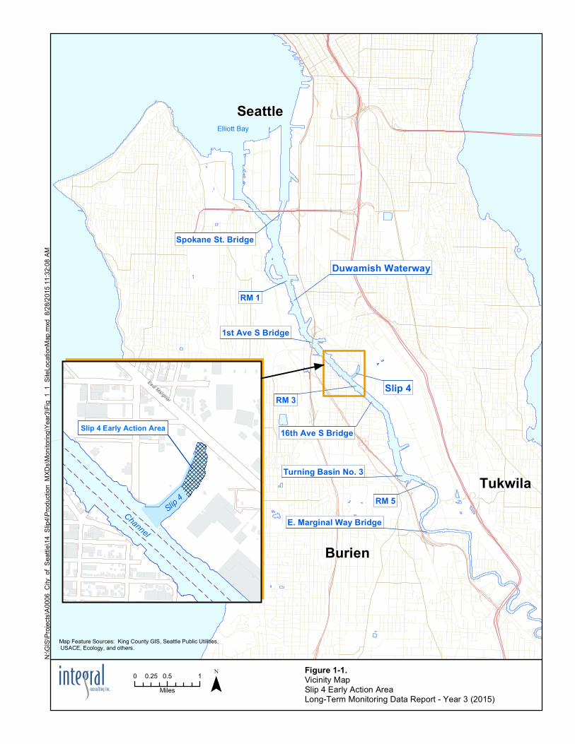
4 5
Seattle
Burien
Tukwila
Duwamish Waterway
RM 1
1st Ave S Bridge
Slip 4RM 3
16th Ave S Bridge
RM 5
Turning Basin No. 3
E. Marginal Way Bridge
Elliott Bay
Spokane St. Bridge
Slip 4
Channel Slip 4Channel
Slip 4 Early Action Area
East Marginal
Figure 1-1.Vicinity MapSlip 4 Early Action Area Long-Term Monitoring Data Report - Year 3 (2015)
Map Feature Sources: King County GIS, Seattle Public Utilities, USACE, Ecology, and others.
¯0 0.5 10.25Miles
N:\G
IS\Pr
ojects
\A00
06_C
ity_o
f_Sea
ttle\14
_Slip
4\Prod
uctio
n_MX
Ds\M
onito
ring\Y
ear3\
Fig_1
_1_S
iteLo
catio
nMap
.mxd
8/28
/2015
11:32
:08 A
M
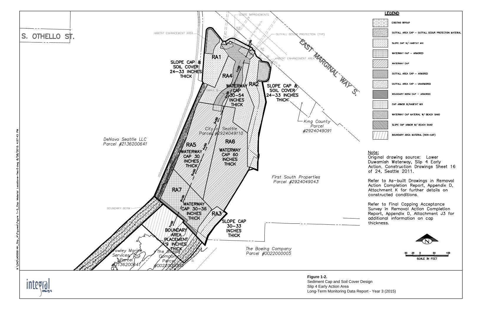
Figure 1-2.Sediment Cap and Soil Cover DesignSlip 4 Early Action AreaLong-Term Monitoring Data Report - Year 3 (2015)

BD-7
BD-2
WC-8WC-7
WC-4WC-3
WC-2
WC-1
SC-3
SC-2
Figure 1-3.
DeNovo Seattle LLC
The BoeingCompany
First SouthProperties
East Marginal Way S
City ofSeattle
I-5 o
utfa
ll
King C
ounty
outfa
ll
North B
oeing
Fiel
d outf
all
Georgeto
wn Flum
e repla
cement
outfa
ll
DeNovo outfall OF6
Emerald Services outfall
F
I
G
H
J
A
B
D
CE
Figure 2-1.Visual Monitoring Photo Station LocationsSlip 4 Early Action AreaLong-Term Monitoring Data Report - Year 3 (2015)
0 50 100
Feet
The locations of photo stations A, J and I were relocated during Year 1 Monitoring.Stations I and F were also relocated during Year 3 Monitoring.The new locations were marked with rebar stakes and marking paint.
Locations shown are approximate.
Background imagery is for reference purposes only, is courtesy of the Port of Seattleand is dated 2012.
Photograph Locations
Photograph Direction
Slip 4 Early Action AreaOutfalls
Tax Parcel Boundary and Property Owner
DeNovo Seattle LLC
The BoeingCompany
First SouthProperties
East Marginal Way S
City ofSeattle
Legend
Existing Riprap
Outfall Area Cap - Outfall Scour Protection Material
Slope Cap with Habitat Mix
Waterway Cap - Armored
Waterway Cap
Outfall Area Cap - Armored
Outfall Area Cap - Unarmored
Boundary Berm Cap - Armored
Cap Armor with Habitat Mix
Waterway Cap Material with Beach Sand
Slope Cap Armor with Beach Sand
Boundary Area Material (Non-Cap)
N:\G
IS\P
roje
cts\
A00
06_C
ity_o
f_S
eattl
e\14
_Slip
4\P
rodu
ctio
n_M
XDs\
Mon
itorin
g\Ye
ar3\
Fig2
_1_V
isM
onPh
otoS
tns.
mxd
11/
30/2
015
11:0
5:43
AM
WC-4
WC-2
WC-1
SC-2-8SC-2-4
SC-3-8
SC-3-4
SC-2-12
SC-3-12
WC-8WC-7
WC-3
Figure 2-2.
DeNovo Seattle LLC
The BoeingCompany
First SouthProperties
East Marginal Way S
City ofSeattle
Figure 2-3. WC-3 Sample Photographs Excerpt from Year 1 Long-Term Monitoring Report Long-Term Monitoring Data Report – Year 3 (2015)
Figure 2-4. WC-3 Sample Photograph Long-Term Monitoring Data Report – Year 3 (2015)
WC-3 Station Substrate
Figure 5-1.
DeNovo Seattle LLC
The BoeingCompany
First SouthProperties
East Marginal Way S
City ofSeattle
Figure 5-2. Year 3 (2015), Year 1 (2013) and Baseline (2012) Concentrations of Select Compounds Slip 4 Early Action Area Long-Term Monitoring Data Report – Year 3 (2015)
Notes: HPAH = high molecular weight polycyclic aromatic hydrocarbon PCB = polychlorinated biphenyl J = The associated numerical value is the approximate concentration R = Rejected data U = Not detected above the reported sample quantitation limit * SMS Exceedance (See Table 5-1)
2012 2013 2015
IS-1
IS-2
IS-3
IS-4
IS-5
SD-PER518
SD-PER512 SD-PER507
SD-PER506
SD-PER516
SD-PER505
SD-PER501
SD-PER517
SD-PER504
SD-PER503
SD-PER502
BD-6
BD-2
BD-5
SG-22
SG-21
SG-20
SG-18SL-4-03
BD-7
WC-7
WC-3
WC-2SC-3
WC-8
WC-4
WC-1SC-2
I-5 outfall
Kin
g C
ount
you
tfall
Nor
th B
oein
gFi
eld
outfa
ll
DeNovo outfall OF6
Geo
rget
own
Flum
ere
plac
emen
t out
fall
Emerald Services outfall
Figure 5-3.
DeNovoSeattle LLC
The BoeingCompany
First SouthProperties
East Marginal Way S
City ofSeattle
B D -2 T o tal P C B A ro clo rs(μg/ kg dry wt) T OC (%)
SD -P ER 501 T o tal P C B A ro clo rs(μg/ kg dry wt) T OC (%)
SD -P ER 502 T o tal P C B A ro clo rs(μg/ kg dry wt) T OC (%)
SD -P ER 503 T o tal P C B A ro clo rs(μg/ kg dry wt) T OC (%)
SD -P ER 504 T o tal P C B A ro clo rs(μg/ kg dry wt) T OC (%)
SD -P ER 505 T o tal P C B A ro clo rs(μg/ kg dry wt) T OC (%)
SD -P ER 506 T o tal P C B A ro clo rs(μg/ kg dry wt) T OC (%)
SD -P ER 507 T o tal P C B A ro clo rs(μg/ kg dry wt) T OC (%)
B D -5SD -P ER 508
T o tal P C B A ro clo rs(μg/ kg dry wt) T OC (%)
B D -6SD -P ER 509
T o tal P C B A ro clo rs(μg/ kg dry wt) T OC (%)
SG-18SD -P ER 510
T o tal P C B A ro clo rs(μg/ kg dry wt) T OC (%)
SL4-3SD -P ER 511
T o tal P C B A ro clo rs(μg/ kg dry wt) T OC (%)
SD -P ER 512 T o tal P C B A ro clo rs(μg/ kg dry wt) T OC (%)
SG-20SD -P ER 513
T o tal P C B A ro clo rs(μg/ kg dry wt) T OC (%)
SG-22SD -P ER 514
T o tal P C B A ro clo rs(μg/ kg dry wt) T OC (%)
SG-21SD -P ER 515
T o tal P C B A ro clo rs(μg/ kg dry wt) T OC (%)
SD-P ER516 T o tal P C B A ro clo rs(μg/ kg dry wt) T OC (%)
SD -P ER 517 T o tal P C B A ro clo rs(μg/ kg dry wt) T OC (%)
SD -P ER 518 T o tal P C B A ro clo rs(μg/ kg dry wt) T OC (%)
SC -2 T o tal P C B A ro clo rs(μg/ kg dry wt) T OC (%)
SC -3 T o tal P C B A ro clo rs(μg/ kg dry wt) T OC (%)
WC -1 T o tal P C B A ro clo rs(μg/ kg dry wt) T OC (%) WC -2 T o tal P C B A ro clo rs
(μg/ kg dry wt) T OC (%)
WC -3 T o tal P C B A ro clo rs(μg/ kg dry wt) T OC (%)
WC -4 T o tal P C B A ro clo rs(μg/ kg dry wt) T OC (%)
WC -7 T o tal P C B A ro clo rs(μg/ kg dry wt) T OC (%)
WC -8 T o tal P C B A ro clo rs(μg/ kg dry wt) T OC (%)
B D -7 T o tal P C B A ro clo rs(μg/ kg dry wt) T OC (%)
IS-1 T o tal P C B A ro clo rs(μg/ kg dry wt) T OC (%)
IS-2 T o tal P C B A ro clo rs(μg/ kg dry wt) T OC (%)
IS-3 T o tal P C B A ro clo rs(μg/ kg dry wt) T OC (%)
IS-4 T o tal P C B A ro clo rs(μg/ kg dry wt) T OC (%)
IS-5 T o tal P C B A ro clo rs(μg/ kg dry wt) T OC (%)

TABLES
Slip 4 Early Action Area Long-Term Monitoring Data Report – Year 3 (2015) December 24, 2015
Integral Consulting Inc. Page 1 of 1
Table 1-1. Long-Term Monitoring Study Questions and Informational Inputs
Study Questions Informational Inputs
Are contaminant concentrations in Slip 4 EAA surface sediments (0–10 cm) below the SQS?
• Chemical analysis of surface sediment samples from capped areas (bank and channel)
• Chemical analysis of surface sediment samples from boundary material placement area
Is the physical integrity of the cap in the Slip 4 EAA being maintained such that the sediment cap continues to isolate contaminants in underlying sediments from marine biota?
• Visual inspections and photo- documentation of cap conditions at low tide
• Hydrographic surveys
• Topographic surveys (if required)
Do the institutional controls associated with the Slip 4 EAA remedy remain in place and continue to work effectively?
• Review status of institutional controls
• Review violations and/or any notifications for variances from institutional controls
• Review available information associated with any activity controlled by an institutional control
Are physical changes occurring related to sediment erosion and sediment deposition in the Slip 4 EAA?
• Visual inspections and photo-documentation of cap conditions at low tide
• Hydrographic surveys
• Topographic surveys (if required)
• Visual observations and photo-documentation of surface sediment samples collected during long-term monitoring
• Documentation of 100-year storm flow events within the monitoring period
Notes: EAA = early action area SQS = Washington State Sediment Quality Standards
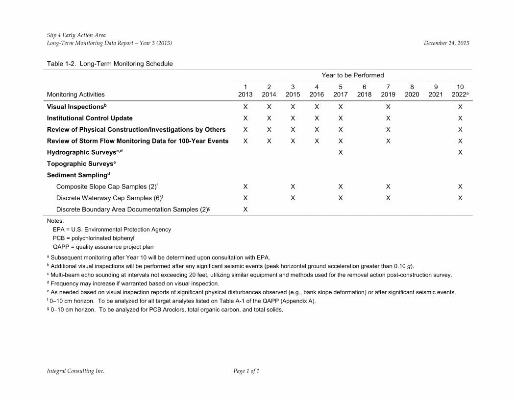
Slip 4 Early Action Area Long-Term Monitoring Data Report – Year 3 (2015) December 24, 2015
Integral Consulting Inc. Page 1 of 1
Table 1-2. Long-Term Monitoring Schedule
Year to be Performed
Monitoring Activities 1
2013 2
2014 3
2015 4
2016 5
2017 6
2018 7
2019 8
2020 9
2021 10
2022a
Visual Inspectionsb X X X X X X X
Institutional Control Update X X X X X X X
Review of Physical Construction/Investigations by Others X X X X X X X
Review of Storm Flow Monitoring Data for 100-Year Events X X X X X X X
Hydrographic Surveysc,d X X
Topographic Surveyse
Sediment Samplingd
Composite Slope Cap Samples (2)f X X X X X
Discrete Waterway Cap Samples (6)f X X X X X
Discrete Boundary Area Documentation Samples (2)g X
Notes: EPA = U.S. Environmental Protection Agency PCB = polychlorinated biphenyl QAPP = quality assurance project plan
a Subsequent monitoring after Year 10 will be determined upon consultation with EPA. b Additional visual inspections will be performed after any significant seismic events (peak horizontal ground acceleration greater than 0.10 g). c Multi-beam echo sounding at intervals not exceeding 20 feet, utilizing similar equipment and methods used for the removal action post-construction survey. d Frequency may increase if warranted based on visual inspection. e As needed based on visual inspection reports of significant physical disturbances observed (e.g., bank slope deformation) or after significant seismic events. f 0–10 cm horizon. To be analyzed for all target analytes listed on Table A-1 of the QAPP (Appendix A). g 0–10 cm horizon. To be analyzed for PCB Aroclors, total organic carbon, and total solids.
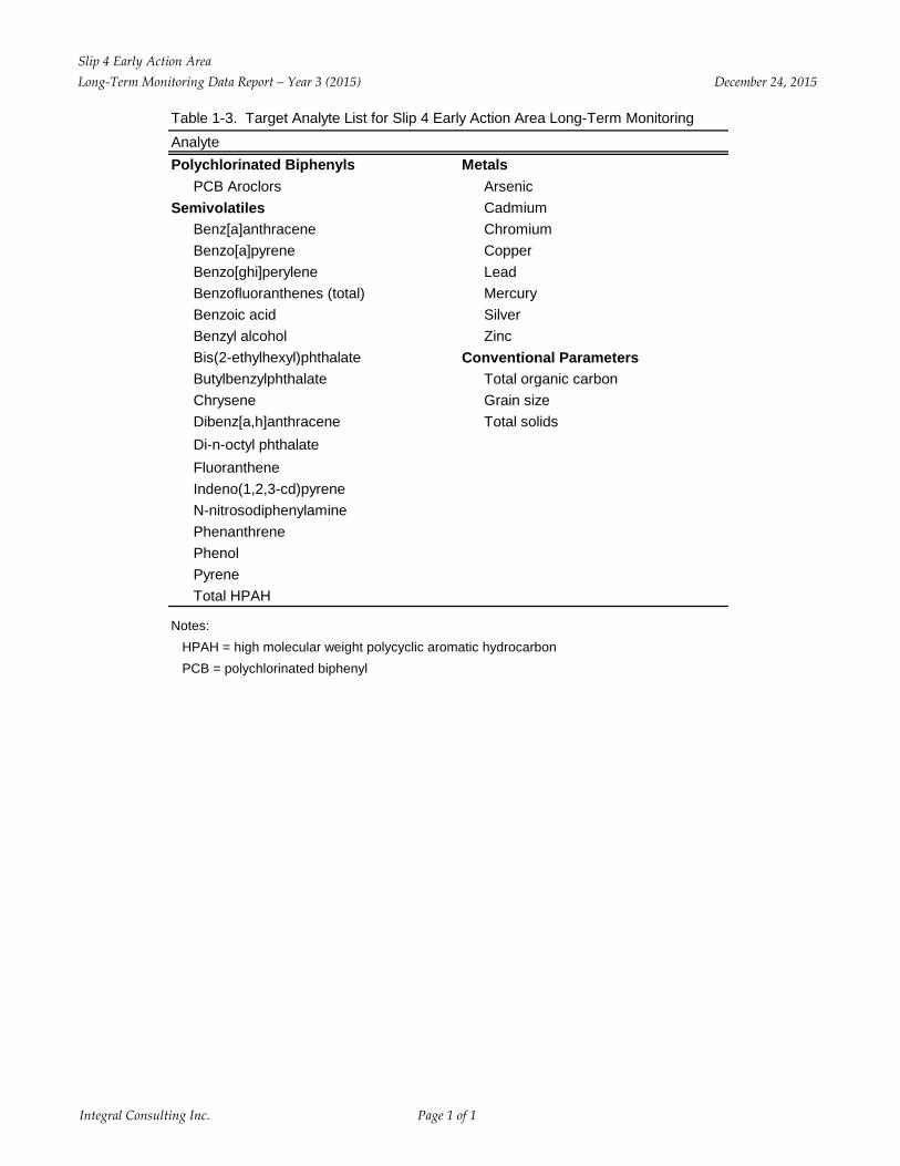
Slip 4 Early Action AreaLong-Term Monitoring Data Report – Year 3 (2015) December 24, 2015
Integral Consulting Inc. Page 1 of 1
Table 1-3. Target Analyte List for Slip 4 Early Action Area Long-Term MonitoringAnalytePolychlorinated Biphenyls Metals
PCB Aroclors ArsenicSemivolatiles Cadmium
Benz[a]anthracene ChromiumBenzo[a]pyrene CopperBenzo[ghi]perylene LeadBenzofluoranthenes (total) MercuryBenzoic acid SilverBenzyl alcohol ZincBis(2-ethylhexyl)phthalate Conventional ParametersButylbenzylphthalate Total organic carbonChrysene Grain sizeDibenz[a,h]anthracene Total solidsDi-n-octyl phthalateFluorantheneIndeno(1,2,3-cd)pyreneN-nitrosodiphenylaminePhenanthrenePhenolPyreneTotal HPAH
Notes:HPAH = high molecular weight polycyclic aromatic hydrocarbonPCB = polychlorinated biphenyl
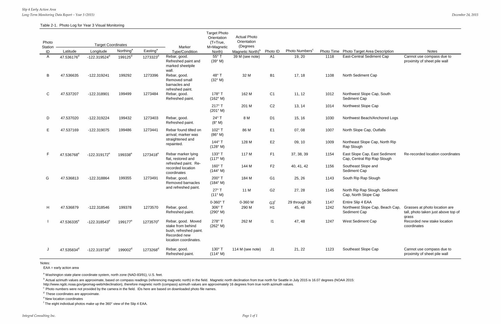
Slip 4 Early Action AreaLong-Term Monitoring Data Report – Year 3 (2015) December 24, 2015
Integral Consulting Inc. Page 1 of 1
Table 2-1. Photo Log for Year 3 Visual Monitoring
Latitude Longitude Northinga Eastinga Photo ID Photo Numbersc Photo Time Photo Target Area Description NotesA 47.536176d -122.319524d 199125d 1273323d Rebar, good.
Refreshed paint and marked sheetpile wall.
55° T(39° M)
39 M (see note) A1 19, 20 1118 East-Central Sediment Cap Cannot use compass due to proximity of sheet pile wall
B 47.536635 -122.319241 199292 1273396 Rebar, good. Removed small barnacles and refreshed paint.
48° T(32° M)
32 M B1 17, 18 1108 North Sediment Cap
178° T(162° M)
162 M C1 11, 12 1012 Northwest Slope Cap, South Sediment Cap
217° T(201° M)
201 M C2 13, 14 1014 Northwest Slope Cap
D 47.537020 -122.319224 199432 1273403 Rebar, good. Refreshed paint.
24° T(8° M)
8 M D1 15, 16 1030 Northwest Beach/Anchored Logs
102° T(86° M)
86 M E1 07, 08 1007 North Slope Cap, Outfalls
144° T(128° M)
128 M E2 09, 10 1009 Northeast Slope Cap, North Rip Rap Slough
133° T(117° M)
117 M F1 37, 38, 39 1154 East Slope Cap, East Sediment Cap, Central Rip Rap Slough
Re-recorded location coordinates
160° T(144° M)
144 M F2 40, 41, 42 1156 Southeast Slope and Sediment Cap
200° T(184° M)
184 M G1 25, 26 1143 South Rip Rap Slough
27° T(11° M)
11 M G2 27, 28 1145 North Rip Rap Slough, Sediment Cap, North Slope Cap
0-360° T 0-360 M G3f 29 through 36 1147 Entire Slip 4 EAAH 47.536879 -122.318546 199378 1273570 Rebar, good.
Refreshed paint.306° T
(290° M)290 M H1 45, 46 1242 Northwest Slope Cap, Beach Cap,
Sediment CapGrasses at photo location are tall, photo taken just above top of grass
I 47.536335e -122.318543e 199177e 1273570e Rebar, good. Moved stake from behind bush, refreshed paint. Recorded new location coordinates.
278° T(262° M)
262 M I1 47, 48 1247 West Sediment Cap Recorded new stake location coordinates
J 47.535834d -122.319738d 199002d 1273268d Rebar, good. Refreshed paint.
130° T(114° M)
114 M (see note) J1 21, 22 1123 Southeast Slope Cap Cannot use compass due to proximity of sheet pile wall
Notes: EAA = early action areaa Washington state plane coordinate system, north zone (NAD-83/91), U.S. feet.
c Photo numbers were not provided by the camera in the field. IDs here are based on downloaded photo file names.d These coordinates are approximate.e New location coordinatesf The eight individual photos make up the 360° view of the Slip 4 EAA.
199338e 1273418e
b Actual azimuth values are approximate, based on compass readings (referencing magnetic north) in the field. Magnetic north declination from true north for Seattle in July 2015 is 16.07 degrees (NOAA 2015: http://www.ngdc.noaa.gov/geomag-web/#declination), therefore magnetic north (compass) azimuth values are approximately 16 degrees from true north azimuth values.
G 47.536813 -122.318864 199355 1273491 Rebar, good. Removed barnacles and refreshed paint.
Rebar marker lying flat, restored and refreshed paint. Re-recorded location coordinates
F 47.536768e -122.319172e
Rebar, good. Refreshed paint.
E 47.537169 -122.319075 199486 1273441 Rebar found tilted on arrival; marker was straightened and repainted.
C 47.537207 -122.318901 199499 1273484
Photo Station
ID
Target Coordinates Marker Type/Condition
Target Photo Orientation(T=True,
M=Magnetic North)
Actual Photo Orientation (Degrees
Magnetic North)b
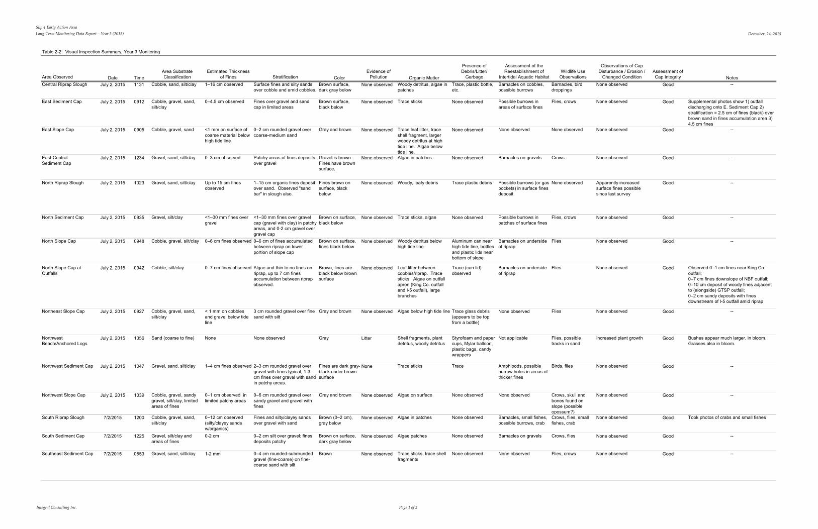
Slip 4 Early Action AreaLong-Term Monitoring Data Report – Year 3 (2015) December 24, 2015
Integral Consulting Inc. Page 1 of 2
Table 2-2. Visual Inspection Summary, Year 3 Monitoring
Area Observed Date TimeArea Substrate Classification
Estimated Thickness of Fines Stratification Color
Evidence of Pollution Organic Matter
Presence of Debris/Litter/
Garbage
Assessment of the Reestablishment of
Intertidal Aquatic HabitatWildlife Use
Observations
Observations of Cap Disturbance / Erosion /
Changed ConditionAssessment of Cap Integrity Notes
Central Riprap Slough July 2, 2015 1131 Cobble, sand, silt/clay 1–16 cm observed Surface fines and silty sands over cobble and amid cobbles.
Brown surface, dark gray below
None observed Woody detritus, algae in patches
Trace, plastic bottle, etc.
Barnacles on cobbles, possible burrows
Barnacles, bird droppings
None observed Good --
East Sediment Cap July 2, 2015 0912 Cobble, gravel, sand, silt/clay
0–4.5 cm observed Fines over gravel and sand cap in limited areas
Brown surface, black below
None observed Trace sticks None observed Possible burrows in areas of surface fines
Flies, crows None observed Good Supplemental photos show 1) outfall discharging onto E. Sediment Cap 2) stratification = 2.5 cm of fines (black) over brown sand in fines accumulation area 3) 4.5 cm fines
East Slope Cap July 2, 2015 0905 Cobble, gravel, sand <1 mm on surface of coarse material below high tide line
0–2 cm rounded gravel over coarse-medium sand
Gray and brown None observed Trace leaf litter, trace shell fragment, larger woody detritus at high tide line. Algae below tide line.
None observed None observed None observed None observed Good --
East-Central Sediment Cap
July 2, 2015 1234 Gravel, sand, silt/clay 0–3 cm observed Patchy areas of fines deposits over gravel
Gravel is brown. Fines have brown surface.
None observed Algae in patches None observed Barnacles on gravels Crows None observed Good --
North Riprap Slough July 2, 2015 1023 Gravel, sand, silt/clay Up to 15 cm fines observed
1–15 cm organic fines deposit over sand. Observed "sand bar" in slough also.
Fines brown on surface, black below
None observed Woody, leafy debris Trace plastic debris Possible burrows (or gas pockets) in surface fines deposit
None observed Apparently increased surface fines possible since last survey
Good --
North Sediment Cap July 2, 2015 0935 Gravel, silt/clay <1–30 mm fines over gravel
<1–30 mm fines over gravel cap (gravel with clay) in patchy areas, and 0-2 cm gravel over gravel cap
Brown on surface, black below
None observed Trace sticks, algae None observed Possible burrows in patches of surface fines
Flies, crows None observed Good --
North Slope Cap July 2, 2015 0948 Cobble, gravel, silt/clay 0–6 cm fines observed 0–6 cm of fines accumulated between riprap on lower portion of slope cap
Brown on surface, fines black below
None observed Woody detritus below high tide line
Aluminum can near high tide line, bottles and plastic lids near bottom of slope
Barnacles on underside of riprap
Flies None observed Good --
North Slope Cap at Outfalls
July 2, 2015 0942 Cobble, silt/clay 0–7 cm fines observed Algae and thin to no fines on riprap, up to 7 cm fines accumulation between riprap observed.
Brown, fines are black below brown surface
None observed Leaf litter between cobbles/riprap. Trace sticks. Algae on outfall apron (King Co. outfall and I-5 outfall), large branches
Trace (can lid) observed
Barnacles on underside of riprap
Flies None observed Good Observed 0–1 cm fines near King Co. outfall;0–7 cm fines downslope of NBF outfall;0–10 cm deposit of woody fines adjacent to (alongside) GTSP outfall;0–2 cm sandy deposits with fines downstream of I-5 outfall amid riprap
Northeast Slope Cap July 2, 2015 0927 Cobble, gravel, sand, silt/clay
< 1 mm on cobbles and gravel below tide line
3 cm rounded gravel over fine sand with silt
Gray and brown None observed Algae below high tide line Trace glass debris (appears to be top from a bottle)
None observed Flies None observed Good --
Northwest Beach/Anchored Logs
July 2, 2015 1056 Sand (coarse to fine) None None observed Gray Litter Shell fragments, plant detritus, woody detritus
Styrofoam and paper cups, Mylar balloon, plastic bags, candy wrappers
Not applicable Flies, possible tracks in sand
Increased plant growth Good Bushes appear much larger, in bloom. Grasses also in bloom.
Northwest Sediment Cap July 2, 2015 1047 Gravel, sand, silt/clay 1–4 cm fines observed 2–3 cm rounded gravel over gravel with fines typical; 1-3 cm fines over gravel with sand in patchy areas.
Fines are dark gray-black under brown surface
None Trace sticks Trace Amphipods, possible burrow holes in areas of thicker fines
Birds, flies None observed Good --
Northwest Slope Cap July 2, 2015 1039 Cobble, gravel, sandy gravel, silt/clay, limited areas of fines
0–1 cm observed in limited patchy areas
0–6 cm rounded gravel over sandy gravel and gravel with fines
Gray and brown None observed Algae on surface None observed None observed Crows, skull and bones found on slope (possible opossum?)
None observed Good --
South Riprap Slough 7/2/2015 1200 Cobble, gravel, sand, silt/clay
0–12 cm observed(silty/clayey sands w/organics)
Fines and silty/clayey sands over gravel with sand
Brown (0–2 cm), gray below
None observed Algae in patches None observed Barnacles, small fishes, possible burrows, crab
Crows, flies, small fishes, crab
None observed Good Took photos of crabs and small fishes
South Sediment Cap 7/2/2015 1225 Gravel, silt/clay and areas of fines
0-2 cm 0–2 cm silt over gravel; fines deposits patchy
Brown on surface, dark gray below
None observed Algae patches None observed Barnacles on gravels Crows, flies None observed Good --
Southeast Sediment Cap 7/2/2015 0853 Gravel, sand, silt/clay 1-2 mm 0–4 cm rounded-subrounded gravel (fine-coarse) on fine-coarse sand with silt
Brown None observed Trace sticks, trace shell fragments
None observed None observed Flies, crows None observed Good --
Slip 4 Early Action AreaLong-Term Monitoring Data Report – Year 3 (2015) December 24, 2015
Integral Consulting Inc. Page 2 of 2
Table 2-2. Visual Inspection Summary, Year 3 Monitoring
Area Observed Date TimeArea Substrate Classification
Estimated Thickness of Fines Stratification Color
Evidence of Pollution Organic Matter
Presence of Debris/Litter/
Garbage
Assessment of the Reestablishment of
Intertidal Aquatic HabitatWildlife Use
Observations
Observations of Cap Disturbance / Erosion /
Changed ConditionAssessment of Cap Integrity Notes
Southeast Slope Cap 7/2/2015 0845 Cobble, gravel, sand, silt 1–2 mm Rounded gravel (fine-coarse) in top 10 cm amid cobbles near entrance; 0-2 cm rounded gravel on fine-medium sand with silt midway across area
Brown and gray None observed Algae, leaf litter, occasional sticks
None observed None observed Bird droppings, small flies
None observed Good --
West Sediment Cap 7/2/2015 1214 Gravel, sand, silt/clay Up to 18 cm observed between gravel hummocks
Appears similar to previous surveys, gravel ridges with fines in between
Brown surface, dark gray below
None observed Algae in patches, trace sticks
None observed Barnacles on gravels and cobbles, possible burrows (holes) in surface fine deposits
Crows and heron observed earlier in the day
None observed Good --
Notes:-- = not recorded
Slip 4 Early Action AreaLong-Term Monitoring Data Report – Year 3 (2015) December 24, 2015
Integral Consulting Inc. Page 1 of 1
Table 2-3. Station Coordinates for Sediment Sampling, Year 3 Monitoring
Calculated Distance (ft)Station Identificationa
Northing Easting Northing Easting Target to Actual LocationsbCap Thickness and Material Type
Slope Cap StationsSC-2-4 199437.24 1273443.05 199446.76 1273443.25 12d
SC-2-8 199444.40 1273426.03 199448.29 1273428.82 6SC-2-12 199449.10 1273411.69 199452.54 1273417.62 6SC-2 199443.58c 1273426.92c 199449.20c 1273429.90c --SC-3-4 199380.61 1273544.05 199376.11 1273548.99 3SC-3-8 199378.60 1273555.46 199375.20 1273558.64 1SC-3-12 199381.17 1273565.44 199374.98 1273572.37 1SC-3 199380.13c 1273554.99c 199375.43c 1273560.00c --
Waterway Cap StationsWC-1 199414.43 1273474.09 199411.88 1273476.19 2 30–54 in. unarmored outfall area capWC-2 199399.42 1273499.06 199394.99 1273501.83 2 30–54 in. armored outfall area capWC-3 199251.02 1273403.73 199271.56 1273410.14 23 30 in. waterway capWC-4 199247.87 1273513.70 199245.24 1273517.52 1 30–54 in. unarmored outfall area capWC-7 199019.44 1273332.04 199043.50 1273317.50 32 30 in. waterway capWC-8 199012.05 1273404.64 199009.94 1273397.46 11 60 in. waterway cap
Horizontal datum: Washington State Plane Coordinate System, North Zone (NAD-83/91), U.S. feet
a See Figures 1-3 and 2-2.
c Station location is the calculated centroid of the three samples that make up this composite sample.d Poor GPS satellite geometry at the time of sampling led the sampler to an area of riprap at the apparent target location. As a result, the sampler shifted the sampling location approximately 5 feet along the same elevation as the target location (see field notes in Appendix D). The coordinates reflect the actual sampling location.
Target Coordinates Actual Coordinates
24–23 in. slope cap and habitat mix
Notes:
Differential correction for all on-foot sampling stations (all slope cap locations and WC-1, WC-2, and WC-4) was performed referencing base station CORS, SEATTLE (SEAT), WASHINGTON Position: 47°39'14.32037"N, 122°18'34.10891"W, 44.44 m.
b The quality assurance project plan (QAPP) states that samples will be collected from within ±2 meters (6.5 ft) of the locations specified in Table A-5 of the QAPP (Integral 2013a).
Slip 4 Early Action AreaLong-Term Monitoring Data Report - Year 3 (2015) December 24, 2015
Integral Consulting Inc. Page 1 of 3
Table 2-4. Sample Collection Summary—Baseline, Year 1, and Year 3 Monitoring
Bottom Penetration Fines Fines RPD
Station Sample ID Date TimeDepth
(m)Depth (cm)
Overlying Cap Material
Thickness (cm)
Depth (cm) Substrate Color Odor
Collection Method Comments and Notes
SC-2-4 SD0036 (composite)
1/30/2012 1506 NA 10 No 0 NA Gravel, sand, silt/clay, and organic matter
drab olive None SS spoon Trace organics - twigs.
SC-2-8 1512 NA 10 No 0 NA Gravel and sand drab olive None SS spoon
SC-2-12 1517 NA 10 No 0 NA Gravel and sand drab olive None SS spoon
SC-2-4
SC-2-8
SD0107 (composite)
7/22/2013 1246
1253
NA
NA
10
10
No
No
0
0
NA
NA
Cobble, gravel, and sandCobble, gravel, and sand
brown surface, brownbrown surface
Slight
Slight
SS spoon/trowelSS spoon/trowel
Gravel / cobble / coarse sand.
Spotty very thin film of silt in areas. Otherwise gravel, some cobble and coarse sand.
SC-2-12 1310 NA 10 No 0 NA Gravel and sand brown surface, brown
None SS spoon/trowel
Gravel layer is atop a 25% sand and 75% gravel mixture.
SC-2-4 SD0118 (composite)
7/2/2015 1015 NA 10 No 0 NA Gravel and sand brown None SS spoon Target location was in riprap area and poor satellite geometry for GPS. Moved sample location ~ 5 ft to the north, parallel to 4 ft elevation.
SC-2-8 1028 NA 10 No 0 NA Gravel and sand brown surface None SS spoon Location moved north ~4 ft, due to riprap/boulders at target location
SC-2-12 1037 NA 10 No 0 NA Sand gray None SS spoonSC-3-4
SC-3-8
SD0037 (composite)
1/30/2012 1535
1540
NA
NA
10
10
No
No
0
0
NA
NA
Gravel
Sand
and sand drab olive
drab olive
None
None
SS
SS
spoon
spoon
SC-3-12 1543 NA 10 No 0 NA Sand drab olive None SS spoon
SC-3-4 SD0108 (composite)
7/22/2013 1200 NA 10 No 0 NA Cobble, gravel, sand, and organic matter
gray Slight SS spoon/trowel
Top 5 cm is rounded gravel. From 5-10 cm a mixture of coarse sand and gravel. Thin algae mat covering top of substrate.
SC-3-8 1222 NA 10 No 0 NA Gravel, sand, and organic
gray Slight SS spoon/trowel
Thin film of algae on top of cap material. Coarse sand from 1-10 cm.
matterSC-3-12 1230 NA 10 No 0 NA Cobble, gravel,
sand, organic matter, and
gray and brown Slight SS spoon/trowel
Slight organic matter, sticks, thin film of algae. Shell fragment.
wood and shell fragments
SC-3-4
SC-3-8
SD0119 (composite)
7/2/2015 0902
0904
NA
NA
10
10
No
No
0
0
NA
NA
Cobble, gravel and sandCobble, gravel and sand
brown
brown
None
None
SS
SS
spoon
spoon
SC-3-12 0917 NA 10 No 0 NA Sand and wood fragments
gray None SS spoon Moved sample location 2 ft covering target location
south of target due to grass
Slip 4 Early Action AreaLong-Term Monitoring Data Report - Year 3 (2015) December 24, 2015
Integral Consulting Inc. Page 2 of 3
Table 2-4. Sample Collection Summary—Baseline, Year 1, and Year 3 Monitoring
Bottom Penetration Fines Fines RPD
Station Sample ID Date TimeDepth
(m)Depth (cm)
Overlying Cap Material
Thickness (cm)
Depth (cm) Substrate Color Odor
Collection Method Comments and Notes
WC-1 SD0025 1/30/2012 1042 2.5 15 No 0 NA Gravel and sand drab olive None Hydraulic sampler
grab Trace organics and twigs
SD0100 7/22/2013 0935 NA 10 Yes 1 1 Gravel, sand, silt/clay, and organic matter
brown surface, drab olive, black
Slight SS spoon/trowel
Fine algae on top of substrate. Drab olive fines top, below 1 cm a 1 cm thick layer of black fines. From 2-10 cm a mixture of gravel and sand. Two worms observed at 4 cm.
SD011 7/2/2015 1121 NA 10 Yes 1 NA Gravel, sand, silt/clay, and organic matter
brown surface, black, with bright specks of
Slight SS spoon Split sample and extra volume for lab QA/QC
orangeSD0112c 7/2/2015 1127
WC-2 SD0026 1/30/2012 0958 2.4 15 No 0 NA Gravel and sand drab olive, grey None Hydraulic sampler
grab Light olive grey gravel with 15% coarse sand
SD0101a
SD0102
7/22/2013 1025 NA 10 Yes <1 1 Gravel, sand, and organic matter
brown surface, drab olive, brown
Slight SS spoon/trowel
Fine algal mat on surface, small boulders. One worm hole.
few sticks. Gravel/cobble with observed in sample collection
SD0113 7/2/2015 1135 NA 10 No 0 NA Sand and silt/clay
brown surface None SS spoon
WC-3 SD0027 1/30/2012 1137 4.8 10 No 0 NA Gravel, sand, trace silt/clay
drab olive None Hydraulic sampler
grab Gravel 2" minus, 25% sand, trace silt
SD0103 7/23/2013 0846b 2.4 13 Yes 2 <1 Gravel, sand, silt/clay, and wood and shell
brown surface, drab olive
Slight Hydraulic sampler
grab 80% gravel, 20 % sand/silt. Color: 5Y 4/2 (olive gray).
3 mussels attached to gravel.
fragments0913b 2.1 15 Yes 8 1 Gravel, sand,
silt/clay, and organic matter
brown surface, black, drab olive
Slight Hydraulic sampler
grab Leaf, few small sticks.
SD0114 7/2/2015 1525 2.5 18 Yes 8 <0.1 Gravel and silt/clay
brown surface Slight, sulfidic
Hydraulic sampler
grab 0-8 cm of silt/clay, surface gravel.
8-10+ cm gravel cap. Barnacles on
WC-4 SD0028 1/30/2012 1223 1.5 10 No 0 NA Gravel and sand drab olive None Hydraulic sampler
grab Gravel 2" minus, subangular to subround, 5-10% sand
SD0104 7/22/2013 1055 NA 10 Yes 5 0.5 Gravel and sand brown surface Slight SS spoon/trowel
Very thin veneer of fines on top of a mixture of sand. One amphipod seen in top 0-2 cm.
gravel and
SD0115 7/2/2015 0938 NA 10 Yes 2 NA Gravel, sand, silt clay and organic
brown surface, brown, black
Slight SS spoon Black black
layer layer
is 2 cm under brown top layer, brown below
matterWC-7 SD0032 2/1/2012 1000 4.8 15 Yes 0 NA Gravel, sand,
and silt/claydrab olive, grey None Hydraulic
samplergrab Washed gravel,
layers - silt over clean sand, silt - not sand over gravel)
mixed (3 separate
SD0105 7/23/2013 1103 1.5 20 Yes 5 1 Gravel, sand, and silt/clay
brown surface, drab olive
Slight Hydraulic sampler
grab Third attempt successful. gravel/coarse sand.
Layer of fine silt atop
SD0116 7/2/2015 1552 3.9 25 Yes 10 0.1 Silt/clay brown surface, drab olive
None Hydraulic sampler
grab 0-10 cm silt/clay. Tube worms present.
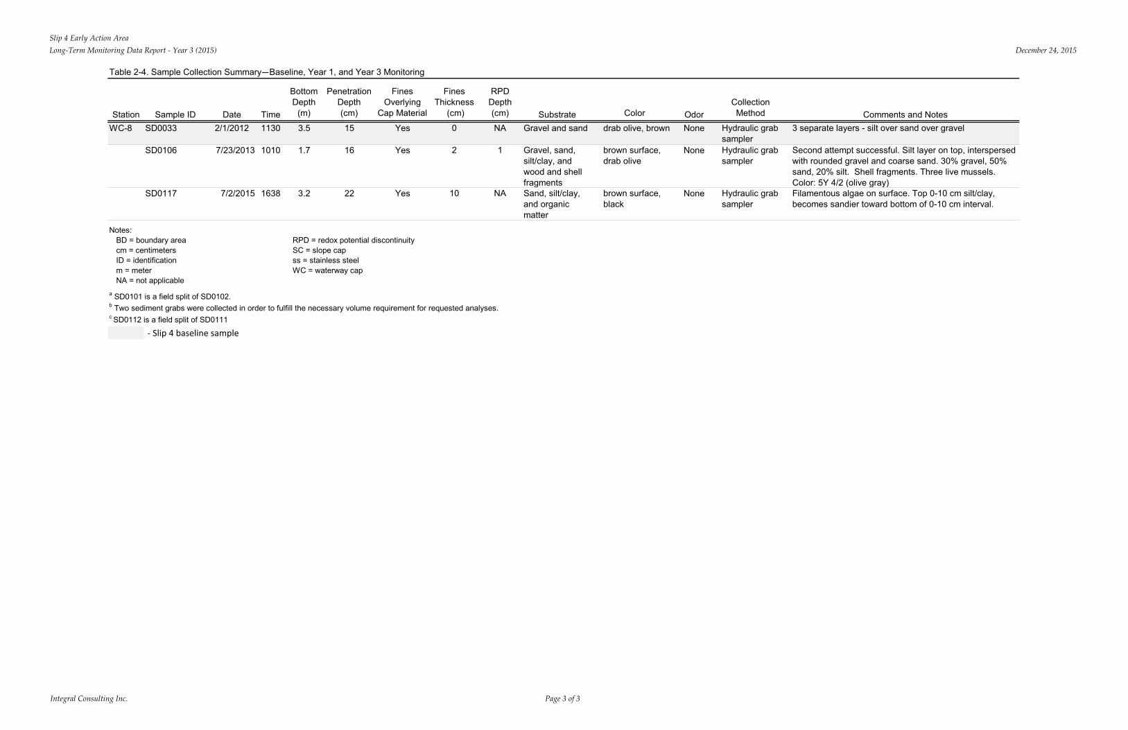
Slip 4 Early Action AreaLong-Term Monitoring Data Report - Year 3 (2015) December 24, 2015
Integral Consulting Inc. Page 3 of 3
Table 2-4. Sample Collection Summary—Baseline, Year 1, and Year 3 Monitoring
Station Sample ID Date Time
Bottom Depth
(m)
Penetration Depth (cm)
Fines Overlying
Cap Material
Fines Thickness
(cm)
RPD Depth (cm) Substrate Color Odor
Collection Method Comments and Notes
WC-8 SD0033 2/1/2012 1130 3.5 15 Yes 0 NA Gravel and sand drab olive, brown None Hydraulic grab sampler
3 separate layers - silt over sand over gravel
SD0106 7/23/2013 1010 1.7 16 Yes 2 1 Gravel, sand, silt/clay, and wood and shell fragments
brown surface, drab olive
None Hydraulic grab sampler
Second attempt successful. Silt layer on top, interspersed with rounded gravel and coarse sand. 30% gravel, 50% sand, 20% silt. Shell fragments. Three live mussels. Color: 5Y 4/2 (olive gray)
SD0117 7/2/2015 1638 3.2 22 Yes 10 NA Sand, silt/clay, and organic matter
brown surface, black
None Hydraulic grab sampler
Filamentous algae on surface. Top 0-10 cm silt/clay, becomes sandier toward bottom of 0-10 cm interval.
Notes:BD = boundary area RPD = redox potential discontinuitycm = centimeters SC = slope capID = identification ss = stainless steelm = meter WC = waterway capNA = not applicable
a SD0101 is a field split of SD0102.b Two sediment grabs were collected in order to fulfill the necessary volume requirement for requested analyses.c SD0112 is a field split of SD0111
- Slip 4 baseline sample
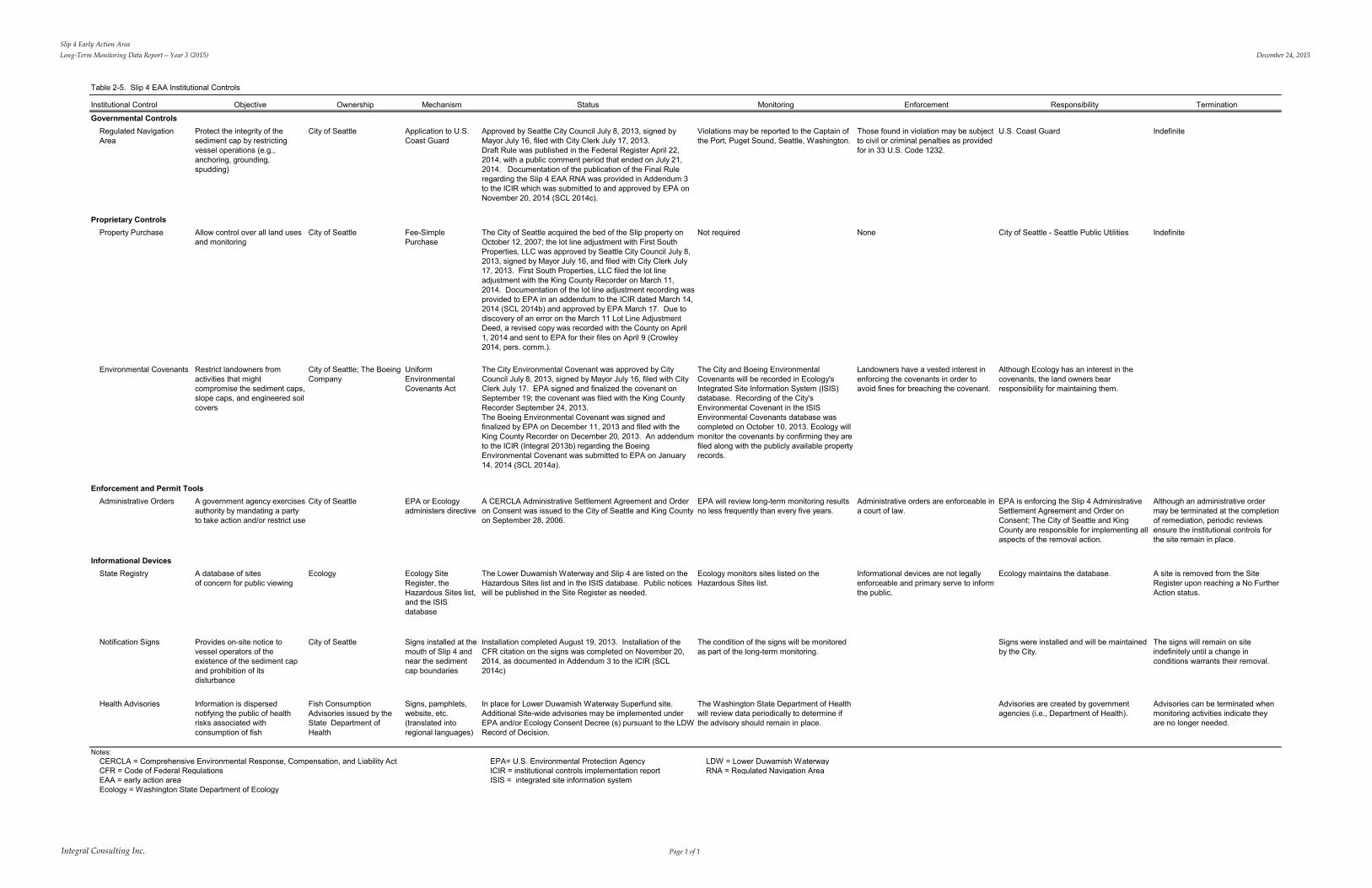
Slip 4 Early Action Area Long-Term Monitoring Data Report – Year 3 (2015) December 24, 2015
Integral Consulting Inc. Page 1 of 1
Table 2-5. Slip 4 EAA Institutional Controls
Institutional Control Objective Ownership Mechanism Status Monitoring Enforcement Responsibility Termination
Regulated Navigation Area
Protect the integrity of the sediment cap by restricting vessel operations (e.g., anchoring, grounding, spudding)
City of Seattle Application to U.S. Coast Guard
Approved by Seattle City Council July 8, 2013, signed by Mayor July 16, filed with City Clerk July 17, 2013. Draft Rule was published in the Federal Register April 22, 2014, with a public comment period that ended on July 21, 2014. Documentation of the publication of the Final Rule regarding the Slip 4 EAA RNA was provided in Addendum 3 to the ICIR which was submitted to and approved by EPA on November 20, 2014 (SCL 2014c).
Violations may be reported to the Captain of the Port, Puget Sound, Seattle, Washington.
Those found in violation may be subject to civil or criminal penalties as provided for in 33 U.S. Code 1232.
U.S. Coast Guard Indefinite
Property Purchase Allow control over all land uses and monitoring
City of Seattle Fee-Simple Purchase
The City of Seattle acquired the bed of the Slip property on October 12, 2007; the lot line adjustment with First South Properties, LLC was approved by Seattle City Council July 8, 2013, signed by Mayor July 16, and filed with City Clerk July 17, 2013. First South Properties, LLC filed the lot line adjustment with the King County Recorder on March 11, 2014. Documentation of the lot line adjustment recording was provided to EPA in an addendum to the ICIR dated March 14, 2014 (SCL 2014b) and approved by EPA March 17. Due to discovery of an error on the March 11 Lot Line Adjustment Deed, a revised copy was recorded with the County on April 1, 2014 and sent to EPA for their files on April 9 (Crowley 2014, pers. comm.).
Not required None City of Seattle - Seattle Public Utilities Indefinite
Environmental Covenants Restrict landowners from activities that might compromise the sediment caps, slope caps, and engineered soil covers
City of Seattle; The Boeing Company
Uniform Environmental Covenants Act
The City Environmental Covenant was approved by City Council July 8, 2013, signed by Mayor July 16, filed with City Clerk July 17. EPA signed and finalized the covenant on September 19; the covenant was filed with the King County Recorder September 24, 2013. The Boeing Environmental Covenant was signed and finalized by EPA on December 11, 2013 and filed with the King County Recorder on December 20, 2013. An addendum to the ICIR (Integral 2013b) regarding the Boeing Environmental Covenant was submitted to EPA on January 14, 2014 (SCL 2014a).
The City and Boeing Environmental Covenants will be recorded in Ecology's Integrated Site Information System (ISIS) database. Recording of the City's Environmental Covenant in the ISIS Environmental Covenants database was completed on October 10, 2013. Ecology will monitor the covenants by confirming they are filed along with the publicly available property records.
Landowners have a vested interest in enforcing the covenants in order to avoid fines for breaching the covenant.
Although Ecology has an interest in the covenants, the land owners bear responsibility for maintaining them.
Administrative Orders A government agency exercises authority by mandating a party to take action and/or restrict use
City of Seattle EPA or Ecology administers directive
A CERCLA Administrative Settlement Agreement and Order on Consent was issued to the City of Seattle and King County on September 28, 2006.
EPA will review long-term monitoring results no less frequently than every five years.
Administrative orders are enforceable in a court of law.
EPA is enforcing the Slip 4 Administrative Settlement Agreement and Order on Consent; The City of Seattle and King County are responsible for implementing all aspects of the removal action.
Although an administrative order may be terminated at the completion of remediation, periodic reviews ensure the institutional controls for the site remain in place.
State Registry A database of sites of concern for public viewing
Ecology Ecology Site Register, the Hazardous Sites list, and the ISIS database
The Lower Duwamish Waterway and Slip 4 are listed on the Hazardous Sites list and in the ISIS database. Public notices will be published in the Site Register as needed.
Ecology monitors sites listed on the Hazardous Sites list.
Informational devices are not legally enforceable and primary serve to inform the public.
Ecology maintains the database. A site is removed from the Site Register upon reaching a No Further Action status.
Notification Signs Provides on-site notice to vessel operators of the existence of the sediment cap and prohibition of its disturbance
City of Seattle Signs installed at the mouth of Slip 4 and near the sediment cap boundaries
Installation completed August 19, 2013. Installation of the CFR citation on the signs was completed on November 20, 2014, as documented in Addendum 3 to the ICIR (SCL 2014c)
The condition of the signs will be monitored as part of the long-term monitoring.
Signs were installed and will be maintained by the City.
The signs will remain on site indefinitely until a change in conditions warrants their removal.
Health Advisories Information is dispersed notifying the public of health risks associated with consumption of fish
Fish Consumption Advisories issued by the State Department of Health
Signs, pamphlets, website, etc. (translated into regional languages)
In place for Lower Duwamish Waterway Superfund site. Additional Site-wide advisories may be implemented under EPA and/or Ecology Consent Decree (s) pursuant to the LDW Record of Decision.
The Washington State Department of Health will review data periodically to determine if the advisory should remain in place.
Advisories are created by government agencies (i.e., Department of Health).
Advisories can be terminated when monitoring activities indicate they are no longer needed.
Notes:CERCLA = Comprehensive Environmental Response, Compensation, and Liability Act EPA= U.S. Environmental Protection Agency LDW = Lower Duwamish WaterwayCFR = Code of Federal Regulations ICIR = institutional controls implementation report RNA = Regulated Navigation AreaEAA = early action area ISIS = integrated site information systemEcology = Washington State Department of Ecology
Informational Devices
Governmental Controls
Proprietary Controls
Enforcement and Permit Tools
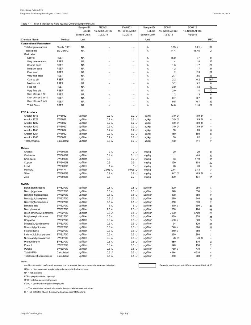
Slip 4 Early Action Area Long-Term Monitoring Data Report – Year 3 (2015) December 24, 2015
Integral Consulting Inc. Page 1 of 1
Table 4-1. Year 3 Monitoring Field Quality Control Sample ResultsSample ID: Sample ID:
Lab ID: Lab ID:Sample Date: Sample Date:
Chemical Name Method Unit Unit RPDConventional Parameters
Total organic carbon Plumb, 1981 NA -- -- % 5.63 J 8.21 J 37Total solids SM 2540G NA -- -- % 44.4 45.45 2Grain size
Gravel PSEP NA -- -- % 76.9 77 0Very coarse sand PSEP NA -- -- % 1.4 1.8 25Coarse sand PSEP NA -- -- % 1.3 1.7 27Medium sand PSEP NA -- -- % 1.2 1.7 34Fine sand PSEP NA -- -- % 2 2.5 22Very fine sand PSEP NA -- -- % 2.7 3.5 26Coarse silt PSEP NA -- -- % 2.2 0.2 167Medium silt PSEP NA -- -- % 3.2 3.2 0Fine silt PSEP NA -- -- % 3.9 4.3 10Very fine silt PSEP NA -- -- % 2.9 1.4 70Clay, phi size > 10 PSEP NA -- -- % 1.2 1.3 8Clay, phi size 9 to 10 PSEP NA -- -- % 0.7 0.7 0Clay, phi size 8 to 9 PSEP NA -- -- % 0.5 0.7 33Total Fines PSEP NA -- -- % 14.6 11.8 21
PCB AroclorsAroclor 1016 SW8082 µg/filter 0.2 U 0.2 U µg/kg 3.9 U 3.9 U --Aroclor 1221 SW8082 µg/filter 0.2 U 0.2 U µg/kg 3.9 U 3.9 U --Aroclor 1232 SW8082 µg/filter 0.2 U 0.2 U µg/kg 3.9 U 3.9 U --Aroclor 1242 SW8082 µg/filter 0.2 U 0.2 U µg/kg 3.9 U 3.9 U --Aroclor 1248 SW8082 µg/filter 0.2 U 0.2 U µg/kg 80 89 11Aroclor 1254 SW8082 µg/filter 0.2 U 0.2 U µg/kg 150 160 6Aroclor 1260 SW8082 µg/filter 0.2 U 0.2 U µg/kg 60 62 3Total Aroclors Calculated µg/filter 0.2 U 0.2 U µg/kg 290 311 7
MetalsArsenic SW6010B µg/filter 2 U 2 U mg/kg 20 20 0Cadmium SW6010B µg/filter 0.1 U 0.1 U mg/kg 1.1 0.8 32Chromium SW6010B µg/filter 0.3 0.2 U mg/kg 53 47.9 10Copper SW6010B µg/filter 0.5 0.5 mg/kg 129 103 22Lead SW6010B µg/filter 1 U 1 U mg/kg 78 78 0Mercury SW7471 µg/filter 0.005 U 0.005 U mg/kg 0.14 0.13 7Silver SW6010B µg/filter 0.2 U 0.2 U mg/kg 0.7 U 0.5 U --Zinc SW6010B µg/filter 2.8 2.7 mg/kg 499 431 15
SVOCsBenz(a)anthracene SW8270D µg/filter 0.5 U 0.5 U µg/filter 290 280 4Benzo(a)pyrene SW8270D µg/filter 0.5 U 0.5 U µg/filter 340 350 3Benzo(b)fluoranthene SW8270D µg/filter 0.5 U 0.5 U µg/filter 830 850 2Benzo(g,h,i)perylene SW8270D µg/filter 0.5 J 0.5 U µg/filter 290 340 16Benzo(k)fluoranthene SW8270D µg/filter 0.5 U 0.5 U µg/filter 850 870 2Benzoic acid SW8270D µg/filter 5 U 5 U µg/filter 370 J 590 J 46Benzyl alcohol SW8270D µg/filter 2.5 U 2.5 U µg/filter 260 160 48Bis(2-ethylhexyl) phthalate SW8270D µg/filter 0.3 J 0.5 U µg/filter 7000 5700 20Butylbenzyl phthalate SW8270D µg/filter 0.5 U 0.5 U µg/filter 260 370 35Chrysene SW8270D µg/filter 0.5 U 0.5 U µg/filter 590 J 620 5Dibenz(a,h)anthracene SW8270D µg/filter 0.5 U 0.5 U µg/filter 94 120 24Di-n-octyl phthalate SW8270D µg/filter 0.5 U 0.5 U µg/filter 740 J 980 28Fluoranthene SW8270D µg/filter 0.5 U 0.5 U µg/filter 840 J 850 1Indeno(1,2,3-cd)pyrene SW8270D µg/filter 0.5 U 0.5 U µg/filter 260 280 7N-nitrosodiphenylamine SW8270D µg/filter 0.5 U 0.5 U µg/filter 78 U 78 U --Phenanthrene SW8270D µg/filter 0.5 U 0.5 U µg/filter 380 370 3Phenol SW8270D µg/filter 0.5 U 0.5 U µg/filter 140 130 7Pyrene SW8270D µg/filter 0.5 U 0.5 U µg/filter 760 J 770 1Total HPAH Calculated µg/filter 0.5 J 0.5 U µg/filter 4344 4510 4Total benzofluoranthenes Calculated µg/filter 0.5 U 0.5 U µg/filter 880 900 2
Notes:
-- = No calculation performed because one or more of the sample results were not detected. Exceeds relative percent difference control limit of 50.
HPAH = high molecular weight polycyclic aromatic hydrocarbonsNA = not availablePCB = polychlorinated biphenylRPD = relative percent differenceSVOC = semivolatile organic compound
J = The associated numerical value is the approximate concentration.U = Not detected above the reported sample quantitation limit.
7/2/201515-12095-AIR8J
FB0901
7/2/201515-12096-AIR8K
FW0901
7/2/201515-12089-AIR8D
SD0111
7/2/201515-12090-AIR8E
SD0112
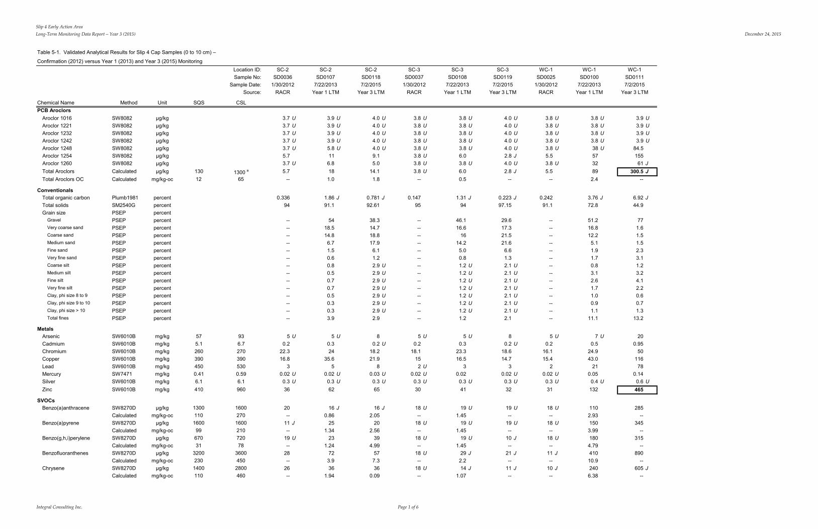
Slip 4 Early Action AreaLong-Term Monitoring Data Report – Year 3 (2015) December 24, 2015
Integral Consulting Inc. Page 1 of 6
Table 5-1. Validated Analytical Results for Slip 4 Cap Samples (0 to 10 cm) –
Confirmation (2012) versus Year 1 (2013) and Year 3 (2015) Monitoring
Chemical Name Method Unit SQS
Location ID:Sample No:
Sample Date:Source:
CSL
SC-2SD0036
1/30/2012RACR
SC-2SD0107
7/22/2013Year 1 LTM
SC-2SD01187/2/2015
Year 3 LTM
SC-3SD0037
1/30/2012RACR
SC-3SD0108
7/22/2013Year 1 LTM
SC-3SD01197/2/2015
Year 3 LTM
WC-1SD0025
1/30/2012RACR
WC-1SD0100
7/22/2013Year 1 LTM
WC-1SD01117/2/2015
Year 3 LTM
PCB AroclorsAroclor 1016Aroclor 1221Aroclor 1232Aroclor 1242Aroclor 1248Aroclor 1254Aroclor 1260
SW8082SW8082SW8082SW8082SW8082SW8082SW8082
µg/kgµg/kgµg/kgµg/kgµg/kgµg/kgµg/kg
3.7 U3.7 U3.7 U3.7 U3.7 U5.73.7 U
3.9 U3.9 U3.9 U3.9 U5.8 U11
6.8
4.0 U4.0 U4.0 U4.0 U4.0 U9.15.0
3.8 U3.8 U3.8 U3.8 U3.8 U3.8 U3.8 U
3.8 U3.8 U3.8 U3.8 U3.8 U6.03.8 U
4.0 U4.0 U4.0 U4.0 U4.0 U2.8 J4.0 U
3.8 U3.8 U3.8 U3.8 U3.8 U5.53.8 U
3.8 U3.8 U3.8 U3.8 U38 U5732
3.9 U3.9 U3.9 U3.9 U
84.515561 J
Total Aroclors Calculated µg/kg 130 1300 a 5.7 18 14.1 3.8 U 6.0 2.8 J 5.5 89 300.5 JTotal Aroclors OC
ConventionalsTotal organic carbonTotal solidsGrain size
GravelVery coarse sandCoarse sandMedium sandFine sandVery fine sandCoarse siltMedium siltFine siltVery fine siltClay, phi size 8 to 9Clay, phi size 9 to 10Clay, phi size > 10Total fines
MetalsArsenicCadmiumChromiumCopperLeadMercurySilver
Calculated
Plumb1981SM2540GPSEPPSEPPSEPPSEPPSEPPSEPPSEPPSEPPSEPPSEPPSEPPSEPPSEPPSEPPSEP
SW6010BSW6010BSW6010BSW6010BSW6010BSW7471SW6010B
mg/kg-oc
percentpercentpercentpercentpercentpercentpercentpercentpercentpercentpercentpercentpercentpercentpercentpercentpercent
mg/kgmg/kgmg/kgmg/kgmg/kgmg/kgmg/kg
12
575.12603904500.416.1
65
936.72703905300.596.1
--
0.33694
----------------------------
5 U0.2
22.316.8
30.02 U0.3 U
1.0
1.86 J91.1
5418.514.86.71.50.60.80.50.70.70.50.30.33.9
5 U0.324
35.65
0.02 U0.3 U
1.8
0.781 J92.61
38.314.718.817.96.11.22.9 U2.9 U2.9 U2.9 U2.9 U2.9 U2.9 U2.9
80.2 U
18.221.9
80.03 U0.3 U
--
0.14795
----------------------------
5 U0.2
18.1152 U
0.02 U0.3 U
0.5
1.31 J94
46.116.6
1614.25.00.81.2 U1.2 U1.2 U1.2 U1.2 U1.2 U1.2 U1.2
5 U0.3
23.316.5
30.020.3 U
--
0.223 J97.15
29.617.321.521.66.61.32.1 U2.1 U2.1 U2.1 U2.1 U2.1 U2.1 U2.1
80.2 U
18.614.7
30.02 U0.3 U
--
0.24291.1
----------------------------
5 U0.2
16.115.4
20.02 U
0.3 U
2.4
3.76 J72.8
51.216.812.25.11.91.70.83.12.61.71.00.91.1
11.1
7 U0.5
24.943.0
210.05
0.4 U
--
6.92 J44.9
771.61.51.52.33.11.23.24.12.20.60.71.3
13.2
200.95
5011678
0.140.6 U
Zinc SW6010B mg/kg 410 960 36 62 65 30 41 32 31 132 465
SVOCsBenzo(a)anthraceneBenzo(a)anthracene OCBenzo(a)pyreneBenzo(a)pyrene OCBenzo(g,h,i)peryleneBenzo(g,h,i)perylene OCBenzofluoranthenesBenzofluoranthenes OCChryseneChrysene OC
SW8270DCalculatedSW8270DCalculatedSW8270DCalculatedSW8270DCalculatedSW8270DCalculated
µg/kgmg/kg-oc
µg/kgmg/kg-oc
µg/kgmg/kg-oc
µg/kgmg/kg-oc
µg/kgmg/kg-oc
130011016009967031
32002301400110
1600270160021072078
36004502800460
20--
11 J--
19 U--
28--
26--
16 J0.86
251.34
231.24
723.936
1.94
16 J2.05
202.56
394.99
577.336
0.09
18 U--
18 U--
18 U--
18 U--
18 U--
19 U1.45
19 U1.45
19 U1.45
29 J2.214 J
1.07
19 U--
19 U--
10 J--
21 J--
11 J--
18 U--
18 U--
18 U--
11 J--
10 J--
1102.93150
3.99180
4.79410
10.9240
6.38
285--
345--
315--
890--
605 J--
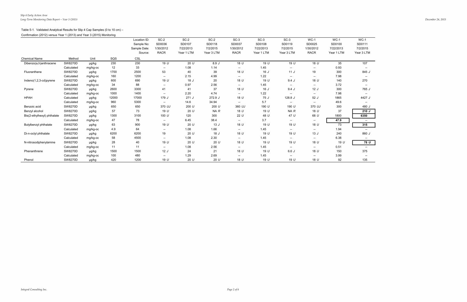
Slip 4 Early Action AreaLong-Term Monitoring Data Report – Year 3 (2015) December 24, 2015
Integral Consulting Inc. Page 2 of 6
Table 5-1. Validated Analytical Results for Slip 4 Cap Samples (0 to 10 cm) –
Confirmation (2012) versus Year 1 (2013) and Year 3 (2015) MonitoringLocation ID: SC-2 SC-2 SC-2 SC-3 SC-3 SC-3 WC-1 WC-1 WC-1Sample No:
Sample Date:Source:
SD00361/30/2012
RACR
SD01077/22/2013
Year 1 LTM
SD01187/2/2015
Year 3 LTM
SD00371/30/2012
RACR
SD01087/22/2013
Year 1 LTM
SD01197/2/2015
Year 3 LTM
SD00251/30/2012
RACR
SD01007/22/2013
Year 1 LTM
SD01117/2/2015
Year 3 LTM
Chemical Name Method Unit SQS CSLDibenzo(a,h)anthracene SW8270DDibenzo(a,h)anthracene OC CalculatedFluoranthene SW8270DFluoranthene OC CalculatedIndeno(1,2,3-cd)pyrene SW8270DIndeno(1,2,3-cd)pyrene OC CalculatedPyrene SW8270DPyrene OC CalculatedHPAH CalculatedHPAH Calculated
µg/kgmg/kg-oc
µg/kgmg/kg-oc
µg/kgmg/kg-oc
µg/kgmg/kg-oc
µg/kgmg/kg-oc
23012
170016060034
2600100012000960
23033
2500120069088
33001400170005300
19 U--
53--
19 U--
41--
179 J--
20 U1.08
402.15
18 J0.97
412.20271 J14.6
8.9 J1.14
394.99
202.56
374.74
272.9 J34.94
18 U--
18 U--
18 U--
18 U--
18 U--
19 U1.45
16 J1.22
19 U1.45
16 J1.22
75 J5.7
19 U--
11 J--
9.4 J--
9.4 J--
128.8 J--
18 U--
19--
18 U--
12 J--
52 J--
350.933007.98140
3.723007.98186549.6
107--
845 J--
270--
765 J--
4427 J--
Benzoic acid SW8270D µg/kg 650 650 370 UJ 200 U 200 U 360 UJ 190 U 190 U 370 UJ 300 480 JBenzyl alcohol SW8270D µg/kg 57 73 19 U 20 U NA R 18 U 19 U NA R 18 U 37 210 JBis(2-ethylhexyl) phthalate SW8270D µg/kg 1300 3100 100 U 120 300 22 U 48 U 47 U 68 U 1800 6350Bis(2-ethylhexyl) phthalate OCCalculated mg/kg-oc 47 78 -- 6.45 38.4 -- 3.7 -- -- 47.9 --Butylbenzyl phthalate SW8270D µg/kg 63 900 19 U 20 U 13 J 18 U 19 U 19 U 18 U 73 315Butylbenzyl phthalate OC CalculatedDi-n-octyl phthalate SW8270DDi-n-octyl phthalate OC Calculated
mg/kg-ocµg/kg
mg/kg-oc
4.9620058
6462004500
--19--
1.0820 U
1.08
1.6618 J
2.30
--18 U--
1.4519 U
1.45
--19 U--
--13 J--
1.94240
6.38
--860 J
--N-nitrosodiphenylamine SW8270D µg/kg 28 40 19 U 20 U 20 U 18 U 19 U 19 U 18 U 19 U 78 UN-Nitrosodiphenylamine OC CalculatedPhenanthrene SW8270DPhenanthrene OC CalculatedPhenol SW8270D
mg/kg-ocµg/kg
mg/kg-ocµg/kg
111500100420
1115004801200
--12 J--
19 U
1.0824
1.2920 U
2.5621
2.6920 U
--18 U--
18 U
1.4519 U
1.4519 U
--6.6 J
--19 U
--18 U--
18 U
0.51150
3.9992
--375
--135
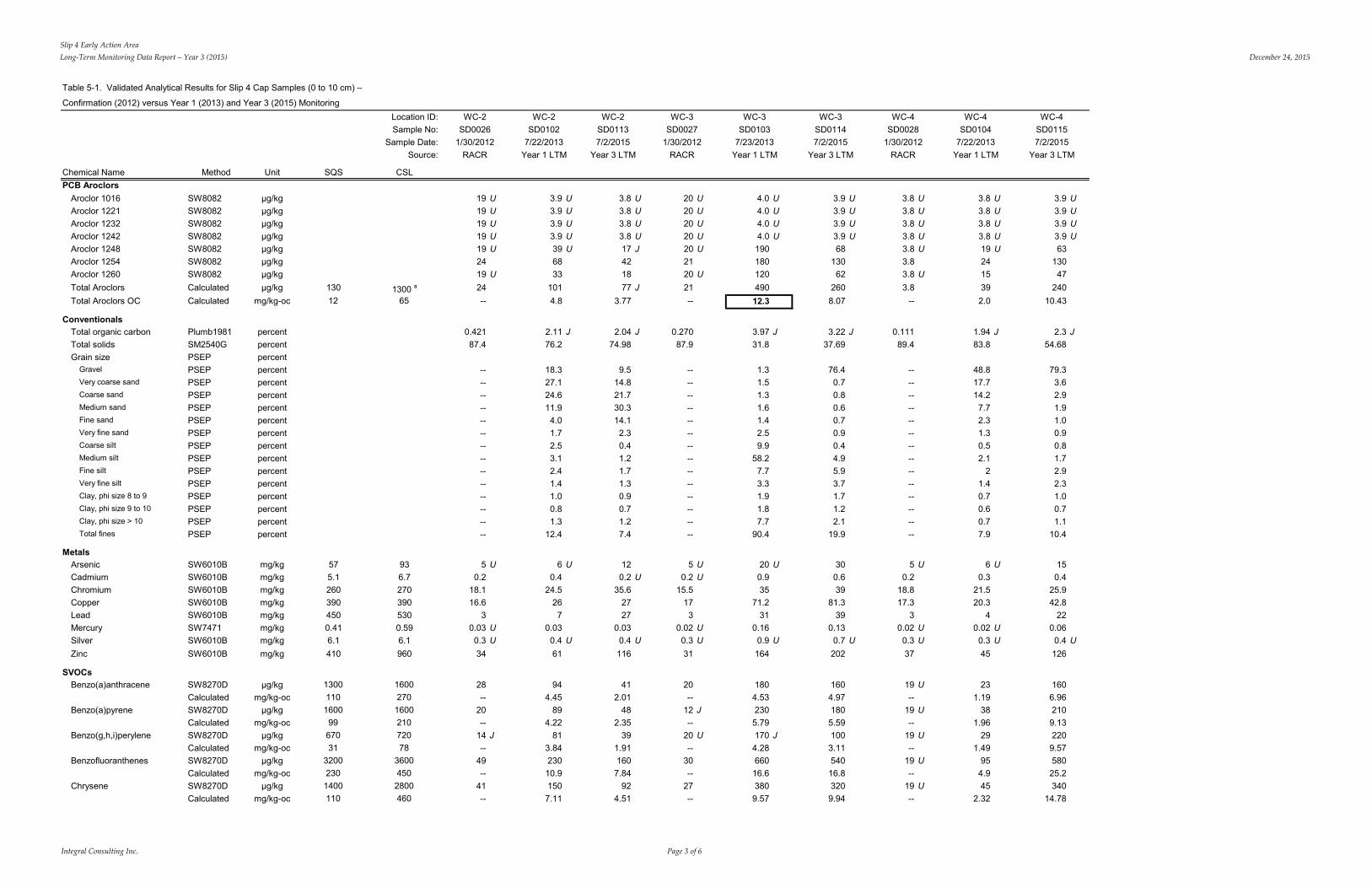
Slip 4 Early Action AreaLong-Term Monitoring Data Report – Year 3 (2015) December 24, 2015
Integral Consulting Inc. Page 3 of 6
Table 5-1. Validated Analytical Results for Slip 4 Cap Samples (0 to 10 cm) –
Confirmation (2012) versus Year 1 (2013) and Year 3 (2015) MonitoringLocation ID: WC-2 WC-2 WC-2 WC-3 WC-3 WC-3 WC-4 WC-4 WC-4Sample No: SD0026 SD0102 SD0113 SD0027 SD0103 SD0114 SD0028 SD0104 SD0115
Sample Date: 1/30/2012 7/22/2013 7/2/2015 1/30/2012 7/23/2013 7/2/2015 1/30/2012 7/22/2013 7/2/2015Source: RACR Year 1 LTM Year 3 LTM RACR Year 1 LTM Year 3 LTM RACR Year 1 LTM Year 3 LTM
Chemical Name Method Unit SQS CSLPCB Aroclors
Aroclor 1016 SW8082 µg/kg 19 U 3.9 U 3.8 U 20 U 4.0 U 3.9 U 3.8 U 3.8 U 3.9 UAroclor 1221 SW8082 µg/kg 19 U 3.9 U 3.8 U 20 U 4.0 U 3.9 U 3.8 U 3.8 U 3.9 UAroclor 1232 SW8082 µg/kg 19 U 3.9 U 3.8 U 20 U 4.0 U 3.9 U 3.8 U 3.8 U 3.9 UAroclor 1242 SW8082 µg/kg 19 U 3.9 U 3.8 U 20 U 4.0 U 3.9 U 3.8 U 3.8 U 3.9 UAroclor 1248 SW8082 µg/kg 19 U 39 U 17 J 20 U 190 68 3.8 U 19 U 63Aroclor 1254 SW8082 µg/kg 24 68 42 21 180 130 3.8 24 130Aroclor 1260 SW8082 µg/kg 19 U 33 18 20 U 120 62 3.8 U 15 47Total Aroclors Calculated µg/kg 130 1300 a 24 101 77 J 21 490 260 3.8 39 240Total Aroclors OC Calculated mg/kg-oc 12 65 -- 4.8 3.77 -- 12.3 8.07 -- 2.0 10.43
ConventionalsTotal organic carbon Plumb1981 percent 0.421 2.11 J 2.04 J 0.270 3.97 J 3.22 J 0.111 1.94 J 2.3 JTotal solids SM2540G percent 87.4 76.2 74.98 87.9 31.8 37.69 89.4 83.8 54.68Grain size PSEP percent
Gravel PSEP percent -- 18.3 9.5 -- 1.3 76.4 -- 48.8 79.3Very coarse sand PSEP percent -- 27.1 14.8 -- 1.5 0.7 -- 17.7 3.6Coarse sand PSEP percent -- 24.6 21.7 -- 1.3 0.8 -- 14.2 2.9Medium sand PSEP percent -- 11.9 30.3 -- 1.6 0.6 -- 7.7 1.9Fine sand PSEP percent -- 4.0 14.1 -- 1.4 0.7 -- 2.3 1.0Very fine sand PSEP percent -- 1.7 2.3 -- 2.5 0.9 -- 1.3 0.9Coarse silt PSEP percent -- 2.5 0.4 -- 9.9 0.4 -- 0.5 0.8Medium silt PSEP percent -- 3.1 1.2 -- 58.2 4.9 -- 2.1 1.7Fine silt PSEP percent -- 2.4 1.7 -- 7.7 5.9 -- 2 2.9Very fine silt PSEP percent -- 1.4 1.3 -- 3.3 3.7 -- 1.4 2.3Clay, phi size 8 to 9 PSEP percent -- 1.0 0.9 -- 1.9 1.7 -- 0.7 1.0Clay, phi size 9 to 10 PSEP percent -- 0.8 0.7 -- 1.8 1.2 -- 0.6 0.7Clay, phi size > 10 PSEP percent -- 1.3 1.2 -- 7.7 2.1 -- 0.7 1.1Total fines PSEP percent -- 12.4 7.4 -- 90.4 19.9 -- 7.9 10.4
MetalsArsenic SW6010B mg/kg 57 93 5 U 6 U 12 5 U 20 U 30 5 U 6 U 15Cadmium SW6010B mg/kg 5.1 6.7 0.2 0.4 0.2 U 0.2 U 0.9 0.6 0.2 0.3 0.4Chromium SW6010B mg/kg 260 270 18.1 24.5 35.6 15.5 35 39 18.8 21.5 25.9Copper SW6010B mg/kg 390 390 16.6 26 27 17 71.2 81.3 17.3 20.3 42.8Lead SW6010B mg/kg 450 530 3 7 27 3 31 39 3 4 22Mercury SW7471 mg/kg 0.41 0.59 0.03 U 0.03 0.03 0.02 U 0.16 0.13 0.02 U 0.02 U 0.06Silver SW6010B mg/kg 6.1 6.1 0.3 U 0.4 U 0.4 U 0.3 U 0.9 U 0.7 U 0.3 U 0.3 U 0.4 UZinc SW6010B mg/kg 410 960 34 61 116 31 164 202 37 45 126
SVOCsBenzo(a)anthracene SW8270D µg/kg 1300 1600 28 94 41 20 180 160 19 U 23 160Benzo(a)anthracene OC Calculated mg/kg-oc 110 270 -- 4.45 2.01 -- 4.53 4.97 -- 1.19 6.96Benzo(a)pyrene SW8270D µg/kg 1600 1600 20 89 48 12 J 230 180 19 U 38 210Benzo(a)pyrene OC Calculated mg/kg-oc 99 210 -- 4.22 2.35 -- 5.79 5.59 -- 1.96 9.13Benzo(g,h,i)perylene SW8270D µg/kg 670 720 14 J 81 39 20 U 170 J 100 19 U 29 220Benzo(g,h,i)perylene OC Calculated mg/kg-oc 31 78 -- 3.84 1.91 -- 4.28 3.11 -- 1.49 9.57Benzofluoranthenes SW8270D µg/kg 3200 3600 49 230 160 30 660 540 19 U 95 580Benzofluoranthenes OC Calculated mg/kg-oc 230 450 -- 10.9 7.84 -- 16.6 16.8 -- 4.9 25.2Chrysene SW8270D µg/kg 1400 2800 41 150 92 27 380 320 19 U 45 340Chrysene OC Calculated mg/kg-oc 110 460 -- 7.11 4.51 -- 9.57 9.94 -- 2.32 14.78
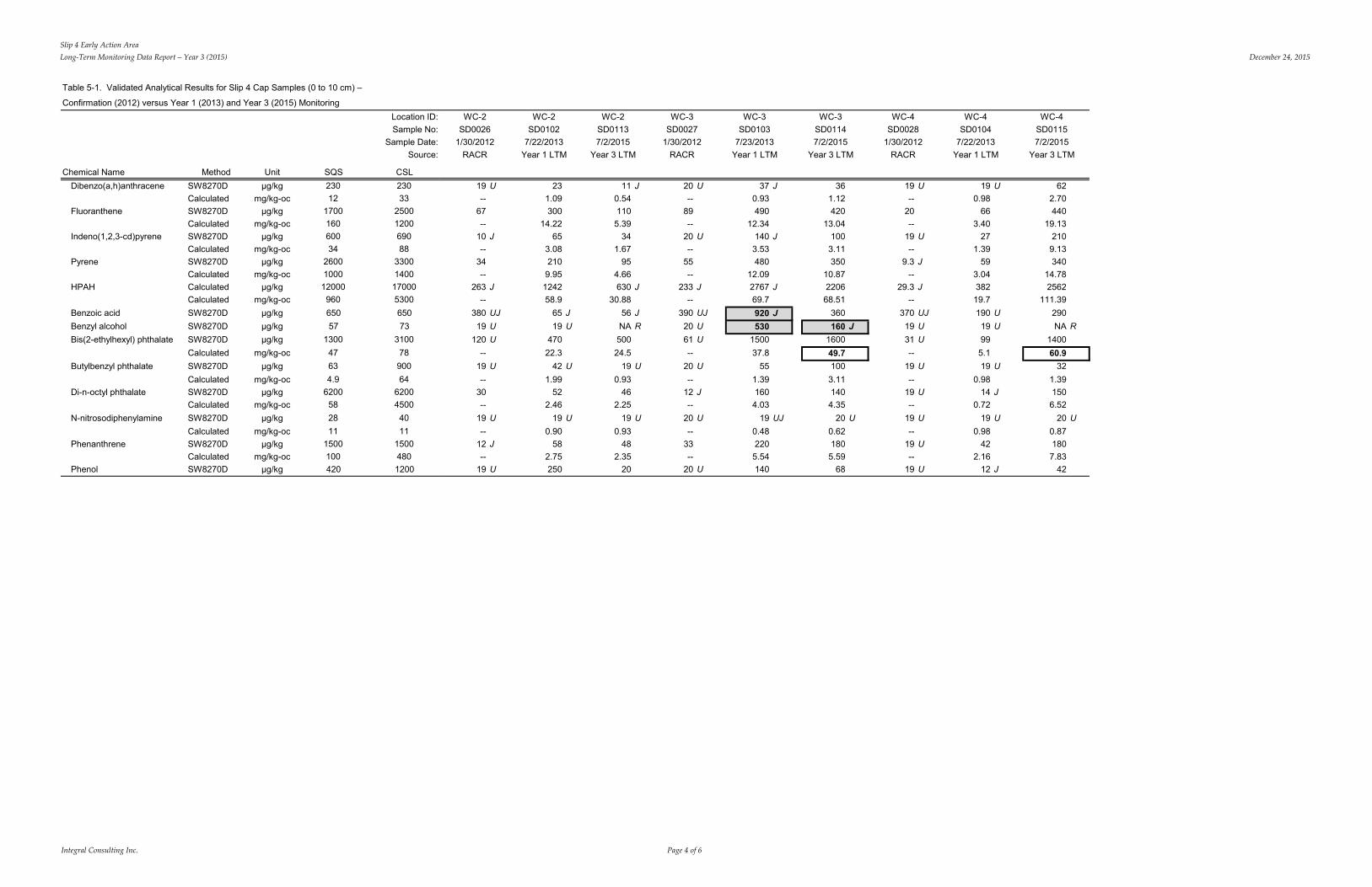
Slip 4 Early Action AreaLong-Term Monitoring Data Report – Year 3 (2015) December 24, 2015
Integral Consulting Inc. Page 4 of 6
Table 5-1. Validated Analytical Results for Slip 4 Cap Samples (0 to 10 cm) –
Confirmation (2012) versus Year 1 (2013) and Year 3 (2015) MonitoringLocation ID: WC-2 WC-2 WC-2 WC-3 WC-3 WC-3 WC-4 WC-4 WC-4Sample No:
Sample Date:Source:
SD00261/30/2012
RACR
SD01027/22/2013
Year 1 LTM
SD01137/2/2015
Year 3 LTM
SD00271/30/2012
RACR
SD01037/23/2013
Year 1 LTM
SD01147/2/2015
Year 3 LTM
SD00281/30/2012
RACR
SD01047/22/2013
Year 1 LTM
SD01157/2/2015
Year 3 LTM
Chemical Name MethodDibenzo(a,h)anthracene SW8270DDibenzo(a,h)anthracene OC CalculatedFluoranthene SW8270DFluoranthene OC CalculatedIndeno(1,2,3-cd)pyrene SW8270DIndeno(1,2,3-cd)pyrene OC CalculatedPyrene SW8270DPyrene OC CalculatedHPAH CalculatedHPAH Calculated
Unitµg/kg
mg/kg-ocµg/kg
mg/kg-ocµg/kg
mg/kg-ocµg/kg
mg/kg-ocµg/kg
mg/kg-oc
SQS23012
170016060034
2600100012000960
CSL23033
2500120069088
33001400170005300
19 U--
67--
10 J--
34--
263 J--
231.09300
14.2265
3.082109.95124258.9
11 J0.54110
5.3934
1.6795
4.66630 J
30.88
20 U--
89--
20 U--
55--
233 J--
37 J0.93490
12.34140 J3.53480
12.092767 J69.7920 J
361.12420
13.041003.11350
10.87220668.51
360160 J
1600
19 U--
20--
19 U--
9.3 J--
29.3 J--
370 UJ19 U31 U
19 U0.98
663.40
271.39
593.0438219.7190 U
19 U99
622.70440
19.132109.13340
14.782562
111.39290NA R
140060.9
32
Benzoic acid SW8270D µg/kg 650 650 380 UJ 65 J 56 J 390 UJBenzyl alcohol SW8270D µg/kg 57 73 19 U 19 U NA R 20 U 530Bis(2-ethylhexyl) phthalate SW8270D µg/kg 1300 3100 120 U 470 500 61 U 1500Bis(2-ethylhexyl) phthalate OCCalculated mg/kg-oc 47 78 -- 22.3 24.5 -- 37.8 49.7 -- 5.1Butylbenzyl phthalate SW8270D µg/kg 63 900 19 U 42 U 19 U 20 U 55 100 19 U 19 UButylbenzyl phthalate OC CalculatedDi-n-octyl phthalate SW8270DDi-n-octyl phthalate OC Calculated
mg/kg-ocµg/kg
mg/kg-oc
4.9620058
6462004500
--30--
1.9952
2.46
0.9346
2.25
--12 J--
1.391604.03
3.111404.35
--19 U--
0.9814 J
0.72
1.391506.52
N-nitrosodiphenylamine SW8270D µg/kg 28 40 19 U 19 U 19 U 20 U 19 UJ 20 U 19 U 19 U 20 UN-Nitrosodiphenylamine OC CalculatedPhenanthrene SW8270DPhenanthrene OC CalculatedPhenol SW8270D
mg/kg-ocµg/kg
mg/kg-ocµg/kg
111500100420
1115004801200
--12 J--
19 U
0.9058
2.75250
0.9348
2.3520
--33--
20 U
0.482205.54140
0.621805.59
68
--19 U--
19 U
0.9842
2.1612 J
0.871807.83
42
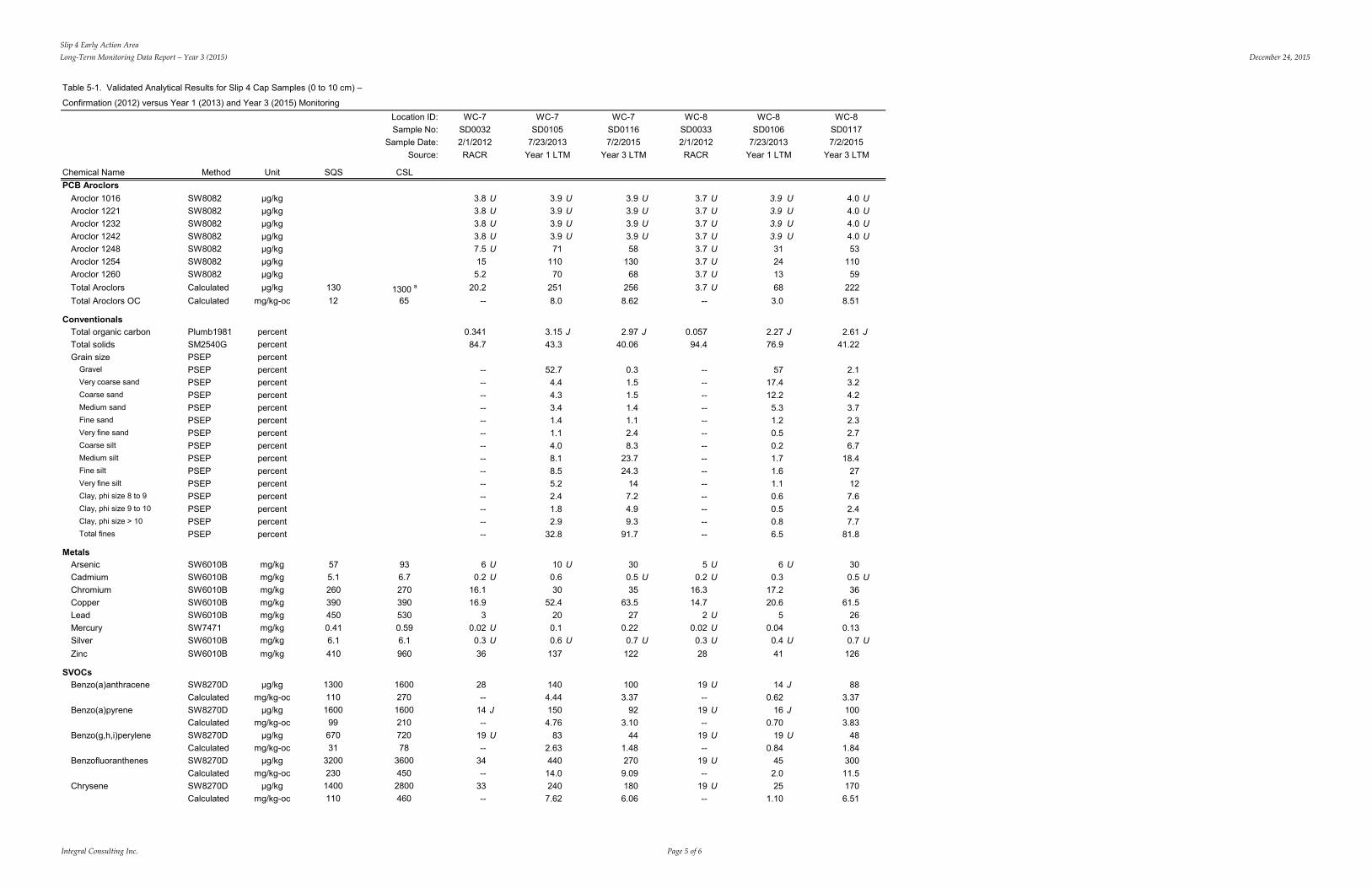
Slip 4 Early Action AreaLong-Term Monitoring Data Report – Year 3 (2015) December 24, 2015
Integral Consulting Inc. Page 5 of 6
Table 5-1. Validated Analytical Results for Slip 4 Cap Samples (0 to 10 cm) –
Confirmation (2012) versus Year 1 (2013) and Year 3 (2015) Monitoring
Chemical Name Method Unit SQS
Location ID:Sample No:
Sample Date:Source:
CSL
WC-7SD00322/1/2012RACR
WC-7SD0105
7/23/2013Year 1 LTM
WC-7SD01167/2/2015
Year 3 LTM
WC-8SD00332/1/2012RACR
WC-8SD0106
7/23/2013Year 1 LTM
WC-8SD01177/2/2015
Year 3 LTM
PCB AroclorsAroclor 1016Aroclor 1221Aroclor 1232Aroclor 1242Aroclor 1248Aroclor 1254Aroclor 1260Total AroclorsTotal Aroclors OC
ConventionalsTotal organic carbonTotal solidsGrain size
GravelVery coarse sandCoarse sandMedium sandFine sandVery fine sandCoarse siltMedium siltFine siltVery fine siltClay, phi size 8 to 9Clay, phi size 9 to 10Clay, phi size > 10Total fines
MetalsArsenicCadmiumChromiumCopperLeadMercurySilverZinc
SVOCsBenzo(a)anthraceneBenzo(a)anthracene OCBenzo(a)pyreneBenzo(a)pyrene OCBenzo(g,h,i)peryleneBenzo(g,h,i)perylene OCBenzofluoranthenesBenzofluoranthenes OCChryseneChrysene OC
SW8082SW8082SW8082SW8082SW8082SW8082SW8082CalculatedCalculated
Plumb1981SM2540GPSEPPSEPPSEPPSEPPSEPPSEPPSEPPSEPPSEPPSEPPSEPPSEPPSEPPSEPPSEP
SW6010BSW6010BSW6010BSW6010BSW6010BSW7471SW6010BSW6010B
SW8270DCalculatedSW8270DCalculatedSW8270DCalculatedSW8270DCalculatedSW8270DCalculated
µg/kgµg/kgµg/kgµg/kgµg/kgµg/kgµg/kgµg/kg
mg/kg-oc
percentpercentpercentpercentpercentpercentpercentpercentpercentpercentpercentpercentpercentpercentpercentpercentpercent
mg/kgmg/kgmg/kgmg/kgmg/kgmg/kgmg/kgmg/kg
µg/kgmg/kg-oc
µg/kgmg/kg-oc
µg/kgmg/kg-oc
µg/kgmg/kg-oc
µg/kgmg/kg-oc
13012
575.12603904500.416.1410
130011016009967031
32002301400110
1300 a
65
936.72703905300.596.1960
1600270160021072078
36004502800460
3.8 U3.8 U3.8 U3.8 U7.5 U155.2
20.2--
0.34184.7
----------------------------
6 U0.2 U
16.116.9
30.02 U0.3 U36
28--
14 J--
19 U--
34--
33--
3.9 U3.9 U3.9 U3.9 U71
11070
2518.0
3.15 J43.3
52.74.44.33.41.41.14.08.18.55.22.41.82.9
32.8
10 U0.630
52.4200.10.6 U137
1404.441504.76
832.6344014.02407.62
3.9 U3.9 U3.9 U3.9 U58
13068
2568.62
2.97 J40.06
0.31.51.51.41.12.48.3
23.724.3
147.24.99.3
91.7
300.5 U35
63.527
0.220.7 U122
1003.37
923.10
441.482709.091806.06
3.7 U3.7 U3.7 U3.7 U3.7 U3.7 U3.7 U3.7 U
--
0.05794.4
----------------------------
5 U0.2 U
16.314.7
2 U0.02 U0.3 U28
19 U--
19 U--
19 U--
19 U--
19 U--
3.9 U3.9 U3.9 U3.9 U312413683.0
2.27 J76.9
5717.412.25.31.20.50.21.71.61.10.60.50.86.5
6 U0.3
17.220.6
50.040.4 U41
14 J0.62
16 J0.70
19 U0.84
452.025
1.10
4.0 U4.0 U4.0 U4.0 U53
11059
2228.51
2.61 J41.22
2.13.24.23.72.32.76.7
18.427127.62.47.7
81.8
300.5 U36
61.526
0.130.7 U
126
883.371003.83
481.8430011.51706.51
Slip 4 Early Action AreaLong-Term Monitoring Data Report – Year 3 (2015) December 24, 2015
Integral Consulting Inc. Page 6 of 6
Table 5-1. Validated Analytical Results for Slip 4 Cap Samples (0 to 10 cm) –
Confirmation (2012) versus Year 1 (2013) and Year 3 (2015) MonitoringLocation ID:Sample No:
Sample Date:Source:
Chemical Name Method Unit SQS CSL Dibenzo(a,h)anthracene SW8270D µg/kg 230 230
Dibenzo(a,h)anthracene OC Calculated mg/kg-oc 12 33Fluoranthene SW8270D µg/kg 1700 2500Fluoranthene OC Calculated mg/kg-oc 160 1200Indeno(1,2,3-cd)pyrene SW8270D µg/kg 600 690Indeno(1,2,3-cd)pyrene OC Calculated mg/kg-oc 34 88Pyrene SW8270D µg/kg 2600 3300Pyrene OC Calculated mg/kg-oc 1000 1400HPAH Calculated µg/kg 12000 17000HPAH Calculated mg/kg-oc 960 5300Benzoic acid SW8270D µg/kg 650 650Benzyl alcohol SW8270D µg/kg 57 73Bis(2-ethylhexyl) phthalate SW8270D µg/kg 1300 3100Bis(2-ethylhexyl) phthalate OCCalculated mg/kg-oc 47 78Butylbenzyl phthalate SW8270D µg/kg 63 900Butylbenzyl phthalate OC Calculated mg/kg-oc 4.9 64Di-n-octyl phthalate SW8270D µg/kg 6200 6200Di-n-octyl phthalate OC Calculated mg/kg-oc 58 4500N-nitrosodiphenylamine SW8270D µg/kg 28 40N-Nitrosodiphenylamine OC Calculated mg/kg-oc 11 11Phenanthrene SW8270D µg/kg 1500 1500Phenanthrene OC Calculated mg/kg-oc 100 480Phenol SW8270D µg/kg 420 1200
WC-8 WC-8WC-7 WC-7 WC-7 WC-8SD0032 SD0105 SD0116 SD0033 SD0106 SD0117
7/23/2013 7/2/20152/1/2012 7/23/2013 7/2/2015 2/1/2012RACR Year 1 LTM Year 3 LTMRACR Year 1 LTM Year 3 LTM
19 U 22 16 J 19 U 19 U 19-- 0.70 0.54 -- 0.84 0.73
120 390 240 31 J 34 240-- 12.38 8.08 -- 1.50 9.20
19 U 76 47 19 U 19 U 51-- 2.41 1.58 -- 0.84 1.95
78 350 210 19 J 31 210-- 11.11 7.07 -- 1.37 8.05
307 J 1891 1199 J 50 J 165 J 1226-- 60.0 40.37 -- 7.3 46.97
370 UJ 540 410 380 UJ 190 U 29019 UJ 390 220 J NA R 19 U 150 J35 790 480 24 U 51 450-- 25.1 16.2 -- 2.2 17.2
19 U 30 21 19 U 19 U 20-- 0.95 0.71 -- 0.84 0.77
19 U 60 36 19 U 19 U 36-- 1.90 1.21 -- 0.84 1.38
19 U 20 U 19 U 19 U 19 U 19 U-- 0.63 0.64 -- 0.84 0.73
43 160 100 16 J 13 J 89-- 5.08 3.37 -- 0.57 3.41
19 U 82 44 19 U 37 32
Notes:Data Sources: RACR - Lower Duwamish Waterway Slip 4 Early Action Area: Removal Action Completion Report. Integral 2012.-- = No calculation performed because total organic carbon was outside of range; calculation is not applicable; or analysis was not requested.CSL = cleanup screening levelHPAH = high molecular weight polycyclic aromatic hydrocarbonsLAET = lowest apparent effect thresholdLTM = long-term monitoringNA = not availableOC = organic carbon–normalized
PCB = polychlorinated biphenylRACR = removal action completion reportSQS = sediment quality standardsSVOC = semivolatile organic compound
J = The associated numerical value is the approximate concentration.R = rejectedU = Not detected above the reported sample quantitation limit.UJ = The analyte was not detected above the reported sample quantitation limit. However, the reported quantitation limit is approximate.
a The cleanup screening level is as reported in the Lower Duwamish Waterway feasibility study.
Result exceeds LAET/SQS value.
Result exceeds 2LAET/CSL value.
Slip 4 Early Action AreaLong-Term Monitoring Data Report – Year 3 (2015) December 24, 2015
Integral Consulting Inc. Page 1 of 1
Table 5-2. Concentrations of Select Contaminants in Subareas of Slip 4, Post-Construction SamplesArea Minimum Maximum Data Source
Within Slip 4 EAATotal PCBs µg/kg dw 2.8 J 490 Year 3; AMEC 2013BEHP µg/kg dw 22 U 6,350 Integral 2012; Year 3Benzyl alcohol µg/kg dw 18 U 530 Integral 2012; Year 1Butylbenzyl phthalate µg/kg dw 13 J 315 Year 3Zinc mg/kg dw 27 U 465 Integral 2012; Year 3
Within Boundary AreaTotal PCBs µg/kg dw 3.8 U 490 J Integral 2012; Ecology 2015aBEHP µg/kg dw 310 560 Integral 2012Benzyl alcohol µg/kg dw 0.012 220 J Ecology 2015a; Integral 2012Butylbenzyl phthalate µg/kg dw 10 J 22 Integral 2012Zinc mg/kg dw 84 J 249 J Integral 2012; Ecology 2015a
Between Boundary Area and Mouth of Slip 4Total PCBs µg/kg dw 133 900 J Integral 2012, 2013c; Year 1; AMEC 2013; Ecology 2015aBEHP µg/kg dw 340 U 1,200 J Ecology 2015aBenzyl alcohol µg/kg dw 28 41 Ecology 2015aButylbenzyl phthalate µg/kg dw 40 J 82 Ecology 2015aZinc mg/kg dw 67 398 J AMEC 2013; Ecology 2015a
In LDW Near Mouth of Slip 4Total PCBs µg/kg dw 92 350 AMEC 2013; Ecology 2015aBEHP µg/kg dw 550 2,000 J Ecology 2015aBenzyl alcohol µg/kg dw 30 30 Ecology 2015aButylbenzyl phthalate µg/kg dw 24 24 Ecology 2015aZinc mg/kg dw 88 160 AMEC 2013
Notes:BEHP = bis(2-ethylhexyl)phthalatedw = dry weightEAA = early action areaJ = estimated concentrationLDW = Lower Duwamish WaterwayPCB = polychlorinated biphenylU = not detected above the reported sample quantitation limit