Embed Size (px)
Citation preview
.
K1A Management Plan #2 Page i
LONG-TERM COMMUNITY FOREST LICENSE AGREEMENT K1A
Management Plan #2
2010 – 2015
Authorized Licensee Signatory: __________________________ Prepared by: Dawn Stronstad, RPF Dawn Stronstad, RPF
Date: ______________________ Authorized Approval: Designated Decision Maker: _________________________________ Josh Pressey, RPF District Manager – Nadina Forest District Date: _______________________

K1A Management Plan #2 Page ii
Table of Contents
1.0 INTRODUCTION .................................................................................................................. 7
1.1 PURPOSE ............................................................................................................................... 7 1.2 LOCATION AND DESCRIPTION OF K1A ...................................................................................... 7 1.3 HISTORY ................................................................................................................................ 7 1.4 LICENSE HOLDER AND ADMINISTRATION ................................................................................... 8 1.5 RESOURCE ISSUES ............................................................................................................... 10
2.0 RESOURCE INVENTORIES ............................................................................................. 10
2.1 GENERAL ............................................................................................................................. 10 2.2 TIMBER ................................................................................................................................ 12
2.2.1 Forest Cover ................................................................................................................. 12 2.4 RECREATION ........................................................................................................................ 13
2.4.1 Recreation Features Inventory ...................................................................................... 13 2.4.2 Visual Landscape Inventory .......................................................................................... 15
2.5 WILDLIFE AND FISH ............................................................................................................... 15 2.5.1 Stream and Wetland Classification ............................................................................... 15 2.5.2 Wildlife ........................................................................................................................... 15
2.7 ARCHAEOLOGICAL ................................................................................................................ 16 2.8 BIOGEOCLIMATIC ECOSYSTEM CLASSIFICATION ...................................................................... 17 2.9 WATERSHEDS ...................................................................................................................... 18 2.10 MINING ............................................................................................................................... 18
3.0 MANAGEMENT OBJECTIVES ......................................................................................... 18
3.1 MANAGEMENT AND UTILIZATION OF THE TIMBER RESOURCE .................................................... 18 3.2 PROTECTION AND CONSERVATION OF NON TIMBER VALUES .................................................... 18 3.3 INTEGRATION OF HARVESTING WITH NON-TIMBER USES .......................................................... 19 3.4 FOREST HEALTH AND FOREST PROTECTION ........................................................................... 19 3.5 SILVICULTURE ....................................................................................................................... 19 3.6 ROADS .................................................................................................................................. 19 3.7 OTHER .................................................................................................................................. 20
4.0 PLANNING ......................................................................................................................... 20
4.1 GENERAL ............................................................................................................................. 20 4.2 STRATEGIC PLANS ................................................................................................................ 21
4.2.1 Lakes District Land and Resource Management Plan (LRMP) .................................. 21 4.2.2 Lakes South Sustainable Resource Plan (LSSRP) .................................................... 21 4.2.3 Lakes North Sustainable Resource Plan (LNSRP) ………………………………………21 4.2.4 Timber Supply Analysis ................................................................................................. 22 4.2.5 AAC Determination…………………………………………………………….……………..24
4.3 OPERATIONAL PLANS ............................................................................................................ 24 4.3.1 Forest Stewardship Plan……………………………………………………………………25 4.3.2 Other Plans, Prescriptions and Permits ...................................................................... 25
5.0 TIMBER RESOURCE MANAGEMENT ............................................................................. 25
5.1 ALLOWABLE ANNUAL CUT ..................................................................................................... 25 5.2 HARVESTING ........................................................................................................................ 26
5.2.1 Harvesting Priorities and Guidelines ........................................................................... 26 5.2.2 Harvesting Systems .................................................................................................... 26 5.2.3 Silvicultural Systems ................................................................................................... 27 5.2.4 Utilization Standards ................................................................................................... 29
5.3 FOREST ROAD SYSTEMS ....................................................................................................... 29 5.3.1 Road System Planning and Development .................................................................. 29 5.3.2 Maintenance ................................................................................................................ 30

K1A Management Plan #2 Page iii
5.3.3 Deactivation ................................................................................................................. 31 5.3.4 Access Management ................................................................................................... 31
5.4 SILVICULTURE ....................................................................................................................... 31 5.4.1 Basic Silviculture ......................................................................................................... 32 5.4.2 Enhanced Silviculture .................................................................................................. 35
5.5 FOREST HEALTH ................................................................................................................... 35 5.5.1 Unsalvaged Losses ..................................................................................................... 38
5.6 FIRE PROTECTION................................................................................................................. 38 5.6.1 Prevention ................................................................................................................... 38 5.6.2 Fire Pre-Organizational Plan ....................................................................................... 38 5.6.3 Fire Detection .............................................................................................................. 38
6.0 NON-TIMBER RESOURCE MANAGEMENT ................................................................... 39
6.1 RANGE ................................................................................................................................. 39 6.2 RECREATION ........................................................................................................................ 39 6.3 VISUAL ................................................................................................................................. 41 6.4 AQUATIC RESOURCES ........................................................................................................... 41 6.5 WILDLIFE AND BIOLOGICAL DIVERSITY ................................................................................... 42
7.0 CONSULTATION WITH THE PUBLIC AND OTHER RESOURCE USERS .................... 42
7.1 NON-TIMBER TENURE HOLDERS ............................................................................................ 43 7.2 FIRST NATIONS ..................................................................................................................... 43 7.3 PUBLIC REVIEW .................................................................................................................... 43
8.0 IMPACT SUMMARY OF MP IMPLEMENTATION ............................................................ 43
9.0 COMPARISON OF CURRENT AND PROPOSED MP ..................................................... 44
10.0 ANNUAL REPORT ............................................................................................................ 45

.
K1A Management Plan #2 Page iv
List of Figures Figure 1. Location Map for K1A .................................................................................................... 9 Figure 2. The Community of Burns Lake ...................................................................................... 9 Figure 3. 1:20,000 Scale Mapsheet Key .................................................................................... 12 Figure 4. Star Lake Recreation Trail........................................................................................... 13 Figure 5. Downhill mountain bike trail in the Boer Mountain Recreation Site ............................ 14 Figure 6. Cross-country skiing at the Omineca Ski Trails .......................................................... 14 Figure 7. Muledeer on K1A ......................................................................................................... 16 Figure 8. Biogeoclimatic subzones present in K1A .................................................................... 17 Figure 9. Base Case Harvest Level ............................................................................................ 24 Figure 10. BLCF Harvest System ................................................................................................. 27 Figure 11. Example of Clearcut silviculture system In Use in K1A .............................................. 27 Figure 12. Example of Clearcut With Reserves silviculture system in K1A ................................. 28 Figure 13. Present Road System in K1A.……………………………………………………………..30 Figure 14. Area in K1A showing extent of mountain pine beetle attack (2007 photo) ................. 36 Figure 15. Recreation site in K1A – Kager Lake .......................................................................... 39

K1A Management Plan #2 Page v
List of Tables
Table 1. Forest Resource Inventories ....................................................................................... 11 Table 2. Biogeoclimatic Subzone and Variant Occurrence ....................................................... 17 Table 3. Timber Harvesting Land Base Definition ..................................................................... 23 Table 4. Base Case Harvest Levels ………………………………………………………………...23 Table 5. Sensitivity Analysis Scenario Summary.………………………………………………….26 Table 6. K1A Utilization Standards ............................................................................................ 29 Table 7. Tree Seed Inventory (January 2009) ........................................................................... 33 Table 8. Common Pests and Diseases of K1A ......................................................................... 36 Table 9. Ranking of Pests Species by Potential Impact on Forest Management
within the Nadina Forest District……………………………………………………………. ........ 37 Table 10. Non-Commercial Recreation Activities on K1A ......................................................... 40 Table 11. Ministry of Tourism, Culture and the Arts Recreation Sites Within K1A ................... 40 Table 12. Direct Employment In K1A .......................................................................................... 44

K1A Management Plan #2 Page vi
List of Appendices Appendix 1.0 - Endangered species in the Nadina Forest District Appendix 2.0 – Burns Lake Community Forest Timber Supply Analysis Report Appendix 3.0 – Referral List a) Advertisements b) First Nations Referral List i) First Nations Referral Letters c) Stakeholder Referral List i) Stakeholder Referral Letters Appendix 4.0 – February 25, 2011 AAC Determination Letter

.
K1A Management Plan #2 Page 7
1.0 Introduction
1.1 Purpose
The purpose of Management Plan #2 is to identify and propose for approval by the Chief Forester (or his designate), the management objectives and strategies for achieving those objectives for the timber and non-timber resources within Long-term Community Forest Agreement K1A. The management plan is a strategic five-year plan. Operations conducted on K1A must be consistent with the objectives and strategies stated in the plan.
1.2 Location and Description of K1A
K1A covers an area of approximately 87,088 hectares. Centred around the Village of Burns Lake it extends west to Maxan Lake, north to Division Lake, east to Priestly Hill and south to the north shore of Francois Lake. The terrain is diverse. It is effectively bisected by both Highway 35 (which runs north-south) and Highway 16 (which runs east-west).
Tree species include lodgepole pine, hybrid spruce, subalpine fir, a minor component of Douglas fir and black spruce, as well as trembling aspen, cottonwood and birch. Elevation in K1A ranges from 700 to 1400 meters in the SBSdk, SBSmc2, SBSdw3 and ESSFmc biogeoclimatic subzones.
Wildlife includes moose, mule and white tail deer, black and grizzly bear, as well as many other fur-bearing animals. Guide-outfitters and trappers rely on the landbase for their income. Bird species are diverse, and many use the riparian areas, streams and lakes for habitat. Outdoor recreational pursuits include skiing, snowmobiling, mountain biking, all-terrain vehicle use, hunting, fishing, boating and hiking.
1.3 History
Burns Lake Community Forest Ltd. (BLCF) was incorporated in December 1998 in response to the Ministry of Forests’ community forest Request for Proposals. Establishment of the company followed a comprehensive round of public consultations in which local residents clearly indicated that ownership of the requested forest license should belong to everyone living in the Lakes District, and not a single political entity or special interest group. Local efforts to obtain a conditional community forest license agreement were rewarded in the summer of 2000, when the Ministry of Forests announced that Burns Lake was one of four organization awarded a community forest pilot agreement. The Corporation of the Village of Burns Lake holds the shares of Comfor Management Services (CMSL) (the parent company of BLCF) in trust for the community.
BLCF’s initial pilot license was signed July 7, 2000, and consisted of 23,325 hectares of Crown Land. K1A has undergone several expansions since that time, and now consists of 87,088 hectares of Crown land. BLCF Ltd. was awarded a 25-year Long Term Community Forest Agreement in April 2005—the first of its kind in the province.
The initial Annual Allowable Cut (AAC) of BLCF was 23,677 cubic meters, increasing to 54,026 cubic meters between 2002 and 2005. In 2005, the AAC of K1A was increased (through an uplift) to 300,000 cubic meters per year. Subsequent uplifts were granted to allow 500,000 cubic meter harvest for both 2006 and 2007, and 250,000 cubic meters for 2008 and 2009. Uplifts were granted to accommodate the salvage of mountain pine beetle-killed and infested areas, and to salvage a large blowdown area. The new AAC

K1A Management Plan #2 Page 8
determination will be made by the District Manager.
The first Management Plan for K1A was approved on September 20, 2000. Amendments to the management plan were postponed due to the forest health situations in K1A. A notice that an amendment to the management plan was required was written on January 26, 2010.
1.4 License Holder and Administration
BLCF is governed by a five member board of directors selected from the board of CMSL board of directors. The company also has a three-member advisory board. CMSL is the parent company of BLCF. The Corporation of the Village of Burns Lake is the sole shareholder of CMSL. CMSL was initially created in 2001 to safeguard the Village of Burns Lake from any losses BLCF could potentially incur. CMSL is governed by a ten-member board, and provides accounting and administrative support to BLCF. The CMSL board includes 4 reserved seats: (one each) The Village of Burns Lake, Burns Lake Band, Wet’suwet’en First Nation and the Office of the Wet’suwet’en Hereditary Chiefs. The other 6 board members are chosen from the community-at-large. BLCF staff manages the day-to-day business. The public has input through regularly scheduled public meetings, as well as an “open door policy”. BLCF carries out regular discussions with First Nations, trappers, guide-outfitters, range tenure holders and other stakeholders. Forest management functions are carried out by staff. Harvesting and silviculture activities are contracted out to a select group of local companies. The goal is to maximize local employment and economic benefit in the community. The company is funded through the proceeds of log sales.
100% of the volume harvested from K1A is sold through a wood fibre sales policy, which favours local buyers. Higher priority is placed on sales that allow the use of local contractors.
K1A lies within the Nadina Forest District. The Ministry of Forest and Range District Office is in Burns Lake.

K1A Management Plan #2 Page 9
Figure 1. Location Map for K1A
Figure 2. The Community of Burns Lake

K1A Management Plan #2 Page 10
1.5 Resource Issues
A number of issues have presented themselves since the approval of the original management plan for K1A. These issues are discussed below.
Mountain Pine beetle epidemic: The first units harvested on the K1A license were for salvage of spruce bark beetle attack. Mountain pine beetle, although endemic in most pine forests, became epidemic in proportion on K1A between 2003 and 2005. By 2005, most pine on K1A was attacked, and considered dead. Approximately 85% of the forested landbase of K1A is pine dominated.
Decreased volume achieved from stands: Volumes achieved on stands prior to 2009 averaged 300 (up to 350) cubic meters per hectare. Volumes in 2009 and 2010 averaged approximately 250 cubic meters per hectare. The quality of wood is decreasing dramatically as beetle-killed stands “age”. It is anticipated that the percent of merchantable volume or sawlog will continue to decrease. Costs for recovering this volume remain relatively constant, while the costs of both waste and residue surveys and piling are increasing.
Harvesting Costs: Harvesting costs have increased in the last decade on K1A. The main reasons for this include: increased fuel costs, lower overall recovery, smaller patch size (less large patches of pine remaining), increased amount of access road construction (remaining stands not adjacent to existing roads), increased amount of in-block road construction (short log harvesting), and upgrades required for existing roads (hayracks being utilized). The increase in water table as a result of lower water intake by dead pine also presents challenges to harvesting.
Wood Quality for the Future: The majority of pine in K1A has been killed by mountain pine beetle. Some factors that affect shelf life include years since attack and site series. Wood quality is decreasing on these stands. Although other uses for partially decayed fiber have been identified (bioenergy, pellet plants, etc.), there was relatively small local market for this “biomass” type volume until recent development of manufacturing facilities commenced.
2.0 Resource Inventories
2.1 General
BLCF has carried out or maintained existing inventories of timber, recreation, and cultural resources. The following table lists all the data sources used in this analysis, the custodian of the data, and the vintage of the data.

K1A Management Plan #2 Page 11
Table 1. Forest Resource Inventories
Description Coverage
Name
Data Source /
Custodian Date Received Vintage of Data Comments
Biogeoclimatic Zones
bec_poly LRDW / Research
Branch MOF 28-Aug-09 15-May-08
Biodiversity Overlaps
biodiv_ovlp BLCF 2-Sep-09 31-Oct-09
Community Forest Boundary
commfor_bdy
BLCF 8-Oct-09 13-Jan-10
Draft Visual Landscape Inventory
dva_vli BLCF 5-Oct-09 5-Oct-09 Use all but “Project”
= ‘Burns Lake Comfor’
Environmentally Sensitive Areas
esa BLCF 2-Sep-09 26-Sept-01
Existing Road Buffers
exist_buf Generated 27-Nov-09 5-Dec-09
Roads compiled from s_rd, f_hwys, TRIM and As Built
Roads
FSP Trail Buffers fsp_trbuf Generated 27-Nov-09 5-Dec-09 FSP_Trails20mBuff source trails data
Young Pine Mortality ibm BLCF 29-Oct-09 16-Nov-06
Deer Winter Habitat lakes_deer BLCF 2-Sep-09 3-Feb-05
Mountain Goat Draft Ungulate Winter Range
lakes_goats MOFR 14-Sep-09 3-Feb-05
Moose Winter Habitat
lakes_moose
BLCF 2-Sep-09 3-Feb-05
Lakes South Old Growth Management Areas
ogma_leg_c
LRDW / Strategic Land Policy and Legislation
Branch (MAL) 28-Aug-09 16-Jul-09
Private Land private BLCF 4-Nov-09 4-May-05
Recommended VQO's
rec_vlnd LRDW / BCGOV FOR
Forest Practices Branch 31-Aug-09 15-Jan-04
Riparian Management
rip_final Generated 4-Dec-09 5-Dec-09
BFPFishdata.mdb - waterbodies and
FPCStreamColour classified and
buffered
Lakes South Connectivity Corridors
rmp_lg_pl LRDW 15-Sep-09 31-Mar-09
Landscape Units rmp_lu_svw LRDW 28-Aug-09 22-Jan-08
RESULTS Reserves rslt_fcres LRDW / BCGOV FOR
Forest Practices Branch 28-Aug-09 9-Dec-09
RESULTS Openings rslt_opngs LRDW / BCGOV FOR
Forest Practices Branch 28-Aug-09 9-Dec-09
Lakes North Connectivity Corridors
s_bens BLCF 2-Sep-09 12-Dec-08
BLCF Blocks s_blk BLCF 11-Sep-09 11-Sep-09
BLCF Reserves s_blk_res BLCF 22-Sep-09 22-Sep-09
Lakes North Old Growth Management Areas
s_cogma BLCF 2-Sep-09 Not required - OGMA exist in ogma_leg_c
Grizzly Bear Habitat s_grizzly BLCF 11-Sep-09 18-Dec-06
Seed Planning Zones
spz_gomtry BLCF 10-Sep-09 11-Apr-08
Utility Buffers util_buf Generated 4-Dec-09 5-Dec-09 f_ea source for
buffers
Visual Design Unit Blocks (Units A and D)
vdu_ad_pblk
BLCF 10-Sep-09 17-Mar-08
Visual Design Unit Areas
vdu_areas BLCF 10-Sep-09 17-Mar-08
Visual Design Unit Blocks (Units B and C)
vdu_bc_pblks
BLCF 10-Sep-09 17-Mar-08

K1A Management Plan #2 Page 12
Visual Design Unit WTP's
vdu_bc_pwtp
BLCF 10-Sep-09 17-Mar-08
VRI in Community Forest
vri_cf TNRG 28-Aug-09 31-Dec-09
VRI outside Community Forest (Woodlots and Gaps)
vri_cfout LRDW / BCGOV FOR Forest Analysis and
Inventory Branch 15-Sep-09 15-Oct-06
PEM in Community Forest
pem_4510_ecp
Timberline Natural Resource Group
28-Aug-09 31-Mar-09
PEM not in CF PEM or Woodlots TEM
pem_gap LRDW 1-Dec-09 24-Apr-03
TEM in Woodlots tem_wl TNRG 4-Sep-09 19-Jun-08
Public Sustained Yield Units
psyu LRDW /BCGOV FOR
Resource Tenures and Engineering (RTEB)
10-Dec-09 9-May-03
Region Compartment
rc LRDW /BCGOV FOR
Resource Tenures and Engineering (RTEB)
10-Dec-09 9-May-03
2.2 Timber
2.2.1 Forest Cover
Phase 1 Vegetation Resources Inventory (VRI) was completed for the majority of the K1A area in 2006-2007. This was completed to Resources Inventory Branch Specifications and approved by the Ministry of Forests in 2007. The Vegetation Resource Inventory was completed in 2008-2009 to update the K1A expansion into the Maxan, Coop and Tchesinkut Lake areas.
Figure 3. 1:20,000 Scale Mapsheet Key

K1A Management Plan #2 Page 13
2.4 Recreation
2.4.1 Recreation Features Inventory
The Boer Mountain Recreation Site tenure area (approximately 4000 ha in size), is completely within the K1A boundary and administered under a ten-year agreement by the Burns Lake Mountain Biking Association (BLMBA).
Figure 4. Star Lake Recreation Trail
There are currently no parks or protected areas within the K1A area.
There are two Recreation Sites with established objectives within K1A tenure area. These are the Bear Dens Recreation Trail and the Guyishton Lake Recreation Trail. Additional recreation sites and trails within the K1A boundary are Agate Point, Maxan Lake, Eagle Creek, and Kager Lake Recreation Sites, and Bear Dens, Star Lake, Kager and Guyishton Recreation Trails.
BLCF has worked extensively with the Lakes Outdoor Recreation Society (LORS) in its mandate to maintain local recreation sites and trails. BLCF has donated both monetarily and in-kind to numerous projects since 2001.

K1A Management Plan #2 Page 14
Figure 5. Downhill mountain bike trail in the Boer Mountain Recreation Site
The majority of the Omineca Ski Club Trails are encompassed by, but outside the tenure area of K1A. BLCF has constructed short connector trails on K1A for the ski club, contributed to the construction of a biathlon range, and is cooperating with the club for trail expansion using roads no longer required for harvesting operations on K1A.
Figure 6. Cross-country skiing at the Omineca Ski Trails
BLCF has also partnered with the Burns Lake Snowmobile Club in the construction of snowmobile trail north of Burns Lake. Approximately 10 km of new snowmobile trail constructed in 2009 are within the K1A tenure area.

K1A Management Plan #2 Page 15
2.4.2 Visual Landscape Inventory
Visual Quality Objectives were initially established under the Forest Practices Code Act, and were rolled into the Lakes District Land and Resource Management Plan in 2000. Visual Quality Objectives are now established for K1A through Section 17 of the Government Actions Regulation (GAR) for scenic areas made known prior to October 24, 2002. The Scenic Areas and Visual Quality Objectives within the Lakes TSA portion of the Nadina Forest District were amended through GAR Orders on April 1, 2010. These objectives are addressed in the Forest Stewardship Plan.
2.5 Wildlife and Fish 2.5.1 Stream and Wetland Classification
K1A encompasses the headwaters of the Fraser River watershed. The streams, wetlands, and lakes of K1A support resident fish species including rainbow trout, char, and others. Fishing of both migratory and non-migratory species is an important recreation and tourism feature of the region. The area also supports First Nations food fisheries. One major stream flows through the east portion of K1A, the Endako River. Many tributaries of streams and other feeder streams of lakes support fish populations.
Stream and wetland classification has been completed for most of K1A. However, all streams and wetlands have not been visited due to minor nature of the features. These have been classified from maps or aerial photos.
Field classification of these streams will be gradually completed as BLCF does forestry fieldwork adjacent to map-classified streams and wetlands.
2.5.2 Wildlife
K1A is home to a diversity of habitat types and wildlife species (not limited to those listed below). Many of these are regionally or provincially significant. Others are commercially important. Ungulate populations in the area include moose, mule deer, and mountain goat. Moose and mule deer populations are found throughout K1A planning area, their critical habitat being low-elevation southern exposures, steep south-facing, wind-swept grasslands, and deciduous and wetland complexes.
Populations of large omnivores and carnivores, include black bear, grizzly bear,
coyote, and wolves (with some occurrences of wolverines and cougars), can also
be found. Fur bearing species such as lynx, red fox, fisher, marten, ermine,
beaver, gray wolf, coyote, snowshoe hare, beaver, river otter, marmots, and red
squirrels are reasonably abundant. Many are commercially harvested.
Upland game birds include ruffed, blue, and spruce grouse, and several species of ptarmigan. Numerous lakes and wetland complexes provide habitat for the Canada goose, mallard duck, common loon, common and red-breasted merganser, bufflehead, common and barrows golden-eye, sandhill crane, kingfisher, spotted sandpiper, and harlequin duck. Avian predators include osprey, bald eagle, and American kestrel, as well as several species of hawks (notably the northern goshawk) and owls. Songbirds found in the planning area include: Swainson's thrush, yellow warbler, yellow-rumped warbler, blackpoll warbler, olive-sided flycatcher, Hammond's flycatcher, pileated woodpecker, hairy woodpecker, black-capped chickadee, and red-breasted nuthatch.

K1A Management Plan #2 Page 16
Figure 7. Muledeer on K1A
Wildlife species in the planning area require a variety of habitats to sustain their populations. Important wildlife habitats include interior mature and old growth forest, riparian areas along lakes, rivers and streams, sub-alpine and alpine areas, wetland complexes and steep south-facing slopes. The various habitats are broadly distributed in K1A. Hunting and viewing of wildlife are important recreation and tourism features of the region.
A list of red and blue listed species (and other species of note) that occur in the Nadina Forest District is included in Appendix 1.0.
Hunting occurs throughout K1A for a variety of species (game birds, waterfowl, black bear, grizzly bear, moose, deer) and is governed by BC hunting regulations.
2.7 Archaeological
First nations groups have a long history of using the area now occupied by K1A. The K1A tenure area overlaps eight First Nation traditional territories. Historical trails such as the Maxan Trail and the Old Babine Trail cross K1A. Burns Lake was central to the “grease trail” that linked south to north. Rivers and lakes served as transportation corridors and were the most heavily used areas within K1A. Historic village sites have been identified on both Burns Lake and Maxan Lake. The Nadina Forest District maintains Cultural Heritage Resource Mapping which identifies known archaeological sites associated with First Nations in the K1A area.
Also of historical interest are the activities of early settlers, miners and tie-hackers. BLCF has carried out Level 1 CMT surveys in numerous K1A locations. AIA’s have been conducted by certified archeologists in the area adjacent to Maxan Lake, in the vicinity of Guyishton Lake, Eagle Creek/Opal bed area, and Kager Lake area.
BLCF will continue to cooperate with First Nations and other groups in identifying potential archaeological sites and carrying out archaeological impact assessments as required.

K1A Management Plan #2 Page 17
2.8 Biogeoclimatic Ecosystem Classification
The biogeoclimatic subzones and variants that occur in K1A are listed in Table 2 and illustrated in Figure 8. For the most part, K1A is in the cool, moist sub-boreal spruce subzone. Complete descriptions of these subzones can be found in A Field Guide for Site Identification and Interpretation for the Prince Rupert Forest Region.
Table 2. Biogeoclimatic Subzone and Variant Occurrence
Biogeoclimatic Subzone and
Variant
Total Area (ha)
THLB Area (ha)
Proportion of entire K1A
Proportion of operable landbase (THLB) in
K1A
SBSdk 49,448 29,980 56.8% 51.7%
SBSmc2 25,094 18,830 28.8% 32.5%
SBSdw3 2,625 1,414 3.0% 2.4%
ESSFmc 9,922 7,749 11.4% 13.4%
Total 87,088 57,974
BLCF has defined the site series for K1A from the most recent TEM.
Figure 8. Biogeoclimatic subzones present in K1A

K1A Management Plan #2 Page 18
2.9 Watersheds
There are no community watersheds on K1A.
2.10 Mining
Numerous mining claims exist on K1A, but no mining operations are currently active.
3.0 Management Objectives BLCF first outlined management objectives for K1A in the Management Plan approved in July 2000.
3.1 Management and Utilization of the Timber Resource
Objectives for the management and utilization of the forest resource are:
Manage the license area according to environmentally sound integrated resource use principles and land-use plans within the context of government regulations and guidelines.
Harvest the various forest types in proportion to their relative abundance within the operable land base. This is sometimes referred to as “harvesting the profile”
Use forest management and harvest planning strategies that will sustain the long term productivity of the working forest while minimizing impact on non-timber resources including fish, wildlife, recreation, biological diversity, wilderness and water.
Use harvest methods that best suit the on-site conditions and that allow access to all areas of the timber harvesting landbase.
Maximize conifer timber utilization.
Explore utilization of the deciduous timber resource.
Manage the forest in a manner that will produce a continuous flow of logs of suitable quality and quantity while maintaining other resource management goals.
Recommend an annual allowable cut (AAC) which reflects the timber producing capacity of the landbase, the needs of non-timber resource users, and the social and economic values related to K1A.
3.2 Protection and Conservation of Non Timber Values
Objectives for protection and conservation of non-timber values are:
Continue to use visual landscape planning principles and design in harvest planning and to coordinate visual landscape planning with other non-timber resource users.

K1A Management Plan #2 Page 19
Minimize the effect of forestry activities on water quality, quantity, and flow timing.
Continue to provide opportunities for public recreational use at the current level and to explore opportunities for increase and enhancement in the future.
Protect cultural heritage resources.
Provide a diversity of habitat capable of supporting viable populations of native fish and wildlife species.
Protect biological diversity on K1A
3.3 Integration of Harvesting with Non-Timber Uses
Objectives for integrating harvesting with non-timber uses are:
Consider the needs of other licensed users during planning and operations within K1A. At present, these users include guide outfitters, trappers, range and mining tenure holders and outdoor recreational users
Foster a cooperative relationship with First Nations groups having an interest in the K1A tenure area
3.4 Forest Health and Forest Protection
Objectives for maintenance and protection of the forest resources are:
Maintain a forest health program that will promote healthy conditions within the forest
Minimize losses caused by forest fires, insects, diseases, and other damaging agents.
3.5 Silviculture
Silvicultural objectives include:
Maintain a basic silviculture program that complies with forest legislation and ensures prompt and appropriate restocking of productive forestland.
Undertake selected treatments on free-growing stands that result in increased forest growth, reduced losses to pests and diseases, and improved timber quality in the future.
3.6 Roads
Objectives relating to forest access structures are:
Design, construct, and maintain roads in accordance with all applicable Ministry of Forests and Range requirements.
Respond promptly to road-induced erosion hazards in order to minimize environmental damage.

K1A Management Plan #2 Page 20
Deactivate roads in accordance with all applicable Ministry of Forests and Range requirements.
3.7 Other
Other objectives include:
Provide open and accessible information to the public concerning the management of K1A.
Favor local suppliers, customers, consultants and contractors.
4.0 Planning
4.1 General
K1A occupies a challenging landscape. K1A centers on the community of Burns Lake, and follows Highway 16 corridors to the east and west, and the Highway 35 corridor to the south. The area is characterized by varied topography, productive forestland (some occupied by low value forests), recreationally valuable landscapes, and valuable habitat combined with areas of cultural significance to First Nations together create considerable planning challenges. In this environment, BLCF must profitably harvest and reforest its lands while ensuring that future opportunities will not be compromised, and that other resources are adequately managed.
In order to profitably harvest both now and in the future without compromising other forest values, careful planning must take place. The basis of any sound planning process is good information. BLCF has collected or recently improved the following information:
1. Aerial photography 2. Digital orthophotos 3. Stream, lake, and wetland classification and inventory 4. Vegetation resource inventory mapping 5. Predictive ecosystem mapping 6. Aggregate potential mapping
The information collected is of limited utility unless it is in a form that is convenient to use. To this end, BLCF has developed digital map database layers that include (but are not limited to):
1. Contours 2. Visual Landscape Inventory 3. Streams, lakes, wetlands 4. Roads Permits 5. Long term WTPs 6. OGMAs 7. BLCF harvest units (past, planned, approved) 8. Other licensee blocks 9. Digital orthophotos 10. Biological Ecosystem Networks (for general reference) 11. Vegetation resource inventory 12. Predictive ecosystem mapping

K1A Management Plan #2 Page 21
13. Aggregate potential mapping 14. Recreation features
With this information in the BLCF database, intensive planning is both possible and effective. Plans are revisited and refined as better information (local knowledge and updated inventories) becomes available.
4.2 Strategic Plans
4.2.1 Lakes District Land and Resource Management Plan (LRMP)
The Lakes District Land and Resource Management Planning (LRMP) process provides broad direction for the sustainable use of Crown land and resources. The process was launched in April 1994 with the formation of the Lakes Resource Council (the planning table). The table concluded its meetings in November 1997 with a consensus on the Land Use Recommendation. The government of British Columbia has now approved in principle the recommendations as prepared by the planning table. K1A is entirely within the area that the LRMP recommendations cover. This plan was approved in January 2000, and Resource Management Zones and Resource Management Zone Objectives were established through an Order dated July 26, 2000 (Lakes Higher Level Plan Order).
The Lakes District LRMP is implemented by tenure holders under the oversight of government agencies including the provincial ministries of Forests; Environment, Lands and Parks; and Energy and Mines. The approved plan guides a variety of resource management programs and activities.
4.2.2 Lakes South Sustainable Resource Plan
The Lakes South Sustainable Resource Management Plan (LSSRMP) outlines objectives and strategies for resource management in the southern half of the Lakes Timber Supply Area (TSA) in the Nadina Forest District. This plan is consistent with the provisions of the Lakes Land and Resource Management Plan (LRMP), January 2000 and the Lakes Higher Level Plan Order (HLP) established on July 26, 2000 for Resource Management Zones in the Lakes District. This plan was approved July 17, 2003. The catastrophic Mountain Pine Beetle infestation currently sweeping through the Lakes TSA has necessitated the need to temporarily deviate from the seral stage objectives of the HLP. This deviation is consistent with the mutual agreement and public consultation components of objective 1(1) and 3(1) of the HLP. A very small portion of K1A lies within the LSSRMP boundary. 4.2.3 Lakes North Sustainable Resource Plan
Lakes North Sustainable Resource Management Plan (Lakes North SRMP) is a strategic land use plan that covers the northern portion of the Lakes Timber Supply Area in the Nadina Forest District. Lakes North SRMP outlines

K1A Management Plan #2 Page 22
biodiversity objectives and strategies for resource management. The plan is consistent with, and builds upon the provisions of the Lakes Land and Resource Management Plan (LRMP) approved in January 2000. This plan was approved January 26, 2009. The Lakes North SRMP outlines land use objectives that are established by legal order under section 93.4 of the Land Act by the Regional Executive Director of the Northern Region of the Integrated Land Management Bureau. The majority of K1A lies within the boundary of the LNSRMP.
4.2.4 Timber Supply Analysis
The timber supply analysis is used to provide a basis for the Annual Allowable Cut (AAC) proposed in Management Plan #2. This analysis will provide a projection of expected timber supply over the next 250 years, and provide an approximation of selected forest conditions over time. The full report, entitled Burns Lake Community Forest Timber Supply Analysis Report 2010 can be found in Appendix 2.
Spatial analysis was conducted using the Patchworks spatial optimization model. Patchworks is a spatially explicit harvest scheduling optimization model developed by Spatial Planning Systems in Ontario. It is capable of developing spatially explicit harvest allocations that explore trade-offs between a broad range of conflicting management and harvest goals.
For this analysis Patchworks will be formulated to maximize harvest volume while meeting all the required management objectives.
Harvest scheduling decisions are based on maximizing the harvest forecast over the long-term subject to meeting non-timber and other management objectives on the land base. As such, there are no explicit harvest rules, other than minimum merchantability limits, applied to the model. Merchantability limits are set up such that no stands may be harvested before they have achieved 140m3/ha although sensitivities have been examined for alternative merchantability limits. All scenarios must maintain a sustainable growing stock level in the long-term.
The purpose of this analysis is to examine the short-, medium- and long-term timber harvesting opportunities in K1A, in light of current forest management practices. Modeling assists the timber supply analyst in assessing the harvest flows associated with various scenarios. Management scenarios are groups of assumptions that define the extent of the timber harvesting land base, timber volumes, and the management regimes. The dominant scenario in this report is the Base Case Option, our current management scenario. Modeling was completed for a minimum of 250 years for each scenario to confirm that the harvest and growing stock levels remain stable. The results of the analysis are an important part of the annual allowable cut determination process and aim to document future harvest flows that will not restrict future options in K1A. The results presented here do not define a new AAC – they are intended only to provide insight into the likely future timber supply of K1A. The final harvest level decision will be made by the Delegated Decision Maker when the management plan is approved. The analysis was completed on a net landbase described in Table 3 and depicted on the net-down map in the information package. The gross area of K1A is 87,088 hectares, but with the series of net-downs, the THLB is 59,948 hectares.

K1A Management Plan #2 Page 23
Table 3. Timber Harvesting Land Base Definition
Land Base Classification Area (ha) % of CFLB
Gross Area 87,088
Area Outside the CFA Boundary 305 Private / Non-Crown Ownership 2 Non-Forest 1,959 Non-Productive Forest 4,685 Existing Roads 1,675
Crown Forested Land Base (CFLB) 78,642 Old Growth Management Areas 5,525 7.0% Blue/Red-listed Ecosystems in the LCM 143 0% Physically Inoperable 1,168 1% Riparian Reserve Zones 1,364 2% Recreation Trails 12 0% Non-Commercial Cover 27 0% Deciduous Leading Stands 5,743 7% Low Volume Pine Leading 2,249 3% Low Volume Other Conifer 4,174 5% Low Site Immature 75 0% Long-Term WTP 1,032 1%
Stand-Level Retention - 0%
Total Crown Forested Land Base Reductions 21,513 27%
Current Timber Harvesting Land Base
56,948
73%
The initial proposed harvest rate is 173,460 m3/year. The mid-term harvest settles at two different levels. The lower initial level is 101,930 m3/year. This level can be sustained for 20 years, at which point it can rise to 150,675 m3/year for the next 60 years. The harvest reaches the long-term sustainable level of 196,250 at the year 2105. Table 4 and Figure 9 show this harvest level pattern.
Table 4. Base Case Harvest levels
Start Year
End Year
Annual Harvest
(m3/year)
2010 2024 173,460
2025 2044 101,930
2045 2104 150,675
2105 2259 196,250

K1A Management Plan #2 Page 24
Base Case Scenario
Figure 9. Base Case Harvest Level
For a more detailed analysis of the base case scenario, as well as Sensitivity analyses, see the full Burns Lake Community Forest Timber Analysis Report in Appendix 2.
4.2.5 AAC Determination
On February 25, 2011, Burns Lake Community Forest was awarded and accepted an allowable annual cut for the Burns Lake Community Forest Agreement of 260,000 cubic metres per year. This allowable cut is subject to the following partition:
A maximum of 52,000 cubic metres attributable to non-pine conifer
This allowable annual cut shall be in effect until December 31, 2013 after which it shall be reduced to 100,000 cubic meters per year unless otherwise determined by an authorized statutory authority.
The AAC Determination letter can be found in Appendix 4.0.
4.3 Operational Plans The requirements for operational planning are detailed in the Forest Planning and Practices Regulation of the Forest and Range Practices Act. The only operational plan for new forest operations is the Forest Stewardship Plan (FSP), although a number of harvested blocks have outstanding obligations under site plans. The FSP and others are discussed below.

K1A Management Plan #2 Page 25
4.3.1 Forest Stewardship Plans
Forest Stewardship Plans (FSP’s) are required under the Forest and Range Practices Act. The Forest Stewardship Plan term is five years but may be extended a further five years with the written notice of the minister in circumstances specified by regulation. The plan will show the Forest Development Units (FDU) and outline the intended results or strategies for the objectives set by the government.
BLCF’s Forest Stewardship Plan was approved July 13, 2007. An amendment was approved January 21, 2010.
4.3.2 Other Plans, Prescriptions and Permits
Other plans, prescriptions, and permits include; site plans, stand management prescriptions, road permits, cutting permits, deactivation prescriptions, and special use permits. These are described below.
Site Plans (SP’s) are prepared for all proposed cutblocks and roads prior to harvesting. Under the Forest and Range Practices Act a Site Plans must include of the following information:
Identify the approximate locations of cutblocks and roads Be consistent with the forest stewardship plan, this Act and the
regulations Identify how the intended results or strategies described in the forest
stewardship plan apply to the site.
Road permits are issued by the Ministry of Forests and Range and are required prior to road construction on K1A. They must be in an FDU of an approved FSP and consistent with the K1A agreement.
Cutting permits are also issued by the Ministry of Forests and Range. They provide the authority to harvest timber and must be in an FDU of an approved FSP and consistent with the K1A agreement. BLCF will submit a sufficient quantity of cutting permits to ensure an adequate log supply without unnecessary slow-downs in harvesting.
5.0 Timber Resource Management
5.1 Allowable Annual Cut The timber supply analysis report, Burns Lake Community Forest Timber Analysis Report (Appendix 2) presents the results of the base case and several sensitivity analyses. The results of the base case analysis are illustrated in Section 4.2.4.
The full results of sensitivity analyses are shown in Appendix 2. Table 5 summarizes the results of the sensitivity analyses that have been performed for this analysis.

K1A Management Plan #2 Page 26
Table 5. Sensitivity Analysis Scenario Summary
Harvest Level Short-term Long-term
Year 1 to 15
Year 16 to 35
Year 36 to 100
Year 101 to 250
Scenario m3/yr m3/yr m3/yr m3/yr
Base Case 173,460 101,930 150,675 196,250
Increase the minimum harvestable volume to 200 m3/ha.
173,200 99,640 149,600 197,700
Decrease the minimum harvestable volume to 100 m3/ha.
177,200 107,120 151,150 196,250
Decrease shelf life (increase grade 4 percentage by 10% 5 years post attack).
172,000 100,200 150,675 196,250
Regenerated Stand Yield Minus 10% 173,460 101,930 135,000 175,220
Regenerated Stand Yield Plus 10% 173,460 101,930 165,750 217,850
Adjust OAF1 Values 173,460 101,930 165,750 217,850
VQO trade-offs 179,400 121,600 150,675 196,250
Fertilize pine and spruce leading stands between 40 and 60 years of age
173,460 110,980 165,800 224,510
Utilize 100% available genetically improved stock for pine and spruce
173,460 101,930 152,750 203,000
Rehabilitate stands that fall below 140 m3/ha
173,460 101,930 154,500 198,000
5.2 Harvesting
5.2.1 Harvesting Priorities and Guidelines
Harvesting taking place on K1A will be in accordance with the legislative requirements as well as the following:
Forest and Range Practices Act and other relevant legislation and regulations.
Relevant Higher Level Plan Orders
Harvesting priorities are currently targeting salvage of beetle-killed lodgepole pine before it reaches its shelf life, and minimizing harvest of non-pine volume to preserve harvest opportunities for the mid-term.
5.2.2 Harvesting Systems
BLCF’s landbase has been harvested primarily by conventional ground-based method. This method is suitable to most terrain types in K1A. Early harvesting on K1A was accomplished using hand falling and line-skidding of beetle-killed trees (single tree or small patch sanitation). The majority of harvesting on K1A

K1A Management Plan #2 Page 27
today is done with feller-bunchers, grapple-skidders and butt ‘n top loaders for roadside harvest systems.
Figure 10. BLCF Harvest System
The use of alternative systems to harvest steeper slopes will be considered as required. Many of the steeper portions of the K1A license area have other harvesting restrictions/constraints such as terrain stability and visual quality objectives.
5.2.3 Silvicultural Systems
Even-aged systems such as clearcutting have been used extensively and continue to play a leading role BLCF’s plans. BLCF has primarily harvested lodgepole pine, a pioneer species, and the majority of the pine harvested to date has been killed by mountain pine beetle.
Figure 11. Example of Clearcut silviculture system In Use in K1A

K1A Management Plan #2 Page 28
Clearcutting will continue to be a commonly used silviculture system on K1A. It is used where visual or biological reasons to use alternate systems do not exist. The variant, clearcutting with reserves, is most often used. The reserves are most often groups of trees rather than single trees and are left to provide wildlife habitat, future snag recovery, or to contribute towards meeting visual quality objectives. Another variation of clearcutting is the use of very small openings. BLCF initially harvested openings under 5 hectares in size, and have increased the size of openings as the mountain pine beetle epidemic has progressed. Very large clearcuts with reserves were also created to salvage windthrow in the vicinity of Maxan Lake several years ago. Large clearcuts with reserves have also been created as a result of mountain pine beetle salvage, most often from repeated entries to an area as the epidemic progressed.
Figure 12. Example of Clearcut With Reserves silviculture system in K1A
As required, other silviculture systems will be utilized during the Management Plan #2 period. Systems will be chosen site specifically with regeneration, wildlife habitat, visual quality, and other objectives in mind.

K1A Management Plan #2 Page 29
5.2.4 Utilization Standards
BLCF will follow the Ministry of Forests and Range, Waste and Residue Manual for utilization standards (Table 6). Variation from these standards may be required occasionally.
Table 6. K1A Utilization Standards
K1A Utilization Standards
Species Maximum Stump
Height (cm)
Minimum DBH (cm) Minimum Top Diameter
(cm)
Pine 30.0 12.5 10.0 Spruce 30.0 15.0 10.0
All other conifer 30.0 17.5 10.0
5.3 Forest Road Systems The objective of the forest roads on K1A is simply to provide safe, efficient, and environmentally appropriate transportation corridors from the forest stands to the public highway. The terrain that the roads pass through varies from easy to moderately difficult and requires careful road design, engineering, and construction.
5.3.1 Road System Planning and Development
The road system has been developed progressively over the past 10 years. Many mainline roads were in existence when the K1A pilot area was awarded (road systems constructed by either the Ministry of Forests or licensees). The majority of the system was designed for highway hauling. Some road systems have been upgraded to permit off-highway loads. Recently, the use of “hayracks” has necessitated minor changes to roads, and additional “day lighting” for visibility.
The road system is designed to transport logs to the market either east or west of Burns Lake via Highway 16. Sawlogs may end up at any of the three local mills or mills in adjacent communities. The present road system is shown in Figure 13.

K1A Management Plan #2 Page 30
Figure 13. Present Road System in K1A
No new major road developments are planned for the first 5 years of this plan, but there will be many smaller road systems and spurs built during the plan period. All access structures will be built to the regulatory requirements in force at the time.
Grass seeding is carried out on new roads following construction to minimize erosion as per the K1A Forest Stewardship Plan.
5.3.2 Maintenance
Maintaining the road system is expensive but necessary to permit safe operation of logging trucks, to provide safe access to the public, and to prevent environmental damage. This is achieved by completing these activities:
Grading road surfaces,
Clearing ditches,
Cleaning culverts to ensure adequate water flow,
Inspecting and maintaining bridges and major culverts,
Removing slide and slough material,
Stabilizing road banks,
Brushing roadsides to maintain adequate visibility,
Falling dangerous snags adjacent to roads,
Spot gravelling, and
Sign maintenance.

K1A Management Plan #2 Page 31
Regular inspections are completed on roads and the maintenance levels are somewhat dependant on use. For example roadside brushing will be completed quite frequently on the main roads but infrequently on lesser-used spurs. Inspections are completed on roads at least annually in the spring as the snow is melting to ensure drainage structures are working properly.
5.3.3 Deactivation
BLCF generally considers roads to be an investment in the land base and thus will be protected like any other forest investment until the next entry. BLCF will deactivate roads for purposes such as access management or stability issues.
5.3.4 Access Management
Access management refers simply to actions taken to “manage” access to areas. This usually means limiting access – typically for wildlife management reasons.
Use of forest roads in K1A is still largely industrial in nature – logging contractors, silviculture workers, and forestry people. However, mining, other resource industry private recreational access is increasing.
Timber development generally requires increased road access. The increased traffic can lead to disturbance of and additional hunting pressure on wildlife. Actions to reduce wildlife disturbance and hunting pressure can include avoidance of road construction, road deactivation, or administrative road closures. All of these methods may be used in K1A.
5.4 Silviculture
The purpose of the silviculture program is to promptly regenerate forest sites with crops that will produce the desired products within the desired time frames. Silviculture activities will be carried out to ensure that all harvested areas, and where possible, productive areas contributing to the THLB that are denuded by wildfire or pests, are reforested with acceptable species. Regenerated stands will be tended to maintain growth rates.
During the period of the last Management Plan, all recently logged areas were promptly reforested.
The goals of the silviculture program are to:
Regenerate all logged areas within a maximum of two years of logging being completed (the average time is expected to be less than two years);
Conduct a brush control program when stand vigour is compromised;
Comply with the Forest Stewardship Plan in satisfying free-growing stocking standards;
When possible, use regeneration techniques that will increase productivity;
Where practicable, establish regeneration with mixtures of two or more species ecologically suited to the growing site;

K1A Management Plan #2 Page 32
Establish silvicultural trials in cooperation with the Ministry of Forest and Range
5.4.1 Basic Silviculture
Basic silviculture will be performed on all areas harvested in compliance with the Forest Planning and Practices Regulation. The reforestation costs of this program will be paid for by BLCF.
Site Plans. Site Plans (SP’s) will be prepared for all cutblocks prior to harvesting. SP objectives are to be consistent with the objective set out in the approved FSP. Silviculture planning will be completed for all areas in accordance with the Forest Practices and Planning Regulation. The Chief Forester’s Standards for Seed Use, which provide rules for the elevation and longitudinal transfer of seedlots, will be followed.
Biogeoclimatic subzones or variants in K1A to which these standards apply are:
SBSdk
SBSmc
SBSdw3
ESSFmc
Conifer Stand Establishment. Stand establishment strategies will focus on prompt reforestation after harvesting. A combination of artificial and natural regeneration will be employed.
Supplementary natural regeneration fill-in will be recognized providing it conforms to the SP and approved FSP stocking standards. Planted species choice will be made to ensure mixtures of species are established both by planting and through the recruitment of natural regeneration. These mixtures of species will comply with the stocking standards specified in the current approved FSP.
Once an area is sufficiently restocked, plantation health and growth will be monitored through silviculture surveys (walkthroughs or surveys) until a free growing stand is achieved. Stand tending treatments will be prescribed during this period to maintain the vigour, growth, and health of the regeneration. Where necessary, fill planting will be done to meet stocking standards.
Site Preparation. Site preparation will be carried out to create plantable spots, facilitate planting (break up slash accumulations, set back competing vegetation, improve soil growing conditions), or to reduce fire hazard as required. This may be accomplished by treatments such as mechanical site preparation (excavator piling or mounding primarily).
Usually the burning of debris piles at landings and along roadsides is all that is required to prepare for planting. Plans for use of this logging residue for biomass purposes would negate the necessity for burning of piles.
Reforestation. Target stocking levels will generally be achieved through planting. Natural regeneration will add to species composition and assist in addressing biodiversity issues. A mixture of ecologically suitable conifer species will be planted dependent on subzones and site series.

K1A Management Plan #2 Page 33
The objective will be to plant a mixture of two conifers on most sites. The approximate distribution of species to be planted is 50% pine/50% spruce on SBSmc2 and ESSFmc sites, with varying percents of Douglas fir added on SBSdk sites in addition to pine and spruce at an approximately 1:1 ratio.
On sites susceptible to root disease, more tolerant species such as lodgepole pine and Douglas fir will be planted to lower the risk of infection and mortality from root rot.
Seed Supply. BLCF will continue to maintain a sufficient seed inventory to supply the projected seedling requirements for a ten-year period. Table 7 illustrates that this objective has been met for most species. This will provide adequate seed to cover fluctuations in cone crops. The seed inventory as of January 2009 is summarized in Table 7.
Table 7. Tree Seed Inventory (January 2009)
Species Potential Seedlings Years of Supply
Fdi 260,600 10
Pli 11,142,500 10+
Sx 4,809,900 10 +
This inventory will be maintained by BLCF through cone collections or seed purchases. Cone collections will be made within the seed zone by elevation band. Collections will be made in accordance with the Chief Forester’s Standards for Seed Use.
The Ministry of Forests and Range has established seed orchards to produce genetically improved seed (known as “Class A” seed). BLCF will purchase available “A” seed that is appropriate for planting on the K1A area.
Seedlings. Coniferous seedlings are grown under contract by private nurseries. Styro-block container grown seedlings are used. Generally the preferred stock types are PSB 310B and PSB313B.
Silviculture Surveys. Silviculture surveys will be done at various stages of the stand establishment phase and may take up to fifteen years after harvesting. The results of these surveys are used to assess the status and stocking of regeneration as well as progress towards completing basic silviculture obligations. The surveys are also used to plan any additional silviculture treatments to ensure that basic silviculture is achieved.
The status and survey results are entered into the silviculture record management system (PhoenixPro). One key progress point will be reported to the Ministry of Forests (RESULTS):
1. Achievement of free growing.
The types of silviculture surveys that may be utilized are:
Regeneration Survey
An initial survey is done at the time of planting, including natural regeneration, to assess regeneration delay. Regeneration will normally be declared based on the planting surveys.

K1A Management Plan #2 Page 34
Walk-thru surveys are carried out on plantations to assess the survival and condition of the planted seedlings and to determine if re-planting or brushing treatment is necessary.
Brushing Survey
Brushing surveys are not normally required as information on brush conditions is collected in conjunction with other surveys. However, any block that has been prescribed for brushing or anticipated to need brushing will be assessed in the spring, prior to brushing, to confirm the need for treatment. This is normally an informal visual confirmation.
Free Growing Survey
This is the final survey used to assess the free-growing status of a cutblock. If free-growing standards have been met, the basic silviculture obligations have been completed. If not, further silviculture treatments may be prescribed. The results of free-growing surveys will be reported to the Ministry of Forests.
Pre-Stand Tending Survey
If a free-growing, or other, survey indicates an opportunity for any enhanced silviculture treatment(s) a pre-stand tending / forest health survey may be carried out to collect the information required to prepare a Stand Management Prescription (SMP). The SMP will define the objectives of the required treatment.
Brushing. The purpose of brushing treatment is to control, temporarily, the growth of woody or herbaceous vegetation that is competing with the preferred crop trees. During the period of stand establishment, brushing treatments will be justified to ensure adequate survival and growth. The strategy for brush control will emphasize early identification of possible competition and timely application of treatment. This starts with identification of potential brush competition in the SP.
In order to reduce the potential need for brushing, other practices that may be employed are:
Identification and monitoring of potential brush problem sites;
Immediate site preparation and planting;
Planting of large, sturdy seedlings; and
Experimentation with vegetation management techniques and timing.
Cutblocks potentially requiring brushing treatment will be assessed at some period after stand establishment. When a survey or other assessment determines that a cutblock requires brushing, enough data is collected to enable the prescribing of preferred and alternative brushing treatments.
Brushing treatments near riparian areas will require careful consideration. On these sites the regrowth of hardwoods and woody brush species after harvesting can be considered as part of the natural vegetative diversity that occurs during the revegetation phase. The vegetation complexes also serve as preferred habitat and browse for wildlife, particularly bears, moose and birds, and provide shade for fish streams.
Brushing treatments commonly used include:

K1A Management Plan #2 Page 35
Manual cutting with hand tools.
Mechanical: motor-manual cutting (e.g., brush saws).
BLCF’s preference is to use manual or mechanical treatments. The requirement for brushing on K1A has been minimal to date.
5.4.2 Enhanced Silviculture
Enhanced silviculture refers to stand treatments that maintain or increase future stand value by increasing the volume to be harvested and/or the quality of wood to be harvested beyond that achieved through basic silviculture. Potential treatments include juvenile spacing, pruning, and fertilization. These are optional treatments and are not required by law or regulation.
Potential treatments are listed below:
Pre-commercial Thinning. Pre-commercial thinning may be prescribed for young, excessively stocked stands to select crop trees for release, optimize preferred species composition, meet specific product quality objectives, and provide future opportunities for commercial thinning. Stands will be assessed for pre-commercial thinning once they have reached sufficient age and height. Selection will be based on forest health considerations, site productivity, and density.
Stand Management Prescriptions are prepared for the selected stands. They include the proposed juvenile spacing, as well as associated, or separate, pruning and / or fertilization treatments. They also accommodate wildlife habitat and biodiversity objectives, and ensure that activities within riparian management areas are prescribed in accordance with the Forest Planning and Practices Regulation.
Pruning. Pruning for value is carried out to increase the amount of high quality, clear logs recovered when harvested.
Fertilization. To date there has been only one stand fertilization of second growth spruce on K1A. Fertilization treatments may be prescribed to increase growth rates and produce merchantable-sized stands sooner. Where funding permits, operational fertilization may be scheduled in conjunction with other enhanced silviculture treatments or be carried out as a separate treatment.
Additional opportunities for enhanced silviculture may arise with funding from Forest Investment Account or other sources. BLCF will explore all possibilities related to enhanced silviculture given financial support from FIA or other sources.
5.5 Forest Health
A variety of insects and diseases occur naturally in the forests of K1A (Table 8). Table 9 shows the ranking of pest species by potential impact on forest management within the Nadina Forest District. The incidence and level of endemic activity is often higher in mature stands.
Spruce bark beetle (Dendroctonus rufipennis) attack of mature spruce stands was problematic on K1A in early 2000. Small patch sanitation and pheromone baiting was

K1A Management Plan #2 Page 36
used. This problem subsided somewhat since, but some current spruce bark beetle-attacked trees have been reported in the fall of 2009 and spring of 2010.
K1A began pheromone baiting, fall and burn and small patch sanitation operations for mountain pine beetle (Dendroctonus ponderosae) in 2000. For the next several years,
harvesting of small mountain pine beetle infested areas was completed utilizing a salvage permit system. Unfortunately, the infestation reached epidemic levels, and by 2005, the majority of pine trees in K1A were dead.
Figure 14. Area in K1A showing extent of mountain pine beetle attack (2007 photo)
Table 8. Common Pests and Diseases of K1A
Type Pest Susceptible tree species
Insects
Bark beetles and borers
Spruce bark beetle (Dendroctonus rufipennis) Sx
Mountain pine beetle (Dendroctonus ponderosae) Pli
Western balsam bark beetle (Dryocoetes confuses) Bl
Tissue feeders
Spruce weevil (Pissodes strobi)
Pine terminal weevil (Pissodes terminalis)
Engraver beetles (Ips spp.)
Sx
Pli
Pli
Diseases
Root diseases
Rhizina root disease (Rhizina undulata )
Tomentosus root disease (Inonotus tomentosus)
Warren’s root collar weevil (Hylobius warreni)
Seedlings
Conifers
Pli, Sx

K1A Management Plan #2 Page 37
seedlings
Stem rusts Comandra Blister Rust (Cronartium comandrae)
Stalactiform Blister Rust (Cronartium coleosporiodez)
Western Gall Rust (Endocronartium harknessii)
Pli
Butt rots Fomitopsis pinicola
Phaeolus schweinitzii
conifiers
Foliar Diseases
Dothistroma needle blight (Dothistroma)
Phaeoseptoria contortae
Lophodermella concolor
Rhizosphaera kaukhoffii
Fireweed rust (Pucciniastrum epilobii)
Pli
Pli
Pli
Sx
true firs
Others Lodgepole pine dwarf mistletoe (Arceuthobium americanum)
Mammal damage
Pli
All seedlings
Table 9. – Ranking of Pests Species by Potential Impact on Forest Management within the Nadina Forest District1
Very High High Medium Low Very Low Mountain
pine beetle Western balsam
bark beetle (Morice TSA)
Tomentosus root disease
Mammal damage Rhizina root disease
Spruce bark beetle
Hard pine stem rusts
Warren’s root collar weevil (Lakes TSA)
Warren’s root collar weevil (Morice TSA)
Spruce leader weevil
Various insect defoliators (Morice
TSA)
Lodgepole pine dwarf mistletoe
Various insect defoliators (Lakes
TSA)
Various foliar diseases of conifers
Pine terminal weevil (Lakes TSA)
Butt rot
Western Balsam bark beetle (Lakes
TSA)
Pityophthorus spp
Dothistroma
It is not possible, nor is it desirable, to eradicate pests from the forest. The strategy will be to attempt to maintain pests at endemic levels by preventing the conditions that favour build-up and spread. Measures to prevent epidemic conditions, or control epidemics if they occur will include:
Prompt harvesting of windthrow (spruce bark beetle); use pheromone attractants (spruce bark beetle) as required.
Salvage harvesting of bark beetle or other heavily damaged stands (pine and spruce bark beetle); minimize unsalvaged losses by harvesting beetle-killed trees through large-scale operations.
Avoid spacing in plantations adjacent to MPB killed stands.
Reforestation with non-host and/or mixed species (hard pine rusts, root diseases, foliar diseases).
1 Nadina Forest District Forest Health Strategy 2009-2010, Ministry of Forests and Range, April 2009

K1A Management Plan #2 Page 38
BLCF will continue to monitor development of new control techniques and utilize them if appropriate. Any control techniques will be conducted in accordance with a plan prepared by BLCF. Ministry of Environment personnel will be provided an opportunity to review the plan when significant impacts to other resources are possible.
5.5.1 Unsalvaged Losses
Unsalvaged losses account for loss of merchantable volume due to wind, fire or epidemic insect events that are not otherwise captured through this analysis. Losses attributed to MPB are modelled explicitly using shelf life assumptions and are therefore not included here. For this analysis, unsalvaged losses will be calculated pro-rata based on the figures from Table 15 in the Lakes Timber Supply Area Timber Supply Review Data Package (April 2009)2. Unsalvaged losses are deduced from the harvest volume from each timber supply scenario. The losses were estimated at 2308 m3 per year.
5.6 Fire Protection
BLCF will continue necessary operations to protect the licence area from fire damage. The goal is to minimize damage from fire in the forested landbase and to maximize the timber salvage from fire damaged stands. Historically, the licence area has experienced a relatively low frequency of wildfires. Most fires that have occurred have resulted from lightning strikes. The fire prevention program consists of fire prevention, detection, and control.
Fire suppression and prevention measures will be done in accordance with the Wildfire Act and Regulation. A high standard of fire fighting organization will be maintained during the fire season.
5.6.1 Prevention
Fire protection awareness and preparedness will be reflected in all forest activities carried out during the fire season.
5.6.2 Fire Pre-Organizational Plan
BLCF will update their fire plan content yearly to update contact information and equipment and supply lists. BLCF will also provide contact details by April 1 each year in accordance with the Wildfire Regulation.
5.6.3 Fire Detection
The goal is to detect all wildfires as soon as possible, and control wildfires by 10:00 am of the day following detection.
During fire season, several functions are carried out to enable early detection and control of fires. Fire weather stations operated by the Ministry of Forests and Range are used to calculate fire weather indices. When the fire danger rises to extreme, forest closure and access restrictions may be applied.
2 http://www.for.gov.bc.ca/hts/tsa/tsa14/current_tsr_2009/14ts09dp.pdf
K1A Management Plan #2 Page 39
6.0 Non-Timber Resource Management
6.1 Range The east and west portions of K1A have active range use. To manage the range resources on K1A, BLCF will continue to information share with the range tenure holders in the planning stage to minimize the impact of road and cutblock location on the range resource 6.2 Recreation Many outdoor recreational activities are carried out on K1A. The types of activities are related to the scenic mountains, streams and lakes within or adjacent to K1A. The range of outdoor recreation options, as well as development of recreation amenities in the area is attracting more recreationists every year. The increase likely has several factors including:
consistent, high quality maintenance programs of local recreation sites, Provincial Parks and trails;
recent development of the Burns Lake Bike Park and the Boer Mountain Recreation Site as a mountain bike emphasis area;
Few restrictions on backcountry use; development of new snowmobile trails in the area, and; increased marketing of local tourism opportunities.
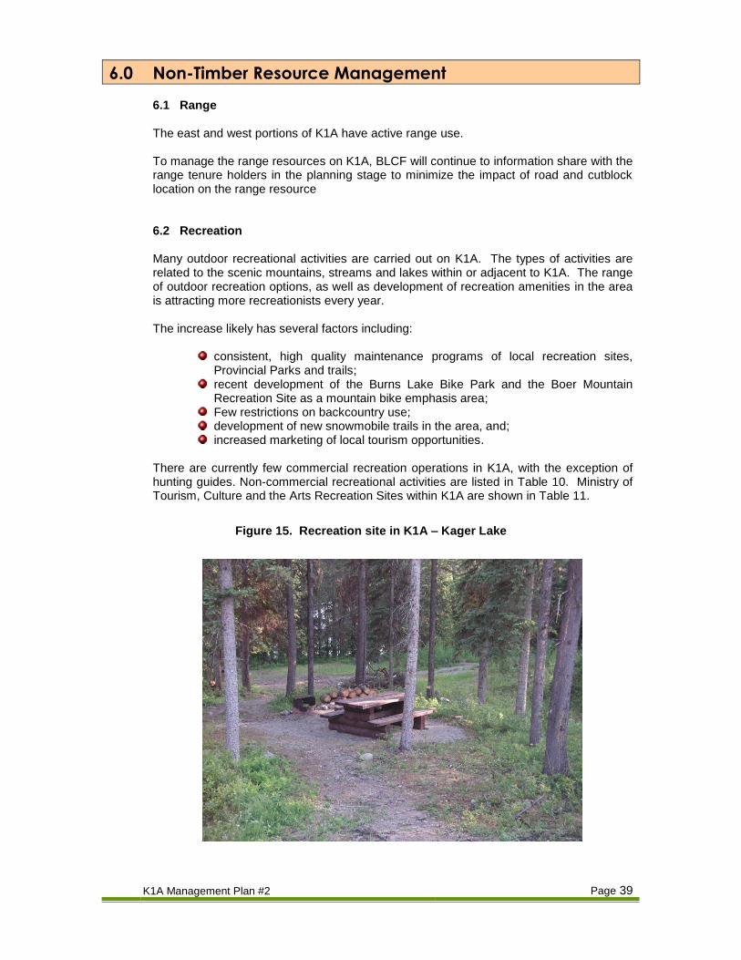
There are currently few commercial recreation operations in K1A, with the exception of hunting guides. Non-commercial recreational activities are listed in Table 10. Ministry of Tourism, Culture and the Arts Recreation Sites within K1A are shown in Table 11.
Figure 15. Recreation site in K1A – Kager Lake

K1A Management Plan #2 Page 40
Table 10. Non-Commercial Recreation Activities on K1A
Activity Location and Comments
Fishing Burns, Decker, Tchesinkut, Guyishton, Maxan, and Fish Lakes are all within the K1A tenure area. These lakes and numerous other small, unnamed lakes are fished regularly.
Hunting Hunting (deer, moose, grizzly bear, black bear, and cougar) takes place. A small amount of grouse and migratory bird hunting also takes place.
Hiking Hiking opportunities are numerous.
Canoeing and Kayaking
There is ample use of local lakes for both canoeing and kayaking.
Wildlife Viewing The forested land and riparian habitat offer a variety of viewing opportunities.
Sightseeing Views are excellent from the logging roads and highways 16 and 35.
Mountain Biking Mountain biking is popular in the Boer Mountain Recreation Site. The Burns Lake Bike Park property (private) is leased from BLCF by the Burns Lake Mountain Biking Association. Mountain biking elsewhere in K1A is light.
Snowmobiling Snowmobiling has been a popular recreation activity for many years. Old roads are used regularly by snowmobilers, and newly constructed snowmobile trail will likely result in increased use.
Cross-country skiing Some cross-country ski trails cross K1A from the Omineca Ski Club trails
Backcountry Skiing Backcountry ski opportunities exist although use is still light.
Table 11. Ministry of Tourism, Culture and the Arts Recreation Sites Within K1A
Site Site Objectives Activity and Comments
Bear Dens Recreation Trail
(Ministry of Forests established legal objectives)
“The objectives are, to manage the Bear Dens recreation trail for a natural recreation experience. The bed rock formations will be protected and all over story vegetation will be maintained within the site boundaries and 10 m on either side of the trail. The trail is to provide the opportunity for hiking, horseback riding and mountain biking activities. Motorized vehicles will not be permitted.
No roads will be constructed or cutblocks harvested within 10 m on either side of the trail.
The trail provides access to viewpoints overlooking Tchesinkut Lake and Burns Lake.
Guyishton Lake Recreation Trail
(Ministry of Forests established legal objectives)
“The objectives are, to manage the Guyishton Lake recreation trail for a natural recreation experience. The coniferous vegetation features will be maintained within 10 m of the trail. The trail is to provide the opportunities for hiking, mountain biking, horse back riding, and snowmobiling activities.”
No roads will be constructed or cutblocks harvested within 10 m on either side of the trail.
This series of trails links Highway 35 to Guyishton Lake. Other access is available via McKenzie Road off Highway 35.
Agate Point No legal objections established. This site is on the north shore of Tchesinkut Lake.
Kager/Long Lake, Star Lake
These recreation sites/trails are within the Boer Mountain Recreation Site. The site objectives would be determined by the Burns Lake Mountain Biking Association.
Recreation site on Kager Lake. Established multi-use recreation trails around Kager, Long and Star Lakes.
Maxan Lake Recreation Site
No legal objectives established. This site is on the west shore of Maxan Lake.
Eagle Creek/Opal Bed Recreation Site and Trails
No legal objectives established. This recreation site and series of trails is located in the vicinity of Eagle Creek Canyon north of Burns Lake.

K1A Management Plan #2 Page 41
To manage the recreational resources on or adjacent to K1A, BLCF will continue to:
Maintain access to important recreational areas and trail heads.
Work with the Ministry of Tourism, Culture and the Arts to maintain or enhance existing recreation sites and trails, and to identify and manage potential recreation sites and trails.
Work with the Ministry of Tourism Culture and the Arts to manage recreation sites and trails for public safety, aesthetic and environmental values
Work with commercial recreation firms to develop and/or maintain commercial recreation opportunities.
6.3 Visual The majority of K1A area consists of rolling hills down to valley bottoms often occupied by lakes of various size. Much of K1A is visible from Highway 16 and Highway 35. Much of the harvestable timber lies on slopes that are visible from valley bottom highways and lakes, and therefore harvesting can easily impact the scenic quality. Visual Quality Objectives have been set for the entire K1A area through Section 17 of the Government Actions Regulation (GAR) for scenic areas made known prior to October 24, 2002. A supplemental GAR order for visual quality objectives, effective April 1, 2010 has been incorporated into our inventories and plans. 6.4 Aquatic Resources Aquatic resources include fisheries and other resources associated with the lakes, streams, and wetlands of K1A. K1A encompasses Burns, Decker, Tchesinkut, and Fish Lakes, includes the Endako River, and many smaller streams and lakes. Most streams and wetlands in K1A have been classified. Fisheries are not the only values associated with riparian areas. For example, wetlands provide important habitat for some species of big game (i.e. moose) and many species of birds, small mammals, reptiles, and insects. BLCF has the following objectives relating to streams, lakes, and wetlands:
Maintain and protect the productive capacity of fish habitat,
Maintain streamside vegetation and the integrity of stream channels,
Prevent unnatural stream bank erosion, sedimentation, and introduction of woody debris,
Maintain the integrity of wetlands.
The objectives will be achieved by completing necessary riparian assessments and adhering to Forest Planning and Practices Regulation legislation and regulations. During planning and fieldwork on areas where watercourses exist, the following procedures are followed:
1. The correct classification for each stream, lake, or wetland will be determined (i.e. S1 to S6, L1 to L5, and W1 to W5).

K1A Management Plan #2 Page 42
2. Harvesting will be designed to protect the riparian reserve and management area.
3. Operating “windows” for in-stream work (i.e. for bridges and culverts) will be adhered to.
BLCF will determine correct classification of each stream, lake, or wetland by using the Forest Practices Code Guidebook or a Qualified Registered Professional. 6.5 Wildlife and Biological Diversity The K1A tenure area is rich in both the presence of individual wildlife species and in biological diversity. These resources are important to licensed users such as trappers and guide-outfitters as well as the general public who might enjoy viewing or simply knowing that these resources are present. Long-term wildlife tree patches (WTP) have been established on the land base to address forest and stand-level retention objectives. BLCF will maintain moose winter habitat, mule deer winter habitat, grizzly bear habitat as per the commitments stated in the approved Forest Stewardship Plan. K1A is covered primarily by the recently approved Lakes North Sustainable Resource Management Plan (SRMP) with a small portion of the Francois East landscape unit covered under the Lakes South Sustainable Resource Management Plan. Each of these plans prescribes minimum stand level retention requirements, and will be adhered to. As well as retention of mature forest, the patch size distribution, maintenance of wildlife trees, and access management are important factors in wildlife and biodiversity management. BLCF will strive to achieve the patch size targets specified in the Biodiversity Guidebook. BLCF recognizes that access management can be a very important tool in maintenance of wildlife populations. Access management is discussed in section 5.3.4.
7.0 Consultation With the Public and Other Resource Users The public have a special stake in K1A and BLCF. BLCF was born out of a desire by the people of Burns Lake to have more influence in forest management decisions in the area. BLCF has continued to provide consultation opportunities to the public as part of the regular processes of running the community forest. These may include:
Regular public meetings; A public Annual General Meeting; An annual report; A weekly column in the local newspaper; A bulletin board in the local mall; Press releases and announcements in the local newspaper advising the public of operations and achievements; and
An “open door” policy for public consultation.
As well, BLCF has provided the required public consultation opportunities for this Management Plan process.

K1A Management Plan #2 Page 43
7.1 Non-Timber Tenure Holders In K1A, non-timber tenure holders include guide-outfitters, trappers and range tenure holders. BLCF’s goal is to continue meaningful consultation with these tenure holders. Referrals will be mailed to these tenure holders as per the Forest Stewardship Plan. Additional information will be mailed or additional meetings will be scheduled when proposed harvest and/or road building activity is deemed to warrant additional consultation. A list of Stakeholders is included in Appendix 3. 7.2 First Nations BLCF must provide opportunities for information sharing with First Nations people within whose traditional territory K1A overlaps. BLCF shares information with First Nations groups as follows:
Letters: (including maps and digital data (as requested)), emails and follow-up letters inviting affected First Nations groups to view and comment on the Forest Stewardship Plan and Management Plan, and yearly planned development (blocks and roads). Affected First Nation groups are given a chance to comment on planned harvesting blocks and roads prior to the approval of Cutting Permits or Road Permits.
Meetings: BLCF staff meet with First Nations whenever such meetings are requested.
The list of First Nations groups who BLCF shares information with is provided in Appendix 3.
7.3 Public Review
Stakeholder notifications and advertisements have been conducted to give the public and interested parties ample time to review and comment on this management plan. Comments received for this management plan are summarized in Appendix Number 4.
8.0 Impact Summary of MP Implementation The impact of the implementation of this management plan will be low. Impacts are broken down into four categories below; annual cut levels, operation costs, employment, and biodiversity and habitat. Annual Cut Levels: The annual cut levels have increased from the original Management Plan. This is primarily due to the addition of operable harvest landbase, and the proposal to maximize the salvage of mountain pine beetle-affected stands within the first 5 years. BLCF will have to continue to maximize the harvestable landbase and carefully balance expenses with expected revenues. Harvest plans will be adjusted dependent on market conditions. Operation Costs: The impact on operating costs will be moderate to high.
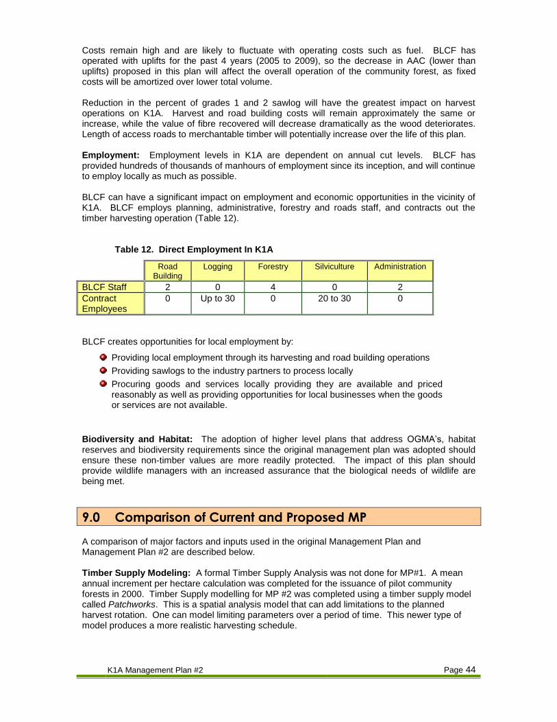
K1A Management Plan #2 Page 44
Costs remain high and are likely to fluctuate with operating costs such as fuel. BLCF has operated with uplifts for the past 4 years (2005 to 2009), so the decrease in AAC (lower than uplifts) proposed in this plan will affect the overall operation of the community forest, as fixed costs will be amortized over lower total volume. Reduction in the percent of grades 1 and 2 sawlog will have the greatest impact on harvest operations on K1A. Harvest and road building costs will remain approximately the same or increase, while the value of fibre recovered will decrease dramatically as the wood deteriorates. Length of access roads to merchantable timber will potentially increase over the life of this plan. Employment: Employment levels in K1A are dependent on annual cut levels. BLCF has provided hundreds of thousands of manhours of employment since its inception, and will continue to employ locally as much as possible. BLCF can have a significant impact on employment and economic opportunities in the vicinity of K1A. BLCF employs planning, administrative, forestry and roads staff, and contracts out the timber harvesting operation (Table 12).
Table 12. Direct Employment In K1A
Road Building
Logging Forestry Silviculture Administration
BLCF Staff 2 0 4 0 2
Contract Employees
0 Up to 30 0 20 to 30 0
BLCF creates opportunities for local employment by:
Providing local employment through its harvesting and road building operations
Providing sawlogs to the industry partners to process locally
Procuring goods and services locally providing they are available and priced reasonably as well as providing opportunities for local businesses when the goods or services are not available.
Biodiversity and Habitat: The adoption of higher level plans that address OGMA’s, habitat reserves and biodiversity requirements since the original management plan was adopted should ensure these non-timber values are more readily protected. The impact of this plan should provide wildlife managers with an increased assurance that the biological needs of wildlife are being met.
9.0 Comparison of Current and Proposed MP A comparison of major factors and inputs used in the original Management Plan and Management Plan #2 are described below. Timber Supply Modeling: A formal Timber Supply Analysis was not done for MP#1. A mean annual increment per hectare calculation was completed for the issuance of pilot community forests in 2000. Timber Supply modelling for MP #2 was completed using a timber supply model called Patchworks. This is a spatial analysis model that can add limitations to the planned harvest rotation. One can model limiting parameters over a period of time. This newer type of model produces a more realistic harvesting schedule.

K1A Management Plan #2 Page 45
Resource Inventories: For MP #2, BLCF used an updated Vegetation Resource Inventory with attributes updated to 2009, as well as comprehensive ecosystem mapping. Management Objectives: There have been no significant changes to the management objectives although the planning and management themselves have changed to better meet the stated objectives. Timber Resource Management: BLCF continues to use clearcut with reserves as the primary silviculture system on K1A. The size of opening has increased between 2001 and 2010 mostly in response to the extent of the mountain pine beetle epidemic. The focus has been on salvage of mountain pine beetle-affected stands and to a much lesser extent windthrow and spruce bark beetle salvage. Timber harvested from mountain pine beetle-affected stands is expected to contribute the clear majority of harvested volume for the term of this Management Plan. Non-Timber Resource Management: The proposed management plan involves harvesting (salvage) at an accelerated rate relative to the previous management plan. This is simply a continuation of salvage efforts to address epidemic level of mountain pine beetle on the K1A area which appeared in 2004 and have since killed the majority of susceptible pine on the landbase. There may be short-term negative impacts on non-timber resources as a result. However, it is felt the net results of increased salvage will be positive over the long-term and BLCF will do its best to mitigate short-term negative impacts to the extent possible.
10.0 Annual Report BLCF will continue to produce Annual Reports. BLCF has produced this document since its inception in 2000. It contains information on forest management activities, details how the community forest has met its Mission Statement objectives, and includes a financial report for the term of the report. This document has proven valuable in providing information to the public regarding all activity of the community forest, and how the community forest tenure continues to benefit the community as a whole. The Annual Report is distributed internally within BLCF as well as to the shareholder, the Corporation of the Village of Burns Lake, and to members of the public.