Embed Size (px)
Citation preview

1
London Borough of Hillingdon – Response to the Select Committee’s 14th and
15th July statements on preliminary conclusions
24 September 2015
Introduction
1. In its statements on 14 and 15 July, the Select Committee asked for reports or proposals to mitigate further the adverse effects of the proposed scheme in Hillingdon. On 14 July the Committee asked the Promoter to explore further how the impact of the Harvil Road construction on the community could be mitigated and to report back by mid-September, including:
Working with TfL and Hillingdon on their proposals to relocate the HS2 railhead to the
West Ruislip London Underground (LUL) depot.
Giving consideration to alternative means of road access from adjacent and nearby sites,
such as the haul road to Harvil Road.
2. On 15 July the Committee also requested:
Reassurance on traffic modelling.
A satisfactory compromise on the Hillingdon Outdoor Activities Centre (HOAC).
Significant further interventions in Hillingdon to mitigate the effect of the railway and its
construction on the community additional to those already envisaged.
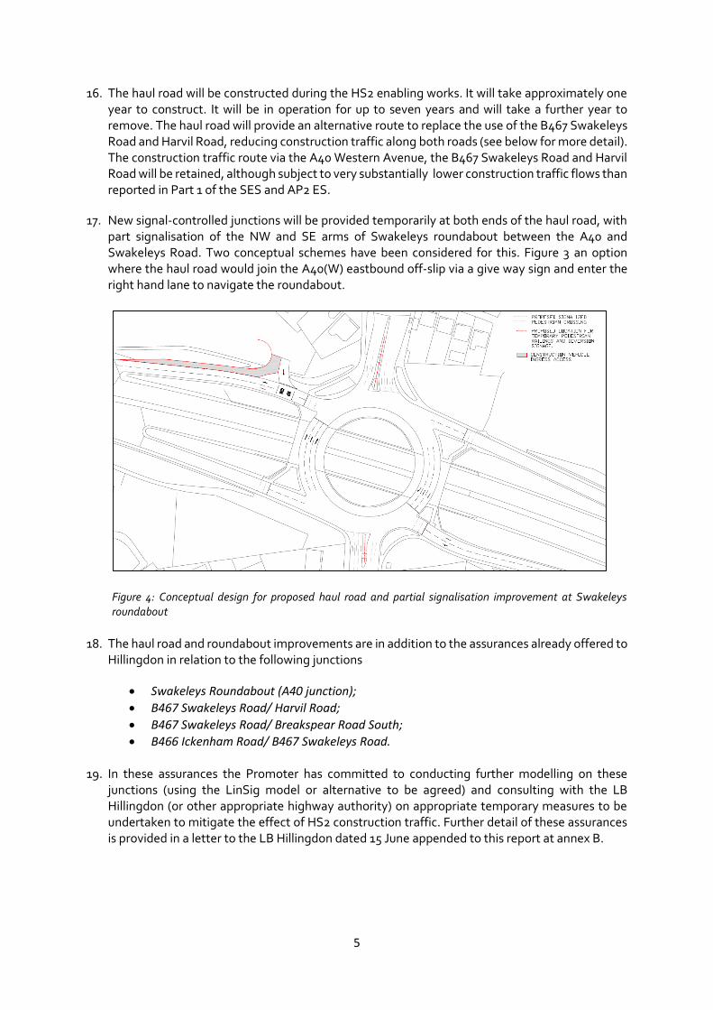
Proposals to reduce the impact on footpath amenity during construction.
Proposals to reduce the impact on local traffic during construction.
Consideration of a design competition for the Colne Valley viaduct.
3. Since July the Promoter has given further consideration to all these topics and has met with both LB Hillingdon and Transport for London (TfL) both separately and together to discuss the options for minimising the adverse effects of the proposed scheme in the area. Progress has been made on measures to address all these issues.
4. This response addresses the Committee’s instructions under four main sections:
SECTION 1: PROPOSED CONSTRUCTION TRAFFIC MITIGATION SECTION 2: POTENTIAL USE OF THE LUL DEPOT SECTION 3: HILLINGDON OUTDOOR ACTIVITIES CENTRE (HOAC) SECTION 4: FOOTPATHS DURING CONSTRUCTION SECTION 5: THE COLNE VALLEY VIADUCT – DESIGN, DEVELOPMENT, ENGAGEMENT AND PROCUREMENT STRATEGY

2
SECTION 1: PROPOSED CONSTRUCTION TRAFFIC MITIGATION
Summary
5. In addressing the Committee’s concerns over environmental and construction impacts resulting from the proposed HS2 West Ruislip railhead and construction compound, the Promoter has focussed on three main issues:
I. Reducing HGV construction traffic on the roads and improving traffic flows;
II. Reducing the need for sustainable placement in the area; and
III. Considering any potential role for the TfL LUL depot in delivering I and II above.
6. This work has concluded that the promotion of a construction haul road (included as part of Additional Provision 4 – AP4) and partial signalisation of Swakeleys roundabout (at a combined cost of just over £25m) will provide the most appropriate further mitigation of the traffic impacts in Ickenham resulting from the Scheme. These two measures reduce the maximum number of HGVs on Swakeleys Road (two way combined) from 1460 per day in AP2 to 500per day and will reduce the number of vehicles per hour from 73 HGVs per hour in each direction to 25 at the peak. And reduce the number of HGVs on Harvil Road from 960per day to 100 per day. It should be noted that these are all worst case scenario rather than estimated numbers. Furthermore the average junction delay at Swakeleys roundabout is reduced from 3.38/0.23 min (am/pm peak) in AP2 to 0.94/0.21min. HS2 modelling shows that the proposed Partial Signalisation of Swakeleys roundabout reduces delay in the non-HS2 traffic situation from 1.32 minutes to 0.56 minutes in the AM peak, which demonstrates a potential benefit post HS2. The proposed haul road and partial signalisation also significantly reduces the need for sustainable placement in the area and assurances have been provided in this regard.
7. A number of additional technical options have been identified which may either further reduce the traffic impacts potentially to a level whereby in consultation with the relevant authorities it may be concluded that the haul road is not needed. These include, but are not limited to, the continued investigation of options around design and re-use of material at the Copthall Cutting and changes to the construction programme in relation to the Harvil Road railhead sidings. The Promoter is committed to exploring these options and assurances will be offered in this regard.
8. In relation to the potential use of the LUL depot, the Promoter, TfL and the LB of Hillingdon have broadly agreed that the TfL depot does not provide a feasible single alternative for the HS2 west Ruislip railhead and construction compound1. Therefore the TfL depot could only be used in parallel to the proposed HS2 compound. This solution is not desirable for a number of technical, environmental and project reasons: it creates new and significant traffic impacts on West End Lane; it introduces new significant adverse effects (including noise and traffic) to Ruislip residents; it creates a bottleneck for trains removing spoil which may limit the Promoters capacity in this regard; it requires lengthy rail possessions and impacts existing services; it could add 1-2 years to the construction programme; and would cost between £60m to £90m more than the Bill Scheme to implement (excluding costs from programme delay). As such the Promoter does not propose to explore this option further. Further information on the points above is provided below and in appendix A to this report.
1 TfL and Hillingdon broadly agreed this position at a meeting on 28 August 2015 and as a result further discussions have focussed on use of the LUL depot in parallel to the HS2 railhead.

3
9. Since the Committee’s announcements the Promoter has met with TfL and Hillingdon on 6 separate occasions to discuss proposals, share modelling and discuss technical feasibilities.
Overview of traffic impacts under AP2
10. The Environmental Statement to AP2 assumes a peak of HS2 construction activity in LB Hillingdon of around 1460 HGVs per day (both directions combined) along Swakeleys Road in addition to baseline traffic. This is equivalent to a maximum number of HGVs per hour one way of 73. This is a pessimistic assessment assuming construction activities at compounds occur concurrently In reality, the estimate of construction traffic (rather than the most likely worst case predicted presented in the ES) is for a peak period of HS2 HGV construction traffic 0f 1060 HGVs gradually decreasing to a much lower rate of less than 200 vehicles per day for the majority of the construction programme. This trend is summarised in Figure 1 below. The geographical distribution of HS2 HGV construction traffic is shown diagrammatically in figure 2 below.
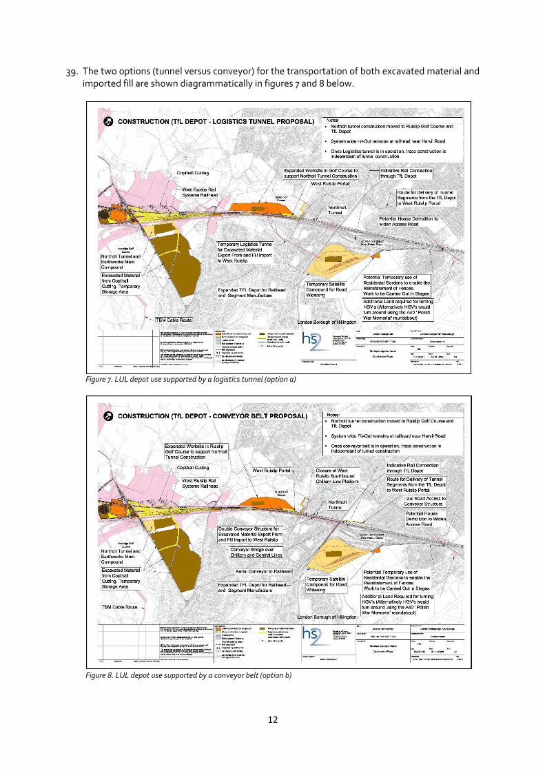
Figure 1. AP2 HGV traffic along Swakeleys Road, LB Hillingdon, throughout the construction phase. This demonstrates the significant higher AP2 daily flows (of 1460 per day) compared with the expected flow shown by the histogram.
Figure 2. Distribution of HS2 AP2 HGV construction traffic in LB Hillingdon2.
2 Approximately 73 HGV per hour (compared to the Baseline) have been assumed to enter Swakeleys roundabout from the A40 eastbound and turn to the north on Swakeleys Road between 0800 and 1800. For the same time periods, it has

4
11. Under AP2 the average junction delay (mins) at Swakeleys roundabout is expected to be 3.38 and 0.74 for the AM and PM peak respectively, compared to a baseline (without HS2 scenario) of 1.32min and 0.23min.
12. All of the above modelling 1) assumes that existing (non HS2 traffic) does not divert due to the additional HS2 HGV traffic, 2) excludes the likely mitigating impacts of Local Traffic Management Plans which would be agreed with the highway authority and 3) ignores any reduction in HGV numbers as the design for the scheme is refined. As such, these represent a reasonable but worst case assessment in this location.
Promoter’s mitigation proposals
13. Following the Committee’s statement the Promoter has explored a number of possible traffic improvements and proposes to bring forward two options in combination: a haul road enabling a direct route from the A40 to the West Ruislip site located between Harvil and Breakspear Roads and partial signalisation of Swakeleys roundabout.
14. In combination these two proposals will significantly mitigate the traffic impacts above.
15. The proposed haul road (which has been included in AP4) will connect at its southern end with the eastbound slip road adjacent to the A40 Western Avenue / B467 Swakeleys Road roundabout. The southern section of the haul road will pass to the west of - and parallel to - The Drive. The northern section will pass through Uxbridge Golf Course and land to the west of Harvil Road. The haul road will cross Harvil Road to enter the HS2 worksite.
Figure 3. Location of the proposed haul road
been assumed that 73 HGV will exit Swakeleys corridor via the A40 / Swakeleys Road roundabout and turn to the west on the A40 (westbound).
5
16. The haul road will be constructed during the HS2 enabling works. It will take approximately one year to construct. It will be in operation for up to seven years and will take a further year to remove. The haul road will provide an alternative route to replace the use of the B467 Swakeleys Road and Harvil Road, reducing construction traffic along both roads (see below for more detail). The construction traffic route via the A40 Western Avenue, the B467 Swakeleys Road and Harvil Road will be retained, although subject to very substantially lower construction traffic flows than reported in Part 1 of the SES and AP2 ES.
17. New signal-controlled junctions will be provided temporarily at both ends of the haul road, with part signalisation of the NW and SE arms of Swakeleys roundabout between the A40 and Swakeleys Road. Two conceptual schemes have been considered for this. Figure 3 an option where the haul road would join the A40(W) eastbound off-slip via a give way sign and enter the right hand lane to navigate the roundabout.
Figure 4: Conceptual design for proposed haul road and partial signalisation improvement at Swakeleys roundabout
18. The haul road and roundabout improvements are in addition to the assurances already offered to Hillingdon in relation to the following junctions
Swakeleys Roundabout (A40 junction);
B467 Swakeleys Road/ Harvil Road;
B467 Swakeleys Road/ Breakspear Road South;
B466 Ickenham Road/ B467 Swakeleys Road.
19. In these assurances the Promoter has committed to conducting further modelling on these junctions (using the LinSig model or alternative to be agreed) and consulting with the LB Hillingdon (or other appropriate highway authority) on appropriate temporary measures to be undertaken to mitigate the effect of HS2 construction traffic. Further detail of these assurances is provided in a letter to the LB Hillingdon dated 15 June appended to this report at annex B.
6
Transport impacts
20. In accordance with the TfL modelling guidelines3, the WeLHAM strategic SATURN model has been used to forecast the traffic flows in LB Hillingdon in AP2 and AP4, arising from the HS2 construction scenario to identify the likely impacts on congestion. In order to develop a more detailed design of the Haul road access at Swakeleys roundabout, and in accordance with the assurance given to LB Hillingdon, LinSig has been used to model the operation of Swakeleys roundabout to better understand the local impacts and to develop more refined options of the geometric layout of the junction and signal staging design. The same methodology for HGV movements has been used as the ES to the Bill and AP4 which represents a reasonable worst case scenario.
21. Table 1 below provides a summary of the traffic impacts (based on the model above) under the baseline (no HS2), AP2 and with the proposed haul road and partial signalisation. It includes HGV movements4 and junction delay data for Swakeleys roundabout5.
22. In summary:
The introduction of the haul road will remove 48 HGV vehicles per hour in each direction from Swakeleys Road, reducing the additional HS2 HGVs routing along Swakeleys Road between Swakeleys roundabout and Harvil Road from 73 to 25 vehicles per hour in each direction.
The introduction of the haul road will reduce the maximum HS2 HGVs per day on Swakeleys roundabout (two-way combined) as assessed in the ES from 1460 to 500, for the predicted 6-9 month period of peak construction activity.
The haul road and partial signalisation will reduce the average delay at Swakeleys roundabout, from 3.38 minutes to 0.94 minutes in the AM peak and from 0.74 minutes to 0.21 minutes in the PM peak compared with the hybrid bill AP2 scenario.
The HS2 Ltd modelling shows that partial signalisation of Swakeleys roundabout reduces delay in the non-HS2 traffic situation from 1.32 minutes to 0.56 minutes in the AM peak, which demonstrates that signalisation could provide a traffic management benefit post HS2 construction if the relevant authorities agreed to make it permanent.
3 https://tfl.gov.uk/cdn/static/cms/documents/traffic-modelling-guidelines.pdf 4 The table includes HGV movement data based on a worst case scenario using the same methodology used in the ES and SES to AP2 (WeLHAM strategic SATURN model). As described in paragraph 10 and shown in figure 1 these are significantly higher than the expected HGV movements. 5 The roundabout junction delay data is based on the LinSig model (as requested by the LB Hillingdon and in line with assurances offered in June 2015).

7
Swakeleys Road Harvil Road Average junction delay (mins) at Swakeleys roundabout
Scenario
Max HS2 HGVs per hour (one way)
Max HS2 HGVs per day (two-way combined)
Max HS2 HGVs per hour (one way)
Max HS2 HGVs per day (two-way combined)
AM peak
PM peak
Baseline6 (no HS2 traffic)
0 0 0 0 1.32 0.23
With HS2 construction traffic (AP2)
73 1460 48 960 3.38 0.74
With HS2 construction traffic (AP2) plus a haul road and partial signalisation
25 500 5 100 0.94 0.21
Baseline plus partial signalisation (i.e. post HS2)
0 0 0 0 0.56 0.25
Table 1: HGV movements on Swakeleys Road and Harvil Road using AP2 assumptions of demand. Junction delays at Swakeleys Roundabout using LinSig modelling as discussed with the LB Hillingdon and TfL and in line with assurances provided to LB Hillingdon on June 15th 2015. LinSig modelling for delays is a refinement to the modelling assessment tool use both in the main ES and for the ES for AP4.
23. Any additional improvements at the junctions described in paragraph 18 of this report which result from the assurances offered to Hillingdon on 15th June are likely to reduce further the impacts described in table 1 above. Traffic modelling is currently underway which will determine any necessary additional works at these junctions. In accordance with TfL modelling guidelines, HS2 Ltd will develop a micro-simulation (VISSIM) model to stimulate the movement of individual vehicles travelling within the local road network and to represent the interaction of the operation of the junctions along Swakeleys Road. The VISSIM model will be able to model the impact of variability upon network behaviour, being capable of representing complex traffic problems. This work will be shared with LB Hillingdon and TfL before the end of the year and will inform any further road junction improvements or traffic management measures required in the area, in line with assurances offered.
Sustainable placement impacts
24. The construction of the haul road provides the opportunity to significantly reduce (and potentially remove) the need for permanent and temporarysustainable placement at the southern sustainable placement site between Harvil and Breakspear Roads. This would be subject to further and ongoing discussions with the LB Hillingdon on potential impacts for HGV movements. The AP2 scheme is shown in figure 5 below and the area of sustainable placement which could be reduced is shown in figure 6.
6 The WeLHAM strategic SATURN model uses 2021 underlying demand to represent its non-HS2 baseline. LinSig uses 2014 counts to calculate the baseline.

8
Figure 5- Hybrid Bill scheme showing sustainable placement area to the south.
Figure 6 – Scheme with Haul road showing area of sustainable placement to the south to be significantly reduced or potentially removed.
25. An assurance will be included on the register in relation to the commitment of the Promoter in regards to delivering a reduction in sustainable placement in this area should the proposals outlined in this report be accepted.

9
Environmental impacts
26. The proposed haul road will have an increased impact on Uxbridge Golf Course temporarily. However, the Promoter has engaged with a golf course designer and is confident it is possible to maintain a playable competition 9 hole course for the duration of the works which will mitigate any potential losses. The Promoter continues to engage with the LB Hillingdon and the golf course on this. If reasonable mitigation is agreed and taken forward and notwithstanding this the golf course still suffers a demonstrable loss, this will be compensable under the Compensation Code. Once the construction is completed the haul road will be removed and in line with schedule 15 a restoration scheme will be agreed with the relevant parties.
27. The haul road will also pass through Frays Farm Meadows SSSI resulting in the direct loss of up to 0.3ha of wet grassland and 0.1ha of other mixed habitat, and temporary effects on 1.5ha of mixed habitat. Mitigation measure will include habitat reinstatement once the haul road is no longer in operation. In isolation, these measures are unlikely to be sufficient to reduce the adverse effect to a level that is not significant. Additional compensation proposals to address any residual effects will be developed in consultation with relevant landowners, the London Wildlife Trust and Natural England. Measures may include habitat enhancement within the unaffected areas of the SSSI and habitat creation. Mitigation measures will be required to address effects on Pinnocks Wood associated with changes in air quality. Measures may include habitat enhancement in the unaffected are of the woodland and habitat creation. This would be brought forward in conjunction with relevant landowners.
Cost and programme impacts
28. The haul road and partial signalisation is estimated to cost £25m. Whilst the haul road will take one year to construct this will begin early enough in the programme to secure the maximum benefit from its use and so as not to delay the project overall.
Other future mitigation options
29. The Promoter recognises that it may be possible to avoid the need for the haul road though detailed construction planning measures (and in consultation with the LB Hillingdon), which may achieving the same traffic mitigating effects whilst avoiding the adverse environmental impacts noted above. These are engineering details to be considered at detailed design and the contract preparation stage in accordance with the Environmental Minimum Requirements (EMRs). However, the Promoter is seeking to bring these investigations forward in so far as is reasonably practicable.
30. These include:
I. Following Ground Investigations it may be possible to increase the gradient of the Copthall cutting, thereby reducing the amount of spoil to be removed and/or to re-use some of the locally excavated material.
II. Working with Network Rail with a view to providing the Harvil Road railhead sidings earlier in the construction programme to reduce the import of material with a view to reducing the import of material via HGVs and potentially further reducing the requirement for sustainable placement.
III. The Nominated Undertaker will engage with the relevant highway authority, transport providers and other relevant stakeholders, including the LB Hillingdon in the preparation of a construction workforce travel plan for HS2 workers in the LB Hillingdon area. This will

10
include engagement in relation to the use of sustainable modes of transport with a view to reducing the impacts of HS2 related workforce travel in Hillingdon on local residents and businesses, insofar as they are consistent with the Environmental Minimum requirements, and do not require the nominated undertaker to secure additional statutory powers to construct the facilities mentioned in or require anything to be done which may unacceptably interrupt the HS2 construction programme in any way.
IV. Local Environment Management Plans (LEMPs) and Traffic Management Plans (TMPs). Prior to the commencement of the works in Hillingdon, the nominated undertaker will ensure that Traffic Management plans (TMPs) will be produced in consultation with the highway and traffic authorities and the emergency services. The nominated undertaker and/or its contractors will engage with the local community, Local Authorities and other stakeholders in Hillingdon in order to develop the Local Environment Management Plans which are applicable to Hillingdon during detailed design and during construction planning.
31. Assurances will be offered to the LB Hillingdon in relation to the points above.

11
SECTION 2: POTENTIAL USE OF THE LUL DEPOT
32. The West Ruislip construction sites proposed in the Bill are necessary to implement three elements of the Proposed Scheme – 1) to build the Northolt tunnel, 2) to build the trace between the tunnel and the Colne Valley viaduct, and 3) to implement the rail systems fit out (track, signalling, overhead electrification, lineside equipment etc.) between Euston and South Heath (approximately 25 km in each direction).
33. The Promoter met with both LB Hillingdon and TfL and commissioned Parsons Brinkerhoff (PB) to review the merits of a railhead and logistics centre at Ruislip Depot including the TfL proposal, and Mott McDonald & ETM to undertake a preliminary construction planning and environmental assessment. These documents were forwarded to both TfL in May 2015 and TfL responded on 23 June with comments on the PB report.
34. Following the Committee’s statement , the Promoter has commissioned further work from Mott MacDonald to review the implications of the Ruislip Depot options and to consider TfL’s comments on the earlier PB May report in the light of the revised proposals for Copthall cutting. The sift analysis from this review are attached at annex A to this report.
Use of the LUL depot as a replacement for the railhead
35. In order to complete the rail fit out of HS2, a location is required with direct rail access to the HS2 trace in both directions, space for reception, loading and dispatch sidings and a space for materials delivery, storage and transfer. Whilst the location proposed by the Promoter meets these requirements, the TfL depot does not. As such it is now agreed by all parties that LUL depot cannot replace wholesale the proposed HS2 railhead and compound in delivering these elements of the works in this area7
36. As a result any use of the TfL depot would need to be in parallel with, not as an alternative to, the HS2 west Ruislip rail head.
Uses for the LUL depot in conjunction with the HS2 site
37. Given the conclusions above, the Promoter conducted further analysis on the potential to use the LUL depot to alleviate construction impacts in the area based on it being used for the following potential functions: tunnel support (manufacture of tunnel segments and removing excavated material from tunnelling), the import of structural fill to build HS2 railway embankments, and the export of material from the Copthall cutting.
38. The fundamental challenge for the proposal is how to transport the tunnel and cutting excavations and the imported construction materials to and from the LUL depot and the HS2 worksites on the other side of the Chiltern Mainline. TfL proposed a conveyor for the excavated material (option b) along the west side of the Metropolitan and over the Chiltern and Central Lines at the intersection of the two lines. It would then continue on the north side of the Chiltern Line through West Ruislip station, under Ickenham Road to the West Ruislip portal and the trace. Tunnel segments and other building materials would be delivered to the trace by road and the rail systems fit out would be served by rail as in the Promoter’s proposal. The Promoter also asked Mott MacDonald to explore options for a logistics tunnel (option a) between the depot and the portal under the residential area.
7 Meeting of 28 August 2015
12
39. The two options (tunnel versus conveyor) for the transportation of both excavated material and imported fill are shown diagrammatically in figures 7 and 8 below.
Figure 7. LUL depot use supported by a logistics tunnel (option a)
Figure 8. LUL depot use supported by a conveyor belt (option b)

13
40. Both of the options outlined above have significant environmental and project impacts which are described in the sift report provided at annex A to this report:
I. Potential temporary possession of a number of residential gardens and permanent acquisition of a strip of a school playing field would be required to widen the existing single lane access road to the LUL depot in order to make this suitable for HGV movements. This may also require the demolition of one residential property. This is shown in figure 9 below.
Figure 9- Showing access road requirements including residential garden space and potential house demolition. (note: impact on school playing fields not shown]
II. Additional Greenbelt land and nature reserve land would be taken from a semi-rural location to an urban environment to extend the LUL depot. Furthermore, land in the ownership of third parties would also need to be acquired. This is shown above and in figure 10 below

14
Figure 10- Red line shows the existing required extension of the LUL depot boundary to accommodate the HS2 works. Which includes taking land currently in the green belt and grade 1 nature conservation land.
III. The West Ruislip satellite construction site would need to be increased in size to accommodate the transfer of the main tunnelling worksite from Harvil Road to West Ruislip portal. This would result in closure of the South Ruislip golf course to facilitate this enlargement. The size of this compound in AP2/Bill Scheme and with the proposed haul road are shown in figures 5 and 6, compared to an increase in size for either LUL depot option (figures 7 and8).
IV. Northern sustainable placement areas can be removed but very large stockpile areas would be required at Harvil Road.
V. The majority of the HGV traffic flows during the busy peak period of construction (up to 1060 HGVs per day) are due to the importation of fill for the railway embankments. In order to mitigate further delays to the programme (to allow for construction of the TfL depot expansion & logistics tunnel), this material must still be brought in to the construction sites by road. Based on the current programme, with the depot option the majority of the material for embankment construction would therefore be brought in via the A40 (and the Polish War Memorial junction) , generating some 960 HGVS per day (two-way combined) on the north section of West End Road, Wood Lane and Ickenham Road. In addition, a further 180 vehicles per day would be generated on the south section of West End Road by the depot expansion plus construction of the West Ruislip portal. Because of the major movement restrictions at the TFL depot access off West End Road HGV movements between the depot and West Ruislip would need to travel southwards to u turn at the Polish War Memorial junction thus effectively nearly doubling HS2 HGV flows on this section of West End Road. However, the traffic flows on Swakeleys Road and Harvil road could be reduced to less than 100 HGVs per day.

15
Swakeleys Road Harvil Road West End Road (north), Wood Lane & Ickenham Road
Scenario
Max HS2 HGVs per hour (one way)
Max HS2 HGVs per day (two-way combined)
Max HS2 HGVs per hour (one way)
Max HS2 HGVs per day (two-way combined)
Max HS2 HGVs per hour (one way)
Max HS2 HGVs per day (two-way combined)
Baseline 0 0 0 0 0 0
With HS2 construction traffic (AP2)
73 1460 48 960 0 0
AP2 plus a haul road and partial signalisation
25 500 5 100 0 0
AP2 plus use of LUL depot
5 <100 5 <100 48 960
Table 2: HGV movements on Swakeleys Road, Harvil Road and West End Lane using AP2 assumptions of demand.
VI. The LUL depot has disadvantages in terms of the efficient use of rail capacity compared to the HS2 railhead. The HS2 railhead is located such that access is provided onto the Chiltern Mainline for trains travelling both eastbound and westbound and is planned to accommodate 400m long trains. In contrast, LUL depot can only be accessed off the Chiltern Line from the west and this access is not arranged to take 400m long trains (restricted to shorter length trains of 200m). For eastbound trains departing the LUL depot, the trains need to access the Chiltern Line westbound and then proceed eastwards. This operation requires two locomotives (one at either end) and two train paths. These restrictions could severely limit the capacity to remove spoil by rail in this area.
VII. An additional provision to the Bill would need to be promoted.
41. Additional impacts (above those described in para 40) of option a (logistics tunnel) include:
I. 5m internal diameter logistics tunnel would pass through different ground conditions to the Northolt tunnel including an area of with poor/less competent ground which introduces a number of risks which cannot be overcome using pressure balance machines. These risks include the potential for settlement impacts on residential area. This would only be able to be confirmed through more detailed Ground Investigations work.
II. 24 hour operations for tunnelling will result in noise and light impacts for some residents.
III. Would add £95m to the cost of the project (excluding delay costs and additional property costs).
IV. Would delay the project by up to 2 years.

16
42. Addition impacts (above those described in para 40) of option b (conveyor belt) include:
I. Above ground conveyor requires a large raised conveyor bridge structures next to residential properties. This will be operational 24 hours per day which will have significant noise and light impacts.
II. Requires lengthy Chiltern Line and LUL railway possessions to construct conveyors (for extended weekends or longer) and closure of the West Ruislip Station Chiltern Line Southbound for the duration of the construction (6 years).
III. Would add £60m to the cost of the project (excluding delay costs and additional property costs).
IV. Would delay the project by up to one year.
43. The Committee suggesting using RAF Northolt as a potential haul road between the LUL depot and the A40 which was considered and the Ministry of Defence (MOD) were consulted on this matter who in turn consulted subject matter experts. In summary, RAF Northolt is not considered a feasible option for this use based on a number of security, technical and environmental issues. Specifically:
The route of the proposed haul road is across a designated Nature Conservation site of Metropolitan or Borough Grade 1 of importance.
The proposed entry point to the west of the site is abutted by the Yeading Brook which would require the existing bridge to be upgraded.
All vehicles accessing the site would have to be booked onto the base and the driver’s security cleared – it is thought that this could add 30 mins to the journey. There is currently no security provision at this location and therefore one would have to be created and manned for the duration which could be up to 10 years. If any driver does not have security clearance then that vehicle would have to be escorted whilst on site. The route would require vehicles transiting in areas where aircraft manoeuvre which would require the driver to hold an airfield driving permit for which a test has to be taken or again the vehicle will need to be escorted if the driver does not have a permit.
FOD (Foreign Object Debris) – All vehicles would have to transit the base with covered vehicles, with wheel wash areas provided at entry and exit points.
Safeguarding – Whatever route is chosen to get to the A40 vehicles will either have to cross the runway or access over aircraft taxi ways. Such access is controlled by traffic lights operated by air traffic control and all air related traffic would take primacy over vehicular traffic potentially adding to delays.
There is a significant risk of traffic queuing to exit the base towards the west of the site which would infringe runway safety zones/surfaces counter to Military Aviation Authority regulations

17
List of annexes to this section of the report:
Annex A: Stage 1 appraisal of options to relieve Harvil Road, Swakeleys road and Ickenham road traffic impacts
Annex B: Assurance letter issued to LB Hillingon on 15 June
SECTION 3: HILLINGDON OUTDOOR ACTIVITIES CENTRE (HOAC) 1. Since the Select Committee’s announcement on the Colne Valley tunnel, HS2 Ltd has had
meetings with the Denham Quarry operator (Summerleaze) and the planning authorities (Buckinghamshire County Council and South Bucks District Council). These meetings have covered, in particular, the size of lake which could be created on this site along with the anticipated timescale of any staged approach.
2. These meetings were constructive and productive, and there is a clear way forward.
3. Summerleaze has confirmed that the land needed for a relocation of HOAC to the site by April 2018 will be available in time for the necessary construction works, and it would be possible to create a 25 acre lake of a suitable shape in the same timescale. There are some practical issues that need to be worked through, for example in relation to the phasing of Summerleaze’s works, but these were not considered to be unsolvable.
4. They believe that, subject to planning approval, a much larger lake could be delivered in stages between 2018 and 2020. In effect they would extract minerals moving south to north, continually releasing sections of the growing lake for recreational use as their works progress northwards.
5. They have also indicated that they have plans for further quarrying in this area beyond the enlarged site, which we have been exploring with them, and that there would be an opportunity for HOAC to influence the restoration proposals required as part of any future expansion.
6. This would be separate to the planning applications set out below, but it demonstrates the great potential of a wider site.
7. HS2 Ltd has also had productive discussions with the planning authorities to clarify the next steps which will have to be taken to submit applications for the necessary consents to re-provide HOAC’s facilities at the existing Denham Quarry site. We have, in particular, discussed a ‘twin tracked’ planning application, by which we would seek consent for the works necessary to relocate HOAC by 2018, against the background of that being a first stage of a wider scheme to ultimately provide for a larger lake on the site.
8. The planning authorities have considered the question of the final size of the lake further since we last reported on this. They are now of the view that it should be ultimately possible to approve an application for a lake of up to 45 acres, which is the size requested by HOAC.
9. So, in summary, subject to planning approval being granted, it should be possible to relocate HOAC to the Denham Quarry site with a 25 acre lake by 2018, with the possibility of gradually increasing the size of the lake thereafter, by potentially up to 45 acres by 2020.
10. HS2 Ltd have appointed a dedicated team to deliver a successful relocation. The next step is to prepare the planning application setting out more details of the location and configuration of facilities as well as the lake itself for stage one. We have told HOAC that we would not wish to do this without their active participation as their input is clearly critical to ensuring that the

18
scheme prepared for submission to the planning authorities meets their operational needs. This was communicated to HOAC on 5 August 2015.
11. HOAC confirmed that they were prepared to work with HS2 Ltd’s dedicated team in this regard on 10 September 2015, and the first meeting was held at their site on 18 September.
12. Beyond the planning considerations, HOAC have indicated that they have some financial concerns around the relocation, mostly relating to the transition to the bigger lake. HS2 Ltd have previously requested further information regarding those concerns which would allow this to be considered further, and we await receipt of the same. We understand that HOAC are also concerned that the London Borough of Hillingdon may withdraw their funding (c£55k pa) if they were to relocate. Whilst this would seem surprising given the Council’s statements about the importance in retaining this valuable community facility, we will continue to seek an assurance from the Council that the new location would not be a material consideration in their continued funding of HOAC.
13. We will keep Select Committee informed of future developments on both the funding issues and progress on the planning application.

19
SECTION 4: FOOTPATHS DURING CONSTRUCTION 1. The Secretary of State has provided the following assurance to LB Hillingdon with regards to Public
Rights of Way (PROW):
I. The Secretary of State will require the Nominated Undertaker to use reasonable endeavours
to provide for diversions of the public rights of way shown on the attached drawings (U49 U50
Diversion), (U43 U45 U46 Diversion), (U36 U37 U38 Diversion) (“the Drawings”) and which are
broadly in accordance with the arrangements described in the construction phasing summary
attached at Appendix 1.
II. The Promoter shall remain open to further discussions with LBH to consider alternative routes
for any necessary diversions of the public rights of way to those shown on the Drawings so far
as reasonably practicable and which are:-
a. within the limits and powers set out in the HS2 Act; and
b. do not create any new or different significant impacts that have not been assessed in
the Environmental Statement for the Bill.
2. Amore detailed description of the diversions are listed below. There remains 2 PROWs that HS2
need to discuss in greater detail with LBH (U47 and U81) to agree the appropriate mitigation
measures to provide a reasonable diversion.LBH and HS2 have agreed to hold further discussions
in relation to highways including PROWS when all the necessary information is available by the end
of September.
Diversions in West Ruislip and Ickenham
3. There a number of Public Rights of Way (PROW) in the West Ruislip area, between the River Pinn
and Breakspear Road South, which require temporary diversions to facilitate the HS2 construction
activities and permanent diversion to facilitate the HS2 alignment. Temporary diversions that were
proposed in the main Environmental Statement (ES) are in the process of being reviewed subject
to the development of more detailed information on the phasing of works and consequent
alternative diversionary routes.
Revised temporary diversion of footpaths U36, U37 and U38
4. The Bill provides for the temporary closure of footpaths U36, U37 and U38 during deposition of
sustainable placement materials north of Newyears Green Lane. The Bill assumed the concurrent
closure of footpaths U36, U37 and U38 and a diversion utilising Breakspear Road North and the
existing footpath west of Bayhurst Wood. The main ES stated that diversion of footpaths U36, U37
and U38 would be required for a period of approximately 7 years. Since submission of the Bill,
revised temporary diversionary routes for footpaths U36, U37 and U38 are proposed based on the
intended phasing of sustainable placement of excavated materials in this area.
5. The revised temporary diversion routes are as follows:
footpaths U36 and U37 will remain in their current position with only one being
closed at any one time, therefore maintaining a link between footpath U35 and

20
Newyears Green Lane with a diversion distance of less than 200m during each
closure; and
footpath U38: diverted approximately 700m, around the sustainable placement
site, within the field boundaries along the northern edge of Newyears Green Lane
and western edge of Breakspear Road North. The footpath is to be segregated
from the deposition works by a temporary fence.
6. These diversion routes and closures will only be in place during the deposition of excavated
materials at the sustainable placement areas, which will commence in Q2 2018 and last for
approximately 15 months. Where temporary haul routes intersect the alignment of footpaths U36
and U37, crossing points will be in place to ensure users of the public rights of way can cross the
alignment of the haul routes in a safe manner.
7. This is shown in U36 U37 U38 Diversions.pdf attached to this report.
Revised temporary diversion of footpath U49
8. The Bill provides for the temporary closure and diversion of footpath U49 to accommodate the
Northolt Tunnel and Earthworks Main Compound and areas for sustainable placement. The
diversion route proposed for footpath U49 in the main ES was approximately 2000m long, from
the start of footpath U49, south on Breakspear Road South and Swakeleys Road and north along
Harvil Road. The diversion would have been for a period of approximately seven years, with
permanent reinstatement along its existing alignment.
9. Since submission of the Bill, a revised diversion route for footpath U49 has been developed and is
now proposed. Footpath U49 will be diverted approximately 850m along the south-eastern edge
of the Northolt Tunnel and Earthworks main construction compound and part way along the
western boundary, adjacent to Harvil Road. The footpath is to be segregated from the works with
a temporary fence and from Harvil Road by the existing hedgerow/fence. The diversion of footpath
U49 will be in place for the full duration of construction works in this area (2017-2026).
10. Where the alignment of the revised diversion is intersected by a temporary haul road associated
with sustainable placement, crossing points will be in place to ensure users of the public right of
way can cross the alignment of the haul route in a safe manner. The temporary haul route is
anticipated to be in place for approximately 3 years.
11. This is shown in U49 U50 Diversions.pdf attached to this report.
Revised temporary diversion of footpaths U43, U45 and U47
12. The Bill provides for the temporary closure of footpath U43 for a period of approximately 3 months
and diversion via U45, U46 and Breakspear Road South whilst the proposed flood compensation
area, across which the footpath passes, is excavated. Footpaths U45 and U47 would be temporarily
closed following reinstatement of footpath U43, for approximately 7 years, for the construction of
a new embankment and railway bridge over the River Pinn. The proposed diversionary route is via
the Celandine Route, Breakspear Road South and footpath U43.

21
13. Since submission of the Bill, a replacement diversion route for footpath U43 has been proposed,
based on phasing of the construction of the replacement floodplain storage area. Initially, footpath
U43 will be diverted along Footpath U45, along the east side of the River Pinn, to the adjacent
footpath U46 (170m to south) during construction. At this stage of construction footpath U46 will
still be in use. Footpath U43 will then be diverted along a route parallel to Breakspear Road South.
This is a diversion of approximately 280m. Footpath U43 will be closed for approximately two
months commencing in 2017. The verges on Breakspear Road South between footpaths U43 and
U46 are narrow and comprise a small bund then a drainage channel. Therefore, to divert the path
along a route parallel Breakspear Road South, the creation of a temporary footpath along the
western side of the road is necessary. HS2 is further assessing measures to segregate the
aforementioned footpath and will provide more detail once the assessment is complete.
14. Footpath U45 will be temporarily closed from late June 2017. It will be diverted along the reinstated
footpath U43, along a route parallel to Breakspear Road South via a temporary footpath to a
temporary footbridge over the River Pinn, to join up with footpath U47 and the Celandine Route
to the south of the Chiltern Main Lines. FootpathU45 will remain closed during the construction of
the embankment, River Pinn bridge, Breakspear Road South bridge and to allow for the removal of
the haul road alongside these works. This is expected to last for approximately one year
commencing in 2017.
15. The proposed alternative diversion route for footpath U47 is the reverse of the situation proposed
for footpath U45. The section of footpath U47 adjacent the River Pinn will remain closed during
the construction of the River Pinn bridge and whilst the haul road crossing the footpath is in use.
This is expected to last for approximately 14 months commencing in 2017.
16. The temporary footpath and footbridge will be required to provide access across the River Pinn to
allow the proposed diversion route of U45 to connect Breakspear Road South to footpath U47 and
the Celandine Route. A temporary footpath will also be required alongside Breakspear Road South
from Grays Cottages to Gatemead Farm. Temporary user controlled crossings may be required to
allow safe crossing of Breakspear Road South. Temporary narrowing of Breakspear Road under the
Chiltern Main Line is necessary to provide two-way traffic with a segregated walking route on the
east side of the bridge. HS2 is currently in the process of further assessing traffic safety measures
to segregating traffic and pedestrians and will be discussing these with LBH further.
17. This is shown in U43 45 46 Diversions.pdf attached to this report.
Revised temporary diversion of footpaths U81
18. HS2 is continuing to undertake further works to better assess appropriate mitigation measures for
this PROW and will be providing LBH with appropriate drawings and possible alternative routes by
the end of September.

22
SECTION 5: The Colne Valley Viaduct - Design Development, Engagement and Procurement Strategy
Summary
1. At the Select Committee’s request the Promoter has given further consideration to the proposal
to hold an international design competition for the Colne Valley viaduct. Having done so the
Promoter remains of the view that the processes it will employ will ensure high quality design
and, that an international design competition would not deliver any benefit over and above this.
The reasons for this are set out below.
The Design Vision and the Design Panel
2. The HS2 Design Vision published on 23 March 2015, will help to drive design excellence in every
aspect of HS2 to achieve social, economic and environmental potential. The Design Vision will
underpin all aspects of design. The objective is to provide direction and to form part of the
requirements for any contract involving design and therefore ensure the HS2’s potential is
realised in line with the Design Vision and principles. HS2 Ltd will apply this Design Vision to all
aspects of the HS2 experience.
3. The HS2 Design Vision sets out nine principles grouped under the three themes of People, Place
and Time. These principles, set the common context for all HS2 design decisions. The design
vision is a platform for driving high quality design practice at HS2.
4. HS2 Ltd’s Design Panel is set up in line with the mandate from the Secretary of State for
Transport, as set out in 2012, “To ensure high quality design along the HS2 route, and to give
communities confidence that they will be as sensitive as possible to the character of their setting.”
In addition further site specific design panels have been set up in response to Assurances made
in the hybrid bill. The Design Panel is chaired by Sadie Morgan.
5. The Design Panel will provide independent advice and critique of the development of HS2 to help
achieve its Design Vision. It will work to ensure that design decisions deliver against the Design
Vision, consider the needs of a range of audiences and people, and ensure the process is robust
and transparent. A core design principle of HS2’s Design Vision is ‘People: Design for everyone to
benefit and enjoy’ which includes engaging with communities over the life of the project. Section
2 of the Design Vision states:
“HS2 is a project that will affect many communities. There are interests to serve at a national,
regional and local level. Designing HS2 is all about meeting social and economic aspiration and
opportunity.
Where a particular impact is unwanted, design is there to find the best solution. In order to
respond effectively to community concern and need, it is important to have strong design
engagement.”

23
6. Given its scale and setting, the design of the Colne Valley Viaduct is of notable interest to the
Design Panel as a key structure. The Design Panel has confirmed that the Colne Valley Viaduct
will be the subject of a dedicated panel review process. This process will ensure a high quality
design for the Colne Valley Viaduct within the context of its setting.
7. In addition it is important to note that the Design Policy, the Design Vision and Design Panel will
not sit in isolation from the other controls on the project, such as the Environmental Minimum
Requirements (EMRs), the planning regime specified in Schedule 16 of the Bill and engagement
with local communities on design outcomes. These will combine to influence design
development and form a robust process for ensuring the high quality design outcomes.
Competition in Procurement – the Promoter’s Approach
8. As a key design element, the Promoter will engage the public on the design development of the
Colne Valley Viaduct. While the exact form and nature of such engagement will be developed
closer to the time, it is likely to be an open engagement exercise, with public exhibitions, leaflet
drops and on-line materials and related publicity. As stated in the Promoter's Design Policy
(Information Paper D1), any engagement on key design elements, such as the Colne Valley
viaduct, is likely to focus on engaging the public in the locality of that element. The Promoter
intends to publish more detail on how it will engage with communities at the design development
stage in due course.
9. HS2 Ltd will shortly be undertaking an international procurement exercise for the design and
construction of the main civil elements of HS2 Phase One, including the Colne Valley Viaduct.
Given the nature of these contracts they will attract significant interest from the leading design
and engineering companies that specialise in national infrastructure projects throughout the
world. This will ensure that all elements of HS2 have world-leading design.
10. With the appointment of the Chair of the Design Panel and the establishment of the Design Panel
itself the Promoter has shown its commitment to embedding good design at the heart of all it
does. The Terms of Reference of the Design Panel identify that the Design Panel will have a role
in scrutinising how design requirements are incorporated into the key stages of the procurement
of design contracts. To this end the Design Panel have been invited to review and consider the
design specifications stated in the procurement documents for these civils contracts.
An international design competition
11. The Promoter does not consider there to be compelling evidence to demonstrate that an
international design competition would produce a better design than that which will be achieved
by the processes it intends to employ. These processes will be highly competitive and will
undoubtedly attract the best designers and design teams in the world.
12. Whilst it is recognised that design competitions can result in high quality design outcomes, they
also have a series of potential drawbacks:

24
By their nature international design competitions tend to generate designs developed in
isolation rather than through the level of community engagement that HS2 envisages for its
own civils design;
Design of a railway viaduct relies on significant integration between, amongst other things,
structures, railway systems, safety measures and environmental considerations. For
structures to be capable of being built and incorporating all technical requirements designs
for structures cannot be designed in isolation. The constraints of a design competition mean
that this level of integration cannot be achieved during the competition stage, which may
result in a design that requires substantial later amendment;
An international design competition for the Colne Valley Viaduct would delay the overall
procurement programme for HS2 Phase One, as this element would need to be removed
from the current contracts and then the successful civils contractor would need to amend the
winning architect’s design for deliverability. All of which would add cost and time to the
process.
13. Through the Promoter’s proposed approach to procurement it is considered that many of these
issues above can be avoided, while ensuring that high quality design outcomes are achieved.
Conclusion
14. Whilst the value of having an international design competition, or any competition, is that it can
generate in an open way a choice of concepts from which the competition winner can be picked
and unacceptable designs can be eliminated. The Promoter is however already committed to a
design process and governance process that involve public engagement, independent review,
and a vision for a high quality design to meet the needs of all stakeholders. This is enshrined in
the Information Papers and corresponding assurances to Parliament, the establishment of a
project-wide Design Panel with an independent chairperson, and other assurances given to
Parliament relating to consultation.
15. The Colne Valley Viaduct will be one of the Key Design Elements to be considered by the Design
Panel who will seek to challenge the design process against the stated Design Vision.
16. The procurement of design and construction packages as contemplated by the Promoter will
necessarily be by an international competition, and will involve careful consideration of quality
and competence.
17. For these reasons, HS2 remains of the view that at this point in time, an international design
competition offers no substantive benefits to the design development process beyond those
which will be achieved through the Promoter’s approach.

HS2 C221 Package 1b - London Metropolitan INTERNAL
Colloquial Name
Chainage
Description of Existing Structure
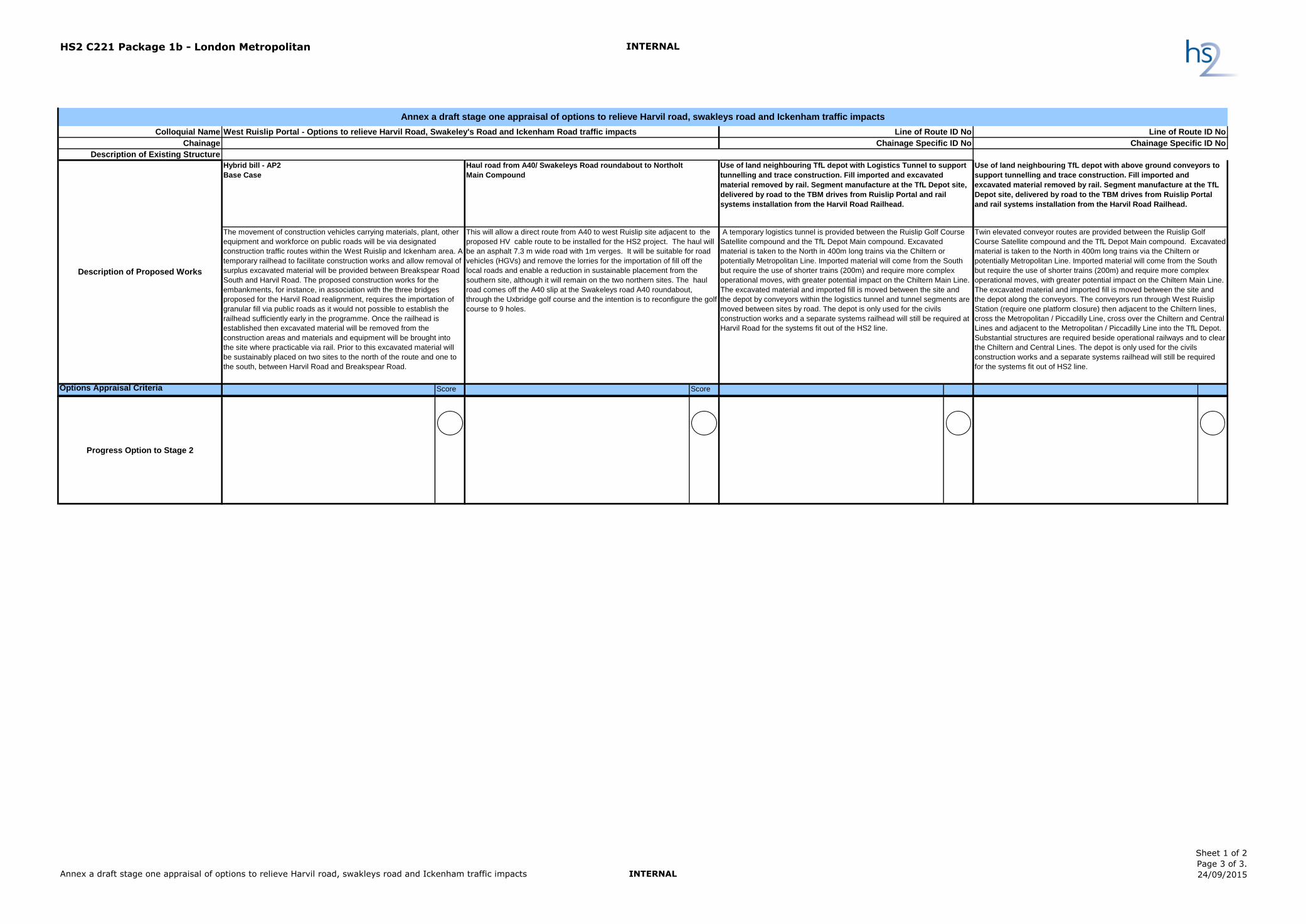
Hybrid bill - AP2
Base Case
Haul road from A40/ Swakeleys Road roundabout to Northolt
Main Compound
Options Appraisal Criteria Score Score
Strategic Fit
Meets the project objective for opening date in 2026. Single
location for Railheads.
Meets the project objective for opening date in 2026. Single
location for Railheads
Does not meet the project objective for opening date in 2026.
Requires railhead, in two locations both at West Ruislip and TFL
Depot.
Does not meet the project objective for opening date by 1 year.
Requires railhead, in two locations both at West Ruislip and TFL
Depot.
Construction Feasibility
Feasible. Defined sequence of work required to meet
programme. Some excavated of Copthall Cutting required to
construct railhead requiring Sustainable Placement for
excavated material, prior to railhead operation.
Feasible. Haul road is required to be constructed early in the
programme.
Potentially feasible but involves the use of untried and untested
technology through the use of vertical conveyors used to transport
materials downwards in shafts. Additional works required to
construct Logistics Tunnel in poor ground.
Potentially feasible but complex with large structures required to
be installed over existing railway corridors at crossing of the
Central lines and Chiltern lines. Significant structures to be
constructed within rail corridor and works will require significant
possessions of the railway lines.
Costs ( excludes property costs)
£0 +£25m +95m +60m (excludes Chiltern Trains compensation costs)
Environment (excluding Traffic related
effects)
Residents on Harvil Road are predicted to experience in-
combination effects due visual effects from views of the
sustainable placement of surplus excavated materials on
land between Harvil Road and Breakspear Road South.
Impact on Uxbridge and Ruislip Golf Courses and
relocation of Great Crest Newts required. 24 hour
operation for tunnelling support along trace - noise and
light impact.
Reduced sustainable placement but increased impact on
Uxbridge Golf Course and SSSI. Additional land take. 24 hour
operation for tunnelling support along trace - noise and light
impact.
Northern Sustainable placement areas can be removed but very
large stockpile area required at Harvil Road. Additional green belt
land and nature reserve land taken from semi rural location to
Urban environment. Closure of uxbridge golf course for enlarged
construction site. Temporary possession of gardens and
permanent school playing field required for construction of haul
road and one house potentially requires demolishing to enable
access for HGVs to depot. 24 hour operation for tunnelling
support and logistics tunnel construction from TfL depot - noise
and light impact.
Sustainable placement areas can be removed but some stockpile
areas required at Harvil Road and Ruislip Golf Course. Additional
green belt land and nature reserve land taken from semi rural
location to Urban environment. Closure of uxbridge golf course for
enlarged construction site. Temporary possession of gardens and
permanent school playing field required for construction of haul
road and one house potentially requires demolishing to enable
access for HGVs to depot. 24 hour operation for tunnelling
support from TfL depot - noise and light impact.
Visual and noise impact of 24 hour raised above ground conveyor
very close to residential properties (2nd/3rd storey). Closure of
Chiltern Line Southbound platform.
Traffic
Significant HGV traffic on Swakeleys Road due to import of fill
early in construction causing delays and congestion to vehicle
users and also impacts from noise and air pollution.
Decrease in congestion on Swakeleys road but with additional
effects to rear of properties due to use of the haul road
Reduction in traffic on Swakeleys and Harvil Road.
Reduce traffic on A40 Roundabout
Some increase in traffic on West End land and Long Lane
Reduction in traffic on Swakeleys and Harvil Road.
Reduce traffic on A40 Roundabout
Some increase in traffic on West End land and Long Lane
Line of Route ID No
Chainage Specific ID No
Use of land neighbouring TfL depot with above ground conveyors to
support tunnelling and trace construction. Fill imported and
excavated material removed by rail. Segment manufacture at the TfL
Depot site, delivered by road to the TBM drives from Ruislip Portal
and rail systems installation from the Harvil Road Railhead.
Twin elevated conveyor routes are provided between the Ruislip Golf
Course Satellite compound and the TfL Depot Main compound. Excavated
material is taken to the North in 400m long trains via the Chiltern or
potentially Metropolitan Line. Imported material will come from the South
but require the use of shorter trains (200m) and require more complex
operational moves, with greater potential impact on the Chiltern Main Line.
The excavated material and imported fill is moved between the site and
the depot along the conveyors. The conveyors run through West Ruislip
Station (require one platform closure) then adjacent to the Chiltern lines,
cross the Metropolitan / Piccadilly Line, cross over the Chiltern and Central
Lines and adjacent to the Metropolitan / Piccadilly Line into the TfL Depot.
Substantial structures are required beside operational railways and to clear
the Chiltern and Central Lines. The depot is only used for the civils
construction works and a separate systems railhead will still be required
for the systems fit out of HS2 line.
Annex a draft stage one appraisal of options to relieve Harvil road, swakleys road and Ickenham traffic impacts
A temporary logistics tunnel is provided between the Ruislip Golf Course
Satellite compound and the TfL Depot Main compound. Excavated
material is taken to the North in 400m long trains via the Chiltern or
potentially Metropolitan Line. Imported material will come from the South
but require the use of shorter trains (200m) and require more complex
operational moves, with greater potential impact on the Chiltern Main Line.
The excavated material and imported fill is moved between the site and
the depot by conveyors within the logistics tunnel and tunnel segments are
moved between sites by road. The depot is only used for the civils
construction works and a separate systems railhead will still be required at
Harvil Road for the systems fit out of the HS2 line.
The movement of construction vehicles carrying materials, plant, other
equipment and workforce on public roads will be via designated
construction traffic routes within the West Ruislip and Ickenham area. A
temporary railhead to facilitate construction works and allow removal of
surplus excavated material will be provided between Breakspear Road
South and Harvil Road. The proposed construction works for the
embankments, for instance, in association with the three bridges
proposed for the Harvil Road realignment, requires the importation of
granular fill via public roads as it would not possible to establish the
railhead sufficiently early in the programme. Once the railhead is
established then excavated material will be removed from the
construction areas and materials and equipment will be brought into
the site where practicable via rail. Prior to this excavated material will
be sustainably placed on two sites to the north of the route and one to
the south, between Harvil Road and Breakspear Road.
Use of land neighbouring TfL depot with Logistics Tunnel to support
tunnelling and trace construction. Fill imported and excavated
material removed by rail. Segment manufacture at the TfL Depot site,
delivered by road to the TBM drives from Ruislip Portal and rail
systems installation from the Harvil Road Railhead.
Description of Proposed Works
West Ruislip Portal - Options to relieve Harvil Road, Swakeley's Road and Ickenham Road traffic impacts
This will allow a direct route from A40 to west Ruislip site adjacent to the
proposed HV cable route to be installed for the HS2 project. The haul will
be an asphalt 7.3 m wide road with 1m verges. It will be suitable for road
vehicles (HGVs) and remove the lorries for the importation of fill off the
local roads and enable a reduction in sustainable placement from the
southern site, although it will remain on the two northern sites. The haul
road comes off the A40 slip at the Swakeleys road A40 roundabout,
through the Uxbridge golf course and the intention is to reconfigure the golf
course to 9 holes.
Line of Route ID No
Chainage Specific ID No
Annex a draft stage one appraisal of options to relieve Harvil road, swakleys road and Ickenham traffic impacts INTERNAL
Sheet 1 of 2
Page 1 of 3.
24/09/2015
HS2 C221 Package 1b - London Metropolitan INTERNAL
Colloquial Name
Chainage
Description of Existing Structure
Hybrid bill - AP2
Base Case
Haul road from A40/ Swakeleys Road roundabout to Northolt
Main Compound
Options Appraisal Criteria Score Score
Line of Route ID No
Chainage Specific ID No
Use of land neighbouring TfL depot with above ground conveyors to
support tunnelling and trace construction. Fill imported and
excavated material removed by rail. Segment manufacture at the TfL
Depot site, delivered by road to the TBM drives from Ruislip Portal
and rail systems installation from the Harvil Road Railhead.
Twin elevated conveyor routes are provided between the Ruislip Golf
Course Satellite compound and the TfL Depot Main compound. Excavated
material is taken to the North in 400m long trains via the Chiltern or
potentially Metropolitan Line. Imported material will come from the South
but require the use of shorter trains (200m) and require more complex
operational moves, with greater potential impact on the Chiltern Main Line.
The excavated material and imported fill is moved between the site and
the depot along the conveyors. The conveyors run through West Ruislip
Station (require one platform closure) then adjacent to the Chiltern lines,
cross the Metropolitan / Piccadilly Line, cross over the Chiltern and Central
Lines and adjacent to the Metropolitan / Piccadilly Line into the TfL Depot.
Substantial structures are required beside operational railways and to clear
the Chiltern and Central Lines. The depot is only used for the civils
construction works and a separate systems railhead will still be required
for the systems fit out of HS2 line.
Annex a draft stage one appraisal of options to relieve Harvil road, swakleys road and Ickenham traffic impacts
A temporary logistics tunnel is provided between the Ruislip Golf Course
Satellite compound and the TfL Depot Main compound. Excavated
material is taken to the North in 400m long trains via the Chiltern or
potentially Metropolitan Line. Imported material will come from the South
but require the use of shorter trains (200m) and require more complex
operational moves, with greater potential impact on the Chiltern Main Line.
The excavated material and imported fill is moved between the site and
the depot by conveyors within the logistics tunnel and tunnel segments are
moved between sites by road. The depot is only used for the civils
construction works and a separate systems railhead will still be required at
Harvil Road for the systems fit out of the HS2 line.
The movement of construction vehicles carrying materials, plant, other
equipment and workforce on public roads will be via designated
construction traffic routes within the West Ruislip and Ickenham area. A
temporary railhead to facilitate construction works and allow removal of
surplus excavated material will be provided between Breakspear Road
South and Harvil Road. The proposed construction works for the
embankments, for instance, in association with the three bridges
proposed for the Harvil Road realignment, requires the importation of
granular fill via public roads as it would not possible to establish the
railhead sufficiently early in the programme. Once the railhead is
established then excavated material will be removed from the
construction areas and materials and equipment will be brought into
the site where practicable via rail. Prior to this excavated material will
be sustainably placed on two sites to the north of the route and one to
the south, between Harvil Road and Breakspear Road.
Use of land neighbouring TfL depot with Logistics Tunnel to support
tunnelling and trace construction. Fill imported and excavated
material removed by rail. Segment manufacture at the TfL Depot site,
delivered by road to the TBM drives from Ruislip Portal and rail
systems installation from the Harvil Road Railhead.
Description of Proposed Works
West Ruislip Portal - Options to relieve Harvil Road, Swakeley's Road and Ickenham Road traffic impacts
This will allow a direct route from A40 to west Ruislip site adjacent to the
proposed HV cable route to be installed for the HS2 project. The haul will
be an asphalt 7.3 m wide road with 1m verges. It will be suitable for road
vehicles (HGVs) and remove the lorries for the importation of fill off the
local roads and enable a reduction in sustainable placement from the
southern site, although it will remain on the two northern sites. The haul
road comes off the A40 slip at the Swakeleys road A40 roundabout,
through the Uxbridge golf course and the intention is to reconfigure the golf
course to 9 holes.
Line of Route ID No
Chainage Specific ID No
Safety
HS2 HGV traffic on public highways Separation of HS2 construction traffic and public vehicles
but A40 roundabout needs to be managed and potentially
revised for construction vehicles entering from Haul Road.
Requires additional tunnelling in difficult ground conditions.
Removes traffic from Swakeleys road and A40 but requires
turning of HGVs off West End Road and HGV traffic
through shops and smaller roads and works required to
restricted junction off West End Road.
Requires significant construction at height and within
railway environment presenting additional hazards for
construction staff, passengers and residents. Construction
of tracks and running of trains through live depot will need
to be carefully managed. Removes traffic from Swakeleys
road and A40 but requires turning of HGVs off West End
Road and HGV traffic through shops and smaller roads and
works required to restricted junction off West End Road.
Assurances/Commitments
Agreements required with Hillingdon over Uxbridge and
Ruislip Golf Courses.
Agreements required with Hillingdon over Uxbridge and Ruislip
Golf Courses.
Complex contractual agreement required with TfL / LU / NR /
Hillingdon to set out detailed arrangements / rights /
responsibilities for all parties for operation of the depot, HS2 train
pathing and the construction compound. Agreements required
with Hillingdon over shutting Uxbridge Golf Course.
Complex contractual agreement required with TfL / LU / NR /
Hillingdon to set out detailed arrangements / rights /
responsibilities for all parties for operation of the depot, HS2 train
pathing and the construction compound. Agreements required
with Hillingdon over shutting Uxbridge Golf Course.
Agreement required to close Chiltern Line platform at West
Ruislip Station.
Key Risks
Short term delays due to deliveries stuck in traffic congestion.
Copthall Cutting excavation and trace construction delays
railhead and tunnel construction.
Limited train paths slows work and/or requires additional
sustainable placement
Copthall Cutting excavation and trace construction delays railhead
and tunnel construction.
Limited train paths slows work and/or requires additional HGVs on
haul road
Completion of haul road after required start of peak imported
material demand period.
Use of golf course cannot be maintained.
Consents/ approvals take longer than programmed.
Tunnelling in difficult ground proves unfeasible/unsafe or more
complex than assumed
Unfeasibility to use vertical conveyor for downward movement of
excavated material
Increase in road traffic as importation of fill and/or exportation of
excavated material by rail is insufficient to meet programme. Risk
significantly increased by requirements to move material from/to
the south requiring shunting on Chiltern Line and simultaneous
north and south train paths.
Incompatibility of depot rail operations with HS2 train paths
requirements, including HS2 trains potentially being delayed by
LUL passenger services.
Relocation of exiting Depot rail infrastructure and revisions of
depot layout cannot be achieved in time to meet HS2 programme.
Use of short trains to access the depot requires more train paths
that available
Consents/ approvals take longer than programmed.
Construction of conveyor structures proves unfeasible/unsafe or
more complex than assumed
Closure of Chiltern Line platform is unacceptable
Increase in road traffic as importation of fill and/or exportation of
excavated material by rail is insufficient to meet programme. Risk
significantly increased by requirements to move material from/to
the south requiring shunting on Chiltern Line and simultaneous
north and south train paths.
Incompatibility of depot rail operations with HS2 train paths
requirements, including HS2 trains potentially being delayed by
LUL passenger services.
Relocation of exiting Depot rail infrastructure and revisions of
depot layout cannot be achieved in time to meet HS2 programme.
Use of short trains to access the depot requires more train paths
that available
Opportunities for Development
HS2 Maintenance sidings HS2 Maintenance sidings Legacy benefit to TfL with expanded depot site. Legacy benefit to TfL with expanded depot site.
Annex a draft stage one appraisal of options to relieve Harvil road, swakleys road and Ickenham traffic impacts INTERNAL
Sheet 1 of 2
Page 2 of 3.
24/09/2015
HS2 C221 Package 1b - London Metropolitan INTERNAL
Colloquial Name
Chainage
Description of Existing Structure
Hybrid bill - AP2
Base Case
Haul road from A40/ Swakeleys Road roundabout to Northolt
Main Compound
Options Appraisal Criteria Score Score
Line of Route ID No
Chainage Specific ID No
Use of land neighbouring TfL depot with above ground conveyors to
support tunnelling and trace construction. Fill imported and
excavated material removed by rail. Segment manufacture at the TfL
Depot site, delivered by road to the TBM drives from Ruislip Portal
and rail systems installation from the Harvil Road Railhead.
Twin elevated conveyor routes are provided between the Ruislip Golf
Course Satellite compound and the TfL Depot Main compound. Excavated
material is taken to the North in 400m long trains via the Chiltern or
potentially Metropolitan Line. Imported material will come from the South
but require the use of shorter trains (200m) and require more complex
operational moves, with greater potential impact on the Chiltern Main Line.
The excavated material and imported fill is moved between the site and
the depot along the conveyors. The conveyors run through West Ruislip
Station (require one platform closure) then adjacent to the Chiltern lines,
cross the Metropolitan / Piccadilly Line, cross over the Chiltern and Central
Lines and adjacent to the Metropolitan / Piccadilly Line into the TfL Depot.
Substantial structures are required beside operational railways and to clear
the Chiltern and Central Lines. The depot is only used for the civils
construction works and a separate systems railhead will still be required
for the systems fit out of HS2 line.
Annex a draft stage one appraisal of options to relieve Harvil road, swakleys road and Ickenham traffic impacts
A temporary logistics tunnel is provided between the Ruislip Golf Course
Satellite compound and the TfL Depot Main compound. Excavated
material is taken to the North in 400m long trains via the Chiltern or
potentially Metropolitan Line. Imported material will come from the South
but require the use of shorter trains (200m) and require more complex
operational moves, with greater potential impact on the Chiltern Main Line.
The excavated material and imported fill is moved between the site and
the depot by conveyors within the logistics tunnel and tunnel segments are
moved between sites by road. The depot is only used for the civils
construction works and a separate systems railhead will still be required at
Harvil Road for the systems fit out of the HS2 line.
The movement of construction vehicles carrying materials, plant, other
equipment and workforce on public roads will be via designated
construction traffic routes within the West Ruislip and Ickenham area. A
temporary railhead to facilitate construction works and allow removal of
surplus excavated material will be provided between Breakspear Road
South and Harvil Road. The proposed construction works for the
embankments, for instance, in association with the three bridges
proposed for the Harvil Road realignment, requires the importation of
granular fill via public roads as it would not possible to establish the
railhead sufficiently early in the programme. Once the railhead is
established then excavated material will be removed from the
construction areas and materials and equipment will be brought into
the site where practicable via rail. Prior to this excavated material will
be sustainably placed on two sites to the north of the route and one to
the south, between Harvil Road and Breakspear Road.
Use of land neighbouring TfL depot with Logistics Tunnel to support
tunnelling and trace construction. Fill imported and excavated
material removed by rail. Segment manufacture at the TfL Depot site,
delivered by road to the TBM drives from Ruislip Portal and rail
systems installation from the Harvil Road Railhead.
Description of Proposed Works
West Ruislip Portal - Options to relieve Harvil Road, Swakeley's Road and Ickenham Road traffic impacts
This will allow a direct route from A40 to west Ruislip site adjacent to the
proposed HV cable route to be installed for the HS2 project. The haul will
be an asphalt 7.3 m wide road with 1m verges. It will be suitable for road
vehicles (HGVs) and remove the lorries for the importation of fill off the
local roads and enable a reduction in sustainable placement from the
southern site, although it will remain on the two northern sites. The haul
road comes off the A40 slip at the Swakeleys road A40 roundabout,
through the Uxbridge golf course and the intention is to reconfigure the golf
course to 9 holes.
Line of Route ID No
Chainage Specific ID No
Progress Option to Stage 2
Annex a draft stage one appraisal of options to relieve Harvil road, swakleys road and Ickenham traffic impacts INTERNAL
Sheet 1 of 2
Page 3 of 3.
24/09/2015