Embed Size (px)
Citation preview
Location of the Old Kingdom Pyramids in Egypt
Miroslav Bârta
The principal factors influencing the location of the Old Kingdom pyramids in Egypt are reconsidered. The decisive factors influencing their distribution over an area of c. eighty kilometres were essentially of economic, géomorphologie, socio-political and unavoidably also of religious nature. Primary importance is to be attributed to the existence of the Old Kingdom capital of Egypt, Memphis, which was a central place with regard to the Old Kingdom pyramid fields. Its economic potential and primacy in the largely redistribution-driven state economy sustained construction of the vast majority of the pyramid complexes in its vicinity. The location of the remaining number of the Old Kingdom pyramids, including many of the largest ever built, is explained using primarily archaeological evidence. It is claimed that the major factors influencing their location lie in the sphere of
general trends governing ancient Egyptian society of the period.
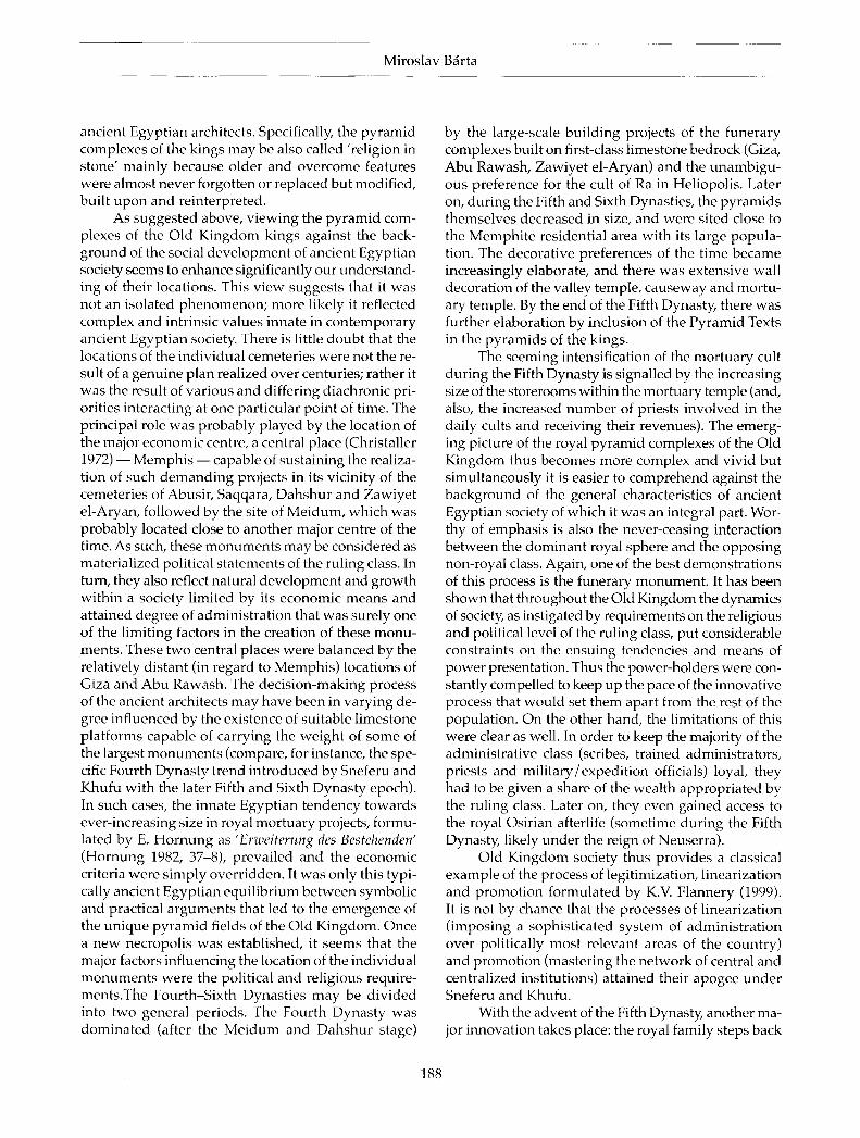
F o r millennia, megaliths and monumental arts were commissioned by the local chieftains and later by the kings of Egypt. The ideological reasons connected with the construction and symbolism of the pyramids were manifold, and in most cases obvious: the manifestation of power, status and supremacy over the territory and population, the connection with the sacred world and the unlimited authority of the rulers (O'Connor & Silverman 1995). One may wonder, however, what the decisive factors were that influenced the specific locations of these monuments. In this study, the reasons that may have played a decisive role in the spatial distribution of the Old Kingdom pyramids (built during the 27th-22nd century BC, i.e. during the Third (2649-2575 BC), Fourth (2575-2465 BC), Fifth (2465-2323 BC) and Sixth (2323-2150 BC) Dynasties 1) will be discussed. These monuments are scattered along the western bank of the Nile from the city of Cairo about 80 km southwards, reaching the northern frontier of the Fayum Oasis (Fig. 1).
From the Old Kingdom period twenty-two pyramids are known that served as tombs for the deceased kings. These were studied with varying degrees of detail and accuracy. The following are the principal sites (north to south): Abu Rawash, Giza, Zawyiet el-Aryan, Abusir, Saqqara, Dahshur and Meidum (for detailed information on each of the Old Kingdom
pyramids see Edwards 1993; Fakhry 1961; Hawass 2003; Lehner 1997; Stadelmann 1985; 1990; Vallogia 2001; Verner 2002; Dodson 2003). The reasons that may be put forward to explain their location and arrangement are numerous but may be divided into two basic groups: practical and religious. It will be argued that whereas the general pattern in the distribution of the pyramid sites may be due mainly to practical reasons, the intrasite structure might have been largely influenced by religious concepts as well. By default, there were certain universal preconditions that every burial place of the king had to meet: a clearly distinguishable place set off from other parts of the cemetery, location on the western bank of the Nile, in transitional zones between the valley and the Western Desert plateau, yet above the valley itself. When finished, the pyramids became an inseparable part of the local topography, a feature which is also sometimes indicated by their names such as 'Horizon of Khufu' in the case of the pyramid complex of Khufu in Giza (Richards 2000; Bradley 2000,18-32). Their characteristics — the highest places on the western horizon — expressed clearly the idea of the transition and connection between the profane and divine world personified by the king and his achievements (Arnold 1997). Dealing with the overall site distribution, this study focuses on practical factors, which, fortunately enough, may be
Cambridge Archaeological journal 15:2, 177-91 © 2005 McDonald Institute for Archaeological Research
DOI: 10.1017/S0959774305000090 Printed in the United Kingdom.
Miroslav Bärta
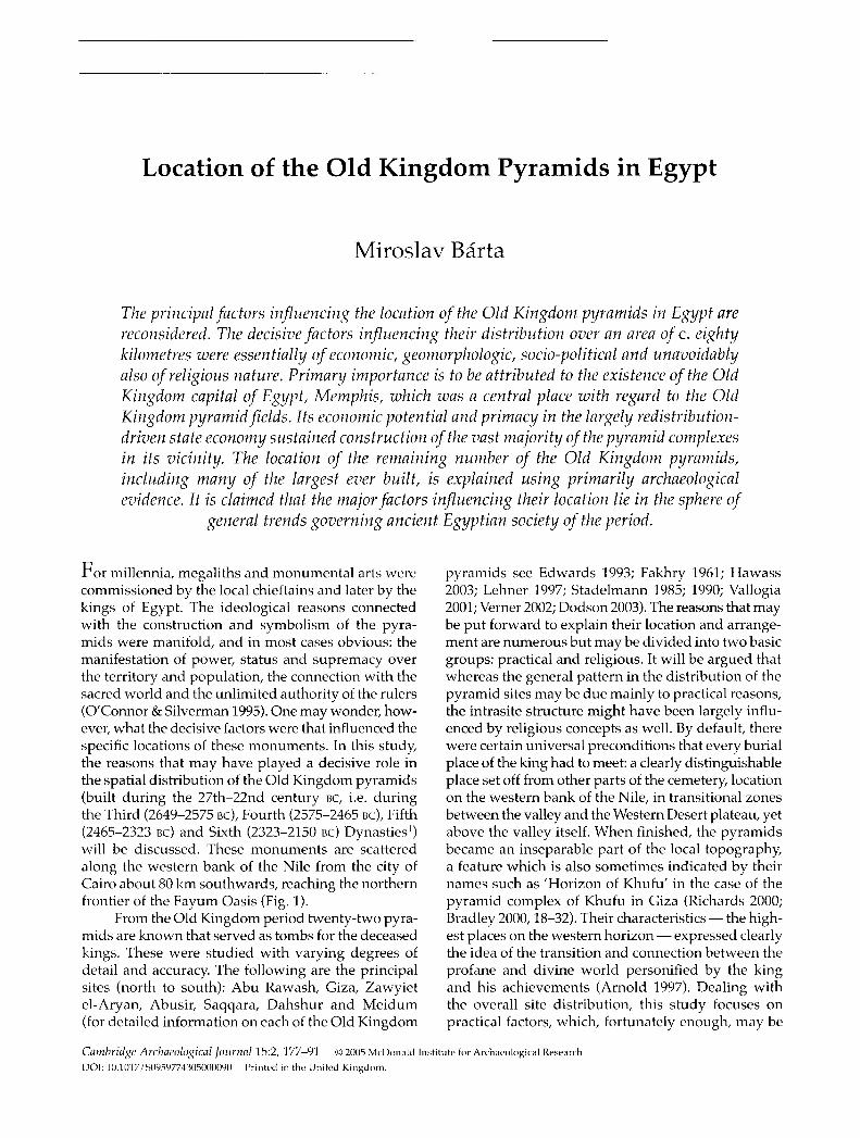
Figure 1. Location of the pyramid fields of the Old Kingdom Rawash; 2) Giza; 3) Zawyiet el-Aryan; 4) Abusir; 5) Saqqarc 7) Meidum.
better verified by praxis and the sober evaluation of the pertinent, predominantly archaeological data.
Each of the Old Kingdom pyramid complexes consisted of five essential components: the valley temple, the causeway, the pyramid temple, the cult pyramid and the pyramid itself. The valley temple was
built at its eastern end, closest to the valley It was the true entrance into the complex, usually situated near the water. From the rear part of the building a causeway ascended on the rocky plateau of the Western Desert leading into the mortuary temple. Here the priests performed daily ritual offerings for the soul of the deceased king. Adjoining the western end of the temple was a pyramid protecting the proper burial place of the Egyptian king. The pyramid itself was the most monumental element of the pyramid complex and as such it necessitated the major expenditure of economic resources of the state and physical labour. The size of individual pyramids is given in Table 1.
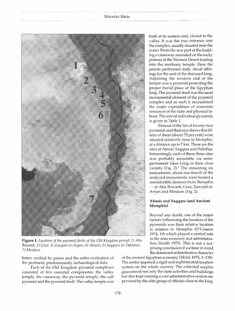
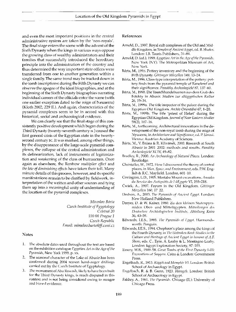
Perusal of the list of twenty-two pyramids and their size shows that fifteen of them (about 75 per cent) were situated relatively close to Memphis, at a distance up to 7 km. These are the sites of Abusir, Saqqara and Dahshur. Interestingly, each of these three sites was probably accessible via semipermanent lakes lying in their close vicinity (Fig. 2) . 2 The remaining six monuments, about one-fourth of the analyzed monuments, were located a considerable distance from Memphis — at Abu Rawash, Giza, Zawyiet el-Aryan and Meidum (Fig. 2).
Abusir and Saqqara (and Ancient Memphis)
Beyond any doubt, one of the major factors influencing the location of the pyramids was their relative location in relation to Memphis (O'Connor 1974,19) which played a central role in the state economy and administration (Smith 1975). This is not a surprising conclusion if we bear in mind the dominant redistributive character
of the ancient Egyptian economy (Helck 1975,3-138). The centre imposed a rigid and sophisticated taxation system on the whole country. The collected surplus guaranteed not only the state activities and buildings but also kept running a vast administrative system supervised by the elite group of officials close to the king.
period: 1) Abu <; 6) Dahshur;
178
Locat ion of the Old Kingdom Pyramids in Egypt
I - Khufu I - Khafra 3 - Menkaura ï - Unfinished Pyramid 5 - Layered Pyramid 5 - Sun temple of Niuserra 7 - Sun temple of Userkaf 3 - Sahura
9 - Niuserra 10 - Neferirkara 11 - Neferefra 1 2 - T e t i 13 - Userkaf 14 - Djoser 15 - Unas 16 - Sekhemkhet
17 - G isre l -Mudi r 18 - Pepy I 19 - Djedkara Izezi 20 - Merenra 21 - Pepy II 22 - Shepseskaf 23 - Red Pyramid - Sneferu 24 - Bent Pyramid - Sneferu
Abu Rawash
Giza
Zawyiet el-Aryan
Meidum
/Abu Ghurab Abusir Saqqara
Dahshur Lake of Abusir
Dahshur LaRe South Saqqara Lake?
Qìd Kingdom Memphis/
Figure 2. Location of the individual pyramids in relation to Memphis.
Equal ly importantly, the collected resources played
a substantial role in the form of prestations in kind
paid to workmen part icipating in the construct ion of
the pyramids (Muller-Wollermann 1985; Bârta 1998) .
The advantages of construct ion sites within a short
walking distance from the residence were obvious:
there was a large h u m a n workforce nearby, a series
of workshops supplying basic working implements
and complexes of s tore-rooms delivering beer, bread,
fish (i.e. the mos t ubiqui tous staples of the ancient
Egypt ian diet), cloths and sandals for the workforce
on a daily basis .
The city of Memphis , according to tradition, was
founded by the legendary king Menés at the beginning
of the unified Egypt ian state, housing all the principal
state offices and the residence of the king (for sum
mary see M a l e k 1997; Wenke 1997, 4 2 - 3 ) . S o m e t ime
later the kings of Egypt establ ished their cemetery
at Saqqara (during the Second Dynasty) . Already at
this t ime the city and its hinter land represented an
impress ive and very capable economic and demo
graphic support sys tem for any state project. This is
attested by the vast cemeter ies on both the western
and eastern bank of the Nile at North Saqqara and
He lwan (Emery 1 9 4 9 - 5 8 ; Saad 1951) . Whereas at
North Saqqara there were found dozens of large-scale
tombs of weal thy officials of the state, in Helwan,
more than ten thousand of First and Second Dynas ty
graves of lower-ranking officials and commoners were
excavated by Z.Y. Saad (for summary see Jeffreys &
Tavares 1994, 147ff.). Royal mor tuary monument s ,
with superstructures built largely of mudbr ick in
combinat ion with stone, appeared in Saqqara during
the Second Dynasty. They are represented by the Gisr
e l -Mudir enclosure (dated provisionally to the reign
of Khasekhemwy) and at least three royal tombs built
in the area of the causeway of Unas and south of it
(Raven et al. 2004, 9 9 - 1 0 0 ; Dodson 2003, 3 7 - 9 ) . The
pinnacle of this deve lopment can certainly be seen at
the Third Dynas ty Step pyramid of king Netjerikhet
Djoser, the first monumenta l complex constructed
exclusively out of s tone. This structure cont inued in
the tradition of the Second Dynas ty kings buried in
Saqqara and was located to the north of the Second
Dynas ty royal tombs, close to the large wadi running
north towards the lake of Abusi r (Raven et al. 2004,
179
Miroslav Bärta
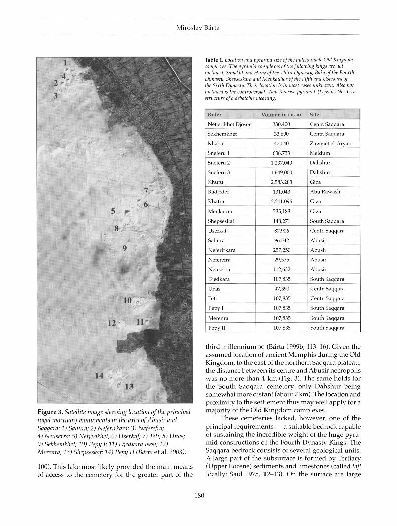
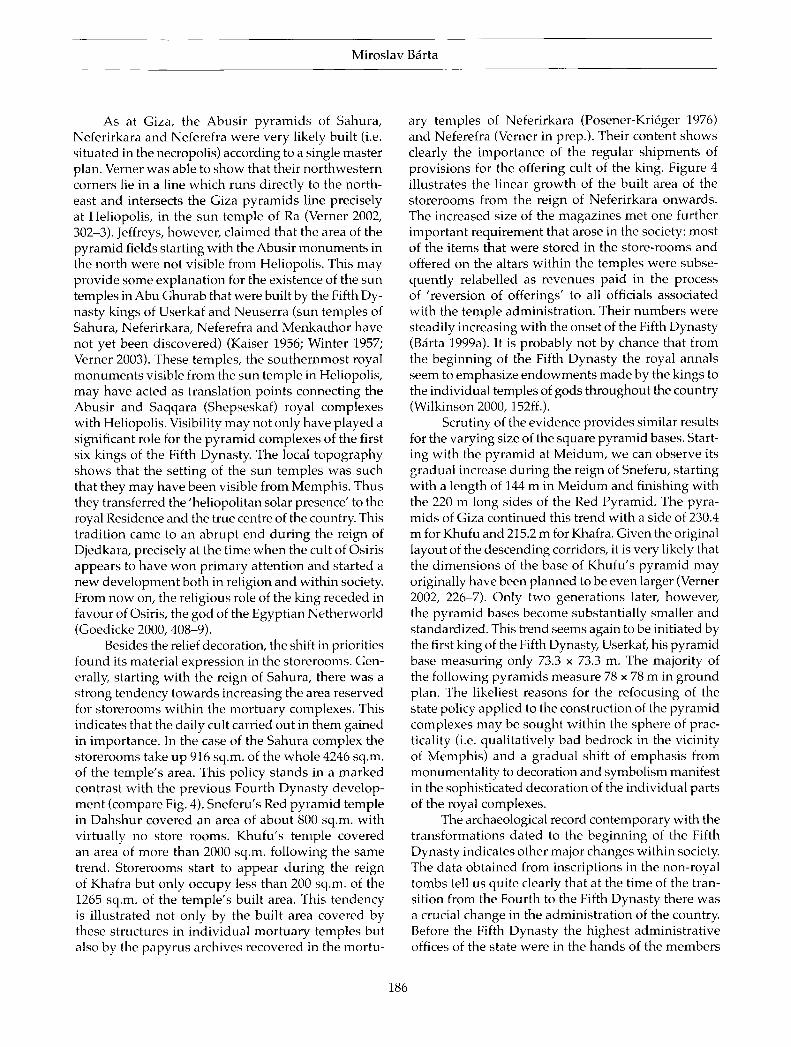
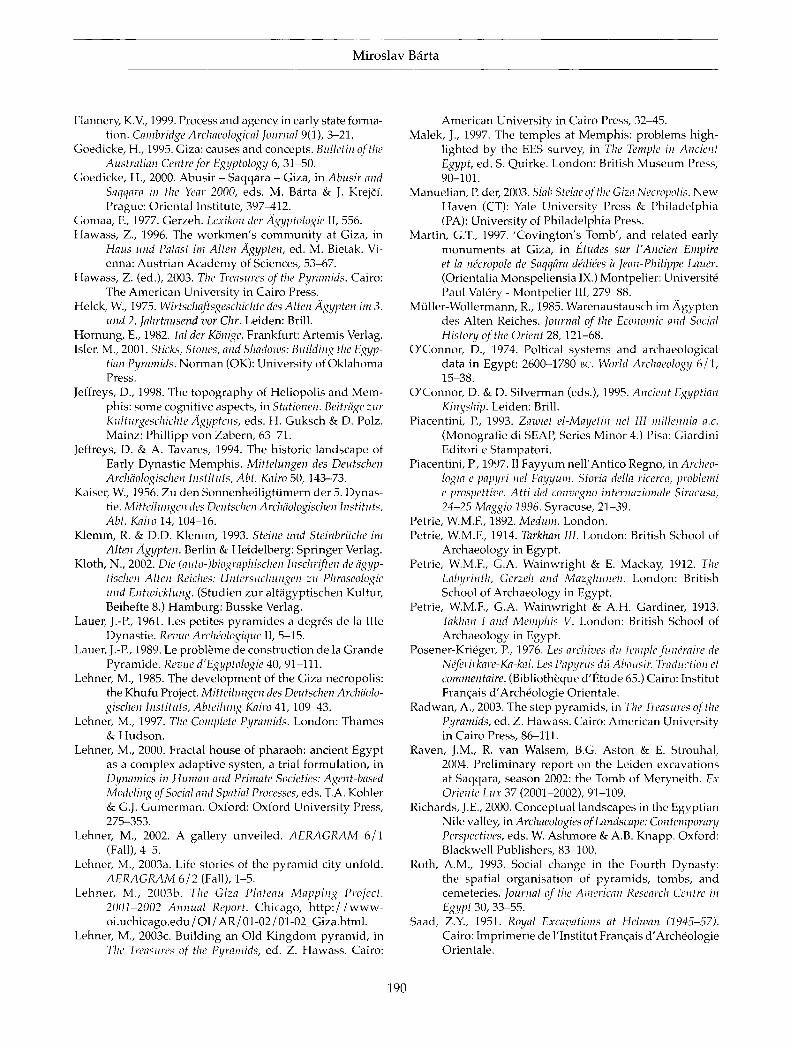
Figure 3. Satellite image showing location of the principal royal mortuary monuments in the area of Abusir and Saqqara: 1) Sahura; 2) Neferirkara; 3) Neferefra; 4) Neuserra; 5) Netjerikhet; 6) Userkaf; 7) Teti; 8) Unas; 9) Sekhemkhet; 10) Pepy I; 11) Djedkara Isesi; 12) Merenra; 13) Shepseskaf; 14) Pepy II (Bdrta et al. 2003).
100) . This lake mos t l ikely provided the main means of access to the cemetery for the greater part of the
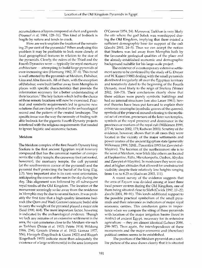
Table 1. Location and pyramid size of the indisputable Old Kingdom complexes. The pyramid complexes of the following kings are not included: Sanakht and Hunt of the Third Dynasty, Baka of the Fourth Dynasty, Shcpseskara and Menkauhor of the Fifth and Userkara of the Sixth Dynasty. Their location is in most cases unknown. Also not included is the controversial 'Abu Rawash pyramid' (Lepsius No. 1), a structure of a debatable meaning.
Ruler Volume in cu. m Site
Netjerikhet Djoser 330,400 Centr. Saqqara
Sekhemkhet 33,600 Centr. Saqqara
Khaba 47,040 Zawyiet el-Aryan
Sneferu 1 638,733 Meidum
Sneferu 2 1,237,040 Dahshur
Sneferu 3 1,649,000 Dahshur
Khufu 2,583,283 Giza
Radjedef 131,043 Abu Rawash
Khafra 2,211,096 Giza
Menkaura 235,183 Giza
Shepseskaf 148,271 South Saqqara
Userkaf 87,906 Centr. Saqqara
Sahura 96,542 Abusir
Neferirkara 257,250 Abusir
Neferefra 29,575 Abusir
Neuserra 112,632 Abusir
Djedkara 107,835 South Saqqara
Unas 47,390 Centr. Saqqara
Teti 107,835 Centr. Saqqara
Pepy I 107,835 South Saqqara
Merenra 107,835 South Saqqara
Pepy II 107,835 South Saqqara
third mi l lennium BC (Barta 1999b, 1 1 3 - 1 6 ) . Given the a s sumed locat ion of ancient M e m p h i s during the Old Kingdom, to the east of the northern Saqqara plateau, the dis tance be tween its centre and Abus i r necropolis was no more than 4 k m (Fig. 3) . The same holds for the South Saqqara cemetery, only Dahshu r be ing somewhat more distant (about 7 km) . The location and proximity to the set t lement thus m a y well apply for a majority of the Old K i n g d o m complexes .
These cemeter ies lacked, however , one of the principal requirements — a suitable bedrock capable of sustaining the incredible weight of the huge pyramid construct ions of the Four th Dynas ty Kings . The Saqqara bedrock consists of several geological units. A large part of the subsurface is formed by Tertiary (Upper Eocene) sediments and l imestones (called tafl locally: Said 1975, 1 2 - 1 3 ) . O n the surface are large
180
Location of the Old K i n g d o m Pyramids in Egypt
accumulations of layers composed of chert and gravels (Youssef et al. 1984, 1 2 8 - 3 1 ) . This kind of bedrock is fragile by nature and tends to crack.
H o w are we to explain the location of the remaining 25 per cent of the pyramids? When analyzing this problem it m a y be profitable to look more closely at local geographical features in relation to the size of the pyramids . Clearly, the rulers of the Third and the Fourth Dynast ies were — typically for royal mortuary architecture — at tempting to build large pyramids of ever-increasing size (Hornung 1982, 3 7 - 8 ) . This trend is well attested by the pyramids at Meidum, Dahshur, Giza and Abu Rawash. All of them, with the exception of Dahshur, were built farther away from M e m p h i s in places wi th specific characterist ics that provide the information necessary for a better unders tanding of their locat ion. 1 The key factors which led to the choice of these remote locations will now be examined . Practical and symbol ic requirements led to genuine new solutions that are clearly reflected in the archaeological record and the pattern of the created landscape. The specific issue was the way the necessity of finding suitable bedrock for the gigantic Fourth Dynas ty projects interfered with the religious requirements that needed to ignore logistic and economic factors.
M e i d u m
The M e i d u m complex of the first Fourth Dynasty king Sneferu is the first ancient Egypt ian royal funerary compound that has the canonical number of components: the valley temple, the causeway (not yet roofed, however) , the mor tuary temple, the cult pyramid (at the southwestern corner of the pyramid) and the pyramid itself protecting the burial of the king (Fig. 1:7). Very important also is its eas t -wes t orientation, anticipating the course of the sun in the sky during the day. This a l ignment was fol lowed by all subsequent royal tombs of the Old Kingdom. The locat ion of the m o n u m e n t seemingly so far away from the residence in Memphis m a y be due to several factors. It was probably the first t ime that a high-quali ty l imestone bedrock (the Qurn and Wadi Garrawi cenozoic beds) able to carry the weight of the pyramid played a major role (Said 1990, 464) . The mos t important factor, however, is indicated by the archaeological evidence. Though we lack any remains of an extensive set t lement in the area, the vast cemeteries close to the M e i d u m site such as Tarkhan (Petrie et al. 1913; Petrie 1914; Wildung 1986, 234) , Gerzeh (Petrie et al. 1912; G o m a a 1977, 556) , Harageh (Engelbach & Gunn 1923) and Riqqeh (Engelbach 1915) indicate more than adequately the exis tence of a large set t lement(s) in the area (compare
O 'Connor 1974, 24) . Moreover , Tarkhan is very likely the site where the god Sobek was worshipped during the Old Kingdom, implying that there existed a sufficient demographic base for support of the cult (Zecchi 2001 , 2 4 - 5 ) . Thus we can accept the notion that Sneferu was led away from M e m p h i s both by the favourable geological qualities of the place and the already-established economic and demographic background suitable for his large-scale project.
The existence of a contemporary extensive settlement seems to be confirmed by the study of G. Dreyer and W. Kaiser (1980) deal ing with the small pyramids distr ibuted irregularly all over the Egypt ian territory and tentatively dated to the beginning of the Fourth Dynasty, most likely to the reign of Sneferu (Verner 2002, 1 6 8 - 7 3 ) . Their conclusions clearly show that these edifices were purely symbol ic bui ldings and had no internal structures (see also Lauer 1961) . Several theories have been put forward to explain their existence: cenotaphs (symbol ic graves of the queens) , symbols of the primeval mound referring to the mythical act of creation, precursors of the later sun temples, symbols of the royal presence and dominance in the provinces or markers of the royal cult (Wilkinson 1999, 2 7 7 - 8 ; Verner 2 0 0 2 , 1 7 3 ; Radwan 2003) . Scrutiny of the evidence, however , shows that in all cases they were located in the vicinity of the major set t lements and power centres of the ancient Egyptian state (generally Wilkinson 1999,328ff . , Piacentini 1993 for Zawyie t el-Mayi t in) . The location of the nor thernmost site is to the west of Meidum, near Sileh (the others are located at Elephantine, Edfu, Hierakonpol is , Ombos , Abydos and Zawyie t el-Mayitin). In most cases they were situated at higher altitudes that a l lowed for unobstructed visibility despite their relatively low heights ranging from 4 m to 8.25 m (Radwan 2003, 111).
A recent survey of the evidence suggests that the area of Fayum was divided among at least three local power centres during the Old Kingdom, one of them being situated close to Si leh (Cwiek 1 9 9 7 , 1 7 - 2 2 ; Zecchi 2001 , 8 9 - 9 1 ) . This lends addit ional support to the possible practical symbol i sm of the small pyramids and their relevance as indicators of major royal economic centres. This conclus ion gains in importance when we compare the siting of these pyramids with location of the major irrigation basins (hawd in Arabic) of ancient Egypt, necessary for its extensive agriculture — they are a lmost identical (Lehner 2000 , 2 9 8 - 3 0 7 ) . Thus again, the in terdependence of these m o n u m e n t s and the major economic and (therefore) political centres seems to be established.
The posit ion of the M e i d u m pyramid on a satellite picture of the area shows clearly that it is si tuated
181
Miroslav Bärta
at a place where the Ni le val ley and the F a y u m Oasis come closest together (Fig. 1:7; Verner 2 0 0 2 , 1 6 1 ) . This evidence seems to favour the conclusion that Sneferu had no problems with local conscript ion during the bui lding of the M e i d u m royal necropol is and that the area of M e i d u m together with the eastern tip of the F a y u m Oasis provided the necessary demographic and economic base for a pyramid bui ld ing project of such a scale (compare Piacentini 1997) .
A closer look at the locat ion of the M e i d u m cemetery shows one more striking feature in the spatial distribution of the funerary structures. Whereas the pyramid itself seems to form the southernmost point of the early Fourth Dynas ty cemetery, the remaining tombs built for member s of the royal family extend over a ki lometre to the north with a slight northeast curve at its nor thern end (Petrie 1892) . Its resulting shape shows that the nor thernmost part of the cemetery was no more than some 4.5 k m from the vast cemetery at Gerzeh. This cemetery is located at the junct ion of a modern road coming up from the Nile valley wes twards and heading towards the F a y u m oasis (called Darb Gerza, M a p of Egypt Sheet 7 4 / 630, 1, 25,000, Atfih). This was still at the beginning of the twentieth century a famous caravan road connect ing the Nile val ley with Fayum. The strongly prolonged shape of the M e i d u m cemetery is very unusual in the light of the contemporary ev idence that Egypt ians tended to bui ld royal and important non-royal cemeteries in clusters of rather densely distributed tombs. It was not quite so, however , in this case. Only one explanat ion accounts for all the evidence: that the architect of this pyramid cemetery sought to place it as close as possible to the main part of the exist ing cemetery that served this part icular set t lement
Dahshur
In the sixteenth year of his reign Sneferu decided to transfer his burial g round to Dahshur, further to the north (Fig. 1:6, Verner 2 0 0 1 , 3 6 5 - 7 2 ) . The reasons for his decision are unknown. M a y b e the king wished from the inception of the project to build a new, larger pyramid (the square-shaped base of the Bent pyramid measures 188 m compared in length to 144 m of the M e i d u m pyramid) and one that in its shape was the first true pyramid. Another factor m a y have been the relative proximity of Memph i s . W h e n the Bent pyramid bui lding reached a height of about 46 m, cracks appeared within the masonry and the architect was forced to reduce the steep slope of the side-walls from 54° to 43° . Finally, the decis ion was m a d e to start the third, so-called North pyramid. This pyramid was
conceived as an even bigger construction (the length of the base being 220 m) but the slope of the walls was from the very beginning lessened to 43° . This pyramid probably b e c a m e the final resting place of the king. In Dahshur we encounter for the first t ime explici t problems connected with the bedrock. The huge projects of the Dahshur pyramids seem to have been complicated by the local tafia bedrock which was quite unsui table to bear the immense weight of the individual gigantic structures. This m a y have led the architects to expand the built area of the base of the third pyramid and to decrease the slope of the walls .
In the t remendous amount of bui lding work by Sneferu one m a y observe the profound changes that took part on different levels of culture and society precisely at the same time. These are to be seen within the context of the overburdened state economy: a vital part of the resources seems to have been directed towards the state bui ld ing projects of the pyramids . Inevitably, this tendency led to the economiza t ion in non-royal mortuary cults and architecture. It is at M e i d u m for the first t ime we can observe three new, socially-significant classes of pottery which evolve and expand the inventory of Old K ingdom vessels: miniature bowls and plates and the so-called M e i d u m ware. Whereas M e d i u m ware was probably invented to imitate expens ive stone vessels for the cult and funerary equipment of the weal thy officials of the day (Barta 1996, 150), miniature vessels may have been designed exclusively for the upkeep of daily cults for both royal and non-royal persons, miniature plates intended as receptacles for symbol ic amounts of food and miniature bowls for beverages (Barta 1995) .
The architecture of non-royal tombs develops in line with these changes . Scrut iny of the early Fourth Dynas ty evidence shows that before Sneferu 's bui lding activities in Dahshur, tombs for member s of the royal family in M e i d u m covered the incredible size of several thousand square metres (the tomb of the vizier Nefermaat and his wife Atet [M 16] cover ing an area of 6048 sq.m., mastaba M 17 5512 sq.m., and M 6 of Rahotep and Nofret with 3203 sq.m.). Their contemporary counterparts from Saqqara are smaller but still cover impress ive areas — their sizes range from 470 to 1431 sq.m. Sneferu 's cemetery for family m e m b e r s in Dahshur, however, shows strict s tandardizat ion in terms of size, approximat ing about 600 sq.m. of built area. Moreover , it is during the reign of Sneferu that the first offering formulas (the so-called htp dj nswt formula) appear in the non-royal tombs. Last but not least, the substructure of the tombs undergoes a profound reduction in size, resulting in a single burial chamber underground, which contrasts with
182
Locat ion of the Old K ingdom Pyramids in Egypt
the previous development of large-scale subterranean rooms imitat ing the ground plan of a house. Finally, starting from the reign of Sneferu, the location of the tombs of the highest officials of the state depended heavi ly on the siting of the king 's mortuary complex — a rule that remained in operat ion for the mos t part of the Fourth Dynas ty (Roth 1993, 42ff.).
Giza, A b u Rawa s h and Zawyie t e l -Aryan
The pyramids of the three principal kings of the Fourth Dynas ty — Khufu, Khafra and Menkaura — at Giza represent one of the landmarks of the contemporary pyramid fields topography (Fig. 1:2). There is no doubt that it was even more striking after their complet ion almost 4500 years ago. Khufu, son of Sneferu and Het-epheres (I) was the first king to choose the Giza plateau and launch a single bui lding project unparal leled in the history of the ancient Egypt ian state. Khufu 's successful overcoming of the initial obstacles resulted in a pyramid with a base of 230.33 m, originally 146.6 m high with a vo lume of some 2,500,000 cu.m. of built stone, by far the largest comple ted funerary monument attested from ancient Egypt .
For this project, Khufu found the sole one feasible solution: he was forced to m o v e nor thwards as far as the Giza plateau where the only suitable bedrock l imestone formation was located (Said 1990, 459ff.). This prospect ive bui lding site guaranteed success for the largest single bui lding project in Egyptian history. Only the solid l imestone bedrock of the Moqa t t am and Maadi formations could sustain the weight of the colossal pyramids of three Fourth Dynas ty rulers (Lehner 1985) . As ide from such architectural necessities, there were also unavoidable economic needs for the realization of such a project. There was only one issue to be resolved: the economic basis that would make up for the dis tance from Memphis .
Given the meagre archaeological ev idence indicating some kind of l imited set t lement within the Giza area (Covington 1905; Mart in 1997, 2 7 9 - 8 8 ) , it s eems l ikely that the p la teau was not densely populated prior to the Fourth Dynasty. Unde r such c i rcumstances the state administrat ion had to make sure that the workforce of several thousand had suitable accommodat ion , and had to arrange for a large number of workshops for bread and beer production, and magaz ines for storing dried food and fish, the mos t c o m m o n staples of the ancient Egypt ian diet. All these installations had to be built anew in the vicinity of the construct ion site. This is one of the mos t impor tant a rguments against the theory of residence transi t ion sugges ted b y S t ade lmann (1981 , 7 6 - 7 ) .
From what we know it seems likely that the city of M e m p h i s remained in its original location for most of its Old K i n g d o m history (leaving aside its expansion southwards to the area of South Saqqara during the twenty-fourth century BC).
Modern excavat ions led by M a r k Lehner immediately to the southeast of the Giza cemetery (in the vicinity of the local vi l lage Nazlet e l -Saman) brought to light huge complexes of breweries, bakeries and installations for drying fish, des igned to provide the basic staples of the ancient Egypt ian diet (Hawass 1996, 5 3 - 6 7 ; Lehner 1997, 2 3 6 - 7 ) . Moreover, in the past few years his excavat ions have exposed spacious structures designed to accommoda te the workforce work ing on py ramid cons t ruc t ion (Lehner 2 0 0 2 ; 2003a,b). According to preliminary calculations related to the excavated areas, it is es t imated that the buildings currently revealed served as night shelter for no fewer than 1600-2000 workmen. The excavations have shown a wide spectrum of amenit ies necessary for a fully-fledged and efficient long-term set t lement (i.e. settlement lasting, say, for several decades): accommodation that functioned as self-sustaining units (Gallery Il ia) , a manor for the overseer of the bui lding project, magazines and bakeries , silos, a royal administrat ive bui lding and the Eastern town for the permanent labour force.
Logically, such an ambi t ious project as Khufu 's pyramid complex represented a chal lenge not only for the king himself, but above all for the administrative system and the economic vigour of the country. There are even some indicat ions that Khufu followed the tough retrenching policy introduced by his father: it is probably not by chance that the mas tabas of his family member s built a round his pyramid are strictly s tandardized and the decorat ion of most of the contemporary tombs is l imited to the s imple slab stela (Manuel ian 2 0 0 3 , 1 6 7 - 9 ) .
Khufu 's immedia te successors seem to follow what in the m e a n t i m e b e c a m e a well-establ ished practice: keeping close to stable and reliable l imestone bedrock while changing the burial site with every new king. Radjedef built a pyramid north of Giza at A b u Rawash (the pyramid base being 106 m), only a few ki lometres north of Giza (Fig. 1:1). The pyramid itself occupies a very favourable posit ion atop a l imestone plateau over looking the region. Clearly, the architects encounte red ser ious obs tac les w h e n bui ld ing the causeway connect ing the valley temple with the mortuary temple. The expenditure of labour was, however, compensated again by the high-quality bedrock. As in the case of Meidum, here also there mus t have been the necessary economic base serving the project: the
183
Miroslav Bärta
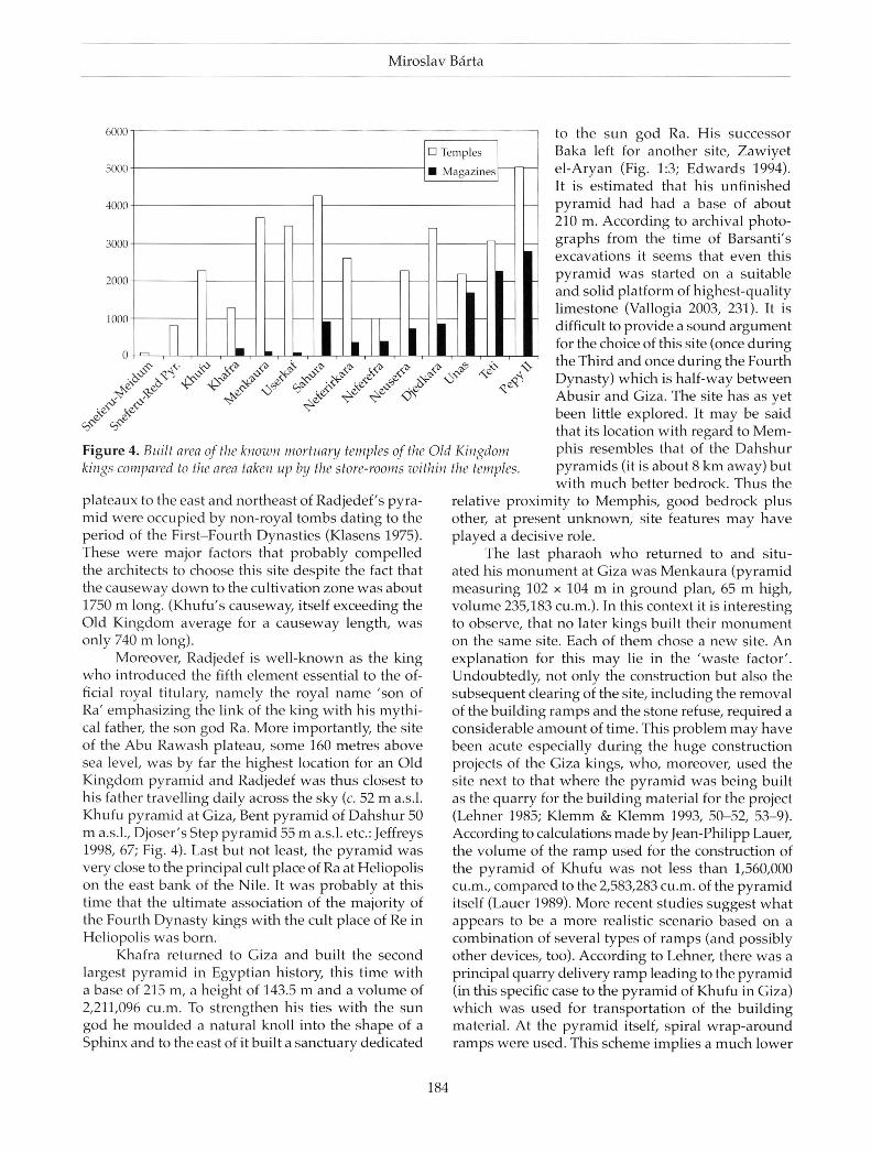
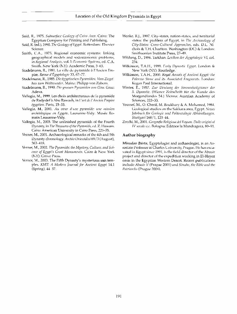
Figure 4. Built area of the known mortuary temples of the Old Kingdom kings compared to the area taken up by the store-rooms within the temples
plateaux to the east and northeast of Radjedef ' s pyramid were occupied by non-royal tombs dat ing to the period of the Fi rs t -Four th Dynas t ies (Klasens 1975) . These were major factors that probably compel led the architects to choose this site despite the fact that the causeway d o w n to the cultivation zone was about 1750 m long. (Khufu 's causeway, itself exceeding the Old K ingdom average for a causeway length, was only 740 m long).
Moreover, Radjedef is wel l -known as the king w h o introduced the fifth e lement essential to the official royal titulary, namely the royal n a m e 'son of Ra ' emphas iz ing the link of the king with his mythical father, the son god Ra. More importantly, the site of the Abu Rawash plateau, some 160 metres above sea level, was by far the highest location for an Old K i n g d o m pyramid and Radjedef was thus closest to his father travelling daily across the sky (c. 52 m a.s.l. Khufu pyramid at Giza, Bent pyramid of Dahshur 50 m a.s.l., Djoser ' s Step pyramid 55 m a.s.l. etc.: Jeffreys 1998, 67; Fig. 4 ) . Last but not least, the pyramid was very close to the principal cult place of Ra at Heliopolis on the east bank of the Nile. It was probably at this t ime that the ul t imate associat ion of the majority of the Fourth Dynas ty kings with the cult place of R e in Heliopolis was born.
Khafra returned to Giza and built the second largest pyramid in Egypt ian history, this t ime with a base of 215 m, a height of 143.5 m and a vo lume of 2,211,096 cu.m. To strengthen his ties wi th the sun god he moulded a natural knoll into the shape of a Sphinx and to the east of it built a sanctuary dedicated
to the sun god Ra . His successor Baka left for another site, Zawiye t e l -Aryan (Fig. 1:3; Edwards 1994) . It is es t imated that his unfinished pyramid had had a base of about 210 m. Accord ing to archival photographs from the t ime of Barsant i ' s excavat ions it seems that even this pyramid was started on a suitable and solid platform of highest-quali ty l imestone (Vallogia 2003, 231) . It is difficult to provide a sound argument for the choice of this site (once during the Third and once during the Fourth Dynas ty) which is half-way be tween Abusi r and Giza. The site has as yet been little explored. It m a y be said that its location with regard to M e m phis resembles that of the Dahshur pyramids (it is about 8 k m away) but with much better bedrock. Thus the
relative proximity to Memphis , good bedrock plus other, at present unknown, site features m a y have p layed a decisive role.
The last pharaoh w h o returned to and situated his m o n u m e n t at Giza was Menkaura (pyramid measur ing 102 x 104 m in ground plan, 65 m high, vo lume 235,183 cu.m.). In this context it is interesting to observe, that no later kings built their m o n u m e n t on the same site. Each of them chose a n e w site. A n explanat ion for this may lie in the 'was te factor ' . Undoubtedly, not only the construct ion bu t also the subsequent clearing of the site, including the removal of the bui lding ramps and the stone refuse, required a considerable amount of t ime. This problem m a y have been acute especial ly during the huge construction projects of the Giza kings, who , moreover, used the site next to that where the pyramid was be ing built as the quarry for the bui lding material for the project (Lehner 1985; K l e m m & K l e m m 1993, 5 0 - 5 2 , 5 3 - 9 ) . According to calculations made by Jean-Philipp Lauer, the vo lume of the r amp used for the construct ion of the pyramid of Khufu was not less than 1,560,000 cu.m., compared to the 2,583,283 cu.m. of the pyramid itself (Lauer 1989) . M o r e recent studies suggest what appears to be a more realistic scenario based on a combinat ion of several types of ramps (and possibly other devices, too). Accord ing to Lehner, there was a principal quarry delivery ramp leading to the pyramid (in this specific case to the pyramid of Khufu in Giza) which was used for t ransportat ion of the bui lding material . At the pyramid itself, spiral wrap-around ramps were used. This scheme implies a much lower
184
Locat ion of the Old Kingdom Pyramids in Egypt
vo lume of bui lding material in their construction, a l though the total amount was still quite substantial (Lehner 2003c, 40^11) . Quite recently, Isler rejected the use of both linear and spiral ramps in the construction of the Great pyramid of Khufu (except for the material del ivery ramp, see Isler 2001 , 2 1 1 - 2 1 ) and indicated that mos t of the stone blocks may have been put into place using levers, wedges and slideways, tumble with masonry and raised by means of s tairways (Isler 2001 , 2 4 6 - 6 6 ) . This simple fact may have made the site practically inaccessible for several years after the bui lding itself was successfully accomplished. Moreover, when considering the internal disposit ion of the Dahshur and Giza sites (the sites with the largest pyramids) one can note the relatively large dis tance separat ing each of the two pyramids on the site. This makes it probable that the question of refuse may actually have played a significant role in the post-construction managemen t of the site. Interestingly, this feature seems to be much less in operat ion during the following period when much smaller pyramids were constructed, producing, undoubtedly, much less debris.
At any rate, Goedicke was able to show that the resulting plan of the three Giza pyramids was closely associated with the temple of Ra in Heliopolis . Prolongat ion of the line connect ing their southeastern corners leads directly to Heliopolis , to its pr imary cult centre (Goedicke 1995) . The ' solar charac ter ' of the Giza royal necropolis is emphasized by the Sphinx and the temple built to the east of it. Accord ing to the prevalent opinion, the Sphinx was a symbol of royal authority par excellence depicting the king Khafra as an embod imen t of the god Atum, possibly in his aspect of the setting sun (in Egypt ian theology equaled with the process of dying) (Lehner 2003b , 1 7 3 - 8 9 ) .
The Fifth and Sixth Dynasties: Abus ir and Saqqara
With Menkaura began a n e w trend leading to distinctly smal ler pyramids . Again, practical reasons such as the location of the pyramid in regard to the economic base and the quali ty and availabili ty of the suitable bedrock must be taken into consideration. All of the extant pyramids of his and the following period are si tuated in the immedia te vicinity of M e m p h i s at the sites of Abus i r (Fig. 1:4) and Central and South Saqqara (Fig. 1:5). Nevertheless, the decrease in monu-mental i ty was to be compensa ted for s ince it is also during his reign that the pyramid substructure was enriched by a complex of s torerooms. At Menkaura ' s pyramid there were six. Shepseskaf ' s pyramid possessed five of them in its substructure and later on their canonical number was three (Roth 1993 ,45 ) . This
feature also corroborates a significant shift in the philosophy behind the mor tuary complexes of the kings. Shepseskaf is the first king of the Fourth Dynas ty who decided to return to the area of M e m p h i s and built his m o n u m e n t (shaped to resemble a mastaba) some distance from that of Djoser, at South Saqqara . There is no satisfactory explanat ion for the specific location of his monumen t but it was certainly located close to the major economic base provided by the Residence . Equal ly important m a y have been the proximity of the tomb to the Fourth Dynas ty founder Sneferu in Dahshur — Shepseskaf might have been the son of one of the lesser wives of Menkaura and therefore not a fully legi t imate possessor of the throne. The proximity to Sneferu m a y have been considered an additional support to his legitimacy. Last but not least, rich sources of l imestone necessary for the construction of his m o n u m e n t were available in their vicinity (Verner 2002, 2 5 8 - 9 ) .
Userkaf , the first k ing of the Fifth Dynasty, returned to central Saqqara , preferring to show his adherence to the previous development , and built his pyramid complex outside the northeastern corner of Djoser ' s enclosure. One of the principal innovat ions of his t ime was the construct ion of the so-called sun-temple dedicated to the cult of the sun god Ra in Abu Ghurab , north of Abusir, a distance of some 3 k m to the north from his pyramid (a policy that was pursued by the majority of the Fifth Dynas ty kings) . F rom the t ime of Userkaf and his Abusi r successors we have relatively rich textual evidence for the intensive material support of the Heliopolis priesthood in the form of extensive land endowment s (Wilkinson 2000 ,152f f . ) .
It seems that somet ime around the beginning of the Fifth Dynasty, during the reign of the second king Sahura at the latest, another major change in the conception of the royal mortuary complex occurred. Hand in hand with the sudden decrease in pyramid size there went a tendency to emphasize the decoration program of the complex, thus favouring a symbolism of the royal tomb set not by its sheer size and monumenta l impression, but by the elaborate and much more thoughtful and extensive decoration programme on the walls. The clearest example is set by the complex of Sahura, founder of the royal necropolis in Abusir. His temple comprised some 370 running metres of decoration, whereas several of the most important kings of the Fourth Dynasty seem to have paid little attention to this component . (Sneferu, the biggest pyramid builder, reserved only 64 running metres for the decoration of his complex, his son Khufu 100 m and the direct predecessor of Sahure, king Userkaf, only about 120 m of relief decoration: Arnold 1999, 98.)
185
Miroslav Bärta
As at Giza, the Abus i r py ramids of Sahura , Neferirkara and Neferefra were very likely built (i.e. situated in the necropolis) according to a single master plan. Verner was able to show that their nor thwestern corners lie in a line which runs directly to the northeast and intersects the Giza pyramids line precisely at Heliopolis , in the sun temple of Ra (Verner 2002, 3 0 2 - 3 ) . Jeffreys, however , c la imed that the area of the pyramid fields starting with the Abusir monuments in the north were not visible from Heliopolis . This m a y provide some explanat ion for the exis tence of the sun temples in Abu Ghurab that were built by the Fifth Dynasty kings of Userkaf and Neuserra (sun temples of Sahura, Neferirkara, Neferefra and M e n k a u h o r have not yet been discovered) (Kaiser 1956; Winter 1957; Verner 2003) . These temples , the southernmost royal monuments visible from the sun temple in Heliopolis, m a y have acted as translat ion points connect ing the Abusi r and Saqqara (Shepseskaf) royal complexes with Heliopolis. Visibility may not only have played a significant role for the pyramid complexes of the first six kings of the Fifth Dynasty. The local topography shows that the setting of the sun temples was such that they m a y have been visible from Memph i s . Thus they transferred the 'heliopolitan solar presence ' to the royal Residence and the true centre of the country. This tradition came to an abrupt end during the reign of Djedkara, precisely at the t ime when the cult of Osiris appears to have won pr imary at tention and started a new deve lopment both in religion and within society. F rom n o w on, the religious role of the king receded in favour of Osiris, the god of the Egyptian Netherworld (Goedicke 2000 , 4 0 8 - 9 ) .
Besides the relief decoration, the shift in priorities found its material express ion in the s torerooms. Generally, starting with the reign of Sahura, there was a strong tendency towards increasing the area reserved for s torerooms within the mor tuary complexes . This indicates that the daily cult carried out in them gained in impor tance . In the case of the Sahura complex the s torerooms take up 916 sq.m. of the who le 4246 sq.m. of the temple ' s area. This policy s tands in a marked contrast with the previous Four th Dynas ty development (compare Fig. 4 ) . Sneferu 's Red pyramid temple in Dahshur covered an area of about 800 sq.m. with virtually no store rooms. Khufu 's temple covered an area of more than 2000 sq.m. fol lowing the same trend. S torerooms start to appear during the reign of Khafra but only occupy less than 200 sq.m. of the 1265 sq.m. of the temple ' s built area. This tendency is i l lustrated not only by the buil t area covered by these structures in individual mor tuary temples but also by the papyrus archives recovered in the mortu
ary temples of Neferirkara (Posener-Krieger 1976) and Neferefra (Verner in prep.). Thei r content shows clearly the impor tance of the regular sh ipments of provisions for the offering cult of the king. Figure 4 illustrates the l inear growth of the built area of the s torerooms from the reign of Neferirkara onwards . The increased size of the magaz ines met one further important requirement that arose in the society: mos t of the i tems that were stored in the store-rooms and offered on the altars within the temples were subsequently relabelled as revenues paid in the process of ' reversion of offerings' to all officials associated with the temple administrat ion. Thei r numbers were steadily increasing with the onset of the Fifth Dynas ty (Barta 1999a) . It is probably not by chance that from the beginning of the Fifth Dynas ty the royal annals seem to emphas ize endowment s made by the kings to the individual temples of gods throughout the country (Wilkinson 2000 ,152f f . ) .
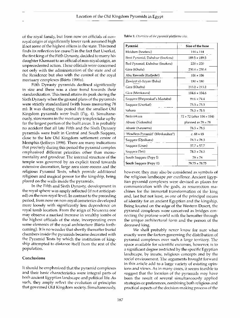
Scrutiny of the evidence provides similar results for the varying size of the square pyramid bases. Starting with the pyramid at Me idum, w e can observe its gradual increase during the reign of Sneferu, starting with a length of 144 m in M e i d u m and finishing with the 220 m long sides of the R e d Pyramid . The pyramids of Giza cont inued this trend with a side of 230.4 m for Khufu and 215.2 m for Khafra. Given the original layout of the descending corridors, it is very likely that the d imens ions of the base of Khufu 's pyramid m a y originally have been planned to be even larger (Verner 2002, 2 2 6 - 7 ) . Only two generat ions later, however , the pyramid bases b e c o m e substantial ly smaller and standardized. This trend seems again to be initiated by the first king of the Fifth Dynasty, Userkaf, his pyramid base measuring only 73.3 x 73.3 m. The majority of the following pyramids measure 78 x 78 m in ground plan. The likeliest reasons for the refocusing of the state policy applied to the construction of the pyramid complexes m a y be sought wi thin the sphere of practicality (i.e. quali tat ively bad bedrock in the vicinity of Memph i s ) and a gradual shift of emphas is from monumental i ty to decoration and symbol ism manifest in the sophist icated decoration of the individual parts of the royal complexes .
The archaeological record contemporary with the t ransformations dated to the beginning of the Fifth Dynas ty indicates other major changes within society. The data obtained from inscript ions in the non-royal tombs tell us quite clearly that at the t ime of the transition from the Fourth to the Fifth Dynas ty there was a crucial change in the administrat ion of the country. Before the Fifth Dynas ty the highest administrat ive offices of the state were in the hands of the members
186
Location of the Old Kingdom Pyramids in Egypt
of the royal family, but from n o w on officials of non-royal origin of significantly lower rank assumed high if not some of the highest offices in the state. This trend finds its reflection (or cause?) in the fact that Userkaf, the first king of the Fifth Dynasty, decided to marry his daughter Khamaat to an official of non-royal origin, an unprecedented action. These officials were concerned not only with the administrat ion of the state and of the Res idence but also with the control of the royal mor tuary complexes (Barta 1999a) .
Fifth Dynas ty pyramids declined significantly in size and there was a clear trend towards their standardization. This trend attains its peak during the Sixth Dynasty when the ground plans of the pyramids were strictly s tandardized (with bases measur ing 78 m) . It was during this per iod that the smallest Old K i n g d o m pyramids were built (Fig. 4) . S imul taneously, s torerooms in the mor tuary temples take up by far the largest portion of the built areas. It is probably no accident that all late Fifth and the Sixth Dynas ty pyramids were buil t in Central and South Saqqara, close to the late Old K i n g d o m set t lement centre of M e m p h i s (Jeffreys 1998) . There are many indications that precisely during this period the pyramid complex emphas ized different priori t ies other than m o n u -mental i ty and grandeur. The internal structure of the temple was governed by an explicit trend towards extensive decorat ion, large area store-rooms and the religious Pyramid Texts, which provide addit ional religious and magical power for the kingship, be ing placed on the walls inside the pyramids .
In the Fifth and Sixth Dynasty, deve lopment in the royal sphere was amply reflected (if not anticipated) on the non-royal level. In contrast to the preceding period, from now on non-royal cemeter ies developed more loosely with significantly less dependence on royal tomb location. F r o m the reign of Neuserra one may observe a marked increase in weal thy tombs of the highest officials of the state, incorporat ing even some e lements of the royal architecture (Barta forthcoming) . It is no wonder that shortly thereafter burial chambers inside the pyramids became decorated with the Pyramid Texts b y which the institution of kingship a t tempted to distance itself from the rest of the populat ion.
Conclus ions
It should be emphas ized that the pyramid complexes and their basic characterist ics were integral parts of both ancient Egypt ian landscape and political life. As such, they amply reflect the evolut ion of principles that governed Old K ingdom society. Simultaneously,
Table 2. Overview of the pyramid platforms size.
Pyramid Size of the base
Meidum (Sneferu) 1 4 4 x 1 4 4
Bent Pyramid, Dahshur (Sneferu) 189.5 x 189.5
Red Pyramid, Dahshur (Sneferu) 220 x 220
Giza (Khufu) 230.4 x 230.4
Abu Rawash (Radjedef) 106 x 106
Zawiyet el-Aryan (Baka) 180 x 180
Giza (Khafra) 215.2 x 215.2
Giza (Menkaura) 104.6 x 104.6
Saqqara (Shepseskaf's Mastaba) 99.6 x 74.4
Saqqara (Userkaf) 73.3 x 73.3
Sahura 78.5 x 78.5
Neferirkara 72 x 72 (after 104 x 104)
Abusir (Neferefra) planned as 78 x 78
Abusir (Neuserra) 78.5 x 78.5
'Headless Pyramid' (Menkauhor?) c . 68 x 65
Saqqara (Djedkara) 78.5 x 78.5
Saqqara (Unas) 57.7 x 57.7
Saqqara (Teti) 78.5 x 78.5
South Saqqara (Pepy I) 78 x 78
South Saqqara (Pepy II) 78.75 x 78.75
however, they m a y also be considered as symbols of the religious landscape par excellence. Ancient Egyptian pyramid complexes were devised as places for communica t ion with the gods, as resurrection machines for the immorta l t ransformation of the king and, last but not least, as one of the principal means of identi ty for an ancient Egypt ian and the kingship. Being located on the edge of the Western Desert , the pyramid complexes were conceived as br idges connecting the profane world with the hereafter through the unique architectural form and the person of the deceased king.
We shall probably never k n o w for sure wha t exactly were the factors governing the distribution of pyramid complexes over such a large territory. The space avai lable for scientific excursus, however, is to a significant degree restricted by the specific Egyptian landscape, by innate, religious concepts and by the social environment . The arguments brought forward in this article add to a large variety of exist ing opinions and views. As in many cases, it seems feasible to suggest that the location of the pyramids m a y have been the result of several s imul taneously applied strategies or preferences, combining both religious and practical aspects of the decis ion-making process of the
187
Miroslav Bârta
ancient Egyptian architects. Specifically, the pyramid complexes of the kings may be also called 'religion in stone' mainly because older and overcome features were almost never forgotten or replaced but modified, built upon and reinterpreted.
As suggested above, viewing the pyramid complexes of the Old Kingdom kings against the background of the social development of ancient Egyptian society seems to enhance significantly our understanding of their locations. This view suggests that it was not an isolated phenomenon; more likely it reflected complex and intrinsic values innate in contemporary ancient Egyptian society. There is little doubt that the locations of the individual cemeteries were not the result of a genuine plan realized over centuries; rather it was the result of various and differing diachronic priorities interacting at one particular point of time. The principal role was probably played by the location of the major economic centre, a central place (Christaller 1972) — Memphis — capable of sustaining the realization of such demanding projects in its vicinity of the cemeteries of Abusir, Saqqara, Dahshur and Zawiyet el-Aryan, followed by the site of Meidum, which was probably located close to another major centre of the time. As such, these monuments may be considered as materialized political statements of the ruling class. In turn, they also reflect natural development and growth within a society limited by its economic means and attained degree of administration that was surely one of the limiting factors in the creation of these monuments. These two central places were balanced by the relatively distant (in regard to Memphis) locations of
Giza and Abu Rawash. The decision-making process of the ancient architects may have been in varying degree influenced by the existence of suitable limestone platforms capable of carrying the weight of some of the largest monuments (compare, for instance, the specific Fourth Dynasty trend introduced by Sneferu and Khufu with the later Fifth and Sixth Dynasty epoch). In such cases, the innate Egyptian tendency towards ever-increasing size in royal mortuary projects, formulated by E. Hornung as 'Erweiterung des Bestehenden' (Hornung 1982, 37-8), prevailed and the economic criteria were simply overridden. It was only this typically ancient Egyptian equilibrium between symbolic and practical arguments that led to the emergence of the unique pyramid fields of the Old Kingdom. Once a new necropolis was established, it seems that the major factors influencing the location of the individual monuments were the political and religious requirements.The Fourth-Sixth Dynasties may be divided into two general periods. The Fourth Dynasty was dominated (after the Meidum and Dahshur stage)
by the large-scale building projects of the funerary complexes built on first-class limestone bedrock (Giza, Abu Rawash, Zawiyet el-Aryan) and the unambiguous preference for the cult of Ra in Heliopolis. Later on, during the Fifth and Sixth Dynasties, the pyramids themselves decreased in size, and were sited close to the Memphite residential area with its large population. The decorative preferences of the time became increasingly elaborate, and there was extensive wall decoration of the valley temple, causeway and mortuary temple. By the end of the Fifth Dynasty, there was further elaboration by inclusion of the Pyramid Texts in the pyramids of the kings.
1 he seeming intensification ot the mortuary cult during the Fifth Dynasty is signalled by the increasing size of the storerooms within the mortuary temple (and, also, the increased number of priests involved in the daily cults and receiving their revenues). The emerging picture of the royal pyramid complexes of the Old Kingdom thus becomes more complex and vivid but simultaneously it is easier to comprehend against the background of the general characteristics of ancient Egyptian society of which it was an integral part. Worthy of emphasis is also the never-ceasing interaction between the dominant royal sphere and the opposing non-royal class. Again, one of the best demonstrations of this process is the funerary monument. It has been shown that throughout the Old Kingdom the dynamics of society, as instigated by requirements on the religious and political level of the ruling class, put considerable constraints on the ensuing tendencies and means of power presentation. Thus the power-holders were constantly compelled to keep up the pace of the innovative process that would set them apart from the rest of the population. On the other hand, the limitations of this were clear as well. In order to keep the majority of the administrative class (scribes, trained administrators, priests and military/expedition officials) loyal, they had to be given a share of the wealth appropriated by the ruling class. Later on, they even gained access to the royal Osirian afterlife (sometime during the Fifth Dynasty, likely under the reign of Neuserra).
Old Kingdom society thus provides a classical example of the process of legitimization, linearization and promotion formulated by K.V. Flannery (1999). It is not by chance that the processes of linearization (imposing a sophisticated system of administration over politically most relevant areas of the country) and promotion (mastering the network of central and centralized institutions) attained their apogee under Sneferu and Khufu.
With the advent of the Fifth Dynasty, another major innovation takes place: the royal family steps back
188
Location of the Old K i n g d o m Pyramids in Egypt
and even the mos t important posi t ions in the central
administrat ive sys tem are taken by the 'non-royals ' .
The final stage enters the scene with the advent of the
Sixth Dynas ty when the kings in various ways oppose
the growing class of weal thy administrators and their
families that successfully introduced the hereditary
principle into the administrat ion of the country and
thus determined the w a y important state offices were
transferred from one to another generat ion within a
single family. The same trend m a y be tracked down in
the tomb inscriptions: during the Fifth Dynasty we can
observe the apogee of the ideal biographies, and at the
beginning of the Sixth Dynas ty b iographies narrat ing
individual careers of the officials enter the scene (with
one earlier except ion dated to the reign of Neuserra)
(Kloth 2002, 229 ff.). A n d again, characterist ics of the
pyramid complexes seem to be in accord with this
historical, social and archaeological evidence.
We can clearly see that the final stage of this con
sistently positive development which began during the
Third Dynasty (twenty-seventh century BC) caused the
first general crisis of the Egyptian state in the twenty-
second century BC. It was marked, among other things,
by the disappearance of the large-scale pyramid com
plexes, the collapse of the central administration and
its delinearization, lack of instruments of legitimiza
tion and weakening of the class of bureaucrats. Once
again as elsewhere, the Renfrew multiplier effect and
the law of diminishing effects have taken their toll. Many
minute details of this process, however, and its specific
manifestations remain to be clarified by fieldwork, in
terpretation of the written and other sources and tying
them up into a meaningful unity of understanding of
the location of the pyramid complexes.
Miroslav Barta
Czech Institute of Egyptology
Celetnd 20
U0 00 Praguel
Czech Republic
Email: [email protected]
Notes
1. The absolute dates used throughout the text are based on the exhibition catalogue Egyptian Art in the Age of the Pyramids, New York 1999, p. xx.
2. The seasonal character of the Lake of Abusir has been confirmed during 2004 season hand-auger drillings carried out by the Czech Institute of Egyptology.
3. The monument of Abu Rawash, likely to have been built for the Third Dynasty kings, is much disputed in this context and is not being considered owing to meagre and biased evidence.
References
Arnold, D., 1997. Royal cult complexes of the Old and Middle Kingdom, in Temples of Ancient Egypt, ed. B. Shafer. London: LB. Tauris Publishers, 31-84.
Arnold, D. (ed.), 1999. Egyptian Art in the Age of the Pyramids. New York (NY): The Metropolitan Museum of Art, New York.
Bârta, M., 1995. Pottery inventory and the beginning of the IVth Dynasty. Göttinger Miszellen 149,15-24.
Bârta, M., 1996. Class-type interpretation of the pottery: pottery finds from the pyramid temple of Raneferef and their significance. Pamâtky Archeologickc 87, 137-60.
Bârta, M., 1998. Die Tauschhandelszenen aus dem Grab des Fetekty in Abusir. Studien zur altägyptischen Kultur 26, 19-34.
Bârta, M., 1999a. The title inspector of the palace during the Egyptian Old Kingdom. Archiv Orientâlnl 67, 1-20.
Bârta, M., 1999b. The title 'priest of Hekef during the Egyptian Old Kingdom. Journal of Near Eastern Studies 58(2), 107-16.
Bârta, M., forthcoming. Architectural innovations in the development of the non-royal tomb during the reign of Nyuserra, in Architecture and Significance, ed. P. Jânosi. Vienna: Austrian Academy of Sciences.
Bârta, M., V. Brüna & R. Krivânek, 2003. Research at South Abusir in 2001-2002: methods and results. Pamâtky Archeologické XCIV, 49-82.
Bradley, R., 2000. An Archaeology of Natural Places. London: Routledge.
Christaller, W., 1972. How I discovered the theory of central places, in Man, Space, and Environment, eds. PW. English & R.C. Mayfield. London, 601-10.
Covington, L.D., 1905. Mastaba Mount excavations. Annales du Service des Antiquités de I ûEgypte VI, 193-218.
Cwiek, A., 1997. Fayum in the Old Kingdom. Göttinger Miszellen 160,17-22.
Dodson, A., 2003. The Pyramids of Ancient Egypt. London: New Holland Publishers.
Dreyer, D. & W. Kaiser, 1980. Zu den kleinen Stufenpyramiden Ober- und Mittelägypten. Mitteilungen des Deutschen Archäologischen Instituts, Abteilung Kairo 36, 43-59.
Edwards, I.E.S., 1993. The Pyramids of Egypt. Harmonds-worth: Penguin.
Edwards, I.E.S., 1994. Chephren's place among the kings of the Fourth Dynasty, in The Unbroken Reed: Studies in the Culture and Heritage of Ancient Egypt in honour ofA.F. Shore, eds. C . Eyre, A. Leahy & L. Montagno Leahy. London: Egypt Exploration Society, 97-105.
Emery, W.B., 1949-58. Great Tombs of the First Dynasty I-III: Excavations at Saqqara. Cairo & London: Government Press.
Engelbach, R., 1915. Riqqehand Memphis VI. London: British School of Archaeology in Egypt.
Engelbach, R. & B. Gunn, 1923. Harageh. London: British School of Archaeology in Egypt.
Fakhry, A., 1961. The Pyramids. Chicago (IL): University of Chicago Press.
189
Miroslav Bârta
Flannery, K.V., 1999. Process and agency in early state formation. Cambridge Archaeological journal 9(1), 3-21.
Goedicke, H., 1995. Giza: causes and concepts. Bulletin of the Australian Centre for Egyptology 6, 31-50.
Goedicke, H., 2000. Abusir - Saqqara - Giza, in Abusir and Saqqara in the Year 2000, eds. M. Bârta & J. Krejcï. Prague: Oriental Institute, 397-412.
Gomaa, R, 1977. Gerzeh. Lexikon der Ägyptologie II, 556. Hawass, Z., 1996. The workmen's community at Giza, in
Haus und Palast im Alten Ägypten, ed. M. Bietak. Vienna: Austrian Academy of Sciences, 53-67.
Hawass, Z. (ed.), 2003. The Treasures of the Pyramids. Cairo: The American University in Cairo Press.
Helck, W., 1975. Wirtschaftsgeschichte des Alten Ägypten im 3. und 2. Jahrtausend vor Chr. Leiden: Brill.
Hornung, E., 1982. Tal der Könige. Frankfurt: Artemis Verlag. Isler, M., 2001. Sticks, Stones, and Shadows: Building the Egyp
tian Pyramids. Norman (OK): University of Oklahoma Press.
Jeffreys, D., 1998. The topography of Heliopolis and Memphis: some cognitive aspects, in Stationen. Beiträge zur Kulturgeschichte Ägyptens, eds. H. Guksch & D. Polz. Mainz: Phillipp von Zabern, 63-71.
Jeffreys, D. & A. Tavares, 1994. The historic landscape of Early Dynastic Memphis. Mittelungen des Deutschen Archäologischen Instituts, Abt. Kairo 50, 143-73.
Kaiser, W., 1956. Zu den Sonnenheiligtümern der 5. Dynastie. Mitteilungen des Deutschen Archäologischen Instituts, Abt. Kairo 14,104-16.
Klemm, R. & D.D. Klemm, 1993. Steine und Steinbrüche im Alten Ägypten. Berlin & Heidelberg: Springer Verlag.
Kloth, N., 2002. Die (auto-)biographischcn Inschriften de ägyptischen Alten Reiches: Untersuchungen zu Phraseologie und Entwicklung. (Studien zur altägyptischen Kultur, Beihefte 8.) Hamburg: Busske Verlag.
Lauer, J.-R, 1961. Les petites pyramides a degrés de la Ille Dynastie. Revue Archéologique II, 5-15.
Lauer, J.-P, 1989. Le problème de construction de la Grande Pyramide. Revue d'Egyptologie 40, 91-111.
Lehner, M., 1985. The development of the Giza necropolis: the Khufu Project. Mitteilungen des Deutschen Archäologischen Instituts, Abteilung Kairo 41, 109^13.
Lehner, M., 1997. The Complete Pyramids. London: Thames & Hudson.
Lehner, M., 2000. Fractal house of pharaoh: ancient Egypt as a complex adaptive systen, a trial formulation, in Dynamics in Human and Primate Societies: Agent-based Modeling of Social and Spatial Processes, eds. TA. Kohler & G.J. Gumerman. Oxford: Oxford University Press, 275-353.
Lehner, M., 2002. A gallery unveiled. AERAGRAM 6 /1 (Fall), 4-5.
Lehner, M., 2003a. Life stories of the pyramid city unfold. AERAGRAM 6 / 2 (Fall), 1-5.
Lehner, M., 2003b. The Giza Plateau Mapping Project. 2001-2002 Annual Report. Chicago, h t tp : / /www-oi.uchicago.edu / Ol / AR / 01-02 / 01-02_Giza.html.
Lehner, M., 2003c. Building an Old Kingdom pyramid, in The Treasures of the Pyramids, ed. Z. Hawass. Cairo:
American University in Cairo Press, 3 2 ^ 5 . Malek, J., 1997. The temples at Memphis: problems high
lighted by the EES survey, in The Temple in Ancient Egypt, ed. S. Quirke. London: British Museum Press, 90-101.
Manuelian, P. der, 2003. Slab Stelae of the Giza Necropolis. New Haven (CT): Yale University Press & Philadelphia (PA): University of Philadelphia Press.
Martin, G.T., 1997. 'Covington's Tomb', and related early monuments at Giza, in Etudes sur l'Ancien Empire et la nécropole de Saqqâra dédiées à jean-Philippe Lauer. (Orientalia Monspeliensia IX.) Montpelier: Université Paul Valéry - Montpelier III, 279-88.
Müller-Wollermann, R., 1985. Warenaustausch im Ägypten des Alten Reiches. Journal of the Economic and Social History of the Orient 28,121-68.
O'Connor, D., 1974. Poltical systems and archaeological data in Egypt: 2600-1780 B C World Archaeology 6 / 1 , 15-38.
O'Connor, D. & D. Silverman (eds.), 1995. Ancient Egyptian Kingship. Leiden: Brill.
Piacentini, P., 1993. Zawiet el-Mayetin nel III millennia a.c. (Monografie di SEAR Series Minor 4.) Pisa: Giardini Editori e Stampatori.
Piacentini, P., 1997. Il Fayyum nell'Antico Regno, in Archeologia e papyri nel Fayyum. Storia della ricerca, problemi e prospettive. Atti del convegno internazionale Siracusa, 24-25 Maggio 1996. Syracuse, 21-39.
Petrie, W.M.F., 1892. Medum. London. Petrie, W.M.F., 1914. Tarkhan ili. London: British School of
Archaeology in Egypt. Petrie, W.M.F., G.A. Wainwright & E. Mackay, 1912. The
Labyrinth, Gerzeh and Mazghuneh. London: British School of Archaeology in Egypt.
Petrie, W.M.F., G.A. Wainwright & A.H. Gardiner, 1913. Takhan I and Memphis V. London: British School of Archaeology in Egypt.
Posener-Kriéger, P., 1976. Les archives du temple funéraire de Néferirkare-Ka-kai. Les Papyrus dû Abousir. Traduction et commentaire. (Bibliothèque d'Étude 65.) Cairo: Institut Français d'Archéologie Orientale.
Radwan, A., 2003. The step pyramids, in The Treasures of the Pyramids, ed. Z. Hawass. Cairo: American University in Cairo Press, 86-111.
Raven, J.M., R. van Walsem, B.C. Aston & E. Strouhal, 2004. Preliminary report on the Leiden excavations at Saqqara, season 2002: the Tomb of Meryneith. Ex Oriente Lux 37 (2001-2002), 91-109.
Richards, J.E., 2000. Conceptual landscapes in the Egyptian Nile valley, in Archaeologies of Landscape: Contemporary Perspectives, eds. W. Ashmore & A.B. Knapp. Oxford: Blackwell Publishers, 83-100.
Roth, A.M., 1993. Social change in the Fourth Dynasty: the spatial organisation of pyramids, tombs, and cemeteries, journal of the American Research Centre in Egypt 30, 33-55.
Saad, Z.Y., 1951. Royal Excavations at Helwan (1945-57). Cairo: Imprimerie de l'Institut Français d'Archéologie Orientale.
190
Locat ion of the Old Kingdom Pyramids in Egypt
Said, R., 1975. Subsurface Geology of Cairo Area. Cairo: The Egyptian Company for Printing and Publishing.
Said, R. (ed.), 1990. The Geology of Egypt. Rotterdam: Elsevier Science.
Smith, C.A., 1975. Regional economic systems: linking geographical models and socioeconomic problems, in Regional Analysis, vol. I: Economic Systems, ed. C.A. Smith. New York (NY): Academic Press, 3-63.
Stadelmann, R., 1981. La ville de pyramide à l'Ancien Empire. Revue d'Egyptologie 33, 67-77.
Stadelmann, R., 1985. Die ägyptischen Pyramiden. Vom Ziegelbau zum Weltwunder. Mainz: Philipp von Zabern.
Stadelmann, R., 1990. Die grossen Pyramiden von Giza. Graz: Adeva.
Vallogia, M., 1999. Les choix architecturaux de la pyramide de Radjedef à Abu Rawash, in L'art de l'Ancien Empire égyptien. Paris, 15-33.
Vallogia, M., 2001. Au cœur d'une pyramide: une mission archéologique en Egypte. Lausanne-Vidy: Musée Romain Lausanne-Vidy.
Vallogia, M., 2003. The unfinished pyramids of the Fourth Dynasty, in The Treasures of the Pyramids, ed. Z. Hawass. Cairo: American University in Cairo Press, 225-35.
Verner, M., 2001. Archaeological remarks of the 4th and 5th Dynasty chronology. Archiv Orientalin'69/3 (August), 3 6 3 ^ 1 8 .
Verner, M., 2002. The Pyramids: the Mystery, Culture, and Science of Egypt's Great Monuments. Cairo & New York (NY): Grove Press.
Verner, M., 2003. The Fifth Dynasty's mysterious sun temples. KMT: A Modern journal for Ancient Egypt 14.1 (Spring), 44-57.
Wenke, R.J., 1997. City-states, nation-states, and territorial states: the problem of Egypt, in The Archaeology of City-States: Cross-Cultural Approaches, eds. D.L. Nichols & T.H. Charlton. Washington (DC) & London: Smithsonian Institute Press, 27-49.
Wildung, D., 1986. Tarkhan. Lexikon der Ägyptologie VI, col. 234.
Wilkinson, T.A.H., 1999. Early Dynastic Egypt. London & New York (NY): Routledge.
Wilkinson, T.A.H., 2000. Royal Annals of Ancient Egypt: the Palermo Stone and its Associated Fragments. London: Kegan Paul International.
Winter, E., 1957. Zur Deutung der Sonnenheilgtümer der 5. Dynastie. (Wiener Zeitschrift für die Kunde des Morgendlandes 54.) Vienna: Austrian Academy of Sciences, 222-33.
Youssef, M., O. Cherif, M. Boukhary & A. Mohamed, 1984. Geological studies on the Sakkara area, Egypt. Neues Jahrbuch für Geologie und Paläontologie Abhandlungen, Stuttgart 168 /1 , 125-44.
Zecchi, M., 2001. Geografia Religiosa del Fayum. Dalle origini al IV secolo a.c. Bologna: Editrice la Mandragora, 89-91.
Author b iography
Miroslav Bärta, Egyptologist and archaeologist, is an Associate Professor at Charles University, Prague. He has excavated in Egypt since 1991, is the field director of the Abusir project and director of the expedition working in El-Hayez oasis in the Egyptian Western Desert. Recent publications include Abusir V (Prague 2001) and Sinuhe, the Bible and the Patriarchs (Prague 2004).
191