Embed Size (px)
Citation preview
Flood Risk Review Report – UoM 25/26 Lanesborough Power Station IRR V0_B 1
Location: Lanesborough Power Station Co. Longford
Unique ID: 265485 (from PFRA database)
Initial OPW Designation APSR AFRR IRR
Co-ordinates Easting: 200500 Northing: 269250
River / Catchment / Sub-catchment River Shannon / Shannon
Type of Flooding / Flood Risk (identify all that apply)
Fluvial non-tidal Fluvial tidal Coastal
Stage 1: Desktop Review
1.1 Flood History (include review of Floodmaps.ie)
River Flow Path
The River Shannon flows from north to south through the town of Lanesborough and past the Power Station, which is situated on the river’s left bank. Lanesborough is immediately upstream of the inlet of Lough Ree.
Flood Event Records
Eight flood records are listed in floodmaps.ie. The main flood risk to the station is from the Shannon.
1.2 Relevant information on flooding issues from OPW and LA staff
PFRA database comments (in italics): OPW Comments Not designated APSR as failed to reach predictive analysis threshold. Power station included as IRR. Power station in separately. Village not in SHA RBD docs. IRR for power station - No evidence for town to be APSR - No strong LA Opinion. No change (Shannon MPW flood mapping can inform as to risk, and could be included as APSR after mapping, if necessary) LA Comments Land flooded Road impassible - primary Some sewer trouble. Shannon problem/solution Meeting / discussion summary comments: OPW comments No comments LA comments No comments
Flood Risk Review Report – UoM 25/26 Lanesborough Power Station IRR V0_B 2
1.4 PFRA Data
1.4.1 PFRA hazard mapping
PFRA mapping available in GIS layer: Yes No
PFRA mapping included on FRR map: Yes No
Type FRI score (if available)
1.4.2 Summary of Principal Receptors
Power_station_Weighted_F-C Total Note: There are additional scores for other assets under the 1ESB_Lanesbrough PFRA database entry.
2500
2654.3
Aspect Clearly IRR Uncertain
Flood History (1.1) X
OPW / LA Information (1.2)
N/A
As comments refer to the town, rather than the IRR
PFRA Evaluation (1.4) X
1.7 Stage 1 Evaluation
Overall Desktop Evaluation
(if any above aspect is uncertain then overall designation is uncertain)
X
Level A Site Visit 1.8 Proposed level of assessment for Stage 2 site visits Level B Site Visit
(refer to summary comment below)
Summary Comments The River Shannon in this locality has a long history of flooding. The PFRA mapping predicts a significant flood risk to Lanesborough Power Station and the surrounding road / infrastructure network. Lanesborough Power Station is confirmed as having sufficiently significant flood risk to warrant designation as an IRR following this desk based assessment. No site visit is warranted in accordance with Jacobs correspondence to OPW dated the 24
th August
2011 (email ref: 147/MH) as the site has a clear flood history, and the PFRA evaluation indicates that the site is at risk.
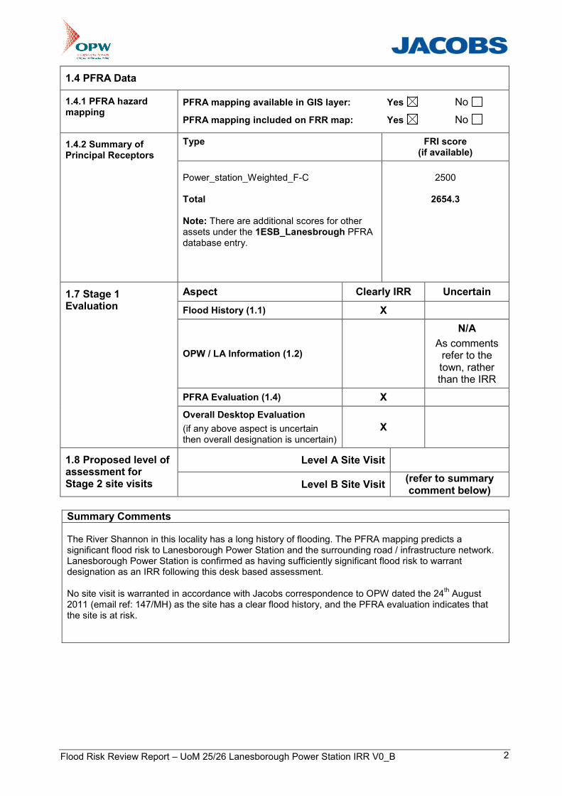
196500 197000 197500 198000 198500 199000 199500 200000 200500 201000 201500 202000 202500 203000 203500 204000 204500
2660
0026
6500
2670
0026
7500
2680
0026
8500
2690
0026
9500
2700
0027
0500
2710
0027
1500
2720
0027
2500
Revision
FINAL
@ A3Drawn
Oct 04, 2011
32103000
Shannon CFRAM Study
Client
Project
Title
Drawing StatusJob No.Figure No.
Scale
Copyright reservedJacobs UK Ltd95 Bothwell Street, Glasgow, G2 7HX
Includes Ordnance Survey Ireland data reproduced under OSi Licence number EN0021011. Unauthorised reproduction infringes Ordnance Survey Ireland and Government of Ireland copyright, © Ordnance Survey Ireland, 2011.
1:25,000
0 0.5 10.25Km
IRR4
Flood Risk Review Map
LegendAPSR Boundary for CARs onlyHistoric Flooding IncidentsWater bodies mapped from RADARSAT-2 *Hydrometric Gauging StationsEPA River NetworkRail StationsNursing HomesResidential Care for the ElderlySchoolsPorts and HarboursOPW BuildingsHealth CentresGarda StationsHospitalsFire StationsCivil Defence Head QuartersAirports
Rail NetworkRoads (National Roads Authority)Airport LandOPW EmbankmentsHistoric Flood DataArchitectural HeritageUNESCO SitesSpecial Protection AreaSpecial Area for ConservationProposed National Heritage AreaNational Heritage AreaBenefiting Lands
Flood Extents (PFRA, 2010)10% AEP Flood Extent (1 in 10 chance in any given year)1% AEP Flood Extent (1 in 100 chance in any given year)0.1% AEP Flood Extent (1 in 1000 chance in any given year)
AD/SF IB/PSChecked Approved
JCReview
KK/JM
Lanesbrough Power Station
Lanesbrough Power Station
* Data Source - Service Régional de Traitement d’Image et de Télédétection (SERTIT) (acquired on the 5th of December 2009).
The PFRA Flood Extents shown are indicative. They have been developed using simple and cost-effective methods that are suitable for the PFRA. They should not be used for local decision-making or any other purpose without verification.