Embed Size (px)
Citation preview
LOCATION BASED SERVICES: DEVELOPING MOBILE GIS APPLICATIONS
CHARL ANTHONY MOCKE
Thesis presented in partial fulfilment of the requirements for the degree of Master of Natural Sciences at the University of Stellenbosch.
Supervisor: Mr A van Niekerk December 2005

iiDeclaration
I, the undersigned, hereby declare that the work contained in this thesis is my own original work
and that I have not previously in its entirety or in part submitted it at any university for a degree.
Signature: …………………………………….
Date: …………………………………….
iiiABSTRACT
The substantial growth of the Internet during the past few years has sparked the adaptation of several fields
of current technologies to its demanding and cutting-edge standards. Mobile wireless cellular engineering
and Geographic Information Systems (GIS) are two such technologies. Integrating these two technologies
has resulted in the possibility of providing a type of useful functionality in the form of a technological
service to the public in terms of their geographical location, named Location Based Services (LBS). An LBS
can be defined as any service or application that extends spatial information processing or GIS capabilities to
end users via the Internet and/or wireless networks. Thanks to wireless cellular engineering, GIS, computer
programming and a little intellectual ingenuity, LBS now has the ability to provide a solution to the
persisting problem of the intractable incapability of prevalent technology to extend utile spatial information
to a user in terms of his/her geographical location.
The purpose of this study is to investigate how geographical information, derived from GIS processing, can
be supplied and presented in a useful manner to users' mobile electronic devices, using today’s available
technology. A sample LBS application will demonstrate how this is achieved in the South African context. It
includes features such as position location, street finding, shortest street route calculation, and map display,
all on a mobile cellular device. Relevant issues such as impending wireless cellular technology, development
cycles, implementation, costs, revenues and shortcomings are also discussed.
OPSOMMING
Die Internet se onlangse groei het veroorsaak dat vele aspekte van hedendaagse tegnologieë aangepas is om
tred te hou met die nuutste en mees veeleisende standaarde. Mobiele sellulêre tegnologie en Geografiese
Inligtingstelsels (GIS) is twee sulke tipiese tegnologieë. Deur hierdie tegnologieë te integreer het die
moontlikheid ontstaan om nuttige gebruikersfunksionaliteit in die vorm van ‘n tegnologiese diens aan die
publiek te verskaf met betrekking tot hul geografiese ligging. Hierdie tipe van diensbedrywe staan bekend as
Ligging Gebaseerde Dienste (LBD). ‘n LBD kan gedefinieer word as enige diens of toepassing wat
ruimtelike inligtingprosessering of GIS vermoeëns aan eindgebruikers via die Internet of koordlose
kommunikasie-netwerke verleen. Danksy sellulêre ingenieurstegniek, GIS, rekenaarprogrammering en ‘n
bietjie intellek, het LBD nou die vermoë om ‘n oplossing te bied vir die probleem van heersende tegnologie
se onvermoë om nuttige ruimtelike inligting aan eindgebruikers met ‘n bekende geografiese ligging, te lewer.
Die doel van hierdie studie is om die hedendaagse tegnologieë wat gebruik kan word om geografiese
inligting aan ‘n gebruiker se mobiele elektroniese eenheid te lewer, na te vors. ‘n Koordlose applikasie sal
demonstreer hoe hierdie doelwit bereik word in die Suid-Afrikaanse konteks. Hooftrekke soos
liggingsvasstelling, straat-opsporing, kortste-roete berekening, en kaartvertoning word op ‘n mobiele
sellulêre platform ge-implementeer. Toepaslike onderwerpe soos toekomstige koordlose sellulêre tegnologie,
ontwikkeling-siklusse, implementering, kostes, inkomste en tekortkominge word ook bespreek.

ivACKNOWLEDGEMENTS
• Alan Zimmerman and Chris Dixon (Synapp, Stellenbosch) and my fellow developers;
• Ray Wilkinson and Trevor Morgan (MapIT, Pretoria);
• Braam Brink (Location Based Systems, Cape Town);
• MapStudio and MapIT for use of their digital SA map geodataset;
• Neels van Rooyen (Georigin, Pretoria);
• Peter How (Composite Technologies, Midrand);
• Sean Wiid (Spatial Dimension, Cape Town);
• Prof H van der Piepen (German Aerospace Centre, Cologne);
• Prof Dieter Fritsch (Stuttgart University);
• Bernhard Scherer (Map & Guide, Karlsruhe);
• Marco Bakker (Siemens, Eindhoven);
• Adrian Tout (Sensis, Sydney);
• Thinus van der Merwe (B.A., H.O.D. (UOVS)) for the grammar checking;
• My supervisor Mr A van Niekerk.

vCOPYRIGHT CREDITS
AfriGIS Swoop is a trademark of AfriGIS (Pty) Ltd.
ArcGIS, ArcIMS, ArcSDE, ArcView, MapObjects, MapObjects Internet Map Server and
RouteMap IMS are trademarks, registered trademarks, or service marks of Environmental Systems
Research Institute, Inc. (ESRI) in the United States, the European Community, or certain other
jurisdictions.
ChronoX Routing Engine is a trademark of Magellan Engénierie, France.
FindMe is a trademark of MTN SA (Pty) Ltd.
GIF is a trademark of CompuServe Graphics Inc.
Java, J2SE, J2EE and J2ME are registered trademarks of Sun Microsystems Inc.
Look4It, Look4Me and Look4Help are trademarks of Vodacom Corporation SA (Pty) Ltd and
CellFind (Pty) Ltd.
Map & Travel Navigator South Africa 2004 and iNETServer are registered trademarks of Map
& Guide GmbH, MapStudio (Pty) Ltd and MapIT (Pty) Ltd.
Microsoft Windows, Windows XP, Windows 2000, Windows CE, Windows Mobile, Visual
Basic and C# are either registered trademarks or trademarks of Microsoft Corporation Inc. in the
United States and/or other countries.
MobiMap is a trademark of Location Based Systems (Pty) Ltd.
New Atlanta ServletExec is a registered trademark of New Atlanta Communications LLC.
SmartRoute is a trademark of SmartSurv Wireless (Pty) Ltd.
SYMBIAN and SYMBIAN OS are trademarks or registered trademarks of Symbian Ltd.

viCONTENTS
Page
ABSTRACT / OPSOMMING .......................................................................................................................iii
ACKNOWLEDGEMENTS........................................................................................................................... iv
COPYRIGHT CREDITS................................................................................................................................ v
CHAPTER 1: EXTENDING GIS CAPABILITIES ONTO MOBILE DEVICES.....................................1
1.1 OBJECTIVES, APPROACHES AND METHODOLOGY .................................................................................2 1.2 STUDY AREA .............................................................................................................................................3 1.3 RESEARCH FRAMEWORK ........................................................................................................................3
CHAPTER 2: CURRENT STATUS AND TRENDS OF LBS AND M-GIS ..............................................4
CHAPTER 3: M-GIS COMPONENTS..........................................................................................................9
3.1 CLIENT COMPONENTS .............................................................................................................................9 3.1.1 MOBILE CELLULAR PHONES .................................................................................................................10 3.1.1.1 Mobile Information Device Profile...................................................................................................10 3.1.1.2 Wireless Application Protocol ..........................................................................................................15 3.1.1.3 Symbian operating system ................................................................................................................16 3.1.1.4 Short Message Service, Enhanced Message Service, Picture-SMS..................................................16 3.1.1.5 Multimedia Messaging Service.........................................................................................................17 3.1.2 PALM HANDHELDS ...............................................................................................................................17 3.1.3 POCKET PCS.........................................................................................................................................18 3.1.4 GPS RECEIVERS....................................................................................................................................18 3.1.5 LAPTOP COMPUTERS ............................................................................................................................19 3.1.6 SUMMARY ............................................................................................................................................19 3.2 COMMUNICATION TECHNOLOGIES AND INFRASTRUCTURE ...............................................................19 3.2.1 HARD-LINE INFRASTRUCTURES............................................................................................................20 3.2.2 “OVER THE AIR” ..................................................................................................................................20 3.2.2.1 Global System for Mobile Communication ......................................................................................20 3.2.2.2 General Packet Radio Services .........................................................................................................21 3.2.2.3 Universal Mobile Telecommunications System ...............................................................................22 3.3 POSITION LOCATION..............................................................................................................................23 3.3.1 MANUALLY ..........................................................................................................................................23 3.3.2 NEAREST CELL MAST / SINGLE CELL-ID.............................................................................................24 3.3.3 MULTIPLE CELL TRIANGULATION .......................................................................................................24 3.3.4 GLOBAL POSITIONING SYSTEM............................................................................................................25 3.4 SERVER COMPONENTS...........................................................................................................................26 3.4.1 WEB SERVER SOFTWARE......................................................................................................................26 3.4.1.1 Operating system...............................................................................................................................27 3.4.1.2 Servlet engines ..................................................................................................................................27 3.4.1.3 Programming languages....................................................................................................................27 3.4.1.4 XML parsers .....................................................................................................................................27 3.4.1.5 Other software...................................................................................................................................28 3.4.2 MAP SERVER SOFTWARE ......................................................................................................................28 3.4.2.1 Map generation software...................................................................................................................28 3.4.2.2 Network routing software .................................................................................................................29 3.5 GEODATABASE.......................................................................................................................................33
viiCHAPTER 4: SAMPLE M-GIS APPLICATION DEVELOPMENT ......................................................34
4.1 OBJECTIVES ...........................................................................................................................................34 4.2 DESIGN ...................................................................................................................................................35 4.2.1 ARCHITECTURAL DESIGN .....................................................................................................................37 4.2.2 FUNCTIONAL / MMI DESIGN ................................................................................................................38 4.2.3 BUSINESS MODEL DESIGN ....................................................................................................................40 4.2.4 GUI DESIGN..........................................................................................................................................41 4.3 HARDWARE AND SOFTWARE REQUIREMENTS AND USAGE .................................................................44 4.3.1 COMPUTER/ELECTRONIC HARDWARE ..................................................................................................44 4.3.1.1 Microcomputer servers .....................................................................................................................44 4.3.1.2 Microcomputer development machines ............................................................................................45 4.3.1.3 Mobile/handsfree devices .................................................................................................................45 4.3.2 COMPUTER SOFTWARE.........................................................................................................................45 4.3.2.1 Programming.....................................................................................................................................45 4.3.2.2 GIS programs ....................................................................................................................................47 4.3.2.3 Operating system and administrative services ..................................................................................47 4.3.3 GEOGRAPHICAL DATA..........................................................................................................................47 4.3.4 TELECOMMUNICATION INFRASTRUCTURES .........................................................................................48 4.3.4.1 GSM and GPRS ................................................................................................................................48 4.3.4.2 Internet (TCP/IP)...............................................................................................................................49 4.4 DEVELOPMENT ......................................................................................................................................49
CHAPTER 5: EVALUATION OF SAMPLE M-GIS APPLICATION ....................................................52
5.1 SHORTCOMINGS AND FUTURE IMPROVEMENTS ..................................................................................52 5.2 COSTS AND REVENUES...........................................................................................................................53 5.2.1 COSTS...................................................................................................................................................54 5.2.1.1 Financial costs...................................................................................................................................54 5.2.1.2 Time costs .........................................................................................................................................56 5.2.2 REVENUES ............................................................................................................................................56 5.2.2.1 Models...............................................................................................................................................57 5.2.2.2 Results...............................................................................................................................................58 5.3 CONCLUSION..........................................................................................................................................59 5.3.1 HOLISTIC OBJECTIVES ..........................................................................................................................60 5.3.2 PHYSICAL OBJECTIVES .........................................................................................................................61
CHAPTER 6: SYNTHESIS AND CONCLUSIONS...................................................................................63
6.1 REVISITING THE STUDY’S OBJECTIVES ................................................................................................63 6.2 FUTURE RESEARCH OPPORTUNITIES....................................................................................................64
APPENDIX A ................................................................................................................................................ 70
viiiFIGURES
Page
Figure 2.1 Map & Travel Navigator screenshots ............................................................................................ 6
Figure 3.1 The Java language........................................................................................................................ 10
Figure 3.2 J2ME structure ............................................................................................................................. 11
Figure 3.3 MIDP position in a device............................................................................................................ 13
Figure 3.4 MIDP-compatible cellular phones ............................................................................................... 14
Figure 3.5 Mobile communication networks for multimedia when UMTS is implemented......................... 23
Figure 3.6 Network routing analysis flowchart ............................................................................................. 31
Figure 4.1 Architectural design ..................................................................................................................... 37
Figure 4.2 Functional / MMI design.............................................................................................................. 39
Figure 4.3 Business model design ................................................................................................................. 41
Figure 4.4 Map screen GUI on Motorola Accompli 008 (MIDP)................................................................. 42
Figure 4.5 Map screen GUI on Nokia 9210i Communicator (Symbian OS 6.0) .......................................... 42
Figure 4.6 Map screen on Nokia 3510 (Picture-SMS) .................................................................................. 43
Figure 4.7 Three different-scaled map screens on Nokia 3510 (Picture-SMS)............................................. 43
1CHAPTER 1: EXTENDING GIS CAPABILITIES ONTO MOBILE DEVICES
“Anywhere, anytime, any device – this is the short definition of the rapidly growing field of location
services. It’s where wireless and GIS technologies meet on the Web and it is changing the way
businesses and individuals operate” (ESRI 2001a).
In the last few years the Internet has become almost a household name (Green 1997). Many
advertisements in newspapers and magazines, on television, and even on roadside billboards now
show the familiar “www” or “.com” addresses. Most computer magazines have columns and
articles on the Internet, as do newspapers in the Information Technology (IT) sections. Small
businesses and individuals also have their so-called Home Pages. The World Wide Web (WWW) is
vast and presents exciting opportunities for anyone who has geographic data, analyses geographic
data or otherwise adds value (Limp 1997).
The substantial growth of the Internet during the past few years has sparked the adaptation of
several fields of current technologies to its demanding and cutting-edge standards. Such
technologies have been changed and enhanced to facilitate the incorporation of the Internet or
related Internet protocols (Zhuang 1997). One such technology is that of mobile cellular phones.
Cellphones have enjoyed increased use and acceptance in South Africa since 1995. The South
African cellphone subscriber base for March 2004 was estimated at 14.5 million users (Finance24
2004a), and total world subscriber base for 2006 is estimated at 2 billion users (Finance24 2004b).
Wireless Application Protocol (WAP) was the first technology developed (and globally released
shortly before the turn of the millennium in December 1999) to support the transfer of data between
cellphones and web servers using technologies similar to that of the Internet, and displaying it to the
subscriber in a similar fashion as a web browser on a Personal Computer (NETmaster Africa 1999;
Computing SA 2000). Similar technologies, which address each other’s limitations, have also been
developed or are being developed, or have been suggested (NETmaster Africa 2000).
If there was something not forecast 15 years ago it was the contribution now delivered by the
Internet to the distribution of geographic information (Van Eck & De Kuijper 2000). With the
subsequent rapid expansion and development of the Internet and the WWW, Geographical
Information Systems (GIS) extended onto websites are becoming ever more popular and as a result
numerous sites have added GIS capability on their websites (Zhuang 1997). Furthermore, Mobile
Geographic Information Systems (M-GIS) are emerging as a result of integrating GIS, Global
Positioning Systems (GPS), wireless communications and mobile computing technologies (Karimi
22000). Providing this kind of functionality to the general public has sparked off the initiation and
development of so-called “Location Based Services” (Francica 2000).
A Location Based Service (LBS) can be defined as any service or application that extends spatial
information processing or GIS capabilities to end users (based on their geographic location) via the
Internet and/or wireless networks (ESRI 2000 & 2001d). Such services combine scalable GIS
technology, easy-to-use browsers, mobile and wireless devices, and wireless and Internet
infrastructure with web servers to provide information and services whenever and wherever they are
needed (ArcNews 2001).
A Mobile Geographic Information System (M-GIS) can be defined as a subset of an LBS (Informa
Telecoms Group 2002a). Whereas an LBS extends spatial information processing or GIS
capabilities to end users via the Internet and/or wireless network, an M-GIS limits that extension to
only mobile devices, as to create an abstract “portable GIS”. This study looks at LBSs in general
but focuses on M-GISs, with specific reference to a sample M-GIS application developed. Also, for
the purpose of this study, an application that delivers geographical information (based on location)
to a non-mobile (fixed) device, will be classified as an LBS. An application that delivers
geographical information (based on location) to a mobile device, will be classified as an M-GIS.
1.1 OBJECTIVES, APPROACHES AND METHODOLOGY
The aim of this study is to investigate how geographical information, derived from GIS processing,
can be supplied and presented in a useful manner to mobile devices. A sample M-GIS application
will demonstrate how this is achieved. Thus, this research project aims to fulfil these three goals:
1. to research the latest emerging LBS and M-GIS technologies that can be put to use for
such applications;
2. to investigate the development of a sample M-GIS application which uses the best
suited technologies available; and
3. to demonstrate the usefulness and benefits of such an M-GIS application in the South
African context.
Research material for this study originates from a wide variety of sources. Literature from journals,
magazines, newspaper articles and conference proceedings provide a theoretical background. This
is complemented by a wealth of information on LBS and M-GIS applications (including its
components) found on the Internet. The author also obtained valuable experience and information
from working in the mobile telecommunications and GIS fields for a number of years. All of these

3sources proved to be extremely useful and supplied a very thorough insight and background for
research on LBS and M-GIS applications and components. A number of current commercial LBS
and M-GIS applications are also investigated and supplied as examples in the next chapter. This
delivered an important understanding of the practical application of M-GIS theory.
The theory and insight obtained from the research were practically applied by means of the
development of a complete M-GIS project. The M-GIS application formed part of this project and
was successfully presented and commercially deployed on compatible mobile phones in South
Africa’s consumer market.
1.2 STUDY AREA
South Africa is traditionally known to be "lagging" behind other first world countries like Europe,
Asia and North America as far as technological advances are concerned (Vodacom 2003). Luckily,
this "lagging" seems to have diminished significantly over the last couple of years. Although new
technologies relevant to LBS and M-GIS are still being implemented first in those other countries,
South Africa is nowadays not technologically as far behind (Vodacom 2003).
South Africa was chosen as the study area because the status of LBS and M-GIS in the country can
be properly investigated. Great technological growth opportunities are apparent (Vodacom 2003),
and this suits the development and implementation of LBS and M-GIS projects perfectly. The
sample M-GIS application developed for this study also uses a South African geodatabase.
1.3 RESEARCH FRAMEWORK
The chapters of this thesis closely follow the order in which research was conducted. This
introductory chapter focussed on the general background of LBS, M-GIS and its components. The
objectives of the study were stated and the study area explained. In the next chapter some of the
current trends of LBS and M-GIS locally and internationally are researched. The current status of
LBS and M-GIS projects in South Africa is illustrated by means of a few example LBS and M-GIS
applications already commercially available. Chapter 3 describes the various technological
components that can be used for the development and implementation of a typical M-GIS project,
while chapter 4 outlines the development and implementation of a practical M-GIS application.
Chapter 5 evaluates the sample M-GIS application, taking into account its shortcomings, costs and
revenues. Chapter 6 concludes the study by revisiting the research objectives and application
improvements, and future research opportunities are suggested.

4CHAPTER 2: CURRENT STATUS AND TRENDS OF LBS AND M-GIS
A vast amount of Location Based Services (LBS) and Mobile Geographic Information Systems
(M-GIS) have been commercially deployed worldwide since 2002 (Vodacom 2003). The author
also found a number of M-GIS services that were started in 2001, which had promising prospects,
but died a slow death a year or two afterwards. Outdated websites, some of which have not been
updated for a long time, are reminiscent of these once promising M-GIS applications but which are
now non-existent.
Why did these initial M-GIS offerings fail? A number of possible reasons are suggested, but there is
not one single answer (Wireless Developer Network 2003). However, the assumed reasons all bear
down to the following main encapsulating problem: the mobile (cellphone) market was not ready
for it. The infrastructure and GIS technology were there, the users were there, but the cellphones
were not capable of receiving large volumes of geographical information (usually raster maps). The
map downloads were too slow and the users too impatient. Also, the display limitations (Liquid
Crystal Display (LCD) screen resolution, number of colours) of the cellphones of the time were the
main factors hampering the proper presentation of geographical information, for example street
maps.
Fortunately, cellphone capabilities have improved tremendously since 2002. They now have the
ability to receive and transmit data at speeds supported by most cellular networks. Their display
capabilities have also improved, and large full-colour high-resolution LCD screens are now almost
the norm on most available cellphones. Speed and display limitations are something of the past;
cellphones are now ready for content-rich applications.
Can LBS and M-GIS provide a solution to the persisting problem of the intractable incapability of
prevalent technology to extend utile spatial information to a user in terms of his/her geographical
location? The objectives of this study (as listed in Section 1.1) attempt to provide the answer to this.
Six current LBS and M-GIS applications are discussed below. One of them is available
internationally and locally, whilst the others are available only locally. This does not mean to say
that similar services do not exist overseas; it only means that the LBS or M-GIS service, as it is
known by its unique name, exists in South Africa and is illustrated below as such.
51. Map & Guide Navigator
Map & Guide GmbH is a GIS product specialist company in Karlsruhe, Germany. Amongst other
GIS products, they have recently released a software program that runs on a Pocket PC displaying a
map and providing turn-by-turn street route instructions. This program is intended to be used for in-
car navigation along with a Global Positioning System (GPS) receiver, and is very useful. Through
a partnership with MapIT (Pty) Ltd this product has now also been released in South Africa, using
the MapStudio South African map set, and was named "Map & Travel Navigator South Africa
2004".
The Navigator is an M-GIS application that runs totally stand-alone and performs no
communication with any web or map server. The complete digital map database is loaded and
stored on the Pocket PC itself. The internal Central Processing Unit (CPU) of the Pocket PC also
performs all the route calculations and other processing. The Navigator has the following main
features:
• user can enter any number of destination points (from street address, map, Points of Interest
(POI), Microsoft Outlook Contacts address or favourite locations), and the program
calculates an optimum route between all the points
• Microsoft Outlook Contacts addresses on the user’s Personal Computer (PC) can be placed
on the Pocket PC and street addresses within can be used as destination points
• fully detailed driving instructions given visually (on a full-colour map display) as well as
aurally (clear and concise voice driving instructions)
• uses South African street map dataset with full street detail for major towns, all freeways
and main roads for the rest of the country
• uses South African POI dataset (police stations, petrol stations, schools, hospitals, etc.); user
can also search for nearest POI from current location
• in case the user does not follow the calculated route, a new route is instantly calculated
automatically and shown on the map
• special “Position Tracking Mode” available (no routing – only tracks the moving position of
the driver on a map)
The Navigator has been met with success in South Africa. Over 1500 copies have already been
sold. Some screenshots of its Graphical User Interface (GUI) are presented in Figure 2.1 below.

6
Figure 2.1 Map & Travel Navigator screenshots
2. Vodacom SA
Vodacom SA hosts a number of useful LBSs developed by Cellfind (Pty) Ltd (CellFind 2004;
Vodacom 2004). They are discussed below.
72.1 Look4it
Look4it provides a variety of information of facilities and services available in the user's vicinity
(Look4it 2004) and was developed in association with AfriGIS (Pty) Ltd. The location information
of the cellphone (and its user) is used to determine which required information for the vicinity of
the user should be displayed. This type of LBS service is classified as an Active LBS – the user
personally requests location information based on his/her own position. It uses the Nearest Cell
Mast location technique (see section 3.3.2 for more details). A database of commercial services is
maintained and when the user wants information on a specific public service, a database table
lookup is performed on the central processing server and all the specified services that fall within
the area of the user's nearest cell mast, is returned. The Man-Machine Interface (MMI) service
menu is invoked by dialling *120*555# from the cellphone.
2.2 Look4me
Look4me allows a user with access to a web browser to view a map around the location of a queried
cellphone (Look4me 2004). This type of LBS service is classified as a Passive LBS – a third party
requests location information from the user. It is particularly useful for parents wanting to know the
location of their children. “Look4me For Business” can be used to locate mobile workforces any
time of the working day without interrupting their activities. This LBS uses the “Time Differential
of Arrival” location technique (see section 3.3.3), as well as MapStudio's digital SA map dataset.
2.3 Look4help
A user's cellphone becomes a mobile panic button when he/she saves the number *120*888*888#
as a speed dial (CellFind 2004). The pre-defined recipients of the distress message and location
information can then contact the user in distress, physically come to his/her rescue or contact an
emergency service. This LBS also uses the “Time Differential of Arrival” location technique.
3. MTN FindMe
In 2002 MTN SA launched their FindMe service as part of their range of Value-Added mobile
services known as MTN-ICE. This M-GIS service allows an operator to give verbal driving
instructions to a lost user calling in for assistance.
8The user phones a specific number and the Nearest Cell Mast location technique is used to locate
him/her in a general area. This location is passed to the operator who can then ascertain the exact
location of the user and give him/her street directions to where he/she wants to go. This service is
still operational today, although details of it on MTN-ICE’s website no longer exist.
4. SmartRoute
SmartRoute is the latest innovation released by SmartSurv Wireless (Pty) Ltd that allows any
person with the appropriate cellular phone to enjoy all the benefits of street navigation normally
only available on high-end motor vehicles (SmartSurv Wireless 2004). The application runs on
cellphones using the Symbian 7.0 operating system, such as the Nokia 6600 and Siemens SX1. A
Java Mobile Information Device Profile (MIDP) application is loaded onto the phone which
communicates (using General Packet Radio Service (GPRS)) with a web server. The user's location
(obtained from a GPS receiver) and destination are sent to the server and a route corridor is
calculated and sent back to the cellphone by means of a Multimedia Messaging Service (MMS)
message containing a colour map showing the next driving direction indicated on a street crossing.
All that remains is for the driver to follow the visual guidance and voice-prompted turn-by-turn
instructions to the desired destination.
5. AfriGIS Swoop
AfriGIS Swoop, developed and deployed in 2000 by AfriGIS, is a web service that allows a user to
enter a source and target location, after which a route between the two locations is calculated and
presented on a map, with turn-by-turn directions, in the user's web browser (AfriGIS 2004). The
user has the option of having the system send him/her the directions via Short Messaging Service
(SMS) to his/her cellphone. Although this service initially appeared promising, it is not in service
anymore (error messages are shown when attempting to route), and is currently being upgraded.
These examples of LBS and M-GIS applications are by no means complete. They are bound to
develop even further and spark off further ideas which will develop into secondary LBS and M-GIS
applications. There are also many more similar LBS and M-GIS projects like the above that are
currently in operation worldwide. By means of the above examples, the author has given a small
glimpse of what is possible with LBS and M-GIS applications. The sample M-GIS application
developed for this study has some elements of the above examples in its functioning or capabilities.
But before the sample application is discussed, an understanding of the necessary components for
an M-GIS needs to be gained first. This is the focus of the next chapter.

9CHAPTER 3: M-GIS COMPONENTS
A Mobile Geographic Information System (M-GIS) project consists of several components which
represent individual technological fields conceptual to the architectural design of the project
(Sarjakoski & Lehto 2003). Client components consist of all the physical mobile devices that are
compatible with the front-end requirements of an M-GIS application; in other words, they are the
mobile devices that the application can run on. The communication technologies and infrastructure
components ("middleware") allow for the transmission of requests and responses between the client
and server components. The server components are all the hardware and software involved in
serving the client-side of the M-GIS project on the web server and the map server.
Position determination (location) technology is considered part of the middleware components for
the purpose of this research theme. It deals with the ways in which the position of the user wanting
geographical information can be located.
The last important component is the geodatabase. It is the spatial data source of all the geographical
information that can be effectively presented on the user's mobile device.
Each of the four abovementioned components are discussed in turn below. Research results are
presented comprehensively, but by no means represents all of the possible subcomponents that
could theoretically exist and be usable for any arbitrary M-GIS application. For the sample M-GIS
application of this research, only a selected set of subcomponents was available and/or was used.
Chapter 4 discusses and explains this in more detail.
3.1 CLIENT COMPONENTS
Technological advances in the field of mobile computerised devices have resulted in a large variety
of such products entering the markets during the past decade (Graham et al. 2003). The extent of
this variety will by no doubt increase even further in the forthcoming years. This is very
advantageous to M-GIS applications since it brings about a high degree of diversity to the range of
devices that would allow for M-GIS applications to be run on. These devices are also allowing for
an increasing degree of interoperability between the devices and communication infrastructures.
This section briefly covers all of the mobile devices that would be suitable for M-GIS applications.
103.1.1 Mobile cellular phones
Mobile cellular phones (“cellphones”) must surely be the most popular mobile device in the market
today, however not all cellphones are compatible with all promised features of M-GIS applications
(Informa Telecoms Group 2002a). There are indeed limitations involved, mostly in terms of the
physical capabilities of the cellphone, as well as the communication protocols it is compatible with.
The grouping of these limitations is generally according to the cellphone’s classification. The five
main classifications are discussed below.
3.1.1.1 Mobile Information Device Profile
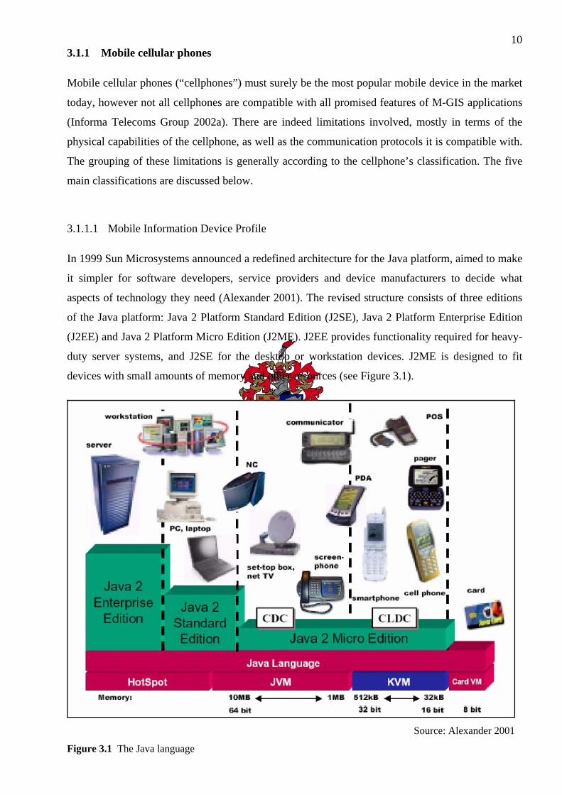
In 1999 Sun Microsystems announced a redefined architecture for the Java platform, aimed to make
it simpler for software developers, service providers and device manufacturers to decide what
aspects of technology they need (Alexander 2001). The revised structure consists of three editions
of the Java platform: Java 2 Platform Standard Edition (J2SE), Java 2 Platform Enterprise Edition
(J2EE) and Java 2 Platform Micro Edition (J2ME). J2EE provides functionality required for heavy-
duty server systems, and J2SE for the desktop or workstation devices. J2ME is designed to fit
devices with small amounts of memory and other resources (see Figure 3.1).
Source: Alexander 2001
Figure 3.1 The Java language
11Software applications on all three Java editions can be developed using the same application
programming technique. Applications designed for J2ME will also work in J2SE and in J2EE.
Within J2ME, major types of consumer devices are grouped into a limited number of categories,
such as wireless devices (pagers and cellphones), screenphones, car and Personal Digital Assistants
(PDA). Each category will include the minimum set of Application Programming Interfaces (API)
useful for that kind of product and a Java Virtual Machine (KVM) required to support those APIs
(Sun Microsystems 1999).
To date, software application developers have already downloaded tens of thousands copies of
J2ME from Sun Microsystems’s website. Innovative solutions for wireless devices such as
entertainment and business applications are being widely developed and deployed today. A recent
market research study by Evans Data Corporation showed that over 33% of wireless application
developers intend to develop for J2ME - the highest response garnered for any wireless platform
(Sun Microsystems 2001). Since its introduction in June 1999, J2ME has been supported by
wireless carriers and mobile cellular device manufacturers.
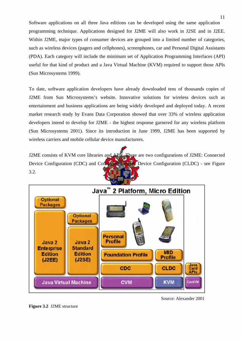
J2ME consists of KVM core libraries and APIs. There are two configurations of J2ME: Connected
Device Configuration (CDC) and Connected Limited Device Configuration (CLDC) - see Figure
3.2.
Source: Alexander 2001
Figure 3.2 J2ME structure

12Alexander (2001) defines KVM as a small-sized computer software program specifically
designed for small devices with lack of resources. It is made as small as possible, but it maintains
support for all main features of Java. The letter “K” in KVM stands for “kilo” – the amount of
memory used by the virtual machine is measured in kilobytes. KVM can be run on 16-bit or 32-bit
microprocessors with a total system memory of less than 128 kilobytes (for the most compact
version). This version is used in cellphones, pagers and organizers (e.g. PDAs). These 128 kilobytes
contain the KVM itself, some Java class libraries and some space for running Java applications.
CLDC defines a Java platform for a group of devices with similar memory total size and similar
resources. CLDC is needed to define a standard Java platform for small connected devices to allow
them to download Java applications and content, and to allow other software developers to create
applications for the particular devices.
MIDP is designed to operate on top of the CLDC. It was produced by the Mobile Information
Device Profile Expert Group (MIDPEG) and its main objective is to establish an open application
development environment for Mobile Information Devices (MID). To achieve this goal the
MIDPEG has defined a MID to be a device that should have the following minimum characteristics:
• Display:
o Device screen resolution: 96 by 54 pixels; pixel shape ratio: approximately 1:1
o Display depth: 1-bit (i.e. monochrome)
• Input:
o one or more of the following user input mechanisms: “one-handed keyboard”
(simple cellular phone keypad), “two-handed keyboard” (usual computer keyboard)
or touch screen (with the aid of a stylus)
• Memory:
o 128 kilobytes of ROM for the MIDP components (content of this memory remains
the same after user switches the device “off” and then “on”)
o 8 kilobytes of ROM for application-created persistent data
o 32 kilobytes of RAM for the Java runtime
• Networking:
o Two-way, wireless, with limited bandwidth

13
Source: Alexander 2001
Figure 3.3 MIDP position in a device
Figure 3.3 illustrates how MIDP fits into a mobile device. The lowest-level block (MID) represents
the MID hardware. On top of this hardware is the native system software. This layer includes the
operating system and libraries used by the device. The next level of software is the CLDC. This
block represents the KVM and associated libraries defined by the CLDC specification.
A MIDP application, or MIDlet, is one that utilises only the APIs defined by the MIDP and CLDC
specifications. Applications that run on devices supporting MIDP are called MIDlets. Like Java
Applets, MIDlets are controlled by the software that runs them – in this case the cellphone that
supports MIDP and the J2ME CLDC. An M-GIS application that would be developed using this
software development technology, would be known as an M-GIS MIDlet.
J2ME has the following distinct advantages:
• Applications are loaded on demand. The user can choose to download applications he/she
needs rather than buying a device with applications pre-installed by the device
manufacturer, making this cost-effective and efficient.
• Java technologies come with libraries that allow an application developer to build a richer,
more intuitive Graphical User Interface (GUI). This allows service providers to offer easy-
to-use personalised applications and services which makes their offering more diverse.
• Java technologies allow more intelligent use of network bandwidth because applications are
downloaded onto the device and run locally, so the network is used only when data is
needed from the server.
14• Java technology provides cross-platform and multiple device support. J2ME and MIDP
technologies can run the same application on any supported system type.
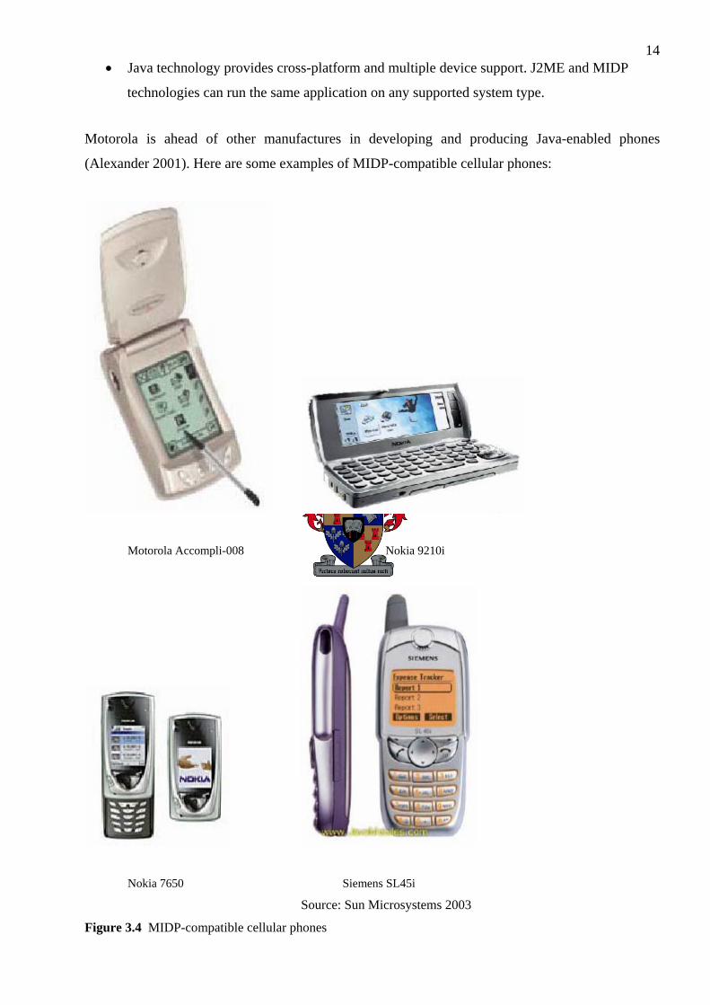
Motorola is ahead of other manufactures in developing and producing Java-enabled phones
(Alexander 2001). Here are some examples of MIDP-compatible cellular phones:
Motorola Accompli-008 Nokia 9210i
Nokia 7650 Siemens SL45i
Source: Sun Microsystems 2003
Figure 3.4 MIDP-compatible cellular phones
153.1.1.2 Wireless Application Protocol
In December 1999, just before the end of the previous millennium, the first cellphones that
supported wireless Internet browsing were released. The key to this breakthrough was the
acceptance of the Wireless Application Protocol (WAP) as the de facto standard for mobile Internet
use. The WAP specification for delivering Internet content to mobile devices was formulated by the
International WAP Forum formed in 1997 (Planting & Bidoli 1999).
The WAP Forum (2001) defines WAP as “an open, global specification that empowers mobile
users with wireless devices to easily access and interact with information and services instantly”.
The purpose of WAP is to enable easy and fast delivery of relevant information and services to
mobile users. Handheld digital wireless devices such as cellphones, pagers, two-way radios,
smartphones, screenphones and communicators would be made able to support and use WAP. The
first cellphone released with WAP support was the Nokia 7110 (Bornman 1999), benchmarking the
emerging so-called “2G” (Second Generation) set of mobile wireless devices”.
Besides being a communications protocol, WAP is also an application environment. It can be build
on any operating system, including Microsoft Windows CE (intended for mobile devices). A WAP-
enabled device can thus be seen as a micro-browser: client software designed to overcome
challenges of mobile handheld devices that enable wireless access to services such as Internet
information in combination with a suitable network server (known as a WAP Gateway Provider).
The initial release of WAP version 1.0 was not without its limitations (Brown & Chidi 2000). Older
wireless devices, constrained by small Liquid Crystal Display (LCD) screens, limited processing
power and bandwidth, could not handle Hypertext Markup Language (HTML) documents (ESRI
2001d). However, WAP has evolved to deal with these problems. From the creation of Extensible
Markup Language (XML) came Wireless Markup Language (WML). Wireless data content is not
directly encoded in XML, but in a specific markup language defined, using XML. WML is an
example of a specific language for wireless applications that is fully compliant with XML's rules.
WML is thus an XML application, and the core specification of WAP.
Currently there are a number of local companies that complement cellular services by supplying
WAP packages with mobile phone packages, one of them being WorldOnline SA. This WAP
service has been functioning very well with simple text messages and small images, but larger
images, greater amounts of text and raster maps have given problems in the sense that it takes too
long to download, because of limited bandwidth. Another problem is the limited display capabilities
and functionality of entry-level WAP-enabled cellphones, especially that of the Nokia 7110 and the

16newer Nokia 3330. For WAP to have been successful in larger applications and wireless data
transfers, data download rates (thus in effect available bandwidths) would have to be increased
through advances in Global System for Mobile Communication (GSM) cellular technology, thus
making it possible for more graphical applications to be delivered to the phone (Ferranti & Niccolai
2000).
WAP effectively works in a series of transmission steps (ESRI 2001d). The user of a mobile device,
such as a WAP-enabled cellphone, keys in a desired web address into a micro-browser, which sends
the request using radio waves to the WAP Gateway Provider. This server, connected to the Internet,
locates the requested web page. The page is converted from HTML to WML and the WAP Gateway
Provider prepares the WML page for wireless transmission. The user’s mobile device receives the
WML script and its built-in micro-browser interprets and displays it on the device’s LCD screen.
From the screen the user can then select menu options, links, pages, etc. which is in effect very
similar to the original web page. The page contents can even be transmitted through the device’s
infrared, Bluetooth or Wi-Fi port (if supported) to any other compatible device (Laing 1999).
3.1.1.3 Symbian operating system
Symbian OS is the advanced, open, standard operating system licensed by the world's leading
mobile phone manufacturers (Wireless Developer Network 2003). Symbian OS is designed for the
specific requirements of data-enabled Second Generation (2G), Second-and-a-half Generation
(2.5G) and Third Generation (3G) cellphones (see Section 3.2.2). Compact enough to fit in the
memory of a mobile phone, Symbian OS was initially planned to be a full operating system in terms
of functionality. Symbian OS is already available in a large range of World Smartphones,
cellphones, and PDAs. With the introduction of Symbian OS version 7.0, the range of mobile
phones with Symbian OS will expand even further (Informa Telecoms Group 2002b).
Symbian OS is the basis of the next generation of mobile phones. It is the common core of APIs
and technologies that are shared by all Symbian OS phones.
3.1.1.4 Short Message Service, Enhanced Message Service, Picture-SMS
Short Message Service (SMS) is an application which became a runaway success in the mobile
cellular world (News24 2001b). SMS is the second biggest growing service world wide (News24
2001a). Current surveys predicted that 40 percent of future 3G wireless network use would be
17dedicated to checking e-mails and sending and receiving messages, proving that no matter how
phones are marketed, at the end of the day, text sells.
Mobile messaging is evolving beyond text by taking a development path from SMS to Enhanced
Messaging Service (EMS) to Multimedia Messaging Service (MMS) (Mobile Lifestreams.com
2000a & 2000b). EMS is the ability to send a combination of simple melodies, pictures, sounds,
animations, modified text and standard text as an integrated message for display on an EMS
compliant mobile phone. Mobile Lifestreams.com (2001b) believes that EMS and MMS (see
Section 3.1.1.5) will be essential next generation messaging technologies.
Recently, Vodacom SA has started to implement various Value-Added Services (VAS) using SMS.
Subscribers can send various “codes” via SMS to the Message Receiving Centre which would
return the requested information to the subscriber, e.g. the latest news, weather, a joke, etc.
3.1.1.5 Multimedia Messaging Service
The Multimedia Messaging Service (MMS) is the ability to send and receive messages comprising
a combination of rich media including text, sounds, images and video to MMS capable handsets
(Vodacom 2001). Today's popular text-based SMS services can be enhanced with richer MMS
content. MMS also offers a radically better end-user experience compared to text only-based SMS
services. For example, a weather service can be extended from text-based information to include
animated weather maps and forecast graphs with MMS capable terminals. Personalisation will be
more effective with e.g. new audio formats and colour screens.
MMS is the key business case driver for General Packet Radio Service (GPRS) and is also the
central driver for the 3G business case. MMS will contribute significantly to returns on 3G
investments (MapFlow 2002).
3.1.2 Palm handhelds
Palm handhelds are small-sized portable computers that were released in the 1990s. Although they
are still around today with new models, their data storage capacity and especially processing power
do not allow for any reasonable form of geographic information processing. This might change in
the future, however.

183.1.3 Pocket PCs
CE-Windows.Net (2004) defines Pocket PCs or PDAs as small computers that fit in the handpalm
which run the Microsoft Windows CE operating system version 3.0. It includes Microsoft programs
like Pocket Word, Pocket Excel, Calendar, Contacts and Tasks as well as many other applications.
It provides a Microsoft Windows look-and-feel GUI to the user by means of a relatively large
colour LCD touch-pad screen. Processing power are mostly provided by the StrongArm processor,
for which speeds vary between 150 Megahertz (MHz) and 500MHz. Pocket PCs have their own
internal storage space for add-on applications and data, which is usually sized around 64MB to
128MB. Users can add additional storage capacity by means of removable storage cards that can be
slotted into the device. These storage cards are either of the type Secure Digital (SD) or Compact
Flash (CF) and sizes vary from 32MB up to 2 GigaByte (GB).
Because of Pocket PCs’ favourable characteristics, they are ideal for M-GIS applications (Map &
Guide 2004). Their communications abilities include Bluetooth and infrared which is used for
short-range communication between other compatible devices, and Wi-Fi (also known as Wireless
Local Area Networks (WLAN)) for short or medium-range communication). They function as
miniature computers which can store digital geographical data and run software applications that
can make use of the geographical data. For instance, a street navigation software program can use a
Global Positioning System (GPS) receiver (connected to the Pocket PC) to obtain a geographical
location and supply turn-by-turn voice instructions to the user, as well as display a street map of the
user's location (obtained from the stored geodatabase).
Recently Pocket PCs with cellular GSM capability have also been released. This is basically a
combination between a normal Pocket PC and a cellphone. Although still relatively expensive, the
benefits of both are captured in one single handheld device.
3.1.4 GPS receivers
Garmin is the international market leader of mobile GPS receivers. These receivers show their
locations in coordinates on LCD screens (monochrome or colour) with or without a map backdrop.
For some of these devices the user can purchase a map set of the country where he/she wishes to
use it, and load the map data onto the device. Some of the devices, like the GPSMAP 76 and the
StreetPilot 2610, also provide optimum street routing functionality. Although these devices can be
perceived as excellent platforms for M-GIS applications, writing 3rd party M-GIS software for
them are difficult, as they do not conform to as many open programming standards as Pocket PCs
running Microsoft Windows do. On average they are also more expensive than Pocket PCs.
193.1.5 Laptop computers
Laptop computers are like conventional PCs but significantly smaller so that they are portable. They
use smaller components than PCs and a flat LCD screen instead of a display monitor, and operate
on rechargeable batteries. A geographical mapping program installed on a laptop can turn it into an
M-GIS system, provided the map dataset used by the system is installed on the laptop, and it can
obtain its location using a connected GPS receiver as well.
3.1.6 Summary
Although there is a vast range of mobile devices in the market today, the above listing shows which
of these generic classes of devices do have the capability to support an M-GIS application. Such
applications can be tailored to function on a specific class or subclass of today's mobile devices, and
this section concludes with a checklist by Graham et al. (2003) which are most important when
considering the physical capability of a particular mobile device to run a typical M-GIS application:
• The programming language used for the particular M-GIS application must be properly
supported by the operating system running on the particular mobile device.
• If the geographical database is not stored and locally queried on the device, the geographical
information must be sent to the device via “Over The Air” (OTA) transmissions.
• If the geoprocessing on the database (e.g. shortest street route) is not performed locally on
the device, the (geo-)server has to perform it and send the results to the device.
• The device must be able to satisfactory display the resulting geographical information (e.g. a
map, street route, etc.).
3.2 COMMUNICATION TECHNOLOGIES AND INFRASTRUCTURE
By definition, M-GIS means useful geographical information presented on a user's mobile device
(Graham et al. 2003). When any part of this information (or the processing of data in order to
deliver information) cannot be presented on the mobile device, it has to be transmitted to the device.
This is where communication technologies and infrastructure (“middleware”) components come
into play. There are several relevant communication technologies deployed in the past two years
that can be used for a typical M-GIS application. Which of those technologies are used and how it is
used depend significantly on the architectural design of the particular M-GIS application and the
capabilities of the mobile device destined to receive the useful geographical information. This
20section outlines the communication technologies that can be utilised for an M-GIS application,
and also briefly explains the techniques involved in such a process.
Transmission of information occurs either using electric ground cables and wire systems ("hard-
line" infrastructures), or wireless transmissions (OTA).
3.2.1 Hard-line infrastructures
Surely the most well-known communication medium for computerised systems today is the
Internet. Although communication using pure Internet usually consists of mostly hard-line
infrastructures, it is highly suitable for communications between systems that are part of an M-GIS
project but not between the mobile device and the first-in-line server it communicates with.
3.2.2 “Over The Air”
Radio waves are used for the finite transmission of analogue and digital information. The latter is
applicable in this case and the current three types used for cellular communications to mobile
devices are briefly discussed.
3.2.2.1 Global System for Mobile Communication
Cellular telecommunication is one of the fastest growing and most challenging telecommunication
applications ever (Vodacom 2003). Today it represents a large and continuously increasing
percentage of all new telephone subscribers around the world. In the long term, cellular digital
technology may become the universal method of communication.
A GSM system is designed as a combination of three major subsystems: the network subsystem, the
radio subsystem, and the operation support subsystem (Redl et al. 1995). In order to ensure that
network operators will have several sources of cellular infrastructure equipment, GSM decided to
specify not only the air interface, but also the main interfaces that identify different parts. There are
three dominant interfaces, namely, an interface between the Mobile Switching Centre (MSC) and
the Base Switching Centre (BSC), an interface between BSC and the Base Transceiver Station
(BTS), and an interface between the BTS and Operational and Maintenance Centre (OMC).
The GSM system is realised as a network of radio cells, which together provide complete coverage
of the service area. Each cell has a BTS with several transceivers. A group of BTSs are controlled
by one BSC. A BSC controls such functions as hand over and power control. The OMC subsystem

21includes the operation and maintenance of GSM equipment and supports the operator network
interface. It is connected to all equipment in the switching system and to the BSC. The OMC
performs GSM's administrative functions (e.g. billing) within a country.
GSM Circuit Switched Data (CSD) supports one user per channel per time slot (3G Generation
2004). High Speed Circuit Switched Data (HSCSD) gives a single user simultaneous access to
multiple channels (up to four) at the same time. As such, there is a direct trade-off between greater
speed and the associated cost from using more radio resources - it is expensive for end users to pay
for multiple simultaneous calls.
Assuming a standard Circuit Switched Data transmission rate of 14.4 kilobits per second (kbps),
using four timeslots with High Speed Circuit Switched Data (HSCSD) allows theoretical speeds of
up to 57.6 kbps. HSCSD is easier to implement in mobile networks than GPRS because some GSM
vendor solutions require only a software upgrade of base stations and no new hardware.
3G Generation (2004) explains a couple of reasons why HSCSD may be the preferred bearer for
certain applications when compared to GPRS. The fact that associated packets can be sent in
different directions to arrive at the same destination should in theory make the transmission more
robust since there are many different ways of achieving the end result. However, this nature of
packet transmission means that packets are subject to variable delay and some could be lost. Whilst
packet retransmission is incorporated into the GPRS standards, naturally this process does take time
and in the case of applications such as video transmission can cause poor quality images. HSCSD is
mainly supported by Nokia with little success (3G Generation 2004).
3.2.2.2 General Packet Radio Services
Today’s carrier service is the worldwide accepted GSM and General Packet Radio Services (GPRS)
standard. GPRS, part of 2.5G, enables mobile phones to send data packets simultaneously, allowing
data to be transmitted at 115 Kb/second, with rates predicted to increase to 384 Kb/second in the
following years (Els 1999). Because the data is sent in packets, users will continuously be
connected to the cellular service and charges will apply only when data is transmitted or received.
An enhanced version of GPRS still in its research phase is Universal Mobile Telecoms System
(UMTS) which will allow data transfers of 2 Mb/second – almost 40 times faster than today’s
dial-up modems – therefore facilitating the possibility of on-the-fly mobile video conferencing.

22GPRS has several unique features which GSM World (2000) summarises as:
• Speed - theoretical maximum speeds of up to 171.2 kilobits per second (Kb/s) are
achievable with GPRS. This is about three times as fast as the data transmission speeds
possible over today's fixed telecommunications networks and ten times as fast as current
CSD services on GSM networks. By allowing information to be transmitted more quickly,
immediately and efficiently across the mobile network, GPRS results in a relatively less
costly mobile data service compared to SMS and CSD.
• Immediacy - GPRS facilitates instant connections whereby information can be sent or
received immediately as the need arises, subject to radio coverage. No dial-up modem
connection is necessary. This is why GPRS users are sometimes referred to be as being
"always connected". Immediacy is one of the advantages of GPRS (and SMS) when
compared to CSD.
• New and better applications - GPRS facilitates several new applications that have not
previously been available over GSM networks due to the limitations in speed of CSD (9,6
kb/s) and message length of SMS (160 characters). GPRS enables the Internet applications
on desktops from web browsing to chat over the mobile network.
3.2.2.3 Universal Mobile Telecommunications System
Universal Mobile Telecommunications System (UMTS) is a Third Generation (3G), broadband,
packet-based transmission of text, digitized voice, video, and multimedia at data rates up to and
possibly higher than 2 megabits per second (Mbps), offering a consistent set of services to mobile
computer and phone users no matter where they are located in the world (3G Generation 2004).
Based on the GSM communication standard, UMTS, endorsed by major standards bodies and
manufacturers, is the planned standard for mobile users around the world by 2005. Once UMTS is
fully implemented, computer and phone users can be constantly attached to the Internet as they
travel, and as they roam have the same set of capabilities no matter where they travel to. Users will
have access through a combination of terrestrial wireless and satellite transmissions. Until UMTS is
fully implemented, users can have multi-mode devices that switch to the currently available
technology (such as GPRS) where UMTS is not yet available (Andersson 2001). The higher
bandwidth of UMTS also promises new services, such as video conferencing. UMTS promises to
realise the Virtual Home Environment in which a roaming user can have the same services to which
the user is accustomed when at home or in the office, through a combination of transparent
terrestrial and satellite connections. Figure 3.5 illustrates how mobile communication networks for
multimedia may look like once UMTS is fully implemented.

23
Source: 3G Generation 2004
Figure 3.5 Mobile communication networks for multimedia when UMTS is implemented
3.3 POSITION LOCATION
Position location is the process of determining the geographical location (expressed in a particular
coordinate projection system, e.g. the World Geodetic System 1984 (WGS84) ellipsoid) of a person
or object on the globe, using what is known as locationing technology (Wireless Developer
Network 2003). The currently available locationing technologies are discussed below.
3.3.1 Manually
By means of a human's awareness of his/her surroundings, he/she can use the GUI of an M-GIS
application (either mobile or fixed) to interface with the Man-Machine Interface (MMI) of the
application, in order to manually enter his/her location in a geographical format as required. This
can be one or more of the following ways:
• geographical coordinate
• street name (and street address number, if available)
• street crossing names
• Point of Interest (POI) name

24This location information can then be accepted by the M-GIS application for further processing.
The location accuracy of this method is dependent on the accuracy of the human location input.
3.3.2 Nearest Cell Mast / Single Cell-ID
The general location of a user with a mobile phone is always known to his/her Mobile Cellular
Operator (MCO) on which roaming is taking place. This is because the MCO records the Cell-ID of
one of the nearest cell masts to which the cellphone is connected to for communications.
Although the accuracy of this method can vary between 100m and 30km, it is a relative simple and
cost-effective means of determining location, since no special upgrade to cellphones or cell masts
are needed, i.e. the technology is already in place to facilitate this. MTN's FindMe and Vodacom's
Look4it services are examples of M-GIS applications that uses this method (see Chapter 2).
3.3.3 Multiple Cell Triangulation
This is a sophisticated technique of cellular location. Two or more cell masts are needed to
accurately pinpoint a cellphone's location. The particular MCO's GSM network also needs to have
the necessary hardware and infrastructure in place in order to support accurate position locationing.
There are four ways in which this is done:
Angle of Arrival
The cellular signal strength is measured and compared between two nearest cell masts. An
estimation of the cellphone's location is determined within an accuracy of 150m to 300m.
Time of Arrival
The time of cellular signal arrival is measured and compared between two or more nearest cell
masts. An estimation of the cellphone's location is determined within an accuracy of 100m.
Time Differential of Arrival
This is a more advanced technique based on Time of Arrival and uses three or more nearest cell
masts. Location accuracy is improved to between 50m and 75m.
25Radio Camera Technology
This is a very advanced location determination technique where the shape of the GSM waveform is
analysed. Accuracy of 50m or less can be obtained.
Since accurate positioning is important for typical M-GIS services like street routing, it is clear that
the better locationing technology used, the more accurate the source location of the user can be
assumed, and less chance that inaccurate source location fed into an M-GIS application can occur.
3.3.4 Global Positioning System
Using Global Positioning System (GPS) currently provides the best possible location positioning
accuracy (Garmin 2000).
GPS is a worldwide radio-navigation system consisting of a constellation of 24 satellites (in orbit
around the earth) and their controlling ground stations. This system was built by the United States
Department of Defence at a cost of approximately US$12 billion. Originally an accuracy
scrambling system was implemented to all GPS users except United States military personnel.
However, this restriction had to be removed during the 1991 Gulf War since United States military
ground units did not have enough accuracy descrambling GPS receivers, so that conventional and
commercial receivers had to be used. Ever since, GPS now provides full accuracy (1m) to all GPS
receivers. With some advanced forms of GPS, position measurements can be made accurate to 1cm.
GPS receivers use the satellites as reference points to calculate positions. These receivers have been
miniaturized to just a few integrated circuits and so are becoming very economical, which makes
the technology accessible to virtually everyone. Today, GPS is finding its way into cars, boats,
planes, construction equipment, movie making gear, farm machinery, and even Pocket PCs.
GPS effectively works in five sequential steps (Garmin 2000):
1. The basis of GPS is "triangulation" from satellites.
2. To "triangulate," a GPS receiver measures distance using the travel time of radio signals.
3. To measure travel time, GPS uses very accurate timing techniques.
4. Converting travel time into distance, the satellites’ locations in orbit are determined. High orbits
and precise monitoring are used to obtain this.
5. Any delays the signal experiences while travelling through the atmosphere are compensated for.

26This section aimed at providing the reader with a solid background on the communication
technologies and infrastructure relevant to a typical M-GIS application. Hard-line and OTA
transmissions were discussed and its relevance and usability to M-GIS was described. Basic and
advanced positioning technologies, which are readily available today in South Africa, were shown
to be of great use to M-GIS applications where the user's location is important in providing useful
geographical information to him/her.
However, the heart of most M-GIS applications lies at the servers, which is discussed next.
3.4 SERVER COMPONENTS
Most of the physical processing done by a thin-client M-GIS application occurs on the computer
servers. Two types of servers are needed: a web server to handle requests from and responses to the
client (via the MCO Gateway), and a map server to analyse the requests from the web server and to
prepare the relevant geographical information and return it to the web server. These two conceptual
servers can in fact be one machine, but this is usually not recommended because of the potentially
severe load generated by multiple M-GIS requests and the subsequent preparation of geographical
information for those requests. Thus, two machines are typically used. They may or may not reside
in the same Local Area Network (LAN).
The hardware specifications for the web and map server are not discussed here; the servers used for
the sample M-GIS application are representative of typical hardware specifications for such servers;
refer to Chapter 4 for more details.
The software that can be used for an M-GIS application are divided into two categories: those that
run on the web server and those that run on the map server (Graham et al. 2003). There are also
some generic software programs that should run on both machines, for example an operating
system, HTTP/XML parsers, Servlet engines, etc.
3.4.1 Web server software
The software needed for the web server is typical for most web servers. Since most programming
languages are designed to function under a wide range of different operating systems, it is up to the
developer to decide on one or more programming languages that are convenient to him/her. Based
on prior research the author has concluded that the following popular software can be used on the
web server (divided into broad categories):

273.4.1.1 Operating system
• Microsoft Windows 2000 (or 2003) Server
• Linux (any major distribution) with Apache as web server software
3.4.1.2 Servlet engines
The task of Servlet engines (“Servlets”) is to handle incoming requests from the client,
communicate with the map server, and return the geographical content received from the map
server back to the client. The following Servlet engines are suitable and widely used:
• New Atlanta Servlet ServletExec (for Windows OS)
• JBoss/Jakarta Tomcat Catalina (for Linux OS)
3.4.1.3 Programming languages
The programming language should be able to send and receive TCP/IP HTTP communications from
the MCO Gateway as well as the map server. Examples of programming languages that would be
suitable for this are:
• Java 2 Enterprise Edition (J2EE)
• C++
• C# (on Microsoft .Net framework)
• Delphi
• Visual Basic
3.4.1.4 XML parsers
If the syntax type of the communication with the map server or billing server is XML, for instance,
an XML parser is needed to encode and decode (“parse”) the XML code sent between the two
machines via the HTTP TCP/IP protocol (Box et al. 2000). Java has a good XML parser object built
into its API, while Visual Basic applications can make use of the Microsoft HTTPXML parser
object (Pitts 1999).
283.4.1.5 Other software
It is always recommended that any web server open to the Internet be protected by good anti-virus
software to protect itself from malicious viruses, hacking, etc. A good and secure firewall server,
situated between the web server and the external Internet, is also a good idea as an extra measure of
protection.
3.4.2 Map server software
This is the server that will perform most of the geographical operations in order to deliver useful
geographical content on request. Besides the generic software that are needed for the web server
(e.g. operating system, HTTP/XML parsers, Servlet engines, etc.), a substantial amount of GIS
software and software capable of performing geographical operations are needed on the map server.
These software can be divided into two categories: software for the generation of basic map
backdrops, and software for preparing special geographical information (e.g. optimum street
routes). Typical examples of both GIS software categories are discussed below.
3.4.2.1 Map generation software
Most M-GIS applications will require a basic street map as backdrop to more special geographical
content. The market leader for generating digital maps from a geodatabase is ESRI's ArcIMS
(Internet Map Server). Alternatively, Scalable Vector Graphics (SVG), Linux’s Geographic
Resources Analysis Support System (GRASS) and OpenSource MapServer are three other
commonly-known mainstream platforms for generating digital maps. These platforms could also
have been used for serving maps to this study’s sample M-GIS application (MobiMap), but because
of the complexity of the MapStudio geodatabase, SVG was found not to sufficiently support of the
spatial formats used by the MapStudio geodatabase. GRASS runs on the Linux operating system,
but the only available web server at MobiMap’s disposal was a Windows-operated server (which
was already running several other Windows server applications). OpenSource MapServer is very
similar to ArcIMS in terms of capabilities and would have been a possible choice, but familiarity
with the ESRI range of products and map formats, as well as the fact that ArcIMS supports more
raster map image formats, it was decided to use ArcIMS for the digital map generation. Thus,
ArcIMS is used in the case study to illustrate the serving of digital maps to MobiMap client devices.
ArcIMS is sophisticated server-side software which follows an integrated approach to creating and
maintaining geography-based websites (ESRI 2002). ArcIMS offers powerful GIS capabilities in an
easy-to-use framework. It is the latest solution ESRI has created for serving maps on the Internet,
29and has evolved from other ESRI solutions (explained below), taking some of the best elements
of each. However, each IMS solution offers unique features and functionality so that one product
does not replace another.
ArcView Internet Map Server is an extension to ArcView GIS 3.1/3.2 that enables live mapping and
GIS applications on the Internet. No programming needs to be done because the extension provides
a ready-made Java Applet called MapCafé, allowing people to view, browse, explore, and query
ArcView GIS documents on the Internet.
MapObjects Internet Map Server is an extension product for MapObjects that is designed for
Windows developers who want to build custom web applications (ESRI 2001f). MapObjects IMS
combines the ease of use of ArcExplorer with the power and flexibility of MapObjects,
customizable with Visual Basic, Delphi, Visual C++, and other programming languages.
ArcIMS clients send requests for maps to the ArcIMS server using HTTP. After the request is sent
the connection to the server is closed while the ArcIMS server generates a response. Each
combination of request sent to the server and the corresponding response is called an atomic
transaction.
ArcIMS software is a popular foundation for distributing GIS data and applications on the Internet
(ESRI 2002). It includes software for creating and administering mapping websites, server
components for serving, and client software for viewing those sites.
ArcIMS server-side components work with a web server to distribute mapping data through the
World Wide Web (WWW). Like web server software, ArcIMS is always running in the background
on the server machine, waiting (“idling”) until it is needed.
In terms of client-side components, ArcIMS supports HTML and Java Client Viewers that
significantly optimise the performance of many operations. HTML Viewers are lightweight clients
that receive image maps from the ArcIMS Spatial Server. Java Viewers serve information to a client
browser in a specially optimised compressed format, resulting in new processing capabilities.
3.4.2.2 Network routing software
This research focuses on one particular useful GIS capability namely network routing. In the
context of an M-GIS application, this capability could be put to use to provide the user with
30optimum street route directions. The concept of network routing is briefly explained, after which
two examples of institutions offering street network routing services are discussed.
Network routing relies on an implementation of a shortest-path algorithm on an interconnected line
network (ESRI 1991). An algorithm is a step-by-step procedure that results in a conclusion, like the
least-cost path. There are several algorithms that find least-cost paths through such a network.
Perhaps the most well known algorithm is generally credited to Dijkstra. It is one of the simplest
path finding algorithms and many software routing engines make use of it.
Least-cost paths will be found from the origin node. Given any node, the adjacent nodes are the
nodes at the other end of the line segments connected to that node. A reached node is any node that
has been reached by the least-cost path. A node becomes reached when it has the lowest cumulative
travel time from the set of scanned nodes. This will become apparent when the algorithm is
executed, and is the salient feature of the algorithm.
A “reached table” is created and contains information about nodes that have been reached by the
least-cost path. The reached table has one record for every node in the coverage. It contains the
following items:
• nodes: each containing the cumulative cost (which is the cost (such as time) it takes to reach
the node by the least-cost path, as calculated by the algorithm);
• previous node (which is the adjacent node from which travel was made); and
• a scanned node which is any non-reached node adjacent to a reached node.
A “scanned table” is created and contains temporary information for the algorithm. At each step of
the algorithm, entries are added or subtracted from the scanned table, so the number of entries in the
scanned table varies. Cumulative cost and previous node have the same definition as in the reached
table. An unscanned node is any node that has not been scanned or reached.
The flowchart in Figure 3.6 illustrates the correspondence between the flowchart components and
the general steps of the algorithm.
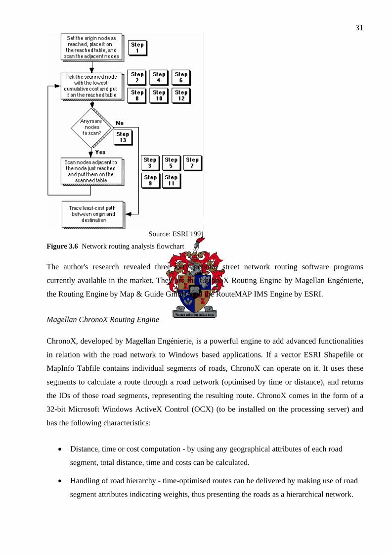
31
Source: ESRI 1991
Figure 3.6 Network routing analysis flowchart
The author's research revealed three very popular street network routing software programs
currently available in the market. They are the ChronoX Routing Engine by Magellan Engénierie,
the Routing Engine by Map & Guide GmbH, and the RouteMAP IMS Engine by ESRI.
Magellan ChronoX Routing Engine
ChronoX, developed by Magellan Engénierie, is a powerful engine to add advanced functionalities
in relation with the road network to Windows based applications. If a vector ESRI Shapefile or
MapInfo Tabfile contains individual segments of roads, ChronoX can operate on it. It uses these
segments to calculate a route through a road network (optimised by time or distance), and returns
the IDs of those road segments, representing the resulting route. ChronoX comes in the form of a
32-bit Microsoft Windows ActiveX Control (OCX) (to be installed on the processing server) and
has the following characteristics:
• Distance, time or cost computation - by using any geographical attributes of each road
segment, total distance, time and costs can be calculated.
• Handling of road hierarchy - time-optimised routes can be delivered by making use of road
segment attributes indicating weights, thus presenting the roads as a hierarchical network.

32• Fully customizable “roadbooks” - the ChronoX roadbook is the data structure which
stores the optimum calculated route, and can be customised for specialised presentation
purposes.
• Advanced settings and vehicle library - different vehicle profiles can be created and
subsequently stored in a vehicle library. When a route is requested, the particular vehicle
profile to be used can be specified.
• Features to tie up (x,y) locations or POIs to a network - a route can be forced to include
specified road segments. For example, if a POI is known to exist close to road segment ID
number 110, a simple specification to the routing request will ensure that the calculated
route uses road segment ID 110.
Because of its ease of use, impressive performance and rich diversity of functions, the ChronoX
version 3.0 Routing Engine was used in the M-GIS sample application of this research study. See
Chapter 4 for more details on how it was implemented.
Map & Guide Routing Engine
The Map & Guide Routing Engine, developed by Map & Guide GmbH in Germany, is part of its
proprietary Internet map server software called iNETServer. Similar to Magellan ChronoX Routing
Engine, the Map & Guide Routing Engine is a 32-bit ActiveX (OCX) control that can be utilised on
a server to deliver a vast array of GIS functions. This routing engine is used by the SmartRoute
M-GIS product (see “SmartRoute” in Chapter 2).
ESRI RouteMAP IMS Engine
RouteMAP IMS by ESRI allows for the creation of a web page with maps and detailed driving
directions (ESRI 2001c & 2001e). Its stand-alone software resides on the web server and the
administrator can change, edit, and serve an unlimited number of maps and routes, while having
total control of the GUI and content.
RouteMAP IMS can also be used by Application Service Providers (ASPs) who want to offer
customers the ability to map their locations. Using a standard web browser, individuals can access
these maps to find and route to the nearest company locations. In this case, map data resides on the
ASP’s computers and are served to customer websites that have map authoring software for map
creation and publishing.

33Normally, RouteMAP IMS only functioned with United States or European formatted
geographical data (in terms of the codes they use as naming convention for their address locations).
However, according to Martin (2005 Pers com), ESRI’s development branch in South Africa
(GIMS SA) is now in the process of modifying RouteMAP IMS to work with South African
address formats as well. This opens the door of opportunities for local application developers
interested in using RouteMAP IMS as routing engine for web-based street routing applications.
3.5 GEODATABASE
No M-GIS application can be complete without a sufficient geodatabase to derive useful
geographical content from. This section briefly describes the properties of the South African
geodatabase that was used for the sample application.
MapStudio is a leading supplier of paper maps and digital map data in South Africa. Because of
this and the fact that its very complete digital geodatabase is in the popular and convenient ESRI
Shapefile GIS format, it was decided to use this geodatabase for the delivery of geographical
information to the study’s sample M-GIS application.
The MapStudio geodataset is jointly owned in a 50:50 rights division agreement by MapStudio SA
(Pty) Ltd and MapIT (Pty) Ltd, and consists of the following subsets:
• ESRI Shapefiles for South African geographical features (streets, towns, built-up areas, etc.)
• ESRI Shapefile containing more than 500000 segments of SA roads (for routing purposes)
• POI table - contains approximately 29000 POIs, categorised into 51 categories.
• National Address Range (NAR) table - contains nearly 600000 national street addresses.
• Road Crossings (RC) table - contains nearly 200000 street crossings. These street crossings
can be used in a search for the closest street crossing to the user's location, for instance. As
destination, he/she might also want to specify a street crossing. These are two points that can
be used as the start and stop points to calculate an optimum route.
• Commercial content tables - contain the locations and information of commercial
institutions offering services which can be displayed on raster maps.
The next chapter demonstrates the development and implementation of a real-time live M-GIS
application, aptly named MobiMap. With a sufficient background on all the components relevant to
a typical M-GIS, the reader can turn over and see all the theory put to the test.

34CHAPTER 4: SAMPLE M-GIS APPLICATION DEVELOPMENT
In order to demonstrate all the facets pertinent to a Mobile Geographic Information System
(M-GIS) application, the author designed, developed, tested and implemented a sophisticated
M-GIS project over a period of approximately two years (2002-2003). This project would serve as a
case study to demonstrate an M-GIS application in South Africa.
The technology available during the two-year period was utilised for the development and
implementation of this project. During the course of the two years, the number of relevant
technologies available in South Africa increased dramatically, along with the service quality of
existing technologies. The development of the M-GIS project was kept dynamic in order to
facilitate improvements and/or incorporations of emerging technologies, thus ensuring the project
remained up-to-date and as far as possible representative of relevant M-GIS technologies. By
staying in touch with the mobile device and GIS industry, the author succeeded in the consequent
implementation of the M-GIS project, which has become known as MobiMap.
Project MobiMap is discussed in detail below. First, the initial objectives of MobiMap are stated.
Following that, the application design is laid out (as formed around the objectives). All the expected
required hardware and software technologies are listed thereafter, as well as which were chosen (or
available) for use. The application development is then explained in detail. Project implementation
follows the final testing stage.
4.1 OBJECTIVES
MobiMap had to achieve a number of objectives, which were divided into two distinctive classes:
holistic objectives (to demonstrate the general capabilities of a typical M-GIS) and physical
objectives (hardware compatibilities, speed requirements, etc.).
The following most important holistic objectives were set for MobiMap:
1. to demonstrate how the merging of several technologies could successfully deliver a usable
and scaleable M-GIS application;
2. to highlight the aspects of an M-GIS application that are significantly dependant on the
technology of the time, in terms of reliability, shortcomings and improvements; and
3. to act as a suitable, representative and practical project which fulfils and complements this
research thesis.
35The following most important physical objectives were set for MobiMap:
1. A sophisticated yet simple and efficient design, development and implementation process.
2. A high degree of cost-effectiveness applied to as large extent as possible during the whole
Software Development Life Cycle (SDLC).
3. Technological constraints have to be adhered to (e.g. availability of hardware and
infrastructure).
4. Application design has to be dynamic in order to facilitate scalability as user base and
functionalities grow.
5. Man-Machine Interface (MMI) has to be simplistic and user-friendly.
6. Application design and utilisation of infrastructure has to ensure an acceptable level of
reliability.
Throughout the course of the design and development of MobiMap the above holistic and physical
objectives were pursued as far as possible. As can be expected from any typical computer
application, a number of problems were encountered, some of which were foreseen, and some not.
However, it is believed that the above objectives were fulfilled to satisfactory levels, and all
expectations in terms of performance and results were met.
Although MobiMap was primarily designed and developed by the author, there are some minor
software components which must be accredited to other fellow developers and Third Parties.
Without these software components, MobiMap’s components would not have been able to interact
with each other today as it does. Full recognition to these persons and parties are given in the
“Acknowledgements” section at the start of this study.
Henceforth, the physical work on MobiMap commencing with its design is discussed below in
detail.
4.2 DESIGN
Good designs are imperative to the development and success of any technological project (Graham
et al. 2003; Reichenbacher 2003). The following guidelines from Reichenbacher (2003) are crucial
to follow when designing any project of similar stature to an M-GIS project:

36Scalability and expandability
Technological advances in the computer, electronics and telecommunication fields are happening
today at such a fast pace that any system that bases its functionality on such technologies are bound
to become what’s known as a "legacy" system as soon as the technology it utilises becomes
obsolete (or worse, unsupported). Therefore it is very important that the system be designed to
allow for expansion of functionality and/or upgrades of the mission-critical components that form
an integral part of the system.
Simplicity and efficiency
Excessively complex system designs are usually doomed to become a behemoth of programming
components and eventually stagnate to become a system that is too complex to complete, debug,
implement and maintain (physically and financially). One way which is usually very successful in
avoiding this trap is to follow the Extreme Programming (XP) approach when developing the
programming code that will form the heart of the operation(s) of the system. However,
implementation of this unique approach should ideally already start with the system design.
Multiple and qualified inputs
An M-GIS system will typically consist of a variety of technological components (referred to here
in the abstract sense) that span across several scientific fields. The two main relevant fields here are
computer programming and GIS. Another important field is billing. These three fields alone warrant
expert input and opinions from at least three professional persons or entities: computer
programmers, GIS specialists, and system billing consultants. The harmonic and smooth co-
operation of all the relevant components of an M-GIS system deserves that its design be
professionally undertaken by experts in the fields of all the technological facets it entails.
The author endeavoured to follow and implement the above guidelines in the four fundamental
designs of MobiMap, namely:
1. Architectural design;
2. Functional / MMI design;
3. Business model design; and
4. Graphical User Interface (GUI) design.
Each of the above designs are illustrated diagrammatically and explained next.

374.2.1 Architectural design
This is MobiMap’s first and most encapsulating design, illustrating most of the major hardware
components involved (see Figure 4.1). By means of a quick glance, the important hardware systems
can be distinguished as well as how they interact with each other.
BSC
Nearest cell mast
MSC
WAP Gateway Provider
GeoDB
Application servlet
Web server: Linux Apache
ArcIMS
Map server: Windows 2000 Server
JBoss Tomcat
Mobile device
Symbian 6.0 / 7.0MIDP/CLDCPicture-SMSWAP
Picture-SMS servlet
CSD/HSCSD/GPRS
HTTP over TCP/IP
HTTP over TCP/IP
New Atlanta ServletExec
Colour service
Monochrone service
Picture-SMS service
ChronoX Routing Engine
Active Server Pages
MapStudio SA ShapefilesPOI tablesNAR tablesRC tables
MapObjects 2.x
IIS
.axl service configuration
filesHTTP over TCP/IP
Figure 4.1 Architectural design
The client device (in this case a cellphone) makes a request for geographical information. This
request is carried “Over The Air” (OTA) to the nearest cell mast, Base Switching Centre (BSC),
Mobile Switching Centre (MSC) and finally to the Mobile Cellular Operator (MCO) Gateway
Provider, which redirects the request to the web server via Hypertext Transfer Protocol (HTTP)
over Transmission Control Protocol / Internet Protocol (TCP/IP) on a hard-line transmission. The

38web server, running a Linux Operating System (OS) distribution with Apache as the web server
software, marshals the request to the appropriate Servlet, managed by JBoss Tomcat. The request is
re-formatted to Extensible Markup Language (XML) syntax and sent to the map server. An Active
Server Page (ASP) acceptor page, managed by Microsoft’s Internet Information Server (IIS) on the
map server, accepts the request and uses the relevant ArcIMS service to prepare the geographical
information. The spatial data for this information is retrieved from the appropriate geodatabase
table(s). If a street route was requested, the ChronoX Routing Engine is invoked as well. The
response travels all the way back to the web server and eventually the client application on the
cellphone presents the geographical information to the user.
4.2.2 Functional / MMI design
A flow chart is used here to illustrate how MobiMap functions (Figure 4.2). Each of the steps, from
the time when the user initiates the system, up to when he/she receives the required geographical
information (ultimately a digital map indicating a shortest street route (or not), and/or shortest route
turn-by turn directions), are presented in logical order. The MMI allows for the functional workings
of the application to take place, therefore forming part of MobiMap's functionality.
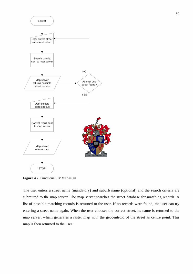
39
START
User enters street name and suburb
Search criteria sent to map server
User selects correct result
Correct result sent to map server
Map server returns possible
street results
STOP
Map server returns map
At least one street found?
YES
NO
Figure 4.2 Functional / MMI design
The user enters a street name (mandatory) and suburb name (optional) and the search criteria are
submitted to the map server. The map server searches the street database for matching records. A
list of possible matching records is returned to the user. If no records were found, the user can try
entering a street name again. When the user chooses the correct street, its name is returned to the
map server, which generates a raster map with the geocentroid of the street as centre point. This
map is then returned to the user.

404.2.3 Business model design
The main purpose of the business model design (Figure 4.3) is to illustrate how the user gets billed
for the use of MobiMap. Billing is a very important facet of any commercial system, so it is
important that this design also adhere to the aforementioned design guidelines.
MobiMap's billing was developed and implemented in co-operation with ExactMobile (Pty) Ltd.
Users subscribe to the MobiMap ExactMobile service (receiving a username and password) prior to
using the application, and credits are purchased. A fixed, pre-determined amount of credits are
subtracted from the user's account each time he/she successfully receives a map on his/her
cellphone.
The user logs in to the ExactMobile system. He/she performs a street search and gets search results
back. The moment a map is requested, a credit check is performed on his/her account. If sufficient
credits are available, the process continues. If not, the user is reminded to purchase more credits.
The user is only billed (i.e. a fixed amount of credits subtracted from his/her account) when the
client device (cellphone) sends an acknowledgement transmission to the web server stating that the
map has been fully received and displayed successfully.

41
Figure 4.3 Business model design
4.2.4 GUI design
MobiMap's GUI is the visible interface between the user and the MMI. The GUI consists of several
screens on the mobile device that pop up depending on the current step the user is busy with in the
MMI. These screens were mostly designed on-the-fly and modified continuously as needed. A few
screenshots below illustrate what the final GUI looks like on all the relevant mobile devices

42(Figures 4.4-4.7). The GUI screens differ from device to device, but the graphical components
that are present on each screen representing a particular step in the MMI, are conceptually similar.
Figure 4.4 Map screen GUI on Motorola Accompli 008 (MIDP)
Figure 4.5 Map screen GUI on Nokia 9210i Communicator (Symbian OS 6.0)

43
Figure 4.6 Map screen on Nokia 3510 (Picture-SMS)
<Large area>Sub=Stellenboschx=Crozier +-2=N13=N24=N75=R3006=R3047=R3108=R44
<Medium area>Sub=Stellenboschx=Crozier +-2=R3103=R3044=R445=Merriman6=Dorp
<Small area>Sub=Stellenbosch1=Crozier2=Adam Tas3=Alexander4=Merriman5=Bird6=Andringa7=Ryneveld8=Victoria
Figure 4.7 Three different-scaled map screens on Nokia 3510 (Picture-SMS)
444.3 HARDWARE AND SOFTWARE REQUIREMENTS AND USAGE
Technology, as it is known in the abstract sense of the word, is applied practically by means of
man-made products. The relevant products in this case are computer (or electronic) hardware,
computer software, geographical data and telecommunications infrastructure. Successful
development and implementation of MobiMap required an extensive array of the abovementioned
three technological products. The following section briefly explains the details pertaining to the
specific make and type of these products available (at the time of development and
implementation), required (to obtain acceptable levels of operation, reliability and speed of
geographical content delivery to the user), and ultimately acquired and utilised.
4.3.1 Computer/electronic hardware
4.3.1.1 Microcomputer servers
An Intel Pentium-class Personal Computer (PC) was made available for the development and
implementation of the server-side components of MobiMap. This server thus provided a complete
service delivery of the geographical content pertinent to MobiMap, from the map server to the client
device. The particular hardware specification of the server (e.g. Central Processing Unit (CPU)
speed, hard drive storage and Redundant Array of Independent Disks (RAID) service, Random
Access Memory (RAM) storage, etc.) was considered typical for the time and delivered acceptable
performance. The hardware was upgraded from time to time to keep pace with the increased server
load.
Another Intel Pentium-class PC was made available for serving digital maps to the web server.
Since this map server also services Internet mapping websites with digital maps, its hardware
specifications were slightly higher than that of the web server. Today, this map server serves on
average approximately 30000 ArcIMS-generated raster maps per day to Internet mapping sites,
MobiMap, vehicle tracking systems (e.g. NetStar and Tracker), and others. The CPU load over a 1
hour monitoring period is on average 80% which is considered acceptable.
The billing servers are a collection of two or more Pentium-class PCs which handle all billing-
related transactions relevant to MobiMap. These servers are managed and maintained by
ExactMobile.

454.3.1.2 Microcomputer development machines
These are ordinary office-specification desktop Pentium-class PCs that the author used to develop,
debug and test the programming code for MobiMap. The specifications of those PCs used
corresponded with the highest set of system requirements of the collection of programming
languages and source code compilers needed. A permanent connection to the Internet was also
needed to monitor results during the development and testing of MobiMap, since both the web
server and map server were located at remote premises.
4.3.1.3 Mobile/handsfree devices
The following Java 2 Micro Edition (J2ME) / Mobile Information Device Profile (MIDP)
compatible cellphones were available to develop the J2ME leg of MobiMap on: a Motorola
Accompli A-008, T720 and a Nokia 7650.
The following Wireless Application Protocol (WAP) compatible cellphones were available to
develop the WAP leg of MobiMap on: a Motorola T720, a Nokia 3330, 6310i and 7650.
The following Symbian 60 OS compatible cellphones were available to develop the Java 2 Standard
Edition (J2SE) leg of MobiMap on: a Nokia 7650 and 9210i.
The following Picture-SMS compatible cellphones were available to develop the Short Messaging
Service (SMS) leg of MobiMap on: a Motorola T720, a Nokia 3330, 3510, 6210, 7650 and 9210i.
Some of the above cellphones were both Global System for Mobile Communication (GSM) and
General Packet Radio Service (GPRS) enabled in order to facilitate successful and efficient
communications between the phone and the web server.
4.3.2 Computer software
4.3.2.1 Programming
The programming of MobiMap's source code was implemented in three conceptual cores:
programming on the web server, the map server, and on the mobile devices (known as client
programming).

46The main server components for handling incoming requests and serving the appropriate results
were programmed in Java 2 Enterprise Edition (J2EE). JBoss Tomcat was used for the deployment
and maintenance of each of the Java Servlets. JSwat was used for code debugging, and Ant was
used to conveniently compile all Java classes and dependencies with single-line commands and
parameters. JUnit was used for the XP testing of each source code compilation, while JUnitPerf was
used to measure and fine-tune the performance of the web server running the Servlets. Two
scripting languages, Perl and Python, was marginally used for executing some Linux scripts
pertaining to the SMS leg of MobiMap.
WAP programming was also done on the web server which, when requested from a mobile device,
runs on the server and serves Wireless Markup Language (WML) formatted content back to the
device.
Requests for geographical data from the web server was handled by ASP POST acceptor pages
(running under IIS version 6.0) deployed on the map server. A combination of JavaScript and
VBScript pages handled all incoming requests, communication with ArcIMS (via the ArcXML
markup language), and delivery of results back to the web server. MapObjects 2.x was used to
instantiate point and line objects (amongst others) in the ASP code in order to facilitate the creation
of geographical objects in the correct format as required by the methods of the ChronoX Library
(which was also instantiated as an object in the executed ASP code). Java Runtime Edition (JRE)
was also needed on the map server as one of ArcIMS's pre-requisites. Version 1.3.0 was initially
installed, which was later upgraded to version 1.3.1 to overcome instability issues.
Client programming in MobiMap translates to programming on the devices which act as clients in
the transactional architecture, in this case cellphones. J2ME was used to program source code which
was compiled to byte code (Java Classes) which adhered to the MIDP specification on the MIDP-
compatible phones. J2SE was used to develop classes that would run on Symbian 60 (version 6.0)
operating systems on a select few of the cellphones available, as well as for the Picture-SMS
compatible cellphones.
The Motorola cellphones (Accompli A-008 and T720) also had custom classes that contained
dedicated GUI widget objects. These were also compiled and loaded on the Motorola phones and
were used by the J2ME GUI classes on them to display and use Motorola-specific GUI widgets.

474.3.2.2 GIS programs
ArcIMS 3.1 (which was later upgraded to ArcIMS 4.0) was used to generate raster maps based on
the geodataset. The other alternative GIS programs or platforms that could have been used to
generate maps include Scalable Vector Graphics (SVG), Geographic Resources Analysis Support
System (GRASS) and OpenSource MapServer. See Section 3.4.2.1 for an explanation why ArcIMS
was chosen for the digital map delivery to MobiMap.
Requests for geographical data were made to the three ArcIMS background services (Application
Server, Monitor, Tasker) running on the map server. The syntax of these requests (and responses
from ArcIMS) was the ArcXML format. Separate front-end ArcIMS services were created using the
ArcIMS Administrator program; each of those serviced a particular family of requests from the web
server (either request for a colour map, monochrome map, or Picture-SMS map). These services are
configured separately by ArcXML-formatted configuration files, detailing which map layers are
shown on the map, how each of their geographical features are styled, etc. These ArcXML
configuration files are also known as ".axl" files.
The ChronoX Street Routing Engine 3.0 from Magellan Ingénierie was used to provide the optimal
street routing functionality of MobiMap. As explained in 4.3.2.1, MapObjects server-side objects
were instantiated in the executed ASP code on the map server to facilitate the creation of
geographical information which is needed by the ChronoX libraries.
4.3.2.3 Operating system and administrative services
The development of the programming code was done on a Pentium-class PC running Microsoft
Windows XP Professional. The web server runs on Linux Apache and the map server on Microsoft
Windows 2000 Server. Microsoft IIS version 6.0 is responsible for the handling of all the Internet
requests and responses through ASP pages running as web services. New Atlanta ServletExec
allows for the deployment of Java Servlets (as implemented by ArcIMS) and Java Server Pages
(JSP) on IIS in a standard, robust, high-performance environment. Thus, in order for ArcIMS to
operate successfully, a Servlet engine like New Atlanta ServletExec is necessary. Version 4.1.1 was
used. JBoss Tomcat was used as the Java Servlet deployer on the web server.
4.3.3 Geographical data
MapStudio's digital geodatabase was used to supply the delivery of geographical information to
MobiMap. Although the usage of a spatial database engine would have improved the efficiency and

48performance of spatial data retrieval, it was decided not to use such an engine as acceptable
performance was obtained using bare ESRI Shapefiles stored on the map server’s hard drive.
ArcIMS was quite efficient and quick in generating raster maps from those Shapefiles. However, if
MobiMap grew to such an extent that vector maps would have had to be generated, a spatial
database engine like ESRI’s ArcSDE would be needed. This would significantly redude the time
needed to generate vector maps. Vector map generation as a solution to map delivery to MobiMap
client devices is discussed in more depth in Section 5.1. Also refer to Chapter 6.
The following subsets of the geodatabase were used:
• ESRI Shapefiles for South African geographical features (streets, towns, built-up areas, etc.)
• ESRI Shapefile containing segments of SA roads (for the purpose of street routing)
• Points of Interest (POI) databases
All POIs are configured to be displayed (with appropriate icons and labels) by default on all
maps served to MobiMap by means of the .axl configuration file for the ArcIMS front-end
services used by MobiMap.
• National Address Range (NAR) database
All address points are configured to be displayed (with appropriate icons and labels) by
default on all maps served to MobiMap by means of the .axl configuration file for the
ArcIMS front-end services used by MobiMap.
4.3.4 Telecommunication infrastructures
The following section describes the various telecommunication infrastructures that are used by
MobiMap. The OTA telecommunications consisted of GSM and/or GPRS. Ground connectivity
was achieved by means of Telkom SAIX (South African Internet eXchange) landlines transmitting
TCP/IP requests and responses formatted according to the popular HTTP protocol.
4.3.4.1 GSM and GPRS
All of the utilised cellphones (see 4.3.1.3), with the exception of the Nokia 3330 and Nokia 6210,
have the ability to perform both GSM and GPRS OTA transmissions. GPRS is a faster and more
efficient, cost-effective means of cellular data transmission, and thus it was used for MobiMap
running on cellphones. Normal GSM protocol was used for SMS/Picture-SMS transmissions.
49At the time of MobiMap's development, GPRS were just beginning to be implemented by South
Africa's two mobile cellular operators. As a result, there were plenty of GPRS service downtimes,
which negatively affected development and testing of MobiMap's communication functions. As
time passed, the quality and speed of the GPRS services improved considerably, and by the start of
2003 MobiMap could reliably communicate with the web server with very few (if any) intermittent
GPRS service.
4.3.4.2 Internet (TCP/IP)
A permanent 96kb/s Internet connection enabled the author to successfully transfer compiled Java
Classes to the web server and ASP code to the map server. Monitoring of the transaction log files
made debugging possible. A permanent Internet connection between the web server and the map
server also allowed for requests to be passed from the web server to the map server, and responses
to be returned.
4.4 DEVELOPMENT
Development of most of the components was done in parallel. A simple "Hello World" client
application was developed to run on the cellphones. The telecommunication infrastructures was
organised and set up so that proper OTA communications could be performed. Basic Java Servlet
Classes were developed to handle requests from the cellphones and deliver "Hello World"
responses in return.
Once basic functionality between the cellphones and the web server was established, simple
JavaScript code was developed on the map server to deliver some geographical content back to the
web server (e.g. simple street search results). More extensive geographical data was served as
functionality on the client and web server was systematically increased. After 10 months the map
server was capable of delivering colour and monochrome maps to the compatible cellphones. In
addition to the raster maps, POIs were also included to be shown on the maps.
In late 2002 the SMS leg of MobiMap was developed. Servlet classes were developed (primarily by
the author but also partly by fellow developers) on the map server to handle incoming SMS requests
from the cellphones. Street search results were returned by means of SMSs returned to the
cellphone. A Picture-SMS ArcIMS service was created on the map server, and this allowed for the
delivery of Picture-SMSs to the cellphone.

50MobiMap was complete with the exception of an optimum street routing service. JavaScipt code
was developed to utilise the ChronoX routing library (with the aid of MapObjects geodata
structures). Simple turn-by-turn instructions could be delivered upon request, as well as Shapefiles
including a route on the generated raster map. These turn-by-turn instructions and raster maps with
routes were successfully delivered to the cellphones.
The functionality of MobiMap was complete and tested by mid-2003. It was commercially
deployed and implemented soon afterwards, and today runs as a successful Location Based Service
(LBS) in South Africa under management and control of LBS Mobile (Pty) Ltd in association with
ExactMobile (Pty) Ltd and MapIT (Pty) Ltd.
The development of MobiMap was by no means without problems. The following list explains the
most significant problems encountered.
Quality of GPRS service
As stated previously, GPRS services in South Africa were being deployed during the time of
MobiMap's initial development stages. Frequent service downtimes were experienced. This made
the upload of the client applications to the cellphones very difficult, time-consuming and
frustrating. On average about 5 uploads of client code per day were needed to test new functionality
on the cellphone. Each of these uploads took at least 10 minutes, and when GPRS went down, the
uploaded code became corrupted and thus upload had to be retried later the day when the GPRS
service was up again. Physical testing of the functionality was also influenced by GPRS downtimes,
since communications between the cellphone and the web server could not occur in such cases. In
some instances GSM was used instead of GPRS in the case of a continued GPRS service downtime,
but since using GSM is much more expensive than GPRS, this solution was eventually
discontinued.
Quality of Internet service
Interruption of Internet services was also quite frequent. More often than not the service was very
slow. Since MobiMap's development was done in Stellenbosch, and both the web server and the
map server were hosted in Johannesburg, slow Internet services negatively affected MobiMap's
testing. Raster map delivery to the phones was usually slow, and since map download was quite a
frequent task in the development, this negatively affected development speed.

51Unfamiliarity with new development software
Previously the author was not familiar with Java, JBoss Tomcat, ArcIMS, MapObjects, to name but
a few. Significant time was needed to become acquainted with these new development software
programs, perform debugging, optimisation, etc.
Unstable map server
Stability was very hard to maintain on the map server. The author had to use slow Remote Desktop
Connection programs to sort out crashes and other instability problems, or even telephone calls to
the map server administrators in Johannesburg, asking them to diagnose and/or fix server problems.
When ArcIMS 3.1 was upgraded to version 4.0, and JRE 1.3.0 to version 1.3.1, stability improved
significantly. The map server was also hacked a couple of times, after which total downtime
resulted. Updated Microsoft Service Packs were continually installed, which usually minimized
Microsoft security flaws and other backdoors, resulting in improved stability and less chance of
server hacking. The security of the firewall computer behind which the map server resided was also
improved and upgraded. Frequent power failures at the Johannesburg hosting site of the two servers
also resulted in service downtimes. Uninterruptible Power Supplies (UPS) were present at the
hosting site but for some reason were never properly installed.
Client requirements vs. research requirements
The immediate clients of MobiMap were a collection of the stakeholders and venture capital
providers of the project (while the end-user clients would be the subscriber user base). There were
cases where the author had different goals in mind for MobiMap than what client requirements
(which were mostly applied later in the development phase) were. However, the author managed to
persuade the relevant clients into accepting compromises in terms of application requirements and
research requirements. In the end, an acceptable balance was achieved between the two sides of
requirements.
MobiMap, serving as an example of a typical M-GIS application, is evaluated in the following
chapter. The initial objectives are also revisited by means of a conclusive summary of all of the
facets of MobiMap.

52CHAPTER 5: EVALUATION OF SAMPLE M-GIS APPLICATION
This chapter evaluates MobiMap as a sample Mobile Geographic Information System (M-GIS)
application. The application shortcomings, future additions, and possible improvements are
discussed and evaluated against the application’s costs and benefits from a financial perspective
(expenditures and revenues).
5.1 SHORTCOMINGS AND FUTURE IMPROVEMENTS
MobiMap has the following shortcomings which, due to either lack of development time, resources
or suitable technology, were inevitable. MobiMap can be improved by addressing these
shortcomings and adding new functionalities, as explained below.
No Multimedia Messaging Service (MMS)
Although MobiMap can be extended to function using MMS, this was planned but never developed.
A Java Servlet would have to be written to handle MMS requests from the Mobile Cellular
Operator (MCO) Gateway Provider, and return the MMS-formatted raster map in the correct format
specific to MMS technical specifications. In particular, there are several code headers that need to
be implemented. MobiMap MMS will offer a significant improvement over MobiMap Picture-
SMS, since the quality of the delivered raster map will be much improved (colour, larger size, etc.).
Size of raster maps
The size of the ArcIMS-generated raster maps are sometimes still too large to be delivered in an
acceptable time to the cellphone. The two ways of improving this is to speed up the infrastructure
used for the “Over The Air” (OTA) and ground delivery, or to decrease the map size (kilobytes, not
physical map dimensions).
The first solution is, in a manner of speaking, already happening since General Packet Radio
Service (GPRS) speeds are constantly being improved by South Africa's MCOs. Internet speeds are
also being improved by means of many hosting companies implementing an Asymmetric Digital
Subscriber Line (ADSL). Thus, the sum of all communications between the map server and the
cellphone is being improved.
The second solution is not really possible to implement. ArcIMS is configured to generate Portable
Network Graphics (PNG) images, which results in slightly bigger raster images than Joint
Photographic Experts Group (JPEG) images or Graphic Interchange Format (GIF) images, but
significantly smaller than Bitmap images (BMP). If JPEG is chosen as the raster image type, image
file size is reduced but a "lossy" quality map image is generated. This affects the readability of the

53street labels on the map. Although GIF images can now be generated directly by ArcIMS (the
GIF format is a former-proprietary image format licensed exclusively to Compuserve Graphics Inc.,
and is open in all countries since 7 July 2004), they are still larger in file size than the PNG format.
GIF also supports only 256 colours, but this is not really a problem on the ArcIMS map images
since nine colours are used at most.
An exception to the above would be the case where vector maps (generated by the map server) are
sent to the client devices instead of raster maps. Vector maps are significantly smaller in byte size
than raster maps and would significantly reduce the download times needed for map download.
ArcIMS can be configured to generate vector maps, but performance will be affected. A spatial
database engine like ESRI’s ArcSDE would efficiently handle the generation of vector maps
(amongst other things) in order to keep the map generation performance at acceptable levels (see
Section 4.3.3). However, additional development is also needed on the client devices; the
programming code will need to be able to handle vector maps and as well as display them. This is a
point for future research and is discussed in more depth in Chapter 6.
Service reliability
Telecommunication services downtimes and map server instability are problems that occurred
frequently during MobiMap's development (see Section 4.4.1). Although the occurrence of these
problems decreased significantly over the last two years, there are still sporadic cases when
downtime occurs. It is hoped that the parties responsible for these services will minimise downtimes
in the future.
National map coverage
Users want accurate and up-to-date maps displayed on their cellphones. MapStudio's digital map
coverage of South Africa is indeed accurate and extensive but by no means complete. There are
many rural towns that exist in the geodatabase as point locations, but for which no street data is
present. MapIT is constantly improving coverage by digitising absent and new streets (and other
geographical man-made features) as sources for those become available (1:50000 map sheets, aerial
photography, satellite imagery, cadastral data from municipalities, town planning maps, etc.).
5.2 COSTS AND REVENUES
This section briefly summarises the expenditure (costs) and income (revenues) accounted to this
study’s sample M-GIS application, MobiMap. Because MobiMap is based on the various types of
technologies (including hardware, software and telecommunication infrastructures) that would
54typically be used for M-GIS applications, its costs and revenues can be perceived as a reasonable
indication of what such a typical M-GIS project would cost and deliver. Although MobiMap was
developed and implemented at least one year prior to writing this thesis, current and future costs
and revenues would not be too difficult to predict, provided that current inflation trends and price
increases across the entire spectrum of technologies utilised, are taken into account.
The author found that the determination of costs and revenues for MobiMap was generally not too
difficult to establish, and this should be even easier in future since, for example, MCOs have
recently tailored their business proposals specifically for cutting-edge products making use of
cellular technology, thus streamlining the costing and revenue determination processes even further:
a quick look at Vodacom’s (one of South Africa’s MCO’s) website shows a link on the first page to
full information on becoming a Vodacom Wireless Application Service Provider (WASP). A
company intending to develop M-GIS applications could register as an MCO WASP and get started
with the business side of M-GIS development and implementation quite soon, and get reasonably
accurate cost and revenue predictions without too much difficulty beforehand.
Costs, in the context of MobiMap (and most Information Technology (IT) products), include both
financial (monetary) and time expenditures. Both are summarised in the next section. A brief
overview of the revenue models MobiMap was based on follows, as well as some notes on the
actual approximate revenues generated by MobiMap.
5.2.1 Costs
5.2.1.1 Financial costs
The financial expenses of the MobiMap project’s four main stages (design, development, testing
and implementation) were funded partly by LBS Mobile (Pty) Ltd and its business partners, and
partly by the author. The most prominent expenses encountered in this regard were human resource
costs. This is a very broad and indirect expense attributed to MobiMap, and is better measured in
terms of time costs instead of financial costs. See Section 5.1.2 for an overview of the time costs
associated with the MobiMap project’s stages.
All of the monetary figures given below are Value Added Tax (VAT)-inclusive approximate costs
(in South African Rand currency unless specified otherwise) as applicable at the time. However,
ranges are used on some items to indicate what the amount of cost variation would have typically
been, depending on the specification levels of the hardware or software used. The actual cost of the

55particular hardware or software unit can thus be assumed to be the average between the minimum
and maximum values of the cost range.
Hardware
• Web server: R15000 – R25000
• Map server: R20000 – R30000
• Billing server: R15000 – R25000
• Development Personal Computers (PC): R10000 each
• Cellphones (A-008, T720, 7650, 3330, 6310i, 9210i, etc.): R500 – R10000 each
Software
• Web server (Linux Apache, Java 2 Enterprise Edition (J2EE), JBoss, JSwat, Ant, JUnit, JUnitPerf, Perl, Python, etc.): no costs
• Map server: o Microsoft Windows 2000 Server: R5000 o ESRI ArcIMS 3.1: R70000 with 20% annual maintenance fee o ESRI MapObjects 2.x: no cost if used in conjunction with ArcIMS o Sun Java Runtime Edition (JRE): no cost o New Atlanta Servlet ServletExec: $800 o ChronoX 3.0: 10000€ - 20000€ depending on usage circumstances (e.g. single/multi-
user)
• Billing server (Microsoft Windows 2000 Server): R5000
• Development PCs (Microsoft XP Professional): R900 each
• Cellphones (Java 2 Micro Edition (J2ME) for Mobile Information Device Profile (MIDP), Symbian OS, etc.): no costs
Geodatabase
The MapStudio/MapIT digital geodatabase for South Africa was created from various sources of
spatial data over a period of four years and is updated twice a year. The costs involved with the
creation and maintenance of this digital spatial data source would not be directly attributed to
MobiMap since there are a number of other clients (and products) that make use of the geodatabase
as well. It would thus be difficult to make an estimate of the direct costs of this geodatabase
relevant to MobiMap. Nevertheless, the geodatabase is made available to users at a monthly fee,
determined on the individual client’s circumstances and usage profile(s). In MobiMap’s case these
cost figures varied significantly over time.
565.2.1.2 Time costs
The time costs applicable to MobiMap are specified with regard to the project’s four main stages,
namely its design, development, testing and implementation.
Design
MobiMap’s initial design work consisted of daily meetings with relevant parties, including LBS
Mobile (Pty) Ltd and its associates, developers and the author, for a period of approximately 3
weeks. The architectural, functional, business model and Graphical User Interface (GUI) designs
(see Section 4.2) were fundamentally drawn up during this period. Thereafter, weekly design
sessions were held to plan and discuss modifications and/or improvements to the initial design(s).
Development
Development of MobiMap’s components (client-side and server-side) was performed mostly in
parallel, starting in early 2002, and completed in early 2003 (see Section 4.4). Thus, approximately
one year of work (taking normal office hours into account) was needed, and was provided by one
developer (the author).
Testing
Three weeks were needed to test MobiMap functioning as a whole. In that time, various bugs and
other problems were also corrected that were not detected during the development phase.
Implementation
Putting all the external systems in place for MobiMap’s implementation as a commercial consumer
product took approximately one month. This task consisted mostly of configuring the billing
systems. Billing servers were installed and contracts and agreements were put into place to facilitate
the administrative aspects of the business model offered by ExactMobile (Pty) Ltd. Most of the
implementation was performed by ExactMobile and other senior relevant parties, with the author
providing assistance from a developmental perspective when required.
5.2.2 Revenues
MobiMap’s revenue results from ExactMobile credits debited against users’ accounts after they
successfully receive maps on their cellphones (refer to Section 4.2.3). This functions according to
ExactMobile’s business model. The reasons for the choice of this particular business model are

57briefly explained next, and other possible models for M-GIS application revenue generation are
given. Some actual revenue figures for MobiMap conclude this section.
5.2.2.1 Models
Although there are a number of different business models that can be used to generate income for
any typical M-GIS application, the choice of model for MobiMap was done for two reasons.
Firstly, LBS Mobile (Pty) Ltd approached a number of companies that were willing to perform
transactional costing procedures on MobiMap communications, i.e. between the client and the
server. All offerings (and revenue sharing requirements) were taken into account and ExactMobile
(Pty) Ltd was chosen as business partner responsible for MobiMap’s billing.
Secondly, ExactMobile’s business model has a number of distinctive advantages, namely:
• The user has already paid for the maps he/she intends to download. Thus, the collection of
revenue from the billing process is quicker.
• Users don’t have to be sent bills for their map downloads. This makes for less
administration on both LBS Mobile’s side, ExactMobile’s side and the user’s side.
• The model is robust because of its simplicity, and the user is not billed unless a complete
map is successfully received on his/her mobile device.
ExactMobile’s business model also has a few disadvantages:
• Additional communication steps are introduced. The billing server at ExactMobile has to be
contacted (from the web server) before and after map delivery to the user’s mobile device.
• The billing server has to perform more processing in order to firstly notify the web server if
the particular user has sufficient ExactMobile credits to download a map, and secondly to
debit a number of credits against the user’s account.
• Users have to purchase sufficient ExactMobile credits before being able to download maps.
In the case of an emergency and a user urgently requesting a map, he/she will not be able to
download a map before going through the process of purchasing additional credits first.
Other business models which can also suit a typical M-GIS application are mostly divided between
“pre-paid” revenue or “on-the-fly” revenue, or combinations thereof (Informa Telecoms Group

582002a). One example is a system where successful map downloads are merely logged on the
user’s account and he/she receives a monthly bill. An initial registration fee, as well as an additional
monthly connection fee, can be charged against the user’s account. Another example is to have the
user pay a registration fee and a (higher) monthly connection fee, but he/she is then free to
download as many maps as desired. Another option is to bill the user per map size downloaded.
This would suit a server and communication system where there are significant cost factors
involved with the amount of Internet or OTA traffic generated, or where the web and map server
have to handle large amounts of map requests, and performance are severely affected by larger map
size requests (Wireless Developer Network 2003).
The advantages and disadvantages of each business model considered should be weighed up against
each other, taking the particular M-GIS project setup into account. Revenue should be generated
and attributed to components of the system where costing is high or expected to be high. In turn,
components that involve very few (or no) costs should not directly receive too much of the
generated revenue. This will ensure a well-balanced M-GIS system from a financial point of view,
especially if future trends in component costing are foreseen and taken into account when deciding
on a particular business model and its future revenue generating capabilities.
5.2.2.2 Results
One MobiMap colour map download (excluding Picture Short Message Service (Picture-SMS)
maps) costs 40 ExactMobile credits. One such credit costs R0.10, thus one map download costs
R4.00. On average, 666 maps were downloaded per month in 2004, with a total of 8000 maps for
the whole year. This amounts to R32000 gross revenue (attributed directly to map downloads).
Picture-SMS map downloads are billed through ExactMobile as well, but rather per SMS sent from
the user, instead of a map received. The user needs to send at least two SMS’s to get a Picture-SMS
map, and each SMS is charged from the user’s cellular account at premium SMS rates.
Approximately 9000 Picture-SMS maps were generated during 2004, so taking a premium SMS
rate (for 2004) of R3.50 times two (for two SMS’s sent per Picture-SMS map received), this
amounts to a total gross revenue of R63000.
Not including the gross revenue generated in 2003 (since MobiMap was deployed live only in the
second half of 2003), it can be concluded that R95000 gross revenue was generated by MobiMap
during 2004. Revenue sharing as per contract agreement(s) determines the amount of income
divided between the respective business partners and stakeholders associated with MobiMap.
59As can be seen from the above figures, MobiMap delivered significant revenue during a
measurement period of one year. However, the initial and continuous expenses as listed in 5.2.1.1
are significant as well. It is thus clear that a fairly large sum of capital is required to get an M-GIS
project such as MobiMap up and running. The time costs as listed in 5.2.1.2 will result in additional
interest costs based upon the amount of initial capital invested, as well as possible loss of revenue
due to delays with early market penetration strategies, and/or competitors filling up the available
market shares instead (Pekkinen & Rainio 2003).
This section concludes with a list of five points the author deems most important for M-GIS
projects such as MobiMap to be feasible from a costing and revenue point of view:
• The initial stages of the project must be started and completed in a short as possible time, to
minimise (a) costs due to interest based on initial capital investment(s), (b) delays with early
market penetration strategies, and/or (c) competitors filling up the available market shares.
• The most suitable business model must be chosen based on the project’s holistic setup and
components (see Section 5.2.2.1).
• Application design must be of such a nature that maintenance costs (after project
implementation and commercial deployment) should be minimal (see Section 4.2)
• Exact prices for billing must be carefully decided upon. Setting prices too low may deprive
the project of valuable income, and prices are often difficult to change or raise at later
stages. Setting prices too high may cut out a significant portion of the target consumer
market, and pave the way for competitors wanting to penetrate the market with their own M-
GIS applications instead (Pekkinen & Rainio 2003).
• Hardware and telecommunication infrastructure setup(s) must be performed and managed in
such a way to ensure that service downtimes are kept to an absolute minimum (refer to
Section 4.4). If necessary, contractual penalty clauses must be included in Service Level
Agreements (SLA) with the relevant 3rd party service providers, to (a) lawfully motivate
them to provide acceptable levels of service, and (b) be compensated for lost revenue in
unfortunate cases of unacceptable service.
5.3 CONCLUSION
Although MobiMap took a relative long time from its initial design and planning stage, up to the
point when it was completed and commercially implemented, it must be kept in mind that this was
the first of its kind attempted in South Africa. No other M-GIS project was successfully designed,
60developed, deployed and implemented to the extent that MobiMap was. It can thus be seen as a
"pioneer" project, demonstrating how new and cutting-edge technology could be used to create a
useful application that never existed before in a country. MobiMap's original objectives are
revisited below to determine to which extent these were fulfilled.
5.3.1 Holistic objectives
1.) To demonstrate how the merging of several technologies could successfully deliver a usable
and scaleable M-GIS application.
Bar the service and stability problems encountered, MobiMap now offers very acceptable
uptimes. A wide variety of technological fields are utilised in order to deliver a map in the
user's hand. The map has proved usable and the chances of a user getting lost are very small.
MobiMap is scalable in terms of the compatible mobile phones it will run on (from the top-end
Nokia 9210i Communicator to any entry-level Picture-SMS capable cellphone) and able to
address a wide target market. Its design is also scalable in terms of future improvements and
additions (e.g. MobiMap MMS – see Section 5.1 and 6.2).
2.) To highlight the aspects of an M-GIS application that are significantly dependant on the
technology of the time, in terms of reliability, shortcomings and improvements.
Users of MobiMap are well aware of its abilities and limitations. These were made clear in its
marketing and user manuals. The user will also have a better understanding of the technology
and how this helps his/her installation of MobiMap operate.
3.) To act as a suitable, representative and practical project to comply with the requirements for a
scientific research thesis of this nature.
MobiMap took a long time to develop but it is scaled to suit the extent of this research theme
quite well. All relevant components of a modern M-GIS system are implemented and used.
The available technologies are well represented by means of MobiMap's functionality - all
must function harmoniously together, or the user will not get a map on his cellphone.
Theoretical knowledge and insight obtained from scientific research were applied in the
development of all the software components that reside and run on each of the hardware
components, so that it is practically put to the test.

615.3.2 Physical objectives
1.) Sophisticated yet simple and efficient design, development and implementation.
MobiMap offers maps to users' cellphones, which travel a long way. Professional software
services are optimally used to deliver quality geographical information to the client device.
However, software and hardware components are kept separate and communicate with each
other by means of simple and discrete atomic transactions. MobiMap also has a relative simple
business model which allows for smooth and problem-free billing.
2.) A high degree of cost-effectiveness applied to as large extent as possible in the whole SDLC
(Software Development Life Cycle).
Several parties had opportunity to gain from MobiMap. These gains were financial and
scientific of nature. Because of the financial factors, there were a number of constraints to
adhere by. Although most of the required hardware can be considered quite expensive initially,
it must be remembered that these are mostly only initial costs. Hardware maintenance is a
substantial smaller financial expense in comparison with the initial cost, especially in
MobiMap's case. In terms of software costs, many of the development platforms used for
MobiMap were free of charge (e.g. the Java programming language). The only actual software
costs are those of the Microsoft operating systems running on the development PCs and the
servers, and ESRI software’s initial and maintenance costs. See Section 5.2.1 for more details.
The author endeavoured to make minimum use of the GPRS and especially GSM services
when downloading new client code and testing the application's functionality. For example, a
large number of bug fixes and/or new code was implemented and tested on simulation
software (e.g. a Nokia 9210 Emulator program running on a development PC), before
uploading it to the cellphone and then testing it.
3.) Technological constraints have to be adhered to (e.g. availability of hardware, infrastructure,
etc.).
New developments in MobiMap were done as soon as the hardware and software required for
it became available and/or reliable. For example, the routing functionality could only be
developed once the ChronoX Routing Engine was made available. Stability issues could also
only be addressed once software bug-fix updates became available (e.g. JRE, ArcIMS – see
Section 4.4).
624.) Application design has to be dynamic in order to facilitate scalability as user base and
functionalities grow.
MobiMap's architectural design is simple and thus hardware can easily be upgraded or
increased in order to facilitate new functionalities or an increased user base. For example, a
server farm can, with little changes to the programming code (mostly Internet Protocol (IP)
address changes), be installed when the load becomes too much for one server to handle. This
is applicable to both the web and map server.
5.) MMI (Man-Machine Interface) has to be simplistic and user friendly.
MobiMap was tested by five users (randomly chosen) who are completely computer illiterate.
With the aid of online help (in the client application running on the cellphone, where
applicable), users managed to download the maps they requested very quickly. The process
from searching for a street to getting a map is straightforward and presented in a step-by-step
fashion by MobiMap’s GUI. The MobiMap SMS service is also very quick and easy to use.
Users are sent an SMS explaining the syntax of the SMS service when they used the wrong
syntax.
6.) Application design and utilisation of infrastructure has to ensure an acceptable level of
reliability.
Over and above the general transmission retry procedures normally found in GPRS
(Andersson, 2001), TCP/IP and HTTP protocols, MobiMap also has a system of error
messages presented to the user, which makes the application practically foolproof. If the web
or map server is down, a message is returned to the user's cellphone informing him/her of the
service downtime and advising to try again later. The web server can also detect if GPRS
service is down, and the user is informed of this as well by means of a message on his/her
cellphone. He/she then has the choice to use GSM, or to try again later.
If the street or location the user searched for cannot be found in the geodatabase, a message is
returned to the user informing him/her of this. Either the street is too new and does not yet
exist in the database, or the user spelt the street name incorrectly.
Users are only billed after they have successfully received a map on their cellphone. If the map
delivery to the cellphone is interrupted or corrupted by any means, the system does not receive
automatic acknowledgement of the map delivery, and the user is not billed.
MobiMap has been noted and praised in a number of local newspapers over the course of the last
year. Copies of these newspaper articles can be found in Appendix A.
63CHAPTER 6: SYNTHESIS AND CONCLUSIONS
Mobile Geographic Information System (M-GIS) applications are all about bringing new and
exciting technologies together and offering useful geographical information and content-rich
features to the consumer. This chapter concludes the study by revisiting its objectives and
discussing future research opportunities, extending from both the problems encountered with the
study’s sample M-GIS application, MobiMap, and new features not offered by MobiMap.
6.1 REVISITING THE STUDY’S OBJECTIVES
The objective of this study was to investigate how geographical information, derived from GIS
processing, can be delivered and presented in a useful manner to users' mobile devices. A sample
M-GIS application was developed to complement the research done for this study.
Location Based Service (LBS) and M-GIS technologies, as used by a number of typical M-GIS
applications that are already in use in the commercial market, were researched (see Chapter 2). All
of the components used by these technologies were listed and explained in Chapter 3. Using current
circumstances and best suited technologies available at the time, a sample M-GIS application,
MobiMap, was designed, developed, tested and implemented as a fully-fledged commercial M-GIS
project. It challenged and met a set of holistic and physical pre-determined objectives (see Chapter
4). MobiMap proved to be unique in its kind as the first pioneer M-GIS application launched in
South Africa, using digital map data of South Africa. It has been noted and praised for its benefits
and usefulness in a number of local newspapers over the course of 2004, as is clear from several
newspaper articles and advertisements (see Appendix A).
However, cutting-edge technological applications such as MobiMap, or any M-GIS application for
that matter, are seldom without problems. Section 4.4 discussed some of the problems related to
MobiMap. Typical M-GIS applications could experience similar problems. By means of research
into these problems and the desire to find solutions and create better follow-up versions of products,
shortcomings can be addressed, as described in section 5.1. The following section concludes this
chapter and study, and presents the reader with a number of intuitive ideas relating to M-GIS
problems, shortcomings, and future possibilities.
64
6.2 FUTURE RESEARCH OPPORTUNITIES
MMS is the protocol for mobile messaging in the future. M-GIS applications should take full
advantage of this technological offering and exploit this potential as soon as possible. No
Multimedia Messaging Service (MMS) service for MobiMap was developed, and this provides
great opportunities.
Client software programs running on mobile devices, as part of the M-GIS architecture, should
be improved to receive true geographical information, for instance vector maps. Vector maps are
much smaller to transmit “Over The Air” (OTA), thus resulting in quicker map download times. It
also allows for a variety of additional geographic mapping functions, like zooming, panning, and
more. Currently, MobiMap must download a new map every time the user requests a map at a
different zoom level (scale).
Various techniques for improving the routing service could be introduced. For example, when
calculating a fastest route, preference could be given to a route that has more left-turns than right-
turns, since in countries that drive in the left lane it is usually quicker to turn left than to turn right
(the opposite would be true for right lane drive countries). Another example would be to take the
time of the day into account, since highways will travel slower during peak hours (these hours could
typically be pre-specified by the user), thus ordinary roads should rather be used during such times.
M-GIS applications should be user-driven, not technology-driven. This basically means that the
range of features offered by the M-GIS application should be determined by what the user (in the
target market) wants, not what the technology can offer. MobiMap almost succumbed to this
temptation a number of times, but functionality was quickly revised in such cases, to ensure that
resources are not wasted continuing development on features that the end-users would not be
interested in.
This study concludes with a quote from JD Wilson’s article, “Mobile technology takes GIS to the
field” in GEO World from June 2000, which matches the author’s foresight about the exciting
future of M-GIS:
“The future of most enterprise systems, especially GIS, will be defined by their mobility. Welcome
to the age of m-business, m-commerce and m-GIS” (Wilson 2000).
65REFERENCES
3G Generation 2004. 3G: Dive into the multimedia wave! [online]. Available from http://www.3g-
generation.com/what_is.htm [Accessed 20 October 2004].
AfriGIS 2004. Swoop [online]. Pretoria: AfriGIS. Available from http://www.swoop.co.za/
[Accessed 16 September 2004].
Alexander D 2001. Java technology on mobile devices. Paper delivered at the Seminar on Data
Processing 2001, Lappeenranta University of Technology, Lappeenranta, Finland.
Andersson C 2001. GPRS and 3G wireless applications. New York: John Wiley & Sons, Inc.
ArcNews 2001. JLocationservices.com advertisement 23, 1: back cover.
Bornman J 1999. Nokia’s new 7110. What SA cellphone, satellite, Internet 6, 8: 28-29.
Box D, Skonnard A & Lam J 2000. Essential XML: Beyond Markup. Upper Saddle: Addison-
Wesley.
Brown R & Chidi GA 2000. Gates casts doubt on WAP future. Computing SA 20, 36: 24, 14.
CellFind 2004. Look4help [online]. Midrand: CellFind. Available from
https://www.look4me.co.za/look4helpintro.php [Accessed 26 November 2004].
CE-Windows.Net 2004. Pocket PC / PDA definition [online]. Available from
http://www.cewindows.net/ [Accessed 20 October 2004].
Computing SA 2000. WAP- where is it all going? 18 September: 22.
Els F 1999. Weird, wireless world of Bluetooth: cellular phones; Don’t dump the old cell. Finance
Week 3 December: 26.
ESRI 1991. ARC.INFO user’s guide 6.0: Network analysis. Redlands: Environmental Systems
Research Institute, Inc.
ESRI 2000. What Are Location Services? The GIS Perspective. ESRI White Paper. Redlands:
Environmental Systems Research Institute, Inc.

66ESRI 2001a. ESRI Telecom and Location Services Summit 2001 [online]. Available from
http://www.esri.com/ESRI Telecom and Location Services Summit 2001.htm [Accessed 1
June 2001].
ESRI 2001b. GIS for Location Services - Travel Directions [online]. Available from
http://www.esri.com/industries/locationservices/travel.html [Accessed 1 June 2001].
ESRI 2001c. GIS for Location Services [online]. Available from
http://www.esri.com/industries/locationservices [Accessed 1 June 2001].
ESRI 2001d. Intersecting technologies: creating location services. ArcUser 4, 2: 14-17. Redlands:
Environmental Systems Research Institute, Inc.
ESRI 2001e. Routing and Scheduling Solutions from ESRI [online]. Available from
http://www.esri.com/industries/logistics.html [Accessed 1 June 2001].
ESRI 2001f. MapObjects Internet Map Server (IMS) [online]. Available from
http://www.esri.com/software/mapobjects/ims [Accessed 1 June 2001].
ESRI 2002. Introduction to ArcIMS. Redlands: Environmental Systems Research Institute, Inc.
Ferranti M & Niccolai J 2000. Orange says WAP not ready, looking at Bluetooth. Computing SA
20, 25: 12-14.
Finance24 2004a. Mobile sector talks up numbers [online]. Cape Town: Naspers. Available from
http://www.finance24.com/Finance/Companies/0,6778,1518-24_1630087,00.html
[Accessed 2 December 2004].
Finance24 2004b. 2bn cell users seen by 2006 [online]. Cape Town: Naspers. Available from
http://www.finance24.com/Finance/Economy/0,6778,1518-25_1592280,00.html [Accessed
20 September 2004].
Francica J 2000. Location-based services: wireless meets GIS. GIS World 13, 12: 38.
Garmin 2000. GPS for beginners. Garmin pamphlet. Garmin Corporation.
Graham C, Urquhart K, Davies J & Vetere F 2003. Evaluating and Evolving Digital Mobile Maps.
Paper delivered at the International Cartographic Conference 2003, Durban, South Africa.

67Green DR 1997. Cartography and the Internet. The Cartographic Journal 34, 1: 23-27.
GSM World 2000. GSM - An Introduction to GPRS [online]. Available from
http://www.gsmworld.com/technology/yes2gprs.html [Accessed 1 June 2001].
Informa Telecoms Group 2002a. Mobile travel services. Mobile Location Analyst September: 6-17.
London: Baskerville.
Informa Telecoms Group 2002b. Location services in Latin America. Mobile Location Analyst
October: 8-10. London: Baskerville.
Karimi HA 2000. Distributed mobile GIS. Geomatics Info Magazine 14, 9: 80-83.
Laing R 1999. Streets ahead: get the Internet on your cellphone. Finance Week 10 September: 36.
Limp WF 1997. Weave maps across the Web. GIS World 10, 9: 46-55.
Look4it 2004. Look4it [online]. Midrand: Vodacom SA. Available from http://www.look4it.co.za/
[Accessed 26 November 2004].
Look4me 2004. Look4me [online]. Midrand: Vodacom SA. Available from
http://www.look4me.co.za/ [Accessed 26 November 2004].
Map & Guide 2004. Product catalog. Karlsruhe: Map & Guide.
MapFlow 2002. Enhance your position: LBS and MMS. White Paper [online]. Available from
http://www.mapflow.com/ [Accessed 20 October 2004].
Mobile Lifestreams.com 2000a. Messaging is Enhanced with Mobile Lifestreams [online].
Available from http://www.mobileEMS.com [Accessed 1 June 2001].
Mobile Lifestreams.com 2000b. Messaging goes Multimedia with Mobile Lifestreams [online].
Available from http://www.mobileMMS.com [Accessed 1 June 2001].
NETmaster Africa 1999. Wireless, cellular technology set to drive new connectivity growth.
October: 42-44.
NETmaster Africa 2000. The mobile Internet. September: 10-12.

68News24 2001a. Focus on mobile technology. Press release 5 June [online]. Available from
http://www.news24.co.za [Accessed 1 June 2001].
News24 2001b. Quest for “killer” cell phone “app”. Press release 13 June [online]. Available from
http://www.news24.co.za [Accessed 1 June 2001].
Pekkinen P & Rainio A 2003. Market analysis of mobile map services. Paper delivered at the
International Cartographic Conference 2003, Durban, South Africa.
Pitts N 1999. XML in record time. Alameda: Sybex Inc.
Planting S & Bidoli M 1999. The worldwide WAP wave: multimedia over mobile phones.
Financial Mail 155, 8: 90-91.
Redl SH, Weber MK & Oliphant MW 1995. An introduction to GSM. Boston: Artech House.
Reichenbacher 2003. Adaptive methods for mobile cartography. Paper delivered at the International
Cartographic Conference 2003, Durban, South Africa. Department of
Cartography.Technische, Universität München.
Sarjakoski T & Lehto L 2003. Mobile map services based on Open System architecture. Paper
delivered at the International Cartographic Conference 2003, Durban, South Africa. Finnish
Geodetic Institute, Department of Geoinformatics and Cartography: Masala, Finland.
SmartSurv Wireless 2004. SmartRoute [online]. Cape Town: SmartSurv Wireless. Available from
http://www.smartsurv.co.za/ [Accessed 18 October 2004].
Sun Microsystems 1999. Press release 15 June [online]. Available from
http://java.sun.com/pr/1999/06/pr990615-02.html [Accessed 15 October 2004].
Sun Microsystems 2001. Press release 4 June [online]. Available from
http://www.sun.com/smi/Press/sunflash/2001-06/sunflash.20010604.4.html [Accessed 15
October 2004].
Sun Microsystems 2003. JavaMobiles [online]. Available from http://www.javamobiles.com/
[Accessed 15 October 2004].

69Van Eck WHJ & De Kuijper CA 2000. The map on the street: With the Internet and mobile
technology. Kartografisch Tijdschrift 26, 3: 61-63.
Vodacom 2001. It’s My Life [online]. Available from
http://www.vodaworld.co.za/showarticle.asp?id=1134 [Accessed 15 October 2004].
Vodacom 2003. SA is catching up [online]. Available from
http://www.vodaworld.co.za/showarticle.asp?id=1893 [Accessed 20 October 2004].
Vodacom 2004. Location, location, location. YeboNews November: 3.
WAP Forum 2001. WAP - Frequently Asked Questions [online]. Available from
http://www.wapforum.org/faqs [Accessed 1 June 2001].
Wilson JD 2000. Mobile technology takes GIS to the field. GEO World June 2000: 33-36.
Wireless Developer Network 2003. LBS Report [online]. Wireless Developer Network. Available
from http://www.wirelessdevnet.com/newswire-less/lbsreport.html [Accessed 18 October
2004].
Zhuang V 1997. Spatial engines drive Web-based GIS. GIS World 10, 10: 54-58.
PERSONAL COMMUNICATIONS
Martin S 2005. GIS Product Manager, GIMS SA (Pty) Ltd. Midrand. Interview on 4 April about
modifying RouteMAP IMS for South African address formats.

70APPENDIX A
Source: Rapport 23 March 2003
Figure A1 MobiMap advertisement

71
Source: TechNews 3 April 2003
Figure A2 MobiMap article
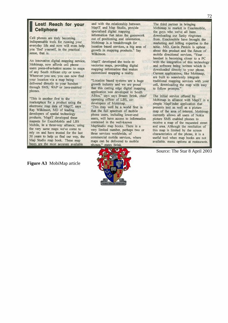
72
Source: The Star 8 April 2003
Figure A3 MobiMap article
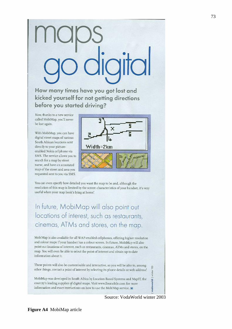
73
Source: VodaWorld winter 2003
Figure A4 MobiMap article
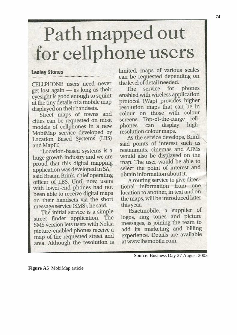
74
Source: Business Day 27 August 2003
Figure A5 MobiMap article