Embed Size (px)
DESCRIPTION
In this study, we analyzed the location of banks in the City of Buffalo. In developing our project, we asked ourselves, “Are the location of banks related to the location of various income levels?” In other words, do the banks locate mostly near higher income areas or do they locate over a wide range of incomes?After analyzing the existing banking network, there were areas that were not served by a local bank (areas that did not have a bank within a 10 minute walk). We then developed a set of criteria to find potential locations for new banks.Our research hopes to create new opportunities for local banks to extend their network to become more accessible to a broader audience of bank users who were unable to access banking services previously.
Citation preview
Bank Location AnalysisCity of Buffalo
Final Project
PD 469/569 - GIS Applications
Spring 2009
Professor Li Yin
Raymond Chetti Saet Byul Lim

Introduction In this study, we analyzed the location of banks in the City of Buffalo. In developing our project, we asked ourselves, “Are the location of banks related to the location of various income levels?” In other words, do the banks locate mostly near higher income areas or do they locate over a wide range of incomes?
After analyzing the existing banking network, there were areas that were not served by a local bank (areas that did not have a bank within a 10 minute walk). We then developed a set of criteria to find potential locations for new banks.
Our research hopes to create new opportunities for local banks to extend their network to become more accessible to a broader audience of bank users who were unable to access banking services previously.
Background According to the United States Census Bureau, the City of Buffalo is the second poorest city in the United States with an average median household income of $27,850 and a poverty rate of approximately 30%. A possible cause of this is the lack of access to financial institutions that offer banking services.
The following case study by New York Congressman Anthony D. Weiner in 2007 inspired the concept for our project and helped us understand why access to banks is important. •The Office of Congressman Anthony D. Weiner, 2007. Many More Banks in New York City (But only for some).
According to this study by Congressman Anthony D. Weiner, access to banking services and financial institutions is critical for New Yorkers who are struggling to stay or move into the middle class. Weiner’s report discusses the dramatic increase in financial institutions and notes how the locations of new banks are centered within neighborhoods that possess high median household incomes while neighborhoods with lower median household incomes have added a much lower number of banks.
This report also discusses how New Yorkers who do not have access to any banking institution are forced to use alternative services such as check cashing stores, pawn shops, and payday loans. As noted by this study, “New Yorkers who are forced to use these alternative services have less take home pay, are less able to accumulate long-term and emergency savings, and have a harder time establishing credit or qualifying for a loan.”
As noted in our introduction, our research hopes to educate and promote access to banking institutions to areas that may have been underserved by a local bank.
Solving the Problem with Geographic Information Systems (GIS) In order to solve this problem for the City of Buffalo, we used existing bank locations, total population and median household income data. By spatially mapping out existing bank locations and median household income data in ArcGIS, we were able to determine where the existing banks are and what areas in the city were higher/lower income neighborhoods.
We also used GIS to spatially represent how many people were served by an existing bank by creating an 800 meter buffer (10 minute walk) around the existing banks and calculating the total population of each income group (as noted by our maps) in each 800 meter buffer.
For finding new bank locations, we used GIS to query data according to the criteria we set for a suitable new bank location.
Criteria
1) Land Use Code = 330 – vacant commercial; to determine which areas were suitable for a new commercial bank.
2) Density > .3 person per square foot; to map out which areas were dense enough to support a bank.
3) Select parcels that were out of the existing banks buffer.
4) Parcel area by square feet > 2,500; to see which parcels are large enough for a bank.
5) Parcel total assessed value < $3000; to determine which sites are economically feasible to purchase for a new bank.
Method•DATA COLLECTION
We collected the Buffalo City block group census data at “www.census.gov.” We downloaded, Total Population (P1), Median Household Income [Income in 1999] (P53), and Vacancy Status (H8). In the data sets, we edited variables; the total population, total households, total housing units, vacant hous-ing units, and median household income. In Microsoft Excel 2003 the edited data was saved as DBF4 format.
From the School of Architecture and Urban Planning, University at Buffalo, we were allowed to use the shapefiles that “minic.shp”, “blkgrps_2000.shp”, “BFLOROAD.shp”, and “bflo_parcels_2005.shp.” [S:\courses\PD469569.s]
For the geocoding process, we searched banks in the City of Buffalo in Google Maps webpage, http://maps.google.com. We found 154 banks in the City of Buffalo and made a database in Microsoft Excel 2003 and saved our database as a DBF4 format.
•DATA PROCESSING AND ANALYSIS
To begin with the geo-process, we used the create address locator in the Geocoding tool. After creating our address locator, we selected geocode address tool. Among the 154 banks, 95 banks were able to be geocoded within the City of Buffalo road shapefile.
With the editor tool we modified 4 banks which failed to geocode. Our final result was 101 banks in the City of Buffalo. After geo-processing, we joined the bank database with the block group shapefile, “blkgrps_2000.shp.” To combine the data with parcel shapefile, “bflo_parcels_2005.shp,” we used the spatial join.
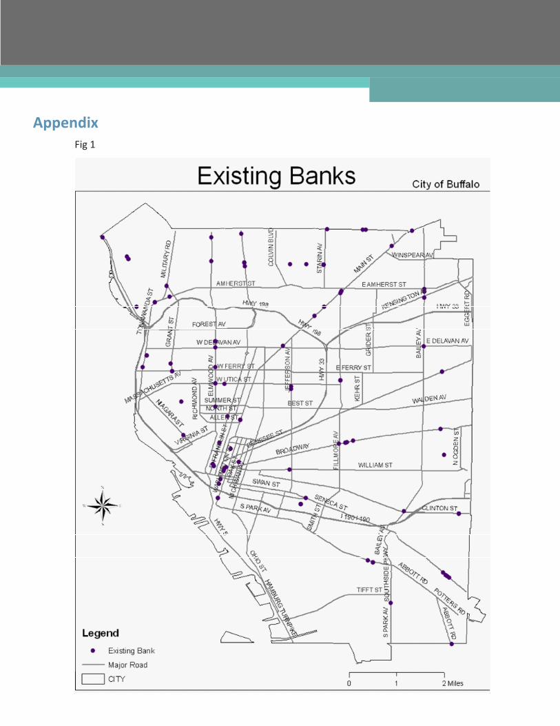
For mapping existing banks, we needed the city outline of Buffalo, selected the name “Buffalo” in the attribute table of “minic.shp” and created the city outline layer from the shapefile. We then were able to map the locations of existing banks in the City of Buffalo [Fig.1].
To analyze the existing bank locations, we incorporated a land use criteria. The commercial land use classification code is 400 and we queried “LANDUSE>= 411 AND LANDUSE<= 486” in the select by at-tribute menu. Most of banks are located near other commercial land uses [Fig 2].
Using symbology, the parcels of Buffalo were divided by median household income; $0 - $8,125, $8,126 - $20,667, $20,667 - $30,703, $30,704 - $52,115, and $52,116 - $146,379 [Fig 3]. To find the parcels that located in the banks’ buffer zone, we used the buffer tool and the distance of 800 meters to deter-mine a 10 minutes walking distance [Fig 4]. In the select by location menu, we selected features layer from parcels that fell completely within the buffer zone. We then obtained parcels in the buffer zone [Fig 5].
We made layers in order to analyze the existing banks by income level and those five layers helped to calculate the population for a bank. However, this sum of total population in the parcel data table was over the City of Buffalo total population which is about 290,000. Accordingly, we clipped to the parcels in buffer zone with joined block group shapefile. In addition, we queried the number of banks by using select by location. We wanted to select features from bank layer that are within a 800 meter distance of each income level parcel layer.
Another part of the project is finding eligible new bank location. To find the new locations, we set variables that are vacant land located in commercial areas, density, land total value, and area. Vacant land located in commercial areas was one of the criteria that we used. Land use classification code for vacant commercial properties is 330. We used the select by attributes and queried “LANDUSE=330.”
To calculate the density, we added an extra field in the attribute table for the parcel shapefile and used the field calculator. We put the “total population/Area.” We used the mean value and queried for parcels that had more than 0.3 density by selecting by attributes. By using the intersect tool with those two layers (density and land use code 330) we found 174 parcels.
For the next step, we should find parcels in the existing banks’ buffer zone. By using the select by loca-tion tool, we queried features from parcels that completely fell within the buffer zone of existing banks. In the attribute table of the parcel shapefile, some parcels are selected and we switched selections and made the layer that means parcels out of buffer zone.
Among those parcels, we queried “Total Land Value < 3000 AND AREA > 2500” in the select by attri-butes tool. We then selected parcels near major roads that have class code 1, 2, and 3. Although we
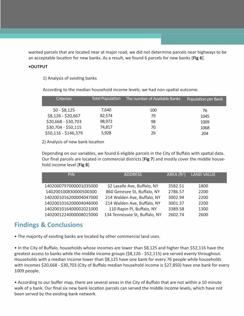
•OUTPUT 1) Analysis of existing banks
According to the median household income levels, we had non-spatial outcome.
wanted parcels that are located near at major road, we did not determine parcels near highways to be an acceptable location for new banks. As a result, we found 6 parcels for new banks [Fig 6].
Criterion
$0 - $8,125$8,126 - $20,667
$20,668 - $30,703$30,704 - $50,115
$50,116 - $146,379
Total Population
7,64082,57498,97274,8175,928
The number of Available Banks
10079987029
Population per Bank
76104510091068204
2) Analysis of new bank location
Depending on our variables, we found 6 eligible parcels in the City of Buffalo with spatial data. Our final parcels are located in commercial districts [Fig 7] and mostly cover the middle house-hold income level [Fig 8].
PIN
1402000797000001035000140200100830000500300
1402001016200004047000 1402001016200004046000 1402001016400002021000 1402001224000008015000
ADDRESS
32 Lasalle Ave, Buffalo, NY860 Genesee St, Buffalo, NY 214 Walden Ave, Buffalo, NY 214 Walden Ave, Buffalo, NY
110 Rapin Pl, Buffalo, NY 134 Tennessee St, Buffalo, NY
AREA (ft2)
3582.512786.573002.943001.373389.582602.74
LAND VALUE
180022002200220013002600
Findings & Conclusions
• The majority of existing banks are located by other commercial land uses.
• In the City of Buffalo, households whose incomes are lower than $8,125 and higher than $52,116 have the greatest access to banks while the middle income groups ($8,126 - $52,115) are served evenly throughout. Households with a median income lower than $8,125 have one bank for every 76 people while households with incomes $20,668 - $30,703 (City of Buffalo median household income is $27,850) have one bank for every 1009 people.
• According to our buffer map, there are several areas in the City of Buffalo that are not within a 10 minute walk of a bank. Our final six new bank location parcels can served the middle income levels, which have not been served by the existing bank network.
• Four new bank location parcels are located near each other and these new bank locations will serve areas in the City of Buffalo that are not served by a local bank.
• Based on our criteria for a new bank location, we have found several new bank locations that would serve areas in the City of Buffalo that are not currently served by a local bank. • Compared to Congressman Anthony D. Weiner’s research in New York City, our research shows different results. In Weiner’s research, most banks are located in higher income neighborhoods. Our research shows that the low-est income class and the highest income class have access to the most banks in Buffalo. However, the middle ranged incomes ($8,126 - $50,115) are not as well served by banks.
• Our findings for this report are unsatisfactory because the United States Census Bureau data we had access to is from 2000 and the median household income data was collected in 1999. There might be a possibility
ReferenceMany More Banks in New York City (But Only For Some). (2007, September 9). The Office of Congressman Anthony D. Weiner. Retrieved April 18, 2009, http://www.nytimes.com/packages/pdf/nyregion/ city_room/20070910_weinerbankreport.pdf
AppendixFig 1
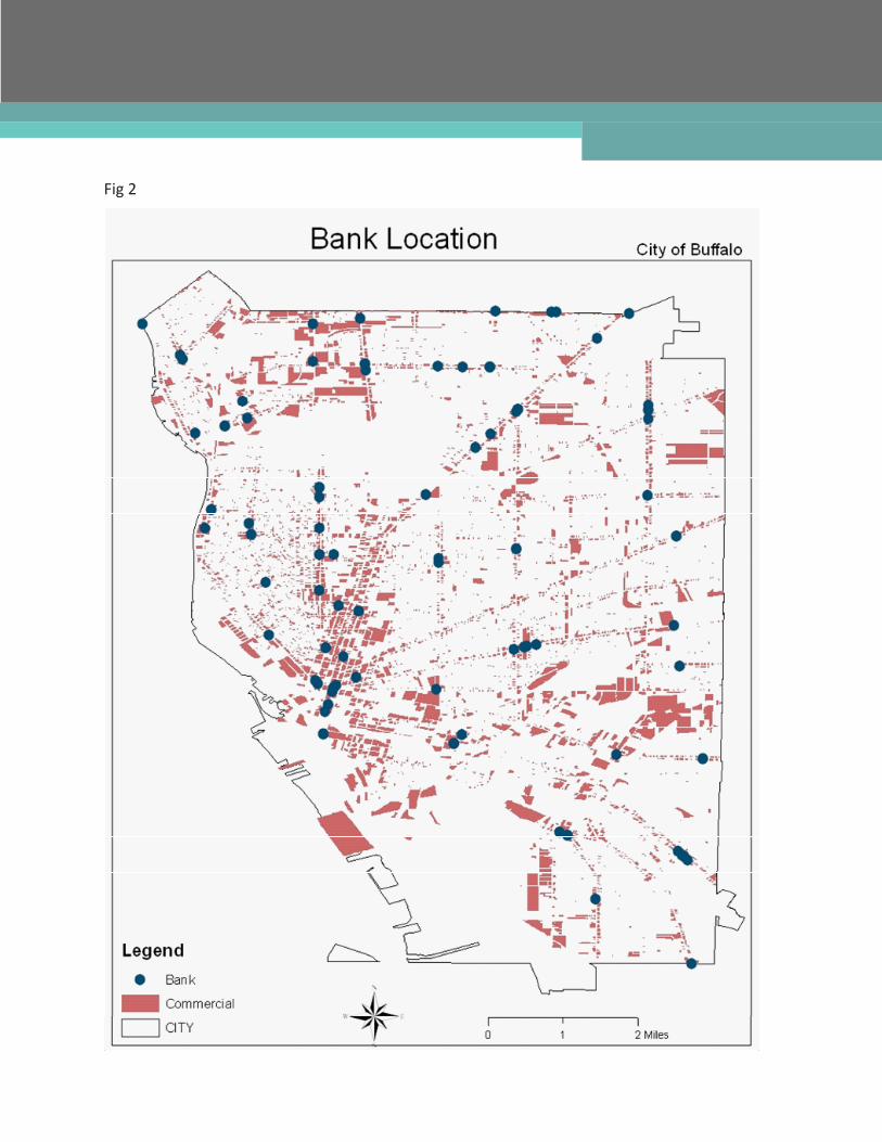
Fig 2
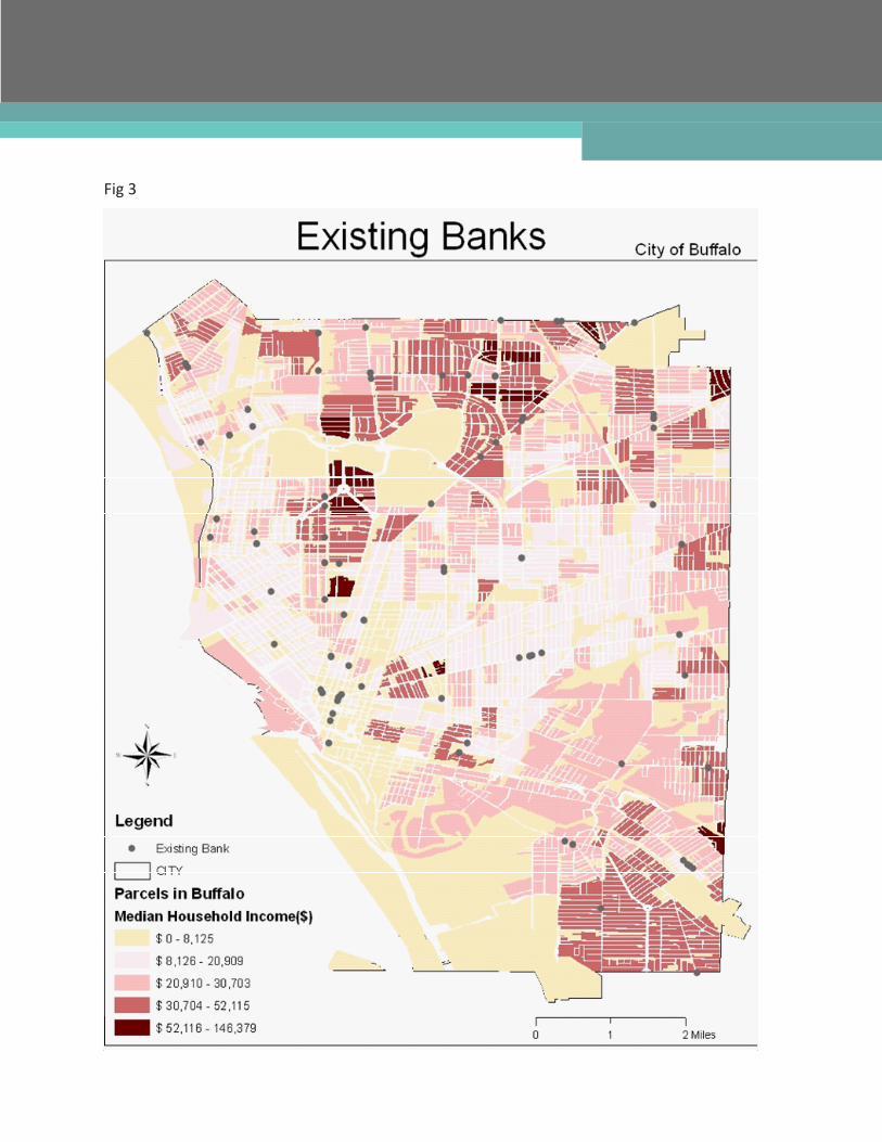
Fig 3
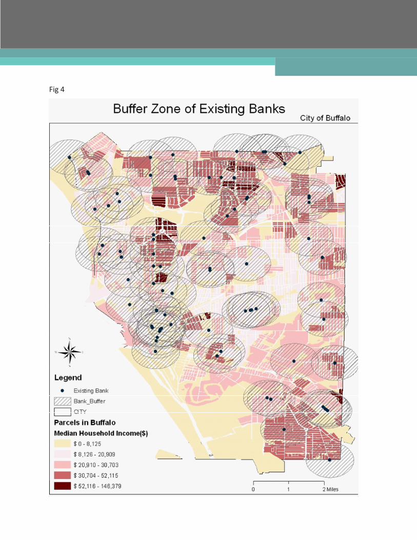
Fig 4
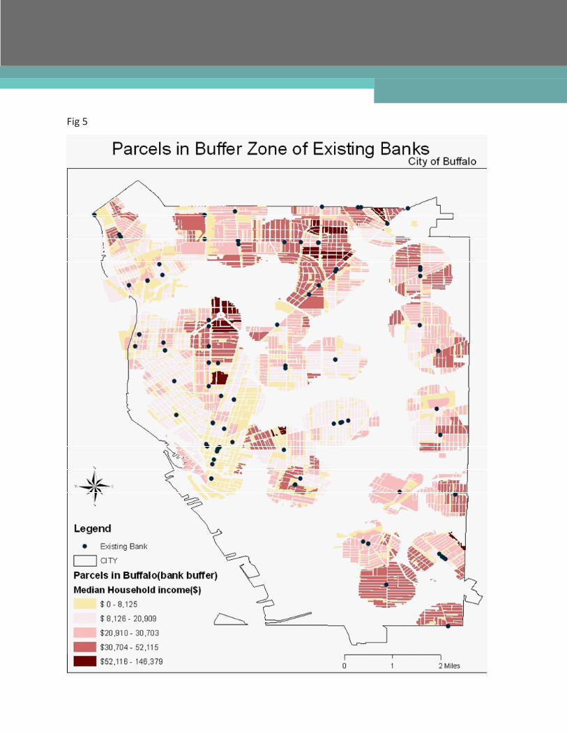
Fig 5
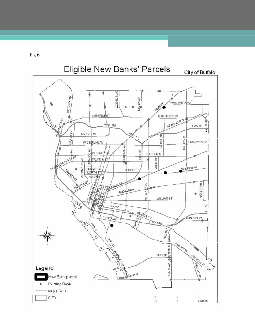
Fig 6
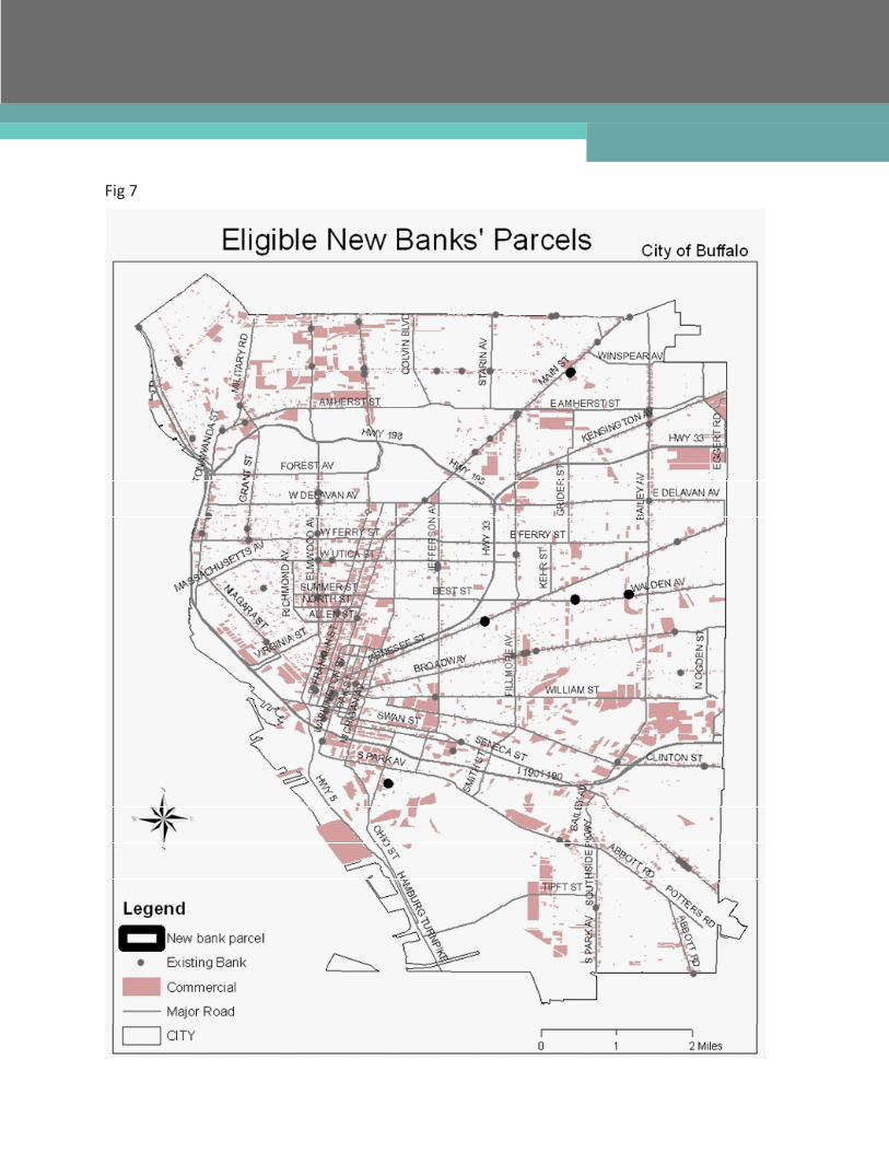
Fig 7
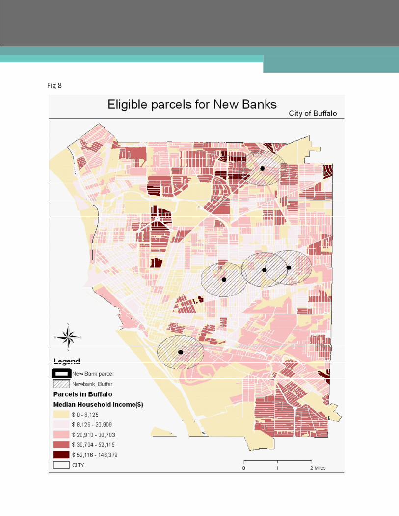
Fig 8