Embed Size (px)
Citation preview
LOCATION-BASED MOBILE TOUR GUIDE SERVICES TOWARDS DIGITAL DUNHUANG
Ma Chang-jie, Fang Jin-yun
Laboratory of Spatial Information Technology, Institute of Computing Technology, Chinese Academy of Sciences, Beijing, 100190, PRC -
KEY WORDS: GIS; Value-added; Services; Mobile; Internet/Web; GPS/INS; Real-time; On-line ABSTRACT: Dunhuang Mogao Grottoes, as a world cultural heritage, is the existed world’s largest and best-preserved Buddhist art treasures. For thousands of years, it has attracted millions of people all around world. However, in the long-term protection and exploitation, Mogao Grottoes has been in the dilemma between cultural relic protections and tourism developments. In this regard, the paper, leveraged technologies of wireless network, mobile communication and geographical information, established Digital Dunhuang oriented Mobile Tour Guide (MTG) architecture and workflow extended C/S or B/S modes, and designed location-based MTG services by means of SMS, MMS and WAP, IVR, such as variegated location-aware services, handheld Mogao Grottoes cultural libraries, mobile virtual Mogao Grottoes experience, wireless identification and tour booking, personal journey tips and so on. Furthermore, it listed some evaluation indicators to measure the pros and cons of services and satisfaction of tourists. It also exhibited a simple MTG J2ME prototype run on mobile phones. All these MTG services will become well complement for current Mogao tourism items and reinforce service quality day by day.
1. INTRODUCTION
1.1 Background and Related work
Regarded as the famous world cultural heritage, Dunhuang Mogao Grottoes(China 2007) is the existed world’s largest and best-preserved Buddhist art treasures. For thousands of years, it has attracted millions of people all around world. However, in the long-term protection and exploitation, Mogao Grottoes has been in the dilemma between cultural relic protections and tourism developments. Aiming to this, the paper, taking technologies of wireless network, mobile communication and geographical information as the foundation, conducted the research and development on the Digital Dunhuang Mobile Tour Guide (MTG) services based on the location awareness. It will facilitate tourists to make full use and enjoyment of MTG services at anytime anywhere through Personal Digital Assistants (PDAs), mobile-phones and other handheld devices. Along with flourishing movement of 3G, there has emerged a lot of GPRS or CDMA1X based applications including personal information, business transaction and popular entertainment, location services and so on. All these will play more and more essential role in people’s daily life. According to the report of NDC Advisory(NDC 2005), it has found that in China location-based services had entered the maturity stage in 2007 and after 2008 its size of the market would continue to expand until 2010 it would be expected to reach 1.72 billion Yuan. At the same time, tourism navigation services, depending strongly on information technologies, have appeared dramatically changed in these years. As we all know, tourism industry is providing food, travel, housing, shopping and transportation, entertainment etc. Moreover, with the in-depth development of it, tourists have become increasingly mature
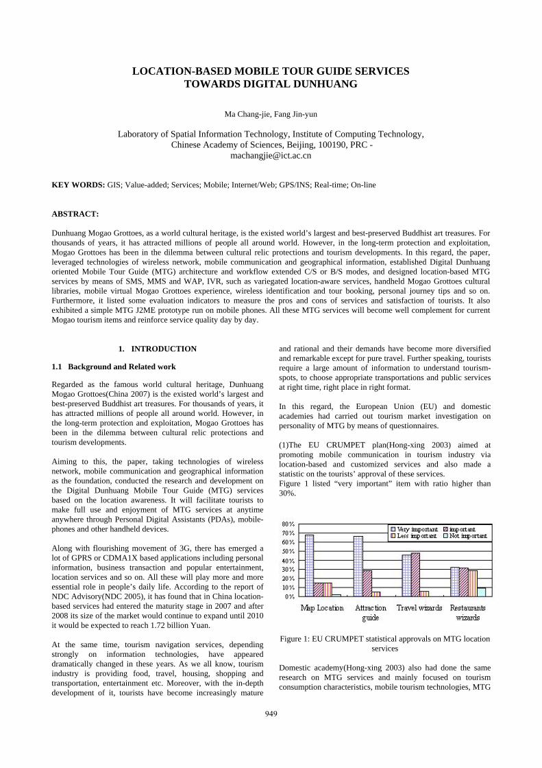
and rational and their demands have become more diversified and remarkable except for pure travel. Further speaking, tourists require a large amount of information to understand tourism-spots, to choose appropriate transportations and public services at right time, right place in right format. In this regard, the European Union (EU) and domestic academies had carried out tourism market investigation on personality of MTG by means of questionnaires. (1)The EU CRUMPET plan(Hong-xing 2003) aimed at promoting mobile communication in tourism industry via location-based and customized services and also made a statistic on the tourists’ approval of these services. Figure 1 listed “very important” item with ratio higher than 30%.
Figure 1: EU CRUMPET statistical approvals on MTG location services
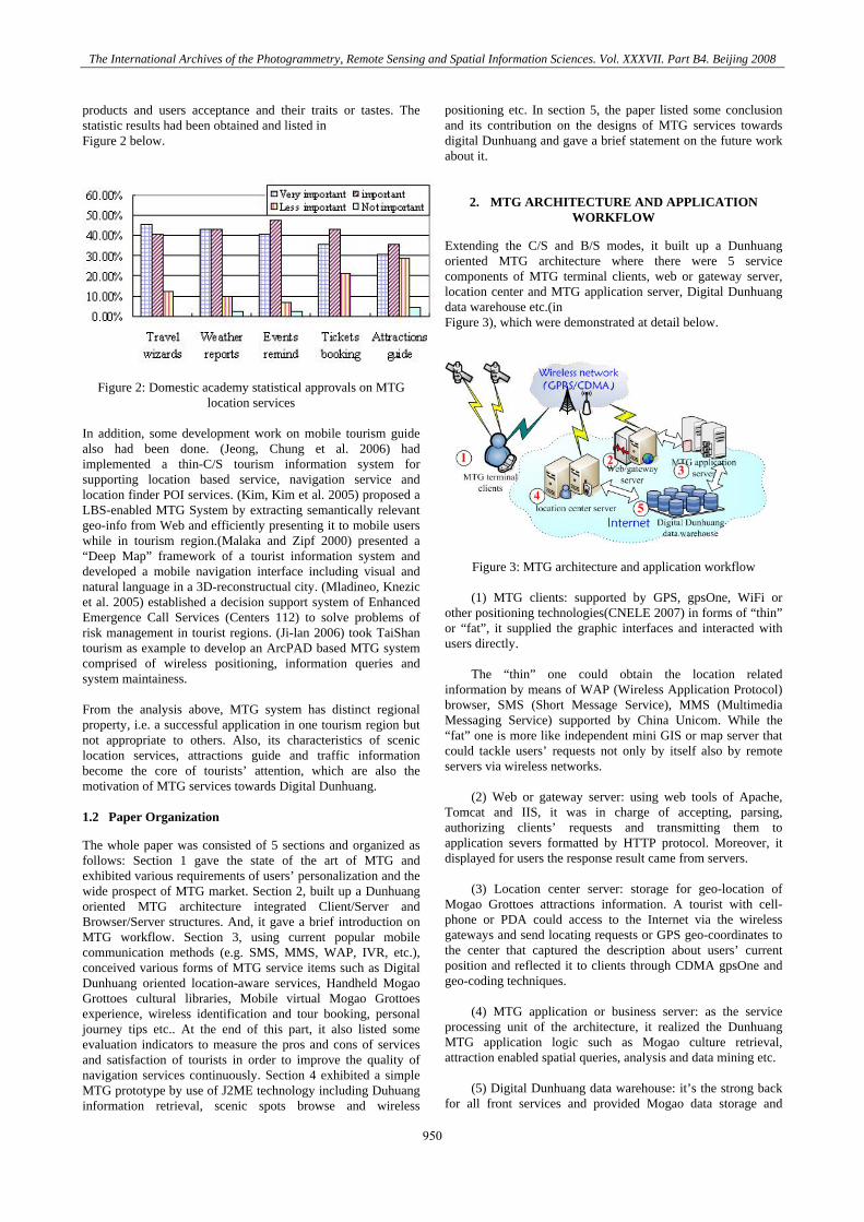
Domestic academy(Hong-xing 2003) also had done the same research on MTG services and mainly focused on tourism consumption characteristics, mobile tourism technologies, MTG
949
The International Archives of the Photogrammetry, Remote Sensing and Spatial Information Sciences. Vol. XXXVII. Part B4. Beijing 2008
products and users acceptance and their traits or tastes. The statistic results had been obtained and listed in Figure 2 below.
Figure 2: Domestic academy statistical approvals on MTG location services
In addition, some development work on mobile tourism guide also had been done. (Jeong, Chung et al. 2006) had implemented a thin-C/S tourism information system for supporting location based service, navigation service and location finder POI services. (Kim, Kim et al. 2005) proposed a LBS-enabled MTG System by extracting semantically relevant geo-info from Web and efficiently presenting it to mobile users while in tourism region.(Malaka and Zipf 2000) presented a “Deep Map” framework of a tourist information system and developed a mobile navigation interface including visual and natural language in a 3D-reconstructual city. (Mladineo, Knezic et al. 2005) established a decision support system of Enhanced Emergence Call Services (Centers 112) to solve problems of risk management in tourist regions. (Ji-lan 2006) took TaiShan tourism as example to develop an ArcPAD based MTG system comprised of wireless positioning, information queries and system maintainess. From the analysis above, MTG system has distinct regional property, i.e. a successful application in one tourism region but not appropriate to others. Also, its characteristics of scenic location services, attractions guide and traffic information become the core of tourists’ attention, which are also the motivation of MTG services towards Digital Dunhuang. 1.2 Paper Organization
The whole paper was consisted of 5 sections and organized as follows: Section 1 gave the state of the art of MTG and exhibited various requirements of users’ personalization and the wide prospect of MTG market. Section 2, built up a Dunhuang oriented MTG architecture integrated Client/Server and Browser/Server structures. And, it gave a brief introduction on MTG workflow. Section 3, using current popular mobile communication methods (e.g. SMS, MMS, WAP, IVR, etc.), conceived various forms of MTG service items such as Digital Dunhuang oriented location-aware services, Handheld Mogao Grottoes cultural libraries, Mobile virtual Mogao Grottoes experience, wireless identification and tour booking, personal journey tips etc.. At the end of this part, it also listed some evaluation indicators to measure the pros and cons of services and satisfaction of tourists in order to improve the quality of navigation services continuously. Section 4 exhibited a simple MTG prototype by use of J2ME technology including Duhuang information retrieval, scenic spots browse and wireless
positioning etc. In section 5, the paper listed some conclusion and its contribution on the designs of MTG services towards digital Dunhuang and gave a brief statement on the future work about it.
2. MTG ARCHITECTURE AND APPLICATION WORKFLOW
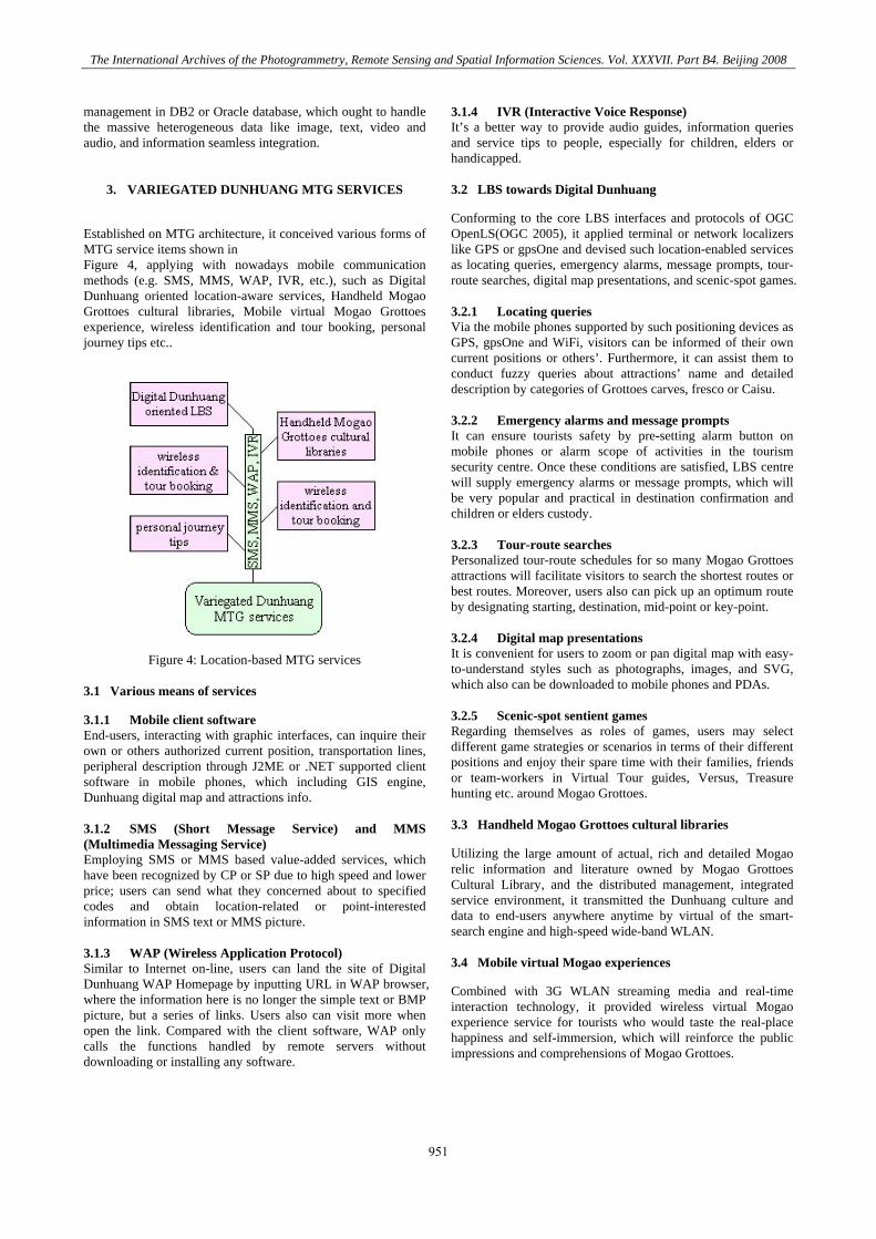
Extending the C/S and B/S modes, it built up a Dunhuang oriented MTG architecture where there were 5 service components of MTG terminal clients, web or gateway server, location center and MTG application server, Digital Dunhuang data warehouse etc.(in Figure 3), which were demonstrated at detail below.
Figure 3: MTG architecture and application workflow
(1) MTG clients: supported by GPS, gpsOne, WiFi or other positioning technologies(CNELE 2007) in forms of “thin” or “fat”, it supplied the graphic interfaces and interacted with users directly.
The “thin” one could obtain the location related
information by means of WAP (Wireless Application Protocol) browser, SMS (Short Message Service), MMS (Multimedia Messaging Service) supported by China Unicom. While the “fat” one is more like independent mini GIS or map server that could tackle users’ requests not only by itself also by remote servers via wireless networks.
(2) Web or gateway server: using web tools of Apache,
Tomcat and IIS, it was in charge of accepting, parsing, authorizing clients’ requests and transmitting them to application severs formatted by HTTP protocol. Moreover, it displayed for users the response result came from servers.
(3) Location center server: storage for geo-location of
Mogao Grottoes attractions information. A tourist with cell-phone or PDA could access to the Internet via the wireless gateways and send locating requests or GPS geo-coordinates to the center that captured the description about users’ current position and reflected it to clients through CDMA gpsOne and geo-coding techniques.
(4) MTG application or business server: as the service
processing unit of the architecture, it realized the Dunhuang MTG application logic such as Mogao culture retrieval, attraction enabled spatial queries, analysis and data mining etc.
(5) Digital Dunhuang data warehouse: it’s the strong back
for all front services and provided Mogao data storage and
950
The International Archives of the Photogrammetry, Remote Sensing and Spatial Information Sciences. Vol. XXXVII. Part B4. Beijing 2008
management in DB2 or Oracle database, which ought to handle the massive heterogeneous data like image, text, video and audio, and information seamless integration.
3. VARIEGATED DUNHUANG MTG SERVICES
Established on MTG architecture, it conceived various forms of MTG service items shown in Figure 4, applying with nowadays mobile communication methods (e.g. SMS, MMS, WAP, IVR, etc.), such as Digital Dunhuang oriented location-aware services, Handheld Mogao Grottoes cultural libraries, Mobile virtual Mogao Grottoes experience, wireless identification and tour booking, personal journey tips etc..
Figure 4: Location-based MTG services 3.1 Various means of services
3.1.1 Mobile client software End-users, interacting with graphic interfaces, can inquire their own or others authorized current position, transportation lines, peripheral description through J2ME or .NET supported client software in mobile phones, which including GIS engine, Dunhuang digital map and attractions info. 3.1.2 SMS (Short Message Service) and MMS (Multimedia Messaging Service) Employing SMS or MMS based value-added services, which have been recognized by CP or SP due to high speed and lower price; users can send what they concerned about to specified codes and obtain location-related or point-interested information in SMS text or MMS picture. 3.1.3 WAP (Wireless Application Protocol) Similar to Internet on-line, users can land the site of Digital Dunhuang WAP Homepage by inputting URL in WAP browser, where the information here is no longer the simple text or BMP picture, but a series of links. Users also can visit more when open the link. Compared with the client software, WAP only calls the functions handled by remote servers without downloading or installing any software.
3.1.4 IVR (Interactive Voice Response) It’s a better way to provide audio guides, information queries and service tips to people, especially for children, elders or handicapped. 3.2 LBS towards Digital Dunhuang
Conforming to the core LBS interfaces and protocols of OGC OpenLS(OGC 2005), it applied terminal or network localizers like GPS or gpsOne and devised such location-enabled services as locating queries, emergency alarms, message prompts, tour-route searches, digital map presentations, and scenic-spot games. 3.2.1 Locating queries Via the mobile phones supported by such positioning devices as GPS, gpsOne and WiFi, visitors can be informed of their own current positions or others’. Furthermore, it can assist them to conduct fuzzy queries about attractions’ name and detailed description by categories of Grottoes carves, fresco or Caisu. 3.2.2 Emergency alarms and message prompts It can ensure tourists safety by pre-setting alarm button on mobile phones or alarm scope of activities in the tourism security centre. Once these conditions are satisfied, LBS centre will supply emergency alarms or message prompts, which will be very popular and practical in destination confirmation and children or elders custody. 3.2.3 Tour-route searches Personalized tour-route schedules for so many Mogao Grottoes attractions will facilitate visitors to search the shortest routes or best routes. Moreover, users also can pick up an optimum route by designating starting, destination, mid-point or key-point. 3.2.4 Digital map presentations It is convenient for users to zoom or pan digital map with easy-to-understand styles such as photographs, images, and SVG, which also can be downloaded to mobile phones and PDAs. 3.2.5 Scenic-spot sentient games Regarding themselves as roles of games, users may select different game strategies or scenarios in terms of their different positions and enjoy their spare time with their families, friends or team-workers in Virtual Tour guides, Versus, Treasure hunting etc. around Mogao Grottoes. 3.3 Handheld Mogao Grottoes cultural libraries
Utilizing the large amount of actual, rich and detailed Mogao relic information and literature owned by Mogao Grottoes Cultural Library, and the distributed management, integrated service environment, it transmitted the Dunhuang culture and data to end-users anywhere anytime by virtual of the smart-search engine and high-speed wide-band WLAN. 3.4 Mobile virtual Mogao experiences
Combined with 3G WLAN streaming media and real-time interaction technology, it provided wireless virtual Mogao experience service for tourists who would taste the real-place happiness and self-immersion, which will reinforce the public impressions and comprehensions of Mogao Grottoes.
951
The International Archives of the Photogrammetry, Remote Sensing and Spatial Information Sciences. Vol. XXXVII. Part B4. Beijing 2008
3.5 Wireless identification and tour booking
Extended from the existing Internet tour prearrangement, it supported wireless identification based tour booking service via the smart-phones, PDAs and other handheld devices, which will not only promote the level of Mogao travel managements and optimize its resources, but also simplify the booking procedure and make it more convenient and flexible. 3.6 Personal journey tips
According to the requirements of tour individuation, it designed personal journey tips about Dunhuang tied to each tourist such as weather reports, journey schedules, hot line tips, advice on departure fee and souvenir shopping and so on. In addition, it is necessary to establish a viable evaluation system and define effective indicators for mobile tour navigation, such as positioning accuracy, service coverage, real-time interactive, information creditability and personal privacy. In order to achieve better efficiency of MTG, it is also a must to perform a host of system testing and overall function testing. On the other hand, it’s a significant manner to carry out investigation or survey among tourists who have touched MTG services to assess the system quality and tourist satisfaction which will help improve and promote the MTG services continuously.
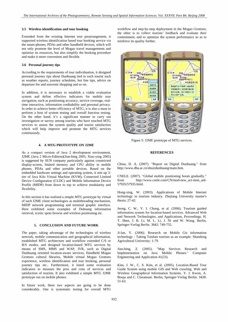
4. A MTG PROTOTYPE ON J2ME
As a compact version of Java 2 development environment, J2ME (Java 2 Micro-Edition)(Jian-bing 2005; Xiao-ying 2005) is suggested by SUN company particularly against constricted display-screen, limited memory and CPU ability in mobile phones, PDAs and other portable devices. Based on the embedded hardware settings and operating system, it sets up 3-tier of Java Kilo Virtual Machine (KVM), Connected Limited Device Configuration (CLDC) and Mobile Information Device Profile (MIDP) from down to top to achieve modularity and flexibility. In this section it has realized a simple MTG prototype by virtual of such J2ME client technologies as multithreading mechanism, MIDP network programming and terminal graphic interface. Here exhibited some examples of Duhuang information retrieval, scenic spots browse and wireless positioning etc.
5. CONCLUSION AND FUTURE WORK
The paper, taking advantage of the technologies of wireless network, mobile communication and geographical information, established MTG architecture and workflow extended C/S or B/S modes, and designed location-based MTG services by means of SMS, MMS and WAP, IVR, such as Digital Dunhuang oriented location-aware services, Handheld Mogao Grottoes cultural libraries, Mobile virtual Mogao Grottoes experience, wireless identification and tour booking, personal journey tips etc.. Furthermore, it listed some evaluation indicators to measure the pros and cons of services and satisfaction of tourists. It also exhibited a simple MTG J2ME prototype run on mobile phones. In future work, there two aspects are going to be done considerably. One is systematic testing for overall MTG
workflow and step-by-step deployment in the Mogao Grottoes; the other is to collect tourists’ feedback and evaluate their contentment, and to optimize the system performance so as to reinforce its quality further.
Figure 5: J2ME prototype of MTG services.
REFERENCES
China, D. A. (2007). "Report on Digital Dunhuang." from http://www.dha.ac.cn/shuzidunhuang/main.htm. CNELE. (2007). "Global mobile positioning boom gradually." from http://www.cnele.com/CN/mod-new_act-item_aid-57935/57935.html. Hong-xing, W. (2003). Applications of Mobile Internet technology in tourism industry. Zhejiang University master's thesis: 27-42. Jeong, C. W., Y. J. Chung, et al. (2006). Tourism guided information system for location-based services. Advanced Web and Network Technologies, and Applications, Proceedings. H. T. Shen, J. B. Li, M. L. Li, J. Ni and W. Wang. Berlin, Springer-Verlag Berlin. 3842: 749-755. Ji-lan, Y. (2006). Research on Mobile Gis information technology - Taking Taishan tourism as an example. Shandong Agricultural University: 1-79. Jian-bing, Z. (2005). "Map Services Research and Implementation on Java Mobile Phones." Computer Engineering and Application 41(23). Kim, J. W., C. S. Kim, et al. (2005). Location-Based Tour Guide System using mobile GIS and Web crawling. Web and Wireless Geographical Information Systems. Y. J. Kwon, A. Bouju and C. Claramunt. Berlin, Springer-Verlag Berlin. 3428: 51-63.
952

The International Archives of the Photogrammetry, Remote Sensing and Spatial Information Sciences. Vol. XXXVII. Part B4. Beijing 2008
Malaka, R. and A. Zipf (2000). DEEP MAP: Challenging IT research in the framework of a tourist information system. Information and Communication Technologies in Tourism 2000. D. R. Fesenmaier, S. Klein and D. Buhalis. Vienna, Springer-Verlag Wien: 15-27. Mladineo, N., S. Knezic, et al. (2005). DSS for risk management in tourist regions. Wmsci 2005: 9th World Multi-Conference on Systemics, Cybernetics and Informatics, Vol 10. D. Zinn, M. J. Savoie, K. C. Lin, E. S. ElBadawy and G. Banga. Orlando, Int Inst Informatics & Systemics: 410-415.
NDC. (2005). "Market Analysis on China's Mobile Location-based Services. ." from http://data.chinabyte.com/177/2228677. shtml. OGC (2005). "05-016:Location Service (OpenLS): Core Services." 6-36. Xiao-ying, S. (2005). Design and Implementation of Mobile Location Services Platform on 3G mobile phones. SICT.ac master's thesis.
953

The International Archives of the Photogrammetry, Remote Sensing and Spatial Information Sciences. Vol. XXXVII. Part B4. Beijing 2008
954


![DUNHUANG Buddhist Art at the Gateway of the Silk Road...DUNHUANG Buddhist Art at the Gateway of the Silk Road [Introduction in Foyer] Dunhuang, an oasis town strategically located](https://img.pdfslide.us/doc/110x75/60cf6f577bcc97491b679a39/dunhuang-buddhist-art-at-the-gateway-of-the-silk-dunhuang-buddhist-art-at-the.jpg)