Embed Size (px)
Citation preview
i
Lively Streets and Better Social Life
——A case study of three comparable streets in Kristianstad
Author: Qing Yang
Supervisor: Gunnar Nyström
Submitted to Blekinge Tekniska Högskola for the Master of Science Programme in
Spatial Planning with an emphasis on Urban Design in Europe and China
Karlskrona, Sweden
2012. 05. 18
ii
Abstract
For much of the twentieth century, streets were designed to accommodate the ever
increasing traffic flow, but it has become apparent that streets have many social and
recreational functions which are severely impaired by fast car traffic. There is plenty
of research on conditions for non-motorized transport and development of design
measures on the streetscape to protect pedestrians and cyclists, but how places are
made in the street is less studied and seldom implemented. In order to create more
humanistic space in the street, we need to take consideration of people first, figure out
how space can turn into a good place and which physical conditions will improve
social life.
This paper starts with pointing out the problems of ignoring social life in urban streets,
and investigating the main theories and applications in contemporary western
countries. After that, the thesis introduces literature on improving street life, including
the books of Gehl: Cities for People (2010), New City Life (2006), and Burton and
Mitchell: Inclusive Urban Design - Streets for life (2006), etc. Moreover, to see how
these theories can be applied on a specific case, three streets in the town of
Kristianstad are studied. This thesis is conducting an investigation on characteristics
of these streets, observing social life in each street, and trying to figure out under
which conditions does a street change from subduing social life to enhancing it. The
theoretical tools and observation results of social life are all taken into the case study
for practice, aiming at creating lively streets.
My conclusions concern the primary factors for creating lively streets: location and
role of the comparable streets in the overall traffic network, the characteristics of
these streets and adjacent buildings, and the relationships between the physical
conditions and the observed social life.
Key words: urban design, traffic calming, lively streets, social life, public space,
place making

iii
Acknowledgment
This is a diploma work submitted to Blekinge Tekniska Högskola for the Master of
Science Programme in Spatial Planning, with an emphasis on Urban Design in Europe
and China. This thesis is supported by many people. They give me lots of assistance,
suggestions and encouragements. I cannot finish this work successfully without their
help.
Firstly, I would like to express my sincere appreciation to my supervisor Gunnar
Nyström for his patience guidance and professional engagement throughout the
diploma work. He has given me important information about the city of Kristianstad.
He has also given me valuable advices and comments on my thesis, so that I am able
to deal with the difficulties as the research progresses.
Secondly, I want to thank Lina Berglund-Snodgrass, who has given me useful advices
about the structure of the thesis and writing techniques. And I want to thank Abdellah
Abarkan, Eric Markus and other staffs working at BTH. Also, I would like to take this
opportunity to thank to Tao Jiang for correcting my English and Wei Qian for giving
me so much inspiration.
Lastly, I give my grateful thanks to my family and friends for their support and love,
which make me spend a wonderful time in Sweden.
In the end I hope that this thesis has managed to transfer my interest and enthusiasm
in this topic, and I wish you will find it interesting to read as I found it when I was
writing.
Karlskrona, 18th
May 2012
Qing Yang
iv
Contents
Chapter 1 Introduction to the research topic ............................................................ 1
1 Introduction ...................................................................................................... 1
1.1 Background: Revaluing the diverse roles of streets ........................... 1
1.2 Problem statement .............................................................................. 1
2 Research approach ........................................................................................... 2
2.1 Research question .............................................................................. 2
2.2 Methodology ...................................................................................... 2
2.2.1 Empirical investigation ................................................................. 2
2.2.2 Observation ................................................................................... 4
2.3 Structure of the thesis ......................................................................... 4
Chapter 2 Literature review and theoretical study .................................................. 6
3 Literature review .............................................................................................. 6
3.1 Definition of street ............................................................................. 6
3.2 A brief history of street development in Europe ................................ 8
3.3 Related concepts to protect pedestrians and cyclists ....................... 10
3.3.1 Traffic calming ............................................................................ 10
3.3.2 Livable streets ............................................................................. 12
3.3.3 Shared space ............................................................................... 13
3.3.4 Living street ................................................................................ 14
3.3.5 Complete street ........................................................................... 15
3.4 A review of traffic control in different cities ................................... 16
3.4.1 Copenhagen ................................................................................ 16
3.4.2 London ........................................................................................ 17
3.4.3 Beijing ......................................................................................... 19
3.4.4 New York .................................................................................... 20
3.5 Summary and illustration ................................................................. 21
4 Theoretical framework ................................................................................... 23
4.1 New City Life and Cities for People ................................................ 23
4.2 Human dimension and street life ..................................................... 24
4.3 Psychological needs on the streets ................................................... 25
4.4 Diagram of theoretical framework ................................................... 26
Chapter 3 Analysis and Research ............................................................................. 28
v
5 Objective streets in Kristianstad .................................................................... 28
5.1 Introduction to Kristianstad ............................................................. 28
5.2 Objective streets in Östra center ...................................................... 29
6 Analysis and research of streets in Kristianstad ............................................ 33
6.1 Safety needs ..................................................................................... 33
6.1.1 Slower traffic and pedestrian-priority ......................................... 34
6.1.2 Crime prevention ........................................................................ 36
6.2 Accessibility needs .......................................................................... 37
6.2.1 Street layout ................................................................................ 38
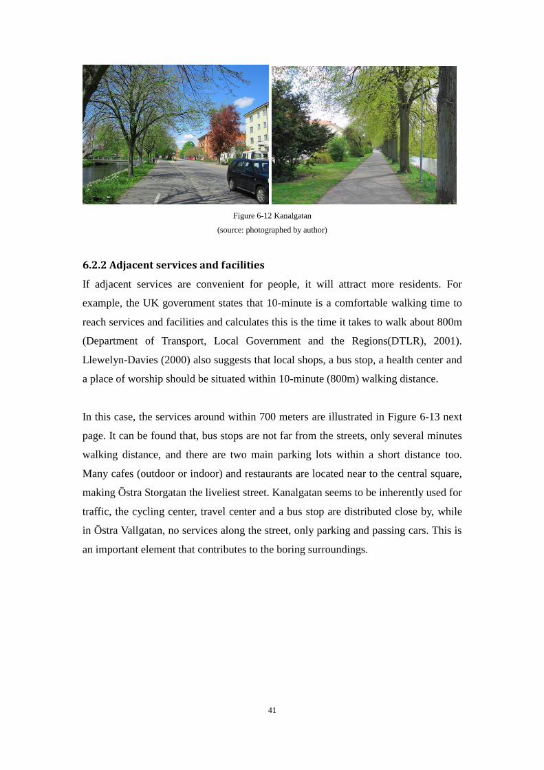
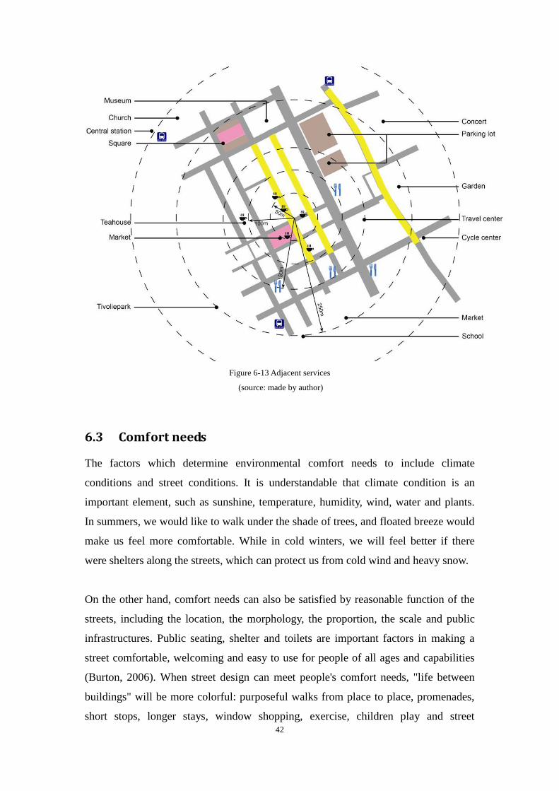
6.2.2 Adjacent services and facilities ................................................... 41
6.3 Comfort needs .................................................................................. 42
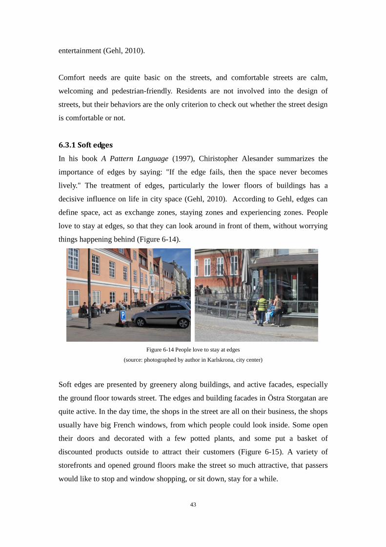
6.3.1 Soft edges .................................................................................... 43
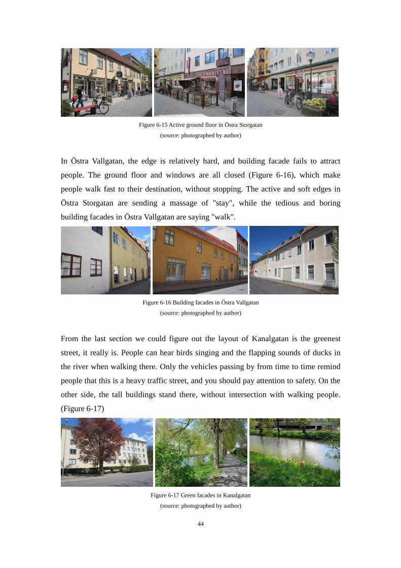
6.3.2 Fine scale .................................................................................... 45
6.4 Legibility needs ................................................................................ 49
6.4.1 Signs ............................................................................................ 49
6.4.2 Paving materials .......................................................................... 49
6.4.3 Distinctive streets ........................................................................ 50
6.5 Participation needs ........................................................................... 51
6.5.1 Street as meeting place ................................................................ 51
6.5.2 A good view ................................................................................ 54
6.6 Summary .......................................................................................... 56
7 Social life observation ................................................................................... 57
7.1 Outdoor activities ............................................................................. 57
7.2 Observation study ............................................................................ 58
7.3 Observation results .......................................................................... 59
7.3.1 Groups of street users and their activities ................................... 59
7.3.2 Social life in Östra Storgatan ...................................................... 61
7.3.3 Social life in Östra Vallgatan ...................................................... 68
7.3.4 Social life in Kanalgatan ............................................................. 69
7.4 Summary .......................................................................................... 72
Chapter 4 Conclusions ............................................................................................... 74
List of Figures ............................................................................................................. 76
References ................................................................................................................... 79
1
Chapter 1 Introduction to the research topic
1 Introduction
1.1 Background: Revaluing the diverse roles of streets
Streets provide alignment for sewers, carry vehicles, and form the structure of a city.
Streets allow people to be outside, provide access to their destinations. However, the
streets in a lively city serve more than that. Cliff Moughtin (2003) states that, it is
such a common practice to regard the street as a road for motor vehicles, that the
function as a place has been quite overlooked. For many generations the street has
provided urban communities with public open space right outside their homes.
It has been 50 years since The Death and Life of Great American Cities was published
in 1961. These 50 years have witnessed a great change to streets in cities, the
domination of cars has been decreased, and better conditions are provided for
pedestrians and cyclists. The value of streets has been reappraised, especially in the
recent decades. Lots of social activities happen on the street every day. There is an
inherent feeling of safety and social bond which has much to do with the obviousness
and simple order of the form of the street. The street is not only a means of access but
also an arena for social expression (Moughtin, 2003).
Today, most of the streets are still dominated by vehicles. Pedestrians' and cyclists'
social activities are limited. For a long period of time, traffic engineers and urban
designers were trying to figure out a way that can bring more people out onto the
streets — allowing these spaces to serve as public places where neighbors and friends
can connect with one another, in order to build livable cities, and meanwhile
transportation planners and engineers consistently seek the way to design and operate
the entire roadway with all users in mind — including bicyclists, public transportation
vehicles, and pedestrians of all ages and abilities.
1.2 Problem statement
In the past few decades, people realized that streets have many social and recreational
functions which are severely impaired by fast car traffic. There are plenty of research
2
findings to protect pedestrians and cyclists, create more humanistic space in the street.
Public concern has arisen about constructing streets for life. However, how places are
made in the street was ignored. Gehl states that, "In a world where planners look after
the plans, architects look after the buildings, landscape architects attend to the
landscapes, and traffic planners provide for the traffic it has become increasingly
apparent that no one is specifically asked to look after the people" (Gehl, 2010).
This paper is proceeding from people's psychological needs, conducting a research of
three living streets characteristics, aiming at creating lively streets, trying to figure out
what conditions of the street can improve social life.
2 Research approach
2.1 Research question
A living street serves both ends for many individuals. Jan Gehl (1987) describes three
types of activities in outdoor space, that is, necessary activities, optional activities and
social activities. He states that a necessary activity can turn into a social activity if the
conditions of the street are favorable for rest and talk. A place that is not a path might
be very isolated and non-active, while a path with dominant car traffic may inhibit
social talk. Therefore, what kind of conditions of the street are more desirable to
people? When the space on the street can turn into a place for social life? These
questions need to be answered in the future urban design.
The research question of the thesis is:
Under which conditions does a street change from subduing social life to enhancing it?
2.2 Methodology
2.2.1 Empirical investigation
To promote active public life, we have to move away from planning approaches that
focus on the building structure, its design, layout and functions, but views the social
life outside the buildings (Gehl, 1987). And the significant factor that should be taken
into account is activities and social life in the streets. The book New City Life (2006)
and Cities for People (2010) are used as the theoretical framework.
3
The theoretical study is conducted based on the literature and theories, to summarize
the basic essentials of different elements on the streets from people's psychological
needs. Further, a case study is carried out based on the theoretical studies, to explore
which conditions will enhance social life in the streets.
Case study- Why?
A case study method is defined by Yin (2010) as "an empirical investigation which
examines a contemporaneous phenomenon in deep and in its real life context,
especially when the limits between the phenomenon and the context are not clearly
evident". Hence the case study can give the researcher, as well as the reader, rich and
detailed information about the research topic.
To explore under which conditions a street changes from subduing social life to
enhancing it, it is necessary to investigate certain cases. On one hand, spring is
coming, and people in the city, who have been waiting all winter, would like to go out
and enjoy the pleasant warmth. On the other hand, the data of the city Kristianstad
and streets in city center is easy to get, and the season is also appropriate for a
researcher to do the analysis outdoor, and observe social life. To some extent,
applying a case study analysis is the best option.
Where?
Three streets in central location of Kristianstad are selected to do the case study: Östra
Storgatan, Östra vallgatan, and Kanalgatan, because they are different in their traffic
volumes, street layouts, zoning and adjacent services. The thesis compares the
different characteristics of these streets to observe and judge which conditions can
better supports social life.
The reason
In developing countries, the proportion of car users is increasingly higher in large
cities, regardless of street life. The pedestrian-priority place can only be found in
commercial streets, usually city center. People choose bicycle or public transport by
necessity, and individual mobility is often a prerequisite for being able to get to work
and earn a living. While in developed countries, people prefer to spend time on streets
and enjoy the sunshine. However, in both scenarios, conditions for pedestrians and
4
cyclists dramatically impaired. We should learn from the practices of developed
countries, to provide valuable experience for lively street design.
Further, as we all know, it is hard to experience life higher up in buildings from the
street, the higher up, the more difficult it is to see. In fact, the connection between
street plane and high-rise buildings is effectively lost above the fifth floor (Gehl,
2010). Fifth floor as a threshold maybe not that accurate, but it is true that higher
floors connect little with the streets. As a result, the high-rise buildings will not be
considered in the street analysis in this paper. The streets in a medium-sized town are
suitable to be used as study objects.
2.2.2 Observation
Direct observation is a valuable method for collecting evaluation information and data
by watching what people actually do, or what events take place in a certain situation
(Tayloy-Powell and Steele, 1996). "Seeing and listening" is key to observation. This
method provides the opportunity to document activities, behavior and physical aspects
without having to depend on people's willingness and ability to respond to questions
(Tayloy-Powell and Steele, 1996). This paper uses observation as the methodology to
investigate behavior and social life in the streets, trying to figure out what conditions
will enhance social life or subdue it. The residents were not told that they were being
observed.
2.3 Structure of the thesis
The thesis is structured by four chapters: Introduction to the research topic, Literature
review and theoretical study, Research and Analysis, Conclusions.
The following chapter two is literature review and theoretical study. It shows the
history of street development in Europe, and main theories and findings about street
design. Then it describes the theoretical framework on full display. In chapter three,
the research on the street begins. First, people are divided into several groups:
passers-by, children, young people, retired elderly and disabilities. Their needs are
different from each other. Second, the research and analysis is conducted to differ the
characteristics from people's psychological needs in the streets. Third, social life,

5
what people are doing in the streets will be observed and studied.
The final chapter four will discuss the results of analysis and social life observations.
It gives the answer and conclusions to the research question, and summarizes the pros
and cons of the thesis. Finally, it demonstrates some recommendations to the future
street design.
6
Chapter 2 Literature review and theoretical study
3 Literature review
In order to answer the research question, the theories and findings in recent years
about the street are searched. These concepts are traffic calming, livable streets,
shared space, living streets, and complete streets. It is widely accepted that we should
revalue the diverse roles of streets towards a better social life and sustainable
development.
3.1 Definition of street
There are various types of streets. They are classified due to the flow of vehicles per
time unit, maximum speed allowed, width and zoning, proliferation of services or
retails. According to the PennDOT (Pennsylvania Department of Transportation) road
classification system and AASHTO (American Association of State Highway and
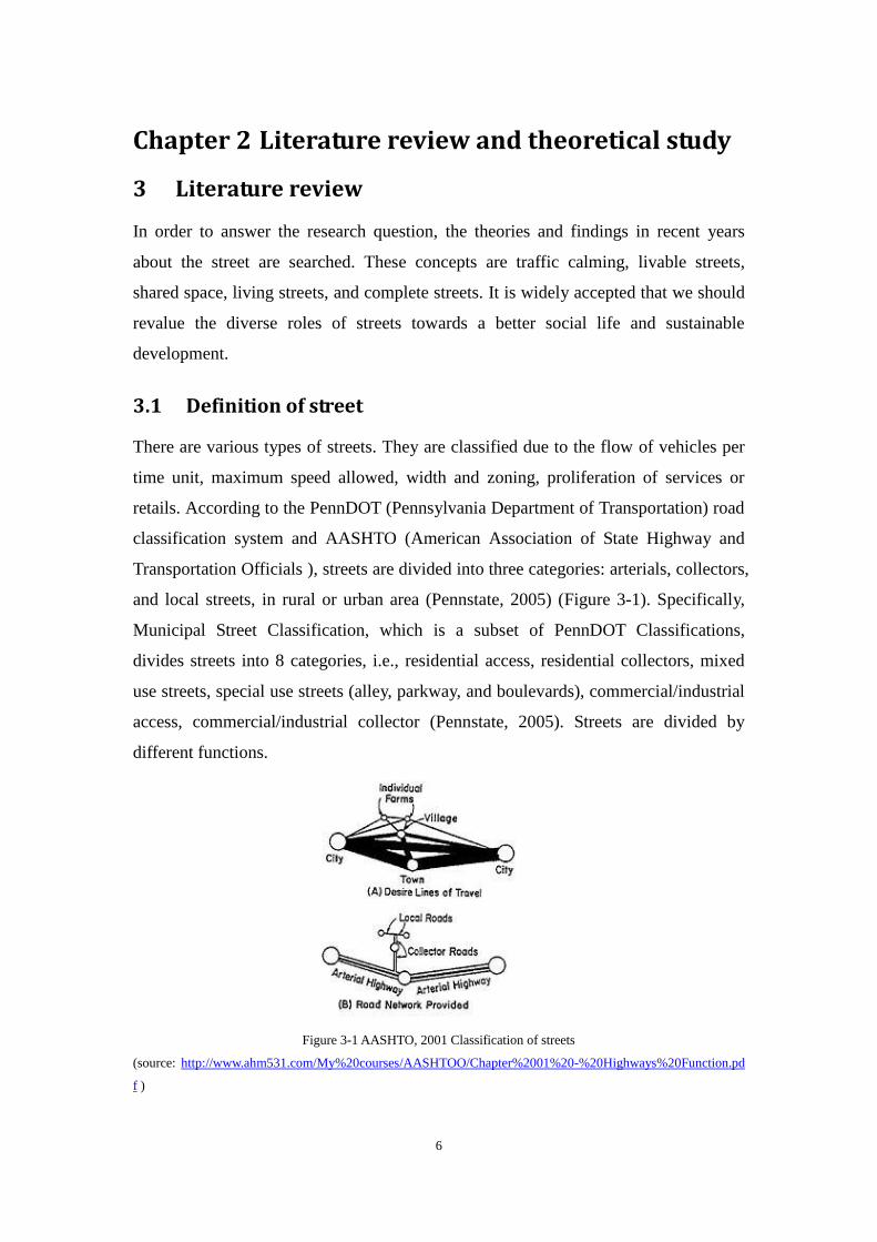
Transportation Officials ), streets are divided into three categories: arterials, collectors,
and local streets, in rural or urban area (Pennstate, 2005) (Figure 3-1). Specifically,
Municipal Street Classification, which is a subset of PennDOT Classifications,
divides streets into 8 categories, i.e., residential access, residential collectors, mixed
use streets, special use streets (alley, parkway, and boulevards), commercial/industrial
access, commercial/industrial collector (Pennstate, 2005). Streets are divided by
different functions.
Figure 3-1 AASHTO, 2001 Classification of streets
(source: http://www.ahm531.com/My%20courses/AASHTOO/Chapter%2001%20-%20Highways%20Function.pd
f )
7
Another important distinction has to be made is between road and street. A road is
functioned as a connection between two distant places, such as two towns or villages.
The emphasis is on movement between two places (Cliff, 2003). A street is described
as a road in a city or town, wider than a lane or alley, especially on lined with houses,
shops, or other buildings, according to the definition in dictionary.
In this thesis, I am not going to discuss in depth about the details of classification
system. Considering that the purpose of the paper is to investigate the relationships
between conditions of streets and qualities of social life, the living streets in the city
should be taken into account, where social life happens most frequently. Therefore,
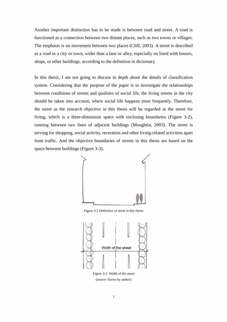
the street as the research objective in this thesis will be regarded as the street for
living, which is a three-dimension space with enclosing boundaries (Figure 3-2),
running between two lines of adjacent buildings (Moughtin, 2003). The street is
serving for shopping, social activity, recreation and other living-related activities apart
from traffic. And the objective boundaries of streets in this thesis are based on the
space between buildings (Figure 3-3).
Figure 3-2 Definition of street in this thesis
Figure 3-3 Width of the street
(source: drawn by author)
8
3.2 A brief history of street development in Europe
Most European cities have grown from medieval origins, with characteristics of
small-scale, narrow, non-geometric street patterns. In the next period, from the 14th to
the 17th century, the Renaissance started in Italy in the late Middle Ages and then
spread to the rest of Europe, followed by Baroque starting around 1600 in Rome. In
the late 19th and early 20th centuries, modernism was arising, and it was shaped by
the development of modern industrial societies and the rapid growth of cities, and also
the horror of World War I.
In street design realm, since Haussman's renovation of Paris (between 1853 and 1870),
many of the streets have become long and straight boulevards. In 1889, Camillo Sitte
produced an aesthetic criticism of the urbanism in 19th century in his influential book
"City Planning According to Artistic Principles". He feared that Urbanism would have
become a mere technical task without any artistic involvement, and argued the most
important thing was the inherent creative quality of urban space (Sitte, 1889). Sitte
studied the issue from a psychological viewpoint of the perception of the proportions
between the monuments and its surroundings, opposing the fashion of very wide
streets and squares, and the dogma of orthogonality and symmetry (Sitte, 1889).
In 1898, Howard published his book To-morrow: a Peaceful Path to Real Reform.
Garden Cities were intended to be planned, self-contained communities surrounded
by "greenbelts", containing proportionate areas of residences, industry and agriculture.
Letchworth in England is the first Garden City in the world. Its development inspired
other garden cities such as Welwyn in England and Hellerau in Germany. In the
meantime, the German sociologist and economist Max Weber conducted a detailed,
general study of the city as the characteristic locus of the social and economic
relations, resulted in the book of "The City", published posthumously in 1921. Weber
argued that the most important difference among societies is not how people produce
things but how people think about the world. In Weber's view, modern society was the
product of a new way of thinking (Macionis, 2012). There are also many other famous
architects and urban planners active in the Weimar era in Germany, such as Ernst May,
Heinrich Tessenow, and Bruno Taut.
9
In 1940s, Sigfried Giedion wrote an influential standard history of modern
architecture in "Space, Time & Architecture: The Growth of a New Tradition". This
monumental work has been a milestone in architectural theory, and an unparalleled
work on the shaping of our architectural environment. After surveying the modern
age's European heritage, Giedion focused on the demand for morality in architecture,
and the discussion of leading architects-Wright, Gropius, Le Corbusier, Van der Rohe,
Aalto, Utzon, Sert, Tange, and Maki. (Giedion, 2003)
In the 1930s and 1940s, the concept of "neighborhood unit" was spread from United
States. In 1942, Sir Alker Tripp, Assistant Commissioner of London's Metropolitan
Police, proposed a theory of "precinct" planning which formalized the idea of a
hierarchy of arterials, sub-arterials, and local streets (Plowden 1972). But the
problems of traffic interference in United Kingdom were not addressed until the late
1950s and early 1960s.
Another significant book The City in History(1961), written by Lewis Mumford,
explored the development of urban civilizations and harshly criticized urban sprawl.
Mumford argued that the structure of modern cities is partially responsible for many
social problems seen in western society, and urban planning should emphasize an
organic relationship between people and their living spaces. After that, The Buchanan
Report, Traffic in Towns, authorized by the Ministry of Transport, published in 1963,
produced the first planning concept addressed primarily to the traffic problem in
residential neighborhoods. The main argument of the report was that the environment
of British cities was suffering severe deterioration from traffic, so environment should
be regarded as a major variable in future traffic planning. The chief proposal of the
Buchanan Report was that cities be divided into "environment areas" (Buchanan, p.
44). It means that through-traffic would be excluded to travel along the distributor
streets. The most important contribution of the report is the idea that streets in the city
should have an environmental capacity. This concept was first put forward in this
report, and was studied by many scholars. The Buchanan Report reflects that streets
play an important role in the city, and emphasizes the significance of street life and
aesthetic.
The creation of environmental areas was applied by local authorities in existing cities

10
in Britain. In other European countries, particularly in Scandinavia, Holland, and
Germany, as well as in Japan and Australia, programs for managing traffic in
neighborhoods have flourished (OECD, Organization for Economic Cooperation and
Development, 1975a, b, c). In Sweden, this work has been given a powerful impetus
by the research of Stina Sandels on the problems of children in traffic (Sandels et al.
1971; Sandels, 1975).
In the 1970s and 1980s, the most innovative concept has been the Dutch word
"woonerf". It refers to an area, usually residential, where motorists and other users
share the street without boundaries. Meanwhile, the techniques of shared spaces,
traffic calming, and low speed limits are planned to improve the safety of the street.
New urbanism arose in the United States in 1980s. This planning movement promotes
walkable neighborhoods, mixed-use and complete communities. They usually contain
housing, work places, shops, entertainment, schools, parks, and civic facilities
essential to the daily lives of the residents, all within easy walking distance of each
other. In other words, make places walkable. New Urbanism is a broad movement,
and while the conventional approach to growth remains dominant, New Urbanist
principles have become increasingly influential in the fields of planning, architecture,
and public policy (Cozens, 2008).
To conclude, in the past few decades, traffic planners and urban designers are seeking
approaches to force the major traffic outside of cities or neighborhoods, and protect
the local street from overload traffic. Street development has been processed to a new
era.
3.3 Related concepts to protect pedestrians and cyclists
3.3.1 Traffic calming
Gehl argues that many cities today are invaded by cars, hampering social exchange,
and the remedy is traffic calming. Traffic calming began in Europe, it is intended to
slow or reduce motor-vehicle traffic, in order to improve the living conditions for
residents. The methods of traffic calming also improve safety for pedestrians and
cyclists. A definition from the Institute of Transportation Engineers is: 'the
11
combination of mainly physical measures that reduce the negative effects of motor
vehicles, alter driver behaviors and improve conditions for non-motorized street users'
(Lockwood, 1997, p212).
The three most common direct objectives of traffic calming are reducing speeds, the
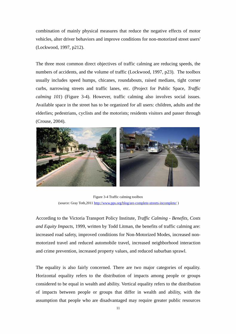
numbers of accidents, and the volume of traffic (Lockwood, 1997, p23). The toolbox
usually includes speed humps, chicanes, roundabouts, raised medians, tight corner
curbs, narrowing streets and traffic lanes, etc. (Project for Public Space, Traffic
calming 101) (Figure 3-4). However, traffic calming also involves social issues.
Available space in the street has to be organized for all users: children, adults and the
elderlies; pedestrians, cyclists and the motorists; residents visitors and passer through
(Crouse, 2004).
Figure 3-4 Traffic calming toolbox
(source: Gray Toth,2011 http://www.pps.org/blog/are-complete-streets-incomplete/ )
According to the Victoria Transport Policy Institute, Traffic Calming - Benefits, Costs
and Equity Impacts, 1999, written by Todd Litman, the benefits of traffic calming are:
increased road safety, improved conditions for Non-Motorized Modes, increased non-
motorized travel and reduced automobile travel, increased neighborhood interaction
and crime prevention, increased property values, and reduced suburban sprawl.
The equality is also fairly concerned. There are two major categories of equality.
Horizontal equality refers to the distribution of impacts among people or groups
considered to be equal in wealth and ability. Vertical equality refers to the distribution
of impacts between people or groups that differ in wealth and ability, with the
assumption that people who are disadvantaged may require greater public resources
12
(Litman, 1999). The report describes a framework for evaluating traffic calming
program, gives data collection and analysis of each benefit, and bows to quantify
those benefits.
3.3.2 Livable streets
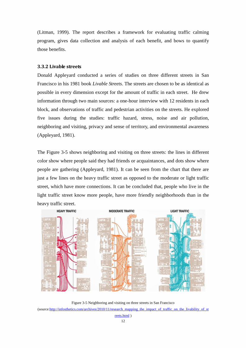
Donald Appleyard conducted a series of studies on three different streets in San
Francisco in his 1981 book Livable Streets. The streets are chosen to be as identical as
possible in every dimension except for the amount of traffic in each street. He drew
information through two main sources: a one-hour interview with 12 residents in each
block, and observations of traffic and pedestrian activities on the streets. He explored
five issues during the studies: traffic hazard, stress, noise and air pollution,
neighboring and visiting, privacy and sense of territory, and environmental awareness
(Appleyard, 1981).
The Figure 3-5 shows neighboring and visiting on three streets: the lines in different
color show where people said they had friends or acquaintances, and dots show where
people are gathering (Appleyard, 1981). It can be seen from the chart that there are
just a few lines on the heavy traffic street as opposed to the moderate or light traffic
street, which have more connections. It can be concluded that, people who live in the
light traffic street know more people, have more friendly neighborhoods than in the
heavy traffic street.
Figure 3-5 Neighboring and visiting on three streets in San Francisco
(source:http://infosthetics.com/archives/2010/11/research_mapping_the_impact_of_traffic_on_the_livability_of_st
reets.html )
13
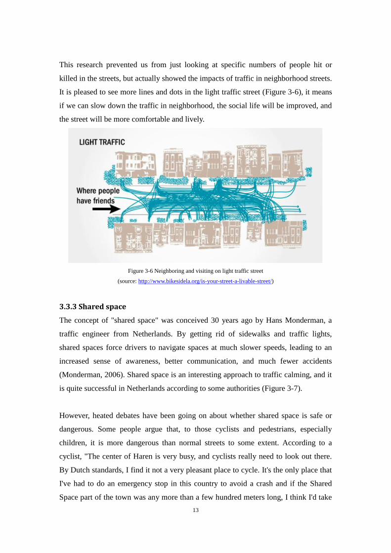
This research prevented us from just looking at specific numbers of people hit or
killed in the streets, but actually showed the impacts of traffic in neighborhood streets.
It is pleased to see more lines and dots in the light traffic street (Figure 3-6), it means
if we can slow down the traffic in neighborhood, the social life will be improved, and
the street will be more comfortable and lively.
Figure 3-6 Neighboring and visiting on light traffic street
(source: http://www.bikesidela.org/is-your-street-a-livable-street/)
3.3.3 Shared space
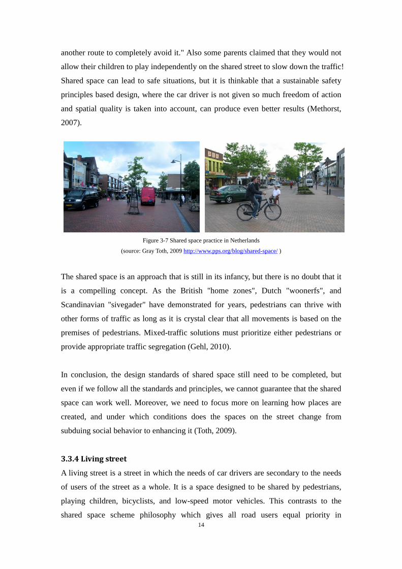
The concept of "shared space" was conceived 30 years ago by Hans Monderman, a
traffic engineer from Netherlands. By getting rid of sidewalks and traffic lights,
shared spaces force drivers to navigate spaces at much slower speeds, leading to an
increased sense of awareness, better communication, and much fewer accidents
(Monderman, 2006). Shared space is an interesting approach to traffic calming, and it
is quite successful in Netherlands according to some authorities (Figure 3-7).
However, heated debates have been going on about whether shared space is safe or
dangerous. Some people argue that, to those cyclists and pedestrians, especially
children, it is more dangerous than normal streets to some extent. According to a
cyclist, "The center of Haren is very busy, and cyclists really need to look out there.
By Dutch standards, I find it not a very pleasant place to cycle. It's the only place that
I've had to do an emergency stop in this country to avoid a crash and if the Shared
Space part of the town was any more than a few hundred meters long, I think I'd take
14
another route to completely avoid it." Also some parents claimed that they would not
allow their children to play independently on the shared street to slow down the traffic!
Shared space can lead to safe situations, but it is thinkable that a sustainable safety
principles based design, where the car driver is not given so much freedom of action
and spatial quality is taken into account, can produce even better results (Methorst,
2007).
Figure 3-7 Shared space practice in Netherlands
(source: Gray Toth, 2009 http://www.pps.org/blog/shared-space/ )
The shared space is an approach that is still in its infancy, but there is no doubt that it
is a compelling concept. As the British "home zones", Dutch "woonerfs", and
Scandinavian "sivegader" have demonstrated for years, pedestrians can thrive with
other forms of traffic as long as it is crystal clear that all movements is based on the
premises of pedestrians. Mixed-traffic solutions must prioritize either pedestrians or
provide appropriate traffic segregation (Gehl, 2010).
In conclusion, the design standards of shared space still need to be completed, but
even if we follow all the standards and principles, we cannot guarantee that the shared
space can work well. Moreover, we need to focus more on learning how places are
created, and under which conditions does the spaces on the street change from
subduing social behavior to enhancing it (Toth, 2009).
3.3.4 Living street
A living street is a street in which the needs of car drivers are secondary to the needs
of users of the street as a whole. It is a space designed to be shared by pedestrians,
playing children, bicyclists, and low-speed motor vehicles. This contrasts to the
shared space scheme philosophy which gives all road users equal priority in
15
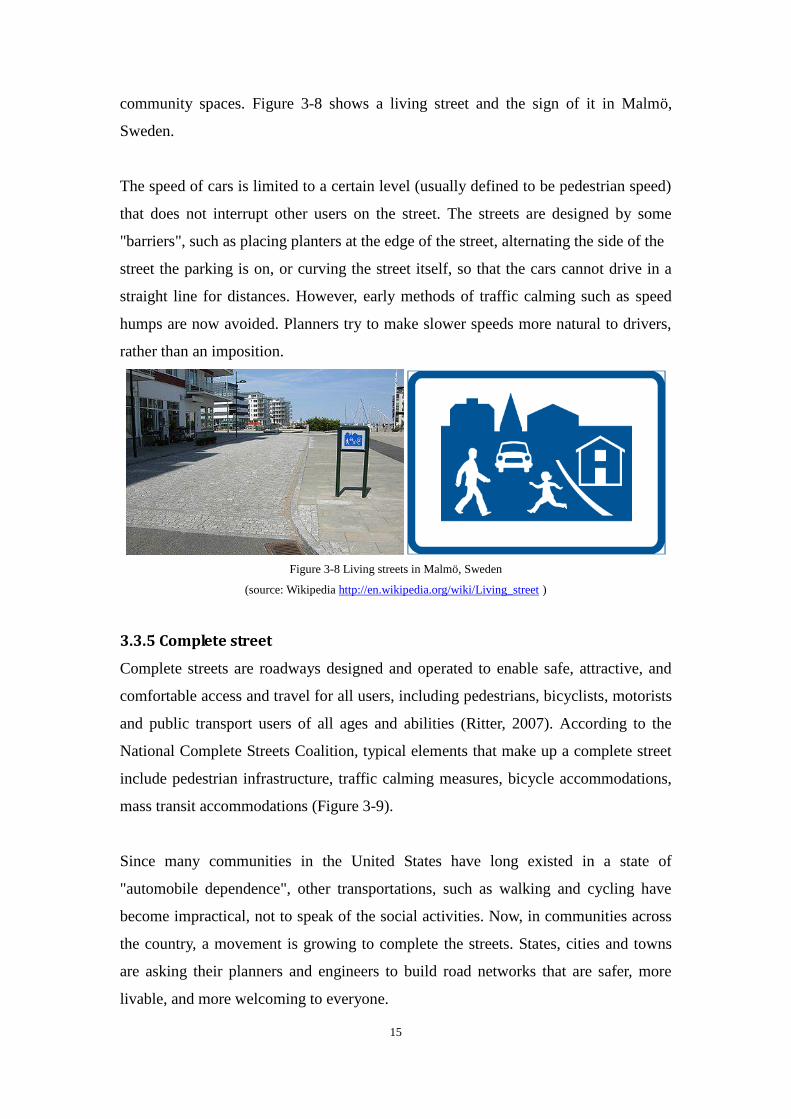
community spaces. Figure 3-8 shows a living street and the sign of it in Malmö,
Sweden.
The speed of cars is limited to a certain level (usually defined to be pedestrian speed)
that does not interrupt other users on the street. The streets are designed by some
"barriers", such as placing planters at the edge of the street, alternating the side of the
street the parking is on, or curving the street itself, so that the cars cannot drive in a
straight line for distances. However, early methods of traffic calming such as speed
humps are now avoided. Planners try to make slower speeds more natural to drivers,
rather than an imposition.
Figure 3-8 Living streets in Malmö, Sweden
(source: Wikipedia http://en.wikipedia.org/wiki/Living_street )
3.3.5 Complete street
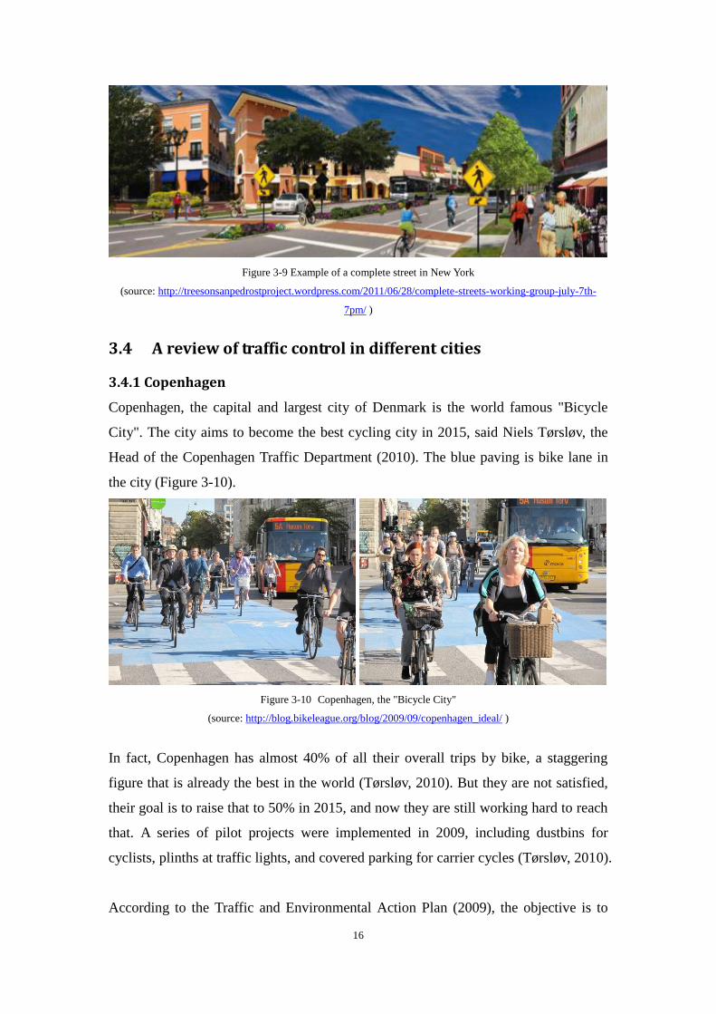
Complete streets are roadways designed and operated to enable safe, attractive, and
comfortable access and travel for all users, including pedestrians, bicyclists, motorists
and public transport users of all ages and abilities (Ritter, 2007). According to the
National Complete Streets Coalition, typical elements that make up a complete street
include pedestrian infrastructure, traffic calming measures, bicycle accommodations,
mass transit accommodations (Figure 3-9).
Since many communities in the United States have long existed in a state of
"automobile dependence", other transportations, such as walking and cycling have
become impractical, not to speak of the social activities. Now, in communities across
the country, a movement is growing to complete the streets. States, cities and towns
are asking their planners and engineers to build road networks that are safer, more
livable, and more welcoming to everyone.
16
Figure 3-9 Example of a complete street in New York
(source: http://treesonsanpedrostproject.wordpress.com/2011/06/28/complete-streets-working-group-july-7th-
7pm/ )
3.4 A review of traffic control in different cities
3.4.1 Copenhagen
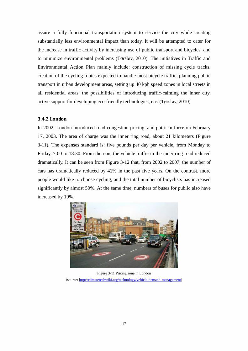
Copenhagen, the capital and largest city of Denmark is the world famous "Bicycle
City". The city aims to become the best cycling city in 2015, said Niels Tørsløv, the
Head of the Copenhagen Traffic Department (2010). The blue paving is bike lane in
the city (Figure 3-10).
Figure 3-10 Copenhagen, the "Bicycle City"
(source: http://blog.bikeleague.org/blog/2009/09/copenhagen_ideal/ )
In fact, Copenhagen has almost 40% of all their overall trips by bike, a staggering
figure that is already the best in the world (Tørsløv, 2010). But they are not satisfied,
their goal is to raise that to 50% in 2015, and now they are still working hard to reach
that. A series of pilot projects were implemented in 2009, including dustbins for
cyclists, plinths at traffic lights, and covered parking for carrier cycles (Tørsløv, 2010).
According to the Traffic and Environmental Action Plan (2009), the objective is to
17
assure a fully functional transportation system to service the city while creating
substantially less environmental impact than today. It will be attempted to cater for
the increase in traffic activity by increasing use of public transport and bicycles, and
to minimize environmental problems (Tørsløv, 2010). The initiatives in Traffic and
Environmental Action Plan mainly include: construction of missing cycle tracks,
creation of the cycling routes expected to handle most bicycle traffic, planning public
transport in urban development areas, setting up 40 kph speed zones in local streets in
all residential areas, the possibilities of introducing traffic-calming the inner city,
active support for developing eco-friendly technologies, etc. (Tørsløv, 2010)
3.4.2 London
In 2002, London introduced road congestion pricing, and put it in force on February
17, 2003. The area of charge was the inner ring road, about 21 kilometers (Figure
3-11). The expenses standard is: five pounds per day per vehicle, from Monday to
Friday, 7:00 to 18:30. From then on, the vehicle traffic in the inner ring road reduced
dramatically. It can be seen from Figure 3-12 that, from 2002 to 2007, the number of
cars has dramatically reduced by 41% in the past five years. On the contrast, more
people would like to choose cycling, and the total number of bicyclists has increased
significantly by almost 50%. At the same time, numbers of buses for public also have
increased by 19%.
Figure 3-11 Pricing zone in London
(source: http://climatetechwiki.org/technology/vehicle-demand-management)

18
Figure 3-12 Ingoing traffic in congestion zone
(source: Gehl, 2010 Cities for People)
Furthermore, on 4th
January, 2011, several more changes were implemented based on
the public consultation conducted in 2008, which included the removal of the Western
Extension, a charge increased from £8 to £10, and the introduction of an automated
payment system (Transport for London).
In fact, Singapore is the first city around the world that charges a congestion fee. They
have been considering this issue since 1960s. The policy is quite successful because
of their developed public transport system. When London introduced this traffic
regulation, and made benefits to traffic and environment, there has been a great
influence around the world. However it is currently still limited to a small number of
cities, such as Stockholm and Milan. In China, the city of Guangzhou has planned
traffic improvements program in 2009, and has decided to charge fees for the
congestion. The plan was approved by the local government, and will carried out in
the near future. However, most residents don’t like this regulation. They think the
local government is charging fees for their own benefits. Overall, the road congestion
pricing cannot be popularized in every big city, unless the city itself has developed
public transport system and actively cooperation of public.
As for the residential area, London introduces the concept of "Home Zone", where the
street is not divided into exclusive sidewalk and traffic lines. So that walking, cycling
and cars have equal rights, they share the street similar as shared space in Netherlands.
The traffic speed is limited to very low level, around 20km/h. Traffic calming
methods also used in communities, such as road humps, broken line, increasing the
height of intersection, etc. (Figure 3-13)
19
Figure 3-13 Traffic calming in residential areas, London
(source: sina blog http://blog.sina.com.cn/s/blog_49958c8c0100lo2n.html)
3.4.3 Beijing
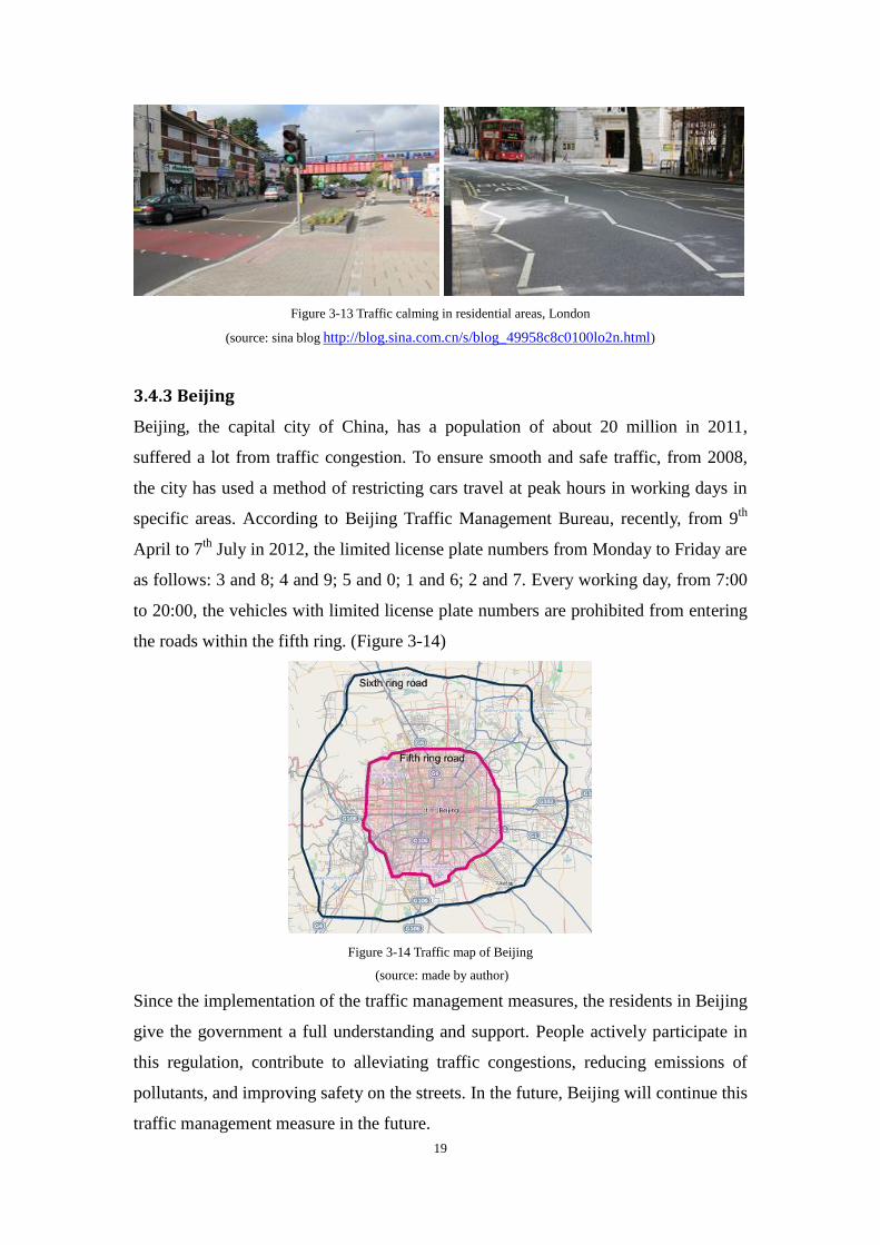
Beijing, the capital city of China, has a population of about 20 million in 2011,
suffered a lot from traffic congestion. To ensure smooth and safe traffic, from 2008,
the city has used a method of restricting cars travel at peak hours in working days in
specific areas. According to Beijing Traffic Management Bureau, recently, from 9th
April to 7th
July in 2012, the limited license plate numbers from Monday to Friday are
as follows: 3 and 8; 4 and 9; 5 and 0; 1 and 6; 2 and 7. Every working day, from 7:00
to 20:00, the vehicles with limited license plate numbers are prohibited from entering
the roads within the fifth ring. (Figure 3-14)
Figure 3-14 Traffic map of Beijing
(source: made by author)
Since the implementation of the traffic management measures, the residents in Beijing
give the government a full understanding and support. People actively participate in
this regulation, contribute to alleviating traffic congestions, reducing emissions of
pollutants, and improving safety on the streets. In the future, Beijing will continue this
traffic management measure in the future.
20
In the meantime, Beijing will improve the public transportation, expanding the range
of subway. According to Xiaoming Liu, the director of Municipal Transportation
Commission, Beijing should develop a saving and high-density traffic model, that is,
we should give priority to the public bus transportation. He states that the next step
for Beijing traffic system is to construct fast bus lane network, and put efforts to
increase the numbers of bus lanes in the city. Only in this way, we can ensure the
equality of different users on the street.
3.4.4 New York
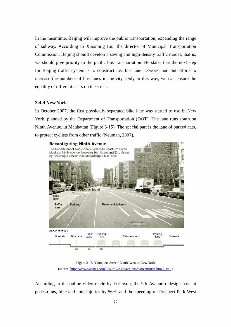
In October 2007, the first physically separated bike lane was started to use in New
York, planned by the Department of Transportation (DOT). The lane runs south on
Ninth Avenue, in Manhattan (Figure 3-15). The special part is the lane of parked cars,
to protect cyclists from other traffic (Neuman, 2007).
Figure 3-15 "Complete Street" Ninth Avenue, New York
(source: http://www.nytimes.com/2007/09/23/nyregion/23streetfuture.html?_r=1 )
According to the online video made by Eckerson, the 9th Avenue redesign has cut
pedestrians, bike and auto injuries by 56%, and the speeding on Prospect Park West
21
has dropped, while driving times have remained nearly the same. In fact, a recent
Quinnipiac Poll showed New York City residents support bike lanes 54% to 39%
(Eckerson, 2011).
3.5 Summary and illustration
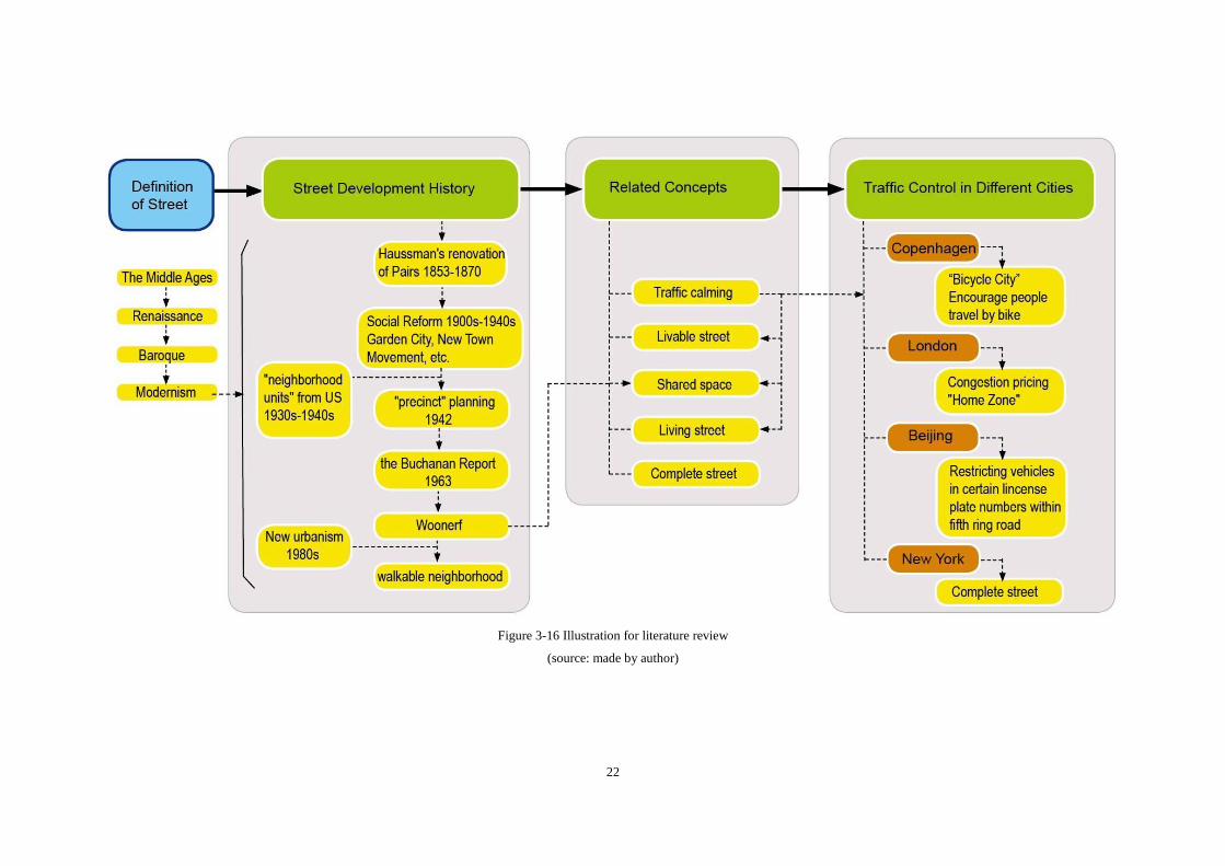
Figure 3-16 shows illustration of the review work. It can be concluded that Traffic
Calming is a prerequisite for solving traffic problems in populated neighborhoods and
improving social life in the street in contemporary worldwide. Countries and agencies
usually use traffic calming in different measures when grappling with their traffic.
Traffic Calming is not only about drawing on toolbox and techniques, but also a
mindset and an attitude. In the future, we would like to see more people participate
into calming down the traffic and enhancing our social life activities in the street.
22
Figure 3-16 Illustration for literature review
(source: made by author)
23
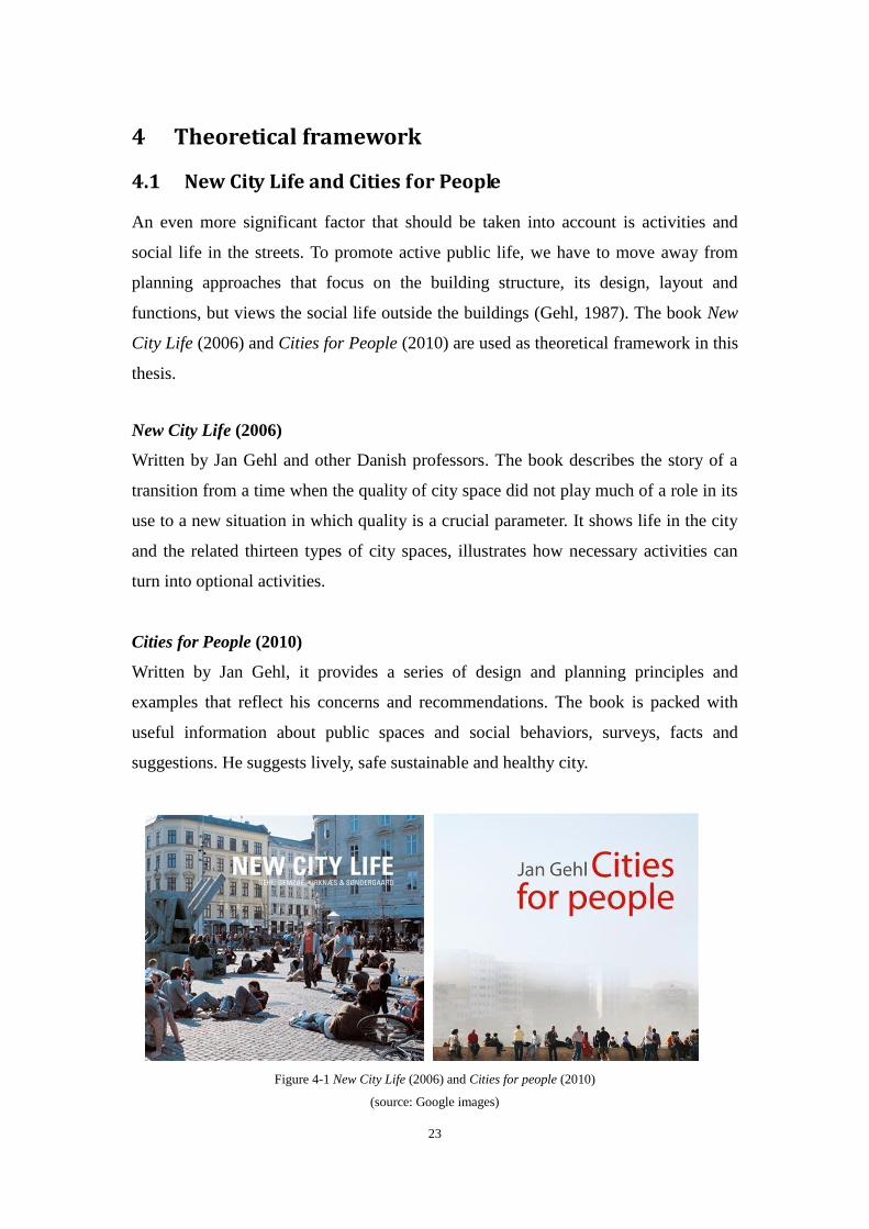
4 Theoretical framework
4.1 New City Life and Cities for People
An even more significant factor that should be taken into account is activities and
social life in the streets. To promote active public life, we have to move away from
planning approaches that focus on the building structure, its design, layout and
functions, but views the social life outside the buildings (Gehl, 1987). The book New
City Life (2006) and Cities for People (2010) are used as theoretical framework in this
thesis.
New City Life (2006)
Written by Jan Gehl and other Danish professors. The book describes the story of a
transition from a time when the quality of city space did not play much of a role in its
use to a new situation in which quality is a crucial parameter. It shows life in the city
and the related thirteen types of city spaces, illustrates how necessary activities can
turn into optional activities.
Cities for People (2010)
Written by Jan Gehl, it provides a series of design and planning principles and
examples that reflect his concerns and recommendations. The book is packed with
useful information about public spaces and social behaviors, surveys, facts and
suggestions. He suggests lively, safe sustainable and healthy city.
Figure 4-1 New City Life (2006) and Cities for people (2010)
(source: Google images)
24
4.2 Human dimension and street life
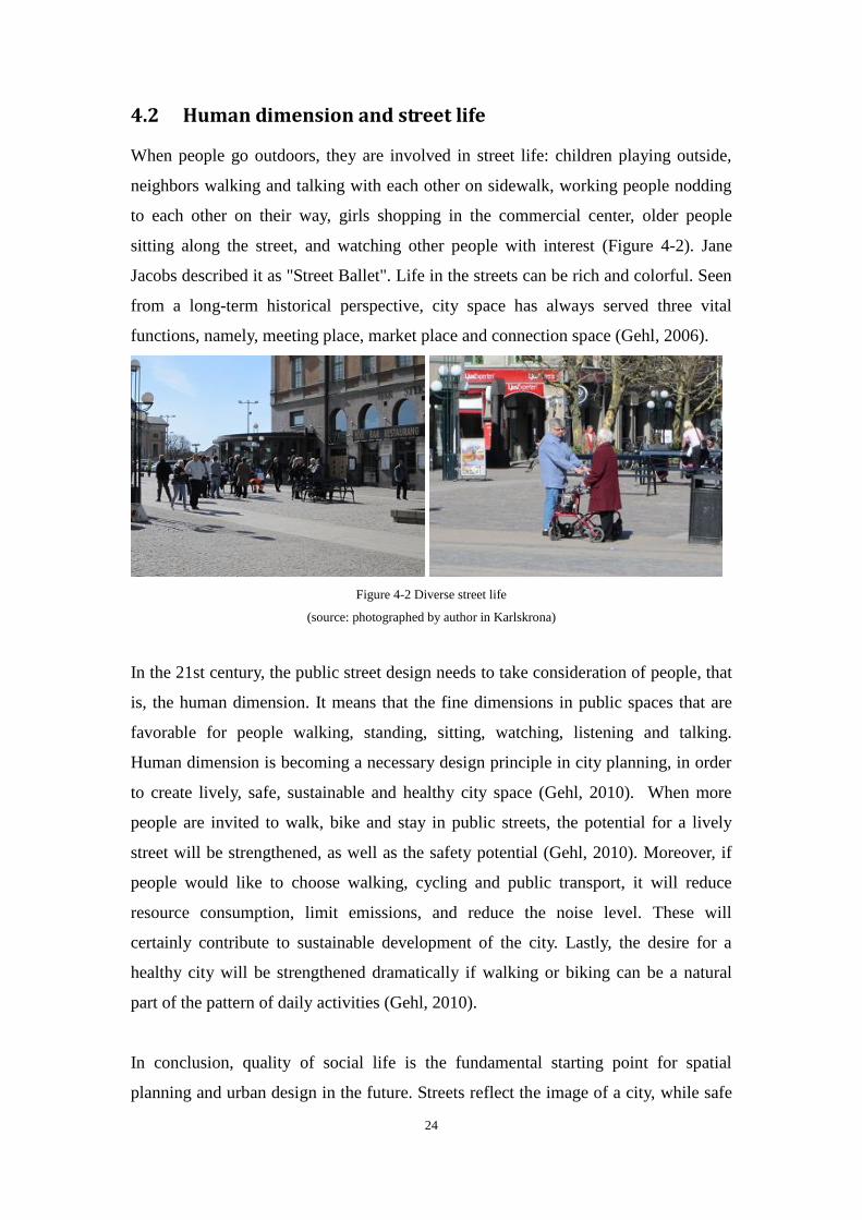
When people go outdoors, they are involved in street life: children playing outside,
neighbors walking and talking with each other on sidewalk, working people nodding
to each other on their way, girls shopping in the commercial center, older people
sitting along the street, and watching other people with interest (Figure 4-2). Jane
Jacobs described it as "Street Ballet". Life in the streets can be rich and colorful. Seen
from a long-term historical perspective, city space has always served three vital
functions, namely, meeting place, market place and connection space (Gehl, 2006).
Figure 4-2 Diverse street life
(source: photographed by author in Karlskrona)
In the 21st century, the public street design needs to take consideration of people, that
is, the human dimension. It means that the fine dimensions in public spaces that are
favorable for people walking, standing, sitting, watching, listening and talking.
Human dimension is becoming a necessary design principle in city planning, in order
to create lively, safe, sustainable and healthy city space (Gehl, 2010). When more
people are invited to walk, bike and stay in public streets, the potential for a lively
street will be strengthened, as well as the safety potential (Gehl, 2010). Moreover, if
people would like to choose walking, cycling and public transport, it will reduce
resource consumption, limit emissions, and reduce the noise level. These will
certainly contribute to sustainable development of the city. Lastly, the desire for a
healthy city will be strengthened dramatically if walking or biking can be a natural
part of the pattern of daily activities (Gehl, 2010).
In conclusion, quality of social life is the fundamental starting point for spatial
planning and urban design in the future. Streets reflect the image of a city, while safe
25
and lively streets will be beneficial to the potential of lively, safe, sustainable and
healthy city development.
4.3 Psychological needs on the streets
In order to understand the social life in the street, people's psychological needs should
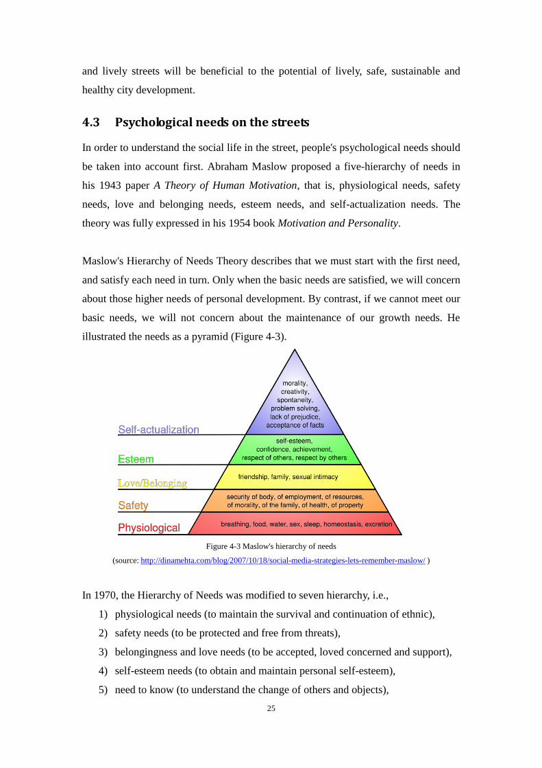
be taken into account first. Abraham Maslow proposed a five-hierarchy of needs in
his 1943 paper A Theory of Human Motivation, that is, physiological needs, safety
needs, love and belonging needs, esteem needs, and self-actualization needs. The
theory was fully expressed in his 1954 book Motivation and Personality.
Maslow's Hierarchy of Needs Theory describes that we must start with the first need,
and satisfy each need in turn. Only when the basic needs are satisfied, we will concern
about those higher needs of personal development. By contrast, if we cannot meet our
basic needs, we will not concern about the maintenance of our growth needs. He
illustrated the needs as a pyramid (Figure 4-3).
Figure 4-3 Maslow's hierarchy of needs
(source: http://dinamehta.com/blog/2007/10/18/social-media-strategies-lets-remember-maslow/ )
In 1970, the Hierarchy of Needs was modified to seven hierarchy, i.e.,
1) physiological needs (to maintain the survival and continuation of ethnic),
2) safety needs (to be protected and free from threats),
3) belongingness and love needs (to be accepted, loved concerned and support),
4) self-esteem needs (to obtain and maintain personal self-esteem),
5) need to know (to understand the change of others and objects),
26
6) aesthetic needs (to appreciate good things and hope they are in order, well
structured and pursue truth),
7) self-actualization needs (to achieve all the personal needs and ideal).
Accordingly, the first four needs are the basic needs, and latter three needs are growth
needs. However, the Needs Theory has limitations in some fields, for example, some
cultures appear to place social needs before any others. Overall, the theory is applied
and studied in many areas. Elizabeth Burton (2006) in the book of Inclusive Urban
Design-Streets for Life, describes that, there are six key principles on street design:
familiar, legible, distinctive, accessible, comfortable and safe. The author gives
definition of each principle, and explains how these affect older people's ability to use
and enjoy their local neighborhoods.
However, in this thesis, all street users should be considered. Gehl (2010) argues that
whether people are enticed to walk around and stay in city space is very much a
question of working carefully with the human dimension and issuing a tempting
invitation. I suggest that only if people's psychological needs are satisfied, people will
feel they are welcomed and invited into the street. Based on the Hierarchy of Needs
theory and the key principles on street design, it can be summarized that, people's
psychological needs in the streets mainly include: safety needs, accessibility needs,
comfort needs, legibility needs, and participation needs. These five needs will be
applied to the case study in the latter chapter.
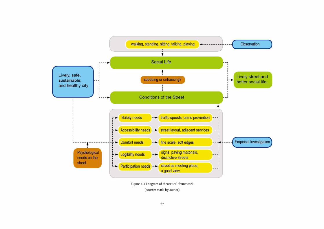
4.4 Diagram of theoretical framework
Figure 4-4 illustrates the theoretical framework. The following chapter will discuss
about physical conditions of the streets and how these conditions will affect social life
in Kristianstad of Sweden based on this framework.
27
Figure 4-4 Diagram of theoretical framework
(source: made by author)
28
Chapter 3 Analysis and Research
5 Objective streets in Kristianstad
5.1 Introduction to Kristianstad
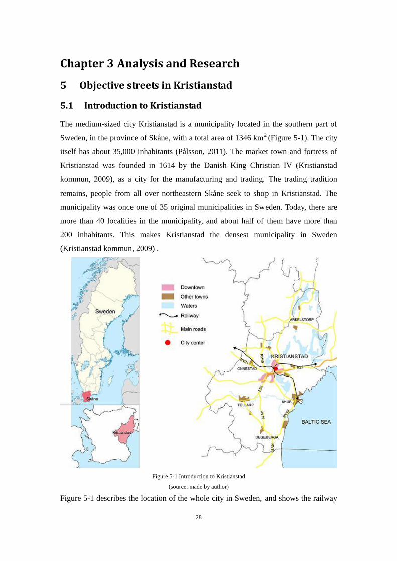
The medium-sized city Kristianstad is a municipality located in the southern part of
Sweden, in the province of Skåne, with a total area of 1346 km2 (Figure 5-1). The city
itself has about 35,000 inhabitants (Pålsson, 2011). The market town and fortress of
Kristianstad was founded in 1614 by the Danish King Christian IV (Kristianstad
kommun, 2009), as a city for the manufacturing and trading. The trading tradition
remains, people from all over northeastern Skåne seek to shop in Kristianstad. The
municipality was once one of 35 original municipalities in Sweden. Today, there are
more than 40 localities in the municipality, and about half of them have more than
200 inhabitants. This makes Kristianstad the densest municipality in Sweden
(Kristianstad kommun, 2009) .
Figure 5-1 Introduction to Kristianstad
(source: made by author)
Figure 5-1 describes the location of the whole city in Sweden, and shows the railway
29
across the municipality, and the main roads connecting Karlskrona to the east and
Malmö to the west.
The old city center is a vibrant hub for trade, service, industry and commerce.
Recently, commercial investigations show that the city need strengthen their offerings
to customers. According to a brochure about the future construction in Östra center, a
new shopping mall will be planned in autumn 2012, between Nya Boulevarden and
Södra Kaserngatan (Figure 5-5). It is scheduled to be fully completed in the year of
2014 (Kristianstad kommun, 2011). The social life and commercial activities would
be more colorful by that time.
5.2 Objective streets in Östra center
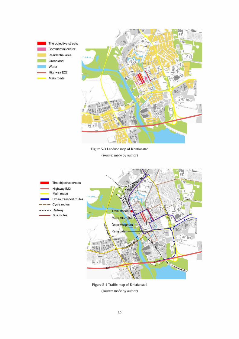
Three streets in Östra center of Kristianstad are selected to perform the case study:
Östra Storgatan, Östra vallgatan, and Kanalgatan. The city is divided by a canal from
south to north and has two main parts. Östra Storgatan and Östra vallgatan are located
in central location, and the buildings along the streets are for commercial use. The
streets are all surrounded by residential buildings in the whole city (Figure 5-3).
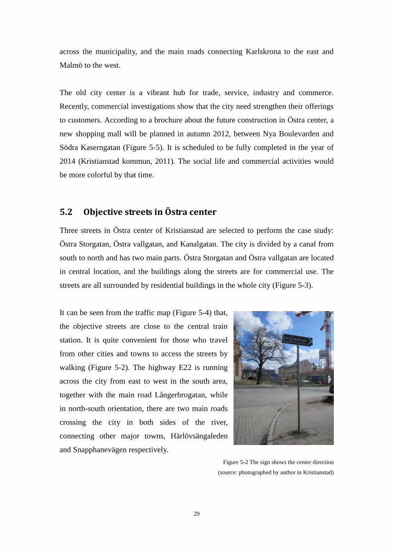
It can be seen from the traffic map (Figure 5-4) that,
the objective streets are close to the central train
station. It is quite convenient for those who travel
from other cities and towns to access the streets by
walking (Figure 5-2). The highway E22 is running
across the city from east to west in the south area,
together with the main road Långerbrogatan, while
in north-south orientation, there are two main roads
crossing the city in both sides of the river,
connecting other major towns, Härlövsängaleden
and Snapphanevägen respectively.
Figure 5-2 The sign shows the center direction
(source: photographed by author in Kristianstad)
30
Figure 5-3 Landuse map of Kristianstad
(source: made by author)
Figure 5-4 Traffic map of Kristianstad
(source: made by author)
31
The blue lines illustrate main transport routes, while the red lines reflect the bus
routes across the city. Evidently, Kanalgatan, which dominated by fast traffic, is
playing an important role in urban transport system. As for the cycling routes, they are
showed in brown broken lines in the figure, almost cover everywhere in the city.
However, Östra Storgatan (as a pedestrian commercial street) and Östra vallgatan do
not provide bicycle lanes (Figure 5-4).
As shown in the above figures, the objective streets appear different in traffic volumes,
street layouts, and zoning. The three objective streets are all convenient to access for
residents or visitors, by bus or bike. It should be noted that Kanalgatan is a main
transport street running through the city from north to south, with heavy and fast
traffic.
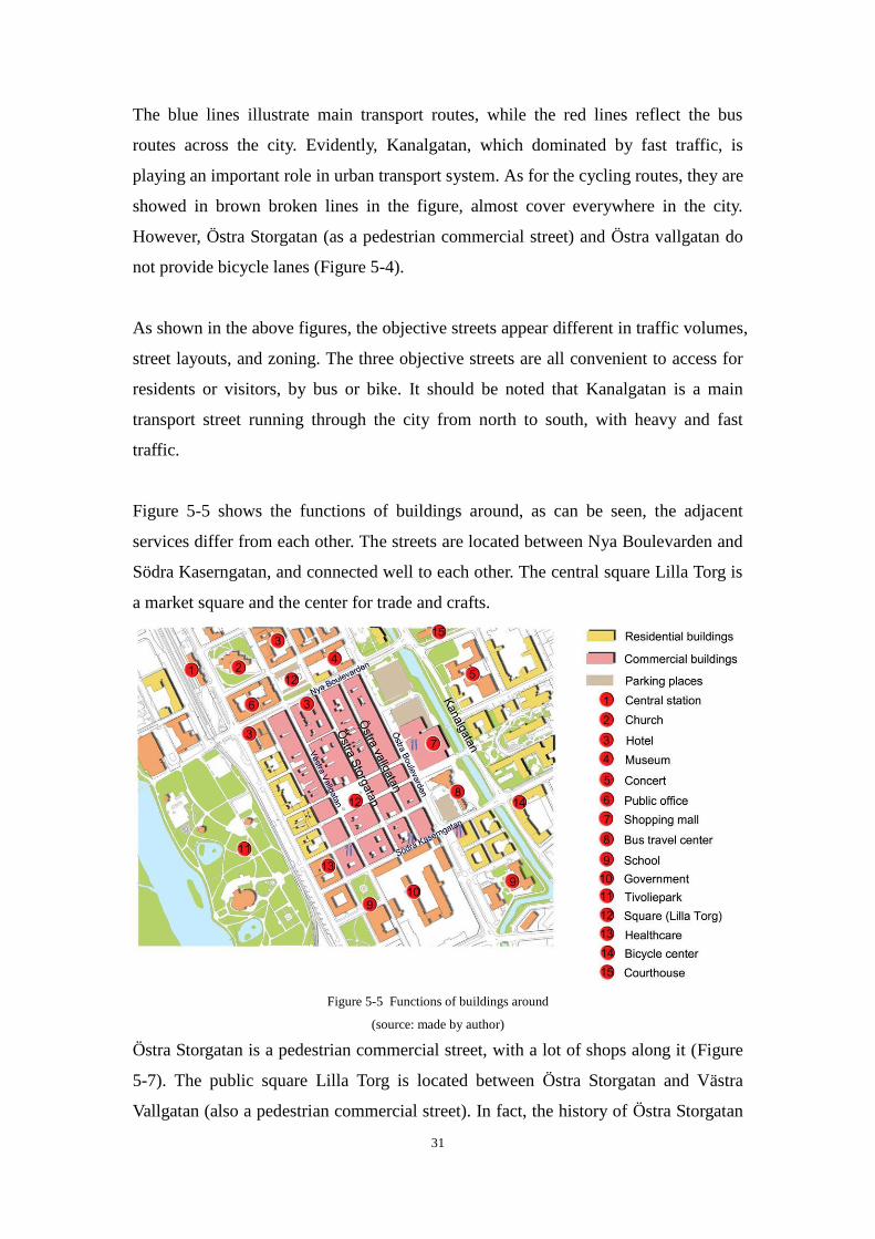
Figure 5-5 shows the functions of buildings around, as can be seen, the adjacent
services differ from each other. The streets are located between Nya Boulevarden and
Södra Kaserngatan, and connected well to each other. The central square Lilla Torg is
a market square and the center for trade and crafts.
Figure 5-5 Functions of buildings around
(source: made by author)
Östra Storgatan is a pedestrian commercial street, with a lot of shops along it (Figure
5-7). The public square Lilla Torg is located between Östra Storgatan and Västra
Vallgatan (also a pedestrian commercial street). In fact, the history of Östra Storgatan
32
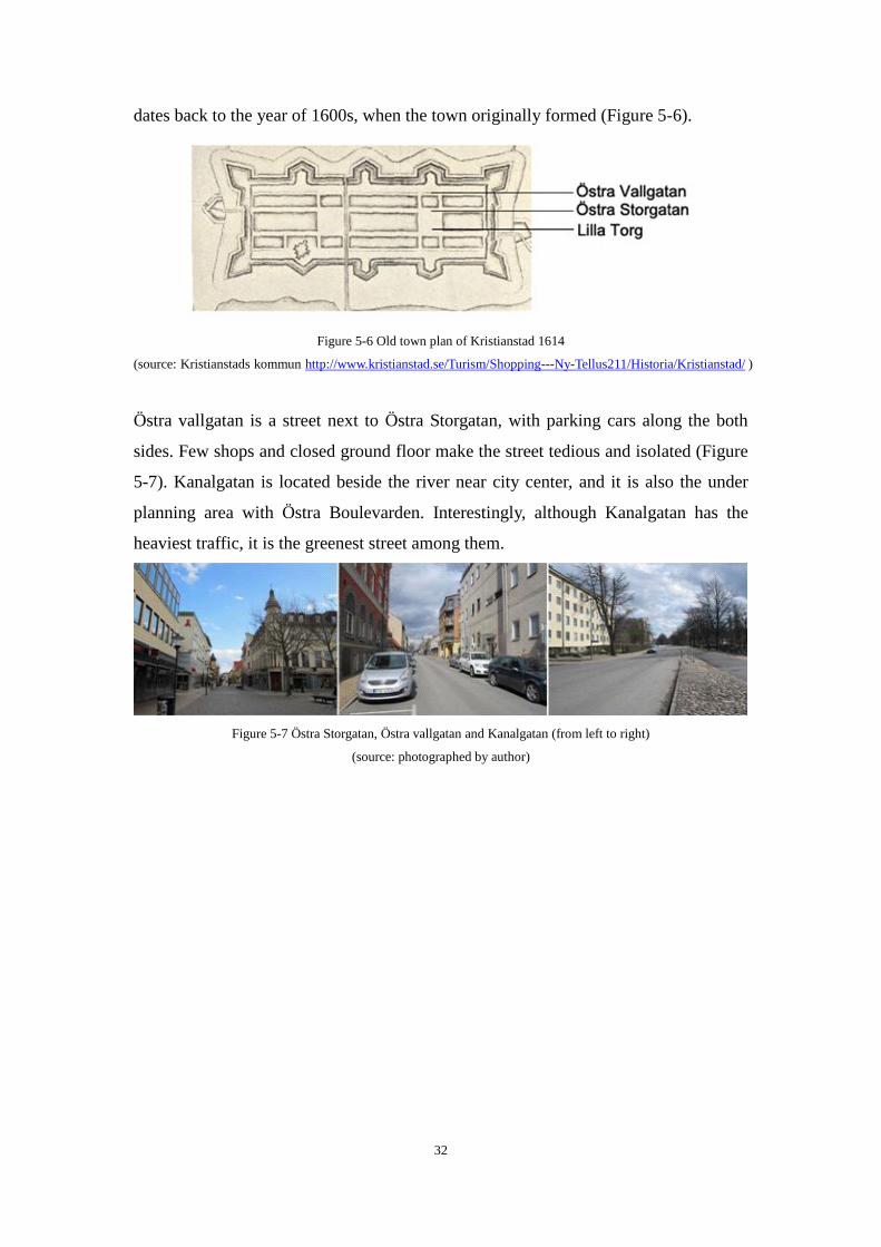
dates back to the year of 1600s, when the town originally formed (Figure 5-6).
Figure 5-6 Old town plan of Kristianstad 1614
(source: Kristianstads kommun http://www.kristianstad.se/Turism/Shopping---Ny-Tellus211/Historia/Kristianstad/ )
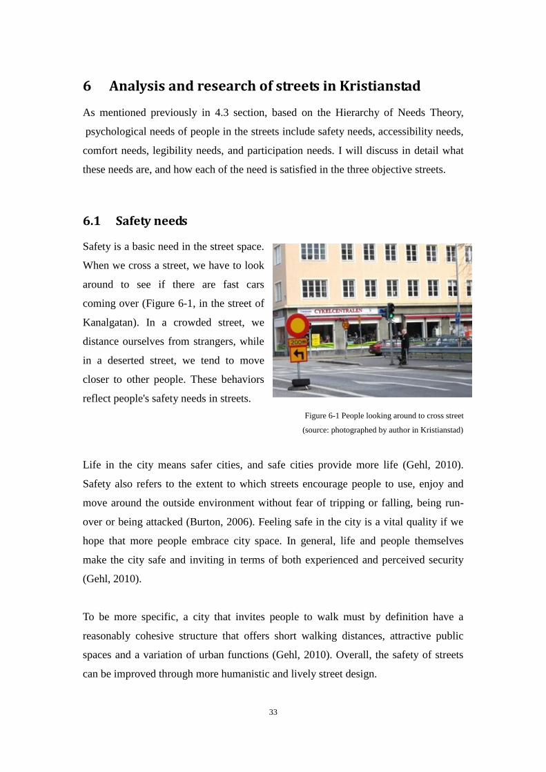
Östra vallgatan is a street next to Östra Storgatan, with parking cars along the both
sides. Few shops and closed ground floor make the street tedious and isolated (Figure
5-7). Kanalgatan is located beside the river near city center, and it is also the under
planning area with Östra Boulevarden. Interestingly, although Kanalgatan has the
heaviest traffic, it is the greenest street among them.
Figure 5-7 Östra Storgatan, Östra vallgatan and Kanalgatan (from left to right)
(source: photographed by author)
33
6 Analysis and research of streets in Kristianstad
As mentioned previously in 4.3 section, based on the Hierarchy of Needs Theory,
psychological needs of people in the streets include safety needs, accessibility needs,
comfort needs, legibility needs, and participation needs. I will discuss in detail what
these needs are, and how each of the need is satisfied in the three objective streets.
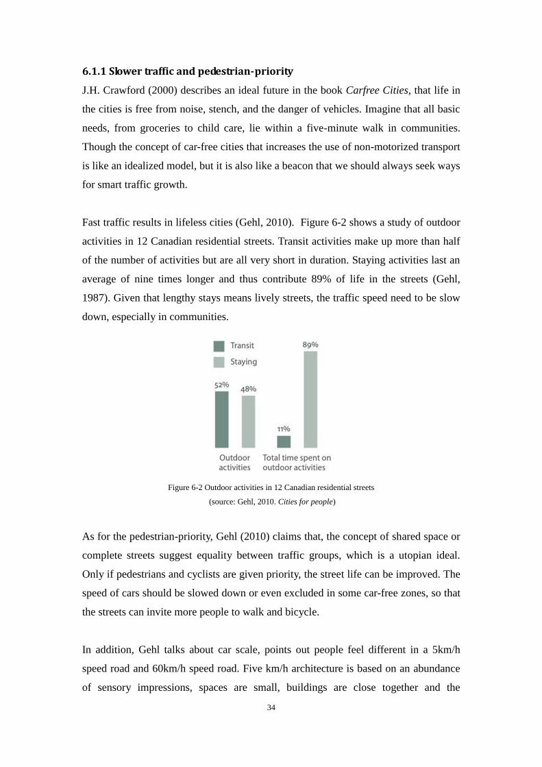
6.1 Safety needs
Safety is a basic need in the street space.
When we cross a street, we have to look
around to see if there are fast cars
coming over (Figure 6-1, in the street of
Kanalgatan). In a crowded street, we
distance ourselves from strangers, while
in a deserted street, we tend to move
closer to other people. These behaviors
reflect people's safety needs in streets.
Figure 6-1 People looking around to cross street
(source: photographed by author in Kristianstad)
Life in the city means safer cities, and safe cities provide more life (Gehl, 2010).
Safety also refers to the extent to which streets encourage people to use, enjoy and
move around the outside environment without fear of tripping or falling, being run-
over or being attacked (Burton, 2006). Feeling safe in the city is a vital quality if we
hope that more people embrace city space. In general, life and people themselves
make the city safe and inviting in terms of both experienced and perceived security
(Gehl, 2010).
To be more specific, a city that invites people to walk must by definition have a
reasonably cohesive structure that offers short walking distances, attractive public
spaces and a variation of urban functions (Gehl, 2010). Overall, the safety of streets
can be improved through more humanistic and lively street design.
34
6.1.1 Slower traffic and pedestrian-priority
J.H. Crawford (2000) describes an ideal future in the book Carfree Cities, that life in
the cities is free from noise, stench, and the danger of vehicles. Imagine that all basic
needs, from groceries to child care, lie within a five-minute walk in communities.
Though the concept of car-free cities that increases the use of non-motorized transport
is like an idealized model, but it is also like a beacon that we should always seek ways
for smart traffic growth.
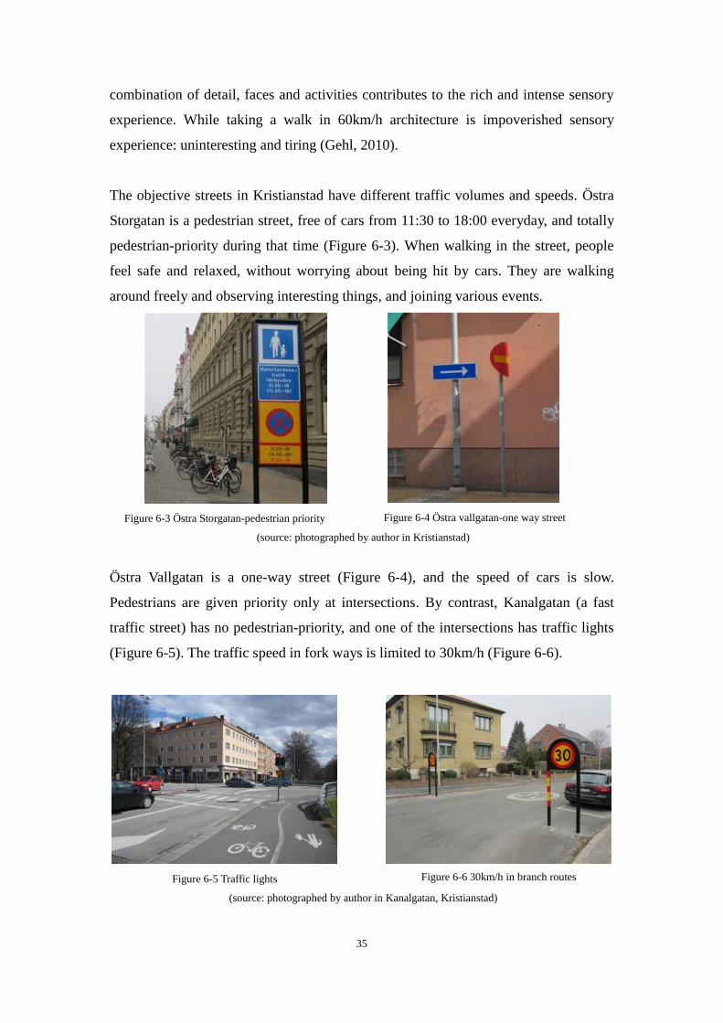
Fast traffic results in lifeless cities (Gehl, 2010). Figure 6-2 shows a study of outdoor
activities in 12 Canadian residential streets. Transit activities make up more than half
of the number of activities but are all very short in duration. Staying activities last an
average of nine times longer and thus contribute 89% of life in the streets (Gehl,
1987). Given that lengthy stays means lively streets, the traffic speed need to be slow
down, especially in communities.
Figure 6-2 Outdoor activities in 12 Canadian residential streets
(source: Gehl, 2010. Cities for people)
As for the pedestrian-priority, Gehl (2010) claims that, the concept of shared space or
complete streets suggest equality between traffic groups, which is a utopian ideal.
Only if pedestrians and cyclists are given priority, the street life can be improved. The
speed of cars should be slowed down or even excluded in some car-free zones, so that
the streets can invite more people to walk and bicycle.
In addition, Gehl talks about car scale, points out people feel different in a 5km/h
speed road and 60km/h speed road. Five km/h architecture is based on an abundance
of sensory impressions, spaces are small, buildings are close together and the
35
combination of detail, faces and activities contributes to the rich and intense sensory
experience. While taking a walk in 60km/h architecture is impoverished sensory
experience: uninteresting and tiring (Gehl, 2010).
The objective streets in Kristianstad have different traffic volumes and speeds. Östra
Storgatan is a pedestrian street, free of cars from 11:30 to 18:00 everyday, and totally
pedestrian-priority during that time (Figure 6-3). When walking in the street, people
feel safe and relaxed, without worrying about being hit by cars. They are walking
around freely and observing interesting things, and joining various events.
Figure 6-3 Östra Storgatan-pedestrian priority
Figure 6-4 Östra vallgatan-one way street
(source: photographed by author in Kristianstad)
Östra Vallgatan is a one-way street (Figure 6-4), and the speed of cars is slow.
Pedestrians are given priority only at intersections. By contrast, Kanalgatan (a fast
traffic street) has no pedestrian-priority, and one of the intersections has traffic lights
(Figure 6-5). The traffic speed in fork ways is limited to 30km/h (Figure 6-6).
Figure 6-5 Traffic lights
Figure 6-6 30km/h in branch routes
(source: photographed by author in Kanalgatan, Kristianstad)
36
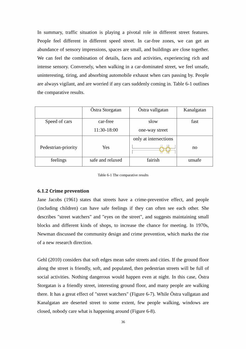
In summary, traffic situation is playing a pivotal role in different street features.
People feel different in different speed street. In car-free zones, we can get an
abundance of sensory impressions, spaces are small, and buildings are close together.
We can feel the combination of details, faces and activities, experiencing rich and
intense sensory. Conversely, when walking in a car-dominated street, we feel unsafe,
uninteresting, tiring, and absorbing automobile exhaust when cars passing by. People
are always vigilant, and are worried if any cars suddenly coming in. Table 6-1 outlines
the comparative results.
Östra Storgatan Östra vallgatan Kanalgatan
Speed of cars car-free
11:30-18:00
slow
one-way street
fast
Pedestrian-priority
Yes
only at intersections
no
feelings safe and relaxed fairish unsafe
Table 6-1 The comparative results
6.1.2 Crime prevention
Jane Jacobs (1961) states that streets have a crime-preventive effect, and people
(including children) can have safe feelings if they can often see each other. She
describes "street watchers" and "eyes on the street", and suggests maintaining small
blocks and different kinds of shops, to increase the chance for meeting. In 1970s,
Newman discussed the community design and crime prevention, which marks the rise
of a new research direction.
Gehl (2010) considers that soft edges mean safer streets and cities. If the ground floor
along the street is friendly, soft, and populated, then pedestrian streets will be full of
social activities. Nothing dangerous would happen even at night. In this case, Östra
Storgatan is a friendly street, interesting ground floor, and many people are walking
there. It has a great effect of "street watchers" (Figure 6-7). While Östra vallgatan and
Kanalgatan are deserted street to some extent, few people walking, windows are
closed, nobody care what is happening around (Figure 6-8).

37
Figure 6-7 Östra Storgatan
Figure 6-8 Östra vallgatan
(source: photographed by author)
In addition, it is evident that the light from buildings along streets makes a significant
contribution to the feeling of security when the night falls. And lighting design is also
an important element of a safety road. The objective streets in Kristianstad are all
have good lighting at night.
6.2 Accessibility needs
Accessibility refers to that can encourage people to reach, enter, use and walk around
places they need or wish to visit, regardless of any physical, sensory or mental
impairment (Burton, 2006). Accessible streets have local services and facilities,
connected to each other, have wide footways and bike lanes (Burton, 2006). Gehl
(2010) also suggests that the prerequisite for street life was the building density,
which encouraged many people to get around the street by foot. More importantly, a
lively street should be a friendly place for older people and disabilities, with no
barriers (Figure 6-9). Accessibility should be regarded as street layout and adjacent
services in this paper.
Figure 6-9 Older people and disabilities need accessibility
(source: photographed by author in Kristianstad)
38
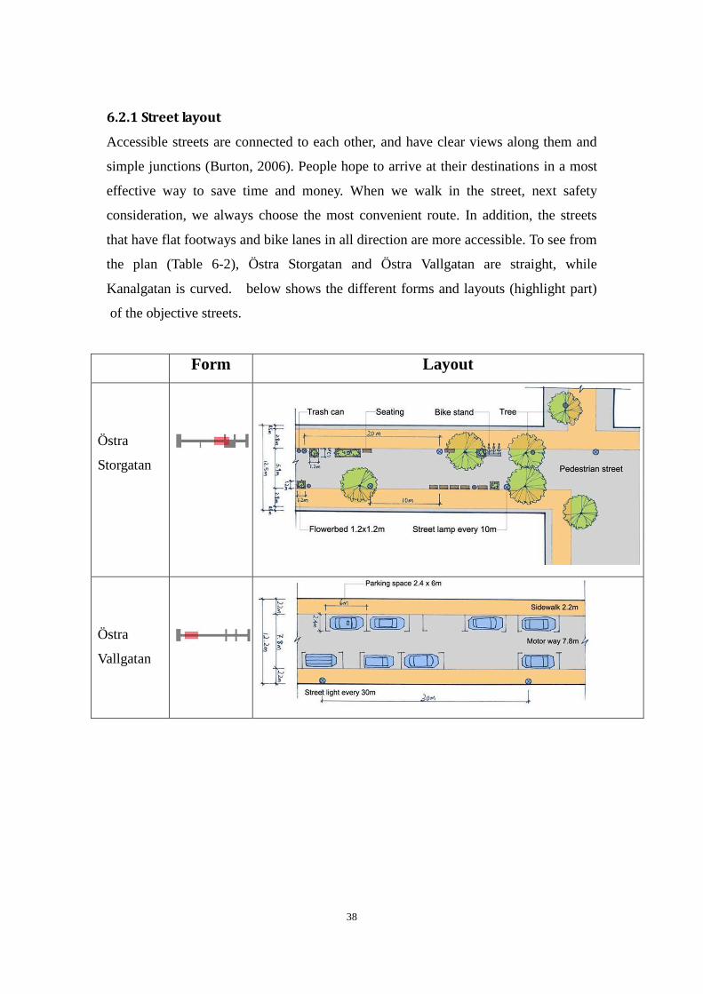
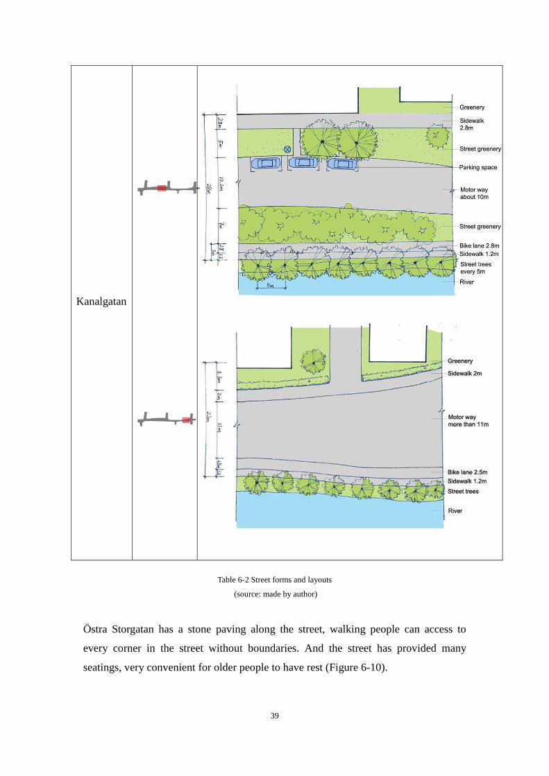
6.2.1 Street layout
Accessible streets are connected to each other, and have clear views along them and
simple junctions (Burton, 2006). People hope to arrive at their destinations in a most
effective way to save time and money. When we walk in the street, next safety
consideration, we always choose the most convenient route. In addition, the streets
that have flat footways and bike lanes in all direction are more accessible. To see from
the plan (Table 6-2), Östra Storgatan and Östra Vallgatan are straight, while
Kanalgatan is curved. below shows the different forms and layouts (highlight part)
of the objective streets.
Form Layout
Östra
Storgatan
Östra
Vallgatan
39
Kanalgatan
Table 6-2 Street forms and layouts
(source: made by author)
Östra Storgatan has a stone paving along the street, walking people can access to
every corner in the street without boundaries. And the street has provided many
seatings, very convenient for older people to have rest (Figure 6-10).
40
Figure 6-10 Östra Storgatan
(source: photographed by author)
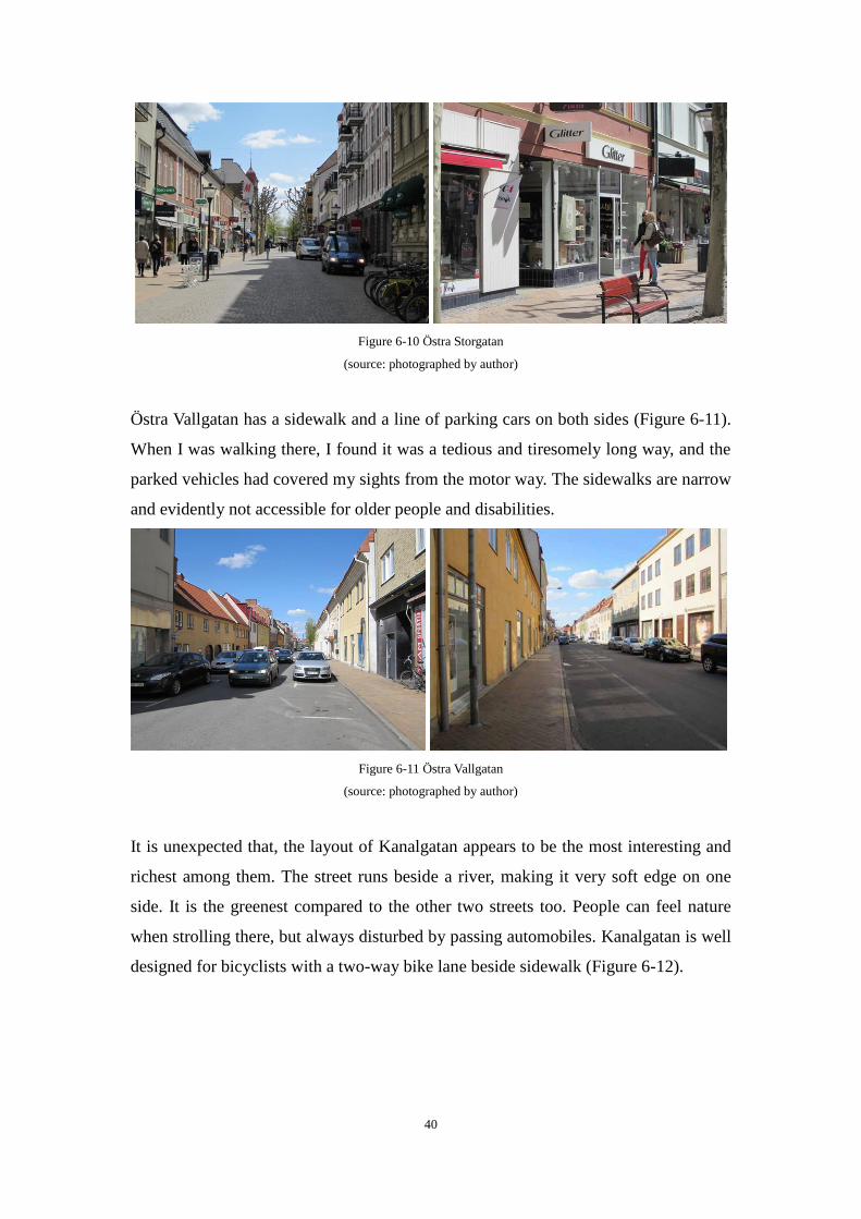
Östra Vallgatan has a sidewalk and a line of parking cars on both sides (Figure 6-11).
When I was walking there, I found it was a tedious and tiresomely long way, and the
parked vehicles had covered my sights from the motor way. The sidewalks are narrow
and evidently not accessible for older people and disabilities.
Figure 6-11 Östra Vallgatan
(source: photographed by author)
It is unexpected that, the layout of Kanalgatan appears to be the most interesting and
richest among them. The street runs beside a river, making it very soft edge on one
side. It is the greenest compared to the other two streets too. People can feel nature
when strolling there, but always disturbed by passing automobiles. Kanalgatan is well
designed for bicyclists with a two-way bike lane beside sidewalk (Figure 6-12).
41
Figure 6-12 Kanalgatan
(source: photographed by author)
6.2.2 Adjacent services and facilities
If adjacent services are convenient for people, it will attract more residents. For
example, the UK government states that 10-minute is a comfortable walking time to
reach services and facilities and calculates this is the time it takes to walk about 800m
(Department of Transport, Local Government and the Regions(DTLR), 2001).
Llewelyn-Davies (2000) also suggests that local shops, a bus stop, a health center and
a place of worship should be situated within 10-minute (800m) walking distance.
In this case, the services around within 700 meters are illustrated in Figure 6-13 next
page. It can be found that, bus stops are not far from the streets, only several minutes
walking distance, and there are two main parking lots within a short distance too.
Many cafes (outdoor or indoor) and restaurants are located near to the central square,
making Östra Storgatan the liveliest street. Kanalgatan seems to be inherently used for
traffic, the cycling center, travel center and a bus stop are distributed close by, while
in Östra Vallgatan, no services along the street, only parking and passing cars. This is
an important element that contributes to the boring surroundings.
42
Figure 6-13 Adjacent services
(source: made by author)
6.3 Comfort needs
The factors which determine environmental comfort needs to include climate
conditions and street conditions. It is understandable that climate condition is an
important element, such as sunshine, temperature, humidity, wind, water and plants.
In summers, we would like to walk under the shade of trees, and floated breeze would
make us feel more comfortable. While in cold winters, we will feel better if there
were shelters along the streets, which can protect us from cold wind and heavy snow.
On the other hand, comfort needs can also be satisfied by reasonable function of the
streets, including the location, the morphology, the proportion, the scale and public
infrastructures. Public seating, shelter and toilets are important factors in making a
street comfortable, welcoming and easy to use for people of all ages and capabilities
(Burton, 2006). When street design can meet people's comfort needs, "life between
buildings" will be more colorful: purposeful walks from place to place, promenades,
short stops, longer stays, window shopping, exercise, children play and street
43
entertainment (Gehl, 2010).
Comfort needs are quite basic on the streets, and comfortable streets are calm,
welcoming and pedestrian-friendly. Residents are not involved into the design of
streets, but their behaviors are the only criterion to check out whether the street design
is comfortable or not.
6.3.1 Soft edges
In his book A Pattern Language (1997), Chiristopher Alesander summarizes the
importance of edges by saying: "If the edge fails, then the space never becomes
lively." The treatment of edges, particularly the lower floors of buildings has a
decisive influence on life in city space (Gehl, 2010). According to Gehl, edges can
define space, act as exchange zones, staying zones and experiencing zones. People
love to stay at edges, so that they can look around in front of them, without worrying
things happening behind (Figure 6-14).
Figure 6-14 People love to stay at edges
(source: photographed by author in Karlskrona, city center)
Soft edges are presented by greenery along buildings, and active facades, especially
the ground floor towards street. The edges and building facades in Östra Storgatan are
quite active. In the day time, the shops in the street are all on their business, the shops
usually have big French windows, from which people could look inside. Some open
their doors and decorated with a few potted plants, and some put a basket of
discounted products outside to attract their customers (Figure 6-15). A variety of
storefronts and opened ground floors make the street so much attractive, that passers
would like to stop and window shopping, or sit down, stay for a while.
44
Figure 6-15 Active ground floor in Östra Storgatan
(source: photographed by author)
In Östra Vallgatan, the edge is relatively hard, and building facade fails to attract
people. The ground floor and windows are all closed (Figure 6-16), which make
people walk fast to their destination, without stopping. The active and soft edges in
Östra Storgatan are sending a massage of "stay", while the tedious and boring
building facades in Östra Vallgatan are saying "walk".
Figure 6-16 Building facades in Östra Vallgatan
(source: photographed by author)
From the last section we could figure out the layout of Kanalgatan is the greenest
street, it really is. People can hear birds singing and the flapping sounds of ducks in
the river when walking there. Only the vehicles passing by from time to time remind
people that this is a heavy traffic street, and you should pay attention to safety. On the
other side, the tall buildings stand there, without intersection with walking people.
(Figure 6-17)
Figure 6-17 Green facades in Kanalgatan
(source: photographed by author)
45
6.3.2 Fine scale
In urban design realm, the relationship between senses, communication and
dimensions is an important theme. Small scale means eventful intense and "warm"
cities (Gehl, 2010). Gehl (1987) asserts that when we talk about social range in vision,
100 meters is a boundary, the point at which we can see people in motion and their
body language in roughly. 25 meters is another significant threshold, only under
which we can precisely read facial expression and principal emotions.
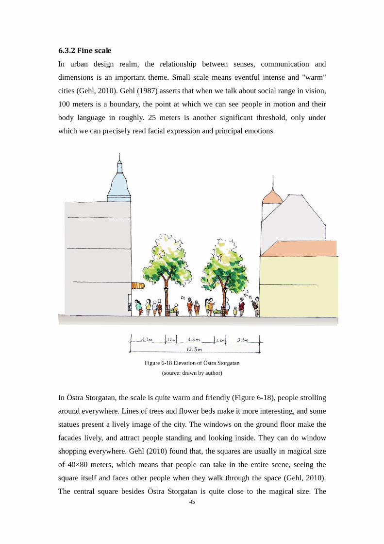
Figure 6-18 Elevation of Östra Storgatan
(source: drawn by author)
In Östra Storgatan, the scale is quite warm and friendly (Figure 6-18), people strolling
around everywhere. Lines of trees and flower beds make it more interesting, and some
statues present a lively image of the city. The windows on the ground floor make the
facades lively, and attract people standing and looking inside. They can do window
shopping everywhere. Gehl (2010) found that, the squares are usually in magical size
of 40×80 meters, which means that people can take in the entire scene, seeing the
square itself and faces other people when they walk through the space (Gehl, 2010).
The central square besides Östra Storgatan is quite close to the magical size. The
46
space between buildings is in about 83×54 meters, a very friendly scale for leisure
activities (Figure 6-19).
Figure 6-19 The square beside Östra Storgatan
(source: photographed by author)
However, in Östra Vallgatan, the windows are all closed, only few trees planted there
(Figure 6-20), but many cars are parked along. Boring layout and facade make the
street deserted. The result is that few cars and few people pass by.
Figure 6-20 Elevation of Östra Vallgatan
(source: drawn by author)
Fine scale is also expressed by a wide footway, that allows older people, children and
wheelchair users to walk safely, and gives people a chance to walk a little further
away from the fast traffic on the road (Burton, 2006). Kanalgatan has a footway of
1.2m and 2.8m on both side, and a two-way bike lane (about 2.5m) between the
footway and motor way on one side of it (Figure 6-21). It should be noticed that, if
two bikes come together or oncoming, they will occupy the space of footway, so the
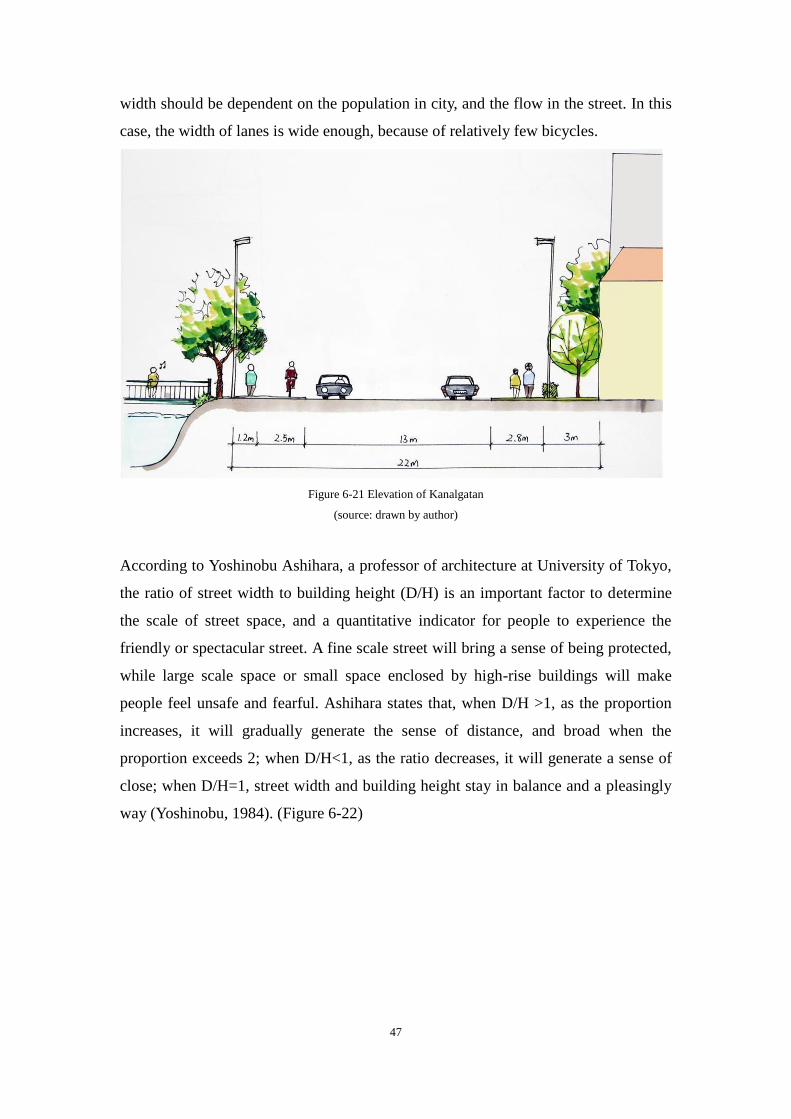
47
width should be dependent on the population in city, and the flow in the street. In this
case, the width of lanes is wide enough, because of relatively few bicycles.
Figure 6-21 Elevation of Kanalgatan
(source: drawn by author)
According to Yoshinobu Ashihara, a professor of architecture at University of Tokyo,
the ratio of street width to building height (D/H) is an important factor to determine
the scale of street space, and a quantitative indicator for people to experience the
friendly or spectacular street. A fine scale street will bring a sense of being protected,
while large scale space or small space enclosed by high-rise buildings will make
people feel unsafe and fearful. Ashihara states that, when D/H >1, as the proportion
increases, it will gradually generate the sense of distance, and broad when the
proportion exceeds 2; when D/H<1, as the ratio decreases, it will generate a sense of
close; when D/H=1, street width and building height stay in balance and a pleasingly
way (Yoshinobu, 1984). (Figure 6-22)
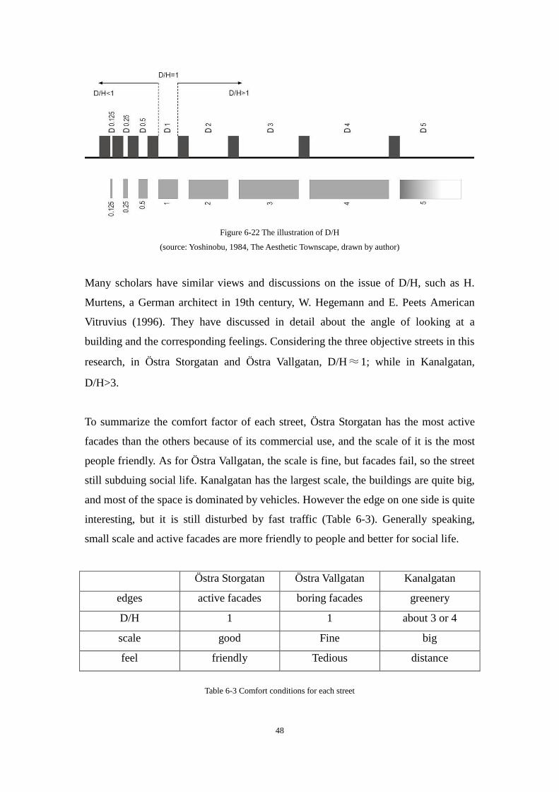
48
Figure 6-22 The illustration of D/H
(source: Yoshinobu, 1984, The Aesthetic Townscape, drawn by author)
Many scholars have similar views and discussions on the issue of D/H, such as H.
Murtens, a German architect in 19th century, W. Hegemann and E. Peets American
Vitruvius (1996). They have discussed in detail about the angle of looking at a
building and the corresponding feelings. Considering the three objective streets in this
research, in Östra Storgatan and Östra Vallgatan, D/H≈1; while in Kanalgatan,
D/H>3.
To summarize the comfort factor of each street, Östra Storgatan has the most active
facades than the others because of its commercial use, and the scale of it is the most
people friendly. As for Östra Vallgatan, the scale is fine, but facades fail, so the street
still subduing social life. Kanalgatan has the largest scale, the buildings are quite big,
and most of the space is dominated by vehicles. However the edge on one side is quite
interesting, but it is still disturbed by fast traffic (Table 6-3). Generally speaking,
small scale and active facades are more friendly to people and better for social life.
Östra Storgatan Östra Vallgatan Kanalgatan
edges active facades boring facades greenery
D/H 1 1 about 3 or 4
scale good Fine big
feel friendly Tedious distance
Table 6-3 Comfort conditions for each street
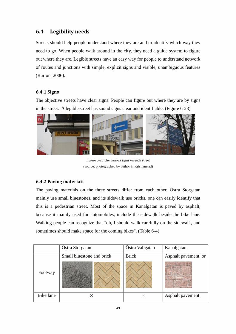
49
6.4 Legibility needs
Streets should help people understand where they are and to identify which way they
need to go. When people walk around in the city, they need a guide system to figure
out where they are. Legible streets have an easy way for people to understand network
of routes and junctions with simple, explicit signs and visible, unambiguous features
(Burton, 2006).
6.4.1 Signs
The objective streets have clear signs. People can figure out where they are by signs
in the street. A legible street has sound signs clear and identifiable. (Figure 6-23)
Figure 6-23 The various signs on each street
(source: photographed by author in Kristianstad)
6.4.2 Paving materials
The paving materials on the three streets differ from each other. Östra Storgatan
mainly use small bluestones, and its sidewalk use bricks, one can easily identify that
this is a pedestrian street. Most of the space in Kanalgatan is paved by asphalt,
because it mainly used for automobiles, include the sidewalk beside the bike lane.
Walking people can recognize that "oh, I should walk carefully on the sidewalk, and
sometimes should make space for the coming bikes". (Table 6-4)
Östra Storgatan Östra Vallgatan Kanalgatan
Footway
Small bluestone and brick
Brick
Asphalt pavement, or
Bike lane × × Asphalt pavement
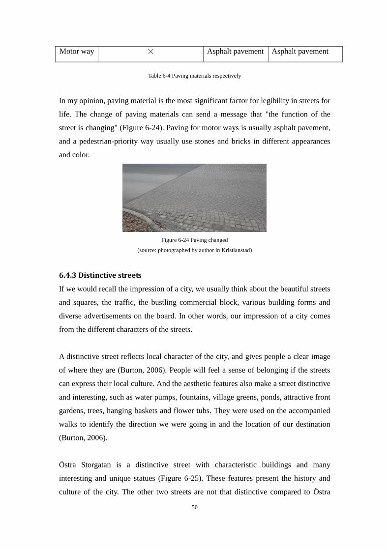
50
Motor way × Asphalt pavement Asphalt pavement
Table 6-4 Paving materials respectively
In my opinion, paving material is the most significant factor for legibility in streets for
life. The change of paving materials can send a message that "the function of the
street is changing" (Figure 6-24). Paving for motor ways is usually asphalt pavement,
and a pedestrian-priority way usually use stones and bricks in different appearances
and color.
Figure 6-24 Paving changed
(source: photographed by author in Kristianstad)
6.4.3 Distinctive streets
If we would recall the impression of a city, we usually think about the beautiful streets
and squares, the traffic, the bustling commercial block, various building forms and
diverse advertisements on the board. In other words, our impression of a city comes
from the different characters of the streets.
A distinctive street reflects local character of the city, and gives people a clear image
of where they are (Burton, 2006). People will feel a sense of belonging if the streets
can express their local culture. And the aesthetic features also make a street distinctive
and interesting, such as water pumps, fountains, village greens, ponds, attractive front
gardens, trees, hanging baskets and flower tubs. They were used on the accompanied
walks to identify the direction we were going in and the location of our destination
(Burton, 2006).
Östra Storgatan is a distinctive street with characteristic buildings and many
interesting and unique statues (Figure 6-25). These features present the history and
culture of the city. The other two streets are not that distinctive compared to Östra
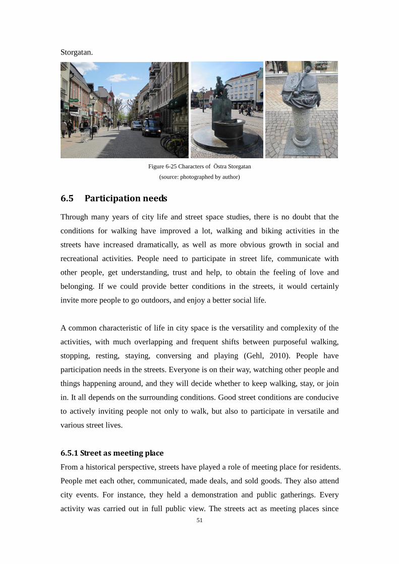
51
Storgatan.
Figure 6-25 Characters of Östra Storgatan
(source: photographed by author)
6.5 Participation needs
Through many years of city life and street space studies, there is no doubt that the
conditions for walking have improved a lot, walking and biking activities in the
streets have increased dramatically, as well as more obvious growth in social and
recreational activities. People need to participate in street life, communicate with
other people, get understanding, trust and help, to obtain the feeling of love and
belonging. If we could provide better conditions in the streets, it would certainly
invite more people to go outdoors, and enjoy a better social life.
A common characteristic of life in city space is the versatility and complexity of the
activities, with much overlapping and frequent shifts between purposeful walking,
stopping, resting, staying, conversing and playing (Gehl, 2010). People have
participation needs in the streets. Everyone is on their way, watching other people and
things happening around, and they will decide whether to keep walking, stay, or join
in. It all depends on the surrounding conditions. Good street conditions are conducive
to actively inviting people not only to walk, but also to participate in versatile and
various street lives.
6.5.1 Street as meeting place
From a historical perspective, streets have played a role of meeting place for residents.
People met each other, communicated, made deals, and sold goods. They also attend
city events. For instance, they held a demonstration and public gatherings. Every
activity was carried out in full public view. The streets act as meeting places since
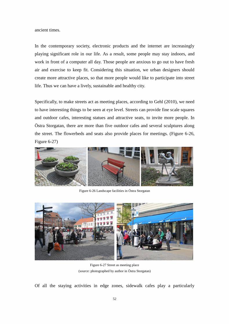
52
ancient times.
In the contemporary society, electronic products and the internet are increasingly
playing significant role in our life. As a result, some people may stay indoors, and
work in front of a computer all day. Those people are anxious to go out to have fresh
air and exercise to keep fit. Considering this situation, we urban designers should
create more attractive places, so that more people would like to participate into street
life. Thus we can have a lively, sustainable and healthy city.
Specifically, to make streets act as meeting places, according to Gehl (2010), we need
to have interesting things to be seen at eye level. Streets can provide fine scale squares
and outdoor cafes, interesting statues and attractive seats, to invite more people. In
Östra Storgatan, there are more than five outdoor cafes and several sculptures along
the street. The flowerbeds and seats also provide places for meetings. (Figure 6-26,
Figure 6-27)
Figure 6-26 Landscape facilities in Östra Storgatan
Figure 6-27 Street as meeting place
(source: photographed by author in Östra Storgatan)
Of all the staying activities in edge zones, sidewalk cafes play a particularly

53
significant role in modern streetscape (Gehl, 2010). There have been a dramatic
growth in the number of cafe shops along streets around the world these years (Figure
6-28), investigated by Gehl. This is a new need and new way of using the street space.
Even in winter, some cities like Copenhagen and Stockholm also provide outdoor
seating cafes with blanket.
Figure 6-28 The growth of outdoor cafe shops
(source: Gehl, 2010. Cities for People)
In the city center of Karlskrona, there is an outdoor cafe that opens for the whole year,
but it is located inside a shopping mall (Figure 6-29). That is a good place to meet
people and observe others.
Figure 6-29 Outdoor cafe in the shopping mall
(source: photographed by author in Karlskrona)
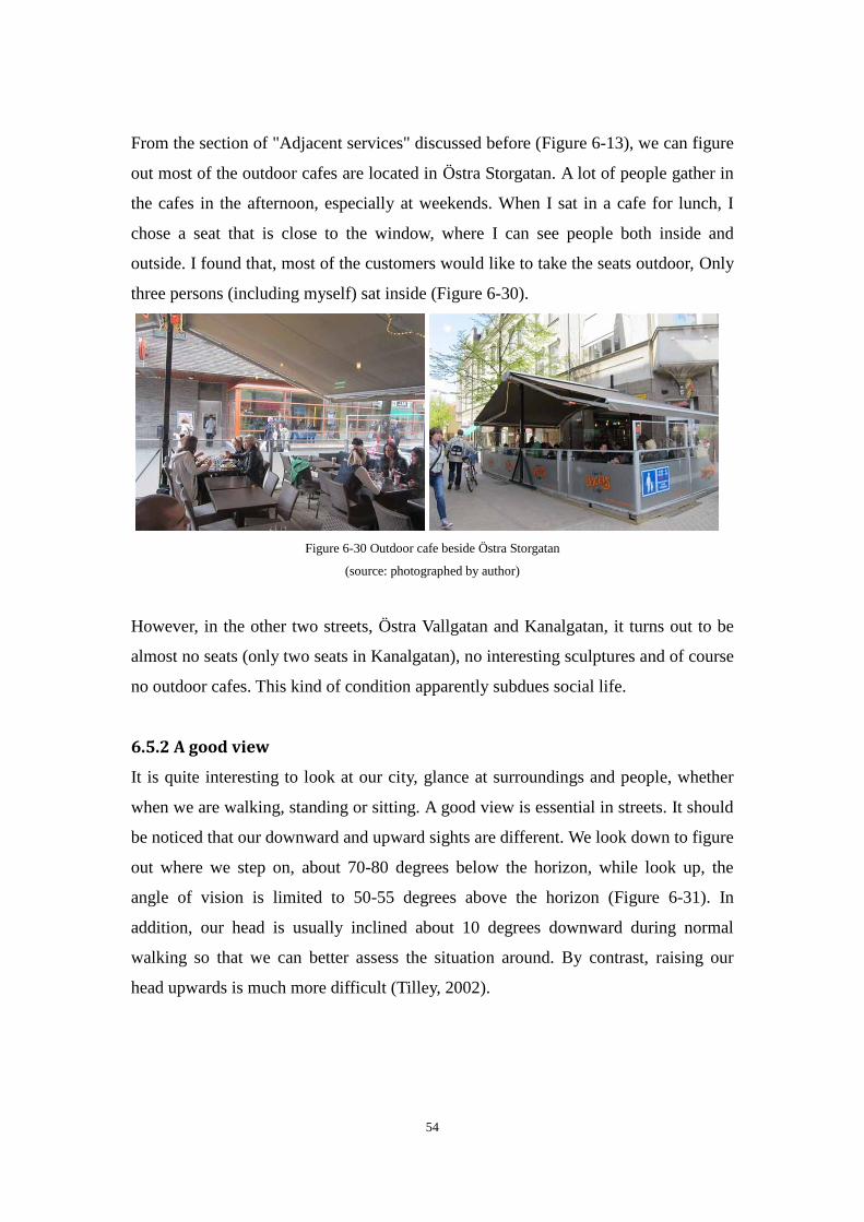
54
From the section of "Adjacent services" discussed before (Figure 6-13), we can figure
out most of the outdoor cafes are located in Östra Storgatan. A lot of people gather in
the cafes in the afternoon, especially at weekends. When I sat in a cafe for lunch, I
chose a seat that is close to the window, where I can see people both inside and
outside. I found that, most of the customers would like to take the seats outdoor, Only
three persons (including myself) sat inside (Figure 6-30).
Figure 6-30 Outdoor cafe beside Östra Storgatan
(source: photographed by author)
However, in the other two streets, Östra Vallgatan and Kanalgatan, it turns out to be
almost no seats (only two seats in Kanalgatan), no interesting sculptures and of course
no outdoor cafes. This kind of condition apparently subdues social life.
6.5.2 A good view
It is quite interesting to look at our city, glance at surroundings and people, whether
when we are walking, standing or sitting. A good view is essential in streets. It should
be noticed that our downward and upward sights are different. We look down to figure
out where we step on, about 70-80 degrees below the horizon, while look up, the
angle of vision is limited to 50-55 degrees above the horizon (Figure 6-31). In
addition, our head is usually inclined about 10 degrees downward during normal
walking so that we can better assess the situation around. By contrast, raising our
head upwards is much more difficult (Tilley, 2002).
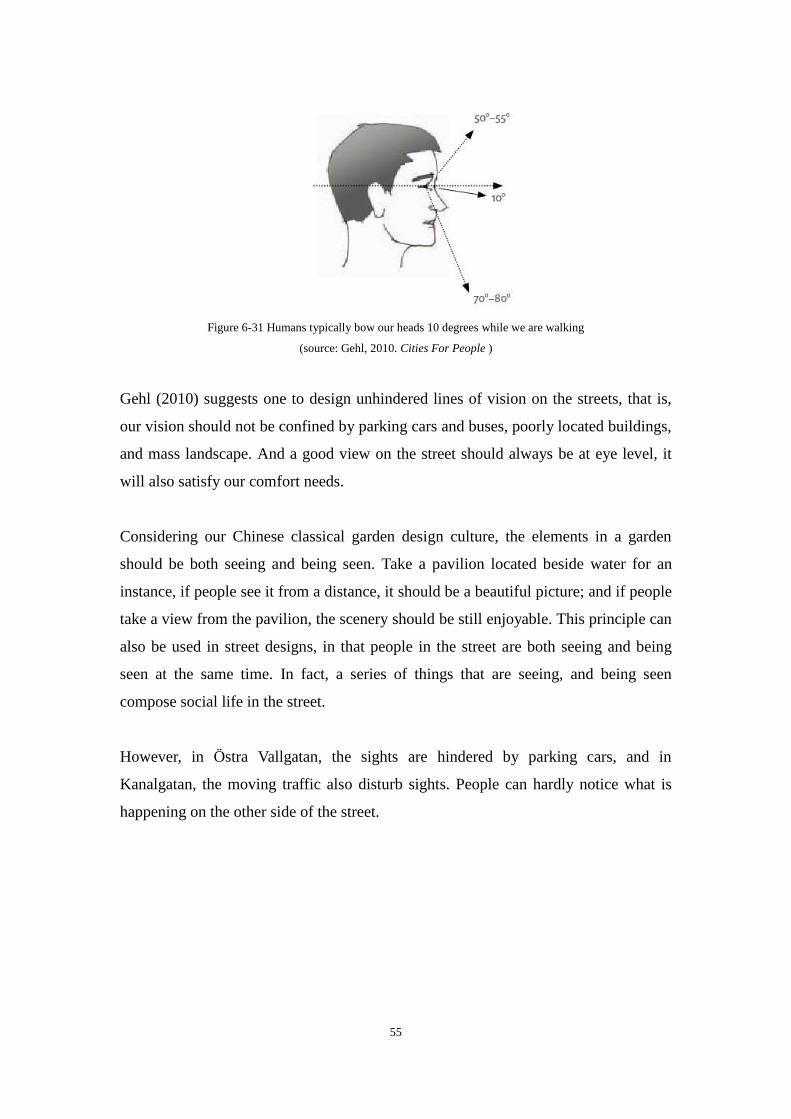
55
Figure 6-31 Humans typically bow our heads 10 degrees while we are walking
(source: Gehl, 2010. Cities For People )
Gehl (2010) suggests one to design unhindered lines of vision on the streets, that is,
our vision should not be confined by parking cars and buses, poorly located buildings,
and mass landscape. And a good view on the street should always be at eye level, it
will also satisfy our comfort needs.
Considering our Chinese classical garden design culture, the elements in a garden
should be both seeing and being seen. Take a pavilion located beside water for an
instance, if people see it from a distance, it should be a beautiful picture; and if people
take a view from the pavilion, the scenery should be still enjoyable. This principle can
also be used in street designs, in that people in the street are both seeing and being
seen at the same time. In fact, a series of things that are seeing, and being seen
compose social life in the street.
However, in Östra Vallgatan, the sights are hindered by parking cars, and in
Kanalgatan, the moving traffic also disturb sights. People can hardly notice what is
happening on the other side of the street.

56
Figure 6-32 Sights hindered by vehicles in Östra Vallgatan and Kanalgatan
(source: photographed by author)
6.6 Summary
Through the above analysis, the satisfaction level of the psychological needs in each
objective street can be summarized by Table 6-5. All 5 psychological needs are very
well satisfied in Östra Storgatan, but the satisfaction level in Östra Vallgatan and
Kanalgatan are quite low. As a result, one can observe that fewer pedestrians can be
found in Östra Vallgatan, and social life is quite restrained compared to Östra
Storgatan.
Östra Storgatan Östra Vallgatan Kanalgatan
Safety needs
Accessibility needs
Comfort needs
Legibility needs
Participation needs
Table 6-5 Psychological needs of people in each street
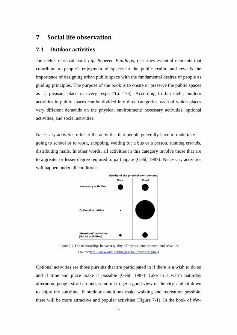
57
7 Social life observation
7.1 Outdoor activities
Jan Gehl's classical book Life Between Buildings, describes essential elements that
contribute to people's enjoyment of spaces in the public realm, and reveals the
importance of designing urban public space with the fundamental desires of people as
guiding principles. The purpose of the book is to create or preserve the public spaces
as "a pleasant place in every respect"(p. 173). According to Jan Gehl, outdoor
activities in public spaces can be divided into three categories, each of which places
very different demands on the physical environment: necessary activities, optional
activities, and social activities.
Necessary activities refer to the activities that people generally have to undertake ---
going to school or to work, shopping, waiting for a bus or a person, running errands,
distributing mails. In other words, all activities in this category involve those that are
to a greater or lesser degree required to participate (Gehl, 1987). Necessary activities
will happen under all conditions.
Figure 7-1 The relationships between quality of physical environment and activities
(source:http://www.rudi.net/images/3622?size=original)
Optional activities are those pursuits that are participated in if there is a wish to do so
and if time and place make it possible (Gehl, 1987). Like in a warm Saturday
afternoon, people stroll around, stand up to get a good view of the city, and sit down
to enjoy the sunshine. If outdoor conditions make walking and recreation possible,
there will be more attractive and popular activities (Figure 7-1). In the book of New
58
City Life, he discusses about today’s city life is an option instead of necessity, and the
importance of quality of city space, which plays much of a role in transforming
necessary activities into optional activities.
Social activities include all types of communication between people and require the
presence of other people (Gehl, 2010). It includes children at play, greetings and
conversations, communal activities of various kinds, and finally-as the most
widespread social activity - passive contacts, that is, simply seeing and hearing other
people (Gehl, 1987). If city space is isolated, social life will be subdued, and nothing
happens.
7.2 Observation study
After the empirical investigation of the streets, I planned to study behavior and social
life in the objective streets in Kristianstad, because they are quite different in physical
appearance. By observation, we can focus on not only the immediate impact of an
event and aspects of everyday life, but also the setting and behavior of individuals to
get a directly view of reality. The types of observation include both participant and
non-participant.
As to my observation method in this case study, the goal is to observe normal flow of
events happening in the street. I sat inconspicuously on the bench, and recorded the
behavior of people and social life, especially those who were staying or
communicating for more than one minute. It was a non-participant observation for
people were not told they were being observed. The observer is like an eavesdropper.
In addition, the necessary activities, such as carrying out the garbage, or doing
construction work, are taking place regardless of the surroundings. These kinds of
activities are not recorded. The optional activities and social activities, such as sitting
down and observing others, communicating and playing are recorded because they
will only occur where the conditions of a street are supportive.
I selected sunny afternoons on Friday and Saturday, from 12:00 to 16:00, because
outdoor activities are most active during that time. And each observation period lasted
for one hour in each street. I recorded the different behaviors of each age group and
their behaviors, where leisure activities happened, and where the communications
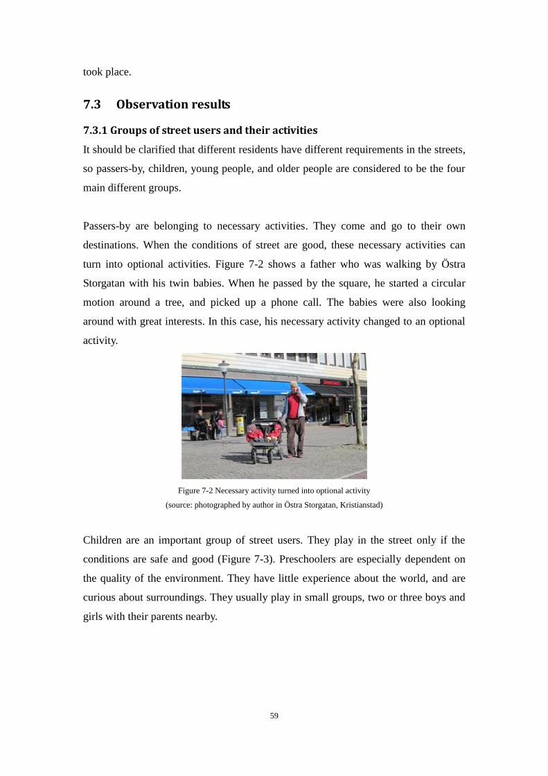
59
took place.
7.3 Observation results
7.3.1 Groups of street users and their activities
It should be clarified that different residents have different requirements in the streets,
so passers-by, children, young people, and older people are considered to be the four
main different groups.
Passers-by are belonging to necessary activities. They come and go to their own
destinations. When the conditions of street are good, these necessary activities can
turn into optional activities. Figure 7-2 shows a father who was walking by Östra
Storgatan with his twin babies. When he passed by the square, he started a circular
motion around a tree, and picked up a phone call. The babies were also looking
around with great interests. In this case, his necessary activity changed to an optional
activity.
Figure 7-2 Necessary activity turned into optional activity
(source: photographed by author in Östra Storgatan, Kristianstad)
Children are an important group of street users. They play in the street only if the
conditions are safe and good (Figure 7-3). Preschoolers are especially dependent on
the quality of the environment. They have little experience about the world, and are
curious about surroundings. They usually play in small groups, two or three boys and
girls with their parents nearby.
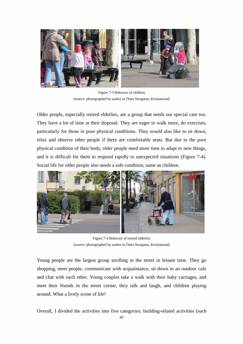
60
Figure 7-3 Behavior of children
(source: photographed by author in Östra Storgatan, Kristianstad)
Older people, especially retired elderlies, are a group that needs our special care too.
They have a lot of time at their disposal. They are eager to walk more, do exercises,
particularly for those in poor physical conditions. They would also like to sit down,
relax and observe other people if there are comfortable seats. But due to the poor
physical condition of their body, older people need more time to adapt to new things,
and it is difficult for them to respond rapidly to unexpected situations (Figure 7-4).
Social life for older people also needs a safe condition, same as children.
Figure 7-4 Behavior of retired elderlies
(source: photographed by author in Östra Storgatan, Kristianstad)
Young people are the largest group strolling in the street in leisure time. They go
shopping, meet people, communicate with acquaintance, sit down in an outdoor cafe
and chat with each other. Young couples take a walk with their baby carriages, and
meet their friends in the street corner, they talk and laugh, and children playing
around. What a lively scene of life!
Overall, I divided the activities into five categories: building-related activities (such
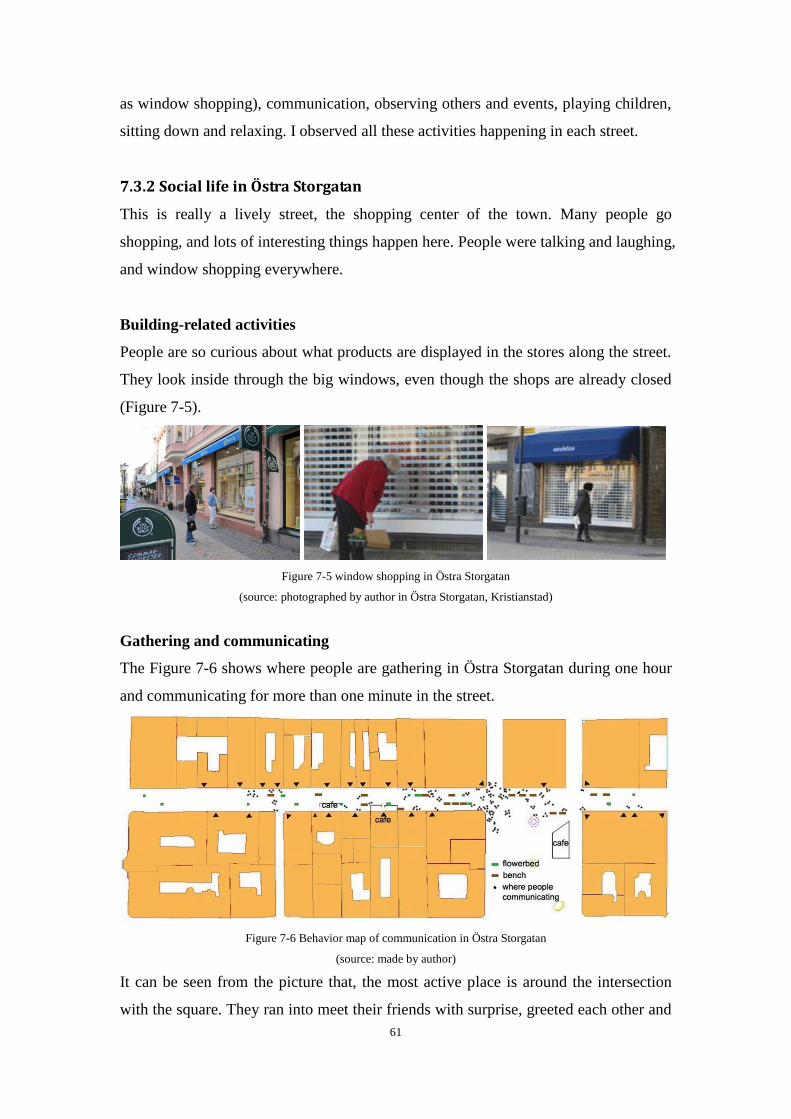
61
as window shopping), communication, observing others and events, playing children,
sitting down and relaxing. I observed all these activities happening in each street.
7.3.2 Social life in Östra Storgatan
This is really a lively street, the shopping center of the town. Many people go
shopping, and lots of interesting things happen here. People were talking and laughing,
and window shopping everywhere.
Building-related activities
People are so curious about what products are displayed in the stores along the street.
They look inside through the big windows, even though the shops are already closed
(Figure 7-5).
Figure 7-5 window shopping in Östra Storgatan
(source: photographed by author in Östra Storgatan, Kristianstad)
Gathering and communicating
The Figure 7-6 shows where people are gathering in Östra Storgatan during one hour
and communicating for more than one minute in the street.
Figure 7-6 Behavior map of communication in Östra Storgatan
(source: made by author)
It can be seen from the picture that, the most active place is around the intersection
with the square. They ran into meet their friends with surprise, greeted each other and
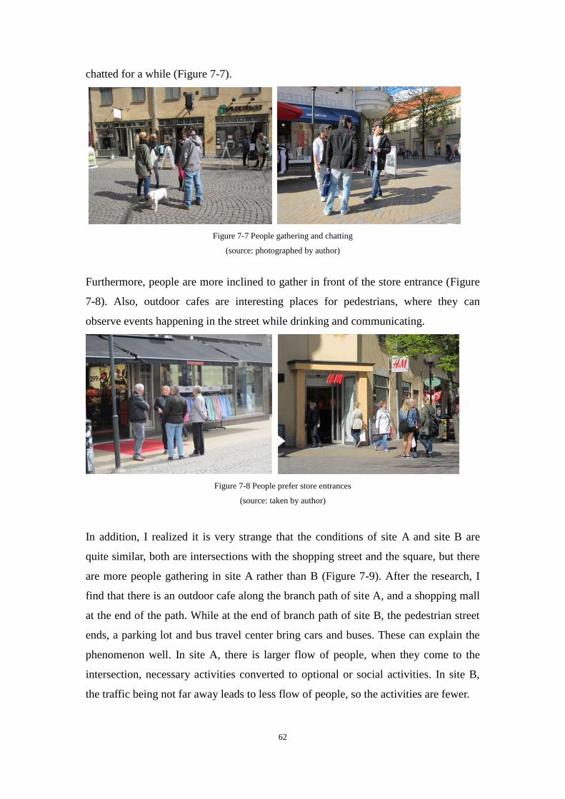
62
chatted for a while (Figure 7-7).
Figure 7-7 People gathering and chatting
(source: photographed by author)
Furthermore, people are more inclined to gather in front of the store entrance (Figure
7-8). Also, outdoor cafes are interesting places for pedestrians, where they can
observe events happening in the street while drinking and communicating.
Figure 7-8 People prefer store entrances
(source: taken by author)
In addition, I realized it is very strange that the conditions of site A and site B are
quite similar, both are intersections with the shopping street and the square, but there
are more people gathering in site A rather than B (Figure 7-9). After the research, I
find that there is an outdoor cafe along the branch path of site A, and a shopping mall
at the end of the path. While at the end of branch path of site B, the pedestrian street
ends, a parking lot and bus travel center bring cars and buses. These can explain the
phenomenon well. In site A, there is larger flow of people, when they come to the
intersection, necessary activities converted to optional or social activities. In site B,
the traffic being not far away leads to less flow of people, so the activities are fewer.
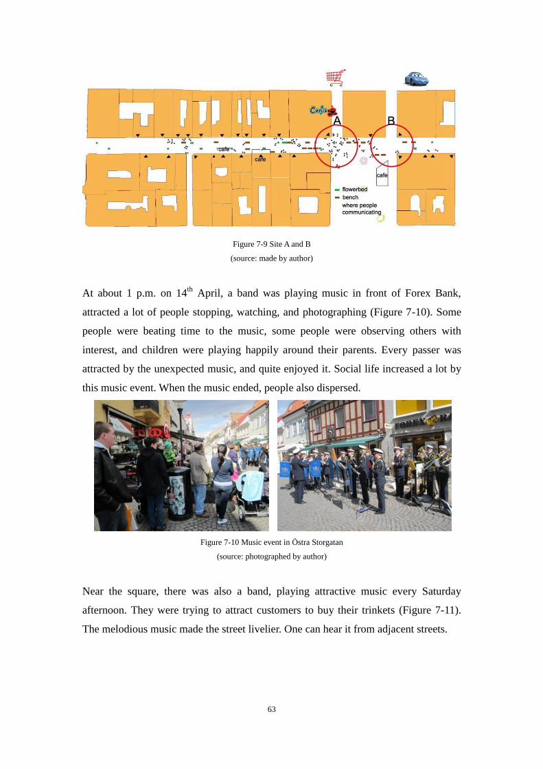
63
Figure 7-9 Site A and B
(source: made by author)
At about 1 p.m. on 14th
April, a band was playing music in front of Forex Bank,
attracted a lot of people stopping, watching, and photographing (Figure 7-10). Some
people were beating time to the music, some people were observing others with
interest, and children were playing happily around their parents. Every passer was
attracted by the unexpected music, and quite enjoyed it. Social life increased a lot by
this music event. When the music ended, people also dispersed.
Figure 7-10 Music event in Östra Storgatan
(source: photographed by author)
Near the square, there was also a band, playing attractive music every Saturday
afternoon. They were trying to attract customers to buy their trinkets (Figure 7-11).
The melodious music made the street livelier. One can hear it from adjacent streets.
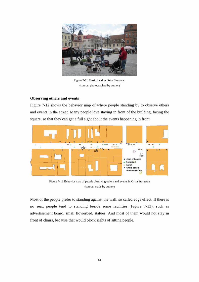
64
Figure 7-11 Music band in Östra Storgatan
(source: photographed by author)
Observing others and events
Figure 7-12 shows the behavior map of where people standing by to observe others
and events in the street. Many people love staying in front of the building, facing the
square, so that they can get a full sight about the events happening in front.
Figure 7-12 Behavior map of people observing others and events in Östra Storgatan
(source: made by author)
Most of the people prefer to standing against the wall, so called edge effect. If there is
no seat, people tend to standing beside some facilities (Figure 7-13), such as
advertisement board, small flowerbed, statues. And most of them would not stay in
front of chairs, because that would block sights of sitting people.
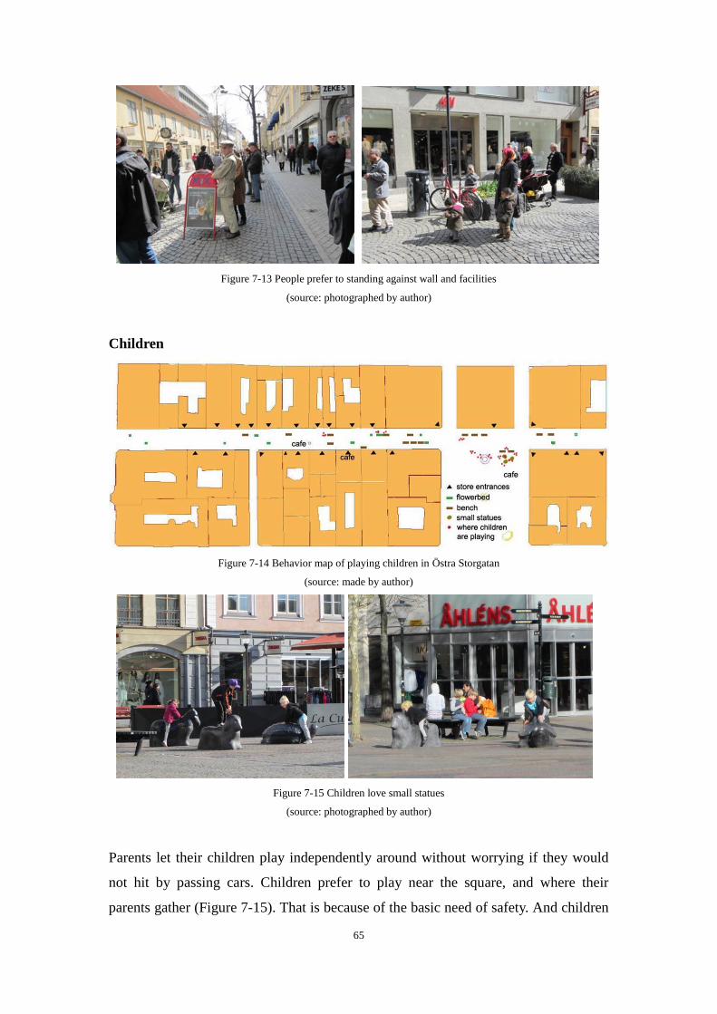
65
Figure 7-13 People prefer to standing against wall and facilities
(source: photographed by author)
Children
Figure 7-14 Behavior map of playing children in Östra Storgatan
(source: made by author)
Figure 7-15 Children love small statues
(source: photographed by author)
Parents let their children play independently around without worrying if they would
not hit by passing cars. Children prefer to play near the square, and where their
parents gather (Figure 7-15). That is because of the basic need of safety. And children
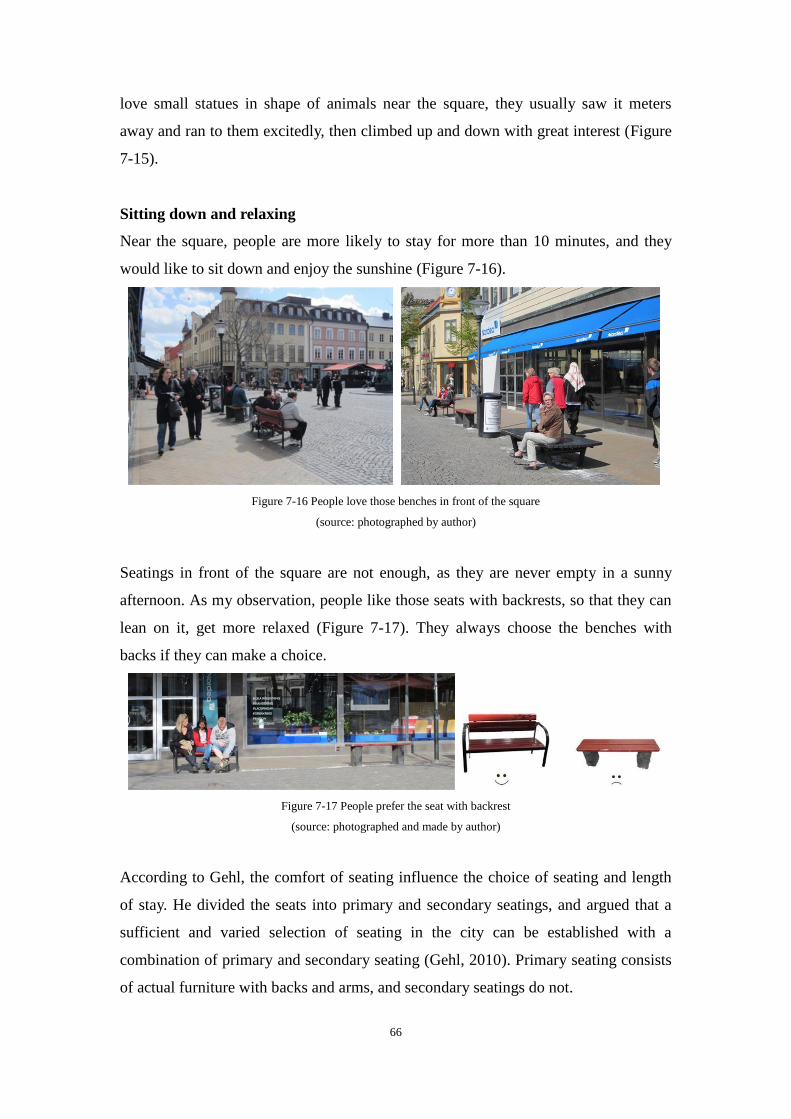
66
love small statues in shape of animals near the square, they usually saw it meters
away and ran to them excitedly, then climbed up and down with great interest (Figure
7-15).
Sitting down and relaxing
Near the square, people are more likely to stay for more than 10 minutes, and they
would like to sit down and enjoy the sunshine (Figure 7-16).
Figure 7-16 People love those benches in front of the square
(source: photographed by author)
Seatings in front of the square are not enough, as they are never empty in a sunny
afternoon. As my observation, people like those seats with backrests, so that they can
lean on it, get more relaxed (Figure 7-17). They always choose the benches with
backs if they can make a choice.
Figure 7-17 People prefer the seat with backrest
(source: photographed and made by author)
According to Gehl, the comfort of seating influence the choice of seating and length
of stay. He divided the seats into primary and secondary seatings, and argued that a
sufficient and varied selection of seating in the city can be established with a
combination of primary and secondary seating (Gehl, 2010). Primary seating consists
of actual furniture with backs and arms, and secondary seatings do not.
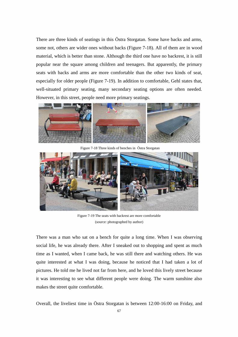
67
There are three kinds of seatings in this Östra Storgatan. Some have backs and arms,
some not, others are wider ones without backs (Figure 7-18). All of them are in wood
material, which is better than stone. Although the third one have no backrest, it is still
popular near the square among children and teenagers. But apparently, the primary
seats with backs and arms are more comfortable than the other two kinds of seat,
especially for older people (Figure 7-19). In addition to comfortable, Gehl states that,
well-situated primary seating, many secondary seating options are often needed.
However, in this street, people need more primary seatings.
Figure 7-18 Three kinds of benches in Östra Storgatan
Figure 7-19 The seats with backrest are more comfortable
(source: photographed by author)
There was a man who sat on a bench for quite a long time. When I was observing
social life, he was already there. After I sneaked out to shopping and spent as much
time as I wanted, when I came back, he was still there and watching others. He was
quite interested at what I was doing, because he noticed that I had taken a lot of
pictures. He told me he lived not far from here, and he loved this lively street because
it was interesting to see what different people were doing. The warm sunshine also
makes the street quite comfortable.
Overall, the liveliest time in Östra Storgatan is between 12:00-16:00 on Friday, and
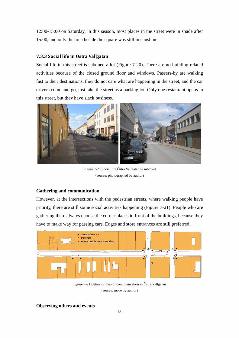
68
12:00-15:00 on Saturday. In this season, most places in the street were in shade after
15:00, and only the area beside the square was still in sunshine.
7.3.3 Social life in Östra Vallgatan
Social life in this street is subdued a lot (Figure 7-20). There are no building-related
activities because of the closed ground floor and windows. Passers-by are walking
fast to their destinations, they do not care what are happening in the street, and the car
drivers come and go, just take the street as a parking lot. Only one restaurant opens in
this street, but they have slack business.
Figure 7-20 Social life Östra Vallgatan is subdued
(source: photographed by author)
Gathering and communication
However, at the intersections with the pedestrian streets, where walking people have
priority, there are still some social activities happening (Figure 7-21). People who are
gathering there always choose the corner places in front of the buildings, because they
have to make way for passing cars. Edges and store entrances are still preferred.
Figure 7-21 Behavior map of communication in Östra Vallgatan
(source: made by author)
Observing others and events
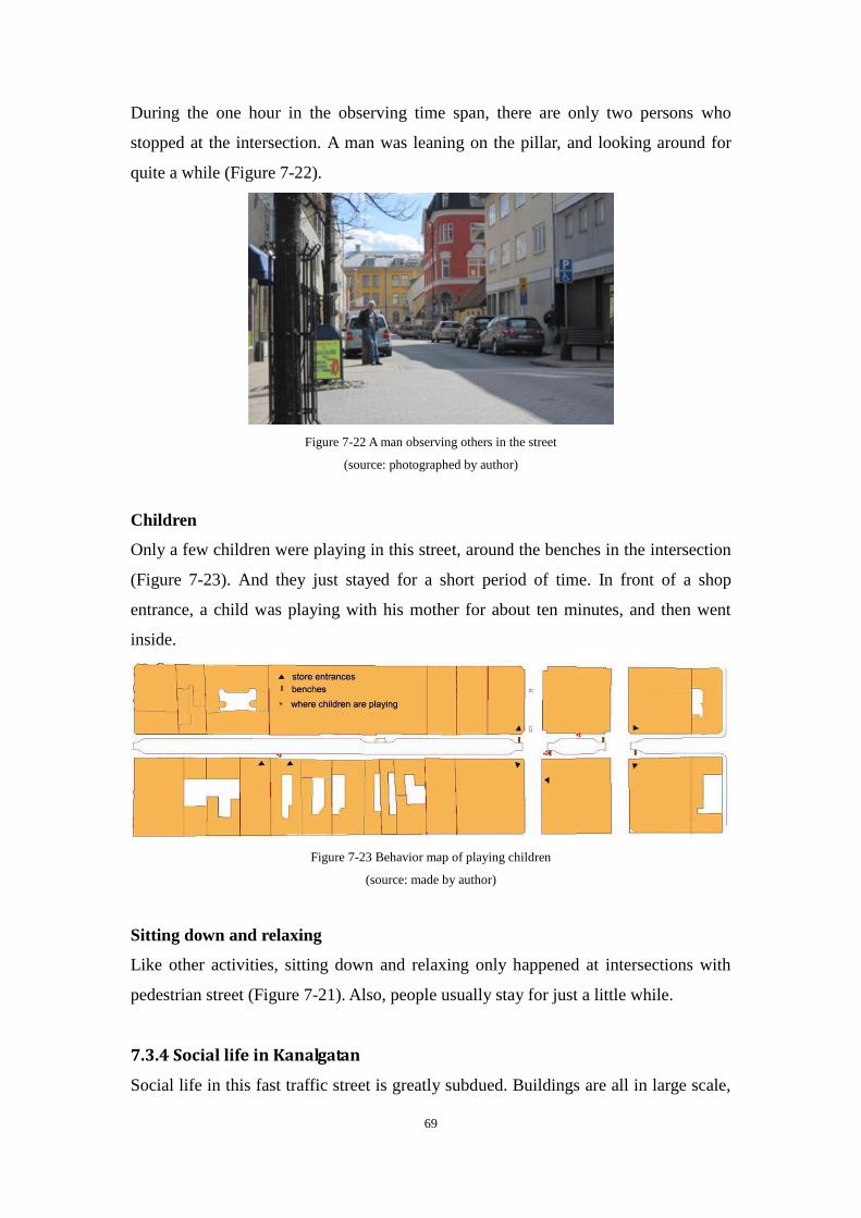
69
During the one hour in the observing time span, there are only two persons who
stopped at the intersection. A man was leaning on the pillar, and looking around for
quite a while (Figure 7-22).
Figure 7-22 A man observing others in the street
(source: photographed by author)
Children
Only a few children were playing in this street, around the benches in the intersection
(Figure 7-23). And they just stayed for a short period of time. In front of a shop
entrance, a child was playing with his mother for about ten minutes, and then went
inside.
Figure 7-23 Behavior map of playing children
(source: made by author)
Sitting down and relaxing
Like other activities, sitting down and relaxing only happened at intersections with
pedestrian street (Figure 7-21). Also, people usually stay for just a little while.
7.3.4 Social life in Kanalgatan
Social life in this fast traffic street is greatly subdued. Buildings are all in large scale,
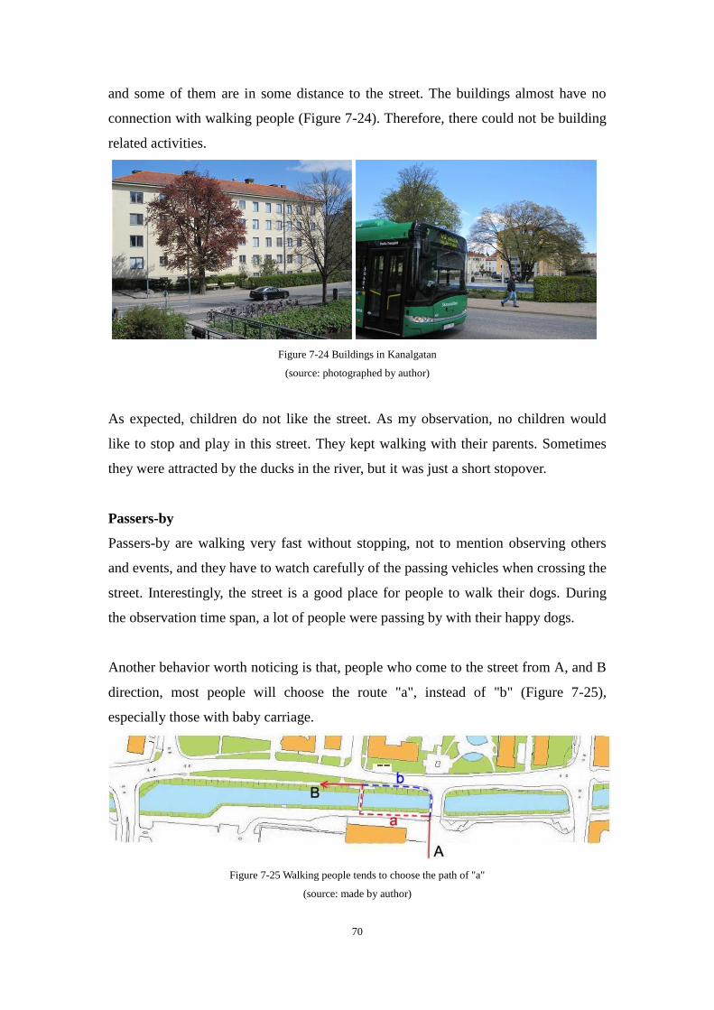
70
and some of them are in some distance to the street. The buildings almost have no
connection with walking people (Figure 7-24). Therefore, there could not be building
related activities.
Figure 7-24 Buildings in Kanalgatan
(source: photographed by author)
As expected, children do not like the street. As my observation, no children would
like to stop and play in this street. They kept walking with their parents. Sometimes
they were attracted by the ducks in the river, but it was just a short stopover.
Passers-by
Passers-by are walking very fast without stopping, not to mention observing others
and events, and they have to watch carefully of the passing vehicles when crossing the
street. Interestingly, the street is a good place for people to walk their dogs. During
the observation time span, a lot of people were passing by with their happy dogs.
Another behavior worth noticing is that, people who come to the street from A, and B
direction, most people will choose the route "a", instead of "b" (Figure 7-25),
especially those with baby carriage.
Figure 7-25 Walking people tends to choose the path of "a"
(source: made by author)
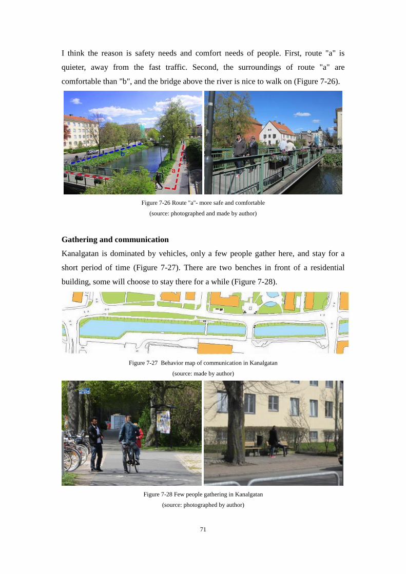
71
I think the reason is safety needs and comfort needs of people. First, route "a" is
quieter, away from the fast traffic. Second, the surroundings of route "a" are
comfortable than "b", and the bridge above the river is nice to walk on (Figure 7-26).
Figure 7-26 Route "a"- more safe and comfortable
(source: photographed and made by author)
Gathering and communication
Kanalgatan is dominated by vehicles, only a few people gather here, and stay for a
short period of time (Figure 7-27). There are two benches in front of a residential
building, some will choose to stay there for a while (Figure 7-28).
Figure 7-27 Behavior map of communication in Kanalgatan
(source: made by author)
Figure 7-28 Few people gathering in Kanalgatan
(source: photographed by author)
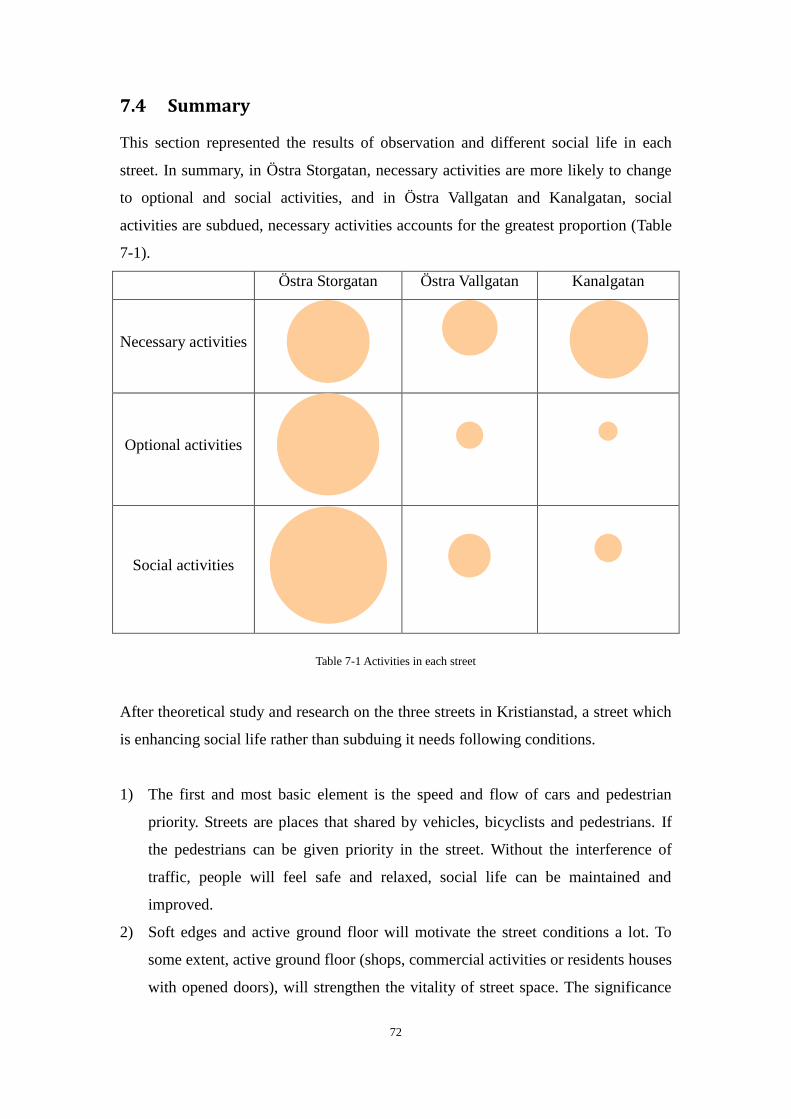
72
7.4 Summary
This section represented the results of observation and different social life in each
street. In summary, in Östra Storgatan, necessary activities are more likely to change
to optional and social activities, and in Östra Vallgatan and Kanalgatan, social
activities are subdued, necessary activities accounts for the greatest proportion (Table
7-1).
Östra Storgatan Östra Vallgatan Kanalgatan
Necessary activities
Optional activities
Social activities
Table 7-1 Activities in each street
After theoretical study and research on the three streets in Kristianstad, a street which
is enhancing social life rather than subduing it needs following conditions.
1) The first and most basic element is the speed and flow of cars and pedestrian
priority. Streets are places that shared by vehicles, bicyclists and pedestrians. If
the pedestrians can be given priority in the street. Without the interference of
traffic, people will feel safe and relaxed, social life can be maintained and
improved.
2) Soft edges and active ground floor will motivate the street conditions a lot. To
some extent, active ground floor (shops, commercial activities or residents houses
with opened doors), will strengthen the vitality of street space. The significance

73
of active facades overrides the scale of a street.
3) Paving materials are quite significant. The paving materials like stones or bricks
are more friendly than an asphalt paving. A friendly pavement can stimulate the
desire of walking, it is like a sign that tells people "this place is safe, walk here".
4) People need to participate into street life, not just pass by, but really involve in it.
Streets worked as meeting places in ancient times, why not today? The active
seats and outdoor cafes are good choice, and interesting statues are greatly
welcomed. The life in streets can become colorful and lively!
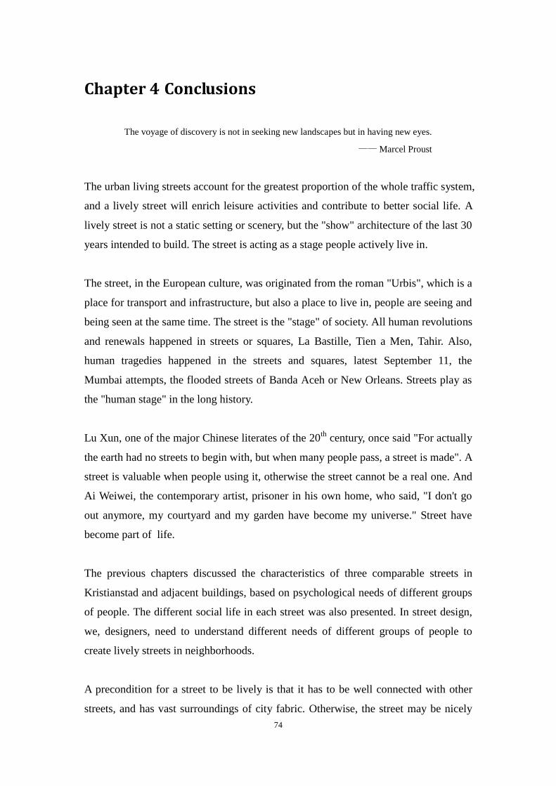
74
Chapter 4 Conclusions
The voyage of discovery is not in seeking new landscapes but in having new eyes.
—— Marcel Proust
The urban living streets account for the greatest proportion of the whole traffic system,
and a lively street will enrich leisure activities and contribute to better social life. A
lively street is not a static setting or scenery, but the "show" architecture of the last 30
years intended to build. The street is acting as a stage people actively live in.
The street, in the European culture, was originated from the roman "Urbis", which is a
place for transport and infrastructure, but also a place to live in, people are seeing and
being seen at the same time. The street is the "stage" of society. All human revolutions
and renewals happened in streets or squares, La Bastille, Tien a Men, Tahir. Also,
human tragedies happened in the streets and squares, latest September 11, the
Mumbai attempts, the flooded streets of Banda Aceh or New Orleans. Streets play as
the "human stage" in the long history.
Lu Xun, one of the major Chinese literates of the 20th
century, once said "For actually
the earth had no streets to begin with, but when many people pass, a street is made". A
street is valuable when people using it, otherwise the street cannot be a real one. And
Ai Weiwei, the contemporary artist, prisoner in his own home, who said, "I don't go
out anymore, my courtyard and my garden have become my universe." Street have
become part of life.
The previous chapters discussed the characteristics of three comparable streets in
Kristianstad and adjacent buildings, based on psychological needs of different groups
of people. The different social life in each street was also presented. In street design,
we, designers, need to understand different needs of different groups of people to
create lively streets in neighborhoods.
A precondition for a street to be lively is that it has to be well connected with other
streets, and has vast surroundings of city fabric. Otherwise, the street may be nicely
75
arranged but not very frequently visited. Östra Storgatan and Östra Vallgatan are
located in city center. The history of them is about 400 years, dates back to 1614,
when the town of Kristianstad was originally established. Today, the city center is a
vibrant hub for trade, service, industry and commerce. Östra Storgatan plays a pivotal
role in the whole city network, and promotes the development of local economy. This
pedestrian commercial street has the inherent advantage of attracting walking people.
However, Östra Vallgatan is inferior to Östra Storgatan because of its poor physical
conditions. Kanalgatan, which located beside the river near city center, is an
important transport route in the overall traffic network. The street assumes the
responsibility of city transport, and the most important distinguishing feature of it is
the fast traffic.
Each of the streets has its own responsibility in the whole traffic network, and each of
them is irreplaceable. By comparison, Östra Storgatan has a great advantage of
attracting people over the other two streets, but Kanalgatan is also an important street
for city traffic system. The role of each street in the overall traffic network is a vital
element to judge whether a street can be lively and have better social life.
In conclusion, a lively street depends on the primary factors as following: the location
and role in the overall traffic network in a city, the comfortable physical conditions,
and adjacent services. When the conditions of a street can meet the needs and requests
of people, the social life will be enhanced, and bring in lively street space.
I hope this thesis will play a valuable role in the urban street design realm, and inspire
the future studies. But owing to the limitations of capacity of the author, the research
objects and the weather conditions, the depth and breadth of the thesis are not enough.
There must be some shortcomings, errors or omissions in the thesis, and I hope you as
a reader, will point out these issues.
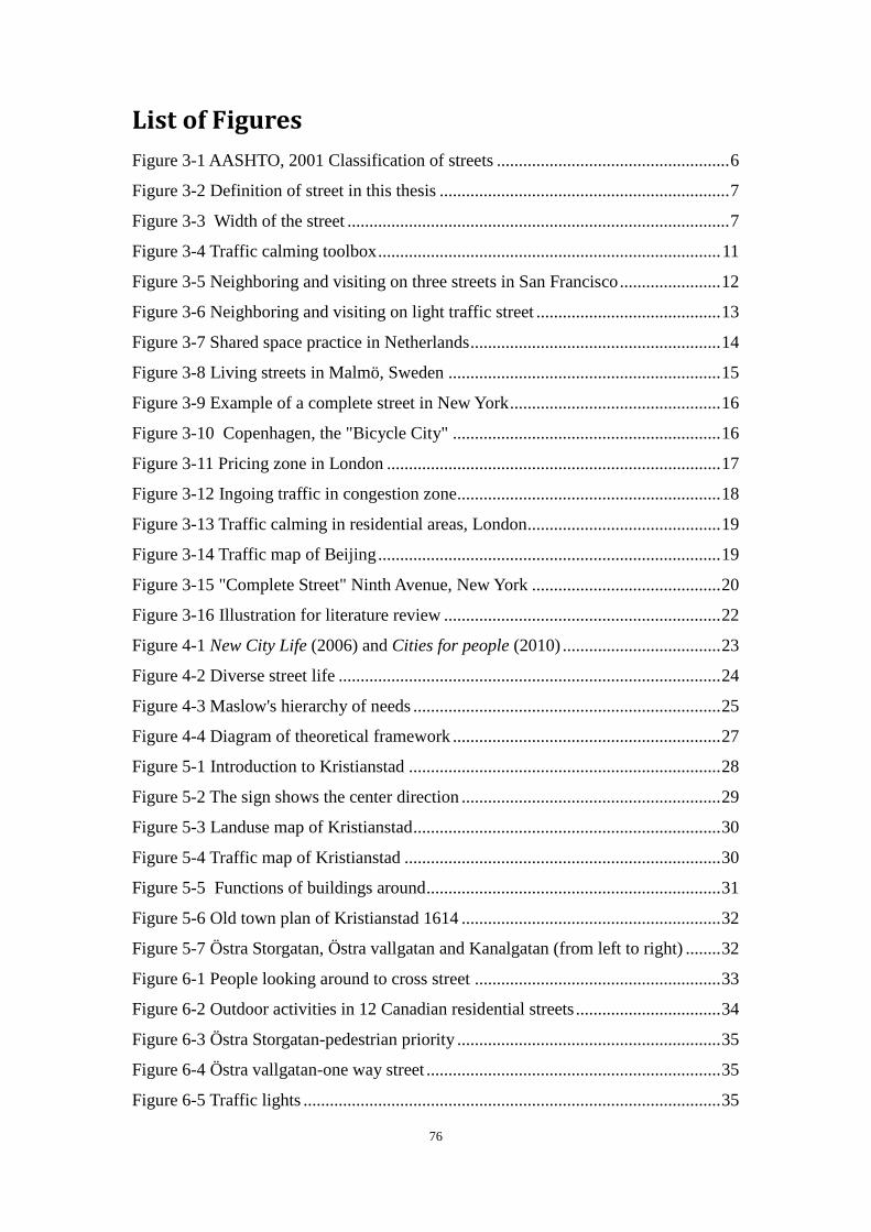
76
List of Figures
Figure 3-1 AASHTO, 2001 Classification of streets ..................................................... 6
Figure 3-2 Definition of street in this thesis .................................................................. 7
Figure 3-3 Width of the street ....................................................................................... 7
Figure 3-4 Traffic calming toolbox .............................................................................. 11
Figure 3-5 Neighboring and visiting on three streets in San Francisco ....................... 12
Figure 3-6 Neighboring and visiting on light traffic street .......................................... 13
Figure 3-7 Shared space practice in Netherlands ......................................................... 14
Figure 3-8 Living streets in Malmö, Sweden .............................................................. 15
Figure 3-9 Example of a complete street in New York ................................................ 16
Figure 3-10 Copenhagen, the "Bicycle City" ............................................................. 16
Figure 3-11 Pricing zone in London ............................................................................ 17
Figure 3-12 Ingoing traffic in congestion zone ............................................................ 18
Figure 3-13 Traffic calming in residential areas, London ............................................ 19
Figure 3-14 Traffic map of Beijing .............................................................................. 19
Figure 3-15 "Complete Street" Ninth Avenue, New York ........................................... 20
Figure 3-16 Illustration for literature review ............................................................... 22
Figure 4-1 New City Life (2006) and Cities for people (2010) .................................... 23
Figure 4-2 Diverse street life ....................................................................................... 24
Figure 4-3 Maslow's hierarchy of needs ...................................................................... 25
Figure 4-4 Diagram of theoretical framework ............................................................. 27
Figure 5-1 Introduction to Kristianstad ....................................................................... 28
Figure 5-2 The sign shows the center direction ........................................................... 29
Figure 5-3 Landuse map of Kristianstad ...................................................................... 30
Figure 5-4 Traffic map of Kristianstad ........................................................................ 30
Figure 5-5 Functions of buildings around ................................................................... 31
Figure 5-6 Old town plan of Kristianstad 1614 ........................................................... 32
Figure 5-7 Östra Storgatan, Östra vallgatan and Kanalgatan (from left to right) ........ 32
Figure 6-1 People looking around to cross street ........................................................ 33
Figure 6-2 Outdoor activities in 12 Canadian residential streets ................................. 34
Figure 6-3 Östra Storgatan-pedestrian priority ............................................................ 35
Figure 6-4 Östra vallgatan-one way street ................................................................... 35
Figure 6-5 Traffic lights ............................................................................................... 35
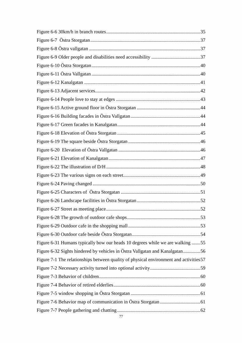
77
Figure 6-6 30km/h in branch routes ............................................................................. 35
Figure 6-7 Östra Storgatan .......................................................................................... 37
Figure 6-8 Östra vallgatan ........................................................................................... 37
Figure 6-9 Older people and disabilities need accessibility ........................................ 37
Figure 6-10 Östra Storgatan ......................................................................................... 40
Figure 6-11 Östra Vallgatan ......................................................................................... 40
Figure 6-12 Kanalgatan ............................................................................................... 41
Figure 6-13 Adjacent services ...................................................................................... 42
Figure 6-14 People love to stay at edges ..................................................................... 43
Figure 6-15 Active ground floor in Östra Storgatan .................................................... 44
Figure 6-16 Building facades in Östra Vallgatan ......................................................... 44
Figure 6-17 Green facades in Kanalgatan .................................................................... 44
Figure 6-18 Elevation of Östra Storgatan .................................................................... 45
Figure 6-19 The square beside Östra Storgatan ........................................................... 46
Figure 6-20 Elevation of Östra Vallgatan ................................................................... 46
Figure 6-21 Elevation of Kanalgatan ........................................................................... 47
Figure 6-22 The illustration of D/H ............................................................................. 48
Figure 6-23 The various signs on each street ............................................................... 49
Figure 6-24 Paving changed ........................................................................................ 50
Figure 6-25 Characters of Östra Storgatan ................................................................. 51
Figure 6-26 Landscape facilities in Östra Storgatan .................................................... 52
Figure 6-27 Street as meeting place ............................................................................. 52
Figure 6-28 The growth of outdoor cafe shops ............................................................ 53
Figure 6-29 Outdoor cafe in the shopping mall ........................................................... 53
Figure 6-30 Outdoor cafe beside Östra Storgatan ........................................................ 54
Figure 6-31 Humans typically bow our heads 10 degrees while we are walking ....... 55
Figure 6-32 Sights hindered by vehicles in Östra Vallgatan and Kanalgatan .............. 56
Figure 7-1 The relationships between quality of physical environment and activities 57
Figure 7-2 Necessary activity turned into optional activity ......................................... 59
Figure 7-3 Behavior of children ................................................................................... 60
Figure 7-4 Behavior of retired elderlies ....................................................................... 60
Figure 7-5 window shopping in Östra Storgatan ......................................................... 61
Figure 7-6 Behavior map of communication in Östra Storgatan ................................. 61
Figure 7-7 People gathering and chatting .................................................................... 62
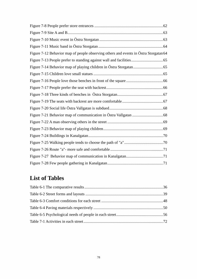
78
Figure 7-8 People prefer store entrances ..................................................................... 62
Figure 7-9 Site A and B ................................................................................................ 63
Figure 7-10 Music event in Östra Storgatan ................................................................ 63
Figure 7-11 Music band in Östra Storgatan ................................................................. 64
Figure 7-12 Behavior map of people observing others and events in Östra Storgatan 64
Figure 7-13 People prefer to standing against wall and facilities ................................ 65
Figure 7-14 Behavior map of playing children in Östra Storgatan .............................. 65
Figure 7-15 Children love small statues ...................................................................... 65
Figure 7-16 People love those benches in front of the square ..................................... 66
Figure 7-17 People prefer the seat with backrest ......................................................... 66
Figure 7-18 Three kinds of benches in Östra Storgatan .............................................. 67
Figure 7-19 The seats with backrest are more comfortable ......................................... 67
Figure 7-20 Social life Östra Vallgatan is subdued ...................................................... 68
Figure 7-21 Behavior map of communication in Östra Vallgatan ............................... 68
Figure 7-22 A man observing others in the street ........................................................ 69
Figure 7-23 Behavior map of playing children ............................................................ 69
Figure 7-24 Buildings in Kanalgatan ........................................................................... 70
Figure 7-25 Walking people tends to choose the path of "a" ....................................... 70
Figure 7-26 Route "a"- more safe and comfortable ..................................................... 71
Figure 7-27 Behavior map of communication in Kanalgatan ..................................... 71
Figure 7-28 Few people gathering in Kanalgatan ........................................................ 71
List of Tables
Table 6-1 The comparative results ............................................................................... 36
Table 6-2 Street forms and layouts .............................................................................. 39
Table 6-3 Comfort conditions for each street .............................................................. 48
Table 6-4 Paving materials respectively ...................................................................... 50
Table 6-5 Psychological needs of people in each street ............................................... 56
Table 7-1 Activities in each street ................................................................................ 72
79
References
APPLEYARD, D. (1981) Livable Streets, protected neighborhoods. United States of
America.
ALEXANDER, C. (1977) A Pattern Language: Towns, Buildings, Constructions.
New York: Oxford University Press.
BEIJING TRAFFIC MANAGEMENT BUREAU (2012) Restricting cars travel at
peak hours in working days [online] Available from:
http://www.bjjtgl.gov.cn/publish/portal0/tab41/info31614.htm [Accessed 02/04/2012]
BRUTON, E. and MITCHELL, L. (2006) Inclusive Urban Design-Streets for Life.
Britain.
BIN, J. et al. (2002) Spatial analysis and geovisualization in GIS. Higher education
press Beijing.
COZENS, P.M. (2008) New Urbanism, Crime and the Suburbs: A Review of the
Evidence. Urban Policy and Research. 26(4), pp. 429-444.
CROUSE, D.W. (2004) Traffic Calming: A Social Issue. Bulletin of Science
Technology & Society, 24(2), pp. 138-144.
CARMONA, M. (2003) Public places, urban spaces: the dimensions of urban
design .Italy.
DTLR (Department of Transport, Local Government and the Regions) (2001). By
Design. Better Places to Live: A Companion Guide to PPG3. London: The Stationery
Office.
ECKERSON, C. Jr. (2011) Complete Streets: It's About More Than Bike Lanes [online
video]. Available from: http://www.streetfilms.org/category/issues/traffic-calming/
[Accessed 02/04/2012]
GEHL, J. (2010) Cities for People. Island Press.
GEHL, J. et al. (2006) New City Life. The Danish Architecture Press.
GEHL, J. (2006) Close Encounters with Buildings, Urban Design International, no.1,
pp. 29-47.
GIEDION, S. (2003) Space, Time & Architecture: the growth of a new tradition. 5th
ed. Harvard University Press.
GEHL, J. (1987) Life Between Buildings: Using Public Space, translated by Koch, J.
Van Nostrand Reinhold, New York.
80
HILLIER, B.(2004) Space is the machine: A configurational theory of architecture.
United Kingdom.
KRISTIANSTAD KOMMON (2011) Kristianstad bygger för framtiden. [online]
Available
from:http://www.kristianstad.se/upload/%C3%96versta%20menyn/Om%20kommune
n/Kristianstad%20bygger/Kristianstad%20bygger_uppslag.pdf [Accessed08/04/12]
KRISTIANSTAD KOMMON (2009) Facts about Kristianstad 2009. Information
Department, 31st March 2009
LIVABLE CITY, (2006) Livable Neighborhoods. [WWW] Available from:
https://livablecity.org/campaigns/livableneighborhoods.html [Accessed 02/03/12]
LLEWELYN, D. (2000) Urban Design Compendium. London: Llewelyn-Davis
LITMAN, T. (1999) Traffic Calming: Benefits, Costs and Equity Impacts. Victoria
Transport Policy Institute (7th
Decem ber). [WWW] Available from:
http://www.vtpi.org/calming.pdf [Accessed 24/02/12]
LOCKWOOD, I.M. (1997) ITE Traffic calming definition. ITE Journal, 67, 22-24, pp.
212.
LYNCH, K. (1960) The Image of the City. MIT Press.
JACOBS, J. (1961) The Death and Life of Great American Cities
MACIONIS, J.J. (2012) Sociology, 14th
ed. Boston: Pearson. pp. 88. ISBN 978-0-
205-11671-3
METHORST, R. et al. (2007) Shared Space: Safe or Dangerous? (3rd
September)
Rotterdam/Wuppertal.
MONDERMAN, H. and CLARKE, E. (2006) Shared Space: the alternative approach
to calming traffic. Traffic engineering&control. 47(8), pp. 290-292.
MOUGHTIN, C. (2003) Urban Design: Street and Square. 3rd
ed. Britain.
MASLOW, A.H. (1987) Motivation and Personality. 3rd
ed. Harper Collins Publishers.
NEUMAN, W. (2007) A Busy City Street Makes Room for Bikes [WWW] Available
from: http://www.nytimes.com/2007/09/23/nyregion/23streetfuture.html?_r=1
[Accessed 02/04/12]
PALSSON, A. (2011) Making Cities Resilient: My City is Getting Ready.
Kristianstads kommun, 2nd May.
PENNSTATE Civil and Environment Engineering (2005) Street Classification and
Standards [WWW] Available from:
http://www.engr.psu.edu/phrc/Land%20Development_files/February%2010,%202005
81
/Road%20and%20Street%20Classification%20Powerpoint%20Updated.pdf
[Accessed 06/03/12]
PROJECT FOR PUBLIC SPACES, Traffic Calming 101 [WWW] Available from:
http://www.pps.org/articles/livememtraffic/ [Accessed 12/03/12]
PHAROAH, T. and RUSSELL, J. (1989) Traffic Calming: Policy and evaluations in
three European countries. London: South Bank Polytechnic. pp. 167
RITTER, J. (2007) "Complete streets" program gives more room for
pedestrians,cyclists [WWW] USA TODAY. Available from:
http://www.usatoday.com/news/nation/2007-07-29-complete-streets_N.htm [Accessed
06/03/12]
RAHMAN, F. et al. (2005) Comparative Study of Design and Planning Process of
Traffic Calming Devices. Proceedings of the Eastern Asia Society for Transportation
Studies, Vol.5, pp. 1322-1336.
SITTE, C. (1889) City Planning According to Artistic Principles. Translation of "Der
Sta dtebau nach seinem ku nstlerischen Grundsa tzen". Vienna: Carl Graeser.
TØRSLØV, N. (2010) Traffic in Copenhagen 2009. Published by City of Copenhagen,
Technical and Environmental Administration Copenhagen Traffic Department, Islands
Brygge 37, DK-2300 Copenhagen S.
TOTH, G. (2009) Where the Sidewalk Doesn't End: What Shared Space has to
Share(17th
August). [WWW] Available from: http://www.pps.org/blog/shared-space/
[Accessed 06/03/12]
TILLEY, A.R. and DREYFUSS, H. (2002) The Measure of Man and Woman. Human
Factors in Design, revised edition. New York: John Willey & Sons.
TUAN, Y.F. (2001) Space and Place - The Perspective of Experience. 8th
ed. London:
The University of Minnesota.
TRANSPORT FOR LONDON (n.d.) Consultation results [WWW] Available from:
http://www.tfl.gov.uk/roadusers/congestioncharging/17094.aspx [Accessed 03/04/12]
TYLOR-POWELL, E. and STEELE, S. (1996) Collecting Evaluation Data: Direct
Observation [WWW] University of Wisconsin Cooperative Extension. Available from:
http://learningstore.uwex.edu/assets/pdfs/G3658-5.PDF [Accessed 09/04/12]
YIN, R. K. (2009) Case Study Research: Design and Methods. London: Sage
Publications.
YOSHINOBU ASHIHARA (1984) The Aesthetic Townscape. The MIT Press.


![2003 SOCIAL RESPONSIBILITY REPORT - ubibanca.it1]1.pdf · The question of corporate social responsibility has developed into a lively ... (the Social and Environmental ... where full](https://img.pdfslide.us/doc/110x75/5b91d01009d3f26a278c934e/2003-social-responsibility-report-11pdf-the-question-of-corporate-social.jpg)