Embed Size (px)
Citation preview
Kritipur Patan
Madhyapur
Kathmandu
Lalitpur
Bhaktapur
Lele
Sundarijal
Suntol
Godawari
Lapsephedi
DhuselNallu
Lamatar
Sudal
Devichour
Tathali
Chhaling
Sipadol
Gundu
Nagarkot
Budanilkantha
Gagalphedi
Lubhu
Bageswori
Baluwa
Bhardev
Chhaimale
Sangla
Nankhel
IchangNarayan
Jitpurphedi
Talkududechour
Nayapati
Thankot
Ramkot
Satikhel
Duwakot
Dadhikot
Kapan
Badikhel
Chapagaun
Chitapol
Matatirtha
Sainbu
Jhaukhel
Imadol
Daanchhi
Gothatar
Chalnakhel
Daxinkali
Bhimdhunga
Goldhunga
Kautunje
MulpaniChangunarayan
Thecho
Balkot
Bisankhunarayan
Tikathali
Kabhresthali
Jorpati
Chhampi
Mahadevathan
JhorMahankal
Dukuchhap
Mahankal
Sitapaila
Sheshnarayan
Machhegaun
Gokarneswor
Bungamati
Khokana
Chunikhel
ChapaliBhadrakali
Dhapakhel
Thaiba
ChouketarDahachokBaadBhanjyang
Jharuwarasi
Manmaiju
Sunakothi
Harisiddhi
Indrayani
Seuchatar
Satungal
Bajrayogini(Sankhu)
Godamchaur
Dhapasi
TokhaChandeswori
Balambu
Gonggabu
Siddhipur
Futung
Sirutar
Aalapot
Bhadrabas
Tinthana
Dharmasthali TokhaSarswoti
KhadkaBhadrakali
Pukhulachhi
NaikapPuranoBhanjyang
NaikapNayaBhanjyang
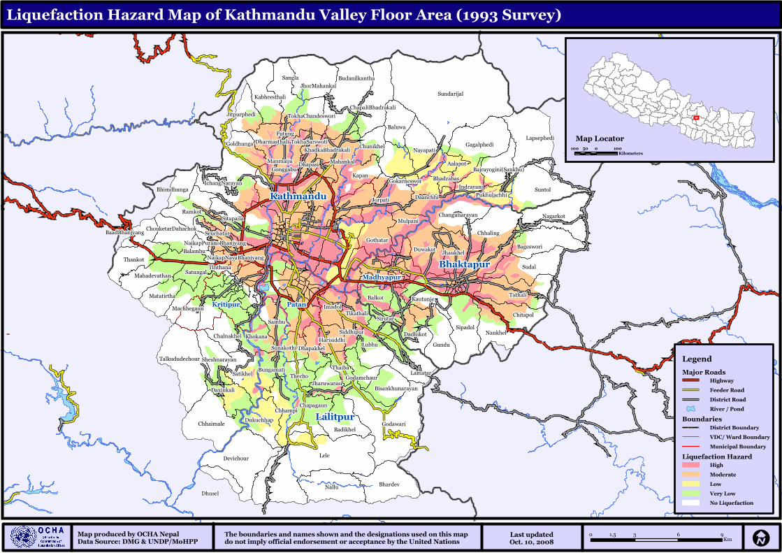
The boundaries and names shown and the designations used on this map do not imply official endorsement or acceptance by the United Nations
Last updatedOct. 10, 2008
Map produced by OCHA NepalData Source: DMG & UNDP/MoHPP
Liquefaction Hazard Map of Kathmandu Valley Floor Area (1993 Survey)
0 3 6 91.5Km I
Legend
Major Roads
Highway
Feeder Road
District Road
River / Pond
Boundaries
District Boundary
VDC/ Ward Boundary
Municipal Boundary
Liquefaction Hazard
High
Moderate
Low
Very Low
No Liquefaction
Map Locator100 0 10050
Kilometers

![INDEX [reliefweb.int]reliefweb.int/sites/reliefweb.int/files/resources/maps_index.pdf · INDEX Index Health facility name Functional Status Health facility type Structure Type 0 1000](https://img.pdfslide.us/doc/110x75/5e89a2a5e988f11bf13a6b08/index-index-index-health-facility-name-functional-status-health-facility-type.jpg)