Embed Size (px)
Citation preview
8/8/2019 Lidar - A Flow to Generate Lidar From Dem
http://slidepdf.com/reader/full/lidar-a-flow-to-generate-lidar-from-dem 1/3
A flow to generate DEM from Lidar data
Lai Xudong
129 luoyu Road, Wuhan 430079, China
School of Remote Sensing and Information Engineering,
Wuhan University
Wuhan, [email protected]
Zheng Xuedong
Spatial Information Technology Application Monograph
Wuhan, China
Jiang JunweiChina railway siyuan survey and design group co., ltd
Wuhan, China
Abstract —To consume less time and less memory, this paper
presents a flow to generate DEM from Lidar data. Firstly the
flow labels non-ground points based on multi-echo information.
Secondly by the relativity among neighbor points, the flow labels
many other non-ground points. After these two up-to-down steps,
many non-ground points have been eliminated, which has
reduced the amount of the Lidar points successful. At last, the
flow use filtering arithmetic based on scan lines to get DEM. This
paper comes to a conclusion that both the flow and algorithm are
feasible by using them to disposing laboratory data.
Keywords- Lidar; Filter; DEM; flow
I. I NTRODUCTION
Nowadays, Lidar (light detection and ranging, Lidar)technology has become an important remote sensingtechnology to acquire of spatial information, which includeslight detection and ranging technology, computer technology,satellite positioning device (GPS), inertial navigation device(IMS). With the rapid development of relevant technology, theapplication of Lidar technology in the field of remote sensing ismore and more extensive.
Lidar data is useful for rapidly obtaining large-scale 3Dterrain data and generating digital products such as DEM(Digital Elevation Model). The DEM can be used in manyfields, such as, in urban plan, in digital city, in themeasurement and calculation of earthwork, in management of drainage area, etc. Since it can fast and veraciously generateDEM, Lidar data is becoming a very important way insurveying and mapping.
II. PRESENT STATUSES AND A NALYZING
The Lidar data usually gives footprints not all on the realterrain surface, some on artificial buildings (roofs, chimneys,towers, etc.) and some on vegetation (trees, bushes, grass, etc.).
In order to generate DEM we must eliminate off-terrain pointsand this is filtering of Lidar data.
The most classic principle of generate DEM from Lidar data is that the Lidar points’ height will change in shortdistance if there are two kinds of objects. That is, the elevationshould be continuous and the topographic fracture lines (steep banks, cliffs, etc.) are less. So, if suddenly changing is taken place to the adjacent footprints, it is probable that the higher
footprint is on non-ground objects. And we must eliminate it.Based on this principle, much different filtering arithmetic has been presented.
Volsselman designed a specific kernel function using suchtheory in 2000, and generated DEM by mathematicalmorphology operation [1].Zhang Dong has proposed athreshold segment method based on the wave crest of rangeimage. As it still uses a certain value to estimate every image
element, it can’t reflect the real terrain impersonally. Theresults will be worse especially in areas where landformchange is great [2]. Through order scan along the scan lines of LIDAR data, Shan marked ground point and object point by judging whether the different of gradient and elevation betweenneighbor points exceed threshold [3]. Hyun S. Lee improvedlinear prediction method, assembling linear prediction andadaptation processing technique to generate elevation model,obtained refined DEM [4]. There is some other filteringarithmetic which is use mult-kinds data, such as intensive data,digital photo data, GIS data, etc[5,6].
All these filtering arithmetic mentioned above are difficultyto apply in project, the reasons mostly is the Lidar data is too
magnitude to filtering it in a short time. Today there are mainlytwo filtering arithmetic have been used in business software.One is TerraSolid; it is based on the TIN densification. Firstlyit partition the region to some grids each of which is 60 meters
60 meters or more. Secondly, it selects one low point in
every grid. Then it builds a TIN of the low points. At last, itadds nearby points to TIN if the points meet the rules. Theother is Scop++; it is based on Least Squares Interpolation.Firstly, it uses all points to interpolation with unit weights.Secondly it analyses of the residuals. Then it weights themeasurements with an asymmetric weight function. At last itinterpolation with new weights. All these filtering arithmeticcan get good results in most condition, but they are all time-consuming.
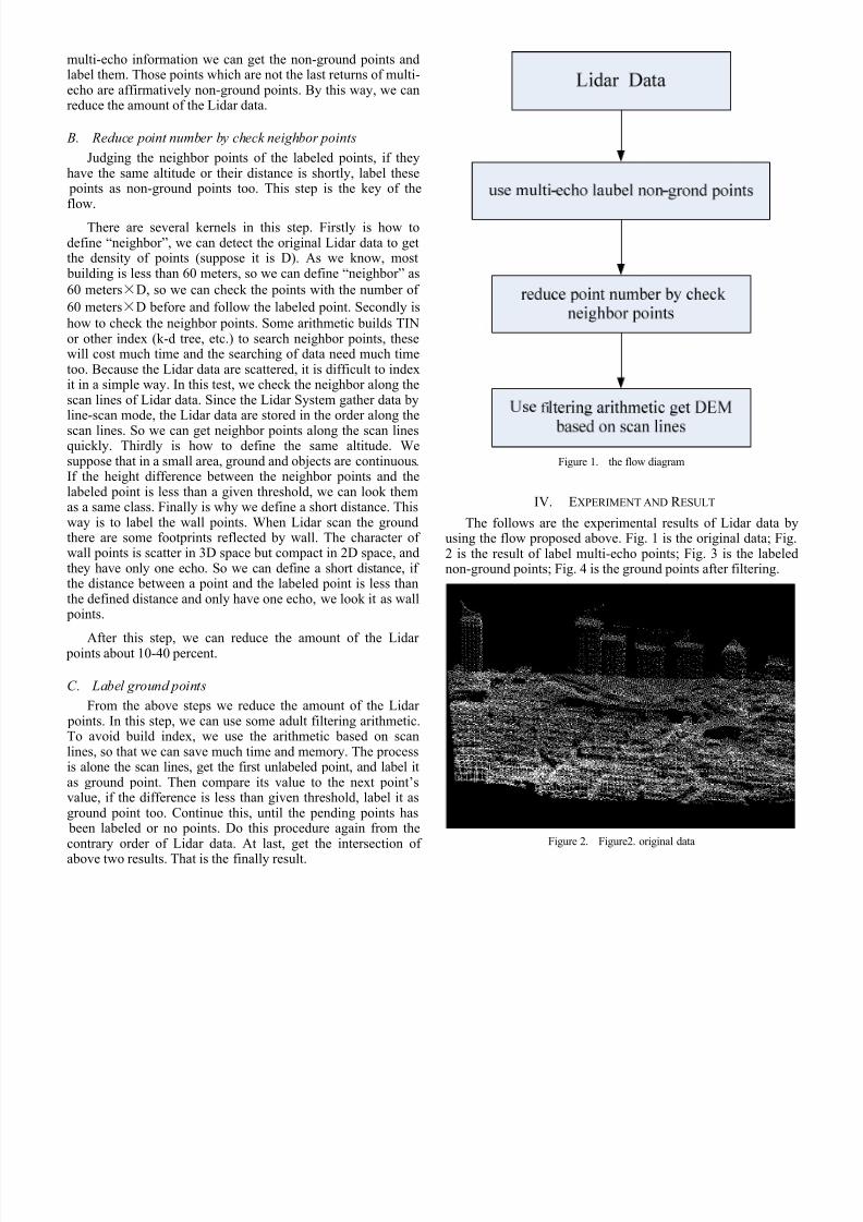
III. FLOW DESCRIPTIONGS
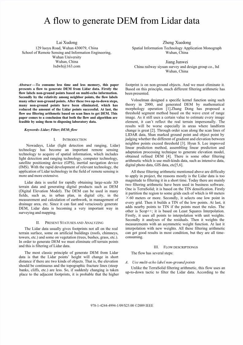
The flow has several steps:
A. Use multi-echo label non-ground points
Unlike the TerraSolid filtering arithmetic, this flow uses anup-to-down tactic to filter the Lidar data. According to the
978-1-4244-4994-1/09/$25.00 ©2009 IEEE
8/8/2019 Lidar - A Flow to Generate Lidar From Dem
http://slidepdf.com/reader/full/lidar-a-flow-to-generate-lidar-from-dem 2/3
multi-echo information we can get the non-ground points andlabel them. Those points which are not the last returns of multi-echo are affirmatively non-ground points. By this way, we canreduce the amount of the Lidar data.
B. Reduce point number by check neighbor points
Judging the neighbor points of the labeled points, if theyhave the same altitude or their distance is shortly, label these points as non-ground points too. This step is the key of theflow.
There are several kernels in this step. Firstly is how todefine “neighbor”, we can detect the original Lidar data to getthe density of points (suppose it is D). As we know, most building is less than 60 meters, so we can define “neighbor” as
60 metersD, so we can check the points with the number of
60 metersD before and follow the labeled point. Secondly is
how to check the neighbor points. Some arithmetic builds TINor other index (k-d tree, etc.) to search neighbor points, thesewill cost much time and the searching of data need much timetoo. Because the Lidar data are scattered, it is difficult to indexit in a simple way. In this test, we check the neighbor along thescan lines of Lidar data. Since the Lidar System gather data byline-scan mode, the Lidar data are stored in the order along the
scan lines. So we can get neighbor points along the scan linesquickly. Thirdly is how to define the same altitude. Wesuppose that in a small area, ground and objects are continuous.If the height difference between the neighbor points and thelabeled point is less than a given threshold, we can look themas a same class. Finally is why we define a short distance. Thisway is to label the wall points. When Lidar scan the groundthere are some footprints reflected by wall. The character of wall points is scatter in 3D space but compact in 2D space, andthey have only one echo. So we can define a short distance, if the distance between a point and the labeled point is less thanthe defined distance and only have one echo, we look it as wall points.
After this step, we can reduce the amount of the Lidar points about 10-40 percent.
C. Label ground points
From the above steps we reduce the amount of the Lidar points. In this step, we can use some adult filtering arithmetic.To avoid build index, we use the arithmetic based on scanlines, so that we can save much time and memory. The processis alone the scan lines, get the first unlabeled point, and label itas ground point. Then compare its value to the next point’svalue, if the difference is less than given threshold, label it asground point too. Continue this, until the pending points has been labeled or no points. Do this procedure again from thecontrary order of Lidar data. At last, get the intersection of
above two results. That is the finally result.
Figure 1. the flow diagram
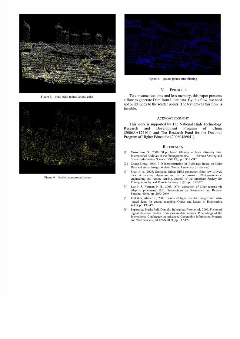
IV. EXPERIMENT AND R ESULT
The follows are the experimental results of Lidar data byusing the flow proposed above. Fig. 1 is the original data; Fig.2 is the result of label multi-echo points; Fig. 3 is the labelednon-ground points; Fig. 4 is the ground points after filtering.
Figure 2. Figure2. original data
8/8/2019 Lidar - A Flow to Generate Lidar From Dem
http://slidepdf.com/reader/full/lidar-a-flow-to-generate-lidar-from-dem 3/3
Figure 3. multi-echo points(yellow color)
Figure 4. labeled non-ground points
Figure 5. ground points after filtering
V. EPILOGUES
To consume less time and less memory, this paper presentsa flow to generate Dem from Lidar data. By this flow, we neednot build index to the scatter points. The test proves this flow isfeasible.
ACKNOWLEDGMENT
This work is supported by The National High TechnologyResearch and Development Program of China(2006AA122101) and The Research Fund for the DoctoralProgram of Higher Education (20060486041).
R EFERENCES
[1] Vosselman G., 2000. Slope based filtering of laser altimetry data.International Archives of the Photogrammetry, Remote Sensing andSpatial Information Science. 33(B3/2), pp. 935 -942.
[2] Zhang Dong, 2005. 3-D Reconstruction of Buildings Based on Lidar Data and Aerial Image. Wuhan: Wuhan University (in chinese)
[3] Shan J, A., 2005. Sampath. Urban DEM generation from raw LIDAR data: A labeling algorithm and its performance. Photogrammetric
engineering and remote sensing, Journal of the American Society for Photogrammetry and Remote Sensing. 71(2), pp. 217-226.
[4] Lee H S, Younan N H., 2003. DTM extraction of Lidar returns viaadaptive processing. IEEE Transactions on Geoscience and RemoteSensing. 41(9), pp. 2063-2069
[5] Elaksher, Ahmed F, 2008. Fusion of hyper spectral images and lidar- based dems for coastal mapping. Optics and Lasers in Engineering.46(7), pp. 493-498
[6] Papasaika, Haris; Poli, Daniela; Baltsavias, Emmanuel, 2009. Fusion of digital elevation models from various data sources. Proceedings of theInternational Conference on Advanced Geographic Information Systemsand Web Services, GEOWS 2009, pp. 117-122