Embed Size (px)
Citation preview
ESA Land Product Validation, ESRIN, 28 January 2014
www.GlobAlbedo.org
Lessons learnt from the ESA DUE GlobAlbedo land surface albedo product validation from European sensors.Jan-Peter Muller, Neville Shane, Said Kharbouche,
Gerardo López, Gill Watson Mullard Space Science Laboratory, UCL
P.Lewis, UCL GeographyJürgen Fischer, Luis Guanter, Réné Preusker
Freie Universität BerlinPeter North, Andreas Heckel, Swansea University
Olaf Danne, Uwe Krämer, Marco Zülhke, Carsten Brockmann, Brockmann Consult
Alessandro Cescatti, JRC Ispra; Simon Pinnock, ESA ESRIN
with contributions from Zhuosen Wang & Crystal Schaaf (U. of Mass., Boston), Gabriela Schaapman-Strub (U of Zurich)
ESA Land Product Validation, ESRIN, 28 January 2014
www.GlobAlbedo.org
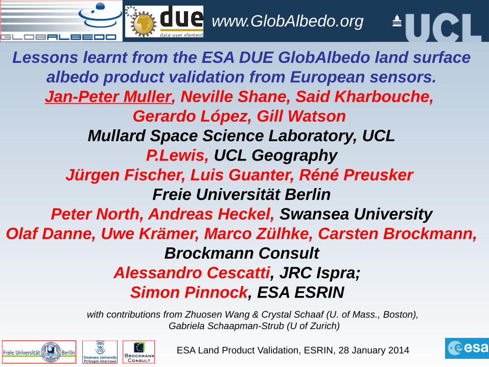
Overall Aims - GlobAlbedo
Production of a 14 year record (1998-2011) of 1km Land Surface BroadBand Albedo (BBA) every 8 days as well as 0.05º & 0.5º monthly from European space assets to provide an independent capability to generate this Essential Climate Variable
• Input data consists of level 1b (radiometrically calibrated, satellite projection) as well as MODIS C5 BRDF
MCD43A1,2 (3/2000-3/2010)MERIS (6/2002-4/12)
VGT (24.3.98-31.1.03) and VGT2 (1.2.03-12/11)[ATSR2 6/95-3/00, AATSR 6/02-4/12 unusable due to
geocoding]An estimated uncertainty (variance-covariance matrix) for
each output pixel using an optimal estimation frameworkValidation of final albedo products as well as intermediate
products (e.g. cloud masks, aerosol retrievals, narrow-to-broadband)
GlobAlbedo products freely available via wget/curl, http and display via animations and an OGC-compliant webGIS
ESA Land Product Validation, ESRIN, 28 January 2014
www.GlobAlbedo.org
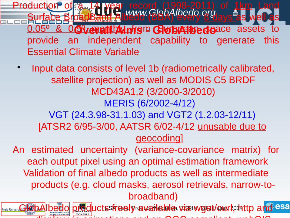
Overall Algorithm & Validation• MERIS & VGT I/P
• Subset of GlobAlbedoproductsvalidated
• Focus onPixel IDAOTSDRN-to-BBAlbedo
• Internal validation performed byrelevant producer
• Albedo validation performed over FLUXNET, BSRN, SURFRAD sites intercomparison with other EO
Overall GlobAlbedo processing chain GlobAlbedo product flowchartLewis et al., IGARSS12Muller et al., IGARSS12
BC SU
FUB
ESA Land Product Validation, ESRIN, 28 January 2014
www.GlobAlbedo.org
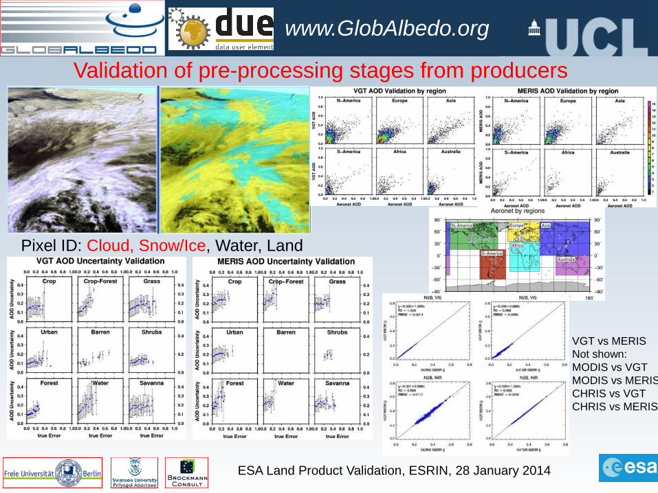
Validation of pre-processing stages from producers
Pixel ID: Cloud, Snow/Ice, Water, Land
VGT vs MERISNot shown:MODIS vs VGTMODIS vs MERISCHRIS vs VGTCHRIS vs MERIS
ESA Land Product Validation, ESRIN, 28 January 2014
www.GlobAlbedo.org
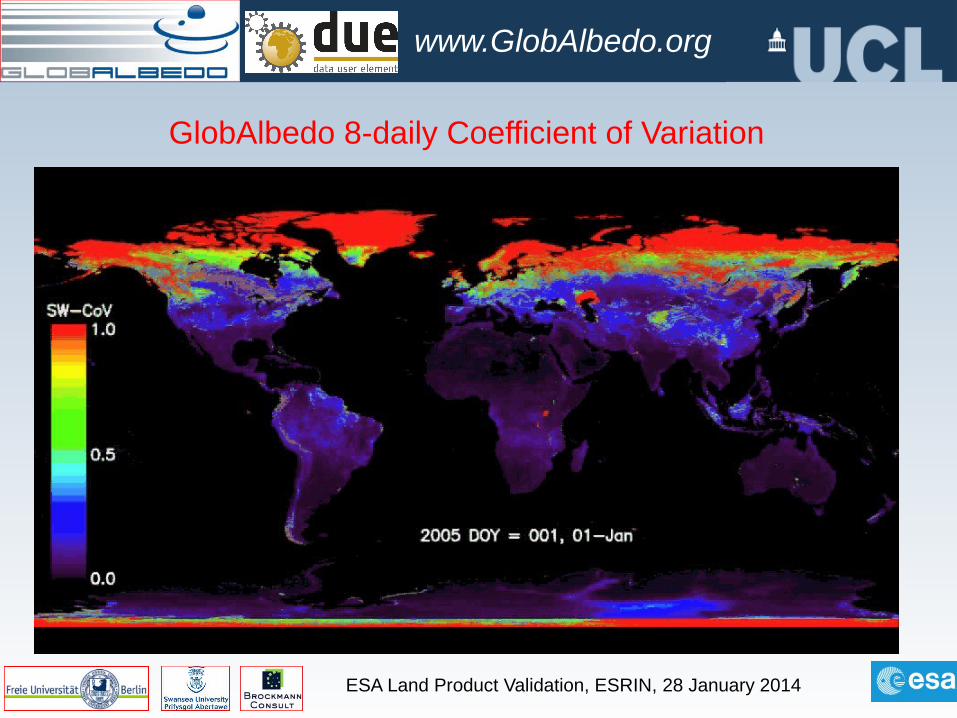
GlobAlbedo 8-daily Coefficient of Variation
ESA Land Product Validation, ESRIN, 28 January 2014
www.GlobAlbedo.org
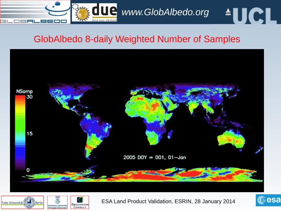
GlobAlbedo 8-daily Weighted Number of Samples
ESA Land Product Validation, ESRIN, 28 January 2014
www.GlobAlbedo.org
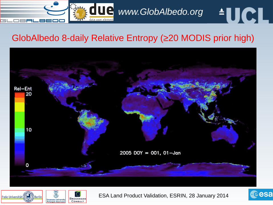
GlobAlbedo 8-daily Relative Entropy (≥20 MODIS prior high)
ESA Land Product Validation, ESRIN, 28 January 2014
www.GlobAlbedo.org
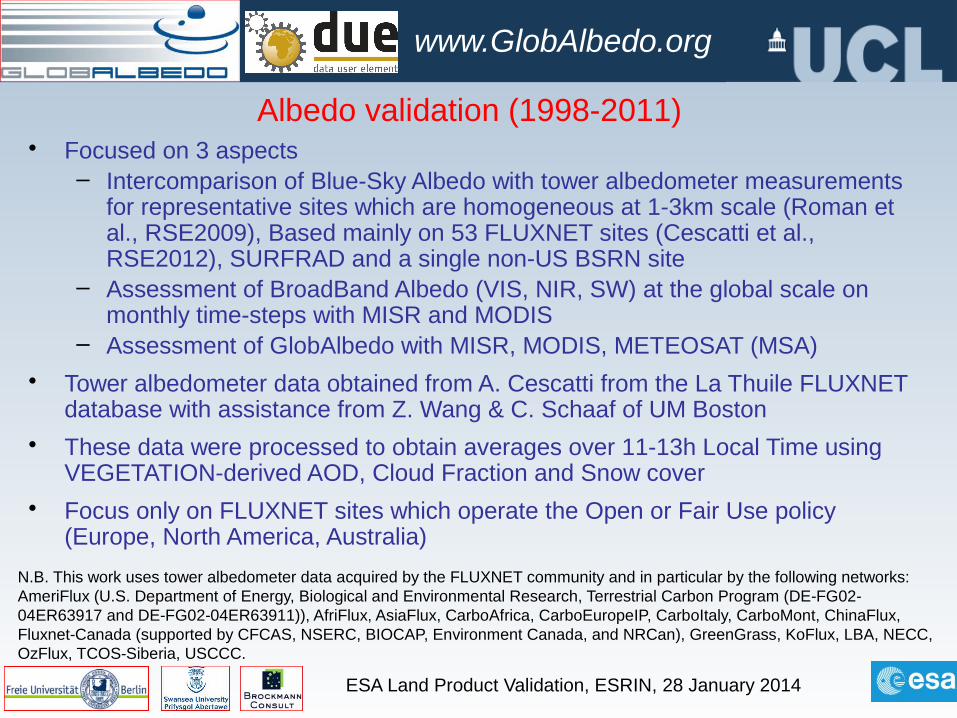
Albedo validation (1998-2011)• Focused on 3 aspects
– Intercomparison of Blue-Sky Albedo with tower albedometer measurements for representative sites which are homogeneous at 1-3km scale (Roman et al., RSE2009), Based mainly on 53 FLUXNET sites (Cescatti et al., RSE2012), SURFRAD and a single non-US BSRN site
– Assessment of BroadBand Albedo (VIS, NIR, SW) at the global scale on monthly time-steps with MISR and MODIS
– Assessment of GlobAlbedo with MISR, MODIS, METEOSAT (MSA)
• Tower albedometer data obtained from A. Cescatti from the La Thuile FLUXNET database with assistance from Z. Wang & C. Schaaf of UM Boston
• These data were processed to obtain averages over 11-13h Local Time using VEGETATION-derived AOD, Cloud Fraction and Snow cover
• Focus only on FLUXNET sites which operate the Open or Fair Use policy (Europe, North America, Australia)
N.B. This work uses tower albedometer data acquired by the FLUXNET community and in particular by the following networks: AmeriFlux (U.S. Department of Energy, Biological and Environmental Research, Terrestrial Carbon Program (DE‐FG02‐04ER63917 and DE‐FG02‐04ER63911)), AfriFlux, AsiaFlux, CarboAfrica, CarboEuropeIP, CarboItaly, CarboMont, ChinaFlux, Fluxnet‐Canada (supported by CFCAS, NSERC, BIOCAP, Environment Canada, and NRCan), GreenGrass, KoFlux, LBA, NECC, OzFlux, TCOS‐Siberia, USCCC.
ESA Land Product Validation, ESRIN, 28 January 2014
www.GlobAlbedo.org
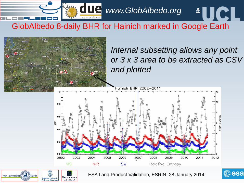
GlobAlbedo 8-daily BHR for Hainich marked in Google Earth
Internal subsetting allows any pointor 3 x 3 area to be extracted as CSVand plotted
ESA Land Product Validation, ESRIN, 28 January 2014
www.GlobAlbedo.org
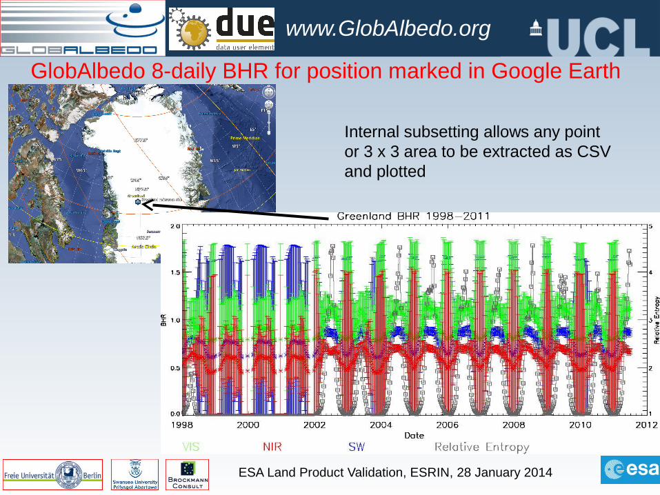
GlobAlbedo 8-daily BHR for position marked in Google Earth
Internal subsetting allows any pointor 3 x 3 area to be extracted as CSVand plotted
ESA Land Product Validation, ESRIN, 28 January 2014
www.GlobAlbedo.org
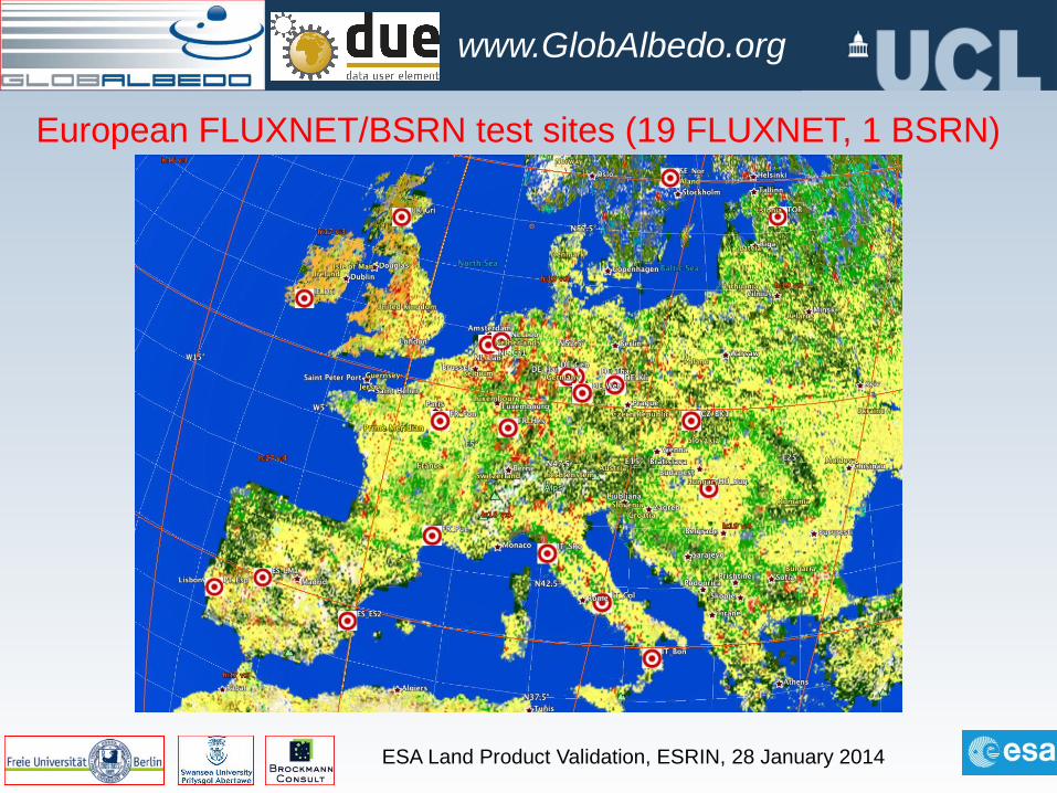
European FLUXNET/BSRN test sites (19 FLUXNET, 1 BSRN)
ESA Land Product Validation, ESRIN, 28 January 2014
www.GlobAlbedo.org
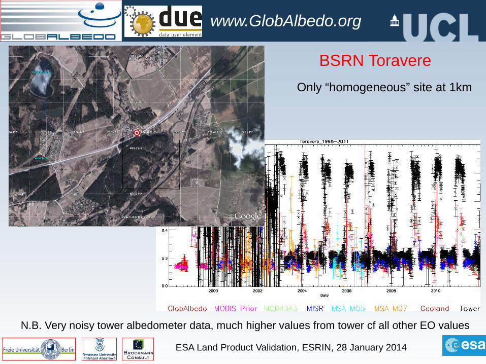
BSRN Toravere
N.B. Very noisy tower albedometer data, much higher values from tower cf all other EO values
Only “homogeneous” site at 1km
ESA Land Product Validation, ESRIN, 28 January 2014
www.GlobAlbedo.org
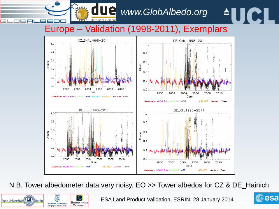
Europe – Validation (1998-2011), Exemplars
N.B. Tower albedometer data very noisy. EO >> Tower albedos for CZ & DE_Hainich
ESA Land Product Validation, ESRIN, 28 January 2014
www.GlobAlbedo.org
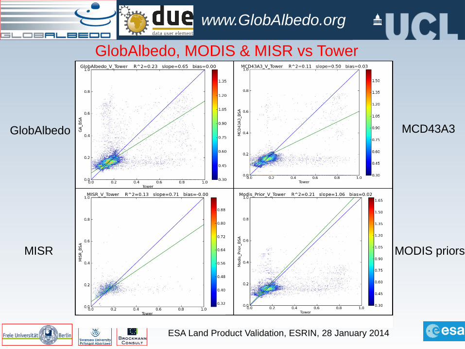
GlobAlbedo, MODIS & MISR vs Tower
GlobAlbedo
MISR
MCD43A3
MODIS priors
ESA Land Product Validation, ESRIN, 28 January 2014
www.GlobAlbedo.org
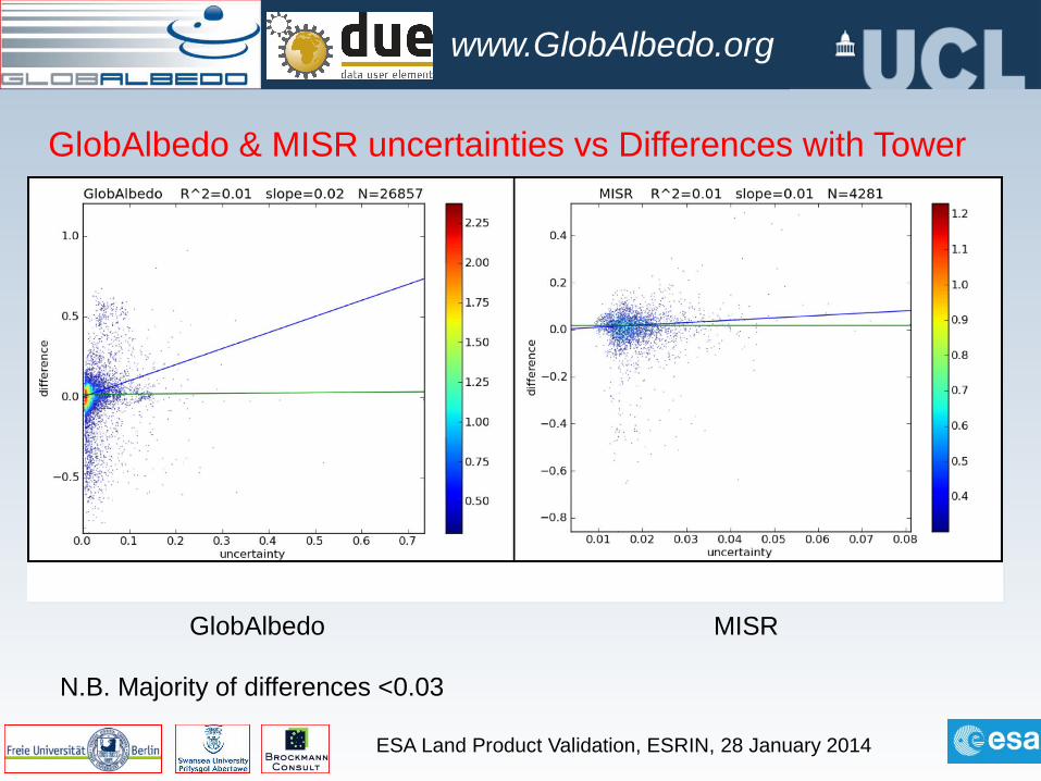
GlobAlbedo & MISR uncertainties vs Differences with Tower
GlobAlbedo MISR
N.B. Majority of differences <0.03
ESA Land Product Validation, ESRIN, 28 January 2014
www.GlobAlbedo.org
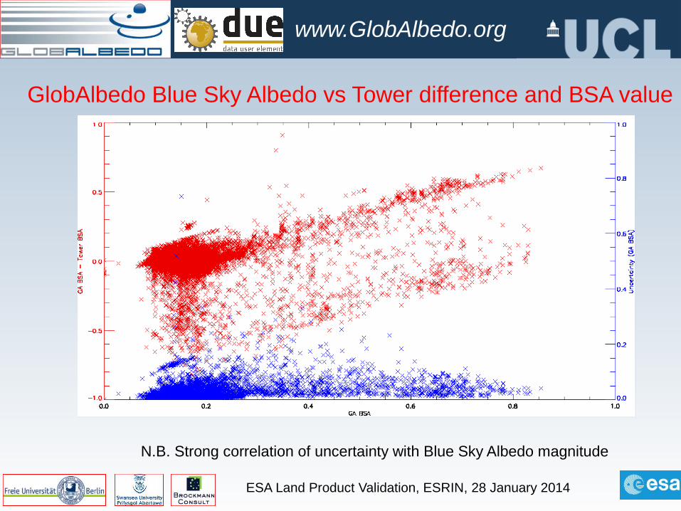
GlobAlbedo Blue Sky Albedo vs Tower difference and BSA value
N.B. Strong correlation of uncertainty with Blue Sky Albedo magnitude
ESA Land Product Validation, ESRIN, 28 January 2014
www.GlobAlbedo.org
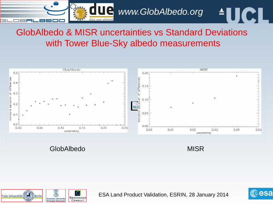
GlobAlbedo & MISR uncertainties vs Standard Deviations with Tower Blue-Sky albedo measurements
GlobAlbedo MISR
ESA Land Product Validation, ESRIN, 28 January 2014
www.GlobAlbedo.org
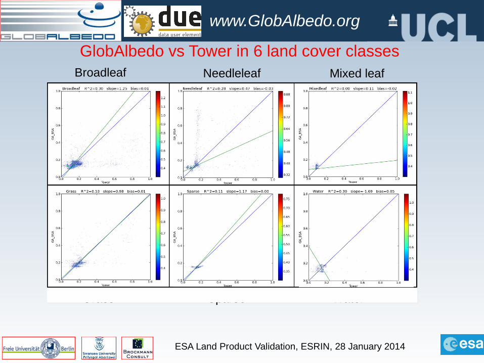
GlobAlbedo vs Tower in 6 land cover classesBroadleaf Needleleaf Mixed leaf
Grass Sparse Water
ESA Land Product Validation, ESRIN, 28 January 2014
www.GlobAlbedo.org
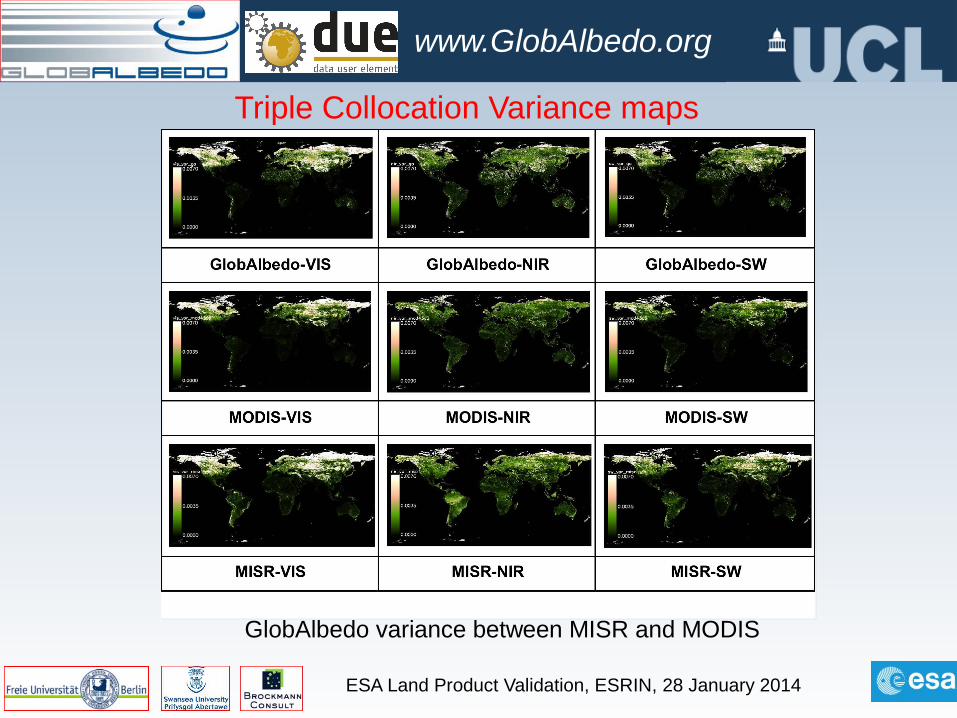
Triple Collocation Variance maps
GlobAlbedo variance between MISR and MODIS
ESA Land Product Validation, ESRIN, 28 January 2014
www.GlobAlbedo.org
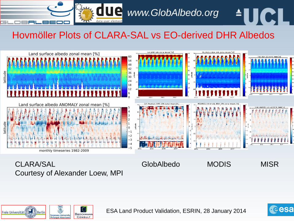
Hovmöller Plots of CLARA-SAL vs EO-derived DHR Albedos
CLARA/SALCourtesy of Alexander Loew, MPI
GlobAlbedo MODIS MISR

Atmospheric contamination of MCD43 products
19 March 2013 http://adam.noveltis.com/ 21
Africa (upper panel) and S. America (lower panel)
FDS (left) vs GA (right)Note the whitish hue due
to uncorrected aerosol/cloud contamination issues which are highlighted in the GA product
FDS uses pixel interpolation/extrapolation to explicitly remove aerosol/cloud in monthly composites”
Fonds des Sols MODIS “priors”
ESA Land Product Validation, ESRIN, 28 January 2014
www.GlobAlbedo.org
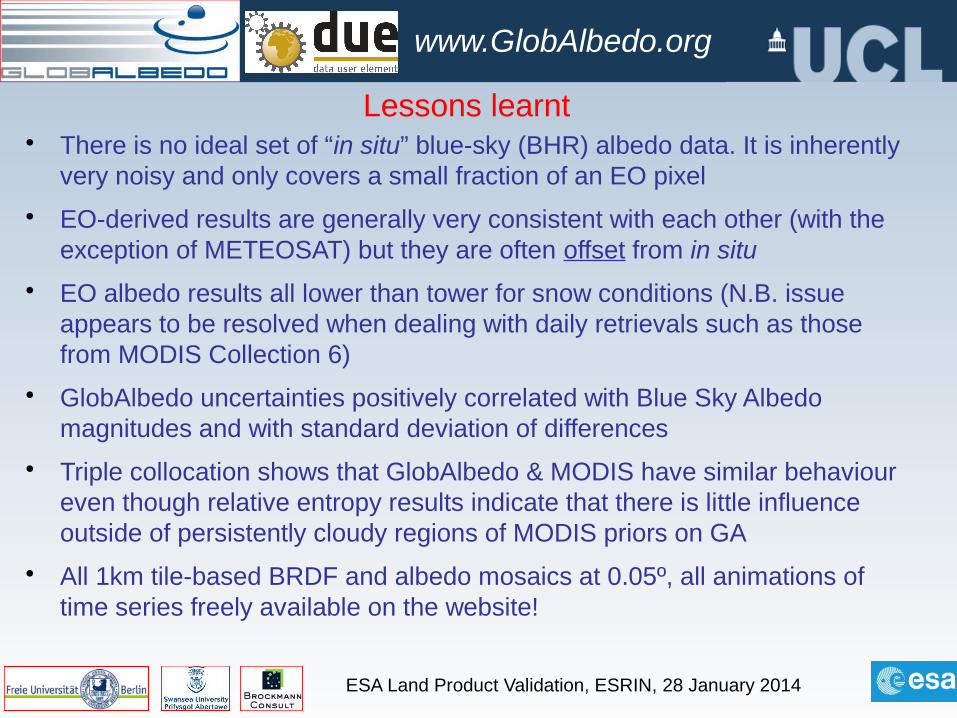
Lessons learnt• There is no ideal set of “in situ” blue-sky (BHR) albedo data. It is inherently
very noisy and only covers a small fraction of an EO pixel
• EO-derived results are generally very consistent with each other (with the exception of METEOSAT) but they are often offset from in situ
• EO albedo results all lower than tower for snow conditions (N.B. issue appears to be resolved when dealing with daily retrievals such as those from MODIS Collection 6)
• GlobAlbedo uncertainties positively correlated with Blue Sky Albedo magnitudes and with standard deviation of differences
• Triple collocation shows that GlobAlbedo & MODIS have similar behaviour even though relative entropy results indicate that there is little influence outside of persistently cloudy regions of MODIS priors on GA
• All 1km tile-based BRDF and albedo mosaics at 0.05º, all animations of time series freely available on the website!
ESA Land Product Validation, ESRIN, 28 January 2014
www.GlobAlbedo.org
What next?• 1998-2011 complete and
available online
• Validation datasets are established from FLUXNET and BSRN for global sites for entire time period
• Inter-comparisons done with MISR, MCD43, METEOSAT, MSG Land-SAF,GEOLAND2
• MPI Hamburg, UK Met Office, ETHZ, CICERO, NCEO, ITI, ECMWF, Météo-France testing impact of uncertainties on NWP forecasts
• Working with scientific partners on evaluation
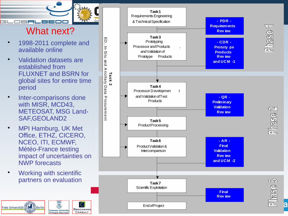
Task 1 Requirements Engineering
& Technical Specification
Task 3 Prototyping
Processor and Products , and Validation of
Prototype Products
Task 4 Processor Developmen t
and Validation of Test Products
Task 5 Product Processing
Task 6
Product Validation & Intercomparison
Task 7 Scientific Exploitation
End of Project
- PDR - Requirements
Rev iew
- CDR - Prototy pe Products Rev iew
and UCM -1
- QR - Preliminary Validation
Rev iew
- AR - Final
Validation Rev iew
and UCM -2
Final Rev iew
Ta
sk
2 E
O, In-S
itu an
d A
ncilla
ry Da
ta P
rocu
rem
en
t
ESA Land Product Validation, ESRIN, 28 January 2014
www.GlobAlbedo.org
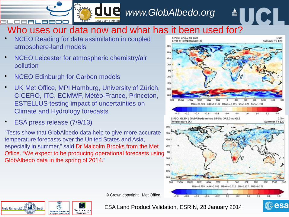
Who uses our data now and what has it been used for?• NCEO Reading for data assimilation in coupled
atmosphere-land models
• NCEO Leicester for atmospheric chemistry/air pollution
• NCEO Edinburgh for Carbon models
• UK Met Office, MPI Hamburg, University of Zürich, CICERO, ITC, ECMWF, Météo-France, Princeton, ESTELLUS testing impact of uncertainties on Climate and Hydrology forecasts
• ESA press release (7/9/13)
“Tests show that GlobAlbedo data help to give more accurate temperature forecasts over the United States and Asia, especially in summer,” said Dr Malcolm Brooks from the Met Office. “We expect to be producing operational forecasts using GlobAlbedo data in the spring of 2014.”
© Crown copyright Met Office
ESA Land Product Validation, ESRIN, 28 January 2014
www.GlobAlbedo.org
SPA.2013.1.1-03: Traceable quality assurance system for multi-decadal ECVs
FP7-SPACE-2013-1 Project No. 607405
1.1.14-31.12.17
Quality Assurance for Essential Climate VariablesK. Folkert Boersma ([email protected])
Co-ordinator(Precursor GHG)
Jan-Peter Muller ([email protected])
Deputy Co-ordinator (Land)
Daily albedo (and derived fapar, LAI) for 1982-2015
09- 07- 12 20:56www.esa- cci.org
Pagina 1 van 1http:/ / www.esa- cci.org/
CCI
Navigation
HomeAbout CCIProject planResourcesSupport
Related programs
ESA CCI Aerosol Cloud CMUG Fire GHG Glaciers Ice Sheets Land Cover Ocean Colour Ozone Sea Ice Sea Level SST
ESA Climate Change Initiative
Wed, 2010-09-01 11:03Climate change is arguably the greatest challenge facing mankind in the twenty-first century. Its importance has been recognised in recentreports from the IPCC and from UNFCCC, and the overwhelming economic consequences are set out in the Stern Report.
Read more »
Over 30 years of global soil moisture observations for climate
Wed, 2012-06-20 12:31The CCI Soil Moisture project, together with ESA's WACMOS project, has publically released an Essential Climate Variable soil moisturedataset that has been put together by the two projects. The dataset of changes in global soil moisture was generated using active andpassive microwave spaceborne-instruments and covers the 32 year period from 1978 to 2010.
Read more »
Remote Sensing of Environment: Special issue on the Sentinels
Thu, 2012-06-14 13:12ESA is developing five new missions called Sentinels specifically for the operational needs of the Global Monitoring for Environment andSecurity (GMES) programme. The series of Sentinel constellations, with the launch of the first Sentinels in 2013, will provide data continuityof ERS, Envisat, and SPOT-like observations.
Read more »
CCI Guidelines for Data Producers
Fri, 2012-04-27 15:56The CCI programme aims to make its datasets as widely useable as possible, in user communities outside the existing ones. Usingcommon data formats and a number of agreed and consistent metadata conventions will facilitate this.
Therefore guidelines have been drawn up for data producers in the CCI, to ensure consistency between the output products - CCIGuidelines for Data Producers. This is an evolving document that will be revised as the programme progresses.
Read more »
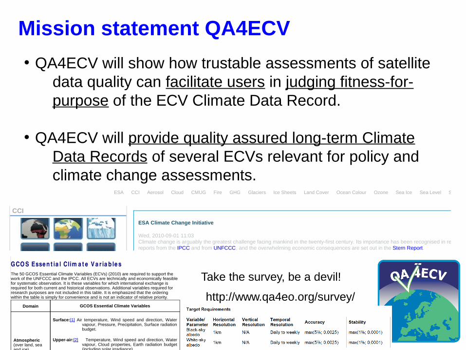
Mission statement QA4ECV
• QA4ECV will show how trustable assessments of satellite data quality can facilitate users in judging fitness-for-purpose of the ECV Climate Data Record.
• QA4ECV will provide quality assured long-term Climate Data Records of several ECVs relevant for policy and climate change assessments.
09- 07- 12 20:45GCOS: Essent ial Climate Variables
Pagina 1 van 2http:/ / www.wmo.int / pages/ prog/ gcos/ index.php?name= EssentialClimateVariables#footnote3
News Contact Publications Calendar Site mapNewsAbout GCOS
ClimateObservation NeedsUNFCCC and GCOSUNFCCC Guidelines
GCOS Reports toUNFCCC Essential Climate
Variables
Climate MonitoringPrinciples
Observing Systemsand Data
ActivitiesPartners
OutreachContact
GCO S Esse n t ia l Clim a t e V a r ia b le sThe 50 GCOS Essential Climate Variables (ECVs) (2010) are required to support thework of the UNFCCC and the IPCC. All ECVs are technically and economically feasiblefor systematic observation. It is these variables for which international exchange isrequired for both current and historical observations. Additional variables required forresearch purposes are not included in this table. It is emphasized that the orderingwithin the table is simply for convenience and is not an indicator of relative priority.
Domain GCOS Essential Climate Variables
Atmospheric(over land, seaand ice)
Surface:[1] Air temperature, Wind speed and direction, Water
vapour, Pressure, Precipitation, Surface radiationbudget.
Upper-air:[2] Temperature, Wind speed and direction, Water
vapour, Cloud properties, Earth radiation budget(including solar irradiance).
Composition: Carbon dioxide, Methane, and other long-lived
greenhouse gases[3], Ozone and Aerosol,supported by their precursors[4].
Oceanic
Surface:[5] Sea-surface temperature, Sea-surface salinity,
Sea level, Sea state, Sea ice, Surface current,Ocean colour, Carbon dioxide partial pressure,Ocean acidity, Phytoplankton.
Sub-surface: Temperature, Salinity, Current, Nutrients, Carbon
dioxide partial pressure, Ocean acidity, Oxygen,Tracers.
Terrestrial
River discharge, Water use, Groundwater, Lakes, Snow cover,Glaciers and ice caps, Ice sheets, Permafrost, Albedo, Landcover (including vegetation type), Fraction of absorbedphotosynthetically active radiation (FAPAR), Leaf area index(LAI), Above-ground biomass, Soil carbon, Fire disturbance, Soilmoisture.
[1] Including measurements at standardized, but globally varying heights in closeproximity to the surface.[2] Up to the stratopause.[3] Including nitrous oxide (N2O), chlorofluorocarbons (CFCs), hydrochlorofluorocarbons(HCFCs), hydrofluorocarbons (HFCs), sulphur hexafluoride (SF6), and perfluorocarbons
(PFCs).[4] In particular nitrogen dioxide (NO2), sulphur dioxide (SO2), formaldehyde (HCHO)
and carbon monoxide (CO).[5] Including measurements within the surface mixed layer, usually within the upper15m.
http://www.qa4eo.org/survey/
Take the survey, be a devil!

ESA Land Product Validation, ESRIN, 28 January 2014
www.GlobAlbedo.org
GCOS requirements on Albedo


![INAS 342 - the Flying Sentinels [Indian Navy]](https://img.pdfslide.us/doc/110x75/577d1cf51a28ab4e1e8b4993/inas-342-the-flying-sentinels-indian-navy.jpg)