Embed Size (px)
Citation preview
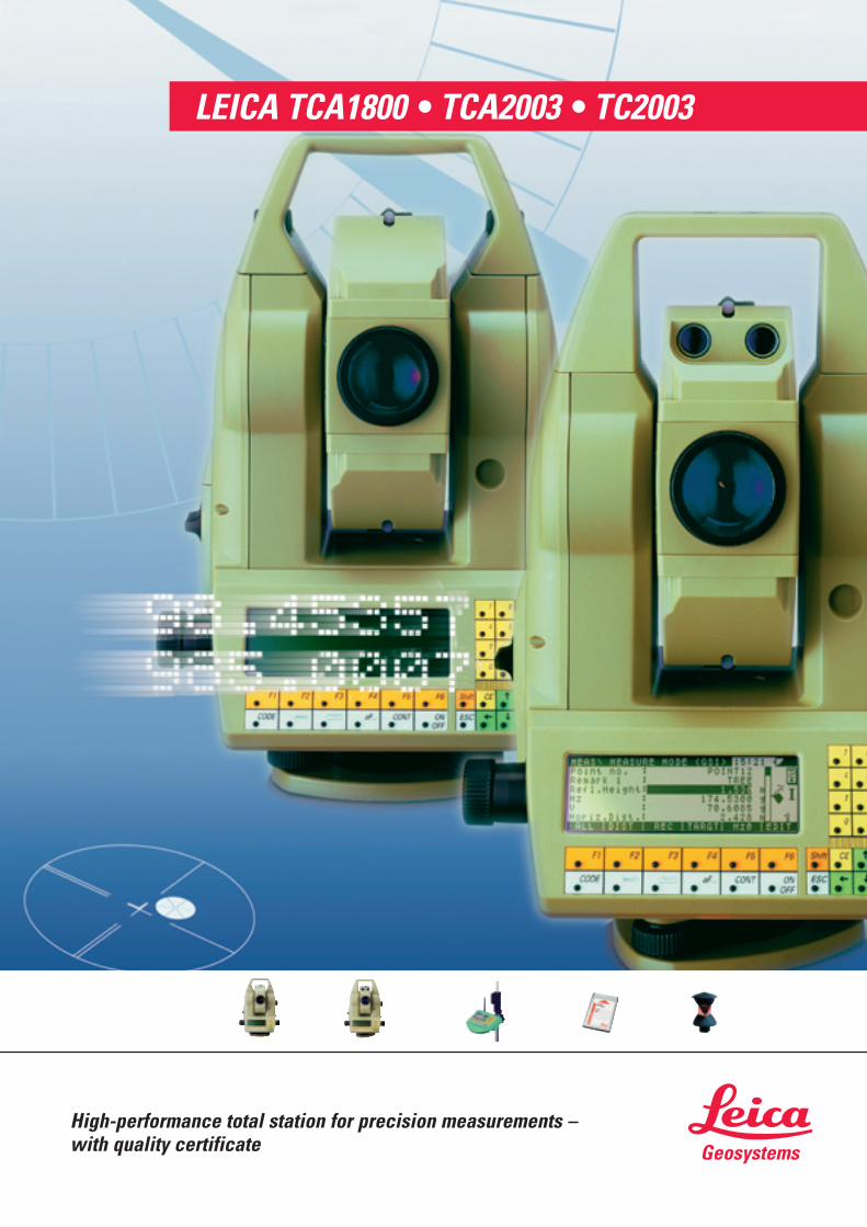
LEICA TCA1800 • TCA2003 • TC2003
High-performance total station for precision measurements – with quality certificate
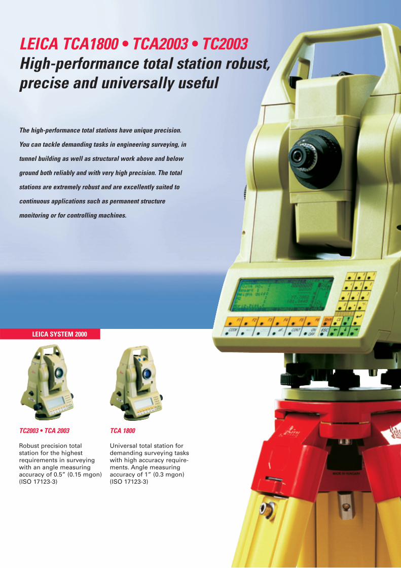
LEICA TCA1800 • TCA2003 • TC2003High-performance total station robust, precise and universally useful
TC2003 • TCA 2003
The high-performance total stations have unique precision.
You can tackle demanding tasks in engineering surveying, in
tunnel building as well as structural work above and below
ground both reliably and with very high precision. The total
stations are extremely robust and are excellently suited to
continuous applications such as permanent structure
monitoring or for controlling machines.
TCA 1800
Universal total station fordemanding surveying taskswith high accuracy require-ments. Angle measuringaccuracy of 1” (0.3 mgon)(ISO 17123-3)
LEICA SYSTEM 2000
Robust precision total station for the highest requirements in surveyingwith an angle measuringaccuracy of 0.5” (0.15 mgon)(ISO 17123-3)
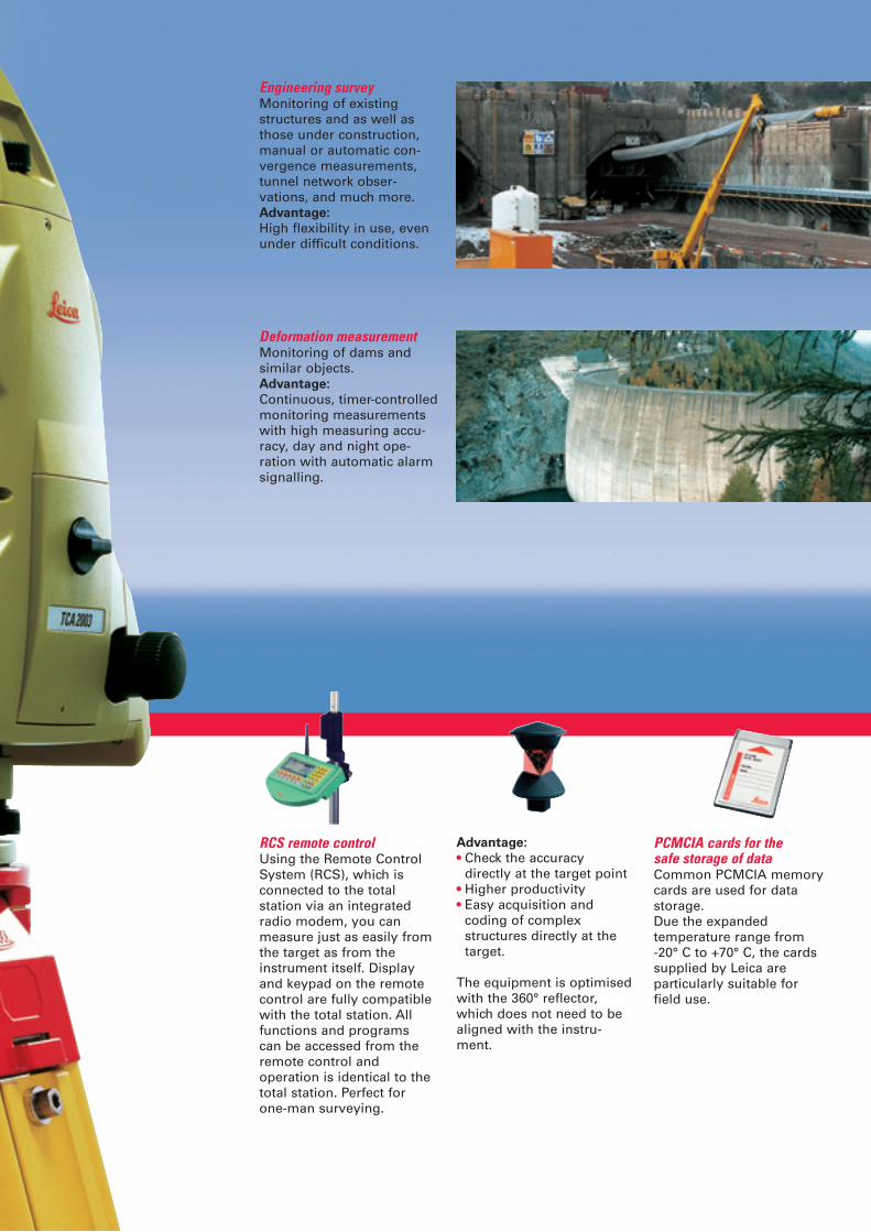
Advantage:
• Check the accuracy directly at the target point
• Higher productivity• Easy acquisition and
coding of complex structures directly at the target.
The equipment is optimisedwith the 360° reflector,which does not need to bealigned with the instru-ment.
Engineering surveyMonitoring of existingstructures and as well asthose under construction,manual or automatic con-vergence measurements,tunnel network obser-vations, and much more. Advantage:
High flexibility in use, evenunder difficult conditions.
Deformation measurementMonitoring of dams andsimilar objects.Advantage:
Continuous, timer-controlledmonitoring measurementswith high measuring accu-racy, day and night ope-ration with automatic alarmsignalling.
RCS remote controlUsing the Remote ControlSystem (RCS), which isconnected to the totalstation via an integratedradio modem, you canmeasure just as easily fromthe target as from theinstrument itself. Displayand keypad on the remotecontrol are fully compatiblewith the total station. Allfunctions and programs can be accessed from theremote control andoperation is identical to thetotal station. Perfect forone-man surveying.
PCMCIA cards for the safe storage of dataCommon PCMCIA memorycards are used for data storage. Due the expanded temperature range from -20° C to +70° C, the cardssupplied by Leica are particularly suitable for field use.
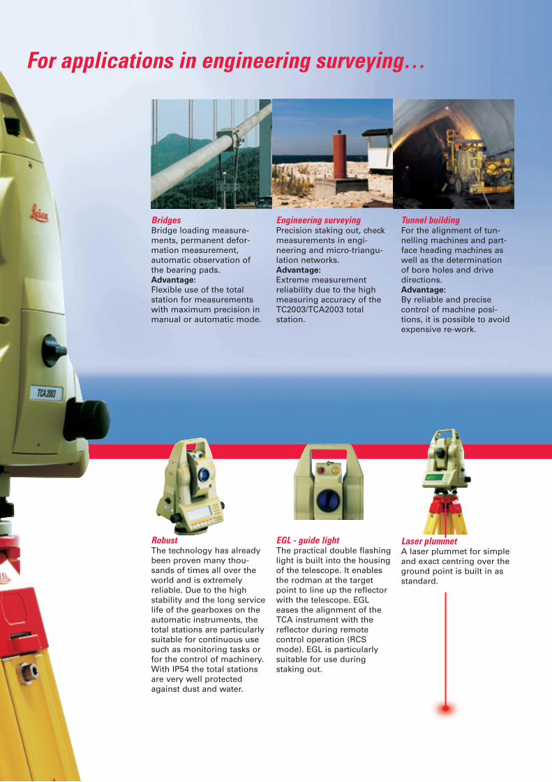
Laser plummetA laser plummet for simpleand exact centring over theground point is built in asstandard.
Tunnel buildingFor the alignment of tun-nelling machines and part-face heading machines aswell as the determinationof bore holes and drivedirections. Advantage:
By reliable and precisecontrol of machine posi-tions, it is possible to avoidexpensive re-work.
EGL - guide lightThe practical double flashinglight is built into the housingof the telescope. It enablesthe rodman at the targetpoint to line up the reflectorwith the telescope. EGLeases the alignment of theTCA instrument with thereflector during remotecontrol operation (RCSmode). EGL is particularlysuitable for use duringstaking out.
BridgesBridge loading measure-ments, permanent defor-mation measurement,automatic observation of the bearing pads. Advantage:
Flexible use of the total station for measurementswith maximum precision inmanual or automatic mode.
Engineering surveyingPrecision staking out, checkmeasurements in engi-neering and micro-triangu-lation networks. Advantage:
Extreme measurementreliability due to the highmeasuring accuracy of theTC2003/TCA2003 totalstation.
For applications in engineering surveying…
RobustThe technology has alreadybeen proven many thou-sands of times all over theworld and is extremelyreliable. Due to the highstability and the long servicelife of the gearboxes on theautomatic instruments, thetotal stations are particularlysuitable for continuous usesuch as monitoring tasks orfor the control of machinery.With IP54 the total stationsare very well protectedagainst dust and water.

Road building, railway buildingUsed for the control of slabform pavers, bitumes finis-hers, graders and cuttingmachines. Advantage:Due to the continuousonline measurements withthe total station, the time-consuming installation ofguide wires for controllingmachinery is not necessary.
LevellingUsed for the control of rollers of all types. Advantage:With the use of an automatictotal station, expensivemachine downtimes fordetermining height areunnecessary. Even slopedsurfaces can be easilyworked without interruption.
…in machine control
Automatic target trackingIn the LOCK mode theinstrument automaticallytracks the reflector after thefirst measurement. With asingle button press, allmeasured values can berecorded at any time with-out the need to interrupttarget tracking.Measurement is particularlyconvenient using the 360°reflector, as this does notneed to be aligned.
The LOCK mode is predominantly suitable for • Topographical mass point
surveys• Coded surveys for further
processing in LIS/GIS• Staking out
Automatic fine pointingThe Automatic TargetRecognition (ATR) demon-strates its full benefitsduring routine repeat mea-surements, e.g. monitoring,set measurements andmeasurement at two teles-cope faces. Using the sight,the observer aligns thetelescope roughly with thetarget point and triggers adistance measurement. Thetotal station automaticallymoves the telescope to thecentre of the prism, measu-res the distance and cor-rects the angle
1 mm
with the deviation to thecentre of the prism.• High, constant accuracy
independent of the observer
• Fatigue-free and quick• No focussing necessary• Measures using any
standard prisms (active prisms not required)
Earth worksUsed for the control of vertical boring machineryand rammers as well as forthe alignment of installa-tions and machines.Advantage:
Stakes for marking gridpoints are superfluous.
LEICA SYSTEM 2000
0,5''
1 mm + 1 ppm
…and for monitoring tasks of all types
Optional programs:
• Free Station• Road Line and Stakeout
incl. File Editor• Sets of Angles• Area• COGO (coordinate
geometry calculations)• Hidden Point, measurement
of points that are not directly visible
• Reference Line• Local Resection• Remote Height• Traverse• Monitoring• GeoBasic, for developing
custom programs
Onboard software – an application program suitablefor every taskThe comprehensive instru-ment software libraryprovides software suitable formany surveying tasks
Integrated programs:
• Station opening• Target Eccentricity• Manual Input of Coordinates
Standard programs:
• Orientation• Height Transfer• Resection• Stakeout• Computation of Tie Distance
The total stations have aspecially-manufacturedangle measuring systemthat facilitates a measuringaccuracy of 0.15mgon (0.5")on the TC2003 andTCA2003. Key elementshere are the precise drivesand the quadruple detec-tion of the graduatedcircles.
All total stations are equippedwith coaxial precisiondistancers. On the TC2003 and TCA2003, a distance measuring accuracy of 1mm +1ppm is achieved due to theuse of specially-developedcomponents.
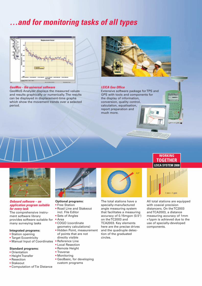
GeoMos - the universal softwareGeoMoS Analyzer displays the measured values and results graphically or numerically. The resultscan be displayed in displacement-time graphs which show the movement trends over a selectedperiod.
WORKINGTOGETHER
LEICA Geo OfficeExtensive software package for TPS and GPS with tools and components for the display of information, conversion, quality control, calculation, equalisation, report preparation and much more.
LEICA SYSTEM 2000
LEICA TCA1800 • TCA2003 • TC2003Technical specifications
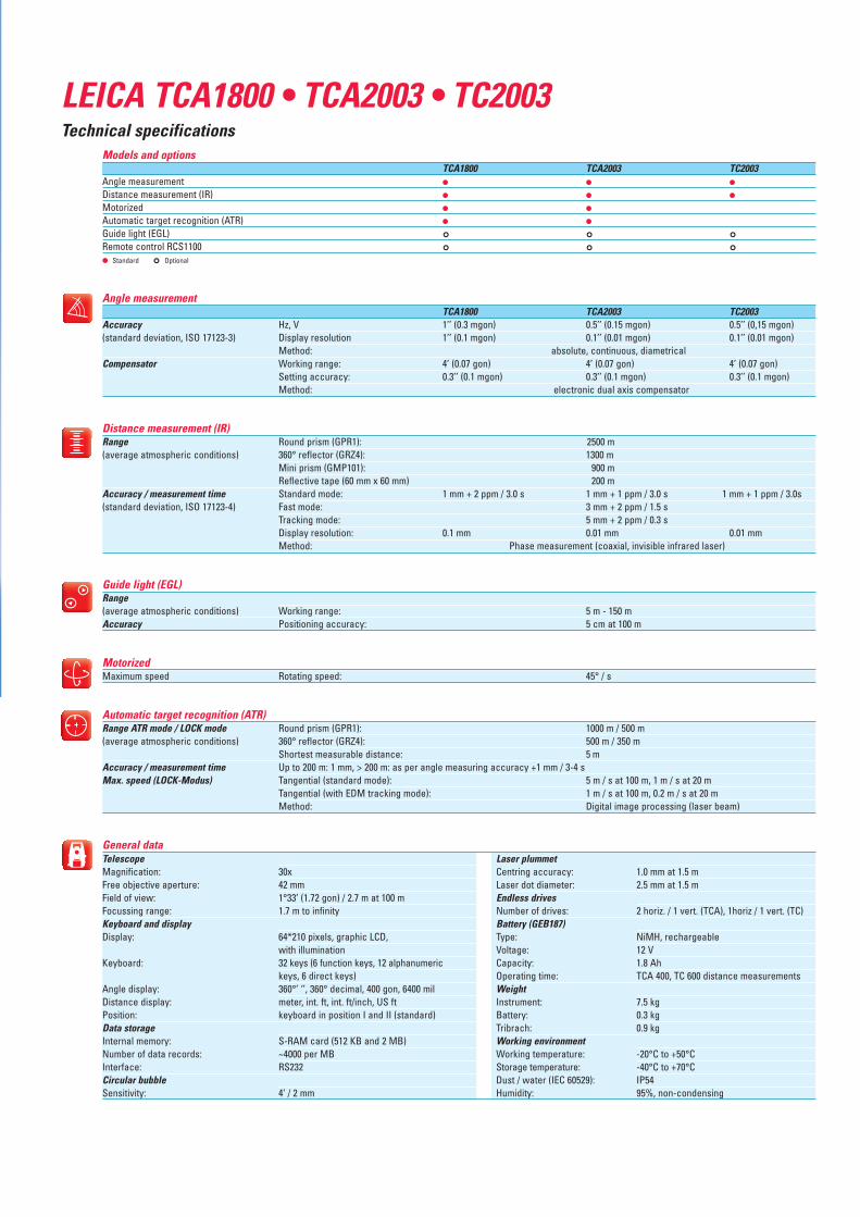
TelescopeMagnification: 30xFree objective aperture: 42 mmField of view: 1°33’ (1.72 gon) / 2.7 m at 100 mFocussing range: 1.7 m to infinityKeyboard and displayDisplay: 64*210 pixels, graphic LCD,
with illuminationKeyboard: 32 keys (6 function keys, 12 alphanumeric
keys, 6 direct keys)Angle display: 360°’ ‘’, 360° decimal, 400 gon, 6400 milDistance display: meter, int. ft, int. ft/inch, US ftPosition: keyboard in position I and II (standard)Data storageInternal memory: S-RAM card (512 KB and 2 MB)Number of data records: ~4000 per MBInterface: RS232Circular bubbleSensitivity: 4’ / 2 mm
Laser plummetCentring accuracy: 1.0 mm at 1.5 mLaser dot diameter: 2.5 mm at 1.5 mEndless drivesNumber of drives: 2 horiz. / 1 vert. (TCA), 1horiz / 1 vert. (TC) Battery (GEB187)Type: NiMH, rechargeableVoltage: 12 VCapacity: 1.8 AhOperating time: TCA 400, TC 600 distance measurementsWeightInstrument: 7.5 kgBattery: 0.3 kgTribrach: 0.9 kg Working environmentWorking temperature: -20°C to +50°CStorage temperature: -40°C to +70°CDust / water (IEC 60529): IP54Humidity: 95%, non-condensing
Models and optionsTCA1800 TCA2003 TC2003
Angle measurement ● ● ●
Distance measurement (IR) ● ● ●
Motorized ● ●
Automatic target recognition (ATR) ● ●
Guide light (EGL) ° ° °Remote control RCS1100 ° ° °● Standard ° Optional
Angle measurementTCA1800 TCA2003 TC2003
Accuracy Hz, V 1’’ (0.3 mgon) 0.5’’ (0.15 mgon) 0.5’’ (0,15 mgon)(standard deviation, ISO 17123-3) Display resolution 1’’ (0.1 mgon) 0.1’’ (0.01 mgon) 0.1’’ (0.01 mgon)
Method: absolute, continuous, diametricalCompensator Working range: 4’ (0.07 gon) 4’ (0.07 gon) 4’ (0.07 gon)
Setting accuracy: 0.3’’ (0.1 mgon) 0.3’’ (0.1 mgon) 0.3’’ (0.1 mgon)Method: electronic dual axis compensator
Distance measurement (IR)Range Round prism (GPR1): 2500 m(average atmospheric conditions) 360° reflector (GRZ4): 1300 m
Mini prism (GMP101): 900 mReflective tape (60 mm x 60 mm) 200 m
Accuracy / measurement time Standard mode: 1 mm + 2 ppm / 3.0 s 1 mm + 1 ppm / 3.0 s 1 mm + 1 ppm / 3.0s(standard deviation, ISO 17123-4) Fast mode: 3 mm + 2 ppm / 1.5 s
Tracking mode: 5 mm + 2 ppm / 0.3 sDisplay resolution: 0.1 mm 0.01 mm 0.01 mmMethod: Phase measurement (coaxial, invisible infrared laser)
Guide light (EGL)Range(average atmospheric conditions) Working range: 5 m - 150 mAccuracy Positioning accuracy: 5 cm at 100 m
MotorizedMaximum speed Rotating speed: 45° / s
Automatic target recognition (ATR)Range ATR mode / LOCK mode Round prism (GPR1): 1000 m / 500 m(average atmospheric conditions) 360° reflector (GRZ4): 500 m / 350 m
Shortest measurable distance: 5 m Accuracy / measurement time Up to 200 m: 1 mm, > 200 m: as per angle measuring accuracy +1 mm / 3-4 sMax. speed (LOCK-Modus) Tangential (standard mode): 5 m / s at 100 m, 1 m / s at 20 m
Tangential (with EDM tracking mode): 1 m / s at 100 m, 0.2 m / s at 20 mMethod: Digital image processing (laser beam)
General data
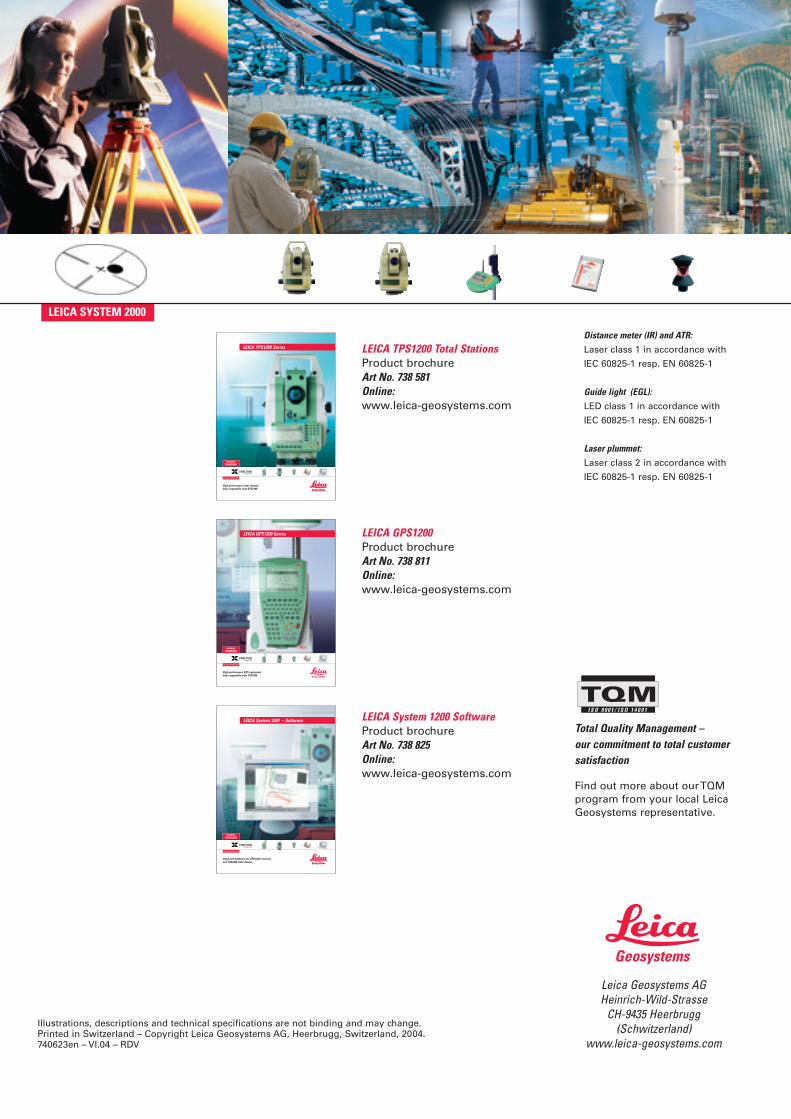
LEICA TPS1200 Total StationsProduct brochureArt No. 738 581Online:www.leica-geosystems.com
Leica Geosystems AGHeinrich-Wild-Strasse
CH-9435 Heerbrugg(Schwitzerland)
www.leica-geosystems.com
Total Quality Management – our commitment to total customersatisfaction
Find out more about our TQMprogram from your local LeicaGeosystems representative.
Illustrations, descriptions and technical specifications are not binding and may change.Printed in Switzerland – Copyright Leica Geosystems AG, Heerbrugg, Switzerland, 2004.740623en – VI.04 – RDV
I S O 9 0 0 1 / I S O 1 4 0 0 1
LEICA GPS1200 Product brochureArt No. 738 811Online:www.leica-geosystems.com
LEICA System 1200 SoftwareProduct brochureArt No. 738 825Online:www.leica-geosystems.com
Distance meter (IR) and ATR:Laser class 1 in accordance with
IEC 60825-1 resp. EN 60825-1
Guide light (EGL):LED class 1 in accordance with
IEC 60825-1 resp. EN 60825-1
Laser plummet:Laser class 2 in accordance with
IEC 60825-1 resp. EN 60825-1
LEICA SYSTEM 2000
High performance total stations fully compatible with GPS1200
LEICA TPS1200 Series
WORKINGTOGETHER
FUNCTIONintegrated
LEICA SYSTEM 1200
LEICA GPS1200 Series
High performance GPS equipment fully compatible with TPS1200
WORKINGTOGETHER
FUNCTIONintegrated
LEICA SYSTEM 1200
Integrated Software for GPS1200 receivers and TPS1200 total stations
LEICA System 1200 – Software
WORKINGTOGETHER
FUNCTIONintegrated
LEICA SYSTEM 1200