Embed Size (px)
Citation preview

LECTURE 2_12:
FEB. 25, 2014
WATER
HUMAN INTERVENTIONS IN THE
HYDROLOGICAL CYCLE
T. Randall, Lakehead University, WA 2014
Text Reference: Dearden and Mitchell (2012), Ch. 11, pp. 374-383.

Outline
Key components of the hydrological cycle
Water diversions, with examples
{dams: WAC Bennett; Old Man River; La Grande; Columbia River; Revelstoke Dam}
{floodways: Winnipeg; Neebing-McIntyre}
{inter-basin transfers: Kemano; Nechako River}
From: Dearden and Mitchell (2012)

Canada
only 0.5% of the world’s
population
Home to almost 20% of the
global stock of fresh water;
Only 7% of total flow of
renewable water (Brazil and
Russia have more)
2nd amongst water consumers in
the world
From: Dearden and Mitchell (2012)

Hydrological Cycle
From: Dearden and Mitchell (2012)
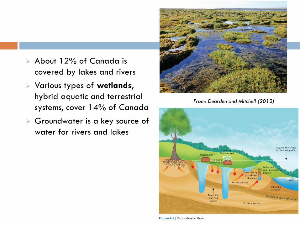
About 12% of Canada is
covered by lakes and rivers
Various types of wetlands,
hybrid aquatic and terrestrial
systems, cover 14% of Canada
Groundwater is a key source of
water for rivers and lakes
From: Dearden and Mitchell (2012)

Terminology:
Watershed;
Drainage Divide or
Divide;
Floodplain

Water Diversion
Dams
(~900 large ones in Canada)
Inter-basin diversions
(~60 large ones in Canada)
~333 (Quebec)
~149 (Ontario)
~131 (British Columbia)
From: Dearden and Mitchell (2012)

Reasons for Water Diversions (1)
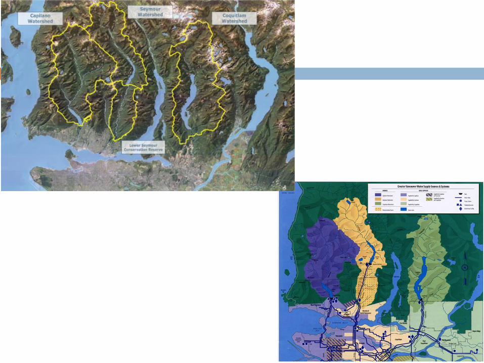
To increase community water supplies (for consumption, for irrigation … less common in Canada than elsewhere)
e.g., Old Man R. dam (S. Alberta) (installed in 1992, response to droughts); Vancouver’s three northshore watersheds
Capilano Reservoir Old Man River dam.

Reasons for Water Diversions (2)
To protect communities/intrastructure (flood protection)
e.g. Winnipeg Floodway (shown during 1997 floods)
Potential impact of 700 year flood on Winnipeg without the floodway (left). Source:
Natural Resources Canada
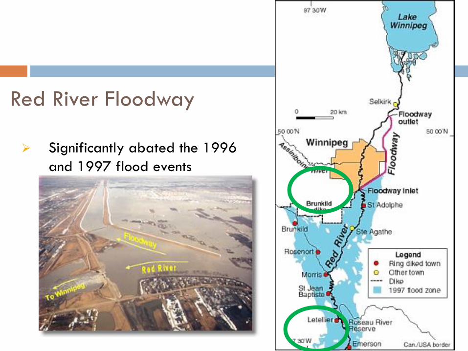
Red River Floodway
Significantly abated the 1996
and 1997 flood events

Winnipeg spillway – inlet; in operation during 1997
flood

Extensive flooding near Roseau River Reserve
channel banks

Neebing River Spillway (Thunder Bay)
Completed in 1982
To carry floodwaters from Neebing R. to Neebing-
McIntyre Diversion
Dam at Lake Tamblyn part of “catchment control
measures”
To protect Intercity area
Photo Credit: TA Randall (Oct. 2004).

Neebing R. Spillway (Thunder Bay)
To protect Intercity area
From: Lakehead Region Conservation Authority (2005)
Intercity Mall

From: Google Earth (2009)
Chapples GC
McIntyre River
Neebing River
Neebing R.
Spillway
Intercity Mall
Neebing
Spillway
Confederation College
Dam at LU’s
Lake Tamblyn

Reasons for Water Diversions (3)
To augment/increase river capacity (for shipping, for moving
goods downriver)
e.g., small dams on Ottawa river to move logs to sawmills
Timber rafts at Parliament Hill (in
1882)

Reasons for Water Diversions (4)
To concentrate/consolidate water flows (for hydroelectric generation purposes)
Canada a global leader in diversions for these purposes
e.gs., Columbia River Treaty; James Bay Project; Churchill Falls; Gardner Dam, SK; Kemano Completion
Kemano diversion (Nechako R. Fraser
R.) Power generation in Ottawa River
watershed

Columbia River Treaty (Can-US)
http://www.nwd-
wc.usace.army.mil/report/colmap.htm
Revelstoke Dam, completed 1984 but
NOT part of Columbia River Treaty
dams
Keenleyside Dam

Columbia River Treaty (Can-US)
Agreement 1964, re development and operation of dams in the
upper Columbia basin for purposes of flood control and power
generation;
4 dams constructed under this treaty (3 in Canada, 1 in US);
The Canadian treaty dams (except the Mica) were initially for water
storage and discharge regulation only;
Canada is compensated financially for providing these storage and
floor control benefits to downstream states;
Treaty has no expiration, however at 60 years (in 2024), either
country can terminate most provisions given a full 10 years notice
(…. Currently both governments are reviewing as 2014 is this
advanced 10 years)

Columbia River Treaty (Can-US)
Advantages
Economic benefits to both BC and Pacific NW states (including but not
limited to employment);
Flood control
Disadvantages
Social impacts: community and home relocations; loss of culturally significant
First Nations landscapes (including burial grounds) of the Sinixt people who
occupied the Columbia Valley;
Environmental impacts: during both construction and operation phases; “loss
of natural river behaviour” (e.g., smoothing of annual hydrograph – lower
peak flows, higher winter ‘low’ flows) (reduced peak levels by 10’s of
metres); impacts on fish habitat (water temperature, sedimentation) and fish
migration;

Hugh Keenleyside Dam, completed in 1968
Other images viewable at:
http://www.cbt.org/crt/resources-PreAndPostImages.html

Kitimat-Kemano Project
1948: BC Gov’t invited Alcan to consider building aluminum smelter on BC Coast;
Dec. 1950: BC Govt granted Alcan license to divert water from Nechako and Ninika watersheds to feed turbines at Kemano hydro-station;
First Nations situated on reserves on Lake Cheslatta (which would be inundated by the rising Nechako Reservoir) were relocated – with very little notice – April 1952;
Kenney Dam completed in Oct 1952
www.kitimatmuseum.ca

Nechako Reservoir – Ootsa Lake
Kenney Dam
Source: Google Earth 2014

Flows in upper Nechako dropped to 25% of normal for 4 years after dam completion (to fill reservoir)
Chinook salmon run all but destroyed during this period
1957: Smelter at Kitimat in full operation, powered by “Kemano 1”
Late 1970’s interest in Kemano 2 (“Kemano Completion Project”) – has been subject of much debate during 1980s-1990s at times being approved by Fed Govt (e.g., exempted from an Environmental Assessment in 1991 by Mulrooney Govt); it has yet to be built
Kemano plant is now largely automated, with the community of Kemano formally closed in 2000;
Dislocated FN still active ….

An aboriginal band in north-central B.C. has moved toward harnessing the
power of a hydro-electric dam that flooded their territory and imprinted
images of floating coffins into their history.
Sixty-two years after the Kenney Dam flooded the traditional territory of
the Cheslatta Carrier Nation, destroying hunting, fishing and living areas
and drying up parts of the Nechako River, the Prince George-area nation
plans to profit from the structure built without their consultation to power
the Rio Tinto Alcan smelter in Kitimat. Source: The Globe and Mail, Monday September, 30, 2013
Cheslatta aboriginals seek Kenney Dam water licence
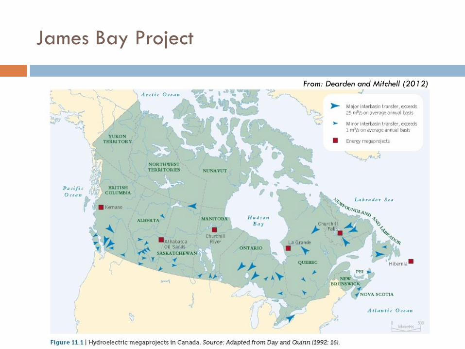
James Bay Project
From: Dearden and Mitchell (2012)

La Grande River (James Bay Pr. Phase I)
Part of hydro development
originally proposed in 1971 to
satisfy future electricity needs in
Quebec;
Phase I: La Grande River
Flow to this basin doubled via
diversions from adjacent
watersheds;
LG2, 3 and 4 constructed; LG1
deferred to Phase II;
Phase I completed in 1986
Phase II: announced 1985
Energy for export to US;
Energy (low cost) to attract
energy-intensive industries to PQ
From: Dearden and Mitchell (2012)

James Bay Pr. Phase II
(Great Whale Project)
Like Phase I, continues to encroach on
traditional territory of >10,000 Cree
and Inuit;
Encompasses an area ~size of France
An agreement was reached “James
Bay and Northern Quebec
Agreement” in 1975 – between govts
and these First Nations (the first
‘modern’ land claims agreement)
Agreement included provisions for: 1)
land rights; 2) a process to deal with
future hydro developments

Need for adaptive management approach …
… reinforced by concerns / issues raised during construction period
and in years following construction:
During Construction:
Relocation of Ft George to new site at Chisasibi;
Quality of drinking water at new community;
Problems maintaining traditional hunting activities (affected due to access
road construction, altered patterns of ice breakup by release of ‘warm’
water from reservoirs)
Following Construction:
Very high levels of Mercury in fish caught in reservoirs or connecting rivers;

No environmental assessment had predicted the appearance of Hg in reservoir fish;
Monitoring ongoing for both fish and higher consumers (e.g., Cree populations);
Some improvements (i.e., drop in Hg levels in Cree) but these may be due to change in diet rather than change in concentrations in fish species they used to consume; (from studies in late 1990s’)
Fig. NAM-28-12
(11) Average mercury levels [mg kg-1] in the
flesh of lake whitefish and northern pike in the
La Grande 2 and Opinaca Reservoirs.
http://wldb.ilec.or.jp/data/databook_html/nam/nam-28.html

WAC Bennett Dam, Peace River, BC
Built in 1967
Created Lake Williston
Significant downstream
on river hydrology
(magnitude and timing
of discharge) and on
riverine habits
(especially the Peace-
Athabasca delta) and
the loss of ‘regular
flooding’ in that
ecosystem

Thursday: “The Evolution of Development” (Dan Duckert, PhD
candidate, Lakehead University Faculty of Natural Resources
Management)
Tuesday: “Water Quality and Water Security”
Read ahead (Chpt. 11, Water, pp. 383 397)
Looking Ahead to the next lectures

References
Dearden, P and Mitchell, B. 2012. Environmental Change and Challenge,
Fourth Edition, Don Mills, Ontario: Oxford University Press {Chapter 11:
‘Water’}