Embed Size (px)
Citation preview
LEA RIVER PARKPRIMER
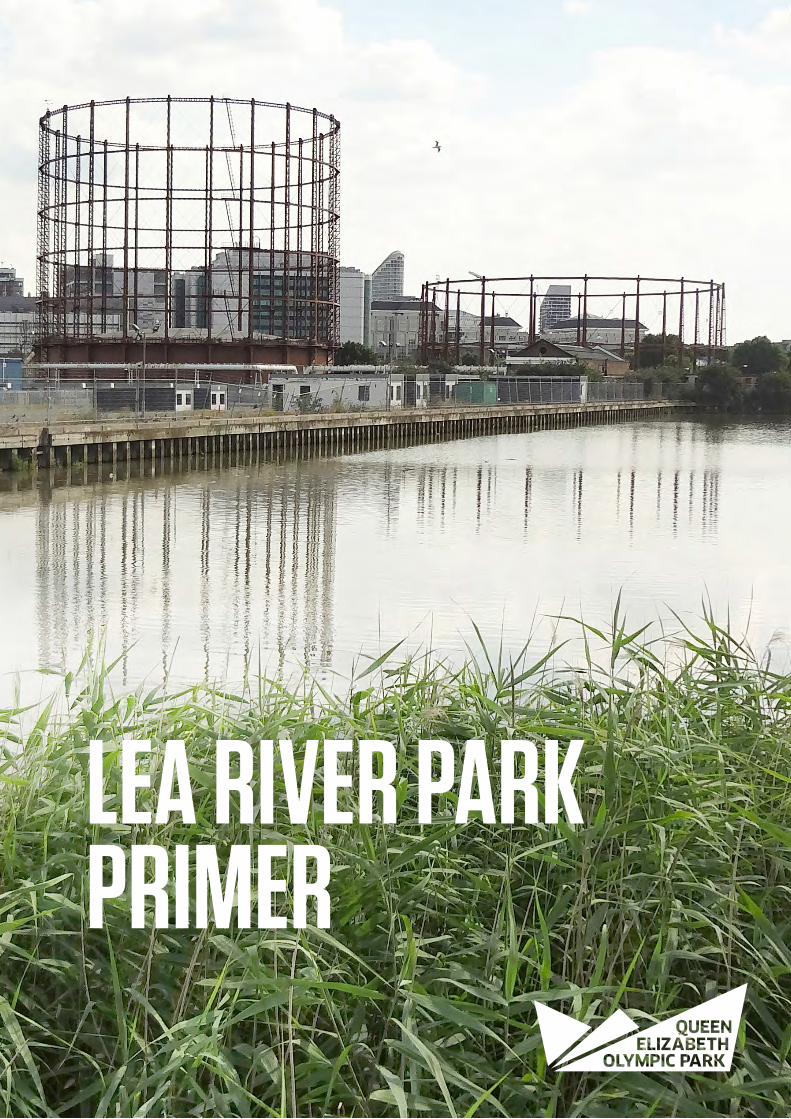
© Philip Vile
CONTENTS
Published October 2016
Welcome to the ParkExecutive SummaryIntroductionCompleting the Lee Valley Park
An Amazing ValleyThe Context of the Lea ValleyThe Six Parks and the LeawayA Day Out in the Lea River ParkCurating the Valley
The LeawayThe Leaway - Overcoming SeveranceTwelvetrees CrescentPoplar Reach and Cody DockCanning Town ConnectionsExotic WildSilvertown ViaductFuture Phased Delivery
Conclusion
468
10
1214161820
2224262830323638
40
LEA RIVER PARKPRIMER
4 Lea River Park - Primer
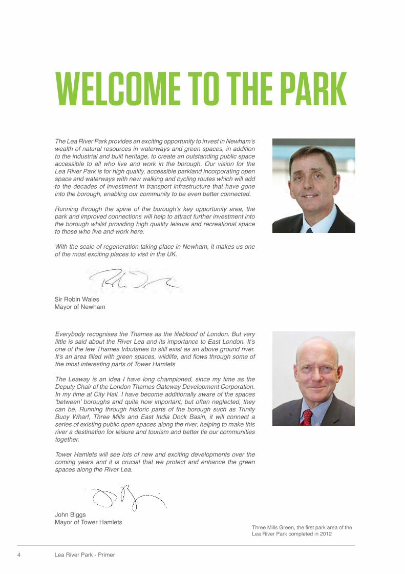
WELCOME TO THE PARKThe Lea River Park provides an exciting opportunity to invest in Newham’s wealth of natural resources in waterways and green spaces, in addition to the industrial and built heritage, to create an outstanding public space accessible to all who live and work in the borough. Our vision for the Lea River Park is for high quality, accessible parkland incorporating open space and waterways with new walking and cycling routes which will add to the decades of investment in transport infrastructure that have gone into the borough, enabling our community to be even better connected. Running through the spine of the borough’s key opportunity area, the park and improved connections will help to attract further investment into the borough whilst providing high quality leisure and recreational space to those who live and work here.
With the scale of regeneration taking place in Newham, it makes us one of the most exciting places to visit in the UK.
Sir Robin Wales Mayor of Newham
Everybody recognises the Thames as the lifeblood of London. But very little is said about the River Lea and its importance to East London. It’s one of the few Thames tributaries to still exist as an above ground river. It’s an area fi lled with green spaces, wildlife, and fl ows through some of the most interesting parts of Tower Hamlets The Leaway is an idea I have long championed, since my time as the Deputy Chair of the London Thames Gateway Development Corporation. In my time at City Hall, I have become additionally aware of the spaces ‘between’ boroughs and quite how important, but often neglected, they can be. Running through historic parts of the borough such as Trinity Buoy Wharf, Three Mills and East India Dock Basin, it will connect a series of existing public open spaces along the river, helping to make this river a destination for leisure and tourism and better tie our communities together. Tower Hamlets will see lots of new and exciting developments over the coming years and it is crucial that we protect and enhance the green spaces along the River Lea.
John BiggsMayor of Tower Hamlets
Three Mills Green, the fi rst park area of the Lea River Park completed in 2012
© Philip Vile
© Philip Vile
6 Lea River Park - Primer
EXECUTIVE SUMMARY
Twelvetrees Ramp, currently under construction - open October 2016
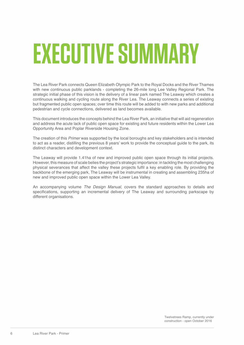
The Lea River Park connects Queen Elizabeth Olympic Park to the Royal Docks and the River Thames with new continuous public parklands - completing the 26-mile long Lee Valley Regional Park. The strategic initial phase of this vision is the delivery of a linear park named The Leaway which creates a continuous walking and cycling route along the River Lea. The Leaway connects a series of existing but fragmented public open spaces; over time this route will be added to with new parks and additional pedestrian and cycle connections, delivered as land becomes available.
This document introduces the concepts behind the Lea River Park, an initiative that will aid regeneration and address the acute lack of public open space for existing and future residents within the Lower Lea Opportunity Area and Poplar Riverside Housing Zone.
The creation of this Primer was supported by the local boroughs and key stakeholders and is intended to act as a reader, distilling the previous 8 years’ work to provide the conceptual guide to the park, its distinct characters and development context.
The Leaway will provide 1.41ha of new and improved public open space through its initial projects. However, this measure of scale belies the project’s strategic importance: in tackling the most challenging physical severances that affect the valley these projects fulfi l a key enabling role. By providing the backbone of the emerging park, The Leaway will be instrumental in creating and assembling 235ha of new and improved public open space within the Lower Lea Valley.
An accompanying volume The Design Manual, covers the standard approaches to details and specifi cations, supporting an incremental delivery of The Leaway and surrounding parkscape by different organisations.
Three Mills Green
Abbey Mills
East India Dock Basin
Limehouse Cut
Ecolog
y park
Stratford High Street
A12
A12
A13
A13
Silv
erto
wn
Way
Twelvetrees
Canning TownRiverside
SilvoceaWay
SilvertownViaduct
TheCodyWilds
Working Wharves
Interim Leaway route
Interim
Leaway route
East India
Langdon Park
Devons Road
Bow Church
Star Lane
West Ham
Canning Town
Royal Victoria
Bromley-by-Bow
North Greenwich
Pudding Mill Lane< Aldgate
CS3
CS2
Barking >
Stratford >
< Tower Gateway
The ThamesTrinity Buoy Wharf
South Park Hub
The House Mill
Cody Dock
Mill Meads
Twelvetrees Park
The Exotic Wild
Poplar River Park
8 Lea River Park - Primer
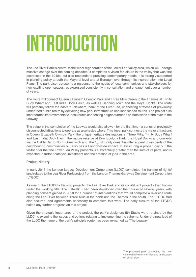
INTRODUCTIONThe Lea River Park is central to the wider regeneration of the Lower Lea Valley area, which will undergo massive change over the coming decades. It completes a vision for leisure in the valley that was fi rst expressed in the 1940s, but also responds to pressing contemporary needs. It is strongly supported in planning policy at both the Mayoral level and at Borough level through its incorporation into Local Plans. The park also represents a response to the needs of local communities and stakeholders for new exciting open spaces, as expressed consistently in consultation and engagement over a number of years.
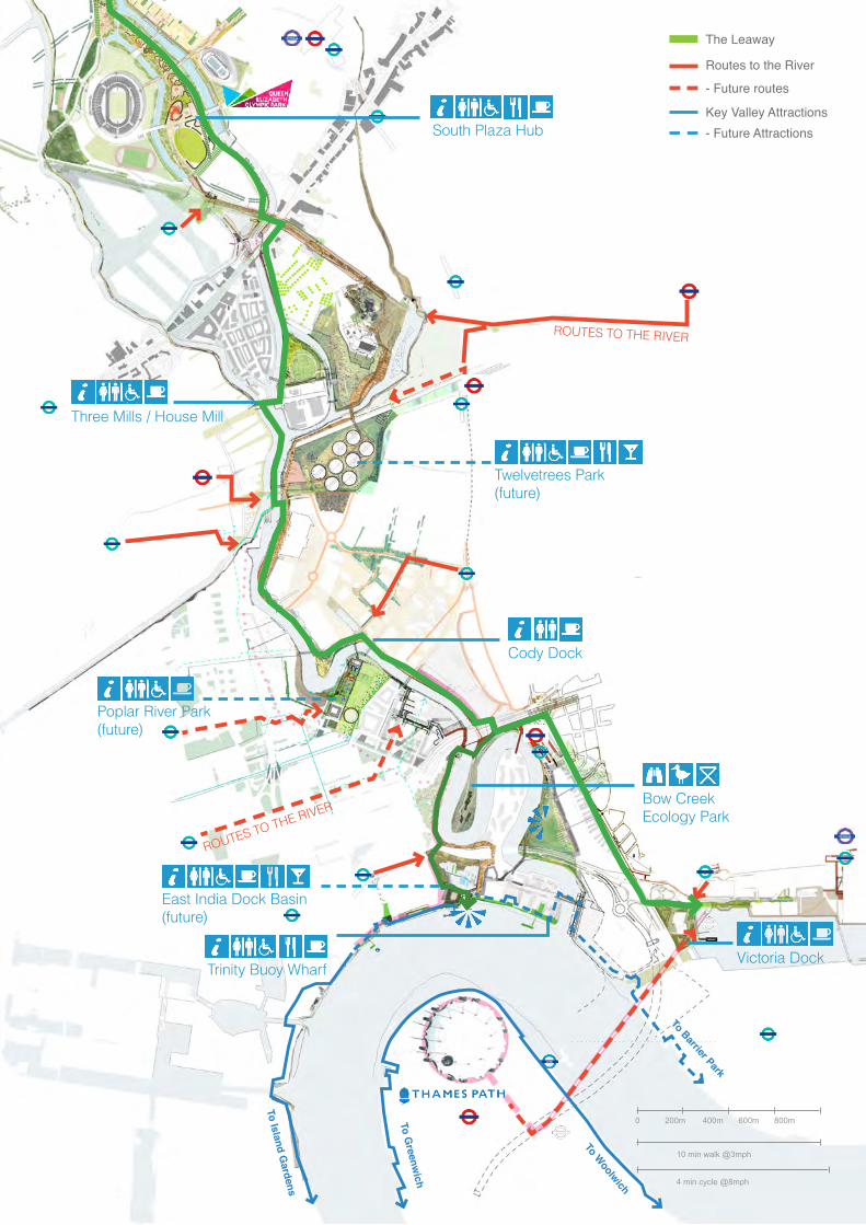
The route will connect Queen Elizabeth Olympic Park and Three Mills Green to the Thames at Trinity Buoy Wharf and East India Dock Basin, as well as Canning Town and the Royal Docks. The route will primarily follow the eastern (Newham) bank of the River Lea, connecting stretches of previously underused public realm by delivering new park infrastructure and landscaped routes. The project also incorporates improvements to local routes connecting neighbourhoods on both sides of the river to the Leaway.
The value in the completion of the Leaway would also allows - for the fi rst time - a series of previously disconnected attractions to operate as a cohesive whole. This linear park connects the major attractions in Queen Elizabeth Olympic Park, the unique heritage destinations at Three Mills, Trinity Buoy Wharf and East India Dock Basin, the nature reserve at Bow Ecology Park, the Royal Docks and onwards via the Cable Car to North Greenwich and The O2. Not only does this offer appeal to residents of the neighbouring communities but also has a London-wide impact. In structuring a proper ‘day out’ the visitor offer that the Lower Lea Valley presents is substantially greater than the sum of its parts, and is expected to further catalyse investment and the creation of jobs in the area.
Project History
In early 2013 the London Legacy Development Corporation (LLDC) completed the transfer of rights/land related to the Lea River Park project from the London Thames Gateway Development Corporation (LTGDC).
As one of the LTGDC’s fl agship projects, the Lea River Park and its constituent project - then known under the working title ‘The Fatwalk’ - had been developed over the course of several years, with planning consent gained in 2010 for a number of interventions that would complete a riverside route along the Lea River between Three Mills in the north and the Thames in the south. The LTGDC had also secured land agreements necessary to complete this work. The early closure of the LTGDC halted any further progress on this project.
Given the strategic importance of the project, the park’s designers 5th Studio were retained by the LLDC to examine the issues and options relating to implementing the scheme. Under the new lead of the LLDC the name of the park’s principle route has been re-named as ‘The Leaway’.
The proposed park connecting the river valley with the communities and landscapes on either side
Three Mills Green
Abbey Mills
East India Dock Basin
Limehouse Cut
Ecolog
y park
Stratford High Street
A12
A12
A13
A13
Silv
erto
wn
Way
Twelvetrees
Canning TownRiverside
SilvoceaWay
SilvertownViaduct
TheCodyWilds
Working Wharves
Interim Leaway route
Interim
Leaway route
East India
Langdon Park
Devons Road
Bow Church
Star Lane
West Ham
Canning Town
Royal Victoria
Bromley-by-Bow
North Greenwich
Pudding Mill Lane< Aldgate
CS3
CS2
Barking >
Stratford >
< Tower Gateway
The ThamesTrinity Buoy Wharf
South Park Hub
The House Mill
Cody Dock
Mill Meads
Twelvetrees Park
The Exotic Wild
Poplar River Park
Three Mills Green
Abbey Mills
East India Dock Basin
Limehouse Cut
Ecolog
y park
Stratford High Street
A12
A12
A13
A13
Silv
erto
wn
Way
Twelvetrees
The Connector
Silvocea
SilvertownViaduct
TheCodyWilds
Working Wharves
East India
Langdon Park
Devons Road
Bow Church
Star Lane
West Ham
Canning Town
Royal Victoria
Bromley-by-Bow
North Greenwich
Pudding Mill Lane< Aldgate
CS3
CS2
Barking >
Stratford >
< Tower Gateway
The ThamesTrinity Buoy Wharf
South Park Hub
The House Mill
Cody Dock
Future Lea River Parkpark area projects
Leaway route
Leaway route (coming soon)
Leaway future phase routes
Leaway access routes
Development/regeneration sites
Cycle superhighways
Underground/DLR/railways
10 Lea River Park - Primer
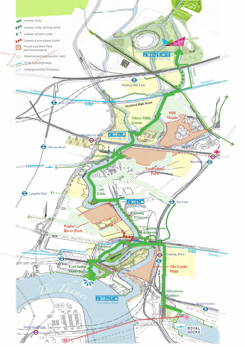
The Lea River Park exists within a context of several other great parks in London’s East End: Victoria Park, Mile End Park and Queen Elizabeth Olympic Park. The Lea River Park completes the fi nal section of the Lee Valley Regional Park, itself an act of highly conscious planning that prefi gures the ongoing regeneration of the area. Ultimately it will meet the practical need for more local green space within the wider area, which suffers a defi ciency at district and local levels.
The possibility of re-imagining the largely industrial Lee Valley as a “Great Playground for Londoners” was fi rst mooted before the Second World War, and in 1944 Sir Patrick Abercrombie revived the idea in his Greater London Plan when he suggested “the valley gives the opportunity for a great piece of regenerative planning... every piece of land welded into a great regional reservation.”
Today the Regional Park occupies around 10,000 acres of the Lee Valley, of which some 4,000 acres are actually owned by the Authority. The Park currently stretches from Hackney Marshes up to Ware in Hertfordshire. At no point is it wider than a mile, and in some it is little more than the width of the Lee Navigation towpath. There is no other area of comparable size so close to the centre of London that has been set aside specifi cally for leisure and recreational use.
Strategically, the Lea River Park is an important project to fi nally deliver the vision set out in the original plan for the regional park, linking the dense inner city with the countryside through a continuous chain of open space.
COMPLETING THE LEE VALLEY REGIONAL PARK
Lee ValleyRegional ParkThe location of the proposed Lea River
Park (in red) with respect to the Lee Valley Regional Park (outlined), the London Legacy Development Corporations area (green) and the Olympic legacy boroughs
LEARIVERPARKLondon Legacy
Development Corporation
Hackney
Tower Hamlets
Newham
Greenwich
Waltham Forest
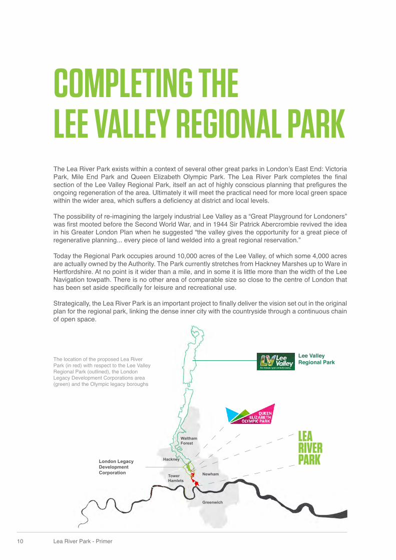
THE LEA RIVER PARK PROJECT WILL DELIVER A NUMBER OF STRATEGIC OBJECTIVES AND SUPPORT THE SUCCESSFUL REGENERATION OF THE LOWER LEA VALLEY:
1. Completing the 26-mile Lea Valley Park, connecting Queen Elizabeth Olympic Park to the River Thames
2. Unlocking local connectivity across the Lower Lea Valley and opening up the River Lea
3. Tackling severe defi ciency to open space by improving access and creating new spaces
4. Shaping the major redevelopment anticipated adjacent to the Lea River Park
Lee ValleyRegional Park
Route on quieter roads recommended by cyclists
Route signed for cyclists that may be on busier roads
Fatwalk route for pedestrians and responsible cyclists
Source: Transport for London, except Olympic related enhancements (Source: London2012)
Future desired route for cyclists and pedestrians to connect the Fatwalk with existing strategic routes
Provision for cyclists adjacent to busy roads. May be shared with pedestrians
Routes through parks and on canal towpaths for walking and cycling. Pedestrians have priority but responsible cycling is permitted
Olympic Park and River Zone Walking and Cycling enhancements
Strategic Walking Route:Lea Valley Walk
Strategic Walking Route:Capital Ring
terra incognita
2010
Route on quieter roads recommended by cyclists
Route signed for cyclists that may be on busier roads
Fatwalk route for pedestrians and responsible cyclists
Source: Transport for London, except Olympic related enhancements (Source: London2012)
Future desired route for cyclists and pedestrians to connect the Fatwalk with existing strategic routes
Provision for cyclists adjacent to busy roads. May be shared with pedestrians
Routes through parks and on canal towpaths for walking and cycling. Pedestrians have priority but responsible cycling is permitted
Olympic Park and River Zone Walking and Cycling enhancements
Strategic Walking Route:Lea Valley Walk
Strategic Walking Route:Capital Ring
Leaway
2017
STRATFORD CITY
THAMES WATER ESTATE
STEPHENSON STREET SITE
CODY ROAD ESTATE
CANNING TOWN MASTERPLAN
POPLAR HARCA REGENERATION
LEASIDE
BROMELY by BOW MASTERPLAN
OLYMPIC LEGACY DEVELOPMENTS
12 Lea River Park - Primer
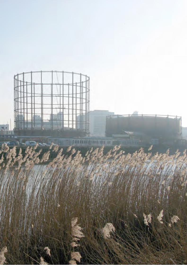
‘Out of the strong came forth sweetness’ 1
The Lower Lea Valley is a ‘made’ landscape, which plays an intimate role in provisioning the city around it. Naturalistic landscape scenography is not appropriate here. Rather, park space is created from adopting and ‘contaminating’ elements of infrastructure and monocultural land uses, which have had free reign in the valley, forcing them to culture a richer, more urbane role. Elements such as railway tunnels, by-pass structures and gasholders are co-opted into making places for a day out in the valley.
Early pieces of infrastructure are regarded as catalysts for converting what is currently land used for gas storage, sewage pumping and transport infrastructure into the diverse park spaces of the Lea River Park, turning what is an industrial backwater into the foreground of a new public space which people can start to access, use and enjoy. The ‘Leaway’ is the fi rst stage - a linear park connecting disparate landscape areas and combining existing routes and left-over land.
The landscape strategy for the park aims to:
• Draw out the extraordinary landscape narratives that have shaped the valley, juxtaposing ‘native’ riverine landscape with an ‘exotic’ overlay, referencing, for example, the global trading of the docks, and the adaptation of colonising plants to industrial sites.
• Respond to and enhance particular landscapes that already exist in the valley.
• Create new landscapes that help uncover the overlaid uses that have shaped the landscape.
• Create ‘edible landscapes’ referencing the valley’s role in provisioning London.
• Use tree planting to create ‘urban connectors’ leading into the park, and to mark the course of the river.
1. The old testament motto of the locally based Tate and Lyle factory (at Plaistow Wharf and West Silvertown) which features on their characteristic tins of golden syrup.
AN AMAZING VALLEY
extent of tidal flooding
STRA
TFO
RD
CA
USE
WA
Y
MA
RK
E
T GARDENS
Abbey Gardens
The Orchard
BLA
CK
WA
LL R
EA
CH
BUGSBY ’S REACH
Allotments
Mill Stream
Mill Stream
Mill Stream
Mill Stream
14 Lea River Park - Primer
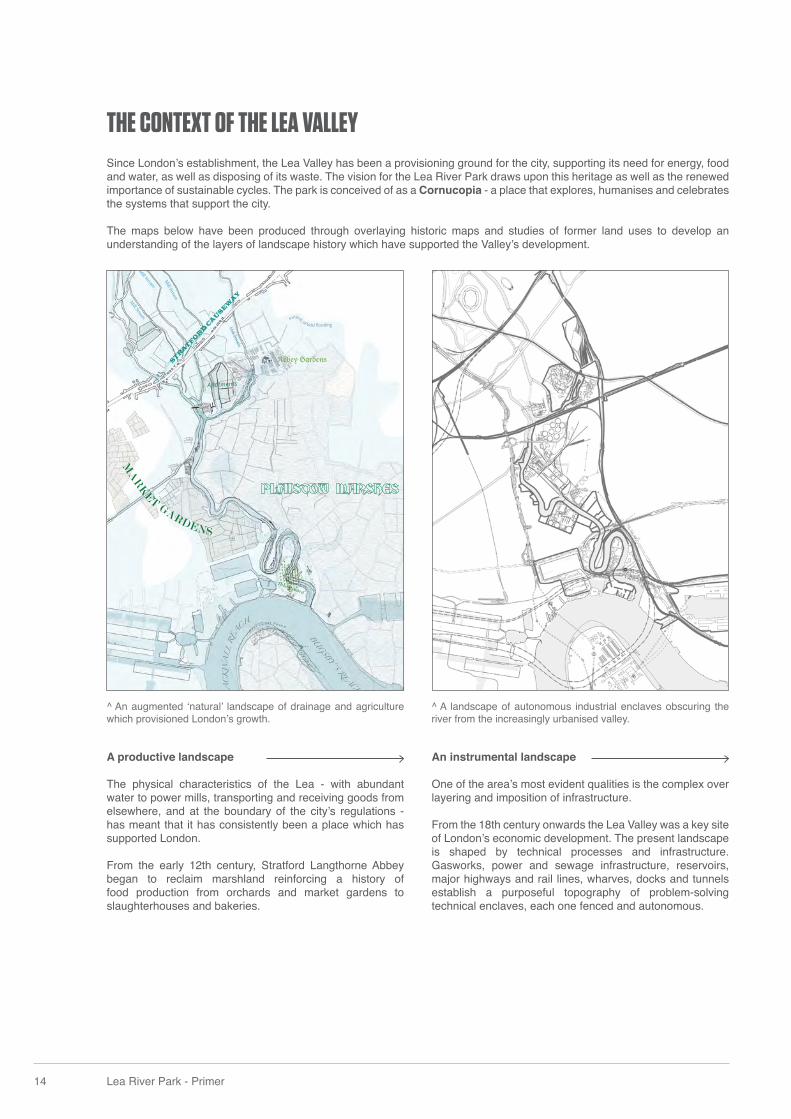
Since London’s establishment, the Lea Valley has been a provisioning ground for the city, supporting its need for energy, food and water, as well as disposing of its waste. The vision for the Lea River Park draws upon this heritage as well as the renewed importance of sustainable cycles. The park is conceived of as a Cornucopia - a place that explores, humanises and celebrates the systems that support the city.
The maps below have been produced through overlaying historic maps and studies of former land uses to develop an understanding of the layers of landscape history which have supported the Valley’s development.
A productive landscape
The physical characteristics of the Lea - with abundant water to power mills, transporting and receiving goods from elsewhere, and at the boundary of the city’s regulations - has meant that it has consistently been a place which has supported London.
From the early 12th century, Stratford Langthorne Abbey began to reclaim marshland reinforcing a history of food production from orchards and market gardens to slaughterhouses and bakeries.
An instrumental landscape
One of the area’s most evident qualities is the complex over layering and imposition of infrastructure.
From the 18th century onwards the Lea Valley was a key site of London’s economic development. The present landscape is shaped by technical processes and infrastructure. Gasworks, power and sewage infrastructure, reservoirs, major highways and rail lines, wharves, docks and tunnels establish a purposeful topography of problem-solving technical enclaves, each one fenced and autonomous.
THE CONTEXT OF THE LEA VALLEY
^ An augmented ‘natural’ landscape of drainage and agriculture which provisioned London’s growth.
^ A landscape of autonomous industrial enclaves obscuring the river from the increasingly urbanised valley.
Palette
Str
atfor
d Ca
usew
ay
CODY CAMPUS
Canning Town
WORKING WHARVES
The Thames
Victorian Infrastructure
EXOTIC WILD
POPLAR G
REEN GRIDA public landscape
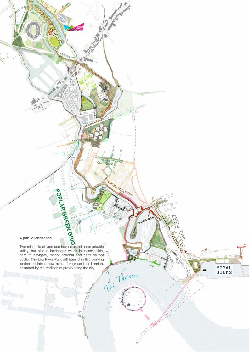
Two millennia of land use have created a remarkable valley, but also a landscape which is inaccessible, hard to navigate, monofunctional and certainly not public. The Lea River Park will transform this working landscape into a new public foreground for London, animated by the tradition of provisioning the city.
16 Lea River Park - Primer
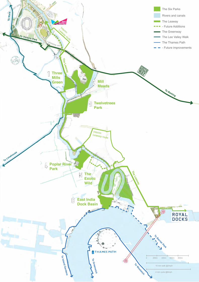
THE SIX PARKS AND THE LEAWAY
1
3
5
2
4
6
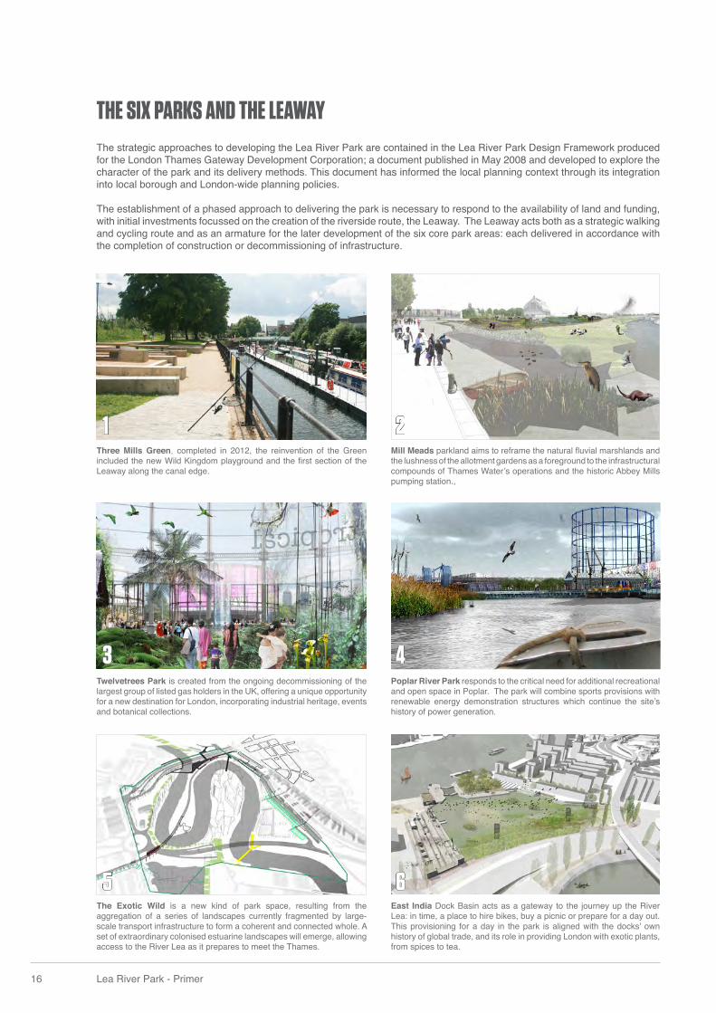
The strategic approaches to developing the Lea River Park are contained in the Lea River Park Design Framework produced for the London Thames Gateway Development Corporation; a document published in May 2008 and developed to explore the character of the park and its delivery methods. This document has informed the local planning context through its integration into local borough and London-wide planning policies.
The establishment of a phased approach to delivering the park is necessary to respond to the availability of land and funding, with initial investments focussed on the creation of the riverside route, the Leaway. The Leaway acts both as a strategic walking and cycling route and as an armature for the later development of the six core park areas: each delivered in accordance with the completion of construction or decommissioning of infrastructure.
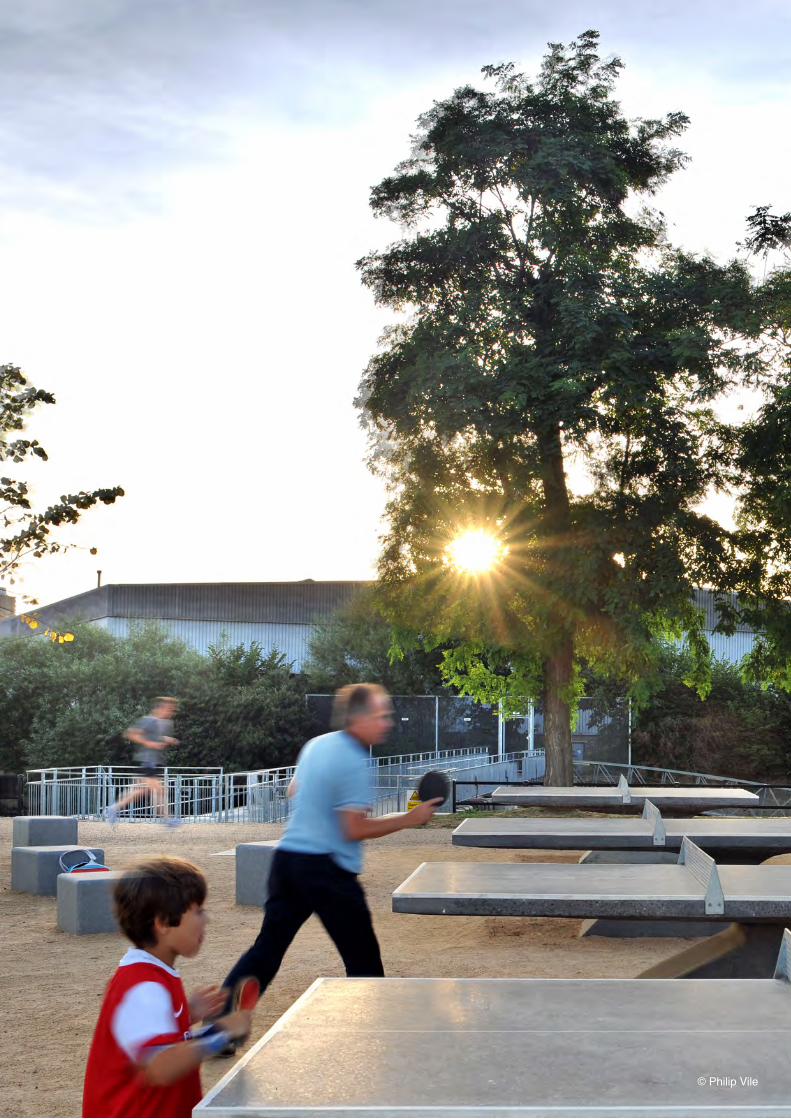
Three Mills Green, completed in 2012, the reinvention of the Green included the new Wild Kingdom playground and the fi rst section of the Leaway along the canal edge.
Twelvetrees Park is created from the ongoing decommissioning of the largest group of listed gas holders in the UK, offering a unique opportunity for a new destination for London, incorporating industrial heritage, events and botanical collections.
The Exotic Wild is a new kind of park space, resulting from the aggregation of a series of landscapes currently fragmented by large-scale transport infrastructure to form a coherent and connected whole. A set of extraordinary colonised estuarine landscapes will emerge, allowing access to the River Lea as it prepares to meet the Thames.
Mill Meads parkland aims to reframe the natural fl uvial marshlands and the lushness of the allotment gardens as a foreground to the infrastructural compounds of Thames Water’s operations and the historic Abbey Mills pumping station.,
Poplar River Park responds to the critical need for additional recreational and open space in Poplar. The park will combine sports provisions with renewable energy demonstration structures which continue the site’s history of power generation.
East India Dock Basin acts as a gateway to the journey up the River Lea: in time, a place to hire bikes, buy a picnic or prepare for a day out. This provisioning for a day in the park is aligned with the docks’ own history of global trade, and its role in providing London with exotic plants, from spices to tea.
To Limehouse
Interim Leaway route
The Leaway
The Leaway
Interim Leaway route
1
3
5
2
4
6
Three Mills Green Mill
Meads
Twelvetrees Park
Poplar River Park
The Exotic Wild
East India Dock Basin
To Victoria Park
To Barking
To W
are
To Limehouse
To Woolwich
To Greenw
ich
To Island Gardens
To Barrier Park
The Six Parks
Rivers and canals
The Greenway
The Lee Valley Walk
The Thames Path- Future improvements
The Leaway - Future Additions
0 200m
10 min walk @3mph
4 min cycle @8mph
400m 600m 800m
18 Lea River Park - Primer
Queen ElizabethOlympic Park
Three Mills Green
Three Mills
Poplar Reach
Cody Dock
Bow Creek Ecology Park
East India Dock Basin
Trinity Buoy Wharf
The Royal Docks
++ +
++
The Leaway
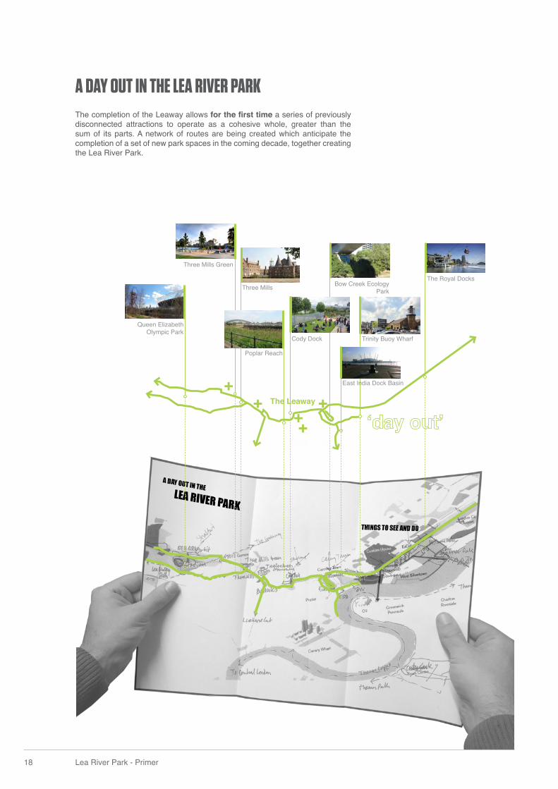
A DAY OUT IN THE LEA RIVER PARKThe completion of the Leaway allows for the fi rst time a series of previously disconnected attractions to operate as a cohesive whole, greater than the sum of its parts. A network of routes are being created which anticipate the completion of a set of new park spaces in the coming decade, together creating the Lea River Park.
South Plaza Hub
ROUTES TO THE RIVER
ROUTES TO THE RIVER
Trinity Buoy Wharf
Cody Dock
Bow Creek Ecology Park
Victoria Dock
Three Mills / House Mill
Twelvetrees Park (future)
East India Dock Basin(future)
Poplar River Park (future)
To Woolwich
To Greenw
ich
To Island Gardens
To Barrier Park
Routes to the River
- Future routes
Key Valley Attractions- Future Attractions
The Leaway
0 200m
10 min walk @3mph
4 min cycle @8mph
400m 600m 800m
20 Lea River Park - Primer
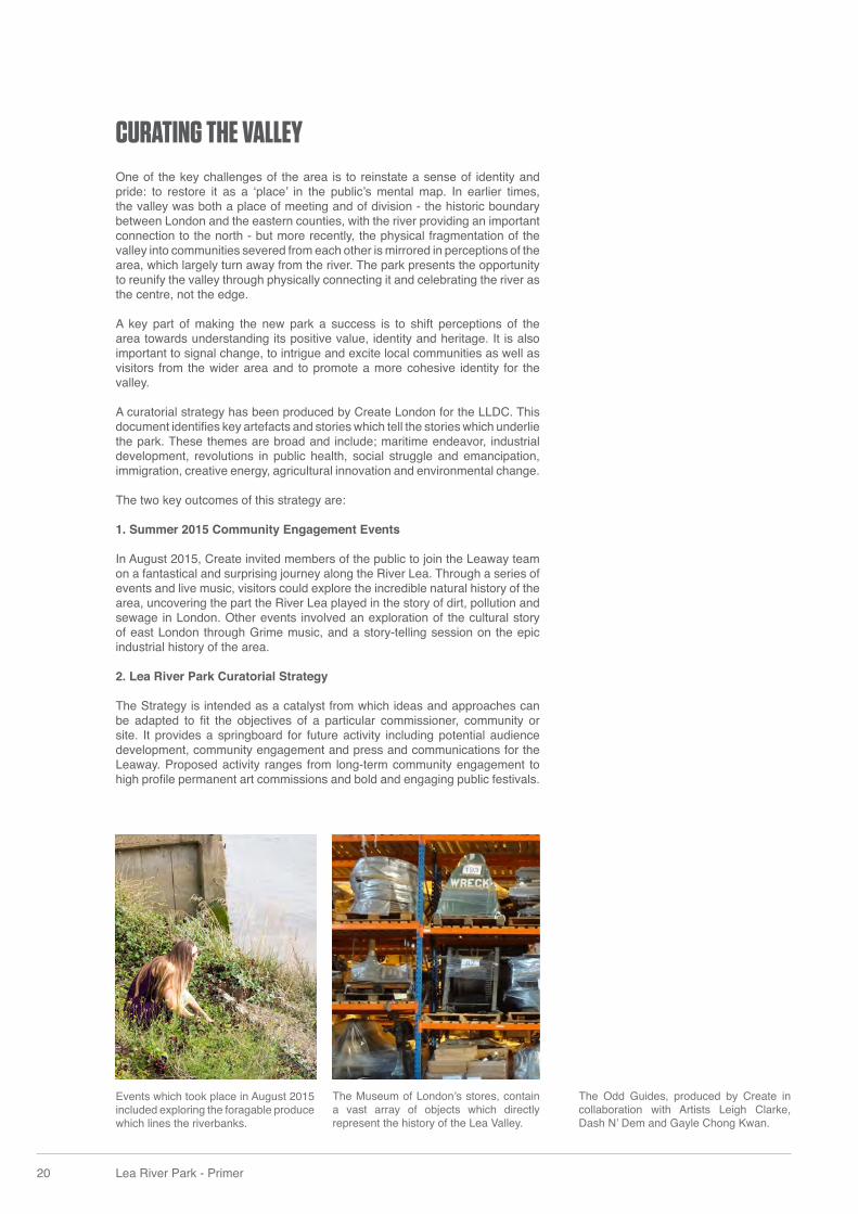
CURATING THE VALLEYOne of the key challenges of the area is to reinstate a sense of identity and pride: to restore it as a ‘place’ in the public’s mental map. In earlier times, the valley was both a place of meeting and of division - the historic boundary between London and the eastern counties, with the river providing an important connection to the north - but more recently, the physical fragmentation of the valley into communities severed from each other is mirrored in perceptions of the area, which largely turn away from the river. The park presents the opportunity to reunify the valley through physically connecting it and celebrating the river as the centre, not the edge. A key part of making the new park a success is to shift perceptions of the area towards understanding its positive value, identity and heritage. It is also important to signal change, to intrigue and excite local communities as well as visitors from the wider area and to promote a more cohesive identity for the valley. A curatorial strategy has been produced by Create London for the LLDC. This document identifi es key artefacts and stories which tell the stories which underlie the park. These themes are broad and include; maritime endeavor, industrial development, revolutions in public health, social struggle and emancipation, immigration, creative energy, agricultural innovation and environmental change. The two key outcomes of this strategy are: 1. Summer 2015 Community Engagement Events In August 2015, Create invited members of the public to join the Leaway team on a fantastical and surprising journey along the River Lea. Through a series of events and live music, visitors could explore the incredible natural history of the area, uncovering the part the River Lea played in the story of dirt, pollution and sewage in London. Other events involved an exploration of the cultural story of east London through Grime music, and a story-telling session on the epic industrial history of the area. 2. Lea River Park Curatorial Strategy The Strategy is intended as a catalyst from which ideas and approaches can be adapted to fi t the objectives of a particular commissioner, community or site. It provides a springboard for future activity including potential audience development, community engagement and press and communications for the Leaway. Proposed activity ranges from long-term community engagement to high profi le permanent art commissions and bold and engaging public festivals.
The Museum of London’s stores, contain a vast array of objects which directly represent the history of the Lea Valley.
Events which took place in August 2015 included exploring the foragable produce which lines the riverbanks.
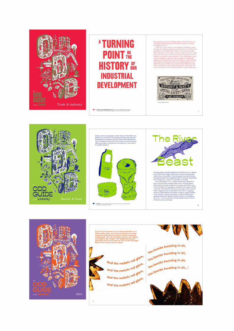
The Odd Guides, produced by Create in collaboration with Artists Leigh Clarke, Dash N’ Dem and Gayle Chong Kwan.
3
A TURNING POINT IN
HISTORY OF
INDUSTRIALDEVELOPMENT
The political actions of working people on the River Lea led to radical improvements in the social conditions of work throughout the UK.
In the late 19th century a new political confidence swept through the working population of industries on the River Lea, propelled by the Match Girls’ Strike at the Bryant and May Match Factory in 1888. There, women workers formed a strike group that forced one of the most powerful employers in east London to concede to their demands. This unexpected victory roused confidence amongst other employees to challenge oppressive and inhumane working conditions. Next came the Gas Workers Petition that led to the implementation of an eight-hour day and The Great London Dock Strike of 1889 that established the idea of general workers’ unions for all classes of workers and inspired the British Labour Movement.
Bryant & May matches.
THE
OUR
A. The Bryant and May Match Factory: the site of the Match Girls’ Strike now redeveloped as The Bow Quarter gated community, Fairfield Road, Bow.
Today, waste management is still a feature of the River Lea. Bywaters is one of the UK’s leading recycling and resource management companies, based in Bow and established in 1952, it handles a total of 800,000 tonnes of waste annually, offering all types of businesses the option of a ‘zero direct to landfill’ solution. I
An apocryphal crocodile appeared in the River Lea on 5 August 2005, when boat trippers witnessed ‘a goose being pulled underwater very quickly.’ Several cygnets also mysteriously disappeared and it was suggested that the creature responsible was a large fish, a caiman, or possibly a crocodile.
On 13 December 2011, a similar attack was reported to have occurred when another goose went ‘vertically down’. Observed by two boat trippers on a section of the River Lea, it was said that the large goose vanished ‘in the space of half a second’. The observers did not see any sign of the creature. Other suggestions for the predator have been a snapping turtle or catfish (which are known to exist in small numbers in the Thames and its tributaries). A British Waterways spokeswoman said “We don’t believe there is a crocodile in the river… but we would encourage people to get in touch if they have seen anything.”
The River
Beast
I. Bywaters is one of the UK’s leading recycling and resource management companies, established in 1952. 31
If you are lost between the Lea Valley Gasholders on a bleak London night, you may be encircled by two large, monstrous black ghosts covered in streams of glowing orange liquid. They will stare deep into your eyes, hoping you might be the inventor. Their deafening song will penetrate your ears with the lines from the Star Spangled Banner over and over and over again…
‘And the rockets red glare, the bombs bursting in air,
and the rockets red glare, the bombs bursting in air,
and the rockets red glare, the bombs bursting in air,
and the rockets red glare, the bombs bursting in air…’
12
Trade & Industry
An
ODD GUIDE to the Leaway
Nature & Food
An
ODD GUIDE to the Leaway
Dirt
An
ODD GUIDE to the Leaway
22 Lea River Park - Primer
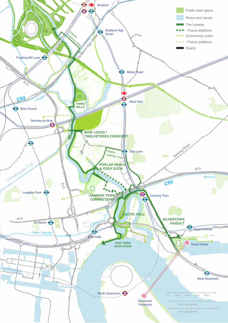
The Lower Lea Valley has historically suffered from major physical severances: where accessible stretches of landscape and riverside paths have been delivered they are currently fractured, limiting connectivity and the creation of user groups.
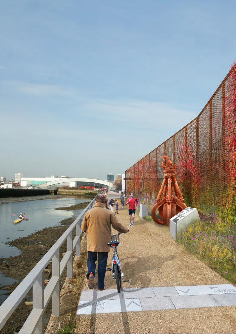
The delivery of the Leaway creates for the fi rst time a continuous route between Queen Elizabeth Olympic Park, the Thames and the Royal Docks by opening up the edges of the River Lea to pedestrians and cyclists.
This section identifi es the key severances which need to be resolved, where effort and investment are needed to overcome physical separation.
These ‘knuckles’ are characterised by complex topography, each holding the potential to not only provide connections but to become interesting and engaging places in their own right: locations for art installations, new landscapes and activities to be introduced to the Valley’s already rich sense of place.
These ‘knuckles’ each have the capacity to act as gateways into the Lea River Park and are being developed as engaging spaces which anticipate the development of the future park spaces.
THE LEAWAY
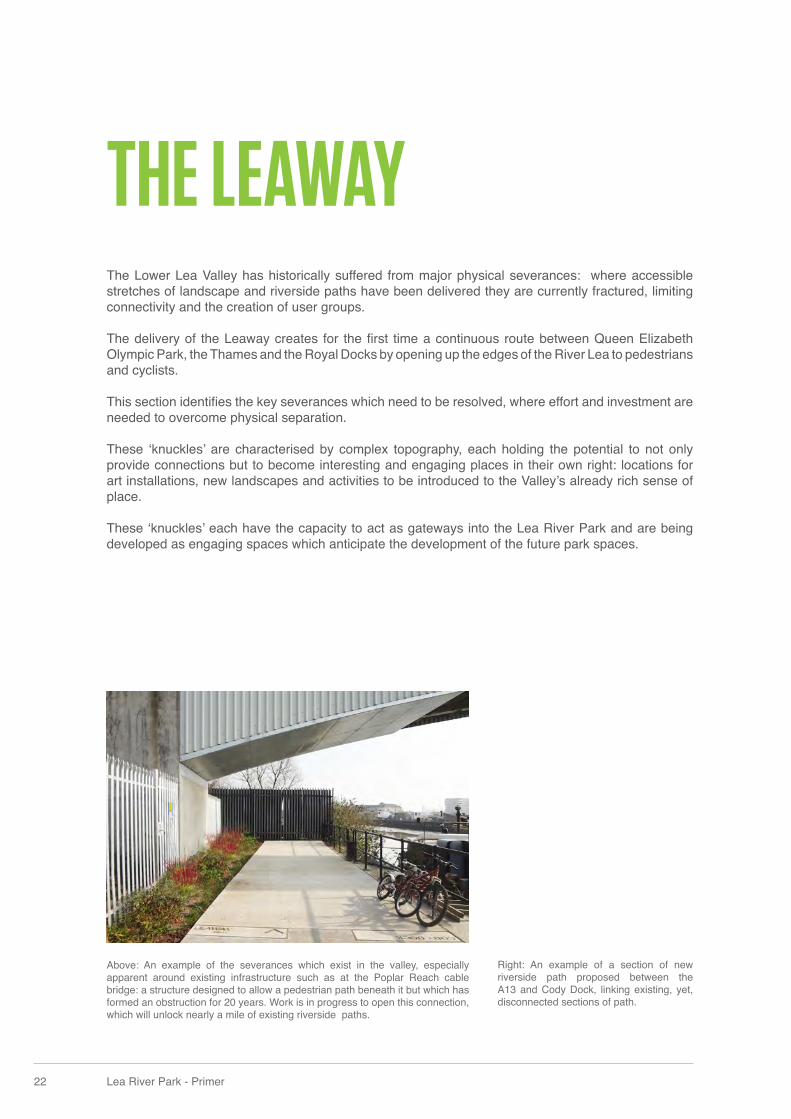
Above: An example of the severances which exist in the valley, especially apparent around existing infrastructure such as at the Poplar Reach cable bridge: a structure designed to allow a pedestrian path beneath it but which has formed an obstruction for 20 years. Work is in progress to open this connection, which will unlock nearly a mile of existing riverside paths.
Right: An example of a section of new riverside path proposed between the A13 and Cody Dock, linking existing, yet, disconnected sections of path.
24 Lea River Park - Primer
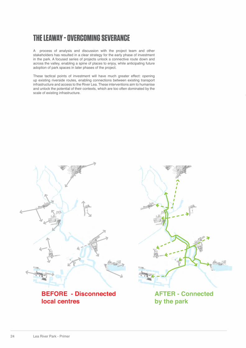
THE LEAWAY - OVERCOMING SEVERANCEA process of analysis and discussion with the project team and other stakeholders has resulted in a clear strategy for the early phase of investment in the park. A focused series of projects unlock a connective route down and across the valley, enabling a spine of places to enjoy, while anticipating future adoption of park spaces in later phases of the project.
These tactical points of investment will have much greater effect: opening up existing riverside routes, enabling connections between existing transport infrastructure and access to the River Lea. These interventions aim to humanise and unlock the potential of their contexts, which are too often dominated by the scale of existing infrastructure.
AFTER - Connected by the park
BEFORE - Disconnected local centres
24 Lea River Park - Primer
THE LEAWAY - OVERCOMING SEVERANCEA process of analysis and discussion with the project team and other stakeholders has resulted in a clear strategy for the early phase of investment in the park. A focused series of projects unlock a connective route down and across the valley, enabling a spine of places to enjoy, while anticipating future adoption of park spaces in later phases of the project.
These tactical points of investment will have much greater effect: opening up existing riverside routes, enabling connections between existing transport infrastructure and access to the River Lea. These interventions aim to humanise and unlock the potential of their contexts, which are too often dominated by the scale of existing infrastructure.
AFTER - Connected by the park
BEFORE - Disconnected local centres
BOW LOCKS / TWELVETREES CRESCENT
EXOTIC WILD
POPLAR REACH& CODY DOCK
SILVERTOWN VIADUCT
CANNING TOWN CONNECTIONS
EAST INDIA DOCK BASIN
THREE MILLS
Interim Leaway route
Interim Leaway route
CS2< Aldgate
CS3Barking >
< Tower Gateway
Royal Docks
Greenwich Peninsula
North Greenwich
Bromley-by-Bow
West Ham
Canning Town
Pudding Mill Lane
All Saints
Langdon Park
West Silvertown
Bow Church
East India
Star Lane
Abbey Road
Stratford High Street
Stratford
Royal Victoria
A12
A12A13
A13
Barking Road
Strat
ford H
igh S
treet
Limehouse Cut
Public open space
Rivers and canals
Connecting routes
- Future additions
Roads
The Leaway- Future additions
0 200m
10 min walk @3mph
4 min cycle @8mph
400m 600m 800m
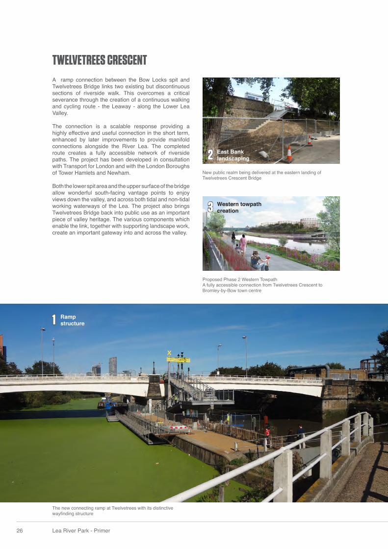
TWELVETREES CRESCENT
Proposed Phase 2 Western TowpathA fully accessible connection from Twelvetrees Crescent to Bromley-by-Bow town centre
New public realm being delivered at the eastern landing of Twelvetrees Crescent Bridge
2
3
2
26 Lea River Park - Primer
The new connecting ramp at Twelvetrees with its distinctive wayfi nding structure
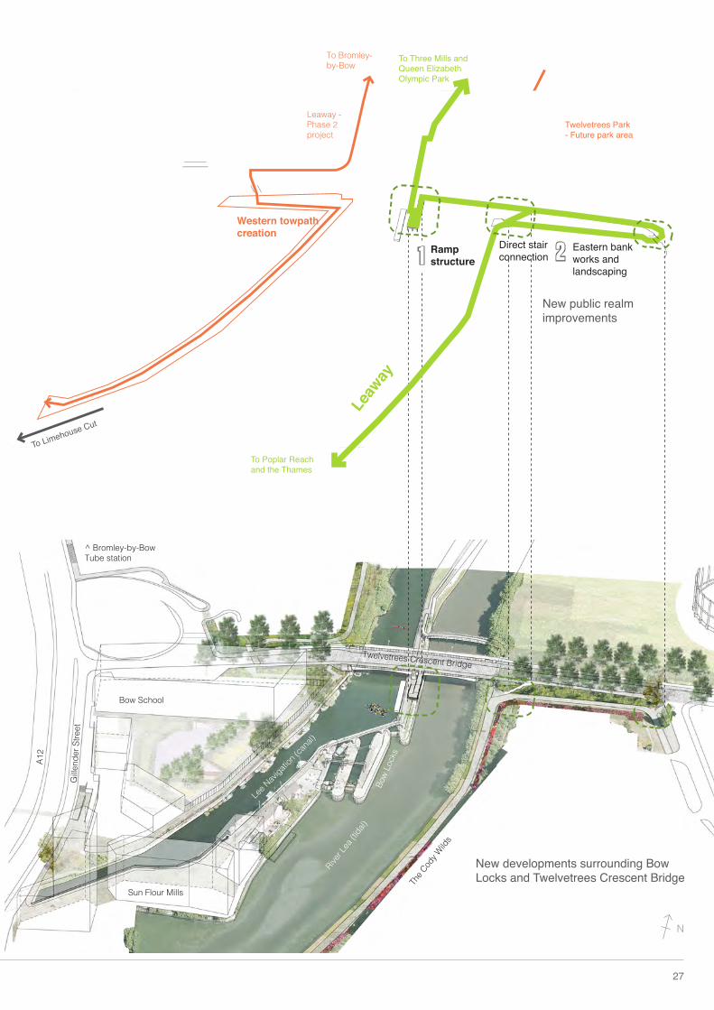
A ramp connection between the Bow Locks spit and Twelvetrees Bridge links two existing but discontinuous sections of riverside walk. This overcomes a critical severance through the creation of a continuous walking and cycling route - the Leaway - along the Lower Lea Valley.
The connection is a scalable response providing a highly effective and useful connection in the short term, enhanced by later improvements to provide manifold connections alongside the River Lea. The completed route creates a fully accessible network of riverside paths. The project has been developed in consultation with Transport for London and with the London Boroughs of Tower Hamlets and Newham.
Both the lower spit area and the upper surface of the bridge allow wonderful south-facing vantage points to enjoy views down the valley, and across both tidal and non-tidal working waterways of the Lea. The project also brings Twelvetrees Bridge back into public use as an important piece of valley heritage. The various components which enable the link, together with supporting landscape work, create an important gateway into and across the valley.
Ramp structure
Western towpath creation
East Bank landscaping
1
TWELVETREES CRESCENT
Proposed Phase 2 Western TowpathA fully accessible connection from Twelvetrees Crescent to Bromley-by-Bow town centre
New public realm being delivered at the eastern landing of Twelvetrees Crescent Bridge
2
3
2
26 Lea River Park - Primer
The new connecting ramp at Twelvetrees with its distinctive wayfi nding structure
A ramp connection between the Bow Locks spit and Twelvetrees Bridge links two existing but discontinuous sections of riverside walk. This overcomes a critical severance through the creation of a continuous walking and cycling route - the Leaway - along the Lower Lea Valley.
The connection is a scalable response providing a highly effective and useful connection in the short term, enhanced by later improvements to provide manifold connections alongside the River Lea. The completed route creates a fully accessible network of riverside paths. The project has been developed in consultation with Transport for London and with the London Boroughs of Tower Hamlets and Newham.
Both the lower spit area and the upper surface of the bridge allow wonderful south-facing vantage points to enjoy views down the valley, and across both tidal and non-tidal working waterways of the Lea. The project also brings Twelvetrees Bridge back into public use as an important piece of valley heritage. The various components which enable the link, together with supporting landscape work, create an important gateway into and across the valley.
Ramp structure
Western towpath creation
East Bank landscaping
12
3
27
Western towpath creation
Bow School
^ Bromley-by-Bow Tube station
Sun Flour Mills
River L
ea (ti
dal)
Bow
Lock
s
Lee N
avigati
on (c
anal)
Twelvetrees Crescent Bridge
Gille
nder
Stre
et
A12
The C
ody W
ilds
Ramp structure
Direct stair connection
To Three Mills and Queen Elizabeth Olympic Park
To Poplar Reach and the Thames
To Limehouse Cut
Leaw
ay
Eastern bank works and landscaping
Twelvetrees Park- Future park area
Leaway - Phase 2 project
New public realm improvements
New developments surrounding Bow Locks and Twelvetrees Crescent Bridge
To Bromley-by-Bow
1 2
N
3
1
2
28 Lea River Park - Primer
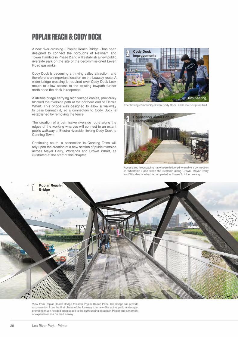
View from Poplar Reach Bridge towards Poplar Reach Park. The bridge will provide a connection from the fi rst phase of the Leaway to a new 6ha active park landscape, providing much needed open space to the surrounding estates in Poplar and a moment of expansiveness on the Leaway
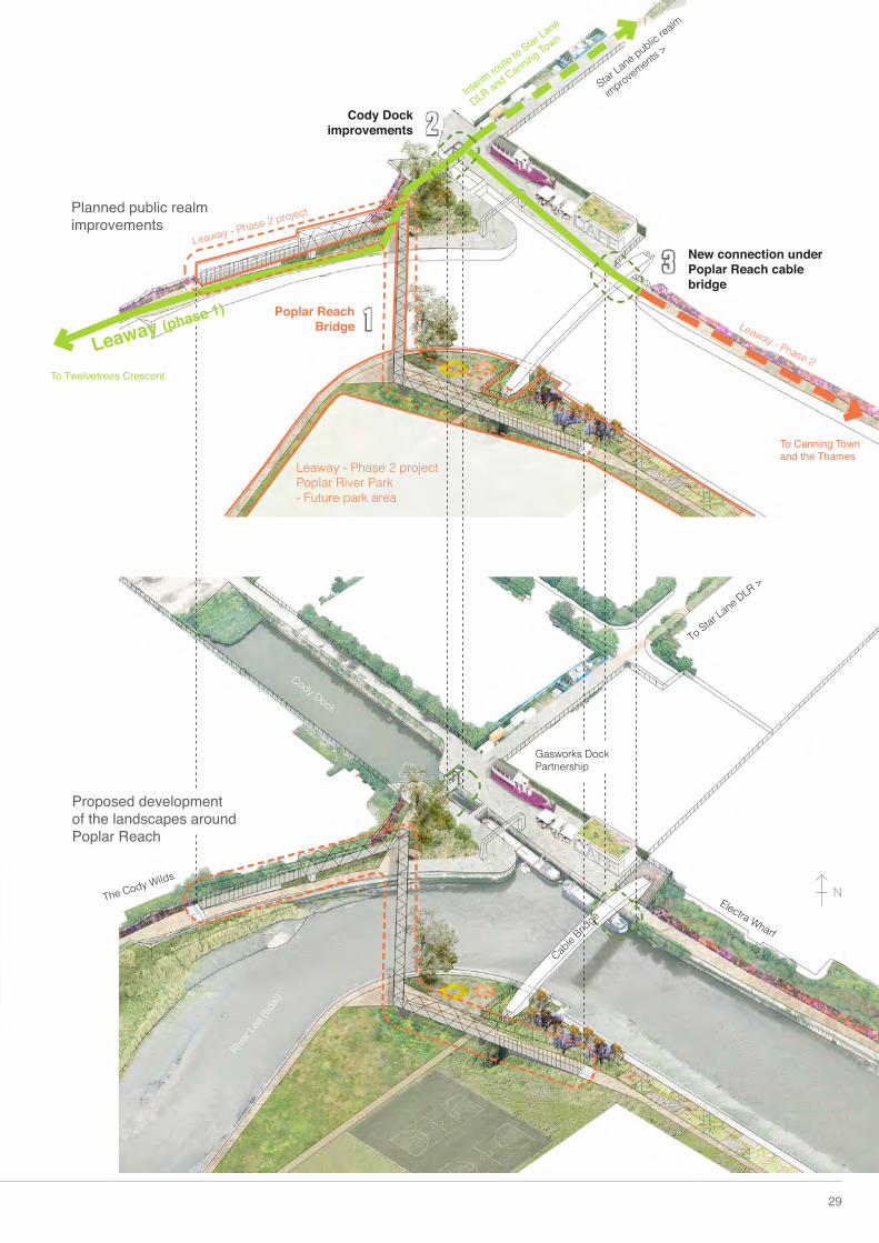
POPLAR REACH & CODY DOCKA new river crossing - Poplar Reach Bridge - has been designed to connect the boroughs of Newham and Tower Hamlets in Phase 2 and will establish a new public riverside park on the site of the decommissioned Leven Road gasworks.
Cody Dock is becoming a thriving valley attraction, and therefore is an important location on the Leaway route. A wider bridge crossing is required over Cody Dock Lock mouth to allow access to the existing towpath further north once the dock is reopened.
A utilities bridge carrying high voltage cables, previously blocked the riverside path at the northern end of Electra Wharf. This bridge was designed to allow a walkway to pass beneath it, so a connection to Cody Dock is established by removing the fence.
The creation of a permissive riverside route along the edges of the working wharves will connect to an extant public walkway at Electra riverside, linking Cody Dock to Canning Town.
Continuing south, a connection to Canning Town will rely upon the creation of a new section of publc riverside across Mayer Parry, Worlands and Crown Wharf, as illustrated at the start of this chapter.
The thriving community-driven Cody Dock, and Line Sculpture trail.
Access and landscaping have been delivered to enable a connection to Wharfside Road when the riverside along Crown, Mayer Parry and Whorlands Wharf is completed in Phase 2 of the Leaway.
Connection under Poplar Reach cable bridge
Poplar Reach Bridge
Cody Dock improvements
© Ruth Keating
Gasworks Dock Partnership
2
3
1
To Twelvetrees Crescent
Interim route to Star Lane
DLR and Canning Town
To Canning Town and the Thames
Leaway (phase 1)
29
Poplar Reach Bridge
Electra Wharf
The Cody Wilds
New connection under Poplar Reach cable bridge
Cable
Bridge
Star Lane public re
alm
improvements >
To Star Lane DLR >
Cody Dock improvements
Proposed development of the landscapes around Poplar Reach
River L
ea (ti
dal)
Leaway - Phase 2 project
Leaway - Phase 2
Planned public realm improvements
Leaway - Phase 2 projectPoplar River Park- Future park area
Cody Dock
N
1
2
30 Lea River Park - Primer
After: London Borough of Newham have worked in close collaboration with Transport for London to rationalise the position of fences to produce clear site lines. Actions such as installing CCTV and closing the road to traffi c will create a new safe pedestrian and cyclist dominated access point to the park. Hardlandscaping and tree planting is complete and soft landscaping will be fi nished in Autumn 2016.
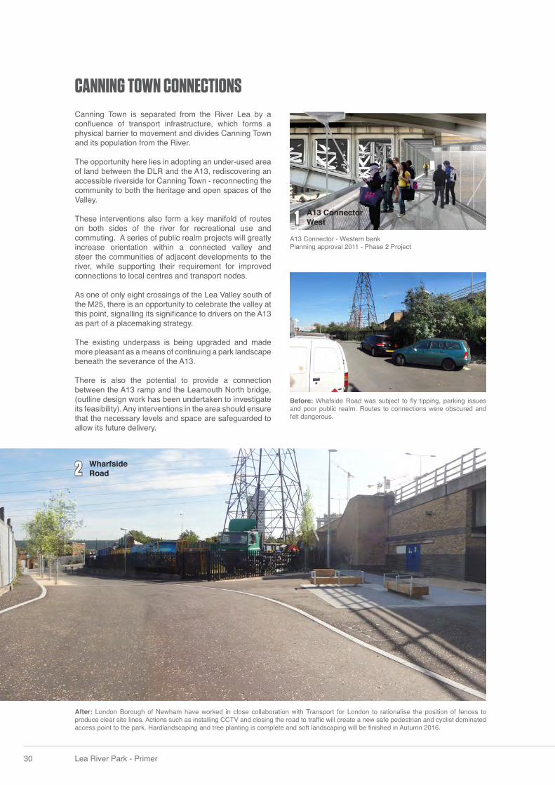
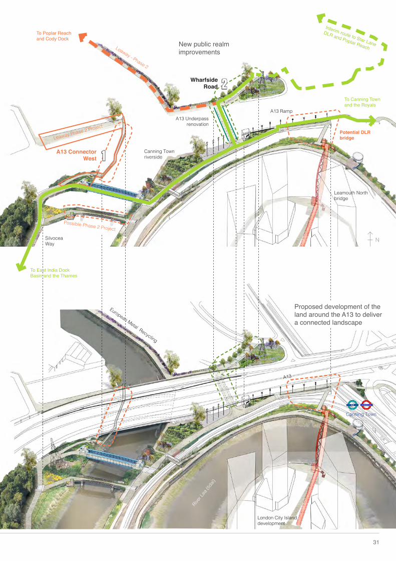
Canning Town is separated from the River Lea by a confl uence of transport infrastructure, which forms a physical barrier to movement and divides Canning Town and its population from the River.
The opportunity here lies in adopting an under-used area of land between the DLR and the A13, rediscovering an accessible riverside for Canning Town - reconnecting the community to both the heritage and open spaces of the Valley. These interventions also form a key manifold of routes on both sides of the river for recreational use and commuting. A series of public realm projects will greatly increase orientation within a connected valley and steer the communities of adjacent developments to the river, while supporting their requirement for improved connections to local centres and transport nodes.
As one of only eight crossings of the Lea Valley south of the M25, there is an opportunity to celebrate the valley at this point, signalling its signifi cance to drivers on the A13 as part of a placemaking strategy.
The existing underpass is being upgraded and made more pleasant as a means of continuing a park landscape beneath the severance of the A13.
There is also the potential to provide a connection between the A13 ramp and the Leamouth North bridge, (outline design work has been undertaken to investigate its feasibility). Any interventions in the area should ensure that the necessary levels and space are safeguarded to allow its future delivery.
CANNING TOWN CONNECTIONS
A13 Connector - Western bankPlanning approval 2011 - Phase 2 Project
Before: Whafside Road was subject to fl y tipping, parking issues and poor public realm. Routes to connections were obscured and felt dangerous.
Wharfside Road
A13 Connector West
Interim route to Star Lane
DLR and Poplar Reach
To Canning Town and the Royals
To East India Dock Basin and the Thames
To Poplar Reach and Cody Dock
Leaway - Phase 2
31
Silvocea Way
A13 Underpass renovation
Wharfside Road
A13 Ramp
Leamouth North bridge
Potential DLR bridge
London City Island development
Canning Town
Canning Town riverside
A13
European Metal Recycling
A13 Connector West
River L
ea (ti
dal)
Leaway Phase 2 Project
Possible Phase 2 Project
Proposed development of the land around the A13 to deliver a connected landscape
New public realm improvements
1
2
N
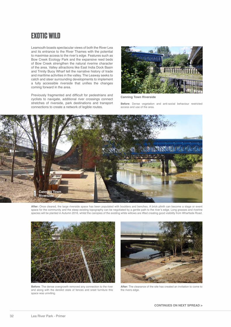
Leamouth boasts spectacular views of both the River Lea and its entrance to the River Thames with the potential to maximise access to the river’s edge. Features such as Bow Creek Ecology Park and the expansive reed beds of Bow Creek strengthen the natural riverine character of the area. Valley attractions like East India Dock Basin and Trinity Buoy Wharf tell the narrative history of trade and maritime activities in the valley. The Leaway seeks to catch and steer surrounding developments to implement a fully accessible riverside that unifi es the changes coming forward in the area.
Previously fragmented and diffi cult for pedestrians and cyclists to navigate, additional river crossings connect stretches of riverside, park destinations and transport connections to create a network of legible routes.
After: Once cleared, the large riverside space has been populated with boulders and benches. A brick plinth can become a stage or event space for the community and the steep existing topography can be negotiated by a gentle path to the river’s edge. Long grasses and riverine species will be planted in Autumn 2016, whilst the canopies of the existing white willows are lifted creating good visibility from Wharfside Road.
Before: The dense overgrowth removed any connection to the river and along with the derelict state of fences and sreet furniture this space was univiting.
After: The clearance of the site has created an invitation to come to the rivers edge.
Canning Town Riverside
Before: Dense vegetation and anti-social behaviour restricted access and use of the area.
CONTINUES ON NEXT SPREAD >
32 Lea River Park - Primer
EXOTIC WILD
1 Canning Town Riverside
33
Future development site
Canning Town
East India
Leamouth Development
The Limmo Park
(future)
Bow
Cree
k
Bow Creek Ecology Park
Bow C
reek
The Thames
East India Dock Basin
Silvo
cea
WayLeam
outh Road
Lower Lea Crossing
To Silvertown and the Royal Docks
Phase 2 to Cody Dock and Poplar Reach
Leaw
ayThe Limmo Park
Phase 2 A13 Connectorto Poplar
Phase 2 Pedestrian and cycle bridge to Silvertown Way
A13
Ramp to A13 and bridge over DLR
Trinity Buoy Wharf
Leamouth Crossing (future)
InstoneWharf Crossing
(future)Thames Path Extension
Thames Path Extension
Proposed development of Leamouth focused to deliver a connected landscape
Planned public realm improvements
Interim route to Star Lane DLR and Poplar Reach
1
2
3
5
4
Silvocea Way
East India Dock Basin
Canning Town Riverside
N
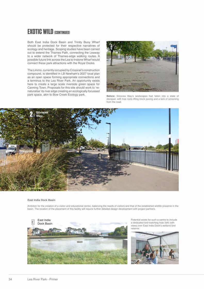
Before: Silvocea Way’s landscapes had fallen into a state of disrepair, with tree roots lifting block paving and a lack of screening from the road.
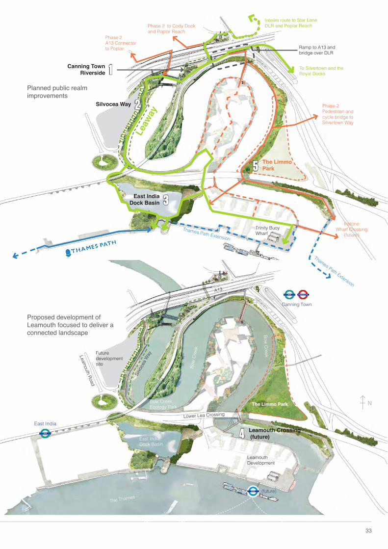
Both East India Dock Basin and Trinity Buoy Wharf should be protected for their respective narratives of ecology and heritage. Scoping studies have been carried out to extend the Thames Path, connecting the Leaway to a wider network of Thames-edge walking routes. A possible future link across the Lea to Instone Wharf would connect these park attractions with the Royal Docks.
The Limmo, currently occupied by Crossrail’s construction compound, is identifi ed in LB Newham’s 2027 local plan as an open space forming appropriate connections and a terminus to the Lea River Park. An opportunity exists here to create a large scale riverside green space for Canning Town. Proposals for this site should work to ‘re-naturalise’ its river edge creating an ecologically focussed park space, akin to Bow Creek Ecology park.
Potential exists for such a centre to include a dedicated bird-watching hide (left) with views over East India Dock’s wetland bird reserve.
East India Dock Basin
Ambition for the creation of a visitor and educational centre, balancing the needs of visitors and that of the established wildlife preserve in the basin. The location of the placement of this facility will require further detailed design development with project partners.
34 Lea River Park - Primer
EXOTIC WILD (CONTINUED)
3 East India Dock Basin
2 Silvocea Way
The Limmo is an important area of open space for the Lea River Park: here there is the opportunity to create a sizeable new park at the confl uence of Lea and Thames. It is also one of the few locations where softening of the river edge is practical.
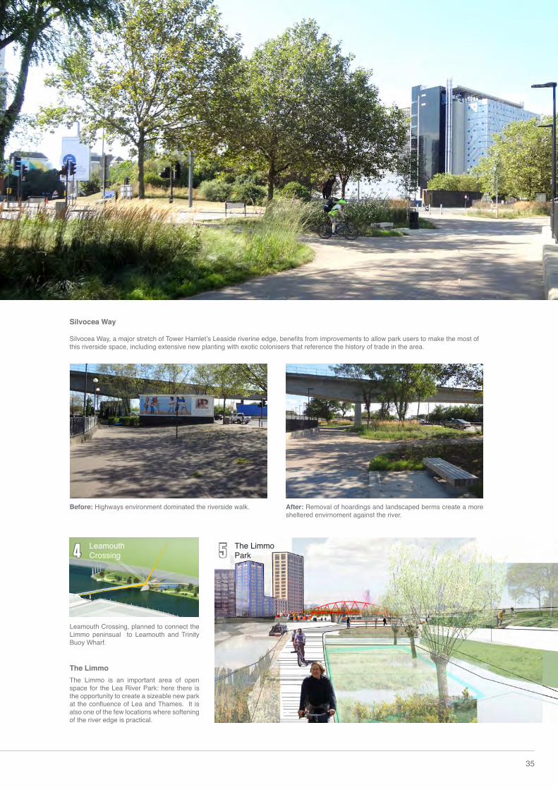
Before: Highways environment dominated the riverside walk. After: Removal of hoardings and landscaped berms create a more sheltered envirnoment against the river.
35
The Limmo Park
Silvocea Way Silvocea Way, a major stretch of Tower Hamlet’s Leaside riverine edge, benefi ts from improvements to allow park users to make the most of this riverside space, including extensive new planting with exotic colonisers that reference the history of trade in the area.
Leamouth Crossing, planned to connect the Limmo peninsual to Leamouth and Trinity Buoy Wharf.
4 5Leamouth Crossing
The Limmo
36 Lea River Park - Primer
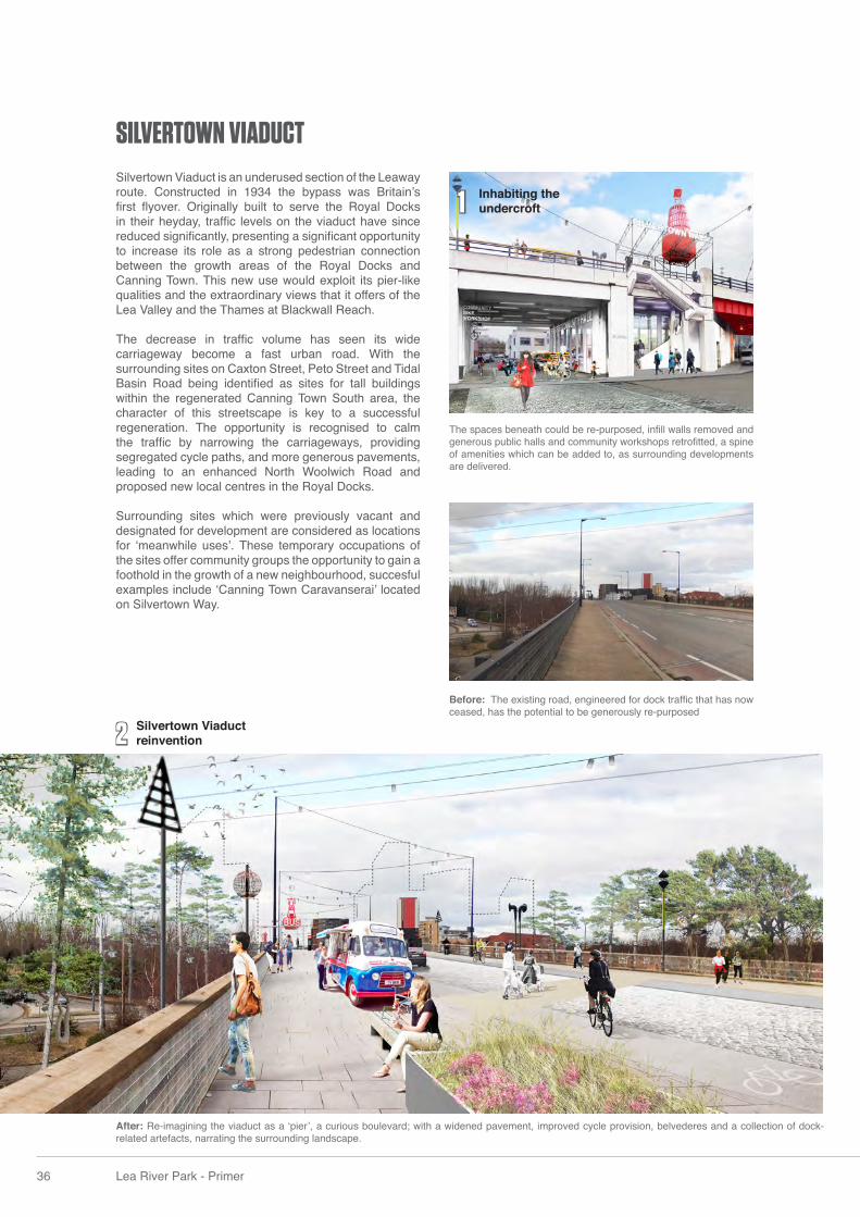
After: Re-imagining the viaduct as a ‘pier’, a curious boulevard; with a widened pavement, improved cycle provision, belvederes and a collection of dock-related artefacts, narrating the surrounding landscape.
SILVERTOWN VIADUCTSilvertown Viaduct is an underused section of the Leaway route. Constructed in 1934 the bypass was Britain’s fi rst fl yover. Originally built to serve the Royal Docks in their heyday, traffi c levels on the viaduct have since reduced signifi cantly, presenting a signifi cant opportunity to increase its role as a strong pedestrian connection between the growth areas of the Royal Docks and Canning Town. This new use would exploit its pier-like qualities and the extraordinary views that it offers of the Lea Valley and the Thames at Blackwall Reach. The decrease in traffi c volume has seen its wide carriageway become a fast urban road. With the surrounding sites on Caxton Street, Peto Street and Tidal Basin Road being identifi ed as sites for tall buildings within the regenerated Canning Town South area, the character of this streetscape is key to a successful regeneration. The opportunity is recognised to calm the traffi c by narrowing the carriageways, providing segregated cycle paths, and more generous pavements, leading to an enhanced North Woolwich Road and proposed new local centres in the Royal Docks.
Surrounding sites which were previously vacant and designated for development are considered as locations for ‘meanwhile uses’. These temporary occupations of the sites offer community groups the opportunity to gain a foothold in the growth of a new neighbourhood, succesful examples include ‘Canning Town Caravanserai’ located on Silvertown Way.
Before: The existing road, engineered for dock traffi c that has now ceased, has the potential to be generously re-purposed
The spaces beneath could be re-purposed, infi ll walls removed and generous public halls and community workshops retrofi tted, a spine of amenities which can be added to, as surrounding developments are delivered.
Silvertown Viaduct reinvention2
1 Inhabiting the undercroft
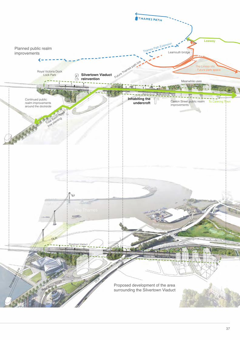
Proposed development of the area surrounding the Silvertown Viaduct
Planned public realm improvements
37
To Canning Town
Leaway
Caxton Street public realm improvements
Royal Victoria Dock Lock Park
Meanwhile uses
Silvertown Viaduct reinvention
Inhabiting the undercroft
Tidal Basin Road
Lower Lea Crossing
Silvertown Viaduct
DLR
Emira
tes A
ir Lin
e
DLR
Continued public realm improvements around the dockside
Tidal Basin Road
tree planting
Leamouth bridge
Future Thames path link
River Lea (tidal)
The Thames
The Limmo site- Future park space
Thames Path Extension
2
1
or
GREENWICH
PENINSULAR
WOOD WHARF
CANARY WHARF + O2
Tham
es Path
CROSSRAIL
TIDE
WAY
SILVERTOWN
TUNNEL
CROSSRAIL
Limehouse Cut Interim Leaway route
Interim Leaway route
38 Lea River Park - Primer
FUTURE PHASED DELIVERY
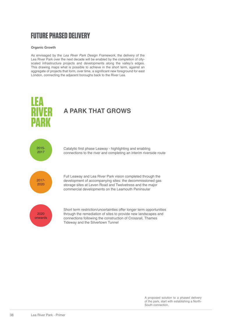
Catalytic fi rst phase Leaway - highlighting and enabling connections to the river and completing an interim riverside route
Short term restriction/uncertainties offer longer term opportunities through the remediation of sites to provide new landscapes and connections following the construction of Crossrail, Thames Tideway and the Silvertown Tunnel
Full Leaway and Lea River Park vision completed through the development of accompanying sites: the decommissioned gas storage sites at Leven Road and Twelvetress and the major commercial developments on the Leamouth Peninsular
Organic Growth
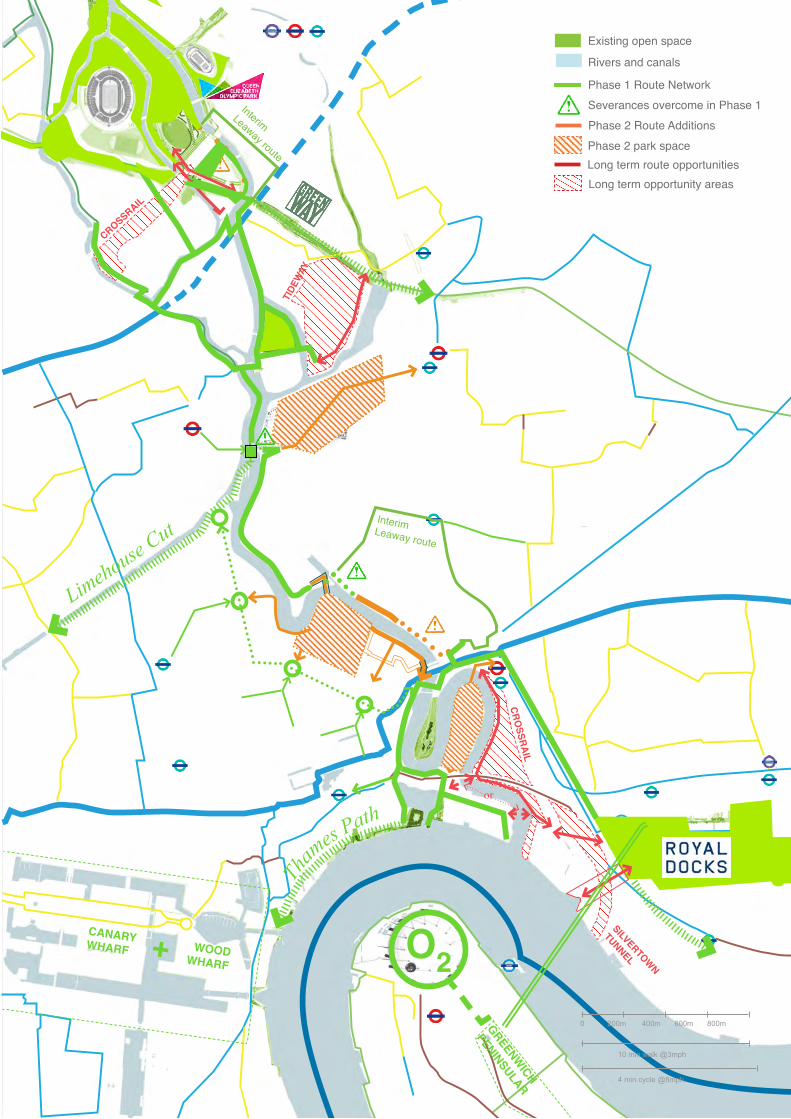
As envisaged by the Lea River Park Design Framework, the delivery of the Lea River Park over the next decade will be enabled by the completion of city-scaled infrastructure projects and developments along the valley’s edges. This drawing maps what is possible to achieve in the short term, against an aggregate of projects that form, over time, a signifi cant new foreground for east London, connecting the adjacent boroughs back to the River Lea.
2017-2020
2015-2017
2020 onwards
A PARK THAT GROWS
A proposed solution to a phased delivery of the park, start with establishing a North-South connection,
LEARIVERPARK
or
GREENWICH
PENINSULAR
WOOD WHARF
CANARY WHARF + O2
Tham
es Path
CROSSRAIL
TIDE
WAY
SILVERTOWN
TUNNEL
CROSSRAIL
Limehouse Cut Interim Leaway route
Interim Leaway route
Existing open space
Rivers and canals
Phase 2 Route Additions
Long term route opportunitiesLong term opportunity areas
Phase 1 Route Network
Phase 2 park space
Severances overcome in Phase 1
0 200m
10 min walk @3mph
4 min cycle @8mph
400m 600m 800m
40 Lea River Park - Primer
The proposals set out here address key severances in the Lower Lea Valley and together form the Leaway, the central parkland spine of the Lea River Park, establishing a network of pedestrian and cycling routes along and across the Valley. A ‘catch and steer’ strategy should be adopted with forthcoming developments in the area to help deliver the required public realm improvements and to create a comphrehensive network of public riverside routes.
This connective landscape network benefi ts from comprehensive policy support and ongoing investment from key stakeholders, including the London Legacy Development Corporation and the London Boroughs of Tower Hamlets and Newham. The Lea River Park and the Leaway continue to receive extensive and enthusiastic support from the Mayor of London, the Greater London Authority, Transport for London and Poplar HARCA. Delivery partners Gasworks Dock Partnership, Canal and Rivers Trust, Lea Valley Regional Park Authority, and Thames 21 have and will continue to enable the delivery of key parts of the Leaway.
The project has been recognised through initiatives such as the Mayor of London’s Great Spaces and Big Green Fund, demonstrating the project’s signifi cance in supporting valley regeneration and addressing the east London context of defi ciency of access to open spaces. By providing the backbone of the emerging park, the Leaway will be instrumental in creating and assembling 235ha of new and improved public open space within the Lower Lea, fi nally realising the long-imagined connection between the Lee Valley Regional Park and the River Thames.
CONCLUSION
Leaway Design Team/Document produced by;
Contact:
Tom HolbrookDirectorDarkroomUnit 8, Dales BreweryGwydir StreetCambridgeCB1 2LJ
with
To fi nd out more about the Leaway visit: queenelizabetholympicpark.co.uk/leaway
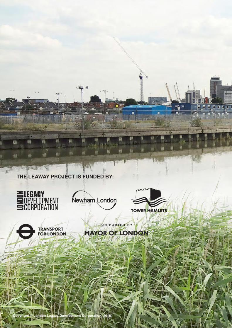
The Leaway is being delivered by the London Legacy Corporation, the London Boroughs of Newham and Tower Hamlets and Transport for London, Poplar HARCA, and Gasworks Dock Partnership.
ENVIRONMENT & LANDSCAPEJCLA
Published:October 2016
Copyright © London Legacy Development Corporation, 2016
THE LEAWAY PROJECT IS FUNDED BY: