Embed Size (px)
Citation preview
Planning for wind energy
Draft Supplementary Guidance
East Ayrshire Local Development Plan:
Proposed Plan
MARCH 20151
2EAST AYRSHIRE LOCAL DEVELOPMENT PLAN PLANNING FOR WIND ENERGY
1 Context and Purpose of Supplementary Guidance. 3
2 A Spatial Framework for wind energy 7
3 Considerations to apply to all wind energy developments of 50 metres or over 11
4 Smaller scale wind energy guidance 25
5 Required information checklist 42
CONTENTS
3EAST AYRSHIRE LOCAL DEVELOPMENT PLAN PLANNING FOR WIND ENERGY
1 Context and Purpose of Supplementary Guidance.
1.1 The Renewable Energy Agenda The use and development of renewable energy technologies plays an important
part in the national and international drive to respond to climate change and move towards a low carbon future. By increasing our use of renewable energy sources and reducing reliance on traditional fossil fuels, not only can we secure a safe long term energy supply, but also tackle the rise in global temperature associated with the burning of fossil fuels.
The Scottish Government is firmly committed to increasing Scotland’s renewable energy output and has set ambitious targets for the generation of renewable energy. The 2020 Routemap for Renewable Energy in Scotland, most recently updated December 2013, sets out the Governments targets for renewable energy generation and how these targets could be met. Headline targets include that by 2020:
• The equivalent of 100% of Scotland’s electricity demand should come from renewables;
• 11% of heat demand should come from renewable sources;
• At least 30% of overall energy demand will be from renewables;
• There should be 500 MW of community and locally-owned renewable energy.
These targets are the most ambitious in the EU and working towards them will see Scotland position itself as an international leader in renewable energy production.
1.2 Wind energy The Scottish Government’s targets are expected to be met from a range of energy
sources, including on and off shore wind, hydro, solar, biomass and geothermal.
Guidance on renewable heat generation will be provided in separate Supplementary Guidance.
Onshore wind energy is an important part of the energy mix and is an area the Scottish Government is committed to expanding to help meet renewables targets. Whilst no specific targets are set out for the amount of renewable energy the government wants to see derived from wind energy, or indeed any spatial indication of where such development could be accommodated, the Routemap makes clear that onshore wind is a resource that can be deployed at a high rate and that can make a large contribution to the progress towards Scotland’s renewable electricity target. As part of the renewables agenda, the Routemap expects the planning system to play its part, by balancing environmental sensitivities with the need to make progress on renewables targets.
1.3 Renewable Energy in East Ayrshire In an East Ayrshire context, similar to much of rural Scotland, the demand for renewable
energy production is most clearly seen in relation to onshore wind energy development.
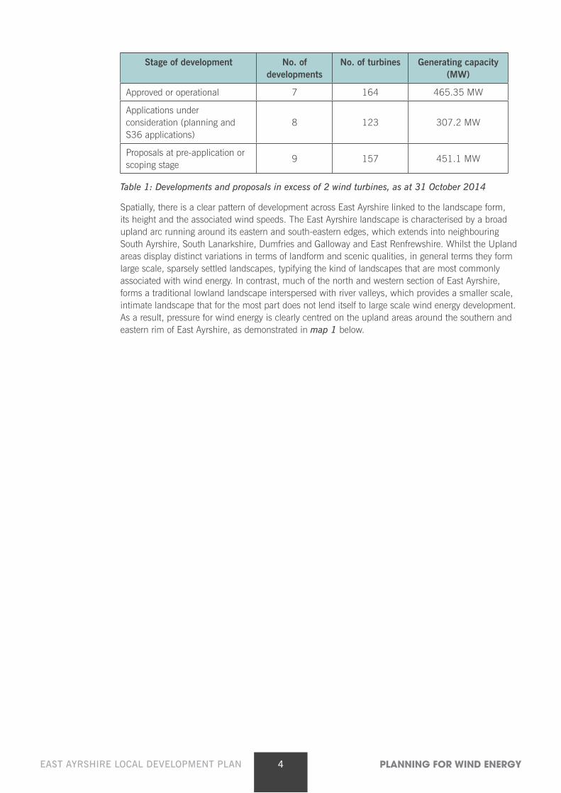
Wind energy has become a major land use in East Ayrshire. With 100 of the 215 turbines that make up Whitelee falling within East Ayrshire, along with the 20 turbine Hare Hill development that provides part of the backdrop to New Cumnock, wind turbines are becoming a notable feature within the landscape. Further development currently in the pipeline, has the potential to bring far greater renewable energy development into East Ayrshire. As per table 1 below, the level of development that is proposed or is currently being scoped far exceeds the scale of development that is currently on the ground.
4EAST AYRSHIRE LOCAL DEVELOPMENT PLAN PLANNING FOR WIND ENERGY
Stage of development No. of developments
No. of turbines Generating capacity (MW)
Approved or operational 7 164 465.35 MW
Applications under consideration (planning and S36 applications)
8 123 307.2 MW
Proposals at pre-application or scoping stage
9 157 451.1 MW
Table 1: Developments and proposals in excess of 2 wind turbines, as at 31 October 2014
Spatially, there is a clear pattern of development across East Ayrshire linked to the landscape form, its height and the associated wind speeds. The East Ayrshire landscape is characterised by a broad upland arc running around its eastern and south-eastern edges, which extends into neighbouring South Ayrshire, South Lanarkshire, Dumfries and Galloway and East Renfrewshire. Whilst the Upland areas display distinct variations in terms of landform and scenic qualities, in general terms they form large scale, sparsely settled landscapes, typifying the kind of landscapes that are most commonly associated with wind energy. In contrast, much of the north and western section of East Ayrshire, forms a traditional lowland landscape interspersed with river valleys, which provides a smaller scale, intimate landscape that for the most part does not lend itself to large scale wind energy development. As a result, pressure for wind energy is clearly centred on the upland areas around the southern and eastern rim of East Ayrshire, as demonstrated in map 1 below.
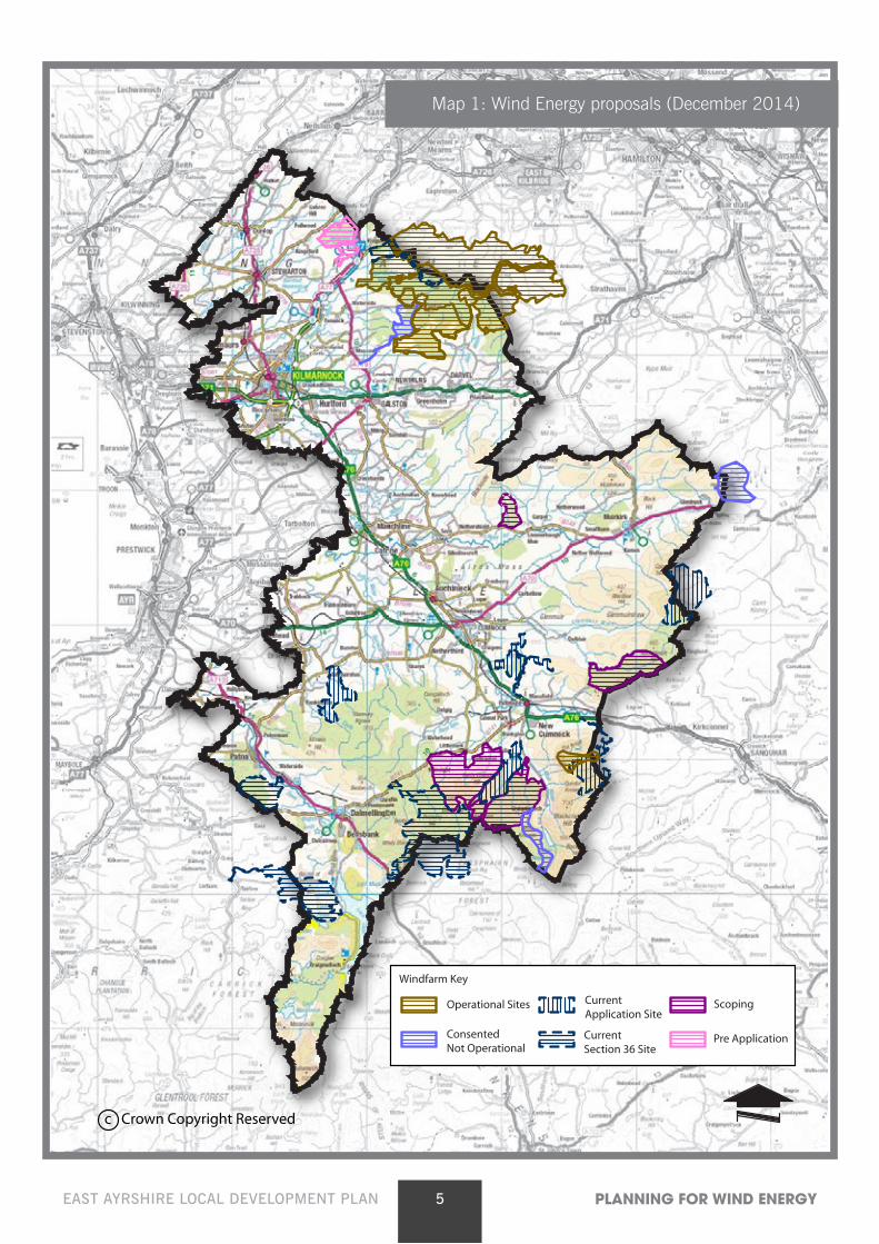
5EAST AYRSHIRE LOCAL DEVELOPMENT PLAN PLANNING FOR WIND ENERGY
c Crown Copyright Reserved
Windfarm Key
Pre Application
Scoping
ConsentedNot Operational
Operational Sites CurrentApplication Site
CurrentSection 36 Site
Map 1: Wind Energy proposals (December 2014)
6EAST AYRSHIRE LOCAL DEVELOPMENT PLAN PLANNING FOR WIND ENERGY
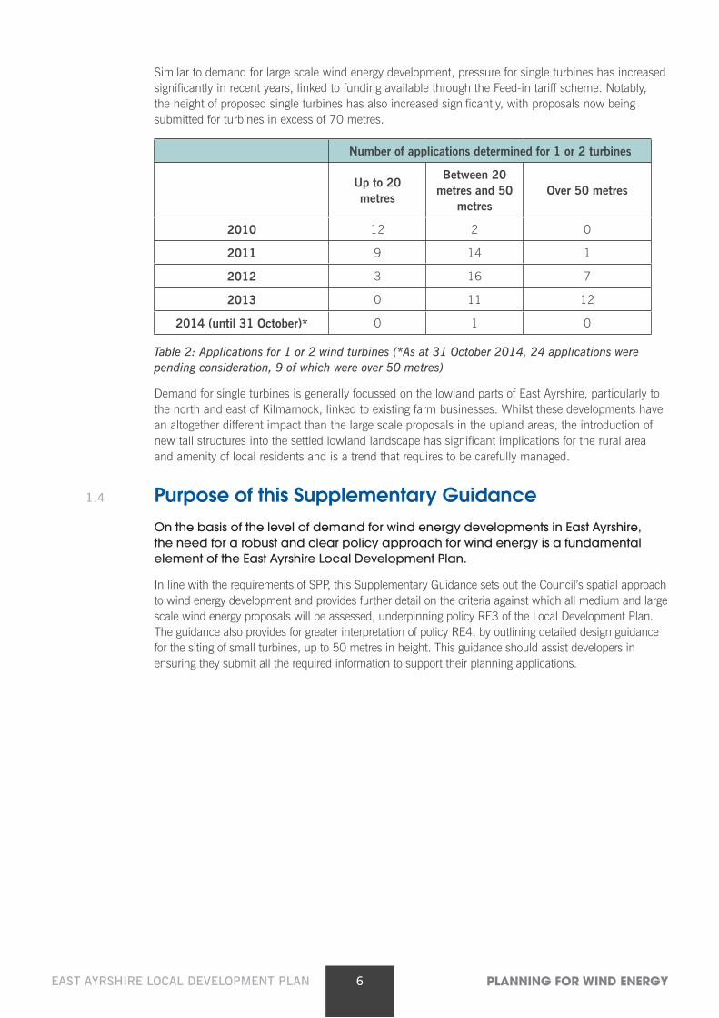
Similar to demand for large scale wind energy development, pressure for single turbines has increased significantly in recent years, linked to funding available through the Feed-in tariff scheme. Notably, the height of proposed single turbines has also increased significantly, with proposals now being submitted for turbines in excess of 70 metres.
Number of applications determined for 1 or 2 turbines
Up to 20 metres
Between 20 metres and 50
metresOver 50 metres
2010 12 2 0
2011 9 14 1
2012 3 16 7
2013 0 11 12
2014 (until 31 October)* 0 1 0
Table 2: Applications for 1 or 2 wind turbines (*As at 31 October 2014, 24 applications were pending consideration, 9 of which were over 50 metres)
Demand for single turbines is generally focussed on the lowland parts of East Ayrshire, particularly to the north and east of Kilmarnock, linked to existing farm businesses. Whilst these developments have an altogether different impact than the large scale proposals in the upland areas, the introduction of new tall structures into the settled lowland landscape has significant implications for the rural area and amenity of local residents and is a trend that requires to be carefully managed.
1.4 Purpose of this Supplementary Guidance On the basis of the level of demand for wind energy developments in East Ayrshire,
the need for a robust and clear policy approach for wind energy is a fundamental element of the East Ayrshire Local Development Plan.
In line with the requirements of SPP, this Supplementary Guidance sets out the Council’s spatial approach to wind energy development and provides further detail on the criteria against which all medium and large scale wind energy proposals will be assessed, underpinning policy RE3 of the Local Development Plan. The guidance also provides for greater interpretation of policy RE4, by outlining detailed design guidance for the siting of small turbines, up to 50 metres in height. This guidance should assist developers in ensuring they submit all the required information to support their planning applications.
7EAST AYRSHIRE LOCAL DEVELOPMENT PLAN PLANNING FOR WIND ENERGY
2. A Spatial Framework for wind energy2.1 SPP Methodology Scottish Planning Policy sets out a clear requirement for Local Development Plans
to include a Spatial Framework for onshore wind energy. The purpose of the spatial framework is to set out spatially those areas where wind energy development is likely to be most appropriate, providing a guide for developers and communities.
SPP requires that spatial frameworks identify certain constraints and effectively divide each authority area into 3 groups as set out in table 3 below.
2.2 Scale of development SPP requires that Development Plans should indicate the minimum scale of onshore
wind development that their spatial framework is intended to apply to. When assessing the appropriateness of wind energy developments, the Council is of the view that it is the environmental impact of the proposal and its physical relationship with its setting, rather than generating capacity, that most influence the significance and appropriateness of any development proposal. Therefore the spatial framework applies to all developments for wind energy development of 50 metres in height or above. For clarity, the spatial framework applies to proposals of single or multiple turbines of 50 metres or above. The term wind farm is not used.
Turbines smaller than 50 metres have a very different development focus; generally they are proposed as single or small groupings of turbines, within lowland settled landscapes where they are associated with existing farms or settlements. Given the diversity of such landscapes and the different factors that need to be taken into account, it is considered that it is not appropriate to provide strategic guidance in a spatial format for turbines under 50 metres. Instead, they are more appropriately assessed against RE6 of the LDP and should be guided by the dedicated design guidance, as outlined in section 4.0 of this document.
In terms of landscape guidance, the scale of development is further broken down into large and medium typologies; over 70 metres and between 50 and 70 metres, respectively.
Grouping DescriptionConstraints to be considered in line
with SPP
How do the constraints apply to East Ayrshire?
Group 1 Areas where wind energy (over 50 metres) will not be acceptable
National Parks
National Scenic areas
East Ayrshire does not contain any National Parks or National Scenic Areas.
East Ayrshire’s spatial framework does not include Group 1.
8EAST AYRSHIRE LOCAL DEVELOPMENT PLAN PLANNING FOR WIND ENERGY
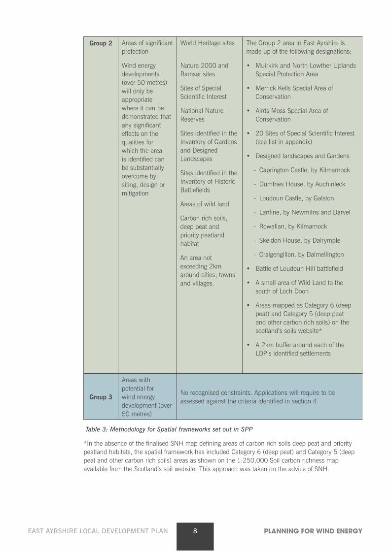
Group 2 Areas of significant protection
Wind energy developments (over 50 metres) will only be appropriate where it can be demonstrated that any significant effects on the qualities for which the area is identified can be substantially overcome by siting, design or mitigation
World Heritage sites
Natura 2000 and Ramsar sites
Sites of Special Scientific Interest
National Nature Reserves
Sites identified in the Inventory of Gardens and Designed Landscapes
Sites identified in the Inventory of Historic Battlefields
Areas of wild land
Carbon rich soils, deep peat and priority peatland habitat
An area not exceeding 2km around cities, towns and villages.
The Group 2 area in East Ayrshire is made up of the following designations:
• Muirkirk and North Lowther Uplands Special Protection Area
• Merrick Kells Special Area of Conservation
• Airds Moss Special Area of Conservation
• 20 Sites of Special Scientific Interest (see list in appendix)
• Designed landscapes and Gardens
- Caprington Castle, by Kilmarnock
- Dumfries House, by Auchinleck
- Loudoun Castle, by Galston
- Lanfine, by Newmilns and Darvel
- Rowallan, by Kilmarnock
- Skeldon House, by Dalrymple
- Craigengillan, by Dalmellington
• Battle of Loudoun Hill battlefield
• A small area of Wild Land to the south of Loch Doon
• Areas mapped as Category 6 (deep peat) and Category 5 (deep peat and other carbon rich soils) on the scotland’s soils website*
• A 2km buffer around each of the LDP’s identified settlements
Group 3
Areas with potential for wind energy development (over 50 metres)
No recognised constraints. Applications will require to be assessed against the criteria identified in section 4.
Table 3: Methodology for Spatial frameworks set out in SPP
*In the absence of the finalised SNH map defining areas of carbon rich soils deep peat and priority peatland habitats, the spatial framework has included Category 6 (deep peat) and Category 5 (deep peat and other carbon rich soils) areas as shown on the 1:250,000 Soil carbon richness map available from the Scotland’s soil website. This approach was taken on the advice of SNH.
9EAST AYRSHIRE LOCAL DEVELOPMENT PLAN PLANNING FOR WIND ENERGY
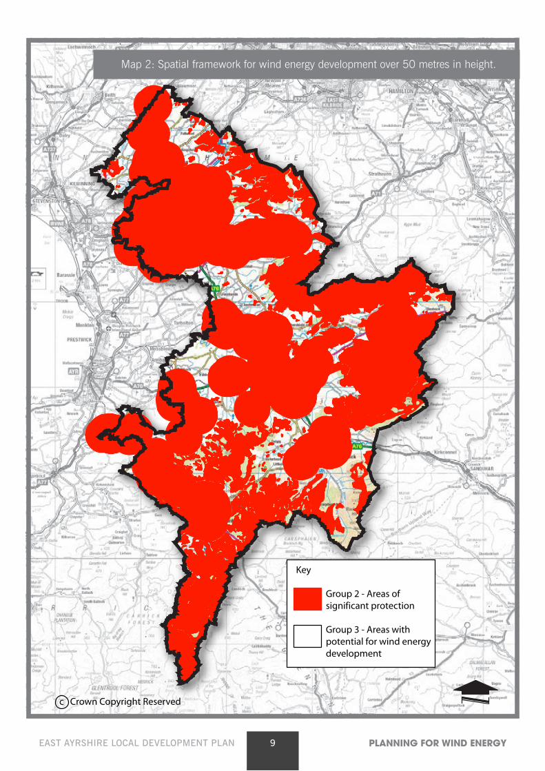
c Crown Copyright Reserved
Key
Group 2 - Areas of significant protection
Group 3 - Areas with potential for wind energy development
Map 2: Spatial framework for wind energy development over 50 metres in height.
10EAST AYRSHIRE LOCAL DEVELOPMENT PLAN PLANNING FOR WIND ENERGY
2.3 What does the spatial framework mean for East Ayrshire?
Only in group 1, should there be a presumption against wind energy developments. As noted in table 3 and Map 2, East Ayrshire does not contain any areas that fall within group 1. As per SPP and policy RE3, whilst group 2 areas are to be given significant protection, there may be limited opportunities for sensitively sited wind energy proposals, where it can be demonstrated that any significant effects on the qualities of these areas can be substantially overcome by siting, design or other mitigation, through assessment against the criteria listed in Schedule 1 of the Plan.
Within Group 3 areas, proposals will be supported where it can be demonstrated that that they are acceptable in terms of the criteria listed in Schedule 1 of the Plan and detailed in Section 3 below.
Any developer exploring opportunities for wind energy developments in East Ayrshire should give due attention to the spatial framework, recognising that any development within an Area requiring significant protection will only be supported should its impacts be shown to be acceptable through the planning application and EIA processes, taking on board the considerations outlined in Schedule 1 of the LDP and described in detail below.
2.4 Where are East Ayrshire’s areas of strategic capacity? SPP indicates that group 3 areas constitute areas of strategic capacity for wind energy
development. However, as the LDP clearly sets out, much of the land that makes up group 3 within East Ayrshire is inappropriate for wind energy development over 50 metres. Instead of defining these areas of having strategic capacity, the LDP takes a more realistic approach and describes why these areas do not in fact have strategic capacity.
The Scottish Government has made clear in its advice to the Council in the preparation of the LDP that sites of existing wind energy development can be defined as areas of strategic capacity. Whitelee is currently East Ayrshire’s only large scale wind energy development. Although much of the Whitelee area is identified as requiring significant protection through the spatial framework map, the development was appropriately planned and designed to become a successful example of a large scale wind energy scheme. In moving forward, the Council sees merit in identifying the area as having strategic capacity, on the basis that there may be scope for limited extension in the upland core of the area, away from the more sensitive outer edges, and due to the potential for re-powering. Whilst any re-powering applications would be assessed on their own merits against RE3, in principle, it is considered that this area could be suitable for such proposals. The Whitelee area is therefore identified as East Ayrshire’s only area of strategic capacity.
11EAST AYRSHIRE LOCAL DEVELOPMENT PLAN PLANNING FOR WIND ENERGY
3 Considerations to apply to all wind energy developments of 50 metres or over
SPP makes clear that decisions on wind energy proposals should take account of the spatial framework, but should also be assessed against identified policy criteria. The policy criteria are listed in Schedule 1 of the Plan. This section of the guidance provides further detail on these criteria, providing guidance on what information should be submitted for developments over 50 metres and outlining how applications will be assessed.
The criteria to be considered in the determination of planning applications are grouped under three headings:
(i) Environment
(ii) Local Economy and Communities and;
(iii) Infrastructure.
3.1 Environmental criteria
3.1.1 Landscape and Visual Amenity
The landscape and visual impacts of a development will be assessed for every application. The level and extent of landscape and visual assessment required will depend on the scale of development proposed.
As part of the application process, a Landscape and Visual Impact Assessment (LVIA) should be prepared to clearly demonstrate the landscape and visual effects of any proposal. Landscape impacts comprise of the potential change that will take place to the physical landscape, including impact on landscape character and impact on prominent landscape features and their setting. Visual Impact Assessments consider the potential changes to available views in a landscape that will arise as a result of a development proposal and the resultant effect on visual amenity and peoples responses to such changes.
The LVIA must follow best practice in the selection of viewpoint locations and in the preparation of photomontage/panoramic images. (Visual representation of wind farms (SNH – July 2014))
A Zone of Theoretical Visibility map (ZTV) should be used as starting point to identify appropriate locations for viewpoints, selecting points where the development is likely to be most visible and where there are appropriate receptors. The list of viewpoints must be agreed with the Council and, in respect of large scale schemes, should be subject to consultation with SNH. Viewpoints should comprise a variety of local and long range views and should include, but not be restricted to, the following receptors:
• Settlements from where the development will be visible
• Important heritage designations, including prominent listed buildings, scheduled monuments and designed gardens and landscapes where there setting may be affected.
• Strategic walking routes including the Southern Upland Way and the River Ayr Way
• Landmark Hills comprising Auchenroy Hill, Benquhat Hill, Blackcraig Hill, Craigbraneoch Rig, Hare Hill, Corsencon Hill, Wardlaw Hill, Cairn Table, Blackside, Loudoun Hill and Carrick Forest Hills.
12EAST AYRSHIRE LOCAL DEVELOPMENT PLAN PLANNING FOR WIND ENERGY
• The Sensitive Landscape Area
• Tourist Routes, A Roads and other relevant local roads.
East Ayrshire Landscape Wind Capacity Study and key landscape constraints
In light of the pressure for wind energy development across Ayrshire, a landscape capacity study was commissioned by SNH, along with East, South and North Ayrshire Councils to assess the sensitivity of the landscape to further wind energy development. This study was approved by East Ayrshire Council in July 2013 as non-statutory supplementary guidance and is publicly available on the Council’s website.
The Capacity Study provides an up-to-date, detailed and robust analysis of the special landscape features and characteristics of particular landscape areas and assesses the sensitivities of such landscape areas to wind energy developments. In line with the conclusions of the study, the following spatial principles should be followed in identifying sites for wind energy developments:
• Turbines over 50 metres should be directed to the less sensitive parts of East Ayrshire’s uplands, where their significant scale can best be accommodated within the natural landscape;
• Wind energy development should not compromise the most valuable features of the East Ayrshire upland landscape, particularly (i) landmark hills and their setting such as Cairn Table and Blackside and (ii) the rugged scenery and wildness associated with the Loch Doon area.
• East Ayrshire’s lowlands, particularly the sensitive river valleys, should be protected from turbines over 50 metres, which would dominate the lowland landscape and distract from its diverse land cover pattern and heritage.
• Development should not result in unacceptable cumulative impacts when taken together with other developments. To date, this is especially prevalent in the context of Whitelee, given the significant scale of development that has taken place.
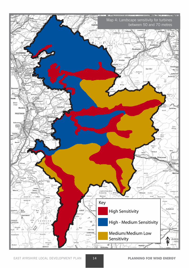
The study identifies a number of landscape character areas that have a high sensitivity to turbines over 70 metres. These areas are primarily the lowland section of East Ayrshire including the lowland river valleys, and the most sensitive of the upland areas, comprising of the upland river valleys and glens and the area around Loch Doon. The study also identifies landscapes with a high-medium sensitivity to turbines over 70 metres and those areas with a medium sensitivity. The same sensitivities are also assessed for turbines between 50 and 70 metres. Maps 3 and 4 below show the landscape sensitivities for turbines in excess of 70 metres and between 50 and 70 metres respectively.
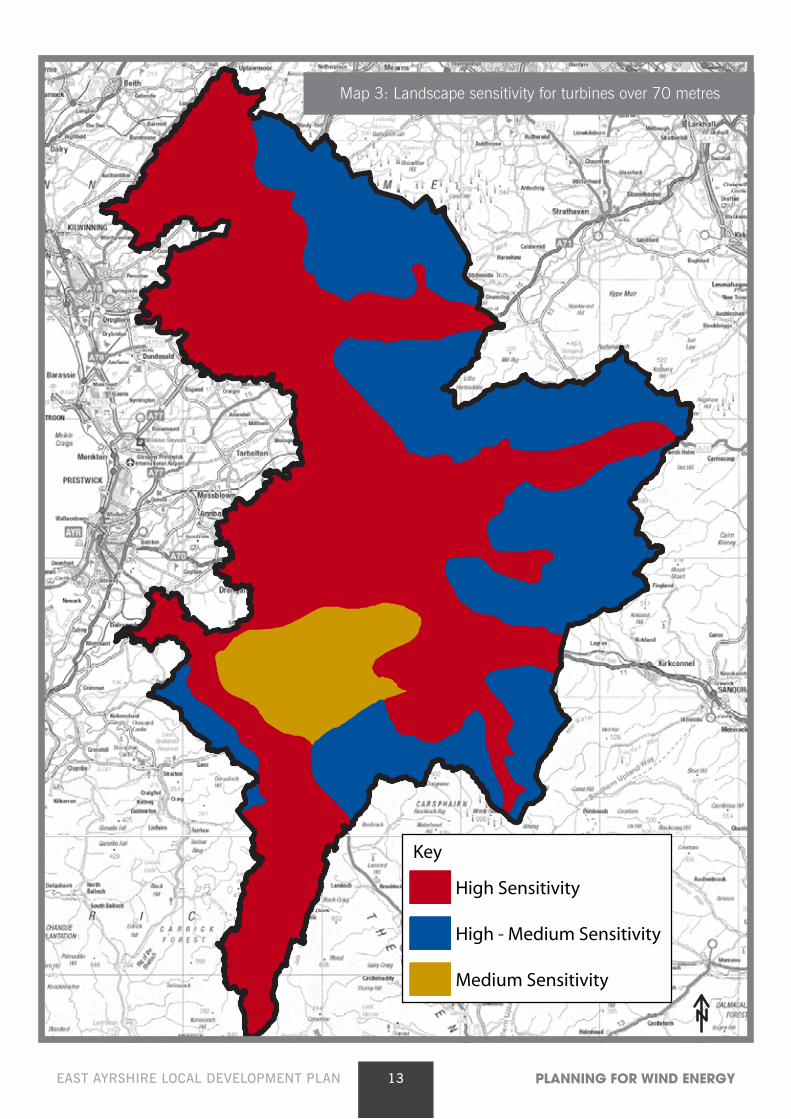
13EAST AYRSHIRE LOCAL DEVELOPMENT PLAN PLANNING FOR WIND ENERGYThis map is reproduced from the Ordnance Survey material with permission of Ordnance Survey on behalf of the Controller of Her Majesty`s Stationery
Office(C) Crown copyright. Unauthorised reproduction infringes Crown Copyright and may lead to prosecution or civil proceedings. East AyrshireCouncil. 100023409.
High Sensitivity
High - Medium Sensitivity
Medium Sensitivity
Key
Map 3: Landscape sensitivity for turbines over 70 metres
14EAST AYRSHIRE LOCAL DEVELOPMENT PLAN PLANNING FOR WIND ENERGY
This map is reproduced from the Ordnance Survey material with permission of Ordnance Survey on behalf of the Controller of Her Majesty`s StationeryOffice(C) Crown copyright. Unauthorised reproduction infringes Crown Copyright and may lead to prosecution or civil proceedings. East Ayrshire
Council. 100023409.
High Sensitivity
High - Medium Sensitivity
Medium/Medium Low Sensitivity
Key
Map 4: Landscape sensitivity for turbines between 50 and 70 metres
15EAST AYRSHIRE LOCAL DEVELOPMENT PLAN PLANNING FOR WIND ENERGY
The landscape study makes the following key conclusions:
• Landscapes identified as having a high sensitivity to development have no scope to accommodate that scale of development;
• Landscapes identified as having a high-medium sensitivity to development have very limited scope to accommodate that scale of development. These limited opportunities are described in the Landscape study.
• Landscapes identified as having a medium or medium-low sensitivity to development offer the most scope for accommodating that scale of development.
As required through policies RE3 and RE5, all proposals will be required to pay due regard to landscape sensitivities. Any proposals in high or high-medium sensitivity areas should be accompanied by a robust assessment of the landscape impacts to demonstrate that such sites are appropriate for wind energy development. The applicant should be able to demonstrate an understanding of the key sensitivities of the landscape area in which their development is proposed and show how they have responded to these sensitivities in their site selection and design process. This should include an indication of how any negative landscape impacts will be avoided or minimised.
The Council will use the landscape sensitivity maps and detailed sensitivity assessments within the landscape capacity study to help assess all applications for wind energy development.
SNH has prepared several pieces of guidance in relation to expressing and assessing the landscape impacts of wind energy developments and are currently reviewing existing guidance. Developers should refer to:
• Siting and designing windfarms in the landscape (SNH – May 2014) http://www.snh.org.uk/pdfs/strategy/renewables/Guidance_Siting_Designing_wind_farms.pdf
• Visual representation of wind farms (SNH – July 2014) http://www.snh.org.uk/pdfs/publications/heritagemanagement/Visual%20representation%20of%20wind%20farms%20-%20version%202.1%20-%20December%202014.pdf
3.1.2 Cumulative impact
Cumulative impacts are the additional changes caused by a proposed development in conjunction with other similar developments i.e. the combined impact of more than one development. The assessment of cumulative impacts should form a key part of LVIA’s submitted alongside any application.
Cumulative impacts most frequently involve landscape and visual impacts, but may also affect natural heritage designations and aviation interests. Cumulative impacts need to be assessed where a proposed development will be viewed in conjunction with other developments. Given the scale of wind energy development proposed in East Ayrshire and in neighbouring authorities, the cumulative impact is likely to be relevant to all wind energy proposals.
Key issues to be addressed in the assessment of cumulative impacts include:
• Given the number of different wind energy proposals moving through the consents procedures, the cumulative impact of developments is continually evolving. In preparing cumulative assessments, all
16EAST AYRSHIRE LOCAL DEVELOPMENT PLAN PLANNING FOR WIND ENERGY
operational and consented wind energy developments as well as those at the planning and Section 36 application stage, should be taken into account. The Council also considers it good practice for applicants to consider other developments where the scoping stage has been undertaken, as these may get to the application stage quicker than the applicants own submission.
• Assessment should take account of wind energy developments and proposals in East Ayrshire and surrounding authorities. The Zone of Theoretical Visibility (ZTV) should consider all such developments/proposals within a 35km buffer of the proposed site.
• Cumulative impact assessment should consider sequential views i.e. an assessment of how views are affected when travelling through the landscape rather than just at one fixed point.
• Cumulative impact should not be limited to other wind energy developments, but should also consider other land uses, including surface coal mining where relevant.
The assessment of cumulative impacts should take on board the guidance and methodologies included within:
• The East Ayrshire Landscape Wind Capacity study, which highlights particular cumulative issues in relation to each landscape character area within East Ayrshire.
• ‘Assessing the cumulative impact of onshore wind energy developments’ (SNH – 2012) http://www.snh.gov.uk/docs/A675503.pdf
Key cumulative issue raised in the Landscape Wind Capacity Study
Whitelee wind farm comprises of the original development, plus two additional extensions, altogether amounting to 100 turbines in East Ayrshire, with a further 115 turbines in neighbouring authorities. In addition, there are 15 turbines approved at Sneddons Law, adjacent to Whitelee and within East Renfrewshire, a further two developments at Middleton and Neilston adding a further 10 turbines, approximately 6km and 9km respectively from Whitelee.
Whitelee sits within the Plateau Moorland landscape character type. The scale of development within this landscape has resulted in the nature of the landscape changing to what can now be viewed on the ground as a wind farmed landscape with wind turbines being the dominant landscape feature.
The landscape study makes clear that the level of development that has already occurred, limits the capacity of this landscape to accommodate further development. The landscape study concludes that there is very limited scope for additional turbines over 70 metres within this landscape. The study indicates two opportunities for further development that would not result in unacceptable impacts, comprising; (i) further development in the simpler core of the upland plateau, set well back from the small scale settled fringes and (ii) a small cluster of less than 10 turbines to the west of the M77 motorway.
17EAST AYRSHIRE LOCAL DEVELOPMENT PLAN PLANNING FOR WIND ENERGY
In line with the findings of the landscape study, in order to prevent unacceptable cumulative impacts arising in the Whitelee plateau moorland landscape, the Council will act to:
(i) prevent the growth of the wind farmed landscape stretching into more sensitive outer edges of the landscape area;
(ii) maintain a visual separation between Whitelee and the East Renfrewshire turbines to the north west; and
(iii) protect the amenity of surrounding residential properties.
As indicated in policy RE4, any development proposal within the Whitelee landscape character area, over and above the limited opportunities described in the landscape study, would result in unacceptable cumulative impacts. Given the large scale of development that has already taken place at Whitelee and the impact the existing turbines have had on East Ayrshire’s skyline, the Council will seek to protect the landscape from any further development that would exceed the landscapes capacity to absorb wind energy development. Map 13 of Volume 1 of the LDP outlines the extent of the area to the south and south east of Whitelee, where additional development will result in unacceptable cumulative impacts.
At the time of writing the southern part of East Ayrshire, is under significant pressure for wind energy development. This has not yet filtered through to development on the ground, however there are a number of consented schemes, both within East Ayrshire and close to its boundary in South Ayrshire and Dumfries and Galloway. It is considered that it is not appropriate to at this point in time make an assessment of the cumulative impact of such developments. As indicated in RE4, the Council will monitor closely this evolving situation and will, if necessary, update this guidance should the level of consented development have implications for the landscape capacity of the area.
3.1.3 Carbon-rich soils
Scotland’s peatlands soils play an important role in driving towards a low carbon future. The carbon stored in Scotland’s soils is equivalent to over 180 years of greenhouse gas emissions from Scotland at current emission rates.
Areas of carbon rich soils, deep peat and priority peatland habitats are identified within the spatial framework as areas requiring special protection. In line with Policy RE3 of the LDP, any proposal in such an area will only be permitted where any significant effects on the environmental quality of such soils can be substantially overcome by siting, design or mitigation.
Any proposed wind energy development must confirm whether existing peatlands will be disturbed. If peatlands are to be affected, the carbon losses arising from the disturbance of the peat must be balanced against the carbon gains that would come from the renewable energy output of the proposed wind energy development. In order to make this assessment, applications should be accompanied by evidence that the proposal has been assessed for carbon losses and savings using the Scottish Government’s published carbon calculation method, as per link below:
http://www.gov.scot/Topics/Business-Industry/Energy/Energy-sources/19185/17852-1/CSavings
3.1.4 Natural heritage, biodiversity and wild land
East Ayrshire benefits from significant areas of recognised natural heritage, most notably Natura 2000 sites, SSSI’s and a small area of Wild Land. These areas are granted special protection within the spatial framework and developments within these areas will only be acceptable under LDP policy RE3 when any significant negative impacts can be overcome by siting, design or mitigation. Any such proposals would require to be accompanied by substantial supporting information, to the satisfaction of the Council and SNH.
18EAST AYRSHIRE LOCAL DEVELOPMENT PLAN PLANNING FOR WIND ENERGY
Outwith the above recognised areas, developers will be expected to fully assess the natural attributes of the sites in terms of biodiversity and to assess the impact of the proposal on existing habitats and species. As far as possible, mitigation measures should be identified for any predicted adverse impacts.
Wind energy developments can present potential risks to birds, through displacement, collision with turbine blades or direct habitat loss through the construction of wind energy infrastructure. The RSPB has prepared a map indicating the areas across Scotland where wind energy developments would pose the biggest risk to important bird populations. Developers should consider this map in developing wind energy proposals. An assessment of the potential impacts that a wind energy development, pre and post construction, may have on birds should be included as part of the application submission, in line with guidance published by SNH.
http://www.snh.gov.uk/planning-and-development/renewable-energy/onshore-wind/windfarm-impacts-on-birds-guidance/
3.1.5 Historic Environment
East Ayrshire’s historic environment plays an important role in establishing a sense of place and local distinctiveness. The LDP seeks to protect and enhance important historic environment features and their settings.
All wind energy proposals will be required to assess the impact of development on the following historic features, including their setting.
• Listed buildings
• Conservation areas
• Scheduled monuments
• Battlefields
• Designed Gardens and Landscapes
The Council will be unlikely to support a development that would result in a significant adverse impact on a recognised historic asset, in particular one of national interest.
3.1.6 Effects on hydrology, the water environment and flood risk
Wind energy developments require to be carefully considered and monitored especially at construction stage, to avoid any pollution of watercourses and groundwater and to ensure the ecological status of waterbodies is not adversely affected. An assessment of both the risks to water quality and any increased risk of flooding as well as any mitigation measures proposed, should be carried out through the EIA process, and will be subject to detailed consultation with SEPA and SNH.
3.1.7 Forestry and Woodlands
Trees and woodland make an important contribution to East Ayrshire’s environment and economy and account for a substantial proportion of the area’s land cover.
The Scottish Government Policy on ‘The Control of Woodland Removal’ recognises the value of woodlands and seeks to reduce the impact of development on woodland resources by requiring compensatory planting for woods lost to development.
The Ayrshire and Arran Forestry and Woodland Strategy (2013), which forms non-statutory guidance to the LDP, aims to steer appropriate compensatory planting to areas where a wide range
19EAST AYRSHIRE LOCAL DEVELOPMENT PLAN PLANNING FOR WIND ENERGY
of benefits can be delivered. The strategy sets out the priorities for woodland expansion within spatially defined landscape zones, which provides a starting point for identifying appropriate sites for providing compensatory planting. Where woodland is to be removed in Ayrshire and Arran to facilitate development, the first preference should be to replace with onsite planting. Where this is not appropriate, the associated compensatory planting should also be provided within the boundary of Ayrshire and Arran.
Wind energy developments that involve the removal of woodland cover will be required to provide a phased deforestation plan and details of compensatory planting proposals. Proposals should pay due regard to the Forestry and Woodland Strategy and should be prepared in consultation with the Forestry Commission Scotland.
3.1.8 Effect on greenhouse gas emissions
Applications should be accompanied by an estimate of the total annual CO2 savings that would be derived from the proposal. This should be weighed against the carbon footprint associated with the wind energy developments construction, in order to indicate the ‘CO2 payback period’ i.e. the time required for the development to generate enough electricity to offset its own carbon footprint.
Where the proposal will affect established peatlands, the Council will expect the CO2 payback period to take into account the carbon losses resulting from the loss of peat.
3.2 Local economy and community criteria
3.2.1 Residential amenity
Wind energy developments can have a significant impact on the amenity of residents living close by. The Council would recommend that wind energy developers notify as many residents as possible at each stage of the application process. In particular, the Council encourages developers to notify all residential properties within 2km of the proposal in addition to the statutory neighbour notification process that takes place for every application. A key role of the planning authority in determining and responding to applications for wind energy developments will be to examine the likely impact that will be felt by residents and to assess whether such an impact will be at a level considered acceptable. Residential amenity will be assessed in three separate respects:
Noise The noise associated with wind turbines is a common concern raised in relation to wind energy
developments. Two distinct types of noise are generated by turbines; mechanical noise, associated with the gearbox and generator and aerodynamic noise, produced by the blades moving through the air.
Any adverse noise impacts are most effectively eliminated through ensuring wind energy proposals are sufficiently remote from communities and residential properties. All proposals for turbines of over 50 metres should be accompanied by a full assessment of the noise impacts of the proposal, in line with ETSU-R-97 standards, which outlines a framework for measuring noise. Applicants should refer to the Institute of Acoustics ‘A Good Practice Guide to the Application of ETSU-R-97 For the Assessment and Rating of Wind Turbine Noise’, (May 2013). The Council will only support proposals where it can be clearly evidenced that the noise levels will offer a reasonable degree of protection to neighbours of wind energy developments. As part of any planning consent granted, there may be a requirement for continuous noise monitoring.
20EAST AYRSHIRE LOCAL DEVELOPMENT PLAN PLANNING FOR WIND ENERGY
Shadow flicker Shadow flicker is caused by low sun passing behind the rotating blades of a turbine. The movement of
the turbine blades can cause light and dark shadows to be to be cast over properties. Where there are narrow window openings in a property this flickering between light and dark can cause considerable disturbance and annoyance.
Shadow flicker can generally be avoided by ensuring there is an adequate separation distance between turbines and existing properties. As a general rule, there should be separation distance of 10 times the blade diameter, between any turbine and surrounding properties. However, depending on topography and particular site specific circumstances, careful siting of turbines may be required to reduce or eliminate the potential for shadow flicker. Developers are expected to demonstrate that the elimination of shadow flicker has been fully considered in the preparation of wind energy proposals. Details should also be provided of any proposed mitigation scheme to shut off turbines should periods of shadow flicker arise.
Visual dominance To reduce the visual dominance of wind energy developments, as a general rule proposals should
be 2km apart from any settlement, as outlined in SPP and the LDP spatial framework. As stated in relation to Landscape and Visual Impact Assessment, all proposals for turbines over 50 metres should be accompanied by a clear and robust assessment of the how the development will be viewed from nearby settlements.
The LVIA should consider fully the visual impact of the proposed developments on individual properties within the vicinity of the development. Whilst no standard separation guidelines are suggested in specific reference to visual impacts, applicants are expected to make an assessment of the visual effects of the proposed development on all residential properties within 2km of the proposed turbines. The Council will only support proposals when the applicant can demonstrate that the proposal will not result in any such properties experiencing an over-bearing impact, whereby their visual amenity is detrimentally affected to the extent that the properties become far less pleasant places to live.
3.2.2 Tourism and recreation, including public access
An important role of the Local Development Plan is to support the development of tourism in East Ayrshire as a key element of the wider local economy. Wind energy applications should provide an assessment of any potential impacts of the development on any relevant tourism resources, including, but not exclusively:
• The Dark Sky Park and Scottish Dark Sky Observatory
- The Galloway Dark Sky Park forms a unique tourist attraction for South West Scotland. The associated observatory on Craigengillan Estate, provides the ideal platform from which to view the dark sky in this area. Any wind energy proposal within the Dark Sky Park or in close proximity to its boundary will be expected to demonstrate that the turbines will not have a significant impact on the quality of the Dark Sky or the operation of the observatory.
• Heritage and cultural attractions, and their settings;
• The high scenic and landscape quality of the Irvine and Doon Valleys, Loch Doon and Glen Afton
• The nature conservation interests of the Muirkirk Uplands and River Nith areas
21EAST AYRSHIRE LOCAL DEVELOPMENT PLAN PLANNING FOR WIND ENERGY
• Important strategic routes, into, out of and through East Ayrshire, including national cycle routes, the River Ayr Way and the Galloway Tourist Route
- NPF 3 identifies a National Long Distance Cycling and Walking Network as a National Development. A 20km route linking Muirkirk and Darvel is among the routes selected for national development status. The development of this important route, linking the Irvine Valley to the River Ayr Way, will be taken into account in the assessment of any relevant wind energy proposal, in terms of any possible impacts.
The Council recognises that wind energy developments themselves can make a contribution to the local tourism offer, as demonstrated at Whitelee with its dedicated visitor centre. Developers are encouraged to incorporate within their proposals, measures to promote access to and recreational use of their proposed sites.
3.2.3 Economic impact of proposal
Wind energy proposals should be accompanied by detailed information outlining the economic benefits of the development for the local area. As a minimum, this should detail:
• Direct job creation associated with construction and operation
• Indirect job creation and supply-chain opportunities for local businesses
• Wider benefits to the local economy pertaining to any particular recreational / public access features that the proposal may include
Where justification for a wind energy proposal is in part or in full to financially support a local business, the Council will require full financial details of the proposal and a business plan which shows exactly how the proposal will cross fund and/or be invested into the business.
3.3 Infrastructure criteria
3.3.1 Aviation and defence
Aviation issues represent major considerations in terms of wind energy development within East Ayrshire. The consultation zone for Prestwick Airport takes in the vast majority of East Ayrshire, with the exception of the southern part of the Doon Valley, whilst the consultation zone for Glasgow airport takes in the northern part of East Ayrshire. Within these areas both airport authorities will need to be satisfied that aviation safety will not be compromised.
Over and above the consultation zones, the presence of Prestwick Airport raises two key constraints in relation to wind energy development in East Ayrshire.
(i) the impact of wind energy on radar equipment – wind turbines can interfere with radar equipment. Significant work and research has been undertaken to develop new technologies to resolve radar issues at Prestwick, which has now allowed several aviation objections to be lifted. All new applications will need to be considered by Prestwick on a case by case basis and a solution to any radar issues required before any proposal can be deemed acceptable in planning terms.
22EAST AYRSHIRE LOCAL DEVELOPMENT PLAN PLANNING FOR WIND ENERGY
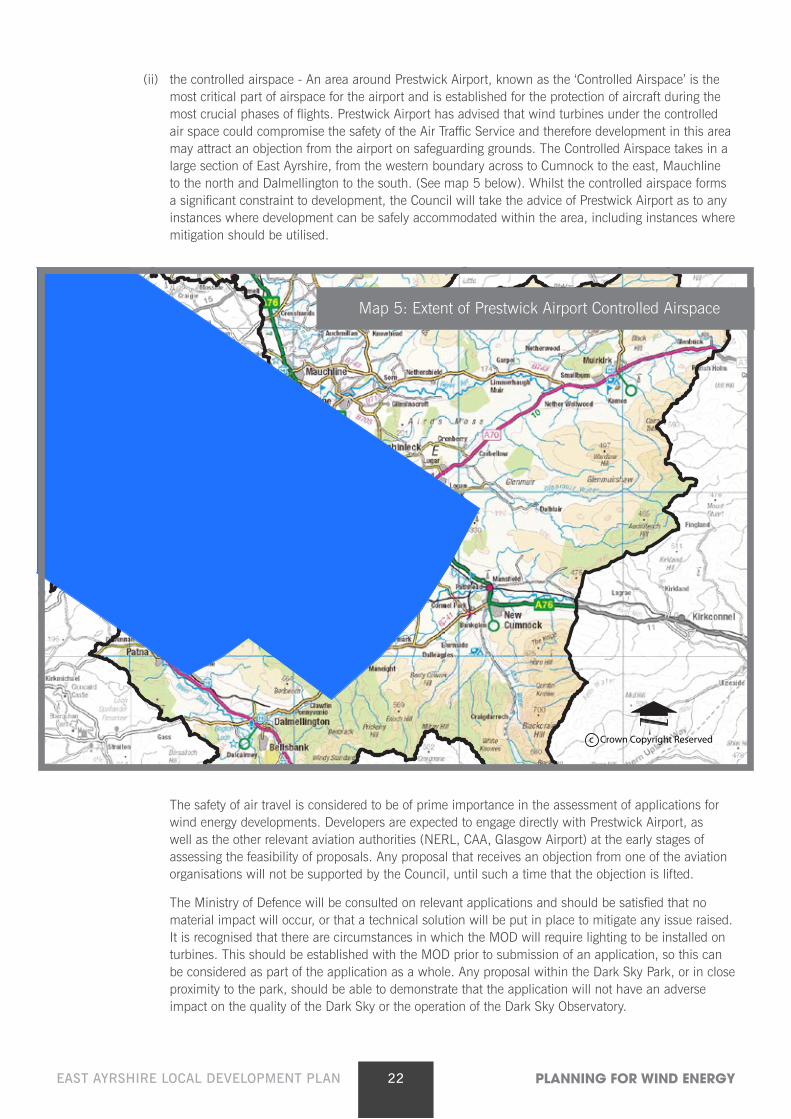
(ii) the controlled airspace - An area around Prestwick Airport, known as the ‘Controlled Airspace’ is the most critical part of airspace for the airport and is established for the protection of aircraft during the most crucial phases of flights. Prestwick Airport has advised that wind turbines under the controlled air space could compromise the safety of the Air Traffic Service and therefore development in this area may attract an objection from the airport on safeguarding grounds. The Controlled Airspace takes in a large section of East Ayrshire, from the western boundary across to Cumnock to the east, Mauchline to the north and Dalmellington to the south. (See map 5 below). Whilst the controlled airspace forms a significant constraint to development, the Council will take the advice of Prestwick Airport as to any instances where development can be safely accommodated within the area, including instances where mitigation should be utilised.
The safety of air travel is considered to be of prime importance in the assessment of applications for wind energy developments. Developers are expected to engage directly with Prestwick Airport, as well as the other relevant aviation authorities (NERL, CAA, Glasgow Airport) at the early stages of assessing the feasibility of proposals. Any proposal that receives an objection from one of the aviation organisations will not be supported by the Council, until such a time that the objection is lifted.
The Ministry of Defence will be consulted on relevant applications and should be satisfied that no material impact will occur, or that a technical solution will be put in place to mitigate any issue raised. It is recognised that there are circumstances in which the MOD will require lighting to be installed on turbines. This should be established with the MOD prior to submission of an application, so this can be considered as part of the application as a whole. Any proposal within the Dark Sky Park, or in close proximity to the park, should be able to demonstrate that the application will not have an adverse impact on the quality of the Dark Sky or the operation of the Dark Sky Observatory.
c Crown Copyright Reserved
Map 5: Extent of Prestwick Airport Controlled Airspace
23EAST AYRSHIRE LOCAL DEVELOPMENT PLAN PLANNING FOR WIND ENERGY
3.3.2 Road and traffic implications
During construction, wind energy developments have the potential to generate significant levels of traffic, including abnormal loads associated with transporting the turbine components. The Council expects all proposals to fully consider the impact of the development on East Ayrshire Council’s road network in terms of the structural and physical ability of both roads and bridges to accommodate the additional traffic generated and the need to minimise any disturbance to local communities. Should turbine transportation routes require to cross third party land, the applicant should ensure that appropriate agreements are in place to allow access to be achieved. Early contact should be made with the Ayrshire Roads Alliance in terms of the scope and extent of a Transport Assessment and Construction Traffic Management Plan, which would be required to address issues such as routeing, timing of deliveries, community liaison and road infrastructure improvements.
3.3.3 Broadcasting Installations
Wind energy developments have the potential to impact upon existing broadcasting installations. Applicants should consult with appropriate network operators to confirm the existence of any infrastructure and to assess whether the proposal would be likely to result in any interference to broadcasting. Where any such interference is likely, the applicant should put forward a technical solution to resolve the issue.
The Council may require a planning condition or Section 75 Obligation to resolve any issues of interference that may occur after construction.
3.3.4 Efficient operation of technology
The Council expects that proposed wind energy developments should be in locations that allow for wind energy technology to operate efficiently to secure the greatest output of renewable energy.
In some cases, there is a need to put in place conditions/ planning obligations to require the shutdown of wind turbines in particular circumstances. For example, this may be when unacceptable shadow flicker and / or noise may occur, either individually, or cumulatively as a result of the interaction with nearby wind energy developments.
In the determination of proposals, the Council will consider whether the likelihood of periods of inactivity and/or reduced output, will undermine the overall efficiency and renewable energy benefits of the proposal.
In line with policy RE7 of the LDP, if an installed and operation turbine is not supplying electricity for a continuous period of 6 months, and is not in the process of being repaired or replaced, the Council will, through an appropriate planning condition or legal obligation, require the developer to dismantle the turbine and to restore the land to its original condition or as agreed by the Planning Authority.
24EAST AYRSHIRE LOCAL DEVELOPMENT PLAN PLANNING FOR WIND ENERGY
3.3.5 Siting and design of turbines and ancillary works
In addition to the turbines themselves, wind energy developments routinely comprise additional works, the impact of which will be assessed alongside the impact of the turbines. Such works will commonly include access tracks, borrow pits, temporary construction compounds and sub-stations.
The overall impact of the proposal can be largely influenced by its design, in terms of the detailed siting of turbines and ancillary works, the colour, style and size of turbines and any proposed lighting. The design of the site should take full account of the land conditions, topography and landscape features of the site, as well as surrounding uses including existing and proposed wind energy developments.
In developing proposals, developers are expected to follow the principles and guidance outlined in the SNH document ‘Siting and Designing Windfarms in the Landscape’ (May 2014) as well as the East Ayrshire ‘Landscape Wind Capacity Study’ (July 2013).
The connection of the wind energy development to the national grid will normally require additional infrastructure to be put in place, by way of underground cabling or overhead power lines. Whilst it is recognised that such works fall within a separate regulatory process, applicants should, where possible, demonstrate within their supporting information the likely method of connecting to the grid and the proposed route that this will take, allowing a more comprehensive assessment to be made of the overall impacts of the wind energy development.
3.3.6 Decommissioning, Restoration and Aftercare
Wind energy developments are normally granted consent for a period of 25 years, after which all apparatus should be removed and sites returned to a natural condition. All applications should be accompanied by a restoration programme outlining, to the satisfaction of the Council, the extent of works that will be undertaken when operations cease. The restoration programme should include sufficient detail and relate to the turbines, foundations, borrow pits, access tracks and all other associated infrastructure. This will be secured through an appropriate planning condition and/or Section 75 Obligation.
As per policy RE9, in order to ensure restoration and aftercare requirements are met in full, the Council will require financial guarantees to be put in place for all wind energy developments. Separate supplementary guidance has been prepared, detailing the Council’s requirements for financial guarantees.
Policy RE10 requires a compliance monitoring regime to be carried out for wind energy proposals and for the associated costs to be met by the operator. Compliance monitoring will be carried out by an independent specialist on behalf of the Council, during construction and for a period of 3 years following the date upon which the development becomes fully operational. Further detail on compliance monitoring is contained within the Supplementary Guidance on Financial Guarantees.
3.3.7 Contribution to renewable energy generation targets
The Scottish Government has set ambitious targets for the generation of renewable energy. However, no regional targets have been set up and no spatial guidance is provided to guide where the national targets should be met. It is expected that all local authorities have a positive approach to renewable energy and support proposals that can help contribute to the national targets without causing unacceptable adverse impacts.
All proposals should provide details of the extent to which the turbines will help to meet government targets for renewable energy generation. These details will form part of the Council’s consideration on any application.
25EAST AYRSHIRE LOCAL DEVELOPMENT PLAN PLANNING FOR WIND ENERGY
4 Smaller scale wind energy guidance The design guidance set out below is an extract from the Ayrshire Landscape Wind
Capacity Study 2013, which forms guidance for the whole of Ayrshire. Reference to coastal features therefore does not apply directly to East Ayrshire which is a landlocked authority.
Smaller scale turbines are considered to comprise turbines of 50 metres or below. This scale of turbine is generally proposed as a single structure or sometimes in small groupings of 2 or 3 turbines. This scale of turbine is generally associated with quite different geographical and topographical areas than the large or medium scale developments, and therefore requires a different assessment process.
Proposals for turbines under 50 metres will be assessed against policy RE6. As per criterion (i) of policy RE6, proposals will be assessed against the design guidance described below.
4.1 Categories of smaller turbines The height of turbines relative to other structures in the landscape is a key
consideration in terms of landscape ‘fit’. With this in mind, three types of ‘smaller’ turbines are considered in the following guidance as follows:
• Micro-small wind turbine Below 15m to blade tip
• Small wind turbine 15m – 30m to blade tip
• Small-medium wind turbine 30m – 50m to blade tip
4.2 Guidance for micro-small wind developments (up to 15m to blade tip)
The 15m ‘cut off’ for turbine height was selected because of the small size of many of the farm buildings in Ayrshire. Turbines up to 12m in height relate well to the size of existing buildings in the landscape, including smaller farm buildings. 12m high turbines are just over twice the height of a single storey house, while a two storey house is about 9m high to roof pitch. Some farm buildings are higher than this.
A well mature forest broadleaved or conifer tree will be about 15m in height. Turbines up to 15m in height will therefore generally relate well to the size of farm buildings and forest trees. They are also similar to small telephone masts and tall telegraph poles.
This size of turbine has not been considered in detail in the landscape sensitivity assessment although the appropriateness of this typology to some landscapes is noted, where relevant, in the guidance section of the assessments.
In Ayrshire, the following issues have been identified as being particularly influential in terms of detailed siting of this typology within character types identified as being appropriate for this typology:
• Turbine height in relation to the scale of the landscape
• Development pattern
• Visibility
• Potential cumulative issues
26EAST AYRSHIRE LOCAL DEVELOPMENT PLAN PLANNING FOR WIND ENERGY
Turbine height in relation to the scale of the landscape Understanding scale, and the relative proportions of features in the landscape, is important in siting
this typology. Landscape scale is made up of two factors, the scale of the landform and the scale of the pattern of land use.
Assessing the scale of the landform involves assessing the perceived vertical height and horizontal expanse of the topography, as well as the degree of openness and containment created by topographical relief.
The pattern of land use creates an additional layer of possible enclosure, for example where woodland, hedges and field walls provide containment. Conversely, low-growing vegetation, such as moorland, can reinforce openness. In addition, while we often assess sense of scale relative to ourselves within the landscape, individual elements, from trees to pylons, can provide reference points against which the scale of the landscape or size of other elements is perceived and understood.
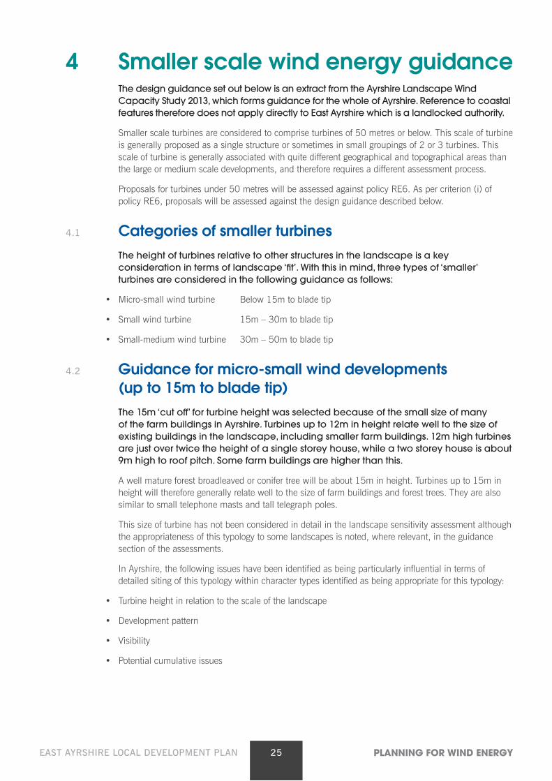
A single turbine of this height is most likely to be used to contribute to the energy needs of a residential house, farm or other rural based small business. The size means that it is relatively easy to accommodate in a settled landscape, if sited to be associated with such a building cluster. It is therefore likely that any assessment of landscape sensitivity will conclude that this size of turbine could be readily accommodated – perhaps, at the most, subject to siting considerations to encourage the turbines to be located where they can be visually seen to be part of a group of buildings, or clearly linked to an individual house, as shown in Image 1.
Image 1: Scale in relation to buildings: A turbine illustrated at an indicative 2x the height of the house from this view. The turbine is well scaled in relation to the size of other individual features. It is also located on the side of the hill, rather than the hill top, where it can be ‘read’ in conjunction with the farm buildings. This forms a ‘cluster’ of development, which reduces landscape and visual impact.
While generally, with careful siting, the landscapes of Ayrshire can accommodate this size of turbine, there are two key sensitivities to consider for siting this height of turbine:
• The first is that the tops of coastal features, such as raised beaches and headlands are as sensitive to this height of turbine as any other, due to the visual prominence of skylines of this type of landform.
• It is also recognised that turbines of up to 15m may have cumulative effects on the landscape, especially where farms are located close together.
Nevertheless, their general ability to be absorbed within the scale of the landscape means that they have been excluded from detailed assessment within the sensitivity assessments.
27EAST AYRSHIRE LOCAL DEVELOPMENT PLAN PLANNING FOR WIND ENERGY
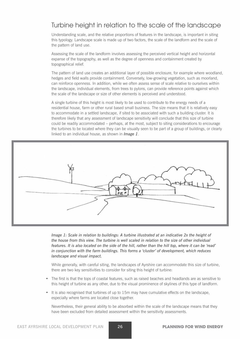
Development pattern When siting turbines in a farmed landscape, such as the lowlands, valleys or the dales character
types, it is desirable to support the existing pattern of built development. Turbines of a similar size are consistently associated with a commonly occurring detailed landform or built features associated with the farms or small settlements in an area. Note that proximity to ‘regularly occupied’ buildings will also need to be balanced with a noise buffer zone.
Image 2 – Poor relationship with settlement pattern. Here a turbine is located in between two farms, and is not associated with either. It appears to ‘drift’ unattached in the landscape as it does not reflect the existing pattern of built development. Instead, the turbine is setting up a new pattern of development which conflicts with the existing well-established pattern.
Image 3 – Strong relationship with settlement pattern. The same landscape, with a turbine sited to each of the farms, close to the buildings, each of which now form ‘building clusters’. Here the turbines reflect the existing pattern of settlement, emphasising this, rather than starting a new built pattern which conflicts with the existing pattern. Micro-siting will need to balance creating a development cluster with the need to apply a recommended ‘noise buffer’ zone.
28EAST AYRSHIRE LOCAL DEVELOPMENT PLAN PLANNING FOR WIND ENERGY
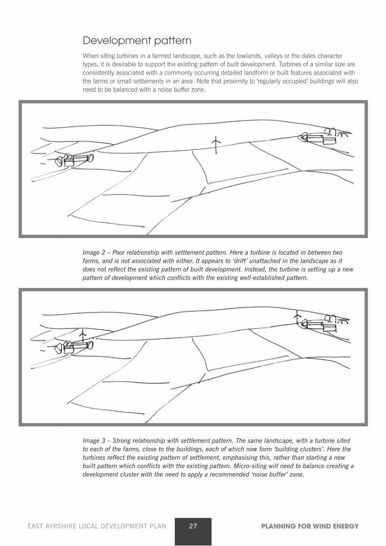
Image 4 – Settlement pattern on extensive low-lying farmed landscapes: Micro-small turbines can be located relatively close to buildings, to form ‘clusters of development’ consistently placed across more expansive farmland areas. Consistent siting and association with existing farms will limit negative cumulative landscape effects. Micro-siting will need to balance creating a development cluster with the need to apply a recommended ‘noise buffer’ zone.
Visibility Unsurprisingly, these micro-small turbines are likely to be less visible than the larger ones over a wider
area. Turbines which are 15m or less in height are more likely to be able to be screened or partially hidden by low ridges and more undulating landform. Tree cover, including sometimes extensive woodland, also limits visibility.
Hiding turbines per se is not more important than choosing a turbine of the right size in relation to landform or other landscape features, or than good micro-siting in relation to landform and settlement pattern. However, reducing sustained visibility of turbines helps limit potential cumulative visual impacts.
Siting turbines on the sides of ridges and low hills, rather than on their summits and high points overall reduces visual cumulative effects – turbines are partially screened from some viewpoints to the lee of the hill and slopes in these locations. If several turbines are visible in an area, broad consistency of turbine design, height and location can help mitigate potential visual impacts.
Potential cumulative issues Given the current incentives, these micro-small turbines may become a frequent and common
occurrence in farmed landscapes. Key cumulative issues for small turbines are likely to relate strongly to potential clutter in the landscape. Issues may include:
• Several individual, or small groups of turbines, could begin to dominate local character;
• The landscape could appear ‘cluttered’ if single or groups of turbines were associated with the majority of land holdings, especially where holdings are small and therefore closer together;
• Lack of a clear siting strategy could lead to fragmentation of an existing robust, recognisable, consistent and characteristic pattern of settlement, especially if turbines do not relate well to existing buildings and established pattern of built development;
• While one turbine breaching a skyline may be a focal point, a number of diverse structures, all spinning at different speeds – or even several of the same type of turbine – or appearing at irregular intervals along a prominent or important skyline will become a visual distraction from other landscape features or from perceived visual amenity, especially from key viewpoints;
29EAST AYRSHIRE LOCAL DEVELOPMENT PLAN PLANNING FOR WIND ENERGY
• The variety of potential different types of wind turbines within the landscape could lead to clutter with different styles, sizes of structures and speeds of blade movement dotted across a landscape;
• There may be the added complication of increased visual clutter created by a wide range of different heights of turbine within a farmed landscape with micro-, small and small/medium sized turbines;
• Potential clutter may also be exacerbated if there are other masts, such as telecoms masts, overhead wires and pylons within the same vicinity.
Periodic review will need to be undertaken to assess the cumulative situation in areas where there is a concentration of operational, consented and proposed turbine developments. Adherence to the siting principles set out in this guidance will minimise potential cumulative landscape and visual effects.
4.3 Guidance for small turbines (15m – 30m to blade tip) The sensitivity of the landscape to this development scenario has been included in all
assessments carried out in settled and farmed lowland, valleys, foothills and coastal character types.
Less settled upland landscape character types were not assessed for this size of development, as applications are unlikely to come forward for this size of turbine in areas where there are no farms or other settlement.
Background In Ayrshire, the following issues have been identified as being particularly influential in terms of
detailed siting of this typology within character types identified as being appropriate for this typology:
• Turbine height in relation to the scale of the landscape
• Landform shape
• Settlement and land use pattern and features
• Visibility
• Potential cumulative issues
Turbine height in relation to the scale of the landscape Turbines of between 15m and 30m are going to be one of the tallest structures in most Ayrshire
landscapes. They are going to be taller than many buildings and most trees. They are still, however, similar in height to some taller pylons and communications masts.
Understanding scale, and the relative proportions of features in the landscape, is important in siting this typology. Landscape scale is made up of two factors, the scale of the landform and the scale of the pattern of land use.
Assessing the scale of the landform involves judging the perceived vertical height and horizontal expanse of the topography, as well as the degree of openness and containment created by topographical relief.
The pattern of land use creates an additional layer of possible enclosure, for example where woodland, hedges and field walls provide containment. Conversely, low-growing vegetation, such as moorland, can reinforce openness. In addition, while we often assess sense of scale relative to ourselves within the landscape, individual elements, from trees to pylons, can provide reference points against which the scale of the landscape or size of other elements is perceived and understood.
30EAST AYRSHIRE LOCAL DEVELOPMENT PLAN PLANNING FOR WIND ENERGY
Scale: Topography In Ayrshire, the scale of the landform is a significant factor in defining landscape character. More
enclosed and wooded river valleys, glens and smaller dales, small scale hummocky landforms and very low hills, raised beaches as well as more complex landform along some of the foothills and valley sides, create areas of relatively small scale character.
More expansive slopes, medium sized hills, long undulating ridges and the foothills create a more medium scale landform, while sweeping plateaux and much higher relief create the larger scale of the upland areas.
Relatively expansive but undulating landscape, sometimes folded into more complex rounded landform of low relief, is more characteristic of the lowland farmed plains. These lowlands landscape types offer potential for this typology because of the overall expansiveness of the landscape, although some of the small rounded complex landforms may be sensitive even to this height of turbine.
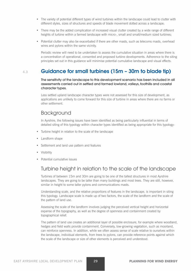
Taller turbines within this typology are more likely to able to take advantage of the higher degree of relief along the broad slopes of foothills and lower fringes of upland areas, the lower side slopes of valleys or the sides of undulating ridges to be found in the dales character types. This is shown in Image 5 below.
Image 5 – Landscape scale and size of features: A taller turbine of the ‘small typology’ range located on a low-lying ridgeline set back from, but still associated with the pattern of settlement. In this location, the turbine is linked to the scale of the landform and there are no features in the immediate proximity against which to judge turbine height. It is sited at a slight dip in the ridge, and back-dropped in this view by higher ground. It is located away from the low farm buildings to avoid overwhelming the buildings in terms of scale.
Scale: Farmland Trees and woodland, field pattern, settlements and farms are located across the farmed lowlands and
extend onto the lower fringes of the uplands. They are also a characteristic of the valleys and dales. The consistent and recurring presence of these elements creates a pattern that reduces the landscape scale in these areas, and the individual elements provide scale reference points against which height can be judged.
31EAST AYRSHIRE LOCAL DEVELOPMENT PLAN PLANNING FOR WIND ENERGY
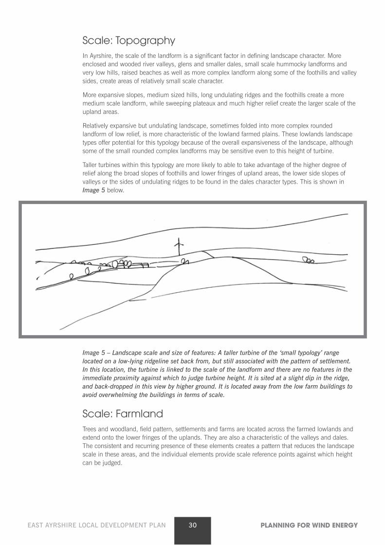
Care should be taken to site 15m – 30m high turbines where they do not dominate individual buildings, trees or other features, although some association with broad settlement pattern is still considered appropriate. Turbines in the lower range of this height (15m – 20m) are still likely to be small enough to be sited where they can be closely associated with larger buildings and trees to form the type of development cluster illustrated in Image 6 below.
Image 6: Scale in relation to buildings: A turbine illustrated at an indicative 2x the height of the house from this view, or a taller turbine located behind the ridge to reduce overall height from this view. The turbine is well scaled in relation to the size of other individual features. It is also located on the side of the hill, rather than the hill top, where it can be ‘read’ in conjunction with the farm buildings. This forms a ‘cluster’ of development, which reduces landscape and visual impact.
As shown in Image 6 above, although they may sometimes be bigger than these elements, a turbine of this size is unlikely to be more than three times the size of any building or tree, and within a wider landscape setting, this size relationship can usually be accommodated unless there are site-specific scale sensitivities.
Taller turbines (20m – 30m) may require to be located further away from smaller buildings and trees, so that they do not overwhelm them in terms of size, as shown in Image 6. This is a particular issue in Ayrshire as many of the farm buildings are low.
Scale: Coast On the coast, landform relief tends to be low. A particular feature are the low but well defined raised
beaches that frequently form a backdrop to level fields, or the convex slopes of foothills hills forming a containing skyline. Views from the sea are a particular consideration on this busy sea. Even where higher cliffs, headlands and more pronounced landform is present, the scale is sensitive, as a turbine of any height can easily diminish the perceived sense of height and drama.
As a result, the landscape sensitivity assessments for the coastal character types conclude that there is only very limited scope for turbines of less than 30m to blade tip in the coastal character types. No opportunities were found for even these small turbines on raised beaches and more complex landforms, or along the prominent skylines of headlands.
All turbines should be set well inland from raised beaches, promontories, cliffs, headlands or other key landform features. They should avoid being located close to, or directly on, the skyline. The visual drama of these topographical features often depends on their perceived scale, and this can easily be diminished by turbines sitting on top of these features.
32EAST AYRSHIRE LOCAL DEVELOPMENT PLAN PLANNING FOR WIND ENERGY
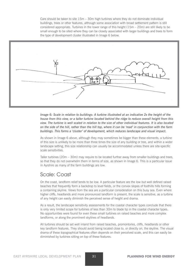
Image 7 – Coastal landscapes: This turbine is poorly sited. It is perched on top of the raised beach and although it is quite small, instantly dominates the view and overlooks, or appears to ‘hover above’, the coast.
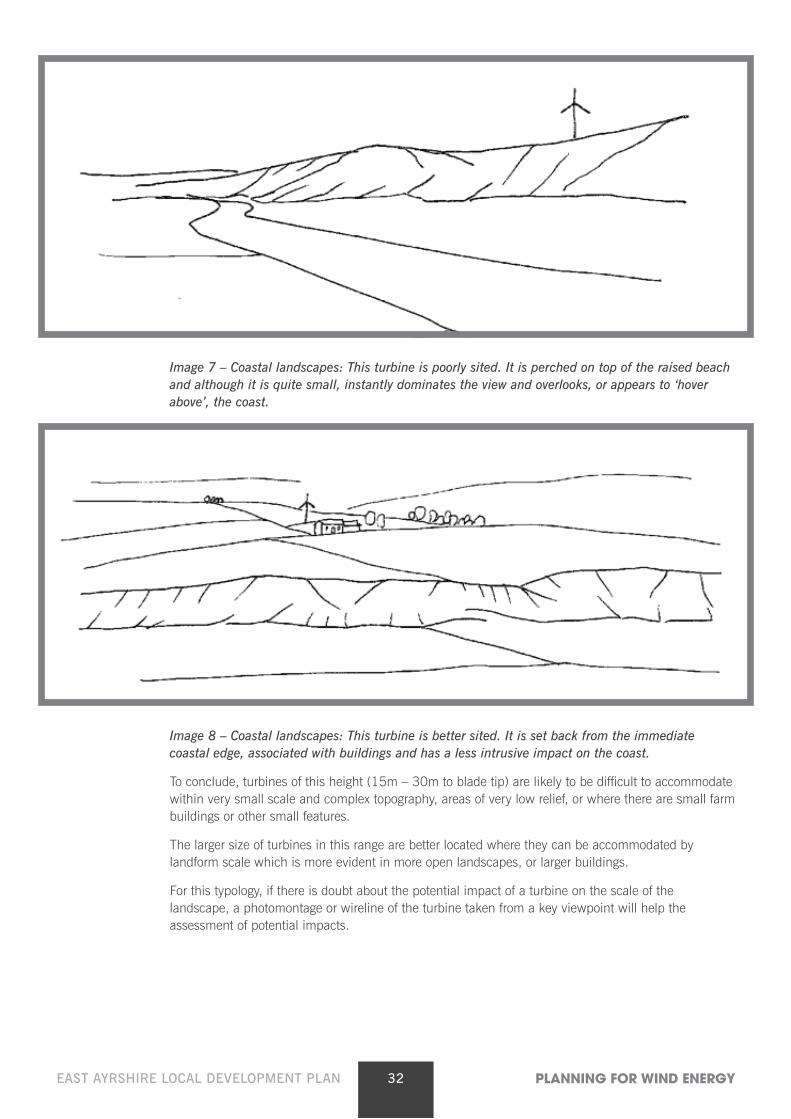
Image 8 – Coastal landscapes: This turbine is better sited. It is set back from the immediate coastal edge, associated with buildings and has a less intrusive impact on the coast.
To conclude, turbines of this height (15m – 30m to blade tip) are likely to be difficult to accommodate within very small scale and complex topography, areas of very low relief, or where there are small farm buildings or other small features.
The larger size of turbines in this range are better located where they can be accommodated by landform scale which is more evident in more open landscapes, or larger buildings.
For this typology, if there is doubt about the potential impact of a turbine on the scale of the landscape, a photomontage or wireline of the turbine taken from a key viewpoint will help the assessment of potential impacts.
33EAST AYRSHIRE LOCAL DEVELOPMENT PLAN PLANNING FOR WIND ENERGY
Landform shape Turbines of this height (15m – 30m) are most likely to be located within the farmed lowlands, lower
hill slopes and valley floors. The narrow coastal plains are flat, while the more extensive lowlands are gently undulating, often with areas of more complex, interlocking rounded landform created by deposits which can also appear in the dales.
Turbines of this size are most easily accommodated on the more open side slopes of low hills or ridgelines and along the simple gradients along the sides of the dales or in the lowland hills and foothill types. Other opportunities include the rising ground which provides the transition between the uplands and the farmed lowland areas and river valleys, as the higher hills form a backdrop to the turbines.
Most landforms, including low hills, are gently rounded, and valley sides vary from convex slopes to more abrupt concave slopes along the coast. Valley sides can offer natural terraces and changes in gradient, often associated with deposits.
These terraces, narrow ledges, folds and subtle hollows and distinct changes in gradient associated with rising slopes or dips within undulations, have the potential to create natural platforms for siting turbines in this height range.
Turbines should not be located on the tops of low hills or knolls. Side slopes of low hill and ridges, and terraces or places where there is a marked change in gradient offer good opportunities.
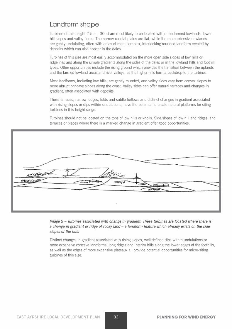
Image 9 – Turbines associated with change in gradient: These turbines are located where there is a change in gradient or ridge of rocky land – a landform feature which already exists on the side slopes of the hills
Distinct changes in gradient associated with rising slopes, well defined dips within undulations or more expansive concave landforms, long ridges and interim hills along the lower edges of the foothills, as well as the edges of more expansive plateaux all provide potential opportunities for micro-siting turbines of this size.
34EAST AYRSHIRE LOCAL DEVELOPMENT PLAN PLANNING FOR WIND ENERGY
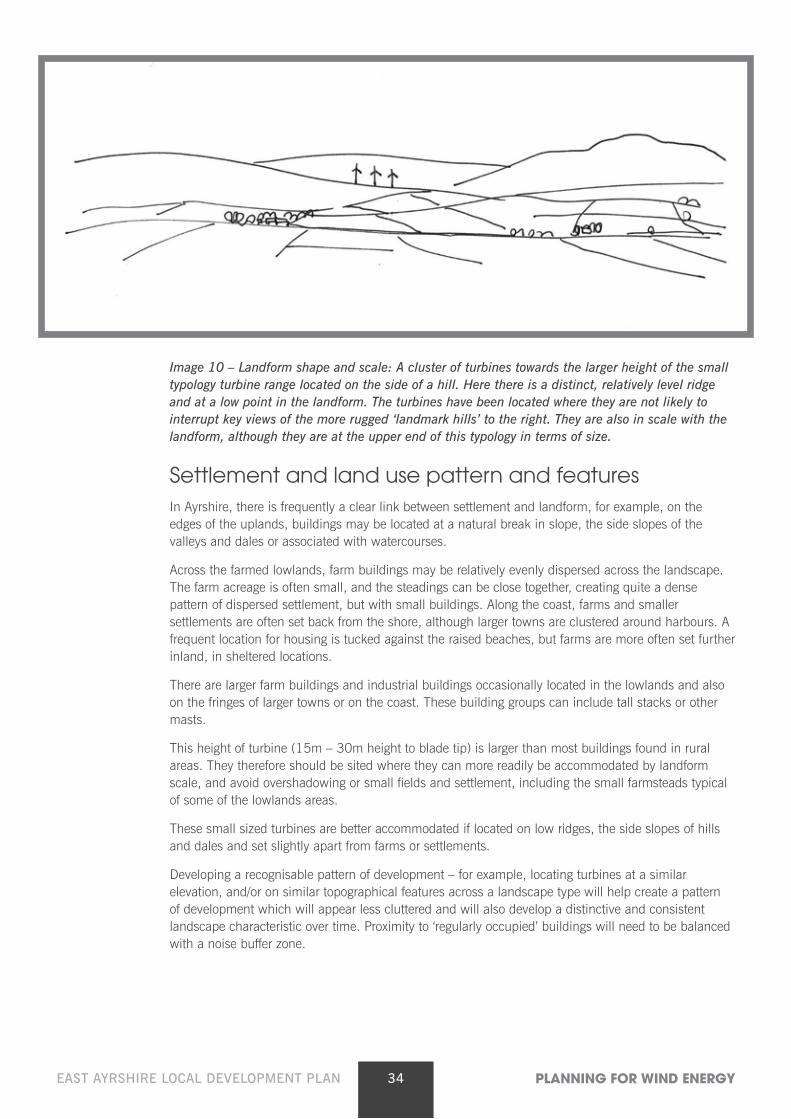
Image 10 – Landform shape and scale: A cluster of turbines towards the larger height of the small typology turbine range located on the side of a hill. Here there is a distinct, relatively level ridge and at a low point in the landform. The turbines have been located where they are not likely to interrupt key views of the more rugged ‘landmark hills’ to the right. They are also in scale with the landform, although they are at the upper end of this typology in terms of size.
Settlement and land use pattern and features In Ayrshire, there is frequently a clear link between settlement and landform, for example, on the
edges of the uplands, buildings may be located at a natural break in slope, the side slopes of the valleys and dales or associated with watercourses.
Across the farmed lowlands, farm buildings may be relatively evenly dispersed across the landscape. The farm acreage is often small, and the steadings can be close together, creating quite a dense pattern of dispersed settlement, but with small buildings. Along the coast, farms and smaller settlements are often set back from the shore, although larger towns are clustered around harbours. A frequent location for housing is tucked against the raised beaches, but farms are more often set further inland, in sheltered locations.
There are larger farm buildings and industrial buildings occasionally located in the lowlands and also on the fringes of larger towns or on the coast. These building groups can include tall stacks or other masts.
This height of turbine (15m – 30m height to blade tip) is larger than most buildings found in rural areas. They therefore should be sited where they can more readily be accommodated by landform scale, and avoid overshadowing or small fields and settlement, including the small farmsteads typical of some of the lowlands areas.
These small sized turbines are better accommodated if located on low ridges, the side slopes of hills and dales and set slightly apart from farms or settlements.
Developing a recognisable pattern of development – for example, locating turbines at a similar elevation, and/or on similar topographical features across a landscape type will help create a pattern of development which will appear less cluttered and will also develop a distinctive and consistent landscape characteristic over time. Proximity to ‘regularly occupied’ buildings will need to be balanced with a noise buffer zone.
35EAST AYRSHIRE LOCAL DEVELOPMENT PLAN PLANNING FOR WIND ENERGY
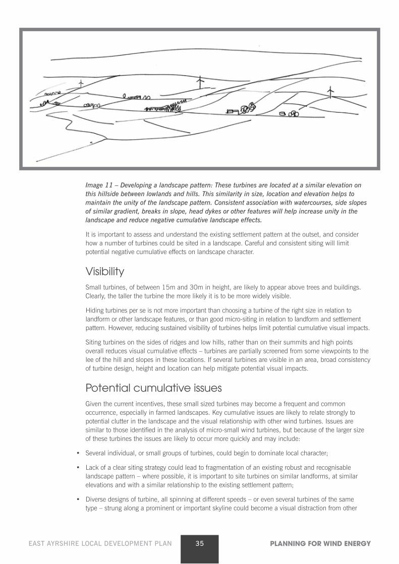
Image 11 – Developing a landscape pattern: These turbines are located at a similar elevation on this hillside between lowlands and hills. This similarity in size, location and elevation helps to maintain the unity of the landscape pattern. Consistent association with watercourses, side slopes of similar gradient, breaks in slope, head dykes or other features will help increase unity in the landscape and reduce negative cumulative landscape effects.
It is important to assess and understand the existing settlement pattern at the outset, and consider how a number of turbines could be sited in a landscape. Careful and consistent siting will limit potential negative cumulative effects on landscape character.
Visibility Small turbines, of between 15m and 30m in height, are likely to appear above trees and buildings.
Clearly, the taller the turbine the more likely it is to be more widely visible.
Hiding turbines per se is not more important than choosing a turbine of the right size in relation to landform or other landscape features, or than good micro-siting in relation to landform and settlement pattern. However, reducing sustained visibility of turbines helps limit potential cumulative visual impacts.
Siting turbines on the sides of ridges and low hills, rather than on their summits and high points overall reduces visual cumulative effects – turbines are partially screened from some viewpoints to the lee of the hill and slopes in these locations. If several turbines are visible in an area, broad consistency of turbine design, height and location can help mitigate potential visual impacts.
Potential cumulative issues Given the current incentives, these small sized turbines may become a frequent and common
occurrence, especially in farmed landscapes. Key cumulative issues are likely to relate strongly to potential clutter in the landscape and the visual relationship with other wind turbines. Issues are similar to those identified in the analysis of micro-small wind turbines, but because of the larger size of these turbines the issues are likely to occur more quickly and may include:
• Several individual, or small groups of turbines, could begin to dominate local character;
• Lack of a clear siting strategy could lead to fragmentation of an existing robust and recognisable landscape pattern – where possible, it is important to site turbines on similar landforms, at similar elevations and with a similar relationship to the existing settlement pattern;
• Diverse designs of turbine, all spinning at different speeds – or even several turbines of the same type – strung along a prominent or important skyline could become a visual distraction from other
36EAST AYRSHIRE LOCAL DEVELOPMENT PLAN PLANNING FOR WIND ENERGY
landscape features or from perceived visual amenity, especially from key viewpoints;
• The larger the turbine, the harder it is likely to be to accommodate a number of them in a single view or recognisable tract of landscape without them becoming the dominant feature. It is also harder to accommodate the turbines in a sequence of views experienced, for example, when travelling along a road;
• The variety of potential different types of wind turbines within the landscape could lead to clutter with different styles, sizes of structures and speeds of blade movement dotted across a landscape;
• Potential clutter may also be easily created if there are other masts, such as telecoms masts, overhead wires and pylons within the same vicinity;
• There may be the added complication of increased visual clutter created by a wide range of different heights of turbine within a farmed landscape with micro-, small and small/medium sized turbines;
• An additional complication may be the visual interrelationship with larger wind farms of large and medium sized turbines, especially along the upper edge of farmland adjacent to upland character types.
Periodic review will need to be undertaken to assess the cumulative situation in areas where there is a concentration of operational, consented and proposed turbine developments. Adherence to the siting principles set out in this guidance will minimise potential cumulative landscape and visual effects.
Other landscape issues associated with this typology Undergrounding electricity cables to a suitable off-site location to connect with the grid should also be
undertaken in order to avoid a clutter of disparate built elements in the landscape.
4.4 Guidance for small-medium turbines (30m – 50m in height to blade tip)
The sensitivity of the landscape to this development scenario has been included in all assessments carried out in settled lowland landscape and coastal character types. Less settled upland landscape character types, however, were not assessed in detail for this size of development, as applications are unlikely to come forward in areas where there are no farms or other settlements.
Background In Ayrshire, the following issues have been identified as being particularly influential in terms of
detailed siting of this typology within character types identified as being appropriate for this typology:
• Turbine height in relation to the scale of the landscape
• Landform shape
• Settlement and land use pattern and features
• Visibility
• Cumulative issues
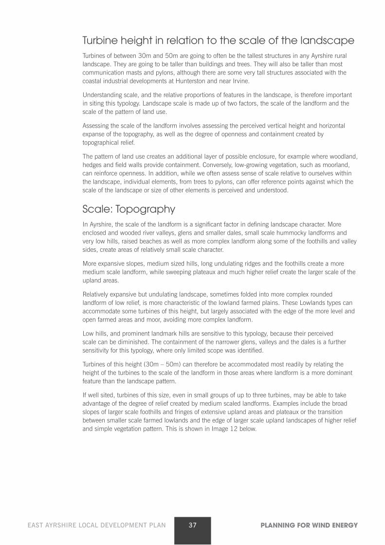
37EAST AYRSHIRE LOCAL DEVELOPMENT PLAN PLANNING FOR WIND ENERGY
Turbine height in relation to the scale of the landscape Turbines of between 30m and 50m are going to often be the tallest structures in any Ayrshire rural
landscape. They are going to be taller than buildings and trees. They will also be taller than most communication masts and pylons, although there are some very tall structures associated with the coastal industrial developments at Hunterston and near Irvine.
Understanding scale, and the relative proportions of features in the landscape, is therefore important in siting this typology. Landscape scale is made up of two factors, the scale of the landform and the scale of the pattern of land use.
Assessing the scale of the landform involves assessing the perceived vertical height and horizontal expanse of the topography, as well as the degree of openness and containment created by topographical relief.
The pattern of land use creates an additional layer of possible enclosure, for example where woodland, hedges and field walls provide containment. Conversely, low-growing vegetation, such as moorland, can reinforce openness. In addition, while we often assess sense of scale relative to ourselves within the landscape, individual elements, from trees to pylons, can offer reference points against which the scale of the landscape or size of other elements is perceived and understood.
Scale: Topography In Ayrshire, the scale of the landform is a significant factor in defining landscape character. More
enclosed and wooded river valleys, glens and smaller dales, small scale hummocky landforms and very low hills, raised beaches as well as more complex landform along some of the foothills and valley sides, create areas of relatively small scale character.
More expansive slopes, medium sized hills, long undulating ridges and the foothills create a more medium scale landform, while sweeping plateaux and much higher relief create the larger scale of the upland areas.
Relatively expansive but undulating landscape, sometimes folded into more complex rounded landform of low relief, is more characteristic of the lowland farmed plains. These Lowlands types can accommodate some turbines of this height, but largely associated with the edge of the more level and open farmed areas and moor, avoiding more complex landform.
Low hills, and prominent landmark hills are sensitive to this typology, because their perceived scale can be diminished. The containment of the narrower glens, valleys and the dales is a further sensitivity for this typology, where only limited scope was identified.
Turbines of this height (30m – 50m) can therefore be accommodated most readily by relating the height of the turbines to the scale of the landform in those areas where landform is a more dominant feature than the landscape pattern.
If well sited, turbines of this size, even in small groups of up to three turbines, may be able to take advantage of the degree of relief created by medium scaled landforms. Examples include the broad slopes of larger scale foothills and fringes of extensive upland areas and plateaux or the transition between smaller scale farmed lowlands and the edge of larger scale upland landscapes of higher relief and simple vegetation pattern. This is shown in Image 12 below.
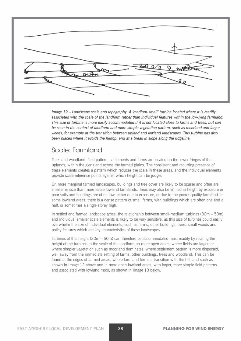
38EAST AYRSHIRE LOCAL DEVELOPMENT PLAN PLANNING FOR WIND ENERGY
Image 12 – Landscape scale and topography: A ‘medium-small’ turbine located where it is readily associated with the scale of the landform rather than individual features within the low-lying farmland. This size of turbine is more easily accommodated if it is not located close to farms and trees, but can be seen in the context of landform and more simple vegetation pattern, such as moorland and larger woods, for example at the transition between upland and lowland landscapes. This turbine has also been placed where it avoids the hilltop, and at a break in slope along the ridgeline.
Scale: Farmland Trees and woodland, field pattern, settlements and farms are located on the lower fringes of the
uplands, within the glens and across the farmed plains. The consistent and recurring presence of these elements creates a pattern which reduces the scale in these areas, and the individual elements provide scale reference points against which height can be judged.
On more marginal farmed landscapes, buildings and tree cover are likely to be sparse and often are smaller in size than more fertile lowland farmlands. Trees may also be limited in height by exposure or poor soils and buildings are often low, either due to exposure, or due to the poorer quality farmland. In some lowland areas, there is a dense pattern of small farms, with buildings which are often one and a half, or sometimes a single storey high.
In settled and farmed landscape types, the relationship between small-medium turbines (30m – 50m) and individual smaller scale elements is likely to be very sensitive, as this size of turbines could easily overwhelm the size of individual elements, such as farms, other buildings, trees, small woods and policy features which are key characteristics of these landscapes.
Turbines of this height (30m – 50m) can therefore be accommodated most readily by relating the height of the turbines to the scale of the landform on more open areas, where fields are larger, or where simpler vegetation such as moorland dominates, where settlement pattern is more dispersed, well away from the immediate setting of farms, other buildings, trees and woodland. This can be found at the edges of farmed areas, where farmland forms a transition with the hill land such as shown in Image 12 above and in more open lowland areas, with larger, more simple field patterns and associated with lowland moor, as shown in Image 13 below.
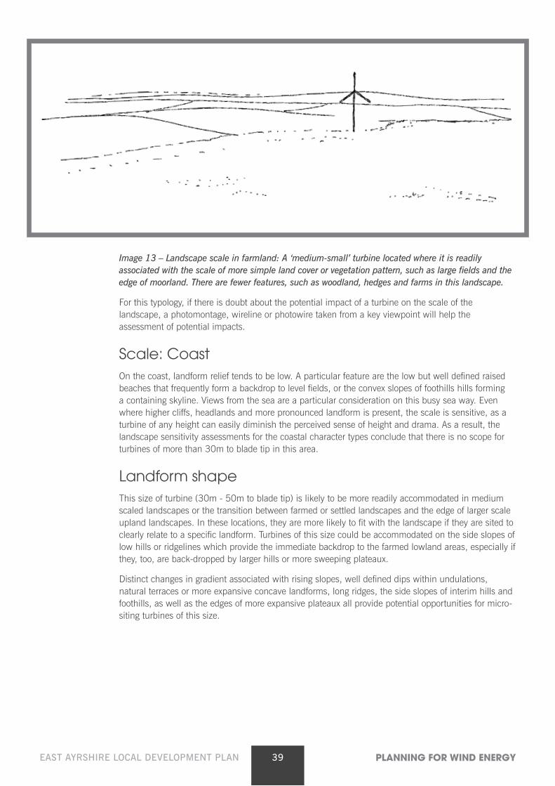
39EAST AYRSHIRE LOCAL DEVELOPMENT PLAN PLANNING FOR WIND ENERGY
Image 13 – Landscape scale in farmland: A ‘medium-small’ turbine located where it is readily associated with the scale of more simple land cover or vegetation pattern, such as large fields and the edge of moorland. There are fewer features, such as woodland, hedges and farms in this landscape.
For this typology, if there is doubt about the potential impact of a turbine on the scale of the landscape, a photomontage, wireline or photowire taken from a key viewpoint will help the assessment of potential impacts.
Scale: Coast On the coast, landform relief tends to be low. A particular feature are the low but well defined raised
beaches that frequently form a backdrop to level fields, or the convex slopes of foothills hills forming a containing skyline. Views from the sea are a particular consideration on this busy sea way. Even where higher cliffs, headlands and more pronounced landform is present, the scale is sensitive, as a turbine of any height can easily diminish the perceived sense of height and drama. As a result, the landscape sensitivity assessments for the coastal character types conclude that there is no scope for turbines of more than 30m to blade tip in this area.
Landform shape This size of turbine (30m - 50m to blade tip) is likely to be more readily accommodated in medium
scaled landscapes or the transition between farmed or settled landscapes and the edge of larger scale upland landscapes. In these locations, they are more likely to fit with the landscape if they are sited to clearly relate to a specific landform. Turbines of this size could be accommodated on the side slopes of low hills or ridgelines which provide the immediate backdrop to the farmed lowland areas, especially if they, too, are back-dropped by larger hills or more sweeping plateaux.
Distinct changes in gradient associated with rising slopes, well defined dips within undulations, natural terraces or more expansive concave landforms, long ridges, the side slopes of interim hills and foothills, as well as the edges of more expansive plateaux all provide potential opportunities for micro-siting turbines of this size.
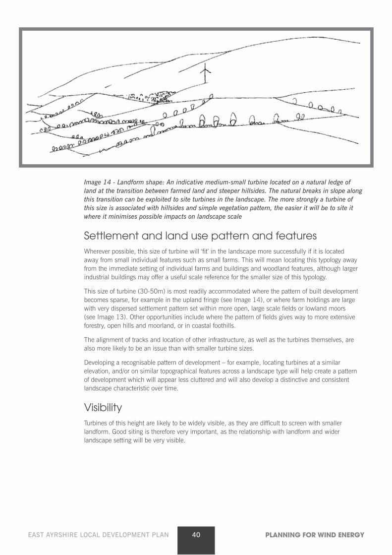
40EAST AYRSHIRE LOCAL DEVELOPMENT PLAN PLANNING FOR WIND ENERGY
Image 14 - Landform shape: An indicative medium-small turbine located on a natural ledge of land at the transition between farmed land and steeper hillsides. The natural breaks in slope along this transition can be exploited to site turbines in the landscape. The more strongly a turbine of this size is associated with hillsides and simple vegetation pattern, the easier it will be to site it where it minimises possible impacts on landscape scale
Settlement and land use pattern and features Wherever possible, this size of turbine will ‘fit’ in the landscape more successfully if it is located
away from small individual features such as small farms. This will mean locating this typology away from the immediate setting of individual farms and buildings and woodland features, although larger industrial buildings may offer a useful scale reference for the smaller size of this typology.
This size of turbine (30-50m) is most readily accommodated where the pattern of built development becomes sparse, for example in the upland fringe (see Image 14), or where farm holdings are large with very dispersed settlement pattern set within more open, large scale fields or lowland moors (see Image 13). Other opportunities include where the pattern of fields gives way to more extensive forestry, open hills and moorland, or in coastal foothills.
The alignment of tracks and location of other infrastructure, as well as the turbines themselves, are also more likely to be an issue than with smaller turbine sizes.
Developing a recognisable pattern of development – for example, locating turbines at a similar elevation, and/or on similar topographical features across a landscape type will help create a pattern of development which will appear less cluttered and will also develop a distinctive and consistent landscape characteristic over time.
Visibility Turbines of this height are likely to be widely visible, as they are difficult to screen with smaller
landform. Good siting is therefore very important, as the relationship with landform and wider landscape setting will be very visible.
41EAST AYRSHIRE LOCAL DEVELOPMENT PLAN PLANNING FOR WIND ENERGY
Cumulative issues Given the current incentives, these small-medium sized turbines may become a more common
occurrence. Key cumulative issues are likely to relate strongly to potential clutter in the landscape and the visual relationship with wind farms of larger turbines or individual and small groups of small turbines. Cumulative issues may include:
• Several individual, or small groups of turbines, could begin to dominate local character;
• Diverse designs of turbine, all spinning at different speeds – or even several turbines of the same type – strung along a prominent or important skyline could become a visual distraction from other landscape features or from perceived visual amenity, especially from key viewpoints;
• Lack of a clear siting strategy could lead to fragmentation of an existing robust and recognisable landscape pattern – where possible, it is important to site turbines on similar landforms, at similar elevations and with a similar relationship to the existing settlement pattern;
• The larger the turbine, the harder it is likely to be to accommodate a number of them in a single view or recognisable tract of landscape without them becoming the dominant feature. It is also harder to accommodate the turbines in a sequence of views experienced, for example, when travelling along a road;
• The variety of potential different types of wind turbines within the landscape could lead to clutter with different styles, sizes of structures and speeds of blade movement dotted across a landscape;
• Potential clutter may also be easily created if there are other masts, such as telecoms masts, overhead wires and pylons within the same vicinity – this is likely to be a bigger problem with these small turbines than larger ones;
• There may be the added complication of increased visual clutter created by a wide range of different heights of turbine within a farmed landscape with micro-, small and small/medium sized turbines;
• Other complications may be the visual interrelationship with larger wind farms of large and medium sized turbines, especially along the upper edge of farmland adjacent to upland character types.
Periodic review will need to be undertaken to assess the cumulative situation in areas where there is a concentration of operational, consented and proposed turbine developments. Adherence to the siting principles set out in this guidance will minimise potential cumulative landscape and visual effects.
Other landscape issues associated with this typology More complex landform, such as the areas of small-scale deposits and knolls will be particularly
sensitive to the construction of access tracks for this size of wind turbine development. The construction of new access tracks should be minimised by careful siting of turbines to use existing tracks and to avoid more difficult or steep terrain. Care should also be taken in the alignment and design of any access tracks to ensure that sensitive landform and vegetation is not adversely affected and that intrusion on key views is avoided.
Undergrounding electricity cables to a suitable off-site location to connect with the grid should also be undertaken in order to avoid a clutter of disparate built elements in the landscape.
42EAST AYRSHIRE LOCAL DEVELOPMENT PLAN PLANNING FOR WIND ENERGY
5 Required information checklist All applications for wind energy developments will be required to be accompanied
by clear and robust supporting information, to allow the Council to make an informed assessment of the application against this supplementary guidance and all other relevant LDP policies.
• All statutory requirements for planning applications, including location plan, site plan and scaled plans and elevations of turbines and all associated infrastructure
• Environmental Statement as required by the Town and Country Planning (Environmental Impact Assessment)(Scotland) Regulations 2011 – Dependent on outcome of a screening request
• Landscape and Visual Assessment, including cumulative assessment in compliance with current SNH guidance*
• Assessment of impact on natural heritage and biodiversity (flora and fauna). Any protected species information must be provided in a confidential annex, clearly marked as such.*
• Assessment of impact on soils and demonstration of carbon calculation*
• Assessment of impact on waterbodies and ground water*
• Assessment of impact on cultural heritage and archaeology*
• Assessment of the impact on existing peatlands and a calculation of the CO2 payback period*
• Deforestation phasing plan and details of compensatory planting proposals if the development will remove existing woodlands
• Borrow pit scheme and details of import of construction materials
• Noise Assessment, including cumulative assessment*
• Residential Visual Impact Assessment (this may form part of the LVIA)*
• Shadow Flicker Assessment and proposed mitigation scheme*
• Analysis of any implications for existing tourist facilities and the wider tourist market
• Details of anticipated economic impact benefits of the proposal
• Evidence of dialogue with the relevant aviation bodies and confirmation of any agreements reached.
• Transport Assessment, Construction Traffic Management Plan and Turbine Transportation Plan
• Assessment of impacts on broadcasting installations
• Design Statement
• Details of decommissioning, restoration and aftercare arrangements and confirmation of proposed financial bond
• Analysis of how the proposed development will contribute to national renewable energy targets
(*In many cases, these issues will be explored through the EIA process)
Should the applicant be of the view that any of the above requirements are not relevant to their particular proposal, this should be cleared explained and justified within the submission.

Planning and Economic Development The Johnnie Walker Bond, 15 Strand Street
Kilmarnock KA1 1HU
www.east-ayrshire.gov.uk
Des
igne
d an
d pr
oduc
ed b
y Ea
st A
yrsh
ire C
ounc
il G
raph
ics
Sect
ion
© 2
015