Embed Size (px)
Citation preview

Ceol. Soc. Malaysia, Bulletin 6, July 1973; pp. 165-176.
Late Tertiary Geologic History of the Continental Shelf oft- Northwestern Palawan, Philippines
E.V. TAMESISl, E.V. MANALAC2, C.A. REYEs2, AND L.M. OTE2
Abstract: Marine seismic and magnetometer surveys, plus the drilling of two offshore wells on the northwestern shelf of Palawan, Philippines have yielded valuable information on the geology and Late Tertiary geologic history of this region . These exploration activities have shown that the structural framework of the shelf consists essentially of a thick westward-dipping sequence of sediments of Neogene age on a basement of older rocks. Among the more common structural features of this framework are horst blocks and grabens, compressional and supratenuous folds, deltaic and associated cut and fill structures, reefal buildups and unconformities. Thus far, structural forms suggesting Late Tertiary igneous activity have not been recognized in any of the geophysical data.
Integration of available drill hole data with seismic information indicates that since the deposition of several thousand meters of deep sea marine clastic sediments on a lower Miocene limestone depositional base in early Miocene time, the region has undergone two major periods of regression and marine transgression. These events are recorded as two prominent unconformities recognized on seismic profiles which subsequently have been identified from well information as intervening between the middle Miocene and upper Miocene, and between upper Miocene and Pliocene strata. Major uplift of the north Palawan block toward the end of middle Miocene time resulted in erosional truncation of the tilted lower and middle Miocene sequence. In the latter part of the Miocene, the shelf off northwestern Palawan was once more transgressed by shallow seas, in which were deposited detrital carbonate and other clastic sediments. Some of these were laid down on synchronous highs developed on the folded and faulted middle and lower Miocene sequence. During the latter part of the Miocene, parts of the area may have been temporarily emerged to cause partial removal of upper Miocene sediments. The beginning of Pliocene time saw another transgression chaterized by the deposition of carbonate sediments over the shallow shelf continuing up to the present.
INTRODUCTION
The revival of oil exploration in the Philippines in 1969 has brought new areas under geologic and geophysical investigation by several local and foreign-based oil companies. One of these areas is the shelf off northwestern Palawan, which forms part of the southeastern margins of the South China Sea basin (Fig. 1). Early in 1970, two Phllippine Oil comparues, namely, Philippine Overseas Drilling and Oil Development Corporation and Oriental Petroleum and Minerals Corporation, jointly undertook a reconnaissance seismic survey of the shelf around Palawan. Approximately 3,360 kilometers of continuous profiles were run, of which 1,840 kilometers were recorded on the northwestern shelf. Additional and more detailed seismic surveys were undertaken by the latter firm in late 1970, and in 1971 the first offshore test holes in these waters were drilled by the same company. The following paper presents a description of the principal structural features of the shelf and its Neogene geological history from the results of Oriental Petroleum and Minerals Corporation exploration activities during the past two years.
REGIONAL GEOLOGIC SETTING
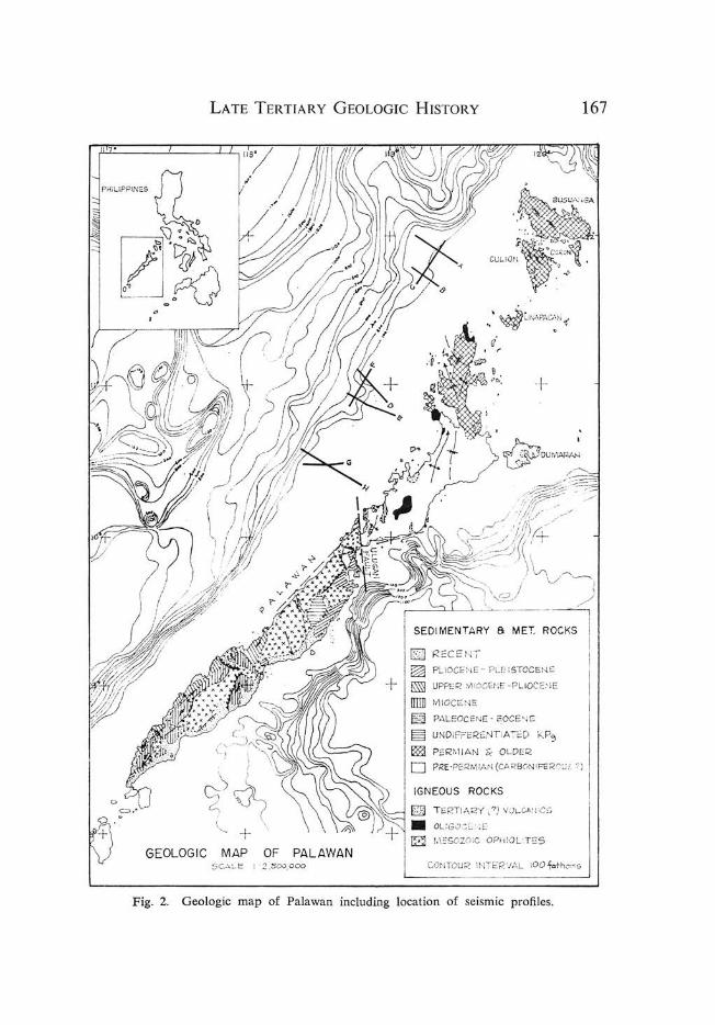
The Island of Palawan and the surrounding shelves (Fig. 2) represent respectively the protruding portions of a Late Paleozoic and Mesozoic basement and the submerg-
1 Department of Geology and Geography, University of the Philippines. 2 Geologists, Oriental Petroleum and Minerals Corporation.

166 E. V. TAMESIS, E. V. MANALAC, C. A. REYES, AND L. M. GTE
Fig. 1. Location map showing area surveyed in the South China Sea Basin (modified from Mainguy (1970), Map of Regional Geology and Petroleum Prospects of the marine shelves of Eastern Asia; Tech. Bull. vol. 3, ECAFE Committee for Coordination of Joint Prospecting for Mineral Resources of Offshore Asia, May, 1970).
ed sediment fills on a block-faulted shelf in the southwestel11 part of the Philippines. Together, they comprise 69,094 square kilometers of which 52,914 square kilometers is shelf area. The average width of the shelf on the westel11 part of Palawan, over which most of the present work was done, is approximately 50 kilometers. On the east, the average width is about 20 ki lometers.
The onshore areas of Palawan, including the Calamian Group, Dumaran Island and Balabac Island can be divided on the basis of common structural and petrological features into two regions-a 1l0rthel11 one, of highly folded and complexly faulted Late Paleozoic metamorphic and sedimentary rocks, acidic plutons and limited exposures of Tertiary rocks, and a southern one consisting largely of a suite of CretaceousPaleogene ophiolites and associated siliceous sediments onlapped by Paleogene to Neogene marine sedimentary rocks (Belendres, c., 1963). The marine Tertiary sedimentary rocks are generally well exposed in the southern end of the mainland where they wrap around the southwest-plunging nose of the Island and in the southwestern coast where they occur as structural embayments with pronounced seaward plunges. Sedimentary rocks of Tertiary age in the north are represented by erosional outliers of
LATE TERTIAR H ISTORY Y GEOLOGIC
'PI;
fCS1 RECENT TOCENE w,:; 1,<=_ PLEI S
~ PLiOCE - ENE -P LlDCEr.IE ~ UPPER Mloe
[J]] MIOCIONE
167
EOCE~,E S PALEO"::ENE -T; ATED KP~ 1'3 UNDIFrEREN
E3 ., OLDER rn PERMIAN NIFEROUS? ) o PRE-PERM IAN(CARBO
NEOUS ROCKS IG (?) VOLGAH ICS {E]j T ERTIARY
---""" . -< .. OLlGO,:;" ,.lEOPHIOlITES !Zl MESOZOIC
L IOOfotho,"5 PALAWAN CONTOUR INTERVA MAP OF ~====== ____ __ G
EOLOGIC "".'00,000 . profiles_ sc.,,- . of selSIDlC
. locatIOn f Palawan inciudmg - map 0 Geologic Fig. 2.

168 E. V. T AMESIS, E. V. MANALAC, C. A. REYES, AND L. M. OTE
a middle Miocene limestone on the Late Paleozoic sequence and an Eocene limestone on Pabellion Island off the northeastern coast of Palawan.
The structurally more complex northern region is underlain by a basal sequence of metamorphic rocks consisting of quartzo-feldspathic and mica schists, phyllites, slates, and quartzites. To the north, this sequence in turn is overlain by a sequence of progressively younger rocks dominated by cherts, siliceous clastic sediments, arkosic wacke, and an uppermost carbonate unit whose age has recently been determined to be Middle Permian l . These rocks display a wide variety of folding styles and orientation reflective of different phases of folding. Although the regional strike of the mainland and the surrounding shelf is northeast, fo ld trends which have surfaced on the islands are generally north and northwest, and on the Island of Busuanga and Culion , northwest trends predominate.
There is local evidence of tight folding and intricate faulting in the southern part ofPalawan, but the area as a whole is less tectonically deformed. Where the sedimentary sections involved are of Tertiary age, the axes of the major folds are parallel to the northeast-southwest trend of Palawan. Departures from this trend are controlled commonly by irregularities on the morphology of the basement terrain.
Palawan appears to be cut by several north trending strike-slip faults, one of which (Ulugan Bay Fault) conspicuously divides the island into two structural as well as petrologic regions. A strong component of dip slip is also suspected along tills fault to account for the contrasting stratigraphy.
GEOPHYSICAL METHODS
A total of 1,840 kilometers of non-grid seismic and geomagnetic traverses were completed in a series of four separate surveys during 1970-1971 on the continental shelf off northern Palawan. Tills paper presents 8 of these traverses willch were selected to give a general view of the area's internal structure. Figure 2 shows the location of the selected seismic profiles.
The first seismic survey was designed to obtain a continuous six-fold CDP coverage. The energy source consisted of three Bolt airguns with 40,80 and 160 c.c. capacities operating at a pressure of 2,000 p.s.i. The 800-meter streamer cable consisted of twelve hydrophone groups (with 20 hydrophones per group in a tapered array) at intervals of 70.1 meters. This was towed 197 meters from the vessel. Recording instruments used were an SDS 1010 with binary gain ranging and dual magnetic tape transports. Recording was done on t" 9-track magnetic tape. The second survey was done with essentially the same data gathering parameters with the exception of the use of a 24-trace, 1600-meter cable.
The subsequent surveys2 on the other hand, were carried out to obtain 12 and 24-fold subsurface reflection coverages utilizing a 24-trace, 1200-meter and 1600-meter cables respectively, with a pneumatic acoustic energy source in 620 and 860 c.c. array. The cable was towed 255 meters astern. Depths of both energy source and cable were kept at about 12 meters except in some cases where they had to be brought up to as
1 Middle Permian fusulinids belonging to the genera Neosc/llvagerina and Verbeekina have recently been identified from this unit by Paleontologists of the Philippine Bureau of Mines.
2 The first two reconnaissance surveys were conducted by United Geophysical Corporation. Subsequent surveys were done by Geophysical Services International and Ray Geophysical Division.

LATE T ERTIARY GEOLOGIC HISTORY 169
shallow as 5 meters due to expected shallow reefs along the traverse. Seismic recordings were made using a TI DFS-III in 21 - track Binary gain digital format (TIAC) on a 1 inch magnetic tape. All the survey data were recorded on paper printouts via teletype and in two of the surveys, these were recorded on t inch magnetic tape. Positional control during all the surveys was provided by a satellite-sonar doppler navigational system complete with gyrocompass, velocimeter, VLF radio and jnclinometer.
The data acquired were subsequently digitally processed3 with the following procedures: velocity analysis every five miles and deconvolution and filtering after stack. Velocity analysis over the first drill site assumed water-top velocity functions of 1.46 km./sec. in water and 2.77 km./sec. down to 1.70 seconds two-way time in the section. Well-velocity logging on the other hand, assumed a water velocity of 1.52 km./sec. and a computed 2.70 km./sec. velocity at a depth of 2.29 km. or a two-way time of about 1.70 seconds.
The total geomagnetic field was also measured during the seismic survey. Abundant reefing in some areas however, prevented magnetic measurements on some lines due to danger to the sensor. The instrument used was a Varian proton magnetometer system. The sensor, towed 200 m. astern provided data that were recorded on analog chart recorders. Regional gradients of the total geomagnetic field intensity along each line were estimated from the U.S. Naval Oceanographic Office's "Total Intensity of the Earth's Magnetic Force Map (Chart 1703) Epoch 1965.0" . After removal of the regional gradient, the resulting anomalies were plotted as profiles. Diurnal variations were not considered in the computations.
GEOPHYSICAL RESULTS
A representative reflection seismic record is shown in Figure 3, and interpretative line drawings of the selected seismic and magnetic profiles, where the latter is available,
0.0-
~ 1.0-
u w
'" 2.0-
w
'" ;::
w ' .0-> q
0: ....
>-q 4 .0 -;;
0 ;; ....
s.o-
Fig. 3. Actual seismic profile of Line F.
3 Data processed by GEOCOM in Houston, Texas and GSI computer center at Singapore.

I
20 " "'Urn I
~]t=======--====---------11 JL--0
_~_:-~:"-\-_'_;-~_-_-__ -:J:L--~_~,_~_:~_:-:;;~~C"_?:;:'_=-::'~ '----~_____'~--1'
Fig. 4 Interpretative line drawings of Northernm05t profiles A , B, and C, with residual magnetic profile of Line A. P, base of Pliocene; UM, base of Upper Miocene; MM, base of Middle Miocene; LM, basal Lower Miocene limestone. Reliability of data: - - - very good ; - - - fair; .... .. ... poor.
" 20
12
o
"0 25 '" 301(m.
::: 30 0 >-,1--
Fig. 5. Interpretative line drawings of profiles D, E , and F.
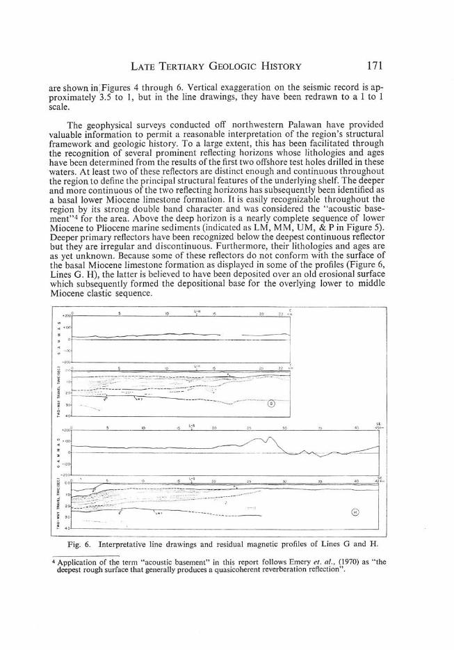
LATE TERTIARY GEOLOGIC HISTORY 171
are shown in; Figures 4 through 6. Vertical exaggeration on the seismic record is approximately 3.5 to 1, but in the line drawings, they have been redrawn to a 1 to 1 scale.
The geophysical surveys conducted off northwestern Palawan have provided valuable information to permit a reasonable interpretation of the region's structural framework and geologic history. To a large extent, this has been facilitated through the recognition of several prominent reflecting horizons whose lithologies and ages have been determined from the results of the first two offshore test holes drilled in these waters. At least two of these reflectors are distinct enough and continuous throughout the region to define the principal structural features of the underlying shelf. The deeper and more continuous of the two reflecting horizons has subsequently been identified as a basal lower Miocene limestone formation. It is easily recognizable throughout the region by its strong double band character and was considered the " acoustic basement"4 for the area. Above the deep horizon is a nearly complete sequence of lower Miocene to Pliocene marine sediments (indicated as LM, MM, UM, & P in Figure 5). Deeper primary reflectors have been recognized below the deepest continuous reflector but they are irregular and discontinuous. Furthermore, their lithologies and ages are as yet unknown. Because some of these reflectors do not conform with the surface of the basal Miocene limestone formation as displayed in some of the profiles (Figure 6, Lines G. H), the latter is believed to have been deposited over an old erosional surface which subsequently formed the depositional base for the overlying lower to middle Miocene clastic sequence.
'0 L-H , 20
~ 05 ' '0 Lt" ') ~2p . . _ _ ." 'I'.
i :rf~~~=~~~~=:5~ ~. " 0 "
~ ~
!"~0l=== ====="'=====:"====::' ~=====-"~~3 I ::~~~-- :~=-;~,,;:-: ::.; ':. · '" ;:10 - r' __ ______ 0 o
~ ,~----------~------------------------~----------------------~
Fig. 6. Interpretative line drawings and residual magnetic profiles of Lines G and H.
4 Application of the term "acoustic basement" in this report follows Emery et. al., (1970) as "the deepest rough surface that generally produces a quasicoherent reverberation reflection".

172 E. V. TAMESIS, E. V. MANALAC, C. A. REYEs, AND L. M . GTE
The shallower, continuous reflecting horizon on the other hand, corresponds to the base of a Pliocene carbonate unit which is lithologically very similar to the Pliocene limestone formations of southeastern Luzon and the Visayan area. Overlying the Pliocene sequence are varying thickness of Pleistocene rocks often forming coralline reef mounds and horizontal layers of sediments. The Pliocene sequence, and parts of the upper Miocene, are generally undeformed, unlike the middle and lower Miocene section which shows evidence of folding and faulting. Elsewhere (Parke, et. aI., 1971, p . 748), a similar observation has been made regarding the contrasting structural attitude between middle Miocene and younger rocks.
Two extensive unconformities observed from the seismic data were later confirmed by drilling. The more regionally significant of the two separates the middle Miocene from the upper Miocene at least beneath the present shelf. The second unconformity intervenes between upper Miocene and Pliocene strata. Thus far, structural features suggesting late Tertiary intrusive or extrusive igneous activity have not been recognized on any of the seismic profiles. Its absence in the area seems to be confirmed likewise by the lack of volcanic detritus from the cores and ditch samples of the two offshore test holes.
The following sequence of interpretative profiles and their descriptions illustrate the variety of geologic structures that characterize the shelf from north to south. Lines A and B cross the shelf edge at the northern part of the region. Line C, is a tie line connecting A and B at and just beyond the shelf break. Line A, the farthest north of the traverses here presented, is approximately 32 kilometers long and trends almost northwest. It shows an extremely flat shelf area with the shelf slope breaking almost imperceptively at a water depth of 100 meters. Beyond this point, the slope drops off gradually to water depths of 273 meters to 335 meters . Between kilometers 10 and 30 is an asymmetrical syncline with a steep and apparently faulted west limb and a broad anticlinal fold whose crest is approximately 3 kilometers from the west end of the line. The deepest continuous reflecting horizon is not as well developed on the seaward side of the traverse as in the shelf area, thus suggesting a possible change in lithology. Directly underneath the flat-lying base of the Pliocene sequence, where the slope is steepest, are reflecting horizons which suggest local ponding of at least part of the prePliocene sediments on an earlier structural depression.
Line B was run about 20 kilometers south, and parallel to line A. Over 50 percent of the line traverses water depths in excess of 91 meters on the upper margins of the slope. As in Line A, the sea bottom over the slope is almost featureless, and is underlain by beds that are apparently parallel; on the shelf, however, some irregularities, probably arising from reefal growth, are reflected on the sea bottom. The most prominent underlying structural feature is a down to the basin fault with approximately 1,200 meters of displacement. This fault has brought the "acoustic basement" closer to the sea bottom near the edge of the shelf, where the Pliocene section is immediately juxtaposed on it. On the down-thrown block of the fault and above the "acoustic basement" are severallocalIy continuous reflecting horizons that suggest depositional upbuilding and outbuilding of the continental terrace, (Moore and Curray, 1962), but the strata have evidently been truncated by later erosion.
Line C trends roughly parallel to the hingeline and intersects profiles A and B in waters that are approximately 102 meters and 225 meters deep respectively. As shown by this and other profiles run in this general area, horst blocks and grabens are common, but these structures are not reflected in the sea-bottom's topography. Compres-

LATE TERTIARY GEOLOGIC HISTORY 173
sional folds bounded by steep faults and a major truncation and overlap of the early Neogene section is displayed by the profile. Supratenuous folds arising from the deposition of sediments on synchronous highs most of which coincide with the crest of anticlinal folds characterize this section. The upper Miocene section encountered in drilling one of the structural highs in the vicinity is quite thin and drapes over folded and eroded middle Miocene sediments. The folds observed along this tie line, generally have higher amplitudes in comparison to those seen in profiles that were run normal to the edge of the basin, thus suggesting a possible continuation offshore of the north and northwest swing of folds noted onshore in northern Palawan. Forms indicating reefal build-ups, usually identified by draping, velocity pull-up and disappearance of seismic events over crests of compressional folds, are not so evident in the Pliocene sequence of the Neogene section, but appear on the lower Miocene limestone reflector.
The offshore geology off northwest Palawan assumes a different structural aspect farther south as shown in the next sequence of profiles. Lines D, E, and F were run about 95 kilometers southwest of the preceding sequence of seismic lines. Here, the main structural framework of both the shelf and slope is a seaward thickening sequence of sediments cut by high angle faults that are generally down to the east underneath the shelf, and down to the west beyond the continental shelf. As in the northern area, most of the faulting is evidently pre-Pliocene, but a number apparently post date this epoch, and are reflected in the sea bottom's topography.
Line D which was run close to where the first offshore test well was drilled, shows a shelf with an irregular sea-bottom characterized by nearly vertical escarpments from reef growth. The shallow, upraised portion of the sea bottom with some 100 meters of relief, near the west-end of the profile is a submerge atoll. Beneath it can be seen the west-dipping homoclinal sequence of truncated lower to middle Miocene sediments capped by the gently dipping and nearly flat-lying transgressive sequence of upper Miocene and younger starta. At kilometer 12, the prominent reflecting horizons at about 1.2 to 1.3 seconds are lower Miocene turbidites.
Essentially, similar structural features are noted on the next profile. Line E runs parallel to Line D and is about 16 kilometers farther south. The profile was run far enough across the shelf edge to give an indication of the origin of the slope and the underlying structural framework. The precipitous slope off the edge of the shelf is due to reef growth on the up thrown block of a fault and is evidently responsible for the poor quality of seismic data immediately below. The principal structural feature underlying the upper transgressive sequence is seaward dipping strata with foreset bedding discernible on the seaward portion of the profile. The latter is best shown in the next profile, Line F, which crosses Line D near the edge of the shelf.
On Line F, associated cut and fill structures are evident on the south end of the profile. Based on a projection of the stratigraphic data from the test hole, the part of the section displaying the well developed deltaic features is probably of upper Miocene age. There are at least two channels recognizable in the profile. The lower of these is believed to be related to the late middle Miocene unconformity in the region. The younger channel, which appears to have migrated farther south of the older one, probably corresponds to the unconformity separating the Pliocene from the upper Miocene. Classical internal structures including foreset, bottomset and top set beds can be seen, as well as small mound-like forms developed on the lower surface which could be reefal build-ups.

174 E. V. TAMESIS, E. V. MANALAC, C. A. REYES, AND L. M. OTE
Although the seismic records of the last two profiles, G & H are not as clear as those obtained in the preceding traverses, they nevertheless provide a readable picture of the structural framework in the southern part of the region surveyed. Both profiles were recorded about 32 kilometers south of Line F, in relatively shallow waters averaging 60 meters.
Along Line G, the smoothness of the sea-bottom is interrupted by severalmounds which are most likely submerged atolls. On the eastern end of the line the mounds appear to coincide with a gentle local arching of the underlying section. The quality of the seismic data generally deteriorates with respect to the deepest continuous reflecting horizon. However, the upper sequence of reflecting horizons are sufficiently well defined and indicate the depositional outbuilding origin of the internal structure. The deep continuous reflecting horizon, which is believed to still be the lower Miocene limestone formation, is recognizable throughout most of the profile, although the record quality is poor toward the southeastern end. With the exception of some suggestions of small faults, there seems to be no indication of the large scale block-faulting that characterize the other sections. Evidence of compressional type folds is also lacking. However, the deepest continuous reflecting horizon seem to be down-warped on the eastern end of the profile, where the overlying sedimentary section is thickest. Deeper primary events are discernible below the deep horizon near the sh~lf edge and indicate eastward thickening of the section in contrast to the general westward thickening well illustrated by the Miocene and Pliocene sequence overlying the deep horizon. Some ofthese sub-"acoustic basement" reflectors are as deep as 3.5 seconds (two-way time), which indicates a sedimentary section probably as thick as 4,200 meters.
Along Line H, the irregularity of the surface on the slope off the shelf edge is probably due to slumping, although the possibility of channeling by bottom currents is not being discounted. Bottom topography on the shelf however, essentially repeats what is shown on line G, and on the southeastern end of the traverse, the relief of the reef mounds are well accentuated.
The strata above the deepest continuous reflector maintain their gentle seaward dips except locally where, probably because of sea-bottom irregularities, they assume reverse attitudes. About one second above the deep horizon near the center of the profiles are some fairly continuous reflectors forming irregular mounds going updip which may be slumped turbidites. The deepest continuous reflector does not appear in the eastern end of the line. Because the magnetic profile on the same line has an unusually steep gradient localized over the area where there is acoustic discontinuity, this feature is believed to be a fault. The continuous reflecting horizon appears as a broad domal feature with approximately 150 milliseconds (two-way time) relief. The comparatively low relief of the deep horizon in both profiles may be cited as additional evidence that the basal lower Miocene limestone reflector was probably deposited on an erosional surface. Limited traces of sub-"acoustic basement" reflector likewise appear on line H.
INFERRED SUMMARY OF NEOGENE GEOLOGIC HISTORY
The structural framework of the shelf and slope off northwestern Palawan consists essentially of a thick sequence of folded and block-faulted, westward dipping sediments of Neogene age on a basement framework of older rocks. Among the more common structural features of this framework are horst blocks and grabens, compressional and supratenuous folds, deltaic and associated cut and fill structures, reefal build-ups and unconformities. The significance of these features and their role in de-

LATE TERTIARY GEOLOGIC HISTORY 175
fining the major events of the region's Late Tertiary geological history has been made possible through the integration of seismic and well data, with known aspects of Palawan's onshore geology.
The two test holes drilled offshore of northwestern Palawan reached total depth on the same formation whose age is generally considered to represent the base of the Miocene in the Philippines. Failure, however, to penetrate the complete Tertiary section in both holes leaves much to be learned about the Paleogene and older geologic history of the offshore environs of the Palawan-South China Sea area. It is beyond the scope of this paper to go into the details of the region's pre-Neogene geologic history. Some insight into this phase of geologic history can be obtained from a review of the stratigraphic record of the onshore areas, and notably from published studies on the tectonics and orogenesis of the Philippine Archipelago (Gervacio, 1966, a.b.). The preMiocene basinal strata of northern Palawan consists of Late Paleozoic to Eocene rocks that have undergone a complex history of sedimentation and tectogenesis traceable to as early as pre-Middle Permian and possibly even Carboniferous time. These rocks probably continue underneath the wedge of Neogene sediments observed on all the seismic profiles.
The stage for the formation of the Miocene basins or zones of sedimentation was not established until after an uplift of the north Palawan block, which may have come late in the Eocene or Oligocene. Strata of Oligocene age have not been found in north Palawan, thus suggesting that they were either not deposited there, or if they were, an orogeny sometime late in this epoch must have transpired and resulted in stripping Oligocene strata off the Island. In any case, it appears that during early Miocene time, wide-scale westward tilting of the Island and adjacent western shelf produced the shallow platform on which the basal lower Miocene limestone was deposited. The exact limits of the early Miocene shelf are not known but it must have extended beyond the present hingeline. Sometime during the latter part of the early Miocene, rapid basin deepening occurred during which several thousand meters of marine silts, clays, deep sea carbonate rocks and sporadic turbidites were deposited. This rapid sedimentation was probably aided by subsidence along block-faults peripheral to the Island. The deposition of deep sea sediments prevailed through most of lower and middle Miocene time, but toward the end of the latter epoch, the region became once more tectonically active, resulting in the general westward retreat of the sea as a consequence of the major uplift of the north Palawan block.
The deformation of the early Neogene section seems to have been progressively more intense toward the north and may have attained its maximum development sometime late in the middle Miocene or just before the deposition of upper Miocene sediments. The entire region remained above sea level for some time and erosion cut an almost fiat surface across many of the folded sections. In the north, where deformation was more pronounced, some of the horst blocks probably existed as islands. Their beveling, however, was not accomplished until after the deposition of the upper Miocene sediments.
During late Miocene time, the shelf off northwestern Palawan was again transgressed by a shallow sea wherein fine grained detrital carbonate and clastic sediments were laid down. Some of these were deposited on synchronous highs developed on the folded and faulted lower and middle Miocene sequence. At least locally, during the latter part of the Miocene, the area may have been temporarily emerged to cause partial removal of upper Miocene sediments. The beginning of Pliocene time saw
176 E. V. TAMESIS, E. V. MANALAC, C. A. REyES, AND L. M. OTE
once more a return to another epoch of transgression characterized by the deposition of carbonate facies sediments over the shallow shelf. This appears to have continued through the Pleistocene and up to the present.
ACKNOWLEDGEMENT
The writers gratefully acknowledge the help and support of the management of Oriental Petroleum and Minerals Corporation in the preparation of this report and for permitting its pUblication. Thanks are also due to Dr. Mateo H. Tupas, Dr. Walter B. Brown, and other colleagues in the Dept. of Geology of the University of the Philippines for the valuable suggestions and discussions in the presentation of this paper, and to Miss Barbara Soria for the final drafting of the illustrations.
REFERENCES
BELENDRES, CONSTANTE, 1963. Notes on the Geology of Pal alVan, Soulh of Puerto Princesa. Unpublished Bureau of Mines Report.
EMERY, K.O., UCHUPI ELAZAR, PHILLIPS, J.D., BOWIN, e.O. , BUNCE, E.T., and KNOTT, S.T., 1970. Continental Rise off Eastern North America, American Assoc. Petroleum Geologist Bull., V. 54, No. 1, pp. 50--51.
GERVACIO, F.C., 1966. The Age and Nature of Orogenesis of the Philippines: The Philippine Geologist V. 20, No.4, pp. 121-140.
GERVACIO, F.e. , 1966. A study of the tectonics of the Philippine Archipelago, The Philippine Geologist, v. 20, No.2, pp. 51-74.
MOORE, D.G., and CuRRAY, J.R., 1962. Structural Framework of the Continental Terrace, Northwest Gulf of Mexico, ContriBution from the Scripps Institution of Oceanography, University of California, La Jolla, California, contribution, No. 1506, pp. 1745-1747.
PARKE JR., M.L., EMERY, K.O., SZYMANKIEWICZ, RAYMOND, and REYNOLDS, L.M., 1971. Structural framework of the continental margin in the South China Sea. Am. Assoc. of Petroleum Geologists, Bull. v. 55, No.5, pp. 723-751.