Embed Size (px)
Citation preview
Ar izon a Geolog ical Soc iety Digest , Volume XI, October 1978
LATE CENOZOIC VOLCANISM AND METALLOGENESIS OVER AN
ACTIVE BENIOFF ZONE IN CHIAPAS, MEXICO I
by
Paul E. Damon 2 and Enrique Montesinos 3
Abstract
Chiapas, Mexico is a critical area for plate tectonic phenomena. The southeast part of the state, in the region of Motozintla, marks the juncture of three plates: the American, Cocos, and Caribbean plates. The Central (Middle) American trench strikes parallel to the coastline and to most of the Large-scale geological features of Chiapas such as the Sierra Madre de Ch iapas, the Central Depr€ssion, and the folded ridge and valley province of northeastern Chiapas.
The offshore trench and inland Chiapas are regions of intense seismicity. There is a distinct tendency for fewer but deeper and more intense earthquakes proceeding from the trench to inland Chiapas. This pattern of s e ismiCity is similar to that of other Benioff zones and demo nstrates that the Cocos plateis continuing to subduct under Chiapas .
The major mineral deposits of Chiapas are genetically associated with Cenozoic plutons. One set of plutons has been shown by K-Ar dating to be middle to late Miocene in age. These plutons intrude an ancient Paleozoic batholithic terrain within the Chiapas Massif. This set of plutons lies along an abandoned segment of the Miocene Central AmericanMexican volcanic arcs.
The second set of plutons is clearly associated with a belt of calc-alkalic, andesitic to dacitic stratovolcanos of Pliocene and Pleistocene age. The volcano EI Chichc5n in tha t belt contains an active solfatara field. Others still retain much of their primary structure. This belt is referred to as th e modern Chiapanecan volcanic arc.
The rate of erosion required to expose the mineral deposits below the tops of the stratovolcanos, according to the model of Sillitoe (1973), is from 300 m/m.y. to 900 m/m.y.
Prior to 9 m. y. ago, the ancestral Mexican volcanic arc was probably continuous to Cape Corrientes. Between 9 and 3 m . y. ago, reorganization of the subducting Cocos plate resulted in a volcanic arc, which is conve x to the north. A magma gap exists within the Central Depression of Chiapas.
We conclude that continuing ore genesis in Chiapas is associated with subduction of the Cocos plate. The ore deposits are the roots of calc-alkalic stratovolcanos . Both the ancestral Miocene Central Am erican-Mexican arcs and the modern arc are prime targets for ore deposits of Neogene age.
Plate Tectonic Setting of Chiapas
155
1 Contribution No. 817, Department of Geosciences, University of Arizona, Tucson
2 Laboratory of Isotope Geochemistry, Department of Geosciences, University of Arizona, Tucson, Arizona 85721
3 Consejo de Recursos Minerales, Tuxtla Gutierrez, Chiapas, Mexico
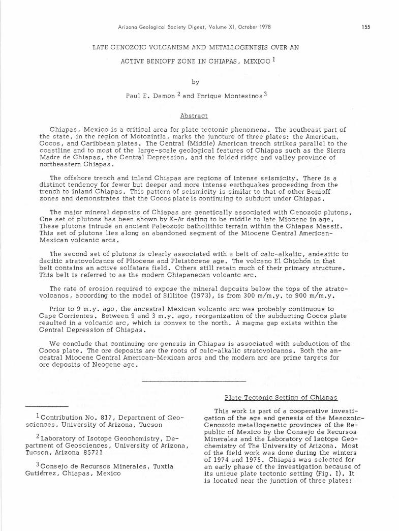
This work is part of a cooperative investigation of the age and genesis of the Mesozoic Cenozoic metallogenetic provinces of the Re public of Mexico by the Consejo de Recursos Minerales and the Laboratory of Isotope Geochemistry of The University of Arizona. Most of the fie ld work wa s done during the winters of 1974 and 1975. Chiapas was selected for an early phase of the investigation because of its unique plate tectonic setting (Fig. 1). It is located near the junction of three plates:
156 DAMON and MONTESlNOS
100 70
AM E RICAN
COCOS
PL ATE ______ ~~~,-----~-------t~----~~1t,~
I 200 400 600
! ! ,
KI LOMETERS
15°t-t------+"""""---.1rt------t-------j
94° 93° 91° 90 70
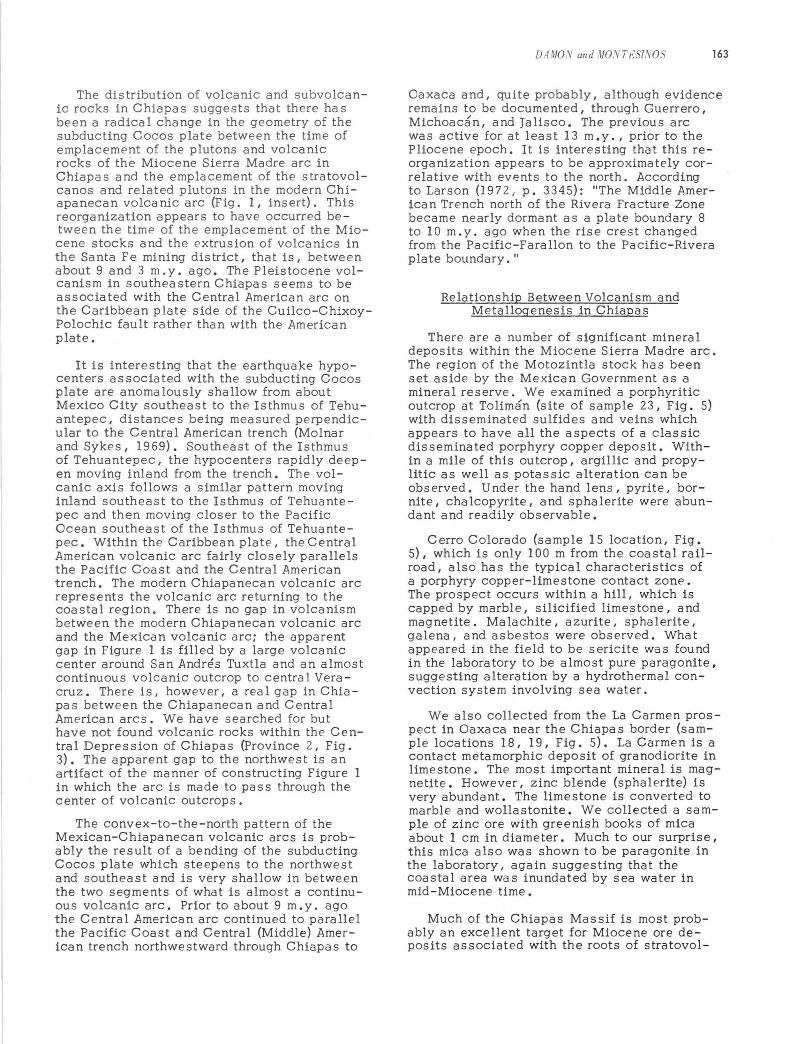
Fig. 1. Plate tectonic sketch map of the Cocos, Caribbean, and American plates from Cape Corrientes to Venezuela. Data for this figure was obtained from Chase, Menard, and Mammerick (1970), Fisher (196l), Herron (197 2), Molnar and Sykes (1969), Muehlberger and Ritchie (1975), Schubert and Sifontes (1970), Schubert (1974), and Shor and Fisher (1961).
the American, the Caribbean, and the Cocos plates. The Cuilco-Chixoy-Polochic fault forms the present boundary between the Caribbean and American plates in southeastern Chiapas and Guatemala (Kesler, 1971; Muehlberger and Ritchie, 1975). The Central (Middle) American trench forms the boundary between these plates and the Cocos plate roughly paralleling the C e ntral American shoreline.
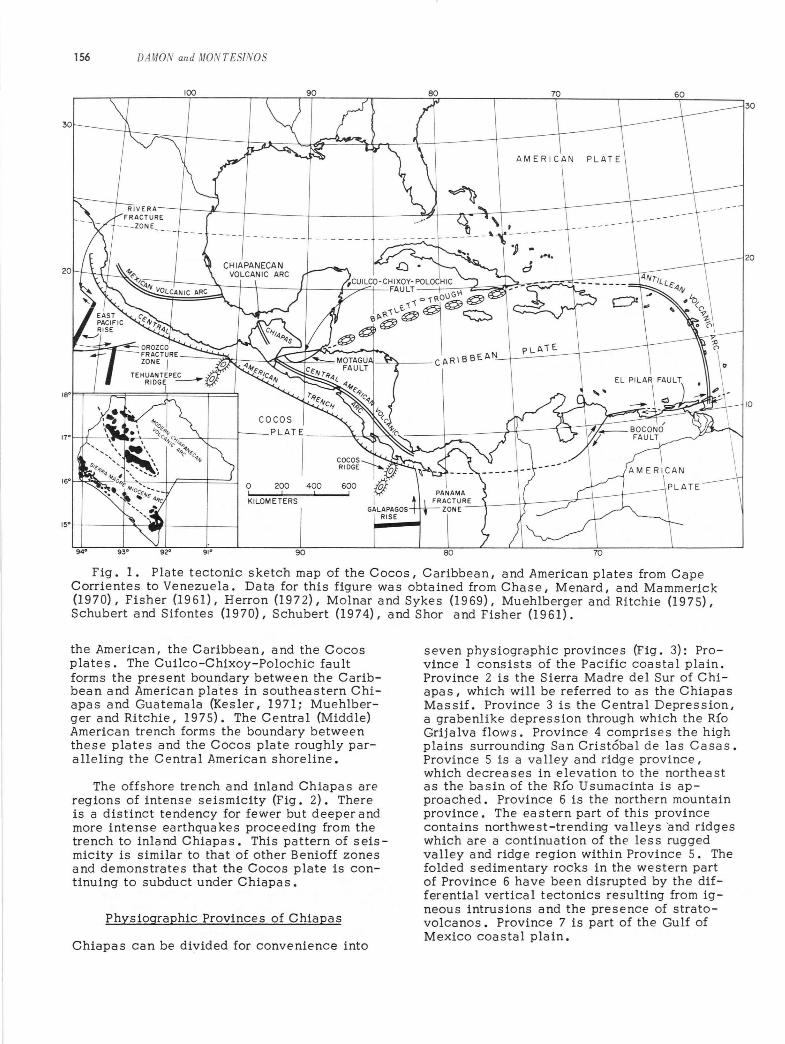
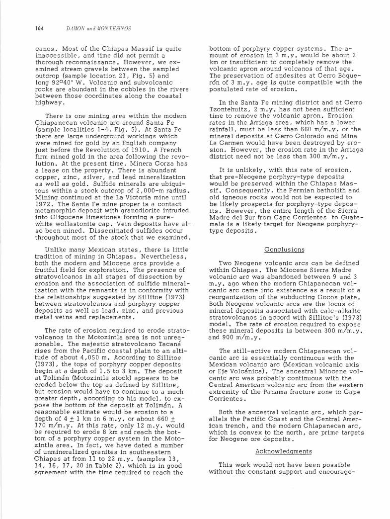
The offshore trench and inland Chiapas are regions of intense seismicity (Fig. 2). There is a distinct tendency for fewer but deeper and more intense earthquakes proceeding from the trench to inla nd Chiapa s. This pattern of s eismicity is similar to that of other Benioff zones and demonstrates that the Cocos plate is continuing to subduct under Chiapas.
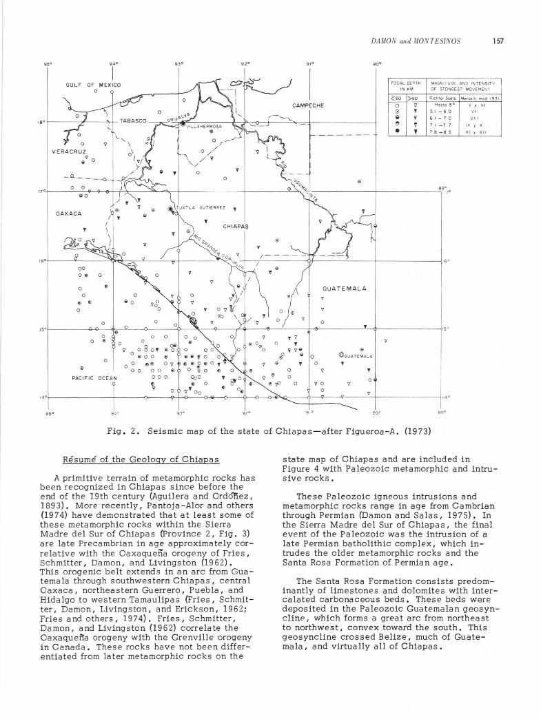
Physiographic Provinces of Chiapas
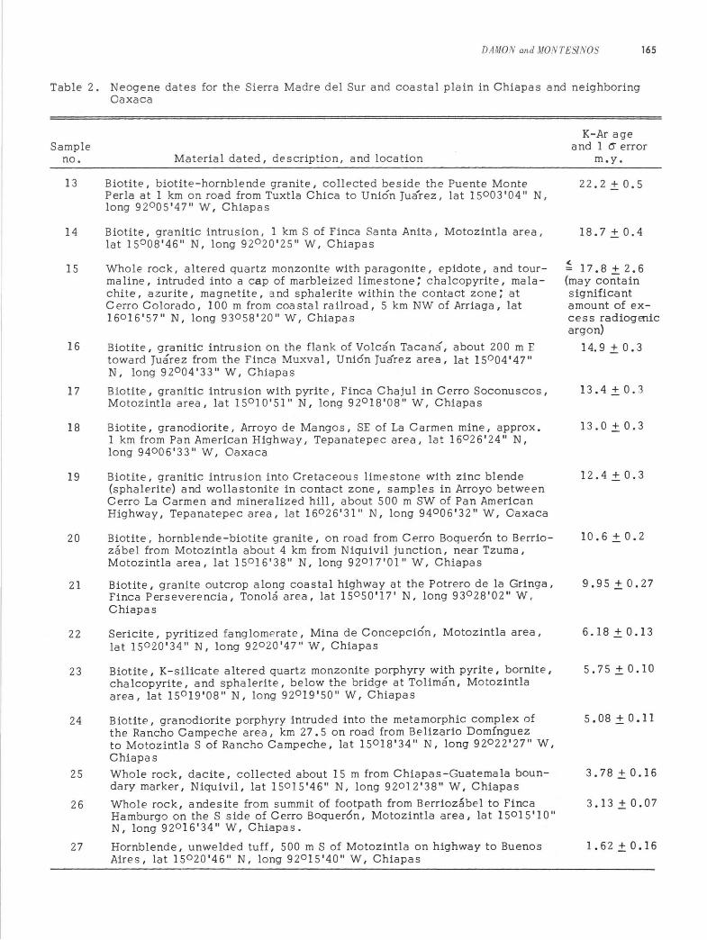
Chiapas can be divided for convenience into
seven physiographic provinces (Fig. 3): Province 1 consists of the Pacific coastal plain. Province 2 is the Sierra Madre del Sur of Chiapas, which will be referred to as the Chiapas Massif. Province 3 is the Central Depression, a grabenlike depression through which the RIO Grijalva flows. Province 4 comprises the high pla i ns surrounding San Cristobal de las Casas. Province 5 is a valley and ridg e provinc e, which decreases in elevation to the northeast as the basin of the Rio Usuma c inta is approached. Province 6 is the northern mountain province. The ea stern part of this province contains northwest-trending valleys 'and ridges which are a continuation of the less rugged valley and ridge region within Province 5. The folded sedimentary rocks in the western part of Province 6 have been disrupted by the differential vertical tectonics resulting from igneous intrusions and the presence of stratovolcanos. Province 7 is part of the Gulf of Mexico coastal plain.
160
Of) 0
0 f)
0
fl fl
0
0 15 0
fl 0
0 ® 0
0
®
PACIFIC OC EAN
14 0
95 0 94 0
o
0
" 0 930
0
0 0
9 0
080 ' fl 00
00 flfl
00 00
93 0
,
0
O® ®o fl
09
®
0.1' .- '/ "
o ./ .-\ //y
' ./
o o
92 0
000
fl fl 0 f) .. 0 V ' 00
Ii) Of)
930 92 0
9
'iJ
0
~ @
0
'" 0
~<JO
DAMON and MONTESlNOS 157
91 0 900
FOCAL DEPTH MAGNITUDE AND INTENSIT Y
IN KM OF STONGEST MOVEMENT
(60 )60 RichTer Scole Mercollt mod 193 1
CAMPECHE 0 'iJ Hoslo 5° V , VI
,
0
(;) , 5 I - 6 0
~ .. 6 I - 7 0
e l' 7 I -7 7
• , 78 -85
Ii)
890
.---- -----1-------; 170
GUA TEMAL A V
9
0 , 9
®
0 !OGUATEMALA
0 , 'iJ ,
0 90 9
0 9 _-Jl ' ___ -+-______ ~ 1 4°
910 900 89 0
VII
VIII
IX , X
XI , XII
Fig. 2. Seismic map of the state of Chiapas-after Figueroa-A. (1973)
Resume of the Geology of Chiapas
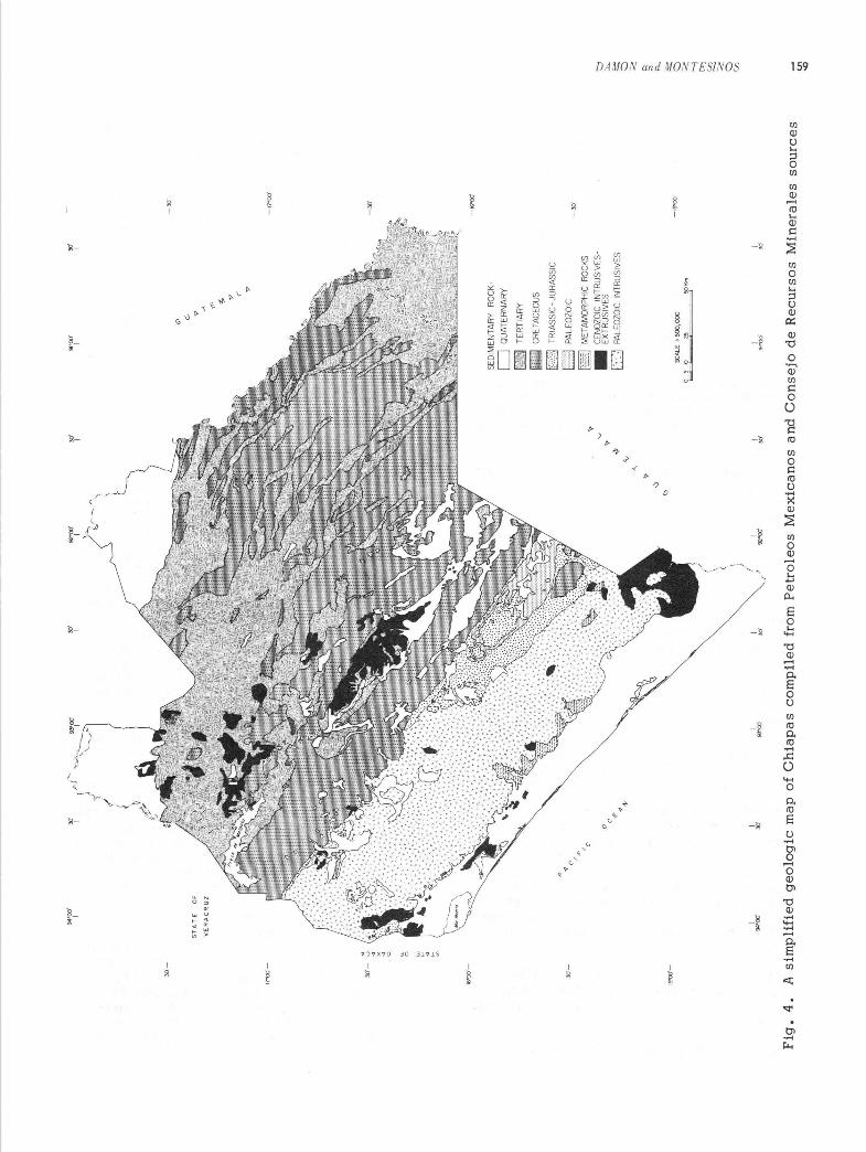
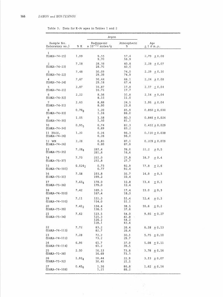
A primitive terrain of metamorphic rocks has been recognized in Chiapas since before the end of the 19th century (Aguilera and Ordonez, 1893). More recently, Pantoja-Alor and others (1974) have demonstrated that at least some of these metamorphic rocks within the Sierra Madre del Sur of Chiapas (Province 2, Fig. 3) are late Precambrian in age approximately correlative with the Oa xaquena orogeny of Fries, Schmitter, Damon, and Livingston (1962). This orogenic belt extends in an arc from Guatemala through southwestern Chiapas, central Oa xaca, northeastern Guerrero, Puebla, and Hidalgo to western Tamaulipas (Fries, Schmitter, Damon, Livingston, and Erickson, 1962; Fries and others, 1974). Fries, Schmitter, Damon, and Livingston (1962) correlate the Oaxaqueffa orogeny with the Grenville orogeny in Canada. These rocks have not been differentiated from later metamorphic rocks on the
state map of Chiapas and are included in Figure 4 with Paleozoic metamorphic and intrusive rocks.
These Paleozoic igneous intrusions and metamorphic rocks range in age from Cambrian through Permian (Damon and Salas, 1975). In the Sierra Madre del Sur of Chiapas I the final event of the Paleozoic was the intrusion of a late Permian batholithic complex, which intrudes the older metamorphic rocks and the Santa Rosa Formation of Permian age.
The Santa R()sa Formation consists predominantly of limestones and dolomites with intercalated carbonaceous beds. These beds were deposited in the Paleozoic Guatemalan geosyncline, which forms a great arc from northeast to northwest, convex toward the south. This geosyncline crossed Belize, much of Guatemala, and virtually all of Chiapas.
158 DAMON and MONTESINOS
LEGEND :
Rail road _______________ +++-+-+-
o Pond Rood ______________ _
hnpro .... d Dir' Rood ____ ___ ____ _
Dlr! Rood ___ __________ _
T,o ll ____________ ____ __
River. and .,royo, _______ __ ~
".If--1I--f"---7~--"""r------'~-+-:~--"'=-="---'--=~""""" 'j=-------=T-+--------lI
PHYSIOGRAPHIC PROVINCES
I. Pac ific Coastal Plain
2.Chiopos Mossi f (S i."o Modre del Sur)
3. Central Deprelsion
4. HiOh Pla ins
5. Bas in of the Usumac inta
6 , Mountains of the North
7. Gu lf of Mexico Coostol ,..If-~-=:-4-"""1;_-----+_--___,_~~""=~~-_+------+__--------'~
o
o
.... .., C'
/ ...
SCALE 1: 2 .250,000 22.' 4~ 9011".
".H-----i-------"-/"C'-+--~____jt___4t_':___r.:':c+.,____, ___ -----+_----~". o
... .,. oz· .,.
Fig. 3. The physiographic provinces of Chiapas-after Bose (1905)
Following the deposition of sediments in the Guatemalan geosyncline, a large basin was the locus of salt deposition, the socalled Isthmus Salt Basin of Late Jurassic age or post-Callovian-pre-late Oxfordian according to Viniegra-O. (1971). This salt basin occupied most of Chiapa s excepting the Sierra Madre del Sur and Pacific coastal plain. In northern Chiapas, salt deposition continued into latest Jurassic (Kimmeridgian-Tithonian) time according to Viniegra -0. (1971). The salt deposits are overlain toward the Chiapas Massif by the red beds (Lechos Rojos) of the Todos Santos Formation. On the state geologic map of Chiapa s (Fig. 4), the Todos Santos Formation is referred to as Triassic-Jurassic in age; however, according to Viniegra-O. (1971), this formation must be Late Jurassic and Early Cretaceous in age. Some geologists refer to the Early Cretaceous continental red beds intertongued with marine limestones as the San Ricardo Formation (Richards, 1963). We examined the Todos Santos red beds east of Cintalapa. The formation there consists of aeolian cross-bedded sandstones and cobble
conglomerates containing quartz, granitic debris, and abundant volcanic rock grains and cobbles. In one place, we found a cobble of red-bed sandstone within a Todos Santos redbed conglomerate. The general aspect was that of debris from the unroofing of the ancestral Chiapas Massif (Province 2, Fig. 3) . The abundance of volcanic rock fragments indicates that erosion of the Chiapas Massif had not proceeded to a great depth at the time of deposition of the Todos Santos Formation. From the outcrop pattern (Fig. 4) one can surmise that debris from unroofing of the massif was distributed to a basin lying to the northeast.
Marine conditions prevailed throughout Chiapas following the deposition of the San Ricardo Formation. Limestone and dolomites are most abundant with lesser amounts of chert, shale, and sandstone. Occasionally, deposition of marine sediments wa § interrupted by formation of soils, some of which were lateritic. During this time, Chiapas was part of the Mexican geosyncline (Kay, 1951).
yj-
11
'"0
0'-
",'-
~""'
-
",'-
15
"'0
0'-
~
o w
~
~
~
"""0
0'
I
ST
AT
E
OF
VE
RA
CR
UZ
I "'0
0'
~ • c
, ~ , c
y;,' I
o c ,l"
, 1
'-')
<{J
I
(' .",
\ ',-
-~~~oo
I 93
"00'
",'
I I ",'
) ) f
92
"00
' I
(\c"
'~_A
b
~
I """'"
\ " " " .,.
",'
.,. ~
<v
I ,l"
.,.
~·od
I
'" c. .,. <" ~ .,. <'
.,.
SE
DIM
EN
TAR
Y
RO
CK
,
D
QU
ATE
RN
AR
Y
~
TER
TIA
RY
e C
RET
ACEO
US
E3
TRIA
SS
IC-
JUR
AS
SIC
~
PA
LEO
ZOIC
§ M
ETA
MO
RP
HIC
R
OC
KS
• C
ENO
ZOIC
IN
TRU
SIV
ES
E
XTR
US
IVE
S
D
f¥>L
EOZO
IC I
NTR
US
IVE
S
SC
ALE
1
'50
0,0
00
o
5 10
25
~I(m
91.1
00'
",'
I
-",'
-17
·00
'
-",'
-16
-00
'
-",'
-I~-OO'
,l"
Fig
. 4
. A
sim
pli
fied
geo
log
ic m
ap o
f C
hia
pa
s co
mp
iled
fro
m P
etro
leo
s M
exic
an
os
and
Co
nse
jo d
e R
ecu
rsos
Min
era
les
sou
rces
t:::l
;:".
;:;:
: a <: " '" "'- iii:
: a <:
""-l
t>'] ~
<:
a '" IJ1
-0
160 DAMON and MONTES/NOS
During the early Cenozoic, marine deposition retreated to the northeast. By late Eocene time, the southwestern half of Chiapas was a land area and streams were carrying cobbles of schist, granite, and quartzite to the northeast beyond what is now the Central Depression of Chiapas (Province 3, Fig. 3). These streams deposited the conglomerates that are included within the El Bosque Formation.
Marine conditions prevailed in northern Chiapas through the Oligocene epoch. However, the seas gradually retreated to the north toward the Gulf of Mexico. Terrestrial conditions prevailed from Miocene time to the present.
The state geologic map of Chiapas (Fig. 4) shows two episodes of igneous activity: an early Cenozoic episode of dioritic, granodioritic, and quartz monzonitic intrusions and a late Cenozoic episode of volca nic activity. We will demonstrate in this paper that there are two episodes of igneous activity, but both are Neogene in age rather than separated into Paleogene intrusive and Neogene volcanic episodes.
K-Ar Dating Technigues
The K-Ar dating method requires precise, accurate determinations of K and 40Ar (Dalrymple and Lanphere, 1969). In the Laboratory of Isotope Geochemistry, K was determined by atomic absorption spectrophotometry. The solution used contained 0.1 g of the sample as sulfate in 200 ml of aqueous solution containing 800 ppm Li and 1000 ppm Na. Two aliquots were measured for each sample. The atomic absorption spectrometer us ed wa s a Perkin-Elmer 403, single beam instrument. A 30 Ib-60 lb acetylene-air flame was used with the wavelength dial set at 3827 $. (3-s10t burner head in parallel position, slit 4, filter in).
Molybdenum crucibles were used for the radio frequency induction heating to fuse the sample to release argon for analysis. The molybdenum crucible was suspended by a platinum wire and carefully centered within a 90-mm air-cooled pyrex fusion envelope. Four samples were mounted in the fusion system, and the system was baked over the weekend at 270 0C. The system was also baked overnight after every fusion. In addition to the usual titanium foil gettering and conversion of hydrogen to water over CuO, a Zr-Al appendage pump provided a final purification step that insures very pure argon for ma s s spectrometric analysis.
Argon isotopes were analyzed on either a
Nier-type 15.2 cm radius, 600 sector field mass spectrometer with magnetic sweeping or an MS-I0, 5.1 cm, 1800 mass spectrometer with electrostatic sweeping. Two analyses per fusion were made in the static mode.
For young samples, for example, samples of Pleistocene age, the standard error was determined primarily by the atmospheric argon contamination. The standard deviation for a sample with negligible air argon is 2.3%, 15% with 90% air argon, and 100% with 98.4% air argon.
All dates were calculated with the following decay cons ta nts:
0.581 x 10⁻¹⁰ yr- 1
4.963 x 10⁻¹⁰ yr- 1
5.544 x 10⁻¹⁰ yr- l
1.167 x 10⁻⁴ atomic ratio
Age and Genesis of Cenozoic Igneous Rocks in Chiapa s« Including the Southern Oaxaca Border Region
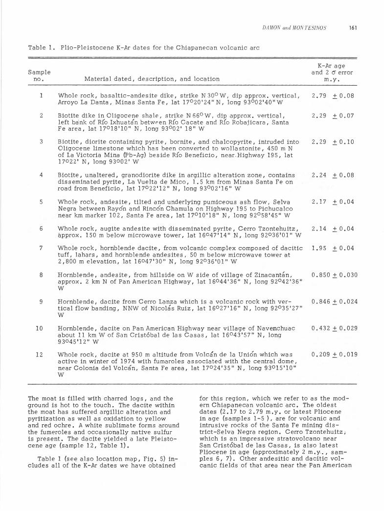
There are two regions within Chiapas that contain Cenozoic igneous rocks (see Fig. 4 and lower left-hand inset in Fig. 1). The first region lies in central and northwestern Chiapas (within physiographic Provinces 4, 6, and 7). The geologic map of Chiapas classifies the outcrops a s early Cenozoic intrusive a nd late Cenozoic volcanic rocks. Before beginning field work in that area, we spent several days dOing aerial reconnaissance. It became apparent from the morphology of the volcanic rocks as seen from low aerial altitudes that the region included domes, necks, and stratovolcanoes of no great antiquity. In fact, we were quite surpris ed to fly over a volcano, Volcan El Chichon, which had numerous active fumeroles. Volcan El Chichon is also known locally as Volcan de la Union and Volcan Ostuacan. It is listed as the site of an active solfatara field in the Catalogue of the Active Volcanos of the World (International Volcanological Association, 1951-1973), but apparently it is not well known in Mexico as an active volcano. At a later date we ascended the volcano, which wa s thickly covered with jungle growth, necessitating the use of machetes to clear a path. The volcano has a central dome, which rises to 1,350 m above sea level, and a surrounding moat at an elevation of 950 m. The flanks are composed of hornblende dacite with a few quartz phenocrysts and disseminated pyrite. Both the moat and the dome are sites of active solfataric activity, which rises some 50 m into the air as extremely hot jets.
DAMON and MONTES/NOS 161
Table 1. Plio-Pleistocene K-Ar dates for the Chiapanecan volcanic arc
K-Ar age Sample and 2 (5 error
no. Material dated, description, and location m.y.
1 Whole rock, basaltic-andesite dike, strike N300 W, dip approx. vertical, 2.79 ±0.08 Arroyo La Danta, Minas Santa Fe, lat 17 0 20'24''N, long 93 002'40"W
2 Biotite dike in Oligocene shale, strike N 660 W. dip approx. vertical, 2.29 ± 0.07 left bank of R(o Ixhuatan betwpen R{o Cacate and Rio Robajicara, Santa Fe area, lat 170 18'10" N, long 93 002' 18" W
3 Biotite, diorite containing pyrite, bornite, and chalcopyrite, intruded into 2.29 ± 0.10 Oligocene limestone which has been converted to wollastonite, 450 m N of La Victoria Mina (Pb-Ag) beside R(o Beneficio, near. Highway 195, lat 170 22' N, long 93002' W
4 Biotite, unaltered, granodiorite dike in argillic a lteration zone, contains 2.24 ± 0.08 disseminated pyrite, La Vuelta de Mico, 1.5 km from Minas Santa Fe on road from Beneficio, lat 170 22'12" N, long 930 02'16"W
5 Whole rock, andesite, tilted and underlying pumiceous ash flow, Selva 2.17 ± 0.04 Negra between Rayon and Rincon Chamula on Highway 195 to Pichucalco near km marker 102, Santa Fe area, lat 170 10'18" N, long 92 0 58'45" W
6 Whole rock, augite andesite with disseminated pyrite, Cerro Tzontehuitz, 2.14 ± 0.04 approx. 150 m below microwave tower, 1at 16047'14" N, long 92 0 36'01" W
7 Whole rock, hornblende dacite, from volcanic complex composed of dacitic 1.95 ± 0.04 tuff, lahars, and hornblende andesites, 50 m below microwave tower at 2,800 m elevation, lat 16047'30" N, long 92 0 36'01" W
8 Hornblende, andesite, from hillside on W side of village of Zinacantan, 0.850 ± 0.030 approx. 2 km N of Pan American Highway, lat 16044'36" N, long 92042'36" W
9 Hornblende, dacite from Cerro Lanza which is a volcanic rock with ver- 0.846 ± 0.024 tical flow banding, NNW of Nicolas Ruiz, lat 160 27'16" N, long 92 0 35'27" W
10 Hornblende, dacite on Pan American Highway near village of Navenchuac 0.432 ± 0.029 about 11 km W of San Cristobal de las Casas, lat 16043'57" N, long 93 045'12" W
12 Whole rock, dacite at 950 m altitude from Volcan de la Union which was 0.209 ± 0.019 active in winter of 1974 with fumaroles associated with the central dome, near Colonia del Volcan, Santa Fe area, lat 170 24'35" N, long 930 15'10" W
The moat is filled with charred logs, and the ground is hot to the touch. The dacite within the moat has suffered argillic alteration and pyritization as well as oxidation to yellow and red ochre. A white sublimate forms around the fumeroles and occasionally native sulfur is present. The dacite yielded a late Pleistocene age (sample 12, Table 1).
Table 1 (see also location map, Fig. 5) includes all of the K-Ar dates we have obtained
for this region, which we refer to as the modern Chiapanecan volcanic arc. The oldest dates (2.17 to 2.79 m.y. or latest Pliocene in age (samples 1-5 ), are for volcanic and intrusive rocks of the Santa Fe mining district-Selva Negra region. Cerro Tzontehuitz i which is an impressive stratovolcano near San Cristobal de las Casas, is also latest Pliocene in age (approximately 2 m. Y' " samples 6, 7). Other andesitic and dacitic volcanic fields of that area near the Pan American
162 DAMON and MONTES/NOS
I TABASCO
�8°oo' --------~--------+_--~--+_=F~~~------_4--~~~~------+_------~-----
G'(, ~,>-
~-t, ~(-+------
~ 1.9(7)
2.1(6) 17°00'--------~~L------+_------+_------~------~--~--~~~~~+_------~-----
~ AQ,Au
~ Pb,Zn
~Cu
~ Fe o ~=+----+---_+---+_~"'___i0.4(IO)
16°30' -~----~1--------+------~--------~------1-------~------~----~~~---~ o
17.8(15) 12.4 (19) ~:::t--.... ~
16ooo'----~L-~~~----+_------+_------~------~--_+--~~------+_------~---
'Y~ ~~
15°30'---------r------_+--~r__+------~------~~~~~------~r_--,~~~----
..0 ~~~$~~=t5.8(23) ~~ SCALE: 1:2,500,000 ~ 3.8(25) ~ 0 25 50 100 '>.<' 3.1(26) I I I ,
1~00'--------+-----/--0~------+-~~~--~~~~~~~~~~::~~~137·47(~17~)-+------1---22.2(13)
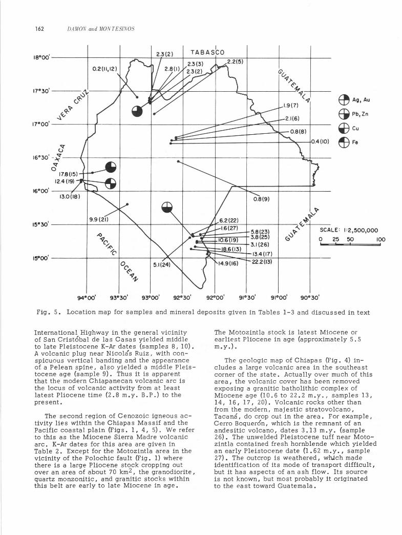
Fig. 5. Location map for samples and mineral deposits given in Tables 1-3 and discussed in text
International Highway in the general vicinity of San Cristobal de las Casas yielded middle to late Pleistocene K-Ar dates (samples 8, 10). A volcanic plug near Nicolas Ruiz, with conspicuous vertical banding and the appearance of a Pelean spine, also yielded a middle Pleistocene age (sample 9) I Thus it is apparent that the modern Chiapanecan volcanic arc is the locus of volcanic activity from at least latest Pliocene time (2.8 m.y. B,P,) to the present.
The second region of Cenozoic igneous activity lies within the Chiapas Massif and the Pacific coastal plain (Figs. I, 4, 5). We refer to this as the Miocene Sierra Madre volcanic arc. K-Ar dates for this area are given in Table 2. Except for the Motozintla area in the vicinity of the Polochic fault (Fig. 1) where there is a large Pliocene stock cropping out over an area of about 70 km 2 , the granodiorite, quartz monzonitic, and granitic stocks within this belt are early to late Miocene in age.
The Motozintla stock is latest Miocene or earliest Pliocene in age (approximately 5.5 m.y.) .
The g eologic map of Chiapa s (Fig. 4) includes a large volcanic area in the southea st corner of the state. Actually over much of this area, the volcanic cover has been removed e xposing a granitic batholithic complex of Miocene age (10.6 to 22.2 m.y., samples 13, 14,16,17, 20). Vo lcanic rocks other than from the modern, maj estic stratovolcano, Tacana , do crop out in the area. For example, Cerro Boquer6n, which is the remnant of an andesitic volcano, dates 3.13 m.y. (sample 26). The unwelded Pleistocene tuff near Motozintla contained fresh hornblende which yielded an early Pleistocene date (I .6 2 m.y., sample 27). The outcrop is weathered, which made identification of its mode of transport difficult, but it has aspects of an ash flow. Its source is not known, but most probably it originated to the east toward Guatemala.
The d i stribution of volcanic and s ubvolcanic rocks in Chiapas sugge s ts that there ha s been a radical change in the geometry of the subducting Cocos plate between the time of e mplaceme nt of the plutons and volcanic roc ks of the Miocene Sierra Madre arc in Chiapa s and the emplacement of the stratovolcanos and related plutons in the modern Chi apanecan volcanic arc (Fig. I, insert). This reorganization appears to have occurred betwee n th e time of th e emplaceme nt of the Mioc e ne stocks and the extrusion of volcanics in the Santa Fe mining district, that is, between about 9 and 3 m. y. ago. The Pleistocene volcanism in southeastern Chiapas seems to be associated with the Central American arc on the Caribbean plate side of the Cuilco-ChixoyPolochic fault rather than with the American plate.
It is interesting that the earthquake hypocenters associated with the subducting Cocos plate are anomalously shallow from about Mexico City southeast to the Isthmus of Tehuantepec, distances being measured perpendicular to the Central American trench (Molnar and Sykes, 1969). Southeast of the Isthmus of Tehuantepec, the hypocenters rapidly deepen moving inland from the trench. The volcanic axis follows a similar pattern moving inland southeast to the Isthmus of Tehuantepec and then moving closer to the Pacific Ocean southeast of the Isthmus of Tehuantepec. Within the Caribbean plate, the Central American volcanic arc fairly closely parallels the Pacific Coast and the Central American trench. The modern Chiapanecan volcanic arc represents the volcanic arc returning to the coastal region. There is no gap in volcanism between the modern Chiapanecan volcanic arc and the Mexican volcanic arc; the apparent gap in Figure 1 is filled by a large volcanic center around San Andres Tuxtla and an almost continuous volcanic outcrop to central Vera cruz. There is, however, a rea I gap in Chiapas between the Chiapanecan and Central American arcs. We have searched for but have not found volcanic rocks within the Central Depression of Chiapas (Province 2, Fig. 3). The apparent gap to the northwest is an artifact of the manner of constructing Figure 1 in which the arc is made to pass through the center of volcanic outcrops.
The convex-to-the-north pattern of the Mexican-Chiapanecan volcanic arcs is probably the result of a bending of the subducting Cocos plate which steepens to the northwest and southeast and is very shallow in between the two segments of what is almost a continuous volcanic arc. Prior to about 9 m. y. ago the Central American arc continued to parallel the Pacific Coast and Central (Middle) American trench northwestward through Chiapas to
DAMON and MONTiS/NOS 163
Oa xaca and, quite probably, although evidence remains to be documented, through Guerrero, Michoacan, and Jalisco. The previous arc was active for at least 13 m.y., prior to the Pliocene epoch. It is interesting that this reorganization appears to be approximately correlative with events to the north. According to Larson (1972 , p. 3345): "The Middle American Trench north of the Rivera Fracture Zone became nearly dormant as a plate boundary 8 to 10 m.y. ago when the rise crest changed from the Pacific-Farallon to the Pacific-Rivera plate boundary. "
Relationship Between Volcanism and Metallogenesis in Chiapas
There are a number of significa nt minera I deposits within the Miocene Sierra Madre arc. The region of the Motozintla stock has been set aside by the Mexican Government as a mineral reserve. We examined a porphyritic outcrop at Toliman (site of sample 23, Fig. 5) with disseminated sulfides and veins which appears to have all the aspects of a classic disseminated porphyry copper deposit. Within a mile of this outcrop, argillic and propylitic as well as potassic alteration can be obs erved. Under the hand lens, pyrite, bornite, chalcopyrite, and sphalerite were abundant and readily observable.
Cerro Colorado (sample 15 location, Fig. 5), which is only 100 m from the coastal railroad, also has the typical characteristics of a porphyry copper-limestone contact zone. The prospect occurs within a hill, which is capped by marble, silicified limestone, and magnetite. Malachite, azurite, sphalerite, galena, and asbestos were observed. What appeared in the field to be sericite was found in the laboratory to be almost pure paragonite, suggesting alteration by a hydrothermal convection system involving sea water.
We also collected from the La Carmen prospect in Oaxa ca near the Chiapa s border (sa mpIe locations 18,19, Fig. 5). La Carmen is a contact metamorphic deposit of granodiorite in limestone. The most important mineral is magnetite. However, zinc blende (sphalerite) is very abundant. The limestone is converted to marble and wollastonite. We collected a sample of zinc ore with greenish books of mica about 1 cm in diameter. Much to our surprise, this mica also was shown to be paragonite in the laboratory, again suggesting that the coastal area was inundated by sea water in mid-Miocene time.
Much of the Chiapas Massif is most probably an excellent target for Miocene ore deposits associated with the roots of stratovol-
164 DAMON and MONTES/NOS
canos. Most of the Chiapas Massif is quite inaccessible, and time did not permit a thorough reconnaissance. However, we examined stream gravels between the sampled outcrop (sample location 21, Fig. S) and long 92 0 40' W. Volcanic and subvolcanic rocks are abundant in the cobbles in the rivers between those coordinates along the coastal highway .
There is one mining area within the modern Chiapanecan volcanic arc around Santa Fe (sample localities 1-4, Fig. S). At Santa Fe there are large underground workings which were mined for gold by an English company just before the Revolution of 1910. A French firm mined gold in the area following the revolution. At the present time, Minera Corza has a lease on the property. There is abundant copper, zinc, silver, and lead mineralization a s we 11 a s gold. Sulfide minera Is are ubiquitous within a stock outcrop of 2, OOO-m radius. Mining continued at the La Victoria mine until 1972. The Santa Fe mine proper is a contact metamorphic deposit with granodiorite intruded into Oligocene limestones forming a purewhite wollastonite cap. Vein deposits have also been mined. Disseminated sulfides occur throughout most of the stock that we examined.
Unlike many Mexican states, there is little tradition of mining in Chiapas. Nevertheless, both the modern and Miocene arcs provide a fruitful field for exploration. The presence of stratovolcanos in all stages of dissection by erosion and the association of sulfide mineralization with the remnants is in conformity with the relationships suggested by Sillitoe (1973) between stratovolcanos and porphyry copper deposits a s well a s lead, zinc, and previous metal veins and replacements.
The rate of erosion required to erode stratovolcanos in the Motozintla area is not unreasonable. The majestic stratovolcano Tacam3 rises from the Pacific coastal plain to an altitude of about 4,OSO m. According to Sillitoe (1973), the tops of porphyry copper deposits begin at a depth of 1. S to 3 km. The deposit at Toliman (Motozintla stock) appears to be eroded below the top as defined by Sillitoe, but erosion would have to continue to a much greater depth, according to his model, to expose the bottom of the deposit at Toliman. A reasonable estimate would be erosion to a depth of 4 ± 1 km in 6 m.y. or about 660 ± 170 m/m. y. At this rate, only 12 m. y. would be required to erode 8 km and reach the bot tom of a porphyry copper system in the Motozintla area. In fact, we have dated a number of unmineralized granites in southeastern Chiapas at from 11 to 22 m.y. (samples 13, 14, 16, 17, 20 in Table 2), which is in good agreement with the time required to reach the
bottom of porphyry copper systems. The amount of erosion in 3 m. y. would be about 2 km or insufficient to completely remove the volcanic apron around volcanos of that age. The preservation of andesites at Cerro Boquer6n of 3 m. y. age is quite compatible with the postulated rate of erosion.
In the Santa Fe mining district and at Cerro Tzontehuitz, 2 m. y. has not been sufficient time to remove the volcanic apron. Erosion rates in the Arriaga area, which has a lower rainfall, must be less than 660 m/m. y. or the mineral deposits at Cerro Colorado and Mina La Carmen would have been destroyed by erosion. However, the erosion rate in the Arriaga district need not be less than 300 m/m.y.
It is unlikely, with this rate of erosion, that pre-Neogene porphyry-type deposits would be preserved within the Chiapas Massif. Consequently, the Permian batholith and old igneous rocks would not be expected to be likely prospects for porphyry-type deposits. However, the entire length of the Sierra Madre del Sur from Cape Corrientes to Guatemala is a likely target for Neogene porphyrytype deposits.
Conclusions
Two Neogene volcanic arcs can be defined within Chiapas. The Miocene Sierra Madre volcanic arc was abandoned between 9 and 3 m. y. ago when the modern Chiapa neca n volcanic arc came into existence as a result of a reorganization of the subducting Cocos plate. Both Neogene volcanic arcs are the locus of mineral deposits associated with calc-alkalic stratovolcanos in accord with Sillitoe's (1973) model. The rate of erosion required to expose these mineral deposits is between 300 m/m.y. and 900 m/m.y.
The still-active modern Chiapanecan volcanic arc is essentially continuous with the Mexican volcanic arc (Mexican volcanic axis or Eje Volcanica). The ancestral Miocene volcanic arc wa s probably continuous with the Central American volcanic arc from the eastern extremity of the Panama fracture zone to Cape Corrientes.
Both the ancestral volcanic arc, which parallels the Pacific Coast and the Central American trench, and the modern Chiapanecan arc, which is convex to the north, are prime targets for Neogene ore deposits.
Acknowledgments
This work would not have been possible without the constant support and encourage-
DAMON and MONTES/NOS 165
Table 2. Neogene dates for the Sierra Madre del Sur and coastal plain in Chiapas and neighboring Oaxaca
Sample no.
13
14
15
16
17
18
19
20
21
22
23
24
25
26
27
Material dated, description, and location
Biotite, biotite-hornblende granite, collected beside the Puente Monte Perla at 1 km on road from Tuxtla Chica to Union Juarez, lat 15003'04" N, long 9 2005'47" W, Chiapas
Biotite, granitic intrusion I 1 km S of Finca Sa nta Anita, Motozintla area, lat 15°08'46" N, long 9 20 20' 25" W, Chiapas
Whole rock I altered quartz monzonite with paragonite, epidote, and tourmaline, intruded into a cap of marbleized limestone; chalcopyrite, malachite, azurite, magnetite, 3 nd sphalerite within the contact zone; at Cerro Colorado, 100 m from coastal railroad,S km NW of Arriaga, lat 160 16'57" N, long 93 0 58' 20" W, Chiapas
Biotite, granitic intrusion on the flank of Volcan Tacana, about 200 m E toward Juarez from the Finca Muxval, Union Juarez area, 1at 15°04'47" N, long 92 004'33" W , Chiapas
Biotite, granitic intrusion with pyrite, Finca Chaju1 in Cerro Soconuscos, Motozint1a area, 1at 15010'51" N, long 9 2018'08" W, Chiapas
Biotite, granodiorite I Arroyo de Mangos, SE of La Carmen mine, approx. 1 km from Pan American Highway, Tepanatepec area, lat 160 26' 24" N, long 94006'33" W, Oaxaca
Biotite, granitic intrusion into Cretaceous limestone with zinc blende (sphalerite) and wollastonite in contact zone, samples in Arroyo between Cerro La Carmen and mineralized hill, about 500 m SW of Pan American Highway, Tepanatepec area, lat 160 26'31" N, long 94006'32" W, Oaxaca
Biotite I hornblende-biotite granite, on road from Cerro Boqueron to Berriozabel from Motozintla about 4 km from Niquivil junction, near Tzuma, Motozintla area, lat 15°16'38" N, long 920)7'01" W, Chiapas
Biotite, granite outcrop along coastal highway at the Potrero de la Gringa, Finca Perseverencia, Tonolil area, lat 150 50'17' N, long 930 28'02" W, Chiapas
Sericite, pyritized fanglome rate, Mina de Concepcion, Motozintla area, lat 150 20'34" N, long 92020'47" W, Chiapas
Biotite, K-silicate altered quartz monzonite porphyry with pyrite, bornite, chalcopyrite, and sphalerite, below the bridge at Toliman, Motozintla area, lat 15°19'08" N, long 92019'50" W, Chiapas
Biotite, granodiorite porphyry intruded into the metamorphic complex of the Rancho Campeche area, km 27.5 on road from Belizario Dominguez to Motozintla S of Rancho Campeche, lat 150 18'34" N, long 92022'27" W, Chiapa s
Whole rock, dacite, collected about 15 m from Chiapa s -Guatema la boundary marker, Niquivil, lat 150 15'46" N, long 92012'38" W, Chiapas
Whole rock, andesite from summit of footpath from Berriozabel to Finca Hamburgo on the S side of Cerro Boqueron, Motozintla area, lat 150 15'10" N, long 92016'34" W, Chiapas.
Hornblende, unwelded tuff, 500 m S of Motozintla on highway to Buenos Aires, lat 15°20'46" N I long 92015'40" W, Chiapas
K-Ar age and 1 (J error
m.y.
22.2±0.5
18.7±0.4
< 17.8+2.6 (may contain s ignifica nt amount of excess radiogEnic argon)
14.9 ± 0.3
13.4±0.3
13.0±0.3
12.4±0.3
10.6±O.2
9.95±0.27
6.18±0.13
5.75±0.10
5.08 ± 0.11
3.78±0.16
3.13±0.07
1.62±0.16
166 DAMON and MONTESlNOS
Table 3 . Data for K-Ar ages in Tables I and 2
Argon
Sample No. Radiogenic Atmospheric Age (Ia bora tory no.) %K x 10- 12 moles/g % ± I r:rm.y.
I (UAKA-74-25) 1. 99 9.55 57.4 2.79 ± 0.08
9.70 56.9
2 7.18 28.39 60.8 2.29 ± 0.07 (UAKA-74-23) 28.70 60.5
3 7 .48 30 .09 74.0 2.29 ± 0.10 (UAKA-74- 22) 29 . 39 74.9
4 7.67 30.44 66.1 2 . 24 ± 0.08 (UAKA-74-24) 29.18 67.4
5 2 .87 10.87 17.8 2 .17 ± 0.04 (UAKA-74-2I) 10.75 17.7
6 2.22 8 . 36 10 .8 2.14 ± 0.04 (UAKA-74-32) 8.15 11.0
7 2.63 8.88 24.5 1. 95 ± 0.04 (UAKA-74-3I) 8.90 23 .8
8 0.798 1. 20 85.9 0.850 ± 0.030 (UAKA-74-33) 1.16 86.0
9 1. 05 1. 58 80.3 0.846 ± 0.024 (UAKA-74-3 0) 1. 50 81.1
10 0.95 5 0.74 8 2.3 0 .43 2 ±0.029 (UAKA-74-34) 0 . 69 83 .2
II Hbld. 1. 20 0 . 24 96.3 0.120±0.038 (UAKA-74-26) 0.26 96.0
12 WR 2 . 28 0.85 87.1 0.209±0.019 (UAKA-74- 26) 0.80 87. 9
13 7. 284 28 1.4 1'6.0 22 .2 ± 0.5 (UAKA-75-35) 281. 6 16.6
14 7.73 251. 0 27.9 18.7 ± 0.4 (UAKA-75-37) 251.8 27.7
IS 0. 024 2 0.73 9 2. 9 17.8 ± 2.6 (UAKA-74-10I) 0.77 92 . 4
16 7.58 193.8 35.7 14.9 ± 0.3 (UAKA-75-3I) 199.2 33.4
17 7. 63 4 178.0 12.8 13.4 ± 0.3 (UAKA-75-36) 179.0 12.4
18 7.42 169. 3 17.4 13 .0 ± 0.3 (UAKA-74-103) 167.4 18.3
19 7.11 151. 3 51.4 12.4 ± 0.3 (UAKA-74-105) 154.0 51.1
20 7. 41 2 134.4 38 . 5 10.6 ± 0.2 (UAKA-75-39) 138.5 37.6
21 7.62 123.5 54.0 9.95 ± 0 . 27 (UAKA-75-34) 12 5 .3 41.8
126. 2 54.2 128.1 43 . 4
22 7.72 83.2 26 . 4 6.18 ± 0.13 (UAKA-74-113) 8 2 .7 26 .4
23 7.28 72. 2 30 .1 5.75 ± 0.10 (UAKA-74-ll2) 73.2 29.7
24 6 .9 6 61.7 37.9 5.08 ± O.ll (UAKA-74-114) 61.2 39.5
25 2 .50 16.13 73.8 3 .78 ± 0.16 (UAKA-75-38) 16.69 73. 3
26 I. 924 10.44 22.9 3.13 ± 0 .07 (UAKA-75-32) 10.45 21.5
27 0. 45 6 I. 36 86.8 I. 62 ± 0.16 (UAKA-74-108) 1. 21 88. 2
ment provided by Ing. Guillermo P. Salas, Director General of the Consejo de Recursos Minerales. The authors are grateful to Ings. Carlos GarcIa Herrera and Ricardo Rivapalacio Ch. of the Comision Federal de Electricidad, Chiapas, for several informative discussions concerning the geology and seismicity of Chiapas. The senior author is also grateful to several of his colleagues, particularly Drs. Peter Coney and Charles Drake, for encouragement and for several stimulating discussions.
Twelve successful geological reconnaissance flights over Chiapas and bordering states were made possible by the effective services of the pilot and engineer of the Consejo de Recursos Minerales reconnaissance plane, Srs. Enrique Estrada and Jesus Mart{nez-Aldana. We benefited from the services of many hard-working assistants from different parts of Chiapas who helped us collect and lug rocks, climb mountains, ford rivers, and traverse dense forests. We are deeply grateful to them and to many other citizens of Chiapas, too numerous to mention, for their many kindnesses and hospitality during our work in their beautiful state.
Mrs. Mary Janet Damon served as aerial photographer, secretary and field assistant during the winter of 1974. We are particularly grateful to Dr. Muhammad Shafiqullah for taking over many of the senior author's responsibilities during his absence in the field and for his assistance in all phases of the K-Ar measurements. Daniel Lynch, Janis Blainer, Robert Butcher, Margot Jennison, and Kathleen Trevena also assisted in various aspects of the K-Ar measurements.
This research was supported by National SCience Foundations grants EAR76-02590 and INT74-05592 A01, the Government of Mexico, a nd the s ta te of Arizona.
References
Aguilera, J. C., and Ordonez, Ezequiel, 1893, Datos para la geologIa de Mexico: Tacuba ya, D. F ., Imprenta y Fotocolgra fla del Cosmos, 87 p.
Bose, E., 1905, Resena acerca de la geolog{a de Chiapas y Tabasco: Instituto Geologico de Mexico Bol. 20 (Imprenta y Fototipia de la Secretar{a de Fomento), 113 p.
Chase, T. E., Menard, H. W., and Mamme.rick, J., 1970, Bathymetry of the North Pacific (map): La Jolla, CA, Institute of Marine Resources, University of California, San Diego.
DAMON and MONTESlNOS 167
Dalrymple, G. B., and Lanphere, M. A., 1969, Potassium-argon dating: San Francisco, W. H. Freeman & Co., 258 p.
Damon, P. E., and Salas, G. P., 1975, Dating of Mesozoic-Cenozoic metallogenetic provinces within the Republic of Mexico (1965-1975): cooperative research project between Laboratory of Isotope Geochemistry, Dept. of Geosciences, University of Arizona and the Consejo de Recursos Minerales, Interim Report, unpublished.
Figueroa-A., J., 1973, Sismicidad en Chiapas: Instituto de Ingenierla, Universidad Nacional Autonoma de Mexico, June, no. 316, 37 p.
Fisher, R. L., 1961, Middle American trench: topography and structure: Geol. Soc. America Bull., v. 72, p. 703-720.
Fries, Carl, Jr., Rincon-Orta, Cesar, Silver, L. T., McDowell, F. W., Solorio-Munguia, Jos e, Schmitter - Villada, Eduardo, and Cserna, E. Z., 1974, Nuevas aportaciones a la geocronologfa de la faja tectoni-ca Oaxaquena, in Lopez Rubio, J. M. (ed.), Contribuciones a la geocronologfa de Mexico: Asociacion Mexicana de Geologos Petroleros Bol., v. 26, nos. 4-6, p.157-182.
Fries, C., Jr., Schmitter, E., Damon, P. E . , and Livingston, D. E., 1962, Rocas Preca'mbricas de edad Grenvilliana de la parte central de Oaxaca en el sur de Mexico ·, in Estudios geocronologicos de rocas Mexicanas: Instituto de Geolog{a Bol. 64, parte 3, p. 45-53.
Fries, C., Jr., Schmitter, E., Damon, P. E., Livingston, D. E., and Erickson, R., 1962, Edad de las rocas metamorficas en los canones de la Peregrina y de Caballeros, parte centro-occidental de Tamaulipas, in Estudios geocronologicos de rocas Mexicanas: Instituto de Geolog{a Bol. 64, parte 4, p. 55-69.
Herron, E. M., 1972, Sea-floor spreading and the Cenozoic history of the eastcentral Pacific: Geol. Soc. America Bull. , v. 83, p. 1671-1692.
International Volcanological Association, 1951-1973, Catalogue of the active volcanos of the world, including solfatara fields: Napoli.
Kay, Marshall, 1951, North American geosynclines: Geol. Soc. America Mem. 48, 143 p.
168 DAMON and MONTESINOS
Kesler, S. E., 1971, Nature of ancestral orogenic zone in nuclear Central America: Am. Assoc. Petroleum Geologists Bull. , v. 55, p. 2116-2129.
Larson, R. L., 1972, Bathymetry, magnetic anomalies, and plate tectonic history of the mouth of the Gulf of California: Geol. Soc. America Bull., v. 83, p. 3345-3360.
Molnar, P., and Sykes, L. R., 1969, Tectonics of the Caribbean and Middle American regions from focal mechanisms and seismicity: Geol. Soc. America Bull., v. 80, p. 1639-1684.
Muehlberger, W. R., and Ritchie, A. W. , 1975, Caribbean-Americas plate boundary in Guatemala and southern Mexico as seen on Skylab IV orbital photography: Geology, May, p. 232-235.
Pantoja-Alor, J., Fries, C., Jr., Rincon-Orta, C., Silver, L. T., and Solorio-Munguia, J., 1974, Contribucion a la geocronologia del Estado de Chiapas, in Lopez Rubio, J. M. (ed.), Contribuciones ala geocronolog{a de Mexico: Asociacion Mexicana de Geologos Petroleros Bol., v. 26, nos. 4-6, p. 205-223.
Richards, H. G., 1963, Stra tigraphy of ear liest Mesozoic sediments in southeastern Mexico and ' western Guatemala: Amer. As soc. Petrol. Geologists Bull., v. 47, no. I 0, p. 18 6 1-18 7 0 •
Schubert, C., 1974, Venezuela: fallas geologicas y terremotos: Llneas no. 207, p.34-39.
andSifontes, R. S., 1970, Bocona --~
fault, Venezuelan Andes: evidence of postglacial movement: Science, v. 170, p.66-69.
Shor, G. G., Jr., and Fisher, R. L., 1961, Middle America trench: seismic-refraction studies: Geol. Soc. America Bull. , v. 72, p. 721-730.
Sillitoe, R. H., 1973, The tops and bottom s of porphyry copper deposits: Econ. Geology, v. 68, p. 799-815.
Viniegra-O., F., 1971, age and evolution of salt basins of southeastern Mexico: Amer. Assoc. Petrol. Geologists Bull., v. 55, no. 3, p. 478-494.


![Cenozoic volcanism and tectonics in the southern Tyrrhenian sea] … · 2014-11-22 · Cenozoic volcanism and tectonics in the southern Tyrrhenian sea] space!time distribution and](https://img.pdfslide.us/doc/110x75/5edbd346ad6a402d66663a97/cenozoic-volcanism-and-tectonics-in-the-southern-tyrrhenian-sea-2014-11-22-cenozoic.jpg)