Embed Size (px)
Citation preview
Evolution and metallogenesis of the North Australian Craton
Conference Abstracts GEOSCIENCE AUSTRALIA RECORD 2006/16 by Patrick Lyons and David L. Huston, Editors
Minerals Division, Geoscience Australia, GPO Box 378, Canberra, ACT 2601
Department of Industry, Tourism and Resources Minister for Industry, Tourism and Resources: The Hon. Ian Macfarlane, MP Parliamentary Secretary: The Hon. Bob Baldwin, MP Secretary: Mark Paterson Geoscience Australia Chief Executive Officer: Dr Neil Williams © Commonwealth of Australia, 2006 This work is copyright. Apart from any fair dealings for the purpose of study, research, criticism, or review, as permitted under the Copyright Act 1968, no part may be reproduced by any process without written permission. Copyright is the responsibility of the Chief Executive Officer, Geoscience Australia. Requests and enquiries should be directed to the Chief Executive Officer, Geoscience Australia, GPO Box 378 Canberra ACT 2601. Geoscience Australia has tried to make the information in this product as accurate as possible. However, it does not guarantee that the information is totally accurate or complete. Therefore, you should not solely rely on this information when making a commercial decision. ISSN 1448-2177 ISBN 1 920871 92 6 (Hardcopy) ISBN 1 920871 93 4 (Web) GeoCat # 64764 Bibliographic reference: Lyons, P. & Huston, D.L. (Eds.), 2006. Evolution and metallogenesis of the North Australian Craton, Conference Abstracts. Geoscience Australia Record 2006/16.
Evolution and metallogenesis of the North Australia Craton Conference Abstracts
iii
Contents An overview of the North Australian Craton.....................................................................................1 Arunta-Tennant-Tanami: the early evolution to ca 1700 Ma ...........................................................3 Intracratonic Orogeny in Mesoproterozoic Australia ......................................................................8 Evolution and mineral potential of the Palaeoproterozoic Warumpi Province .............................9 Post-1570 Ma intracratonic reworking of the North Australian Craton........................................11 40Ar/39Ar constraints on the episodic history of mineralisation and tectonism in the southern North Australian Craton ...................................................................................................................13 Geophysical delineation and mineral potential of mafic-ultramafic intrusions in the Arunta Region ................................................................................................................................................15 Zinc-copper-lead metallogeny of the eastern Arunta ....................................................................17 Composition, timing, and provenance of hydrothermal fluids in the Tanami–Arunta regions .20 Iron oxide copper-gold deposits in the Tennant and Arunta regions..........................................23 Introduction to the geology of the Nolan’s Bore LREE/P/U deposit ............................................26 Uranium in North Australian Craton: Resources, Metallogeny, and Potential............................28 Overview of the Palaeoproterozoic Tanami Region Geology, Northern Territory ......................30 Paleoproterozoic gold deposits in the Bald Hill and Coyote areas, western Tanami, Western Australia .............................................................................................................................................32 Eastern Tanami mineralisation ........................................................................................................33 Determining regional stratigraphy and potential gold host rocks in poorly exposed Palaeoproterozoic metasedimentary rocks of the Tanami region, northern Australia ..............35 3D geology of the Tanami Region and overview of the seismic survey......................................37 The 2005 Tanami seismic survey: acquisition, processing, and interpretation pitfalls.............40 The 2005 Tanami Seismic Collaborative Research Project: Seismic results. .............................41 Deep seismic reflection profiling in the Arunta, Musgrave and McArthur regions: Implications for Central and North Australian tectonics.....................................................................................47 The 2005 Tanami Seismic Collaborative Research Project: Synthesis of results ......................49 Geology and mineralisation of the King Leopold and Halls Creek Orogens...............................51 Geology and geochronology of the Palaeoproterozoic Pine Creek Orogen ...............................53 Some aspects of metallogenesis in the Pine Creek Orogen, Northern Territory........................57 Geology and mineralisation in the southern McArthur region and Mt Isa Inlier .........................59 Geodynamic framework for Mount Isa and contemporaneous Proterozoic terranes in the Curnamona and southern NAC (Arunta-Tanami) ...........................................................................61 Mineral systems and tectonic evolution of the North Australian Craton.....................................64

Evolution and metallogenesis of the North Australia Craton Conference Abstracts
iv
Evolution and metallogenesis of the North Australia Craton Conference Abstracts
1
An overview of the North Australian Craton Ian Scrimgeour Northern Territory Geological Survey, GPO Box 3000, Darwin NT 0801
The late Palaeoproterozoic to early Mesoproterozoic is a time period of fundamental importance in the geological evolution of Australia, as it is the timing of formation of most of Australia’s world-class Proterozoic mineral deposits. Prior to the mid-1990s, the prevailing view of the tectonic evolution of Proterozoic Australia was a ‘stabilist’ view in which a single intact continent was affected by intraplate processes (e.g., Etheridge et al. 1987). More recently, however, tectonic models for the Australian Proterozoic have invoked processes analogous to modern plate tectonics (Myers et al. 1996, Betts et al. 2002). An understanding of tectonic processes during the Proterozoic is critical to any assessment of prospectivity of Proterozoic terranes.
The North Australian Craton (NAC; Myers et al. 1996) includes Palaeoproterozoic orogens and basins in northern Australia including the Halls Creek, Pine Creek, McArthur, Mount Isa, Tennant Creek, Tanami, and Aileron (northern Arunta) geological regions. Archean basement to the NAC crops out in the Pine Creek and Tanami regions, with ages in the range 2.67 Ga – 2.50 Ga. An early phase of basin development at 2.05-2.00 Ga is reflected in the basal units of the Pine Creek Orogen. The nature of the basement remains unclear across much of the NAC, although geophysical and isotopic evidence suggests widespread presence of thick Neoarchean to Palaeoproterozoic continental crust.
Recent work by the Northern Territory Geological Survey and Geoscience Australia , particularly the Arunta and Tanami Regions, has provided important new constraints on the tectonic evolution of the North Australian Craton. Current evidence suggest that most of the NAC was a coherent entity by 1.86-1.83 Ga, when large areas of the craton was covered by thick sedimentary packages which now form regionally important hosts for gold mineralisation. In the Northern Territory, apparent correlations are now possible between packages at 1.865-1.860 Ga (Finniss River and South Alligator Groups, Waramunga Formation, Junalki Formation), 1.84-1.83 Ga (Lander Rock Formation, Killi Killi Formation, lower Ooradidgee Group), and 1.82-1.80 Ga (Ware Group, Hatches Creek Group, Strangways Metamorphic Complex). Tectonism throughout much of the Northern Territory in this period was dominated by intraplate tectonics, although these are likely to have been driven by events at the northern and western margins of the craton, such as the postulated collision between the Kimberley and North Australian Cratons at 1.83 Ga (Sheppard et al. 1999).
At about 1.82 Ga, there was a fundamental shift in the tectonic regime in the NAC, with the focus of tectonism shifting to the southern margin of the craton in what is now the Aileron Province of the Arunta Region The Arunta Region underwent prolonged tectonic activity in a series of events during the period 1.81 Ga – 1.56 Ga, which are interpreted to reflect changing responses to plate margin processes (Scrimgeour 2006). An understanding of the tectonic evolution of the southern margin of the NAC is important in assessing the relative fertility of various domains of the Arunta Region for mineralisation. It also appears likely that many of the important mineralising events within the craton (e.g., Tanami Au at 1.80 Ga, Ranger U at 1.73 Ga, Jabiluka U, HYC Zn-Pb and Browns Cu-Pb-Ni-Co at 1.64-1.63 Ga), are related to intraplate responses to tectonism on the southern margin of the craton.
Most known Proterozoic mineralization in the Aileron Province can be related to a long-lived north-dipping subduction system in the southeast between 1.81-1.69 Ga, with an evolving system of back-
Evolution and metallogenesis of the North Australia Craton Conference Abstracts
2
arcs and continental arcs with associated VHMS, IOCG, skarn and mafic-hosted mineralisation in diverse lithologies close to the plate margin. In comparison, orogenic gold and granite-related tungsten, tin, and base metals formed distal to the margin within the craton (northern and western Aileron Province and Tanami Region. Between 1.69-1.61 Ma, the active plate margin was in the southwest, with a south-dipping subduction zone. This led to volcanism, back-arc basin development, tectonism, and large-scale magmatism in the Warumpi Province (Close et al. this volume), which has high (and largely untested) potential for base metal, copper-gold, mafic-hosted Ni-Cu, and epithermal or mesothermal gold. Widespread tectonism at 1.59-1.57 Ga led to the effective cratonisation of the NAC, possibly related to collision with the South Australian Craton.
REFERENCES Betts, P.G., Giles, D., Lister, G.S. & Frick, L.R. 2002. Evolution of the Australian lithosphere.
Australian Journal of Earth Sciences 49, 661-695. Close, D.F., Scrimgeour, I.R. & Edgoose, C.J. 2006. Evolution and mineral potential of the
Warumpi Province. In: Lyons, P. & Huston, D.L. (Eds.), Evolution and metallogenesis of the North Australian Craton Conference: 20-22 June, Abstracts. Geoscience Australia Record 2006/16, 9-10.
Etheridge, M.A., Rutland, R.W.R. & Wyborn, L.A.I. 1987. Orogenesis and tectonic process in the Early to Middle Proterozoic of northern Australia. American Geophysical Union Geodynamic Series 17, 131-147.
Myers, JS, Shaw RD & Tyler IM, 1996. Tectonic evolution of Proterozoic Australia. Tectonics 15, 1431-1446.
Scrimgeour, I.R. 2006. The Arunta Region: links between tectonics and mineralization. In: Munson, T.J. & Scrimgeour, I.S. (Eds.), Annual Geoscience Exploration Seminar (AGES) 2006. Record of abstracts. Northern Territory Geological Survey Record 2006-002, 7-10.
Sheppard S., Tyler I.M., Griffin, T.J. & Taylor, W.R. 1999. Palaeoproterozoic subduction-related and passive margin basalts in the Halls Creek Orogen, northwest Australia. Australian Journal of Earth Sciences 46, 679-690.
Evolution and metallogenesis of the North Australia Craton Conference Abstracts
3
Arunta-Tennant-Tanami: the early evolution to ca 1700 Ma Jon Claoué-Long (with acknowledgements to numerous colleagues in GA, NTGS, universities and companies) Geoscience Australia
The North Australia Project of Geoscience Australia had, as its starting point, the review of event chronology in the Arunta Region compiled by Collins & Shaw (1995) and only sparse dating coverage in the Tanami and Tennant regions. The knowledge-base was still dominated by younger systems, which overprinted the Palaeoproterozoic rocks. Early attempts to unravel the pre-1700 Ma evolution with SHRIMP U-Pb dating had not yet identified all of the major event systems and their scope. In the absence of detailed timing constraints, regional correlations were conjectural or based on perceived litholigical links. The prevailing model was that the earliest evolution across the Proterozoic inliers of northern Australia comprised two major basin phases separated by a single correlated orogenic episode, the ‘Barramundi Orogeny’, which created and defined the North Australian Craton as a tectonic domain (Etheridge et al., 1987, Meyers et al., 1996).
Detailed regional re-mapping, combined with a program of imaging-assisted SHRIMP U-Pb dating studies, has led to a new understanding. Several distinct events are now recognised and there are many basin phases separated by a variety of stratigraphic and/or tectonic surfaces. Although major issues are yet to be resolved, there is greater confidence in reconstructing the evolution and metallogeny of individual regions. Some key inter-region correlations can now be demonstrated at the scale of individual formations, unconformities or events.
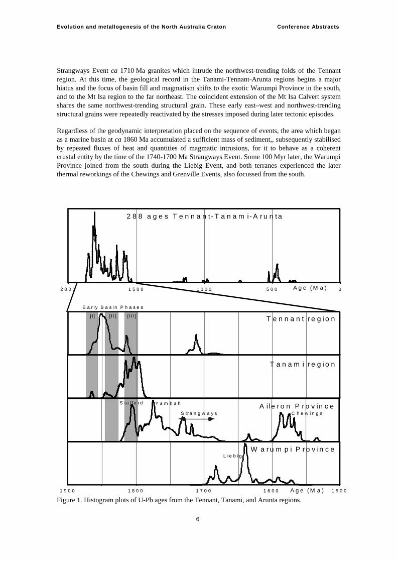
The entire development of the region is captured in a histogram of nearly 300 individual U-Pb age measurements in the Tennant, Tanami and Arunta regions (Figure 1). Major thermal systems are registered by clusters of zircon crystallisation ages beginning at ca 1860 Ma and terminating with the ‘Chewings’ event at ca 1590 Ma – 1560 Ma at which point the creation and reworking of this area of crust was largely complete. Later systems include a ca 1150 Ma (Grenvillian) thermal event, a few sub-1000 Ma ages which may relate to the opening of the Centralian Superbasin, high-grade components of the early Palaeozoic Irindina Province, and the 400 Ma – 300 Ma Alice Springs event.
TENNANT REGION The early evolution is resolved in separate age compilations for the Tennant, Tanami, Aileron, and Warumpi regions. The key template is the Tennant Inlier where outcropping stratigraphic continuity is dated by intercalated volcanics and detrital zircons in sediments. Three basin phases follow each other in rapid succession, separated by angular unconformities (Compston, 1995; Smith, 2001; Donnellan, 2005; Claoué-Long et al., 2005, Claoué-Long et al., in press):
Basin phase 1. Warramunga Group deep water sediments and volcanics at ca 1860 Ma
Basin phase 2. Ooradidgee Group bimodal volcanics and sediments at ca 1840 Ma
Basin phase 3. Hatches Creek Group shallow-water sediments and bimodal volcanics after ca 1815 Ma
Evolution and metallogenesis of the North Australia Craton Conference Abstracts
4
Erupted volcanics in each successive basin phase are matched by the intrusion of subvolcanic plutons into underlying units, notably gabbros and granites intruding the Warramunga Group and correlatives at ca 1855 Ma – 1855 Ma, and dolerites and granites intruding the Ooradidgee Group and correlatives at ca 1810 Ma.
Detrital zircon ages in all three basin phases consistently infer basin development marginal to continental crust that was dominated by 1880 Ma – 1850 Ma crystalline rocks.
After a 100-My-interval without recorded effects, Tennant region stratigraphy was still at shallow crustal depths (sub-greenschist facies) when it was intruded by ca 1710 Ma granites and mantle-derived lamprophyre dykes relating to the Strangways thermal system, which had deeper crustal expression several hundred kilometres to the south.
TANAMI REGION Constraints are more patchy in the poorly outcropping Tanami Region where unconformity surfaces are yet to be delineated, but a closely related evolution can be constructed from recent evidence (Cross et al., 2005). The earliest stratigraphic constraint of ca 1860 Ma for the Bald Hill sequence is identical to that of Tennant region basin phase 1 (D. Maidment, unpublished). Detrital zircon ages and a tuff age of ca 1840 Ma correlate the Killi Killi Formation with Tennant Region basin phase 2. Dated volcanics and detrital zircon ages link the Tanami region Ware Group with Tennant region basin phase 3. Granites intruded ca 1820 Ma – 1795 Ma, broadly coincident with the development of basin phase 3. The Tanami region also preserves components of younger basins, including the < ca 1760 Ma Pargee Group, and the basal Birrindudu Group of the north Australian platform cover, deposited after ca 1690 Ma.
Ar/Ar ages in Tanami region granites are consistent with regional cooling soon after their 1820-1795 Ma emplacement. The overprinting Strangways event is registered only cryptically, in the form of ca 1730 Ma – 1700 Ma Ar/Ar ages for micas in certain vein systems (Fraser, 2003).
The Tanami region preserves some evidence of the presence of small areas of late Archaean basement, either under the region or nearby. Certain intrusions and some sedimentary units are dominated by ca 2500 Ma inheritance, probably locally derived, and a small outcrop in the southeast Tanami could be a remnant Archaean inlier.
AILERON PROVINCE OF THE ARUNTA REGION As the U-Pb age histogram makes clear, the Aileron Province has experienced significant overprinting by later thermal events which are not important in regions to the north.
The earliest rocks of the Arunta region are widespread clastic sediments collectively known as the Lander Package, which comprise more than 60% of the known outcrop. Before dating evidence became available, these rocks were considered to belong to the earliest ‘pre-Barramundi Orogeny’ basin phase, overlain by a post-orogenic cover sequence in the form of the Reynolds Range Group, which unconformably overlies parts of the region. However, new dating coverage in the Aileron Province (e.g., Claoué-Long, 2003, Cross et al., 2004; Cross et al., 2005a,b) has so far failed to find basin phase 1 of the Tennant and Tanami regions. Detrital zircons regionally in the Lander Package correlate it with basin phase 2, and the earliest magmatic intrusions ca 1810-1800 Ma (Stafford Event) relate to the volcanism in basin phase 3. Magmatism older than ca 1810 Ma is notably absent from the Aileron Province.
The Ongeva Package in the east of the Aileron Province comprises marine sediments and bimodal magmatism, much of it now granulite facies protoliths to the Strangways Metamorphic Complex.
Evolution and metallogenesis of the North Australia Craton Conference Abstracts
5
Protolith ages in the range ca 1810-1800 Ma link these units to basin phase 3 and to the intrusion of ca 1810-1800 Ma plutons in the Lander Package (Hussey et al., 2005). The nature of any contact between the Lander and Ongeva Packages is obscure.
The stratigraphic position and significance of the Reynolds Package of sedimentary rocks, preserved as inliers in the keels of major synclines, is not clear. The base of the package is a major regional unconformity; detrital zircons ca 1800 Ma permit correlation within basin phase 3, or to one of the several younger sedimentary systems seen in the Tanami region.
The south Aileron Province is characterised by younger activity not seen elsewhere. Granites and gabbros ca 1780 Ma – 1760 Ma are widespread in a belt within 150 km of the southern margin. To some extent, these are a timing continuum with 1810 Ma – 1790 Ma magmatism further north and there is a sense of diachronous migration of a thermal system southwards, but a cluster of ages permits reference to a separate ‘Yambah’ thermal event. The preservation of a small ca 1775-1765 Ma volcano-sedimentary belt in the southeast is evidence of local basin development at the same time.
Commencing at ca 1740 Ma a restricted area in the southeast experienced a major thermal and deformation system (Strangways Event) with a prolonged series of responses over 50 Myr whose effects trend south to north. In the southeast, protoliths were buried to 10 kb equivalent, producing granulite facies rocks. Northwards the metamorphic grade becomes lower (amphibolite facies) with higher grade effects spatially associated with certain intrusions. Further north still, in the Tennant region, granite stocks and lamprophyre dykes were emplaced in (sub)greenschist facies country rocks at shallow crustal levels. Termination of the Strangways Event at ca 1690 Ma coincided with the local intrusion of dolerite dykes.
THE CREATION OF A COHERENT CRUSTAL ENTITY In the early part of this evolution the evidence is of a basin system sourced from pre-existing continental crust to the north. Crust compatible with the provenance of detritus of basin phases 1–3 exists in Pine Creek (Worden & Carson, 2006), and perhaps Halls Creek and the unknown basement to the Kimberley area. The geometry of early geological systems was dominated by east–west structures exemplified by the Willowra gravity ridge, which is a gravity response to the crustal discontinuity imaged in Line 1 of the Tanami-Arunta seismic experiment. This early east–west structure is interpreted to pre-date ca 1840 Ma because it is draped by successions of the widespread basin phase 2
Marine sedimentation of basin phase 1 is locally preserved in the Tennant and Tanami regions. This was followed by a very large sediment transport system depositing during basin phase 2 over all regions, comparable in scale with the Bengal Fan today. The subsequent basin phase 3 has more variable expression in different areas, from marine in the southeast to shallow water or subaerial in the north. There is a sense of both basin fill and thermal activity shifting southwards over time, from early systems dominant in the Tennant and north Tanami regions, to the later thermal activity restricted within the south Arunta region at ca 1770-1760 Ma. Bimodal volcanic and subvolcanic activity coincident with the basin phases may be consistent with an active plate margin to the south and a north-dipping subduction system, back-arc bimodal magmatism, and associated features. It is possible that a collision, brought to this southern margin by the subduction system, was responsible for the crustal reworking of the 1740 Ma – 1690 Ma Strangways Event.
The early east–west trending geometry is truncated by regional northwest-trending structures in the east and northeast of the region. The earliest time constraint on a northwest-trending structure is
Evolution and metallogenesis of the North Australia Craton Conference Abstracts
6
Strangways Event ca 1710 Ma granites which intrude the northwest-trending folds of the Tennant region. At this time, the geological record in the Tanami-Tennant-Arunta regions begins a major hiatus and the focus of basin fill and magmatism shifts to the exotic Warumpi Province in the south, and to the Mt Isa region to the far northeast. The coincident extension of the Mt Isa Calvert system shares the same northwest-trending structural grain. These early east–west and northwest-trending structural grains were repeatedly reactivated by the stresses imposed during later tectonic episodes.
Regardless of the geodynamic interpretation placed on the sequence of events, the area which began as a marine basin at ca 1860 Ma accumulated a sufficient mass of sediment,, subsequently stabilised by repeated fluxes of heat and quantities of magmatic intrusions, for it to behave as a coherent crustal entity by the time of the 1740-1700 Ma Strangways Event. Some 100 Myr later, the Warumpi Province joined from the south during the Liebig Event, and both terranes experienced the later thermal reworkings of the Chewings and Grenville Events, also focussed from the south.
Figure 1. Histogram plots of U-Pb ages from the Tennant, Tanami, and Arunta regions. 1 5 0 01 6 0 01 7 0 01 8 0 01 9 0 0 �
05 0 01 0 0 01 5 0 02 0 0 0 � A g e ( M a )
A g e ( M a )
2 8 8 a g e s T e n n a n t - T a n a m i- A r u n t a
T e n n a n t r e g io n
T a n a m i r e g io n
A i le r o n P r o v in c e
W a r u m p i P r o v in c e
S tr a n g w a y s
S ta f fo r d Y a m b a h
C h e w i n g s
L i e b i g
E a r l y B a s i n P h a s e s
[I] [ I I ] [ I I I ]
Evolution and metallogenesis of the North Australia Craton Conference Abstracts
7
REFERENCES Claoué-Long, 2003. Event chronology in the Arunta Region. In: Munson, T.J., & Scrimgeour, I.S.
(Eds.), Northern Territory Geological Survey, Annual Geoscience Exploration Seminar (AGES) 2003. Record of abstracts. Northern Territory Geological Survey Record 2003-001.
Claoué-Long, J.C., Fraser, G., Huston, D., Neumann, N. & Worden, K. 2005. Towards a correlation of the earliest Proterozoic evolution in central Australia. In: Munson, T. (Ed.), Annual Geoscience Exploration Seminar (AGES) 2005. Record of abstracts. Northern Territory Geological Survey Record 2005-001.
Compston, D., 1995. Time constraints on the evolution of the Tennant Creek Block, northern Australia. Precambrian Research 71, 107-129.
Collins, W.J. & Shaw, R.D. 1995. Geochronological constraints on orogenic events in the Arunta Inlier: a review. Precambrian Research 71, 315-346.
Cross, A., Claoué-Long, J.C., Scrimgeour, I.R., Close, D.F., & Edgoose, C.J. 2004. . Summary of results. Joint NTGS-GA geochronology project southern Arunta region. In: Munson, T.J., & Scrimgeour, I. (Eds.), Annual Geoscience Exploration Seminar (AGES) 2004. Record of abstracts. Northern Territory Geological Survey Record 2004-003.
Cross, A., Claoué-Long, J.C., Scrimgeour, I.R., Crispe, A., & Donnellan, N. 2005a. Summary of results. Joint NTGS-GA geochronology project northern Arunta and Tanami Regions. Northern Territory Geological Survey Record 2005-003.
Cross, A., Claoué-Long, J.C., Scrimgeour, I.R., Ahmad, M., & Kruse, P. 2005b. Summary of results. Joint NTGS-GA geochronology project: Rum Jungle, basement to southern Georgina Basin and eastern Arunta Region. Northern Territory Geological Survey Record 2005-006.
Cross, A., Fletcher, I.R., Crispe, A.J., Huston, D.L., & Williams, N., 2005. New constraints on the timing of deposition and mineralisation in the Tanami Group. In: Munson, T. (Ed.), Annual Geoscience Exploration Seminar (AGES) 2005. Record of abstracts. Northern Territory Geological Survey Record 2005-001.
Donnellan, N., 2005. A framework for the Palaeoproterozoic geology of the Tennant Region. In: Munson, T. (Ed.), Annual Geoscience Exploration Seminar (AGES) 2005. Record of abstracts. Northern Territory Geological Survey Record 2005-001.
Etheridge, M.A., Rutland, R.W.R. & Wyborn, L.A.I., 1987. Orogenesis and tectonic process in the early to middle Proterozoic of northern Australia. Geodynamic Series 17, American Geophysical Union, Washington DC, 131-147.
Fraser, G. 2003. Geological relationships between the Tanami and north Arunta regions: evidence from Ar/Ar geochronology. In: Munson, T.J., Scrimgeour, I.S. (Eds.), Northern Territory Geological Survey, Annual Geoscience Exploration Seminar (AGES) 2003. Record of Abstracts. Northern Territory Geological Survey Record 2003-001.
Hussey, K.J., Huston, D. & Claoué-Long, J.C. 2005. Geology and origin of some Cu-Pb-Zn(Au-Ag) deposits in the Strangways Metamorphic Complex, Arunta Region, Northern Territory. Northern Territory Geological Survey Report 17.
Myers, J.S., Shaw, R.D., & Tyler, I.M., 1996. Tectonic evolution of Proterozoic Australia. Tectonics 15, 1431-1446.
Smith, J. 2001. Summary of results – Joint NTGS-AGSO age determination program. Northern Territory Geological Survey Record 2001-007.
Evolution and metallogenesis of the North Australia Craton Conference Abstracts
8
Intracratonic Orogeny in Mesoproterozoic Australia
Martin Hand Continental Evolution Research Group, Geology and Geophysics, School of Earth and Environmental Sciences, University of Adelaide.
The Early Mesoproterozoic (1600 Ma – 1570 Ma) was a period of widespread compressional tectonism and high geothermal gradient metamorphism in the Australian Proterozoic. In the eastern half of the North Australian Craton, the bulk of Palaeoproterozoic terrains underwent high-temperature tectonism between 1600 Ma to 1550 Ma. In central Australia, the Chewings Orogeny (1600 Ma – 1570 Ma) was associated with approximately north-south shortening coeval with regional low-pressure high-temperature metamorphism up to granulite grade. In northeastern Australia, the Early Isan (1600 Ma – 1580 Ma), and Ewamin-Janan Orogenies (1585 Ma – 1555 Ma) in the Mt Isa and Georgetown and Yambo Inliers, respectively, were also associated with approximately north-south shortening and high geothermal gradient metamorphism. In the southern Australian Proterozoic, the Olarian Orogeny (1610 Ma – 1585 Ma) in the Curnamona Province was also characterised by high geothermal gradient metamorphism. Aside from the Ewamin-Janan Orogeny which was associated with extensive magmatism, a common feature of all these events is, despite their high geothermal gradient character, there is little evidence for external heat inputs in the form of regional magmatic rock suites. The Early Isan and Chewings Orogenies inverted intracratonic basins that formed during the 20-40-million year preceding orogeny. These basins had a rift origin and incorporated high heat-producing Palaeoproterozoic basement, resulting in the establishment of regionally elevated thermal gradients prior to orogeny. Basin development was terminated by crustal thickening, with the locus of intraplate deformation focussed into regions of thermal anomalism arising from basin development. Prograde P-T paths were associated with thermal gradients in the order of 45°C-50°Ckm−1, with up-pressure evolutions reflecting thickening of the thermally weakened crust. The timing of the intraplate deformation events coincides with the development of a 1600 Ma – 1550 Ma magmatic arc system, now preserved in the Musgrave Province in central southern Australia. While there is some ambiguity surrounding the architecture and timing of assembly of the northern and southern Australian Proterozoic elements, at least for the North Australian Craton, the development of the continental-scale 1600 Ma – 1550 Ma tectonic system represents an intracratonic response to the on-going development of the adjacent continental margin.
Evolution and metallogenesis of the North Australia Craton Conference Abstracts
9
Evolution and mineral potential of the Palaeoproterozoic Warumpi Province Dorothy Close, Ian Scrimgeour, Christine Edgooose Northern Territory Geological Survey
The Warumpi Province is an east-trending 1690 Ma – 1600 Ma terrane which extends for >500 km along the southwestern margin of the Arunta Region. It is interpreted to be an exotic terrane that accreted onto the southern margin of the North Australian Craton (NAC) at 1640 Ma (Scrimgeour et al 2005a). The evolution of the Warumpi Province from 1690 Ma to 350 Ma has been constrained through integrated lithological, structural and metamorphic mapping, geochemical and isotopic analysis, and geophysical interpretation (Scrimgeour et al 2005b). The Warumpi Province has been subdivided into three domains that have differing protolith ages and structural and metamorphic histories: the amphibolite facies Haasts Bluff Domain in the south and east, the granulite facies Yaya Domain in the north, and the greenschist facies Kintore Domain in the west. The Warumpi Province can be viewed as greenfields in terms of minerals exploration and has the potential to host a variety of mineralisation styles including base metals (BHT, VMS), IOCG, and diamonds. No modern mineral exploration has been undertaken within the Warumpi Province.
The earliest known event in the Warumpi Province is the 1690 Ma – 1660 Ma Argilke Event, a period of voluminous felsic intrusive and extrusive magmatism in the Haasts Bluff Domain that represents the development of a magmatic arc outboard of the North Australian Craton. U-Pb SHRIMP zircon analysis of these magmas show a distinct absence of NAC signature inheritance (Cross et al 2004), whilst Sm-Nd model ages of 2.2 Ga to 2.09 Ga and ε Nd values -2.64 to -1.29 suggest the magmatic arc was developing on a fragment of pre-existing crust. No felsic magmatism of this age is recognised on the adjoining Aileron Province of the Arunta Region.
At ~1660 Ma, sections of the Haasts Bluff Domain were exposed and sediments from this source where shed into a probable forearc basin. Contemporaneous mafic volcanism or subsequent intrusion occurred at this time, producing a sequence of interlayered sediments and mafics (protoliths of the Yaya Metamorphic Complex). U-Pb SHRIMP detrital zircon dating of these metasediments are dominated by 1690 Ma – 1660 Ma inherited zircons, again with no recognisable input from the NAC.
Oblique sinistral collision of the Warumpi Province onto the southern margin of the NAC occurred during the Liebig Orogeny at 1640-1635 Ma (Scrimgeour et al 2005a). This event metamorphosed the 1660-1650 Ma sediment package to granulite facies (>850ºC, 9-10 kbars) and produced voluminous granites, granodiorites, charnockites, and minor mafic intrusions, from melting of the lower crust. This belt of granulite facies metasediments and ~1640 Ma intrusions defines the Yaya Domain. The westernmost exposure of the Warumpi Province within the Northern Territory, the Kintore Domain, comprises 1690-1670 Ma granite intrusion and 1630 Ma volcanics, weakly deformed under greenschist facies conditions. The Kintore Domain is interpreted to be an eastern extension of the Mount Webb region in Western Australia, where granites and volcanics show alteration consistent with IOCG systems (Wyborn et al 1998). Synchronous with the Liebig Orogeny, the Andrew Young Igneous Complex, prospective for mafic-hosted Ni-Cu-Co mineralisation (Hoatson et al 2005) was emplaced at upper crustal levels in an extensional environment within the adjoining NAC.
Evolution and metallogenesis of the North Australia Craton Conference Abstracts
10
Immediately following the Liebig Orogeny, the Yaya Domain and sections of the Haasts Bluff Domain were rapidly exhumed, allowing for the deposition of a succession of siltstone, arkose, and quartz-rich sandstones from 1630 Ma to 1610 Ma. This sedimentary package forms the Iwupataka Metamorphic Complex and hosts Cu-Au and base metal prospects with lead isotopic signatures that exhibit some similarities with Broken Hill-type deposits (Huston et al 2006).
Pervasive south-vergent amphibolite facies deformation overprinted the Warumpi Province during the 1590-1570 Ma Chewings Orogeny and allowed the juxtaposition of the Haasts Bluff, Yaya and Kintore Domains into similar crustal levels. The Chewings Orogeny produced no known magmatism within the Warumpi Province.
Further reworking of the Warumpi Province occurred during the 1150 Ma Teapot Event producing localised effects including migmatisation, pegmatite and granite intrusion, and isotopic resetting. Mid to lower greenschist facies deformation during the early stages of the 450 Ma – 300 Ma intraplate Alice Springs Orogeny resulted in the reactivation of pre-existing shear zones and the structural interleaving of basal Neoproterozoic Amadeus Basin stratigraphy with basement rocks of the Warumpi Province. Plug-like ultramafic lherzholitic intrusions, with primitive geochemistry, that post date the regional deformation are scattered through the Warumpi Province, and may be prospective for diamonds.
REFERENCES Cross A., Claoué-long J., Scrimgeour I.R., Close D.F. & Edgoose, C.J. 2004. Summary of results.
Joint NTGS-GA geochronological project: southern Arunta Region 2000-2003. Northern Territory Geological Survey Record 2004-003.
Hoatson D., Sun S. & Claoué-long J. 2005. Proterozoic mafic–ultramafic intrusions in the Arunta Region, central Australia. Part 1: Geological setting and mineral potential. Precambrian Research 142, 93-133.
Huston D., Hussey K., Frater M. & Bagas, L. 2006. Trends in lead isotopes across northern Australia. In: Munson, T.J. & Scrimgeour, I.S. (Eds.), Annual Geoscience Exploration Seminar (AGES) 2006. Record of abstracts. Northern Territory Geological Survey Record 2006-002, 37.
Scrimgeour I.R., Close D.F. & Edgoose, C.J. 2005a. Mount Liebig, Northern Territory (Second Edition). 1:250 000 geological map series explanatory notes, SF 52-16. Northern Territory Geological Survey, Darwin.
Scrimgeour I.R., Kinny P.D., Close D.F. & Edgoose, C.J. 2005b. High-T granulites and polymetamorphism in the southern Arunta Region, central Australia: evidence for a 1.64 Ga accretional event. Precambrian Research 142, 1-27.
Wyborn L., Hazell M., Page R., Idnurm M. & Sun, S. 1998. A newly discovered major Proterozoic granite-alteration system in the Mount Webb region, central Australia, and implications for Cu-Au mineralisation. AGSO Research Newsletter 28, 1-6.
Evolution and metallogenesis of the North Australia Craton Conference Abstracts
11
Post-1570 Ma intracratonic reworking of the North Australian Craton David Maidment Geoscience Australia
Widespread tectonism in the North Australian Craton (NAC) between ~1800 Ma and ~1570 Ma was followed by an extended period of tectonic quiescence, punctuated at ~1135 Ma when relatively limited felsic magmatism took place along the southern margin of the craton. This event, known as the Teapot Event in the Arunta Province, appears to be related to voluminous felsic magmatism of similar age in the Musgrave Inlier, though the drivers for this tectonism remain unclear.
The central Australian region was the focus of prolonged intracratonic tectonism over a period of 250 m.y. between the latest Neoproterozoic and the Carboniferous. This period encompasses the Petermann and King Leopold orogenies (~560 Ma – 530 Ma) to the south and west of the NAC respectively, the Stanovos and Larapinta events in the southeastern Arunta Region (~520 Ma and 480-460 Ma), and the Alice Springs Orogeny (~450 Ma – 300 Ma), which affected a large part of the southeastern and southern Arunta Region. The extent and intensity of this reworking of the NAC has only become apparent in recent years and has forced a re-evaluation of the early Palaeozoic tectonics of the region.
Dextral transpressional deformation took place outside the NAC within WNW-trending belts in the Petermann and King Leopold orogens between 560 Ma and 530 Ma. The effects of this deformation appear to be largely confined to the Musgrave Inlier and the southern margin of the Kimberley Block, however Pb-loss in zircon at about this time in the western Tanami Region might record the effects of this deformation in the NAC.
During the latest Neoproterozoic and Early Cambrian, the formation of deep sub-basins along the northern margin of the Amadeus Basin marked a renewed phase of tectonism in the southeastern Arunta Region. Sedimentary rocks deposited within a sub-basin in the Harts Range area underwent partial melting at ~520 Ma, forming a suite of S-type granites. The emplacement of these granites was coeval with mafic magmatism and a marine transgression. This tectonism, known as the Stanovos Event, is interpreted to reflect the onset of extension in the southeastern NAC. The onset of this interpreted extension coincides with the end of dextral transpression marginal to the NAC and a prominent inflection of the Australian Apparent Polar Wander Path.
Peak marine transgression in the southeastern Arunta Region in the Early Ordovician coincided with granulite-facies metamorphism of Cambrian and Neoproterozoic sedimentary rocks at 480-460 Ma, the Larapinta Event. The Larapinta Event caused no large-scale folding, but was associated with the formation of a shallowly-dipping foliation in the middle to lower crust and the emplacement of mafic dykes, all beneath a sedimentary depocentre (the Irindina Sub-basin). This is consistent with an extensional setting for the Larapinta Event, which implies that the Neoproterozoic-Cambrian sediments were buried to deep crustal levels by progressive sediment loading within an extraordinarily deep sub-basin. The Palaeoproterozoic basement in the region shows little evidence of metamorphism or deformation during the Larapinta Event, its effects recognised only by isotopic disturbance at a relatively limited number of locations. If the proposed extensional model is correct, this might indicate that the currently exposed basement formed the rift margins of the Irindina Sub-basin.
Evolution and metallogenesis of the North Australia Craton Conference Abstracts
12
Inversion of the Irindina Sub-basin commenced with the earliest phases of the Alice Springs Orogeny, a prolonged period of episodic north–south to northeast–southwest directed shortening between ~450 Ma and ~300 Ma. The Alice Springs Orogeny resulted in the uplift of the Arunta Region along discrete greenschist-facies shear zones, causing the final dismemberment of the overlying Centralian Superbasin into the current structural basins. The style of deformation during the Alice Springs Orogeny varied from thick-skinned in the south-central Arunta Inlier to a combination of thick- and thin skinned in the southeastern Arunta Region, where a major sub-horizontal crustal detachment has been recognised. In the southeastern Arunta Region, the metamorphic grade was significantly higher than that observed elsewhere, with Palaeproterozoic basement undergoing reworking at amphibolite facies conditions. This was accompanied by southwest- and south-vergent folding and thrusting and the emplacement of small granite and pegmatite bodies.
Known mineralisation associated with Palaeozoic reworking of the NAC is restricted to the formation of lode-Au at Arltunga and REE-bearing felsic intrusives at Nolans Bore. However, if the extensional model for the Larapinta and Stanovos events is correct, then the southeastern Arunta Inlier might have an unrealised potential for base metal mineralisation. In this context, it is worth noting that the Harts Range Metamorphic Complex contains many of the elements recognised in Broken Hill-style deposits, though it has a Palaeozoic age.
Evolution and metallogenesis of the North Australia Craton Conference Abstracts
13
40Ar/39Ar constraints on the episodic history of mineralisation and tectonism in the southern North Australian Craton Geoff Fraser1, David Huston1, Leon Bagas2,3, Kelvin Hussey4, Jon Claoué-Long1, Andrew Cross1, Leon Vandenburg5, Andrew Wygralak5, Nigel Donnellan5, Andrew Crispe5
1Geoscience Australia 2Geological Survey of Western Australia 3Centre for Exploration Targeting, University of Western Australia 4Arafura Resources 5Northern Territory Geological Survey
New and previously published 40Ar/39Ar data from the Tennant, Tanami, Davenport, and northern Arunta regions complement U-Pb geochronological data, providing additional time-constraints for various styles of mineralisation, and reveal the spatial extent of low- to medium-grade thermal overprints within the craton.
In the Tennant region, published 40Ar/39Ar ages (Compston & McDougall, 1994) from white mica, interpreted as synchronous with Cu-Au mineralisation, range from ~1825 Ma to 1830 Ma. On the basis of a revised age for the GA-1550 argon age standard (Spell & McDougall, 2003) these published ages can be revised upwards to ~1837 Ma – 1832 Ma. Recent intercalibration of the U-Pb and 40Ar/39Ar timescales (Kwon et al., 2002) suggests that, in general, 40Ar/39Ar ages may require upward revision by slightly less than 1% for direct comparison with U-Pb-based ages. Such a revision shifts the Tennant Creek 40Ar/39Ar muscovite ages of Compston & McDougall (1994) to ~1850 Ma. These 40Ar/39Ar ages, together with U-Pb ages of zircons from an altered pyroclastic (tuff) unit in the gold-hosting Warramunga Formation (Compston, 1995), tightly bracket the time of Cu-Au mineralisation to between ~1860 Ma and 1850 Ma, essentially synchronous with local felsic magmatism.
In the Tanami region, timing of gold mineralisation at the Callie deposit most likely occurred at ~1800 Ma, based on U-Pb ages of xenotime from gold-bearing veins (Cross et al., 2005). A new 40Ar/39Ar age of ~1760 Ma from muscovite from a quartz vein at Callie provides a minimum age constraint for gold mineralisation. At the Sandpiper prospect, muscovite intergrown with arsenopyrite in gold-bearing veins yields a 40Ar/39Ar age of ~1785 Ma, best regarded as a minimum age for gold mineralisation at this prospect. Recalculation using the revised parameters of Kwon et al. (2002) shifts both the Callie and Sandpiper 40Ar/39Ar ages to ~1775 Ma and ~1800 Ma, respectively.
Several biotite and muscovite samples from both Callie and The Granites gold mines show evidence of argon isotopic resetting at ~1720 Ma – 1700 Ma, although whether this event was responsible for any remobilization of gold (e.g., Fraser, 2002) remains speculative. K/Ar and 40Ar/39Ar data from the Tennant region also indicate isotopic disturbance at ~1700 Ma (Compston & McDougall, 1994). In the Davenport Ranges, immediately south of the Tennant region, muscovite selvages on W-Sn-bearing quartz veins in the Hatches mineral field yield 40Ar/39Ar ages of ~1705 Ma. Recalculation of these ages using the revised parameters of Kwon et al. (2002) yields ages of ~1720 Ma. These ages are broadly similar to U-Pb ages for the local Devils Suite magmas (Compston, 1995), and are also
Evolution and metallogenesis of the North Australia Craton Conference Abstracts
14
similar to U-Pb and 40Ar/39Ar ages from pegmatite-related Sn-Ta mineralisation in the Pine Creek region to the north (Frater, 2005).
In the Arunta region, south of the Tennant and Tanami regions, the regional distribution of 40Ar/39Ar ages reveals the thermal effects of successive younger tectonic events. Specifically, immediately south of the Tanami, 40Ar/39Ar mica cooling ages from granites and migmatites are ~ 1550 Ma, consistent with cooling and isotopic closure soon after the Chewings Event. Still further south, in the Mt Doreen region, there is evidence in the argon data for isotopic resetting at ~1200 Ma – 1100 Ma, possibly related to the Teapot magmatic event in the southern Arunta, and also evidence of isotopic resetting during the Palaeozoic Alice Springs Orogeny.
REFERENCES Compston, D. M., 1995. Time constraints on the evolution of the Tennant Creek Block,
northern Australia. Precambrian Research 71, 107-129. Compston, D. M. & McDougall, I., 1994. 40Ar-39Ar and K-Ar age constraints on the Early
Proterozoic Tennant Creek Block, northern Australia, and the age of its gold deposits. Australian Journal of Earth Sciences 41, 609-616.
Cross, A. J., Fletcher, I. R., Crispe, A. J., Huston, D. L. & Williams, N., 2005. New constraints on the timing of deposition and mineralisation in the Tanami Group. In: Munson, T. (Ed.), Annual Geoscience Exploration Seminar (AGES) 2005. Record of abstracts. Northern Territory Geological Survey Record 2005-001.
Fraser, G. 2002. Timing of regional tectonism and Au-mineralisation in the Tanami region: 40Ar/39Ar geochronological constraints. AGES 2002, Abstracts, Northern Territory Geological Survey Record 2002-003.
Frater, K. M., 2005. Tin-Tantalum pegmatites of the Northern Territory. Northern Territory Geological Survey Report 16.
Kwon, J., Min, K., Bickel, P. J. & Renne, P. R., 2002. Statistical methods for jointly estimating the decay constant of 40K and the age of a dating standard. Mathematical Geology 34, 457-474.
Spell, T. L. & McDougall, I., 2003. Characterization and calibration of 40Ar/39Ar dating standards. Chemical Geology 198, 189-211.
Evolution and metallogenesis of the North Australia Craton Conference Abstracts
15
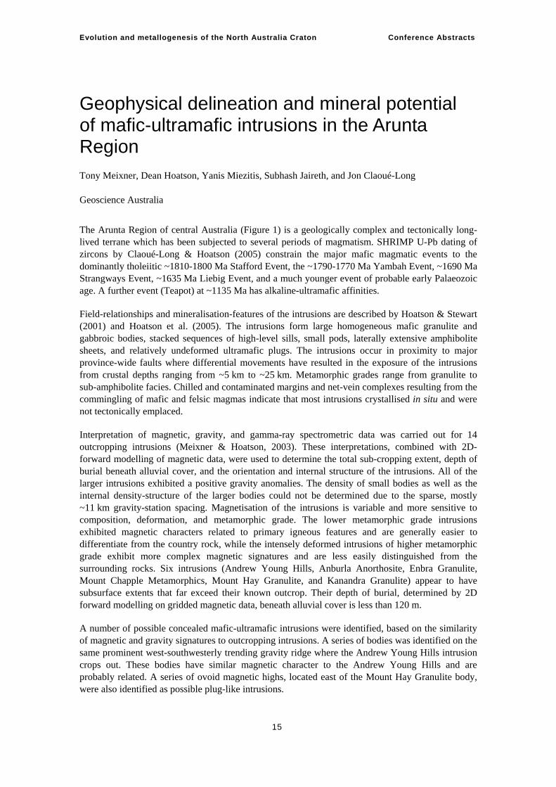
Geophysical delineation and mineral potential of mafic-ultramafic intrusions in the Arunta Region Tony Meixner, Dean Hoatson, Yanis Miezitis, Subhash Jaireth, and Jon Claoué-Long Geoscience Australia
The Arunta Region of central Australia (Figure 1) is a geologically complex and tectonically long-lived terrane which has been subjected to several periods of magmatism. SHRIMP U-Pb dating of zircons by Claoué-Long & Hoatson (2005) constrain the major mafic magmatic events to the dominantly tholeiitic ~1810-1800 Ma Stafford Event, the ~1790-1770 Ma Yambah Event, ~1690 Ma Strangways Event, ~1635 Ma Liebig Event, and a much younger event of probable early Palaeozoic age. A further event (Teapot) at ~1135 Ma has alkaline-ultramafic affinities.
Field-relationships and mineralisation-features of the intrusions are described by Hoatson & Stewart (2001) and Hoatson et al. (2005). The intrusions form large homogeneous mafic granulite and gabbroic bodies, stacked sequences of high-level sills, small pods, laterally extensive amphibolite sheets, and relatively undeformed ultramafic plugs. The intrusions occur in proximity to major province-wide faults where differential movements have resulted in the exposure of the intrusions from crustal depths ranging from ~5 km to ~25 km. Metamorphic grades range from granulite to sub-amphibolite facies. Chilled and contaminated margins and net-vein complexes resulting from the commingling of mafic and felsic magmas indicate that most intrusions crystallised in situ and were not tectonically emplaced.
Interpretation of magnetic, gravity, and gamma-ray spectrometric data was carried out for 14 outcropping intrusions (Meixner & Hoatson, 2003). These interpretations, combined with 2D-forward modelling of magnetic data, were used to determine the total sub-cropping extent, depth of burial beneath alluvial cover, and the orientation and internal structure of the intrusions. All of the larger intrusions exhibited a positive gravity anomalies. The density of small bodies as well as the internal density-structure of the larger bodies could not be determined due to the sparse, mostly ~11 km gravity-station spacing. Magnetisation of the intrusions is variable and more sensitive to composition, deformation, and metamorphic grade. The lower metamorphic grade intrusions exhibited magnetic characters related to primary igneous features and are generally easier to differentiate from the country rock, while the intensely deformed intrusions of higher metamorphic grade exhibit more complex magnetic signatures and are less easily distinguished from the surrounding rocks. Six intrusions (Andrew Young Hills, Anburla Anorthosite, Enbra Granulite, Mount Chapple Metamorphics, Mount Hay Granulite, and Kanandra Granulite) appear to have subsurface extents that far exceed their known outcrop. Their depth of burial, determined by 2D forward modelling on gridded magnetic data, beneath alluvial cover is less than 120 m.
A number of possible concealed mafic-ultramafic intrusions were identified, based on the similarity of magnetic and gravity signatures to outcropping intrusions. A series of bodies was identified on the same prominent west-southwesterly trending gravity ridge where the Andrew Young Hills intrusion crops out. These bodies have similar magnetic character to the Andrew Young Hills and are probably related. A series of ovoid magnetic highs, located east of the Mount Hay Granulite body, were also identified as possible plug-like intrusions.
Evolution and metallogenesis of the North Australia Craton Conference Abstracts
16
Chalcophile trace-element trends show, for the first time, that the Arunta intrusions fall into two major geochemical groups: (1) a S-rich group (~300 ppm S – ~1200 ppm S) from the western and central parts of the Arunta Region (Andrew Young Hills, Mount Hay Granulite, Mount Chapple Metamorphics, Papunya ultramafic), and; (2) a relatively S-poor (<300 ppm S), slightly more primitive group from the eastern Arunta Region (Attutra Metagabbro, Mordor Complex)
Prospectivity analysis (qualitative method of assessment) of the intrusions based on critical prospectivity indicators such as size, shape, trace-element trends, and sulphur-saturation levels indicate that the Andrew Young Hills intrusion, Mount Hay Granulite, and Mount Chapple Metamorphics have moderate to high potential for basal Ni-Cu-Co (Voisey’s Bay-style) mineralisation (Miezitis et al., in prep). These intrusions belong to the S-rich group. The relatively S-poor Attutra Metagabbro (<225 ppm S), on the other hand, has moderate to high potential for stratabound platinum-group element mineralisation.
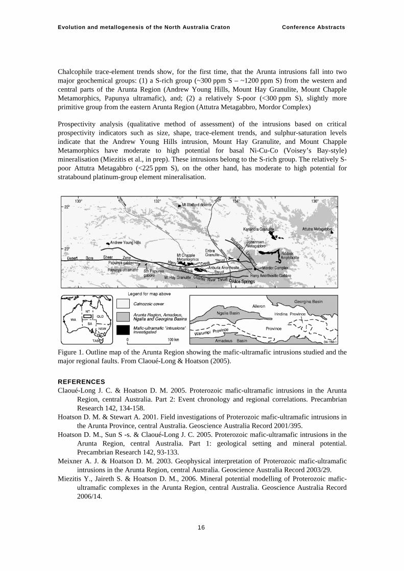
Figure 1. Outline map of the Arunta Region showing the mafic-ultramafic intrusions studied and the major regional faults. From Claoué-Long & Hoatson (2005).
REFERENCES Claoué-Long J. C. & Hoatson D. M. 2005. Proterozoic mafic-ultramafic intrusions in the Arunta
Region, central Australia. Part 2: Event chronology and regional correlations. Precambrian Research 142, 134-158.
Hoatson D. M. & Stewart A. 2001. Field investigations of Proterozoic mafic-ultramafic intrusions in the Arunta Province, central Australia. Geoscience Australia Record 2001/395.
Hoatson D. M., Sun S -s. & Claoué-Long J. C. 2005. Proterozoic mafic-ultramafic intrusions in the Arunta Region, central Australia. Part 1: geological setting and mineral potential. Precambrian Research 142, 93-133.
Meixner A. J. & Hoatson D. M. 2003. Geophysical interpretation of Proterozoic mafic-ultramafic intrusions in the Arunta Region, central Australia. Geoscience Australia Record 2003/29.
Miezitis Y., Jaireth S. & Hoatson D. M., 2006. Mineral potential modelling of Proterozoic mafic-ultramafic complexes in the Arunta Region, central Australia. Geoscience Australia Record 2006/14.
Evolution and metallogenesis of the North Australia Craton Conference Abstracts
17
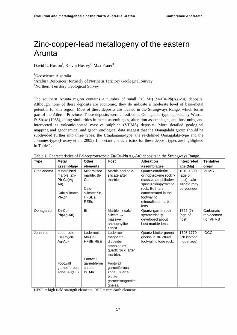
Zinc-copper-lead metallogeny of the eastern Arunta David L. Huston1, Kelvin Hussey2, Max Frater3
1Geoscience Australia 2Arafura Resources; formerly of Northern Territory Geological Survey 3Northern Territory Geological Survey
The southern Arunta region contains a number of small (<5 Mt) Zn-Cu-Pb(Ag-Au) deposits. Although none of these deposits are economic, they do indicate a moderate level of base-metal potential for this region. Most of these deposits are located in the Strangways Range, which forms part of the Aileron Province. These deposits were classified as Oonagalabi-type deposits by Warren & Shaw (1985), citing similarities in metal assemblages, alteration assemblages, and host units, and interpreted as volcanic-hosted massive sulphide (VHMS) deposits. More detailed geological mapping and geochemical and geochronological data suggest that the Oonagalabi group should be subdivided further into three types, the Utnalanama-type, the re-defined Oonagalabi-type and the Johnnies-type (Hussey et al., 2005). Important characteristics for these deposit types are highlighted in Table 1. Table 1. Characteristics of Palaeoproterozoic Zn-Cu-Pb(Ag-Au) deposits in the Strangways Range. Type Metal
assemblage Other elements
Host Alteration assemblages
Interpreted age (Ma)
Tentative origin
Utnalanama Mineralised marble: Zn-Pb-Cu(Ag-Au) Calc-silicate: Pb-Zn
Mineralised marble: Bi-Cd Calc-silicate: Sn, HFSEs, REEs
Marble and calc-silicate after marble.
Quartz-cordierite± orthopyroxene rock > massive amphibole± spinel±clinopyroxene rock. Both are concentrated in the footwall to mineralised marble lens.
1810-1800 (age of host); calc-silicate may be younger
VHMS
Oonagalabi Zn-Cu-Pb(Ag-Au)
Bi Marble → calc-silicate → massive anthophyllite schist.
Quartz-garnet rock symmetrically developed about host marble lens.
1765 (?) (age of host)
Carbonate replacement or VHMS
Johnnies Lode rock: Cu-Pb(Zn-Ag-Au) Footwall garnetiferous zone: Au(Cu)
Lode rock: Mn-Ca-HFSE-REE Footwall garnetiferous zone: Bi±Mo
Lode rock: magnetite-diopside-amphibole± quartz rock (after marble). Footwall garnetiferous zone: Quartz-biotite-garnet±magnetite gneiss.
Quartz-biotite-garnet gneiss in structural footwall to lode rock.
1795-1770 (Pb isotope model age)
IOCG
HFSE = high field strength elements; REE = rare earth elements
Evolution and metallogenesis of the North Australia Craton Conference Abstracts
18
Utnalanama-type deposits, which are hosted by the 1810-1800 Ma Ongeva package are classified as VHMS deposits based on ore metal assemblages, the pre-metamorphic mineralogy (quartz-chlorite) and morphology of the alteration zone and Pb-isotope data. Zinc-Pb-Cu(Ag-Au) mineralisation is mostly hosted by marble lenses and is associated with asymmetrically distributed quartz-cordierite gneiss, interpreted as metamorphosed quartz-chlorite altered volcaniclastic rock. The presence of bimodal magmatism of similar age to the Ongeva package (the Stafford Event) suggests that this unit and the deposits hosted by it were formed in an extensional environment, possibly in a back-arc.
Re-defined Oonagalabi-type deposits are restricted to the Oonagalabi "tongue", where the ~1765 Ma Bungintina Metamorphics (Hussey et al., 2005) contain the Oonagalabi deposit and several nearby prospects. These deposits are hosted by metasomatised and metamorphosed limestone units that are now marble, calc-silicate, and massive orthoamphibole rock. Sphalerite and chalcopyrite are disseminated at levels to a few percent in all rock types. Textural relationships suggest that an original carbonate lens was replaced by calc-silicate rock and then by talc±quartz rock. Subsequent metamorphism converted the carbonate lens to marble and the talc±quartz rock to the massive orthoamphibole rock. In contrast to Utnalanama-type deposits, quartz-garnet rock is the main alteration assemblage at Oonagalabi. These deposits are interpreted as carbonate-replacement deposits, although it is also possible that they are VHMS deposits.
Johnnies-type deposits, which include the Johnnies Reward and Gumtree prospects in the Strangways Range and the Jervois group of deposits further to the east, are differentiated from the other deposit types by their close association with magnetite-rich rocks, high and variable Pb/Zn, more radiogenic Pb isotopes and the enrichment of Mn, and selected high field strength and rare-earth elements. These deposits are interpreted as iron-oxide Cu-Au deposits and are discussed separately in Huston et al. (2006).
Outside of the Strangways Ranges, the only other significant Zn-Cu-Pb(Ag-Au) prospects in the southern Arunta are in the Haasts Bluff Domain of the Warumpi Province, with Zn-Pb-dominated prospects at Stokes Yard and Ulpuruta and Cu-dominated prospects at Haast Bluff and Mount Larry. All prospects are associated with marble and calc-silicate rocks; Frater (2005) interpreted the Stokes Yard and Ulpurata prospects as deformed distal skarn deposits.
Lead isotope data (Huston et al., 2003) indicate that deposits from the Warumpi Province had the most primitive source, followed by Oonagalabi-type deposits and then by Utnalanama-type deposits. This suggests that along the southern margin of the Arunta region, the crust became progressively more primitive with time and to the south, a result consistent with Nd-isotope data (Zhao & McCulloch, 1995).
REFERENCES Frater, M., 2005. Mineralisation in the 1690-1610 Ma Warumpi Province. In: Munson, T. (Ed.),
Annual Geoscience Exploration Seminar (AGES) 2005. Record of abstracts. Northern Territory Geological Survey Record 2005-001.
Hussey, K.J., Huston, D.L., & Claoué-Long, J., 2005. Geology and origin of some Cu-Pb-Zn (-Au-Ag) deposits in the Strangways Metamorphic Complex, Arunta Region, Northern Territory. Northern Territory Geological Survey Report 17.
Huston, D.L., Hussey, K.J, Claoué-Long, J., & Wygralak, A.S., 2003. Lead isotope constraints on the ages and metal sources of lode gold and base-metal deposits from the Tanami, Warumpi and southeast Arunta. In: Munson, T.J., & Scrimgeour, I., eds., Annual Geoscience Exploration Seminar (AGES) 2003. Northern Territory Geological Survey Record 2003-001.
Evolution and metallogenesis of the North Australia Craton Conference Abstracts
19
Huston, D.L., Maidment, M., & Hussey, K.J., 2006. Iron oxide copper-gold deposits in the Tennant and Arunta regions. In: Lyons, P. & Huston, D.L. (Eds.), Evolution and metallogenesis of the North Australia Craton Conference: 20-22 June, Abstracts. Geoscience Australia Record 2006/16, 23-25.
Warren, R.G. & Shaw, R.D., 1985. Volcanogenic Cu-Pb-Zn bodies in granulites of the central Arunta Block, central Australia. Journal of Metamorphic Geology 3, 481-499.
Zhao, J-X. & McCulloch, M.T., 1995. Geochemical and Nd isotopic systematics of granites from the Arunta Inlier, central Australia: implications for Proterozoic crustal evolution. Precambrian Research, 71 265-299.
Evolution and metallogenesis of the North Australia Craton Conference Abstracts
20
Composition, timing, and provenance of hydrothermal fluids in the Tanami–Arunta regions Andrew S Wygralak1, Terrence P Mernagh2
1Northern Territory Geological Survey 2Geoscience Australia
This presentation summarises research work, conducted during 1999 – 2000, aimed at determining the physico-chemical characteristics, timing, and provenance of palaeo-fluid flow across a large portion of the Northern Territory, from the Tanami Region in the west to the Aileron and Warumpi Provinces of the Arunta Region in the east and south, respectively. It also includes the Davenport Province of the Tennant Creek Inlier.
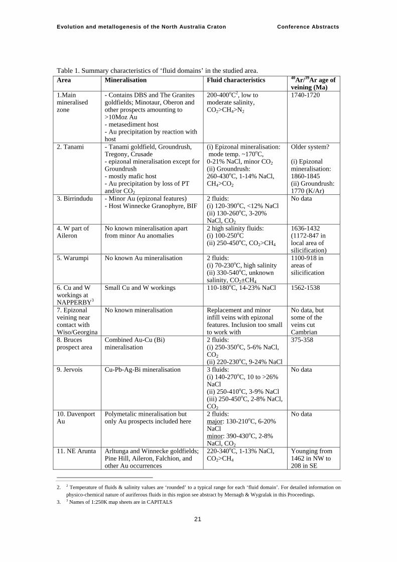
The work is based on a study of quartz veining in The Granites, Dead Bullock Soak (DBS) and Tanami goldfields, and approximately 120 outcropping quartz vein clusters scattered throughout the entire region. The research included microthermometric analysis and Raman microprobing of ~3500 fluid inclusions, ~70 δ18O analyses of vein quartz and ~50 40Ar/39Ar age determinations1 of vein related micas. It resulted in delineation of 11 areas with different fluid characteristics (‘fluid domains’) and five areas with different age of vein-related micas (‘age domains’). Within the Arunta region it also defined a northwest-trending zone where fluids have similar characteristics to the gold-bearing fluids of the Tanami region, therefore indicating potential for further discoveries of gold mineralisation. Fluid characteristics of the 11 distinguished ‘fluid domains’ are presented in Table 1.
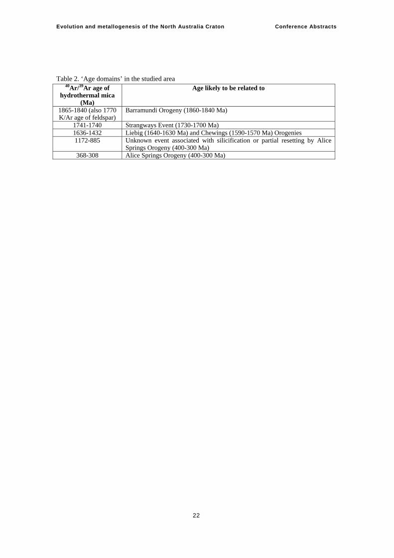
40Ar/39Ar age determinations indicated 5 distinctive ‘age domains’. Their age ranges and possible associations with particular tectonothermal events are given in Table 2. There is a clear younging trend of veining from the NW part of the studied region to its SE part. 40Ar/39Ar ages record the last time the mineral was heated to 300-320oC (closure temperature for resetting of Ar isotopes), which is not necessarily the age of veining. Younging of the ages towards SW indicate influence of subsequent tectonothermal events.
Calculated δ18O data of fluid exist for the western half of the studied region only. A distinctive zone dominated by magmatic/metamorphic fluid extends from the south part of TANAMI in the north to MOUNT RENNIE and MOUNT LIEBIG in the south. A major area dominated by meteoric fluids covers most of MOUNT THEO, extending south to MOUNT DOREEN and north to MOUNT SOLITAIRE. A smaller area dominated by meteoric fluid is also located in the western part of THE GRANITES. All three known goldfields (DBS, The Granites, Tanami) are located in areas dominated by magmatic/metamorphic fluids.
In conclusion, the ‘fluid domain’ number 11 in Arunta (see PowerPoint presentation) has fluid characteristics similar to fluids associated with gold mineralisation in the Tanami region and has potential for further gold discoveries. 40Ar/39Ar ages approximately equivalent to the 1730-1700 Ma Strangways Event are no longer considered as critical for auriferous quartz veining as they do not reflect the age of veining but ages reset by subsequent tectonothermal events.
1. 1 40Ar/39Ar dating for this project was conducted by G. Fraser from Geoscience Australia & by J. Dunlop from the School of
Earth Sciences of the Australian National University.
Evolution and metallogenesis of the North Australia Craton Conference Abstracts
21
Table 1. Summary characteristics of ‘fluid domains’ in the studied area. Area Mineralisation Fluid characteristics 40Ar/39Ar age of
veining (Ma) 1.Main mineralised zone
- Contains DBS and The Granites goldfields; Minotaur, Oberon and other prospects amounting to >10Moz Au - metasediment host - Au precipitation by reaction with host
200-400oC2, low to moderate salinity, CO2>CH4>N2
1740-1720
2. Tanami - Tanami goldfield, Groundrush, Tregony, Crusade - epizonal mineralisation except for Groundrush - mostly mafic host - Au precipitation by loss of PT and/or CO2
(i) Epizonal mineralisation: mode temp. ~170oC, 0-21% NaCl, minor CO2 (ii) Groundrush: 260-430oC, 1-14% NaCl, CH4>CO2
Older system? (i) Epizonal mineralisation: 1860-1845 (ii) Groundrush: 1770 (K/Ar)
3. Birrindudu - Minor Au (epizonal features) - Host Winnecke Granophyre, BIF
2 fluids: (i) 120-390oC, <12% NaCl (ii) 130-260oC, 3-20% NaCl, CO2
No data
4. W part of Aileron
No known mineralisation apart from minor Au anomalies
2 high salinity fluids: (i) 100-250oC (ii) 250-450oC, CO2>CH4
1636-1432 (1172-847 in local area of silicification)
5. Warumpi No known Au mineralisation 2 fluids: (i) 70-230oC, high salinity (ii) 330-540oC, unknown salinity, CO2±CH4
1100-918 in areas of silicification
6. Cu and W workings at NAPPERBY3
Small Cu and W workings 110-180oC, 14-23% NaCl 1562-1538
7. Epizonal veining near contact with Wiso/Georgina
No known mineralisation Replacement and minor infill veins with epizonal features. Inclusion too small to work with
No data, but some of the veins cut Cambrian
8. Bruces prospect area
Combined Au-Cu (Bi) mineralisation
2 fluids: (i) 250-350oC, 5-6% NaCl, CO2 (ii) 220-230oC, 9-24% NaCl
375-358
9. Jervois Cu-Pb-Ag-Bi mineralisation 3 fluids: (i) 140-270oC, 10 to >26% NaCl (ii) 250-410oC, 3-9% NaCl (iii) 250-450oC, 2-8% NaCl, CO2
No data
10. Davenport Au
Polymetalic mineralisation but only Au prospects included here
2 fluids: major: 130-210oC, 6-20% NaCl minor: 390-430oC, 2-8% NaCl, CO2
No data
11. NE Arunta Arltunga and Winnecke goldfields; Pine Hill, Aileron, Falchion, and other Au occurrences
220-340oC, 1-13% NaCl, CO2>CH4
Younging from 1462 in NW to 208 in SE
2. 2 Temperature of fluids & salinity values are ‘rounded’ to a typical range for each ‘fluid domain’. For detailed information on
physico-chemical nature of auriferous fluids in this region see abstract by Mernagh & Wygralak in this Proceedings. 3. 3 Names of 1:250K map sheets are in CAPITALS
Evolution and metallogenesis of the North Australia Craton Conference Abstracts
22
Table 2. ‘Age domains’ in the studied area
40Ar/39Ar age of hydrothermal mica
(Ma)
Age likely to be related to
1865-1840 (also 1770 K/Ar age of feldspar)
Barramundi Orogeny (1860-1840 Ma)
1741-1740 Strangways Event (1730-1700 Ma) 1636-1432 Liebig (1640-1630 Ma) and Chewings (1590-1570 Ma) Orogenies 1172-885 Unknown event associated with silicification or partial resetting by Alice
Springs Orogeny (400-300 Ma) 368-308 Alice Springs Orogeny (400-300 Ma)
Evolution and metallogenesis of the North Australia Craton Conference Abstracts
23
Iron oxide copper-gold deposits in the Tennant and Arunta regions David L Huston1, David Maidment1, Kelvin Hussey2, Max Frater3
1Geoscience Australia 2Arafura Resources; formerly of Northern Territory Geological Survey 3Northern Territory Geological Survey
The Tennant Creek goldfield, the third largest goldfield in the Northern Territory, producing over 150 tonnes of gold (Wedekind et al., 1989), was only discovered in the mid-1930s due to the association of gold with ironstone rather than quartz veins. Over the last two decades ironstone-hosted gold deposits have been included in the group of deposits termed iron-oxide copper-gold (IOCG) deposits (Hitzman et al., 1992). Elsewhere in the Northern Territory, prospects with IOCG characteristics have been recognised in the southeastern Arunta (Hussey et al., 2005), and potential for these deposits has been recognised in the Mount Webb area of the Warumpi Province (Wyborn et al., 1998).
In the Tennant Creek goldfield, IOCG deposits have been classed into Juno-type, Peko-type, and Gecko-type deposits (Huston et al., 1993). In each type of deposit, metals are closely associated with magnetite- and hematite-bearing ironstone. Gold-rich Juno-type deposits are strongly zoned, with gold enriched in pods near the base of ironstones and passing upwards through a Bi(Pb)-rich shell, into a Cu-rich shell and finally into an outer pyrite-rich shell. Minor quantities of hematite are associated with the ore minerals, and the feeder zone underlying the deposit is hematitic (Large, 1975). Peko-type deposits are unzoned, have lower Au grades and higher Cu grades, and contain significant amounts of pyrrhotite (Skirrow & Walshe, 2002). Gecko-type deposits are also Cu-rich and relatively Au-poor, but are associated with extensive hematite. Hematite-rich deposits, which are not readily detectable using magnetic data, have been an exploration target at Tennant Creek over the last few years. Paragenetically, the Au-Cu assemblage is interpreted to have been emplaced after the formation of the ironstones (Wedekind et al., 1989; Huston et al., 1993; Skirrow & Walshe, 2002). Only a small proportion of the ironstone bodies in the Tennant Creek goldfield are known to contain significant Au-Cu ore zones. The Tennant Creek deposits also contain high levels of Bi and Se, and, in the outer part of the gold shell at the Juno deposit, U enriched (in excess of 80 ppm) (Large, 1975).
The deposits are hosted by the Warramunga Formation, a ~1860 Ma turbiditic succession (Compston, 1995) characterised by abundant diagenetic and/or detrital magnetite (Large, 1975). This unit was intruded by granites and felsic porphyry dykes between 1850 Ma and 1845 Ma (Compston, 1995; Maidment et al., 2006). At the White Devil deposit, one of these dykes, dated at 1847 ± 3 Ma (Maidment et al., 2006; see also Compston, 1995), intruded ironstone but is altered by chlorite paragenetically associated with Au-Cu mineralisation. 40Ar-39Ar age estimates of ironstone- and Au-Cu-related muscovite by Compston & McDougal (1994) have been recalculated at ~1850 Ma by Fraser et al. (2006) using revised ages for internal standards and recalibrated decay constants. These results suggest that both ironstone and Au-Cu mineralisation in the Tennant Creek goldfield correspond to the Tennant Creek magmatic event and are part of a single evolving hydrothermal system. Moreover, the transition from foliated to unfoliated chlorite between the ironstone and Au-Cu stages of mineralisation suggests that mineralisation and magmatism may have accompanied the inversion of the original Warramunga basin.
Evolution and metallogenesis of the North Australia Craton Conference Abstracts
24
Au-Cu prospects in the Rover (or Babylon) field, which is located ~100 km to the southwest of Tennant Creek, have many similarities to Tennant Creek deposits, including an association with ironstones and metal assemblages. However, a volcaniclastic rock from the host unit to the Rover field has been dated at 1798 ± 5 Ma (Smith, 2001), raising the possibility that units younger than the Warramunga Formation may be prospective and that a second Au-Cu event was active in the Tennant region. This date is being checked using a second sample of volcaniclastic rocks from the Rover field.
In the Strangways Ranges, Hussey et al. (2005) classified the Johnnies Reward prospect as an IOCG. Although this deposit was originally interpreted as a volcanic-hosted massive sulphide deposit (Warren & Shaw, 1985), metal assemblages and ratios, a close association with ironstone, and Pb isotope model ages suggest an IOCG origin. The deposit has a distinct zonation from the structural footwall, as follows: Au(Cu-Bi-S±Mo) → Cu-Pb-S(Zn-Ag-Au) → Pb-Mn(Cu-S±Ca) → REEs-HFSEs → Ca, with Fe- and Mg-enrichment present through much of the mineralised interval. The Au-rich zone is located over the boundary between the ironstone lode rock and underlying quartz-biotite-garnet gneiss, whereas the other zones are located within the lode rock. The magnetite-tremolite-diopside lode rock is inferred to have replaced a marble lens. Lead-isotopes from galena yield model ages of 1795-1770 Ma (Hussey et al., 2005), suggesting an overlap with the Yambah igneous event.
The Jervois mineral field contains both Cu-Au and Pb-Zn-Ag(Au) deposits, although these two types are gradational. These deposits are localised along en echelon D3 shears within a magnetite-bearing, apparently stratigraphically-controlled, mineralised sequence. The Pb-Zn-rich deposits, of which Green Parrot is the best example, are hosted by garnet-magnetite-rich skarn and are interpreted to have replaced calc-silicate (Frater, 2006). The Cu-Au deposits, of which the Bellbird prospect is a good example, are associated with magnetite, chlorite, mica, and garnet. In addition to the Cu-Au, these deposits are enriched in Ag, Co, U, and P (Frater, 2006). Like the Johnnies Reward deposit, lead isotope model ages suggest an age consistent with an association with Yambah-aged magmatism.
Wyborn et al. (1998) suggested that alteration and localised Cu mineralisation in Mount Webb area of the western Warumpi Province has affinities to IOCG systems. They documented sodic-calcic alteration assemblages in ~1640 Ma granites and hematite and epidote alteration assemblages in country rocks as well as Cu mineralisation at surface.
REFERENCES Compston, D. M., 1995. Time constraints on the evolution of the Tennant Creek Block, northern
Australia. Precambrian Research 71, 107-129. Compston, D. M. & McDougall, I., 1994. 40Ar-39Ar and K-Ar age constraints on the Early
Proterozoic Tennant Creek Block, northern Australia, and the age of its gold deposits. Australian Journal of Earth Sciences 41, 609-616.
Fraser, G., Huston, D., Bagas, L., Hussey K., Claoué-Long, J., Cross, A., Vandenburg, L., Wygralak, A., Donnellan, N., & Crispe, A., 2006. 40Ar/39Ar constraints on the episodic history of mineralization and tectonism in the southern North Australian Craton. In: Lyons, P. & Huston, D.L. (Eds.), Evolution and metallogenesis of the North Australia Craton Conference: 20-22 June, Abstracts. Geoscience Australia Record 2006/16, 13-14.
Frater, M., 2006. New insights into the Jervois mineral field. In: Munson, T.J. & Scrimgeour, I.S. (Eds.), Annual Geoscience Exploration Seminar (AGES) 2006. Record of abstracts. Northern Territory Geological Survey Record 2006-002, 18-20.
Evolution and metallogenesis of the North Australia Craton Conference Abstracts
25
Hitzman, M.W., Oreskes, N., & Einaudi, M.T., 1992. Geological characteristics and tectonic setting of Proterozoic iron oxide (Cu-U-Au-REE) deposits. Precambrian Research 58, 241-287.
Hussey, K.J., Huston, D.L., & Claoué-Long, J., 2005. Geology and origin of some Cu-Pb-Zn (-Au-Ag) deposits in the Strangways Metamorphic Complex, Arunta Region, Northern Territory. Northern Territory Geological Survey Report 17.
Huston, D.L., Bolger, C., & Cozens, G., 1993. A comparison of mineral deposits at the Gecko and White Devil deposits: implications for ore genesis in the Tennant Creek district, Northern Territory, Australia. Economic Geology 88, 1198-1225.
Large, R.R., 1975, 1975. Zonation of hydrothermal minerals at the Juno mine, Tennant Creek goldfield, central Australia. Economic Geology 70, 1387-1413.
Maidment, D., Lambeck, L., Huston, D., & Donnellan, N., 2006. New geochronological data from the Tennant region. In: Munson, T.J. & Scrimgeour, I.S. (Eds.), Annual Geoscience Exploration Seminar (AGES) 2006. Record of abstracts. Northern Territory Geological Survey Record 2006-002, 32-25.
Skirrow, R.G., & Walshe, J., 2002. Reduced and oxidized Au-Cu-Bi iron oxide deposits of the Tennant Creek Inlier, Australia; an integrated geologic and chemical model. Economic Geology 97, 1167-1202.
Smith, J.B., 2001. Summary of Results. Joint NTGS – AGSO Age determination program 1999-2001. Northern Territory Geological Survey Record 2001-007.
Warren, R.G. & Shaw, R.D., 1985. Volcanogenic Cu-Pb-Zn bodies in granulites of the central Arunta Block, central Australia. Journal of Metamorphic Geology 3, 481-499.
Wedekind. M.R., Large, R.R., & Williams, B.T., 1989. Controls on high-grade gold mineralization at Tennant Creek, Northern Territory, Australia. Economic Geology Monograph 6, 168-179.
Wyborn, L.A.I., Hazell, M., Page, R., Idnurm, M., & Sun, S.-S., 1998. A newly discovered major Proterozoic gahnite-alteration system in the Mount Webb region, central Australia, and implications for Cu-Au mineralisation. AGSO Research Newsletter 28, 1-5.
Evolution and metallogenesis of the North Australia Craton Conference Abstracts
26
Introduction to the geology of the Nolan’s Bore LREE/P/U deposit John Goulevitch Consulting Geologist, Arafura Resources NL, Darwin
The Nolan’s Bore LREE/P/U deposit is located at 133º 14' 15"E ,22º 34' 40"S , approximately 135 km NNW of Alice Springs. The deposit was initially located in 1994 by PNC Exploration (Australia) Pty Ltd (Thevissen, 1995) and rediscovered by Arafura Resources NL in 1999 when the REE and phosphate potential of the deposit came to prominence. Current identified mineral resources (Indicated + Inferred, JORC compliant) stand at 18.6 Mt at 3.1% REO, 14% P2O5, and 0.021% U3O8 (Goulevitch, 2006).
REE/P/U(/Th/F) mineralisation in the deposit occurs predominantly in a series of sub-parallel tabular bands (veins or dykes) of massive fluorapatite (Ca5(PO4)3(F,OH)). Fluorapatite comprises 80% – 95% of these bands which contain 7-10% REO, 30-35% P2O5, 0.05-0.06% U3O8, 0.7-1% ThO2, and 1.5% F, Ce (48.0%), Nd (21.6%), La (20.0%), Pr (5.9%), Sm (2.4%), and Gd (1.0%) account for 99% of the REE content. The bands dip steeply (65° to 90º) to the NNW and collectively constitute an extensive vein- or dyke-swarm. They vary in thickness from 0.3 m to 25 m and extend laterally and at depth over for several 10s to several 100s of metres. Contacts with the country rock are sharp and generally (curvi-) planar. Other forms of mineralisation include stockworks of irregular fluorapatite veins, 1-15 centimetres thick, as well as zones and bands dominated by cheralite (see below) where grades of 20-30% REO and 0.1-0.3% U3O8 have been recorded over intervals of 1 m to-4 m.
The deposit is open laterally and at depth. The bulk of the mineralisation is currently restricted to an area about 1500 m × 1100 m in extent, and this may increase if suspected continuity to other fluorapatite outcrops 500-600 m along strike to the SW is confirmed. A fluorapatite band located about one kilometre west of the main deposit does not appear to be linked at shallow depths to the main deposit as mineralisation is absent in the intervening area.
The fluorapatite rock generally appears fine-grained, massive, and pale greenish white, pale green, olive green or maroon-brown in colour. Reflective surfaces, to 15 mm in some specimens, indicate areas of coarse crystallinity and other specimens display an appearance of equant, massive apatite clasts, to 15 mm, in fine-grained apatite matrix. Texturally, some of the massive apatite rocks resemble porphyry in that the bands consist of coarse euhedral to subhedral ‘phenocrysts’ of apatite (1 cm to 8 cm) in a microcrystalline apatite matrix. There is no evidence, either macroscopically or microscopically, of any inherent metamorphic fabric in the massive bands, though there is clear evidence of post-depositional crackle, mosaic and rubble brecciation, some of which may be the result of syn-depositional milling (Hussey, in prep.).
Scanning electron microscope studies of massive fluorapatite by ANSTO (Callea et al., 2001) has demonstrated that the bulk of the REE/U content in the fluorapatite rock (65% – 70%) is hosted by minor amounts (up to 8%) of the phosphate-deficient, REE mineral, cheralite ([LREE,Ca][P,Si]O4]). Both Ce- and La-rich variants of this mineral fill intensely developed microfractures and micro-veins in the fluorapatite. Only about 30% – 35% of the REE/U is hosted in the crystal lattice of the
Evolution and metallogenesis of the North Australia Craton Conference Abstracts
27
fluorapatite. Other identified REE/U/Th mineral species identified include bastnaesite, monazite, thorite, and allanite.
Strong kaolinite alteration of gneissic and pegmatitic wall rocks is associated with the massive fluorapatite bands as well as some areas of stockwork veining. Kaolinite is particularly strongly developed where the fluorapatite bands transgress a 10 m to 25 m wide, steeply N-dipping mylonite zone which transects the northern part of the deposit. The greatest thicknesses of massive fluorapatite are developed along the northern margin of this mylonite zone. Fluorapatite/ mylonite contacts transgress the mylonite fabric. No mylonitised fluorapatite has been observed.
In places, clinopyroxene, actinolite, garnet, titanite, and epidote-allanite calc-silicate alteration forms endoskarn-like haloes (5 cm – 30 cm) on thicker fluorapatite stockwork veins. Smectite alteration has been observed as zones (1 cm – 10 cm) marginal to some thinner fluorapatite bands (0.5 m – 2 m) and as stockwork veins in gneissic granite. Other identified alteration minerals include chlorite, carbonate, laumontite, heulandite and possible zeolites.
The fluorapatite-cheralite bands and veins are mainly hosted by gneissic granite assigned to the Mount Boothby Orthogneiss. Lesser developments occur in cordierite-magnetite psammopelitic gneiss of the Lander Rock Beds (1865 Ma – 1820 Ma; all ages from Huston, et al, 2006) which were intruded by the Mount Boothby Orthogneiss (?Stafford Event, 1820-1800 Ma or ?Yambah Event, 1780-1770 Ma) prior to regional metamorphism and development of gneissic fabric (Strangways Event, 1740-1690 Ma and/or Chewings Orogeny, 1590-1570 Ma). Weak mineralisation and kaolinite alteration also occurs in pegmatite bodies which postdate the Orthogneiss and metamorphic fabric (?late Chewings Event).
The age of the mineralisation has yet to be definitively established though the breccia textures, the crosscutting relationship with the metamorphic fabric, pegmatites and the mylonite fabric, and the linearity of the bands in plan view all suggest deposition subsequent to all of the Proterozoic thermal and regional metamorphic events, and subsequent to at least the initial stages of the Alice Springs Orogeny (450 Ma – 300 Ma).
REFERENCES Callea, N.F.A., Collier, D.E., Soldenhoff, K.H. & Trautman, R., 2001. Processing of Nolan’s Bore
rare earth apatite ore. Unpublished Australian Nuclear Science and Technology Organisation Report C683.
Goulevitch, J., 2006, 2005 drilling results and resource estimate, Nolan's Bore REE/P/U deposit, Aileron, Northern Territory. Exploremin Pty Ltd unpublished report EPL-05/177.
Hussey, K.J., in prep., Report on NBDH037, a cored diamond drill hole at the Nolan's BoreP-REE-Th-U prospect in the ReynoldsRange, AruntaRegion.Northern Territory Geological Survey Record.
Thevissen, J., 1995. Napperby Annual Report EL 8411 1995 field season. PNC Exploration (Australia) Pty Ltd unpublished report NTDME CR96/187.
Evolution and metallogenesis of the North Australia Craton Conference Abstracts
28
Uranium in North Australian Craton: Resources, Metallogeny, and Potential
I.B. Lambert, S. Jaireth, Y. Miezitis, A.D. McKay Geoscience Australia
KNOWN MINERALISATION Over a half (570) of the known uranium occurrences in Australia are located in the North Australian Craton and the overlying Ngalia, Amadeus, and McArthur River basins These occurrences include 43 uranium deposits with recorded resources. The uranium occurrences and deposits show a general spatial relationship to uranium-enriched felsic igneous rocks.
The total uranium resource (production + resources) of the North Australian Craton and the overlying basins amount to about 510,000 t U3O8. The bulk of these resources are accounted for by the following: unconformity type in the Pine Creek Orogen (~420,000 t U3O8), sandstone uranium (~36,000 t U3O8) in the McArthur, Amadeus and Ngalia Basins, metasomatite (~38,000 t U3O8) and metamorphic deposits of the Mt Isa Orogen, and calcrete deposits in Arunta.
Significant concentrations of uranium have also been reported in rare earth element-rich fluorapatite veins (Nolans Bore in Aileron Province), and in iron oxide-copper-gold deposits in the Warramunga province (Juno).
URANIUM POTENTIAL Geoscience Australia has published online geoprovince-scale mineral potential assessments for selected types of uranium (unconformity, sandstone and iron-oxide or hematite breccia complex) deposits. The levels of potential are assigned to the whole of a geoprovince or sub-province rather than specific lithological/structural tracts within the region. The assessments can be accessed at http://www.australianminesatlas.gov.au/.
Apart from the Pine Creek Orogen, there is moderate to high potential for unconformity style uranium in the Granites-Tanami (where a narrow intersection in historical drilling had over 4% U3O8) and the Murphy Inlier.
There is high potential for future discoveries of uranium resources within the North Australian Craton and in sedimentary basins adjacent to it. Parts of the Georgina Basin, adjacent to uranium-rich basements, may also have potential for sandstone type uranium.
Some base metal sulphide deposits (Johnnies-type) in the Strangways Metamorphic Complex, in the Aileron region, are interpreted to be metamorphosed iron oxide-copper-gold systems, with features similar to deposits in the Tennant Creek district and the Cloncurry district, in Queensland (Hussey et al, 2005). These have the potential to contain uranium-enriched zones.
Some parts of iron-oxide copper-gold deposits contain uranium (Large, 1975; Ryan, 1998). At Juno, for example, the uranium zone coincides with the outer edge of the gold zone and has an umbrella-shaped distribution similar to that of the bismuth and copper zones. Current models for these deposits postulate involvement of high-salinity hematite-buffered fluids which can carry significant concentration of uranium to form economic uranium ore bodies. The deposits (e.g. Juno, White
Evolution and metallogenesis of the North Australia Craton Conference Abstracts
29
Devil, Gecko, and Eldorado) with relatively oxidised (hematite bearing) ore assemblages have a potential to contain uranium enriched zones.
The granitoids of the Mt. Webb Suite (1615 Ma) in the Warumpi Province, is geochemically similar to the I-type, oxidised Hiltaba-type granites of the Gawler craton, and hence have potential to form uranium-enriched iron oxide copper-gold deposits.
The Aileron Province in Arunta contains several rare metal and rare earth element bearing vein and pegmatite deposits. At the Nolans Bore prospect, uranium and rare earth element mineralisation is associated with massive and stockwork veins of fluorapatite. The pegmatite, apatite and fluroapatite occurrences, together with the Mud Tank Carbonatite and the Mordor Complex, form a NW-trending corridor that recent seismic studies indicate is a zone of thickened crust (~ 60 km thick) in proximity to the Willowra gravity ridge. This zone of thickened crust may host alkaline and carbonatitic magmatic complexes that have potential to form uranium deposits.
REFERENCES Hussey, K. J., Huston, D. L., & Claoué-Long, J. C., 2005. Geology and origin of some Cu-Pb-Zn(-
Au-Ag) deposits in the Strangways Metamorphic Complex, Arunta Regions, Northern Territory. Northern Territory Geological Survey, Report 17.
Large, R. R., 1975. Zonation of hydrothermal minerals at the Juno Mine, Tennant Creek Goldfields, Central Australia. Economic Geology, 70, pp. 1387-1415.
Ryan, A. J., 1998. Ernest Henry copper-gold deposit, in Geology of Australia and Papua New Guinean Mineral Deposits (eds. D. A. Burkman & D. H. Mackenzie). The Australasian Institute of Mining and Metallurgy, Melbourne, pp. 759-768.
Evolution and metallogenesis of the North Australia Craton Conference Abstracts
30
Overview of the Palaeoproterozoic Tanami Region Geology, Northern Territory
Andrew Crispe, Leon Vandenberg Northern Territory Geological Survey
The Tanami Region (TANAMI and THE GRANITES 1:250 000 map sheet areas) is centrally located within the North Australian Craton and contains a gold-mineralised Palaeoproterozoic orogenic sequence. Page et al (1995) postulated Neo-Archaean granitic gneiss as basement to the Tanami Group, although no lower sedimentary contact has been observed.
The lower Dead Bullock Formation (Ferdies Member) consists of thick feldspathic sandstone with siltstone interbeds. The upper Dead Bullock Formation (Callie Member) consists of siltstone, and carbonaceous and iron-rich shale. Thick mafic sills intruded into soft sediment at this level and are probably responsible for the high-magnetisation of this horizon. The overlying Killi Killi Formation consists of poorly sorted greywacke, siltstone, and minor chert. Tanami Group sedimentation concluded with the onset of the Tanami Event that took place between 1840 Ma and 1825 Ma. This imparted tight to isoclinal folds on Tanami Group rocks and also resulted in greenschist to amphibolite-grade metamorphism.
Deposition of Ware Group felsic volcanic and sedimentary rocks post-date the Tanami Event. Early folds trend northeast and correlate with a second folding event in the underlying Tanami Group. A predominantly north-trending fold pattern in the Ware Group overprints the first. As Ware Group rocks contain detrital zircon dated at 1815 ±13 Ma, an upper age constraint on these two deformation phases is inferred.
The Mount Charles Formation, a mineralised sequence of intercalated tholeiitic basalt and immature sediment, cannot be dated directly. It is structurally simple and is essentially un-metamorphosed, except for metasomatism probably associated with mineralisation and thin contact aureoles adjacent to granite. Importantly, it does not exhibit the phases of folding present in the Tanami or Ware Group rocks. As most magmatism ceased by ~1790 Ma, this forms a tentative minimum age for the Mount Charles Formation. We infer that north-south directed shortening took place some after granite emplacement, as east-west trending folds and crenulations are best developed around the margins of several granite intrusions. Orogenic rocks are unconformably overlain by the silicic Pargee Sandstone which is, in turn, overlain by the siliciclastic platform rocks of the Birrindudu Group, with a slight angular unconformity.
Ferdies Member detrital zircon age spectra (Cross & Crispe 2006) indicate a Neo-Archaean source supplied material to the early Tanami basin, which may have formed in a rifted/passive margin or failed-rifted setting. Sediment supply gradually decreased as finer-grained sediments were deposited. The overlying Callie Member represents a period of sediment-starvation in a distal, deep-water, poorly oxygenated basin. Following this, the Killi Killi Formation represents a rejuvenation of sedimentary input, with abundant sediment supply from felsic igneous source rocks depositing in a prograding turbiditic sequence (Lambeck, 2005)
The Tanami Event may be a distal expression of the Halls Creek Orogeny, which represents the amalgamation of the Kimberley and North Australian Cratons at around 1830 Ma (Sheppard et al. 1999). Felsic volcanism and granophyre emplacement during 1825 Ma – 1815 Ma may reflect a
Evolution and metallogenesis of the North Australia Craton Conference Abstracts
31
period of localised extension. Subsequent deformation and granite intrusion 1815 Ma – 1790 Ma is attributed to the Stafford Event, which is best known from the northern Aileron Province to the southeast. This is followed by the 1780-1770 Ma Yambah Event and the 1730 Ma –. 1690 Ma Strangways Orogeny which had only slight effects on the Tanami Region. This 1815 Ma – 1690 Ma period of repeated orogenesis may be due to north-dipping subduction to the southeast (Scrimgeour, 2006). Gold mineralisation in the Tanami Region took place at or before ~1800 Ma (Cross et al. 2005, Fraser et al. 2006), early in this series of subduction-related events. Importantly, orogenesis moved south and the deposits were not significantly deformed, allowing their preservation.
REFERENCES Cross, A.J. & Crispe, A.J., 2006. SHRIMP U-Pb analyses of detrital zircon: A window to
understanding the early Palaeoproterozoic development of the Tanami Basin, Northern Australia. Mineralium Deposita (in press).
Cross, A.J., Fletcher, I.R., Crispe, A.J., Huston, D.L. & Williams, N., 2005. New constraints on the timing of deposition and mineralisation in the Tanami Group. In: Munson, T. (Ed.), Annual Geoscience Exploration Seminar (AGES) 2005. Record of abstracts. Northern Territory Geological Survey Record 2005-001.
Fraser, G., Huston, D., Bagas, L., Hussey K., Claoué-Long, J., Cross, A., Vandenburg, L., Wygralak, A., Donnellan, N., & Crispe, A., 2006. 40Ar/39Ar constraints on the episodic history of mineralization and tectonism in the southern North Australian Craton. In: Lyons, P. & Huston, D.L. (Eds.), Evolution and metallogenesis of the North Australia Craton Conference: 20-22 June, Abstracts. Geoscience Australia Record 2006/16, 13-14.
Lambeck, A., 2005. Geochemistry summary: Tanami Desert, Western Australia. Geoscience Australia Professional Opinion 2005/02.
Page, R., Sun, S.-s. & Blake, D., 1995. Geochronology of an exposed late Archaean basement terrane in The Granites-Tanami region. AGSO Research Newsletter 22, 19-20.
Scrimgeour, I.R., 2006. The Arunta Region: Links between tectonics and mineralisation. In: Munson, T.J. & Scrimgeour, I.S. (Eds.), Annual Geoscience Exploration Seminar (AGES) 2006. Record of abstracts. Northern Territory Geological Survey Record 2006-002, 7-10.
Sheppard, S., Tyler, I.M., Griffin, T.J. & Taylor, W.R., 1999. Palaeoproterozoic subduction-related and passive margin basalts in the Halls Creek Orogen, northwest Australia. Australian Journal of Earth Sciences 46, 679-690.
Evolution and metallogenesis of the North Australia Craton Conference Abstracts
32
Paleoproterozoic gold deposits in the Bald Hill and Coyote areas, western Tanami, Western Australia Leon Bagas1,2, David L. Huston3, James Anderson4, Terrence P. Mernagh3 1Geological Survey of Western Australia 2Centre of Exploration Targeting, University of Western Australia
3Geoscience Australia 4Tanami Gold NL
The ca 1864 Ma Stubbins Formation is a sequence of turbiditic and mafic volcanic rocks that were informally called the Bald Hill sequence. The formation hosts the Kookaburra and Sandpiper deposits and a number of smaller prospects in the Bald Hill area of Western Australia. The ca 1835 Ma turbiditic Killi Killi Formation hosts the Coyote deposit and several nearby prospects.
The Kookaburra deposit forms as a saddle reef within a syncline, and the Sandpiper deposit is localised within graphitic metasedimentary rocks along a limb of an anticline. Gold in these deposits is hosted by anastomosing quartz-(pyrite-arsenopyrite) veins within quartz-sericite schist with disseminated arsenopyrite, pyrite, and marcasite (after pyrrhotite). Based on relative timing relationships with structural elements, the auriferous veins are interpreted to have been emplaced before or during the ca 1835 Ma – 1825 Ma Tanami Orogeny. Gold deposition is thought to have been caused by pressure drops associated with saddle reef formation (Kookaburra) and chemical reactions with graphitic rocks (Sandpiper).
The Coyote deposit, the largest in the western Tanami region, consists of a number of ore lenses localized along the limbs of the Coyote Anticline, which formed during the Tanami Orogeny. The largest lenses are associated with the Gonzalez Fault, with is located along the steeply dipping southern limb of this fold. Gold was introduced at about 1790 Ma into dilatant zones that formed in local perturbations along this fault during later reactivation (regional D5) towards the end of a period of granite emplacement. Gold is associated with quartz-chlorite-pyrite-(arsenopyrite-galena-sphalerite) veins with narrow (<5 mm) chloritic selvages. A quartz-muscovite-biotite-K-feldspar-(tourmaline-actinolite-arsenopyrite) assemblage, which is interpreted to relate to granite emplacement, overprints the regional greenschist facies metamorphic assemblage. The mineralogical similarity between this over-printing assemblage and the vein assemblage suggests that the auriferous veins at the Coyote deposit are associated with the granite-related metamorphic-metasomatic assemblage. Gold deposition is thought to have been caused by pressure drops within dilatant zones.
Evolution and metallogenesis of the North Australia Craton Conference Abstracts
33
Eastern Tanami mineralisation
T. P Mernagh1, A.S. Wygralak2 1Geoscience Australia 2Northern Territory Geological Survey
The Eastern Tanami region of northern Australia has emerged over the last two decades as the largest gold producing region in the Northern Territory, with an estimated total resource of >12 Moz Au. Gold is present in epigenetic quartz veins hosted by metasediments and mafic rocks, and in sulphide-rich replacement zones within banded iron formations (BIF). Most deposits are associated with late (D5) faults and shear zones. Structures active during D5 include ESE-trending sinistral faults that curve into north-trending reverse faults localised between and around granitoid domes. Limited geochronological data suggest that most gold mineralisation is temporally associated with granitoid intrusion at about 1815 Ma to 1790 Ma.
The region contains over 100 gold occurrences, largely concentrated in three goldfields: Dead Bullock Soak (DBS), The Granites, and the Tanami. The DBS goldfield (total resource >7.0 Moz Au) contains mineralisation in folded greenschist facies siltstone, BIFs, and chert of the Dead Bullock Formation. At Callie, the largest deposit in the region (>6.0 Moz Au), mineralisation is in D5 sheeted quartz veins associated with fold closures within carbonaceous metasiltstone. The remaining DBS deposits consist of Au + quartz ± carbonate stringers in BIF and chert beds and the gold is contained within arsenopyrite, pyrrhotite and minor pyrite.
The Granites goldfield (total resource 1.3 Moz Au) comprises Au + quartz ± carbonate veins and disseminations within intensely folded amphibolite facies BIF of the Dead Bullock Formation. The Granites goldfield lies in proximity to the Inningarra Granite and The Granites Granite (1815 ± 4 Ma and 1795 ± 5 Ma respectively), and is associated with D5 shearing. Mineralised veins are characterised by the occurrence of pyrrhotite, arsenopyrite, and loellingite. Gold occurs as distinct grains, within arsenopyrite and, less frequently in pyrrhotite and chalcopyrite but up to 30% of the sulphides may reside in the host rocks.
The Tanami goldfield (total resource 1.6 Moz Au) comprises Au + quartz ± carbonate veins in sub-greenschist facies basalt and interbedded sedimentary units of the Mount Charles Formation. Mineralisation is controlled by three sets of D5 faults striking 350° – 010°, 020° – 040° and 060° – 080° and dipping east to southeast. There is close spatial relationship with granite of the Coomarie Dome (Frederick Suite) and Frankenia Dome (Grimwade Suite), dated at a 1815 ± 4 Ma and 1805 ± 6 Ma, respectively. Gold occurs in sulphides (pyrite, arsenopyrite and pyrrhotite). Vein textures indicate high-level mineralisation. Wallrock alteration involved bleaching of basalt and sedimentary rocks to produce a proximal K-silicate assemblage containing sericite + quartz ± pyrite ± carbonate. Other significant deposits in the region include Groundrush (0.73 Moz Au), Oberon (0.42 Moz Au), Minotaur (0.07 Moz Au), and Crusade (0.07 Moz Au).
Fluid inclusion studies indicate that ore deposition occurred at depths ranging from 1.5 km to 11 km, from generally low to moderate salinity carbonic fluids with temperatures from 200°C to 430°C. The Groundrush deposit formed at the greatest temperatures and depths (260°C – 430°C and 5.6 km –11 km), whereas deposits in the Tanami goldfield formed at the lower temperatures (200 ºC – 340°C) and at the shallowest depths (1.5 km – 5.6 km). Other deposits (e.g., The Granites and Callie) formed at intermediate depths and at temperatures ranging from 240ºC – 360 ºC. All ore
Evolution and metallogenesis of the North Australia Craton Conference Abstracts
34
fluids contained CO2 ± N2 ± CH4 with the more deeply formed deposits being enriched in CH4 and higher level deposits being enriched in CO2. Fluids from deposits hosted mainly by sedimentary rocks generally contained appreciable quantities of N2. The one exception is the Tanami goldfield, where the quartz veins were dominated by aqueous inclusions with rare CO2-bearing inclusions.
Calculated δ18O values for the ore fluids range from 3.8 ‰ to 8.5 ‰ and the corresponding δD values range from –89 ‰ to –37 ‰. Measured δ 13C values from CO2 extracted from fluid inclusions ranged from –5.1 ‰to –8.4 ‰. These data indicate a magmatic or mixed magmatic/metamorphic source for the ore fluids in the Tanami region. Similarly, the δ34S data are not diagnostic of a particular origin for the sulphur but the lead isotope data suggest that lead in the ore fluids had a similar source to that in granites, possibly a mid-crustal reservoir.
Interpretation of the above data suggests that mineralisation may have occurred via a number of processes. Gold occurs in veins associated with brittle fracturing and other dilational structures, but in the larger deposits, there is also an association with iron-rich rocks or carbonaceous sediments, suggesting that both structural and chemical controls are important. The major mineralisation process appears to be boiling/effervescence of a gas-rich fluid, which leads to partitioning of H2S into the vapour phase resulting in gold precipitation. However, some deposits also show evidence of desulphidation by fluid-rock interaction and/or reduction of the ore-fluid by fluid mixing. These latter processes are generally more prevalent in the higher crustal-level deposits.
Evolution and metallogenesis of the North Australia Craton Conference Abstracts
35
Determining regional stratigraphy and potential gold host rocks in poorly exposed Palaeoproterozoic metasedimentary rocks of the Tanami region, northern Australia
Lex Lambeck Geoscience Australia
The Tanami region is northern Australia’s largest Palaeoproterozoic gold province. It includes significant gold deposits at Callie, Titania, Groundrush, and Coyote, but outcrop is poor. Mineral exploration in areas of poor outcrop is expensive and carries substantial risks, so a new lithological fingerprinting technique has been developed by Geoscience Australia. Regional geochemical sampling and U-Pb detrital zircon age spectra have been used to develop an evolutionary model for sediment deposition in the Tanami basin. This basin model is an important tool for understanding and testing the regional stratigraphy and predicting the distribution of the units most likely to host epigenetic gold.
Relationships between rare earth elements (REE), high field strength elements, Sm-Nd isotopes, and detrital zircon populations enable the fingerprinting and identification of the provenance of siliciclastic sedimentary rocks within the fine-grained Palaeoproterozoic Tanami stratigraphy (Table 1). Samples for down-hole geochemistry were collected from regional diamond drill cores (Newmont and Tanami Gold) in the Bald Hill Sequence, Tanami Group, (including the Dead Bullock and Killi Killi Formations), and Mt Charles Formation. Representative samples of outcrop taken from the Ware Group, and Pargee Formation, (geochemical data for the latter are limited).
Whole-rock and trace element geochemistry in the Tanami has highlighted distinct differences in the regional stratigraphy. The regional stratigraphy can be divided into two groups based on geochemical and geochronological parameters (Table 1). The first group consists of the mixed mafic-felsic provenance, strongly mineralised, sediments of the Dead Bullock Formation and Mt Charles Formation; the second group consists of dominantly felsic provenance, less well mineralised, sediments of the Killi Killi Formation and the Ware Group. The Pargee Formation is also tentatively placed in the felsic provenance grouping but lack of data precludes any further discrimination. Geochronology and εNd values discriminate the regional stratigraphy within each of the two geochemical groupings.
Effective discriminators that define the strongly mineralised mafic-felsic provenance group include (1) high Cr values combined with low Th/Sc values, (2) high Yb/La PAAS values, (3) low εNd values, and (4) detrital zircon spectra. In contrast, turbiditic sandstones of the Killi Killi Formation and Ware Group, which are less strongly mineralised, are characterised by (1) low Cr values combined with high Th/Sc values, (2) lower Yb/La PAAS values, and (3) low εNd values (Table 1).
The multi-disciplinary approach used here to elucidate and highlight gold bearing stratigraphy has important implications for regional exploration by being able to fingerprint gold-hosting strata. Therefore, fine-grained units and black shales can now be placed within the regional Tanami stratigraphy and their gold prospectivity predicted.
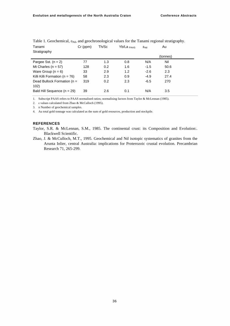
Evolution and metallogenesis of the North Australia Craton Conference Abstracts
36
Table 1. Geochemical, εNd, and geochronological values for the Tanami regional stratigraphy. Tanami Stratigraphy
Cr (ppm) Th/Sc Yb/La PAAS εNd Au (tonnes)
Pargee Sst. (n = 2) 77 1.3 0.8 N/A Nil Mt Charles (n = 57) 128 0.2 1.6 -1.5 50.6 Ware Group (n = 6) 33 2.9 1.2 -2.6 2.3 Killi Killi Formation (n = 76) 58 2.3 0.9 -4.9 27.4 Dead Bullock Formation (n = 102)
319 0.2 2.3 -6.5 270
Bald Hill Sequence (n = 29) 39 2.6 0.1 N/A 3.5
1. Subscript PAAS refers to PAAS normalised ratios; normalising factors from Taylor & McLennan (1985). 2. ε values calculated from Zhao & McCulloch (1995). 3. n Number of geochemical samples. 4. Au total gold tonnage was calculated as the sum of gold resources, production and stockpile.
REFERENCES Taylor, S.R. & McLennan, S.M., 1985. The continental crust: its Composition and Evolution:.
Blackwell Scientific. Zhao, J. & McCulloch, M.T., 1995. Geochemical and Nd isotopic systematics of granites from the
Arunta Inlier, central Australia: implications for Proterozoic crustal evolution. Precambrian Research 71, 265-299.
Evolution and metallogenesis of the North Australia Craton Conference Abstracts
37
3D geology of the Tanami Region and overview of the seismic survey Leon Vandenberg1, Tony Meixner2
1 Northern Territory Geological Survey
2 Geoscience Australia
THE TANAMI 3D GEOLOGICAL MODEL The area covered by the Tanami 3D geological model (Meixner et al., 2004; Vandenberg & Meixner, 2004) straddles the Northern Territory – Western Australia border and includes the Tanami Region and the north-western portion of the Arunta Region. The model is an integration of recent outcrop and basement mapping, rock property data, and gravity and magnetic data to show 3D relationships between the main geological features of the upper crust. The Tanami 3D geological model is viewable at http://www.ga.gov.au/map/web3d/tanami/index.jsp.
Seventeen geological sections, tested by forward modelling of potential-field data using ModelVision, were used to constrain the model. Over 250 rock property measurements (density and magnetic susceptibility) taken from field samples of the Palaeoproterozoic stratigraphy also constrained the modelling. The sections were sited, where possible, to cross geophysical anomalies at right angles, thereby simulating a 2D potential-field modelling environment. The sections were also sited to cross areas with exposed geology to provide the further geological and geometrical constraints for the modelling. Some major geological features were crossed more than once, to enable comparison and testing on multiple sections.
Interpolated 3D fault surfaces were constructed in GoCad using the 2D modelled sections and basement interpretation maps. The 2D sections, 3D fault surfaces, maps, images and other data sets were output to Virtual Reality Modelling Language (VRML) allowing the model to be viewed and manipulated over the web. Additional 3D datasets are included in the VRML model and consist of (1) a depth to magnetic basement surface, delineating the thickness of cover, (2) multiscale analysis (‘strings’ or ‘worms’) of gravity and magnetic data, (3) 3D inversion surfaces defining regions in the 3D volume of anomalously low density, and (4) high magnetic susceptibility. The VRML also incorporates a live link to Geoscience Australia’s OZCHRON geochronology database.
Some findings and relationships derived from the modelling include:—
• That the large granitic plutons (Coomarie, Frankenia, and Browns Range granites) are approximately 8 km thick.
• The overlying Proterozoic cover sequence, in the far-northwest, reaches preserved thicknesses of approximately 5 km, and several east directed thrusts disrupt the basement and cover sequences.
• West of the Coomarie granite in the NT, stratigraphy and structures are dominated by westerly dips, however, further west (into WA) the stratigraphy has an easterly dip.
• To the east of the Coomarie granite, stratigraphy and structures have easterly dips, however, a large west dipping structure has also been interpreted.
• The main regional folds are approximately 10 km – 25 km in wavelength. • Granite-cored doubly-plunging antiformal structures were modelled to exist in the south-
west of the Tanami region. • Palaeoproterozoic Tanami Group stratigraphy is probably underlain by Archaean basement
Evolution and metallogenesis of the North Australia Craton Conference Abstracts
38
• The Willowra Gravity Ridge coincides with north dipping Archaean basement and Proterozoic stratigraphy that has been subjected to higher grade metamorphic conditions than (possible) stratigraphic equivalents to the north, suggesting uplift of deeper crustal levels.
• South of the Willowra Gravity Ridge the region is dominated by southerly dipping faults.
Modelling limitations include the extrapolation of sparse geological data off section to construct the original geological sections, resulting in a probable under-representation of shallowly dipping features, and lack of distinct contrast in geophysical properties across fault structures or contacts that resulted in indefinite results. To manage these limitations, the extrapolation of relationships constrained from adjacent sections was employed to maintain internal modelling consistency. In this context, many interpreted faults in the south and south-west of the project area have dominantly south-westerly dips, though few geological constrains were available.
Three generations of the Tanami 3D model have been constructed since inception in 2003. The next generation of the Tanami 3D model is expected to be available early in 2007 and will incorporate the results of the Tanami 2005 seismic survey.
THE TANAMI SEISMIC SURVEY The Tanami Seismic Reflection Survey is a collaborative research project involving Geoscience Australia (GA), the Northern Territory Geological Survey (NTGS), the Geological Survey of Western Australia (GSWA), Newmont Exploration Pty Ltd, and Tanami Gold NL (Vandenberg et al., 2006). The main objectives of the seismic reflection survey were to investigate the crustal architecture of the region, identify the geological features and settings that may have influenced gold mineralisation, and assist mineral explorers now facing the challenges of discovering deposits undercover.
Much of the planning for the positioning of the four regional seismic traverses (05GA-T1 through to 05GA-T4) was facilitated by the modelling of parallel section lines in the Tanami 3D geological model. Traverse 05GA-T1 is a northwest-southeast regional transect and Traverses 05GA-T2, 05GA-T3 and 05GA-T4 provide orthogonal three-dimensional control on regional geological features. Through targeting these features, the survey aimed to: image the geometry of the main faults; determine a deformation sequence for these faults; identify through-going crustal structures; determine the thickness of stratigraphic packages and granite body geometries; determine the relationships of the various stratigraphic packages to controlling structures; identify Archaean basement and its relationship to the overlying Tanami Group, and; investigate the character of the Tanami-Arunta boundary. A fundamental design aspect of the survey was that the seismic traverses passed close to or over the Tanami, Groundrush, Callie, The Granites, and Coyote mine sites and the Bald Hill deposit, thereby providing crustal-scale information on the geological settings of these mineral-rich areas.
The Tanami Seismic Collaborative Research Project, with its 354 km long ‘backbone’ traverse (05GA-T1), and the three cross-lines (05GA-T2, 05GA-T3, and 05GA-T4) will provide a better understanding of the three-dimensional structure of the Tanami Region. Encouraged by the high quality seismic data that have been acquired, negotiations have commenced for acquisition of Magneto-Telluric data (MT) along sections of the seismic traverse lines.
ACKNOWLEDGEMENTS The Tanami 3D model has evolved through the efforts of a number of geoscientists, including: Andrew Crispe for geological input; Richard Larson and Malcolm Nicoll for GoCad modelling, and;
Evolution and metallogenesis of the North Australia Craton Conference Abstracts
39
Russell Hay, David Beard, Dustin Edge, Fiona Watford and Malcom Nicoll for producing the VRML model. The efforts involved in the acquisition of the seismic data by the staff at ANSIR are also gratefully acknowledged. We also thank GA, the GSWA, the NTGS, Newmont Exploration Pty Ltd and Tanami Gold NL for assistance during the field operations and input during the planning, acquisition and interpretation phases of the project. GA provided staff to process the seismic data.
REFERENCES Meixner A. J., Vandenberg L. C. & Nicoll M. G. 2004. 3-D modelling of the Tanami Gold Region.
Bulletin of the society of economic geologists – Perth conference 2004, extended abstracts, 304-308.
Vandenberg L. C., Goleby B. R., Jones L. E. A., Bagas L., Huston D. L., Crispe A. J., Lyons P., Johnson W., Smith T. & Barton T. J. 2006. The Tanami Deep Reflection Seismic Experiment: 2006 preliminary results. In: Munson, T.J. & Scrimgeour, I.S. (Eds.), Annual Geoscience Exploration Seminar (AGES) 2006. Record of abstracts. Northern Territory Geological Survey Record 2006-002, 22-26.
Vandenberg L. C., Meixner A. J. & Nicoll M. G. 2004. The Tanami 3-D geological model – integrating geology and potential field data. ASEG 17th Geophysical Conference and exhibition, Sydney 2004, Extended abstract.
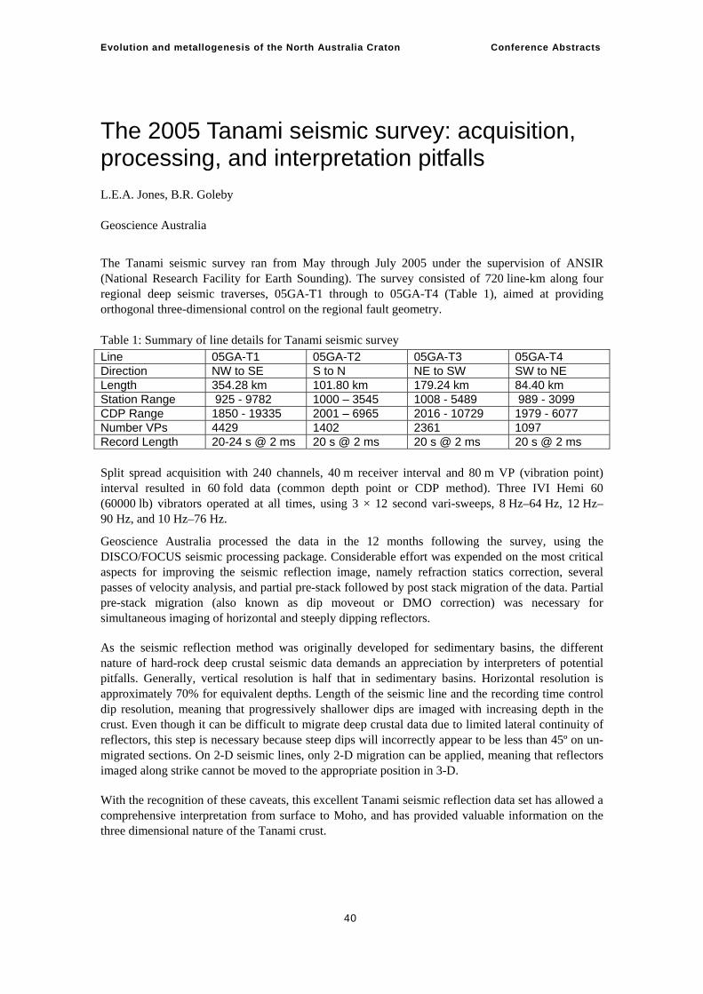
Evolution and metallogenesis of the North Australia Craton Conference Abstracts
40
The 2005 Tanami seismic survey: acquisition, processing, and interpretation pitfalls L.E.A. Jones, B.R. Goleby Geoscience Australia
The Tanami seismic survey ran from May through July 2005 under the supervision of ANSIR (National Research Facility for Earth Sounding). The survey consisted of 720 line-km along four regional deep seismic traverses, 05GA-T1 through to 05GA-T4 (Table 1), aimed at providing orthogonal three-dimensional control on the regional fault geometry. Table 1: Summary of line details for Tanami seismic survey Line 05GA-T1 05GA-T2 05GA-T3 05GA-T4 Direction NW to SE S to N NE to SW SW to NE Length 354.28 km 101.80 km 179.24 km 84.40 km Station Range 925 - 9782 1000 – 3545 1008 - 5489 989 - 3099 CDP Range 1850 - 19335 2001 – 6965 2016 - 10729 1979 - 6077 Number VPs 4429 1402 2361 1097 Record Length 20-24 s @ 2 ms 20 s @ 2 ms 20 s @ 2 ms 20 s @ 2 ms Split spread acquisition with 240 channels, 40 m receiver interval and 80 m VP (vibration point) interval resulted in 60 fold data (common depth point or CDP method). Three IVI Hemi 60 (60000 lb) vibrators operated at all times, using 3 × 12 second vari-sweeps, 8 Hz–64 Hz, 12 Hz–90 Hz, and 10 Hz–76 Hz.
Geoscience Australia processed the data in the 12 months following the survey, using the DISCO/FOCUS seismic processing package. Considerable effort was expended on the most critical aspects for improving the seismic reflection image, namely refraction statics correction, several passes of velocity analysis, and partial pre-stack followed by post stack migration of the data. Partial pre-stack migration (also known as dip moveout or DMO correction) was necessary for simultaneous imaging of horizontal and steeply dipping reflectors.
As the seismic reflection method was originally developed for sedimentary basins, the different nature of hard-rock deep crustal seismic data demands an appreciation by interpreters of potential pitfalls. Generally, vertical resolution is half that in sedimentary basins. Horizontal resolution is approximately 70% for equivalent depths. Length of the seismic line and the recording time control dip resolution, meaning that progressively shallower dips are imaged with increasing depth in the crust. Even though it can be difficult to migrate deep crustal data due to limited lateral continuity of reflectors, this step is necessary because steep dips will incorrectly appear to be less than 45º on un-migrated sections. On 2-D seismic lines, only 2-D migration can be applied, meaning that reflectors imaged along strike cannot be moved to the appropriate position in 3-D.
With the recognition of these caveats, this excellent Tanami seismic reflection data set has allowed a comprehensive interpretation from surface to Moho, and has provided valuable information on the three dimensional nature of the Tanami crust.
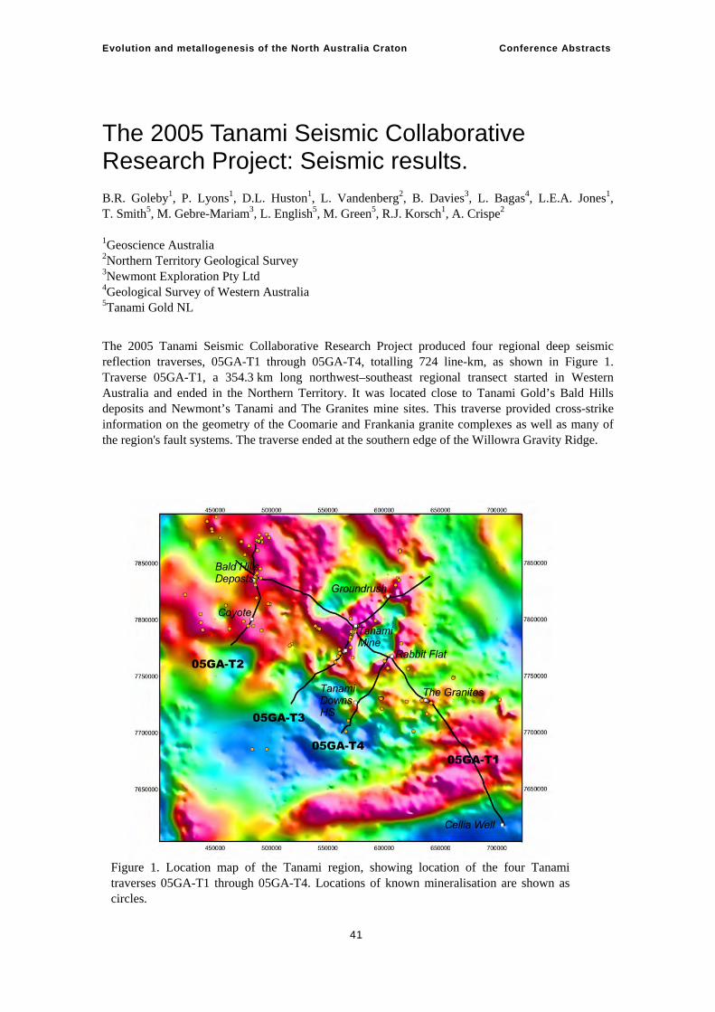
Evolution and metallogenesis of the North Australia Craton Conference Abstracts
41
The 2005 Tanami Seismic Collaborative Research Project: Seismic results. B.R. Goleby1, P. Lyons1, D.L. Huston1, L. Vandenberg2, B. Davies3, L. Bagas4, L.E.A. Jones1, T. Smith5, M. Gebre-Mariam3, L. English5, M. Green5, R.J. Korsch1, A. Crispe2 1Geoscience Australia 2Northern Territory Geological Survey 3Newmont Exploration Pty Ltd 4Geological Survey of Western Australia 5Tanami Gold NL
The 2005 Tanami Seismic Collaborative Research Project produced four regional deep seismic reflection traverses, 05GA-T1 through 05GA-T4, totalling 724 line-km, as shown in Figure 1. Traverse 05GA-T1, a 354.3 km long northwest–southeast regional transect started in Western Australia and ended in the Northern Territory. It was located close to Tanami Gold’s Bald Hills deposits and Newmont’s Tanami and The Granites mine sites. This traverse provided cross-strike information on the geometry of the Coomarie and Frankania granite complexes as well as many of the region's fault systems. The traverse ended at the southern edge of the Willowra Gravity Ridge.
Figure 1. Location map of the Tanami region, showing location of the four Tanami traverses 05GA-T1 through 05GA-T4. Locations of known mineralisation are shown as circles.
Evolution and metallogenesis of the North Australia Craton Conference Abstracts
42
The cross-traverses, 05GA-T2 (101.8 km long), 05GA-T3 (179.2 km long) and 05GA-T4 (84.4 km long) provide orthogonal three-dimensional control on the geometry of the region's main fault systems.
The Project objectives are to:—
• Image the geometry of the main faults; • Determine a deformation sequence for these faults; • Identify any through-going crustal structures; • Determine stratigraphic thicknesses of the Tanami Group and granite body geometries; • Determine relationships of the various stratigraphic packages to controlling structures; • Investigate the relationship of mineralised domains to crustal scale structures; • Identify Archaean basement and its relationship to the overlying Tanami Group stratigraphy; • Investigate the character of the Tanami-Arunta boundary.
INTERPRETATION OF SEISMIC TRAVERSES For all traverses, the seismic data have been interpreted in conjunction with regional geophysical data (gravity and magnetics), previous integrated geological and geophysical interpretations (e.g., Slater, 2000 a,b; Vandenberg et al., 2004) and integrated geological-geophysical modelling (Vandenberg and Meixner, 2003, 2004).
TRAVERSE 05GA-T1 DESCRIPTION Traverse 05GA-T1 is a 354.3 km long northwest–southeast regional transect ideally positioned to resolve most of the Project objectives. The seismic data has imaged the geometry of the main faults in the region and variations in thickness of the Tanami Group (including Mt Charles, Killi Killi, and Dead Bullock Formations). Both the Killi Killi and Dead Bullock Formations have distinguishing seismic reflection characteristics and these have been used to define an inferred base to each of these units. The Tanami Group is thickest in the north-west part of the traverse, south-east of the Bald Hills deposits and towards the Mt Fredricks region, where it is interpreted to reach a maximum thickness of 10 km (3.5 s TWT). In this area, a thick succession of inferred Bald Hills rocks, at or near the base of the Tanami Group, has been imaged.
From this area there is a gradual, though variable, thinning of the Tanami Group southwards to a point south of ‘The Granites’ area, where the Tanami Group then thins rapidly to a depth of 3 km (1 s TWT). Further south, the structural style changes from antiformal stacking dominated to being more ‘thin-skinned’ thrust dominated. At this point is becomes difficult to distinguish the Killi Killi Formation and the Dead Bullock Formations, thus, only the base of the Tanami Group has been delineated. This change also corresponds to the change from mapped outcrop of Killi Killi Formation to mapped outcrop of Lander Rock Formation.
The traverse crosses numerous granites, including the Coomarie and Frankania granite complexes. The seismic indicates there granites are thin, reaching a maximum thickness of just over 1 km. Although investigated, it was extremely difficult to identify additional buried granite bodies of a similar size and seismic character to that imaged. The seismic image indicates that the Coomarie and Frankania regions are not domes, rather they are underlain by inward-dipping reflections. This suggests that the granites are flanked by antiformal thrust stacks.
The seismic image shows a subtle but significant change in structural character at a depth that corresponds to the approximate base to the Tanami Group, though does not always correlate with this surface. This change is inferred to represent a décollement that corresponds in places to the unconformity between the Tanami Group and its Proterozoic-Archaean basement, and in other places to a surface that cuts through this basement.
Evolution and metallogenesis of the North Australia Craton Conference Abstracts
43
The mid and lower crust beneath the basement has an overall south-east apparent dip to the majority of the reflections. These reflections are interpreted as both structural and stratigraphi. The seismic data suggest a series of deep penetrating shear zones with apparent dips to the south-east. They appear to project to places where the Moho has enhanced topography, suggesting that whole-of-crust processes implicated in their formation.
Traverse 1 shows considerable variation in depth beneath the Tanami basement where it is around 40 km (12 s – 13 s TWT) depth. As the seismic traverse approaches the Willowra Gravity Ridge, the Moho rapidly deepens to some 60 km (20 s TWT). The south-eastern most part of the traverse is characterised by an apparent northwest-dipping package of high amplitude reflections. This region is inferred to represent Arunta basement as it is seismically similar to the 1985 central Australian deep seismic data (Goleby et al., 1989). The seismic character of the region between the Tanami basement proper and the Arunta basement proper suggests a region of collision between each.
TRAVERSE 05GA-T2 DESCRIPTION Traverse 05GA-T2 is a 101.8 km long, north-northeast-south-southwest directed transect across the Tanami region, Western Australia. Traverse T2 runs pas the Bald Hills and Coyote gold deposits. It also crosses the Mongrel and Trans-Tanami shear zone.
The Tanami Group’s, Dead Bullock Formation varies in depth from a maximum of 10 km (3.5 s TWT) to a minimum of 6 km (2 s TWT). The Killi Killi Formation is again recognized by its seismic character. In the south it is evident as a thin, variable unit above the Dead Bullock formation. In the north, it is inferred to be absent.
As imaged in Traverse T1, the granites are thin and there is little evidence for large granite bodies at depth. There is also evidence of a structural change around the level of the inferred base to the Tanami Group, also inferred to be a regional décollement surface.
The seismic data do not image any significant structures in the vicinity of either the Mongrel or Trans-Tanami Shear Zones. This suggests that these structures are not large-scale but can only extend to depths in the order of 1 km depth. We infer that these structures are short, en-echelon faults that form an apparently long structure, whereas they are late and were formed through large stress-adjustment of cold crust.
The Tanami Group, along Traverse 2, shows a variable structural complexity. In some regions, the seismic data indicate deformation is simple; in other regions, deformation is complex. In the latter, thrust deformation dominates, with antiformal thrust stacks and hanging-wall anticlines. There is a suggestion that the south and central parts of the section have been thrust over the northern part, resulting in some 4 km of relative uplift
Reflections within the mid and lower crust imply the predominance of a series of gently to moderately south-dipping structures, with at least one deep penetrating shear zone that also appears to intersect the Moho at a place where the Moho has enhanced topography.
The Moho is clearly imaged. It shows considerable variation in depth, ranging from 12 s in the central and northern parts to just over 11 s in the south.
TRAVERSE 05GA-T3 DESCRIPTION Traverse 05GA-T3 is a 175 km-long northeast-southwest directed traverse across the Tanami region, Northern Territory. This traverse was designed to image many of the regions dominant northwest–north-trending structures and many related to known gold mineralisation. Traverse T3 crosses structures interpreted to control gold mineralisation at the Groundrush gold mine, the Tanami mine area (including Jim’s pit) and structures related to the (historical) Wild Turkey prospect.
Evolution and metallogenesis of the North Australia Craton Conference Abstracts
44
The base of the crust has been imaged and is located at approximately 12.5 s to 13 s (approximately 36 km – 40 km depth).
Numerous fault systems have been imaged, most of which have a moderate to shallow easterly dip component (in section). Several of these fault systems disrupt shallow overlying Proterozoic cover sequence in the east (Birrindudu Group) and Palaeozoic cover sequences in the east and west (e.g. Pedestal Beds, Antrim Plateau Volcanics; see Jones and Goleby, this volume) and display reverse sense movement. Locally, these thrust faults appear to link or sole down to larger, regional scale fault systems that also appear to affect reverse sense movement through the underlying Palaeoproterozoic stratigraphy (Tanami Group). In the west a large thrust related ‘ramp antiform’ has been interpreted. Alternatively, a pre-existing antiform has been disrupted by later faulting. In either case, when viewed in conjunction with existing basement interpretation of this area of previously established gold anomalism, the possibility of mineralisation along strike of this structure remains open.
To the east several large easterly dipping fault systems have affected reverse sense displacement of Palaeoproterozoic Tanami Group over younger Palaeoproterozoic Mount Charles Formation (MCF). In the central portion of the section the MCF, the main Tanami mine sequence, dips moderately northwest and is imaged as near horizontal stratigraphy (due to the orientation of the transect). Curiously, a large reflective domain is imaged at 4-5 s (beneath the MCF), and is the same body imaged on Traverse T1. West of the main Tanami mine area the MCF dips westerly, however we are unable at this time to distinguish features that might be related to the Jim’s Pit and Wild Turkey deposit areas due to data quality and processing issues.
Farther west, complex fault relationships at the position of the Tanami Fault are yet to be resolved. Future comparison to Traverses T4 and T1 should help to resolve this problem. Nevertheless, immediately west of the Tanami Fault (an area previously identified during modelling as a doubly-plunging granite cored antiform and an area of complex remnant magnetism; Vandenberg and Meixner 2003, 2004), there are complex relationships between easterly and westerly dipping faults that disrupt thin granitic material and Tanami Group stratigraphy. These upper-level faults appear to splay off a major easterly dipping thrust. Combined with previous mapping and basement interpretation, the mineral potential of this structure may not previously have been fully realised.
Westerly dipping structures have been imaged at depth in the far west of the section traverse at 4-5 s depth, and to the east of the MCF- Tanami mine sequence. The significance of these structures has not yet been fully resolved. However, a large westerly dipping fault array has also been identified on the eastern margin of the Talbot Wells Granite, and is coincident with mineralisation at the Groundrush deposit.
Initial impressions are that the Groundrush deposit sits at the apex of a series of west-dipping stacked ramp-antiform structures. When viewed in conjunction with previous basement interpretation (Slater 2000a), it is suggested that this ramp-antiform corridor may have a strike length of at least 10 km. Notably the seismic data shows that the western margin of the Talbot Well Granite is dominated by easterly dipping thrust structures (example: Mount Charles Fault) that are similarly associated with a series of stacked antiform structures. This area is one where gold anomalism has previously been recognised. The seismic data also indicates that the fault systems may link at depth with the Groundrush array beneath the thin, irregularly shaped granite body. Previous basement interpretation suggests that these fault systems may merge along strike to the northeast. Given these relationships, the Mount Charles-Groundrush thrust systems are probably linked at depth and may have accommodated a significant amount of east-west directed shortening around the Talbot Wells Granite, effectively acting as pop-up structures and focussing mineralisation into favourable structural settings.
Evolution and metallogenesis of the North Australia Craton Conference Abstracts
45
TRAVERSE 05GA-T4 DESCRIPTION Traverse 05GA-T4 is 84.4 km long and is orientated in a northwest-southeast direction. It intersects Traverse T1 near Rabbit Flat. The reflection Moho is imaged at approximately 40 km depth (~ 13 s TWT); the top of crystalline basement at ~ 2.5–3.5 s TWT. Traverse T4 corsses several areas of younger cover, which reach 1.5 km thick. This younger cover includes the Antrim Plateau Volcanics, the Pedestal Beds and some buried older channel fill (see Jones and Goleby, this volume) The crystalline basement is overlain by the Tanami Group but the data do not permit distinction between the Killi Killi Formation and the Dead Bullock Formation, as it does on Traverse T1. This may be due to structural complexity or facies changes. Within the Tanami Group there are numerous thrusts with apparent dips, to both north and south, of 30°–50°.
The principal fault associated with the Callie deposit, a northwest-trending fault, is a member of a set of north-dipping thrusts reaching depths of ~ 8 km. They are structurally complex, which affords a high density of fluid conduits over a zone-width of 4 km–5 km. Typical of the Tanami region, the imaged plutons are not thick, here usually 500 m–600 m. The granite at the southern end of the Traverse T4 is sheared and faulted.
As noted above, prominent trans-regional faults such as the Tanami and Mongrel Faults have little or no expression in the seismic data, and are vertical strike-slip faults extending only a kilometre or two into the crust. The basement-unconformity is characterised by an abrupt increase in amplitude and wavelength of reflections. It appears to be deformed by ramp-flat thrusts producing duplexes. Much of this unconformity may also be a detachment surface. Steeper thrusts are identified in the top 3 s TWT of the basement and, at the northern end of the profile; they may cut the unconformity and propagate into the Tanami Group. This implies that the mineralising fluids may have circulated through the top 6 s TWT of the crust. Below about 6 s TWT, the crust is dominated by flat- to shallow-dipping reflectors.
ACKNOWLEDGEMENTS ANSIR is thanked for collection of the seismic data. The Seismic Acquisition and Processing Group, Geoscience Australia is thanked for processing the seismic data. The Geological Survey of Western Australia, the Northern territory Geological Survey, Tanami Gold NL and Newmont Exploration Pty Ltd. staff are thanked for their contributions to the acquisition and their valuable contributions and involvement in the interpretation of the seismic data.
REFERENCES Goleby, B.R., Blewett, R.S., Groenewald, P.B., Cassidy, K.F., Champion, D.C., Korsch, R.J.,
Whitaker, A., Jones, L.E.A., Bell, B., & Carlson, G., 2003. Seismic interpretation of the northeastern Yilgarn Craton seismic data. In: B.R. Goleby, R.S. Blewett, P.B. Groenewald, K.F. Cassidy, D.C. Champion, L.E.A. Jones, R.J. Korsch, S. Shevchenko and S.N. Apak. (editors), The 2001 Northeastern Yilgarn Deep Seismic Reflection Survey. Geoscience Australia, Record 2003/28. 143pp.
Goleby, B.R., Shaw, R.D., Wright, C., Kennett, B.L.N. & Lambeck, K., 1989: Geophysical evidence for 'thick-skinned' crustal deformation in central Australia, Nature 337, 325-330.
Goleby, B.R., MacCready, T., Drummond, B.J. & Goncharov, A., 1997. The Mount Isa Geodynamic Transect - Crustal Implications. In Jean Braun, Jim Dooley, Bruce Goleby, Rob van der Hilst (Eds), Structure and evolution of the Australian continent. AGU Geodynamics Series 26, 109-118.
Jones, L.E.A. & Goleby, B.R., 2006. The 2005 Tanami seismic survey: acquisition, processing and interpretation pitfalls. In: Lyons, P. & Huston, D.L. (Eds.), Evolution and metallogenesis of the North Australian Craton, Conference Abstracts. Geoscience Australia Record 2006/16, 40.
Evolution and metallogenesis of the North Australia Craton Conference Abstracts
46
Slater K.R., 2000a. TANAMI SE 52-15 1:250 000 Integrated interpretation of geophysics and geology. Northern Territory Geological Survey, Darwin, Australia.
Slater K.R., 2000b. THE GRANITES SF 52-3 1:250 000 Integrated interpretation of geophysics and geology. Northern Territory Geological Survey, Darwin, Australia.
Vandenberg L.C., Johnstone A., Donnellan N., Green M.G., & Crispe A.J., 2004. Northern Arunta Region Geophysical Interpretation, Northern Territory (First Edition) 1:500 000-scale map. Northern Territory Geological Survey, Alice Springs.
Vandenberg L.C., & Meixner T., 2003. The Tanami in 3D. Annual Geoscience Exploration Seminar (AGES) Record of Abstracts. Northern Territory Geological Survey, Record 2003-001.
Vandenberg L.C., Meixner T., 2004. The Tanami 3D model – 2004 update. Annual Geoscience Exploration Seminar (AGES) Record of Abstracts. Northern Territory Geological Survey, Record 2004-001.
Evolution and metallogenesis of the North Australia Craton Conference Abstracts
47
Deep seismic reflection profiling in the Arunta, Musgrave and McArthur regions: Implications for Central and North Australian tectonics R.J. Korsch, B.R. Goleby Geoscience Australia
Deep seismic reflection profiling has been used for many years to provide images of the continental crust in the third dimension (depth) across parts of Australia. Prior to the 2005 Tanami deep seismic survey, a limited amount of deep seismic reflection profiling was conducted in central and northern Australia. A major survey in 1985 examined the geometry of the Amadeus Basin and Arunta Block (Goleby et al., 1988). Subsequent surveys examined the Officer Basin and southern Musgrave Province in 1993 (Korsch et al., 1998) and the southern McArthur Basin in 2002 (Rawlings et al., 2004). Here, we review aspects of these surveys and briefly examine the implications for the tectonics of the region.
In central Australia, the seismic traverses crossed parts of the Arunta Region, Amadeus Basin, Musgrave Province, and Officer Basin, and were oriented north-south, at high angles to the regional strike of the principal mapped geological structures. The crust is dominated by major north-dipping planar structures, interpreted as thick-skinned thrusts. Based on the crustal reflectivity patterns in the Arunta Region, we are able to partition the crust into several fault-bounded packages. Many of these thrusts cut deep into the crust, and at least one, the Redbank Thrust in the Arunta Region, appears to cut and offset the crust-mantle boundary. The Redbank Thrust is the boundary between the North Australia Craton (Aileron Province) and the Warumpi Province. These two provinces collided during ocean closure as a result of south-dipping subduction (Scrimgeour, 2006). Thus, the Redbank Thrust could represent the southward obduction of the Aileron Province onto the Warumpi Province.
In the southern Musgrave Province, the crust is also dominated by major north-dipping structures, interpreted as thick-skinned thrust faults. In contrast, in the northern Musgrave Province, limited field mapping and teleseismic data suggest that the major crustal structures are south-dipping and, in the central to southern Amadeus Basin, deformation is essentially thin-skinned, with north-directed thrusting confined to the sedimentary succession. The thick-skinned thrusts formed in the Mesoproterozoic, but both thick-skinned and thin-skinned thrusts were active during the Alice Springs Orogeny. Thus, the present day crustal architecture in central Australia is the response of the crust to Proterozoic terrane amalgamation and to reactivation by interplate and intraplate deformational events.
In the southern McArthur Basin, the Emu Fault Zone is interpreted to be a near-vertical strike-slip fault system. The seismic data suggest the likelihood of stratigraphic thickening adjacent to the Emu Fault during deposition of the McArthur Group and formation of the giant McArthur River deposit, probably in a small pull-apart basin, forming in a negative flower structure within the braided fault system. This interpretation is supported by the rectilinear nature of the fault system, in plan, and the rapid changes in geometry along strike.
Most of the east-west seismic profile across the southern McArthur Basin is dominated by a series of west-dipping low-angle faults. We interpret these faults to form part of a major thrust belt that has propagated eastward, forming a forward-breaking sequence of thrusts. Within the section,
Evolution and metallogenesis of the North Australia Craton Conference Abstracts
48
displacement on the thrusts tends to be greatest in the west and diminishes to the east, with the frontal thrust of the system occurring ~6 km west of the Emu Fault Zone, having only minor displacement. In the west, the Roper Group (ca 1500 Ma – 1430 Ma) forms the western limb of the Bauhinia Monocline, which developed above the western-most thrust ramp shown in the seismic data, indicating a post-Roper Group timing for the thrust system. Deformation and fault geometries are consistent with tectonic transport towards the east. The thrusts continue at depth beyond the western limit of the seismic section, and this part of the thrust belt is now hidden beneath younger cover. If this is a typical thrust belt, there could be considerable basement involvement in the western part of the system, well to the west of the seismic traverses. This has implications for the evolution of the North Australian Craton, with the development of a major thrust belt at some time after 1430 Ma, occurring in what is generally considered to be a period of tectonic inactivity in an intraplate setting. Thus the deep seismic reflection data collected from central and northern Australia provide constraints for interpreting the geodynamic evolution of the region.
ACKNOWLEDGEMENTS We thank Natalie Kositcin, Patrick Lyons and Leonie Jones for their comments on this abstract. REFERENCES Goleby, B.R., Wright, C., Collins, C.D.N. and Kennett, B.L.N., 1988. Seismic reflection and
refraction profiling across the Arunta Block and Ngalia and Amadeus basins. Australian Journal of Earth Sciences 35, 275-294.
Korsch, R.J., Goleby, B.G., Leven, J.H. & Drummond, B.J., 1998. Crustal architecture of central Australia based on deep seismic reflection profiling. Tectonophysics 288, 57-69.
Rawlings, D.J., Korsch, R.J., Goleby, B.R., Gibson G.M., Johnstone, D.W. & Barlow, M., 2004. The 2002 Southern McArthur Basin Seismic Reflection Survey. Geoscience Australia, Record 2004/17, 78 pp.
Scrimgeour, I., 2006. The Arunta Region: links between tectonics and mineralisation. In: Munson, T.J. & Scrimgeour, I.S. (Eds.), Annual Geoscience Exploration Seminar (AGES) 2006. Record of abstracts. Northern Territory Geological Survey Record 2006-002, 7-10.
Evolution and metallogenesis of the North Australia Craton Conference Abstracts
49
The 2005 Tanami Seismic Collaborative Research Project: Synthesis of results P. Lyons1, B.R. Goleby1, D.L. Huston1, L. Vandenberg2, B. Davies3, L. Bagas4, L.E.A. Jones1, T. Smith5, M. Gebre-Mariam3, L. English5, M. Green5, R.J. Korsch1, A. Crispe2 1Geoscience Australia 2Northern Territory Geological Survey 3Newmont Exploration Pty Ltd 4Geological Survey of Western Australia 5Tanami Gold NL
The 2005 Tanami Seismic Collaborative Research Project was developed to provide a better understanding of the crustal architecture and mineral systems of the Tanami region within Western Australian and the Northern Territory. This was achieved through the acquisition of four regional-scale deep crustal seismic reflection profiles.
The Tanami Seismic Collaborative Research Project involved Geoscience Australia, the Northern Territory Geological Survey, the Geological Survey Western Australian, Newmont Exploration Pty Ltd and Tanami Gold NL.
SURVEY SUMMARY The four seismic traverses gave data of high quality and produced excellent images of the crustal architecture of the region. They show:—
• A Tanami crust that is partitioned into a less reflective upper crust and a more reflective middle to lower crust, separated by a regionally extensive change in structural complexity.
• A Tanami crust that is characterised by a series of SE dipping reflectors interpreted as thrust zones, which are often associated with antiformal stacks and an overall increase in structural complexity.
• The presence of a reflective Moho that is strongly imaged throughout the survey, with local topographic variations, the most important being a significant thickening across the Willowra Gravity ridge.
• A major SE dipping suture, that extends from the upper crust to the Moho, that possibly separates Tanami basement from Arunta basement in the lower to middle crust; this boundary at depth corresponds to the Willowra Gravity Ridge.
• The existence of a pop-up structure corresponding to the Willowra Gravity Ridge, which is characterised by higher metamorphic grade, changes in Ar-Ar geochronology and changes in fluid composition.
MINERALISATION The relationship identified in the seismic images between known mineralisation and crustal structure, namely the coincidence of deep penetrating crustal shear with near surface antiformal thrust stacking and its correlation between known mineralised areas, suggests a potential increase in the prospectively for further economic mineralisation in other areas with similar relationships.
This important correlation between known ore deposits with regions of increased structural complexity, and their associated deeper-tapping fluid pathways suggest that both operated as part of a Tanami-wide gold system. The interpretation of these seismic data is assisting mineral explorers
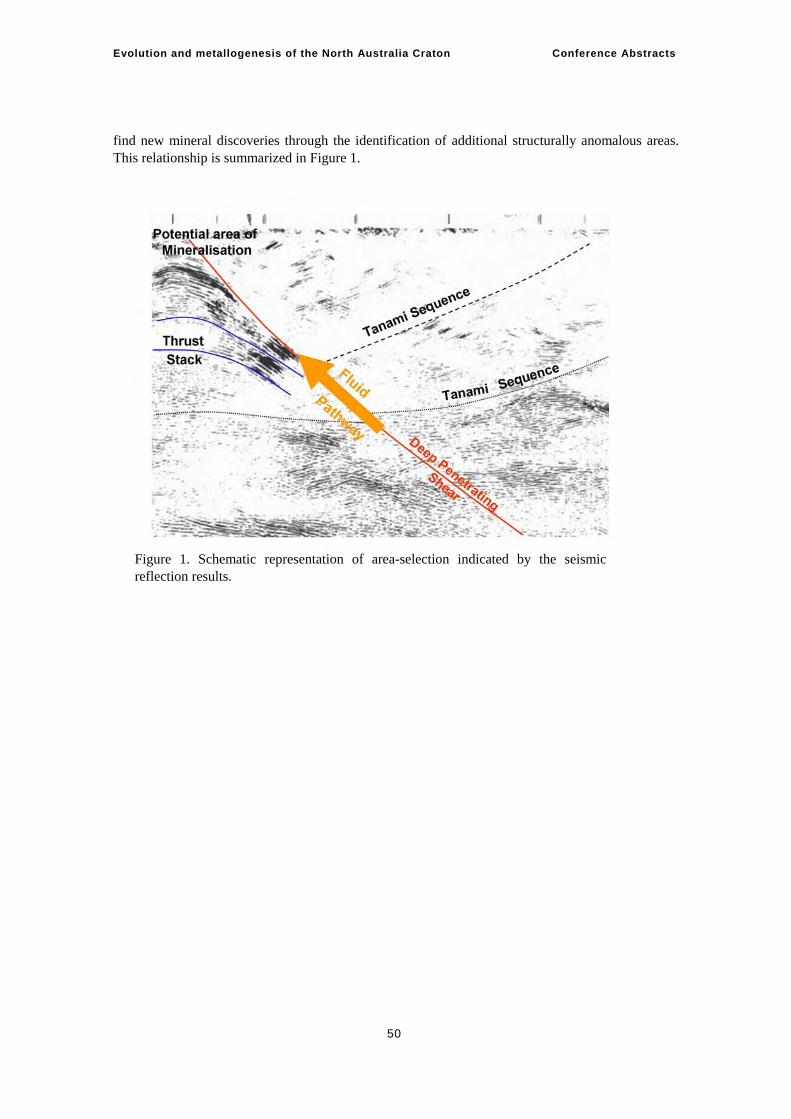
Evolution and metallogenesis of the North Australia Craton Conference Abstracts
50
find new mineral discoveries through the identification of additional structurally anomalous areas. This relationship is summarized in Figure 1.
Figure 1. Schematic representation of area-selection indicated by the seismic reflection results.
Evolution and metallogenesis of the North Australia Craton Conference Abstracts
51
Geology and mineralisation of the King Leopold and Halls Creek Orogens I. M. Tyler, S. Sheppard Geological Survey of Western Australia, Mineral House, 100 Plain Street, East Perth WA 6004
The King Leopold and Halls Creek Orogens in the Kimberley region of northern Australia are divided into three distinct terranes, each representing a different tectonic setting, that may be part of a larger, diverse collisional orogen on a scale similar to the present Alpine-Himalayan Orogen. Collision with the Kimberley Craton drove intracratonic deformation in the adjacent Tanami and Arunta regions of the North Australian Craton.
The Hooper Complex in the King Leopold Orogen and Western Zone of the Lamboo Complex in the Halls Creek Orogen formed between 1870 Ma and 1850 Ma as a rift marginal to the Kimberley Craton. The rift is filled with low- to high-grade turbiditic metasedimentary rocks of the Marboo Formation with a maximum depositional age of ~1872 Ma. Analysed detrital zircons are dominated by ages ranging from 2500 Ma to 1910 Ma, indicating derivation from predominantly Paleoproterozoic accreted terranes. The Marboo Formation was deformed and metamorphosed at ~1861 Ma and then intruded by granitic and mafic rocks of the 1865 Ma – 1850 Ma Paperbark Supersuite, and by layered mafic-ultramafic intrusions, including the Springvale intrusion, during the accretionary Hooper Orogeny. Felsic volcanism of the Whitewater Volcanics is cogenetic with the supersuite.
In the Central Zone of the Halls Creek Orogen an oceanic island arc developed at ~1865 Ma. Turbiditic metasedimentary rocks, and predominantly mafic volcanic and volcaniclastic rocks, form the amphibolite to granulite facies Tickalara Metamorphics. The metasedimentary rocks are dominated by a single detrital zircon population giving a maximum depositional age of ~1865 Ma. A granitic sheet, the Rose Bore Granite, intruded at ~1863 Ma, suggesting that development of the arc took place rapidly. Mafic-ultramafic intrusions, such as the Panton intrusion, contain PGE-Cr-Ni-Cu-Au mineralization and were emplaced at ~1855 Ma, with intrusion of tonalite sheets of the Dougalls Suite at ~1850 Ma. Peak metamorphism, with the formation of migmatitic rocks took place at ~1845 Ma, coincident with further mafic-ultramafic intrusions containing Ni-Cu-Co-PGE-Cr and Ti-V mineralization, including the Sally Malay intrusion. Rifting of the arc produced felsic volcanism of the Koongie Park Formation and associated Cu-Pb-Zn VHMS and porphyry Cu mineralization.
The oldest rocks in the Eastern Zone of the Halls Creek Orogen are ~1910 Ma felsic volcanic rocks of the Ding Dong Downs Volcanics, and associated granites. These are overlain by the passive continental margin fluviatile to shallow marine Saunders Creek Formation at the base of the Halls Creek Group, which had an Archean source region, ranging from ~3600 Ma to ~2512 Ma. It is overlain by ~1880 Ma passive margin basalts of the Biscay Formation, which have associated Cu-Pb-Zn and Au mineralization. Low- to medium-grade turbiditic metasedimentary rocks of the overlying Olympio Formation can be divided into upper and lower units separated by phases of alkaline volcanism at ~1857 Ma (Maude Headly Member) and ~1847 Ma (Butchers Gully Member) associated with REE and Au mineralization. The Olympio Formation represents a transition from a passive to an active margin setting, with the development of a foreland basin. A single population of
Evolution and metallogenesis of the North Australia Craton Conference Abstracts
52
detrital zircons at ~1874 Ma dominates the lower unit, while the upper unit is dominated by a ~1847 Ma population.
Further granites and gabbros of the Sally Downs Supersuite, together with layered mafic-ultramafic intrusions including the McIntosh intrusion, mainly intruded the Central Zone between 1835 Ma and 1805 Ma, representing syn- to post-collisional settings during the Halls Creek Orogeny. Deformed and metamorphosed Olympio Formation was intruded by ~1820 Ma post-collisional granite. Syn- to post collisional sedimentary basins include the ~1835 Ma Speewah Basin overlying the Kimberley Craton, and the younger Moola Bulla and Red Rock Basins overlying the Lamboo Complex. The ~1780 Ma granites of the San Sou Suite are intruded into the southern part of the Eastern zone and are associated with Sn-Ta-W mineralization. These granites are similar in age to the ~1780 Ma Hart Dolerite, part of a large igneous province that intruded the ~1800 Ma Kimberley Basin, overlying the Kimberley Craton.
The subsequent history of the Kimberley region is dominated by the formation and reactivation of the strike-slip Halls Creek Fault system with associated sedimentary basin formation. The oldest basins (Crowhurst, Osmond, Bastion, and Birrindudu Basins) may be in part equivalent to the 1730 Ma – 1575 Ma Calvert and Isa Superbasins. Depositon in the ca 1200 Ma Carr Boyd Basin, Glidden Basin, and lower part of the Victoria River Basin was contemporaneous with the diamondiferous Argyle lamproite pipe. Thrusting and orthogonal strike-slip faulting took place during the ~1000 Ma Yampi Orogeny and the ~560 Ma King Leopold Orogeny, bracketting the development of the Centralian Superbasin. Basin development and fault reactivation continued into the Palaeozoic culminating in the 400 Ma – 300 Ma Alice Springs Orogeny. Hydrothermal Au mineralization is associated with major fault and fracture systems that may be as young as Mesozoic.
Evolution and metallogenesis of the North Australia Craton Conference Abstracts
53
Geology and geochronology of the Palaeoproterozoic Pine Creek Orogen K.E.Worden Geoscience Australia
The Pine Creek Orogen forms the northern margin of the North Australian Craton (Plumb, 1979). Broadly, it comprises sequences of carbonaceous, clastic, and volcanogenic sediments deposited upon rifted Archaean crystalline basement, which were subsequently deformed, metamorphosed, and intruded by syn- to post-orogenic granitoids and mafic bodies. The Pine Creek Orogen can be divided into three distinct domains, reflecting different deformational, metamorphic, and stratigraphic attributes (Worden et al., in review). These are, from west to east, the Litchfield Domain, the Central Domain, and the Nimbuwah Domain.
ARCHAEAN BASEMENT: .ca 2675 Ma – 2470 Ma Archaean basement is present in the Central and Nimbuwah Domains. In the Rum Jungle region (Central Domain), basement is represented by two exposed granite-gneiss complexes with crystallisation ages of ca 2545 Ma – 2520 Ma (Cross et al., 2005) and which are intercalated with the Stanley Metamorphics (Lally, 2002). Also in the Central Domain, drillcore has intersected the Woolner Granite (2675 ± 15 Ma: McAndrew et al., 1985) and overlying Archaean Dirty Water Metamorphics (Pietsch & Stuart-Smith, 1987). The ca 2470 Ma Nanambu Complex is considered Archaean-Palaeoproterozoic basement in the Nimbuwah Domain (Page et al., 1980). Archaean basement has not been identified in the Litchfield Domain.
BASIN DEVELOPMENT: ca 2025 Ma – ca 1863 Ma In response to rifting and subsidence of Archaean basement, initial Palaeoproterozoic sedimentation comprised arkosic sandstones, conglomerates, carbonates, and carbonaceous sediments of the Manton, Namoona and Kakadu Groups (Needham et al., 1988). This episode of sedimentation concluded with extrusion of the ca 2020 Ma – 2050 Ma Stag Creek Volcanics in the Central Domain. Unconformably overlying these volcanics are immature fluvial, clastic, carbonaceous and volcanogenic sediments, siltstones, volcanics, and carbonates of the Mount Partridge Group (Needham et al., 1988). Tuffaceous sediments in the upper sequences of the Mount Partridge Group provide a stratigraphic age of 2020 Ma – 2030 Ma. (Needham et al., 1988). Following a considerable sedimentary hiatus (possibly as much as ca 160 million years) carbonaceous and pyritic shales, cherts, tuffs, and volcanogenic sediments of the ca 1863 Ma South Alligator Group were deposited. A rapid transition to the extensive conformable turbiditic sediments of the Finniss River Group occurred after deposition of ca 1863 Ma basal volcanics.
In the Litchfield Domain, poor exposure and higher metamorphic grade prevent direct correlations with the Central Domain. Early stratigraphy includes graphitic siliciclastics and mafic volcanogenic sedimentary rocks of the Fog Bay Metamorphics, known only from drillcore. The Hermit Creek Metamorphics also comprise early siliciclastic sequences. Above these, the Welltree Metamorphics are considered metamorphosed equivalents to the Finniss River Group in the Central Domain (Pietsch & Edgoose, 1988), supported by the presence of correlated basal volcanics.
Lithostratographic correlations between the Nimbuwah Domain and Central Domain are also difficult to establish for stratigraphy above the Manton-Namoona-Kakadu Groups. The position of
Evolution and metallogenesis of the North Australia Craton Conference Abstracts
54
the Myra Falls Metamorphics is unknown, while the Nourlangie Schist is tentatively correlated with the Wildman Siltstone (Needham, 1988).
METAMORPHISM, DEFORMATION, AND INTRUSION: ca 1863 Ma – ca 1847 Ma Prior to deformation, intrusion of the extensive continental tholeiitic Zamu Dolerite Suite, which may be associated with the Wangi Basics of the Litchfield Domain, took place. Litchfield Domain sediments underwent high T-, low P-metamorphism to lower amphibolite-granulite facies, possibly in response to the intrusion of the Wangi Basics. Monazite and zircon rim development suggest peak metamorphism within higher metamorphic grade packages of the Hermit Creek and Fog Bay Metamorphics occurred ca.1855 Ma (Carson et al., 2006). Elsewhere in the Litchfield Domain, tight to isoclinal folding deformed lower grade (greenschist-amphibolite facies) sedimentary packages of the Hermit Creek Metamorphics and the Welltree Metamorphics. A ca 1812 Ma monazite age for the Welltree Metamorphics (Carson et al., 2006) reflects a second metamorphic episode; its relationship to Litchfield Domain deformation history remains unclear. In contrast, the Central Domain stratigraphy records only greenschist facies metamorphism, and experienced intense deformation dominated by west verging tight upright folding. Deformation in the Central Domain is bracketed by the ca 1863 Ma pre-orogenic volcanics and volcaniclastics within the Finniss River and South Alligator River Groups, and by a post-orogenic pegmatite at the Ranger deposit with an age of 1847 ± 1 Ma (Annesley et al., 2002). The Nimbuwah Domain experienced Barrovian-style metamorphism, locally attaining amphibolite-granulite metamorphic conditions at somewhat higher pressures than those affecting the Litchfield Domain. Deformation involved early bedding-parallel folding followed by isoclinal folding (Needham, 1988). Recent dating of Nimbuwah Complex granites from drillcore yield crystallisation ages of ca 1865 Ma, supporting the 1886 Ma – 1866 Ma ages for complex migmatites and granites by Page et al. (1980).
RENEWED BASIN DEVELOPMENT, MAGMATISM: ca 1835 Ma – 1723 Ma Following the major period of orogenesis, renewed extension prompted localised basin development in the South Alligator Valley region. Two unconformable sequences, the El Sherana Group and Edith River Groups, contain ignimbrites and dacites with ages of 1829 ± 5 Ma and 1825 ± 4 Ma, respectively (Jagodzinski, 1998; Page, 1996a). Post-orogenic granites were emplaced in the Central Domain (e.g., ca 1835 Ma – 1800 Ma Cullen Batholith: Stuart-Smith et al., 1993; ca 1831 Ma Mount Bundey Granite: Page, 1996b), Nimbuwah Domain (e.g., ca 1818 Ma Nabarlek Granite), and the Litchfield Domain (e.g., ca 1850-1840 Ma granitoids: Page et al., 1985). Central Domain Granites are predominantly I-type (Stuart-Smith et al., 1993), with S-type granites dominating the Litchfield Domain (Page et al., 1985). Granites with both affinities occur in the Nimbuwah Domain. A final episode of mafic magmatism occurred much later in the Nimbuwah Domain, after deposition of the Katherine River Group (basal sequence of the McArthur River Basin), marked by the intrusion of the Oenpelli Dolerite at ca 1723 Ma (Page, 1996c).
COVER SEQUENCES The Palaeoproterozoic packages are unconformably overlain by Palaeo-Mesoproterozoic cover: the Victoria River Basin to the west and south-west, and the McArthur River Basin to the east (Ahmad, 1998). The Tolmer Group of the Litchfield and Central Domains is thought to correlate with the Katherine River Group in the Nimbuwah Domain. The Mesozoic Bathurst Terrace and Bonaparte Basin cover the Pine Creek Orogen to the north and far southwest, respectively; the Palaeozoic Daly Basin, in turn, overlies the Mesoproterozoic Basins to the south and southeast.
Evolution and metallogenesis of the North Australia Craton Conference Abstracts
55
REFERENCES Ahmad, M., 1998, Geology and mineral deposits of the Pine Creek Inlier and McArthur Basin,
Northern Territory, AGSO Journal of Geology and Geophysics 17, 1-17. Ahmad, M., Wygralak, A.S., Ferenczi, P.A., & Bajwah, Z.U., 1993, Pine Creek SD52-8. 1:250000
Metallogenic Map Series: Explanatory notes and mineral deposit data sheets, Northern Territory Geological Survey.
Annesley, I.R., Madore, C., Kwok, Y.Y., Kamo, S., Troy, A., & Hughes, L., 2002, Petrochemistry and U-Pb monazite geochronology of granitic pegmatite from the Ranger U deposit, Australia. In: Saskatoon 2002, Geological Association of Canada and Mineralogical Association of Canada Joint Annual Meeting, May 27-29, Poster and Abstract.
Carson, C.J, Scrimgeour, I.R., Goldberg, A., Stern, R., & Worden, K.E., 2006, Western Pine Creek Orogen (Litchfield Province) – recent advances and regional correlations. In: Munson, T.J. & Scrimgeour, I.S. (Eds.), Annual Geoscience Exploration Seminar (AGES) 2006. Record of abstracts. Northern Territory Geological Survey Record 2006-002, 37-41.
Cross, A.J., Claoué-Long, J.C., Ahmad, M., Kruse, P., & Lally, J.H., 2005, Summary of results. Joint NTGS-GA geochronology project: Rum Jungle, eastern Arunta, and basement to southern Georgina Basin regions 2001-2003, Northern Territory Geological Survey Record 2004-2005.
Jagodzinski, E., 1998, Shrimp U-Pb dating of ignimbrites in the Pul Pul Rhyolite, Northern Territory: a cautionary tale, AGSO Research Newsletter 28, 23-25.
Lally, J.H., 2002, Stratigraphy, structure, and mineralisation, Rum Jungle Mineral Field, Northern Territory, Northern Territory, Geological Survey Record 2002-005.
McAndrew, J., Williams, I.S., & Compston, W., 1985, A concealed Archaean complex in the Pine Creek Geosyncline, N.T., CSIRO Division of Mineralogy and Geochemistry Research Review 1985, CSIRO, Melbourne, 56-57.
Needham, R.S., 1988, Geology of the Alligator Rivers Uranium Field, Northern Territory, BMR Bulletin 224.
Needham, R.S., Stuart-Smith, P.G., & Page, R.W., 1988, Tectonic evolution of the Pine Creek Inlier, Northern Territory, Precambrian Research 40/41, 543-564.
Page, R.W., 1996a, Sample 79125009 (Plum Tree Creek Volcanics), Unpublished data in Geoscience Australia’s OZCHRON geochronology database: www.ga.gov.au.
Page, R.W., 1996b, Sample 79125003 (Mount Bundey Granite), Unpublished data in Geoscience Australia’s OZCHRON geochronology database: www.ga.gov.au.
Page, R.W., 1996c, Sample 88126035 (Oenpelli Dolerite), Unpublished data in Geoscience Australia’s OZCHRON geochronology database: www.ga.gov.au.
Page, R.W., Bower, M.J., & Guy, D.B., 1985, An isotopic study of granites in the Litchfield Block, Northern Territory, BMR Journal of Geology and Geophysics 9, 219-223.
Page, R.W., Compston, W., & Needham, R.S.,1980, Geochronology and evolution of the late-Archaean basement and Proterozoic rocks in the Alligator Rivers uranium field, Northern Territory, Australia, In Ferguson, J., Goleby, A. (Eds.), Proceedings of International Uranium Symposium on the Pine Creek Geosyncline, International Atomic Energy Agency, Vienna, 1980, 39-68.
Pietsch, B.A., & Edgoose, C.J., 1988, The stratigraphy, metamorphism and tectonics of the Early Proterozoic Litchfield Province and western Pine Creek Geosyncline, Northern Territory, Precambrian Research 40/41, 565-588.
Pietsch, B.A., & Stuart-Smith, P.G., 1987, Darwin SD52-4. 1:250000 Geological Map Series: Explanatory notes, Northern Territory Geological Survey.
Plumb, K.A., 1979, The tectonic evolution of Australia, Earth Science Reviews 14/3, 205-249. Stuart-Smith, P.G., Needham, R.S., Page, R.W., & Wyborn, L.A.I., 1993, Geology and mineral
deposits of the Cullen mineral field, Northern Territory, AGSO Bulletin 229.

Evolution and metallogenesis of the North Australia Craton Conference Abstracts
56
Worden, K.E., Carson, C.J., Scrimgeour, I.R., Lally, J.H., & Doyle, J.H., in review, A revised Palaeoproterozoic chronostratigraphy for the Pine Creek Orogen, northern Australia: evidence from SHRIMP U-Pb zircon geochronology, Precambrian Research.
Evolution and metallogenesis of the North Australia Craton Conference Abstracts
57
Some aspects of metallogenesis in the Pine Creek Orogen, Northern Territory M. Ahmad, A.S. Wygralak Northern Territory Geological Survey
The Pine Creek Orogen (PCO) is part of the North Australian Craton and is correlated with other Palaeoproterozoic domains of northern Australia. Archaean (>2.5 Ga – 2.7 Ga) granite and metamorphics are overlain by Palaeoproterozoic strata comprising sandstone, mudstone, and minor carbonates and volcanics. Its age is constrained between 2.5 Ga and 1.86 Ga, and the succession is divided into two supergroups. The older Woodcutters Supergroup comprises <2.5 Ga to 2.02 Ga arenites, stromatolitic dolostone, and pyritic carbonaceous shale. The younger Cosmo Supergroup comprises BIF, mudstone, and tuff, succeeded by a monotonous flysch sequence. Zircons from the tuff beds provided an age of 1863 Ma, confirming a major depositional break of about 150 million years.
Regional metamorphism, deformation, and plutonic activity, associated with the 1.86 Ga – 1.845 Ga Nimbuwah Event of the craton-scale Barramundi Orogeny followed sedimentation. Metamorphic grades range from sub-greenschist facies in the central PCO to upper amphibolite facies along its western and eastern margins. A felsic magmatic event (Cullen Event) at 1.83-1.82 Ga closely followed the Nimbuwah Event and caused widespread thermal metamorphism. Coincident extensional tectonics in the South Alligator Valley produced narrow northwest-trending graben, which were infilled by sedimentary and felsic volcanic rocks.
On the basis of structure, metamorphism, and granite types, the PCO can be divided into five sub-provinces, each having a distinctive suite of mineral commodities. The Litchfield Province represents an area of isoclinally folded amphibolite- to greenschist-facies metamorphic rocks. It is characterised by the presence of predominantly S-type granites and associated swarms of Sn-Ta-bearing pegmatites. The Rum Jungle and Central regions have sub-greenschist-facies metamorphic grades and simple structures dominated by upright northwest- or north-trending folds. The Rum Jungle Region surrounds the Archaean basement inliers and exhibits polyphase upright folds, domes, and basins. It is endowed with a wide spectrum of mineral commodities including U, Zn-Pb-Ag, Cu-Pb-Ni-Co, magnesite, phosphate, and iron ore. The Central Region contains most of the Au deposits as well as some Sn, Cu, Pb-Zn, and iron ore deposits. The South Alligator River Region is also characterised by lower greenschist-facies metamorphism, but thrusting is more common and metamorphic grade increases eastward. It hosts a number of U and U-Au-PGE deposits. The East Alligator Rivers Region is characterised by amphibolite-facies metamorphism and upright to recumbent folds. It hosts the giant uranium deposits at Ranger, Jabiluka, Koongarra, and Nabarlek.
Gold deposits are usually contained within folded, faulted and regionally metamorphosed flysch successions. Nearly all are within the thermal aureole of granites of the Cullen Supersuite. Gold is present in quartz veins, or stockworks, or occurs as stratiform lenses within BIF. It is accompanied by white mica, chlorite, and K-feldspar, pyrite, and arsenopyrite, with pyrrhotite, chalcopyrite, sphalerite, and galena. The base-metal sulfides are paragenetically younger. Grades are usually less than 3 g/t Au and individual deposits range from less than 0.5 t to more than 50 t of gold. Fluid inclusion and stable isotope studies, spatial associations, and geochronological data on these deposits
Evolution and metallogenesis of the North Australia Craton Conference Abstracts
58
are consistent with an intrusion-related thermal aureole gold model, with possible mixing of a reduced CH4-CO2-bearing low- to moderate-salinity fluid and an oxidised high-salinity fluid.
The Browns deposit is within black carbonaceous shale of the Whites Formation and is the largest base-metal deposit found, to date, in the PCO. The large size and unusual composition, including 70 Mt of black pelites, with an average base metal content in excess of 4% Pb + Cu + Ni + Co +Zn, up to 8% C and up to 7.6% S, makes it distinct from other sediment-hosted stratiform deposits. The geological setting, stable isotope, textural, and mineralogical data are suggestive of a syndiagenetic origin, with possible later local remobilization.
World-class uranium deposits of the PCO are near the unconformity with the overlying platform-cover arenites of the McArthur Basin. These deposits account for about 20% of Australia’s total U resource inventory, and represent about 30% of the world’s low-cost category U resources. Most researchers favour a model in which U-bearing oxidised fluids, sourced from overlying platform-cover arenites were reduced by reaction with suitable lithologies in the PCO, so as to precipitate U. However, an alternative uranium source is possible, either from the Archaean basement or overlying first-cycle arenites.
The PCO also hosts a large number of Sn-quartz veins and Sn-Ta-bearing pegmatites, with most in the Western region. These are associated with S-type granites.
A series of low-temperature, hydrothermal, haematite-rich stratabound lenses at Frances Creek are hosted within ferruginous and carbonaceous pelites of the Wildman Siltstone. They contain a recently investigated resource of 6.84 Mt of 60.6% Fe.
Evolution and metallogenesis of the North Australia Craton Conference Abstracts
59
Geology and mineralisation in the southern McArthur region and Mt Isa Inlier P.N. Southgate1, N.L. Neumann1, P.A. Polito2
1Geoscience Australia 2Anglo American, PO Box 1067, Bentley WA 6983
The Mt Isa Inlier and southern McArthur basin are, arguably, the most extensively studied and best understood Palaeo- to Mesoproterozoic terranes in Australia, and possibly the world. These rocks host one of the world’s largest base metal repositories. The McArthur – Mt Isa – Cloncurry mineral belt contains several world class Zn-Pb-Ag, Cu, and Cu-Au deposits as well as hosting significant uranium resources.
Since 1995, Geoscience Australia, in combination with the Geological Surveys of Queensland and the Northern Territory,, has implemented a series of integrated, multidisciplinary projects in the Mt Isa and southern McArthur regions with the aim of generating a chronostratigraphic understanding of basin evolution. The integration of detrital and magmatic U-Pb zircon SHIRMP geochronology with depositional facies and sequence stratigraphic analysis has allowed the development of a chronostratigraphic framework for the Leichhardt (~1800-1745 Ma), Calvert (~1730-1690 Ma) and Isa (~1670-1575 Ma) Superbasins of the Mt Isa and southern McArthur regions. The new event chart recognises three supersequences in the Leichhardt Superbasin, two supersequences in the Calvert Superbasin, and seven supersequences in the Isa Superbasin. Each of the supersequences is unconformity-bounded. In the Mt Isa region, times of increased magmatic activity broadly coincided with intervals of incision and gaps in the sedimentary rock record.
The event-based chronostratigraphy links the tectonic drivers of accommodation history in the basins to the evolution of the underlying basement. Hence, it is possible to better constrain the development of basin or container-shape through time, the internal stratigraphic architecture of the basin-fills and links between basement and basin faults, basin history, and fluid flow. The use of a system-approach in basin analysis facilitates better mineral system prediction and enables the following questions to be addressed:—
• Which parts of the stratigraphy provided the source rocks for base metals? • At what burial depths or temperatures did the basinal brine(s) become enriched in base metals? • What is the timing of brine expulsion and sulphide precipitation? • Where in the basin were the fertile brines resident and along which pathways did they migrate?
Mineral paragenesis studies combined with geochemical investigations have permitted the identification of early diagenetic aquifers and aquicludes within the superbasins and provided an understanding of their evolution into deep basin aquifers and aquicludes during subsequent burial. The identification of deep basin aquifers permits the location of fertile brine reservoirs to be determined. Because fluid composition in deep basin aquifers is related to the breakdown of unstable mineral components the reservoirs serve as a proxy for metal source.
Pb/Pb model ages for the world-class zinc and uranium deposits in north Australia identify four principal phases of fluid migration and ore formation at ~1670-1680Ma (Cannington, Pegmont, Broken Hill and Jabiluka), ~1650Ma (Mt Isa and Westmoreland), ~1640 Ma (McArthur River) and ~1575 Ma (Century). Iron oxide-copper-gold mineralisation in the Eastern Succession (e.g., Ernest
Evolution and metallogenesis of the North Australia Craton Conference Abstracts
60
Henry), Cu mineralisation at Mt Isa and U mineralisation at Valhalla are regarded as coincident with east-west, D3 compression at approximately 1530 Ma. The event chart for the Western Succession identifies times of fluid migration and metal precipitation as coinciding with intervals of missing rock record. Such intervals also coincide with bends or cusps on the Apparent Polar Wander Path for northern Australia, suggesting that the tectonic drivers of basin subsidence and uplift also drove fluid migration. Numerous U/Pb and 207Pb/206Pb ages from northern Australian uraninite and brannerite cluster within 50 Myr around 1350 Ma, 1100 Ma, 850 Ma, and 550 Ma and, respectively, coincide with the intrusion of phonolitic dykes in the McArthur Basin, the amalgamation of Australia and Laurentia during the Grenville Orogeny, the break-up of Rodinia, and initiation of the Georgina Basin/extrusion of the Antrim Volcanics. These young ages support our contention that fluid flow in sedimentary basins is controlled by far-field tectonic events.
Zircon and Ar/Ar geochronology of magmatic and metamorphic rocks from the Tanami / Arunta / Tennant Creek / Davenport Regions of Central Australia identify a series of tectonothermal events that may have acted as far-field drivers for the event chronology recognised in the Mt Isa and McArthur regions. Hence, through the careful analysis of the nature and timing of magmatic, accommodation, metamorphic and fluid migration events it is possible to derive integrated understandings of the evolution of northern Australia, processes that must ultimately be linked through continent-scale geodynamics.
Evolution and metallogenesis of the North Australia Craton Conference Abstracts
61
Geodynamic framework for Mount Isa and contemporaneous Proterozoic terranes in the Curnamona and southern NAC (Arunta-Tanami) George M. Gibson Geoscience Australia
Strikingly similar geological histories and metal endowments support the view that the Broken Hill (Curnamona craton) and Mt Isa regions were once contiguous, or at least formed part of a single continuous Zn-Pb and/or IOCG mineral province, during the late Palaeoproterozoic-early Mesoproterozoic (Giles et al., 2004). Pb model ages for major Zn-Pb deposits like Broken Hill and Cannington (1675 Ma and 1665 Ma respectively) are comparable (Carr et al., 2004) and high grade metasedimentary rocks hosting these deposits are thought to have been deposited at about the same time (ca 1690-1670 Ma) in either an intra-continental rift or a back–arc extensional environment (e.g., Blake, 1987; Walters & Bailey 1998; Betts et al., 2003). High grade deformation and metamorphism at 1580-1600 Ma (e.g., Page & Sweet, 1998; Page et al. 2004) preclude unequivocal identification of the original ore-forming environment in both cases, although clues to the tectonic setting and kinematic framework are still preserved in less intensely metamorphosed rocks of equivalent age in the Mount Isa Western Succession. The Western Succession rocks developed over a 200-Myr period from 1.8 Ga to 1.6 Ga (Blake, 1987) and, thus, overlap in age with five major tectonothermal events (Claoué-Long, 2003; Scrimgeour, 2005) recognised in the Arunta-Tanami region of the NAC. Major events identified at 1810 Ma and 1770 Ma (Stafford and Yambah), 1730-1700 Ma (Strangways), ~ 1640 Ma (Leibig) and 1560-1590 Ma (Chewings) in the NAC also find expression in the Mount Isa and Broken Hill regions (Page et al., 2000; Neumann et al., 2006), inviting speculation that the crustal processes and geodynamic framework inferred for these two regions are equally pertinent to the mineral provinces in the southern and eastern NAC.
Particularly important in this context is recognition of a major temporal boundary between successive extensional regimes in the Western Succession and, across which, there was a switch in the principal extensional direction from ENE–WSW to NE–SW (Gibson et al., 2005). This switch heralded a major change in basin architecture and the pattern of sedimentation (Southgate et al., 2000), and superimposed a differently oriented set of extensional structures on a pre-existing structural template. These two regimes correspond to the 1730 Ma – 1670 Ma Calvert and 1800 Ma – 1745 Ma Leichhardt Superbasins (Jackson et al., 2000) and map a progressive change in the depositional environment from narrow intracontinental rift to passive continental margin (Gibson et al., 2004). Coincidently, the mid-crust was subjected to episodic bimodal magmatic intrusion and melt-enhanced low-P, high-T metamorphism, locally culminating in the extensional unroofing of syn-kinematic granites (Holcombe et al., 1991; Gibson et al., 2005).
Mapped geology and crustal-scale trends in the potential-field data for the Tanami-Arunta region indicate that one or both of these two regimes may also have impacted on the southern NAC as evidenced by the superposition of a strong NW–SE structural grain on rocks preserving an older east–west fabric. Crystallisation ages (e.g., Collins & Shaw, 1995) from magmatic and low–P, high-T metamorphic rocks (Strangways Event) associated with this NW-trending structural belt support the idea that this fabric developed contemporaneously with NE–SW directed crustal extension accompanying formation of the 1730 Ma – 1670 Ma Calvert Superbasin. A corresponding episode (1710 Ma – 1670 Ma) of crustal extension, bimodal magmatism and low-P, high-T metamorphism
Evolution and metallogenesis of the North Australia Craton Conference Abstracts
62
accompanying basin formation is also recognised in the Curnamona Province (Gibson & Nutman, 2004). Previous interpretations (e.g., Giles et al., 2004) that the Strangways event is collisional in origin and resulted from plate convergence between the SAC and NAC may have to be revisited.
Detrital zircon ages and Nd model ages point to a central Australian source for sediments deposited between ca 1660 Ma and 1640 Ma in the Broken Hill region (Barovich, 2000; Page et al., 2004). Subsequent to 1640 Ma, sedimentation appears to have been disrupted, consistent with uplift following the onset of orogenesis in the Curnamona craton (1600 Ma Olary orogeny), and docking of the Warumpi terrane along the southern margin of the NAC (Leibig event). Increased tectonic instability at about 1640 Ma coincided with a return to coarse clastic sedimentation in the Mount Isa region following a period of slow thermal subsidence.
Terrane accretion and collision have been recognised as important processes along the southern margin of Laurentia with which the Proterozoic rocks of eastern and central Australia are often compared (e.g., Karlstrom et al., 2001). This has lead to reconstructions of Rodinia in which there is a mismatch between terranes formed dominantly through extensional as opposed to contractional processes. Such mismatches can only be resolved if the 1.8 Ga – 1.6 Ga basinal sequences of northern Australia (and Broken Hill) originally occupied a back-arc extensional setting in the overriding plate of a north-dipping subduction zone (Scott et al., 2000; Giles et al., 2004).
REFERENCES Barovich, K.M., 2003. Geochemical and Nd isotopic evidence for sedimentary source changes in the
Willyama basin, Curnamona Province. Geoscience Australia Record 2003/13, 3-5. Betts P. G., Giles D. & Lister G.S., 2003. Tectonic environment of shale-hosted massive sulphide
Pb-Zn-Ag deposits of Proterozoic northern Australia. Economic Geology 98, 557-576. Blake D.H., 1987. Geology of the Mount Isa Inlier and environs, Queensland and Northern
Territory. BMR Bulletin 225, 83p. Carr G.R., Denton G. J., Parr J., Sun S-S., Korsch M.J. & Bodon S.B., 2004. Lightening does strike
twice: multiple ore events in major mineralised systems in northern Australia. SEG 2004, 332-335.
Claoué-Long, J.C., 2003. Event chronology in the Arunta region. In: Munson, T.J., Scrimgeour, I.S. (Eds.), Northern Territory Geological Survey, Annual Geoscience Exploration Seminar (AGES) 2003. Record of Abstracts, Northern Territory Geological Survey Record 2003-001.
Collins, E.J., & Shaw, R.D., 1995. Geochronological constraints on orogenic events in the Arunta Inlier: a review. Precambrian Research, 71, 315-346.
Gibson G.M., Henson P.A., Hutton, L.J., & Neumann, N.L., 2005. Extensional unroofing of 1670 Ma granite and formation of a late Palaeoproterozoic Basin and Range Province in the Mount Isa region. EGRU Contribution, 64, p.55.
Gibson G.M., & Nutman, A. P., 2004. Detachment faulting and bimodal magmatism in the Palaeoproterozoic Willyama Supergroup, south-central Australia – keys to recognition of a multiply deformed Precambrian core complex. Journal of Geological Society, 161, 55-66.
Giles D., Betts P.G. & Lister G.S., 2004. 1.8-1.5-Ga links between the North and South Australian Cratons and the Early-Middle Proterozoic configuration of Australia. Tectonophysics 380, 27-41.
Holcombe R.J., Pearson P.J. & Oliver N.H.S., 1991. Geometry of a Middle Proterozoic extensional decollement in north-eastern Australia. Tectonophysics 191, 255-274.
Jackson M.J., Simpson, E.L., & Eriksson, K.A., 1990. Facies and sequence stratigraphic analysis in an intracratonic, thermal-relaxation basin: the Early Proterozoic, Lower Quilalar Formation and Ballara Quartzite, Mount Isa Inlier, Australia. Sedimentology 37, 1053-1078.
Evolution and metallogenesis of the North Australia Craton Conference Abstracts
63
Jackson M.J., Scott, D.L., & Rawlings, D.J., 2000. Stratigraphic framework for the Leichhardt and Calvert Superbasins: review and correlations of the pre-1700 Ma successions between Mt Isa and McArthur River. Australian Journal of Earth Sciences 47, 381-403.
Karlstrom, K.E., Ahall, K-I., Harlan, S.S., Williams, M. L., McLelland, J., & Geismann, J. W., 2001. Long-lived (1.8-1.0 Ga) convergent orogen in southern Laurentia, its extensions to Australia and Baltica, and implications for refining Rodinia. Precambrian Research, 111, 5-30.
Neumann, N.L., Southgate, P.N., Gibson, G.M. & McIntyre, A., 2006. New SHRIMP geochronology for the Western Fold Belt of the Mount Isa inlier: developing a 1800-1650 Ma event framework. Australian Journal of Earth Sciences, in press.
Page R.W. & Sweet I.P., 1998. Geochronology of basin phases in the western Mt Isa Inlier, and correlation with the McArthur Basin. Australian Journal of Earth Sciences 45, 219-232.
Page R.W., Jackson, M.J., & Krassay, A.A., 2000. Constraining sequence stratigraphy in north Australian basins: SHRIMP U-Pb zircon geochronology between Mt Isa and McArthur River. Australian Journal of Earth Sciences 47, 431-459.
Page R.W., Stevens, B.P.J., & Gibson, G.M., 2004. Geochronology of the sequence hosting the Broken Hill Pb-Zn-Ag orebody, Australia. Economic Geology 100, 633-661.
Scott D.L., Rawlings D.J., Page R.W., Tarlowski C.Z., Idnurm M., Jackson M.J. & Southgate P.N., 2000. Basement framework and geodynamic evolution of the Palaeoproterozoic superbasins of north-central Australia: an integrated review of geochemical, geochronological, and geophysical data. Australian Journal of Earth Sciences 47, 341-380.
Scrimgeour, I.S., 2006. The Arunta Region – links between tectonics and mineralisation. Annual Geoscience Exploration Seminar (AGES) 2006, Record of Abstracts, Northern Territory Geological Survey.
Southgate P.N., Scott D.L., Sami T.T., Domagala J., Jackson M.J., James N.P. & Kyser T.K., 2000. Chronostratigraphic basin framework for Palaeoproterozoic rocks (1730-1575 Ma) in northern Australia and implications for base-metal mineralisation. Australian Journal of Earth Sciences 47, 509-531.
Walters S. & Bailey A., 1998. Geology and mineralisation of the Cannington Ag-Pb-Zn deposit: an example of Broken Hill-type mineralisation in the Eastern Succession, Mount Isa Inlier, Australia. Economic Geology 93, 1307-1329.
Evolution and metallogenesis of the North Australia Craton Conference Abstracts
64
Mineral systems and tectonic evolution of the North Australian Craton David L. Huston Geoscience Australia
The North Australian Craton, which stretches from the Kimberley Craton, in the west, to the Mt Isa Inlier, in the east, and from the Pine Creek Orogen, in the north, to the Warumpi Province in the south, began in the late Archaean and continued through much of the Palaeoproterozoic, terminating at about 1635 Ma with accretion of the Warumpi Province during the Leibig Orogeny (Close et al., 2006). The growth of this craton was accompanied by mineral systems that produced world class lode gold (Callie), Zn-Pb-Ag (Mt Isa-type—MIT: Mt Isa, Hilton, HYC and Century; and Broken Hill-type—BHT: Cannington), unconformity U (Jabiluka), and iron oxide-copper-gold (IOCG: Ernest Henry) as well as smaller, but still economic, magmatic-related W-Mo and Sn-Ta deposits, and uneconomic volcanic-hosted massive sulphides (VHMS) and layered mafic intrusion-related Ni-Cu-PGE deposits. Over the past fifteen years workers at Geoscience Australia, the Northern Territory Geological Survey, and the Geological Survey of Western Australia have established temporally constrained geological and tectonic frameworks for the constituent parts of the North Australia Craton, into which, mineral systems can be placed. Although some of the frameworks presented here are well established, others are speculative and are presented to assess potential implications to the evolution of the North Australian Craton.
Broadly, the North Australian Craton grew by a series of tectonothermal events that occurred mostly between 1920 Ma and 1575 Ma: (1) growth of basement (2700 Ma – 1880 Ma), (2) ESE-dipping subduction to form the central Halls Creek assemblage and back-arc basins (Bald Hill Sequence and Warramunga basin) on the proto-North Australian Craton (1920 Ma – 1840 Ma), (3) initiation of collision of the Kimberley Craton with the proto-North Australian Craton and development of the foreland Tanami basin to the east (1840 Ma – 1835 Ma), (4) progression of collision-related deformation into foreland Tanami basin (1835 Ma – 1825 Ma), (5) transition from ESE-directed convergence in the Halls Creek-Tanami region to N-dipping subduction along the southern margin of the Aileron Province (1820 Ma – 1790 Ma), (6) NNE-dipping subduction along the southern margin of the Aileron Province and deposition of Leichhardt Superbasin in north-trending rifts in the Mt Isa Inlier (1790 Ma – 1745 Ma), (7) NE-dipping subduction along the southern margin of the Aileron Province that triggered deposition of the Calvert Superbasin in the Mt Isa Inlier (1730 Ma – 1690 Ma), (8) S-dipping subduction to form the Warumpi Province (1690 Ma – 1640 Ma), (9) accretion and exhumation of the Warumpi Province (1640 Ma – 1610 Ma), and (10) development of the of Isa Superbasin in the Mt Isa Inlier (1670 Ma – 1575 Ma). The accretion of the Warumpi Province at 1640-1635 Ma resulted in the cratonisation of the North Australia Craton. Subsequent to cratonisation, the North Australia Craton has been reworked by later thermotectonic events at 1615-1600 Ma (Ormiston events), 1600 Ma – 1560 Ma (Chewings-Early Isan Orogeny), ~1530 Ma (Late Isan Orogeny), 1150-1130 Ma (Teapot Event), 520 Ma (Stanovos Event), 500-460 Ma (Larapinta Event) and 450 Ma – 300 Ma (Alice Springs Orogeny).
BASEMENT GROWTH (2680 Ma – 1920 Ma) Archaean (2675 Ma – 2470 Ma) rocks are relatively restricted at the surface in the North Australian Craton, only recognised in the Billabong Complex of the Tanami region (Page et al., 1995), and in the Rum Jungle region and Nanumbu Complex in the Pine Creek Orogen (Cross et al., 2005). In the
Evolution and metallogenesis of the North Australia Craton Conference Abstracts
65
Central Domain of the Pine Creek Orogen, the Archaean rocks are overlain by sedimentary and minor volcanic rocks deposited at 2050-2020 Ma (Worden, 2006). Although exposure of rocks of this age are relatively restricted outside of the Pine Creek Orogen, seismic data suggest these rocks may underlie supracrustal rocks of the North Australia Craton at least as far south as the Tanami region (Goleby et al., 2006).
The seismic data have also identified a potential suture between "Tanami basement" and "Arunta basement" that broadly corresponds with the Willowra gravity ridge (Goleby et al., 2006). As the Killi Killi-Lander Rock formations overlie this suture, it is interpreted to have formed prior to ~1840 Ma, and is a possible fundamental basement structure controlling the distribution of later events. This suture also corresponds with a major thickening of the crust, which, if also corresponding to a thickening of the lithosphere, may indicate potential for diamonds.
The Archean-early Palaeoproterozoic basement to the North Australia Craton appears to be poorly mineralised. The only mineral deposits that possibly formed during this period are the Frances Creek iron deposits (Ahmad & Wygralak, 2006) and the Browns deposit, which McCready et al. (2004) interpreted as a syn-diagenetic deposit within the ~2050-2020 Ma sedimentary sequence in the Rum Jungle area. Huston et al. (2006), however, suggest a much younger, epigenetic age for the Browns deposit.
ESE-DIPPING SUBDUCTION (1920 Ma – 1840 Ma) Known rocks in the age-range 1880 Ma – 1840 Ma are largely restricted to the Halls Creek (Hoatson & Blake, 2000) and Pine Creek Orogens (Worden, 2006), the Warramunga basin in the Tennant region (Compston, 1995; Maidment et al., 2006) and the basement of the McArthur region and the Mt Isa Inlier (Page et al., 2000). Based on geochemistry and the spatial distribution of rocks in the Halls Creek Orogen, Sheppard et al. (1999) suggested that this zone represented a suture between the Kimberley Craton, to the west, and the proto-North Australia Craton, to the east. They inferred that the 1865 Ma – 1840 Ma volcanic, sedimentary and granitic rocks in Central Zone of the Halls Creek Orogen represented the remnants of a convergent margin, although the polarity of the subduction zone could not be established.
New data from the Bald Hill sequence in the western Tanami region suggests that this unit formed at ~1865 Ma (D. Maidment, unpub. data) within a likely back-arc setting (based on basalt geochemistry: A. Lambeck, pers. comm., 2006). As the Bald Hill sequence is located to the east of the Halls Creek Orogen, it is likely that the Halls Creek subduction zone dipped to the east and the Central Zone represents an oceanic island-arc (first option of Sheppard et al., 1999). Subduction likely continued until the collision of the Kimberley and proto-North Australia Cratons at ~1840 Ma.
Further to the east, formation of the Warramunga basin (1865-1860 Ma: Compston, 1995; Maidment et al., 2006) and emplacement of the Tennant Granite Suite (1850-1845 Ma: Compston, 1995; Maidment et al., 2006) temporally corresponds to Halls Creek subduction. Page et al. (2000) indicate that in the McArthur region, Murphy Inlier and Mt Isa Inlier, the basement to the Leichhardt Superbasin contains volcanic and magmatic rocks that yielded ages between ~1858 Ma and 1845 Ma. The tectonic relationship between these rocks and similarly-aged rocks further to the west is unclear. Although the tectonic setting is not clear, an extensive package of fine-grained sedimentary rocks of the South Alligator Group were conformably overlain by turbidites of the Finniss River Group in the Pine Creek Orogen, also at ~1863 Ma (Worden, 2006).
Both the Halls Creek and Pine Creek Orogens and the Warramunga basin were mineralised prior to 1840 Ma, although the style and timing of mineralisation varied. In the Halls Creek Orogen, VHMS
Evolution and metallogenesis of the North Australia Craton Conference Abstracts
66
mineralisation occurred at ~1880 Ma in the Eastern Zone and at ~1845 Ma in the Central Zone, probably within back-arc basins. The main mineralising events in the Halls Creek Orogen, however, was the emplacement of mafic-ultramafic bodies containing both orthomagmatic Ni-Cu and PGE deposits between 1857 Ma and 1844 Ma in late- to post-orogoenic extensional environments mostly in the Central Zone (Hoatson & Blake, 2000).
In the Pine Creek Orogen, mineralisation of this period is restricted to ~1862 Ma VHMS deposits in the Daly River mineral field (Ferenczi, 2004). In the Warramunga basin, reconsideration of the ages of standards and decay constants have led Fraser et al. (2006; based on data of Compston & McDougall, 1994) to infer that Cu-Au-Bi mineralisation in the Tennant Creek mineral field occurred at 1850-1845 Ma, corresponding in time with the emplacement of the Tennant granite suite and associated porphyritic dykes (Compston, 1995; Maidment, 2006). The Warramunga basin and the Bald Hill sequence in the Tanami region have potential for ~1860 Ma VHMS deposits.
KIMBERLEY-NORTH AUSTRALIA COLLISION AND FORMATION OF FORELAND BASIN (1840-1835 Ma) Sheppard et al. (1999), among others, have related the Halls Creek Orogeny to the docking of the Kimberley Craton onto the North Australia Craton. The earliest stages of this orogeny and of the Tanami Orogeny to the southeast potentially overlap with the deposition of extensive turbiditic sandstones that make up the Killi Killi Formation, in the Tanami region, and the Lander Rock Formation, in the Aileron Province. These sediments are characterised by a major provenance peak at ~1860 Ma, corresponding to the age of major felsic volcanism in the Pine Creek and Halls Creek Orogens. The timing and composition of these sedimentary units is consistent with them forming in a foreland basin developed to the east of the evolving Kimberley-North Australia collision zone. Although this concept is speculative, it is supported by seismic interpretations that indicate apparent thinning of the Killi Killi-Lander Rock assemblages to the south and east, and tectonic transport in the upper crust from the northwest (Goleby et al, 2006). Mineralisation of this age is restricted to possible lode gold event in the Bald Hill sequence (Bagas et al., 2006), although this inferred age has not been confirmed by geochronology.
CONTINUED COLLISION AND DEFORMATION OF FORELAND BASIN (1835-1825 Ma) After initial collision and deposition of the Kill Killi-Lander formations in a potential foreland basin, continued collision may have resulted in the development of a fold-thrust belt with tectonic transport from the northwest that extended into the Killi Killi-Lander Rock assemblage, as suggested by seismic interpretations (Goleby et al., 2006). This, the main stage of the Halls Creek and Tanami Orogenies, did not result in significant mineralisation, but established a structural framework exploited by later mineral systems to form lode gold deposits of the Tanami region.
TRANSITION FROM ESE-DIRECTED COLLISION TO N-DIPPING SUBDUCTION (1825 Ma – 1790 Ma) Between 1825 Ma and 1790 Ma, the locus of convergence appears to have shifted from the northwestern margin of the North Australia Craton (Halls Creek-Pine Creek Orogens) to the southern margin. As a consequence, the locus of basin development and magmatism also shifted to the south. In the Tanami region and Halls Creek Orogen, this period is marked by the deposition of turbidites and localised mafic and felsic volcanism (Ware Group: Crispe & Vandenberg, 2006; Moola Boola Formation and Kimberley Group: Hoatson & Blake, 2000). It is also marked by extensive magmatism, with magmatism in the Tanami region extending as young as 1795 Ma. In the northwest North Australia Craton, this time-period corresponds to a period of post-collisional relaxation with the development of localised extensional basins (e.g., Mount Charles basin).
Evolution and metallogenesis of the North Australia Craton Conference Abstracts
67
Further to the south, in the Aileron Province, this period corresponds to the initiation of north-dipping subduction (Zhao & McCulloch, 1995). At this time, the Ongeva sedimentary package (Scrimgeour, 2003) was developed, largely along the southeastern margin of the North Australian Craton. Zircon provenance data suggest that, in the Strangways Range, Ongeva package rocks were likely volcaniclastic in origin. This period was also a period of extensive bimodal magmatism (with local high-grade metamorphism), the Stafford Event, that affected most of the Aileron Province (Scrimgeour, 2003).
The change in direction of convergence and active margins significantly changed the character of mineralisation in the North Australia Craton. In the Tanami region, the period between 1800 Ma and 1790 Ma (Cross et al., 2005; Bagas et al., 2006) was the most extensive period of lode gold mineralisation. Limited data suggest that this event extended into the northern Aileron Province, and limited age data (Rasmussen et al., 2006) suggest that lode gold mineralisation in the Pine Creek Orogen corresponds to this event. It is possible that the change in far-field stresses associated in the transition in convergence directions may have opened up structures formed during the Tanami Orogeny and drove the flow of hydrothermal fluids to form gold deposits. In contrast, the southern margin of the Aileron Province is characterised by the development of numerous, but small, VHMS deposits (Hussey et al., 2005) in an opening back-arc basin at 1810-1800 Ma.
NORTH-DIPPING SUBDUCTION ALONG SOUTHERN MARGIN AND DEPOSITION OF LEICHHARDT SUPERBASIN IN THE EAST (1790 Ma – 1745 Ma) The period between 1790 Ma and 1745 Ma is characterised by nearly continuous magmatism in the Aileron Province and the initiation and closure of the Leichhardt Superbasin in the Mt Isa and southern McArthur regions. Scrimgeour (2003) recognised two magmatic assemblages of this age in the Aileron Province, the Yambah Event (1790 Ma – 1770 Ma) and the Inkamulla Event (1765 Ma – 1745 Ma). The geographic distribution of these two events and the earlier Stafford Event indicates a migration of magmatism from northwest to southeast within the Aileron Province, with the Inkamulla Event restricted to the southeast. High-grade metamorphism associated with the Yambah and Inkamulla events is limited. Although Yambah-aged supracrustal rocks are restricted (possibly the Reynolds package: Scrimgeour, 2003), the Ledan package, which includes volcaniclastic rocks at the Oonagalabi deposit (Hussey et al., 2005), correlates in time with the early part of the Inkamulla Event. Zhao & McCulloch (1995) interpreted Inkamulla-aged granites to have formed in a back-arc setting. Within the Aileron Province, probable IOCG deposits (Johnnies Reward and Jervois) are interpreted to be associated with Yambah-aged magmatism, and carbonate-replacement (or VHMS) Zn-Cu deposits are hosted by the Ledan package, possibly related to back-arc Inkamulla magmatism.
In the southern McArthur and Mt Isa regions, the Leichhardt Superbasin consists of a series of narrow, north-trending extensional basins filled largely by mafic volcanic rocks and coarse-grained siliciclastic rocks, with very minor carbonate rocks (Jackson et al., 2000). Gibson (2006) indicates that the Leichhardt Superbasin formed under a ENE–SWS directed extensional regime, which is nearly orthogonal to north–south directed extension proposed for subduction along the southern margin of the North Australian Craton. Although no mineralisation occurred during the development of this Leichhardt Superbasin, rocks, within the basin are metal sources for later MIT Zn-Pb mineral systems and hosts to later U deposits.
NE-DIPPING SUBDUCTION (1730 Ma – 1690 Ma) In the Mount Isa Inlier, a switch from the Leichhardt to the Calvert depositional systems between 1745 Ma and 1730 Ma was the result of a change in extension directions from ENE–WSW to northeast–southwest (Gibson, 2006). This change temporally corresponds to a change in the thermo-
Evolution and metallogenesis of the North Australia Craton Conference Abstracts
68
tectonic setting of the Aileron Province, and the Tennant and Tanami regions, where high-temperature, low-pressure metamorphism in the Strangways Range grades northward and westward to magmatism and low-temperature thermal effects. Gibson (2006) links events in the Mt Isa Inlier with those in the Aileron Province (the Strangways event), suggesting both may have been the result of northeast–southwest directed crustal extension. This extension may be related to northeast-dipping subduction, which is broadly consistent with an overall period of north-dipping subduction from 1810 Ma to 1640 Ma, as advocated by Scrimgeour (2006). Within the Calvert Superbasin, the initial rift phase was accompanied by bimodal magmatism, culminating in emplacement of the Sybella Granite and associated volcanic rocks at 1690-1680 Ma (N. Neumann et al., in press).
Although no mineralisation of this age has been demonstrated to have occurred during high-grade metamorphism in the Strangways Range, granites formed during the Strangways event are associated with skarn W and Mo-W mineralisation further to the north in the northern Aileron Province and Tennant region. In the Tanami region local gold remobilisation may be associated with distal thermal effects associated with this event (Fraser et al., 2006).
GROWTH OF THE WARUMPI PROVINCE (1690 Ma – 1640 Ma) Development of the Warumpi Province began at 1690 Ma – 1660 Ma with voluminous felsic magmatism in the Haasts Bluff Domain, which Close et al. (2006) interpreted as the development of a magmatic arc outboard of the North Australian Craton. Contemporaneous with or after this magmatic event (1660-1640 Ma), sedimentary rocks interlayered with mafic volcanic rocks (Yaya Metamorphic Complex) were deposited in a probable fore-arc basin (Close et al., 2006). The westernmost part of the Warumpi Province is dominated by the Kintore Domain, which consists of volcanics and granites that have been dated at ~1640 Ma (Wyborn et al., 1998). Although the Warumpi has few established mineral prospects of any type, analogies to other terranes and local mineralised zones suggest that this province has potential for 1690-1670 Ma VHMS or BHT deposits in the Haasts Bluff Domain, and for ~1640 Ma IOCG in the Kintore Domain and its extensions into the Mount Webb area in Western Australia. COLLISION AND EXHUMATION OF THE WARUMPI PROVINCE (1640 Ma – 1610 Ma) The Warumpi Province docked onto the North Australian Craton during the 1840-1835 Ma Liebig Orogeny, resulting in high grade metamorphism and deformation in both the Warumpi Province and in the southern part of the Aileron Province (Close et al., 2006). This event was also accompanied by late- to post-orogenic emplacement of voluminous granites and less voluminous mafic intrusions (Hoatson et al., 2005; Close et al., 2006). The mafic intrusions extend into the southern Aileron where the ~1833 Ma Andrew Young Hills complex appears to be the surface exposure of a more extensive suite of mafic intrusions (Meixner et al., 2006). After the Liebig Orogeny, exhumation of the Warumpi Province resulted in deposition of 1630-1610 Ma siliciclastic rocks of the Iwupataka Metamorphic Complex (Close et al., 2006).
The Iwupataka Metamorphic Complex hosts a series of Zn-Pb and Cu-Au prospects associated with marble lenses and/or mylonitic shear zones (Frater, 2005). The tectonic setting of these deposits is unclear, although Pb isotope data suggest that they have a relatively primitive (compared to the Aileron Province) source. The ~1835 late- to post-tectonic mafic intrusions have potential for Ni-Cu deposits (Hoatson et al., 2005). The 1840-1835 Ma Liebig Orogeny may have also triggered mineral systems that led to the 1640 Ma HYC Zn-Pb-Ag deposit in the McArthur region, the ~1635 Ma (based on Pb isotope model ages: Huston et al., 2006), Browns Pb-Cu-Ni-Co deposits in the Pine Creek Orogen, and ~1650-1630 Ma U deposits extending from the Tanami region to the Mount Isa Inlier (Southgate et al., 2006; Vallini et al., in press). The collision of the Warumpi Province set up far-field stresses that allowed the flow of hydrothermal fluids responsible for these deposits.
Evolution and metallogenesis of the North Australia Craton Conference Abstracts
69
RIFT-RELATED AND PASSIVE MARGIN SEDIMENTATION IN THE EAST AND NORTH (1690 Ma – 1575 Ma) As the Warumpi Province formed in the south, the eastern part of the North Australia Craton (i.e., Eastern Succession of Mt Isa Inlier) rifted to deposit the 1680-1670 Ma Maronan Group (Page & Sun, 1998), which is characterised by rift-related turbidites containing significant amphibolite and metabasalt, and minor felsic volcanics (Beardsmore et al., 1988). This corresponds to the emplacement of the Sybella Granite on the platform to the west. Upon cessation of rifting, an extensive sag basin, the Isa Superbasin developed on a passive margin through much of the eastern and northern North Australia Craton. This superbasin, which initiated at ~1670 Ma, extended from the Victoria River Basin in the west through the McArthur region and into the Mt Isa Inlier in the east. In contrast to the underlying Calvert and Leichhardt Superbasins and the Maronan Group, the Isa Superbasin is characterised by a low abundance of coarser-grained siliciclastic and volcanic rocks, and a higher abundance of carbonates (compare Jackson et al., 2000 with Southgate et al., 2000). The Maronan Group correlates with emplacement of the Sybella Granite and Carters Bore Rhyolite that underlie the Isa Superbasin. This superbasin is interpreted as a sag basin developed on a passive margin (P. Southgate, pers. comm., 2006).
The part of northern Australia formed between 1690 Ma and 1575 Ma is one of the most richly mineralised regions known on Earth, with world class Zn-Pb-Ag deposits forming at ~1675 Ma (Cannington), ~1655 Ma (Mount Isa and Hilton-George Fisher), ~1640 Ma (HYC), and ~1575 Ma (Century). The Cannington (and nearby Pegmont) BHT deposit were formed during early-phase rifting, whereas the other MIT deposits formed during passive margin sag-phase deposition. The formation of the major MIT deposits in the North Australia Craton corresponds closely to bends in the Australian Proterozoic apparent polar wander path (Idnurm, 2000), suggesting that the mineralising events were triggered by far-field tectonic events. Although the ~1655 Ma Mt Isa-Hilton event cannot be correlated to events in the North Australia Craton, the ~1640 Ma and ~1575 Ma events correspond to the Liebig (accretion of the Warumpi Province) and Chewings Orogenies (see below), respectively. The tectonic event that triggered the Mt Isa-Hilton mineralising event may have occurred in (now removed) terranes to the east of the North Australian Craton. Alternatively, the Mt Isa-Hilton event may have been triggered by the initial pulse of north-directed stress as the Warumpi Province approached the North Australia Craton.
In addition to the HYC deposit, the docking of the Warumpi terrane is temporally associated with uranium mineralisation at Westmoreland (~1650 Ma: Southgate et al., 2006) and in the Killi Killi Hills (~1632 Ma: Vallini et al., in press), and with the possible age (~1635 Ma: Huston et al., 2006) of the Browns Pb-Cu-Ni-Co deposit. The association of uranium deposits and MIT deposits suggests that the Liebig Orogeny may have triggered far-field low temperature (~200°C), oxidised fluid circulation. By analogy, the ~1600 Ma – 1560 Ma Chewings Orogeny may have triggered uranium mobilisation in the North Australian Craton in addition to the ~1575 Ma Century Mt Isa type Zn-Pb-Ag deposit.
INTRACRATONIC EVENTS (POST-1610 Ma) After cratonisation associated with the accretion of the Warumpi Province, the North Australia Craton experienced several intracratonic events, the most metallogenically important of which are the 1590 Ma – 1560 Ma Chewings-(Early)Isan Orogeny and the 450 Ma – 300 Ma Alice Springs Orogeny. Outside of these two events, economically significant mineralisation is restricted to PGE-Cu-Ni deposits associated with an ultramafic intrusion in the ~1132 Ma Mordor igneous complex (Claoué-Long & Hoatson, 2005: Teapot Event), and vermiculite deposits associated with the ~734 Ma Mud Tank carbonatite (Black & Gulson, 1978).
Evolution and metallogenesis of the North Australia Craton Conference Abstracts
70
Both the Chewings and (Early) Isan Orogenies involve approximately north-south shortening coeval with regional low-pressure, high-temperature metamorphism. Outside of the North Australian Craton, these events correspond in time with the Olarian (Curnamona) and Ewamin-Janan (Georgetown Inlier) Orogenies (Hand, 2006). Hand (2006) noted that these events correspond in time to the development of a magmatic arc in the Musgrave Province to the south. Although mineralisation was not associated with the Chewing Orogeny in the Aileron and Warumpi Provinces, IOCG deposits (e.g., Osbourne: Perkins & Wyborn, 1998; Gauthier et al., 2001) in the Mt Isa Inlier formed at this time, as did the Mt Isa Cu deposit (Duncan et al., 2006), and the Hiltaba igneous suite and associated Olympic Dam Cu-U-Au deposit (Creaser & Cooper, 1993; Johnson & Cross, 1995).
The Alice Springs Orogeny is a long-lived intracratonic deformation event that involved thick-skinned deformation and exhumation along major crustal-scale shear zones. Mineralisation associated with the Alice Springs Orogeny includes lode gold deposits in the Arltunga and Winnicke goldfields, and, probably, the Nolans Bore REE-P-U-bearing apatite veins near Aileron. Dunlap (pers. comm., 2002) reported an age of ~300 Ma for lode gold deposits in the Arltunga goldfield, and Goulevitch (2006) infers a late Alice Springs age for the Nolans Bore deposit.
ACKNOWLEDGEMENTS This contribution is the product of five years of discussions that involved members of the North Australia and Tanami National Geoscience Accord Project and others. The author thanks Jon Claoué-Long, Alan Crawford, Andrew Cross, Geoff Fraser, Bruce Goleby, Dean Hoatson, Subhash Jaireth, Russell Korsch, Patrick Lyons, David Maidment, Tony Meixner, Terry Mernagh, Yanis Miezitis, Narelle Neumann, Peter Southgate, Kurt Worden (Geoscience Australia), Dot Close, Andrew Crispe, Nigel Donnellan, Max Frater, Mike Green, Kelvin Hussey, Ian "Bunge" Scrimgeour, Andrew Wygralak, Leon Vandenberg (Northern Territory Geological Survey), and Leon Bagas (Geological Survey of Western Australia) for their input and discussions. Russell Korsch and Peter Southgate reviewed and improved an earlier draft of this contribution.
REFERENCES Bagas, L., Huston, D.L, Anderson, J. & Mernagh, T.P., 2006. Paleoproterozoic gold deposits in the
Bald Hill and Coyote areas, western Tanami, Western Australia. In: Lyons, P. & Huston, D.L. (Eds.), Evolution and metallogenesis of the North Australian Craton, Conference Abstracts. Geoscience Australia Record 2006/16, 32.
Beardsmore, T.J., Newberry, S.P. & Laing, W.P., 1988. The Maronan Supergroup: an inferred early volcanosedimentary rift sequence in the Mount Isa Inlier, and its implications for ensialic rifting in the Middle Proterozoic of northwest Queensland: Precambrian Research, 40/41, 487-507.
Black, L.P. & Gulson, B.L., 1978. The age of the Mud Tank carbonatite, Strangways Range, Northern Territory. Bureau of Mineral Resources Journal of Geology and Geophysics, 3, 227-232.
Claoué-Long, J.C., Hoatson, D. M., 2005. Proterozoic mafic-ultramafic intrusions in the Arunta Region, central Australia. Part 2: event chronology and regional correlations. Precambrian Research, 142, 134-158.
Close., D., Scrimgeour, I. & Edgoose, C., 2006. Evolution and mineral potential of the Palaeoproterozoic Warumpi Province. In: Lyons, P. & Huston, D.L., eds., Evolution and metallogenesis of the North Australian Craton, Conference Abstracts. Geoscience Australia Record 2006/16, 9-10.
Compston, D., 1995. Time constraints on the evolution of the Tennant Creek Block, northern Australia. Precambrian Research 71, 107-129.
Evolution and metallogenesis of the North Australia Craton Conference Abstracts
71
Compston, D. M. & McDougall, I., 1994. 40Ar-39Ar and K-Ar age constraints on the Early Proterozoic Tennant Creek Block, northern Australia, and the age of its gold deposits. Australian Journal of Earth Sciences, 41, 609 – 616.
Creaser, R.A. & Cooper, J.A., 1993. U-Pb geochronology of Middle Proterozoic felsic magmatism surrounding the Olympic Dam Cu-U-Au-Ag and Moonta Cu-Au-Ag deposits, South Australia. Economic Geology, 88, 186-197.
Crispe, A. & Vandenberg, L., 2006. Overview of the Palaeoproterozoic Tanami Region Geology, Northern Territory. In: Lyons, P. & Huston, D.L. (Eds.), Evolution and metallogenesis of the North Australian Craton, Conference Abstracts. Geoscience Australia Record 2006/16, 30-31.
Cross, A., Claoué-Long, J.C., Scrimgeour, I.R., Ahmad, M., & Kruse, P. 2005a. Summary of results. Joint NTGS-GA geochronology project: Rum Jungle, basement to southern Georgina Basin and eastern Arunta Region. NTGS Record 2005-006.
Cross, A., Fletcher, I.R., Crispe, A.J., Huston, D.L., & Williams, N., 2005b. New constraints on the timing of deposition and mineralisation in the Tanami Group. In: Munson, T. (Ed.), Annual Geoscience Exploration Seminar (AGES) 2005. Record of abstracts. Northern Territory Geological Survey Record 2005-001.
Ferenczi, P., 2004. The Daly River mineral field. In: Munson, T.J., & Scrimgeour, I., eds., Annual Geoscience Exploration Seminar (AGES) 2004. Northern Territory Geological Survey Record 2004-001, 32-25.
Fraser, G., Huston, D., Bagas, L., Hussey, K., Claoué-Long, J., Cross, A., Vandenburg, L., Wygralak, A., Donnellan, N. & Crispe, A., 2006. 40Ar/39Ar constraints on the episodic history of mineralization and tectonism in the southern North Australian Craton. In: Lyons, P. & Huston, D.L. (Eds.), Evolution and metallogenesis of the North Australian Craton, Conference Abstracts. Geoscience Australia Record 2006/16, 13-14.
Frater, M., 2005. Mineralisation in the 1690-1610 Ma Warumpi Province. In: Munson, T. (Ed.), Annual Geoscience Exploration Seminar (AGES) 2005. Record of abstracts. Northern Territory Geological Survey Record 2005-001.
Gauthier, L., Hall, G., Stein, H. & Schaltegger, U., 2001. The Osborne deposit, Cloncurry district: a 1595 Ma Cu-Au skarn deposit. In Williams, P.J. (Ed.), 2001: A hydrothermal odyssey, extended conference abstracts. EGRU Contribution 59, 58-59.
Gibson, G.M., 2006. Geodynamic Framework for Mount Isa and contemporaneous Proterozoic terranes in the Curnamona and southern NAC (Arunta-Tanami). In: Lyons, P. & Huston, D.L. (Eds.), Evolution and metallogenesis of the North Australian Craton, Conference Abstracts. Geoscience Australia Record 2006/16, 54-56.
Goleby, B.R., Lyons, P., Huston, D.L., Vandenberg, L., Davies, B., Bagas, L.,. Jones, L.E.A., Smith, T., Gebre-Mariam, M., English, L., Green, M., Korsch, R.J., & Crispe, A., 2006. The 2005 Tanami Seismic Collaborative Research Project: Seismic results.In: Lyons, P. & Huston, D.L. (Eds.), Evolution and metallogenesis of the North Australian Craton, Conference Abstracts. Geoscience Australia Record 2006/16, 41-46.
Goulevitch, J., 2006. Introduction to the geology of the Nolan's Bore LREE/P/U deposit. In: Lyons, P. & Huston, D.L. (Eds.), Evolution and metallogenesis of the North Australian Craton, Conference: Abstracts. Geoscience Australia Record 2006/16, 26-27.
Hoatson, D.M. & Blake, D.H., eds., 2000. Geology and economic potential of the Palaeoproterozoic layered mafic-ultramafic intrusions in the East Kimberley, Western Australia. AGSO Bulletin 246.
Hoatson D., Sun S. & Claoué-long J. 2005. Proterozoic mafic–ultramafic intrusions in the Arunta Region, central Australia. Part 1: Geological setting and mineral potential. Precambrian Research 142, 93-133.
Evolution and metallogenesis of the North Australia Craton Conference Abstracts
72
Hussey, K.J., Huston, D.L., & Claoué-Long JC, 2005. Geology and origin of some Cu-Pb-Zn (Au-Ag) deposits in the Strangways Metamorphic Complex, Arunta region Northern Territory. Northern Territory Geological Survey Report 17.
Huston D., Hussey K., Frater M. & Bagas, L. 2006. Trends in lead isotopes across northern Australia. In Annual Geoscience Exploration Seminar (AGES) 2006. Record of abstracts. Northern Territory Geological Survey Record 2006-002.
Idnurm, M., 2000, Toward a high resolution Late Palaeoproterozoic-earliest Mesoproterozoic apparent polar wander path for northern Australia. Australian Journal of Earth Sciences 47, 405-430.
Jackson, M.J., Scott, D.L. & Rawlings, D.J., 2000, Stratigraphic framework for the Leichhardt and Calvert Superbasins: review and correlations of the pre-1700 Ma successions between Mt Isa and McArthur River. Australian Journal of Earth Sciences 47, 381-404.
Johnson, P.P. & Cross, K.C., 1995. U-Pb geochronological constraints on the genesis of the Olympic Dam Cu-U-Au-Ag deposit, South Australia. Economic Geology 90, 1046-1063.
Maidment, D., Lambeck, L., Huston, D., & Donnellan, N., 2006. New geochronological data from the Tennant region. In: Munson, T.J., and Scrimgeour, I., eds., Annual Geoscience Exploration Seminar (AGES) 2006. Northern Territory Geological Survey Record 2006-002, 32-25.
Meixner, T., Hoatson, D., Miezitis, Y., Jaireth, J. & Claoué-Long, J., 2006. Geophysical delineation and mineral potential of mafic-ultramafic intrusions in the Arunta Region. In: Lyons, P. & Huston, D.L. (Eds.), Evolution and metallogenesis of the North Australian Craton, Conference Abstracts. Geoscience Australia Record 2006/16, 15-16.
Neumann, N.L., Southgate, P.N., Gibson, G.M. & McIntyre, A., In press. New SHRIMP geochronology for the Western Fold Belt of the Mount Isa inlier: developing a 1800 Ma-1650 Ma event framework. Australian Journal of Earth Sciences.
Page, R.W. & Sun, S.-S., 1998. Aspects of geochronology and crustal evolution in the Eastern Fold Belt, Mt Isa Inlier. Australian Journal of Earth Sciences 45, 343-362.
Page, R., Sun, S.-s. & Blake, D., 1995. Geochronology of an exposed late Archaean basement terrane in The Granites-Tanami region. AGSO Research Newsletter 22, 19-20.
Page, R.W., Jackson, M.J. & Krassay, A.A., 2000. Constraining sequence stratigraphy in north Australia basins: SHRIMP U-Pb zircon geochronology between Mt Isa and McArthur River. Australian Journal of Earth Sciences 47, 431-460.
Perkins, C. & Wyborn, L.A.I., 1998. Age of Cu-Au mineralisation, Cloncurry District, eastern Mt Isa Inlier, Queensland, as determined by 40Ar/39Ar dating, Australian Journal of Earth Sciences 45, 233-246.
Rasmussen, B., Sheppard, S. & Fletcher, I.R., 2006. Testing ore deposit models using in situ U-Pb geochronology of hydrothermal monazite: Paleoproterozoic gold mineralization in northern Australia. Geology 34, 77-80.
Scrimgeour I, 2003. Developing a revised framework for the Arunta region. In: Munson, T.J., Scrimgeour, I.S. (Eds.), Northern Territory Geological Survey, Annual Geoscience Exploration Seminar (AGES) 2003. Record of Abstracts. Northern Territory Geological Survey Record 2003-001.
Scrimgeour, I., 2006, An overview of the North Australian Craton. In: Lyons, P. & Huston, D.L. (Eds.), Evolution and metallogenesis of the North Australian Craton, Conference Abstracts. Geoscience Australia Record 2006/16, 1-2.
Sheppard, S., Tyler, I.M., Griffin, T.J. & Taylor, W.R., 1999. Palaeoproterozoic subduction-related and passive margin basalts in the Halls Creek Orogen, northwest Australia. Australian Journal of Earth Sciences 46, 679-690.
Southgate, P.N., Bradshaw, B.E., Domalga, J., Jackson, M.J., Idnurm, M., Krassay, A.A., Page, R.W., Sami, T.T., Scott, D.L., Lindsay, J.F., McConachie, B.A. & Tarlowski, C., 2000.
Evolution and metallogenesis of the North Australia Craton Conference Abstracts
73
Chronostratigraphic basin framework for Palaeoproterozoic rocks (1730-1575 Ma) in northern Australian and implications for base-metal mineralisation: Australian Journal of Earth Sciences 47, 461-484.
Southgate, P.N., Neumann, N. & Polito, P., 2006. Geology and Mineralisation in the southern McArthur region and Mt Isa Inlier. In: Lyons, P. & Huston, D.L. (Eds.), Evolution and metallogenesis of the North Australian Craton, Conference Abstracts. Geoscience Australia Record 2006/16, 52-53.
Vallini, D.A., Groves, D.I., McNaughton, N.J. & Fletcher, I.R., in press. Uraniferous authigenic xenotime in northern Australia and its relationship to unconformity-associated uranium mineralization. Mineralium Deposita.
Worden, K.E., 2006. Geology and geochronology of the Palaeoproterozoic Pine Creek Orogen. In: Lyons, P. & Huston, D.L. (Eds.), Evolution and metallogenesis of the North Australian Craton, Conference Abstracts. Geoscience Australia Record 2006/16, 47-49.
Wyborn L., Hazell M., Page R., Idnurm M. & Sun, S. 1998. A newly discovered major Proterozoic granite-alteration system in the Mount Webb region, central Australia, and implications for Cu-Au mineralisation. AGSO Research Newsletter 28, 1-6.
Zhao, J-X. & McCulloch, M.T., 1995. Geochemical and Nd isotopic systematics of granites from the Arunta Inlier, central Australia: implications for Proterozoic crustal evolution. Precambrian Research 71, 265-299.