Embed Size (px)
Citation preview

Date: 07/20/04 RIEGL USA Proprietary InformationReproduction and unauthorized distribution is prohibited.
Page 1
Laser Measurement System Solutions
RIEGL USA Complex Road Topography Cunningham Creek Project
In cooperation with: LD Bradley CompanyJacksonville, FL October 2007
presented by:Riegl USA, Inc,Orlando, FL 407 248 [email protected]

Date: 07/20/04 RIEGL USA Proprietary InformationReproduction and unauthorized distribution is prohibited.
Page 2
Laser Measurement System Solutions
Project OverviewRIEGL Mobile 3D Imaging System • Captured spatial/image data along 1200 ft
of road at each side of Cunningham Creek Bridge on SR13 in northern Florida.
• Develop detailed 3D survey topography in CAD format for the Florida Department of Transportation.

Date: 07/20/04 RIEGL USA Proprietary InformationReproduction and unauthorized distribution is prohibited.
Page 3
Laser Measurement System Solutions
RIEGL 3D Imaging SystemRIEGL LMS-Z390i – Nikon D200
Safety:-Class 1 invisible beam: eye safe-No workers on the road-Mobile platform: easy to transport equipment and acquire data
Performance:-10Mpixel calibrated images-100 million pixel 360º panorama image per position -4.5 million measurement points per scan-High data quality with direct feedback with established survey control network
Fast acquisition:-15 min per position

Date: 07/20/04 RIEGL USA Proprietary InformationReproduction and unauthorized distribution is prohibited.
Page 4
Laser Measurement System Solutions
Field Set Up• Set up reference targets over survey markers• Cylindrical targets can be identified and located up to about 400 ft over 360 degrees
• Targets placed on each side of the road at approximately 150 ft intervals

Date: 07/20/04 RIEGL USA Proprietary InformationReproduction and unauthorized distribution is prohibited.
Page 5
Laser Measurement System Solutions
3D Image Acquisition
Mobile System:• Productive• Efficient• Safe
Date: 07/20/04 RIEGL USA Proprietary InformationReproduction and unauthorized distribution is prohibited.
Page 6
Laser Measurement System Solutions
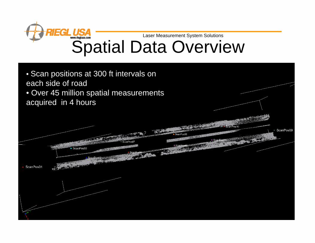
Spatial Data Overview• Scan positions at 300 ft intervals on each side of road• Over 45 million spatial measurements acquired in 4 hours

Date: 07/20/04 RIEGL USA Proprietary InformationReproduction and unauthorized distribution is prohibited.
Page 7
Laser Measurement System Solutions
Data Acquisition and Quality Assurance
• On site registration to established control network • Least squares fit to reference target locations• All data in control network coordinate system

Date: 07/20/04 RIEGL USA Proprietary InformationReproduction and unauthorized distribution is prohibited.
Page 8
Laser Measurement System Solutions
Quality Assurance• Immediate graphical feedback to operator displaying scanner registration to control network

Date: 07/20/04 RIEGL USA Proprietary InformationReproduction and unauthorized distribution is prohibited.
Page 9
Laser Measurement System Solutions
Post Processing
RISCAN PRO
MICROSTATION
• Direct import Riscan Pro project into Microstation/PHIDIAS environment

Date: 07/20/04 RIEGL USA Proprietary InformationReproduction and unauthorized distribution is prohibited.
Page 10
Laser Measurement System Solutions
Post Processing
• Phidias combines spatial 3D data with calibrated images in MicroStation
• Specialized road topography tool sets facilitate extraction of topography features

Date: 07/20/04 RIEGL USA Proprietary InformationReproduction and unauthorized distribution is prohibited.
Page 11
Laser Measurement System Solutions
Point Modification Tools•Convert to Curb Point•Convert to Road Point•Create Curb Point•Create Road Point•Place Center line Point
ACS Tools•Set ACS to a Point
Riegl USA Toolbox•Road Profile: Automated drain line and top of curb•Feature Code Extraction: Attach feature code
Point Creation•Curb Points to Path: Places curb template along path•Curb Point to point on Path: Places curb point along path
RIEGL USA Road Topography Tools

Date: 07/20/04 RIEGL USA Proprietary InformationReproduction and unauthorized distribution is prohibited.
Page 12
Laser Measurement System Solutions
Post Processing
•Feature points are accurately extracted from spatial data
•All data is mapped to calibrated images as reference to existing conditions and maintaining quality control

Date: 07/20/04 RIEGL USA Proprietary InformationReproduction and unauthorized distribution is prohibited.
Page 13
Laser Measurement System Solutions
Post Processing
• Detailed line work can be easily extracted
• Constant feedback to CAD technician for QA/QC

Date: 07/20/04 RIEGL USA Proprietary InformationReproduction and unauthorized distribution is prohibited.
Page 14
Laser Measurement System Solutions
Post ProcessingFeatures mapped to images confirm data integrity2D features are also easily identified and extracted

Date: 07/20/04 RIEGL USA Proprietary InformationReproduction and unauthorized distribution is prohibited.
Page 15
Laser Measurement System Solutions
Post Processing

Date: 07/20/04 RIEGL USA Proprietary InformationReproduction and unauthorized distribution is prohibited.
Page 16
Laser Measurement System Solutions
Post Processing
RIEGL System facilitates identification, modeling and analysis of complex conditions

Date: 07/20/04 RIEGL USA Proprietary InformationReproduction and unauthorized distribution is prohibited.
Page 17
Laser Measurement System Solutions
Deliverables
Deliver topographies of any complexity meeting project requirements
Surrounding Terrain Points
Road Elevation Points at specified density
General Topography Features i.e. trees, utilities, signs, etc Break lines

Date: 07/20/04 RIEGL USA Proprietary InformationReproduction and unauthorized distribution is prohibited.
Page 18
Laser Measurement System Solutions
Cunningham Creek Bridge Project Key Facts
Riegl LMS-Z390 laser scanner with Nikon D200 CameraRIEGL scan truck
RIEGL Instruments
10 Scan Positions / Approx 45 million points100 Calibrated Photo Images / 10 MPixel per image
Data
4 HoursData Acquisition Time
3 Hours RiScan Pro1.5 Days MicroStation/PHIDIAS
Post Processing Time
3D topography of Cunningham Creek Bridge in standard FDOT format
Deliverable