Embed Size (px)
Citation preview
1
Las Virgenes Homeowners Federation, Inc.Post Office Box 353, Agoura Hills, California 91301
The voice and conscience of the Santa Monica Mountains for 45 years
NOV. 2012 MEETING
Tuesday, Nov. 27 at 7:00 p.m.
AGENDA www.lvhf.org
The Place – Diamond X – Take Las Virgenes to Mulholland; turn left on Mulholland. For the next 3/4 mile, the King Gillette Ranch will be on your right. After you’ve passed Stokes Canyon Road, in about 3/4 mile, you will see a sign on your right with “Diamond X” and the National Park Service logo on it. A short distance past the sign a narrow road goes south at a right angle. This is Wickland Road, and, at this point you are entering the King Gillette Ranch. Follow Wickland about 300 yards until the road forks; take the left-hand fork; keep bearing left to the lighted house on the right. Park; enter through the lit doorway.
Call to Order Correspondence/Announcements Roll Call Officers’ Reports Agenda Changes/ Approval Approval of Meeting Minutes
OLD BUSINESS
1. Chesebro Meadow Liberty Canyon Wildlife Corridor Preservation Update. Jess
Thomas.
2. Calabasas Right to Vote Initiative and Term Limits Initiative Updates. Jody Thomas.
- - - - - - - - - - -
3. Wildlife Corridor Committee Report & Breakout. Cynthia Maxwell.
4. Oak Tree Committee Report & Breakout. Roger Pugliese. Calabasas Oak Tree
Ordinance Amendments.
5. Protect CEQA Committee Report & Breakout.
6. Creek Stewards Committee.

2
NEW BUSINESS
1. Pat Henkel – President, Malibou Lakeside Homeowners Association. Proposal for two new homes – each 8000 square feet – on the old lodge property. North Area Plan. 2. John Luker – Vice-President, Santa Susana Mountain Park Association. Update &
presentation. Long term concerns Santa Susana Field Lab and Q & A.
3. Calabasas. Flurry of Development Projects. Diamond West, Inc. facilitating 3 mega
mansion project on scenic corridor. Calabasas Highlands - heritage oak property.
4. LVHF Business – Banquet Committee, etc.
HOLIDAY PARTY!
FUTURE AGENDA ITEMS
December 11, 2012 Meeting
1. Margie Steigerwald, principal planner National Park Service's Rim of the Valley
Corridor Study Update. Comment period closes in early January.
2. Emma Howard, lead planner, Community Studies-North Section, re: the County's
new Significant Ecological Area (SEA) Program.
3. Santa Monica Mountains National Recreation Area proposed name change. Save
Open Space (SOS).
3
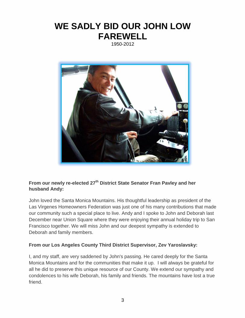
WE SADLY BID OUR JOHN LOW
FAREWELL 1950-2012
From our newly re-elected 27th District State Senator Fran Pavley and her
husband Andy:
John loved the Santa Monica Mountains. His thoughtful leadership as president of the
Las Virgenes Homeowners Federation was just one of his many contributions that made
our community such a special place to live. Andy and I spoke to John and Deborah last
December near Union Square where they were enjoying their annual holiday trip to San
Francisco together. We will miss John and our deepest sympathy is extended to
Deborah and family members.
From our Los Angeles County Third District Supervisor, Zev Yaroslavsky:
I, and my staff, are very saddened by John's passing. He cared deeply for the Santa
Monica Mountains and for the communities that make it up. I will always be grateful for
all he did to preserve this unique resource of our County. We extend our sympathy and
condolences to his wife Deborah, his family and friends. The mountains have lost a true
friend.
4
The Las Virgenes Homeowners Federation pays tribute to our past president, John
Palmer Low, Jr. who unexpectedly passed away at the age of 62 in September.
A cherished husband, son, brother, friend and activist John pursued family life, work,
and friendship with passion.
He cared deeply about the exhibit projects he executed as the principal in John Palmer
Low Designs, sharing his talent for visual storytelling with audiences across the country
and around the globe. He had a great enthusiasm for exotic cars and delighted in
cooking for family and friends. He was always eager to learn anything new and
overcame his fear of heights by receiving his private pilot’s license. An easy
communicator, John was rarely at a loss for words on any subject!!
John was also a long time resident and activist of the beautiful mountain community of
Monte Nido, tucked neatly away in unincorporated Los Angeles County between the
cities of Malibu and Calabasas.
John was a gifted leader and advocate for the Santa Monica Mountains he so dearly
loved. As our president, he was both a consensus builder and a warrior fighting the
usual culprit developers to preserve the wild and wonderful places and things in our
mountains. He had a generous heart and an open spirit. He was consistent and
enduring and frequently harnessed the power of reason to create harmony from
contentiousness. Under his guidance, the forces for good were reinforced and solidified
and our beloved mountains protected.
John’s contributions will live on forever. He was always ready for a new challenge, the
different approach, the new day and new idea of how best to fight the latest battle.
He was taken from us far too early. He is survived by many relatives and friends across
the country, but most specially by his wife and companion of 40 years, Deborah Low.
The Woad Has Died
The woad has died, leaves all crisp and brown, and so have you.
I blinked and you were gone.
Too soon too fast you breathed your last.
Remaining pain, the ache, the hollowness unimagined.
Yet you are everywhere within without my world.
Healing will come,
In time.
Time.
Time.
Time.
Deborah Low, Sept. 2012
We miss you John.
5
ALLIANCE! The Las Virgenes Homeowners Federation, Inc. is very pleased to announce an
important new alliance with the Federation of Hillside and Canyon Associations, Inc.
The Federation of Hillside and Canyon Associations (Hillside Federation) was founded
in 1952 and stretches through the City of Los Angeles portions of the Santa Monica
Mountains from Pacific Palisades to Griffith Park. The Hillside Federation currently
represents approximately 200,000 homeowners.
Their mission of “protecting the quality of life of the residents of the Santa Monica
Mountains and other hillside areas of Los Angeles and its environs and to preserve the
natural topography and wildlife for the benefit of all the people of Los Angeles,” is very
similar to that of LVHF’s.
Our organizations will be joining forces to information share and serve on joint
Committees. LVHF will be welcoming delegates from the Hillside Federation to serve on
our Wildlife Corridor, Oak Tree, Creek Stewards and Defend CEQA Committees.
Together we will have a stronger, combined voice, particularly at the state level.
Both the Las Virgenes and Hillside and Canyon Federations lie in Los Angeles County’s
Third Supervisorial District.
We are very much looking forward to working with the Hillside and Canyon Federation -
with their President, Marian Dodge, Chairman, Charley Mims, and Vice Presidents
Wendy-Sue Rosen and Mark Stratton.
THE FEDERATION OF HILLSIDE AND CANYON ASSOCIATIONS, INC.
6
“GROWTH PLAN RUN AMOK” Whose Story Was It?
Anyone who suffered through Los Angeles County’s development spree in the Santa
Monica Mountains in the 1980s and early 1990s when Michael Antonovich was the
Third District Supervisor, is probably familiar with the 1998 Los Angeles Times article,
“Growth Plan Run Amok.” The story was an exposé of Los Angeles County’s affinity for
approving development with little regard for the general plan and area plan consistency.
Computer technology was used to quantitatively disclose to what extent the County
exceeded prescribed residential densities in this area—an area of national significance
due to its location within the authorized boundaries of the Santa Monica Mountains
National Recreation Area. Eyebrows were raised, and audible gasps heard at the
finding that 2,200 dwellings were approved in an area envisioned for just 1,000. During
the development boom, one might sum up the County’s approach to hillside
development this way: “We’ll approve it; you see if you can do it.”
Yet that was just the beginning of the oft-cited investigative report. The story found
development approvals were suspiciously in sync with campaign contributions to
County Supervisors. Perhaps most upsetting to parkland supporters were the findings
on disaster relief claims. Developers forced high density subdivisions onto steep
hillsides by massive landform grading. The contrived, but ever-so-desirable, flat
residential “pads” shook in the 1994 Northridge earthquake, cracked, and sometimes
slipped down the hill after torrential rains. Before that, the houses built at the wildland
interface burned in the 1993 wildfires. “Acts of God” seem to strike the Santa Monica
Mountains routinely in some sort of vicious karmic retribution for imposing human will on
the rugged terrain. Federal public disaster relief payouts in the amount of $54 million
benefitted a limited number of homeowners. Meanwhile, state and national park staff
and the supportive public were routinely pleading for acquisition funds to buy lands that
have to offer far more to the ecosystem to which they belong and to the general public
than to future potential private homeowners. Wildlife needs the Santa Monica
Mountains’ open spaces and so does the greater public for aesthetic and recreational
enjoyment.
Follow-up editorials and community letters to the editor called yet again for campaign
finance reform, for development review reform, and for the need to finish a new area
plan underway for the Santa Monica Mountains because the old plan had been
“loopholed” to death. The County did, indeed, change the way calculations for density
were generated. Nearly 30 other municipalities asked how they could have such a
before-and-after approval analysis done for their communities. The article, in other
7
words, created quite a splash and changed for the better the way development
proposals in the Santa Monica Mountains are reviewed.
If you know the story, you may know it was written by L.A. Times staff writer T. Christian
Miller. In 1999, he went on to win the prestigious John B. Oakes Award for
environmental investigative reporting, an annual award program then managed by
Natural Resources Defense Council (NRDC). The Amicus Journal, NRDC’s journal at
the time, published an excerpt from Miller’s Oakes-award-winning Times story.
According to a call-out box in the story:
“...Miller relied heavily on computer databases and computer mapping programs in
conducting the research for this story.” ... “Miller spent six months gathering and
analyzing information from various government agencies, combing through about a
dozen databases that included development records, property owner information,
subdivision applications, county political contributions, and disaster damage reports.
Out of this data, he created a map of the 1980 growth plan for the Santa Monica
Mountains and a second map of developments built during the past twenty years.
Then, using a computer mapping program, he overlaid the two maps. The result: a
clear outline of which developments were in violation of growth limits in the original
zoning plan.”
What a great idea to use state-of-the-art computer databases and computer programs
to disclose development approval trends. The findings could then be used to correlate
approvals to campaign contributions, disaster relief claims, and development-specific
investigation of the developer and county planning practices. Was this T. Christian
Miller’s original idea? Did he come up with how to put together the data necessary to
make this award-winning land use analysis? Read on and decide for yourself.
The year is 1995. A CSUN geography grad student has finished another day interning
at the Geographic Information System (GIS) Department at City Hall in Ventura. She’s
contemplating subjects for her master’s thesis. She wants to do a thesis that isn’t just
an intellectual exercise left to molder on the CSUN library shelves. She wants her
thesis to change hearts and minds. She’s thinking about past years working at the
Resource Conservation District of the Santa Monica Mountains, and the staff who wrote
comment letters on development proposals, repeatedly lamenting: “They’re not
following their own plan!” These exclamations were about a long string of subdivision
proposals before L.A. County that exceeded prescribed density. “GIS” was just entering
the scene—a computer mapping program that combines database manipulation
capabilities tied to geographic location and map production facility. GIS offers endless
opportunities to discern patterns, trends, and correlations of “stuff” scarring the face of
the earth. In the Santa Monica Mountains, that “stuff” was poorly sited, sprawling
development. Meaningful thesis identified: County not following plan... tremendous loss
of long-envisioned public open space to the great heartbreak of the public...what had
8
the municipal plan called for...GIS...graphic, irrefutable, quantitative
answers...highlighting the gap between intentions and planning policies directing the
safeguarding of open space and open space values...and the ugly, post-approval, on-
the-ground reality.
It is now 1996, and the student delved into thesis preparation. After determining a
manageable study area for the thesis (unincorporated L.A. County that is now the City
of Calabasas), she combed through development permitting information at numerous
agencies, sat for days in the musty bowels of the County Recorder’s Office figuring out
tract boundaries (you should see what Prop 13 did to those hardcopy tract map books!),
and digitized the Malibu/Santa Monica Mountains Interim Area Plan (a tedious task).
Then, she spent weeks in the National Park Service GIS lab creating the right set of
GIS-ready data layers and arranging the right set of GIS commands to come up with the
desired information. The data layers for prescribed density and approved development
were then unioned in GIS matrimony and voilà, quantifiable data of approved
development vs. prescribed density were created. More computing followed, and from
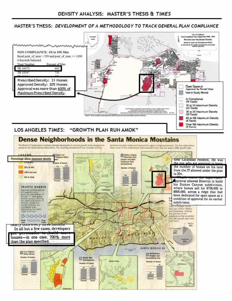
maps and charts emerged a sobering picture: 72% of tract approvals exceeded
prescribed density, two-thirds of which got approved in the “roaring” 1980s. The
student’s follow-up analyses confirmed that high-density approvals illustrated the failure
of hillside management policies specifically designed to protect open space values: high
density developments involved unimaginative, cookie-cutter housing architecture that
works on flat pads graded into steep hillsides, streams were straight-jacketed into
concrete channels, and open space set-aside requirements were spurned. Extra units
granted for affordable housing were not rented as affordable housing. The student,
holed up for more weeks on end, wrote up the thesis that described the GIS
methodology and compliance/non-compliance findings in text, charts, and GIS-
generated maps. The thesis was unglamorously titled “Development of a Methodology
to Track General Plan Compliance,” and it confirmed the local community’s foregone
conclusion that policies in the county-wide General Plan and the Malibu/Santa Monica
Mountains Interim Area Plan were grossly flouted. A notable conclusion in the thesis:
“The primary purpose of this project was to demonstrate the use of GIS-based
methodology to track general plan compliance. However, in this thesis, the information
generated by GIS analysis was so striking that the thesis will more likely be
remembered for its secondary purpose: that local agencies, organizations, and
individuals interested in monitoring land use change might use the information to
elucidate the consequences of development approval and to adjust policies related to
land use development in the Santa Monica Mountains” (pg. 89).
The CSUN thesis committee signed off on the work, and it was published in August,
1997, with a copyright designation for the grad student author.
9
The student gave presentations on her thesis to various agency staff and to local open
space stakeholder groups in the Santa Monica Mountains. Even before the Times
story, eyebrows were raised and people murmured about the quantitative data’s
confirmation of what they suspected all along: the Malibu/Santa Monica Mountains
Interim Area Plan lacked teeth, the amendments resulted in massive grading away of
hills and valleys, and the envisioned gateway route into the Santa Monica Mountains
National Recreation Area was suburbanized. There was also the humble affirmation of
the rationale for the City of Calabasas’ incorporation as a way to take land use control
from L.A. County.
1998. L.A. Times staff writer T. Christian Miller approached staff at the Resource
Conservation District of the Santa Monica Mountains seeking environmental reporting
ideas. He was referred to the student and her thesis. Miller did call on the student.
She discussed how she got the idea for the thesis (“They’re not following their own
plan!”) and those important two purposes of the thesis: craft the GIS methodology to
track compliance (“consistency”) and spur change in planning and development policies
for the Santa Monica Mountains. Furthermore, the student noted another thesis
conclusion: “Much more extensive discourse on why such development has been
permitted could fill pages of another thesis and would concern politics, economics, and
sociology” (pg. 84). What a great story in this thesis! It may have been politically naïve
on the student’s part, but the heady excitement of the thesis “making a difference”
outweighed any egocentric thoughts about the importance of being cited for one’s own
intellectual property. Miller said he’d work with the student on the citation issue, and he
got busy with the story.
Miller expanded his area of interest to include the greater Santa Monica Mountains. He
and other Times staff put in a lot of work compiling digital, GIS-ready development
approval information, as had the student for the thesis. They digitized more of the
Malibu/Santa Monica Mountains Interim Area Plan’s Land Use Policy Map. Miller even
paid the student to come to the L.A. County Assessor’s Office to run her thesis-crafted
set of GIS commands. There were many calls to the student during this time requesting
advice on processing the data.
It’s early December, 1998. The student e-mailed Miller about when the story might run.
He replied the story was with the editors, and he wasn’t sure. She asked if she had
been cited/quoted, just for the sake of government employee-associated issues, as well
as for her own satisfaction of accuracy. Miller didn’t reply to this e-mail, and the student
didn’t press him for an answer.
The article, “Growth Plan Run Amok,” ran in the L.A. Times on December 27, 1998:
Sunday Report on Page A1 front and center. The article filled two more full pages with
text, maps, and graphics. It was a seminal “shock and awe” article, as could be
10
expected. Sources for the article were cited, but, lo and behold, they did not include the
student and her thesis. The presentation of the results so closely looked and read like
those findings and graphics in the thesis that several people called the student at work
the next day asking, “Was that your thesis?” She answered humbly that, yes, it was
indeed her thesis that was used to construct the story. “The Times didn’t cite you!” “It
was your work and you should get credit for it.” She was going to have to speak with
Mr. Miller about this. His response: “I thought you genuinely [sic] did not want to be
cited.”
It’s early 1999. After the student reproached Miller for providing no citation at all, Miller
provided a letter on L.A. Times letterhead thanking the student for her “time, energy and
help” while he was researching his story, and that the thesis “was key to developing the
methodology I used in writing the story and your GIS knowledge was immensely helpful
in working with the assessor’s office.” Miller had told the student about his using the
“approved” date versus the “recordation” date, but that the results were pretty much the
same. Also, he looked at clustered tract approvals rather than a tract-by-tract analysis
done in the thesis. Other than that, the article’s format of the findings and graphic
presentation of information were strikingly similar to the thesis. Most importantly, Miller
certainly wasn’t sitting alone contemplating GIS-based land use analysis for a great
environmental investigative report.
He took the idea and the methodology from the student’s thesis and presented it as his
own brain child.
The student had been so accommodating during article preparation that to get angry
and seek retribution at this point in the success of the story seemed counterproductive
to the story’s effectiveness. Wasn’t it enough to have realized a “meaningful” thesis?
Yes, …mostly. The student is certainly proud to have indirectly, if not directly, raised
awareness of the development boom of the 1980s and to have made a difference in
planning practices at L.A. County. As for Miller, he wrote a great story. He won the
Oakes award for this story, and has gone on to more courageous investigative reporting
on corrupt contracting practices in Iraq and on the lack of adequate treatment for
soldiers who have suffered traumatic brain injuries.
The story ran nearly 15 years ago. Density calculation methodology has been
corrected. No similar subdivisions have been proposed since this development boom
ran amok. Los Angeles County now has a new area plan for the Santa Monica
Mountains and a ridgeline and grading ordinance to fend off the worst sorts of
development. Who was this student? Well, it was me, Melanie Beck, and my thesis
was the foundational contribution to the Times’ story. Miller needed my thesis to write
“Growth Plan Run Amok,” and I needed Miller to spread the message.
So, whose story was it?
11
12
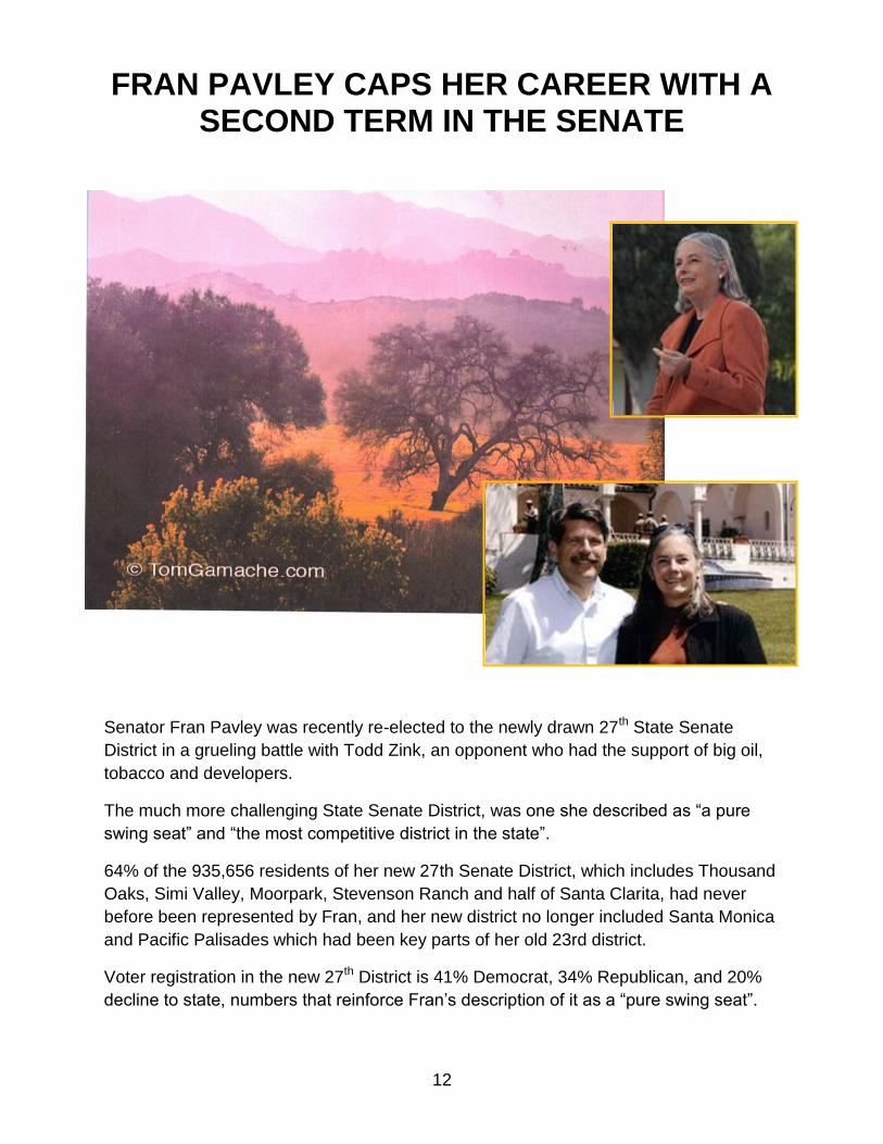
FRAN PAVLEY CAPS HER CAREER WITH A SECOND TERM IN THE SENATE
Senator Fran Pavley was recently re-elected to the newly drawn 27th State Senate
District in a grueling battle with Todd Zink, an opponent who had the support of big oil,
tobacco and developers.
The much more challenging State Senate District, was one she described as “a pure
swing seat” and “the most competitive district in the state”.
64% of the 935,656 residents of her new 27th Senate District, which includes Thousand
Oaks, Simi Valley, Moorpark, Stevenson Ranch and half of Santa Clarita, had never
before been represented by Fran, and her new district no longer included Santa Monica
and Pacific Palisades which had been key parts of her old 23rd district.
Voter registration in the new 27th District is 41% Democrat, 34% Republican, and 20%
decline to state, numbers that reinforce Fran’s description of it as a “pure swing seat”.
13
Fran, a former Federation Secretary, has always drawn support in the Santa Monica
Mountains from Republicans and Democrats alike for her superb efforts on behalf of the
environment, open space and conservation.
Fran had only a few months time to make the acquaintance of over 600,000 new
constituents in her district - many of whom may have never heard her name until it
appeared on their ballot.
During the campaign, Fran had to contend with opposition from an anonymous group,
which spent $561,000 on an inaccurate campaign against her. An investigation by the
Ventura County Star showed the anonymous opposition group, the California Senior
Advocates League PAC, was actually funded by well-known special interests,
specifically, the National Association of Realtors, Anthem Blue Cross, Chevron, and
Philip Morris. Eventually, special interests spent over $2 million dollars in independent
expenditures and in donations to her opponent.
On the evening of November 6th the absentee ballots and the Ventura County election
results came in first, showing her opponent running a couple of thousand votes ahead
of Fran. Those results held until after most people had gone to bed. Then the Los
Angeles County results came in …
Semi-final results in the 27th Senate District race show Fran Pavley leading Todd Zink
with 182,861 votes (52.9%) to 162,532 votes (47.1%).
This will be the last election of Fran Pavley’s long political career, which began with her
election as Mayor of Agoura Hills. She will continue to serve as our State Senator
through December, 2016.
* * *
Fran Pavley first appeared on the Las Virgenes scene almost forty years ago in the
wake of a controversy over the creation of Malibu Creek State Park. The State had
purchased over a thousand acres of oak savanna north of Mulholland from Bob Hope,
but had not yet publicized that purchase or decided what to do with it.
The Liberty Canyon purchase brought the state ownership to within a few hundred
yards of the Liberty Canyon community, where a couple of young teachers, Fran and
Andy Pavley, had just brought home their first baby, a girl named Jenny.
Enter the American Motorcycle Association, which was looking for a good location for a
motorcycle recreation area. Liberty Canyon seemed an ideal location to them, so they
drew up a map showing the thousand acres laced with motorcycle trails and motocross
race courses, and submitted it to the State.
Folks in Liberty Canyon were not aware of the American Motorcycle Association
proposal until Bob Pool, then employed by the old Thousand Oaks News-Chronicle, got
14
wind of the story. He ran a blowup of the American Motorcycle Association motocross
map on page one of the News-Chronicle. Superimposed on it was a photo of hundreds
of motorcycles taking off in a cloud of dust at the start of the annual Las Vegas-to-
Barstow race.
When the residents of Liberty Canyon saw Bob Pool’s story and the accompanying
photos, they went ballistic. The press and elected officials were barraged with angry
letters and phone calls, demanding that the State immediately turn down the motorcycle
proposal.
To alert the community and help clarify the situation for Liberty Canyon residents,
several activists went door-to-door in the community. One of those activists, Dave
Brown, said, “I knocked on the front door of the Pavleys home. Fran came to the door
and told me she couldn’t possibly attend any meetings, pointing to Baby Jenny as her
excuse”. According to Fran, Dave suggested she come to the meeting, anyway, and
bring Baby Jenny along, which she did.
Hundreds of Liberty Canyon residents showed up for a particularly raucous hearing of
the State Park Commission on the future uses of the Liberty Canyon purchase, some of
them playing loud recordings of motorcycle noises to make their point. When the
hearing was over, the State Park Commission voted to designate Liberty Canyon as a
State Natural Preserve, and the American Motorcycle Association went home empty-
handed.
* * *
In those days neither Calabasas nor Agoura Hills existed as incorporated cities. They
were still unincorporated communities under the jurisdiction of Los Angeles County, with
their planning and zoning decisions at the mercy of pro-development County
Supervisors such as Mike Antonovich, about whom it was said that he never met a
developer he didn’t like.
This was a time of runaway County development, where developers cut deals with
supervisors and their staffs in the privacy of their downtown offices before going through
the formality of public hearings that were invariably held downtown during working
hours. Antonovich was represented locally by his Field Deputy, Leeta Pistone, who
was almost inaccessible to any local homeowner who wasn’t a subdivider.
Fran soon became active in the Liberty Canyon Homeowners Association, and, before
long, had become its President. In the late 70’s ands early ‘80’s she and her neighbors
had their hands full with one development proposal after another.
Another problem Fran had to deal with was several homes in Liberty Canyon that had
experienced slope failures during the heavy rains of the late ‘70’s and early ‘80’s.
Antonovich and Leeta Pistone had done nothing to help the homeowners and acted as
if they weren’t even aware of the problem, so Fran sent out questionnaires to every
15
resident and discovered that more residents of Liberty Canyon than the County realized
had been experiencing slope failures and cracked slabs on recently built homes.
Through Tom and Joan Yacovone, Fran made contact with Dr. James Slosson, one of
the top geologists in the state and made him aware of the problems some of the
homeowners in Liberty Canyon were experiencing. As a result, the County became at
least better informed of the special problems in Liberty Canyon and the need to be more
careful in processing development applications there.
In the late 70’s and early ‘80’s Fran and her neighbors, Tom and Joan Yacovone, Don
and Fran Foster, and Don and Betty Wiechec, were opposing a number of
developments in and around Liberty Canyon.
First Liberty Canyon tried unsuccessfully to block County approval of a 40-home tract
developer Alan Satterlee was trying to get approved on the ridgeline above the Pavley
home. Jim Slosson looked at Satterlee’s geology report and found an amazing lack of
data, and conclusions about the geology but, when these deficiencies were called to the
County’s attention the project was approved, nevertheless. Then there was an even
bigger battle over Currey-Riach’s plan for 1100 condos and a million square feet of
commercial buildings in the Lost Hills development in the Las Virgenes Valley just over
the ridge from the Pavley home, also approved by the Board of Supervisors without
change from what the developer had proposed.
Next came the monster Oren Realty proposal for 1700 condos, an industrial park, and a
shopping center that would have destroyed the magnificent stands of oaks in nearby
Cheeseboro Canyon. By this time the Pavleys were becoming active in the Federation,
and took a lead role in the long fight against Oren Realty, which finally resulted in the
National Park Service buying the property forty years later.
Another long-standing threat to Liberty Canyon in these years was a developer named
Al Abrams, who owned a wooded canyon on the west side of lower Liberty Canyon. The
Pavleys worked for years to keep him from getting the zoning and development
approvals he needed to build 400 apartments on the property. Finally they helped
persuade Abrams to sell the property to the Santa Monica Mountains Conservancy as
part of the Liberty Canyon Wildlife Corridor.
* * *
Though Fran Pavley sometimes testified in opposition to pending developments, her
style was different from that of most other activists. She was not particularly adversarial
or aggressive and usually relied on reason and quiet persuasion. She preferred to
explain her position rather than assert it aggressively. As a result, she got along better
with Mike Antonovich, and, especially Roy Donley, his Planning Commissioner, who
once said Fran reminded him of his daughter.
16
In fact, Fran and a group of Liberty Canyon homeowners were invited to a delicious
dinner at Planning Commissioner Roy Donley’s beautiful hillside home in Studio City.
* * *
By the early 1980’s several Las Virgenes communities were becoming very dissatisfied
with the way the County was treating them, especially on local planning issues. There
was an unsuccessful attempt to incorporate the entire area in the early 1980’s as the
City of Las Virgenes. When that effort failed, there was a movement to liberate the
unincorporated, largely developed, community of Agoura from the control of Los
Angeles County and incorporate it as its own separate City of Agoura Hills.
Many citizens developed mixed feelings about incorporation, feeling that it would
accelerate the urbanization of the area, but others, after several years of runaway
development under the County, understood the importance of gaining local control of
planning and zoning.
Fran Pavley was one of the latter group. She made a decision to run for City Council in
the first incorporation election. In those days it cost little or nothing to run for City
Council. Fran’s biggest contributor – at less than $100 – was Roy Donley, Antonovich’s
appointee to the Regional Planning Commission. Her second biggest contribution was
$50.
The residents of Agoura at that time, had not had any previous experience with self-
government. The candidates in the first City Council election were a very mixed group.
Many of them were little-known and appeared to have ties to developers and other
moneyed interests. The questionable character of some of these City Council
candidates made many people uneasy about the whole idea of incorporation and this
threatened to de-rail the movement for cityhood. But Pat MacGregor took charge,
drafted a flyer that reminded people of the benefits of self government, and circulated it
throughout the community. That flyer turned the
scales in favor of cityhood.
Thanks to Pat and others, Agoura Hills ended up
voting overwhelmingly in favor of incorporation,
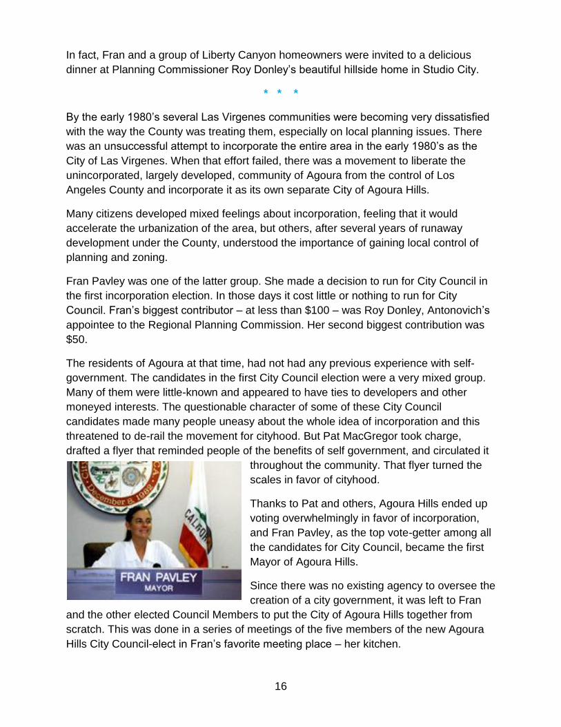
and Fran Pavley, as the top vote-getter among all
the candidates for City Council, became the first
Mayor of Agoura Hills.
Since there was no existing agency to oversee the
creation of a city government, it was left to Fran
and the other elected Council Members to put the City of Agoura Hills together from
scratch. This was done in a series of meetings of the five members of the new Agoura
Hills City Council-elect in Fran’s favorite meeting place – her kitchen.
17
Some people may think of Fran Pavley as a political neophyte - a well-meaning, but
somewhat naive schoolteacher in a room full of fat, cigar-smoking machine politicians. If
you find yourself thinking of her this way, just remind yourself that this is the woman
who, after she had appeared to exhaust her political influence by getting the State to
cough up the money to buy Ahmanson Ranch, then had to turn around almost
immediately and persuade the state to come up with $36 million more to buy Soka when
it unexpectedly came on the market.
You have to also remember that there were 119 other members of the California State
Legislature, and that a lot of them could have put the money that was spent on
Ahmanson Ranch and Soka to good use in their respective districts. It took some
political skill for Fran to play the lead role of nailing down both of those major
acquisitions. Clearly, Fran is a lot more than a naïve schoolteacher.
So, what in Fran’s background would have given her this unusual political talent?
Several years ago, Mr. Brown said he was over at the Pavley’s, and Fran gave him a
tour of her living room, pointing out various pieces of furniture. Finally, she pointed to
one and announced, “This one belonged to my Great Grandfather. He was William
Jennings Bryan.”
So, there’s the answer. Fran is the Great-Grand Daughter of the youngest man ever to
be nominated for President of the United States by a major political party (He was 36 at
the time.). William Jennings Bryan didn’t end up in the White House, but he was the
Democratic nominee for President three times, in 1896, 1900, and 1908, and, made a
very respectable showing each time, especially in the dramatic 1896 Election, where
Bryan challenged the most powerful special interests of his day – the railroads, the
trusts, and the banks – and came very close to winning the presidency.
Fran did not have an easy time as Mayor. For many years Los Angeles County had
been very permissive in approving a large number of billboards and tall pole signs in
Agoura’s Freeway Corridor, giving the downtown area of the City the appearance of an
oversized Texas truck stop. Fran and her newly-elected city council colleagues had
promised to clean up this unsightly signage, but the sign owners, most of whom were
out of state businesses backed by the well-funded Sign Users’ Council, fought the City
Council tooth and nail.
Candidates backed by developers and the sign interests challenged the City Council –
especially Fran – in almost every election in these early years. These challenges were
too often immature and abusive – and several people thought they had the backing of
The Acorn.
Since Fran and the majority of her Council colleagues in these years were usually
women, the pro-development, pro-pole sign male chauvinist opposition often publicly
referred to the City Council derisively as “the girls”.
18
As Mayor throughout these early years, Fran was subjected to special abuse. In one
City Council election anonymous opponents circulated a forged letter at the last-minute,
claiming Council Member Louise Rishoff had taken payoffs from a particularly unpopular
developer. With no time to correct this forgery, Louise came within two votes of losing
her seat.
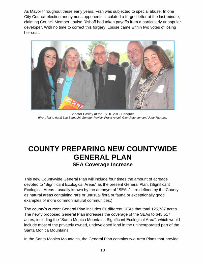
Senator Pavley at the LVHF 2012 Banquet.
(From left to right) Liat Samouhi, Senator Pavley, Frank Angel, Glen Peterson and Jody Thomas.
COUNTY PREPARING NEW COUNTYWIDE GENERAL PLAN SEA Coverage Increase
This new Countywide General Plan will include four times the amount of acreage
devoted to “Significant Ecological Areas” as the present General Plan. (Significant
Ecological Areas - usually known by the acronym of “SEAs”- are defined by the County
as natural areas containing rare or unusual flora or fauna or exceptionally good
examples of more common natural communities.)
The county’s current General Plan includes 61 different SEAs that total 125,787 acres.
The newly proposed General Plan increases the coverage of the SEAs to 645,517
acres, including the “Santa Monica Mountains Significant Ecological Area”, which would
include most of the privately owned, undeveloped land in the unincorporated part of the
Santa Monica Mountains.
In the Santa Monica Mountains, the General Plan contains two Area Plans that provide
19
more specific guidance over land use development in our area: the North Area Plan,
which will govern land use and zoning north of the Coastal Zone boundary (generally
north of Mulholland Highway), while the Santa Monica Mountains Local Coastal Plan
will govern land use and zoning issues within five miles of the ocean (generally the area
south of Mulholland).
The North Area Plan was originally approved by the Board of Supervisors 12 years ago,
but the Board has not yet enacted many of the needed rules that will fully implement the
Plan.
The Board of Supervisors has indicated its intent to approve the Santa Monica
Mountains Local Coastal Program, which must be based on the requirements of the
Coastal Act. But it still needs additional work and cannot take effect until it has been
certified by the Coastal Commission.
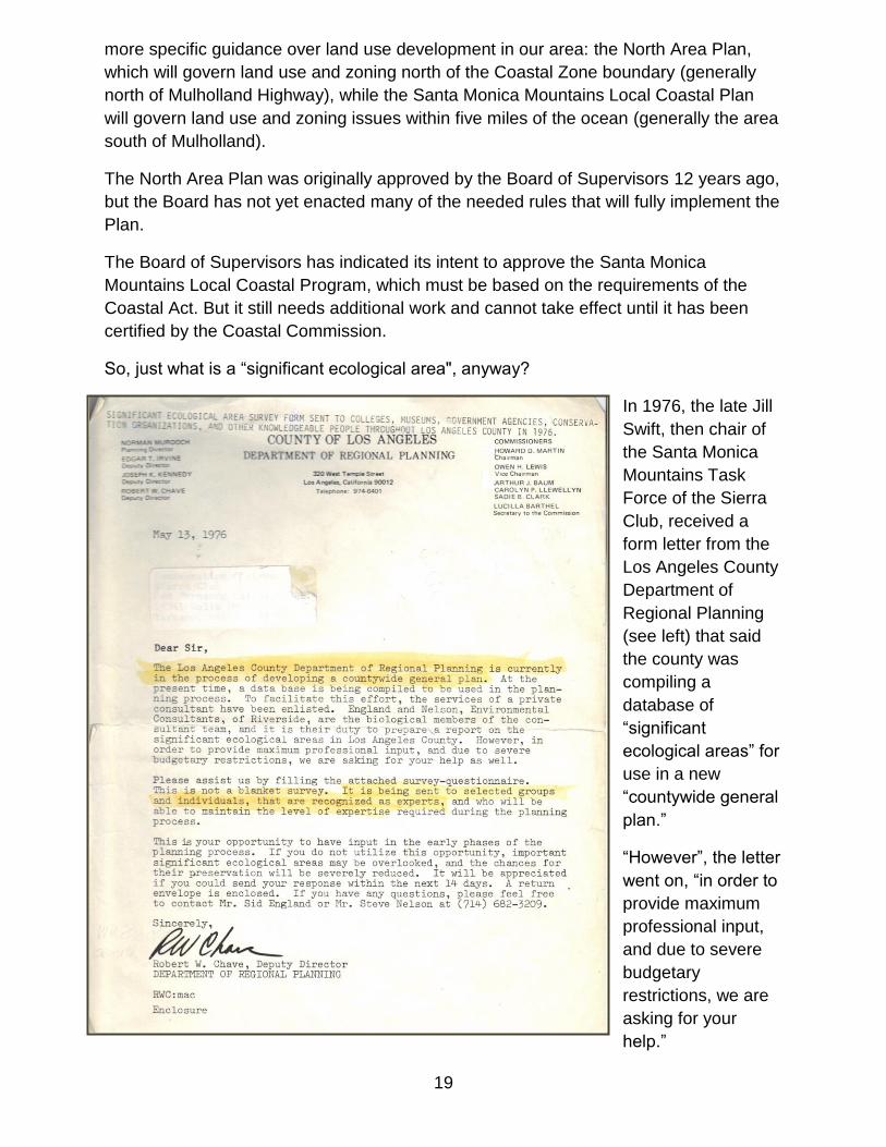
So, just what is a “significant ecological area", anyway?
In 1976, the late Jill
Swift, then chair of
the Santa Monica
Mountains Task
Force of the Sierra
Club, received a
form letter from the
Los Angeles County
Department of
Regional Planning
(see left) that said
the county was
compiling a
database of
“significant
ecological areas” for
use in a new
“countywide general
plan.”
“However”, the letter
went on, “in order to
provide maximum
professional input,
and due to severe
budgetary
restrictions, we are
asking for your
help.”
20
Included with the letter was a form recipients could use to nominate additional
significant ecological areas to be included in the upcoming County General Plan.
Several local activists collaborated and nominated at least eight areas for possible
designation as SEAs, including Malibu Canyon, Malibu Lagoon, Cold Creek, the
wooded hillsides along the 101 Freeway, watersheds draining into Malibu Creek State
Park, Tuna Canyon, Zuma Canyon, and Upper La Sierra Canyon above Seminole Hot
Springs.
The county distributed it to a broad list of its deemed experts. All told these “experts”
nominated a total of 115 potential SEAs and 62 were subsequently designated as such
in the County’s 1980 General Plan, including the eight areas mentioned in the previous
paragraph.
So, why, back in 1976, was the notoriously pro-development Los Angeles County Board
of Supervisors so anxious to persuade scientists and environmentalists to nominate
areas to be given a special planning designation as significant ecological areas?
The Open Space Lands Act Of 1970
A product of the original Earth Day, the Open Space Lands Act of 1970 requires every
city and county in California to adopt an Open Space Element in its General Plan and
to, “take positive action to carry out such plans … “. It goes on to say, “no building
permit may be issued, no subdivision map approved, and no open space ordinance
adopted unless the proposed construction, subdivision, or ordinance is consistent with
the local open space plan.”
In spite of this, the L.A. County Board of Supervisors continued its customary practice of
going through the motions of zoning large areas for “open space” and then later
approving high-density urban developments in those same areas. Before long, the
media were trumpeting plans for large-scale urban developments in Lower Malibu
Canyon, Upper Topanga, Brentwood, Westlake Village, and the heart of the Las
Virgenes Valley in the area then known as “Century Ranch”, now Malibu Creek State
Park.
Environmentalists Sue the County (The “Judge Thomas Decision”)
In 1975, the Center for Law in the Public Interest, joined by the Sierra Club and Margot
Feuer filed suit against the county for violating the Open Space Lands Act, winning an
injunction that overturned the County’s 1973 General Plan and blocked approval of any
further urban development in rural-zoned areas of the Santa Monica Mountains.
To avoid further litigation, the county hired the consulting firm of England and Nelson
and began to draw up a new General Plan that would satisfy the court and pay lip
service to the Open Space Lands Act and the protection of Significant Ecological Areas.
21
In addition to the 62 proposed SEAs, England and Nelson also recommended that,
“riparian woodland habitat outside the designated significant ecological areas… should
be regarded as important wildlife habitat and preserved,” describing it as, “the best
wildlife habitat remaining in the state”.”No developments should take place”, it asserted,
“which would alter the flow of water into or through the area”.
“In addition a 75 – 100 foot buffer of natural vegetation should be maintained
surrounding the riparian community. This is necessary because many of the organisms
which nest or roost in the riparian habitat forage in adjacent areas.”
Since that time development proposals within any of the SEAs have been required to
obtain a Conditional Use Permit and the development itself would have to be reviewed
by the Significant Ecological Area Technical Advisory Committee (SEATAC), a
committee of independent experts appointed by the County Planning Director.
But, the “bad old days” were not yet over. In the 1980 election the Building Industry
Association backed a slate of pro-development candidates, swept four of the five seats
on the Board of Supervisors, and set out to undo the environmental gains of the 1970s,
including the SEA program.
During the 1980s, several developers ignored the Open Space Lands Act and urged the
Board of Supervisors to allow them to build more than 6,000 homes in the Palo Comado
Significant Ecological Area alone. One developer sought county approval to build 1,700
condominiums, a shopping center, and an industrial park, along with a highway that
would be carved through well over a mile of oak savanna on National Park Service land
within the Palo Comado SEA. The Baldwin development, known facetiously today as
“The Oaks”, proposed to remove over 1,800 native oaks to make room for 1,500
mansions and a four-lane boulevard, also entirely within the Palo Comado SEA.
One pro-development County Planning Commissioner, appointed by Mike Antonovich,
seriously proposed building a four-lane boulevard along the very crest of the Santa
Monica Mountains which would have intersected a north-south-boulevard through the
Malibu Canyon SEA and carved a swath through Malibu Canyon to the coast.
Since most SEAs are on private property that has already been zoned for some type of
development, the courts believe they cannot constitutionally allow SEAs to be treated as
if they were public wilderness preserves. Unless park agencies are able to come up with
enough money to buy and administer the land – an increasingly difficult challenge today
- the only hope of saving these special places may be to find a constitutional way to
regulate the development of the property that will ensure the survival of at least some of
each SEA’s unique natural resources.
This could mean trying to persuade the landowner to sell or donate the most sensitive
22
parts of an SEA to a park agency or to a non-profit or allowing the owner to cluster his
development on part of the property and donate the rest to a park agency or to a non-
profit. A combination of purchase in fee, partial development, and dedication of the
remainder, has already been used to preserve 2,000 acres – more than 60% of the Palo
Comado SEA - along the Ventura Freeway. A majority of the Cold Creek SEA has been
preserved through purchase by the Mountains Restoration Trust and State Parks.
Other SEAs, such as the Malibu Canyon and Lagoon SEA, Cheeseboro Canyon, and
Upper La Sierra Canyon, have been largely or partially preserved by state, federal, or
private purchase – after their designation as SEAs focused public attention on the
importance of preserving their unique natural resources.
The replacement of pro-development County Supervisors, such as Deane Dana and
Mike Antonovich, with Ed Edelman in 1991 and later with Zev Yaroslavsky in1994,
along with the incorporation of local cities more committed to the protection of the
environment has made the County more sensitive to the need to protect SEAs, at least
for now. Under current Supervisor Zev Yaroslavsky, protection of SEAs has been a high
priority. But unfortunately, Zev will be “termed out” in two years and, with each
Supervisor called on to represent two million largely urban constituents, most of them a
long way from the Santa Monica Mountains, we have no guarantee Zev’s successor will
share our commitment to the protection of our significant ecological areas. In case she
or he doesn’t, we will need to be prepared to insist the County maintain a strong SEA
program.
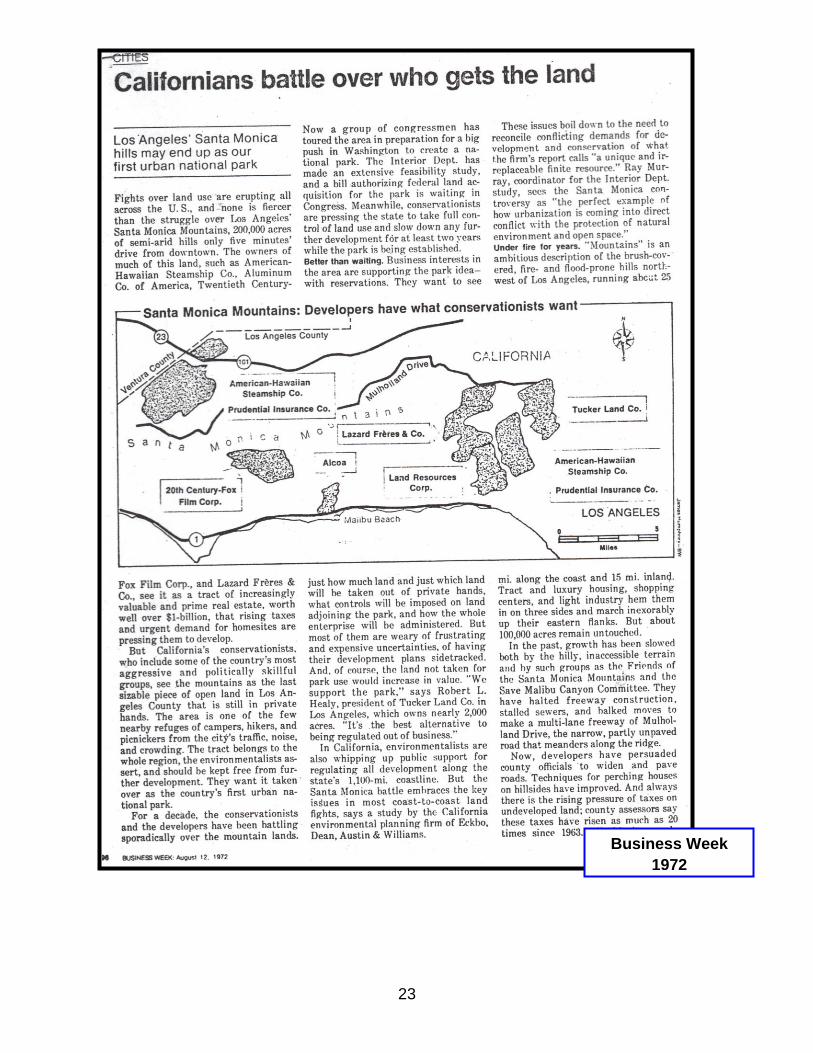
(Next Page - See article from Business Week in 1972 “Californians Battle Over Who
Gets the Land”)
23
Business Week
1972