Embed Size (px)
Citation preview

Dr. M. Rokhis KhomarudinDirector of Remote Sensing Application Center, LAPAN
LAPAN’s Activities on Remote Sensing Application

Outline
Background: Law (UU) No. 21 / 2013 on space activities Organization in LAPAN
Data received by LAPAN ground stationThe remote sensing application: Land resources Coastal and Marine resources Environmeny and Disaster Mitigation
Network

UU No. 21 Tahun 2013 on Space ActivitiesSubstances related to remote sensing activities, such as: Planning, developing and operating satellites and remote
sensing ground stations (articles 16 and 17). Procurement of high-resolution remote sensing data (article
18). Preparation of the standard methods and the data
processing quality (article 19). Organizing the storage and distribution of data through the
National Remote Sensing Data Bank as a network node remote sensing data in the National Spatial Data Network System (article 20).
Establish guidelines for the use and dissemination of remote sensing information (article 22).

Organization’s Structure
Chairman of LAPAN(Indonesian National Institute of Aeronautics
and Space)
Primary SecretaryDeputy Chairman
ofRemote Sensing
Deputy Chairman ofAerospace Technology
Deputy Chairman of Aerospace Science,
Assessment and Information
Cooperation & Public Relation Bureau
General AffairsBureau
Remote SensingApplications Center
Aerospace Vehicle Technology Center
Aerospace Electronics Technology Center
Applied Aerospace Technology Center
Space Science Application Center
Atmosphere & Climate Science Application
Center
Planning andOrganization Bureau
Inspector
Aerospace Policy Analysis and Information
Center
Remote SensingTechnology and Data
Center

DEPUTY OF REMOTE SENSING
Remote Sensing Technology and Data
Center
Remote Sensing Application Center
Land and Natural Resources
Division
Coastal and Marine
Resources Division
Production Of Information
Division
Environmental & Disaster Mitigation
Division
Remote Sensing - LAPAN

ALow Res.
• Terra/Aqua• NPP• NOAA-18/19• Metop• MTSAT-1R
BMedium Res.
• Landsat-7• Landsat-8
CHigh Res.
• SPOT-5• SPOT-6
Aqua
Landsat-8
SPOT-5
SPOT-6
Data received by LAPAN ground station
Terra
Landsat-7

Land Resources

Forest and non-forest classification
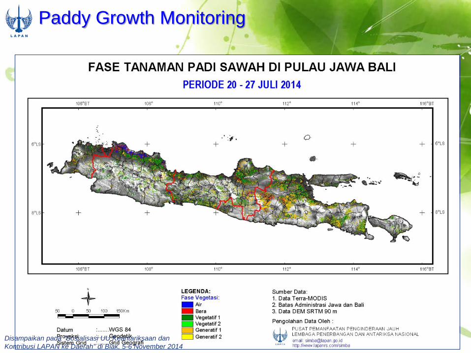
Paddy Growth Monitoring
Disampaikan pada “Sosialisasi UU Keantariksaan danKontribusi LAPAN ke Daerah” di Biak, 5-6 November 2014
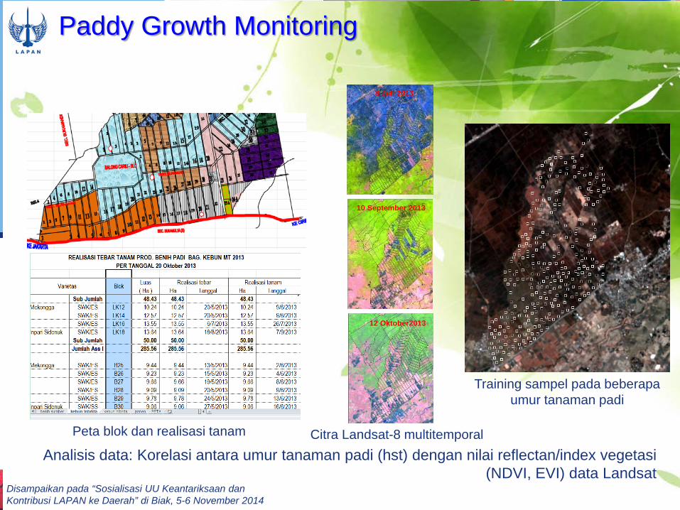
Paddy Growth Monitoring
Training sampel pada beberapaumur tanaman padi
Analisis data: Korelasi antara umur tanaman padi (hst) dengan nilai reflectan/index vegetasi(NDVI, EVI) data Landsat
8 Juli 2013
10 September 2013
12 Oktober2013
Citra Landsat-8 multitemporalPeta blok dan realisasi tanam
Disampaikan pada “Sosialisasi UU Keantariksaan danKontribusi LAPAN ke Daerah” di Biak, 5-6 November 2014

2005 2004 2006
2007
2010
2012
2009
2002
Oil Palm Monitoring (Landsat)
Disampaikan pada “Sosialisasi UU Keantariksaan danKontribusi LAPAN ke Daerah” di Biak, 5-6 November 2014

2009 2013
32% 45%
Lake/water Quality (Landsat/SPOT)
Disampaikan pada “Sosialisasi UU Keantariksaan danKontribusi LAPAN ke Daerah” di Biak, 5-6 November 2014

Mining and Geological Resources
Height Model (XSAR+SRTM C+ Palsar)
Citra Landsat (R:3/1 G:5/4 B:5/7)
Citra Palsar (R:HH G:HV B: (HH+HV)/2)
Peta gaya berat bumi dan potensi mineral
Peta struktur dan formasi geologi
Deteksi tambang dengan komponenxi
Deteksi tambang dengan komponeneta
Deteksi tambang dengan komponen xi d t
Prediksi potensi tambang batubara, bijih besi, bauksit di sekitar KPC dan Adaro setelah
dilakukan pendeteksian Gambut (batubara tipe 5)
Profil melintang dan volume di kawasanAdaro
Profil melintang dan volume di kawasanKideco

SPOT4, 2008
Mining area monitoring
Disampaikan pada “Sosialisasi UU Keantariksaan danKontribusi LAPAN ke Daerah” di Biak, 5-6 November 2014

Coastal and Marine Resources

Potential Fisihing Zone
Suhu Permukaan Laut Konsentrasi klorofil
Arus Geostrofik
Informasi ZPPI harian Informasi ZPPI bulanan

Project Area No. ZPPI Harian E-mail / Telp. Project Area
1 Dinas Kelautan dan Perikanan Kab. Indramayu
[email protected] 11, 12, 13
2 UniversitasBrawijaya,
[email protected][email protected]
20
3 UPTD Balai Benih Ikan Kota Medan
[email protected] 01,02
4 Dinas Pertanian danKelautan Kota Medan
[email protected] 01,02
5 UPTD PPI Parigi, Ciamis
[email protected] 10, 20
6 Dinas Pengamanan A.L.
[email protected] 01,02,06,10,11,
12,13,14,19,20,21
7 Suku Dinas Peternakan,Perikanan dan Kelautan, Jakarta Utara
[email protected] 11, 12
8 Dinas Kelautan dan Perikanan Provinsi Sulsel
9 Dinas Perikanan dan Peternakan Kabupaten Maros
13
10 Dinas Kelautan dan Perikanan Kab.Pangkep
11 Politeknik Pertanian Pangkep
13
12 Dinas Kelautan dan Perikanan Kab.Baru
13 Dinas Kabupaten Lampung Barat (Bapak Imam)
[email protected] 10,11
14 Kepala Dinas Kelautan dan Perikanan Kota Sibolga
[email protected] 1,2,10
15 Dinas Kelautan dan Perikanan, Tanah Laut Kalimantan selatan
[email protected] 12, 13
Tambahan instansi penerimainformasi ZPPI: kegiatan PKPP, SIDA, kerjasama

Potentian Fishing Zone(http://pusfatja.lapan.go.id/)

Application of PFZ Information to Fishing Activities Monitoring and Surveillance

Mangrove Classification

False Colour Composite (FCC)
LANDSAT 8BAND 5,6 AND 4
Segara Anakan, Central Java: September 10, 2013
Alas Purwo, Banyuwangi, East Java: May 15, 2014
Brown Dark Colour is the Representative of Mangrove
Ujung Kulon, Banten : Oktober 4, 2013

SUPERVISED CLASSIFICATION : MANGROVE – NON MANGROVELANDSAT 8 : September 10, 2013
Green Color for Mangrove; location: Segara Anakan, Central Java
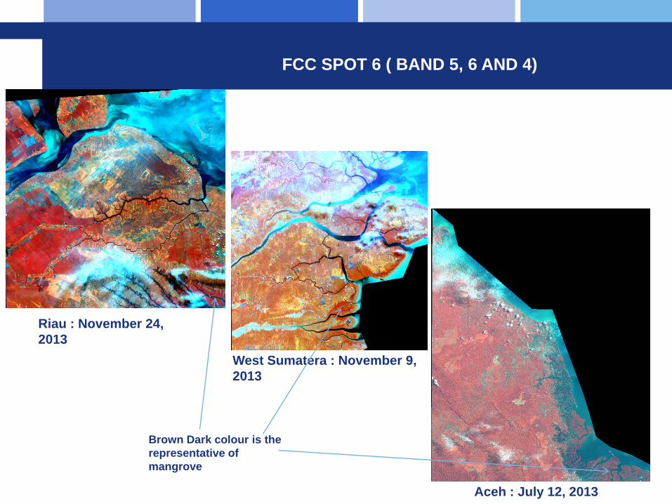
FCC SPOT 6 ( BAND 5, 6 AND 4)
Riau : November 24, 2013
West Sumatera : November 9, 2013
Aceh : July 12, 2013
Brown Dark colour is the representative of mangrove

Coral Reefs Classification

Small Island MonitoringDana 2 (SPOT 5, 26 April 2013)

Environment and Disaster Mitigation

Applications of RS related to disatermanagement risk cycle
PRE-DISASTER: • Early Warning System• Hazard MappingEMERGENCY RESPONSEPOST-DISASTER:
• Damaged area

Available Methods and Information
Disastertype
Pre-Disaster Emergency Response Available Information
Flood • Cloud Cover Monitoring
• Potential Flood Area Monitoring
• Flood simulation
• Flood detectionmethods
• Flood Risk Assessment
• Flood simulation modeling
• Daily potential of flooded area
Drought • Drought monitoringmethods
• Vegetation Index• Drought information in
paddy field area (8-day basis)
Forest Fire • Hotspot methodology• Burned Scar Detection• Smoke/haze detection
• FDRS• Daily hotspot
information• Smoke/haze
information
Volcano • Volcano hazard mapping methods
• Volcano hazard map (coming soon)
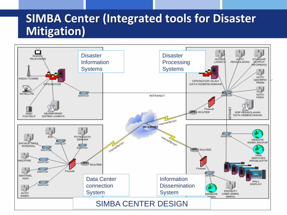
SIMBA Center (Integrated tools for Disaster Mitigation)
Disaster InformationSystems
Disaster ProcessingSystems
Data Center connection System
Information Dissemination System
SIMBA CENTER DESIGN

SIMBA Center Room

PRE-DISASTER: Early Warning System
Flood, Drought, Forest/Land Fire

Cloud cover monitoring

Potential of Flooded Area in Java(19 Nov 2013) KML Format

Meteorological Drought :Standardize Precipitation Index (monthly basis)

Agricultural Drought :Vegetation Condition Index (monthly basis)

Agricultural Drought : Vegetation Health Index (monthly basis)
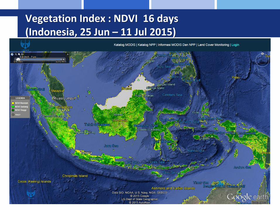
Vegetation Index : NDVI 16 days(Indonesia, 25 Jun – 11 Jul 2015)

8 days monitoring of agricultural drought

Fire Danger Rating System (remote sensing based)

Utilization of FWI Calculator for Local Government
Provincial Forestry Office:-West Kalimantan-Central Kalimantan-South Sumatera
Plantation Company at South Sumatera

Smoke haze and fire hotspot monitoring

Dumai-Bengkalis-Siak
Smoke haze(Spot 6, 18 Juni 2013)

Smoke haze distribution - Landsat-8(West Kalimantan, 7 June 2015)
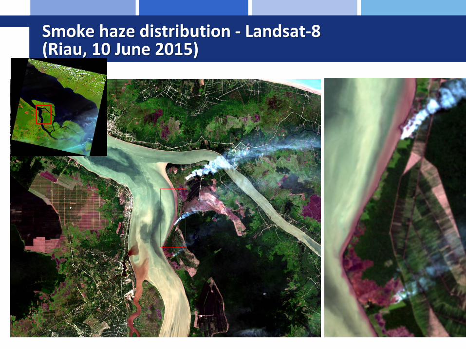
Smoke haze distribution - Landsat-8 (Riau, 10 June 2015)

Hotspot and its validation
Hotspot Data Period accuracy Reference
NOAA-ASMC Daily 12 % Lapan, 2013
MODIS-all Confidence level
Daily 64% Lapan, 2013
MODIS- confidence level > 80 %
Daily 42-43% Vetrita et al, 2012Lapan, 2013
VNF, MODIS 3 weeks 87 % Lapan 2014
Data:NOAA, MODIS, VNF
PRE-DISASTER:Hazard Mapping
Flood, Forest/Land Fire, Volcano
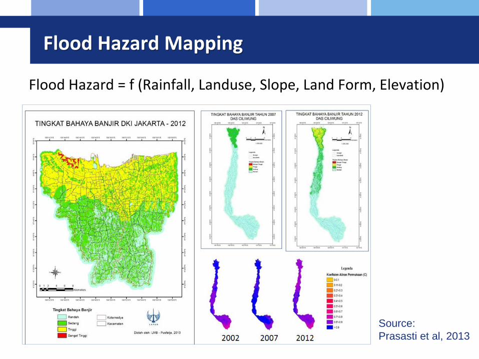
Flood Hazard Mapping
Flood Hazard = f (Rainfall, Landuse, Slope, Land Form, Elevation)
Source: Prasasti et al, 2013

Flood Hazard Mapping
Flood Hazard = f (Rainfall, Landuse, Slope, Land Form, Elevation)Methodology: Multicriteria Componet Analysis using GIS
Source: Haryani et al, 2011
Flood Hazard MappingSampang District, East Java
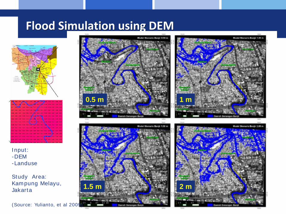
Flood Simulation using DEM
0.5 m 1 m
1.5 m 2 mStudy Area:Kampung Melayu,Jakarta
(Source: Yulianto, et al 2009)
Input:-DEM-Landuse

Flood Simulation Based on Watershed Modelling System (WMS)
Data Input:- Rainfall (Qmorph/TRMM)- Slope, Flow Direction,
Flow Accumulation(DEM SRTM)
- Landuse (SPOT-5)- Soil Map
Source:Haryani et al, 2012

FOREST/LAND FIRE PRONE MAP (Central Kalimantan)
Input: Fire hotspot series, Peat Land, Landuse
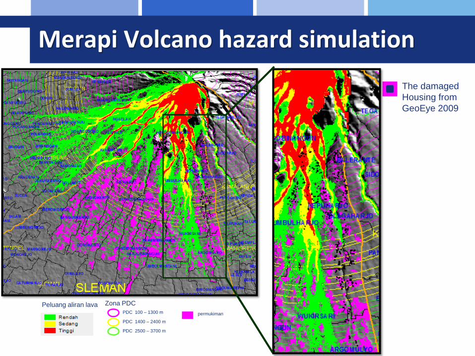
Merapi Volcano hazard simulation
The damaged Housing fromGeoEye 2009
Peluang aliran lava Zona PDCPDC 100 – 1300 m
PDC 1400 – 2400 m
PDC 2500 – 3700 m
permukiman
DISASTER EMERGENCY RESPONSE

EMERGENCY RESPONSE
Disaster LAPAN TEAM COORDINATION
SEARCH DATA ON LAPAN DATABASE
IMAGERY BEFORE AND AFTER DISASTER
(SPOT-4, LANDSAT TM; MODIS,Etc.)
ANALYZED PRODUCTS
DATA PROCESSING AND ANALYSIS (DONE BY LAPAN TEAM)
REQUEST DATA TO ADRC, SENTINEL
ASIA
IMAGERY BEFORE AND AFTER DISASTER
INTERNATIONAL CHARTER
ACTIVATION
HIGH RESOLUTION IMAGERIES SUCH
AS WorldView, QUICKBIRD, ETC.
DATA PROCESSING AND ANALYSIS (DONE BY LAPAN TEAM
AND PARTNER e.g. DLR)
INFORMATION DISSEMINATIONS (http://inderaja.lapan.go.id/SIMBA , Sentinel asia website, Presdident Office, National
Disaster Management Agency, local goverments,, etc )
Other resources (CRISP, PDC, etc)


National Network
Sentinel
ASIA
UNSPIDER
Ministry/Institutio
n BNPBBPBD
People
AHACenter
Inter-nationa
l Charter
1 & 3
1 & 3
2
2
1. Pre-disaster2. Emergency Response3. Recovery and Reconstraction
National Disaster Management Body

LAPAN frame work in supporting emergency quick responseAs a DAN (Data Analysis Node) since 2010PM on International Charter since 2013RSO – UNSPIDER since 2013

Records as PM Project on International Charter Activation
No Year Disaster Charter Requestor PM
1. 2013 Haiyan Thyphoon ADRC for LAPAN LAPAN
2. 2014 Mount Kelud Eruption ADRC for LAPAN LAPAN
3. 2015 Banjarnegara Landslide ADRC for LAPAN LAPAN

Landslide in Wasior - 2010

Merapi Volcano Eruption - 2010
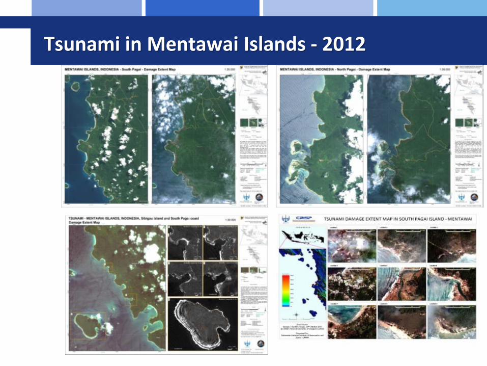
Tsunami in Mentawai Islands - 2012

Flood in Jakarta - 2015

Flood Mapping in Philipines - 2012

Haiyan Storm - 2013

Haiyan Storm - 2013

Sinabung Volcano eruption - 2014

Assessment of Sinabung Volcano eruption-2014
• ASTER ALI (6-02-2014) also showed the devastated of lava dome after eruption and the affected area
• It helps the policy maker to navigate an evacuation of people
Estimated distribution of deposit eruption (lava and pyroclastic)
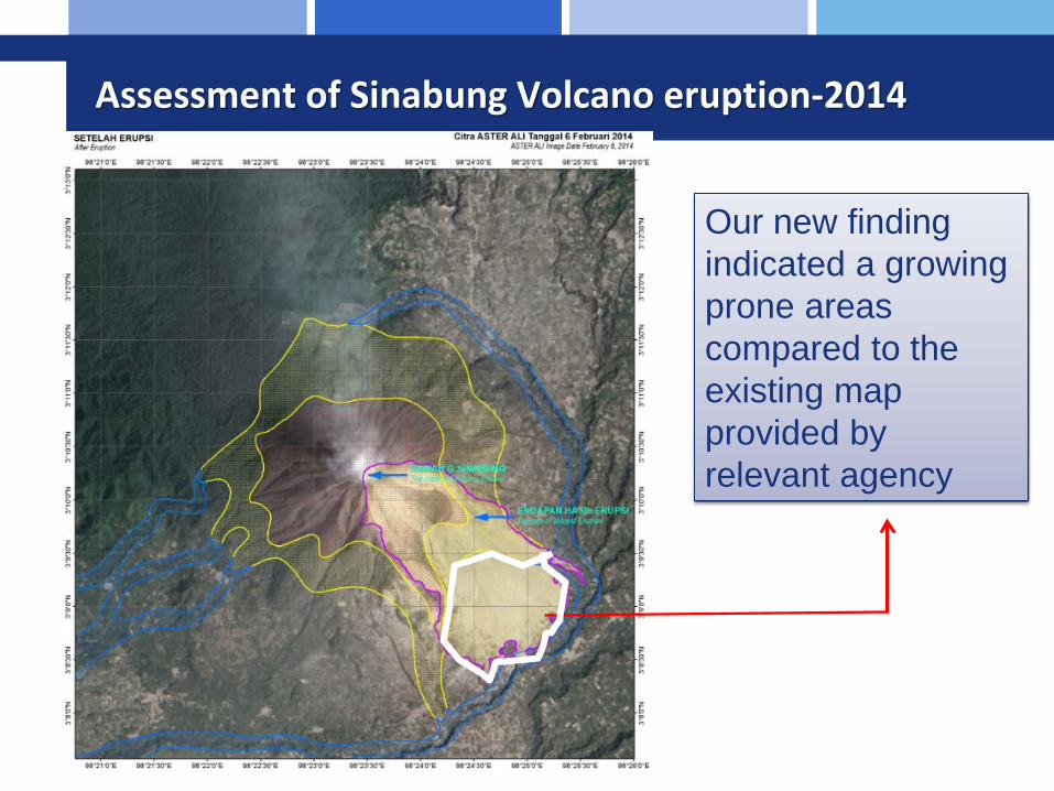
Assessment of Sinabung Volcano eruption-2014
Our new finding indicated a growing prone areas compared to the existing map provided by relevant agency

Kelud Volcano Eruption, East Java - 2014

Landslide in Banjarnegara, Central Java -2015

UAV TECHNOLOGY

UAV Results

Flood in Jakarta 2013

Post-DISASTER: assesment of burnt area & volcano eruption

BURNED AREALANDSAT-8 OLI (April-June 2014)

BURNT AREA FROM SPOT5/6
SPOT 6: 18-06-2013
SPOT 5: 25-02-2014
Probably yet in the process of combustion
Fact! The burnt episode can be continued to the next
season
The burnt episode can be continued to the next season or recurrent

Landsat 8 night
16062014
Landsat 828062014
Landsat 812062014
asap
+ 0: Hotspot MODIS 1-30 Juni 2014, LAPAN
+ : Hotspot VIIRS Nighttime, NOAA/NASA
Dumai
RokanHilir
P. Rupat
Aqua MODIS, 21 Juni2014
A C
D
B
BURNT AREA FROM Landsat-8

MERAPI VOLCANO DAMAGED ASSESSMENT
Yulianto et al, 2013

Environment Studies from Remote Sensing

Hazardous Waste
Landsat 8-OLI (15 Aug 2013) Field Spectral Library
Landsat 8 - TIRS Band 10, 11
LST fromSplit Window Algoritm
(Spektral Angel Mapper)
classification
NDVI

Forest Degradation
03-07-2009 16-05-2012 15-10-2012
Data SPOT-4
Green Vegetation (GV)
Shade
Non PhotoshynteticVegetation (NPV)
Soil
NDFI NBR NDVIManage Logging 70.20 69.80 67.65
Logged and burned 94.91 66.10 74.58Intact forest 80.34 69.27 68.17
West Kalimantan accuracy

Land subsidence
• ALOS PALSARPair
Year Month DayMaximum
Subsidence Value (m)
MeanSubsidence Value (m)
1 2008 05 12 -0.1424 -0.0195
2 2008 06 27 -0.1371 -0.0332
3 2008 08 12 -0.2057 -0.02
4 2008 09 27 -0.0124 -0.0124
5 2008 12 28 -0.209 -0.0363
6 2009 02 12 -0.0699 -0.0104
7 2009 06 30 -0.2204 -0.0253
8 2009 08 15 -0.1677 -0.0459
9 2009 09 30 -0.2426 -0.0334
10 2009 11 15 -0.2448 -0.0626
11 2009 12 31 -0.1795 -0.0269
Average value of land subsidence in Pekalongan city : -3 cm/year
2008
2009
0.26450-0.2448 cm

Vegetation monitoring(Green Space in Urban Area)
SPOT 6 - 2013.NDVI : percentage of green space inJakarta: 19.4% (2013)

Regional and International Network

Jaxa Mini Project
Jaxa mini project merupakan kegiatan kerjasama Jaxa – AIT (sentinel asia) dan Indonesia (BPPT dan LAPAN), untuk studi pemanfaatan data SAR dalam analisa penurunan lahan (land susbsidence), LMB menugaskan Sdri. Junita Monika Pasaribu untuk mengikuti kegiatan ini. Fase 1 : 10-28 Sept 2012, Fase 2: 3-21 Des 2012.

SAFE Project
SAFE (Space Applications for Environment) workshop dilaksanakan pada tanggal 10 Desember 2012, sehari sebelum pelaksanaan APRSAF-19. Pada workshop tersebut disampaikan proposal SAFE Prototyping Project mengenai perhitungan kandungan karbon di hutan mangrove diusulkan oleh LAPAN (Yenni Vetrita)
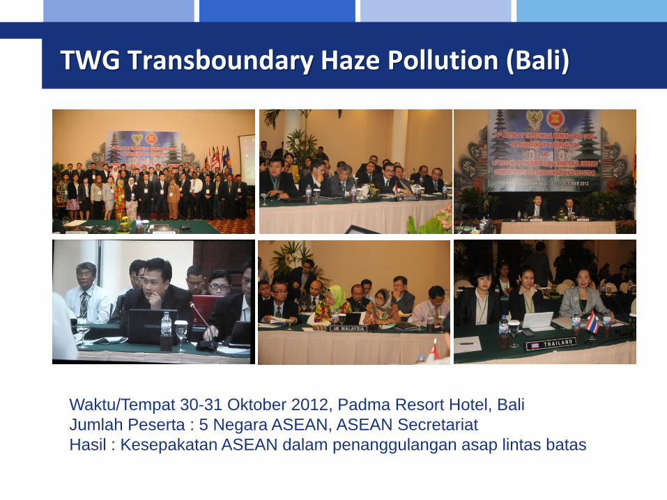
TWG Transboundary Haze Pollution (Bali)
Waktu/Tempat 30-31 Oktober 2012, Padma Resort Hotel, BaliJumlah Peserta : 5 Negara ASEAN, ASEAN SecretariatHasil : Kesepakatan ASEAN dalam penanggulangan asap lintas batas

Agreement RSO

UN SPIDER
Workshop dan Training UN SPIDER
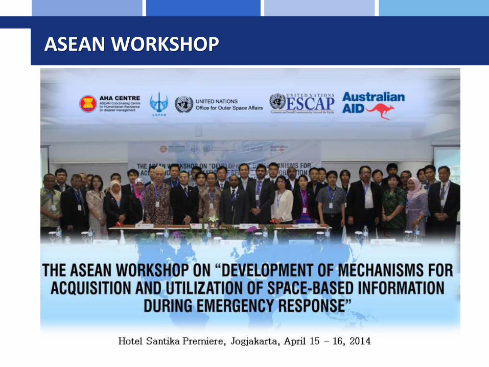
ASEAN WORKSHOP

PROJECT MANAGER TRAINING FOR INTERNATIONAL CHARTER – Sep 9-10 2014)

Contact Person
Dr. M. Rokhis KhomarudinHp: 085231023573 / 021 71684803email: [email protected]@[email protected]

Terima Kasih