Embed Size (px)
Citation preview

1
Site Review and Update
Lang Property
Pemberton Township, Burlington County, New Jersey
Cerclis No. NJD980505382
July 9, 1997
Prepared by:
New Jersey Department of Health and Senior ServicesConsumer and Environmental Health Services
Under Cooperative Agreement with:
The Agency for Toxic Substances and Disease Registry

SUMMARY OF BACKGROUND AND HISTORY
The Lang Property site is located on a 40-acre parcel of land near the Lebanon State Forest in asparsely populated rural area of Pemberton Township, Burlington County, New Jersey (see inset).The Lang Property site encompasses about 40 acres, however, the area of contamination and remedialactivity is limited to approximately 2 acres. Portions of the 40acres was used for blueberry farming between 1965 and 1970.
The site is bounded by an active cranberry bog to the north andwest. State Highway Route 70 lies to the north and the PennCentral Railroad tracks lie to the south. Former cultivatedfields of blueberry plants and forested sections lie directly tothe east of the site. Figure 1 shows details of the LangProperty site.
The area surrounding the forty-acre site is forested andagricultural. The remainder of the site is vacant, covered withmostly uncultivated blueberry plants and forested sections. Currently there remain some portions of cultivated blueberryfields on the portion of the 40 acres away from thecontaminated area.
In 1975, between 1200 to 1500 drums of unknown chemicalwastes were found on the site. In 1976, the owners of theproperty began removal of the drums. During drum removal,some of the drums into were emptied into unlined pits. Otherswere spilled directly onto the ground.
Two aquifers (upper and lower) were identified at the site. The upper aquifer (Cohansey SandFormation) and the lower aquifer (Kirkwood Formation) are not separated by an impermeable layer.Groundwater in the Kirkwood Formation is recharged by percolation through the Cohansey SandFormation. The depth to groundwater ranges from one to three feet below the ground surfacedepending on the time of year. The direction of groundwater flow is in a northwesterly direction.
Several residences were identified in the vicinity of the Lang Property site that depend on the shallowgroundwater for domestic water supply. The aquifer beneath the site supplies drinking water toapproximately 13,000 residents. As many as 20 private wells are located within 1 mile of the site.However, potable wells identified in the immediate area were up gradient from the site (not in thedirection of groundwater flow).
Residents living near the Lang Property site and nearby blueberry farmers cultivating berries haveexpressed concerns regarding potential human health effects from spillage of the drums as well as thepossible contamination of blueberry and cranberry fields. This Site Review and Update will...

2
Demographics
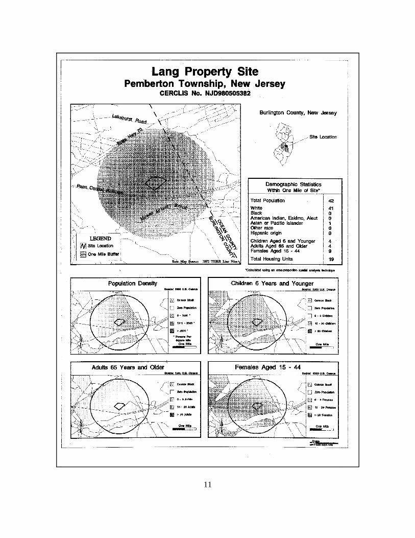
According to 1990 United States Census data, 395,066 people live in Burlington County.Approximately 31,342 people reside in Pemberton Township. About 42 people reside within a onemile radius of the site. The nearest occupied residence is located approximately 1300 feet south eastof the site.
A summary of population statistics within one mile of the site is presented in the attached ATSDRdemographic map. Remedial History
Between 1977 to 1979, environmental sampling was conducted by the Burlington County HealthDepartment and the New Jersey Department of Environmental Protection (NJDEP). The samplingresults indicated the presence of volatile organic compound (VOC) contamination in groundwateron the site.
The groundwater contamination included 1,1- dichloroethene (max. conc. - 1400 ppb), 1,1-dichloroethane (max. conc. - 4300 ppb), trans-1,2-dichloroethene (max. conc. - 2500 ppb), 1,1,1-trichloroethane (max. conc. - 8200 ppb), trichloroethane (max. conc. - 55,000 ppb), benzene (max.conc. - 1600 ppb), and tetrachloroethene (max. conc. - 15000 ppb).
In 1982, the Lang Property site was included in the United States Environmental Protection Agency(USEPA) National Priority List (NPL). A Remedial Investigation/Feasibility Study (RI/FS) wascompleted by the EPA in August, 1986. The RI included investigation of groundwater, as well assampling of site-associated soil and nearby surface water. Groundwater investigation includedsampling and analysis of water collected from nineteen monitoring wells installed at the LangProperty site. Most groundwater contamination was found in the shallow monitoring wells (30 feetor less). The results of groundwater sampling showed the presence of volatile organic compounds(VOC’s) and inorganic compounds. The VOC’s included tetrachloroethene, benzene, toluene,trichloroethane, trichloroethylene, and xylene. The inorganics that were detected were aluminum,antimony, cadmium, chromium, iron, lead, manganese, nickel, and thallium.
The RI/FS characterized the contaminant plume as migrating slightly outside the site boundaries. Itwas determined that contaminants had migrated up to 500 feet downgradient and to the northwestfrom the disposal area, and up to 30 feet in depth.
A Record of Decision (ROD) was issued by USEPA in September, 1986. The ROD provided forexcavation of contaminated soil, extraction and treatment of contaminated groundwater followed byreinjection, filling site surface with new soil, and a security fence to restrict access to the site.
Phase I of the ROD (soil clean-up, restoration, and site fencing) was completed by November, 1988.Phase II of the ROD, the design and construction of the system, was completed by August , 1995.

3
Start-up and operational testing of the groundwater remediation system was initiated on August 22,1995. Operation of the groundwater treatment system will continue to operate until establishedcleanup levels are met (expected to be 1999).
ATSDR Activity
The Agency for Toxic Substances and Disease Registry (ATSDR) completed a Public HealthAssessment (PHA) for the Lang Property site in April, 1989. The PHA noted that ingestion,inhalation, and direct contact of contaminants associated with on-site soils, surface water, sediments,groundwater, air, and consumable plants and animals were the identifiable human exposure pathwaysassociated with the site. Contaminants of concern at the site consisted of polychlorinated biphenyls(PCB), VOC’s, semi-VOC’s, and metals. The PHA categorized the Lang Property site as a potentialpublic health concern because of the risk to health caused by potential human exposure to VOC’s,semi-VOC’s and PCB’s by either inhalation, ingestion or dermal routes. The 1989 Public Health Assessment identified community health concerns regarding the spillage ofthe drums as well as the possible contamination of blueberry and cranberry fields. Residents werealso concerned about the nature and extent of contamination, impact of the site on property values,and it’s possible effects on air quality. The ATSDR identified the following public health concerns in the 1989 Public health assessment:
1) Inhalation of site related contaminants entrained in air during remedial activities is a potentialexposure pathway to remedial workers. This pathway is not substantiated in the light ofcurrent information since workers were provided with adequate personal protectiveequipments during remediation as specified in OSHA regulations.
2) Some local residences in the vicinity of Lang Property site, who rely on private wells fortheir drinking water supply may be at risk of exposure to contaminants in the groundwater.However, current site information indicates this exposure pathway is limited since the estimated groundwater contamination plume does not extend much beyond siteboundaries. Also the private potable wells near the site are located up gradient fromthe groundwater plume.
3) Direct contact and incidental ingestion of contaminated soil by trespassers is the most likelyroute of exposure. Current site data and information indicates this pathway is limited sincethe Lang Property site is fenced and on-site contaminated soils has been removed as part ofongoing remediation.
4) There is a potential human exposure pathway to bioaccumulated contaminants in the foodchain (blueberries and cranberries grown in the area). This pathway is not substantiated in thelight of current site data and information. No crops or gardens (i.e., containing edible plants)are being grown on-site.

4
5) Contaminants can be transported off-site by surface water and sediment runoff. Thesepathways are not substantiated in the light of current site data and information as there is nosurface water body on the site.
Recommendations consisted of : 1) a well inventory to locate all wells within a half mile radius of thesite and monitoring of the residential wells in the vicinity of the site, 2) institutional controls forinstallation of new water supply wells within the contaminated portion of the site; 3) remedial workersprovided with adequate personal protective equipment and optimal dust control measuresimplemented; and 4) additional sampling of the surface water and sediments during remediation ofthe soil and groundwater.
CURRENT SITE CONDITIONS
Two additional visits were made to the Lang Property site since the PHA was documented in 1989.James Pasqualo from New Jersey Department of Health and Senior Services (NJDHSS), and SteveJones (ATSDR, Region 2) participated in a site visit, along with representatives of the USEPA onApril 19, 1995.
On March 20, 1996, James Pasqualo and Steve Miller of the NJDHSS visited the Lang Property siteaccompanied by a representative of the United States Environmental Protection Agency (USEPA)and the New Jersey Department of Environmental Protection (NJDEP).
The following observations were made during the site visits: # The Lang Property site is a well-kept, fenced parcel of land, comprising some 40 acres.
# There are no residences on-site, although there is the foundation of a burned hunting/fishing
lodge in a site clearing.
# Inside the fenced area are recovery wells and pumps for extraction of contaminatedgroundwater for processing. There is a trailer for the contractor and other remediationworkers as well as a large process vessel or storage tank and a larger main building whichhouses several process vessels and holding tanks. An adjacent room houses office space,equipment, and controls for monitoring the processes in the main building. The remediationsfor on-site contaminated soil recommended in the ROD have already been conducted. Thegroundwater treatment is ongoing and is expected to be completed by 1999.
5
CURRENT ISSUES
Based on the environmental data available, site related contamination is present in groundwater. Theprimary public health issue associated with the Lang Property site is the potential impact of thegroundwater contamination on existing private potable wells.
Two aquifers (upper and lower) were identified at the site. The upper aquifer (Cohansey SandFormation) and the lower aquifer (Kirkwood Formation) are not separated by an impermeable layer.The direction of groundwater flow is in a northwesterly direction.
Several residences were identified in the vicinity of the Lang Property site that depend on the shallowgroundwater for domestic water supply. The aquifer beneath the site supplies drinking water toapproximately 13,000 residents. As many as 20 private wells are located within 1 mile of the site.However, almost all of the private potable wells identified in the immediate area were up gradientfrom the site (opposite the direction of groundwater flow). The closest residential potable waterwells, are approximately 1300 feet up gradient from the site. Under current site conditions, thecontaminant groundwater plume has been captured by the pump and treat remediation .Theremediation of the contaminated groundwater at the Lang Property site is ongoing and is expectedto be completed by 1999.
The RI noted that one private well was located to be hydraulically downgradient from the site andwithin a one-mile radius. However, the sampling and analysis of water from monitoring wells locatedbetween the site and the nearest downgradient potable well did not indicate any site relatedcontamination.
Approximately one-half to three-quarter miles from the site are active cranberry and blueberryfarming areas. These are irrigated by surface water, and are not affected by site contaminationbecause the contaminant plume never migrated more than 500 feet off-site. In addition, blueberrieshave been sampled with no evidence of site-related contamination.
Contaminated on-site soils have been removed; eliminating this possible pathway of contamination.
No new additional community health concerns associated with the site have been identified.

6
CONCLUSIONS
1. Based on current conditions at the site, it has been determined that the site poses no apparentpublic health hazard. Site contamination continues to exist, however, current humanexposures are not occurring at the present time since on-site contaminated soils have beenremoved, the plume of groundwater contamination is being treated by extraction/reinjection,and private wells are not affected by site related contaminants.
2. Recommendation from the 1989 ATSDR Public Health Assessment have either been satisfiedor currently are not viable options for protection of public health.
3. No new additional community health concerns associated with the site have been identified.
4. Based on current conditions, no further activities are needed to assess the public healthimplications of this site.
RECOMMENDATIONS
1. Results of the ongoing environmental monitoring program for groundwater quality shouldbe periodically reviewed for public health significance when available. Should the dataindicate a change in site conditions, further health evaluations should be performed for publichealth implications.
2. Current remedial activities specified in the ROD should be continued to minimize themigration of contaminated groundwater to off-site areas of the site.
3. Based upon current site data and information no further health assessment evaluation orfollow-up activities are recommended for the Lang Property site.
4. If additional data becomes available, ATSDR/NJDHSS will review and evaluate such data forpublic health implications.

7
PUBLIC HEALTH ACTION PLAN
The Public Health Action Plan (PHAP) for the Lang Property site contains a description of theactions to be taken by ATSDR and/or NJDHSS at or in the vicinity of the site subsequent to thecompletion of this Site Review and Update (SRU). The purpose of the PHAP is to ensure that thisSRU not only identifies public health hazards, but provides a plan of action designed to mitigate andprevent adverse human health effects resulting from exposure to hazardous substances in theenvironment. Included, is a commitment on the part of ATSDR and NJDHSS to follow-up on thisplan to ensure that it is implemented. ATSDR will provide an annual follow-up to this PHAP,outlining the actions completed and those in progress. This report will be placed in repositories thatcontain copies of this SRU, and will be provided to persons who request it. The public health actionstaken or to be implemented are as follows:
Public Health Actions Undertaken by ATSDR/NJDHSS:
1. Environmental data and proposed remedial activities have been evaluated within the contextof human exposure pathways and relevant public health issues.
Public Health Actions Planned by ATSDR/NJDHSS:
1. ATSDR and the NJDHSS will coordinate with the appropriate environmental agencies todevelop plans to implement the recommendations contained in this SRU.
2. ATSDR will provide an annual follow up to this PHAP, outlining the actions completed andthose in progress. This report will be placed in repositories that contain copies of this sitereview and update, and will be provided to persons who request it.
3. Document will be circulated to the Burlington County Health Department (BCHD).
ATSDR will reevaluate and expand the Public Health Action Plan (PHAP) when needed. Newenvironmental, toxicological, health outcome data, or the results of implementing the above proposedactions may determine the need for additional actions at this site.

8
CERTIFICATION
This Site Review and Update (SRU) was prepared by the New Jersey Department of Health andSenior Services (NJDHSS) under a cooperative agreement with the Agency for Toxic Substances andDisease Registry (ATSDR). It is in accordance with approved methodology and procedures existingat the time the SRU was begun.
Technical Project Officer
Superfund Site Assessment Branch (SSAB)Division of Health Assessment and Consultation (DHAC)
ATSDR
The Division of Health Assessment and Consultation, ATSDR, has reviewed this SRU and concurswith its findings.
Chief, SPS, SSAB, DHAC,

9
DOCUMENTS REVIEWED
1 . Record of Decision, Lang Property Site, Pemberton Township, Burlington County, NewJersey, USEPA Region II, September 1986.
2. Agency for Toxic Substances and Disease Registry, Health Assessment for Lang PropertySite, Pemberton Township, Burlington County, New Jersey, October, 1989.
3. Camp Dresser and Mckee Inc., Draft Phase II Remedial Investigation Report for the LangProperty Site, Pemberton Township, Burlington County, New Jersey, April 1986.
4. U.S. Environmental Protection Agency (USEPA), Preliminary Close-out Report, LangProperty Superfund Site, Burlington County, Pemberton Township, New Jersey.
INTERVIEWS/PERSONAL COMMUNICATIONS:
1. Remedial Project Manager/NJDEP
2. Project Manager/Emergency & Remedial Response Division/USEPA

10
PREPARERS OF REPORT
Preparer of Report:
Steven M. Miller, M.S., Ph.D.Environmental Scientist II ATSDR Health Assessment ProjectConsumer and Environmental Health ServiceNew Jersey Department of Health and Senior Services
ATSDR Regional Representative:
Arthur BlockSenior Regional Representative; Region IIRegional OperationsOffice of the Assistant Administrator
ATSDR Technical Project Officer:
David HutchinsTechnical Project OfficerSuperfund Site Assessment Branch (SSAB)Division of Health Assessment and Consultation (DHAC)
Any questions concerning this document should be directed to:
ATSDR Project Manager Consumer and Environmental Health ServiceNew Jersey Department of Health and Senior Services210 South Broad StreetCN 360Trenton, NJ 08625-0360
11