Embed Size (px)
Citation preview
Recent Landslide near West Fork of Buffalo Creek
Seth Wittke, Alan Ver Ploeg
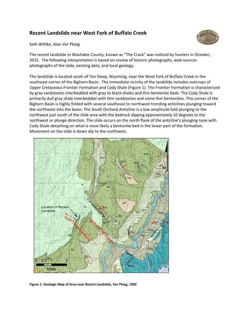
The recent landslide in Washakie County, known as “The Crack” was noticed by hunters in October, 2015. The following interpretation is based on review of historic photographs, web‐sources photographs of the slide, existing data, and local geology. The landslide is located south of Ten Sleep, Wyoming, near the West Fork of Buffalo Creek in the southeast corner of the Bighorn Basin. The immediate vicinity of the landslide includes outcrops of Upper Cretaceous Frontier Formation and Cody Shale (Figure 1). The Frontier Formation is characterized by gray sandstones interbedded with gray to black shales and thin bentonite beds. The Cody Shale is primarily dull gray shale interbedded with thin sandstones and some thin bentonites. This corner of the Bighorn Basin is highly folded with several southeast to northwest trending anticlines plunging toward the northwest into the basin. The South Orchard Anticline is a low amplitude fold plunging to the northwest just south of the slide area with the bedrock dipping approximately 10 degrees to the northwest or plunge direction. The slide occurs on the north flank of the anticline’s plunging nose with Cody Shale detaching on what is most likely a bentonite bed in the lower part of the formation. Movement on the slide is down dip to the northwest.
Figure 1. Geologic Map of Area near Recent Landslide, Ver Ploeg, 1992
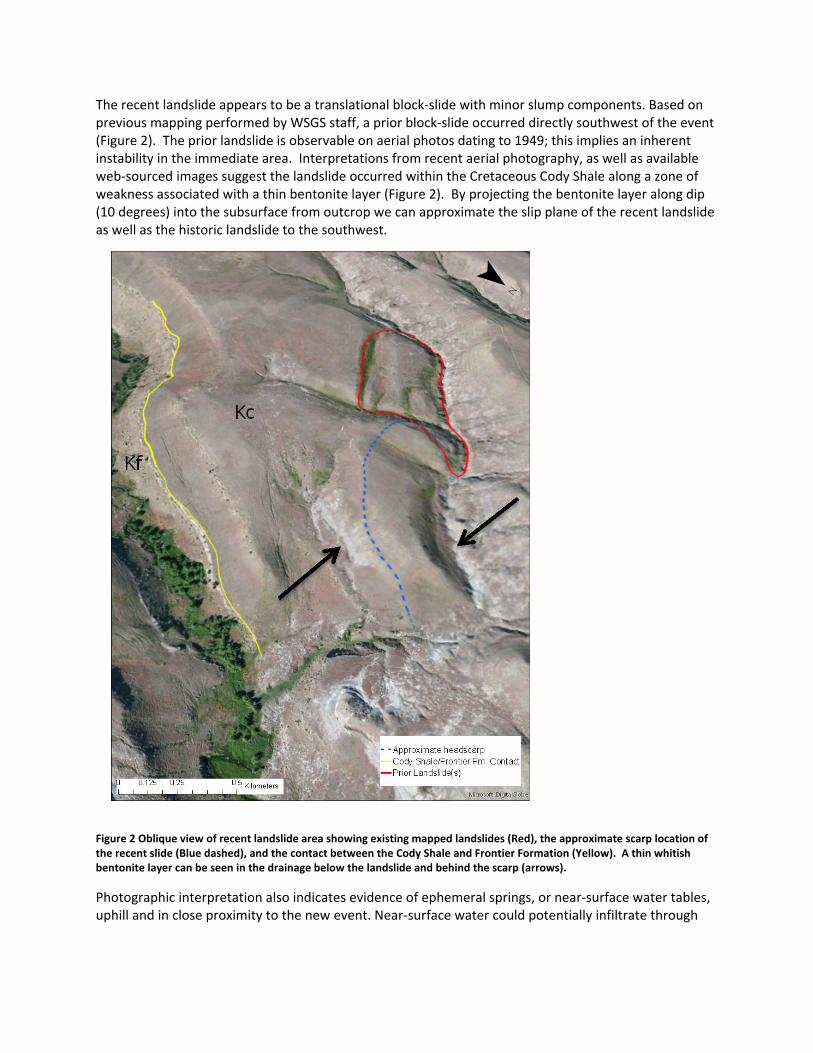
The recent landslide appears to be a translational block‐slide with minor slump components. Based on previous mapping performed by WSGS staff, a prior block‐slide occurred directly southwest of the event (Figure 2). The prior landslide is observable on aerial photos dating to 1949; this implies an inherent instability in the immediate area. Interpretations from recent aerial photography, as well as available web‐sourced images suggest the landslide occurred within the Cretaceous Cody Shale along a zone of weakness associated with a thin bentonite layer (Figure 2). By projecting the bentonite layer along dip (10 degrees) into the subsurface from outcrop we can approximate the slip plane of the recent landslide as well as the historic landslide to the southwest.
Figure 2 Oblique view of recent landslide area showing existing mapped landslides (Red), the approximate scarp location of the recent slide (Blue dashed), and the contact between the Cody Shale and Frontier Formation (Yellow). A thin whitish bentonite layer can be seen in the drainage below the landslide and behind the scarp (arrows).
Photographic interpretation also indicates evidence of ephemeral springs, or near‐surface water tables, uphill and in close proximity to the new event. Near‐surface water could potentially infiltrate through

the subsurface and accumulate along the bentonite layer causing additional weakness and ultimately failure of the slope. There is no infrastructure or property at risk from this recent landslide. Based on the orientation of this landslide the WSGS also does not anticipate future risks to infrastructure or property. The greatest risk associated with this landslide is objects, including humans, falling into the crevasse, either from unstable edge material or being in close proximity to the landslide if it were to suddenly mobilize. The historic landslide to the southwest suggests that a catastrophic failure of the landslide is unlikely. If it were to occur and effectively dam the drainage floor, we anticipate minimal runoff damming to occur. The drainage behind the potential earthen dam is approximately 0.4 mi2, it is unlikely to capture enough runoff behind the dam to overtop it catastrophically. Time and weather permitting, geologists from the WSGS will visit the landslide area and groundtruth our observations. At that time landmarks will be established to measure the landslide size and offset. Future measurements from the same landmarks will allow us to determine whether the landslide has stabilized or continues to move. The WSGS would like to remind individuals that walking on or near potentially active landslides is not advisable. Edges of recent landslides are typically unstable. Landslides can also suddenly mobilize, posing a risk to objects, including humans, in their path. If you see a landslide, historic or recent, feel free to report it at http://www.wsgs.wyo.gov/hazards/report‐landslide.