Embed Size (px)
Citation preview

Landform mapping in support of Landform mapping in support of soil surveys at Washingtonsoil surveys at Washington’’s s
National ParksNational Parks
Jon RiedelJon RiedelGeologistGeologist
North Cascades National ParkNorth Cascades National Park
OutlineOutline• NPS Natural Resource Challenge (why)
• Landform Advantages • Methods
• Comparison of NPS and NASIS • Landform Progress
• Linking Soils and Landforms

National Park Service Units of the North Coast and Cascades Network(~2 million acres, mostly wilderness)
NOCA
OLYM EBLA
SAJH
MORA
LEWI
FOVA
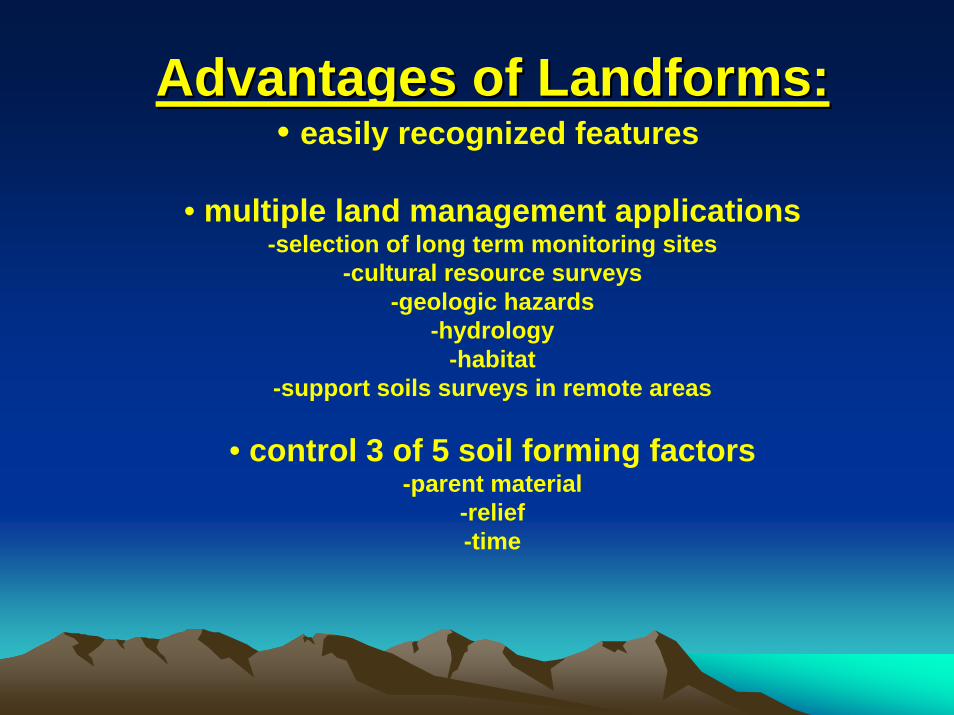
Advantages of Landforms:Advantages of Landforms:• easily recognized features
• multiple land management applications-selection of long term monitoring sites
-cultural resource surveys-geologic hazards
-hydrology-habitat
-support soils surveys in remote areas
• control 3 of 5 soil forming factors-parent material
-relief-time

Approximate landform surface ages at Approximate landform surface ages at North Cascades National ParkNorth Cascades National Park
-debris cones, floodplains and alluvial fans < 500 years-most neoglacial moraines < 300 years-valley walls 100-12,000 years-high outwash terraces and fan terraces 10,000-12,000 years-Pleistocene moraines 12,000 &18,000 years-bedrock benches 12,000 years-landslides 0-14,000 years

MethodsMethods• current legend 37 landforms, tailored for each park
• focus at 1:24,000 scale
• use 1:12,000 and other scale stereo aerial photographs,10m digital elevation models, and occasionally LiDAR(light detection and range-finding)
• field check most valley floors

Mt. Rainier Mt. Rainier
- stratovolcano (welded tuffs, breccias, basaltic to andesitic lavas)
- Tatoosh granite
- 12,000 feet of local relief
-Twenty five glaciers covering 34 square miles
- 22 volcanic ashes

- Failure of large masses of hydrothermally altered rocks spawned massivelahars approximately4,800 and 500 years ago.
-These lahars reached Puget Sound and left hummocky deposits onlower valley walls and floodplains.
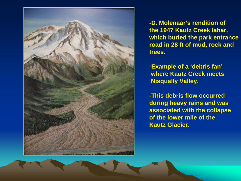
--D. D. MolenaarMolenaar’’ss rendition of rendition of the 1947 the 1947 KautzKautz Creek Creek laharlahar,,which buried the park entrancewhich buried the park entranceroad in 28 ft of mud, rock and road in 28 ft of mud, rock and trees.trees.
--Example of a Example of a ‘‘debris fandebris fan’’where where KautzKautz Creek meets Creek meets NisquallyNisqually Valley. Valley.
--This debris flow occurred This debris flow occurred during heavy rains and wasduring heavy rains and wasassociated with the collapse associated with the collapse of the lower mile of the of the lower mile of the KautzKautz Glacier.Glacier.

North CascadesNorth Cascades
-bedrock mostly gneiss and granite
-8,000 ft local relief
-wide variation in climate with elevationand distance from Pacific
-at least 8 volcanic ashes
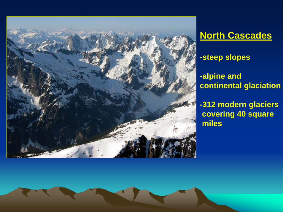
North Cascades
-steep slopes
-alpine and continental glaciation
-312 modern glacierscovering 40 square miles

GoodellGoodell Creek landslide occurred in Creek landslide occurred in December 2003, and created December 2003, and created a small lake on the floodplain.a small lake on the floodplain.
lakelake

Sackung (MM-SG)•Gravitational spreading/ deep seated slope deformation at or near ridge tops •Associated with faults and over steepened valley walls •Well-expressed SG have giant steps in the landscape, ponds, or double ridges•Possible dead fallen trees and/or broken bedrock in troughs

Snow Avalanche Impact Landforms (SAIL) (MM-SL)•Elliptical depression and hummocky, crescent-shaped mound of debriscreated by snow avalanche impact on valley floor deposits•Within or at the base of the debris apron or a debris cone

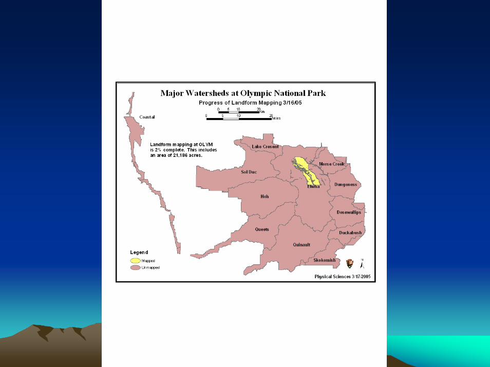
Olympic
-accreted volcanic and sedimentary rocks (no granite)
-thrust faults and horseshoe structure
-266 active glaciers
-coastal processes
-one volcanic ash (Mazama ‘O’)
-

ElwhaElwha River and River and recent landsliderecent landslide

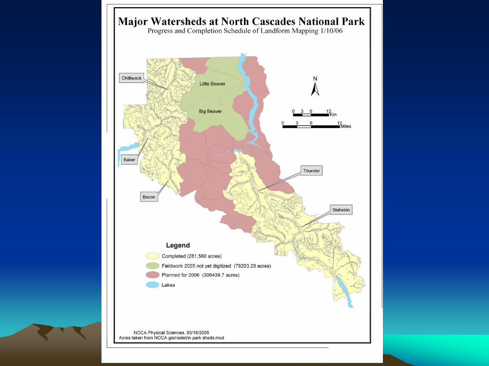
Landform ProgressLandform Progress

LiDARLiDAR assisted mapping assisted mapping of landforms in the of landforms in the StehekinStehekinValley Valley
AF
FT
FP
T
FT
LakeLakeChelanChelan
T
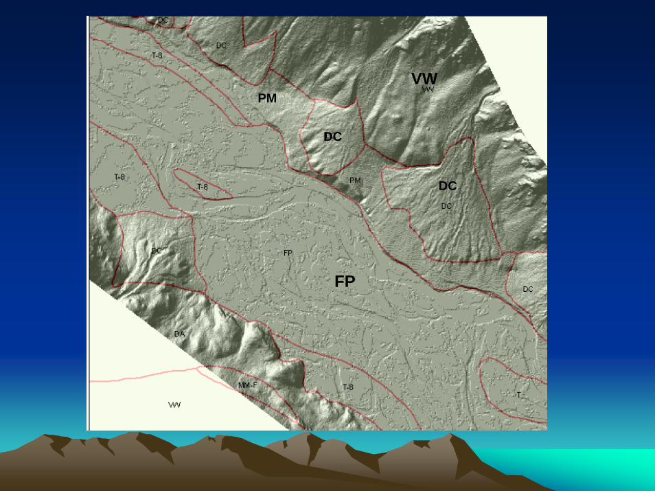
DC
DC
FP
PMVW

Table 2. Percent of watershed by landform type, North Cascades National Park (NPS, 2005)
Stehekin Thunder Chilliwack Bacon Baker
% of WS % of WS % of WS % of WS % of WS
Type of Landform (542 km2) (301 km2) (218 km2) (133 k2) (246 k2)
ALLUVIAL FAN (AF) 0.5 0.2 0.1 0 0.1
BEDROCK BENCH (BB) 1.0 1.0 0 0.6 0.3
DEBRIS APRON (DA) 10.0 9.5 9.8 8.7 5.9
DEBRIS CONE (DC) 2.8 2.7 3.8 2.2 2.6
ALLUVIAL FAN TERRACE (FT) 0.2 0.1 0.1 0.1 0.4
FLOOD PLAIN (FP) 1.7 1.9 2.8 1.4 1.5
LITTLE ICE AGE MORAINE (LM) 0.2 0.1 0.3 0.1 0.4
MASS MOVEMENT-DEBRIS AVALANCHE -DA) 0.3 2.1 1.5 0.4 0.8
MASS MOVEMENT-DEBRIS TORRENT (MM-DT) 0.1 0.1 0 0 0.2
MASS MOVEMENT-FALL/TOPPLE (MM-F) 1.4 1.6 0.1 1.0 1.6
MASS MOVEMENT-SLUMP/CREEP (MM-S) 0 0 1.6 0 0
PLEISTOCENE MORAINE (PM) 0.5 0.2 0.5 0.3 0.1
RIVER CANYON (RC) 1.0 1.3 1.4 0.4 0.8
TERRACE (T) 1.0 1.0 1.1 0.9 0.7
UNDIFFERENTIATED (U) 0.1 0.1 0 0 0
VALLEY BOTTOM (VB) 0.9 0.5 0.2 0.3 0.7
VALLEY WALL (VW) 70.5 55.4 53.1 68.8 65.4
ARETE (A) 0.5 1.3 1.1 0.5 1.0
CIRQUE (C) 6.1 19.3 19.4 12.7 15.9
PASS (P) 0.1 0.2 0.2 0 0
RIDGE (R ) 0.7 0.6 2.2 1.1 1.0
HORN (H) 0.4 0.6 0.6 0.1 0.2
OTHER MOUNTAIN (O) 0.2 0.1 0 0.2 0.1

Table 2. Percent of watershed by landform type, North Cascades National Park (NPS, 2005)
Stehekin Thunder Chilliwack Bacon Baker
% of WS % of WS % of WS % of WS % of WS
Type of Landform (542 km2) (301 km2) (218 km2) (133km2) (246 m2)
ALLUVIAL FAN (AF) 0.5 0.2 0.1 0 0.1
BEDROCK BENCH (BB) 1.0 1.0 0 0.6 0.3
DEBRIS APRON (DA) 10.0 9.5 9.8 8.7 5.9
DEBRIS CONE (DC) 2.8 2.7 3.8 2.2 2.6
ALLUVIAL FAN TERRACE (FT) 0.2 0.1 0.1 0.1 0.4
FLOOD PLAIN (FP) 1.7 1.9 2.8 1.4 1.5
LITTLE ICE AGE MORAINE (LM) 0.2 0.1 0.3 0.1 0.4
MASS MOVEMENT-DEBRIS AVALANCHE (MDA) 0.3 2.1 1.5 0.4 0.8
MASS MOVEMENT-DEBRIS TORRENT (MM-DT) 0.1 0.1 0 0 0.2
MASS MOVEMENT-FALL/TOPPLE (MM-F) 1.4 1.6 0.1 1.0 1.6
MASS MOVEMENT-SLUMP/CREEP (MM-S) 0 0 1.6 0 0
PLEISTOCENE MORAINE (PM) 0.5 0.2 0.5 0.3 0.1
RIVER CANYON (RC) 1.0 1.3 1.4 0.4 0.8
TERRACE (T) 1.0 1.0 1.1 0.9 0.7
UNDIFFERENTIATED (U) 0.1 0.1 0 0 0
VALLEY BOTTOM (VB) 0.9 0.5 0.2 0.3 0.7
VALLEY WALL (VW) 70.5 55.4 53.1 68.8 65.4
ARETE (A) 0.5 1.3 1.1 0.5 1.0
CIRQUE (C) 6.1 19.3 19.4 12.7 15.9
PASS (P) 0.1 0.2 0.2 0 0
RIDGE (R ) 0.7 0.6 2.2 1.1 1.0
HORN (H) 0.4 0.6 0.6 0.1 0.2
OTHER MOUNTAIN (O) 0.2 0.1 0 0.2 0.1


LiDARLiDAR at Mt. Rainierat Mt. Rainier
lateral moraine

NASIS NASIS –– NPS Landform Term ComparisonNPS Landform Term Comparison
-TERMINOLOGY: Generally very good correspondence with few gaps. only 6 of 28 NPS landform terms have no direct NASIS counterpart, and most of these are minor mapping units. Decide whether to useNASIS or NPS terms.
-SCALE: In some cases, such as floodplains, NPS includes several NASIS features (e.g. bar, river, alluvial flat in one NPS map unit).
-’NEW’ LANDFORMS: NPS has requested new units such as snow avalanche impact landforms and sackung be added to NASIS.

NPS LF Terms NASIS Terms NASIS Related Terms
FLOOD PLAIN flood plainalluvial flat, bar, bog, braided stream, flood plain step, marsh, river, swamp,
VALLEY BOTTOM alluvial flat valley plain, lake, pond, valley floor
TERRACE terrace stream terrace
DEBRIS CONE alluvial cone, talus cone avalanche chute, avalanche track, levee
ALLUVIAL FAN alluvial fan fan apron, fan collar, delta*
ALLUVIAL FAN TERRACE fan remnant eroded fan remnant, ballena
DEBRIS FAN (Mt. Rainier) none debris flow, fan
LAHAR debris flow (lahar)
DEBRIS ACCUMULATION scree, talus slopes
MASS MOVEMENT-FALL/TOPPLE
fall (rockfall, topple), talus slope
block stream
MASS MOVEMENT-DEBRIS AVALANCHE
flow (debris avalanche) debris fall, debris slide, debris spread
MASS MOVEMENT-SLUMP/CREEP
slide (rotational landslide-slump)
flow (earthflow-creep), rotational debris slide,
MASS MOVEMENT-DEBRIS TORRENT flow (rock fragment flow)
complex landslide, spread (debris spread)
MASS MOVEMENT-SACKUNG none
MASS MOVEMENT-SAIL none
NASIS-NPS Landform Term Comparison
* Special cases (example- dammed Ross Lake)

Linking Soils and Landforms:Linking Soils and Landforms:The Thunder Creek test caseThe Thunder Creek test case
Snow/Glaciers
Rock
Major StreamsTrails
Lakes
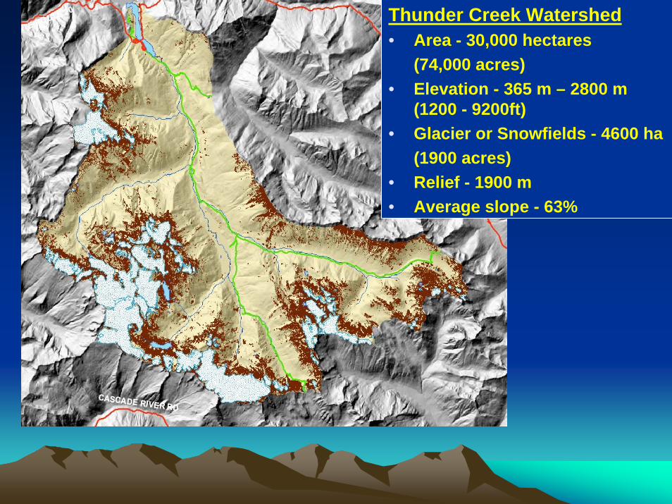
RoadsThunder Creek Watershed• Area - 30,000 hectares
(74,000 acres)• Elevation - 365 m – 2800 m
(1200 - 9200ft)• Glacier or Snowfields - 4600 ha
(1900 acres)• Relief - 1900 m• Average slope - 63%

(1) Aspect + Elevation + Vegetation = Temperature and Moisture Regime
(2) MTR + Vegetation = Cover Type
(3) Covertype + Landforms = Soilscape
(4) Soilscape + Aspect + Elevation + Wetness index = Soil Types
Remote Area Soil Proxy Model Development


Valley Wall (VW)Too steep to hold a significant amount of slope debris.
Debris Apron (DA)Accumulation of material at toe of steep valley walls. Usually forested soils developed in thicker colluvial and glacial deposits
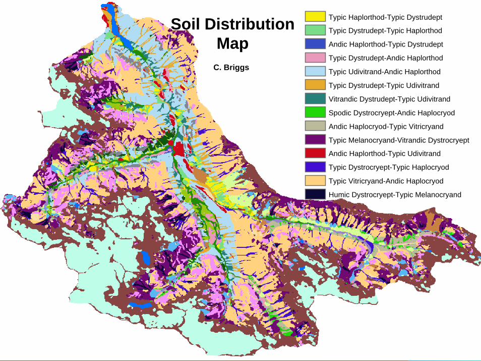
Typic Haplorthod-Typic Dystrudept
Typic Dystrudept-Typic Haplorthod
Andic Haplorthod-Typic Dystrudept
Typic Dystrudept-Andic Haplorthod
Typic Udivitrand-Andic Haplorthod
Typic Dystrudept-Typic Udivitrand
Vitrandic Dystrudept-Typic Udivitrand
Spodic Dystrocryept-Andic Haplocryod
Andic Haplocryod-Typic Vitricryand
Typic Melanocryand-Vitrandic Dystrocryept
Andic Haplorthod-Typic Udivitrand
Typic Dystrocryept-Typic Haplocryod
Typic Vitricryand-Andic Haplocryod
Humic Dystrocryept-Typic Melanocryand
Soil Distribution Map
C. Briggs

SpodosolsSpodosols• Cold coniferous forests with high
precipitation
• Translocation of Al, Fe, and OC– Albic horizon– Spodic horizon
• High terraces, Pleistocene age moraines, bedrock benches
slide courtesy C. Briggs

AndisolsAndisols
• Volcanic ash or amorphous materials
• Common soils in PNW forests
• Valley walls and debris apron
slide courtesy C. Briggs

InceptisolsInceptisols
• Young or active landscapes
• Minimal pedogenic development
• Lack sufficient ash for Andisols
• Recent debris cones and low terraces
slide courtesy C. Briggs
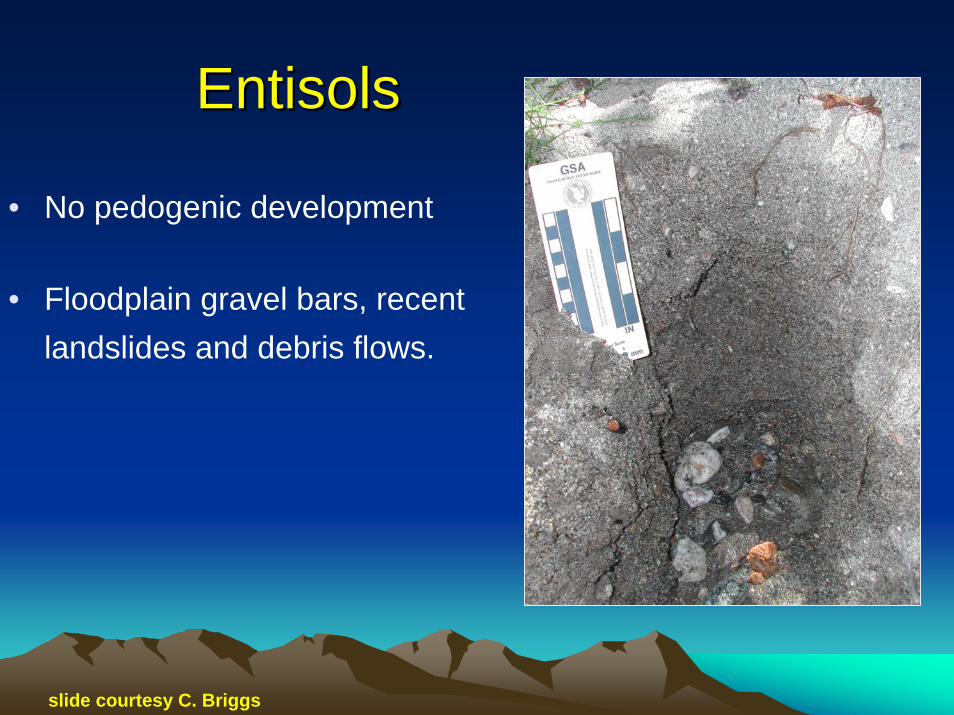
EntisolsEntisols
• No pedogenic development
• Floodplain gravel bars, recent landslides and debris flows.
slide courtesy C. Briggs

Soil Order Distribution by LandformThunder Creek Watershed
0
2
4
6
8
10
12
14
16
ValleyWall
DebrisApron
DebrisCone
BedrockBench
Terrace Floodplain AlluvialFan
Pass Moraine FanTerrace
Landforms
Num
ber
of O
bser
vatio
ns
Andisol
Spodosol
Inceptisol
Entisol
??

AcknowledgementsAcknowledgements
Pete Pete BiggamBiggam, NPS Soil Program , NPS Soil Program CoordinatorCoordinator
Crystal Briggs and Toby Rogers,Crystal Briggs and Toby Rogers,NRCS colleaguesNRCS colleagues
Bruce Bruce HeiseHeise, NPS Geologic Resources , NPS Geologic Resources DivisionDivision
JeannaJeanna Wenger, Steve Wenger, Steve DorschDorsch, Rebecca Doyle,, Rebecca Doyle,Bill Bill BaccusBaccus, Mike , Mike LarrabeeLarrabee and other members and other members
of NPS field crewof NPS field crew