Embed Size (px)
Citation preview
Land Use & Zoning
Chapter 10 Goals & Objectives


Land Use and Zoning
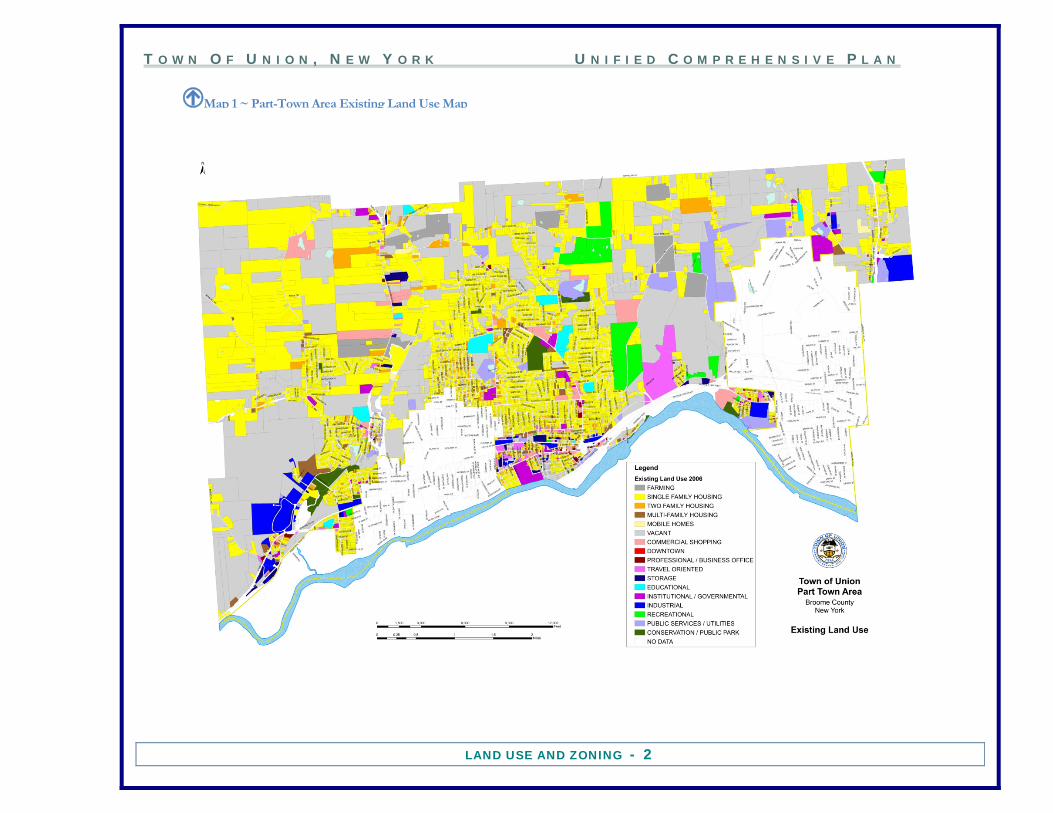
ased upon state land use classification codes, the development pattern of the Part-Town area is predominantly residential. Slightly less than forty percent of the land is used for single-family housing while two-family, multi-family, and mobile homes account for approximately three percent. Slightly more than thirty-nine percent is
vacant, with most of this land in the steeply sloped northern portion of the town. Approximately six percent is categorized as commercial shopping, travel oriented, industrial, and professional offices.
BFigure 1 ~ Part-Town Area Existing Land Use, Percentage Of Land By Broad Category
T O W N O F U N I O N , N E W Y O R K U N I F I E D C O M P R E H E N S I V E P L A N
LAND USE AND ZONING - 2
snIMap 1 ~ Part-Town Area Existing Land Use Map
T O W N O F U N I O N , N E W Y O R K U N I F I E D C O M P R E H E N S I V E P L A N
LAND USE AND ZONING - 3
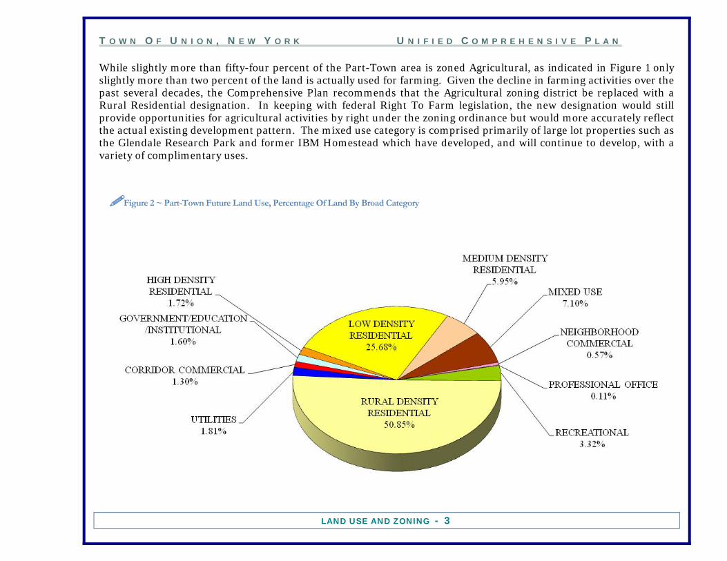
While slightly more than fifty-four percent of the Part-Town area is zoned Agricultural, as indicated in Figure 1 only slightly more than two percent of the land is actually used for farming. Given the decline in farming activities over the past several decades, the Comprehensive Plan recommends that the Agricultural zoning district be replaced with a Rural Residential designation. In keeping with federal Right To Farm legislation, the new designation would still provide opportunities for agricultural activities by right under the zoning ordinance but would more accurately reflect the actual existing development pattern. The mixed use category is comprised primarily of large lot properties such as the Glendale Research Park and former IBM Homestead which have developed, and will continue to develop, with a variety of complimentary uses.
Figure 2 ~ Part-Town Future Land Use, Percentage Of Land By Broad Category

T O W N O F U N I O N , N E W Y O R K U N I F I E D C O M P R E H E N S I V E P L A N
LAND USE AND ZONING - 4
IMap 2 ~ Proposed Part-Town Future Land Use Map

T O W N O F U N I O N , N E W Y O R K U N I F I E D C O M P R E H E N S I V E P L A N
LAND USE AND ZONING - 5
Figure 3 ~ Part-Town Area , Percentage Of Land By Current Zoning District
T O W N O F U N I O N , N E W Y O R K U N I F I E D C O M P R E H E N S I V E P L A N
LAND USE AND ZONING - 6
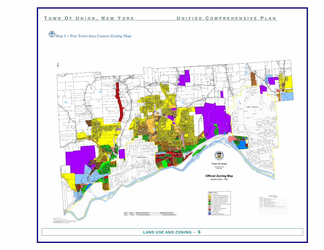
IMap 3 ~ Part Town Area Current Zoning Map

T O W N O F U N I O N , N E W Y O R K U N I F I E D C O M P R E H E N S I V E P L A N
LAND USE AND ZONING - 7
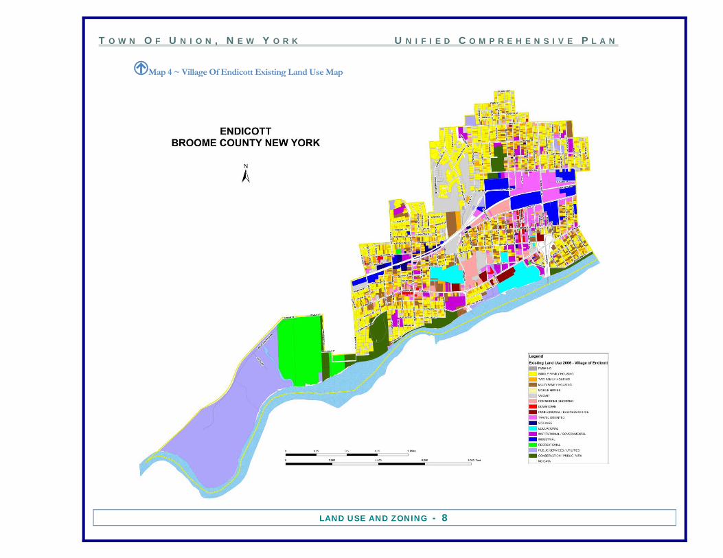
Based upon state land use classification codes, the development pattern of the Village of Endicott is also primarily residential however Endicott has developed in a much denser manner than the Part-Town. The percentage of acreage developed as two-family and multi-family is significantly higher than that of the Part-Town. The Travel Oriented category is skewed due to a number of large parking lots in and around the Washington Avenue Central Business District. With very little vacant land left to develop, it is unlikely that the village will experience a significant change in land use patterns. The Recreational and Utilities categories are also somewhat skewed by large municipally owned properties such as the En-Joie Golf Course and the Tri-Cities Airport.
Figure 4 ~ Village Of Endicott Existing Land Use, Percentage Of Land By Broad Category
T O W N O F U N I O N , N E W Y O R K U N I F I E D C O M P R E H E N S I V E P L A N
LAND USE AND ZONING - 8
IMap 4 ~ Village Of Endicott Existing Land Use Map
T O W N O F U N I O N , N E W Y O R K U N I F I E D C O M P R E H E N S I V E P L A N
LAND USE AND ZONING - 9
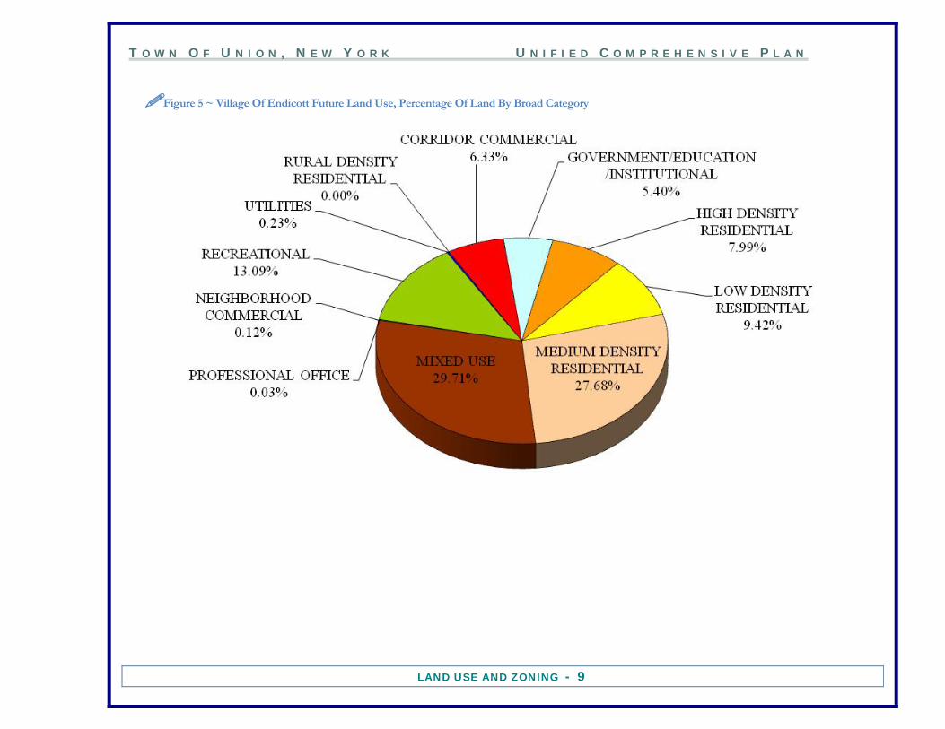
Figure 5 ~ Village Of Endicott Future Land Use, Percentage Of Land By Broad Category

T O W N O F U N I O N , N E W Y O R K U N I F I E D C O M P R E H E N S I V E P L A N
LAND USE AND ZONING - 10
IMap 5 ~ Village of Endicott Future Land Use Map

T O W N O F U N I O N , N E W Y O R K U N I F I E D C O M P R E H E N S I V E P L A N
LAND USE AND ZONING - 11
Figure 6 ~ Village Of Endicott Current Zoning, Percentage Of Land By Broad Category

T O W N O F U N I O N , N E W Y O R K U N I F I E D C O M P R E H E N S I V E P L A N
LAND USE AND ZONING - 12
IMap 6 ~ Village Of Endicott Current Zoning Map

T O W N O F U N I O N , N E W Y O R K U N I F I E D C O M P R E H E N S I V E P L A N
LAND USE AND ZONING - 13
Based upon state land use classification codes, the development pattern of the Village of Johnson City is primarily residential. While the Part-Town area and villages all have roughly forty percent of acreage in residential use, the villages have significantly higher percentages in two- family and multi-family development. Much of the housing in the villages was built before the automobile became the primary means of transportation and therefore was located in close proximity to developing industrial complexes in order to support a growing workforce. The single-family development pattern in the Part-Town was established under the process of suburbanization as people left the densely populated City of Binghamton and Villages of Endicott and Johnson City. Johnson City has several large parcels in the Institutional/Governmental category that are used for institutional uses such as cemeteries.
Figure 7 ~ Village Of Johnson City Existing Land Use, Percentage Of Land By Broad Category

T O W N O F U N I O N , N E W Y O R K U N I F I E D C O M P R E H E N S I V E P L A N
LAND USE AND ZONING - 14
IMap 7 ~ Village Of Johnson City Existing Land Use Map (Rotate To View)
T O W N O F U N I O N , N E W Y O R K U N I F I E D C O M P R E H E N S I V E P L A N
LAND USE AND ZONING - 15
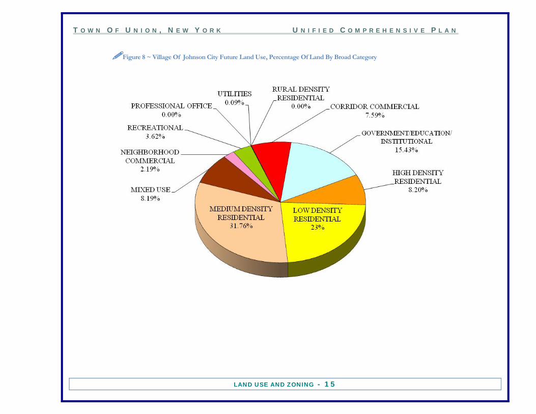
Figure 8 ~ Village Of Johnson City Future Land Use, Percentage Of Land By Broad Category
T O W N O F U N I O N , N E W Y O R K U N I F I E D C O M P R E H E N S I V E P L A N
LAND USE AND ZONING - 16
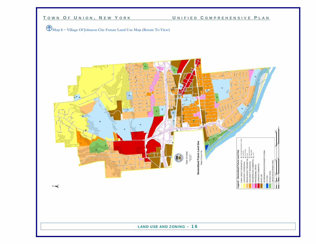
IMap 8 ~ Village Of Johnson City Future Land Use Map (Rotate To View)

T O W N O F U N I O N , N E W Y O R K U N I F I E D C O M P R E H E N S I V E P L A N
LAND USE AND ZONING - 17
Figure 9 ~ Village Of Johnson City Current Zoning, Percentage Of Land By Broad Category

T O W N O F U N I O N , N E W Y O R K U N I F I E D C O M P R E H E N S I V E P L A N
LAND USE AND ZONING - 18
IMap 9 ~ Village Of Johnson City Current Zoning Map (Rotate To View)
T O W N O F U N I O N , N E W Y O R K U N I F I E D C O M P R E H E N S I V E P L A N
LAND USE AND ZONING - 19
FUTURE LAND USE PLAN INTRODUCTION The land use categories are composed of seven broad types of uses: residential, commercial, office, institutional, utilities, recreation, and mixed uses. Several of these seven types of land use are further differentiated. Residential land use is comprised of rural density, low density, medium density and high density. Commercial land use is defined as neighborhood commercial or corridor commercial. Government uses, educational uses, and institutional uses are categorized together. Mixed uses include residential/office, office/commercial, and office/research/light industrial. Recreational uses include the passive and active uses, and office is a complete category, excepting when combined with the residential or commercial uses in Mixed Use categories. Limited Development acts as an overlay to protect those areas sensitive to development, permitting land uses with special consideration for environmental conditions.
1. RESIDENTIAL LAND USE Development of the residential land use plan involved consideration of a number of factors: land for development, subdivision design, neighborhood infrastructure, and services. RURAL DENSITY (recommended density <=1 dwelling unit per acre) This density reflects a single-family housing development pattern in areas that do not have both public water and sewer. Development would take place on lots large enough to support private wells and septic systems pursuant to Broome County Health Department requirements. Limited development and larger lots preclude the need for public utilities and help preserve the existing rural character of these areas. LOW DENSITY RESIDENTIAL (recommended density =>1 <4 dwelling units per acre) This density reflects a single-family housing development pattern on lots of 15,000 to 40,000 square feet in size that are already serviced by or have reasonable access to public water and sewer. MEDIUM DENSITY RESIDENTIAL (recommended density =>4 <7 dwelling units per acre) This density reflects a single-family housing development pattern on lots of 7,000 to 10,000 square feet in size that are already serviced by or have reasonable access to public water and sewer.

T O W N O F U N I O N , N E W Y O R K U N I F I E D C O M P R E H E N S I V E P L A N
LAND USE AND ZONING - 20
HIGH DENSITY RESIDENTIAL (recommended density =>7 <15 dwelling units per acre) This density reflects a single and two family development pattern with dwelling units on lots of 4,000 to 5,000 square feet in size that are already serviced by or have reasonable access to public water and sewer. MULTIPLE FAMILY DENSITY RESIDENTIAL (recommended density =>10<15 dwelling units per acre) This density reflects a single, two family housing, and multifamily dwelling units that are already serviced by or have reasonable access to public water and sewer. This category may also include areas where single and two-family housing units may have been converted into multifamily buildings.
2. COMMERCIAL LAND USE NEIGHBORHOOD COMMERCIAL Neighborhood shopping areas are designed to serve a localized trade area within a community. The neighborhood shopping areas serve a radius about one-half mile and a population of 2,500 to 4,000 people. Small food markets are often accompanied by convenience stores and personal service establishments such as banks, dry cleaners, and small-scale drug stores. CORRIDOR COMMERCIAL Commercial uses include a variety of businesses such as automobile servicing, gasoline stations, fast food restaurants, large scale freestanding drug stores, and bulk merchandise operations. The automobile oriented uses, due to the nature of their locational needs, are lineal developments on the major arteries. Where feasible, automobile oriented uses should augment neighborhood shopping and regional shopping areas to best serve the needs of the residents in the immediate vicinity of the commercial areas. PROFESSIONAL OFFICE Medical, legal, and other professional and business offices are highly specialized, requiring a central location in the community. The areas should be aligned with other commercial uses and high density residential uses to form a community node. The concentration of services also permits free movement between related services such as law offices and banks.
T O W N O F U N I O N , N E W Y O R K U N I F I E D C O M P R E H E N S I V E P L A N
LAND USE AND ZONING - 21
3. INDUSTRIAL LAND USE LIGHT INDUSTRIAL Light industrial uses include manufacturing establishments, wholesalers, research laboratories, and office parks. The desired development pattern is the industrial park or campus, including office parks and a combination of office and light industrial uses. The primary locational factors are relatively level land, good road access, existing or proposed public sewer and water lines, and for some specific industries railroad siding. Very little land in the Town of Union is suitable for heavy industrial uses and this use is being phased out.
4. MIXED LAND USE MIXED USE RESIDENTIAL/OFFICE Residential/office mixed uses are intended for those areas where such land uses have developed prior to the implementation of zoning regulations, and where such mixed use provides a transitional buffer between residential areas and busier, predominantly commercial areas. The lots tend to be less than an acre in size, and with limited parking area for smaller office or residential uses which will not increase traffic volumes significantly. This type of mixed use is recommended for the residential areas in the Village of Endicott, where there are both homes and commercial businesses bordering the Washington Avenue Business District. MIXED USE OFFICE/COMMERCIAL Office/commercial mixed use is appropriate for those areas along heavily traveled corridors, with large lot sizes and traffic volumes that could support such uses. This type of mixed use may also provide a buffer between a high-density residential area and a more intensive commercial district. An example of a new development with mixed commercial and office uses is at the former IBM Country Club facility on Watson Boulevard. The Traditions at the Glen Conference Center/Resort has been recently renovated, and a new “modern”/“state of the art” office building was constructed for the American Cancer Society. The complex is adjacent to two different residential areas, and the low traffic volumes and limited hours of operation make these compatible uses.
T O W N O F U N I O N , N E W Y O R K U N I F I E D C O M P R E H E N S I V E P L A N
LAND USE AND ZONING - 22
MIXED USE OFFICE/RESEARCH/LIGHT INDUSTRIAL As a result of the history of the area’s industrial development, the Town of Union has various industrial sites incorporated with world-renowned high-tech research corporations. Office uses are necessary and integral to these uses, and therefore, an office/research/light industrial mixed use category is relevant to the area. The IBM facility in the Village of Endicott and the Airport Corporate Park, which has a mix of offices and warehouses, are representative of this type of mixed use.
5. INSTITUTIONAL LAND USE INSTITUTIONAL Institutional land uses include government buildings, religious uses, cemeteries, nursing homes, community centers, educational facilities (public and private), and fire stations. RECREATIONAL Includes public and private golf courses, parks, playgrounds, tot lots, and other outdoor spaces where sports or play activities occur. Also includes public and private open space areas where the main uses are walking, picnicking, and camping. LIMITED DEVELOPMENT AREA/CONSERVATION Conservation areas have important physical characteristics that may limit future use or should be preserved because of their uniqueness. Conservation areas may include areas of land where there are significant cones of depression due to the location of public wells, wetlands, floodways, steeped slope areas, and similar areas. FUTURE LAND USE PLAN ASSUMPTIONS (Part-Town area) Basic to land use are the infrastructure requirements for various types of uses. Infrastructure is defined here as public water, public sewer, storm sewer, and road improvements necessary to serve the proposed development. For the majority of the Town, the existing infrastructure is adequate for the proposed future densities. For some areas, it was assumed that the necessary water, sewer, and/or road improvements would be completed in tandem with the change in land use. In other areas, it was assumed that the necessary infrastructure improvements would not occur during the initial scope of the plan. Public health problems could create a situation where services may need to be provided

T O W N O F U N I O N , N E W Y O R K U N I F I E D C O M P R E H E N S I V E P L A N
LAND USE AND ZONING - 23
on an emergency basis. This change in assumptions should lead to an update to the Future Land Use Plan to reflect these changes. These assumptions are provided below. North Endwell/Union Center - Route 26: It is assumed that public water and public sewer will not be extended on Route 26, north of Nanticoke Estates development. The recommendation for not extending utilities is based on the lack of sufficient developable acreage to amortize the investment. Generally, the area to the east of Route 26 is in the floodplain and the area to the west of Route 26 is too steep for development. North Endwell/Union Center and Airport Heights-Day Hollow Road, Bean Hill Road, Boswell Hill Road, and Nanticoke Drive: It is assumed that public water and public sewer will not be extended to Day Hollow Road, Bean Hill Road, Boswell Hill Road, and Nanticoke Drive. Development in these areas is projected for a period beyond the initial scope of this plan. North Endwell/Union Center-Twist Run Road and Taft Avenue: It is assumed that during the initial scope of this plan, Twist Run Road will not be reconstructed to the north of its current location to intersect with Nanticoke Drive north of its current intersection, removing the road from the ravine. It is further assumed that public water and public sewer lines will not be extended within the initial scope of this plan. Airport Heights-Bornt Hill Road and Western Heights Boulevard: It is assumed that public water and public sewer will not be extended on Bornt Hill Road and Western Heights Boulevard. Development in these areas is projected for a period beyond the initial scope of this plan. North Endwell East and Fairmont Park-Struble Road and Robinson Hill Road: It is assumed that public water and public sewer will not be extended on Struble Road and on Robinson Hill Road, between Kirk Road and Struble Road. While the extension of utilities would allow for higher density housing development it is unlikely that these improvements would occur within the initial scope of this plan. North Endwell East, North Endwell West, Central Endwell, and South Endwell - Hooper Road and Farm to Market Road: It is assumed that Hooper Road, between Farm to Market Road and East Main Street, will not be reconstructed to provide additional travel lanes within the initial scope of this plan. While the Planning Board believes that some additional selective low density non-residential development could be accommodated, limited zoning changes are recommended until such time as the improvements outlined in the BMTS Hooper Road Corridor Study are fully implemented. These improvements would include dedicated turning lanes and replacement of the outdated traffic control devices with new state of the art technology.

T O W N O F U N I O N , N E W Y O R K U N I F I E D C O M P R E H E N S I V E P L A N
LAND USE AND ZONING - 24
Fairmont Park-Watson Boulevard: It is assumed that a road connection between Watson Boulevard and Route 17 (proposed Interstate 86) will be not be constructed within the initial scope of this plan to allow direct access to the Traditions at the Glen property. Fairmont Park and Choconut Center-Robinson Hill Road: It is assumed that public water and public sewer will not be extended on Robinson Hill Road, east of Case Road. Development in these areas is projected for a period beyond the initial scope of this plan. Choconut Center-East Maine Road and County Airport Road: Public water has been extended up County Airport Road. It is assumed that extension of public sewers in this area will not occur within the initial scope of this plan. LAND USE PLAN ASSUMPTIONS (Villages) There were no Future Land Use assumptions necessary for the Villages of Endicott Village and Johnson City. There is very little vacant land left to develop that would be dependent on extension of utilities such as public water and sewer. Areas that are likely to be redeveloped already have access to water and sewer. The only variable would be if a new potential land use involves “wet processing” where water and/or sewer capacity could be an issue.