Embed Size (px)
Citation preview

ZONING ORDINANCE
OF THE
TOWN OF WILTON
Amended June 15, 2009

1
ARTICLE 1 GENERAL........................................................... 1
1.1 Authority.......................................................... 1 1.2 Purpose............................................................ 1 1.3 Basic Requirements................................................. 1 1.4 Validity and Severability.......................................... 2 1.5 Conflict With Other Ordinances..................................... 2 1.6 Amendments......................................................... 3 1.7 Ordinance Review................................................... 4
ARTICLE 2 NONCONFORANCE.................................................... 5
2.1 Definition......................................................... 5 2.2 Land Use Requirements.............................................. 5 2.3 Nonconformance..................................................... 5
ARTICLE 3 ESTABLISHMENT OF ZONES.......................................... 10
3.1 Zones............................................................. 10 3.2 Zone Boundaries................................................... 10 3.3 Lots in Two or More Zones......................................... 10
ARTICLE 4 ZONING DISTRICT REQUIREMENTS.................................... 11
4.0 Basic Requirements................................................ 11 4.1 Resource Protection Zone.......................................... 11 4.2 Limited Residential & Recreational Zone .......................... 13 4.3 Residential I Zone ............................................... 13 4.4 Residential II Zone .............................................. 14 4.5 Farm and Forest Zone ............................................. 14 4.6 Commercial Zone................................................... 15 4.7 Industrial Zone................................................... 16 4.8 Watershed Overlay District........................................ 16 4.9 Downtown/Village Zone............................................. 17 4.10 Stream Protection District ....................................... 18
ARTICLE 5 PERFORMANCE STANDARDS........................................... 19
5.1 Sanitation........................................................ 19 5.2 Principal and Accessory Structures and Lots....................... 20 5.2A Piers, Docks, Wharfs, Bridges and Other Structures and Uses Extending
Over or Beyond the Normal High-Water Line of a Water Body or Within a Wetland............................................................20
5.3 Agriculture ...................................................... 22 5.4 Timber Harvesting and Clearing of Vegetation for Development...... 22 5.5 Floodplains....................................................... 25 5.6 Individual Private Campsites ..................................... 26 5.6A. Campgrounds .................................................... 26 5.7 Roads and Driveways.............................................. 27 5.7.A Parking Areas ................................................... 28 5.7.B. Essential Services..............................................29
5.7.C. Mineral Exploration.............................................29
5.7.D. Water Quality...................................................29

2
5.7.E. Archeological Site...............................................30
5.8 Erosion and Sedimentation Control...................................30 5.9 Conversion of Dwellings.............................................30 5.10 Entrances and Exits to Public Ways..................................31 5.11 Off-Street Parking and Loading......................................31 5.12 Removal of Topsoil..................................................32 5.13 Removal of Stone, Sand, Gravel & Minerals ....................... ..32 5.14 Public Service Corporations ....................................... 34 5.15 Signs ............................................................. 35 5.16 Hazardous Waste ................................................... 39 5.17 Cluster Development ............................................... 39 5.18 Windmills and Towers .............................................. 39 5.19 Construction Standards ............................................ 39 5.20 New Street Construction and Driveway Entrances .................... 40 5.21 Water and Sewer Lines ............................................. 42 5.22 Animal Raising .................................................... 42 5.23 Recreational Vehicles, Campers/Camper Trailers .................... 42 5.24 Elder Cottage Housing Opportunity (ECHO) Units .................... 43 5.25 Soils ............................................................. 43 5.26 Small Enterprises, Home Occupations and In-Home Offices ........... 44 5.27 Rear Lots ......................................................... 45 5.27.A. Lots served by Nonconforming Rights-of-way.....................46
5.28 Corner Lots ....................................................... 47 5.29 On-site Disposal of Demolition Debris ............................. 47 5.30 Automobile Recycling Business Permits ............................. 47
ARTICLE 6 SITE PLAN REVIEW ................................................ 49
6.1 Purpose ........................................................... 49 6.2 Applicability ..................................................... 49 6.3 Administration .................................................... 49 6.4 Criteria and Standards ............................................ 50 6.5 Submission Requirements ........................................... 60 6.6 Conditions of Approval ............................................ 61
ARTICLE 7 ADMINISTRATION AND ENFORCEMENT .................................. 62
7.1 Code Enforcement Officer .......................................... 62 7.2 Building Permit ................................................... 62 7.3 Fee for Permits ................................................... 62 7.4 Plot Plan ......................................................... 63 7.5 Additional Criteria for the Shoreland Zone........................ 63 7.6 Expiration of Permits ............................................. 63 7.7 Appeal ............................................................ 64 7.8 Administrative and Variance Appeals to the Board of Appeals ....... 64 7.9 Violations ........................................................ 67 7.10 Penalty for Violation ............................................. 68
ARTICLE 8 DEFINITIONS.......................................................69
ARTICLE 9 TABLES -RESIDENTIAL-COMMERCIAL-INDUSTRIAL-EDUCATION-OUTDOOR RESOURCE-SPACE & BULK TABLE B................................................................101

1
GENERAL
ARTICLE 1
1.1 Authority
This Ordinance is adopted pursuant to Article VIII, Part 2, Section 1 of the Maine Constitution and Title 30-A M.R.S.A. Section 3001 and Title 38 M.R.S.A. Sections 435 et seq. and shall be known and may be cited as the “Zoning Ordinance of the Town of Wilton.”
1.2 Purpose
The purpose of this Ordinance, pursuant to the Wilton, Maine, Comprehensive Plan, is to promote the health, safety, and general welfare of the residents of the Town; to encourage the most appropriate use of the land throughout the Town; to promote traffic safety, to provide safety from fire and other elements; to provide adequate light and air; to prevent overcrowding of real estate; to promote a wholesome home environment; to prevent housing development in unsanitary areas; to provide an adequate street system; to promote the coordinated development of unbuilt areas; to encourage the formation of community units; to provide allotment of land area in new developments sufficient for all the requirements of community life; to conserve natural resources; to provide for adequate public services; to prevent and control water pollution; to protect spawning grounds, fish, aquatic life, birds, other wildlife habitat; to conserve the shore cover and to enhance visual and actual points of access to inland waters, retain natural beauty, to protect archaeological and historic resources.
1.3 Basic Requirements (Amended June 18, 2001 and June 19, 2006)
A. A building permit is not required if the project is normal maintenance, as defined. A building permit is also not required if the project enlarges the existing volume of the structure but the materials used in the project cost less than $2,000 and the project is not normal maintenance, as defined.
B. A building permit is required if the project is not normal maintenance, as defined, and the project either: 1) Enlarges the footprint of the existing building; or, 2) Enlarges the existing volume and the materials used in the project cost $2,000 or more.
C. A building permit is also required in the Resource Protection Zone, Limited Residential and Recreational Zone and Stream Protection Zone when construction, erection, movement, or alteration is proposed or when a project is not normal maintenance. Normal maintenance in the shore land zone is defined as the normal upkeep and maintenance of a structure, including repairs and maintenance that do not involve the expansion of a structure. Expansion is defined as an increase in the floor area or volume of a structure, including all extensions such as, but not limited to: attached decks, garages, porches, and greenhouses.
D. Any accessory structure that is less than one-hundred twenty (120) square
feet in floor area and less than ten (10) in height does not require a building permit and does not have to comply with side and rear setback requirements but must meet shore land setback requirements and must meet a front setback requirement of fifty (50) feet in the Farm and Farm Zone, Commercial Zone, and Industrial Zone and must meet a front setback requirement of twenty-five (25) feet for all other Zones, provided that the accessory structure is not placed on a permanent foundation and

2
provided that only one accessory structure that complies with the requirement in this Article is allowed on a lot. Permanent foundation is defined as a foundation that attaches to the structure permanently to the ground.
E. If more than one residential dwelling unit, principal governmental, institutional, commercial, or industrial structure or use, or combination thereof, is constructed or established on a single parcel, all dimensional requirements and setbacks shall be met for each dwelling unit, principal structure or use.
F. A use permit is required from the Code Enforcement Officer (CEO) or from the Planning Board (PB) for any use or change of use noted in Table A. When a use permit is required from the CEO or from the PB and a building permit is also required from the CEO, then the CEO shall only issue the building permit after the use permit has been approved by the CEO or by the PB and the conditions established by the CEO or by the PB that must be complied with prior to the issuance of a building permit have been met. Use permits that involve only change of ownership of an existing permitted business may be issued by the CEO with notification of abutters 10 days prior to the issuance of said permit.
G. A sign permit is required prior to the erection, enlargement or replacement of any sign under Section 5.15 of this Ordinance.
H. Building, Use, and Sign permit application fees are to be established by the Selectmen with Planning Board input.
1.4 Validity and Severability
The invalidity of any section or provision of this Ordinance shall not be held to invalidate any other section or provision of this Ordinance.
1.5 Conflict With Other Ordinances
A. This Ordinance shall not be construed to repeal any existing bylaws or ordinances, or to impair the provisions of private restrictions placed upon property, provided, however, that where this Ordinance imposes greater restrictions, its provisions shall control. Notwithstanding the foregoing, the previously adopted Wilton Zoning Ordinance and all amendments thereto are replaced effective upon the adoption of this Ordinance by Town Meeting.
B. Subdivision Ordinance
The review and approval of proposed subdivisions, generally defined as the
division of a tract or parcel of land into three or more lots within a five-year period, or the division of an existing residential or commercial structure into three or more distinct and separate units shall be governed by the Town of Wilton Subdivision Ordinance as adopted at Town Meeting in June 2003, and all amendments thereto.

3
1.6 Amendments
A. Initiation of Amendments
An amendment to this Ordinance may be initiated by:
1. The Planning Board provided a majority of the Board has so voted; 2. Request of a majority of the Selectmen; or 3. Written petition of a number of voters equal to at least 10% of
the number of votes cast in the Town of Wilton in the last gubernatorial election.
B. The Planning Board shall hold a public hearing on the proposed amendment
at least 15 days prior to the Town Meeting at which the proposed amendment is to be considered. Notice of the hearing shall be posted in the municipal office at least 14 days before the public hearing and published at least twice in a newspaper that has general circulation in the Town of Wilton. The date of first publication must be at least 14 days before the hearing and the date of second publication must be at least 7 days before the hearing.
C. Adoption of Amendment
An amendment to this Ordinance may be adopted by a majority vote of a special Town Meeting attended by at least 100 Wilton residents over 18 or by a majority vote of the Annual Town Meeting.
D. Copies of amendments within the shore land area attested by the Town Clerk shall be submitted to the Commissioner of the Department of Environmental Protection within fourteen (14) days of approval by the voters at Town Meeting and shall not be effective unless approved by the Commissioner of the Department of Environmental Protection. If the Commissioner fails to act on any amendment within forty-five (45) days of the Commissioner’s receipt of the amendment, the amendment is automatically approved. Any application for a permit submitted to the municipality within this period shall be governed by the terms of the amendment, if such amendment is approved by the Commissioner.
4
1.7 Ordinance Review
The original Wilton Zoning Ordinance was adopted and became effective on March 11, 1974, and was revised and amended as follows:
Adopted March 11, 1974 First Revision March 10, 1975 Second Revision March 15, 1976 Third Revision March 25, 1977 Fourth Revision March 9, 1981 Amended March 8, 1982 Amended March 7, 1983 Amended March 12, 1984 Amended March 11, 1985 Amended March 10, 1986 Amended March 10, 1986 Amended March 21, 1988 Amended March 6, 1989 Amended March 12, 1990 Amended March 11, 1991 Amended March 3, 1992 Amended August 10,1992 Amended June 12, 1995 Amended June 22, 1998 Amended June 21, 1999 Amended June 19, 2000 Amended June 18, 2001
Amended June 17, 2002 Amended June 16, 2003 Amended June 14, 2004 Amended June 13, 2005 Amended June 19, 2006 Amended June 18, 2007 Amended June 16, 2008 Amended June 15, 2009

5
NONCONFORMANCE
Amended 6/18/2007 and 6/16/2008
ARTICLE 2
2.1 Definition
Any lot, building, structure, use of land or portion thereof, existing at the effective date of adoption of, or any amendment to, this Ordinance, which as a result of the adoption or amendment to this Ordinance does not conform with one or more of the applicable provisions of this Ordinance, shall be considered lawfully nonconforming.
2.2 Land Use Requirements
Except as hereinafter specified, no building, structure or land shall hereafter be used or occupied, and no building or structure or part thereof shall hereafter be erected, constructed, expanded, moved or altered and no new lot shall be created or existing lot altered except in conformity with all of the provisions of this Ordinance and the regulations herein specified for the district in which it is located, unless a variance is granted.
2.3 Nonconformance
A. Purpose
It is the intent of this Ordinance to promote land use conformities,
except that lawfully nonconforming conditions that existed before the effective date of this Ordinance or an amendment to this Ordinance shall be allowed to continue, subject to the requirements set forth in this section. Except as otherwise provided by this Ordinance, a nonconforming condition shall not be permitted to become more nonconforming.
B. General
1. Transfer of Ownership. Nonconforming structures, lots and uses
may be transferred, and the new owner may continue the nonconforming use or continue to use the nonconforming structure or lot, subject to the provisions of this Ordinance.
2. Repair and Maintenance. This Ordinance allows, without a permit, the normal upkeep and maintenance of nonconforming uses and structures including repairs or renovations which do not involve expansion of the nonconforming use or structure, and such other changes in a nonconforming use or structure as federal, state or local building codes may require.
C. Nonconforming Structures
1. Expansions. A nonconforming structure may be added to or expanded
after obtaining a permit from the same permitting authority as that for a new structure, if such addition or expansion does not increase the nonconformity of the structure and is in accordance with

6
subparagraphs (a) and (b) below.
a. After January 1, 1989, if any portion of a structure is less than
any required setback that portion of the structure shall not be expanded, as measured in floor area or volume, by 30 percent or more, during the lifetime of the structure. If a replacement structure conforms to the requirements of Section 2.3.C.3, and is less than the required setback from a water body, tributary stream or wetland, the replacement structure may not be expanded if the original structure existing on January 1, 1989 had been expanded by 30% in floor area or volume since that date.
b. When a new, enlarged or replacement foundation is constructed
under a nonconforming structure, the new foundation must be placed such that the setback requirement is met to the greatest practical extent as determined by the Planning Board, basing its decision on the criteria specified in subsection 2, “Relocation,” below, and the completed foundation does not extend beyond the exterior dimensions of the structure, except for expansions in conformity with Section 2.3.C.1.a above. In addition in shoreland areas (1) the foundation does not cause the structure to be elevated by more than three additional feet, as measured from the uphill side of the structure (from the original ground level to the bottom of the first floor sill), it shall not be considered as an expansion of the structure; (2) there is less than 5 feet between the finished basement floor and the bottom of the first floor joists; and (3) the basement area is used exclusively for storage or mechanical purposes, and not for habitation.
2. Relocation. A nonconforming structure may be relocated within the
boundaries of the parcel on which the structure is located, provided that the site of relocation conforms to all setback requirements to the greatest practical extent as determined by the Planning Board, and provided that the applicant demonstrates that the present subsurface sewage disposal system meets the requirements of State law and the State of Maine Subsurface Wastewater Disposal Rules (Rules), or that a new system can be installed in compliance with the law and said Rules. In no case shall a structure be relocated in a manner that causes the structure to be more nonconforming.
In determining whether the building relocation meets the setback to the greatest practical extent, the Planning Board shall consider the size of the lot, the slope of the land, the potential for soil erosion, the location of other structures on the property and on adjacent properties, the location of the septic system and other on-site soils suitable for septic systems, and the type and amount of vegetation to be removed to accomplish the relocation. When it is necessary to remove vegetation within the water or wetland setback area in order to relocate a structure, the Planning Board shall require replanting of native vegetation to compensate for the destroyed vegetation. In addition, the area from which the relocated structure was removed must be replanted with vegetation. Replanting shall be required as follows:
a. Trees removed in order to relocate a structure must be replanted with at least one native tree, three (3) feet in height, for every tree removed. If more than five trees are planted, no one species of tree shall make up more than 50% of the number of

7
trees planted. Replaced trees must be planted no further from the water or wetland than the trees that were removed.
Other woody and herbaceous vegetation, and ground cover, that are removed or destroyed in order to relocate a structure must be re-established. An area at least the same size as the area where vegetation and/or ground cover was disturbed, damaged, or removed must be reestablished within the setback area. The vegetation and/or ground cover must consist of similar native vegetation and/or ground cover that was disturbed, destroyed or removed. b. Where feasible, when a structure is relocated on a parcel the original location of the structure shall be replanted with vegetation which may consist of grasses, shrubs, trees, or a combination thereof.
3. Reconstruction or Replacement. Any nonconforming structure which is removed, or which is damaged or destroyed, regardless of the cause, by more than 50 percent of the market value of the structure before such removal or damage, may be reconstructed or replaced provided that such reconstruction or replacement is in compliance with the dimensional requirements of this Ordinance to the greatest practical extent as determined by the Planning Board in accordance with the purposes of this Ordinance, and provided a permit is obtained for the reconstruction or replacement within eighteen months of said damage, destruction, or removal. In no case shall a structure be reconstructed or replaced so as to increase its nonconformity. If the reconstructed or replacement structure is less than the required setback it shall not be any larger than the original structure, except as allowed pursuant to Section 2.3.C.1 above, as determined by the non-conforming floor area and volume of the reconstructed or replaced structure at its new location. If the total amount of floor area and volume of the original structure can be relocated or reconstructed beyond the required setback area, no portion of the relocated or reconstructed structure shall be replaced or constructed at less than the setback requirement for a new structure. When it is necessary to remove vegetation in order to replace or reconstruct a structure vegetation shall be replanted in accordance with Section 2.3.C.2 above.
If any such structure is located within a floodplain along a river or
other waterbody identified by the 100-year floodplain as designated on the Federal Emergency Management Agency’s (FEMA) Flood Insurance Rate Maps or Flood Hazard Boundary Maps, such structure shall be reconstructed only in compliance with the standards of the Floodplain Management Ordinance for the Town of Wilton.
Any nonconforming structure which is damaged or destroyed by 50 percent or less of the market value of the structure, excluding normal maintenance and repair, may be reconstructed in place with a permit, from the Code Enforcement Officer.
In determining whether the building reconstruction or replacement meets the dimensional requirements of this Ordinance to the greatest practical extent, the Planning Board shall consider in addition to the criteria in

8
Paragraph 2 above, the physical condition and type of foundation present, if any.
4. Change of Use of a Nonconforming Structure. The use of a
nonconforming structure may not be changed to another use unless the Planning Board after receiving a written application determines that the new use will have no greater adverse impact on any adjacent water body, tributary stream or wetland, or on the subject or adjacent properties and resources, than the existing use.
In determining that no greater adverse impact will occur, the Planning
Board shall require written documentation from the applicant, regarding the probable effects on wildlife habitat, vegetative cover, visual and actual points of public access to waters, natural beauty, floodplain management, archaeological and historic resources and functionally water-dependent uses.
D. Nonconforming Uses
1. Expansion of nonconforming uses outside of the shoreland zone may be
allowed provided the Planning Board after reviewing written application determines that no greater adverse impacts would occur as the result of the expansion as defined below. In the shoreland zone, only expansions of non-conforming residential uses are permitted, in accordance with the 30% expansion limitation in Article 2, section 2.3.c.1.a.
a. The expansion of a nonconforming use will be in accordance with any
applicable Performance Standards set forth in Article 5 and 6, Site Plan Review Standards.
b. The expansions of the nonconforming use will not encroach further on the required setbacks.
c. The proposed expansion is of the same character or less noxious than the current nonconforming use.
d. The expansion use will not create a traffic hazard nor increase an existing traffic hazard.
e. That the amount of parking required to meet the minimum requirements for the proposed use exists on the site or will be otherwise provided in Ordinance.
f. The amount of noise, odors, vibrations, smoke, dust and air discharges of the proposed expansion shall be equal to or less than the present use.
g. The hours of operation of the proposed expansion will be compatible with the existing, surrounding land uses.
2. Resumption Prohibited. A lot, building or structure in or on which a nonconforming use is discontinued for a period exceeding one year, or which is superseded by a conforming use, may not again be devoted to a nonconforming use except that the Planning Board may, for good cause shown by the applicant, grant a single extension, of up to one year of that time period where the application for extension is made before expiration of the original one-year period. This provision shall not apply to prohibit the resumption of use of a residential structure for residential purposes provided that the structure has been used or maintained for residential purposes at any time during the preceding five (5) year period.
3. Change of Use. An existing nonconforming use may be changed to another nonconforming use provided that the proposed use has no greater adverse impact on the subject and adjacent properties and resources than the former use, as determined by the Planning Board. The determination of no greater adverse impact shall be made according to the criteria listed in Section 2.3.(c).(4) above.

9
E. Nonconforming Lots
1. Lots of Record. A single lot of record which at the time of first
recording of its legal description in the Franklin County Registry of Deeds met all minimum lot frontage and lot area requirements then applicable, but subsequently has become non-conforming as to minimum lot frontage or lot area as a result of the passage of this Ordinance or any amendment to this Ordinance, may be built upon, without the need for a variance, provided that such lot is not owned by the same person or persons as any other contiguous lot and provided that all other requirements of this Ordinance are met. Relief from the requirements of this Ordinance other than lot frontage or lot area may be granted only by variance from the Board of Appeals in accordance with the provisions of this Ordinance.
2. Merger of Lots (a) If two or more contiguous lots are owned by the
same person(s), and if any of the lots do not meet the requirements for lot frontage or lot area established by this Ordinance, the lots shall be merged to the extent necessary to create a lot or lots which comply with the lot frontage and lot area requirements of this Ordinance, and no portion of the lots so merged which does not meet the lot area or lot frontage requirements of this Ordinance may be built upon, or may be sold if such sale would result in separate ownership of the non-conforming portion. (b) This section 2.3 (E)(2) shall require merger only of (i) unimproved lots with one another and (ii) unimproved lots with lots which are separately improved with a principal structure. As used in this subsection, the term “unimproved lot” includes any lot which does not contain a principal structure.
3. Division of Single Lots Containing More Than One Principal
Structure. Where a single lot of record contains more than one principal structure, each of which at the time of its construction complied with any applicable dimensional requirements, the lot may be divided and each principal structure may be conveyed separately upon approval by the Codes Enforcement Officer of a plot plan which complies to the fullest extent possible with the dimensional requirements of this Ordinance, provided such dividing and conveyance comply with all other applicable local ordinances and State law.
4. Nonconforming lots in the Shore land Zone. Notwithstanding anything to the contrary in paragraphs 1 through 3 above, any lot in the Shore land Zone which is not served by public sewer and has less than 20,000 square feet of lot area or less than 100 feet of shore land frontage is subject to the following restrictions:
a. no conversions from seasonal dwellings (as defined in 30-A
M.R.S.A. section 4201(4)) to year-round dwellings are allowed. b. no new year-round dwellings are allowed.

10
ESTABLISHMENT OF ZONES
ARTICLE 3
3.1 Zones
For the purpose of this Ordinance, the Town of Wilton is hereby divided into ten zones:
Residential I (RI) Farm & Forest (F&F) Residential II (RII) Resource Protection (RP) Commercial © Limited Residential & Recreational (LR&R) Industrial (I) Downtown/Village Stream Protection (SP) Watershed Overlay District
3.2 Zone Boundaries
A. The boundaries of these zones are hereby established as shown on a map prepared by the Wilton Planning Board and entitled “Zoning Map of the Town of Wilton”, and listed by lot number on a set of Wilton tax maps. In case of any apparent inconsistency between the boundaries shown on the map and the definitions, descriptions and purposes contained in the text of this ordinance, the map shall govern.
B. This map, with such changes and amendments as may be made in accordance with the provisions of this Ordinance, shall be part of this Zoning Ordinance and shall be placed on file in the office of the Town Clerk.
C. Where uncertainty exists with respect to the boundaries of any zone as shown on the Zoning Map, the Planning Board shall determine the boundaries.
D. Shore land Zones: The Shore land Zone includes those lands lying within 250 feet horizontal distance of the normal high water mark of Pease Pond and Varnum Pond, Wilson Lake, and Wilson Stream above and below Wilson Lake. In addition, the Shore land Zone includes those lands located within 250 feet, horizontal distance, of the upland edge of freshwater wetlands as defined on the Zoning Map, within 75 feet horizontal distance of a stream as defined herein and within the 100 year floodplain.
3.3 Lots in Two or More Zones
Where a zone boundary line as established in this Ordinance and shown on the Zoning Map, divides a lot which was a lot of record at the time of the enactment of this Ordinance, the provisions of this Ordinance applicable to the less restrictive zone shall be considered as extending to a maximum of 25 feet beyond the zone boundary line into the adjacent zone. Where a zone boundary line divides a lot created after enactment of this Ordinance, the provisions of this Ordinance applicable to the more restrictive zone shall extend 25 feet into the less restrictive zone. These provisions do not apply when the other portion is located in the Resource Protection, Stream Protection or Limited Residential & Recreation Districts.

11
ZONING DISTRICT REQUIREMENTS
ARTICLE 4
4.0 BASIC REQUIREMENTS
The following basic requirements apply in all zoning districts:
A. Use Regulations
Table A sets forth those uses which are permitted, permitted with a
permit from the Code Enforcement Officer, permitted with a permit from the local plumbing inspector, permitted with a permit from the Planning Board, or prohibited in each zoning district. Any use not listed on Table A is prohibited use. Uses requiring Planning Board review (other than home occupations) must be approved under the Site Plan Review Standards of Article 6 of this Ordinance.
B. Dimensional Requirements
Dimensional Requirements are set forth on Table B.
C. Performance Standards
Performance standards are set forth in Article 5 of this Ordinance.
Additional requirements applicable in particular zoning districts are set forth in Sections 4.1 through 4.10 below.
4.1 Resource Protection Zone
A. Purpose
1. To protect the most vulnerable shore land areas along with other
areas in which development would adversely affect water quality, productive habitat, biological ecosystems, or scenic and natural values, and to discourage development in unsafe and unhealthful areas. The Resource Protection Zone may include areas located outside the Shore land Zone. The Resource Protection Zone may include but is not limited to:
a. Wetlands, swamps, and bogs; b. Floodplains to the extent of the 100 year flood designation on the
Federal Emergency Management Agency (FEMA) Flood Insurance Rate Maps or Flood Hazard Boundary Maps; or other floodplains as mapped by the Town and depicted on the Zoning Map.

12
c. Slopes subject to severe natural erosion or on which erosion would be expected to be severe as the result of human activities;
d. Areas designated as having special historic or scenic or natural significance;
e. Areas within 250 feet, horizontal distance, of the upland edge of freshwater wetlands, and wetlands associated with great ponds and rivers, which are rated “moderate” or “high” value waterfowl and wading bird habitat, including nesting and feeding areas by the Maine Department of Inland Fisheries and Wildlife (MDIF&W) that are depicted on a Geographic Information System (GIS) data layer maintained by either MDIF&W or the Department as of May 1, 2006 or as subsequently adopted. For the purposes of this paragraph “wetlands associated with great ponds and rivers” shall mean areas characterized by non-forested wetland vegetation and hydric soils that are contiguous with a great pond or river, and have a surface elevation at or below the water level of the great pond or river during the period of normal high water. “Wetlands associated with great ponds or rivers” are considered to be part of that great pond or river.
f. Areas of two or more contiguous acres with sustained slopes of 20 percent or greater that are located in the shore land zone as defined herein; and
g. Land areas along rivers subject to severe bank erosion, undercutting or river bed movements.
h. Areas of two (2) or more contiguous acres supporting wetland vegetation and hydric soils, which are not part of a freshwater wetland as defined, and which are not surficially connected to a water body during the period of normal high water.
B. Specific Performance Standards
The provisions contained in Section 4.8 governing the Varnum Pond
Watershed Overlay District apply if the property is also located in said District.
C. Special Permit for Single Family Residence
Notwithstanding the provisions of Section 4.0.A and Table A, excepting
structure setback requirements the Planning Board may issue a special permit for construction of a single family residence in the Resource Protection Zone if the applicant demonstrates that all of the following conditions are met:
1. There is no location on the property, other than a location within the Resource Protection Zone, where the structure can be built.
2. The lot on which the structure is proposed is undeveloped and was established and recorded in the Franklin County Registry of Deeds before the adoption of the Resource Protection Zone.
3. All proposed buildings, sewage disposal systems and other improvements are:
(a) Located on natural ground slopes of less than 20% and (b) Located outside the floodway of the 100-year floodplain
along rivers and artificially formed great ponds along rivers based on detailed flood insurance studies and as delineated on the Federal Emergency Management Agency’s Flood Boundary and Floodway Maps and Flood Insurance Rate Maps; all buildings, including basements, are elevated at least one foot above the

13
100-year floodplain elevation; and the development is otherwise in compliance with the Floodplain Management Ordinance for the Town of Wilton. If the floodway is not shown on the Federal Emergency Management Agency maps, it is deemed to be ½ the width of the 100-year floodplain. For purposes of this subparagraph, “floodway” means the channel of a river or other watercourse and adjacent land areas that must be reserved in order to discharge the 100-year flood without cumulatively increasing the water surface elevation more than one foot in height.
4. The total ground-floor area, including cantilevering or similar overhanging extensions of all principal and accessory structures is limited to a maximum of 1,500 square feet. This limitation shall not be altered by variance.
5. All structures, except functionally water-dependent structures, are set back from the normal high-water line of a waterbody, tributary stream or upland edge of a wetland to the greatest practical extent, but not less than 75 feet, horizontal distance. In determining the greatest practical extent, the planning board shall consider the depth of the lot, the slope of the land, the potential for soil erosion, the type and amount of vegetation to be removed, the proposed building site’s elevation in regard to the floodplain and its proximity to moderate-value and high-value wetlands.
4.2 Limited Residential & Recreational Zone
A. Definition and Purpose
1. Definition: This zone comprises areas which would fall into the Resource Protection Zone except that they have already been developed, primarily for residential and recreational uses.
2. Purpose: To regulate uses in such a way as to prevent significant pollution of the water and to preserve the aesthetic and recreational values of shore land areas.
4.3 Residential I Zone
A. Definition and Purpose
1. Definition: This zone comprises the older built-up village areas of Wilton, Dryden, and East Wilton. These areas are, for the most part, served by Town water and sewer.
2. Purpose: To maintain the close residential character of these areas, the older built-up village areas of Wilton, Dryden and East Wilton, and to assure new development is compatible.
4.4 Residential II Zone

14
A. Definition and Purpose
1. Definition. This zone comprises the medium density, suburban residential areas of the Town.
2. Purpose. The purpose of establishing this zone is to identify those areas whose proximity to Town maintained roads indicate a historical use for residential or other low intensity development and designate areas where low density residential growth can occur while minimizing local service costs.
4.5 Farm and Forest Zone
A. Definition and Purpose
1. Definition: This zone comprises the majority of generally unbuilt areas
in the Town, primarily woodland and farmland. 2. Purpose: To encourage the continued production of renewable resources by
recognizing and maintaining those areas suitable for either agricultural or forest production.
B. Specific Performance Standards
The requirements of §4.8 governing the Varnum Pond Watershed District
shall apply if the property is also located within said District.
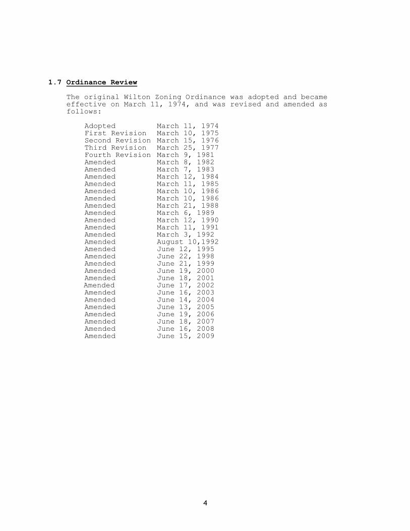
C. Rural Land Management System
The following system shall be used to determine the required minimum lot
area per dwelling unit and thus the density of development for residential subdivisions in the Farm & Forest Zone of the Town of Wilton. This system is based upon the United States Department of Agriculture’s farmland importance classification and the sites’ suitability for subsurface sewage disposal.
To determine the density of development for a subdivision proposal, the site shall be evaluated according to the following factors.
This evaluation shall be based on a soils map prepared by a soil scientist following an on-site investigation and certified by the Franklin County Conservation District. For each factor, a numerical rating shall be made, and the ratings for the four factors shall be combined to get the “Overall Suitability Rating” for the parcel. The following schedule shall then be applied to the “OSR” to determine the allowable density of development.
Minimum Lot Area Per
Overall Suitability Rating Dwelling Unit
30 to 35 40,000 sq. ft. 24 to 29 80,000 sq. ft. 16 to 23 120,000 sq. ft. 12 to 15 200,000 sq. ft. less than 12 Not permitted
15
Criteria
1. Percent of the site classified as Prime Farmland or Unique Farmland by the U.S. Department of Agriculture Soil Conservation Service.
a. less than 10% 10 b. 11% - 20% 9 c. 21% - 40% 7 d. 41% - 65% 4 e. more than 65% 0
2. Percent of the site suitable for private underground sewage disposal
utilizing conventional septic tank leach field systems based upon Part 11 of the Maine State Plumbing Code.
a. more than 90% 10 b. more than 70-90% 9 c. more than 40-70% 7 d. more than 20-40% 4 e. less than 20% 0
3. Percent of the site with a SCS soil suitability rating of good or fair
for houses with basements.
a. more than 90% 10 b. more than 70-90% 9 c. more than 40-70% 7 d. more than 20-40% 4 e. less than 20% 0
4. Percent of the site located outside of a flood hazard area or wetland
area, or located at least 100 feet from the high watermark of any pond, perennial stream or river.
a. more than 90% 10 b. more than 70-90% 9 c. more than 40-70% 7 d. more than 20-40% 4 e. less than 20% 0
4.6 Commercial Zone
A. Purpose
To identify those areas which were deemed suitable for light industry, stores, lodging, or similar businesses.
4.7 Industrial Zone

16
A. Purpose
To provide areas within the Town of Wilton for manufacturing, processing, treatment, research, warehousing, distribution and other industrial activities through the establishment of an industrial floating zone.
B. Location (Amended June 19, 2000)
The location of the Industrial Zone shall be by amendment to this
Ordinance and shall be adopted by a majority vote of the Governing Body of the Town.
1. The location of an Industrial Zone shall be based upon:
a. The minimum size of the area to be zoned shall not be less than
twenty (20) acres. b. The zone is or will be served by adequate infrastructure including
water and sewer provided by the Town or the developer. c. The availability of adequate transportation and traffic
facilities. d. The zone shall be affixed not more than two (2) times without
amendment to the Comprehensive Plan.
C. Application for Location of Industrial Zone
An application for the location of industrial development shall follow a
two step procedure (except those areas already zoned industrial), for proper rezoning of land and approval of development plans:
1. The applicant shall submit to the Planning Board for rezoning consideration a general plan of the proposed parcel or use. This information shall not serve to comply with the Site Plan Review approval.
2. The rezoning amendment shall comply with the provisions of Section 1.6 of this Ordinance.
4.8 Watershed Overlay District
A. Purpose
The Watershed Overlay District is intended to maintain safe and healthful
environmental conditions; prevent and control water pollution; protect spawning grounds, fish, aquatic life, bird and other wildlife habitats; control building sites; provide visual and physical points of access to waters and natural beauty; and protect and maintain the present quality and volume of potable water supplied
from the Varnum Pond Watershed to residents of Wilton, Farmington, and North Jay.
B. Boundaries and Definitions
The Watershed Overlay Zone is that area of Wilton in which surface and
ground waters ultimately flow or drain into Varnum Pond as delineated on a

17
watershed map on file in the Wilton Town Office. The Watershed Overlay Zone shall be superimposed over underlying zones. Permitted uses in the underlying zones shall continue subject to compliance with the provisions of the Watershed Overlay Zone.
C. Use, Dimensional and Environmental Regulations
All buildings, structures, uses and activities in the Watershed Overlay
Zone shall comply with the performance standards of Sections 5.1 through 5.8 of Article 5 of this Ordinance.
D. Waiver
When by reason of extraordinary physical conditions peculiar to the land
or buildings under appeal but not to other land or buildings adjoining or nearby, an owner of land would be subject to unusual difficulty or special hardships (not mere financial hardship or hardships caused by rigid sewage disposal regulations) by reason of the literal application and rigorous enforcement of the terms of this section, the Planning Board may grant a waiver from strict compliance with the requirements of this section after notice and public hearing. No such waiver shall be granted unless the Board is satisfied that the waiver applied for will not adversely affect the quality of the Varnum Pond water supply. When an application for a waiver is filed, it shall be forwarded to the Water Department together with a request for an informational report and a recommendation to the Board regarding the disposition of the requested waiver application. In any case in which a waiver request is granted despite the recommendation of the Water Department that it be denied, the Planning Board shall make part of its permanent records a written statement of its reasons for taking such action. In granting any such waiver application, the Board may also impose reasonable conditions upon the use as part of the permanent records of the Board, as well as being furnished to the applicant for compliance which shall be enforced by the Code Enforcement Officer or Plumbing Inspector.
E. Conflict
In any case in which a provision of this section conflicts with a provision of any other section of this Chapter, the provisions which establishes the more stringent standard shall apply.
4.9 Downtown/Village Zone
A. Purpose and Location
1. Purpose. The Downtown/Village Zone is intended to maintain the traditionally developed area of Town. Development is of greater density than in other areas of the Town and covers a mixture of land uses including manufacturing, commercial, public and residential. The traditional downtown area of the community should be a vital and active area, and this zone seeks to maintain the existing character and land use mix.
2. Location. The Downtown/Village Zone shall include those lots on the
west side of Wilson Stream with frontage on Main Street in the area between Weld Street and the Canal Street Bridge.
4.10 Stream Protection District
A. Purpose and Location

18
1. Purpose. To provide a buffer area adjacent to streams to maintain their natural values.
2. Location. The Stream Protection District includes all land areas within 75 feet, horizontal distance, of the normal high-water line of a stream, exclusive of those areas within 250 feet, horizontal distance, of the normal high-water line of a great pond or river, or within 250 feet, horizontal distance, of the upland edge of a freshwater wetland. Where a stream and its associated shore land area is located within 250 feet, horizontal distance, of the above water bodies or wetlands, that land area shall be regulated under the terms of the shoreland district associated with that water body or wetland.

19
PERFORMANCE STANDARDS
ARTICLE 5
Sections 5.1 through 5.7.F apply only to Resource Protection, Limited Residential and Recreational, Stream Protection and Watershed Overlay zones and to all land areas located within 250 feet, horizontal distance, of the normal high-water line of any great pond, river or the upland edge of a wetland and not located within the Downtown/Village, Commercial or Industrial zones. All other sections of this Article 5 apply in all zones.
5.1 Sanitation
A. Privies shall be permitted in areas not served by municipal sewage facilities provided that they conform to the provisions of the State of Maine Subsurface Disposal Rules.
B. All subsurface sewage disposal facilities shall be installed in conformance with the Maine Subsurface Disposal Rules and the following.
1. Clearing or removal of woody vegetation necessary to site a new
system and any associated fill extensions, shall not extend closer than seventy- five (75) feet, horizontal distance, from the normal high water line of a water body or the upland edge of a wetland; and
2. A holding tank is not allowed for a first-time use in the shoreland zone.
5.2 Principal and Accessory Structures and Lots
A. All new principal and accessory structures shall be setback at least 100
feet, horizontal distance, from the normal high-water line of great
ponds, and 75 feet, horizontal distance, from the normal high-water line of other water bodies, tributary streams, or the upland edge of a wetland, except that in the Downtown/Village and Industrial Zones the setback from the normal high-water line shall be at least 25 feet. In the Resource Protection District the setback requirement shall be 250, feet horizontal distance, except for structure, roads, parking spaces or other related objects allowed in that district in which case the setback requirements specified above shall apply.
In addition
1. The water body, tributary stream or wetland setback provision shall not apply to structures which require direct access to the water body or wetland as an operational necessity, such as piers, private docks and retaining walls, and shall not apply to other functionally water-dependent uses. The setback provisions shall apply to boathouses, storage sheds, garages and other similar structures.
2. The Planning Board may increase the required setback of a proposed structure, as a condition to permit approval, if necessary to accomplish the purposes of this ordinance. Instances where a greater setback may be appropriate include, but are not limited to, areas of steep slope; shallow or erodible soils; or where an adequate vegetative buffer does not exist.

20
B. The lowest floor elevation of all buildings and structures, and all openings into structures including basements, shall be elevated at least one foot above the elevation of the 100 year flood, the flood of record, or in the absence of these, the flood as defined by soil types identified as recent flood plain soils.
C. Notwithstanding the requirements stated above, stairways or similar structures may be allowed with a permit from the Code Enforcement Officer, to provide shoreline access in areas of steep slopes or unstable soils provided; 1) that the structure is limited to a maximum of four (4) feet in width; 2) that the structure does not extend below or over the normal high-water line of a water body or upland edge of a wetland, (unless permitted by the Department of Environmental Protection pursuant to the Natural Resources Protection Act, Title 38, MRSA Section 480-C); and 3) that the applicant demonstrates that no reasonable access alternative exists on the property.
D. In determining compliance with the minimum lot size requirements set forth on Table B of this Ordinance, the following provisions apply to all land located within the shore land zone:
1. Land below the normal high water line of a water body or upland
edge of a wetland and land beneath roads serving more than two lots shall not be included toward calculating minimum lot area.
2. Lots located on opposite sides of a public or private road shall be considered each a separate tract or parcel of land, and shall be considered each a separate lot unless such road was established by the owner of land on both sides thereof after September 22, 1971.
3. The minimum width of any portion of any lot within 100 feet, horizontal distance, of the normal high water line of a water body or upland edge of a wetland shall be equal to or greater than the shore frontage requirement for a lot with the proposed use.
5.2.A. Piers, Docks, Wharfs, Bridges and Other Structures and Uses
Extending Over or Below the Normal High-Water Line of a Water Body or Within a Wetland (Amended June 21, 1999 and June 16, 2008)
1. Access from shore shall be developed on soils appropriate for such use and constructed so as to control erosion.
2. The location shall not interfere with existing developed or natural beach areas.
3. The facility shall be located so as to minimize adverse effects on fisheries.
4. The facility shall be no larger in dimension than necessary to carry on the activity and be consistent with the surrounding character and uses of the area. A temporary pier, dock or wharf shall not be wider than six feet for non-commercial uses.
5. No new structure shall be built on, over or abutting a pier, wharf, dock or other structure extending beyond the normal high-water line of a water body or within a wetland unless the structure requires direct access to the water body or wetland as an operational necessity.
6. New permanent piers and docks shall not be permitted unless it is clearly demonstrated to the Planning Board that a temporary pier or dock is not feasible, and a permit has been obtained from the Department of Environmental Protection, pursuant to the Natural Resources Protection Act.
7. No existing structures built on, over or abutting a pier, wharf, dock or
other structure extending beyond the normal high-water line of a water body or within a wetland shall be converted to residential dwelling units in any district.
8. Except in the Downtown/Village, Commercial or Industrial zones,

21
structures built on, over or abutting a pier, wharf, dock or other structures extending beyond the normal high-water line of a water body or within a wetland shall not exceed twenty (20) feet in height above the pier, wharf, dock or other structure.

22
5.3. Agriculture
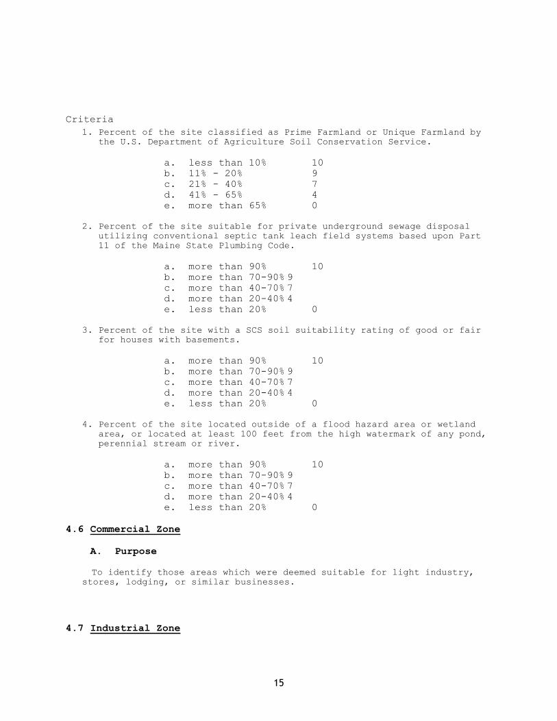
A. All spreading of manure shall be accomplished in conformance with
the Manure Utilization Guidelines published by the Maine Department of Agriculture on November 1, 2001, and the Nutrient Management Law (7 M.R.S.A. sections 4201-4209), OR AMENDMENTS THERETO.
B. Manure shall not be stored or stockpiled within one hundred (100) feet, horizontal distance, of a great pond or within seventy-five (75) feet horizontal distance, of other water bodies, tributary streams, or wetlands. All manure storage areas within the shore land zone must be constructed or modified such that the facility produces no discharge of effluent or contaminated storm water.
C. All agricultural activities involving the tilling or fertilizing of soil greater than 10,000 square feet in surface area within the shore land zone, or the spreading, disposal or storage of more than 1 ton of manure within the shore land zone shall be done in conformance with a soil and water conservation plan that conforms with or provides greater safeguards and protections than the standards and specifications contained in the publication entitled State of Maine Strategy for Managing Non point Source Pollution from Agricultural Sources and Best Management System Guidelines, dated October, 1991. Such activities shall require a permit from the Planning Board. Application for such permit shall be accompanied by the soil and water conservation plan. The Planning Board may require review and critique by the Franklin County Soil and Water Conservation District of any plan not prepared by the District and may impose conditions upon the activity as recommended by the District. Non-conformance with the provisions of said plan or conditions shall constitute a violation of this Ordinance. Agricultural activities involving the draining or altering of any inland wetlands within the shore land zone shall not be undertaken without applicable permits required under state and federal law and under the Floodplain Management Ordinance for the Town of Wilton. Notwithstanding anything to the contrary in 1 M.R.S.A. §302, this paragraph (B) applies to applications for permits pending on the date of its adoption.
D. There shall be no new tilling of soil within one-hundred (100) feet, horizontal distance, of the normal high-water line of a great pond; within seventy-five (75) feet, horizontal distance, from other water bodies; nor within twenty-five feet, horizontal distance, of tributary streams, and wetlands. Operations in existence on the effective date of this ordinance and not in conformance with this provision may be maintained.
E. Newly established livestock grazing areas shall not be permitted within one hundred (100) feet, horizontal distance, of the normal high-water line of a great pond; within seventy-five (75) feet, horizontal distance of other water bodies, nor, within twenty-five (25) feet, horizontal distance, of tributary streams, and wetlands. Livestock grazing associated with ongoing farm activities, and which are not in conformance with the above setback provisions may continue, provided that such grazing is conducted in accordance with a Conservation Plan.
5.4 Timber Harvesting and Clearing of Vegetation for Development
A. Timber Harvesting
1. Within a shoreland area abutting a great pond, there shall be no
timber harvesting within the strip of land extending 75 feet inland from the normal high water line, except to remove safety hazards.
2. Selective cutting of no more than 40% of total volume of trees 4 inches or more in diameter measured at 4 ½ feet above ground level,

23
in any ten year period is permitted. In addition:
a. Within one-hundred (100) feet, horizontal distance of the normal
high-water line of a great pond classified GPA, and within seventy-five (75) feet, horizontal distance, of the normal high-water line of other water bodies, tributary streams, or the upland edge of a wetland, there shall be no clear cut openings and a well-distributed stand of trees and other vegetation, including existing ground cover, shall be maintained.
b. At distances greater than one-hundred (100) feet, horizontal distance, of a great pond, and greater than seventy-five (75) feet, horizontal distance, of the normal high-water line of other water bodies or the upland edge of a wetland, harvesting operations shall not create single clear cut openings greater than ten-thousand (10,000) square feet in the forest canopy. Where such openings exceed five-thousand (5000) square feet they shall be at least one hundred (100) feet apart. Such clear cut openings shall be included in the calculation of total volume removal. For
the purposes of these standards, Volume may be considered to be equivalent to basal area.
c. No accumulation of slash shall be left within seventy-five (75)feet of the normal high-water line of a water body. In all other areas, slash shall either be removed or disposed of in such a manner that it lies on the ground and no part thereof extends more than four (4) feet above the ground. Any debris that falls below the normal high-water line of a water body shall be removed.
d. Timber harvesting equipment shall not use stream channels as travel routes except when:
i. Surface waters are frozen; and ii. The activity will not result in any ground disturbance.
e. All crossings of flowing water shall require a bridge or culvert,
except in areas with low banks and channel beds which are composed of gravel, rock or similar hard surface which would not be eroded or otherwise damaged.
f. Skid trail approaches to water crossings shall be located and designed so as to prevent water runoff from directly entering the water body or tributary stream. Upon completion of timber harvesting, temporary bridges and culverts shall be removed and areas of exposed soil re-vegetated.
g. Except for water crossings, skid trails and other sites where the operation of machinery used in timber harvesting results in the exposure of mineral soil shall be located such that an unscarred strip of vegetation of at least seventy-five (75) feet in width for slopes up to ten (10) percent shall be retained between the exposed mineral soil and the normal high-water line of a water body or upland edge of a wetland. For each ten (10) percent increase in slope, the unscarred strip shall be increased by twenty (20) feet. The provisions of this paragraph apply only to a face sloping toward the water body or wetland, provided, however, that no portion of such exposed mineral soil on a back face shall be closer than twenty five (25) feet from the normal high-water line of a water body or upland edge of a wetland.
h. The Planning Board may issue a permit to exceed the 40 percent limitation upon a clear showing, including a Forest Management Plan signed by a Maine licensed Professional Forester, that such timber harvesting in excess of the 40 percent is necessary for good forestry management and is carried out in accordance with the purposes of Shore land Zoning. The Department of Environmental Protection shall be notified of any permits issued for timber harvesting in excess of the 40 percent within 14 days of approving

24
such permits.
B. Clearing of Vegetation for Development
1. Within a shore land area zoned for resource protection abutting a
great pond, there shall be no cutting of vegetation within the strip of land extending 75 feet inland from the normal high water mark except to remove safety hazards.
Elsewhere in any Resource Protection District the clearing of vegetation
shall be limited to that which is necessary for uses expressly authorized in that district.
2. Except in areas as described in Paragraph 1, above, and except to allow for the development of permitted uses, within a strip of land extending one hundred (100) feet, horizontal distance, inland from the normal high-water line of a great pond classified GPA or a river flowing to a great pond classified GPA, and seventy-five (75) feet, horizontal distance, from any other water body, tributary stream, or the upland edge of a wetland, a buffer strip of vegetation shall be preserved as follows:
a. There shall be no cleared opening greater than 250 square feet in
the forest canopy as measured from the outer limits of the tree crown. However, a footpath not to exceed SIX (6) feet in width as measured between tree trunks is permitted provided that a cleared line of sight to the water through the buffer strip is not created. Adjacent to a great pond classified GPA, or stream or river flowing to a great pond classified GPA, the width of the foot path shall be limited to six (6) feet.
b. Selective cutting of trees within the buffer strip is permitted
provided that a well distributed stand of trees and other vegetation is maintained. For the purposes of this section a “well-distributed stand of trees” adjacent to a great pond classified GPA or a river or stream flowing to a great pond classified GPA, shall be defined as maintaining a rating score of 12 or more in any 25-foot by 25 foot square (625 square feet) area as determined by the following rating system.
Diameter of tree at 4 ½ Feet above ground level Points (inches)
2-4 1 >4-12 2 >12 4
Adjacent to other water bodies, tributary streams, and wetlands, a “well-
distributed stand of trees” and other vegetation” is defined as maintaining a minimum rating score of 8 per 25-foot by 25-foot square area.
For the purposes of Section 5.4.B.2.b., “other natural vegetation” is defined as retaining existing vegetation under three (3) feet in height and other ground cover and retaining at least three (3) saplings less than two (2) inches in diameter at four and one-half (4 ½) feet above ground level for each 25-foot by 25-foot rectangular area. If three (3) saplings do not exist, no woody stems less than two (2) inches in diameter can be removed until 3 saplings have been recruited in to the plot.
Notwithstanding the above provisions, no more than 40% of the total volume of trees four (4) inches or more in diameter, measured at 4 ½ feet

25
above ground level may be removed in any ten (10) year period.
c. In order to protect water quality and wildlife habitat, adjacent to great ponds classified GPA, and streams and rivers which flow to great ponds classified GPA, existing vegetation under three (3) feet in height and other ground cover shall not be removed, except to provide for a footpath or other permitted uses as described in paragraphs B.2 and B.2a. above.
d. Pruning of tree branches, on the bottom 1/3 of the tree is permitted. e. In order to maintain a buffer strip of vegetation, when the removal of
storm-damaged, diseased, unsafe, or dead trees results in the creation of cleared openings, these openings shall be replanted with native tree species unless existing new tree growth is present.
The provisions contained in paragraph B.2 above shall not apply to those
portions of public recreational facilities adjacent to public swimming areas. Cleared areas, however, shall be limited to the minimum area necessary.
3. At distances greater than one hundred (100) feet, horizontal distance, from a great pond classified GPA or a river flowing to a great pond classified GPA, and seventy-five (75) feet, horizontal distance, from the normal high water line of any other water body, tributary stream, or the upland edge of a wetland, except to allow for the development of permitted uses, there shall be permitted on any lot, in any ten (10) year period, selective cutting of not more than forty (40) percent of the volume of trees four (4) inches or more in diameter, measured 4 ½ feet above ground level. Tree removal in conjunction with the development of permitted uses shall be included in the forty (40) percent calculation. For the purposes of these standards volume may be considered to be equivalent to basal area.
In no event shall cleared openings for development, including but not
limited to, principal and accessory structures, driveways and sewage disposal areas, exceed in the aggregate, 25% of the lot area or ten thousand (10,000) square feet, whichever is greater, including land previously developed This provision shall not apply to the Industrial and Downtown Village Zones.
4. Cleared openings legally in existence on the effective date of this Ordinance may be maintained, but shall not be enlarged, except as permitted by this Ordinance.
5. Fields which have reverted to primarily shrubs, trees, or other woody vegetation shall be regulated under the provisions of this section.
C. Plan Required in Watershed Overlay District (Amended June 21,
1999)
Within the Watershed Overlay District, harvesting of trees may be
permitted only after a plan prepared by a qualified forester is submitted to and approved by the Planning Board. Such plan shall be approved or disapproved on the basis of its conformance with good watershed management practice for domestic water supplies and shall be judged by the standards of this section 5.4.
5.5 Floodplains

26
All buildings and structures constructed, erected, enlarged modified, replaced or relocated within a floodplain area must comply with the requirements of the Floodplain Management Ordinance of the Town of Wilton.
A. Mobile Home Parks in Floodplains
In the case of mobile home parks located in Zone A of the Flood Hazard
Boundary Map, an evacuation plan shall be filed, by the owner, with the Town Civil Emergency Preparedness Office, indicating alternate vehicular access and escape routes.
5.6 Individual Private Campsites
Individual, private campsites not associated with campgrounds are allowed provided the following conditions are met:
1. One campsite per lot existing on the effective date of this Ordinance,
or thirty thousand (30,000) square feet of lot area within the shore land zone, whichever is less, may be permitted.
2. Campsite placement on any lot, including the area intended for a recreational vehicle or tent platform, shall be set back one hundred (100) feet, horizontal distance from the normal high water line of a great pond and seventy-five (75) feet, horizontal distance, from the normal high-water line of other water bodies, tributary streams, or the upland edge of a wetland.
3. Only one recreational vehicle shall be allowed on a campsite. The
recreational vehicles shall not be located on any type of permanent foundation except for a gravel pad, and no structure except a canopy shall be attached to the recreational vehicle.
4. The clearing of vegetation for the siting of the recreational vehicle, tent or similar shelter in a Resource Protection District shall be limited to one thousand (1000) square feet. (Amended June 21, 1999)
5. A written sewage disposal plan describing the proposed method and location of sewage disposal shall be required for each campsite and shall be approved by the Local Plumbing Inspector. Where disposal is off-site, written authorization from the receiving facility or land owner is required.
6. When a recreational vehicle, tent or similar shelter is placed on-site for more than one hundred and twenty (120) days per year, all requirements for residential structures shall be met, including the installation of a subsurface sewage disposal system in compliance with the State of Maine Subsurface Wastewater Disposal Rules unless served by public sewage facilities.
5.6.A. Campgrounds (Amended June 21, 1999)
Campgrounds shall conform to the minimum requirements imposed under State licensing procedures and the following:
1. Campgrounds shall contain a minimum of five thousand (5,000) square feet of land, not including roads and driveways, for each site. Land supporting wetland vegetation, and land below the high-water line of a water body shall not be included in calculating land area per site.
2. The areas intended for placement of a recreational vehicle, tent or shelter, and utility and service buildings shall be set back a minimum of one-hundred (100) feet, horizontal

27
distance, from the normal high-water line of a great pond and seventy-five (75) feet, horizontal distance from the normal high-water line of other water bodies, tributary streams, or the upland edge of a wetland.
5.7. Roads and Driveways The following standards shall apply to the construction of
roads and/or driveways and drainage systems, culverts and other related features.
1. Roads and driveways shall be set back at least one-hundred (100) feet,
horizontal distance, from the normal high-water line of a great pond and seventy-five (75) feet, horizontal distance, from the normal high-water line of other water bodies, tributary steams, or the upland edge of a wetland unless no reasonable alternative exists as determined by the Planning Board. If no other reasonable alternative exists, the road and/or driveway setback requirement shall be no less than fifty (50) feet, horizontal distance, upon clear showing by the applicant that appropriate techniques will be used to prevent sedimentation of the water body, tributary stream, or wetland. Such techniques may include, but are not limited to, the installation of settling basins, and/or the effective use of additional ditch relief culverts and turnouts placed so as to avoid sedimentation of the water body, tributary stream, or wetland.
On slopes of greater than twenty (20) percent the road and/or driveway
setback shall be increased by ten (10) feet, horizontal distance, for each five (5) percent increase in slope above twenty (20) percent.
Section 1 does not apply to approaches to water crossings nor to roads or driveways that provide access to permitted structures, and facilities located nearer to the shoreline, or tributary stream due to an operational necessity, excluding temporary docks for recreational uses. Roads and driveways providing access to permitted structures within the setback area shall comply fully with the requirements of Section 1 except for that portion of the road or driveway necessary for direct access to the structure.
2. Existing public roads may be expanded within the legal road right-of-way regardless of setback from a water body, tributary stream or wetland.
3. New roads and driveways are prohibited in a Resource Protection District except that the Planning Board may grant a permit to construct a road or driveway to provide access to permitted uses within the district. A road or driveway may also be approved by the Planning Board in a Resource Protection District, upon a finding that no reasonable alternative route or location is available outside the district. When a road or driveway is permitted in a Resource Protection District the road and/or driveway shall be set back as far as practicable from the normal high-water line of a water body, tributary stream, or upland edge of a wetland.
4. Road and driveway banks shall be no steeper than a slope of two (2) horizontal to one (1) vertical, and shall be graded and stabilized in accordance with the provisions for erosion and sedimentation control contained in Article 5.8. (Amended June 21, 1999)
5. Road and driveway grades shall be no greater than ten (10) percent except for short segments of less than two hundred (200) feet.
6. In order to prevent road and driveway surface drainage from directly entering water bodies tributary streams or wetlands, roads and driveways shall be designed, constructed, and maintained to empty onto an unscarred buffer strip at least (50) feet plus two times the average slope, in width between the outflow point of the ditch or culvert and the normal high-water line of a water body, tributary stream, or upland

28
edge of a wetland. Surface drainage which is directed to an unscarred buffer strip shall be diffused or spread out to promote infiltration of the runoff and to minimize channelized flow of the drainage through the buffer strip.

29
7. Ditch relief (cross drainage) culverts, drainage dips and water turnouts shall be installed in a manner effective in directing drainage onto unscarred buffer strips before the flow gains sufficient volume or head to erode the road, driveway or ditch. To accomplish this, the following shall apply:
a. Ditch relief culverts, drainage dips and associated water turnouts
shall be spaced along the road or driveway at intervals no greater than indicated in the following table:
Grade Spacing (Percent) (Feet) 0-2 250 3-5 200-135 6-10 100-80 11-15 80-60 16-20 60-45 21+ 40
b. Drainage dips may be used in place of ditch relief culverts only where the grade is ten (10) percent or less.
c. On sections having slopes greater than ten (10) percent, ditch relief culverts shall be placed at approximately a thirty (30) degree angle down slope from a line perpendicular to the centerline of the road or driveway.
d. Ditch relief culverts shall be sufficiently sized and properly installed in order to allow for effective functioning and their inlet and outlet ends shall be stabilized with appropriate materials.
8. Ditches, culverts, bridges, dips, water turnouts and other storm
water runoff control installations associated with roads and driveways shall be maintained on a regular basis to assure effective functioning.
5.7.A. Parking Areas (Amended June 21, 1999)
1. Parking areas shall meet the shoreline and tributary stream setback for structures for the district in which such areas are located. The setback requirement for parking areas serving public boat launching facilities may be reduced to no less than fifty (50) feet from the normal high-water line or upland edge of a wetland if the Planning Board finds that no other reasonable alternative exists.
2. Parking areas shall be adequately sized for the proposed use and shall be designed to prevent storm water runoff from flowing directly into a water body, and where feasible, to retain all runoff on-site.
3. In determining the appropriate size of proposed parking facilities, the following shall apply: 1. Typical parking space: Approximately ten (10) feet wide
and twenty (20) feet long, except that parking spaces for a vehicle and boat trailer shall be forty (40) feet long.
2. Internal travel aisles: Approximately twenty (20) feet wide.

30
5.7.B. Essential Services
1. Where feasible, the installation of essential services shall be
limited to existing public ways and existing service corridors. 2. The installation of essential services, other than road-side distribution lines, is not allowed in a Resource Protection or Stream Protection District, except to provide services to a permitted use within said district, or except where the applicant demonstrates that no reasonable alternative exists. Where allowed, such structures and facilities shall be located so as to minimize any adverse impacts on surrounding uses and resources, including visual impacts. 3. Damaged or destroyed public utility transmission and distribution
lines, towers and related equipment may be replaced or reconstructed without a permit.
5.7.C. Mineral Exploration Mineral exploration to determine the nature or extent of mineral
resources shall be accomplished by hand sampling, test boring, or other methods which create minimal disturbance of less than one hundred (100) square feet of ground surface. A permit from the Code Enforcement Officer shall be required for mineral exploration which exceeds the above limitation. All excavations, including test pits and holes, shall be immediately capped, filled or secured by other equally effective measures to restore disturbed areas and to protect the public health and safety.
5.7.D. Water Quality No activity shall deposit on or into the ground or discharge to the
waters of the State any pollutant that, by itself or in combination with other activities or substances, will impair designated uses or the water classification of the water body, tributary stream or wetland.
5.7.E. Archaeological Site Any proposed land use activity involving structural development or soil disturbance on or adjacent to sites listed on, or eligible to be listed on the National Register of Historic Places, as determined by the permitting authority, shall be submitted by the applicant to the Maine Historic Preservation Commission for review and comment, at least twenty (20) days prior to action being taken by the permitting authority. The permitting authority shall consider comments received from the Commission prior to rendering a decision on the application.

31
5.8 Erosion and Sedimentation Control (Amended June 21, 1999)
A. Filling, grading, lagooning, dredging, earth moving activities and other
land use activities shall be conducted in such a manner to prevent to a maximum extent the erosion and sedimentation of surface waters.
B. Clearing of vegetation in the shore land zone shall require a permit from the Code Enforcement Officer. Filling and earth-moving activities greater than ten (10) cubic yards in the shore land zone shall require a permit from the Code Enforcement Officer, except that filling and earth-moving activities greater than ten (10) cubic yards in the Resource Protection District shall require a permit from the Planning Board.
C. Conditions may be imposed on earth moving activities by the Code Enforcement Officer or the Planning Board as necessary to prevent erosion and sedimentation and such conditions will become part of a permit.
5.9 Conversion of Dwellings
A. General Requirements
This section does not apply to dwellings in the shoreland zone. The
Planning Board may permit a dwelling which existed prior to March 11, 1974 and which cannot meet the dimensional or parking requirements for two-family or multi- family dwellings to be converted to a two family or multi-family dwelling if the Board finds that the proposed conversion meets the criteria and standards of Section 6.4 of this Ordinance, subject to the limitations and guidelines of paragraphs B and C below. Approval of a conversion under this Section shall not require and shall not be deemed to be the granting of a variance.
B. Limitations
1. Dimensional requirements may not be decreased more than fifty-five
percent (55%). 2. Parking requirements may not be decreased more than fifty percent (50%).
C. Guidelines
In setting required conditions, the Planning Board shall use the following guidelines.
1. Minimum Dwelling Unit Size 500 square feet 2. Exterior. Exteriors of structures shall be maintained or reconstructed
in a manner so that the architectural and aesthetic character of the property and of the neighborhood is maintained.
3. Open Space. Open, unpaved (lawn, garden, shrub or tree) area of a minimum equal to half the combined floor space of the dwelling units but no less than twenty-five percent (25%) of the property shall be maintained.

32
5.10 Entrances and Exits to Public Ways (Amended June 21, 1999)
All new developments must provide properly marked entrances and exits at right angles to the public way, including subsurface drainage when needed and curbing and sidewalks as may be required by the Maine Department of Transportation, the Planning Board, the Town, or Article 6.4.3.
5.11 Off-Street Parking and Loading
A. The following minimum off-street parking requirements shall be provided and maintained for all new construction, alterations and changes of use:
1. Dwellings: 1 ½ parking spaces for each
dwelling unit
2. Motels, tourist homes: 1 parking space for each sleeping room
3. Schools: 5 parking spaces for each room used for the purpose of instruction
4. Health institutions: 1 parking space for every(bed
facilities only) 3 beds and 1 parking space for each employee based on the expected average employee occupancy
5. Theaters, auditoria, 1 parking space for and churches: every 4 seats or for every
100 square feet or major fraction thereof of assemblage space if no fixed seats
6. Retail stores: 1 parking space for every 200
square feet of gross floor area
7. Restaurants, eating and 1 parking space for drinking establishments: 3 seats
8. Offices, professional 1 parking space for and public buildings: every 200 square feet of
gross leasable area, exclusive of cellar and bulk
storage areas
9. Industrial: 1 parking space for each 2 employees, based on the highest expected average employee occupancy
B. Required off-street parking spaces shall be located on the same lot as
the principal building or use except within the Downtown/Village Zone where required off-street may be provided within 1,000 feet of the

33
principal building measured along lines of access or at an off-site satellite parking area approved by the Planning Board. (Amended June 21, 1999.)
C. The Planning Board is empowered to determine the number of parking spaces required for any use not specifically listed herein by applying the requirements for the listed use category which most closely resembles the non-listed use.
5.12 Removal of Topsoil
The removal of topsoil in excess of 100 cubic yards within a 12 month period shall not be permitted without a site plan approval by the Planning Board except where such removal is necessarily incidental to or in connection with the construction, alteration, excavation, or grading of a building, structure, road or parking area on the premises. The Planning Board may impose such restrictions as it deems necessary to protect adjacent properties or water bodies, and such restrictions shall be considered a condition of the permit.
5.13 Removal of Stone, Sand, Gravel & Minerals (Amended June 21, 2002)
The removal of sand, gravel or fill that is not for commercial sale or use, which will result in a total excavated area of one acre or less, shall be permitted with a permit from the Code Enforcement Officer provided that the standards in this Section are complied with.
Any removal of sand, gravel or fill that is for commercial sale or use, as well as removal that is not for commercial sale or use but that will result in a total excavated area in excess of one acre shall be permitted only with a Site Plan approval from the Planning Board. This Section also applies to the quarrying of stone or minerals for commercial sale or use. In addition to complying with the requirements of Article 6, such excavation or quarrying must comply with the following submissions requirements, review criteria and standards:
A. Submission Requirements
The Site Plan must show:
1. The existing and proposed limits of excavation clearly delineated. 2. Location, functions and ground area of all structures, facilities,
(processing equipment such as crushers, washers, screeners, and hot-mix asphalt facilities) parking lots, roads, and mud run-off areas.
3. Entrance and exit layout. 4. Gates or other means for controlling access. 5. Pre- and post-development topography using an interval of ten foot
contours for pits of less than five (5) acres and no greater than 10 foot contours for pits of five (5) acres or more if deemed necessary by the Planning Board.
6. Location of topsoil stockpile areas. Sufficient topsoil shall be salvaged for reclamation purposes.
7. Areas where natural vegetation will be left and where plantings
will be made to screen the operation from view. 8. Slopes and vegetation for protecting adjacent structures. 9. For an extraction for commercial sale or use, location of a
benchmark sufficient to verify the location of the seasonal high water table and one or more monitoring wells documenting the seasonal

34
high water table during the life of the pit. 10. Proposed disposal method for stumps and grubbing. 11. Plans and schedule for reclamation. 12. A spill prevention, control and countermeasure plan to control
spills of petroleum products and other hazardous materials. 13. The phases of excavation and reclamation. 14. Surface drainage and watersheds on parcel, pre- and post-
excavation. 15. For pits of five (5) acres or more, at least one cross section
along the long axis of the pit and another cross section at a right angle to it. The cross section diagrams should show the existing grade, the proposed final grade including maximum depth of excavation, depth to ground water and the stratigraphy of the surficial deposits at the site.
B. Review Criteria and Standards
1. A natural buffer strip of not less than 50 feet shall be
maintained between the location of any extraction of materials and all property lines. The existing vegetation within the natural buffer strip shall not be removed. This buffer strip may be reduced to 10 feet with written consent from abutting property owners. The Planning Board may reduce the front setback to twenty-five feet from the right-of-way of a public road, if in the opinion of the Planning Board, suitable buffers and fencing are provided.
2. Buffers may be eliminated between abutting properties containing pits provided the Planning Board is shown proof of written permission of the abutting pit owners.
3. No petroleum products shall be stored or handled in the pit and no refueling or oil changes shall be conducted in the pit unless such activities comply with applicable standards promulgated by the Maine Department of Environmental Protection and a spill prevention, control and countermeasure plan is provided.
4. There shall be no storage or dumping in the pit of any substances that could produce harmful leach ate, unless such substances are placed under cover and on impermeable, spill proof base. Such potentially deleterious substances include, but are not limited to salt, rubbish, creosoted timber and petroleum products.
5. No oiling of access and haul roads is permitted.
6. No excavation within five (5) feet of the seasonal high water
table may occur at any site. 7. No ditches, trenches, pumping or other methods shall be used to
lower the water table to permit more gravel extraction than could occur under natural conditions unless a plan for such activities has been approved by the Maine Department of Environmental Protection and the Planning Board.
8. Access to the pit shall be strictly controlled. 9. All final reclaimed slopes shall not exceed a horizontal to
vertical ratio of 2:1. 10. The affected land shall be restored to a condition or physical
state which either is similar to or compatible with that which existed prior to extraction, or encourages the future productive use of the land. The pit shall be reclaimed in phases so that:
a. the working pit (operation phase) does not exceed ten (10) acres at any time; and
b. the area being actively reclaimed (reclamation phase) does not exceed fifteen (15) acres at any time.
Upon the completion of excavation, the side slopes of the pit shall be

35
re-graded within thirty (30) days.
11. Stumps and grubbings shall be disposed of in a manner approved by the Planning Board and in conformance with all applicable State of Maine regulations.
12. Upon cessation of the extraction of materials or upon the expiration of the Planning Board approval, the site shall be rehabilitated in accordance with a plan approved by the Board.
13. Unless authorized pursuant to the Natural Resources Protection Act, Title 38, M.R.S.A., Section 480-C no part of any extraction operation, including drainage and runoff control features shall be permitted within one hundred (100) feet, horizontal distance of the normal high-water line of a great pond and within seventy-five (75) feet, horizontal distance, of the normal high-water line of any other water body, tributary stream, or the upland edge of a wetland as defined.
14. Any gravel pit which requires a permit from the Maine Department of Environmental Protection under the Site Location of Development Act shall obtain written approval from the Department before the site plan is approved under this Ordinance.
5.14 Public Service Corporations (Amended June 21, 1999)
Nothing in this Ordinance shall prevent the erection, construction,
alteration or maintenance in any zone of the transmission or distribution system of a utility, water or gas main, sewer pipe, telephone or power line, and their accessories. Structures essential to such a utility, such as power substations, standpipes, and the like, shall be permitted by the Planning Board subject to such restrictions as the Planning Board may impose in order to protect adjacent properties. A public utility, water district, sanitary district, or any utility company of any kind may not install services to any new structure located in the shore land zone unless written authorization attesting to the validity and currency of all local permits required under this or any previous Ordinance has been issued by the appropriate municipal officials or other written arrangements have been made between the municipal officials and the utility.

36
5.15 Signs (Amended 6/18/07)
The following signs do not require a permit issued by the Code Enforcement
Officer: Political Signs Business Flags or insignias
Temporary signs, flags, banners, pennants, inflatable signs, and tethered balloons
On premise growers of agricultural products signs Residential name signs No hunting, fishing or trespassing, etc. signs Public and Private Safety signs Real Estate signs Government signs Memorial Signs Signs on registered motor vehicles Hand Held signs
The above listed signs may have restrictions placed on them in other sections of this article.
No sign requiring a permit shall be erected, enlarged or relocated without a sign permit issued by the Code Enforcement Officer upon finding that the sign complies with the requirements of this Article. Article 5.15 A and Article 5.15 C through Article 5.15 E, inclusive, are provisions for sign supports that are not in the Resource Protection, Stream Protection and Limited Residential and Recreational Zones:
A. Nonconforming Signs and Sign Supports; Standards and Illumination
1. Signs and sign supports that are no longer in use and that are
nonconforming must be made conforming before a new sign permit can be issued for the use of the sign and sign support.
2. Signs shall be prohibited: if they attempt or appear to attempt to direct the movement of traffic or if they interfere with, imitate, or resemble any official traffic sign, signal, or device; if they prevent the driver of a vehicle from having a clear and unobstructed view of official signs and approaching or merging traffic; if they have flashing, intermittent, or moving lights or lights that cause glare; or if they have moving parts.
3. Signs cannot be located: on utility poles, unless approved by the utility that owns the pole; on rocks, trees or other natural features, or, on any traffic control sign, etc., except that signs regulating hunting, fishing, trespassing, etc. can be located on natural features.
4. Signs and sign supports must be removed after a business has closed within 60 days after closing for conforming signs, and, within 90 days after closing for nonconforming signs, by either the sign owner or the property owner.
5. Sign and sign support heights are as follows: the height limit for freestanding signs is 25 feet above grade; and, the height limit for wall and roof signs is 10 feet above the wall or roof.
6. Projecting signs and awning/canopy signs can extend out from the structure no more than 4 feet or to within 2 feet of the edge of pavement, whichever creates the smaller sign.
7. Wall and roof signs cannot exceed the existing area of the wall or roof that the wall or roof sign will be attached to.
8. Canopies over fuel islands can only advertise fuel or fuel products.

37
9. A steady, stationary light(s) of single color, shielded, and directed solely at the sign is allowed in all districts.
10. Interior, non-exposed white lights of reasonable intensity are allowed in all zones except for the Residential I, Residential II and Farm and Forest zones.
11. Non-flickering neon lights are allowed only in window signs and only in the Commercial and Downtown Village zones.
12. Home Occupation Signs cannot be lit or illuminated.
B. The following provisions shall govern the use of signs in the Resource
Protection, Stream Protection and Limited Residential and Recreational Zones:
1. Signs relating to goods and services sold on the premises shall be
permitted, provided that such signs shall not exceed six (6) square feet in area and shall not exceed two (2) signs per premises. Signs relating to goods or services not sold or rendered on the premises shall be prohibited.
2. Name signs shall be permitted, provided such signs shall not exceed two (2) signs per premises and shall not exceed twelve (12) square feet in the aggregate.
3. Residential users may display a single sign not over three (3) square feet in area relating to the sale, rental, or lease of the premises.
4. Signs relating to trespassing and hunting shall be permitted without restriction as to number provided that no such sign shall exceed two (2) square feet in area.
5. Signs relating to public safety shall be permitted without restriction.
6. No sign shall extend higher than twenty (20) feet above the ground.
C. Standards for On-Premise Signs
1. Signs cannot be located within the right-of-way of any public way. 2. Signs must be located within 1,000 feet of the principal building
where the business facility is carried on or practiced or within 1,000 feet of the point of interest. Storage areas, warehouses, and other auxiliary structures or fixtures are not deemed to be buildings where the business facility or point of interest is carried on or practiced.
3. Approach Signs: any business or facility whose principal building,
or point of interest, is located on a private way more than 1,000 feet from the nearest public way, or is not visible to traffic from the nearest public way, may erect no more than 2 approach signs with a total surface area not to exceed 100 square feet per sign. These signs are to be located outside the public right-of-way limits within 300 feet of the junction of the public and private ways.
4. Business Flags or Insignias: limited to 2 flags per premise; size of flag is limited to 15 square feet per flag (30 square feet per flag limit if flag is doubled sided).
5. Construction Site Signs: limited to 1 sign per contractor per premises; size of sign is limited to 8 square feet per sign (16 square feet per sign limit if the sign is double-sided). If site exceeds 32 square feet in total signs for single-sided signs, then the premises are limited to 1 sign per premise; size of sign is limited to 32 square feet per sign (64 square feet per sign limit if the sign is double-sided).
6. Cultural, Religious, Historical and Civic Organizations Signs: limited to 2 signs per premise; size of sign is limited to 32 square

38
feet per sign (64 square feet per sign limit if the sign is double-sided).
7. Farm Name or Farm Product Signs: limited to 1 sign per premise; size of sign is limited to 32 square feet per sign (64 square feet per sign limit if the sign is doubled-sided).
8. Flags, Banners, Pennants: 30 day limit for advertising public events or special sales.
9. Freestanding Signs: require a kiosk if more than 2 businesses are located on the property; kiosk size is limited to 160 square feet (320 square feet per kiosk limit if the kiosk is double-sided), if the property is located on US Route 2 East and US Route 2 West and 80 square feet (160 square feet per kiosk limit if the kiosk is double-sided), for all other properties. Height limit of kiosk is 20 feet.
10. Garage Sale Signs: no limit on size or quantity, but cannot be erected more than 2 days before the event and must be removed within 3 days of the end of the event.
11. Growers of Agricultural Products Signs, including Christmas trees and wreaths, while product is available; limited to 4 signs per premise; size of sign is limited to 8 square feet per sign (16 square feet per sign limit if the size is double-sided).
12. Home Occupation Signs: limited to 1 sign per premise; size of sign is limited to 6 square feet per sign (12 square feet per sign limit if the sign is double-sided).
13. Inflatable Signs, Tethered Balloons, and Pennants: limited to 4 events a year and a total of 30 calendar days a year.
14. Name Signs: limited to 2 signs per premise. 15. No Hunting, Fishing or Trespassing, etc. Signs: limited to 2
square feet per sign; signs can be no closer to each other than 50 feet.
16. Private Safety Signs: limited to 2 signs per premise plus 1 sign per entrance and exit; size of sign is limited to 4 square feet per sign (8 square feet per sign limit if the sign is double-sided).
17. Public Safety Signs, Stop Signs, Fare Zone Limit Signs: no limit
on the number of signs; size of sign is limited to 260 square inches (520 square inches per sign limit if the sign is double-sided).
18. Real Estate Signs: removed within 1 week of the date of transfer; limited to 2 signs per premise; size of sign is limited to 3 square feet per sign (6 square feet per sign limit if the sign is double-sided).
19. Sandwich-board Signs: allowed only in the Downtown Village zone; cannot be taller than 6 feet and no wider than 1.5 feet; allowed only during business houses; and, must be brought into the business at the close of each business day.
20. Subdivision or Housing Complex Signs: limited to 1 sign per premise; size of sign is limited to 32 square feet per sign (64 square feet per sign limit if the sign is double-sided).
21. Temporary Sign for a Community or Civic Activity, and Non-business or Business Use to advertise a Special Sale or a New Business Opening: 60 day time limit; limited to 1 sign per premise; size of sign is limited to 32 square feet per sign (64 square feet per sign limit if the sign is double-sided).
22. Temporary, Moveable Sign: 60 day time limit; limited to 1 sign per premise; size of sign is limited to 32 square feet per sign (64 square feet per sign limit if the sign is double-sided).
D. Standards for Off-Premise Signs
1. Signs for growers of agricultural products, including Xmas trees
and wreaths, maple syrup, etc: limited to 4 signs within 5 miles of the sales area; size of sign is limited to 8 square feet per sign (16

39
square feet per sign limit if the sign is double-sided); signs must be directional and may only advertise the agricultural product that is available for immediate purchase; signs can be displayed only while product is available; signs may only be erected on private property with landowner’s permission; signs must be a minimum of 33 feet from the center of a road; and, the total number of off-premise signs and on-premise signs combined cannot exceed 6 signs. A grower of agricultural products located on a numbered state highway may not erect any off-premise signs adjacent to that numbered state highway.
2. Off-premise Political Signs: no limit on the number of signs; cannot be erected more than 6 week before the event and must be removed within 1 week of the event; size of sign is limited to 32 square feet per sign (64 square feet per sign limit if the sign is double-sided).
3. Signs Showing the Place and Time of Services or Meetings of In-Town Religious and Civic Organizations: limited to 4 signs for each organization; size of sign is limited to 24” by 30”.
4. Signs that may be included within the right-of-way limits of a
road: Public Safety Signs, Stop Signs, Fare Zone Limit Signs; State, Federal and Town Signs; Political Signs; Growers of Agricultural Products Signs, including Xmas trees and wreaths; and, within the Downtown Village District, Projecting Signs and Awning/Canopy Signs and Sandwich-board Signs.
E. Signs Allowed With No Limit on Size or Quantity
1. Government signs, including signs for soil and water conservation
districts and regional planning districts. 2. Memorial signs. 3. On-premise political signs. 4. Signs on registered and inspected motor vehicles and rolling stock
of common carriers, unless trying to circumvent the intent of this ordinance.
5. Hand-held or similar signs not affixed to the ground or a building, except for sandwich board signs.
F. Definitions
For the purposes of this Article, the following certain terms and words
are hereby defined as follows. The definition of “Sign” is found in Article 8 of the Zoning Ordinance.
Awning Sign: A sign placed on, affixed, or incorporated onto the surface of an awning.
Fare Zone Limit Sign: A sign that designates rate limits for fare zones.
Government Sign: A sign erected and maintained pursuant to and in discharge of any governmental functions or require by law, ordinance or other governmental regulation.
Memorial Sign: A sign-tablet, or plaque memorializing a person, event, structure or site.
Sandwich Board Sign: A two-faced sign in an A-frame configuration placed temporarily during business hours on a sidewalk or street frontage.
Sign Supports: Posts, poles or other structural members that support a sign.
Traffic Sign: An official route marker, warning sign, sign directing traffic to or from a community, or a sign regulating traffic, which has been erected by officers having jurisdiction over the public way.

40
5.16 Hazardous Waste
A. The disposal or storage of hazardous wastes as designated under the U.S.
Clean Water Act, Section 311, Public Law 92-500 and/or the disposal or storage of hazardous waste as designated by the Maine Board of Environmental Protection under M.R.S.A, Title 38, Section 1303 and 1303.A, and/or the disposal or storage of radioactive waste material as defined by M.R.S.A. Title 38, Section 361-1-B within the boundaries of the Town of Wilton is prohibited.
B. Any request for an exception to this prohibition shall be submitted in
writing to the Planning Board and brought to the whole Town of Wilton, acting as a body politic; to be voted on by all registered voters present in a Town Meeting. Any person intending to construct or operate any temporary or permanent hazardous waste repository shall at least one year prior to commencing any construction or operation notify the Planning Board in writing of his or her intent and of the nature and location of the facility, together with any other information the Planning Board may require.
C. Any exception granted shall comply with all conditions and regulations as may be established by the Planning Board, or may be found in M.R.S.A., Title 38, Section 13, the Maine Hazardous Waste, Septage, and Solid Waste Management Act, whichever is more restrictive.
5.17 Cluster, or Open Space Development
A. Purpose
It is the policy of the Town of Wilton to encourage land development that preserves the agricultural and village landscapes characteristic of the area. Incentives, standards, and criteria for open space, or cluster development of subdivisions are governed by the provisions of the Town of Wilton Subdivision Ordinance.
(Amended June 13, 2005) 5.18 Windmills and Towers
A. Transmission towers allowed under Section 5.14 and windmills
may be built provided they meet the following:
1. A windmill tower must be located such that its distance from all property lines is equal to the tower height plus the blade length plus 10 feet. The noise level and pitch of the operating windmill shall not have an unreasonable adverse effect on the normal use of other properties in the immediate vicinity of the windmill.
2. A transmission tower must be located such that its distance from all property lines is equal to the height of the tower and any antenna structures which extend above the top of the tower, plus 10 feet. The Code Enforcement Officer may modify or waive this requirement where necessary to accommodate the reasonable operation of a federally licensed amateur radio station.
5.19 Construction Standards
A. The minimum size of a dwelling shall be 500 square feet. All dwellings
shall be set upon an 8 inch solid foundation of concrete, stone, or other

41
masonry wall. Concrete slabs may be permitted when properly installed with a minimum of 4 inch reinforced concrete on a minimum of 12 inch of compacted gravel. Concrete posts may be permitted if placed upon a footing below the frost line.
B. Mobile homes and manufactured homes shall comply with the Manufactured Home Installation Standard promulgated by the State of Maine, Department of Professional and Financial Regulation, Manufactured Housing Board, dated March 31, 1993, as such may be amended from time to time.
5.20 New Street Construction and Driveway Entrances (Amended June 18, 2001)
All streets shall comply with the Town of Wilton’s Street Standards Ordinance if they are to be considered for acceptance by the Town.
A. All streets. As defined, except for streets that provide access for rear lots, shall comply with the Town of Wilton’s Street Standards Ordinance.
B. 1. Any entrance within the right-of-way limit of town maintained roads for any parcel of land on which agricultural, timber-harvesting, or any other use will be conducted or on which an existing use will be changed to another use, or on which a new structure will be built must be reviewed by the Road Commissioner, or the Commissioner’s designee, prior to the use being initiated or the structure being built.
2. The following minimum standards shall apply to all entrances;
a. Sight Distance in each direction along the town-maintained road is
equal to or greater than 10 times the posted speed limit for the section of the road where the driveway entrance is located.
b. Culverts, if required, shall be of aluminized Type II steel construction; have a minimum gauge of 16, a minimum diameter of 15 inches, or shall be polyethylene double wall (n-12) corrugated outside with a smooth interior and a minimum diameter of 12 inches. All culverts shall have a minimum length of 30 feet for all uses or for any parcel of land on which a new structure will be built; shall be installed so as not to interfere with the existing road drainage; and shall be covered with an amount of gravel equal to or exceeding the diameter of the installed culvert. Culverts shall be sized based on the 25 year storm.
c. Proper erosion control measures shall be installed prior to the construction of the entrance and shall be maintained during and after construction until the entrance and associated work area is stabilized.
3. When the Road Commissioner, or the Commissioner’s designee,
determines that the entrance cannot meet the above minimum standards, the Road Commissioner, or the Commissioner’s designee, may allow a reduction of no more than 30% or a change to the above minimum standards. When the standards are reduced or changed, the Road Commissioner or the Commissioner’s designee, may require as applicable, the trimming of additional vegetation, the installation of “hidden drive” signage, the installation of a larger culvert, additional ditching, etc. or the placement of the entrance to another location.
4. The construction of a driveway entrance is the responsibility of the landowner, even if the landowner hires a private contractor to construct the entrance. The landowner is also responsible for complying with all conditions established by the Road Commissioner or

42
the Commissioner’s designee. 5. After the driveway entrance has been constructed, and any
conditions imposed by the Road Commissioner or the Commissioner’s designee have been satisfactorily complied with, the Road Commissioner shall issue a Certificate of Compliance. A landowner must receive a Certificate of Compliance from the Road Commissioner prior to initiating the use or occupying the structure.
6. Culverts installed at entrances that either complies with the minimum standards in Section B.2.b. above, or that have received a permit from the Road Commissioner shall be maintained by the town.
43
5.21 Water and Sewer Lines
The Developer must install sewer lines at their own expense in conformance with the town’s regulations and standards. Water lines must be installed in conformance with Public Utility Commission Regulations governing funding and installation as adopted by the Town’s Water Department.
5.22 Animal Raising
Nondomestic farm animals kept on lots of less than five acres shall comply with the following standards:
A. A parcel of land used for the keeping of horses, mules, cows, goats,
sheep, hogs, poultry and similar size animals for the domestic use of the residents of the lot, shall contain land area for each animal unit of at least the following, excluding water bodies of one-quarter (1/4) acre surface area or larger.
1. Cattle: 2 bovine animal units per 40,000 sq. ft. lot. 2. Horse: 2 equine animal units per 40,000 sq. ft. lot. 3. Sheep or goats: 6 animal units per 40,000 sq. ft. lot.
4. Swine: 2 animal units per 40,000 sq. ft. lot.
5. Fowl: 50 animal units per 40,000 sq. ft. lot. 6. Combinations of the above: The required lot size
shall be determined by the Planning Board and shall conform to the lot size for similar size animals.
B. Fences shall be constructed so as to protect neighbor rights in
accordance with the determination of the Code Enforcement Officer. (Amended June 21, 1999)
C. Manure shall be removed every six months.
5.23 Recreational Vehicles, Campers/Camper Trailers (Amended June 21, 1999)
A camper, camper trailer, or RV that is used for residential purposes, may remain in place for more than thirty (30) days with a permit from the Code Enforcement Officer, provided that it is not inhabited for more than ninety (90) days in any one calendar year and that written permission to use the town’s sewage treatment plant for the disposal of the wastewater generated by the camper, camper trailer, or RV has been given by the Superintendent of the Sewer Department or that sewage is properly disposed of in accordance with the Maine State Plumbing Code. Campers, camper trailers, or RVs in the shore land zone are also subject to Article 5.6.6 and subject to the Floodplain Management Ordinance for the Town of Wilton.

44
5.24 Elder Cottage Housing Opportunity (ECHO) Units
A. Purpose: The purpose of these standards is to provide for the temporary
habitation of a dwelling unit, to be occupied by an older person(s), on lots where single family dwellings exist, except in the Resource Protection and Stream Protection Districts, so that adult children may care for aging parents or persons with a disability.
B. General Requirements: The construction or placement of an “ECHO” unit on a lot which a single family dwelling is located may be allowed by a permit granted by the Planning Board regardless of lot size and frontage if the following are met.
1. The owner of the principal structure must reside in either the
principal structure or the “ECHO” unit. 2. The owner of the principal structure shall be related to the
occupants by blood, marriage or adoption. 3. The occupant of the “ECHO” unit must be at least 62 years of age
or be unable to live independently due to a disability. 4. The number of occupants of the “ECHO” unit shall be limited to two
persons. 5. All zoning setbacks and non-vegetated surface ratio requirements
contained in this Ordinance shall be met. 6. There shall be a separation of a minimum of fifteen (15) feet
between the principal dwelling and the “ECHO” unit. 7. The maximum size of the “ECHO” unit shall be 750 square feet of
living space and shall be limited in size to accommodate two (2) bedrooms.
8. The subsurface sewage disposal system on the property shall be functioning properly and be of sufficient size to accommodate the additional flow in compliance with the Maine State Plumbing Code.
9. The parking requirements of the performance standards contained herein or those of the applicable zoning district apply.
10. Proper ingress and egress shall be provided to an ECHO unit. 11. Prior to the issuance of a building permit for the placement or
construction of an ECHO unit by the Code Enforcement Officer, the owner of the property shall sign a binding agreement limiting the approval of an ECHO unit for the purposes set forth in this subsection and that ECHO unit must be removed or converted to a non-habitable accessory structure within ninety (90) days from the date of occupancy cessation.
12. Occupancy of the “ECHO” unit shall be conditioned upon the issuance by the Code Enforcement Officer of an occupancy permit annually on the anniversary date of the building permit. The Code Enforcement Officer shall issue the annual occupancy permit only upon determining that the unit continues to comply with all requirements of this subsection B.
5.25 Soils
All land uses shall be located on soils in or upon which the proposed uses or structures can be established or maintained without causing adverse structural or environmental impacts, including severe erosion, mass soil movement, improper drainage, and water pollution, whether during or after construction. Proposed uses requiring subsurface waste disposal, and commercial or industrial development and other similar intensive land uses, shall require a soils report based on an on-site investigation and prepared by state-certified professionals. Certified persons may include Maine Certified Site Evaluators, Maine Certified Soil Scientists, Maine Registered Professional Engineers, Maine State Certified Geologists and other persons who have training and experience in the recognition and evaluation of soil properties. The report shall

45
be based upon the analysis of the characteristics of the soil and surrounding land and water areas, maximum ground water elevation, presence of ledge, drainage conditions, and other pertinent data which the evaluator deems appropriate, including the soil’s ability to support the structure or use. The soils report shall include recommendations for a proposed use to counteract soil limitations where they exist.
5.26 Small Enterprises, Home Occupations and In-Home Offices
A. SMALL ENTERPRISES
Small enterprises, as defined in Article 8 of this Ordinance, require
site plan review by
The Planning Board and, in addition to meeting the criteria for site plan approval, must comply with the following conditions:
1. The total number of employees, both full and part-time, shall be six or less. All residents of the dwelling who participate in the small enterprise shall be considered employees for the purpose of determining compliance with this standard.
2. The total area utilized for the small enterprise, including floor area within the principal structure, floor area within any accessory structures, parking spaces and paved areas shall not exceed 2,500 square feet.
B. HOME OCCUPATIONS
Home occupations require a permit from the Planning Board (but do not
require site plan approval) and must comply with the following conditions:
1. No more than two persons, including part time workers, who do not make the dwelling their permanent home, may be employed in the home occupation.
2. Any additions to the dwelling and any accessory structure utilized for the home occupation are constructed and finished in the same manner as the original dwelling, so that the residential character and appearance of the principal structure are retained.
3. The home occupation is conducted in a manner that will not cause the dwelling to differ from its residential character by means of colors, lights or sounds.
4. There is adequate off-street parking on the premises for customer or client use.

46
5. There is no substantial increase in traffic over the normal traffic volume in the neighborhood.
6. The home occupation does not generate any nuisance, waste discharge, offensive noise, vibrations, smoke, dust, odors, heat, glare, radiation, fumes or electrical interference detectable to the normal senses, or interfere with normal radio or television reception, or cause other nuisance conditions which extend beyond the boundaries of the lot on which the home occupation is located.
7. All waste materials must be removed promptly from the premises in compliance with state law and applicable local ordinances.
8. The home occupation will not adversely affect any natural resource or environmentally sensitive area, including, but not limited to, a wetland, aquifer, and watercourse or water body.
9. The home occupation will not use chemicals not commonly found in a residence and will not use chemicals in quantities not commonly used in a residence.
C. IN-HOME OFFICES
The operation of an in-home office by one or more residents of a dwelling
unit is allowed in all districts as an accessory use to the dwelling unit and shall not be considered a home occupation requiring a planning board permit if the following conditions are met:
1. Customers or clients do not come to the dwelling to receive goods or services.
2. Communication with customers, clients and business associates is principally by mail, electronic mail, telephone or other telecommunication device, and deliveries or pick-ups by truck, if any, occur at an average frequency not substantially greater than the ordinary frequency of delivery truck traffic at a single family residence.
3. There are no signs or any other exterior indications of the in-home office activity.
4. The activities conducted within the in-home office are limited to processes which do not create noise, pollution or nuisance conditions detectable outside the dwelling, such as data processing, word processing, desk top publishing and the like.
5. The in-home office does not employ any persons who do not make the dwelling their permanent home.
6. There are no signs, exterior exhibits, exterior storage of materials or any other exterior indications of the in-home office.
5.27 Rear Lots (Amended June 18, 2001)
A. Notwithstanding the street frontage requirements of this ordinance, a
single family dwelling may be constructed on a lot that does not have frontage on a street or that has insufficient frontage on a street, provided the following requirements are met:
1. The right-of-way width for a rear lot for all zoning districts
shall be 50 feet. 2. The rear lot is located to the rear of a lot that meets the total
of the minimum street frontage requirement for the front lot added to the width of the right-of-way required for the rear lot for the zoning district that the front lot is located in.
3. The area of the rear lot is equal to or greater than the minimum lot size noted in Table B for the zoning district in which the rear lot is located.
4. The right of way for the rear lot shall, first, be located where

47
the driveway for the front lot is currently located in order to promote shared driveways; or second, shall be located in such a way that the minimum frontage requirement of the front lot is continuous.
5. The minimum width of the traveled way for a 50-foot wide right-of-way on which no more than one single-family dwelling will be constructed shall be 12 feet. The minimum width of the traveled way for a 50-foot wide right-of-way on which more than one single-family dwelling will be constructed shall be 20 feet. These minimum widths shall not be reduced during winter conditions.
6. The minimum depth of gravel of the traveled way for a 50-foot wide right-of-way is 18 inches.
7. The right of way serving the rear lot is in the form of a permanent easement deed, described by metes and bounds or by reference to a recorded plan, which deed is recorded in the Franklin County Registry of Deeds.
8. A copy of the recorded permanent easement deed creating the right of way is attached to the building permit application.
9. The rear lot and all structures located on the rear lot meet all other applicable requirements of this ordinance.
B. After the traveled way has been constructed, but prior to the occupancy of the single-family dwelling, the Code Enforcement Officer shall issue a Certificate of Compliance indicating that the traveled way is in compliance with the above standards. The landowner or the applicant is responsible for constructing the traveled way to the above standards.
C. A single-family dwelling may also be constructed on a lot that abuts only the end and neither sideline of an existing public or private street, provided the street meets the minimum street requirements of Section A, above, and the lot meets the minimum lot area requirements of Table B.
D. Previously created rights-of-way that were limited to serving only the single-family dwelling located on the rear lot no longer have to comply with that limitation but must comply with the requirements of Article 5.27 A.5. above.
5.27-A Lots Served by Nonconforming Rights-of-way Amended 6/18/2007
A lot which could otherwise be legally built upon but which is served by a right-of-way which does not comply with Article 5.27 may nevertheless be used for a single-family dwelling with Planning Board approval. No other use either requiring a permit or not permitted by this ordinance shall occur on such lots. The Board shall require the following before approval may be granted.
1. A copy of the deed or other legal instrument which grants use of the right-of-way and the description of the right-of-way;
2. The names and addresses of all others granted use of the right-of-way; 3. Assurance in such form as the Planning Board may require that all other
applicable state laws and regulations and local ordinances will be complied with; and
4. A statement in recordable form signed by the applicant that if conversion of summer camps or the erection of new dwellings accessed by the unaccepted right-of-way occurs, those persons owning property on the unaccepted right-of-way shall continue to assume responsibility for maintaining and plowing the access road and that, because the private access road is not constructed to town street standards, the travel of personal, service, emergency and maintenance vehicles over the access road may be hindered. Nothing contained within shall be construed as requiring the Town to provide additional services to properties on unaccepted rights-of-way not already receiving those services or to accept such rights-of-way as public streets.

48
5.28 Corner Lots
A. Where a lot abuts more than one public street, the front setback
requirement shall be observed on all such streets. Where a lot abuts both a public street and one or more private streets, the front setback requirement shall be maintained from the public street, and side or rear setbacks shall be maintained from the private streets as appropriate.
B. Walls, fences, trees, shrubs and any other structures or vegetation which, because of their height, would block motorists’ views of other vehicles at the intersection shall not be located on a corner lot within a radius of 25 feet from the intersection of the lot lines abutting the intersecting streets.
5.29 On-site Disposal of Demolition Debris
Disposal of landscape refuse, fill and demolition or construction debris which is not hazardous waste as defined in state or federal law is permitted with a permit from the Code Enforcement Officer provided the following conditions are met:
A. the surface area of the disposal area does not exceed one acre; B. the disposal is limited to materials which are generated on the lot or
parcel or within the subdivision where the disposal area is located and the disposal is secondary and incidental to construction or building activity which complies with the requirements of this Ordinance;
C. the disposal is allowed under state laws regulating solid waste disposal; and
D. the materials are buried or covered with fill so that no unsanitary, unsightly or nuisance conditions exist.
5.30 Automobile Recycling Business Permits
An automobile business, automobile graveyard and junkyard business must meet the operation standards of 30-A M.R.S.A Sections 3753-3755-A, Subsection 1 Paragraph C, except that the following criteria shall apply under this ordinance:
A. A vehicle with an intact engine or motor may not be stored, crushed
or dismantled within 300 feet of any body of water or freshwater wetland.
B. A vehicle may not be located or dismantled closer than 50 feet from
any lot line, unless the operator has obtained written permission from the abutting owner bearing the abutting owner’s notarized signature.
C. All dismantling of vehicles shall take place only between the hours
of 7:00 a.m. and 6:00 p.m.
D. All vehicles are to be dismantled and completely removed from the premises within 30 days, except for those component parts which have been removed, shelved and inventoried specifically for resale.

49
E. The recycling yard shall be available for inspection at all reasonable times so that the Code Enforcement Officer may determine compliance with these standards and the operation standards of the state statute.

50
SITE PLAN REVIEW
ARTICLE 6
6.1 Purpose
Large scale development or major land use change can have a profound effect upon the cost and efficiency of municipal services and upon the environment of the Town of Wilton. The regulations and standards contained within the provisions of this Ordinance are sufficient to advance those objectives and to protect the health, safety, convenience and general welfare of the citizens of the Town of Wilton where development involves only the construction of single and two-family dwellings and agricultural buildings; but those regulations need to be supplemented when development involves commercial, retail, industrial, institutional uses or multiple family residential developments.
6.2 Applicability
A. This Article shall apply to, and site plan review and approval shall be required for, all development proposals for new construction, alterations or change in use to existing commercial, retail, industrial, institutional, recreational uses and structures, multi-family dwellings, topsoil removal and mining activities, their accessory uses and structures and all structures, uses and activities requiring Planning Board review under Table A.
B. This Article does not apply to detached single or two-family dwelling units, the normal and customary practices involved with forestry and timber management and traditional agricultural operations.
C. All proposed residential and commercial subdivisions shall be reviewed under the standards and criteria of the Town of Wilton
Subdivision Ordinance.
6.3 Administration
A. The following procedures and requirements shall apply to all applications for site plan review:
1. All applications for site plan review shall be made in writing to
the Code Enforcement Officer on the forms provided for this purpose. The application shall be made by the owner of the property or business or his agent as designated in writing by the owner, and shall be accompanied by the payment of an application fee pursuant to Section 7.3.A.
Any new occupancy of a business into a building location that has been previously approved for a site plan review by the Planning Board is required to apply for an occupancy permit to be reviewed by the Planning Board accompanied by the payment of an application fee pursuant to Section 7.3.A.
The completed application for site plan review, together with the documentation required in these regulations, shall be placed on the Planning Board’s agenda for consideration within thirty (30) days of its receipt. However, any application which is determined by the Code Enforcement Officer to be incomplete shall not be placed on the agenda but
51
shall be returned to the applicant by the Code Enforcement Officer with an indication of the additional information required. Within sixty (60) days of the receipt of a completed application, the Board shall act to approve, approve with conditions or disapprove the site plan as submitted or amended. Prior to taking final action on any site plan review application, the Planning Board may hold a hearing to afford the public the opportunity to comment on the application.
2. Abutting property owners shall be notified by mail of a pending application for site plan review. This notice shall indicate the time, date, and place of Planning Board consideration of the application. Failure of an abutter to receive notice does not invalidate Planning Board action on an application.
3. One copy of the approved site plan shall be included in the application for a Building Permit.
4. Prior to formal application, an owner or his authorized agent may request an informal review of the site plan by the Planning Board to determine its compliance with Town regulations.
B. The Planning Board may require the posting, prior to final approval of
any plan, of a bond, irrevocable letter of credit or escrow deposit in such amount as is approved by the Planning Board as being reasonably necessary to ensure completion of all improvements described in the site plan or required as conditions of approval of such plan.
C. The Planning Board may require the owner or his authorized agent to deposit in escrow with the Town an amount of money sufficient to cover the costs for any professional review of the site plan documents which the Board may feel is reasonably necessary to protect the general welfare of the Town. This escrow payment shall be made before the Board engages any outside party to undertake this review and to make recommendations to the Board. Any part of this escrow payment in excess of the final costs for the review shall be returned to the owner or his agent.
6.4 Criteria and Standards
A. The following criteria and standards shall be utilized by the Planning Board in reviewing applications for site plan review. These standards are intended to provide a guide for the applicant in the development of site, use, and building plans as well as a method of review for the Board. These standards are not intended to discourage creativity, invention and innovation.
1. Preservation of Landscape: The landscape shall be preserved in its
natural state, insofar as practicable, by minimizing tree and soil removal, retaining existing vegetation where desirable, and keeping any grade changes in character with the general appearance of neighboring areas. No unreasonable adverse effects on wildlife habitat shall be created.
2. Relation of Proposed Buildings to the Environment: Proposed
structures shall be related harmoniously to the terrain and to existing building in the vicinity which have a visual relationship to the proposed buildings. Special attention shall be paid to the scale of the proposed building(s), massing of the structure(s), and such natural features as slope, orientation, soil type, and drainage courses.
3. Vehicular Access: The proposed site layout shall give special consideration to the location, number, and control of access points, adequacy of adjacent streets, traffic flow, sight distances, turning lanes, and existing or proposed traffic signalization.

52
a. The proposed development shall provide safe vehicular access to
and from public and private streets. The applicant for a development to be located on a parcel of land of ten (10) acres or greater or five hundred (500) feet or more of frontage on a public street shall file a conceptual Access Master Plan with the Planning Board. The conceptual Access Master Plan shall address the overall use of the parcel, the overall vehicular circulation system within the parcel and the coordination of access into and out of the site. The conceptual Access Master Plan shall demonstrate how the requirements for access as contained in this section will be met.
After the Conceptual Access Master Plan has been filed with the Planning Board, any application for approval shall be consistent with the plan unless a revised plan is filed.
1) Vehicular access to the site shall be on roads which have adequate capacity to accommodate the additional traffic generated by the development.
The Planning Board may approve a development not meeting this requirement if the applicant demonstrates that:
a) A public agency has committed funds to construct the improvements necessary to bring the level of access to
this standard, or b) The applicant shall assume financial responsibility for the
improvements necessary and will guarantee the completion of the improvements within one (1) year of approval of the project.
2) Any exit driveway or driveway land shall be so designed in
profile and grading and so located as to provide the following minimum sight distance measured in each direction. The measurements shall be from the driver’s seat of a vehicle standing on that portion of the exit driveway from distances of between 10 and 15 feet behind the curb line or edge of the shoulder with the height of the eye 3.5 feet to the top of an object 4.25 feet above the pavement.

53
MINIMUM SIGHT DISTANCE
Posted Speed Limit
25 mph 250’ 30 mph 300’ 35 mph 350’ 40 mph 400’ 45 mph 450’ 50 mph 500’ 55 mph 550’
3) Where more than one business or structure is located on a single parcel,
all vehicular access to and from a public or private road shall be via a common access or entrance way(s) serving all business and structures except as provided for herein. When a common access or entrance is provided, a 15 percent reduction in lot area and lot frontage may be granted by the Planning Board.
4) The grade of any exit driveway or proposed street for a distance of fifty (50) feet from its intersection with any existing street will be a maximum of three (3) percent.
5) The intersection of any access drive or proposed street will function at a Level of Service of C, following development if the project will generate 400 or more vehicle trips per 24-hour period or a level which will allow safe access into and out of the project if less than 400 trips are generated.
6) Projects generating 400 or more vehicle trips per 24-hour period will provide two or more separate points of vehicular access into and out of the site.
7) The Planning Board may require the applicant to conduct a traffic impact study. In making the determination as to the need for a traffic impact study, the Planning Board shall consider the following:
a) The proposed development will generate 100 or more peak hour site
trips in the peak direction of flow (inbound or outbound). b) The existence of a current safety problem in the area: high
accident location, confusing intersection, etc. c) Current or projected capacity deficiencies near the development. d) Sensitive neighborhood areas adjacent to the development. e) The proximity of site drives to other drives or intersections.
b. Vehicular access to Route 2 & 4 shall comply with the following
provisions in addition to the above. Where conflicts exist between this subsection and above, this subsection shall apply.
1) Where a proposed development is to be located at the intersection
of 2 or 4 and a minor or collector road, entrance(s) to and exit(s) from the site shall be located only on the minor or collector road, provided that this requirement may be waived where the applicant demonstrates that existing site conditions preclude the location of a driveway on the minor or collector road, or that the location of a driveway on the minor or
Collector road would conflict with residential areas. When entrance(s) are provided on the minor or collector road, a 15 percent reduction in lot area and lot size may be granted by the Planning Board.
2) Curb cuts or access points shall be limited to one per lot for all lots with less than the required road frontage as of the effective date of this ordinance. For lots with greater than 150 feet of

54
frontage, a maximum of one curb cut per 150 feet of frontage shall be permitted to a maximum of two, provided the Planning Board makes a finding that (a) the driveway design relative to the site characteristics and site design provides safe entrance and exit to the site and (b) no other practical alternative exists.
3) The maximum number of curb cuts to a particular site shall be governed by the following:
a) No low volume traffic generator shall have more than one two-way
access onto a single roadway. b) No medium or high volume traffic generator shall have more than
two two-way accesses in total onto Routes 2 or 4.
4) Curb cut widths and design shall conform to the following
standards:
a) Low volume driveways: Defined as driveways with less than
50 vehicle trips/day based on the latest edition of the Institute of Traffic Engineers’ Trip Generation Report, as the same may be amended from time to time shall:
(1) have two-way operation; (2) intersect the road at an angle as close to 90 degrees as
site conditions permit, but at no less than 60 degrees; (3) not require a median; (4) slope from the gutter line on a straight slope of 3 percent
or less for at least 50 feet, with a slope no greater than 8 percent except where unique site conditions permit a waiving of the
slope standard to 10 percent; and (5) comply with the following geometric standards:
NOTE: The Planning Board may vary these standards due to unique factors such as a significant level of truck traffic.
Item
Desired Value (ft.)
Minimum Value (ft.)
Maximum Value (ft.)
R
15-25*
10
15-25*
W
20-30*
20
24-30*
*Upper values apply where major street speed and/or volume is high.
b) Medium volume driveways with more than 50 vehicle trips/day but fewer than 200 peak hour vehicle trips, based on the latest edition of the Institute of Traffic Engineers’ Trip Generation Report, as the same may be amended from time to time, and generally including all land uses not in the low or high volume groups shall:
(1) have either two-way or one-way operation and be a minimum of 50
feet in length; (2) intersect the road at an angle as close to 90 degrees as site
conditions permit, but at no less than 60 degrees; (3) not require a median; (4) slope upward from the gutter line on a straight slope of 3 percent
or less for at least 50 feet and a slope of no more than 6 percent thereafter, with the preferred grade being a 4 ½ percent, depending

55
on the site; and (5) comply with the following geometric standards;
NOTE: The Planning Board may vary these standards
due to unique factors such as a significant level of truck traffic.
Item
Desired Value (ft.)
Minimum Value (ft.)
Maximum Value (ft.)
ONE WAY R1 (radius) R2 (radius) W (drive width)
30 5 20-24
25 5 20
40 10 24
TWO WAY R WS
30 26-36*
25 24
40 30-40*
*Where separate left and right exit lanes are desirable.

56
c) High volume driveway defined as driveways with more than 200 peak hour vehicle trips and generally 25,000 sq. ft. or more of retail space, or 75,000 sq. ft. or more of office space, or 150,000 sq. ft. or more of industrial space, shall:
(1) have two-way operations separated by a raised median of 6 to
10 feet in width and be a minimum of 50 feet in length. (2) intersect with the road at an angle as close to 90 degrees as
possible but at no less than 60 degrees; (3) be striped for 2 to 4 lanes, with each lane 12 feet wide; (4) slope upward from the gutter line on a straight slope of 3 percent
or less for at least 75 feet and a slope of no more than 5 percent thereafter;
(5) have a “STOP” sign control and appropriate “Keep Right” and “Yield” sign controls for channelization; signalization may be required. Level of service and traffic signal warrants
should be conducted for all high volume drive-ways; and
(6) comply with the following geometric standards;
NOTE: The Planning Board may vary these standards due to unique factors
such as a significant level of truck traffic.
Item
Desired Value (ft.)
Minimum Value (ft.)
Maximum Value (ft.)
W/O CHANNELIZATION R R W
50 24 6
30 20 6
50 26 10
W/CHANNELIZATION R WD M WR
100 24 6 20
75 20 6 16
100 26 10 20
*For industrial developments with a high percentage of truck traffic maximum values are desired.

57
5) Distance from edge of driveway corner (point of tangency) to edge of intersection corner (point of tangency) shall be as follows:
Minimum Corner Clearance (feet)
Driveway
Intersection Signalization
Intersection Unsignalization
Low Volume <50-100 trips/day
150
50
Medium Volume >50-100 trips/day <200 trips/hour
150
50
High Volume >200 trips/hour
500
250
6) The minimum distance between driveways shall be measured from the center
of the driveways and shall be a function of highway need according to the following table. Where these standards would prohibit access to a lot, the Planning Board shall have the authority to waive the minimum spacing standards.
MINIMUM DISTANCE BETWEEN DRIVEWAYS
Highway Speed
Minimum Spacing
20 mph 25 mph 30 mph 35 mph 40 mph 45 mph 50 mph
85 feet 105 feet 125 feet 150 feet 185 feet 230 feet 275 feet

58
7) Minimum distance between driveways serving the same parcel, measured from point of tangency to point of tangency by type of driveway, shall be as follows:
Minimum Spacing to Adjacent Driveway by Driveway Type
Driveway Type
Medium feet
High w/o RT feet
High w/RT feet
Medium Volume
75
High Volume W/O RT (without right-turn channelization)
75
150
High Volume W/RT (with right-turn channelization
75
250
500
8) The minimum distance between driveway to property line, as measured from
point of tangency shall be:
Driveway Type Minimum Spacing to Property Line (ft.)
Low Volume Medium Volume High Volume (without right-turn channelization) High Volume (with right-turn channelization)
10 20 75 75
The minimum spacing to property line may be varied if (1) the safest
point of access to the site is closer to the property line and (2) there are at least 20 feet of separation between low volume driveways serving adjacent parcels, 40 feet of separation between medium volume driveways, and 150 feet of separation between high volume driveways.
9) When the proposed development is to be located on the opposite side of an existing development, the driveway shall be directly opposite of the existing driveway or separated from the opposite driveway by a minimum of seventy-five (75) feet whenever possible.
10) When a conversion or expansion of an existing use occurs, access shall be upgraded to comply with these standards. This requirement may be waived upon a written finding that (a) the need to demolish or relocate an existing building on the site or (b) denial of full access to Route 4 where full access presently exists and cannot be provided by Route 4 and/or adjacent side street.
59
4. Parking and Circulation: The layout and design of all means of
vehicular and pedestrian circulation, including walkways, interior drives, and parking areas shall consider general interior circulation, separation of pedestrian and vehicular traffic, service, traffic, loading areas, and the arrangement and use of parking areas. These facilities shall be safe and convenient and, insofar as practicable, shall not detract from the proposed buildings and neighboring properties.
a. Parking areas associated with developments which abut or are
accessed by Routes 2 and 4 shall comply with the following provisions.
1) No parking stall shall be directly accessible for Routes 2 and 4. 2) No parking lot or area shall be located closer than 35 feet from
the edge of the pavement. 3) A buffer comprised of natural vegetation or landscaping which does
not interfere with site distances from driveways shall be maintained from the edge of a road shoulder to the parking area.
4) Where the development will abut an existing or potential parking area, provisions shall be made for internal vehicular connections between parking areas. The vehicular connector shall be a minimum of 20 feet in width and set back a minimum of 60 feet measured from the edge of the pavement to the center line of connector. If internal connections between
parking areas are provided, the Planning Board may allow a ten (10) percent reduction in required lot size and street frontage requirements.
5) No loading dock or receiving area shall be located such that it faces Routes 2 or 4 unless the loading dock or receiving area is set back a minimum of 100 feet from the edge of the pavement.
5. Surface Water Drainage: Adequate provisions shall be made for surface
drainage so that removal of surface waters will not adversely affect neighboring properties, downstream conditions, or the public storm drainage system. On-site retention and/or absorption shall be utilized to minimize discharges whenever possible. All drainage calculations shall be based on a ten-year storm frequency.
6. Utilities: The site plan shall show what facilities are proposed for water supply and waste water disposal. Whenever feasible, electric, telephone, and other utility lines shall be installed underground. Any utility installations above ground shall be located so as to have a harmonious relationship with neighboring properties and the site. Adequate water supply shall be available to meet the demands of the proposed development, including fire protection.
7. Advertising Features: The size, location, design, color, texture, lighting and materials of all exterior signs and outdoor advertising structures or features shall not detract from the design of proposed buildings and structures and the surrounding properties.
8. Special Features: Exposed storage areas, exposed machinery installations, service areas, truck loading areas, utility buildings and structures and similar accessory areas, and structures shall be subject to such setbacks, screen plantings or other screening methods as shall reasonably be required to prevent their being incongruous with the existing or contemplated environment and the surrounding properties.
9. Exterior Lighting: All exterior lighting shall be designed to minimize adverse impact on neighboring properties and public ways.
10.Emergency Vehicle Access: The development shall provide and maintain convenient and safe emergency vehicle access to all buildings and structures at all times.

60
11.Landscaping: Landscaping shall be designed and installed to define, soften, or screen the appearance of off-street parking areas from the public right-of-way and abutting properties, to enhance the physical design of the building(s) and site, and to minimize the encroachment of the proposed use on neighboring land uses. Particular attention should be paid to the use of planting to break up parking areas.
12.Fire Protection: The site layout and design shall provide adequate fire protection features.
13.Solid Waste: Adequate provisions shall be made for the removal and disposal of all solid waste and the development must not cause an unreasonable burden on municipal solid waste disposal. Adequate provision shall be made for the lawful transportation, storage and disposal of any hazardous materials as defined by State law.
14.Community Impact: The Planning Board may require the applicant to obtain, at the applicant’s expense, a professional review of the impact of the development on off-site public improvements including any new public improvements that may be required to accommodate the development. A one-time “impact fee” may be charged to a new development, by the Town, to accommodate the new development, as determined by the Planning Board through professional review.
15.Water Supply. The development will not have unreasonable adverse effects on the quality or quantity of groundwater.
16.Erosion Control. The development will not cause undue sedimentation or erosion. A soil and water conservation plan reviewed by the Franklin County Soil and Water Conservation District may be required.
17.Pollution Control. The development will not cause undue air or water pollution.
18.Health and Safety. Safe and healthful conditions will be maintained at all times within and about the proposed development.
19.Shore land Protection. The proposed development will conserve visual, as well as actual, points of public access to inland waters.
20.Floodplain Protection. The proposed development will avoid problems associated with floodplain development and use.
21.Performance Standards. All performance standards of this Ordinance which are applicable to the proposed development shall be met.
In determining whether a proposed development meets the foregoing
standards, the Planning Board shall consider the following factors:
a. The need of a particular location for the proposed development; b. Access to the site from existing or proposed roads; c. The location of the site with respect to floodplains and floodways of
rivers or streams; d. The amount and type of wastes to be generated by the proposed
development and adequacy of the proposed disposal systems; e. The impact of the proposed development on the land and adjacent water
bodies and the capability of the land and water to sustain such development without degradation;
f. Existing topographic and drainage features and vegetative cover on the site;
g. The erosion potential of the site based upon degree and direction of slope, soil type, and vegetation cover;
h. The impact of the proposed development on transportation facilities; i. The impact of the proposed development on local population and community
facilities; j. The impact of the proposed development on local water supplies; and k. The amount of dust, noise, or smoke produced.
B. Waivers

61
Where the Planning Board makes written findings that the applicant will incur an unreasonable economic or other hardship if certain of the criteria or standards of Section 6.4A are strictly applied, the Board may waive the necessity of strict compliance in order to permit a more practical and economical development, provided that the public health, safety and welfare will not be compromised and provided no other standards of this Ordinance are waived. A waiver under this subsection shall not require and shall not be deemed a variance under Section 7.8
6.5 Submission Requirements
A. When the owner of the property or his authorized agent makes formal application for site plan review, the application shall contain at least the following exhibits and information:
1. A fully executed and signed copy of the application for site plan
review.
2. Two (2) copies of a site plan drawn at a scale sufficient to allow
review of the items listed under the preceding general standards, but at not more than 50 feet to the inch for that portion of the total tract of land being proposed for development, and showing the following:
a. Owner’s name, address and signature. b. Names and addresses of all abutting property owners. c. Sketch map showing general location of the site within the Town. d. Boundaries of all contiguous property under the control of the
owner or applicant regardless of whether all or part is being developed at this time.
e. The bearings and distances of all property lines and the source of this information. The Board may waive the requirement of a formal boundary survey when sufficient information is available to establish, on the ground, all property boundaries.
f. Zoning classification(s) of the property and the location of zoning district boundaries if the property is located in two or more zoning districts.
g. Soil types and location of soil boundaries as certified by a registered engineer or soil scientist.
h. The location of all building setbacks required by the Zoning Ordinance.
i. The location, size, and character of all signs and exterior lighting.
j. The lot area of the parcel, street frontage and the zoning requirements for minimum lot size and frontage.
k. The location of all existing and proposed buildings (including size and height), driveways, sidewalks, parking spaces, loading areas, open spaces, large trees, open drainage courses, signs, exterior lighting, service areas, easements, and landscaping.
l. The location of all buildings within 50 feet of the parcel to be developed and the location of intersecting roads or driveways within 200 feet of the parcel.
m. Existing and proposed topography of the site at two foot contour intervals if major changes to the existing topography are being proposed.
n. A storm water drainage plan showing:
1) The existing and proposed method of handling storm water
runoff.

62
2) The direction of flow of the run-off through the use of arrows.
3) The location, elevation, and size of all catch basins, dry
wells, drainage ditches, swales, retention basins, and storm sewers.
4) Engineering calculations used to determine drainage requirements based upon a 10-year storm frequency, if the project will significantly alter the existing drainage pattern due to such factors as the amount of new impervious surfaces (such as paving and building area) being proposed.
o. A utility plan showing provisions for water supply and waste water
disposal including the size and location of all piping, holding tanks, leach fields, etc.
p. Where the plan was prepared by an architect, engineer, surveyor, geologist, soil scientist or other professional licensed or certified and issued a seal by the State of Maine, the preparer’s seal shall be affixed to the plan.
3. A planting schedule keyed to the site plan and indicating the
varieties and sizes of trees, shrubs, and other plants to be planted on the site.
4. Building plans showing, as a minimum, the first floor plan and all elevations, together with a schedule detailing the type, color, and texture of all exterior surfacing materials of all proposed principal buildings and structures and all accessory buildings and structures.
5. Copies of any proposed or existing easements, covenants, deed restrictions, etc.
6. Copies of all applicable State approvals and permits, provided, however, that the Board may approve site plans subject to the issuance of special State licenses and permits in cases where it determines that it is not feasible for the applicant to obtain them at the time of site plan review.
B. The Planning Board may waive any of these requirements when the Board
determines that the scale of the project is of such magnitude as to make the information unnecessary.
6.6 Conditions of Approval
The Planning Board may impose conditions on any site plan approval where the Board finds such conditions are necessary to insure that the development will comply with the criteria and standards of Section 6.4 of this Ordinance. All elements and features of the plan and all representations made by the applicant concerning the development and use of the property which appear in the record of the Planning Board proceedings are conditions of approval. No change from the conditions of approval is permitted unless an amended plan is first submitted to and approved by the Planning Board.

63
ADMINISTRATION & ENFORCEMENT
ARTICLE 7
7.1 Code Enforcement Officer
A. The Code Enforcement Officer (CEO) shall act as Building Inspector. B. It shall be the duty of the CEO to enforce the provisions of this
Ordinance. If the CEO shall find that any of the provisions of this Ordinance are being violated, he shall notify in writing the person responsible for such violation(s), indicating the nature of the violation and ordering the action necessary to correct it. He shall order discontinuance of illegal changes thereto; discontinuance of any illegal work being done, or shall take any other action authorized by this Ordinance to insure compliance with or to prevent violation of its provisions, including revocation of a previously issued permit.
C. When any violation of any provision of this Ordinance, including failure to comply with any subdivision or site plan approved by the Planning Board, any condition imposed by the Board of Appeals or any order of the Code Enforcement Officer shall be found to exist, the CEO shall notify the Municipal Officers who may then institute any and all actions to be brought in the name of the Town.
D. The code enforcement officer may, with the assistance of the Planning Board, develop and utilize standardized forms, procedures, handouts and other administrative aids to facilitate the implementation and enforcement of this Zoning Ordinance.
7.2 Building Permit
The requirements of this Ordinance must be complied with even where the land use activity does not require issuance of a building permit.
A. No building or structure or part thereof shall be erected, structurally
altered, enlarged, or moved unless a Building Permit for such action has been issued by the Code Enforcement Officer or the Planning Board, according to Table A.
B. No Building Permit shall be issued until the Code Enforcement Officer shall have certified on said Building Permit that the plans and proposed use of said building or structure conform to all the provisions of this Ordinance.
C. A building permit shall be conspicuously displayed at the building site. D. Applications for building permits shall be accompanied by a fee
established pursuant to Section 7.3.A.
7.3 Fee for Permits
A. All application, permit, notification, inspection and other fees required by this Ordinance or required for subdivision review shall be established by the Board of Selectmen and published within a schedule of fees, which the Selectmen may amend from time to time according to the procedures required for taking actions at meetings of the Board.
B. When the Planning Board determines, in its sole discretion, that it

64
requires special advice or expertise to review technical aspects of an application under consideration, it reserves the right to assess the applicant the cost of retaining said assistance, which cost shall be paid in full prior to the issuance of a building permit.
7.4 Plot Plan
A. Each application for a Building Permit shall be accompanied by a plot plan showing the measurements of the lot and of all buildings, setbacks, parking spaces, existing or proposed, and a description of the intended use or uses of the land and buildings, and such further information as the Code Enforcement Officer may require for a clear understanding of the case.
B. Except where the building is to be served by a public sewer, or where no sanitary wastes will be produced, or the building is not a dwelling unit, each application for said permit shall be accompanied by proof that the soils of the lot on which it is to be built are suitable for on-site sewage disposal and/or construction, and as may be required by the Maine Plumbing Code.
7.5 Additional criteria for the shoreland zone In addition to other criteria of this Ordinance the Planning Board
shall find that the proposed use in the Shoreland Zone:
A. Will maintain safe and healthful conditions; B. Will not result in water pollution, erosion, or sedimentation
to surface waters; C. Will adequately provide for the disposal of all wastewater; D. Will not have an adverse impact on spawning grounds, fish,
aquatic life, bird or other wildlife habitat; E. Will conserve shore cover and visual, as well as actual,
points of access to inland waters; F. Will protect archaeological and historic resources as
designated in the comprehensive plan; G. Will avoid problems associated with floodplain development and
use; and E. Is in conformance with the provisions of Section 5.1-5.7.F.
7.6 Expiration of Permits
Permits issued under this Ordinance are not transferable and expire one year after date of issuance. If substantial construction has not commenced or the use has not been instituted and one year has elapsed since the date of issuance, the applicant must apply for and obtain a new permit. A permit may be extended for one additional year only if the applicant applies to the issuing board or the CEO prior to the expiration of the original permit. As used in this section, substantial construction means completion of 30% of the work authorized by the permit, measured as a percentage of total estimated cost.
7.7 Appeal
65
All aggrieved persons have the right of appeal to the Board of Appeals upon payment of a fee to cover costs of advertising the appeal hearing, as established under Section 7.3.A.
7.8 Administrative and Variance Appeals to the Board of Appeals
A. Appointment and Composition
There shall be a Board of Appeals of seven members and all of whom shall
be residents of the Town of Wilton, and serve without compensation. The members of the Board of Appeals shall be appointed by the Board of Selectmen, in accordance with the laws of the State of Maine and the following provisions shall apply.
1. Terms of Board member shall be for three years except that initial appointments shall be made so that the terms of not more than two members expire in any given year.
2. Neither Municipal officers nor their spouses shall be appointed as members of the Board of Appeals.
3. When there is a permanent vacancy, the Board of Selectmen shall appoint a person to fill the unexpired term within ninety (90) days.
B. Powers and Duties
1. The Board shall elect a Chairman and Secretary from its own
membership. 2. A quorum for the conduct of business shall consist of at least
four members. 3. An appeal shall lie from the decision of the Code Enforcement
Officer or Planning Board, to the Board of Appeals, and from the Board of Appeals to the Superior Court according to the provisions of the laws of the State of Maine.
C. Administrative Appeals
To hear and decide administrative appeals, on an appellate basis, where it is alleged by an aggrieved party that there is an error in any order, requirement, decision, or determination made by, or failure to act by, the Planning Board in the administration of this Ordinance; and to hear and decide administrative appeals on a de novo basis where it is alleged by an aggrieved party that there is an error in any order, requirement, decision or determination made by, or failure to act by, the Code Enforcement Officer in his or her review of and action on a permit application under this Ordinance. Any order, requirement, decision or determination made, or failure to act, in the enforcement of this ordinance is not appealable to the Board of Appeals.
When the Board of Appeals reviews a decision of the Code Enforcement Officer the Board of Appeals shall hold a “de novo” hearing. At this time the Board may receive and consider new evidence and testimony, be it oral or written. When acting in a “de novo” capacity the Board of Appeals shall hear and decide the matter afresh, undertaking its own independent analysis

66
of evidence and the law, and reaching its own decision.
When the Board of Appeals hears a decision of the Planning Board, it shall hold an appellate hearing, and may reverse the decision of the Planning Board only upon finding that the decision was contrary to specific provisions of the Ordinance or contrary to the facts presented to the Planning Board. The Board of Appeals may only review the record of the proceedings before the Planning Board. The Board Appeals shall not receive or consider any evidence which was not presented to the Planning Board, but the Board of Appeals may receive and consider written or oral arguments. If the Board of Appeals determines that the record of the Planning Board proceedings are inadequate, the Board of Appeals may remand the matter to the Planning Board for additional fact finding.
D. Variance Appeals
The Board of Appeals has the authority to hear and decide, upon appeal;
in specific cases such a variance from the terms of this Ordinance as will not be contrary to the public interest where; owing to the special conditions, literal enforcement of the provisions of this Ordinance would result in undue hardship. In granting any variance the Board of Appeals may prescribe conditions and safeguards as are appropriate under this Ordinance. The granting of a variance requires a majority vote of those Board of Appeals members present and voting, except that there must be a minimum of three (3) votes in favor of the variance.
As used in this Ordinance, “undue hardship” shall mean: 1. That the land in question cannot yield a reasonable return unless
a variance is granted; 2. That the need for a variance is due to the unique circumstances of
the property and not to the general conditions in the neighborhood; 3. That the granting of a variance will not alter the essential
character of the locality; and 4. That the hardship is not the result of action taken by the
applicant or a prior owner.
E. Setback Variance for Single Family Dwellings
The Board of Appeals may permit a variance from setback requirements for
a single family dwelling which is the primary year-round residence of the applicant or its accessory structure(s) upon finding that strict application of the Ordinance to the applicant’s property would create undue hardship, defined for purposes of this subsection only as follows:
1. the need for the variance is due to the unique circumstances of the property and not to the general conditions in the neighborhood;
2. the granting of a variance will not alter the essential character of the locality;
3. the hardship is not the result of action taken by the applicant or a prior owner;
4. the granting of the variance will not substantially reduce or impair the use of abutting property; and
5. the granting of a variance is based upon demonstrated need, not convenience, and no other feasible alternative is available.
The Board may not grant a variance under this subsection if the result
would be to exceed the maximum non-vegetated surface ratio allowed in the

67
zoning district. Minimum setback from a water body or wetland may not be reduced under this subsection. Minimum front, side and rear setbacks may be reduced by more than 20% under this subsection only if the applicant has obtained the written consent of any affected abutting landowner.
F. Disability Variance
Notwithstanding Section 7.8.D.1-4 above, the Board of Appeals may grant a
variance to an owner of a residential dwelling for the purpose of making that dwelling accessible to a person with a disability who resides in or regularly uses the dwelling. The board shall restrict any variance granted under this subsection solely to the installation of equipment or the construction of structures necessary for access to or egress from the dwelling by the person with the disability. The board may impose conditions on the variance, including limiting the variance to the duration of the disability or to the time that the person with the disability lives in the dwelling. The term “structures necessary for access to or egress from the dwelling” shall include railing, wall or roof systems necessary for the safety or effectiveness of the structure.
G. Public Hearings
For appeals from the decision of the Code Enforcement Officer or Planning
Board, or appeals for a variance, and for the consideration of applications for permits requiring approval of the Board, the Board shall hold a public hearing as prescribed, herein:
1. At least seven days before the public hearing, the Town Clerk shall cause notice to be published in a locally distributed newspaper and posted in a conspicuous place, which notice shall indicate the property involved, the nature of the appeal, and the time and place of the public hearing.
2. The Town Clerk shall forthwith notify by mail the owners of all property within 500 feet of the property for which the appeal or application is made. Failure to receive this notice shall not invalidate the proceeding herein prescribed. The owners of properties shall be considered to be the parties listed by the Board of Assessors as against whom the taxes are assessed.
3. The Code Enforcement Officer and the Chairman of the Planning Board, unless prevented by illness or absence from the State, shall attend all hearings and shall present to the Board, all plans, photographs, or other factual materials which are appropriate to an understanding of the case.
4. The Board of Appeals shall not continue hearings to a future date except for good cause.
5. The Board of Appeals shall state the reasons and basis for its
decision, including a statement of the facts found and conclusions reached by the Board. Copies of written decisions of the Board of Appeals shall be given to the Planning Board, Code Enforcement Officer, and the municipal officers within seven (7) days of the Boards decision.
6. For appeals in the shoreland zone the Board shall cause written notice of its decision to be mailed or hand-delivered to the Department of Environmental Protection within seven (7) days of the Board’s decision.
68
H. Appeal Procedure
1. Any person, firm or corporation aggrieved by a decision of the Code
Enforcement Officer or Planning Board may appeal such decision to the Board of Appeals.
2. Any appeal to the Board of Appeals must be filed within 30 days of the date of the decision of the Code Enforcement Officer or Planning Board. The appellant shall file an appeal at the office of the Town Clerk upon forms to be approved by the Board of Appeals. The appellant shall set forth on said forms, the grounds of his appeal and shall refer to the specific provisions of the Zoning Ordinance involved. A fee shall be paid at the time of filing as established under Section 7.3.A.
Following the receipt of the appeal, the Town Clerk shall notify
forthwith the Code Enforcement Officer and/or Planning Board and the Chairman of the Board of Appeals.
A copy of each variance request in the shoreland zone, including the application and all supporting information supplied by the applicant, shall be forwarded by the town clerk to the Commissioner of the Department of Environmental Protection at least twenty (20) days prior to action by the Board of Appeals. Any comments received from the Commissioner prior to the action by the Board of Appeals shall be made part of the record and shall be taken into consideration by the Board of Appeals.
I. Successive Appeals
After a decision has been made by the Board of Appeals, a new appeal
involving the same matter shall not be entertained by the Board until one year shall have elapsed from the date of said decision, except that the Board may entertain a new appeal if the Chairman believes, that owing to a mistake of law or misunderstanding of fact, an injustice was done, or if he believes that a change has taken place in some essential aspect of the case, sufficient to warrant a reconsideration of the appeal.
J. Further Appeal
An aggrieved party may appeal from the decision of the Board of Appeals
to the Superior Court as provided by the laws of the State of Maine.
7.9 Violations
The Board of Selectmen, on notification by the Code Enforcement Officer, shall institute or cause to be instituted, in the name of the Town, any and all actions, legal and equitable, that may be appropriate or necessary for the enforcement of this Ordinance.
7.10 Penalty for Violation (Amended June 19, 2000)

69
Any person, firm, or corporation owning or having control of any building or premises or part thereof, who violates any of the provisions of this Ordinance, or who fails to comply with a “Stop Work” order posted by the Code Enforcement Officer or who fails to conform to any of the provisions hereof, commits a civil violation and is subject to civil penalties under 30-A M.R.S.A. §4452. Each day such violation or failure to comply is permitted to exist, after notification by the Code Enforcement Officer, shall constitute a separate violation. All such fines shall be paid to the Town of Wilton. Note: Current penalties include fines of not less than $100 or more than $2,500 per violation for each day that the violation continues. However, in the resource protection district, the maximum penalty is increased to $5,000.

70
DEFINITIONS
ARTICLE 8
For the purpose of this Ordinance, certain terms and words are hereby defined as follows:
Accessory Structure: A structure detached from a principal building, located on the same lot and customarily incidental and subordinate to the principal building or use.
Accessory Use: A use of land or of a building or portion thereof customarily incidental and subordinate to the principal use of the land or building and located on the same lot with the principal use.
Adult Business Establishment: Any business or commercial
establishment that customarily derives at least fifty(50)percent of its operating income from the retail sale or lease of goods and/or services which may not be lawfully sold or leased to persons under the age of eighteen(18), or a business entity which customarily excludes person under the age of twenty(20) from admission to its premises, including but not limited to, adult amusement establishments, private membership clubs, taverns, restaurants or other establishments deriving at least fifty(50) percent of their operating income from the sale of alcoholic beverages; and shall also include any licensed billiard or pool hall and any business establishment containing more than two(2) of any type of billiard or pool table.
Agriculture: The normal, customary traditional production, keeping or maintenance for sale or lease, of plants and/or animals, including but not limited to: forages and sod crops; grains and seed crops; dairy animals and dairy products; poultry and poultry products; livestock; fruits and vegetables; and ornamental and green house products. Agriculture does not include forest management and timber harvesting activities and does not include confined feeding operations.
Agricultural/Sales/Services: The use of building or land for the sale or service of equipment or products to those engaged in agriculture.
Amusement Facility: any indoor private, commercial premises which are maintained or operated primarily for the amusement, patronage, or recreation of the public, containing four (4) or more table sports, pinball machines, video games, or similar mechanical or electronic games, whether activated by coins, tokens or discs, or whether activated through remote control by the management.
Apartment House: A building erected or converted for the purpose of providing three or more dwelling units.
Aquaculture: The growing or propagation of harvestable freshwater, estuarine, or marine plant or animal species.
Automobile Graveyard: see “junkyard.”
Automobile Hobbyist: A person who will store, organize, restore, or display antique autos, antique motorcycles, classic vehicles, horseless carriages, reconstruction vehicles, street rods or parts of these vehicles

71
as these vehicles are defined in Title 29-A, Sect. 101 as long as the hobbyist’s activities comply with all applicable federal, state statutes and rules and municipal ordinances, other than ordinances that are more restrictive than this subsection regarding the storage of vehicles or vehicles or vehicle parts that are collected by a hobbyist. For the purposes of this subparagraph, an automobile hobbyist is a person who is not primarily engaged in the business of selling any of those vehicles or parts from those vehicles.
Automobile Recycling Business: the business premises of a person who purchases or acquires salvage vehicles for the purpose of reselling the vehicles or component parts of the vehicles or rebuilding or repairing salvage vehicles for the purpose of resale or for selling the basic materials in the salvage vehicles, provided that at least 80 percent of the premises is used for recycling operations.
Basal Area: the area of cross-section of a tree stem at 4 ½ feet above ground level and inclusive of bark. Basement: any portion of a structure with a floor-to-ceiling height of 6
feet or more and having more than 50% of its volume below the existing ground level.
Bed and Breakfast: a dwelling in which a full-time permanent resident of the dwelling provides transient lodging or boarding and lodging to the public for compensation for periods of less than one week per guest or group of guests and where there are no cooking facilities in any of the guest rooms.
Boat Launching Facility: a facility designed primarily for the
launching and landing of watercraft, and which may include an access ramp, docking area, and parking spaces for vehicles and trailers.
Building: Any structure designed or intended for the shelter or protection of persons, animals, chattels, or property.
Camp: A single family dwelling which is occupied no more than 150 calendar days per year and is not a primary residence.
Camper/Camper Trailer: A trailer or semi-trailer of less than 32 feet in length primarily designed and constructed to provide temporary living quarter for recreational camping, travel or other use, or a self-contained recreational vehicle.
Campground: Any area of tract of land to accommodate two (2) or more parties in temporary living quarters, including, but not limited to tents, recreational vehicles or other shelters.
Canopy: the more or less continuous cover formed by tree crowns in a wooded area.
Cluster Development: A method of subdividing or developing a parcel of land whereby densities are increased on some sections while other sections are left undeveloped. The subdivision or development may be comprised of single-family homes, mobile homes and/or multi-family structures.
Commercial Use: The use of lands, buildings, or structures, other than a small enterprise, home occupation, or in-home office allowed pursuant to Section 5.26, the intent and result of which activity is the production of income from the buying and selling of goods and/or services, to include rental dwelling units. Amended 6/18/07
Commercial Firewood Processing: The wholesale or retail sale of

72
more than 100 cords of cut, sawed and/or split logs or cord- wood suitable for fuel in any calendar year.
Commercial Recreation, Indoor: A commercial enterprise conducted in a structure or building that receives a fee in return for the provisions of some recreation activity including but not limited to: racket and tennis facilities, gymnasiums, indoor swimming pools, and bowling alleys but not including amusement facilities as defined herein.
Commercial Recreation, Outdoor: A commercial enterprise conducted out of doors that receives a fee in return for the provisions of some recreation activity including but not limited to: X-country ski areas, shooting ranges and tennis courts but not including amusement facilities as defined herein.
Commercial School: an institution operated for profit which offers classes in various skills, trades, professions or fields of knowledge, but is not authorized by the State to award baccalaureate or higher degrees.
Community Center: a building which provides a meeting place for local, nonprofit community organizations on a regular basis and which is not used for activities customarily carried on by businesses.
Confined Feeding Operations: specialized livestock production enterprises with confined beef cattle or confined hog feeding or poultry or egg farms and accessory structures.
Congregate Housing: residential housing consisting of private apartment and central dining facilities and within which a supportive services program assists functionally impaired elderly or disabled residents who are unable to live independently but do not require the constant supervision of intensive health care of an intermediate care or skilled nursing care facility.
Convenience Store: A store where such items as, but not limited to, basic foods, newspapers, emergency home repair articles and other household items, and gasoline are sold.
DBH – the diameter of a standing tree measured 4.5 feet from ground level.
Deck: A platform which does not have walls, roof, or an enclosed foundation.
Development: means any change caused by individuals or entities to improved or unimproved real estate, including but not limited to the construction of buildings or other structures; the construction of additions or substantial improvements to buildings or other structures; mining, dredging, filling, grading, paving, excavation, drilling operations or storage of equipment or materials; and the storage, deposition, or extraction or materials, public or private sewage disposal systems or water supply facilities.
Disability - any disability, infirmity, malformation, disfigurement, congenital defect or mental condition caused by bodily injury, accident, disease, birth defect, environmental conditions or illness; and also includes the physical or mental condition of a person which constitutes a substantial handicap as determined by a physician or in the case of mental handicap, by a psychiatrist or psychologist, as well as any other health or sensory impairment which requires special education, vocational
rehabilitation or related services.
Driveway: An access way serving not more than two single family or one two-family dwellings. Wood roads and field roads are not considered

73
driveways until a dwelling is proposed.
Domestic Pet: A pet normally kept in a dwelling, such as a dog, cat and the like.
Dwelling, two families: a building containing two dwelling units.
Dwelling, Single-Family: A building containing one dwelling unit, including trailers and mobile homes.
Dwelling, Multi-family: A building containing three or more dwelling units.
Dwelling Unit: A room or suite of rooms designed for residential use as living quarters by a single-family, and including provisions for sleeping, living, cooking and eating. The term “dwelling unit” shall include mobile homes, but shall not include campers or camper/trailers.
“ECHO” Unit: a small residential structure placed or constructed to the side or rear of an existing single family dwelling and occupied by one or two people who benefit from living close to the family. Also called an Elder Cottage Housing Opportunity Unit.
Emergency Operations: Operations conducted for the public health, safety or general welfare, such as protection of resources from immediate destruction or loss, law enforcement, and operations to rescue human beings, property and livestock from the threat of destruction of injury.
Entrance: The access between the right-of-way line of a town-maintained road and the traveled way of a town-maintained road. (Amended June 18, 2001)
Essential Services: Gas, electrical or communications facilities; steam, fuel, electric power or water transmission or distribution lines, towers and related equipment; telephone cables or lines, poles and related equipment; gas, oil, water, slurry or other similar pipelines; municipal sewage lines, collection or supply systems; and associated storage tanks. Such systems may include towers, poles, wires, mains, drains, piles, conduits, cables, fire alarms and police call boxes, traffic signals, hydrants and similar accessories, but shall not include service drops or buildings which are necessary for the furnishing of such services.
Expansion of a structure: an increase in the floor area or volume of a structure, including all extensions such as, but not limited to: attached decks, garages, porches and greenhouses.
Expansion of use: the addition of one or more months to a use’s operating season; or the use of more floor area or ground area devoted to a particular use.
Family: One or more persons occupying premises and living as a
single housekeeping unit. Farm: An area which is used for the growing of farm products such
as vegetables, fruits, trees, and grain and their storage on the area, as well as for the raising thereon of farm poultry and farm animals. The term “farming” includes the operation of such an area for one or more of the above uses.

74
Floodplain: The lands adjacent to a body of water which have been designated as within the limits of a 100 year flood.
Floodway: The channel of a stream and those portions of the
floodplain that are required to carry and discharge the flood waters, and further defined as “Regulatory Floodway” in the Town of Wilton Floodplain Management Ordinance.
Floor area: the sum of the horizontal areas of the floor(s) of a structure enclosed by exterior walls, plus the horizontal area of any unenclosed portions of a structure such as porches and decks.
Forest Management Activities: Timber cruising and other forest
resource evaluation activities, pesticide or fertilizer application, management planning activities, timber stand improvement, pruning, regeneration of forest stands, and other similar or associated activities, exclusive of timber harvesting and the construction, creation or maintenance of roads.
Forested wetland: a freshwater wetland dominated by woody vegetation that is six (6) meters tall (approximately twenty (20) feet) or taller.
Foundation: the supporting substructure of a building or other
structure, excluding wooden sills and post supports, but including basements, slabs, frost walls, or other base consisting of concrete, block, brick or similar material.
Freshwater Wetland: Freshwater swamps, marshes, bogs and similar
areas, other than forested wetlands, which are:
A. of ten or more acres; or of less than 10 contiguous acres and adjacent to a surface water body, excluding any river, stream or brook such that in a natural state, the combined surface area is in excess of 10 acres; and
B. inundated or saturated by surface or ground water at a frequency and for duration sufficient to support, and which under normal circumstances do support, a prevalence of wetland vegetation typically adapted for life in saturated soils.
Freshwater Wetland may contain small stream channels or inclusions of
land that do not conform to the criteria of this definition. For the purposes of this Ordinance, the upland edge (the shoreline) of a freshwater wetland is defined as the boundary line at which the wetland becomes a forested wetland. Although wetlands are shown on the Official Zoning Map, the actual boundaries shall be determined by field investigation.
Frontage, street or shoreline: the horizontal distance, measured in a straight line without regard to road or shoreline curvature, between the points of intersection of the side lot lines with the street or with the shoreline at normal high water elevation. On a cul-de-sac, street frontage is measured along a curve which is parallel to the sideline of the street and which is set back from the street a distance equal to the front yard setback requirement for the zoning district in which the lot is located or equal to the actual setback of the building closest to the street, whichever is greater.
Functionally water-dependent uses (amended June 21, 1999) - Those uses that require, for their primary purpose, location on submerged lands or that require direct access to, or location in, coastal or inland waters and

75
that cannot be located away from these waters. The uses include but are not limited to commercial and recreational fishing and boating facilities, excluding recreational boat storage buildings, finfish and shellfish processing, fish storage and retail and wholesale fish marketing facilities, waterfront dock and port facilities, shipyards and boat building facilities, marinas, navigation aids, basins and channels, retaining walls, industrial uses dependent upon water-borne transportation or requiring large volumes of cooling or processing water that cannot be reasonably located or operated at an inland site, and uses that primarily provide general public access to coastal or inland waters.
Governmental Use: The use of land or structures by a governmental entity for public and not private purposes.
Great Pond: Any inland body of water which in a natural state has a surface area in excess of 10 acres, and any inland body of water artificially formed or increased which has a surface area in excess of 30 acres except for the purposes of this article, where the artificially formed or increased inland body of water is completely surrounded by land held by a single owner and except those privately owned inland bodies of water which are held primarily as waterfowl and fish breeding areas or for hunting and fishing.
Ground cover: small plants, fallen leaves, needles and twigs, and the partially decayed organic matter of the forest floor.
Group Home: A housing facility for mentally handicapped or developmentally disabled persons which is approved, authorized, certified or licensed by the state. A group home may include a community living facility or foster home.
Height of a structure: the vertical distance between the mean original (prior to construction) grade at the downhill side of the structure and the highest point of the structure, excluding chimneys, steeples, antennas, and similar appurtenances that have no floor area.
Home Occupation: Any occupation or profession carried on by an occupant of a building within that building which contains his dwelling unit or a structure accessory to the dwelling unit, and which does not occupy more than forty percent (40%) of the space including basement devoted to the occupant’s living quarters and which employs not more than two (2) non-residents of the dwelling unit.
Hospice: A facility that offers a range of interdisciplinary services provided o a 24-hour-a-day, 7-days-a-week basis to a person terminally ill and that person’s family.
In-home office: a small scale, low impact office use conducted exclusively within a dwelling unit or structure accessory to a dwelling unit and which does not employ anyone who is not a resident of the dwelling unit. Examples of activities permitted as an in-home office include word processing, data processing and desk top publishing. In-home offices are subject to the standards of section 5.26(c).
Increase in non-conformity of a structure (amended June 21, 1999) - Any change in a structure or property which causes further deviation room the dimensional standard(s) creating the nonconformity such as, but not limited to, reduction in property line, right-of-way line, water body, tributary stream or wetland setback distance, increase in lot coverage, or increase in height of a structure. Property changes or structure expansions which either meet the dimensional standard or which cause no further increase in

76
the linear extend of nonconformance of the existing structure shall not be considered to increase nonconformity. For example, there is no increase in nonconformity with the setback requirement for water bodies, wetlands, or tributary streams if the expansion extends no further into the required setback area than does any portion of the existing nonconforming structure. Hence, a structure may be expanded laterally provided that the expansion extends no closer to the water body, tributary stream or wetland than the closest portion of the existing structure from that water body tributary stream or wetland. Included in this allowance are expansions which in-fill irregularly shaped structures.
Individual private campsite: an area of land which is not associated with a campground, but which is developed for repeated camping by only one group not to exceed ten (10) individuals and which involves site improvements which may include but not be limited to a gravel pad, parking area, fire place, or tent platform.
Industrial: The assembling, fabrication, finishing,
manufacturing, packaging or processing of goods, or the extraction of minerals.
Inland Wetland: Areas enclosed by the normal high water mark of inland waters and areas otherwise identified on the basis of soils, vegetation, or other criteria as inland wetlands, including but not limited to bogs, swamps and marshes.
Junkyard: A lot or part thereof, which is used for the outdoor storage of:
A. Secondhand products or materials, such as automobile parts, tires,
building supplies, appliances, furniture, scrap metal, general household garbage, and the like, or
B. More than two unregistered, discarded, worn-out or junked motor vehicles, excluding vehicles held for repair in the normal course of an automobile repair or restoration business and kept outdoors on the premises for no longer than 60 days in total. Operational plow truck are exempt (plow frame must be attached to vehicle)
Kennel: Any place, building, structure, or tract of land in or on which three (3) privately owned dogs or other pets, or both, are kept at any one time for their owners in return for a fee.
Lot Width: The distance measured along the road line or shore line measured in a straight line between the points of intersection of the side lot lines with the road line or shoreline at normal high water elevation.
Lot: A parcel of land described in a deed, plan or other similar document which has been recorded in the Franklin County Registry of Deeds. Parcels on opposite sides of a street, as defined in this ordinance, shall constitute separate lots.
Lot line, side: any lot boundary line which is not a front or rear lot line.
Lot line, front: the lot boundary line separating the lot from the street. On lots abutting more than one street, the street line on which the principal structure faces.
Lot line, rear: the lot boundary line opposite and furthest from the front lot line.

77
Manufacturing, Light: A use engaged in the manufacture, predominately from previously prepared materials, finished products or parts, or the processing, fabrication, assembly, packing, incidental storage, sales and distribution of such previously prepared materials, finished products, or goods and the production, manufacturing, assembly, fabrication, processing, treatment, compounding, preparation, cleaning, servicing, testing or the repair of materials, goods or finished products. (Amended June 21, 1999.)
Manufacturing, Heavy: A use engaged in the basic processing and manufacturing of materials or products predominately from extracted or raw materials and the production, manufacturing, assembly, fabrication, processing, treatment, compounding, preparation, cleaning, servicing, testing, or the repair of materials, goods or products occupying a space exceeding 20,000 square feet and where more than 25 employees typically occupy the space at any given time.
Manufactured Home: a structure, transportable in one or more sections which were constructed in a manufacturing facility and transported to a building site to be used as a dwelling when connected to the required utilities.
Market value: the estimated price a property will bring in the open market and under prevailing market conditions in a sale between a willing seller and a willing buyer, both conversant with the property and with prevailing general price levels.
Mineral Exploration: Hand sampling, test boring, or other methods of determining the nature or extend of mineral resources which create minimal disturbance to the land and which include reasonable measures to restore the land to its original condition.
Mineral Extraction: Any operation which removes soil, topsoil, loam, sand, gravel, clay, rock, peat, or other like material from its natural location and to transport the product removed, away from the extraction site.
Minerals: A naturally occurring aggregate of inorganic substances that has a definite chemical composition and more or less characteristic physical properties.
Mobile Home Park: a parcel of land under unified ownership approved by the Planning Board for the placement of three or more mobile homes or manufactured homes.
Mobile Home: A structure transportable in one or more sections which is 8 body feet or more in width and is 32 body feet or more in length and which is built on a permanent chassis and designed to be used as a dwelling with or without a permanent foundation when connected to the required utilities and includes the plumbing, heating, air conditioning and electrical systems contained therein.
Native: indigenous to the local forests.
Neighborhood convenience store: a store of less than 1,000 square feet of floor space intended to service the convenience of a residential neighborhood primarily with the sale of merchandise such as, but not limited to, basic foods, newspapers, emergency home repair articles and other household items but not gasoline.

78
Non-conforming condition – non-conforming lot, structure or use which is allowed solely because it was in lawful existence at the time this Ordinance or subsequent amendment took effect.
Non-conforming lot - a single lot of record which, at the effective date of adoption or amendment of this Ordinance, does not meet the area, frontage, or width requirements of the district in which it is located.
Non-conforming structure - a structure which does not meet any one or more of the following dimensional requirements; setback, height, or lot coverage, but which is allowed solely because it was in lawful existence at the time this Ordinance or subsequent amendments took effect.
Non-conforming use - use of buildings, structures, premises, land
or parts thereof which is not allowed in the district in which it is situated, but which is allowed to remain solely because it was in lawful existence at the time this Ordinance or subsequent amendments took effect.
Normal High Water Line - That line which is apparent from visible markings, changes in the character of soils due to prolonged action of the water or changes in vegetation, and which distinguishes between predominantly aquatic and predominantly terrestrial land. Areas contiguous with rivers and great ponds that support non-forested wetland vegetation and hydric soils and that are at the same or lower elevation as the water level of the river or great pond during the period of normal high-water are considered part of the river or great pond.
Normal Maintenance: Structural repairs that do not enlarge the existing footprint or volume of the structure. Normal maintenance does not include activities that alter, remove, or replace load-bearing and structural members of a structure. By way of example, new roofing materials on the same roof pitch, new siding, and the installation of bay windows and new stairways are considered normal maintenance. (See Article 1.3 C for the definition of normal maintenance in the shore land zone.) (Amended June 19, 2001.)
Nursing Home: A facility operated in connection with a hospital, or in which nursing care and medical services are prescribed by or performed under the general direction of persons licensed to practice medicine or surgery in the State, for the accommodation of convalescent of other persons who are not acutely ill and not in need of hospital care, but do require skilled nursing care and related medical services. The term nursing home shall be restricted to those facilities, the purpose of which is to provide skilled nursing care and related medical services for a period of not less than 24 hours per day to individuals admitted because of illness, disease or physical or mental infirmity and which provides a community service.

79
Parking Space: An area designed or used for the parking of a motor vehicle.
Parking Area: A public or private open area for the use of the owners, tenants, lessees, or occupants of the lot on which the parking area is located or their customers, employees or others designed for five or more motor vehicles.
Parking Garage: A building or structure consisting one or more levels and used to store motor vehicles.
Parks and Recreation: Non-commercially operated facilities open to the public including, but not limited to, playgrounds, parks, monuments, open space athletic fields, boat launching ramps, along with necessary accessory facilities. The term shall not include campgrounds or commercial recreation and amusement centers.
Piers, Docks, Wharves, and Bridges: Over 20 feet in length, other uses projecting into water bodies. Permanent: Structures which remain in the water seven or more months in
any period of twelve (12) consecutive months
Temporary: Structures which remain in the water less than seven months in any period of twelve (12) consecutive months
Principal Structure: A structure in which is conducted the principal use of the lot.
Private Air Strip: An area of land used or intended to be used by any individual or individuals for the landing and take off of private noncommercial aircraft.
Public utility: any person, firm, corporation, municipal department, board or commission authorized to furnish gas, steam, electricity, water disposal, communication facilities, transportation or water to the public.
Recreational facility: a place designed and equipped for the conduct of sports, leisure time activities, and other customary and usual recreational activities, excluding boat launching facilities.
Recreational vehicle - a vehicle or an attachment to a vehicle
designed to be towed, and designed for temporary sleeping or living quarters for one or more persons, and which may include a pick-up camper, travel trailer, tent trailer, camp trailer, and motor home. In order to be considered as a vehicle and not as a structure, the unit must remain with its tires on the ground, and must be registered with the State Division of Motor Vehicles.
Residual basal area: the average of the basal area of trees remaining on a harvested site.
Riprap - rocks, irregularly shaped, and at least six (6) inches in diameter, used for erosion control and soil stabilization, typically used on ground slopes of two (2) units horizontal to one (1) unit vertical or less.

80
River: a free-flowing body of water including its associated
floodplain wetlands from that point at which it provides drainage for a watershed of twenty five (25) square miles to its mouth.
Road and Driveway Construction: The activities including but not limited to grubbing and filling associated with driveway and road construction.
Service Drop: Any utility line extension which does not cross or run beneath any portion of a water body provided that:
A. in the case of electric service
1. the placement of wires and/or the installation of utility poles is located entirely upon the premises of the customer requesting service or upon a roadway right-of-way; and
2. the total length of the extension is less than one thousand (1,000) feet.
B. in the case of telephone service 1. the extension, regardless of length, will be made by the
installation of telephone wires to existing utility poles, or 2. the extension requiring the installation of new utility poles or
placement underground is less than one thousand (1,000) feet in length.
Setback: The shortest horizontal distance from the edge of a street or traveled way or lot line to the closest point of a structure.
Shore frontage: the length of a lot bordering on a water body or wetland measured in a straight line between the intersections of the lot lines with the shoreline.
Shore land Setback: The horizontal distance from the normal high-water line of a water body, tributary stream, or from the upland edge of a wetland to the nearest part of a structure, road, parking space or other regulated object or area.
Shore land Zone: The land area located within 250 feet, horizontal distance, of the normal high-water line of any great pond, river, or the upland edge of a freshwater wetland; within 75 feet horizontal distance of the normal high-water line of a stream, and within the 100 year floodplain.
Sign: Any notice or advertisement used to display or convey messages or
pictures out-of-doors.
Skid trail: a route repeatedly used by forwarding machinery or animal to haul or drag forest products from the stump to the yard or landing, the construction of which requires minimal excavation.
Slash: the residue, e.g., treetops and branches, left on the ground after a timber harvest.
Small enterprise: a small scale commercial or industrial enterprise which is conducted exclusively in a dwelling unit or structure accessory to a dwelling unit. Small enterprises are subject to site plan review and to the standards of section 5.26(A).

81
Stream Channel: A channel between defined banks created by the action of surface water and characterized by the lack of terrestrial vegetation or by the presence of a bed.
Stream: A free-flowing body of water from the outlet of a great pond or the confluence of two perennial streams as depicted on the most recent edition of a United States Geological Survey 7.5 minute series topographic map, or, if not possible, a 15-minute series topographic map, to the point where the body of water becomes a river or flows to another water body or wetland within the shore land zone, or any other free-flowing bodies of water as depicted on the official Wilton Zoning Map.
Street: (1) A public way established by or maintained under public authority; or (2) a private right of way at least 50 feet in width, the description of which is recorded in the Franklin County Registry of Deeds.
Street Line: A dividing line between a lot and a contiguous street.
Subdivision: See Town of Wilton Subdivision Ordinance.
Structure: Anything built for the support, shelter or enclosure of persons, animals, goods or property of any kind, together with anything constructed or erected with a fixed location on or in the ground, exclusive of fences, and poles, wiring and other aerial equipment normally associated with service drops as well as guying and guy anchors. The term includes structures temporarily or permanently located, such as decks, patios, and satellite dishes.
Substantial Expansion of Building: An expansion which, individually or together with past expansions, increases either the volume or floor area by 30% or more. The 30% expansion limitation is for the lifetime of the structure.
Substantial start: completion of thirty (30) percent of a permitted structure or use measured as a percentage of estimated total cost.
Sustained slope: a change in elevation where the referenced percent grade is substantially maintained or exceeded throughout the measured area.
Swimming Pool: An outdoor artificial receptacle or other container, whether in or above the ground, used or intended to be used to contain water for swimming or bathing and designed for a water depth of 24 inches or more. A swimming pool is considered a structure.
Timber Harvesting: the cutting and removal of timber for the primary purpose of selling or processing forest products. The cutting or removal of trees in the shoreland zone on a lot that has less than two (2) acres within the shoreland zone shall not be

82
considered timber harvesting. Such cutting or removal of trees shall be regulated pursuant to Article 5.4.B.
Tributary stream: means a channel between defined banks created by the action of surface water, which is characterized by the lack of terrestrial vegetation or by the presence of a bed, devoid of topsoil, containing waterborne deposits or exposed soil, parent material or bedrock; and which is connected hydrologically with other water bodies. “Tributary stream” does not include rills or gullies forming because of accelerated erosion in disturbed soils where the natural vegetation cover has been removed by human activity.
This definition does not include the term “stream” as defined elsewhere in this Ordinance, and only applies to that portion of the tributary stream located within the shoreland zone of the receiving water body or wetland.
Upland edge of a wetland: the boundary between upland and wetland. For purposes of a freshwater wetland, the upland edge is formed where the soils are not saturated for a duration sufficient to support wetland vegetation; or where the soils support the growth of wetland vegetation, but such vegetation is dominated by woody stems that are six (6) meters (approximately twenty (20) foot) tall or taller.
Vegetation: All live trees, shrubs, and other plants including without limitation, trees both over and under 4 inches in diameter, measured at 4 ½
feet above ground level.
Volume of a Structure: The volume of all portions of a structure enclosed by a roof and fixed exterior walls as measured from the exterior faces of the walls and roof, including basements.
Water body: any great pond, river or stream.
Water crossing: any project extending from one bank to the opposite bank of a river, stream, tributary stream, or wetland whether under, through, or over the water or wetland. Such projects include but may not be limited to roads, fords, bridges, culverts, water lines, sewer lines, and cables as well as maintenance work on these crossings. This definition includes crossings for timber harvesting equipment and related activities.
Wetland: A freshwater wetland is inundated or saturated by surface or ground water at a frequency and for a duration sufficient to support, and which under normal circumstances do support, a prevalence of wetland vegetation typically adapted for life in saturated soils.
Wetlands Associated With Great Ponds and Rivers: Wetlands contiguous
with or adjacent to a great pond or river, and which during normal high water, are connected by surface water to the great pond or river. Also included are wetlands which are separated from the great pond or river by a berm, causeway, or similar feature less than 100 feet in width, and which have a surface elevation at or below the normal high water line of the great pond or river. Wetlands associated with great ponds or rivers are considered to be part of that great pond or river.

83
Windmill: A device for generating electrical or mechanical energy using wind power.
Woody Vegetation: live trees or woody, non-herbaceous shrubs.
Yard Sale: The activity of selling or offering to sell household or personal articles (such as, but not limited to, furniture, tools, or clothing) on the lot on which the owner of the articles resides, provided that such activity occurs on no more than twelve days during any calendar year commencing on or after January 1, 1994. Any such activity occurring on more than twelve days per calendar year shall constitute a commercial use. Any such activity commenced prior to the adoption of this definition shall not constitute a lawful non- conforming use and can occur only as permitted pursuant to this definition. The term yard sale shall include garage sales, porch sales, tag sales, and the like. A yard sale is allowed in any district as an accessory use to a dwelling.
AMENDED: JUNE 22, 1998
JUNE 21, 1999 JUNE 19, 2000 JUNE 18, 2001 JUNE 16, 2003 JUNE 14, 2004 JUNE 13, 2005 JUNE 19, 2006 JUNE 18, 2007 JUNE 16, 2008
SHORELANDZONEAMENDMENTS.08.14.07