Embed Size (px)
Citation preview
HAL Id: halshs-02372323https://halshs.archives-ouvertes.fr/halshs-02372323
Submitted on 20 Nov 2019
HAL is a multi-disciplinary open accessarchive for the deposit and dissemination of sci-entific research documents, whether they are pub-lished or not. The documents may come fromteaching and research institutions in France orabroad, or from public or private research centers.
L’archive ouverte pluridisciplinaire HAL, estdestinée au dépôt et à la diffusion de documentsscientifiques de niveau recherche, publiés ou non,émanant des établissements d’enseignement et derecherche français ou étrangers, des laboratoirespublics ou privés.
Land Reform in Vietnam. The analysis of the rolesplayed by different actors and changes within central
and provincial institutionsMarie Mellac, Frederic Fortunel, Dac Dan Tran
To cite this version:Marie Mellac, Frederic Fortunel, Dac Dan Tran. Land Reform in Vietnam. The analysis of the rolesplayed by different actors and changes within central and provincial institutions. [Research Report]Technical Committee on ”Land Tenure and Development”; AFD; MAEE. 2010, pp.168. �halshs-02372323�
Marie Mellac (dir.) Frédéric Fortunel and Tran Dac Dan
2
Contents
PREFACE ................................................................................................................................ 4 SUMMARY .............................................................................................................................. 7 METHODOLOGY ................................................................................................................... 11
1. Summary of the issues ........................................................................................ 11 2. Land institutions and players at the national and provincial levels .................... 13 3. Strengths and weaknesses of the study ............................................................... 14
II. RURAL LAND ISSUES TODAY: HAS AGRICULTURE BEEN FORGOTTEN? ........................... 16 1. Urban and industrial growth in the major deltas ................................................. 16
1.1 Peri-urbanisation, privatisation, expropriation ........................................... 16 1.2 The impacts of peri-urbanisation on agricultural spaces ............................ 19 1.3 The problem of land conversions in Binh Duong province ........................ 22
2. Changing peripheral rural areas .......................................................................... 23 2.1 Multiple and diffuse land issues ................................................................. 23 2.2 Lao Cai, an exemplary province ................................................................. 26
3. The global food crisis and inflation: return to the rural agenda .......................... 30 3.1 The freeze on rice-growing land ................................................................. 30 3.2 The ‘three nong’ policy .............................................................................. 31
III. LAND INSTITUTIONS PUT IN PLACE SINCE THE LATE 1970S ........................................... 32 1. Increasingly complex legislation ........................................................................ 32
1.1 1979 to 1993: the revival of land as an issue, assumptions and experimentation .......................................................................................... 32
1.2 Legislation since 1992: the move towards privatisation ............................. 34 1.3 Implementation of legislation at the provincial level: the example
of Binh Duong province ............................................................................. 42 1.4 Intense and chaotic legislative activity ....................................................... 45
2. The land administration since 1993: from centralised control to greater autonomy for the provinces ................................................................................ 46 2.1 The first land administration system ........................................................... 46 2.2 The modernisation of the administration .................................................... 47 2.3 Putting in place provincial land institutions ............................................... 50
3. The specific institutional treatment of forests and agricultural lands ................. 56 4. Land categories and the nature of assigned land rights: a compromise
resembling ‘market socialism’ ............................................................................ 59
3
IV. HOW LAND IS PERCEIVED BY THE ACTORS CONCERNED ................................................ 61 1. Land actors .......................................................................................................... 62
1.1 The hierarchical structure of institutional actors ........................................ 62 1.2 Foreign cooperation: ‘enter the World Bank!’ ............................................ 63
2. Land actors’ views on the mechanisms for building institutions ........................ 69 2.1 A history of experimentation ...................................................................... 69 2.2 Writing the law today: an iterative and consultative processus .................. 71 2.3 The ‘problematic’ articulation between the national and provincial levels 74
3. The evolution of land matters: discourses and descriptions ............................... 75 3.1 Is land a marketable asset or a public good? .............................................. 75 3.2 The uncertain future for agricultural land ................................................... 83
CONCLUSION ....................................................................................................................... 89 Land institutions ‘in transition’ .................................................................................. 89 The functioning and dysfunctionality of the land administration: reality testing ..... 92 Agricultural land: protected area or sacrifical sector? ............................................... 95 The interplay of actors concerned with land matters ................................................. 96 Where do customary land systems fit in? .................................................................. 98
ANNEXES ........................................................................................................................... 100 Annex 1: Flow charts ............................................................................................... 101 Annex 2: Timelines .................................................................................................. 113 Annex 3: Maps and data .......................................................................................... 120 Annex 4: Surveys ..................................................................................................... 131 Annex 5: Essay on the history of land institutions in Vietnam ............................... 147 Annex 6: Illustrations ............................................................................................... 154 Annex 7: Bibliography ............................................................................................. 158
4
PREFACE
This research report was prepared as part of the ‘research’ component of the catalytic ‘Support for land policy formulation’ project, which was funded by the French Development Agency and implemented under the auspices of the French Cooperation ‘Land Tenure and Development’ Technical Committee.
The aim of this research component is to deepen knowledge in this field through empirical work on two themes undertaken by research teams in the Northern and Southern Hemispheres:
• Land dynamics and transactions: the different forms of transaction, the concerned actors, modes of regulation, economic and social impacts.
• Land policy formulation processes: the political and economic issues, the involved actors , formal and informal lobbying and negotiations, the role of research and expertise, etc.
The reports that came out of this research can be found on the ‘Land tenure and development’ portal at:
http://www.foncier-developpement.org/vie-des-reseaux/le-projet-appui-a-lelaboration-des-politiques-foncieres/volet-recherche
5
Acronyms and abbreviations
5MHRP Five million hectares reforestation programme
ADB Asian Development Bank
AFD French Development Agency
AFP Agence France-presse
AusAID Australian Agency for International Development
CPLAR Cooperation programme on land administration reform (Sweden)
CPMU Central project management unit
CVN Courrier du Viêt Nam
DBLA District Bureau of Land Administration
DFI Direct Foreign Investment
DLRO District Land Registration Office
DoNRE Department of Natural Resources and Environment (provincial)
DPI Department of Planning and Investment (provincial)
DRV Democratic Republic of Vietnam (North Vietnam)
EPZ Export Processing Zone
FAO Food and Agriculture Organization of the United Nations
GDLA General Department of Land Administration
GDLM General Department of Land Management
GDP Gross Domestic Product
GMS Greater Mekong sub-region
GTZ Gesellschaft für technische zusammenarbeit
IBRD International Bank for Reconstruction and Development
ICT Information and communication technology
IDA International Development Association (World Bank)
JICA Japanese International Cooperation Agency
LTC Land tenure certificate
LSDS Legal system development strategy
LUP Land use planning
LUR Land use rights
LURC Land use right certificates
MARD Ministry of Agriculture and Rural Development
MoNRE Ministry of Natural Resources and Environment
MPI Ministry of Planning and Investment
6
PDLA Provincial Department of Land Administration
PDMLA Program for the development and modernization of the land administration
PRSC Poverty reduction support credits (World Bank)
PPC Provincial People’s Committee
REFAS Reform of the forestry administration system (GTZ)
SEMA Strengthening of the environmental management authority in Vietnam (Sweden)
SEMLA Strengthening environmental management and land administration (Sweden)
SEK Swedish krona
SFDP Social forestry development project (GTZ)
SIDA Swedish International Development Cooperation Agency
SONRE Section of Natural Resources and Environment (district)
SRV Socialist Republic of Vietnam
UNDP United Nations Development Programme
VHLSS Vietnam household living standards survey
VND Vietnamese dong (Vietnamese currency)
VUUP Vietnam Urban Upgrading Project (World Bank)
WB World Bank
WTO World Trade Organisation
WWF World Wide Fund for Nature
7
SUMMARY
One of the peculiarities of the Vietnamese land system is the existence of a ‘zero state’ with regard to land institutions: all the country’s existing land institutions were put in place in the last 25 to 30 years. However, this does not mean that there is no history of such bodies; indeed, those that are now emerging carry the traces of each past period. The many local customary institutions reflect the principles underpinning previous systems regulating the social and spatial distribution of resources, and elements of the French land tenure system can be seen in the decision to register land ownership certificates rather than follow the more Anglo Saxon system of using the titles themselves as proof of ownership. Nevertheless, there is a clear synchronic dimension to the process of putting land institutions in place, which is reflected in the role it has played in the profound transformation of the Vietnamese State and society.
In the first stage of this process, between 1979 and 1993, one of the primary concerns in designing land institutions was to respond to the high expectations of a deeply rural society without making land an autonomous domain. This period saw the progressive dissolution of the cooperatives through the withdrawal of their land prerogatives. Moving in incremental stages, the State first recognised individuals and households as potential land users (with Decree 100, Decree 10 and the Land Law of 1989), although land use rights were still limited and defined within cooperatives through temporary contracts between the cooperatives, which still held delegated management rights, and these new users. This stage ended with the Land Law of 1993 which, while not openly challenging the cooperatives, paved the way for their disappearance by recognising that individuals and households had fundamental derived management rights in addition to the right to use agricultural lands (rights to exchange, assign, rent, bequeath and mortgage land) for relatively long fixed periods. This gave them significant control over land while dispossessing the cooperatives of any real land management capacities. Since these rights are associated with use rights, it was not the land that could be transferred or mortgaged, but the right to use it and enjoy its produce. However, the very existence of these rights and their fairly long-term allocation to households meant that a land market could develop, and that land tenure seemed to function on the basis of private ownership, even if it was not characterised as such.
The second stage was a transition facilitating the ‘smooth’ passage from a land tenure system designed to meet the needs of the rural population to one that could support the drive to make Vietnam a modern industrial and urban country. This stage roughly corresponded to the decade separating the land laws of 1993 and 2003. In this period, the State did little to the rights assigned to individuals and households and hardly changed agricultural land tenure. It did, however, endeavour to put in place the land administration, for which it created an independent organ at the ministerial level in 1994, the General Department of Land Administration (GDLA). For the first time, this brought together its decision-making, operational and technical dimensions (the former General department of land management created in 1979, and the former National department of surveys and cartography), demonstrating the government’s willingness to make this an autonomous domain that carried some weight. The State also progressively regulated modes of access to urban, industrial and commercial lands and increased the rights assigned to private enterprise, thus paving the way for the changes in the next period (albeit rather haphazardly by generating a growing number of texts).
The third stage started with a reform of the land administration in 2002 and the publication of a new Land Law in 2003. Land was now becoming a tool to develop the territory for industrialisation and urbanisation. This was made clear by the law of 2003, which incorporated regulations from the previous period and barely touched on rural affairs. Little was done to modify access to agricultural and forest lands, which had been regulated in 1993, or provide more flexible access for rural households. But the other categories of land and land users – some of whom appeared in legislation for the first time – occupied a growing and even dominant place in
8
the law. Thus, the new legislation was full of arrangements to facilitate industrial and commercial investments by private and foreign enterprises, and allowed for the development of markets for land and land use rights. It also specified procedures for cataloguing and planning land use. While land use planning remained a top-down procedure steered by the Land Office at different levels, the legislation made the planning process much more flexible by extending the provinces’ prerogatives and enabling the infra-provincial administrative authorities to change the status of lands.
Since 2002, land issues have both multiplied and intensified on several levels. The partial and poorly managed decentralisation of land management increased the shortcomings and tensions between the central and provincial levels. On the one hand, the Land Office, which had been substantially modernised and was responsible for planning at every level, had never had as much potential power. This certainly rattled the central government and probably prompted its demotion in 2002 from a ministry to part of the Ministry of Natural Resources and Environment (MoNRE). On the other hand, the provinces have used even greater rifts within the administrative system to lessen the constraints of centralised planning and work very broadly with the legislation in order to respond to local expectations, and especially those of private interests. The increasing privatisation of land has been another point of tension. Since the Constitution of 1959, the State has owned all land in the name of the entire population, and while individual land rights have constantly been extended, individuals are assigned rights of use and management. However, the growing number of recognised users, more flexible conditions of access to land and the progressive extension of rights associated with use rights have allowed private national and foreign enterprises to become dominant land actors – hence the spectacular growth in the number and size of landholdings reserved for industrial, commercial, real-estate and leisure projects, especially in peri-urban areas.
The creation of ‘land fund development organisations’ in 2004 is symptomatic of the problems posed by redefing the role of the provinces and private investors. Modes of expropriation are a recurrent problem with investments, and especially compensation for those whose use rights have been expropriated. This issue was only settled recently, and has been treated on a case-by-case basis by the provinces or the Land Office. The Law of 2003 still presents the State as the principal actor in land distribution insofar as it is the authority that requisitions land in order to immediately reallocate it to investors. However, the State has disengaged from transactions since 2004, creating a new, State-mandated body to intervene when lands are repossessed: ‘land fund development organisations’ whose task is to simplify procedures for investors by offering them a single interface, managing the funds from land recovered by the State in accordance with decisions by the competent bodies, and preparing these lands for reallocation to investors. However, the exact status of these organisations, which are not commercial but also not totally public, is somewhat unclear. They are not financially autonomous, they are not mandatory, and their form and level of competence fluctuates as they can operate at the district or the provincial level. This lack of clarity, which results in the creation of bodies whose nature varies from province to province, suggests that the State is trying to divest itself of the highly sensitive problem of expropriations at the expense of their beneficiaries, rather than seeking to resolve it in the long term.
What is the explanation for this disengagement, given that the problems created by the way that land is expropriated for investment projects are some of the thorniest and most intractable for the authorities in Hanoi? One reason is probably the increasing complexity of land management, and the human and financial resources that can be devolved to the administration to carry out the tasks it habeen assigned. These are very substantial needs, especially at the lowest echelons (communes, districts) where staff usually have little or no training. But the State’s disengagement cannot be entirely ascribed to these technical and financial challenges; it is also a manifestation of the difficulties of addressing two very different priorities: leading Vietnam towards modernity by transforming it into an industrial and urban country, and organising a fragile and numerically superior rural population with a long habit of socialist values. One of the factors currently execerbating the question of expropriation is the fact that agricultural and forested lands have
9
been kept in a relatively isolated state of suspension for the last 15 years. One would assume that the State has a duty to protect these lands (and their users), but it is actually making them more vulnerable to the dynamics of urban and/or non-agricultural land use (industrial and commercial, leisure, etc.).
Agricultural land has been subject to various changes since 1993, but access to such land is still highly regulated. Maintaining a ceiling on the amount of land and duration of the rights allocated limits the process of land accumulation and ensures that the rural population has egalitarian access to land. By the same token, households that have been allocated rights to agricultural land by the State do not have to pay tax on this land, whose value is set according to the value of its agricultural produce rather than the price of adjacent lands (market price). Although this should mean that such land remains accessible even to poor rural households, this specific status, and especially that of highly protected rice-producing land, works against rural households by trapping them in small, low-value farms and weakening their position when private and/or non-agricultural interests come into play. It seems that rather than being protected, agricultural households – along with agriculture itself – are being sacrificed to industrialisation and urbanisation.
However, things are not as simple as the last few lines suggest. On the one hand, rural households’ situations vary greatly from region to region, and there are cases where they may be protected by modes of access to agricultural and forested land, especially the most vulnerable households. Recent events, and the global food crisis in particular, have reminded Vietnam that there is still a role for agriculture and rural producers, and once again put the question of rural land under the spotlight. In response to this crisis (and soaring rice prices), the government decided to freeze more than one million hectares of rice fields and launch a campaign reaffirming the value of rural areas in relation to urban areas (the ‘three nong’). It is too early to know whether the return to ‘rural values’ in 2008 will have a lasting impact on agricultural land, and exactly what this impact will be. But the decisions that have been taken show that agricultural land still constitutes a lever that the government will not hesitate to use when the need arises. For certain national officials, agricultural land remains a strong symbol of socialism, and its regulation a crucial element of social peace in what is still a largely rural society with close attachments to the land. Agricultural land is also an issue that raises questions about the State’s role in the move towards ‘market socialism’, and the legitimacy of the Communist Party. While the State’s indecision (or approximations) with regard to land matters could be interpreted as evidence of a certain pragmatism and determination to work with the legacy of the socialist period, recent developments in this domain are testing the very foundations of the Communist Party’s legitimacy, and it could try to deflect this threat by getting the government to maintain the specific status of rural land. So is Vietnam heading towards a two-tier system where some land – the vast block of agricultural and forest lands allocated free of charge – continues to be managed by central government in the nation’s interest, while other agricultural land can be mobilised at leisure and managed under a liberal regime in order to support the country’s economic development?
In order to answer this question we needed to turn to the land actors and seek their opinions. The majority of foreign actors (who were historically excluded from this sensitive strategic domain and whose involvement is therefore relatively recent) view the reform as incomplete and thus a major cause of corruption. They are pushing to divest the law of these ‘socialist archaisms’ and make it even more liberal. As recently as March 2008 the World Bank, which some see as the global symbol of liberalism, and which had until then deliberately avoided land matters, signed up to the highly ambitious Land Administration Project, making it the lead foreign actor in this domain and giving a strong indication of the direction in which land affairs are heading. However, the positions expressed by various national land actors are much less clear. On the one hand, officials in the land administration in particular take a fairly technical approach to land: their main concern is the effectiveness of the administration and legislation, and making land an autonomous domain. Officials working directly with foreign experts tend to take a ‘top-down’ approach, looking at the development of the whole country and seeing the constraints associated with the
10
processes of urbanisation, industrialisation and increasing openness. On the other hand, some of the actors we spoke to from the Ministry of Agriculture and Rural Development (MARD) see land as something that cannot be detached from local and sectoral contexts. Therefore, they believe that agricultural land should respond to the needs of agriculture and rural populations, while forest land should primarily respond to environmental protection objectives. At the moment the first group of actors is much more influential because of their strategic position within the land administration and support from international cooperation; however, in the current economic climate the question of agriculture and rural areas and populations has re-emerged as a priority and is slowing the pace of liberalisation.
So far there is no indication that agricultural land will be able to take account of the specificities and great diversity of rural areas, whether or not it is prioritised, planned or liberalised. Agricultural land tenure is controlled by the State, and characterised more by the numerous constraints that it imposes (categories, temporal and spatial limits, etc.) than its capacity to adapt to the problems facing the country’s rural populations, agricultural practices and environment. Liberalising agricultural land tenure would bring it closer to a system of individual ownership, which would make land legislation more onerous in many settings where local rights of access to resources are not managed in this way. The Land Law of 2003 introduced several innovations that are helpful in this respect, mainly by creating a new category of users, ‘residential communities’, which allows groups to collectively hold use rights to unlimited amounts of agricultural and forest land that they are allocated free of charge for unlimited periods. However, this new measure is itself very restrictive in terms of what constitutes a ‘community’, the procedures it entails and the framework it imposes on collective management. So what place do customary land tenure systems have in the emerging land system? Vietnamese land institutions seem to have made little or no attempt to plan for this; and the main reason why there are still such diverse local situations appears to be the government’s hesitant approach to agricultural land tenure. The co-existence of actors with divergent positions on this question and on the role of the State, and the relative abandonment of the rural world (especially remote rural areas) because it is not considered important as long it doesn’t challenge the objectives of urbanisation and industrialisation have left a gap where customary systems can continue to function. The recent resurgence of interest in this domain could revive the debate about systems that are considered incompatible with the establishment of a modern State, either because of agricultural practices such as slash-and-burn or the functioning of longstanding local power systems, but customary systems will continue to survive as long as efforts to develop intensive, industrial-type agriculture are not sustained effectively across the country.
11
METHODOLOGY
1. Summary of the issues The Vietnamese model of collectivism, which was put in place in the North in the late 1950s and then extended across the rest of the country from 1975 onwards, only recognised cooperatives, farms and State enterprises as legal users of agricultural lands. In the 1980s, several reforms of the collectivist system (including ‘Resolution 100’ and ‘Contract 10’ of 1981 and 1988) progressively softened the principle of distributing resources within collective structures and helped (re)create links between households and the land (Bergeret, 1995). The first Land Law, which was promulgated in 1988, recognised rural households as units of production and guaranteed them the right to enjoy the fruits of their labour on land that they could use for a period of 15 years. But, as with preceding reforms, collective and state structures remained the sole legal land users and retained the power to decide how much land households would be allocated, as well as the duration and terms and conditions of its use.
The foundations for a genuine transformation of land relations were eventually put in place in 1993, with the promulgation of a new land law. This second version of the land law, which can be seen as the basis for current legislation,1 recognises families’ and individuals’ rights to use land in the long term (for 20 to 50 years), and allows these use rights to be sold, rented, mortgaged and passed down through the family. This marked a de facto – but unacknowledged (Pillot, 1995) – break with the precepts on which socialist Vietnam had based its political choices for over 30 years, and established the conditions for a shift from collectivist-type land tenure to direct individual tenure. The State went even further by almost exclusively promoting individual tenure and putting in place vast land use rights allocation programmes in order to extend this regime across all the country’s agricultural and forest lands.
However, dividing land and allocating individual use rights was not an easy matter in rural areas where a wide range of ethnic groups operated under collective regimes. There have been numerous studies on recent changes in rural areas,2 which specifically analyse the effects of the land reform (see Mellac and Sikor, for example) and emphasise the very diverse situations observed at the local level between plains and mountains, rice-growers and shifting cultivators (slashing and burning land for cultivation), and often even within a single village between agricultural and forest lands, annual and perennial crops, rice fields and sloping lands … They also show the gaps between the different administrative levels responsible for implementing this reform at the local level (mainly communes and districts). In moving away from attempting to organise the entire country in a homogenous manner, the land reform and its implementation (re)activated local differentiations in land distribution between different groups, and even between households within these groups.
Until now, the effects of the new land policy in North and South Vietnam have only been considered in case studies that rarely go beyond the level of the commune or district. When they do attempt to explain the diversity of local land situations, they mainly focus on local resistance, which is largely ascribed to the variety of local conditions. But local diversity cannot survive unless the upper echelons allow the conditions for resistance to emerge, intentionally or otherwise. This means that the growing number of local studies are unlikely to make full sense without better understanding of why the upper echelons permitted such diverse situations at the local level. Because of the lack of knowledge about the land reform at these levels, few studies are
1 The Land Law of 1993 has been amended twice (in 1998 and 2001), and was modified before being replaced by a
new land law in July 2004. 2 Such as Fforde A., Vylder S., Kerkvliet B., Porter D., Le Trong C., Rambo T. and Bergeret P.
12
able to explain how such diversity could emerge in what is still a highly centralised system with no legal provisions for such adaptations.
Rather than attempting to explain the diversity of situations as necessarily ‘contingent’ on the articulation between localities, this project aims to investigate its meaning at the higher levels of the province and the State.
The complex interplay of actors at the central level raises numerous questions in contemporary Vietnam. While the land reform as a whole may have furthered economic growth in rural areas, it has also helped create new divisions, and the reform itself has led to social tensions within the country.3 Each actor’s strategy reflects their response to issues such as overlapping land rights at the local level, the unequal distribution of official rights and the existence of an unofficial land market, which may or may not be supported by the local authorities. Similarly, the multiplicity of social, economic and environmental issues associated with land matters is reflected in the differing levels of priority given to rural households, businesses (private and public) or even protected areas in each locality.
All this means that the issue of land tenure and its enforcement raises questions about the State’s legitimacy, its capacity to transfer control over land to the public and to organise this transfer – especially as the question of land can be seen as one of the principal levers of the socialist revolution (Kerkvliet, 1997). What does the land reform tell us about the State? Is the apparent contradiction between socialist ideology and privatisation proof of its symbolic weakening? On a more practical level, how does the State compensate for its loss of control over land in the context of territorial management (population and space)? Are we seeing a hybrid model of land tenure being put in place over the economic model of ‘market socialism’? Are the procrastinations and delays proof of the State’s pragmatism or its loss of control over internal affairs? And is the State acting in response to the international context in which it has evolved since the 1980s, or to local changes initiated in the framework of the Doi Moi economic reform?
Despite the powers wielded at the central level, the province is the only level at which the authorities control substantial budgets and have any real decision-making powers over local affairs. This means that they are the only authorities with the power to produce their own, more refined institutions (which condition those at lower levels), which may explain the variety of local land situations from a legal point of view. Located at the interface between the central and the local levels, the provincial level is crucial to our exploration of the logics behind land policies that view top-down and bottom-up directives as stakeholders in the process itself. How does dialogue between the national and provincial authorities occur? What are the concrete mechanisms that allow a first level of diversity between the provinces? How do the provinces reflect the diversity of local land tenure in relation to the central level, and how do they manage crosscutting strategies?
The provinces’ apparent role as the interface between the State and local levels leads us to consider the different actors at these levels, and their place in the political spectrum. Are we witnessing the forms of ‘topocracy’ that Terry Canon (2006) identified in China, which are linked to the particular characteristics of local government behaviour and the forms and specific goals of spatial entities? This room to manoeuvre is particularly evident in land matters because it affects the way that territories are organised and the political balances that shape them. The Vietnamese press often carries reports of land regulations that have been applied for the benefit of particular influential actors by local authorities operating on the margins of legality. Apart from specific cases determined by local contexts, the variable application of the land reforms could be explained by changes in the relationships between State structures as economic leverage takes precedence over the purely political. Exploring how actors use their capacity to influence the interpretation of texts generated by the land reform allows us to determine to an unprecedented degree what room there is to manoeuvre, and what effect this has at the local local level.
3 Particularly over the lack of recognition for minority-managed collective lands, or the pressure on the price of land in
the central plateaux since the late 1990s.
13
Arrangements introduced since 2004 (the new Land Law) have facilitated the introduction and proliferation of numerous local experiments challenging individual land tenure, and reinforced the development of capitalist-type modes of management. Both represent a small but very real withdrawal by the State, and a possible foretaste of new changes that gradually make the legislation more progressive and more complex, giving less weight to official actors (such as the government and the Communist Party) and creating more room for new types of actor. Preparing the conditions for the participation of these actors, and more especially for projects supporting the formulation and implementation of future land policies, is therefore a particularly useful exercise.
2. Land institutions and players at the national and provincial levels This research has three methodological focal points.
The first takes the central and provincial levels as an entry point. There are several theoretical and practical advantages to this. The first is that it generates knowledge on land matters that does not exist at these upper levels, or is very fragmentary and lacking in analysis. The second advantage is that working at a higher geographic scale supplements the knowledge produced at the local level, and could enable us to analyse the observed diversity by taking account of factors that intervene at different levels and during the passage from one level to another. Previous case studies could be ‘recontextualised’ while a comparative analysis is made of them. At the provincial level, our study focused on two provinces, one in the North of the country, Lao Cai; and the other in the south, Binh Duong. They were chosen because of what was already known about them, and because they are representative of regional issues.4 Lao Cai is a very rural, partially forested province located far from the centres of power. Bordering Yunnan, on the developing Kunming-Hai Phong transport corridor, this province is moving towards greater economic openness but on a completely different scale to Binh Duong, where much of the south of the province is gradually being taken over by industrial zones spreading from the outermost suburbs of Ho Chi Minh City. Straddling the highlands and lowlands, Binh Duong province allows us to consider two issues that do not figure greatly in Lao Cai: rural lands used for industrial crops, and agricultural lands under considerable pressure from industrial and urban encroachment.
The second focus is describing and analysing, in as much detail as possible, how land institutions have been put in place since the end of the 1980s. This was mainly done by:
• working to establish timelines that would show the different stages of the land reform (designing the reform, producing and revising the legislation, creating/transforming the administration, enforcement at different levels) and the times when different actors were involved in the different types of land specifically covered by this study (agricultural and forest lands) at the two levels studied;
• working to establish flow charts showing the major changes in the institutions and legal texts over the course of time.
Various sources of formal and informal data were used: legal texts, local and national publications, statistics, foreign press articles, scientific and grey literature (project documents, reports, etc.). However, most of the information came from surveys of actors who had intervened in different aspects of the reform (formulating and enforcing the legislation, political advice, etc.).
The third focal point is analysis of the texts (articles, grey literature, etc.) and testimonies given by different actors. Here it was a matter of working on existing materials and the surveys conducted
4 In Vietnam, there are very marked physical and social differences between the North/Centre/South. The main
characteristics of the northern and central highlands (Highlands) are summarised below: – the mountains of the North: spatial, political and cultural proximity with the centre of power (Hanoi); proximity to
China; long history of considerable ethnic diversity; small-scale family farming characterised by flooded rice on wetlands and cleared slopes, ongoing agricultural diversification; residual, relatively stable forested areas;
– central highlands: spatial, political and cultural distance from the centre of power; proximity to Cambodia and Laos; recent ethnic diversity and agricultural colonisation (massive influx of people from the North); agricultural specialisation in cash crops, large but rapidly diminishing forested areas.
14
during several field trips, and comparing these two types of source material. With each actor we sought to tease out the trains of thought and/or inconsistencies in their testimony, and highlight their possible hidden intentions by comparing their discourse with that of the other actors. This helped us identify how the relationships and tensions between actors shaped their relative positions.
3. Strengths and weaknesses of the study When this project was designed, it was still unclear whether it would be possible to directly address the question of land with institutional actors in Vietnam. Previous experiences in the field in Hanoi and various rural and urban localities had shown how difficult it could be to tackle this issue openly, and it was still a delicate question in June-July 2007, when certain contacts advised us to proceed cautiously with our preliminary field study.
Things were very different when we made the second field trip less than 10 months later (April 2008). Everyone in Hanoi was talking about land matters, which were getting extensive media coverage and were a subject of daily conversation with taxi drivers, street vendors and so on.
This new context – which will be explained in the third section of this report – had several consequences for our work. Land had become an issue that could be freely addressed at the national level. It is still highly controversial (due to expropriations, personal enrichment by high-ranking Party officials and members of the Government, etc.), but the existence of these controversies is accepted at this level and the subject is no longer taboo. This meant that we could openly state the nature of our work, and few meetings were turned down on account of their subject matter.5 Land has also become a topical issue that is widely covered by the media, which enabled us to collect information and test public opinion.
However, it is still a very sensitive subject at the provincial level. During the surveys in Hanoi, several Vietnamese respondents indicated that the government wished to regain control of provincial land management because of the widespread abuses observed in certain provinces. This kind of problem was also a recurrent theme among foreign observers, and the justification for investment aimed at improving governance at this level. There has been particular criticism of provincial management since Hanoi and certain provinces were singled out during the surveys (Dak Lak and Son La, for example); and it should be noted that the priority now given to rural areas (the ‘three nông’ and accompanying programme) is reinforcing the pressure that Hanoi is exerting on rural provinces. Given the climate of suspicion and the pressures that we identified at the central level, it is fairly logical that land is generally a more sensitive issue in the provinces than in Hanoi.
The situation in Binh Duong and Lao Cai showed that this was still a delicate issue. In fact, we were unable to collect much information in Lao Cai because the research had not been authorised, and it was impossible to broach the subject of land directly without the official paperwork – hence the imbalance in the information collected in these two provinces. In Binh Duong, we could address the subject directly and people initially seemed happy to discuss it. But 10 days into our work the police suddenly became suspicious about the surveys, and from then on doors remained firmly shut.
Another constraint was the very strong focus on questions relating to urbanisation and peri-urbanisation. These help symbolically distance the problem of agricultural lands (including forest land), especially in the highlands where most marginal regions lie. Although the question of rights to use agricultural and forest lands was a major concern not long ago – despite the lack of media attention – the transformation of agricultural lands into industrial and commercial zones in peri-urban areas has become such an urgent question that it now overshadows events occurring further away, far from the media and most of the population. The current hot topic in land matters is thus 5 Nevertheless, in the interests of confidentiality we never name our oral sources as some of our interviews could
make life difficult for the people we spoke to. Similarly, we do not always indicate the position occupied by our sources in order to protect their identity.
15
no longer rights to agricultural and forest lands, but the changing status of land, especially agricultural land near cities in the major deltas, which is being transformed into urban and industrial areas, leisure and business parks. While it was not a major element of our initial research question, the transformation of peri-urban areas did emerge as a very important issue. Nevertheless, the focus of this research remained, as stated, on agricultural and forested lands as a whole.
In the three sections that present the results of this study (III, IV and V), we follow a logic that moves from the general to the particular. The first section (III) provides an overview of the main issues associated with land today, and emphasises the importance of non-agricultural dynamics in understanding these issues in rural areas. This section helps contextualise the most recent changes in land institutions described in part IV, and explain the reactions of the land actors we questioned about the evolution of these institutions (part V). Therefore, part III is necessary in order to understand parts IV and V, which concentrate almost exclusively on land institutions and actors.6
The conclusion in the final section of this document (Part VI) proposes a new reading of rural land issues in light of our research into the creation of Vietnam’s land institutions and the actors directly involved in their creation.
6 In order to help the reader understand the logics and issues associated with land, an essay on the pre-collectivist and
collectivist history of land institutions in Vietnam is presented in the Annex (Document B, Annex A.5).
16
II. RURAL LAND ISSUES TODAY: HAS AGRICULTURE BEEN FORGOTTEN?
In the mid-1980s Vietnam followed the path taken by all socialist countries recently converted to the market economy, and embarked upon a radical reform of its institutions. One of the most momentous reforms was that of land, which lies at the heart of questions regarding access to and distribution of resources. The fundamental role played by land has a particular resonance in Vietnam because of the rural nature of the country and the very important place that agriculture still occupies within its economy. Land is therefore a major issue at every level, from local groups engaged in agricultural production right up to the highest echelons of government responsible for territorial management. In rural societies, changes that affect land not only directly relate to modes of agricultural production, but also extend well beyond this domain into social and political arenas. The conflicts and claims associated with new modes of access to land make land a strategic issue that affects most of Vietnamese society.
However, rural land issues today cannot simply be understood in terms of rural areas. Urban pressure and industrialisation are major elements in rural dynamics, and important factors in the transformation of rural land. Because the country has opened up to the world and changed fundamentally as a result of this, its land can no longer be considered in a purely national framework. Having shown how land and agricultural activities are giving way to industrial activities and urbanisation in two different types of rural area (delta and coastal plains undergoing urbanisation and rural peripheries), the third part of this document returns to a recent aspect of the economic environment, the global food crisis, which has changed the way that the central government views agriculture and put it back on the political agenda.
1. Urban and industrial growth in the major deltas
1.1 Peri-urbanisation, privatisation, expropriation
The privatisation of land is a recent but very rapid phenomenon in Vietnam, which has developed in parallel with greater economic openness and resulted in the progressive takeover of urban lands by private actors, businesses and individuals (Grard, 2004). This process of privatisation is accompanied by massive peri-urbanisation around major cities, especially Hanoi and Ho Chi Minh City, which is rapidly accelerating around secondary and tertiary hubs. Apart from extending the urban fabric by progressively encroaching upon the agricultural lands attached to cities, especially along major transport corridors, it has resulted in the proliferation of scattered and sometimes (as in Hanoi) huge non-agricultural zones around cities that are used for housing (closed residential areas), industrial, commercial or leisure purposes. These two types of process obviously have an impact on agricultural land, and the rate and scale of their progress has made this the most important – or at least the most debated and visible – rural land issue issue today.
Peri-urbanisation is also a relatively recent process. The Atlas infographique de la province de Hanoï (Rossi et al., 2002) describes the restrictions on this phenomenon up to the mid-1990s, with the ban on changes to the status of agricultural lands (strengthened in 1992) and very tightly controlled urban growth. As a result, Hanoi became denser but its urban fabric did not spread much and remained within the ordained administrative boundaries.7 Much of the investment during this period was direct foreign investment (DFI) focused on the city centre, which meant
7 Here we are referring to the city in the administrative sense. Hanoi ranks as a provincial-level city (Thanh Pho),
which means that it has the same status as a province and is directly dependent on the government in terms of development. The city of Hanoi is divided into units whose specific status determines how they are managed. It includes rural districts that are subdivided into communes, and urban districts (arrondissements) subdivided into neighbourhoods.
17
that it was Hanoi’s physiognomy that changed rather than its size. Nevertheless, rural peri-urban areas were already being affected by several phenomena.
On the one hand, rural villages that had been incorporated into the administrative city were changing rapidly in response to urban demand, as well their inhabitants’ rising living standards and the new socio-economic conditions. Housing changed, becoming denser, higher and increasingly urban; while linear urbanisation along various axes gradually linked villages to the city, forming a continuous urban fabric. The expansion of residential areas was still limited by the restrictions imposed by the People’s Committee of Hanoi City, which set the boundaries for residential expansion every three years and encouraged communes to build on former ‘10%’ lands (ibid.).
But the new residential areas created by the communes in response to demand from those wanting to escape the insalubrious and over-populated city centres prompted a new phenomenon: land speculation by city dwellers in peri-urban areas. It should be noted that land transfers were completely illegal until 1993, in that only buildings could be legally appropriated. Land was thus ‘bought’ and ‘sold’ with no guarantees, and transactions were not registered.
On the other hand, while DFIs mainly focused on city centres, they also started extending into peri-urban areas, especially investments in industry (which accounted for 8 per cent of DFIs between 1988 and 1997; ibid.). The first investments corresponded with the government decree of 1991 regarding the creation of export processing zones (EPZ), rising from 1994 onwards with the creation of industrial parks and zones. The initial plan was for five industrial zones covering 975 hectares (ibid.). As these were not particularly large areas the impacts of industrialisation at this stage were much more social and economic (reinforcing social disparities) than spatial. But apart from the fact that this process was a completely new aspect of industrialisation in Hanoi, it was a foretaste of coming changes that would affect much larger spaces and subsequently outstrip urban areas (in 2000, industrial zones occupied 2,060 hectares of Hanoi, ibid). It also created tensions over land in the rural areas concerned, especially over compensation for households whose land was requisitioned for industrial purposes, and contributed to new differentiations within rural areas (depending on their proximity to industrial areas) without mitigating the much greater rural/urban differentiation caused by the concentration of investment in urban areas and the land controls put in place by the ruling authority.
These phenomena were relatively contained until the mid-1990s, but then gained increasing momentum and developed extremely rapidly in the 2000s: between 2001 and 2007 some 500,000 hectares of agricultural land was converted into urban or industrial land (Manilla Times, 7th May 2008, Food crisis bites in Vietnam despite economic boom).
This acceleration was initially driven by the exodus of increasingly wealthy urbanites from city centres and the inflow of new arrivals heading for peri-urban areas, often close to industrial zones where they could find work. Both were making the most of the opportunities created by the Land Law of 1993, which included the possibility of buying and selling land. Although it was not easy to change agricultural land into residential land, it was possible, thanks to two factors:
• progressive use of the ‘10% lands’ and communal lands for housing, which raised the stakes for these kinds of land in peri-urban rural communes (Rossi et al., 2002) and also led to their gradual disappearance, leaving communes with less spatial room to manoeuvre;
• the effect of the change in the communes’ status from rural to urban, which made it easier to switch from agricultural land use and allowed the urban fabric to expand rapidly. It is this phenomenon in particular that has facilitated today’s swift urban growth.
This second factor started to take effect some time ago, and really gathered pace after the Land Law of 2003 with the decentralisation of development planning. Although provincial-level development plans still had to be approved by the government, the provinces could now change them substantially and decide to create industrial, commercial and/or leisure areas on the basis of their local economic usefulness.
18
However, the new legal arrangements are not the only causes of today’s current extraordinary peri-urban growth, which has been accelerated by several other factors.
The State has moved away from the principle of ‘anti-urbanisation’ that dominated public management until the Doi Moi economic reform, in favour of developing existing urban hubs and implementing policies designed to attract capital to these hubs. So it could be said that the authorities are initiating land dynamics and changes in the market; on the one hand by encouraging certain activities that are in line with national guidelines, and on the other by meeting private actors’ (individuals and businesses) need for urban land (Grard, 2004). As noted above, the political leadership’s prioritisation of foreign investment and industrialisation is evident in the most recent land texts, particularly the 2003 Land Law. These texts regulate yet soften – and facilitate – the conditions for access to land by mixed or foreign enterprises, opening the door to numerous new initatives, such as the Korean project approved by the Ministry of Planning and Investment in early 2006. The new ‘Tay Ho Tay’ urban complex will cover 207 hectares of land west of the West Lake and include buildings, commercial centres and hotels (Le blog immobilier, 2008).
Peri-urbanisation is also driven by the quest for less expensive land, and can be likened to an ‘endless growth’ constantly feeding off new land. Land prices in the centre of Hanoi and Ho Chi Minh City are so high that it has become extremely difficult for the city to put in place new infrastructures or carry out building projects. According to Karl D. John (2006, Asia Time), one square metre of land along the main arteries of Hanoi and Ho Chi Minh City reached $5,000 in 2006, boosting the price of apartments to $300 - $1,000 or more per square metre. Referring to research undertaken by local experts, John claimed that land and property speculation had pushed prices so high that only 5 per cent of Vietnamese households could gain access to land or housing in urban areas at the time. Judging by the scale of land and property transactions, there must be a considerable number of very wealthy Vietnamese who have opted to invest in this sector rather than put their money in the bank or productive assets. This has contributed to a huge increase in urban land prices, starting in the centre of agglomerations, spreading out to peripheral areas and pushing projects and individuals further away from the centre, creating a ripple effect as pressure on the inner suburbs then impacts on the outer suburbs, and so on …
This drive to gain access to land as cheaply as possible reflects the desire of provinces and districts near major agglomerations to benefit from industrial and commercial zones that can provide work for their inhabitants and generate revenue for their governments (and officials). There is considerable competition between the different administrative units at various levels, to attract investment that can bring wealth and prestige as well as employment. Such competition is also evident between the country’s two major agglomerations. For example, Hanoi recently (7th May 2008) chose to extend the boundaries of its urban envelope (thanh pho Ha Noi) by incorporating the entire province of Ha Tay and several districts and communes of neighbouring provinces.8 This trebled the surface area of the capital, which now covers 334,470 hectares, including 190,000 ha of agricultural and forested land (Thu Trang, CVN, 2008), making Hanoi the largest city in Southeast Asia thanks to the vast swathes of rural land that are included in the urban envelope!
This ‘miraculous’ operation did not immediately change the status of agricultural lands in urban areas, but did facilitate the development of industrial, residential and commercial zones, which are prioritised in the development of new urban spaces. In anticipation of the decision to extend Hanoi’s footpint, numerous private investors, administrations and public enterprises invested hugely in Ha Tay province, prompting a spate of land operations on various scales long before the change in the province’s status. Several sources also mentioned that there was a surge in purchases of individual agricultural land use rights by city dwellers and local officials in Hanoi who were aware of the forthcoming changes. They were able to buy the use rights cheaply and then build on and/or sell the land for much more than the initial purchase price, partly because of
8 The province of Ha Tay, the district of Me Linh in Vinh Phuc province, and the four communes of Dong Xuan, Tien
Xuan, Yen Trung and Yen Binh in the district of Luong Son, province of Hoa Binh (Thu Trang, CVN, 2008).
19
its changed status, but also because of the heightened demand for housing prompted by the administrations relocating to Ha Tay and the construction of industrial parks and zones.
The various administrative headquarters were to be moved to different sites so that central management bodies could remain in central Hanoi, while the other services were moved out towards the city of Ha Dong, formerly located in the province of Ha Tay. In addition to this, 13 investment projects in tourist infrastructures and craft villages were planned in the former Ha Tay, at a total cost of 125 billion dongs. One of the largest was ‘Bao Son Paradise Park’, to be built 12 kilometres from the city centre as ‘a recreation and tourist complex that meets international standards. It will be a showcase for Vietnamese culture, with traditional houses and original craftworks selected from the three regions of the country. Highlights will include reconstructions of the old quarters of Hanoi, traditional craft villages, a theatre with the capacity to seat 10,000, and a garden of butterflies and flowers …’ (Thu Trang, CVN, 2008). Ha Tay province also intends to cater for golf enthusiasts,9 with the public Tuan Chau Group recently investing in a leisure centre that includes a golf course running 254 hectares along the future Hoa Lac motorway (Vietnam Business News, 2008).
There have also been projects to establish industrial and residential zones in the province, including huge initiatives like the Phung Xa industrial zone, which attracted capital from Japan and elsewhere and in 2006 became the third largest industrial zone in Vietnam in terms of foreign investment. In April 2004, the People’s Committee of Ha Tay gave the company Cavico Corp. the green light to to construct the Ngo Sai residential area along 30 kilometres of the future Hoa Lac motorway.
These projects sparked huge increases in the price of land in the province. In the commune of Yen Nghia, for example, one square metre of rural residential land in Hoai Duc district, five kilometres from the city of Ha Dong, cost $157 in 2002 compared with an estimated price of between $376 and $439 dollars in 2007. In urban areas, such as the new zone of Van Phu, prices even exceeded $1,250 dollars per square metre in 2007 (ibid.).
Ha Tay is a very clear example of another factor that can explain the speed of peri-urbanisation: land speculation. Some of the people we spoke to said that this was more specific to Hanoi than Ho Chi Minh City, partly because of its proximity to the centre of power, but also because there is a tradition of investing in property rather than production (which helps explain the very high price of land in Hanoi – in 2006, the city ranked 32nd out of the 144 most expensive cities in the world, while Ho Chi Minh City was 36th). This speculation developed as the banking sector opened up to foreign banks, which can now set up in Vietnam (London-based HSBC was the first to do so), and the volume of credit increased. Credit approvals rose by 53 per cent in 2007, well over the 28 per cent ceiling that one source told us the State was seeking. Another factor driving the pace of peri-urbanisation is the State’s close relations with business through State enterprises. These are set up as joint ventures in order to create large-scale projects that local and national authorities are much more ready to agree to because they have direct or indirect interests in national enterprises. The type of huge concessions available to these mixed capital ventures can be seen in Bac An Khan new town and a stretch of the Hao Lac motorway in Ha Tay province, which led to an association between Vinaconex and the South Korean company Posco E&C (Vietnam News, 2006). The law allows projects to obtain cheap concessions to large sites that they can use for construction, provided they put in place the necessary infrastructures. When the project is completed, the enterprises can then rent or sell the buildings and hand the infrastructures over to the State.
1.2 The impacts of peri-urbanisation on agricultural spaces
Urban sprawl and the expansion of urban envelopes have a profound effect on the remaining agricultural spaces in the vicinity. Half of the agricultural land (4,000 ha) in certain districts of Ha Tay province, such as Quoc Oai, will soon be allocated for urban development. This raises 9 At the time of writing, Vietnam had 123 golf courses that were operational or under construction in 64 of the
country’s 51 cities and provinces, including 34 in eastern Nam Bô alone (national record). In total, they cover 38,445 ha, of which 15,264 ha is former agricultural land (Hoang Minh, 2008, CVN, 2008).
20
various problems, from changing the status of agricultural households (some 2.5 million people make their living from agriculture in the city of Hanoi, which has been enlarged to accommodate a total population of 6.2 million), to the risk of flooding associated with distributing and evacuating water for what is left of the local agricultural sector (Thê Linh, CVN, 2008). Agricultural areas will also be reclassified according to their function. It is anticipated that future agricultural production in the enlarged Hanoi will shift from the current rice production to the cultivation of trees, organic vegetables and horticulture (Thê Linh, CVN, 2008).
Urban sprawl obviously leads to the loss of agricultural land. In certain districts of Vinh Phuc province, 70 per cent of the area has been turned over to industrial use, and according to the Courrier du Viêt Nam of 28th April 2008, agricultural lands have been hugely diminished in the Red River delta (where 300,000 agricultural households lost their parcels), eastern Nam Bo (100,000 households) and Ho Chi Minh City (52,094 households). And it is not just that agricultural land is disappearing: our sources also mentioned that the ‘de-intensification’ of production is a problem in the remaining agricultural areas.10 This is partly due to members of the workforce (often the youngest) leaving for urban areas, drawn by the prospect of salaried work (as labourers) or less formal activities that are better paid than agriculture, such as piece-work. On the ground, producers are not helped by the disorganised irrigation/drainage networks in zones close to new non-agricultural areas, which have very different water needs, and the fact that the weight of construction has raised water levels. People also spoke of other problems, such as pollution, dumping of solid waste on parcel perimeters, and unregulated dumping of toxic liquids and all kinds of refuse … In certain areas close to Hanoi, rice-growers have resumed the practice of harvesting twice a year, cultivating traditional old varieties that produce less but also need less care; and some producers have to hire labour for their agricultural activities, which considerably reduces their income. But many households choose to keep their agricultural lands (which then have to be put to productive use) so that they have some capital that can provide a minimum income when times are hard. This enables them to retain their status as agricultural households,11 and exempts them from land taxes. If these households engage in non-agricultural production activities, they do so informally in order to maintain the advantages associated with being involved in agriculture.
We were also told that some people illegally transform part of their agricultural land into rented space. The development of industrial zones is changing the composition of the rural population, as the growing number of migrant workers increases the demand for cheap housing and encourages farmers to construct and rent out illegal housing on their land.
§ Expropriations and conflicts
Converting agricultural land to non-agricultural land creates many economic, social and environmental problems. The most acute and visible of these is currently the conditions in which agricultural land is expropriated.
As noted elsewhere in this report (section 4.1 B.5), the method for calculating land prices varies according to the type of land. It is also disadvantageous to agricultural land, which is assessed according to the value of its annual production, without taking account of the value of neighbouring lands, ongoing or future investment projects or plans to change the status of the land. This means that well-informed buyers can expropriate agricultural use rights at very little cost and then assign or rent the land at its new market value. On top of this, there is the problem 10 According to calculations by the Department for Cooperatives and Rural Development in the Ministry of
Agriculture and Rural Development, the expropriation of one hectare of land affects the lives of 10 agricultural households. Thus, in the period from 2001 to 2005, some 2.5 million people were affected by land expropriations (Courrier du Viêt Nam, 28th April 2008).
11 Vietnam households have different residence permits (hộ khẩu) depending on their urban or rural status. A household with an urban home cannot own agricultural land, and a rural household cannot live in town (although there is a temporary residence permit). They may be able to buy a house, but will not have access to urban services such as healthcare, schooling, water, electricity, vehicle registration, etc. In order to obtain these services, they have to change status, which means losing the opportunity to access agricultural land. Many households use their children’s urban status to set up in town while retaining their agricultural land.
21
of corruption and the innumerable charges that the administration levies on the compensation allocated to farmers, who are thus swindled on two fronts – by being paid agricultural prices for land whose status will be changed, and by not receiving the full compensation due from the enterprises or individuals who bought their use rights.
These processes naturally differ according to the provinces and projects concerned, with varying levels of compensation for the farmers whose land have been expropriated. They often create severe tensions between farmers and the local authorities, which are accused of doing little or nothing to defend the interests of their constituents. In Vinh Phuc province, for example, expropriated farmers complain that they receive less for expropriated land (13 to 20 million dongs per sao12) than their counterparts in the neighbouring provinces of Hanoi and former Ha Tay. The price of agricultural land is set at the provincial level, which can result in significant variations in the price of parcels that are located close to each other.
In certain cases the tension turns to conflict and the administration becomes involved at the provincial or even national level. This often leads to long and highly visible but silent non-violent demonstrations in front of buildings representing the authority concerned. Most people are aware of such demonstrations, which occur on an almost daily basis in Hanoi (before the National Assembly) and Ho Chi Minh City, and are usually covered by the press. More periodic and violent conflicts get little mention in the local press, although news of such events does travel abroad through brief reports in foreign despatches.
For example, according to the FPA, on 8th November 2002 “there were violent clashes between the police and peasants in a district close to Hanoi, as thousands of peasants assembled to protest about efforts by local officials from Hoai Duc district in Ha Tay province, 30 kilometres south west of Hanoi, to force them off their land in order to expropriate it. One policeman reported that certain ‘extremists’ had held two police officers and an official for two hours. Eight police officers were hospitalised due to their injuries. Mme Phan Thuy Thanh, the spokesperson for Foreign Affairs, acknowledged that ‘certain peasant families are opposed to the government’s decision, and that there had been slight clashes between local residents and public officials’ ”.
Such foreign despatches or paragraphs in the local press are extremely common nowadays. But these events are rarely covered in any depth, and it is most unusual to get any follow-up on these matters. It is highly likely that most protests are ‘resolved’ through a combination of loss of interest among the demonstrators and strong pressure from the political authorities at various levels (some short articles tell of households returning home accompanied by army trucks). But matters are sometimes resolved in the farmers’ favour. Thus, in September 2006, Viêt Nam Infos13 reported that, “After several days of demonstrations in Hanoi, several hundred peasants from North Vietnam succeeded in stopping a huge building project that had been planned on their land. Between 200 and 300 demonstrators spent several days in front of the offices of the National Assembly, protesting at the confiscation of 500 hectares of land in Van Giang district in the province of Hung Yen, south of Hanoi, for the planned construction of a huge, $250-million residential area by the private Viet Hung company. A government spokesperson indicated that Vice Prime Minister Truong Vinh Trong had signed a circular ‘temporarily suspending’ the project”.
But this example of an apparently (and temporarily) ‘happy’ outcome for the farmers cannot hide the tangle of tensions and conflicts that land-related problems are now causing; rather, it shows that the government is very cautious about extreme or emblematic cases that arise on a regular basis. Expropriations remain an acute problem, and are the primary cause of conflict in the country. In Ho Chi Minh City, for example, 85 per cent of the complaints lodged against the
12 1 sao = 360 m². 13 FPA information taken from Viêt Nam Infos n°38 of 15th September 2006.
22
directorate for operations in South Vietnam’s National Assembly relate to land problems in general, and the amount paid for expropriations in particular (Tuoi Tre, 16th July 2007, p. 2).
1.3 The problem of land conversions in Binh Duong province
The factors shaping land use in Binh Duong province are determined by its position. Situated just 30 kilometres or so from the southern ‘capital’, the province is sandwiched between the fertile red agricultural lands to the north where rubber has flourished since colonial times, and Ho Chi Minh City to the south, with its expanding industrial and commercial activities.
To get an idea of the extent of this expansion, it is worth noting that in 2006 Binh Duong was second only to Ho Chi Minh City in terms of having the most foreign projects in the country (1,315 projects), and fourth in terms of the value of industrial exports (accounting for 8 per cent of total national exports). Nationally lauded for its ‘modernist’ dimension and industrial achievements, the province’s agricultural land use was somewhat sidelined, especially its substantial rubber output.
This duality between agriculture and industrial exports is reflected in the spatial organisation of the province and its relationship with Ho Chi Minh City: the districts closest to the metropolis have been turned over to housing, industry and services, while the northern districts are clearly agricultural. These two main activities have contributed to substantial growth in the province’s GDP: in 2005 agriculture and forestry (primary sector) accounted for 8 per cent of its GDP (20.9 per cent of national GDP); industry and construction (secondary sector) accounted for 64 per cent (41 per cent of national GDP); and services (tertiary sector) up to 28 per cent of its GDP (compared with 38.1 per cent of national GDP).14 The provincial forecasts for 2010, 2015 and 2020 are respectively 4.5 per cent, 3.4 per cent and 2.3 per cent for the primary sector; 65.5 per cent, 63 per cent and 55.5 per cent for the secondary sector; and 30 per cent, 33.6 per cent and 42.2 per cent for the tertiary sector. According to these hypotheses, average individual incomes calculated according to 2005 prices would be $2,000 in 2010, $4,000 in 2015, and $5,800 in 2020 (QĐ 81/2007/QĐ-TTg).
These dynamics not only make Binh Duong one of the models to be followed in terms of nationwide industrialisation, but also illustrate the land-related problems associated with converting predominantly agricultural areas to industrial and residential use.
The information on the main forms of land use between 2000 and 2006 provided by the Office of Statistics (Table 12, Annex A.3.7) clearly shows how they have changed, with a large increase in the amount of land used for construction and a significant decrease in unused land. However, although the growth of residential and industrial areas shown by these data reflects one of the realities of the province, we need to look again at the spectacular retention of agricultural lands, as interviewees from this province stressed that residential and industrial zones are mainly established at the expense of agricultural areas. The provincial authorities maintain that Binh Duong is not good for rice production, which would explain why they were not completely in line with orders to retain rice-growing areas for national production, especially after the ‘food crisis’ and soaring price of raw materials in 2007-2008. However, it seems that they only had limited room to manœuvre, given the emphasis on the fact that areas for agricultural use – and especially those destined for rice growing – had to be and were maintained in Binh Duong.
According to current and projected statistics for the province in documents validated at the national level, the overall amount of agricultural land has been maintained. However, this has been at the cost of some major adjustments to other categories, especially ‘unused’ lands, which have dwindled to the extent that they no longer feature in the official figures. These data could be seen as illustrating the contradictory position in which the authorities find themselves. They have to fulfil three requirements: first, they have to attract foreign investment; second, they have to
14 Cục thống kê Bình Dương, 2007 ; Đinh Hien Minh, 2007.
23
extend residential areas – largely to meet the need for workers in the food industry;15 and third, they have to achieve the political goal of maintaining their rice- and rubber-producing areas.16 There is no more land available for major industrial zones, largely because of the competition with other provinces in the Ho Chi Minh City agglomeration (including Dong Nai).
While land occupancy between 2000 and 2006 is characterised by a large increase in the amount of land for construction and a signification decrease in unused and irrigated lands, the trends indicated by the plan for 2006 to 2010 (57/2007/NQ-CP) leave even less room to manoeuvre. In addition to making appropriate pronouncements about agricultural areas, the authorities have acknowledged that the overriding concern in Binh Duong is to house the workforce living and working in the southern metropolis, especially by encouraging housing and construction to the detriment of agricultural lands on the one hand, and ‘unused’ lands on the other.17
2. Changing peripheral rural areas
2.1 Multiple and diffuse land issues
Rural areas far from Hanoi and Ho Chi Minh City have not undergone such profound changes, and social tensions in these areas are less systematic and visible than they are in urban and peri-urban areas. But the dynamics at play here are are still significant, even if they are not as well documented. Several types of dynamic were identified during our interviews.
The first reflects a profound change in rural spaces that have shifted from a state of relative isolation to a much more intense and permanent relationship with urban areas and greater participation in the dynamics of the market. These spaces are usually situated in the inner peripheries of large cities, close to secondary cities (provincial capitals) and/or along the axes of main roads; the dynamics are the result of their relative accessibility. In terms of land, there are two new phenomena:
• The institutional creation of specialised non-agricultural zones (industrial, commercial, residential, leisure), usually on a large scale on the outskirts of secondary cities, and more rarely in very small towns or isolated areas (such as tourist projects). These ongoing processes mirror what is happening in the heart of the deltas, especially the problems posed by modes of expropriation and compensation. Nevertheless, tensions are attenuated, subjectively by the relative distance, and more objectively by less demographic pressure and the fact that households have the opportunity to move to other rural areas nearby;
• the progressive erosion of rural spaces by city dwellers investing in second homes, agricultural holdings (such as fruit plantations) and/or small businesses (food stalls, restaurants and cafes along main roads).
These investments can be quite substantial in certain regions or specific areas, altering the demographic and agricultural balance of the locality:
• For example, on the southern uplands of Tam Dao in Vinh Phuc province, people from Hanoi have invested heavily in farms and secondary homes. This is partly a way of investing in rural households, but also speculative investment to develop tourist activities in Tam Dao and rapid industrialisation in Vinh Phuc (Grard, 2004). Thus, areas with poor
15 Most of the workers in these industrial zones are migrants from other provinces: up to 92% of employees in the
zones under provincial control. This is a large labour force, representing 38% of the workers in the province. It is hard to recruit labour, largely because of the low wages (33,000 dong/day, compared with 50,000 dong/day; or the equivalent of €1.3 compared with €2), the low levels of technical expertise and the age range for recruitment (18 to 35 year-olds only). Chu Viết Soạn, 2003, pp. 317-318.
16 In addition to this, there are also leisure infrastructures such as golf courses, which are particularly numerous around Ho Chi Minh City (Dong Nai, Binh Duong, Vung Tau, Lam Dong – the city of Dalat – and Ha Tay). It should also be remembered that that land law anticipates that certain changes in land use will need to be authorised (Article 36 and Section 4 of the 2003 Land Law).
17 The planning process is considered later in this section.
24
sloping land (reserved for cassava and eucalyptus) that were of little value a short while ago because they were expensive to cultivate are now sought after, and have seen their value increase thanks to the introduction of orchards;
• Residents of Hanoi are investing in small businesses along transport corridors around Son La. Apart from the classic phenomenon of rural people being dispossessed of their land by city dwellers (losing land on the best sites, often because they are unaware of construction or infrastructure improvement projects), the processes of demographic and economic change favouring the Kinh from the delta also pose the problem of political equilibrium, as the urban, non-resident Kinh are better informed than local people.
The second type of dynamic is found in even more remote areas, where four major phenomena can be identified:
• The development of agricultural farms. As described below (section 4.1. B.4), Article 82 of the 2003 Land Law authorises the creation of a new type of large-scale farm (tran tai) in order to ‘improve the efficiency of agricultural land use’, allowing 5ha for annual crops and 10ha for perennial crops in the plains and 10ha to 30ha in mountainous areas. Households working these farms have the opportunity to change the land allocations at their own initiative, provided they are backed up by production plans approved by the district People’s Committee. This arrangement is particularly interesting in that the change of status means that the allocation can be extended from 20 years (for annual crops) to 50 years (for perennial crops, ponds and gardens). The introduction of these farms also facilitates access to more credit than can be obtained with smaller farms, without needing a mortgage (up to 30 million dong). Although such farms are supposed to be owned and cultivated by a single owner, there are numerous illegal groupings operated by several farmers who only declare one owner. There are also many cases of urban households that set up farms by buying land and using landless farmers to cultivate it;
• Slash-and-burn cultivation on slopes is being disrupted by the introduction of annual commercial crops: one case that was cited several times is agri-food companies (such as the Thai company Sun) that encourage maize production and then sell the produce to pig farmers in the major deltas. A recent study by GRET in the provinces of Thanh Hoa and Son La (Lamballe et al., 2008) shows that producer incomes rose over several years as a result of increased efforts to open up cleared lands for commercial crops like maize, cassava and bamboo. For example, maize, which is not locally consumed in large quantities, accounts for over 25 per cent of productively used land, and the overall volume of foodstuffs produced is three times that of the local population’s needs. While traditional land clearance practices were aimed at food self-sufficiency and managing land and forest resources over the long term, the growing amount of land under maize and cassava represents a shift to productivist agriculture concerned with immediate individual incomes, and raises the question of the social and environmental sustainability of these practices (sharing and transferring resources within and between generations). These crops generate no returns at the local level (as there are no land taxes and marketing is taken care of by agro-industrial companies based in large agglomerations) and compete with more sustainable development projects (including government initatives) such as bamboo and rubber plantations, and agro-forestry projects in general;
• In addition to annual crops that disrupt slash-and-burn practices, perennial crops such as coffee, tea and rubber are developing at industrial levels, not only in the former pioneer fronts of the uplands, but increasingly in the mountainous provinces of the north, which are more densely populated and less ‘traditionally’ involved with these crops. For example, rubber is grown in rapidly increasing volumes in the northwest, in the provinces of Son La and Dien Bien Phu. And while it is not a perennial crop, it is also worth noting the development of bamboo production in certain young forest stands, in association with processing industries that make bamboo flooring and goods;
25
• Displacements and expropriations associated with the implementation of large infrastructure projects, such as the hydro-electric dam in Truong Son, are also fairly widespread in marginal rural areas. Much of the tension caused by these projects is due to the way that compensation is handled – as in the major deltas, where there have been disputes over the amount of financial compensation (which has been deemed too high, and varies from one province to the next), the type of replacement housing in reception areas, and the reallocation of agricultural lands on what is often considered to be inferior land in areas where households are not directly affected by the infrastructures. One source told us “In theory, the government recommends that resettlement should improve people’s living conditions, but this is not possible because there’s not enough available land. Land has had to be confiscated from some people so that it can be allocated to others, and the compensation never fully covers what has been lost.” This process, which is tantamount to a sudden huge increase in demographic pressure, raises the question of whether the population has the capacity to react to such a rapid increase in pressure, and whether the environment can support its response.
These four processes raise the more general question of what becomes of forested areas, which rarely benefit from the various measures that are supposed to protect them through the allocation of land use rights (3.2 million hectares of land were allocated to households in the space of 15 years; Dinh Huu Hoang and Dang Kim Son, 2008). We will discuss certain phenomena relating to the land legislation later in this paper, although it is hard to get a clear picture of the dynamics in forested areas due to the lack of precise data on most of their economic activities (timber extraction, harvesting, etc.). However, it does seem that there are contradictory dynamics at work in forested areas.
• As in neighbouring countries in Southeast Asia (Dery et al., 2005), the network of protected areas in Vietnam has increased considerably in recent years, rising from 12 in the mid-1970s to 126 in 2004 (doubling between 1995 and 2004) and now covering over 2.5 million hectares of land (World Bank et al., 2005). In 2006, there were about 1.9 million hectares of classified forest (accounting for 76 per cent of all protected areas), or nearly 16 per cent of forests and just under 6 per cent of the national territory. These protected areas are unpopulated, since all human activity is banned and residents have moved elsewhere. However, the new zoning introduced by the Forestry Law of 2004 represented a significant development for ‘national ‘parks’ and ‘natural reserves’.18 This law effectively creates buffer zones around existing spaces and stipulates that populations living in these areas before the zones were created retain the right to engage in different economic activities (including agriculture), provided they do not have an impact on the expansion and quality of the zones already covered with forest, and that they respect the management plans put in place by the park manager. This means that neighbouring communities in buffer zones around ‘classified forests’ can benefit from land use certificates. However, this is not to say that the new ways of taking account of local populations in parks and reserves gives them more space or greater flexibility. The way that buffer zones are defined actually further restricts activities within protected areas, thereby limiting possible activities within the whole buffer zone. Furthermore, the buffer zones were defined around existing spaces, and thus constitute an extension of the protected areas, reinforcing and extending the mechanism rather than making it more flexible;
• While forests are increasingly kept within closed protected areas, the highly ambitious plantation programmes implemented and funded by the government have run into major problems. The main case in point is the Five Million Hectares Reforestation Programme (5MHRP) launched by Prime Ministerial Decision n° 661/QD-TTg in July 1998. This
18 The new zoning includes a reinforced protection zone, an ecological restoration zone, an adminstrative services
zone and a buffer zone. These zones correspond to an increasing gradient of tolerance for housing and individual resource use. There is a total ban on housing and activities in the first two types of protection zone; they are tolerated but highly regulated by the management committee in the buffer zone; and ‘administrative service zones’ are rented for employees of parks and reserves to gather dead wood.
26
programme has had considerable difficulty in delimiting the areas that can be planted, partly for technical reasons (demarcation), and partly because so-called ‘empty’ spaces are being used for agriculture and farming households are claiming rights to these lands.
• Another significant phenomenon is the recent appearance of land speculation along major roadways and in the most accessible parts of forested areas. These investments are sometimes linked with large projects, as well-informed city dwellers and locals buy forest land that they know will be affected by large plantation programmes, and can then use it to take advantage of very generous aid packages. Forested land earmarked for farming is also bought in order to develop eco-tourism ‘resorts’ (hotel complexes) or produce cash crops. Sometimes the investments have no immediate goal, and are a painless way of putting capital into areas whose value will hopefully increase in the long term (there is no obligation to use forested areas, unlike agricultural lands, which have to be cultivated).
• Of the 8.1 million hectares of forested land allocated in the last 15 years, 4.9 million hectares have been allocated to organisations – in other words, businesses. However, this allocation has not revitalised forest production, either by individuals, who have hardly invested in forest plantations, or by state and private forestry enterprises. No land market has been created either, which is a sign of the weakness of this sector: in 2003, there were only 841 registered land transfers, just 51 per cent of which were based on financial transactions (sale/purchases; Dinh Huu Hoang and Dang Kim Son, 2008).
Overall, forest lands are developed as protected areas or transformed into agricultural lands; little use is made of the forest itself – legally, at least.
2.2 Lao Cai, an exemplary province
La Cai province lies in the Tay Bac (North West) region, with Lai Chau province to its west, Ha Giang province to its east and Yen Bai province to its south. It faces the Chinese province of Yunnan, with which it shares 200 kilometres of the border. Its main city is Lao Cai, which has ranked as a national-level city (Thanh Pho) since 2005, and is twinned with Hekou (Ha Khau), a secondary city in Yunnan.
This very rural province (78 per cent of the population were still employed in the agricultural and forestry sectors in 2004) is far from Hanoi (296 km by rail and 330 km by road), but enjoys an advantageous position on the eastern foothills of the Hoang Lien Son mountain chain, which makes the city of Lao Cai the sole crossing point between Yunnan and Vietnam.
Situated at the junction of the Red River and the Nam Ti River, the city of Lao Cai has long been an important crossing point between China and Vietnam. The Red River itself is not a transport corridor, but can be crossed at two bridges that have provided road and rail links between Hanoi and Kunming (capital of Yunnan) and connected the two countries’ transport routes since colonial times.
Although two decades of tension with China in the 1970s and 1980s prevented the province from taking full advantage of its location, it has made up for this since the two countries started opening up in the mid-1980s and rapidly entered the global economy. Less trade passes through Lao Cai province (evaluated at US$ 740,000 in 2007) than the two more eastern border towns of Lang Son and Mong Cai, which open onto the rich Guang Xi region,19 but the province is still very dynamic, showing 12 per cent annual average growth in GDP between 2001 and 2005 for the province, and 16 per cent for the city of Lao Cai in 2005 (Cuc Thong Ke Lào Cai, 2006).
This advantage has been strengthened by the establishment of the ‘Hai Phong-Hanoi-Kunming’ development corridor, as part of the Greater Mekong Subregion (GMS) project supported by the Asian Development Bank (ADB). The province and city of Lao Cai are directly affected by the development of this corridor, both benefiting from investment designed to facilitate the movement
19 Exports through the border ports of Mong Cai (Quang Ninh province), Huu Nghi and Dong Dang (Lang Son
province) currently represent 75 per cent of Vietnam’s cross-border trade with China (Courrier du Viêt Nam, 2008).
27
of people and goods, as well as routine investments by Vietnam, the province and other donors. Such investments include the planned construction of an international airport, repairs to the road and rail links between Hanoi and Lao Cai, and large-scale cross-border infrastructure initiatives. In the context of the GMS, the two countries also have an understanding to put in place a single customs point on the border crossing. The current window has had its opening hours extended for road crossings, and is permanently open for trains. The procedures for obtaining visas, which are very straightforward for residents of both countries, have been simplified for those from third countries, and now take less than 72 hours on either side of the border (Lao Cao Provincial People’s Committee, 2008).
In 2005, in order to increase economic exchanges along the Hai Phong-Kunming corridor, the ADB supported the provinces of Lao Cai and Yunnan in signing up to a project for an ‘economic collaboration zone’ that would add to the different national economic zones already existing along the border. Vietnam has three economic zones around Lao Cai: the Kim Thanh Trading Zone (152 ha), the Bac Duyen Industrial Zone (80 ha) and the Dong Pho Moi Industrial Zone (80 ha). All offer favourable investment conditions, such as lower income taxes and exemptions on land rent while projects are being set up, and for 7 to 11 years after construction is completed. These incentives are not available in a third industrial zone 30 km south of the province’s main city, Tang Loong (650 ha), which is reserved for heavy industry (Lao Cai Provincial People’s Committee, 2008). In addition to these new industrial and commercial areas, there is the new town of Lao Cai - Cam Duong, which will be built further south to accommodate all the provincial administrations and provide new housing and commercial areas. The aim is to free up the old city centre and offer the two centres new spaces dedicated to investment. Once it is completed in 2010, this project will result in a three- to fourfold increase in the Lao Cai urban envelope.
Lao Cai province enjoys another advantage due to its location at the foot of the Hoang Lien Son mountain range, which stretches 200 km to the west of the Red River and is the highest in Vietnam (Phan Xi Pang: 3,143 metres). This location ensures that national and international tourists can savour the spectacular mountain views in a cooler climate than the plains offer during the summer months. The region’s great ethnic diversity (Tày, Dao, Thái, Nùng, Giao, Giáy, Phù Lá, Mường, Hà Nhì, La Chí, etc.) also attracts tourists, enlivens the mountain markets and is the source of its renowned crafts (especially fabrics). Lao Cai province has several famous tourist spots (Bat Xat, Bac Ha, Ban Den), especially the very popular small town of Sapa (1,200m - 1,800m), a former local market for the Hmong and the Yao (cf. Michaud) and subsequently a garrison town and mountain resort for French colonials living in Hanoi. The province of Lao Cai and the French region of Aquitaine are involved in a major joint project to develop this town, which attracts several thousand tourists each year, drawn by the site and/or walking trips to nearby ‘ethnic’ villages in which the province has also invested. Revenues from the hotels and catering industry in the province increased sevenfold between 1995 and 2003 (ibid.), reaching 35,000 million dongs in 2003, and rising from 0.6 per cent to 1.6 per cent of the province’s GDP. The exponential growth in tourism saw the number of people spending at least one night in the province rise from 38,000 in 1995 to 180,000 in 2003 (including 96,000 foreigners).
Finally, the province of Lao Cai is becoming more oriented towards trade and tourism. This is reflected in the structure of its GDP, as the tertiary sector is taking a small but (in terms of the population) significant lead over the primary and secondary sectors: in 2007, it accounted for 37 per cent of GDP, compared with 31 per cent for primary sector and 32 per cent for the secondary sector (ibid., 2008).
This trend is partly historical, but looks set to continue in the future. Thus, of the 46 priority projects retained for the province for 2006-2010, 20 were in the trade, tourism and services sectors (investment in certain tourist projects exceeded 100 billion dongs), while industry and agriculture (and forestry) only had 11 projects each (ibid., 2008). However, that is about the only point of comparison between these two sectors.
28
While planned investments in industry are higher than those for agriculture (over 500 billion dongs, compared with 180 billon dongs for agriculture), the industrial sector is of average importance in generating revenue for Lao Ci. It accounted for less than 3 per cent of revenues in 2003, compared with 7 per cent for the mining sector, but accounted for over 30 per cent of GDP in 2007, and roughly the same percentage of exports (29 per cent of exports in 2003, according to Cuc Thong Ke Lao Cai, 2004). Unlike the province of Binh Duong, which exports large quantities of industrial products, Lao Cai is no different to North Vietnam’s other mountainous provinces in this respect. As shown on Map1 (Annex A.3.1), they form a ring of low-level export provinces that contrast sharply with the export-generating provinces of the Red River delta. This map also shows Lao Cai’s low ranking in terms of foreign projects: it only attracted about 40 foreign projects between 1988 and 2005, putting it in 20th place in Vietnam along with Lang Son and Quang Nam, but well below Binh Duong. These projects, which are often small scale, tend to focus on trade and tourism, and Lao Cai can barely fill the three industrial zones created around its provincial capital.
Agriculture and forestry are still important sectors, accounting for 39 per cent of GDP and 49 per cent of exports in 2003 (Cuc Thong Ke Lào Cai, 2004). It is true that these revenues have to be shared between nearly 80 per cent of the population of the province, and that exports are often on a very small scale, but these sectors are still vital for the majority of the province’s inhabitants. Furthermore, the investments approved in this domain are not only at the family level, and there has been a slight but visible increase in investments in industrial plantations (tea, fruit trees, flowers) and traditional family crops (like high quality rice), both for export outside the province, often to China, and for local markets linked with tourism. These investments do not generally represent very large sums compared with the amount invested in tourism or industry, but they are being put in place over several hundred hectares of land and can thus affect hundreds of families. There is growing demand from China for this type of investment.
These characteristics have a direct impact on land matters in the province of Lao Cai.
In terms of land, industry is not a major issue as it does not take up much space and is mainly located around the city of Lao Cai (two industrial zones) and in the Tan Loong industrial zone south of the city. Commerce does not take up much land either, and as far as one can tell from official sources, levels of urbanisation across the province as a whole remain very low. The total population of Lao Cai was only 82,000 people in 2003 (Cuc Thong Ke Lào Cai, 2003), with over one third of its residents classified as rural. In 2004, the combined areas allocated for residential and special purposes (industry, commerce, infrastructure) represented less than 3 per cent of the total area of the province (see tables in Annex A.3.8). In spatial and economic terms, this means that the industrial, residential and commercial stakes that are so high elsewhere – as in Binh Duong – and create competition over land with agriculture, are much lower in Lao Cai. Urban and industrial pressures are limited to the peripheries of the city of Lao Cai, and judging by the number of vacant lots in the industrial and commercial zones established over the last five years, they are still not particularly strong even there (Lao Cao Provincial People’s Committee, 2008).
Tourism occupies a particular place in this picture. As we have noted, this is a flourishing sector whose exponential growth is strongly supported by the provincial People’s Committee. Most unusually, it is also developing beyond the city of Lao Cai in the area around Sapa in Bac Ha district, as well as certain surrounding villages designated as centres for the development of eco-tourism. In the document presenting the planned investments for 2006-2010 (ibid. 2008), some of the 18 areas set aside for tourism covered nearly 1,000 hectares, such as projects to extend the tourist areas of Sa Pa and Bac Ha. While tourism cannot currently be seen as a sector that competes with agricultural and forestry activities or has a directly perceptible impact on land tenure, it is having a diffuse spatial impact (not concentrated around Lao Cai) and creating needs for both ‘natural’ and agricultural spaces that are profoundly changing rural areas.
Not surprisingly for a province that is still very rural and whose revenue from agriculture accounts for a relatively high proportion of total revenues, the most important land issues today relate to these domains.
29
There seem to be two kinds of land issues in forested areas: pressure caused by setting aside certain portions of the forest (or natural areas), and the allocation of forest land use rights to individuals on family farms.
In 2000, there were 13,500 hectares of classified land, which represented (even before the classification of Hoang Lien Son) 6 per cent of the spaces categorised as classified forests (more specifically, special use forests – rung dac dung), as well as areas where local people were not allowed to grow crops or gather produce. In 2002, this area was increased by the creation of the Hoàng Liên national park in Hoàng Liên natural reserve (Prime Ministerial decision n° 90/2002 QD-TTg). Not long afterwards, the Hoang Lien natural reserve in Sa Pa also became part of the national park, taking its total area to 29,845 ha, of which 11,800 ha were strictly protected, 17,900 ha were ecological regeneration areas, and several hectares were set aside for tourism and service areas. In addition to this, 38,724 ha of buffer zones were created in three districts of Lai Chau province (Van Ban, Than Uyen and Phong Tho).
Protected forests, which are less strictly protected, account for 75 per cent of the land in this category, and productive forests, where ligneous resources can be used relatively freely, only account for 19 per cent of these spaces. This means that households cultivating land in classified and protected areas stand to lose income if they do not have land certificates, because they cannot benefit from investment or compensation initiatives (for plantations or forest protection) such as the Five Million Hectares Reforestation Programme, launched in 1998 by the MARD to replant wood species in vast areas designated as denuded spaces.
We do not have precise data on the areas where use rights have been allocated to households. Land use certificates theoretically offer the households concerned access to these spaces, but are accompanied by very strict and restrictive conditions and allocate land on a permanent basis, which means that households cannot use the land according to their needs or practice slash-and-burn, which is forbidden everywhere.
Forests are also under pressure from investors who want to establish industrial and/or export plantations in the region. For example, in the district of Van Ban, the Bao Yen forestry centre gave a Vietnamese company the right to use forest lands (rung kinh doanh or productive forest) for 10 years in order to produce tea. This company also bought the timber produced on forest parcels whose use rights had been allocated to households (rung trong de kinh doanh: commercial reforestation), and produces sawdust destined for China. Between 1990 and 2003, the fixed value of forest products increased almost 14-fold, going from 15 billion to 219 billion dongs (Cuc Thong Ke Lào Cai, 2004).
Although we do not have any detailed analysis of the main current agricultural trends in the province, the provincial statistics (ibid.) suggest that between 1991 and 2003 there was a 40 per cent increase in the amount of cultivated land, and that industrial annual crops doubled and industrial perennial crops trebled. This meant that they accounted for 17 per cent of cultivated land in 2003, compared with 8.5 per cent in 1991; and that not only has the cultivated area increased (in conjunction with the practice of double- or triple cropping annual crops), but so has the relative share of industrial crops – presumably increasing pressure on land and thus expectations for agricultural lands.
At first sight, the land issues in Lao Cai seem less sensitive than those in Binh Duong. The expansion of urbanised and industrial spaces is much less dramatic, and the province has no large-scale projects such as the construction of hydroelectric dams. Nevertheless, small hydroelectric projects are starting to develop, the city of Lao Cai has undertaken some impressive extension works, and tourism projects are proliferating around Sa Pa – raising the question of how land is expropriated from the households affected by these projects, especially when they represent a smaller opposition force than their counterparts in low-lying provinces. This means that the problem could be even more sensitive in Lao Cai as the affected communities are often members of minority ethnic groups whose agricultural and social practices are traditionally (and officially) under-valued. A significant example of the fate awaiting these communities is that of the labour force in the industrial and commercial zones. Several sources told us that this includes very few if
30
any members of minority groups as they do not want to work in these areas, indicating a de facto exclusion of these populations from ongoing projects. Therefore, it is very likely that the land problems that these communities may experience will be particularly difficult for them, even if they are relatively small in the overall scheme of things.
3. The global food crisis and inflation: return to the rural agenda As recent developments in land legislation have shown (Part IV), agriculture has not been a priority for the Vietnamese government for about the last 15 years. Vietnam has set itself the challenge of becoming an industrial country by 2020, and completely changing the structure of its population from nearly 80 per cent agricultural in 1995 (79.25 per cent, to be precise20) to 23 per cent in agriculture, 47 per cent in industry and 30 per cent in services (Hoang Minh, CVN, 2008). The government’s focus on achieving this objective meant that it invested little in agriculture, and investment in this sector fell sharply from 10 per cent in the 1990s to 8 per cent between 2000 and 2005, and 5 per cent since 2005. Expenditure on this sector is also marginal: in 2007, the government spent less than 5 per cent (4.8 per cent) of the State budget on agriculture – half of what was invested in the 1990s.
This disinvestment was made possible by the formidable growth in agricultural production in Vietnam. Its agricultural sector grew at an annual rate of 3.7 per cent between 2000 and 2007, despite the loss of 500,000 hectares of agricultural land and various climatic uncertainties. In 2007, 5.5 million tonnes more cereal was produced than in 2000. On average, the country went from 420kg of foodcrops per inhabitant in 2001 to 470kg in 2007. This not only ensured the country’s food security, but also allowed Vietnam to export over 4 million tonnes of rice each year (Hoang Minh, CVN, 2008).
In a sense, 2008 can be seen as the year that marked a return to agriculture. The ‘food crisis’ first affected Vietnam at the end of 2007, prompting massive increases in the price of rice in the first half of 2008. Although food price inflation varied depending on the period and sources concerned (according the Manilla Times of 7th May 2008, inflation ran at over 38 per cent for foodstuffs alone in April 2008), there was at least a doubling in the price of rice from 8,000 dongs per kilo at the end of the 2007 summer harvest to 16,000 dongs in April 2008. There are several indications suggesting that the government became increasingly preoccupied with agriculture over the course of 2008, and the possibility of taking action in this domain.
3.1 The freeze on rice-growing land
The decision to freeze some of the land used for rice production in July 2008 was a direct consequence of the global food crisis and its inflationary effects on rice prices in the preceding months, and was one of the key points of that year. The government responded to this problem in two stages:
• First, taking measures to control the rise in rice prices at the end of April 2008, by making traders sell their stocks and organising the sale of State stocks (Courrier du Viêt Nam, 29th April 2008);
• Second, in July 2008, by following China’s example (China had decided to freeze several millions of hectares of rice-growing land) and opting to freeze a fixed quantity of rice fields in order to maintain rice production. The idea was to keep 4 million hectares under rice in 2010, 3.8 million hectares in 2015, and 3.6 million hectares in 2020. After 2020, 3.5 million hectares would remain under rice until 2050 to enable the country to remain self-sufficient in rice (Hoang Minh, CVN, 2008). This programme was accompanied by funding for the urgently needed task of surveying rice fields, since statistics were extremely unreliable due to various technical problems and figures that had been fiddled to hide
20 TONG CUC THONG KE, 2007.
31
illegal changes in land use. An ambitious series of land consolidation programmes was also planned in order to modernise rice production.
3.2 The ‘three nong’ policy
The second key sign of a likely return to agriculture was the publication by the Central Committee of Resolution nghị quyết TW7-X in July 2008. One of the three axes of this resolution is known as the ‘three nông’ (nghị quyết về vấn đề nông nghiệp, nông thôn và nông dân) since it refers to nông thôn (rural), nông nghiệp (agriculture) and nông dân (farmer). The objective of this resolution – which looks like an overarching agricultural development project – was to redevelop rural areas by investigating the differences between urban and rural living standards, and improving living conditions in rural areas by investing in rural infrastructures (health, education) and agriculture, which, it was officially recognised, had been abandoned some years before. One approach to increasing rural incomes was to reaffirm the principle of using agricultural land free of charge. There would be no land tax and no income tax for an indeterminate period that would extend beyond the planned term of 2010. Several respondents to our surveys described the dynamic that had prompted this resolution in the MARD, with meetings to organise reflection on the specific status of agricultural lands within the whole land system.
As an indication of the government’s renewed interest in agriculture, it is also worth noting that various conferences were held on agriculture and rural affairs, such as the conference in Hanoi in mid-June 2008 to prepare the aforementioned policy,21 and increased press coverage of this topic.
It is still too soon to know whether agriculture will become and remain a major priority for the government. However, it seems that certain policy choices made in the last 15 years are starting to be questioned and that old themes, such as food self-sufficiency, are coming to the fore again at the national level. It will be interesting to see if this has an impact on land legislation. What is certain is that this context is important in understanding our subjects’ state of mind at the time of the surveys (April and July 2008).
21 This conference, which was organised by the MARD and the World Bank, was an opportunity to gather together
Vietnamese decision-makers, specialists from different organisations and NGOs (such as FAO and Oxfam) and donors.
32
III. LAND INSTITUTIONS PUT IN PLACE SINCE THE LATE 1970S
This section describes how land institutions have been put in place in Vietnam since the end of the 1970s. The Vietnamese State showed little clear interest in the land law until 1986, when the Doi Moi economic reform opened the way for market socialism. But we need to go back a bit further to the very end of the 1970s, to see how the gradual desertion of the collectivist system naturally brought the focus back to land. The objective of this study is not only to provide information about this process, but also to note any inconsistencies, repetitions and stops and starts in the creation of land institutions. By doing so we can identify hesitations and detours that give us an idea of how public policies are formulated in more general terms, and how policy choices have been taken forward or dropped since Doi Moi (particularly ‘market socialism).
1. Increasingly complex legislation The time from the end of the 1970s until the present day can be divided into two periods:
• The first period, from 1979 to 1993, was one of hesitation. Land tenure gradually became more individualised although cooperatives retained control over land and remained the principal actors. The State also put in place the first elements of the land administration, but did not focus on the question of land per se;
• From 1993 onwards the privatisation of land accelerated and land institutions became increasingly autonomous. Cooperatives lost all control over land, the land law clearly turned towards a system close to private ownership, and a specific land administration was put in place. This second phase is described in more detail than the first.
1.1 1979 to 1993: the revival of land as an issue, assumptions and experimentation
In order to explain the changes that came about in the 1980s, we need to look at the history of the socialist bloc as a whole, and the tremors that started to run through the USSR, China and East Germany during this period. It is also customary to mention the serious crisis that shook rural Vietnam, the fall in agricultural production and the counter-productive effects of large-scale socialist agriculture, whose excesses turned peasants away from collectivist structures. In the delta, certain cooperatives reacted by distributing land to households and agreeing illegal contracts with them, which increased production (Gironde, 2001). Similar phenomena were observed in the mountains, where collectivisation was generally less established, and in certain cooperatives in Tay regions, households started to regain stable control over land that had belonged to their forebears (Mellac, 2000). The events that took place from the early 1980s onwards can be seen as a reaction to the strong pressures from the cooperative bases.
During this period the State was still hesitating between ‘liberalisation’ and increasing its control over land. It regularly reaffirmed the principal of centralised land management and ownership by the people as a whole, but put in place the first authorities in the administration that would allow the individualisation of land management, and made arrangements that would allow individuals to re-establish a relationship with the land.
Two events in 1979 are particularly noteworthy. The government established a national land management body (probably the General Department for Land Management), which was placed under the direct stewardship of the government, and later became the General Department of Land Administration (GDLA). Two sources also told us that the very first land law was put in place that year, although we were unable to find any written traces of it (see summary table of land texts in Annex A.2.1), and it is possible that this has been confused with the creation of the land administration.
The government continued to work on land following year, reaffirming the uniformity of centralised land management over the whole territory in 1980, in the Council of Ministers’ Decree
33
201. But the Prime Minister also issued another decree (Decree 299) authorising a cadastral survey accompanied by individual allocations of agricultural use rights. Land remained the property of the people as a whole under the direct control of the State, but households were allocated land use rights by cooperatives and enterprises. A little later, in 1982, the authorisation to allocate use rights was extended to different types of forested land (and more generally to non-agricultural land) in order to establish plantations (Decree 184 of the Council of Ministers), confirming Decree 29 issued by the Policy Bureau in 1983 by encouraging the individual allocation of rights to use forests and woodlands.
§ ‘Directive 100’
The most important text of this period, in the sense that it prompted moves to allocate lands to households, was ‘Directive 100’ of 13th January 1981 (chỉ thị 100 – CT/TU/100, sometimes also wrongly known as ‘Contract 100’). This directive introduced production contracts between cooperatives and groups of workers in order to remedy the system of remuneration based solely on work points, which was thought to discourage production. These contracts related to the land, which was divided between groups of individual workers who agreed a contract with the cooperative determining the delivery date for a set amount of produce, to be paid in work points. Land was allocated for a limited but unspecified period, and the crop was chosen by the cooperative, not the contractor. The producers could keep any produce exceeding the five-year standard. Certain links in the production chain had to be overseen by specialist brigades: nurseries, labour, planting out, irrigation and phyto-sanitary treatments (Yvon, 1994). Directive 100 thus redefined the role of cooperatives and their relations with peasants or producer groups through fixed-price production contracts (khoán sản phẩm).
In principle, this was an egalitarian system for distributing agricultural lands that took account of land quality, the number of active household members, and was based on a lottery system. But in reality this model of distribution was not followed particularly scrupulously. Methods of land classification varied and arrangements could be made between beneficiaries before or after the lots were allocated. In many cases, efforts to strike a balance between households resulted in considerable land fragmentation, with parcels divided out so that every household had a parcel of each category of land. D. Pillot (1995a) notes that central planning did little or nothing about the distribution system, and that any solutions that were developed came at the local level. In hilly and mountainous regions use rights were only allocated for wetlands; sloping land was ignored, including areas that were always used to grow industrial and perennial crops (Mellac, 2000).
This distribution system functioned for several years (often fairly haphazardly) before it it was decided that a new policy was needed (Doi Moi). Efforts to overhaul the land tenure system really got under way two years later, in 1988.
§ The first land law
Vietnam’s first land law was published in January 1988. Based on Decree 201, which went to the vote in 1980 and was completed in March 1989 with enforcement orders 30/HDBT and 67/CT, it reaffirmed the principle that land is owned by the people and managed by the State (Article 1),22 but also enshrined the principle of allocating land use rights to individuals.23 Land was divided into five categories (agricultural land, forest land, land for housing,24 land set aside for specific purposes, and unused land); and users into seven categories (cf. annex A.2.3): farms, State enterprises and institutions, army units, cooperatives, producer groups, social organisations and individuals (cá nhân). Most of the law was devoted to agricultural and forest lands, which could be allocated to agricultural households in two different ways and for two types of use. One
22 “Đất đai thuộc sở hữu toàn dân, do Nhà nước thống nhất quản lý”. 23 Article 1 stipulates that “Nhà nước giao đất cho các nông trường, lâm trường, hợp tác xã, tập đoàn sản xuất nông nghiệp, lâm nghiệp, xí
nghiệp, đơn vị vũ trang nhân dân, cơ quan nhà nước, tổ chức xã hội và cá nhân -dưới đây gọi là người sử dụng đất-để sử dụng ổn định, lâu dài.” “The State allocates land to State agricultural and forestry farms, cooperatives, agricultural and forestry production groups, State enterprises, units of the People’s Army, State services, social organisations and individuals – who will henceforth be known as land users – in order to use the land in a stable manner over the long term.”(Translated from the author’s French translation).
24 Đất khu dân cư: this term actually signifies ‘land for residential community groups’.
34
category, ‘land for families’ economic activities’ (đất làm kinh tế gia đình), could be allocated for an unspecified period (but for stable use) by cooperatives and agricultural and forestry producer groups. This type of land was not supposed to occupy more than 10 per cent of the communes’ agricultural land, with a maximum of 200 m² per household in the central and northern plains and delta, 500 m² in the southern plains and delta, and 1,000 m² in the mountains and highlands. The other category was ‘land for individual farm households’ (Đất sản xuất của nông dân cá thể). People’s Committees in the provinces and cities allocated these lands on behalf of the State, within limits that were not clearly defined but which were supposed to take account of the amount of available land and number of households in the locality (Article 28). The law also encouraged the provinces, districts and communes to allocate unused land to different categories of user, including households, for agricultural or forestry activities. The duration for each category was outlined a little later in Article 3 of Decree 30 (the law simply stipulates that the land should be allocated on a temporary basis or within specific periods). Land set aside for production and housing was assigned for long (unspecified) periods, land for economic activities was assigned for a minimum period of five years, and land whose use had not yet been defined had to be allocated for a maximum of five years. Although it was very short and imprecise, this law was the first to address outstanding matters such as the ownership of constructions, the results of investment and work undertaken by land users. However, it clearly forbids the purchase and sale of land (Article 50), and any form of transfer other than allocation on behalf of the State, which meant that households and individuals still had no control over their parcels. The law’s expected effects on agricultural investments were partly negated by its lack of clarity regarding the duration of land allocations.
§ ‘Khoan 10’
This shortcoming was quickly remedied by Policy Bureau Directive CT/TW 10 of 5th April 1988, known as ‘khoán 10’ (or Contract 10). Contract 10 marked an important stage in the reform of the collectivist system as it abolished State subsidies for agriculture and instituted a market-oriented system. It confirmed family farms as the basic unit of production, indicating that land should be divided according to the number of people in the household rather than the number of active household members, and thus questioning the link between the capacity to work and the amount of land allocated. There was some clarification of the period for which use rights were to be allocated, with the suggestion that the minimum periods should be 5-10 years for annual crops (often 5 years for rice fields), and 15-30 years for forest lands and perennial crops. The methods for enforcing these measures (especially the division of land) were established over time.
This directive was particularly important because it defined the duration of the proposed allocations and thus introduced a degree of tenure security – although this was limited by the fact that households did not always have rights enabling them to transfer, assign or acquire land use rights. They were also dependent on the State-led reallocation of land rights, organised by the commune’s People’s Committees or the relevant collectivist structure (cooperatives, farms or businesses). However, it was not long before further changes had to be made to the way that households gained access to land, due to the large number of transfers between households in both the Red River delta and mountainous areas (Mellac, 2000).25
1.2 Legislation since 1992: the move towards privatisation
§ The Constitution of 1992
These new modes of access to land first appeared in the Constitution of 1992, barely four years after the promulgation of the 1998 Land Law. This Constitution (which was amended in 2001) put in place elements that were subsequently revisited in the law of 1993.
25 It is now widely recognised that the directives and laws put in place since 1981 tended to ratify more or less
widespread existing illegal land tenure situations (Bergeret, 1995; Kerkvliet,1995 and 1997; Herland, 1999 ; Gironde, 2001).
35
With regard to eminent land ownership, there was no notable change between the Constitutions of 1980 and 1992 (see Annex A.2.2). Article 17 of the Constitution of 1992 virtually repeats that of the 1980 version, stating that “lands, forests, mountains, rivers, lakes, water sources, etc. are the property of the people as a whole” (sở hữu toàn dân). However, while the Constitution of 1980 only mentions State and socialist ownership, Article 15 of the 1992 Constitution stipulates that “The economic structure […] is built on regimes of ownership by the entire people, collective ownership and individual ownership, which are based on ownership by the people as a whole and collective ownership” [Article 15].26 Article 18 also specifies that land is allocated to groups and individuals who may transfer use rights to others.27
The Constitution of 1992 also protects individual ownership, adding that “Goods legally belonging to any natural or legal body cannot be nationalised. In the case of urgent needs relating to national defence, national security or national interest, the State may expropriate or requisition the goods of natural or legal bodies, provided they are compensated at the going market rate [Article 23]; also “ Every citizen owns their legally earned income, goods that they have set aside, their housing, means of daily life, production tools, contributions in cash and kind invested in enterprises or economic organisations. For lands whose use they have been allocated by the State, Articles 17 and 18 apply. The State protects citizens’ rights to legally acquired ownership and inheritance rights” [Article 58].
The State now has a constitutional duty to protect individual ownership (sở hữu tư nhân), allocate land (giao đất) to households and groups, and ensure that use rights can be transferred to them (chuyển quyền sử dụng đất). It still owns all land in the name of the entire people (toàn dân), but does not have absolute rights over this land as it is a public good and not the State’s private property. Although land is a public good, the State allocates it (giao đ ất) to households and groups as an individual means of production, and they then have rights that allow them to transfer the right to use this land. Therefore, households can be allocated land that they have the right to use, and to transfer these use rights. This Constitution did not resolve the problem of urban or residential land insofar as land use rights are allocated for limited periods, while people or bodies who build, buy or receive buildings own them for an unspecified period.
§ The 1993 Land Law
This contradiction was replicated in the Land Law of 1993, which reaffirms the State’s public ownership of land and the principle that individuals may be allocated temporary use rights for agricultural and forested lands. These rights are allocated to any user who belongs to a commune that can certify that the parcels have been put to stable use (Article 2) – provided the land was not previously allocated – and are provided free of charge in accordance with the principle that every individual has the right to access agricultural land.
This law also contains some important new elements. On the one hand, it extends the period for which land use rights are allocated to 20 years for annual crops and 50 years for perennial crops and forests, with a ceiling of three hectares on agricultural areas whose use rights have been allocated. Several months later, Decree 64 determined the amount of land to be allocated according to the region concerned: use rights for annual crops are limited to two hectares in the North and three in the South; while the limit for perennial crops is 10 hectares on the plains and 30 hectares in the mountains and hills. Enshrining these timescales in the law gave households much greater security of tenure, for periods that theoretically allowed them to invest in the land
26 “Cơ cấu kinh tế nhiều thành phần với các hình thức tổ chức sản xuất, kinh doanh đa dạng dựa trên chế độ sở hữu
toàn dân, sở hữu tập thể, sở hữu tư nhân, trong đó sở hữu toàn dân và sở hữu tập thể là nền tảng.” 27 Article 18 – “The State allocates land to groups and individuals for stable and sustainable use. All groups and
individuals are expected to protect and make productive use of the land allocated to them by the State, to use it wisely, for economic purposes. They may transfer the right to use the land to a third party in accordance with the law.” « Nhà nước giao đất cho các tổ chức và cá nhân sử dụng ổn định lâu dài. Tổ chức và cá nhân có trách nhiệm bảo vệ, bồi bổ, khai thác hợp lý, sử dụng tiết kiệm đất, được chuyển quyền sử dụng đất được Nhà nước giao theo quy định của pháp luật »
36
allocated to them. Although the maximum area was determined by the law, the provincial and district People’s Committees were responsible for allocating use rights and setting local limits for land allocations based on the ratio between the population and the land available. Article 20 of the law of 1993 indicates that households that are allocated land so that they can build their own homes can hold this land for a long but unspecified period – thus sidestepping the problem of the dissociation between the land and housing owned by households by postponing it indefinitely rather than resolving it.
One very important change in this law is the introduction of five sub-rights to the right to use land: rights to exchange, assign, rent, bequeath and mortgage land. As land is allocated for limited periods, these rights are time-bound, which means that the right to use a rice field purchased halfway through the 20-year period period will only be valid for the remaining 10 years. As these rights apply to use rights, ownership is not always private. Nevertheless, their very existence and the fact that the allocation lasts for a fairly long time means that a land market can develop and function much like a market based on private ownership, despite the different nature of the holdings.
While previous texts made very little mention of the modalities for land allocation, the law of 1993 did attempt (however imperfectly) to tackle this issue with the famous red booklets that we will call land use certificates (LUCs). These guaranteed their land use rights (LUR) and sub-rights. The law specifically states that rural districts are responsible for allocating agricultural land use rights to households and individuals, and for giving them their land use certificates, which are issued at the national level by the General Department for Land Administration. This is what Dang Hung Vo calls a title system, where the land administration systematically registers any changes made to these certificates, rather than a deed system where land is transferred through contracts agreed between the users. Under the new system, households were given a red booklet (certificate) recording all the parcels to which a household member had been assigned use rights. This meant that if a parcel belonged to several people from different households, it would appear in several red booklets. We also discovered during our surveys that household members did not have personal use rights, but were designated as ‘single-person households’!
The extent of the changes made by this law and the obligation to issue land use rights certificates, which meant that households now had the right to these red booklets (Article 73), resulted in the redistribution of agricultural lands in many localities. But according to Article 2 of the law, these localities were not allowed to allocate rights to land that had already been legally assigned, and were supposed to grant land use rights (within the limits set by the State) to those who had made consistent and productive use of the land. Unlike the land allocations following the ‘khoan 10’, those made after the 1993 land law were readjustments intended to help clarify the situation before certificates for agricultural lands were issued over the next two or three years (rights to forested lands were distributed much more slowly), rather than a general redistribution of land. 1993 can be seen as the new starting point for agricultural land tenure because households are considered to have held their agricultural land use certificates since then, meaning that use rights for perennial crops will expire in 2013.
§ The amendements of 1998 and 2001
The fact that agricultural land use rights are assigned for a limited period severely limits the rights allocated to agricultural households and individuals. No changes were made to these timeframes in the years after the law of 1993 was passed, but the law of 1998 amending the 1993 Land Law stipulates (Article 4 amending Article 20 of the 1993 law) that the State should reallocate land to users who have expressed a wish to retain it at the end of the legal period, provided they have used it productively and in accordance with current regulations. So while LURs remain limited for agricultural lands, the principle of reallocation generally agreed in the years after 1993 is enshrined in the law, giving households greater security.
Apart from this, most of the law of 1998 is dedicated to the modalities for renting land. For example, agricultural land left over from the quotas for land use rights allocated free of charge could be rented. This law mainly focuses on regulating the rental and allocation of urban,
37
industrial and commercial lands, and is not particularly concerned with agricultural and forested areas. But one point that indirectly affected the agricultural sector is worth noting: private Vietnamese enterprises could be allocated permanent rights to use land (not just to rent it) if it was obtained to construct housing. Furthermore, enterprises that were exempt from tax during the construction period were made responsible for all the infrastructures needed for the new buildings, and could make a return on their investments by renting or selling the housing (and mortgaging the land use rights). This method of financing new infrastructures in exchange for assigning permanent land use rights became widespread, and would greatly accelerate the reclassification of agricultural lands in peri-urban areas.
The amendment of 2001 clarifies two important points. First, rural households can rent land located within the territorial boundaries of their commune that is reserved in the public interest (this theoretically accounts for 5 per cent of communal lands). The second point concerns the modalities for changing the categorisation of land. Rural communes are responsible for dealing with households’ requests to change the status of rice-growing land, and must do so in accordance with previously approved plans; while districts are responsible for changing the status of agricultural or forested land. These points are important because although the political and administrative authorities still held the power to make these changes, it became much easier for households to determine how they could use the land to which they had been allocated stable use rights, especially for rice, and to legalise de facto changes made since 1993.
One final point indirectly related to rural land tenure is that provinces now had the opportunity to convert agricultural land to industrial sites covering 1 to 200 hectares. This meant that they could develop much larger industrial projects than was previously possible, and could do so more quickly and with fewer formalities as they no longer had to go through the central authorities. This would be an important factor in accelerating the expropriation of land from households.
§ The law of 2003
The Land Law of 2003 is three times longer than the previous law, containing 147 articles rather than the 89 in the 1993 law (and 31 in the law of 1988). It is a much more developed piece of legislation, and represented an important qualitative and quantitative step forward.
Quantitatively, it clarifies numerous aspects of the 1993 law and describes others in much more detail.
Qualitatively, it clarifies many points and provides a much more solid framework for land management. Nevertheless, it should be noted that this clarity is relative (as we were repeatedly reminded during the surveys), and while it does address certain issues, others remain unresolved. It is possible to read and grasp the key points of the other texts fairly quickly, but this one is less accessible because it is much more technical, and anticipates many more situations and cases than previous texts, as shown in the analytical tables in the annexes to this paper.
The main points of this law are summarised below.
• Article 5 attempts to clarify the concept of ‘ownership by the people as a whole’. It is difficult to translate the original Vietnamese phrasing,28 but according to the French translation by the Maison du droit Vietnamo-française, this signifies in English that “The land belongs to the people as a whole. The State represents the people as the owners of the land”. However, this could also be translated more literally as: “The land belongs to the people as a whole represented by the State as the owner”.
Article 5 continues as follows: “ The State exercises the right to dispose of land in the following manner: a) Determining the allocation of land (objective of the land use) by approving plans to develop and use the land; b) Regulating the maximum area that can be allocated and the duration of land use;
28 Điều 5 : ‘Dất đai thuộc sở hữu toàn dân do Nhà nước đại diện chủ sở hữu’.
38
c) Deciding on the allocation of lands, their location, reallocation to the State and changes in their allocation; d) Regulating land prices”.
• More users are recognised, and the new users mentioned in the law have extended rights. More specifically, the law tends to bring the regime for foreign nationals in line with that of Vietnamese nationals. In addition to the right of lien already available to foreign users, it anticipates a series of new rights that vary according to whether rent is paid annually or for the whole rental period. Renting gives foreigners access to use many categories of land, but they cannot be assigned land use rights or rent land to households or individuals, while domestic organisations can.
• The law also clarifies the fundamental differences between allocation and rental. Furthermore, Article 4 states that:
“1. The expression "allocation of land by the State” should be understood in the sense that the State allocates the right to use land to persons who wish to use it through an administrative decision. 2. The expression "rental of land by the State" should be understood in in the sense that the State allocates the right to use land to persons who wish to use it through a contract”.
Thus, the difference lies in the nature of the instrument recording the attribution: allocation is an administrative decision, while rental is a contract. These definitions show in passing that what is described as an allocation or rental is actually an attribution of land use rights, confirming the idea that the rights accorded are strictly rights of use.
• Land classifications no longer refer to the location of the land. The law of 1993 distinguished between urban and rural residential areas, while the new law anticipates no more than three classifications: agricultural land, non-agricultural land, and land whose use has yet to be determined. This new classification is only based on the purpose of the land and no longer takes account of its location (this also applies to the sub-categories), which should facilitate land management. In this new classification, forested lands no longer appear as a separate category and are considered as agricultural lands, which, symbolically at least, reduces the previous distinction (which posed a particular problem for agroforestry practices and crops rotated with forest use). It should be noted that the terms used to define the classes show the agricultural tropism of Vietnam, as the second category (non-agricultural lands – đất phi nông nghiệp) was automatically defined as a whole as land used for purposes other than agriculture.
• A new type of farm is defined: large-scale farms (tran trai). According to Article 82, these farms should be created in order to “develop agricultural production, enlarge farms and improve the effectiveness of agricultural land use”. The land for these farms is allocated free of charge by the State within the maximum limits allowed by the law, which are 5 ha for annual crops and 10 ha for perennial crops, and 10 ha and 30 ha respectively in mountainous areas. They should be farmed by the rights holder, but the households that farm them may change the land use themselves provided this is in accordance with the production plans approved by the district People’s Committees. Article 82 ends by stating that land that is not cultivated by the owner should be rented out, and forbids farming as a means of accumulating land or for unproductive land speculation.
• There is considerable emphasis on arrangements to facilitate industrial and commercial investments and the property market. Much less attention is paid to the fate of agricultural land and forests.
• The law creates a new category of ‘residential community’, which is defined as ‘communities of Vietnamese people living in the same hamlets, villages and agglomerations and sharing the same habits and customs or belonging to a single family,
39
to which the State rents land or allocates land use rights”.29 They are allocated unlimited amounts of agricultural and forested land for unlimited periods, free of charge.
• The amount of land allocated to individuals and households is still regulated: 3 hectares for annual crops, aquaculture and salt production (with a ceiling of 5 hectares for all three categories); and a maximum of 10 hectares on the plains and 30 hectares in the mountains for perennial crops and all other crops combined.
• A good deal of attention is also paid to the modalities for planning and cataloguing land (see diagram in Annex A.1.1). Planning remains highly vertical and centralised, as local plans have to conform to plans at higher levels.
Article 21 - 2. Global plans are a necessary pre-requisite for detailed [communal-level] plans. Development plans and land use plans at lower levels must be in accordance with those at higher levels. Land use plans should respect the territorial development plans approved by the competent State organ.
The ‘bottom-up’ annual census and five-yearly inventories are established by aggregating data gathered at the communal level. These inventories are supposed to record changes in land use made in accordance with the five- and 10-year plans, and therefore do not constitute the basis for modifying plans.
• The law defines new, more flexible modalities for the administrative authorities to change the status of land (thus making changes possible): in simple terms, the provinces are authorised to decide on land allocations and rentals, and authorise changes in land allocations in favour of groups; districts are authorised to do this for family households and individuals, and to decide on land allocations for local communities (Article 37). Changes that affect rice-growing areas, protected and special use forests require prior authorisation, as do those involving a change from an agricultural category to a non-agricultural category.
• New ways of setting land prices are defined: these modalities, whose main characteristic is that they differ between agricultural and non-agricultural lands, were subsequently clarified in Decree n° 188/2004/ND-CP, which is described below.
• New rights for users: agricultural land users now have the right to sub-let use rights, give them away, assign them for a deposit, contribute them as business capital, and receive compensation if they are reallocated by the State. This means that there are now 10 sub-rights associated with use rights (with the right to exchange, assign in exchange for payment, rent, and leave to heirs, and mortgage land use rights).
• Re-affirmation that the right to use agricultural land will be granted free of charge to individuals, households and ‘public communities’ for an indefinite period. This also applies to groups using land to build homes to rehouse residents in the context of State projects (in the case of expropriation, Article 33).
• New mechanisms are put in place for compensation for land requisitioned by the State.
• Mechanisms are put in place to facilitate the resolution of conflicts caused by successive land allocations.
The law of 2003 is thus highly complex and consistent. However, it soon became clear that it also had certain limitations …
29 “Công đồng dân cu gồm công đòng ngời Viêt Nam sinh sống trên cùng địa bàn thôn, làng, ấp, bản, buôn, phum, sóc
và các điểm dân ở tơng tự có cùng phong tục, tập quán hoặc có chung dòng họ đợc Nhà nước giạo đất hoặc công nhân quyền sử dụng đất.”
40
§ Modifications after 2003
Many modifications were made to this law, starting in 2004 when at least six major changes were made (Annex A.2.1) – thus partly cancelling out efforts to clarify the legislation in the law of 2003 by assembling all the texts preceding this law.
Two of the most important texts were produced in 2004, and the third in 2007.
Decree n° 181/2004/ND/CP of 2004, implementing the land law of 2003. This decree invalidated or replaced 39 previous decrees enacted since 1993, in what could be seen as an attempt to unify land legislation and facilitate the rapid application of the new land law.
This desire for standardisation can also be seen in the introduction of a national model for mandatory land use rights certificates. The Ministry of Natural Resources and the Environment (MoNRE) was responsible for developing this model. Each certificate was to be filed at the Land Use Rights Registry, a new body operating under the auspices of the central authority, which should have had branches in every province and city by 1st July 2007.
This decree also clarifies certain disputes over previous land allocations, and lists cases where the State will not deal will complaints and claims rising from land use rights reallocated before 1993. It states that land users can now post comments while the cadastral register is being established, and that the MoNRE and its local departments should inform the public about the formulation of this register and ensure that all documents describing approved investment projects are made available for it.
The decree also covers cases where the State can requisition land for reasons of security, in the public interest or for economic development. This means that the State can recover land in order to promote economic development by constructing industrial parks, establishing high-technology zones or economic zones. This includes projects funded by development organisations or fully funded with foreign capital, which cannot be set up in existing zones.
The State is withdrawing from transactions associated with the requisitioning of land (use rights). Under the law of 2003, the State could retake land and immediately reallocate it to investors. This formality no longer exists, giving investors greater autonomy during land use rights operations.
This decree also mentions a new body that can be mandated by the State to manage land transfers: Land fund development organisations (tổ chức phát triển quỹ đất), which are non-commercial bodies answerable firstly to the MoNRE and secondly to the Ministry of the Interior. Their task is to manage funds generated by land that has been recovered by the State as a result of decisions by competent organs. Article 10 stipulates that these organisations are responsible for making compensation and preparing land (bồi thường, giải phóng mặt bằng) in cases where it has been requisitioned before the investments are available. They should also receive sums corresponding to the transfer of use rights in zones where land needs to be requisitioned but its users want to move before it is recovered by the State, manage the reclaimed land and organise the auctioning of use rights.
Decree n° 188/2004/ND-CP sets out the methods for determining land prices and the relevant price ranges.
Article 2 of this decree indicates certain cases where the price of land should be set according to specific methods:
• Calculating land taxes and the taxes levied on transfers,
• Calculating the land rent to be paid to the State
• Determining the value of land assigned by the State to organisations, individuals or Businesses, free of charge or in return for payment
• Calculating the cost of registering land when it is assigned or when use rights are transferred,
41
• Evaluating the amount of compensation to be paid to users whose land has been expropriated by the State, and the amount of damages and interest owed to the State by persons who have not complied with the legislation.
These methods are used to determine the minimum price of land that is to be auctioned (reserve price), but the decree does not apply to agreements between users transferring, renting or sub-letting use rights. Therefore, the State influences the price of certain land operations and transactions by determining how they should be calculated, and allows prices to find their own level in other situations. Taxes and duties do not seem to be calculated on the basis of the actual cost of land transactions between individuals.
This disconnection is reinforced by the fact that there are two methods of calculation: one (Method 1) that partly takes account of prices on the land market by comparing the cost of transactions involving similar land; and the other (Method 2) that determines the price of land according to the revenue generated by its use or its value as collateral.
“Article 4. – Methods for determining the price of land 1. Method of direct comparison means the method of determining the price levels through analysis of actual land use rights transfer market price levels of similar land categories (in terms of land categories, land acreage, land plots, land grade, urban center grades, street grades and position) for comparison and determination of prices of the land plots, land categories which need to be priced. 2. The income-based method means the method of determining the price level being the quotient between the annual net income level earned on a land acreage unit and the annual average savings interest rate (up to the time of land pricing) of VND deposits with one-year (12 months) term at the State-run commercial bank having the highest savings interest rate in the locality.”
The first method is applied when there is an active land market, which means that comparisons can be made for categories of land that change hands fairly frequently. The second method is only used when the value of the land can determined solely on the basis of annual income. Prices determined according to the procedures set out in the decree should fall within the range it sets for each category of land (annual or perennial crops, forest, residential, urban, etc.) and the region concerned: delta, middle region and mountain, which are themselves defined according to rather vague and whimsical criteria – for example, “Midland is the land region of medium height, lower than the mountain region but higher than the delta”.
Although this is not specified in the decree, the second method of setting prices mainly applies to agricultural and forest lands, since internal land transfers within the category are still fairly rare, and it is relatively easy to determine the annual income generated by the land – for agricultural lands at least.
As stipulated in the law of 2003, this decree also divides land into three categories. The price categories are set by the State every 10 years, as follows:
• Category 1: three types of agricultural land (plains, watersheds, mountains) and five groups (annual crops, perennial crops, productive forests, aquaculture, salt production);
• Category 2: three types of non-agricultural land (plains, watersheds, mountains) and four groups (rural housing, urban housing, rural commercial production, urban commercial production);
• Category 3: unused land.
Provincial prices should not exceed the national ceiling, but a 20 per cent difference is acceptable.
By setting the price range according to the category of land, the decree puts agricultural land in a price-setting system that is disconnected from the market, because the price of neighbouring commercial, residential or industrial land cannot be taken into consideration when determining the
42
price of agricultural land, even if these lands were very recently converted from longstanding agricultural use.
Decree n° 84/2007/ND-CP of 2007 makes certain arrangements regarding the issue and exercise of land use rights, LURs requisitioned by the government, procedures for compensation, assistance and rehousing following these requisitions, and complaints regarding the exercise of LURs.
This decree is one of many attempts to regulate the numerous disputes over land caused by the allocation of use rights and relocations. It covers certain matters in particular detail, such as how households that have never received land use certificates can claim them, and what the law means by ‘consistent long-term use’ so that users who can claim certificates can be identified. There are also numerous articles regarding the regulation of disputes relating to contradictions in previous successive allocations, and the procedures to be followed when LUCs have not been issued in accordance with the law. Finally, this decree specifies the circumstances in which households can have their land expropriated (major economic and residential projects) and the projects’ obligations with regard to compensation for these households. It also provides important guarantees for corporations wishing to invest foreign capital in housing construction projects in Vietnam.
1.3 Implementation of legislation at the provincial level: the example of Binh Duong province
Diachronic analysis of the implementation of the 1993 Land Law in the provinces provided some valuable insights into how Binh Duong has positioned itself with regard to this law. Thanks in large part to the work done by the Justice Department and the People’s Committee, we were able to retrace most of the dynamics behind the creation of the land law at both the provincial and national levels. This information is presented in a diagram in Annex A.2.4 showing the year, hierarchical level and bodies concerned, and the subject of the decisions. It should also be noted that the People’s Committee compiled the texts relating to land, collating all the regulations, decisions and modifications relating to land and every People’s Committee office in the province in three thick volumes. The fact that this crosscutting compilation of the respective competences was undertaken at all indicates the level of interest that the authorities in Binh Duong take in land matters.
Reading this body of legislation better enabled us to determine how the land regulations were produced and amended. The summary table in the annex highlights three main points:
• There is significant increase in the amount of legislation produced at the end of the land law’s life cycle.30 Looking at each legislative entity, we can see that the number of texts increased considerably in 1999, 2000 and 2001 (by 21, 29 and 25 texts respectively) as numerous arrangements were also made for modifications, corrections and additions. This temporal dynamic continued in 2002, when most activities were focused on preparations for the second land law of 2003, hence the sharp fall in the number of texts produced (12);
• The way that specific problems are addressed over time. Certain problems that have emerged were partially anticipated in the initial arrangements of the 1993 land law, such as foreign investments (by both enterprises and individuals), which first appeared in 1997 – before the law encouraging investment was passed in 1998. The process leading to the adoption of the law (which emanates from the government) is clearly illustrated in the way that the legislation was executed and corrected: the order of 1997 regulating industrial zones was not executed until 1999, after the vote on the law itself, and was corrected the same year (Order 51/1999, thong tu 02/1999 and Order 20/1998). This point regarding the appearance and subsequent correction, modification and additions to the different texts is important: our interviews at the provincial level suggest that the lack of coherence in the legislative arsenal is partly due to the profusion of regulations, and partly to their
30 Here, the term ‘life cycle’ refers to the fact that the Vietnamese authorites produce a new land law each year.
43
incorporation into a structured and homogenous body. Thus, the example cited above suggests that texts are modified without reference to any subsequent laws, and that with little idea of what is being decided at the national level, the provinces have tended to sit on their hands while waiting for corrections to be published;
• Decisions made at the provincial level have relatively little effect on legislation as a whole. The People’s Committee of Binh Duong made very few announcements in the period between 1993 and 2002, and its decisions represented just 12 per cent of the legislative arsenal mobilised over these nine years. The lack of legislation emanating from the province is somewhat surprising and such reticence is hard to analyse, although our reading of the texts suggests that it was a matter of determining the elements within the regulatory margins left by the State.
This ‘wait-and-see’ attitude is reflected in the fact that Binh Duong had a stronger presence at the end of the legislative cycle than at the beginning, which is consistent with our interviews. One area where this can be seen is land pricing.
We should remember that the land law does not set the price of land in the strict sense, as the State remains the sole landowner in the name of the people. Therefore, the prices set in the framework of the 2003 Land Law only relate to transactions involving land use rights and compensation for the loss of allocated land use rights (Article 4, paragraphs 23 and 24, except in circumstances described in Article 43). There are also regulations regarding compensation for installations on land, which are unrelated to land prices.
Prices are set by the State according to current use, which is linked to pre-determined plans. National debates over land prices led to proposals to change the way that they were set, so that they would relate to planned use rather than current use, as was then the case. However, the State refused to make this change on the grounds that it would create distortions between the planned and actual prices. This shift from actual current land use prices to potential future prices created considerable speculation over land whose use was most likely to be changed, especially unproductive agricultural land slated for housing. The press also carried reports on another proposal by MoNRE representatives in Ho Chi Minh City to adjust the price to market prices – a proposal that has yet to receive a favourable response.
The State wanted to maintain its hold over land (use and prices), but had to contend with the reality of setting land prices. Part of the problem seemed to be the modest levels of compensation it offered those whose land was currently used for agriculture but earmarked for conversion to housing, which were compensated at agricultural rates. If the State was unable to procure the same category of land for resettlement, former users received 50 per cent more than the price of the land concerned.
The problem with setting regulated prices for land use is that taxes are deemed to be too high and compensation too low. It all depends whether one is on the side of the land user or the person receiving compensation. In the latter case, the value claimed is generally higher than the real price, especially in urban areas that are being developed – just as when rights are transferred.
A provincial official involved in price setting described the dual problem of doing this at the provincial level: one the one hand, the State determines the general framework within which prices must remain, and on the other hand, provincial prices have to be based on observed realities. The greater the gap between the two, the greater speculation is likely to be. In addition to this distortion between real and regulated prices, there is often quite a lengthy delay between the change of user and payment of compensation (a minimum of three to six months, Phúc Huy, 2008), which has prompted much debate about the dates that should be taken into account for compensation, actual change of use and payment.
The gap between real and regulated prices is partly due to the legal process of establishing regulated prices. In order to analyse this process at the provincial level, several texts from both levels were collected and compared in a flowchart, which is presented in Annex A.2.5 of this document (texts regulating land prices in Binh Duong province, 1994-2004).
44
On 21st March 1998, the government issued Directive NĐ 17/1998/NĐ-CP, correcting Order 87/CP of August 1994 on the price framework for different types of land. This directive retains the direct price-setting system and respects the district administrative boundaries set according to categories, and groups according to proximity. However, the ratios (percentage of the price of the category concerned) are determined according to main roads, secondary roads, etc.
The categories established by the State (which are identical to those of 1994) are divided into rural and urban areas. Categories in rural areas are distinguished by soil quality (ranked from 1 to 5 or 6) and subdivided into types according to their location (plains, watersheds and mountains for agriculture; and three types for industrial lands). Categories in urban areas are divided into three levels of quality (according to the quality of the road and wealth generated by activities on the site) and subdivided into types (situation and ease of access to the road), with a maximum and minimum price for each type within these two categories. This mechanism for distinguishing between land values can result in a single category having 30 to 36 different price levels.
In 1994 prices ranged from 50 dongs/m² (quality 5 mountain land under annual crops) to 11,500,000 dongs/m² (type 1, group 1, central urban lands).
In 1994, Song Be province (which was divided in 1999 to create Binh Duong in the south and Binh Phuoc in the north) set its own price levels and presented them directly to the districts, which were divided into groups. The important difference was that the province did not set the upper or lower limit for the group; prices were set by district without taking account of the divisions according to proximity recommended by the national order.
This was not taken into consideration until 2004, with Directive QĐ 182/2004/QĐ-UB (Binh Duong People’s Committee) regarding price setting, which followed the government’s Decree NĐ 188/2004/NĐ-CP of 16th November 2004 on price-setting methods. By respecting the general schedule, the province distinguished between different categories and qualities of land, and used these main groups to set a ratio according to the land’s location in relation to main traffic routes. Certain avenues or boulevards were selected in each district and given the maximum rating (1) or a lower rate such as 0.5.
In 2007, the authorities at the national level decided that the districts and provinces needed to communicate with each other (NĐ 123/2007 of 27th July 2007 correcting articles in Order 188/2004/ND-CP). As the Department of Finance is responsible for setting prices, this meant that its services had to conduct more consultations to determine actual land prices in each part of the province, while taking account of any legislative changes at the national level. Consultations had to start in the middle of the year in order to meet the January 1st deadline set by the law of 1997, when each province had to be ready to publish tables showing their land prices.
At the beginning of the following year, Binh Duong People’s Committee took Decision 03/2008/QĐ-UBND of 22nd January 2008, determining the minimum sizes of parcels. This decision is interesting because it shows how the provincial authorities had to deal with the limitations of national legislation – in this case, the fact that the law prescribed maximum land quotas but did not set the minimum area that could be considered as a parcel. One of the problems in Binh Duong is the division of certain agricultural parcels into smaller and smaller units, which contributes to the fragmentation of communal territory. The authorities in Binh Duong report numerous cases where what was originally agricultural land has been divided into small lots of 20 or 30 square metres that are then assigned to several families on the black market (phân lô). This division into small plots leads to the proliferation of housing that effectively shifts the main land use from agricultural to rural residential (remembering that agriculture is marginal in the southern part of the province), while creating parcels that were not originally planned on the register. Apart from the fiscal consequences of bypassing legislation in this way, these areas make it particularly difficult for the authorities to manage residential infrastructures like water supply, roads, etc. The provincial authorities indicate that they have noted this gap in the current land law and will ensure that it is taken into account in the next one. The reading of the next text for the land law at the national level will show whether the province and others who may have raised the same problem can make their voices heard.
45
1.4 Intense and chaotic legislative activity
A quick description of the legal texts relating to land, and a (far from exhaustive) list of these texts shows the intensity of legislative activity in this domain (Document B, Annex A.2.1 for the national level, and A.2.4 for the provincial level). The annual bursts of activity at the national level after the promulgation of a new law shows how incomplete these texts are and/or how quickly they become obsolete. At the end of 1997, some 70 documents and decrees supplementing the new land law of 1993 were produced solely in relation to forest lands and their management and distribution.31 This was one of the reasons used to justify plans to revise the law in 1998. In 2004, as noted above, Decree n° 181/2004/ND/CP enforcing the land law of 2003 rescinded or replaced 19 decrees promulgated since 1993, and modified 10 others. We also identified 13 texts promulgated after the 2003 Land Law in 2004 alone, and there are doubtless more. Conversely, activity at the provincial level is most intense at the end of the legislature (when laws reach the end of their validity), which could be indicative of a prudent reaction to hesitancy at the national level, or a relatively slow response time. The obvious problem with this response time, which was mentioned by actors at every level, is that it means the legislation is usually obsolete at the provincial level.
Such activity at the national level does not always correspond with better land legislation. Far from it, in fact, as can be seen from the number of texts promulgated in order to correct earlier legislation, and the contradictions that progressively emerge between these texts. New texts are also enacted to correct practices by institutions that have not followed the legal procedures, and decisions or orders issued to supplement particular points in general texts, such as those relating to forest lands. These lands are still covered by separate legislation, which is often driven by the MARD as the body with specific responsibility for this type of land. A directive dating from 1996, stating that enforcement orders and decrees should not contradict the law, has reduced the confusion between these texts, but this directive is not always respected and the laws are sufficiently vague and incomplete for the surrounding texts – which may be contradictory – to create considerable confusion over important questions that are dealt with singly, with no global vision of the changes that are affecting other domains.
On this point, it is interesting to note that the law of 1993 mainly focused on agricultural lands and the rights of rural households, while that of 2003 included numerous articles designed to facilitate industrial and commercial investments. This reflects the country’s main concerns in the period before the laws were passed, and suggest that they were prepared without planning for future developments. It also means that the law has had to be readjusted to accommodate socio-economic developments in Vietnam: the influx of investments and booming property market after 1993, and the refocus on rural issues prompted by demonstrations by expropriated households and the subsequent food crisis after 2003.
Although the different land actors we spoke to had various explanations for this legislative hesitancy (which is sometimes presented as a technical problem, as we will show later), all said that it poses real problems for the enforcement of the texts.
As with the law of 1993, the law of 2003 was scheduled for a complete review at the end of 2008/beginning of 2009. Certain sources told us that the review was supposed to be accompanied by the formulation of a land code (planned for 2010) that would cover every aspect of all types of land in detail. A new land law is also planned for 2013, when the LURs for agricultural lands under perennial crops are due to expire. But can the new modalities for preparing legal texts resolve these problems?
31 Short speech by the representative of the General Cadastral Department at the National Workshop on Land Use
Planning and Forest Land Allocation held in Hanoi, 4-6 December 1997.
46
2. The land administration since 1993: from centralised control to greater autonomy for the provinces
The reform of the land administration since 1993 has taken place in two stages, whose start dates (1994 and 2002) bear little relation to the two main laws of this period. There was no policy or specific plan for this reform, and an overall programme was not put in place until the second wide-ranging reform began in 2002. When the first full land administration was created in 1994, the State was still considering a somewhat experimental system rather than aiming to build and modernise the administration over the long term.
2.1 The first land administration system
In 1994 the government of Vietnam decided to create a general cadastral department – better known as the General Department of Land Administration (GDLA) – which brought together and reorganised two state organs, the General Department of Land Management (GDLM) and the National Department of Surveying and Mapping (NDSM).
This new administration was an organ of the State, organised at four levels:
• At the national level: the General Department of Land Administration (GDLA), which was directly accountable to the National Assembly. This was not part of any ministry, and therefore ranked alongside the ministries;
• At the provincial level, a Provincial Department of Land Administration (PDLA), which was accountable to the provincial People’s Committee;
• At the district level: the District Bureau of Land Administration (DBLA), which was accountable to the district People’s Committee;
• At the communal level, a Land Officer.
According to Dang Hung Vo (1997), the former Director of the GDLA, the tasks of this administration included:
• Preparing land legislation and land policies to be submitted to the government for approval (it was thus the GDLA which was responsible for writing the 2003 Land Law);
• Responsibility for the cadastral system: preparing cadastral maps, establishing land registers, registering land and issuing land certificates (historically, the GDLA was responsible for issuing land certificates in rural areas and the Ministry for Construction was supposed to issue certificates for urban areas; in 1994 it was agreed that both bodies would issue urban certificates);
• Measuring and cataloguing land in order to classify it and evaluate and estimate land prices;
• Compiling land-related statistics and land use maps;
• Long-term and annual planning;
• Land management;
• Resolving land-related conflicts,
• Baseline studies and mapping to define a reference system and establish coordinates and levels;
• Nationwide aerial photographic coverage and topographic mapping,
• Mapping the hydrographic network and coastline.
So this administration had numerous tasks, ranging from the most political to the most technical; some resulting from the absence of competent technical services that could provide the necessary
47
data for a cadastral register. These tasks were even more daunting due to the fact that the country had no land administration until 1979, and this was largely inactive until the law of 1993. Therefore, the land administration had to be built from scratch, function everywhere and work for each citizen. It was also faced with the massive task of issuing land use certificates when land was the most important and widespread means of production in what was still a rural and agricultural society. Those who knew it at the time describe the GDLA as a powerful and impenetrable administration, which had been given substantial resources and a more or less free rein from the outset. Created with the rank of ministry, it was both independent of the other administrative services and in direct contact with the highest levels of government, giving it the capacity to react quickly and act relatively autonomously
2.2 The modernisation of the administration
All this changed in 2002, when the GDLA was incorporated into the MoNRE, a new body that drew together various departments and agencies:
• The former Enviromental Agency for Vietnam, which was part of the Ministry of Science, Technology and the Environment,
• The General Department for Land Administration,
• The General Department for Hydrology and Meteorology,
• The Department for Geology and Minerals and the institute of the same name, which were both subsequently transferred from the Minstry of Industry
• The ‘Water resource management’ section, which had previously belonged to the Department for Water resources and management of dykes, which was itself part of the Ministry of Agriculture and Rural Development.
Through its incorporation into a ministry, the Cadastral Department (now officially known as Tong cuc quan ly dat dai – the Central Office for Land Management, but still often called the General Department of Land Administration) lost some of the administrative autonomy it had enjoyed as a national-level organ with the rank of ministry. The GDLA was now one of three departments within the MoNRE, along with the Department for the Environment and the Department of Sea and Islands. It could call upon different types of services provided by specialist departments and institutes (see Annex A.1.4) directly overseen by the ministry or managed by several departments, and also provided commercial services through ‘commercial enterprises’ attached to the ministry, which weakened its capacity to generate revenue. Nevertheless, it is still sometimes described as a ‘ministry within a ministry’, a status clearly reflected in its large new premises set apart from other MoNRE buildings.
The structure of the MoNRE meant that this ministry now accounted to the government for all land management matters. Despite the rather vague general MoNRE flowchart shown in Annex A.1.4, this clarified the organisation of land management by bringing the following functions together within a single ministry:
• Cadastral register and registration of LURs,
• Land use planning,
• Cataloguing and surveying land use,
• Mapping,
• Managing and planning the use of all resources.
As a result of this new organisation, the MoNRE acquired certain prerogatives from other ministries. For example, the MARD lost a good deal of control over the management of agricultural and forest lands, to the extent that it had to prioritise environmental questions over agricultural and forestry matters – which cannot be considered an insignificant decision by the
48
government. The GDLA had also previously held important prerogatives, but was not part of a ministry.
In addition to the restructuring of the land administration, 2002 also saw the launch of two 15-year programmes: the Program for the Development and Modernization of the Land Administration (PDMLA), and the Strategy for the application and development of information technologies in natural resources and the environment approved by the Prime Minister (supplemented by a 20-year vision). The aim of this strategy, one of whose main components was land, was to complete the modernisation of the land administration by 2010. Both programmes had the same overall priorities, to automate and standardise the land databases and registration procedures; and the second programme planned to create a Land Information Clearing House (World Bank, 2002) to facilitate the management and dissemination of this information at the national level. Land registration, issuing certificates and establishing the cadastral system are all tasks that have been beset by substantial technical and organisational difficulties.
For example, the Vietnam Household Living Standards Survey (VHLSS) indicates that only 76 per cent of the agricultural parcels and 68 per cent of the urban parcels in use in 2004 were covered by land use certificates. The situation was even worse with regard to forest lands, as land use certificates had only been issued for 34 per cent of the parcels in use. The 24 million certificates issued in 2004 only represented about half of those that should have been issued, and the report adds that the land registration documents and cadastral maps were largely incomplete, inaccurate and not up to date.
Despite the significant efforts invested in issuing land certificates (an average of 2.5 million were issued each year between 1993 and 2006; Tran Nhu et al., 2006) and producing new cadastral maps, the objectives set at the launch of the two modernisation programmes in 2002 (presented in the tables in Annex A.3.3; Dang and Palmkvist, 2001) were not achieved nationwide.
It is not easy to find or verify figures relating to the number of certificates issued. The explanations for the differences between the regions and land categories presented in an article whose authors include former and current members of the GDLA (Than Nhu et al., 2006) illustrate some of the difficulties encountered by the land administration.
Main findings from analysis of LTC from practices (Tran Nhu et al, 2006, pp. 10-12)
Main findings regarding 7 socio-economic regions
• 7 regions have the same trend of land registration. Very distinctive to each other on the condition of social, natural and economic conditions but actually they are only two main groups regarding the land registration.
• The first advanced group in land registration contains Mekong river delta, the East South and Red river delta regions. The second group with less advanced in land registration progress contains the rest of four regions.
• However, from the percentages of LTC issued point of view, Mekong river delta and the East South region are on the top with above 84% and 64% of land with LTC respectively. All other regions are in between of 34%-48% of land with LTC issued.
• Concerning the high percentage of land with LTC for Mekong river delta and the East South region, one main reason could be those land are flat & large area. It also could the different in history and cultural of land use since the Nguyen Dynasty (1804-1945) with the land reclaim program (Phuc, 1979).
• For the less advance group, Highland and the Central Coast are always in bottom line for both number of LTC issued and the percentages of area with LTC. Highland is a large and fertile area but somehow still is constrained with the customary land use system (ethnic people); many re-settlement programs might cause the slow speed in land registration process. However, this less advanced in Highland was recovered since the year 1999,
49
2000. • The percentages of land with LTC in Highland are the same (39% of land with LTC) as the North Mountain and North Centre regions.
• Statistic data seems has some inconsistency for Red river delta between year 1999 and 2002 for the total number of LTC in year 2002 is less than 1999. The same issue for the Central Coast in year 2002 and 2005. However, the main reason for reducing number of LTC is caused by land consolidation program and some changes land users. Land consolidation, in Vietnamese is “dồn điền đổi thửa”, is actually a program to support and encourage land users to exchange land parcels to each other to increase the extent of land parcels and to reduce number of land parcels per land user, (Trung, 2006). Changes in land users also might reduce the number of LTC. For example, one investor buy land from many land user (many LTC) and re-register with only one LTC.
Main findings regarding three kinds of land use:
• Very different land registration progress for three kinds of land use. Agricultural land is on top of registration, second is for forestry land and the bottom is residential land. [...]
• Concerning agricultural land, the number of LTC and area of land with LTC is increasing gradually since year 1998, but the percentages of land with LTC increased from 68% (1998) to 81% (1999), reduced quickly to 75% (2002) then increased steadily up to 81% (2006). The main reason is the total area of agricultural land is increased annually from about 7 to 9 million ha from 1993 to 2006 by land reclaim program, converting more un-used land to other land use purpose.
• Concerning forestry land, the number of LTC is not much in compared to agricultural and residential land but the area and percentages of land with LTC is very significant results. It is about 50% of forestry land with LTC. This also shows that the extent of forestry land registration on each LTC is much larger than the one of agricultural and residential land.
• Residential land with a huge number of LTC, just behind the agricultural land, but only has very limited percentages of land with LTC (only 25%). It is worth to remind that the total residential land area is data from 1995, which is must be very different for recent years with high urbanization process. That means that the real percentages of residential land with LTC must be lower to 25%.
Although the explanations that the authors of this article give for the variations in the number of certificates issued according to region and land category are not always convincing, they do show the complexity of this work and the wide range of geographic, historical and even cultural constraints that have to be overcome. The constant changes imposed on rural areas, such as resettlement programmes in mountainous areas and the land consolidation programme in the Red River delta, also cause problems. The authors also note that the work is made more complex by the constantly changing administrative boundaries and profusion of legal texts and types of certificate that have to be issued (five types in urban areas). Another problem is the land use plans on which land allocations are supposed to be based, as only 55 per cent of the country’s communes had land use plans for their territory in 2005.
Coming back to the modernisation of the registration system, it should also be remembered that a decree was passed in 2004 making it a legal obligation to issue land use certificates according to a standard model for the entire country (Decree n° 181/2004/ND/CP of 2004 promulgating the Land Law of 2003). Even now, the systems that are in place vary from province to province, as do the different categories of land – even within each province. This can be explained by the fact that the provincial technical services needed to make the land allocations within a very short time frame (land injunction) when there was still no centralised and standardised allocation system, or sufficient human and financial resources for the task. The provinces had to call in various competences and received financial and human aid from different projects, which will be described later in more detail. Various different allocation techniques were tested – participatory and automated, computerised and manual, completely revised and taking account of previous
50
allocations – and the land administration now has to deal with very disparate situations while continuing to deliver the missing certificates and registering ongoing changes.
It is also worth noting that the modernisation of the land administration underlines the importance of the tasks of cataloguing and planning (which should be standardised and regularly undertaken nationwide), and involves the new task of determining the price of land (valuation) in addition to classifying and evaluating it (Dang and Palmvisk, 2001). The Land Office is still the central actor in land use planning – and thus territorial development – and has become a key player in the land market.
Finally, it should be remembered that the Land Office reports back to the MoNRE on land legislation and more generally on the preparation of land policies. Between 2003 and 2008 it was assigned the task (and necessary resources) of completing the legislation and putting in place a land code that had to be submitted to the National Assembly (ibid.). As legislation becomes a genuine tool for land management (and especially for managing access to land), the Land Office acquires additional power.
2.3 Putting in place provincial land institutions
In recent years the provinces have also made significant efforts to create structures that are capable of responding to the mounting demands associated with land matters: increasingly complex legislation, new users, new categories of land, and changes in the processes for recovering State lands, etc.
§ The provincial structures involved in land matters: comparison of Lao Cai and Binh Duong
Although the provinces of Lao Cai and Binh Duong organise their administrative services in accordance with the national system,32 their structure varies in several ways.
At the provincial level, the departments of the different ministries are answerable to both the provincial People’s Committee and the ministries. This means that they have greater power to propose and make decisions than the provinces. There are 16 of these departments in the two provinces in question, four of which have substantial competences relating to land matters:33
• Sở Nội vụ: Department of internal affairs,
• Sở Kế hoạch - Đầu tư: Department of planning and investment,
• Sở Tài nguyên - Môi trường: Department of natural resources and the environment,
• Sở Tài chính: Department of finance.
Lao Cai has had a Department of Natural Resources and Environemnt (DRNE)34 since 2003, which was put in place following the creation of the MoNRE in 2002. Like the ministry from which it emanates, it contains specialist sections dealing with land and the environment. In the past, the province had an independent cadastral service (the Department of Land Administration),
32 See http://làocai.gov.vn – the official site of the Lao Cai province – consulted in July 2008; interviews with Binh
Duong People’s Committee, July 2008. 33 The others are the Department of Science and Technology (Sở Khoa học - Công nghệ), the Department of Culture,
Sport and Tourism (Sở Văn hóa, Thể thao và Du lịch), the Department of Trade and Industry (Sở Công thương), the Department of Agriculture and Rural Development (Sở Nông nghiệp & PTNT), the Department of Justice (Sở Tư pháp), the Department of Education and Training (Sở Giáo dục và Đào tạo), the Department of Information and Traditions (Sở Thông tin và Truyền thông), the Department of Health (Sở Y tế), the Department of Construction (Sở Xây dựng), the Department of External Relations (Sở Ngoại vụ), the Department of Communications and Transport (Sở Giao thông Vận tải), the Department of Work, Disability and Social Affairs (Sở Lào động – TBXH).
34 It includes five services (Phòng), the Service for plans and planning (Phòng Quy hoạch kế hoạch), the Service for the technical management of the land registry and mapping (Phòng Quản lý kỹ thuật đo đạc bản đồ), the Service for environmental management (Phòng Quản lý Môi trường), the Service for the management of mining resources (Phòng Quản lý Tài nguyên khoáng sản nước), and the Service for the management of land resources (Phòng Quản lý Tài nguyên đất).
51
and matters relating to the environment were managed at the provincial level by the Service for science, technology and the environment within the ministry of that name.
The creation of this service made it possible to bring together in an official and visible form of all activities linked with the allocation or expropriation of land. Its action was also strengthened by the new modalities for putting in place and accrediting plans at the national level through governmental Decree 391/CP, which authorises and protects the development plan for Lao Cai.
In order to respond to the growing demands of land management, officials in this service have followed training courses since 1995. These are usually delivered by foreign institutions, either in-country, as with the training offered by SIDA and OXFAM-GB, or abroad in Malaysia or Sweden. This enables officials who have sometimes not received training on land registration (but have received some kind of training on agriculture or forestry) to acquire skills in land use and management. OXFAM-GB also set up a project on the management and distribution of land use rights in Ho Quy O, which helped establish a methodological model for managing and allocating land in forested areas that is now used throughout the province.
As in Lao Cai, the DNRE in Binh Duong is largely responsible for land management. It is subdivided into offices that are linked with the national level (Administrative Office, Land Office – formerly the Planning Office, the Environment Office, the Office for Mineral and Water Resources, Departmental Control), and into two service offices (the land rights registry Office, Văn phòng đăng ký quyền sử dụng đẩt, which is associated with the districts, and the Centre for the observation of resources and the environment).
Since 2007, the Department of Planning and Investment (DPI) has acted as an intermediary between investors and the province. Beforehand, entrepreneurs had to deal with each of the services concerned, and often ended up losing time and money because they didn’t know which services had to be consulted. The DPI’s role is to manage investment applications and follow procedures with key services (such as the DRNE) and those relevant to specific projects (construction, agriculture etc.).
In this procedure, the DNRE is consulted to evaluate the project’s compatibility with the development plan, or possibly to prepare for the modification of this plan. When a request is made to modify the plan, the DPI and DRNE look into the socio-economic aspects of the project in order to determine the validity of the requested modification. A project is deemed viable if it is useful to the local population, in which case a request to modify the plan is attached to the final synthesis report and sent to the provincial People’s Committee. One source told us that the specialist technical services for each domain are always mobilised in such cases, and that the final (political) decision is made by the provincial People’s Committee.
Until 2004, this committee’s backing was sufficient for any investment under US$5 million, or around 85 billion VND. This ceiling has since been raised to 300 billion VND (about US$17 million). Any investment above this has to be approved by the government (chính phủ) before it can be effected.
Land in every category apart from protected forests and rice fields can be requisitioned and reallocated for any investment project that is deemed useful to the local population, and therefore considered allowable whether or not the plan has to be modified. In such cases the projects have to engage directly with households in the affected area (that possess LURs) to seek an agreement. This should lead to financial compensation in straightforward cases of expropriation, or compensation through employment if the households are direct participants in the project.
The Department of Finance used to be responsible for setting both the price of land and the amount of compensation due for expropriations, although this was due to change in March 2008, when all aspects of price setting were to be transferred to the DNRE as part of efforts to make a single authority responsible for land matters (ND 25/2008/ND-CP of 4th March 2008).
In addition to these departments, there are also various offices and management committees with competences relating to specific spaces and/or assigned rights that enable them to organise the rental of land to investors. In Lao Cai, these include the Management committee for industrial
52
groups (Ban quản lý các cụm công nghiệp, whose overall objective is to facilitate industrial settlements), which organises land rentals in these zones but has no decision-making powers. Similarly, in Binh Duong, there is a bureau for the management of industrial zones and a bureau responsible for managing the Vietnam-Singapore industrial zone. The most important of these centres in terms of land matters is the Land development fund (Trung tâm phát triển quỹ đất).
§ The evolution of the Land development fund in Binh Duong
While the Land Law of 1993 was rather vague about changes in land use and makes no mention of compensation, the law of 2003 makes provisions for entities that will manage funds and facilitate the conversion of land for development purposes (industrial zones, advanced technology areas, economic zones). These arrangements are part of the explicitly titled ‘gateway’ policy initiated in 2003 (Prime Ministerial Order n°181/2003/QĐ-TTg) in order to rationalise the process and provide investors with a single interface during the legal operations involved in the allocation of land use rights.
These land development funds were defined in 2004 and 2006 by Orders NĐ 181/CP and 43/CP. According to Article 10 of the first order, the MoNRE and Ministry of the Interior are responsible for organising Land development fund activities (this fund goes by several names: Tổ chực phát triẻn quỹ đất, Trung tâm phát triển quỹ đất and Trung tâm hỗ trợ đâu tư), which are then decided by the provincial People’s Committee.
In simple terms, the State sets the framework for this process and the provinces decide what institutional form these funds may take. This means that the provinces have some room to manoeuvre in the sense of having the opportunity to create this fund and deciding how it will function administratively. Thus, while it is administered at the neighbourhood level in metropolises like Hanoi, in other localities it functions at the provincial level, supposedly according to the complexity of the problems associated with funding land transactions. In theory it is autonomous, with a legal status defined by Order 43/CP, which determines the powers, autonomy, operational responsibilities, staff and financial management of entitities established by the State (Quy định quyền tự chủ, tự chịu trách nhiệm về thực hiện nhiệm vụ, tổ chức bộ máy, biên chế và tài chính đối với đơn vị sự nghiệp công lập).
It is interesting to compare the funds that have been set up in various provinces – in Ho Chi Minh City and Hanoi in 2005, and in Duong Thap, Thanh Hoa, Quang Nam, Vinh Long and Duong Nai – to deal with predominantly local problems. For example, one of the functions of the fund in Thanh Hoa is to manage urban land that is covered by plans and has been requisitioned by the State. It is not involved in allocating or renting land; the goal is to optimise the resources for national finances. In terms of administrative structuring, the fund in Long An (created in June 2007) only exists in one district (Can Duroc). It was specifically set up for two communes on the advice of the Centre for the promotion of investments and expertise (Trung tâm xúc tiến và tu vấn dầu tư), in order to manage about 20 hectares of land targeted for foreign investment.
This centre, which was planned at the national level, represents one of the provincial accommodations envisaged by the legislature to deal with diverse situations across the country. Thus, in Binh Duong, this fund was created by Directive 01/2007/QĐ-UBND of 2nd January 2007, but has only functioned since early 2008 under the joint auspices of the Department for Natural Resources and the Environment and the Department of Internal Affairs. Its relations with the People’s Committee are clearly defined: it is responsible for managing its own affairs, but has to report to the People’s Committee on its activities (Article 9). Although it was very difficult to interview officials in Binh Duong, we know that the fund is run by an official from the provincial Department of Finance.
The Centre’s missions are to organise, prepare and make land available for investors. More generally, this involves facilitating land application procedures and authorising investments with the different provincial and communal services. One of its functions is to centralise the money to be used as compensation for expropriations when start-up industrial or other activities are authorised. It is also responsible for overseeing changes in land use and users: making and
53
covering expenditure, and recovering land through compensation and/or resettlement (Article 42) in accordance with plans that have been approved but not executed.
The Land development fund plays a key role as an interface between land users, investors and the authorities, supervising the transition between State and commercial land activities. It is a public service, but is distinct from the administration proper, and constitutes the general provincial framework for these transactions. Although there is another structure, the committee for the distribution of compensation (Ban giải tỏa đền bù), whose task is to manage virtually the same things but within a shorter time frame and in the context of a particular project, this ad hoc structure does not seem to have the same logistical or human resources as the Fund. The coexistence of these two structures is a matter that needs to be addressed at the national level, but these types of structure would need to coexist with private companies if the trial phase described below was rolled out at the national level.
In theory, the official process for installing foreign investors is as follows: authorisation is sought at the national level, and compensation for the current land users is set in accordance with prices determined at the provincial level within the national-level framework. Once the allocation has been authorised by the government, detailed plans are drawn up at the provincial, district and communal levels. Serious investors are then invited to come forward, and the money is paid (investments and infrastructure-related expenses). At the end of this process, the land may be rented to other enterprises.
The Fund’s mission is to centralise demand, follow procedures with all the relevant services and then deliver the response. In theory, the reform simplified the procedure while retaining the multiplicity of interlocuteurs, but certain aspects of the administrative process are still very unclear, including the amount of compensation that users whose land is expropriated will receive.
In light of the dificulties associated with compensation and preparing the land for transfer in certain provinces like Binh Duong, the government recently authorised a private company to act on behalf of Ho Chi Minh City for a trial five-year period (Công ty cổ phần Đ ức Khải), recovering land and compensating current users (Theo H. Trâm, 2008). This prototype, which has been authorised in major agglomerations receiving substantial investments, should function in one of two ways:
• After planning, the land is transferred to the company, which then compensates its former users. This ‘clean’ land (đất sạch) – in the sense that it is not associated with any conflict relating to compensation – is then returned to the authorities, which auction the rights to use it.35 The company keeps difference between the legal price and the bidding price;
• The company transfers the land and compensates the current land users. It then auctions the land and gives the State a percentage of the revenue from the sale.
This experimental model, whose mode of functioning is still under discussion, shows the limitations of the Land development funds and, more generally, the choices that the State has to make regarding its participation in the regulation of land matters. The main limitation is the Fund’s public service function, especially as the private sector plays an increasingly active role in land management. The State’s objective in this initiative is to formulate regulations that facilitate the creation of a new mechanism for commercial activities in domains that were previously the government’s preserve. This can either be seen as an attempt to harness complementary aspects of the two forces, or as evidence of the growing tension between the market and the State’s desire to remain a key player even though it lacks the resources to do so.
35 As anticipated by the Land Law of 2003, Section VI, Article 58.
54
§ Formulating and revising development plans: Binh Duong as an example of ineffective planning
Development plans are key land management tools, even though the previous section on the establishment of land institutions made very little mention of them. We can learn a lot from the way that the development plan for Binh Duong province was formulated and revised.
Planning in Vietnam follows a retroactive principle set out in the Land Law of 2003. The process is as follows: the province formulates a plan for two five-year periods – hence the dual title quy hoạch (10-year plan or project) and kế hoạch (five-year plan),36 the first term denoting a general 10-year development plan, and the second clarifying the fact that it is broken down into two five-year periods.
The plan for the province is prepared by actors at the national level. Some provinces use private firms to produce their plans, but Binh Duong does not do this on the grounds that they are not competent to do so. It prefers to use services like the MARD, MoNRE, General Cadastral Bureau (Tổng cục Địa chính), Institute for agricultural projects and planning (Viện quy hoạch thiết kế nông nghiệp) and one of the organs of the Ministry of Defence (Trắc địa bộ quốc phòng).
Under central regulations, the provincial plan is approved by the Prime Minister (Article 26) and then becomes a government order. However, the provincial authorities often have a long wait before they actually receive their plans. In Binh Duong, the plan for 2000-2010 was approved at government level in 2005 – five years before the end of the period concerned. We were told that the district-level plan, which was formulated at the provincial level, was approved in 2007 (n° 57/2007/NQ-CP), and that the communes only received their plans from the district in 2008. This is an important process because this type of plan is the only legal document that is authenticated and approved by the authorities; it becomes an official national document for the whole locality, and all other documents are derived from this initial 10-year plan, the quy hoạch.
According to the process for establishing these plans, changes between the previous and the next plan are verified in such a way that if the envisaged changes relate to less than 10 per cent of the area concerned, the previous plan is extended and thus serves as the official plan (as prescribed in Order 181/CP).
Halfway through the quy hoạch, the province produces a report that is evaluated by a national commission whose members represent various institutions and bodies associated with land use.37 It should be noted that the provincial representatives play a technical role in this commission, not a political one.
This report is presented to the provincial People’s Council and then to the government, which produces an order (n° 57/2007/NQ-CP) setting out the definitive plan for the province. In the plan for 2010, changes were made between the plan proposed by the province, the one in the ministerial report and the version that was finally enacted by the government.
This shows the various margins that exist between the provincial People’s Committees, the ministerial authorities and the decisions made by the government. Although the differences are small, they reflect the choices made at the different administrative levels. For example, while Binh Duong had proposed reducing agricultural lands from 215,000 ha to 207,000 ha between 2005 and 2010, the government decided to cut them further to 202,000 ha.
36 The two terms quy hoạch and kế hoạch have very similar meanings in Vietnamese. In the translation of the 2003
Land Law by the Maison du droit vietnamo-française, the first was translated as “development plan” and the second as “land use plan”.
37 The deputy minister and head of cadastral services in the MoNRE, representatives from the government bureau, the Ministry of Construction, the MARD, the Minister for Industry, the Institute for Land Use Planning and Surveillance (Viện đi ều tra quy hoạch đ ất đai), the Sports Committee, the Ministry for Communications and Transport, the Ministry of Finance, the Ministry of National Defence, the Ministry of Culture and Information, the Ministry of Planning and Investment, the Ministry of Training and Education, the Party’s Central Economic Committee and representatives of the provincial People’s Committee (director, deputy director and civil servants from the DoNRE, deputy head of the Office for Planning and Investment).
55
The detailed plan for each district also reviews past and projected changes in land use by the State. Plans for the period between 2008 and 2010 confirm the major shift from agricultural land on the one hand (to the detriment of perennial crops) and on the other, the transformation of unused, largely non-agricultural lands. This plan also has to conform to another level of decision-making, the Master Plan, which is simply a more general plan with a greater timespan, as it is supposed to cover socio-economic development up to 2002/2020 (81/2007/QD-TTg of 5th June 2007).
This bottom-up process of proposals and top-down validation/correction raises several questions.
Firstly, the timing of the process means that plans are not validated until two or three years before they are due to end. The administrative process for the 2006-2010 plan was fairly long, and as the order for this plan was not approved until November 2007, this only left two years to enforce it. The districts deal with this problem by using the plan that has already been approved at a higher level, which leads to lack of clarity at the lower levels because the districts and department have to compose an informal transitional ‘plan’ in anticipation of the detailed plan being validated at some point in the future. The Department of Agriculture and Rural Development articulated the problem this raises: in the absence of a plan, how can productive activities be anticipated and/or encouraged? As there’s no point waiting five years to start planting fruit trees, lower-level administrative units and departments are given some degree of autonomy to structure their activities while awaiting official directives that are only valid as guidelines.
The second question is linked with the first. In this process the administrative levels are interlinked and interdependent in two ways: since provincial planning already covers the districts and communes, what is the purpose of having plans validated at the provincial level, if not to endorse decisions that have already been taken? This point is being considered at the ministerial level, and the next land law of 2013 will eliminate planning at either the district or the communal level. The second point about the links between the different levels is that the same organs create and validate the plan for the province. The plan in Binh Duong is formulated by several institutions, which include Ho Chi Minh University of Agroforestry, an institute (viện quy hoạch thiết kế nông nghiệp) and the Ministry of the Environment at the national level.
This set up leads to inertia, partly because of the numerous modifications made by each actor in the planning process. If we compare the proposed provincial plan with the government’s decision, we can see that the government did not follow Binh Duong’s proposals to substantially increase the amount of land set aside for forestry, urban housing, production and trade, and to maintain unused lands. It is difficult to assess the significance of these changes in the absence of any clear comments on the question, but it can probably be said that the State wished to influence land use in one of its provinces through the planning process – although its interest waned considerably as time elapsed.
The third issue is the inability to verify retrospectively whether the plan has actually been executed. There is no guarantee that it will be possible to establish the difference between what was planned and what happened. The provincial authorities in Binh Duong say that they do not have the tools to verify that the plan for the previous period has been implemented, or at least that they cannot evaluate the difference between the previous plan and current reality. The other major problem raised by the Planning Department (Sở Quy hoạch kê hoạch) is that the province’s rapid development qickly renders plans obsolete. Given the combined absence of an assessment of the difference between the plans and the reality on the ground, and the speed at which plans are outstripped by change, it is not hard to see that these planning arrangements create various problems. In short, while the official reports may reflect a certain level of expertise, concrete action – following and monitoring the implementation of these plans (and thus having the willingness and/or resources to do so) – is clearly particularly problematic.
Fourthly, in addition to the authorities’ difficulties in implementing and evaluating these plans, there is a major problem with the texts on planning, which provide the legal basis for the authorities’ action since they are signed by the Prime Minister. In theory, this makes it very difficult for the provinces to reverse decisions when the superior authorities have validated the
56
procedure. However, if all the spaces in a new industrial zones are occupied and an investor wishes to set up operations in the area, the province will not hesitate to change the plan retrospectively (or as it is under way) in order to accommodate them – thereby reducing the supposed authority of the plan and efficiency of the procedure.
In conclusion, planning is beset by many problems, such as returns from inactive projects, critical equipment, crosscutting management and poor temporal organisation. All these elements combine to make planning a particularly ineffective element in the Vietnamese land system.
3. The specific institutional treatment of forests and agricultural lands In order to get to the heart of our research question, this final section will focus on the specificities of agricultural and forested lands in the land legislation and land administration, in order to show their particular status and consider its consequences for rural households.
These lands are treated differently in several respects:
• Use rights are allocated to rural households free of charge, and taxes on their income were abolished in 2004 with the enforcement of the National Assembly’s Resolution n° 15/2003/QH11 regarding the removal or reduction of taxes on agricultural land use;
• Rights to use land for perennial crops are allocated for a specific, very short, period (20 years). The initial 50-year period for forests was abolished in 2007, and these lands are now allocated for unlimited periods;
• The amount of land for which rural households may be assigned use rights free of charge is still regulated: 3 hectares for annual crops and 10 hectares for perennial crops on plains (30 ha for perennial crops in mountain areas), and 30 hectares for forest lands. Those wishing to acquire more land can rent it, paying annual rent equivalent to 0.5 per cent of the land’s value;
• The State makes special arrangements to protect the use of agricultural and forest lands. Thus, Article 36 of the 2003 Land Law stipulates that prior authorisation is required for changes in the allocation of land set aside for crops (irrigated rice, multi-annual plantations, forestry or aquaculture), special and protected forests, and the reallocation of agricultural land for non-agricultural use. The reallocation of other types of land does not require prior authorisation, but should still be registered with People’s Committee in the commune. The arrangements in the law of 2003 offer households much more flexibility and freedom than that of 1993, but do not change Article 6 of this law, which stipulates that land can only be used for the purpose specified at the time of allocation. And while it theoretically authorises changes in allocation, the legislation of 2003 seriously restricts rural households’ room to manoeuvre, even with regard to possible changes in the crops they grow on their agricultural land. Any changes entail fairly lengthy formalities, and must comply with planning. Within agricultural lands (including forests), rice fields are subject to special ‘surveillance’, as set out in Article 74:
“The State makes all useful arrangements to ensure the protection of land set aside exclusively for irrigated rice, and limits the reallocation of such land for non-agricultural use. When it is necessary to reallocate some of this land, the State will take the necessary measures to increase the area under irrigated rice or improve the effectiveness of this type of land use”.
Recent measures have reduced the constraints and spatial and temporal restrictions on issuing land use rights. For example, the article in the law of 1998 stipulates that at the end of the initial allocation, the State should reallocate land to users who express an interest in it provided they have used the land productively and complied with current regulations. This article is repeated in Article 67 of the law of 2003 (with an additional specification that the land use should comply
57
with the land use plan), which guarantees households continued use rights beyond the duration of the initial allocation.
As already noted, there are also arrangements favouring the establishment of large-scale farms, or tran trai. The easing of restrictions on land transactions means that large farms that exceed the areas defined by the law can be created under rental regimes, which are subject to land tax and taxes on the revenues generated by production. There are also opportunities to make large investments in agricultural and forestry enterprises, and profit from measures to expropriate land and create vast estates dedicated to industrial production.
We should also mention the case of forests, which became a sub-category of agricultural lands with the law of 2003. This classification raises the specific nature of forests, and indicates a functional approach to this type of land. There is nothing particularly new in this approach, which first emerged in 1993 with the affirmation of willingness to allocate forests to individuals. It was reinforced by this arrangement and corroborated by the progressive but discreet recognition of the need to make room for local populations and their activities in these spaces, including the most protected areas. Article 77 of the 2003 Land Law stipulates that “From now on, the body charged with managing forest lands set aside for special use may allocate such lands within strictly protected areas to family households and individuals that do not have the opportunity to leave these areas, so that they may use these lands for a short period, and in order to protect the forests”.
However, forests are still covered by protective arrangements, and remain under a very specific regime that is partly defined outside the framework of land tenure (in particular the 2004 ‘Law on the protection and development of forests’), which is very restrictive for households.
In simple terms (Mellac, 2002), rural households supposedly have three possible levels of access to the ‘forest lands’ they have traditionally used:
• Almost total lack of access when forests are classified:38 as in national parks and reserves where land is not allocated to individuals (except in the case of Article 77 below), and which the public may only access for recreational purposes;
• Highly regulated access and use when they are allocated land: with productive forests (directly allocated) and protected forests (allocated to State management bodies and assigned to households through contracts), households decide on the location or amount of land they are allocated, how they can use it and how it may be shared between households;
• Access and use is tolerated but highly restricted for all other lands, with the possibility of gathering non-protected plants and dead wood, but exclusively for domestic use.
Although one would hope that the allocation of individual use rights would give households a greater margin of freedom (and enable them to become actors in forests), it actually creates considerable constraints. Households become criminally liable for their parcels and are often allocated parcels for purposes that are of little practical use to them (uncommercial plantations, protected woodlands). And use rights are even more restricted than before the allocation, insofar as it ends the previous vagueness regarding the classification of forests, and for the first time restricts land use according to types of forest that did not exist under customary forestry systems. Apart from the spatial restrictions on use, the land law offers far fewer derived rights to forests than to agricultural lands. While users of productive forests have the right to transfer, mortgage,
38 Forests are divided into three cateogries, described since 1991 in the ‘Law on the protection and development of
forests’ and again, with modifications to the sub-categories, in the law of 2004. According to Article 4 of this law, these are: ‘specific use forests’ [rung dac diêm] which broadly correspond to what are generally known as ‘classified forests’, and usually include ‘national parks’ and ‘natural reserves’. Two other categories, ‘protected country areas’ and ‘experimental and scientific research forests’ are more specific to Vietnam; ‘productive forests’[rung san xuât] which are primarily set aside for the production and marketing of timber and non-timber forest products; ‘protected forests’ [rung phong hô] where it is not so much the forest cover as the wider environment that is protected, along with water sources (95% of ‘protected forests’ in 2004), measures to combat erosion and desertification [sic], disaster prevention and climate regulation.
58
rent, bequeath, give away and use their land use certificates as a capital contribution up to the level of investment made on the parcels (mainly plantations), those allocated protected and natural protected forests have none of these rights, and are thus ‘captive’ users unable to choose either how they use their parcels or what becomes of their use rights.
The existence of a specific legal framework for forests also poses certain problems with regard to land tenure. Tenure of this kind of land is covered by two regimes: one for forests and one for land. The question of forests is addressed in the 2003 Land Law, and the 2004 ‘Law on the protection and development of forests’ contains articles regarding the allocation of land use rights, provision of certificates, taxation and planning relating to forests. Therefore, any land-related activity involves reference to a large number of texts (for both regimes). However, while the two laws are full of arrangements that are supposed to prevent any major contradictions between them (the forestry law often refers to the land law), the specific treatment of forests is full of grey areas and even ‘contradictions’. The most obvious case is that of planning. In the interests of continuity, Chapter II of the forestry law indicates that the MARD is responsible for planning, for forest protection and development plans, and for submitting these to the Prime Minister for approval. But while it clearly states that this planning (and the plans) should be compatible at each level with “the overall socio-economic, defense and security development planning and plans; the forestry development strategies, the land-use plannings and plans” (Article 13), it is not clear whether it is the MARD or the MoNRE (which has overall responsibility for land use plans) that has the capacity to decide on land use planning. There is also the longstanding question (originating from the significant variations in the amount of forest lands declared by the bodies that provide data) of knowing how to define forest lands and distinguish them from agricultural lands.
The final point that we would like to make regarding the specificity of agricultural lands and forests is the appearance of a new type of user: residential communities (Cộng đ ồng dân cứ), which are only recognised in the case of these lands, and which, as we have mentioned, are allocated unlimited amounts of such land for unspecified periods, free of charge. Like Article 77 of the land law, which authorises the allocation of classified forests to households, the creation of this new category shows the State’s willingness to take better account of local populations’ needs and practices. More specifically, this arrangement contradicts the desire (affirmed since 1993) to individualise use rights. However, it seems to us that this arrangement is more of a temporary concession – aimed at satisfying the demand from certain foreign organisations and resolving temporary problems such as delayed allocations or non-compliance with allocations – than a sustainable alternative. This is particularly obvious in the lack of space given to this very specific category in various pieces of legislation: two articles in the forestry law and mere mentions in the land law. The lack of attention given to this category can even be seen in the way that it is defined, especially in the forestry law, which defines ‘residential village communities’ as communities “with the same customs, practices and traditions, and characterised by communal modes of production, living, culture and beliefs closely associated with the forests; and capable of managing forests”. Apart from the need to be able to demonstrate the existence of a common identity as defined in the land law, this implies a specific way of life and skills that the district (which has the power to allocate community use rights) needs to know how to assess. Lastly, the limitations imposed on communities that hold forest lands are such that they make the arrangement uninviting or even inoperable. Article 30 of the forestry law lists several fundamental prohibitions:
Not to divide forests among their members; not to convert, transfer, donate, lease, mortgage, provide guarantee or contribute business capital with, the value of the use rights over the assigned forests (Article 30 of the 2004 forestry law).
59
4. Land categories and the nature of assigned land rights: a compromise resembling ‘market socialism’
Our analysis of the land legislation highlights two points that we believe to be of particular significance for projects in Vietnam.
The first concerns the distinction between agricultural and non-agricultural lands. Although the conditions for the allocation of use rights to agricultural lands (and forests) are more flexible in the law of 2003, the spatial and temporal constraints still attached to them give these lands a specific status that clearly distinguishes them from non-agricultural land. The arrangements for non-agricultural lands are implemented in such a way as to accelerate their commodification and concentration, while in some ways agricultural lands and forests are treated as a common good that should benefit the largest number of people, and upon which the country’s stability partly depends. This can be seen in the State’s continued close involvement, which is aimed at ensuring that they are distributed equitably between rural households – raising the question of whether Vietnam is moving towards a two-tier land system where some land (the great mass of agricultural and forest lands allocated free of charge) still has to be managed by the central government in the common interest, while the rest is mobilised in order to contribute to the country’s economic enrichment.
The second point concerns the nature of the rights assigned to households. Since the Constitution of 1992, the State has retained ownership of all lands in the name of the people as a whole. Over the course of time and through various pieces of legislation (especially that of 1993 and 2003), an ever-growing number of users have had their use rights recognised, and Vietnamese individuals and households have been granted very extensive sub-rights to these use rights (foreigners can only obtain use rights by renting land). Therefore, one might say that there are two levels of land ownership in Vietnam. The State has public ownership of all lands, which, although they are public, it allocates as an individual means of production to households and groups that then have what could be called (provided we do not limit ourselves to the definition of ownership rights under French law) ‘individual ownership’ rights. This is non-exclusive ownership, acquired by obtaining use rights that are directly allocated by the State or transferred with its approval. The texts say that the State allocates the right to use land that belongs to it (see section on the law of 2003), although State ownership is defined as not being full since it has the duty to allocate land and can only resume its use under certain conditions and according to specific procedures. Therefore, one could say that no one has full ownership rights (and consquently that we should not talk about ownership rights) or, conversely, that everyone has limited ownership rights. In the case of agricultural lands, individual ownership is spatially and temporally limited (surplus land that is used productively should be rented, and use rights are of limited duration) and conditional, since the land use is defined according to the category to which it belongs. So this is still not private ownership, even if its looks like a form of ownership due to the variety of rights available to users and, since 2003, the stability of these rights.
Therefore, agricultural land is a common good to which individual ownership rights are assigned.39 Is this a contradiction, or a compromise designed to make the ongoing liberal reforms more acceptable and take temporary control over them?
Some of the tensions associated with land tenure exist more generally in Vietnam as a whole. The country is now being pulled between two types of demand. On the one hand, it has to maintain the appearance of living up to Marxist ideology that is still held up as the basis of major political choices, and keep a predominantly agricultural and rural grassroots happy. On the other hand, there are the demands associated with the decision to develop a market economy and the need to please the new entrepreneurs, foreign actors and, more generally, the more affluent middle classes who wish to invest in the country. 39 This proposition needs to be verified (and possibly invalidated) by specialists in land law who have closely
examined the nature of the rights held by different land actors. In order to avoid replicating any possible errors in the rest of this text, we decided to call rights allocated as use rights “land use rights” rather than “individual ownership rights”.
60
How do different land actors view the tension that can exist between these two types of demand? Is it taken into account, and is it seen in a positive or negative light?
61
IV. HOW LAND IS PERCEIVED BY THE ACTORS CONCERNED
This paper only considers some of the actors that have had an impact on land in Vietnam. Our surveys focused on those who have been given or periodically assumed the task of ‘building’ institutions, that is to say, who have played a direct or indirect – but always open and official – role in the evolution of the legal texts and management structures relating to land. In other words, we decided to stay with the institutions and consider their emergence from the viewpoint of those who created and mostly work within them.
In doing so, we do not take account of private economic actors such as industrialists and investors, who may nevertheless play a major role in land-related decisions because of their capacity to influence decision-makers in their favour. Nor do we take account of civil society, which has reacted in many ways and is now theoretically consulted on certain texts.
This bias is justified by the huge array of actors that play a role in land, the impossibility of taking them all into account at the national level in the context of this project, and the hidden or diffuse nature of their impact. To our knowledge, economic actors are still not called upon to participate officially in the process of transforming institutions, which means that they tend to operate more through hidden lobbying or corruption that is difficult to identify. And while civil society has certainly been asked to express itself through official channels, its real impact is not felt at all in these channels, but through resistance at the local level (‘everyday resistances’) or, increasingly, demonstrations aimed at the national level that do not always lead to a process of open dialogue with the authorities.
Therefore, the actors that feature in this study are mainly the national institutions most directly concerned with land (and their members), either because they are directly reponsible for its management and for proposing legislation (MoNRE, MARD, Ministry of Construction, etc.) or because they contribute to thinking related to this issue (research centres). Within these institutions, it should be noted that the Communist Party and the Central Committee play an extremely important but virtually invisible role. We found it impossible to question members of these bodies in their official capacity. Many of the people that we met are members of the Party, some operating at very high levels, but we never spoke to them on this basis, nor they us. It should also be noted that the members of Vietnamese institutions that we met made very few direct allusions to the role of the Party, which thus remains barely visible but ever-present, as is generally the case in Vietnamese society.
There are also foreign, national and international institutions, private organisations (NGOs), semi-private bodies (development banks) and public entities that have been called upon to participate in the transformation process by providing technical expertise and financial assistance, to pilot projects or even just to advise on the framework for the decision-making process in which they have participated. When all is said and done, it is these bodies that cooperate with the Vietnamese institutions in land matters.
This section starts with a brief description of the actors that play an important role in building institutions. We then look at the mechanisms for creating and developing institutions as revealed in our interviews with these actors, and their roles in these mechanisms. The last two sections consider how these actors perceive and analyse the evolution of the land system from a functional and strategic viewpoint and, more specifically, the question of agricultural and forest lands.
62
1. Land actors This section aims to describe the actors identified as playing a role in the creation of institutions and to evaluate their relative weight in this process on the basis of their known activities.
1.1 The hierarchical structure of institutional actors
The diagram of the process used to formulate the Vietnamese legislative system, as it appears in the Constitution of 1992 (Annex A.1.2), shows that this is a hierarchical process, at least at the national level.
• The first level, which is not shown on the diagram because it is not described in the Constitution, is the Party and its Central Committee, whose 113 members include 64 chiefs of provincial Party cells and members of the government, the National Assembly and representatives of mass organisations. The Party does not legislate, but publishes policy guidelines that have a major influence on the orientations of legal texts, and on defining legal priorities. The Party’s Central Committee meets in congress every five years, when the priorities for the next five and 10 years are set. These priorities are published and disseminated throughout the country. Much of the last congress (10th Congress), which was held in 2006, was devoted to economic questions. The Central Committee meets occasionally between congresses and takes resolutions (nghị quyết) that redefine current priorities. One recent resolution concerned the ‘three nông’ (nông nghiệp, nông thôn và nông dân), which were already under discussion. This helped add weight to and push through current projects to reform rural land.
• The second level is the National Assembly, which holds constitutional and legislative powers. It adopts laws and can repeal acts passed by any other organ of power. Legal texts may be proposed by the government, or the National Assembly can ask the government to work on texts, ask for a new text to be produced or an existing one to be revised. In the case of important texts it can set up a working committee to supervise the whole process and thus oversee the work of the government. The Permanent Committee of the National Assembly also adopts orders or decisions (quyết định) proposed by the National Assembly, which means that decisions can be taken without the need for the National Assembly to meet. Orders generally relate to specific topical matters, and may subsequently be adopted during a session of the National Assembly.
• The third level is the government, which proposes draft laws and orders, takes decisions (quyết định) and issues decrees (nghị định) allowing the law to be enforced. For example, the implementation of the land laws is decided, guided and can also be clarified by decrees. The 2003 Land Law states more than 10 times that “the Government – or the MoNRE – will regulate or organise the details…” of points that will then be covered by decrees. The Prime Minister has special powers within government in that he can repeal its decisions and any texts adopted at the provincial level and below. However, he can only interrupt and propose the cancellation of resolutions taken by the legislative power at the provincial level (the People’s Council), which gives him certain power to control it, but not to make decisions at this level.
• The fourth level is another one that does not feature in the diagram. This is the ministry within the government that is responsible for preparing legal texts, which may be new laws or their enforcement orders. When a new text needs to be prepared, a working group is either set up by the government or proposed by the National Assembly, and managed by the ministry most directly concerned with the matters covered by the law. In the case of land, this is the MoNRE. One member of this ministry, drawn from the GDLA management (director or deputy director) is specifically responsible for the working group. Other members of the working group are chosen from the other ministries most concerned with the law. For the land law, this includes the Ministry of Agriculture and Rural
63
Development, the Ministry of Construction, the Ministry of Internal Affairs, the Ministry of Planning and Investment and the Minsitry of Finance, plus another member of the MoNRE who is responsible for the environment. This group is responsible for organising every stage of preparing the text.
• The fifth level is in some ways the ‘technical ‘level’. It is like a less formal version of the fourth level, as actors are periodically brought in to do more in-depth work on the text. This work will be decribed in more detail later in this paper. These actors include members of the aforementioned ministries and, on certain specific points, members of other ministries less directly concerned. For example, the Ministry of Foreign Affairs would be brought in to determine whether the texts for the land law are in line with international agreements that have been signed. This group also includes lawyers, who are responsible for writing the text itself, and thus for its form. In the case of the land law, the lawyer was a university professor specialising in land matters. Because of their experience and knowledge of the history of Vietnam and the legislation of other countries, he and some of his colleagues were also consulted on the content of the text.
Finally, it should be noted that like the national level, the provincial level (as described in the Constitution) is divided in two, with the People’s Council representing the legislature making resolutions on one side, and the executive People’s Committee on the other side making decisions, issuing decrees and enforcing resolutions passed by the People’s Council.
1.2 Foreign cooperation: ‘enter the World Bank!’
As we can see from the table presented in Annex 1.7 (Foreign donors involved in the legal system in 2006), there is now very active international involvement in Vietnam’s legal domain. This table, which is based on incomplete data, shows that over 200 projects partly funded by foreign donors were under way in 2006. It also highlights the considerable fragmentation of aid in this arena, with 18 foreign countries and a dozen international organisations providing legislative support, and most donors intervening in several, sometimes very different, sectors. The original document (which was a 40-page table and is therefore only presented in part here) gives an even clearer picture of this fragmentation as it goes into far more detail than we do on the particular domains covered by these projects. It also shows (which our table does not) the large number of State bodies involved in projects, as 12 ministries appear in the matrix, along with 10 national-level organs (such as the National Assembly and its bureau, the Peoples’ Supreme Court, the Government Bureau, the National Bank of Vietnam, universities and so on) and provincial bodies (such as provincial People’s Committees).
This multiplicity of actors, which is justified by the significance of the issues at stake, the amount of work involved and the thematic scope of the legal system, led to questions about the actors operating in this domain, and prompted the authorities to formulate a Legal System Development Strategy (LSDS) for the period 2006-2020. This was adopted by the Politburo in 2005. Implementation of this strategy is supported by an international project funded by the UNDP, Sweden, Denmark, Norway, Ireland and the Ministry of Justice, with the stated objective of assisting Vietnam in establishing the rule of law in order to ensure its transition to a market economy and entry into the international arena. It intervenes in four more specific domains: improving the process of producing legislation and the quality of this legislation, improving the capacity of State organs to enforce the law, the distribution and quality of human resources (at every level), and putting in place an information and dissemination system in the legal domain. Willingness to address the legal system as a whole can also be seen in the constitution of a working group on legal matters (Legal partnership Group) composed of nearly 50 Vietnamese and foreign experts, and monthly informal Donor Governance Forums held under the auspices of the UNDP to allow donors working on governance issues to exchange information (World Bank, 2003).
However, given the extreme complexity of the current process, these efforts are unlikely to be able to resolve all the problems posed by the rapid and intensive introduction of a very new legal
64
system in an institutional environment that is still being established, and a context of cooperation that is neither entirely free of competition nor entirely rational (project replication). All of these problems exist in the domain of land, albeit to a slightly lesser degree.
It is interesting to note that land is barely mentioned in the matrix of donors involved in legal affairs. It only appears twice in the matrix for 2006, and then in the context of a single project, the Swedish Cooperation programme on Strengthening Capacity of Land and Environment Management (SEMLA), a bilateral Swedish and Vietnamese initiative that we will return to later in this paper. This is very little compared with the 17 actions relating to Vietnam’s entry into the World Trade Organization (WTO), and nine projects dealing with this specific question.
Unsurprisingly, it turns out that land-related actions were not confined to one major project in 2006: closer inspection reveals a web of actors and projects covering land matters, which becomes extremely complex when all the projects with a land component are taken into account. Many more or less localised rural development and/or environmental protection projects have a land dimension, and are involved in the allocation of use rights to agricultural and/or forestry land in villages, communes or, more rarely, districts or watersheds. This was the case with the FAO’s integrated rural development project, Participatory Watershed Management in Hoanh Bô District, Quang Ninh Province, GCP/VIE/019/BEL, in which we participated in 1996. Our task was to support the competent authorities in the province of Quang Ning and the Yen Lap Watershed Development Board in allocating use rights to protected forest lands, and help produce a computerised inventory of the forest and a computerised land register. The local impacts of such projects, which are legion in Vietnam, are not negligeable, and add to the prevailing confusion over land matters. It is also worth noting all the large-scale projects (institutional support for particular provinces, multi-sectoral poverty reduction projects, etc.) that incorporate a land component and are endeavouring to accelerate land titling. However, not all of these projects participate in the process of producing land institutions, or only do so fairly indirectly,40 and relatively few actors play a really important role in this process.
§ Historical actors
The United Nations Development Programme (UNDP)
In an interview that he granted us, M. Dang Hung Vo argued that the UNDP was probably the first foreign body to show an interest in land affairs in the early 1990s. His view was that all questions relating to the law were primarily political at that point, and that foreign actors in Vietnam were reluctant (and probably unable?) to venture into this domain. Having been in Vietnam for longer than most other development agencies (since reunification), the UNDP could use its legitimacy to venture into what was then one of the most sensitive of all arenas. It made a measured contribution, restricting itself to funding technical assistance between 1991 and 1994. After assisting the land administration with a feasibility study on putting in place a modern land management system (Dang and Palmkvist, 2001), it then paid little more direct attention to land matters, and any further association with land was given through projects dedicated to related issues (such as the UNDP Urban Environmental and Planning Project in Hanoi, VIE/97/007), which were also supported by the Swiss. On the UNDP website land now appears as a marginal aspect of its activities in Vietnam, featuring as element of very localised rural development projects. Most of it efforts are focused on institutional matters, with support for the legal and administrative system as a whole (for example, by participating in the Legal System Development Strategy support project).
The Australian Agency for International Development (AusAID)
The Australian Agency for International Development is an equally longstanding land actor in Vietnam, having co-financed and implemented the technical assistance project to modernise the land management system with the UNDP. Since then, there has been very little significant activity
40 See, for example, our oral presentation at the UNDP/FAO/GTZ National Workshop on Land Use Planning and
Forest Land Allocation held in Hanoi in 1997, based on the results of this project
65
by AusAID in the land sector, as (according to its website http://www.ausaid.gov.au/vietnam/ projects.cfm) it has focused on poverty reduction, health (especially HIV), following up entry into the WTO, and the financial and commercial sectors in general. Nevertheless, AusAID is often referred to in reports thanks to the publication of a working paper on the land administration in 2000.
The Swedish International Development Cooperation Agency (SIDA)
The Swedish cooperation is the third organisation mentioned here because it started intervening in land a little later than UNDP and AusAID. However, it is a much more important actor in terms of both the amount it has invested in this domain and its sustained support. Sweden is also a historic partner of Vietnam, as the Swedish cooperation has had a presence in the country since the 1960s when, according to the Swedish ambassador in Vietnam (http://www.swedenabroad.com/), the Swedish public supported calls to stop the war in Vietnam. Sweden has also supported the ongoing reform process since the launch of Doi Moi at the end of the 1980s, with less political activities whose main focus has been timber production.
Sweden is currently involved in land matters through a much bigger initiative, the huge five-year Strengthening Environmental Management and Land Administration programme (SEMLA) agreed between SIDA and the MoNRE to run from 2005 to 2009 (launched on 15th November 2004). According to the official presentation, the objectives of this programme were to “improve Vietnam’s capacity at the national, provincial and local levels to prevent and control pollution and to provide equitable and effective services in the domains of land registration, land-related information and planning, and the evaluation of land prices” (ibid.). This programme is itself the descendant of two previous projects, Strengthening of the Environmental Management Authority in Vietnam (SEMA), and Sweden Cooperation Programme on Land Administration Reform (CPLAR), which were funded from 1997 to 2003.41 In the years before the CPLAR project was put in place, SIDA provided assistance to the GDLA through technical and methodological studies. This cooperation led to backing for the CPLAR project, a specific cooperation agreement between the two institutions originally signed for 10 years. The first phase of CPLAR included six projects: Land Legislation, Cadastral Mapping, Land Use Mapping & Planning, Land Valuation and Land Registration, Land Information System and Programme Management (Dang and Palmkvisk, 2001).
In their article, Dang Hung Vo and Gösta Palmkvist, who was the technical advisor to CPLAR (ibid.), suggest that this project could be seen as the most important land-related project in Vietnam at the time. Although it has since been outstripped by investments made by the World Bank, the project still retains a powerful financial presence,42 and is distinguished by the number and scope of its actions in this domain. SIDA is also an actor that has invested heavily in land for many years. Over time it has developed a network of international experts extending way beyond Sweden that it mobilises in pursuit of its objectives (for example, it calls upon the company Infoterra Ltd, a member of the EADS group specialising in geomatic solutions). SIDA has also chosen to intervene directly in this domain at the national level through the MoNRE and, more
41 The first phase of the CPLAR project received 88 million Swedish krona (SEK), with contributions of 65 million
from Sweden and 23 million from Vietnam. Sweden initially contributed 200 million SEK to the SEMLA programme, while Vietnam provided 50 million SEK. At the time of writing (August 2008), 1 Swedish krona was worth US$ 0.156, which meant that Sweden had invested about US$3.12 million in the SEMLA project.
42 “SEMLA promotes an integrated approach to natural resources, including land and environmental management. Two key processes linking land and environment are land use planning (LUP) and strategic and environmental impact assessments (SEA and EIA). The programme links national policy development, drafting of legislation and preparation of technical guidelines on the one hand and the application of policy and legislation at the local (province, district and commune) levels. This is done through the implementation of pilots and demonstration projects and feeding back the relevant experience to the policy level. The direct beneficiaries of SEMLA are the poor in rural and urban areas. The programme aims at strengthening the land use rights and the provisions of land related services to these households, as well as mitigating the hazards from pollution and degradation of natural resources. In addition, government officials and others directly involved in the programme at national, provincial, district and commune levels will benefit from the capacity building activities” (http://www.semla.org.vn/)
66
specifically the GDLA, which gives it numerous solid inside contacts and significant impact. However, it should also be noted that it publishes very little, and is not an easily accessible organisation.
§ A new, dominant actor
The World Bank
Despite being a very new actor on the scene, the World Bank has been called upon to become a dominant player in Vietnamese land matters. The first of its projects to be directly – and solely – concerned with land was the US$100 million Land Administration Project that began in March 2008 (http://web.worldbank.org/external/projects/main?pagePK=64283627&piPK=64624210& theSitePK=2748750&menuPK=2805043&Projectid=P096418). Vietnam contributed US$25 million to this project, the International Development Association (IDA43) provided US$70 million, and bilateral donors a further US$5 million. As this is a very recent project, there was no documentation describing its activities when this paper was written, and it is still too early to determine what impact it has had. However, its sheer size suggests that this will be considerable. It should also be noted that the implementation of this programme constitutes a kind of reversal of Vietnamese policy on land matters. Dang and Palmksvist (2001) indicate that in the period between 1994 and 1997 the World Bank approached the GDLA several times to discuss the pertinence of providing soft loans to finance the project to modernise the land management system (estimated at US$360 million). In the end, however, the Vietnamese government decided to finance the project through the State budget.
This project represents a kind of victory for the World Bank’s policy on land, and recognition of its actions in Vietnam. This is acknowledged in the project document, which also shows that it had previously been far from inactive in this domain: “The country program has a number of land related activities already. Land-policy issues represent a major theme in PRSCs I-V as well as the forthcoming PRSC cycle. The Bank has carried out a number of AAA work related to land--land consolidation review; poverty assessments, environment and poverty nexus, ethnic minority development, land markets and private sector development, and land policy synthesis. Various aspects of land administration are also addressed in on-going investment projects such as Vietnam Urban Upgrading Project (VUUP) and Information Communication Technology (ICT) (with a particular focus on the registration of property in urban areas) and Agriculture Diversification Project, Forest Protection & Rural Development Project, and Forest Sector Development Project (with a particular focus on land allocation and issuance of LURCs in rural areas)”.44 In its strategy document for Vietnam for the period 2003-2007 (World Bank, 2002), the World Bank also planned to step up its interventions in the reform of the land administration in the following years, in the context of Poverty Reduction Support Credits (PRSC).
To give an idea of the structure and content of this project, an extract of the project document, which is available online, is presented in the box below (it partly retains the original structure but eliminates numerous points).
43 “The IDA is a World Bank institution (created in 1960) that assists the poorest countries on the planet. IDA’s action
complements that of the other World Bank lending mechanism – the International Bank for Reconstruction and Development (IBRD) – which provides middle-income countries with advisory services and capital to fund their expenditure on amenities. The IBRD and IDA share the same staff and the same headquarters, and evaluate projects according to the same rigorous standards. The IDA is one of the principal aid donors to 78 of the most deprived countries in the world, 39 of which are in Africa. It is the main source of donor funding for basic social services in the poorest countries. The Association lends money (known as credits) at low interest rates. In other words, IDA credits are interest-free, with repayments spread over a period of 35-40 years, including a 10-year grace period”. (http://web.worldbank.org/WBSITE/EXTERNAL/EXTABOUTUS/IDA/).
44 The document also states that “The World Bank has financed more than one hundred and seventy land administration and management projects throughout the world including more than a dozen land administration and management projects in EAP [East Asia and Pacific] since the early 1980s as well as land management components in projects in Vietnam”.
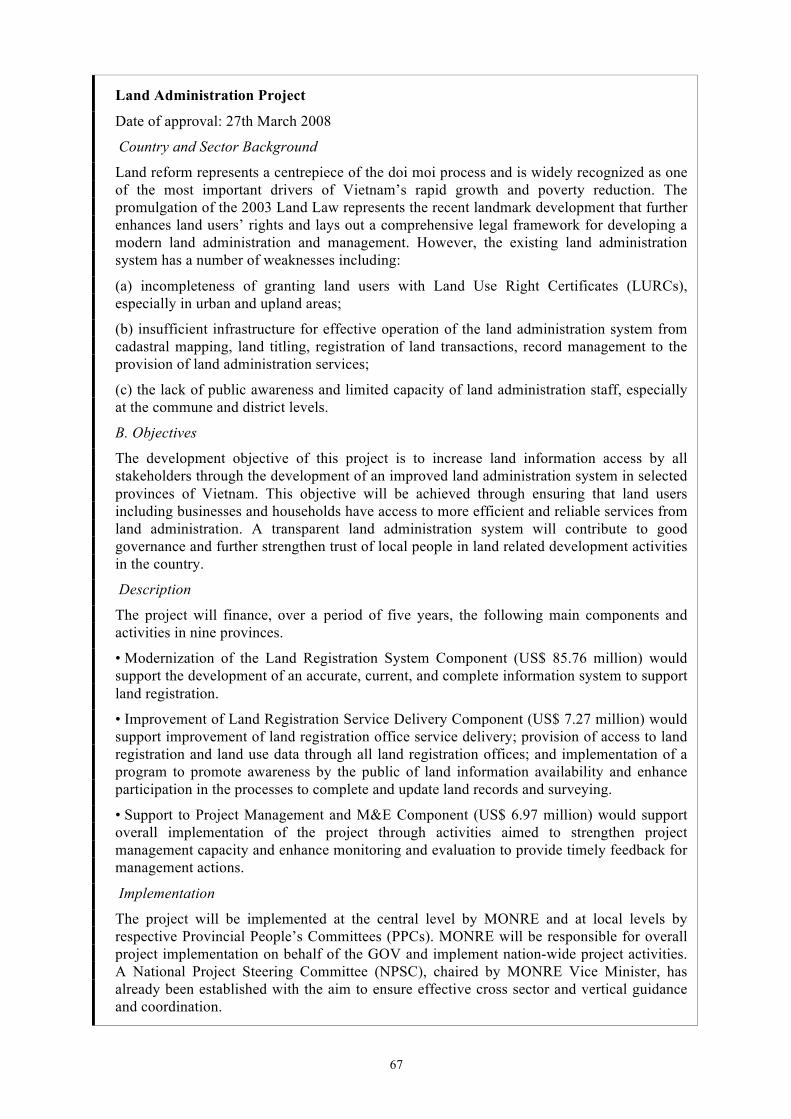
67
Land Administration Project
Date of approval: 27th March 2008
Country and Sector Background
Land reform represents a centrepiece of the doi moi process and is widely recognized as one of the most important drivers of Vietnam’s rapid growth and poverty reduction. The promulgation of the 2003 Land Law represents the recent landmark development that further enhances land users’ rights and lays out a comprehensive legal framework for developing a modern land administration and management. However, the existing land administration system has a number of weaknesses including:
(a) incompleteness of granting land users with Land Use Right Certificates (LURCs), especially in urban and upland areas;
(b) insufficient infrastructure for effective operation of the land administration system from cadastral mapping, land titling, registration of land transactions, record management to the provision of land administration services;
(c) the lack of public awareness and limited capacity of land administration staff, especially at the commune and district levels.
B. Objectives
The development objective of this project is to increase land information access by all stakeholders through the development of an improved land administration system in selected provinces of Vietnam. This objective will be achieved through ensuring that land users including businesses and households have access to more efficient and reliable services from land administration. A transparent land administration system will contribute to good governance and further strengthen trust of local people in land related development activities in the country.
Description
The project will finance, over a period of five years, the following main components and activities in nine provinces.
• Modernization of the Land Registration System Component (US$ 85.76 million) would support the development of an accurate, current, and complete information system to support land registration.
• Improvement of Land Registration Service Delivery Component (US$ 7.27 million) would support improvement of land registration office service delivery; provision of access to land registration and land use data through all land registration offices; and implementation of a program to promote awareness by the public of land information availability and enhance participation in the processes to complete and update land records and surveying.
• Support to Project Management and M&E Component (US$ 6.97 million) would support overall implementation of the project through activities aimed to strengthen project management capacity and enhance monitoring and evaluation to provide timely feedback for management actions.
Implementation
The project will be implemented at the central level by MONRE and at local levels by respective Provincial People’s Committees (PPCs). MONRE will be responsible for overall project implementation on behalf of the GOV and implement nation-wide project activities. A National Project Steering Committee (NPSC), chaired by MONRE Vice Minister, has already been established with the aim to ensure effective cross sector and vertical guidance and coordination.
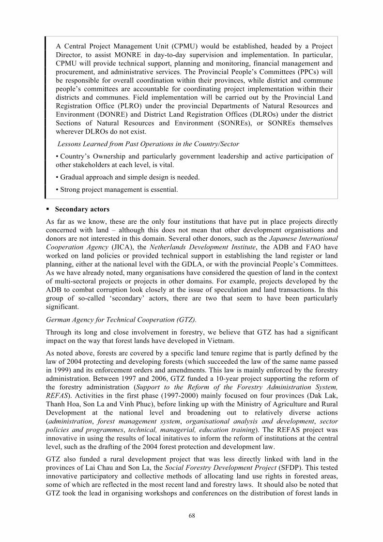
68
A Central Project Management Unit (CPMU) would be established, headed by a Project Director, to assist MONRE in day-to-day supervision and implementation. In particular, CPMU will provide technical support, planning and monitoring, financial management and procurement, and administrative services. The Provincial People’s Committees (PPCs) will be responsible for overall coordination within their provinces, while district and commune people’s committees are accountable for coordinating project implementation within their districts and communes. Field implementation will be carried out by the Provincial Land Registration Office (PLRO) under the provincial Departments of Natural Resources and Environment (DONRE) and District Land Registration Offices (DLROs) under the district Sections of Natural Resources and Environment (SONREs), or SONREs themselves wherever DLROs do not exist.
Lessons Learned from Past Operations in the Country/Sector
• Country’s Ownership and particularly government leadership and active participation of other stakeholders at each level, is vital.
• Gradual approach and simple design is needed.
• Strong project management is essential.
§ Secondary actors
As far as we know, these are the only four institutions that have put in place projects directly concerned with land – although this does not mean that other development organisations and donors are not interested in this domain. Several other donors, such as the Japanese International Cooperation Agency (JICA), the Netherlands Development Institute, the ADB and FAO have worked on land policies or provided technical support in establishing the land register or land planning, either at the national level with the GDLA, or with the provincial People’s Committees. As we have already noted, many organisations have considered the question of land in the context of multi-sectoral projects or projects in other domains. For example, projects developed by the ADB to combat corruption look closely at the issue of speculation and land transactions. In this group of so-called ‘secondary’ actors, there are two that seem to have been particularly significant.
German Agency for Technical Cooperation (GTZ).
Through its long and close involvement in forestry, we believe that GTZ has had a significant impact on the way that forest lands have developed in Vietnam.
As noted above, forests are covered by a specific land tenure regime that is partly defined by the law of 2004 protecting and developing forests (which succeeded the law of the same name passed in 1999) and its enforcement orders and amendments. This law is mainly enforced by the forestry administration. Between 1997 and 2006, GTZ funded a 10-year project supporting the reform of the forestry administration (Support to the Reform of the Forestry Administration System, REFAS). Activities in the first phase (1997-2000) mainly focused on four provinces (Dak Lak, Thanh Hoa, Son La and Vinh Phuc), before linking up with the Ministry of Agriculture and Rural Development at the national level and broadening out to relatively diverse actions (administration, forest management system, organisational analysis and development, sector policies and programmes, technical, managerial, education training). The REFAS project was innovative in using the results of local initatives to inform the reform of institutions at the central level, such as the drafting of the 2004 forest protection and development law.
GTZ also funded a rural development project that was less directly linked with land in the provinces of Lai Chau and Son La, the Social Forestry Development Project (SFDP). This tested innovative participatory and collective methods of allocating land use rights in forested areas, some of which are reflected in the most recent land and forestry laws. It should also be noted that GTZ took the lead in organising workshops and conferences on the distribution of forest lands in
69
Vietnam (such as the 1997 National Workshop on Land Use Planning and Forest Land Allocation, jointly organised with the UNDP and FAO), and has funded numerous publications, including scientific papers, by researchers invoved in these projects (such as Thomas Sikor).
The Asian Development Bank (ADB)
The Asian Development Bank intervenes unobtrusively and indirectly in land matters. It has taken an active part in the reform of the public administration (PAR) since 1996, and provided early technical assistance to the government in 1995 through a study entitled Land Information System and Agricultural Taxation Study. Like many development organisations, it has also shown a longstanding concern for land matters in its strategic documents, especially with regard to tackling corruption and reducing poverty, and supporting rural development and greater economic openness.
2. Land actors’ views on the mechanisms for building institutions We touched on the mechanisms for building institutions in the section on institutional actors, and will now describe these mechanisms in greater detail, give an idea of the way that land actors see this process, how they position themselves in relation to each other and how they see each other. This section describes and analyses the process over the long term and in the recent past.
2.1 A history of experimentation
During this study we spoke to various actors with a long involvement in establishing the nation’s land institutions (since the 1980s and/or Doi Moi). Those best able to stand back from the process and demonstrate a reasonable understanding of its evolution came from Vietnamese institutions; most foreign actors could give key dates in the history of land matters after the late 1980s, but only tend to be aware of the key points in this process, such as the land law of 1993 recognising five derived rights for holders of LURs. Conversely, they often have detailed knowledge of the current situation, and less sectoral and limited knowledge about what happens in Hanoi than most Vietnamese actors.
The main factor distinguishing foreign and Vietnamese actors over the long term is the relatively recent participation of external actors. As noted above, foreign interventions in the overall market and in the context of formulating the Land Law of 1993 did not begin until 1991 at the earliest. Development projects and institutions tend to have a high staff turnover, which impacts on their institutional memory (newcomers often only have written traces of their predecessors), and most personnel stay with projects for short periods, have fixed objectives and often pre-determined methodologies. This limits their capacity to take a longer-term view and mobilise knowledge of the past. What knowledge they do make use of is gleaned from previous reports (such as the often-cited AusAID report of 2000), and little effort is invested in generating new knowledge that could deepen understanding of the ongoing process. However, it should be noted that contact with their Vietnamese partners does provide increasingly detailed knowledge of the past in Vietnam …
Among the Vietnamese actors, we need to differentiate between members of the GDLA and the MoNRE on the one hand, and those of other ministries on the other. Logically, the former should have extensive, in-depth knowledge of the process of establishing institutions over the long term. Several told us how they saw this process, providing details such as the dates and names of decrees, etc., as well as the chronology of participation by foreign actors and the roles that they played.
Members of the GDLA and MoNRE describe the process that the Vietnamese government followed in producing texts for the land law as one of ‘trial and error’. According to these actors, the government would test new arrangements in the regions (at the provincial or communal level) and then promulgate texts, decrees and amendments to laws, or even new laws to facilitate their application. The results of enforcing these texts were then analysed and the same process used to propose amendments to them. The Land Law of 1993, for example, was presented as a ‘revisional land law’ by Dang Hung Vo (2007), and put in place after five years of testing the law of 1988.
70
This process of producing texts through trial and error explains why they are so numerous, incomplete, and often tardy … and also why they were tested at the provincial or district level (often by cooperation projects) with the authorities’ blessing, but not in accordance with current legislation.
Analysis of the evolution of the legal texts confirms this view. For example, the Land Law of 1993 draws up the new framework for land tenure, but is very quickly supplemented by a series of texts that modify certain points, clarify others and even contradict the original text. In the law of 2003, which had taken much longer to prepare than the previous one, there are over a dozen points that the State had yet to settle, clearly denoted by the phrase “The government – or the MoNRE – will regulate or organise the details …” Even more interestingly, numerous decrees surrounding the law were published in order to correct contradictions between texts or their poor implementation, showing that this was not a well-managed process.
It is also worth noting that the government was in the process of preparing to review the Land Law at the end of 2009 (probable date for implementation of the text), even though a new law was already scheduled for 2013. Therefore, certain aspects of this process of trial and error were planned, since the government could not wait until 2013 to revise all the legislation, and had to propose interim revisions.
A similar observation can be made regarding the three-stage creation of the land administration, which started as a relatively independent entity at the highest level of the State and ended up being attached to a ministry. This suggests that, having ceased to exist over 20 years ago, it was seeking to position itself within the overall national administrative system. We have already noted the dysfunctionality of the land administration, and that the government felt the need to issue a decree (n° 181/2004/ND/CP of 2004) to ensure that the GDLA fulfilled its obligation to establish a standardised national system for issuing land use rights certificates.
This experimental approach, which resulted in the production of successive and sometimes inconsistent texts, is usually described as detrimental to the enforcement of legal texts, partly because they were so short-lived that they were sometimes already superseded by the time they were enforced.
However, not everyone saw this as evidence of the dysfunctional evolution of land institutions. Two actors suggested that it was a technique for dealing with the legal void in which Vietnam found it self after opting for market socialism. Although China had taken a similar route, Vietnam could not follow its example because the two countries had made very different choices with regard to land matters. Neithercountry has a clear way forward, and each has to constantly invent ways of reconciling socialist imperatives with greater economic openness. These interviewees pointed to the treatment of agricultural lands as an emblematic example of this.
But this is a minority view. Many Vietnamese and foreigners think that the process of trial and error is due to technical and political deficiencies, the institutions’ inability to renew themselves and the lack of policies with clear, long-term vision.
The usual reasons are cited at the ‘technical’ level: lack of staff, resources and expertise … Land legislation and land administration are often described as particularly problematic areas that require a wide range of skills, and whose problems are compounded by the relatively short time that land has been an issue in Vietnam. The foreign actors we spoke to maintain that this shortcoming is being corrected as experience is acquired over time, and also thanks to investment in training by both the government and development organisations. Nevertheless, this is a problem that has yet to be resolved, especially at the infra-national levels.
Various explanations are offered at the political level. No one mentioned the lack of long-term vision among decision-makers preoccupied with more immediate concerns. This would explain why the law of 1993 focused on agricultural land without taking account of the changes under way in other domains, and why the law of 2003 failed to see the rural problems coming … Many people also noted the government’s nervousness on this subject. The history of land is linked with that of Vietnam, and land is a sensitive matter that cannot be treatly lightly. The external actors
71
we spoke to also note this this is a ‘closed’ sector. The fact that making land-related decisions is politically tricky and that advising on such decisions is difficult does not encourage clear positions or major changes, and explains the numerous experimental initiatives in this domain.
One apparently anecdotal factor that cropped up several times was the imbalances and friction between various institutions and ministries. Tensions between the MARD and the MoNRE were mentioned on several occasions, as the MARD lost some of its decision-making powers over agricultural lands and forests to the GDLA following the redistribution of land and its incorporation into the MoNRE. Because the MoNRE is now responsible for land use planning, the MARD does not have the power to influence land allocations through its agricultural development strategies, and its members have to ‘lobby’ (sic) in order to get their views heard on certain questions that are considered important for rural areas. There is also friction between the MoNRE and the Ministry of Construction, as the former has overall responsibility for land matters, while the latter still has the power to issue the ‘pink booklets’ that guarantee property ownership rights in urban areas. Another highly contentious issue is the difference between the treatment of urban and rural areas.
Looking at land-related texts over the long term, it does seem that increasing account has been taken of the specificities of the different categories of land, such as forests and residential areas. This can be seen in the larger number of categories (or sub-categories) of land that are recognised, and the way that each category is dealt with separately. However, everyone we spoke to mentioned the lack of consultation between institutions in the process of producing legislation, and the consequent proliferation of sectoral enforcement orders that supplement and clarify, but also contradict the land law in order to make it enforceable. This creates a certain amount of confusion around the land legislation, and can lead to contradictions with the texts produced in related sectors, as we will see later with the legislation on land and forestry.
2.2 Writing the law today: an iterative and consultative processus
While they have not been entirely remedied, these shortcomings in the process of producing land legislation do seem to have been reduced in recent years. The process of writing the law has changed in several ways.
• More time and care is devoted to writing the texts, and fairly substantial human and material resources are mobilised for this task. For example, members of the GDLA claim that while the law of 1993 was prepared quite quickly, that of 2003 involved more in-depth work, and preparations for the law of 2013 are even more detailed. There are several reasons why more attention has been paid to preparing these texts. On the one hand, there was the ‘urgency’ of the land situation in Vietnam before 1993, with the need for stability driving the government to support pratices (like land sales) that were often already widespread (Kerkvielt, 1997). There was also the fact that Vietnamese State had only recently decided to follow the rule of law, and that it had to overcome both political reservations45 and the constraints associated with the absence of any legislative framework. One Vietnamese source told us – in jest, but certainly not without reason – that neither members of the Assembly nor the Prime Minister knew what to expect or how to proceed when they started the process of writing the first two laws. The same source also indicated that the unfinished nature of the law of 1993 had prompted legislators to look at existing foreign legislation, especially in neighbouring countries, and to obtain training and technical advice. This opening up to the outside world is obviously not unrelated to pressure from the international community and donors who prioritise the establishment of the rule of law based on comprehensive modern legislation – as can be seen from the rejection of advances by the World Bank in the early 1990s, and acceptance of those from the Swedish cooperation.
45 A report by AusAID (2000) ascribed the fact that the 1993 Land Law took much longer to enforce in the North than
in the South (up to two years in certain localities) to the conservatism of numerous political officials in the North.
72
• Another improvement in the process of producing legislation is the fact that it takes account of the provincial and local levels through consultations with institutions at these levels. This is part of the ongoing (but incomplete) process of decentralisation in Vietnam (Mellac, 2007). However, some sources felt that the time and resources set aside for these consultations are not commensurate with immensity of the task; and it should also be noted that this consultation was undertaken by the GDLA, was not made public, and that the decion-making process remains completely centralised.
• The public is now consulted on important texts, and people can use various channels to express their views on the texts while they are being finalised. These include:
– The National Assembly website (http://www.na.gov.vn/);
– A special postal service to ‘35 Ngo Quyen’ (the National Assembly’s address in Hanoi) ;
– The services of representatives of the National Assembly in provincial People’s Councils.
However, these are new procedures that few people know about and which receive little media coverage Furthermore, as with the consultations at infra-national levels, the information is collected by and sent directly to central organs that do not publicise it, which raises questions about the public’s capacity to exercise any real pressure.
• One process that does seem to have had more impact is the horizontal consulation at the central level. This involves circulating notebooks (with one page of text and one page left blank for comment, or with the old and new texts shown next to each other) or electronic versions (possibly translated) of draft texts among the ministries and various national and international institutions concerned. Groups of experts have also been set up in the context of producing or amending texts, some of them permanent and some temporary (see below). According to members of the GDLA, this relatively open procedure enables certain bodies to join the discussion without having been invited to do so.
Allowing more actors to participate in the administration should ensure that the land legislation sits better with the rest of the legislation, and that greater account is taken of problems and issues that the GDLA may not be able to manage. Opening up to external actors makes it possible to draw on experience acquired outside Vietnam and prepare legislation that is better adapted to the constraints associated with joining the international community (signing conventions or agreements such as the WTO agreement). However, it has to be said that the consultation process is not entirely problem-free.
Internal problems:
• A number of our sources mentioned the extreme rapidity of the process. Certain senior officials indicated that they had too little time to react to the texts, and that the reorganisation of the law, which they believe to be a useful exercise, is too big a task to be undertaken simultaneously in practical and political terms;
• Certain members of ministries that had not been consulted criticised the fact that the consultation only involved senior civil servants and did not allow technicians and/or those dealing with the realities on the ground to express their opinions;
• None of the people we interviewed mentioned the role of the Central Committee, although it doubtless gives its opinion both before and after the texts are produced.
External problems:
• The fact that the land reform is funded by a very small number of actors gives them huge weight. We will return to this point later in relation to agricultural lands and forests.
73
Description of the process of producing the law of 2003 (based on descriptions gathered during the surveys)
1. The process begins with a decision by the National Assembly to revise the legal text or prepare a new law.
2. The National Assembly creates a small working group to write the text and proposes this group to the government. It is managed by an official from the GDLA within the MoNRE.
3. The MoNRE creates two larger new working groups:
– a committee to prepare the new law, chaired by an official from the MoNRE and including an official from each of the ministries concerned (the Ministry of Construction, the Ministry of Finance, the MARD, the Ministry of Industry and Trade, the Ministry of Planning and Investment);
– a group of experts, also led by the MoNRE, bringing together experts from the different ministries and foreign specialists. This group works in close association with the preparatory committee, but has no official status and is strictly consultative. It includes lawyers, agronomists, forestry experts, notaries, etc.
This was the group that was officially supported by the SIDA project (SEMLA) in 2003, and was working on the revision of the Land Law of 2009 during our study. As the funding agency, SIDA is the body that mobilises foreign experts on specific points (for example, the SEMLA project funded an Australian lawyer to assist his Vietnamese counterpart in writing the text amending the Land Law in July 2008), but foreign organisations can participate in the process by expressing their opinion of the draft texts.
4. The preparatory committee prepares a first concrete draft.
5. This text is submitted to experts and compared with the texts of similar (or related) laws produced in neighbouring countries (including China) and the West (France).
6. After this comparison, a second, more substantial text is produced.
7. This second text is submitted for comment to the People’s Committees in 64 provinces and various other localities (such as cities and districts), and to other competent bodies (Vietnamese and foreign).
8. The third version of the text is written on the basis of their comments.
9. This version is submitted to the small working group led by the MoNRE (which approves or rejects it).
10. If approved, it is resubmitted to the provinces.
11. It may be modified again (fourth version).
12. This version is submitted to the small working group led by the MoNRE.
13. Then to the legislative Committee and the economic and political Committee in the National Assembly.
14. The text is revised again according to their comments.
15. It goes through the same verification process again (the working group and the two committees).
16. It is presented to the National Assembly, which studies it in detail and accepts all or part of it.
17. The ‘final’ version is then written by a member of the national University of Law.
18. In the case of important texts, such as the one relating to land, it is then presented to the public, who can submit their comments through various channels.
74
19. At this stage the national University of Law may give its advice – it is the only university that directly advises the National Assembly.
20. The National Assembly meets a second time and examines the advice: if there is no major problem the text is amended in the margin; if there is a problem a new text will be required. The cycle resumes … a new text is written and the Assembly meets again …
21. National or foreign groups have the opportunity to make an appeal and ask for the text to be rewritten, but this will only be heard if 50 per cent of members of the Assembly accept that it needs to be revised.
22. The National Assembly votes on the text.
Before 1993, the GDLA was solely responsible for writing the texts for land laws, as this was an internal affair. The decisions taken mainly depended on how members of the National Assembly and the most senior civil servants viewed land issues. The process of writing is much more open nowadays. The procedure described above resembles that in the analysis of the Constitution (Annex A.1.3), but is more complete in that there is much greater articulation between the different levels, and numerous actors are consulted. Despite all the aforementioned shortcomings, this is a consultative and iterative process that facilitates – as the texts themselves show – the production of a richer, more detailed body of legislation than in the past. However, there is now the question of the weight of external influences on the internal officials responsible for producing the legislation, and the way in which external pressure may be exercised.
2.3 The ‘problematic’ articulation between the national and provincial levels
Another particularly pressing problem nowadays is the articulation between institutions at different administrative levels, especially the national and provincial levels. We were told that the process of building institutions is consultative, and we have seen that the provinces have progressively established institutions that are capable of responding to the ever-increasing number of land transactions and actors. However, the case of Binh Duong clearly shows that land legislation has been slow to adapt to provincial settings and does not always do so in accordance with national recommendations.
Several people that we spoke to maintain that these discrepancies are due to the fact that the texts are not adapted to local contexts, mainly because of the rigidity of the different classifications. The fact that provinces are classified according to their location (plains, watersheds, mountains) is a particular problem, since many provinces, such as Binh Duong, are located in intermediate zones. The variations within and between provinces are thus the result of these classifications and (partial or total) failure to respect them at the provincial level.
The frequency and significance of the legislative changes was also often cited as the reason why they are poorly enforced or ignored at the provincial level, as the provincial administrations have neither the time nor the capacity to adapt each new arrangement to their locality. This is obvious in Binh Duong, where the province is slow to react to land arrangements, and often does so just before new arrangements made at the national level render their local adaptations obsolete or out of line.
The land development funds are one of the elements that are seen as helpful in improving the functioning of the land administration in the provinces, because of its key role in the mechanism for compensating households whose land has been expropriated. However, several people we spoke to said that this can also cause difficulties, especially in establishing a clear financial system, as is the case in Binh Duong. Because it is not directly dependent on the People’s Committee (see flowchart of the executive and legislature in Binh Duong), this fund does not officially have its own resources, but requires the financial organisation and ability to mobilise funds in order to fulfil its mission of paying compensation and collecting investment funds. It seems that no directive has been issued clarifying its budgetary mechanisms. Provincial officials raised this issue on several occasions, suggesting that an unofficial mechanism where investors
75
pay compensation would be more ‘complex’ and possible entail going through other institutional actors involved in the process, which indicates that informal flows of money do exist.
Binh Duong province recently tested new modes of requisitioning land and paying compensation involving a private company. The protoype has yet to be finalised, and it is still unclear whether the State or the company will bid for the rights. Either way, the thorny issue of compensation (conflicts/necessary funds) is transferred to the private sector, with the possible consequence of creating land speculation. Transferring the risks of transactions to the private sector could increase land values, simply because some of the land has to be set aside to resettle former users. This part of the land – which is earmarked for housing and thus has a significant value – could then serve as a cushion against any possible losses resulting from insufficient bids, or simply increase the revenues from land thanks to the part set aside for housing. In these conditions, property prices would increase significantly, as they already have in metropolitan areas.
As we will see later, corruption is an ever-present issue in the provinces, either periodically when investment projects are set up, particularly when households are compensated for their expropriated land, or more generally when development and land use plans are put in place. To a certain extent, this reflects the actors’ inability to follow the complex process of building institutions at the provincial level. Despite conducting in-depth surveys in Binh Duong, we found it difficult to disentangle this process, whose complexity is partly due to the dual origins of land institutions at the national and provincial levels. It can only be described in a very full and complicated table (Annex A.2.4) whose main advantage is that it shows the discrepancies between the two levels. All actors, whether local, national or foreign, agree that situations vary greatly, that a lot happens at the interface between the provincial and the national levels, and that there is very little control or forward planning. This articulation fosters both innovation and anomaly: and is thus is the testing ground for national legislation. Foreign actors, including the World Bank, are not mistaken in anticipating a large number of interventions at the provincial level, partly to identify the points that need to be clarified most urgently, but also to determine how more effective institutions can be established, in a less restrictive framework than the national level.
3. The evolution of land matters: discourses and descriptions
3.1 Is land a marketable asset or a public good?
The great majority of people that we spoke to said they felt that current legislation is better able to address the multiple issues associated with rural and urban lands. The Land Law of 1993 was a ‘political law’ designed to respond to specific expectations that mainly related to agricultural land as a whole, and looked more like a vague programme than a law that would help deal with a wide range of land situations. The law of 2003 was naturally still ‘political’ and also considered land as a whole, but was also much more ‘technical’, incorporating legal, administrative and technical aspects that enabled it to respond to many more specific situations. Nevertheless, the current legislation still has many weaknesses, and not everyone is happy with the direction it has taken. As one of our Vietnamese sources said, “Vietnamese legislation is in transition, like the country”, and any future changes will be crucial for Vietnam.
In this section we will return to the distinction between Vietnamese and foreign actors. Although opinions differ within each group, particularly among institutional actors, there are clear differences between the views held by the two groups as a whole, which differ on the points that are seen as most problematic or satisfactory. In both cases, we will identify the issues that were mentioned most often and/or best described by our sources.
§ The liberal discourse of foreign actors
Assessments of land matters and Vietnamese legislation in general repeatedly emphasize the imperfect nature of the land market, which is ascribed to the unfinished process of liberalisation and the State’s inability to properly exert the control that it wishes to maintain. This situation is seen as exacerbating corruption, mainly by creating tensions between public and private actors
76
(the land administration is frequently cited as an example of a corrupt administration; World Bank, 2007), and as delaying the economic development of the country by creating an unstable environment for would-be investors of both Vietnamese and foreign extraction. For example, a quick assessment of the legal environment of Vietnam by the Swiss Development Cooperation reports that “slow progress in reforming the public administration system and ambient corruption continue to negatively affect the country’s ability to attract both foreign and domestic investment, and create obstacles to business”.46
Land is a particularly important issue for Vietnam as it makes the transition towards a market economy. Most actors now recognise that considerable progress has already been made in this domain. For example, the World Bank and ADB see the redistribution and registration of agricultural land use rights as one of Vietnam’s major achievements since the launch of Doi Moi (World Bank, 2002b). This process has resulted in substantial increases in agricultural productivity, supported growth in a context of equality, and helped reduce poverty considerably. Economic openness – seen as synonymous with economic development – and poverty reduction are two recurrent themes associated with land matters, and are clearly evident in the expectations of the SEMLA project piloted by SIDA: “The objective of the Land Administration Group is to support the continued development and implementation of land policy and legislation, and to strengthen and streamline a land administration system that supports the Government's objectives of sustainable development and poverty alleviation” (http://www.semla.org.vn/). The World Bank raises land issues in numerous projects aimed at supporting Vietnam in its evolution towards a market economy, but emphasises questions of governance and poverty reduction in its recent project to support the land administration (see box above). The World Bank and Bretton Woods institutions in general have made poverty reduction their primary raison d’être since the end of the Cold War, and this entry point allows them to raise a politically sensitive subject by stating intentions whose legitimacy is hard to challenge. However, the main expectations stay the same whatever the stated viewpoint: the liberalisation of the land market, privatisation of land and more secure rights offered by the State, since deregulation, privatisation and security of tenure are deemed to be more conducive to the increased investments required for growth and sustainable improvements in poor and marginal people’s living conditions (questions of gender and exclusion are also often raised).
In this context, the most problematic issues in land legislation and its implementation are now seen as excessive State intervention in land management, and the land administration’s difficulties in establishing an effective and reliable system of land registration.
§ Heavy-handed interventions
In the questionnaire that we sent to members of several international institutions (Annex A.4.2), respondents were asked for their opinion of Article 1 of the 2003 Land Law (This Law prescribes the powers and responsibilities of the State which represents the entire-people owner of land and uniformly manages land; the regime of land management and use; the rights and obligations of land users). Most respondents did not seem to see land ownership as problematic. This article revisits a principle set out in the Constitution, and they did not feel that it needs to be challenged insofar as the use rights and derived rights assigned to land users make them resemble de facto landowners. Many maintain that, in practice, it makes little difference to land users whether they hold full and exclusive rights to land or the right to use it, provided these rights are not restricted. Thus, it is not the nature of the rights obtained (whether they relate to the land or its use) that matters. These actors are essentially pragmatic, and are not concerned with the ideological content of the public ownership of land held by the State. What matters to them is that these rights continue to be offered to all users, and that they are free to exercise them in a secure environment.
The State seems to use the different categories of land and land user defined in the land legislation as a means of exerting temporal, territiorial and human control, by distributing more or less
46 http://www.sdc.org.vn/en/Home/About_Swiss_International_Cooperation/ressources/resource_en_167727.pdf
77
extended and long-term rights according to the type of user and land concerned (reflecting planning as a whole). This dual categorisation makes the situation much more complex (Annexes A.1.5 and A.1.6) and is believed to distort the land market due to the restrictions imposed by too many administrative measures.
The Land Law of 2003 is usually presented as being progressive with regard to categories of land use, in that it extends users’ rights and recognises a larger number of users. New categories such as ‘residential comunities’, ‘overseas Vietnamese’ (viêt kieu), ‘foreign organisations and individuals’ are seen as constituting a major step forward – although the limitations of the nature of the rights assigned to these users and the manner in which they are assigned soon became apparent
The objective of the ‘residential communities’ category was to allow customary land regulations to secure local access to land and resources, especially in forested mountainous areas. However, the framework in which these rights can be exercised is too restrictive. On the one hand, communities have to conform to the definitions given in the legislation and be recognised by the upper echeleons. On the other hand, they have to set out their rules in writing (taking them out of the realm of the oral and into jurisprudence), distribute the rights recognised by the law (which disqualifies rights to resources rather than land), and do so in a way that is deemed to be equitable, not only by the group, but also by the officials responsible for approving the project. Therefore, while customary land tenure systems now have a recognised legal existence, it is somewhat illusory because the requirements that these groups have to meet render their systems meaningless and thus ineffective.
The categories ‘overseas Vietnamese’ and ‘foreign organisations and individuals’ reflect a distinction between domestic and foreign that some see as irrelevant, and others as inequitable or even nationalistic. This distinction is seen as highly problematic because of the limited range of rights assigned to foreigners (who are essentially restricted to long-term rentals based on their investments; see table in Annex A.1.5), and as encouraging corruption because these restrictions encourage foreign investors to bypass the legal framework, by using front companies to purchase land, for example. It discourages good quality, sustainable investment and bolsters Vietnam’s poor image. Some say that it will also have to be scrapped, since it is not permitted under the rules of the WTO, which Vietnam joined in 2005.
The different categories of land are also seen as problematic. While the fact that land is no longer defined by its location is viewed positively (it is now defined according to its use), the content of the categories – rather than their existence – still causes problems. Opinion is more divided on this than on the previous point: certain donors or project workers believe that it is necessary to retain, or even reinforce, the particular status of certain categories of land, especially residential land. Some even argue that this should constitute a fourth category of land (by subdividing the category of non-agricultural lands) because of its importance and the specificity of the regime for this kind of land. One difficulty that is often raised with regard to residential land is the distinction between property assets, which are covered by full ownership rights, and land that can only be held through temporary use rights (or ‘individual ownership rights’).
The specific regime for agricultural lands is generally unpopular and widely regarded as over-protective, while forests are seen as needing greater protection. For example, one argument put forward by the World Bank is that the specific status of these lands in terms of the duration of use rights (short), taxation (non-existent) and official prices (determined by the value of output) leads to corruption and is an important factor in market distortion. The problem with agricultural lands is also accentuated by the restrictions on their conversion and transfer, which, despite being been reduced, make land relatively scarce and increase the price of land whose status has been changed. This not only makes poor people who move to urban areas more vulnerable as they cannot access the peri-urban market, but also affects rural populations since their land is of very little value (WB, 2002b, p. 46). As a result, it is the poor who are the first to suffer from market distortions.
78
“Overall, the study's preliminary findings suggest that increased efficiency, greater transparency and reduced costs in the formal land market may benefit the poor more than traditional "protective" interventions aimed at restricting market transactions” (ADB, 2004).
Few challenge the need for different categories of forest – in fact, the argument here is whether or not they need to be made more specific. Conservation organisations like WWF argue that old forested areas need to be protected, and that their classification (as special use forest land) distinguishes them from cultivable lands and allows certain uses to be banned. However, organisations that are more concerned with people than woodlands, such as the FAO (or, to a lesser extent, GTZ), believe that the distinction between forests and agricultural land is too rigid, that it hampers the development of agroforestry and destabilises populations that practice slash-and-burn. As noted earlier in this paper, the land legislation of 2003 does take more account of local people in forested areas, largely by recognising customary land tenure systems or by authorising bodies responsible for forest management to allocate the use of strictly protected lands for short periods in certain conditions (Article 77). The writings and sayings of these organisations show that it is not so much a matter of challenging the forest categories, but of extending rights to this land and making it more like agricultural land, emphasising the need for greater recognition of customary rights and a framework that is more conducive to the exercise of these rights.
It is easy to see why analysis of the discourse on land legislation among foreign actors shows almost unanimous support for liberalisation of the land market, which requires more rights, fewer restrictions and less State interference, except in rare and clearly defined cases where the protection of land or land users is deemed useful. The World Bank sees the development of the land market as a real miracle cure, even though it is recognised that it can accentuate rural poverty by concentrating land and increasing the number of landless farmers (World Bank, 2002b and 2007). The rural land market needs to be liberalised in order to increase non-agricultural employment, which creates wealth in rural areas. Therefore, it is necessary to put in place measures that will help correct the market’s shortcomings and reduce people’s vulnerability: making credit available, developing insurance, programmes for the State to repurchase lands, and low taxation (World Bank, 2002b).
§ Building an administration
While the State needs to be a less obvious presence in the market, it should also ensure that the market functions by providing an efficient administration that safeguards users’ rights by issuing certificates that guarantee their use rights. Land use rights certificates are the World Bank’s second miracle cure (or rather, ‘speedy miracle cure’).
“Establishing the framework for an efficient land market is an important part of the second-generation reform program. Land titling is bound to increase efficiency. Land Use-right Certificates (LUCs) can be used as collateral to obtain credit and help improve the insufficient access to finance, which is arguably the main constraint to business development in Vietnam. Property titles should also provide a more sound foundation to develop a real estate market. From a social perspective, they could help formalize the status of urban migrants, who continue to be registered as “temporary residents” despite having lived in the cities for years, if not decades. However, land titling alone is not enough to ensure efficiency and equity. Strengthening land management and administration is a top priority to consolidate and safeguard user-rights already issued, to promote efficiency and equity through enhanced transparency in land records management as well as to strengthen the emerging rural and peri-urban land markets” (WB, 2007, p10).
The administration forms a dense network that is present at every level, even the very lowest. Although decentralisation has produced positive results by reorganising every level of the administration and better distributing tasks, the administration still has limited capacity to enforce
79
legislation and manage land. This is the main justification for two important land-related projects that are currently under way. It is also worth noting that donors are using primarily technical and organisational objectives requiring significant levels of funding and modern tools as an entry into land matters.
There are two advantages to this technical entry point:
• It improves the administration’s capacity to issue certificates and provide the land-related information needed for the market to function
• It makes the donors’ presence acceptable.
For example, (as already noted) the land administration is often accused of being very corrupt. While this is naturally not explicitly mentioned in proposals for projects to support the land administration, the terms ‘transparency’, ‘standardisation’ and ‘control’ clearly indicate that this is a major concern among donors. Having a presence in the GDLA and provincial centres allows them to observe practices on a daily basis, position themselves as closely as possible to the centres of decision-making, and indirectly influence the evolution of legislation.
§ Institutional actors looking for solutions
It is extremely difficult to provide a synthesis of institutional actors’ views because they vary so greatly. In fact, this divergence is one of their main characteristics. To our mind, it is evidence of the unease about land matters at the very highest levels of government, and is not surprising in a context of transition and generational and behavioural change.
§ Unfinished land reform
Unlike foreign actors, who are not especially concerned with the leaders’ ideological position, Vietnamese land actors frequently mention their own and the public’s discomfiture with the transitional state of the land system. Most clearly expect land management to follow the course prescribed by the World Bank in coming years: that all lands will be covered by a private ownership regime (or one that functions as such) in a deregulated market. But this kind of regime cannot suddenly be put in place without upsetting the public, especially the rural majority who welcomed the return to individual land access but are not prepared to put up with internal and external competition. Therefore, it is a matter of avoiding excessive tension in a domain that is crucial to the political legitimacy of Hanoi, by continuing to affirm collective land ownership, ensuring that there is a specific regime for agricultural lands, and emphasising the equity of the regime for these lands (by limiting the size and duration of land allocations) rather than its economic efficiency. Several sources also note that certain senior officials, especially in the National Assembly, are not ready to purge the legislation of principles that are seen as fundamental for the political regime. As a result, land-related choices may seem ideological rather than functional, and even appear to undermine the smooth running of the land system. This notion cropped up several times during our interviews, and also appears in the AusAID report published in 2000 summarising the land situation:
“In Viet Nam, the state is acutely aware that decolonisation struggles and ultimately its own legitimacy revolved around the equitable distribution of land. People ownership and state management of land are central principles of Communist doctrine that underpin legal definitions of land ownership and use. Doctrinal issues are most evident in the regulation of rural and other income-producing land and less relevant to residential land. Finally, the land law regime in Viet Nam is exceedingly complex” (AusAID, 2000).
Certain officials believe that the central State has gone too far towards liberalisation and decentralisation and is insufficiently prepared for these changes; while others think that it has not gone far enough and that its hesitancy is responsible for the dysfunctionalities of the system. “The leaders say that they’re Communists, but they behave like capitalists, and it’s completely
80
unacceptable!” What both sides do agree on is that the reforms are incomplete and there is little control over land dynamics.
We discussed a wide variety of topics with Vietnamese actors, ranging from the details of particular articles of the law to the ideology underpinning the collective ownership regime. The themes that cropped up most frequently were corruption caused by the dysfunctional land law, and the much more specific problem of land prices.
§ Pervasive corruption
The delicate issue of corruption often cropped up spontaneously during our interviews and conversations, usually in relation to questions about the effectiveness of the new legislation. As we conducted our interviews with civil officials in Hanoi, they were relatively distant from the supposed sources of corruption, which are mainly found at the provincial and local levels.
The decision to give power to the provinces and districts was identified as one of the main causes of corruption, especially the power to decide on land attributions, rentals and changes of use. The provinces authorise changes in land allocation for groups, and the districts authorise changes in favour of family households and individuals (Article 37). In theory, this power is framed by land use plans, which determine the changes in land allocation that can be made over a five-year period. These plans should be approved by the next level up, which is the MoNRE for the provinces. However, this planning, whose role is to maintain central State control over land allocation and use, is described as being much more theoretical than real. The MoNRE does not have the capacity to make a detailed assessment of all these plans, and there are long delays in getting them approved. Decree 181 of 2004 was supposed to have regulated this, but it does not seem to have much effect, which means that there are long transitional periods. Furthermore, the fact that many districts and half of the communes have no plans of any kind makes it easy for officials in the districts and provinces to make decisions outside any planned or centralised framework.
In the absence of any real control, the provinces and districts use various tactics to increase their room to manoeuvre: creating phased projects to install industrial or commercial enterprises on parcels of less than 200 hectares (any changes in land use exceeding this area have to be approved by the government), and manipulating the figures to camouflage changes in land allocations. Therefore, it is often said that the rate at which agricultural land is diminishing has stabilised, and that the amount of unused land (such as land outside dykes in the delta) is decreasing in parallel with an increase in non-agricultural lands. In reality, however, the rapid transformation of agricultural lands is camouflaged by that of unused lands, which are changing at a much slower rate. Some districts may also minimise their declarations of agricultural land so that their reserve of land that can be awarded to households exceeds the legal 5 per cent limit, and can be used to generate extra revenue.
It is likely that genuine cases of corruption are due to situations where it is all too easy for local officials to cash in on their power to allocate land, change the status of land for investors, and use their knowledge of planning and projects in their jurisdiction to acquire:
• Agricultural lands at low prices before a change of use is decided, giving them access to land whose value has increased,
• Agricultural lands at low prices before an expropriation is decided, enabling them to benefit from compensation,
• Forest lands before the start of environmental protection projects, providing funds to put in place forest plantations, etc.
Another situation conducive to corruption is the expropriation of land from rural households and payment of compensation. Businesses pay households relatively little compensation when they have to give up their land, but they do not negotiate directly with these households, and have to pay very high transaction costs as each administrative level makes a charge for agreeing to a new installation and following the procedures for such initiatives. In addition to this, the communes do
81
not usually worry about getting the agreement of the households whose land will have to be expropriated, which means that they cannot negotiate the price of their resettlement. It is also necessary to go through three different departments to obtain all the athorisations (construction, finance and the DoNRE). Through its policy instituting the ‘single entry point’, and in order to simplify procedures in every administrative domain (Order 81/2003/QĐ-TTg),47 the government recently decided to create a single window for investors at the provincial level. However, as one source remarked, there may only be one entry but several locks need to be opened to get into it – rather than acting as tool to simplify the process, this the window makes space for another actor who may be susceptible to corruption.
The power available to the provincial and district authorities is not only a source of corruption, but also of conflict between the authorities and individuals who belatedly realise that they have been swindled. According to one source, 70 per cent of the conflicts currently registered in Vietnam are related to land (this corroborates the previous figures given by the paper Tuoi Tre). The national and local press is full of such disputes, of which we were given many examples. It is hard to resolve them because there are numerous gaps in the land legislation with regard to conflict resolution, and it is unusual for disputes to go to court. The People’s Council at the next level up is responsible for resolving such matters, which means that the longer a dispute drags on, the further up the hierarchy it goes.
Another area of concern was the increasing number of land prerogatives acquired by the provincial and local levels (setting official land prices, determining the maximum size of agricultural farms, etc.). Some of the people we spoke to think that tensions are now at such a level that the government will have to backtrack on this; some believe that the provinces will lose control of certain categories of land in coming years, such as protected forests and rice fields, that it will be the government that decides on changes of use or allocates such lands, and that provincial planning will be sufficient for the other categories of land; while others hope for still greater liberalisation that will remove power from the provinces by reducing their authority to make decisions. All agree that the current transitional situation is a source of tension and corruption, as there are no controls over provinces that are poorly prepared to deal with either the significant powers with which they are endowed, or the considerable pressure exerted on them by the private sector.
§ The problem of setting land prices
A good deal of concern was expressed in various quarters about land prices. Foreign donors find price-setting procedures opaque, over-administrative and dominated by public actors; and numerous institutional actors raised this issue too, perhaps because they are both land users and land administrators, but also because this topic was getting huge media coverage while we were conducting our research.
Institutional actors mentioned two problems with particular frequency. Firstly, that there are two methods of setting prices during State interventions: one that mainly applies to non-agricultural lands and takes account of market prices, and the other that applies to different categories of agricultural land and takes account of annual agricultural incomes rather than the value of adjacent land. This means that agricultural lands have the same value regardless of changes in the use of adjacent land, road building, new enterprises or residential areas, etc., which disqualify rights holders from using this type of land but enable speculators to acquire agricultural land cheaply, change its status and rent it out (after investing in the construction of housing or servicing the land, for example).
The second problem is the price range set by the State according to the category and location of the land. Although these different criteria are taken into consideration, many feel that the ranges set at the national level are unable to take account of the diversity of situations. For example, land
47 The exact title of the order is “Quyết định của Thủ tớng Chính Phủ Về việc ban hành quy chế thực hiện cơ chế “một cửa” tại cơ quan hành chính nhà nước ở địa phơng“.
82
under annual crops in deltas is supposed to fall within the price range of 4,000 to 90,000 VN dongs per m² (+/-20 % at either end of the range), but this is seen as much too low for the rich soils of the Mekong and Red River delta, which are harvested several times a year. Furthermore, price ranges are extremely unfavourable for agricultural lands valued at over 90,000 VN dongs per m². This price bears no relation to the price of residential land in rural areas, which can cost as much as 1,250,000 VN dongs (nearly 14 times more), and even less to non-agricultural productive rural land, which can go for as much as 67,500,000 VN dongs (750 times more!).
Most institutional actors describe these methods of price setting as an open door for all kinds of corruption. Malpractice by officials (passing on information about new development plans before they have been published, or exploiting producers’ ignorance) is generating growing discontent among rural people as they discover that not only have they not been paid all their due compensation, but that the price of their parcel has increased by a factor of 10, 20 or even more in the space of a few months and a couple of visits from a mechanical digger. Farmers and agriculture are particularly adversely affected by the legislation because most rural people know little about land legislation, and local officials are not trained and are therefore easy to manipulate.
There is less agreement about the best way of resolving this problem. Some believe that the sector should be better framed to make speculation impossible and maintain ways of protecting agricultural land, while others think that the market needs to be completely liberalised in order to avoid excessive distortion and speculation. Both sides see the State’s choice between the market economy and the planned economy, which has yet to be settled, as a problematic decision that affects vulnerable populations more than any other sector.
§ What next?
This description of the position that international institutions have taken on land issues in Vietnam will hold few surprises for those who are familiar with such matters, and especially with the World Bank. Poverty and corruption are recurrent themes and problems associated with – and even explained by – dysfunctional markets and excessive State intervention. From this perspective, the State is simply seen as an operator that needs to exert sufficient control to implement and guarantee consistently modelled reforms (allocation of individual use rights, certificates, etc.), as the functioning of the market will resolve these problems. Although we have seen that there are some differences between the foreign actors concerned, their position is relatively homogenous compared with the apparent ‘cacophony’ among the institutional actors involved in this sector.
Land is a much-debated topic that links into fundamental questions about the nature of power and the future social and economic orientation of the country. Is the rice-growing peasant still the face of Vietnam? In what way is the country still socialist, and will it remain so on a profound or superficial level? What role should agriculture and rural areas play? There are many political sensitivities and interests at stake, and obvious tensions in the process of establishing institutions – both the land administration, which is a powerful and yet ineffectual State within the State, and the legislation, whose progress is jerky and apparently oblivious to contradiction. There is a good deal of uncertainty, and there will doubtless be other clashes in this rapid transition, but the overall evolution is now clear: Vietnam is progressively aligning itself with international land law.Many people that we spoke to see this as inevitable, given the economic choices that have been made and the constraints of joining the international community (the ASEAN and WTO, among others). With the World Bank’s entry into the land arena, Vietnam is clearly indicating at the highest level that this question is no longer a purely internal affair, and that it may open up to other views and external models. But is this increasing openness, which will involve the State giving up some of its powers, tenable in modern Vietnam? Is it a response to economic conditions intended to give the appearance of normalisation, or a determined long-term choice? Events such as the rocketing price of rice, the ‘food crisis’ and inflation have served to remind Vietnam in different ways that it is still a rural country; the constant peasant demonstrations that it is a country where the rural population matters and still believes in the State; and the uncertainty
83
among officials that they can still reflect on the way forward and question whether they are going in the right direction …
3.2 The uncertain future for agricultural land
§ External actors
While the Vietnamese actors that we spoke to gave us long interviews, our external contacts went into much less detail about the specific issue of agricultural land and forests in the land legislation. This makes it difficult to add anything to their position on this topic beyond the foregoing presentation of their opinion of the legislation as a whole. Nevertheless, there are certain points that kept on cropping up in what they said and wrote, which are summarised below.
• The question of insecurity: many noted the limited duration of rights to agricultural land. This is deemed to be unconducive to long-term investments, and of no practical use in terms of redistribution since people will find ways of keeping land that they have used productively. Another problem is the duration of rights acquired following the sale or transfer of land. Therefore, time limits are seen as a cause of tenure insecurity that has no social utility.
• Another frequent observation was that the legislation places far too much value on measures that guarantee equitable tenure rather than economically effective agriculture.
• The fragmentation of agricultural land was was also often mentioned. The extreme drive for equity in the early 1990s resulted in the proliferation of categories of parcels whose use is allocated to households. Those in the Red River delta can have up to 30 parcels, which poses significant problems for mechanisation, water supplies, the construction of infrastructures and so on. There have been efforts to consolidate land, particularly in the Red River delta, but more needs to be done. There is also a risk of that parcels will be voluntarily regrouped, and the World Bank believes that it would be more opportune to let market mechanisms run their course.
“The government's response has been to promote the voluntary exchange of parcels among farmers, with the aim of consolidating land into larger blocks when several plots are held by a single household. Whether consolidation can substantially increase agricultural productivity remains an open question. Care needs to be taken to maintain the risk mitigating benefits of spatially dispersed plots in different agro-ecological areas. In any event, this measure is essentially a one-off intervention. There already exist bottom-up processes of consolidation and land accumulation through informal channels, including land exchange, and the rental and sale of land-use right certificates (Chung, 2000, and Kerkvliet, 2000). But these informal processes need to be complemented by market mechanisms that provide more adaptability and flexibility for households”. (World Bank, 2007)
In short, the current management of agricultural lands is dominated by administrative measures that restrict economic dynamics; future legislation will need to remove all kinds of administrative constraints.
“Numerous administrative constraints over land-use allocation and land use remain. There is administrative influence over crops to be grown, even if it is now being eased with the 2001 revisions to the Land Law. There are constraints on land leasing as well. The family leasing land must be in poverty, have taken up another occupation, or lack the capacity to work its land. There are also ceilings on land holdings, on duration of land-use rights, and on land transactions. Ceilings on land holdings are set at levels below what is economically optimal, given experience in neighboring countries. The length of the period of land use is also low. It is currently set at 20 years and 50 years for agricultural land and forest land, respectively. Lengthening these periods would encourage long-term fixed investments in both agricultural land and upland”. (World Bank, 2002b)
84
We have already mentioned that the actors’ positions on forest lands depend on whether they consider their management from an environmental or a social point of view. Some want part of the forests to be more open, while others want to strengthen protective measures and close them off. However, the existence of multiple categories of forest has not been challenged, and all actors agree that there is a problem delimiting forests and enforcing these boundaries. For example, in a report on the reform of forest enterprises, the World Bank notes that delays in its implementation can be ascribed to the poorly defined boundaries of forest lands and parcels, and failure to clearly define the different categories of forest (World Bank, 2005a). This creates tensions between forest enterprises and households during efforts to get businesses to reallocate land use rights to households. These difficulties not only relate to the availability (or lack) of resources to catalogue and register forest lands, but also to the lack of clear categories of forest land in the legislation and procedures for allocating and cataloguing land.
GTZ places particular emphasis on the need to involve the public in planning and allocation processes, and has developed participatory methodologies in the context of its Land Use Planning and Land Allocation projects. These methods relate to questions of governance, but also include technical solutions (mapping, MIS systems, remote sensing) designed to address the shortcomings identified in this domain. As we mentioned, GTZ has also initated community forestry projects, and criticised some of the social aspects of the legislation on the grounds that local people are insufficiently involved in forest management, and policies are poorly thought out.
§ Institutional actors
The last section considered several aspects of agricultural and forest lands, especially the specific way that the legislation deals with these lands. We also noted that Vietnamese officials respond to this situation in different ways; some believing that it is useful to further protect agricultural land, and others preferring to abandon any specific system and let the market take its course. As Dinh Huu Hoang and Dang Kim Son (2008) observed, there are two current trains of thought in Vietnam regarding the future management of agricultural land. One sees it as a key element of poverty reduction, believing that it is necessary to allocate land resources equitably between farming households. The other thinks that the future of rural areas lies in a large number of households migrating to urban and peri-urban areas, a radical modernisation of farms (and greater concentration of land) and greater focus on using land for tourism and ecological purposes.
It is hard to explain why different Vietnamese officials support one or other thesis, as we do not have enough information about the hypotheses, the individuals or their institutions. However, the fact that there are such diverse views is interesting in itself, as it indicates that there are tensions between both officials and institutions regarding the future of agricultural lands. Although members of the MoNRE and MARD that we approached were by no means unanimous, we felt that there was much more sympathy for greater liberalisation of the land market within the MoNRE, and that the MARD was more in favour of strengthening the place of the State and recentralisation in order to protect agriculture and farmers, who are seen as ill-prepared for greater liberalisation. It is likely that members of the MARD, whose attributions have been considerably reduced by the land reforms, are partly seeking to protect their functions by advocating greater State intervention in agricultural affairs. Conversely, members of the land administration see their role valorised and their power strengthened by the introduction of modern registration systems. Their positions are therefore probably linked to the history of the institutions themselves, and should be seen in relation to the competition between them described earlier in this paper.
The positioning of the different actors also needs to be understood in the political context of Vietnam, and the increasing priority given to the industrialisation of the nation since the mid-1990s – its objective is to become an industrial country by 2020 – to the detriment of agriculture. This has led to differentiations between actors. In the province of Lao Cai, which is still very agricultural, certain officials think that the government has not gone far enough in promoting the processes of industrialisation and investment. One source in the province wanted to be able to intervene on the land use certificates allocated for forest lands, which he considers (in a very
85
classic way) to be under-utilised by households. In his view, allocating individual use rights to forest lands is of little benefit to the recipients and significantly hampers investment in agriculture and forestry, and thus the development of the province as a whole (including its exports, which are mainly agricultural). Therefore, this allocation should be reviewed and the province allowed to directly manage forest lands. This type of position is clearly driven by the desire to develop the province and the strong competition between provinces, which is mainly focused on industrial and commercial development, with provinces publicly ranked each year according to the amount of investment they have attracted.
Unaffected by such pressures, actors at the national level have a different view of agricultural issues. Some think it is a shame that priority has been given to industrial investments, and believe that the little room that legislation has given to agricultural and forest lands since the 1993 Land Law is not only prejudicial to the modernisation of the agricultural sector, but also makes it vulnerable to other sectors of land-related activity.
The differences between national actors also seem to be linked to the role that foreign institutions play in land matters. While MARD officials use rhetoric reminiscent of the socialist period to justify the specific treatment of agricultural land (essential means of production, equitable distribution, limited accumulation, need for planning, etc.), it is worth noting that MoNRE officials use very similar arguments to those of the institutions that currently dominate land matters. So it was interesting that two members of the MoNRE made references to the work of the Peruvian economist Hernando de Soto (favoured by the World Bank) in order to justify the consolidation of the land administration and strengthen private ownership. As one member of the MARD told us, “at the MoNRE, everyone talks about de Soto’s theory, but no one thinks about the specificities of Vietnamese agricrulture”. Is this a passing fashion? Perhaps. But there’s no mystery about where it originated.
§ Problems with the legislation on agricultural affairs
In addition to the problems created by the specific treatment of agricultural and forest lands, the legislation on these categories of land raises numerous other issues.
• The absence of tax is sometimes seen as problematic, in that because producers aren’t taxed they are not encouraged to produce directly and may under-utilise or rent out their land. This limits land transactions and penalises households with little or no land (because the land is retained by people who don’t use it). The two phenomena are often presented as interlinked.
• Another problem is the choice of an approach that focuses solely on the quantity of land and not its quality. It is not deemed sufficient to set spatial limits for such huge categories as rice fields, annual crops, perennial crops, etc., when a single parcel may produce three rice harvests, yields from perennial crops can vary greatly, and soil quality and farming practices also need to be taken into account. This is a common criticism among members of the MARD, who question the land classification proposed by the MoNRE on the grounds that it is too simplistic and shows a lack of knowledge about the realities of agriculture. The problem here is partly due to ‘incomplete’ and insufficiently detailed planning, and concern for the mechanism to deliver immediate – and visible – results rather than agricultural effectiveness.
• Other officials – mostly from the MoNRE – who are critical of the land categories think the problem is not that the categories are inadequate, but that they have been imposed at all. Why compel some farmers to produce rice in a context where they get very little return for working hard throughout the year? Why should these farmers have to sacrifice themselves for national food security? The only way that producers can maintain their activity is by sidestepping the law.
• Some officials go even further, arguing that there is no further use (apart from ideological) in maintaining temporal or spatial limits on agricultural holdings as the time limits are not
86
real, since the land will be reallocated to its users and the spatial limits can easily be circumvented by land acquisitions. The land categories and spatial and temporal limitations are archaisms that live on in the texts but no longer reflect the realities on the ground.
• Another recurrent point was the producers’ lack of involvement in the allocation of agricultural land and decisions regarding land management. While certain land-related decisions taken in the early 1990s are deemed to have responded to the aspirations of the majority of producers, these producers are no more involved in formulating land legislation and development plans now than they were in the past, at any administrative level, which makes them subject to rather than actors in the land system. This situation is aggravated by their poor understanding of complex legislation, as no effort has been made to ‘translate’ it into a more accessible format. There has also been criticism of the lack of public information in the legal domain, which puts rural households in a vulnerable position and exacerbates problems of corruption at every level, as households usually only become aware of the abuse to which they have fallen victim well after it has taken place.
§ Problems with the legislation on forestry
Many of the problems that were raised with regard to forested lands are technical, as these lands are seen as being particularly difficult to manage.
• One issue is the difficulty in determining the different categories of forest lands, given the extent of forested areas and the variety of natural and secondary forests – not to mention the distinction between agricultural and forest areas, which is a common stumbling block among forestry and agricultural experts. This is partly due to the lack of clear forest typologies and acute shortage of qualified staff to undertake this work (which result in fanciful interpretations that differ from one province to the next); and (despite more appropriate legal texts relating to land and forests) partly to the unresolved problem caused by the lack of correspondance between the various categories that the MARD uses to manage forests and the MoNRE to allocate forest use rights.
• There is also a technical problem in allocating use rights and establishing land registers in hilly regions, which are often inaccessible. The registers that do exist are not very accurate, and households don’t always know the exact location or boundaries of their parcels. This makes it almost impossible to respect others’ land ‘ownership’ or for producers to control the ownership of their own parcels. “People go onto each other’s land and those who have got parcels can’t keep livestock (buffalo) off them, or stop other people from coming in and harvesting produce or even planting crops”. This situation also means that people who do have parcels don’t benefit from programmes to assist households (such as Programme 61, which planned to provide assistance with plantations) because they only provide help for holders of clearly identified parcels.
• The forestry administration also suffers from lack of staff and effective monitoring tools, and is powerless to respond to the need to monitor ownership or verify how land is actually used.
• Another point that was frequently mentioned is the excessive fragmentation of farms due to the different categories of forest and sub-rights, as households have to receive parcels from each category. According to Dinh Huu Hoang and Dang Kim Son (2008), households receive two or three parcels averaging 2.87 ha each, and in extreme situations some have been allocated about 15 parcels, often located some distance from each other.
And apart from purely technical questions, the State’s position on households and individuals is far from clear on several issues.
• Households and individuals have received about 25 per cent of the available forest land that has been registered in Vietnam (currently 12 million hectares), but their derived rights are limited and they have very little say in how this land can be used, even down to the crop variety they can plant, as each province determines the priority species.
87
• The forestry legislation bans slash-and-burn in all classified forests – not that households have sufficient land to continue this practice anyway. They have not had any assistance in switching to a new production system, even though agro-forestry crops take a lot of time and money to establish, and farmers do not always see the benefit in growing them as they are not particularly profitable. Thus, the distribution of land rights is inefficient, ignored, or may put households in a difficult situation. One of our sources suggested that using land tenure to manage forested areas is an ineffective and dangerously easy solution regularly employed by the government in the uplands during riots. This is frequently blamed on proselytising by the United States, but the fact is that land is often a major problem.
• Another problem that was mentioned is the disappearance of communal forest lands because of the allocation of individual use rights. This makes it difficult to rear large ruminants, especially buffalo, which now graze virtually anywhere in the forest, get lost and have high mortality rates. For, example, huge numbers of buffalo died in the very cold winter in the north of the country in 2007-2008, leaving many households in the mountains without animals for traction. Collections were organised to help them by sending livestock from the delta, reversing the normal flow as producers in the delta usually buy animals from mountainous areas.
• It is also difficult to get money to establish plantations. Because credit is only available to better-off households, poorer people have no alternative but to carry on harvesting or using land illegally, which reinforces inequalities between households. Acording to two members of MARD (Dinh Huu Hoang and Dang Kim Son, 2008), the wealthiest households make a smaller proportion of their income from forests than the poor (7 per cent for the wealthiest households, compared with 19 per cent for the poorest), but much more in absolute terms (respectively 2.5 million dongs and 1.6 millions dongs per producer). In addition to this, the fact that aid programmes only help holders of clearly defined parcels is seen as creating inequalities between households, especially when local officials who are better informed about regulations and allocation procedures use their position to capture aid from programmes supporting agroforestry or plantations.
Because of the difficulties in controlling forest land use, and because the proposed uses do not correspond to households’ needs, only 20 to 30 per cent of households use their parcels as they are supposed to (ibid.). Certain sources say that this has led the government to change the categories of forest lands, in order to open up some of these areas to agriculture and limit the amount of land that is completely closed off. No one that we spoke to questioned the need for classes of forest land that allow their use to be regulated in order to protect certain forests from human activity.
It is not only individuals and households that are failed by land and forestry policies. As noted above, the main beneficiaries of use rights to forested areas are forest enterprises, which have been allocated two thirds of the land concerned. Yet timber production is not very well developed, and the small amount of forested land that does go on the market is transferred between individuals. Thus, land and forestry legislation have not had the expected effect of boosting the industrial forestry sector through private or State forestry companies.
There are very few private forestry companies, even though the law of 2003 allows foreigners to rent forested land for long periods. Private foreign and national companies invest little in the forestry sector, partly because of the poor transport infrastructure and the fact that forestry activities are not very profitable (neighbouring countries like Laos and Cambodia have more abundant forests and lower production costs), and partly for reasons associated with the legal system:
• The legislation is incomplete and subject to frequent changes;
• Provincial plans may change, as the provinces can decide which species are essential and which may or may not be grown, such as bamboo, rubber, etc. Companies making long-term investments want to know that there will be a market for what they have planted;
88
• The National Assembly has to approve any enterprise covering more than 200 hectares. This is a lengthy procedure because the Assembly doesn’t have time to attend to non-urgent individual cases, and only meets four times a year, when it has to examine numerous draft laws
• Forested lands are extremely fragmented, which makes it difficult to set up large enterprises as this involves negotiating with huge numbers of use rights holders.
The majority of projects are backed by the State. However, this is not a very effective sector. In 2007, there were 355 State enterprises (lâm truong) or NFEs (national forestry entreprises) managing 3.5 million hectares of forest (Dinh Huu Hoang and Dang Kim Son, 2008), but they had little known output.48 There are various reasons for this:
• Their known output is not only small, but also inaccurate due to the opaque management of NFEs, especially those that belong to the army. Little is known about their activity, and they probably produce much more than official statistics suggest;
• Despite efforts to reform businesses, the focus on closing the least profitable enterprises (Decree 200/CP) means that now, many continue solely to benefit from State subsidies in the form of wages, management assistance and help from development projects;
• This process is interfering with the allocation of use rights for productive forest lands to local communities (which is supposed to be implemented by these enterprises), depriving them of labour and the resources to manage plantations;
• There is no coordination between enterprise and local government (Jong et al., 2006). NFEs may be directly managed at the central or provincial levels, which respectively managed 40 and 328 entreprises in 2006. Some enterprises allocate land themselves, and the very largest call upon the services of each of the districts in which they operate to do this, but purely as executing agencies with no decision-making powers.
The final point raised by institutional actors is the failure of plantation programmes. This can be explained by their lack of monitoring, as the State decides the content of major programmes (as in the recent initiative to develop 200,000 hectares of rubber plantations) and provides the financial resources to set them up, but takes no interest in how they are implemented. This does not create a climate conducive to participation by local actors, and the lack of monitoring is also responsible for the failure of the plantations in the long term, as the trees die due to lack of care or are sometimes pulled up after plantation project staff have left the area. Another problem is that plantation programmes like the Five million hectares Reforestation Program cannot find sufficient deforested land to replant. Most of the land has been distributed between households that claim they are using parcels to which they have no established use rights, arguing that they have been cultivated recently and are therefore being used.
48 NFEs were introduced in the North in the mid-1950s and then replicated in the South after 1975. They continued to
increase until the mid-1980s and peaked at over 1,000 by the end of the 1980s, before falling to about 500 in 2004, 370 in 2006 and 355 in 2007.
89
CONCLUSION
This conclusion is an opportunity to revisit the original research questions, which operate on two levels.
The first concerns the conditions that explain the diversity of situations observed at the local level. We believe that this diversity is evidence of the vitality of customary local land institutions (and thus social and spatial organisation), despite 30 years of collectivisation in the north of the country. This diversity has to be acceptable at other levels in order to flourish at the local level, raising the question of how is it handled by the political and administrative echelons that have real autonomy in Vietnam: the State and the provinces. Is this diversity endured, managed or even manipulated? Has it had an impact on the current reforms? One of the objectives of this research was to investigate the ‘spaces’ in the evolution and functioning of institutions at these two levels that make this diversity possible. Our first hypothesis was that one of these spaces lies in the articulation between the two levels. Therefore, it is absolutely essential to understand how the land system functions in the provinces – the level at which the most detailed decisions are taken within the framework of decentralisation – in order to determine how much of this diversity is due to the legal and administrative framework itself, whether or not this is intentional (or presented as such).
The second level concerns the State and how the basis of its legitimacy has changed in the context of the land reform. What does this reform tell us about the broader reform of the Vietnamese State, about its practical and symbolic approach to the reform of its institutions, and how it comes to terms with its ‘historic’ ideological foundations? By redefining the links between the land, individuals and organisations, the land reform is at the heart of the new social contract proposed in the ‘market socialism’ project, and reveals a good deal about this initiative.
The proposed procedure for answering these questions was based on analysis of the land reform process (which was itself based on a preliminary study describing this process in detail), and identifying the actors in this reform and analysing their discourses. While this was obviously not going to give us definitive answers to all of our questions, it does inform the analysis of our findings, indicate how they help answer our questions, and show which questions remain unanswered.
The first two sections of this conclusion present a more technical viewpoint, synthesising what we learned about the process of reforming land institutions, while bearing in mind the fact that this reform is an ongoing – and constantly evolving – process, and that the diversity of local situations is partly explained by the shortcomings of the legal and administrative systems.
The next two sections focus more on the discourse surrounding this reform, and how the various actors analyse its performance and dysfunctionalities. That leads us to the question of whether or not the shortcomings identified are genuinely technical. We also raise the specific issue of the place given to agriculture, farmers and agricultural and forested areas in the new Vietnam that is being built and, through the prism of land, reflect on the course it is taking in it efforts to modernise and change from a highly centralised agricultural country to a modern industrial and liberal nation.
Land institutions ‘in transition’ One of the peculiarities of the Vietnamese land system is the existence of a ‘zero state’ with regard to land institutions: all the country’s land institutions have been put in place in the last 25 years or so. However, this does not mean that there is no history of institutions. Those that are now emerging carry the traces of the past, as can be seen in the multiplicity of customary institutions whose logic often continues to function at the local level, and which thus live on in
90
land management practices. Similarly, echoes of the French land system can be found in the decision to prioritise registered certificates of ownership (deed system) rather than the more Anglo-Saxon title system. Paradoxically, it seems that the collectivist period has had the strongest influence on current institutions, although this is becoming less marked. In the last 25 years, the process of creating institutions has shown that they were initially kept to the bare minimum, and were put in place in response to the high expectations of what was then a rural society, without making land an autonomous domain. It is only recently that the State has come to formulate a genuine land system that supersedes the last vestiges of the previous period. How have these institutions been put in place and what stage are they at now?
The first stage (1979-1993) saw the dissolution of the cooperatives and a return to the question of land in rurual areas. Reversing the process of collectivisation, which had entailed the progressive dissolution of land institutions in the collectivist project, the Vietnamese government used land as a lever to undo the cooperatives – without initially acknowledging this. The State then proceeded in small stages, first recognising individuals and households as potential land users (Decree 100, Decree 10 and the Land Law of 1989), although use rights were limited and defined within the cooperatives through temporary contracts between the cooperatives, which still held delegated management rights, and these new users. The Land Law of 1993 marked the second phase of this period. Cooperatives were not openly challenged, but individuals and households now had fundamental derived management rights in addition to use rights (the right to exchange, assign, rent, bequeath and mortgage land), giving them significant control over land for relatively long fixed periods and divesting the cooperatives of their real capacity to manage land. These rights only apply to use rights, so it is not land that is transferred or mortgaged, but the right to use land and enjoy its produce. However, their very existence and the relatively long periods for which they were allocated meant that land rights increasingly resembled a form of limited private ownership, and that a land market could develop.
The second stage was one of transition, allowing a ‘smooth’ (or ‘imperceptible’) shift from a land system designed to meet rural expectations to one intended to support efforts to transform Vietnam into a modern industrial and urban nation. This stage more or less coincided with the 10 years separating the land laws of 1993 and 2003. During this period the State did very little to the rights accorded to individuals and households, simply reassuring users by indicating in the law of 1998 (which amended that of 1993) that it would not undertake a large-scale redistribution of land use rights in 2013, when the use rights for rice fields assigned for 20 years in 1993 are due to expire. Land use planning was also made more flexible in 2001 (in an amendment to the 1993 land law), making it easier to modify land categories at the lowest levels and better respond to producers’ aspirations. Land use was thus made more secure and more account was taken of local initiatives without modifying the length of allocations or questioning the categories of land. Meanwhile, the State was endeavouring to put the land administration in place, and in 1994 it created an independent body, the General Department of Land Administration (GDLA). This was the first time that the decision-making, operational and technical departments concerned with land were brought together in one department (which now included the the former General Department of Land Management created in 1979, and the former National Department of Surveys and Mapping), demonstrating the political will to make this an autonomous domain that carried some weight. The State also progressively (but haphazardly, by generating more and more texts) regulated modes of access to urban, industrial and commercial land and increased the rights assigned to private enterprises, thus paving the way for change in the next period.
The third stage started with the reform of the land administration in 2002 and the publication of a new Land Law in 2003. In this new configuration, land became a tool for territorial development aimed at industrialisation and urbanisation, although this was not immediately apparent. The new administrative structure created to manage land was effectively incorporated into a new ministry, the Ministry of Natural Resources and Environment (MoNRE), which seemed more indicative of a desire to use land to share natural resources and serve the environment. This was not a neutral choice in a period when the environment was a ‘fashionable’ issue among the international authorities. There is almost certainly‘corporatist’ logic at work too, as land specialists were often
91
recruited among those trained in environmental sciences and/or associated technical domains such as cartography, topography or topometry. In Vietnam, land is thus an environmental and a technical issue, before being a social, political or legal matter. But establishing the new structure within this ministry could also be interpreted in a different way: it is impossible not to think that being attached to the MoNRE, which then became the central office for land management and thus placed this new body under ministerial tutelage, is evidence of a political will to reduce the weight – and even the power – of the land administration by stripping it of its administrative and financial autonomy.
This loss of autonomy came at a time when efforts were being made to modernise the land administration and increase efficiency, and it is possible that this new balance was established in order to avoid creating an over-powerful institution. Most efforts were focused on the technical aspects of land registries and land registration, with the stated aim of increasing transparency. This modernisation also reaffirmed the central role of the Land Office in land use planning at every level (and thus in territorial development) and, by giving it the new task of determining land prices, made it a key actor in the land market. Finally, the Land Office remained the principal legislator, giving it the power to guide modes of land management, especially those regulating access to land. The law of 2003 and ensuing arrangements made the land legislation a much more complete and effective land management tool. Few changes were made to the rules regulating access to agricultural and forest lands set in 1993, which did not become much more flexible for rural households. But other categories of land and users – some of which appear for the first time in the legislation – occupied a growing, and even dominant, place in the law. Thus, the new legislation was full of arrangements designed to facilitate industrial and commercial investments by private and foreign enterprises, and allowed markets for land and land use rights to develop. The new legislation also specified cataloguing and planning procedures. Land use planning remained a top-down procedure steered by the Land Office at different levels, but became much more flexible as the legislation extended the prerogatives of the provinces and provided opportunities for the administrative authorities at this level to modify the status of land. In a context of proliferating and increasingly complex issues associated with land and decentralisation, the Land Office became more powerful than ever as the sole body with responsibility for planning at every level.
The history of land institutions in Vietnam since the opening up of the economy can be summarised as the ‘creation’ and progressive but chaotic ‘standardisation’ of these institutions. Over the long term, it seems to have been a relatively linear evolution, following Vietnam’s increasing openness to the outside world and growing understanding that it needs to be more like other countries in order to trade and do business with them. The legislation became increasingly complex, but also more complete, allowing land to emerge from virtual obscurity to become a self-contained domain. The vagueness of the initial texts (1988 and 1993), which were more political projects than real legislation, was replaced by detailed, unified and enforceable (in part) legislation that the forthcoming land code should further improve. The land system was becoming increasingly open: including new users and new categories of land, and proposing fundamental new and derived rights. It also gave the private sector an increasing role, even in the system for managing land issues (private bodies undertaking land use planning at the provincial or district levels and managing land funds during expropriations). The system was becoming ever more liberal.
However, land institutions, and land legislation in particular, were also evolving chaotically. It is hard to find projects that were conceived and implemented for the long term, and while the land laws succeeded each other with relative (and commendable) regularity, this was driven by the need to catch up with the pressing problems of the day rather than a continuous process of resolving land issues. The law of 1998, for example, created land tenure at the legal level, but was perfectly pointless. That of 1993 ratified the regulation of the question of agricultural and forest lands for rural households, but did nothing to address the needs of other domains. Later on, the law of 2003 ignored rural areas whose needs had nevertheless evolved and whose future was increasingly linked with urban areas, and – belatedly as ever – supported endeavours to make
92
Vietnam an urban and industrial country by 2020. This lack of method raises the question of where the reforms were heading. While they had been moving towards greater liberalisation (decentralisation, creating a market, increasing numbers of users, giving more space to the private sector, etc.), the real nature of the Vietnamese project was not entirely clear – which may help explain this lack of method.
The general move towards greater openness and liberalisation has not erased all traces of socialism from the Vietnamese project (hence the ‘market socialism’). Since the Constitution of 1959, the State has retained ownership of the land (in the name of the entire people), and while land rights have been constantly extended, they are still derived rights of use and management since land ownership is limited to the State. Therefore, it is only the conditions of use and recognised users that have changed. Clearly interventionist mechanisms such as the principle of land classification and top-down land use planning remain in place.
The chaotic and hesitant nature of the changes affecting land should not simply be seen as proof of incompetence at the highest levels of authority. Some of the people we spoke to see it as “a technique of trial and error”, proof of a pragmatic State (and Party) that authorises discrepancies, gaps and lack of precision in order to facilitate subsequent adjustments that can (possibly) be enshrined in laws. This idea of a loosely controlled process of trial and error is particularly pertinent to agricultural lands, which are covered by specific regulations that still bear the imprint of the philosophy behind the socialist period, and to the land administration with all its apparent shortcomings.
The functioning and dysfunctionality of the land administration: reality testing The fairly large number of reports, project documents and institutional publications that express concern about the delays and lack of coherence in the Vietnamese land administration justify an intervention in this domain. However, these assessments are based on figures that are both unreliable and rarely available. Any assessment will necessarily be limited, given the lack of detailed qualitative studies. Even now, parts of the country are still not covered by land registers, many registers are still done manually, and households don’t always have certificates for the land that they use (use right certificates, which they have had the right to hold since 1993). Land administration is patchy, and there are significant variations between land categories and regions (two characteristics that may or may not be related to each other). However, these delays and lack of coherence should not be ascribed to an ineffective administration, since certificates have been allocated for nearly 80 per cent of agricultural land, and the land administration has also had to deal with the specific difficulty of establishing itself on the job in a constantly changing administrative and economic context; not only putting in place cohorts of civil servants at every level, but also defining complex technical procedures adapted to every situation. As in many other countries, there is also the question of the human and financial resources available to enable the land administration to do its job. It still has considerable human and financial needs, especially at the lowest levels (communes, districts) where staff usually have little or no training. But the technical and financial aspects are only part of the picture. Even a very rough analysis of the administration’s main achievements shows that, like the legislation, it primarily responds to the emergencies and priorities of the moment, and reflects political uncertainties.
This was the case with the priority first given to rural areas at the end of the 1980s, (to a lesser extent) to agricultural lands and forests, and to the most densely populated areas with the highest demand for land allocations, such as the Red River delta – which largely explains the disparities we observed. Today, urbanisation and industrial development are concentrating efforts in new areas, and the realities of economic openness (such as membership of the WTO) have forced the focus to shift from large numbers of allocations to the quality and sustainability of the registration system. This is reflected in the objectives of the programme to modernise the administration launched in 2002; or, on a more modest scale, the decree of 2004 requiring land use rights certificates to be issued according to a uniform system across the country.
93
This arrangement calling for the standardisation of titling procedures highlights another difficulty for the central land administration: its articulation with the provincial powers. Our work in the province of Binh Duong shows that a lot happens between the central and the provincial levels.
Planning is a telling example of the distortions associated with a shift between levels. The initial 10-year plan (quy hoạch), which covers the entire province, is a document approved at the central level by the Prime Minister, and constitutes the only authentic legal document at that level. In practice, however, this plan has little meaning: the bottom-up process of proposals and top-down process of validation/correction is problematic in several respects, and raises questions about the application of the plan. Significant time lags mean that the provinces have to deal with current plans that have not been validated (in Binh Duong the 2000-2010 plan was approved by the government in 2005, five years before its expiry date), and administrative sub-divisions have to extend plans from previous periods that have been validated. The need to have plans validated at the national level before they can be adopted at the district or communal level, while the province already plans for the districts, makes planning inoperative at these levels and now raises questions about planning at the district level. Another problem with planning is the multiplicity of actors and interests at play. On the one hand, provincial planning is entirely led by the MoNRE, which is both project manager (this is not always the case, as in Lao Ci, for example) and decision-maker at this level. This raises problems regarding the objectivity of the procedure, and does not prevent disagreements between the different levels as the central level does not always approve provincial-level plans, thus demonstrating the limitations of decentralisation.
Paradoxically, the problems with planning also highlight the limitations of centralism. As noted, plans are usually approved very tardily, and the provinces do not have the resources to control their application. However, this actually gives them considerable room to manouevre – room that a very dynamic province like Binh Duong desperately needs to alleviate the deficiencies of planning that is generally incapable of anticipating ongoing changes. The role that Hanoi seems to want to retain in land use planning raises the question of its capacity to deal with local issues in a context of rapid change. What should we think about a Land Office that has to prepare, monitor and put forward for validation detailed plans for 57 very diverse provinces? In the province of Binh Duong alone, land use management raises three fundamental and contradictory issues: accommodating foreign investors, extending residential areas, and maintaining rice- and rubber-producing areas. Apart from the technical impossibility of doing this, does the Land Office have the capacity to take account of the social and economic dimensions of the decisions it will be required to make?
Another pressing question in the provinces is the place given to the private sector. The rapidly changing balance between the public and private sectors is creating tensions between the different levels of administration and decision-making, which have an effect on land matters. One revealing example is the installation of private investment projects. Since the amendment of 2001 the provinces have been able to convert 1 to 200 hectares of agricultural land into industrial land, giving them the opportunity to develop much more substantial industrial projects than they could in the past, and with fewer formalities and less delay because they no longer have to go through the central level. Decree N° 181 of 2004 allows projects (including totally foreign ones) to be established outside special zones or parks, but not in existing zones. This possibility, combined with delays in planning, gives the provinces considerable room to manoeuvre in meeting investors’ needs.
The greater autonomy given to the provinces and private investors was heightened by the creation of ‘land fund development organisations’ in 2004. The recurrent problems with installations are largely due to the way that land is expropriated, and especially how holders of use rights are compensated for expropriated land. Recent attempts have been made to regulate this problem, which is dealt with on a case-by-case basis by the provinces or the Land Office. In the Law of 2003, the State still seemed to be the main actor in land distribution, requisitioning land in order to immediately reallocate it to investors. Since 2004, the State has disengaged itself from land requisition transactions by creating a new body, the ‘land fund development organisations’ it has mandated to manage land transfers. Their main task is to simplify procedures for investors by
94
offering them a single interface, to manage the funds from land recovered by the State in accordance with decisions by the competent bodies, and to prepare these lands before they are handed over to investors. In reality, however, these organisations do not have much of a presence. They are not mandatory, and operate under the auspices of two ministries, the MoNRE and the Ministry of the Interior. Their form and level of competence are vaguely defined, as they can operate at the district or provincial level; they are neither commercial nor entirely public, and do not have their own financial capacity because they are not entirely dependent on the provincial People’s Committee. For all these reasons, it is hard for them to be independent of the structures whose actions they are supposed to harmonise, confirming the negative opinion held by certain civil servants in Hanoi, who view them as an additional obstacle to investment rather than an element that facilitates it. For the same reasons, people whose rights have been expropriated have not been better compensated since the ‘land funds’ and their management bodies were put in place. It is difficult for these organisations to mobilise funds for compensation because they do not have their own resources; and in their centralising role they do not question the decision-making capacities of the different organisations involved in investment projects (and thus their potential financial requirements), to the cost of those whose land has been expropriated.
The government’s response to the problem of expropriations in the province of Binh Duong has been to create a private company that will recover land and compensate current users over a probationary five-year period. The problematic aspect of installing investors is thus transferred to the private sector, leaving this institution to manage any problems that might arise.
One of the likely consequences of these new modalities is land speculation. Transferring the risk of transactions to the private sector could increase land values due to the simple fact that some of this land has to be set aside for former users. This part of the land – which is slated for housing and is therefore of high value – could then be used as a cushion against possible losses if there are insufficient bids, or simply to increase land revenues thanks to the residential element. Property prices would increase significantly in these conditions, as they already have in metropolitan areas.
Many of the people we spoke to in Hanoi (officials at the central level) are uneasy about the fact that the provinces have acquired an increasing number of prerogatives in land matters: changing land use, modes of compensation, setting official prices (as clearly seen in Binh Duong), determining the size of agricultural farms, etc. They see the current interim situation, where the provinces have relatively substantial powers but act as a buffer between the State and private investors, as a source of tension and corruption.
There is often a close connection between land and corruption. Many Vietnamese officials, external actors and observers believe that corruption is linked with the role that the State plays in land matters, or more precisely, the way that public and private actors meet and/or hold their discussions. With land, this is a particularly pressing problem at the provincial level, which recently acquired important decision-making powers that allow it to capture (to the detriment of the State and other lower levels) revenues generated by new investment projects that provide local employment and potentially enrich the province in the longer term if the projects develop. Our surveys in Lao Cai province show that certain investments have been authorised without proper preliminary investigations, and that the stated objectives of a project may be hijacked or the land obtained sublet for projects other than those that were planned. The people we spoke to had different views on how this could be tackled: some proposed recentralisation, as the central level is supposedly better equipped to negotiate with powerful private actors; others advocated greater liberalisation in order to reduce the role of public actors. In the last five years, the State has given greater credence to the latter view, assigning certain delicate tasks to private actors and approving projects that should improve the transparency of land operations while the administration ensures that the market functions. But the principle of centralised planning has yet to be questioned, and the continued ring-fencing of certain domains means that they are both protected and weakened.
95
Agricultural land: protected area or sacrifical sector? For the last 15 years agricultural and forested areas (or agricultural land in the broad sense) have been kept in a relatively isolated and unchanging state. Although this is supposed to protect them (and their users), it is now making them vulnerable to the dynamics of urban and/or non-agricultural lands (industrial and commercial, leisure, etc.).
The current situation with agricultural land is largely the product of history. Since the communist revolution, land in Vietnam has been a primarily rural issue whose history is closely linked with various rural reforms: agrarian reform, collectivisation and then decollectivisation. This continued after Doi Moi until the early 1990s and culminated in the Land Law of 1993. Like the law of 1988, this was a sectoral law in that it was almost exclusively concerned with rural, agricultural and forest lands, and paid scant attention to urban and non-agricultural lands. At this point it was a matter of legalising and organising individualised land tenure in the countryside, through a law that granted fundamental individual rights to agricultural land users under the auspices of the State, rather than the cooperatives as was previously the case. This law also organised the distribution of land between users and protected agricultural uses. Rights of use were secured by sub-rights, but these use rights were still assigned on a temporary basis for variable periods determined by the crop grown (rice, annual or perennial crops). The amount of land to which rights could be allocated was also regulated according to the type of land, which could not be modified outside the framework of plans produced in Hanoi. This law led to the last major redistribution of agricultural lands, relaunched the setting of forest boundaries, and marked the start of a nationwide titling process (individuals now had the right to certificates) and 10 years of intense activity for the different levels of the land administration.
From then on it seemed as though legislation partly forgot about agricultural land, apparently considering the matter settled. There were several changes: the rights associated with use rights were extended (and increased from five to ten), ways of changing the status of land became more flexible, a new status for large-scale farms was introduced, and the time limits on rights to use forest lands were lifted. But access to agricultural land remains highly regulated, especially by maintaining the maximum limits on the size and duration of land allocations. This specific status makes it possible to limit land accumulation and ensure equitable access to land among the rural population. According to the same logic, the use rights allocated to households by the State are not taxed, and land prices are determined by the value of agricultural output rather than the price of adjacent land (market prices), which should mean that land remains accessible to even the poorest rural households. But the specific status of agricultural land, and especially land used for rice, which is particularly protected, can work against rural households by confining them to small landholdings and forcing them to use their land for agricultural purposes. The fact that agricultural land is not taxed is one reason why the agricultural sector is stagnating, as there is no economic benefit in changing the status of land or selling it when changing to another activity. Using its output to determine the value of agricultural land also penalises households whose land has been expropriated and who have been obliged to transfer it. While land outside the agricultural sector is becoming increasingly valuable and more and more users can gain relatively easy access to agricultural land through long-term rental contracts, each expropriation shows that some rural households end up being more exposed than supported. In reality, are they – along with agriculture – actually being sacrificed to industrialisation and urbanisation, rather than being protected from it?
The answer to this question is not as simple as it might seem. The situation for rural households varies considerably from one region to the next. The land market (and pressures on land) has not developed much outside the major deltas, and the conversion of agricultural land is not always an immediate issue, which makes land legislation more or less of a constraint for different households. It does protect some rural households, such as those on forest land, whose rights are allocated for open-ended periods – although certain provincial officials would very much like to challenge this so that they can allocate (or rent) rights to vast areas to businesses without having to negotiate with the current users. More recent events, especially the food crisis, have reminded Vietnam that it has not done with agriculture and rural producers, and pushed the question of rural
96
land firmly back to centre stage. In response to the global food crisis (and a substantial increase in the price of rice), the government decided to freeze over a million hectares of rice fields in order to maintain rice production at levels that will keep the country self-sufficient until 2050. It has also launched a campaign (the ‘three nong’) whose objective is to revalorise rural areas in relation to urban areas, one of whose components reaffirms that agricultural land can be used free of charge. Without questioning its decision 15 years ago to prioritise urbanisation and industrialisation, the introductory text to its campaign to support rural areas indicates that the government recognises the possible danger of neglecting agriculture and hopes to remedy this mistake.
It is too early to know whether the renewed focus on rural affairs that characterised 2008 will have a lasting impact on agricultural land, and exactly what this impact will be. But the land freeze and some of the arrangements made in the ‘three nong’ campaign show that this land is still a lever that the government will not hesitate to use if it feels the need to do so. As certain national officials observed, agricultural land is a symbol of socialism, and its regulation remains a crucial element of social peace in what is still a largely rural society with strong ties to the land. This leaves the government facing a tough choice. It may hope to retain its control over land by maintaining its special status, but how can it do this without penalising its users, and how can it become a modern, open State that relies on competitive agriculture? The question of agricultural land also raises the whole issue of the role of the State in the voice of ‘market socialism’, as well as the legitimacy of the Communist Party. The hesitations (or approximations) in land matters could be seen as the manifestation of a certain State pragmatism that can be traced back to the socialist period. However, recent developments in land matters have challenged the very foundations of the legitimacy of the Communist Party, which the Party, though the government, could seek to reinforce by maintaining the specific status of rural land. The question is whether Vietnam is heading towards a two-tier land system, with some land – the great mass of agricultural and forest lands – managed as a common good by the central authorities in the interests of the huge rural population and the entire nation beyond them (food), while other land is mobilised to help further the economic enrichment of the country.
The interplay of actors concerned with land matters As one might think, different actors have different levels of concern about the legitimacy of the Party and the compromises to be made between socialist ideology and the market economy. Yet every actor, the history of their involvement in land matters, and the roles that they have assumed and been assigned, tells us something about the place that the government has given land in the exercise of its powers, and clarifies – by confirming it – the clearly liberal direction in which land has been evolving.
The history of land actors can be read through that of the land institutions. When these institutions were first establishing themselves, land was seen as a vital element in meeting the growing demand to end the collectivist experience, making it a particularly sensitive political issue and an essentially internal affair. The first law of 1988 was drafted without looking outwards, and the little horizontal consultation that did take place was only at the very highest level of the legislative hierarchy – in other words, among the Council of Ministers in the National Assembly, which was itself very closely tied to the Party. Some 20 years later, we were still unable to gather the testimony of any of the actors that participated in or even simply observed this process. External cooperation on land matters began in the early 1990s, soon after the first Land Law; but the project put in place by the UNDP in 1991 was mainly technical and did not last for long. The law of 1993 was also written at the highest levels, making it difficult to know who was involved. While it is longer and more detailed than the preceding law (more than twice the length), the 1993 Land Law was primarily a political programme, a framework law that left considerable room for manoeuvre and possible interpretation regarding its application.
After 1993, the question of land was not entirely sidelined, but became routine and externalised. Enforcement orders proliferated, rapidly rendering the law of 1993 obsolete and requiring
97
significant adjustments in 1998 and 2001, before a new law clarifying the situation was produced in 2003. A single, autonomous land administration was put in place, and some important long-term cooperation agreements concluded with the Swedish international development cooperation agency Sida (the signing of the CPLAR programme in 1997, which was initially due to last for 10 years). This cooperation extended beyond the purely technical framework to the reform of the whole land administration and land-related legislation. This period also saw the development of a number of cooperation projects that were not directly concerned with land but touched on it at the local level through rural development and environmental management activities (allocation of agricultural and/or forest land use rights, creating land registers, cataloguing forests, etc.), with foreign actors intervening directly at different levels of the land system. At the same time, the process of writing the land law was opened up to Vietnamese officials, and draft texts were circulated for comment in the different ministries and provinces. Land gradually became a subject that it was possible to discuss and which foreigners could act on, partly losing its status as a highly sensitive matter of State.
Nevertheless, the fact that Vietnam has still not completed its land reform is causing problems. The demonstrations of discontent provoked by multiple expropriations of rural land for urbanisation and private industrial or commercial interests pose a major problem for the regime in Hanoi, which usually resorts to the ‘good old’ government methods of appointing, silencing and/or banning official scapegoats. Foreign actors view the reform as unfinished, and are applying pressure to make the law even more liberal and rid it of ‘socialist archaisms’ like continued State ownership of land and the differentiated treatment of Vietnamese and foreign nationals. In March 2008 the World Bank, which some see as the global symbol of liberalism, signed the highly ambitious cooperation Land Administration Project, making it the current leading external actor in this domain. As the World Bank had long been distanced from cooperation in this field, this project, which operates at the central level and in several provinces, marks a clear reversal in Vietnamese policy on the role of foreign partners in land matters.
But this is not to say that there is a clear road map for land. The continued uncertainty about agricultural land is reflected in the divergent positions expressed by officials at the national and provincial levels who have participated more or less directly in the reform of land institutions. Nevertheless, it is possible to make some sense out of the apparent jumble of ideas.
Firstly, these officials tend to express themselves in ideological terms, unlike most of the actors whose views we gathered, who generally see things from an economic perspective, analysing society in terms of poverty and wealth, and seeing integration (through standardisation) as inescapable. These officials are concerned with allowing the spirit of socialism to live on through notions of equality, equity, sharing, redistribution, planning, etc.; and beyond that, although it is rarely expressed in this way, enabling the Communist Party to continue to govern, or at least making the ongoing changes socially acceptable.
There seem to be two opposing positions among officials. On one, clearly demarcated side, are the officials in the land administration, who take a fairly technical approach to land matters, are mainly concerned with the effectiveness of both the administration and the legislation, and who would like to make land an autonomous domain. These officials are directly involved with foreign experts who take a ‘top-down’ approach and consider the development of the country as a whole, including the constraints associated with the processes of urbanisation, industrialisation and openness. In their view, it no longer makes sense to maintain State ownership or frameworks that restrict land dynamics and transactions, such as categories of land and users, temporary land allocations, price categories, etc. On the other side, there are those (mostly from the MARD in our study sample) who see land as an issue that cannot be separated from local and sectoral contexts. These actors believe that agricultural land should be able to meet the needs of agriculture and rural populations, while forested land should primarily respond to environmental protection objectives, etc. Unlike the other group, these officials want a stronger State and think that liberalisation and decentralisation have already gone too far. This view is tinged with a certain romanticism based on the idea of Vietnam as a strong country that has chosen to go its own way in pursuit of fundamental social principles like equality, rural values and so on. Nevertheless, it is
98
realistic in that this is an activity that accounts for nearly 25 per cent of annual GDP, in a country whose population is still predominantly rural (accounting for 75 per cent of the total population, with 65 per cent of the active population involved in agriculture) and is not afraid to stand up for itself. The questions raised in Vietnam regarding the market’s effectiveness in resolving social inequalities and the role that the State should play in correcting the functioning of the market take on a global resonance as land is increasingly liberalised around the world. What mechanisms can ensure equitable access to land? Can equity be achieved through the kind of equality practiced in Vietnam?
At the moment the first group of actors have much more influence than the second because most of them occupy strategic positions in the land administration and are supported by international cooperation. It is they who manage land and are leading this domain towards greater liberalisation. But this liberalisation is constrained by the question of agriculture and rural populations and spaces, so even though the second category of actors are less closely involved in land matters, the role that they have recently been able to play in formulating and implementing the ‘three nong’ campaign, for example, shows that the authorities are sensitive to their arguments, at least in the current economic conditions.
Where do customary land systems fit in? Recent developments in the price of foodstuffs (the global food crisis) seem to have triggered a sudden interest in the agricultural sector, although this had been building for while as a result of recurrent demonstrations over expropriation procedures and, more indirectly, the feelings of injustice that land-related corruption and astronomically increased land prices have generated among those who have not enjoyed the windfalls captured by certain actors. The government has recognised the all-too obvious neglect of the rural sector and taken measures to restore it to its important position and to satisfy agricultural producers. However, at the moment there is nothing to indicate that more account is being taken of the specificities of the rural world, especially its great diversity.
The problems that the present land system poses for agriculture are not only linked to the secondary consequences of the specific status given to agricultural land, but with the fact that this status brings additional constraints (categories, temporal and spatial limits, etc.) rather than the capacity to address the difficulties that rural people already face in their practices and environment. Although agricultural land differs from non-agricultural land in several respects, both are based on individually allocated rights to administratively defined uses, and are thus restricted by the land legislation in numerous local contexts.
The Land Law of 2003 introduced several innovations that mitigate these constraints. It officially created a new type of large-scale farm and a new category of user, ‘residential communities’, which allows groups to collectively hold use rights to unlimited amounts of agricultural and forest lands that they have been allocated free of charge for an unspecified period. These two measures have very different objectives: the first accentuates the individualisation of tenure, while the second challenges it, thus acknowledging that it is not suitable for every situation. This is immediately obvious for slash-and-burn systems, but also true for every community that manages resources in ways other than individual or land-based systems. This new category was introduced after several years of testing different ways of allocating land use rights, especially by GTZ in villages in mountainous areas. It may also be the result of repeated observations that legislation has not been enforced in certain localities, either because no land was allocated, or because allocations did not have an immediate effect on practices. However, this new measure is itself highly restrictive, in terms of what constitutes a ‘community’, the procedures it requires and the framework it imposes on collective management. Consequently, few such communities exist (many officials are unaware of this arrangement), and most are associated with foreign development projects.
So where do customary land systems fit in? Land institutions seem to have given little or no thought to their place in the overall system, and the continuing diversity of local situations seems
99
to be more the result of government indecision regarding agricultural land than any firm policy. Customary systems can subsist in the space created by give-and-take between actors with divergent positions on this issue and on the role of the State. They also owe their continued existence to the fact that the rural world (especially remote areas) is largely overlooked, and that what goes on in it is not seen as important as long as it doesn’t interfere with the objectives of urbanisation and industrialisation. The recent resurgence of interest in this domain could also revive the subject of systems that are supposedly unsuited to establishing a modern State because of agricultural practices such as slash-and-burn or the functioning of longstanding local power systems. Customary systems will persist unless there is widespread and effective support for efforts to develop intensive industrial agriculture. Although it is not compatible with the great majority of customary land systems, the specific regime for agricultural lands does allow them to avoid excessive competition by developing activities in ways that local customary systems do not take into account (and to which they will therefore have to adapt) and by introducing and strengthening actors from outside the system.
100
Annexes
n Annex 1: Flow charts n Annex 2: Timelines n Annex 3: Maps and data n Annex 4: Surveys n Annex 5 : Essay on the history of land nstitutions in Vietnam n Annex 6 : Illustrations n Annex 7 : Bibliography
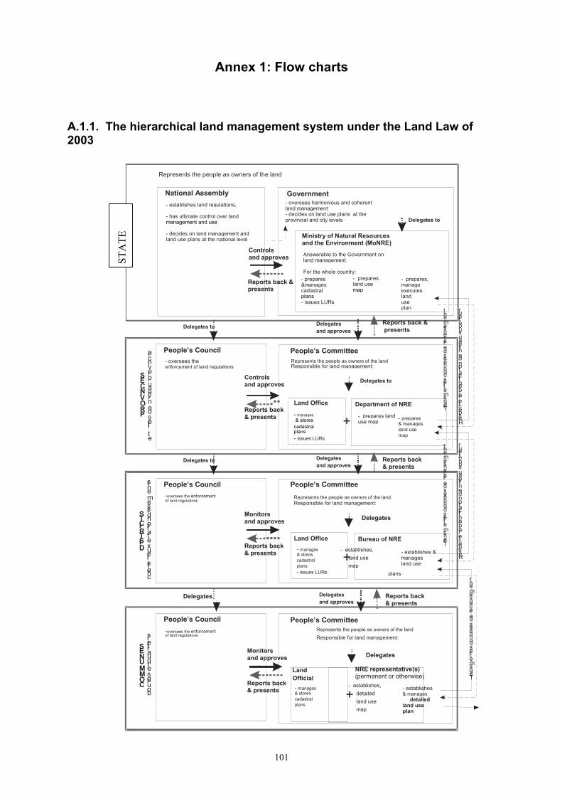
101
Annex 1: Flow charts
A.1.1. The hierarchical land management system under the Land Law of 2003
National Assembly Government
Ministry of Natural Resources and the Environment (MoNRE)
- establishes land regulations, - has ultimate control over land management and use
- decides on land management and land use plans at the national level
Represents the people as owners of the land
- oversees harmonious and coherent land management - decides on land use plans at the provincial and city levels
Answerable to the Government on land management. For the whole country:
P R O V I N C E S
e t i l l e s d e n i v e a u p r o v i n c i a People’s Council People’s Committee
Department of NRE
- oversees the enforcement of land regulations
- manages LURs mmmanagesmanagees
& stores cadastral plans - issues LURs
Represents the people as owners of the land Responsible for land management:
Controls and approves
Delegates to
- prepares, manages, executes land use plan
- prepares &manages cadastral plans - issues LURs
Delegates to
- prepares & manages land use map
Delegates to
Delegates and approves
Reports back & presents
Reports back & presents
Reports back & presents
Controls and approves
+
D I S T R I C T S
c h e f s l i e u x e t a r r o n d i s s e m e n t s People’s Council People’s Committee
-oversees the enforcement of land regulations
Delegates to
Delegates
Delegates and approves
Reports back & presents
Reports back & presents
Monitors and approves
+
C O M M U N E S
b o u r g s e t q u a r t i e r s People’s Council People’s Committee
NRE representative(s) (permanent or otherwise)
-oversees the enforcement of land regulations
- manages & stores cadastral plans
Delegates
- establishes & manages
detailed land use plan
Delegates
T r a n s m e t l e s d o n n é e s d e r e c e n s e m e n t
R e s p e c t e l a p l a n i f i c a t i o n d e n i v e a u s u p é r i e u r
Delegates and approves
Reports back & presents
Reports back & presents
Monitors and approves
+ Seeks public opinion
- prepares land use map
- prepares land use map
Land Office
Represents the people as owners of the land Responsible for land management:
- manages & stores cadastral plans - issues LURs
Land Office Bureau of NRE - establishes & manages land use
plans
- establishes, land use map
Represents the people as owners of the land Responsible for land management:
- establishes, land use map
detailed
T r a n s m e t l e s d o n n é e s d e r e c e n s e m e n t
R e s p e c t e l a p l a n i f i c a t i o n d e n i v e a u s u p é r i e u r
T r a n s m e t l e s d o n n é e s d e r e c e n s e m e n t
R e s p e c t e l a p l a n i f i c a t i o n d e n i v e a u s u p é r i e u r
Land Official
STA
TE
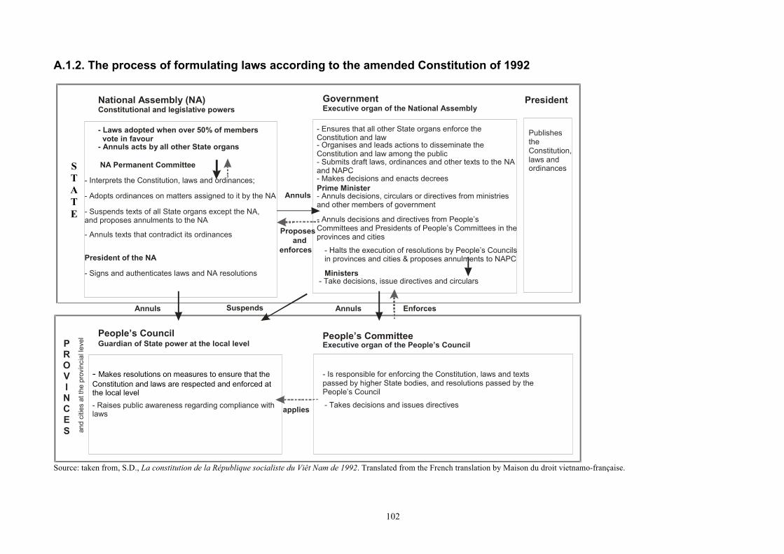
102
A.1.2. The process of formulating laws according to the amended Constitution of 1992
STATE
National Assembly (NA) Government
- Laws adopted when over 50% of members vote in favour - Annuls acts by all other State organs
PROV I NCES an
d ci
ties
at th
e pr
ovin
cial
leve
l
Annuls
Proposes and
enforces
Constitutional and legislative powers Executive organ of the National Assembly
President of the NA - Signs and authenticates laws and NA resolutions
NA Permanent Committee - Interprets the Constitution, laws and ordinances; - Adopts ordinances on matters assigned to it by the NA - Suspends texts of all State organs except the NA, and proposes annulments to the NA - Annuls texts that contradict its ordinances
- Ensures that all other State organs enforce the Constitution and law - Organises and leads actions to disseminate the Constitution and law among the public - Submits draft laws, ordinances and other texts to the NA and NAPC - Makes decisions and enacts decrees Prime Minister - Annuls decisions, circulars or directives from ministries and other members of government - Annuls decisions and directives from People’s Committees and Presidents of People’s Committees in the provinces and cities
- Halts the execution of resolutions by People’s Councils in provinces and cities & proposes annulments to NAPC
- Take decisions, issue directives and circulars Ministers
Publishes the Constitution, laws and ordinances
President
Annuls Enforces
People’s Council People’s Committee
- Makes resolutions on measures to ensure that the Constitution and laws are respected and enforced at the local level - Raises public awareness regarding compliance with laws
- Is responsible for enforcing the Constitution, laws and texts passed by higher State bodies, and resolutions passed by the People’s Council - Takes decisions and issues directives applies
Annuls
Guardian of State power at the local level Executive organ of the People’s Council
Suspends
Source: taken from, S.D., La constitution de la République socialiste du Viêt Nam de 1992. Translated from the French translation by Maison du droit vietnamo-française.
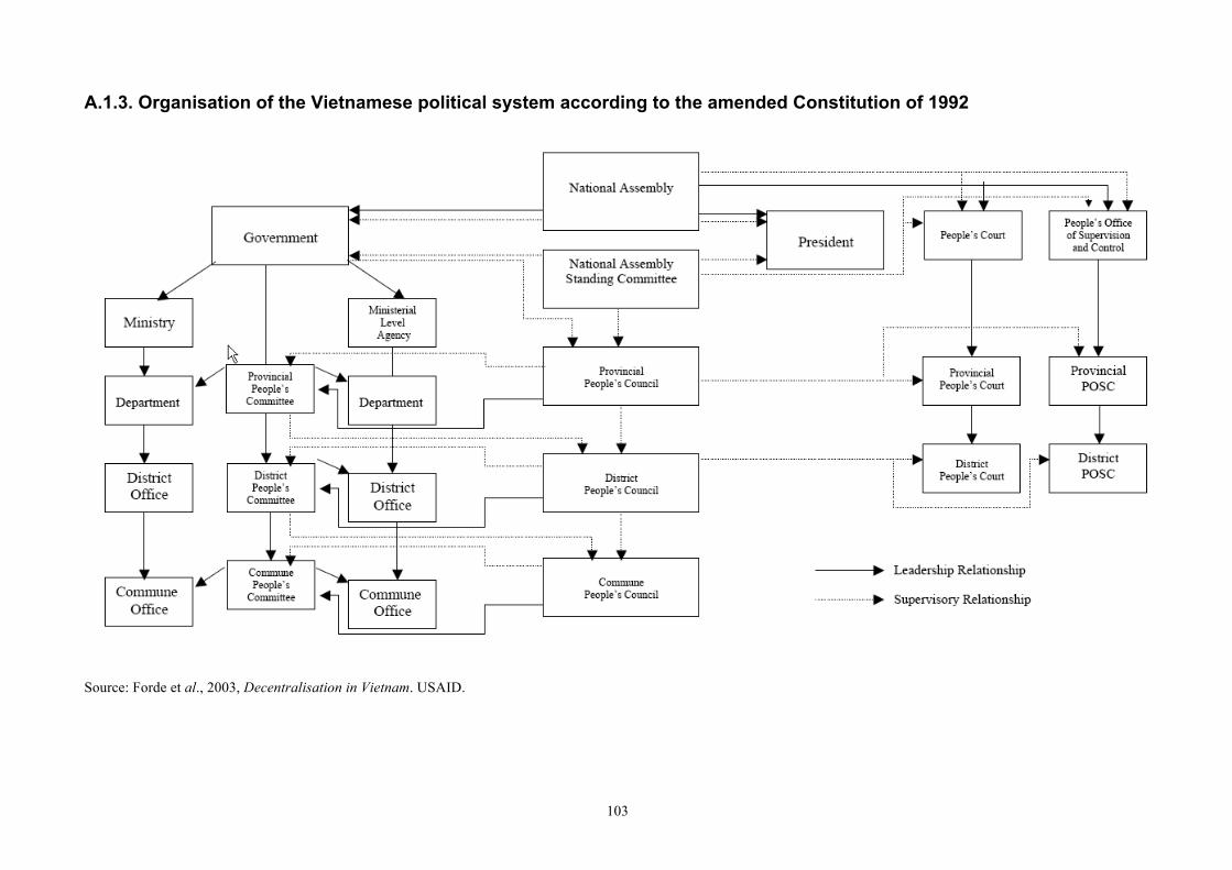
103
A.1.3. Organisation of the Vietnamese political system according to the amended Constitution of 1992
Source: Forde et al., 2003, Decentralisation in Vietnam. USAID.
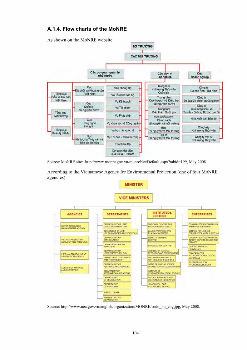
104
A.1.4. Flow charts of the MoNRE
As shown on the MoNRE website
Source: MoNRE site: http://www.monre.gov.vn/monreNet/Default.aspx?tabid=199, May 2008. According to the Vietnamese Agency for Environmental Protection (one of four MoNRE agencies)
Source: http://www.nea.gov.vn/english/organization/MONRE/sodo_bo_eng.jpg, May 2008.
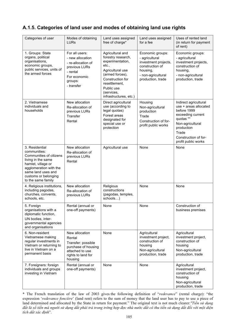
105
A.1.5. Categories of land user and modes of obtaining land use rights
Categories of user Modes of obtaining LURs
Land uses assigned free of charge*
Land uses assigned for a fee
Uses of rented land (in return for payment of rent)
1. Groups: State organs, political organisations, economic groups, public services, units of the armed forces
For all users: - new allocation - re-allocation of previous LURs - rental For economic groups: - transfer
Agricultural and forestry research, experimentation, etc., Agricultural use (armed forces), Construction for resettlement, Public use (services, infrastructures, etc.)
Economic groups: - agricultural investment projects, construction of housing, - non-agricultural production, trade
Economic groups: - agricultural investment projects, construction of housing, - non-agricultural production, trade
2. Vietnamese individuals and households
New allocation Re-allocation of previous LURs Transfer Rental
Direct agricultural use (according to legal quotas) Forest areas designated for special use or protection
Housing Non-agricultural production Trade Construction of for-profit public works
Indirect agricultural use + areas allocated before 1999 exceeding current quotas ** Non-agricultural production Trade Construction of for-profit public works
3. Residential communities: Communities of citizens living in the same hamlet, village or agglomeration with the same land uses and customs or belonging to the same family
New allocation Re-allocation of previous LURs Rental
Agricultural use None None
4. Religious institutions, including pagodas, churches, convents, schools, etc.
New allocation Re-allocation of previous LURs
Religious constructions (pagodas, temples, schools…)
None None
5. Foreign organisations with a diplomatic function, UN bodies, inter-governmental agencies and organisations
Rental (annual or one-off payments)
None None Construction of business premises
6. Non-resident Vietnamese making regular investments in Vietnam or returning to live in Vietnam on a permanent basis
New allocation Rental Transfer: possible purchase of housing attached to use rights to land for housing
None Agricultural investment project, construction of housing Non-agricultural production, trade
Agricultural investment project, construction of housing Non-agricultural production, trade
7. Foreigners: foreign individuals and groups investing in Vietnam
Rental (annual or one-off payments)
None
None Agricultural investment project, construction of housing Non-agricultural production, trade
* The French translation of the law of 2003 gives the following definition of “redevance” (rental charge): “the expression ‘redevance foncière’ (land rent) refers to the sum of money that the land user has to pay to use a piece of land determined and allocated by the State in return for payment.” The original text is not much clearer:"Tiền sử dụng đất là số tiền mà người sử dụng dất phải trả trong trờng hợp đợc nhà nước dất có thu tiền sử dụng dất đối với một diện tích dất xác định”.

106
** More specifically: areas allocated before 1999 that exceed current quotas whose use rights have expired, areas allocated before 1999 that exceed current quotas, deducting land acquired through transfers. Source: Forestry Law of 2003, simplified presentation.
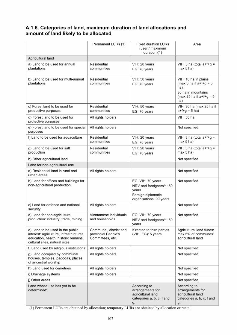
107
A.1.6. Categories of land, maximum duration of land allocations and amount of land likely to be allocated
Permanent LURs (1) Fixed duration LURs (user / maximum
duration)(1)
Area
Agricultural land
a) Land to be used for annual plantations
Residential communities
VIH: 20 years EG: 70 years
VIH: 3 ha (total a+f+g = max 5 ha)
b) Land to be used for multi-annual plantations
Residential communities
VIH: 50 years EG: 70 years
VIH: 10 ha in plains (max 5 ha if a+f+g = 5 ha), 30 ha in mountains (max 25 ha if a+f+g = 5 ha)
c) Forest land to be used for productive purposes
Residential communities
VIH: 50 years EG: 70 years
VIH: 30 ha (max 25 ha if a+f+g = 5 ha)
d) Forest land to be used for protective purposes
All rights holders VIH: 30 ha
e) Forest land to be used for special purposes
All rights holders Not specified
f) Land to be used for aquaculture Residential communities
VIH: 20 years EG: 70 years
VIH: 3 ha (total a+f+g = max 5 ha)
g) Land to be used for salt production
Residential communities
VIH: 20 years EG: 70 years
VIH: 3 ha (total a+f+g = max 5 ha)
h) Other agricultural land Not specified
Land for non-agricultural use
a) Residential land in rural and urban areas
All rights holders Not specified
b) Land for offices and buildings for non-agricultural production
EG, VIH: 70 years NRV and foreigners**: 50 years Foreign diplomatic organisations: 99 years
Not specified
c) Land for defence and national security
All rights holders Not specified
d) Land for non-agricultural production: industry, trade, mining
Vientamese individuals and households
EG, VIH: 70 years NRV and foreigners**: 50 years
Not specified
e) Land to be used in the public interest: agriculture, infrastructures, education, health, historic remains, cultural sites, natural sites
Communal, district and provincial People’s Committees, etc.
If rented to third parties (VIH, EG): 5 years
Agricultural land funds: max 5% of communes’ agricultural land
f) Land used by religious institutions All rights holders Not specified
g) Land occupied by communal houses, temples, pagodas, places of ancestral worship
All rights holders Not specified
h) Land used for cemetries All rights holders Not specified
i) Drainage systems All rights holders Not specified j) Other areas Not specified
Land whose use has yet to be determined*
According to arrangements for agricultural land categories a, b, c, f and g.
According to arrangements for agricultural land categories a, b, c, f and g.
(1) Permanent LURs are obtained by allocation; temporary LURs are obtained by allocation or rental.
108
* This land may be allocated to Vietnamese individuals and households to be used for categories a, b, c, f or g. It has the same characteristics but its area does not count towards the maximum area of land allocated in categories a, b, c, f and g. ** This period is extended to 70 years if the investments require long-term management and if the land is in remote or difficult areas. VIH: Vietnamese individuals and households; EG: economic groups; NRV: Non-resident Vietnamese. Source: 2003 Land Law.
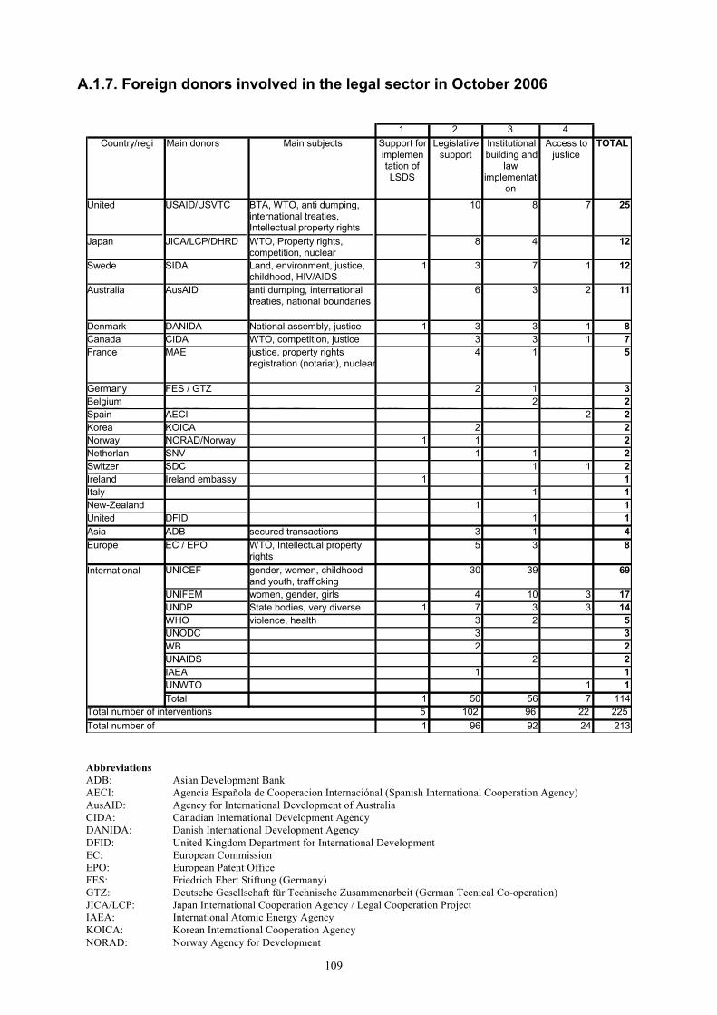
109
A.1.7. Foreign donors involved in the legal sector in October 2006
1 2 3 4
Country/region
Main donors Main subjects Support for implemen tation of LSDS
Legislative support
Institutional building and
law implementati
on
Access to justice
TOTAL
United States
USAID/USVTC BTA, WTO, anti dumping, international treaties, Intellectual property rights
10 8 7 25
Japan JICA/LCP/DHRD WTO, Property rights, competition, nuclear
8 4 12
Swedenn
SIDA Land, environment, justice, childhood, HIV/AIDS
1 3 7 1 12
Australia AusAID anti dumping, international treaties, national boundaries
6 3 2 11
Denmark DANIDA National assembly, justice 1 3 3 1 8 Canada CIDA WTO, competition, justice 3 3 1 7 France MAE justice, property rights
registration (notariat), nuclear 4 1 5
Germany FES / GTZ 2 1 3 Belgium 2 2 Spain AECI 2 2 Korea KOICA 2 2 Norway NORAD/Norway 1 1 2 Netherlands
SNV 1 1 2 Switzerland
SDC 1 1 2 Ireland Ireland embassy 1 1 Italy 1 1 New-Zealand 1 1 United Kingomd
DFID 1 1 Asia ADB secured transactions 3 1 4 Europe EC / EPO WTO, Intellectual property
rights 5 3 8
International UNICEF gender, women, childhood and youth, trafficking
30 39 69
UNIFEM women, gender, girls 4 10 3 17 UNDP State bodies, very diverse 1 7 3 3 14 WHO violence, health 3 2 5 UNODC 3 3 WB 2 2 UNAIDS 2 2 IAEA 1 1 UNWTO 1 1 Total 1 50 56 7 114
Total number of interventions 5 102 96 22 225 Total number of ‘projects’
1 96 92 24 213 Abbreviations ADB: Asian Development Bank AECI: Agencia Española de Cooperacion Internaciónal (Spanish International Cooperation Agency) AusAID: Agency for International Development of Australia CIDA: Canadian International Development Agency DANIDA: Danish International Development Agency DFID: United Kingdom Department for International Development EC: European Commission EPO: European Patent Office FES: Friedrich Ebert Stiftung (Germany) GTZ: Deutsche Gesellschaft für Technische Zusammenarbeit (German Tecnical Co-operation) JICA/LCP: Japan International Cooperation Agency / Legal Cooperation Project IAEA: International Atomic Energy Agency KOICA: Korean International Cooperation Agency NORAD: Norway Agency for Development
110
SDC: Swiss Agency for Development and Cooperation SECO: State Secretariat for Economic Affairs of Switzerland SIDA: Swedish International Development Agency SNV: Netherlands-based International Development Organisation UNDP: United Nations Development Programme UNICEF: United Nations Children's Fund UNIFEM: United Nations Development Fund for Women UNODC: United Nations Office on Drugs and Crime UNWTO: World Tourism Organisation USAID: United States Agency for International Development WB: World Bank WHO: World Health Organisation WTO: The World Trade Organisation Source: The matrix on ongoing donor-government cooperation in the legal sector, updated in October 2006; project VIE0201, [email protected].
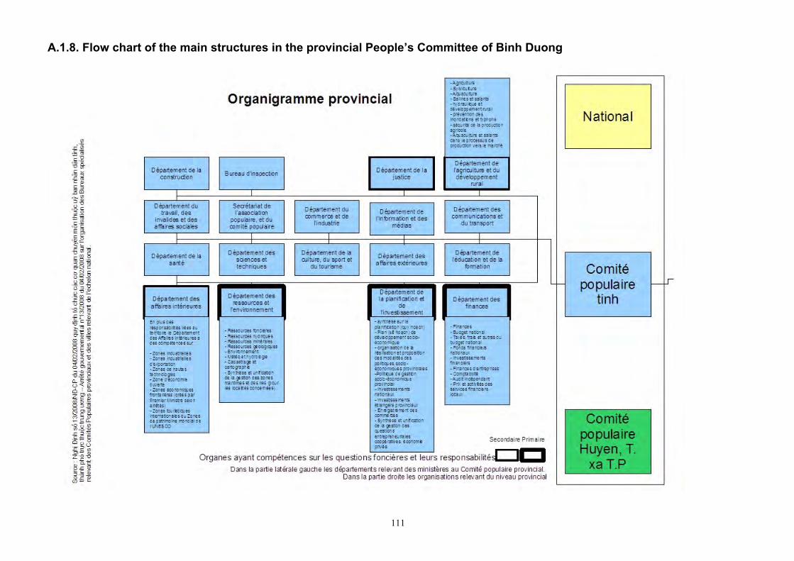
111
A.1.8. Flow chart of the main structures in the provincial People’s Committee of Binh Duong
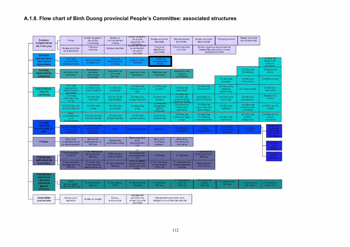
112
A.1.8. Flow chart of Binh Duong provincial People’s Committee: associated structures
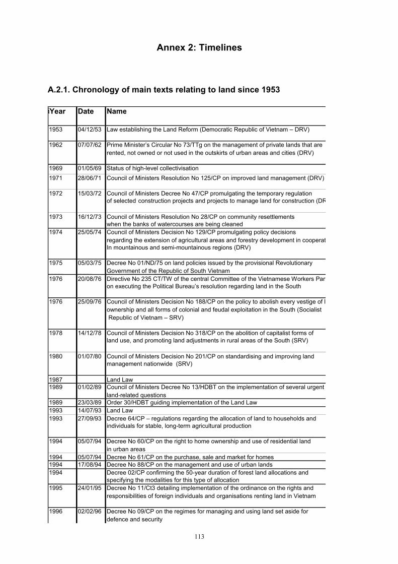
113
Annex 2: Timelines
A.2.1. Chronology of main texts relating to land since 1953
i Year Date Name
1953 04/12/53 Law establishing the Land Reform (Democratic Republic of Vietnam – DRV)
1962 07/07/62 Prime Minister’s Circular No 73/TTg on the management of private lands that are rented, not owned or not used in the outskirts of urban areas and cities (DRV)
1969 01/05/69 Status of high-level collectivisation 1971 28/06/71 Council of Ministers Resolution No 125/CP on improved land management (DRV)
1972 15/03/72 Council of Ministers Decree No 47/CP promulgating the temporary regulation
of selected construction projects and projects to manage land for construction (DRV)
1973 16/12/73 Council of Ministers Resolution No 28/CP on community resettlements when the banks of watercourses are being cleaned
1974 25/05/74 Council of Ministers Decision No 129/CP promulgating policy decisions regarding the extension of agricultural areas and forestry development in cooperatives In mountainous and semi-mountainous regions (DRV)
1975 05/03/75 Decree No 01/ND/75 on land policies issued by the provisional Revolutionary Government of the Republic of South Vietnam
1976 20/08/76 Directive No 235 CT/TW of the central Committee of the Vietnamese Workers Party on executing the Political Bureau’s resolution regarding land in the South
1976 25/09/76 Council of Ministers Decision No 188/CP on the policy to abolish every vestige of land ownership and all forms of colonial and feudal exploitation in the South (Socialist Republic of Vietnam – SRV)
1978 14/12/78 Council of Ministers Decision No 318/CP on the abolition of capitalist forms of land use, and promoting land adjustments in rural areas of the South (SRV)
1980 01/07/80 Council of Ministers Decision No 201/CP on standardising and improving land management nationwide (SRV)
1987 Land Law 1989 01/02/89 Council of Ministers Decree No 13/HDBT on the implementation of several urgent
land-related questions 1989 23/03/89 Order 30/HDBT guiding implementation of the Land Law 1993 14/07/93 Land Law 1993 27/09/93 Decree 64/CP – regulations regarding the allocation of land to households and
individuals for stable, long-term agricultural production
1994 05/07/94 Decree No 60/CP on the right to home ownership and use of residential land in urban areas
1994 05/07/94 Decree No 61/CP on the purchase, sale and market for homes 1994 17/08/94 Decree No 88/CP on the management and use of urban lands 1994 Decree 02/CP confirming the 50-year duration of forest land allocations and
specifying the modalities for this type of allocation 1995 24/01/95 Decree No 11/Ct3 detailing implementation of the ordinance on the rights and
responsibilities of foreign individuals and organisations renting land in Vietnam
1996 02/02/96 Decree No 09/CP on the regimes for managing and using land set aside for defence and security
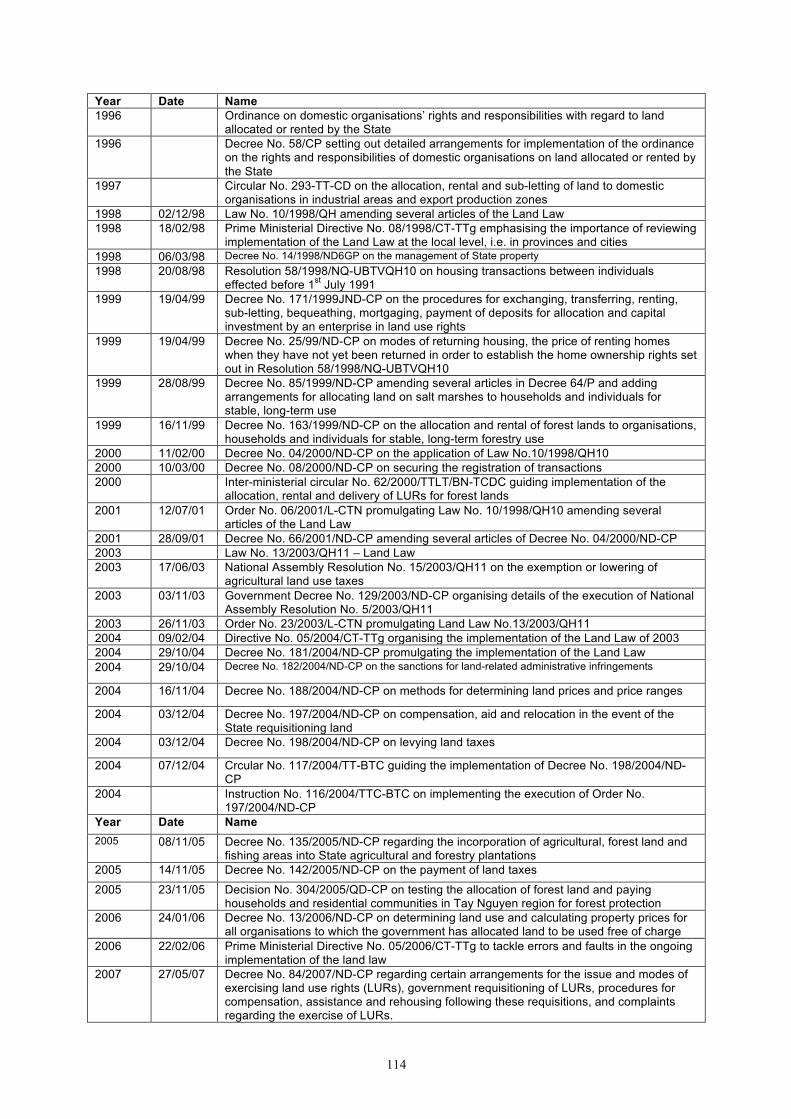
114
Year Date Name 1996 Ordinance on domestic organisations’ rights and responsibilities with regard to land
allocated or rented by the State 1996 Decree No. 58/CP setting out detailed arrangements for implementation of the ordinance
on the rights and responsibilities of domestic organisations on land allocated or rented by the State
1997 Circular No. 293-TT-CD on the allocation, rental and sub-letting of land to domestic organisations in industrial areas and export production zones
1998 02/12/98 Law No. 10/1998/QH amending several articles of the Land Law 1998 18/02/98 Prime Ministerial Directive No. 08/1998/CT-TTg emphasising the importance of reviewing
implementation of the Land Law at the local level, i.e. in provinces and cities 1998 06/03/98 Decree No. 14/1998/ND6GP on the management of State property 1998 20/08/98 Resolution 58/1998/NQ-UBTVQH10 on housing transactions between individuals
effected before 1st July 1991 1999 19/04/99 Decree No. 171/1999JND-CP on the procedures for exchanging, transferring, renting,
sub-letting, bequeathing, mortgaging, payment of deposits for allocation and capital investment by an enterprise in land use rights
1999 19/04/99 Decree No. 25/99/ND-CP on modes of returning housing, the price of renting homes when they have not yet been returned in order to establish the home ownership rights set out in Resolution 58/1998/NQ-UBTVQH10
1999 28/08/99 Decree No. 85/1999/ND-CP amending several articles in Decree 64/P and adding arrangements for allocating land on salt marshes to households and individuals for stable, long-term use
1999 16/11/99 Decree No. 163/1999/ND-CP on the allocation and rental of forest lands to organisations, households and individuals for stable, long-term forestry use
2000 11/02/00 Decree No. 04/2000/ND-CP on the application of Law No.10/1998/QH10 2000 10/03/00 Decree No. 08/2000/ND-CP on securing the registration of transactions 2000 Inter-ministerial circular No. 62/2000/TTLT/BN-TCDC guiding implementation of the
allocation, rental and delivery of LURs for forest lands 2001 12/07/01 Order No. 06/2001/L-CTN promulgating Law No. 10/1998/QH10 amending several
articles of the Land Law 2001 28/09/01 Decree No. 66/2001/ND-CP amending several articles of Decree No. 04/2000/ND-CP 2003 Law No. 13/2003/QH11 – Land Law 2003 17/06/03 National Assembly Resolution No. 15/2003/QH11 on the exemption or lowering of
agricultural land use taxes 2003 03/11/03 Government Decree No. 129/2003/ND-CP organising details of the execution of National
Assembly Resolution No. 5/2003/QH11 2003 26/11/03 Order No. 23/2003/L-CTN promulgating Land Law No.13/2003/QH11 2004 09/02/04 Directive No. 05/2004/CT-TTg organising the implementation of the Land Law of 2003 2004 29/10/04 Decree No. 181/2004/ND-CP promulgating the implementation of the Land Law 2004 29/10/04 Decree No. 182/2004/ND-CP on the sanctions for land-related administrative infringements
2004 16/11/04 Decree No. 188/2004/ND-CP on methods for determining land prices and price ranges
2004 03/12/04 Decree No. 197/2004/ND-CP on compensation, aid and relocation in the event of the State requisitioning land
2004 03/12/04 Decree No. 198/2004/ND-CP on levying land taxes
2004 07/12/04 Crcular No. 117/2004/TT-BTC guiding the implementation of Decree No. 198/2004/ND-CP
2004 Instruction No. 116/2004/TTC-BTC on implementing the execution of Order No. 197/2004/ND-CP
Year Date Name 2005 08/11/05 Decree No. 135/2005/ND-CP regarding the incorporation of agricultural, forest land and
fishing areas into State agricultural and forestry plantations 2005 14/11/05 Decree No. 142/2005/ND-CP on the payment of land taxes
2005 23/11/05 Decision No. 304/2005/QD-CP on testing the allocation of forest land and paying households and residential communities in Tay Nguyen region for forest protection
2006 24/01/06 Decree No. 13/2006/ND-CP on determining land use and calculating property prices for all organisations to which the government has allocated land to be used free of charge
2006 22/02/06 Prime Ministerial Directive No. 05/2006/CT-TTg to tackle errors and faults in the ongoing implementation of the land law
2007 27/05/07 Decree No. 84/2007/ND-CP regarding certain arrangements for the issue and modes of exercising land use rights (LURs), government requisitioning of LURs, procedures for compensation, assistance and rehousing following these requisitions, and complaints regarding the exercise of LURs.
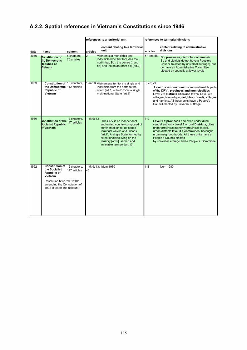
115
A.2.2. Spatial references in Vietnam’s Constitutions since 1946 references to a territorial unit references to territorial divisions
date name content articles content relating to a territorial unit articles
content relating to administrative divisions
1946 Constitution of the Democratic Republic of Vietnam
6 chapters, 70 articles
2 Vietnam is a monolithic and indivisible bloc that Includes the north (bac Bo), the centre (trung bo) and the south (nam bo) [art.2]
57 and 58 . Bo, provinces, districts, communes Bo and districts do not have a People’s Council (elected by universal suffrage), but do have an Administrative Committee elected by councils at lower levels
1959 Constitution of the Democratic Republic of Vietnam
10 chapters, 112 articles
1 and 3 Vietnamese territory is single and indivisible from the north to the south [art.1] – the DRV is a single multi-national State [art.3]
3; 78; 79 Level 1 = autonomous zones (inalienable parts of the DRV), provinces and municipalities Level 2 = districts cities and towns; Level 3 = villages, townships, neighbourhoods, villages and hamlets. All these units have a People’s Council elected by universal suffrage
1980 Constitution of the Socialist Republic of Vietnam
12 chapters, 147 articles
1; 5; 9; 13 The SRV is an independent and united country composed of continental lands, air space territorial waters and islands [art.1]. A single State formed by all nationalities living on the territory [art.5], sacred and inviolable territory [art.13]
113 Level 1 = provinces and cities under direct central authority Level 2 = rural Districts, cities under provincial authority provincial capital, urban districts level 3 = communes, boroughs, urban neighbourhoods. All these units have a People’s Council elected by universal suffrage and a People’s Committee
1992 Constitution of the Socialist Republic of Vietnam Resolution N°51/2001/QH10 amending the Constitution of 1992 is taken into account
12 chapters, 147 articles
1; 5; 9; 13; 45
Idem 1980 118 idem 1980
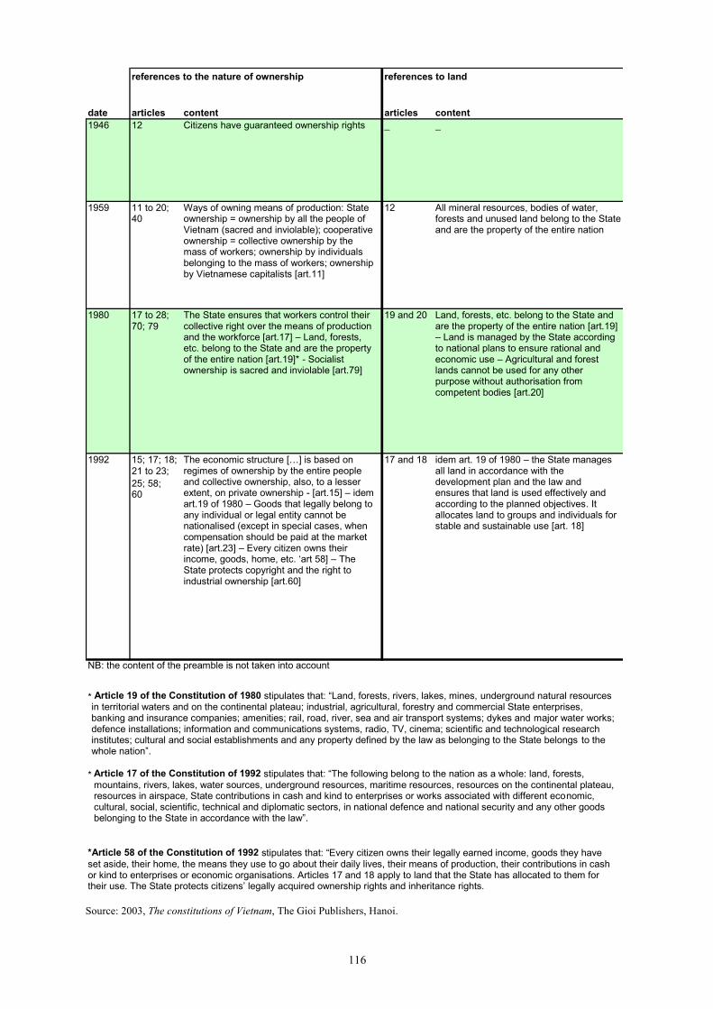
116
references to the nature of ownership references to land
date articles content articles content 1946 12 Citizens have guaranteed ownership rights _ _
1959 11 to 20; 40
Ways of owning means of production: State ownership = ownership by all the people of Vietnam (sacred and inviolable); cooperative ownership = collective ownership by the mass of workers; ownership by individuals belonging to the mass of workers; ownership by Vietnamese capitalists [art.11]
12 All mineral resources, bodies of water, forests and unused land belong to the State and are the property of the entire nation
1980 17 to 28; 35; 70; 79
The State ensures that workers control their collective right over the means of production and the workforce [art.17] – Land, forests, etc. belong to the State and are the property of the entire nation [art.19]* - Socialist ownership is sacred and inviolable [art.79]
19 and 20 Land, forests, etc. belong to the State and are the property of the entire nation [art.19] – Land is managed by the State according to national plans to ensure rational and economic use – Agricultural and forest lands cannot be used for any other purpose without authorisation from competent bodies [art.20]
1992 15; 17; 18; 21 to 23; 25; 58; 60
The economic structure […] is based on regimes of ownership by the entire people and collective ownership, also, to a lesser extent, on private ownership - [art.15] – idem art.19 of 1980 – Goods that legally belong to any individual or legal entity cannot be nationalised (except in special cases, when compensation should be paid at the market rate) [art.23] – Every citizen owns their income, goods, home, etc. ‘art 58] – The State protects copyright and the right to industrial ownership [art.60]
17 and 18 idem art. 19 of 1980 – the State manages all land in accordance with the development plan and the law and ensures that land is used effectively and according to the planned objectives. It allocates land to groups and individuals for stable and sustainable use [art. 18]
NB: the content of the preamble is not taken into account
* Article 17 of the Constitution of 1992 stipulates that: “The following belong to the nation as a whole: land, forests, mountains, rivers, lakes, water sources, underground resources, maritime resources, resources on the continental plateau, resources in airspace, State contributions in cash and kind to enterprises or works associated with different economic, cultural, social, scientific, technical and diplomatic sectors, in national defence and national security and any other goods belonging to the State in accordance with the law”.
*Article 58 of the Constitution of 1992 stipulates that: “Every citizen owns their legally earned income, goods they have set aside, their home, the means they use to go about their daily lives, their means of production, their contributions in cash or kind to enterprises or economic organisations. Articles 17 and 18 apply to land that the State has allocated to them for their use. The State protects citizens’ legally acquired ownership rights and inheritance rights.
* Article 19 of the Constitution of 1980 stipulates that: “Land, forests, rivers, lakes, mines, underground natural resources in territorial waters and on the continental plateau; industrial, agricultural, forestry and commercial State enterprises, banking and insurance companies; amenities; rail, road, river, sea and air transport systems; dykes and major water works; defence installations; information and communications systems, radio, TV, cinema; scientific and technological research institutes; cultural and social establishments and any property defined by the law as belonging to the State belongs to the whole nation”.
Source: 2003, The constitutions of Vietnam, The Gioi Publishers, Hanoi.
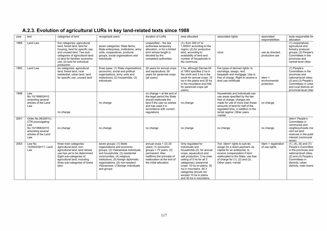
117
A.2.3. Evolution of agricultural LURs in key land-related texts since 1988 year text categories of land recognised users duration of LURs area allocated associated rights associated
responsibilities body responsible for allocation
1988 Land Law five categories: agricultural land, forest land, land for housing, land for specific use, and unused land. Two sub-categories of agricultural land: (i) land for families’ economic use; (ii) land for individual production
seven categories: State farms, State enterprises, institutions, army units, cooperatives, producer groups, social organisations and individuals
unspecified – the law authorises temporary allocation, or for a limited term whose length is decided by the competent authorities
(1): from 300 m² to 1,000m² according to the region; (2) for productive land, according to availability of land and number of households in the commune
none
use as directed, productive use
(1) cooperatives, agricultural and forestry producer groups; (2) People’s Committees in the provinces and central-level cities
1993 Land Law six categories: agricultural land, forest land, rural residential, urban land, land for specific use, unused land
three types: (1) State organisations (economic, social and political organisations, army units and institutions); (2) households; (3) individuals
20 years for annual crops and aquaculture; 50 years for perennial crops (all users)
3 ha, although Decree 64 of 1993 specifies 2 ha in the north and 3 ha in the south for annual crops; 10 ha in the plains and 30 ha in the mountains and hills for perennial crops (all users)
five types of derived rights: to exchange, assign, rent, bequeath and mortgage. Use is free of charge. Right to receive a land use certificate
idem + environmental protection
(1) People’s Committees in the provinces and national-level cities; (2) and (3) People’s Committees in urban and rural districts and provincial-level cities
1998 Law No.10/1998/QH10 amending several articles of the Land Law
no change
no change
no change + at the end of the legal period the State should reallocate the land if the user so wishes and has used it in accordance with current regulations
no change
Households and individuals can use areas specified by the law free of charge; charges are made for use of more than these amounts of land for half of the regulated time, in addition to the rental regime. Other users =rental
no change
2001 Order No.06/2001/L-CTN promulgating Law No.10/1998/QH10 amending several articles of the Land Law
no change
no change
no change
no change
no change
no change
idem+ People’s Committees in communes and neighbourhoods may rent out land reserves in the public interest (communal lands)
2003 Law No. 13/2003/QH11- Land Law
three main categories: agricultural land, non-agricultural land, land whose use has yet to be determined. Eight sub-categories of agricultural land, including three sub-categories of forest land
seven groups: (1) State organisations and economic groups, (2) Vietnamese individuals and households, (3) residential communities, (4) religious institutions, (5) foreign diplomatic organisations, (6) non-resident Vietnamese, (7)foreign individuals and groups
annual crops = (2) 20 years; (1) economic groups = 70 years; (3) permanent. Also reaffirms the principle of reallocation at the end of the initial allocation
Only regulated for individuals and households (2): for annual crops, aquaculture and salt production; 3 ha (max ceiling of 5 ha for all 3 categories); prerennial crops: 10 ha on plains, 30 ha in mountains. All 3 categories should not exceed 10 ha in plains and 30 ha in mountains.
Ten: idem+ rights to sub-let, assign for a down payment, as capital for an enterprise, to receive compensation if land reallocated to the State; use free of charge for (1), (2) and (3). Other users =rental
Idem + registration of use rights
(1), (4), (6) and (7): People’s Committees in the provinces and national-level cities; (2) and (3) People’s Committees in districts, urban districts, main towns
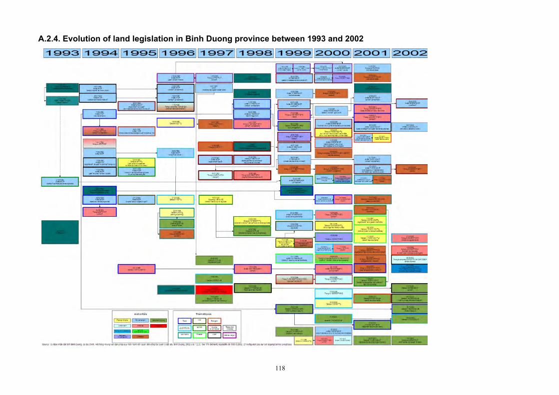
118
A.2.4. Evolution of land legislation in Binh Duong province between 1993 and 2002
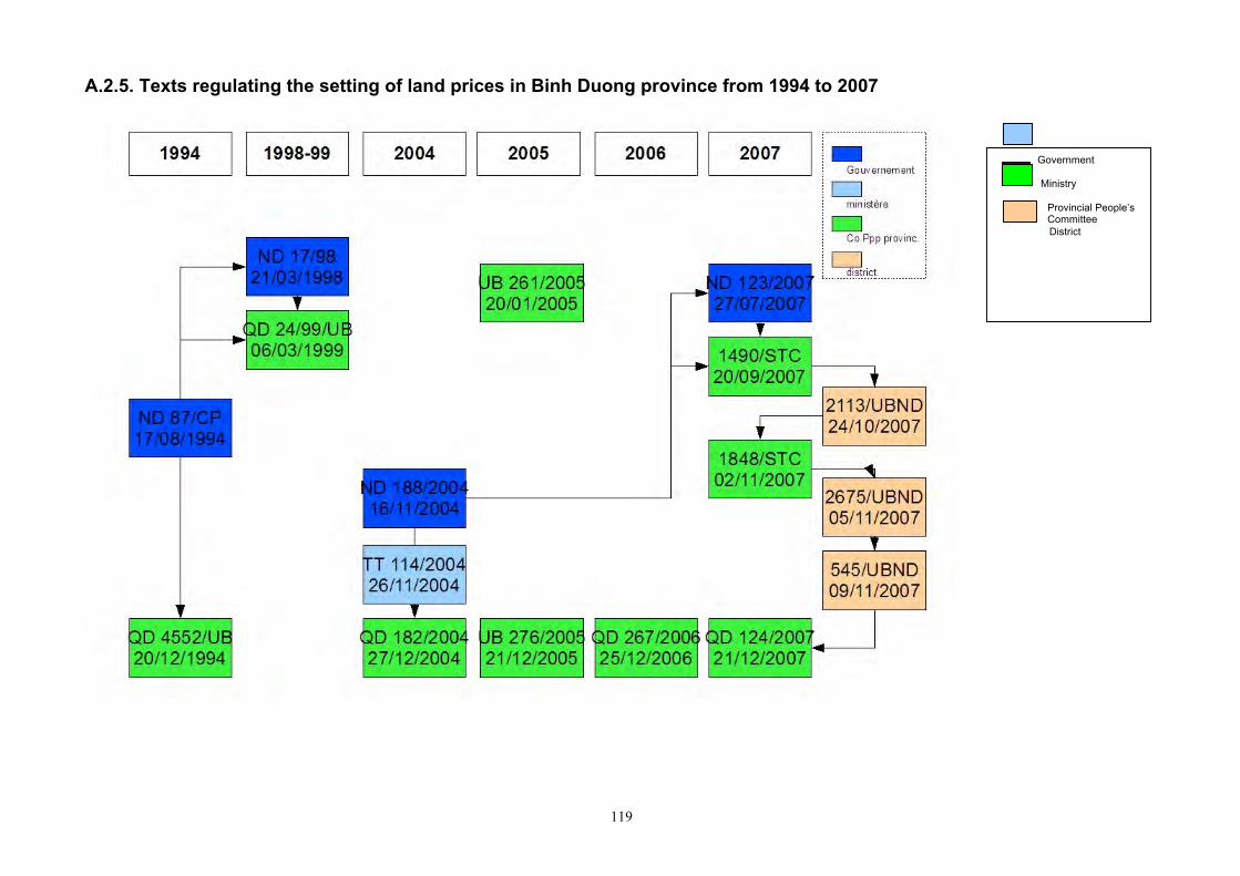
119
A.2.5. Texts regulating the setting of land prices in Binh Duong province from 1994 to 2007
Government Ministry
Provincial People’s Committee
District
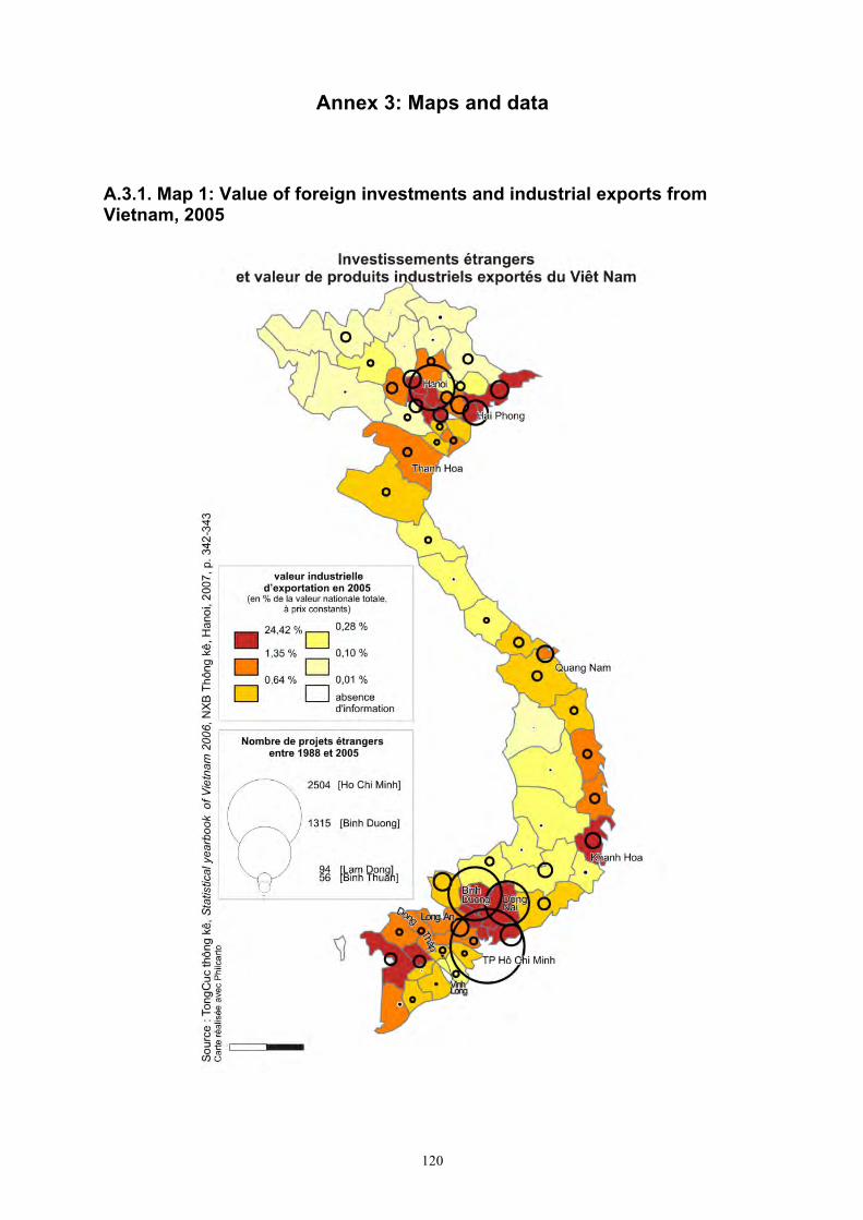
120
Annex 3: Maps and data
A.3.1. Map 1: Value of foreign investments and industrial exports from Vietnam, 2005
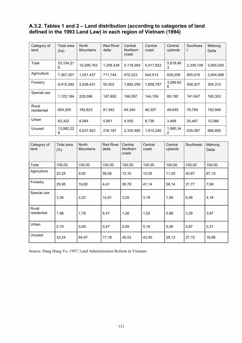
121
A.3.2. Tables 1 and 2 – Land distribution (according to categories of land defined in the 1993 Land Law) in each region of Vietnam (1994)
Category of land
Total area (ha)
North Mountains
Red River delta
Central Northern coast
Central coast
Central uplands
Southeast
Mekong Delta
Total 33,104,218 10,296,763 1,258,438 5,118,054 4,517,822 5,618,48
3 2,339,108 3,955,550
Agriculture 7,367,207 1,021,437 711,744 670,323 544,513 629,208 955,916 2,654,066
Forestry 9,915,092 2,038,421 55,502 1,882,259 1,858,767 3,266,626 509,207 304,310
Special use 1,122,184 228,096 187,692 166,097 144,159 89,190 141,647 165,303
Rural residential 654,205 182,823 81,362 64,340 46,307 49,649 76,784 152,940
Urban 63,302 8,064 5,951 4,550 8,736 3,468 20,467 12,066
Unused 13,982,228 6,637,922 216,187 2,330,485 1,915,340 1,580,34
2 635,087 666,865
Category of land
Total area (%)
North Mountains
Red River delta
Central Northern coast
Central coast
Central uplands
Southeast Mekong Delta
Total 100,00 100,00 100,00 100,00 100,00 100,00 100,00 100,00
Agriculture 22,25 9,92 56,56 13,10 12,05 11,20 40,87 67,10
Forestry 29,95 19,80 4,41 36,78 41,14 58,14 21,77 7,69
Special use 3,39 2,22 14,91 3,25 3,19 1,59 6,06 4,18
Rural residential 1,98 1,78 6,47 1,26 1,02 0,88 3,28 3,87
Urban 0,19 0,09 0,47 0,09 0,19 0,06 0,87 0,31
Unused 42,24 64,47 17,18 45,53 42,40 28,13 27,15 16,86
Source: Dang Hung Vo, 1997, Land Administration Reform in Vietnam.
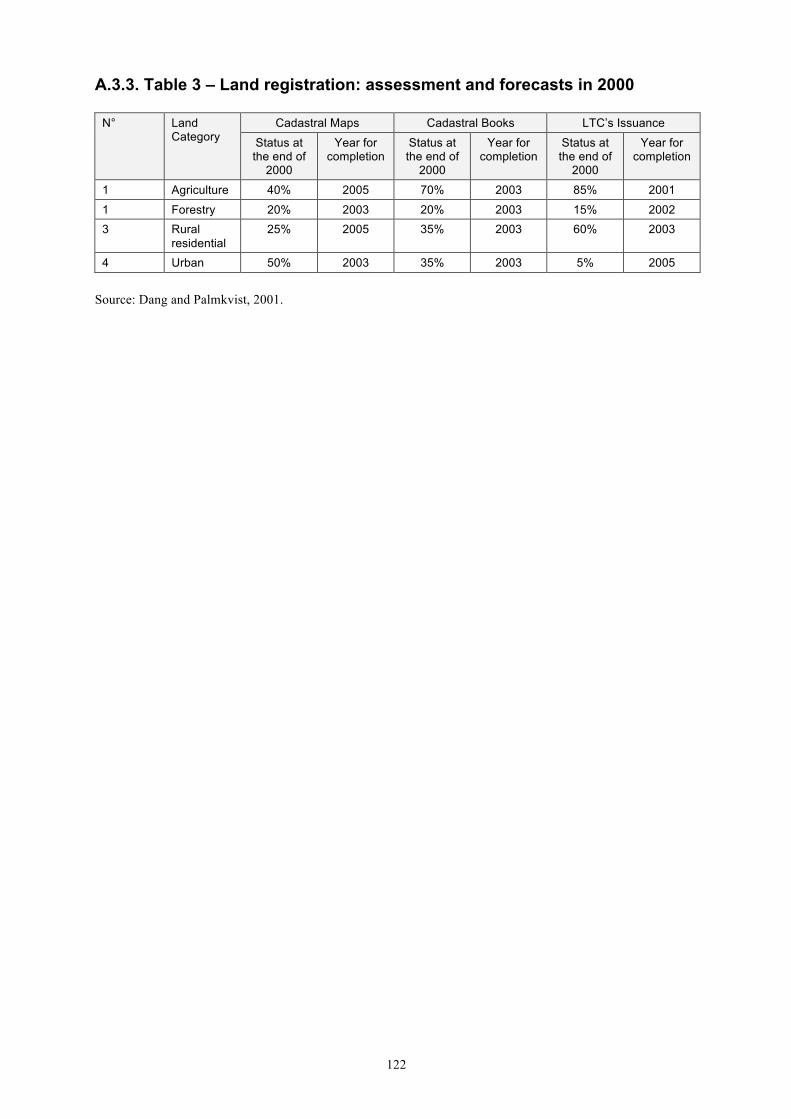
122
A.3.3. Table 3 – Land registration: assessment and forecasts in 2000
N° Land Category
Cadastral Maps Cadastral Books LTC’s Issuance
Status at the end of
2000
Year for completion
Status at the end of
2000
Year for completion
Status at the end of
2000
Year for completion
1 Agriculture 40% 2005 70% 2003 85% 2001
1 Forestry 20% 2003 20% 2003 15% 2002 3 Rural
residential 25% 2005 35% 2003 60% 2003
4 Urban 50% 2003 35% 2003 5% 2005
Source: Dang and Palmkvist, 2001.
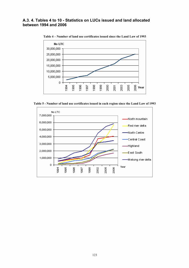
123
A.3. 4. Tables 4 to 10 - Statistics on LUCs issued and land allocated between 1994 and 2006
Table 4 – Number of land use certificates issued since the Land Law of 1993
Table 5 - Number of land use certificates issued in each region since the Land Law of 1993
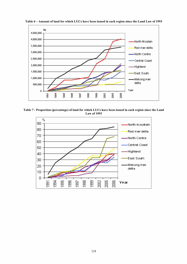
124
Table 6 – Amount of land for which LUCs have been issued in each region since the Land Law of 1993
Table 7 - Proportion (percentage) of land for which LUCs have been issued in each region since the Land Law of 1993
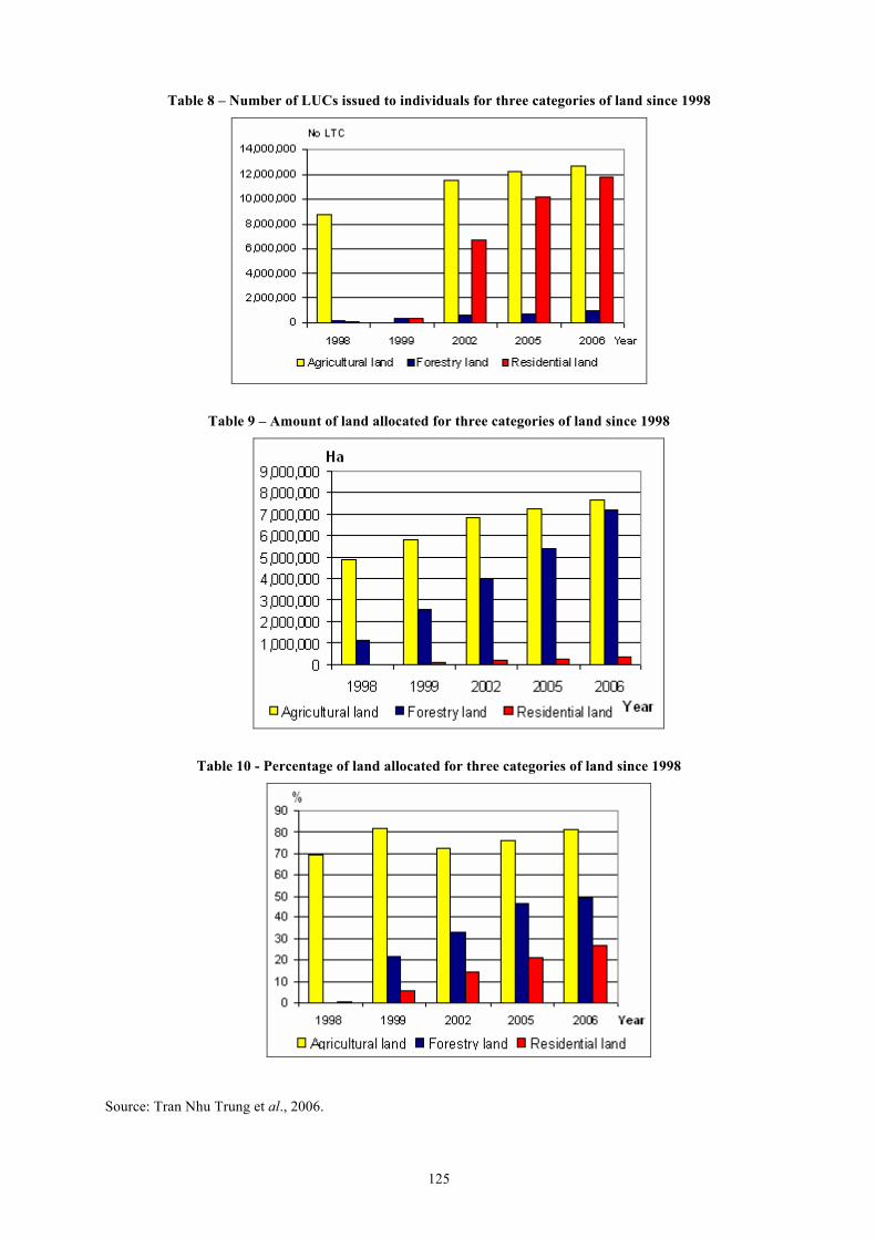
125
Table 8 – Number of LUCs issued to individuals for three categories of land since 1998
Table 9 – Amount of land allocated for three categories of land since 1998
Table 10 - Percentage of land allocated for three categories of land since 1998
Source: Tran Nhu Trung et al., 2006.
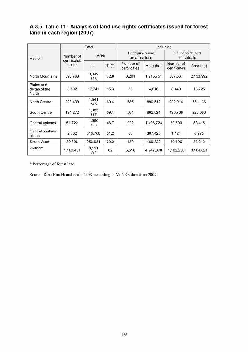
126
A.3.5. Table 11 –Analysis of land use rights certificates issued for forest land in each region (2007) Total Including
Region Number of
certificates issued
Area Entreprises and organisations
Households and individuals
ha % (*) Number of certificates Area (ha) Number of
certificates Area (ha)
North Mountains 590,768 3,349 743 72.8 3,201 1,215,751 587,567 2,133,992
Plains and deltas of the North
8,502 17,741 15.3 53 4,016 8,449 13,725
North Centre 223,499 1,541 648 69.4 585 890,512 222,914 651,136
South Centre 191,272 1,085 887 59.1 564 862,821 190,708 223,066
Central uplands 61,722 1,550 138 46.7 922 1,496,723 60,800 53,415
Central southern plains 2,862 313,700 51.2 63 307,425 1,124 6,275
South West 30,826 253,034 69.2 130 169,822 30,696 83,212
Vietnam 1,109,451 8,111 891 62 5,518 4,947,070 1,102,258 3,164,821
* Percentage of forest land.
Source: Dinh Huu Hoand et al., 2008, according to MoNRE data from 2007.
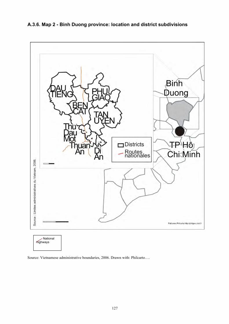
127
A.3.6. Map 2 - Binh Duong province: location and district subdivisions
Source: Vietnamese administrative boundaries, 2006. Drawn with: Philcarto….
National highways
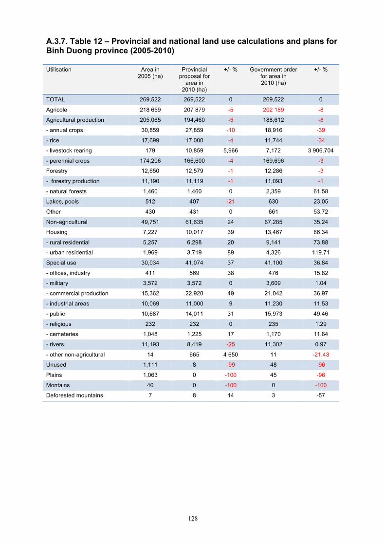
128
A.3.7. Table 12 – Provincial and national land use calculations and plans for Binh Duong province (2005-2010) Utilisation Area in
2005 (ha) Provincial
proposal for area in
2010 (ha)
+/- % Government order for area in 2010 (ha)
+/- %
TOTAL 269,522 269,522 0 269,522 0
Agricole 218 659 207 879 -5 202 189 -8
Agricultural production 205,065 194,460 -5 188,612 -8
- annual crops 30,859 27,859 -10 18,916 -39
- rice 17,699 17,000 -4 11,744 -34
- livestock rearing 179 10,859 5,966 7,172 3 906.704
- perennial crops 174,206 166,600 -4 169,696 -3
Forestry 12,650 12,579 -1 12,286 -3
- forestry production 11,190 11,119 -1 11,093 -1
- natural forests 1,460 1,460 0 2,359 61.58
Lakes, pools 512 407 -21 630 23.05
Other 430 431 0 661 53.72
Non-agricultural 49,751 61,635 24 67,285 35.24
Housing 7,227 10,017 39 13,467 86.34
- rural residential 5,257 6,298 20 9,141 73.88
- urban residential 1,969 3,719 89 4,326 119.71
Special use 30,034 41,074 37 41,100 36.84
- offices, industry 411 569 38 476 15.82
- military 3,572 3,572 0 3,609 1.04
- commercial production 15,362 22,920 49 21,042 36.97
- industrial areas 10,069 11,000 9 11,230 11.53
- public 10,687 14,011 31 15,973 49.46
- religious 232 232 0 235 1.29
- cemeteries 1,048 1,225 17 1,170 11.64
- rivers 11,193 8,419 -25 11,302 0.97
- other non-agricultural 14 665 4 650 11 -21.43
Unused 1,111 8 -99 48 -96
Plains 1,063 0 -100 45 -96
Montains 40 0 -100 0 -100
Deforested mountains 7 8 14 3 -57
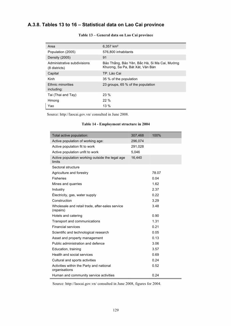
129
A.3.8. Tables 13 to 16 – Statistical data on Lao Cai province
Table 13 – General data on Lao Cai province
Area 6,357 km² Population (2005) 576,800 inhabitants Density (2005) 91 Administrative subdivisions (8 districts)
Bảo Thắng, Bảo Yên, Bắc Hà, Si Ma Cai, Mường Khương, Sa Pa, Bát Xát, Văn Bàn
Capital TP. Lào Cai Kinh 35 % of the population Ethnic minorities including:
23 groups, 65 % of the population
Tai (Thai and Tay) 23 % Hmong 22 % Yao 13 %
Source: http://laocai.gov.vn/ consulted in June 2008.
Table 14 - Employment structure in 2004
Total active population: 307,468 100% Active population of working age: 296,074 Active population fit to work 291,028 Active population unfit to work 5,046 Active population working outside the legal age limits
16,440
Sectoral structure Agriculture and forestry 78.07 Fisheries 0.04 Mines and quarries 1.62 Industry 2.37 Électricity, gas, water supply 0.22 Construction 3.29 Wholesale and retail trade, after-sales service (repairs)
3.48
Hotels and catering 0.90 Transport and communications 1.31 Financial services 0.21 Scientific and technological research 0.05 Asset and property management 0.13 Public administration and defence 3.06 Education, training 3.57 Health and social services 0.69 Cultural and sports activities 0.24 Activities within the Party and national organisations
0.52
Human and community service activities 0.24
Source: http://laocai.gov.vn/ consulted in June 2008, figures for 2004.

130
Table 15 – Income structure in 2003 (millions of dongs)
Total GNP 2,150 294 100 % Domestic sector 2,132,294 99.16 State sector 875,000 40.69 Private and collective sector 1,257,294 58.47 Foreign sector 18,000 0.84 Sectoral structure Agriculture and forestry 825,995 38.41 Fisheries 10,575 0.49 Mines and quarries 140,600 6.54 Industry 58,923 2.74 Électricity, gas, water supply 39,743 1.85 Construction 240,222 11.17 Wholesale and retail trade, after-sales service (repairs)
74,440 3.46
Hotels and catering 34,194 1.59 Transport and communications 79,936 3.72 Financial services 51,104 2.38 Scientific and technological research 2,226 0.10 Asset and property management 141,548 6.58 Public administration and defence 86,640 4.03 Éducation, training 218,650 10.17 Health and social services 29,206 1.36 Cultural and sports activities 13,740 0.64 Activities within the Party and national organisations
24,882 1.16
Human and community service activities 6,990 0.33
Source: Statistical handbook year 2003, Lao Cai Statistical Office.
Table 16 – Land use (recognised use), probably for 2004-2005
Area (ha) Percentage of total area Total area 635,707 100 Agricultural land: 76,254 12.00 rice 17,304 2.72 other annual crops 36,361 5.72 perennial crops 10,512 1.65 livestock rearing, grazing 3,841 0.60 fisheries 1,241 0.20 Forest land: 278,907 43.87 natural forest 229,297 36.07 planted forest 49,610 7.8 Residential land: 2,998 0.47 land for urban housing 497 0.08 land for rural housing 2,501 0.39 Land for special use 13,781 2.17 Land with no designated use 263,767 41.49
Source: http://laocai.gov.vn/ consulted in June 2008.
131
Annex 4: Surveys
A.4.1. Framework for national surveys
This framework was designed as a guide for interviews with national-level actors, who are mostly Vietnamese civil servants.
A. The process of formulating the law
Land Law of 2003 Which actors/institutions were involved in drafting and writing the Land Law of 2003?
What is the process for formulating a new land law:
• Are there working groups, consultations, etc. If so, what are they? Who puts them in place? Who steers them? Who is involved?
• Stages in the process
• Length of the process
• Are there mechanisms for lower-level and public consultations? Which Vietnamese institutions influence decisions relating to (legal) land matters? What is their role?
Which foreign institutions (NGOs, donors, cooperation agencies, etc.) influence decisions relating to (legal) land matters? What is their role?
Current legislation What are the main legal texts, decrees and decisions that are currently in force?
• current: name, date, content
• previous: name, date, content
• main changes in terms of content
Next stages What are the next stages in land legislation? Which laws, decrees and amendments are currently being worked on?
Ask the same question with regard to the formulation process. How does the current process differ from the process followed for the 2003 Land Law?
Previous stages What are the main changes in the process of formulating the law since 1987? New actors? Are some actors no longer involved? Does the public participate in the process?
B. Characteristics of the 2003 Land Law
Main characteristics What were the main reasons for revising/renewing the Land Law of 1993?
Which topics and points were discussed the most?
132
What are the main improvements in the law of 2003 (compared with that of 1993)?
What are the key characteristics of the current legal system?
Which problematic areas were not resolved, and why?
Which points (domains) of the law of 2003 are currently under discussion?
What are the main shortcomings or defects of the law of 2003? Which areas do they relate to?
Why (taxation/duties; land prices; inventories and census; planning; land register and issuing land rights; land categories; categories of user; other)?
Which points (areas) will be changed soon or are being modified? How is this being done?
Detailed characteristics What is the main purpose of Article 1 of the law (This Law prescribes the powers and responsibilities of the State which represents the entire people as owners of the land and uniformly manages land; the regime of land management and use; the rights and obligations of land users)?
What is the logic behind dividing land into three categories (agricultural, non-agricultural and unused land)?
Why is agricultural land (which includes forest land) a distinct category?
Why has the length of agricultural land allocations been reduced (20 years for annual crops and 50 years for perennial crops)? What are the advantages and drawbacks of this? Will it be changed?
What is the basis for the current divison of users into seven categories (1. Domestic organisations; 2. Households and individuals; 3. Residential communities; 4. Religious establishments; 5. Foreign diplomatic organisations; 6. Non-resident Vietnamese nationals; 7. Foreign organisations and individuals)?
What needs are met by the ‘residential community’ category of user? Is this category widespread? Where? Can you give examples?
Regarding the allocation of agricultural and forest land
• What stage is the process at and why?
• Will agricultural land be redistributed in 2013? Why?
• What is the reason for allocating forest land to rural households?
• Statistics? Where? Who?
Develop the following questions (legal level) according to the interviewee:
• land prices,
• taxation,
• inventories and census,
• land use planning,
• land register and issuing LURs.
133
C. The land administration
Overall flow chart of the land administration Which administrations play a direct role in land management?
• which administrations are involved
• what is their role
• what has changed recently (since 2000-2003)
• what are the main changes in terms of functioning
• what changes are under way
Who are the non-institutional actors that play a direct role in land management alongside institutions (NGOs, donors, private enterprises) involved in:
• finance
• advice
• technical and logistical assistance
• Who? When? To whom? How?
Three specific areas of investigation
• land use planning (according to legal terminology: land use projects and plans – quy hoạch kế hoạch sử dụng đất) theoretically undertaken every 10 years.
• land registration and allocation
• annual surveys (kiểm kê đất đai) and five-yearly land use inventories (bản đồ hiện trạng sử dụng đất)
For each component:
• detailed operational flow chart (who actually does what?)
• what room to manoeuvre do the provinces have in relation to the State?
• what competences are delegated at this level?
• what works and what doesn’t work?
• statistics
For all components:
• show the relationship between components (links between land allocation, planning, land use surveys)
• what is the specific role of planning? How has this role changed over time?
D - The place of the provinces in institutions (administration and legislation)
Where do the provinces have room to manoeuvre with regard to land management and legislation? In which areas do the provinces have significant decision-making powers (prices, land categories, land use plans)?
What are the advantages/disadvantages of giving the provinces more weight in this domain?
Is the considerable differentiation that exists at this level due to the fact that the provinces have room to manoeuvre? If so, in which domains?
134
E – Current land issues at the national level (focusing on agriculture and forestry)
What is the main problem posed by land in Vietnam at the moment?
Is land a major problem in Vietnam today?
In which areas (agriculture, forestry, urban, industrial, commercial) are land issues most pressing (pressure on land, land-related problems)?
• agricultural land (rice fields, other)
• forest land
• urban land (land for housing)
• industrial, commercial, leisure…
What are these issues? How do they manifest themselves? Are they covered by the media?
In which regions of the country are these issues most pressing? What are these issues? How do they manifest themselves? Are they covered by the media? Can you give examples? Are there differences between the north, the centre and the south of the country?
Which categories of user are most affected by these issues? Which issues are they? How do they manifest themselves? Are they covered by the media? Can you give examples?
Apart from institutions, which actors/bodies carry most weight in current changes in land matters (such as private enterprise)? How do they do this? What are their relations with institutions?
Does Vietnam have an innovative land system? In what way is it innovative? Are there any similarities with other countries?
What kind of land system is Vietnam moving towards? Greater liberalisation? More State control? More or less decentralisation?
135
A.4.2. Electronic surveys
These electronic surveys were sent to foreign organisations. INTRODUCTION Duration. The interview was designed to be completed in 10 to 15 minutes. Please feel free to answer a part of it only when you do not feel concerned with the questions. We are specifically thinking of the boxes number 3 and 4. We still remain interested by your opinion in boxes 5 and 6. Confidentiality. Your identity is of interest for our project because we would like to have a precise view of the actors participating in building the land system. But there will be no individual results published and the confidentiality of the information will be strictly guaranteed. How to fill the form. The cursor will automatically move from one question to another by using the left and right arrows. Please type the answer in the grey text fields - txt ....... The field will expand as much as necessary when you type. For “yes or no” answers, please tick in the correct tick field. For numbers and years, please choose the right answer in the menu - year 2008 1 - WHO ARE YOU? W1 – Name : txt
W2 – First Name: txt
W3 – Nationality: txt
W4 – Institution: txt
W5 – Position: txt
W6 – Special field: txt
W7 – Date of first entry in Vietnam: year 2008 2 - YOUR PARTICIPATION IN THE IMPLEMENTATION AND TRANSFORMATION OF THE LAND SYSTEM P1 – Did you participate – or are you now participating – in the implementation and/or transformation of the Vietnamese land system (administration and regulation)?
yes / no If yes, in which part of the land system were (are) you involved? P2 - land administration: yes / no (if yes, please answer box 3)
P3 - land regulations: yes / no (if yes, please answer box 4) If no, please answer the following questions and then go to box 5. P3 – Do you know someone in your institution who has participated in the process? yes / no Who? P4 – Name: txt
P5 – Position: txt
P6 – e.mail address: txt
136
3 - LAND ADMINISTRATION A1 - Which area(s) were (are) you involved in? - land pricing: - land use statistics and land inventory: - cadastral works and land use titling: - land use planning in urban area: - land use planning in rural area: - another domain: Which one? txt
What was (is) your involvement? A2 - You A3 - Your institution consultancy: consultancy: technical/logistical support: technical/logistical support: control: control: evaluation: evaluation: decision making: decision making:
financial assistance: A4 - Which Vietnamese institution was (is) your main partner? txt
A5 - Did (does) you institution have a contractual relationship with it? yes / no A6 -Which type of contract? txt
A7 -Why do you think you have been contacted to participate in the process? txt
A8 - Additional useful information concerning your work:
137
4 - LAND REGULATION R1 - Which piece(s) of legislation did you work on or around? 1993 Land Law 2004 - Decree No. 181/2004/ND-CP on
the implementation of the Land Law
1993 - Regulations on allocation of land to households and individuals for stable and long-term use for agricultural production (issued with Decree no. 64-cp).
2004 - Decree No. 197/2004/ND-CP on compensation, support and resettlement when land is recovered by the State
1998 - Law amending and supplementing a number of articles of the Land Law (No. 10 of 1998)
2004 - Decree No. 198/2004/ND-CP on collection of land use levies
2001 - Order No. 06/2001/L-CTN on the promulgation of the Law amending and supplementing a number of articles of the Land Law
2007- Decree No. 84/2007/ND-CP additionally stipulating the granting of land use right certificates, recovery of land, exercise of land use rights (etc.)
2003 Land Law
R2 - Other pieces of legislation (including forthcoming pieces): Which one: txt
R3 - Which domain(s)/subject(s) were (are) you involved in? - legal aspect: - text writing: - taxation: - land pricing: - land use statistics and land inventory: - cadastral works and land use titling: - land use planning: - agricultural land: - forest land: - residential and urban land: - land for construction: - another domain: Which one ? txt
What was (is) your involvement? R4 - You R5 - Your institution
consultancy: consultancy: technical/logistical support: technical/logistical support: control: control: evaluation: evaluation: decision making: decision making:
financial assistance: R6 - Which institution was (is) your main partner? txt
R7 - Did (does) your institution have a contractual relationship with it? yes / no R8 - Which type of contract? txt
R9 - Why do you think you have been contacted to participate in the process? txt
R10 - Additional useful information concerning your work: txt
138
5 – OTHER ACTORS IN THE LAND SYSTEM O1 - Do you know other people or institutions that are involved in building the land administration? yes / no O2 - If yes, can you identify them and give a quick overview of the nature of their participation? If possible please list them in what you see as their descending order of importance Foreign institutions Vietnamese institutions 1
1
2
2
3
3
4
4
5
5
O3 - Do you know other people or institutions that are involved in improving land regulation? yes / no O4 - If yes, can you identify them and give a quick overview of the nature of their participation? If possible please list them in what you see as their descending order of importance Vietnamese institutions Foreign institutions 1
1
2
2
3
3
4
4
5
5
139
6 – YOUR ANALYSIS OF THE VIETNAMESE LAND SYSTEM Y1 - What are the main improvements ensuing from the 2003 Land Law? txt
Y2 -What do you see as the main qualities of Vietnamese land regulations? txt
Y3 -What do you see as the main qualities of the Vietnamese land administration? txt
Y4 -What do you think of “Article 1”? (Article 1: This Law prescribes the powers and responsibilities of the State which represents the entire people as owners of the land and uniformly manages land; the regime of land management and use; the rights and obligations of land users) txt
Y5 –Which areas of the land legislation do you see as most problematic today? Please list them descending order of importance (7 for the most problematic to 1 for the least problematic) - land taxation: nbre 1 - land pricing: nbre 1 - land use statistics and inventory: nbre 1 - cadastral works and land use titling: nbre 1 - land use planning: nbre 1 - land categories: nbre 1 - land user categories: nbre 1 - other problematic domains: name
name
name
Y6 -What do you think of the present land categories and why? (1 - agricultural land/ 2 – non-agricultural land / 3 - unused land) txt
Y7 -Which land categories do you think face the most acute problems nowadays? Please list them in what you see as the descending order of the importance of the problem - agricultural land: nber 1 - forest land: nber 1 - residential and urban land: nber 1 - land for construction: nber 1 - other problematic categories : name
name
name
Y8 -What do you think about the duration of agricultural land allocations (20 and 50 years)? Do you think these periods should be maintained, abrogated, reduced or lengthened? Why? txt
Y9 -Why do you think the duration of land allocations for annual crops is limited to 20 years? txt
Y10 -What do you think of the present categories of land users? Are there too many or too few
140
categories? Which categories could be merged/split? Why? (1. Domestic organisations; 2. Domestic households and individuals; 3. Residential communities; 4. Religious establishments; 5. Foreign organisations with diplomatic functions; 6. Overseas Vietnamese; 7. Foreign organisations and individuals) txt
Y11 – In your opinion, which are the first three categories of land user whose rights and duties should be revised? 1 –
2 –
3 -
Y12 – In your opinion, what is the reason for having the category ‘residential community’ (céng ®ång d©n c-)? txt
Y13 -What do you think of the land pricing procedures? txt
Y14 -What do you think of the land taxation procedures? txt
Y15 -What do you think of the land use statistics and inventory procedures? txt
Y16 -What do you think of the cadastral works and land use titling procedures? txt
Y 17 - What do you think of the land use planning procedures? txt
Y18 – What do you see as the most important land issues of today? txt
Y19 – Any other comments? txt
Thank you very much for filling in this form. A.4.2. Electronic surveys
These electronic surveys were sent to foreign organisations.
141
A.4.3. Framework for provincial surveys
Identification of land institutions at the provincial level Main objectives
• What role do the provinces play in the (vertical) structure of land institutions in Vietnam (administration and legislation)?
• More specifically, what room to manoeuvre do the provinces have in relation to the State, and how do they use it?
• What are the land institutions at the provincial level, and how do they function?
• What are the specificities of the rural/forestry dimension in land issues?
A – Legal aspects: survey of texts (decisions, decrees, etc.) relating to the implementation of land legislation at the provincial level
Rather than a detailed inventory, the idea is to use the texts to determine:
• what room there is to manoeuvre at the provincial level
• what choices the provinces make, and the domains in which they choose to legislate
• are the provinces in or out of step with reforms at the national level?
Do texts exist at lower levels? Directives to enforce planning and/or development?
B – Flow chart of the overall administration of land management at the provincial level (focusing on articulation with higher and lower levels)
Assesment conducted in 2008.
Evolution: main changes before/after the law of 2003 and preceding periods if possible.
C – Three specific areas of investigation
Land use planning (according to the legal terminology: land use projects and plans – quy hoạch kế hoạch sử dụng đất). Theoretically undertaken every 10 years.
Land registration and allocation.
Annual surveys (kiÓm kª ®Êt ®ai) and five-yearly land use inventories (bản đồ hiện trạng sử dụng đất).
For each component
• Detailed operational flow chart (who actually does what)
• Links with upper and lower levels: what role does the province play in the flow chart as a whole? What room to manoeuvre do the provinces have in relation to the State? Which competences are delegated to lower levels?
• Statistics.
For all components
• Show the relationship between components (links between land allocation, planning, land use surveys).
• What is the specific role of planning? How has this role changed over time?
142
For planning
• Identify the administrative channels according to scalar and crosscutting levels (flow chart in one entity and administrative report in another).
• Identify/ask detailed questions about the statistics: what does the planning and land use show?
• Key questions on how the provinces/districts take account of the relationship between allocation and planning.
• Identify who actually designs the plans: who prepares plans at the provincial level, is planning dealt with by private companies or civil servants in the provinces?
• If so, how are they trained? Is this done by national-level administrations?
• What room to manoeuvre do the provinces have in planning?
• Questions about the benefits, advantages and/or disadvantages of planning/lack of planning at the national and/or local levels.
For land use surveys and inventories
• Identify their role/place in land use planning (stakeholder?) and (ensuing?) allocation.
• Benefits of statistics: diachronic, comparison with synchronic planning.
For allocation and registration
• Time lag between the workings of different levels of the land system.
• Between provincial and national directives.
• Benefits of statistics: synchronic and diachronic comparison of the relationship between land allocation and use on the one hand, and planning on the other.
• Who manages land allocations? How? What are the relationships involved? What are the issues at stake?
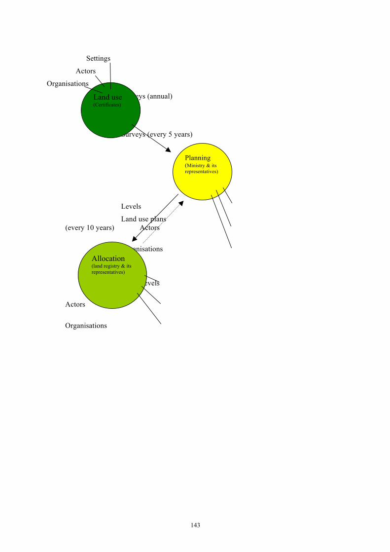
143
Settings
Actors
Organisations
Surveys (annual)
Surveys (every 5 years)
Levels
Land use plans (every 10 years) Actors
Organisations
Levels
Actors
Organisations
Planning (Ministry & its representatives)
Allocation (land registry & its representatives)
Land use (Certificates)
144
The actors and their views Main objectives
• Who are the main actors that play a direct and indirect role in land matters?
• What actors know and think about land institutions. The questions we would like to ask the various actors can be summarised as follows:
– role: what do they do in land management?
– knowledge: what do they know about land institutions at the provincial and national levels? And about other actors involved in land management at the provincial level?
– opinion: what do they think about land management at the national and provincial levels?
A – Identification of actors involved in land-related decisions at the provincial level
Who are the actors that intervene directly (visibly/officially)?
– this is mainly institutional actors who participate in land management (see flow chart),
– but also actors who play an advisory role and/or provide services. They may be institutional actors (civil servants in related services: forestry, agriculture, etc., who have advised land administration officials), international NGOs or donors that have supported land institutions at the provincial level in the context of cooperation agreements, businesses that have provided technical services (such as drawing up development plans), etc.
Who are the actors that intervene indirectly? These actors influence the evolution and progress of land institutions, affecting the way that they function by exerting pressure through demands and actions. Their actions may be legal or illegal:
– private actors who invest in land or whose demands impact on land matters (constructing leisure parks, housing, setting up industrial areas, forestry and agricultural activities, agri-food enterprises, etc.),
– institutional actors (corruption, insider dealing, etc.),
– State enterprises,
– civil society pressure groups (demonstrations/organisations by expropriated rural landholders, etc.).
B – What do actors know and think about land institutions and the land situation in the provinces?
Role
• Specify the identity of the person, institution or enterprise.
• Their relative position in the land management flow chart.
• Interests in land matters.
Knowledge
About institutions
Institutions at the national level (quick overview – especially civil servants involved in land management)
What are the main legal texts, decrees and decisions in force at the moment?
– currently: name, date, content
– previously: name, date, content
– main changes in terms of content
145
Which administrations play a direct role in land administration?
– currently
– previously
– main changes in terms of functioning
Which actors play an indirect role in land administration at the national level (NGOs, donors, enterprises, etc.)?
Institutions at the provincial level (all – including actors who are not directly involved, to get an idea of what they know and don’t know … These questions need to be put to land officials in order to create the land management flow chart)
What are the main land-related enforcement orders in the province?
– current
– previous
– main changes in terms of content
Which administrations play a direct role in land management?
– which administrations are they?
– what is their role?
– what has changed recently (since 2000-2003)?
– what are the main changes in terms of functioning?
– what changes are under way now?
Who are the non-institutional actors that play a direct role in land management alongside institutions (NGOs, donors, private service providers) in terms of:
– finance
– advice
– technical and logistical assistance
– who? when? to whom? how?
What room to manoeuvre do the provinces have in relation to what is decided and put in place in Hanoi? In which areas are provinces able to make their own decisions? In which areas do provinces have no decision-making powers?
Which actors or institutions do you know in this flow chart?
– which of them have you already worked with? Which of them are you involved with? On what? Why? In what circumstances? When?
Other actors (apart from land institutions)
Which actors play an ‘indirect’ role in land management?
Actors who provide advice, exert pressure: NGOs, donors, political leaders …
– who?
– when?
– to whom?
– how?
146
Actors with significant interests in land matters
– economic interests: large private and public enterprises in every area, including agriculture and forestry; public institutions, etc.
– political and administrative interests: institutions other than land institutions that intervene or have interests in land matters (such as construction, town planning, agricultural and forestry services, etc.)
Which of these actors or institutions do you know?
With whom – or with which institution – have you already worked? Or had discussions? Why? In what circumstances? When?
Opinions
On institutions and their functioning
Are the changes of the last 10 years moving in the right direction?
Which land mechanisms have improved and why?
Which mechanisms don’t work, and why? Did they not work before?
What needs to be improved and how can this be done?
On current land issues in the province (focusing on agriculture and forestry)
What are the main land dynamics in the province?
What are the most striking land-related achievements in the province?
In which areas (agriculture, forestry, urban, industrial, commercial) are land-related problems most pressing (pressure on land, land-related problems, etc.)?
What are the strengths and weaknesses of each of these domains (what has been done, what still needs to be done, what has been done well, what has been done badly…)?
– agricultural land (rice fields, other types of agricultural land)
– forest land
– urban land (for housing)
– industrial, commercial, leisure areas …
Which regions face the most crucial issues? Why?
Has the province had more or fewer land-related problems than other provinces/regions in Vietnam?
147
Annex 5: Essay on the history of land institutions in Vietnam (by Marie Mellac)
According to Nguyen and Leroy (2005) “Vietnamese law is standing […] at the crossroads of several influences, which naturally makes it harder to understand: the political foundations of the colonial enterprise, Marxist-Leninist ideology, social order and religious belief”. This observation holds true for the land law and, more generally, for all land institutions. As Vietnam’s territory has not existed in its current form for very long (1975), we cannot talk of a single history of Vietnamese institutions. There are several, all of which have combined to produce the institutions that are in place today.
The land law and institutions we now see are clearly evolving as a result of very modern dynamics, which are largely driven by the processes of globalisation and liberalisation. They have also been shaped by land systems from previous periods (temporal strata) and, albeit less visibly, the multi-culturalism characteristic of Vietnamese society.
For N. Rouland (1998, cited by Nguyen and Leroy, ibid.), “The observation of diversity is only useful insofar as it serves to prepare the ground for reflection on the possible existence of an underlying order to this diversity”. We aim to help find this order, by sketching out the possible early history of Vietnamese land institutions and identifying what we believe to be its strengths.
The classic approach distinguishes four main periods in the history of land in Vietnam: the pre-colonial period, which lasted from the second half of the 19th century when France progressively took charge of the administration of its colonies and protectorates, first in the South and then in the North; the colonial period, which ended in 1954 in the North and 1975 in the South; the collectivist period, which began soon after decolonisation and officially ended in 1986 with the launch of the Doi Moi (Renewal) policy; and the post-collectivist period, which is treated independently as it constitutes the heart of this report. This presentation mainly focuses on North Vietnam, since this is where most of our sources came from, and because political power was based in Hanoi during the colonial period and following the ‘reunification’ of Vietnam in 1975.
A.5.1. The pre-colonial period: land at the heart of inter-ethnic relations Although present-day Vietnam bears very little relation to its pre-colonial form, it is worth considering its earlier composition to get some idea of the diversity of land situations that the French encountered in their efforts to colonise and unify the the territory.
The mountainous areas are the most diverse in terms of culture and policy. These areas were (and are) home to a large number of particularly varied ethnic groups, whose differing socio-political systems were generally more limited than those of the groups living on the plains (such as the Kinh, Lao, Khmer). The degree of cooperation/dependence within and between groups varied at different periods. Socio-political configurations were very fluid, and the very diverse customary land institutions, which reflected this fluidity, were a key element in long-term relations between the different ethnic groups. Over time they helped shape the groups’ spatial distribution over vast areas (altitudinal logics), and social relations within and between groups at more local levels (both as an element of social distinctiveness and, for example, through the process of integrating non-Tai groups into Tai society). It is extremely difficult to impose some kind of order on such diversity, and the usual distinctions that can be made between groups (ethno-linguistic categories; rice-growers/slash-and-burners; small/large social groups; dominant/dominated, etc.) do little to clarify the situation when there are so many variations within these categories themselves. To get a clearer picture of the situation, we will start with the Herculean task of looking at the land institutions.
148
Ngo Duc Tinh (2006) distinguishes what he calls two types of codes (bodies of codified rules, of which a varying number relate to land), such as the numerous oral codes found in the central uplands, and the written codes of the Tai and Chams groups. It is also possible to identify characteristics shared by most groups, like the principle of collective ownership of land and resources, with use rights differentiated according to the individual’s ‘standing’. Groups also used markers to delimit land and resources that they had appropriated on a temporary basis, and there were common rules regulating the co-existence of neighbouring groups.
The land systems in certain mountainous areas probably changed considerably as a result of prolonged contact with the Kinh from the Red River delta – as with the Tay, a Tai group that occupied vast areas north east of the Red River. Their system was characterised by individual appropriation of rice fields that is highly reminiscent of the Kinh (with the possibility of selling and purchasing land, and patrilineal transfers), but which also bears traces of a land system similar to that of the Muong Tai (in toponymy and cultural aspects).
After freeing themselves from the Chinese in the 10th century, the Kinh established a power base in the plains of the North and the Red River delta, progressively spreading south and taking over from the Chams and then the Khmers. Our knowledge of the Kinh land institutions is based on the formalisation of land rules within the imperial codes (the Lê in the 15th century, and the Gia Long the 19th century) and numerous studies written over the years describing their main elements (Philastre, 1876 and 1909; Bienvenue, 1911; Boudillon, 1915; Ngo Kim Chung and Nguyen Duc Nghinh, 1987; Papin, 1997; Phan Huy Lê, 1997, Ngo Duc Thinh, 2006, etc.).
We learn from the more recent imperial code of the Gia Long (1815) that “From our special viewpoint, the Emperor, father and mother of his people according to the Annamite expression, [was] the owner of all property, of which the occupants, simple tenants, [acquired] possession by different means, but always originating from concession granted by the Sovereign, who [retained] over them the right of eminent domain” (Bienvenue, 1911, cited by Tessier, 2003). Through the Emperor, the State in some way owned all property, including land. Individuals only held extended use rights and certain derived rights to land (including that of patrilineal transfer) provided they worked the land and paid land tax. Relations between the State and peasants were largely based on a ‘land contract’, whereby the State ensured that peasants had a certain degree of tenure security in return for using the land productively and filling its coffers. This kind of contract (which is fairly similar to the code of the Lê, which provided much of the basis of the Gia Long code) could not function properly without a system for registering people and land. The Kinh sovereigns put in place several registration systems, first the Ly dynasty between the 11th and 13th centuries, then the Le dynasty at the end of the 15th century, and finally the Nguyen at the beginning of the 19th century.
“The first cadastral system in Vietnam was established by the Le dynasty in 1490. It is a DEED system in service for the nationwide land administration focusing on the utmost collection of agricultural tax. Meanwhile Hong Duc Law, the first Vietnamese law, was promulgated, of which 60 articles were about the land. The second cadastral system established in Vietnam took 31 years between 1805 and 1836 by the Nguyen dynasty. It is a DEED system also containing 10,044 volumes of cadastral books that covered 18 thousand communes across the country. Meanwhile Gia Long Law, the second Vietnamese law, was promulgated, of which 14 articles were to regulate the civil and administrative relation on housing, land and rice tax (Dang Hung Vo et Palmkvisk, 2001)”
This is what O. Tessier (2003) has to say about the land registration system established during the Nguyen dynasty (Gia Long).
“The first document that gives us some idea of the conditions for production in villages is the điền bạ, or register of rice fields for the commune of Ninh Dân [the commune studied by the
149
author]. This document is written in hán (pictograms), and is part of the body of land registers (điền bạ and điạ bạ) systematically established in every commune Bắc Bộ (North) between 1803 and 1805 under the reign of the Gia Long, in order to enumerate all the agricultural and populated lands in the North. This was not the first time that the country’s sovereigns had attempted to catalogue their landholdings, but it was the first time that this operation was completed across the whole country, even though it was not finished in the South (Nam Kú) until 1836 (Phan Huy Lê, 1995: 36). This desire for centralisation in the newly reconstituted imperial State explains the structural unity of each of these documents, which are composed of four distinct descriptive parts (Phan Huy Lê, 1998: 231-233):
1 - The location of the commune and its subsequent inclusion in broader territorial and administrative units (tæng ‘canton’, huyÖn ‘district’, and possibly phñ ‘prefecture’ and tØnh ‘province’);
2 – The different types of land (rice fields, land for housing, cemeteries, ponds, etc.), their respective status or allocation (private, public, communal, allocation for a pagoda or temple, etc.), and their use when a register was established (cultivated, abandoned, fallow, etc.);
3 – The list of owners, whether private or public, the location of each of their parcels or group of parcels, and the amount of land owned;
4 – The official declaration summarising the information previously provided, signed with the offical mark (seal or signature) of the dignitaries and communal, cantonal, district and provincial officials.
These are the most valuable documentary sources because they tell us about the size of the landholdings, the nature of the different land regimes, certain modes of individual tenure (such as ‘phu canh’ lands) and the number of registered landholders. However, they cannot be likened to a cadastral survey, as is sometimes the case, because they lack one essential element: a map of the territory divided into holdings and showing the name of each parcel’s owner - public or private, real or fictitious” (p. 40 and 41).
Apart from this shortcoming (which meant that the records were not particularly accurate), the Kinh land system was highly formalised in the early 19th century, with tools facilitating very tight State controls over land. In addition to the rule of law, several authors (Ngo Duc Tinh, 2006; Nguyen and Leroy, 2005) note that codified rules also existed at the communal (or village, lang) level. Nguyen and Leroy (ibid.) maintain that the rule of (State) law did not take precedence at the local level, regardless of whether it was codified or not, and it seems that communes were primarily regulated according to customs that varied from one commune to the next (Le Thanh Khoi, 1981). Dery notes (1999) that “the community was solidly organised to ensure that it had sufficient men and food. Its political organisation was clearly integrated and its territory clearly demarcated (Brocheux and Hemery, 1995). However, this affirmation should be qualified in the case of southern territories; in what then constituted Cochinchine, the “commune [was] much less powerful, and [villagers] were much less concerned with tradition than their counterparts in Tonkin” (Robequain, 1948)”.
Thus, certain aspects of the land system in this region, which was later colonised by the Kinh (who did not reach the Mekong delta until the end of the 17th century and the shores of the gulf of Thailand until 1870) were similar to those of land systems in the North, although it was characterised by more individualised family tenure and less emphasis on village structures.
A.5.2. The colonial period: the creation of a land problem “The French colonial land tenure system can be characterised by the introduction of the concept of State property and the attempt to promote private property amongst the local population, via land registration programmes. While the French sought to promote conversion of public land to private ownership, and made legal provision for indigenous people to register land, this made
150
little impact, and customary systems persisted to a high degree with little direct intervention by the authorities”. This observation by Leonard and Longbottom (2000) with regard to West Africa only holds true in the mountainous regions of Vietnam, where State ownership did not exist and where the French were generally unable to enforce the land system laid down in Hanoi. Therefore, the French were often content to let local systems function at the communal and village levels, provided they could raise taxes and duties – when they had the capacity to do so. While the French did not have a huge effect on land matters, their influence should not be entirely discounted as they restructured and partially unified socio-political structures at the highest levels and imposed a local system of private ownership. For example, in the province of Bắc Kạn, which was geographically close to Hanoi, a cadastral service was not put in place until the early 1940s, and was only withdrawn, before the French departed, in several villages surrounding the city of Bắc Kạn. Many rice fields in this province were allocated to former soldiers (sometimes in remote areas) and the French appropriated large swathes of land (in mining or forested areas, for example). It should also be noted that the French did not hesitate to intervene in ‘indigenous affairs’ when they had the opportunity to do so, as shown by the piece on this province published in 1931, Coutumier à l’usage des Mans (Yao), describing the social rules of this group, which differ from those of the Tày with regard to land.
The French influence in the whole mountain region can be summarised in four main points:
• they had little impact on local customary rules,
• slash-and-burn was forbidden, and cleared lands were not recognised as land that had been appropriated by groups,
• the number of taxes and duties increased,
• an ‘inequitable’ titling process began, benefiting indigenous and French administrators and, more generally those who asked for titles,
• ‘vacant’ lands were gradually appropriated.
The colonial authorities had a much greater impact on land tenure in the two large deltas and coastal plains of the North and South, scaling up processes that were starting to emerge in the mountains. For example, the French quickly resumed the process of land registration, which enabled them to raise land taxes and establish a status of ‘vacant and ownerless lands’, which the colonial authority incorporated into its private landholdings and then allocated to French settlers as concessions of varying sizes.
However, the impact of colonialisation was not homogenous. An order issued in 1898 allowed for a dual legal system in which the ‘indigenous’ customary regime coexisted with the metropolitan land law (Ta Thi Thuy, 1993). In simple terms, this resulted in a system where the State agreed land contracts with peasants in rural areas (which were published by the communal authorities) and real land ownership titles were issued in urban areas (Dang Hung Vo, 1997).
The Atlas de la province de Hanoï (Rossi et al., 2002) tells us that at the end of the 1950s, the characteristic social structure of the Red River delta included large landowners, a class of small- and medium-scale farmers who controlled land and production, and landless farmers who lived as labourers and worked as sharecroppers for the large landowners. Their numbers varied according to the regions of the delta, rising to as much as 80 per cent of the population in certain communes close to Hanoi. Nevertheless, the old community-based land structure remained important, with land collectively owned by the commune and redistributed to households every five years in exchange for a tax based on the quality of the land. The authors argue that the phenomenon of land grabbing by large landowners developed in parallel with urban growth: at the end of the 19th century urban lands were private property while agricultural lands in peri-urban villages were collectively owned. As this slowed urban growth, the colonial authorities privatised a lot of rural land so that they could develop the cities, assuming its ownership at the expense of village communities.
151
The growing privatisation of land ownership by the French administration progressively accentuated the differentiation between landowners, small farmers and landless farmers, which was more pronounced in the south than the north of the country. Dao The Tuan (1998) notes that farms were smaller and there was less land differentiation and few very big landowners in the North and Centre, where more of the communal land system was retained due to greater demographic pressure. In the South, where land was more abundant, there was less communal land and greater differentiation, with large agricultural holdings and more landless farmers. Quoting Y. Henri (1932), he reports that 21 per cent of land in the North was communal in 1930, compared with 25 per cent of land in the Centre and 3 per cent in the South.
The land inequalities that flourished in Vietnam’s great plains and delta in the first half of the 20th century provoked numerous land conflicts and fostered deep feelings of injustice and resentment among a large section of the rural population towards the colonialists and those that had profited from colonisation. While these inequalities were certainly not the only conditions that allowed the ‘socialist revolution’ to take place, land played a fundamental role in legitimising the socialist project. Hence the incorporation of the agrarian reform into the PCI programme from its inception in 1930: “ the abolition of any vestiges of feudalism, distribution of land to peasants, reversal of imperialism” (Le Thanh Khôi, 1978, cited by Tessier, 2003). The battles for access to land were also an inextricable element of the wars that were fought to expel the French and reunify the country (Kerkvliet, 1997).
A.5.3. The collectivist period: the ‘disappearance’ of land tenure The collectivist period is characterised by the progressive establishment of a system that responded to a non-market socialist conception of land, where land management and ownership were the sole preserve of the public authorities. However, the collectivisation of land did not begin until the Democratic Republic of Vietnam (North Vietnam) was put in place, and was preceded, as the PCI planned, by a process of agrarian reform (1953-1956) under the famous slogan ‘the land belongs to he who works it’.
The objectives of this reform were partly political and partly designed to address the economic conditions of the time (weaken opponents of the new regime and give power to the peasants) by confiscating land from large landowners and redistributing this and communal lands among small-scale and landless farmers. The reform was pushed through in the plains and delta of the North before over-zealous attempts to establish order in the countryside led to its abandonment in a climate of terror in 1956. Implementation in mountainous areas was more discreet, and very little land was redistributed in some places, although it is unclear whether this was due to political pragmatism (desire to conciliate the local population) or realism (lack of major land inequalities). However, the societal reform that was an integral part of the whole project continued, revolutionising the functioning of local societies and transforming political structures at the higher levels.
The collectivisation of the nation was neither a linear nor a homogenous process. It was undertaken in phases, which were themselves preceded by periods of experimentation in various parts of the country. Florence Yvon (1994) identifies four main periods: (i) the ‘launch of collectivisation’ between 1959 and 1961, (ii) the ‘consolidation of agricultural cooperatives’, which corresponds to the first five-year plan, and whose objective was to put in place high-level cooperatives, (iii) the war years from 1961 to 1975, when the government disengaged from the agricultural sector and dispensed with the process of collectivisation, and (iv) the period of ‘large-scale socialist agriculture’ that began in 1975 and marked a temporary return to the collectivist ideal. This period saw a radical restructuring of the cooperatives and was particularly painful for the rural population, prompting the end of the collectivist movement and dismantling of the cooperatives as the pendulum swung back to other forms of tenure.
The Constitution of 1946 guaranteed citizens rights of ownership but made no mention of forms of ownership, while the Constitution of 1959 recognised four forms of ownership, two of which were completely new. One of these new forms was State ownership, which was sacred and
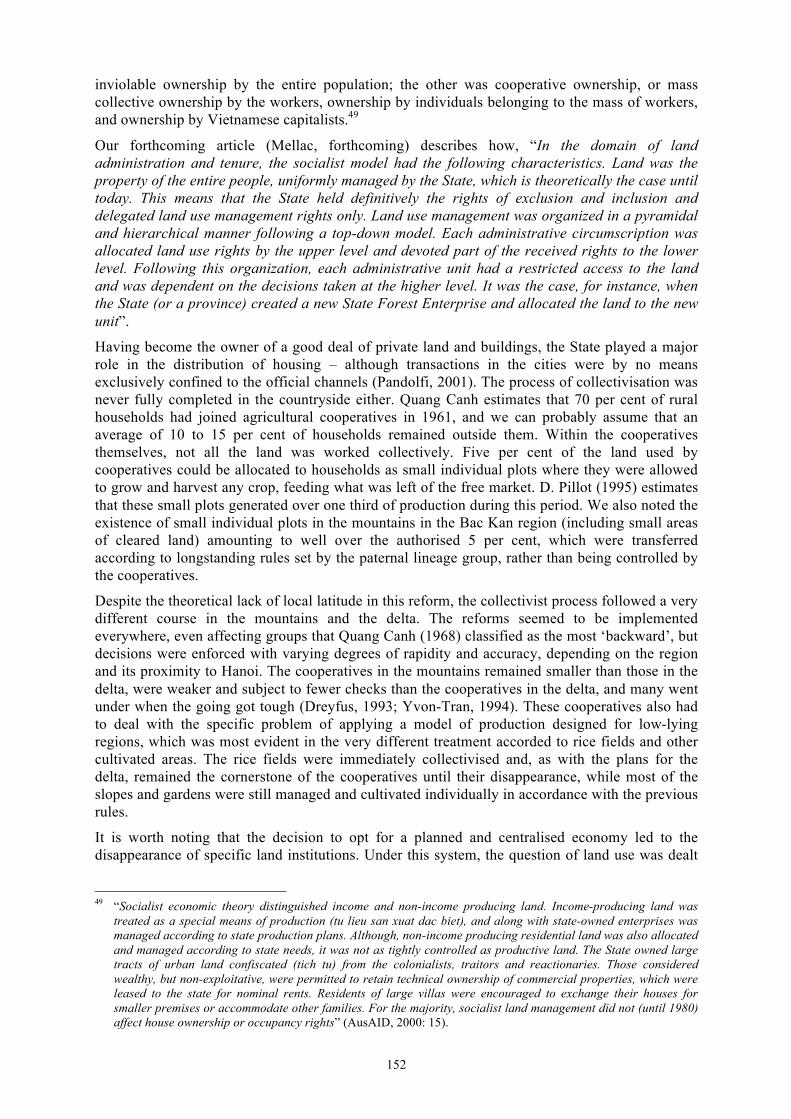
152
inviolable ownership by the entire population; the other was cooperative ownership, or mass collective ownership by the workers, ownership by individuals belonging to the mass of workers, and ownership by Vietnamese capitalists.49
Our forthcoming article (Mellac, forthcoming) describes how, “In the domain of land administration and tenure, the socialist model had the following characteristics. Land was the property of the entire people, uniformly managed by the State, which is theoretically the case until today. This means that the State held definitively the rights of exclusion and inclusion and delegated land use management rights only. Land use management was organized in a pyramidal and hierarchical manner following a top-down model. Each administrative circumscription was allocated land use rights by the upper level and devoted part of the received rights to the lower level. Following this organization, each administrative unit had a restricted access to the land and was dependent on the decisions taken at the higher level. It was the case, for instance, when the State (or a province) created a new State Forest Enterprise and allocated the land to the new unit”.
Having become the owner of a good deal of private land and buildings, the State played a major role in the distribution of housing – although transactions in the cities were by no means exclusively confined to the official channels (Pandolfi, 2001). The process of collectivisation was never fully completed in the countryside either. Quang Canh estimates that 70 per cent of rural households had joined agricultural cooperatives in 1961, and we can probably assume that an average of 10 to 15 per cent of households remained outside them. Within the cooperatives themselves, not all the land was worked collectively. Five per cent of the land used by cooperatives could be allocated to households as small individual plots where they were allowed to grow and harvest any crop, feeding what was left of the free market. D. Pillot (1995) estimates that these small plots generated over one third of production during this period. We also noted the existence of small individual plots in the mountains in the Bac Kan region (including small areas of cleared land) amounting to well over the authorised 5 per cent, which were transferred according to longstanding rules set by the paternal lineage group, rather than being controlled by the cooperatives.
Despite the theoretical lack of local latitude in this reform, the collectivist process followed a very different course in the mountains and the delta. The reforms seemed to be implemented everywhere, even affecting groups that Quang Canh (1968) classified as the most ‘backward’, but decisions were enforced with varying degrees of rapidity and accuracy, depending on the region and its proximity to Hanoi. The cooperatives in the mountains remained smaller than those in the delta, were weaker and subject to fewer checks than the cooperatives in the delta, and many went under when the going got tough (Dreyfus, 1993; Yvon-Tran, 1994). These cooperatives also had to deal with the specific problem of applying a model of production designed for low-lying regions, which was most evident in the very different treatment accorded to rice fields and other cultivated areas. The rice fields were immediately collectivised and, as with the plans for the delta, remained the cornerstone of the cooperatives until their disappearance, while most of the slopes and gardens were still managed and cultivated individually in accordance with the previous rules.
It is worth noting that the decision to opt for a planned and centralised economy led to the disappearance of specific land institutions. Under this system, the question of land use was dealt
49 “Socialist economic theory distinguished income and non-income producing land. Income-producing land was
treated as a special means of production (tu lieu san xuat dac biet), and along with state-owned enterprises was managed according to state production plans. Although, non-income producing residential land was also allocated and managed according to state needs, it was not as tightly controlled as productive land. The State owned large tracts of urban land confiscated (tich tu) from the colonialists, traitors and reactionaries. Those considered wealthy, but non-exploitative, were permitted to retain technical ownership of commercial properties, which were leased to the state for nominal rents. Residents of large villas were encouraged to exchange their houses for smaller premises or accommodate other families. For the majority, socialist land management did not (until 1980) affect house ownership or occupancy rights” (AusAID, 2000: 15).
153
with in the overall framework of territorial planning, and land distribution and access considered in the overall framework of collectivisation. Despite the multiple phases of collectivisation, the status of land remained unchanged until the ‘Doi Moi’ economic reform. What did change was the way that individuals came together to work (the size of cooperatives, working groups and gangs) and then how they gained physical access to land (or not). These changes also affected the way that produce from the land was redistributed among workers in cooperatives and State enterprises. But despite being central to the beginnings of the socialist revolution, the question of land ‘dissolved’ within the collectivist project.
Although the current re-emergence of land as an issue is a reflection of contemporary impulses and logics, the institutions that are appearing now are derived from those that were put in place in previous periods, even when land institutions as such did not exist. The tradition of planned management described above raises the question of how previous management structures can be adapted to the new land system that is progressively being put in place. How has this system been defined and applied over time? Which structures have been put in place, and how have the former structures been redefined?
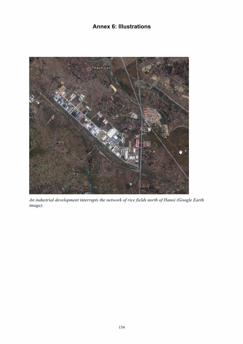
154
Annex 6: Illustrations
An industrial development interrupts the network of rice fields north of Hanoi (Google Earth image).
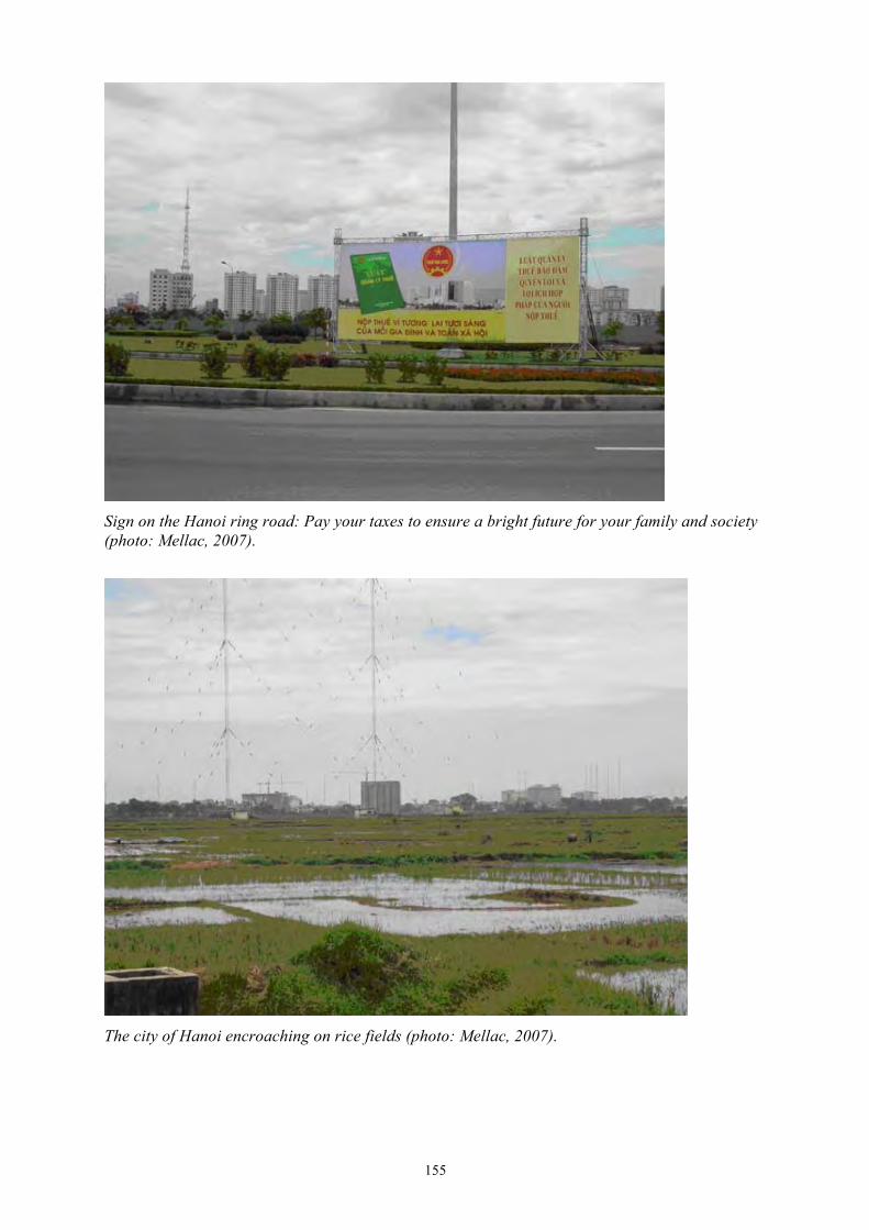
155
Sign on the Hanoi ring road: Pay your taxes to ensure a bright future for your family and society (photo: Mellac, 2007).
The city of Hanoi encroaching on rice fields (photo: Mellac, 2007).
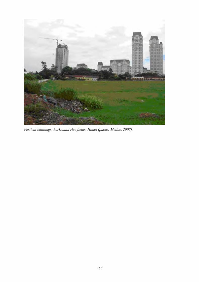
156
Vertical buildings, horizontal rice fields, Hanoi (photo: Mellac, 2007).
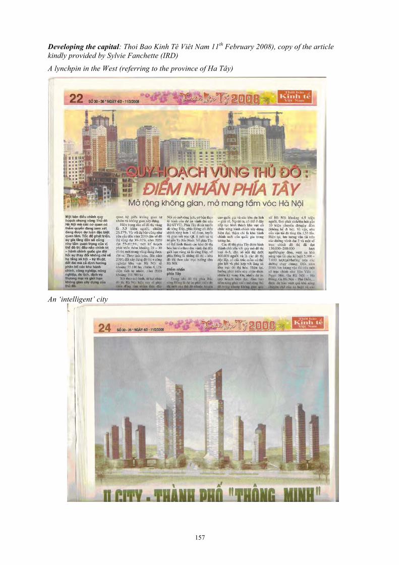
157
Developing the capital: Thoi Bao Kinh Tê Viêt Nam 11th February 2008), copy of the article kindly provided by Sylvie Fanchette (IRD)
A lynchpin in the West (referring to the province of Ha Tây)
An ‘intelligent’ city
158
Annex 7: Bibliography
Vietnam and South East Asia: general context 1. BERESFORD, M., FRASER, L., 1992, Political economy of the environment in Vietnam.
Journal of Contemporary Asia, 22(1), pp. 3-18.
2. BERGERET, P., 2002, Paysans, Etat et marchés au Vietnam. Dix ans de coopération agricole dans le bassin du Fleuve Rouge. GRET/KARTHALA, Paris, 291 p.
3. CANNON, T., 2006, La chine et l’économie spatiale des réformes: comprendre la topocratie et l’Etat développementaliste local. In Decroly J.M., Nicolaï H. (dir.), Mutations des territoires dans le Monde à l’aube du XXIe siècle, Harmattan, pp. 149-190.
4. CRYSTAL, E., 1997, Upland voices, highland development choices. Paper presented at the EuroViet III Conference, July 1997, Amsterdam, 17 p.
5. DAO THE TUAN, 1998, The crisis in agriculture in the northern uplands. Paper presented at the Asian Studies Annual Conference, May 1998, Washington, 8 p.
6. DE KONINCK, R., 1994, L'Asie du Sud-Est. Paris: Masson.
7. DE KONINCK (R.), DURAND (F.), FORTUNEL (F.), Agriculture, environnement et sociétés sur les Hautes terres du Viêt Nam, IRASEC-Arkuiris, Bangkok-Toulouse, 2005, 224 p.
8. DERY, S., 1999, La colonisation agricole au Vietnam. Unpublished thesis. Quebec, Université Laval.
9. DERY, S., VANHOOREN, R., 2005, Les aires protégées en Asie du Sud-Est continentale, 1962-2005. Texte soumis pour publication dans les Actes du colloque « Re-penser l’Asie du Sud-Est: conflits, connivence et vulnérabilités. Conseil Canadien des Etudes sur l’Asie du Sud-Est, York University, Toronto. [http://www.yorku.ca/ycar/CCSEAS%20Papers/ Vanhooren-Dery%20Paper.pdf - 2006]
10. DONOVAN, D., RAMBO, A.T., FOX, J., LE TRONG CUC, TRAN DUC VIEN, (Eds.), 1997, Development Trends in Vietnam’s Northern Mountain Region, Vol. 1. An overview and analysis. East-West Center, Center for Natural Resources and Environmental Sudies, Vietnam National University, National Political Publishing House, Hanoi, 110 p.
11. DONOVAN, D., RAMBO, A.T., FOX, J., LE TRONG CUC, TRAN DUC VIEN, (Eds.), 1997, Development Trends in Vietnam’s Northern Mountain Region, Vol. 2. Case studies and lessons from Asia. East-West Center, Center for Natural Resources and Environmental Sudies, Vietnam National University, National Political Publishing House, Hanoi, 231 p.
12. DREYFUS, F., 1993, Traditions, idéologies et pragmatisme. Les principales transformations de l’agriculture et de la campagne du Viêtnam du nord entre 1930 et 1990. CNEARC, Montpellier, 71 p. (mimeograph).
13. Eudes Vietnamiennes, Spécial: Forêts et sylviculture au Vietnam. 1996 (4) – 122.
14. Etudes Vietnamiennes, Spécial: Problèmes Agricoles (4) – La gestion des Cooperatives. 1977 (51).
15. FAO, 2005, Situation des forêts du monde. Rome, 135 p.
16. FFORDE, A., 1989, The agrarian question in north Vietnam 1974-1979: a study of cooperator resistance to state policy. M.E. Sharpe, New York.
159
17. FORTUNEL, F., 2005, L’amertume du café dans les plateaux du Centre Viêt Nam. In De Koninck, R., Durand, F., Fortunel, F., (eds), Agriculture, environnement et sociétés sur les hautes terres du Viêt Nam, IRASEC-Arkuiris, Bangkok-Toulouse, 2005, pp. 161-186.
18. GIRONDE, C, 2001, Réhabilitation et transformations de l’économie familiale au Nord Vietnam, Geneva, PhD thesis, Institut Universitaire d’Études du Développement.
19. JAMIESON, N.L., LE TRONG CUC, RAMBO, A.T., 1998, The development crisis in Vietnam's mountains. East-West center special reports, nº 6, East-West Center, Honolulu, 32 p. Kerkvliet, BJT. and Porter, DJ. (eds), 1995, Vietnam's rural transformation, Institute of Southeast Asian Studies, Boulder,
20. LANG, C., 2001, Deforestation in Vietnam, Laos and Cambodia, in Vajpeyi, D.K. (ed.) (2001) Deforestation, Environment, and Sustainable Development: A Comparative Analysis. Praeger: Westport, Connecticut and London, pp. 111–137.
21. LE BA THAO, 2000, Vietnam, pays et regions geographiques. Editions The Gioi, Hanoi, 594 p.
22. LE DUAN, PHAM VAN DONG, 1975, Vers une agriculture de grande production socialiste. Hanoi: The Gioi.
23. LE THANH KHOI, 1981, Caractéristiques de l'état Vietnamien et de la monarchie bureaucratique, Histoire du Viêt-Nam des origines à 1858, Paris, Sudestasie.
24. LE TRONG CUC, RAMBO, A.T., (eds), 1993, Too many people, too little land: the human ecology of a wet rice-growing village in the Red River Delta of Vietnam. East-West Center, Honolulu.
25. LE TRONG CUC, RAMBO, A.T., (eds), 1993, Bright Peaks, Dark Valleys, A Comparative Analysis of Environmental and Social Conditions and Development Trends in Five Communities in Vietnam’s Northern Mountain Region. East-West Center, CRES Upland Working Group, The National Political Publishing House, Hanoi, 309 p.
26. LE TRONG CUC, RAMBO, A.T., FAHRNEY, K., et al., (eds), 1996, Red books, green hills: economic reform and restoration ecology in the midlands of Northern Vietnam. East-West Center, Honolulu, 127 p.
27. McELWEE, P., 1999, Policies of Prejudice: Ethnicity and Shifting Cultivation in Viet Nam. Watershed, 5 (2), pp. 33-8.
28. McELWEE, P., 2001, Parks or people: exploring alternative explanations for protected areas development in Vietnam. Yale University [http://research.yale.edu/CCR/environment/papers/]
29. McELWEE, P., 2004, You Say Illegal, I Say Legal: The Relationship Between 'Illegal' Logging and Land Tenure, Poverty, and Forest Use Rights in Vietnam, Journal of Sustainable Forestry, Vol. 19, No. 1/2/3, 2004.
30. MELLAC, G.M., 1999, La gestion des espaces forestiers au Nord Viêt Nam, un modèle et son application. Les Cahiers d'Outre Mer, 51 (204), Oct-Dec, pp. 367-384.
31. MELLAC, G.M., 2000, Des forêts sans partage. Dynamique de l'espace et utilisation des ressources dans un district de montagne au Nord Viêt-Nam". Geography PhD, Université Michel de Montaigne - Bordeaux 3, 608 p.
32. MELLAC, G.M., 2006, Gestion décentralisée des ressources forestières et jeux d’acteurs au Vietnam. Seminar ‘Les biens environnementaux: biens publics, biens communs, quelles gestions décentralisées durables’, UMR ADES, 6 January 2006.
33. MELLAC, G.M., forthcoming, Land reform and changing identities in two Tai-speaking districts in northern Vietnam. In Michaud, J., and Forsyth, T., (eds), Moving Mountains. Highland Livehoods and post Socialism in China, Vietnam and Laos.
160
34. MORGER, C., 1998, Les forêts du peuple au Vietnam. Etudes Vietnamiennes, nº3(129), Hanoi, pp. 129-135.
35. LE THI PHI, TON VAN CHUNG, LE BANG TAM, 2004, What maintains poverty? A study of factors affecting poverty in mountainous areas of Quang Ninh province, Vietnam. IIED, 92 p. [http://www.iied.org/NR/forestry/documents/intravillage_studyfinal_May04.pdf]
36. PAPIN, P., 1997, Des ‘villages dans la ville’ aux ‘villages urbains’: l’espace et les formes de pouvoir à Ha Noi de 1805 à 1940. PhD thesis, Université de Paris VII, 2 volumes.
37. PAPIN, P., TESSIER, O., (dir.), 2002, Le village en questions. Hanoi: EFEO / Trung Tam Khoa Hoc Xa Hoi va Nhan Van Quoc Gia, 740 p.
38. PHAM XUAN PHONG, 2000, People’s Participation in Forest Management in Vietnam. In Decentralisation and Devolution of Forest Management in Asia and the Pacific, RECOFT Report n°18, FAO RAP Publication, 2000/1, pp. 87-93.
39. PHAN HUY LE, 1997, The country life in the Red River delta. Ha Nôi, Nha Xuât Ban The Gioi.
40. PILLOT, D., 1995a, La fin des coopératives: la décollectivisation agricole au Nord Viêtnam. Les Cahiers d’Outre Mer, n°190, April-June, pp. 107-130.
41. PILLOT, D., YVON, F., 1995, Technical Development of an economy in transition. Vietnamese Studies, New Series nº 45(115), pp. 46-64.
42. POFFENBERGER, M., (ed.), 1998, Stewards of Vietnam’s upland forests. A collaborative study by the Asia Forest Network and the Forest Inventory and Planning Institute. Asia Forest network publication, Research Network Report, n°10, January 1998.
43. QUANG CANH, 1968, Economic transformation of mountain regions. Vietnamese Studies, n°15, Hanoi, pp. 89-108.
44. RAMBO, A.T., et al., (ed.), The challenges of higland development in Vietnam, East-West Center.
45. ROBEQUAIN, 1948, L’Indochine Française. Paris: Armand Colin.
46. ROSSI, G., PHAM VAN CU, (dir.), 2002, Atlas infographique de la province de Ha Noi. Hanoi: CNRS,/MAE, 379 p.
47. SAVILLS, Industrial Vietnam, Q2, 2007, 4 p.
48. SIKOR, T., 1999, The political economy of decollectivization: a study of differentiation in and among Black Thai villages of northern Vietnam. Ph.D Dissertation, University of California, Berkeley, 377 p.
49. SIKOR, T., DAO MINH TRUONG, 1998, The economic and environmental effects of agricultural reforms in three Black Thai villages on northwestern Vietnam. In International Conference on Vietnamese Studies and the enhancement of International Cooperation, Hanoi, July 14-17 1998, 11 p.
50. SIKOR, T., O’Rourke, D., 1996, Economic and environmental dynamics of reform in Vietnam. Asian Survey, vol. 36, nº6, June 1996, University of California Press, pp. 601-617.
51. SWINKELS, R.; TURK, C., 2006, Explaining Ethnic Minority Poverty in Vietnam: a summary of recent trends and current challenges. World Bank, Vietnam, Draft Background paper for CEM/ MPI meeting on Ethnic Minority Poverty, Hanoi, 28 September 2006.
52. TA THI THUY, 1993, Les concessions agricoles françaises au Tonkin de 1884 à 1918. Thèse d’Histoire sous la direction de Denys Lombard. Paris: EHESS.
161
53. TACHIBANA, T., NGUYEN M.T., OTSUKA, K., 1998, From deforestation to reforestation through tenure reforms: the case of the northern hill region of Vietnam. Hokkaido University, Vietnam Agricultural Science Institute, 37 p.
54. VEILLEUX, C., 1994, The state of Viet Nam’s Forests: historical perspectives on a contempory dilemna. Documents du GERAC, n°7, Le défi forestier en Asie du Sud-Est, Université de Laval, pp. 67-88.
55. VO QUY, 1997, Vietnam: environmental challenges and solutions. Vietnam National University, Hanoi, 14 p.
56. WAIBEL (Michael), Migration to the greater Ho Chi Minh City in the course of doi moi policy, spatial dimensions, consequences and policy changes, 6 p.
57. WORLD BANK, 1995, Viet Nam Environmental Program and policy priorities for a socialist economy in transition. Volume II, The supporting Annexes, Agriculture and Environment Operations Division, Country Department I, East Asia and Pacific Region, 167 p.
58. WORLD BANK, 2002a, Country Assistance Strategy of the World Bank Group for the Socialist Republic of Vietnam 2003-2007. Hanoi: World Bank, 90 p.
59. WORLD BANK, 2002b, Vietnam Delivering on its Promise, Development Report 2003. 156 p.
60. WORLD BANK, 2003, Vietnam Partnership for Development. An Informal Report for the Consultative Group Meeting for Vietnam, Hanoi, December 2-3, 2003, 135 p.
61. WORLB BANK, 2005a, State Forest Enterprise Reform in Vietnam Review of Policy and Implementation Framework for Decree 200.50 p.
62. WORLD BANK et al., 2005, Vietnam Environment Monitor 2005. World Bank/MoNRE/SIDA, 94 p.
63. WORLD BANK, 2007, Vietnam Country Partnership Strategy with the Socialist Republic of Vietnam 2007-2011. 170 p.
Vietnam (and SEA): institutional context 64. ADB, 2004, Poor Must Benefit More in Viet Nam's Rural Land Market.
http://www.adb.org/Documents/News/VRM/vrm-200423.asp
65. EEUWES, J.G.C.M., 1995, Upland use in Vietnam, Institutions and regulations of forest management systems: Black Thai cooperatives in Son La province. Wageningen University, 146 p.
66. ENTERS, T., DURST, P.B., VICTOR, M., (eds), 2000, Decentralization and Devolution of Forest Management in Asia and the Pacific. RECOFTC Report n° 18, RAP Publication 2000/1. Bangkok, Thailand.
67. FAO, 1992a, Vietnam watershed management and ethnic minorities. Appendices, UNDP/FAO work program, Rome, 29 p.
68. FAO, 1992b, Vietnam watershed management and ethnic minorities. Main Report, UNDP/FAO work program, Rome, 75 p.
69. FAO, 1994, National workshop on ‘strengthening re-afforestation programmes in Vietnam’. JICA/STRAP/FORTIP, Hanoi, 224 p.
70. FAO, 1995, Vietnam agroforestry networking programme. Programme document, DRAFT, Hanoi, 33 p.
162
71. FFORDE, A., et al, 2003, Decentralisation in Vietnam - Working Effectively at the Provincial and Local Government Level – Aus-AID Australian Agency for International Development.
72. FFORDE, A., De Vylder, S., 1996, From plan to market, Westview, Oxford.
73. Jong (de), W., Do Dinh Sam, Trieu Van Hung, 2006, Forest rehabilitation in Vietnam: histories, realities and future. Center for International Forestry Research (CIFOR), Bogor, Indonesia. Review of Forest Rehabilitation: Lessons from the Past. 76p.
74. KERLVLIET, B.J.T., 1995, Rural society and state relations. In Kerkvliet, BJT., Porter, DJ. (Ed.), Vietnam's rural transformation, Institute of Southeast Asian Studies, Boulder, pp. 65-96.
75. KERLVLIET, B.J.T, 2004, Surveying Local Government and Authority in Contemporary Vietnam. In Kerkvliet, B.J.T, Marr, D.G., Beyond Hanoi. Local governement in Vietnam. Singapore: ISEAS, Vietnam Update Series, pp. 1-27.
76. KERKVLIET, B.J. 2005, The power of everyday politics: how Vietnamese peasants transformed national policy. Ithaca: Cornell University Press.
77. LI, T.M., 2002, Engaging Simplifications: Community-Based Resource Management, Market Processes and State Agendas in Upland Southeast Asia. World Developement, Vol. 30, n°2, pp. 256-282.
78. LICHTENSTEIN, N. G., 1994, A survey of Vietnam’s legal framework in transition. The World Bank, Legal Department, 61 p.
79. MACKINNON, J. (1990). Review of the Natural Conservation Systems, National Parks and Protected Areas: Forestry Sector Review Tropical Forestry Action Plan. Hanoi: FAO.
80. MARR, D.G, 2004, A Brief History of Local Government in Vietnam. In Kerkvliet, B.J.T, Marr, D.G., Beyond Hanoi. Local governement in Vietnam. Singapore: ISEAS, Vietnam Update Series, pp. 28-53.
81. MOF (MINISTRY OF FORESTRY), 1991a, Vietnam forestry sector review: tropical forestry action programme. Executive summary, Socialist Republic of Vietnam, Hanoi, 25 p.
82. MOF (MINISTRY OF FORESTRY), 1991b, Vietnam forestry sector review: tropical forestry action programme. Main Report, Socialist Republic of Vietnam, Hanoi, 201 p.
83. MOF (MINISTRY OF FORESTRY), 1991c, Research Documents on forest inventory and planning, 1961-1991. Socialist Republic of Vietnam, Hanoi, 300 p.
84. MOF (MINISTRY OF FORESTRY), 1994, Vietnam Forestry. Agricultural Publishing House, Hanoi, 70 p.
85. Nguyen Ngoc Dien, Leroy, C.E., 2005, Pluralité des approches juridiques de la pluriculturalité au regard de la conception du patrimoine en droit vietnamien. (http://fr.jurispedia.org/index.php/Pluralit%C3%A9_des_approches_juridiques_de_la_pluriculturalit%C3%A9_au_regard_de_la_conception_du_patrimoine_en_droit_vietnamien)
86. PILLOT, D., 1995, La fin des coopératives: la décollectivisation agricole au Nord Viêtnam. Les Cahiers d’Outre Mer, n°190, April-June, pp. 107-130.
87. PARDO, D.R., 1989, Forest policy formulation for Vietnam. FAO, Rome, 53 p.
88. PHAN THANH XUAN, 1989, Policies and practices to achieve sustainable development of the forestry sector. Ministry of Forestry, Hanoi, 13 p.
89. PORTER, G., 1990, The politics of ‘renovation’ in Vietnam. Problem of Communism, vol. 39, nº3, Information agency, Washington, pp. 72-88.
90. RAO, Y. S., 1990, Forestry in Vietnam: an overview. FAO, Bangkok, 30 p.
163
91. UNDP, 1991, Proceedings of the forum on reforestation issues in Vietnam. Hanoi, 10 p.
92. YVON-TRAN, F., 1994, Une résistible collectivisation, l’agriculture au Nord Viêt Nam 1959-1988. PhD thesis, Université de Paris VII, UFR-Géographie, Histoire, Sciences de la Société, 210 p.
Vietnam (and SEA): land 93. ADGER, W.N., KELLY, M., NGUYEN HUU NINH, NGO CAM THANH, 1997, The
enclosure of common property and its implications for coastal management in northern Vietnam. Paper for the Third Euroviet Biannual Conference, University of Amsterdam, The Netherlands, July 2-4 1997, 17 p.
94. AusAID, 2000, Land Administration. Canberra: AusAID, Working Paper 4, 25 p.
95. BASSFORD, J.L., 1984, Land Development policy in Cochinchina under the French (1865-1925). Dissertation submitted for a PhD in History, University of Hawaii, 348 p.
96. BERGERET, P., 1995, La politique foncière au Vietnam. Etudes Vietnamiennes, Nouvelle série nº 45(115), numéro spécial Les nouveaux paysans du delta du Fleuve Rouge, pp. 33-47.
97. BLOCH, P.C., OESTERBERG, T., 1989, Land tenure and allocation situation and policy in Viêtnam with special reference to the forest development area (Vinh Phu, Hoang Lien Son and Ha Tuyen Provinces). Land Tenure Center, University of Winconsin/Swedsurvey, Gaevle, 51 p.
98. BOUDILLON, A., 1915, Le régime de la propriété foncière en Indochine. Emile Larose Editeur, Paris, 578 p.
99. CARR, K., 1999, The socio-economic effects of forest land policies in Viet Nam: a case study of Lang Beo Village. In Hainsworth G.B., (ed.), Localizes Poverty reduction in Viet Nam: improving the enabling environment for rural livehood enhancement, Centre for Southeast Asia Research, Vancouver, pp. 227-246.
100. DANG HUNG VO, 1997, Land Administration Reform in Vietnam. 1997 FIG Working week, Penang, Malaysia, 5-9 May 1997 ((http://www.fig.net/pub/)
101. DANG HUNG VO, PALMKVIST, G., 2001, Sweden-Vietnam Cooperation on Land Administration Reform in Vietnam. New Technology for a New Century International Conference, FIG Working Week, Seoul, Korea 6–11 May 2001. (http://www.fig.net/pub/proceedings/korea/full-papers/session7/dang-palmkvist.htm)
102. DANG HUNG VO, TRAN THU TRUNG, 2006, Land policy for foodless cancellation and poverty reduction in Vietnam. Congress Shaping the change, Munich, 8-13 October.
103. DINH HUU HOANG, DANG KIM SON, 2008, Forest and land allocation in Vietnam - Policy and Practice. Paper presented at the National Forum on Forest land Allocation, Hanoi, 29 May 2008.
104. DUCOURTIEUX, O., CASTELLA, J-C., 2006, Land reforms and impact on land use in the uplands of Vietnam and Laos: Environmental protection or poverty alleviation? International symposium ‘Aux frontières du foncier, enchâssement social des droits et politiques publiques’, Montpellier, 17-18-19 May 2006.
105. DURAND, F., FORTUNEL, F., Phan Viet Ha, 2005, La question foncière dans les dynamiques rurales du Centre Viêt Nam. In De Koninck, R., Durand, F., Fortunel, F., (eds), Agriculture, environnement et sociétés sur les hautes terres du Viêt Nam, IRASEC-Arkuiris, Bangkok-Toulouse, 2005, pp. 119-160.
106. DU VAN CHAU, 1998, Redistribution foncière et différenciation sociale au Viêt-Nam. Revue Tiers Monde, nº153, tome 34, Paris, pp. 161-174.
164
107. 2000, Experiences and potential for community forest management in Vietnam. Workshop proceedings, Hanoi, June 1-2, 2000.
108. FAO, 1997, Report on forest land use planning and forest land allocation in Phong Du commune – Tien yen district- Quang Ninh province. Project Management Board Tien yen distrit, Tien yen, 11 p.
109. FAO, 1998, Report on forest land use planning and forest land alloaction in Dong Tam commune – Dong Phu district. Dong Phu management board of FAO project, Binh Phuoc province, Hanoi, 11 p.
110. FEYSSAC, C., 1890, La réforme foncière en Indochine. Exposition Coloniale Internationale, Paris, 38 p.
111. FORTUNEL, F., 2006, ‘10 ans d'application de la réforme foncière au Viêt Nam, les populations locales et le contournement du cloisonnement territorial’, in COLIN Jean-Philippe, LÉONARD Éric (eds), Les politiques d'enregistrement des droits fonciers, du cadre légal aux pratiques locales, IRD-Karthala, 2007.
112. GENERAL CADASTRAL DEPARTMENT, 1997, 1993 Land Law and stipulations on the forest land allocation. Paper presented at the ‘National Workshop on Land Use Planning and Forest Land Allocation’, Dec. 4-6 1997, Hanoi, 10 p.
113. GRARD, A., 2004, Les réformes foncières au Vietnam. Etude des marchés fonciers périurbains de deux pôles secondaires du Nord Vietnam. Mémoire de DESS de l’IFU, Université Paris 8.
114. HAROON AKRAM-LODHI, ‘Are landlords taking back the land? An essay on the agrarian transition in Vietnam’, The European Journal of Development Research, vol. 16, n°4, 2004, pp. 752-789.
115. KERKVLIET, B.J.T., 1997, Land struggles and land regimes in the Philippines and Vietnam during the twentieth century. The Wertheim lecture 1997, Centre for Asian Studies Amsterdam, Amsterdam, 40 p.
116. LAMBALLE, P., et al., 2008, Research on Livelihood of Trung Son Hydroelectric Dam Project. Hanoi: GRET, unpublished project document.
117. LAM THANH LIEM, 2000, ‘La nouvelle gestion des terres au Vietnam (1986-2000)’, Conference Prospects for economic and social progress, Washington.
118. MARD, 1997, Several issues to forestry land allocation in Vietnam. Report for presentation at the National Seminar on land use planning and forestry land allocation, Forest Protection Department, Hanoi, December 4-6 1997, 11 p.
119. MARSH P.S., MACAULAY T. G., 2002, Land reform and the development of commercial agriculture in Vietnam: policy and issues, Agribusiness review, vol. 10, 14 p.
120. MARSH P. S., PHAM VAN HUNG, NGUYEN TRONG DAC, MACAULAY T.G., Farm size change and the market for agricultural land use and land use rights in Vietnam since 1993.
121. MELLAC, G.M., 2002, Accès aux ressources naturelles et distribution des terres dans un district de montagne du Nord Viêt Nam (Exemple du district de Cho Don - Province de Bac Kan). In Kleinen, J., (ed.), Vietnamese society in transition, The daily politics of reform and change, IIAS, Amsterdam, pp. 102-116.
122. MELLAC, G.M., 2004, Des politiques foncières aux logiques locales. Exemple du foncier rizicole chez les Tai du Viêt Nam septentrional. Annales de la Fondation Fyssen, n°18, pp 93-108.
165
123. MELLAC, G.M., 2006, Des ‘rizières du muong’ aux ‘rizières de la coopérative’: réflexion sur l’évolution des catégories cognitives mobilisées par les Tai du nord-ouest du Viêt Nam dans le domaine foncier. International symposium ‘Aux frontières du foncier, enchâssement social des droits et politiques publiques’, Montpellier, 17-18-19 May 2006.
124. NABANGCHANG-SRISAWALAK (O.), Land tenure data and policy making in Southeast Asia, Land reform, n°1, 2006.
125. NGO DUC TINH, 2006, Customary law and rural devlopment in Vietnam today. Vietnamese Studies, n°3-2006 (161), pp. 32-50.
126. NGO KIM CHUNG, NGUYEN DUC NGHINH, 1987, Propriété privée et propriété collective dans l’ancien Vietnam. Harmattan, coll. Recherches Asiatiques, 227 p.
127. NGUYEN DUY KHIEM, VAN DER POEL, P., 1993, Land use in the Song Da watershed (North-West Vietnam). Social Forestry Developement project Song Da, Hanoi, 60 p.
128. SIKOR, T., 1995, Decree 327 and the restoration of barren land in the Vietnamese highlands. In Rambo, A.T., et al. (ed.), The challenges of highland development in Vietnam, East West Center, pp. 143-156.
129. SIKOR, T., 2004, Local Governement in the Exercise of State Power: the Politics of Land Allocation in Black Thai Villages. Kerkvliet, B.J.T, Marr, D.G., Beyond Hanoi. Local governement in Vietnam. Singapore: ISEAS, Vietnam Update Series, pp. 167-196.
130. SMITH, W., TRAN THANH BINH, 1994, The impact of the 1993 land law on rural households in the Mai Son District of Son La province. ActionAid Vietnam, 67 p.
131. SMITH, W., 1995, Implementing the land law: the impact of land allocation on rural households in Son La and Ha Tinh provinces. ActionAid Vietnam, 49 p.
132. THI THUY VAN DINH, 2006, Le droit forestier du Vietnam. FAO, online legal study, n°51.
133. TRAN NHU TRUNG, DAO ANH KIET, HYDE, I., DANG HUNG VO, 2006, Vietnam Land Registration from Terminology to the Practice. In Shaping the Change, XXIII FIG Congress, Munich, Germany, October 8-13, 2006.
134. VUONG XUAN TINH, HJEMDAHL, P., 1997, The impact of the 1993 land law on the ethnic minority communities in Vietnam. EuroVietnam III, July 1997, Amsterdam, 31 p.
Press articles and websites 135. Manilla Times, 7 May 2008, Food crisis bites in Vietnam despite economic boom.
136. Le blog immobilier, 2008 - http://leblogimmobilier.wordpress.com/2006/01/29/hanoi-le-plus-grand-projet-dinvestissement-immobilier/ consulted July 2008
137. Karl D John, 2006, Vietnam's property market boils over. Asia Time Online, http://www.atimes.com/atimes/Southeast_Asia/HG27Ae01.html - consulted 15 April 2008.
138. Thu Trang, 2008, Un vaste espace culturel et touristique sera créé à Hanoi. Courrier du Viet Nam, 01/08/2008.
139. The Linh, 2008, Vers un équilibre entre zones rurale et urbaine de Hanoi - Courrier du Viet Nam, 04/08/2008.
140. Vietnam Business News, 2008, Will there be a land fever in Hà tay? http://www.vnbusinessnews.com/2008/02/will-there-be-land-fever-in-ha-tay.html - consulted in April 2008.
141. VietnamNews, 2006, Une joint-venture vietnamo-sud-coréenne dans la construction d'une zone urbaine – VietnamNews, 18/12/2006.
166
142. Tuoi Tre, 16/07/07. Press summary by the Consulat général de France in Ho Chi Minh Ville, from 16-20 July 2007 (http://www.consulfrance-hcm.org/IMG/pdf/1184864400.pdf)
143. Hoang Minh, 2008, Quelle stratégie pour l'agriculture nationale? Courrier du Vietnam, 20/07/2008.
Binh Duong Province
Books and reports
144. Anonymous, ‘8 yêu cầu Luật đất đai 2003 cần sửa đổI’ [8 questions on the 2003 Land Law that can be resolved], Lao Động [Workers’ Daily], n·57, 13/03/2008.
145. Anonymous, Chào mừng quý khách đến Bình Dương, NXB Thông tấn, TP Hô Chi Mình, 2004, 55 p.
146. CHU VIẾT SOẠN (dir.), Bình Dương, thế và lực mới trong thế kỷ XXI, NXB chính trị quốc gia, TP. Hồ Chí Minh, 2003, 470 p.
147. CÔNG HOÀ XẠ HỘI CHỦ NGHĨA VIỆT NAM, Luật đất đai 2003, NXB Giao thông vận tải, TP HCM, 2008, 282 p.
148. CÔNG HOÀ XẠ HỘI CHỦ NGHĨA VIỆT NAM, Nghị Định CP 13/2008/NĐ-CP, 4 February 2008.
149. CÔNG HOÀ XẠ HỘI CHỦ NGHĨA VIỆT NAM, Nghị Định CP 14/2008/NĐ-CP, 4 February 2008.
150. CÔNG HOÀ XẠ HỘI CHỦ NGHĨA VIỆT NAM, Những quy đ ịnh mới nhất hướng dẫn thực hiện luật đất đai năm 2007 [Final decisions taken in 2007 regarding the Land Law], NXB Lao Động-xã hội, Hanoi, 2007, 471 p.
151. CÔNG HOÀ XẠ HỘI CHỦ NGHĨA VIỆT NAM, Những quy định về quuyền sử dụng đất đai của tổ chức, hô gia đình và cá nhân [Orders regarding land use rights for organisations, families and individuals], NXB Mũi cà mau, TP Hô Chi Mình, 1999, 459 p.
152. CỤC THỐNG KÊ BÌNH DƯƠNG, Niên giám thống kế 2001, TP Hô chi Minh, 2002.
153. CỤC THỐNG KÊ BÌNH DƯƠNG, Niên giám thống kế 2003, TP Hô chi Minh, 2004.
154. CỤC THỐNG KÊ BÌNH DƯƠNG, Niên giám thống kế 2006, TP Hô chi Minh, 2007.
155. DINH HIEN MINH, ‘Vietnam's economic growth in 2006 and outlook for 2007’, Vietnam economic management review, n°2, 2007, pp.69-78.
156. LÊ ĐÌNH THẮNG (dir.), Giáo trình nguyên lý thị trường nhà đất, NXB chính trị quốc gia, Hanoi, 2000, 179 p.
157. MARSH P.Sally, Mc AULAY T. Gordon, HUNG V. Pham, Agricultural development and land policy in Vietnam, Australian Centre for International Agricultural Research, Canberra, 2006, 272 p.
158. TỔNG CỤC THUẾ-CỤC THUẾ TỈNH BÌNH DƯƠNG, n° 7585/CT-THNVDT
159. UỶ BAN NHÂN DÂN HUYỆN PHÚ GIÁO, Dự thảo giá các loại đất năm 2008 huyện Phú Giáo.
160. UỶ BAN NHÂN DÂN HUYỆN TÂN UYÊN, Dự thảo giá các loại đất năm 2008 huyện Tân Uyên.
161. UỶ BAN NHÂN DÂN TỈNH BÌNH DƯƠNG SỞ ĐỊA CHÍNH, Hệ thống những văn bản pháp quy hiện hành liến quan đ ến công tác quản lý đ ất đai [Legislative texts in force regarding land management], NXB Bình Dương, 2002, 3 volumes: 1012 p, 1012 p, 732 p.
167
162. UỶ BAN NHÂN DÂN TỈNH BÌNH DƯƠNG-SỞ TÀI CHÍNH, bảng giá các loại đất trên địa bàn tỉnh Bình Dương [Table of prices for different land categories in Binh Duong], 20/09/2007.
163. UỶ BAN NHÂN DÂN TỈNH BÌNH DƯƠNG-SỞ TÀI CHÍNH, Báo cáo tổng hơp ý kiến đóng góp về giá đất năm 2008, Bình Dương, 02/11/2007.
164. UỶ BAN NHÂN DÂN TỈNH BÌNH DƯƠNG, Chỉ thị về việc tiếp tục triển khai thi hành Luật Đất đai năm 2003 trên địa bàn Bình Dương [Directive on the deployment of the 2003 Land Law in Binh Duong], n°03/2008/CT-UBND 02 April 2008.
Electronic documentation
165. CÔNG HOÀ XẠ HỘI CHỦ NGHĨA VIỆT NAM, ‘System of legislative texts’ (Hệ thống văn bản quy phạm pháp luật), http://www.chinhphu.vn/portal/page?-_pageid=33,638897&_dad=portal&_schema=PORTAL&newdoc=1, consulted 14 June-26 July 2008.
166. HƯƠNG LOAN, ‘Tìm cơ chế cho doanh nghiệp đền bù giải tỏa’, VnEconomy, 11/07/2008, http://vneconomy.vn/home/tin-tuc/0/17/58117/nha-dat/tim-co-che-cho-doanh-nghiep-den-bu-giai-toa.htm, consulted 24 July 2008.
167. NGUYỄN AN, ‘Thiết kế đô thị phải chi tiết đến tùng lô đất’,
168. PHÚC HUY, ‘Đền bù giải tỏa: sẽ thay đổi theo hường có lời cho dân’, Tuổi trẻ, 23/07/2008, http://www.tuoitre.com.vn/Tianyon/Index.aspx?ArticleID=269961&ChannelID=3, consulted 24 July 2008.
169. THEO H.TRÂM, ‘Cho phép thành lập thí đi ểm DN tư nhân đ ền bù giải tỏa’, Sài Gòn giải phóng, 12 July 2008 posted on the Internet by Thanhnien, http://thanhnien.com.vn/Nhadat/2008/7/12/250118.tno, consulted 13 July 2008.
170. THEO THANH NIÊN, ‘Thành lập Tổng công ty đ ền bù giải tỏa’, Diaconline.vn, http://diaoconline.vn/web/tintuc/tintucdiaoc/2008/05/03/111928/7695/, 03 May 2008, consulted 10 July 2008.
171. UỶ BAN NHÂN DÂN TỈNH DONG THAP, ‘Ministry of Natural Resources and the Environment in Dong Thap province’ (Sở taì nguyên và môi trường tỉnh Đ ồng Tháp), http://www.dongthap.gov.vn/wps/portal/sotnmt, consulted 25 June 2008.
Lao Cai Province 172. CUC THONG KE LAO CAI, 2004, Niên giam thông kê tom tat nam 2003, Nha Xuât Ban
thông kê, Hanoi, 124 p.
173. Cuc Thong Ke Lao Cai, 2006, Niên giam thông kê tom tat nam 2005, Nha Xuât Ban thông kê, Hanoi.
174. LAO CAO PROVINCIAL PEOPLE’S COMMITTEE, (s.d.), The Comprehensive Poverty Reduction and Growth Stratégy in Lao Cai for the Period of 2004-2010. 243 p.
175. LAO CAO PROVINCIAL PEOPLE’S COMMITTEE, 2008, Lao Cai delivering on its promise. Lao Cai.
176. POVERTY TASK FORCE, 2003, Lao Cai Participatory Poverty Assessement. Hanoi, Department for International Developement: 105.
168
Legal texts (NB: not all the documents consulted are listed below)
177. 1993, Fundamental laws and regulations of Vietnam, The Gioi, Hanoï, 536 p.
178. 1995, Les constitutions du Vietnam 1946-1959-1980-1992. Editions Thê Gioi, Hanoi, 216 p.
179. 2003, The constitutions of Vietnam, The Gioi Publishers, Hanoi
180. CONG HOA XA HOI CHU NGHIA VIET NAM, Luât dat dai – Land law, NXB Giao thông Vân Tai, TP hô Chi Minh, 2008, 282 p.
181. MARD (MINISTRY OF AGRICULTURE AND RURAL DEVELOPMENT), 1996, Selected Government Decisions on Forestry during 1992, 1993, 1994, and 1995 (Unofficial translations). Compiled by the Project ‘Strategies for Forestry Development’, Third Edition, Hanoi, 67p.
182. MAISON DU DROIT VIETNAMO-FRANCAISE, s.d., Constitution de la République Socialiste du Vietnam de 1992. Hanoi, 39 p. [http://www.maisondudroit.org/dowload/F-ConstitutionVNamendee.pdf]
183. PHILASTRE, P.L.F., 1909, Le code Annamite, Nouvelle traduction complète. Volume 1, Ernest Leroux Editeur, Paris, 791 p.
184. REPUBLIQUE SOCIALISTE DU VIETNAM, 1992, Constitution 1992. Language Editions, Hanoi, 71 p.
185. REPUBLIQUE SOCIALISTE DU VIETNAM, 1993, Loi agraire. [unofficial translation], n.p.
186. REPUBLIQUE SOCIALISTE DU VIETNAM, 1995, Les constitutions du Vietnam 1946-1959-1980-1992. Editions The Gioi, Hanoi, 215 p.
187. SOCIALIST REPUBLIC OF VIETNAM, 1991, Law on the forest protection and development. State Committee for Co-operation and Investment, official English translation, Hanoi, pp. 95-111.
188. SOCIALIST REPUBLIC OF VIETNAM, 1993, Law on land. Vietnam Trade Information Centre, Hanoi, 77 p.
189. SOCIALIST REPUBLIC OF VIETNAM, 1993, Law on protection of the environment. State Committee for Co-operation and Investment, official English translation, Hanoi, pp. 533-551.
190. SOCIALIST REPUBLIC OF VIETNAM, 1994, Decree on protection of the environment. State Committee for Co-operation and Investment, official English translation, Hanoi, pp. 651-670.
Statistics 191. GENERAL STATISTICAL OFFICE, 2001, Population and housing census Vietnam 1999,
completed census results. Nhà Xuất Bản Thống Kê, Hanoi, 640 p.
192. TÖNG CUC THONG KE, Niên giam thông kê 2006, NXB thông kê, Hanoi, 2007, 800 p.
193. TRAN THI QUE, NGUYEN THI HONG PHAN, TRANG DANG TUAN, 1996, So lieu thong ke cac vung thua dan o Viet Nam [Data on populations in sparsely populated areas of Vietnam]. Statistical Publishing House, Hanoi.