Embed Size (px)
Citation preview
International Journal of Computer Applications (0975 – 8887)
Volume 120 – No.7, June 2015
39
Land Information Extraction with Boundary Preservation
for High Resolution Satellite Image
Suresh Singh
Geomatics Engg. Group IIT, Roorkee
Roorkee, India
Merugu Suresh Geomatics Engg. Group
IIT, Roorkee Roorkee, India
K. Jain Geomatics Engg. Group
IIT, Roorkee Roorkee, India
ABSTRACT
The advancement of technology in satellite system has
drastically improved the quality of images which we call high
resolution images. Today we have many satellites which
provide high resolution images such as QUICKBIRD,
IKONOS,WORLD-VIEW etc. High resolution provides much
greater detail of information such as buildings or trees etc. can
be seen clearly. Now the question arises how we can extract
these land objects which contain various information.
Traditionally we use manual digitization which is a time
taking task and not appropriate for the changing land details.
In this modern world we need some fast techniques which can
extract the land boundaries as well as give the information
associated with them such as their area. Object based
techniques are used for the high resolution images but it is
associated with the problem of proper segmentation. This
paper includes efficient technique for edge detection to define
land boundaries and feature selection technique for land
information extraction. So this paper aims to use an edge
detection technique and object based classification to extract
the land information automatically and then associate the area
detail with each land object.
Keywords
Land Parcel, Edge Detection, Object, Feature Selection,
Segmentation
1. INTRODUCTION Extracting land information has been a challenging task for
the modern world as there is no proper method available for
this. We often use manual digitization to extract land objects
and use their database information for further work. This
approach is time taking and with change in the land detail
updating the information is very challenging task. Object
based techniques are the solution of this problem which was
derived from the necessity of their use in the high resolution
images. Earlier we were using pixel based techniques for all
images to extract the information but in case of high
resolution images pixel based techniques cannot be applied as
two different objects may have same reflectance value
[1&2].The problem associated with object based classification
is the quality of segmentation which is very necessary to
extract the land objects so that proper information can be
retrieved. Segmentation result can be improved with the help
of edge detection techniques. Today we have different edge
detecting methods but for better result we will apply a
relatively new method for edge detection which is helpful in
better segmentation.
So our first aim will be edge detection which can be used as
one of the image layer during segmentation. Then we will use
object based techniques to separate these objects.
2. LITERATURE REVIEW There are many methods available for classification of images
but in case of high resolution images pixel property is not
sufficient to classify the image. Earlier pixel based hard and
soft classifications were used but use of the image
interpretation elements can create more distance between
various land features available on the image. This paper
includes an object based technique to classify the image. Here
different land features were classified and the overall accuracy
was near 82% which can be increased by using more image
interpretation elements [3&12].
This paper contains various segmentation methods of object
based analysis which includes three basic approaches i.e.
region approach, boundary approach and edge approach.
Segmentation is a procedure of defining the objects. In
segmentation the whole image got segmented in the form of
objects. Here comparison between these segmentation
algorithms was shown which helps in selection of
segmentation algorithm [10&11].
After this there is need of edge detection so that boundary of
object can be identified. Traditionally a number of methods
are available which include Canny, Sobel Laplace etc. But
these methods can be modified with the use of directionality
and efficient thresholding algorithms [6].
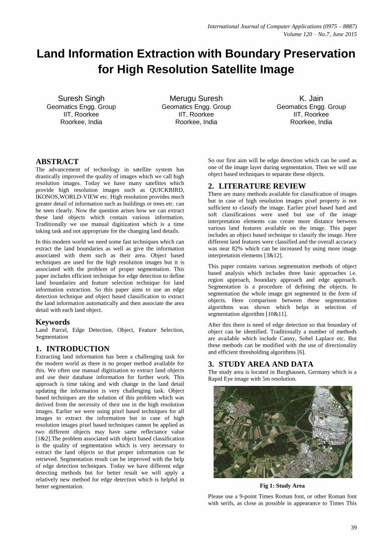
3. STUDY AREA AND DATA The study area is located in Burghausen, Germany which is a
Rapid Eye image with 5m resolution.
Fig 1: Study Area
Please use a 9-point Times Roman font, or other Roman font
with serifs, as close as possible in appearance to Times This

International Journal of Computer Applications (0975 – 8887)
Volume 120 – No.7, June 2015
40
image contains various details such as buildings, roads,
agricultural fields, forest area, river which we have to extract
with their proper boundary.
4. METHODOLOGY
4.1 Edge Detection Technique This is the most important part of the land information
extraction. Edge detection means to detect the pixel changing
boundaries [9&13].We have different methods available for
edge detection but in case of satellite images these techniques
are not very promising as land objects do not have very sharp
boundary[14]. So for better result we will use this new edge
detection algorithm which is written in MATLAB.
In this method we modify the Sobel operator. As we know
that Sobel operator only detect horizontal and vertical edges
and find the gradient by them but this is not the solution for
satellite images where we have effect of noise and texture
variation. So we detect gradient at horizontal, vertical, 450
and 1350 by using 5X5 mask
Fig 2: Mask for Edge Detection
So the highest gradient output will be selected and then we
use threshold value using Otsu algorithm [10]. We can see the
result by this method which will be used in further work.
4.2 Comparison of Result
(a) (b)
(c) (d)
(e) (f)
(g)
Fig 3: Edge Detection Results (A). Test Image (B). Canny
Edge Detection (C). Prewitt Edge Detection (D). Sobel
Edge Detection (E). Laplace Edge Detection (F). Modified
Method Edge Detection (G). Overall Edge Detection with
Modified Method
4.3 Object Based Analysis for Land Object
Definition Here we have used e-Cognition Developer 8.1 to define the
land objects. In first step we will merge the edge detection
result with the original image and then we will apply the
multiresolution segmentation with a scale to define the objects
boundary [5].
Fig.4 Land object boundary result after Segmentation
International Journal of Computer Applications (0975 – 8887)
Volume 120 – No.7, June 2015
41
Fig.5 Segmentation Result
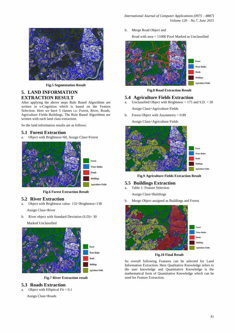
5. LAND INFORMATION
EXTRACTION RESULT After applying the above steps Rule Based Algorithms are
written in e-Cognition which is based on the Feature
Selection. Here we have 5 classes i.e. Forest, River, Roads,
Agriculture Fields Buildings. The Rule Based Algorithms are
written with each land class extraction.
So the land information results are as follows:
5.1 Forest Extraction a. Object with Brightness<60, Assign Class=Forest
Fig.6 Forest Extraction Result
5.2 River Extraction a. Object with Brightness value- 132<Brightness<138
Assign Class=River
b. River object with Standard Deviation (S.D)> 30
Marked Unclassified
Fig.7 River Extraction result
5.3 Roads Extraction a. Object with Elliptical Fit < 0.1
Assign Class=Roads
b. Merge Road Object and
Road with area < 11000 Pixel Marked as Unclassified
Fig.8 Road Extraction Result
5.4 Agriculture Fields Extraction a. Unclassified Object with Brightness < 175 and S.D. < 30
Assign Class=Agriculture Fields
b. Forest Object with Asymmetry > 0.89
Assign Class=Agriculture Fields
Fig.9 Agriculture Fields Extraction Result
5.5 Buildings Extraction a. Table 1: Feature Selection
Assign Class=Buildings
b. Merge Object assigned as Buildings and Forest
Fig.10 Final Result
So overall following Features can be selected for Land
Information Extraction. Here Qualitative Knowledge refers to
the user knowledge and Quantitative Knowledge is the
mathematical form of Quantitative Knowledge which can be
used for Feature Extraction.
International Journal of Computer Applications (0975 – 8887)
Volume 120 – No.7, June 2015
42
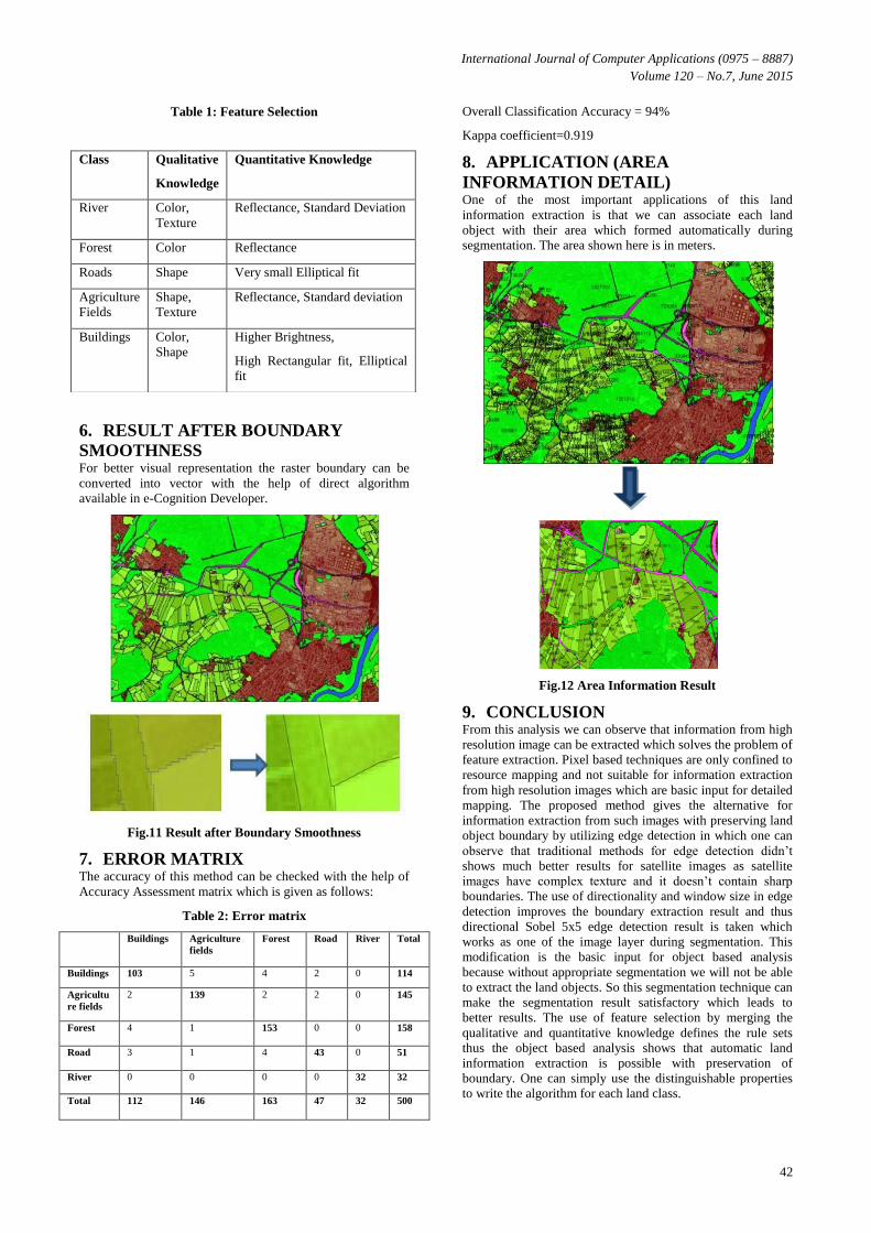
Table 1: Feature Selection
6. RESULT AFTER BOUNDARY
SMOOTHNESS For better visual representation the raster boundary can be
converted into vector with the help of direct algorithm
available in e-Cognition Developer.
Fig.11 Result after Boundary Smoothness
7. ERROR MATRIX The accuracy of this method can be checked with the help of
Accuracy Assessment matrix which is given as follows:
Table 2: Error matrix
Buildings Agriculture
fields
Forest Road River Total
Buildings 103 5 4 2 0 114
Agricultu
re fields
2 139 2 2 0 145
Forest 4 1 153 0 0 158
Road 3 1 4 43 0 51
River 0 0 0 0 32 32
Total 112 146 163 47 32 500
Overall Classification Accuracy = 94%
Kappa coefficient=0.919
8. APPLICATION (AREA
INFORMATION DETAIL) One of the most important applications of this land
information extraction is that we can associate each land
object with their area which formed automatically during
segmentation. The area shown here is in meters.
Fig.12 Area Information Result
9. CONCLUSION
From this analysis we can observe that information from high
resolution image can be extracted which solves the problem of
feature extraction. Pixel based techniques are only confined to
resource mapping and not suitable for information extraction
from high resolution images which are basic input for detailed
mapping. The proposed method gives the alternative for
information extraction from such images with preserving land
object boundary by utilizing edge detection in which one can
observe that traditional methods for edge detection didn’t
shows much better results for satellite images as satellite
images have complex texture and it doesn’t contain sharp
boundaries. The use of directionality and window size in edge
detection improves the boundary extraction result and thus
directional Sobel 5x5 edge detection result is taken which
works as one of the image layer during segmentation. This
modification is the basic input for object based analysis
because without appropriate segmentation we will not be able
to extract the land objects. So this segmentation technique can
make the segmentation result satisfactory which leads to
better results. The use of feature selection by merging the
qualitative and quantitative knowledge defines the rule sets
thus the object based analysis shows that automatic land
information extraction is possible with preservation of
boundary. One can simply use the distinguishable properties
to write the algorithm for each land class.
Class Qualitative
Knowledge
Quantitative Knowledge
River Color,
Texture
Reflectance, Standard Deviation
Forest Color Reflectance
Roads Shape Very small Elliptical fit
Agriculture
Fields
Shape,
Texture
Reflectance, Standard deviation
Buildings Color,
Shape
Higher Brightness,
High Rectangular fit, Elliptical
fit

International Journal of Computer Applications (0975 – 8887)
Volume 120 – No.7, June 2015
43
The future scope of the project is to minimize the computation
time for segmentation process with the help of efficient
parallel processing algorithms for fast execution and efficient
memory utilization. From this method a database can be
created for land records which can help different government
or private organization to access the information.
So overall we can say that this technique can be used as an
alternative of manual digitization which can use for detailed
mapping for high resolution images while preserving the
boundary of land objects and helps in fast information
retrieval.
10. REFERENCES [1] Anuj Tiwari, Merugu Suresh, Arun Kumar Rai, (2014),
Ecological Planning for Sustainable Development with a
Green Technology: GIS, International Journal of
Advanced Research in Computer Engineering &
Technology (IJARCET), Volume 3 Issue 3, March 2014,
ISSN: 2278 – 1323, pp 636-641.
[2] Arora S. Acharya J, Verma A, Panigrahi Prasanta K.
(2007), Multilevel thresholding for image
segmentation through a fast statistical recursive
algorithm, Indian Institute of Technology, Kharagpur
721 302, Indiac Physical Research Laboratory,
Navrangpura, Ahmedabad 380 009, India.
[3] Belgiu Mariana, Lampoltshammer Thomas J.
(2013),Ontology based interpretation of very high
resolution imageries grounding ontology on visual
interpretation keys, Salzburg Department of
Geoinformatics Schillerstrasse 30, 5020 Salzburg,
Austria.
[4] Bouziani Mourad, Goita Kalifa (2010), Rule-Based
Classification of a High Resolution Image in an Urban
Environment Using Multispectral Segmentation Guided
by Cartographic Data, IEEE transactions on geoscience
and remote sensing, vol. 48, no. 8.
[5] Cleve Casey, Kelly Maggi, Kearns Faith R., Moritz Max
(2007), Classification of the wildland–urban interface: A
comparison of pixel- and object-based classifications
using high-resolution aerial photography, Center for Fire
Research and Outreach, University of California,
Berkeley, 137 Mulford Hall #3114, Berkeley, CA 94720,
United States.
[6] Caetano Mario (2009), Image classification, Department
of Geology,University of Prague,Czech Republic.
[7] G.T. Shrivakshan (September 2012), A Comparison of
various Edge Detection Techniques used in Image
Processing, Bharathiar University, Coimbatore,
Tamilnadu, India, IJCSI International Journal of
Computer Science Issues, Vol. 9, Issue 5, No 1.
[8] Jabari Shabnam and Zhang Yun (2013), Very High
Resolution Satellite Image Classification Using Fuzzy
Rule-Based Systems, Department of Geodesy and
Geomatics Engineering, University of New Brunswick,
15 Dineen Drive, Fredericton, NB E3B 5A3, Canada.
[9] Karlsson Anders (2003),Classifcation of high resolution
satellite images, Chalmers University of Technology SE-
412 96 GAoteborg, Sweden.
[10] Lu D. and Weng Q. (2006), A survey of image
classification methods and techniques for improving
classification performance, Department of Geography,
Geology, and Anthropology, Indiana State University,
Terre Haute, IN 47809, USA.
[11] Merugu Suresh, Kamal Jain, (2014), A Review of Some
Information Extraction Methods, Techniques and their
Limitations for Hyperspectral Dataset International
Journal of Advanced Research in Computer Engineering
& Technology (IJARCET), Volume 3 Issue 3, March
2014, ISSN: 2278 – 1323, pp 2394-2400.
[12] Merugu Suresh, Kamal Jain, (2013) Sub Pixel Analysis
on Hypothetical Image by using Colorimetry,
International Journal of Recent Technology and
Engineering(IJRTE), ISSN: 2277-3878,Volume 2, Issue-
4, September 2013.
[13] Merugu Suresh, Kamal Jain, (2013), Colorimetrically
Resolution Enhancement Method for Satellite Imagery to
Improve Land Use, 14th ESRI User Conference id:
UCP0046, New Delhi, India, 11-12th Dec, 2013.
[14] Merugu Suresh, Kamal Jain, (2014), A New Super
Resolution Mapping Algorithm by Combining Pixel and
Subpixel-Level Spatial Dependences with Colorimetry,
Journal of Indian Society of Remote Sensing (ISRS),
10/2014; 42(4):10, Springer.
[15] Narkhede H.P. (2013), Review of Image Segmentation
Techniques, International Journal of Science and Modern
Engineering (IJISME) ISSN: 2319-6386, Volume-1,
Issue-8.
[16] Syed Sohel, Dare Paul, Jones Simon (2003), Automatic
classification of land cover features with high resolution
imagery and lidar data: an object-oriented approach, The
university of California,USA.
[17] Vala Hetal J., Baxi Astha (February 2013), A Review on
Otsu Image Segmentation Algorithm, Department of
Computer Engineering Parul Institute of Engineering &
Technology, Waghodia, Gujarat (India). International
Journal of Advanced Research in Computer Engineering
& Technology (IJARCET) Volume 2, Issue 2.
IJCATM : www.ijcaonline.org


![Alveolar Ridge Preservation after Tooth Extraction Using ... · ridge resorption rate and bone remodelling after tooth extraction [15]. Autogenous bone as bone graft material is still](https://img.pdfslide.us/doc/110x75/5ed57c6a0bd3843450408daa/alveolar-ridge-preservation-after-tooth-extraction-using-ridge-resorption-rate.jpg)