Embed Size (px)
Citation preview

B.4
M E M O R A N D U M To: Senator Larry Teague Representative Lane Jean From: Lisa Pelton, Director of Real Estate Commissioner of State Lands Office RE: Deed Report Date: February 11, 2019 Pursuant to A.C.A. Annotated Section 26-37-202 (b)(3), attached please find the deed report for the property sold by the Commissioner of State Lands office from October 2018 through December 2018. These properties are ones that were not sold at the public auction and were subsequently sold through our post auction sale process. This report is sent quarterly. If you have any questions or need anything further, please let me know.

State of Arkansas
Commissioner of State Lands
Thursday, January 31, 2019
Limited Warranty Deeds Report10/1/2018 to 12/31/2018
ARKANSAS County
Code - Year Parcel Number Deed Name:County
$80.00
Taxes:
SIDTaxes:
Interest:
County Costs:
Municipal Liens:
Total:
Deed Date:
Deed #:
Years Collected:
Legal Description: Penalty:
State Costs:
7-10 2008 074-04064-000 VARELA'S INVESTMENTS, LLC
164 MENDON AVE.
PAWTUCKET, RI 02861
LOT 7 & N1/2 OF LOT 8 Section: Township: Range: Acreage: Lot: Block: 34 City: STUTTGART Addition: REINSCHS SD: 22C C
2008 - 2017
20.00
0.00
5.94
2.00
49.06
3.00
0.00
10/17/2018
ARKA
196153
$31.00
Taxes:
SIDTaxes:
Interest:
County Costs:
Municipal Liens:
Total:
Deed Date:
Deed #:
Years Collected:
Legal Description: Penalty:
State Costs:
7-9 2005 074-04275-000 C53 LAND TRUST, C/O ERIC HERM, TRUSTEE, DATED APRIL 17, 2017
PO BOX 881655
PORT ST LUCIE, FL 34988
. Section: Township: Range: Acreage: 0 Lot: 22 Block: 7 City: STUTTGART Addition: ROCK ISLAND SD: 22C C
2005 - 2017
0.00
0.00
0.00
0.00
28.00
3.00
0.00
12/20/2018
ARKA
197509
$31.00
Taxes:
SIDTaxes:
Interest:
County Costs:
Municipal Liens:
Total:
Deed Date:
Deed #:
Years Collected:
Legal Description: Penalty:
State Costs:
8-11 2010 074-02468-000 CHEAP HOME FINDERS, INC.
PO BOX 881655
PORT ST LUCIE, FL 34988
W90' LOT 07 (AKA LOT 12 PER REVISED PLAT) REVISED PLAT E-5 PAGE 6 Section: Township: Range: Acreage: Lot: Block: 7 City:
STUTTGART Addition: IMPROVEMENT CO 3RD SD: 22C C
2010 - 2017
0.00
0.00
0.00
0.00
28.00
3.00
0.00
12/20/2018
ARKA
197510
Page 1 of 587

State of Arkansas
Commissioner of State Lands
Thursday, January 31, 2019
Limited Warranty Deeds Report10/1/2018 to 12/31/2018
Totals for ARKANSAS County (3 ):
Interest:
SIDTaxes:
Taxes:
142.00
Penalty:
20.00
0.00
5.94
2.00
105.06
9.00
0.00
Total:
Municipal Liens:
County Costs:
State Costs:
Page 2 of 587

State of Arkansas
Commissioner of State Lands
Thursday, January 31, 2019
Limited Warranty Deeds Report10/1/2018 to 12/31/2018
ASHLEY County
Code - Year Parcel Number Deed Name:County
$30.00
Taxes:
SIDTaxes:
Interest:
County Costs:
Municipal Liens:
Total:
Deed Date:
Deed #:
Years Collected:
Legal Description: Penalty:
State Costs:
13-5 2011 001-10337-000 PROFESSIONAL HOUSING & LAND, LLC
75 N WOODWARD AVE #81956
TALLAHASSEE, FL 32313
PT. N1/2 NW1/4 NE1/4; BEGINNING AT A POINT 105 YARDS WEST OF THE SE CORNER OF SAID N1/2 NW1/4 NE1/4 AND RUN NORTH 70
YARDS, THENCE RUN WEST 35 YARDS, THENCE RUN SOUTH 70 YARDS, THENCE RUN EAST 35 YARDS TO THE POB Section: 24 Township: 18S
Range: 09W Acreage: 0.50 Lot: Block: City: Addition: RURAL METES & BOUNDS SD: CR
2011 - 2017
0.00
0.00
0.00
0.00
26.00
4.00
0.00
10/17/2018
ASHL
196154
$36.00
Taxes:
SIDTaxes:
Interest:
County Costs:
Municipal Liens:
Total:
Deed Date:
Deed #:
Years Collected:
Legal Description: Penalty:
State Costs:
16-11 2011 702-00073-000 CHEAP HOME FINDERS, INC.
PO BOX 881655
PORT ST LUCIE, FL 34988
(INCL TRACTS) Section: 19 Township: 18S Range: 04W Acreage: 0.26 Lot: 002 Block: 005 City: PARKDALE Addition: RICHARDSON'S SURVEY
SD: PAC
2011 - 2017
0.00
0.00
0.00
0.00
32.00
4.00
0.00
10/23/2018
ASHL
196343
$639.80
Taxes:
SIDTaxes:
Interest:
County Costs:
Municipal Liens:
Total:
Deed Date:
Deed #:
Years Collected:
Legal Description: Penalty:
State Costs:
2-5 2013 001-01341-000 GLENN LAWSON OR CAROLYN LAWSON
630 SAVAGE ST
HAMBURG, AR 71646
RURAL METES AND BOUNDS Section: 20 Township: 16S Range: 05W Acreage: 0.5 Lot: Block: City: Addition: SD: PO
2013 - 2017
376.65
0.00
49.78
37.67
171.70
4.00
0.00
10/23/2018
ASHL
196344
Page 3 of 587

State of Arkansas
Commissioner of State Lands
Thursday, January 31, 2019
Limited Warranty Deeds Report10/1/2018 to 12/31/2018
ASHLEY County
Code - Year Parcel Number Deed Name:County
$55.00
Taxes:
SIDTaxes:
Interest:
County Costs:
Municipal Liens:
Total:
Deed Date:
Deed #:
Years Collected:
Legal Description: Penalty:
State Costs:
11-5 2007 705-00220-000 ABW AUCTIONS, LLC
13400 S ROUTE 59 STE 116-226
PLAINFIELD, IL 60585
SIMPSON'S S/D BUNN'S SURVEY PT LOT 2 A PARCEL OF LAND IN THE NW1/4 NW1/4 SEC. 14, TWP. 17 S. RANGE 7 WEST, DESCRIBED AS
FOLLOWS: COMMENCING AT A POINT 908 FT. NORTH OF SW CORNER OF NW1/4 NW1/4 THENCE GO EAST 140 YDS. FOR THE POINT OF
BEGINNING; THENCE NORTH 100 FT. THENCE WEST 100 FT. THENCE SOUTH 100 FT. THENCE EAST 100 FT. BACK TO THE POINT OF
BEGINNING. Section: 14 Township: 17S Range: 7W Acreage: 0.23 Lot: Block: 3 City: HAMBURG Addition: SIMPSON'S SD: HAC
2007 - 2017
0.00
0.00
0.00
0.00
52.00
3.00
0.00
10/30/2018
ASHL
196484
$60.00
Taxes:
SIDTaxes:
Interest:
County Costs:
Municipal Liens:
Total:
Deed Date:
Deed #:
Years Collected:
Legal Description: Penalty:
State Costs:
10-10 2007 703-00489-000 ABW AUCTIONS, LLC
13400 S ROUTE 59 STE 116-226
PLAINFIELD, IL 60585
WILMOT UNPLATTED PT NW1/4 NW1/4 NE1/4 Section: 13 Township: 19S Range: 5W Acreage: 0.25 Lot: Block: City: Addition: SD: WIC
2007 - 2017
2.00
0.00
0.31
0.20
54.49
3.00
0.00
10/30/2018
ASHL
196485
$60.00
Taxes:
SIDTaxes:
Interest:
County Costs:
Municipal Liens:
Total:
Deed Date:
Deed #:
Years Collected:
Legal Description: Penalty:
State Costs:
9-6 2008 703-00264-001 ABW AUCTIONS, LLC
13400 S ROUTE 59 STE 116-226
PLAINFIELD, IL 60585
CONSISTING OF A PARCEL 60' WIDE, NORTH & SOUTH AND 180' DEEP EAST & WEST Section: 12 Township: 19S Range: 05W Acreage: 0.38
Lot: Block: 1 City: WILMOT Addition: PARKER'S SD: WIC
2008 - 2017
7.50
0.00
0.84
0.75
47.91
3.00
0.00
10/30/2018
ASHL
196486
Page 4 of 587

State of Arkansas
Commissioner of State Lands
Thursday, January 31, 2019
Limited Warranty Deeds Report10/1/2018 to 12/31/2018
ASHLEY County
Code - Year Parcel Number Deed Name:County
$55.00
Taxes:
SIDTaxes:
Interest:
County Costs:
Municipal Liens:
Total:
Deed Date:
Deed #:
Years Collected:
Legal Description: Penalty:
State Costs:
6-5 2008 001-10008-000 ABW AUCTIONS, LLC
13400 S ROUTE 59 STE 116-226
PLAINFIELD, IL 60585
RURAL METES AND BOUNDS PT NW1/4 NE1/4 A PARCEL IN NW1/4 NE1/4 START AT SW CORNER & RUN NORTH 220 YARDS. EAST 121 YARDS
TO P.O.B. THENCE NORTH 40 FEET, EAST 120 FEET, SOUTH 40 FEET, WEST 120 FEET TO P.O.B. Section: 14 Township: 18S Range: 09W
Acreage: 0.25 Lot: Block: City: Addition: SD: CR
2008 - 2017
3.00
0.00
0.79
0.30
47.91
3.00
0.00
10/30/2018
ASHL
196487
$55.00
Taxes:
SIDTaxes:
Interest:
County Costs:
Municipal Liens:
Total:
Deed Date:
Deed #:
Years Collected:
Legal Description: Penalty:
State Costs:
14-4 2008 706-01910-001 ABW AUCTIONS, LLC
13400 S ROUTE 59 STE 116-226
PLAINFIELD, IL 60585
PT LOT 8 BEGINNING AT THE NORTHEAST CORNER OF SAID LOT 8 ON THE EAST BOUNDARY OF MISSISSIPPI STREET, RUN IN A
SOUTHEASTERLY DIRECTION ALONG THE EAST BOUNDARY OF SAID LOT 8; THENCE RUN IN A SOUTHWESTERLY DIRECTION ALONG THE
SOUTH BOUNDARY OF SAID LOT 8 A DISTANCE OF 44.9 FEET TO A FENCE; THENCE RUN IN A NORTHWESTERLY DIRECTION ALONG SAID
FENCE A DISTANCE OF 159.0 FEET, BACK TO THE POB, CONTAINING 3570 SQ. FT., MORE OR LESS Section: 30 Township: 18S Range: 08W
Acreage: 0.11 Lot: Block: 17 City: CROSSETT Addition: OAKHURST SD: CRC
2008 - 2017
0.00
0.00
0.00
0.00
52.00
3.00
0.00
10/30/2018
ASHL
196488
$60.00
Taxes:
SIDTaxes:
Interest:
County Costs:
Municipal Liens:
Total:
Deed Date:
Deed #:
Years Collected:
Legal Description: Penalty:
State Costs:
11-5 2010 706-00347-000 ABW AUCTIONS, LLC
13400 S ROUTE 59 STE 116-226
PLAINFIELD, IL 60585
OAKHURST A Section: 30 Township: 18S Range: 8W Acreage: 0.31 Lot: 3 Block: 16 City: Addition: OAKHURST SD: CRC
2010 - 2017
0.00
0.00
0.00
0.00
57.00
3.00
0.00
10/30/2018
ASHL
196489
Page 5 of 587

State of Arkansas
Commissioner of State Lands
Thursday, January 31, 2019
Limited Warranty Deeds Report10/1/2018 to 12/31/2018
ASHLEY County
Code - Year Parcel Number Deed Name:County
$328.84
Taxes:
SIDTaxes:
Interest:
County Costs:
Municipal Liens:
Total:
Deed Date:
Deed #:
Years Collected:
Legal Description: Penalty:
State Costs:
16-10 2011 702-00072-000 GEORGIA MORRIS
PO BOX 175
PARKDALE, AR 71661
(INCL TRACTS) Section: 19 Township: 18S Range: 04W Acreage: 0.206 Lot: 1 Block: 5 City: PARKDALE Addition: RICHARDSON'S SURVEY SD:
PAC
2011 - 2017
100.38
0.00
28.82
10.04
185.60
4.00
0.00
11/06/2018
ASHL
196647
$80.00
Taxes:
SIDTaxes:
Interest:
County Costs:
Municipal Liens:
Total:
Deed Date:
Deed #:
Years Collected:
Legal Description: Penalty:
State Costs:
13-4 2011 001-10192-000 CAROLYN HARRIS
138 YATES
CROSSETT, AR 71635
PT. N1/2 SW1/4 SW1/4 SE1/4; STARTING AT THE SW CORNER OF SAID N1/2 SW1/4 SW1/4 SE1/4, THENCE RUNNING NORTH FOR 66 FT. TO
THE POB, THENCE CONTINUE NORTH FOR 66 FT., THENCE RUN EAST FOR 330 FT., THENCE RUN SOUTH FOR 66 FT., THENCE RUN WEST FOR
330 FT. BACK TO THE POB Section: 14 Township: 18S Range: 09W Acreage: 0.5 Lot: Block: City: Addition: RURAL METES AND BOUND SD:
CR
2011 - 2017
25.00
0.00
4.60
2.50
43.90
4.00
0.00
11/13/2018
ASHL
196716
$80.00
Taxes:
SIDTaxes:
Interest:
County Costs:
Municipal Liens:
Total:
Deed Date:
Deed #:
Years Collected:
Legal Description: Penalty:
State Costs:
20-4 2011 705-01057-000 CAROLYN HARRIS
138 YATES
CROSSETT, AR 71635
SURVEY PT LOT 4 STARTING AT THE CENTER OF WEST LINCOLN ST. AND RUN SOUTHWESTERLY ALONG THE EAST EDGE OF THE UNNAMED ST
340 FEET; THENCE RUN EAST 60 FEET ALONG THE NORTH BOUNDARY OF A 28 FOOT ALLEY OR STREET THENCE RUN SOUTH 28 FEET TO THE
POB THENCE RUN EAST 210 FEET THENCE RUN SOUTH 145 FEET THENCE RUN WEST 210 FEET THENCE RUN NORTH 145 FEET BACK TO THE
POB SAID PART BEING LOTS 11, 12, AND 13 OF THE F.W. CARPENTER SUB DIV OF LOT 4 BLOCK 53 BUNN'S Section: 15 Township: 17S Range:
07W Acreage: 0.699 Lot: Block: 053 City: HAMBURG Addition: BUNN'S SURVEY F SD: HAC
2011 - 2017
25.00
0.00
4.60
2.50
43.90
4.00
0.00
11/13/2018
ASHL
196717
Page 6 of 587

State of Arkansas
Commissioner of State Lands
Thursday, January 31, 2019
Limited Warranty Deeds Report10/1/2018 to 12/31/2018
ASHLEY County
Code - Year Parcel Number Deed Name:County
$85.00
Taxes:
SIDTaxes:
Interest:
County Costs:
Municipal Liens:
Total:
Deed Date:
Deed #:
Years Collected:
Legal Description: Penalty:
State Costs:
22-5 2011 706-01738-000 CAROLYN HARRIS
138 YATES
CROSSETT, AR 71635
ADJACENT TO LOT 12 NO LEGAL Section: 19 Township: 18S Range: 08W Acreage: 0.31 Lot: Block: 4 City: CROSSETT Addition: OAKHURST A
SD: CRC
2011 - 2017
30.00
0.00
4.10
3.00
43.90
4.00
0.00
11/13/2018
ASHL
196718
Totals for ASHLEY County (13 ):
Interest:
SIDTaxes:
Taxes:
1,624.64
Penalty:
569.53
0.00
93.84
56.96
858.31
46.00
0.00
Total:
Municipal Liens:
County Costs:
State Costs:
Page 7 of 587

State of Arkansas
Commissioner of State Lands
Thursday, January 31, 2019
Limited Warranty Deeds Report10/1/2018 to 12/31/2018
BAXTER County
Code - Year Parcel Number Deed Name:County
$241.22
Taxes:
SIDTaxes:
Interest:
County Costs:
Municipal Liens:
Total:
Deed Date:
Deed #:
Years Collected:
Legal Description: Penalty:
State Costs:
11-1 2011 002-07252-000 KELLIE C. BLAKE
701 ELM ST
PARAGOULD, AR 72450
NLE Section: 19 Township: 20N Range: 11W Acreage: 0 Lot: 1 Block: 5 City: Addition: FOREST HILLS SD: 09R
2011 - 2016
46.38
0.00
15.24
4.64
170.96
4.00
0.00
10/03/2018
BAXT
196028
$30.00
Taxes:
SIDTaxes:
Interest:
County Costs:
Municipal Liens:
Total:
Deed Date:
Deed #:
Years Collected:
Legal Description: Penalty:
State Costs:
7-1 2010 002-03272-000 Y BAR K, LLC
442 COUNTY ROAD 457
CARTHAGE, TX 75633
. Section: 20 Township: 20N Range: 12W Acreage: Lot: 19 Block: 2 City: Addition: DOGWOOD PARK 1 SD: 09R
2010 - 2017
0.00
0.00
0.00
0.00
27.00
3.00
0.00
10/17/2018
BAXT
196155
$332.79
Taxes:
SIDTaxes:
Interest:
County Costs:
Municipal Liens:
Total:
Deed Date:
Deed #:
Years Collected:
Legal Description: Penalty:
State Costs:
8-4 2011 002-03746-000 CHRISTOPHER J. BARNES AND CAMELLIA M. BARNES
310 NE 5TH ST
WALNUT RIDGE, AR 72476
. Section: 30 Township: 20N Range: 12W Acreage: 0 Lot: 10 Block: C City: Addition: DOGWOOD PARK 4 SD: 09R
2011 - 2017
104.01
0.00
22.57
10.40
191.81
4.00
0.00
11/06/2018
BAXT
196648
Page 8 of 587

State of Arkansas
Commissioner of State Lands
Thursday, January 31, 2019
Limited Warranty Deeds Report10/1/2018 to 12/31/2018
BAXTER County
Code - Year Parcel Number Deed Name:County
$105.00
Taxes:
SIDTaxes:
Interest:
County Costs:
Municipal Liens:
Total:
Deed Date:
Deed #:
Years Collected:
Legal Description: Penalty:
State Costs:
16-5 2011 002-10881-000 VANCE HYMES
PO BOX 1155
LONG BEACH, CA 90802
LOT PT 3, PT 7 Section: 30 Township: 20N Range: 14W Acreage: 0 Lot: Block: B City: Addition: WUNDERLAND ESTATES SD: 09R
2011 - 2017
15.00
0.00
6.59
1.50
77.91
4.00
0.00
11/15/2018
BAXT
196809
$51.00
Taxes:
SIDTaxes:
Interest:
County Costs:
Municipal Liens:
Total:
Deed Date:
Deed #:
Years Collected:
Legal Description: Penalty:
State Costs:
7-5 2011 002-03089-000 B42 LAND TRUST, C/O ERIC HERM, TRUSTEE, DATED APRIL 17, 2017
PO BOX 881655
PORT ST LUCIE, FL 34988
. Section: 22 Township: 20N Range: 14W Acreage: 0 Lot: 3 Block: 2 City: Addition: COUNTRY LIFE MOBILE PK 1 SD: 09R
2011 - 2017
0.00
0.00
0.00
0.00
47.00
4.00
0.00
11/15/2018
BAXT
196810
$31.00
Taxes:
SIDTaxes:
Interest:
County Costs:
Municipal Liens:
Total:
Deed Date:
Deed #:
Years Collected:
Legal Description: Penalty:
State Costs:
1-2 2011 001-00201-000 CHEAP HOME FINDERS, INC.
PO BOX 881655
PORT ST LUCIE, FL 34988
PT NW1/4 NW1/4 Section: 19 Township: 18N Range: 11W Acreage: 1.89 Lot: Block: City: Addition: SD: 61R
2011 - 2017
0.00
0.00
0.00
0.00
27.00
4.00
0.00
11/15/2018
BAXT
196811
Page 9 of 587
State of Arkansas
Commissioner of State Lands
Thursday, January 31, 2019
Limited Warranty Deeds Report10/1/2018 to 12/31/2018
BAXTER County
Code - Year Parcel Number Deed Name:County
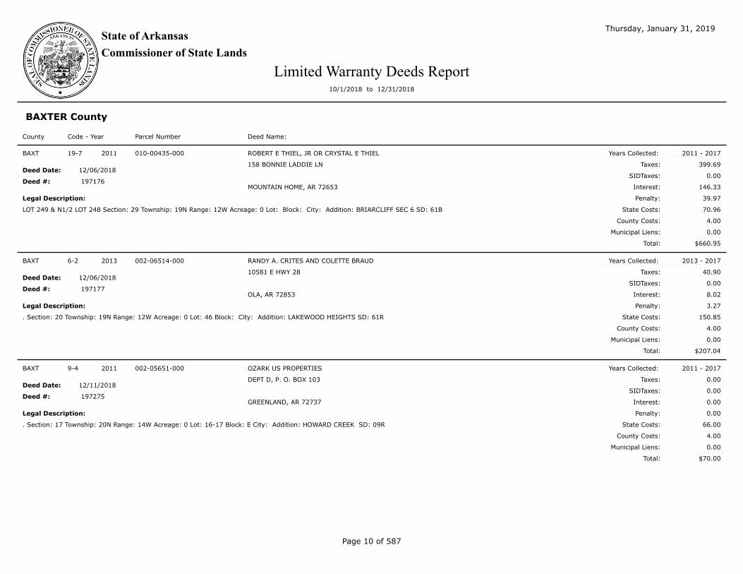
$660.95
Taxes:
SIDTaxes:
Interest:
County Costs:
Municipal Liens:
Total:
Deed Date:
Deed #:
Years Collected:
Legal Description: Penalty:
State Costs:
19-7 2011 010-00435-000 ROBERT E THIEL, JR OR CRYSTAL E THIEL
158 BONNIE LADDIE LN
MOUNTAIN HOME, AR 72653
LOT 249 & N1/2 LOT 248 Section: 29 Township: 19N Range: 12W Acreage: 0 Lot: Block: City: Addition: BRIARCLIFF SEC 6 SD: 61B
2011 - 2017
399.69
0.00
146.33
39.97
70.96
4.00
0.00
12/06/2018
BAXT
197176
$207.04
Taxes:
SIDTaxes:
Interest:
County Costs:
Municipal Liens:
Total:
Deed Date:
Deed #:
Years Collected:
Legal Description: Penalty:
State Costs:
6-2 2013 002-06514-000 RANDY A. CRITES AND COLETTE BRAUD
10581 E HWY 28
OLA, AR 72853
. Section: 20 Township: 19N Range: 12W Acreage: 0 Lot: 46 Block: City: Addition: LAKEWOOD HEIGHTS SD: 61R
2013 - 2017
40.90
0.00
8.02
3.27
150.85
4.00
0.00
12/06/2018
BAXT
197177
$70.00
Taxes:
SIDTaxes:
Interest:
County Costs:
Municipal Liens:
Total:
Deed Date:
Deed #:
Years Collected:
Legal Description: Penalty:
State Costs:
9-4 2011 002-05651-000 OZARK US PROPERTIES
DEPT D, P. O. BOX 103
GREENLAND, AR 72737
. Section: 17 Township: 20N Range: 14W Acreage: 0 Lot: 16-17 Block: E City: Addition: HOWARD CREEK SD: 09R
2011 - 2017
0.00
0.00
0.00
0.00
66.00
4.00
0.00
12/11/2018
BAXT
197275
Page 10 of 587

State of Arkansas
Commissioner of State Lands
Thursday, January 31, 2019
Limited Warranty Deeds Report10/1/2018 to 12/31/2018
BAXTER County
Code - Year Parcel Number Deed Name:County
$80.00
Taxes:
SIDTaxes:
Interest:
County Costs:
Municipal Liens:
Total:
Deed Date:
Deed #:
Years Collected:
Legal Description: Penalty:
State Costs:
8-1 2011 002-03472-000 US PRIVATE LENDERS, LLC
2230 ALLEN RD
MACON, GA 31216
. Section: 20 Township: 20N Range: 12W Acreage: 0 Lot: 30-32 Block: 3 City: Addition: DOGWOOD PARK 2 SD: 09R
2011 - 2017
15.00
0.00
2.44
1.50
57.06
4.00
0.00
12/27/2018
BAXT
197593
$80.00
Taxes:
SIDTaxes:
Interest:
County Costs:
Municipal Liens:
Total:
Deed Date:
Deed #:
Years Collected:
Legal Description: Penalty:
State Costs:
21-6 2011 010-00881-000 US PRIVATE LENDERS, LLC
2230 ALLEN RD
MACON, GA 31216
. Section: 32 Township: 19N Range: 12W Acreage: 0 Lot: 281-283 Block: City: Addition: BRIARCLIFF SEC 8 SD: 61B
2011 - 2017
0.00
0.00
0.00
0.00
76.00
4.00
0.00
12/27/2018
BAXT
197594
$90.00
Taxes:
SIDTaxes:
Interest:
County Costs:
Municipal Liens:
Total:
Deed Date:
Deed #:
Years Collected:
Legal Description: Penalty:
State Costs:
26-1 2012 010-01065-000 US PRIVATE LENDERS, LLC
2230 ALLEN RD
MACON, GA 31216
. Section: 32 Township: 19N Range: 12W Acreage: 0 Lot: 185 Block: City: Addition: BRIARCLIFF SEC 9 SD: 61B
2012 - 2017
27.54
0.00
4.86
2.75
50.85
4.00
0.00
12/27/2018
BAXT
197595
Page 11 of 587

State of Arkansas
Commissioner of State Lands
Thursday, January 31, 2019
Limited Warranty Deeds Report10/1/2018 to 12/31/2018
BAXTER County
Code - Year Parcel Number Deed Name:County
$75.00
Taxes:
SIDTaxes:
Interest:
County Costs:
Municipal Liens:
Total:
Deed Date:
Deed #:
Years Collected:
Legal Description: Penalty:
State Costs:
29-4 2012 010-02495-000 US PRIVATE LENDERS, LLC
2230 ALLEN RD
MACON, GA 31216
. Section: 04 Township: 18N Range: 12W Acreage: 0 Lot: 326 Block: City: Addition: BRIARCLIFF SEC 16 SD: 61B
2012 - 2017
27.54
0.00
3.76
2.75
36.95
4.00
0.00
12/27/2018
BAXT
197596
$80.00
Taxes:
SIDTaxes:
Interest:
County Costs:
Municipal Liens:
Total:
Deed Date:
Deed #:
Years Collected:
Legal Description: Penalty:
State Costs:
30-4 2012 010-02530-000 US PRIVATE LENDERS, LLC
2230 ALLEN RD
MACON, GA 31216
. Section: 04 Township: 18N Range: 12W Acreage: 0 Lot: 374 Block: City: Addition: BRIARCLIFF SEC 16 SD: 61B
2012 - 2017
27.54
0.00
6.85
2.75
38.86
4.00
0.00
12/27/2018
BAXT
197597
$75.00
Taxes:
SIDTaxes:
Interest:
County Costs:
Municipal Liens:
Total:
Deed Date:
Deed #:
Years Collected:
Legal Description: Penalty:
State Costs:
31-6 2012 010-05598-000 US PRIVATE LENDERS, LLC
2230 ALLEN RD
MACON, GA 31216
. Section: 29 Township: 19N Range: 12W Acreage: 0 Lot: 18 Block: City: Addition: HOLIDAY HILLS EST 5 MOBILE HOM SD: 61B
2012 - 2017
27.54
0.00
6.85
2.75
33.86
4.00
0.00
12/27/2018
BAXT
197598
Page 12 of 587

State of Arkansas
Commissioner of State Lands
Thursday, January 31, 2019
Limited Warranty Deeds Report10/1/2018 to 12/31/2018
Totals for BAXTER County (15 ):
Interest:
SIDTaxes:
Taxes:
2,209.00
Penalty:
731.14
0.00
223.51
72.28
1,123.07
59.00
0.00
Total:
Municipal Liens:
County Costs:
State Costs:
Page 13 of 587

State of Arkansas
Commissioner of State Lands
Thursday, January 31, 2019
Limited Warranty Deeds Report10/1/2018 to 12/31/2018
BENTON County
Code - Year Parcel Number Deed Name:County
$195.26
Taxes:
SIDTaxes:
Interest:
County Costs:
Municipal Liens:
Total:
Deed Date:
Deed #:
Years Collected:
Legal Description: Penalty:
State Costs:
75-1 2013 16-06926-000 RYAN GLENN AND MARANDA GLENN
4807 TRAILS END LANE
FAYETTEVILLE, AR 72764
. Section: 09 Township: 20N Range: 31W Acreage: 1.79 Lot: 98 Block: 4 City: BELLA VISTA VILLAGE Addition: CARDIGAN SD: CBV6
2013 - 2017
123.71
0.00
20.99
9.61
36.95
4.00
0.00
10/17/2018
BENT
196156
$121.47
Taxes:
SIDTaxes:
Interest:
County Costs:
Municipal Liens:
Total:
Deed Date:
Deed #:
Years Collected:
Legal Description: Penalty:
State Costs:
31-4 2012 15-70062-000 NIKOLAY NEDKOV
706 EARLS CT
BENTONVILLE, AR 72712
PT OF 23-25 Section: 1 Township: 20N Range: 31W Acreage: 0.36 Lot: Block: 5 City: Addition: BELLA VISTA ORIG-RURBAN SD: 6
2012 - 2017
66.90
0.00
15.01
5.56
30.00
4.00
0.00
10/17/2018
BENT
196205
$85.00
Taxes:
SIDTaxes:
Interest:
County Costs:
Municipal Liens:
Total:
Deed Date:
Deed #:
Years Collected:
Legal Description: Penalty:
State Costs:
25-4 2011 15-05806-000 WAYNE E. BOLLMAN
1203 ALMA DR.
ALMA, AR 72921
PT LOT 10 Section: 21 Township: 20N Range: 34W Acreage: Lot: Block: 1 City: RURBAN Addition: MAYSVILLE ORIG REVISED SD: 20
2011 - 2017
20.00
0.00
2.94
2.00
57.06
3.00
0.00
10/17/2018
BENT
196206
Page 14 of 587

State of Arkansas
Commissioner of State Lands
Thursday, January 31, 2019
Limited Warranty Deeds Report10/1/2018 to 12/31/2018
BENTON County
Code - Year Parcel Number Deed Name:County
$60.00
Taxes:
SIDTaxes:
Interest:
County Costs:
Municipal Liens:
Total:
Deed Date:
Deed #:
Years Collected:
Legal Description: Penalty:
State Costs:
63-1 2013 16-04280-000 DAVID HONER
306 W CLEVELAND, A6
PRAIRIE GROVE, AR 72753
. Section: 30 Township: 21N Range: 30W Acreage: 0.31 Lot: 18 Block: 5 City: BELLA VISTA VILLAGE Addition: BERKSHIRE SD: CBV6
2013 - 2017
4.00
0.00
0.75
0.40
50.85
4.00
0.00
10/17/2018
BENT
196207
$188.40
Taxes:
SIDTaxes:
Interest:
County Costs:
Municipal Liens:
Total:
Deed Date:
Deed #:
Years Collected:
Legal Description: Penalty:
State Costs:
95-7 2012 16-27879-000 RON SMITH`S SCHOLAR MINISTRIES
PO BOX 5640
BELLA VISTA, AR 72714
. Section: 13 Township: 21N Range: 32W Acreage: 0.36 Lot: 20 Block: 8 City: BELLA VISTA VILLAGE Addition: SELKIRK SD: CBV20
2012 - 2017
116.36
0.00
18.45
11.64
37.95
4.00
0.00
10/22/2018
BENT
196267
$437.98
Taxes:
SIDTaxes:
Interest:
County Costs:
Municipal Liens:
Total:
Deed Date:
Deed #:
Years Collected:
Legal Description: Penalty:
State Costs:
117-7 2013 16-16497-000 PAUL R. NORRIS
101 SOUTH SCHILLER ST
LITTLE ROCK, AR 72205
. Section: 34 Township: 21N Range: 31W Acreage: 0.68 Lot: 21 Block: 1 City: BELLA VISTA VILLAGE Addition: KENSINGTON SD: CBV6
2013 - 2017
324.07
0.00
40.55
32.41
36.95
4.00
0.00
10/24/2018
BENT
196399
Page 15 of 587

State of Arkansas
Commissioner of State Lands
Thursday, January 31, 2019
Limited Warranty Deeds Report10/1/2018 to 12/31/2018
BENTON County
Code - Year Parcel Number Deed Name:County
$60.00
Taxes:
SIDTaxes:
Interest:
County Costs:
Municipal Liens:
Total:
Deed Date:
Deed #:
Years Collected:
Legal Description: Penalty:
State Costs:
78-2 2011 16-32515-000 ABW AUCTIONS, LLC
13400 S ROUTE 59 STE 116-226
PLAINFIELD, IL 60585
. Section: 36 Township: 21N Range: 32W Acreage: 0.27 Lot: 12 Block: 7 City: BELLA VISTA VILLAGE Addition: WHITHORN SD: CBV20
2011 - 2017
5.00
0.00
0.65
0.50
50.85
3.00
0.00
10/30/2018
BENT
196490
$60.00
Taxes:
SIDTaxes:
Interest:
County Costs:
Municipal Liens:
Total:
Deed Date:
Deed #:
Years Collected:
Legal Description: Penalty:
State Costs:
56-7 2011 16-16896-000 ABW AUCTIONS, LLC
13400 S ROUTE 59 STE 116-226
PLAINFIELD, IL 60585
. Section: 03 Township: 20N Range: 31W Acreage: 0.29 Lot: 10 Block: 6 City: BELLA VISTA VILLAGE Addition: KENWOOD SD: CBV6
2011 - 2017
5.00
0.00
0.65
0.50
50.85
3.00
0.00
10/30/2018
BENT
196491
$60.00
Taxes:
SIDTaxes:
Interest:
County Costs:
Municipal Liens:
Total:
Deed Date:
Deed #:
Years Collected:
Legal Description: Penalty:
State Costs:
57-7 2011 16-17711-000 ABW AUCTIONS, LLC
13400 S ROUTE 59 STE 116-226
PLAINFIELD, IL 60585
. Section: 35 Township: 21N Range: 32W Acreage: 0.31 Lot: 6 Block: 6 City: BELLA VISTA VILLAGE Addition: KINROSS SD: CBV20
2011 - 2017
5.00
0.00
0.65
0.50
50.85
3.00
0.00
10/30/2018
BENT
196492
Page 16 of 587

State of Arkansas
Commissioner of State Lands
Thursday, January 31, 2019
Limited Warranty Deeds Report10/1/2018 to 12/31/2018
BENTON County
Code - Year Parcel Number Deed Name:County
$60.00
Taxes:
SIDTaxes:
Interest:
County Costs:
Municipal Liens:
Total:
Deed Date:
Deed #:
Years Collected:
Legal Description: Penalty:
State Costs:
58-10 2011 16-19060-000 ABW AUCTIONS, LLC
13400 S ROUTE 59 STE 116-226
PLAINFIELD, IL 60585
. Section: 24 Township: 21N Range: 31W Acreage: 0.25 Lot: 47 Block: 1 City: BELLA VISTA VILLAGE Addition: LEICESTER SD: CBV6
2011 - 2017
10.00
0.00
2.10
1.00
43.90
3.00
0.00
10/30/2018
BENT
196493
$60.00
Taxes:
SIDTaxes:
Interest:
County Costs:
Municipal Liens:
Total:
Deed Date:
Deed #:
Years Collected:
Legal Description: Penalty:
State Costs:
57-11 2011 16-17980-000 ABW AUCTIONS, LLC
13400 S ROUTE 59 STE 116-226
PLAINFIELD, IL 60585
. Section: 14 Township: 21N Range: 32W Acreage: 0.29 Lot: 13 Block: 3 City: BELLA VISTA VILLAGE Addition: KIRKOSWALD SD: CBV20
2011 - 2017
0.00
0.00
0.00
0.00
57.00
3.00
0.00
10/30/2018
BENT
196494
$60.00
Taxes:
SIDTaxes:
Interest:
County Costs:
Municipal Liens:
Total:
Deed Date:
Deed #:
Years Collected:
Legal Description: Penalty:
State Costs:
78-8 2011 16-32839-000 ABW AUCTIONS, LLC
13400 S ROUTE 59 STE 116-226
PLAINFIELD, IL 60585
. Section: 30 Township: 21N Range: 30W Acreage: 0.32 Lot: 20 Block: 1 City: BELLA VISTA VILLAGE Addition: WILTSHIRE SD: CBV6
2011 - 2017
0.00
0.00
0.00
0.00
57.00
3.00
0.00
10/30/2018
BENT
196495
Page 17 of 587

State of Arkansas
Commissioner of State Lands
Thursday, January 31, 2019
Limited Warranty Deeds Report10/1/2018 to 12/31/2018
BENTON County
Code - Year Parcel Number Deed Name:County
$60.00
Taxes:
SIDTaxes:
Interest:
County Costs:
Municipal Liens:
Total:
Deed Date:
Deed #:
Years Collected:
Legal Description: Penalty:
State Costs:
57-3 2011 16-17325-000 ABW AUCTIONS, LLC
13400 S ROUTE 59 STE 116-226
PLAINFIELD, IL 60585
. Section: 30 Township: 21N Range: 31W Acreage: 0.36 Lot: 1 Block: 4 City: BELLA VISTA VILLAGE Addition: KINCARDINE SD: CBV20
2011 - 2017
10.00
0.00
2.10
1.00
43.90
3.00
0.00
10/30/2018
BENT
196496
$60.00
Taxes:
SIDTaxes:
Interest:
County Costs:
Municipal Liens:
Total:
Deed Date:
Deed #:
Years Collected:
Legal Description: Penalty:
State Costs:
78-9 2011 16-33076-000 ABW AUCTIONS, LLC
13400 S ROUTE 59 STE 116-226
PLAINFIELD, IL 60585
. Section: 33 Township: 21N Range: 31W Acreage: 0.31 Lot: 1 Block: 2 City: BELLA VISTA VILLAGE Addition: WINDSOR SD: CBV6
2011 - 2017
10.00
0.00
2.10
1.00
43.90
3.00
0.00
10/30/2018
BENT
196497
$60.00
Taxes:
SIDTaxes:
Interest:
County Costs:
Municipal Liens:
Total:
Deed Date:
Deed #:
Years Collected:
Legal Description: Penalty:
State Costs:
60-2 2011 16-19498-000 ABW AUCTIONS, LLC
13400 S ROUTE 59 STE 116-226
PLAINFIELD, IL 60585
. Section: 20 Township: 21N Range: 30W Acreage: 0.29 Lot: 8 Block: 7 City: BELLA VISTA VILLAGE Addition: LINCOLN SD: CBV6
2011 - 2017
0.00
0.00
0.00
0.00
57.00
3.00
0.00
10/30/2018
BENT
196498
Page 18 of 587

State of Arkansas
Commissioner of State Lands
Thursday, January 31, 2019
Limited Warranty Deeds Report10/1/2018 to 12/31/2018
BENTON County
Code - Year Parcel Number Deed Name:County
$60.00
Taxes:
SIDTaxes:
Interest:
County Costs:
Municipal Liens:
Total:
Deed Date:
Deed #:
Years Collected:
Legal Description: Penalty:
State Costs:
60-6 2011 16-19678-000 ABW AUCTIONS, LLC
13400 S ROUTE 59 STE 116-226
PLAINFIELD, IL 60585
. Section: 14 Township: 21N Range: 32W Acreage: 0.31 Lot: 7 Block: 4 City: BELLA VISTA VILLAGE Addition: LOCKERBIE SD: CBV20
2011 - 2017
10.00
0.00
2.10
1.00
43.90
3.00
0.00
10/30/2018
BENT
196499
$60.00
Taxes:
SIDTaxes:
Interest:
County Costs:
Municipal Liens:
Total:
Deed Date:
Deed #:
Years Collected:
Legal Description: Penalty:
State Costs:
46-5 2011 16-09862-000 ABW AUCTIONS, LLC
13400 S ROUTE 59 STE 116-226
PLAINFIELD, IL 60585
. Section: 21 Township: 21N Range: 31W Acreage: 0.35 Lot: 5 Block: 3 City: BELLA VISTA VILLAGE Addition: DERBY SD: CBV6
2011 - 2017
0.00
0.00
0.00
0.00
57.00
3.00
0.00
10/30/2018
BENT
196500
$60.00
Taxes:
SIDTaxes:
Interest:
County Costs:
Municipal Liens:
Total:
Deed Date:
Deed #:
Years Collected:
Legal Description: Penalty:
State Costs:
70-9 2010 16-10500-000 ABW AUCTIONS, LLC
13400 S ROUTE 59 STE 116-226
PLAINFIELD, IL 60585
. Section: 21 Township: 21N Range: 30W Acreage: 0.29 Lot: 5 Block: 2 City: BELLA VISTA VILLAGE Addition: DOVER SD: CBV6
2010 - 2017
0.00
0.00
0.00
0.00
57.00
3.00
0.00
10/30/2018
BENT
196501
Page 19 of 587

State of Arkansas
Commissioner of State Lands
Thursday, January 31, 2019
Limited Warranty Deeds Report10/1/2018 to 12/31/2018
BENTON County
Code - Year Parcel Number Deed Name:County
$60.00
Taxes:
SIDTaxes:
Interest:
County Costs:
Municipal Liens:
Total:
Deed Date:
Deed #:
Years Collected:
Legal Description: Penalty:
State Costs:
61-3 2011 16-20058-000 ABW AUCTIONS, LLC
13400 S ROUTE 59 STE 116-226
PLAINFIELD, IL 60585
. Section: 13 Township: 21N Range: 32W Acreage: 0.34 Lot: 19 Block: 4 City: BELLA VISTA VILLAGE Addition: LOTHIAN SD: CBV20
2011 - 2017
5.00
0.00
0.65
0.50
50.85
3.00
0.00
10/30/2018
BENT
196502
$60.00
Taxes:
SIDTaxes:
Interest:
County Costs:
Municipal Liens:
Total:
Deed Date:
Deed #:
Years Collected:
Legal Description: Penalty:
State Costs:
69-11 2011 16-26529-000 ABW AUCTIONS, LLC
13400 S ROUTE 59 STE 116-226
PLAINFIELD, IL 60585
. Section: 31 Township: 21N Range: 31W Acreage: 0.35 Lot: 9 Block: 1 City: BELLA VISTA VILLAGE Addition: ROTHBURY SD: CBV20
2011 - 2017
5.00
0.00
0.65
0.50
50.85
3.00
0.00
10/30/2018
BENT
196503
$60.00
Taxes:
SIDTaxes:
Interest:
County Costs:
Municipal Liens:
Total:
Deed Date:
Deed #:
Years Collected:
Legal Description: Penalty:
State Costs:
70-1 2011 16-26543-000 ABW AUCTIONS, LLC
13400 S ROUTE 59 STE 116-226
PLAINFIELD, IL 60585
PLAT P-177 Section: 31 Township: 21N Range: 31W Acreage: 0.35 Lot: 11 Block: 2 City: BELLA VISTA VILLAGE Addition: ROTHBURY SD:
CBV20
2011 - 2017
5.00
0.00
0.65
0.50
50.85
3.00
0.00
10/30/2018
BENT
196504
Page 20 of 587

State of Arkansas
Commissioner of State Lands
Thursday, January 31, 2019
Limited Warranty Deeds Report10/1/2018 to 12/31/2018
BENTON County
Code - Year Parcel Number Deed Name:County
$60.00
Taxes:
SIDTaxes:
Interest:
County Costs:
Municipal Liens:
Total:
Deed Date:
Deed #:
Years Collected:
Legal Description: Penalty:
State Costs:
69-2 2011 16-25966-000 ABW AUCTIONS, LLC
13400 S ROUTE 59 STE 116-226
PLAINFIELD, IL 60585
. Section: 31 Township: 21N Range: 30W Acreage: 0.36 Lot: 32 Block: 7 City: BELLA VISTA VILLAGE Addition: REIGHTON SD: CBV6
2011 - 2017
5.00
0.00
0.65
0.50
50.85
3.00
0.00
10/30/2018
BENT
196505
$60.00
Taxes:
SIDTaxes:
Interest:
County Costs:
Municipal Liens:
Total:
Deed Date:
Deed #:
Years Collected:
Legal Description: Penalty:
State Costs:
69-9 2011 16-26403-000 ABW AUCTIONS, LLC
13400 S ROUTE 59 STE 116-226
PLAINFIELD, IL 60585
. Section: 03 Township: 20N Range: 31W Acreage: 0.28 Lot: 17 Block: 2 City: BELLA VISTA VILLAGE Addition: ROCKINGHAM SD: CBV6
2011 - 2017
5.00
0.00
0.65
0.50
50.85
3.00
0.00
10/30/2018
BENT
196506
$60.00
Taxes:
SIDTaxes:
Interest:
County Costs:
Municipal Liens:
Total:
Deed Date:
Deed #:
Years Collected:
Legal Description: Penalty:
State Costs:
70-2 2011 16-26662-000 ABW AUCTIONS, LLC
13400 S ROUTE 59 STE 116-226
PLAINFIELD, IL 60585
. Section: 31 Township: 21N Range: 31W Acreage: 0.27 Lot: 5 Block: 9 City: BELLA VISTA VILLAGE Addition: ROTHBURY SD: CBV20
2011 - 2017
10.00
0.00
2.10
1.00
43.90
3.00
0.00
10/30/2018
BENT
196507
Page 21 of 587

State of Arkansas
Commissioner of State Lands
Thursday, January 31, 2019
Limited Warranty Deeds Report10/1/2018 to 12/31/2018
BENTON County
Code - Year Parcel Number Deed Name:County
$60.00
Taxes:
SIDTaxes:
Interest:
County Costs:
Municipal Liens:
Total:
Deed Date:
Deed #:
Years Collected:
Legal Description: Penalty:
State Costs:
41-3 2011 16-07036-000 ABW AUCTIONS, LLC
13400 S ROUTE 59 STE 116-226
PLAINFIELD, IL 60585
. Section: 25 Township: 21N Range: 32W Acreage: 0.37 Lot: 2 Block: 5 City: BELLA VISTA VILLAGE Addition: CARGILL SD: CBV20
2011 - 2017
5.00
0.00
0.65
0.50
50.85
3.00
0.00
10/30/2018
BENT
196508
$60.00
Taxes:
SIDTaxes:
Interest:
County Costs:
Municipal Liens:
Total:
Deed Date:
Deed #:
Years Collected:
Legal Description: Penalty:
State Costs:
41-4 2011 16-07082-000 ABW AUCTIONS, LLC
13400 S ROUTE 59 STE 116-226
PLAINFIELD, IL 60585
. Section: 25 Township: 21N Range: 32W Acreage: 0.36 Lot: 1 Block: 8 City: BELLA VISTA VILLAGE Addition: CARGILL SD: CBV20
2011 - 2017
5.00
0.00
0.65
0.50
50.85
3.00
0.00
10/30/2018
BENT
196509
$60.00
Taxes:
SIDTaxes:
Interest:
County Costs:
Municipal Liens:
Total:
Deed Date:
Deed #:
Years Collected:
Legal Description: Penalty:
State Costs:
49-3 2011 16-12223-000 ABW AUCTIONS, LLC
13400 S ROUTE 59 STE 116-226
PLAINFIELD, IL 60585
. Section: 21 Township: 21N Range: 30W Acreage: 0.36 Lot: 14 Block: 1 City: BELLA VISTA VILLAGE Addition: EXMINSTER SD: CBV6
2011 - 2017
5.00
0.00
0.65
0.50
50.85
3.00
0.00
10/30/2018
BENT
196510
Page 22 of 587

State of Arkansas
Commissioner of State Lands
Thursday, January 31, 2019
Limited Warranty Deeds Report10/1/2018 to 12/31/2018
BENTON County
Code - Year Parcel Number Deed Name:County
$60.00
Taxes:
SIDTaxes:
Interest:
County Costs:
Municipal Liens:
Total:
Deed Date:
Deed #:
Years Collected:
Legal Description: Penalty:
State Costs:
63-2 2011 16-21564-000 ABW AUCTIONS, LLC
13400 S ROUTE 59 STE 116-226
PLAINFIELD, IL 60585
. Section: 19 Township: 21N Range: 31W Acreage: 0.34 Lot: 4 Block: 8 City: BELLA VISTA VILLAGE Addition: MORVAN SD: CBV20
2011 - 2017
5.00
0.00
0.65
0.50
50.85
3.00
0.00
10/30/2018
BENT
196511
$60.00
Taxes:
SIDTaxes:
Interest:
County Costs:
Municipal Liens:
Total:
Deed Date:
Deed #:
Years Collected:
Legal Description: Penalty:
State Costs:
63-8 2011 16-21836-000 ABW AUCTIONS, LLC
13400 S ROUTE 59 STE 116-226
PLAINFIELD, IL 60585
. Section: 30 Township: 21N Range: 30W Acreage: 0.37 Lot: 1 Block: 10 City: BELLA VISTA VILLAGE Addition: NELSON SD: CBV6
2011 - 2017
5.00
0.00
0.65
0.50
50.85
3.00
0.00
10/30/2018
BENT
196512
$60.00
Taxes:
SIDTaxes:
Interest:
County Costs:
Municipal Liens:
Total:
Deed Date:
Deed #:
Years Collected:
Legal Description: Penalty:
State Costs:
64-3 2011 16-22382-000 ABW AUCTIONS, LLC
13400 S ROUTE 59 STE 116-226
PLAINFIELD, IL 60585
. Section: 28 Township: 21N Range: 31W Acreage: 0.29 Lot: 7 Block: 11 City: BELLA VISTA VILLAGE Addition: NORFOLK SD: CBV6
2011 - 2017
5.00
0.00
0.65
0.50
50.85
3.00
0.00
10/30/2018
BENT
196513
Page 23 of 587

State of Arkansas
Commissioner of State Lands
Thursday, January 31, 2019
Limited Warranty Deeds Report10/1/2018 to 12/31/2018
BENTON County
Code - Year Parcel Number Deed Name:County
$60.00
Taxes:
SIDTaxes:
Interest:
County Costs:
Municipal Liens:
Total:
Deed Date:
Deed #:
Years Collected:
Legal Description: Penalty:
State Costs:
61-10 2011 16-20310-000 ABW AUCTIONS, LLC
13400 S ROUTE 59 STE 116-226
PLAINFIELD, IL 60585
. Section: 11 Township: 20N Range: 31W Acreage: 0.38 Lot: 6 Block: 1 City: BELLA VISTA VILLAGE Addition: MACON SD: CBV6
2011 - 2017
5.00
0.00
0.65
0.50
50.85
3.00
0.00
10/30/2018
BENT
196514
$60.00
Taxes:
SIDTaxes:
Interest:
County Costs:
Municipal Liens:
Total:
Deed Date:
Deed #:
Years Collected:
Legal Description: Penalty:
State Costs:
64-4 2011 16-22482-000 ABW AUCTIONS, LLC
13400 S ROUTE 59 STE 116-226
PLAINFIELD, IL 60585
. Section: 17 Township: 21N Range: 30W Acreage: 0.24 Lot: 19 Block: 3 City: BELLA VISTA VILLAGE Addition: NORTHHAMPTON SD: CBV6
2011 - 2017
5.00
0.00
0.65
0.50
50.85
3.00
0.00
10/30/2018
BENT
196515
$60.00
Taxes:
SIDTaxes:
Interest:
County Costs:
Municipal Liens:
Total:
Deed Date:
Deed #:
Years Collected:
Legal Description: Penalty:
State Costs:
64-5 2011 16-22507-000 ABW AUCTIONS, LLC
13400 S ROUTE 59 STE 116-226
PLAINFIELD, IL 60585
. Section: 17 Township: 21N Range: 30W Acreage: 0.32 Lot: 2 Block: 4 City: BELLA VISTA VILLAGE Addition: NORTHAMPTON SD: CBV6
2011 - 2017
0.00
0.00
0.00
0.00
57.00
3.00
0.00
10/30/2018
BENT
196516
Page 24 of 587

State of Arkansas
Commissioner of State Lands
Thursday, January 31, 2019
Limited Warranty Deeds Report10/1/2018 to 12/31/2018
BENTON County
Code - Year Parcel Number Deed Name:County
$60.00
Taxes:
SIDTaxes:
Interest:
County Costs:
Municipal Liens:
Total:
Deed Date:
Deed #:
Years Collected:
Legal Description: Penalty:
State Costs:
70-5 2011 16-26806-000 ABW AUCTIONS, LLC
13400 S ROUTE 59 STE 116-226
PLAINFIELD, IL 60585
. Section: 04 Township: 20N Range: 31W Acreage: 0.23 Lot: 48 Block: 2 City: BELLA VISTA VILLAGE Addition: ROUNTREE SD: CBV6
2011 - 2017
10.00
0.00
2.10
1.00
43.90
3.00
0.00
10/30/2018
BENT
196517
$60.00
Taxes:
SIDTaxes:
Interest:
County Costs:
Municipal Liens:
Total:
Deed Date:
Deed #:
Years Collected:
Legal Description: Penalty:
State Costs:
70-6 2011 16-26827-000 ABW AUCTIONS, LLC
13400 S ROUTE 59 STE 116-226
PLAINFIELD, IL 60585
. Section: 04 Township: 20N Range: 31W Acreage: 0.33 Lot: 69 Block: 2 City: BELLA VISTA VILLAGE Addition: ROUNTREE SD: CBV6
2011 - 2017
10.00
0.00
2.10
1.00
43.90
3.00
0.00
10/30/2018
BENT
196518
$60.00
Taxes:
SIDTaxes:
Interest:
County Costs:
Municipal Liens:
Total:
Deed Date:
Deed #:
Years Collected:
Legal Description: Penalty:
State Costs:
70-4 2011 16-26774-000 ABW AUCTIONS, LLC
13400 S ROUTE 59 STE 116-226
PLAINFIELD, IL 60585
. Section: 04 Township: 20N Range: 31W Acreage: 0.26 Lot: 16 Block: 2 City: BELLA VISTA VILLAGE Addition: ROUNTREE SD: CBV6
2011 - 2017
5.00
0.00
0.65
0.50
50.85
3.00
0.00
10/30/2018
BENT
196519
Page 25 of 587

State of Arkansas
Commissioner of State Lands
Thursday, January 31, 2019
Limited Warranty Deeds Report10/1/2018 to 12/31/2018
BENTON County
Code - Year Parcel Number Deed Name:County
$60.00
Taxes:
SIDTaxes:
Interest:
County Costs:
Municipal Liens:
Total:
Deed Date:
Deed #:
Years Collected:
Legal Description: Penalty:
State Costs:
89-5 2010 16-21348-000 ABW AUCTIONS, LLC
13400 S ROUTE 59 STE 116-226
PLAINFIELD, IL 60585
. Section: 3 Township: 20N Range: 31W Acreage: 0.25 Lot: 20 Block: 3 City: BELLA VISTA VILLAGE Addition: MONTGOMERY SD: CBV6
2010 - 2017
10.00
0.00
2.21
1.00
43.79
3.00
0.00
10/30/2018
BENT
196520
$60.00
Taxes:
SIDTaxes:
Interest:
County Costs:
Municipal Liens:
Total:
Deed Date:
Deed #:
Years Collected:
Legal Description: Penalty:
State Costs:
59-7 2011 16-19233-000 ABW AUCTIONS, LLC
13400 S ROUTE 59 STE 116-226
PLAINFIELD, IL 60585
. Section: 24 Township: 21N Range: 31W Acreage: 0.23 Lot: 13 Block: 7 City: BELLA VISTA VILLAGE Addition: LEICESTER SD: CBV6
2011 - 2017
10.00
0.00
2.10
1.00
43.90
3.00
0.00
10/30/2018
BENT
196521
$60.00
Taxes:
SIDTaxes:
Interest:
County Costs:
Municipal Liens:
Total:
Deed Date:
Deed #:
Years Collected:
Legal Description: Penalty:
State Costs:
70-8 2011 16-27113-000 ABW AUCTIONS, LLC
13400 S ROUTE 59 STE 116-226
PLAINFIELD, IL 60585
. Section: 36 Township: 21N Range: 31W Acreage: 0.41 Lot: 4 Block: 11 City: BELLA VISTA VILLAGE Addition: RUGBY SD: CBV6
2011 - 2017
5.00
0.00
0.65
0.50
50.85
3.00
0.00
10/30/2018
BENT
196522
Page 26 of 587

State of Arkansas
Commissioner of State Lands
Thursday, January 31, 2019
Limited Warranty Deeds Report10/1/2018 to 12/31/2018
BENTON County
Code - Year Parcel Number Deed Name:County
$60.00
Taxes:
SIDTaxes:
Interest:
County Costs:
Municipal Liens:
Total:
Deed Date:
Deed #:
Years Collected:
Legal Description: Penalty:
State Costs:
67-10 2011 16-25101-000 ABW AUCTIONS, LLC
13400 S ROUTE 59 STE 116-226
PLAINFIELD, IL 60585
. Section: 03 Township: 20N Range: 31W Acreage: 0.35 Lot: 9 Block: 2 City: BELLA VISTA VILLAGE Addition: QUEENSBOROUGH SD: CBV6
2011 - 2017
0.00
0.00
0.00
0.00
57.00
3.00
0.00
10/30/2018
BENT
196523
$60.00
Taxes:
SIDTaxes:
Interest:
County Costs:
Municipal Liens:
Total:
Deed Date:
Deed #:
Years Collected:
Legal Description: Penalty:
State Costs:
61-4 2011 16-20116-000 ABW AUCTIONS, LLC
13400 S ROUTE 59 STE 116-226
PLAINFIELD, IL 60585
. Section: 13 Township: 21N Range: 32W Acreage: 0.42 Lot: 14 Block: 7 City: BELLA VISTA VILLAGE Addition: LOTHIAN SD: CBV20
2011 - 2017
0.00
0.00
0.00
0.00
57.00
3.00
0.00
10/30/2018
BENT
196524
$60.00
Taxes:
SIDTaxes:
Interest:
County Costs:
Municipal Liens:
Total:
Deed Date:
Deed #:
Years Collected:
Legal Description: Penalty:
State Costs:
61-8 2011 16-20168-000 ABW AUCTIONS, LLC
13400 S ROUTE 59 STE 116-226
PLAINFIELD, IL 60585
. Section: 13 Township: 21N Range: 32W Acreage: 0.35 Lot: 9 Block: 11 City: BELLA VISTA VILLAGE Addition: LOTHIAN SD: CBV20
2011 - 2017
5.00
0.00
0.65
0.50
50.85
3.00
0.00
10/30/2018
BENT
196525
Page 27 of 587

State of Arkansas
Commissioner of State Lands
Thursday, January 31, 2019
Limited Warranty Deeds Report10/1/2018 to 12/31/2018
BENTON County
Code - Year Parcel Number Deed Name:County
$60.00
Taxes:
SIDTaxes:
Interest:
County Costs:
Municipal Liens:
Total:
Deed Date:
Deed #:
Years Collected:
Legal Description: Penalty:
State Costs:
60-1 2011 16-19491-000 ABW AUCTIONS, LLC
13400 S ROUTE 59 STE 116-226
PLAINFIELD, IL 60585
. Section: 20 Township: 21N Range: 30W Acreage: 0.28 Lot: 1 Block: 7 City: BELLA VISTA VILLAGE Addition: LINCOLN SD: CBV6
2011 - 2017
5.00
0.00
0.65
0.50
50.85
3.00
0.00
10/30/2018
BENT
196526
$60.00
Taxes:
SIDTaxes:
Interest:
County Costs:
Municipal Liens:
Total:
Deed Date:
Deed #:
Years Collected:
Legal Description: Penalty:
State Costs:
59-5 2011 16-19194-000 ABW AUCTIONS, LLC
13400 S ROUTE 59 STE 116-226
PLAINFIELD, IL 60585
. Section: 24 Township: 21N Range: 31W Acreage: 0.36 Lot: 5 Block: 6 City: BELLA VISTA VILLAGE Addition: LEICESTER SD: CBV6
2011 - 2017
5.00
0.00
0.65
0.50
50.85
3.00
0.00
10/30/2018
BENT
196527
$60.00
Taxes:
SIDTaxes:
Interest:
County Costs:
Municipal Liens:
Total:
Deed Date:
Deed #:
Years Collected:
Legal Description: Penalty:
State Costs:
80-7 2011 16-35577-000 ABW AUCTIONS, LLC
13400 S ROUTE 59 STE 116-226
PLAINFIELD, IL 60585
. Section: 31 Township: 21N Range: 31W Acreage: 0.26 Lot: 2 Block: 13 City: BELLA VISTA VILLAGE Addition: EVANTON SD: CBV20
2011 - 2017
5.00
0.00
0.65
0.50
50.85
3.00
0.00
10/30/2018
BENT
196528
Page 28 of 587

State of Arkansas
Commissioner of State Lands
Thursday, January 31, 2019
Limited Warranty Deeds Report10/1/2018 to 12/31/2018
BENTON County
Code - Year Parcel Number Deed Name:County
$60.00
Taxes:
SIDTaxes:
Interest:
County Costs:
Municipal Liens:
Total:
Deed Date:
Deed #:
Years Collected:
Legal Description: Penalty:
State Costs:
48-11 2011 16-12023-000 ABW AUCTIONS, LLC
13400 S ROUTE 59 STE 116-226
PLAINFIELD, IL 60585
. Section: 28 Township: 21N Range: 31W Acreage: 0.21 Lot: 13 Block: 12 City: BELLA VISTA VILLAGE Addition: ESSEX SD: CBV6
2011 - 2017
5.00
0.00
0.65
0.50
50.85
3.00
0.00
10/30/2018
BENT
196529
$60.00
Taxes:
SIDTaxes:
Interest:
County Costs:
Municipal Liens:
Total:
Deed Date:
Deed #:
Years Collected:
Legal Description: Penalty:
State Costs:
48-3 2011 16-11313-000 ABW AUCTIONS, LLC
13400 S ROUTE 59 STE 116-226
PLAINFIELD, IL 60585
. Section: 19 Township: 21N Range: 30W Acreage: 0.34 Lot: 17 Block: 3 City: BELLA VISTA VILLAGE Addition: EAST RIDING SD: CBV6
2011 - 2017
20.00
0.00
5.00
2.00
30.00
3.00
0.00
10/30/2018
BENT
196530
$60.00
Taxes:
SIDTaxes:
Interest:
County Costs:
Municipal Liens:
Total:
Deed Date:
Deed #:
Years Collected:
Legal Description: Penalty:
State Costs:
46-4 2011 16-09859-000 ABW AUCTIONS, LLC
13400 S ROUTE 59 STE 116-226
PLAINFIELD, IL 60585
. Section: 21 Township: 21N Range: 31W Acreage: 0.41 Lot: 2 Block: 3 City: BELLA VISTA VILLAGE Addition: DERBY SD: CBV6
2011 - 2017
0.00
0.00
0.00
0.00
57.00
3.00
0.00
10/30/2018
BENT
196531
Page 29 of 587

State of Arkansas
Commissioner of State Lands
Thursday, January 31, 2019
Limited Warranty Deeds Report10/1/2018 to 12/31/2018
BENTON County
Code - Year Parcel Number Deed Name:County
$60.00
Taxes:
SIDTaxes:
Interest:
County Costs:
Municipal Liens:
Total:
Deed Date:
Deed #:
Years Collected:
Legal Description: Penalty:
State Costs:
66-10 2011 16-24355-000 ABW AUCTIONS, LLC
13400 S ROUTE 59 STE 116-226
PLAINFIELD, IL 60585
. Section: 23 Township: 21N Range: 32W Acreage: 0.32 Lot: 13 Block: 5 City: BELLA VISTA VILLAGE Addition: PENTLAND SD: CBV20
2011 - 2017
10.00
0.00
2.10
1.00
43.90
3.00
0.00
10/30/2018
BENT
196532
$60.00
Taxes:
SIDTaxes:
Interest:
County Costs:
Municipal Liens:
Total:
Deed Date:
Deed #:
Years Collected:
Legal Description: Penalty:
State Costs:
66-9 2011 16-24344-000 ABW AUCTIONS, LLC
13400 S ROUTE 59 STE 116-226
PLAINFIELD, IL 60585
. Section: 23 Township: 21N Range: 32W Acreage: 0.34 Lot: 2 Block: 5 City: BELLA VISTA VILLAGE Addition: PENTLAND SD: CBV20
2011 - 2017
5.00
0.00
0.65
0.50
50.85
3.00
0.00
10/30/2018
BENT
196533
$60.00
Taxes:
SIDTaxes:
Interest:
County Costs:
Municipal Liens:
Total:
Deed Date:
Deed #:
Years Collected:
Legal Description: Penalty:
State Costs:
67-8 2011 16-25005-000 ABW AUCTIONS, LLC
13400 S ROUTE 59 STE 116-226
PLAINFIELD, IL 60585
. Section: 28 Township: 21N Range: 31W Acreage: 0.28 Lot: 14 Block: 4 City: BELLA VISTA VILLAGE Addition: QUANTOCK HILLS SD: CBV20
2011 - 2017
0.00
0.00
0.00
0.00
57.00
3.00
0.00
10/30/2018
BENT
196534
Page 30 of 587

State of Arkansas
Commissioner of State Lands
Thursday, January 31, 2019
Limited Warranty Deeds Report10/1/2018 to 12/31/2018
BENTON County
Code - Year Parcel Number Deed Name:County
$60.00
Taxes:
SIDTaxes:
Interest:
County Costs:
Municipal Liens:
Total:
Deed Date:
Deed #:
Years Collected:
Legal Description: Penalty:
State Costs:
66-4 2011 16-24085-000 ABW AUCTIONS, LLC
13400 S ROUTE 59 STE 116-226
PLAINFIELD, IL 60585
. Section: 13 Township: 21N Range: 32W Acreage: 0.28 Lot: 5 Block: 6 City: BELLA VISTA VILLAGE Addition: PEEBLES SD: CBV20
2011 - 2017
5.00
0.00
0.65
0.50
50.85
3.00
0.00
10/30/2018
BENT
196535
$60.00
Taxes:
SIDTaxes:
Interest:
County Costs:
Municipal Liens:
Total:
Deed Date:
Deed #:
Years Collected:
Legal Description: Penalty:
State Costs:
59-6 2011 16-19220-000 ABW AUCTIONS, LLC
13400 S ROUTE 59 STE 116-226
PLAINFIELD, IL 60585
. Section: 24 Township: 21N Range: 31W Acreage: 0.27 Lot: 31 Block: 6 City: BELLA VISTA VILLAGE Addition: LEICESTER SD: CBV6
2011 - 2017
10.00
0.00
2.10
1.00
43.90
3.00
0.00
10/30/2018
BENT
196536
$60.00
Taxes:
SIDTaxes:
Interest:
County Costs:
Municipal Liens:
Total:
Deed Date:
Deed #:
Years Collected:
Legal Description: Penalty:
State Costs:
61-5 2010 16-04404-000 ABW AUCTIONS, LLC
13400 S ROUTE 59 STE 116-226
PLAINFIELD, IL 60585
. Section: 17 Township: 21N Range: 30W Acreage: 0.36 Lot: 17 Block: 2 City: BELLA VISTA VILLAGE Addition: BETHNAL SD: CBV6
2010 - 2017
0.00
0.00
0.00
0.00
57.00
3.00
0.00
10/30/2018
BENT
196537
Page 31 of 587

State of Arkansas
Commissioner of State Lands
Thursday, January 31, 2019
Limited Warranty Deeds Report10/1/2018 to 12/31/2018
BENTON County
Code - Year Parcel Number Deed Name:County
$60.00
Taxes:
SIDTaxes:
Interest:
County Costs:
Municipal Liens:
Total:
Deed Date:
Deed #:
Years Collected:
Legal Description: Penalty:
State Costs:
47-8 2011 16-11172-000 ABW AUCTIONS, LLC
13400 S ROUTE 59 STE 116-226
PLAINFIELD, IL 60585
. Section: 22 Township: 21N Range: 30W Acreage: 0.24 Lot: 17 Block: 5 City: BELLA VISTA VILLAGE Addition: EASTLEIGH SD: CBV109
2011 - 2017
5.00
0.00
0.65
0.50
50.85
3.00
0.00
10/30/2018
BENT
196538
$60.00
Taxes:
SIDTaxes:
Interest:
County Costs:
Municipal Liens:
Total:
Deed Date:
Deed #:
Years Collected:
Legal Description: Penalty:
State Costs:
47-11 2011 16-11257-000 ABW AUCTIONS, LLC
13400 S ROUTE 59 STE 116-226
PLAINFIELD, IL 60585
. Section: 19 Township: 21N Range: 30W Acreage: 0.31 Lot: 27 Block: 1 City: BELLA VISTA VILLAGE Addition: EAST RIDING SD: CBV6
2011 - 2017
5.00
0.00
0.65
0.50
50.85
3.00
0.00
10/30/2018
BENT
196539
$55.00
Taxes:
SIDTaxes:
Interest:
County Costs:
Municipal Liens:
Total:
Deed Date:
Deed #:
Years Collected:
Legal Description: Penalty:
State Costs:
113-3 2011 18-14263-000 ABW AUCTIONS, LLC
13400 S ROUTE 59 STE 116-226
PLAINFIELD, IL 60585
PART OF THE SE1/4 OF THE SW1/4 OF SECTION 3, TOWNSHIP 19 NORTH, RANGE 33 WEST, DESCRIBED AS BEGINNING AT THE NW CORNER
OF SAID SE1/4 SW1/4, SOUTH 0* WEST 1320 FEET; THENCE SOUTH 90* EAST 30 FEET; THENCE NORTH 0* EAST 1320 FEET; THENCE NORTH
90* WEST 30 FEET TO THE POINT OF BEGINNING SUBJECT TO ACCESS ROAD TO PARCEL 18-14347-000. Section: 03 Township: 19N Range:
33W Acreage: 0.48 Lot: Block: City: RURAL Addition: SD: 17
2011 - 2017
6.00
0.00
1.50
0.60
43.90
3.00
0.00
10/30/2018
BENT
196540
Page 32 of 587

State of Arkansas
Commissioner of State Lands
Thursday, January 31, 2019
Limited Warranty Deeds Report10/1/2018 to 12/31/2018
BENTON County
Code - Year Parcel Number Deed Name:County
$60.00
Taxes:
SIDTaxes:
Interest:
County Costs:
Municipal Liens:
Total:
Deed Date:
Deed #:
Years Collected:
Legal Description: Penalty:
State Costs:
46-1 2011 16-09759-000 ABW AUCTIONS, LLC
13400 S ROUTE 59 STE 116-226
PLAINFIELD, IL 60585
. Section: 02 Township: 20N Range: 31W Acreage: 0.42 Lot: 34 Block: 3 City: BELLA VISTA VILLAGE Addition: CUNNINGHAM SD: CBV6
2011 - 2017
10.00
0.00
2.10
1.00
43.90
3.00
0.00
10/30/2018
BENT
196541
$60.00
Taxes:
SIDTaxes:
Interest:
County Costs:
Municipal Liens:
Total:
Deed Date:
Deed #:
Years Collected:
Legal Description: Penalty:
State Costs:
47-5 2011 16-10542-000 ABW AUCTIONS, LLC
13400 S ROUTE 59 STE 116-226
PLAINFIELD, IL 60585
. Section: 21 Township: 21N Range: 30W Acreage: 0.26 Lot: 4 Block: 3 City: BELLA VISTA VILLAGE Addition: DOVER SD: CBV6
2011 - 2017
5.00
0.00
0.65
0.50
50.85
3.00
0.00
10/30/2018
BENT
196542
$60.00
Taxes:
SIDTaxes:
Interest:
County Costs:
Municipal Liens:
Total:
Deed Date:
Deed #:
Years Collected:
Legal Description: Penalty:
State Costs:
41-1 2011 16-07003-000 ABW AUCTIONS, LLC
13400 S ROUTE 59 STE 116-226
PLAINFIELD, IL 60585
. Section: 25 Township: 21N Range: 32W Acreage: 0.27 Lot: 20 Block: 3 City: BELLA VISTA VILLAGE Addition: CARGILL SD: CBV20
2011 - 2017
5.00
0.00
0.65
0.50
50.85
3.00
0.00
10/30/2018
BENT
196543
Page 33 of 587

State of Arkansas
Commissioner of State Lands
Thursday, January 31, 2019
Limited Warranty Deeds Report10/1/2018 to 12/31/2018
BENTON County
Code - Year Parcel Number Deed Name:County
$60.00
Taxes:
SIDTaxes:
Interest:
County Costs:
Municipal Liens:
Total:
Deed Date:
Deed #:
Years Collected:
Legal Description: Penalty:
State Costs:
68-11 2011 16-25734-000 ABW AUCTIONS, LLC
13400 S ROUTE 59 STE 116-226
PLAINFIELD, IL 60585
. Section: 25 Township: 21N Range: 32W Acreage: .29 Lot: 7 Block: 5 City: BELLA VISTA VILLAGE Addition: RANNOCH SD: CBV20
2011 - 2017
5.00
0.00
0.65
0.50
50.85
3.00
0.00
10/30/2018
BENT
196544
$60.00
Taxes:
SIDTaxes:
Interest:
County Costs:
Municipal Liens:
Total:
Deed Date:
Deed #:
Years Collected:
Legal Description: Penalty:
State Costs:
71-5 2011 16-27443-000 ABW AUCTIONS, LLC
13400 S ROUTE 59 STE 116-226
PLAINFIELD, IL 60585
. Section: 29 Township: 21N Range: 31W Acreage: 0.33 Lot: 22 Block: 5 City: BELLA VISTA VILLAGE Addition: SCALLOWAY SD: CBV20
2011 - 2017
0.00
0.00
0.00
0.00
57.00
3.00
0.00
10/30/2018
BENT
196545
$60.00
Taxes:
SIDTaxes:
Interest:
County Costs:
Municipal Liens:
Total:
Deed Date:
Deed #:
Years Collected:
Legal Description: Penalty:
State Costs:
71-8 2011 16-27602-000 ABW AUCTIONS, LLC
13400 S ROUTE 59 STE 116-226
PLAINFIELD, IL 60585
. Section: 29 Township: 21N Range: 31W Acreage: 0.29 Lot: 51 Block: 1 City: BELLA VISTA VILLAGE Addition: SCARBOROUGH SD: CBV20
2011 - 2017
5.00
0.00
0.65
0.50
50.85
3.00
0.00
10/30/2018
BENT
196546
Page 34 of 587

State of Arkansas
Commissioner of State Lands
Thursday, January 31, 2019
Limited Warranty Deeds Report10/1/2018 to 12/31/2018
BENTON County
Code - Year Parcel Number Deed Name:County
$60.00
Taxes:
SIDTaxes:
Interest:
County Costs:
Municipal Liens:
Total:
Deed Date:
Deed #:
Years Collected:
Legal Description: Penalty:
State Costs:
68-10 2011 16-25730-000 ABW AUCTIONS, LLC
13400 S ROUTE 59 STE 116-226
PLAINFIELD, IL 60585
. Section: 25 Township: 21N Range: 32W Acreage: 0.31 Lot: 3 Block: 5 City: BELLA VISTA VILLAGE Addition: RANNOCH SD: CBV20
2011 - 2017
5.00
0.00
0.65
0.50
50.85
3.00
0.00
10/30/2018
BENT
196547
$60.00
Taxes:
SIDTaxes:
Interest:
County Costs:
Municipal Liens:
Total:
Deed Date:
Deed #:
Years Collected:
Legal Description: Penalty:
State Costs:
67-5 2011 16-24584-000 ABW AUCTIONS, LLC
13400 S ROUTE 59 STE 116-226
PLAINFIELD, IL 60585
. Section: 33 Township: 21N Range: 31W Acreage: 0.37 Lot: 3 Block: 4 City: BELLA VISTA VILLAGE Addition: PIMLICO SD: CBV6
2011 - 2017
10.00
0.00
2.10
1.00
43.90
3.00
0.00
10/30/2018
BENT
196548
$60.00
Taxes:
SIDTaxes:
Interest:
County Costs:
Municipal Liens:
Total:
Deed Date:
Deed #:
Years Collected:
Legal Description: Penalty:
State Costs:
67-3 2011 16-24443-000 ABW AUCTIONS, LLC
13400 S ROUTE 59 STE 116-226
PLAINFIELD, IL 60585
. Section: 24 Township: 21N Range: 31W Acreage: 0.38 Lot: 5 Block: 4 City: BELLA VISTA VILLAGE Addition: PETERBOROUGH SD: CBV6
2011 - 2017
10.00
0.00
2.10
1.00
43.90
3.00
0.00
10/30/2018
BENT
196549
Page 35 of 587

State of Arkansas
Commissioner of State Lands
Thursday, January 31, 2019
Limited Warranty Deeds Report10/1/2018 to 12/31/2018
BENTON County
Code - Year Parcel Number Deed Name:County
$60.00
Taxes:
SIDTaxes:
Interest:
County Costs:
Municipal Liens:
Total:
Deed Date:
Deed #:
Years Collected:
Legal Description: Penalty:
State Costs:
73-1 2011 16-28587-000 ABW AUCTIONS, LLC
13400 S ROUTE 59 STE 116-226
PLAINFIELD, IL 60585
. Section: 19 Township: 21N Range: 31W Acreage: 0.34 Lot: 3 Block: 3 City: BELLA VISTA VILLAGE Addition: SIDLAW HILLS SD: CBV20
2011 - 2017
10.00
0.00
2.10
1.00
43.90
3.00
0.00
10/30/2018
BENT
196550
$60.00
Taxes:
SIDTaxes:
Interest:
County Costs:
Municipal Liens:
Total:
Deed Date:
Deed #:
Years Collected:
Legal Description: Penalty:
State Costs:
43-9 2011 16-08230-000 ABW AUCTIONS, LLC
13400 S ROUTE 59 STE 116-226
PLAINFIELD, IL 60585
. Section: 21 Township: 21N Range: 31W Acreage: 0.36 Lot: 25 Block: 10 City: BELLA VISTA VILLAGE Addition: CHESHIRE SD: CBV6
2011 - 2017
5.00
0.00
0.65
0.50
50.85
3.00
0.00
10/30/2018
BENT
196551
$60.00
Taxes:
SIDTaxes:
Interest:
County Costs:
Municipal Liens:
Total:
Deed Date:
Deed #:
Years Collected:
Legal Description: Penalty:
State Costs:
42-1 2011 16-07357-000 ABW AUCTIONS, LLC
13400 S ROUTE 59 STE 116-226
PLAINFIELD, IL 60585
. Section: 14 Township: 21N Range: 32W Acreage: 0.35 Lot: 17 Block: 8 City: BELLA VISTA VILLAGE Addition: CARNAHAN SD: CBV20
2011 - 2017
5.00
0.00
0.65
0.50
50.85
3.00
0.00
10/30/2018
BENT
196552
Page 36 of 587

State of Arkansas
Commissioner of State Lands
Thursday, January 31, 2019
Limited Warranty Deeds Report10/1/2018 to 12/31/2018
BENTON County
Code - Year Parcel Number Deed Name:County
$60.00
Taxes:
SIDTaxes:
Interest:
County Costs:
Municipal Liens:
Total:
Deed Date:
Deed #:
Years Collected:
Legal Description: Penalty:
State Costs:
42-8 2011 16-07875-000 ABW AUCTIONS, LLC
13400 S ROUTE 59 STE 116-226
PLAINFIELD, IL 60585
. Section: 03 Township: 20N Range: 31W Acreage: 0.25 Lot: 18 Block: 2 City: BELLA VISTA VILLAGE Addition: CHELMSWORTH SD: CBV6
2011 - 2017
5.00
0.00
0.65
0.50
50.85
3.00
0.00
10/30/2018
BENT
196553
$60.00
Taxes:
SIDTaxes:
Interest:
County Costs:
Municipal Liens:
Total:
Deed Date:
Deed #:
Years Collected:
Legal Description: Penalty:
State Costs:
43-10 2011 16-08239-000 ABW AUCTIONS, LLC
13400 S ROUTE 59 STE 116-226
PLAINFIELD, IL 60585
. Section: 21 Township: 21N Range: 31W Acreage: 0.23 Lot: 34 Block: 10 City: BELLA VISTA VILLAGE Addition: CHESHIRE SD: CBV6
2011 - 2017
5.00
0.00
0.65
0.50
50.85
3.00
0.00
10/30/2018
BENT
196554
$60.00
Taxes:
SIDTaxes:
Interest:
County Costs:
Municipal Liens:
Total:
Deed Date:
Deed #:
Years Collected:
Legal Description: Penalty:
State Costs:
63-1 2010 16-05947-000 ABW AUCTIONS, LLC
13400 S ROUTE 59 STE 116-226
PLAINFIELD, IL 60585
. Section: 25 Township: 21N Range: 31W Acreage: 0.32 Lot: 5 Block: 9 City: BELLA VISTA VILLAGE Addition: BUCKINGHAM SD: CBV6
2010 - 2017
10.00
0.00
2.21
1.00
43.79
3.00
0.00
10/30/2018
BENT
196555
Page 37 of 587

State of Arkansas
Commissioner of State Lands
Thursday, January 31, 2019
Limited Warranty Deeds Report10/1/2018 to 12/31/2018
BENTON County
Code - Year Parcel Number Deed Name:County
$60.00
Taxes:
SIDTaxes:
Interest:
County Costs:
Municipal Liens:
Total:
Deed Date:
Deed #:
Years Collected:
Legal Description: Penalty:
State Costs:
42-5 2011 16-07444-000 ABW AUCTIONS, LLC
13400 S ROUTE 59 STE 116-226
PLAINFIELD, IL 60585
. Section: 24 Township: 21N Range: 32W Acreage: 0.33 Lot: 9 Block: 3 City: BELLA VISTA VILLAGE Addition: CARRICK SD: CBV20
2011 - 2017
5.00
0.00
0.65
0.50
50.85
3.00
0.00
10/30/2018
BENT
196556
$60.00
Taxes:
SIDTaxes:
Interest:
County Costs:
Municipal Liens:
Total:
Deed Date:
Deed #:
Years Collected:
Legal Description: Penalty:
State Costs:
77-8 2011 16-31973-000 ABW AUCTIONS, LLC
13400 S ROUTE 59 STE 116-226
PLAINFIELD, IL 60585
. Section: 33 Township: 21N Range: 31W Acreage: 0.55 Lot: 7 Block: 3 City: BELLA VISTA VILLAGE Addition: WESTBROOK SD: CBV20
2011 - 2017
5.00
0.00
0.65
0.50
50.85
3.00
0.00
10/30/2018
BENT
196557
$60.00
Taxes:
SIDTaxes:
Interest:
County Costs:
Municipal Liens:
Total:
Deed Date:
Deed #:
Years Collected:
Legal Description: Penalty:
State Costs:
80-7 2010 16-16687-000 ABW AUCTIONS, LLC
13400 S ROUTE 59 STE 116-226
PLAINFIELD, IL 60585
. Section: 21 Township: 21N Range: 30W Acreage: 0.29 Lot: 37 Block: 2 City: BELLA VISTA VILLAGE Addition: KENT SD: CBV6
2010 - 2017
0.00
0.00
0.00
0.00
57.00
3.00
0.00
10/30/2018
BENT
196558
Page 38 of 587

State of Arkansas
Commissioner of State Lands
Thursday, January 31, 2019
Limited Warranty Deeds Report10/1/2018 to 12/31/2018
BENTON County
Code - Year Parcel Number Deed Name:County
$60.00
Taxes:
SIDTaxes:
Interest:
County Costs:
Municipal Liens:
Total:
Deed Date:
Deed #:
Years Collected:
Legal Description: Penalty:
State Costs:
76-9 2011 16-31394-000 ABW AUCTIONS, LLC
13400 S ROUTE 59 STE 116-226
PLAINFIELD, IL 60585
. Section: 21 Township: 21N Range: 30W Acreage: 0.39 Lot: 12 Block: 3 City: BELLA VISTA VILLAGE Addition: WEEDON SD: CBV6
2011 - 2017
0.00
0.00
0.00
0.00
57.00
3.00
0.00
10/30/2018
BENT
196559
$60.00
Taxes:
SIDTaxes:
Interest:
County Costs:
Municipal Liens:
Total:
Deed Date:
Deed #:
Years Collected:
Legal Description: Penalty:
State Costs:
77-9 2011 16-32027-000 ABW AUCTIONS, LLC
13400 S ROUTE 59 STE 116-226
PLAINFIELD, IL 60585
. Section: 31 Township: 21N Range: 30W Acreage: 0.29 Lot: 6 Block: 2 City: BELLA VISTA VILLAGE Addition: WESTMINSTER SD: CBV6
2011 - 2017
5.00
0.00
0.65
0.50
50.85
3.00
0.00
10/30/2018
BENT
196560
$60.00
Taxes:
SIDTaxes:
Interest:
County Costs:
Municipal Liens:
Total:
Deed Date:
Deed #:
Years Collected:
Legal Description: Penalty:
State Costs:
68-11 2010 16-09411-000 ABW AUCTIONS, LLC
13400 S ROUTE 59 STE 116-226
PLAINFIELD, IL 60585
. Section: 21 Township: 21N Range: 30W Acreage: 0.27 Lot: 4 Block: 4 City: BELLA VISTA VILLAGE Addition: CROYDON SD: CBV6
2010 - 2017
0.00
0.00
0.00
0.00
57.00
3.00
0.00
10/30/2018
BENT
196561
Page 39 of 587

State of Arkansas
Commissioner of State Lands
Thursday, January 31, 2019
Limited Warranty Deeds Report10/1/2018 to 12/31/2018
BENTON County
Code - Year Parcel Number Deed Name:County
$60.00
Taxes:
SIDTaxes:
Interest:
County Costs:
Municipal Liens:
Total:
Deed Date:
Deed #:
Years Collected:
Legal Description: Penalty:
State Costs:
43-7 2011 16-08206-000 ABW AUCTIONS, LLC
13400 S ROUTE 59 STE 116-226
PLAINFIELD, IL 60585
. Section: 21 Township: 21N Range: 31W Acreage: 0.24 Lot: 1 Block: 9 City: BELLA VISTA VILLAGE Addition: CHESHIRE SD: CBV6
2011 - 2017
5.00
0.00
0.65
0.50
50.85
3.00
0.00
10/30/2018
BENT
196562
$60.00
Taxes:
SIDTaxes:
Interest:
County Costs:
Municipal Liens:
Total:
Deed Date:
Deed #:
Years Collected:
Legal Description: Penalty:
State Costs:
79-10 2011 16-34041-000 ABW AUCTIONS, LLC
13400 S ROUTE 59 STE 116-226
PLAINFIELD, IL 60585
. Section: 16 Township: 21N Range: 31W Acreage: 0.29 Lot: 2 Block: 6 City: BELLA VISTA VILLAGE Addition: ZENNOR SD: CBV20
2011 - 2017
10.00
0.00
2.10
1.00
43.90
3.00
0.00
10/30/2018
BENT
196563
$60.00
Taxes:
SIDTaxes:
Interest:
County Costs:
Municipal Liens:
Total:
Deed Date:
Deed #:
Years Collected:
Legal Description: Penalty:
State Costs:
58-5 2011 16-18480-000 ABW AUCTIONS, LLC
13400 S ROUTE 59 STE 116-226
PLAINFIELD, IL 60585
. Section: 13 Township: 21N Range: 32W Acreage: 0.29 Lot: 9 Block: 1 City: BELLA VISTA VILLAGE Addition: LANARK SD: CBV20
2011 - 2017
5.00
0.00
0.65
0.50
50.85
3.00
0.00
10/30/2018
BENT
196564
Page 40 of 587

State of Arkansas
Commissioner of State Lands
Thursday, January 31, 2019
Limited Warranty Deeds Report10/1/2018 to 12/31/2018
BENTON County
Code - Year Parcel Number Deed Name:County
$60.00
Taxes:
SIDTaxes:
Interest:
County Costs:
Municipal Liens:
Total:
Deed Date:
Deed #:
Years Collected:
Legal Description: Penalty:
State Costs:
79-11 2011 16-34046-000 ABW AUCTIONS, LLC
13400 S ROUTE 59 STE 116-226
PLAINFIELD, IL 60585
. Section: 16 Township: 21N Range: 31W Acreage: 0.32 Lot: 7 Block: 6 City: BELLA VISTA VILLAGE Addition: ZENNOR SD: CBV20
2011 - 2017
5.00
0.00
0.65
0.50
50.85
3.00
0.00
10/30/2018
BENT
196565
$60.00
Taxes:
SIDTaxes:
Interest:
County Costs:
Municipal Liens:
Total:
Deed Date:
Deed #:
Years Collected:
Legal Description: Penalty:
State Costs:
42-2 2011 16-07381-000 ABW AUCTIONS, LLC
13400 S ROUTE 59 STE 116-226
PLAINFIELD, IL 60585
. Section: 14 Township: 21N Range: 32W Acreage: 0.28 Lot: 5 Block: 12 City: BELLA VISTA VILLAGE Addition: CARNAHAN SD: CBV20
2011 - 2017
5.00
0.00
0.65
0.50
50.85
3.00
0.00
10/30/2018
BENT
196566
$60.00
Taxes:
SIDTaxes:
Interest:
County Costs:
Municipal Liens:
Total:
Deed Date:
Deed #:
Years Collected:
Legal Description: Penalty:
State Costs:
42-3 2011 16-07391-000 ABW AUCTIONS, LLC
13400 S ROUTE 59 STE 116-226
PLAINFIELD, IL 60585
. Section: 14 Township: 21N Range: 32W Acreage: 0.32 Lot: 15 Block: 12 City: BELLA VISTA VILLAGE Addition: CARNAHAN SD: CBV20
2011 - 2017
5.00
0.00
0.65
0.50
50.85
3.00
0.00
10/30/2018
BENT
196567
Page 41 of 587

State of Arkansas
Commissioner of State Lands
Thursday, January 31, 2019
Limited Warranty Deeds Report10/1/2018 to 12/31/2018
BENTON County
Code - Year Parcel Number Deed Name:County
$60.00
Taxes:
SIDTaxes:
Interest:
County Costs:
Municipal Liens:
Total:
Deed Date:
Deed #:
Years Collected:
Legal Description: Penalty:
State Costs:
44-9 2011 16-08820-000 ABW AUCTIONS, LLC
13400 S ROUTE 59 STE 116-226
PLAINFIELD, IL 60585
. Section: 24 Township: 21N Range: 31W Acreage: 0.26 Lot: 14 Block: 9 City: BELLA VISTA VILLAGE Addition: CORNWALL SD: CBV6
2011 - 2017
10.00
0.00
2.10
1.00
43.90
3.00
0.00
10/30/2018
BENT
196568
$60.00
Taxes:
SIDTaxes:
Interest:
County Costs:
Municipal Liens:
Total:
Deed Date:
Deed #:
Years Collected:
Legal Description: Penalty:
State Costs:
79-3 2011 16-33709-000 ABW AUCTIONS, LLC
13400 S ROUTE 59 STE 116-226
PLAINFIELD, IL 60585
. Section: 19 Township: 21N Range: 30W Acreage: 0.27 Lot: 32 Block: 7 City: BELLA VISTA VILLAGE Addition: YORK SD: CBV6
2011 - 2017
10.00
0.00
2.10
1.00
43.90
3.00
0.00
10/30/2018
BENT
196569
$60.00
Taxes:
SIDTaxes:
Interest:
County Costs:
Municipal Liens:
Total:
Deed Date:
Deed #:
Years Collected:
Legal Description: Penalty:
State Costs:
64-8 2011 16-22662-000 ABW AUCTIONS, LLC
13400 S ROUTE 59 STE 116-226
PLAINFIELD, IL 60585
. Section: 21 Township: 21N Range: 30W Acreage: 1.31 Lot: 2 Block: 4 City: BELLA VISTA VILLAGE Addition: NORTHFLEET SD: CBV6
2011 - 2017
5.00
0.00
0.65
0.50
50.85
3.00
0.00
10/30/2018
BENT
196570
Page 42 of 587

State of Arkansas
Commissioner of State Lands
Thursday, January 31, 2019
Limited Warranty Deeds Report10/1/2018 to 12/31/2018
BENTON County
Code - Year Parcel Number Deed Name:County
$60.00
Taxes:
SIDTaxes:
Interest:
County Costs:
Municipal Liens:
Total:
Deed Date:
Deed #:
Years Collected:
Legal Description: Penalty:
State Costs:
78-11 2011 16-33590-000 ABW AUCTIONS, LLC
13400 S ROUTE 59 STE 116-226
PLAINFIELD, IL 60585
. Section: 19 Township: 21N Range: 30W Acreage: 0.32 Lot: 11 Block: 5 City: BELLA VISTA VILLAGE Addition: YORK SD: CBV6
2011 - 2017
10.00
0.00
2.10
1.00
43.90
3.00
0.00
10/30/2018
BENT
196571
$60.00
Taxes:
SIDTaxes:
Interest:
County Costs:
Municipal Liens:
Total:
Deed Date:
Deed #:
Years Collected:
Legal Description: Penalty:
State Costs:
56-8 2011 16-16922-000 ABW AUCTIONS, LLC
13400 S ROUTE 59 STE 116-226
PLAINFIELD, IL 60585
. Section: 19 Township: 21N Range: 30W Acreage: 0.42 Lot: 6 Block: 1 City: BELLA VISTA VILLAGE Addition: KESTEVEN SD: CBV6
2011 - 2017
20.00
0.00
5.00
2.00
30.00
3.00
0.00
10/30/2018
BENT
196572
$60.00
Taxes:
SIDTaxes:
Interest:
County Costs:
Municipal Liens:
Total:
Deed Date:
Deed #:
Years Collected:
Legal Description: Penalty:
State Costs:
61-2 2011 16-20055-000 ABW AUCTIONS, LLC
13400 S ROUTE 59 STE 116-226
PLAINFIELD, IL 60585
. Section: 13 Township: 21N Range: 32W Acreage: 0.28 Lot: 16 Block: 4 City: BELLA VISTA VILLAGE Addition: LOTHIAN SD: CBV20
2011 - 2017
20.00
0.00
5.00
2.00
30.00
3.00
0.00
10/30/2018
BENT
196573
Page 43 of 587

State of Arkansas
Commissioner of State Lands
Thursday, January 31, 2019
Limited Warranty Deeds Report10/1/2018 to 12/31/2018
BENTON County
Code - Year Parcel Number Deed Name:County
$60.00
Taxes:
SIDTaxes:
Interest:
County Costs:
Municipal Liens:
Total:
Deed Date:
Deed #:
Years Collected:
Legal Description: Penalty:
State Costs:
69-8 2011 16-26355-000 ABW AUCTIONS, LLC
13400 S ROUTE 59 STE 116-226
PLAINFIELD, IL 60585
. Section: 32 Township: 21N Range: 30W Acreage: 0.32 Lot: 1 Block: 5 City: BELLA VISTA VILLAGE Addition: RILLINGTON SD: CBV6
2011 - 2017
20.00
0.00
5.00
2.00
30.00
3.00
0.00
10/30/2018
BENT
196574
$60.00
Taxes:
SIDTaxes:
Interest:
County Costs:
Municipal Liens:
Total:
Deed Date:
Deed #:
Years Collected:
Legal Description: Penalty:
State Costs:
69-6 2011 16-26223-000 ABW AUCTIONS, LLC
13400 S ROUTE 59 STE 116-226
PLAINFIELD, IL 60585
. Section: 04 Township: 20N Range: 31W Acreage: 0.35 Lot: 23 Block: 9 City: BELLA VISTA VILLAGE Addition: RETFORD SD: CBV6
2011 - 2017
15.00
0.00
3.55
1.50
36.95
3.00
0.00
10/30/2018
BENT
196575
$60.00
Taxes:
SIDTaxes:
Interest:
County Costs:
Municipal Liens:
Total:
Deed Date:
Deed #:
Years Collected:
Legal Description: Penalty:
State Costs:
60-4 2011 16-19523-000 ABW AUCTIONS, LLC
13400 S ROUTE 59 STE 116-226
PLAINFIELD, IL 60585
. Section: 17 Township: 21N Range: 30W Acreage: 0.22 Lot: 6 Block: 1 City: BELLA VISTA VILLAGE Addition: LINDSEY SD: CBV6
2011 - 2017
20.00
0.00
5.00
2.00
30.00
3.00
0.00
10/30/2018
BENT
196576
Page 44 of 587

State of Arkansas
Commissioner of State Lands
Thursday, January 31, 2019
Limited Warranty Deeds Report10/1/2018 to 12/31/2018
BENTON County
Code - Year Parcel Number Deed Name:County
$60.00
Taxes:
SIDTaxes:
Interest:
County Costs:
Municipal Liens:
Total:
Deed Date:
Deed #:
Years Collected:
Legal Description: Penalty:
State Costs:
60-9 2011 16-19713-000 ABW AUCTIONS, LLC
13400 S ROUTE 59 STE 116-226
PLAINFIELD, IL 60585
. Section: 14 Township: 21N Range: 32W Acreage: 0.35 Lot: 9 Block: 6 City: BELLA VISTA VILLAGE Addition: LOCKERBIE SD: CBV20
2011 - 2017
10.00
0.00
2.10
1.00
43.90
3.00
0.00
10/30/2018
BENT
196577
$60.00
Taxes:
SIDTaxes:
Interest:
County Costs:
Municipal Liens:
Total:
Deed Date:
Deed #:
Years Collected:
Legal Description: Penalty:
State Costs:
49-9 2011 16-12745-000 ABW AUCTIONS, LLC
13400 S ROUTE 59 STE 116-226
PLAINFIELD, IL 60585
PLATS 3/09/1973 P-47 & REPLATS 7/26/1973 P-271 & 7/28/1975 R-79 Section: 19 Township: 21N Range: 31W Acreage: 0.32 Lot: 1 Block: 7
City: BELLA VISTA VILLAGE Addition: GLASGOW SD: CBV20
2011 - 2017
20.00
0.00
5.00
2.00
30.00
3.00
0.00
10/30/2018
BENT
196578
$60.00
Taxes:
SIDTaxes:
Interest:
County Costs:
Municipal Liens:
Total:
Deed Date:
Deed #:
Years Collected:
Legal Description: Penalty:
State Costs:
62-6 2011 16-20526-000 ABW AUCTIONS, LLC
13400 S ROUTE 59 STE 116-226
PLAINFIELD, IL 60585
. Section: 16 Township: 21N Range: 31W Acreage: 0.24 Lot: 26 Block: 4 City: BELLA VISTA VILLAGE Addition: MANCHESTER SD: CBV20
2011 - 2017
15.00
0.00
3.55
1.50
36.95
3.00
0.00
10/30/2018
BENT
196579
Page 45 of 587

State of Arkansas
Commissioner of State Lands
Thursday, January 31, 2019
Limited Warranty Deeds Report10/1/2018 to 12/31/2018
BENTON County
Code - Year Parcel Number Deed Name:County
$60.00
Taxes:
SIDTaxes:
Interest:
County Costs:
Municipal Liens:
Total:
Deed Date:
Deed #:
Years Collected:
Legal Description: Penalty:
State Costs:
46-10 2011 16-10174-000 ABW AUCTIONS, LLC
13400 S ROUTE 59 STE 116-226
PLAINFIELD, IL 60585
. Section: 29 Township: 21N Range: 30W Acreage: 0.33 Lot: 25 Block: 5 City: BELLA VISTA VILLAGE Addition: DICKENSHIRE SD: CBV6
2011 - 2017
20.00
0.00
5.00
2.00
30.00
3.00
0.00
10/30/2018
BENT
196580
$60.00
Taxes:
SIDTaxes:
Interest:
County Costs:
Municipal Liens:
Total:
Deed Date:
Deed #:
Years Collected:
Legal Description: Penalty:
State Costs:
48-2 2011 16-11312-000 ABW AUCTIONS, LLC
13400 S ROUTE 59 STE 116-226
PLAINFIELD, IL 60585
. Section: 19 Township: 21N Range: 30W Acreage: 0.34 Lot: 16 Block: 3 City: BELLA VISTA VILLAGE Addition: EAST RIDING SD: CBV6
2011 - 2017
20.00
0.00
5.00
2.00
30.00
3.00
0.00
10/30/2018
BENT
196581
$60.00
Taxes:
SIDTaxes:
Interest:
County Costs:
Municipal Liens:
Total:
Deed Date:
Deed #:
Years Collected:
Legal Description: Penalty:
State Costs:
80-6 2011 16-35526-000 ABW AUCTIONS, LLC
13400 S ROUTE 59 STE 116-226
PLAINFIELD, IL 60585
. Section: 31 Township: 21N Range: 31W Acreage: 0.29 Lot: 6 Block: 9 City: BELLA VISTA VILLAGE Addition: EVANTON SD: CBV20
2011 - 2017
20.00
0.00
5.00
2.00
30.00
3.00
0.00
10/30/2018
BENT
196582
Page 46 of 587

State of Arkansas
Commissioner of State Lands
Thursday, January 31, 2019
Limited Warranty Deeds Report10/1/2018 to 12/31/2018
BENTON County
Code - Year Parcel Number Deed Name:County
$60.00
Taxes:
SIDTaxes:
Interest:
County Costs:
Municipal Liens:
Total:
Deed Date:
Deed #:
Years Collected:
Legal Description: Penalty:
State Costs:
45-4 2011 16-09289-000 ABW AUCTIONS, LLC
13400 S ROUTE 59 STE 116-226
PLAINFIELD, IL 60585
. Section: 19 Township: 21N Range: 31W Acreage: 0.32 Lot: 15 Block: 3 City: BELLA VISTA VILLAGE Addition: CROMARTY SD: CBV20
2011 - 2017
10.00
0.00
2.10
1.00
43.90
3.00
0.00
10/30/2018
BENT
196583
$60.00
Taxes:
SIDTaxes:
Interest:
County Costs:
Municipal Liens:
Total:
Deed Date:
Deed #:
Years Collected:
Legal Description: Penalty:
State Costs:
45-11 2011 16-09726-000 ABW AUCTIONS, LLC
13400 S ROUTE 59 STE 116-226
PLAINFIELD, IL 60585
. Section: 02 Township: 20N Range: 31W Acreage: 0.35 Lot: 1 Block: 3 City: BELLA VISTA VILLAGE Addition: CUNNINGHAM SD: CBV6
2011 - 2017
20.00
0.00
5.00
2.00
30.00
3.00
0.00
10/30/2018
BENT
196584
$60.00
Taxes:
SIDTaxes:
Interest:
County Costs:
Municipal Liens:
Total:
Deed Date:
Deed #:
Years Collected:
Legal Description: Penalty:
State Costs:
76-8 2011 16-31316-000 ABW AUCTIONS, LLC
13400 S ROUTE 59 STE 116-226
PLAINFIELD, IL 60585
. Section: 11 Township: 20N Range: 31W Acreage: 0.39 Lot: 10 Block: 5 City: BELLA VISTA VILLAGE Addition: WATERBURY SD: CBV6
2011 - 2017
20.00
0.00
5.00
2.00
30.00
3.00
0.00
10/30/2018
BENT
196585
Page 47 of 587

State of Arkansas
Commissioner of State Lands
Thursday, January 31, 2019
Limited Warranty Deeds Report10/1/2018 to 12/31/2018
BENTON County
Code - Year Parcel Number Deed Name:County
$60.00
Taxes:
SIDTaxes:
Interest:
County Costs:
Municipal Liens:
Total:
Deed Date:
Deed #:
Years Collected:
Legal Description: Penalty:
State Costs:
43-4 2011 16-07963-000 ABW AUCTIONS, LLC
13400 S ROUTE 59 STE 116-226
PLAINFIELD, IL 60585
. Section: 03 Township: 20N Range: 31W Acreage: 0.27 Lot: 32 Block: 5 City: BELLA VISTA VILLAGE Addition: CHELMSWORTH SD: CBV6
2011 - 2017
20.00
0.00
5.00
2.00
30.00
3.00
0.00
10/30/2018
BENT
196586
$60.00
Taxes:
SIDTaxes:
Interest:
County Costs:
Municipal Liens:
Total:
Deed Date:
Deed #:
Years Collected:
Legal Description: Penalty:
State Costs:
44-2 2011 16-08506-000 ABW AUCTIONS, LLC
13400 S ROUTE 59 STE 116-226
PLAINFIELD, IL 60585
. Section: 18 Township: 21N Range: 30W Acreage: 0.35 Lot: 2 Block: 1 City: BELLA VISTA VILLAGE Addition: CLEVELAND HILLS SD: CBV6
2011 - 2017
10.00
0.00
2.10
1.00
43.90
3.00
0.00
10/30/2018
BENT
196587
$60.00
Taxes:
SIDTaxes:
Interest:
County Costs:
Municipal Liens:
Total:
Deed Date:
Deed #:
Years Collected:
Legal Description: Penalty:
State Costs:
43-2 2011 16-07953-000 ABW AUCTIONS, LLC
13400 S ROUTE 59 STE 116-226
PLAINFIELD, IL 60585
. Section: 03 Township: 20N Range: 31W Acreage: 0.29 Lot: 22 Block: 5 City: BELLA VISTA VILLAGE Addition: CHELMSWORTH SD: CBV6
2011 - 2017
10.00
0.00
2.10
1.00
43.90
3.00
0.00
10/30/2018
BENT
196588
Page 48 of 587

State of Arkansas
Commissioner of State Lands
Thursday, January 31, 2019
Limited Warranty Deeds Report10/1/2018 to 12/31/2018
BENTON County
Code - Year Parcel Number Deed Name:County
$60.00
Taxes:
SIDTaxes:
Interest:
County Costs:
Municipal Liens:
Total:
Deed Date:
Deed #:
Years Collected:
Legal Description: Penalty:
State Costs:
71-4 2011 16-27375-000 ABW AUCTIONS, LLC
13400 S ROUTE 59 STE 116-226
PLAINFIELD, IL 60585
. Section: 29 Township: 21N Range: 31W Acreage: 0.35 Lot: 13 Block: 1 City: BELLA VISTA VILLAGE Addition: SCALLOWAY SD: CBV20
2011 - 2017
15.00
0.00
3.55
1.50
36.95
3.00
0.00
10/30/2018
BENT
196589
$60.00
Taxes:
SIDTaxes:
Interest:
County Costs:
Municipal Liens:
Total:
Deed Date:
Deed #:
Years Collected:
Legal Description: Penalty:
State Costs:
71-2 2011 16-27326-000 ABW AUCTIONS, LLC
13400 S ROUTE 59 STE 116-226
PLAINFIELD, IL 60585
. Section: 30 Township: 21N Range: 30W Acreage: 0.36 Lot: 6 Block: 3 City: BELLA VISTA VILLAGE Addition: RUTLAND SD: CBV6
2011 - 2017
20.00
0.00
5.00
2.00
30.00
3.00
0.00
10/30/2018
BENT
196590
$60.00
Taxes:
SIDTaxes:
Interest:
County Costs:
Municipal Liens:
Total:
Deed Date:
Deed #:
Years Collected:
Legal Description: Penalty:
State Costs:
68-1 2011 16-25159-000 ABW AUCTIONS, LLC
13400 S ROUTE 59 STE 116-226
PLAINFIELD, IL 60585
. Section: 03 Township: 20N Range: 31W Acreage: 0.33 Lot: 7 Block: 5 City: BELLA VISTA VILLAGE Addition: QUEENSBOROUGH SD: CBV6
2011 - 2017
20.00
0.00
5.00
2.00
30.00
3.00
0.00
10/30/2018
BENT
196591
Page 49 of 587

State of Arkansas
Commissioner of State Lands
Thursday, January 31, 2019
Limited Warranty Deeds Report10/1/2018 to 12/31/2018
BENTON County
Code - Year Parcel Number Deed Name:County
$60.00
Taxes:
SIDTaxes:
Interest:
County Costs:
Municipal Liens:
Total:
Deed Date:
Deed #:
Years Collected:
Legal Description: Penalty:
State Costs:
67-4 2011 16-24532-000 ABW AUCTIONS, LLC
13400 S ROUTE 59 STE 116-226
PLAINFIELD, IL 60585
. Section: 33 Township: 21N Range: 31W Acreage: 0.28 Lot: 4 Block: 2 City: BELLA VISTA VILLAGE Addition: PIMLICO SD: CBV6
2011 - 2017
20.00
0.00
5.00
2.00
30.00
3.00
0.00
10/30/2018
BENT
196592
$60.00
Taxes:
SIDTaxes:
Interest:
County Costs:
Municipal Liens:
Total:
Deed Date:
Deed #:
Years Collected:
Legal Description: Penalty:
State Costs:
60-11 2011 16-19876-000 ABW AUCTIONS, LLC
13400 S ROUTE 59 STE 116-226
PLAINFIELD, IL 60585
. Section: 22 Township: 21N Range: 30W Acreage: 0.31 Lot: 8 Block: 8 City: BELLA VISTA VILLAGE Addition: LONGVIEW SD: CBV6
2011 - 2017
20.00
0.00
5.00
2.00
30.00
3.00
0.00
10/30/2018
BENT
196593
$137.04
Taxes:
SIDTaxes:
Interest:
County Costs:
Municipal Liens:
Total:
Deed Date:
Deed #:
Years Collected:
Legal Description: Penalty:
State Costs:
41-2 2013 15-02162-000 DAVID HONER
306 W CLEVELAND, A6
PRAIRIE GROVE, AR 72753
. Section: 13 Township: 20N Range: 28W Acreage: 0.56 Lot: 170 Block: City: RURBAN Addition: DEERWOOD SECTION 1 SD: 30
2013 - 2017
74.22
0.00
14.45
7.42
36.95
4.00
0.00
11/06/2018
BENT
196649
Page 50 of 587

State of Arkansas
Commissioner of State Lands
Thursday, January 31, 2019
Limited Warranty Deeds Report10/1/2018 to 12/31/2018
BENTON County
Code - Year Parcel Number Deed Name:County
$389.45
Taxes:
SIDTaxes:
Interest:
County Costs:
Municipal Liens:
Total:
Deed Date:
Deed #:
Years Collected:
Legal Description: Penalty:
State Costs:
60-2 2012 16-13992-000 PAUL NORRIS
101 SOUTH SCHILLER ST
LITTLE ROCK, AR 72205
. Section: 34 Township: 21N Range: 31W Acreage: 0.31 Lot: 15 Block: 1 City: BELLA VISTA VILLAGE Addition: HARLOW SD: CBV6
2012 - 2017
289.73
0.00
29.80
28.97
36.95
4.00
0.00
11/06/2018
BENT
196650
$325.00
Taxes:
SIDTaxes:
Interest:
County Costs:
Municipal Liens:
Total:
Deed Date:
Deed #:
Years Collected:
Legal Description: Penalty:
State Costs:
35-4 2012 16-01750-000 US PRIVATE LENDERS, LLC
2230 ALLEN RD
MACON, GA 31216
. Section: 19 Township: 21N Range: 31W Acreage: 0.32 Lot: 17 Block: 7 City: BELLA VISTA VILLAGE Addition: ARDWELL SD: CBV20
2012 - 2017
232.55
0.00
28.24
23.26
36.95
4.00
0.00
11/06/2018
BENT
196651
$270.00
Taxes:
SIDTaxes:
Interest:
County Costs:
Municipal Liens:
Total:
Deed Date:
Deed #:
Years Collected:
Legal Description: Penalty:
State Costs:
35-5 2012 16-01769-000 US PRIVATE LENDERS, LLC
2230 ALLEN RD
MACON, GA 31216
. Section: 19 Township: 21N Range: 31W Acreage: 0.3 Lot: 8 Block: 8 City: BELLA VISTA VILLAGE Addition: ARDWELL SD: CBV20
2012 - 2017
192.31
0.00
17.51
19.23
36.95
4.00
0.00
11/06/2018
BENT
196652
Page 51 of 587

State of Arkansas
Commissioner of State Lands
Thursday, January 31, 2019
Limited Warranty Deeds Report10/1/2018 to 12/31/2018
BENTON County
Code - Year Parcel Number Deed Name:County
$220.00
Taxes:
SIDTaxes:
Interest:
County Costs:
Municipal Liens:
Total:
Deed Date:
Deed #:
Years Collected:
Legal Description: Penalty:
State Costs:
51-9 2013 16-01735-000 US PRIVATE LENDERS, LLC
2230 ALLEN RD
MACON, GA 31216
. Section: 19 Township: 21N Range: 31W Acreage: 0.29 Lot: 2 Block: 7 City: BELLA VISTA VILLAGE Addition: ARDWELL SD: CBV20
2013 - 2017
163.42
0.00
9.23
13.35
30.00
4.00
0.00
11/06/2018
BENT
196653
$220.00
Taxes:
SIDTaxes:
Interest:
County Costs:
Municipal Liens:
Total:
Deed Date:
Deed #:
Years Collected:
Legal Description: Penalty:
State Costs:
52-1 2013 16-01749-000 US PRIVATE LENDERS, LLC
2230 ALLEN RD
MACON, GA 31216
. Section: 19 Township: 21N Range: 31W Acreage: 0.29 Lot: 16 Block: 7 City: BELLA VISTA VILLAGE Addition: ARDWELL SD: CBV20
2013 - 2017
163.42
0.00
9.23
13.35
30.00
4.00
0.00
11/06/2018
BENT
196654
$85.00
Taxes:
SIDTaxes:
Interest:
County Costs:
Municipal Liens:
Total:
Deed Date:
Deed #:
Years Collected:
Legal Description: Penalty:
State Costs:
9-7 2009 01-14305-000 HCO, LLC
PO BOX 85
CAVE SPRINGS, AR 72718
PLAT 5/3/06 2006-6095 Section: 19 Township: 20N Range: 30W Acreage: 0.14 Lot: 65 Block: City: BENTONVILLE Addition: OAKLAWN HILLS
SD: C6
2009 - 2017
3.50
0.00
1.14
0.35
77.01
3.00
0.00
11/06/2018
BENT
196655
Page 52 of 587

State of Arkansas
Commissioner of State Lands
Thursday, January 31, 2019
Limited Warranty Deeds Report10/1/2018 to 12/31/2018
BENTON County
Code - Year Parcel Number Deed Name:County
$85.00
Taxes:
SIDTaxes:
Interest:
County Costs:
Municipal Liens:
Total:
Deed Date:
Deed #:
Years Collected:
Legal Description: Penalty:
State Costs:
72-1 2010 16-11181-000 HCO, LLC
PO BOX 85
CAVE SPRINGS, AR 72718
Section: 22 Township: 21N Range: 30W Acreage: 0.3 Lot: 3 Block: 7 City: BELLA VISTA VILLAGE Addition: EASTLEIGH SD: CBV109
2010 - 2017
12.50
0.00
3.83
1.25
64.42
3.00
0.00
11/06/2018
BENT
196656
$85.00
Taxes:
SIDTaxes:
Interest:
County Costs:
Municipal Liens:
Total:
Deed Date:
Deed #:
Years Collected:
Legal Description: Penalty:
State Costs:
109-6 2010 16-33789-000 HCO, LLC
PO BOX 85
CAVE SPRINGS, AR 72718
Section: 19 Township: 21N Range: 30W Acreage: 0.23 Lot: 37 Block: 11 City: BELLA VISTA VILLAGE Addition: YORK SD: CBV6
2010 - 2017
12.50
0.00
3.61
1.25
64.64
3.00
0.00
11/06/2018
BENT
196657
$85.00
Taxes:
SIDTaxes:
Interest:
County Costs:
Municipal Liens:
Total:
Deed Date:
Deed #:
Years Collected:
Legal Description: Penalty:
State Costs:
37-6 2011 16-05261-000 HCO, LLC
PO BOX 85
CAVE SPRINGS, AR 72718
. Section: 36 Township: 21N Range: 32W Acreage: .30 Lot: 10 Block: 3 City: BELLA VISTA VILLAGE Addition: BRIGADOON SD: CBV20
2011 - 2017
25.00
0.00
3.65
2.50
50.85
3.00
0.00
11/06/2018
BENT
196658
Page 53 of 587

State of Arkansas
Commissioner of State Lands
Thursday, January 31, 2019
Limited Warranty Deeds Report10/1/2018 to 12/31/2018
BENTON County
Code - Year Parcel Number Deed Name:County
$85.00
Taxes:
SIDTaxes:
Interest:
County Costs:
Municipal Liens:
Total:
Deed Date:
Deed #:
Years Collected:
Legal Description: Penalty:
State Costs:
36-8 2011 16-04734-000 HCO, LLC
PO BOX 85
CAVE SPRINGS, AR 72718
PLAT 5/23/85 8-95 Section: 1 Township: 20N Range: 32W Acreage: .23 Lot: 7 Block: 1 City: BELLA VISTA VILLAGE Addition: BORELAND SD:
CBV20
2011 - 2017
30.00
0.00
5.10
3.00
43.90
3.00
0.00
11/06/2018
BENT
196659
$85.00
Taxes:
SIDTaxes:
Interest:
County Costs:
Municipal Liens:
Total:
Deed Date:
Deed #:
Years Collected:
Legal Description: Penalty:
State Costs:
56-2 2011 16-16696-000 HCO, LLC
PO BOX 85
CAVE SPRINGS, AR 72718
. Section: 21 Township: 21N Range: 30W Acreage: 0.27 Lot: 46 Block: 2 City: BELLA VISTA VILLAGE Addition: KENT SD: CBV6
2011 - 2017
35.00
0.00
6.55
3.50
36.95
3.00
0.00
11/06/2018
BENT
196660
$85.00
Taxes:
SIDTaxes:
Interest:
County Costs:
Municipal Liens:
Total:
Deed Date:
Deed #:
Years Collected:
Legal Description: Penalty:
State Costs:
84-4 2011 16-38152-000 HCO, LLC
PO BOX 85
CAVE SPRINGS, AR 72718
. Section: 31 Township: 21N Range: 31W Acreage: 0.22 Lot: 10 Block: 9 City: BELLA VISTA VILLAGE Addition: KINTYRE SD: CBV20
2011 - 2017
25.00
0.00
3.65
2.50
50.85
3.00
0.00
11/06/2018
BENT
196661
Page 54 of 587

State of Arkansas
Commissioner of State Lands
Thursday, January 31, 2019
Limited Warranty Deeds Report10/1/2018 to 12/31/2018
BENTON County
Code - Year Parcel Number Deed Name:County
$172.44
Taxes:
SIDTaxes:
Interest:
County Costs:
Municipal Liens:
Total:
Deed Date:
Deed #:
Years Collected:
Legal Description: Penalty:
State Costs:
3-4 2012 01-09662-000 HCO, LLC
PO BOX 85
CAVE SPRINGS, AR 72718
PLAT P4-38 Section: 25 Township: 20N Range: 31W Acreage: 0.1 Lot: WEST CMN AREA Block: City: BENTONVILLE Addition: SADDLEBROOK
SUB SD: C6
2012 - 2017
21.94
0.00
7.36
2.19
136.95
4.00
0.00
11/06/2018
BENT
196662
$171.30
Taxes:
SIDTaxes:
Interest:
County Costs:
Municipal Liens:
Total:
Deed Date:
Deed #:
Years Collected:
Legal Description: Penalty:
State Costs:
10-6 2012 02-19975-000 HCO, LLC
PO BOX 85
CAVE SPRINGS, AR 72718
PLAT 3/30/06 2006-357 Section: 30 Township: 19N Range: 29W Acreage: 0.48 Lot: CMN SPACE Block: City: ROGERS Addition: ROLLER'S
RIDGE SUB SD: C30
2012 - 2017
21.12
0.00
7.12
2.11
136.95
4.00
0.00
11/06/2018
BENT
196663
$209.54
Taxes:
SIDTaxes:
Interest:
County Costs:
Municipal Liens:
Total:
Deed Date:
Deed #:
Years Collected:
Legal Description: Penalty:
State Costs:
64-8 2012 16-15705-000 HCO, LLC
PO BOX 85
CAVE SPRINGS, AR 72718
. Section: 24 Township: 21N Range: 32W Acreage: 0.3 Lot: 13 Block: 1 City: BELLA VISTA VILLAGE Addition: ISLAY SD: CBV20
2012 - 2017
153.14
0.00
10.07
12.33
30.00
4.00
0.00
11/06/2018
BENT
196664
Page 55 of 587

State of Arkansas
Commissioner of State Lands
Thursday, January 31, 2019
Limited Warranty Deeds Report10/1/2018 to 12/31/2018
BENTON County
Code - Year Parcel Number Deed Name:County
$254.48
Taxes:
SIDTaxes:
Interest:
County Costs:
Municipal Liens:
Total:
Deed Date:
Deed #:
Years Collected:
Legal Description: Penalty:
State Costs:
115-7 2012 16-36856-000 HCO, LLC
PO BOX 85
CAVE SPRINGS, AR 72718
. Section: 34 Township: 21N Range: 32W Acreage: 0.26 Lot: 2 Block: 3 City: BELLA VISTA VILLAGE Addition: BIRSAY SD: CBV20
2012 - 2017
188.28
0.00
16.36
15.84
30.00
4.00
0.00
11/06/2018
BENT
196665
$260.02
Taxes:
SIDTaxes:
Interest:
County Costs:
Municipal Liens:
Total:
Deed Date:
Deed #:
Years Collected:
Legal Description: Penalty:
State Costs:
115-10 2012 16-36932-000 HCO, LLC
PO BOX 85
CAVE SPRINGS, AR 72718
. Section: 34 Township: 21N Range: 32W Acreage: 0.24 Lot: 5 Block: 7 City: BELLA VISTA VILLAGE Addition: BIRSAY SD: CBV20
2012 - 2017
188.50
0.00
21.66
15.86
30.00
4.00
0.00
11/06/2018
BENT
196666
$254.48
Taxes:
SIDTaxes:
Interest:
County Costs:
Municipal Liens:
Total:
Deed Date:
Deed #:
Years Collected:
Legal Description: Penalty:
State Costs:
115-11 2012 16-36951-000 HCO, LLC
PO BOX 85
CAVE SPRINGS, AR 72718
. Section: 34 Township: 21N Range: 32W Acreage: 0.31 Lot: 9 Block: 8 City: BELLA VISTA VILLAGE Addition: BIRSAY SD: CBV20
2012 - 2017
188.28
0.00
16.36
15.84
30.00
4.00
0.00
11/06/2018
BENT
196667
Page 56 of 587

State of Arkansas
Commissioner of State Lands
Thursday, January 31, 2019
Limited Warranty Deeds Report10/1/2018 to 12/31/2018
BENTON County
Code - Year Parcel Number Deed Name:County
$176.50
Taxes:
SIDTaxes:
Interest:
County Costs:
Municipal Liens:
Total:
Deed Date:
Deed #:
Years Collected:
Legal Description: Penalty:
State Costs:
137-4 2012 18-15174-000 HCO, LLC
PO BOX 85
CAVE SPRINGS, AR 72718
PT NE NW SURVEY R-209 Section: 24 Township: 20N Range: 33W Acreage: 0.14 Lot: Block: City: Addition: RURAL SD: 20
2012 - 2017
24.74
0.00
8.34
2.47
136.95
4.00
0.00
11/06/2018
BENT
196668
$341.49
Taxes:
SIDTaxes:
Interest:
County Costs:
Municipal Liens:
Total:
Deed Date:
Deed #:
Years Collected:
Legal Description: Penalty:
State Costs:
64-5 2013 16-04433-000 HCO, LLC
PO BOX 85
CAVE SPRINGS, AR 72718
. Section: 17 Township: 21N Range: 30W Acreage: 0.31 Lot: 26 Block: 3 City: BELLA VISTA VILLAGE Addition: BETHNAL SD: CBV6
2013 - 2017
255.20
0.00
30.59
21.70
30.00
4.00
0.00
11/06/2018
BENT
196669
$175.37
Taxes:
SIDTaxes:
Interest:
County Costs:
Municipal Liens:
Total:
Deed Date:
Deed #:
Years Collected:
Legal Description: Penalty:
State Costs:
72-11 2013 16-06588-000 HCO, LLC
PO BOX 85
CAVE SPRINGS, AR 72718
. Section: 21 Township: 21N Range: 30W Acreage: 0.29 Lot: 31 Block: 2 City: BELLA VISTA VILLAGE Addition: CANTERBURY SD: CBV6
2013 - 2017
127.34
0.00
4.42
9.61
30.00
4.00
0.00
11/06/2018
BENT
196670
Page 57 of 587

State of Arkansas
Commissioner of State Lands
Thursday, January 31, 2019
Limited Warranty Deeds Report10/1/2018 to 12/31/2018
BENTON County
Code - Year Parcel Number Deed Name:County
$85.00
Taxes:
SIDTaxes:
Interest:
County Costs:
Municipal Liens:
Total:
Deed Date:
Deed #:
Years Collected:
Legal Description: Penalty:
State Costs:
31-6 2011 16-01704-000 KHSS INTERNATIONAL, LLC
2230 ALLEN RD
MACON, GA 31216
. Section: 19 Township: 21N Range: 31W Acreage: .25 Lot: 14 Block: 4 City: BELLA VISTA VILLAGE Addition: ARDWELL SD: CBV20
2011 - 2017
20.00
0.00
2.20
2.00
57.80
3.00
0.00
11/06/2018
BENT
196671
$85.00
Taxes:
SIDTaxes:
Interest:
County Costs:
Municipal Liens:
Total:
Deed Date:
Deed #:
Years Collected:
Legal Description: Penalty:
State Costs:
31-7 2011 16-01777-000 KHSS INTERNATIONAL, LLC
2230 ALLEN RD
MACON, GA 31216
. Section: 19 Township: 21N Range: 31W Acreage: .33 Lot: 16 Block: 8 City: BELLA VISTA VILLAGE Addition: ARDWELL SD: CBV20
2011 - 2017
25.00
0.00
3.65
2.50
50.85
3.00
0.00
11/06/2018
BENT
196672
$85.00
Taxes:
SIDTaxes:
Interest:
County Costs:
Municipal Liens:
Total:
Deed Date:
Deed #:
Years Collected:
Legal Description: Penalty:
State Costs:
55-9 2011 16-16227-000 KHSS INTERNATIONAL, LLC
2230 ALLEN RD
MACON, GA 31216
. Section: 17 Township: 21 Range: 31N Acreage: 0.41 Lot: 16 Block: 2 City: BELLA VISTA VILLAGE Addition: KELAEN SD: CBV20
2011 - 2017
20.00
0.00
2.20
2.00
57.80
3.00
0.00
11/06/2018
BENT
196673
Page 58 of 587

State of Arkansas
Commissioner of State Lands
Thursday, January 31, 2019
Limited Warranty Deeds Report10/1/2018 to 12/31/2018
BENTON County
Code - Year Parcel Number Deed Name:County
$285.00
Taxes:
SIDTaxes:
Interest:
County Costs:
Municipal Liens:
Total:
Deed Date:
Deed #:
Years Collected:
Legal Description: Penalty:
State Costs:
116-7 2013 16-16244-000 KHSS INTERNATIONAL, LLC
2230 ALLEN RD
MACON, GA 31216
. Section: 17 Township: 21N Range: 31W Acreage: 0.49 Lot: 7 Block: 3 City: BELLA VISTA VILLAGE Addition: KELAEN SD: CBV20
2013 - 2017
203.66
0.00
29.96
17.38
30.00
4.00
0.00
11/06/2018
BENT
196674
$185.00
Taxes:
SIDTaxes:
Interest:
County Costs:
Municipal Liens:
Total:
Deed Date:
Deed #:
Years Collected:
Legal Description: Penalty:
State Costs:
84-5 2011 16-38176-000 MATTHEW WHORTON AND SHARYL WHORTON
1 LITTLE DR ENTRY
BELLA VISTA, AR 72715
. Section: 31 Township: 21N Range: 31W Acreage: 0.3 Lot: 5 Block: 3 City: BELLA VISTA VILLAGE Addition: GRANTON SD: CBV20
2011 - 2017
85.00
0.00
16.80
8.50
71.70
3.00
0.00
11/13/2018
BENT
196719
$232.90
Taxes:
SIDTaxes:
Interest:
County Costs:
Municipal Liens:
Total:
Deed Date:
Deed #:
Years Collected:
Legal Description: Penalty:
State Costs:
173-5 2013 16-28520-000 ABSOLUTE HOME SERVICES, INC.
PO BOX 5603
BELLA VISTA, AR 72714
. Section: 14 Township: 21N Range: 31W Acreage: 0.37 Lot: 28 Block: 3 City: BELLA VISTA VILLAGE Addition: SHROPSHIRE SD: CBV6
2013 - 2017
167.01
0.00
19.01
12.88
30.00
4.00
0.00
11/15/2018
BENT
196812
Page 59 of 587

State of Arkansas
Commissioner of State Lands
Thursday, January 31, 2019
Limited Warranty Deeds Report10/1/2018 to 12/31/2018
BENTON County
Code - Year Parcel Number Deed Name:County
$35.00
Taxes:
SIDTaxes:
Interest:
County Costs:
Municipal Liens:
Total:
Deed Date:
Deed #:
Years Collected:
Legal Description: Penalty:
State Costs:
32-10 2011 16-02604-000 CLRB PROPERTIES 401K TRUST
PO BOX 326
BELTON, TX 76513
. Section: 22 Township: 21N Range: 31W Acreage: .23 Lot: 29 Block: 13 City: BELLA VISTA VILLAGE Addition: AVONDALE 1 SD: CBV6
2011 - 2017
0.00
0.00
0.00
0.00
32.00
3.00
0.00
11/27/2018
BENT
196881
$35.00
Taxes:
SIDTaxes:
Interest:
County Costs:
Municipal Liens:
Total:
Deed Date:
Deed #:
Years Collected:
Legal Description: Penalty:
State Costs:
35-11 2011 16-04133-000 CLRB PROPERTIES 401K TRUST
PO BOX 326
BELTON, TX 76513
. Section: 30 Township: 21N Range: 30W Acreage: .32 Lot: 48 Block: 1 City: BELLA VISTA VILLAGE Addition: BERKSHIRE SD: CBV6
2011 - 2017
0.00
0.00
0.00
0.00
32.00
3.00
0.00
11/27/2018
BENT
196882
$35.00
Taxes:
SIDTaxes:
Interest:
County Costs:
Municipal Liens:
Total:
Deed Date:
Deed #:
Years Collected:
Legal Description: Penalty:
State Costs:
36-2 2011 16-04208-000 CLRB PROPERTIES 401K TRUST
PO BOX 326
BELTON, TX 76513
. Section: 30 Township: 21N Range: 30W Acreage: .34 Lot: 16 Block: 3 City: BELLA VISTA VILLAGE Addition: BERKSHIRE SD: CBV6
2011 - 2017
0.00
0.00
0.00
0.00
32.00
3.00
0.00
11/27/2018
BENT
196883
Page 60 of 587

State of Arkansas
Commissioner of State Lands
Thursday, January 31, 2019
Limited Warranty Deeds Report10/1/2018 to 12/31/2018
BENTON County
Code - Year Parcel Number Deed Name:County
$35.00
Taxes:
SIDTaxes:
Interest:
County Costs:
Municipal Liens:
Total:
Deed Date:
Deed #:
Years Collected:
Legal Description: Penalty:
State Costs:
40-2 2011 16-06674-000 CLRB PROPERTIES 401K TRUST
PO BOX 326
BELTON, TX 76513
. Section: 21 Township: 21N Range: 30W Acreage: .36 Lot: 11 Block: 6 City: BELLA VISTA VILLAGE Addition: CANTERBURY SD: CBV6
2011 - 2017
0.00
0.00
0.00
0.00
32.00
3.00
0.00
11/27/2018
BENT
196884
$35.00
Taxes:
SIDTaxes:
Interest:
County Costs:
Municipal Liens:
Total:
Deed Date:
Deed #:
Years Collected:
Legal Description: Penalty:
State Costs:
62-11 2011 16-21307-000 CLRB PROPERTIES 401K TRUST
PO BOX 326
BELTON, TX 76513
. Section: 03 Township: 20N Range: 31W Acreage: 0.3 Lot: 40 Block: 2 City: BELLA VISTA VILLAGE Addition: MONTGOMERY SD: CBV6
2011 - 2017
0.00
0.00
0.00
0.00
32.00
3.00
0.00
11/27/2018
BENT
196885
$35.00
Taxes:
SIDTaxes:
Interest:
County Costs:
Municipal Liens:
Total:
Deed Date:
Deed #:
Years Collected:
Legal Description: Penalty:
State Costs:
75-7 2011 16-30243-000 CLRB PROPERTIES 401K TRUST
PO BOX 326
BELTON, TX 76513
. Section: 28 Township: 21N Range: 30W Acreage: 0.28 Lot: 12 Block: 2 City: BELLA VISTA VILLAGE Addition: SUSSEX SD: CBV6
2011 - 2017
0.00
0.00
0.00
0.00
32.00
3.00
0.00
11/27/2018
BENT
196886
Page 61 of 587

State of Arkansas
Commissioner of State Lands
Thursday, January 31, 2019
Limited Warranty Deeds Report10/1/2018 to 12/31/2018
BENTON County
Code - Year Parcel Number Deed Name:County
$167.25
Taxes:
SIDTaxes:
Interest:
County Costs:
Municipal Liens:
Total:
Deed Date:
Deed #:
Years Collected:
Legal Description: Penalty:
State Costs:
77-8 2012 16-21437-000 PCBS, LLC
3370 N HAYDEN RD #123-266
SCOTTSDALE, AZ 85251
. Section: 19 Township: 21N Range: 31W Acreage: 0.31 Lot: 4 Block: 1 City: BELLA VISTA VILLAGE Addition: MORVAN SD: CBV20
2012 - 2017
116.36
0.00
7.69
9.20
30.00
4.00
0.00
11/27/2018
BENT
196887
$167.25
Taxes:
SIDTaxes:
Interest:
County Costs:
Municipal Liens:
Total:
Deed Date:
Deed #:
Years Collected:
Legal Description: Penalty:
State Costs:
78-11 2012 16-21659-000 PCBS, LLC
3370 N HAYDEN RD #123-266
SCOTTSDALE, AZ 85251
. Section: 24 Township: 21N Range: 32W Acreage: 0.31 Lot: 35 Block: 4 City: BELLA VISTA VILLAGE Addition: NAIRN SD: CBV20
2012 - 2017
116.36
0.00
7.69
9.20
30.00
4.00
0.00
11/27/2018
BENT
196888
$167.25
Taxes:
SIDTaxes:
Interest:
County Costs:
Municipal Liens:
Total:
Deed Date:
Deed #:
Years Collected:
Legal Description: Penalty:
State Costs:
92-10 2012 16-26965-000 PCBS, LLC
3370 N HAYDEN RD #123-266
SCOTTSDALE, AZ 85251
. Section: 18 Township: 21N Range: 31W Acreage: 0.34 Lot: 8 Block: 8 City: BELLA VISTA VILLAGE Addition: ROXBURGH SD: CBV20
2012 - 2017
116.36
0.00
6.69
9.20
31.00
4.00
0.00
11/27/2018
BENT
196889
Page 62 of 587

State of Arkansas
Commissioner of State Lands
Thursday, January 31, 2019
Limited Warranty Deeds Report10/1/2018 to 12/31/2018
BENTON County
Code - Year Parcel Number Deed Name:County
$174.20
Taxes:
SIDTaxes:
Interest:
County Costs:
Municipal Liens:
Total:
Deed Date:
Deed #:
Years Collected:
Legal Description: Penalty:
State Costs:
95-3 2012 16-27825-000 PCBS, LLC
3370 N HAYDEN RD #123-266
SCOTTSDALE, AZ 85251
. Section: 13 Township: 21N Range: 32W Acreage: 0.34 Lot: 3 Block: 5 City: BELLA VISTA VILLAGE Addition: SELKIRK SD: CBV20
2012 - 2017
116.36
0.00
13.64
9.20
31.00
4.00
0.00
11/27/2018
BENT
196890
$174.20
Taxes:
SIDTaxes:
Interest:
County Costs:
Municipal Liens:
Total:
Deed Date:
Deed #:
Years Collected:
Legal Description: Penalty:
State Costs:
95-5 2012 16-27855-000 PCBS, LLC
3370 N HAYDEN RD #123-266
SCOTTSDALE, AZ 85251
. Section: 13 Township: 21N Range: 32W Acreage: 0.31 Lot: 10 Block: 7 City: BELLA VISTA VILLAGE Addition: SELKIRK SD: CBV20
2012 - 2017
116.36
0.00
13.64
9.20
31.00
4.00
0.00
11/27/2018
BENT
196891
$35.00
Taxes:
SIDTaxes:
Interest:
County Costs:
Municipal Liens:
Total:
Deed Date:
Deed #:
Years Collected:
Legal Description: Penalty:
State Costs:
32-6 2011 16-02265-000 CLRB PROPERTIES 401K TRUST
PO BOX 326
BELTON, TX 76513
. Section: 22 Township: 21N Range: 31W Acreage: .27 Lot: 5 Block: 1 City: BELLA VISTA VILLAGE Addition: AVONDALE 1 SD: CBV6
2011 - 2017
0.00
0.00
0.00
0.00
32.00
3.00
0.00
11/27/2018
BENT
196892
Page 63 of 587

State of Arkansas
Commissioner of State Lands
Thursday, January 31, 2019
Limited Warranty Deeds Report10/1/2018 to 12/31/2018
BENTON County
Code - Year Parcel Number Deed Name:County
$172.45
Taxes:
SIDTaxes:
Interest:
County Costs:
Municipal Liens:
Total:
Deed Date:
Deed #:
Years Collected:
Legal Description: Penalty:
State Costs:
101-11 2013 16-13081-000 RON SMITH`S SCHOLAR MINISTRIES
PO BOX 5640
BELLA VISTA, AR 72714
. Section: 14 Township: 21N Range: 32W Acreage: 0.39 Lot: 3 Block: 11 City: BELLA VISTA VILLAGE Addition: GRAMPIAN SD: CBV20
2013 - 2017
101.45
0.00
12.95
10.15
43.90
4.00
0.00
11/27/2018
BENT
196893
$329.22
Taxes:
SIDTaxes:
Interest:
County Costs:
Municipal Liens:
Total:
Deed Date:
Deed #:
Years Collected:
Legal Description: Penalty:
State Costs:
155-6 2013 16-24032-000 JAMES W. BOOK & MARY A. BOOK
109 SELKIRK DR
BELLA VISTA, AR 72715
. Section: 13 Township: 21N Range: 32W Acreage: 0.29 Lot: 3 Block: 3 City: BELLA VISTA VILLAGE Addition: PEEBLES SD: CBV20
2013 - 2017
203.36
0.00
43.72
20.34
57.80
4.00
0.00
11/27/2018
BENT
196894
$85.00
Taxes:
SIDTaxes:
Interest:
County Costs:
Municipal Liens:
Total:
Deed Date:
Deed #:
Years Collected:
Legal Description: Penalty:
State Costs:
29-8 2011 15-70318-000 KAURA SABLOTNE
15 KIRKBRIDGE LN
BELLA VISTA, AR 72714
. Section: 1 Township: 20N Range: 31W Acreage: .25 Lot: 55 Block: 38 City: RURBAN Addition: BELLA VISTA ORIG SD: 6
2011 - 2017
30.00
0.00
5.10
3.00
43.90
3.00
0.00
11/27/2018
BENT
196895
Page 64 of 587

State of Arkansas
Commissioner of State Lands
Thursday, January 31, 2019
Limited Warranty Deeds Report10/1/2018 to 12/31/2018
BENTON County
Code - Year Parcel Number Deed Name:County
$285.00
Taxes:
SIDTaxes:
Interest:
County Costs:
Municipal Liens:
Total:
Deed Date:
Deed #:
Years Collected:
Legal Description: Penalty:
State Costs:
31-4 2011 16-01556-000 PALOS VERDES SEA KINGS, LLC
517 NORTH HELBERTA AVENUE
REDONDO BEACH, CA 90277
. Section: 27 Township: 21N Range: 31W Acreage: .28 Lot: 2 Block: 2 City: BELLA VISTA VILLAGE Addition: ANNSBOROUGH SD: CBV6
2011 - 2017
175.00
0.00
24.75
17.50
64.75
3.00
0.00
12/06/2018
BENT
197178
$322.00
Taxes:
SIDTaxes:
Interest:
County Costs:
Municipal Liens:
Total:
Deed Date:
Deed #:
Years Collected:
Legal Description: Penalty:
State Costs:
51-4 2013 16-01444-000 PALOS VERDES SEA KINGS, LLC
517 NORTH HELBERTA AVENUE
REDONDO BEACH, CA 90277
. Section: 25 Township: 21N Range: 32W Acreage: 0.32 Lot: 19 Block: 3 City: BELLA VISTA VILLAGE Addition: ANGUS SD: CBV20
2013 - 2017
203.36
0.00
45.00
17.38
52.26
4.00
0.00
12/06/2018
BENT
197179
$332.00
Taxes:
SIDTaxes:
Interest:
County Costs:
Municipal Liens:
Total:
Deed Date:
Deed #:
Years Collected:
Legal Description: Penalty:
State Costs:
51-5 2013 16-01478-000 PALOS VERDES SEA KINGS, LLC
517 NORTH HELBERTA AVENUE
REDONDO BEACH, CA 90277
. Section: 25 Township: 21N Range: 32W Acreage: 0.43 Lot: 8 Block: 4 City: BELLA VISTA VILLAGE Addition: ANGUS SD: CBV20
2013 - 2017
203.36
0.00
34.93
17.38
72.33
4.00
0.00
12/06/2018
BENT
197180
Page 65 of 587

State of Arkansas
Commissioner of State Lands
Thursday, January 31, 2019
Limited Warranty Deeds Report10/1/2018 to 12/31/2018
BENTON County
Code - Year Parcel Number Deed Name:County
$318.00
Taxes:
SIDTaxes:
Interest:
County Costs:
Municipal Liens:
Total:
Deed Date:
Deed #:
Years Collected:
Legal Description: Penalty:
State Costs:
51-6 2013 16-01530-000 PALOS VERDES SEA KINGS, LLC
517 NORTH HELBERTA AVENUE
REDONDO BEACH, CA 90277
. Section: 25 Township: 21N Range: 32W Acreage: 0.3 Lot: 8 Block: 6 City: BELLA VISTA VILLAGE Addition: ANGUS SD: CBV20
2013 - 2017
203.66
0.00
39.12
20.37
50.85
4.00
0.00
12/06/2018
BENT
197181
$35.00
Taxes:
SIDTaxes:
Interest:
County Costs:
Municipal Liens:
Total:
Deed Date:
Deed #:
Years Collected:
Legal Description: Penalty:
State Costs:
32-5 2011 16-02172-000 CLRB PROPERTIES 401K TRUST
PO BOX 326
BELTON, TX 76513
. Section: 16 Township: 21N Range: 30W Acreage: .32 Lot: 22 Block: 4 City: BELLA VISTA VILLAGE Addition: AUCKLAND SD: CBV109
2011 - 2017
0.00
0.00
0.00
0.00
32.00
3.00
0.00
12/11/2018
BENT
197276
$35.00
Taxes:
SIDTaxes:
Interest:
County Costs:
Municipal Liens:
Total:
Deed Date:
Deed #:
Years Collected:
Legal Description: Penalty:
State Costs:
34-6 2011 16-03502-000 CLRB PROPERTIES 401K TRUST
PO BOX 326
BELTON, TX 76513
. Section: 17 Township: 21N Range: 30W Acreage: .5 Lot: 8 Block: 2 City: BELLA VISTA VILLAGE Addition: BEDFORD SD: CBV6
2011 - 2017
0.00
0.00
0.00
0.00
32.00
3.00
0.00
12/11/2018
BENT
197277
Page 66 of 587

State of Arkansas
Commissioner of State Lands
Thursday, January 31, 2019
Limited Warranty Deeds Report10/1/2018 to 12/31/2018
BENTON County
Code - Year Parcel Number Deed Name:County
$35.00
Taxes:
SIDTaxes:
Interest:
County Costs:
Municipal Liens:
Total:
Deed Date:
Deed #:
Years Collected:
Legal Description: Penalty:
State Costs:
34-10 2011 16-03677-000 CLRB PROPERTIES 401K TRUST
PO BOX 326
BELTON, TX 76513
. Section: 17 Township: 21N Range: 30W Acreage: .25 Lot: 31 Block: 6 City: BELLA VISTA VILLAGE Addition: BEDFORD SD: CBV6
2011 - 2017
0.00
0.00
0.00
0.00
32.00
3.00
0.00
12/11/2018
BENT
197278
$35.00
Taxes:
SIDTaxes:
Interest:
County Costs:
Municipal Liens:
Total:
Deed Date:
Deed #:
Years Collected:
Legal Description: Penalty:
State Costs:
38-8 2011 16-06192-000 CLRB PROPERTIES 401K TRUST
PO BOX 326
BELTON, TX 76513
. Section: 4 Township: 20N Range: 31W Acreage: .27 Lot: 6 Block: 3 City: BELLA VISTA VILLAGE Addition: BUCKLAND SD: CBV6
2011 - 2017
0.00
0.00
0.00
0.00
32.00
3.00
0.00
12/11/2018
BENT
197279
$35.00
Taxes:
SIDTaxes:
Interest:
County Costs:
Municipal Liens:
Total:
Deed Date:
Deed #:
Years Collected:
Legal Description: Penalty:
State Costs:
39-8 2011 16-06498-000 CLRB PROPERTIES 401K TRUST
PO BOX 326
BELTON, TX 76513
. Section: 13 Township: 21N Range: 31W Acreage: .34 Lot: 9 Block: 5 City: BELLA VISTA VILLAGE Addition: CAMBRIDGE SD: CBV6
2011 - 2017
0.00
0.00
0.00
0.00
32.00
3.00
0.00
12/11/2018
BENT
197280
Page 67 of 587

State of Arkansas
Commissioner of State Lands
Thursday, January 31, 2019
Limited Warranty Deeds Report10/1/2018 to 12/31/2018
BENTON County
Code - Year Parcel Number Deed Name:County
$35.00
Taxes:
SIDTaxes:
Interest:
County Costs:
Municipal Liens:
Total:
Deed Date:
Deed #:
Years Collected:
Legal Description: Penalty:
State Costs:
41-8 2011 16-07294-000 CLRB PROPERTIES 401K TRUST
PO BOX 326
BELTON, TX 76513
. Section: 14 Township: 21N Range: 32W Acreage: 0.3 Lot: 3 Block: 4 City: BELLA VISTA VILLAGE Addition: CARNAHAN SD: CBV20
2011 - 2017
0.00
0.00
0.00
0.00
32.00
3.00
0.00
12/11/2018
BENT
197281
$35.00
Taxes:
SIDTaxes:
Interest:
County Costs:
Municipal Liens:
Total:
Deed Date:
Deed #:
Years Collected:
Legal Description: Penalty:
State Costs:
44-5 2011 16-08661-000 CLRB PROPERTIES 401K TRUST
PO BOX 326
BELTON, TX 76513
. Section: 24 Township: 21N Range: 31W Acreage: 0.24 Lot: 3 Block: 1 City: BELLA VISTA VILLAGE Addition: CORNWALL SD: CBV6
2011 - 2017
0.00
0.00
0.00
0.00
32.00
3.00
0.00
12/11/2018
BENT
197282
$35.00
Taxes:
SIDTaxes:
Interest:
County Costs:
Municipal Liens:
Total:
Deed Date:
Deed #:
Years Collected:
Legal Description: Penalty:
State Costs:
48-9 2011 16-11610-000 CLRB PROPERTIES 401K TRUST
PO BOX 326
BELTON, TX 76513
Section: 02 Township: 20N Range: 31W Acreage: 0.4 Lot: 10 Block: 9 City: BELLA VISTA VILLAGE Addition: ELVENDON SD: CBV6
2011 - 2017
0.00
0.00
0.00
0.00
32.00
3.00
0.00
12/11/2018
BENT
197283
Page 68 of 587

State of Arkansas
Commissioner of State Lands
Thursday, January 31, 2019
Limited Warranty Deeds Report10/1/2018 to 12/31/2018
BENTON County
Code - Year Parcel Number Deed Name:County
$35.00
Taxes:
SIDTaxes:
Interest:
County Costs:
Municipal Liens:
Total:
Deed Date:
Deed #:
Years Collected:
Legal Description: Penalty:
State Costs:
51-2 2011 16-13506-000 CLRB PROPERTIES 401K TRUST
PO BOX 326
BELTON, TX 76513
. Section: 04 Township: 20N Range: 31W Acreage: 0.44 Lot: 1 Block: 2 City: BELLA VISTA VILLAGE Addition: HAMPTON SD: CBV6
2011 - 2017
0.00
0.00
0.00
0.00
32.00
3.00
0.00
12/11/2018
BENT
197284
$35.00
Taxes:
SIDTaxes:
Interest:
County Costs:
Municipal Liens:
Total:
Deed Date:
Deed #:
Years Collected:
Legal Description: Penalty:
State Costs:
51-11 2011 16-14113-000 CLRB PROPERTIES 401K TRUST
PO BOX 326
BELTON, TX 76513
. Section: 29 Township: 21N Range: 30W Acreage: 0.29 Lot: 3 Block: 3 City: BELLA VISTA VILLAGE Addition: HARRINGTON SD: CBV6
2011 - 2017
0.00
0.00
0.00
0.00
32.00
3.00
0.00
12/11/2018
BENT
197285
$35.00
Taxes:
SIDTaxes:
Interest:
County Costs:
Municipal Liens:
Total:
Deed Date:
Deed #:
Years Collected:
Legal Description: Penalty:
State Costs:
53-11 2011 16-15451-000 CLRB PROPERTIES 401K TRUST
PO BOX 326
BELTON, TX 76513
. Section: 13 Township: 21N Range: 31W Acreage: 0.28 Lot: 11 Block: 5 City: BELLA VISTA VILLAGE Addition: HUNTINGDON SD: CBV6
2011 - 2017
0.00
0.00
0.00
0.00
32.00
3.00
0.00
12/11/2018
BENT
197286
Page 69 of 587

State of Arkansas
Commissioner of State Lands
Thursday, January 31, 2019
Limited Warranty Deeds Report10/1/2018 to 12/31/2018
BENTON County
Code - Year Parcel Number Deed Name:County
$35.00
Taxes:
SIDTaxes:
Interest:
County Costs:
Municipal Liens:
Total:
Deed Date:
Deed #:
Years Collected:
Legal Description: Penalty:
State Costs:
54-3 2011 16-15609-000 CLRB PROPERTIES 401K TRUST
PO BOX 326
BELTON, TX 76513
. Section: 09 Township: 20N Range: 31W Acreage: 0.33 Lot: 11 Block: 6 City: BELLA VISTA VILLAGE Addition: INGLEBOROUGH SD: CBV6
2011 - 2017
0.00
0.00
0.00
0.00
32.00
3.00
0.00
12/11/2018
BENT
197287
$35.00
Taxes:
SIDTaxes:
Interest:
County Costs:
Municipal Liens:
Total:
Deed Date:
Deed #:
Years Collected:
Legal Description: Penalty:
State Costs:
56-1 2011 16-16591-000 CLRB PROPERTIES 401K TRUST
PO BOX 326
BELTON, TX 76513
. Section: 34 Township: 21N Range: 31W Acreage: 0.26 Lot: 71 Block: 2 City: BELLA VISTA VILLAGE Addition: KENSINGTON SD: CBV6
2011 - 2017
0.00
0.00
0.00
0.00
32.00
3.00
0.00
12/11/2018
BENT
197288
$35.00
Taxes:
SIDTaxes:
Interest:
County Costs:
Municipal Liens:
Total:
Deed Date:
Deed #:
Years Collected:
Legal Description: Penalty:
State Costs:
56-10 2011 16-16997-000 CLRB PROPERTIES 401K TRUST
PO BOX 326
BELTON, TX 76513
. Section: 14 Township: 21N Range: 31W Acreage: 0.53 Lot: 11 Block: 2 City: BELLA VISTA VILLAGE Addition: KESWICK SD: CBV6
2011 - 2017
0.00
0.00
0.00
0.00
32.00
3.00
0.00
12/11/2018
BENT
197289
Page 70 of 587

State of Arkansas
Commissioner of State Lands
Thursday, January 31, 2019
Limited Warranty Deeds Report10/1/2018 to 12/31/2018
BENTON County
Code - Year Parcel Number Deed Name:County
$35.00
Taxes:
SIDTaxes:
Interest:
County Costs:
Municipal Liens:
Total:
Deed Date:
Deed #:
Years Collected:
Legal Description: Penalty:
State Costs:
65-5 2011 16-23053-000 CLRB PROPERTIES 401K TRUST
PO BOX 326
BELTON, TX 76513
. Section: 23 Township: 21N Range: 31W Acreage: 0.3 Lot: 23 Block: 6 City: BELLA VISTA VILLAGE Addition: NORWOOD SD: CBV6
2011 - 2017
0.00
0.00
0.00
0.00
32.00
3.00
0.00
12/11/2018
BENT
197290
$35.00
Taxes:
SIDTaxes:
Interest:
County Costs:
Municipal Liens:
Total:
Deed Date:
Deed #:
Years Collected:
Legal Description: Penalty:
State Costs:
66-8 2011 16-24261-000 CLRB PROPERTIES 401K TRUST
PO BOX 326
BELTON, TX 76513
. Section: 11 Township: 20N Range: 31W Acreage: 0.4 Lot: 39 Block: 2 City: BELLA VISTA VILLAGE Addition: PENRITH SD: CBV6
2011 - 2017
0.00
0.00
0.00
0.00
32.00
3.00
0.00
12/11/2018
BENT
197291
$35.00
Taxes:
SIDTaxes:
Interest:
County Costs:
Municipal Liens:
Total:
Deed Date:
Deed #:
Years Collected:
Legal Description: Penalty:
State Costs:
68-2 2011 16-25168-000 CLRB PROPERTIES 401K TRUST
PO BOX 326
BELTON, TX 76513
. Section: 03 Township: 20N Range: 31W Acreage: 0.3 Lot: 16 Block: 5 City: BELLA VISTA VILLAGE Addition: QUEENSBOROUGH SD: CBV6
2011 - 2017
0.00
0.00
0.00
0.00
32.00
3.00
0.00
12/11/2018
BENT
197292
Page 71 of 587

State of Arkansas
Commissioner of State Lands
Thursday, January 31, 2019
Limited Warranty Deeds Report10/1/2018 to 12/31/2018
BENTON County
Code - Year Parcel Number Deed Name:County
$35.00
Taxes:
SIDTaxes:
Interest:
County Costs:
Municipal Liens:
Total:
Deed Date:
Deed #:
Years Collected:
Legal Description: Penalty:
State Costs:
73-10 2011 16-29060-000 CLRB PROPERTIES 401K TRUST
PO BOX 326
BELTON, TX 76513
. Section: 18 Township: 21N Range: 30W Acreage: 0.3 Lot: 10 Block: 2 City: BELLA VISTA VILLAGE Addition: STOCKTON SD: CBV6
2011 - 2017
0.00
0.00
0.00
0.00
32.00
3.00
0.00
12/11/2018
BENT
197293
$35.00
Taxes:
SIDTaxes:
Interest:
County Costs:
Municipal Liens:
Total:
Deed Date:
Deed #:
Years Collected:
Legal Description: Penalty:
State Costs:
75-6 2011 16-30240-000 CLRB PROPERTIES 401K TRUST
PO BOX 326
BELTON, TX 76513
. Section: 28 Township: 21N Range: 30W Acreage: 0.34 Lot: 9 Block: 2 City: BELLA VISTA VILLAGE Addition: SUSSEX SD: CBV6
2011 - 2017
0.00
0.00
0.00
0.00
32.00
3.00
0.00
12/11/2018
BENT
197294
$35.00
Taxes:
SIDTaxes:
Interest:
County Costs:
Municipal Liens:
Total:
Deed Date:
Deed #:
Years Collected:
Legal Description: Penalty:
State Costs:
84-10 2011 16-38622-000 CLRB PROPERTIES 401K TRUST
PO BOX 326
BELTON, TX 76513
. Section: 35 Township: 21N Range: 32W Acreage: 0.34 Lot: 5 Block: 4 City: BELLA VISTA VILLAGE Addition: CLACKMANNAN SD: CBV20
2011 - 2017
0.00
0.00
0.00
0.00
32.00
3.00
0.00
12/11/2018
BENT
197295
Page 72 of 587

State of Arkansas
Commissioner of State Lands
Thursday, January 31, 2019
Limited Warranty Deeds Report10/1/2018 to 12/31/2018
BENTON County
Code - Year Parcel Number Deed Name:County
$35.00
Taxes:
SIDTaxes:
Interest:
County Costs:
Municipal Liens:
Total:
Deed Date:
Deed #:
Years Collected:
Legal Description: Penalty:
State Costs:
86-5 2011 16-39669-000 CLRB PROPERTIES 401K TRUST
PO BOX 326
BELTON, TX 76513
. Section: 31 Township: 21N Range: 31W Acreage: 0.4 Lot: 8 Block: 6 City: BELLA VISTA VILLAGE Addition: STIRLING SD: CBV20
2011 - 2017
0.00
0.00
0.00
0.00
32.00
3.00
0.00
12/11/2018
BENT
197296
$462.33
Taxes:
SIDTaxes:
Interest:
County Costs:
Municipal Liens:
Total:
Deed Date:
Deed #:
Years Collected:
Legal Description: Penalty:
State Costs:
96-11 2012 16-28448-000 ABSOLUTE HOME SERVICES, INC.
PO BOX 5603
BENTONVILLE, AR 72714
. Section: 14 Township: 21N Range: 31W Acreage: 0.47 Lot: 32 Block: 1 City: BELLA VISTA VILLAGE Addition: SHROPSHIRE SD: CBV6
2012 - 2017
310.90
0.00
79.39
31.09
36.95
4.00
0.00
12/11/2018
BENT
197304
$373.34
Taxes:
SIDTaxes:
Interest:
County Costs:
Municipal Liens:
Total:
Deed Date:
Deed #:
Years Collected:
Legal Description: Penalty:
State Costs:
104-8 2013 16-13587-000 ABSOLUTE HOME SERVICES, INC.
PO BOX 5603
BELLA VISTA, AR 72714
. Section: 30 Township: 21N Range: 30W Acreage: 0.33 Lot: 12 Block: 2 City: BELLA VISTA VILLAGE Addition: HAMPSHIRE SD: CBV6
2013 - 2017
255.20
0.00
51.67
25.52
36.95
4.00
0.00
12/11/2018
BENT
197305
Page 73 of 587

State of Arkansas
Commissioner of State Lands
Thursday, January 31, 2019
Limited Warranty Deeds Report10/1/2018 to 12/31/2018
BENTON County
Code - Year Parcel Number Deed Name:County
$35.00
Taxes:
SIDTaxes:
Interest:
County Costs:
Municipal Liens:
Total:
Deed Date:
Deed #:
Years Collected:
Legal Description: Penalty:
State Costs:
95-3 2007 15-02978-000 ABW AUCTIONS, LLC
13400 S ROUTE 59 STE 116-226
PLAINFIELD, IL 60585
. Section: 19 Township: 17N Range: 33W Acreage: Lot: 23 Block: 41 City: RURBAN Addition: FOREST PARK SD: 21
2007 - 2017
0.00
0.00
0.00
0.00
32.00
3.00
0.00
12/13/2018
BENT
197408
$35.00
Taxes:
SIDTaxes:
Interest:
County Costs:
Municipal Liens:
Total:
Deed Date:
Deed #:
Years Collected:
Legal Description: Penalty:
State Costs:
100-1 2007 15-06956-007 ABW AUCTIONS, LLC
13400 S ROUTE 59 STE 116-226 PLAINFIELD, IL 60585
PLAINFIELD, IL 60585
. Section: 23 Township: 20N Range: 31W Acreage: .16 Lot: RSV 2 Block: City: RURBAN Addition: OAKHILLS SD: 6
2007 - 2017
0.00
0.00
0.00
0.00
32.00
3.00
0.00
12/13/2018
BENT
197409
$35.00
Taxes:
SIDTaxes:
Interest:
County Costs:
Municipal Liens:
Total:
Deed Date:
Deed #:
Years Collected:
Legal Description: Penalty:
State Costs:
130-5 2007 16-19580-000 ABW AUCTIONS, LLC
13400 S ROUTE 59 STE 116-226
PLAINFIELD, IL 60585
. Section: 17 Township: 21N Range: 30W Acreage: Lot: 32 Block: 2 City: BELLA VISTA VILLAGE Addition: LINDSEY SD: CBV6
2007 - 2017
0.00
0.00
0.00
0.00
32.00
3.00
0.00
12/13/2018
BENT
197410
Page 74 of 587

State of Arkansas
Commissioner of State Lands
Thursday, January 31, 2019
Limited Warranty Deeds Report10/1/2018 to 12/31/2018
BENTON County
Code - Year Parcel Number Deed Name:County
$30.00
Taxes:
SIDTaxes:
Interest:
County Costs:
Municipal Liens:
Total:
Deed Date:
Deed #:
Years Collected:
Legal Description: Penalty:
State Costs:
53-7 2008 03-00172-001 ABW AUCTIONS, LLC
13400 S ROUTE 59 STE 116-226
PLAINFIELD, IL 60585
BEGINNING 445.71 FEET NORTH OF THE SE CORNER OF THE NE 1/4 OF THE SE 1/4 OF SECTION 6, TOWNSHIP 17 NORTH, RANGE 33 WEST,
BENTON COUNTY, ARKANSAS; THENCE SOUTH 89 DEGREES 19'49" WEST 192.01 FEET; THENCE NORTH 61.53 FEET; THENCE EAST 192.00
FEET TO A POINT IN HICO STREET; THENCE SOUTH 59.29 FEET ALONG AND IN SAID STREET TO THE POINT OF BEGINNING, SUBJECT TO THE
RIGHT-OF-WAY OF SAID STREET. LEGAL INCLUDES PARCELS 03-00172-000 & 03-00172-001 Section: 06 Township: 17N Range: 33W
Acreage: 0.06 Lot: Block: City: SILOAM SPRINGS Addition: SD: C21
2008 - 2017
0.00
0.00
0.00
0.00
27.00
3.00
0.00
12/13/2018
BENT
197411
$35.00
Taxes:
SIDTaxes:
Interest:
County Costs:
Municipal Liens:
Total:
Deed Date:
Deed #:
Years Collected:
Legal Description: Penalty:
State Costs:
22-5 2009 03-05143-000 ABW AUCTIONS, LLC
13400 S ROUTE 59 STE 116-226
PLAINFIELD, IL 60585
PT LOT, PLAT 06/08/04 2004-562 Section: 7 Township: 17N Range: 33W Acreage: 0.2 Lot: Block: City: SILOAM SPRINGS Addition: GREEN
SPACE PAIGE PLACE PH 2 SD: C21
2009 - 2017
0.00
0.00
0.00
0.00
32.00
3.00
0.00
12/13/2018
BENT
197412
$35.00
Taxes:
SIDTaxes:
Interest:
County Costs:
Municipal Liens:
Total:
Deed Date:
Deed #:
Years Collected:
Legal Description: Penalty:
State Costs:
109-3 2009 15-12614-000 ABW AUCTIONS, LLC
13400 S ROUTE 59 STE 116-226
PLAINFIELD, IL 60585
PLAT G-77 A PT L5 BLK F PLEASURE HTS NO 3 ADD (EXC L34 BLK 2, L58 BLK 1 LOTS 3"X3" STS 3") Section: 12 Township: 18N Range: 29W
Acreage: Lot: ALL Block: 1-2 City: RURBAN Addition: TOM THUMB NO1 SD: 50
2009 - 2017
0.00
0.00
0.00
0.00
32.00
3.00
0.00
12/13/2018
BENT
197414
Page 75 of 587

State of Arkansas
Commissioner of State Lands
Thursday, January 31, 2019
Limited Warranty Deeds Report10/1/2018 to 12/31/2018
BENTON County
Code - Year Parcel Number Deed Name:County
$35.00
Taxes:
SIDTaxes:
Interest:
County Costs:
Municipal Liens:
Total:
Deed Date:
Deed #:
Years Collected:
Legal Description: Penalty:
State Costs:
109-4 2009 15-12616-000 ABW AUCTIONS, LLC
13400 S ROUTE 59 STE 116-226
PLAINFIELD, IL 60585
PLAT G-77 3"X3" LOT SIZE A PT OF LT5 BLK F PLEASURE HTS NO 3 ADD Section: 12 Township: 18N Range: 29W Acreage: Lot: 34 Block: 2
City: RURBAN Addition: TOM THUMB SD: 50
2009 - 2017
0.00
0.00
0.00
0.00
32.00
3.00
0.00
12/13/2018
BENT
197415
$35.00
Taxes:
SIDTaxes:
Interest:
County Costs:
Municipal Liens:
Total:
Deed Date:
Deed #:
Years Collected:
Legal Description: Penalty:
State Costs:
112-2 2009 15-70469-000 ABW AUCTIONS, LLC
13400 S ROUTE 59 STE 116-226
PLAINFIELD, IL 60585
. Section: 1 Township: 20N Range: 31W Acreage: .11 Lot: 17 Block: 42 City: RURBAN Addition: BELLA VISTA ORIG SD: 6
2009 - 2017
0.00
0.00
0.00
0.00
32.00
3.00
0.00
12/13/2018
BENT
197416
$35.00
Taxes:
SIDTaxes:
Interest:
County Costs:
Municipal Liens:
Total:
Deed Date:
Deed #:
Years Collected:
Legal Description: Penalty:
State Costs:
112-6 2009 15-70752-000 ABW AUCTIONS, LLC
13400 S ROUTE 59 STE 116-226
PLAINFIELD, IL 60585
. Section: 1 Township: 20N Range: 31W Acreage: .19 Lot: 32 Block: D City: RURBAN Addition: BELLA VISTA ORIG SD: 6
2009 - 2017
0.00
0.00
0.00
0.00
32.00
3.00
0.00
12/13/2018
BENT
197417
Page 76 of 587

State of Arkansas
Commissioner of State Lands
Thursday, January 31, 2019
Limited Warranty Deeds Report10/1/2018 to 12/31/2018
BENTON County
Code - Year Parcel Number Deed Name:County
$35.00
Taxes:
SIDTaxes:
Interest:
County Costs:
Municipal Liens:
Total:
Deed Date:
Deed #:
Years Collected:
Legal Description: Penalty:
State Costs:
113-4 2009 15-71002-000 ABW AUCTIONS, LLC
13400 S ROUTE 59 STE 116-226
PLAINFIELD, IL 60585
. Section: 1 Township: 20N Range: 31W Acreage: .17 Lot: 10 Block: GG City: RURBAN Addition: BELLA VISTA ORIG SD: 6
2009 - 2017
0.00
0.00
0.00
0.00
32.00
3.00
0.00
12/13/2018
BENT
197418
$35.00
Taxes:
SIDTaxes:
Interest:
County Costs:
Municipal Liens:
Total:
Deed Date:
Deed #:
Years Collected:
Legal Description: Penalty:
State Costs:
113-6 2009 15-71088-000 ABW AUCTIONS, LLC
13400 S ROUTE 59 STE 116-226
PLAINFIELD, IL 60585
. Section: 1 Township: 20N Range: 31W Acreage: .17 Lot: 14 Block: LL City: RURBAN Addition: BELLA VISTA ORIG SD: 6
2009 - 2017
0.00
0.00
0.00
0.00
32.00
3.00
0.00
12/13/2018
BENT
197419
$35.00
Taxes:
SIDTaxes:
Interest:
County Costs:
Municipal Liens:
Total:
Deed Date:
Deed #:
Years Collected:
Legal Description: Penalty:
State Costs:
116-2 2009 16-02088-000 ABW AUCTIONS, LLC
13400 S ROUTE 59 STE 116-226
PLAINFIELD, IL 60585
. Section: 20 Township: 21N Range: 30W Acreage: .27 Lot: 19 Block: 8 City: BELLA VISTA VILLAGE Addition: ASHDOWN SUB SD: CBV6
2009 - 2017
0.00
0.00
0.00
0.00
32.00
3.00
0.00
12/13/2018
BENT
197420
Page 77 of 587

State of Arkansas
Commissioner of State Lands
Thursday, January 31, 2019
Limited Warranty Deeds Report10/1/2018 to 12/31/2018
BENTON County
Code - Year Parcel Number Deed Name:County
$35.00
Taxes:
SIDTaxes:
Interest:
County Costs:
Municipal Liens:
Total:
Deed Date:
Deed #:
Years Collected:
Legal Description: Penalty:
State Costs:
119-3 2009 16-03774-000 ABW AUCTIONS, LLC
13400 S ROUTE 59 STE 116-226
PLAINFIELD, IL 60585
. Section: 4 Township: 20N Range: 31W Acreage: .25 Lot: 8 Block: 3 City: BELLA VISTA VILLAGE Addition: BELGRAVIA SD: CBV6
2009 - 2017
0.00
0.00
0.00
0.00
32.00
3.00
0.00
12/13/2018
BENT
197421
$35.00
Taxes:
SIDTaxes:
Interest:
County Costs:
Municipal Liens:
Total:
Deed Date:
Deed #:
Years Collected:
Legal Description: Penalty:
State Costs:
125-6 2009 16-06623-000 ABW AUCTIONS, LLC
13400 S ROUTE 59 STE 116-226
PLAINFIELD, IL 60585
. Section: 21 Township: 21N Range: 30W Acreage: .27 Lot: 20 Block: 3 City: BELLA VISTA VILLAGE Addition: CANTERBURY SD: CBV6
2009 - 2017
0.00
0.00
0.00
0.00
32.00
3.00
0.00
12/13/2018
BENT
197422
$35.00
Taxes:
SIDTaxes:
Interest:
County Costs:
Municipal Liens:
Total:
Deed Date:
Deed #:
Years Collected:
Legal Description: Penalty:
State Costs:
132-6 2009 16-10512-000 ABW AUCTIONS, LLC
13400 S ROUTE 59 STE 116-226
PLAINFIELD, IL 60585
. Section: 21 Township: 21N Range: 30W Acreage: .31 Lot: 17 Block: 2 City: BELLA VISTA VILLAGE Addition: DOVER SD: CBV6
2009 - 2017
0.00
0.00
0.00
0.00
32.00
3.00
0.00
12/13/2018
BENT
197423
Page 78 of 587

State of Arkansas
Commissioner of State Lands
Thursday, January 31, 2019
Limited Warranty Deeds Report10/1/2018 to 12/31/2018
BENTON County
Code - Year Parcel Number Deed Name:County
$35.00
Taxes:
SIDTaxes:
Interest:
County Costs:
Municipal Liens:
Total:
Deed Date:
Deed #:
Years Collected:
Legal Description: Penalty:
State Costs:
141-4 2009 16-14747-000 ABW AUCTIONS, LLC
13400 S ROUTE 59 STE 116-226
PLAINFIELD, IL 60585
. Section: 20 Township: 21N Range: 30W Acreage: 0.3 Lot: 9 Block: 4 City: BELLA VISTA VILLAGE Addition: HERTFORD SD: CBV6
2009 - 2017
0.00
0.00
0.00
0.00
32.00
3.00
0.00
12/13/2018
BENT
197424
$35.00
Taxes:
SIDTaxes:
Interest:
County Costs:
Municipal Liens:
Total:
Deed Date:
Deed #:
Years Collected:
Legal Description: Penalty:
State Costs:
150-6 2009 16-18517-000 ABW AUCTIONS, LLC
13400 S ROUTE 59 STE 116-226
PLAINFIELD, IL 60585
. Section: 13 Township: 21N Range: 32W Acreage: 0.36 Lot: 8 Block: 4 City: BELLA VISTA VILLAGE Addition: LANARK SD: CBV20
2009 - 2017
0.00
0.00
0.00
0.00
32.00
3.00
0.00
12/13/2018
BENT
197425
$35.00
Taxes:
SIDTaxes:
Interest:
County Costs:
Municipal Liens:
Total:
Deed Date:
Deed #:
Years Collected:
Legal Description: Penalty:
State Costs:
154-2 2009 16-19612-000 ABW AUCTIONS, LLC
13400 S ROUTE 59 STE 116-226
PLAINFIELD, IL 60585
. Section: 17 Township: 21N Range: 30W Acreage: 0.26 Lot: 5 Block: 3 City: BELLA VISTA VILLAGE Addition: LINDSEY SD: CBV6
2009 - 2017
0.00
0.00
0.00
0.00
32.00
3.00
0.00
12/13/2018
BENT
197426
Page 79 of 587

State of Arkansas
Commissioner of State Lands
Thursday, January 31, 2019
Limited Warranty Deeds Report10/1/2018 to 12/31/2018
BENTON County
Code - Year Parcel Number Deed Name:County
$35.00
Taxes:
SIDTaxes:
Interest:
County Costs:
Municipal Liens:
Total:
Deed Date:
Deed #:
Years Collected:
Legal Description: Penalty:
State Costs:
161-6 2009 16-22438-000 ABW AUCTIONS, LLC
13400 S ROUTE 59 STE 116-226
PLAINFIELD, IL 60585
. Section: 17 Township: 21N Range: 30W Acreage: .28 Lot: 10 Block: 2 City: BELLA VISTA VILLAGE Addition: NORTHAMPTON SD: CBV6
2009 - 2017
0.00
0.00
0.00
0.00
32.00
3.00
0.00
12/13/2018
BENT
197427
$35.00
Taxes:
SIDTaxes:
Interest:
County Costs:
Municipal Liens:
Total:
Deed Date:
Deed #:
Years Collected:
Legal Description: Penalty:
State Costs:
161-7 2009 16-22487-000 ABW AUCTIONS, LLC
13400 S ROUTE 59 STE 116-226
PLAINFIELD, IL 60585
PLAT H-133 Section: 17 Township: 21N Range: 30W Acreage: .36 Lot: 24 Block: 3 City: BELLA VISTA VILLAGE Addition: NORTHAMPTON SD:
CBV6
2009 - 2017
0.00
0.00
0.00
0.00
32.00
3.00
0.00
12/13/2018
BENT
197428
$35.00
Taxes:
SIDTaxes:
Interest:
County Costs:
Municipal Liens:
Total:
Deed Date:
Deed #:
Years Collected:
Legal Description: Penalty:
State Costs:
179-6 2009 16-31376-000 ABW AUCTIONS, LLC
13400 S ROUTE 59 STE 116-226
PLAINFIELD, IL 60585
. Section: 21 Township: 21N Range: 30W Acreage: .31 Lot: 5 Block: 2 City: BELLA VISTA VILLAGE Addition: WEEDON SD: CBV6
2009 - 2017
0.00
0.00
0.00
0.00
32.00
3.00
0.00
12/13/2018
BENT
197429
Page 80 of 587

State of Arkansas
Commissioner of State Lands
Thursday, January 31, 2019
Limited Warranty Deeds Report10/1/2018 to 12/31/2018
BENTON County
Code - Year Parcel Number Deed Name:County
$35.00
Taxes:
SIDTaxes:
Interest:
County Costs:
Municipal Liens:
Total:
Deed Date:
Deed #:
Years Collected:
Legal Description: Penalty:
State Costs:
180-2 2009 16-31419-000 ABW AUCTIONS, LLC
13400 S ROUTE 59 STE 116-226
PLAINFIELD, IL 60585
. Section: 21 Township: 21N Range: 30W Acreage: .34 Lot: 3 Block: 7 City: BELLA VISTA VILLAGE Addition: WEEDON SD: CBV6
2009 - 2017
0.00
0.00
0.00
0.00
32.00
3.00
0.00
12/13/2018
BENT
197430
$35.00
Taxes:
SIDTaxes:
Interest:
County Costs:
Municipal Liens:
Total:
Deed Date:
Deed #:
Years Collected:
Legal Description: Penalty:
State Costs:
24-2 2010 02-15418-000 ABW AUCTIONS, LLC
13400 S ROUTE 59 STE 116-226
PLAINFIELD, IL 60585
LOT WEST RESERVED PROPERTY, PLAT P3-943. Section: 18 Township: 19N Range: 29W Acreage: 0.05 Lot: Block: City: ROGERS Addition:
SANDSTONE SD: C30
2010 - 2017
0.00
0.00
0.00
0.00
32.00
3.00
0.00
12/13/2018
BENT
197431
$35.00
Taxes:
SIDTaxes:
Interest:
County Costs:
Municipal Liens:
Total:
Deed Date:
Deed #:
Years Collected:
Legal Description: Penalty:
State Costs:
46-9 2010 15-05727-001 ABW AUCTIONS, LLC
13400 S ROUTE 59 STE 116-226
PLAINFIELD, IL 60585
PT LOT 10 Section: 4 Township: 19N Range: 29W Acreage: 0.01 Lot: Block: City: RURBAN Addition: MACK GRIMES 3RD SD: 30
2010 - 2017
0.00
0.00
0.00
0.00
32.00
3.00
0.00
12/13/2018
BENT
197432
Page 81 of 587

State of Arkansas
Commissioner of State Lands
Thursday, January 31, 2019
Limited Warranty Deeds Report10/1/2018 to 12/31/2018
BENTON County
Code - Year Parcel Number Deed Name:County
$35.00
Taxes:
SIDTaxes:
Interest:
County Costs:
Municipal Liens:
Total:
Deed Date:
Deed #:
Years Collected:
Legal Description: Penalty:
State Costs:
51-8 2010 15-16325-001 ABW AUCTIONS, LLC
13400 S ROUTE 59 STE 116-226
PLAINFIELD, IL 60585
PT LOT 1A 0.05 REPLAT 5/4/06 2006-566 BEG SW/C LT1 N0*E80' S38*E92.50' S82*W58.05' POB Section: 11 Township: 20N Range: 28W
Acreage: 0.05 Lot: Block: City: RURBAN Addition: LOST BRIDGE STORAGE SD: 30
2010 - 2017
0.00
0.00
0.00
0.00
32.00
3.00
0.00
12/13/2018
BENT
197433
$35.00
Taxes:
SIDTaxes:
Interest:
County Costs:
Municipal Liens:
Total:
Deed Date:
Deed #:
Years Collected:
Legal Description: Penalty:
State Costs:
53-8 2010 15-70472-000 ABW AUCTIONS, LLC
13400 S ROUTE 59 STE 116-226
PLAINFIELD, IL 60585
. Section: 1 Township: 20N Range: 31W Acreage: .08 Lot: 20 Block: 42 City: RURBAN Addition: BELLA VISTA ORIG SD: 6
2010 - 2017
0.00
0.00
0.00
0.00
32.00
3.00
0.00
12/13/2018
BENT
197434
$35.00
Taxes:
SIDTaxes:
Interest:
County Costs:
Municipal Liens:
Total:
Deed Date:
Deed #:
Years Collected:
Legal Description: Penalty:
State Costs:
53-9 2010 15-70507-000 ABW AUCTIONS, LLC
13400 S ROUTE 59 STE 116-226
PLAINFIELD, IL 60585
. Section: 1 Township: 20N Range: 31W Acreage: .1 Lot: 42 Block: 46 City: RURBAN Addition: BELLA VISTA ORIG SD: 6
2010 - 2017
0.00
0.00
0.00
0.00
32.00
3.00
0.00
12/13/2018
BENT
197435
Page 82 of 587

State of Arkansas
Commissioner of State Lands
Thursday, January 31, 2019
Limited Warranty Deeds Report10/1/2018 to 12/31/2018
BENTON County
Code - Year Parcel Number Deed Name:County
$35.00
Taxes:
SIDTaxes:
Interest:
County Costs:
Municipal Liens:
Total:
Deed Date:
Deed #:
Years Collected:
Legal Description: Penalty:
State Costs:
54-1 2010 15-70691-000 ABW AUCTIONS, LLC
13400 S ROUTE 59 STE 116-226
PLAINFIELD, IL 60585
. Section: 1 Township: 20N Range: 31W Acreage: .27 Lot: 29 Block: A City: RURBAN Addition: BELLA VISTA ORIG SD: 6
2010 - 2017
0.00
0.00
0.00
0.00
32.00
3.00
0.00
12/13/2018
BENT
197436
$35.00
Taxes:
SIDTaxes:
Interest:
County Costs:
Municipal Liens:
Total:
Deed Date:
Deed #:
Years Collected:
Legal Description: Penalty:
State Costs:
59-7 2010 16-03505-000 ABW AUCTIONS, LLC
13400 S ROUTE 59 STE 116-226
PLAINFIELD, IL 60585
. Section: 17 Township: 21N Range: 30W Acreage: .27 Lot: 11 Block: 2 City: BELLA VISTA VILLAGE Addition: BEDFORD SD: CBV6
2010 - 2017
0.00
0.00
0.00
0.00
32.00
3.00
0.00
12/13/2018
BENT
197437
$35.00
Taxes:
SIDTaxes:
Interest:
County Costs:
Municipal Liens:
Total:
Deed Date:
Deed #:
Years Collected:
Legal Description: Penalty:
State Costs:
59-9 2010 16-03615-000 ABW AUCTIONS, LLC
13400 S ROUTE 59 STE 116-226
PLAINFIELD, IL 60585
. Section: 17 Township: 21N Range: 30W Acreage: .32 Lot: 30 Block: 5 City: BELLA VISTA VILLAGE Addition: BEDFORD SD: CBV6
2010 - 2017
0.00
0.00
0.00
0.00
32.00
3.00
0.00
12/13/2018
BENT
197438
Page 83 of 587

State of Arkansas
Commissioner of State Lands
Thursday, January 31, 2019
Limited Warranty Deeds Report10/1/2018 to 12/31/2018
BENTON County
Code - Year Parcel Number Deed Name:County
$35.00
Taxes:
SIDTaxes:
Interest:
County Costs:
Municipal Liens:
Total:
Deed Date:
Deed #:
Years Collected:
Legal Description: Penalty:
State Costs:
64-4 2010 16-06572-000 ABW AUCTIONS, LLC
13400 S ROUTE 59 STE 116-226
PLAINFIELD, IL 60585
. Section: 21 Township: 21N Range: 30W Acreage: .26 Lot: 15 Block: 2 City: BELLA VISTA VILLAGE Addition: CANTERBURY SD: CBV6
2010 - 2017
0.00
0.00
0.00
0.00
32.00
3.00
0.00
12/13/2018
BENT
197439
$35.00
Taxes:
SIDTaxes:
Interest:
County Costs:
Municipal Liens:
Total:
Deed Date:
Deed #:
Years Collected:
Legal Description: Penalty:
State Costs:
64-7 2010 16-06613-000 ABW AUCTIONS, LLC
13400 S ROUTE 59 STE 116-226
PLAINFIELD, IL 60585
. Section: 21 Township: 21N Range: 30W Acreage: .25 Lot: 10 Block: 3 City: BELLA VISTA VILLAGE Addition: CANTERBURY SD: CBV6
2010 - 2017
0.00
0.00
0.00
0.00
32.00
3.00
0.00
12/13/2018
BENT
197440
$35.00
Taxes:
SIDTaxes:
Interest:
County Costs:
Municipal Liens:
Total:
Deed Date:
Deed #:
Years Collected:
Legal Description: Penalty:
State Costs:
77-8 2010 16-14871-000 ABW AUCTIONS, LLC
13400 S ROUTE 59 STE 116-226
PLAINFIELD, IL 60585
. Section: 20 Township: 21N Range: 30W Acreage: 0.3 Lot: 5 Block: 6 City: BELLA VISTA VILLAGE Addition: HERTFORD SD: CBV6
2010 - 2017
0.00
0.00
0.00
0.00
32.00
3.00
0.00
12/13/2018
BENT
197441
Page 84 of 587

State of Arkansas
Commissioner of State Lands
Thursday, January 31, 2019
Limited Warranty Deeds Report10/1/2018 to 12/31/2018
BENTON County
Code - Year Parcel Number Deed Name:County
$35.00
Taxes:
SIDTaxes:
Interest:
County Costs:
Municipal Liens:
Total:
Deed Date:
Deed #:
Years Collected:
Legal Description: Penalty:
State Costs:
94-4 2010 16-24088-000 ABW AUCTIONS, LLC
13400 S ROUTE 59 STE 116-226
PLAINFIELD, IL 60585
. Section: 13 Township: 21N Range: 32W Acreage: .33 Lot: 8 Block: 6 City: BELLA VISTA VILLAGE Addition: PEEBLES SD: CBV20
2010 - 2017
0.00
0.00
0.00
0.00
32.00
3.00
0.00
12/13/2018
BENT
197442
$35.00
Taxes:
SIDTaxes:
Interest:
County Costs:
Municipal Liens:
Total:
Deed Date:
Deed #:
Years Collected:
Legal Description: Penalty:
State Costs:
100-9 2010 16-27871-000 ABW AUCTIONS, LLC
13400 S ROUTE 59 STE 116-226
PLAINFIELD, IL 60585
. Section: 13 Township: 21N Range: 32W Acreage: .33 Lot: 12 Block: 8 City: BELLA VISTA VILLAGE Addition: SELKIRK SD: CBV20
2010 - 2017
0.00
0.00
0.00
0.00
32.00
3.00
0.00
12/13/2018
BENT
197443
$35.00
Taxes:
SIDTaxes:
Interest:
County Costs:
Municipal Liens:
Total:
Deed Date:
Deed #:
Years Collected:
Legal Description: Penalty:
State Costs:
105-1 2010 16-30691-000 ABW AUCTIONS, LLC
13400 S ROUTE 59 STE 116-226
PLAINFIELD, IL 60585
. Section: 32 Township: 21N Range: 31W Acreage: 0.36 Lot: 5 Block: 6 City: BELLA VISTA VILLAGE Addition: TILTON SD: CBV20
2010 - 2017
0.00
0.00
0.00
0.00
32.00
3.00
0.00
12/13/2018
BENT
197444
Page 85 of 587

State of Arkansas
Commissioner of State Lands
Thursday, January 31, 2019
Limited Warranty Deeds Report10/1/2018 to 12/31/2018
BENTON County
Code - Year Parcel Number Deed Name:County
$35.00
Taxes:
SIDTaxes:
Interest:
County Costs:
Municipal Liens:
Total:
Deed Date:
Deed #:
Years Collected:
Legal Description: Penalty:
State Costs:
107-4 2010 16-32415-000 ABW AUCTIONS, LLC
13400 S ROUTE 59 STE 116-226
PLAINFIELD, IL 60585
. Section: 11 Township: 20N Range: 31W Acreage: 0.32 Lot: 8 Block: 9 City: BELLA VISTA VILLAGE Addition: WEYMOUTH SD: CBV6
2010 - 2017
0.00
0.00
0.00
0.00
32.00
3.00
0.00
12/13/2018
BENT
197445
$35.00
Taxes:
SIDTaxes:
Interest:
County Costs:
Municipal Liens:
Total:
Deed Date:
Deed #:
Years Collected:
Legal Description: Penalty:
State Costs:
108-4 2010 16-33425-000 ABW AUCTIONS, LLC
13400 S ROUTE 59 STE 116-226
PLAINFIELD, IL 60585
. Section: 19 Township: 21N Range: 30W Acreage: 0.27 Lot: 21 Block: 1 City: BELLA VISTA VILLAGE Addition: YORK SD: CBV6
2010 - 2017
0.00
0.00
0.00
0.00
32.00
3.00
0.00
12/13/2018
BENT
197446
$35.00
Taxes:
SIDTaxes:
Interest:
County Costs:
Municipal Liens:
Total:
Deed Date:
Deed #:
Years Collected:
Legal Description: Penalty:
State Costs:
111-9 2010 16-38059-000 ABW AUCTIONS, LLC
13400 S ROUTE 59 STE 116-226
PLAINFIELD, IL 60585
. Section: 31 Township: 21N Range: 31W Acreage: 0.27 Lot: 7 Block: 3 City: BELLA VISTA VILLAGE Addition: KINTYRE SD: CBV20
2010 - 2017
0.00
0.00
0.00
0.00
32.00
3.00
0.00
12/13/2018
BENT
197447
Page 86 of 587

State of Arkansas
Commissioner of State Lands
Thursday, January 31, 2019
Limited Warranty Deeds Report10/1/2018 to 12/31/2018
BENTON County
Code - Year Parcel Number Deed Name:County
$35.00
Taxes:
SIDTaxes:
Interest:
County Costs:
Municipal Liens:
Total:
Deed Date:
Deed #:
Years Collected:
Legal Description: Penalty:
State Costs:
112-11 2010 16-39717-000 ABW AUCTIONS, LLC
13400 S ROUTE 59 STE 116-226
PLAINFIELD, IL 60585
. Section: 31 Township: 21N Range: 31W Acreage: 0.28 Lot: 25 Block: 9 City: BELLA VISTA VILLAGE Addition: STIRLING SD: CBV20
2010 - 2017
0.00
0.00
0.00
0.00
32.00
3.00
0.00
12/13/2018
BENT
197448
$35.00
Taxes:
SIDTaxes:
Interest:
County Costs:
Municipal Liens:
Total:
Deed Date:
Deed #:
Years Collected:
Legal Description: Penalty:
State Costs:
120-7 2010 18-03443-001 ABW AUCTIONS, LLC
13400 S ROUTE 59 STE 116-226
PLAINFIELD, IL 60585
PT S1/2 SW1/4, NE/C LOT 1149, N53*W70' TO NE/C LOT 1150, S77*E102' TO SE/C 1153 SWLY TO POB Section: 13 Township: 19N Range:
29W Acreage: 0.03 Lot: Block: City: RURAL Addition: SD: 30
2010 - 2017
0.00
0.00
0.00
0.00
32.00
3.00
0.00
12/13/2018
BENT
197449
$35.00
Taxes:
SIDTaxes:
Interest:
County Costs:
Municipal Liens:
Total:
Deed Date:
Deed #:
Years Collected:
Legal Description: Penalty:
State Costs:
75-2 2011 16-29836-000 ABW AUCTIONS, LLC
13400 S ROUTE 59 STE 116-226
PLAINFIELD, IL 60585
. Section: 18 Township: 21N Range: 30W Acreage: 0.36 Lot: 19 Block: 8 City: BELLA VISTA VILLAGE Addition: SUFFOLK SD: CBV6
2011 - 2017
0.00
0.00
0.00
0.00
32.00
3.00
0.00
12/13/2018
BENT
197450
Page 87 of 587

State of Arkansas
Commissioner of State Lands
Thursday, January 31, 2019
Limited Warranty Deeds Report10/1/2018 to 12/31/2018
BENTON County
Code - Year Parcel Number Deed Name:County
$35.00
Taxes:
SIDTaxes:
Interest:
County Costs:
Municipal Liens:
Total:
Deed Date:
Deed #:
Years Collected:
Legal Description: Penalty:
State Costs:
75-3 2011 16-29874-000 ABW AUCTIONS, LLC
13400 S ROUTE 59 STE 116-226
PLAINFIELD, IL 60585
. Section: 18 Township: 21N Range: 30W Acreage: 0.27 Lot: 3 Block: 9 City: BELLA VISTA VILLAGE Addition: SUFFOLK SD: CBV6
2011 - 2017
2.00
0.00
0.00
0.00
30.00
3.00
0.00
12/13/2018
BENT
197451
$35.00
Taxes:
SIDTaxes:
Interest:
County Costs:
Municipal Liens:
Total:
Deed Date:
Deed #:
Years Collected:
Legal Description: Penalty:
State Costs:
75-4 2011 16-30162-000 ABW AUCTIONS, LLC
13400 S ROUTE 59 STE 116-226
PLAINFIELD, IL 60585
. Section: 20 Township: 21N Range: 30W Acreage: 0.25 Lot: 9 Block: 5 City: BELLA VISTA VILLAGE Addition: SURREY SD: CBV6
2011 - 2017
2.00
0.00
0.00
0.00
30.00
3.00
0.00
12/13/2018
BENT
197452
$35.00
Taxes:
SIDTaxes:
Interest:
County Costs:
Municipal Liens:
Total:
Deed Date:
Deed #:
Years Collected:
Legal Description: Penalty:
State Costs:
75-9 2011 16-30274-000 ABW AUCTIONS, LLC
13400 S ROUTE 59 STE 116-226
PLAINFIELD, IL 60585
. Section: 28 Township: 21N Range: 30W Acreage: 0.39 Lot: 19 Block: 4 City: BELLA VISTA VILLAGE Addition: SUSSEX SD: CBV6
2011 - 2017
0.00
0.00
0.00
0.00
32.00
3.00
0.00
12/13/2018
BENT
197453
Page 88 of 587

State of Arkansas
Commissioner of State Lands
Thursday, January 31, 2019
Limited Warranty Deeds Report10/1/2018 to 12/31/2018
BENTON County
Code - Year Parcel Number Deed Name:County
$35.00
Taxes:
SIDTaxes:
Interest:
County Costs:
Municipal Liens:
Total:
Deed Date:
Deed #:
Years Collected:
Legal Description: Penalty:
State Costs:
76-1 2011 16-30623-000 ABW AUCTIONS, LLC
13400 S ROUTE 59 STE 116-226
PLAINFIELD, IL 60585
. Section: 06 Township: 20N Range: 31W Acreage: 0.28 Lot: 4 Block: 7 City: BELLA VISTA VILLAGE Addition: TARANSAY SD: CBV20
2011 - 2017
0.00
0.00
0.00
0.00
32.00
3.00
0.00
12/13/2018
BENT
197454
$35.00
Taxes:
SIDTaxes:
Interest:
County Costs:
Municipal Liens:
Total:
Deed Date:
Deed #:
Years Collected:
Legal Description: Penalty:
State Costs:
76-4 2011 16-30972-000 ABW AUCTIONS, LLC
13400 S ROUTE 59 STE 116-226
PLAINFIELD, IL 60585
. Section: 09 Township: 20N Range: 31W Acreage: 0.32 Lot: 9 Block: 1 City: BELLA VISTA VILLAGE Addition: TOPCLIFFE SD: CBV6
2011 - 2017
2.00
0.00
0.00
0.00
30.00
3.00
0.00
12/13/2018
BENT
197455
$35.00
Taxes:
SIDTaxes:
Interest:
County Costs:
Municipal Liens:
Total:
Deed Date:
Deed #:
Years Collected:
Legal Description: Penalty:
State Costs:
76-5 2011 16-30999-000 ABW AUCTIONS, LLC
13400 S ROUTE 59 STE 116-226
PLAINFIELD, IL 60585
. Section: 09 Township: 20N Range: 31W Acreage: 0.36 Lot: 10 Block: 3 City: BELLA VISTA VILLAGE Addition: TOPCLIFFE SD: CBV6
2011 - 2017
0.00
0.00
0.00
0.00
32.00
3.00
0.00
12/13/2018
BENT
197456
Page 89 of 587

State of Arkansas
Commissioner of State Lands
Thursday, January 31, 2019
Limited Warranty Deeds Report10/1/2018 to 12/31/2018
BENTON County
Code - Year Parcel Number Deed Name:County
$35.00
Taxes:
SIDTaxes:
Interest:
County Costs:
Municipal Liens:
Total:
Deed Date:
Deed #:
Years Collected:
Legal Description: Penalty:
State Costs:
76-7 2011 16-31280-000 ABW AUCTIONS, LLC
13400 S ROUTE 59 STE 116-226
PLAINFIELD, IL 60585
. Section: 11 Township: 20N Range: 31W Acreage: 0.39 Lot: 10 Block: 5 City: BELLA VISTA VILLAGE Addition: WATERBURY SD: CBV6
2011 - 2017
0.00
0.00
0.00
0.00
32.00
3.00
0.00
12/13/2018
BENT
197457
$35.00
Taxes:
SIDTaxes:
Interest:
County Costs:
Municipal Liens:
Total:
Deed Date:
Deed #:
Years Collected:
Legal Description: Penalty:
State Costs:
77-10 2011 16-32028-000 ABW AUCTIONS, LLC
13400 S ROUTE 59 STE 116-226
PLAINFIELD, IL 60585
. Section: 31 Township: 21N Range: 30W Acreage: 0.3 Lot: 7 Block: 2 City: BELLA VISTA VILLAGE Addition: WESTMINSTER SD: CBV6
2011 - 2017
0.00
0.00
0.00
0.00
32.00
3.00
0.00
12/13/2018
BENT
197458
$35.00
Taxes:
SIDTaxes:
Interest:
County Costs:
Municipal Liens:
Total:
Deed Date:
Deed #:
Years Collected:
Legal Description: Penalty:
State Costs:
78-7 2011 16-32764-000 ABW AUCTIONS, LLC
13400 S ROUTE 59 STE 116-226
PLAINFIELD, IL 60585
. Section: 24 Township: 21N Range: 32W Acreage: 0.3 Lot: 30 Block: 4 City: BELLA VISTA VILLAGE Addition: WIGTOWN SD: CBV20
2011 - 2017
0.00
0.00
0.00
0.00
32.00
3.00
0.00
12/13/2018
BENT
197459
Page 90 of 587

State of Arkansas
Commissioner of State Lands
Thursday, January 31, 2019
Limited Warranty Deeds Report10/1/2018 to 12/31/2018
BENTON County
Code - Year Parcel Number Deed Name:County
$35.00
Taxes:
SIDTaxes:
Interest:
County Costs:
Municipal Liens:
Total:
Deed Date:
Deed #:
Years Collected:
Legal Description: Penalty:
State Costs:
80-1 2011 16-34383-000 ABW AUCTIONS, LLC
13400 S ROUTE 59 STE 116-226
PLAINFIELD, IL 60585
TOWNHOUSE TCT 2 A/K/A DRAKE CT Section: 22 Township: 21N Range: 31W Acreage: 0.03 Lot: 26 Block: 2 City: BELLA VISTA VILLAGE
Addition: SD: CBV6
2011 - 2017
0.00
0.00
0.00
0.00
32.00
3.00
0.00
12/13/2018
BENT
197460
$35.00
Taxes:
SIDTaxes:
Interest:
County Costs:
Municipal Liens:
Total:
Deed Date:
Deed #:
Years Collected:
Legal Description: Penalty:
State Costs:
80-8 2011 16-35633-000 ABW AUCTIONS, LLC
13400 S ROUTE 59 STE 116-226
PLAINFIELD, IL 60585
REPLAT P3-84 6/21/00 Section: 26 Township: 21N Range: 32W Acreage: 0.33 Lot: 2A Block: 2 City: BELLA VISTA VILLAGE Addition:
DIRLETON SD: CBV20
2011 - 2017
0.00
0.00
0.00
0.00
32.00
3.00
0.00
12/13/2018
BENT
197461
$35.00
Taxes:
SIDTaxes:
Interest:
County Costs:
Municipal Liens:
Total:
Deed Date:
Deed #:
Years Collected:
Legal Description: Penalty:
State Costs:
80-9 2011 16-35662-000 ABW AUCTIONS, LLC
13400 S ROUTE 59 STE 116-226
PLAINFIELD, IL 60585
. Section: 26 Township: 21N Range: 32W Acreage: 0.27 Lot: 29 Block: 3 City: BELLA VISTA VILLAGE Addition: DIRLETON SD: CBV20
2011 - 2017
0.00
0.00
0.00
0.00
32.00
3.00
0.00
12/13/2018
BENT
197462
Page 91 of 587

State of Arkansas
Commissioner of State Lands
Thursday, January 31, 2019
Limited Warranty Deeds Report10/1/2018 to 12/31/2018
BENTON County
Code - Year Parcel Number Deed Name:County
$35.00
Taxes:
SIDTaxes:
Interest:
County Costs:
Municipal Liens:
Total:
Deed Date:
Deed #:
Years Collected:
Legal Description: Penalty:
State Costs:
81-4 2011 16-36391-000 ABW AUCTIONS, LLC
13400 S ROUTE 59 STE 116-226
PLAINFIELD, IL 60585
. Section: 34 Township: 21N Range: 32W Acreage: 0.39 Lot: 13 Block: 10 City: BELLA VISTA VILLAGE Addition: LOCKHART SD: CBV20
2011 - 2017
0.00
0.00
0.00
0.00
32.00
3.00
0.00
12/13/2018
BENT
197463
$35.00
Taxes:
SIDTaxes:
Interest:
County Costs:
Municipal Liens:
Total:
Deed Date:
Deed #:
Years Collected:
Legal Description: Penalty:
State Costs:
81-5 2011 16-36444-000 ABW AUCTIONS, LLC
13400 S ROUTE 59 STE 116-226
PLAINFIELD, IL 60585
Section: 35 Township: 21N Range: 32W Acreage: 0.3 Lot: 9 Block: 1 City: BELLA VISTA VILLAGE Addition: LATHERON SD: CBV20
2011 - 2017
0.00
0.00
0.00
0.00
32.00
3.00
0.00
12/13/2018
BENT
197464
$35.00
Taxes:
SIDTaxes:
Interest:
County Costs:
Municipal Liens:
Total:
Deed Date:
Deed #:
Years Collected:
Legal Description: Penalty:
State Costs:
81-7 2011 16-36553-000 ABW AUCTIONS, LLC
13400 S ROUTE 59 STE 116-226
PLAINFIELD, IL 60585
. Section: 35 Township: 21N Range: 32W Acreage: 0.32 Lot: 5 Block: 1 City: BELLA VISTA VILLAGE Addition: KIRKWALL SD: CBV20
2011 - 2017
0.00
0.00
0.00
0.00
32.00
3.00
0.00
12/13/2018
BENT
197465
Page 92 of 587

State of Arkansas
Commissioner of State Lands
Thursday, January 31, 2019
Limited Warranty Deeds Report10/1/2018 to 12/31/2018
BENTON County
Code - Year Parcel Number Deed Name:County
$35.00
Taxes:
SIDTaxes:
Interest:
County Costs:
Municipal Liens:
Total:
Deed Date:
Deed #:
Years Collected:
Legal Description: Penalty:
State Costs:
81-8 2011 16-36558-000 ABW AUCTIONS, LLC
13400 S ROUTE 59 STE 116-226
PLAINFIELD, IL 60585
. Section: 35 Township: 21N Range: 32W Acreage: 0.32 Lot: 10 Block: 1 City: BELLA VISTA VILLAGE Addition: KIRKWALL SD: CBV20
2011 - 2017
0.00
0.00
0.00
0.00
32.00
3.00
0.00
12/13/2018
BENT
197466
$35.00
Taxes:
SIDTaxes:
Interest:
County Costs:
Municipal Liens:
Total:
Deed Date:
Deed #:
Years Collected:
Legal Description: Penalty:
State Costs:
81-9 2011 16-36590-000 ABW AUCTIONS, LLC
13400 S ROUTE 59 STE 116-226
PLAINFIELD, IL 60585
. Section: 35 Township: 21N Range: 32W Acreage: 0.30 Lot: 16 Block: 2 City: BELLA VISTA VILLAGE Addition: KIRKWALL SD: CBV20
2011 - 2017
2.00
0.00
0.00
0.00
30.00
3.00
0.00
12/13/2018
BENT
197467
$35.00
Taxes:
SIDTaxes:
Interest:
County Costs:
Municipal Liens:
Total:
Deed Date:
Deed #:
Years Collected:
Legal Description: Penalty:
State Costs:
82-9 2011 16-37113-000 ABW AUCTIONS, LLC
13400 S ROUTE 59 STE 116-226
PLAINFIELD, IL 60585
. Section: 35 Township: 21N Range: 32W Acreage: 0.38 Lot: 15 Block: 3 City: BELLA VISTA VILLAGE Addition: COPINSAY SD: CBV20
2011 - 2017
0.00
0.00
0.00
0.00
32.00
3.00
0.00
12/13/2018
BENT
197468
Page 93 of 587

State of Arkansas
Commissioner of State Lands
Thursday, January 31, 2019
Limited Warranty Deeds Report10/1/2018 to 12/31/2018
BENTON County
Code - Year Parcel Number Deed Name:County
$35.00
Taxes:
SIDTaxes:
Interest:
County Costs:
Municipal Liens:
Total:
Deed Date:
Deed #:
Years Collected:
Legal Description: Penalty:
State Costs:
82-11 2011 16-37164-000 ABW AUCTIONS, LLC
13400 S ROUTE 59 STE 116-226
PLAINFIELD, IL 60585
. Section: 06 Township: 20N Range: 31W Acreage: 0.4 Lot: 2 Block: 3 City: BELLA VISTA VILLAGE Addition: GARDENSTOWN SD: CBV20
2011 - 2017
0.00
0.00
0.00
0.00
32.00
3.00
0.00
12/13/2018
BENT
197469
$35.00
Taxes:
SIDTaxes:
Interest:
County Costs:
Municipal Liens:
Total:
Deed Date:
Deed #:
Years Collected:
Legal Description: Penalty:
State Costs:
84-11 2011 16-38629-000 ABW AUCTIONS, LLC
13400 S ROUTE 59 STE 116-226
PLAINFIELD, IL 60585
. Section: 35 Township: 21N Range: 32W Acreage: 0.30 Lot: 12 Block: 4 City: BELLA VISTA VILLAGE Addition: CLACKMANNAN SD: CBV20
2011 - 2017
0.00
0.00
0.00
0.00
32.00
3.00
0.00
12/13/2018
BENT
197470
$35.00
Taxes:
SIDTaxes:
Interest:
County Costs:
Municipal Liens:
Total:
Deed Date:
Deed #:
Years Collected:
Legal Description: Penalty:
State Costs:
86-4 2011 16-39667-000 ABW AUCTIONS, LLC
13400 S ROUTE 59 STE 116-226
PLAINFIELD, IL 60585
. Section: 31 Township: 21N Range: 31W Acreage: 0.33 Lot: 6 Block: 6 City: BELLA VISTA VILLAGE Addition: STIRLING SD: CBV20
2011 - 2017
0.00
0.00
0.00
0.00
32.00
3.00
0.00
12/13/2018
BENT
197471
Page 94 of 587

State of Arkansas
Commissioner of State Lands
Thursday, January 31, 2019
Limited Warranty Deeds Report10/1/2018 to 12/31/2018
BENTON County
Code - Year Parcel Number Deed Name:County
$144.00
Taxes:
SIDTaxes:
Interest:
County Costs:
Municipal Liens:
Total:
Deed Date:
Deed #:
Years Collected:
Legal Description: Penalty:
State Costs:
101-8 2013 16-13013-000 US PRIVATE LENDERS, LLC
2230 ALLEN RD
MACON, GA 31216
. Section: 14 Township: 21N Range: 32W Acreage: 0.32 Lot: 1 Block: 4 City: BELLA VISTA VILLAGE Addition: GRAMPIAN SD: CBV20
2013 - 2017
101.45
0.00
4.55
4.00
30.00
4.00
0.00
12/27/2018
BENT
197599
$144.00
Taxes:
SIDTaxes:
Interest:
County Costs:
Municipal Liens:
Total:
Deed Date:
Deed #:
Years Collected:
Legal Description: Penalty:
State Costs:
114-10 2013 16-15927-000 US PRIVATE LENDERS, LLC
2230 ALLEN RD
MACON, GA 31216
. Section: 23 Township: 21N Range: 32W Acreage: 0.4 Lot: 6 Block: 1 City: BELLA VISTA VILLAGE Addition: JURA SD: CBV20
2013 - 2017
101.45
0.00
4.55
4.00
30.00
4.00
0.00
12/27/2018
BENT
197600
$144.00
Taxes:
SIDTaxes:
Interest:
County Costs:
Municipal Liens:
Total:
Deed Date:
Deed #:
Years Collected:
Legal Description: Penalty:
State Costs:
200-11 2013 16-36955-000 US PRIVATE LENDERS, LLC
2230 ALLEN RD
MACON, GA 31216
. Section: 34 Township: 21N Range: 32W Acreage: 0.28 Lot: 13 Block: 8 City: BELLA VISTA VILLAGE Addition: BIRSAY SD: CBV20
2013 - 2017
101.45
0.00
4.55
4.00
30.00
4.00
0.00
12/27/2018
BENT
197601
Page 95 of 587

State of Arkansas
Commissioner of State Lands
Thursday, January 31, 2019
Limited Warranty Deeds Report10/1/2018 to 12/31/2018
BENTON County
Code - Year Parcel Number Deed Name:County
$144.00
Taxes:
SIDTaxes:
Interest:
County Costs:
Municipal Liens:
Total:
Deed Date:
Deed #:
Years Collected:
Legal Description: Penalty:
State Costs:
124-11 2013 16-17917-000 US PRIVATE LENDERS, LLC
2230 ALLEN RD
MACON, GA 31216
. Section: 24 Township: 21N Range: 32W Acreage: 0.42 Lot: 59 Block: 6 City: BELLA VISTA VILLAGE Addition: KIRKCUDBRIGHT SD: CBV20
2013 - 2017
101.45
0.00
4.55
4.00
30.00
4.00
0.00
12/27/2018
BENT
197602
$144.00
Taxes:
SIDTaxes:
Interest:
County Costs:
Municipal Liens:
Total:
Deed Date:
Deed #:
Years Collected:
Legal Description: Penalty:
State Costs:
144-8 2013 16-21613-000 US PRIVATE LENDERS, LLC
2230 ALLEN RD
MACON, GA 31216
. Section: 24 Township: 21N Range: 32W Acreage: 0.27 Lot: 19 Block: 2 City: BELLA VISTA VILLAGE Addition: NAIRN SD: CBV20
2013 - 2017
101.45
0.00
4.55
4.00
30.00
4.00
0.00
12/27/2018
BENT
197603
$138.00
Taxes:
SIDTaxes:
Interest:
County Costs:
Municipal Liens:
Total:
Deed Date:
Deed #:
Years Collected:
Legal Description: Penalty:
State Costs:
166-1 2013 16-26887-000 US PRIVATE LENDERS, LLC
2230 ALLEN RD
MACON, GA 31216
. Section: 18 Township: 21N Range: 31W Acreage: 0.4 Lot: 16 Block: 2 City: BELLA VISTA VILLAGE Addition: ROXBURGH SD: CBV20
2013 - 2017
101.45
0.00
1.55
1.00
30.00
4.00
0.00
12/27/2018
BENT
197604
Page 96 of 587

State of Arkansas
Commissioner of State Lands
Thursday, January 31, 2019
Limited Warranty Deeds Report10/1/2018 to 12/31/2018
BENTON County
Code - Year Parcel Number Deed Name:County
$144.00
Taxes:
SIDTaxes:
Interest:
County Costs:
Municipal Liens:
Total:
Deed Date:
Deed #:
Years Collected:
Legal Description: Penalty:
State Costs:
170-3 2013 16-27830-000 US PRIVATE LENDERS, LLC
2230 ALLEN RD
MACON, GA 31216
. Section: 13 Township: 21N Range: 32W Acreage: 0.45 Lot: 8 Block: 5 City: BELLA VISTA VILLAGE Addition: SELKIRK SD: CBV20
2013 - 2017
101.45
0.00
4.55
4.00
30.00
4.00
0.00
12/27/2018
BENT
197605
$158.00
Taxes:
SIDTaxes:
Interest:
County Costs:
Municipal Liens:
Total:
Deed Date:
Deed #:
Years Collected:
Legal Description: Penalty:
State Costs:
170-4 2013 16-27834-000 US PRIVATE LENDERS, LLC
2230 ALLEN RD
MACON, GA 31216
. Section: 13 Township: 21N Range: 32W Acreage: 0.32 Lot: 12 Block: 5 City: BELLA VISTA VILLAGE Addition: SELKIRK SD: CBV20
2013 - 2017
101.45
0.00
12.40
10.15
30.00
4.00
0.00
12/27/2018
BENT
197606
$144.00
Taxes:
SIDTaxes:
Interest:
County Costs:
Municipal Liens:
Total:
Deed Date:
Deed #:
Years Collected:
Legal Description: Penalty:
State Costs:
176-7 2013 16-29383-000 US PRIVATE LENDERS, LLC
2230 ALLEN RD
MACON, GA 31216
. Section: 23 Township: 21N Range: 32W Acreage: 0.43 Lot: 7 Block: 6 City: BELLA VISTA VILLAGE Addition: STONEYKIRK SD: CBV20
2013 - 2017
101.45
0.00
4.55
4.00
30.00
4.00
0.00
12/27/2018
BENT
197607
Page 97 of 587

State of Arkansas
Commissioner of State Lands
Thursday, January 31, 2019
Limited Warranty Deeds Report10/1/2018 to 12/31/2018
BENTON County
Code - Year Parcel Number Deed Name:County
$144.00
Taxes:
SIDTaxes:
Interest:
County Costs:
Municipal Liens:
Total:
Deed Date:
Deed #:
Years Collected:
Legal Description: Penalty:
State Costs:
176-8 2013 16-29395-000 US PRIVATE LENDERS, LLC
2230 ALLEN RD
MACON, GA 31216
. Section: 23 Township: 21N Range: 32W Acreage: 0.32 Lot: 19 Block: 6 City: BELLA VISTA VILLAGE Addition: STONEYKIRK SD: CBV20
2013 - 2017
101.45
0.00
4.55
4.00
30.00
4.00
0.00
12/27/2018
BENT
197608
$791.35
Taxes:
SIDTaxes:
Interest:
County Costs:
Municipal Liens:
Total:
Deed Date:
Deed #:
Years Collected:
Legal Description: Penalty:
State Costs:
38-1 2013 15-01105-001 ALAN C. LOUIE AND PETER MARSHALL
1025 ALAMEDA DE LAS PULGAS #301
BELMONT, CA 94002
. Section: 14 Township: 19N Range: 29W Acreage: 0.41 Lot: 1040,1041 Block: City: RURBAN Addition: BEAVER SHORES UNIT 5 SD: 30
2013 - 2017
621.43
0.00
73.78
62.14
30.00
4.00
0.00
12/27/2018
BENT
197609
Totals for BENTON County (254 ):
Interest:
SIDTaxes:
Taxes:
21,401.96
Penalty:
8,351.42
0.00
1,112.91
722.38
10,408.25
807.00
0.00
Total:
Municipal Liens:
County Costs:
State Costs:
Page 98 of 587

State of Arkansas
Commissioner of State Lands
Thursday, January 31, 2019
Limited Warranty Deeds Report10/1/2018 to 12/31/2018
BOONE County
Code - Year Parcel Number Deed Name:County
$35.00
Taxes:
SIDTaxes:
Interest:
County Costs:
Municipal Liens:
Total:
Deed Date:
Deed #:
Years Collected:
Legal Description: Penalty:
State Costs:
8-6 2011 570-03004-004 WENDI GRAVES
701 E RIDGE AVE, APT B
HARRISON, AR 72601
. Section: 13 Township: 21N Range: 19W Acreage: 0.17 Lot: 42 Block: 3 City: Addition: SUNSET BLUFF SD: 4
2011 - 2016
0.00
0.00
0.00
0.00
31.00
4.00
0.00
10/03/2018
BOON
196029
$35.00
Taxes:
SIDTaxes:
Interest:
County Costs:
Municipal Liens:
Total:
Deed Date:
Deed #:
Years Collected:
Legal Description: Penalty:
State Costs:
8-10 2011 570-06006-000 WENDI GRAVES
701 E RIDGE AVE, APT B
HARRISON, AR 72601
. Section: 13 Township: 21N Range: 19W Acreage: Lot: 6 Block: 6 City: Addition: SUNSET BLUFF SD: 4
2011 - 2016
0.00
0.00
0.00
0.00
31.00
4.00
0.00
10/03/2018
BOON
196030
$35.00
Taxes:
SIDTaxes:
Interest:
County Costs:
Municipal Liens:
Total:
Deed Date:
Deed #:
Years Collected:
Legal Description: Penalty:
State Costs:
8-5 2011 570-03004-002 WENDI GRAVES
701 E RIDGE AVE, APT B
HARRISON, AR 72601
. Section: 13 Township: 21N Range: W19 Acreage: Lot: 41 Block: 3 City: Addition: SUNSET BLUFF SD: 4
2011 - 2016
0.00
0.00
0.00
0.00
31.00
4.00
0.00
10/03/2018
BOON
196031
Page 99 of 587

State of Arkansas
Commissioner of State Lands
Thursday, January 31, 2019
Limited Warranty Deeds Report10/1/2018 to 12/31/2018
BOONE County
Code - Year Parcel Number Deed Name:County
$35.00
Taxes:
SIDTaxes:
Interest:
County Costs:
Municipal Liens:
Total:
Deed Date:
Deed #:
Years Collected:
Legal Description: Penalty:
State Costs:
8-9 2011 570-06005-000 WENDI GRAVES
701 E RIDGE AVE APT B
HARRISON, AR 72601
. Section: 13 Township: 21N Range: 19W Acreage: Lot: 5 Block: 6 City: Addition: SUNSET BLUFF SD: 4
2011 - 2016
0.00
0.00
0.00
0.00
31.00
4.00
0.00
10/03/2018
BOON
196032
$35.00
Taxes:
SIDTaxes:
Interest:
County Costs:
Municipal Liens:
Total:
Deed Date:
Deed #:
Years Collected:
Legal Description: Penalty:
State Costs:
9-3 2011 570-06015-000 WENDI GRAVES
701 E RIDGE AVE APT. B
HARRISON, AR 72601
2 Section: 13 Township: 21N Range: 19W Acreage: Lot: 62 Block: 6 City: Addition: SUNSET BLUFF SD: 4
2011 - 2016
0.00
0.00
0.00
0.00
31.00
4.00
0.00
10/03/2018
BOON
196033
$35.00
Taxes:
SIDTaxes:
Interest:
County Costs:
Municipal Liens:
Total:
Deed Date:
Deed #:
Years Collected:
Legal Description: Penalty:
State Costs:
9-2 2011 570-06014-000 WENDI GRAVES
701 E RIDGE AVE APT B
HARRISON, AR 72601
. Section: 13 Township: 21N Range: 19W Acreage: Lot: 61 Block: 6 City: Addition: SUNSET BLUFF SD: 4
2011 - 2016
0.00
0.00
0.00
0.00
31.00
4.00
0.00
10/03/2018
BOON
196034
Page 100 of 587

State of Arkansas
Commissioner of State Lands
Thursday, January 31, 2019
Limited Warranty Deeds Report10/1/2018 to 12/31/2018
BOONE County
Code - Year Parcel Number Deed Name:County
$35.00
Taxes:
SIDTaxes:
Interest:
County Costs:
Municipal Liens:
Total:
Deed Date:
Deed #:
Years Collected:
Legal Description: Penalty:
State Costs:
8-11 2011 570-06007-000 WENDI GRAVES
701 E RIDGE AVE, APT B
HARRISON, AR 72601
. Section: 13 Township: 21N Range: 19W Acreage: Lot: 7 Block: 6 City: Addition: SUNSET BLUFF SD: 4
2011 - 2016
0.00
0.00
0.00
0.00
31.00
4.00
0.00
10/03/2018
BOON
196035
$135.00
Taxes:
SIDTaxes:
Interest:
County Costs:
Municipal Liens:
Total:
Deed Date:
Deed #:
Years Collected:
Legal Description: Penalty:
State Costs:
24-3 2006 775-01058-000 JENNIFER PRESTON
2624 HUDSON XING
MCKINNEY, TX 75072
. Section: 00 Township: 21N Range: 18W Acreage: Lot: 42 Block: 8 City: DIAMOND CITY Addition: DIAMOND POINT SD: 4DC
2006 - 2017
40.00
0.00
10.10
4.00
79.40
1.50
0.00
10/17/2018
BOON
196157
$135.00
Taxes:
SIDTaxes:
Interest:
County Costs:
Municipal Liens:
Total:
Deed Date:
Deed #:
Years Collected:
Legal Description: Penalty:
State Costs:
24-1 2006 775-01056-000 JENNIFER PRESTON
2624 HUDSON XING
MCKINNEY, TX 75072
. Section: 00 Township: 21N Range: 18W Acreage: Lot: 40 Block: 8 City: DIAMOND CITY Addition: DIAMOND POINT SD: 4DC
2006 - 2017
40.00
0.00
10.10
4.00
79.40
1.50
0.00
10/17/2018
BOON
196158
Page 101 of 587

State of Arkansas
Commissioner of State Lands
Thursday, January 31, 2019
Limited Warranty Deeds Report10/1/2018 to 12/31/2018
BOONE County
Code - Year Parcel Number Deed Name:County
$135.00
Taxes:
SIDTaxes:
Interest:
County Costs:
Municipal Liens:
Total:
Deed Date:
Deed #:
Years Collected:
Legal Description: Penalty:
State Costs:
23-10 2006 775-01054-000 JENNIFER PRESTON
2624 HUDSON XING
MCKINNEY, TX 75072
. Section: 00 Township: 21N Range: 18W Acreage: Lot: 38 Block: 8 City: DIAMOND CITY Addition: DIAMOND POINT SD: 4DC
2006 - 2017
40.00
0.00
10.10
4.00
79.40
1.50
0.00
10/17/2018
BOON
196159
$40.00
Taxes:
SIDTaxes:
Interest:
County Costs:
Municipal Liens:
Total:
Deed Date:
Deed #:
Years Collected:
Legal Description: Penalty:
State Costs:
8-10 2009 775-01122-000 RESORT MARKETING INT.
PO BOX 647
WESTMINSTER, SC 29693
. Section: 00 Township: 21N Range: 18W Acreage: Lot: 14 Block: 3 City: DIAMOND CITY Addition: DIAMOND POINT II SD: 4DC
2009 - 2017
0.00
0.00
0.00
0.00
35.00
5.00
0.00
10/17/2018
BOON
196160
$40.00
Taxes:
SIDTaxes:
Interest:
County Costs:
Municipal Liens:
Total:
Deed Date:
Deed #:
Years Collected:
Legal Description: Penalty:
State Costs:
7-9 2009 775-00579-000 RESORT MARKETING INT.
PO BOX 647
WESTMINSTER, SC 29693
. Section: 00 Township: 21N Range: 18W Acreage: Lot: 9 Block: 11 City: DIAMOND CITY Addition: COUNTRY CLUB HILLS SD: 4DC
2009 - 2017
0.00
0.00
0.00
0.00
35.00
5.00
0.00
10/17/2018
BOON
196161
Page 102 of 587

State of Arkansas
Commissioner of State Lands
Thursday, January 31, 2019
Limited Warranty Deeds Report10/1/2018 to 12/31/2018
BOONE County
Code - Year Parcel Number Deed Name:County
$35.00
Taxes:
SIDTaxes:
Interest:
County Costs:
Municipal Liens:
Total:
Deed Date:
Deed #:
Years Collected:
Legal Description: Penalty:
State Costs:
10-10 2011 775-00494-000 WAYNE E. BOLLMAN
1203 ALMA DR.
ALMA, AR 72921
. Section: 20 Township: 21N Range: 18W Acreage: Lot: 2 Block: 9 City: DIAMOND CITY Addition: COUNTRY CLUB HILLS SD: 4DC
2011 - 2017
0.00
0.00
0.00
0.00
31.00
4.00
0.00
10/17/2018
BOON
196208
$35.00
Taxes:
SIDTaxes:
Interest:
County Costs:
Municipal Liens:
Total:
Deed Date:
Deed #:
Years Collected:
Legal Description: Penalty:
State Costs:
11-10 2004 775-01545-000 WAYNE E. BOLLMAN
1203 ALMA DR.
ALMA, AR 72921
. Section: 20 Township: 21N Range: 18W Acreage: 0 Lot: 8 Block: 6 City: DIAMOND CITY Addition: EVERGREEN PARK SD: 4DC
2004 - 2017
0.00
0.00
0.00
0.00
33.50
1.50
0.00
10/17/2018
BOON
196209
$60.00
Taxes:
SIDTaxes:
Interest:
County Costs:
Municipal Liens:
Total:
Deed Date:
Deed #:
Years Collected:
Legal Description: Penalty:
State Costs:
13-10 2011 775-01755-000 WAYNE E. BOLLMAN
1203 ALMA DR.
ALMA, AR 72921
. Section: 20 Township: 21N Range: 18W Acreage: Lot: 19 Block: 3 City: DIAMOND CITY Addition: GOLD COAST SUB II SD: 4DC
2011 - 2017
0.00
0.00
0.00
0.00
56.00
4.00
0.00
10/17/2018
BOON
196210
Page 103 of 587

State of Arkansas
Commissioner of State Lands
Thursday, January 31, 2019
Limited Warranty Deeds Report10/1/2018 to 12/31/2018
BOONE County
Code - Year Parcel Number Deed Name:County
$45.00
Taxes:
SIDTaxes:
Interest:
County Costs:
Municipal Liens:
Total:
Deed Date:
Deed #:
Years Collected:
Legal Description: Penalty:
State Costs:
8-4 2011 570-03001-000 SARA R. AVRAMS
10865 ARD ROAD
DARDANELLE, AR 72834
. Section: 13 Township: 21N Range: 19W Acreage: 0.17 Lot: 1 Block: 3 City: Addition: SUNSET BLUFF SUBDIVISION SD: 4
2011 - 2017
0.00
0.00
0.00
0.00
41.00
4.00
0.00
10/22/2018
BOON
196268
$85.00
Taxes:
SIDTaxes:
Interest:
County Costs:
Municipal Liens:
Total:
Deed Date:
Deed #:
Years Collected:
Legal Description: Penalty:
State Costs:
9-5 2011 570-09003-000 SARA R. AVRAMS
10865 ARD ROAD
DARDANELLE, AR 72834
. Section: 13 Township: 21N Range: 19W Acreage: Lot: 86 Block: 9 City: Addition: SUNSET BLUFF SUBDIVISION SD: 4
2011 - 2017
18.76
0.00
5.35
1.61
55.28
4.00
0.00
10/22/2018
BOON
196269
$65.00
Taxes:
SIDTaxes:
Interest:
County Costs:
Municipal Liens:
Total:
Deed Date:
Deed #:
Years Collected:
Legal Description: Penalty:
State Costs:
9-6 2011 570-10007-000 SARA R. AVRAMS
10865 ARD ROAD
DARDANELLE, AR 72834
. Section: 13 Township: 21N Range: 19W Acreage: Lot: 84 Block: 10 City: Addition: SUNSET BLUFF SUBDIVISION SD: 4
2011 - 2017
7.50
0.00
1.90
0.75
50.85
4.00
0.00
10/22/2018
BOON
196270
Page 104 of 587

State of Arkansas
Commissioner of State Lands
Thursday, January 31, 2019
Limited Warranty Deeds Report10/1/2018 to 12/31/2018
BOONE County
Code - Year Parcel Number Deed Name:County
$65.00
Taxes:
SIDTaxes:
Interest:
County Costs:
Municipal Liens:
Total:
Deed Date:
Deed #:
Years Collected:
Legal Description: Penalty:
State Costs:
9-7 2011 570-11002-000 SARA R. AVRAMS
10865 ARD ROAD
DARDANELLE, AR 72834
. Section: 13 Township: 21N Range: 19W Acreage: Lot: 2 Block: 11 City: Addition: SUNSET BLUFF SUBDIVISION SD: 4
2011 - 2017
7.50
0.00
1.90
0.75
50.85
4.00
0.00
10/22/2018
BOON
196271
$35.00
Taxes:
SIDTaxes:
Interest:
County Costs:
Municipal Liens:
Total:
Deed Date:
Deed #:
Years Collected:
Legal Description: Penalty:
State Costs:
17-3 2006 775-00493-000 CLRB PROPERTIES 401K TRUST
PO BOX 326
BELTON, TX 76513
. Section: Township: Range: Acreage: Lot: 1 Block: 9 City: DIAMOND CITY Addition: COUNTRY CLUB HILLS SD: 4DC
2006 - 2017
0.00
0.00
0.00
0.00
33.50
1.50
0.00
10/22/2018
BOON
196272
$35.00
Taxes:
SIDTaxes:
Interest:
County Costs:
Municipal Liens:
Total:
Deed Date:
Deed #:
Years Collected:
Legal Description: Penalty:
State Costs:
17-5 2006 775-00541-000 CLRB PROPERTIES 401K TRUST
PO BOX 326
BELTON, TX 76513
. Section: Township: Range: Acreage: Lot: 10 Block: 10 City: DIAMOND CITY Addition: COUNTRY CLUB HILLS SD: 4DC
2006 - 2017
0.00
0.00
0.00
0.00
33.50
1.50
0.00
10/22/2018
BOON
196273
Page 105 of 587

State of Arkansas
Commissioner of State Lands
Thursday, January 31, 2019
Limited Warranty Deeds Report10/1/2018 to 12/31/2018
BOONE County
Code - Year Parcel Number Deed Name:County
$35.00
Taxes:
SIDTaxes:
Interest:
County Costs:
Municipal Liens:
Total:
Deed Date:
Deed #:
Years Collected:
Legal Description: Penalty:
State Costs:
26-8 2006 775-01753-000 CLRB PROPERTIES 401K TRUST
PO BOX 326
BELTON, TX 76513
. Section: 00 Township: 21N Range: 18W Acreage: Lot: 17 Block: 3 City: DIAMOND CITY Addition: GOLD COAST 11 SD: 4DC
2006 - 2017
0.00
0.00
0.00
0.00
33.50
1.50
0.00
10/22/2018
BOON
196274
$35.00
Taxes:
SIDTaxes:
Interest:
County Costs:
Municipal Liens:
Total:
Deed Date:
Deed #:
Years Collected:
Legal Description: Penalty:
State Costs:
46-6 2006 775-02978-000 CLRB PROPERTIES 401K TRUST
PO BOX 326
BELTON, TX 76513
. Section: Township: Range: Acreage: Lot: 30 Block: 20 City: DIAMOND CITY Addition: VALLEY VIEW SD: 4DC
2006 - 2017
0.00
0.00
0.00
0.00
33.50
1.50
0.00
10/22/2018
BOON
196275
$35.00
Taxes:
SIDTaxes:
Interest:
County Costs:
Municipal Liens:
Total:
Deed Date:
Deed #:
Years Collected:
Legal Description: Penalty:
State Costs:
46-7 2006 775-02979-000 CLRB PROPERTIES 401K TRUST
PO BOX 326
BELTON, TX 76513
. Section: Township: Range: Acreage: Lot: 31 Block: 20 City: DIAMOND CITY Addition: VALLEY VIEW SD: 4DC
2006 - 2017
0.00
0.00
0.00
0.00
33.50
1.50
0.00
10/22/2018
BOON
196276
Page 106 of 587

State of Arkansas
Commissioner of State Lands
Thursday, January 31, 2019
Limited Warranty Deeds Report10/1/2018 to 12/31/2018
BOONE County
Code - Year Parcel Number Deed Name:County
$35.00
Taxes:
SIDTaxes:
Interest:
County Costs:
Municipal Liens:
Total:
Deed Date:
Deed #:
Years Collected:
Legal Description: Penalty:
State Costs:
7-8 2009 775-00542-000 CLRB PROPERTIES 401K TRUST
PO BOX 326
BELTON, TX 76513
. Section: 00 Township: 21N Range: 18W Acreage: Lot: 11 Block: 10 City: DIAMOND CITY Addition: COUNTRY CLUB HILLS SD: 4DC
2009 - 2017
0.00
0.00
0.00
0.00
30.00
5.00
0.00
10/22/2018
BOON
196277
$35.00
Taxes:
SIDTaxes:
Interest:
County Costs:
Municipal Liens:
Total:
Deed Date:
Deed #:
Years Collected:
Legal Description: Penalty:
State Costs:
12-1 2009 775-02621-000 CLRB PROPERTIES 401K TRUST
PO BOX 326
BELTON, TX 76513
. Section: 00 Township: 21N Range: 18W Acreage: Lot: 66 Block: 2 City: DIAMOND CITY Addition: VALLEY VIEW SD: 4DC
2009 - 2017
0.00
0.00
0.00
0.00
30.00
5.00
0.00
10/22/2018
BOON
196278
$35.00
Taxes:
SIDTaxes:
Interest:
County Costs:
Municipal Liens:
Total:
Deed Date:
Deed #:
Years Collected:
Legal Description: Penalty:
State Costs:
12-4 2010 775-01719-000 CLRB PROPERTIES 401K TRUST
PO BOX 326
BELTON, TX 76513
. Section: 00 Township: 21N Range: 18W Acreage: Lot: 15 Block: 1 City: DIAMOND CITY Addition: GOLD COAST II SD: 4DC
2010 - 2017
0.00
0.00
0.00
0.00
30.00
5.00
0.00
10/22/2018
BOON
196279
Page 107 of 587

State of Arkansas
Commissioner of State Lands
Thursday, January 31, 2019
Limited Warranty Deeds Report10/1/2018 to 12/31/2018
BOONE County
Code - Year Parcel Number Deed Name:County
$35.00
Taxes:
SIDTaxes:
Interest:
County Costs:
Municipal Liens:
Total:
Deed Date:
Deed #:
Years Collected:
Legal Description: Penalty:
State Costs:
19-5 2010 775-02620-000 CLRB PROPERTIES 401K TRUST
PO BOX 326
BELTON, TX 76513
. Section: 00 Township: 21N Range: 18W Acreage: Lot: 65 Block: 2 City: DIAMOND CITY Addition: VALLEY VIEW SD: 4DC
2010 - 2017
0.00
0.00
0.00
0.00
30.00
5.00
0.00
10/22/2018
BOON
196280
$35.00
Taxes:
SIDTaxes:
Interest:
County Costs:
Municipal Liens:
Total:
Deed Date:
Deed #:
Years Collected:
Legal Description: Penalty:
State Costs:
11-5 2012 775-01754-000 CLRB PROPERTIES 401K TRUST
PO BOX 326
BELTON, TX 76513
. Section: 00 Township: 21N Range: 18W Acreage: 0 Lot: 18 Block: 3 City: DIAMOND CITY Addition: GOLD COAST II SD: 4DC
2012 - 2017
0.00
0.00
0.00
0.00
31.00
4.00
0.00
10/22/2018
BOON
196281
$85.00
Taxes:
SIDTaxes:
Interest:
County Costs:
Municipal Liens:
Total:
Deed Date:
Deed #:
Years Collected:
Legal Description: Penalty:
State Costs:
7-7 2009 775-00522-000 2VIN HOME INVESTMENTS
PO BOX 1155
LONG BEACH, CA 90802
. Section: 00 Township: 21N Range: 18W Acreage: Lot: 33 Block: 9 City: DIAMOND CITY Addition: COUNTRY CLUB HILLS SD: 4DC
2009 - 2017
7.50
0.00
1.58
0.75
70.17
5.00
0.00
11/13/2018
BOON
196720
Page 108 of 587

State of Arkansas
Commissioner of State Lands
Thursday, January 31, 2019
Limited Warranty Deeds Report10/1/2018 to 12/31/2018
BOONE County
Code - Year Parcel Number Deed Name:County
$35.00
Taxes:
SIDTaxes:
Interest:
County Costs:
Municipal Liens:
Total:
Deed Date:
Deed #:
Years Collected:
Legal Description: Penalty:
State Costs:
5-10 2006 360-03026-000 Y BAR K, LLC
442 COUNTY ROAD 457
CARTHAGE, TX 75633
. Section: 33 Township: 21N Range: 18W Acreage: Lot: 26 Block: 3 City: RURBAN Addition: LAKEVIEW SD: 4
2006 - 2017
0.00
0.00
0.00
0.00
33.50
1.50
0.00
11/27/2018
BOON
196896
$35.00
Taxes:
SIDTaxes:
Interest:
County Costs:
Municipal Liens:
Total:
Deed Date:
Deed #:
Years Collected:
Legal Description: Penalty:
State Costs:
6-3 2011 360-02004-000 Y BAR K, LLC
442 COUNTY ROAD 457
CARTHAGE, TX 75633
N1/2 LOT 4 Section: 33 Township: 21N Range: 18W Acreage: Lot: Block: 2 City: RURBAN Addition: LAKEVIEW SD: 4
2011 - 2017
0.00
0.00
0.00
0.00
31.00
4.00
0.00
11/27/2018
BOON
196897
$35.00
Taxes:
SIDTaxes:
Interest:
County Costs:
Municipal Liens:
Total:
Deed Date:
Deed #:
Years Collected:
Legal Description: Penalty:
State Costs:
6-4 2011 360-02005-000 Y BAR K, LLC
442 COUNTY ROAD 457
CARTHAGE, TX 75633
. Section: 33 Township: 21N Range: 18W Acreage: Lot: 5 Block: 2 City: RURBAN Addition: LAKEVIEW SD: 4
2011 - 2017
0.00
0.00
0.00
0.00
31.00
4.00
0.00
11/27/2018
BOON
196898
Page 109 of 587

State of Arkansas
Commissioner of State Lands
Thursday, January 31, 2019
Limited Warranty Deeds Report10/1/2018 to 12/31/2018
BOONE County
Code - Year Parcel Number Deed Name:County
$35.00
Taxes:
SIDTaxes:
Interest:
County Costs:
Municipal Liens:
Total:
Deed Date:
Deed #:
Years Collected:
Legal Description: Penalty:
State Costs:
6-9 2011 360-03025-000 Y BAR K, LLC
442 COUNTY ROAD 457
CARTHAGE, TX 75633
. Section: 33 Township: 21N Range: 18W Acreage: Lot: 25 Block: 3 City: RURBAN Addition: LAKEVIEW SD: 4
2011 - 2017
0.00
0.00
0.00
0.00
31.00
4.00
0.00
11/27/2018
BOON
196899
$35.00
Taxes:
SIDTaxes:
Interest:
County Costs:
Municipal Liens:
Total:
Deed Date:
Deed #:
Years Collected:
Legal Description: Penalty:
State Costs:
6-10 2011 361-03038-000 Y BAR K, LLC
442 COUNTY ROAD 457
CARTHAGE, TX 75633
. Section: 33 Township: 21N Range: 18W Acreage: Lot: 38 Block: 3 City: RURBAN Addition: LAKEVIEW II SD: 4
2011 - 2017
0.00
0.00
0.00
0.00
31.00
4.00
0.00
11/27/2018
BOON
196900
$35.00
Taxes:
SIDTaxes:
Interest:
County Costs:
Municipal Liens:
Total:
Deed Date:
Deed #:
Years Collected:
Legal Description: Penalty:
State Costs:
7-3 2011 361-04014-000 Y BAR K, LLC
442 COUNTY ROAD 457
CARTHAGE, TX 75633
. Section: 33 Township: 21N Range: 18W Acreage: Lot: 14 Block: 4 City: RURBAN Addition: LAKEVIEW II SD: 4
2011 - 2017
0.00
0.00
0.00
0.00
31.00
4.00
0.00
11/27/2018
BOON
196901
Page 110 of 587

State of Arkansas
Commissioner of State Lands
Thursday, January 31, 2019
Limited Warranty Deeds Report10/1/2018 to 12/31/2018
BOONE County
Code - Year Parcel Number Deed Name:County
$35.00
Taxes:
SIDTaxes:
Interest:
County Costs:
Municipal Liens:
Total:
Deed Date:
Deed #:
Years Collected:
Legal Description: Penalty:
State Costs:
7-4 2011 361-04015-000 Y BAR K, LLC
442 COUNTY ROAD 457
CARTHAGE, TX 75633
. Section: 33 Township: 21N Range: 18W Acreage: Lot: 15 Block: 4 City: RURBAN Addition: LAKEVIEW II SD: 4
2011 - 2017
0.00
0.00
0.00
0.00
31.00
4.00
0.00
11/27/2018
BOON
196902
$35.00
Taxes:
SIDTaxes:
Interest:
County Costs:
Municipal Liens:
Total:
Deed Date:
Deed #:
Years Collected:
Legal Description: Penalty:
State Costs:
7-5 2011 361-04036-000 Y BAR K, LLC
442 COUNTY ROAD 457
CARTHAGE, TX 75633
. Section: 33 Township: 21N Range: 18W Acreage: Lot: 36 Block: 4 City: RURBAN Addition: LAKEVIEW II SD: 4
2011 - 2017
0.00
0.00
0.00
0.00
31.00
4.00
0.00
11/27/2018
BOON
196903
$35.00
Taxes:
SIDTaxes:
Interest:
County Costs:
Municipal Liens:
Total:
Deed Date:
Deed #:
Years Collected:
Legal Description: Penalty:
State Costs:
7-8 2011 362-08007-001 Y BAR K, LLC
442 COUNTY ROAD 457
CARTHAGE, TX 75633
. Section: 33 Township: 21N Range: W18 Acreage: 0.11 Lot: 43 Block: 8 City: RURBAN Addition: LAKEVIEW III SD: 4
2011 - 2017
0.00
0.00
0.00
0.00
31.00
4.00
0.00
11/27/2018
BOON
196904
Page 111 of 587

State of Arkansas
Commissioner of State Lands
Thursday, January 31, 2019
Limited Warranty Deeds Report10/1/2018 to 12/31/2018
BOONE County
Code - Year Parcel Number Deed Name:County
$35.00
Taxes:
SIDTaxes:
Interest:
County Costs:
Municipal Liens:
Total:
Deed Date:
Deed #:
Years Collected:
Legal Description: Penalty:
State Costs:
26-4 2006 775-01487-000 LAND MULE, LLC
921 PRAIRIE TIMBER RD
BURLESON, TX 76028
. Section: 20 Township: 21N Range: 18W Acreage: 0.15 Lot: 37 Block: 4 City: DIAMOND CITY Addition: EVERGREEN PARK SD: 4DC
2006 - 2017
0.00
0.00
0.00
0.00
33.50
1.50
0.00
12/27/2018
BOON
197610
Totals for BOONE County (40 ):
Interest:
SIDTaxes:
Taxes:
1,905.00
Penalty:
161.26
0.00
41.03
15.86
1,547.35
139.50
0.00
Total:
Municipal Liens:
County Costs:
State Costs:
Page 112 of 587

State of Arkansas
Commissioner of State Lands
Thursday, January 31, 2019
Limited Warranty Deeds Report10/1/2018 to 12/31/2018
BRADLEY County
Code - Year Parcel Number Deed Name:County
$35.00
Taxes:
SIDTaxes:
Interest:
County Costs:
Municipal Liens:
Total:
Deed Date:
Deed #:
Years Collected:
Legal Description: Penalty:
State Costs:
4-10 2010 707-00160-000 JAN YOUNG & JOE YOUNG
2005 FOX MEADOW LANE
JONESBORO, AR 72404
. Section: Township: Range: Acreage: Lot: 16 & 54 Block: 9 City: WARREN Addition: GANNAWAY SD: 010
2010 - 2017
0.00
0.00
0.00
0.00
32.00
3.00
0.00
10/17/2018
BRAD
196162
$55.00
Taxes:
SIDTaxes:
Interest:
County Costs:
Municipal Liens:
Total:
Deed Date:
Deed #:
Years Collected:
Legal Description: Penalty:
State Costs:
3-4 2009 700-45016-000 DAVID HONER
306 W CLEVELAND, A6
PRAIRIE GROVE, AR 72753
PT LOT 12 Section: Township: Range: Acreage: Lot: Block: 45 City: WARREN Addition: ORIGINAL TOWN SD: 010
2009 - 2017
0.00
0.00
0.00
0.00
52.00
3.00
0.00
10/17/2018
BRAD
196211
$88.00
Taxes:
SIDTaxes:
Interest:
County Costs:
Municipal Liens:
Total:
Deed Date:
Deed #:
Years Collected:
Legal Description: Penalty:
State Costs:
4-2 2011 703-00177-000 CHEAP HOME FINDERS, INC.
PO BOX 881655
PORT ST LUCIE, FL 34988
. Section: Township: Range: Acreage: 0 Lot: 4 Block: 5 City: WARREN Addition: CULBREATH & PIERCE SD: 010
2011 - 2017
25.00
0.00
5.65
2.50
50.85
4.00
0.00
10/23/2018
BRAD
196345
Page 113 of 587

State of Arkansas
Commissioner of State Lands
Thursday, January 31, 2019
Limited Warranty Deeds Report10/1/2018 to 12/31/2018
BRADLEY County
Code - Year Parcel Number Deed Name:County
$78.00
Taxes:
SIDTaxes:
Interest:
County Costs:
Municipal Liens:
Total:
Deed Date:
Deed #:
Years Collected:
Legal Description: Penalty:
State Costs:
4-11 2011 723-00025-000 C53 LAND TRUST, C/O ERIC HERM, TRUSTEE, DATED APRIL 17, 2017
PO BOX 881655
PORT ST LUCIE, FL 34988
S1/2 OF 152.5' OF LOT 7 Section: Township: Range: Acreage: 0 Lot: Block: 2 City: WARREN Addition: WATKINS SD: 010
2011 - 2017
0.00
0.00
0.00
0.00
74.00
4.00
0.00
10/24/2018
BRAD
196400
$98.00
Taxes:
SIDTaxes:
Interest:
County Costs:
Municipal Liens:
Total:
Deed Date:
Deed #:
Years Collected:
Legal Description: Penalty:
State Costs:
2-7 2006 702-00116-000 THIRTEEN OAKS, INC.
PO BOX 23415
NASHVILLE, TN 37202
. Section: Township: Range: Acreage: Lot: 21 Block: City: WARREN Addition: BELLS SUBD OF WILSON ADDN SD: 010
2006 - 2017
30.00
0.00
7.14
3.00
54.86
3.00
0.00
11/06/2018
BRAD
196675
$397.50
Taxes:
SIDTaxes:
Interest:
County Costs:
Municipal Liens:
Total:
Deed Date:
Deed #:
Years Collected:
Legal Description: Penalty:
State Costs:
4-11 2013 732-00043-000 DIANA HILL & MURIALYN JANE HILL
221 SOUTH MAIN STREET
WARREN, AR 71671
CITY ACREAGE, PT LOT 27 Section: 32 Township: 12S Range: 09W Acreage: Lot: Block: City: Addition: SD: 010
2013 - 2017
188.31
0.00
27.56
18.83
158.80
4.00
0.00
11/13/2018
BRAD
196721
Page 114 of 587

State of Arkansas
Commissioner of State Lands
Thursday, January 31, 2019
Limited Warranty Deeds Report10/1/2018 to 12/31/2018
BRADLEY County
Code - Year Parcel Number Deed Name:County
$55.00
Taxes:
SIDTaxes:
Interest:
County Costs:
Municipal Liens:
Total:
Deed Date:
Deed #:
Years Collected:
Legal Description: Penalty:
State Costs:
3-9 2011 702-00193-000 ABW AUCTIONS LLC
13400 S ROUTE 59 STE 116-226
PLAINFIELD, IL 60585
. Section: Township: Range: Acreage: .47 Lot: 6-A Block: City: Addition: BRADLEY SD: 010
2011 - 2017
0.00
0.00
0.00
0.00
51.00
4.00
0.00
12/12/2018
BRAD
197355
$31.00
Taxes:
SIDTaxes:
Interest:
County Costs:
Municipal Liens:
Total:
Deed Date:
Deed #:
Years Collected:
Legal Description: Penalty:
State Costs:
3-11 2007 713-00122-000 C53 LAND TRUST, C/O ERIC HERM, TRUSTEE, DATED APRIL 17, 2017
PO BOX 881655
PORT ST LUCIE, FL 34988
LOT 29 & PT LOTS 26-28 Section: Township: Range: Acreage: Lot: Block: 3 City: WARREN Addition: MEEK SD: 010
2007 - 2017
0.00
0.00
0.00
0.00
28.00
3.00
0.00
12/20/2018
BRAD
197511
$31.00
Taxes:
SIDTaxes:
Interest:
County Costs:
Municipal Liens:
Total:
Deed Date:
Deed #:
Years Collected:
Legal Description: Penalty:
State Costs:
3-11 2011 703-00141-000 CHEAP HOME FINDERS, INC.
PO BOX 881655
PORT ST LUCIE, FL 34988
. Section: Township: Range: Acreage: Lot: 16 Block: 1 City: WARREN Addition: CULBREATH & PIERCE SD: 010
2011 - 2017
0.00
0.00
0.00
0.00
27.00
4.00
0.00
12/20/2018
BRAD
197512
Page 115 of 587

State of Arkansas
Commissioner of State Lands
Thursday, January 31, 2019
Limited Warranty Deeds Report10/1/2018 to 12/31/2018
Totals for BRADLEY County (9 ):
Interest:
SIDTaxes:
Taxes:
868.50
Penalty:
243.31
0.00
40.35
24.33
528.51
32.00
0.00
Total:
Municipal Liens:
County Costs:
State Costs:
Page 116 of 587

State of Arkansas
Commissioner of State Lands
Thursday, January 31, 2019
Limited Warranty Deeds Report10/1/2018 to 12/31/2018
CALHOUN County
Code - Year Parcel Number Deed Name:County
$265.67
Taxes:
SIDTaxes:
Interest:
County Costs:
Municipal Liens:
Total:
Deed Date:
Deed #:
Years Collected:
Legal Description: Penalty:
State Costs:
3-1 2011 711-00066-000 LEE FORD
P.O. BOX 48
HARRELL, AR 71745
. Section: Township: Range: Acreage: 0 Lot: 1-2 Block: 80 City: HARRELL CITY Addition: SD: 1HARC
2011 - 2017
70.00
0.00
19.92
7.00
164.75
4.00
0.00
11/15/2018
CALH
196813
$181.11
Taxes:
SIDTaxes:
Interest:
County Costs:
Municipal Liens:
Total:
Deed Date:
Deed #:
Years Collected:
Legal Description: Penalty:
State Costs:
4-1 2013 711-00086-000 LEE FORD
P.O. BOX 48
HARRELL, AR 71745
. Section: Township: Range: Acreage: 0 Lot: 7 Block: 83 City: HARRELL Addition: SD: 1HARC
2013 - 2017
12.50
0.00
2.46
1.25
160.90
4.00
0.00
12/11/2018
CALH
197306
$55.00
Taxes:
SIDTaxes:
Interest:
County Costs:
Municipal Liens:
Total:
Deed Date:
Deed #:
Years Collected:
Legal Description: Penalty:
State Costs:
2-4 2011 100-04398-000 ABW AUCTIONS LLC
13400 S ROUTE 59 STE 116-226
PLAINFIELD, IL 60585
PT NE1/4 SE1/4 Section: 13 Township: 11S Range: 14W Acreage: 1 Lot: Block: City: Addition: SD: 53O
2011 - 2017
0.15
0.00
0.00
0.00
50.85
4.00
0.00
12/12/2018
CALH
197356
Page 117 of 587

State of Arkansas
Commissioner of State Lands
Thursday, January 31, 2019
Limited Warranty Deeds Report10/1/2018 to 12/31/2018
CALHOUN County
Code - Year Parcel Number Deed Name:County
$55.00
Taxes:
SIDTaxes:
Interest:
County Costs:
Municipal Liens:
Total:
Deed Date:
Deed #:
Years Collected:
Legal Description: Penalty:
State Costs:
4-2 2011 753-00388-003 ABW AUCTIONS LLC
13400 S ROUTE 59 STE 116-226
PLAINFIELD, IL 60585
Acres NE1/4 NE1/4 Section: 13 Township: 11S Range: 14W Acreage: 0.17 Lot: Block: City: THORNTON Addition: CITY SD: 53I
2011 - 2017
0.15
0.00
0.00
0.00
50.85
4.00
0.00
12/12/2018
CALH
197357
Totals for CALHOUN County (4 ):
Interest:
SIDTaxes:
Taxes:
556.78
Penalty:
82.80
0.00
22.38
8.25
427.35
16.00
0.00
Total:
Municipal Liens:
County Costs:
State Costs:
Page 118 of 587

State of Arkansas
Commissioner of State Lands
Thursday, January 31, 2019
Limited Warranty Deeds Report10/1/2018 to 12/31/2018
CARROLL County
Code - Year Parcel Number Deed Name:County
$30.00
Taxes:
SIDTaxes:
Interest:
County Costs:
Municipal Liens:
Total:
Deed Date:
Deed #:
Years Collected:
Legal Description: Penalty:
State Costs:
24-5 2010 320-02678-000 PCBS, LLC
3370 N HAYDEN RD #123-266
SCOTTSDALE, AZ 85251
*WEST DISTRICT* UNIT: 8-8-9 .280 ACRES Section: 27 Township: 21N Range: 26W Acreage: 0.28 Lot: 9 Block: 8 City: Addition: UNIT 8
HOLIDAY ISLAND SD: 21H
2010 - 2016
0.00
0.00
0.00
0.00
24.00
6.00
0.00
10/03/2018
CARR
196036
$30.00
Taxes:
SIDTaxes:
Interest:
County Costs:
Municipal Liens:
Total:
Deed Date:
Deed #:
Years Collected:
Legal Description: Penalty:
State Costs:
8-2 2008 320-02206-000 PCBS, LLC
3370 N HAYDEN RD #123-266
SCOTTSDALE, AZ 85251
*WEST DISTRICT UNIT 6-11-12 Section: 16 Township: 21N Range: 26W Acreage: Lot: 12 Block: 11 City: HOLIDAY ISLAND Addition: SD: 21H
2008 - 2016
0.00
0.00
0.00
0.00
24.00
6.00
0.00
10/03/2018
CARR
196037
$30.00
Taxes:
SIDTaxes:
Interest:
County Costs:
Municipal Liens:
Total:
Deed Date:
Deed #:
Years Collected:
Legal Description: Penalty:
State Costs:
8-4 2008 320-02281-000 PCBS, LLC
3370 N HAYDEN RD #123-266
SCOTTSDALE, AZ 85251
*WEST DISTRICT UNIT 6-15-10 Section: 16 Township: 21N Range: 26W Acreage: 0.5 Lot: 10 Block: 15 City: HOLIDAY ISLAND Addition: SD:
21H
2008 - 2016
0.00
0.00
0.00
0.00
24.00
6.00
0.00
10/03/2018
CARR
196038
Page 119 of 587

State of Arkansas
Commissioner of State Lands
Thursday, January 31, 2019
Limited Warranty Deeds Report10/1/2018 to 12/31/2018
CARROLL County
Code - Year Parcel Number Deed Name:County
$30.00
Taxes:
SIDTaxes:
Interest:
County Costs:
Municipal Liens:
Total:
Deed Date:
Deed #:
Years Collected:
Legal Description: Penalty:
State Costs:
8-5 2008 320-02282-000 PCBS, LLC
3370 N HAYDEN RD #123-266
SCOTTSDALE, AZ 85251
*WEST DISTRICT UNIT 6-15-11 Section: 16 Township: 21N Range: 26W Acreage: 0.41 Lot: 11 Block: 15 City: HOLIDAY ISLAND Addition: SD:
21H
2008 - 2016
0.00
0.00
0.00
0.00
24.00
6.00
0.00
10/03/2018
CARR
196039
$30.00
Taxes:
SIDTaxes:
Interest:
County Costs:
Municipal Liens:
Total:
Deed Date:
Deed #:
Years Collected:
Legal Description: Penalty:
State Costs:
49-11 2007 320-02895-000 PCBS, LLC
3370 N HAYDEN RD #123-266
SCOTTSDALE, AZ 85251
WEST DISTRICT UNIT 9-12-13 Section: 26 Township: 21N Range: 26W Acreage: Lot: 13 Block: 12 City: HOLIDAY ISLAND Addition: SD: 21H
2007 - 2016
0.00
0.00
0.00
0.00
24.00
6.00
0.00
10/03/2018
CARR
196040
$30.00
Taxes:
SIDTaxes:
Interest:
County Costs:
Municipal Liens:
Total:
Deed Date:
Deed #:
Years Collected:
Legal Description: Penalty:
State Costs:
19-2 2007 320-00600-000 PCBS, LLC
3370 N HAYDEN RD #123-266
SCOTTSDALE, AZ 85251
WEST DISTRICT UNIT 2-8-8 .796 AC Section: 14 Township: 21N Range: 26W Acreage: 0.8 Lot: 8 Block: 8 City: HOLIDAY ISLAND Addition:
SD: 21H
2007 - 2016
0.00
0.00
0.00
0.00
24.00
6.00
0.00
10/03/2018
CARR
196041
Page 120 of 587

State of Arkansas
Commissioner of State Lands
Thursday, January 31, 2019
Limited Warranty Deeds Report10/1/2018 to 12/31/2018
CARROLL County
Code - Year Parcel Number Deed Name:County
$30.00
Taxes:
SIDTaxes:
Interest:
County Costs:
Municipal Liens:
Total:
Deed Date:
Deed #:
Years Collected:
Legal Description: Penalty:
State Costs:
50-1 2007 320-02896-000 PCBS, LLC
3370 N HAYDEN RD #123-266
SCOTTSDALE, AZ 85251
WEST DISTRICT UNIT 9-12-14 Section: 26 Township: 21N Range: 26W Acreage: Lot: 14 Block: 12 City: HOLIDAY ISLAND Addition: SD: 21H
2007 - 2016
0.00
0.00
0.00
0.00
24.00
6.00
0.00
10/03/2018
CARR
196042
$30.00
Taxes:
SIDTaxes:
Interest:
County Costs:
Municipal Liens:
Total:
Deed Date:
Deed #:
Years Collected:
Legal Description: Penalty:
State Costs:
50-10 2007 320-02988-000 PCBS, LLC
3370 N HAYDEN RD #123-266
SCOTTSDALE, AZ 85251
WEST DISTRICT UNIT 10-5-8 Section: 16 Township: 21N Range: 26W Acreage: Lot: 8 Block: 5 City: HOLIDAY ISLAND Addition: SD: 21H
2007 - 2016
0.00
0.00
0.00
0.00
24.00
6.00
0.00
10/03/2018
CARR
196043
$30.00
Taxes:
SIDTaxes:
Interest:
County Costs:
Municipal Liens:
Total:
Deed Date:
Deed #:
Years Collected:
Legal Description: Penalty:
State Costs:
50-4 2007 320-02929-000 PCBS, LLC
3370 N HAYDEN RD #123-266
SCOTTSDALE, AZ 85251
WEST DISTRICT UNIT 10-2-7 Section: 16 Township: 21N Range: 26W Acreage: Lot: 7 Block: 2 City: HOLIDAY ISLAND Addition: SD: 21H
2007 - 2016
0.00
0.00
0.00
0.00
24.00
6.00
0.00
10/03/2018
CARR
196044
Page 121 of 587

State of Arkansas
Commissioner of State Lands
Thursday, January 31, 2019
Limited Warranty Deeds Report10/1/2018 to 12/31/2018
CARROLL County
Code - Year Parcel Number Deed Name:County
$80.00
Taxes:
SIDTaxes:
Interest:
County Costs:
Municipal Liens:
Total:
Deed Date:
Deed #:
Years Collected:
Legal Description: Penalty:
State Costs:
32-2 2011 320-04812-000 VARELA'S INVESTMENTS, LLC
164 MENDON AVE.
PAWTUCKET, RI 02861
*WESTERN DISTRICT* UNIT 116-1-25 Section: 20 Township: 21N Range: 26W Acreage: 0 Lot: 25 Block: 1 City: HOLIDAY ISLAND Addition:
SD: 21H
2011 - 2017
25.00
0.00
4.60
2.50
43.90
4.00
0.00
10/17/2018
CARR
196163
$80.00
Taxes:
SIDTaxes:
Interest:
County Costs:
Municipal Liens:
Total:
Deed Date:
Deed #:
Years Collected:
Legal Description: Penalty:
State Costs:
58-10 2007 320-03564-000 VANCRETE DECORATIVE CONCRETE, LLC
8831 SOUTH 73RD EAST AVENUE
TULSA, OK 74133
WEST DISTRICT UNIT 12-2-9 Section: 23 Township: 21N Range: 26W Acreage: Lot: 9 Block: 2 City: HOLIDAY ISLAND Addition: SD: 21H
2007 - 2017
25.00
0.00
3.91
2.50
42.59
6.00
0.00
10/22/2018
CARR
196282
$80.00
Taxes:
SIDTaxes:
Interest:
County Costs:
Municipal Liens:
Total:
Deed Date:
Deed #:
Years Collected:
Legal Description: Penalty:
State Costs:
26-6 2011 320-03565-000 VANCRETE DECORATIVE CONCRETE, LLC
8831 SOUTH 73RD EAST AVENUE
TULSA, OK 74133
*WEST DISTRICT*UNIT:12-2-10 Section: 23 Township: 21N Range: 26W Acreage: 0 Lot: 10 Block: 2 City: HOLIDAY ISLAND Addition: SD:
21H
2011 - 2017
7.50
0.00
3.00
0.75
64.75
4.00
0.00
10/22/2018
CARR
196283
Page 122 of 587

State of Arkansas
Commissioner of State Lands
Thursday, January 31, 2019
Limited Warranty Deeds Report10/1/2018 to 12/31/2018
CARROLL County
Code - Year Parcel Number Deed Name:County
$30.00
Taxes:
SIDTaxes:
Interest:
County Costs:
Municipal Liens:
Total:
Deed Date:
Deed #:
Years Collected:
Legal Description: Penalty:
State Costs:
22-1 2010 320-02213-000 PCBS, LLC
3370 N HAYDEN RD #123-266
SCOTTSDALE, AZ 85251
*WESTERN DISTRICT* UNIT: 6-11-19 .622 AC Section: 16 Township: 21N Range: 26W Acreage: 0.62 Lot: 19 Block: 11 City: Addition: UNIT 6
HOLIDAY ISLAND SD: 21H
2010 - 2017
0.00
0.00
0.00
0.00
24.00
6.00
0.00
11/13/2018
CARR
196722
$30.00
Taxes:
SIDTaxes:
Interest:
County Costs:
Municipal Liens:
Total:
Deed Date:
Deed #:
Years Collected:
Legal Description: Penalty:
State Costs:
24-8 2010 320-02936-000 PCBS, LLC
3370 N HAYDEN RD #123-266
SCOTTSDALE, AZ 85251
*WEST DISTRICT* UNIT: 10-2-14 Section: 16 Township: 21N Range: 26W Acreage: 0 Lot: 14 Block: 2 City: UNIT 10 HOLIDAY ISLAND
Addition: SD: 21H
2010 - 2017
0.00
0.00
0.00
0.00
24.00
6.00
0.00
11/13/2018
CARR
196723
$30.00
Taxes:
SIDTaxes:
Interest:
County Costs:
Municipal Liens:
Total:
Deed Date:
Deed #:
Years Collected:
Legal Description: Penalty:
State Costs:
24-9 2010 320-02939-000 PCBS, LLC
3370 N HAYDEN RD #123-266
SCOTTSDALE, AZ 85251
*WESTERN DISTRICT* UNIT: 10-2-17 Section: 16 Township: 21N Range: 26W Acreage: 0 Lot: 17 Block: 2 City: UNIT 10 HOLIDAY ISLAND
Addition: SD: 21H
2010 - 2017
0.00
0.00
0.00
0.00
24.00
6.00
0.00
11/13/2018
CARR
196724
Page 123 of 587

State of Arkansas
Commissioner of State Lands
Thursday, January 31, 2019
Limited Warranty Deeds Report10/1/2018 to 12/31/2018
CARROLL County
Code - Year Parcel Number Deed Name:County
$30.00
Taxes:
SIDTaxes:
Interest:
County Costs:
Municipal Liens:
Total:
Deed Date:
Deed #:
Years Collected:
Legal Description: Penalty:
State Costs:
25-1 2010 320-02997-000 PCBS, LLC
3370 N HAYDEN RD #123-266
SCOTTSDALE, AZ 85251
*WESTERN DISTRICT* UNIT: 10-6-2 Section: 16 Township: 21N Range: 26W Acreage: 0 Lot: 2 Block: 6 City: UNIT 10 HOLIDAY ISLAND
Addition: SD: 21H
2010 - 2017
0.00
0.00
0.00
0.00
24.00
6.00
0.00
11/13/2018
CARR
196725
$30.00
Taxes:
SIDTaxes:
Interest:
County Costs:
Municipal Liens:
Total:
Deed Date:
Deed #:
Years Collected:
Legal Description: Penalty:
State Costs:
22-1 2011 320-02273-000 PCBS, LLC
3370 N HAYDEN RD #123-266
SCOTTSDALE, AZ 85251
*WESTERN DISTRICT* UNIT: 6-15-2 Section: 16 Township: 21N Range: 26W Acreage: 0 Lot: 2 Block: 15 City: UNIT 6 HOLIDAY ISLAND
Addition: SD: 21H
2011 - 2017
0.00
0.00
0.00
0.00
26.00
4.00
0.00
11/13/2018
CARR
196726
$30.00
Taxes:
SIDTaxes:
Interest:
County Costs:
Municipal Liens:
Total:
Deed Date:
Deed #:
Years Collected:
Legal Description: Penalty:
State Costs:
24-7 2011 320-02529-000 PCBS, LLC
3370 N HAYDEN RD #123-266
SCOTTSDALE, AZ 85251
*WESTERN DISTRICT* UNIT: 7-11-14 Section: 23 Township: 21N Range: 26W Acreage: 0 Lot: 14 Block: 11 City: HOLIDAY ISLAND Addition:
SD: 21H
2011 - 2017
0.00
0.00
0.00
0.00
26.00
4.00
0.00
11/13/2018
CARR
196727
Page 124 of 587

State of Arkansas
Commissioner of State Lands
Thursday, January 31, 2019
Limited Warranty Deeds Report10/1/2018 to 12/31/2018
CARROLL County
Code - Year Parcel Number Deed Name:County
$80.00
Taxes:
SIDTaxes:
Interest:
County Costs:
Municipal Liens:
Total:
Deed Date:
Deed #:
Years Collected:
Legal Description: Penalty:
State Costs:
32-3 2011 320-04834-000 WAYNE E. BOLLMAN
1203 ALMA DR.
ALMA, AR 72921
*WESTERN DISTRICT* UNIT 116-2-11 Section: 20 Township: 21N Range: 26W Acreage: 0 Lot: 11 Block: 2 City: HOLIDAY ISLAND Addition:
SD: 21H
2011 - 2017
25.00
0.00
4.60
2.50
43.90
4.00
0.00
11/13/2018
CARR
196728
$30.00
Taxes:
SIDTaxes:
Interest:
County Costs:
Municipal Liens:
Total:
Deed Date:
Deed #:
Years Collected:
Legal Description: Penalty:
State Costs:
48-10 2007 320-02558-000 ABW AUCTIONS LLC
13400 S ROUTE 59 STE 116-226
PLAINFIELD, IL 60585
WEST DISTRICT UNIT 8-2-10 .352 ACRES Section: 22 Township: 21N Range: 26W Acreage: 0.35 Lot: 10 Block: 2 City: HOLIDAY ISLAND
Addition: SD: 21H
2007 - 2017
0.00
0.00
0.00
0.00
24.00
6.00
0.00
11/15/2018
CARR
196814
$30.00
Taxes:
SIDTaxes:
Interest:
County Costs:
Municipal Liens:
Total:
Deed Date:
Deed #:
Years Collected:
Legal Description: Penalty:
State Costs:
74-6 2007 320-04148-000 ABW AUCTIONS LLC
13400 S ROUTE 59 STE 116-226
PLAINFIELD, IL 60585
WEST DISTRICT UNIT 102-1-2 Section: 17 Township: 21N Range: 26W Acreage: Lot: 2 Block: 1 City: HOLIDAY ISLAND Addition: SD: 21H
2007 - 2017
0.00
0.00
0.00
0.00
24.00
6.00
0.00
11/15/2018
CARR
196815
Page 125 of 587

State of Arkansas
Commissioner of State Lands
Thursday, January 31, 2019
Limited Warranty Deeds Report10/1/2018 to 12/31/2018
CARROLL County
Code - Year Parcel Number Deed Name:County
$30.00
Taxes:
SIDTaxes:
Interest:
County Costs:
Municipal Liens:
Total:
Deed Date:
Deed #:
Years Collected:
Legal Description: Penalty:
State Costs:
74-7 2007 320-04149-000 ABW AUCTIONS LLC
13400 S ROUTE 59 STE 116-226
PLAINFIELD, IL 60585
WEST DISTRICT UNIT 102-1-3 Section: 17 Township: 21N Range: 26W Acreage: Lot: 3 Block: 1 City: HOLIDAY ISLAND Addition: SD: 21H
2007 - 2017
0.00
0.00
0.00
0.00
24.00
6.00
0.00
11/15/2018
CARR
196816
$30.00
Taxes:
SIDTaxes:
Interest:
County Costs:
Municipal Liens:
Total:
Deed Date:
Deed #:
Years Collected:
Legal Description: Penalty:
State Costs:
74-8 2007 320-04151-000 ABW AUCTIONS LLC
13400 S ROUTE 59 STE 116-226
PLAINFIELD, IL 60585
WEST DISTRICT UNIT 102-1-5 Section: 17 Township: 21N Range: 26W Acreage: Lot: 5 Block: 1 City: HOLIDAY ISLAND Addition: SD: 21H
2007 - 2017
0.00
0.00
0.00
0.00
24.00
6.00
0.00
11/15/2018
CARR
196817
$30.00
Taxes:
SIDTaxes:
Interest:
County Costs:
Municipal Liens:
Total:
Deed Date:
Deed #:
Years Collected:
Legal Description: Penalty:
State Costs:
74-10 2007 320-04186-000 ABW AUCTIONS LLC
13400 S ROUTE 59 STE 116-226
PLAINFIELD, IL 60585
WEST DISTRICT UNIT 102-2-15 Section: 17 Township: 21N Range: 26W Acreage: Lot: 15 Block: 2 City: HOLIDAY ISLAND Addition: SD: 21H
2007 - 2017
0.00
0.00
0.00
0.00
24.00
6.00
0.00
11/15/2018
CARR
196818
Page 126 of 587

State of Arkansas
Commissioner of State Lands
Thursday, January 31, 2019
Limited Warranty Deeds Report10/1/2018 to 12/31/2018
CARROLL County
Code - Year Parcel Number Deed Name:County
$30.00
Taxes:
SIDTaxes:
Interest:
County Costs:
Municipal Liens:
Total:
Deed Date:
Deed #:
Years Collected:
Legal Description: Penalty:
State Costs:
76-4 2007 320-04658-000 ABW AUCTIONS LLC
13400 S ROUTE 59 STE 116-226
PLAINFIELD, IL 60585
WEST DISTRICT UNIT 114-1-8 Section: 17 Township: 21N Range: 26W Acreage: Lot: 8 Block: 1 City: HOLIDAY ISLAND Addition: SD: 21H
2007 - 2017
0.00
0.00
0.00
0.00
24.00
6.00
0.00
11/15/2018
CARR
196819
$30.00
Taxes:
SIDTaxes:
Interest:
County Costs:
Municipal Liens:
Total:
Deed Date:
Deed #:
Years Collected:
Legal Description: Penalty:
State Costs:
77-6 2007 320-04777-000 ABW AUCTIONS LLC
13400 S ROUTE 59 STE 116-226
PLAINFIELD, IL 60585
WEST DISTRICT UNIT 115-4-19 Section: 17 Township: 21N Range: 26W Acreage: Lot: 19 Block: 4 City: HOLIDAY ISLAND Addition: SD: 21H
2007 - 2017
0.00
0.00
0.00
0.00
24.00
6.00
0.00
11/15/2018
CARR
196820
$30.00
Taxes:
SIDTaxes:
Interest:
County Costs:
Municipal Liens:
Total:
Deed Date:
Deed #:
Years Collected:
Legal Description: Penalty:
State Costs:
77-11 2007 320-04856-000 ABW AUCTIONS LLC
13400 S ROUTE 59 STE 116-226
PLAINFIELD, IL 60585
WEST DISTRICT UNIT 117-1-1 Section: 17 Township: 21N Range: 26W Acreage: Lot: 1 Block: 1 City: HOLIDAY ISLAND Addition: SD: 21H
2007 - 2017
0.00
0.00
0.00
0.00
24.00
6.00
0.00
11/15/2018
CARR
196821
Page 127 of 587

State of Arkansas
Commissioner of State Lands
Thursday, January 31, 2019
Limited Warranty Deeds Report10/1/2018 to 12/31/2018
CARROLL County
Code - Year Parcel Number Deed Name:County
$30.00
Taxes:
SIDTaxes:
Interest:
County Costs:
Municipal Liens:
Total:
Deed Date:
Deed #:
Years Collected:
Legal Description: Penalty:
State Costs:
78-1 2007 320-04863-000 ABW AUCTIONS LLC
13400 S ROUTE 59 STE 116-226
PLAINFIELD, IL 60585
WEST DISTRICT UNIT 117-1-8 Section: 17 Township: 21N Range: 26W Acreage: Lot: 8 Block: 1 City: HOLIDAY ISLAND Addition: SD: 21H
2007 - 2017
0.00
0.00
0.00
0.00
24.00
6.00
0.00
11/15/2018
CARR
196822
$30.00
Taxes:
SIDTaxes:
Interest:
County Costs:
Municipal Liens:
Total:
Deed Date:
Deed #:
Years Collected:
Legal Description: Penalty:
State Costs:
78-3 2007 320-04873-000 ABW AUCTIONS LLC
13400 S ROUTE 59 STE 116-226
PLAINFIELD, IL 60585
WEST DISTRICT UNIT 117-2-4 Section: 17 Township: 21N Range: 26W Acreage: Lot: 4 Block: 2 City: HOLIDAY ISLAND Addition: SD: 21H
2007 - 2017
0.00
0.00
0.00
0.00
24.00
6.00
0.00
11/15/2018
CARR
196823
$30.00
Taxes:
SIDTaxes:
Interest:
County Costs:
Municipal Liens:
Total:
Deed Date:
Deed #:
Years Collected:
Legal Description: Penalty:
State Costs:
78-4 2007 320-04875-000 ABW AUCTIONS LLC
13400 S ROUTE 59 STE 116-226
PLAINFIELD, IL 60585
WEST DISTRICT UNIT 117-2-6 Section: 17 Township: 21N Range: 26W Acreage: Lot: 6 Block: 2 City: HOLIDAY ISLAND Addition: SD: 21H
2007 - 2017
0.00
0.00
0.00
0.00
24.00
6.00
0.00
11/15/2018
CARR
196824
Page 128 of 587

State of Arkansas
Commissioner of State Lands
Thursday, January 31, 2019
Limited Warranty Deeds Report10/1/2018 to 12/31/2018
CARROLL County
Code - Year Parcel Number Deed Name:County
$30.00
Taxes:
SIDTaxes:
Interest:
County Costs:
Municipal Liens:
Total:
Deed Date:
Deed #:
Years Collected:
Legal Description: Penalty:
State Costs:
78-5 2007 320-04876-000 ABW AUCTIONS LLC
13400 S ROUTE 59 STE 116-226
PLAINFIELD, IL 60585
WEST DISTRICT UNIT 117-2-7 Section: 17 Township: 21N Range: 26W Acreage: Lot: 7 Block: 2 City: HOLIDAY ISLAND Addition: SD: 21H
2007 - 2017
0.00
0.00
0.00
0.00
24.00
6.00
0.00
11/15/2018
CARR
196825
$30.00
Taxes:
SIDTaxes:
Interest:
County Costs:
Municipal Liens:
Total:
Deed Date:
Deed #:
Years Collected:
Legal Description: Penalty:
State Costs:
78-6 2007 320-04880-000 ABW AUCTIONS LLC
13400 S ROUTE 59 STE 116-226
PLAINFIELD, IL 60585
WEST DISTRICT UNIT 117-2-11 Section: 17 Township: 21N Range: 26W Acreage: Lot: 11 Block: 2 City: HOLIDAY ISLAND Addition: SD: 21H
2007 - 2017
0.00
0.00
0.00
0.00
24.00
6.00
0.00
11/15/2018
CARR
196826
$30.00
Taxes:
SIDTaxes:
Interest:
County Costs:
Municipal Liens:
Total:
Deed Date:
Deed #:
Years Collected:
Legal Description: Penalty:
State Costs:
78-9 2007 320-05013-000 ABW AUCTIONS LLC
13400 S ROUTE 59 STE 116-226
PLAINFIELD, IL 60585
WEST DISTRICT UNIT 13-1-13 Section: 22 Township: 21N Range: 26W Acreage: Lot: 13 Block: 1 City: HOLIDAY ISLAND Addition: SD: 21H
2007 - 2017
0.00
0.00
0.00
0.00
24.00
6.00
0.00
11/15/2018
CARR
196827
Page 129 of 587

State of Arkansas
Commissioner of State Lands
Thursday, January 31, 2019
Limited Warranty Deeds Report10/1/2018 to 12/31/2018
CARROLL County
Code - Year Parcel Number Deed Name:County
$30.00
Taxes:
SIDTaxes:
Interest:
County Costs:
Municipal Liens:
Total:
Deed Date:
Deed #:
Years Collected:
Legal Description: Penalty:
State Costs:
78-10 2007 320-05016-000 ABW AUCTIONS LLC
13400 S ROUTE 59 STE 116-226
PLAINFIELD, IL 60585
WEST DISTRICT UNIT 13-1-16 Section: 22 Township: 21N Range: 26W Acreage: Lot: 16 Block: 1 City: HOLIDAY ISLAND Addition: SD: 21H
2007 - 2017
0.00
0.00
0.00
0.00
24.00
6.00
0.00
11/15/2018
CARR
196828
$30.00
Taxes:
SIDTaxes:
Interest:
County Costs:
Municipal Liens:
Total:
Deed Date:
Deed #:
Years Collected:
Legal Description: Penalty:
State Costs:
78-11 2007 320-05018-000 ABW AUCTIONS LLC
13400 S ROUTE 59 STE 116-226
PLAINFIELD, IL 60585
WEST DISTRICT UNIT 13-1-18 Section: 22 Township: 21N Range: 26W Acreage: Lot: 18 Block: 1 City: HOLIDAY ISLAND Addition: SD: 21H
2007 - 2017
0.00
0.00
0.00
0.00
24.00
6.00
0.00
11/15/2018
CARR
196829
$30.00
Taxes:
SIDTaxes:
Interest:
County Costs:
Municipal Liens:
Total:
Deed Date:
Deed #:
Years Collected:
Legal Description: Penalty:
State Costs:
79-2 2007 320-05025-000 ABW AUCTIONS LLC
13400 S ROUTE 59 STE 116-226
PLAINFIELD, IL 60585
WEST DISTRICT UNIT 13-2-3 Section: 22 Township: 21N Range: 26W Acreage: Lot: 3 Block: 2 City: HOLIDAY ISLAND Addition: SD: 21H
2007 - 2017
0.00
0.00
0.00
0.00
24.00
6.00
0.00
11/15/2018
CARR
196830
Page 130 of 587

State of Arkansas
Commissioner of State Lands
Thursday, January 31, 2019
Limited Warranty Deeds Report10/1/2018 to 12/31/2018
CARROLL County
Code - Year Parcel Number Deed Name:County
$30.00
Taxes:
SIDTaxes:
Interest:
County Costs:
Municipal Liens:
Total:
Deed Date:
Deed #:
Years Collected:
Legal Description: Penalty:
State Costs:
79-3 2007 320-05026-000 ABW AUCTIONS LLC
13400 S ROUTE 59 STE 116-226
PLAINFIELD, IL 60585
WEST DISTRICT UNIT 13-2-4 Section: 22 Township: 21N Range: 26W Acreage: Lot: 4 Block: 2 City: HOLIDAY ISLAND Addition: SD: 21H
2007 - 2017
0.00
0.00
0.00
0.00
24.00
6.00
0.00
11/15/2018
CARR
196831
$30.00
Taxes:
SIDTaxes:
Interest:
County Costs:
Municipal Liens:
Total:
Deed Date:
Deed #:
Years Collected:
Legal Description: Penalty:
State Costs:
79-4 2007 320-05027-000 ABW AUCTIONS LLC
13400 S ROUTE 59 STE 116-226
PLAINFIELD, IL 60585
WEST DISTRICT UNIT 13-2-5 Section: 22 Township: 21N Range: 26W Acreage: Lot: 5 Block: 2 City: HOLIDAY ISLAND Addition: SD: 21H
2007 - 2017
0.00
0.00
0.00
0.00
24.00
6.00
0.00
11/15/2018
CARR
196832
$30.00
Taxes:
SIDTaxes:
Interest:
County Costs:
Municipal Liens:
Total:
Deed Date:
Deed #:
Years Collected:
Legal Description: Penalty:
State Costs:
79-5 2007 320-05048-000 ABW AUCTIONS LLC
13400 S ROUTE 59 STE 116-226
PLAINFIELD, IL 60585
WEST DISTRICT UNIT 79-5 Section: 22 Township: 21N Range: 26W Acreage: Lot: 26 Block: 2 City: HOLIDAY ISLAND Addition: SD: 21H
2007 - 2017
0.00
0.00
0.00
0.00
24.00
6.00
0.00
11/15/2018
CARR
196833
Page 131 of 587

State of Arkansas
Commissioner of State Lands
Thursday, January 31, 2019
Limited Warranty Deeds Report10/1/2018 to 12/31/2018
CARROLL County
Code - Year Parcel Number Deed Name:County
$30.00
Taxes:
SIDTaxes:
Interest:
County Costs:
Municipal Liens:
Total:
Deed Date:
Deed #:
Years Collected:
Legal Description: Penalty:
State Costs:
79-6 2007 320-05051-000 ABW AUCTIONS LLC
13400 S ROUTE 59 STE 116-226
PLAINFIELD, IL 60585
WEST DISTRICT UNIT 13-2-29 Section: 22 Township: 21N Range: 26W Acreage: Lot: 29 Block: 2 City: HOLIDAY ISLAND Addition: SD: 21H
2007 - 2017
0.00
0.00
0.00
0.00
24.00
6.00
0.00
11/15/2018
CARR
196834
$30.00
Taxes:
SIDTaxes:
Interest:
County Costs:
Municipal Liens:
Total:
Deed Date:
Deed #:
Years Collected:
Legal Description: Penalty:
State Costs:
79-7 2007 320-05052-000 ABW AUCTIONS LLC
13400 S ROUTE 59 STE 116-226
PLAINFIELD, IL 60585
WEST DISTRICT UNIT 13-2-30 Section: 22 Township: 21N Range: 26W Acreage: Lot: 30 Block: 2 City: HOLIDAY ISLAND Addition: SD: 21H
2007 - 2017
0.00
0.00
0.00
0.00
24.00
6.00
0.00
11/15/2018
CARR
196835
$30.00
Taxes:
SIDTaxes:
Interest:
County Costs:
Municipal Liens:
Total:
Deed Date:
Deed #:
Years Collected:
Legal Description: Penalty:
State Costs:
79-8 2007 320-05053-000 ABW AUCTIONS LLC
13400 S ROUTE 59 STE 116-226
PLAINFIELD, IL 60585
WEST DISTRICT UNIT 13-2-31 Section: 22 Township: 21N Range: 26W Acreage: Lot: 31 Block: 2 City: HOLIDAY ISLAND Addition: SD: 21H
2007 - 2017
0.00
0.00
0.00
0.00
24.00
6.00
0.00
11/15/2018
CARR
196836
Page 132 of 587

State of Arkansas
Commissioner of State Lands
Thursday, January 31, 2019
Limited Warranty Deeds Report10/1/2018 to 12/31/2018
CARROLL County
Code - Year Parcel Number Deed Name:County
$30.00
Taxes:
SIDTaxes:
Interest:
County Costs:
Municipal Liens:
Total:
Deed Date:
Deed #:
Years Collected:
Legal Description: Penalty:
State Costs:
79-9 2007 320-05057-000 ABW AUCTIONS LLC
13400 S ROUTE 59 STE 116-226
PLAINFIELD, IL 60585
WEST DISTRICT UNIT 13-2-35 Section: 22 Township: 21N Range: 26W Acreage: Lot: 35 Block: City: HOLIDAY ISLAND Addition: SD: 21H
2007 - 2017
0.00
0.00
0.00
0.00
24.00
6.00
0.00
11/15/2018
CARR
196837
$30.00
Taxes:
SIDTaxes:
Interest:
County Costs:
Municipal Liens:
Total:
Deed Date:
Deed #:
Years Collected:
Legal Description: Penalty:
State Costs:
79-10 2007 320-05059-000 ABW AUCTIONS LLC
13400 S ROUTE 59 STE 116-226
PLAINFIELD, IL 60585
WEST DISTRICT UNIT 13-2-37 Section: 22 Township: 21N Range: 26W Acreage: Lot: 37 Block: 2 City: HOLIDAY ISLAND Addition: SD: 21H
2007 - 2017
0.00
0.00
0.00
0.00
24.00
6.00
0.00
11/15/2018
CARR
196838
$30.00
Taxes:
SIDTaxes:
Interest:
County Costs:
Municipal Liens:
Total:
Deed Date:
Deed #:
Years Collected:
Legal Description: Penalty:
State Costs:
79-11 2007 320-05060-000 ABW AUCTIONS LLC
13400 S ROUTE 59 STE 116-226
PLAINFIELD, IL 60585
WEST DISTRICT UNIT 13-2-38 Section: 22 Township: 21N Range: 26W Acreage: Lot: 38 Block: 2 City: HOLIDAY ISLAND Addition: SD: 21H
2007 - 2017
0.00
0.00
0.00
0.00
24.00
6.00
0.00
11/15/2018
CARR
196839
Page 133 of 587

State of Arkansas
Commissioner of State Lands
Thursday, January 31, 2019
Limited Warranty Deeds Report10/1/2018 to 12/31/2018
CARROLL County
Code - Year Parcel Number Deed Name:County
$30.00
Taxes:
SIDTaxes:
Interest:
County Costs:
Municipal Liens:
Total:
Deed Date:
Deed #:
Years Collected:
Legal Description: Penalty:
State Costs:
80-10 2007 320-06037-000 ABW AUCTIONS LLC
13400 S ROUTE 59 STE 116-226
PLAINFIELD, IL 60585
WEST DISTRICT UNIT 119-1-2 Section: 17 Township: 21N Range: 26W Acreage: Lot: 2 Block: 1 City: HOLIDAY ISLAND Addition: SD: 21H
2007 - 2017
0.00
0.00
0.00
0.00
24.00
6.00
0.00
11/15/2018
CARR
196840
$30.00
Taxes:
SIDTaxes:
Interest:
County Costs:
Municipal Liens:
Total:
Deed Date:
Deed #:
Years Collected:
Legal Description: Penalty:
State Costs:
13-5 2008 320-05030-000 ABW AUCTIONS LLC
13400 S ROUTE 59 STE 116-226
PLAINFIELD, IL 60585
*WEST DISTRICT UNIT 13-2-8 Section: 22 Township: 21N Range: 26W Acreage: Lot: 8 Block: 2 City: HOLIDAY ISLAND Addition: SD: 21H
2008 - 2017
0.00
0.00
0.00
0.00
24.00
6.00
0.00
11/15/2018
CARR
196841
$30.00
Taxes:
SIDTaxes:
Interest:
County Costs:
Municipal Liens:
Total:
Deed Date:
Deed #:
Years Collected:
Legal Description: Penalty:
State Costs:
3-8 2010 320-00164-000 ABW AUCTIONS LLC
13400 S ROUTE 59 STE 116-226
PLAINFIELD, IL 60585
*WEST DISTRICT* UNIT: 1-4-15&16 Section: 10 Township: 21N Range: 26W Acreage: 0 Lot: 15, 16 Block: 4 City: Addition: UNIT 1 HOLIDAY
ISLAND SD: 21H
2010 - 2017
0.00
0.00
0.00
0.00
24.00
6.00
0.00
11/15/2018
CARR
196842
Page 134 of 587

State of Arkansas
Commissioner of State Lands
Thursday, January 31, 2019
Limited Warranty Deeds Report10/1/2018 to 12/31/2018
CARROLL County
Code - Year Parcel Number Deed Name:County
$30.00
Taxes:
SIDTaxes:
Interest:
County Costs:
Municipal Liens:
Total:
Deed Date:
Deed #:
Years Collected:
Legal Description: Penalty:
State Costs:
34-1 2010 320-05010-000 ABW AUCTIONS LLC
13400 S ROUTE 59 STE 116-226
PLAINFIELD, IL 60585
*WESTERN DISTRICT* UNIT 13-1-10 Section: 22 Township: 21N Range: 26W Acreage: 0 Lot: 10 Block: 1 City: Addition: UNIT 13 HOLIDAY
ISLAND SD: 21H
2010 - 2017
0.00
0.00
0.00
0.00
24.00
6.00
0.00
11/15/2018
CARR
196843
$30.00
Taxes:
SIDTaxes:
Interest:
County Costs:
Municipal Liens:
Total:
Deed Date:
Deed #:
Years Collected:
Legal Description: Penalty:
State Costs:
34-2 2010 320-05014-000 ABW AUCTIONS LLC
13400 S ROUTE 59 STE 116-226
PLAINFIELD, IL 60585
*WESTERN DISTRICT* UNIT 13-1-14 Section: 22 Township: 21N Range: 26W Acreage: 0 Lot: 14 Block: 1 City: Addition: UNIT 13 HOLIDAY
ISLAND SD: 21H
2010 - 2017
0.00
0.00
0.00
0.00
24.00
6.00
0.00
11/15/2018
CARR
196844
$30.00
Taxes:
SIDTaxes:
Interest:
County Costs:
Municipal Liens:
Total:
Deed Date:
Deed #:
Years Collected:
Legal Description: Penalty:
State Costs:
34-4 2010 320-06029-000 ABW AUCTIONS LLC
13400 S ROUTE 59 STE 116-226
PLAINFIELD, IL 60585
*WESTERN DISTRICT* UNIT 118-2-23 Section: 17 Township: 21N Range: 26W Acreage: 0 Lot: 23 Block: 2 City: Addition: UNIT 118 HOLIDAY
ISLAND SD: 21H
2010 - 2017
0.00
0.00
0.00
0.00
24.00
6.00
0.00
11/15/2018
CARR
196845
Page 135 of 587

State of Arkansas
Commissioner of State Lands
Thursday, January 31, 2019
Limited Warranty Deeds Report10/1/2018 to 12/31/2018
CARROLL County
Code - Year Parcel Number Deed Name:County
$30.00
Taxes:
SIDTaxes:
Interest:
County Costs:
Municipal Liens:
Total:
Deed Date:
Deed #:
Years Collected:
Legal Description: Penalty:
State Costs:
24-8 2011 320-02700-000 ABW AUCTIONS LLC
13400 S ROUTE 59 STE 116-226
PLAINFIELD, IL 60585
*WEST DISTRICT* UNIT:8-9-9 Section: 27 Township: 21N Range: 26W Acreage: 0 Lot: 9 Block: 9 City: Addition: HOLIDAY ISLAND SD: 21H
2011 - 2017
0.00
0.00
0.00
0.00
26.00
4.00
0.00
11/15/2018
CARR
196846
$30.00
Taxes:
SIDTaxes:
Interest:
County Costs:
Municipal Liens:
Total:
Deed Date:
Deed #:
Years Collected:
Legal Description: Penalty:
State Costs:
24-9 2011 320-02738-000 ABW AUCTIONS LLC
13400 S ROUTE 59 STE 116-226
PLAINFIELD, IL 60585
*WEST DISTRICT* UNIT:9-2-7 Section: 27 Township: 21N Range: 26W Acreage: 0.27 Lot: 7 Block: 2 City: HOLIDAY ISLAND Addition: SD:
21H
2011 - 2017
0.00
0.00
0.00
0.00
26.00
4.00
0.00
11/15/2018
CARR
196847
$30.00
Taxes:
SIDTaxes:
Interest:
County Costs:
Municipal Liens:
Total:
Deed Date:
Deed #:
Years Collected:
Legal Description: Penalty:
State Costs:
31-6 2011 320-04708-000 ABW AUCTIONS LLC
13400 S ROUTE 59 STE 116-226
PLAINFIELD, IL 60585
*WEST DISTRICT* UNIT 115-2-6 Section: 17 Township: 21N Range: 26W Acreage: 0 Lot: 6 Block: 2 City: HOLIDAY ISLAND Addition: SD: 21H
2011 - 2017
0.00
0.00
0.00
0.00
26.00
4.00
0.00
11/15/2018
CARR
196848
Page 136 of 587

State of Arkansas
Commissioner of State Lands
Thursday, January 31, 2019
Limited Warranty Deeds Report10/1/2018 to 12/31/2018
CARROLL County
Code - Year Parcel Number Deed Name:County
$30.00
Taxes:
SIDTaxes:
Interest:
County Costs:
Municipal Liens:
Total:
Deed Date:
Deed #:
Years Collected:
Legal Description: Penalty:
State Costs:
31-7 2011 320-04709-000 ABW AUCTIONS LLC
13400 S ROUTE 59 STE 116-226
PLAINFIELD, IL 60585
*WEST DISTRICT* UNIT 115-2-7 Section: 17 Township: 21N Range: 26W Acreage: 0 Lot: 7 Block: 2 City: HOLIDAY ISLAND Addition: SD: 21H
2011 - 2017
0.00
0.00
0.00
0.00
26.00
4.00
0.00
11/15/2018
CARR
196849
$30.00
Taxes:
SIDTaxes:
Interest:
County Costs:
Municipal Liens:
Total:
Deed Date:
Deed #:
Years Collected:
Legal Description: Penalty:
State Costs:
32-1 2011 320-04778-000 ABW AUCTIONS LLC
13400 S ROUTE 59 STE 116-226
PLAINFIELD, IL 60585
*WEST DISTRICT* UNIT 115-4-20 Section: 17 Township: 21N Range: 26W Acreage: 0 Lot: 20 Block: 4 City: HOLIDAY ISLAND Addition: SD:
21H
2011 - 2017
0.00
0.00
0.00
0.00
26.00
4.00
0.00
11/15/2018
CARR
196850
$30.00
Taxes:
SIDTaxes:
Interest:
County Costs:
Municipal Liens:
Total:
Deed Date:
Deed #:
Years Collected:
Legal Description: Penalty:
State Costs:
32-4 2011 320-04857-000 ABW AUCTIONS LLC
13400 S ROUTE 59 STE 116-226
PLAINFIELD, IL 60585
*WEST DISTRICT* UNIT 117-1-2 Section: 17 Township: 21N Range: 26W Acreage: 0 Lot: 2 Block: 1 City: HOLIDAY ISLAND Addition: SD: 21H
2011 - 2017
0.00
0.00
0.00
0.00
26.00
4.00
0.00
11/15/2018
CARR
196851
Page 137 of 587

State of Arkansas
Commissioner of State Lands
Thursday, January 31, 2019
Limited Warranty Deeds Report10/1/2018 to 12/31/2018
CARROLL County
Code - Year Parcel Number Deed Name:County
$30.00
Taxes:
SIDTaxes:
Interest:
County Costs:
Municipal Liens:
Total:
Deed Date:
Deed #:
Years Collected:
Legal Description: Penalty:
State Costs:
32-5 2011 320-05017-000 ABW AUCTIONS LLC
13400 S ROUTE 59 STE 116-226
PLAINFIELD, IL 60585
*WEST DISTRICT* UNIT 13-1-17 Section: 22 Township: 21N Range: 26W Acreage: 0 Lot: 17 Block: 1 City: HOLIDAY ISLAND Addition: SD:
21H
2011 - 2017
0.00
0.00
0.00
0.00
26.00
4.00
0.00
11/15/2018
CARR
196852
$55.44
Taxes:
SIDTaxes:
Interest:
County Costs:
Municipal Liens:
Total:
Deed Date:
Deed #:
Years Collected:
Legal Description: Penalty:
State Costs:
35-6 2010 925-01090-000 DAVID HONER
1108 MCLEAN
MALVERN, AR 72104
*WESTERN DISTRICT* LOT 2 NORTH OF ROCKHOUSE & POINT ST Section: 15 Township: 20N Range: 26W Acreage: 0 Lot: 2 Block: 83 City:
EUREKA SPRINGS Addition: RILEY & ARMSTRONG SD: 21E
2010 - 2017
0.00
0.00
0.00
0.00
49.44
6.00
0.00
12/20/2018
CARR
197513
Totals for CARROLL County (59 ):
Interest:
SIDTaxes:
Taxes:
1,995.44
Penalty:
82.50
0.00
16.11
8.25
1,558.58
330.00
0.00
Total:
Municipal Liens:
County Costs:
State Costs:
Page 138 of 587

State of Arkansas
Commissioner of State Lands
Thursday, January 31, 2019
Limited Warranty Deeds Report10/1/2018 to 12/31/2018
CHICOT County
Code - Year Parcel Number Deed Name:County
$55.00
Taxes:
SIDTaxes:
Interest:
County Costs:
Municipal Liens:
Total:
Deed Date:
Deed #:
Years Collected:
Legal Description: Penalty:
State Costs:
19-6 2010 050-00549-000 ABW AUCTIONS, LLC
13400 S ROUTE 59 STE 116-226
PLAINFIELD, IL 60585
*IMP DIST 052 & 062* Section: Township: Range: Acreage: 0.16 Lot: 9 Block: 9 City: DERMOTT Addition: BLOUNT & MOSS SD: 302
2010 - 2016
5.00
0.00
1.71
0.50
44.79
3.00
0.00
10/03/2018
CHIC
196045
$276.38
Taxes:
SIDTaxes:
Interest:
County Costs:
Municipal Liens:
Total:
Deed Date:
Deed #:
Years Collected:
Legal Description: Penalty:
State Costs:
15-8 2006 050-00559-000 JAMES DANIELS
915 WASHINGTON BLVD APT 1210
KANSAS CITY, KS 66101
. Section: Township: Range: Acreage: .16 Lot: 19 Block: 9 City: DERMOTT Addition: BLOUNT & MOSS SD: 302
2006 - 2016
135.74
0.00
70.84
13.57
53.23
3.00
0.00
10/10/2018
CHIC
196138
$80.00
Taxes:
SIDTaxes:
Interest:
County Costs:
Municipal Liens:
Total:
Deed Date:
Deed #:
Years Collected:
Legal Description: Penalty:
State Costs:
7-6 2011 010-03704-000C ANTHONY RAINO
PO BOX 304
WILMOTT, AR 71676
A PAR IN SW1/4 NW1/4 SEC 36 & SE1/4 NE1/4 SEC 35 IN TS 18-02 MPDA COM AT NE COR OF W1/2 NW1/4 SEC 36 TH W 173.84' TO A POINT
W BDRY OF HWY 159 ROW WH IS 30' CONTD FM CTR OF HWY ROW AS NOW EXISTS TH S24*26' W AL W BDRY 2709.77' TO POB TH S24*26'
W AL HWY ROW 139.40' TH S88*47'03" W 188.31' TH N22*03'51" E 210.59' TH S66*48'18" E 113.87' TH S72*39'41" E 65.11' TO POB &
CONT .17 AC IN SEC 36 & .525 AC IN SEC 35 & .695 AC IN TTL BEING IN SE COR OF TRACT DEED TO WILLIAM T & CAROLEE BALL (THE "REAL
PROPERTY") Section: 35 Township: 18S Range: 2W Acreage: 0.53 Lot: Block: City: Addition: SD: 201
2004 - 2017
0.00
0.00
0.00
0.00
77.00
3.00
0.00
10/17/2018
CHIC
196164
Page 139 of 587

State of Arkansas
Commissioner of State Lands
Thursday, January 31, 2019
Limited Warranty Deeds Report10/1/2018 to 12/31/2018
CHICOT County
Code - Year Parcel Number Deed Name:County
$55.00
Taxes:
SIDTaxes:
Interest:
County Costs:
Municipal Liens:
Total:
Deed Date:
Deed #:
Years Collected:
Legal Description: Penalty:
State Costs:
16-8 2011 040-02622-000 JOE NATHANIEL
6326 S MORGAN
CHICAGO, IL 60621
. Section: Township: Range: Acreage: 0 Lot: 4 Block: B City: EUDORA Addition: POWELLS SD: 202
1992 - 2017
5.00
0.00
2.60
0.50
43.90
3.00
0.00
10/23/2018
CHIC
196346
$55.00
Taxes:
SIDTaxes:
Interest:
County Costs:
Municipal Liens:
Total:
Deed Date:
Deed #:
Years Collected:
Legal Description: Penalty:
State Costs:
15-3 2011 040-02067-000 JOE NATHANIEL
6326 S MORGAN
CHICAGO, IL 60621
. Section: Township: Range: Acreage: 0.22 Lot: 30 Block: City: EUDORA Addition: REPLAT OF MEADOWVIEW#2 SD: 202
2005 - 2017
0.00
0.00
0.00
0.00
52.00
3.00
0.00
10/23/2018
CHIC
196347
$55.00
Taxes:
SIDTaxes:
Interest:
County Costs:
Municipal Liens:
Total:
Deed Date:
Deed #:
Years Collected:
Legal Description: Penalty:
State Costs:
15-2 2011 040-02066-000 JOE NATHANIEL
6326 S MORGAN
CHICAGO, IL 60621
. Section: Township: Range: Acreage: 0.22 Lot: 29 Block: City: EUDORA Addition: REPLAT OF MEADOWVIEW #2 SD: 202
2005 - 2017
0.00
0.00
0.00
0.00
52.00
3.00
0.00
10/23/2018
CHIC
196348
Page 140 of 587

State of Arkansas
Commissioner of State Lands
Thursday, January 31, 2019
Limited Warranty Deeds Report10/1/2018 to 12/31/2018
CHICOT County
Code - Year Parcel Number Deed Name:County
$286.83
Taxes:
SIDTaxes:
Interest:
County Costs:
Municipal Liens:
Total:
Deed Date:
Deed #:
Years Collected:
Legal Description: Penalty:
State Costs:
20-10 2013 050-02882-000 LESLY K. BRADFORD
1104 N ALMA ST
DERMOTT, AR 71638
. Section: Township: Range: Acreage: 0.17 Lot: 9 Block: 2 City: DERMOTT Addition: HELMSTETTER SD: 302
2013 - 2017
101.52
0.00
20.31
10.15
150.85
4.00
0.00
11/27/2018
CHIC
196905
$55.00
Taxes:
SIDTaxes:
Interest:
County Costs:
Municipal Liens:
Total:
Deed Date:
Deed #:
Years Collected:
Legal Description: Penalty:
State Costs:
67-8 2004 050-03776-000 ABW AUCTIONS, LLC
13400 S ROUTE 59 STE 116-226
PLAINFIELD, IL 60585
. Section: Township: Range: Acreage: .16 Lot: 3 Block: 14 City: DERMOTT Addition: PARNELLS SECOND SD: 302
2004 - 2017
0.00
0.00
0.00
0.00
52.00
3.00
0.00
11/29/2018
CHIC
196942
$55.00
Taxes:
SIDTaxes:
Interest:
County Costs:
Municipal Liens:
Total:
Deed Date:
Deed #:
Years Collected:
Legal Description: Penalty:
State Costs:
16-10 2006 050-00744-000 ABW AUCTIONS, LLC
13400 S ROUTE 59 STE 116-226
PLAINFIELD, IL 60585
. Section: Township: Range: Acreage: 0.17 Lot: 5 Block: 10 City: DERMOTT Addition: BLOUNT & MOSS SCHOOL SD: 302
2005 - 2017
0.00
0.00
0.00
0.00
52.00
3.00
0.00
11/29/2018
CHIC
196943
Page 141 of 587

State of Arkansas
Commissioner of State Lands
Thursday, January 31, 2019
Limited Warranty Deeds Report10/1/2018 to 12/31/2018
CHICOT County
Code - Year Parcel Number Deed Name:County
$55.00
Taxes:
SIDTaxes:
Interest:
County Costs:
Municipal Liens:
Total:
Deed Date:
Deed #:
Years Collected:
Legal Description: Penalty:
State Costs:
18-1 2006 050-00952-000 ABW AUCTIONS, LLC
13400 S ROUTE 59 STE 116-226
PLAINFIELD, IL 60585
. Section: Township: Range: Acreage: 0.16 Lot: 9 Block: 24 City: DERMOTT Addition: BLOUNT & MOSS SCHOOL #2 SD: 302
2006 - 2017
0.00
0.00
0.00
0.00
52.00
3.00
0.00
11/29/2018
CHIC
196944
$55.00
Taxes:
SIDTaxes:
Interest:
County Costs:
Municipal Liens:
Total:
Deed Date:
Deed #:
Years Collected:
Legal Description: Penalty:
State Costs:
18-7 2006 050-01034-000 ABW AUCTIONS, LLC
13400 S ROUTE 59 STE 116-226
PLAINFIELD, IL 60585
. Section: Township: Range: Acreage: 0.16 Lot: 9 Block: 29 City: DERMOTT Addition: BLOUNT & MOSS #2 SD: 302
2006 - 2017
0.00
0.00
0.00
0.00
52.00
3.00
0.00
11/29/2018
CHIC
196945
$55.00
Taxes:
SIDTaxes:
Interest:
County Costs:
Municipal Liens:
Total:
Deed Date:
Deed #:
Years Collected:
Legal Description: Penalty:
State Costs:
17-9 2007 050-00349-000 ABW AUCTIONS, LLC
13400 S ROUTE 59 STE 116-226
PLAINFIELD, IL 60585
. Section: Township: Range: Acreage: .15 Lot: 11 Block: 2 City: DERMOTT Addition: BLOUNTS SD: 302
2007 - 2017
0.00
0.00
0.00
0.00
52.00
3.00
0.00
11/29/2018
CHIC
196946
Page 142 of 587

State of Arkansas
Commissioner of State Lands
Thursday, January 31, 2019
Limited Warranty Deeds Report10/1/2018 to 12/31/2018
CHICOT County
Code - Year Parcel Number Deed Name:County
$55.00
Taxes:
SIDTaxes:
Interest:
County Costs:
Municipal Liens:
Total:
Deed Date:
Deed #:
Years Collected:
Legal Description: Penalty:
State Costs:
20-10 2007 050-01145-000 ABW AUCTIONS, LLC
13400 S ROUTE 59 STE 116-226
PLAINFIELD, IL 60585
. Section: Township: Range: Acreage: .09 Lot: 4 Block: 17 City: DERMOTT Addition: BUCKNERS SD: 302
2007 - 2017
0.00
0.00
0.00
0.00
52.00
3.00
0.00
11/29/2018
CHIC
196947
$55.00
Taxes:
SIDTaxes:
Interest:
County Costs:
Municipal Liens:
Total:
Deed Date:
Deed #:
Years Collected:
Legal Description: Penalty:
State Costs:
21-10 2007 050-01527-000 ABW AUCTIONS, LLC
13400 S ROUTE 59 STE 116-226
PLAINFIELD, IL 60585
. Section: Township: Range: Acreage: .41 Lot: 1-2 Block: 17 City: DERMOTT Addition: DANIELS SD: 302
2007 - 2017
0.00
0.00
0.00
0.00
52.00
3.00
0.00
11/29/2018
CHIC
196948
$55.00
Taxes:
SIDTaxes:
Interest:
County Costs:
Municipal Liens:
Total:
Deed Date:
Deed #:
Years Collected:
Legal Description: Penalty:
State Costs:
26-1 2007 050-03692-000 ABW AUCTIONS, LLC
13400 S ROUTE 59 STE 116-226
PLAINFIELD, IL 60585
. Section: Township: Range: Acreage: .16 Lot: 1 Block: 6 City: DERMOTT Addition: PARNELLS SECOND SD: 302
2007 - 2017
0.00
0.00
0.00
0.00
52.00
3.00
0.00
11/29/2018
CHIC
196949
Page 143 of 587

State of Arkansas
Commissioner of State Lands
Thursday, January 31, 2019
Limited Warranty Deeds Report10/1/2018 to 12/31/2018
CHICOT County
Code - Year Parcel Number Deed Name:County
$55.00
Taxes:
SIDTaxes:
Interest:
County Costs:
Municipal Liens:
Total:
Deed Date:
Deed #:
Years Collected:
Legal Description: Penalty:
State Costs:
12-9 2008 040-00382-000 ABW AUCTIONS, LLC
13400 S ROUTE 59 STE 116-226
PLAINFIELD, IL 60585
. Section: Township: Range: Acreage: .16 Lot: 226 Block: City: EUDORA Addition: ORIGINAL TOWN OF EUDORA SD: 202
2008 - 2017
0.00
0.00
0.00
0.00
52.00
3.00
0.00
11/29/2018
CHIC
196950
$55.00
Taxes:
SIDTaxes:
Interest:
County Costs:
Municipal Liens:
Total:
Deed Date:
Deed #:
Years Collected:
Legal Description: Penalty:
State Costs:
14-2 2009 050-01641-000 ABW AUCTIONS, LLC
13400 S ROUTE 59 STE 116-226
PLAINFIELD, IL 60585
Section: Township: Range: Acreage: .16 Lot: 9 Block: 1 City: Addition: DAVIS SD: 302
2009 - 2017
10.00
0.00
3.05
1.00
37.95
3.00
0.00
11/29/2018
CHIC
196951
$55.00
Taxes:
SIDTaxes:
Interest:
County Costs:
Municipal Liens:
Total:
Deed Date:
Deed #:
Years Collected:
Legal Description: Penalty:
State Costs:
13-8 2011 040-00065-000C ABW AUCTIONS, LLC
13400 S ROUTE 59 STE 116-226
PLAINFIELD, IL 60585
LOT 22X190 NE1/4 NW1/4 BEING THE S 22' S1/2 OF STEPHENSON STORE LOT BY DEED REC. X-3-552 Section: 25 Township: 18S Range: 2W
Acreage: 0.1 Lot: Block: City: Addition: SD: 202
2011 - 2017
0.00
0.00
0.00
0.00
52.00
3.00
0.00
11/29/2018
CHIC
196952
Page 144 of 587

State of Arkansas
Commissioner of State Lands
Thursday, January 31, 2019
Limited Warranty Deeds Report10/1/2018 to 12/31/2018
CHICOT County
Code - Year Parcel Number Deed Name:County
$130.00
Taxes:
SIDTaxes:
Interest:
County Costs:
Municipal Liens:
Total:
Deed Date:
Deed #:
Years Collected:
Legal Description: Penalty:
State Costs:
18-8 2011 050-00024-000 ABW AUCTIONS, LLC
13400 S ROUTE 59 STE 116-226
PLAINFIELD, IL 60585
PT NE1/4 NW1/4 Section: 31 Township: 13S Range: 3W Acreage: 1 Lot: Block: City: Addition: SD: 302
1994 - 2017
0.00
0.00
0.00
0.00
127.00
3.00
0.00
11/29/2018
CHIC
196953
$55.00
Taxes:
SIDTaxes:
Interest:
County Costs:
Municipal Liens:
Total:
Deed Date:
Deed #:
Years Collected:
Legal Description: Penalty:
State Costs:
19-1 2011 050-00069-000 ABW AUCTIONS, LLC
13400 S ROUTE 59 STE 116-226
PLAINFIELD, IL 60585
S PT S1/2 NE1/4 Section: 32 Township: 13S Range: 3W Acreage: 1 Lot: Block: City: Addition: SD: 302
1994 - 2017
15.00
0.00
5.50
1.50
30.00
3.00
0.00
11/29/2018
CHIC
196954
$55.00
Taxes:
SIDTaxes:
Interest:
County Costs:
Municipal Liens:
Total:
Deed Date:
Deed #:
Years Collected:
Legal Description: Penalty:
State Costs:
7-5 2009 040-00292-000 ABW AUCTIONS, LLC
13400 S ROUTE 59 STE 116-226
PLAINFIELD, IL 60585
W 1/2 OF LOT 141 & ALL OF LOT 143 Section: Township: Range: Acreage: Lot: Block: City: EUDORA Addition: EUDORA ORIGINAL SD: 202
2009 - 2017
0.00
0.00
0.00
0.00
52.00
3.00
0.00
12/06/2018
CHIC
197182
Page 145 of 587

State of Arkansas
Commissioner of State Lands
Thursday, January 31, 2019
Limited Warranty Deeds Report10/1/2018 to 12/31/2018
CHICOT County
Code - Year Parcel Number Deed Name:County
$55.00
Taxes:
SIDTaxes:
Interest:
County Costs:
Municipal Liens:
Total:
Deed Date:
Deed #:
Years Collected:
Legal Description: Penalty:
State Costs:
23-9 2007 050-02745-000 ABW AUCTIONS, LLC
13400 S ROUTE 59 STE 116-226
PLAINFIELD, IL 60585
. Section: Township: Range: Acreage: .14 Lot: 6 Block: 3 City: DERMOTT Addition: HOLLANDS SD: 302
2007 - 2017
3.00
0.00
0.79
0.30
47.91
3.00
0.00
12/06/2018
CHIC
197183
$55.00
Taxes:
SIDTaxes:
Interest:
County Costs:
Municipal Liens:
Total:
Deed Date:
Deed #:
Years Collected:
Legal Description: Penalty:
State Costs:
15-6 2011 040-02070-000 JOE NATHANIEL
6326 S MORGAN
CHICAGO, IL 60621
. Section: Township: Range: Acreage: 0.22 Lot: 33 Block: City: EUDORA Addition: REPLAT OF MEADOWVIEW #2 SD: 202
2005 - 2017
0.00
0.00
0.00
0.00
52.00
3.00
0.00
12/27/2018
CHIC
197611
Totals for CHICOT County (23 ):
Interest:
SIDTaxes:
Taxes:
1,818.21
Penalty:
275.26
0.00
104.80
27.52
1,340.63
70.00
0.00
Total:
Municipal Liens:
County Costs:
State Costs:
Page 146 of 587

State of Arkansas
Commissioner of State Lands
Thursday, January 31, 2019
Limited Warranty Deeds Report10/1/2018 to 12/31/2018
CLARK County
Code - Year Parcel Number Deed Name:County
$239.00
Taxes:
SIDTaxes:
Interest:
County Costs:
Municipal Liens:
Total:
Deed Date:
Deed #:
Years Collected:
Legal Description: Penalty:
State Costs:
8-6 2013 90-00466-000 SHARON D. GILL
1101 S 1ST ST
GURDON, AR 71743
. Section: Township: Range: Acreage: 0 Lot: 6 Block: 7 City: GURDON Addition: DEANS SD: 60GR
2013 - 2017
60.00
0.00
11.20
6.00
157.80
4.00
0.00
11/06/2018
CLAR
196676
$232.01
Taxes:
SIDTaxes:
Interest:
County Costs:
Municipal Liens:
Total:
Deed Date:
Deed #:
Years Collected:
Legal Description: Penalty:
State Costs:
8-7 2013 90-00467-000 SHARON D. GILL
1101 S 1ST ST
GURDON, AR 71743
. Section: Township: Range: Acreage: 0 Lot: 7 Block: 7 City: GURDON Addition: DEANS SD: 60GR
2013 - 2017
60.00
0.00
11.16
6.00
150.85
4.00
0.00
11/06/2018
CLAR
196677
$232.01
Taxes:
SIDTaxes:
Interest:
County Costs:
Municipal Liens:
Total:
Deed Date:
Deed #:
Years Collected:
Legal Description: Penalty:
State Costs:
8-8 2013 90-00468-000 SHARON D. GILL
1101 S 1ST ST
GURDON, AR 71743
. Section: Township: Range: Acreage: 0 Lot: 8 Block: 7 City: GURDON Addition: DEANS SD: 60GR
2013 - 2017
60.00
0.00
11.16
6.00
150.85
4.00
0.00
11/06/2018
CLAR
196678
Page 147 of 587

State of Arkansas
Commissioner of State Lands
Thursday, January 31, 2019
Limited Warranty Deeds Report10/1/2018 to 12/31/2018
CLARK County
Code - Year Parcel Number Deed Name:County
$458.74
Taxes:
SIDTaxes:
Interest:
County Costs:
Municipal Liens:
Total:
Deed Date:
Deed #:
Years Collected:
Legal Description: Penalty:
State Costs:
7-10 2013 90-00077-000 RHONDA Y. STEPHENS
PO BOX 271
GURDON, AR 71743
. Section: Township: Range: Acreage: 0 Lot: 35 & 36 Block: City: GURDON Addition: BEARDS SD: 60GR
2013 - 2017
240.00
0.00
39.89
24.00
150.85
4.00
0.00
12/11/2018
CLAR
197297
$36.00
Taxes:
SIDTaxes:
Interest:
County Costs:
Municipal Liens:
Total:
Deed Date:
Deed #:
Years Collected:
Legal Description: Penalty:
State Costs:
16-11 2010 90-01185-000 CHEAP HOME FINDERS, INC.
PO BOX 881655
PORT ST LUCIE, FL 34988
. Section: Township: Range: Acreage: Lot: 1 Block: 9 City: GURDON Addition: R S TATE SD: 60GR
2010 - 2017
0.00
0.00
0.00
0.00
33.00
3.00
0.00
12/20/2018
CLAR
197514
Totals for CLARK County (5 ):
Interest:
SIDTaxes:
Taxes:
1,197.76
Penalty:
420.00
0.00
73.41
42.00
643.35
19.00
0.00
Total:
Municipal Liens:
County Costs:
State Costs:
Page 148 of 587

State of Arkansas
Commissioner of State Lands
Thursday, January 31, 2019
Limited Warranty Deeds Report10/1/2018 to 12/31/2018
CLAY County
Code - Year Parcel Number Deed Name:County
$41.00
Taxes:
SIDTaxes:
Interest:
County Costs:
Municipal Liens:
Total:
Deed Date:
Deed #:
Years Collected:
Legal Description: Penalty:
State Costs:
6-8 2011 751-03588-000 OZARK US PROPERTIES
P. O. BOX 103 DEPT. B
GREENLAND, AR 72737
N1/2 LOT 1, N1/2 W1/2 LOT 2 Section: 23 Township: 19N Range: 07E Acreage: .12 Lot: Block: 4 City: RECTOR Addition: C.H. WRIGHT'S 2ND
SD: 101
2011 - 2017
0.00
0.00
0.00
0.00
37.00
4.00
0.00
11/06/2018
CLAY
196679
$280.16
Taxes:
SIDTaxes:
Interest:
County Costs:
Municipal Liens:
Total:
Deed Date:
Deed #:
Years Collected:
Legal Description: Penalty:
State Costs:
6-8 2013 751-03081-000 GREEN HOUSE GROUP, LLC
2885 SANFORD AVE, SW #41743
GRANDVIEW, MI 49418
S1/2 LOT 8 Section: 23 Township: 19N Range: 07E Acreage: Lot: Block: 34 City: RECTOR Addition: HARBERT & CASE SD: 101
2013 - 2017
101.65
0.00
19.44
10.17
144.90
4.00
0.00
11/13/2018
CLAY
196729
$653.85
Taxes:
SIDTaxes:
Interest:
County Costs:
Municipal Liens:
Total:
Deed Date:
Deed #:
Years Collected:
Legal Description: Penalty:
State Costs:
6-10 2013 751-03273-000 ALLEN MANSFIELD
405 WILSON ST
CAMPBELL, MO 63933
N64 1/2' LOT 3, LESS W50' Section: 23 Township: 19N Range: 07E Acreage: 0.13 Lot: Block: 2 City: RECTOR Addition: MOTSINGER 1ST SD:
101
2013 - 2017
407.04
0.00
58.81
32.15
151.85
4.00
0.00
11/13/2018
CLAY
196730
Page 149 of 587

State of Arkansas
Commissioner of State Lands
Thursday, January 31, 2019
Limited Warranty Deeds Report10/1/2018 to 12/31/2018
CLAY County
Code - Year Parcel Number Deed Name:County
$9,980.00
Taxes:
SIDTaxes:
Interest:
County Costs:
Municipal Liens:
Total:
Deed Date:
Deed #:
Years Collected:
Legal Description: Penalty:
State Costs:
13-5 2010 722-01061-000C WAYNE E. BOLLMAN
1203 ALMA DR.
ALMA, AR 72921
LOTS 1-5, 8-12 & W32' LOTS 6-7 & PT STREETS BLOCK 2000 MATTHEW'S PT HAZEL ST & PT LINCOLN ST Section: 31 Township: 21N Range: 5E
Acreage: Lot: Block: City: CORNING Addition: SD: 401
2010 - 2017
8,000.00
0.00
983.56
800.00
193.44
3.00
0.00
11/13/2018
CLAY
196731
$322.00
Taxes:
SIDTaxes:
Interest:
County Costs:
Municipal Liens:
Total:
Deed Date:
Deed #:
Years Collected:
Legal Description: Penalty:
State Costs:
1-6 2013 022-00255-000 A31 LAND TRUST, C/O ERIC HERM, TRUSTEE, DATED APRIL 17, 2017
PO BOX 881655
PORT ST LUCIE, FL 34988
PT NW1/4 SE1/4, W OF (NEW) HWY 67 Section: 15 Township: 20N Range: 03E Acreage: 1.25 Lot: Block: City: Addition: SD: 004
2013 - 2017
136.95
0.00
25.19
10.96
144.90
4.00
0.00
11/13/2018
CLAY
196732
$30.00
Taxes:
SIDTaxes:
Interest:
County Costs:
Municipal Liens:
Total:
Deed Date:
Deed #:
Years Collected:
Legal Description: Penalty:
State Costs:
6-9 2011 751-03634-000 PROFESSIONAL HOUSING & LAND, LLC
75 N WOODWARD AVE #81956
TALLAHASSEE, FL 32313
. Section: 23 Township: 19N Range: 07E Acreage: 0 Lot: 1-2 Block: 1 City: RECTOR Addition: G W WINN'S SD: 101
2011 - 2017
0.00
0.00
0.00
0.00
26.00
4.00
0.00
11/13/2018
CLAY
196733
Page 150 of 587

State of Arkansas
Commissioner of State Lands
Thursday, January 31, 2019
Limited Warranty Deeds Report10/1/2018 to 12/31/2018
CLAY County
Code - Year Parcel Number Deed Name:County
$30.00
Taxes:
SIDTaxes:
Interest:
County Costs:
Municipal Liens:
Total:
Deed Date:
Deed #:
Years Collected:
Legal Description: Penalty:
State Costs:
7-1 2011 751-03812-000 PROFESSIONAL HOUSING & LAND, LLC
75 N WOODWARD AVE #81956
TALLAHASSEE, FL 32313
N50' LOT 13 (PT NE1/4 NW1/4) Section: 26 Township: 19N Range: 07E Acreage: .2 Lot: Block: City: RECTOR Addition: LAFFLERS SURVEY
SD: 101
2011 - 2017
0.00
0.00
0.00
0.00
26.00
4.00
0.00
11/13/2018
CLAY
196734
$3,030.41
Taxes:
SIDTaxes:
Interest:
County Costs:
Municipal Liens:
Total:
Deed Date:
Deed #:
Years Collected:
Legal Description: Penalty:
State Costs:
7-2 2012 751-03764-000 MR. PAVELBOUKOV BOUKOV & MRS. LUBIMA BOUKOV
5A HIGH ST
WADDESDON HP18 0JB, UK
E165' S90' LOT 5, PT E1/2 SE1/4 SE1/4 (620 CLAYTON) Section: 23 Township: 19N Range: 07E Acreage: 0.34 Lot: Block: City: RECTOR
Addition: LAFFLERS SURVEY SD: 101
2012 - 2017
2,439.69
0.00
250.80
204.92
131.00
4.00
0.00
11/15/2018
CLAY
196853
$285.14
Taxes:
SIDTaxes:
Interest:
County Costs:
Municipal Liens:
Total:
Deed Date:
Deed #:
Years Collected:
Legal Description: Penalty:
State Costs:
7-3 2013 751-03635-000 DEED NOW PROPERTIES, LLC
786 BETHLYNN COURT
EAST MEADOW, NY 11554
. Section: 23 Township: 19N Range: 07E Acreage: 0.69 Lot: 3-6 Block: 1 City: RECTOR Addition: G W WINN'S SD: 101
2013 - 2017
112.35
0.00
14.90
8.99
144.90
4.00
0.00
12/06/2018
CLAY
197184
Page 151 of 587

State of Arkansas
Commissioner of State Lands
Thursday, January 31, 2019
Limited Warranty Deeds Report10/1/2018 to 12/31/2018
CLAY County
Code - Year Parcel Number Deed Name:County
$31.00
Taxes:
SIDTaxes:
Interest:
County Costs:
Municipal Liens:
Total:
Deed Date:
Deed #:
Years Collected:
Legal Description: Penalty:
State Costs:
1-1 2011 021-00670-000 C53 LAND TRUST, C/O ERIC HERM, TRUSTEE, DATED APRIL 17, 2017
PO BOX 881655
PORT ST LUCIE, FL 34988
PT NW1/4 NW1/4, W OF CR 247, E OF DITCH Section: 09 Township: 20N Range: 06E Acreage: 0.25 Lot: Block: City: Addition: SD: 003
2011 - 2017
0.00
0.00
0.00
0.00
27.00
4.00
0.00
12/20/2018
CLAY
197515
$2,613.16
Taxes:
SIDTaxes:
Interest:
County Costs:
Municipal Liens:
Total:
Deed Date:
Deed #:
Years Collected:
Legal Description: Penalty:
State Costs:
7-11 2013 761-00223-000 GARY RANDELL MOFFITT
1165 W MAIN ST
PIGGOTT, AR 72454
LOT S60 4-5 Section: 10 Township: 20N Range: 08E Acreage: 0.16 Lot: Block: 14 City: PIGGOTT Addition: BARE'S 2ND SD: 201
2013 - 2017
1,891.50
0.00
369.71
189.15
158.80
4.00
0.00
12/27/2018
CLAY
197612
Totals for CLAY County (11 ):
Interest:
SIDTaxes:
Taxes:
17,296.72
Penalty:
13,089.18
0.00
1,722.41
1,256.34
1,185.79
43.00
0.00
Total:
Municipal Liens:
County Costs:
State Costs:
Page 152 of 587

State of Arkansas
Commissioner of State Lands
Thursday, January 31, 2019
Limited Warranty Deeds Report10/1/2018 to 12/31/2018
CLEBURNE County
Code - Year Parcel Number Deed Name:County
$54.51
Taxes:
SIDTaxes:
Interest:
County Costs:
Municipal Liens:
Total:
Deed Date:
Deed #:
Years Collected:
Legal Description: Penalty:
State Costs:
23-11 2006 600-03959-000 LUTHER A. FLOWERS
23 TIMOTHY LN
CONWAY, AR 72034
. Section: 11 Township: 11N Range: 12W Acreage: Lot: 141 Block: 10 City: FAIRFIELD BAY Addition: INDIAN HILLS SD: 404
2006 - 2017
9.90
0.00
5.10
0.90
35.61
3.00
0.00
10/17/2018
CLEB
196165
$42.57
Taxes:
SIDTaxes:
Interest:
County Costs:
Municipal Liens:
Total:
Deed Date:
Deed #:
Years Collected:
Legal Description: Penalty:
State Costs:
20-2 2010 600-03960-000 LUTHER A. FLOWERS
23 TIMOTHY LN
CONWAY, AR 72034
. Section: 11 Township: 11N Range: 12W Acreage: Lot: 142 Block: 010 City: FAIRFIELD BAY Addition: INDIAN HILLS SD: 404
2010 - 2017
6.78
0.00
1.20
0.59
31.00
3.00
0.00
10/17/2018
CLEB
196166
$285.00
Taxes:
SIDTaxes:
Interest:
County Costs:
Municipal Liens:
Total:
Deed Date:
Deed #:
Years Collected:
Legal Description: Penalty:
State Costs:
27-1 2007 600-02733-000 KHSS INTERNATIONAL, LLC
2230 ALLEN RD
MACON, GA 31216
. Section: 2 Township: 11N Range: 12W Acreage: Lot: 204 Block: 1 City: FAIRFIELD BAY Addition: CASTLE RIDGE SD: 404
2007 - 2017
175.00
0.00
39.96
17.50
49.54
3.00
0.00
11/01/2018
CLEB
196594
Page 153 of 587

State of Arkansas
Commissioner of State Lands
Thursday, January 31, 2019
Limited Warranty Deeds Report10/1/2018 to 12/31/2018
CLEBURNE County
Code - Year Parcel Number Deed Name:County
$285.00
Taxes:
SIDTaxes:
Interest:
County Costs:
Municipal Liens:
Total:
Deed Date:
Deed #:
Years Collected:
Legal Description: Penalty:
State Costs:
18-11 2008 600-02644-000 KHSS INTERNATIONAL, LLC
2230 ALLEN RD
MACON, GA 31216
. Section: 2 Township: 11N Range: 12W Acreage: Lot: 115 Block: 1 City: FAIRFIELD BAY Addition: CASTLE RIDGE SD: 404
2008 - 2017
175.00
0.00
22.37
17.50
67.13
3.00
0.00
11/01/2018
CLEB
196595
$215.00
Taxes:
SIDTaxes:
Interest:
County Costs:
Municipal Liens:
Total:
Deed Date:
Deed #:
Years Collected:
Legal Description: Penalty:
State Costs:
8-10 2011 002-00520-000 KHSS INTERNATIONAL, LLC
2230 ALLEN RD
MACON, GA 31216
. Section: 25 Township: 11N Range: 11W Acreage: 0 Lot: 165 Block: City: Addition: BUDD CREEK SD: 402
2011 - 2017
15.00
0.00
1.95
1.50
192.55
4.00
0.00
11/01/2018
CLEB
196596
$73.78
Taxes:
SIDTaxes:
Interest:
County Costs:
Municipal Liens:
Total:
Deed Date:
Deed #:
Years Collected:
Legal Description: Penalty:
State Costs:
29-6 2006 600-04713-000 DAVID BYARD
9460 OLD PLANTATION COVE
GERMANTOWN, TN 38139
. Section: 14 Township: 11N Range: 12W Acreage: Lot: 3 Block: 16 City: FAIRFIELD BAY Addition: INDIAN HILLS SD: 404
2006 - 2017
9.90
0.00
5.12
0.90
54.86
3.00
0.00
11/13/2018
CLEB
196735
Page 154 of 587

State of Arkansas
Commissioner of State Lands
Thursday, January 31, 2019
Limited Warranty Deeds Report10/1/2018 to 12/31/2018
CLEBURNE County
Code - Year Parcel Number Deed Name:County
$85.00
Taxes:
SIDTaxes:
Interest:
County Costs:
Municipal Liens:
Total:
Deed Date:
Deed #:
Years Collected:
Legal Description: Penalty:
State Costs:
45-7 2007 600-04793-000 DAVID BYARD
9460 OLD PLANTATION COVE
GERMANTOWN , TN 38139
. Section: 14 Township: 11N Range: 12W Acreage: Lot: 084 Block: 016 City: FAIRFIELD BAY Addition: INDIAN HILLS SD: 404
2007 - 2017
24.86
0.00
4.96
1.61
50.57
3.00
0.00
11/13/2018
CLEB
196736
$70.44
Taxes:
SIDTaxes:
Interest:
County Costs:
Municipal Liens:
Total:
Deed Date:
Deed #:
Years Collected:
Legal Description: Penalty:
State Costs:
25-1 2009 600-04380-000 DAVID BYARD
9460 OLD PLANTATION COVE
GERMANTOWN, TN 38139
. Section: 11 Township: 11N Range: 12W Acreage: Lot: 002 Block: 011 City: FAIRFIELD BAY Addition: INDIAN HILLS SD: 404
2009 - 2017
7.56
0.00
2.83
0.67
56.38
3.00
0.00
11/13/2018
CLEB
196737
$50.54
Taxes:
SIDTaxes:
Interest:
County Costs:
Municipal Liens:
Total:
Deed Date:
Deed #:
Years Collected:
Legal Description: Penalty:
State Costs:
21-7 2010 600-04391-000 DAVID BYARD
9460 OLD PLANTATION COVE
GERMANTOWN, TN 38139
. Section: 11 Township: 11N Range: 12W Acreage: Lot: 013 Block: 011 City: FAIRFIELD BAY Addition: INDIAN HILLS SD: 404
2010 - 2017
6.78
0.00
2.22
0.59
37.95
3.00
0.00
11/13/2018
CLEB
196738
Page 155 of 587

State of Arkansas
Commissioner of State Lands
Thursday, January 31, 2019
Limited Warranty Deeds Report10/1/2018 to 12/31/2018
CLEBURNE County
Code - Year Parcel Number Deed Name:County
$83.89
Taxes:
SIDTaxes:
Interest:
County Costs:
Municipal Liens:
Total:
Deed Date:
Deed #:
Years Collected:
Legal Description: Penalty:
State Costs:
20-6 2011 600-04717-000 DAVID BYARD
9460 OLD PLANTATION COVE
GERMANTOWN, TN 38139
Section: 14 Township: 11N Range: 12W Acreage: Lot: 7 Block: 16 City: FAIRFIELD BAY Addition: INDIAN HILLS SD: 404
2011 - 2017
6.00
0.00
1.68
0.51
71.70
4.00
0.00
11/13/2018
CLEB
196739
$63.04
Taxes:
SIDTaxes:
Interest:
County Costs:
Municipal Liens:
Total:
Deed Date:
Deed #:
Years Collected:
Legal Description: Penalty:
State Costs:
20-7 2011 600-04764-000 DAVID BYARD
9460 OLD PLANTATION COVE
GERMANTOWN, TN 38139
Section: 14 Township: 11N Range: 12W Acreage: Lot: 55 Block: 16 City: FAIRFIELD BAY Addition: INDIAN HILLS SD: 404
2011 - 2017
6.00
0.00
1.68
0.51
50.85
4.00
0.00
11/13/2018
CLEB
196740
$63.04
Taxes:
SIDTaxes:
Interest:
County Costs:
Municipal Liens:
Total:
Deed Date:
Deed #:
Years Collected:
Legal Description: Penalty:
State Costs:
20-8 2011 600-04767-000 DAVID BYARD
9460 OLD PLANTATION COVE
GERMANTOWN, TN 38139
Section: 14 Township: 11N Range: 12W Acreage: Lot: 58 Block: 16 City: FAIRFIELD BAY Addition: INDIAN HILLS SD: 404
2011 - 2017
6.00
0.00
1.68
0.51
50.85
4.00
0.00
11/13/2018
CLEB
196741
Page 156 of 587

State of Arkansas
Commissioner of State Lands
Thursday, January 31, 2019
Limited Warranty Deeds Report10/1/2018 to 12/31/2018
CLEBURNE County
Code - Year Parcel Number Deed Name:County
$63.04
Taxes:
SIDTaxes:
Interest:
County Costs:
Municipal Liens:
Total:
Deed Date:
Deed #:
Years Collected:
Legal Description: Penalty:
State Costs:
20-9 2011 600-04789-000 DAVID BYARD
9460 OLD PLANTATION COVE
GERMANTOWN, TN 38139
Section: 14 Township: 11N Range: 12W Acreage: Lot: 80 Block: 16 City: FAIRFIELD BAY Addition: INDIAN HILLS SD: 404
2011 - 2017
6.00
0.00
1.68
0.51
50.85
4.00
0.00
11/13/2018
CLEB
196742
$60.00
Taxes:
SIDTaxes:
Interest:
County Costs:
Municipal Liens:
Total:
Deed Date:
Deed #:
Years Collected:
Legal Description: Penalty:
State Costs:
26-10 2006 600-04389-000 DAVID BYARD
9460 OLD PLANTATION COVE
GERMANTOWN, TN 38139
. Section: 11 Township: 11N Range: 12W Acreage: Lot: 11 Block: 11 City: FAIRFIELD BAY Addition: INDIAN HILLS SD: 404
2006 - 2017
0.00
0.00
0.00
0.00
57.00
3.00
0.00
11/29/2018
CLEB
196955
$60.00
Taxes:
SIDTaxes:
Interest:
County Costs:
Municipal Liens:
Total:
Deed Date:
Deed #:
Years Collected:
Legal Description: Penalty:
State Costs:
26-11 2006 600-04392-000 DAVID BYARD
9460 OLD PLANTATION COVE
GERMANTOWN, TN 38139
. Section: 11 Township: 11N Range: 12W Acreage: Lot: 14 Block: 11 City: FAIRFIELD BAY Addition: INDIAN HILLS SD: 404
2006 - 2017
0.00
0.00
0.00
0.00
57.00
3.00
0.00
11/29/2018
CLEB
196956
Page 157 of 587

State of Arkansas
Commissioner of State Lands
Thursday, January 31, 2019
Limited Warranty Deeds Report10/1/2018 to 12/31/2018
CLEBURNE County
Code - Year Parcel Number Deed Name:County
$60.00
Taxes:
SIDTaxes:
Interest:
County Costs:
Municipal Liens:
Total:
Deed Date:
Deed #:
Years Collected:
Legal Description: Penalty:
State Costs:
27-1 2006 600-04393-000 DAVID BYARD
9460 OLD PLANTATION COVE
GERMANTOWN, TN 38139
. Section: 11 Township: 11N Range: 12W Acreage: Lot: 15 Block: 11 City: FAIRFIELD BAY Addition: INDIAN HILLS SD: 404
2006 - 2017
0.00
0.00
0.00
0.00
57.00
3.00
0.00
11/29/2018
CLEB
196957
$58.88
Taxes:
SIDTaxes:
Interest:
County Costs:
Municipal Liens:
Total:
Deed Date:
Deed #:
Years Collected:
Legal Description: Penalty:
State Costs:
29-7 2006 600-04738-000 DAVID BYARD
9460 OLD PLANTATION COVE
GERMANTOWN, TN 38139
. Section: 14 Township: 11N Range: 12W Acreage: Lot: 29 Block: 16 City: FAIRFIELD BAY Addition: INDIAN HILLS SD: 404
2006 - 2017
9.90
0.00
4.12
0.90
40.96
3.00
0.00
11/29/2018
CLEB
196958
$58.88
Taxes:
SIDTaxes:
Interest:
County Costs:
Municipal Liens:
Total:
Deed Date:
Deed #:
Years Collected:
Legal Description: Penalty:
State Costs:
29-8 2006 600-04739-000 DAVID BYARD
9460 OLD PLANTATION COVE
GERMANTOWN, TN 38139
. Section: 14 Township: 11N Range: 12W Acreage: Lot: 30 Block: 16 City: FAIRFIELD BAY Addition: INDIAN HILLS SD: 404
2006 - 2017
9.90
0.00
4.12
0.90
40.96
3.00
0.00
11/29/2018
CLEB
196959
Page 158 of 587

State of Arkansas
Commissioner of State Lands
Thursday, January 31, 2019
Limited Warranty Deeds Report10/1/2018 to 12/31/2018
CLEBURNE County
Code - Year Parcel Number Deed Name:County
$58.88
Taxes:
SIDTaxes:
Interest:
County Costs:
Municipal Liens:
Total:
Deed Date:
Deed #:
Years Collected:
Legal Description: Penalty:
State Costs:
29-9 2006 600-04778-000 DAVID BYARD
9460 OLD PLANTATION COVE
GERMANTOWN, TN 38139
. Section: 14 Township: 11N Range: 12W Acreage: Lot: 69 Block: 16 City: FAIRFIELD BAY Addition: INDIAN HILLS SD: 404
2006 - 2017
9.90
0.00
4.12
0.90
40.96
3.00
0.00
11/29/2018
CLEB
196960
$55.56
Taxes:
SIDTaxes:
Interest:
County Costs:
Municipal Liens:
Total:
Deed Date:
Deed #:
Years Collected:
Legal Description: Penalty:
State Costs:
25-1 2008 600-04730-000 DAVID BYARD
9460 OLD PLANTATION COVE
GERMANTOWN, TN 38139
. Section: 14 Township: 11N Range: 12W Acreage: Lot: 21 Block: 16 City: FAIRFIELD BAY Addition: INDIAN HILLS SD: 404
2008 - 2017
8.34
0.00
2.51
0.75
40.96
3.00
0.00
11/29/2018
CLEB
196961
$55.56
Taxes:
SIDTaxes:
Interest:
County Costs:
Municipal Liens:
Total:
Deed Date:
Deed #:
Years Collected:
Legal Description: Penalty:
State Costs:
25-4 2008 600-04777-000 DAVID BYARD
9460 OLD PLANTATION COVE
GERMANTOWN, TN 38139
. Section: 14 Township: 11N Range: 12W Acreage: Lot: 68 Block: 16 City: FAIRFIELD BAY Addition: INDIAN HILLS SD: 404
2008 - 2017
8.34
0.00
2.51
0.75
40.96
3.00
0.00
11/29/2018
CLEB
196962
Page 159 of 587

State of Arkansas
Commissioner of State Lands
Thursday, January 31, 2019
Limited Warranty Deeds Report10/1/2018 to 12/31/2018
CLEBURNE County
Code - Year Parcel Number Deed Name:County
$60.00
Taxes:
SIDTaxes:
Interest:
County Costs:
Municipal Liens:
Total:
Deed Date:
Deed #:
Years Collected:
Legal Description: Penalty:
State Costs:
25-5 2008 600-04794-000 DAVID BYARD
9460 OLD PLANTATION COVE
GERMANTOWN, TN 38139
. Section: 14 Township: 11N Range: 12W Acreage: Lot: 85 Block: 16 City: FAIRFIELD BAY Addition: INDIAN HILLS SD: 404
2008 - 2017
1.50
0.00
0.49
0.15
54.86
3.00
0.00
11/29/2018
CLEB
196963
$55.56
Taxes:
SIDTaxes:
Interest:
County Costs:
Municipal Liens:
Total:
Deed Date:
Deed #:
Years Collected:
Legal Description: Penalty:
State Costs:
25-9 2008 600-04813-000 DAVID BYARD
9460 OLD PLANTATION COVE
GERMANTOWN, TN 38139
. Section: 14 Township: 11N Range: 12W Acreage: Lot: 104 Block: 16 City: FAIRFIELD BAY Addition: INDIAN HILLS SD: 404
2008 - 2017
8.34
0.00
2.51
0.75
40.96
3.00
0.00
11/29/2018
CLEB
196964
$43.71
Taxes:
SIDTaxes:
Interest:
County Costs:
Municipal Liens:
Total:
Deed Date:
Deed #:
Years Collected:
Legal Description: Penalty:
State Costs:
20-6 2010 600-04070-000 RICHARD RAINEY
1333 NORTH 24TH ST. #163
PHOENIX, AZ 85008
. Section: 11 Township: 11N Range: 12W Acreage: Lot: 252 Block: 010 City: FAIRFIELD BAY Addition: INDIAN HILLS SD: 404
2010 - 2017
6.78
0.00
2.25
0.68
31.00
3.00
0.00
12/20/2018
CLEB
197516
Page 160 of 587

State of Arkansas
Commissioner of State Lands
Thursday, January 31, 2019
Limited Warranty Deeds Report10/1/2018 to 12/31/2018
Totals for CLEBURNE County (24 ):
Interest:
SIDTaxes:
Taxes:
2,061.88
Penalty:
517.78
0.00
115.06
49.58
1,302.46
77.00
0.00
Total:
Municipal Liens:
County Costs:
State Costs:
Page 161 of 587

State of Arkansas
Commissioner of State Lands
Thursday, January 31, 2019
Limited Warranty Deeds Report10/1/2018 to 12/31/2018
CLEVELAND County
Code - Year Parcel Number Deed Name:County
$314.32
Taxes:
SIDTaxes:
Interest:
County Costs:
Municipal Liens:
Total:
Deed Date:
Deed #:
Years Collected:
Legal Description: Penalty:
State Costs:
4-4 2013 25757-00 B42 LAND TRUST, C/O ERIC HERM, TRUSTEE, DATED APRIL 17, 2017
PO BOX 881655
PORT ST LUCIE, FL 34988
PT LOT 3 SW1/4 NW1/4 Section: 12 Township: 09S Range: 11W Acreage: Lot: Block: City: RISON ACREAGE Addition: SD: 36S
2013 - 2017
165.67
0.00
22.08
16.57
106.00
4.00
0.00
10/23/2018
CLEV
196349
$288.08
Taxes:
SIDTaxes:
Interest:
County Costs:
Municipal Liens:
Total:
Deed Date:
Deed #:
Years Collected:
Legal Description: Penalty:
State Costs:
2-6 2012 08071-00 CHEAP HOME FINDERS, INC.
PO BOX 881655
PORT ST LUCIE, FL 34988
PT NW1/4 SW1/4 Section: 22 Township: 11S Range: 11W Acreage: 2 Lot: Block: City: Addition: SD: 05
2012 - 2017
129.99
1.90
28.19
13.00
111.00
4.00
0.00
10/23/2018
CLEV
196350
$317.17
Taxes:
SIDTaxes:
Interest:
County Costs:
Municipal Liens:
Total:
Deed Date:
Deed #:
Years Collected:
Legal Description: Penalty:
State Costs:
4-6 2013 25767-00 CHEAP HOME FINDERS, INC.
PO BOX 881655
PORT ST LUCIE, FL 34988
PT. LOT 2 SW1/4 NW1/4 Section: 12 Township: 09S Range: 11W Acreage: Lot: Block: City: RISON ACREAGE Addition: SD: 36S
2013 - 2017
167.66
0.00
22.74
16.77
106.00
4.00
0.00
10/23/2018
CLEV
196351
Page 162 of 587

State of Arkansas
Commissioner of State Lands
Thursday, January 31, 2019
Limited Warranty Deeds Report10/1/2018 to 12/31/2018
Totals for CLEVELAND County (3 ):
Interest:
SIDTaxes:
Taxes:
919.57
Penalty:
463.32
1.90
73.01
46.34
323.00
12.00
0.00
Total:
Municipal Liens:
County Costs:
State Costs:
Page 163 of 587

State of Arkansas
Commissioner of State Lands
Thursday, January 31, 2019
Limited Warranty Deeds Report10/1/2018 to 12/31/2018
COLUMBIA County
Code - Year Parcel Number Deed Name:County
$767.17
Taxes:
SIDTaxes:
Interest:
County Costs:
Municipal Liens:
Total:
Deed Date:
Deed #:
Years Collected:
Legal Description: Penalty:
State Costs:
15-4 2011 01-06596-000 COREY MARTIN, SHAWN MARTIN, & SPENCER MARTIN
171 MC 24
FOUKE, AR 71837
BOOK 371 PAGE 298 BOOK 371 PAGE 299 *1014 MCARTHUR* Section: Township: Range: Acreage: 0 Lot: 6 Block: I City: MAGNOLIA
Addition: HILLDALE UNIT III SD: 0401
2011 - 2017
440.04
0.00
135.23
44.00
143.90
4.00
0.00
10/17/2018
COLU
196167
$770.80
Taxes:
SIDTaxes:
Interest:
County Costs:
Municipal Liens:
Total:
Deed Date:
Deed #:
Years Collected:
Legal Description: Penalty:
State Costs:
15-3 2011 01-06595-000 COREY MARTIN, SHAWN MARTIN, & SPENCER MARTIN
171 MC 24
FOUKE, AR 71837
BOOK 371 PAGE 298 BOOK 371 PAGE 299 *1012 MCARTHUR* Section: Township: Range: Acreage: 0 Lot: 5 Block: I City: MAGNOLIA
Addition: HILLDALE S/D UNIT III SD: 0401
2011 - 2017
443.46
0.00
135.09
44.35
143.90
4.00
0.00
10/17/2018
COLU
196168
$692.15
Taxes:
SIDTaxes:
Interest:
County Costs:
Municipal Liens:
Total:
Deed Date:
Deed #:
Years Collected:
Legal Description: Penalty:
State Costs:
15-1 2011 01-06593-000 COREY MARTIN, SHAWN MARTIN, & SPENCER MARTIN
171 MC 24
FOUKE, AR 71837
BOOK 371 PAGE 298 BOOK 371 PAGE 299 Section: Township: Range: Acreage: 0 Lot: 3 Block: I City: MAGNOLIA Addition: HILLDALE UNIT
III SD: 0401
2011 - 2017
387.60
0.00
117.89
38.76
143.90
4.00
0.00
10/17/2018
COLU
196169
Page 164 of 587

State of Arkansas
Commissioner of State Lands
Thursday, January 31, 2019
Limited Warranty Deeds Report10/1/2018 to 12/31/2018
COLUMBIA County
Code - Year Parcel Number Deed Name:County
$861.66
Taxes:
SIDTaxes:
Interest:
County Costs:
Municipal Liens:
Total:
Deed Date:
Deed #:
Years Collected:
Legal Description: Penalty:
State Costs:
14-10 2011 01-06591-000 COREY MARTIN, SHAWN MARTIN, & SPENCER MARTIN
171 MC 24
FOUKE, AR 71837
BOOK 371 PAGE 298 BOOK 371 PAGE 299 Section: Township: Range: Acreage: 0 Lot: 1 Block: I City: MAGNOLIA Addition: HILLDALE UNIT
III SD: 0401
2011 - 2017
478.04
0.00
146.22
47.80
185.60
4.00
0.00
10/17/2018
COLU
196170
$682.37
Taxes:
SIDTaxes:
Interest:
County Costs:
Municipal Liens:
Total:
Deed Date:
Deed #:
Years Collected:
Legal Description: Penalty:
State Costs:
12-3 2011 01-06562-000 COREY MARTIN, SHAWN MARTIN, & SPENCER MARTIN
171 MC 24
FOUKE, AR 71837
BOOK 371 PAGE 298 BOOK 371 PAGE 299 Section: Township: Range: Acreage: 0 Lot: 30 Block: A City: MAGNOLIA Addition: HILLDALE
UNIT III SD: 0401
2011 - 2017
380.00
0.00
116.47
38.00
143.90
4.00
0.00
10/17/2018
COLU
196171
$809.48
Taxes:
SIDTaxes:
Interest:
County Costs:
Municipal Liens:
Total:
Deed Date:
Deed #:
Years Collected:
Legal Description: Penalty:
State Costs:
7-1 2011 01-00806-000 COREY MARTIN, SHAWN MARTIN, & SPENCER MARTIN
171 MC 24
FOUKE, AR 71837
#5 50' X 160' SW1/4 SE1/4 BOOK 371 PAGE 298 BOOK 371 PAGE 299 COMMENCING AT THE NORTHEAST CORNER OF THE SOUTHWEST
QUARTER OF THE SOUTHEAST QUARTER OF SECTION 13, TOWNSHIP 17 SOUTH, RANGE 21 WEST, RUN DUE SOUTH 350 FEET TO THE POINT
OF BEGINNING, THENCE RUN WEST 160 FEET, THENCE NORTH 50 FEET, THENCE EAST 160 FEET, THENCE SOUTH 50 FEET TO THE POINT OF
BEGINNING Section: 13 Township: 17S Range: 21W Acreage: 0 Lot: Block: City: MAGNOLIA Addition: SD: 0401
2011 - 2017
428.26
0.00
121.73
42.83
212.66
4.00
0.00
10/17/2018
COLU
196172
Page 165 of 587

State of Arkansas
Commissioner of State Lands
Thursday, January 31, 2019
Limited Warranty Deeds Report10/1/2018 to 12/31/2018
COLUMBIA County
Code - Year Parcel Number Deed Name:County
$2,220.00
Taxes:
SIDTaxes:
Interest:
County Costs:
Municipal Liens:
Total:
Deed Date:
Deed #:
Years Collected:
Legal Description: Penalty:
State Costs:
7-5 2013 01-01866-000 LONNIE JACKSON & VELMA BRENT
915 HIGHTOWER ST
MAGNOLIA, AR 71753
LESS 60 X 80 NS BOOK 368 PAGE 271 *614 W UNION* Section: 11 Township: 17S Range: 21W Acreage: 0 Lot: 4 Block: City: Addition:
DIXON SD: 0401
2013 - 2017
1,936.10
0.00
95.01
154.89
30.00
4.00
0.00
10/24/2018
COLU
196401
$60.00
Taxes:
SIDTaxes:
Interest:
County Costs:
Municipal Liens:
Total:
Deed Date:
Deed #:
Years Collected:
Legal Description: Penalty:
State Costs:
2-6 2011 00-08066-000 ABW AUCTIONS, LLC
13400 S ROUTE 59 STE 116-226
PLAINFIELD, IL 60585
SWC SW1/4 SW1/4 Section: 30 Township: 17S Range: 20W Acreage: 1 Lot: Block: City: Addition: SD: 04
2011 - 2017
4.00
0.00
0.75
0.40
50.85
4.00
0.00
11/29/2018
COLU
196965
$60.00
Taxes:
SIDTaxes:
Interest:
County Costs:
Municipal Liens:
Total:
Deed Date:
Deed #:
Years Collected:
Legal Description: Penalty:
State Costs:
3-6 2011 00-11454-000 ABW AUCTIONS, LLC
13400 S ROUTE 59 STE 116-226
PLAINFIELD, IL 60585
NW1/4 SW1/4 Section: 14 Township: 16S Range: 21W Acreage: 1 Lot: Block: City: Addition: SD: 03
2011 - 2017
0.00
0.00
0.00
0.00
56.00
4.00
0.00
11/29/2018
COLU
196966
Page 166 of 587

State of Arkansas
Commissioner of State Lands
Thursday, January 31, 2019
Limited Warranty Deeds Report10/1/2018 to 12/31/2018
COLUMBIA County
Code - Year Parcel Number Deed Name:County
$60.00
Taxes:
SIDTaxes:
Interest:
County Costs:
Municipal Liens:
Total:
Deed Date:
Deed #:
Years Collected:
Legal Description: Penalty:
State Costs:
6-6 2011 01-00474-000 ABW AUCTIONS, LLC
13400 S ROUTE 59 STE 116-226
PLAINFIELD, IL 60585
NWC SW1/4 SE1/4 Section: 11 Township: 17S Range: 21W Acreage: 0.5 Lot: Block: City: MAGNOLIA Addition: SD: 0401
2011 - 2017
10.00
0.00
1.10
1.00
43.90
4.00
0.00
11/29/2018
COLU
196967
$185.00
Taxes:
SIDTaxes:
Interest:
County Costs:
Municipal Liens:
Total:
Deed Date:
Deed #:
Years Collected:
Legal Description: Penalty:
State Costs:
6-7 2011 01-00662-000 RAFAEL LOPEZ
866 CHURRITUCK DR
SAN DIEGO, CA 92154
SW1/4 SE1/4 Section: 12 Township: 17S Range: 21W Acreage: 0.66 Lot: 72 Block: City: MAGNOLIA Addition: SD: 0401
2011 - 2017
0.00
0.00
0.00
0.00
181.00
4.00
0.00
12/06/2018
COLU
197185
$165.00
Taxes:
SIDTaxes:
Interest:
County Costs:
Municipal Liens:
Total:
Deed Date:
Deed #:
Years Collected:
Legal Description: Penalty:
State Costs:
7-6 2013 01-01880-000 TANEKA PAIGE
400 N UNIVERSITY AVE 106
LITTLE ROCK, AR 72205
S1/2 W1/2 OF LOT 6 BOOK 368 PAGE 271 Section: 11 Township: 17S Range: 21W Acreage: 0 Lot: Block: City: MAGNOLIA Addition: DIXON
SD: 0401
2013 - 2017
7.60
0.00
1.90
0.61
150.89
4.00
0.00
12/11/2018
COLU
197298
Page 167 of 587

State of Arkansas
Commissioner of State Lands
Thursday, January 31, 2019
Limited Warranty Deeds Report10/1/2018 to 12/31/2018
COLUMBIA County
Code - Year Parcel Number Deed Name:County
$36.00
Taxes:
SIDTaxes:
Interest:
County Costs:
Municipal Liens:
Total:
Deed Date:
Deed #:
Years Collected:
Legal Description: Penalty:
State Costs:
16-3 2011 02-00372-000 CHEAP HOME FINDERS, INC.
PO BOX 881655
PORT ST LUCIE, FL 34988
. Section: Township: Range: Acreage: 0 Lot: 2 Block: City: MCNEIL Addition: J L RUNYAN SOUTH SD: 0302
2011 - 2017
0.00
0.00
0.00
0.00
32.00
4.00
0.00
12/20/2018
COLU
197517
Totals for COLUMBIA County (13 ):
Interest:
SIDTaxes:
Taxes:
7,369.63
Penalty:
4,515.10
0.00
871.39
412.64
1,518.50
52.00
0.00
Total:
Municipal Liens:
County Costs:
State Costs:
Page 168 of 587

State of Arkansas
Commissioner of State Lands
Thursday, January 31, 2019
Limited Warranty Deeds Report10/1/2018 to 12/31/2018
CONWAY County
Code - Year Parcel Number Deed Name:County
$36.00
Taxes:
SIDTaxes:
Interest:
County Costs:
Municipal Liens:
Total:
Deed Date:
Deed #:
Years Collected:
Legal Description: Penalty:
State Costs:
7-5 2009 001-09589-000 C53 LAND TRUST, C/O ERIC HERM, TRUSTEE, DATED APRIL 17, 2017
PO BOX 881655
PORT ST LUCIE, FL 34988
RURAL METES & BOUNDS FRL SE1/4 SE1/4 Section: 20 Township: 09N Range: 17W Acreage: 0.05 Lot: Block: City: Addition: SD: 002
2009 - 2017
0.00
0.00
0.00
0.00
31.00
5.00
0.00
12/20/2018
CONW
197518
Totals for CONWAY County (1 ):
Interest:
SIDTaxes:
Taxes:
36.00
Penalty:
0.00
0.00
0.00
0.00
31.00
5.00
0.00
Total:
Municipal Liens:
County Costs:
State Costs:
Page 169 of 587

State of Arkansas
Commissioner of State Lands
Thursday, January 31, 2019
Limited Warranty Deeds Report10/1/2018 to 12/31/2018
CRAIGHEAD County
Code - Year Parcel Number Deed Name:County
$2,095.93
Taxes:
SIDTaxes:
Interest:
County Costs:
Municipal Liens:
Total:
Deed Date:
Deed #:
Years Collected:
Legal Description: Penalty:
State Costs:
20-4 2012 7-146271-45200 ANGELA HARDESTY
31462 YUCAIPA BLVD
YUCAIPA, CA 92399
. Section: 27 Township: 14N Range: 06E Acreage: Lot: 1 Block: J City: LAKE CITY Addition: SPRINGER'S 2ND SD: RS
2012 - 2017
1,678.14
0.00
143.94
139.85
130.00
4.00
0.00
10/23/2018
CRAI
196352
$95.00
Taxes:
SIDTaxes:
Interest:
County Costs:
Municipal Liens:
Total:
Deed Date:
Deed #:
Years Collected:
Legal Description: Penalty:
State Costs:
4-4 2009 1-143251-28600 RAFAEL LOPEZ
866 CHURRITUCK DR.
SAN DIEGO, CA 92154
REVISED PLAT OF WESTERN HEIGHTS ADDN 105' LOT 22 Section: 25 Township: 14N Range: 3E Acreage: Lot: Block: City: JONESBORO
Addition: SD: J
2009 - 2017
25.00
0.00
3.17
2.50
61.33
3.00
0.00
12/11/2018
CRAI
197299
Totals for CRAIGHEAD County (2 ):
Interest:
SIDTaxes:
Taxes:
2,190.93
Penalty:
1,703.14
0.00
147.11
142.35
191.33
7.00
0.00
Total:
Municipal Liens:
County Costs:
State Costs:
Page 170 of 587

State of Arkansas
Commissioner of State Lands
Thursday, January 31, 2019
Limited Warranty Deeds Report10/1/2018 to 12/31/2018
CRAWFORD County
Code - Year Parcel Number Deed Name:County
$55.00
Taxes:
SIDTaxes:
Interest:
County Costs:
Municipal Liens:
Total:
Deed Date:
Deed #:
Years Collected:
Legal Description: Penalty:
State Costs:
32-2 2007 700-09506-000 WAYNE E. BOLLMAN
1203 ALMA DR.
ALMA, AR 72921
PT NE1/4 NW1/4 Section: 25 Township: 9N Range: 32W Acreage: 0.34 Lot: Block: City: VAN BUREN ACREAGE Addition: SD: 421
2007 - 2017
0.00
0.00
0.00
0.00
47.50
7.50
0.00
10/17/2018
CRAW
196212
$55.00
Taxes:
SIDTaxes:
Interest:
County Costs:
Municipal Liens:
Total:
Deed Date:
Deed #:
Years Collected:
Legal Description: Penalty:
State Costs:
1-1 2011 001-00546-002 WAYNE E. BOLLMAN
1203 ALMA DR.
ALMA, AR 72921
PT S1/2 S3/4 SE1/4 SE1/4 Section: 03 Township: 08N Range: 31W Acreage: 0.3 Lot: Block: City: Addition: SD: 420
2011 - 2017
0.00
0.00
0.00
0.00
51.00
4.00
0.00
10/17/2018
CRAW
196213
$55.00
Taxes:
SIDTaxes:
Interest:
County Costs:
Municipal Liens:
Total:
Deed Date:
Deed #:
Years Collected:
Legal Description: Penalty:
State Costs:
8-6 2011 001-09391-000 WAYNE E. BOLLMAN
1203 ALMA DR
ALMA, AR 72921
PT SE1/4 SW1/4 Section: 09 Township: 10N Range: 31W Acreage: 0.86 Lot: Block: City: Addition: SD: 300
2011 - 2017
5.00
0.00
1.60
0.50
43.90
4.00
0.00
12/06/2018
CRAW
197186
Page 171 of 587

State of Arkansas
Commissioner of State Lands
Thursday, January 31, 2019
Limited Warranty Deeds Report10/1/2018 to 12/31/2018
CRAWFORD County
Code - Year Parcel Number Deed Name:County
$31.00
Taxes:
SIDTaxes:
Interest:
County Costs:
Municipal Liens:
Total:
Deed Date:
Deed #:
Years Collected:
Legal Description: Penalty:
State Costs:
17-4 2011 253-00003-000 C53 LAND TRUST, C/O ERIC HERM, TRUSTEE, DATED APRIL 17, 2017
PO BOX 881655
PORT ST LUCIE, FL 34988
PT LOT 3 Section: 03 Township: 09N Range: 32W Acreage: 0.41 Lot: Block: City: Addition: HARRISON ACRES SD: 420
2011 - 2017
0.00
0.00
0.00
0.00
27.00
4.00
0.00
12/20/2018
CRAW
197519
$31.00
Taxes:
SIDTaxes:
Interest:
County Costs:
Municipal Liens:
Total:
Deed Date:
Deed #:
Years Collected:
Legal Description: Penalty:
State Costs:
11-2 2006 001-13307-001 CHEAP HOME FINDERS, INC.
PO BOX 881655
PORT ST LUCIE, FL 34988
PT NE1/4 NW1/4 Section: 11 Township: 11N Range: 30W Acreage: 0.24 Lot: Block: City: Addition: SD: 160
2006 - 2017
0.00
0.00
0.00
0.00
23.50
7.50
0.00
12/20/2018
CRAW
197520
Totals for CRAWFORD County (5 ):
Interest:
SIDTaxes:
Taxes:
227.00
Penalty:
5.00
0.00
1.60
0.50
192.90
27.00
0.00
Total:
Municipal Liens:
County Costs:
State Costs:
Page 172 of 587

State of Arkansas
Commissioner of State Lands
Thursday, January 31, 2019
Limited Warranty Deeds Report10/1/2018 to 12/31/2018
CRITTENDEN County
Code - Year Parcel Number Deed Name:County
$1,795.92
Taxes:
SIDTaxes:
Interest:
County Costs:
Municipal Liens:
Total:
Deed Date:
Deed #:
Years Collected:
Legal Description: Penalty:
State Costs:
26-11 2013 386331000000 EXIUS OVE STEWART
1405 EVERGREEN DR
WEST MEMPHIS, AR 72301
. Section: 07 Township: 06N Range: 09E Acreage: 0 Lot: 10 Block: 21 City: WEST MEMPHIS Addition: M L THOMPSON 1ST SD: 114
2013 - 2017
1,279.70
0.00
219.50
127.97
164.75
4.00
0.00
10/24/2018
CRIT
196402
$222.61
Taxes:
SIDTaxes:
Interest:
County Costs:
Municipal Liens:
Total:
Deed Date:
Deed #:
Years Collected:
Legal Description: Penalty:
State Costs:
9-9 2013 210741000000 FRED MCINTOSH
5530 N WINTHROP APT G1
CHICAGO, IL 60640
. Section: 04 Township: 07N Range: 06E Acreage: 0.09 Lot: 14 Block: 9 City: EARLE Addition: RHODES SD: 103
2013 - 2017
52.60
0.00
9.90
5.26
150.85
4.00
0.00
11/06/2018
CRIT
196680
$55.00
Taxes:
SIDTaxes:
Interest:
County Costs:
Municipal Liens:
Total:
Deed Date:
Deed #:
Years Collected:
Legal Description: Penalty:
State Costs:
6-4 2006 208430410000 ABW AUCTIONS, LLC
13400 S ROUTE 59 STE 116-226
PLAINFIELD, IL 60585
LOT 7 BLOCK 22 AMMENDED Section: 33 Township: 08N Range: 06E Acreage: 0.17 Lot: 7 Block: 22 City: EARLE Addition: SD: 103
2006 - 2017
0.00
0.00
0.00
0.00
52.00
3.00
0.00
11/29/2018
CRIT
196968
Page 173 of 587

State of Arkansas
Commissioner of State Lands
Thursday, January 31, 2019
Limited Warranty Deeds Report10/1/2018 to 12/31/2018
CRITTENDEN County
Code - Year Parcel Number Deed Name:County
$55.00
Taxes:
SIDTaxes:
Interest:
County Costs:
Municipal Liens:
Total:
Deed Date:
Deed #:
Years Collected:
Legal Description: Penalty:
State Costs:
4-6 2007 201229314000 ABW AUCTIONS, LLC
13400 S ROUTE 59 STE 116-226
PLAINFIELD, IL 60585
. Section: 14 Township: 7N Range: 8E Acreage: Lot: 112 Block: City: RURBAN Addition: HARVARD YARD 2ND SD: 105
2007 - 2017
0.00
0.00
0.00
0.00
52.00
3.00
0.00
11/29/2018
CRIT
196969
$55.00
Taxes:
SIDTaxes:
Interest:
County Costs:
Municipal Liens:
Total:
Deed Date:
Deed #:
Years Collected:
Legal Description: Penalty:
State Costs:
5-6 2008 201229386000 ABW AUCTIONS, LLC
13400 S ROUTE 59 STE 116-226
PLAINFIELD, IL 60585
*IMP DIST 106* *IMP DIST 209* *IMP DIST 301* Section: 14 Township: 07N Range: 08E Acreage: Lot: 148 Block: City: RURAL Addition:
HARVARD YARD 2ND SD: 105
2008 - 2017
0.00
0.00
0.00
0.00
52.00
3.00
0.00
11/29/2018
CRIT
196970
$55.00
Taxes:
SIDTaxes:
Interest:
County Costs:
Municipal Liens:
Total:
Deed Date:
Deed #:
Years Collected:
Legal Description: Penalty:
State Costs:
10-3 2008 208317000000 ABW AUCTIONS, LLC
13400 S ROUTE 59 STE 116-226
PLAINFIELD, IL 60585
*IMP DIST 110, 206, 301* Section: 33 Township: 8N Range: 6E Acreage: .14 Lot: 13-14 Block: 17 City: EARLE Addition: ORIGINAL SD: 103
2008 - 2017
2.50
0.00
0.55
0.25
48.70
3.00
0.00
11/29/2018
CRIT
196971
Page 174 of 587

State of Arkansas
Commissioner of State Lands
Thursday, January 31, 2019
Limited Warranty Deeds Report10/1/2018 to 12/31/2018
CRITTENDEN County
Code - Year Parcel Number Deed Name:County
$80.00
Taxes:
SIDTaxes:
Interest:
County Costs:
Municipal Liens:
Total:
Deed Date:
Deed #:
Years Collected:
Legal Description: Penalty:
State Costs:
27-7 2008 368070000000 ABW AUCTIONS, LLC
13400 S ROUTE 59 STE 116-226
PLAINFIELD, IL 60585
*IMP DIST 106* *IMP DIST 209* IMP DIST 301* *IMP DIST 601* Section: 18 Township: 06N Range: 09E Acreage: 0.17 Lot: 28-29 Block: 98
City: WEST MEMPHIS Addition: KENDAL SD: 114
2008 - 2017
15.00
0.00
6.37
1.50
54.13
3.00
0.00
11/29/2018
CRIT
196972
$55.00
Taxes:
SIDTaxes:
Interest:
County Costs:
Municipal Liens:
Total:
Deed Date:
Deed #:
Years Collected:
Legal Description: Penalty:
State Costs:
7-4 2009 208383000000 ABW AUCTIONS, LLC
13400 S ROUTE 59 STE 116-226
PLAINFIELD, IL 60585
. Section: 33 Township: 08N Range: 06E Acreage: 0.07 Lot: 21 Block: 19 City: EARLE Addition: ORIGINAL SD: 103
2009 - 2017
10.00
0.00
3.42
1.00
37.58
3.00
0.00
11/29/2018
CRIT
196973
$55.00
Taxes:
SIDTaxes:
Interest:
County Costs:
Municipal Liens:
Total:
Deed Date:
Deed #:
Years Collected:
Legal Description: Penalty:
State Costs:
32-1 2009 384545000000 ABW AUCTIONS, LLC
13400 S ROUTE 59 STE 116-226
PLAINFIELD, IL 60585
. Section: 17 Township: 6N Range: 9E Acreage: .07 Lot: 21 Block: 2 City: Addition: SUNSET MOBILE HOME PARK SD: 114
2009 - 2017
5.00
0.00
1.97
0.50
44.53
3.00
0.00
11/29/2018
CRIT
196974
Page 175 of 587

State of Arkansas
Commissioner of State Lands
Thursday, January 31, 2019
Limited Warranty Deeds Report10/1/2018 to 12/31/2018
CRITTENDEN County
Code - Year Parcel Number Deed Name:County
$55.00
Taxes:
SIDTaxes:
Interest:
County Costs:
Municipal Liens:
Total:
Deed Date:
Deed #:
Years Collected:
Legal Description: Penalty:
State Costs:
8-6 2010 210814000000 ABW AUCTIONS, LLC
13400 S ROUTE 59 STE 116-226
PLAINFIELD, IL 60585
. Section: 04 Township: 07N Range: 06E Acreage: 0.09 Lot: 17 Block: 12 City: EARLE Addition: RHODES SD: 103
2010 - 2017
0.00
0.00
0.00
0.00
52.50
2.50
0.00
11/29/2018
CRIT
196975
$80.00
Taxes:
SIDTaxes:
Interest:
County Costs:
Municipal Liens:
Total:
Deed Date:
Deed #:
Years Collected:
Legal Description: Penalty:
State Costs:
8-11 2010 211835100000 ABW AUCTIONS, LLC
13400 S ROUTE 59 STE 116-226
PLAINFIELD, IL 60585
PT UNIT 198 SEC 3,4,9,10,14,15 76 THIS IS THE REMAINDER OF UNIT 198 Section: 04 Township: 07N Range: 06E Acreage: 0.04 Lot: Block:
City: EARLE Addition: SD: 103
2010 - 2017
4.50
0.00
0.96
0.45
71.59
2.50
0.00
11/29/2018
CRIT
196976
$55.00
Taxes:
SIDTaxes:
Interest:
County Costs:
Municipal Liens:
Total:
Deed Date:
Deed #:
Years Collected:
Legal Description: Penalty:
State Costs:
22-10 2010 370521000000 ABW AUCTIONS, LLC
13400 S ROUTE 59 STE 116-226
PLAINFIELD, IL 60585
PLAT BK 2 PG 326 *GRASS CUT LIEN* Section: 17 Township: 06N Range: 09E Acreage: 0.09 Lot: 4 Block: 7 City: WEST MEMPHIS Addition:
KENDAL 5TH SD: 114
2010 - 2017
0.00
0.00
0.00
0.00
52.50
2.50
0.00
11/29/2018
CRIT
196977
Page 176 of 587

State of Arkansas
Commissioner of State Lands
Thursday, January 31, 2019
Limited Warranty Deeds Report10/1/2018 to 12/31/2018
CRITTENDEN County
Code - Year Parcel Number Deed Name:County
$180.00
Taxes:
SIDTaxes:
Interest:
County Costs:
Municipal Liens:
Total:
Deed Date:
Deed #:
Years Collected:
Legal Description: Penalty:
State Costs:
23-3 2010 374030000000 ABW AUCTIONS, LLC
13400 S ROUTE 59 STE 116-226
PLAINFIELD, IL 60585
*GRASS CUT LIEN* Section: 08 Township: 06N Range: 09E Acreage: 0.17 Lot: 8 Block: 2 City: WEST MEMPHIS Addition: MEMPHIS VIEW SD:
114
2010 - 2017
0.00
0.00
0.00
0.00
177.50
2.50
0.00
11/29/2018
CRIT
196978
$180.00
Taxes:
SIDTaxes:
Interest:
County Costs:
Municipal Liens:
Total:
Deed Date:
Deed #:
Years Collected:
Legal Description: Penalty:
State Costs:
8-5 2011 211104000000 ABW AUCTIONS, LLC
13400 S ROUTE 59 STE 116-226
PLAINFIELD, IL 60585
. Section: 5 Township: 7N Range: 6E Acreage: 0.18 Lot: 5 Block: City: EARLE Addition: SOUTH ACRES SD: 103
2011 - 2017
30.00
0.00
6.05
3.00
136.95
4.00
0.00
11/29/2018
CRIT
196979
$55.00
Taxes:
SIDTaxes:
Interest:
County Costs:
Municipal Liens:
Total:
Deed Date:
Deed #:
Years Collected:
Legal Description: Penalty:
State Costs:
14-2 2011 367045000000 ABW AUCTIONS, LLC
13400 S ROUTE 59 STE 116-226
PLAINFIELD, IL 60585
. Section: 18 Township: 6N Range: 9E Acreage: 0.16 Lot: 1-2 Block: 32 City: WEST MEMPHIS Addition: KENDAL SD: 114
2011 - 2017
0.00
0.00
0.00
0.00
51.00
4.00
0.00
11/29/2018
CRIT
196980
Page 177 of 587

State of Arkansas
Commissioner of State Lands
Thursday, January 31, 2019
Limited Warranty Deeds Report10/1/2018 to 12/31/2018
CRITTENDEN County
Code - Year Parcel Number Deed Name:County
$55.00
Taxes:
SIDTaxes:
Interest:
County Costs:
Municipal Liens:
Total:
Deed Date:
Deed #:
Years Collected:
Legal Description: Penalty:
State Costs:
14-3 2011 367072000000 ABW AUCTIONS, LLC
13400 S ROUTE 59 STE 116-226
PLAINFIELD, IL 60585
. Section: 18 Township: 6N Range: 9E Acreage: 0.08 Lot: 26 Block: 32 City: WEST MEMPHIS Addition: KENDAL SD: 114
2011 - 2017
0.00
0.00
0.00
0.00
51.00
4.00
0.00
11/29/2018
CRIT
196981
$180.00
Taxes:
SIDTaxes:
Interest:
County Costs:
Municipal Liens:
Total:
Deed Date:
Deed #:
Years Collected:
Legal Description: Penalty:
State Costs:
14-6 2011 367367000000 ABW AUCTIONS, LLC
13400 S ROUTE 59 STE 116-226
PLAINFIELD, IL 60585
*IMP DIST 601* Section: 18 Township: 6N Range: 9E Acreage: 0.25 Lot: 19-21 Block: 73 City: WEST MEMPHIS Addition: KENDAL SD: 114
2007 - 2017
20.00
0.00
3.15
2.00
150.85
4.00
0.00
11/29/2018
CRIT
196982
$80.00
Taxes:
SIDTaxes:
Interest:
County Costs:
Municipal Liens:
Total:
Deed Date:
Deed #:
Years Collected:
Legal Description: Penalty:
State Costs:
21-9 2010 369862000000 ABW AUCTIONS, LLC
13400 S ROUTE 59 STE 116-226
PLAINFIELD, IL 60585
N1/2 OF LOT 7 Section: 17 Township: 06N Range: 09E Acreage: 0.17 Lot: Block: 159 City: WEST MEMPHIS Addition: KENDAL SD: 114
2010 - 2017
0.00
0.00
0.00
0.00
77.50
2.50
0.00
12/06/2018
CRIT
197187
Page 178 of 587

State of Arkansas
Commissioner of State Lands
Thursday, January 31, 2019
Limited Warranty Deeds Report10/1/2018 to 12/31/2018
CRITTENDEN County
Code - Year Parcel Number Deed Name:County
$55.00
Taxes:
SIDTaxes:
Interest:
County Costs:
Municipal Liens:
Total:
Deed Date:
Deed #:
Years Collected:
Legal Description: Penalty:
State Costs:
3-5 2006 201229294000 ABW AUCTIONS, LLC
13400 S ROUTE 59 STE 116-226
PLAINFIELD, IL 60585
. Section: 14 Township: 7N Range: 8E Acreage: Lot: 102 Block: City: RURBAN Addition: HARVARD YARD 2ND SD: 105
2006 - 2017
0.00
0.00
0.00
0.00
52.00
3.00
0.00
12/06/2018
CRIT
197188
$55.00
Taxes:
SIDTaxes:
Interest:
County Costs:
Municipal Liens:
Total:
Deed Date:
Deed #:
Years Collected:
Legal Description: Penalty:
State Costs:
8-2 2004 208520000000 ABW AUCTIONS, LLC
13400 S ROUTE 59 STE 116-226
PLAINFIELD, IL 60585
. Section: 33 Township: 8N Range: 6E Acreage: .17 Lot: 8 Block: 30 City: EARLE Addition: AMMENDED SD: 103
2004 - 2017
0.00
0.00
0.00
0.00
52.00
3.00
0.00
12/12/2018
CRIT
197358
$55.00
Taxes:
SIDTaxes:
Interest:
County Costs:
Municipal Liens:
Total:
Deed Date:
Deed #:
Years Collected:
Legal Description: Penalty:
State Costs:
5-5 2004 201229430000 ABW AUCTIONS, LLC
13400 S ROUTE 59 STE 116-226
PLAINFIELD, IL 60585
. Section: 14 Township: 7N Range: 8E Acreage: 0 Lot: 172 Block: City: MARION Addition: HARVARD YARD 2ND REPLAT SD: 105
2004 - 2017
0.00
0.00
0.00
0.00
52.00
3.00
0.00
12/12/2018
CRIT
197359
Page 179 of 587

State of Arkansas
Commissioner of State Lands
Thursday, January 31, 2019
Limited Warranty Deeds Report10/1/2018 to 12/31/2018
CRITTENDEN County
Code - Year Parcel Number Deed Name:County
$80.00
Taxes:
SIDTaxes:
Interest:
County Costs:
Municipal Liens:
Total:
Deed Date:
Deed #:
Years Collected:
Legal Description: Penalty:
State Costs:
10-3 2004 210719000000 ABW AUCTIONS, LLC
13400 S ROUTE 59 STE 116-226
PLAINFIELD, IL 60585
. Section: 4 Township: 7N Range: 6E Acreage: .19 Lot: 13-14 Block: 8 City: EARLE Addition: RHODES SD: 103
2004 - 2017
0.00
0.00
0.00
0.00
77.00
3.00
0.00
12/12/2018
CRIT
197360
$743.94
Taxes:
SIDTaxes:
Interest:
County Costs:
Municipal Liens:
Total:
Deed Date:
Deed #:
Years Collected:
Legal Description: Penalty:
State Costs:
21-7 2013 369717000000 HOUSE OF BARLOW, LLC
13245 ATLANTIC BLVD #4-171
JACKSONVILLE, FL 32225
. Section: 17 Township: 06N Range: 09E Acreage: 0.17 Lot: 27-28 Block: 152 City: WEST MEMPHIS Addition: KENDAL SD: 114
2013 - 2017
350.68
0.00
91.66
35.07
143.90
4.00
118.63
12/20/2018
CRIT
197521
$55.00
Taxes:
SIDTaxes:
Interest:
County Costs:
Municipal Liens:
Total:
Deed Date:
Deed #:
Years Collected:
Legal Description: Penalty:
State Costs:
3-3 2006 201229146000 KEITH WHITFIELD
4216 S BOWMAN
LITTLE ROCK, AR 72210
N1/2 Section: 14 Township: 7N Range: 8E Acreage: Lot: 31 Block: City: RURBAN Addition: HARVARD YARD SD: 105
2006 - 2017
0.00
0.00
0.00
0.00
52.00
3.00
0.00
12/20/2018
CRIT
197522
Page 180 of 587

State of Arkansas
Commissioner of State Lands
Thursday, January 31, 2019
Limited Warranty Deeds Report10/1/2018 to 12/31/2018
CRITTENDEN County
Code - Year Parcel Number Deed Name:County
$328.84
Taxes:
SIDTaxes:
Interest:
County Costs:
Municipal Liens:
Total:
Deed Date:
Deed #:
Years Collected:
Legal Description: Penalty:
State Costs:
19-6 2013 368257000000 ANGEL & COMPANY INVESTMENTS, LLC
4210 HAYWATER COVE
BUFORD, GA 30519
. Section: 18 Township: 06N Range: 09E Acreage: 0.17 Lot: 1-2 Block: 104 City: WEST MEMPHIS Addition: KENDAL SD: 114
2013 - 2017
152.80
0.00
22.87
12.22
136.95
4.00
0.00
12/20/2018
CRIT
197523
$31.00
Taxes:
SIDTaxes:
Interest:
County Costs:
Municipal Liens:
Total:
Deed Date:
Deed #:
Years Collected:
Legal Description: Penalty:
State Costs:
34-7 2008 370233000000 C53 LAND TRUST, C/O ERIC HERM, TRUSTEE, DATED APRIL 17, 2017
PO BOX 881655
PORT ST LUCIE, FL 34988
*IMP DIST 106 209 301* *GCL* Section: 17 Township: 6N Range: 9E Acreage: .23 Lot: 9 Block: 180 City: WEST MEMPHIS Addition: KENDAL
SD: 114
2008 - 2017
0.00
0.00
0.00
0.00
28.00
3.00
0.00
12/20/2018
CRIT
197524
$31.00
Taxes:
SIDTaxes:
Interest:
County Costs:
Municipal Liens:
Total:
Deed Date:
Deed #:
Years Collected:
Legal Description: Penalty:
State Costs:
7-4 2011 209915000000 C53 LAND TRUST, C/O ERIC HERM, TRUSTEE, DATED APRIL 17, 2017
PO BOX 881655
PORT ST LUCIE, FL 34988
. Section: 33 Township: 8N Range: 6E Acreage: 0.34 Lot: 5-6 Block: 62 City: EARLE Addition: MORNINGSIDE SD: 103
2011 - 2017
0.00
0.00
0.00
0.00
27.00
4.00
0.00
12/20/2018
CRIT
197525
Page 181 of 587

State of Arkansas
Commissioner of State Lands
Thursday, January 31, 2019
Limited Warranty Deeds Report10/1/2018 to 12/31/2018
CRITTENDEN County
Code - Year Parcel Number Deed Name:County
$31.00
Taxes:
SIDTaxes:
Interest:
County Costs:
Municipal Liens:
Total:
Deed Date:
Deed #:
Years Collected:
Legal Description: Penalty:
State Costs:
7-11 2011 210590000000 C53 LAND TRUST, C/O ERIC HERM, TRUSTEE, DATED APRIL 17, 2017
PO BOX 881655
PORT ST LUCIE, FL 34988
. Section: 4 Township: 7N Range: 6E Acreage: 0.28 Lot: 19-21 Block: 2 City: EARLE Addition: RHODES SD: 103
2011 - 2017
0.00
0.00
0.00
0.00
27.00
4.00
0.00
12/20/2018
CRIT
197526
$30.00
Taxes:
SIDTaxes:
Interest:
County Costs:
Municipal Liens:
Total:
Deed Date:
Deed #:
Years Collected:
Legal Description: Penalty:
State Costs:
23-10 2009 363384000000 ALAN C. LOUIE & PETER MARSHALL
1025 ALAMEDA DE LAS PULGAS #301
BELMONT, CA 94002
PLAT BK 2 PGS 197 & 198 *GC LIEN 2009* Section: 7 Township: 6N Range: 9E Acreage: .21 Lot: 13 Block: 16 City: WEST MEMPHIS Addition:
HOLIDAY GARDENS SD: 114
2009 - 2017
0.00
0.00
0.00
0.00
27.00
3.00
0.00
12/27/2018
CRIT
197613
$1,427.16
Taxes:
SIDTaxes:
Interest:
County Costs:
Municipal Liens:
Total:
Deed Date:
Deed #:
Years Collected:
Legal Description: Penalty:
State Costs:
13-1 2013 223901211840 ALAN C. LOUIE & PETER MARSHALL
1025 ALAMEDA DE LAS PULGAS #301
BELMONT, CA 94002
PLAT BK 5 PAGE 146 & 149 Section: 26 Township: 07N Range: 08E Acreage: 0.25 Lot: 340 Block: City: Addition: BAYOU VISTA PH IV SD: 106
2013 - 2017
1,184.50
0.00
113.90
94.76
30.00
4.00
0.00
12/27/2018
CRIT
197614
Page 182 of 587

State of Arkansas
Commissioner of State Lands
Thursday, January 31, 2019
Limited Warranty Deeds Report10/1/2018 to 12/31/2018
CRITTENDEN County
Code - Year Parcel Number Deed Name:County
$566.28
Taxes:
SIDTaxes:
Interest:
County Costs:
Municipal Liens:
Total:
Deed Date:
Deed #:
Years Collected:
Legal Description: Penalty:
State Costs:
17-7 2013 367186000000 INVESTED ASSETS, LLC
463 TERRACE DR
MARYSVILLE, OH 43040
. Section: 18 Township: 06N Range: 09E Acreage: 0.33 Lot: 18-21 Block: 37 City: WEST MEMPHIS Addition: KENDAL SD: 114
2013 - 2017
305.60
0.00
61.37
30.56
164.75
4.00
0.00
12/27/2018
CRIT
197615
$125.60
Taxes:
SIDTaxes:
Interest:
County Costs:
Municipal Liens:
Total:
Deed Date:
Deed #:
Years Collected:
Legal Description: Penalty:
State Costs:
40-6 2008 389608000000 INVESTED ASSETS, LLC
463 TERRACE DR
MARYSVILLE, OH 43040
*IMP DIST 106 209 301* Section: 14 Township: 6N Range: 8E Acreage: .22 Lot: 12 Block: 3 City: WEST MEMPHIS Addition: WESTWOOD
ACRES 6TH SD: 114
2008 - 2017
50.00
0.00
12.74
5.00
54.86
3.00
0.00
12/27/2018
CRIT
197616
Totals for CRITTENDEN County (32 ):
Interest:
SIDTaxes:
Taxes:
6,963.35
Penalty:
3,462.88
0.00
554.41
319.54
2,402.39
105.50
118.63
Total:
Municipal Liens:
County Costs:
State Costs:
Page 183 of 587

State of Arkansas
Commissioner of State Lands
Thursday, January 31, 2019
Limited Warranty Deeds Report10/1/2018 to 12/31/2018
CROSS County
Code - Year Parcel Number Deed Name:County
$737.63
Taxes:
SIDTaxes:
Interest:
County Costs:
Municipal Liens:
Total:
Deed Date:
Deed #:
Years Collected:
Legal Description: Penalty:
State Costs:
5-3 2013 900-03155-009 SMITH RENTAL & MEL SMITH
1306 MLK DRIVE
WYNNE, AR 72396
. Section: 17 Township: 07N Range: 03E Acreage: 0.27 Lot: 10 Block: City: WYNNE Addition: MATTHEWS SD: 900
2013 - 2017
445.50
0.00
85.78
44.55
157.80
4.00
0.00
11/27/2018
CROS
196906
$60.00
Taxes:
SIDTaxes:
Interest:
County Costs:
Municipal Liens:
Total:
Deed Date:
Deed #:
Years Collected:
Legal Description: Penalty:
State Costs:
7-9 2004 814-05634-000 ABW AUCTIONS, LLC
13400 S ROUTE 59 STE 116-226
PLAINFIELD, IL 60585
W12.5 LOT 13 & E15.5 OF S100 LOT 14 Section: 3 Township: 7N Range: 5E Acreage: .06 Lot: Block: 7 City: PARKIN Addition: LANSING
WHEELBARROW CO 1ST SD: 814
2004 - 2017
0.00
0.00
0.00
0.00
57.00
3.00
0.00
12/12/2018
CROS
197361
$60.00
Taxes:
SIDTaxes:
Interest:
County Costs:
Municipal Liens:
Total:
Deed Date:
Deed #:
Years Collected:
Legal Description: Penalty:
State Costs:
5-2 2010 814-05628-000 ABW AUCTIONS, LLC
13400 S ROUTE 59 STE 116-226
PLAINFIELD, IL 60585
E24'S110' LOT 12 Section: 3 Township: 7N Range: 5E Acreage: 0.061 Lot: 12 Block: 7 City: PARKIN Addition: LANSING WHEELBARROW CO
1ST SD: 814
2010 - 2017
0.00
0.00
0.00
0.00
57.00
3.00
0.00
12/12/2018
CROS
197362
Page 184 of 587

State of Arkansas
Commissioner of State Lands
Thursday, January 31, 2019
Limited Warranty Deeds Report10/1/2018 to 12/31/2018
CROSS County
Code - Year Parcel Number Deed Name:County
$60.00
Taxes:
SIDTaxes:
Interest:
County Costs:
Municipal Liens:
Total:
Deed Date:
Deed #:
Years Collected:
Legal Description: Penalty:
State Costs:
5-5 2010 814-05662-000 ABW AUCTIONS, LLC
13400 S ROUTE 59 STE 116-226
PLAINFIELD, IL 60585
W20'OF E36' LOT 08 Section: 3 Township: 7N Range: 5E Acreage: 0.059 Lot: 8 Block: 8 City: PARKIN Addition: LANSING WHEELBARROW CO
1ST SD: 814
2010 - 2017
0.00
0.00
0.00
0.00
57.00
3.00
0.00
12/12/2018
CROS
197363
$60.00
Taxes:
SIDTaxes:
Interest:
County Costs:
Municipal Liens:
Total:
Deed Date:
Deed #:
Years Collected:
Legal Description: Penalty:
State Costs:
7-2 2010 900-02859-000 ABW AUCTIONS, LLC
13400 S ROUTE 59 STE 116-226
PLAINFIELD, IL 60585
. Section: 21 Township: 7N Range: 3E Acreage: 0.05 Lot: 8 Block: 3 City: WYNNE Addition: MARTIN DIVISION SD: 900
2010 - 2017
0.00
0.00
0.00
0.00
57.00
3.00
0.00
12/12/2018
CROS
197364
$85.00
Taxes:
SIDTaxes:
Interest:
County Costs:
Municipal Liens:
Total:
Deed Date:
Deed #:
Years Collected:
Legal Description: Penalty:
State Costs:
4-2 2011 814-05401-000 ABW AUCTIONS, LLC
13400 S ROUTE 59 STE 116-226
PLAINFIELD, IL 60585
. Section: Township: Range: Acreage: 0.179 Lot: 1-2 Block: 1 City: PARKIN Addition: HIGHLAND PLACE SD: 814
2011 - 2017
0.00
0.00
0.00
0.00
81.00
4.00
0.00
12/12/2018
CROS
197365
Page 185 of 587

State of Arkansas
Commissioner of State Lands
Thursday, January 31, 2019
Limited Warranty Deeds Report10/1/2018 to 12/31/2018
CROSS County
Code - Year Parcel Number Deed Name:County
$60.00
Taxes:
SIDTaxes:
Interest:
County Costs:
Municipal Liens:
Total:
Deed Date:
Deed #:
Years Collected:
Legal Description: Penalty:
State Costs:
4-7 2011 814-05581-000 ABW AUCTIONS, LLC
13400 S ROUTE 59 STE 116-226
PLAINFIELD, IL 60585
. Section: 03 Township: 07N Range: 05E Acreage: 0.505 Lot: 004 Block: 004 City: PARKIN Addition: LANSING WHEELBARROW CO 1ST SD:
814
2011 - 2017
0.00
0.00
0.00
0.00
56.00
4.00
0.00
12/12/2018
CROS
197366
$85.00
Taxes:
SIDTaxes:
Interest:
County Costs:
Municipal Liens:
Total:
Deed Date:
Deed #:
Years Collected:
Legal Description: Penalty:
State Costs:
4-11 2011 814-05612-000 ABW AUCTIONS, LLC
13400 S ROUTE 59 STE 116-226
PLAINFIELD, IL 60585
. Section: 03 Township: 07N Range: 05E Acreage: 0.303 Lot: 018 Block: 006 City: PARKIN Addition: LANSING WHEELBARROW CO 1ST SD:
814
2011 - 2017
0.00
0.00
0.00
0.00
81.00
4.00
0.00
12/12/2018
CROS
197367
$60.00
Taxes:
SIDTaxes:
Interest:
County Costs:
Municipal Liens:
Total:
Deed Date:
Deed #:
Years Collected:
Legal Description: Penalty:
State Costs:
5-4 2011 814-05648-000 ABW AUCTIONS, LLC
13400 S ROUTE 59 STE 116-226
PLAINFIELD, IL 60585
W1/2 N1/2 LOT 18 Section: 03 Township: 07N Range: 05E Acreage: 0.076 Lot: Block: 7 City: PARKIN Addition: LANSING WHEELBARROW CO
1ST SD: 814
2011 - 2017
0.00
0.00
0.00
0.00
56.00
4.00
0.00
12/12/2018
CROS
197368
Page 186 of 587

State of Arkansas
Commissioner of State Lands
Thursday, January 31, 2019
Limited Warranty Deeds Report10/1/2018 to 12/31/2018
Totals for CROSS County (9 ):
Interest:
SIDTaxes:
Taxes:
1,267.63
Penalty:
445.50
0.00
85.78
44.55
659.80
32.00
0.00
Total:
Municipal Liens:
County Costs:
State Costs:
Page 187 of 587

State of Arkansas
Commissioner of State Lands
Thursday, January 31, 2019
Limited Warranty Deeds Report10/1/2018 to 12/31/2018
DALLAS County
Code - Year Parcel Number Deed Name:County
$51.00
Taxes:
SIDTaxes:
Interest:
County Costs:
Municipal Liens:
Total:
Deed Date:
Deed #:
Years Collected:
Legal Description: Penalty:
State Costs:
2-2 2011 001-02830-000 C53 LAND TRUST, C/O ERIC HERM, TRUSTEE, DATED APRIL 17, 2017
PO BOX 881655
PORT ST LUCIE, FL 34988
*METES AND BOUNDS* BEGINNING AT THE SOUTHWEST CORNER OF LOT FOUR IN BLOCK SEVEN OF THE JORDAN AND HARRIS ADDITION TO
THE CITY OF FORDYCE, ARKANSAS AND RUN SOUTH 116 FEET, THENCE WEST 75 FEET, THENCE NORTH 116 FEET, THENCE EAST SEVENTY
FIVE FEET TO THE POINT OF BEGINNING; AND ALSO, COMMENCING AT THE SOUTHWEST CORNER OF LOT 4 IN BLOCK 7 IN THE JORDAN AND
HARRIS ADDITION IN THE CITY OF FORDYCE, ARKANSAS, THENCE RUN WEST 75 FEET FOR A STARTING POINT, THENCE RUN SOUTH 116
FEET, THENCE WEST 60 FEET, THENCE NORTH 116 FEET, THENCE EAST 60 FEET TO THE POINT OF BEGINNING. Section: 34 Township: 10S
Range: 13W Acreage: 0.36 Lot: Block: City: Addition: SD: O39
2011 - 2017
0.00
0.00
0.00
0.00
48.00
3.00
0.00
10/23/2018
DALL
196353
$56.00
Taxes:
SIDTaxes:
Interest:
County Costs:
Municipal Liens:
Total:
Deed Date:
Deed #:
Years Collected:
Legal Description: Penalty:
State Costs:
7-9 2011 801-02356-000 C53 LAND TRUST, C/O ERIC HERM, TRUSTEE, DATED APRIL 17, 2017
PO BOX 881655
PORT ST LUCIE, FL 34988
LOT 1 & E1/2 LOT 2 Section: Township: Range: Acreage: 0.33 Lot: Block: 1 City: FORDYCE Addition: STOVER'S SD: I39
2011 - 2017
0.00
0.00
0.00
0.00
53.00
3.00
0.00
10/23/2018
DALL
196354
$36.00
Taxes:
SIDTaxes:
Interest:
County Costs:
Municipal Liens:
Total:
Deed Date:
Deed #:
Years Collected:
Legal Description: Penalty:
State Costs:
10-10 2011 970-03926-000 C53 LAND TRUST, C/O ERIC HERM, TRUSTEE, DATED APRIL 17, 2017
PO BOX 881655
PORT ST LUCIE, FL 34988
METES AND BOUNDS PT W1/2 SW1/4 Section: 28 Township: 10S Range: 13W Acreage: 1.13 Lot: Block: City: Addition: SD: I39
2011 - 2017
0.00
0.00
0.00
0.00
33.00
3.00
0.00
10/23/2018
DALL
196355
Page 188 of 587

State of Arkansas
Commissioner of State Lands
Thursday, January 31, 2019
Limited Warranty Deeds Report10/1/2018 to 12/31/2018
DALLAS County
Code - Year Parcel Number Deed Name:County
$36.00
Taxes:
SIDTaxes:
Interest:
County Costs:
Municipal Liens:
Total:
Deed Date:
Deed #:
Years Collected:
Legal Description: Penalty:
State Costs:
5-4 2011 761-00557-000 CHEAP HOME FINDERS, INC.
PO BOX 881655
PORT ST LUCIE, FL 34988
. Section: Township: Range: Acreage: 0 Lot: 2 Block: 8 City: DALARK ORIGINAL Addition: SD: O04
2011 - 2017
0.00
0.00
0.00
0.00
33.00
3.00
0.00
10/23/2018
DALL
196356
$36.00
Taxes:
SIDTaxes:
Interest:
County Costs:
Municipal Liens:
Total:
Deed Date:
Deed #:
Years Collected:
Legal Description: Penalty:
State Costs:
10-7 2011 970-03727-000 CHEAP HOME FINDERS, INC.
PO BOX 881655
PORT ST LUCIE, FL 34988
METES AND BOUNDS PT SW1/4 SE1/4 Section: 26 Township: 10S Range: 13W Acreage: 1.75 Lot: Block: City: Addition: SD: I39
2011 - 2017
0.00
0.00
0.00
0.00
33.00
3.00
0.00
10/23/2018
DALL
196357
$35.00
Taxes:
SIDTaxes:
Interest:
County Costs:
Municipal Liens:
Total:
Deed Date:
Deed #:
Years Collected:
Legal Description: Penalty:
State Costs:
3-11 2008 741-00182-000 PROFESSIONAL HOUSING & LAND, LLC
75 N WOODWARD AVE #81956
TALLAHASSEE, FL 32313
. Section: Township: Range: Acreage: .16 Lot: 9 Block: 25 City: CARTHAGE Addition: ORIGINAL SD: I09
2008 - 2017
0.00
0.00
0.00
0.00
32.00
3.00
0.00
11/13/2018
DALL
196743
Page 189 of 587

State of Arkansas
Commissioner of State Lands
Thursday, January 31, 2019
Limited Warranty Deeds Report10/1/2018 to 12/31/2018
DALLAS County
Code - Year Parcel Number Deed Name:County
$35.00
Taxes:
SIDTaxes:
Interest:
County Costs:
Municipal Liens:
Total:
Deed Date:
Deed #:
Years Collected:
Legal Description: Penalty:
State Costs:
2-11 2009 001-08041-000 PROFESSIONAL HOUSING & LAND, LLC
75 N WOODWARD AVE #81956
TALLAHASSEE, FL 32313
*SEE ATTACHED DEED 2008-1376* METES AND BOUNDS PT SW1/4 NW1/4 Section: 05 Township: 10N Range: 16W Acreage: .66 Lot: Block:
City: Addition: SD: O04
2009 - 2017
0.00
0.00
0.00
0.00
32.00
3.00
0.00
11/13/2018
DALL
196744
$35.00
Taxes:
SIDTaxes:
Interest:
County Costs:
Municipal Liens:
Total:
Deed Date:
Deed #:
Years Collected:
Legal Description: Penalty:
State Costs:
6-8 2011 801-01415-000 PROFESSIONAL HOUSING & LAND, LLC
75 N WOODWARD AVE #81956
TALLAHASSEE, FL 32313
. Section: Township: Range: Acreage: 0 Lot: 1-2 Block: 5 City: FORDYCE Addition: HOLDERNESS SD: I39
2011 - 2017
0.00
0.00
0.00
0.00
32.00
3.00
0.00
11/13/2018
DALL
196745
$282.61
Taxes:
SIDTaxes:
Interest:
County Costs:
Municipal Liens:
Total:
Deed Date:
Deed #:
Years Collected:
Legal Description: Penalty:
State Costs:
10-10 2013 970-03714-000 DEED NOW PROPERTIES, LLC
786 BETHLYNN COURT
EAST MEADOW, NY 11554
*METES AND BOUNDS* PT SW1/4 NE1/4 Section: 26 Township: 10S Range: 13W Acreage: 0.74 Lot: Block: City: Addition: SD: I39
2013 - 2017
99.45
0.00
19.35
7.96
151.85
4.00
0.00
12/06/2018
DALL
197189
Page 190 of 587

State of Arkansas
Commissioner of State Lands
Thursday, January 31, 2019
Limited Warranty Deeds Report10/1/2018 to 12/31/2018
DALLAS County
Code - Year Parcel Number Deed Name:County
$342.72
Taxes:
SIDTaxes:
Interest:
County Costs:
Municipal Liens:
Total:
Deed Date:
Deed #:
Years Collected:
Legal Description: Penalty:
State Costs:
10-11 2013 970-03776-000 JOHN DANIEL HORTON
1245 OLD DALLAS RD
ROYAL, AR 71968
*METES AND BOUNDS* PT NE1/4 NE1/4 Section: 27 Township: 10S Range: 13W Acreage: 1.5 Lot: Block: City: Addition: SD: I39
2013 - 2017
146.90
0.00
22.27
11.75
157.80
4.00
0.00
12/11/2018
DALL
197307
$60.00
Taxes:
SIDTaxes:
Interest:
County Costs:
Municipal Liens:
Total:
Deed Date:
Deed #:
Years Collected:
Legal Description: Penalty:
State Costs:
18-3 2010 970-03702-000 ABW AUCTIONS, LLC
13400 S ROUTE 59 STE 116-226
PLAINFIELD, IL 60585
METES AND BOUNDS PT NW1/4 SE1/4 Section: 26 Township: 10S Range: 13W Acreage: 1 Lot: Block: City: Addition: SD: I39
2010 - 2017
0.00
0.00
0.00
0.00
57.00
3.00
0.00
12/12/2018
DALL
197369
$60.00
Taxes:
SIDTaxes:
Interest:
County Costs:
Municipal Liens:
Total:
Deed Date:
Deed #:
Years Collected:
Legal Description: Penalty:
State Costs:
10-9 2011 970-03738-000 ABW AUCTIONS, LLC
13400 S ROUTE 59 STE 116-226
PLAINFIELD, IL 60585
METES AND BOUNDS PT SW1/4 SE1/4 Section: 26 Township: 10S Range: 13W Acreage: 1.06 Lot: Block: City: Addition: SD: I39
2011 - 2017
0.00
0.00
0.00
0.00
57.00
3.00
0.00
12/12/2018
DALL
197370
Page 191 of 587

State of Arkansas
Commissioner of State Lands
Thursday, January 31, 2019
Limited Warranty Deeds Report10/1/2018 to 12/31/2018
DALLAS County
Code - Year Parcel Number Deed Name:County
$36.00
Taxes:
SIDTaxes:
Interest:
County Costs:
Municipal Liens:
Total:
Deed Date:
Deed #:
Years Collected:
Legal Description: Penalty:
State Costs:
13-9 2010 801-02400-000 CHEAP HOME FINDERS, INC.
PO BOX 881655
PORT ST LUCIE, FL 34988
PT LOT 25 20 X 50 YDS Section: Township: Range: Acreage: Lot: Block: City: FORDCYE Addition: TRAMMELLS SD: I39
2010 - 2017
0.00
0.00
0.00
0.00
33.00
3.00
0.00
12/20/2018
DALL
197527
$122.00
Taxes:
SIDTaxes:
Interest:
County Costs:
Municipal Liens:
Total:
Deed Date:
Deed #:
Years Collected:
Legal Description: Penalty:
State Costs:
13-2 2010 801-02258-000 MARK WATSON
820 N. POTTENGER AVE
SHAWNEE, OK 74801
. Section: Township: Range: Acreage: Lot: 6 Block: 16 City: FORDYCE Addition: SOUTH SIDE SD: I39
2010 - 2017
36.16
0.00
11.56
3.62
67.66
3.00
0.00
12/20/2018
DALL
197528
$93.00
Taxes:
SIDTaxes:
Interest:
County Costs:
Municipal Liens:
Total:
Deed Date:
Deed #:
Years Collected:
Legal Description: Penalty:
State Costs:
11-9 2011 970-04676-000 MARK WATSON
820 N. POTTENGER AVE
SHAWNEE, OK 74801
* METES AND BOUNDS * PT SE1/4 NW1/4 Section: 35 Township: 10S Range: 13W Acreage: 0.37 Lot: Block: City: Addition: SD: I39
2011 - 2017
31.64
0.00
9.43
3.16
45.77
3.00
0.00
12/20/2018
DALL
197529
Page 192 of 587

State of Arkansas
Commissioner of State Lands
Thursday, January 31, 2019
Limited Warranty Deeds Report10/1/2018 to 12/31/2018
DALLAS County
Code - Year Parcel Number Deed Name:County
$35.00
Taxes:
SIDTaxes:
Interest:
County Costs:
Municipal Liens:
Total:
Deed Date:
Deed #:
Years Collected:
Legal Description: Penalty:
State Costs:
10-2 2010 801-00937-000 LAND MULE, LLC
921 PRAIRIE TIMBER RD
BURLESON, TX 76028
. Section: Township: Range: Acreage: Lot: 2 Block: 1 City: FORDYCE Addition: ATKINSON SD: I39
2010 - 2017
0.00
0.00
0.00
0.00
32.00
3.00
0.00
12/27/2018
DALL
197617
Totals for DALLAS County (16 ):
Interest:
SIDTaxes:
Taxes:
1,351.33
Penalty:
314.15
0.00
62.61
26.49
898.08
50.00
0.00
Total:
Municipal Liens:
County Costs:
State Costs:
Page 193 of 587

State of Arkansas
Commissioner of State Lands
Thursday, January 31, 2019
Limited Warranty Deeds Report10/1/2018 to 12/31/2018
DESHA County
Code - Year Parcel Number Deed Name:County
$583.20
Taxes:
SIDTaxes:
Interest:
County Costs:
Municipal Liens:
Total:
Deed Date:
Deed #:
Years Collected:
Legal Description: Penalty:
State Costs:
7-4 2013 005-00581-000 EUGENE E. CHRISTOPHER
1322 BUSH ST.
MCGEE, AR 71654
. Section: 34 Township: 12S Range: 03W Acreage: 0 Lot: 15 Block: 90 City: MCGEHEE ORIGINAL INSIDE Addition: SD: 801
2013 - 2017
279.10
0.00
59.75
27.91
212.44
4.00
0.00
10/17/2018
DESH
196214
$429.17
Taxes:
SIDTaxes:
Interest:
County Costs:
Municipal Liens:
Total:
Deed Date:
Deed #:
Years Collected:
Legal Description: Penalty:
State Costs:
4-8 2013 004-00403-000 DON LIVINGSTON
316 PICKENS
DUMAS, AR 71639
. Section: 27 Township: 09S Range: 04W Acreage: 0 Lot: 14 Block: 3 City: DUMAS Addition: COTHAM`S SD: 601
2013 - 2017
209.60
0.00
41.00
16.77
157.80
4.00
0.00
11/27/2018
DESH
196907
$55.00
Taxes:
SIDTaxes:
Interest:
County Costs:
Municipal Liens:
Total:
Deed Date:
Deed #:
Years Collected:
Legal Description: Penalty:
State Costs:
5-10 2006 005-00808-000 ABW AUCTIONS, LLC
13400 S ROUTE 59 STE 116-226
PLAINFIELD, IL 60585
. Section: 27 Township: 12S Range: 3W Acreage: Lot: 15 Block: 9 City: MCGEHEE Addition: BELL SD: 801
2006 - 2017
0.00
0.00
0.00
0.00
52.00
3.00
0.00
12/12/2018
DESH
197371
Page 194 of 587

State of Arkansas
Commissioner of State Lands
Thursday, January 31, 2019
Limited Warranty Deeds Report10/1/2018 to 12/31/2018
DESHA County
Code - Year Parcel Number Deed Name:County
$61.00
Taxes:
SIDTaxes:
Interest:
County Costs:
Municipal Liens:
Total:
Deed Date:
Deed #:
Years Collected:
Legal Description: Penalty:
State Costs:
8-9 2007 005-01055-000 C53 LAND TRUST, C/O ERIC HERM, TRUSTEE, DATED APRIL 17, 2017
PO BOX 881655
PORT ST LUCIE, FL 34988
E PT LOTS 13 & 15 Section: 34 Township: 12S Range: 03W Acreage: Lot: Block: C City: MCGEHEE Addition: ERWINS 1ST INSIDE SD: 801
2007 - 2017
0.00
0.00
0.00
0.00
58.00
3.00
0.00
12/20/2018
DESH
197530
Totals for DESHA County (4 ):
Interest:
SIDTaxes:
Taxes:
1,128.37
Penalty:
488.70
0.00
100.75
44.68
480.24
14.00
0.00
Total:
Municipal Liens:
County Costs:
State Costs:
Page 195 of 587

State of Arkansas
Commissioner of State Lands
Thursday, January 31, 2019
Limited Warranty Deeds Report10/1/2018 to 12/31/2018
DREW County
Code - Year Parcel Number Deed Name:County
$2,129.81
Taxes:
SIDTaxes:
Interest:
County Costs:
Municipal Liens:
Total:
Deed Date:
Deed #:
Years Collected:
Legal Description: Penalty:
State Costs:
6-5 2013 703-02037-000 VARELA`S INVESTMENTS, LLC
164 MENDON AVE
PAWTUCKET, RI 02861
*441 WINCHESTER RD* Section: 25 Township: 12S Range: 07W Acreage: 0.17 Lot: 10 Block: 1 City: MONTICELLO Addition: EDGEWOOD SD:
18
2013 - 2017
1,540.00
0.00
296.86
123.20
165.75
4.00
0.00
11/27/2018
DREW
196908
Totals for DREW County (1 ):
Interest:
SIDTaxes:
Taxes:
2,129.81
Penalty:
1,540.00
0.00
296.86
123.20
165.75
4.00
0.00
Total:
Municipal Liens:
County Costs:
State Costs:
Page 196 of 587

State of Arkansas
Commissioner of State Lands
Thursday, January 31, 2019
Limited Warranty Deeds Report10/1/2018 to 12/31/2018
FRANKLIN County
Code - Year Parcel Number Deed Name:County
$501.29
Taxes:
SIDTaxes:
Interest:
County Costs:
Municipal Liens:
Total:
Deed Date:
Deed #:
Years Collected:
Legal Description: Penalty:
State Costs:
5-5 2012 002-01944-002 MICHAEL NOREN
9446 NORTH STATE HIGHWAY 309
OZARK , AR 72949
PT W1/2 NE1/4 REALC28-203 Section: 26 Township: 09N Range: 29W Acreage: 0.61 Lot: Block: City: Addition: SD: 01
2012 - 2017
248.40
0.00
59.30
24.84
164.75
4.00
0.00
11/06/2018
FRAN
196681
$333.65
Taxes:
SIDTaxes:
Interest:
County Costs:
Municipal Liens:
Total:
Deed Date:
Deed #:
Years Collected:
Legal Description: Penalty:
State Costs:
8-5 2012 009-00482-000 CYNTHIA ESTUS
5022 EAST HWY 65
OZARK, AR 72949
PT SE1/4 NE1/4 70' X 99' Section: 35 Township: 10N Range: 27W Acreage: 0.16 Lot: Block: City: Addition: SD: 14C
2012 - 2017
145.20
0.00
35.40
12.10
136.95
4.00
0.00
11/27/2018
FRAN
196909
$55.00
Taxes:
SIDTaxes:
Interest:
County Costs:
Municipal Liens:
Total:
Deed Date:
Deed #:
Years Collected:
Legal Description: Penalty:
State Costs:
2-4 2006 001-05957-003 WAYNE E. BOLLMAN
1203 ALMA DR
ALMA, AR 72921
PT NE1/4 207-599 Section: 9 Township: 10N Range: 28W Acreage: .18 Lot: Block: City: Addition: SD: 04
2006 - 2017
0.00
0.00
0.00
0.00
52.00
3.00
0.00
12/11/2018
FRAN
197308
Page 197 of 587

State of Arkansas
Commissioner of State Lands
Thursday, January 31, 2019
Limited Warranty Deeds Report10/1/2018 to 12/31/2018
Totals for FRANKLIN County (3 ):
Interest:
SIDTaxes:
Taxes:
889.94
Penalty:
393.60
0.00
94.70
36.94
353.70
11.00
0.00
Total:
Municipal Liens:
County Costs:
State Costs:
Page 198 of 587

State of Arkansas
Commissioner of State Lands
Thursday, January 31, 2019
Limited Warranty Deeds Report10/1/2018 to 12/31/2018
FULTON County
Code - Year Parcel Number Deed Name:County
$60.00
Taxes:
SIDTaxes:
Interest:
County Costs:
Municipal Liens:
Total:
Deed Date:
Deed #:
Years Collected:
Legal Description: Penalty:
State Costs:
84-10 2010 705-26018-000 WAYNE E. BOLLMAN
1203 ALMA DR.
ALMA, AR 72921
. Section: 32 Township: 19N Range: 7W Acreage: Lot: 8 Block: 9 City: Addition: HORSESHOE BEND ESTATES SD: 30H
2010 - 2017
0.00
0.00
0.00
0.00
56.00
4.00
0.00
10/17/2018
FULT
196215
$35.00
Taxes:
SIDTaxes:
Interest:
County Costs:
Municipal Liens:
Total:
Deed Date:
Deed #:
Years Collected:
Legal Description: Penalty:
State Costs:
154-3 2009 687-25504-000 AMBER L. TAYLER
282 E ROCKCLIFF DR
HARDY, AR 72542
. Section: 24 Township: 20N Range: 05W Acreage: Lot: 233 Block: City: Addition: W H-HUNTINGTON SD: 42R
2009 - 2017
0.00
0.00
0.00
0.00
31.00
4.00
0.00
11/01/2018
FULT
196597
$235.00
Taxes:
SIDTaxes:
Interest:
County Costs:
Municipal Liens:
Total:
Deed Date:
Deed #:
Years Collected:
Legal Description: Penalty:
State Costs:
80-7 2011 910-27882-000 JOSEPH C. GARNER & CHELSEA D. GARNER
PO BOX 222
VIOLA, AR 72583
. Section: 18 Township: 20N Range: 5W Acreage: Lot: 2 Block: City: VIOLA Addition: KENYON SD: 15C
2011 - 2017
125.00
0.00
27.75
12.50
65.75
4.00
0.00
11/27/2018
FULT
196911
Page 199 of 587

State of Arkansas
Commissioner of State Lands
Thursday, January 31, 2019
Limited Warranty Deeds Report10/1/2018 to 12/31/2018
FULTON County
Code - Year Parcel Number Deed Name:County
$60.00
Taxes:
SIDTaxes:
Interest:
County Costs:
Municipal Liens:
Total:
Deed Date:
Deed #:
Years Collected:
Legal Description: Penalty:
State Costs:
3-7 2009 001-01305-000 ABW AUCTIONS, LLC
13400 S ROUTE 59 STE 116-226
PLAINFIELD, IL 60585
PT E1/2 SW1/4 NE1/4 Section: 35 Township: 21N Range: 5W Acreage: 1 Lot: Block: City: Addition: SD: 2R
2009 - 2017
0.00
0.00
0.00
0.00
56.00
4.00
0.00
11/29/2018
FULT
196983
$2,076.36
Taxes:
SIDTaxes:
Interest:
County Costs:
Municipal Liens:
Total:
Deed Date:
Deed #:
Years Collected:
Legal Description: Penalty:
State Costs:
1-7 2013 001-00416-000 ALLIED TIRE RECYCLING, LLC
1039 SWEET BRIAR PLACE
WELLINGTON, FL 33414
PT NE1/4 NE1/4 Section: 26 Township: 20N Range: 05W Acreage: 0.71 Lot: Block: City: Addition: SD: 42R
2013 - 2017
1,500.48
0.00
251.12
117.11
203.65
4.00
0.00
12/06/2018
FULT
197190
$442.43
Taxes:
SIDTaxes:
Interest:
County Costs:
Municipal Liens:
Total:
Deed Date:
Deed #:
Years Collected:
Legal Description: Penalty:
State Costs:
9-9 2013 455-22333-000 DALE THOMAS
167 W LAKESHORE DR
CHEROKEE VILLAGE, AR 72529
. Section: 16 Township: 19N Range: 06W Acreage: 0 Lot: 8 Block: City: Addition: BYHALIA EST 3RD SD: 42R
2013 - 2017
216.36
0.00
35.93
17.24
168.90
4.00
0.00
12/06/2018
FULT
197191
Page 200 of 587

State of Arkansas
Commissioner of State Lands
Thursday, January 31, 2019
Limited Warranty Deeds Report10/1/2018 to 12/31/2018
FULTON County
Code - Year Parcel Number Deed Name:County
$3,536.79
Taxes:
SIDTaxes:
Interest:
County Costs:
Municipal Liens:
Total:
Deed Date:
Deed #:
Years Collected:
Legal Description: Penalty:
State Costs:
1-6 2013 001-00415-000 JAN YOUNG AND/OR JOE YOUNG
1604 TROUTMAN CR
JONESBORO, AR 72404
PT NE1/4 NE1/4 Section: 26 Township: 20N Range: 05W Acreage: 2.31 Lot: Block: City: Addition: SD: 42R
2013 - 2017
2,579.40
0.00
491.80
257.94
203.65
4.00
0.00
12/06/2018
FULT
197192
$35.00
Taxes:
SIDTaxes:
Interest:
County Costs:
Municipal Liens:
Total:
Deed Date:
Deed #:
Years Collected:
Legal Description: Penalty:
State Costs:
27-6 2004 705-26136-000 ABW AUCTIONS, LLC
13400 S ROUTE 59 STE 116-226
PLAINFIELD, IL 60585
. Section: Township: Range: Acreage: 0 Lot: 6 Block: 16 City: Addition: HORSESHOE BEND ESTATES SD: 30H
2004 - 2017
0.00
0.00
0.00
0.00
31.00
4.00
0.00
12/13/2018
FULT
197472
$35.00
Taxes:
SIDTaxes:
Interest:
County Costs:
Municipal Liens:
Total:
Deed Date:
Deed #:
Years Collected:
Legal Description: Penalty:
State Costs:
30-9 2005 705-26098-000 ABW AUCTIONS, LLC
13400 S ROUTE 59 STE 116-226
PLAINFIELD, IL 60585
. Section: Township: Range: Acreage: Lot: 38 Block: 13 City: Addition: HORSESHOE BEND ESTATES SD: 30H
2005 - 2017
0.00
0.00
0.00
0.00
31.00
4.00
0.00
12/13/2018
FULT
197473
Page 201 of 587

State of Arkansas
Commissioner of State Lands
Thursday, January 31, 2019
Limited Warranty Deeds Report10/1/2018 to 12/31/2018
FULTON County
Code - Year Parcel Number Deed Name:County
$35.00
Taxes:
SIDTaxes:
Interest:
County Costs:
Municipal Liens:
Total:
Deed Date:
Deed #:
Years Collected:
Legal Description: Penalty:
State Costs:
30-10 2005 705-26104-000 ABW AUCTIONS, LLC
13400 S ROUTE 59 STE 116-226
PLAINFIELD, IL 60585
. Section: Township: Range: Acreage: Lot: 44 Block: 13 City: Addition: HORSESHOE BEND ESTATES SD: 30H
2005 - 2017
0.00
0.00
0.00
0.00
31.00
4.00
0.00
12/13/2018
FULT
197474
$35.00
Taxes:
SIDTaxes:
Interest:
County Costs:
Municipal Liens:
Total:
Deed Date:
Deed #:
Years Collected:
Legal Description: Penalty:
State Costs:
30-11 2005 705-26105-000 ABW AUCTIONS, LLC
13400 S ROUTE 59 STE 116-226
PLAINFIELD, IL 60585
. Section: Township: Range: Acreage: Lot: 45 Block: 13 City: Addition: HORSESHOE BEND ESTATES SD: 30H
2005 - 2017
0.00
0.00
0.00
0.00
31.00
4.00
0.00
12/13/2018
FULT
197475
$35.00
Taxes:
SIDTaxes:
Interest:
County Costs:
Municipal Liens:
Total:
Deed Date:
Deed #:
Years Collected:
Legal Description: Penalty:
State Costs:
32-2 2005 945-28967-000 ABW AUCTIONS, LLC
13400 S ROUTE 59 STE 116-226
PLAINFIELD, IL 60585
PT NW1/4 SW1/4 ANNEXED INTO CITY Section: 36 Township: 20N Range: 5W Acreage: 0.21 Lot: Block: City: HARDY Addition: HARDY
ACRES SD: 42H
2005 - 2017
0.00
0.00
0.00
0.00
31.00
4.00
0.00
12/13/2018
FULT
197476
Page 202 of 587

State of Arkansas
Commissioner of State Lands
Thursday, January 31, 2019
Limited Warranty Deeds Report10/1/2018 to 12/31/2018
FULTON County
Code - Year Parcel Number Deed Name:County
$35.00
Taxes:
SIDTaxes:
Interest:
County Costs:
Municipal Liens:
Total:
Deed Date:
Deed #:
Years Collected:
Legal Description: Penalty:
State Costs:
62-4 2006 688-25752-000 ABW AUCTIONS, LLC
13400 S ROUTE 59 STE 116-226
PLAINFIELD, IL 60585
151/497 165/126 163/395 04/2185 05/6717 Section: 36 Township: 20N Range: 05W Acreage: Lot: 178 Block: City: RURBAN Addition: W H
KENT SD: 42H
2006 - 2017
0.00
0.00
0.00
0.00
31.00
4.00
0.00
12/13/2018
FULT
197477
$35.00
Taxes:
SIDTaxes:
Interest:
County Costs:
Municipal Liens:
Total:
Deed Date:
Deed #:
Years Collected:
Legal Description: Penalty:
State Costs:
63-3 2006 705-26034-000 ABW AUCTIONS, LLC
13400 S ROUTE 59 STE 116-226
PLAINFIELD, IL 60585
***IMPROVEMENT TAX** Section: Township: Range: Acreage: Lot: 19 Block: 10 City: RURBAN Addition: HORSEHORE BEND ESTATES SD:
30H
2006 - 2017
0.00
0.00
0.00
0.00
31.00
4.00
0.00
12/13/2018
FULT
197478
$35.00
Taxes:
SIDTaxes:
Interest:
County Costs:
Municipal Liens:
Total:
Deed Date:
Deed #:
Years Collected:
Legal Description: Penalty:
State Costs:
63-4 2006 705-26087-000 ABW AUCTIONS, LLC
13400 S ROUTE 59 STE 116-226
PLAINFIELD, IL 60585
***IMPROVEMENT TAX*** Section: Township: Range: Acreage: Lot: 27 Block: 13 City: RURBAN Addition: HORSESHOE BEND ESTATES SD:
30H
2006 - 2017
0.00
0.00
0.00
0.00
31.00
4.00
0.00
12/13/2018
FULT
197479
Page 203 of 587

State of Arkansas
Commissioner of State Lands
Thursday, January 31, 2019
Limited Warranty Deeds Report10/1/2018 to 12/31/2018
FULTON County
Code - Year Parcel Number Deed Name:County
$35.00
Taxes:
SIDTaxes:
Interest:
County Costs:
Municipal Liens:
Total:
Deed Date:
Deed #:
Years Collected:
Legal Description: Penalty:
State Costs:
3-1 2007 001-04461-001 ABW AUCTIONS, LLC
13400 S ROUTE 59 STE 116-226
PLAINFIELD, IL 60585
PT SW1/4 SE1/4 WEST OF RD 124/595 01/3166 05/3789 Section: 7 Township: 21N Range: 7W Acreage: 0.2 Lot: Block: City: Addition: SD:
30R
2007 - 2017
0.00
0.00
0.00
0.00
31.00
4.00
0.00
12/13/2018
FULT
197480
$35.00
Taxes:
SIDTaxes:
Interest:
County Costs:
Municipal Liens:
Total:
Deed Date:
Deed #:
Years Collected:
Legal Description: Penalty:
State Costs:
6-7 2007 105-10427-000 ABW AUCTIONS, LLC
13400 S ROUTE 59 STE 116-226
PLAINFIELD, IL 60585
. Section: Township: Range: Acreage: Lot: 21 Block: 09 City: CHEROKEE VILLAGE Addition: 15TH SD: 42C
2007 - 2017
0.00
0.00
0.00
0.00
31.00
4.00
0.00
12/13/2018
FULT
197481
$35.00
Taxes:
SIDTaxes:
Interest:
County Costs:
Municipal Liens:
Total:
Deed Date:
Deed #:
Years Collected:
Legal Description: Penalty:
State Costs:
6-9 2007 110-10510-000 ABW AUCTIONS, LLC
13400 S ROUTE 59 STE 116-226
PLAINFIELD, IL 60585
. Section: Township: Range: Acreage: Lot: 10 Block: 2 City: CHEROKEE VILLAGE Addition: 16TH SD: 42C
2007 - 2017
0.00
0.00
0.00
0.00
31.00
4.00
0.00
12/13/2018
FULT
197482
Page 204 of 587

State of Arkansas
Commissioner of State Lands
Thursday, January 31, 2019
Limited Warranty Deeds Report10/1/2018 to 12/31/2018
FULTON County
Code - Year Parcel Number Deed Name:County
$35.00
Taxes:
SIDTaxes:
Interest:
County Costs:
Municipal Liens:
Total:
Deed Date:
Deed #:
Years Collected:
Legal Description: Penalty:
State Costs:
7-2 2007 110-10624-000 ABW AUCTIONS, LLC
13400 S ROUTE 59 STE 116-226
PLAINFIELD, IL 60585
. Section: Township: Range: Acreage: Lot: 37 Block: 03 City: CHEROKEE VILLAGE Addition: 16TH SD: 42C
2007 - 2017
0.00
0.00
0.00
0.00
31.00
4.00
0.00
12/13/2018
FULT
197483
$35.00
Taxes:
SIDTaxes:
Interest:
County Costs:
Municipal Liens:
Total:
Deed Date:
Deed #:
Years Collected:
Legal Description: Penalty:
State Costs:
7-3 2007 110-10638-000 ABW AUCTIONS, LLC
13400 S ROUTE 59 STE 116-226
PLAINFIELD, IL 60585
. Section: Township: Range: Acreage: Lot: 03 Block: 04 City: CHEROKEE VILLAGE Addition: 16TH SD: 42C
2007 - 2017
0.00
0.00
0.00
0.00
31.00
4.00
0.00
12/13/2018
FULT
197484
$35.00
Taxes:
SIDTaxes:
Interest:
County Costs:
Municipal Liens:
Total:
Deed Date:
Deed #:
Years Collected:
Legal Description: Penalty:
State Costs:
156-2 2007 705-26102-000 ABW AUCTIONS, LLC
13400 S ROUTE 59 STE 116-226
PLAINFIELD, IL 60585
. Section: Township: Range: Acreage: Lot: 42 Block: 13 City: HORSESHOE BEND Addition: HORSESHOE BEND ESTATES SD: 30H
2007 - 2017
0.00
0.00
0.00
0.00
31.00
4.00
0.00
12/13/2018
FULT
197485
Page 205 of 587

State of Arkansas
Commissioner of State Lands
Thursday, January 31, 2019
Limited Warranty Deeds Report10/1/2018 to 12/31/2018
FULTON County
Code - Year Parcel Number Deed Name:County
$35.00
Taxes:
SIDTaxes:
Interest:
County Costs:
Municipal Liens:
Total:
Deed Date:
Deed #:
Years Collected:
Legal Description: Penalty:
State Costs:
156-3 2007 705-26103-000 ABW AUCTIONS, LLC
13400 S ROUTE 59 STE 116-226
PLAINFIELD, IL 60585
. Section: Township: Range: Acreage: Lot: 43 Block: 13 City: HORSESHOE BEND Addition: HORSESHOE BEND ESTATES SD: 30H
2007 - 2017
0.00
0.00
0.00
0.00
31.00
4.00
0.00
12/13/2018
FULT
197486
$35.00
Taxes:
SIDTaxes:
Interest:
County Costs:
Municipal Liens:
Total:
Deed Date:
Deed #:
Years Collected:
Legal Description: Penalty:
State Costs:
156-4 2007 705-26106-000 ABW AUCTIONS, LLC
13400 S ROUTE 59 STE 116-226
PLAINFIELD, IL 60585
. Section: Township: Range: Acreage: Lot: 46 Block: 13 City: HORSESHOE BEND Addition: HORSESHOE BEND ESTATES SD: 30H
2007 - 2017
0.00
0.00
0.00
0.00
31.00
4.00
0.00
12/13/2018
FULT
197487
$35.00
Taxes:
SIDTaxes:
Interest:
County Costs:
Municipal Liens:
Total:
Deed Date:
Deed #:
Years Collected:
Legal Description: Penalty:
State Costs:
156-5 2007 705-26108-000 ABW AUCTIONS, LLC
13400 S ROUTE 59 STE 116-226
PLAINFIELD, IL 60585
. Section: Township: Range: Acreage: Lot: 2 Block: 14 City: HORSESHOE BEND Addition: HORSESHOE BEND ESTATES SD: 30H
2007 - 2017
0.00
0.00
0.00
0.00
31.00
4.00
0.00
12/13/2018
FULT
197488
Page 206 of 587

State of Arkansas
Commissioner of State Lands
Thursday, January 31, 2019
Limited Warranty Deeds Report10/1/2018 to 12/31/2018
FULTON County
Code - Year Parcel Number Deed Name:County
$35.00
Taxes:
SIDTaxes:
Interest:
County Costs:
Municipal Liens:
Total:
Deed Date:
Deed #:
Years Collected:
Legal Description: Penalty:
State Costs:
156-6 2007 705-26109-000 ABW AUCTIONS, LLC
13400 S ROUTE 59 STE 116-226
PLAINFIELD, IL 60585
. Section: Township: Range: Acreage: Lot: 3 Block: 14 City: HORSESHOE BEND Addition: HORSESHOE BEND ESTATES SD: 30H
2007 - 2017
0.00
0.00
0.00
0.00
31.00
4.00
0.00
12/13/2018
FULT
197489
$35.00
Taxes:
SIDTaxes:
Interest:
County Costs:
Municipal Liens:
Total:
Deed Date:
Deed #:
Years Collected:
Legal Description: Penalty:
State Costs:
156-7 2007 705-26116-000 ABW AUCTIONS, LLC
13400 S ROUTE 59 STE 116-226
PLAINFIELD, IL 60585
. Section: Township: Range: Acreage: Lot: 10 Block: 14 City: HORSESHOE BEND Addition: HORSESHOE BEND ESTATES SD: 30H
2007 - 2017
0.00
0.00
0.00
0.00
31.00
4.00
0.00
12/13/2018
FULT
197490
$35.00
Taxes:
SIDTaxes:
Interest:
County Costs:
Municipal Liens:
Total:
Deed Date:
Deed #:
Years Collected:
Legal Description: Penalty:
State Costs:
156-8 2007 705-26117-000 ABW AUCTIONS, LLC
13400 S ROUTE 59 STE 116-226
PLAINFIELD, IL 60585
. Section: Township: Range: Acreage: Lot: 1 Block: 15 City: HORSESHOE BEND Addition: HORSESHOE BEND ESTATES SD: 30H
2007 - 2017
0.00
0.00
0.00
0.00
31.00
4.00
0.00
12/13/2018
FULT
197491
Page 207 of 587

State of Arkansas
Commissioner of State Lands
Thursday, January 31, 2019
Limited Warranty Deeds Report10/1/2018 to 12/31/2018
FULTON County
Code - Year Parcel Number Deed Name:County
$35.00
Taxes:
SIDTaxes:
Interest:
County Costs:
Municipal Liens:
Total:
Deed Date:
Deed #:
Years Collected:
Legal Description: Penalty:
State Costs:
156-9 2007 705-26118-000 ABW AUCTIONS, LLC
13400 S ROUTE 59 STE 116-226
PLAINFIELD, IL 60585
. Section: Township: Range: Acreage: Lot: 2 Block: 15 City: HORSESHOE BEND Addition: HORSESHOE BEND ESTATES SD: 30H
2007 - 2017
0.00
0.00
0.00
0.00
31.00
4.00
0.00
12/13/2018
FULT
197492
$35.00
Taxes:
SIDTaxes:
Interest:
County Costs:
Municipal Liens:
Total:
Deed Date:
Deed #:
Years Collected:
Legal Description: Penalty:
State Costs:
156-10 2007 705-26122-000 ABW AUCTIONS, LLC
13400 S ROUTE 59 STE 116-226
PLAINFIELD, IL 60585
. Section: Township: Range: Acreage: Lot: 6 Block: 15 City: HORSESHOE BEND Addition: HORSESHOE BEND ESTATES SD: 30H
2007 - 2017
0.00
0.00
0.00
0.00
31.00
4.00
0.00
12/13/2018
FULT
197493
$35.00
Taxes:
SIDTaxes:
Interest:
County Costs:
Municipal Liens:
Total:
Deed Date:
Deed #:
Years Collected:
Legal Description: Penalty:
State Costs:
156-11 2007 705-26123-000 ABW AUCTIONS, LLC
13400 S ROUTE 59 STE 116-226
PLAINFIELD, IL 60585
. Section: Township: Range: Acreage: Lot: 7 Block: 15 City: HORSESHOE BEND Addition: HORSESHOE BEND ESTATES SD: 30H
2007 - 2017
0.00
0.00
0.00
0.00
31.00
4.00
0.00
12/13/2018
FULT
197494
Page 208 of 587

State of Arkansas
Commissioner of State Lands
Thursday, January 31, 2019
Limited Warranty Deeds Report10/1/2018 to 12/31/2018
FULTON County
Code - Year Parcel Number Deed Name:County
$35.00
Taxes:
SIDTaxes:
Interest:
County Costs:
Municipal Liens:
Total:
Deed Date:
Deed #:
Years Collected:
Legal Description: Penalty:
State Costs:
157-1 2007 705-26129-000 ABW AUCTIONS, LLC
13400 S ROUTE 59 STE 116-226
PLAINFIELD, IL 60585
. Section: Township: Range: Acreage: Lot: 13 Block: 15 City: HORSESHOE BEND Addition: HORSESHOE BEND ESTATES SD: 30H
2007 - 2017
0.00
0.00
0.00
0.00
31.00
4.00
0.00
12/13/2018
FULT
197495
$35.00
Taxes:
SIDTaxes:
Interest:
County Costs:
Municipal Liens:
Total:
Deed Date:
Deed #:
Years Collected:
Legal Description: Penalty:
State Costs:
157-2 2007 705-26130-000 ABW AUCTIONS, LLC
13400 S ROUTE 59 STE 116-226
PLAINFIELD, IL 60585
. Section: Township: Range: Acreage: Lot: 14 Block: 15 City: HORSESHOE BEND Addition: HORSESHOE BEND ESTATES SD: 30H
2007 - 2017
0.00
0.00
0.00
0.00
31.00
4.00
0.00
12/13/2018
FULT
197496
$35.00
Taxes:
SIDTaxes:
Interest:
County Costs:
Municipal Liens:
Total:
Deed Date:
Deed #:
Years Collected:
Legal Description: Penalty:
State Costs:
157-3 2007 705-26131-000 ABW AUCTIONS, LLC
13400 S ROUTE 59 STE 116-226
PLAINFIELD, IL 60585
. Section: Township: Range: Acreage: Lot: 1 Block: 16 City: HORSESHOE BEND Addition: HORSESHOE BEND ESTATES SD: 30H
2007 - 2017
0.00
0.00
0.00
0.00
31.00
4.00
0.00
12/13/2018
FULT
197497
Page 209 of 587

State of Arkansas
Commissioner of State Lands
Thursday, January 31, 2019
Limited Warranty Deeds Report10/1/2018 to 12/31/2018
FULTON County
Code - Year Parcel Number Deed Name:County
$35.00
Taxes:
SIDTaxes:
Interest:
County Costs:
Municipal Liens:
Total:
Deed Date:
Deed #:
Years Collected:
Legal Description: Penalty:
State Costs:
157-4 2007 705-26134-000 ABW AUCTIONS, LLC
13400 S ROUTE 59 STE 116-226
PLAINFIELD, IL 60585
. Section: Township: Range: Acreage: Lot: 4 Block: 16 City: HORSESHOE BEND Addition: HORSESHOE BEND ESTATES SD: 30H
2007 - 2017
0.00
0.00
0.00
0.00
31.00
4.00
0.00
12/13/2018
FULT
197498
$35.00
Taxes:
SIDTaxes:
Interest:
County Costs:
Municipal Liens:
Total:
Deed Date:
Deed #:
Years Collected:
Legal Description: Penalty:
State Costs:
157-5 2007 705-26135-000 ABW AUCTIONS, LLC
13400 S ROUTE 59 STE 116-226
PLAINFIELD, IL 60585
. Section: Township: Range: Acreage: Lot: 5 Block: 16 City: HORSESHOE BEND Addition: HORSESHOE BEND ESTATES SD: 30H
2007 - 2017
0.00
0.00
0.00
0.00
31.00
4.00
0.00
12/13/2018
FULT
197499
$35.00
Taxes:
SIDTaxes:
Interest:
County Costs:
Municipal Liens:
Total:
Deed Date:
Deed #:
Years Collected:
Legal Description: Penalty:
State Costs:
157-6 2007 705-26140-000 ABW AUCTIONS, LLC
13400 S ROUTE 59 STE 116-226
PLAINFIELD, IL 60585
. Section: Township: Range: Acreage: Lot: 10 Block: 16 City: HORSESHOE BEND Addition: HORSESHOE BEND ESTATES SD: 30H
2007 - 2017
0.00
0.00
0.00
0.00
31.00
4.00
0.00
12/13/2018
FULT
197500
Page 210 of 587

State of Arkansas
Commissioner of State Lands
Thursday, January 31, 2019
Limited Warranty Deeds Report10/1/2018 to 12/31/2018
FULTON County
Code - Year Parcel Number Deed Name:County
$35.00
Taxes:
SIDTaxes:
Interest:
County Costs:
Municipal Liens:
Total:
Deed Date:
Deed #:
Years Collected:
Legal Description: Penalty:
State Costs:
157-7 2007 705-26143-000 ABW AUCTIONS, LLC
13400 S ROUTE 59 STE 116-226
PLAINFIELD, IL 60585
. Section: Township: Range: Acreage: Lot: 13 Block: 16 City: HORSESHOE BEND Addition: HORSESHOE BEND ESTATES SD: 30H
2007 - 2017
0.00
0.00
0.00
0.00
31.00
4.00
0.00
12/13/2018
FULT
197501
$35.00
Taxes:
SIDTaxes:
Interest:
County Costs:
Municipal Liens:
Total:
Deed Date:
Deed #:
Years Collected:
Legal Description: Penalty:
State Costs:
157-8 2007 705-26148-000 ABW AUCTIONS, LLC
13400 S ROUTE 59 STE 116-226
PLAINFIELD, IL 60585
. Section: Township: Range: Acreage: Lot: 4 Block: 17 City: HORSESHOE BEND Addition: HORSESHOE BEND ESTATES SD: 30H
2007 - 2017
0.00
0.00
0.00
0.00
31.00
4.00
0.00
12/13/2018
FULT
197502
$35.00
Taxes:
SIDTaxes:
Interest:
County Costs:
Municipal Liens:
Total:
Deed Date:
Deed #:
Years Collected:
Legal Description: Penalty:
State Costs:
157-9 2007 705-26149-000 ABW AUCTIONS, LLC
13400 S ROUTE 59 STE 116-226
PLAINFIELD, IL 60585
. Section: Township: Range: Acreage: Lot: 5 Block: 17 City: HORSESHOE BEND Addition: HORSESHOE BEND ESTATES SD: 30H
2007 - 2017
0.00
0.00
0.00
0.00
31.00
4.00
0.00
12/13/2018
FULT
197503
Page 211 of 587

State of Arkansas
Commissioner of State Lands
Thursday, January 31, 2019
Limited Warranty Deeds Report10/1/2018 to 12/31/2018
FULTON County
Code - Year Parcel Number Deed Name:County
$35.00
Taxes:
SIDTaxes:
Interest:
County Costs:
Municipal Liens:
Total:
Deed Date:
Deed #:
Years Collected:
Legal Description: Penalty:
State Costs:
157-10 2007 705-26150-000 ABW AUCTIONS, LLC
13400 S ROUTE 59 STE 116-226
PLAINFIELD, IL 60585
. Section: Township: Range: Acreage: Lot: 6 Block: 17 City: HORSESHOE BEND Addition: HORSESHOE BEND ESTATES SD: 30H
2007 - 2017
0.00
0.00
0.00
0.00
31.00
4.00
0.00
12/13/2018
FULT
197504
$35.00
Taxes:
SIDTaxes:
Interest:
County Costs:
Municipal Liens:
Total:
Deed Date:
Deed #:
Years Collected:
Legal Description: Penalty:
State Costs:
157-11 2007 705-26151-000 ABW AUCTIONS, LLC
13400 S ROUTE 59 STE 116-226
PLAINFIELD, IL 60585
. Section: Township: Range: Acreage: Lot: 7 Block: 17 City: HORSESHOE BEND Addition: HORSESHOE BEND ESTATES SD: 30H
2007 - 2017
0.00
0.00
0.00
0.00
31.00
4.00
0.00
12/13/2018
FULT
197505
$35.00
Taxes:
SIDTaxes:
Interest:
County Costs:
Municipal Liens:
Total:
Deed Date:
Deed #:
Years Collected:
Legal Description: Penalty:
State Costs:
158-1 2007 705-26152-000 ABW AUCTIONS, LLC
13400 S ROUTE 59 STE 116-226
PLAINFIELD, IL 60585
. Section: Township: Range: Acreage: Lot: 8 Block: 17 City: HORSESHOE BEND Addition: HORSESHOE BEND ESTATES SD: 30H
2007 - 2017
0.00
0.00
0.00
0.00
31.00
4.00
0.00
12/13/2018
FULT
197506
Page 212 of 587

State of Arkansas
Commissioner of State Lands
Thursday, January 31, 2019
Limited Warranty Deeds Report10/1/2018 to 12/31/2018
FULTON County
Code - Year Parcel Number Deed Name:County
$35.00
Taxes:
SIDTaxes:
Interest:
County Costs:
Municipal Liens:
Total:
Deed Date:
Deed #:
Years Collected:
Legal Description: Penalty:
State Costs:
158-2 2007 705-26153-000 ABW AUCTIONS, LLC
13400 S ROUTE 59 STE 116-226
PLAINFIELD, IL 60585
. Section: Township: Range: Acreage: Lot: 9 Block: 17 City: HORSESHOE BEND Addition: HORSESHOE BEND ESTATES SD: 30H
2007 - 2017
0.00
0.00
0.00
0.00
31.00
4.00
0.00
12/13/2018
FULT
197507
$35.00
Taxes:
SIDTaxes:
Interest:
County Costs:
Municipal Liens:
Total:
Deed Date:
Deed #:
Years Collected:
Legal Description: Penalty:
State Costs:
158-3 2007 705-26157-000 ABW AUCTIONS, LLC
13400 S ROUTE 59 STE 116-226
PLAINFIELD, IL 60585
. Section: Township: Range: Acreage: Lot: 13 Block: 17 City: HORSESHOE BEND Addition: HORSESHOE BEND ESTATES SD: 30H
2007 - 2017
0.00
0.00
0.00
0.00
31.00
4.00
0.00
12/13/2018
FULT
197508
Totals for FULTON County (44 ):
Interest:
SIDTaxes:
Taxes:
7,740.58
Penalty:
4,421.24
0.00
806.60
404.79
1,931.95
176.00
0.00
Total:
Municipal Liens:
County Costs:
State Costs:
Page 213 of 587

State of Arkansas
Commissioner of State Lands
Thursday, January 31, 2019
Limited Warranty Deeds Report10/1/2018 to 12/31/2018
GARLAND County
Code - Year Parcel Number Deed Name:County
$30.00
Taxes:
SIDTaxes:
Interest:
County Costs:
Municipal Liens:
Total:
Deed Date:
Deed #:
Years Collected:
Legal Description: Penalty:
State Costs:
85-4 2011 74392 PCBS, LLC
3370 N HAYDEN RD #123-266
SCOTTSDALE, AZ 85251
. Section: 36 Township: 01N Range: 19W Acreage: Lot: 009 Block: 002 City: RURAL Addition: GANCHO SD: 010
2011 - 2017
0.00
0.00
0.00
0.00
25.50
4.50
0.00
10/17/2018
GARL
196173
$30.00
Taxes:
SIDTaxes:
Interest:
County Costs:
Municipal Liens:
Total:
Deed Date:
Deed #:
Years Collected:
Legal Description: Penalty:
State Costs:
85-5 2011 74438 PCBS, LLC
3370 N HAYDEN RD #123-266
SCOTTSDALE, AZ 85251
. Section: 36 Township: 01N Range: 19W Acreage: Lot: 16 Block: 4 City: RURAL Addition: GANCHO SD: 010
2011 - 2017
0.00
0.00
0.00
0.00
25.50
4.50
0.00
10/17/2018
GARL
196174
$30.00
Taxes:
SIDTaxes:
Interest:
County Costs:
Municipal Liens:
Total:
Deed Date:
Deed #:
Years Collected:
Legal Description: Penalty:
State Costs:
85-7 2011 74474 PCBS, LLC
3370 N HAYDEN RD #123-266
SCOTTSDALE, AZ 85251
. Section: 36 Township: 01N Range: 19W Acreage: Lot: 052 Block: 004 City: RURAL Addition: GANCHO SD: 010
2011 - 2017
0.00
0.00
0.00
0.00
25.50
4.50
0.00
10/17/2018
GARL
196175
Page 214 of 587

State of Arkansas
Commissioner of State Lands
Thursday, January 31, 2019
Limited Warranty Deeds Report10/1/2018 to 12/31/2018
GARLAND County
Code - Year Parcel Number Deed Name:County
$30.00
Taxes:
SIDTaxes:
Interest:
County Costs:
Municipal Liens:
Total:
Deed Date:
Deed #:
Years Collected:
Legal Description: Penalty:
State Costs:
85-9 2011 74591 PCBS, LLC
3370 N HAYDEN RD #123-266
SCOTTSDALE, AZ 85251
. Section: 36 Township: 01N Range: 19W Acreage: Lot: 008 Block: 003 City: RURAL Addition: CIENTO SD: 010
2011 - 2017
0.00
0.00
0.00
0.00
25.50
4.50
0.00
10/17/2018
GARL
196176
$30.00
Taxes:
SIDTaxes:
Interest:
County Costs:
Municipal Liens:
Total:
Deed Date:
Deed #:
Years Collected:
Legal Description: Penalty:
State Costs:
86-4 2011 74711 PCBS, LLC
3370 N HAYDEN RD #123-266
SCOTTSDALE, AZ 85251
. Section: 36 Township: 01N Range: 19W Acreage: Lot: 009 Block: 003 City: RURAL Addition: ENTRADA SD: 010
2011 - 2017
0.00
0.00
0.00
0.00
25.50
4.50
0.00
10/17/2018
GARL
196177
$30.00
Taxes:
SIDTaxes:
Interest:
County Costs:
Municipal Liens:
Total:
Deed Date:
Deed #:
Years Collected:
Legal Description: Penalty:
State Costs:
87-4 2011 74885 PCBS, LLC
3370 N HAYDEN RD #123-266
SCOTTSDALE, AZ 85251
. Section: 29 Township: 03S Range: 18W Acreage: 0.000 Lot: 023 Block: 00A City: RURAL Addition: DIAMONDHEAD A SD: 090
2011 - 2017
0.00
0.00
0.00
0.00
25.50
4.50
0.00
10/17/2018
GARL
196178
Page 215 of 587

State of Arkansas
Commissioner of State Lands
Thursday, January 31, 2019
Limited Warranty Deeds Report10/1/2018 to 12/31/2018
GARLAND County
Code - Year Parcel Number Deed Name:County
$30.00
Taxes:
SIDTaxes:
Interest:
County Costs:
Municipal Liens:
Total:
Deed Date:
Deed #:
Years Collected:
Legal Description: Penalty:
State Costs:
87-7 2011 75077 PCBS, LLC
3370 N HAYDEN RD #123-266
SCOTTSDALE, AZ 85251
. Section: 29 Township: 03S Range: 18W Acreage: 0.000 Lot: 1968 Block: 00K City: RURAL Addition: DIAMONDHEAD K SD: 090
2011 - 2017
0.00
0.00
0.00
0.00
25.50
4.50
0.00
10/17/2018
GARL
196179
$30.00
Taxes:
SIDTaxes:
Interest:
County Costs:
Municipal Liens:
Total:
Deed Date:
Deed #:
Years Collected:
Legal Description: Penalty:
State Costs:
88-3 2011 75589 PCBS, LLC
3370 N HAYDEN RD #123-266
SCOTTSDALE, AZ 85251
. Section: 29 Township: 03S Range: 18W Acreage: 0.000 Lot: 3025 Block: 00Q City: RURAL Addition: DIAMONDHEAD Q SD: 090
2011 - 2017
0.00
0.00
0.00
0.00
25.50
4.50
0.00
10/17/2018
GARL
196180
$30.00
Taxes:
SIDTaxes:
Interest:
County Costs:
Municipal Liens:
Total:
Deed Date:
Deed #:
Years Collected:
Legal Description: Penalty:
State Costs:
88-5 2011 75925 PCBS, LLC
3370 N HAYDEN RD #123-266
SCOTTSDALE, AZ 85251
. Section: 29 Township: 03S Range: 18W Acreage: 0.000 Lot: 2233 Block: 00N City: RURAL Addition: DIAMONDHEAD N SD: 090
2011 - 2017
0.00
0.00
0.00
0.00
25.50
4.50
0.00
10/17/2018
GARL
196181
Page 216 of 587

State of Arkansas
Commissioner of State Lands
Thursday, January 31, 2019
Limited Warranty Deeds Report10/1/2018 to 12/31/2018
GARLAND County
Code - Year Parcel Number Deed Name:County
$95.01
Taxes:
SIDTaxes:
Interest:
County Costs:
Municipal Liens:
Total:
Deed Date:
Deed #:
Years Collected:
Legal Description: Penalty:
State Costs:
47-6 2013 60676 CAPITAL ACCUMULATION & PRESERVATION, INC
6060 N CENTRAL EXPWY STE 560
DALLAS, TX 75206
. Section: 2 Township: 01S Range: 19W Acreage: 0 Lot: 8 Block: 2 City: RURAL Addition: TARRAGONA B SD: 10
2013 - 2017
42.30
0.00
7.84
4.23
37.64
3.00
0.00
10/17/2018
GARL
196182
$395.01
Taxes:
SIDTaxes:
Interest:
County Costs:
Municipal Liens:
Total:
Deed Date:
Deed #:
Years Collected:
Legal Description: Penalty:
State Costs:
41-4 2013 56002 CAPITAL ACCUMULATION & PRESERVATION, INC
6060 N CENTRAL EXPWY STE 560
DALLAS, TX 75206
PT LOT 9 Section: 29 Township: 02S Range: 19W Acreage: 0 Lot: 9 Block: 162 City: HOT SPRINGS Addition: HOT SPRINGS RESERVATION SD:
61
2013 - 2017
194.07
0.00
34.18
19.41
144.35
3.00
0.00
10/17/2018
GARL
196183
$930.01
Taxes:
SIDTaxes:
Interest:
County Costs:
Municipal Liens:
Total:
Deed Date:
Deed #:
Years Collected:
Legal Description: Penalty:
State Costs:
40-6 2013 55528 CAPITAL ACCUMULATION & PRESERVATION, INC
6060 N CENTRAL EXPWY STE 560
DALLAS, TX 75206
PT LOT 18 Section: 32 Township: 02S Range: 19W Acreage: 0 Lot: Block: 137 City: HOT SPRINGS Addition: HOT SPRINGS RESERVATION SD:
61
2013 - 2017
556.43
0.00
144.86
55.64
170.08
3.00
0.00
10/17/2018
GARL
196184
Page 217 of 587

State of Arkansas
Commissioner of State Lands
Thursday, January 31, 2019
Limited Warranty Deeds Report10/1/2018 to 12/31/2018
GARLAND County
Code - Year Parcel Number Deed Name:County
$355.01
Taxes:
SIDTaxes:
Interest:
County Costs:
Municipal Liens:
Total:
Deed Date:
Deed #:
Years Collected:
Legal Description: Penalty:
State Costs:
39-3 2013 54116 CAPITAL ACCUMULATION & PRESERVATION, INC
6060 N CENTRAL EXPWY STE 560
DALLAS, TX 75206
PT LOT 4 Section: 33 Township: 02S Range: 19W Acreage: 0 Lot: Block: 17 City: HOT SPRINGS Addition: HOT SPRINGS RESERVATION SD: 61
2013 - 2017
165.40
0.00
28.14
16.54
141.93
3.00
0.00
10/17/2018
GARL
196186
$330.01
Taxes:
SIDTaxes:
Interest:
County Costs:
Municipal Liens:
Total:
Deed Date:
Deed #:
Years Collected:
Legal Description: Penalty:
State Costs:
39-2 2013 54088 CAPITAL ACCUMULATION & PRESERVATION, INC
6060 N CENTRAL EXPWY STE 560
DALLAS, TX 75206
PT LOT 3 Section: 4 Township: 03S Range: 19W Acreage: 0 Lot: Block: 16 City: HOT SPRINGS Addition: HOT SPRINGS RESERVATION SD: 61
2013 - 2017
145.57
0.00
25.64
14.56
141.24
3.00
0.00
10/17/2018
GARL
196187
$190.01
Taxes:
SIDTaxes:
Interest:
County Costs:
Municipal Liens:
Total:
Deed Date:
Deed #:
Years Collected:
Legal Description: Penalty:
State Costs:
39-1 2013 53929 CAPITAL ACCUMULATION & PRESERVATION, INC
6060 N CENTRAL EXPWY STE 560
DALLAS, TX 75206
PT LOT 11 Section: 4 Township: 03S Range: 19W Acreage: 0 Lot: Block: 6 City: HOT SPRINGS Addition: HOT SPRINGS RESERVATION SD: 61
2013 - 2017
33.10
0.00
5.84
3.31
144.76
3.00
0.00
10/17/2018
GARL
196188
Page 218 of 587

State of Arkansas
Commissioner of State Lands
Thursday, January 31, 2019
Limited Warranty Deeds Report10/1/2018 to 12/31/2018
GARLAND County
Code - Year Parcel Number Deed Name:County
$330.01
Taxes:
SIDTaxes:
Interest:
County Costs:
Municipal Liens:
Total:
Deed Date:
Deed #:
Years Collected:
Legal Description: Penalty:
State Costs:
38-5 2013 53829 CAPITAL ACCUMULATION & PRESERVATION, INC
6060 N CENTRAL EXPWY STE 560
DALLAS, TX 75206
PT LOT 1 Section: 4 Township: 03S Range: 19W Acreage: 0 Lot: Block: 3 City: HOT SPRINGS Addition: HOT SPRINGS RESERVATION SD: 61
2013 - 2017
145.57
0.00
25.64
14.56
141.24
3.00
0.00
10/17/2018
GARL
196189
$55.00
Taxes:
SIDTaxes:
Interest:
County Costs:
Municipal Liens:
Total:
Deed Date:
Deed #:
Years Collected:
Legal Description: Penalty:
State Costs:
27-1 2007 40318 R & B COMPANY
206 WESTBROOK ST
HOT SPRINGS, AR 71901
*LINWOOD AVE* WEST PT OF LOT 6 Section: 8 Township: 3S Range: 19W Acreage: 0 Lot: Block: 1 City: HOT SPRINGS Addition: J A SMITH
SD: 61
2007 - 2017
7.50
0.00
2.76
0.75
41.59
2.40
0.00
10/17/2018
GARL
196216
$51.00
Taxes:
SIDTaxes:
Interest:
County Costs:
Municipal Liens:
Total:
Deed Date:
Deed #:
Years Collected:
Legal Description: Penalty:
State Costs:
49-6 2010 53823 B42 LAND TRUST, C/O ERIC HERM, TRUSTEE, DATED APRIL 17, 2017
PO BOX 881655
PORT ST LUCIE, FL 34988
. Section: 4 Township: 03S Range: 19W Acreage: 0 Lot: 6 Block: 1 City: HOT SPRINGS Addition: HOT SPRINGS RESERVATION SD: 61
2010 - 2017
0.00
0.00
0.00
0.00
48.60
2.40
0.00
10/17/2018
GARL
196217
Page 219 of 587

State of Arkansas
Commissioner of State Lands
Thursday, January 31, 2019
Limited Warranty Deeds Report10/1/2018 to 12/31/2018
GARLAND County
Code - Year Parcel Number Deed Name:County
$89.31
Taxes:
SIDTaxes:
Interest:
County Costs:
Municipal Liens:
Total:
Deed Date:
Deed #:
Years Collected:
Legal Description: Penalty:
State Costs:
45-4 2013 58852 LMN, LLC
711 W SUMMIT PL
CHANDLER, AZ 85225
. Section: 23 Township: 01S Range: 18W Acreage: 0 Lot: 10 Block: 5 City: RURAL Addition: GUINDOLA SD: 180
2013 - 2017
38.40
0.00
7.12
3.84
36.95
3.00
0.00
10/17/2018
GARL
196218
$89.31
Taxes:
SIDTaxes:
Interest:
County Costs:
Municipal Liens:
Total:
Deed Date:
Deed #:
Years Collected:
Legal Description: Penalty:
State Costs:
45-5 2013 58860 LMN, LLC
711 W SUMMIT PL
CHANDLER, AZ 85225
. Section: 23 Township: 01S Range: 18W Acreage: 0 Lot: 8 Block: 6 City: RURAL Addition: GUINDOLA SD: 180
2013 - 2017
38.40
0.00
7.12
3.84
36.95
3.00
0.00
10/17/2018
GARL
196219
$88.92
Taxes:
SIDTaxes:
Interest:
County Costs:
Municipal Liens:
Total:
Deed Date:
Deed #:
Years Collected:
Legal Description: Penalty:
State Costs:
45-8 2013 59347 LMN, LLC
711 W SUMMIT PL
CHANDLER, AZ 85225
. Section: 1 Township: 01S Range: 19W Acreage: 0 Lot: 1 Block: 2 City: RURAL Addition: BAJADA SD: 10
2013 - 2017
38.10
0.00
7.06
3.81
36.95
3.00
0.00
10/17/2018
GARL
196220
Page 220 of 587

State of Arkansas
Commissioner of State Lands
Thursday, January 31, 2019
Limited Warranty Deeds Report10/1/2018 to 12/31/2018
GARLAND County
Code - Year Parcel Number Deed Name:County
$94.32
Taxes:
SIDTaxes:
Interest:
County Costs:
Municipal Liens:
Total:
Deed Date:
Deed #:
Years Collected:
Legal Description: Penalty:
State Costs:
46-1 2013 59472 LMN, LLC
711 W SUMMIT PL
CHANDLER, AZ 85225
. Section: 1 Township: 01S Range: 19W Acreage: 0 Lot: 11 Block: 4 City: RURAL Addition: SANTISTABAN SD: 10
2013 - 2017
42.30
0.00
7.84
4.23
36.95
3.00
0.00
10/17/2018
GARL
196221
$94.32
Taxes:
SIDTaxes:
Interest:
County Costs:
Municipal Liens:
Total:
Deed Date:
Deed #:
Years Collected:
Legal Description: Penalty:
State Costs:
50-7 2013 63799 LMN, LLC
711 W SUMMIT PL
CHANDLER, AZ 85225
. Section: 8 Township: 01S Range: 19W Acreage: 0 Lot: 12 Block: 2 City: RURAL Addition: CORDOBA SD: 10
2013 - 2017
42.30
0.00
7.84
4.23
36.95
3.00
0.00
10/17/2018
GARL
196222
$96.26
Taxes:
SIDTaxes:
Interest:
County Costs:
Municipal Liens:
Total:
Deed Date:
Deed #:
Years Collected:
Legal Description: Penalty:
State Costs:
56-8 2013 67593 LMN, LLC
711 W SUMMIT PL
CHANDLER, AZ 85225
. Section: 12 Township: 01S Range: 19W Acreage: 0 Lot: 17 Block: 2 City: RURAL Addition: RODRIGO SD: 180
2013 - 2017
38.40
0.00
7.12
3.84
43.90
3.00
0.00
10/17/2018
GARL
196223
Page 221 of 587

State of Arkansas
Commissioner of State Lands
Thursday, January 31, 2019
Limited Warranty Deeds Report10/1/2018 to 12/31/2018
GARLAND County
Code - Year Parcel Number Deed Name:County
$89.31
Taxes:
SIDTaxes:
Interest:
County Costs:
Municipal Liens:
Total:
Deed Date:
Deed #:
Years Collected:
Legal Description: Penalty:
State Costs:
57-1 2013 67627 LMN, LLC
711 W SUMMIT PL
CHANDLER, AZ 85225
. Section: 12 Township: 01S Range: 19W Acreage: 0 Lot: 4 Block: 4 City: RURAL Addition: RODRIGO SD: 180
2013 - 2017
38.40
0.00
7.12
3.84
36.95
3.00
0.00
10/17/2018
GARL
196224
$96.26
Taxes:
SIDTaxes:
Interest:
County Costs:
Municipal Liens:
Total:
Deed Date:
Deed #:
Years Collected:
Legal Description: Penalty:
State Costs:
58-6 2013 68704 LMN, LLC
711 W SUMMIT PL
CHANDLER, AZ 85225
(CONT) Section: 13 Township: 01S Range: 19W Acreage: 0 Lot: 3 Block: 3 City: RURAL Addition: VIEDO SD: 180
2013 - 2017
38.40
0.00
7.12
3.84
43.90
3.00
0.00
10/17/2018
GARL
196225
$89.31
Taxes:
SIDTaxes:
Interest:
County Costs:
Municipal Liens:
Total:
Deed Date:
Deed #:
Years Collected:
Legal Description: Penalty:
State Costs:
59-2 2013 68982 LMN, LLC
711 W SUMMIT PL
CHANDLER, AZ 85225
. Section: 13 Township: 01S Range: 19W Acreage: 0 Lot: 4 Block: 3 City: RURAL Addition: ALICANTE SD: 180
2013 - 2017
38.40
0.00
7.12
3.84
36.95
3.00
0.00
10/17/2018
GARL
196226
Page 222 of 587

State of Arkansas
Commissioner of State Lands
Thursday, January 31, 2019
Limited Warranty Deeds Report10/1/2018 to 12/31/2018
GARLAND County
Code - Year Parcel Number Deed Name:County
$89.31
Taxes:
SIDTaxes:
Interest:
County Costs:
Municipal Liens:
Total:
Deed Date:
Deed #:
Years Collected:
Legal Description: Penalty:
State Costs:
59-4 2013 69049 LMN, LLC
711 W SUMMIT PL
CHANDLER, AZ 85225
. Section: 13 Township: 01S Range: 19W Acreage: 0 Lot: 71 Block: 3 City: RURAL Addition: ALICANTE SD: 180
2013 - 2017
38.40
0.00
7.12
3.84
36.95
3.00
0.00
10/17/2018
GARL
196227
$89.31
Taxes:
SIDTaxes:
Interest:
County Costs:
Municipal Liens:
Total:
Deed Date:
Deed #:
Years Collected:
Legal Description: Penalty:
State Costs:
59-7 2013 69150 LMN, LLC
711 W SUMMIT PL
CHANDLER, AZ 85225
. Section: 13 Township: 01S Range: 19W Acreage: 0 Lot: 14 Block: 4 City: RURAL Addition: ESTREMEDURA SD: 180
2013 - 2017
38.40
0.00
7.12
3.84
36.95
3.00
0.00
10/17/2018
GARL
196228
$89.31
Taxes:
SIDTaxes:
Interest:
County Costs:
Municipal Liens:
Total:
Deed Date:
Deed #:
Years Collected:
Legal Description: Penalty:
State Costs:
60-7 2013 69979 LMN, LLC
711 W SUMMIT PL
CHANDLER, AZ 85225
. Section: 14 Township: 01S Range: 19W Acreage: 0 Lot: 43 Block: 3 City: RURAL Addition: ALBACETE SD: 180
2013 - 2017
38.40
0.00
7.12
3.84
36.95
3.00
0.00
10/17/2018
GARL
196229
Page 223 of 587

State of Arkansas
Commissioner of State Lands
Thursday, January 31, 2019
Limited Warranty Deeds Report10/1/2018 to 12/31/2018
GARLAND County
Code - Year Parcel Number Deed Name:County
$94.32
Taxes:
SIDTaxes:
Interest:
County Costs:
Municipal Liens:
Total:
Deed Date:
Deed #:
Years Collected:
Legal Description: Penalty:
State Costs:
66-9 2013 73168 LMN, LLC
711 W SUMMIT PL
CHANDLER, AZ 85225
. Section: 34 Township: 01N Range: 19W Acreage: 0 Lot: 5 Block: 1 City: RURAL Addition: TOLEDO SD: 10
2013 - 2017
42.30
0.00
7.84
4.23
36.95
3.00
0.00
10/17/2018
GARL
196230
$248.20
Taxes:
SIDTaxes:
Interest:
County Costs:
Municipal Liens:
Total:
Deed Date:
Deed #:
Years Collected:
Legal Description: Penalty:
State Costs:
71-7 2013 75982 LMN, LLC
711 W SUMMIT PL
CHANDLER, AZ 85225
. Section: 29 Township: 03S Range: 18W Acreage: 0 Lot: 2290 Block: N City: RURAL Addition: DIAMONDHEAD N SD: 90
2013 - 2017
163.54
0.00
28.36
16.35
36.95
3.00
0.00
10/17/2018
GARL
196231
$365.46
Taxes:
SIDTaxes:
Interest:
County Costs:
Municipal Liens:
Total:
Deed Date:
Deed #:
Years Collected:
Legal Description: Penalty:
State Costs:
82-6 2012 75344 ANGELA HARDESTY
31462 YUCAIPA BLVD
YUCAIPA, CA 92399
. Section: 29 Township: 3S Range: 18W Acreage: Lot: 2765 Block: P2 City: RURAL Addition: DIAMONDHEAD P2 SD: 90
2012 - 2017
276.51
0.00
27.36
20.14
36.95
4.50
0.00
10/22/2018
GARL
196284
Page 224 of 587

State of Arkansas
Commissioner of State Lands
Thursday, January 31, 2019
Limited Warranty Deeds Report10/1/2018 to 12/31/2018
GARLAND County
Code - Year Parcel Number Deed Name:County
$343.97
Taxes:
SIDTaxes:
Interest:
County Costs:
Municipal Liens:
Total:
Deed Date:
Deed #:
Years Collected:
Legal Description: Penalty:
State Costs:
83-2 2012 75676 ANGELA HARDESTY
31462 YUCAIPA BLVD.
YUCAIPA, CA 92399
. Section: 29 Township: 3S Range: 18W Acreage: Lot: 2650A Block: Q City: RURAL Addition: DIAMONDHEAD Q SD: 90
2012 - 2017
247.80
0.00
34.56
20.16
36.95
4.50
0.00
10/22/2018
GARL
196285
$247.75
Taxes:
SIDTaxes:
Interest:
County Costs:
Municipal Liens:
Total:
Deed Date:
Deed #:
Years Collected:
Legal Description: Penalty:
State Costs:
83-6 2012 76003 ANGELA HARDESTY
31462 YUCAIPA BLVD
YUCAIPA, CA 92399
. Section: 29 Township: 3S Range: 18W Acreage: Lot: 2311 Block: N City: RURAL Addition: DIAMONDHEAD N SD: 90
2012 - 2017
162.11
0.00
27.98
16.21
36.95
4.50
0.00
10/22/2018
GARL
196286
$365.76
Taxes:
SIDTaxes:
Interest:
County Costs:
Municipal Liens:
Total:
Deed Date:
Deed #:
Years Collected:
Legal Description: Penalty:
State Costs:
84-9 2012 76645 ANGELA HARDESTY
31462 YUCAIPA BLVD
YUCAIPA, CA 92399
(NO PROBATE) Section: 29 Township: 3S Range: 18W Acreage: Lot: 1836 Block: J City: RURAL Addition: DIAMONDHEAD J SD: 90
2012 - 2017
282.18
0.00
22.58
19.55
36.95
4.50
0.00
10/22/2018
GARL
196287
Page 225 of 587

State of Arkansas
Commissioner of State Lands
Thursday, January 31, 2019
Limited Warranty Deeds Report10/1/2018 to 12/31/2018
GARLAND County
Code - Year Parcel Number Deed Name:County
$68.00
Taxes:
SIDTaxes:
Interest:
County Costs:
Municipal Liens:
Total:
Deed Date:
Deed #:
Years Collected:
Legal Description: Penalty:
State Costs:
24-3 2005 50267 THIRTEEN OAKS, INC.
PO BOX 23415
NASHVILLE, TN 37202
LIST PT NW1/4 SW1/4 Section: 4 Township: 3S Range: 19W Acreage: .09 Lot: Block: City: Addition: SD: 61
2005 - 2017
0.00
0.00
0.00
0.00
63.00
5.00
0.00
11/06/2018
GARL
196682
$38.00
Taxes:
SIDTaxes:
Interest:
County Costs:
Municipal Liens:
Total:
Deed Date:
Deed #:
Years Collected:
Legal Description: Penalty:
State Costs:
31-8 2008 38449 THIRTEEN OAKS, INC.
PO BOX 23415
NASHVILLE, TN 37202
PT LOT 27, Section: 34 Township: 02S Range: 19W Acreage: 0 Lot: Block: 1 City: HOT SPRINGS (IN) Addition: MELLARD & BELDING SD: 61
2008 - 2017
0.00
0.00
0.00
0.00
35.60
2.40
0.00
11/06/2018
GARL
196683
$106.00
Taxes:
SIDTaxes:
Interest:
County Costs:
Municipal Liens:
Total:
Deed Date:
Deed #:
Years Collected:
Legal Description: Penalty:
State Costs:
42-10 2008 50269 THIRTEEN OAKS, INC.
PO BOX 23415
NASHVILLE, TN 37202
PT NW1/4 SW1/4 Section: 4 Township: 03S Range: 19W Acreage: 0.11 Lot: Block: City: Addition: UNPLATTED HOT SPRING SD: 61
2008 - 2017
25.00
0.00
7.91
2.50
68.19
2.40
0.00
11/06/2018
GARL
196684
Page 226 of 587

State of Arkansas
Commissioner of State Lands
Thursday, January 31, 2019
Limited Warranty Deeds Report10/1/2018 to 12/31/2018
GARLAND County
Code - Year Parcel Number Deed Name:County
$58.00
Taxes:
SIDTaxes:
Interest:
County Costs:
Municipal Liens:
Total:
Deed Date:
Deed #:
Years Collected:
Legal Description: Penalty:
State Costs:
34-1 2010 35411 THIRTEEN OAKS, INC.
PO BOX 23415
NASHVILLE, TN 37202
LOTS 10 & 11 Section: 3 Township: 03S Range: 19W Acreage: 0 Lot: Block: 10 City: HOT SPRINGS Addition: BOULEVARD SD: 61
2010 - 2017
0.00
0.00
0.00
0.00
55.60
2.40
0.00
11/06/2018
GARL
196685
$120.74
Taxes:
SIDTaxes:
Interest:
County Costs:
Municipal Liens:
Total:
Deed Date:
Deed #:
Years Collected:
Legal Description: Penalty:
State Costs:
43-9 2011 56208 KASANDRA MILLER
1343 MEADOW CREEK DR. #369
IRVING, TX 75038
LOT 7 & PT LOT 8 Section: 32 Township: 02S Range: 19W Acreage: Lot: Block: 181 City: HOT SPRINGS (IN) Addition: HSR BLK 181 SD: 061
2011 - 2017
28.02
0.00
6.77
2.80
78.65
4.50
0.00
11/15/2018
GARL
196854
$30.00
Taxes:
SIDTaxes:
Interest:
County Costs:
Municipal Liens:
Total:
Deed Date:
Deed #:
Years Collected:
Legal Description: Penalty:
State Costs:
205-3 2007 74954 PCBS, LLC
3370 N HAYDEN RD #123-266
SCOTTSDALE, AZ 85251
*INDEPENDENCE* Section: 29 Township: 3S Range: 18W Acreage: 0 Lot: 1372 Block: K City: RURAL Addition: DIAMONDHEAD K SD: 90
2007 - 2017
0.00
0.00
0.00
0.00
27.60
2.40
0.00
11/15/2018
GARL
196855
Page 227 of 587
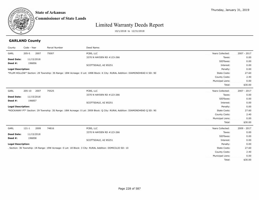
State of Arkansas
Commissioner of State Lands
Thursday, January 31, 2019
Limited Warranty Deeds Report10/1/2018 to 12/31/2018
GARLAND County
Code - Year Parcel Number Deed Name:County
$30.00
Taxes:
SIDTaxes:
Interest:
County Costs:
Municipal Liens:
Total:
Deed Date:
Deed #:
Years Collected:
Legal Description: Penalty:
State Costs:
205-5 2007 75007 PCBS, LLC
3370 N HAYDEN RD #123-266
SCOTTSDALE, AZ 85251
*PLUM HOLLOW* Section: 29 Township: 3S Range: 18W Acreage: 0 Lot: 1898 Block: K City: RURAL Addition: DIAMONDHEAD K SD: 90
2007 - 2017
0.00
0.00
0.00
0.00
27.60
2.40
0.00
11/15/2018
GARL
196856
$30.00
Taxes:
SIDTaxes:
Interest:
County Costs:
Municipal Liens:
Total:
Deed Date:
Deed #:
Years Collected:
Legal Description: Penalty:
State Costs:
205-10 2007 75525 PCBS, LLC
3370 N HAYDEN RD #123-266
SCOTTSDALE, AZ 85251
*ROCKAWAY PT* Section: 29 Township: 3S Range: 18W Acreage: 0 Lot: 2959 Block: Q City: RURAL Addition: DIAMONDHEAD Q SD: 90
2007 - 2017
0.00
0.00
0.00
0.00
27.60
2.40
0.00
11/15/2018
GARL
196857
$30.00
Taxes:
SIDTaxes:
Interest:
County Costs:
Municipal Liens:
Total:
Deed Date:
Deed #:
Years Collected:
Legal Description: Penalty:
State Costs:
121-1 2009 74816 PCBS, LLC
3370 N HAYDEN RD #123-266
SCOTTSDALE, AZ 85251
. Section: 36 Township: 1N Range: 19W Acreage: 0 Lot: 18 Block: 3 City: RURAL Addition: DOMICILIO SD: 10
2009 - 2017
0.00
0.00
0.00
0.00
27.60
2.40
0.00
11/15/2018
GARL
196858
Page 228 of 587

State of Arkansas
Commissioner of State Lands
Thursday, January 31, 2019
Limited Warranty Deeds Report10/1/2018 to 12/31/2018
GARLAND County
Code - Year Parcel Number Deed Name:County
$30.00
Taxes:
SIDTaxes:
Interest:
County Costs:
Municipal Liens:
Total:
Deed Date:
Deed #:
Years Collected:
Legal Description: Penalty:
State Costs:
93-2 2010 74780 PCBS, LLC
3370 N HAYDEN RD #123-266
SCOTTSDALE, AZ 85251
. Section: 36 Township: 01N Range: 19W Acreage: 0 Lot: 1 Block: 2 City: RURAL Addition: DOMICILIO SD: 10
2010 - 2017
0.00
0.00
0.00
0.00
27.60
2.40
0.00
11/15/2018
GARL
196859
$30.00
Taxes:
SIDTaxes:
Interest:
County Costs:
Municipal Liens:
Total:
Deed Date:
Deed #:
Years Collected:
Legal Description: Penalty:
State Costs:
86-6 2011 74750 PCBS, LLC
3370 N HAYDEN RD #123-266
SCOTTSDALE, AZ 85251
. Section: 36 Township: 01N Range: 19W Acreage: Lot: 007 Block: 005 City: RURAL Addition: ENTRADA SD: 010
2011 - 2017
0.00
0.00
0.00
0.00
25.50
4.50
0.00
11/15/2018
GARL
196860
$130.00
Taxes:
SIDTaxes:
Interest:
County Costs:
Municipal Liens:
Total:
Deed Date:
Deed #:
Years Collected:
Legal Description: Penalty:
State Costs:
60-6 2011 65644 VARELA`S INVESTMENTS, LLC
164 MENDON AVE
PAWTUCKET, RI 02861
. Section: 10 Township: 01S Range: 19W Acreage: Lot: 013 Block: 001 City: RURAL Addition: SORIA SD: 010
2011 - 2017
50.00
0.00
12.70
5.00
57.80
4.50
0.00
11/27/2018
GARL
196912
Page 229 of 587

State of Arkansas
Commissioner of State Lands
Thursday, January 31, 2019
Limited Warranty Deeds Report10/1/2018 to 12/31/2018
GARLAND County
Code - Year Parcel Number Deed Name:County
$551.83
Taxes:
SIDTaxes:
Interest:
County Costs:
Municipal Liens:
Total:
Deed Date:
Deed #:
Years Collected:
Legal Description: Penalty:
State Costs:
183-6 2007 72647 JERRY L. FOSHEE & YOUSSEF KERBA
920 ARLENE DR #A
PALM SPRINGS, CA 92264
*QUISTO WAY* Section: 26 Township: 1N Range: 19W Acreage: 0 Lot: 10 Block: 10 City: RURAL Addition: VUESTA SD: 10
2007 - 2017
375.17
0.00
81.25
37.52
55.49
2.40
0.00
11/27/2018
GARL
196913
$80.00
Taxes:
SIDTaxes:
Interest:
County Costs:
Municipal Liens:
Total:
Deed Date:
Deed #:
Years Collected:
Legal Description: Penalty:
State Costs:
68-1 2006 76707 OMNI HOME BUILDERS AT DIAMONDHEAD RESORT COMMUNITY, LLC
32045 CASTLE CT STE 100
EVERGREEN, CO 80439
. Section: 29 Township: 3S Range: 18W Acreage: Lot: 3168 Block: S City: RURAL Addition: DIAMONDHEAD S SD: 90
2006 - 2017
15.00
0.00
3.64
1.50
54.86
5.00
0.00
12/03/2018
GARL
196990
$80.00
Taxes:
SIDTaxes:
Interest:
County Costs:
Municipal Liens:
Total:
Deed Date:
Deed #:
Years Collected:
Legal Description: Penalty:
State Costs:
68-7 2006 76835 OMNI HOME BUILDERS AT DIAMONDHEAD RESORT COMMUNITY, LLC
32045 CASTLE CT STE 100
EVERGREEN, CO 80439
. Section: 29 Township: 3S Range: 18W Acreage: Lot: 3463 Block: S City: RURAL Addition: DIAMONHEAD S SD: 90
2006 - 2017
20.00
0.00
5.09
2.00
47.91
5.00
0.00
12/03/2018
GARL
196991
Page 230 of 587

State of Arkansas
Commissioner of State Lands
Thursday, January 31, 2019
Limited Warranty Deeds Report10/1/2018 to 12/31/2018
GARLAND County
Code - Year Parcel Number Deed Name:County
$80.00
Taxes:
SIDTaxes:
Interest:
County Costs:
Municipal Liens:
Total:
Deed Date:
Deed #:
Years Collected:
Legal Description: Penalty:
State Costs:
206-2 2007 75936 OMNI HOME BUILDERS AT DIAMONDHEAD RESORT COMMUNITY, LLC
32045 CASTLE CT STE 100
EVERGREEN, CO 80439
*SCENIC DR* Section: 29 Township: 3S Range: 18W Acreage: 0 Lot: 2244 Block: N City: Rural Addition: DIAMONDHEAD N SD: 90
2007 - 2017
7.50
0.00
3.22
0.75
66.13
2.40
0.00
12/03/2018
GARL
196992
$80.00
Taxes:
SIDTaxes:
Interest:
County Costs:
Municipal Liens:
Total:
Deed Date:
Deed #:
Years Collected:
Legal Description: Penalty:
State Costs:
206-6 2007 76357 OMNI HOME BUILDERS AT DIAMONDHEAD RESORT COMMUNITY, LLC
32045 CASTLE CT STE 100
EVERGREEN, CO 80439
*WAIKIKI DR* Section: 29 Township: 3S Range: 18W Acreage: 0 Lot: 2060 Block: MI City: Rural Addition: DIAMONDHEAD M1 SD: 90
2007 - 2017
25.00
0.00
3.19
2.50
46.91
2.40
0.00
12/03/2018
GARL
196993
$80.00
Taxes:
SIDTaxes:
Interest:
County Costs:
Municipal Liens:
Total:
Deed Date:
Deed #:
Years Collected:
Legal Description: Penalty:
State Costs:
206-7 2007 76364 OMNI HOME BUILDERS AT DIAMONDHEAD RESORT COMMUNITY, LLC
32045 CASTLE CT STE 100
EVERGREEN, CO 80439
*WAIKIKI DR* Section: 29 Township: 3S Range: 18W Acreage: 0 Lot: 2099 Block: M1 City: Rural Addition: DIAMONDHEAD M1 SD: 90
2007 - 2017
25.00
0.00
3.19
2.50
46.91
2.40
0.00
12/03/2018
GARL
196994
Page 231 of 587

State of Arkansas
Commissioner of State Lands
Thursday, January 31, 2019
Limited Warranty Deeds Report10/1/2018 to 12/31/2018
GARLAND County
Code - Year Parcel Number Deed Name:County
$80.00
Taxes:
SIDTaxes:
Interest:
County Costs:
Municipal Liens:
Total:
Deed Date:
Deed #:
Years Collected:
Legal Description: Penalty:
State Costs:
207-8 2007 77200 OMNI HOME BUILDERS AT DIAMONDHEAD RESORT COMMUNITY, LLC
32045 CASTLE CT STE 100
EVERGREEN, CO 80439
*POSSUM RUN RD* Section: 2- Township: 3S Range: 18W Acreage: 0 Lot: 5059 Block: U City: Rural Addition: DIAMONDHEAD U SD: 90
2007 - 2017
17.50
0.00
4.49
1.75
53.86
2.40
0.00
12/03/2018
GARL
196995
$80.00
Taxes:
SIDTaxes:
Interest:
County Costs:
Municipal Liens:
Total:
Deed Date:
Deed #:
Years Collected:
Legal Description: Penalty:
State Costs:
207-10 2007 77396 OMNI HOME BUILDERS AT DIAMONDHEAD RESORT COMMUNITY, LLC
32045 CASTLE CT STE 100
EVERGREEN, CO 80439
*PEBBLE BEACH CT* Section: 29 Township: 3S Range: 18W Acreage: 0 Lot: 1727 Block: 0L2 City: Rural Addition: DIAMONDHEAD L2 SD: 90
2007 - 2017
12.50
0.00
3.04
1.25
60.81
2.40
0.00
12/03/2018
GARL
196996
$80.00
Taxes:
SIDTaxes:
Interest:
County Costs:
Municipal Liens:
Total:
Deed Date:
Deed #:
Years Collected:
Legal Description: Penalty:
State Costs:
104-10 2008 74970 OMNI HOME BUILDERS AT DIAMONDHEAD RESORT COMMUNITY, LLC
32045 CASTLE CT STE 100
EVERGREEN, CO 80439
. Section: 29 Township: 03S Range: 18W Acreage: 0 Lot: 1860 Block: City: RURAL Addition: DIAMONDHEAD K SD: 90
2008 - 2017
12.50
0.00
3.04
1.25
60.81
2.40
0.00
12/03/2018
GARL
196997
Page 232 of 587

State of Arkansas
Commissioner of State Lands
Thursday, January 31, 2019
Limited Warranty Deeds Report10/1/2018 to 12/31/2018
GARLAND County
Code - Year Parcel Number Deed Name:County
$80.00
Taxes:
SIDTaxes:
Interest:
County Costs:
Municipal Liens:
Total:
Deed Date:
Deed #:
Years Collected:
Legal Description: Penalty:
State Costs:
105-6 2008 75749 OMNI HOME BUILDERS AT DIAMONDHEAD RESORT COMMUNITY, LLC
32045 CASTLE CT STE 100
EVERGREEN, CO 80439
. Section: 29 Township: 03S Range: 18W Acreage: 0 Lot: 3112 Block: R City: RURAL Addition: DIAMONDHEAD SD: 90
2008 - 2017
1.00
0.00
0.16
0.10
76.34
2.40
0.00
12/03/2018
GARL
196998
$80.00
Taxes:
SIDTaxes:
Interest:
County Costs:
Municipal Liens:
Total:
Deed Date:
Deed #:
Years Collected:
Legal Description: Penalty:
State Costs:
105-9 2008 75906 OMNI HOME BUILDERS AT DIAMONDHEAD RESORT COMMUNITY, LLC
32045 CASTLE CT STE 100
EVERGREEN, CO 80439
. Section: 29 Township: 03S Range: 18W Acreage: 0 Lot: 2202 Block: N City: RURAL Addition: DIAMONDHEAD SD: 90
2008 - 2017
0.00
0.00
0.00
0.00
77.60
2.40
0.00
12/03/2018
GARL
196999
$80.00
Taxes:
SIDTaxes:
Interest:
County Costs:
Municipal Liens:
Total:
Deed Date:
Deed #:
Years Collected:
Legal Description: Penalty:
State Costs:
42-1 2005 75076 OMNI HOME BUILDERS AT DIAMONDHEAD RESORT COMMUNITY, LLC
32045 CASTLE CT STE 100
EVERGREEN, CO 80439
*LAKESIDE-OUT* Section: 29 Township: 3S Range: 18W Acreage: 0 Lot: 1967 Block: K City: HOT SPRINGS Addition: DIAMONDHEAD K SD: 90
2005 - 2017
0.00
0.00
0.00
0.00
75.00
5.00
0.00
12/03/2018
GARL
197000
Page 233 of 587

State of Arkansas
Commissioner of State Lands
Thursday, January 31, 2019
Limited Warranty Deeds Report10/1/2018 to 12/31/2018
GARLAND County
Code - Year Parcel Number Deed Name:County
$80.00
Taxes:
SIDTaxes:
Interest:
County Costs:
Municipal Liens:
Total:
Deed Date:
Deed #:
Years Collected:
Legal Description: Penalty:
State Costs:
43-1 2005 76349 OMNI HOME BUILDERS AT DIAMONDHEAD RESORT COMMUNITY, LLC
32045 CASTLE CT STE 100
EVERGREEN, CO 80439
*LAKESIDE-OUT* Section: 29 Township: 3S Range: 18W Acreage: 0 Lot: 2052 Block: M1 City: HOT SPRINGS Addition: DIAMONDHEAD M1 SD:
90
2005 - 2017
7.50
0.00
2.88
0.75
63.87
5.00
0.00
12/03/2018
GARL
197001
$80.00
Taxes:
SIDTaxes:
Interest:
County Costs:
Municipal Liens:
Total:
Deed Date:
Deed #:
Years Collected:
Legal Description: Penalty:
State Costs:
43-2 2005 76358 OMNI HOME BUILDERS AT DIAMONDHEAD RESORT COMMUNITY, LLC
32045 CASTLE CT STE 100
EVERGREEN, CO 80439
*LAKESIDE-OUT* Section: 29 Township: 3S Range: 18W Acreage: 0 Lot: 2061 Block: M1 City: HOT SPRINGS Addition: DIAMONDHEAD M1 SD:
90
2005 - 2017
15.00
0.00
3.64
1.50
54.86
5.00
0.00
12/03/2018
GARL
197002
$80.00
Taxes:
SIDTaxes:
Interest:
County Costs:
Municipal Liens:
Total:
Deed Date:
Deed #:
Years Collected:
Legal Description: Penalty:
State Costs:
44-4 2005 76249 OMNI HOME BUILDERS AT DIAMONDHEAD RESORT COMMUNITY, LLC
32045 CASTLE CT STE 100
EVERGREEN, CO 80439
*LAKESIDE-OUT* Section: 29 Township: 3S Range: 18W Acreage: 0 Lot: 2205 Block: M2 City: HOT SPRINGS Addition: DIAMONDHEAD M2 SD:
90
2005 - 2017
20.00
0.00
5.09
2.00
47.91
5.00
0.00
12/03/2018
GARL
197003
Page 234 of 587

State of Arkansas
Commissioner of State Lands
Thursday, January 31, 2019
Limited Warranty Deeds Report10/1/2018 to 12/31/2018
GARLAND County
Code - Year Parcel Number Deed Name:County
$80.00
Taxes:
SIDTaxes:
Interest:
County Costs:
Municipal Liens:
Total:
Deed Date:
Deed #:
Years Collected:
Legal Description: Penalty:
State Costs:
63-6 2006 75068 OMNI HOME BUILDERS AT DIAMONDHEAD RESORT COMMUNITY, LLC
32045 CASTLE CT STE 100
EVERGREEN, CO 80439
. Section: 29 Township: 3S Range: 18W Acreage: Lot: 1959 Block: K City: RURAL Addition: DIAMONDHEAD K SD: 090
2006 - 2017
15.00
0.00
3.64
1.50
54.86
5.00
0.00
12/03/2018
GARL
197004
$80.00
Taxes:
SIDTaxes:
Interest:
County Costs:
Municipal Liens:
Total:
Deed Date:
Deed #:
Years Collected:
Legal Description: Penalty:
State Costs:
64-8 2006 76289 OMNI HOME BUILDERS AT DIAMONDHEAD RESORT COMMUNITY, LLC
32045 CASTLE CT STE 100
EVERGREEN, CO 80439
. Section: 29 Township: 3S Range: 18W Acreage: Lot: 1447 Block: M1 City: RURAL Addition: DIAMONDHEAD M1 SD: 090
2006 - 2017
20.00
0.00
5.09
2.00
47.91
5.00
0.00
12/03/2018
GARL
197005
$80.00
Taxes:
SIDTaxes:
Interest:
County Costs:
Municipal Liens:
Total:
Deed Date:
Deed #:
Years Collected:
Legal Description: Penalty:
State Costs:
65-6 2006 76428 OMNI HOME BUILDERS AT DIAMONDHEAD RESORT COMMUNITY, LLC
32045 CASTLE CT STE 100
EVERGREEN, CO 80439
. Section: 29 Township: 3S Range: 18W Acreage: Lot: 2411 Block: M1 City: RURAL Addition: DIAMONDHEAD M1 SD: 090
2006 - 2017
20.00
0.00
5.09
2.00
47.91
5.00
0.00
12/03/2018
GARL
197006
Page 235 of 587

State of Arkansas
Commissioner of State Lands
Thursday, January 31, 2019
Limited Warranty Deeds Report10/1/2018 to 12/31/2018
GARLAND County
Code - Year Parcel Number Deed Name:County
$80.00
Taxes:
SIDTaxes:
Interest:
County Costs:
Municipal Liens:
Total:
Deed Date:
Deed #:
Years Collected:
Legal Description: Penalty:
State Costs:
96-9 2010 76367 OMNI HOME BUILDERS AT DIAMONDHEAD RESORT COMMUNITY, LLC
32045 CASTLE CT STE 100
EVERGREEN, CO 80439
. Section: 29 Township: 03S Range: 18W Acreage: 0 Lot: 2102 Block: M1 City: RURAL Addition: DIAMONDHEAD SD: 90
2010 - 2017
10.00
0.00
1.96
1.00
64.64
2.40
0.00
12/03/2018
GARL
197007
$80.00
Taxes:
SIDTaxes:
Interest:
County Costs:
Municipal Liens:
Total:
Deed Date:
Deed #:
Years Collected:
Legal Description: Penalty:
State Costs:
96-6 2010 76195 OMNI HOME BUILDERS AT DIAMONDHEAD RESORT COMMUNITY, LLC
32045 CASTLE CT STE 100
EVERGREEN, CO 80439
. Section: 29 Township: 03S Range: 18W Acreage: 0 Lot: 2043 Block: M2 City: RURAL Addition: DIAMONDHEAD SD: 90
2010 - 2017
10.00
0.00
1.96
1.00
64.64
2.40
0.00
12/03/2018
GARL
197008
$80.00
Taxes:
SIDTaxes:
Interest:
County Costs:
Municipal Liens:
Total:
Deed Date:
Deed #:
Years Collected:
Legal Description: Penalty:
State Costs:
95-8 2010 75805 OMNI HOME BUILDERS AT DIAMONDHEAD RESORT COMMUNITY, LLC
32045 CASTLE CT STE 100
EVERGREEN, CO 80439
. Section: 29 Township: 03S Range: 18W Acreage: 0 Lot: 3218 Block: R City: RURAL Addition: DIAMONDHEAD SD: 90
2010 - 2017
10.00
0.00
1.96
1.00
64.64
2.40
0.00
12/03/2018
GARL
197009
Page 236 of 587

State of Arkansas
Commissioner of State Lands
Thursday, January 31, 2019
Limited Warranty Deeds Report10/1/2018 to 12/31/2018
GARLAND County
Code - Year Parcel Number Deed Name:County
$80.00
Taxes:
SIDTaxes:
Interest:
County Costs:
Municipal Liens:
Total:
Deed Date:
Deed #:
Years Collected:
Legal Description: Penalty:
State Costs:
95-4 2010 75728 OMNI HOME BUILDERS AT DIAMONDHEAD RESORT COMMUNITY, LLC
32045 CASTLE CT STE 100
EVERGREEN, CO 80439
. Section: 29 Township: 03S Range: 18W Acreage: 0 Lot: 3091 Block: R City: RURAL Addition: DIAMONDHEAD SD: 90
2010 - 2017
10.00
0.00
1.96
1.00
64.64
2.40
0.00
12/03/2018
GARL
197010
$80.00
Taxes:
SIDTaxes:
Interest:
County Costs:
Municipal Liens:
Total:
Deed Date:
Deed #:
Years Collected:
Legal Description: Penalty:
State Costs:
108-10 2008 77309 OMNI HOME BUILDERS AT DIAMONDHEAD RESORT COMMUNITY, LLC
32045 CASTLE CT STE 100
EVERGREEN, CO 80439
. Section: 29 Township: 03S Range: 18W Acreage: 0 Lot: 2536 Block: V City: RURAL Addition: DIAMONDHEAD SD: 90
2008 - 2017
30.00
0.00
3.01
3.00
41.59
2.40
0.00
12/03/2018
GARL
197011
$80.00
Taxes:
SIDTaxes:
Interest:
County Costs:
Municipal Liens:
Total:
Deed Date:
Deed #:
Years Collected:
Legal Description: Penalty:
State Costs:
89-8 2011 76765 OMNI HOME BUILDERS AT DIAMONDHEAD RESORT COMMUNITY, LLC
32045 CASTLE CT STE 100
EVERGREEN, CO 80439
. Section: 29 Township: 03S Range: 18W Acreage: 0.000 Lot: 3307 Block: 00S City: RURAL Addition: DIAMONDHEAD S SD: 090
2011 - 2017
7.50
0.00
2.50
0.75
64.75
4.50
0.00
12/03/2018
GARL
197012
Page 237 of 587

State of Arkansas
Commissioner of State Lands
Thursday, January 31, 2019
Limited Warranty Deeds Report10/1/2018 to 12/31/2018
GARLAND County
Code - Year Parcel Number Deed Name:County
$80.00
Taxes:
SIDTaxes:
Interest:
County Costs:
Municipal Liens:
Total:
Deed Date:
Deed #:
Years Collected:
Legal Description: Penalty:
State Costs:
89-7 2011 76701 OMNI HOME BUILDERS AT DIAMONDHEAD RESORT COMMUNITY, LLC
32045 CASTLE CT STE 100
EVERGREEN, CO 80439
. Section: 29 Township: 03S Range: 18W Acreage: 0.000 Lot: 3162 Block: 00S City: RURAL Addition: DIAMONDHEAD S SD: 090
2011 - 2017
2.50
0.00
1.05
0.25
71.70
4.50
0.00
12/03/2018
GARL
197013
$80.00
Taxes:
SIDTaxes:
Interest:
County Costs:
Municipal Liens:
Total:
Deed Date:
Deed #:
Years Collected:
Legal Description: Penalty:
State Costs:
108-8 2008 77288 OMNI HOME BUILDERS AT DIAMONDHEAD RESORT COMMUNITY, LLC
32045 CASTLE CT STE 100
EVERGREEN, CO 80439
. Section: 29 Township: 03S Range: 18W Acreage: 0 Lot: 2515 Block: V City: RURAL Addition: DIAMONDHEAD SD: 90
2008 - 2017
30.00
0.00
3.01
3.00
41.59
2.40
0.00
12/03/2018
GARL
197014
$80.00
Taxes:
SIDTaxes:
Interest:
County Costs:
Municipal Liens:
Total:
Deed Date:
Deed #:
Years Collected:
Legal Description: Penalty:
State Costs:
97-2 2010 76543 OMNI HOME BUILDERS AT DIAMONDHEAD RESORT COMMUNITY, LLC
32045 CASTLE CT STE 100
EVERGREEN, CO 80439
. Section: 29 Township: 03S Range: 18W Acreage: 0 Lot: 1314 Block: J City: RURAL Addition: DIAMONDHEAD SD: 90
2010 - 2017
10.00
0.00
1.96
1.00
64.64
2.40
0.00
12/03/2018
GARL
197015
Page 238 of 587

State of Arkansas
Commissioner of State Lands
Thursday, January 31, 2019
Limited Warranty Deeds Report10/1/2018 to 12/31/2018
GARLAND County
Code - Year Parcel Number Deed Name:County
$80.00
Taxes:
SIDTaxes:
Interest:
County Costs:
Municipal Liens:
Total:
Deed Date:
Deed #:
Years Collected:
Legal Description: Penalty:
State Costs:
65-2 2006 76386 OMNI HOME BUILDERS AT DIAMONDHEAD RESORT COMMUNITY, LLC
32045 CASTLE CT STE 100
EVERGREEN, CO 80439
. Section: 29 Township: 3S Range: 18W Acreage: Lot: 2121 Block: M1 City: RURAL Addition: DIAMONDHEAD M1 SD: 090
2006 - 2017
20.00
0.00
5.09
2.00
47.91
5.00
0.00
12/03/2018
GARL
197016
$80.00
Taxes:
SIDTaxes:
Interest:
County Costs:
Municipal Liens:
Total:
Deed Date:
Deed #:
Years Collected:
Legal Description: Penalty:
State Costs:
123-3 2009 76352 OMNI HOME BUILDERS AT DIAMONDHEAD RESORT COMMUNITY, LLC
32045 CASTLE CT STE 100
EVERGREEN, CO 80439
. Section: 29 Township: 3S Range: 18W Acreage: 0 Lot: 2055 Block: M1 City: RURAL Addition: DIAMONDHEAD M1 SD: 90
2009 - 2017
27.50
0.00
4.29
2.75
43.06
2.40
0.00
12/03/2018
GARL
197017
$80.00
Taxes:
SIDTaxes:
Interest:
County Costs:
Municipal Liens:
Total:
Deed Date:
Deed #:
Years Collected:
Legal Description: Penalty:
State Costs:
87-9 2011 75245 OMNI HOME BUILDERS AT DIAMONDHEAD RESORT COMMUNITY, LLC
32045 CASTLE CT STE 100
EVERGREEN, CO 80439
. Section: 29 Township: 03S Range: 18W Acreage: 0.000 Lot: 2663 Block: 0P1 City: RURAL Addition: DIAMONDHEAD P1 SD: 090
2011 - 2017
3.00
0.00
0.50
0.30
71.70
4.50
0.00
12/03/2018
GARL
197018
Page 239 of 587

State of Arkansas
Commissioner of State Lands
Thursday, January 31, 2019
Limited Warranty Deeds Report10/1/2018 to 12/31/2018
GARLAND County
Code - Year Parcel Number Deed Name:County
$80.00
Taxes:
SIDTaxes:
Interest:
County Costs:
Municipal Liens:
Total:
Deed Date:
Deed #:
Years Collected:
Legal Description: Penalty:
State Costs:
207-9 2007 77226 OMNI HOME BUILDERS AT DIAMONDHEAD RESORT COMMUNITY, LLC
32045 CASTLE CT STE 100
EVERGREEN, CO 80439
*HICKORY HILL DR* Section: 29 Township: 3S Range: 18W Acreage: 0 Lot: 2453 Block: V City: Rural Addition: DIAMONDHEAD V SD: 90
2007 - 2017
25.00
0.00
3.19
2.50
46.91
2.40
0.00
12/03/2018
GARL
197019
$80.00
Taxes:
SIDTaxes:
Interest:
County Costs:
Municipal Liens:
Total:
Deed Date:
Deed #:
Years Collected:
Legal Description: Penalty:
State Costs:
107-5 2008 76702 OMNI HOME BUILDERS AT DIAMONDHEAD RESORT COMMUNITY, LLC
32045 CASTLE CT STE 100
EVERGREEN, CO 80439
. Section: 29 Township: 03S Range: 18W Acreage: 0 Lot: 3163 Block: S City: RURAL Addition: DIAMONDHEAD SD: 90
2008 - 2017
25.00
0.00
3.19
2.50
46.91
2.40
0.00
12/03/2018
GARL
197020
$80.00
Taxes:
SIDTaxes:
Interest:
County Costs:
Municipal Liens:
Total:
Deed Date:
Deed #:
Years Collected:
Legal Description: Penalty:
State Costs:
207-6 2007 77067 OMNI HOME BUILDERS AT DIAMONDHEAD RESORT COMMUNITY, LLC
32045 CASTLE CT STE 100
EVERGREEN, CO 80439
*OHIO DR* Section: Township: Range: Acreage: 0 Lot: 3524 Block: U City: Rural Addition: DIAMONDHEAD U SD: 90
2007 - 2017
25.00
0.00
3.19
2.50
46.91
2.40
0.00
12/03/2018
GARL
197021
Page 240 of 587

State of Arkansas
Commissioner of State Lands
Thursday, January 31, 2019
Limited Warranty Deeds Report10/1/2018 to 12/31/2018
GARLAND County
Code - Year Parcel Number Deed Name:County
$80.00
Taxes:
SIDTaxes:
Interest:
County Costs:
Municipal Liens:
Total:
Deed Date:
Deed #:
Years Collected:
Legal Description: Penalty:
State Costs:
206-1 2007 75765 OMNI HOME BUILDERS AT DIAMONDHEAD RESORT COMMUNITY, LLC
32045 CASTLE CT STE 100
EVERGREEN, CO 80439
*RAZORBACK DR* Section: 29 Township: 3S Range: 18W Acreage: 0 Lot: 3178 Block: R City: Rural Addition: DIAMONDHEAD R SD: 90
2007 - 2017
15.00
0.00
1.92
1.50
59.18
2.40
0.00
12/03/2018
GARL
197022
$80.00
Taxes:
SIDTaxes:
Interest:
County Costs:
Municipal Liens:
Total:
Deed Date:
Deed #:
Years Collected:
Legal Description: Penalty:
State Costs:
68-6 2006 76831 OMNI HOME BUILDERS AT DIAMONDHEAD RESORT COMMUNITY, LLC
32045 CASTLE CT STE 100
EVERGREEN, CO 80439
. Section: 29 Township: 3S Range: 18W Acreage: Lot: 3382 Block: S City: RURAL Addition: DIAMONDHEAD S SD: 90
2006 - 2017
15.00
0.00
3.64
1.50
54.86
5.00
0.00
12/03/2018
GARL
197023
$80.00
Taxes:
SIDTaxes:
Interest:
County Costs:
Municipal Liens:
Total:
Deed Date:
Deed #:
Years Collected:
Legal Description: Penalty:
State Costs:
66-3 2006 75972 OMNI HOME BUILDERS AT DIAMONDHEAD RESORT COMMUNITY, LLC
32045 CASTLE CT STE 100
EVERGREEN, CO 80439
. Section: 29 Township: 3S Range: 18W Acreage: Lot: 2280 Block: N City: RURAL Addition: DIAMONDHEAD N SD: 090
2006 - 2017
15.00
0.00
3.64
1.50
54.86
5.00
0.00
12/03/2018
GARL
197024
Page 241 of 587

State of Arkansas
Commissioner of State Lands
Thursday, January 31, 2019
Limited Warranty Deeds Report10/1/2018 to 12/31/2018
GARLAND County
Code - Year Parcel Number Deed Name:County
$80.00
Taxes:
SIDTaxes:
Interest:
County Costs:
Municipal Liens:
Total:
Deed Date:
Deed #:
Years Collected:
Legal Description: Penalty:
State Costs:
207-3 2007 76834 OMNI HOME BUILDERS AT DIAMONDHEAD RESORT COMMUNITY, LLC
32045 CASTLE CT STE 100
EVERGREEN, CO 80439
*POSSUM RUN RD* SECTION S Section: 29 Township: 3S Range: 18W Acreage: 0 Lot: 3462 Block: City: Rural Addition: DIAMONDHEAD S SD:
90
2007 - 2017
15.00
0.00
1.92
1.50
59.18
2.40
0.00
12/03/2018
GARL
197025
$80.00
Taxes:
SIDTaxes:
Interest:
County Costs:
Municipal Liens:
Total:
Deed Date:
Deed #:
Years Collected:
Legal Description: Penalty:
State Costs:
207-1 2007 76674 OMNI HOME BUILDERS AT DIAMONDHEAD RESORT COMMUNITY, LLC
32045 CASTLE CT STE 100
EVERGREEN, CO 80439
*RAZORBACK DR* Section: 29 Township: 3S Range: 18W Acreage: 0 Lot: 3131 Block: S City: Rural Addition: DIAMONDHEAD S SD: 90
2007 - 2017
25.00
0.00
3.19
2.50
46.91
2.40
0.00
12/03/2018
GARL
197026
$80.00
Taxes:
SIDTaxes:
Interest:
County Costs:
Municipal Liens:
Total:
Deed Date:
Deed #:
Years Collected:
Legal Description: Penalty:
State Costs:
206-10 2007 76673 OMNI HOME BUILDERS AT DIAMONDHEAD RESORT COMMUNITY, LLC
32045 CASTLE CT STE 100
EVERGREEN, CO 80439
*RAZORBACK DR* Section: 29 Township: 3S Range: 18W Acreage: 0 Lot: 3130 Block: S City: Rural Addition: DIAMONDHEAD S SD: 90
2007 - 2017
25.00
0.00
3.19
2.50
46.91
2.40
0.00
12/03/2018
GARL
197027
Page 242 of 587

State of Arkansas
Commissioner of State Lands
Thursday, January 31, 2019
Limited Warranty Deeds Report10/1/2018 to 12/31/2018
GARLAND County
Code - Year Parcel Number Deed Name:County
$80.00
Taxes:
SIDTaxes:
Interest:
County Costs:
Municipal Liens:
Total:
Deed Date:
Deed #:
Years Collected:
Legal Description: Penalty:
State Costs:
207-2 2007 76827 OMNI HOME BUILDERS AT DIAMONDHEAD RESORT COMMUNITY, LLC
32045 CASTLE CT STE 100
EVERGREEN, CO 80439
*POSSUM RUN ROAD* Section: 29 Township: 3S Range: 18W Acreage: 0 Lot: 3378 Block: S City: Rural Addition: DIAMONDHEAD S SD: 90
2007 - 2017
25.00
0.00
3.19
2.50
46.91
2.40
0.00
12/03/2018
GARL
197028
$80.00
Taxes:
SIDTaxes:
Interest:
County Costs:
Municipal Liens:
Total:
Deed Date:
Deed #:
Years Collected:
Legal Description: Penalty:
State Costs:
106-11 2008 76539 OMNI HOME BUILDERS AT DIAMONDHEAD RESORT COMMUNITY, LLC
32045 CASTLE CT STE 100
EVERGREEN, CO 80439
. Section: 33 Township: 03S Range: 18W Acreage: 0 Lot: 1310 Block: J City: RURAL Addition: DIAMONDHEAD SD: 90
2008 - 2017
25.00
0.00
3.19
2.50
46.91
2.40
0.00
12/03/2018
GARL
197029
$80.00
Taxes:
SIDTaxes:
Interest:
County Costs:
Municipal Liens:
Total:
Deed Date:
Deed #:
Years Collected:
Legal Description: Penalty:
State Costs:
206-4 2007 76343 OMNI HOME BUILDERS AT DIAMONDHEAD RESORT COMMUNITY, LLC
32045 CASTLE CT STE 100
EVERGREEN, CO 80439
*CHERRY HILL DR* Section: 29 Township: 3S Range: 18W Acreage: 0 Lot: 1502 Block: M1 City: Rural Addition: DIAMONDHEAD M1 SD: 90
2007 - 2017
15.00
0.00
1.92
1.50
59.18
2.40
0.00
12/03/2018
GARL
197030
Page 243 of 587

State of Arkansas
Commissioner of State Lands
Thursday, January 31, 2019
Limited Warranty Deeds Report10/1/2018 to 12/31/2018
GARLAND County
Code - Year Parcel Number Deed Name:County
$80.00
Taxes:
SIDTaxes:
Interest:
County Costs:
Municipal Liens:
Total:
Deed Date:
Deed #:
Years Collected:
Legal Description: Penalty:
State Costs:
205-9 2007 75401 OMNI HOME BUILDERS AT DIAMONDHEAD RESORT COMMUNITY, LLC
32045 CASTLE CT STE 100
EVERGREEN, CO 80439
*SCENIC DR* Section: 29 Township: 3S Range: 18W Acreage: 0 Lot: 2822 Block: P2 City: Rural Addition: DIAMONDHEAD P2 SD: 90
2007 - 2017
15.00
0.00
1.92
1.50
59.18
2.40
0.00
12/03/2018
GARL
197031
$80.00
Taxes:
SIDTaxes:
Interest:
County Costs:
Municipal Liens:
Total:
Deed Date:
Deed #:
Years Collected:
Legal Description: Penalty:
State Costs:
4-1 2010 105810 OMNI HOME BUILDERS AT DIAMONDHEAD RESORT COMMUNITY, LLC
32045 CASTLE CT STE 100
EVERGREEN, CO 80439
. Section: 29 Township: 03S Range: 18W Acreage: 0 Lot: 2229 Block: N City: RURAL Addition: DIAMONDHEAD N SD: 90
2010 - 2017
0.00
0.00
0.00
0.00
77.60
2.40
0.00
12/03/2018
GARL
197032
$80.00
Taxes:
SIDTaxes:
Interest:
County Costs:
Municipal Liens:
Total:
Deed Date:
Deed #:
Years Collected:
Legal Description: Penalty:
State Costs:
107-9 2008 77052 OMNI HOME BUILDERS AT DIAMONDHEAD RESORT COMMUNITY, LLC
32045 CASTLE CT STE 100
EVERGREEN, CO 80439
. Section: 29 Township: 03S Range: 18W Acreage: 0 Lot: 3457 Block: U City: RURAL Addition: DIAMONDHEAD SD: 90
2008 - 2017
30.00
0.00
3.01
3.00
41.59
2.40
0.00
12/03/2018
GARL
197033
Page 244 of 587

State of Arkansas
Commissioner of State Lands
Thursday, January 31, 2019
Limited Warranty Deeds Report10/1/2018 to 12/31/2018
GARLAND County
Code - Year Parcel Number Deed Name:County
$80.00
Taxes:
SIDTaxes:
Interest:
County Costs:
Municipal Liens:
Total:
Deed Date:
Deed #:
Years Collected:
Legal Description: Penalty:
State Costs:
43-4 2005 76403 OMNI HOME BUILDERS AT DIAMONDHEAD RESORT COMMUNITY, LLC
32045 CASTLE CT STE 100
EVERGREEN, CO 80439
*LAKESIDE-OUT* Section: 29 Township: 3S Range: 18W Acreage: 0 Lot: 2147 Block: M1 City: HOT SPRINGS Addition: DIAMONDHEAD M1 SD:
90
2005 - 2017
0.00
0.00
0.00
0.00
75.00
5.00
0.00
12/03/2018
GARL
197034
$80.00
Taxes:
SIDTaxes:
Interest:
County Costs:
Municipal Liens:
Total:
Deed Date:
Deed #:
Years Collected:
Legal Description: Penalty:
State Costs:
62-2 2006 74891 OMNI HOME BUILDERS AT DIAMONDHEAD RESORT COMMUNITY, LLC
32045 CASTLE CT STE 100
EVERGREEN, CO 80439
. Section: 29 Township: 3S Range: 18W Acreage: Lot: 30 Block: A City: RURAL Addition: DIAMONDHEAD A SD: 090
2006 - 2017
6.50
0.00
0.77
0.60
67.13
5.00
0.00
12/03/2018
GARL
197035
$80.00
Taxes:
SIDTaxes:
Interest:
County Costs:
Municipal Liens:
Total:
Deed Date:
Deed #:
Years Collected:
Legal Description: Penalty:
State Costs:
66-7 2006 76051 OMNI HOME BUILDERS AT DIAMONDHEAD RESORT COMMUNITY, LLC
32045 CASTLE CT STE 100
EVERGREEN, CO 80439
. Section: 29 Township: 3S Range: 18W Acreage: Lot: 2371 Block: N City: RURAL Addition: DIAMONDHEAD N SD: 090
2006 - 2017
6.50
0.00
0.77
0.60
67.13
5.00
0.00
12/03/2018
GARL
197036
Page 245 of 587

State of Arkansas
Commissioner of State Lands
Thursday, January 31, 2019
Limited Warranty Deeds Report10/1/2018 to 12/31/2018
GARLAND County
Code - Year Parcel Number Deed Name:County
$80.00
Taxes:
SIDTaxes:
Interest:
County Costs:
Municipal Liens:
Total:
Deed Date:
Deed #:
Years Collected:
Legal Description: Penalty:
State Costs:
67-5 2006 75740 OMNI HOME BUILDERS AT DIAMONDHEAD RESORT COMMUNITY, LLC
32045 CASTLE CT STE 100
EVERGREEN, CO 80439
. Section: 29 Township: 3S Range: 18W Acreage: Lot: 3103 Block: R City: RURAL Addition: DIAMONDHEAD R SD: 90
2006 - 2017
2.00
0.00
0.35
0.20
72.45
5.00
0.00
12/03/2018
GARL
197037
$80.00
Taxes:
SIDTaxes:
Interest:
County Costs:
Municipal Liens:
Total:
Deed Date:
Deed #:
Years Collected:
Legal Description: Penalty:
State Costs:
108-1 2008 77149 OMNI HOME BUILDERS AT DIAMONDHEAD RESORT COMMUNITY, LLC
32045 CASTLE CT STE 100
EVERGREEN, CO 80439
. Section: 29 Township: 03S Range: 18W Acreage: 0 Lot: 3763 Block: U City: RURAL Addition: DIAMONDHEAD SD: 90
2008 - 2017
25.00
0.00
3.19
2.50
46.91
2.40
0.00
12/03/2018
GARL
197038
$80.00
Taxes:
SIDTaxes:
Interest:
County Costs:
Municipal Liens:
Total:
Deed Date:
Deed #:
Years Collected:
Legal Description: Penalty:
State Costs:
105-10 2008 75944 OMNI HOME BUILDERS AT DIAMONDHEAD RESORT COMMUNITY, LLC
32045 CASTLE CT STE 100
EVERGREEN, CO 80439
. Section: 29 Township: 03S Range: 18W Acreage: 0 Lot: 2252 Block: N City: RURAL Addition: DIAMONDHEAD SD: 90
2008 - 2017
17.50
0.00
4.54
1.75
53.81
2.40
0.00
12/03/2018
GARL
197039
Page 246 of 587

State of Arkansas
Commissioner of State Lands
Thursday, January 31, 2019
Limited Warranty Deeds Report10/1/2018 to 12/31/2018
GARLAND County
Code - Year Parcel Number Deed Name:County
$80.00
Taxes:
SIDTaxes:
Interest:
County Costs:
Municipal Liens:
Total:
Deed Date:
Deed #:
Years Collected:
Legal Description: Penalty:
State Costs:
106-1 2008 75961 OMNI HOME BUILDERS AT DIAMONDHEAD RESORT COMMUNITY, LLC
32045 CASTLE CT STE 100
EVERGREEN, CO 80439
. Section: 29 Township: 03S Range: 18W Acreage: 0 Lot: 2269 Block: N City: RURAL Addition: DIAMONDHEAD SD: 90
2008 - 2017
30.00
0.00
3.01
3.00
41.59
2.40
0.00
12/03/2018
GARL
197040
$80.00
Taxes:
SIDTaxes:
Interest:
County Costs:
Municipal Liens:
Total:
Deed Date:
Deed #:
Years Collected:
Legal Description: Penalty:
State Costs:
106-7 2008 76176 OMNI HOME BUILDERS AT DIAMONDHEAD RESORT COMMUNITY, LLC
32045 CASTLE CT STE 100
EVERGREEN, CO 80439
. Section: 29 Township: 03S Range: 18W Acreage: 0 Lot: 1828 Block: M2 City: RURAL Addition: DIAMONDHEAD SD: 90
2008 - 2017
17.50
0.00
4.49
1.75
53.86
2.40
0.00
12/03/2018
GARL
197041
$80.00
Taxes:
SIDTaxes:
Interest:
County Costs:
Municipal Liens:
Total:
Deed Date:
Deed #:
Years Collected:
Legal Description: Penalty:
State Costs:
107-8 2008 76852 OMNI HOME BUILDERS AT DIAMONDHEAD RESORT COMMUNITY, LLC
32045 CASTLE CT STE 100
EVERGREEN, CO 80439
. Section: 29 Township: 03S Range: 18W Acreage: 0 Lot: 3480 Block: S City: RURAL Addition: DIAMONDHEAD SD: 90
2008 - 2017
12.50
0.00
3.04
1.25
60.81
2.40
0.00
12/03/2018
GARL
197042
Page 247 of 587

State of Arkansas
Commissioner of State Lands
Thursday, January 31, 2019
Limited Warranty Deeds Report10/1/2018 to 12/31/2018
GARLAND County
Code - Year Parcel Number Deed Name:County
$80.00
Taxes:
SIDTaxes:
Interest:
County Costs:
Municipal Liens:
Total:
Deed Date:
Deed #:
Years Collected:
Legal Description: Penalty:
State Costs:
107-10 2008 77140 OMNI HOME BUILDERS AT DIAMONDHEAD RESORT COMMUNITY, LLC
32045 CASTLE CT STE 100
EVERGREEN, CO 80439
. Section: 29 Township: 03S Range: 18W Acreage: 0 Lot: 3754 Block: U City: RURAL Addition: DIAMONDHEAD SD: 90
2008 - 2017
30.00
0.00
3.01
3.00
41.59
2.40
0.00
12/03/2018
GARL
197043
$80.00
Taxes:
SIDTaxes:
Interest:
County Costs:
Municipal Liens:
Total:
Deed Date:
Deed #:
Years Collected:
Legal Description: Penalty:
State Costs:
89-9 2011 76828 OMNI HOME BUILDERS AT DIAMONDHEAD RESORT COMMUNITY, LLC
32045 CASTLE CT STE 100
EVERGREEN, CO 80439
. Section: 29 Township: 03S Range: 18W Acreage: 0.000 Lot: 3379 Block: 00S City: RURAL Addition: DIAMONDHEAD S SD: 090
2011 - 2017
3.00
0.00
0.50
0.30
71.70
4.50
0.00
12/03/2018
GARL
197044
$80.00
Taxes:
SIDTaxes:
Interest:
County Costs:
Municipal Liens:
Total:
Deed Date:
Deed #:
Years Collected:
Legal Description: Penalty:
State Costs:
90-2 2011 77284 OMNI HOME BUILDERS AT DIAMONDHEAD RESORT COMMUNITY, LLC
32045 CASTLE CT STE 100
EVERGREEN, CO 80439
. Section: 29 Township: 03S Range: 18W Acreage: 0.000 Lot: 2510 Block: 00V City: RURAL Addition: DIAMONDHEAD V SD: 090
2011 - 2017
7.50
0.00
2.50
0.75
64.75
4.50
0.00
12/03/2018
GARL
197045
Page 248 of 587

State of Arkansas
Commissioner of State Lands
Thursday, January 31, 2019
Limited Warranty Deeds Report10/1/2018 to 12/31/2018
GARLAND County
Code - Year Parcel Number Deed Name:County
$80.00
Taxes:
SIDTaxes:
Interest:
County Costs:
Municipal Liens:
Total:
Deed Date:
Deed #:
Years Collected:
Legal Description: Penalty:
State Costs:
123-10 2009 77018 OMNI HOME BUILDERS AT DIAMONDHEAD RESORT COMMUNITY, LLC
32045 CASTLE CT STE 100
EVERGREEN, CO 80439
. Section: 29 Township: 3S Range: 18W Acreage: 0 Lot: 3423 Block: U City: RURAL Addition: DIAMONDHEAD U SD: 90
2009 - 2017
25.00
0.00
7.04
2.50
43.06
2.40
0.00
12/03/2018
GARL
197046
$80.00
Taxes:
SIDTaxes:
Interest:
County Costs:
Municipal Liens:
Total:
Deed Date:
Deed #:
Years Collected:
Legal Description: Penalty:
State Costs:
95-6 2010 75752 OMNI HOME BUILDERS AT DIAMONDHEAD RESORT COMMUNITY, LLC
32045 CASTLE CT STE 100
EVERGREEN, CO 80439
. Section: 29 Township: 03S Range: 18W Acreage: 0 Lot: 3115 Block: R City: RURAL Addition: DIAMONDHEAD SD: 90
2010 - 2017
10.00
0.00
1.96
1.00
64.64
2.40
0.00
12/03/2018
GARL
197047
$80.00
Taxes:
SIDTaxes:
Interest:
County Costs:
Municipal Liens:
Total:
Deed Date:
Deed #:
Years Collected:
Legal Description: Penalty:
State Costs:
97-6 2010 77152 OMNI HOME BUILDERS AT DIAMONDHEAD RESORT COMMUNITY, LLC
32045 CASTLE CT STE 100
EVERGREEN, CO 80439
. Section: 29 Township: 03S Range: 18W Acreage: 0 Lot: 3766 Block: U City: RURAL Addition: DIAMONDHEAD SD: 90
2010 - 2017
10.00
0.00
1.96
1.00
64.64
2.40
0.00
12/03/2018
GARL
197048
Page 249 of 587

State of Arkansas
Commissioner of State Lands
Thursday, January 31, 2019
Limited Warranty Deeds Report10/1/2018 to 12/31/2018
GARLAND County
Code - Year Parcel Number Deed Name:County
$80.00
Taxes:
SIDTaxes:
Interest:
County Costs:
Municipal Liens:
Total:
Deed Date:
Deed #:
Years Collected:
Legal Description: Penalty:
State Costs:
95-5 2010 75751 OMNI HOME BUILDERS AT DIAMONDHEAD RESORT COMMUNITY, LLC
32045 CASTLE CT STE 100
EVERGREEN, CO 80439
. Section: 29 Township: 03S Range: 18W Acreage: 0 Lot: 3114 Block: R City: RURAL Addition: DIAMONDHEAD SD: 90
2010 - 2017
10.00
0.00
1.96
1.00
64.64
2.40
0.00
12/03/2018
GARL
197049
$80.00
Taxes:
SIDTaxes:
Interest:
County Costs:
Municipal Liens:
Total:
Deed Date:
Deed #:
Years Collected:
Legal Description: Penalty:
State Costs:
95-9 2010 75814 OMNI HOME BUILDERS AT DIAMONDHEAD RESORT COMMUNITY, LLC
32045 CASTLE CT STE 100
EVERGREEN, CO 80439
. Section: 29 Township: 03S Range: 18W Acreage: 0 Lot: 3227 Block: R City: RURAL Addition: DIAMONDHEAD SD: 90
2010 - 2017
15.00
0.00
3.41
1.50
57.69
2.40
0.00
12/03/2018
GARL
197050
$80.00
Taxes:
SIDTaxes:
Interest:
County Costs:
Municipal Liens:
Total:
Deed Date:
Deed #:
Years Collected:
Legal Description: Penalty:
State Costs:
97-4 2010 76690 OMNI HOME BUILDERS AT DIAMONDHEAD RESORT COMMUNITY, LLC
32045 CASTLE CT STE 100
EVERGREEN, CO 80439
. Section: 29 Township: 03S Range: 18W Acreage: 0 Lot: 3147 Block: S City: RURAL Addition: DIAMONDHEAD SD: 90
2010 - 2017
15.00
0.00
3.41
1.50
57.69
2.40
0.00
12/03/2018
GARL
197051
Page 250 of 587

State of Arkansas
Commissioner of State Lands
Thursday, January 31, 2019
Limited Warranty Deeds Report10/1/2018 to 12/31/2018
GARLAND County
Code - Year Parcel Number Deed Name:County
$80.00
Taxes:
SIDTaxes:
Interest:
County Costs:
Municipal Liens:
Total:
Deed Date:
Deed #:
Years Collected:
Legal Description: Penalty:
State Costs:
94-3 2010 75037 OMNI HOME BUILDERS AT DIAMONDHEAD RESORT COMMUNITY, LLC
32045 CASTLE CT STE 100
EVERGREEN, CO 80439
. Section: 29 Township: 03S Range: 18W Acreage: 0 Lot: 1928 Block: K City: RURAL Addition: DIAMONDHEAD SD: 90
2010 - 2017
10.00
0.00
1.96
1.00
64.64
2.40
0.00
12/03/2018
GARL
197052
$80.00
Taxes:
SIDTaxes:
Interest:
County Costs:
Municipal Liens:
Total:
Deed Date:
Deed #:
Years Collected:
Legal Description: Penalty:
State Costs:
90-1 2011 77283 OMNI HOME BUILDERS AT DIAMONDHEAD RESORT COMMUNITY, LLC
32045 CASTLE CT STE 100
EVERGREEN, CO 80439
. Section: 29 Township: 03S Range: 18W Acreage: 0.000 Lot: 2510 Block: 00V City: RURAL Addition: DIAMONDHEAD V SD: 090
2011 - 2017
7.50
0.00
2.50
0.75
64.75
4.50
0.00
12/03/2018
GARL
197053
$80.00
Taxes:
SIDTaxes:
Interest:
County Costs:
Municipal Liens:
Total:
Deed Date:
Deed #:
Years Collected:
Legal Description: Penalty:
State Costs:
89-1 2011 76278 OMNI HOME BUILDERS AT DIAMONDHEAD RESORT COMMUNITY, LLC
32045 CASTLE CT STE 100
EVERGREEN, CO 80439
. Section: 29 Township: 03S Range: 18W Acreage: 0.000 Lot: 1436 Block: 0M1 City: RURAL Addition: DIAMONDHEAD M1 SD: 090
2011 - 2017
3.00
0.00
0.50
0.30
71.70
4.50
0.00
12/03/2018
GARL
197054
Page 251 of 587

State of Arkansas
Commissioner of State Lands
Thursday, January 31, 2019
Limited Warranty Deeds Report10/1/2018 to 12/31/2018
GARLAND County
Code - Year Parcel Number Deed Name:County
$80.00
Taxes:
SIDTaxes:
Interest:
County Costs:
Municipal Liens:
Total:
Deed Date:
Deed #:
Years Collected:
Legal Description: Penalty:
State Costs:
88-7 2011 76045 OMNI HOME BUILDERS AT DIAMONDHEAD RESORT COMMUNITY, LLC
32045 CASTLE CT STE 100
EVERGREEN, CO 80439
Section: 29 Township: 03S Range: 18W Acreage: 0.000 Lot: 2365 Block: 00N City: RURAL Addition: DIAMONDHEAD N SD: 090
2011 - 2017
20.00
0.00
2.65
2.00
50.85
4.50
0.00
12/03/2018
GARL
197055
$80.00
Taxes:
SIDTaxes:
Interest:
County Costs:
Municipal Liens:
Total:
Deed Date:
Deed #:
Years Collected:
Legal Description: Penalty:
State Costs:
88-4 2011 75900 OMNI HOME BUILDERS AT DIAMONDHEAD RESORT COMMUNITY, LLC
32045 CASTLE CT STE 100
EVERGREEN, CO 80439
. Section: 29 Township: 03S Range: 18W Acreage: 0.000 Lot: 2189 Block: 00N City: RURAL Addition: DIAMONDHEAD N SD: 090
2011 - 2017
3.00
0.00
0.50
0.30
71.70
4.50
0.00
12/03/2018
GARL
197056
$80.00
Taxes:
SIDTaxes:
Interest:
County Costs:
Municipal Liens:
Total:
Deed Date:
Deed #:
Years Collected:
Legal Description: Penalty:
State Costs:
2-9 2011 105811 OMNI HOME BUILDERS AT DIAMONDHEAD RESORT COMMUNITY, LLC
32045 CASTLE CT STE 100
EVERGREEN, CO 80439
. Section: 29 Township: 03S Range: 18W Acreage: 0.000 Lot: 2228 Block: 00N City: RURAL Addition: DIAMONDHEAD SD: 090
2011 - 2017
3.00
0.00
0.50
0.30
71.70
4.50
0.00
12/03/2018
GARL
197057
Page 252 of 587

State of Arkansas
Commissioner of State Lands
Thursday, January 31, 2019
Limited Warranty Deeds Report10/1/2018 to 12/31/2018
GARLAND County
Code - Year Parcel Number Deed Name:County
$80.00
Taxes:
SIDTaxes:
Interest:
County Costs:
Municipal Liens:
Total:
Deed Date:
Deed #:
Years Collected:
Legal Description: Penalty:
State Costs:
97-1 2010 76416 OMNI HOME BUILDERS AT DIAMONDHEAD RESORT COMMUNITY, LLC
32045 CASTLE CT STE 100
EVERGREEN, CO 80439
. Section: 29 Township: 03S Range: 18W Acreage: 0 Lot: 2399 Block: M1 City: RURAL Addition: DIAMONDHEAD SD: 90
2010 - 2017
5.00
0.00
0.51
0.50
71.59
2.40
0.00
12/03/2018
GARL
197058
$80.00
Taxes:
SIDTaxes:
Interest:
County Costs:
Municipal Liens:
Total:
Deed Date:
Deed #:
Years Collected:
Legal Description: Penalty:
State Costs:
96-1 2010 75862 OMNI HOME BUILDERS AT DIAMONDHEAD RESORT COMMUNITY, LLC
32045 CASTLE CT STE 100
EVERGREEN, CO 80439
. Section: 29 Township: 03S Range: 18W Acreage: 0 Lot: 2125 Block: N City: RURAL Addition: DIAMONDHEAD SD: 90
2010 - 2017
10.00
0.00
1.96
1.00
64.64
2.40
0.00
12/03/2018
GARL
197059
$80.00
Taxes:
SIDTaxes:
Interest:
County Costs:
Municipal Liens:
Total:
Deed Date:
Deed #:
Years Collected:
Legal Description: Penalty:
State Costs:
62-5 2006 76577 OMNI HOME BUILDERS AT DIAMONDHEAD RESORT COMMUNITY, LLC
32045 CASTLE CT STE 100
EVERGREEN, CO 80439
. Section: 29 Township: 3S Range: 18W Acreage: Lot: 1387 Block: J City: RURAL Addition: DIAMONDHEAD J SD: 090
2006 - 2017
17.50
0.00
2.52
1.75
53.23
5.00
0.00
12/03/2018
GARL
197060
Page 253 of 587

State of Arkansas
Commissioner of State Lands
Thursday, January 31, 2019
Limited Warranty Deeds Report10/1/2018 to 12/31/2018
GARLAND County
Code - Year Parcel Number Deed Name:County
$80.00
Taxes:
SIDTaxes:
Interest:
County Costs:
Municipal Liens:
Total:
Deed Date:
Deed #:
Years Collected:
Legal Description: Penalty:
State Costs:
62-7 2006 76638 OMNI HOME BUILDERS AT DIAMONDHEAD RESORT COMMUNITY, LLC
32045 CASTLE CT STE 100
EVERGREEN, CO 80439
. Section: 29 Township: 3S Range: 18W Acreage: Lot: 1804 Block: J City: RURAL Addition: DIAMONHEAD J SD: 090
2006 - 2017
17.50
0.00
2.52
1.75
53.23
5.00
0.00
12/03/2018
GARL
197061
$80.00
Taxes:
SIDTaxes:
Interest:
County Costs:
Municipal Liens:
Total:
Deed Date:
Deed #:
Years Collected:
Legal Description: Penalty:
State Costs:
63-3 2006 74960 OMNI HOME BUILDERS AT DIAMONDHEAD RESORT COMMUNITY, LLC
32045 CASTLE CT STE 100
EVERGREEN, CO 80439
. Section: 29 Township: 3S Range: 18W Acreage: Lot: 1850 Block: K City: RURAL Addition: DAIMONDHEAD K SD: 090
2006 - 2017
17.50
0.00
2.52
1.75
53.23
5.00
0.00
12/03/2018
GARL
197062
$80.00
Taxes:
SIDTaxes:
Interest:
County Costs:
Municipal Liens:
Total:
Deed Date:
Deed #:
Years Collected:
Legal Description: Penalty:
State Costs:
89-3 2011 76395 OMNI HOME BUILDERS AT DIAMONDHEAD RESORT COMMUNITY, LLC
32045 CASTLE CT STE 100
EVERGREEN, CO 80439
. Section: 29 Township: 03S Range: 18W Acreage: 0.000 Lot: 2139 Block: 0M1 City: RURAL Addition: DIAMONDHEAD M1 SD: 090
2011 - 2017
12.50
0.00
3.95
1.25
57.80
4.50
0.00
12/03/2018
GARL
197063
Page 254 of 587

State of Arkansas
Commissioner of State Lands
Thursday, January 31, 2019
Limited Warranty Deeds Report10/1/2018 to 12/31/2018
GARLAND County
Code - Year Parcel Number Deed Name:County
$80.00
Taxes:
SIDTaxes:
Interest:
County Costs:
Municipal Liens:
Total:
Deed Date:
Deed #:
Years Collected:
Legal Description: Penalty:
State Costs:
89-2 2011 76389 OMNI HOME BUILDERS AT DIAMONDHEAD RESORT COMMUNITY, LLC
32045 CASTLE CT STE 100
EVERGREEN, CO 80439
. Section: 29 Township: 03S Range: 18W Acreage: 0.000 Lot: 2124 Block: 0M1 City: RURAL Addition: DIAMONDHEAD M1 SD: 090
2011 - 2017
20.00
0.00
2.65
2.00
50.85
4.50
0.00
12/03/2018
GARL
197064
$80.00
Taxes:
SIDTaxes:
Interest:
County Costs:
Municipal Liens:
Total:
Deed Date:
Deed #:
Years Collected:
Legal Description: Penalty:
State Costs:
106-9 2008 76222 OMNI HOME BUILDERS AT DIAMONDHEAD RESORT COMMUNITY, LLC
32045 CASTLE CT STE 100
EVERGREEN, CO 80439
. Section: 29 Township: 03S Range: 18W Acreage: 0 Lot: 2084 Block: M2 City: RURAL Addition: DIAMONDHEAD SD: 90
2008 - 2017
30.00
0.00
3.01
3.00
41.59
2.40
0.00
12/03/2018
GARL
197065
$80.00
Taxes:
SIDTaxes:
Interest:
County Costs:
Municipal Liens:
Total:
Deed Date:
Deed #:
Years Collected:
Legal Description: Penalty:
State Costs:
108-5 2008 77273 OMNI HOME BUILDERS AT DIAMONDHEAD RESORT COMMUNITY, LLC
32045 CASTLE CT STE 100
EVERGREEN, CO 80439
. Section: 29 Township: 03S Range: 18W Acreage: 0 Lot: 2500 Block: V City: RURAL Addition: DIAMONDHEAD SD: 90
2008 - 2017
30.00
0.00
3.01
3.00
41.59
2.40
0.00
12/03/2018
GARL
197066
Page 255 of 587

State of Arkansas
Commissioner of State Lands
Thursday, January 31, 2019
Limited Warranty Deeds Report10/1/2018 to 12/31/2018
GARLAND County
Code - Year Parcel Number Deed Name:County
$80.00
Taxes:
SIDTaxes:
Interest:
County Costs:
Municipal Liens:
Total:
Deed Date:
Deed #:
Years Collected:
Legal Description: Penalty:
State Costs:
107-7 2008 76761 OMNI HOME BUILDERS AT DIAMONDHEAD RESORT COMMUNITY, LLC
32045 CASTLE CT STE 100
EVERGREEN, CO 80439
. Section: 29 Township: 03S Range: 18W Acreage: 0 Lot: 3303 Block: S City: RURAL Addition: DIAMONDHEAD SD: 90
2008 - 2017
30.00
0.00
3.01
3.00
41.59
2.40
0.00
12/03/2018
GARL
197067
$80.00
Taxes:
SIDTaxes:
Interest:
County Costs:
Municipal Liens:
Total:
Deed Date:
Deed #:
Years Collected:
Legal Description: Penalty:
State Costs:
107-6 2008 76742 OMNI HOME BUILDERS AT DIAMONDHEAD RESORT COMMUNITY, LLC
32045 CASTLE CT STE 100
EVERGREEN, CO 80439
. Section: 29 Township: 03S Range: 18W Acreage: 0 Lot: 3259 Block: S City: RURAL Addition: DIAMONDHEAD SD: 90
2008 - 2017
30.00
0.00
3.01
3.00
41.59
2.40
0.00
12/03/2018
GARL
197068
$80.00
Taxes:
SIDTaxes:
Interest:
County Costs:
Municipal Liens:
Total:
Deed Date:
Deed #:
Years Collected:
Legal Description: Penalty:
State Costs:
107-3 2008 76625 OMNI HOME BUILDERS AT DIAMONDHEAD RESORT COMMUNITY, LLC
32045 CASTLE CT STE 100
EVERGREEN, CO 80439
. Section: 29 Township: 03S Range: 18W Acreage: 0 Lot: 1617 Block: J City: RURAL Addition: DIAMONDHEAD SD: 90
2008 - 2017
30.00
0.00
3.01
3.00
41.59
2.40
0.00
12/03/2018
GARL
197069
Page 256 of 587

State of Arkansas
Commissioner of State Lands
Thursday, January 31, 2019
Limited Warranty Deeds Report10/1/2018 to 12/31/2018
GARLAND County
Code - Year Parcel Number Deed Name:County
$80.00
Taxes:
SIDTaxes:
Interest:
County Costs:
Municipal Liens:
Total:
Deed Date:
Deed #:
Years Collected:
Legal Description: Penalty:
State Costs:
65-1 2006 76359 OMNI HOME BUILDERS AT DIAMONDHEAD RESORT COMMUNITY, LLC
32045 CASTLE CT STE 100
EVERGREEN, CO 80439
. Section: 29 Township: 3S Range: 18W Acreage: Lot: 2062 Block: M1 City: RURAL Addition: DIAMONDHEAD M1 SD: 090
2006 - 2017
17.50
0.00
2.52
1.75
53.23
5.00
0.00
12/03/2018
GARL
197070
$80.00
Taxes:
SIDTaxes:
Interest:
County Costs:
Municipal Liens:
Total:
Deed Date:
Deed #:
Years Collected:
Legal Description: Penalty:
State Costs:
65-8 2006 76188 OMNI HOME BUILDERS AT DIAMONDHEAD RESORT COMMUNITY, LLC
32045 CASTLE CT STE 100
EVERGREEN, CO 80439
. Section: 29 Township: 3S Range: 18W Acreage: Lot: 2028 Block: M2 City: RURAL Addition: DIAMONDHEAD M2 SD: 090
2006 - 2017
15.00
0.00
3.64
1.50
54.86
5.00
0.00
12/03/2018
GARL
197071
$80.00
Taxes:
SIDTaxes:
Interest:
County Costs:
Municipal Liens:
Total:
Deed Date:
Deed #:
Years Collected:
Legal Description: Penalty:
State Costs:
66-8 2006 76059 OMNI HOME BUILDERS AT DIAMONDHEAD RESORT COMMUNITY, LLC
32045 CASTLE CT STE 100
EVERGREEN, CO 80439
. Section: 29 Township: 3S Range: 18W Acreage: Lot: 2379 Block: N City: RURAL Addition: DIAMONDHEAD N SD: 090
2006 - 2017
15.00
0.00
3.64
1.50
54.86
5.00
0.00
12/03/2018
GARL
197072
Page 257 of 587

State of Arkansas
Commissioner of State Lands
Thursday, January 31, 2019
Limited Warranty Deeds Report10/1/2018 to 12/31/2018
GARLAND County
Code - Year Parcel Number Deed Name:County
$80.00
Taxes:
SIDTaxes:
Interest:
County Costs:
Municipal Liens:
Total:
Deed Date:
Deed #:
Years Collected:
Legal Description: Penalty:
State Costs:
65-7 2006 76430 OMNI HOME BUILDERS AT DIAMONDHEAD RESORT COMMUNITY, LLC
32045 CASTLE CT STE 100
EVERGREEN, CO 80439
. Section: 29 Township: 3S Range: 18W Acreage: Lot: 2413 Block: M1 City: RURAL Addition: DIAMONDHEAD M1 SD: 090
2006 - 2017
17.50
0.00
2.52
1.75
53.23
5.00
0.00
12/03/2018
GARL
197073
$80.00
Taxes:
SIDTaxes:
Interest:
County Costs:
Municipal Liens:
Total:
Deed Date:
Deed #:
Years Collected:
Legal Description: Penalty:
State Costs:
64-7 2006 76279 OMNI HOME BUILDERS AT DIAMONDHEAD RESORT COMMUNITY, LLC
32045 CASTLE CT STE 100
EVERGREEN, CO 80439
. Section: 29 Township: 3S Range: 18W Acreage: Lot: 1437 Block: M1 City: RURAL Addition: DIAMONDHEAD M1 SD: 090
2006 - 2017
17.50
0.00
2.52
1.75
53.23
5.00
0.00
12/03/2018
GARL
197074
$80.00
Taxes:
SIDTaxes:
Interest:
County Costs:
Municipal Liens:
Total:
Deed Date:
Deed #:
Years Collected:
Legal Description: Penalty:
State Costs:
106-5 2008 76117 OMNI HOME BUILDERS AT DIAMONDHEAD RESORT COMMUNITY, LLC
32045 CASTLE CT STE 100
EVERGREEN, CO 80439
. Section: 29 Township: 03S Range: 18W Acreage: 0 Lot: 1519 Block: M2 City: RURAL Addition: DIAMONDHEAD SD: 90
2008 - 2017
30.00
0.00
3.01
3.00
41.59
2.40
0.00
12/03/2018
GARL
197075
Page 258 of 587

State of Arkansas
Commissioner of State Lands
Thursday, January 31, 2019
Limited Warranty Deeds Report10/1/2018 to 12/31/2018
GARLAND County
Code - Year Parcel Number Deed Name:County
$80.00
Taxes:
SIDTaxes:
Interest:
County Costs:
Municipal Liens:
Total:
Deed Date:
Deed #:
Years Collected:
Legal Description: Penalty:
State Costs:
106-4 2008 76087 OMNI HOME BUILDERS AT DIAMONDHEAD RESORT COMMUNITY, LLC
32045 CASTLE CT STE 100
EVERGREEN, CO 80439
, Section: 29 Township: 03S Range: 18W Acreage: 0 Lot: 1399 Block: M2 City: RURAL Addition: DIAMONDHEAD SD: 90
2008 - 2017
25.00
0.00
3.19
2.50
46.91
2.40
0.00
12/03/2018
GARL
197076
$80.00
Taxes:
SIDTaxes:
Interest:
County Costs:
Municipal Liens:
Total:
Deed Date:
Deed #:
Years Collected:
Legal Description: Penalty:
State Costs:
123-7 2009 76708 OMNI HOME BUILDERS AT DIAMONDHEAD RESORT COMMUNITY, LLC
32045 CASTLE CT STE 100
EVERGREEN, CO 80439
. Section: 29 Township: 3S Range: 18W Acreage: 0 Lot: 3169 Block: S City: RURAL Addition: DIAMONDHEAD S SD: 90
2009 - 2017
15.00
0.00
4.14
1.50
56.96
2.40
0.00
12/03/2018
GARL
197077
$80.00
Taxes:
SIDTaxes:
Interest:
County Costs:
Municipal Liens:
Total:
Deed Date:
Deed #:
Years Collected:
Legal Description: Penalty:
State Costs:
123-6 2009 76677 OMNI HOME BUILDERS AT DIAMONDHEAD RESORT COMMUNITY, LLC
32045 CASTLE CT STE 100
EVERGREEN, CO 80439
. Section: 29 Township: 3S Range: 18W Acreage: 0 Lot: 3134 Block: S City: RURAL Addition: DIAMONDHEAD S SD: 90
2009 - 2017
27.50
0.00
4.29
2.75
43.06
2.40
0.00
12/03/2018
GARL
197078
Page 259 of 587

State of Arkansas
Commissioner of State Lands
Thursday, January 31, 2019
Limited Warranty Deeds Report10/1/2018 to 12/31/2018
GARLAND County
Code - Year Parcel Number Deed Name:County
$80.00
Taxes:
SIDTaxes:
Interest:
County Costs:
Municipal Liens:
Total:
Deed Date:
Deed #:
Years Collected:
Legal Description: Penalty:
State Costs:
67-2 2006 75517 OMNI HOME BUILDERS AT DIAMONDHEAD RESORT COMMUNITY, LLC
32045 CASTLE CT STE 100
EVERGREEN, CO 80439
. Section: 29 Township: 3S Range: 18W Acreage: Lot: 2949 Block: Q City: RURAL Addition: DIAMONDHEAD Q SD: 90
2006 - 2017
15.00
0.00
3.64
1.50
54.86
5.00
0.00
12/03/2018
GARL
197079
$80.00
Taxes:
SIDTaxes:
Interest:
County Costs:
Municipal Liens:
Total:
Deed Date:
Deed #:
Years Collected:
Legal Description: Penalty:
State Costs:
122-8 2009 76266 OMNI HOME BUILDERS AT DIAMONDHEAD RESORT COMMUNITY, LLC
32045 CASTLE CT STE 100
EVERGREEN, CO 80439
. Section: 29 Township: 3S Range: 18W Acreage: 0 Lot: 1424 Block: M1 City: RURAL Addition: DIAMONDHEAD M1 SD: 90
2009 - 2017
37.50
0.00
6.35
3.75
30.00
2.40
0.00
12/03/2018
GARL
197080
$80.00
Taxes:
SIDTaxes:
Interest:
County Costs:
Municipal Liens:
Total:
Deed Date:
Deed #:
Years Collected:
Legal Description: Penalty:
State Costs:
122-7 2009 76097 OMNI HOME BUILDERS AT DIAMONDHEAD RESORT COMMUNITY, LLC
32045 CASTLE CT STE 100
EVERGREEN, CO 80439
. Section: 29 Township: 3S Range: 18W Acreage: 0 Lot: 1409 Block: M2 City: RURAL Addition: DIAMONDHEAD M2 SD: 90
2009 - 2017
32.50
0.00
5.74
3.25
36.11
2.40
0.00
12/03/2018
GARL
197081
Page 260 of 587

State of Arkansas
Commissioner of State Lands
Thursday, January 31, 2019
Limited Warranty Deeds Report10/1/2018 to 12/31/2018
GARLAND County
Code - Year Parcel Number Deed Name:County
$80.00
Taxes:
SIDTaxes:
Interest:
County Costs:
Municipal Liens:
Total:
Deed Date:
Deed #:
Years Collected:
Legal Description: Penalty:
State Costs:
123-2 2009 76351 OMNI HOME BUILDERS AT DIAMONDHEAD RESORT COMMUNITY, LLC
32045 CASTLE CT STE 100
EVERGREEN, CO 80439
. Section: 29 Township: 3S Range: 18W Acreage: 0 Lot: 2054 Block: M1 City: RURAL Addition: DIAMONDHEAD M1 SD: 90
2009 - 2017
20.00
0.00
5.59
2.00
50.01
2.40
0.00
12/03/2018
GARL
197082
$80.00
Taxes:
SIDTaxes:
Interest:
County Costs:
Municipal Liens:
Total:
Deed Date:
Deed #:
Years Collected:
Legal Description: Penalty:
State Costs:
123-9 2009 76873 OMNI HOME BUILDERS AT DIAMONDHEAD RESORT COMMUNITY, LLC
32045 CASTLE CT STE 100
EVERGREEN, CO 80439
. Section: 29 Township: 3S Range: 18W Acreage: 0 Lot: 3501 Block: S City: RURAL Addition: DIAMONDHEAD S SD: 90
2009 - 2017
27.50
0.00
4.29
2.75
43.06
2.40
0.00
12/03/2018
GARL
197083
$80.00
Taxes:
SIDTaxes:
Interest:
County Costs:
Municipal Liens:
Total:
Deed Date:
Deed #:
Years Collected:
Legal Description: Penalty:
State Costs:
121-10 2009 75813 OMNI HOME BUILDERS AT DIAMONDHEAD RESORT COMMUNITY, LLC
32045 CASTLE CT STE 100
EVERGREEN, CO 80439
. Section: 29 Township: 3S Range: 18W Acreage: 0 Lot: 3226 Block: R City: RURAL Addition: DIAMONDHEAD R SD: 90
2009 - 2017
22.50
0.00
2.84
2.25
50.01
2.40
0.00
12/03/2018
GARL
197084
Page 261 of 587

State of Arkansas
Commissioner of State Lands
Thursday, January 31, 2019
Limited Warranty Deeds Report10/1/2018 to 12/31/2018
GARLAND County
Code - Year Parcel Number Deed Name:County
$80.00
Taxes:
SIDTaxes:
Interest:
County Costs:
Municipal Liens:
Total:
Deed Date:
Deed #:
Years Collected:
Legal Description: Penalty:
State Costs:
122-3 2009 75946 OMNI HOME BUILDERS AT DIAMONDHEAD RESORT COMMUNITY, LLC
32045 CASTLE CT STE 100
EVERGREEN, CO 80439
. Section: 29 Township: 3S Range: 18W Acreage: 0 Lot: 2254 Block: N City: RURAL Addition: DIAMONDHEAD N SD: 90
2009 - 2017
32.50
0.00
5.74
3.25
36.11
2.40
0.00
12/03/2018
GARL
197085
$80.00
Taxes:
SIDTaxes:
Interest:
County Costs:
Municipal Liens:
Total:
Deed Date:
Deed #:
Years Collected:
Legal Description: Penalty:
State Costs:
122-4 2009 75957 OMNI HOME BUILDERS AT DIAMONDHEAD RESORT COMMUNITY, LLC
32045 CASTLE CT STE 100
EVERGREEN, CO 80439
. Section: 29 Township: 3S Range: 18W Acreage: 0 Lot: 2265 Block: N City: RURAL Addition: DIAMONDHEAD N SD: 90
2009 - 2017
22.50
0.00
3.68
2.25
49.17
2.40
0.00
12/03/2018
GARL
197086
$80.00
Taxes:
SIDTaxes:
Interest:
County Costs:
Municipal Liens:
Total:
Deed Date:
Deed #:
Years Collected:
Legal Description: Penalty:
State Costs:
122-5 2009 75973 OMNI HOME BUILDERS AT DIAMONDHEAD RESORT COMMUNITY, LLC
32045 CASTLE CT STE 100
EVERGREEN, CO 80439
. Section: 29 Township: 3S Range: 18W Acreage: 0 Lot: 2281 Block: N City: RURAL Addition: DIAMONDHEAD N SD: 90
2009 - 2017
17.50
0.00
1.76
1.75
56.59
2.40
0.00
12/03/2018
GARL
197087
Page 262 of 587

State of Arkansas
Commissioner of State Lands
Thursday, January 31, 2019
Limited Warranty Deeds Report10/1/2018 to 12/31/2018
GARLAND County
Code - Year Parcel Number Deed Name:County
$80.00
Taxes:
SIDTaxes:
Interest:
County Costs:
Municipal Liens:
Total:
Deed Date:
Deed #:
Years Collected:
Legal Description: Penalty:
State Costs:
123-1 2009 76272 OMNI HOME BUILDERS AT DIAMONDHEAD RESORT COMMUNITY, LLC
32045 CASTLE CT STE 100
EVERGREEN, CO 80439
. Section: 29 Township: 3S Range: 18W Acreage: 0 Lot: 1430 Block: M1 City: RURAL Addition: DIAMONDHEAD M1 SD: 90
2009 - 2017
20.00
0.00
5.59
2.00
50.01
2.40
0.00
12/04/2018
GARL
197088
$80.00
Taxes:
SIDTaxes:
Interest:
County Costs:
Municipal Liens:
Total:
Deed Date:
Deed #:
Years Collected:
Legal Description: Penalty:
State Costs:
122-9 2009 76267 OMNI HOME BUILDERS AT DIAMONDHEAD RESORT COMMUNITY, LLC
32045 CASTLE CT STE 100
EVERGREEN, CO 80439
. Section: 29 Township: 3S Range: 18W Acreage: 0 Lot: 1425 Block: M1 City: RURAL Addition: DIAMONDHEAD M1 SD: 90
2009 - 2017
35.00
0.00
9.10
3.50
30.00
2.40
0.00
12/04/2018
GARL
197089
$80.00
Taxes:
SIDTaxes:
Interest:
County Costs:
Municipal Liens:
Total:
Deed Date:
Deed #:
Years Collected:
Legal Description: Penalty:
State Costs:
97-9 2010 77198 OMNI HOME BUILDERS AT DIAMONDHEAD RESORT COMMUNITY, LLC
32045 CASTLE CT STE 100
EVERGREEN, CO 80439
. Section: 29 Township: 03S Range: 18W Acreage: 0 Lot: 5057 Block: U City: RURAL Addition: DIAMONDHEAD SD: 90
2010 - 2017
15.00
0.00
3.41
1.50
57.69
2.40
0.00
12/04/2018
GARL
197090
Page 263 of 587

State of Arkansas
Commissioner of State Lands
Thursday, January 31, 2019
Limited Warranty Deeds Report10/1/2018 to 12/31/2018
GARLAND County
Code - Year Parcel Number Deed Name:County
$80.00
Taxes:
SIDTaxes:
Interest:
County Costs:
Municipal Liens:
Total:
Deed Date:
Deed #:
Years Collected:
Legal Description: Penalty:
State Costs:
89-5 2011 76634 OMNI HOME BUILDERS AT DIAMONDHEAD RESORT COMMUNITY, LLC
32045 CASTLE CT STE 100
EVERGREEN, CO 80439
. Section: 29 Township: 03S Range: 18W Acreage: 0.000 Lot: 1800 Block: 00J City: RURAL Addition: DIAMONDHEAD J SD: 090
2011 - 2017
7.50
0.00
2.50
0.75
64.75
4.50
0.00
12/04/2018
GARL
197091
$80.00
Taxes:
SIDTaxes:
Interest:
County Costs:
Municipal Liens:
Total:
Deed Date:
Deed #:
Years Collected:
Legal Description: Penalty:
State Costs:
108-9 2008 77293 OMNI HOME BUILDERS AT DIAMONDHEAD RESORT COMMUNITY, LLC
32045 CASTLE CT STE 100
EVERGREEN, CO 80439
. Section: 29 Township: 03S Range: 18W Acreage: 0 Lot: 2520 Block: V City: RURAL Addition: DIAMONDHEAD SD: 90
2008 - 2017
8.00
0.00
2.67
0.80
66.13
2.40
0.00
12/04/2018
GARL
197092
$80.00
Taxes:
SIDTaxes:
Interest:
County Costs:
Municipal Liens:
Total:
Deed Date:
Deed #:
Years Collected:
Legal Description: Penalty:
State Costs:
5-9 2009 105812 OMNI HOME BUILDERS AT DIAMONDHEAD RESORT COMMUNITY, LLC
32045 CASTLE CT STE 100
EVERGREEN, CO 80439
. Section: 29 Township: 03S Range: 18W Acreage: 0 Lot: 2230 Block: N City: RURAL Addition: DIAMONDHEAD N SD: 90
2009 - 2017
22.50
0.00
3.68
2.25
49.17
2.40
0.00
12/04/2018
GARL
197093
Page 264 of 587

State of Arkansas
Commissioner of State Lands
Thursday, January 31, 2019
Limited Warranty Deeds Report10/1/2018 to 12/31/2018
GARLAND County
Code - Year Parcel Number Deed Name:County
$80.00
Taxes:
SIDTaxes:
Interest:
County Costs:
Municipal Liens:
Total:
Deed Date:
Deed #:
Years Collected:
Legal Description: Penalty:
State Costs:
121-6 2009 75229 OMNI HOME BUILDERS AT DIAMONDHEAD RESORT COMMUNITY, LLC
32045 CASTLE CT STE 100
EVERGREEN, CO 80439
. Section: 29 Township: 3S Range: 18W Acreage: 0 Lot: 2647 Block: P1 City: RURAL Addition: DIAMONDHEAD P1 SD: 90
2009 - 2017
20.00
0.00
5.59
2.00
50.01
2.40
0.00
12/04/2018
GARL
197094
$80.00
Taxes:
SIDTaxes:
Interest:
County Costs:
Municipal Liens:
Total:
Deed Date:
Deed #:
Years Collected:
Legal Description: Penalty:
State Costs:
121-7 2009 75234 OMNI HOME BUILDERS AT DIAMONDHEAD RESORT COMMUNITY, LLC
32045 CASTLE CT STE 100
EVERGREEN, CO 80439
. Section: 29 Township: 3S Range: 18W Acreage: 0 Lot: 2652 Block: P1 City: RURAL Addition: DIAMONDHEAD P1 SD: 90
2009 - 2017
20.00
0.00
5.59
2.00
50.01
2.40
0.00
12/04/2018
GARL
197095
$80.00
Taxes:
SIDTaxes:
Interest:
County Costs:
Municipal Liens:
Total:
Deed Date:
Deed #:
Years Collected:
Legal Description: Penalty:
State Costs:
108-11 2008 77363 OMNI HOME BUILDERS AT DIAMONDHEAD RESORT COMMUNITY, LLC
32045 CASTLE CT STE 100
EVERGREEN, CO 80439
. Section: 29 Township: 03S Range: 18W Acreage: 0 Lot: 1694 Block: L2 City: RURAL Addition: DIAMONDHEAD SD: 90
2008 - 2017
30.00
0.00
3.01
3.00
41.59
2.40
0.00
12/04/2018
GARL
197096
Page 265 of 587

State of Arkansas
Commissioner of State Lands
Thursday, January 31, 2019
Limited Warranty Deeds Report10/1/2018 to 12/31/2018
GARLAND County
Code - Year Parcel Number Deed Name:County
$80.00
Taxes:
SIDTaxes:
Interest:
County Costs:
Municipal Liens:
Total:
Deed Date:
Deed #:
Years Collected:
Legal Description: Penalty:
State Costs:
123-8 2009 76850 OMNI HOME BUILDERS AT DIAMONDHEAD RESORT COMMUNITY, LLC
32045 CASTLE CT STE 100
EVERGREEN, CO 80439
. Section: 29 Township: 3S Range: 18W Acreage: 0 Lot: 3478 Block: S City: RURAL Addition: DIAMONDHEAD S SD: 90
2009 - 2017
27.50
0.00
4.29
2.75
43.06
2.40
0.00
12/04/2018
GARL
197097
$129.77
Taxes:
SIDTaxes:
Interest:
County Costs:
Municipal Liens:
Total:
Deed Date:
Deed #:
Years Collected:
Legal Description: Penalty:
State Costs:
56-4 2012 62582 SUBURBAN DEVELOPMENT COMPANY
PO BOX 8216
HOT SPRINGS, AR 71910
. Section: 4 Township: 1S Range: 19W Acreage: Lot: 2 Block: 6 City: RURAL Addition: LA CORUNA SD: 10
2012 - 2017
50.76
0.00
12.48
4.23
57.80
4.50
0.00
12/06/2018
GARL
197193
$295.00
Taxes:
SIDTaxes:
Interest:
County Costs:
Municipal Liens:
Total:
Deed Date:
Deed #:
Years Collected:
Legal Description: Penalty:
State Costs:
38-4 2013 53806 MARK WATSON
820 N POTTENGER AVE
SHAWNEE, OK 74801
PT Section: 4 Township: 03S Range: 19W Acreage: 0 Lot: 1 Block: 1 City: HOT SPRINGS Addition: HSR BLK 1 SD: 61
2013 - 2017
119.03
0.00
17.17
11.90
143.90
3.00
0.00
12/06/2018
GARL
197194
Page 266 of 587

State of Arkansas
Commissioner of State Lands
Thursday, January 31, 2019
Limited Warranty Deeds Report10/1/2018 to 12/31/2018
GARLAND County
Code - Year Parcel Number Deed Name:County
$80.00
Taxes:
SIDTaxes:
Interest:
County Costs:
Municipal Liens:
Total:
Deed Date:
Deed #:
Years Collected:
Legal Description: Penalty:
State Costs:
54-3 2008 58339 US PRIVATE LENDERS, LLC
2230 ALLEN RD
MACON, GA 31216
. Section: 22 Township: 01S Range: 18W Acreage: 0 Lot: 22 Block: 1 City: RURAL Addition: CASINO SD: 180
2008 - 2017
20.00
0.00
2.58
2.00
53.02
2.40
0.00
12/06/2018
GARL
197195
$80.00
Taxes:
SIDTaxes:
Interest:
County Costs:
Municipal Liens:
Total:
Deed Date:
Deed #:
Years Collected:
Legal Description: Penalty:
State Costs:
54-5 2008 58373 US PRIVATE LENDERS, LLC
2230 ALLEN RD
MACON, GA 31216
Section: 22 Township: 01S Range: 18W Acreage: 0 Lot: 2 Block: 4 City: RURAL Addition: CASINO SD: 180
2008 - 2017
7.50
0.00
3.27
0.75
66.08
2.40
0.00
12/06/2018
GARL
197196
$80.00
Taxes:
SIDTaxes:
Interest:
County Costs:
Municipal Liens:
Total:
Deed Date:
Deed #:
Years Collected:
Legal Description: Penalty:
State Costs:
62-3 2009 58318 US PRIVATE LENDERS, LLC
2230 ALLEN RD
MACON, GA 31216
. Section: 22 Township: 01S Range: 18W Acreage: 0 Lot: 1 Block: 1 City: RURAL Addition: CASINO SD: 180
2009 - 2017
25.00
0.00
6.20
2.50
43.90
2.40
0.00
12/06/2018
GARL
197197
Page 267 of 587

State of Arkansas
Commissioner of State Lands
Thursday, January 31, 2019
Limited Warranty Deeds Report10/1/2018 to 12/31/2018
GARLAND County
Code - Year Parcel Number Deed Name:County
$80.00
Taxes:
SIDTaxes:
Interest:
County Costs:
Municipal Liens:
Total:
Deed Date:
Deed #:
Years Collected:
Legal Description: Penalty:
State Costs:
92-2 2010 74416 US PRIVATE LENDERS, LLC
2230 ALLEN RD
MACON, GA 31216
. Section: 36 Township: 01N Range: 19W Acreage: 0 Lot: 10 Block: 3 City: RURAL Addition: GANCHO SD: 10
2010 - 2017
15.00
0.00
3.41
1.50
57.69
2.40
0.00
12/06/2018
GARL
197198
$80.00
Taxes:
SIDTaxes:
Interest:
County Costs:
Municipal Liens:
Total:
Deed Date:
Deed #:
Years Collected:
Legal Description: Penalty:
State Costs:
92-3 2010 74494 US PRIVATE LENDERS, LLC
2230 ALLEN RD
MACON, GA 31216
. Section: 36 Township: 01N Range: 19W Acreage: 0 Lot: 15 Block: 5 City: RURAL Addition: GANCHO SD: 10
2010 - 2017
15.00
0.00
3.41
1.50
57.69
2.40
0.00
12/06/2018
GARL
197199
$90.00
Taxes:
SIDTaxes:
Interest:
County Costs:
Municipal Liens:
Total:
Deed Date:
Deed #:
Years Collected:
Legal Description: Penalty:
State Costs:
69-4 2013 74426 US PRIVATE LENDERS, LLC
2230 ALLEN RD
MACON, GA 31216
. Section: 36 Township: 01N Range: 19W Acreage: 0 Lot: 4 Block: 4 City: RURAL Addition: GANCHO SD: 10
2013 - 2017
43.14
0.00
8.20
4.31
31.35
3.00
0.00
12/06/2018
GARL
197200
Page 268 of 587

State of Arkansas
Commissioner of State Lands
Thursday, January 31, 2019
Limited Warranty Deeds Report10/1/2018 to 12/31/2018
GARLAND County
Code - Year Parcel Number Deed Name:County
$95.00
Taxes:
SIDTaxes:
Interest:
County Costs:
Municipal Liens:
Total:
Deed Date:
Deed #:
Years Collected:
Legal Description: Penalty:
State Costs:
69-6 2013 74555 US PRIVATE LENDERS, LLC
2230 ALLEN RD
MACON, GA 31216
. Section: 36 Township: 01N Range: 19W Acreage: 0 Lot: 6 Block: 4 City: RURAL Addition: DELGADO SD: 10
2013 - 2017
43.14
0.00
8.20
4.31
36.35
3.00
0.00
12/06/2018
GARL
197201
$80.00
Taxes:
SIDTaxes:
Interest:
County Costs:
Municipal Liens:
Total:
Deed Date:
Deed #:
Years Collected:
Legal Description: Penalty:
State Costs:
110-2 2009 72272 US PRIVATE LENDERS, LLC
2230 ALLEN RD
MACON, GA 31216
. Section: 25 Township: 01N Range: 19W Acreage: 0 Lot: 10 Block: 1 City: RURAL Addition: VESTONERO SD: 10
2009 - 2017
25.00
0.00
6.20
2.50
43.90
2.40
0.00
12/06/2018
GARL
197202
$80.00
Taxes:
SIDTaxes:
Interest:
County Costs:
Municipal Liens:
Total:
Deed Date:
Deed #:
Years Collected:
Legal Description: Penalty:
State Costs:
110-3 2009 72273 US PRIVATE LENDERS, LLC
2230 ALLEN RD
MACON, GA 31216
. Section: 25 Township: 01N Range: 19W Acreage: 0 Lot: 11 Block: 1 City: RURAL Addition: VESTONERO SD: 10
2009 - 2017
25.00
0.00
6.20
2.50
43.90
2.40
0.00
12/06/2018
GARL
197203
Page 269 of 587

State of Arkansas
Commissioner of State Lands
Thursday, January 31, 2019
Limited Warranty Deeds Report10/1/2018 to 12/31/2018
GARLAND County
Code - Year Parcel Number Deed Name:County
$80.00
Taxes:
SIDTaxes:
Interest:
County Costs:
Municipal Liens:
Total:
Deed Date:
Deed #:
Years Collected:
Legal Description: Penalty:
State Costs:
110-8 2009 72439 US PRIVATE LENDERS, LLC
2230 ALLEN RD
MACON, GA 31216
. Section: 25 Township: 01N Range: 19W Acreage: 0 Lot: 10 Block: 4 City: RURAL Addition: SEGADOR SD: 10
2009 - 2017
20.00
0.00
5.59
2.00
50.01
2.40
0.00
12/06/2018
GARL
197204
$80.00
Taxes:
SIDTaxes:
Interest:
County Costs:
Municipal Liens:
Total:
Deed Date:
Deed #:
Years Collected:
Legal Description: Penalty:
State Costs:
114-8 2009 73433 US PRIVATE LENDERS, LLC
2230 ALLEN RD
MACON, GA 31216
. Section: 35 Township: 01N Range: 19W Acreage: 0 Lot: 34 Block: 1 City: RURAL Addition: ALMENDRA SD: 10
2009 - 2017
25.00
0.00
6.20
2.50
43.90
2.40
0.00
12/06/2018
GARL
197205
$80.00
Taxes:
SIDTaxes:
Interest:
County Costs:
Municipal Liens:
Total:
Deed Date:
Deed #:
Years Collected:
Legal Description: Penalty:
State Costs:
119-6 2009 74546 US PRIVATE LENDERS, LLC
2230 ALLEN RD
MACON, GA 31216
. Section: 36 Township: 01N Range: 19W Acreage: 0 Lot: 3 Block: 3 City: RURAL Addition: DELGADO SD: 10
2009 - 2017
27.50
0.00
4.29
2.75
43.06
2.40
0.00
12/06/2018
GARL
197206
Page 270 of 587

State of Arkansas
Commissioner of State Lands
Thursday, January 31, 2019
Limited Warranty Deeds Report10/1/2018 to 12/31/2018
GARLAND County
Code - Year Parcel Number Deed Name:County
$80.00
Taxes:
SIDTaxes:
Interest:
County Costs:
Municipal Liens:
Total:
Deed Date:
Deed #:
Years Collected:
Legal Description: Penalty:
State Costs:
119-7 2009 74549 US PRIVATE LENDERS, LLC
2230 ALLEN RD
MACON, GA 31216
. Section: 36 Township: 01N Range: 19W Acreage: 0 Lot: 6 Block: 3 City: RURAL Addition: DELGADO SD: 10
2009 - 2017
25.00
0.00
6.20
2.50
43.90
2.40
0.00
12/06/2018
GARL
197207
$80.00
Taxes:
SIDTaxes:
Interest:
County Costs:
Municipal Liens:
Total:
Deed Date:
Deed #:
Years Collected:
Legal Description: Penalty:
State Costs:
80-3 2011 72393 US PRIVATE LENDERS, LLC
2230 ALLEN RD
MACON, GA 31216
. Section: 25 Township: 01N Range: 19W Acreage: Lot: 001 Block: 001 City: RURAL Addition: SEGADOR SD: 010
2011 - 2017
7.50
0.00
2.50
0.75
64.75
4.50
0.00
12/06/2018
GARL
197208
$80.00
Taxes:
SIDTaxes:
Interest:
County Costs:
Municipal Liens:
Total:
Deed Date:
Deed #:
Years Collected:
Legal Description: Penalty:
State Costs:
80-5 2011 72465 US PRIVATE LENDERS, LLC
2230 ALLEN RD
MACON, GA 31216
. Section: 25 Township: 01N Range: 19W Acreage: Lot: 007 Block: 006 City: RURAL Addition: SEGADOR SD: 010
2011 - 2017
7.50
0.00
2.50
0.75
64.75
4.50
0.00
12/06/2018
GARL
197209
Page 271 of 587

State of Arkansas
Commissioner of State Lands
Thursday, January 31, 2019
Limited Warranty Deeds Report10/1/2018 to 12/31/2018
GARLAND County
Code - Year Parcel Number Deed Name:County
$80.00
Taxes:
SIDTaxes:
Interest:
County Costs:
Municipal Liens:
Total:
Deed Date:
Deed #:
Years Collected:
Legal Description: Penalty:
State Costs:
85-6 2011 74447 US PRIVATE LENDERS, LLC
2230 ALLEN RD
MACON, GA 31216
. Section: 36 Township: 01N Range: 19W Acreage: Lot: 025 Block: 004 City: RURAL Addition: GANCHO SD: 010
2011 - 2017
0.00
0.00
0.00
0.00
75.50
4.50
0.00
12/06/2018
GARL
197210
$105.00
Taxes:
SIDTaxes:
Interest:
County Costs:
Municipal Liens:
Total:
Deed Date:
Deed #:
Years Collected:
Legal Description: Penalty:
State Costs:
76-3 2012 72467 US PRIVATE LENDERS, LLC
2230 ALLEN RD
MACON, GA 31216
. Section: 25 Township: 1N Range: 19W Acreage: Lot: 9 Block: 6 City: RURAL Addition: SEGADOR SD: 10
2012 - 2017
50.76
0.00
12.37
5.08
32.29
4.50
0.00
12/06/2018
GARL
197211
$110.00
Taxes:
SIDTaxes:
Interest:
County Costs:
Municipal Liens:
Total:
Deed Date:
Deed #:
Years Collected:
Legal Description: Penalty:
State Costs:
78-3 2012 73422 US PRIVATE LENDERS, LLC
2230 ALLEN RD
MACON, GA 31216
. Section: 35 Township: 1N Range: 19W Acreage: Lot: 23 Block: 1 City: RURAL Addition: ALMENDRA SD: 10
2012 - 2017
51.60
0.00
12.37
5.16
36.37
4.50
0.00
12/06/2018
GARL
197212
Page 272 of 587

State of Arkansas
Commissioner of State Lands
Thursday, January 31, 2019
Limited Warranty Deeds Report10/1/2018 to 12/31/2018
GARLAND County
Code - Year Parcel Number Deed Name:County
$105.00
Taxes:
SIDTaxes:
Interest:
County Costs:
Municipal Liens:
Total:
Deed Date:
Deed #:
Years Collected:
Legal Description: Penalty:
State Costs:
78-4 2012 73423 US PRIVATE LENDERS, LLC
2230 ALLEN RD
MACON, GA 31216
. Section: 35 Township: 1N Range: 19W Acreage: Lot: 24 Block: 1 City: RURAL Addition: ALMENDRA SD: 10
2012 - 2017
51.60
0.00
12.37
5.16
31.37
4.50
0.00
12/06/2018
GARL
197213
$90.00
Taxes:
SIDTaxes:
Interest:
County Costs:
Municipal Liens:
Total:
Deed Date:
Deed #:
Years Collected:
Legal Description: Penalty:
State Costs:
65-4 2013 72474 US PRIVATE LENDERS, LLC
2230 ALLEN RD
MACON, GA 31216
. Section: 25 Township: 01N Range: 19W Acreage: 0 Lot: 16 Block: 6 City: RURAL Addition: SEGADOR SD: 10
2013 - 2017
42.30
0.00
8.20
4.23
32.27
3.00
0.00
12/06/2018
GARL
197214
$370.00
Taxes:
SIDTaxes:
Interest:
County Costs:
Municipal Liens:
Total:
Deed Date:
Deed #:
Years Collected:
Legal Description: Penalty:
State Costs:
23-1 2012 26037 JOHN DAVID PERET & ARIANNA CASEY PERET
108 PINEWOOD ST
HOTSPRINGS, AR 71913
. Section: 3 Township: 03S Range: 20W Acreage: 0 Lot: 4 Block: 2 City: RURAL Addition: PINEY #2 SD: 50
2012 - 2017
227.21
0.00
43.87
22.72
71.70
4.50
0.00
12/11/2018
GARL
197309
Page 273 of 587

State of Arkansas
Commissioner of State Lands
Thursday, January 31, 2019
Limited Warranty Deeds Report10/1/2018 to 12/31/2018
GARLAND County
Code - Year Parcel Number Deed Name:County
$219.11
Taxes:
SIDTaxes:
Interest:
County Costs:
Municipal Liens:
Total:
Deed Date:
Deed #:
Years Collected:
Legal Description: Penalty:
State Costs:
56-7 2007 59861 SCOTT E. ECKHART
28276 ISLET TRAIL
BONITA SPRINGS, FL 34135
PINON VISTA LANE Section: 2 Township: 1S Range: 19W Acreage: 0 Lot: 2 Block: 10 City: Rural Addition: GALICIA SD: 10
2007 - 2017
100.22
0.00
50.98
10.02
55.49
2.40
0.00
12/11/2018
GARL
197310
$37.00
Taxes:
SIDTaxes:
Interest:
County Costs:
Municipal Liens:
Total:
Deed Date:
Deed #:
Years Collected:
Legal Description: Penalty:
State Costs:
27-9 2008 35219 THIRTEEN OAKS, INC.
PO BOX 23415
NASHVILLE, TN 37202
PT LOT 1 Section: 4 Township: 03S Range: 19W Acreage: 0 Lot: Block: A City: HOT SPRINGS (IN) Addition: BAXTER'S SD: 61
2008 - 2017
0.00
0.00
0.00
0.00
34.60
2.40
0.00
12/27/2018
GARL
197618
$158.21
Taxes:
SIDTaxes:
Interest:
County Costs:
Municipal Liens:
Total:
Deed Date:
Deed #:
Years Collected:
Legal Description: Penalty:
State Costs:
27-5 2012 34954 THIRTEEN OAKS INC
PO BOX 23415
NASHVILLE, TN 37202
. Section: 32 Township: 02S Range: 19W Acreage: 0 Lot: 10 Block: 1 City: HOT SPRINGS Addition: LINDEN HEIGHTS SD: 61
2012 - 2017
61.32
0.00
14.56
6.13
71.70
4.50
0.00
12/27/2018
GARL
197619
Page 274 of 587

State of Arkansas
Commissioner of State Lands
Thursday, January 31, 2019
Limited Warranty Deeds Report10/1/2018 to 12/31/2018
GARLAND County
Code - Year Parcel Number Deed Name:County
$136.81
Taxes:
SIDTaxes:
Interest:
County Costs:
Municipal Liens:
Total:
Deed Date:
Deed #:
Years Collected:
Legal Description: Penalty:
State Costs:
27-6 2012 34995 THIRTEEN OAKS, INC.
PO BOX 23415
NASHVILLE, TN 37202
. Section: 32 Township: 02S Range: 19W Acreage: 0 Lot: 17 Block: 3 City: HOT SPRINGS Addition: LINDEN HEIGHTS SD: 61
2012 - 2017
45.32
0.00
10.76
4.53
71.70
4.50
0.00
12/27/2018
GARL
197620
$162.12
Taxes:
SIDTaxes:
Interest:
County Costs:
Municipal Liens:
Total:
Deed Date:
Deed #:
Years Collected:
Legal Description: Penalty:
State Costs:
28-5 2012 35893 THIRTEEN OAKS, INC.
PO BOX 23415
NASHVILLE, TN 37202
. Section: 33 Township: 02S Range: 19W Acreage: 0 Lot: 23 Block: 3 City: HOT SPRINGS Addition: CHOCTAW SD: 61
2012 - 2017
95.28
0.00
15.86
9.53
36.95
4.50
0.00
12/27/2018
GARL
197621
$264.98
Taxes:
SIDTaxes:
Interest:
County Costs:
Municipal Liens:
Total:
Deed Date:
Deed #:
Years Collected:
Legal Description: Penalty:
State Costs:
19-6 2013 22857 THIRTEEN OAKS, INC.
PO BOX 23415
NASHVILLE, TN 37202
. Section: 19 Township: 02S Range: 20W Acreage: 0 Lot: 32 & 33 Block: 1 City: RURAL Addition: TREASURE ISLE #3 SD: 460
2013 - 2017
95.34
0.00
20.16
9.53
136.95
3.00
0.00
12/27/2018
GARL
197622
Page 275 of 587

State of Arkansas
Commissioner of State Lands
Thursday, January 31, 2019
Limited Warranty Deeds Report10/1/2018 to 12/31/2018
GARLAND County
Code - Year Parcel Number Deed Name:County
$319.25
Taxes:
SIDTaxes:
Interest:
County Costs:
Municipal Liens:
Total:
Deed Date:
Deed #:
Years Collected:
Legal Description: Penalty:
State Costs:
20-8 2013 23910 THIRTEEN OAKS, INC.
PO BOX 23415
NASHVILLE, TN 37202
. Section: 30 Township: 02S Range: 20W Acreage: 0 Lot: 5 Block: 2 City: RURAL Addition: TREASURE ISLE #8 SD: 50
2013 - 2017
136.57
0.00
22.12
13.66
143.90
3.00
0.00
12/27/2018
GARL
197623
$280.33
Taxes:
SIDTaxes:
Interest:
County Costs:
Municipal Liens:
Total:
Deed Date:
Deed #:
Years Collected:
Legal Description: Penalty:
State Costs:
22-1 2013 24879 THIRTEEN OAKS, INC.
PO BOX 23415
NASHVILLE, TN 37202
Section: 31 Township: 02S Range: 20W Acreage: 0 Lot: 2 Block: 4 City: RURAL Addition: WOODLAND SHORES #1 SD: 50
2013 - 2017
102.58
0.00
13.64
10.26
150.85
3.00
0.00
12/27/2018
GARL
197624
Totals for GARLAND County (188 ):
Interest:
SIDTaxes:
Taxes:
19,741.93
Penalty:
6,823.54
0.00
1,285.66
660.60
10,352.53
619.60
0.00
Total:
Municipal Liens:
County Costs:
State Costs:
Page 276 of 587

State of Arkansas
Commissioner of State Lands
Thursday, January 31, 2019
Limited Warranty Deeds Report10/1/2018 to 12/31/2018
GRANT County
Code - Year Parcel Number Deed Name:County
$43.00
Taxes:
SIDTaxes:
Interest:
County Costs:
Municipal Liens:
Total:
Deed Date:
Deed #:
Years Collected:
Legal Description: Penalty:
State Costs:
1-5 1990 001-02053-000 CHEAP HOME FINDERS, INC.
PO BOX 881655
PORT ST LUCIE, FL 34988
PT. NW1/4 SE1/4 Section: 4 Township: 6S Range: 12W Acreage: 0.31 Lot: Block: City: Addition: SD:
1990 - 2017
5.00
0.00
0.28
0.50
30.75
6.47
0.00
12/20/2018
GRAN
197531
Totals for GRANT County (1 ):
Interest:
SIDTaxes:
Taxes:
43.00
Penalty:
5.00
0.00
0.28
0.50
30.75
6.47
0.00
Total:
Municipal Liens:
County Costs:
State Costs:
Page 277 of 587

State of Arkansas
Commissioner of State Lands
Thursday, January 31, 2019
Limited Warranty Deeds Report10/1/2018 to 12/31/2018
GREENE County
Code - Year Parcel Number Deed Name:County
$565.41
Taxes:
SIDTaxes:
Interest:
County Costs:
Municipal Liens:
Total:
Deed Date:
Deed #:
Years Collected:
Legal Description: Penalty:
State Costs:
20-5 2013 9150-00021-000 WILLIAM RATLIFF
99 COUNTY ROAD 122
BONO, AR 72416
LOT 21 IN FOX MEADOW ESTATES SUBDIVISION OF A PART OF THE SE SE OF SEC 35 & A PART OF THE SW SW OF SEC 36 TWP 16N RNG 3E.
AS DESCRIBED IN 201305838. Section: 36 Township: 16N Range: 03E Acreage: 1.15 Lot: Block: City: Addition: FOX MEADOW EST SD: T1
2013 - 2017
314.05
0.00
60.22
25.13
162.01
4.00
0.00
11/06/2018
GREE
196686
$35.00
Taxes:
SIDTaxes:
Interest:
County Costs:
Municipal Liens:
Total:
Deed Date:
Deed #:
Years Collected:
Legal Description: Penalty:
State Costs:
26-3 2011 1443-00037-000 PROFESSIONAL HOUSING & LAND, LLC
75 N WOODWARD AVE #81956
TALLAHASSEE, FL 32313
. Section: 06 Township: 16N Range: 06E Acreage: 0 Lot: 2 Block: 5 City: PARAGOULD Addition: MCDONALD 4TH SD: S1P C
2011 - 2017
0.00
0.00
0.00
0.00
31.00
4.00
0.00
11/13/2018
GREE
196746
$85.00
Taxes:
SIDTaxes:
Interest:
County Costs:
Municipal Liens:
Total:
Deed Date:
Deed #:
Years Collected:
Legal Description: Penalty:
State Costs:
16-7 2010 1615-00079-000 ABW AUCTIONS, LLC
13400 S ROUTE 59 STE 116-226
PLAINFIELD, IL 60585
THE EAST HALF OF LOT 2 AND THE WEST HALF OF LOT 3, BLOCK 7, SOUTHWESTERN REALTY AND IMPROVEMENT COMPANY'S ADDITION
Section: 31 Township: 17N Range: 06E Acreage: Lot: Block: City: PARAGOULD Addition: SD: S1P C
2010 - 2017
0.00
0.00
0.00
0.00
75.50
9.50
0.00
12/12/2018
GREE
197372
Page 278 of 587

State of Arkansas
Commissioner of State Lands
Thursday, January 31, 2019
Limited Warranty Deeds Report10/1/2018 to 12/31/2018
GREENE County
Code - Year Parcel Number Deed Name:County
$60.00
Taxes:
SIDTaxes:
Interest:
County Costs:
Municipal Liens:
Total:
Deed Date:
Deed #:
Years Collected:
Legal Description: Penalty:
State Costs:
24-4 2011 1166-00018-000 ABW AUCTIONS, LLC
13400 S ROUTE 59 STE 116-226
PLAINFIELD, IL 60585
AS DESCRIBED IN 242-5. Section: 06 Township: 16N Range: 06E Acreage: 0 Lot: 14 Block: 2 City: PARAGOULD Addition: CARDWELL 4TH SD:
S1P C
2011 - 2017
0.00
0.00
0.00
0.00
56.00
4.00
0.00
12/12/2018
GREE
197373
$60.00
Taxes:
SIDTaxes:
Interest:
County Costs:
Municipal Liens:
Total:
Deed Date:
Deed #:
Years Collected:
Legal Description: Penalty:
State Costs:
24-5 2011 1166-00019-000 ABW AUCTIONS, LLC
13400 S ROUTE 59 STE 116-226
PLAINFIELD, IL 60585
. Section: 06 Township: 16N Range: 06E Acreage: 0 Lot: 15 Block: 2 City: PARAGOULD Addition: CARDWELL 4TH SD: S1P C
2011 - 2017
0.00
0.00
0.00
0.00
56.00
4.00
0.00
12/12/2018
GREE
197374
$80.00
Taxes:
SIDTaxes:
Interest:
County Costs:
Municipal Liens:
Total:
Deed Date:
Deed #:
Years Collected:
Legal Description: Penalty:
State Costs:
27-7 2011 1615-00080-000 ABW AUCTIONS, LLC
13400 S ROUTE 59 STE 116-226
PLAINFIELD, IL 60585
THE EAST HALF OF LOT 3, BLOCK 7, SOUTHWESTERN REALTY AND IMPROVEMENT COMPANY'S ADDITION Section: 31 Township: 17N Range:
06E Acreage: 0 Lot: Block: City: PARAGOULD Addition: SD: S1P C
2011 - 2017
0.00
0.00
0.00
0.00
76.00
4.00
0.00
12/12/2018
GREE
197375
Page 279 of 587

State of Arkansas
Commissioner of State Lands
Thursday, January 31, 2019
Limited Warranty Deeds Report10/1/2018 to 12/31/2018
GREENE County
Code - Year Parcel Number Deed Name:County
$827.37
Taxes:
SIDTaxes:
Interest:
County Costs:
Municipal Liens:
Total:
Deed Date:
Deed #:
Years Collected:
Legal Description: Penalty:
State Costs:
13-1 2013 0017-23220-002 CHRISTOPHER B. POSEY
5609 CROWLEYS RIDGE
JONESBORO, AR 72404
THAT PART OF THE NORTHWEST QUARTER OF THE NORTHWEST QUARTER OF SEC 23 TWP 18N RNG 6E DESCRIBED AS FOLLOWS: BEGINNING
AT THE NORTHEAST CORNER OF SAID TRACT THENCE SOUTH 40' TO THE SOUTH RIGHT OF WAY OF STATE HWY 34 THENCE WEST ALONG
SAID SOUTH RIGHT OF WAY 522' TO THE TRUE POINT OF BEGINNING THENCE WEST ALONG SAID SOUTH RIGHT OF WAY 256' THENCE SOUTH
340' THENCE EAST 256' THENCE NORTH 340' TO THE TRUE POINT OF BEGINNING CONTAINING 2.0 ACRES MORE OR LESS. AS DESCRIBED IN
260-1019. EXCEPT THAT PART OF THE NORTHWEST QUARTER OF THE NORTHWEST QUARTER OF SEC 23 TWP 18N RNG 6E DESCRIBED AS
FOLLOWS: BEGINNING AT THE NORTHEAST CORNER OF SAID TRACT THENCE SOUTH 40' TO THE SOUTH RIGHT OF WAY LINE OF STATE HWY
34 THENCE WEST ALONG SAID HWY 522' TO THE TRUE POINT OF BEGINNING THENCE WEST ALONG SAID HWY 138' THENCE SOUTH 209'
THENCE EAST 138' THENCE NORTH 209' TO THE TRUE POINT OF BEGINNING CONTAINING .66 ACRES MORE OR LESS. AS DESCRIBED IN
201100523. & EXCEPT THAT PART OF THE WEST HALF OF THE NORTHWEST QUARTER OF SEC 23 TWP 18N RNG 6E DESCRIBED AS FOLLOWS:
BEGINNING AT THE NORTHEAST CORNER OF SAID TRACT THENCE SOUTH 40' TO THE SOUTH RIGHT OF WAY LINE OF STATE HWY 34 THENCE
WEST ALONG SAID SOUTH RIGHT OF WAY LINE 660' TO THE TRUE POINT OF BEGINNING THENCE WEST ALONG SAID SOUTH RIGHT OF WAY
LINE 118' THENCE SOUTH 340' THENCE EAST 118' THENCE NORTH 340' TO THE TRUE POINT OF BEGINNING CONTAINING .9 ACRES MORE OR
LESS. AS DESCRIBED IN 200406070. Section: 23 Township: 18N Range: 06E Acreage: 0.42 Lot: Block: City: Addition: SD: S2
2013 - 2017
519.48
0.00
79.24
51.95
172.70
4.00
0.00
12/20/2018
GREE
197532
$748.92
Taxes:
SIDTaxes:
Interest:
County Costs:
Municipal Liens:
Total:
Deed Date:
Deed #:
Years Collected:
Legal Description: Penalty:
State Costs:
10-4 2013 0013-26310-003 CHRISTOPHER B. POSEY
5609 CROWLEYS RIDGE
JONESBORO, AR 72404
THAT PART OF THE NE SW OF SEC 26 TWP 18N RNG 5E DESCRIBED AS FOLLOWS: BEGINNING AT THE INTERSECTION OF THE EAST-WEST
CENTERLINE OF SAID SEC 26 WITH THE WEST LINE OF STATE HIGHWAY 135 THENCE S16*00'E ALONG SAID WEST LINE OF SAID HIGHWAY
880' TO THE TRUE POINT OF BEGINNING THENCE S16*00'E ALONG SAID WEST LINE OF SAID HIGHWAY 140' TO THE NORTH LINE OF AN
ALLEY THENCE S74*50'W ALONG SAID NORTH LINE OF SAID ALLEY 102' THENCE N16*00'W 140' THENCE N74*50'E 102' TO THE TRUE POINT
OF BEGINNING CONT .33 ACRES MORE OR LESS. AS DESCRIBED IN 298-778 Section: 26 Township: 18N Range: 05E Acreage: 0.33 Lot:
Block: City: Addition: SD: S1
2013 - 2017
408.28
0.00
65.06
40.83
230.75
4.00
0.00
12/20/2018
GREE
197533
Page 280 of 587

State of Arkansas
Commissioner of State Lands
Thursday, January 31, 2019
Limited Warranty Deeds Report10/1/2018 to 12/31/2018
GREENE County
Code - Year Parcel Number Deed Name:County
$31.00
Taxes:
SIDTaxes:
Interest:
County Costs:
Municipal Liens:
Total:
Deed Date:
Deed #:
Years Collected:
Legal Description: Penalty:
State Costs:
3-6 2011 0008-23440-001 C53 LAND TRUST, C/O ERIC HERM, TRUSTEE, DATED APRIL 17, 2017
PO BOX 881655
PORT ST LUCIE, FL 34988
THAT PT SE SE SEC 23 TWP 17N RNG 4E DAF BEG AT THE NW COR OF SD TR TH S01*04'W 482.3' TH N89*36'E 290' TO THE TRUE POB TH
CONTINUE N89*36'E 72.2' TH S01*04'W 112.3' TH S89*36'W 72.2' TH N01*04'E 112.3' TO THE TRUE POB CONT .19 AC ML AS DESCRIBED IN
TR 2 IN SURVEY FILED WITH THE ARKANSAS STATE LAND SURVEYOR ONLINE PLAT RETRIEVAL SYSTEM AS DOC # 200803240035. Section: 23
Township: 17N Range: 04E Acreage: 0.19 Lot: Block: City: Addition: SD: S1
2011 - 2017
0.00
0.00
0.00
0.00
27.00
4.00
0.00
12/20/2018
GREE
197534
$166.11
Taxes:
SIDTaxes:
Interest:
County Costs:
Municipal Liens:
Total:
Deed Date:
Deed #:
Years Collected:
Legal Description: Penalty:
State Costs:
2-5 2013 0005-17430-002 CHEAP HOME FINDERS, INC.
PO BOX 881655
PORT ST LUCIE, FL 34988
CHANGE FROM BETWEEN RY & HY SW SE 17-18-3 2AC TO BE: ALL THAT PART OF THE S1/2 OF THE SE1/4 THAT LIES WEST OF STATE HWY
NO 34, AS NOW LOCATED, IN SEC 17 TWP 18N RNG 3E, CONT 20 ACRES MORE OR LESS, EXCEPT RAILROAD RIGHT OF WAY, AS DESCRIBED
IN DEED 136-208, EXCEPT THE SW1/4 OF THE SE1/4 OF SEC 17 TWP 18N RNG 3E LYING NORTH & WEST OF THE MISSOURI-PACIFIC
RAILROAD, AS DESCRIBED IN DEED 224-579. (2 ACRES M/L). Section: 17 Township: 18N Range: 03E Acreage: 2 Lot: Block: City: Addition:
SD: T1
2013 - 2017
8.42
1.60
2.09
0.84
149.16
4.00
0.00
12/20/2018
GREE
197535
Totals for GREENE County (10 ):
Interest:
SIDTaxes:
Taxes:
2,658.81
Penalty:
1,250.23
1.60
206.61
118.75
1,036.12
45.50
0.00
Total:
Municipal Liens:
County Costs:
State Costs:
Page 281 of 587

State of Arkansas
Commissioner of State Lands
Thursday, January 31, 2019
Limited Warranty Deeds Report10/1/2018 to 12/31/2018
HEMPSTEAD County
Code - Year Parcel Number Deed Name:County
$740.74
Taxes:
SIDTaxes:
Interest:
County Costs:
Municipal Liens:
Total:
Deed Date:
Deed #:
Years Collected:
Legal Description: Penalty:
State Costs:
12-5 2012 700-04785-000 LEGACY-HOPE ENTERPRISES, INC.
P O BOX 1021
HOPE, AR 71802-1021
PT SW1/4 SW1/4 Section: 21 Township: 12S Range: 24W Acreage: 0.479 Lot: Block: City: HOPE METES & BOUNDS Addition: SD: 101
2012 - 2017
434.75
0.00
80.25
36.14
185.60
4.00
0.00
10/17/2018
HEMP
196190
$31.00
Taxes:
SIDTaxes:
Interest:
County Costs:
Municipal Liens:
Total:
Deed Date:
Deed #:
Years Collected:
Legal Description: Penalty:
State Costs:
5-5 2011 001-10764-005 C53 LAND TRUST, C/O ERIC HERM, TRUSTEE, DATED APRIL 17, 2017
PO BOX 881655
PORT ST LUCIE, FL 34988
RURAL METES & BOUNDS PT W1/2 W1/2 SW1/4 COMMENCING AT THE SW CORNER OF SAID W1/2 W1/2 SW1/4; THENCE: N00*54'02" E
817.29 (293.84+347.00+176.45) FT TO THE POB; THENCE: N 37*13'36" E 352.47 (80.00+272.47) Section: 18 Township: 09S Range: 26W
Acreage: 0.58 Lot: Block: City: Addition: SD: 001
2011 - 2017
0.00
0.00
0.00
0.00
27.00
4.00
0.00
10/23/2018
HEMP
196358
$31.00
Taxes:
SIDTaxes:
Interest:
County Costs:
Municipal Liens:
Total:
Deed Date:
Deed #:
Years Collected:
Legal Description: Penalty:
State Costs:
7-3 2011 001-13438-000 C53 LAND TRUST, C/O ERIC HERM, TRUSTEE, DATED APRIL 17, 2017
PO BOX 881655
PORT ST LUCIE, FL 34988
RURAL METES & BOUNDS PT SW1/4 SE1/4 Section: 15 Township: 13S Range: 26W Acreage: 1 Lot: Block: City: Addition: SD: 102
2011 - 2017
0.00
0.00
0.00
0.00
27.00
4.00
0.00
10/23/2018
HEMP
196359
Page 282 of 587

State of Arkansas
Commissioner of State Lands
Thursday, January 31, 2019
Limited Warranty Deeds Report10/1/2018 to 12/31/2018
HEMPSTEAD County
Code - Year Parcel Number Deed Name:County
$31.00
Taxes:
SIDTaxes:
Interest:
County Costs:
Municipal Liens:
Total:
Deed Date:
Deed #:
Years Collected:
Legal Description: Penalty:
State Costs:
8-7 2011 265-00015-000 C53 LAND TRUST, C/O ERIC HERM, TRUSTEE, DATED APRIL 17, 2017
PO BOX 881655
PORT ST LUCIE, FL 34988
N1/2 NW1/4 Section: 02 Township: 09S Range: 26W Acreage: 0.077 Lot: 13 Block: 03 City: TOKIO Addition: SD: 001
2011 - 2017
0.00
0.00
0.00
0.00
27.00
4.00
0.00
10/23/2018
HEMP
196360
$77.00
Taxes:
SIDTaxes:
Interest:
County Costs:
Municipal Liens:
Total:
Deed Date:
Deed #:
Years Collected:
Legal Description: Penalty:
State Costs:
12-7 2011 700-01937-000 C53 LAND TRUST, C/O ERIC HERM, TRUSTEE, DATED APRIL 17, 2017
PO BOX 881655
PORT ST LUCIE, FL 34988
. Section: 28 Township: 12S Range: 24W Acreage: 0.165 Lot: 11 Block: 1 City: HOPE Addition: FINLEY SD: 101
2011 - 2017
0.00
0.00
0.00
0.00
73.00
4.00
0.00
10/23/2018
HEMP
196361
$31.00
Taxes:
SIDTaxes:
Interest:
County Costs:
Municipal Liens:
Total:
Deed Date:
Deed #:
Years Collected:
Legal Description: Penalty:
State Costs:
13-5 2011 700-02530-000 C53 LAND TRUST, C/O ERIC HERM, TRUSTEE, DATED APRIL 17, 2017
PO BOX 881655
PORT ST LUCIE, FL 34988
. Section: 28 Township: 12S Range: 24W Acreage: 0.364 Lot: 1-3 Block: 1 City: HOPE Addition: HICKORY GROVE SD: 101
2011 - 2017
0.00
0.00
0.00
0.00
27.00
4.00
0.00
10/23/2018
HEMP
196362
Page 283 of 587

State of Arkansas
Commissioner of State Lands
Thursday, January 31, 2019
Limited Warranty Deeds Report10/1/2018 to 12/31/2018
HEMPSTEAD County
Code - Year Parcel Number Deed Name:County
$31.00
Taxes:
SIDTaxes:
Interest:
County Costs:
Municipal Liens:
Total:
Deed Date:
Deed #:
Years Collected:
Legal Description: Penalty:
State Costs:
14-1 2011 700-03228-000 C53 LAND TRUST, C/O ERIC HERM, TRUSTEE, DATED APRIL 17, 2017
PO BOX 881655
PORT ST LUCIE, FL 34988
. Section: 28 Township: 12S Range: 24W Acreage: 0.195 Lot: 3-4 Block: 4 City: HOPE Addition: NICHOLS SD: 101
2011 - 2017
0.00
0.00
0.00
0.00
27.00
4.00
0.00
10/23/2018
HEMP
196363
$31.00
Taxes:
SIDTaxes:
Interest:
County Costs:
Municipal Liens:
Total:
Deed Date:
Deed #:
Years Collected:
Legal Description: Penalty:
State Costs:
7-8 2011 110-00001-000 CHEAP HOME FINDERS, INC.
PO BOX 881655
PORT ST LUCIE, FL 34988
. Section: 05 Township: 12S Range: 27W Acreage: 0.115 Lot: 01 Block: City: SARATOGA Addition: CORBELL SD: 110
2011 - 2017
0.00
0.00
0.00
0.00
27.00
4.00
0.00
10/23/2018
HEMP
196364
$31.00
Taxes:
SIDTaxes:
Interest:
County Costs:
Municipal Liens:
Total:
Deed Date:
Deed #:
Years Collected:
Legal Description: Penalty:
State Costs:
8-6 2011 265-00014-000 CHEAP HOME FINDERS, INC.
PO BOX 881655
PORT ST LUCIE, FL 34988
N1/2 NW1/4 Section: 02 Township: 09S Range: 26W Acreage: 0.154 Lot: 11-12 Block: 03 City: TOKIO Addition: SD: 001
2011 - 2017
0.00
0.00
0.00
0.00
27.00
4.00
0.00
10/23/2018
HEMP
196365
Page 284 of 587

State of Arkansas
Commissioner of State Lands
Thursday, January 31, 2019
Limited Warranty Deeds Report10/1/2018 to 12/31/2018
HEMPSTEAD County
Code - Year Parcel Number Deed Name:County
$31.00
Taxes:
SIDTaxes:
Interest:
County Costs:
Municipal Liens:
Total:
Deed Date:
Deed #:
Years Collected:
Legal Description: Penalty:
State Costs:
11-6 2011 700-01109-000 CHEAP HOME FINDERS, INC.
PO BOX 881655
PORT ST LUCIE, FL 34988
. Section: 28 Township: 12S Range: 24W Acreage: 0.358 Lot: 02 Block: City: HOPE Addition: BROWNS 2ND SD: 101
2011 - 2017
0.00
0.00
0.00
0.00
27.00
4.00
0.00
10/23/2018
HEMP
196366
$51.00
Taxes:
SIDTaxes:
Interest:
County Costs:
Municipal Liens:
Total:
Deed Date:
Deed #:
Years Collected:
Legal Description: Penalty:
State Costs:
13-8 2011 700-02853-000 CHEAP HOME FINDERS, INC.
PO BOX 881655
PORT ST LUCIE, FL 34988
PT LOT 3 SOUTHWEST CORNER 100' X 165' Section: 34 Township: 12S Range: 24W Acreage: 0.38 Lot: Block: 3 City: HOPE Addition: REPLAT
TRACT G TO HOLCOMB SD: 101
2011 - 2017
0.00
0.00
0.00
0.00
47.00
4.00
0.00
10/23/2018
HEMP
196367
$31.00
Taxes:
SIDTaxes:
Interest:
County Costs:
Municipal Liens:
Total:
Deed Date:
Deed #:
Years Collected:
Legal Description: Penalty:
State Costs:
13-10 2011 700-02976-000 CHEAP HOME FINDERS, INC.
PO BOX 881655
PORT ST LUCIE, FL 34988
. Section: 28 Township: 12S Range: 24W Acreage: 0.215 Lot: 3 Block: 5 City: HOPE Addition: LONDON SD: 101
2011 - 2017
0.00
0.00
0.00
0.00
27.00
4.00
0.00
10/23/2018
HEMP
196368
Page 285 of 587

State of Arkansas
Commissioner of State Lands
Thursday, January 31, 2019
Limited Warranty Deeds Report10/1/2018 to 12/31/2018
HEMPSTEAD County
Code - Year Parcel Number Deed Name:County
$30.00
Taxes:
SIDTaxes:
Interest:
County Costs:
Municipal Liens:
Total:
Deed Date:
Deed #:
Years Collected:
Legal Description: Penalty:
State Costs:
16-8 2011 700-04807-000 PROFESSIONAL HOUSING & LAND, LLC
75 N WOODWARD AVE #81956
TALLAHASSEE, FL 32313
HOPE ACREAGE PT. SW1/4 SE1/4 Section: 21 Township: 12S Range: 24W Acreage: 0.71 Lot: Block: City: Addition: HOPE CITY METES &
BOUNDS SD: 101
2011 - 2017
0.00
0.00
0.00
0.00
26.00
4.00
0.00
11/01/2018
HEMP
196599
$30.00
Taxes:
SIDTaxes:
Interest:
County Costs:
Municipal Liens:
Total:
Deed Date:
Deed #:
Years Collected:
Legal Description: Penalty:
State Costs:
17-10 2011 715-00082-000 PROFESSIONAL HOUSING & LAND, LLC
75 N WOODWARD AVE #81956
TALLAHASSEE, FL 32313
E PT LOT 8 Section: 20 Township: 13N Range: 26W Acreage: 0.115 Lot: Block: 28 City: Addition: FULTON SD: 104
2011 - 2017
0.00
0.00
0.00
0.00
26.00
4.00
0.00
11/01/2018
HEMP
196600
$696.78
Taxes:
SIDTaxes:
Interest:
County Costs:
Municipal Liens:
Total:
Deed Date:
Deed #:
Years Collected:
Legal Description: Penalty:
State Costs:
11-9 2012 700-03842-000 CECILA HAWKINS
505 ROBINSON RD
HOPE, AR 71801
PT S1/2 OF LOTS 25 & 26 & ALL LOT 27 Section: 29 Township: 12S Range: 24W Acreage: 1.178 Lot: Block: City: HOPE Addition: SHADDY
GROVE SD: 101
2012 - 2017
387.90
0.00
92.90
32.33
179.65
4.00
0.00
11/06/2018
HEMP
196687
Page 286 of 587

State of Arkansas
Commissioner of State Lands
Thursday, January 31, 2019
Limited Warranty Deeds Report10/1/2018 to 12/31/2018
HEMPSTEAD County
Code - Year Parcel Number Deed Name:County
$80.00
Taxes:
SIDTaxes:
Interest:
County Costs:
Municipal Liens:
Total:
Deed Date:
Deed #:
Years Collected:
Legal Description: Penalty:
State Costs:
13-3 2005 700-01939-000 ABE G. MESSARRA
P O BOX 34
BRYAN, TX 77806
. Section: 28 Township: 12S Range: 24W Acreage: Lot: 13 Block: 1 City: HOPE Addition: FINLEY SD: 101
2005 - 2017
7.50
0.00
1.62
0.75
67.13
3.00
0.00
11/13/2018
HEMP
196747
$80.00
Taxes:
SIDTaxes:
Interest:
County Costs:
Municipal Liens:
Total:
Deed Date:
Deed #:
Years Collected:
Legal Description: Penalty:
State Costs:
13-9 2005 700-02107-000 ABE G. MESSARRA
P O BOX 34
BRYAN, TX 77806
. Section: 28 Township: 12S Range: 24W Acreage: Lot: 4 Block: 1 City: HOPE Addition: FREDRICK SUB (ANNEX) SD: 101
2005 - 2017
12.50
0.00
3.07
1.25
60.18
3.00
0.00
11/13/2018
HEMP
196748
$80.00
Taxes:
SIDTaxes:
Interest:
County Costs:
Municipal Liens:
Total:
Deed Date:
Deed #:
Years Collected:
Legal Description: Penalty:
State Costs:
16-3 2005 700-03330-000 ABE G. MESSARRA
P O BOX 34
BRYAN, TX 77806
. Section: 28 Township: 12S Range: 24W Acreage: Lot: 4 Block: 7 City: HOPE Addition: OAKLAWN #1 SD: 101
2005 - 2017
5.00
0.00
2.31
0.50
69.19
3.00
0.00
11/13/2018
HEMP
196749
Page 287 of 587

State of Arkansas
Commissioner of State Lands
Thursday, January 31, 2019
Limited Warranty Deeds Report10/1/2018 to 12/31/2018
HEMPSTEAD County
Code - Year Parcel Number Deed Name:County
$80.00
Taxes:
SIDTaxes:
Interest:
County Costs:
Municipal Liens:
Total:
Deed Date:
Deed #:
Years Collected:
Legal Description: Penalty:
State Costs:
16-4 2005 700-03358-000 ABE G. MESSARRA
P O BOX 34
BRYAN, TX 77806
Section: 28 Township: 12S Range: 24W Acreage: Lot: 3 Block: 2 City: HOPE Addition: OAK LAWN #2 SD: 101
2005 - 2017
20.00
0.00
7.09
2.00
47.91
3.00
0.00
11/13/2018
HEMP
196750
$55.00
Taxes:
SIDTaxes:
Interest:
County Costs:
Municipal Liens:
Total:
Deed Date:
Deed #:
Years Collected:
Legal Description: Penalty:
State Costs:
9-5 2011 700-00251-000C ABW AUCTIONS, LLC
13400 S ROUTE 59 STE 116-226
PLAINFIELD, IL 60585
PT LOT 14 & W PT LOT 15 Section: 33 Township: 12S Range: 24W Acreage: 0 Lot: Block: 37 City: HOPE Addition: ORIGINAL TOWN SD: 101
2011 - 2017
0.00
0.00
0.00
0.00
51.00
4.00
0.00
12/12/2018
HEMP
197376
$31.00
Taxes:
SIDTaxes:
Interest:
County Costs:
Municipal Liens:
Total:
Deed Date:
Deed #:
Years Collected:
Legal Description: Penalty:
State Costs:
12-3 2005 700-01208-000 C53 LAND TRUST, C/O ERIC HERM, TRUSTEE, DATED APRIL 17, 2017
PO BOX 881655
PORT ST LUCIE, FL 34988
. Section: 29 Township: 12S Range: 24W Acreage: Lot: 9 Block: C City: HOPE Addition: BRIANT'S SD: 101
2005 - 2017
0.00
0.00
0.00
0.00
28.00
3.00
0.00
12/20/2018
HEMP
197536
Page 288 of 587

State of Arkansas
Commissioner of State Lands
Thursday, January 31, 2019
Limited Warranty Deeds Report10/1/2018 to 12/31/2018
HEMPSTEAD County
Code - Year Parcel Number Deed Name:County
$31.00
Taxes:
SIDTaxes:
Interest:
County Costs:
Municipal Liens:
Total:
Deed Date:
Deed #:
Years Collected:
Legal Description: Penalty:
State Costs:
14-10 2008 700-03015-000 CHEAP HOME FINDERS, INC.
PO BOX 881655
PORT ST LUCIE, FL 34988
. Section: 28 Township: 12S Range: 24W Acreage: Lot: 7 Block: 2 City: HOPE Addition: LONDON SD: 101
2008 - 2017
0.00
0.00
0.00
0.00
28.00
3.00
0.00
12/20/2018
HEMP
197537
$31.00
Taxes:
SIDTaxes:
Interest:
County Costs:
Municipal Liens:
Total:
Deed Date:
Deed #:
Years Collected:
Legal Description: Penalty:
State Costs:
9-8 2011 700-00395-000 CHEAP HOME FINDERS, INC.
PO BOX 881655
PORT ST LUCIE, FL 34988
W 110' LOT 6 Section: 33 Township: 12S Range: 24W Acreage: 0.252 Lot: Block: 62 City: HOPE Addition: SD: 101
2011 - 2017
0.00
0.00
0.00
0.00
27.00
4.00
0.00
12/20/2018
HEMP
197538
Totals for HEMPSTEAD County (23 ):
Interest:
SIDTaxes:
Taxes:
2,372.52
Penalty:
867.65
0.00
187.24
72.97
1,158.66
86.00
0.00
Total:
Municipal Liens:
County Costs:
State Costs:
Page 289 of 587

State of Arkansas
Commissioner of State Lands
Thursday, January 31, 2019
Limited Warranty Deeds Report10/1/2018 to 12/31/2018
HOT SPRING County
Code - Year Parcel Number Deed Name:County
$63.00
Taxes:
SIDTaxes:
Interest:
County Costs:
Municipal Liens:
Total:
Deed Date:
Deed #:
Years Collected:
Legal Description: Penalty:
State Costs:
11-1 2011 700-01336-000 THIRTEEN OAKS, INC.
PO BOX 23415
NASHVILLE, TN 37202
*515 W FIRST ST* Section: 22 Township: 4S Range: 17W Acreage: 0 Lot: 3 Block: 66 City: MALVERN Addition: LUND & HILL (ORIGINAL
TOWN) SD: MS1-R
2011 - 2017
5.00
0.00
2.65
0.50
50.85
4.00
0.00
11/06/2018
HOT
196688
$80.00
Taxes:
SIDTaxes:
Interest:
County Costs:
Municipal Liens:
Total:
Deed Date:
Deed #:
Years Collected:
Legal Description: Penalty:
State Costs:
14-3 2006 633-14095-000 OMNI HOME BUILDERS AT DIAMONDHEAD RESORT COMMUNITY, LLC
32045 CASTLE CT STE 100
EVERGREEN, CO 80439
SECTION C Section: 27 Township: 03S Range: 18W Acreage: Lot: 344 Block: 3 City: Addition: DIAMONDHEAD SD: 080
2006 - 2017
10.00
0.00
1.13
1.00
63.87
4.00
0.00
12/04/2018
HOT
197098
$85.00
Taxes:
SIDTaxes:
Interest:
County Costs:
Municipal Liens:
Total:
Deed Date:
Deed #:
Years Collected:
Legal Description: Penalty:
State Costs:
14-1 2006 633-13061-000 OMNI HOME BUILDERS AT DIAMONDHEAD RESORT COMMUNITY, LLC
32045 CASTLE CT STE 100
EVERGREEN, CO 80439
SECTION B Section: 27 Township: 03S Range: 18W Acreage: Lot: 164 Block: 2 City: Addition: DIAMONDHEAD SD: MSO
2006 - 2017
0.00
0.00
0.00
0.00
81.00
4.00
0.00
12/04/2018
HOT
197099
Page 290 of 587

State of Arkansas
Commissioner of State Lands
Thursday, January 31, 2019
Limited Warranty Deeds Report10/1/2018 to 12/31/2018
HOT SPRING County
Code - Year Parcel Number Deed Name:County
$85.00
Taxes:
SIDTaxes:
Interest:
County Costs:
Municipal Liens:
Total:
Deed Date:
Deed #:
Years Collected:
Legal Description: Penalty:
State Costs:
13-5 2006 633-13059-000 OMNI HOME BUILDERS AT DIAMONDHEAD RESORT COMMUNITY, LLC
32045 CASTLE CT STE 100
EVERGREEN, CO 80439
SECTION B Section: 27 Township: 03S Range: 18W Acreage: Lot: 162 Block: 2 City: Addition: DIAMONDHEAD SD: MSO
2006 - 2017
17.50
0.00
3.20
1.75
58.55
4.00
0.00
12/04/2018
HOT
197100
$85.00
Taxes:
SIDTaxes:
Interest:
County Costs:
Municipal Liens:
Total:
Deed Date:
Deed #:
Years Collected:
Legal Description: Penalty:
State Costs:
13-3 2006 633-12005-000 OMNI HOME BUILDERS AT DIAMONDHEAD RESORT COMMUNITY, LLC
32045 CASTLE CT STE 100
EVERGREEN, CO 80439
SECTION A Section: 27 Township: 03S Range: 18W Acreage: Lot: 32 Block: 1 City: Addition: DIAMONDHEAD SD: MSO
2006 - 2017
7.50
0.00
3.56
0.75
69.19
4.00
0.00
12/04/2018
HOT
197101
$85.00
Taxes:
SIDTaxes:
Interest:
County Costs:
Municipal Liens:
Total:
Deed Date:
Deed #:
Years Collected:
Legal Description: Penalty:
State Costs:
14-1 2010 633-12007-000 OMNI HOME BUILDERS AT DIAMONDHEAD RESORT COMMUNITY, LLC
32045 CASTLE CT STE 100
EVERGREEN, CO 80439
*LAKEVIEW* Section: 27 Township: 3S Range: 18W Acreage: Lot: 34 Block: A City: Addition: DIAMONDHEAD SD: MS0-R
2010 - 2017
7.50
0.00
1.16
0.75
71.59
4.00
0.00
12/04/2018
HOT
197102
Page 291 of 587

State of Arkansas
Commissioner of State Lands
Thursday, January 31, 2019
Limited Warranty Deeds Report10/1/2018 to 12/31/2018
HOT SPRING County
Code - Year Parcel Number Deed Name:County
$85.00
Taxes:
SIDTaxes:
Interest:
County Costs:
Municipal Liens:
Total:
Deed Date:
Deed #:
Years Collected:
Legal Description: Penalty:
State Costs:
18-1 2007 633-16027-000 OMNI HOME BUILDERS AT DIAMONDHEAD RESORT COMMUNITY, LLC
32045 CASTLE CT STE 100
EVERGREEN, CO 80439
SECTION E Section: 27 Township: 03S Range: 18W Acreage: Lot: 554 Block: 5 City: Addition: DIAMONDHEAD SD: MS0
2007 - 2017
20.00
0.00
5.77
2.00
53.23
4.00
0.00
12/04/2018
HOT
197103
$85.00
Taxes:
SIDTaxes:
Interest:
County Costs:
Municipal Liens:
Total:
Deed Date:
Deed #:
Years Collected:
Legal Description: Penalty:
State Costs:
17-2 2007 633-15034-000 OMNI HOME BUILDERS AT DIAMONDHEAD RESORT COMMUNITY, LLC
32045 CASTLE CT STE 100
EVERGREEN, CO 80439
SECTION D Section: 27 Township: 3S Range: 18W Acreage: Lot: 444 Block: 4 City: DIAMONDHEAD Addition: SD: MSO
2007 - 2017
10.00
0.00
2.87
1.00
67.13
4.00
0.00
12/04/2018
HOT
197104
$85.00
Taxes:
SIDTaxes:
Interest:
County Costs:
Municipal Liens:
Total:
Deed Date:
Deed #:
Years Collected:
Legal Description: Penalty:
State Costs:
16-4 2007 633-13066-000 OMNI HOME BUILDERS AT DIAMONDHEAD RESORT COMMUNITY, LLC
32045 CASTLE CT STE 100
EVERGREEN, CO 80439
SECTION B Section: 27 Township: 03S Range: 18W Acreage: Lot: 169 Block: 2 City: Addition: DIAMONDHEAD SD: MSO
2007 - 2017
15.00
0.00
2.69
1.50
61.81
4.00
0.00
12/04/2018
HOT
197105
Page 292 of 587

State of Arkansas
Commissioner of State Lands
Thursday, January 31, 2019
Limited Warranty Deeds Report10/1/2018 to 12/31/2018
HOT SPRING County
Code - Year Parcel Number Deed Name:County
$85.00
Taxes:
SIDTaxes:
Interest:
County Costs:
Municipal Liens:
Total:
Deed Date:
Deed #:
Years Collected:
Legal Description: Penalty:
State Costs:
16-1 2007 633-13008-000 OMNI HOME BUILDERS AT DIAMONDHEAD RESORT COMMUNITY, LLC
32045 CASTLE CT STE 100
EVERGREEN, CO 80439
SECTION B Section: 27 Township: 03S Range: 18W Acreage: Lot: 107 Block: 2 City: Addition: DIAMONDHEAD SD: MS0
2007 - 2017
20.00
0.00
4.14
2.00
54.86
4.00
0.00
12/04/2018
HOT
197106
$85.00
Taxes:
SIDTaxes:
Interest:
County Costs:
Municipal Liens:
Total:
Deed Date:
Deed #:
Years Collected:
Legal Description: Penalty:
State Costs:
15-3 2006 633-16083-000 OMNI HOME BUILDERS AT DIAMONDHEAD RESORT COMMUNITY, LLC
32045 CASTLE CT STE 100
EVERGREEN, CO 80439
SECTION E Section: 27 Township: 03S Range: 18W Acreage: Lot: 852 Block: 5 City: Addition: DIAMONDHEAD SD: MSO
2006 - 2017
12.50
0.00
3.38
1.25
63.87
4.00
0.00
12/04/2018
HOT
197107
$85.00
Taxes:
SIDTaxes:
Interest:
County Costs:
Municipal Liens:
Total:
Deed Date:
Deed #:
Years Collected:
Legal Description: Penalty:
State Costs:
17-2 2008 63316136000 OMNI HOME BUILDERS AT DIAMONDHEAD RESORT COMMUNITY, LLC
32045 CASTLE CT STE 100
EVERGREEN, CO 80439
*WACHES AW* Section: 27 Township: 03S Range: 18W Acreage: Lot: 1114 Block: E City: Addition: DIAMONDHEAD SD: MS0-R
2008 - 2017
25.00
0.00
5.59
2.50
47.91
4.00
0.00
12/04/2018
HOT
197108
Page 293 of 587

State of Arkansas
Commissioner of State Lands
Thursday, January 31, 2019
Limited Warranty Deeds Report10/1/2018 to 12/31/2018
HOT SPRING County
Code - Year Parcel Number Deed Name:County
$85.00
Taxes:
SIDTaxes:
Interest:
County Costs:
Municipal Liens:
Total:
Deed Date:
Deed #:
Years Collected:
Legal Description: Penalty:
State Costs:
16-6 2008 63315013000 OMNI HOME BUILDERS AT DIAMONDHEAD RESORT COMMUNITY, LLC
32045 CASTLE CT STE 100
EVERGREEN, CO 80439
*PLUM HOLLOW* Section: 27 Township: 03S Range: 18W Acreage: Lot: 423 Block: D City: Addition: DIAMONDHEAD SD: MS0-R
2008 - 2017
25.00
0.00
5.59
2.50
47.91
4.00
0.00
12/04/2018
HOT
197109
$85.00
Taxes:
SIDTaxes:
Interest:
County Costs:
Municipal Liens:
Total:
Deed Date:
Deed #:
Years Collected:
Legal Description: Penalty:
State Costs:
15-1 2008 63312004000 OMNI HOME BUILDERS AT DIAMONDHEAD RESORT COMMUNITY, LLC
32045 CASTLE CT STE 100
EVERGREEN, CO 80439
EDGEMONT Section: 27 Township: 03S Range: 18W Acreage: Lot: 31 Block: A City: Addition: DIAMONDHEAD SD: MS0-R
2008 - 2017
25.00
0.00
5.59
2.50
47.91
4.00
0.00
12/04/2018
HOT
197110
$85.00
Taxes:
SIDTaxes:
Interest:
County Costs:
Municipal Liens:
Total:
Deed Date:
Deed #:
Years Collected:
Legal Description: Penalty:
State Costs:
15-2 2008 63312020000 OMNI HOME BUILDERS AT DIAMONDHEAD RESORT COMMUNITY, LLC
32045 CASTLE CT STE 100
EVERGREEN, CO 80439
EDGEMONT Section: 27 Township: 03S Range: 18W Acreage: Lot: 48 Block: A City: Addition: DIAMONDHEAD SD: MS0-R
2008 - 2017
25.00
0.00
5.59
2.50
47.91
4.00
0.00
12/04/2018
HOT
197111
Page 294 of 587

State of Arkansas
Commissioner of State Lands
Thursday, January 31, 2019
Limited Warranty Deeds Report10/1/2018 to 12/31/2018
HOT SPRING County
Code - Year Parcel Number Deed Name:County
$85.00
Taxes:
SIDTaxes:
Interest:
County Costs:
Municipal Liens:
Total:
Deed Date:
Deed #:
Years Collected:
Legal Description: Penalty:
State Costs:
15-4 2008 63312032000 OMNI HOME BUILDERS AT DIAMONDHEAD RESORT COMMUNITY, LLC
32045 CASTLE CT STE 100
EVERGREEN, CO 80439
MORNINGSIDE Section: 27 Township: 03S Range: 18W Acreage: Lot: 61 Block: A City: Addition: DIAMONDHEAD SD: MS0-R
2008 - 2017
25.00
0.00
5.59
2.50
47.91
4.00
0.00
12/04/2018
HOT
197112
$85.00
Taxes:
SIDTaxes:
Interest:
County Costs:
Municipal Liens:
Total:
Deed Date:
Deed #:
Years Collected:
Legal Description: Penalty:
State Costs:
15-6 2008 63313071000 OMNI HOME BUILDERS AT DIAMONDHEAD RESORT COMMUNITY, LLC
32045 CASTLE CT STE 100
EVERGREEN, CO 80439
INDEPENDENCE Section: 27 Township: 03S Range: 18W Acreage: Lot: 174 Block: B City: Addition: DIAMONDHEAD SD: MS0-R
2008 - 2017
25.00
0.00
5.59
2.50
47.91
4.00
0.00
12/04/2018
HOT
197113
$85.00
Taxes:
SIDTaxes:
Interest:
County Costs:
Municipal Liens:
Total:
Deed Date:
Deed #:
Years Collected:
Legal Description: Penalty:
State Costs:
15-9 2008 63313128000 OMNI HOME BUILDERS AT DIAMONDHEAD RESORT COMMUNITY, LLC
32045 CASTLE CT STE 100
EVERGREEN, CO 80439
INDEPENDENCE Section: 27 Township: 03S Range: 18W Acreage: Lot: 262 Block: B City: Addition: DIAMONDHEAD SD: MS0-R
2008 - 2017
25.00
0.00
5.59
2.50
47.91
4.00
0.00
12/04/2018
HOT
197114
Page 295 of 587

State of Arkansas
Commissioner of State Lands
Thursday, January 31, 2019
Limited Warranty Deeds Report10/1/2018 to 12/31/2018
HOT SPRING County
Code - Year Parcel Number Deed Name:County
$85.00
Taxes:
SIDTaxes:
Interest:
County Costs:
Municipal Liens:
Total:
Deed Date:
Deed #:
Years Collected:
Legal Description: Penalty:
State Costs:
16-1 2008 63313134000 OMNI HOME BUILDERS AT DIAMONDHEAD RESORT COMMUNITY, LLC
32045 CASTLE CT STE 100
EVERGREEN, CO 80439
*INDEPENDENCE* Section: 27 Township: 03S Range: 18W Acreage: Lot: 268 Block: B City: Addition: DIAMONDHEAD SD: 900
2008 - 2017
25.00
0.00
5.59
2.50
47.91
4.00
0.00
12/04/2018
HOT
197115
$85.00
Taxes:
SIDTaxes:
Interest:
County Costs:
Municipal Liens:
Total:
Deed Date:
Deed #:
Years Collected:
Legal Description: Penalty:
State Costs:
16-3 2008 63314100000 OMNI HOME BUILDERS AT DIAMONDHEAD RESORT COMMUNITY, LLC
32045 CASTLE CT STE 100
EVERGREEN, CO 80439
*INDEPENDENCE* Section: 27 Township: 03S Range: 18W Acreage: Lot: 349 Block: C City: Addition: DIAMONDHEAD SD: 080-R
2008 - 2017
25.00
0.00
5.59
2.50
47.91
4.00
0.00
12/04/2018
HOT
197116
$85.00
Taxes:
SIDTaxes:
Interest:
County Costs:
Municipal Liens:
Total:
Deed Date:
Deed #:
Years Collected:
Legal Description: Penalty:
State Costs:
7-8 2009 63313148000 OMNI HOME BUILDERS AT DIAMONDHEAD RESORT COMMUNITY, LLC
32045 CASTLE CT STE 100
EVERGREEN, CO 80439
*INDEPENDENCE* Section: 27 Township: 3S Range: 18W Acreage: Lot: 289 Block: B City: Addition: DIAMONDHEAD SD: MS0-R
2009 - 2017
7.50
0.00
2.94
0.75
69.81
4.00
0.00
12/04/2018
HOT
197117
Page 296 of 587

State of Arkansas
Commissioner of State Lands
Thursday, January 31, 2019
Limited Warranty Deeds Report10/1/2018 to 12/31/2018
HOT SPRING County
Code - Year Parcel Number Deed Name:County
$85.00
Taxes:
SIDTaxes:
Interest:
County Costs:
Municipal Liens:
Total:
Deed Date:
Deed #:
Years Collected:
Legal Description: Penalty:
State Costs:
8-8 2009 63316117000 OMNI HOME BUILDERS AT DIAMONDHEAD RESORT COMMUNITY, LLC
32045 CASTLE CT STE 100
EVERGREEN, CO 80439
*MARSH HARBOR* Section: 27 Township: 3S Range: 18W Acreage: Lot: 1095 Block: E City: Addition: DIAMONDHEAD SD: MS0-R
2009 - 2017
7.50
0.00
2.94
0.75
69.81
4.00
0.00
12/04/2018
HOT
197118
$85.00
Taxes:
SIDTaxes:
Interest:
County Costs:
Municipal Liens:
Total:
Deed Date:
Deed #:
Years Collected:
Legal Description: Penalty:
State Costs:
8-9 2009 63316192000 OMNI HOME BUILDERS AT DIAMONDHEAD RESORT COMMUNITY, LLC
32045 CASTLE CT STE 100
EVERGREEN, CO 80439
*WACHESAW* Section: 27 Township: 3S Range: 18W Acreage: Lot: 1172 Block: E City: Addition: DIAMONDHEAD SD: MS0-R
2009 - 2017
7.50
0.00
2.94
0.75
69.81
4.00
0.00
12/04/2018
HOT
197119
$85.00
Taxes:
SIDTaxes:
Interest:
County Costs:
Municipal Liens:
Total:
Deed Date:
Deed #:
Years Collected:
Legal Description: Penalty:
State Costs:
18-9 2008 63318033000 OMNI HOME BUILDERS AT DIAMONDHEAD RESORT COMMUNITY, LLC
32045 CASTLE CT STE 100
EVERGREEN, CO 80439
*PINEAPPLE* Section: 27 Township: 03S Range: 18W Acreage: Lot: 639 Block: G City: Addition: DIAMONDHEAD SD: MS0-R
2008 - 2017
30.00
0.00
5.41
3.00
42.59
4.00
0.00
12/04/2018
HOT
197120
Page 297 of 587

State of Arkansas
Commissioner of State Lands
Thursday, January 31, 2019
Limited Warranty Deeds Report10/1/2018 to 12/31/2018
HOT SPRING County
Code - Year Parcel Number Deed Name:County
$85.00
Taxes:
SIDTaxes:
Interest:
County Costs:
Municipal Liens:
Total:
Deed Date:
Deed #:
Years Collected:
Legal Description: Penalty:
State Costs:
18-5 2008 63317144000 OMNI HOME BUILDERS AT DIAMONDHEAD RESORT COMMUNITY, LLC
32045 CASTLE CT STE 100
EVERGREEN, CO 80439
*INDEPENDENCE* Section: 27 Township: 03S Range: 18W Acreage: Lot: 1047 Block: F City: Addition: DIAMONDHEAD SD: MS0-R
2008 - 2017
27.50
0.00
2.84
2.75
47.91
4.00
0.00
12/04/2018
HOT
197121
$85.00
Taxes:
SIDTaxes:
Interest:
County Costs:
Municipal Liens:
Total:
Deed Date:
Deed #:
Years Collected:
Legal Description: Penalty:
State Costs:
18-6 2008 63317170000 OMNI HOME BUILDERS AT DIAMONDHEAD RESORT COMMUNITY, LLC
32045 CASTLE CT STE 100
EVERGREEN, CO 80439
*KAHIKI* PT LOT 1073 Section: 27 Township: 03S Range: 18W Acreage: Lot: 1073 Block: F City: Addition: DIAMONDHEAD SD: MS0-R
2008 - 2017
27.50
0.00
2.84
2.75
47.91
4.00
0.00
12/04/2018
HOT
197122
$85.00
Taxes:
SIDTaxes:
Interest:
County Costs:
Municipal Liens:
Total:
Deed Date:
Deed #:
Years Collected:
Legal Description: Penalty:
State Costs:
17-6 2008 63317108000 OMNI HOME BUILDERS AT DIAMONDHEAD RESORT COMMUNITY, LLC
32045 CASTLE CT STE 100
EVERGREEN, CO 80439
*ARLINGTON* Section: 27 Township: 03S Range: 18W Acreage: Lot: 1009 Block: F City: Addition: DIAMONDHEAD SD: MS0-R
2008 - 2017
27.50
0.00
2.84
2.75
47.91
4.00
0.00
12/04/2018
HOT
197123
Page 298 of 587

State of Arkansas
Commissioner of State Lands
Thursday, January 31, 2019
Limited Warranty Deeds Report10/1/2018 to 12/31/2018
HOT SPRING County
Code - Year Parcel Number Deed Name:County
$85.00
Taxes:
SIDTaxes:
Interest:
County Costs:
Municipal Liens:
Total:
Deed Date:
Deed #:
Years Collected:
Legal Description: Penalty:
State Costs:
17-7 2008 63317109000 OMNI HOME BUILDERS AT DIAMONDHEAD RESORT COMMUNITY, LLC
32045 CASTLE CT STE 100
EVERGREEN, CO 80439
*ARLINGTON* Section: 27 Township: 03S Range: 18W Acreage: Lot: 1010 Block: F City: Addition: DIAMONDHEAD SD: MS0-R
2008 - 2017
27.50
0.00
2.84
2.75
47.91
4.00
0.00
12/04/2018
HOT
197124
$85.00
Taxes:
SIDTaxes:
Interest:
County Costs:
Municipal Liens:
Total:
Deed Date:
Deed #:
Years Collected:
Legal Description: Penalty:
State Costs:
18-1 2008 63317137000 OMNI HOME BUILDERS AT DIAMONDHEAD RESORT COMMUNITY, LLC
32045 CASTLE CT STE 100
EVERGREEN, CO 80439
*ARLINGTON* Section: 27 Township: 03S Range: 18W Acreage: Lot: 1040 Block: F City: Addition: DIAMONDHEAD SD: MS0-R
2008 - 2017
27.50
0.00
2.84
2.75
47.91
4.00
0.00
12/04/2018
HOT
197125
$85.00
Taxes:
SIDTaxes:
Interest:
County Costs:
Municipal Liens:
Total:
Deed Date:
Deed #:
Years Collected:
Legal Description: Penalty:
State Costs:
11-2 2005 633-16138-000 OMNI HOME BUILDERS AT DIAMONDHEAD RESORT COMMUNITY, LLC
32045 CASTLE CT STE 100
EVERGREEN, CO 80439
SECTION E RURAL Section: 27 Township: 3 Range: 18 Acreage: Lot: 1116 Block: 5 City: Addition: DIAMONDHEAD SD: MSO
2005 - 2017
27.50
0.00
2.84
2.75
47.91
4.00
0.00
12/04/2018
HOT
197126
Page 299 of 587

State of Arkansas
Commissioner of State Lands
Thursday, January 31, 2019
Limited Warranty Deeds Report10/1/2018 to 12/31/2018
HOT SPRING County
Code - Year Parcel Number Deed Name:County
$85.00
Taxes:
SIDTaxes:
Interest:
County Costs:
Municipal Liens:
Total:
Deed Date:
Deed #:
Years Collected:
Legal Description: Penalty:
State Costs:
11-1 2005 633-16099-000 OMNI HOME BUILDERS AT DIAMONDHEAD RESORT COMMUNITY, LLC
32045 CASTLE CT STE 100
EVERGREEN, CO 80439
SECTION E RURAL Section: Township: Range: Acreage: Lot: 914 Block: 5 City: RURAL Addition: DIAMONDHEAD SD: MSO
2005 - 2017
27.50
0.00
2.84
2.75
47.91
4.00
0.00
12/04/2018
HOT
197127
$85.00
Taxes:
SIDTaxes:
Interest:
County Costs:
Municipal Liens:
Total:
Deed Date:
Deed #:
Years Collected:
Legal Description: Penalty:
State Costs:
10-5 2005 633-16067-000 OMNI HOME BUILDERS AT DIAMONDHEAD RESORT COMMUNITY, LLC
32045 CASTLE CT STE 100
EVERGREEN, CO 80439
LOT 832 SECTION E Section: 27 Township: 3S Range: 18W Acreage: Lot: 832 Block: 5 City: RURAL Addition: DIAMONDHEAD SD: MSO
2005 - 2017
20.00
0.00
5.77
2.00
53.23
4.00
0.00
12/04/2018
HOT
197128
$85.00
Taxes:
SIDTaxes:
Interest:
County Costs:
Municipal Liens:
Total:
Deed Date:
Deed #:
Years Collected:
Legal Description: Penalty:
State Costs:
9-2 2005 633-12013-000 OMNI HOME BUILDERS AT DIAMONDHEAD RESORT COMMUNITY, LLC
32045 CASTLE CT STE 100
EVERGREEN, CO 80439
LOT 41 SECTION A Section: 27 Township: 3S Range: 18W Acreage: Lot: 41 Block: 100 City: RURAL Addition: DIAMONDHEAD SD: MSO
2005 - 2017
27.50
0.00
2.84
2.75
47.91
4.00
0.00
12/04/2018
HOT
197129
Page 300 of 587

State of Arkansas
Commissioner of State Lands
Thursday, January 31, 2019
Limited Warranty Deeds Report10/1/2018 to 12/31/2018
HOT SPRING County
Code - Year Parcel Number Deed Name:County
$85.00
Taxes:
SIDTaxes:
Interest:
County Costs:
Municipal Liens:
Total:
Deed Date:
Deed #:
Years Collected:
Legal Description: Penalty:
State Costs:
21-1 2007 633-18011-000 OMNI HOME BUILDERS AT DIAMONDHEAD RESORT COMMUNITY, LLC
32045 CASTLE CT STE 100
EVERGREEN, CO 80439
SECTION G Section: 27 Township: 03S Range: 18W Acreage: Lot: 615 Block: 7 City: Addition: DIAMONDHEAD SD: MS0
2007 - 2017
27.50
0.00
2.84
2.75
47.91
4.00
0.00
12/04/2018
HOT
197130
$85.00
Taxes:
SIDTaxes:
Interest:
County Costs:
Municipal Liens:
Total:
Deed Date:
Deed #:
Years Collected:
Legal Description: Penalty:
State Costs:
20-3 2007 633-17111-000 OMNI HOME BUILDERS AT DIAMONDHEAD RESORT COMMUNITY, LLC
32045 CASTLE CT STE 100
EVERGREEN, CO 80439
SECTION F Section: 27 Township: 03S Range: 18W Acreage: Lot: 1012 Block: 6 City: Addition: DIAMONDHEAD SD: MS0
2007 - 2017
27.50
0.00
2.84
2.75
47.91
4.00
0.00
12/04/2018
HOT
197131
$85.00
Taxes:
SIDTaxes:
Interest:
County Costs:
Municipal Liens:
Total:
Deed Date:
Deed #:
Years Collected:
Legal Description: Penalty:
State Costs:
14-5 2006 633-15043-000 OMNI HOME BUILDERS AT DIAMONDHEAD RESORT COMMUNITY, LLC
32045 CASTLE CT STE 100
EVERGREEN, CO 80439
SECTION D Section: 27 Township: 03S Range: 18W Acreage: Lot: 453 Block: 4 City: Addition: DIAMONDHEAD SD: 080
2006 - 2017
7.50
0.00
3.56
0.75
69.19
4.00
0.00
12/04/2018
HOT
197132
Page 301 of 587

State of Arkansas
Commissioner of State Lands
Thursday, January 31, 2019
Limited Warranty Deeds Report10/1/2018 to 12/31/2018
HOT SPRING County
Code - Year Parcel Number Deed Name:County
$85.00
Taxes:
SIDTaxes:
Interest:
County Costs:
Municipal Liens:
Total:
Deed Date:
Deed #:
Years Collected:
Legal Description: Penalty:
State Costs:
14-4 2006 633-15027-001 OMNI HOME BUILDERS AT DIAMONDHEAD RESORT COMMUNITY, LLC
32045 CASTLE CT STE 100
EVERGREEN, CO 80439
SECTION D Section: 27 Township: 03S Range: 18W Acreage: Lot: 437 Block: 4 City: Addition: DIAMONDHEAD SD: MSO
2006 - 2017
15.00
0.00
4.32
1.50
60.18
4.00
0.00
12/04/2018
HOT
197133
$85.00
Taxes:
SIDTaxes:
Interest:
County Costs:
Municipal Liens:
Total:
Deed Date:
Deed #:
Years Collected:
Legal Description: Penalty:
State Costs:
12-1 2005 633-18048-000 OMNI HOME BUILDERS AT DIAMONDHEAD RESORT COMMUNITY, LLC
32045 CASTLE CT STE 100
EVERGREEN, CO 80439
SECTION G RURAL Section: 27 Township: 3S Range: 18W Acreage: Lot: 772 Block: 7 City: Addition: DIAMONDHEAD SD: MSO
2005 - 2017
5.00
0.00
1.67
0.50
73.83
4.00
0.00
12/04/2018
HOT
197134
$85.00
Taxes:
SIDTaxes:
Interest:
County Costs:
Municipal Liens:
Total:
Deed Date:
Deed #:
Years Collected:
Legal Description: Penalty:
State Costs:
17-4 2007 633-15059-000 OMNI HOME BUILDERS AT DIAMONDHEAD RESORT COMMUNITY, LLC
32045 CASTLE CT STE 100
EVERGREEN, CO 80439
BLK D Section: 27 Township: 03S Range: 18W Acreage: Lot: 472 Block: 4 City: Addition: DIAMONDHEAD ( MAGNET COVE) SD: 080
2007 - 2017
20.00
0.00
4.14
2.00
54.86
4.00
0.00
12/04/2018
HOT
197135
Page 302 of 587

State of Arkansas
Commissioner of State Lands
Thursday, January 31, 2019
Limited Warranty Deeds Report10/1/2018 to 12/31/2018
HOT SPRING County
Code - Year Parcel Number Deed Name:County
$85.00
Taxes:
SIDTaxes:
Interest:
County Costs:
Municipal Liens:
Total:
Deed Date:
Deed #:
Years Collected:
Legal Description: Penalty:
State Costs:
19-4 2007 633-17030-000 OMNI HOME BUILDERS AT DIAMONDHEAD RESORT COMMUNITY, LLC
32045 CASTLE CT STE 100
EVERGREEN, CO 80439
SECTION F Section: 27 Township: 03S Range: 18W Acreage: Lot: 888 Block: 6 City: Addition: DIAMONDHEAD SD: MS0
2007 - 2017
20.00
0.00
4.14
2.00
54.86
4.00
0.00
12/04/2018
HOT
197136
$85.00
Taxes:
SIDTaxes:
Interest:
County Costs:
Municipal Liens:
Total:
Deed Date:
Deed #:
Years Collected:
Legal Description: Penalty:
State Costs:
19-5 2007 633-17057-000 OMNI HOME BUILDERS AT DIAMONDHEAD RESORT COMMUNITY, LLC
32045 CASTLE CT STE 100
EVERGREEN, CO 80439
SECTION F Section: 27 Township: 03S Range: 18W Acreage: Lot: 935 Block: 6 City: Addition: DIAMONDHEAD SD: 1060
2007 - 2017
20.00
0.00
4.14
2.00
54.86
4.00
0.00
12/04/2018
HOT
197137
$85.00
Taxes:
SIDTaxes:
Interest:
County Costs:
Municipal Liens:
Total:
Deed Date:
Deed #:
Years Collected:
Legal Description: Penalty:
State Costs:
14-9 2010 633-14138-000 OMNI HOME BUILDERS AT DIAMONDHEAD RESORT COMMUNITY, LLC
32045 CASTLE CT STE 100
EVERGREEN, CO 80439
*STONEFIELD* Section: 27 Township: 3S Range: 18W Acreage: Lot: 388 Block: C City: Addition: DIAMONDHEAD SD: MS0-R
2010 - 2017
0.00
0.00
0.00
0.00
81.00
4.00
0.00
12/04/2018
HOT
197138
Page 303 of 587

State of Arkansas
Commissioner of State Lands
Thursday, January 31, 2019
Limited Warranty Deeds Report10/1/2018 to 12/31/2018
HOT SPRING County
Code - Year Parcel Number Deed Name:County
$85.00
Taxes:
SIDTaxes:
Interest:
County Costs:
Municipal Liens:
Total:
Deed Date:
Deed #:
Years Collected:
Legal Description: Penalty:
State Costs:
14-7 2010 633-14079-000 OMNI HOME BUILDERS AT DIAMONDHEAD RESORT COMMUNITY, LLC
32045 CASTLE CT STE 100
EVERGREEN, CO 80439
*INDEPENDENCE DR* Section: 27 Township: 3S Range: 18W Acreage: Lot: 328 Block: C City: Addition: DIAMONDHEAD SD: 080-R
2010 - 2017
7.50
0.00
1.27
0.75
71.48
4.00
0.00
12/04/2018
HOT
197139
$85.00
Taxes:
SIDTaxes:
Interest:
County Costs:
Municipal Liens:
Total:
Deed Date:
Deed #:
Years Collected:
Legal Description: Penalty:
State Costs:
14-6 2010 633-14026-000 OMNI HOME BUILDERS AT DIAMONDHEAD RESORT COMMUNITY, LLC
32045 CASTLE CT STE 100
EVERGREEN, CO 80439
*MEDINAH OVERLOOK* Section: 27 Township: 3S Range: 18W Acreage: Lot: 253 Block: C City: Addition: DIAMONDHEAD SD: 080-R
2010 - 2017
7.50
0.00
1.16
0.75
71.59
4.00
0.00
12/04/2018
HOT
197140
$85.00
Taxes:
SIDTaxes:
Interest:
County Costs:
Municipal Liens:
Total:
Deed Date:
Deed #:
Years Collected:
Legal Description: Penalty:
State Costs:
12-5 2005 633-19116-000 OMNI HOME BUILDERS AT DIAMONDHEAD RESORT COMMUNITY, LLC
32045 CASTLE CT STE 100
EVERGREEN, CO 80439
SECTION H RURAL Section: 27 Township: 3S Range: 18W Acreage: Lot: 1243 Block: 8 City: Addition: DIAMONDHEAD SD: MSO
2005 - 2017
0.00
0.00
0.00
0.00
81.00
4.00
0.00
12/04/2018
HOT
197141
Page 304 of 587

State of Arkansas
Commissioner of State Lands
Thursday, January 31, 2019
Limited Warranty Deeds Report10/1/2018 to 12/31/2018
HOT SPRING County
Code - Year Parcel Number Deed Name:County
$85.00
Taxes:
SIDTaxes:
Interest:
County Costs:
Municipal Liens:
Total:
Deed Date:
Deed #:
Years Collected:
Legal Description: Penalty:
State Costs:
11-3 2005 633-16139-000 OMNI HOME BUILDERS AT DIAMONDHEAD RESORT COMMUNITY, LLC
32045 CASTLE CT STE 100
EVERGREEN, CO 80439
SECTION E RURAL Section: 27 Township: 3 Range: 18 Acreage: Lot: 1117 Block: 5 City: Addition: DIAMONDHEAD SD: MSO
2005 - 2017
22.50
0.00
3.02
2.25
53.23
4.00
0.00
12/04/2018
HOT
197142
$85.00
Taxes:
SIDTaxes:
Interest:
County Costs:
Municipal Liens:
Total:
Deed Date:
Deed #:
Years Collected:
Legal Description: Penalty:
State Costs:
21-2 2007 633-18036-000 OMNI HOME BUILDERS AT DIAMONDHEAD RESORT COMMUNITY, LLC
32045 CASTLE CT STE 100
EVERGREEN, CO 80439
SECTION G Section: 27 Township: 03S Range: 18W Acreage: Lot: 642 Block: 7 City: Addition: DIAMONDHEAD SD: MS0
2007 - 2017
22.50
0.00
3.02
2.25
53.23
4.00
0.00
12/04/2018
HOT
197143
$85.00
Taxes:
SIDTaxes:
Interest:
County Costs:
Municipal Liens:
Total:
Deed Date:
Deed #:
Years Collected:
Legal Description: Penalty:
State Costs:
16-5 2007 633-13136-000 OMNI HOME BUILDERS AT DIAMONDHEAD RESORT COMMUNITY, LLC
32045 CASTLE CT STE 100
EVERGREEN, CO 80439
SECTION B Section: 27 Township: 03S Range: 18W Acreage: Lot: 270 Block: 2 City: Addition: DIAMONDHEAD SD: MS0
2007 - 2017
30.00
0.00
5.41
3.00
42.59
4.00
0.00
12/04/2018
HOT
197144
Page 305 of 587

State of Arkansas
Commissioner of State Lands
Thursday, January 31, 2019
Limited Warranty Deeds Report10/1/2018 to 12/31/2018
HOT SPRING County
Code - Year Parcel Number Deed Name:County
$85.00
Taxes:
SIDTaxes:
Interest:
County Costs:
Municipal Liens:
Total:
Deed Date:
Deed #:
Years Collected:
Legal Description: Penalty:
State Costs:
18-7 2008 63318018000 OMNI HOME BUILDERS AT DIAMONDHEAD RESORT COMMUNITY, LLC
32045 CASTLE CT STE 100
EVERGREEN, CO 80439
*PLUM HOLLOW* Section: 27 Township: 03S Range: 18W Acreage: Lot: 624 Block: G City: Addition: DIAMONDHEAD SD: MS0-R
2008 - 2017
20.00
0.00
4.14
2.00
54.86
4.00
0.00
12/04/2018
HOT
197145
$85.00
Taxes:
SIDTaxes:
Interest:
County Costs:
Municipal Liens:
Total:
Deed Date:
Deed #:
Years Collected:
Legal Description: Penalty:
State Costs:
14-4 2010 633-13140-000 OMNI HOME BUILDERS AT DIAMONDHEAD RESORT COMMUNITY, LLC
32045 CASTLE CT STE 100
EVERGREEN, CO 80439
*INDEPENDENCE DR* SECTION B, Section: 27 Township: 3S Range: 18W Acreage: Lot: 281 Block: B City: Addition: DIAMONDHEAD SD:
MS0-R
2010 - 2017
17.50
0.00
4.06
1.75
57.69
4.00
0.00
12/04/2018
HOT
197146
$85.00
Taxes:
SIDTaxes:
Interest:
County Costs:
Municipal Liens:
Total:
Deed Date:
Deed #:
Years Collected:
Legal Description: Penalty:
State Costs:
14-5 2010 633-13145-000 OMNI HOME BUILDERS AT DIAMONDHEAD RESORT COMMUNITY, LLC
32045 CASTLE CT STE 100
EVERGREEN, CO 80439
*INDEPENDENCE* SECTION B, Section: 27 Township: 3S Range: 18W Acreage: Lot: 286 Block: B City: Addition: DIAMONDHEAD SD: MS0-R
2010 - 2017
0.00
0.00
0.00
0.00
81.00
4.00
0.00
12/04/2018
HOT
197147
Page 306 of 587

State of Arkansas
Commissioner of State Lands
Thursday, January 31, 2019
Limited Warranty Deeds Report10/1/2018 to 12/31/2018
HOT SPRING County
Code - Year Parcel Number Deed Name:County
$85.00
Taxes:
SIDTaxes:
Interest:
County Costs:
Municipal Liens:
Total:
Deed Date:
Deed #:
Years Collected:
Legal Description: Penalty:
State Costs:
18-5 2007 633-16140-000 OMNI HOME BUILDERS AT DIAMONDHEAD RESORT COMMUNITY, LLC
32045 CASTLE CT STE 100
EVERGREEN, CO 80439
SECTION E Section: 27 Township: 03S Range: 18W Acreage: Lot: 1118 Block: 5 City: Addition: DIAMONDHEAD SD: MS0
2007 - 2017
22.50
0.00
3.02
2.25
53.23
4.00
0.00
12/04/2018
HOT
197148
$85.00
Taxes:
SIDTaxes:
Interest:
County Costs:
Municipal Liens:
Total:
Deed Date:
Deed #:
Years Collected:
Legal Description: Penalty:
State Costs:
18-4 2007 633-16084-000 OMNI HOME BUILDERS AT DIAMONDHEAD RESORT COMMUNITY, LLC
32045 CASTLE CT STE 100
EVERGREEN, CO 80439
SECTION E Section: 27 Township: 03S Range: 18W Acreage: Lot: 853 Block: 5 City: Addition: DIAMONDHEAD SD: MS0
2007 - 2017
30.00
0.00
5.41
3.00
42.59
4.00
0.00
12/04/2018
HOT
197149
$85.00
Taxes:
SIDTaxes:
Interest:
County Costs:
Municipal Liens:
Total:
Deed Date:
Deed #:
Years Collected:
Legal Description: Penalty:
State Costs:
8-7 2011 633-15051-000 OMNI HOME BUILDERS AT DIAMONDHEAD RESORT COMMUNITY, LLC
32045 CASTLE CT STE 100
EVERGREEN, CO 80439
*PLUM HOLLOW BLVD* Section: 27 Township: 03S Range: 18W Acreage: 0 Lot: 462 Block: 00D City: Addition: DIAMONDHEAD SD: 080-R
2011 - 2017
17.50
0.00
3.95
1.75
57.80
4.00
0.00
12/04/2018
HOT
197150
Page 307 of 587

State of Arkansas
Commissioner of State Lands
Thursday, January 31, 2019
Limited Warranty Deeds Report10/1/2018 to 12/31/2018
HOT SPRING County
Code - Year Parcel Number Deed Name:County
$85.00
Taxes:
SIDTaxes:
Interest:
County Costs:
Municipal Liens:
Total:
Deed Date:
Deed #:
Years Collected:
Legal Description: Penalty:
State Costs:
8-5 2011 633-14114-000 OMNI HOME BUILDERS AT DIAMONDHEAD RESORT COMMUNITY, LLC
32045 CASTLE CT STE 100
EVERGREEN, CO 80439
*STONEFIELD* Section: 27 Township: 03S Range: 18W Acreage: 0 Lot: 364 Block: 00C City: Addition: DIAMONDHEAD SD: MS0-R
2011 - 2017
25.00
0.00
2.65
2.50
50.85
4.00
0.00
12/04/2018
HOT
197151
$85.00
Taxes:
SIDTaxes:
Interest:
County Costs:
Municipal Liens:
Total:
Deed Date:
Deed #:
Years Collected:
Legal Description: Penalty:
State Costs:
16-6 2010 633-18088-000 OMNI HOME BUILDERS AT DIAMONDHEAD RESORT COMMUNITY, LLC
32045 CASTLE CT STE 100
EVERGREEN, CO 80439
*ADAMS CT* Section: 27 Township: 03S Range: 18W Acreage: Lot: 816 Block: 00G City: Addition: DIAMONDHEAD SD: MS0-R
2010 - 2017
12.50
0.00
2.61
1.25
64.64
4.00
0.00
12/04/2018
HOT
197152
$85.00
Taxes:
SIDTaxes:
Interest:
County Costs:
Municipal Liens:
Total:
Deed Date:
Deed #:
Years Collected:
Legal Description: Penalty:
State Costs:
16-2 2010 633-17004-000 OMNI HOME BUILDERS AT DIAMONDHEAD RESORT COMMUNITY, LLC
32045 CASTLE CT STE 100
EVERGREEN, CO 80439
*PLUM HOLLOW* Section: 27 Township: 03S Range: 18W Acreage: 0.000 Lot: 560 Block: 00F City: Addition: DIAMONDHEAD SD: MS0-R
2010 - 2017
12.50
0.00
2.61
1.25
64.64
4.00
0.00
12/04/2018
HOT
197153
Page 308 of 587

State of Arkansas
Commissioner of State Lands
Thursday, January 31, 2019
Limited Warranty Deeds Report10/1/2018 to 12/31/2018
HOT SPRING County
Code - Year Parcel Number Deed Name:County
$85.00
Taxes:
SIDTaxes:
Interest:
County Costs:
Municipal Liens:
Total:
Deed Date:
Deed #:
Years Collected:
Legal Description: Penalty:
State Costs:
15-9 2010 633-16118-000 OMNI HOME BUILDERS AT DIAMONDHEAD RESORT COMMUNITY, LLC
32045 CASTLE CT STE 100
EVERGREEN, CO 80439
*MARSH HARBOR* Section: 27 Township: 3S Range: 18W Acreage: Lot: 1096 Block: E City: Addition: DIAMONDHEAD SD: MS0-R
2010 - 2017
12.50
0.00
2.61
1.25
64.64
4.00
0.00
12/04/2018
HOT
197154
$85.00
Taxes:
SIDTaxes:
Interest:
County Costs:
Municipal Liens:
Total:
Deed Date:
Deed #:
Years Collected:
Legal Description: Penalty:
State Costs:
15-6 2010 633-16069-000 OMNI HOME BUILDERS AT DIAMONDHEAD RESORT COMMUNITY, LLC
32045 CASTLE CT STE 100
EVERGREEN, CO 80439
*SPRINGBROOK* Section: 27 Township: 03S Range: 18W Acreage: 0.000 Lot: 834 Block: 00E City: Addition: DIAMONDHEAD SD: MS0-R
2010 - 2017
12.50
0.00
2.61
1.25
64.64
4.00
0.00
12/04/2018
HOT
197155
$85.00
Taxes:
SIDTaxes:
Interest:
County Costs:
Municipal Liens:
Total:
Deed Date:
Deed #:
Years Collected:
Legal Description: Penalty:
State Costs:
15-5 2010 633-16053-000 OMNI HOME BUILDERS AT DIAMONDHEAD RESORT COMMUNITY, LLC
32045 CASTLE CT STE 100
EVERGREEN, CO 80439
*PLUM HOLLOW* Section: 27 Township: 03S Range: 18W Acreage: Lot: 598 Block: 00E City: Addition: DIAMONDHEAD SD: MS0-R
2010 - 2017
12.50
0.00
2.61
1.25
64.64
4.00
0.00
12/04/2018
HOT
197156
Page 309 of 587

State of Arkansas
Commissioner of State Lands
Thursday, January 31, 2019
Limited Warranty Deeds Report10/1/2018 to 12/31/2018
HOT SPRING County
Code - Year Parcel Number Deed Name:County
$85.00
Taxes:
SIDTaxes:
Interest:
County Costs:
Municipal Liens:
Total:
Deed Date:
Deed #:
Years Collected:
Legal Description: Penalty:
State Costs:
15-3 2010 633-15063-000 OMNI HOME BUILDERS AT DIAMONDHEAD RESORT COMMUNITY, LLC
32045 CASTLE CT STE 100
EVERGREEN, CO 80439
CROOKED STICK CT & PLUM HOLLOW BLVD Section: 27 Township: 03S Range: 18W Acreage: Lot: 476 Block: 00D City: Addition:
DIAMONDHEAD SD: 080-R
2010 - 2017
17.50
0.00
4.06
1.75
57.69
4.00
0.00
12/04/2018
HOT
197157
$85.00
Taxes:
SIDTaxes:
Interest:
County Costs:
Municipal Liens:
Total:
Deed Date:
Deed #:
Years Collected:
Legal Description: Penalty:
State Costs:
15-2 2010 633-14158-000 OMNI HOME BUILDERS AT DIAMONDHEAD RESORT COMMUNITY, LLC
32045 CASTLE CT STE 100
EVERGREEN, CO 80439
*STONEFIELD* Section: 27 Township: 03S Range: 18W Acreage: Lot: 408 Block: 00C City: Addition: DIAMONDHEAD SD: MS0-R
2010 - 2017
12.50
0.00
2.61
1.25
64.64
4.00
0.00
12/04/2018
HOT
197158
$85.00
Taxes:
SIDTaxes:
Interest:
County Costs:
Municipal Liens:
Total:
Deed Date:
Deed #:
Years Collected:
Legal Description: Penalty:
State Costs:
14-3 2010 633-13098-000 OMNI HOME BUILDERS AT DIAMONDHEAD RESORT COMMUNITY, LLC
32045 CASTLE CT STE 100
EVERGREEN, CO 80439
*AVONSHIRE TER* SECTION B, Section: 27 Township: 3S Range: 18W Acreage: Lot: 201 Block: B City: Addition: DIAMONDHEAD SD:
MS0-R
2010 - 2017
12.50
0.00
2.61
1.25
64.64
4.00
0.00
12/04/2018
HOT
197159
Page 310 of 587

State of Arkansas
Commissioner of State Lands
Thursday, January 31, 2019
Limited Warranty Deeds Report10/1/2018 to 12/31/2018
HOT SPRING County
Code - Year Parcel Number Deed Name:County
$85.00
Taxes:
SIDTaxes:
Interest:
County Costs:
Municipal Liens:
Total:
Deed Date:
Deed #:
Years Collected:
Legal Description: Penalty:
State Costs:
8-10 2009 63317005000 OMNI HOME BUILDERS AT DIAMONDHEAD RESORT COMMUNITY, LLC
32045 CASTLE CT STE 100
EVERGREEN, CO 80439
*PLUM HOLLOW* Section: 27 Township: 3S Range: 18W Acreage: Lot: 561 Block: F City: Addition: DIAMONDHEAD SD: MS0-R
2009 - 2017
25.00
0.00
3.33
2.50
50.17
4.00
0.00
12/04/2018
HOT
197160
$85.00
Taxes:
SIDTaxes:
Interest:
County Costs:
Municipal Liens:
Total:
Deed Date:
Deed #:
Years Collected:
Legal Description: Penalty:
State Costs:
8-1 2009 63314120000 OMNI HOME BUILDERS AT DIAMONDHEAD RESORT COMMUNITY, LLC
32045 CASTLE CT STE 100
EVERGREEN, CO 80439
*STONEFIELD* Section: 27 Township: 3S Range: 18W Acreage: Lot: 370 Block: C City: Addition: DIAMONDHEAD SD: MS0-R
2009 - 2017
20.00
0.00
2.25
2.00
56.75
4.00
0.00
12/04/2018
HOT
197161
$85.00
Taxes:
SIDTaxes:
Interest:
County Costs:
Municipal Liens:
Total:
Deed Date:
Deed #:
Years Collected:
Legal Description: Penalty:
State Costs:
18-4 2008 63317142000 OMNI HOME BUILDERS AT DIAMONDHEAD RESORT COMMUNITY, LLC
32045 CASTLE CT STE 100
EVERGREEN, CO 80439
*ARLINGTON* Section: 27 Township: 03S Range: 18W Acreage: Lot: 1045 Block: F City: Addition: DIAMONHEAD SD: MS0-R
2008 - 2017
20.00
0.00
4.14
2.00
54.86
4.00
0.00
12/04/2018
HOT
197162
Page 311 of 587

State of Arkansas
Commissioner of State Lands
Thursday, January 31, 2019
Limited Warranty Deeds Report10/1/2018 to 12/31/2018
HOT SPRING County
Code - Year Parcel Number Deed Name:County
$85.00
Taxes:
SIDTaxes:
Interest:
County Costs:
Municipal Liens:
Total:
Deed Date:
Deed #:
Years Collected:
Legal Description: Penalty:
State Costs:
18-3 2008 63317140000 OMNI HOME BUILDERS AT DIAMONDHEAD RESORT COMMUNITY, LLC
32045 CASTLE CT STE 100
EVERGREEN, CO 80439
*ARLINGTON* Section: 27 Township: 03S Range: 18W Acreage: Lot: 1043 Block: F City: Addition: DIAMONDHEAD SD: MS0-R
2008 - 2017
27.50
0.00
2.84
2.75
47.91
4.00
0.00
12/04/2018
HOT
197163
$85.00
Taxes:
SIDTaxes:
Interest:
County Costs:
Municipal Liens:
Total:
Deed Date:
Deed #:
Years Collected:
Legal Description: Penalty:
State Costs:
17-5 2008 63317007000 OMNI HOME BUILDERS AT DIAMONDHEAD RESORT COMMUNITY, LLC
32045 CASTLE CT STE 100
EVERGREEN, CO 80439
*PLUM HOLLOW* Section: 27 Township: 03S Range: 18W Acreage: Lot: 563 Block: F City: Addition: DIAMONDHEAD SD: MS0-R
2008 - 2017
15.00
0.00
2.69
1.50
61.81
4.00
0.00
12/04/2018
HOT
197164
$85.00
Taxes:
SIDTaxes:
Interest:
County Costs:
Municipal Liens:
Total:
Deed Date:
Deed #:
Years Collected:
Legal Description: Penalty:
State Costs:
17-1 2008 63316122000 OMNI HOME BUILDERS AT DIAMONDHEAD RESORT COMMUNITY, LLC
32045 CASTLE CT STE 100
EVERGREEN, CO 80439
*INDEPENDENCE* Section: 27 Township: 03S Range: 18W Acreage: Lot: 1100 Block: E City: Addition: DIAMONDHEAD SD: MS0-R
2008 - 2017
20.00
0.00
4.14
2.00
54.86
4.00
0.00
12/04/2018
HOT
197165
Page 312 of 587

State of Arkansas
Commissioner of State Lands
Thursday, January 31, 2019
Limited Warranty Deeds Report10/1/2018 to 12/31/2018
HOT SPRING County
Code - Year Parcel Number Deed Name:County
$85.00
Taxes:
SIDTaxes:
Interest:
County Costs:
Municipal Liens:
Total:
Deed Date:
Deed #:
Years Collected:
Legal Description: Penalty:
State Costs:
16-9 2008 63316036000 OMNI HOME BUILDERS AT DIAMONDHEAD RESORT COMMUNITY, LLC
32045 CASTLE CT STE 100
EVERGREEN, CO 80439
*PLUM HOLLOW DR* Section: 27 Township: 03S Range: 18W Acreage: Lot: 581 Block: E City: Addition: DIAMONDHEAD SD: MS0-R
2008 - 2017
15.00
0.00
2.69
1.50
61.81
4.00
0.00
12/04/2018
HOT
197166
$85.00
Taxes:
SIDTaxes:
Interest:
County Costs:
Municipal Liens:
Total:
Deed Date:
Deed #:
Years Collected:
Legal Description: Penalty:
State Costs:
16-5 2008 63314149000 OMNI HOME BUILDERS AT DIAMONDHEAD RESORT COMMUNITY, LLC
32045 CASTLE CT STE 100
EVERGREEN, CO 80439
*STONEFIELD* Section: 27 Township: 03S Range: 18W Acreage: Lot: 399 Block: C City: Addition: DIAMONDHEAD SD: MS0-R
2008 - 2017
30.00
0.00
5.41
3.00
42.59
4.00
0.00
12/04/2018
HOT
197167
$85.00
Taxes:
SIDTaxes:
Interest:
County Costs:
Municipal Liens:
Total:
Deed Date:
Deed #:
Years Collected:
Legal Description: Penalty:
State Costs:
20-1 2007 633-17092-000 OMNI HOME BUILDERS AT DIAMONDHEAD RESORT COMMUNITY, LLC
32045 CASTLE CT STE 100
EVERGREEN, CO 80439
SECTION F Section: 27 Township: 03S Range: 18W Acreage: Lot: 991 Block: 6 City: Addition: DIAMONDHEAD SD: MS0
2007 - 2017
25.00
0.00
5.59
2.50
47.91
4.00
0.00
12/04/2018
HOT
197168
Page 313 of 587

State of Arkansas
Commissioner of State Lands
Thursday, January 31, 2019
Limited Warranty Deeds Report10/1/2018 to 12/31/2018
HOT SPRING County
Code - Year Parcel Number Deed Name:County
$85.00
Taxes:
SIDTaxes:
Interest:
County Costs:
Municipal Liens:
Total:
Deed Date:
Deed #:
Years Collected:
Legal Description: Penalty:
State Costs:
9-1 2009 63317155000 OMNI HOME BUILDERS AT DIAMONDHEAD RESORT COMMUNITY, LLC
32045 CASTLE CT STE 100
EVERGREEN, CO 80439
*HAWAII CT* Section: 27 Township: 3S Range: 18W Acreage: Lot: 1058 Block: F City: Addition: DIAMONDHEAD SD: MS0-R
2009 - 2017
2.50
0.00
0.65
0.25
77.60
4.00
0.00
12/04/2018
HOT
197169
$85.00
Taxes:
SIDTaxes:
Interest:
County Costs:
Municipal Liens:
Total:
Deed Date:
Deed #:
Years Collected:
Legal Description: Penalty:
State Costs:
8-5 2009 63316031000 OMNI HOME BUILDERS AT DIAMONDHEAD RESORT COMMUNITY, LLC
32045 CASTLE CT STE 100
EVERGREEN, CO 80439
*PLUM HOLLOW* Section: 27 Township: 3S Range: 18W Acreage: Lot: 558 Block: E City: Addition: DIAMONDHEAD SD: MS0-R
2009 - 2017
12.50
0.00
3.92
1.25
63.33
4.00
0.00
12/04/2018
HOT
197170
$85.00
Taxes:
SIDTaxes:
Interest:
County Costs:
Municipal Liens:
Total:
Deed Date:
Deed #:
Years Collected:
Legal Description: Penalty:
State Costs:
8-4 2009 63316029000 OMNI HOME BUILDERS AT DIAMONDHEAD RESORT COMMUNITY, LLC
32045 CASTLE CT STE 100
EVERGREEN, CO 80439
*PLUM HOLLOW* Section: 27 Township: 3S Range: 18W Acreage: Lot: 556 Block: E City: Addition: DIAMONDHEAD SD: MS0-R
2009 - 2017
25.00
0.00
3.33
2.50
50.17
4.00
0.00
12/04/2018
HOT
197171
Page 314 of 587

State of Arkansas
Commissioner of State Lands
Thursday, January 31, 2019
Limited Warranty Deeds Report10/1/2018 to 12/31/2018
HOT SPRING County
Code - Year Parcel Number Deed Name:County
$85.00
Taxes:
SIDTaxes:
Interest:
County Costs:
Municipal Liens:
Total:
Deed Date:
Deed #:
Years Collected:
Legal Description: Penalty:
State Costs:
8-4 2011 633-14111-000 OMNI HOME BUILDERS AT DIAMONDHEAD RESORT COMMUNITY, LLC
32045 CASTLE CT STE 100
EVERGREEN, CO 80439
*STONEFIELD* Section: 27 Township: 03S Range: 18W Acreage: 0 Lot: 361 Block: 00C City: Addition: DIAMONDHEAD SD: MS0-R
2011 - 2017
25.00
0.00
2.65
2.50
50.85
4.00
0.00
12/04/2018
HOT
197172
$85.00
Taxes:
SIDTaxes:
Interest:
County Costs:
Municipal Liens:
Total:
Deed Date:
Deed #:
Years Collected:
Legal Description: Penalty:
State Costs:
17-4 2008 63316218000 OMNI HOME BUILDERS AT DIAMONDHEAD RESORT COMMUNITY, LLC
32045 CASTLE CT STE 100
EVERGREEN, CO 80439
*SELDOM SEEN CT* Section: 27 Township: 03S Range: 18W Acreage: Lot: 1202 Block: E City: Addition: DIAMONDHEAD SD: MS0-R
2008 - 2017
25.00
0.00
3.96
2.50
49.54
4.00
0.00
12/04/2018
HOT
197173
$85.00
Taxes:
SIDTaxes:
Interest:
County Costs:
Municipal Liens:
Total:
Deed Date:
Deed #:
Years Collected:
Legal Description: Penalty:
State Costs:
15-2 2006 633-16044-000 OMNI HOME BUILDERS AT DIAMONDHEAD RESORT COMMUNITY, LLC
32045 CASTLE CT STE 100
EVERGREEN, CO 80439
SECTION E Section: 27 Township: 03S Range: 18W Acreage: Lot: 589 Block: 5 City: Addition: DIAMONDHEAD SD: MSO
2006 - 2017
30.00
0.00
7.04
3.00
40.96
4.00
0.00
12/04/2018
HOT
197174
Page 315 of 587

State of Arkansas
Commissioner of State Lands
Thursday, January 31, 2019
Limited Warranty Deeds Report10/1/2018 to 12/31/2018
HOT SPRING County
Code - Year Parcel Number Deed Name:County
$85.00
Taxes:
SIDTaxes:
Interest:
County Costs:
Municipal Liens:
Total:
Deed Date:
Deed #:
Years Collected:
Legal Description: Penalty:
State Costs:
19-1 2007 633-16204-000 OMNI HOME BUILDERS AT DIAMONDHEAD RESORT COMMUNITY, LLC
32045 CASTLE CT STE 100
EVERGREEN, CO 80439
SECTION E Section: 27 Township: 03S Range: 18W Acreage: Lot: 1186 Block: 5 City: Addition: DIAMONDHEAD SD: MS0
2007 - 2017
22.50
0.00
3.02
2.25
53.23
4.00
0.00
12/04/2018
HOT
197175
$60.00
Taxes:
SIDTaxes:
Interest:
County Costs:
Municipal Liens:
Total:
Deed Date:
Deed #:
Years Collected:
Legal Description: Penalty:
State Costs:
28-2 2007 700-03215-000 ABW AUCTIONS, LLC
13400 S ROUTE 59 STE 116-226
PLAINFIELD, IL 60585
S1/2 LOT 1 *ETHEL YARBROUGH 1105 DAWSON ST MALVER, AR 72104* Section: 22 Township: 04S Range: 17W Acreage: Lot: Block: 2 City:
MALVERN Addition: BRYANTS 2ND SD: MS1
2007 - 2017
0.00
0.00
0.00
0.00
56.00
4.00
0.00
12/12/2018
HOT
197377
$60.00
Taxes:
SIDTaxes:
Interest:
County Costs:
Municipal Liens:
Total:
Deed Date:
Deed #:
Years Collected:
Legal Description: Penalty:
State Costs:
10-9 2011 700-01270-000 ABW AUCTIONS, LLC
13400 S ROUTE 59 STE 116-226
PLAINFIELD, IL 60585
*W PAGE AVE* PT LOT 1 Section: 22 Township: 04S Range: 17W Acreage: 0.01 Lot: Block: 49 City: MALVERN Addition: LUND & HILL
(ORIGINAL TOWN) SD: MS1-R
2011 - 2017
0.00
0.00
0.00
0.00
56.00
4.00
0.00
12/12/2018
HOT
197378
Page 316 of 587

State of Arkansas
Commissioner of State Lands
Thursday, January 31, 2019
Limited Warranty Deeds Report10/1/2018 to 12/31/2018
HOT SPRING County
Code - Year Parcel Number Deed Name:County
$36.00
Taxes:
SIDTaxes:
Interest:
County Costs:
Municipal Liens:
Total:
Deed Date:
Deed #:
Years Collected:
Legal Description: Penalty:
State Costs:
24-3 2007 700-01489-000 C53 LAND TRUST, C/O ERIC HERM, TRUSTEE, DATED APRIL 17, 2017
PO BOX 881655
PORT ST LUCIE, FL 34988
. Section: 23 Township: 04S Range: 17W Acreage: Lot: PT LOT 2 Block: 88 City: MALVERN Addition: LUND & HILL (ORIGNIAL TOWN) SD: MS1
2007 - 2017
0.00
0.00
0.00
0.00
32.00
4.00
0.00
12/20/2018
HOT
197539
$63.00
Taxes:
SIDTaxes:
Interest:
County Costs:
Municipal Liens:
Total:
Deed Date:
Deed #:
Years Collected:
Legal Description: Penalty:
State Costs:
28-4 2007 700-03784-000 THIRTEEN OAKS, INC.
PO BOX 23415
NASHVILLE, TN 37202
. Section: 27 Township: 04S Range: 17W Acreage: Lot: 5 Block: 6 City: MALVERN Addition: GAMMEL SD: MS1
2007 - 2017
12.50
0.00
2.66
1.25
42.59
4.00
0.00
12/27/2018
HOT
197625
$63.00
Taxes:
SIDTaxes:
Interest:
County Costs:
Municipal Liens:
Total:
Deed Date:
Deed #:
Years Collected:
Legal Description: Penalty:
State Costs:
26-6 2008 70005645000 THIRTEEN OAKS, INC.
PO BOX 23415
NASHVILLE, TN 37202
FALL ST Section: 14 Township: 04S Range: 17W Acreage: Lot: 53 Block: 01 City: MALVERN Addition: DUKE OF SPRING HILL SD: MS1-R
2008 - 2017
7.50
0.00
1.21
0.75
49.54
4.00
0.00
12/27/2018
HOT
197626
Page 317 of 587

State of Arkansas
Commissioner of State Lands
Thursday, January 31, 2019
Limited Warranty Deeds Report10/1/2018 to 12/31/2018
HOT SPRING County
Code - Year Parcel Number Deed Name:County
$63.00
Taxes:
SIDTaxes:
Interest:
County Costs:
Municipal Liens:
Total:
Deed Date:
Deed #:
Years Collected:
Legal Description: Penalty:
State Costs:
25-3 2008 70004454000 THIRTEEN OAKS, INC.
PO BOX 23415
NASHVILLE, TN 37202
*MOLINE ST* Section: 15 Township: 04S Range: 17W Acreage: Lot: 3 Block: 1 City: MALVERN Addition: MOLINE 2ND SD: MS1-R
2008 - 2017
7.50
0.00
2.84
0.75
47.91
4.00
0.00
12/27/2018
HOT
197627
$63.00
Taxes:
SIDTaxes:
Interest:
County Costs:
Municipal Liens:
Total:
Deed Date:
Deed #:
Years Collected:
Legal Description: Penalty:
State Costs:
11-4 2009 70003203000 THIRTEEN OAKS, INC.
PO BOX 23415
NASHVILLE, TN 37202
*BRYANT ST* Section: 22 Township: 4S Range: 17W Acreage: Lot: 19 Block: 4 City: MALVERN Addition: BRYANT'S 1ST SD: MS1-R
2009 - 2017
0.00
0.00
0.00
0.00
59.00
4.00
0.00
12/27/2018
HOT
197628
$63.00
Taxes:
SIDTaxes:
Interest:
County Costs:
Municipal Liens:
Total:
Deed Date:
Deed #:
Years Collected:
Legal Description: Penalty:
State Costs:
10-9 2009 70003034000 THIRTEEN OAKS, INC.
PO BOX 23415
NASHVILLE, TN 37202
*SHEPPARD* Section: 23 Township: 4S Range: 17W Acreage: Lot: 5 Block: 51 City: MALVERN Addition: BROOMFIELD SD: MS1-R
2009 - 2017
6.00
0.00
1.76
0.60
50.64
4.00
0.00
12/27/2018
HOT
197629
Page 318 of 587

State of Arkansas
Commissioner of State Lands
Thursday, January 31, 2019
Limited Warranty Deeds Report10/1/2018 to 12/31/2018
HOT SPRING County
Code - Year Parcel Number Deed Name:County
$63.00
Taxes:
SIDTaxes:
Interest:
County Costs:
Municipal Liens:
Total:
Deed Date:
Deed #:
Years Collected:
Legal Description: Penalty:
State Costs:
23-6 2010 700-03604-000 THIRTEEN OAKS, INC.
PO BOX 23415
NASHVILLE, TN 37202
*1024 WILSON ST* Section: 23 Township: 04S Range: 17W Acreage: Lot: 17-18 Block: 012 City: MALVERN Addition: EASTWOOD SD: MS1-R
2010 - 2017
0.00
0.00
0.00
0.00
59.00
4.00
0.00
12/27/2018
HOT
197630
$35.00
Taxes:
SIDTaxes:
Interest:
County Costs:
Municipal Liens:
Total:
Deed Date:
Deed #:
Years Collected:
Legal Description: Penalty:
State Costs:
20-6 2008 70001498000 LAND MULE, LLC
921 PRAIRIE TIMBER RD
BURLESON, TX 76028
*KEITH ST* Section: 23 Township: 04S Range: 17W Acreage: Lot: 5 Block: City: MALVERN Addition: JAMISON SD: MS1-R
2008 - 2017
0.00
0.00
0.00
0.00
31.00
4.00
0.00
12/27/2018
HOT
197631
$45.00
Taxes:
SIDTaxes:
Interest:
County Costs:
Municipal Liens:
Total:
Deed Date:
Deed #:
Years Collected:
Legal Description: Penalty:
State Costs:
17-9 2010 700-01288-000 LAND MULE, LLC
921 PRAIRIE TIMBER RD
BURLESON, TX 76028
*W FIFTH ST* W1/2 LOT 7 Section: 22 Township: 04S Range: 17W Acreage: Lot: Block: 050 City: MALVERN Addition: LUND & HILL
(ORIGINAL TOWN) SD: MS1-R
2010 - 2017
0.00
0.00
0.00
0.00
41.00
4.00
0.00
12/27/2018
HOT
197632
Page 319 of 587

State of Arkansas
Commissioner of State Lands
Thursday, January 31, 2019
Limited Warranty Deeds Report10/1/2018 to 12/31/2018
Totals for HOT SPRING County (90 ):
Interest:
SIDTaxes:
Taxes:
7,302.00
Penalty:
1,486.00
0.00
276.79
148.60
5,030.61
360.00
0.00
Total:
Municipal Liens:
County Costs:
State Costs:
Page 320 of 587

State of Arkansas
Commissioner of State Lands
Thursday, January 31, 2019
Limited Warranty Deeds Report10/1/2018 to 12/31/2018
HOWARD County
Code - Year Parcel Number Deed Name:County
$233.39
Taxes:
SIDTaxes:
Interest:
County Costs:
Municipal Liens:
Total:
Deed Date:
Deed #:
Years Collected:
Legal Description: Penalty:
State Costs:
4-8 2013 00900-00085-0000 ARTEE PORTER
1004 CHAPEL HILL ST
SARATOGA , AR 71859
NW COR SW1/4 NE1/4 (165' X 132') Section: 08 Township: 11S Range: 27W Acreage: .05 Lot: Block: City: Addition: SD: 11
2013 - 2017
55.59
0.00
10.94
5.56
158.80
2.50
0.00
12/20/2018
HOWA
197540
Totals for HOWARD County (1 ):
Interest:
SIDTaxes:
Taxes:
233.39
Penalty:
55.59
0.00
10.94
5.56
158.80
2.50
0.00
Total:
Municipal Liens:
County Costs:
State Costs:
Page 321 of 587

State of Arkansas
Commissioner of State Lands
Thursday, January 31, 2019
Limited Warranty Deeds Report10/1/2018 to 12/31/2018
INDEPENDENCE County
Code - Year Parcel Number Deed Name:County
$35.00
Taxes:
SIDTaxes:
Interest:
County Costs:
Municipal Liens:
Total:
Deed Date:
Deed #:
Years Collected:
Legal Description: Penalty:
State Costs:
18-4 2011 11-02926-000 PROFESSIONAL HOUSING & LAND, LLC
75 N WOODWARD AVE #81956
TALLAHASSEE, FL 32313
*LIEN, 373.45, 11.55* Section: Township: Range: Acreage: 0.172 Lot: 003 Block: 058 City: BATESVILLE Addition: MAXFIELD 3RD EAST SD:
01C
2011 - 2017
0.00
0.00
0.00
0.00
32.00
3.00
0.00
11/13/2018
INDE
196751
Totals for INDEPENDENCE County (1 ):
Interest:
SIDTaxes:
Taxes:
35.00
Penalty:
0.00
0.00
0.00
0.00
32.00
3.00
0.00
Total:
Municipal Liens:
County Costs:
State Costs:
Page 322 of 587

State of Arkansas
Commissioner of State Lands
Thursday, January 31, 2019
Limited Warranty Deeds Report10/1/2018 to 12/31/2018
IZARD County
Code - Year Parcel Number Deed Name:County
$30.00
Taxes:
SIDTaxes:
Interest:
County Costs:
Municipal Liens:
Total:
Deed Date:
Deed #:
Years Collected:
Legal Description: Penalty:
State Costs:
237-1 2007 800-09929-000 FENIX CAPITAL MANAGEMENT, LLC
16630 S.W. SANDSTONE CT.
BEAVERTON, OR 97007
. Section: Township: Range: Acreage: Lot: 175 Block: City: HORSESHOE BEND Addition: SETTLERS PARK SD: 101
2007 - 2016
0.00
0.00
0.00
0.00
27.00
3.00
0.00
10/10/2018
IZAR
196139
$30.00
Taxes:
SIDTaxes:
Interest:
County Costs:
Municipal Liens:
Total:
Deed Date:
Deed #:
Years Collected:
Legal Description: Penalty:
State Costs:
237-10 2007 800-09938-000 FENIX CAPITAL MANAGEMENT, LLC
16630 S.W. SANDSTONE CT.
BEAVERTON, OR 97007
. Section: Township: Range: Acreage: Lot: 184 Block: City: HORSESHOE BEND Addition: SETTLERS PARK SD: 101
2007 - 2016
0.00
0.00
0.00
0.00
27.00
3.00
0.00
10/10/2018
IZAR
196140
$30.00
Taxes:
SIDTaxes:
Interest:
County Costs:
Municipal Liens:
Total:
Deed Date:
Deed #:
Years Collected:
Legal Description: Penalty:
State Costs:
237-11 2007 800-09939-000 FENIX CAPITAL MANAGEMENT, LLC
16630 S.W. SANDSTONE CT.
BEAVERTON, OR 97007
. Section: Township: Range: Acreage: Lot: 185 Block: City: HORSESHOE BEND Addition: SETTLERS PARK SD: 101
2007 - 2016
0.00
0.00
0.00
0.00
27.00
3.00
0.00
10/10/2018
IZAR
196141
Page 323 of 587

State of Arkansas
Commissioner of State Lands
Thursday, January 31, 2019
Limited Warranty Deeds Report10/1/2018 to 12/31/2018
IZARD County
Code - Year Parcel Number Deed Name:County
$30.00
Taxes:
SIDTaxes:
Interest:
County Costs:
Municipal Liens:
Total:
Deed Date:
Deed #:
Years Collected:
Legal Description: Penalty:
State Costs:
238-1 2007 800-09940-000 FENIX CAPITAL MANAGEMENT, LLC
16630 S.W. SANDSTONE CT.
BEAVERTON, OR 97007
. Section: Township: Range: Acreage: Lot: 186 Block: City: HORSESHOE BEND Addition: SETTLERS PARK SD: 101
2007 - 2016
0.00
0.00
0.00
0.00
27.00
3.00
0.00
10/10/2018
IZAR
196142
$30.00
Taxes:
SIDTaxes:
Interest:
County Costs:
Municipal Liens:
Total:
Deed Date:
Deed #:
Years Collected:
Legal Description: Penalty:
State Costs:
238-3 2007 800-09943-000 FENIX CAPITAL MANAGEMENT, LLC
16630 S.W. SANDSTONE CT.
BEAVERTON, OR 97007
. Section: Township: Range: Acreage: Lot: 189 Block: City: HORSESHOE BEND Addition: SETTLERS PARK SD: 101
2007 - 2016
0.00
0.00
0.00
0.00
27.00
3.00
0.00
10/10/2018
IZAR
196143
$30.00
Taxes:
SIDTaxes:
Interest:
County Costs:
Municipal Liens:
Total:
Deed Date:
Deed #:
Years Collected:
Legal Description: Penalty:
State Costs:
238-4 2007 800-09944-000 FENIX CAPITAL MANAGEMENT, LLC
16630 S.W. SANDSTONE CT.
BEAVERTON, OR 97007
. Section: Township: Range: Acreage: Lot: 190 Block: City: HORSESHOE BEND Addition: SETTLERS PARK SD: 101
2007 - 2016
0.00
0.00
0.00
0.00
27.00
3.00
0.00
10/10/2018
IZAR
196144
Page 324 of 587

State of Arkansas
Commissioner of State Lands
Thursday, January 31, 2019
Limited Warranty Deeds Report10/1/2018 to 12/31/2018
IZARD County
Code - Year Parcel Number Deed Name:County
$30.00
Taxes:
SIDTaxes:
Interest:
County Costs:
Municipal Liens:
Total:
Deed Date:
Deed #:
Years Collected:
Legal Description: Penalty:
State Costs:
238-5 2007 800-09945-000 FENIX CAPITAL MANAGEMENT, LLC
16630 S.W. SANDSTONE CT.
BEAVERTON, OR 97007
. Section: Township: Range: Acreage: Lot: 191 Block: City: HORSESHOE BEND Addition: SETTLERS PARK SD: 101
2007 - 2016
0.00
0.00
0.00
0.00
27.00
3.00
0.00
10/10/2018
IZAR
196145
$30.00
Taxes:
SIDTaxes:
Interest:
County Costs:
Municipal Liens:
Total:
Deed Date:
Deed #:
Years Collected:
Legal Description: Penalty:
State Costs:
236-11 2007 800-09928-000 FENIX CAPITAL MANAGEMENT, LLC
16630 S.W. SANDSTONE CT.
BEAVERTON, OR 97007
. Section: Township: Range: Acreage: Lot: 174 Block: City: HORSESHOE BEND Addition: SETTLERS PARK SD: 101
2007 - 2016
0.00
0.00
0.00
0.00
27.00
3.00
0.00
10/10/2018
IZAR
196146
$181.00
Taxes:
SIDTaxes:
Interest:
County Costs:
Municipal Liens:
Total:
Deed Date:
Deed #:
Years Collected:
Legal Description: Penalty:
State Costs:
187-3 2007 800-06741-000 DAVID J. FREY
65182 HOT LAKE LANE
LA GRANDE, OR 97850
. Section: Township: Range: Acreage: Lot: 453 Block: City: HORSESHOE BEND Addition: LYNWOOD SD: 101
2007 - 2017
90.10
0.00
42.72
9.01
36.17
3.00
0.00
10/17/2018
IZAR
196232
Page 325 of 587

State of Arkansas
Commissioner of State Lands
Thursday, January 31, 2019
Limited Warranty Deeds Report10/1/2018 to 12/31/2018
IZARD County
Code - Year Parcel Number Deed Name:County
$281.54
Taxes:
SIDTaxes:
Interest:
County Costs:
Municipal Liens:
Total:
Deed Date:
Deed #:
Years Collected:
Legal Description: Penalty:
State Costs:
6-7 2012 800-00931-000 DELANE PARMER OR MICHELLE PARMER
8212 BRIGHTON DR
NORTH LITTLE ROCK, AR 72116
. Section: Township: Range: Acreage: 0 Lot: 301 Block: City: Addition: BEN'S CREEK SD: 101
2012 - 2017
175.32
0.00
40.79
17.53
43.90
4.00
0.00
10/17/2018
IZAR
196233
$30.00
Taxes:
SIDTaxes:
Interest:
County Costs:
Municipal Liens:
Total:
Deed Date:
Deed #:
Years Collected:
Legal Description: Penalty:
State Costs:
83-1 2007 800-03763-000 FENIX CAPITAL MANAGEMENT, LLC
16630 S.W. SANDSTONE CT.
BEAVERTON, OR 97007
. Section: Township: Range: Acreage: Lot: 300 Block: City: HORSESHOE BEND Addition: EXECUTIVE SD: 101
2007 - 2017
0.00
0.00
0.00
0.00
27.00
3.00
0.00
10/17/2018
IZAR
196234
$30.00
Taxes:
SIDTaxes:
Interest:
County Costs:
Municipal Liens:
Total:
Deed Date:
Deed #:
Years Collected:
Legal Description: Penalty:
State Costs:
83-4 2007 800-03767-000 FENIX CAPITAL MANAGEMENT, LLC
16630 S.W. SANDSTONE CT.
BEAVERTON, OR 97007
. Section: Township: Range: Acreage: Lot: 304 Block: City: HORSESHOE BEND Addition: EXECUTIVE SD: 101
2007 - 2017
0.00
0.00
0.00
0.00
27.00
3.00
0.00
10/17/2018
IZAR
196235
Page 326 of 587

State of Arkansas
Commissioner of State Lands
Thursday, January 31, 2019
Limited Warranty Deeds Report10/1/2018 to 12/31/2018
IZARD County
Code - Year Parcel Number Deed Name:County
$30.00
Taxes:
SIDTaxes:
Interest:
County Costs:
Municipal Liens:
Total:
Deed Date:
Deed #:
Years Collected:
Legal Description: Penalty:
State Costs:
83-10 2007 800-03780-000 FENIX CAPITAL MANAGEMENT, LLC
16630 S.W. SANDSTONE CT.
BEAVERTON, OR 97007
. Section: Township: Range: Acreage: Lot: 317 Block: City: HORSESHOE BEND Addition: EXECUTIVE SD: 101
2007 - 2017
0.00
0.00
0.00
0.00
27.00
3.00
0.00
10/17/2018
IZAR
196236
$30.00
Taxes:
SIDTaxes:
Interest:
County Costs:
Municipal Liens:
Total:
Deed Date:
Deed #:
Years Collected:
Legal Description: Penalty:
State Costs:
85-5 2007 800-03856-000 FENIX CAPITAL MANAGEMENT, LLC
16630 S.W. SANDSTONE CT.
BEAVERTON, OR 97007
. Section: Township: Range: Acreage: Lot: 393 Block: City: HORSESHOE BEND Addition: EXECUTIVE SD: 101
2007 - 2017
0.00
0.00
0.00
0.00
27.00
3.00
0.00
10/17/2018
IZAR
196237
$30.00
Taxes:
SIDTaxes:
Interest:
County Costs:
Municipal Liens:
Total:
Deed Date:
Deed #:
Years Collected:
Legal Description: Penalty:
State Costs:
85-6 2007 800-03857-000 FENIX CAPITAL MANAGEMENT, LLC
16630 S.W. SANDSTONE CT.
BEAVERTON, OR 97007
. Section: Township: Range: Acreage: Lot: 394 Block: City: HORSESHOE BEND Addition: EXECUTIVE SD: 101
2007 - 2017
0.00
0.00
0.00
0.00
27.00
3.00
0.00
10/17/2018
IZAR
196238
Page 327 of 587

State of Arkansas
Commissioner of State Lands
Thursday, January 31, 2019
Limited Warranty Deeds Report10/1/2018 to 12/31/2018
IZARD County
Code - Year Parcel Number Deed Name:County
$30.00
Taxes:
SIDTaxes:
Interest:
County Costs:
Municipal Liens:
Total:
Deed Date:
Deed #:
Years Collected:
Legal Description: Penalty:
State Costs:
85-8 2007 800-03859-000 FENIX CAPITAL MANAGEMENT, LLC
16630 S.W. SANDSTONE CT.
BEAVERTON, OR 97007
. Section: Township: Range: Acreage: Lot: 396 Block: City: HORSESHOE BEND Addition: EXECUTIVE SD: 101
2007 - 2017
0.00
0.00
0.00
0.00
27.00
3.00
0.00
10/17/2018
IZAR
196239
$30.00
Taxes:
SIDTaxes:
Interest:
County Costs:
Municipal Liens:
Total:
Deed Date:
Deed #:
Years Collected:
Legal Description: Penalty:
State Costs:
85-9 2007 800-03861-000 FENIX CAPITAL MANAGEMENT, LLC
16630 S.W. SANDSTONE CT.
BEAVERTON, OR 97007
. Section: Township: Range: Acreage: Lot: 398 Block: City: HORSESHOE BEND Addition: EXECUTIVE SD: 101
2007 - 2017
0.00
0.00
0.00
0.00
27.00
3.00
0.00
10/17/2018
IZAR
196240
$30.00
Taxes:
SIDTaxes:
Interest:
County Costs:
Municipal Liens:
Total:
Deed Date:
Deed #:
Years Collected:
Legal Description: Penalty:
State Costs:
86-1 2007 800-03866-000 FENIX CAPITAL MANAGEMENT, LLC
16630 S.W. SANDSTONE CT.
BEAVERTON, OR 97007
. Section: Township: Range: Acreage: Lot: 403 Block: City: HORSESHOE BEND Addition: EXECUTIVE SD: 101
2007 - 2017
0.00
0.00
0.00
0.00
27.00
3.00
0.00
10/17/2018
IZAR
196241
Page 328 of 587

State of Arkansas
Commissioner of State Lands
Thursday, January 31, 2019
Limited Warranty Deeds Report10/1/2018 to 12/31/2018
IZARD County
Code - Year Parcel Number Deed Name:County
$30.00
Taxes:
SIDTaxes:
Interest:
County Costs:
Municipal Liens:
Total:
Deed Date:
Deed #:
Years Collected:
Legal Description: Penalty:
State Costs:
86-2 2007 800-03867-000 FENIX CAPITAL MANAGEMENT, LLC
16630 S.W. SANDSTONE CT.
BEAVERTON, OR 97007
. Section: Township: Range: Acreage: Lot: 404 Block: City: HORSESHOE BEND Addition: EXECUTIVE SD: 101
2007 - 2017
0.00
0.00
0.00
0.00
27.00
3.00
0.00
10/17/2018
IZAR
196242
$30.00
Taxes:
SIDTaxes:
Interest:
County Costs:
Municipal Liens:
Total:
Deed Date:
Deed #:
Years Collected:
Legal Description: Penalty:
State Costs:
86-3 2007 800-03868-000 FENIX CAPITAL MANAGEMENT, LLC
16630 S.W. SANDSTONE CT.
BEAVERTON, OR 97007
. Section: Township: Range: Acreage: Lot: 405 Block: City: HORSESHOE BEND Addition: EXECUTIVE SD: 101
2007 - 2017
0.00
0.00
0.00
0.00
27.00
3.00
0.00
10/17/2018
IZAR
196243
$40.00
Taxes:
SIDTaxes:
Interest:
County Costs:
Municipal Liens:
Total:
Deed Date:
Deed #:
Years Collected:
Legal Description: Penalty:
State Costs:
9-1 2008 800-01651-000 ADAM HARRISON
1920 HILLHURST AVE #1044
LOS ANGELES, CA 90027
. Section: Township: Range: Acreage: Lot: 85 Block: City: HORSESHOE BEND Addition: CEDAR GLADE SD: 101
2008 - 2017
0.00
0.00
0.00
0.00
37.00
3.00
0.00
10/22/2018
IZAR
196288
Page 329 of 587

State of Arkansas
Commissioner of State Lands
Thursday, January 31, 2019
Limited Warranty Deeds Report10/1/2018 to 12/31/2018
IZARD County
Code - Year Parcel Number Deed Name:County
$40.00
Taxes:
SIDTaxes:
Interest:
County Costs:
Municipal Liens:
Total:
Deed Date:
Deed #:
Years Collected:
Legal Description: Penalty:
State Costs:
9-3 2008 800-01726-000 ADAM HARRISON
1920 HILLHURST AVE #1044
LOS ANGELES, CA 90027
. Section: Township: Range: Acreage: Lot: 159 Block: City: HORSESHOE BEND Addition: CEDAR GLADE SD: 101
2008 - 2017
0.00
0.00
0.00
0.00
37.00
3.00
0.00
10/22/2018
IZAR
196289
$40.00
Taxes:
SIDTaxes:
Interest:
County Costs:
Municipal Liens:
Total:
Deed Date:
Deed #:
Years Collected:
Legal Description: Penalty:
State Costs:
9-10 2008 800-01767-000 ADAM HARRISON
1920 HILLHURST AVE #1044
LOS ANGELES, CA 90027
. Section: Township: Range: Acreage: Lot: 199 Block: City: HORSESHOE BEND Addition: CEDAR GLADE SD: 101
2008 - 2017
0.00
0.00
0.00
0.00
37.00
3.00
0.00
10/22/2018
IZAR
196290
$40.00
Taxes:
SIDTaxes:
Interest:
County Costs:
Municipal Liens:
Total:
Deed Date:
Deed #:
Years Collected:
Legal Description: Penalty:
State Costs:
19-3 2008 800-03578-000 ADAM HARRISON
1920 HILLHURST AVE #1044
LOS ANGELES, CA 90027
. Section: Township: Range: Acreage: Lot: 115 Block: City: HORSESHOE BEND Addition: EXECUTIVE SD: 101
2008 - 2017
0.00
0.00
0.00
0.00
37.00
3.00
0.00
10/22/2018
IZAR
196291
Page 330 of 587

State of Arkansas
Commissioner of State Lands
Thursday, January 31, 2019
Limited Warranty Deeds Report10/1/2018 to 12/31/2018
IZARD County
Code - Year Parcel Number Deed Name:County
$40.00
Taxes:
SIDTaxes:
Interest:
County Costs:
Municipal Liens:
Total:
Deed Date:
Deed #:
Years Collected:
Legal Description: Penalty:
State Costs:
19-4 2008 800-03592-000 ADAM HARRISON
1920 HILLHURST AVE #1044
LOS ANGELES, CA 90027
. Section: Township: Range: Acreage: Lot: 129 Block: City: HORSESHOE BEND Addition: EXECUTIVE SD: 101
2008 - 2017
0.00
0.00
0.00
0.00
37.00
3.00
0.00
10/22/2018
IZAR
196292
$40.00
Taxes:
SIDTaxes:
Interest:
County Costs:
Municipal Liens:
Total:
Deed Date:
Deed #:
Years Collected:
Legal Description: Penalty:
State Costs:
19-5 2008 800-03599-000 ADAM HARRISON
1920 HILLHURST AVE #1044
LOS ANGELES, CA 90027
. Section: Township: Range: Acreage: Lot: 136 Block: City: HORSESHOE BEND Addition: EXECUTIVE SD: 101
2008 - 2017
0.00
0.00
0.00
0.00
37.00
3.00
0.00
10/22/2018
IZAR
196293
$40.00
Taxes:
SIDTaxes:
Interest:
County Costs:
Municipal Liens:
Total:
Deed Date:
Deed #:
Years Collected:
Legal Description: Penalty:
State Costs:
27-9 2008 800-07524-000 ADAM HARRISON
1920 HILLHURST AVE #1044
LOS ANGELES, CA 90027
. Section: Township: Range: Acreage: Lot: 156 Block: City: HORSESHOE BEND Addition: PARADISE ACRES SD: 101
2008 - 2017
0.00
0.00
0.00
0.00
37.00
3.00
0.00
10/22/2018
IZAR
196294
Page 331 of 587

State of Arkansas
Commissioner of State Lands
Thursday, January 31, 2019
Limited Warranty Deeds Report10/1/2018 to 12/31/2018
IZARD County
Code - Year Parcel Number Deed Name:County
$40.00
Taxes:
SIDTaxes:
Interest:
County Costs:
Municipal Liens:
Total:
Deed Date:
Deed #:
Years Collected:
Legal Description: Penalty:
State Costs:
43-2 2008 800-10675-000 ADAM HARRISON
1920 HILLHURST AVE #1044
LOS ANGELES, CA 90027
. Section: Township: Range: Acreage: Lot: 127 Block: City: HORSESHOE BEND Addition: SLEEPY HOLLOW SD: 101
2008 - 2017
0.00
0.00
0.00
0.00
37.00
3.00
0.00
10/22/2018
IZAR
196295
$40.00
Taxes:
SIDTaxes:
Interest:
County Costs:
Municipal Liens:
Total:
Deed Date:
Deed #:
Years Collected:
Legal Description: Penalty:
State Costs:
43-3 2008 800-10677-000 ADAM HARRISON
1920 HILLHURST AVE #1044
LOS ANGELES, CA 90027
. Section: Township: Range: Acreage: Lot: 129 Block: City: HORSESHOE BEND Addition: SLEEPY HOLLOW SD: 101
2008 - 2017
0.00
0.00
0.00
0.00
37.00
3.00
0.00
10/22/2018
IZAR
196296
$40.00
Taxes:
SIDTaxes:
Interest:
County Costs:
Municipal Liens:
Total:
Deed Date:
Deed #:
Years Collected:
Legal Description: Penalty:
State Costs:
45-1 2008 800-11158-000 ADAM HARRISON
1920 HILLHURST AVE #1044
LOS ANGELES, CA 90027
. Section: Township: Range: Acreage: Lot: 91 Block: City: HORSESHOE BEND Addition: SOUTH SHORE SD: 101
2008 - 2017
0.00
0.00
0.00
0.00
37.00
3.00
0.00
10/22/2018
IZAR
196297
Page 332 of 587

State of Arkansas
Commissioner of State Lands
Thursday, January 31, 2019
Limited Warranty Deeds Report10/1/2018 to 12/31/2018
IZARD County
Code - Year Parcel Number Deed Name:County
$40.00
Taxes:
SIDTaxes:
Interest:
County Costs:
Municipal Liens:
Total:
Deed Date:
Deed #:
Years Collected:
Legal Description: Penalty:
State Costs:
45-3 2008 800-11222-000 ADAM HARRISON
1920 HILLHURST AVE #1044
LOS ANGELES, CA 90027
. Section: Township: Range: Acreage: Lot: 155 Block: City: HORSESHOE BEND Addition: SOUTH SHORE SD: 101
2008 - 2017
0.00
0.00
0.00
0.00
37.00
3.00
0.00
10/22/2018
IZAR
196298
$40.00
Taxes:
SIDTaxes:
Interest:
County Costs:
Municipal Liens:
Total:
Deed Date:
Deed #:
Years Collected:
Legal Description: Penalty:
State Costs:
48-5 2008 800-11901-000 ADAM HARRISON
1920 HILLHURST AVE #1044
LOS ANGELES, CA 90027
. Section: Township: Range: Acreage: Lot: 173 Block: City: HORSESHOE BEND Addition: STATE SD: 101
2008 - 2017
0.00
0.00
0.00
0.00
37.00
3.00
0.00
10/22/2018
IZAR
196299
$40.00
Taxes:
SIDTaxes:
Interest:
County Costs:
Municipal Liens:
Total:
Deed Date:
Deed #:
Years Collected:
Legal Description: Penalty:
State Costs:
48-6 2008 800-11930-000 ADAM HARRISON
1920 HILLHURST AVE #1044
LOS ANGELES, CA 90027
. Section: Township: Range: Acreage: Lot: 202 Block: City: HORSESHOE BEND Addition: STATE SD: 101
2008 - 2017
0.00
0.00
0.00
0.00
37.00
3.00
0.00
10/22/2018
IZAR
196300
Page 333 of 587

State of Arkansas
Commissioner of State Lands
Thursday, January 31, 2019
Limited Warranty Deeds Report10/1/2018 to 12/31/2018
IZARD County
Code - Year Parcel Number Deed Name:County
$40.00
Taxes:
SIDTaxes:
Interest:
County Costs:
Municipal Liens:
Total:
Deed Date:
Deed #:
Years Collected:
Legal Description: Penalty:
State Costs:
48-9 2008 800-12034-000 ADAM HARRISON
1920 HILLHURST AVE #1044
LOS ANGELES, CA 90027
. Section: Township: Range: Acreage: Lot: 306 Block: City: HORSESHOE BEND Addition: STATE SD: 101
2008 - 2017
0.00
0.00
0.00
0.00
37.00
3.00
0.00
10/22/2018
IZAR
196301
$30.00
Taxes:
SIDTaxes:
Interest:
County Costs:
Municipal Liens:
Total:
Deed Date:
Deed #:
Years Collected:
Legal Description: Penalty:
State Costs:
36-3 2009 800-08034-000 TERRY LEE FRAZIER
4516 SOUTHERN BREEZE DR
BAKERSFIELD, CA 93313
. Section: Township: Range: Acreage: Lot: 133 Block: City: HORSESHOE BEND Addition: PIONEER PARK SD: 101
2009 - 2017
0.00
0.00
0.00
0.00
27.00
3.00
0.00
10/24/2018
IZAR
196403
$30.00
Taxes:
SIDTaxes:
Interest:
County Costs:
Municipal Liens:
Total:
Deed Date:
Deed #:
Years Collected:
Legal Description: Penalty:
State Costs:
27-1 2009 800-04672-000 ALLEN BRANDON TOOMEY SOLE OWNERSHIP
11657 FULTON CT
VICTORVILLE, CA 92392
. Section: Township: Range: Acreage: Lot: 102 Block: City: HORSESHOE BEND Addition: FRONTIER SD: 101
2009 - 2017
0.00
0.00
0.00
0.00
27.00
3.00
0.00
10/24/2018
IZAR
196404
Page 334 of 587

State of Arkansas
Commissioner of State Lands
Thursday, January 31, 2019
Limited Warranty Deeds Report10/1/2018 to 12/31/2018
IZARD County
Code - Year Parcel Number Deed Name:County
$30.00
Taxes:
SIDTaxes:
Interest:
County Costs:
Municipal Liens:
Total:
Deed Date:
Deed #:
Years Collected:
Legal Description: Penalty:
State Costs:
39-9 2009 800-08813-000 MELAINE ANN PURVIS
18230 WESTLOCK ST
TOMBALL, TX 77377
. Section: Township: Range: Acreage: Lot: 919 Block: City: HORSESHOE BEND Addition: PIONEER PARK SD: 101
2009 - 2017
0.00
0.00
0.00
0.00
27.00
3.00
0.00
10/24/2018
IZAR
196405
$30.00
Taxes:
SIDTaxes:
Interest:
County Costs:
Municipal Liens:
Total:
Deed Date:
Deed #:
Years Collected:
Legal Description: Penalty:
State Costs:
7-8 2008 800-01474-000 KAY JESSICA O`REILLY
10685 B HAZELHURST DR #22103
HOUSTON, TX 77043
. Section: Township: Range: Acreage: Lot: 156 Block: City: HORSESHOE BEND Addition: CAPITOL SD: 101
2008 - 2017
0.00
0.00
0.00
0.00
27.00
3.00
0.00
10/24/2018
IZAR
196406
$30.00
Taxes:
SIDTaxes:
Interest:
County Costs:
Municipal Liens:
Total:
Deed Date:
Deed #:
Years Collected:
Legal Description: Penalty:
State Costs:
41-6 2009 800-09116-000 VINLEX CAPITAL, LLC
C/O 1106 2ND ST #851
ENCINITAS, CA 92024
. Section: Township: Range: Acreage: Lot: 144 Block: City: HORSESHOE BEND Addition: RIVER VIEW SD: 101
2009 - 2017
0.00
0.00
0.00
0.00
27.00
3.00
0.00
10/24/2018
IZAR
196407
Page 335 of 587

State of Arkansas
Commissioner of State Lands
Thursday, January 31, 2019
Limited Warranty Deeds Report10/1/2018 to 12/31/2018
IZARD County
Code - Year Parcel Number Deed Name:County
$30.00
Taxes:
SIDTaxes:
Interest:
County Costs:
Municipal Liens:
Total:
Deed Date:
Deed #:
Years Collected:
Legal Description: Penalty:
State Costs:
60-5 2009 800-13574-000 JOHN MARKLAND, SR
620 S BROADWAY
GROVE, OK 74344
. Section: Township: Range: Acreage: Lot: 284 Block: City: HORSESHOE BEND Addition: WHITE HOUSE SD: 101
2009 - 2017
0.00
0.00
0.00
0.00
27.00
3.00
0.00
10/24/2018
IZAR
196408
$30.00
Taxes:
SIDTaxes:
Interest:
County Costs:
Municipal Liens:
Total:
Deed Date:
Deed #:
Years Collected:
Legal Description: Penalty:
State Costs:
42-1 2009 800-09161-000 ELLAVENTURES, LLC
1079 N TAMIAMI TRL #340
NOKOMIS, FL 34275
. Section: Township: Range: Acreage: Lot: 189 Block: City: HORSESHOE BEND Addition: RIVER VIEW SD: 101
2009 - 2017
0.00
0.00
0.00
0.00
27.00
3.00
0.00
10/24/2018
IZAR
196409
$30.00
Taxes:
SIDTaxes:
Interest:
County Costs:
Municipal Liens:
Total:
Deed Date:
Deed #:
Years Collected:
Legal Description: Penalty:
State Costs:
20-8 2009 800-02953-000 PAMELA L HINKLE
439 HAYES
IRVINE, CA 92620
. Section: Township: Range: Acreage: Lot: 51 Block: City: HORSESHOE BEND Addition: EDGE HILL SD: 101
2009 - 2017
0.00
0.00
0.00
0.00
27.00
3.00
0.00
10/24/2018
IZAR
196410
Page 336 of 587

State of Arkansas
Commissioner of State Lands
Thursday, January 31, 2019
Limited Warranty Deeds Report10/1/2018 to 12/31/2018
IZARD County
Code - Year Parcel Number Deed Name:County
$30.00
Taxes:
SIDTaxes:
Interest:
County Costs:
Municipal Liens:
Total:
Deed Date:
Deed #:
Years Collected:
Legal Description: Penalty:
State Costs:
25-4 2010 800-05068-000 DUANN L WASOSKY
31479 SALEM ALLIANCE RD
SALEM, OH 44460
. Section: Township: Range: Acreage: Lot: 124 Block: City: HORSESHOE BEND Addition: GREEN BRIAR SD: 101
2010 - 2017
0.00
0.00
0.00
0.00
27.00
3.00
0.00
10/24/2018
IZAR
196411
$30.00
Taxes:
SIDTaxes:
Interest:
County Costs:
Municipal Liens:
Total:
Deed Date:
Deed #:
Years Collected:
Legal Description: Penalty:
State Costs:
22-1 2010 800-04199-000 JENNA LEILANI TALLMAN
3913 CENTURY DR
EUGENE, OR 97402
. Section: Township: Range: Acreage: Lot: 114 Block: City: HORSESHOE BEND Addition: FORREST HEIGHTS SD: 101
2010 - 2017
0.00
0.00
0.00
0.00
27.00
3.00
0.00
10/24/2018
IZAR
196412
$40.00
Taxes:
SIDTaxes:
Interest:
County Costs:
Municipal Liens:
Total:
Deed Date:
Deed #:
Years Collected:
Legal Description: Penalty:
State Costs:
11-3 2006 800-02645-000 ADAM HARRISON
1920 HILLHURST AVE # 1044
LOS ANGELES, CA 90027
. Section: Township: Range: Acreage: Lot: 123 Block: City: HORSESHOE BEND Addition: DIAMOND COVE SD: 101
2006 - 2017
0.00
0.00
0.00
0.00
37.00
3.00
0.00
10/24/2018
IZAR
196413
Page 337 of 587

State of Arkansas
Commissioner of State Lands
Thursday, January 31, 2019
Limited Warranty Deeds Report10/1/2018 to 12/31/2018
IZARD County
Code - Year Parcel Number Deed Name:County
$40.00
Taxes:
SIDTaxes:
Interest:
County Costs:
Municipal Liens:
Total:
Deed Date:
Deed #:
Years Collected:
Legal Description: Penalty:
State Costs:
20-1 2009 800-02898-000 ADAM HARRISON
1920 HILLHURST AVE # 1044
LOS ANGELES, CA 90027
TRACT E Section: Township: Range: Acreage: Lot: 38 Block: 10 City: HORSESHOE BEND Addition: SD: 101
2009 - 2017
0.00
0.00
0.00
0.00
37.00
3.00
0.00
10/24/2018
IZAR
196414
$40.00
Taxes:
SIDTaxes:
Interest:
County Costs:
Municipal Liens:
Total:
Deed Date:
Deed #:
Years Collected:
Legal Description: Penalty:
State Costs:
20-2 2009 800-02899-000 ADAM HARRISON
1920 HILLHURST AVE # 1044
LOS ANGELES, CA 90027
. Section: Township: Range: Acreage: Lot: 39 Block: 10 City: HORSESHOE BEND Addition: TRACT E SD: 101
2009 - 2017
0.00
0.00
0.00
0.00
37.00
3.00
0.00
10/24/2018
IZAR
196415
$40.00
Taxes:
SIDTaxes:
Interest:
County Costs:
Municipal Liens:
Total:
Deed Date:
Deed #:
Years Collected:
Legal Description: Penalty:
State Costs:
26-8 2009 800-04632-000 ADAM HARRISON
1920 HILLHURST AVE # 1044
LOS ANGELES, CA 90027
. Section: Township: Range: Acreage: Lot: 62 Block: City: HORSESHOE BEND Addition: FRONTIER SD: 101
2009 - 2017
0.00
0.00
0.00
0.00
37.00
3.00
0.00
10/24/2018
IZAR
196416
Page 338 of 587

State of Arkansas
Commissioner of State Lands
Thursday, January 31, 2019
Limited Warranty Deeds Report10/1/2018 to 12/31/2018
IZARD County
Code - Year Parcel Number Deed Name:County
$40.00
Taxes:
SIDTaxes:
Interest:
County Costs:
Municipal Liens:
Total:
Deed Date:
Deed #:
Years Collected:
Legal Description: Penalty:
State Costs:
26-10 2009 800-04665-000 ADAM HARRISON
1920 HILLHURST AVE # 1044
LOS ANGELES, CA 90027
. Section: Township: Range: Acreage: Lot: 95 Block: City: HORSESHOE BEND Addition: FRONTIER SD: 101
2009 - 2017
0.00
0.00
0.00
0.00
37.00
3.00
0.00
10/24/2018
IZAR
196417
$40.00
Taxes:
SIDTaxes:
Interest:
County Costs:
Municipal Liens:
Total:
Deed Date:
Deed #:
Years Collected:
Legal Description: Penalty:
State Costs:
22-9 2010 800-04575-000 ADAM HARRISON
1920 HILLHURST AVE # 1044
LOS ANGELES, CA 90027
. Section: Township: Range: Acreage: Lot: 6 Block: City: HORSESHOE BEND Addition: FRONTIER SD: 101
2010 - 2017
0.00
0.00
0.00
0.00
37.00
3.00
0.00
10/24/2018
IZAR
196418
$40.00
Taxes:
SIDTaxes:
Interest:
County Costs:
Municipal Liens:
Total:
Deed Date:
Deed #:
Years Collected:
Legal Description: Penalty:
State Costs:
22-11 2010 800-04631-000 ADAM HARRISON
1920 HILLHURST AVE # 1044
LOS ANGELES, CA 90027
. Section: Township: Range: Acreage: Lot: 61 Block: City: HORSESHOE BEND Addition: FRONTIER SD: 101
2010 - 2017
0.00
0.00
0.00
0.00
37.00
3.00
0.00
10/24/2018
IZAR
196419
Page 339 of 587

State of Arkansas
Commissioner of State Lands
Thursday, January 31, 2019
Limited Warranty Deeds Report10/1/2018 to 12/31/2018
IZARD County
Code - Year Parcel Number Deed Name:County
$203.60
Taxes:
SIDTaxes:
Interest:
County Costs:
Municipal Liens:
Total:
Deed Date:
Deed #:
Years Collected:
Legal Description: Penalty:
State Costs:
9-10 2011 800-02191-000 RICHARD N. DOONAN, JR.
834 BOURNE RD
PLYMOUTH , MA 02360
. Section: Township: Range: Acreage: Lot: 81 Block: City: HORSESHOE BEND Addition: CROWN VIEW SD: 101
2011 - 2017
104.24
0.00
29.39
8.91
57.06
4.00
0.00
10/24/2018
IZAR
196420
$346.88
Taxes:
SIDTaxes:
Interest:
County Costs:
Municipal Liens:
Total:
Deed Date:
Deed #:
Years Collected:
Legal Description: Penalty:
State Costs:
9-11 2011 800-02244-000 RICHARD N. DOONAN, JR.
834 BOURNE RD
PLYMOUTH, MA 02360
. Section: Township: Range: Acreage: Lot: 134 Block: City: HORSESHOE BEND Addition: CROWN VIEW SD: 101
2011 - 2017
208.90
0.00
59.05
17.87
57.06
4.00
0.00
10/24/2018
IZAR
196421
$200.00
Taxes:
SIDTaxes:
Interest:
County Costs:
Municipal Liens:
Total:
Deed Date:
Deed #:
Years Collected:
Legal Description: Penalty:
State Costs:
122-4 2007 800-04806-000 KHSS INTERNATIONAL, LLC
2230 ALLEN RD
MACON, GA 31216
. Section: Township: Range: Acreage: Lot: 197 Block: City: HORSESHOE BEND Addition: GOLF PARK 1 SD: 101
2007 - 2017
25.00
0.00
3.54
2.50
165.96
3.00
0.00
10/24/2018
IZAR
196422
Page 340 of 587

State of Arkansas
Commissioner of State Lands
Thursday, January 31, 2019
Limited Warranty Deeds Report10/1/2018 to 12/31/2018
IZARD County
Code - Year Parcel Number Deed Name:County
$125.00
Taxes:
SIDTaxes:
Interest:
County Costs:
Municipal Liens:
Total:
Deed Date:
Deed #:
Years Collected:
Legal Description: Penalty:
State Costs:
27-6 2009 800-04824-000 KHSS INTERNATIONAL, LLC
2230 ALLEN RD
MACON, GA 31216
Section: Township: Range: Acreage: Lot: 215 Block: City: HORSESHOE BEND Addition: GOLF PARK 1 SD: 101
2009 - 2017
60.00
0.00
6.46
6.00
49.54
3.00
0.00
10/24/2018
IZAR
196423
$200.00
Taxes:
SIDTaxes:
Interest:
County Costs:
Municipal Liens:
Total:
Deed Date:
Deed #:
Years Collected:
Legal Description: Penalty:
State Costs:
22-4 2011 800-04774-000 KHSS INTERNATIONAL, LLC
2230 ALLEN RD
MACON, GA 31216
. Section: Township: Range: Acreage: Lot: 114 Block: City: HORSESHOE BEND Addition: GOLF PARK 1 SD: 101
2011 - 2017
107.60
0.00
20.58
10.76
57.06
4.00
0.00
10/24/2018
IZAR
196424
$200.00
Taxes:
SIDTaxes:
Interest:
County Costs:
Municipal Liens:
Total:
Deed Date:
Deed #:
Years Collected:
Legal Description: Penalty:
State Costs:
22-5 2011 800-04943-000 KHSS INTERNATIONAL, LLC
2230 ALLEN RD
MACON, GA 31216
. Section: Township: Range: Acreage: Lot: 228 Block: City: HORSESHOE BEND Addition: GOLF PARK 2 SD: 101
2011 - 2017
104.24
0.00
17.33
10.42
64.01
4.00
0.00
10/24/2018
IZAR
196425
Page 341 of 587

State of Arkansas
Commissioner of State Lands
Thursday, January 31, 2019
Limited Warranty Deeds Report10/1/2018 to 12/31/2018
IZARD County
Code - Year Parcel Number Deed Name:County
$125.00
Taxes:
SIDTaxes:
Interest:
County Costs:
Municipal Liens:
Total:
Deed Date:
Deed #:
Years Collected:
Legal Description: Penalty:
State Costs:
14-4 2012 800-04893-000 KHSS INTERNATIONAL, LLC
2230 ALLEN RD
MACON, GA 31216
. Section: Township: Range: Acreage: 0 Lot: 124 Block: City: HORSESHOE BEND Addition: GOLF PARK 2 SD: 101
2012 - 2017
58.44
0.00
5.87
5.84
50.85
4.00
0.00
10/24/2018
IZAR
196426
$30.00
Taxes:
SIDTaxes:
Interest:
County Costs:
Municipal Liens:
Total:
Deed Date:
Deed #:
Years Collected:
Legal Description: Penalty:
State Costs:
20-4 2006 800-07372-000 ADAM HARRISON
1920 HILLHURST AVE # 1044
LOS ANGELES, CA 90027
. Section: Township: Range: Acreage: Lot: 3 Block: City: HORSESHOE BEND Addition: PARADISE ACRES SD: 101
2006 - 2017
0.00
0.00
0.00
0.00
27.00
3.00
0.00
11/01/2018
IZAR
196601
$30.00
Taxes:
SIDTaxes:
Interest:
County Costs:
Municipal Liens:
Total:
Deed Date:
Deed #:
Years Collected:
Legal Description: Penalty:
State Costs:
20-5 2006 800-07373-000 ADAM HARRISON
1920 HILLHURST AVE # 1044
LOS ANGELES, CA 90027
. Section: Township: Range: Acreage: Lot: 4 Block: City: HORSESHOE BEND Addition: PARADISE ACRES SD: 101
2006 - 2017
0.00
0.00
0.00
0.00
27.00
3.00
0.00
11/01/2018
IZAR
196602
Page 342 of 587

State of Arkansas
Commissioner of State Lands
Thursday, January 31, 2019
Limited Warranty Deeds Report10/1/2018 to 12/31/2018
IZARD County
Code - Year Parcel Number Deed Name:County
$30.00
Taxes:
SIDTaxes:
Interest:
County Costs:
Municipal Liens:
Total:
Deed Date:
Deed #:
Years Collected:
Legal Description: Penalty:
State Costs:
20-8 2006 800-07419-000 ADAM HARRISON
1920 HILLHURST AVE # 1044
LOS ANGELES, CA 90027
. Section: Township: Range: Acreage: Lot: 50 Block: City: HORSESHOE BEND Addition: PARADISE ACRES SD: 101
2006 - 2017
0.00
0.00
0.00
0.00
27.00
3.00
0.00
11/01/2018
IZAR
196603
$30.00
Taxes:
SIDTaxes:
Interest:
County Costs:
Municipal Liens:
Total:
Deed Date:
Deed #:
Years Collected:
Legal Description: Penalty:
State Costs:
20-11 2006 800-07467-000 ADAM HARRISON
1920 HILLHURST AVE # 1044
LOS ANGELES, CA 90027
. Section: Township: Range: Acreage: Lot: 98 Block: City: HORSESHOE BEND Addition: PARADISE ACRES SD: 101
2006 - 2017
0.00
0.00
0.00
0.00
27.00
3.00
0.00
11/01/2018
IZAR
196604
$30.00
Taxes:
SIDTaxes:
Interest:
County Costs:
Municipal Liens:
Total:
Deed Date:
Deed #:
Years Collected:
Legal Description: Penalty:
State Costs:
192-10 2007 800-07412-000 ADAM HARRISON
1920 HILLHURST AVE # 1044
LOS ANGELES, CA 90027
. Section: Township: Range: Acreage: Lot: 43 Block: City: HORSESHOE BEND Addition: PARADISE ACRES SD: 101
2007 - 2017
0.00
0.00
0.00
0.00
27.00
3.00
0.00
11/01/2018
IZAR
196605
Page 343 of 587

State of Arkansas
Commissioner of State Lands
Thursday, January 31, 2019
Limited Warranty Deeds Report10/1/2018 to 12/31/2018
IZARD County
Code - Year Parcel Number Deed Name:County
$30.00
Taxes:
SIDTaxes:
Interest:
County Costs:
Municipal Liens:
Total:
Deed Date:
Deed #:
Years Collected:
Legal Description: Penalty:
State Costs:
192-11 2007 800-07413-000 ADAM HARRISON
1920 HILLHURST AVE # 1044
LOS ANGELES, CA 90027
. Section: Township: Range: Acreage: Lot: 44 Block: City: HORSESHOE BEND Addition: PARADISE ACRES SD: 101
2007 - 2017
0.00
0.00
0.00
0.00
27.00
3.00
0.00
11/01/2018
IZAR
196606
$30.00
Taxes:
SIDTaxes:
Interest:
County Costs:
Municipal Liens:
Total:
Deed Date:
Deed #:
Years Collected:
Legal Description: Penalty:
State Costs:
193-1 2007 800-07418-000 ADAM HARRISON
1920 HILLHURST AVE # 1044
LOS ANGELES, CA 90027
. Section: Township: Range: Acreage: Lot: 49 Block: City: HORSESHOE BEND Addition: PARADISE ACRES SD: 101
2007 - 2017
0.00
0.00
0.00
0.00
27.00
3.00
0.00
11/01/2018
IZAR
196607
$30.00
Taxes:
SIDTaxes:
Interest:
County Costs:
Municipal Liens:
Total:
Deed Date:
Deed #:
Years Collected:
Legal Description: Penalty:
State Costs:
8-8 2008 800-01634-000 ADAM HARRISON
1920 HILLHURST AVE # 1044
LOS ANGELES, CA 90027
. Section: Township: Range: Acreage: Lot: 68 Block: City: HORSESHOE BEND Addition: CEDAR GLADE SD: 101
2008 - 2017
0.00
0.00
0.00
0.00
27.00
3.00
0.00
11/01/2018
IZAR
196608
Page 344 of 587

State of Arkansas
Commissioner of State Lands
Thursday, January 31, 2019
Limited Warranty Deeds Report10/1/2018 to 12/31/2018
IZARD County
Code - Year Parcel Number Deed Name:County
$30.00
Taxes:
SIDTaxes:
Interest:
County Costs:
Municipal Liens:
Total:
Deed Date:
Deed #:
Years Collected:
Legal Description: Penalty:
State Costs:
8-9 2008 800-01635-000 ADAM HARRISON
1920 HILLHURST AVE # 1044
LOS ANGELES, CA 90027
. Section: Township: Range: Acreage: Lot: 69 Block: City: HORSESHOE BEND Addition: CEDAR GLADE SD: 101
2008 - 2017
0.00
0.00
0.00
0.00
27.00
3.00
0.00
11/01/2018
IZAR
196609
$30.00
Taxes:
SIDTaxes:
Interest:
County Costs:
Municipal Liens:
Total:
Deed Date:
Deed #:
Years Collected:
Legal Description: Penalty:
State Costs:
37-5 2008 800-09415-000 ADAM HARRISON
1920 HILLHURST AVE # 1044
LOS ANGELES, CA 90027
. Section: Township: Range: Acreage: Lot: 110 Block: City: HORSESHOE BEND Addition: ROLLING ACRES SD: 101
2008 - 2017
0.00
0.00
0.00
0.00
27.00
3.00
0.00
11/01/2018
IZAR
196610
$30.00
Taxes:
SIDTaxes:
Interest:
County Costs:
Municipal Liens:
Total:
Deed Date:
Deed #:
Years Collected:
Legal Description: Penalty:
State Costs:
37-6 2008 800-09416-000 ADAM HARRISON
1920 HILLHURST AVE # 1044
LOS ANGELES, CA 90027
. Section: Township: Range: Acreage: Lot: 111 Block: City: HORSESHOE BEND Addition: ROLLING ACRES SD: 101
2008 - 2017
0.00
0.00
0.00
0.00
27.00
3.00
0.00
11/01/2018
IZAR
196611
Page 345 of 587

State of Arkansas
Commissioner of State Lands
Thursday, January 31, 2019
Limited Warranty Deeds Report10/1/2018 to 12/31/2018
IZARD County
Code - Year Parcel Number Deed Name:County
$30.00
Taxes:
SIDTaxes:
Interest:
County Costs:
Municipal Liens:
Total:
Deed Date:
Deed #:
Years Collected:
Legal Description: Penalty:
State Costs:
13-4 2009 800-01574-000 ADAM HARRISON
1920 HILLHURST AVE # 1044
LOS ANGELES, CA 90027
. Section: Township: Range: Acreage: Lot: 8 Block: City: HORSESHOE BEND Addition: CEDAR GLADE SD: 101
2009 - 2017
0.00
0.00
0.00
0.00
27.00
3.00
0.00
11/01/2018
IZAR
196612
$30.00
Taxes:
SIDTaxes:
Interest:
County Costs:
Municipal Liens:
Total:
Deed Date:
Deed #:
Years Collected:
Legal Description: Penalty:
State Costs:
33-3 2009 800-07500-000 ADAM HARRISON
1920 HILLHURST AVE # 1044
LOS ANGELES, CA 90027
. Section: Township: Range: Acreage: Lot: 131 Block: City: HORSESHOE BEND Addition: PARADISE ACRES SD: 101
2009 - 2017
0.00
0.00
0.00
0.00
27.00
3.00
0.00
11/01/2018
IZAR
196613
$30.00
Taxes:
SIDTaxes:
Interest:
County Costs:
Municipal Liens:
Total:
Deed Date:
Deed #:
Years Collected:
Legal Description: Penalty:
State Costs:
33-4 2009 800-07503-000 ADAM HARRISON
1920 HILLHURST AVE # 1044
LOS ANGELES, CA 90027
. Section: Township: Range: Acreage: Lot: 135 Block: City: HORSESHOE BEND Addition: PARADISE ACRES SD: 101
2009 - 2017
0.00
0.00
0.00
0.00
27.00
3.00
0.00
11/01/2018
IZAR
196614
Page 346 of 587

State of Arkansas
Commissioner of State Lands
Thursday, January 31, 2019
Limited Warranty Deeds Report10/1/2018 to 12/31/2018
IZARD County
Code - Year Parcel Number Deed Name:County
$30.00
Taxes:
SIDTaxes:
Interest:
County Costs:
Municipal Liens:
Total:
Deed Date:
Deed #:
Years Collected:
Legal Description: Penalty:
State Costs:
15-9 2010 800-01575-000 ADAM HARRISON
1920 HILLHURST AVE # 1044
LOS ANGELES, CA 90027
. Section: Township: Range: Acreage: Lot: 9 Block: City: HORSESHOE BEND Addition: CEDAR GLADE SD: 101
2010 - 2017
0.00
0.00
0.00
0.00
27.00
3.00
0.00
11/01/2018
IZAR
196615
$30.00
Taxes:
SIDTaxes:
Interest:
County Costs:
Municipal Liens:
Total:
Deed Date:
Deed #:
Years Collected:
Legal Description: Penalty:
State Costs:
34-5 2010 800-07378-000 ADAM HARRISON
1920 HILLHURST AVE # 1044
LOS ANGELES, CA 90027
. Section: Township: Range: Acreage: Lot: 9 Block: City: HORSESHOE BEND Addition: PARADISE ACRES SD: 101
2010 - 2017
0.00
0.00
0.00
0.00
27.00
3.00
0.00
11/01/2018
IZAR
196616
$30.00
Taxes:
SIDTaxes:
Interest:
County Costs:
Municipal Liens:
Total:
Deed Date:
Deed #:
Years Collected:
Legal Description: Penalty:
State Costs:
34-6 2010 800-07383-000 ADAM HARRISON
1920 HILLHURST AVE # 1044
LOS ANGELES, CA 90027
. Section: Township: Range: Acreage: Lot: 14 Block: City: HORSESHOE BEND Addition: PARADISE ACRES SD: 101
2010 - 2017
0.00
0.00
0.00
0.00
27.00
3.00
0.00
11/01/2018
IZAR
196617
Page 347 of 587

State of Arkansas
Commissioner of State Lands
Thursday, January 31, 2019
Limited Warranty Deeds Report10/1/2018 to 12/31/2018
IZARD County
Code - Year Parcel Number Deed Name:County
$30.00
Taxes:
SIDTaxes:
Interest:
County Costs:
Municipal Liens:
Total:
Deed Date:
Deed #:
Years Collected:
Legal Description: Penalty:
State Costs:
34-11 2010 800-07464-000 ADAM HARRISON
1920 HILLHURST AVE # 1044
LOS ANGELES, CA 90027
. Section: Township: Range: Acreage: Lot: 95 Block: City: HORSESHOE BEND Addition: PARADISE ACRES SD: 101
2010 - 2017
0.00
0.00
0.00
0.00
27.00
3.00
0.00
11/01/2018
IZAR
196618
$30.00
Taxes:
SIDTaxes:
Interest:
County Costs:
Municipal Liens:
Total:
Deed Date:
Deed #:
Years Collected:
Legal Description: Penalty:
State Costs:
35-1 2010 800-07465-000 ADAM HARRISON
1920 HILLHURST AVE # 1044
LOS ANGELES, CA 90027
. Section: Township: Range: Acreage: Lot: 96 Block: City: HORSESHOE BEND Addition: PARADISE ACRES SD: 101
2010 - 2017
0.00
0.00
0.00
0.00
27.00
3.00
0.00
11/01/2018
IZAR
196619
$30.00
Taxes:
SIDTaxes:
Interest:
County Costs:
Municipal Liens:
Total:
Deed Date:
Deed #:
Years Collected:
Legal Description: Penalty:
State Costs:
35-2 2010 800-07466-000 ADAM HARRISON
1920 HILLHURST AVE # 1044
LOS ANGELES, CA 90027
. Section: Township: Range: Acreage: Lot: 97 Block: City: HORSESHOE BEND Addition: PARADISE ACRES SD: 101
2010 - 2017
0.00
0.00
0.00
0.00
27.00
3.00
0.00
11/01/2018
IZAR
196620
Page 348 of 587

State of Arkansas
Commissioner of State Lands
Thursday, January 31, 2019
Limited Warranty Deeds Report10/1/2018 to 12/31/2018
IZARD County
Code - Year Parcel Number Deed Name:County
$30.00
Taxes:
SIDTaxes:
Interest:
County Costs:
Municipal Liens:
Total:
Deed Date:
Deed #:
Years Collected:
Legal Description: Penalty:
State Costs:
43-11 2010 800-09616-000 ADAM HARRISON
1920 HILLHURST AVE # 1044
LOS ANGELES, CA 90027
. Section: Township: Range: Acreage: Lot: 141 Block: City: HORSESHOE BEND Addition: SCENIC ACRES SD: 101
2010 - 2017
0.00
0.00
0.00
0.00
27.00
3.00
0.00
11/01/2018
IZAR
196621
$30.00
Taxes:
SIDTaxes:
Interest:
County Costs:
Municipal Liens:
Total:
Deed Date:
Deed #:
Years Collected:
Legal Description: Penalty:
State Costs:
44-1 2010 800-09617-000 ADAM HARRISON
1920 HILLHURST AVE # 1044
LOS ANGELES, CA 90027
. Section: Township: Range: Acreage: Lot: 142 Block: City: HORSESHOE BEND Addition: SCENIC ACRES SD: 101
2010 - 2017
0.00
0.00
0.00
0.00
27.00
3.00
0.00
11/01/2018
IZAR
196622
$182.00
Taxes:
SIDTaxes:
Interest:
County Costs:
Municipal Liens:
Total:
Deed Date:
Deed #:
Years Collected:
Legal Description: Penalty:
State Costs:
29-7 2012 800-11637-000 JAY BICKEL & KAY SMITH
82 LANE STREET
WATERLOO, IA 50703
. Section: Township: Range: Acreage: 0 Lot: 261 Block: City: Addition: SPRING SD: 101
2012 - 2017
100.78
0.00
23.24
10.08
43.90
4.00
0.00
11/07/2018
IZAR
196689
Page 349 of 587

State of Arkansas
Commissioner of State Lands
Thursday, January 31, 2019
Limited Warranty Deeds Report10/1/2018 to 12/31/2018
IZARD County
Code - Year Parcel Number Deed Name:County
$30.00
Taxes:
SIDTaxes:
Interest:
County Costs:
Municipal Liens:
Total:
Deed Date:
Deed #:
Years Collected:
Legal Description: Penalty:
State Costs:
37-3 2008 800-09395-000 ADAM HARRISON
1920 HILLHURST AVE # 1044
LOS ANGELES, CA 90027
. Section: Township: Range: Acreage: Lot: 90 Block: City: HORSESHOE BEND Addition: ROLLING ACRES SD: 101
2008 - 2017
0.00
0.00
0.00
0.00
27.00
3.00
0.00
11/07/2018
IZAR
196690
$30.00
Taxes:
SIDTaxes:
Interest:
County Costs:
Municipal Liens:
Total:
Deed Date:
Deed #:
Years Collected:
Legal Description: Penalty:
State Costs:
37-4 2008 800-09396-000 ADAM HARRISON
1920 HILLHURST AVE # 1044
LOS ANGELES, CA 90027
. Section: Township: Range: Acreage: Lot: 91 Block: City: HORSESHOE BEND Addition: ROLLING ACRES SD: 101
2008 - 2017
0.00
0.00
0.00
0.00
27.00
3.00
0.00
11/07/2018
IZAR
196691
$30.00
Taxes:
SIDTaxes:
Interest:
County Costs:
Municipal Liens:
Total:
Deed Date:
Deed #:
Years Collected:
Legal Description: Penalty:
State Costs:
43-10 2009 800-09343-000 ADAM HARRISON
1920 HILLHURST AVE # 1044
LOS ANGELES, CA 90027
. Section: Township: Range: Acreage: Lot: 38 Block: City: HORSESHOE BEND Addition: ROLLING ACRES SD: 101
2009 - 2017
0.00
0.00
0.00
0.00
27.00
3.00
0.00
11/07/2018
IZAR
196692
Page 350 of 587

State of Arkansas
Commissioner of State Lands
Thursday, January 31, 2019
Limited Warranty Deeds Report10/1/2018 to 12/31/2018
IZARD County
Code - Year Parcel Number Deed Name:County
$30.00
Taxes:
SIDTaxes:
Interest:
County Costs:
Municipal Liens:
Total:
Deed Date:
Deed #:
Years Collected:
Legal Description: Penalty:
State Costs:
43-11 2009 800-09344-000 ADAM HARRISON
1920 HILLHURST AVE # 1044
LOS ANGELES, CA 90027
. Section: Township: Range: Acreage: Lot: 39 Block: City: HORSESHOE BEND Addition: ROLLING ACRES SD: 101
2009 - 2017
0.00
0.00
0.00
0.00
27.00
3.00
0.00
11/07/2018
IZAR
196693
$31.00
Taxes:
SIDTaxes:
Interest:
County Costs:
Municipal Liens:
Total:
Deed Date:
Deed #:
Years Collected:
Legal Description: Penalty:
State Costs:
28-5 2011 800-07531-000 CHEAP HOME FINDERS, INC.
PO BOX 881655
PORT ST LUCIE, FL 34988
. Section: Township: Range: Acreage: Lot: 163 Block: City: HORSESHOE BEND Addition: PARADISE ACRES SD: 101
2011 - 2017
0.00
0.00
0.00
0.00
27.00
4.00
0.00
11/13/2018
IZAR
196752
$30.00
Taxes:
SIDTaxes:
Interest:
County Costs:
Municipal Liens:
Total:
Deed Date:
Deed #:
Years Collected:
Legal Description: Penalty:
State Costs:
38-8 2008 800-09700-000 ABW AUCTIONS, LLC
13400 S ROUTE 59 STE 116-226
PLAINFIELD, IL 60585
. Section: Township: Range: Acreage: Lot: 225 Block: City: HORSESHOE BEND Addition: SCENIC ACRES SD: 101
2008 - 2017
0.00
0.00
0.00
0.00
27.00
3.00
0.00
11/27/2018
IZAR
196914
Page 351 of 587

State of Arkansas
Commissioner of State Lands
Thursday, January 31, 2019
Limited Warranty Deeds Report10/1/2018 to 12/31/2018
IZARD County
Code - Year Parcel Number Deed Name:County
$30.00
Taxes:
SIDTaxes:
Interest:
County Costs:
Municipal Liens:
Total:
Deed Date:
Deed #:
Years Collected:
Legal Description: Penalty:
State Costs:
34-10 2009 800-07634-000 ABW AUCTIONS, LLC
13400 S ROUTE 59 STE 116-226
PLAINFIELD, IL 60585
. Section: Township: Range: Acreage: Lot: 266 Block: City: HORSESHOE BEND Addition: PARADISE ACRES SD: 101
2009 - 2017
0.00
0.00
0.00
0.00
27.00
3.00
0.00
11/27/2018
IZAR
196915
$30.00
Taxes:
SIDTaxes:
Interest:
County Costs:
Municipal Liens:
Total:
Deed Date:
Deed #:
Years Collected:
Legal Description: Penalty:
State Costs:
41-11 2007 800-00614-000 FENIX CAPITAL MANAGEMENT, LLC
16630 S.W. SANDSTONE CT.
BEAVERTON, OR 97007
TRACT B Section: Township: Range: Acreage: Lot: 28 Block: 8 City: HORSESHOE BEND Addition: SD: 101
2007 - 2017
0.00
0.00
0.00
0.00
27.00
3.00
0.00
12/06/2018
IZAR
197225
$30.00
Taxes:
SIDTaxes:
Interest:
County Costs:
Municipal Liens:
Total:
Deed Date:
Deed #:
Years Collected:
Legal Description: Penalty:
State Costs:
42-1 2007 800-00615-000 FENIX CAPITAL MANAGEMENT, LLC
16630 S.W. SANDSTONE CT.
BEAVERTON, OR 97007
TRACT B Section: Township: Range: Acreage: Lot: 29 Block: 8 City: HORSESHOE BEND Addition: SD: 101
2007 - 2017
0.00
0.00
0.00
0.00
27.00
3.00
0.00
12/06/2018
IZAR
197226
Page 352 of 587

State of Arkansas
Commissioner of State Lands
Thursday, January 31, 2019
Limited Warranty Deeds Report10/1/2018 to 12/31/2018
IZARD County
Code - Year Parcel Number Deed Name:County
$30.00
Taxes:
SIDTaxes:
Interest:
County Costs:
Municipal Liens:
Total:
Deed Date:
Deed #:
Years Collected:
Legal Description: Penalty:
State Costs:
42-2 2007 800-00616-000 FENIX CAPITAL MANAGEMENT, LLC
16630 S.W. SANDSTONE CT.
BEAVERTON, OR 97007
TRACT B Section: Township: Range: Acreage: Lot: 30 Block: 8 City: HORSESHOE BEND Addition: SD: 101
2007 - 2017
0.00
0.00
0.00
0.00
27.00
3.00
0.00
12/06/2018
IZAR
197227
$30.00
Taxes:
SIDTaxes:
Interest:
County Costs:
Municipal Liens:
Total:
Deed Date:
Deed #:
Years Collected:
Legal Description: Penalty:
State Costs:
42-3 2007 800-00617-000 FENIX CAPITAL MANAGEMENT, LLC
16630 S.W. SANDSTONE CT.
BEAVERTON, OR 97007
TRACT B Section: Township: Range: Acreage: Lot: 31 Block: 8 City: HORSESHOE BEND Addition: SD: 101
2007 - 2017
0.00
0.00
0.00
0.00
27.00
3.00
0.00
12/06/2018
IZAR
197228
$30.00
Taxes:
SIDTaxes:
Interest:
County Costs:
Municipal Liens:
Total:
Deed Date:
Deed #:
Years Collected:
Legal Description: Penalty:
State Costs:
42-5 2007 800-00622-000 FENIX CAPITAL MANAGEMENT, LLC
16630 S.W. SANDSTONE CT.
BEAVERTON, OR 97007
. Section: Township: Range: Acreage: Lot: 36 Block: 8 City: HORSESHOE BEND Addition: TRACT B SD: 101
2007 - 2017
0.00
0.00
0.00
0.00
27.00
3.00
0.00
12/06/2018
IZAR
197229
Page 353 of 587

State of Arkansas
Commissioner of State Lands
Thursday, January 31, 2019
Limited Warranty Deeds Report10/1/2018 to 12/31/2018
IZARD County
Code - Year Parcel Number Deed Name:County
$30.00
Taxes:
SIDTaxes:
Interest:
County Costs:
Municipal Liens:
Total:
Deed Date:
Deed #:
Years Collected:
Legal Description: Penalty:
State Costs:
42-7 2007 800-00626-000 FENIX CAPITAL MANAGEMENT, LLC
16630 S.W. SANDSTONE CT.
BEAVERTON, OR 97007
. Section: Township: Range: Acreage: Lot: 40 Block: 8 City: HORSESHOE BEND Addition: TRACT B SD: 101
2007 - 2017
0.00
0.00
0.00
0.00
27.00
3.00
0.00
12/06/2018
IZAR
197230
$30.00
Taxes:
SIDTaxes:
Interest:
County Costs:
Municipal Liens:
Total:
Deed Date:
Deed #:
Years Collected:
Legal Description: Penalty:
State Costs:
42-8 2007 800-00627-000 FENIX CAPITAL MANAGEMENT, LLC
16630 S.W. SANDSTONE CT.
BEAVERTON, OR 97007
. Section: Township: Range: Acreage: Lot: 41 Block: 8 City: HORSESHOE BEND Addition: TRACT B SD: 101
2007 - 2017
0.00
0.00
0.00
0.00
27.00
3.00
0.00
12/06/2018
IZAR
197231
$30.00
Taxes:
SIDTaxes:
Interest:
County Costs:
Municipal Liens:
Total:
Deed Date:
Deed #:
Years Collected:
Legal Description: Penalty:
State Costs:
42-10 2007 800-00629-000 FENIX CAPITAL MANAGEMENT, LLC
16630 S.W. SANDSTONE CT.
BEAVERTON, OR 97007
. Section: Township: Range: Acreage: Lot: 43 Block: 8 City: HORSESHOE BEND Addition: TRACT B SD: 101
2007 - 2017
0.00
0.00
0.00
0.00
27.00
3.00
0.00
12/06/2018
IZAR
197232
Page 354 of 587

State of Arkansas
Commissioner of State Lands
Thursday, January 31, 2019
Limited Warranty Deeds Report10/1/2018 to 12/31/2018
IZARD County
Code - Year Parcel Number Deed Name:County
$30.00
Taxes:
SIDTaxes:
Interest:
County Costs:
Municipal Liens:
Total:
Deed Date:
Deed #:
Years Collected:
Legal Description: Penalty:
State Costs:
42-11 2007 800-00630-000 FENIX CAPITAL MANAGEMENT, LLC
16630 S.W. SANDSTONE CT.
BEAVERTON, OR 97007
. Section: Township: Range: Acreage: Lot: 44 Block: 8 City: HORSESHOE BEND Addition: TRACT B SD: 101
2007 - 2017
0.00
0.00
0.00
0.00
27.00
3.00
0.00
12/06/2018
IZAR
197233
$30.00
Taxes:
SIDTaxes:
Interest:
County Costs:
Municipal Liens:
Total:
Deed Date:
Deed #:
Years Collected:
Legal Description: Penalty:
State Costs:
58-8 2007 800-01302-000 FENIX CAPITAL MANAGEMENT, LLC
16630 S.W. SANDSTONE CT.
BEAVERTON, OR 97007
. Section: Township: Range: Acreage: Lot: 31 Block: 4 City: HORSESHOE BEND Addition: TRACT C SD: 101
2007 - 2017
0.00
0.00
0.00
0.00
27.00
3.00
0.00
12/06/2018
IZAR
197234
$30.00
Taxes:
SIDTaxes:
Interest:
County Costs:
Municipal Liens:
Total:
Deed Date:
Deed #:
Years Collected:
Legal Description: Penalty:
State Costs:
76-6 2007 800-03465-000 FENIX CAPITAL MANAGEMENT, LLC
16630 S.W. SANDSTONE CT.
BEAVERTON, OR 97007
. Section: Township: Range: Acreage: Lot: 2 Block: City: HORSESHOE BEND Addition: EXECUTIVE SD: 101
2007 - 2017
0.00
0.00
0.00
0.00
27.00
3.00
0.00
12/06/2018
IZAR
197235
Page 355 of 587

State of Arkansas
Commissioner of State Lands
Thursday, January 31, 2019
Limited Warranty Deeds Report10/1/2018 to 12/31/2018
IZARD County
Code - Year Parcel Number Deed Name:County
$30.00
Taxes:
SIDTaxes:
Interest:
County Costs:
Municipal Liens:
Total:
Deed Date:
Deed #:
Years Collected:
Legal Description: Penalty:
State Costs:
76-7 2007 800-03469-000 FENIX CAPITAL MANAGEMENT, LLC
16630 S.W. SANDSTONE CT.
BEAVERTON, OR 97007
. Section: Township: Range: Acreage: Lot: 6 Block: City: HORSESHOE BEND Addition: EXECUTIVE SD: 101
2007 - 2017
0.00
0.00
0.00
0.00
27.00
3.00
0.00
12/06/2018
IZAR
197236
$30.00
Taxes:
SIDTaxes:
Interest:
County Costs:
Municipal Liens:
Total:
Deed Date:
Deed #:
Years Collected:
Legal Description: Penalty:
State Costs:
77-1 2007 800-03526-000 FENIX CAPITAL MANAGEMENT, LLC
16630 S.W. SANDSTONE CT.
BEAVERTON, OR 97007
. Section: Township: Range: Acreage: Lot: 63 Block: City: HORSESHOE BEND Addition: EXECUTIVE SD: 101
2007 - 2017
0.00
0.00
0.00
0.00
27.00
3.00
0.00
12/06/2018
IZAR
197237
$30.00
Taxes:
SIDTaxes:
Interest:
County Costs:
Municipal Liens:
Total:
Deed Date:
Deed #:
Years Collected:
Legal Description: Penalty:
State Costs:
77-2 2007 800-03527-000 FENIX CAPITAL MANAGEMENT, LLC
16630 S.W. SANDSTONE CT.
BEAVERTON, OR 97007
. Section: Township: Range: Acreage: Lot: 64 Block: City: HORSESHOE BEND Addition: EXECUTIVE SD: 101
2007 - 2017
0.00
0.00
0.00
0.00
27.00
3.00
0.00
12/06/2018
IZAR
197238
Page 356 of 587

State of Arkansas
Commissioner of State Lands
Thursday, January 31, 2019
Limited Warranty Deeds Report10/1/2018 to 12/31/2018
IZARD County
Code - Year Parcel Number Deed Name:County
$30.00
Taxes:
SIDTaxes:
Interest:
County Costs:
Municipal Liens:
Total:
Deed Date:
Deed #:
Years Collected:
Legal Description: Penalty:
State Costs:
78-2 2007 800-03614-000 FENIX CAPITAL MANAGEMENT, LLC
16630 S.W. SANDSTONE CT.
BEAVERTON, OR 97007
. Section: Township: Range: Acreage: Lot: 151 Block: City: HORSESHOE BEND Addition: EXECUTIVE SD: 101
2007 - 2017
0.00
0.00
0.00
0.00
27.00
3.00
0.00
12/06/2018
IZAR
197239
$30.00
Taxes:
SIDTaxes:
Interest:
County Costs:
Municipal Liens:
Total:
Deed Date:
Deed #:
Years Collected:
Legal Description: Penalty:
State Costs:
78-3 2007 800-03619-000 FENIX CAPITAL MANAGEMENT, LLC
16630 S.W. SANDSTONE CT.
BEAVERTON, OR 97007
. Section: Township: Range: Acreage: Lot: 156 Block: City: HORSESHOE BEND Addition: EXECUTIVE SD: 101
2007 - 2017
0.00
0.00
0.00
0.00
27.00
3.00
0.00
12/06/2018
IZAR
197240
$30.00
Taxes:
SIDTaxes:
Interest:
County Costs:
Municipal Liens:
Total:
Deed Date:
Deed #:
Years Collected:
Legal Description: Penalty:
State Costs:
79-1 2007 800-03640-000 FENIX CAPITAL MANAGEMENT, LLC
16630 S.W. SANDSTONE CT.
BEAVERTON, OR 97007
. Section: Township: Range: Acreage: Lot: 177 Block: City: HORSESHOE BEND Addition: EXECUTIVE SD: 101
2007 - 2017
0.00
0.00
0.00
0.00
27.00
3.00
0.00
12/06/2018
IZAR
197241
Page 357 of 587

State of Arkansas
Commissioner of State Lands
Thursday, January 31, 2019
Limited Warranty Deeds Report10/1/2018 to 12/31/2018
IZARD County
Code - Year Parcel Number Deed Name:County
$30.00
Taxes:
SIDTaxes:
Interest:
County Costs:
Municipal Liens:
Total:
Deed Date:
Deed #:
Years Collected:
Legal Description: Penalty:
State Costs:
79-3 2007 800-03644-000 FENIX CAPITAL MANAGEMENT, LLC
16630 S.W. SANDSTONE CT.
BEAVERTON, OR 97007
. Section: Township: Range: Acreage: Lot: 181 Block: City: HORSESHOE BEND Addition: EXECUTIVE SD: 101
2007 - 2017
0.00
0.00
0.00
0.00
27.00
3.00
0.00
12/06/2018
IZAR
197242
$30.00
Taxes:
SIDTaxes:
Interest:
County Costs:
Municipal Liens:
Total:
Deed Date:
Deed #:
Years Collected:
Legal Description: Penalty:
State Costs:
79-4 2007 800-03645-000 FENIX CAPITAL MANAGEMENT, LLC
16630 S.W. SANDSTONE CT.
BEAVERTON, OR 97007
. Section: Township: Range: Acreage: Lot: 182 Block: City: HORSESHOE BEND Addition: EXECUTIVE SD: 101
2007 - 2017
0.00
0.00
0.00
0.00
27.00
3.00
0.00
12/06/2018
IZAR
197243
$30.00
Taxes:
SIDTaxes:
Interest:
County Costs:
Municipal Liens:
Total:
Deed Date:
Deed #:
Years Collected:
Legal Description: Penalty:
State Costs:
79-5 2007 800-03648-000 FENIX CAPITAL MANAGEMENT, LLC
16630 S.W. SANDSTONE CT.
BEAVERTON, OR 97007
. Section: Township: Range: Acreage: Lot: 185 Block: City: HORSESHOE BEND Addition: EXECUTIVE SD: 101
2007 - 2017
0.00
0.00
0.00
0.00
27.00
3.00
0.00
12/06/2018
IZAR
197244
Page 358 of 587

State of Arkansas
Commissioner of State Lands
Thursday, January 31, 2019
Limited Warranty Deeds Report10/1/2018 to 12/31/2018
IZARD County
Code - Year Parcel Number Deed Name:County
$30.00
Taxes:
SIDTaxes:
Interest:
County Costs:
Municipal Liens:
Total:
Deed Date:
Deed #:
Years Collected:
Legal Description: Penalty:
State Costs:
79-6 2007 800-03649-000 FENIX CAPITAL MANAGEMENT, LLC
16630 S.W. SANDSTONE CT.
BEAVERTON, OR 97007
. Section: Township: Range: Acreage: Lot: 186 Block: City: HORSESHOE BEND Addition: EXECUTIVE SD: 101
2007 - 2017
0.00
0.00
0.00
0.00
27.00
3.00
0.00
12/06/2018
IZAR
197245
$30.00
Taxes:
SIDTaxes:
Interest:
County Costs:
Municipal Liens:
Total:
Deed Date:
Deed #:
Years Collected:
Legal Description: Penalty:
State Costs:
81-8 2007 800-03706-000 FENIX CAPITAL MANAGEMENT, LLC
16630 S.W. SANDSTONE CT.
BEAVERTON, OR 97007
. Section: Township: Range: Acreage: Lot: 243 Block: City: HORSESHOE BEND Addition: EXECUTIVE SD: 101
2007 - 2017
0.00
0.00
0.00
0.00
27.00
3.00
0.00
12/06/2018
IZAR
197246
$30.00
Taxes:
SIDTaxes:
Interest:
County Costs:
Municipal Liens:
Total:
Deed Date:
Deed #:
Years Collected:
Legal Description: Penalty:
State Costs:
81-9 2007 800-03707-000 FENIX CAPITAL MANAGEMENT, LLC
16630 S.W. SANDSTONE CT.
BEAVERTON, OR 97007
. Section: Township: Range: Acreage: Lot: 244 Block: City: HORSESHOE BEND Addition: EXECUTIVE SD: 101
2007 - 2017
0.00
0.00
0.00
0.00
27.00
3.00
0.00
12/06/2018
IZAR
197247
Page 359 of 587

State of Arkansas
Commissioner of State Lands
Thursday, January 31, 2019
Limited Warranty Deeds Report10/1/2018 to 12/31/2018
IZARD County
Code - Year Parcel Number Deed Name:County
$30.00
Taxes:
SIDTaxes:
Interest:
County Costs:
Municipal Liens:
Total:
Deed Date:
Deed #:
Years Collected:
Legal Description: Penalty:
State Costs:
81-11 2007 800-03716-000 FENIX CAPITAL MANAGEMENT, LLC
16630 S.W. SANDSTONE CT.
BEAVERTON, OR 97007
. Section: Township: Range: Acreage: Lot: 253 Block: City: HORSESHOE BEND Addition: EXECUTIVE SD: 101
2007 - 2017
0.00
0.00
0.00
0.00
27.00
3.00
0.00
12/06/2018
IZAR
197248
$30.00
Taxes:
SIDTaxes:
Interest:
County Costs:
Municipal Liens:
Total:
Deed Date:
Deed #:
Years Collected:
Legal Description: Penalty:
State Costs:
82-1 2007 800-03717-000 FENIX CAPITAL MANAGEMENT, LLC
16630 S.W. SANDSTONE CT.
BEAVERTON, OR 97007
. Section: Township: Range: Acreage: Lot: 254 Block: City: HORSESHOE BEND Addition: EXECUTIVE SD: 101
2007 - 2017
0.00
0.00
0.00
0.00
27.00
3.00
0.00
12/06/2018
IZAR
197249
$30.00
Taxes:
SIDTaxes:
Interest:
County Costs:
Municipal Liens:
Total:
Deed Date:
Deed #:
Years Collected:
Legal Description: Penalty:
State Costs:
82-2 2007 800-03718-000 FENIX CAPITAL MANAGEMENT, LLC
16630 S.W. SANDSTONE CT.
BEAVERTON, OR 97007
. Section: Township: Range: Acreage: Lot: 255 Block: City: HORSESHOE BEND Addition: EXECUTIVE SD: 101
2007 - 2017
0.00
0.00
0.00
0.00
27.00
3.00
0.00
12/06/2018
IZAR
197250
Page 360 of 587

State of Arkansas
Commissioner of State Lands
Thursday, January 31, 2019
Limited Warranty Deeds Report10/1/2018 to 12/31/2018
IZARD County
Code - Year Parcel Number Deed Name:County
$30.00
Taxes:
SIDTaxes:
Interest:
County Costs:
Municipal Liens:
Total:
Deed Date:
Deed #:
Years Collected:
Legal Description: Penalty:
State Costs:
82-3 2007 800-03722-000 FENIX CAPITAL MANAGEMENT, LLC
16630 S.W. SANDSTONE CT.
BEAVERTON, OR 97007
. Section: Township: Range: Acreage: Lot: 259 Block: City: HORSESHOE BEND Addition: EXECUTIVE SD: 101
2007 - 2017
0.00
0.00
0.00
0.00
27.00
3.00
0.00
12/06/2018
IZAR
197251
$30.00
Taxes:
SIDTaxes:
Interest:
County Costs:
Municipal Liens:
Total:
Deed Date:
Deed #:
Years Collected:
Legal Description: Penalty:
State Costs:
82-4 2007 800-03723-000 FENIX CAPITAL MANAGEMENT, LLC
16630 S.W. SANDSTONE CT.
BEAVERTON, OR 97007
. Section: Township: Range: Acreage: Lot: 260 Block: City: HORSESHOE BEND Addition: EXECUTIVE SD: 101
2007 - 2017
0.00
0.00
0.00
0.00
27.00
3.00
0.00
12/06/2018
IZAR
197252
$30.00
Taxes:
SIDTaxes:
Interest:
County Costs:
Municipal Liens:
Total:
Deed Date:
Deed #:
Years Collected:
Legal Description: Penalty:
State Costs:
82-5 2007 800-03725-000 FENIX CAPITAL MANAGEMENT, LLC
16630 S.W. SANDSTONE CT.
BEAVERTON, OR 97007
. Section: Township: Range: Acreage: Lot: 262 Block: City: HORSESHOE BEND Addition: EXECUTIVE SD: 101
2007 - 2017
0.00
0.00
0.00
0.00
27.00
3.00
0.00
12/06/2018
IZAR
197253
Page 361 of 587

State of Arkansas
Commissioner of State Lands
Thursday, January 31, 2019
Limited Warranty Deeds Report10/1/2018 to 12/31/2018
IZARD County
Code - Year Parcel Number Deed Name:County
$30.00
Taxes:
SIDTaxes:
Interest:
County Costs:
Municipal Liens:
Total:
Deed Date:
Deed #:
Years Collected:
Legal Description: Penalty:
State Costs:
82-6 2007 800-03728-000 FENIX CAPITAL MANAGEMENT, LLC
16630 S.W. SANDSTONE CT.
BEAVERTON, OR 97007
. Section: Township: Range: Acreage: Lot: 265 Block: City: HORSESHOE BEND Addition: EXECUTIVE SD: 101
2007 - 2017
0.00
0.00
0.00
0.00
27.00
3.00
0.00
12/06/2018
IZAR
197254
$30.00
Taxes:
SIDTaxes:
Interest:
County Costs:
Municipal Liens:
Total:
Deed Date:
Deed #:
Years Collected:
Legal Description: Penalty:
State Costs:
83-6 2007 800-03770-000 FENIX CAPITAL MANAGEMENT, LLC
16630 S.W. SANDSTONE CT.
BEAVERTON, OR 97007
. Section: Township: Range: Acreage: Lot: 307 Block: City: HORSESHOE BEND Addition: EXECUTIVE SD: 101
2007 - 2017
0.00
0.00
0.00
0.00
27.00
3.00
0.00
12/06/2018
IZAR
197255
$30.00
Taxes:
SIDTaxes:
Interest:
County Costs:
Municipal Liens:
Total:
Deed Date:
Deed #:
Years Collected:
Legal Description: Penalty:
State Costs:
83-7 2007 800-03771-000 FENIX CAPITAL MANAGEMENT, LLC
16630 S.W. SANDSTONE CT.
BEAVERTON, OR 97007
. Section: Township: Range: Acreage: Lot: 308 Block: City: HORSESHOE BEND Addition: EXECUTIVE SD: 101
2007 - 2017
0.00
0.00
0.00
0.00
27.00
3.00
0.00
12/06/2018
IZAR
197256
Page 362 of 587

State of Arkansas
Commissioner of State Lands
Thursday, January 31, 2019
Limited Warranty Deeds Report10/1/2018 to 12/31/2018
IZARD County
Code - Year Parcel Number Deed Name:County
$30.00
Taxes:
SIDTaxes:
Interest:
County Costs:
Municipal Liens:
Total:
Deed Date:
Deed #:
Years Collected:
Legal Description: Penalty:
State Costs:
84-3 2007 800-03788-000 FENIX CAPITAL MANAGEMENT, LLC
16630 S.W. SANDSTONE CT.
BEAVERTON, OR 97007
. Section: Township: Range: Acreage: Lot: 325 Block: City: HORSESHOE BEND Addition: EXECUTIVE SD: 101
2007 - 2017
0.00
0.00
0.00
0.00
27.00
3.00
0.00
12/06/2018
IZAR
197257
$30.00
Taxes:
SIDTaxes:
Interest:
County Costs:
Municipal Liens:
Total:
Deed Date:
Deed #:
Years Collected:
Legal Description: Penalty:
State Costs:
84-4 2007 800-03789-000 FENIX CAPITAL MANAGEMENT, LLC
16630 S.W. SANDSTONE CT.
BEAVERTON, OR 97007
. Section: Township: Range: Acreage: Lot: 326 Block: City: HORSESHOE BEND Addition: EXECUTIVE SD: 101
2007 - 2017
0.00
0.00
0.00
0.00
27.00
3.00
0.00
12/06/2018
IZAR
197258
$30.00
Taxes:
SIDTaxes:
Interest:
County Costs:
Municipal Liens:
Total:
Deed Date:
Deed #:
Years Collected:
Legal Description: Penalty:
State Costs:
84-5 2007 800-03791-000 FENIX CAPITAL MANAGEMENT, LLC
16630 S.W. SANDSTONE CT.
BEAVERTON, OR 97007
. Section: Township: Range: Acreage: Lot: 328 Block: City: HORSESHOE BEND Addition: EXECUTIVE SD: 101
2007 - 2017
0.00
0.00
0.00
0.00
27.00
3.00
0.00
12/06/2018
IZAR
197259
Page 363 of 587

State of Arkansas
Commissioner of State Lands
Thursday, January 31, 2019
Limited Warranty Deeds Report10/1/2018 to 12/31/2018
IZARD County
Code - Year Parcel Number Deed Name:County
$30.00
Taxes:
SIDTaxes:
Interest:
County Costs:
Municipal Liens:
Total:
Deed Date:
Deed #:
Years Collected:
Legal Description: Penalty:
State Costs:
84-6 2007 800-03792-000 FENIX CAPITAL MANAGEMENT, LLC
16630 S.W. SANDSTONE CT.
BEAVERTON, OR 97007
. Section: Township: Range: Acreage: Lot: 329 Block: City: HORSESHOE BEND Addition: EXECUTIVE SD: 101
2007 - 2017
0.00
0.00
0.00
0.00
27.00
3.00
0.00
12/06/2018
IZAR
197260
$30.00
Taxes:
SIDTaxes:
Interest:
County Costs:
Municipal Liens:
Total:
Deed Date:
Deed #:
Years Collected:
Legal Description: Penalty:
State Costs:
84-7 2007 800-03793-000 FENIX CAPITAL MANAGEMENT, LLC
16630 S.W. SANDSTONE CT.
BEAVERTON, OR 97007
. Section: Township: Range: Acreage: Lot: 330 Block: City: HORSESHOE BEND Addition: EXECUTIVE SD: 101
2007 - 2017
0.00
0.00
0.00
0.00
27.00
3.00
0.00
12/06/2018
IZAR
197261
$30.00
Taxes:
SIDTaxes:
Interest:
County Costs:
Municipal Liens:
Total:
Deed Date:
Deed #:
Years Collected:
Legal Description: Penalty:
State Costs:
84-10 2007 800-03848-000 FENIX CAPITAL MANAGEMENT, LLC
16630 S.W. SANDSTONE CT.
BEAVERTON, OR 97007
. Section: Township: Range: Acreage: Lot: 385 Block: City: HORSESHOE BEND Addition: EXECUTIVE SD: 101
2007 - 2017
0.00
0.00
0.00
0.00
27.00
3.00
0.00
12/06/2018
IZAR
197262
Page 364 of 587

State of Arkansas
Commissioner of State Lands
Thursday, January 31, 2019
Limited Warranty Deeds Report10/1/2018 to 12/31/2018
IZARD County
Code - Year Parcel Number Deed Name:County
$30.00
Taxes:
SIDTaxes:
Interest:
County Costs:
Municipal Liens:
Total:
Deed Date:
Deed #:
Years Collected:
Legal Description: Penalty:
State Costs:
84-11 2007 800-03849-000 FENIX CAPITAL MANAGEMENT, LLC
16630 S.W. SANDSTONE CT.
BEAVERTON, OR 97007
. Section: Township: Range: Acreage: Lot: 386 Block: City: HORSESHOE BEND Addition: EXECUTIVE SD: 101
2007 - 2017
0.00
0.00
0.00
0.00
27.00
3.00
0.00
12/06/2018
IZAR
197263
$30.00
Taxes:
SIDTaxes:
Interest:
County Costs:
Municipal Liens:
Total:
Deed Date:
Deed #:
Years Collected:
Legal Description: Penalty:
State Costs:
85-1 2007 800-03850-000 FENIX CAPITAL MANAGEMENT, LLC
16630 S.W. SANDSTONE CT.
BEAVERTON, OR 97007
. Section: Township: Range: Acreage: Lot: 387 Block: City: HORSESHOE BEND Addition: EXECUTIVE SD: 101
2007 - 2017
0.00
0.00
0.00
0.00
27.00
3.00
0.00
12/06/2018
IZAR
197264
$30.00
Taxes:
SIDTaxes:
Interest:
County Costs:
Municipal Liens:
Total:
Deed Date:
Deed #:
Years Collected:
Legal Description: Penalty:
State Costs:
85-10 2007 800-03863-000 FENIX CAPITAL MANAGEMENT, LLC
16630 S.W. SANDSTONE CT.
BEAVERTON, OR 97007
. Section: Township: Range: Acreage: Lot: 400 Block: City: HORSESHOE BEND Addition: EXECUTIVE SD: 101
2007 - 2017
0.00
0.00
0.00
0.00
27.00
3.00
0.00
12/06/2018
IZAR
197265
Page 365 of 587

State of Arkansas
Commissioner of State Lands
Thursday, January 31, 2019
Limited Warranty Deeds Report10/1/2018 to 12/31/2018
IZARD County
Code - Year Parcel Number Deed Name:County
$30.00
Taxes:
SIDTaxes:
Interest:
County Costs:
Municipal Liens:
Total:
Deed Date:
Deed #:
Years Collected:
Legal Description: Penalty:
State Costs:
85-11 2007 800-03864-000 FENIX CAPITAL MANAGEMENT, LLC
16630 S.W. SANDSTONE CT.
BEAVERTON, OR 97007
. Section: Township: Range: Acreage: Lot: 401 Block: City: HORSESHOE BEND Addition: EXECUTIVE SD: 101
2007 - 2017
0.00
0.00
0.00
0.00
27.00
3.00
0.00
12/06/2018
IZAR
197266
$30.00
Taxes:
SIDTaxes:
Interest:
County Costs:
Municipal Liens:
Total:
Deed Date:
Deed #:
Years Collected:
Legal Description: Penalty:
State Costs:
86-5 2007 800-03871-000 FENIX CAPITAL MANAGEMENT, LLC
16630 S.W. SANDSTONE CT.
BEAVERTON, OR 97007
. Section: Township: Range: Acreage: Lot: 408 Block: City: HORSESHOE BEND Addition: EXECUTIVE SD: 101
2007 - 2017
0.00
0.00
0.00
0.00
27.00
3.00
0.00
12/06/2018
IZAR
197267
$30.00
Taxes:
SIDTaxes:
Interest:
County Costs:
Municipal Liens:
Total:
Deed Date:
Deed #:
Years Collected:
Legal Description: Penalty:
State Costs:
86-6 2007 800-03872-000 FENIX CAPITAL MANAGEMENT, LLC
16630 S.W. SANDSTONE CT.
BEAVERTON, OR 97007
. Section: Township: Range: Acreage: Lot: 409 Block: City: HORSESHOE BEND Addition: EXECUTIVE SD: 101
2007 - 2017
0.00
0.00
0.00
0.00
27.00
3.00
0.00
12/06/2018
IZAR
197268
Page 366 of 587

State of Arkansas
Commissioner of State Lands
Thursday, January 31, 2019
Limited Warranty Deeds Report10/1/2018 to 12/31/2018
IZARD County
Code - Year Parcel Number Deed Name:County
$30.00
Taxes:
SIDTaxes:
Interest:
County Costs:
Municipal Liens:
Total:
Deed Date:
Deed #:
Years Collected:
Legal Description: Penalty:
State Costs:
86-7 2007 800-03875-000 FENIX CAPITAL MANAGEMENT, LLC
16630 S.W. SANDSTONE CT.
BEAVERTON, OR 97007
. Section: Township: Range: Acreage: Lot: 412 Block: City: HORSESHOE BEND Addition: EXECUTIVE SD: 101
2007 - 2017
0.00
0.00
0.00
0.00
27.00
3.00
0.00
12/06/2018
IZAR
197269
$30.00
Taxes:
SIDTaxes:
Interest:
County Costs:
Municipal Liens:
Total:
Deed Date:
Deed #:
Years Collected:
Legal Description: Penalty:
State Costs:
88-1 2007 800-03905-000 FENIX CAPITAL MANAGEMENT, LLC
16630 S.W. SANDSTONE CT.
BEAVERTON, OR 97007
. Section: Township: Range: Acreage: Lot: 442 Block: City: HORSESHOE BEND Addition: EXECUTIVE SD: 101
2007 - 2017
0.00
0.00
0.00
0.00
27.00
3.00
0.00
12/06/2018
IZAR
197270
$30.00
Taxes:
SIDTaxes:
Interest:
County Costs:
Municipal Liens:
Total:
Deed Date:
Deed #:
Years Collected:
Legal Description: Penalty:
State Costs:
89-1 2007 800-03945-000 FENIX CAPITAL MANAGEMENT, LLC
16630 S.W. SANDSTONE CT.
BEAVERTON, OR 97007
. Section: Township: Range: Acreage: Lot: 482 Block: City: HORSESHOE BEND Addition: EXECUTIVE SD: 101
2007 - 2017
0.00
0.00
0.00
0.00
27.00
3.00
0.00
12/06/2018
IZAR
197271
Page 367 of 587

State of Arkansas
Commissioner of State Lands
Thursday, January 31, 2019
Limited Warranty Deeds Report10/1/2018 to 12/31/2018
IZARD County
Code - Year Parcel Number Deed Name:County
$30.00
Taxes:
SIDTaxes:
Interest:
County Costs:
Municipal Liens:
Total:
Deed Date:
Deed #:
Years Collected:
Legal Description: Penalty:
State Costs:
89-2 2007 800-03947-000 FENIX CAPITAL MANAGEMENT, LLC
16630 S.W. SANDSTONE CT.
BEAVERTON, OR 97007
. Section: Township: Range: Acreage: Lot: 484 Block: City: HORSESHOE BEND Addition: EXECUTIVE SD: 101
2007 - 2017
0.00
0.00
0.00
0.00
27.00
3.00
0.00
12/06/2018
IZAR
197272
$30.00
Taxes:
SIDTaxes:
Interest:
County Costs:
Municipal Liens:
Total:
Deed Date:
Deed #:
Years Collected:
Legal Description: Penalty:
State Costs:
89-3 2007 800-03950-000 FENIX CAPITAL MANAGEMENT, LLC
16630 S.W. SANDSTONE CT.
BEAVERTON, OR 97007
. Section: Township: Range: Acreage: Lot: 487 Block: City: HORSESHOE BEND Addition: EXECUTIVE SD: 101
2007 - 2017
0.00
0.00
0.00
0.00
27.00
3.00
0.00
12/06/2018
IZAR
197273
$30.00
Taxes:
SIDTaxes:
Interest:
County Costs:
Municipal Liens:
Total:
Deed Date:
Deed #:
Years Collected:
Legal Description: Penalty:
State Costs:
89-4 2007 800-03952-000 FENIX CAPITAL MANAGEMENT, LLC
16630 S.W. SANDSTONE CT.
BEAVERTON, OR 97007
. Section: Township: Range: Acreage: Lot: 489 Block: City: HORSESHOE BEND Addition: EXECUTIVE SD: 101
2007 - 2017
0.00
0.00
0.00
0.00
27.00
3.00
0.00
12/06/2018
IZAR
197274
Page 368 of 587

State of Arkansas
Commissioner of State Lands
Thursday, January 31, 2019
Limited Warranty Deeds Report10/1/2018 to 12/31/2018
IZARD County
Code - Year Parcel Number Deed Name:County
$55.00
Taxes:
SIDTaxes:
Interest:
County Costs:
Municipal Liens:
Total:
Deed Date:
Deed #:
Years Collected:
Legal Description: Penalty:
State Costs:
38-3 2008 800-09567-000 WAYNE E. BOLLMAN
1203 ALMA DR
ALMA, AR 72921
. Section: Township: Range: Acreage: Lot: 92 Block: City: HORSESHOE BEND Addition: SCENIC ACRES SD: 101
2008 - 2017
0.00
0.00
0.00
0.00
52.00
3.00
0.00
12/11/2018
IZAR
197301
$55.00
Taxes:
SIDTaxes:
Interest:
County Costs:
Municipal Liens:
Total:
Deed Date:
Deed #:
Years Collected:
Legal Description: Penalty:
State Costs:
10-5 2006 800-02159-000 ADAM HARRISON
1920 HILLHURST AVE # 1044
LOS ANGELES, CA 90027
. Section: Township: Range: Acreage: Lot: 49 Block: City: HORSESHOE BEND Addition: CROWN VIEW SD: 101
2006 - 2017
3.00
0.00
0.79
0.30
47.91
3.00
0.00
12/11/2018
IZAR
197311
$55.00
Taxes:
SIDTaxes:
Interest:
County Costs:
Municipal Liens:
Total:
Deed Date:
Deed #:
Years Collected:
Legal Description: Penalty:
State Costs:
10-6 2006 800-02160-000 ADAM HARRISON
1920 HILLHURST AVE # 1044
LOS ANGELES, CA 90027
. Section: Township: Range: Acreage: Lot: 50 Block: City: HORSESHOE BEND Addition: CROWN VIEW SD: 101
2006 - 2017
3.00
0.00
0.79
0.30
47.91
3.00
0.00
12/11/2018
IZAR
197312
Page 369 of 587

State of Arkansas
Commissioner of State Lands
Thursday, January 31, 2019
Limited Warranty Deeds Report10/1/2018 to 12/31/2018
IZARD County
Code - Year Parcel Number Deed Name:County
$55.00
Taxes:
SIDTaxes:
Interest:
County Costs:
Municipal Liens:
Total:
Deed Date:
Deed #:
Years Collected:
Legal Description: Penalty:
State Costs:
13-4 2006 800-03458-000 ADAM HARRISON
1920 HILLHURST AVE #1044
LOS ANGELES, CA 90027
. Section: Township: Range: Acreage: Lot: 229 Block: City: HORSESHOE BEND Addition: EMERALD COVE SD: 101
2006 - 2017
0.00
0.00
0.00
0.00
52.00
3.00
0.00
12/11/2018
IZAR
197313
$55.00
Taxes:
SIDTaxes:
Interest:
County Costs:
Municipal Liens:
Total:
Deed Date:
Deed #:
Years Collected:
Legal Description: Penalty:
State Costs:
75-6 2007 800-03442-000 ADAM HARRISON
1920 HILLHURST AVE #1044
LOS ANGELES, CA 90027
. Section: Township: Range: Acreage: Lot: 213 Block: City: HORSESHOE BEND Addition: EMERALD COVE SD: 101
2007 - 2017
2.00
0.00
0.26
0.20
49.54
3.00
0.00
12/11/2018
IZAR
197314
$55.00
Taxes:
SIDTaxes:
Interest:
County Costs:
Municipal Liens:
Total:
Deed Date:
Deed #:
Years Collected:
Legal Description: Penalty:
State Costs:
76-4 2007 800-03457-000 ADAM HARRISON
1920 HILLHURST AVE #1044
LOS ANGELES, CA 90027
. Section: Township: Range: Acreage: Lot: 228 Block: City: HORSESHOE BEND Addition: EMERALD COVE SD: 101
2007 - 2017
2.00
0.00
0.26
0.20
49.54
3.00
0.00
12/11/2018
IZAR
197315
Page 370 of 587

State of Arkansas
Commissioner of State Lands
Thursday, January 31, 2019
Limited Warranty Deeds Report10/1/2018 to 12/31/2018
IZARD County
Code - Year Parcel Number Deed Name:County
$55.00
Taxes:
SIDTaxes:
Interest:
County Costs:
Municipal Liens:
Total:
Deed Date:
Deed #:
Years Collected:
Legal Description: Penalty:
State Costs:
119-5 2007 800-04570-000 ADAM HARRISON
1920 HILLHURST AVE # 1044
LOS ANGELES, CA 90027
. Section: Township: Range: Acreage: Lot: 1 Block: City: HORSESHOE BEND Addition: FRONTIER SD: 101
2007 - 2017
12.50
0.00
2.61
1.25
35.64
3.00
0.00
12/11/2018
IZAR
197316
$55.00
Taxes:
SIDTaxes:
Interest:
County Costs:
Municipal Liens:
Total:
Deed Date:
Deed #:
Years Collected:
Legal Description: Penalty:
State Costs:
120-8 2007 800-04663-000 ADAM HARRISON
1920 HILLHURST AVE # 1044
LOS ANGELES, CA 90027
. Section: Township: Range: Acreage: Lot: 93 Block: City: HORSESHOE BEND Addition: FRONTIER SD: 101
2007 - 2017
7.50
0.00
1.16
0.75
42.59
3.00
0.00
12/11/2018
IZAR
197317
$55.00
Taxes:
SIDTaxes:
Interest:
County Costs:
Municipal Liens:
Total:
Deed Date:
Deed #:
Years Collected:
Legal Description: Penalty:
State Costs:
120-9 2007 800-04664-000 ADAM HARRISON
1920 HILLHURST AVE # 1044
LOS ANGELES, CA 90027
. Section: Township: Range: Acreage: Lot: 94 Block: City: HORSESHOE BEND Addition: FRONTIER SD: 101
2007 - 2017
7.50
0.00
1.16
0.75
42.59
3.00
0.00
12/11/2018
IZAR
197318
Page 371 of 587

State of Arkansas
Commissioner of State Lands
Thursday, January 31, 2019
Limited Warranty Deeds Report10/1/2018 to 12/31/2018
IZARD County
Code - Year Parcel Number Deed Name:County
$55.00
Taxes:
SIDTaxes:
Interest:
County Costs:
Municipal Liens:
Total:
Deed Date:
Deed #:
Years Collected:
Legal Description: Penalty:
State Costs:
21-8 2008 800-04603-000 ADAM HARRISON
1920 HILLHURST AVE # 1044
LOS ANGELES, CA 90027
. Section: Township: Range: Acreage: Lot: 34 Block: City: HORSESHOE BEND Addition: FRONTIER SD: 101
2008 - 2017
7.50
0.00
1.16
0.75
42.59
3.00
0.00
12/11/2018
IZAR
197319
$55.00
Taxes:
SIDTaxes:
Interest:
County Costs:
Municipal Liens:
Total:
Deed Date:
Deed #:
Years Collected:
Legal Description: Penalty:
State Costs:
21-11 2008 800-04642-000 ADAM HARRISON
1920 HILLHURST AVE # 1044
LOS ANGELES, CA 90027
. Section: Township: Range: Acreage: Lot: 72 Block: City: HORSESHOE BEND Addition: FRONTIER SD: 101
2008 - 2017
7.50
0.00
1.16
0.75
42.59
3.00
0.00
12/11/2018
IZAR
197320
$55.00
Taxes:
SIDTaxes:
Interest:
County Costs:
Municipal Liens:
Total:
Deed Date:
Deed #:
Years Collected:
Legal Description: Penalty:
State Costs:
22-1 2008 800-04643-000 ADAM HARRISON
1920 HILLHURST AVE # 1044
LOS ANGELES, CA 90027
. Section: Township: Range: Acreage: Lot: 73 Block: City: HORSESHOE BEND Addition: FRONTIER SD: 101
2008 - 2017
7.50
0.00
1.16
0.75
42.59
3.00
0.00
12/11/2018
IZAR
197321
Page 372 of 587

State of Arkansas
Commissioner of State Lands
Thursday, January 31, 2019
Limited Warranty Deeds Report10/1/2018 to 12/31/2018
IZARD County
Code - Year Parcel Number Deed Name:County
$55.00
Taxes:
SIDTaxes:
Interest:
County Costs:
Municipal Liens:
Total:
Deed Date:
Deed #:
Years Collected:
Legal Description: Penalty:
State Costs:
38-9 2008 800-09701-000 ADAM HARRISON
1920 HILLHURST AVE #1044
LOS ANGELES, CA 90027
. Section: Township: Range: Acreage: Lot: 226 Block: City: HORSESHOE BEND Addition: SCENIC ACRES SD: 101
2008 - 2017
0.00
0.00
0.00
0.00
52.00
3.00
0.00
12/11/2018
IZAR
197322
$55.00
Taxes:
SIDTaxes:
Interest:
County Costs:
Municipal Liens:
Total:
Deed Date:
Deed #:
Years Collected:
Legal Description: Penalty:
State Costs:
55-1 2008 800-14283-000 ADAM HARRISON
1920 HILLHURST AVE #1044
LOS ANGELES, CA 90027
. Section: Township: Range: Acreage: Lot: 192 Block: City: HORSESHOE BEND Addition: WOODLAND SD: 101
2008 - 2017
7.50
0.00
1.16
0.75
42.59
3.00
0.00
12/11/2018
IZAR
197323
$55.00
Taxes:
SIDTaxes:
Interest:
County Costs:
Municipal Liens:
Total:
Deed Date:
Deed #:
Years Collected:
Legal Description: Penalty:
State Costs:
55-2 2008 800-14284-000 ADAM HARRISON
1920 HILLHURST AVE #1044
LOS ANGELES, CA 90027
. Section: Township: Range: Acreage: Lot: 194 Block: City: HORSESHOE BEND Addition: WOODLAND SD: 101
2008 - 2017
7.50
0.00
1.16
0.75
42.59
3.00
0.00
12/11/2018
IZAR
197324
Page 373 of 587

State of Arkansas
Commissioner of State Lands
Thursday, January 31, 2019
Limited Warranty Deeds Report10/1/2018 to 12/31/2018
IZARD County
Code - Year Parcel Number Deed Name:County
$55.00
Taxes:
SIDTaxes:
Interest:
County Costs:
Municipal Liens:
Total:
Deed Date:
Deed #:
Years Collected:
Legal Description: Penalty:
State Costs:
55-8 2008 800-14368-000 ADAM HARRISON
1920 HILLHURST AVE #1044
LOS ANGELES, CA 90027
. Section: Township: Range: Acreage: Lot: 279 Block: City: HORSESHOE BEND Addition: WOODLAND SD: 101
2008 - 2017
7.50
0.00
2.79
0.75
40.96
3.00
0.00
12/11/2018
IZAR
197325
$55.00
Taxes:
SIDTaxes:
Interest:
County Costs:
Municipal Liens:
Total:
Deed Date:
Deed #:
Years Collected:
Legal Description: Penalty:
State Costs:
55-9 2008 800-14369-000 ADAM HARRISON
1920 HILLHURST AVE #1044
LOS ANGELES, CA 90027
. Section: Township: Range: Acreage: Lot: 280 Block: City: HORSESHOE BEND Addition: WOODLAND SD: 101
2008 - 2017
7.50
0.00
2.79
0.75
40.96
3.00
0.00
12/11/2018
IZAR
197326
$55.00
Taxes:
SIDTaxes:
Interest:
County Costs:
Municipal Liens:
Total:
Deed Date:
Deed #:
Years Collected:
Legal Description: Penalty:
State Costs:
26-4 2009 800-04589-000 ADAM HARRISON
1920 HILLHURST AVE # 1044
LOS ANGELES, CA 90027
. Section: Township: Range: Acreage: Lot: 20 Block: City: HORSESHOE BEND Addition: FRONTIER SD: 101
2009 - 2017
2.00
0.00
0.26
0.20
49.54
3.00
0.00
12/11/2018
IZAR
197327
Page 374 of 587

State of Arkansas
Commissioner of State Lands
Thursday, January 31, 2019
Limited Warranty Deeds Report10/1/2018 to 12/31/2018
IZARD County
Code - Year Parcel Number Deed Name:County
$55.00
Taxes:
SIDTaxes:
Interest:
County Costs:
Municipal Liens:
Total:
Deed Date:
Deed #:
Years Collected:
Legal Description: Penalty:
State Costs:
26-6 2009 800-04602-000 ADAM HARRISON
1920 HILLHURST AVE # 1044
LOS ANGELES, CA 90027
. Section: Township: Range: Acreage: Lot: 33 Block: City: HORSESHOE BEND Addition: FRONTIER SD: 101
2009 - 2017
7.50
0.00
1.16
0.75
42.59
3.00
0.00
12/11/2018
IZAR
197328
$55.00
Taxes:
SIDTaxes:
Interest:
County Costs:
Municipal Liens:
Total:
Deed Date:
Deed #:
Years Collected:
Legal Description: Penalty:
State Costs:
68-5 2009 800-14266-000 ADAM HARRISON
1920 HILLHURST AVE #1044
LOS ANGELES, CA 90027
. Section: Township: Range: Acreage: Lot: 175 Block: City: HORSESHOE BEND Addition: WOODLAND SD: 101
2009 - 2017
7.50
0.00
1.16
0.75
42.59
3.00
0.00
12/11/2018
IZAR
197329
$55.00
Taxes:
SIDTaxes:
Interest:
County Costs:
Municipal Liens:
Total:
Deed Date:
Deed #:
Years Collected:
Legal Description: Penalty:
State Costs:
70-1 2009 800-14367-000 ADAM HARRISON
1920 HILLHURST AVE #1044
LOS ANGELES, CA 90027
. Section: Township: Range: Acreage: Lot: 278 Block: City: HORSESHOE BEND Addition: WOODLAND SD: 101
2009 - 2017
2.00
0.00
0.26
0.20
49.54
3.00
0.00
12/11/2018
IZAR
197330
Page 375 of 587

State of Arkansas
Commissioner of State Lands
Thursday, January 31, 2019
Limited Warranty Deeds Report10/1/2018 to 12/31/2018
IZARD County
Code - Year Parcel Number Deed Name:County
$55.00
Taxes:
SIDTaxes:
Interest:
County Costs:
Municipal Liens:
Total:
Deed Date:
Deed #:
Years Collected:
Legal Description: Penalty:
State Costs:
22-10 2010 800-04576-000 ADAM HARRISON
1920 HILLHURST AVE # 1044
LOS ANGELES, CA 90027
. Section: Township: Range: Acreage: Lot: 7 Block: City: HORSESHOE BEND Addition: FRONTIER SD: 101
2010 - 2017
5.00
0.00
1.71
0.50
44.79
3.00
0.00
12/11/2018
IZAR
197331
$55.00
Taxes:
SIDTaxes:
Interest:
County Costs:
Municipal Liens:
Total:
Deed Date:
Deed #:
Years Collected:
Legal Description: Penalty:
State Costs:
23-2 2010 800-04644-000 ADAM HARRISON
1920 HILLHURST AVE # 1044
LOS ANGELES, CA 90027
. Section: Township: Range: Acreage: Lot: 74 Block: City: HORSESHOE BEND Addition: FRONTIER SD: 101
2010 - 2017
5.00
0.00
1.71
0.50
44.79
3.00
0.00
12/11/2018
IZAR
197332
$139.30
Taxes:
SIDTaxes:
Interest:
County Costs:
Municipal Liens:
Total:
Deed Date:
Deed #:
Years Collected:
Legal Description: Penalty:
State Costs:
32-4 2009 800-07258-000 JEREMY WINDHOLZ
PO BOX 654
TRABUCO CANYON, CA 92678
Section: Township: Range: Acreage: Lot: 251 Block: City: HORSESHOE BEND Addition: NORTH SHORE SD: 101
2009 - 2017
65.00
0.00
15.26
6.50
49.54
3.00
0.00
12/27/2018
IZAR
197633
Page 376 of 587

State of Arkansas
Commissioner of State Lands
Thursday, January 31, 2019
Limited Warranty Deeds Report10/1/2018 to 12/31/2018
IZARD County
Code - Year Parcel Number Deed Name:County
$157.21
Taxes:
SIDTaxes:
Interest:
County Costs:
Municipal Liens:
Total:
Deed Date:
Deed #:
Years Collected:
Legal Description: Penalty:
State Costs:
22-10 2013 800-07178-000 HENRY F. PARKER
79 LINCOLN AVE
SWANSEA, MA 02777
. Section: Township: Range: Acreage: Lot: 172 Block: City: HORSESHOE BEND Addition: NORTH SHORE SD: 101
2013 - 2017
91.08
0.00
16.92
7.26
37.95
4.00
0.00
12/27/2018
IZAR
197634
$80.00
Taxes:
SIDTaxes:
Interest:
County Costs:
Municipal Liens:
Total:
Deed Date:
Deed #:
Years Collected:
Legal Description: Penalty:
State Costs:
21-11 2010 800-04198-000 DELANE PARMER OR MICHELLE PARMER
8212 BRIGHTON DR.
NORTH LITTLE ROCK, AR 72116
Section: Township: Range: Acreage: Lot: 113 Block: City: HORSESHOE BEND Addition: FORREST HEIGHTS SD: 101
2010 - 2017
30.00
0.00
6.16
3.00
37.84
3.00
0.00
12/27/2018
IZAR
197635
$80.00
Taxes:
SIDTaxes:
Interest:
County Costs:
Municipal Liens:
Total:
Deed Date:
Deed #:
Years Collected:
Legal Description: Penalty:
State Costs:
45-11 2007 800-00880-000 DELANE PARMER OR MICHELLE PARMER
8212 BRIGHTON DR.
NORTH LITTLE ROCK, AR 72116
Section: Township: Range: Acreage: Lot: 250 Block: City: HORSESHOE BEND Addition: BEN'S CREEK SD: 101
2007 - 2017
15.00
0.00
4.01
1.50
56.49
3.00
0.00
12/27/2018
IZAR
197636
Page 377 of 587

State of Arkansas
Commissioner of State Lands
Thursday, January 31, 2019
Limited Warranty Deeds Report10/1/2018 to 12/31/2018
IZARD County
Code - Year Parcel Number Deed Name:County
$30.00
Taxes:
SIDTaxes:
Interest:
County Costs:
Municipal Liens:
Total:
Deed Date:
Deed #:
Years Collected:
Legal Description: Penalty:
State Costs:
17-11 2008 800-03342-000 CLRB PROPERTIES 401K TRUST
PO BOX 326
BELTON, TX 76513
. Section: Township: Range: Acreage: Lot: 113 Block: City: HORSESHOE BEND Addition: EMERALD COVE SD: 101
2008 - 2017
0.00
0.00
0.00
0.00
27.00
3.00
0.00
12/28/2018
IZAR
197637
$30.00
Taxes:
SIDTaxes:
Interest:
County Costs:
Municipal Liens:
Total:
Deed Date:
Deed #:
Years Collected:
Legal Description: Penalty:
State Costs:
24-10 2008 800-06225-000 CLRB PROPERTIES 401K TRUST
PO BOX 326
BELTON, TX 76513
. Section: Township: Range: Acreage: Lot: 16 Block: City: HORSESHOE BEND Addition: LAKEVIEW SD: 101
2008 - 2017
0.00
0.00
0.00
0.00
27.00
3.00
0.00
12/28/2018
IZAR
197638
$30.00
Taxes:
SIDTaxes:
Interest:
County Costs:
Municipal Liens:
Total:
Deed Date:
Deed #:
Years Collected:
Legal Description: Penalty:
State Costs:
20-3 2009 800-02913-000 CLRB PROPERTIES 401K TRUST
PO BOX 326
BELTON, TX 76513
. Section: Township: Range: Acreage: Lot: 11 Block: City: HORSESHOE BEND Addition: EDGE HILL SD: 101
2009 - 2017
0.00
0.00
0.00
0.00
27.00
3.00
0.00
12/28/2018
IZAR
197639
Page 378 of 587

State of Arkansas
Commissioner of State Lands
Thursday, January 31, 2019
Limited Warranty Deeds Report10/1/2018 to 12/31/2018
IZARD County
Code - Year Parcel Number Deed Name:County
$30.00
Taxes:
SIDTaxes:
Interest:
County Costs:
Municipal Liens:
Total:
Deed Date:
Deed #:
Years Collected:
Legal Description: Penalty:
State Costs:
30-2 2009 800-06224-000 CLRB PROPERTIES 401K TRUST
PO BOX 326
BELTON, TX 76513
. Section: Township: Range: Acreage: Lot: 15 Block: City: HORSESHOE BEND Addition: LAKEVIEW SD: 101
2009 - 2017
0.00
0.00
0.00
0.00
27.00
3.00
0.00
12/28/2018
IZAR
197640
$30.00
Taxes:
SIDTaxes:
Interest:
County Costs:
Municipal Liens:
Total:
Deed Date:
Deed #:
Years Collected:
Legal Description: Penalty:
State Costs:
54-5 2009 800-11883-000 CLRB PROPERTIES 401K TRUST
PO BOX 326
BELTON, TX 76513
. Section: Township: Range: Acreage: Lot: 155 Block: City: HORSESHOE BEND Addition: STATE SD: 101
2009 - 2017
0.00
0.00
0.00
0.00
27.00
3.00
0.00
12/28/2018
IZAR
197641
$30.00
Taxes:
SIDTaxes:
Interest:
County Costs:
Municipal Liens:
Total:
Deed Date:
Deed #:
Years Collected:
Legal Description: Penalty:
State Costs:
9-6 2011 800-01893-000 CLRB PROPERTIES 401K TRUST
PO BOX 326
BELTON, TX 76513
. Section: Township: Range: Acreage: Lot: 25 Block: City: HORSESHOE BEND Addition: CROWN ADDITION SD: 101
2011 - 2017
0.00
0.00
0.00
0.00
26.00
4.00
0.00
12/28/2018
IZAR
197642
Page 379 of 587

State of Arkansas
Commissioner of State Lands
Thursday, January 31, 2019
Limited Warranty Deeds Report10/1/2018 to 12/31/2018
IZARD County
Code - Year Parcel Number Deed Name:County
$30.00
Taxes:
SIDTaxes:
Interest:
County Costs:
Municipal Liens:
Total:
Deed Date:
Deed #:
Years Collected:
Legal Description: Penalty:
State Costs:
10-1 2011 800-02247-000 CLRB PROPERTIES 401K TRUST
PO BOX 326
BELTON, TX 76513
. Section: Township: Range: Acreage: 0 Lot: 137 Block: City: HORSESHOE BEND Addition: CROWN VIEW SD: 101
2011 - 2017
0.00
0.00
0.00
0.00
26.00
4.00
0.00
12/28/2018
IZAR
197643
$30.00
Taxes:
SIDTaxes:
Interest:
County Costs:
Municipal Liens:
Total:
Deed Date:
Deed #:
Years Collected:
Legal Description: Penalty:
State Costs:
11-6 2011 800-02659-000 CLRB PROPERTIES 401K TRUST
PO BOX 326
BELTON, TX 76513
. Section: Township: Range: Acreage: 0 Lot: 137 Block: City: HORSESHOE BEND Addition: DIAMOND COVE SD: 101
2011 - 2017
0.00
0.00
0.00
0.00
26.00
4.00
0.00
12/28/2018
IZAR
197644
$30.00
Taxes:
SIDTaxes:
Interest:
County Costs:
Municipal Liens:
Total:
Deed Date:
Deed #:
Years Collected:
Legal Description: Penalty:
State Costs:
12-10 2011 800-02915-000 CLRB PROPERTIES 401K TRUST
PO BOX 326
BELTON, TX 76513
. Section: Township: Range: Acreage: 0 Lot: 13 Block: City: HORSESHOE BEND Addition: EDGE HILL SD: 101
2011 - 2017
0.00
0.00
0.00
0.00
26.00
4.00
0.00
12/28/2018
IZAR
197645
Page 380 of 587

State of Arkansas
Commissioner of State Lands
Thursday, January 31, 2019
Limited Warranty Deeds Report10/1/2018 to 12/31/2018
IZARD County
Code - Year Parcel Number Deed Name:County
$30.00
Taxes:
SIDTaxes:
Interest:
County Costs:
Municipal Liens:
Total:
Deed Date:
Deed #:
Years Collected:
Legal Description: Penalty:
State Costs:
12-9 2011 800-02914-000 CLRB PROPERTIES 401K TRUST
PO BOX 326
BELTON, TX 76513
. Section: Township: Range: Acreage: 0 Lot: 12 Block: City: HORSESHOE BEND Addition: EDGE HILL SD: 101
2011 - 2017
0.00
0.00
0.00
0.00
26.00
4.00
0.00
12/28/2018
IZAR
197646
$30.00
Taxes:
SIDTaxes:
Interest:
County Costs:
Municipal Liens:
Total:
Deed Date:
Deed #:
Years Collected:
Legal Description: Penalty:
State Costs:
12-11 2011 800-02934-000 CLRB PROPERTIES 401K TRUST
PO BOX 326
BELTON, TX 76513
. Section: Township: Range: Acreage: 0 Lot: 32 Block: City: HORSESHOE BEND Addition: EDGE HILL SD: 101
2011 - 2017
0.00
0.00
0.00
0.00
26.00
4.00
0.00
12/28/2018
IZAR
197647
$30.00
Taxes:
SIDTaxes:
Interest:
County Costs:
Municipal Liens:
Total:
Deed Date:
Deed #:
Years Collected:
Legal Description: Penalty:
State Costs:
13-8 2011 800-03110-000 CLRB PROPERTIES 401K TRUST
PO BOX 326
BELTON, TX 76513
. Section: Township: Range: Acreage: 0 Lot: 208 Block: City: HORSESHOE BEND Addition: EDGE HILL SD: 101
2011 - 2017
0.00
0.00
0.00
0.00
26.00
4.00
0.00
12/28/2018
IZAR
197648
Page 381 of 587

State of Arkansas
Commissioner of State Lands
Thursday, January 31, 2019
Limited Warranty Deeds Report10/1/2018 to 12/31/2018
IZARD County
Code - Year Parcel Number Deed Name:County
$30.00
Taxes:
SIDTaxes:
Interest:
County Costs:
Municipal Liens:
Total:
Deed Date:
Deed #:
Years Collected:
Legal Description: Penalty:
State Costs:
14-2 2011 800-03341-000 CLRB PROPERTIES 401K TRUST
PO BOX 326
BELTON, TX 76513
. Section: Township: Range: Acreage: 0 Lot: 112 Block: City: HORSESHOE BEND Addition: EMERALD COVE SD: 101
2011 - 2017
0.00
0.00
0.00
0.00
26.00
4.00
0.00
12/28/2018
IZAR
197649
$30.00
Taxes:
SIDTaxes:
Interest:
County Costs:
Municipal Liens:
Total:
Deed Date:
Deed #:
Years Collected:
Legal Description: Penalty:
State Costs:
14-4 2011 800-03435-000 CLRB PROPERTIES 401K TRUST
PO BOX 326
BELTON, TX 76513
. Section: Township: Range: Acreage: 0 Lot: 206 Block: City: HORSESHOE BEND Addition: EMERALD COVE SD: 101
2011 - 2017
0.00
0.00
0.00
0.00
26.00
4.00
0.00
12/28/2018
IZAR
197650
$30.00
Taxes:
SIDTaxes:
Interest:
County Costs:
Municipal Liens:
Total:
Deed Date:
Deed #:
Years Collected:
Legal Description: Penalty:
State Costs:
26-9 2011 800-06221-000 CLRB PROPERTIES 401K TRUST
PO BOX 326
BELTON, TX 76513
. Section: Township: Range: Acreage: Lot: 12 Block: City: HORSESHOE BEND Addition: LAKEVIEW SD: 101
2011 - 2017
0.00
0.00
0.00
0.00
26.00
4.00
0.00
12/28/2018
IZAR
197651
Page 382 of 587

State of Arkansas
Commissioner of State Lands
Thursday, January 31, 2019
Limited Warranty Deeds Report10/1/2018 to 12/31/2018
IZARD County
Code - Year Parcel Number Deed Name:County
$30.00
Taxes:
SIDTaxes:
Interest:
County Costs:
Municipal Liens:
Total:
Deed Date:
Deed #:
Years Collected:
Legal Description: Penalty:
State Costs:
37-8 2011 800-10596-000 CLRB PROPERTIES 401K TRUST
PO BOX 326
BELTON, TX 76513
. Section: Township: Range: Acreage: 0 Lot: 44 Block: City: HORSESHOE BEND Addition: SLEEPY HOLLOW SD: 101
2011 - 2017
0.00
0.00
0.00
0.00
26.00
4.00
0.00
12/28/2018
IZAR
197652
$30.00
Taxes:
SIDTaxes:
Interest:
County Costs:
Municipal Liens:
Total:
Deed Date:
Deed #:
Years Collected:
Legal Description: Penalty:
State Costs:
37-9 2011 800-10610-000 CLRB PROPERTIES 401K TRUST
PO BOX 326
BELTON, TX 76513
. Section: Township: Range: Acreage: 0 Lot: 58 Block: City: HORSESHOE BEND Addition: SLEEPY HOLLOW SD: 101
2011 - 2017
0.00
0.00
0.00
0.00
26.00
4.00
0.00
12/28/2018
IZAR
197653
$30.00
Taxes:
SIDTaxes:
Interest:
County Costs:
Municipal Liens:
Total:
Deed Date:
Deed #:
Years Collected:
Legal Description: Penalty:
State Costs:
39-4 2011 800-11142-000 CLRB PROPERTIES 401K TRUST
PO BOX 326
BELTON, TX 76513
. Section: Township: Range: Acreage: 0 Lot: 75 Block: City: HORSESHOE BEND Addition: SOUTH SHORE SD: 101
2011 - 2017
0.00
0.00
0.00
0.00
26.00
4.00
0.00
12/28/2018
IZAR
197654
Page 383 of 587

State of Arkansas
Commissioner of State Lands
Thursday, January 31, 2019
Limited Warranty Deeds Report10/1/2018 to 12/31/2018
IZARD County
Code - Year Parcel Number Deed Name:County
$30.00
Taxes:
SIDTaxes:
Interest:
County Costs:
Municipal Liens:
Total:
Deed Date:
Deed #:
Years Collected:
Legal Description: Penalty:
State Costs:
41-9 2011 800-11876-000 CLRB PROPERTIES 401K TRUST
PO BOX 326
BELTON, TX 76513
. Section: Township: Range: Acreage: 0 Lot: 148 Block: City: HORSESHOE BEND Addition: STATE SD: 101
2011 - 2017
0.00
0.00
0.00
0.00
26.00
4.00
0.00
12/28/2018
IZAR
197655
$30.00
Taxes:
SIDTaxes:
Interest:
County Costs:
Municipal Liens:
Total:
Deed Date:
Deed #:
Years Collected:
Legal Description: Penalty:
State Costs:
41-10 2011 800-11877-000 CLRB PROPERTIES 401K TRUST
PO BOX 326
BELTON, TX 76513
. Section: Township: Range: Acreage: 0 Lot: 149 Block: City: HORSESHOE BEND Addition: STATE SD: 101
2011 - 2017
0.00
0.00
0.00
0.00
26.00
4.00
0.00
12/28/2018
IZAR
197656
$30.00
Taxes:
SIDTaxes:
Interest:
County Costs:
Municipal Liens:
Total:
Deed Date:
Deed #:
Years Collected:
Legal Description: Penalty:
State Costs:
29-11 2012 800-11882-000 CLRB PROPERTIES 401K TRUST
PO BOX 326
BELTON, TX 76513
. Section: Township: Range: Acreage: 0 Lot: 154 Block: City: HORSESHOE BEND Addition: STATE SD: 101
2012 - 2017
0.00
0.00
0.00
0.00
26.00
4.00
0.00
12/28/2018
IZAR
197657
Page 384 of 587

State of Arkansas
Commissioner of State Lands
Thursday, January 31, 2019
Limited Warranty Deeds Report10/1/2018 to 12/31/2018
Totals for IZARD County (186 ):
Interest:
SIDTaxes:
Taxes:
8,447.53
Penalty:
1,354.70
0.00
315.99
129.08
6,064.76
583.00
0.00
Total:
Municipal Liens:
County Costs:
State Costs:
Page 385 of 587

State of Arkansas
Commissioner of State Lands
Thursday, January 31, 2019
Limited Warranty Deeds Report10/1/2018 to 12/31/2018
JACKSON County
Code - Year Parcel Number Deed Name:County
$36.00
Taxes:
SIDTaxes:
Interest:
County Costs:
Municipal Liens:
Total:
Deed Date:
Deed #:
Years Collected:
Legal Description: Penalty:
State Costs:
4-10 2011 008-00036-000 B42 LAND TRUST, C/O ERIC HERM, TRUSTEE, DATED APRIL 17, 2017
PO BOX 881655
PORT ST LUCIE, FL 34988
. Section: 28 Township: 12N Range: 03W Acreage: 0.165 Lot: 10 Block: 9 City: JACKSONPORT Addition: ORIGINAL TOWN SD: 024
2011 - 2017
0.00
0.00
0.00
0.00
30.00
6.00
0.00
10/23/2018
JACK
196369
$36.00
Taxes:
SIDTaxes:
Interest:
County Costs:
Municipal Liens:
Total:
Deed Date:
Deed #:
Years Collected:
Legal Description: Penalty:
State Costs:
6-9 2011 013-01097-000 B42 LAND TRUST, C/O ERIC HERM, TRUSTEE, DATED APRIL 17, 2017
PO BOX 881655
PORT ST LUCIE, FL 34988
*IMP DIST* Section: 10 Township: 11N Range: 03W Acreage: 0.248 Lot: 9 Block: N City: NEWPORT Addition: CHASTAIN SD: 013
2011 - 2017
0.00
0.00
0.00
0.00
30.00
6.00
0.00
10/23/2018
JACK
196370
$65.00
Taxes:
SIDTaxes:
Interest:
County Costs:
Municipal Liens:
Total:
Deed Date:
Deed #:
Years Collected:
Legal Description: Penalty:
State Costs:
7-2 2011 013-01785-000 B42 LAND TRUST, C/O ERIC HERM, TRUSTEE, DATED APRIL 17, 2017
PO BOX 881655
PORT ST LUCIE, FL 34988
*IMP DIST* PT LOT 3 & 4 Section: 11 Township: 11N Range: 03W Acreage: 0.226 Lot: Block: 1 City: NEWPORT Addition: GOLDMANS SD: 013
2011 - 2017
10.00
0.00
3.10
1.00
44.90
6.00
0.00
10/23/2018
JACK
196371
Page 386 of 587

State of Arkansas
Commissioner of State Lands
Thursday, January 31, 2019
Limited Warranty Deeds Report10/1/2018 to 12/31/2018
JACKSON County
Code - Year Parcel Number Deed Name:County
$36.00
Taxes:
SIDTaxes:
Interest:
County Costs:
Municipal Liens:
Total:
Deed Date:
Deed #:
Years Collected:
Legal Description: Penalty:
State Costs:
5-10 2011 010-01117-000 CHEAP HOME FINDERS, INC.
PO BOX 881655
PORT ST LUCIE, FL 34988
*IMP DIST* Section: 27 Township: 13N Range: 02W Acreage: 0.163 Lot: 6 Block: 2 City: TUCKERMAN Addition: J H SIMPSON SD: 011
2011 - 2017
0.00
0.00
0.00
0.00
30.00
6.00
0.00
10/23/2018
JACK
196372
$36.00
Taxes:
SIDTaxes:
Interest:
County Costs:
Municipal Liens:
Total:
Deed Date:
Deed #:
Years Collected:
Legal Description: Penalty:
State Costs:
6-11 2011 013-01517-000 CHEAP HOME FINDERS, INC.
PO BOX 881655
PORT ST LUCIE, FL 34988
*IMP DIST* Section: 10 Township: 11N Range: 03W Acreage: 0.163 Lot: 3 Block: 14 City: NEWPORT Addition: DAUGHERTY SD: 013
2011 - 2017
0.00
0.00
0.00
0.00
30.00
6.00
0.00
10/23/2018
JACK
196373
$473.99
Taxes:
SIDTaxes:
Interest:
County Costs:
Municipal Liens:
Total:
Deed Date:
Deed #:
Years Collected:
Legal Description: Penalty:
State Costs:
7-5 2012 013-01163-000 LINDA J. RICHARDSON
2918 PHILLIPS ST
NEWPORT, AR 72112
PT LOT 12 Section: 06 Township: 11N Range: 02W Acreage: 0.097 Lot: Block: 26 City: NEWPORT Addition: CHEROKEE FARMS SD: 013
2012 - 2017
253.72
0.00
33.10
25.37
157.80
4.00
0.00
11/07/2018
JACK
196694
Page 387 of 587

State of Arkansas
Commissioner of State Lands
Thursday, January 31, 2019
Limited Warranty Deeds Report10/1/2018 to 12/31/2018
JACKSON County
Code - Year Parcel Number Deed Name:County
$35.00
Taxes:
SIDTaxes:
Interest:
County Costs:
Municipal Liens:
Total:
Deed Date:
Deed #:
Years Collected:
Legal Description: Penalty:
State Costs:
6-4 2011 013-00942-000V ABW AUCTIONS, LLC
13400 S ROUTE 59 STE 116-226
PLAINFIELD, IL 60585
*IMP DIST* Section: 11 Township: 11N Range: 03W Acreage: 0.163 Lot: 5 Block: 2 City: NEWPORT Addition: BROWNS SD: 013
2011 - 2017
0.00
0.00
0.00
0.00
29.00
6.00
0.00
11/27/2018
JACK
196916
Totals for JACKSON County (7 ):
Interest:
SIDTaxes:
Taxes:
717.99
Penalty:
263.72
0.00
36.20
26.37
351.70
40.00
0.00
Total:
Municipal Liens:
County Costs:
State Costs:
Page 388 of 587

State of Arkansas
Commissioner of State Lands
Thursday, January 31, 2019
Limited Warranty Deeds Report10/1/2018 to 12/31/2018
JEFFERSON County
Code - Year Parcel Number Deed Name:County
$1,277.77
Taxes:
SIDTaxes:
Interest:
County Costs:
Municipal Liens:
Total:
Deed Date:
Deed #:
Years Collected:
Legal Description: Penalty:
State Costs:
15-3 2013 930-02739-000 JOYCE M GOSHEN MANLEY C/O MAXINE GATHWRIGHT
16535 MIWOK TRAIL
CLEARLAKE OAKS, CA 95423
. Section: 16 Township: 06S Range: 09W Acreage: 0 Lot: 006 Block: 013 City: Addition: AUSTIN & TAYLOR SD: 031
2013 - 2016
806.88
0.00
158.90
80.69
227.30
4.00
0.00
10/10/2018
JEFF
196147
$85.00
Taxes:
SIDTaxes:
Interest:
County Costs:
Municipal Liens:
Total:
Deed Date:
Deed #:
Years Collected:
Legal Description: Penalty:
State Costs:
32-11 2011 930-31048-001 ANTHONY RAINO
POX BOX 304
WILMONT, AR 71676
. Section: 26 Township: 5S Range: 10W Acreage: Lot: 8 Block: 5 City: PINE BLUFF Addition: HOUSTON SD: 021
2011 - 2017
2.00
0.00
0.15
0.20
78.65
4.00
0.00
10/17/2018
JEFF
196191
$445.82
Taxes:
SIDTaxes:
Interest:
County Costs:
Municipal Liens:
Total:
Deed Date:
Deed #:
Years Collected:
Legal Description: Penalty:
State Costs:
56-10 2013 930-66241-000 JERRY BRASFIELD, JR.
3514 W 3RD AVE
PINE BLUFF, AR 71601
. Section: 36 Township: 05S Range: 10W Acreage: 0 Lot: 28-30 Block: 013 City: PINE BLUFF Addition: WATERS E J SD: 021
2013 - 2017
177.95
0.00
32.67
17.80
213.40
4.00
0.00
10/17/2018
JEFF
196192
Page 389 of 587

State of Arkansas
Commissioner of State Lands
Thursday, January 31, 2019
Limited Warranty Deeds Report10/1/2018 to 12/31/2018
JEFFERSON County
Code - Year Parcel Number Deed Name:County
$180.00
Taxes:
SIDTaxes:
Interest:
County Costs:
Municipal Liens:
Total:
Deed Date:
Deed #:
Years Collected:
Legal Description: Penalty:
State Costs:
23-5 2010 930-15118-000 WILLIE T. THORNTON & MAXINE M. THORNTON
5109 W JONES ST
WHITE HALL, AR 71602
N1/2 LOT 3 & W 30 FT N1/2 LOT 2 & ALSO BEG 430 FT E1/2 OF NW COR SD BLK 2 TH E 27.6 FT S 05 DEGS 42 MINS W 196 FT W'LY TO A PT
DUE S OF POB TH N TO POB Section: 35 Township: 5S Range: 10W Acreage: Lot: Block: 2 City: PINE BLUFF Addition: DOLLARWAY SCHOOL
SD: 21
2010 - 2017
7.50
0.00
2.25
0.75
165.50
4.00
0.00
10/17/2018
JEFF
196244
$180.00
Taxes:
SIDTaxes:
Interest:
County Costs:
Municipal Liens:
Total:
Deed Date:
Deed #:
Years Collected:
Legal Description: Penalty:
State Costs:
24-9 2008 930-15121-000 WILLIE T. THORNTON & MAXINE M. THORNTON
5109 W JONES ST
WHITE HALL, AR 71602
BLK 2, BEG 220 FT E OF NW COR SD BLK 2 TH S 01 DEG 40 MINS W ALG A FENCE 190 FT S 87 DEGS 24 MINS E ALG A FENCE 101 FT N 03
DEGS 02 MINS E ALG A FENCE 195 FT TO S R/W OF BULLOCK ST TH W ALG SD R/W 105.6 FT TO POB Section: 35 Township: 5S Range: 10W
Acreage: Lot: 3 Block: 2 City: PINE BLUFF Addition: DOLLARWAY SCHOOL SD: 021
2008 - 2017
100.00
0.00
12.14
10.00
54.86
3.00
0.00
10/17/2018
JEFF
196245
$793.57
Taxes:
SIDTaxes:
Interest:
County Costs:
Municipal Liens:
Total:
Deed Date:
Deed #:
Years Collected:
Legal Description: Penalty:
State Costs:
31-1 2012 930-21395-000 FIRST TRINITY COGIC
800 CATALPA ST
PINE BLUFF, AR 71601
. Section: 8 Township: 6S Range: 9W Acreage: 0 Lot: 1 Block: 17 City: PINE BLUFF Addition: GEISREITERS SD: 031
2012 - 2017
262.32
0.00
62.29
26.23
171.70
4.00
267.03
10/23/2018
JEFF
196374
Page 390 of 587

State of Arkansas
Commissioner of State Lands
Thursday, January 31, 2019
Limited Warranty Deeds Report10/1/2018 to 12/31/2018
JEFFERSON County
Code - Year Parcel Number Deed Name:County
$332.73
Taxes:
SIDTaxes:
Interest:
County Costs:
Municipal Liens:
Total:
Deed Date:
Deed #:
Years Collected:
Legal Description: Penalty:
State Costs:
13-2 2013 910-04609-005 SHURREL FREEMAN
6210 S MULBERRY
PINE BLUFF, AR 71603
COMM SE COR BLK 29 TOWN OF ALTHEIMER TH S 37 DEGS 48 MINS E 240 FT N 50 DEGS 55 MINS E 41.3 FT S 38 DEGS 54 MINS E 271.3
FT N 50 DEGS 55 MINS E 130 FT FOR POB TH CONT N 50 DEGS 55 MINS E 130 FT N 38 DEGS 54 MINS W 95 FT S 50 DEGS 55 MINS W 130
FT S 38 DEGS 54 MINS E 95 FT TO POB .28 ACRE Section: 35 Township: 04S Range: 08W Acreage: 0.28 Lot: Block: City: Addition: SD:
023
2013 - 2017
132.50
0.00
25.18
13.25
157.80
4.00
0.00
11/01/2018
JEFF
196623
$185.00
Taxes:
SIDTaxes:
Interest:
County Costs:
Municipal Liens:
Total:
Deed Date:
Deed #:
Years Collected:
Legal Description: Penalty:
State Costs:
29-4 2011 930-23551-000 KHSS INTERNATIONAL, LLC
2230 ALLEN RD
MACON, GA 31216
. Section: 10 Township: 06S Range: 09W Acreage: 0.45 Lot: 4 Block: 2 City: PINE BLUFF Addition: GIBSON SD: 031
2011 - 2017
0.00
0.00
0.00
0.00
181.00
4.00
0.00
11/01/2018
JEFF
196624
$80.00
Taxes:
SIDTaxes:
Interest:
County Costs:
Municipal Liens:
Total:
Deed Date:
Deed #:
Years Collected:
Legal Description: Penalty:
State Costs:
33-1 2011 930-31599-000 KHSS INTERNATIONAL, LLC
2230 ALLEN RD
MACON, GA 31216
PT LOTS 28 THRU 33 DESC AS E 17 FT LOT 33 W 39.5 FT LOT 32 & BEG 39.5 FT E SW COR LOT 32 S 86 DEGS 48 MINS E 69.8 FT N 11 DEGS
22 MINS E 3.9 FT N 11 DEGS 22 MINS E 67.7 FT N 10 DEGS 38 MINS W 37.5 FT N 89 DEGS 03 MINS W 74.5 FT S 104.6 FT TO POB Section:
17 Township: 6S Range: 9W Acreage: Lot: 28 Block: City: PINE BLUFF Addition: HOWARD BEN PROP SD: 031
2011 - 2017
20.00
0.00
3.15
2.00
50.85
4.00
0.00
11/01/2018
JEFF
196625
Page 391 of 587

State of Arkansas
Commissioner of State Lands
Thursday, January 31, 2019
Limited Warranty Deeds Report10/1/2018 to 12/31/2018
JEFFERSON County
Code - Year Parcel Number Deed Name:County
$185.00
Taxes:
SIDTaxes:
Interest:
County Costs:
Municipal Liens:
Total:
Deed Date:
Deed #:
Years Collected:
Legal Description: Penalty:
State Costs:
33-10 2011 930-33844-002 KHSS INTERNATIONAL, LLC
2230 ALLEN RD
MACON, GA 31216
BEG 56.3 FT E OF SW COR LOT 3 TH CONT E 63.7 FT N 77 FT S 88 DEGS 34 MINS W 63.72 FT S 75.41 FT TO POB Section: 4 Township: 6S
Range: 9W Acreage: .111 Lot: Block: O City: PINE BLUFF Addition: JAMES & SIMPSON SD: 031
2011 - 2017
0.00
0.00
0.00
0.00
181.00
4.00
0.00
11/01/2018
JEFF
196626
$185.00
Taxes:
SIDTaxes:
Interest:
County Costs:
Municipal Liens:
Total:
Deed Date:
Deed #:
Years Collected:
Legal Description: Penalty:
State Costs:
31-11 2011 930-29776-000 KHSS INTERNATIONAL, LLC
2230 ALLEN RD
MACON, GA 31216
LOTS 30, 31, 32 & S 10 FT OF LOT 29 Section: 8 Township: 6S Range: 9W Acreage: Lot: Block: 2 City: PINE BLUFF Addition: HIGHLAND
PARK SD: 241
2011 - 2017
7.50
0.00
1.05
0.75
171.70
4.00
0.00
11/01/2018
JEFF
196627
$80.00
Taxes:
SIDTaxes:
Interest:
County Costs:
Municipal Liens:
Total:
Deed Date:
Deed #:
Years Collected:
Legal Description: Penalty:
State Costs:
57-3 2011 931-61253-000 KHSS INTERNATIONAL, LLC
2230 ALLEN RD
MACON, GA 31216
*METES & BOUNDS* PT LOT 15 NE SW EXC 60 X 90 FT IN NW COR & EXC BEG 642 FT S & 14 FT E OF NW COR NE SW TH E 187 FT S 275 FT
W 187 FT N 275 FT TO BEG EXC BEG 465 FT S OF NW COR SD LOT 15 TH E 190 FT S 50 FT W 190 FT N 50 FT TO POB Section: 15 Township:
06S Range: 09W Acreage: 0.55 Lot: Block: City: PINE BLUFF Addition: SD: 031
2011 - 2017
0.00
0.00
0.00
0.00
76.00
4.00
0.00
11/01/2018
JEFF
196628
Page 392 of 587

State of Arkansas
Commissioner of State Lands
Thursday, January 31, 2019
Limited Warranty Deeds Report10/1/2018 to 12/31/2018
JEFFERSON County
Code - Year Parcel Number Deed Name:County
$85.00
Taxes:
SIDTaxes:
Interest:
County Costs:
Municipal Liens:
Total:
Deed Date:
Deed #:
Years Collected:
Legal Description: Penalty:
State Costs:
22-8 2010 930-13010-000 LAND WRANGLER, LLC
7702 E DOUBLETREE RANCH RD STE 300
SCOTTSDALE, AZ 85258
. Section: 27 Township: 5S Range: 10W Acreage: Lot: 11-18 Block: 107 City: PINE BLUFF Addition: COLLEGE HEIGHTS SD: 21
2010 - 2017
12.50
0.00
2.50
1.25
64.75
4.00
0.00
11/07/2018
JEFF
196695
$35.00
Taxes:
SIDTaxes:
Interest:
County Costs:
Municipal Liens:
Total:
Deed Date:
Deed #:
Years Collected:
Legal Description: Penalty:
State Costs:
71-7 2005 930-45352-000 OZARK US PROPERTIES
DEPT. D, P. O. BOX 103
GREENLAND, AR 72737
. Section: 08 Township: 06S Range: 09W Acreage: 0 Lot: 7 & 8 Block: 12 City: PINE BLUFF Addition: MONKS SOUTHWESTERN SD: 031
2005 - 2017
0.00
0.00
0.00
0.00
32.00
3.00
0.00
11/15/2018
JEFF
196861
$31.00
Taxes:
SIDTaxes:
Interest:
County Costs:
Municipal Liens:
Total:
Deed Date:
Deed #:
Years Collected:
Legal Description: Penalty:
State Costs:
52-8 2006 930-45350-000 OZARK US PROPERTIES
DEPT. D, P. O. BOX 103
GREENLAND, AR 72737
. Section: 8 Township: 6S Range: 9W Acreage: Lot: 5 Block: 12 City: PINE BLUFF Addition: MONKS SOUTHWESTERN SD: 031
2006 - 2017
0.00
0.00
0.00
0.00
28.00
3.00
0.00
11/15/2018
JEFF
196862
Page 393 of 587

State of Arkansas
Commissioner of State Lands
Thursday, January 31, 2019
Limited Warranty Deeds Report10/1/2018 to 12/31/2018
JEFFERSON County
Code - Year Parcel Number Deed Name:County
$55.00
Taxes:
SIDTaxes:
Interest:
County Costs:
Municipal Liens:
Total:
Deed Date:
Deed #:
Years Collected:
Legal Description: Penalty:
State Costs:
33-1 2005 930-17865-410 ABW AUCTIONS LLC
13400 S ROUTE 59 STE 116-226
PLAINFIELD, IL 60585
. Section: 12 Township: 6S Range: 10W Acreage: 0 Lot: 3 & 4 Block: 39 City: PINE BLUFF Addition: EUREKA HEIGHTS #1 SD: 241
2005 - 2017
0.00
0.00
0.00
0.00
52.00
3.00
0.00
11/29/2018
JEFF
196984
$55.00
Taxes:
SIDTaxes:
Interest:
County Costs:
Municipal Liens:
Total:
Deed Date:
Deed #:
Years Collected:
Legal Description: Penalty:
State Costs:
39-4 2005 930-17866-133 ABW AUCTIONS LLC
13400 S ROUTE 59 STE 116-226
PLAINFIELD, IL 60585
. Section: 1 Township: 6S Range: 10W Acreage: 0 Lot: 9 Block: 20 City: PINE BLUFF Addition: EUREKA HEIGHTS #2 SD: 241
2005 - 2017
0.00
0.00
0.00
0.00
52.00
3.00
0.00
11/29/2018
JEFF
196985
$55.00
Taxes:
SIDTaxes:
Interest:
County Costs:
Municipal Liens:
Total:
Deed Date:
Deed #:
Years Collected:
Legal Description: Penalty:
State Costs:
68-7 2005 930-44037-000 ABW AUCTIONS LLC
13400 S ROUTE 59 STE 116-226
PLAINFIELD, IL 60585
. Section: 17 Township: 06S Range: 09W Acreage: 0 Lot: 8 Block: City: PINE BLUFF Addition: MIRAMAR SD: 241
2005 - 2017
0.00
0.00
0.00
0.00
52.00
3.00
0.00
11/29/2018
JEFF
196986
Page 394 of 587

State of Arkansas
Commissioner of State Lands
Thursday, January 31, 2019
Limited Warranty Deeds Report10/1/2018 to 12/31/2018
JEFFERSON County
Code - Year Parcel Number Deed Name:County
$55.00
Taxes:
SIDTaxes:
Interest:
County Costs:
Municipal Liens:
Total:
Deed Date:
Deed #:
Years Collected:
Legal Description: Penalty:
State Costs:
70-1 2005 930-44895-000 ABW AUCTIONS LLC
13400 S ROUTE 59 STE 116-226
PLAINFIELD, IL 60585
. Section: 36 Township: 05S Range: 10W Acreage: 0 Lot: 1 Block: 23 City: PINE BLUFF Addition: MONKS J W NORTHWESTERN SD: 021
2005 - 2017
0.00
0.00
0.00
0.00
52.00
3.00
0.00
11/29/2018
JEFF
196987
$55.00
Taxes:
SIDTaxes:
Interest:
County Costs:
Municipal Liens:
Total:
Deed Date:
Deed #:
Years Collected:
Legal Description: Penalty:
State Costs:
38-1 2006 930-29281-000 ABW AUCTIONS LLC
13400 S ROUTE 59 STE 116-226
PLAINFIELD, IL 60585
. Section: 8 Township: 6S Range: 9W Acreage: Lot: 5 Block: 14 City: PINE BLUFF Addition: HIGHLAND SD: 241
2006 - 2017
0.00
0.00
0.00
0.00
52.00
3.00
0.00
11/29/2018
JEFF
196988
$55.00
Taxes:
SIDTaxes:
Interest:
County Costs:
Municipal Liens:
Total:
Deed Date:
Deed #:
Years Collected:
Legal Description: Penalty:
State Costs:
38-5 2006 930-29392-000 ABW AUCTIONS LLC
13400 S ROUTE 59 STE 116-226
PLAINFIELD, IL 60585
LOT 3 TO 18 INC & BEG NE COR LOT 18 N 5FT W 86FT N 5FT W 301FT S 10FT E 387FT TO BEG Section: 8 Township: 6S Range: 9W Acreage:
1.76 Lot: Block: 25 City: PINE BLUFF Addition: HIGHLAND SD: 241
2006 - 2017
0.00
0.00
0.00
0.00
52.00
3.00
0.00
11/29/2018
JEFF
196989
Page 395 of 587

State of Arkansas
Commissioner of State Lands
Thursday, January 31, 2019
Limited Warranty Deeds Report10/1/2018 to 12/31/2018
JEFFERSON County
Code - Year Parcel Number Deed Name:County
$80.00
Taxes:
SIDTaxes:
Interest:
County Costs:
Municipal Liens:
Total:
Deed Date:
Deed #:
Years Collected:
Legal Description: Penalty:
State Costs:
47-3 2005 930-23578-000 ADAM HARRISON
1920 HILLHURST AVE # 1044
LOS ANGELES, CA 90027
W 80 FT OF LOT 2 Section: 10 Township: 6S Range: 9W Acreage: 0 Lot: 2 Block: 6 City: PINE BLUFF Addition: GIBSON SD: 031
2005 - 2017
15.00
0.00
5.64
1.50
54.86
3.00
0.00
12/11/2018
JEFF
197333
$80.00
Taxes:
SIDTaxes:
Interest:
County Costs:
Municipal Liens:
Total:
Deed Date:
Deed #:
Years Collected:
Legal Description: Penalty:
State Costs:
48-9 2005 930-26592-000 ADAM HARRISON
1920 HILLHURST AVE # 1044
LOS ANGELES, CA 90027
BEG 660' N & 621' OF SW COR SW1/4 NW1/4 N 154' E 90' S 154' W 90' TO BEG Section: 10 Township: 6S Range: 9W Acreage: 0 Lot: Block:
12 City: PINE BLUFF Addition: HARDING D SD: 031
2005 - 2017
10.00
0.00
4.19
1.00
61.81
3.00
0.00
12/11/2018
JEFF
197334
$55.00
Taxes:
SIDTaxes:
Interest:
County Costs:
Municipal Liens:
Total:
Deed Date:
Deed #:
Years Collected:
Legal Description: Penalty:
State Costs:
50-1 2005 930-28096-000 ADAM HARRISON
1920 HILLHURST AVE # 1044
LOS ANGELES, CA 90027
. Section: 10 Township: 6S Range: 9W Acreage: 0 Lot: 3 Block: 6 City: PINE BLUFF Addition: HARDING HENRY SD: 031
2005 - 2017
0.00
0.00
0.00
0.00
52.00
3.00
0.00
12/11/2018
JEFF
197335
Page 396 of 587

State of Arkansas
Commissioner of State Lands
Thursday, January 31, 2019
Limited Warranty Deeds Report10/1/2018 to 12/31/2018
JEFFERSON County
Code - Year Parcel Number Deed Name:County
$55.00
Taxes:
SIDTaxes:
Interest:
County Costs:
Municipal Liens:
Total:
Deed Date:
Deed #:
Years Collected:
Legal Description: Penalty:
State Costs:
58-4 2005 930-34836-000 ADAM HARRISON
1920 HILLHURST AVE # 1044
LOS ANGELES, CA 90027
. Section: 1 Township: 6S Range: 10W Acreage: 0 Lot: 3, 4 & 5 Block: 8 City: PINE BLUFF Addition: JEFFERSON HEIGHTS SD: 241
2005 - 2017
0.00
0.00
0.00
0.00
52.00
3.00
0.00
12/11/2018
JEFF
197336
$55.00
Taxes:
SIDTaxes:
Interest:
County Costs:
Municipal Liens:
Total:
Deed Date:
Deed #:
Years Collected:
Legal Description: Penalty:
State Costs:
58-6 2005 930-34845-000 ADAM HARRISON
1920 HILLHURST AVE # 1044
LOS ANGELES, CA 90027
. Section: 1 Township: 6S Range: 10W Acreage: 0 Lot: 18 & 19 Block: 8 City: PINE BLUFF Addition: JEFFERSON HEIGHTS SD: 241
2005 - 2017
7.50
0.00
2.79
0.75
40.96
3.00
0.00
12/11/2018
JEFF
197337
$80.00
Taxes:
SIDTaxes:
Interest:
County Costs:
Municipal Liens:
Total:
Deed Date:
Deed #:
Years Collected:
Legal Description: Penalty:
State Costs:
68-2 2005 930-43257-000 ADAM HARRISON
1920 HILLHURST AVE # 1044
LOS ANGELES, CA 90027
. Section: 10 Township: 06S Range: 09W Acreage: 0 Lot: 6 Block: 3 City: PINE BLUFF Addition: GABE MEYERS HUDSON RES 9-10 SD: 031
2005 - 2017
5.00
0.00
2.74
0.50
68.76
3.00
0.00
12/11/2018
JEFF
197338
Page 397 of 587

State of Arkansas
Commissioner of State Lands
Thursday, January 31, 2019
Limited Warranty Deeds Report10/1/2018 to 12/31/2018
JEFFERSON County
Code - Year Parcel Number Deed Name:County
$55.00
Taxes:
SIDTaxes:
Interest:
County Costs:
Municipal Liens:
Total:
Deed Date:
Deed #:
Years Collected:
Legal Description: Penalty:
State Costs:
35-10 2006 930-26665-000 ADAM HARRISON
1920 HILLHURST AVE # 1044
LOS ANGELES, CA 90027
PT OF E1/2 DESC AS BEG 149 FT N OF SE COR SD BLK W 115 FT N 43 FT E 115 FT S 43 FT TO POB Section: 10 Township: 6S Range: 9W
Acreage: Lot: Block: City: PINE BLUFF Addition: HARDING D SD: 031
2006 - 2017
0.00
0.00
0.00
0.00
52.00
3.00
0.00
12/11/2018
JEFF
197339
$55.00
Taxes:
SIDTaxes:
Interest:
County Costs:
Municipal Liens:
Total:
Deed Date:
Deed #:
Years Collected:
Legal Description: Penalty:
State Costs:
38-3 2006 930-29384-000 ADAM HARRISON
1920 HILLHURST AVE # 1044
LOS ANGELES, CA 90027
. Section: 8 Township: 6S Range: 9W Acreage: Lot: 12 Block: 24 City: PINE BLUFF Addition: HIGHLAND SD: 241
2006 - 2017
0.00
0.00
0.00
0.00
52.00
3.00
0.00
12/11/2018
JEFF
197340
$226.90
Taxes:
SIDTaxes:
Interest:
County Costs:
Municipal Liens:
Total:
Deed Date:
Deed #:
Years Collected:
Legal Description: Penalty:
State Costs:
24-10 2013 930-17865-523 HIGH HORSE ENTERTAINMENT, INC.
7701 CULP RD
PINE BLUFF , AR 71603
. Section: 12 Township: 06S Range: 10W Acreage: 0 Lot: 19-20 Block: 047 City: PINE BLUFF Addition: EUREKA HEIGHTS #1 SD: 241
2013 - 2017
60.85
0.00
12.06
6.09
143.90
4.00
0.00
12/11/2018
JEFF
197341
Page 398 of 587

State of Arkansas
Commissioner of State Lands
Thursday, January 31, 2019
Limited Warranty Deeds Report10/1/2018 to 12/31/2018
JEFFERSON County
Code - Year Parcel Number Deed Name:County
$55.00
Taxes:
SIDTaxes:
Interest:
County Costs:
Municipal Liens:
Total:
Deed Date:
Deed #:
Years Collected:
Legal Description: Penalty:
State Costs:
56-10 2006 930-54649-000 ABW AUCTIONS, LLC
13400 S ROUTE 59 STE 116-226
PLAINFIELD, IL 60585
ALL LOT 17 EXC W 20 FT Section: 10 Township: 6S Range: 9W Acreage: Lot: Block: 5 City: PINE BLUFF Addition: RUTHERFORD PARK SD: 031
2006 - 2017
0.00
0.00
0.00
0.00
52.00
3.00
0.00
12/12/2018
JEFF
197379
$80.00
Taxes:
SIDTaxes:
Interest:
County Costs:
Municipal Liens:
Total:
Deed Date:
Deed #:
Years Collected:
Legal Description: Penalty:
State Costs:
60-11 2006 930-62072-000 ABW AUCTIONS, LLC
13400 S ROUTE 59 STE 116-226
PLAINFIELD, IL 60585
BEG 50 FT S OF NW COR LOT 3 E 180 FT S 29 DEG S 30 MINS W 57.4 FT W 151.2 FT N 50 FT TO POB Section: 9 Township: 6S Range: 9W
Acreage: Lot: Block: City: PINE BLUFF Addition: TANNEHILL & OWEN SD: 031
2006 - 2017
0.00
0.00
0.00
0.00
77.00
3.00
0.00
12/12/2018
JEFF
197380
$80.00
Taxes:
SIDTaxes:
Interest:
County Costs:
Municipal Liens:
Total:
Deed Date:
Deed #:
Years Collected:
Legal Description: Penalty:
State Costs:
16-2 2007 930-04545-000 ABW AUCTIONS, LLC
13400 S ROUTE 59 STE 116-226
PLAINFIELD, IL 60585
. Section: 8 Township: 6S Range: 9W Acreage: Lot: 6 Block: 9 City: PINE BLUFF Addition: BARNEYS SD: 241
2007 - 2017
0.00
0.00
0.00
0.00
77.00
3.00
0.00
12/12/2018
JEFF
197381
Page 399 of 587

State of Arkansas
Commissioner of State Lands
Thursday, January 31, 2019
Limited Warranty Deeds Report10/1/2018 to 12/31/2018
JEFFERSON County
Code - Year Parcel Number Deed Name:County
$80.00
Taxes:
SIDTaxes:
Interest:
County Costs:
Municipal Liens:
Total:
Deed Date:
Deed #:
Years Collected:
Legal Description: Penalty:
State Costs:
34-8 2007 930-29853-000 ABW AUCTIONS, LLC
13400 S ROUTE 59 STE 116-226
PLAINFIELD, IL 60585
. Section: 08 Township: 06S Range: 09W Acreage: Lot: 6 Block: 6 City: PINE BLUFF Addition: HIGHLAND PARK SD: 241
2007 - 2017
7.50
0.00
1.62
0.75
67.13
3.00
0.00
12/12/2018
JEFF
197382
$80.00
Taxes:
SIDTaxes:
Interest:
County Costs:
Municipal Liens:
Total:
Deed Date:
Deed #:
Years Collected:
Legal Description: Penalty:
State Costs:
46-1 2007 930-44180-000 ABW AUCTIONS, LLC
13400 S ROUTE 59 STE 116-226
PLAINFIELD, IL 60585
. Section: 17 Township: 06S Range: 09W Acreage: Lot: 151 Block: City: PINE BLUFF Addition: MIRAMAR SD: 241
2007 - 2017
7.50
0.00
1.62
0.75
67.13
3.00
0.00
12/12/2018
JEFF
197383
$80.00
Taxes:
SIDTaxes:
Interest:
County Costs:
Municipal Liens:
Total:
Deed Date:
Deed #:
Years Collected:
Legal Description: Penalty:
State Costs:
54-9 2007 930-61805-000 ABW AUCTIONS, LLC
13400 S ROUTE 59 STE 116-226
PLAINFIELD, IL 60585
S 50FT OF LOT 2 *MUN LIEN FOR 08 Section: 9 Township: 6S Range: 9W Acreage: Lot: 2 Block: 27 City: PINE BLUFF Addition: TANNEHILL &
OWEN SD: 31
2007 - 2017
0.00
0.00
0.00
0.00
77.00
3.00
0.00
12/12/2018
JEFF
197384
Page 400 of 587

State of Arkansas
Commissioner of State Lands
Thursday, January 31, 2019
Limited Warranty Deeds Report10/1/2018 to 12/31/2018
JEFFERSON County
Code - Year Parcel Number Deed Name:County
$80.00
Taxes:
SIDTaxes:
Interest:
County Costs:
Municipal Liens:
Total:
Deed Date:
Deed #:
Years Collected:
Legal Description: Penalty:
State Costs:
55-6 2007 930-62099-000 ABW AUCTIONS, LLC
13400 S ROUTE 59 STE 116-226
PLAINFIELD, IL 60585
S 20FT ON N1/2 OF LOT 3 Section: 9 Township: 6S Range: 9W Acreage: 0.06 Lot: 3 Block: 77 City: PINE BLUFF Addition: TANNEHILL & OWEN
SD: 31
2007 - 2017
0.00
0.00
0.00
0.00
77.00
3.00
0.00
12/12/2018
JEFF
197385
$55.00
Taxes:
SIDTaxes:
Interest:
County Costs:
Municipal Liens:
Total:
Deed Date:
Deed #:
Years Collected:
Legal Description: Penalty:
State Costs:
8-5 2008 001-13440-000 ABW AUCTIONS, LLC
13400 S ROUTE 59 STE 116-226
PLAINFIELD, IL 60585
*METES AND BOUNDS* IN SQ IN SE COR SE1/4 SE1/4 SW1/4 Section: 01 Township: 7S Range: 10W Acreage: 1 Lot: Block: City: RURAL
Addition: SD: 240
2008 - 2017
0.00
0.00
0.00
0.00
52.00
3.00
0.00
12/12/2018
JEFF
197386
$80.00
Taxes:
SIDTaxes:
Interest:
County Costs:
Municipal Liens:
Total:
Deed Date:
Deed #:
Years Collected:
Legal Description: Penalty:
State Costs:
22-3 2008 930-12143-000 ABW AUCTIONS, LLC
13400 S ROUTE 59 STE 116-226
PLAINFIELD, IL 60585
MUNICIPAL LIEN= $59.40 Section: 27 Township: 5N Range: 10W Acreage: Lot: 14 Block: 58 City: PINE BLUFF Addition: COLLEGE HEIGHTS
SD: 273
2008 - 2017
15.00
0.00
5.64
1.50
54.86
3.00
0.00
12/12/2018
JEFF
197387
Page 401 of 587

State of Arkansas
Commissioner of State Lands
Thursday, January 31, 2019
Limited Warranty Deeds Report10/1/2018 to 12/31/2018
JEFFERSON County
Code - Year Parcel Number Deed Name:County
$180.00
Taxes:
SIDTaxes:
Interest:
County Costs:
Municipal Liens:
Total:
Deed Date:
Deed #:
Years Collected:
Legal Description: Penalty:
State Costs:
15-4 2009 930-03043-000 ABW AUCTIONS, LLC
13400 S ROUTE 59 STE 116-226
PLAINFIELD, IL 60585
N47FT OF S94FT W1/2 LOT3 N47FT OF 94FT LOT 4, 5 Section: 16 Township: 6S Range: 9W Acreage: Lot: 3 Block: 26 City: PINE BLUFF
Addition: AUSTIN & TAYLOR SD: 031
2009 - 2017
0.00
0.00
0.00
0.00
177.00
3.00
0.00
12/12/2018
JEFF
197388
$55.00
Taxes:
SIDTaxes:
Interest:
County Costs:
Municipal Liens:
Total:
Deed Date:
Deed #:
Years Collected:
Legal Description: Penalty:
State Costs:
33-7 2009 930-32444-000 ABW AUCTIONS, LLC
13400 S ROUTE 59 STE 116-226
PLAINFIELD, IL 60585
S 38 FT OF N1/2 OF 3 & S 38 FT OF W 9 FT OF N1/2 OF 2 Section: 15 Township: 6S Range: 9W Acreage: Lot: Block: 3 City: PINE BLUFF
Addition: HUDSON & TRULOCK SD: 31
2009 - 2017
0.00
0.00
0.00
0.00
52.00
3.00
0.00
12/12/2018
JEFF
197389
$80.00
Taxes:
SIDTaxes:
Interest:
County Costs:
Municipal Liens:
Total:
Deed Date:
Deed #:
Years Collected:
Legal Description: Penalty:
State Costs:
43-4 2009 930-49470-000 ABW AUCTIONS, LLC
13400 S ROUTE 59 STE 116-226
PLAINFIELD, IL 60585
E 17 1/2 FT 6 & W 36 1/2 FT LOT 7 Section: 16 Township: 6S Range: 9W Acreage: Lot: Block: 7 City: PINE BLUFF Addition: PARKVIEW SD: 31
2009 - 2017
0.00
0.00
0.00
0.00
77.00
3.00
0.00
12/12/2018
JEFF
197390
Page 402 of 587

State of Arkansas
Commissioner of State Lands
Thursday, January 31, 2019
Limited Warranty Deeds Report10/1/2018 to 12/31/2018
JEFFERSON County
Code - Year Parcel Number Deed Name:County
$85.00
Taxes:
SIDTaxes:
Interest:
County Costs:
Municipal Liens:
Total:
Deed Date:
Deed #:
Years Collected:
Legal Description: Penalty:
State Costs:
16-4 2010 930-04833-000 ABW AUCTIONS, LLC
13400 S ROUTE 59 STE 116-226
PLAINFIELD, IL 60585
*MUN LEIN* Section: 11 Township: 6S Range: 9W Acreage: Lot: 10 Block: 5 City: PINE BLUFF Addition: BARROW SD: 31
2010 - 2017
0.00
0.00
0.00
0.00
81.00
4.00
0.00
12/12/2018
JEFF
197391
$85.00
Taxes:
SIDTaxes:
Interest:
County Costs:
Municipal Liens:
Total:
Deed Date:
Deed #:
Years Collected:
Legal Description: Penalty:
State Costs:
16-10 2010 930-06668-000 ABW AUCTIONS, LLC
13400 S ROUTE 59 STE 116-226
PLAINFIELD, IL 60585
*MUN LIEN* Section: 15 Township: 6S Range: 9W Acreage: 0 Lot: 11, 12, 13 Block: 4 City: PINE BLUFF Addition: BREWSTER SD: 31
2010 - 2017
0.00
0.00
0.00
0.00
81.00
4.00
0.00
12/12/2018
JEFF
197392
$60.00
Taxes:
SIDTaxes:
Interest:
County Costs:
Municipal Liens:
Total:
Deed Date:
Deed #:
Years Collected:
Legal Description: Penalty:
State Costs:
18-2 2010 930-08859-000 ABW AUCTIONS, LLC
13400 S ROUTE 59 STE 116-226
PLAINFIELD, IL 60585
. Section: 10 Township: 6S Range: 9W Acreage: Lot: 2 Block: 7 City: PINE BLUFF Addition: BRUNSONS FANNIE SD: 241
2010 - 2017
0.00
0.00
0.00
0.00
56.00
4.00
0.00
12/12/2018
JEFF
197393
Page 403 of 587

State of Arkansas
Commissioner of State Lands
Thursday, January 31, 2019
Limited Warranty Deeds Report10/1/2018 to 12/31/2018
JEFFERSON County
Code - Year Parcel Number Deed Name:County
$60.00
Taxes:
SIDTaxes:
Interest:
County Costs:
Municipal Liens:
Total:
Deed Date:
Deed #:
Years Collected:
Legal Description: Penalty:
State Costs:
25-1 2010 930-17865-089 ABW AUCTIONS, LLC
13400 S ROUTE 59 STE 116-226
PLAINFIELD, IL 60585
. Section: 12 Township: 6S Range: 10W Acreage: Lot: 11 Block: 13 City: PINE BLUFF Addition: EUREKA HEIGHTS #1 SD: 241
2010 - 2017
0.00
0.00
0.00
0.00
56.00
4.00
0.00
12/12/2018
JEFF
197394
$60.00
Taxes:
SIDTaxes:
Interest:
County Costs:
Municipal Liens:
Total:
Deed Date:
Deed #:
Years Collected:
Legal Description: Penalty:
State Costs:
21-7 2010 930-12396-000 ABW AUCTIONS, LLC
13400 S ROUTE 59 STE 116-226
PLAINFIELD, IL 60585
. Section: 27 Township: 5S Range: 10W Acreage: 0 Lot: 13 Block: 14 City: PINE BLUFF Addition: COLLEGE HEIGHTS SD: 21
2010 - 2017
0.00
0.00
0.00
0.00
56.00
4.00
0.00
12/12/2018
JEFF
197395
$85.00
Taxes:
SIDTaxes:
Interest:
County Costs:
Municipal Liens:
Total:
Deed Date:
Deed #:
Years Collected:
Legal Description: Penalty:
State Costs:
21-9 2010 930-12435-000 ABW AUCTIONS, LLC
13400 S ROUTE 59 STE 116-226
PLAINFIELD, IL 60585
*MUN LIEN* Section: 27 Township: 5S Range: 10W Acreage: Lot: 7 & 8 Block: 20 City: PINE BLUFF Addition: COLLEGE HEIGHTS SD: 21
2010 - 2017
7.50
0.00
1.05
0.75
71.70
4.00
0.00
12/12/2018
JEFF
197396
Page 404 of 587

State of Arkansas
Commissioner of State Lands
Thursday, January 31, 2019
Limited Warranty Deeds Report10/1/2018 to 12/31/2018
JEFFERSON County
Code - Year Parcel Number Deed Name:County
$60.00
Taxes:
SIDTaxes:
Interest:
County Costs:
Municipal Liens:
Total:
Deed Date:
Deed #:
Years Collected:
Legal Description: Penalty:
State Costs:
34-5 2010 930-29309-000 ABW AUCTIONS, LLC
13400 S ROUTE 59 STE 116-226
PLAINFIELD, IL 60585
*MUNICIPAL LIEN* Section: 8 Township: 6S Range: 9W Acreage: 0 Lot: 7 Block: 17 City: PINE BLUFF Addition: HIGHLAND SD: 241
2010 - 2017
0.00
0.00
0.00
0.00
56.00
4.00
0.00
12/12/2018
JEFF
197397
$60.00
Taxes:
SIDTaxes:
Interest:
County Costs:
Municipal Liens:
Total:
Deed Date:
Deed #:
Years Collected:
Legal Description: Penalty:
State Costs:
38-5 2010 930-34792-000 ABW AUCTIONS, LLC
13400 S ROUTE 59 STE 116-226
PLAINFIELD, IL 60585
. Section: 30 Township: 5S Range: 9W Acreage: 0 Lot: 44 Block: 8 City: PINE BLUFF Addition: JEANS #2 SD: 21
2010 - 2017
0.00
0.00
0.00
0.00
56.00
4.00
0.00
12/12/2018
JEFF
197398
$60.00
Taxes:
SIDTaxes:
Interest:
County Costs:
Municipal Liens:
Total:
Deed Date:
Deed #:
Years Collected:
Legal Description: Penalty:
State Costs:
40-6 2010 930-37571-000 ABW AUCTIONS, LLC
13400 S ROUTE 59 STE 116-226
PLAINFIELD, IL 60585
*MUNICIPAL LIEN* LOTS 9, 10, 11 & 12 Section: 35 Township: 5S Range: 10W Acreage: 0 Lot: 9-12 Block: 5 City: PINE BLUFF Addition:
LEITNER'S #4 SD: 21
2010 - 2017
0.00
0.00
0.00
0.00
56.00
4.00
0.00
12/12/2018
JEFF
197399
Page 405 of 587

State of Arkansas
Commissioner of State Lands
Thursday, January 31, 2019
Limited Warranty Deeds Report10/1/2018 to 12/31/2018
JEFFERSON County
Code - Year Parcel Number Deed Name:County
$60.00
Taxes:
SIDTaxes:
Interest:
County Costs:
Municipal Liens:
Total:
Deed Date:
Deed #:
Years Collected:
Legal Description: Penalty:
State Costs:
42-5 2010 930-39163-000 ABW AUCTIONS, LLC
13400 S ROUTE 59 STE 116-226
PLAINFIELD, IL 60585
. Section: 7 Township: 6S Range: 9W Acreage: 0 Lot: 11 Block: 17 City: PINE BLUFF Addition: LINCOLN PARK #2 SD: 241
2010 - 2017
0.00
0.00
0.00
0.00
56.00
4.00
0.00
12/12/2018
JEFF
197400
$60.00
Taxes:
SIDTaxes:
Interest:
County Costs:
Municipal Liens:
Total:
Deed Date:
Deed #:
Years Collected:
Legal Description: Penalty:
State Costs:
42-9 2010 930-39258-000 ABW AUCTIONS, LLC
13400 S ROUTE 59 STE 116-226
PLAINFIELD, IL 60585
. Section: 7 Township: 6S Range: 9W Acreage: 0 Lot: 18 Block: 25 City: PINE BLUFF Addition: LINCOLN PARK #2 SD: 241
2010 - 2017
0.00
0.00
0.00
0.00
56.00
4.00
0.00
12/12/2018
JEFF
197401
$60.00
Taxes:
SIDTaxes:
Interest:
County Costs:
Municipal Liens:
Total:
Deed Date:
Deed #:
Years Collected:
Legal Description: Penalty:
State Costs:
43-8 2010 930-40723-000 ABW AUCTIONS, LLC
13400 S ROUTE 59 STE 116-226
PLAINFIELD, IL 60585
. Section: 8 Township: 6S Range: 9W Acreage: 0 Lot: 6 Block: 9 City: PINE BLUFF Addition: MARSH FOX PLACE SD: 241
2010 - 2017
0.00
0.00
0.00
0.00
56.00
4.00
0.00
12/12/2018
JEFF
197402
Page 406 of 587

State of Arkansas
Commissioner of State Lands
Thursday, January 31, 2019
Limited Warranty Deeds Report10/1/2018 to 12/31/2018
JEFFERSON County
Code - Year Parcel Number Deed Name:County
$135.00
Taxes:
SIDTaxes:
Interest:
County Costs:
Municipal Liens:
Total:
Deed Date:
Deed #:
Years Collected:
Legal Description: Penalty:
State Costs:
43-9 2010 930-41155-000 ABW AUCTIONS, LLC
13400 S ROUTE 59 STE 116-226
PLAINFIELD, IL 60585
. Section: 22 Township: 6S Range: 9W Acreage: 0 Lot: 13-14 Block: 4 City: PINE BLUFF Addition: MAYS SURVEY SD: 31
2010 - 2017
0.00
0.00
0.00
0.00
131.00
4.00
0.00
12/12/2018
JEFF
197403
$60.00
Taxes:
SIDTaxes:
Interest:
County Costs:
Municipal Liens:
Total:
Deed Date:
Deed #:
Years Collected:
Legal Description: Penalty:
State Costs:
51-4 2010 930-53739-000 ABW AUCTIONS, LLC
13400 S ROUTE 59 STE 116-226
PLAINFIELD, IL 60585
*MUN LIEN* Section: 8 Township: 6S Range: 9W Acreage: 0 Lot: 2 Block: 1 City: PINE BLUFF Addition: ROGERS PLAT SE SE NE SD: 31
2010 - 2017
0.00
0.00
0.00
0.00
56.00
4.00
0.00
12/12/2018
JEFF
197404
$60.00
Taxes:
SIDTaxes:
Interest:
County Costs:
Municipal Liens:
Total:
Deed Date:
Deed #:
Years Collected:
Legal Description: Penalty:
State Costs:
65-4 2010 931-87594-000 ABW AUCTIONS, LLC
13400 S ROUTE 59 STE 116-226
PLAINFIELD, IL 60585
COM NW COR NW1/4 NE14/ E 105FT TO POB TH E 60FT S 17 DEGS 44 MINS E 73.8FT TH S 71 DEGS 17 MINS W 70FT TH N 9 DEGS 43 MINS
W 94.2FT TO BEG Section: 27 Township: 5S Range: 10W Acreage: 0.13 Lot: Block: City: PINE BLUFF Addition: SD: 273
2010 - 2017
4.00
0.00
0.75
0.40
50.85
4.00
0.00
12/12/2018
JEFF
197405
Page 407 of 587

State of Arkansas
Commissioner of State Lands
Thursday, January 31, 2019
Limited Warranty Deeds Report10/1/2018 to 12/31/2018
JEFFERSON County
Code - Year Parcel Number Deed Name:County
$80.00
Taxes:
SIDTaxes:
Interest:
County Costs:
Municipal Liens:
Total:
Deed Date:
Deed #:
Years Collected:
Legal Description: Penalty:
State Costs:
76-1 2010 930-48157-000 ABW AUCTIONS, LLC
13400 S ROUTE 59 STE 116-226
PLAINFIELD, IL 60585
N 100FT OF LOT 13 Section: Township: Range: Acreage: Lot: Block: City: PINE BLUFF Addition: OAK PARK SD: 21
2002 - 2017
0.00
0.00
0.00
0.00
76.00
4.00
0.00
12/12/2018
JEFF
197406
$85.00
Taxes:
SIDTaxes:
Interest:
County Costs:
Municipal Liens:
Total:
Deed Date:
Deed #:
Years Collected:
Legal Description: Penalty:
State Costs:
56-8 2011 931-53587-001 ABW AUCTIONS, LLC
13400 S ROUTE 59 STE 116-226
PLAINFIELD, IL 60585
*METES & BOUNDS* BEG NW COR LOT 4 RIVER PINES COMMERCIAL S/D TH S 88 DEGS 36 MINS E 125 FT N 30 FT N 88 DEGS 36 MINS W 125
FT S 30 FT TO POB Section: 12 Township: 06S Range: 09W Acreage: 0.08 Lot: Block: City: PINE BLUFF Addition: SD: 031
2011 - 2017
25.00
0.00
2.65
2.50
50.85
4.00
0.00
12/12/2018
JEFF
197407
$726.05
Taxes:
SIDTaxes:
Interest:
County Costs:
Municipal Liens:
Total:
Deed Date:
Deed #:
Years Collected:
Legal Description: Penalty:
State Costs:
47-1 2013 930-49453-000 REBEKAH WINFIELD & JOSEPH SPOON
16108 W. BASELINE ROAD
LITTLE ROCK, AR 72210
. Section: 16 Township: 06S Range: 09W Acreage: 0 Lot: 003 Block: 005 City: PINE BLUFF Addition: PARKVIEW SD: 031
2013 - 2017
428.50
0.00
58.15
42.85
192.55
4.00
0.00
12/20/2018
JEFF
197541
Page 408 of 587

State of Arkansas
Commissioner of State Lands
Thursday, January 31, 2019
Limited Warranty Deeds Report10/1/2018 to 12/31/2018
JEFFERSON County
Code - Year Parcel Number Deed Name:County
$180.00
Taxes:
SIDTaxes:
Interest:
County Costs:
Municipal Liens:
Total:
Deed Date:
Deed #:
Years Collected:
Legal Description: Penalty:
State Costs:
51-1 2005 930-29256-000 ANTOINE YOUNG AND TANISHA YOUNG
1321 S PEACH STREET
PINE BLUFF, AR 71603
. Section: 8 Township: 6S Range: 9W Acreage: 0 Lot: 9 Block: 11 City: PINE BLUFF Addition: HIGHLAND SD: 241
2005 - 2017
85.00
0.00
16.37
8.50
67.13
3.00
0.00
12/20/2018
JEFF
197542
$30.00
Taxes:
SIDTaxes:
Interest:
County Costs:
Municipal Liens:
Total:
Deed Date:
Deed #:
Years Collected:
Legal Description: Penalty:
State Costs:
48-5 2005 930-25869-000 CARL PARISH & JANA PARISH
21083 NATALIE LANE
LITTLE ROCK, AR 72206
. Section: 8 Township: 6S Range: 9W Acreage: 0 Lot: 21 & 22 Block: 8 City: PINE BLUFF Addition: HAMMETTS SD: 241
2005 - 2017
0.00
0.00
0.00
0.00
27.00
3.00
0.00
12/28/2018
JEFF
197658
$31.00
Taxes:
SIDTaxes:
Interest:
County Costs:
Municipal Liens:
Total:
Deed Date:
Deed #:
Years Collected:
Legal Description: Penalty:
State Costs:
11-11 2005 910-00670-000 B42 LAND TRUST, C/O ERIC HERM, TRUSTEE, DATED APRIL 17, 2017
PO BOX 881655
PORT ST LUCIE, FL 34988
. Section: 34 Township: 4S Range: 8W Acreage: 0 Lot: 1 Block: 1 City: Addition: FLAT BAYOU SD: 221
2005 - 2017
0.00
0.00
0.00
0.00
28.00
3.00
0.00
12/28/2018
JEFF
197659
Page 409 of 587

State of Arkansas
Commissioner of State Lands
Thursday, January 31, 2019
Limited Warranty Deeds Report10/1/2018 to 12/31/2018
JEFFERSON County
Code - Year Parcel Number Deed Name:County
$71.00
Taxes:
SIDTaxes:
Interest:
County Costs:
Municipal Liens:
Total:
Deed Date:
Deed #:
Years Collected:
Legal Description: Penalty:
State Costs:
13-10 2007 930-00666-000 B42 LAND TRUST, C/O ERIC HERM, TRUSTEE, DATED APRIL 17, 2017
PO BOX 881655
PORT ST LUCIE, FL 34988
BEG 192 FT N1/2 SW COR LOT 4 TH E 105 FT N 60 FT W 105 FT S 60 FT TO POB Section: 10 Township: 6S Range: 9W Acreage: Lot: 4 Block:
City: PINE BLUFF Addition: ALLIS SURVEY SD: 031
2007 - 2017
0.00
0.00
0.00
0.00
68.00
3.00
0.00
12/28/2018
JEFF
197660
$31.00
Taxes:
SIDTaxes:
Interest:
County Costs:
Municipal Liens:
Total:
Deed Date:
Deed #:
Years Collected:
Legal Description: Penalty:
State Costs:
9-1 2009 382-00010-000 B42 LAND TRUST, C/O ERIC HERM, TRUSTEE, DATED APRIL 17, 2017
PO BOX 881655
PORT ST LUCIE, FL 34988
PT BLK D Section: 23 Township: 3S Range: 9W Acreage: Lot: J Block: City: Addition: HUNT RES SD: 020
2009 - 2017
0.00
0.00
0.00
0.00
28.00
3.00
0.00
12/28/2018
JEFF
197661
$36.00
Taxes:
SIDTaxes:
Interest:
County Costs:
Municipal Liens:
Total:
Deed Date:
Deed #:
Years Collected:
Legal Description: Penalty:
State Costs:
8-9 2010 106-00009-000 B42 LAND TRUST, C/O ERIC HERM, TRUSTEE, DATED APRIL 17, 2017
PO BOX 881655
PORT ST LUCIE, FL 34988
BEG AT SW COR LOT 5 TH N 125 YDS E 38 2/3 YDS S 125 YDS W 38 2/3 YDS TO POB Section: 35 Township: 6S Range: 7W Acreage: 1 Lot: 5
Block: City: Addition: BERRY JESSE EST SD: 030
2010 - 2017
0.00
0.00
0.00
0.00
33.00
3.00
0.00
12/28/2018
JEFF
197662
Page 410 of 587

State of Arkansas
Commissioner of State Lands
Thursday, January 31, 2019
Limited Warranty Deeds Report10/1/2018 to 12/31/2018
JEFFERSON County
Code - Year Parcel Number Deed Name:County
$56.00
Taxes:
SIDTaxes:
Interest:
County Costs:
Municipal Liens:
Total:
Deed Date:
Deed #:
Years Collected:
Legal Description: Penalty:
State Costs:
20-3 2011 930-12272-000 B42 LAND TRUST, C/O ERIC HERM, TRUSTEE, DATED APRIL 17, 2017
PO BOX 881655
PORT ST LUCIE, FL 34988
*MUN LIEN* Section: 27 Township: 5S Range: 10W Acreage: 0 Lot: 6 Block: 1 City: PINE BLUFF Addition: COLLEGE HEIGHTS SD: 021
2011 - 2017
0.00
0.00
0.00
0.00
52.00
4.00
0.00
12/28/2018
JEFF
197663
$36.00
Taxes:
SIDTaxes:
Interest:
County Costs:
Municipal Liens:
Total:
Deed Date:
Deed #:
Years Collected:
Legal Description: Penalty:
State Costs:
21-2 2011 930-12738-000 B42 LAND TRUST, C/O ERIC HERM, TRUSTEE, DATED APRIL 17, 2017
PO BOX 881655
PORT ST LUCIE, FL 34988
N 48 FT OF LOTS 15 & 16 Section: 27 Township: 05S Range: 10W Acreage: 0 Lot: Block: 61 City: PINE BLUFF Addition: COLLEGE HEIGHTS
SD: 021
2011 - 2017
0.00
0.00
0.00
0.00
32.00
4.00
0.00
12/28/2018
JEFF
197664
$36.00
Taxes:
SIDTaxes:
Interest:
County Costs:
Municipal Liens:
Total:
Deed Date:
Deed #:
Years Collected:
Legal Description: Penalty:
State Costs:
41-1 2011 930-45503-000 B42 LAND TRUST, C/O ERIC HERM, TRUSTEE, DATED APRIL 17, 2017
PO BOX 881655
PORT ST LUCIE, FL 34988
. Section: 06 Township: 06S Range: 09W Acreage: 0 Lot: 1-2 Block: 014 City: PINE BLUFF Addition: MONKS WESTERN SD: 241
2011 - 2017
0.00
0.00
0.00
0.00
32.00
4.00
0.00
12/28/2018
JEFF
197665
Page 411 of 587

State of Arkansas
Commissioner of State Lands
Thursday, January 31, 2019
Limited Warranty Deeds Report10/1/2018 to 12/31/2018
JEFFERSON County
Code - Year Parcel Number Deed Name:County
$51.00
Taxes:
SIDTaxes:
Interest:
County Costs:
Municipal Liens:
Total:
Deed Date:
Deed #:
Years Collected:
Legal Description: Penalty:
State Costs:
67-5 2006 930-68535-000 CHEAP HOME FINDERS, INC.
PO BOX 881655
PORT ST LUCIE, FL 34988
E32 FT OF W87 FT LOT 3 Section: 33 Township: 05S Range: 09W Acreage: Lot: Block: 4 City: PINE BLUFF Addition: WHITE DREW SD: 031
2006 - 2017
0.00
0.00
0.00
0.00
48.00
3.00
0.00
12/28/2018
JEFF
197666
$31.00
Taxes:
SIDTaxes:
Interest:
County Costs:
Municipal Liens:
Total:
Deed Date:
Deed #:
Years Collected:
Legal Description: Penalty:
State Costs:
61-7 2007 930-70094-000 CHEAP HOME FINDERS, INC.
PO BOX 881655
PORT ST LUCIE, FL 34988
W30FT OF S 104FT OF LOT 8 Section: 32 Township: 5S Range: 9W Acreage: Lot: 8 Block: 17 City: PINE BLUFF Addition: WOODRUFF W&S SD:
031
2007 - 2017
0.00
0.00
0.00
0.00
28.00
3.00
0.00
12/28/2018
JEFF
197667
$36.00
Taxes:
SIDTaxes:
Interest:
County Costs:
Municipal Liens:
Total:
Deed Date:
Deed #:
Years Collected:
Legal Description: Penalty:
State Costs:
49-2 2010 930-48403-000 CHEAP HOME FINDERS, INC.
PO BOX 881655
PORT ST LUCIE, FL 34988
. Section: 32 Township: 5S Range: 9W Acreage: 0 Lot: 2 Block: 26 City: PINE BLUFF Addition: OLD TOWN SD: 31
2010 - 2017
0.00
0.00
0.00
0.00
32.00
4.00
0.00
12/28/2018
JEFF
197668
Page 412 of 587

State of Arkansas
Commissioner of State Lands
Thursday, January 31, 2019
Limited Warranty Deeds Report10/1/2018 to 12/31/2018
JEFFERSON County
Code - Year Parcel Number Deed Name:County
$48.00
Taxes:
SIDTaxes:
Interest:
County Costs:
Municipal Liens:
Total:
Deed Date:
Deed #:
Years Collected:
Legal Description: Penalty:
State Costs:
59-7 2010 930-65797-000 CHEAP HOME FINDERS, INC.
PO BOX 881655
PORT ST LUCIE, FL 34988
*MUN LIEN* Section: 16 Township: 6S Range: 9W Acreage: 0 Lot: 5 Block: 18 City: PINE BLUFF Addition: WARDENS SD: 31
2010 - 2017
0.00
0.00
0.00
0.00
44.00
4.00
0.00
12/28/2018
JEFF
197669
$36.00
Taxes:
SIDTaxes:
Interest:
County Costs:
Municipal Liens:
Total:
Deed Date:
Deed #:
Years Collected:
Legal Description: Penalty:
State Costs:
47-6 2011 930-57321-000 CHEAP HOME FINDERS, INC.
PO BOX 881655
PORT ST LUCIE, FL 34988
. Section: 15 Township: 06S Range: 09W Acreage: 0 Lot: 006 Block: City: PINE BLUFF Addition: SINGFIELD SD: 031
2011 - 2017
0.00
0.00
0.00
0.00
32.00
4.00
0.00
12/28/2018
JEFF
197670
$36.00
Taxes:
SIDTaxes:
Interest:
County Costs:
Municipal Liens:
Total:
Deed Date:
Deed #:
Years Collected:
Legal Description: Penalty:
State Costs:
49-1 2010 930-48401-000 C53 LAND TRUST, C/O ERIC HERM, TRUSTEE, DATED APRIL 17, 2017
PO BOX 881655
PORT ST LUCIE, FL 34988
LOT 1 EXC BEG NW COR TH E 50FT S 24 DEGS 01 MINS W 102.6FT S 59.4FT W 10FT N 154FT TO BEG Section: 32 Township: 5S Range: 9W
Acreage: 0 Lot: Block: 26 City: PINE BLUFF Addition: OLD TOWN SD: 31
2010 - 2017
0.00
0.00
0.00
0.00
32.00
4.00
0.00
12/28/2018
JEFF
197671
Page 413 of 587

State of Arkansas
Commissioner of State Lands
Thursday, January 31, 2019
Limited Warranty Deeds Report10/1/2018 to 12/31/2018
Totals for JEFFERSON County (75 ):
Interest:
SIDTaxes:
Taxes:
8,903.84
Penalty:
2,207.50
0.00
415.55
220.76
5,530.00
263.00
267.03
Total:
Municipal Liens:
County Costs:
State Costs:
Page 414 of 587

State of Arkansas
Commissioner of State Lands
Thursday, January 31, 2019
Limited Warranty Deeds Report10/1/2018 to 12/31/2018
JOHNSON County
Code - Year Parcel Number Deed Name:County
$454.39
Taxes:
SIDTaxes:
Interest:
County Costs:
Municipal Liens:
Total:
Deed Date:
Deed #:
Years Collected:
Legal Description: Penalty:
State Costs:
4-2 2012 002-01853-000 GARY J. HAMILTON AND PAMELA HAMILTON (H & W)
1601 WEST MAIN
CLARKSVILLE, AR 72830
OUTLOTS C PT NE1/4 NE1/4 Section: 06 Township: 09N Range: 23W Acreage: 0 Lot: I Block: City: Addition: SD: 17C
2012 - 2017
220.80
0.00
53.39
18.40
157.80
4.00
0.00
11/15/2018
JOHN
196863
Totals for JOHNSON County (1 ):
Interest:
SIDTaxes:
Taxes:
454.39
Penalty:
220.80
0.00
53.39
18.40
157.80
4.00
0.00
Total:
Municipal Liens:
County Costs:
State Costs:
Page 415 of 587

State of Arkansas
Commissioner of State Lands
Thursday, January 31, 2019
Limited Warranty Deeds Report10/1/2018 to 12/31/2018
LAFAYETTE County
Code - Year Parcel Number Deed Name:County
$36.00
Taxes:
SIDTaxes:
Interest:
County Costs:
Municipal Liens:
Total:
Deed Date:
Deed #:
Years Collected:
Legal Description: Penalty:
State Costs:
2-19 2011 00701-00634-0000 C53 LAND TRUST, C/O ERIC HERM, TRUSTEE, DATED APRIL 17, 2017
PO BOX 881655
PORT ST LUCIE, FL 34988
*GUM & LITTLE ST* Section: 17 Township: 16S Range: 23W Acreage: 0.22 Lot: 2 Block: B City: STAMPS Addition: RAILWAY 2ND ADDITION
SD: LCSS
2011 - 2017
0.00
0.00
0.00
0.00
33.00
3.00
0.00
10/23/2018
LAFA
196375
$36.00
Taxes:
SIDTaxes:
Interest:
County Costs:
Municipal Liens:
Total:
Deed Date:
Deed #:
Years Collected:
Legal Description: Penalty:
State Costs:
3-16 2011 00702-01662-0000 CHEAP HOME FINDERS, INC.
PO BOX 881655
PORT ST LUCIE, FL 34988
*120 RED OAK ST* PT Section: 15 Township: 16S Range: 24W Acreage: 0.09 Lot: 2 Block: 1 City: LEWISVILLE Addition: OAK FLAT SD: LC01
2011 - 2017
0.00
0.00
0.00
0.00
33.00
3.00
0.00
10/23/2018
LAFA
196376
$35.00
Taxes:
SIDTaxes:
Interest:
County Costs:
Municipal Liens:
Total:
Deed Date:
Deed #:
Years Collected:
Legal Description: Penalty:
State Costs:
1-10 2009 00001-01340-0000 PROFESSIONAL HOUSING & LAND, LLC
75 N WOODWARD AVE #81956
TALLAHASSEE, FL 32313
PT SE1/4 Section: 16 Township: 16S Range: 23W Acreage: .25 Lot: Block: City: Addition: SD: LC
2009 - 2017
0.00
0.00
0.00
0.00
32.50
2.50
0.00
11/01/2018
LAFA
196629
Page 416 of 587

State of Arkansas
Commissioner of State Lands
Thursday, January 31, 2019
Limited Warranty Deeds Report10/1/2018 to 12/31/2018
LAFAYETTE County
Code - Year Parcel Number Deed Name:County
$35.00
Taxes:
SIDTaxes:
Interest:
County Costs:
Municipal Liens:
Total:
Deed Date:
Deed #:
Years Collected:
Legal Description: Penalty:
State Costs:
2-6 2010 00001-05732-0000 PROFESSIONAL HOUSING & LAND, LLC
75 N WOODWARD AVE #81956
TALLAHASSEE, FL 32313
PT S1/2 NW1/4 Section: 18 Township: 18S Range: 24W Acreage: 0.16 Lot: Block: City: Addition: SD: 20
2010 - 2017
0.00
0.00
0.00
0.00
32.50
2.50
0.00
11/01/2018
LAFA
196630
$35.00
Taxes:
SIDTaxes:
Interest:
County Costs:
Municipal Liens:
Total:
Deed Date:
Deed #:
Years Collected:
Legal Description: Penalty:
State Costs:
3-7 2011 00701-02634-0000 PROFESSIONAL HOUSING & LAND, LLC
75 N WOODWARD AVE #81956
TALLAHASSEE, FL 32313
*221 POPLAR ST* PT NW1/4 Section: 17 Township: 16S Range: 23W Acreage: 0.08 Lot: Block: City: Addition: STAMPS METES AND BOUNDS
SD: LCSS
2011 - 2017
0.00
0.00
0.00
0.00
32.00
3.00
0.00
11/01/2018
LAFA
196631
$1,115.07
Taxes:
SIDTaxes:
Interest:
County Costs:
Municipal Liens:
Total:
Deed Date:
Deed #:
Years Collected:
Legal Description: Penalty:
State Costs:
3-7 2013 00700-00401-0000 COREY MARTIN, SHAWN MARTIN, OR CONNOR MARTIN
171 MILLER COUNTY 24
FOUKE, AR 71837
*BUCKNER METES AND BOUNDS* PT SE1/4 SW1/4 (.50/AC) & PT NW1/4 SE1/4 SW1/4 (.50/AC) Section: 12 Township: 16S Range: 23W
Acreage: 1.00 Lot: Block: City: Addition: SD: LCBU
2013 - 2017
750.65
0.00
135.00
75.07
151.85
2.50
0.00
11/15/2018
LAFA
196864
Page 417 of 587

State of Arkansas
Commissioner of State Lands
Thursday, January 31, 2019
Limited Warranty Deeds Report10/1/2018 to 12/31/2018
LAFAYETTE County
Code - Year Parcel Number Deed Name:County
$1,201.35
Taxes:
SIDTaxes:
Interest:
County Costs:
Municipal Liens:
Total:
Deed Date:
Deed #:
Years Collected:
Legal Description: Penalty:
State Costs:
33-6 2013 00105-00076-0000 ROBERT WESTBROOK
9485 OLD POST RD
TEXARKANA, AR 71854
. Section: 18 Township: 18S Range: 24W Acreage: 0.510 Lot: 8-10 Block: 6 City: CANFIELD Addition: SD: 20
2013 - 2017
806.81
0.00
124.76
80.68
186.60
2.50
0.00
11/15/2018
LAFA
196865
$746.07
Taxes:
SIDTaxes:
Interest:
County Costs:
Municipal Liens:
Total:
Deed Date:
Deed #:
Years Collected:
Legal Description: Penalty:
State Costs:
7-1 2013 00703-00279-0000 DR NINA M. MORGAN
878 LAFAYETTE 57
BRADLEY, AR 71826
. Section: 13 Township: 19S Range: 25W Acreage: 0.16 Lot: 8 Block: 17 City: BRADLEY Addition: SD: 2020
2013 - 2017
451.32
0.00
60.52
45.13
186.60
2.50
0.00
11/15/2018
LAFA
196866
$85.00
Taxes:
SIDTaxes:
Interest:
County Costs:
Municipal Liens:
Total:
Deed Date:
Deed #:
Years Collected:
Legal Description: Penalty:
State Costs:
3-2 2008 00701-00121-0000 KEVIN J. HARRIS
3620 HUFFINES BLVD. #3013
CARROLLTON, TX 75010
PT LOT 10 Section: 8 Township: 16S Range: 23W Acreage: .06 Lot: Block: 5 City: STAMPS Addition: SD: LC
2008 - 2017
30.00
0.00
6.91
3.00
42.59
2.50
0.00
11/27/2018
LAFA
196917
Page 418 of 587

State of Arkansas
Commissioner of State Lands
Thursday, January 31, 2019
Limited Warranty Deeds Report10/1/2018 to 12/31/2018
LAFAYETTE County
Code - Year Parcel Number Deed Name:County
$970.39
Taxes:
SIDTaxes:
Interest:
County Costs:
Municipal Liens:
Total:
Deed Date:
Deed #:
Years Collected:
Legal Description: Penalty:
State Costs:
19-4 2013 00701-02294-0000 MARY JOSEPH
1115 BERRY ST
STAMPS, AR 71860
*STAMPS METES AND BOUNDS* PT E1/2 SW1/4 Section: 16 Township: 16S Range: 23W Acreage: 0.18 Lot: Block: City: Addition: SD: LCSS
2013 - 2017
617.88
0.00
122.47
61.79
165.75
2.50
0.00
11/27/2018
LAFA
196918
Totals for LAFAYETTE County (10 ):
Interest:
SIDTaxes:
Taxes:
4,294.88
Penalty:
2,656.66
0.00
449.66
265.67
896.39
26.50
0.00
Total:
Municipal Liens:
County Costs:
State Costs:
Page 419 of 587

State of Arkansas
Commissioner of State Lands
Thursday, January 31, 2019
Limited Warranty Deeds Report10/1/2018 to 12/31/2018
LAWRENCE County
Code - Year Parcel Number Deed Name:County
$56.00
Taxes:
SIDTaxes:
Interest:
County Costs:
Municipal Liens:
Total:
Deed Date:
Deed #:
Years Collected:
Legal Description: Penalty:
State Costs:
8-4 2011 740-01257-000 C53 LAND TRUST, C/O ERIC HERM, TRUSTEE, DATED APRIL 17, 2017
PO BOX 881655
PORT ST LUCIE, FL 34988
. Section: Township: Range: Acreage: Lot: 2 Block: 1 City: HOXIE Addition: SHARUM & ATCHLEYS SD: 46HC
2011 - 2017
0.00
0.00
0.00
0.00
52.00
4.00
0.00
10/23/2018
LAWR
196377
$56.00
Taxes:
SIDTaxes:
Interest:
County Costs:
Municipal Liens:
Total:
Deed Date:
Deed #:
Years Collected:
Legal Description: Penalty:
State Costs:
8-6 2011 740-01304-000 C53 LAND TRUST, C/O ERIC HERM, TRUSTEE, DATED APRIL 17, 2017
PO BOX 881655
PORT ST LUCIE, FL 34988
1-3 (EXC PT 2-3) Section: Township: Range: Acreage: Lot: Block: 4 City: HOXIE Addition: SHARUM-BENNINGFIELD CO'S SD: 46HC
2011 - 2017
0.00
0.00
0.00
0.00
52.00
4.00
0.00
10/23/2018
LAWR
196378
$56.00
Taxes:
SIDTaxes:
Interest:
County Costs:
Municipal Liens:
Total:
Deed Date:
Deed #:
Years Collected:
Legal Description: Penalty:
State Costs:
7-11 2011 740-00828-000 CHEAP HOME FINDERS, INC.
PO BOX 881655
PORT ST LUCIE, FL 34988
. Section: Township: Range: Acreage: Lot: 25-28 Block: 5 City: HOXIE Addition: R L HAYES 1ST SD: 46HC
2011 - 2017
0.00
0.00
0.00
0.00
52.00
4.00
0.00
10/23/2018
LAWR
196379
Page 420 of 587

State of Arkansas
Commissioner of State Lands
Thursday, January 31, 2019
Limited Warranty Deeds Report10/1/2018 to 12/31/2018
LAWRENCE County
Code - Year Parcel Number Deed Name:County
$56.00
Taxes:
SIDTaxes:
Interest:
County Costs:
Municipal Liens:
Total:
Deed Date:
Deed #:
Years Collected:
Legal Description: Penalty:
State Costs:
8-5 2011 740-01274-000 CHEAP HOME FINDERS, INC.
PO BOX 881655
PORT ST LUCIE, FL 34988
S1/2 1-2 Section: Township: Range: Acreage: Lot: Block: 3 City: HOXIE Addition: SHARUM & ATCHLEYS SD: 46HC
2011 - 2017
0.00
0.00
0.00
0.00
52.00
4.00
0.00
10/23/2018
LAWR
196380
$58.67
Taxes:
SIDTaxes:
Interest:
County Costs:
Municipal Liens:
Total:
Deed Date:
Deed #:
Years Collected:
Legal Description: Penalty:
State Costs:
12-7 2011 810-00290-000 JALK LAND COMPANY
3997 GREENE ROAD 305
BONO, AR 72416
. Section: Township: Range: Acreage: Lot: 37 Block: A City: RAVENDEN Addition: DRIFT WOOD PARKING PARK SD: 45RC
2011 - 2017
3.29
0.00
0.94
0.33
50.11
4.00
0.00
10/24/2018
LAWR
196427
$58.67
Taxes:
SIDTaxes:
Interest:
County Costs:
Municipal Liens:
Total:
Deed Date:
Deed #:
Years Collected:
Legal Description: Penalty:
State Costs:
12-8 2011 810-00291-000 JALK LAND COMPANY
3997 GREENE ROAD 305
BONO, AR 72416
Section: Township: Range: Acreage: Lot: 38 Block: A City: RAVENDEN Addition: DRIFT WOOD PARKING PARK SD: 45RC
2011 - 2017
3.29
0.00
0.94
0.33
50.11
4.00
0.00
10/24/2018
LAWR
196428
Page 421 of 587

State of Arkansas
Commissioner of State Lands
Thursday, January 31, 2019
Limited Warranty Deeds Report10/1/2018 to 12/31/2018
LAWRENCE County
Code - Year Parcel Number Deed Name:County
$272.84
Taxes:
SIDTaxes:
Interest:
County Costs:
Municipal Liens:
Total:
Deed Date:
Deed #:
Years Collected:
Legal Description: Penalty:
State Costs:
5-1 2013 780-00065-000 A31 LAND TRUST, C/O ERIC HERM, TRUSTEE, DATED APRIL 17, 2017
PO BOX 881655
PORT ST LUCIE, FL 34988
PT NW1/4 NW1/4 Section: 06 Township: 15N Range: 01E Acreage: 2 Lot: Block: City: Addition: MINTURN UNPLATTED SD: 46MC
2013 - 2017
127.00
0.00
10.57
1.27
130.00
4.00
0.00
11/13/2018
LAWR
196753
$35.00
Taxes:
SIDTaxes:
Interest:
County Costs:
Municipal Liens:
Total:
Deed Date:
Deed #:
Years Collected:
Legal Description: Penalty:
State Costs:
6-1 2011 700-00145-000C ABW AUCTIONS LLC
13400 S ROUTE 59 STE 116-226
PLAINFIELD, IL 60585
PT SW1/4 NW1/4 Section: 34 Township: 15N Range: 1W Acreage: 0.15 Lot: Block: City: ALICIA UNPLATTED Addition: SD: 19AC
2011 - 2017
0.00
0.00
0.00
0.00
31.00
4.00
0.00
11/15/2018
LAWR
196867
$775.77
Taxes:
SIDTaxes:
Interest:
County Costs:
Municipal Liens:
Total:
Deed Date:
Deed #:
Years Collected:
Legal Description: Penalty:
State Costs:
1-7 2013 120-00016-000 BILLY HARSTON AND JANET HARSTON
21 LAWRENCE RD 259
POWHATAN, AR 72458
. Section: Township: Range: Acreage: 0 Lot: 30-31 Block: City: Addition: HENRY BALTZ 5TH SD: 40
2013 - 2017
471.95
0.00
90.36
37.76
171.70
4.00
0.00
11/15/2018
LAWR
196868
Page 422 of 587

State of Arkansas
Commissioner of State Lands
Thursday, January 31, 2019
Limited Warranty Deeds Report10/1/2018 to 12/31/2018
LAWRENCE County
Code - Year Parcel Number Deed Name:County
$1,112.42
Taxes:
SIDTaxes:
Interest:
County Costs:
Municipal Liens:
Total:
Deed Date:
Deed #:
Years Collected:
Legal Description: Penalty:
State Costs:
6-8 2013 840-00065-000 JERRY WARD OR ANGELA D. TAYLOR
743 N MAIN
STRAWBERRY, AR 72469
W108' LOT 4 Section: Township: Range: Acreage: 0 Lot: Block: 009 City: STRAWBERRY Addition: PENN'S SD: 22SC
2013 - 2017
703.80
0.00
134.74
70.38
199.50
4.00
0.00
11/15/2018
LAWR
196869
$35.00
Taxes:
SIDTaxes:
Interest:
County Costs:
Municipal Liens:
Total:
Deed Date:
Deed #:
Years Collected:
Legal Description: Penalty:
State Costs:
8-7 2009 830-00005-000C ABW AUCTIONS, LLC
13400 S ROUTE 59 STE 116-226
PLAINFIELD, IL 60585
N105' E1/2 Section: Township: Range: Acreage: Lot: Block: CSQ City: SMITHVILLE Addition: SD: 76SC
2009 - 2017
0.00
0.00
0.00
0.00
32.00
3.00
0.00
11/27/2018
LAWR
196919
$36.00
Taxes:
SIDTaxes:
Interest:
County Costs:
Municipal Liens:
Total:
Deed Date:
Deed #:
Years Collected:
Legal Description: Penalty:
State Costs:
7-3 2011 740-00306-000 CHEAP HOME FINDERS, INC.
PO BOX 881655
PORT ST LUCIE, FL 34988
. Section: Township: Range: Acreage: Lot: 7-8 Block: 19 City: HOXIE Addition: BOAS & RANEY'S SD: 46HC
2011 - 2017
0.00
0.00
0.00
0.00
32.00
4.00
0.00
12/28/2018
LAWR
197672
Page 423 of 587

State of Arkansas
Commissioner of State Lands
Thursday, January 31, 2019
Limited Warranty Deeds Report10/1/2018 to 12/31/2018
LAWRENCE County
Code - Year Parcel Number Deed Name:County
$36.00
Taxes:
SIDTaxes:
Interest:
County Costs:
Municipal Liens:
Total:
Deed Date:
Deed #:
Years Collected:
Legal Description: Penalty:
State Costs:
3-10 2008 740-00332-000 C53 LAND TRUST, C/O ERIC HERM, TRUSTEE, DATED APRIL 17, 2017
PO BOX 881655
PORT ST LUCIE, FL 34988
. Section: Township: Range: Acreage: Lot: 1-3 Block: 23 City: HOXIE Addition: BOAS & RANEY'S SD: 46HC
2008 - 2017
0.00
0.00
0.00
0.00
33.00
3.00
0.00
12/28/2018
LAWR
197673
Totals for LAWRENCE County (13 ):
Interest:
SIDTaxes:
Taxes:
2,644.37
Penalty:
1,309.33
0.00
237.55
110.07
937.42
50.00
0.00
Total:
Municipal Liens:
County Costs:
State Costs:
Page 424 of 587

State of Arkansas
Commissioner of State Lands
Thursday, January 31, 2019
Limited Warranty Deeds Report10/1/2018 to 12/31/2018
LEE County
Code - Year Parcel Number Deed Name:County
$435.00
Taxes:
SIDTaxes:
Interest:
County Costs:
Municipal Liens:
Total:
Deed Date:
Deed #:
Years Collected:
Legal Description: Penalty:
State Costs:
5-2 2004 05-00252 BOARD OF 1ST ASSEMBLY OF GOD
149 EAST MLK JR DRIVE
MARIANNA, AR 72360
W END OF LOT 9 Section: Township: Range: Acreage: 0 Lot: Block: A City: MARIANNA Addition: BEVERLY SD: 01C
2004 - 2016
125.00
0.00
40.59
12.50
253.91
3.00
0.00
10/03/2018
LEE
196046
$85.00
Taxes:
SIDTaxes:
Interest:
County Costs:
Municipal Liens:
Total:
Deed Date:
Deed #:
Years Collected:
Legal Description: Penalty:
State Costs:
12-9 2011 05-02379 WAYNE E. BOLLMAN
1203 ALMA DR.
ALMA, AR 72921
E1/2 OF LOT 18 Section: Township: Range: Acreage: Lot: Block: 13 City: MARIANNA Addition: WOODS 2ND SD: 01 C
2011 - 2017
7.50
0.00
1.05
0.75
72.70
3.00
0.00
10/17/2018
LEE
196246
$60.00
Taxes:
SIDTaxes:
Interest:
County Costs:
Municipal Liens:
Total:
Deed Date:
Deed #:
Years Collected:
Legal Description: Penalty:
State Costs:
12-8 2011 05-02378 WAYNE E. BOLLMAN
1203 ALMA DR.
ALMA, AR 72921
E1/2 OF LOT 17 Section: Township: Range: Acreage: Lot: Block: 13 City: MARIANNA Addition: WOODS 2ND SD: 01 C
2011 - 2017
0.00
0.00
0.00
0.00
57.00
3.00
0.00
10/17/2018
LEE
196247
Page 425 of 587

State of Arkansas
Commissioner of State Lands
Thursday, January 31, 2019
Limited Warranty Deeds Report10/1/2018 to 12/31/2018
LEE County
Code - Year Parcel Number Deed Name:County
$60.00
Taxes:
SIDTaxes:
Interest:
County Costs:
Municipal Liens:
Total:
Deed Date:
Deed #:
Years Collected:
Legal Description: Penalty:
State Costs:
12-7 2011 05-02377 WAYNE E. BOLLMAN
1203 ALMA DR.
ALMA, AR 72921
N37' OF LOT 16 Section: Township: Range: Acreage: Lot: Block: 13 City: MARIANNA Addition: WOODS 2ND SD: 01 C
2011 - 2017
0.00
0.00
0.00
0.00
57.00
3.00
0.00
10/17/2018
LEE
196248
$4,878.16
Taxes:
SIDTaxes:
Interest:
County Costs:
Municipal Liens:
Total:
Deed Date:
Deed #:
Years Collected:
Legal Description: Penalty:
State Costs:
7-7 2013 05-00547 JOHNATHON WHALEY
33736 FAIRVIEW DR
YUCAIPA, CA 92399
N1/2 OF LOT 2 & 3 Section: Township: Range: Acreage: Lot: Block: 1 City: MARIANNA Addition: GRIFFIS 2ND SD: 01 C
2013 - 2017
3,703.38
0.00
717.24
295.74
158.80
3.00
0.00
12/28/2018
LEE
197674
$36.00
Taxes:
SIDTaxes:
Interest:
County Costs:
Municipal Liens:
Total:
Deed Date:
Deed #:
Years Collected:
Legal Description: Penalty:
State Costs:
6-1 2010 05-00617 C53 LAND TRUST, C/O ERIC HERM, TRUSTEE, DATED APRIL 17, 2017
PO BOX 881655
PORT ST LUCIE, FL 34988
N PTS OF LOTS 8 & 9 Section: Township: Range: Acreage: Lot: Block: 1 City: MARIANNA Addition: HARRIS & BURKE POPLAR H SD: 01 C
2010 - 2017
0.00
0.00
0.00
0.00
33.00
3.00
0.00
12/28/2018
LEE
197675
Page 426 of 587

State of Arkansas
Commissioner of State Lands
Thursday, January 31, 2019
Limited Warranty Deeds Report10/1/2018 to 12/31/2018
Totals for LEE County (6 ):
Interest:
SIDTaxes:
Taxes:
5,554.16
Penalty:
3,835.88
0.00
758.88
308.99
632.41
18.00
0.00
Total:
Municipal Liens:
County Costs:
State Costs:
Page 427 of 587

State of Arkansas
Commissioner of State Lands
Thursday, January 31, 2019
Limited Warranty Deeds Report10/1/2018 to 12/31/2018
LITTLE RIVER County
Code - Year Parcel Number Deed Name:County
$30.00
Taxes:
SIDTaxes:
Interest:
County Costs:
Municipal Liens:
Total:
Deed Date:
Deed #:
Years Collected:
Legal Description: Penalty:
State Costs:
1-6 2011 001-01875-000 ABW AUCTIONS, LLC
13400 S ROUTE 59 STE 116-226
PLAINFIELD, IL 60585
RURAL METES & BOUNDS NE1/4 Section: 4 Township: 13S Range: 29W Acreage: 1 Lot: 5 Block: 63 City: Addition: SD: 31
2011 - 2017
0.00
0.00
0.00
0.00
26.00
4.00
0.00
11/27/2018
LITT
196920
Totals for LITTLE RIVER County (1 ):
Interest:
SIDTaxes:
Taxes:
30.00
Penalty:
0.00
0.00
0.00
0.00
26.00
4.00
0.00
Total:
Municipal Liens:
County Costs:
State Costs:
Page 428 of 587

State of Arkansas
Commissioner of State Lands
Thursday, January 31, 2019
Limited Warranty Deeds Report10/1/2018 to 12/31/2018
LOGAN County
Code - Year Parcel Number Deed Name:County
$396.48
Taxes:
SIDTaxes:
Interest:
County Costs:
Municipal Liens:
Total:
Deed Date:
Deed #:
Years Collected:
Legal Description: Penalty:
State Costs:
6-6 2012 300-00277-000 DALE RHOADES INVESTMENTS, LLC
48 W. ELLINGTON
MAGAZINE, AR 72943
Lot E 40' 9 Section: 08 Township: 08N Range: 26W Acreage: 0 Lot: Block: 013 City: Addition: ROSEVILLE-CHISM SD: 087
2012 - 2016
176.00
0.00
41.08
17.60
157.80
4.00
0.00
10/10/2018
LOGA
196148
Totals for LOGAN County (1 ):
Interest:
SIDTaxes:
Taxes:
396.48
Penalty:
176.00
0.00
41.08
17.60
157.80
4.00
0.00
Total:
Municipal Liens:
County Costs:
State Costs:
Page 429 of 587

State of Arkansas
Commissioner of State Lands
Thursday, January 31, 2019
Limited Warranty Deeds Report10/1/2018 to 12/31/2018
LONOKE County
Code - Year Parcel Number Deed Name:County
$257.22
Taxes:
SIDTaxes:
Interest:
County Costs:
Municipal Liens:
Total:
Deed Date:
Deed #:
Years Collected:
Legal Description: Penalty:
State Costs:
20-8 2010 750-21212-000 EUDORA BAPTIST CHURCH
115 N WASHINGTON ST.
ENGLAND, AR 72046
. Section: 16 Township: 2S Range: 9W Acreage: Lot: 12 Block: 12 City: ENGLAND Addition: BEAKLEY SD: 2 EN
2010 - 2017
70.00
0.00
18.42
7.00
158.80
3.00
0.00
10/17/2018
LONO
196193
$36.00
Taxes:
SIDTaxes:
Interest:
County Costs:
Municipal Liens:
Total:
Deed Date:
Deed #:
Years Collected:
Legal Description: Penalty:
State Costs:
21-1 2010 760-00402-000 C53 LAND TRUST, C/O ERIC HERM, TRUSTEE, DATED APRIL 17, 2017
PO BOX 881655
PORT ST LUCIE, FL 34988
. Section: 15 Township: 2S Range: 7W Acreage: Lot: 2-3 Block: 4 City: HUMNOKE Addition: SD: 3 HU
2010 - 2017
0.00
0.00
0.00
0.00
33.00
3.00
0.00
12/28/2018
LONO
197676
Totals for LONOKE County (2 ):
Interest:
SIDTaxes:
Taxes:
293.22
Penalty:
70.00
0.00
18.42
7.00
191.80
6.00
0.00
Total:
Municipal Liens:
County Costs:
State Costs:
Page 430 of 587

State of Arkansas
Commissioner of State Lands
Thursday, January 31, 2019
Limited Warranty Deeds Report10/1/2018 to 12/31/2018
MADISON County
Code - Year Parcel Number Deed Name:County
$553.49
Taxes:
SIDTaxes:
Interest:
County Costs:
Municipal Liens:
Total:
Deed Date:
Deed #:
Years Collected:
Legal Description: Penalty:
State Costs:
2-10 2013 001-03617-000 THE ROSE MILLER FAMILY LIVING TRUST
11540 MADSION 3605
KINGSTON, AR 72742
PT NE1/4 SW1/4 Section: 06 Township: 15N Range: 23W Acreage: 2 Lot: Block: City: Addition: SD: JAS
2013 - 2017
315.32
0.00
57.74
31.53
144.90
4.00
0.00
10/17/2018
MADI
196249
Totals for MADISON County (1 ):
Interest:
SIDTaxes:
Taxes:
553.49
Penalty:
315.32
0.00
57.74
31.53
144.90
4.00
0.00
Total:
Municipal Liens:
County Costs:
State Costs:
Page 431 of 587

State of Arkansas
Commissioner of State Lands
Thursday, January 31, 2019
Limited Warranty Deeds Report10/1/2018 to 12/31/2018
MARION County
Code - Year Parcel Number Deed Name:County
$80.00
Taxes:
SIDTaxes:
Interest:
County Costs:
Municipal Liens:
Total:
Deed Date:
Deed #:
Years Collected:
Legal Description: Penalty:
State Costs:
15-7 2011 790-00346-000 MARIE WAGNER AND DAVID WAGNER
PO BOX 467
SEWARD, AK 99664
. Section: 32 Township: 19N Range: 16W Acreage: Lot: 14-17 Block: 14 City: Addition: N. YELLVILLE SD: 4S
2011 - 2017
0.00
0.00
0.00
0.00
76.00
4.00
0.00
11/01/2018
MARI
196632
$30.00
Taxes:
SIDTaxes:
Interest:
County Costs:
Municipal Liens:
Total:
Deed Date:
Deed #:
Years Collected:
Legal Description: Penalty:
State Costs:
15-6 2011 790-00344-000 PROFESSIONAL HOUSING & LAND, LLC
75 N WOODWARD AVE #81956
TALLAHASSEE, FL 32313
. Section: 32 Township: 19N Range: 16W Acreage: Lot: 2-5 Block: 14 City: YELLVILLE Addition: N. YELLVILLE SD: 4S
2011 - 2017
0.00
0.00
0.00
0.00
26.00
4.00
0.00
11/13/2018
MARI
196754
$30.00
Taxes:
SIDTaxes:
Interest:
County Costs:
Municipal Liens:
Total:
Deed Date:
Deed #:
Years Collected:
Legal Description: Penalty:
State Costs:
15-10 2011 790-00414-000 PROFESSIONAL HOUSING & LAND, LLC
75 N WOODWARD AVE #81956
TALLAHASSEE, FL 32313
. Section: 33 Township: 19N Range: 16W Acreage: Lot: 21,22 Block: 24 City: YELLVILLE Addition: N. YELLVILLE SD: 4S
2011 - 2017
0.00
0.00
0.00
0.00
26.00
4.00
0.00
11/13/2018
MARI
196755
Page 432 of 587

State of Arkansas
Commissioner of State Lands
Thursday, January 31, 2019
Limited Warranty Deeds Report10/1/2018 to 12/31/2018
MARION County
Code - Year Parcel Number Deed Name:County
$1,130.00
Taxes:
SIDTaxes:
Interest:
County Costs:
Municipal Liens:
Total:
Deed Date:
Deed #:
Years Collected:
Legal Description: Penalty:
State Costs:
11-7 2013 780-00346-000 KATHERINE LEONARD
26645 BRAHMA DR
WESLEY CHAPEL, FL 33544
. Section: 36 Township: 19N Range: 18W Acreage: 0.43 Lot: 1-6 Block: 26 City: PYATT Addition: SD: 1P
2013 - 2017
733.30
0.00
126.59
58.66
207.45
4.00
0.00
11/27/2018
MARI
196921
$2,295.21
Taxes:
SIDTaxes:
Interest:
County Costs:
Municipal Liens:
Total:
Deed Date:
Deed #:
Years Collected:
Legal Description: Penalty:
State Costs:
2-4 2013 001-02358-000 ASHLEY LEDFORD
1664 ENTERPRISE RD
VIOLA, AR 72583
NW DIAG 1/2 N1/2 NW1/4 NW1/4 SE1/4 NWR Section: 08 Township: 20N Range: 15W Acreage: 2.69 Lot: Block: City: Addition: SD: MH9
2013 - 2017
1,656.75
0.00
322.27
132.54
179.65
4.00
0.00
11/27/2018
MARI
196922
Totals for MARION County (5 ):
Interest:
SIDTaxes:
Taxes:
3,565.21
Penalty:
2,390.05
0.00
448.86
191.20
515.10
20.00
0.00
Total:
Municipal Liens:
County Costs:
State Costs:
Page 433 of 587

State of Arkansas
Commissioner of State Lands
Thursday, January 31, 2019
Limited Warranty Deeds Report10/1/2018 to 12/31/2018
MILLER County
Code - Year Parcel Number Deed Name:County
$893.46
Taxes:
SIDTaxes:
Interest:
County Costs:
Municipal Liens:
Total:
Deed Date:
Deed #:
Years Collected:
Legal Description: Penalty:
State Costs:
44-10 2012 511-021-0 DOUGLAS DODD, JR.
1619 TEAKWOOD DR
WYLIE, TX 75098-8182
. Section: 29 Township: 15S Range: 28W Acreage: 0.133 Lot: 004 Block: 003 City: TEXARKANA Addition: SPRINGERS SD: 07T
2012 - 2016
510.56
0.00
149.19
51.06
178.65
4.00
0.00
10/03/2018
MILL
196047
$695.63
Taxes:
SIDTaxes:
Interest:
County Costs:
Municipal Liens:
Total:
Deed Date:
Deed #:
Years Collected:
Legal Description: Penalty:
State Costs:
2-11 2012 01482-00 JOHNNY RUSSELL AND BRENDA GREEN
404 S MOSLEY RD
TEXARKANA, AR 71854
N .92AC SW1/4 SW1/4 Section: 30 Township: 15S Range: 27W Acreage: 0.92 Lot: Block: City: Addition: SD: 01T
2012 - 2017
415.80
0.00
69.50
41.58
164.75
4.00
0.00
10/17/2018
MILL
196250
$51.00
Taxes:
SIDTaxes:
Interest:
County Costs:
Municipal Liens:
Total:
Deed Date:
Deed #:
Years Collected:
Legal Description: Penalty:
State Costs:
21-1 2011 185-063-0 C53 LAND TRUST, C/O ERIC HERM, TRUSTEE, DATED APRIL 17, 2017
PO BOX 881655
PORT ST LUCIE, FL 34988
*SEE DEED 2008 PG 1947* Section: 29 Township: 15S Range: 28W Acreage: Lot: 8,9 Block: 7 City: TEXARKANA Addition: CARTER, KIRBY &
FOUKE SD: 07T
2011 - 2017
0.00
0.00
0.00
0.00
48.00
3.00
0.00
10/23/2018
MILL
196381
Page 434 of 587

State of Arkansas
Commissioner of State Lands
Thursday, January 31, 2019
Limited Warranty Deeds Report10/1/2018 to 12/31/2018
MILLER County
Code - Year Parcel Number Deed Name:County
$101.00
Taxes:
SIDTaxes:
Interest:
County Costs:
Municipal Liens:
Total:
Deed Date:
Deed #:
Years Collected:
Legal Description: Penalty:
State Costs:
19-10 2011 159-006-0 CHEAP HOME FINDERS, INC.
PO BOX 881655
PORT ST LUCIE, FL 34988
SEE DEED 2011R010129 Section: 32 Township: 15S Range: 28W Acreage: 0.129 Lot: 6 Block: 1 City: TEXARKANA Addition: BRAMBLE
HIGHLAND PARK SD: 07T
2011 - 2017
25.00
0.00
4.75
2.50
65.75
3.00
0.00
10/23/2018
MILL
196382
$31.00
Taxes:
SIDTaxes:
Interest:
County Costs:
Municipal Liens:
Total:
Deed Date:
Deed #:
Years Collected:
Legal Description: Penalty:
State Costs:
28-6 2011 379-006-0 CHEAP HOME FINDERS, INC.
PO BOX 881655
PORT ST LUCIE, FL 34988
SEE DEED 91 PG 380 Section: 29 Township: 15S Range: 28W Acreage: .248 Lot: 14&15 Block: 1 City: TEXARKANA Addition: MAXWELLS E N
SD: 07T
2011 - 2017
0.00
0.00
0.00
0.00
28.00
3.00
0.00
10/23/2018
MILL
196383
$941.10
Taxes:
SIDTaxes:
Interest:
County Costs:
Municipal Liens:
Total:
Deed Date:
Deed #:
Years Collected:
Legal Description: Penalty:
State Costs:
26-7 2012 169-112-0 BILL DUFFER
1804 N STATELINE
TEXARKANA, AR 71854
. Section: 31 Township: 15S Range: 28W Acreage: 0.163 Lot: 005 Block: 014 City: TEXARKANA Addition: BRONWAY HEIGHTS SD: 07T
2012 - 2017
596.22
0.00
133.39
49.69
157.80
4.00
0.00
10/23/2018
MILL
196384
Page 435 of 587

State of Arkansas
Commissioner of State Lands
Thursday, January 31, 2019
Limited Warranty Deeds Report10/1/2018 to 12/31/2018
MILLER County
Code - Year Parcel Number Deed Name:County
$30.00
Taxes:
SIDTaxes:
Interest:
County Costs:
Municipal Liens:
Total:
Deed Date:
Deed #:
Years Collected:
Legal Description: Penalty:
State Costs:
24-2 2006 447-056-0 PROFESSIONAL HOUSING & LAND, LLC
75 N WOODWARD AVE #81956
TALLAHASSEE, FL 32313
SEE DEED 2007 PG 7313 Section: 29 Township: 15S Range: 28W Acreage: 0.13 Lot: 4 Block: 006 City: TEXARKANA Addition: ORR'S 2ND SD:
07T
2006 - 2017
0.00
0.00
0.00
0.00
27.00
3.00
0.00
11/01/2018
MILL
196633
$30.00
Taxes:
SIDTaxes:
Interest:
County Costs:
Municipal Liens:
Total:
Deed Date:
Deed #:
Years Collected:
Legal Description: Penalty:
State Costs:
26-11 2006 555-040-0 PROFESSIONAL HOUSING & LAND, LLC
75 N WOODWARD AVE #81956
TALLAHASSEE, FL 32313
E3/4 OF LOT 5 & ALL OF LOT4 SEE DEED 2006 PG 2070 Section: 19 Township: 15S Range: 28W Acreage: 0.25 Lot: Block: 006 City:
TEXARKANA Addition: WEBSTERS SD: 07T
2006 - 2017
0.00
0.00
0.00
0.00
27.00
3.00
0.00
11/01/2018
MILL
196634
$30.00
Taxes:
SIDTaxes:
Interest:
County Costs:
Municipal Liens:
Total:
Deed Date:
Deed #:
Years Collected:
Legal Description: Penalty:
State Costs:
5-8 2007 02665-00 PROFESSIONAL HOUSING & LAND, LLC
75 N WOODWARD AVE #81956
TALLAHASSEE, FL 32313
W1/2 W1/2 SW1/4 SE1/4 SW1/4 NE1/4 Section: 18 Township: 15S Range: 28W Acreage: .45 Lot: Block: City: TEXARKANA Addition: SD:
07T
2007 - 2017
0.00
0.00
0.00
0.00
27.00
3.00
0.00
11/01/2018
MILL
196635
Page 436 of 587

State of Arkansas
Commissioner of State Lands
Thursday, January 31, 2019
Limited Warranty Deeds Report10/1/2018 to 12/31/2018
MILLER County
Code - Year Parcel Number Deed Name:County
$80.00
Taxes:
SIDTaxes:
Interest:
County Costs:
Municipal Liens:
Total:
Deed Date:
Deed #:
Years Collected:
Legal Description: Penalty:
State Costs:
18-3 2010 365-005-0 ABE G. MESSARRA
P O BOX 34
BRYAN, TX 77806
ALL OF LOTS 1 & 2 SEE DEED 344 PG 539 Section: 19 Township: 15S Range: 28W Acreage: 0.312 Lot: Block: 7 City: TEXARKANA Addition:
LANIER'S SD: 07T
2010 - 2017
7.50
0.00
3.00
0.75
65.75
3.00
0.00
11/13/2018
MILL
196756
$80.00
Taxes:
SIDTaxes:
Interest:
County Costs:
Municipal Liens:
Total:
Deed Date:
Deed #:
Years Collected:
Legal Description: Penalty:
State Costs:
52-7 2009 545-004-0 ABE G. MESSARRA
P O BOX 34
BRYAN, TX 77806
ALL OF LOT 5 *SEE DEED 369 PG 581* Section: 32 Township: 15S Range: 28W Acreage: Lot: Block: 1 City: TEXARKANA Addition:
WASHINGTON SD: 07T
2009 - 2017
15.00
0.00
4.23
1.50
56.27
3.00
0.00
11/13/2018
MILL
196757
$2,000.00
Taxes:
SIDTaxes:
Interest:
County Costs:
Municipal Liens:
Total:
Deed Date:
Deed #:
Years Collected:
Legal Description: Penalty:
State Costs:
40-6 2013 429-022-0 ROGERS REAL ESTATE HOLDINGS, LLC
100 SLATON DR
NASH, TX 75569
. Section: 18 Township: 15s Range: 28w Acreage: 0.159 Lot: 015 Block: 003 City: TEXARKANA Addition: OAKLAND HEIGHTS SD: 07T
2013 - 2017
1,410.95
0.00
258.35
141.10
185.60
4.00
0.00
11/15/2018
MILL
196870
Page 437 of 587

State of Arkansas
Commissioner of State Lands
Thursday, January 31, 2019
Limited Warranty Deeds Report10/1/2018 to 12/31/2018
MILLER County
Code - Year Parcel Number Deed Name:County
$251.84
Taxes:
SIDTaxes:
Interest:
County Costs:
Municipal Liens:
Total:
Deed Date:
Deed #:
Years Collected:
Legal Description: Penalty:
State Costs:
19-6 2013 09874-01 CHEAP HOME FINDERS, INC.
PO BOX 881655
PORT ST LUCIE, FL 34988
PT W1/2 E1/2 NE1/4 Section: 35 Township: 19S Range: 27W Acreage: 1 Lot: Block: City: Addition: SD: 15D
2013 - 2017
81.84
0.00
15.57
6.53
143.90
4.00
0.00
11/15/2018
MILL
196871
$80.00
Taxes:
SIDTaxes:
Interest:
County Costs:
Municipal Liens:
Total:
Deed Date:
Deed #:
Years Collected:
Legal Description: Penalty:
State Costs:
30-11 2011 415-021-2 CARMEN D. BROWN
15717 AVIS AVENUE
LAWNDALE, CA 90260
W90' OF LOTS 1 & 2 Section: 30 Township: 15S Range: 28W Acreage: Lot: Block: 4 City: TEXARKANA Addition: NIX 1ST SD: 07T
2011 - 2017
25.00
0.00
4.60
2.50
44.90
3.00
0.00
11/27/2018
MILL
196923
$80.00
Taxes:
SIDTaxes:
Interest:
County Costs:
Municipal Liens:
Total:
Deed Date:
Deed #:
Years Collected:
Legal Description: Penalty:
State Costs:
23-10 2011 271-009-0 CARMEN D. BROWN
15717 AVIS AVENUE
LAWNDALE, CA 90260
. Section: 29 Township: 15S Range: 28W Acreage: .226 Lot: 9, 10 Block: 1 City: TEXARKANA Addition: FOUKE, G W SD: 07T
2011 - 2017
12.50
0.00
4.45
1.25
58.80
3.00
0.00
11/27/2018
MILL
196924
Page 438 of 587

State of Arkansas
Commissioner of State Lands
Thursday, January 31, 2019
Limited Warranty Deeds Report10/1/2018 to 12/31/2018
MILLER County
Code - Year Parcel Number Deed Name:County
$80.00
Taxes:
SIDTaxes:
Interest:
County Costs:
Municipal Liens:
Total:
Deed Date:
Deed #:
Years Collected:
Legal Description: Penalty:
State Costs:
26-3 2009 133-028-0 EUREKA CALDWELL
3602 PECAN
TEXARKANA , AR 71854
S8.83' LOT 43 & N35' LOT 44 Section: 30 Township: 15S Range: 28W Acreage: 0.16 Lot: Block: 3 City: TEXARKANA Addition: BEIDLER'S 1ST
SD: 07T
2009 - 2017
15.00
0.00
4.23
1.50
56.27
3.00
0.00
11/27/2018
MILL
196925
$90.07
Taxes:
SIDTaxes:
Interest:
County Costs:
Municipal Liens:
Total:
Deed Date:
Deed #:
Years Collected:
Legal Description: Penalty:
State Costs:
18-6 2007 133-027-0 EUREKA CALDWELL
3602 PECAN
TEXARKANA , AR 71854
N1.17' OF S10' & N30' OF LOT 43 Section: 30 Township: 15S Range: 28W Acreage: 0.1 Lot: Block: 3 City: TEXARKANA Addition: BEIDLER'S
1ST SD: 07T
2007 - 2017
20.00
0.00
3.26
2.00
61.81
3.00
0.00
11/27/2018
MILL
196926
$2,850.07
Taxes:
SIDTaxes:
Interest:
County Costs:
Municipal Liens:
Total:
Deed Date:
Deed #:
Years Collected:
Legal Description: Penalty:
State Costs:
5-3 2012 02282-00 ASBILLE PROPERTIES, LLC
1901 E 50TH STREET
TEXARKANA, AR 71854
PT LOT 2 NW1/4 NW1/4 Section: 09 Township: 15S Range: 28W Acreage: 2 Lot: Block: City: Addition: SD: 07T
2011 - 2017
1,921.50
0.00
518.67
164.70
241.20
4.00
0.00
11/27/2018
MILL
196927
Page 439 of 587

State of Arkansas
Commissioner of State Lands
Thursday, January 31, 2019
Limited Warranty Deeds Report10/1/2018 to 12/31/2018
MILLER County
Code - Year Parcel Number Deed Name:County
$30.00
Taxes:
SIDTaxes:
Interest:
County Costs:
Municipal Liens:
Total:
Deed Date:
Deed #:
Years Collected:
Legal Description: Penalty:
State Costs:
15-9 2010 253-005-0 ABW AUCTIONS, LLC
13400 S ROUTE 59 STE 116-226
PLAINFIELD, IL 60585
SEE DEED 2005 PG 7560 Section: 29 Township: 15S Range: 28W Acreage: 0.172 Lot: 6 Block: 1 City: TEXARKANA Addition: ELROD'S SD: 07T
2010 - 2017
0.00
0.00
0.00
0.00
27.00
3.00
0.00
11/27/2018
MILL
196928
$30.00
Taxes:
SIDTaxes:
Interest:
County Costs:
Municipal Liens:
Total:
Deed Date:
Deed #:
Years Collected:
Legal Description: Penalty:
State Costs:
20-6 2011 169-385-0 ABW AUCTIONS, LLC
13400 S ROUTE 59 STE 116-226
PLAINFIELD, IL 60585
N 1AC LESS 63' X 58' NW/C OF BLOCK 201 SEE DEED 320 PG 320 *LIEN* Section: 31 Township: 15S Range: 28W Acreage: .999 Lot: Block:
201 City: TEXARKANA Addition: BRONWAY HGTS SD: 07T
2011 - 2017
0.00
0.00
0.00
0.00
27.00
3.00
0.00
11/27/2018
MILL
196929
$30.00
Taxes:
SIDTaxes:
Interest:
County Costs:
Municipal Liens:
Total:
Deed Date:
Deed #:
Years Collected:
Legal Description: Penalty:
State Costs:
27-10 2008 237-001-1 ABW AUCTIONS, LLC
13400 S ROUTE 59 STE 116-226
PLAINFIELD, IL 60585
W35' OF LOT 1 Section: 19 Township: 15S Range: 28W Acreage: 0.04 Lot: Block: 1 City: TEXARKANA Addition: DEUTCHMAN'S 2ND SD: 07T
2008 - 2017
0.00
0.00
0.00
0.00
27.00
3.00
0.00
11/27/2018
MILL
196930
Page 440 of 587

State of Arkansas
Commissioner of State Lands
Thursday, January 31, 2019
Limited Warranty Deeds Report10/1/2018 to 12/31/2018
MILLER County
Code - Year Parcel Number Deed Name:County
$30.00
Taxes:
SIDTaxes:
Interest:
County Costs:
Municipal Liens:
Total:
Deed Date:
Deed #:
Years Collected:
Legal Description: Penalty:
State Costs:
33-2 2008 345-258-0 ABW AUCTIONS, LLC
13400 S ROUTE 59 STE 116-226
PLAINFIELD, IL 60585
*SEE DEED 2009 R5287* Section: 29 Township: 15S Range: 28W Acreage: Lot: 7-10 Block: 66 City: TEXARKANA Addition: KIRBY COLLEGE
SD: 07T
2008 - 2017
0.00
0.00
0.00
0.00
27.00
3.00
0.00
11/27/2018
MILL
196931
$30.00
Taxes:
SIDTaxes:
Interest:
County Costs:
Municipal Liens:
Total:
Deed Date:
Deed #:
Years Collected:
Legal Description: Penalty:
State Costs:
36-11 2008 437-005-0 ABW AUCTIONS, LLC
13400 S ROUTE 59 STE 116-226
PLAINFIELD, IL 60585
*SEE DEED 189 PG 10* Section: 29 Township: 15S Range: 28W Acreage: 0.17 Lot: 4 Block: 1 City: TEXARKANA Addition: OATS, BARNEY SD:
07T
2008 - 2017
0.00
0.00
0.00
0.00
27.00
3.00
0.00
11/27/2018
MILL
196932
$30.00
Taxes:
SIDTaxes:
Interest:
County Costs:
Municipal Liens:
Total:
Deed Date:
Deed #:
Years Collected:
Legal Description: Penalty:
State Costs:
38-9 2008 495-006-0 ABW AUCTIONS, LLC
13400 S ROUTE 59 STE 116-226
PLAINFIELD, IL 60585
ALL OF LOT 4C & N10' LOT 4A SEE DEED 406 PG 806 Section: 31 Township: 15S Range: 28W Acreage: 0.34 Lot: Block: 1 City: TEXARKANA
Addition: SLIMER'S 1ST SD: 07T
2008 - 2017
0.00
0.00
0.00
0.00
27.00
3.00
0.00
11/27/2018
MILL
196933
Page 441 of 587

State of Arkansas
Commissioner of State Lands
Thursday, January 31, 2019
Limited Warranty Deeds Report10/1/2018 to 12/31/2018
MILLER County
Code - Year Parcel Number Deed Name:County
$31.00
Taxes:
SIDTaxes:
Interest:
County Costs:
Municipal Liens:
Total:
Deed Date:
Deed #:
Years Collected:
Legal Description: Penalty:
State Costs:
51-6 2009 525-110-1 CHEAP HOME FINDERS, INC.
PO BOX 881655
PORT ST LUCIE, FL 34988
ALL LOT 13 *SEE DEED 2010R005674* Section: 29 Township: 15S Range: 28W Acreage: Lot: Block: 11 City: TEXARKANA Addition:
SUNSHINE SD: 07T
2009 - 2017
0.00
0.00
0.00
0.00
28.00
3.00
0.00
12/28/2018
MILL
197677
$37.00
Taxes:
SIDTaxes:
Interest:
County Costs:
Municipal Liens:
Total:
Deed Date:
Deed #:
Years Collected:
Legal Description: Penalty:
State Costs:
32-6 2007 435-013-0 C53 LAND TRUST, C/O ERIC HERM, TRUSTEE, DATED APRIL 17, 2017
PO BOX 881655
PORT ST LUCIE, FL 34988
SEE DEED 2007/6861 Section: 29 Township: 15S Range: 28W Acreage: .16 Lot: 2-3 Block: 002 City: TEXARKANA Addition: OATS SD: 07T
2007 - 2017
0.00
0.00
0.00
0.00
34.00
3.00
0.00
12/28/2018
MILL
197678
$31.00
Taxes:
SIDTaxes:
Interest:
County Costs:
Municipal Liens:
Total:
Deed Date:
Deed #:
Years Collected:
Legal Description: Penalty:
State Costs:
51-5 2009 525-110-0 C53 LAND TRUST, C/O ERIC HERM, TRUSTEE, DATED APRIL 17, 2017
PO BOX 881655
PORT ST LUCIE, FL 34988
ALL OF LOT 12 *SEE DEED 2010R005673* Section: 29 Township: 15S Range: 28W Acreage: Lot: Block: 11 City: TEXARKANA Addition:
SUNSHINE SD: 07T
2009 - 2017
0.00
0.00
0.00
0.00
28.00
3.00
0.00
12/28/2018
MILL
197679
Page 442 of 587

State of Arkansas
Commissioner of State Lands
Thursday, January 31, 2019
Limited Warranty Deeds Report10/1/2018 to 12/31/2018
MILLER County
Code - Year Parcel Number Deed Name:County
$31.00
Taxes:
SIDTaxes:
Interest:
County Costs:
Municipal Liens:
Total:
Deed Date:
Deed #:
Years Collected:
Legal Description: Penalty:
State Costs:
17-9 2011 10953-00 C53 LAND TRUST, C/O ERIC HERM, TRUSTEE, DATED APRIL 17, 2017
PO BOX 881655
PORT ST LUCIE, FL 34988
PT SE1/4 SE1/4 W OF ROAD SEE DEED 315 PG 517 Section: 2 Township: 20S Range: 28W Acreage: .6 Lot: Block: City: DODDRIDGE
Addition: SD: 15D
2011 - 2017
0.00
0.00
0.00
0.00
28.00
3.00
0.00
12/28/2018
MILL
197680
$31.00
Taxes:
SIDTaxes:
Interest:
County Costs:
Municipal Liens:
Total:
Deed Date:
Deed #:
Years Collected:
Legal Description: Penalty:
State Costs:
28-2 2011 361-035-1 C53 LAND TRUST, C/O ERIC HERM, TRUSTEE, DATED APRIL 17, 2017
PO BOX 881655
PORT ST LUCIE, FL 34988
SEE DEED 341 PG 705 Section: 29 Township: 15S Range: 28W Acreage: Lot: 2 & 3 Block: 5 City: TEXARKANA Addition: LANGSDALE SD: 07T
2011 - 2017
0.00
0.00
0.00
0.00
28.00
3.00
0.00
12/28/2018
MILL
197681
Totals for MILLER County (29 ):
Interest:
SIDTaxes:
Taxes:
8,736.17
Penalty:
5,056.87
0.00
1,173.19
466.66
1,946.45
93.00
0.00
Total:
Municipal Liens:
County Costs:
State Costs:
Page 443 of 587

State of Arkansas
Commissioner of State Lands
Thursday, January 31, 2019
Limited Warranty Deeds Report10/1/2018 to 12/31/2018
MISSISSIPPI County
Code - Year Parcel Number Deed Name:County
$36.00
Taxes:
SIDTaxes:
Interest:
County Costs:
Municipal Liens:
Total:
Deed Date:
Deed #:
Years Collected:
Legal Description: Penalty:
State Costs:
33-6 2007 722-00098-000 B42 LAND TRUST, C/O ERIC HERM, TRUSTEE, DATED APRIL 17, 2017
PO BOX 881655
PORT ST LUCIE, FL 34988
W20' N85' LOT 1 & E30' N85' *OSCEOLA DISTRICT* Section: 08 Township: 13N Range: 11E Acreage: .10 Lot: 2 Block: E City: LUXORA
Addition: CALHOUN SD: 57L
2007 - 2017
0.00
0.00
0.00
0.00
31.50
4.50
0.00
10/23/2018
MISS
196385
$1,755.30
Taxes:
SIDTaxes:
Interest:
County Costs:
Municipal Liens:
Total:
Deed Date:
Deed #:
Years Collected:
Legal Description: Penalty:
State Costs:
4-9 2010 301-01492-000 DEBBIE WHITTIER, RUDY ORTEZ WHITTIER, JR. AND RODARIOUS A. WHITTIER
1564 SURF DR
ST LOUIS, MO 63138
*OSCEOLA DIST* Section: 36 Township: 13N Range: 10E Acreage: 0.11 Lot: 6B & 6C Block: F City: OSCEOLA Addition: HIGHLAND SD: 1N
2010 - 2017
1,123.88
0.00
358.78
112.39
155.75
4.50
0.00
11/27/2018
MISS
196934
$362.61
Taxes:
SIDTaxes:
Interest:
County Costs:
Municipal Liens:
Total:
Deed Date:
Deed #:
Years Collected:
Legal Description: Penalty:
State Costs:
15-8 2012 305-01596-000 JAMES MODICA
PO BOX 1233
BLYTHEVILLE, AR 73215
*BLYTHEVILLE DIST* Section: 16 Township: 15N Range: 11E Acreage: .14 Lot: 1 Block: 11 City: BLYTHEVILLE Addition: BUGG SD: 5N
2012 - 2017
163.86
0.00
32.96
16.39
144.90
4.50
0.00
12/11/2018
MISS
197302
Page 444 of 587

State of Arkansas
Commissioner of State Lands
Thursday, January 31, 2019
Limited Warranty Deeds Report10/1/2018 to 12/31/2018
MISSISSIPPI County
Code - Year Parcel Number Deed Name:County
$85.00
Taxes:
SIDTaxes:
Interest:
County Costs:
Municipal Liens:
Total:
Deed Date:
Deed #:
Years Collected:
Legal Description: Penalty:
State Costs:
21-7 2011 305-02673-260 MEADOW GROUP, LLC
508 N MAIN ST
WHEATON, IL 60187
*BLYTHEVILLE DISTRIST* Section: 28 Township: 15N Range: 11E Acreage: .25 Lot: 1 Block: D City: BLYTHEVILLE Addition: DOGWOOD MANOR
SD: 5N
2011 - 2017
17.50
0.00
2.45
1.75
58.80
4.50
0.00
12/20/2018
MISS
197543
$35.00
Taxes:
SIDTaxes:
Interest:
County Costs:
Municipal Liens:
Total:
Deed Date:
Deed #:
Years Collected:
Legal Description: Penalty:
State Costs:
32-9 2010 305-05877-000 LAND MULE, LLC
921 PRAIRIE TIMBER RD
BURLESON, TX 76028
*BLYTHEVILLE DISTRICT* Section: 17 Township: 15N Range: 11E Acreage: .21 Lot: 3 Block: R City: BLYTHEVILLE Addition: PRIDE & GATEWAY
SD: 5N
2010 - 2017
0.00
0.00
0.00
0.00
30.50
4.50
0.00
12/28/2018
MISS
197682
$1,504.83
Taxes:
SIDTaxes:
Interest:
County Costs:
Municipal Liens:
Total:
Deed Date:
Deed #:
Years Collected:
Legal Description: Penalty:
State Costs:
16-7 2013 305-03812-000 RAPHAEL L. BLANKENSHIP
131 N. CRESCENT ST
BLYTHEVILLE, AR 72315
*BLYTHEVILLE DIST* Section: 10 Township: 15N Range: 11E Acreage: 0.17 Lot: 8 Block: 5 City: BLYTHEVILLE Addition: HIGHLAND PLACE SD:
5N
2013 - 2017
1,041.15
0.00
182.36
104.12
172.70
4.50
0.00
12/28/2018
MISS
197683
Page 445 of 587

State of Arkansas
Commissioner of State Lands
Thursday, January 31, 2019
Limited Warranty Deeds Report10/1/2018 to 12/31/2018
MISSISSIPPI County
Code - Year Parcel Number Deed Name:County
$36.00
Taxes:
SIDTaxes:
Interest:
County Costs:
Municipal Liens:
Total:
Deed Date:
Deed #:
Years Collected:
Legal Description: Penalty:
State Costs:
3-1 2008 301-02575-000 CHEAP HOME FINDERS, INC.
PO BOX 881655
PORT ST LUCIE, FL 34988
LOT 6-A REPLAT LOT 6
OSCEOLA DISTRICT Section: 31 Township: 13N Range: 11E Acreage: .34 Lot: Block: City: OSCEOLA Addition: TOWN LOTS WEST OF LEVEE
SD: 1N
2008 - 2017
0.00
0.00
0.00
0.00
33.00
3.00
0.00
12/28/2018
MISS
197684
Totals for MISSISSIPPI County (7 ):
Interest:
SIDTaxes:
Taxes:
3,814.74
Penalty:
2,346.39
0.00
576.55
234.65
627.15
30.00
0.00
Total:
Municipal Liens:
County Costs:
State Costs:
Page 446 of 587

State of Arkansas
Commissioner of State Lands
Thursday, January 31, 2019
Limited Warranty Deeds Report10/1/2018 to 12/31/2018
MONROE County
Code - Year Parcel Number Deed Name:County
$365.16
Taxes:
SIDTaxes:
Interest:
County Costs:
Municipal Liens:
Total:
Deed Date:
Deed #:
Years Collected:
Legal Description: Penalty:
State Costs:
1-5 2010 0001-01849-001 BREKIE BURNETT
1008 N. MAIN ST.
BRINKLEY, AR 72021
RURAL METES & BOUNDS FRL PT SW1/4 NE1/4 108.70 X 50 Section: 5 Township: 3N Range: 1W Acreage: 0.12 Lot: Block: City: Addition:
SD: WHEA
2010 - 2017
151.42
0.00
56.20
14.01
140.53
3.00
0.00
10/17/2018
MONR
196194
$30.00
Taxes:
SIDTaxes:
Interest:
County Costs:
Municipal Liens:
Total:
Deed Date:
Deed #:
Years Collected:
Legal Description: Penalty:
State Costs:
3-1 2010 0001-03302-000 PROFESSIONAL HOUSING & LAND, LLC
75 N WOODWARD AVE #81956
TALLAHASSEE, FL 32313
RURAL METES & BOUNDS FRL SE1/4 SW1/4 SW1/4 Section: 23 Township: 4N Range: 2W Acreage: 1 Lot: Block: City: Addition: SD: BRK
2010 - 2017
0.00
0.00
0.00
0.00
27.00
3.00
0.00
11/13/2018
MONR
196758
$221.65
Taxes:
SIDTaxes:
Interest:
County Costs:
Municipal Liens:
Total:
Deed Date:
Deed #:
Years Collected:
Legal Description: Penalty:
State Costs:
8-8 2013 2630-00038-000 DEQUAN Q. LEON
66 CHESTNUT ST
BRINKLEY, AR 72021
LOT 2 E1/2 BLOCK K Section: 23 Township: 4N Range: 2W Acreage: 0.172 Lot: Block: City: FARGO Addition: SD: BRK
2013 - 2017
62.00
0.00
12.50
6.20
136.95
4.00
0.00
12/28/2018
MONR
197685
Page 447 of 587

State of Arkansas
Commissioner of State Lands
Thursday, January 31, 2019
Limited Warranty Deeds Report10/1/2018 to 12/31/2018
Totals for MONROE County (3 ):
Interest:
SIDTaxes:
Taxes:
616.81
Penalty:
213.42
0.00
68.70
20.21
304.48
10.00
0.00
Total:
Municipal Liens:
County Costs:
State Costs:
Page 448 of 587

State of Arkansas
Commissioner of State Lands
Thursday, January 31, 2019
Limited Warranty Deeds Report10/1/2018 to 12/31/2018
MONTGOMERY County
Code - Year Parcel Number Deed Name:County
$35.00
Taxes:
SIDTaxes:
Interest:
County Costs:
Municipal Liens:
Total:
Deed Date:
Deed #:
Years Collected:
Legal Description: Penalty:
State Costs:
6-4 2011 082-00166-000 PROFESSIONAL HOUSING & LAND, LLC
75 N WOODWARD AVE #81956
TALLAHASSEE, FL 32313
PT LOTS 1-7, ALL LOTS 8-10 Section: 20 Township: 3S Range: 25W Acreage: Lot: Block: 6 City: Addition: EAST BLACK SPRINGS SD: 161N
2011 - 2017
0.00
0.00
0.00
0.00
32.00
3.00
0.00
11/13/2018
MONT
196759
$261.19
Taxes:
SIDTaxes:
Interest:
County Costs:
Municipal Liens:
Total:
Deed Date:
Deed #:
Years Collected:
Legal Description: Penalty:
State Costs:
2-4 2013 001-06890-001 C53 LAND TRUST, C/O ERIC HERM, TRUSTEE, DATED APRIL 17, 2017
PO BOX 881655
PORT ST LUCIE, FL 34988
PT SE1/4 SE1/4 Section: 13 Township: 4S Range: 24W Acreage: 1 Lot: Block: City: RURAL ACREAGE Addition: SD: 161
2013 - 2017
84.00
0.00
15.62
6.72
151.85
3.00
0.00
12/11/2018
MONT
197342
$360.00
Taxes:
SIDTaxes:
Interest:
County Costs:
Municipal Liens:
Total:
Deed Date:
Deed #:
Years Collected:
Legal Description: Penalty:
State Costs:
1-6 2013 001-04202-000 MARK WATSON
820 N. POTTENGER AVE
SHAWNEE, OK 74801
PT SW1/4 SW1/4 Section: 09 Township: 2S Range: 27W Acreage: 0.84 Lot: Block: City: RURAL ACREAGE Addition: SD: 163
2013 - 2017
151.87
0.00
29.63
15.19
160.31
3.00
0.00
12/20/2018
MONT
197544
Page 449 of 587

State of Arkansas
Commissioner of State Lands
Thursday, January 31, 2019
Limited Warranty Deeds Report10/1/2018 to 12/31/2018
Totals for MONTGOMERY County (3 ):
Interest:
SIDTaxes:
Taxes:
656.19
Penalty:
235.87
0.00
45.25
21.91
344.16
9.00
0.00
Total:
Municipal Liens:
County Costs:
State Costs:
Page 450 of 587

State of Arkansas
Commissioner of State Lands
Thursday, January 31, 2019
Limited Warranty Deeds Report10/1/2018 to 12/31/2018
NEVADA County
Code - Year Parcel Number Deed Name:County
$30.00
Taxes:
SIDTaxes:
Interest:
County Costs:
Municipal Liens:
Total:
Deed Date:
Deed #:
Years Collected:
Legal Description: Penalty:
State Costs:
18-6 2010 070-01011-000 PROFESSIONAL HOUSING & LAND, LLC
75 N WOODWARD AVE #81956
TALLAHASSEE, FL 32313
OZAN TO LOUGHBOROUGH & KNOBLES ADDITION Section: 08 Township: 11S Range: 22W Acreage: 0.367 Lot: 7 Block: 1 City: PRESCOTT
Addition: SD: 14C
2010 - 2016
0.00
0.00
0.00
0.00
26.00
4.00
0.00
10/03/2018
NEVA
196048
Totals for NEVADA County (1 ):
Interest:
SIDTaxes:
Taxes:
30.00
Penalty:
0.00
0.00
0.00
0.00
26.00
4.00
0.00
Total:
Municipal Liens:
County Costs:
State Costs:
Page 451 of 587

State of Arkansas
Commissioner of State Lands
Thursday, January 31, 2019
Limited Warranty Deeds Report10/1/2018 to 12/31/2018
NEWTON County
Code - Year Parcel Number Deed Name:County
$190.23
Taxes:
SIDTaxes:
Interest:
County Costs:
Municipal Liens:
Total:
Deed Date:
Deed #:
Years Collected:
Legal Description: Penalty:
State Costs:
1-4 2012 001-08789-000 RUBEN AULDS
HC 73 BOX 139B
MARBLE FALLS, AR 72648
PT NW1/4 NW1/4 NW1/4 NW1/4 OF HWY 43 Section: 06 Township: 16N Range: 22W Acreage: 0.03 Lot: Block: City: Addition: SD: 01
2012 - 2017
26.75
0.00
6.41
2.22
151.85
3.00
0.00
12/11/2018
NEWT
197303
Totals for NEWTON County (1 ):
Interest:
SIDTaxes:
Taxes:
190.23
Penalty:
26.75
0.00
6.41
2.22
151.85
3.00
0.00
Total:
Municipal Liens:
County Costs:
State Costs:
Page 452 of 587

State of Arkansas
Commissioner of State Lands
Thursday, January 31, 2019
Limited Warranty Deeds Report10/1/2018 to 12/31/2018
OUACHITA County
Code - Year Parcel Number Deed Name:County
$30.00
Taxes:
SIDTaxes:
Interest:
County Costs:
Municipal Liens:
Total:
Deed Date:
Deed #:
Years Collected:
Legal Description: Penalty:
State Costs:
23-1 2011 791-00022-000R PROFESSIONAL HOUSING & LAND, LLC
75 N WOODWARD AVE #81956
TALLAHASSEE, FL 32313
. Section: 26 Township: 13S Range: 17W Acreage: 0 Lot: 967 Block: 04 City: CAMDEN Addition: J G REED SD: 16C
2011 - 2016
0.00
0.00
0.00
0.00
27.00
3.00
0.00
10/03/2018
OUAC
196049
$30.00
Taxes:
SIDTaxes:
Interest:
County Costs:
Municipal Liens:
Total:
Deed Date:
Deed #:
Years Collected:
Legal Description: Penalty:
State Costs:
21-2 2011 777-00140-000R PROFESSIONAL HOUSING & LAND, LLC
75 N WOODWARD AVE #81956
TALLAHASSEE, FL 32313
W 29' OF E 150' LOT 327 Section: 23 Township: 13S Range: 17W Acreage: 0 Lot: Block: 47 City: CAMDEN Addition: W BRADLEY - HILLCREST
SD: 16C
2011 - 2016
0.00
0.00
0.00
0.00
27.00
3.00
0.00
10/03/2018
OUAC
196050
$1,192.30
Taxes:
SIDTaxes:
Interest:
County Costs:
Municipal Liens:
Total:
Deed Date:
Deed #:
Years Collected:
Legal Description: Penalty:
State Costs:
42-8 2013 931-00123-000R A. HARDESTY
31462 YUCAIPA BLVD
YUCAIPA, CA 92399
. Section: 35 Township: 11S Range: 15W Acreage: 0 Lot: 09-10 Block: 10 City: BEARDEN Addition: SCHOOL SD: 53B
2013 - 2016
781.16
0.00
157.32
78.12
171.70
4.00
0.00
10/03/2018
OUAC
196051
Page 453 of 587

State of Arkansas
Commissioner of State Lands
Thursday, January 31, 2019
Limited Warranty Deeds Report10/1/2018 to 12/31/2018
OUACHITA County
Code - Year Parcel Number Deed Name:County
$50.00
Taxes:
SIDTaxes:
Interest:
County Costs:
Municipal Liens:
Total:
Deed Date:
Deed #:
Years Collected:
Legal Description: Penalty:
State Costs:
25-2 2011 816-00025-000R OZARK US PROPERTIES
DEPT. B, PO BOX 103
GREENLAND, AR 72737
PT OF LOT 46 Section: 26 Township: 13S Range: 17W Acreage: 0 Lot: Block: City: CAMDEN Addition: JOHN WORKS PLAT SD: 16C
2011 - 2016
0.00
0.00
0.00
0.00
47.00
3.00
0.00
10/10/2018
OUAC
196149
$2,980.00
Taxes:
SIDTaxes:
Interest:
County Costs:
Municipal Liens:
Total:
Deed Date:
Deed #:
Years Collected:
Legal Description: Penalty:
State Costs:
16-8 2006 783-00016-000C US PRIVATE LENDERS, LLC
2230 ALLEN RD
MACON, GA 31216
. Section: 23 Township: 13S Range: 17W Acreage: Lot: 6-9 Block: B City: CAMDEN Addition: RAVINE SD: 16C
2006 - 2017
2,000.00
0.00
520.02
200.00
258.48
1.50
0.00
11/01/2018
OUAC
196636
$480.00
Taxes:
SIDTaxes:
Interest:
County Costs:
Municipal Liens:
Total:
Deed Date:
Deed #:
Years Collected:
Legal Description: Penalty:
State Costs:
33-3 2009 985-00112-000R US PRIVATE LENDERS, LLC
2230 ALLEN RD
MACON, GA 31216
. Section: 21 Township: 15S Range: 19W Acreage: Lot: 4-6 Block: 23 City: STEPHENS Addition: SD: 13S
2009 - 2017
270.39
0.00
76.53
27.04
103.04
3.00
0.00
11/01/2018
OUAC
196637
Page 454 of 587

State of Arkansas
Commissioner of State Lands
Thursday, January 31, 2019
Limited Warranty Deeds Report10/1/2018 to 12/31/2018
OUACHITA County
Code - Year Parcel Number Deed Name:County
$45.00
Taxes:
SIDTaxes:
Interest:
County Costs:
Municipal Liens:
Total:
Deed Date:
Deed #:
Years Collected:
Legal Description: Penalty:
State Costs:
22-1 2011 777-00356-000R OZARK US PROPERTIES
P. O. BOX 103 DEPT. B
GREENLAND, AR 72737
E 50' OF W 125' Section: 23 Township: 13S Range: 17W Acreage: 0 Lot: 397 Block: 88 City: CAMDEN Addition: W BRADLEY - HILLCREST SD:
16C
2011 - 2017
3.50
0.00
1.20
0.35
36.95
3.00
0.00
11/07/2018
OUAC
196696
$247.90
Taxes:
SIDTaxes:
Interest:
County Costs:
Municipal Liens:
Total:
Deed Date:
Deed #:
Years Collected:
Legal Description: Penalty:
State Costs:
2-1 2013 001-00481-000R JOYCE JACKSON
701 BOWMAN RD #22
BEARDEN, AR 71720
*RURAL METES & BOUNDS* PT SW COR SW1/4 SW1/4 210X210 Section: 25 Township: 11S Range: 15W Acreage: 1 Lot: Block: City:
Addition: SD: 53
2013 - 2017
83.32
0.00
15.30
8.33
136.95
4.00
0.00
11/07/2018
OUAC
196697
$55.00
Taxes:
SIDTaxes:
Interest:
County Costs:
Municipal Liens:
Total:
Deed Date:
Deed #:
Years Collected:
Legal Description: Penalty:
State Costs:
16-7 2009 777-00288-000r JOYCE M GOSHEN MANLEY
501 BUSBEE ST #11
EAST CAMDEN, AR 71701
PT LOT 330 Section: 23 Township: 13S Range: 17W Acreage: Lot: Block: 84 City: HILLCREST CAMDEN Addition: W BRADLEY SD: 16C
2009 - 2017
7.50
0.00
1.16
0.75
42.59
3.00
0.00
11/13/2018
OUAC
196760
Page 455 of 587

State of Arkansas
Commissioner of State Lands
Thursday, January 31, 2019
Limited Warranty Deeds Report10/1/2018 to 12/31/2018
OUACHITA County
Code - Year Parcel Number Deed Name:County
$55.00
Taxes:
SIDTaxes:
Interest:
County Costs:
Municipal Liens:
Total:
Deed Date:
Deed #:
Years Collected:
Legal Description: Penalty:
State Costs:
16-8 2009 777-00289-000R JOYCE M. GOSHEN MANLEY
501 BUSBEE ST #11
EAST CAMDEN, AR 71701
E 37FT OF N 100 FT OF W 115 FT OF LOT 330 Section: 23 Township: 13S Range: 17W Acreage: Lot: Block: 84 City: HILLCREST CAMDEN
Addition: W BRADLEY SD: 16C
2009 - 2017
7.50
0.00
1.16
0.75
42.59
3.00
0.00
11/13/2018
OUAC
196761
$55.00
Taxes:
SIDTaxes:
Interest:
County Costs:
Municipal Liens:
Total:
Deed Date:
Deed #:
Years Collected:
Legal Description: Penalty:
State Costs:
17-5 2011 540-00060-000R MAXINE R. GATHWRIGHT
16535 MIWOK TRAIL
CLEARLAKE OAKS, CA 95423
LOT 60 SW SD LESS W10' Section: 34 Township: 14S Range: 17W Acreage: 1.07 Lot: 60 Block: City: FAIRVIEW Addition: SOUTHWOOD SD:
16
2011 - 2017
0.00
0.00
0.00
0.00
52.00
3.00
0.00
11/15/2018
OUAC
196872
$900.00
Taxes:
SIDTaxes:
Interest:
County Costs:
Municipal Liens:
Total:
Deed Date:
Deed #:
Years Collected:
Legal Description: Penalty:
State Costs:
28-2 2013 791-00023-000R O.V. HUGHES C/O MAXINE GATHWRIGHT
16535 MIWOK TRAIL
CLEARLAKE OAKS, CA 95423
. Section: 26 Township: 13S Range: 17W Acreage: 0 Lot: 968 Block: 4 City: CAMDEN Addition: J G REED SD: 16C
2013 - 2017
687.50
0.00
123.50
55.00
30.00
4.00
0.00
11/27/2018
OUAC
196935
Page 456 of 587

State of Arkansas
Commissioner of State Lands
Thursday, January 31, 2019
Limited Warranty Deeds Report10/1/2018 to 12/31/2018
OUACHITA County
Code - Year Parcel Number Deed Name:County
$191.13
Taxes:
SIDTaxes:
Interest:
County Costs:
Municipal Liens:
Total:
Deed Date:
Deed #:
Years Collected:
Legal Description: Penalty:
State Costs:
10-11 2007 466-00028-000R OLLIE PACE, JR
103 N PINE ST
STEPHENS, AR 71764
. Section: 36 Township: 14S Range: 19W Acreage: Lot: 29 Block: City: STEPHENS Addition: INDIAN PARK SD: 13
2007 - 2017
93.28
0.00
39.11
9.33
47.91
1.50
0.00
12/06/2018
OUAC
197215
$222.29
Taxes:
SIDTaxes:
Interest:
County Costs:
Municipal Liens:
Total:
Deed Date:
Deed #:
Years Collected:
Legal Description: Penalty:
State Costs:
9-1 2013 013-00562-000R JOHN ROBINSON
P.O. BOX 775453
ST LOUIS , MO 63177
*RURAL METES & BOUNDS* PT SE1/4 NE1/4 Section: 29 Township: 13S Range: 17W Acreage: 0.87 Lot: Block: City: Addition: SD: 16
2013 - 2017
62.75
0.00
12.31
6.28
136.95
4.00
0.00
12/11/2018
OUAC
197343
$80.00
Taxes:
SIDTaxes:
Interest:
County Costs:
Municipal Liens:
Total:
Deed Date:
Deed #:
Years Collected:
Legal Description: Penalty:
State Costs:
52-9 2010 852-00011-001R MICHAEL G. TYLER
355 OUACHITA 380
CAMDEN, AR 71701
S55' W1/2 LOT 25 & S55' LOT 26 Section: 02 Township: 14S Range: 17W Acreage: Lot: Block: 1 City: CAMDEN Addition: GARNER SD: 16C
2010 - 2017
7.50
0.00
3.00
0.75
65.75
3.00
0.00
12/11/2018
OUAC
197344
Page 457 of 587

State of Arkansas
Commissioner of State Lands
Thursday, January 31, 2019
Limited Warranty Deeds Report10/1/2018 to 12/31/2018
OUACHITA County
Code - Year Parcel Number Deed Name:County
$153.20
Taxes:
SIDTaxes:
Interest:
County Costs:
Municipal Liens:
Total:
Deed Date:
Deed #:
Years Collected:
Legal Description: Penalty:
State Costs:
18-6 2008 852-00024-000R MICHAEL G. TYLER
355 OUACHITA 380
CAMDEN, AR 71701
N1/2 OF LOT 4 BLOCK 2 Section: 2 Township: 14S Range: 17W Acreage: Lot: Block: City: CAMDEN Addition: GARNER SD: 16C
2008 - 2017
70.00
0.00
31.31
6.30
42.59
3.00
0.00
12/11/2018
OUAC
197345
$55.00
Taxes:
SIDTaxes:
Interest:
County Costs:
Municipal Liens:
Total:
Deed Date:
Deed #:
Years Collected:
Legal Description: Penalty:
State Costs:
2-10 2004 731-00040-000R TABERNACLE OF FAITH INTERNATIONAL
PO BOX 53
CAMDEN, AR 71711
S30' OF N180' OF E100' OF Section: 22 Township: 13S Range: 17W Acreage: 0 Lot: 493 Block: 4 City: CAMDEN Addition: H.W. ASHLEY SD:
16C
2004 - 2017
0.00
0.00
0.00
0.00
53.50
1.50
0.00
12/11/2018
OUAC
197346
$30.00
Taxes:
SIDTaxes:
Interest:
County Costs:
Municipal Liens:
Total:
Deed Date:
Deed #:
Years Collected:
Legal Description: Penalty:
State Costs:
12-7 2006 731-00046-000R TABERNACLE OF FAITH INTERNATIONAL
PO BOX 53
CAMDEN, AR 71711
CITY LIEN OF 160.00 Section: 22 Township: 13S Range: 17W Acreage: Lot: 58 Block: 4 City: CAMDEN Addition: H W ASHLEY SD: 16C
2006 - 2017
0.00
0.00
0.00
0.00
28.50
1.50
0.00
12/11/2018
OUAC
197347
Page 458 of 587

State of Arkansas
Commissioner of State Lands
Thursday, January 31, 2019
Limited Warranty Deeds Report10/1/2018 to 12/31/2018
OUACHITA County
Code - Year Parcel Number Deed Name:County
$30.00
Taxes:
SIDTaxes:
Interest:
County Costs:
Municipal Liens:
Total:
Deed Date:
Deed #:
Years Collected:
Legal Description: Penalty:
State Costs:
11-11 2007 731-00042-000R TABERNACLE OF FAITH INTERNATIONAL
PO BOX 53
CAMDEN, AR 71711
1/2 INT IN LOT 62 BLOCK 4 Section: 22 Township: 13S Range: 17W Acreage: Lot: Block: City: CAMDEN Addition: H W ASHLEY SD: 16C
2007 - 2017
0.00
0.00
0.00
0.00
28.50
1.50
0.00
12/11/2018
OUAC
197348
$30.00
Taxes:
SIDTaxes:
Interest:
County Costs:
Municipal Liens:
Total:
Deed Date:
Deed #:
Years Collected:
Legal Description: Penalty:
State Costs:
18-9 2011 731-00041-000R TABERNACLE OF FAITH INTERNATIONAL
PO BOX 53
CAMDEN, AR 71711
. Section: 22 Township: 13S Range: 17W Acreage: Lot: 63 Block: 4 City: CAMDEN Addition: H W ASHLEY SD: 16C
2011 - 2017
0.00
0.00
0.00
0.00
27.00
3.00
0.00
12/11/2018
OUAC
197349
$55.00
Taxes:
SIDTaxes:
Interest:
County Costs:
Municipal Liens:
Total:
Deed Date:
Deed #:
Years Collected:
Legal Description: Penalty:
State Costs:
26-2 2009 883-00024-000R MICHAEL G TYLER
355 OUACHITA 380
CAMDEN, AR 71701
METES & BOUNDS LOT E OF BEN JAGGERS LOT Section: 14 Township: 13S Range: 17W Acreage: Lot: Block: City: CAMDEN Addition: SD:
16C
2009 - 2017
0.00
0.00
0.00
0.00
52.00
3.00
0.00
12/20/2018
OUAC
197545
Page 459 of 587

State of Arkansas
Commissioner of State Lands
Thursday, January 31, 2019
Limited Warranty Deeds Report10/1/2018 to 12/31/2018
OUACHITA County
Code - Year Parcel Number Deed Name:County
$55.00
Taxes:
SIDTaxes:
Interest:
County Costs:
Municipal Liens:
Total:
Deed Date:
Deed #:
Years Collected:
Legal Description: Penalty:
State Costs:
53-4 2010 859-00041-000R MICHAEL G TYLER
355 OUACHITA 380
CAMDEN, AR 71701
. Section: 02 Township: 14S Range: 17W Acreage: Lot: 8-15 Block: 4 City: CAMDEN Addition: HILLCREST NORTH SD: 16C
2010 - 2017
0.00
0.00
0.00
0.00
52.00
3.00
0.00
12/20/2018
OUAC
197546
$55.00
Taxes:
SIDTaxes:
Interest:
County Costs:
Municipal Liens:
Total:
Deed Date:
Deed #:
Years Collected:
Legal Description: Penalty:
State Costs:
53-10 2010 859-00142-000R MICHAEL G TYLER
355 OUACHITA 380
CAMDEN, AR 71701
. Section: 02 Township: 14S Range: 17W Acreage: Lot: 2 Block: 10 City: CAMDEN Addition: HILLCREST NORTH SD: 16C
2010 - 2017
0.00
0.00
0.00
0.00
52.00
3.00
0.00
12/20/2018
OUAC
197547
$55.00
Taxes:
SIDTaxes:
Interest:
County Costs:
Municipal Liens:
Total:
Deed Date:
Deed #:
Years Collected:
Legal Description: Penalty:
State Costs:
7-3 2011 012-00424-000R MICHAEL G TYLER
355 OUACHITA 380
CAMDEN, AR 71701
PT SW1/4 NW1/4 PER 581-727 Section: 22 Township: 13S Range: 16W Acreage: 1 Lot: Block: City: Addition: RURAL METES & BOUNDS SD:
01
2011 - 2017
1.15
0.00
0.00
0.00
50.85
3.00
0.00
12/20/2018
OUAC
197548
Page 460 of 587

State of Arkansas
Commissioner of State Lands
Thursday, January 31, 2019
Limited Warranty Deeds Report10/1/2018 to 12/31/2018
OUACHITA County
Code - Year Parcel Number Deed Name:County
$55.00
Taxes:
SIDTaxes:
Interest:
County Costs:
Municipal Liens:
Total:
Deed Date:
Deed #:
Years Collected:
Legal Description: Penalty:
State Costs:
12-10 2011 022-00562-000R MICHAEL G TYLER
355 OUACHITA 380
CAMDEN, AR 71701
N35 YDS OF E70 YDS W220 YDS OF S1/2 S1/2 NW1/4 Section: 29 Township: 15S Range: 16W Acreage: 0.5 Lot: Block: City: Addition:
RURAL METES & BOUNDS SD: 39
2011 - 2017
0.00
0.00
0.00
0.00
52.00
3.00
0.00
12/20/2018
OUAC
197549
$55.00
Taxes:
SIDTaxes:
Interest:
County Costs:
Municipal Liens:
Total:
Deed Date:
Deed #:
Years Collected:
Legal Description: Penalty:
State Costs:
21-6 2011 777-00202-000R MICHAEL G TYLER
355 OUACHITA 380
CAMDEN, AR 71701
PT OF LOT E Section: 23 Township: 13S Range: 17W Acreage: 0 Lot: Block: 51 City: CAMDEN Addition: W BRADLEY - HILLCREST CMD SD:
16C
2011 - 2017
6.00
0.00
1.50
0.60
43.90
3.00
0.00
12/20/2018
OUAC
197550
$55.00
Taxes:
SIDTaxes:
Interest:
County Costs:
Municipal Liens:
Total:
Deed Date:
Deed #:
Years Collected:
Legal Description: Penalty:
State Costs:
15-4 2007 777-00344-000R MICHAEL G TYLER
355 OUACHITA 380
CAMDEN, AR 71701
S 54 1/2' OF S 123' OF LOT 396 Section: 23 Township: 13S Range: 17W Acreage: Lot: Block: 87 City: CAMDEN Addition: W
BRADLEY-HILLCREST SD: 16C
2007 - 2017
0.00
0.00
0.00
0.00
53.50
1.50
0.00
12/20/2018
OUAC
197551
Page 461 of 587

State of Arkansas
Commissioner of State Lands
Thursday, January 31, 2019
Limited Warranty Deeds Report10/1/2018 to 12/31/2018
OUACHITA County
Code - Year Parcel Number Deed Name:County
$55.00
Taxes:
SIDTaxes:
Interest:
County Costs:
Municipal Liens:
Total:
Deed Date:
Deed #:
Years Collected:
Legal Description: Penalty:
State Costs:
15-5 2007 777-00355-000R MICHAEL G TYLER
355 OUACHITA 380
CAMDEN, AR 71701
E 35 FT OF W 75 FT LOT 397 Section: 23 Township: 13S Range: 17W Acreage: Lot: Block: 88 City: CAMDEN Addition: W
BRADLEY-HILLCREST SD: 16C
2007 - 2017
0.00
0.00
0.00
0.00
53.50
1.50
0.00
12/20/2018
OUAC
197552
$55.00
Taxes:
SIDTaxes:
Interest:
County Costs:
Municipal Liens:
Total:
Deed Date:
Deed #:
Years Collected:
Legal Description: Penalty:
State Costs:
22-6 2007 900-00037-000R MICHAEL G TYLER
355 OUACHITA 380
CAMDEN, AR 71701
METES AND BOUNDS 75X150FT N LOTS 1 TO 6 INCL BLK 5 SE1/4 NW1/4 Section: 2 Township: 14S Range: 17W Acreage: 0.26 Lot: Block:
City: CAMDEN Addition: SD: 16C
2007 - 2017
4.50
0.00
0.64
0.45
47.91
1.50
0.00
12/20/2018
OUAC
197553
$55.00
Taxes:
SIDTaxes:
Interest:
County Costs:
Municipal Liens:
Total:
Deed Date:
Deed #:
Years Collected:
Legal Description: Penalty:
State Costs:
18-2 2008 850-00037-000R MICHAEL G TYLER
355 OUACHITA 380
CAMDEN, AR 71701
. Section: 2 Township: 14S Range: 17W Acreage: Lot: 16 Block: 4 City: CAMDEN Addition: CULLENDALE NORTH SD: 16C
2008 - 2017
0.00
0.00
0.00
0.00
52.00
3.00
0.00
12/20/2018
OUAC
197554
Page 462 of 587

State of Arkansas
Commissioner of State Lands
Thursday, January 31, 2019
Limited Warranty Deeds Report10/1/2018 to 12/31/2018
OUACHITA County
Code - Year Parcel Number Deed Name:County
$55.00
Taxes:
SIDTaxes:
Interest:
County Costs:
Municipal Liens:
Total:
Deed Date:
Deed #:
Years Collected:
Legal Description: Penalty:
State Costs:
7-10 2009 019-00189-000R MICHAEL G TYLER
355 OUACHITA 380
CAMDEN, AR 71701
RURAL METES & BOUNDS S210FT E105FT OF W264FT SE1/4 NE1/4 Section: 8 Township: 14S Range: 19W Acreage: .5 Lot: Block: City:
Addition: SD:
2009 - 2017
0.00
0.00
0.00
0.00
52.00
3.00
0.00
12/20/2018
OUAC
197555
$55.00
Taxes:
SIDTaxes:
Interest:
County Costs:
Municipal Liens:
Total:
Deed Date:
Deed #:
Years Collected:
Legal Description: Penalty:
State Costs:
17-1 2009 777-00342-000R MICHAEL G TYLER
355 OUACHITA 380
CAMDEN, AR 71701
N 38' OF S 50' OF W 120' OF LOT 396 & S 12' OF W 120' S 123' OF LOT 395
Section: 23 Township: 13S Range: 17W Acreage: Lot: Block: 87 City: HILLCREST CAMDEN Addition: W BRADLEY SD: 16C
2009 - 2017
2.00
0.00
0.26
0.20
49.54
3.00
0.00
12/20/2018
OUAC
197556
$55.00
Taxes:
SIDTaxes:
Interest:
County Costs:
Municipal Liens:
Total:
Deed Date:
Deed #:
Years Collected:
Legal Description: Penalty:
State Costs:
22-7 2009 853-00044-000R MICHAEL G TYLER
355 OUACHITA 380
CAMDEN, AR 71701
. Section: 02 Township: 14S Range: 17W Acreage: Lot: 12 Block: 02 City: CAMDEN Addition: BOWIE SD: 16C
2009 - 2017
0.00
0.00
0.00
0.00
52.00
3.00
0.00
12/20/2018
OUAC
197557
Page 463 of 587

State of Arkansas
Commissioner of State Lands
Thursday, January 31, 2019
Limited Warranty Deeds Report10/1/2018 to 12/31/2018
OUACHITA County
Code - Year Parcel Number Deed Name:County
$55.00
Taxes:
SIDTaxes:
Interest:
County Costs:
Municipal Liens:
Total:
Deed Date:
Deed #:
Years Collected:
Legal Description: Penalty:
State Costs:
23-5 2009 859-00096-000R MICHAEL G TYLER
355 OUACHITA 380
CAMDEN, AR 71701
S1/2 Section: 02 Township: 14S Range: 17W Acreage: Lot: 13 Block: 06 City: CAMDEN Addition: HILLCREST NORTH SD: 16C
2009 - 2017
0.00
0.00
0.00
0.00
52.00
3.00
0.00
12/20/2018
OUAC
197558
$55.00
Taxes:
SIDTaxes:
Interest:
County Costs:
Municipal Liens:
Total:
Deed Date:
Deed #:
Years Collected:
Legal Description: Penalty:
State Costs:
24-2 2009 864-00064-000R MICHAEL G TYLER
355 OUACHITA 380
CAMDEN, AR 71701
N 25' LOT 18 Section: 10 Township: 14S Range: 17W Acreage: Lot: Block: 03 City: CAMDEN Addition: FEARING PART 2 SD: 16C
2009 - 2017
0.00
0.00
0.00
0.00
52.00
3.00
0.00
12/20/2018
OUAC
197559
$55.00
Taxes:
SIDTaxes:
Interest:
County Costs:
Municipal Liens:
Total:
Deed Date:
Deed #:
Years Collected:
Legal Description: Penalty:
State Costs:
14-4 2005 777-00334-000R MICHAEL G. TYLER
355 OUACHITA 380
CAMDEN , AR 71701
E58' OF W76 1/2' OF N51' OF S148' & W8' OF E158' OF N72 3/4' OF LOT 387 Section: 23 Township: 13S Range: 17E Acreage: 0 Lot: Block: 87
City: CAMDEN Addition: W BRADLEY-HILLCREST SD: 16C
2005 - 2017
4.00
0.00
1.19
0.40
47.91
1.50
0.00
12/20/2018
OUAC
197560
Page 464 of 587

State of Arkansas
Commissioner of State Lands
Thursday, January 31, 2019
Limited Warranty Deeds Report10/1/2018 to 12/31/2018
OUACHITA County
Code - Year Parcel Number Deed Name:County
$238.18
Taxes:
SIDTaxes:
Interest:
County Costs:
Municipal Liens:
Total:
Deed Date:
Deed #:
Years Collected:
Legal Description: Penalty:
State Costs:
34-3 2012 899-00009-000R JOHN ROBINSON
P.O. BOX 775453
ST LOUIS , MO 63177
PT NW1/4 SW1/4 Section: 1 Township: 14S Range: 17W Acreage: .96 Lot: Block: City: CAMDEN METES & BOUNDS Addition: SD: 16C
2012 - 2017
66.00
0.00
16.68
6.60
144.90
4.00
0.00
12/28/2018
OUAC
197686
$246.28
Taxes:
SIDTaxes:
Interest:
County Costs:
Municipal Liens:
Total:
Deed Date:
Deed #:
Years Collected:
Legal Description: Penalty:
State Costs:
34-4 2012 899-00021-000R JOHN ROBINSON
P.O. BOX 775453
ST LOUIS , MO 63177
PT S1/2 NW1/4 SW1/4 Section: 1 Township: 14S Range: 17W Acreage: 1 Lot: Block: City: CAMDEN METES & BOUNDS Addition: SD: 16C
2012 - 2017
72.00
0.00
18.18
7.20
144.90
4.00
0.00
12/28/2018
OUAC
197687
$192.92
Taxes:
SIDTaxes:
Interest:
County Costs:
Municipal Liens:
Total:
Deed Date:
Deed #:
Years Collected:
Legal Description: Penalty:
State Costs:
36-2 2012 905-00024-000R JOHN ROBINSON
P.O. BOX 775453
ST LOUIS , MO 63177
PT E1/2 NE1/4 Section: 10 Township: 14S Range: 17W Acreage: 1.53 Lot: Block: City: CAMDEN METES & BOUNDS Addition: SD: 16C
2012 - 2017
32.60
0.00
8.16
3.26
144.90
4.00
0.00
12/28/2018
OUAC
197688
Page 465 of 587

State of Arkansas
Commissioner of State Lands
Thursday, January 31, 2019
Limited Warranty Deeds Report10/1/2018 to 12/31/2018
OUACHITA County
Code - Year Parcel Number Deed Name:County
$265.42
Taxes:
SIDTaxes:
Interest:
County Costs:
Municipal Liens:
Total:
Deed Date:
Deed #:
Years Collected:
Legal Description: Penalty:
State Costs:
7-7 2012 013-00388-000R JOHN ROBINSON
P.O. BOX 775453
ST LOUIS , MO 63177
*RURAL METES AND BOUNDS* E132' W1056' S33' NE1/4 NW1/4 Section: 19 Township: 13S Range: 17W Acreage: 1 Lot: Block: City:
Addition: SD: 16
2012 - 2017
91.48
0.00
22.84
9.15
137.95
4.00
0.00
12/28/2018
OUAC
197689
Totals for OUACHITA County (40 ):
Interest:
SIDTaxes:
Taxes:
8,734.62
Penalty:
4,354.13
0.00
1,051.37
420.86
2,793.76
114.50
0.00
Total:
Municipal Liens:
County Costs:
State Costs:
Page 466 of 587

State of Arkansas
Commissioner of State Lands
Thursday, January 31, 2019
Limited Warranty Deeds Report10/1/2018 to 12/31/2018
PHILLIPS County
Code - Year Parcel Number Deed Name:County
$50.00
Taxes:
SIDTaxes:
Interest:
County Costs:
Municipal Liens:
Total:
Deed Date:
Deed #:
Years Collected:
Legal Description: Penalty:
State Costs:
22-1 2011 703-04735-000 OZARK US PROPERTIES
DEPT. B, P. O. BOX 103
GREENLAND, AR 72737
. Section: 01 Township: 2S Range: 4E Acreage: 0.2 Lot: 15 Block: 99 City: WEST HELENA Addition: SD: 103
2011 - 2016
0.00
0.00
0.00
0.00
46.00
4.00
0.00
10/10/2018
PHIL
196150
$926.15
Taxes:
SIDTaxes:
Interest:
County Costs:
Municipal Liens:
Total:
Deed Date:
Deed #:
Years Collected:
Legal Description: Penalty:
State Costs:
2-1 2012 001-02215-000 CHAR-TIARA WRIGHT
1111 MATEHUALA BLVD
NORTH LITTLE ROCK, AR 72118
PT SW1/4, DESC B515 P388 @SW COR SW1/4 E159.53' POB E52.17' N208.7' W52.17' S208.7' TO POB Section: 15 Township: 1S Range: 2E
Acreage: 0.25 Lot: 4 Block: City: Addition: UNDEDICATED HOPE ALLUM SD: 022
2012 - 2017
576.84
0.00
114.93
57.68
172.70
4.00
0.00
10/17/2018
PHIL
196251
$452.92
Taxes:
SIDTaxes:
Interest:
County Costs:
Municipal Liens:
Total:
Deed Date:
Deed #:
Years Collected:
Legal Description: Penalty:
State Costs:
18-7 2009 703-04582-000 SIDNEY RANDLE & PEARLIE SHIELDS
422 N WASHINGTON ST.
WEST HELENA, AR 72390
. Section: 1 Township: 2S Range: 4E Acreage: .16 Lot: 20 Block: 92 City: WEST HELENA Addition: SD: 103
2009 - 2017
163.08
0.00
62.72
16.31
207.81
3.00
0.00
11/07/2018
PHIL
196698
Page 467 of 587

State of Arkansas
Commissioner of State Lands
Thursday, January 31, 2019
Limited Warranty Deeds Report10/1/2018 to 12/31/2018
PHILLIPS County
Code - Year Parcel Number Deed Name:County
$198.00
Taxes:
SIDTaxes:
Interest:
County Costs:
Municipal Liens:
Total:
Deed Date:
Deed #:
Years Collected:
Legal Description: Penalty:
State Costs:
27-6 2008 704-03184-000 THIRTEEN OAKS, INC.
PO BOX 23415
NASHVILLE, TN 37202
. Section: 06 Township: 2S Range: 5E Acreage: 0.39 Lot: 1 Block: City: HELENA Addition: HOLIDAY HILLS 1976 SD: 102
2008 - 2017
100.00
0.00
35.46
10.00
49.54
3.00
0.00
11/07/2018
PHIL
196699
$58.00
Taxes:
SIDTaxes:
Interest:
County Costs:
Municipal Liens:
Total:
Deed Date:
Deed #:
Years Collected:
Legal Description: Penalty:
State Costs:
24-1 2010 704-00550-000 THIRTEEN OAKS, INC.
PO BOX 23415
NASHVILLE, TN 37202
PT LOT 277 65' N & S NW COR Section: 23 Township: 2S Range: 5E Acreage: .1 Lot: Block: City: HELENA Addition: OLD HELENA LOT
200-299 SD: 102
2010 - 2017
2.50
0.00
0.40
0.25
51.85
3.00
0.00
11/07/2018
PHIL
196700
$58.00
Taxes:
SIDTaxes:
Interest:
County Costs:
Municipal Liens:
Total:
Deed Date:
Deed #:
Years Collected:
Legal Description: Penalty:
State Costs:
24-4 2011 704-00774-000 THIRTEEN OAKS, INC.
PO BOX 23415
NASHVILLE, TN 37202
PT LOT 407 52' E END 2388-2S-5E Section: 23 Township: 2S Range: 5E Acreage: 0.08 Lot: Block: City: Addition: OLD HELENA LOTS 403-499
SD: 102
2011 - 2017
2.50
0.00
0.40
0.25
50.85
4.00
0.00
11/07/2018
PHIL
196701
Page 468 of 587

State of Arkansas
Commissioner of State Lands
Thursday, January 31, 2019
Limited Warranty Deeds Report10/1/2018 to 12/31/2018
PHILLIPS County
Code - Year Parcel Number Deed Name:County
$68.00
Taxes:
SIDTaxes:
Interest:
County Costs:
Municipal Liens:
Total:
Deed Date:
Deed #:
Years Collected:
Legal Description: Penalty:
State Costs:
28-1 2011 704-02756-000 THIRTEEN OAKS, INC.
PO BOX 23415
NASHVILLE, TN 37202
PRIVATE SURVEY 2388-2S-5E Section: 23 Township: 2S Range: 5E Acreage: 0 Lot: 241 Block: City: HELENA Addition: HAMILTON PLACE SD:
102
2011 - 2017
5.00
0.00
0.70
0.50
57.80
4.00
0.00
11/07/2018
PHIL
196702
$56.00
Taxes:
SIDTaxes:
Interest:
County Costs:
Municipal Liens:
Total:
Deed Date:
Deed #:
Years Collected:
Legal Description: Penalty:
State Costs:
29-2 2011 704-02888-000 THIRTEEN OAKS, INC.
PO BOX 23415
NASHVILLE, TN 37202
. Section: 24 Township: 2S Range: 5E Acreage: 0 Lot: 27 Block: City: HELENA Addition: HARGRAVES-MCKENZIE SD: 102
2011 - 2017
0.00
0.00
0.00
0.00
52.00
4.00
0.00
11/07/2018
PHIL
196703
$138.00
Taxes:
SIDTaxes:
Interest:
County Costs:
Municipal Liens:
Total:
Deed Date:
Deed #:
Years Collected:
Legal Description: Penalty:
State Costs:
29-6 2011 704-03021-000 THIRTEEN OAKS, INC.
PO BOX 23415
NASHVILLE, TN 37202
EXC. NEWMAN DRIVE Section: 18 Township: 2S Range: 5E Acreage: 0 Lot: 1 Block: City: HELENA Addition: HERITAGE HILLS SD: 102
2011 - 2017
0.00
0.00
0.00
0.00
134.00
4.00
0.00
11/07/2018
PHIL
196704
Page 469 of 587

State of Arkansas
Commissioner of State Lands
Thursday, January 31, 2019
Limited Warranty Deeds Report10/1/2018 to 12/31/2018
PHILLIPS County
Code - Year Parcel Number Deed Name:County
$40.00
Taxes:
SIDTaxes:
Interest:
County Costs:
Municipal Liens:
Total:
Deed Date:
Deed #:
Years Collected:
Legal Description: Penalty:
State Costs:
19-3 2011 703-03518-000 OZARK US PROPERTIES
P. O. BOX 103 DEPT. B
GREENLAND, AR 72737
. Section: 01 Township: 2S Range: 4E Acreage: 0.2 Lot: 12 Block: 35 City: WEST HELENA Addition: SD: 103
2011 - 2017
0.00
0.00
0.00
0.00
36.00
4.00
0.00
11/07/2018
PHIL
196705
$30.00
Taxes:
SIDTaxes:
Interest:
County Costs:
Municipal Liens:
Total:
Deed Date:
Deed #:
Years Collected:
Legal Description: Penalty:
State Costs:
34-5 2011 704-05049-000 LAND WRANGLER, LLC
7702 E DOUBLETREE RANCH RD STE 300
SCOTTSDALE, AZ 85258
*ONLY 2011* Section: 06 Township: 2S Range: 5E Acreage: 0.26 Lot: 2 Block: City: HELENA Addition: VALLEY VIEW SD: 102
2011 - 2017
0.00
0.00
0.00
0.00
26.00
4.00
0.00
11/07/2018
PHIL
196706
$280.00
Taxes:
SIDTaxes:
Interest:
County Costs:
Municipal Liens:
Total:
Deed Date:
Deed #:
Years Collected:
Legal Description: Penalty:
State Costs:
12-1 2010 700-00110-000 DONALD R. CUTLIP AND PHYLLIS G. CUTLIP
PO BOX 997
MARVELL, AR 72366
. Section: 05 Township: 2S Range: 2E Acreage: 0.24 Lot: 29 Block: City: MARVELL Addition: NEW MARVELL SD: 122
2010 - 2017
85.00
0.00
24.70
8.50
158.80
3.00
0.00
11/07/2018
PHIL
196707
Page 470 of 587

State of Arkansas
Commissioner of State Lands
Thursday, January 31, 2019
Limited Warranty Deeds Report10/1/2018 to 12/31/2018
PHILLIPS County
Code - Year Parcel Number Deed Name:County
$80.00
Taxes:
SIDTaxes:
Interest:
County Costs:
Municipal Liens:
Total:
Deed Date:
Deed #:
Years Collected:
Legal Description: Penalty:
State Costs:
31-5 2011 704-03986-000 LUELLA DAVIS
309 CRESENT DR
WEST HELENA, AR 72390
. Section: 07 Township: 2S Range: 5E Acreage: 0.43 Lot: 4 & 5 Block: 12 City: HELENA Addition: MIDLAND HEIGHTS SD: 102
2011 - 2017
20.00
0.00
3.15
2.00
50.85
4.00
0.00
11/13/2018
PHIL
196762
$194.37
Taxes:
SIDTaxes:
Interest:
County Costs:
Municipal Liens:
Total:
Deed Date:
Deed #:
Years Collected:
Legal Description: Penalty:
State Costs:
9-1 2012 102-00013-000 CAVEN OTEY
271 PHILLIP 334 LOOP
HELENA, AR 72342
. Section: 23 Township: 2S Range: 4E Acreage: 0.46 Lot: 13 Block: 1 City: Addition: BRIDGEVIEW SD: 002
2012 - 2017
28.72
0.00
6.93
2.87
151.85
4.00
0.00
11/27/2018
PHIL
196936
$187.42
Taxes:
SIDTaxes:
Interest:
County Costs:
Municipal Liens:
Total:
Deed Date:
Deed #:
Years Collected:
Legal Description: Penalty:
State Costs:
8-11 2012 102-00012-000 CAVEN OTEY
271 PHILLIP 334 LOOP
HELENA, AR 72342
. Section: 23 Township: 2S Range: 4E Acreage: 0.75 Lot: 12 Block: 1 City: Addition: BRIDGEVIEW SD: 002
2012 - 2017
28.72
0.00
6.93
2.87
144.90
4.00
0.00
11/27/2018
PHIL
196937
Page 471 of 587

State of Arkansas
Commissioner of State Lands
Thursday, January 31, 2019
Limited Warranty Deeds Report10/1/2018 to 12/31/2018
PHILLIPS County
Code - Year Parcel Number Deed Name:County
$612.81
Taxes:
SIDTaxes:
Interest:
County Costs:
Municipal Liens:
Total:
Deed Date:
Deed #:
Years Collected:
Legal Description: Penalty:
State Costs:
29-5 2013 704-01851-000 ROSIA M. GREER
135 OAKLAND AVENUE
HELENA, AR 72342
LOT PT 5 W/12 Section: 23 Township: 2S Range: 5E Acreage: Lot: Block: 74 City: HELENA Addition: COOLIDGE & CASTELL SD: 102
2013 - 2017
336.31
0.00
73.11
27.69
171.70
4.00
0.00
11/27/2018
PHIL
196938
$80.00
Taxes:
SIDTaxes:
Interest:
County Costs:
Municipal Liens:
Total:
Deed Date:
Deed #:
Years Collected:
Legal Description: Penalty:
State Costs:
19-4 2010 703-02713-000 DAVID DUMAY
10201 ALLENWOOD DR
RIVERVIEW, FL 33569
. Section: 2 Township: 2S Range: 4E Acreage: 0.15 Lot: 6 Block: D City: WEST HELENA Addition: SD: 103
2010 - 2017
25.00
0.00
4.60
2.50
44.90
3.00
0.00
12/06/2018
PHIL
197216
$80.00
Taxes:
SIDTaxes:
Interest:
County Costs:
Municipal Liens:
Total:
Deed Date:
Deed #:
Years Collected:
Legal Description: Penalty:
State Costs:
18-11 2011 703-03380-000 DAVID DUMAY
10201 ALLENWOOD DR.
RIVERVIEW, FL 33569
. Section: 01 Township: 2S Range: 4E Acreage: 0.2 Lot: 17 Block: 29 City: WEST HELENA Addition: SD: 103
2011 - 2017
3.00
0.00
1.00
0.30
71.70
4.00
0.00
12/06/2018
PHIL
197217
Page 472 of 587

State of Arkansas
Commissioner of State Lands
Thursday, January 31, 2019
Limited Warranty Deeds Report10/1/2018 to 12/31/2018
PHILLIPS County
Code - Year Parcel Number Deed Name:County
$523.06
Taxes:
SIDTaxes:
Interest:
County Costs:
Municipal Liens:
Total:
Deed Date:
Deed #:
Years Collected:
Legal Description: Penalty:
State Costs:
8-1 2012 001-07347-000 DAVID DUMAY
10201 ALLENWOOD DR.
RIVERVIEW, FL 33569
LOT 8 DESC B-495 P-289 Section: 25 Township: 2S Range: 4E Acreage: 0.5 Lot: Block: City: Addition: SD: 002
2012 - 2017
282.39
0.00
54.34
23.53
158.80
4.00
0.00
12/06/2018
PHIL
197218
$459.82
Taxes:
SIDTaxes:
Interest:
County Costs:
Municipal Liens:
Total:
Deed Date:
Deed #:
Years Collected:
Legal Description: Penalty:
State Costs:
9-2 2012 102-00036-000 DAVID DUMAY
10201 ALLENWOOD DR
RIVERVIEW, FL 33569
. Section: 23 Township: 2S Range: 4E Acreage: 0.45 Lot: 2 Block: 2 City: Addition: BRIDGEVIEW SD: 002
2012 - 2017
240.40
0.00
50.51
20.01
144.90
4.00
0.00
12/06/2018
PHIL
197219
$705.64
Taxes:
SIDTaxes:
Interest:
County Costs:
Municipal Liens:
Total:
Deed Date:
Deed #:
Years Collected:
Legal Description: Penalty:
State Costs:
27-10 2012 704-03193-000 INVESTED ASSETS, LLC
463 TERRACE DR
MARYSVILLE, OH 43040
. Section: 6 Township: 2S Range: 5E Acreage: 0.26 Lot: 9 Block: City: HELENA Addition: 1976 ADDITION TO HOLIDAY HILLS SD: 102
2012 - 2017
423.66
0.00
90.82
35.31
151.85
4.00
0.00
12/20/2018
PHIL
197561
Page 473 of 587

State of Arkansas
Commissioner of State Lands
Thursday, January 31, 2019
Limited Warranty Deeds Report10/1/2018 to 12/31/2018
PHILLIPS County
Code - Year Parcel Number Deed Name:County
$31.00
Taxes:
SIDTaxes:
Interest:
County Costs:
Municipal Liens:
Total:
Deed Date:
Deed #:
Years Collected:
Legal Description: Penalty:
State Costs:
7-5 2007 001-06643-001 CHEAP HOME FINDERS, INC.
PO BOX 881655
PORT ST LUCIE, FL 34988
N1/2 N1/2 SW1/4 NW1/4 B640 P559 Section: 33 Township: 1S Range: 4E Acreage: .05 Lot: Block: City: Addition: SD: 002
2007 - 2017
0.00
0.00
0.00
0.00
28.00
3.00
0.00
12/28/2018
PHIL
197690
$51.00
Taxes:
SIDTaxes:
Interest:
County Costs:
Municipal Liens:
Total:
Deed Date:
Deed #:
Years Collected:
Legal Description: Penalty:
State Costs:
15-3 2007 703-01542-000 CHEAP HOME FINDERS, INC.
PO BOX 881655
PORT ST LUCIE, FL 34988
. Section: 12 Township: 2S Range: 4E Acreage: 0.19 Lot: 13 Block: H City: WEST HELENA Addition: PARKDALE SD: 103
2007 - 2017
0.00
0.00
0.00
0.00
48.00
3.00
0.00
12/28/2018
PHIL
197691
Totals for PHILLIPS County (23 ):
Interest:
SIDTaxes:
Taxes:
5,360.19
Penalty:
2,323.12
0.00
530.70
210.57
2,210.80
85.00
0.00
Total:
Municipal Liens:
County Costs:
State Costs:
Page 474 of 587

State of Arkansas
Commissioner of State Lands
Thursday, January 31, 2019
Limited Warranty Deeds Report10/1/2018 to 12/31/2018
POINSETT County
Code - Year Parcel Number Deed Name:County
$2,389.42
Taxes:
SIDTaxes:
Interest:
County Costs:
Municipal Liens:
Total:
Deed Date:
Deed #:
Years Collected:
Legal Description: Penalty:
State Costs:
10-1 2013 666-00288-0001 CHRONISTER HOME BUILDERS
PO BOX 757
LAVACA, AR 72941
PT W1/2 Section: 15N Township: 10E Range: 01 Acreage: 0.74 Lot: Block: City: FISHER Addition: SD: 02FI
2013 - 2017
1,729.40
0.00
332.23
172.94
150.85
4.00
0.00
11/15/2018
POIN
196873
Totals for POINSETT County (1 ):
Interest:
SIDTaxes:
Taxes:
2,389.42
Penalty:
1,729.40
0.00
332.23
172.94
150.85
4.00
0.00
Total:
Municipal Liens:
County Costs:
State Costs:
Page 475 of 587

State of Arkansas
Commissioner of State Lands
Thursday, January 31, 2019
Limited Warranty Deeds Report10/1/2018 to 12/31/2018
POLK County
Code - Year Parcel Number Deed Name:County
$198.70
Taxes:
SIDTaxes:
Interest:
County Costs:
Municipal Liens:
Total:
Deed Date:
Deed #:
Years Collected:
Legal Description: Penalty:
State Costs:
7-1 2012 0000-12287-0000 BRIAN L. TURNER
149 MILLER LN
WICKES, AR 71973
. Section: 16 Township: 5S Range: 32W Acreage: Lot: 4 Block: 3 City: Addition: BOGG SPRINGS SD: 79
2012 - 2017
44.46
0.00
9.58
3.71
137.95
3.00
0.00
11/01/2018
POLK
196638
$236.00
Taxes:
SIDTaxes:
Interest:
County Costs:
Municipal Liens:
Total:
Deed Date:
Deed #:
Years Collected:
Legal Description: Penalty:
State Costs:
7-4 2012 4000-00287-0000 DEED NOW PROPERTIES, LLC
786 BETHLYNN COURT
EAST MEADOW, NY 11554
GRANNIS ACREAGE PT NE1/4 NE1/4 Section: 19 Township: 6S Range: 31W Acreage: 0.25 Lot: Block: City: Addition: SD: 79GR
2012 - 2017
66.57
0.00
16.00
5.53
144.90
3.00
0.00
12/06/2018
POLK
197220
Totals for POLK County (2 ):
Interest:
SIDTaxes:
Taxes:
434.70
Penalty:
111.03
0.00
25.58
9.24
282.85
6.00
0.00
Total:
Municipal Liens:
County Costs:
State Costs:
Page 476 of 587

State of Arkansas
Commissioner of State Lands
Thursday, January 31, 2019
Limited Warranty Deeds Report10/1/2018 to 12/31/2018
POPE County
Code - Year Parcel Number Deed Name:County
$35.00
Taxes:
SIDTaxes:
Interest:
County Costs:
Municipal Liens:
Total:
Deed Date:
Deed #:
Years Collected:
Legal Description: Penalty:
State Costs:
157-6 2010 851-00180-000R PROFESSIONAL HOUSING & LAND, LLC
75 N WOODWARD AVE #81956
TALLAHASSEE, FL 32313
S40' PT NW1/4 SW1/4 Section: 04 Township: 07N Range: 20W Acreage: 0.25 Lot: Block: City: RUSSELLVILLE Addition: RSVL BY SECTIONS
SD: 14RU
2010 - 2017
0.00
0.00
0.00
0.00
32.00
3.00
0.00
10/17/2018
POPE
196195
$35.00
Taxes:
SIDTaxes:
Interest:
County Costs:
Municipal Liens:
Total:
Deed Date:
Deed #:
Years Collected:
Legal Description: Penalty:
State Costs:
6-8 2008 059-00031-003A PROFESSIONAL HOUSING & LAND, LLC
75 N WOODWARD AVE #81956
TALLAHASSEE, FL 32313
PT SE1/4 NW1/4 28-M-707 30W-676 Section: 03 Township: 08N Range: 21W Acreage: .44 Lot: Block: City: Addition: SD: 14
2008 - 2017
0.00
0.00
0.00
0.00
32.00
3.00
0.00
10/17/2018
POPE
196196
$35.00
Taxes:
SIDTaxes:
Interest:
County Costs:
Municipal Liens:
Total:
Deed Date:
Deed #:
Years Collected:
Legal Description: Penalty:
State Costs:
3-10 2010 042-00110-000R PROFESSIONAL HOUSING & LAND, LLC
75 N WOODWARD AVE #81956
TALLAHASSEE, FL 32313
PT NW1/4 SE1/4 60X180 Section: 3 Township: 8N Range: 19W Acreage: .25 Lot: Block: City: Addition: SD: 17
2010 - 2017
0.00
0.00
0.00
0.00
32.00
3.00
0.00
10/17/2018
POPE
196197
Page 477 of 587

State of Arkansas
Commissioner of State Lands
Thursday, January 31, 2019
Limited Warranty Deeds Report10/1/2018 to 12/31/2018
Totals for POPE County (3 ):
Interest:
SIDTaxes:
Taxes:
105.00
Penalty:
0.00
0.00
0.00
0.00
96.00
9.00
0.00
Total:
Municipal Liens:
County Costs:
State Costs:
Page 478 of 587
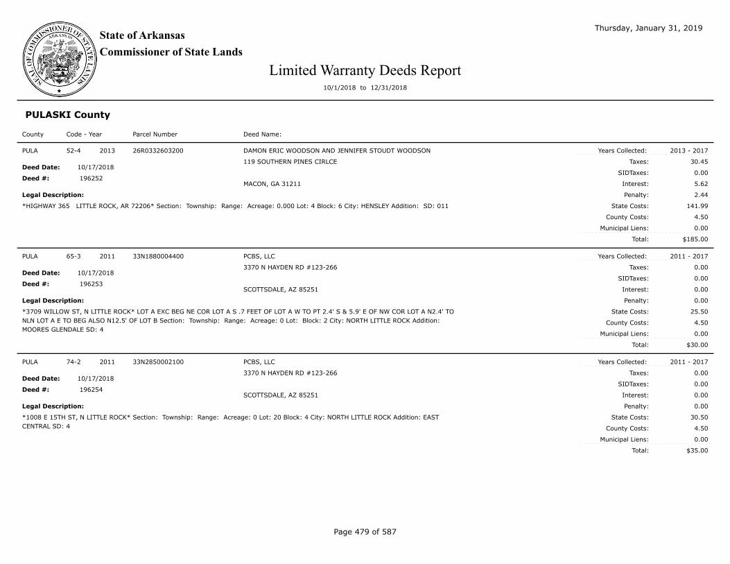
State of Arkansas
Commissioner of State Lands
Thursday, January 31, 2019
Limited Warranty Deeds Report10/1/2018 to 12/31/2018
PULASKI County
Code - Year Parcel Number Deed Name:County
$185.00
Taxes:
SIDTaxes:
Interest:
County Costs:
Municipal Liens:
Total:
Deed Date:
Deed #:
Years Collected:
Legal Description: Penalty:
State Costs:
52-4 2013 26R0332603200 DAMON ERIC WOODSON AND JENNIFER STOUDT WOODSON
119 SOUTHERN PINES CIRLCE
MACON, GA 31211
*HIGHWAY 365 LITTLE ROCK, AR 72206* Section: Township: Range: Acreage: 0.000 Lot: 4 Block: 6 City: HENSLEY Addition: SD: 011
2013 - 2017
30.45
0.00
5.62
2.44
141.99
4.50
0.00
10/17/2018
PULA
196252
$30.00
Taxes:
SIDTaxes:
Interest:
County Costs:
Municipal Liens:
Total:
Deed Date:
Deed #:
Years Collected:
Legal Description: Penalty:
State Costs:
65-3 2011 33N1880004400 PCBS, LLC
3370 N HAYDEN RD #123-266
SCOTTSDALE, AZ 85251
*3709 WILLOW ST, N LITTLE ROCK* LOT A EXC BEG NE COR LOT A S .7 FEET OF LOT A W TO PT 2.4' S & 5.9' E OF NW COR LOT A N2.4' TO
NLN LOT A E TO BEG ALSO N12.5' OF LOT B Section: Township: Range: Acreage: 0 Lot: Block: 2 City: NORTH LITTLE ROCK Addition:
MOORES GLENDALE SD: 4
2011 - 2017
0.00
0.00
0.00
0.00
25.50
4.50
0.00
10/17/2018
PULA
196253
$35.00
Taxes:
SIDTaxes:
Interest:
County Costs:
Municipal Liens:
Total:
Deed Date:
Deed #:
Years Collected:
Legal Description: Penalty:
State Costs:
74-2 2011 33N2850002100 PCBS, LLC
3370 N HAYDEN RD #123-266
SCOTTSDALE, AZ 85251
*1008 E 15TH ST, N LITTLE ROCK* Section: Township: Range: Acreage: 0 Lot: 20 Block: 4 City: NORTH LITTLE ROCK Addition: EAST
CENTRAL SD: 4
2011 - 2017
0.00
0.00
0.00
0.00
30.50
4.50
0.00
10/17/2018
PULA
196254
Page 479 of 587

State of Arkansas
Commissioner of State Lands
Thursday, January 31, 2019
Limited Warranty Deeds Report10/1/2018 to 12/31/2018
PULASKI County
Code - Year Parcel Number Deed Name:County
$35.00
Taxes:
SIDTaxes:
Interest:
County Costs:
Municipal Liens:
Total:
Deed Date:
Deed #:
Years Collected:
Legal Description: Penalty:
State Costs:
89-6 2011 34L1340000500 PCBS, LLC
3370 N HAYDEN RD #123-266
SCOTTSDALE, AZ 85251
*4816 W 22ND ST, LITTLE ROCK* E1/2 OF LOTS 5 & 6 Section: Township: Range: Acreage: 0 Lot: Block: 1 City: LITTLE ROCK Addition:
WALTHOUR SUB OF HYDE PARK SD: 1
2003 - 2017
0.00
0.00
0.00
0.00
30.50
4.50
0.00
10/17/2018
PULA
196255
$35.00
Taxes:
SIDTaxes:
Interest:
County Costs:
Municipal Liens:
Total:
Deed Date:
Deed #:
Years Collected:
Legal Description: Penalty:
State Costs:
93-4 2011 34L1570006600 PCBS, LLC
3370 N HAYDEN RD #123-266
SCOTTSDALE, AZ 85251
*1905 S VALENTINE ST, LITTLE ROCK* Section: Township: Range: Acreage: 0 Lot: 2 Block: 6 City: LITTLE ROCK Addition: BRADDOCKS SD:
1
2011 - 2017
0.00
0.00
0.00
0.00
30.50
4.50
0.00
10/17/2018
PULA
196256
$35.00
Taxes:
SIDTaxes:
Interest:
County Costs:
Municipal Liens:
Total:
Deed Date:
Deed #:
Years Collected:
Legal Description: Penalty:
State Costs:
93-9 2011 34L1570012600 PCBS, LLC
3370 N HAYDEN RD #123-266
SCOTTSDALE, AZ 85251
*3821 W 16TH ST, LITTLE ROCK* Section: Township: Range: Acreage: 0 Lot: 7 Block: 11 City: LITTLE ROCK Addition: BRADDOCKS SD: 1
2011 - 2017
0.00
0.00
0.00
0.00
30.50
4.50
0.00
10/17/2018
PULA
196257
Page 480 of 587

State of Arkansas
Commissioner of State Lands
Thursday, January 31, 2019
Limited Warranty Deeds Report10/1/2018 to 12/31/2018
PULASKI County
Code - Year Parcel Number Deed Name:County
$35.00
Taxes:
SIDTaxes:
Interest:
County Costs:
Municipal Liens:
Total:
Deed Date:
Deed #:
Years Collected:
Legal Description: Penalty:
State Costs:
96-2 2011 34L1640001800 PCBS, LLC
3370 N HAYDEN RD #123-266
SCOTTSDALE, AZ 85251
*4015 W 21ST ST, LITTLE ROCK* Section: Township: Range: Acreage: 0 Lot: 5-6 Block: 2 City: LITTLE ROCK Addition: NEIMEYERS SD: 1
2011 - 2017
0.00
0.00
0.00
0.00
30.50
4.50
0.00
10/17/2018
PULA
196258
$35.00
Taxes:
SIDTaxes:
Interest:
County Costs:
Municipal Liens:
Total:
Deed Date:
Deed #:
Years Collected:
Legal Description: Penalty:
State Costs:
97-8 2011 34L1690002500 PCBS, LLC
3370 N HAYDEN RD #123-266
SCOTTSDALE, AZ 85251
*4405 W 25TH ST, LITTLE ROCK* Section: Township: Range: Acreage: 0 Lot: 2 Block: 3 City: LITTLE ROCK Addition: WEST MILL SD: 1
2011 - 2017
0.00
0.00
0.00
0.00
30.50
4.50
0.00
10/17/2018
PULA
196259
$35.00
Taxes:
SIDTaxes:
Interest:
County Costs:
Municipal Liens:
Total:
Deed Date:
Deed #:
Years Collected:
Legal Description: Penalty:
State Costs:
98-3 2011 34L1700002800 PCBS, LLC
3370 N HAYDEN RD #123-266
SCOTTSDALE, AZ 85251
*2701 WASHINGTON ST, LITTLE ROCK* N48' OF LOTS 4 THRU 6 Section: Township: Range: Acreage: 0 Lot: Block: 3 City: LITTLE ROCK
Addition: LANDRETH & COX SD: 1
2011 - 2017
0.00
0.00
0.00
0.00
30.50
4.50
0.00
10/17/2018
PULA
196260
Page 481 of 587

State of Arkansas
Commissioner of State Lands
Thursday, January 31, 2019
Limited Warranty Deeds Report10/1/2018 to 12/31/2018
PULASKI County
Code - Year Parcel Number Deed Name:County
$2,383.45
Taxes:
SIDTaxes:
Interest:
County Costs:
Municipal Liens:
Total:
Deed Date:
Deed #:
Years Collected:
Legal Description: Penalty:
State Costs:
92-1 2013 34L1620006000 H. LEE LINDSEY & KIMBERLY LINDSEY O`GUINN
1400 ABIGAIL ST
LITTLE ROCK, AR 72204
4223 W 14TH ST LITTLE ROCK, AR 72204 Section: Township: Range: Acreage: 0.000 Lot: 6 Block: 7 City: LITTLE ROCK Addition: JOHNSON
S J SD: 001
2013 - 2017
1,681.46
0.00
378.49
168.15
150.85
4.50
0.00
10/23/2018
PULA
196386
$60.00
Taxes:
SIDTaxes:
Interest:
County Costs:
Municipal Liens:
Total:
Deed Date:
Deed #:
Years Collected:
Legal Description: Penalty:
State Costs:
130-6 2006 34L0450010900 MICHAEL D. WILKINS II
7813 W 44TH ST
LITTLE ROCK, AR 72204
JONES ST LITTLE ROCK, AR Section: Township: Range: Acreage: 0.16 Lot: 1 Block: 15 City: LITTLE ROCK Addition: ROOTS & COY SD: 1
2006 - 2017
0.05
0.00
0.00
0.00
57.55
2.40
0.00
10/24/2018
PULA
196429
$85.00
Taxes:
SIDTaxes:
Interest:
County Costs:
Municipal Liens:
Total:
Deed Date:
Deed #:
Years Collected:
Legal Description: Penalty:
State Costs:
156-3 2006 34L1890004400 MICHAEL D. WILKINS II
7813 W 44TH ST
LITTLE ROCK, AR 72204
2814 W 14TH ST LITTLE ROCK, AR 72204 Section: Township: Range: Acreage: 0 Lot: 11 Block: 4 City: LITTLE ROCK Addition: WORTHEN &
BROWN SD: 1
2006 - 2017
0.00
0.00
0.00
0.00
82.60
2.40
0.00
10/24/2018
PULA
196430
Page 482 of 587

State of Arkansas
Commissioner of State Lands
Thursday, January 31, 2019
Limited Warranty Deeds Report10/1/2018 to 12/31/2018
PULASKI County
Code - Year Parcel Number Deed Name:County
$60.00
Taxes:
SIDTaxes:
Interest:
County Costs:
Municipal Liens:
Total:
Deed Date:
Deed #:
Years Collected:
Legal Description: Penalty:
State Costs:
107-3 2008 34L1890003200 MICHAEL D. WILKINS II
7813 W 44TH ST
LITTLE ROCK, AR 72204
2718 W 13TH ST LITTLE ROCK, AR 72204 Section: Township: Range: Acreage: 0.2 Lot: 17 Block: 3 City: LITTLE ROCK Addition: WORTHEN
& BROWN SD: 1
2008 - 2017
7.00
0.00
0.89
0.70
46.91
4.50
0.00
10/24/2018
PULA
196431
$604.54
Taxes:
SIDTaxes:
Interest:
County Costs:
Municipal Liens:
Total:
Deed Date:
Deed #:
Years Collected:
Legal Description: Penalty:
State Costs:
104-5 2012 34L2670010600 LUCILLE SPIVEY
2601 SOUTH CROSS #B
LITTLE ROCK , AR 72206
MARTEL AVE LITTLE ROCK, AR 72206 Section: Township: Range: Acreage: 0.000 Lot: 23 Block: 3 City: LITTLE ROCK Addition: TUXEDO PARK
SD: 1
2012 - 2017
287.26
0.00
69.89
28.73
214.16
4.50
0.00
10/24/2018
PULA
196432
$736.12
Taxes:
SIDTaxes:
Interest:
County Costs:
Municipal Liens:
Total:
Deed Date:
Deed #:
Years Collected:
Legal Description: Penalty:
State Costs:
104-7 2012 34L2690000500 AEQUUS QUAN PENSUM
2513 MCCAIN BLVD STE 2/310
N LITTLE ROCK, AR 72116
*3115 S MAIN ST LITTLE ROCK, AR 72206* N1/2 OF LOT 4 Section: Township: Range: Acreage: 0.000 Lot: Block: 1 City: LITTLE ROCK
Addition: ROBINSON SD: 1
2012 - 2017
279.49
0.00
67.73
27.95
356.45
4.50
0.00
11/01/2018
PULA
196639
Page 483 of 587

State of Arkansas
Commissioner of State Lands
Thursday, January 31, 2019
Limited Warranty Deeds Report10/1/2018 to 12/31/2018
PULASKI County
Code - Year Parcel Number Deed Name:County
$741.34
Taxes:
SIDTaxes:
Interest:
County Costs:
Municipal Liens:
Total:
Deed Date:
Deed #:
Years Collected:
Legal Description: Penalty:
State Costs:
114-10 2013 34L2680002800 BRYAN T. BRIGGS
2906 CENTER
LITTLE ROCK, AR 72206
3018 S MAIN ST LITTLE ROCK, AR 72206 Section: Township: Range: Acreage: 0.000 Lot: 12 Block: 2 City: LITTLE ROCK Addition: SOUTH
MAIN STREET SD: 001
2013 - 2017
252.14
0.00
47.32
20.17
136.95
4.50
280.26
11/07/2018
PULA
196708
$385.00
Taxes:
SIDTaxes:
Interest:
County Costs:
Municipal Liens:
Total:
Deed Date:
Deed #:
Years Collected:
Legal Description: Penalty:
State Costs:
90-4 2007 34L0760007700 MICHAEL D. WILKINS II
7813 W 44TH ST
LITTLE ROCK, AR 72204
*1006 S MAPLE, LITTLE ROCK* S1/2 OF LOTS 1, 2, & 3 Section: Township: Range: Acreage: 0 Lot: Block: 9 City: LITTLE ROCK Addition:
FOREST HILL SD: 1
2007 - 2017
20.00
0.00
7.30
2.00
353.30
2.40
0.00
11/07/2018
PULA
196709
$285.00
Taxes:
SIDTaxes:
Interest:
County Costs:
Municipal Liens:
Total:
Deed Date:
Deed #:
Years Collected:
Legal Description: Penalty:
State Costs:
129-6 2011 35L0013003100 MICHAEL D. WILKINS II
7813 W 44TH ST
LITTLE ROCK, AR 72204
*RECK RD, LITTLE ROCK* N1/2 OF LOT 12 Section: Township: Range: Acreage: 0 Lot: Block: City: LITTLE ROCK Addition: RINKE
GARDENS ACRES SD: 1
2011 - 2017
30.00
0.00
6.30
3.00
241.20
4.50
0.00
11/07/2018
PULA
196710
Page 484 of 587

State of Arkansas
Commissioner of State Lands
Thursday, January 31, 2019
Limited Warranty Deeds Report10/1/2018 to 12/31/2018
PULASKI County
Code - Year Parcel Number Deed Name:County
$185.00
Taxes:
SIDTaxes:
Interest:
County Costs:
Municipal Liens:
Total:
Deed Date:
Deed #:
Years Collected:
Legal Description: Penalty:
State Costs:
155-4 2011 43R0120109000 MICHAEL D. WILKINS II
7813 W 44TH ST
LITTLE ROCK, AR 72204
*NORMAN RD, N LITTLE ROCK, AR 72118* Section: 12 Township: 2N Range: 13W Acreage: 0 Lot: 52 Block: 0 City: Addition: HIGHLAND SD:
12
2011 - 2017
1.50
0.00
0.20
0.15
178.65
4.50
0.00
11/07/2018
PULA
196711
$185.00
Taxes:
SIDTaxes:
Interest:
County Costs:
Municipal Liens:
Total:
Deed Date:
Deed #:
Years Collected:
Legal Description: Penalty:
State Costs:
155-3 2011 43R0120108900 MICHAEL D. WILKINS II
7813 W 44TH ST
LITTLE ROCK, AR 72204
*NORMAN RD N LITTLE ROCK, AR 72118* Section: 12 Township: 2N Range: 13W Acreage: 0 Lot: 51 Block: 0 City: Addition: HIGHLAND SD:
12
2011 - 2017
1.50
0.00
0.20
0.15
178.65
4.50
0.00
11/07/2018
PULA
196712
$35.00
Taxes:
SIDTaxes:
Interest:
County Costs:
Municipal Liens:
Total:
Deed Date:
Deed #:
Years Collected:
Legal Description: Penalty:
State Costs:
152-2 2003 34L2750202800 PROFESSIONAL HOUSING & LAND, LLC
75 N WOODWARD AVE #81956
TALLAHASSEE, FL 32313
W2/3 OF LOT 3 Section: Township: Range: Acreage: 0 Lot: Block: 27 City: LITTLE ROCK Addition: BRADDOCKS BLVD SD: 1
2003 - 2017
0.00
0.00
0.00
0.00
31.10
3.90
0.00
11/13/2018
PULA
196763
Page 485 of 587

State of Arkansas
Commissioner of State Lands
Thursday, January 31, 2019
Limited Warranty Deeds Report10/1/2018 to 12/31/2018
PULASKI County
Code - Year Parcel Number Deed Name:County
$35.00
Taxes:
SIDTaxes:
Interest:
County Costs:
Municipal Liens:
Total:
Deed Date:
Deed #:
Years Collected:
Legal Description: Penalty:
State Costs:
128-5 2005 34L1180003700 PROFESSIONAL HOUSING & LAND, LLC
75 N WOODWARD AVE #81956
TALLAHASSEE, FL 32313
1421 ADAMS ST LITTLE ROCK Section: Township: Range: Acreage: 0 Lot: 17 Block: 5 City: LITTLE ROCK Addition: BUHLERS 9TH SD: 1
2005 - 2017
0.00
0.00
0.00
0.00
32.60
2.40
0.00
11/13/2018
PULA
196764
$35.00
Taxes:
SIDTaxes:
Interest:
County Costs:
Municipal Liens:
Total:
Deed Date:
Deed #:
Years Collected:
Legal Description: Penalty:
State Costs:
162-3 2005 34L2700008300 PROFESSIONAL HOUSING & LAND, LLC
75 N WOODWARD AVE #81956
TALLAHASSEE, FL 32313
3008 GAINES ST LITTLE ROCK Section: Township: Range: Acreage: 0 Lot: 10 Block: 11 City: LITTLE ROCK Addition: KIMBALL SOUTH PARK
SD: 1
2005 - 2017
0.00
0.00
0.00
0.00
32.60
2.40
0.00
11/13/2018
PULA
196765
$35.00
Taxes:
SIDTaxes:
Interest:
County Costs:
Municipal Liens:
Total:
Deed Date:
Deed #:
Years Collected:
Legal Description: Penalty:
State Costs:
137-2 2006 34L1180005900 PROFESSIONAL HOUSING & LAND, LLC
75 N WOODWARD AVE #81956
TALLAHASSEE, FL 32313
1301 ADAMS ST LITTLE ROCK, AR *CITY LIEN* Section: Township: Range: Acreage: 0 Lot: 20 Block: 6 City: LITTLE ROCK Addition:
BUHLERS 9TH SD: 1
2004 - 2017
0.00
0.00
0.00
0.00
32.60
2.40
0.00
11/13/2018
PULA
196766
Page 486 of 587

State of Arkansas
Commissioner of State Lands
Thursday, January 31, 2019
Limited Warranty Deeds Report10/1/2018 to 12/31/2018
PULASKI County
Code - Year Parcel Number Deed Name:County
$35.00
Taxes:
SIDTaxes:
Interest:
County Costs:
Municipal Liens:
Total:
Deed Date:
Deed #:
Years Collected:
Legal Description: Penalty:
State Costs:
143-7 2006 34L1570008500 PROFESSIONAL HOUSING & LAND, LLC
75 N WOODWARD AVE #81956
TALLAHASSEE, FL 32313
1724 S CEDAR ST LITTLE ROCK, AR Section: Township: Range: Acreage: 0 Lot: 8 Block: 7 City: LITTLE ROCK Addition: BRADDOCKS SD: 1
2006 - 2017
0.00
0.00
0.00
0.00
32.60
2.40
0.00
11/13/2018
PULA
196767
$35.00
Taxes:
SIDTaxes:
Interest:
County Costs:
Municipal Liens:
Total:
Deed Date:
Deed #:
Years Collected:
Legal Description: Penalty:
State Costs:
149-5 2006 34L1700000200 PROFESSIONAL HOUSING & LAND, LLC
75 N WOODWARD AVE #81956
TALLAHASSEE, FL 32313
*2612 ABIGAIL ST, LITTLE ROCK* S50' OF LOTS 1 & 2 *CITY LIEN* Section: Township: Range: Acreage: 0 Lot: Block: 1 City: LITTLE ROCK
Addition: LANDRETH & COX SD: 1
2006 - 2017
0.00
0.00
0.00
0.00
32.60
2.40
0.00
11/13/2018
PULA
196768
$35.00
Taxes:
SIDTaxes:
Interest:
County Costs:
Municipal Liens:
Total:
Deed Date:
Deed #:
Years Collected:
Legal Description: Penalty:
State Costs:
176-4 2006 34L2750112500 PROFESSIONAL HOUSING & LAND, LLC
75 N WOODWARD AVE #81956
TALLAHASSEE, FL 32313
2708 MARSHALL ST LITTLE ROCK, AR Section: Township: Range: Acreage: 0 Lot: 10 Block: 20 City: LITTLE ROCK Addition: BRADDOCKS
BLVD L1 SD: 1
2006 - 2017
0.00
0.00
0.00
0.00
32.60
2.40
0.00
11/13/2018
PULA
196769
Page 487 of 587

State of Arkansas
Commissioner of State Lands
Thursday, January 31, 2019
Limited Warranty Deeds Report10/1/2018 to 12/31/2018
PULASKI County
Code - Year Parcel Number Deed Name:County
$35.00
Taxes:
SIDTaxes:
Interest:
County Costs:
Municipal Liens:
Total:
Deed Date:
Deed #:
Years Collected:
Legal Description: Penalty:
State Costs:
96-2 2007 34L1360006700 PROFESSIONAL HOUSING & LAND, LLC
75 N WOODWARD AVE #81956
TALLAHASSEE, FL 32313
4722 W 26TH LITTLE ROCK, AR 72204 Section: Township: Range: Acreage: 0 Lot: 8 Block: 6 City: LITTLE ROCK Addition: DOWDY & TERRY
SD: 1
2006 - 2017
0.00
0.00
0.00
0.00
32.60
2.40
0.00
11/13/2018
PULA
196770
$35.00
Taxes:
SIDTaxes:
Interest:
County Costs:
Municipal Liens:
Total:
Deed Date:
Deed #:
Years Collected:
Legal Description: Penalty:
State Costs:
117-7 2007 34L2690005100 PROFESSIONAL HOUSING & LAND, LLC
75 N WOODWARD AVE #81956
TALLAHASSEE, FL 32313
*LOUISIANA, LITTLE ROCK* Section: Township: Range: Acreage: 0 Lot: 12 Block: 3 City: LITTLE ROCK Addition: ROBINSON SD: 001
2007 - 2017
0.00
0.00
0.00
0.00
32.60
2.40
0.00
11/13/2018
PULA
196771
$35.00
Taxes:
SIDTaxes:
Interest:
County Costs:
Municipal Liens:
Total:
Deed Date:
Deed #:
Years Collected:
Legal Description: Penalty:
State Costs:
92-2 2008 34L0920028800 PROFESSIONAL HOUSING & LAND, LLC
75 N WOODWARD AVE #81956
TALLAHASSEE, FL 32313
*1418 S MARTIN ST, LITTLE ROCK* MID 46 2/3' OF LOTS 10 THRU 12 & W10' OF S46 2/3' OF LOT 10 Section: Township: Range: Acreage: 0
Lot: Block: 28 City: LITTLE ROCK Addition: JONES & WORTHEN SD: 1
2008 - 2017
0.00
0.00
0.00
0.00
30.50
4.50
0.00
11/13/2018
PULA
196772
Page 488 of 587

State of Arkansas
Commissioner of State Lands
Thursday, January 31, 2019
Limited Warranty Deeds Report10/1/2018 to 12/31/2018
PULASKI County
Code - Year Parcel Number Deed Name:County
$35.00
Taxes:
SIDTaxes:
Interest:
County Costs:
Municipal Liens:
Total:
Deed Date:
Deed #:
Years Collected:
Legal Description: Penalty:
State Costs:
135-1 2008 35L0012605300 PROFESSIONAL HOUSING & LAND, LLC
75 N WOODWARD AVE #81956
TALLAHASSEE, FL 32313
*3950 WOODDALE DR LITTLE ROCK, AR 72209* Section: Township: Range: Acreage: 0 Lot: 53 Block: 0 City: LITTLE ROCK Addition:
DOGWOOD VILLAGE SD: 1
2008 - 2017
0.00
0.00
0.00
0.00
30.50
4.50
0.00
11/13/2018
PULA
196773
$30.00
Taxes:
SIDTaxes:
Interest:
County Costs:
Municipal Liens:
Total:
Deed Date:
Deed #:
Years Collected:
Legal Description: Penalty:
State Costs:
71-7 2009 33N2580000400 PROFESSIONAL HOUSING & LAND, LLC
75 N WOODWARD AVE #81956
TALLAHASSEE, FL 32313
*18TH ST N LITTLE ROCK, AR 72114* THAT PT NE1/4 SE1/4 SE1/4 SEC 27 T2N R12W DESC AS COM AT NE COR OF NE1/4 SE1/4 SE1/4 SAID
SEC 27 & RUN TH S ALONG SEC LINE 218' TO PROPERTY LINE OF 18TH ST IN NLR TH W ALONG SAID W PROPERTY LINE OF 18TH ST 388' TO
PT OF BEG OF LOT THEREIN TO BE DESC TH RUN N140' TH W115.1/2' TO R OF W OF CONWAY PIKE TH SE ALONG R OF W OF SAID PIKE TO
ITS INTERSECTION WITH N LINE OF W 18TH ST OF THE E50' TO PT OF BEG Section: 27 Township: 2N Range: 12W Acreage: 0.27 Lot: Block:
City: NORTH LITTLE ROCK Addition: CASSINELLI SD: 4
2009 - 2017
0.00
0.00
0.00
0.00
25.50
4.50
0.00
11/13/2018
PULA
196774
$35.00
Taxes:
SIDTaxes:
Interest:
County Costs:
Municipal Liens:
Total:
Deed Date:
Deed #:
Years Collected:
Legal Description: Penalty:
State Costs:
99-2 2009 34L1570018300 PROFESSIONAL HOUSING & LAND, LLC
75 N WOODWARD AVE #81956
TALLAHASSEE, FL 32313
*3817 W 19TH ST LITTLE ROCK, AR 72204 * Section: Township: Range: Acreage: 0 Lot: 6 Block: 16 City: LITTLE ROCK Addition:
BRADDOCKS SD: 1
2009 - 2017
0.00
0.00
0.00
0.00
30.50
4.50
0.00
11/13/2018
PULA
196775
Page 489 of 587

State of Arkansas
Commissioner of State Lands
Thursday, January 31, 2019
Limited Warranty Deeds Report10/1/2018 to 12/31/2018
PULASKI County
Code - Year Parcel Number Deed Name:County
$35.00
Taxes:
SIDTaxes:
Interest:
County Costs:
Municipal Liens:
Total:
Deed Date:
Deed #:
Years Collected:
Legal Description: Penalty:
State Costs:
125-7 2009 34L2750306200 PROFESSIONAL HOUSING & LAND, LLC
75 N WOODWARD AVE #81956
TALLAHASSEE, FL 32313
*1221 W 33RD ST LITTLE ROCK, AR 72206* Section: Township: Range: Acreage: 0 Lot: 6 Block: 53 City: LITTLE ROCK Addition:
BRADDOCKS BLVD L3 SD: 1
2009 - 2017
0.00
0.00
0.00
0.00
30.50
4.50
0.00
11/13/2018
PULA
196776
$35.00
Taxes:
SIDTaxes:
Interest:
County Costs:
Municipal Liens:
Total:
Deed Date:
Deed #:
Years Collected:
Legal Description: Penalty:
State Costs:
114-7 2010 34L0920025400 PROFESSIONAL HOUSING & LAND, LLC
75 N WOODWARD AVE #81956
TALLAHASSEE, FL 32313
*1400 ALLIS ST LITTLE ROCK, AR 72204* Section: Township: Range: Acreage: 0 Lot: 1 Block: 26 City: LITTLE ROCK Addition: JONES &
WORTHEN SD: 1
2010 - 2017
0.00
0.00
0.00
0.00
30.50
4.50
0.00
11/13/2018
PULA
196777
$35.00
Taxes:
SIDTaxes:
Interest:
County Costs:
Municipal Liens:
Total:
Deed Date:
Deed #:
Years Collected:
Legal Description: Penalty:
State Costs:
120-5 2010 34L1400000100 PROFESSIONAL HOUSING & LAND, LLC
75 N WOODWARD AVE #81956
TALLAHASSEE, FL 32313
*5209 W 22ND ST LITTLE ROCK, AR 72120* Section: Township: Range: Acreage: 0 Lot: 1 Block: 1 City: LITTLE ROCK Addition: FORSTER
SD: 1
2010 - 2017
0.00
0.00
0.00
0.00
30.50
4.50
0.00
11/13/2018
PULA
196778
Page 490 of 587

State of Arkansas
Commissioner of State Lands
Thursday, January 31, 2019
Limited Warranty Deeds Report10/1/2018 to 12/31/2018
PULASKI County
Code - Year Parcel Number Deed Name:County
$35.00
Taxes:
SIDTaxes:
Interest:
County Costs:
Municipal Liens:
Total:
Deed Date:
Deed #:
Years Collected:
Legal Description: Penalty:
State Costs:
129-3 2010 34L1680002800 PROFESSIONAL HOUSING & LAND, LLC
75 N WOODWARD AVE #81956
TALLAHASSEE, FL 32313
*2421 S ELM ST LITTLE ROCK, AR 72204* N50' OF 5 & 6 Section: Township: Range: Acreage: 0 Lot: Block: 4 City: LITTLE ROCK Addition: R
C BUTLERS SD: 1
2010 - 2017
0.00
0.00
0.00
0.00
30.50
4.50
0.00
11/13/2018
PULA
196779
$35.00
Taxes:
SIDTaxes:
Interest:
County Costs:
Municipal Liens:
Total:
Deed Date:
Deed #:
Years Collected:
Legal Description: Penalty:
State Costs:
137-9 2010 34L1950006600 PROFESSIONAL HOUSING & LAND, LLC
75 N WOODWARD AVE #81956
TALLAHASSEE, FL 32313
*1520 W 20TH ST LITTLE ROCK, AR 72202* Section: Township: Range: Acreage: 0 Lot: 18 Block: 5 City: LITTLE ROCK Addition: FLEMING &
BRADFORD SD: 1
2010 - 2017
0.00
0.00
0.00
0.00
30.50
4.50
0.00
11/13/2018
PULA
196780
$35.00
Taxes:
SIDTaxes:
Interest:
County Costs:
Municipal Liens:
Total:
Deed Date:
Deed #:
Years Collected:
Legal Description: Penalty:
State Costs:
39-6 2011 24N0060009100 PROFESSIONAL HOUSING & LAND, LLC
75 N WOODWARD AVE #81956
TALLAHASSEE, FL 32313
*142 SAUNDERS DR N LITTLE ROCK, AR 72117* Section: Township: Range: Acreage: 0 Lot: 91 Block: 0 City: NORTH LITTLE ROCK Addition:
WALTERS #3 SD: 4
2011 - 2017
0.00
0.00
0.00
0.00
30.50
4.50
0.00
11/13/2018
PULA
196781
Page 491 of 587

State of Arkansas
Commissioner of State Lands
Thursday, January 31, 2019
Limited Warranty Deeds Report10/1/2018 to 12/31/2018
PULASKI County
Code - Year Parcel Number Deed Name:County
$35.00
Taxes:
SIDTaxes:
Interest:
County Costs:
Municipal Liens:
Total:
Deed Date:
Deed #:
Years Collected:
Legal Description: Penalty:
State Costs:
50-7 2011 25W0080013300 PROFESSIONAL HOUSING & LAND, LLC
75 N WOODWARD AVE #81956
TALLAHASSEE, FL 32313
5506 ADAMS ST WRIGHTSVILLE, AR 72183 Section: Township: Range: Acreage: 0 Lot: 8 Block: 14 City: WRIGHTSVILLE Addition: TAFTON
SD: 16
2011 - 2017
0.00
0.00
0.00
0.00
30.50
4.50
0.00
11/13/2018
PULA
196782
$35.00
Taxes:
SIDTaxes:
Interest:
County Costs:
Municipal Liens:
Total:
Deed Date:
Deed #:
Years Collected:
Legal Description: Penalty:
State Costs:
86-4 2011 34L0920006900 PROFESSIONAL HOUSING & LAND, LLC
75 N WOODWARD AVE #81956
TALLAHASSEE, FL 32313
*W 11TH ST, LITTLE ROCK* LOT 3 BLOCK 6 LESS & EXC 139 SQFT FOR R/W PER DEED 05-029793 Section: Township: Range: Acreage: 0
Lot: Block: 6 City: LITTLE ROCK Addition: JONES & WORTHEN SD: 1
2011 - 2017
0.00
0.00
0.00
0.00
30.50
4.50
0.00
11/13/2018
PULA
196783
$35.00
Taxes:
SIDTaxes:
Interest:
County Costs:
Municipal Liens:
Total:
Deed Date:
Deed #:
Years Collected:
Legal Description: Penalty:
State Costs:
88-2 2011 34L1220012900 PROFESSIONAL HOUSING & LAND, LLC
75 N WOODWARD AVE #81956
TALLAHASSEE, FL 32313
*1717 S MONROE ST LITTLE ROCK, AR 72204* Section: Township: Range: Acreage: 0 Lot: 5 Block: 10 City: LITTLE ROCK Addition:
BUHLERS 10TH SD: 1
2011 - 2017
0.00
0.00
0.00
0.00
30.50
4.50
0.00
11/13/2018
PULA
196784
Page 492 of 587

State of Arkansas
Commissioner of State Lands
Thursday, January 31, 2019
Limited Warranty Deeds Report10/1/2018 to 12/31/2018
PULASKI County
Code - Year Parcel Number Deed Name:County
$35.00
Taxes:
SIDTaxes:
Interest:
County Costs:
Municipal Liens:
Total:
Deed Date:
Deed #:
Years Collected:
Legal Description: Penalty:
State Costs:
89-4 2011 34L1310001200 PROFESSIONAL HOUSING & LAND, LLC
75 N WOODWARD AVE #81956
TALLAHASSEE, FL 32313
*4606 W 21ST ST LITTLE ROCK, AR 72204* Section: Township: Range: Acreage: 0 Lot: 13 Block: 1 City: LITTLE ROCK Addition: STEIL &
YOUTS SD: 1
2011 - 2017
0.00
0.00
0.00
0.00
30.50
4.50
0.00
11/13/2018
PULA
196785
$35.00
Taxes:
SIDTaxes:
Interest:
County Costs:
Municipal Liens:
Total:
Deed Date:
Deed #:
Years Collected:
Legal Description: Penalty:
State Costs:
91-1 2011 34L1470001000 PROFESSIONAL HOUSING & LAND, LLC
75 N WOODWARD AVE #81956
TALLAHASSEE, FL 32313
*1608 BROWN ST LITTLE ROCK, AR 72204* TRACT ''C'' PT NE1/4 SW1/4 NE1/4 BEG 496.5 FT N OF SE COR TH N 24 FT, W 90 FT, S 24 FT, E
90 FT TO BEG Section: 8 Township: 1N Range: 12W Acreage: 0 Lot: Block: City: LITTLE ROCK Addition: SD: 1
2011 - 2017
0.00
0.00
0.00
0.00
30.50
4.50
0.00
11/13/2018
PULA
196786
$35.00
Taxes:
SIDTaxes:
Interest:
County Costs:
Municipal Liens:
Total:
Deed Date:
Deed #:
Years Collected:
Legal Description: Penalty:
State Costs:
93-6 2011 34L1570010000 PROFESSIONAL HOUSING & LAND, LLC
75 N WOODWARD AVE #81956
TALLAHASSEE, FL 32313
1622 S CEDAR ST LITTLE ROCK, AR 72204 Section: Township: Range: Acreage: 0 Lot: 9 Block: 8 City: LITTLE ROCK Addition: BRADDOCKS
SD: 1
2011 - 2017
0.00
0.00
0.00
0.00
30.50
4.50
0.00
11/13/2018
PULA
196787
Page 493 of 587

State of Arkansas
Commissioner of State Lands
Thursday, January 31, 2019
Limited Warranty Deeds Report10/1/2018 to 12/31/2018
PULASKI County
Code - Year Parcel Number Deed Name:County
$35.00
Taxes:
SIDTaxes:
Interest:
County Costs:
Municipal Liens:
Total:
Deed Date:
Deed #:
Years Collected:
Legal Description: Penalty:
State Costs:
95-7 2011 34L1620007400 PROFESSIONAL HOUSING & LAND, LLC
75 N WOODWARD AVE #81956
TALLAHASSEE, FL 32313
4318 W15TH ST LITTLE ROCK, AR 72204 Section: Township: Range: Acreage: 0 Lot: 9 Block: 8 City: LITTLE ROCK Addition: S J JOHNSON
SD: 1
2011 - 2017
0.00
0.00
0.00
0.00
30.50
4.50
0.00
11/13/2018
PULA
196788
$35.00
Taxes:
SIDTaxes:
Interest:
County Costs:
Municipal Liens:
Total:
Deed Date:
Deed #:
Years Collected:
Legal Description: Penalty:
State Costs:
96-9 2011 34L1650001400 PROFESSIONAL HOUSING & LAND, LLC
75 N WOODWARD AVE #81956
TALLAHASSEE, FL 32313
2200 S PINE ST LITTLE ROCK, AR 72204 EXCEPT 10' BY 10' IN LT 12 Section: Township: Range: Acreage: 0 Lot: 12 Block: 6 City: LITTLE
ROCK Addition: WAYMANS SD: 1
2011 - 2017
0.00
0.00
0.00
0.00
30.50
4.50
0.00
11/13/2018
PULA
196789
$35.00
Taxes:
SIDTaxes:
Interest:
County Costs:
Municipal Liens:
Total:
Deed Date:
Deed #:
Years Collected:
Legal Description: Penalty:
State Costs:
114-9 2011 34L2680001200 PROFESSIONAL HOUSING & LAND, LLC
75 N WOODWARD AVE #81956
TALLAHASSEE, FL 32313
*MAIN ST LITTLE ROCK, AR 72206* Section: Township: Range: Acreage: 0 Lot: 11 Block: 1 City: LITTLE ROCK Addition: SOUTH MAIN
STREET SD: 1
2011 - 2017
0.00
0.00
0.00
0.00
30.50
4.50
0.00
11/13/2018
PULA
196790
Page 494 of 587

State of Arkansas
Commissioner of State Lands
Thursday, January 31, 2019
Limited Warranty Deeds Report10/1/2018 to 12/31/2018
PULASKI County
Code - Year Parcel Number Deed Name:County
$35.00
Taxes:
SIDTaxes:
Interest:
County Costs:
Municipal Liens:
Total:
Deed Date:
Deed #:
Years Collected:
Legal Description: Penalty:
State Costs:
155-5 2011 43R0120109100 PROFESSIONAL HOUSING & LAND, LLC
75 N WOODWARD AVE #81956
TALLAHASSEE, FL 32313
NORMAN RD N LITTLE ROCK, AR 72118 Section: 12 Township: 2N Range: 13W Acreage: 0 Lot: 53 Block: 0 City: RURAL Addition: HIGHLAND
SD: 12
2011 - 2017
0.00
0.00
0.00
0.00
30.50
4.50
0.00
11/13/2018
PULA
196791
$35.00
Taxes:
SIDTaxes:
Interest:
County Costs:
Municipal Liens:
Total:
Deed Date:
Deed #:
Years Collected:
Legal Description: Penalty:
State Costs:
166-6 2011 44L1460009100 PROFESSIONAL HOUSING & LAND, LLC
75 N WOODWARD AVE #81956
TALLAHASSEE, FL 32313
*10102 YELLOW PINE LN LITTLE ROCK, AR 72204* Section: Township: Range: Acreage: 0 Lot: 87 Block: 0 City: LITTLE ROCK Addition: TALL
TIMBER WEST SD: 1
2011 - 2017
0.00
0.00
0.00
0.00
30.50
4.50
0.00
11/13/2018
PULA
196792
$35.00
Taxes:
SIDTaxes:
Interest:
County Costs:
Municipal Liens:
Total:
Deed Date:
Deed #:
Years Collected:
Legal Description: Penalty:
State Costs:
168-5 2011 44L1570003000 PROFESSIONAL HOUSING & LAND, LLC
75 N WOODWARD AVE #81956
TALLAHASSEE, FL 32313
*5207 NANCY CT LITTLE ROCK, AR 72204* LOT 30 EXC N1' Section: Township: Range: Acreage: 0 Lot: Block: City: LITTLE ROCK Addition:
WESTLAWN #2 SD: 1
2011 - 2017
0.00
0.00
0.00
0.00
30.50
4.50
0.00
11/13/2018
PULA
196793
Page 495 of 587

State of Arkansas
Commissioner of State Lands
Thursday, January 31, 2019
Limited Warranty Deeds Report10/1/2018 to 12/31/2018
PULASKI County
Code - Year Parcel Number Deed Name:County
$1,588.23
Taxes:
SIDTaxes:
Interest:
County Costs:
Municipal Liens:
Total:
Deed Date:
Deed #:
Years Collected:
Legal Description: Penalty:
State Costs:
25-7 2013 23N0460032400 BURNS INVESTMENTS PROPERTIES
1911 FRANKLIN STREET
LITTLE ROCK, AR 72204
912 N F ST N LITTLE ROCK, AR 72114 Section: Township: Range: Acreage: 0.000 Lot: 18 Block: 16 City: NORTH LITTLE ROCK Addition:
DIXIE SD: 004
2013 - 2017
1,056.77
0.00
110.58
105.68
310.70
4.50
0.00
11/15/2018
PULA
196874
$885.00
Taxes:
SIDTaxes:
Interest:
County Costs:
Municipal Liens:
Total:
Deed Date:
Deed #:
Years Collected:
Legal Description: Penalty:
State Costs:
121-9 2007 34L2870014500 AMT PROPERTY SOURCE, LLC
2303 WINDSOR COVE
BRYANT, AR 72022
2820 DR M L KING JR BL LITTLE ROCK, AR 72206 Section: Township: Range: Acreage: 0 Lot: 8 Block: 18 City: LITTLE ROCK Addition:
BOWMANS SD: 1
2007 - 2017
400.00
0.00
103.16
40.00
59.18
2.40
280.26
11/15/2018
PULA
196875
$2,868.60
Taxes:
SIDTaxes:
Interest:
County Costs:
Municipal Liens:
Total:
Deed Date:
Deed #:
Years Collected:
Legal Description: Penalty:
State Costs:
65-2 2013 33N2350001800 LRPP & ASSOCIATES
909 MARINA VILLAGE PKWY APT 340
ALAMEDA, CA 94501
*826 W 23RD ST N LITTLE ROCK, AR 72114* Section: Township: Range: Acreage: 0.000 Lot: 15 Block: City: NORTH LITTLE ROCK Addition:
PLAINVIEW SD: 004
2013 - 2017
2,062.24
0.00
389.19
206.22
206.45
4.50
0.00
11/15/2018
PULA
196876
Page 496 of 587

State of Arkansas
Commissioner of State Lands
Thursday, January 31, 2019
Limited Warranty Deeds Report10/1/2018 to 12/31/2018
PULASKI County
Code - Year Parcel Number Deed Name:County
$3,992.68
Taxes:
SIDTaxes:
Interest:
County Costs:
Municipal Liens:
Total:
Deed Date:
Deed #:
Years Collected:
Legal Description: Penalty:
State Costs:
84-5 2013 34L1180005700 LRPP & ASSOCIATES, LLC
909 MARINA VILLAGE PKWY APT 340
ALAMEDA, CA 94501
1217 ADAMS ST LITTLE ROCK, AR 72204 Section: Township: Range: Acreage: 0.000 Lot: 18 Block: 6 City: LITTLE ROCK Addition: BUHLERS
9TH SD: 001
2013 - 2017
2,407.38
0.00
456.25
240.74
241.20
4.50
642.61
11/15/2018
PULA
196877
$4,631.08
Taxes:
SIDTaxes:
Interest:
County Costs:
Municipal Liens:
Total:
Deed Date:
Deed #:
Years Collected:
Legal Description: Penalty:
State Costs:
94-7 2013 34L1650001800 LRPP & ASSOCIATES, LLC
909 MARINA VILLAGE PKWY APT 340
ALAMEDA, CA 94501
2005 S CEDAR ST LITTLE ROCK, AR 72204 Section: Township: Range: Acreage: 0.000 Lot: 3 Block: 8 City: LITTLE ROCK Addition: WAYMANS
SD: 001
2013 - 2017
3,400.25
0.00
686.80
340.03
199.50
4.50
0.00
11/15/2018
PULA
196878
$985.00
Taxes:
SIDTaxes:
Interest:
County Costs:
Municipal Liens:
Total:
Deed Date:
Deed #:
Years Collected:
Legal Description: Penalty:
State Costs:
199-6 2004 34L2680002200 BRYAN BRIGGS
2906 CENTER ST
LITTLE ROCK, AR 72206
*CITY LIEN* Section: Township: Range: Acreage: 0 Lot: 6 Block: 2 City: LITTLE ROCK Addition: SOUTH MAIN STREET SD: 1
2004 - 2017
756.00
0.00
97.23
70.70
57.17
3.90
0.00
11/27/2018
PULA
196939
Page 497 of 587

State of Arkansas
Commissioner of State Lands
Thursday, January 31, 2019
Limited Warranty Deeds Report10/1/2018 to 12/31/2018
PULASKI County
Code - Year Parcel Number Deed Name:County
$658.36
Taxes:
SIDTaxes:
Interest:
County Costs:
Municipal Liens:
Total:
Deed Date:
Deed #:
Years Collected:
Legal Description: Penalty:
State Costs:
120-6 2013 34L2860013200 JJB COMPUTERS, INC.
1911 FRANKIN ST
LITTLE ROCK, AR 72204
*3200 WOLFE ST, LITTLE ROCK* Section: Township: Range: Acreage: 0.000 Lot: 1 Block: 16 City: LITTLE ROCK Addition: SUNSET ADDN SD:
001
2013 - 2017
373.38
0.00
78.39
37.34
164.75
4.50
0.00
11/27/2018
PULA
196940
$834.43
Taxes:
SIDTaxes:
Interest:
County Costs:
Municipal Liens:
Total:
Deed Date:
Deed #:
Years Collected:
Legal Description: Penalty:
State Costs:
120-2 2013 34L2860000100 JJB COMPUTERS, INC.
1911 FRANKIN
LITTLE ROCK, AR 72204
*2900 WOLFE ST, LITTLE ROCK* Section: Township: Range: Acreage: 0.000 Lot: 1-2 Block: 1 City: LITTLE ROCK Addition: SUNSET SD: 001
2013 - 2017
523.90
0.00
102.79
52.39
150.85
4.50
0.00
11/27/2018
PULA
196941
$85.00
Taxes:
SIDTaxes:
Interest:
County Costs:
Municipal Liens:
Total:
Deed Date:
Deed #:
Years Collected:
Legal Description: Penalty:
State Costs:
100-5 2007 34L1600014600 2VIN HOME INVESTMENTS
PO BOX 1155
LONG BEACH, CA 90802
PINE ST LITTLE ROCK, AR 72204 Section: Township: Range: Acreage: 0 Lot: 9 Block: 14 City: Addition: WORTHEN W B SD: 1
2007 - 2017
20.00
0.00
5.11
2.00
55.49
2.40
0.00
12/06/2018
PULA
197221
Page 498 of 587

State of Arkansas
Commissioner of State Lands
Thursday, January 31, 2019
Limited Warranty Deeds Report10/1/2018 to 12/31/2018
PULASKI County
Code - Year Parcel Number Deed Name:County
$2,001.22
Taxes:
SIDTaxes:
Interest:
County Costs:
Municipal Liens:
Total:
Deed Date:
Deed #:
Years Collected:
Legal Description: Penalty:
State Costs:
101-7 2013 34L1930011200 MARCUS L. CASEY
1303 KING ST.
JACKSONVILLE , AR 72076
2204 HOWARD ST LITTLE ROCK, AR 72202 Section: Township: Range: Acreage: 0.000 Lot: 98 Block: 0 City: LITTLE ROCK Addition: ADAMS
REP #1 SD: 001
2013 - 2017
1,013.09
0.00
262.90
101.31
178.65
4.50
440.77
12/11/2018
PULA
197350
$60.00
Taxes:
SIDTaxes:
Interest:
County Costs:
Municipal Liens:
Total:
Deed Date:
Deed #:
Years Collected:
Legal Description: Penalty:
State Costs:
109-8 2008 34L1950016100 KEITH WHITFIELD
4216 S BOWMAN
LITTLE ROCK, AR 72210
*2105 DR M L KING JR BLVD, LITTLE ROCK* S54' OF LOTS 5 & 6 Section: Township: Range: Acreage: 0 Lot: Block: 12 City: LITTLE ROCK
Addition: FLEMING & BRADFORD SD: 1
2008 - 2017
0.00
0.00
0.00
0.00
55.50
4.50
0.00
12/20/2018
PULA
197562
$85.00
Taxes:
SIDTaxes:
Interest:
County Costs:
Municipal Liens:
Total:
Deed Date:
Deed #:
Years Collected:
Legal Description: Penalty:
State Costs:
90-2 2010 33N1510000300 2VIN HOME INVESTMENTS
PO BOX 1155
LONG BEACH, CA 90802
*4620 PIKE AVE, N LITTLE ROCK, AR 72118* S40' LOT 3 Section: Township: Range: Acreage: 0.13 Lot: Block: 1 City: NORTH LITTLE ROCK
Addition: HOLEADS SD: 4
2010 - 2017
0.00
0.00
0.00
0.00
80.50
4.50
0.00
12/20/2018
PULA
197563
Page 499 of 587

State of Arkansas
Commissioner of State Lands
Thursday, January 31, 2019
Limited Warranty Deeds Report10/1/2018 to 12/31/2018
PULASKI County
Code - Year Parcel Number Deed Name:County
$333.89
Taxes:
SIDTaxes:
Interest:
County Costs:
Municipal Liens:
Total:
Deed Date:
Deed #:
Years Collected:
Legal Description: Penalty:
State Costs:
30-3 2013 23R0163800700 SUBTERRA INVESTMENTS, LLC
2900 PERCY MACHIN DR
NORTH LITTLE ROCK, AR 72114
*JAMISON AVE N LITTLE ROCK, AR 72117* LOT 6 EXC BEG SE COR N20' W70' S20' E70' TB Section: Township: Range: Acreage: 0.000 Lot:
Block: 1 City: Addition: HICKMAN SD: 012
2013 - 2017
110.79
0.00
21.92
11.08
185.60
4.50
0.00
12/20/2018
PULA
197564
$411.28
Taxes:
SIDTaxes:
Interest:
County Costs:
Municipal Liens:
Total:
Deed Date:
Deed #:
Years Collected:
Legal Description: Penalty:
State Costs:
31-4 2012 23R0163805400 SUBTERRA INVESTMENTS, LLC
2900 PERCY MACHIN DR
NORTH LITTLE ROCK, AR 72114
*PATTERSON AVE N LITTLE ROCK, AR 72117* Section: Township: Range: Acreage: 0.000 Lot: 7 Block: 5 City: Addition: HICKMAN SD: 12
2012 - 2017
177.80
0.00
45.82
17.78
165.38
4.50
0.00
12/20/2018
PULA
197565
$35.00
Taxes:
SIDTaxes:
Interest:
County Costs:
Municipal Liens:
Total:
Deed Date:
Deed #:
Years Collected:
Legal Description: Penalty:
State Costs:
40-2 2005 23R0106706500 SUBTERRA INVESTMENTS, LLC
2900 PERCY MACHIN DR
NORTH LITTLE ROCK, AR 72114
8403 SECOND ST Section: Township: Range: Acreage: 0.17 Lot: 70 Block: 0 City: Addition: DIXIE ACRES SUB SD: 12
2005 - 2017
0.00
0.00
0.00
0.00
32.60
2.40
0.00
12/20/2018
PULA
197566
Page 500 of 587

State of Arkansas
Commissioner of State Lands
Thursday, January 31, 2019
Limited Warranty Deeds Report10/1/2018 to 12/31/2018
PULASKI County
Code - Year Parcel Number Deed Name:County
$1,779.57
Taxes:
SIDTaxes:
Interest:
County Costs:
Municipal Liens:
Total:
Deed Date:
Deed #:
Years Collected:
Legal Description: Penalty:
State Costs:
92-1 2012 34L1780011000 PREMIER MANAGEMENT SERVICES, INC
PO BOX 56724
LITTLE ROCK, AR 72215
*MUN LIEN* 2308 S VALENTINE ST LITTLE ROCK, AR 72204 Section: Township: Range: Acreage: 0.000 Lot: 16 Block: 5 City: LITTLE ROCK
Addition: CHESTERFIELD SQUARE SD: 1
2012 - 2017
945.27
0.00
320.42
94.53
220.35
4.50
194.50
12/28/2018
PULA
197692
Totals for PULASKI County (67 ):
Interest:
SIDTaxes:
Taxes:
28,484.79
Penalty:
15,837.72
0.00
3,264.50
1,573.24
5,700.03
270.90
1,838.40
Total:
Municipal Liens:
County Costs:
State Costs:
Page 501 of 587

State of Arkansas
Commissioner of State Lands
Thursday, January 31, 2019
Limited Warranty Deeds Report10/1/2018 to 12/31/2018
RANDOLPH County
Code - Year Parcel Number Deed Name:County
$30.00
Taxes:
SIDTaxes:
Interest:
County Costs:
Municipal Liens:
Total:
Deed Date:
Deed #:
Years Collected:
Legal Description: Penalty:
State Costs:
2-3 2004 020-00984-000 PROFESSIONAL HOUSING & LAND, LLC
75 N WOODWARD AVE #81956
TALLAHASSEE, FL 32313
E60'XS80' BLOCK 48 Section: 27 Township: 19N Range: 1E Acreage: 0 Lot: Block: City: POCAHONTAS Addition: HILL SD:
2004 - 2017
0.00
0.00
0.00
0.00
28.50
1.50
0.00
11/13/2018
RAND
196794
$204.37
Taxes:
SIDTaxes:
Interest:
County Costs:
Municipal Liens:
Total:
Deed Date:
Deed #:
Years Collected:
Legal Description: Penalty:
State Costs:
1-2 2013 001-00430-000 WEAVER`S PROFESSIONAL SERVICES, INC.
PO BOX 881655
PORT ST LUCIE, FL 34988
SE COR SE1/4 NW1/4 Section: 03 Township: 21N Range: 2E Acreage: 1 Lot: Block: City: Addition: SD: 15
2013 - 2017
39.91
0.00
4.62
3.99
151.85
4.00
0.00
11/15/2018
RAND
196879
Totals for RANDOLPH County (2 ):
Interest:
SIDTaxes:
Taxes:
234.37
Penalty:
39.91
0.00
4.62
3.99
180.35
5.50
0.00
Total:
Municipal Liens:
County Costs:
State Costs:
Page 502 of 587

State of Arkansas
Commissioner of State Lands
Thursday, January 31, 2019
Limited Warranty Deeds Report10/1/2018 to 12/31/2018
SALINE County
Code - Year Parcel Number Deed Name:County
$80.00
Taxes:
SIDTaxes:
Interest:
County Costs:
Municipal Liens:
Total:
Deed Date:
Deed #:
Years Collected:
Legal Description: Penalty:
State Costs:
15-3 2011 386-00201-000 RED SQUIRREL PROPERTIES, LLC
62 SIERRA DRIVE
HOT SPRINGS VILLAGE, AR 71909
2006-18765 Section: 7 Township: 1S Range: 17W Acreage: Lot: 2 Block: 10 City: Addition: ALTA VISTA SD: 180
2011 - 2017
12.50
0.00
4.20
1.25
57.80
4.25
0.00
10/17/2018
SALI
196198
$80.00
Taxes:
SIDTaxes:
Interest:
County Costs:
Municipal Liens:
Total:
Deed Date:
Deed #:
Years Collected:
Legal Description: Penalty:
State Costs:
15-5 2011 386-00229-000 RED SQUIRREL PROPERTIES, LLC
62 SIERRA DRIVE
HOT SPRINGS VILLAGE, AR 71909
2005-58050 Section: 7 Township: 1S Range: 17W Acreage: Lot: 30 Block: 10 City: Addition: ALTA VISTA SD: 180
2011 - 2017
20.00
0.00
2.90
2.00
50.85
4.25
0.00
10/17/2018
SALI
196199
$80.00
Taxes:
SIDTaxes:
Interest:
County Costs:
Municipal Liens:
Total:
Deed Date:
Deed #:
Years Collected:
Legal Description: Penalty:
State Costs:
20-5 2011 472-00129-000 RED SQUIRREL PROPERTIES, LLC
62 SIERRA DRIVE
HOT SPRINGS VILLAGE, AR 71909
2006-18765 Section: 10 Township: 01S Range: 18W Acreage: 0 Lot: 24 Block: 004 City: HOT SPRINGS VILLAGE Addition: CIFUENTES SD:
180
2011 - 2017
12.50
0.00
4.20
1.25
57.80
4.25
0.00
10/17/2018
SALI
196200
Page 503 of 587

State of Arkansas
Commissioner of State Lands
Thursday, January 31, 2019
Limited Warranty Deeds Report10/1/2018 to 12/31/2018
SALINE County
Code - Year Parcel Number Deed Name:County
$421.17
Taxes:
SIDTaxes:
Interest:
County Costs:
Municipal Liens:
Total:
Deed Date:
Deed #:
Years Collected:
Legal Description: Penalty:
State Costs:
27-7 2011 596-00052-000 KEN B. CHILTON AND GRAYSON C. CHILTON
5335 KENTUCKY RD
BENTON, AR 72019
2005-116145 Section: 11 Township: 01S Range: 18W Acreage: 0 Lot: 4 Block: 003 City: HOT SPRINGS VILLAGE Addition: HENDAYE SD: 180
2011 - 2017
259.88
0.00
76.81
22.43
57.80
4.25
0.00
10/17/2018
SALI
196201
$424.93
Taxes:
SIDTaxes:
Interest:
County Costs:
Municipal Liens:
Total:
Deed Date:
Deed #:
Years Collected:
Legal Description: Penalty:
State Costs:
36-3 2013 800-28284-000 CHEAP HOME FINDERS, INC.
PO BOX 881655
PORT ST LUCIE, FL 34988
331-097 Section: 14 Township: 02S Range: 15W Acreage: 0 Lot: 47 Block: City: BENTON Addition: GRAY SD: 082
2013 - 2017
224.40
0.00
41.63
17.95
136.95
4.00
0.00
10/17/2018
SALI
196261
$544.01
Taxes:
SIDTaxes:
Interest:
County Costs:
Municipal Liens:
Total:
Deed Date:
Deed #:
Years Collected:
Legal Description: Penalty:
State Costs:
23-3 2012 472-00112-000 D & D VILLAGE PROPERTIES, LLC
32 SIERRA DRIVE
HOT SPRINGS VILLAGE, AR 71909
2012-29794 Section: 11 Township: 1S Range: 18W Acreage: Lot: 7 Block: 4 City: HOT SPRINGS VILLAGE Addition: CIFUENTES SD: 180
2012 - 2017
427.20
0.00
47.21
35.60
30.00
4.00
0.00
10/17/2018
SALI
196262
Page 504 of 587

State of Arkansas
Commissioner of State Lands
Thursday, January 31, 2019
Limited Warranty Deeds Report10/1/2018 to 12/31/2018
SALINE County
Code - Year Parcel Number Deed Name:County
$501.83
Taxes:
SIDTaxes:
Interest:
County Costs:
Municipal Liens:
Total:
Deed Date:
Deed #:
Years Collected:
Legal Description: Penalty:
State Costs:
14-10 2013 471-00090-000 D & D VILLAGE PROPERTIES, LLC
32 SIERRA DRIVE
HOT SPRINGS VILLAGE, AR 71909
2010-22605 Section: 17 Township: 01S Range: 17W Acreage: 0 Lot: 1 Block: 005 City: HOT SPRINGS VILLAGE Addition: CIELO SD: 180
2013 - 2017
400.50
0.00
35.29
32.04
30.00
4.00
0.00
10/17/2018
SALI
196263
$1,925.76
Taxes:
SIDTaxes:
Interest:
County Costs:
Municipal Liens:
Total:
Deed Date:
Deed #:
Years Collected:
Legal Description: Penalty:
State Costs:
22-6 2013 599-00160-000 D & D VILLAGE PROPERTIES, LLC
32 SIERRA DRIVE
HOT SPRINGS VILLAGE, AR 71909
2006-59004 Section: 19 Township: 01S Range: 17W Acreage: 0 Lot: 16 Block: 020 City: HOT SPRINGS VILLAGE Addition: ISABELLA SD: 180
2013 - 2017
1,557.50
0.00
209.66
124.60
30.00
4.00
0.00
10/17/2018
SALI
196264
$500.01
Taxes:
SIDTaxes:
Interest:
County Costs:
Municipal Liens:
Total:
Deed Date:
Deed #:
Years Collected:
Legal Description: Penalty:
State Costs:
29-1 2013 674-00002-000 CAPITAL ACCUMULATION & PRESERVATION, INC.
6060 N COSTAL EXPWY STE 560
DALLAS, TX 75206
2000-17304 Section: 12 Township: 01S Range: 18W Acreage: 0 Lot: 2 Block: 001 City: HOT SPRINGS VILLAGE Addition: PERFECTO SD: 180
2013 - 2017
356.00
0.00
53.56
35.60
50.85
4.00
0.00
10/17/2018
SALI
196265
Page 505 of 587

State of Arkansas
Commissioner of State Lands
Thursday, January 31, 2019
Limited Warranty Deeds Report10/1/2018 to 12/31/2018
SALINE County
Code - Year Parcel Number Deed Name:County
$2,167.78
Taxes:
SIDTaxes:
Interest:
County Costs:
Municipal Liens:
Total:
Deed Date:
Deed #:
Years Collected:
Legal Description: Penalty:
State Costs:
45-10 2012 800-61617-000 VETERANS LAND BANK
P.O. BOX 4351
LITTLE ROCK, AR 72214
2008-45772 Section: 34 Township: 1S Range: 15W Acreage: Lot: 117 Block: City: BENTON Addition: RIVER OAKS PH VII SD: 082
2012 - 2017
1,514.70
0.00
360.66
151.47
136.95
4.00
0.00
11/15/2018
SALI
196880
$80.00
Taxes:
SIDTaxes:
Interest:
County Costs:
Municipal Liens:
Total:
Deed Date:
Deed #:
Years Collected:
Legal Description: Penalty:
State Costs:
20-4 2011 471-00161-000 2VIN HOME INVESTMENTS
PO BOX 1155
LONG BEACH, CA 90802
2007-9626 Section: 18 Township: 01S Range: 17W Acreage: 0 Lot: 1 Block: 011 City: HOT SPRINGS VILLAGE Addition: CIELO SD: 180
2011 - 2017
7.50
0.00
2.75
0.75
64.75
4.25
0.00
12/20/2018
SALI
197567
$80.00
Taxes:
SIDTaxes:
Interest:
County Costs:
Municipal Liens:
Total:
Deed Date:
Deed #:
Years Collected:
Legal Description: Penalty:
State Costs:
28-2 2011 600-00045-000 KHSS INTERNATIONAL, LLC
2230 ALLEN RD
MACON, GA 31216
2005-138671 Section: 16 Township: 01S Range: 18W Acreage: 0 Lot: 5 Block: 003 City: HOT SPRINGS VILLAGE Addition: JARDINERO SD:
180
2011 - 2017
20.00
0.00
2.90
2.00
50.85
4.25
0.00
12/20/2018
SALI
197568
Page 506 of 587

State of Arkansas
Commissioner of State Lands
Thursday, January 31, 2019
Limited Warranty Deeds Report10/1/2018 to 12/31/2018
SALINE County
Code - Year Parcel Number Deed Name:County
$80.00
Taxes:
SIDTaxes:
Interest:
County Costs:
Municipal Liens:
Total:
Deed Date:
Deed #:
Years Collected:
Legal Description: Penalty:
State Costs:
30-11 2009 600-00081-000 KHSS INTERNATIONAL, LLC
2230 ALLEN RD
MACON, GA 31216
2009-77824 Section: 16 Township: 1S Range: 18W Acreage: Lot: 5 Block: 4 City: HOT SPRINGS VILLAGE Addition: JARDINERO SD: 180
2009 - 2017
12.50
0.00
2.76
1.25
56.49
7.00
0.00
12/20/2018
SALI
197569
$1,572.51
Taxes:
SIDTaxes:
Interest:
County Costs:
Municipal Liens:
Total:
Deed Date:
Deed #:
Years Collected:
Legal Description: Penalty:
State Costs:
9-3 2013 380-00046-000 DAVID HOLIMAN
3913 FOXHOUND LANE
FORT WORTH, TX 76123
2005-131585 Section: 08 Township: 01S Range: 18W Acreage: 0 Lot: 26 Block: 2 City: HOT SPRINGS VILLAGE Addition: ALEGRIA SD: 180
2013 - 2017
1,068.00
0.00
215.06
106.80
178.65
4.00
0.00
12/20/2018
SALI
197570
Totals for SALINE County (14 ):
Interest:
SIDTaxes:
Taxes:
8,538.00
Penalty:
5,893.18
0.00
1,059.59
534.99
989.74
60.50
0.00
Total:
Municipal Liens:
County Costs:
State Costs:
Page 507 of 587

State of Arkansas
Commissioner of State Lands
Thursday, January 31, 2019
Limited Warranty Deeds Report10/1/2018 to 12/31/2018
SCOTT County
Code - Year Parcel Number Deed Name:County
$51.00
Taxes:
SIDTaxes:
Interest:
County Costs:
Municipal Liens:
Total:
Deed Date:
Deed #:
Years Collected:
Legal Description: Penalty:
State Costs:
5-2 2011 001-07233-000 B42 LAND TRUST, C/O ERIC HERM, TRUSTEE, DATED APRIL 17, 2017
PO BOX 881655
PORT ST LUCIE, FL 34988
PT SW1/4 NW1/4 Section: 35 Township: 5N Range: 30W Acreage: 0.69 Lot: Block: City: Addition: SD: 76R
2011 - 2017
0.00
0.00
0.00
0.00
47.00
4.00
0.00
11/01/2018
SCOT
196640
$30.00
Taxes:
SIDTaxes:
Interest:
County Costs:
Municipal Liens:
Total:
Deed Date:
Deed #:
Years Collected:
Legal Description: Penalty:
State Costs:
4-1 2009 001-01887-000 PROFESSIONAL HOUSING & LAND, LLC
75 N WOODWARD AVE #81956
TALLAHASSEE, FL 32313
PT SE1/4 NE1/4 (NORTH OF HWY ON WEST SIDE OF FORTY - 54' X 136') Section: 27 Township: 2N Range: 28W Acreage: .16 Lot: Block:
City: Addition: SD: 45R
2009 - 2017
0.00
0.00
0.00
0.00
27.00
3.00
0.00
11/13/2018
SCOT
196795
Totals for SCOTT County (2 ):
Interest:
SIDTaxes:
Taxes:
81.00
Penalty:
0.00
0.00
0.00
0.00
74.00
7.00
0.00
Total:
Municipal Liens:
County Costs:
State Costs:
Page 508 of 587

State of Arkansas
Commissioner of State Lands
Thursday, January 31, 2019
Limited Warranty Deeds Report10/1/2018 to 12/31/2018
SEBASTIAN County
Code - Year Parcel Number Deed Name:County
$35.00
Taxes:
SIDTaxes:
Interest:
County Costs:
Municipal Liens:
Total:
Deed Date:
Deed #:
Years Collected:
Legal Description: Penalty:
State Costs:
9-6 2009 15224-0020-00039-00 PROFESSIONAL HOUSING & LAND, LLC
75 N WOODWARD AVE #81956
TALLAHASSEE, FL 32313
*IMP DIST LIEN* Section: 03 Township: 08N Range: 32W Acreage: Lot: 19 & 20 Block: 39 City: FORT SMITH Addition: MIDLAND HEIGHTS SD:
99FS
2009 - 2017
0.00
0.00
0.00
0.00
32.00
3.00
0.00
11/13/2018
SEBA
196796
$35.00
Taxes:
SIDTaxes:
Interest:
County Costs:
Municipal Liens:
Total:
Deed Date:
Deed #:
Years Collected:
Legal Description: Penalty:
State Costs:
3-5 2011 10622-0012-00013-00 PROFESSIONAL HOUSING & LAND, LLC
75 N WOODWARD AVE #81956
TALLAHASSEE, FL 32313
*FT SMITH DIST* Section: 34 Township: 9N Range: 32W Acreage: 0 Lot: 12 Block: 13 City: FORT SMITH Addition: BONNEVILLE #1 SD: 99FS
2011 - 2017
0.00
0.00
0.00
0.00
31.00
4.00
0.00
11/13/2018
SEBA
196797
$35.00
Taxes:
SIDTaxes:
Interest:
County Costs:
Municipal Liens:
Total:
Deed Date:
Deed #:
Years Collected:
Legal Description: Penalty:
State Costs:
5-1 2011 11317-0007-00075-00 PROFESSIONAL HOUSING & LAND, LLC
75 N WOODWARD AVE #81956
TALLAHASSEE, FL 32313
*FT SMITH DIST* Section: 9 Township: 8 Range: 32 Acreage: 0 Lot: 7 Block: 75 City: FORT SMITH Addition: CITY SD: 99FS
2011 - 2017
0.00
0.00
0.00
0.00
31.00
4.00
0.00
11/13/2018
SEBA
196798
Page 509 of 587

State of Arkansas
Commissioner of State Lands
Thursday, January 31, 2019
Limited Warranty Deeds Report10/1/2018 to 12/31/2018
SEBASTIAN County
Code - Year Parcel Number Deed Name:County
$35.00
Taxes:
SIDTaxes:
Interest:
County Costs:
Municipal Liens:
Total:
Deed Date:
Deed #:
Years Collected:
Legal Description: Penalty:
State Costs:
5-7 2011 11317-0010-00036-00 PROFESSIONAL HOUSING & LAND, LLC
75 N WOODWARD AVE #81956
TALLAHASSEE, FL 32313
*FT SMITH DIST* Section: 9 Township: 8N Range: 32W Acreage: 0 Lot: 10 Block: 36 City: FORT SMITH Addition: CITY SD: 99FS
2011 - 2017
0.00
0.00
0.00
0.00
31.00
4.00
0.00
11/13/2018
SEBA
196799
$35.00
Taxes:
SIDTaxes:
Interest:
County Costs:
Municipal Liens:
Total:
Deed Date:
Deed #:
Years Collected:
Legal Description: Penalty:
State Costs:
9-6 2011 12729-0003-00008-00 PROFESSIONAL HOUSING & LAND, LLC
75 N WOODWARD AVE #81956
TALLAHASSEE, FL 32313
*FT SMITH DISTRICT**IMP DIST LIEN* Section: 9 Township: 8N Range: 32W Acreage: 0 Lot: 3 Block: 8 City: FORT SMITH Addition: FISHBACK
#2 SD: 99FS
2011 - 2017
0.00
0.00
0.00
0.00
31.00
4.00
0.00
11/13/2018
SEBA
196800
$35.00
Taxes:
SIDTaxes:
Interest:
County Costs:
Municipal Liens:
Total:
Deed Date:
Deed #:
Years Collected:
Legal Description: Penalty:
State Costs:
14-2 2011 14789-0006-00201-00 PROFESSIONAL HOUSING & LAND, LLC
75 N WOODWARD AVE #81956
TALLAHASSEE, FL 32313
*FT SMITH DISTRICT* *IMD DIST LIEN 2012 ONLY* Section: 10 Township: 8N Range: 32W Acreage: 0 Lot: 6 Block: 201 City: FORT SMITH
Addition: MAIN EAST SD: 99FS
2011 - 2017
0.00
0.00
0.00
0.00
31.00
4.00
0.00
11/13/2018
SEBA
196801
Page 510 of 587

State of Arkansas
Commissioner of State Lands
Thursday, January 31, 2019
Limited Warranty Deeds Report10/1/2018 to 12/31/2018
SEBASTIAN County
Code - Year Parcel Number Deed Name:County
$35.00
Taxes:
SIDTaxes:
Interest:
County Costs:
Municipal Liens:
Total:
Deed Date:
Deed #:
Years Collected:
Legal Description: Penalty:
State Costs:
22-1 2011 18883-0000-00058-00 PROFESSIONAL HOUSING & LAND, LLC
75 N WOODWARD AVE #81956
TALLAHASSEE, FL 32313
PT SW NE *FT SMITH DIST**IMP DIST LIEN* Section: 2 Township: 8N Range: 32W Acreage: 0.29 Lot: Block: City: Addition: SD: 99FS
2011 - 2017
0.00
0.00
0.00
0.00
31.00
4.00
0.00
11/13/2018
SEBA
196802
$35.00
Taxes:
SIDTaxes:
Interest:
County Costs:
Municipal Liens:
Total:
Deed Date:
Deed #:
Years Collected:
Legal Description: Penalty:
State Costs:
37-6 2011 66349-0203-00000-00 PROFESSIONAL HOUSING & LAND, LLC
75 N WOODWARD AVE #81956
TALLAHASSEE, FL 32313
PT NW NE*GREENWOOD DIST* Section: 12 Township: 6N Range: 31W Acreage: 0.13 Lot: Block: City: GREENWOOD Addition: ACREAGE SD:
25GW
2011 - 2017
0.00
0.00
0.00
0.00
31.00
4.00
0.00
11/13/2018
SEBA
196803
Totals for SEBASTIAN County (8 ):
Interest:
SIDTaxes:
Taxes:
280.00
Penalty:
0.00
0.00
0.00
0.00
249.00
31.00
0.00
Total:
Municipal Liens:
County Costs:
State Costs:
Page 511 of 587

State of Arkansas
Commissioner of State Lands
Thursday, January 31, 2019
Limited Warranty Deeds Report10/1/2018 to 12/31/2018
SEVIER County
Code - Year Parcel Number Deed Name:County
$31.00
Taxes:
SIDTaxes:
Interest:
County Costs:
Municipal Liens:
Total:
Deed Date:
Deed #:
Years Collected:
Legal Description: Penalty:
State Costs:
4-7 2008 070-00365-000R CHEAP HOME FINDERS, INC.
PO BOX 991655
PORT ST LUCIE, FL 34988
. Section: Township: Range: Acreage: Lot: 12 Block: 4 City: DEQUEEN Addition: SD: 117
2008 - 2017
0.00
0.00
0.00
0.00
26.50
4.50
0.00
10/24/2018
SEVI
196433
$480.00
Taxes:
SIDTaxes:
Interest:
County Costs:
Municipal Liens:
Total:
Deed Date:
Deed #:
Years Collected:
Legal Description: Penalty:
State Costs:
5-10 2013 070-01708-000R MURVAL DUMAY
10201 ALLENWOOD DR
RIVERVIEW, FL 33569
. Section: Township: Range: Acreage: Lot: 15 Block: 2 City: DEQUEEN Addition: TALL PINE SD: 117
2013 - 2017
250.00
0.00
49.15
25.00
151.85
4.00
0.00
12/11/2018
SEVI
197351
$461.52
Taxes:
SIDTaxes:
Interest:
County Costs:
Municipal Liens:
Total:
Deed Date:
Deed #:
Years Collected:
Legal Description: Penalty:
State Costs:
5-11 2013 070-01709-000R MURVAL DUMAY
10201 ALLENWOOD DR
RIVERVIEW, FL 33569
. Section: Township: Range: Acreage: Lot: 16 Block: 2 City: DEQUEEN Addition: TALL PINE SD: 117
2013 - 2017
240.00
0.00
46.47
19.20
151.85
4.00
0.00
12/11/2018
SEVI
197352
Page 512 of 587

State of Arkansas
Commissioner of State Lands
Thursday, January 31, 2019
Limited Warranty Deeds Report10/1/2018 to 12/31/2018
Totals for SEVIER County (3 ):
Interest:
SIDTaxes:
Taxes:
972.52
Penalty:
490.00
0.00
95.62
44.20
330.20
12.50
0.00
Total:
Municipal Liens:
County Costs:
State Costs:
Page 513 of 587

State of Arkansas
Commissioner of State Lands
Thursday, January 31, 2019
Limited Warranty Deeds Report10/1/2018 to 12/31/2018
SHARP County
Code - Year Parcel Number Deed Name:County
$30.00
Taxes:
SIDTaxes:
Interest:
County Costs:
Municipal Liens:
Total:
Deed Date:
Deed #:
Years Collected:
Legal Description: Penalty:
State Costs:
79-5 2008 342-00088-000 RANDALL D. KEECH
PO BOX 2180
MOUNTAIN VIEW, AR 72560
N1/2 LOT 3 Section: 15 Township: 19N Range: 05W Acreage: Lot: Block: 4 City: HARDY Addition: CONMACK SD: 42A
2008 - 2016
0.00
0.00
0.00
0.00
27.00
3.00
0.00
10/03/2018
SHAR
196052
$30.00
Taxes:
SIDTaxes:
Interest:
County Costs:
Municipal Liens:
Total:
Deed Date:
Deed #:
Years Collected:
Legal Description: Penalty:
State Costs:
102-4 2010 384-00034-000 RANDALL D. KEECH
PO BOX 2180
MOUNTAIN VIEW, AR 72560
. Section: 21 Township: 19N Range: 5W Acreage: Lot: 20 Block: 2 City: HIGHLAND CITY Addition: RIDGECREST SD: 42H
2010 - 2016
0.00
0.00
0.00
0.00
27.00
3.00
0.00
10/03/2018
SHAR
196053
$30.00
Taxes:
SIDTaxes:
Interest:
County Costs:
Municipal Liens:
Total:
Deed Date:
Deed #:
Years Collected:
Legal Description: Penalty:
State Costs:
102-2 2010 384-00004-000 RANDALL D. KEECH
PO BOX 2180
MOUNTAIN VIEW, AR 72560
. Section: 21 Township: 19N Range: 5W Acreage: Lot: 4 Block: 1 City: HIGHLAND CITY Addition: RIDGECREST SD: 42H
2010 - 2016
0.00
0.00
0.00
0.00
27.00
3.00
0.00
10/03/2018
SHAR
196054
Page 514 of 587

State of Arkansas
Commissioner of State Lands
Thursday, January 31, 2019
Limited Warranty Deeds Report10/1/2018 to 12/31/2018
SHARP County
Code - Year Parcel Number Deed Name:County
$30.00
Taxes:
SIDTaxes:
Interest:
County Costs:
Municipal Liens:
Total:
Deed Date:
Deed #:
Years Collected:
Legal Description: Penalty:
State Costs:
102-5 2010 384-00048-000 RANDALL D. KEECH
PO BOX 2180
MOUNTAIN VIEW, AR 72560
. Section: 21 Township: 19N Range: 5W Acreage: Lot: 34 Block: 2 City: HIGHLAND CITY Addition: RIDGECREST SD: 42H
2010 - 2016
0.00
0.00
0.00
0.00
27.00
3.00
0.00
10/03/2018
SHAR
196055
$30.00
Taxes:
SIDTaxes:
Interest:
County Costs:
Municipal Liens:
Total:
Deed Date:
Deed #:
Years Collected:
Legal Description: Penalty:
State Costs:
82-7 2008 382-00007-000 RANDALL D. KEECH
PO BOX 2180
MOUNTAIN VIEW, AR 72560
. Section: Township: Range: Acreage: Lot: 7 Block: 1 City: HIGHLAND Addition: RED OAK SD: 42H
2008 - 2016
0.00
0.00
0.00
0.00
27.00
3.00
0.00
10/03/2018
SHAR
196056
$30.00
Taxes:
SIDTaxes:
Interest:
County Costs:
Municipal Liens:
Total:
Deed Date:
Deed #:
Years Collected:
Legal Description: Penalty:
State Costs:
89-1 2008 410-00006-000 RANDALL D. KEECH
PO BOX 2180
MOUNTAIN VIEW, AR 72560
. Section: 21 Township: 19N Range: 5W Acreage: Lot: 5 Block: 1 City: HIGHLAND Addition: VALLEY HEART SD: 42H
2008 - 2016
0.00
0.00
0.00
0.00
27.00
3.00
0.00
10/03/2018
SHAR
196057
Page 515 of 587

State of Arkansas
Commissioner of State Lands
Thursday, January 31, 2019
Limited Warranty Deeds Report10/1/2018 to 12/31/2018
SHARP County
Code - Year Parcel Number Deed Name:County
$30.00
Taxes:
SIDTaxes:
Interest:
County Costs:
Municipal Liens:
Total:
Deed Date:
Deed #:
Years Collected:
Legal Description: Penalty:
State Costs:
73-1 2009 366-00008-000 RANDALL D. KEECH
PO BOX 2180
MOUNTAIN VIEW, AR 72560
. Section: 21 Township: 19L Range: 05W Acreage: Lot: 8 Block: 1 City: HIGHLAND Addition: NORTHWOOD SD: 42H
2009 - 2016
0.00
0.00
0.00
0.00
27.00
3.00
0.00
10/03/2018
SHAR
196058
$30.00
Taxes:
SIDTaxes:
Interest:
County Costs:
Municipal Liens:
Total:
Deed Date:
Deed #:
Years Collected:
Legal Description: Penalty:
State Costs:
77-5 2009 404-00050-000 RANDALL D. KEECH
PO BOX 2180
MOUNTAIN VIEW, AR 72560
. Section: 28 Township: 19N Range: 05W Acreage: Lot: 2 Block: 2 City: HIGHLAND Addition: SUMMIT-HIDDEN VALLEY SD: 42H
2009 - 2016
0.00
0.00
0.00
0.00
27.00
3.00
0.00
10/03/2018
SHAR
196059
$30.00
Taxes:
SIDTaxes:
Interest:
County Costs:
Municipal Liens:
Total:
Deed Date:
Deed #:
Years Collected:
Legal Description: Penalty:
State Costs:
87-1 2008 404-00029-000 RANDALL D. KEECH
PO BOX 2180
MOUNTAIN VIEW, AR 72560
. Section: 28 Township: 19N Range: 5W Acreage: Lot: 29 Block: 1 City: HIGHLAND Addition: SUMMIT-HIDDEN VALLEY SD: 42H
2008 - 2016
0.00
0.00
0.00
0.00
27.00
3.00
0.00
10/03/2018
SHAR
196060
Page 516 of 587

State of Arkansas
Commissioner of State Lands
Thursday, January 31, 2019
Limited Warranty Deeds Report10/1/2018 to 12/31/2018
SHARP County
Code - Year Parcel Number Deed Name:County
$30.00
Taxes:
SIDTaxes:
Interest:
County Costs:
Municipal Liens:
Total:
Deed Date:
Deed #:
Years Collected:
Legal Description: Penalty:
State Costs:
74-5 2009 384-00068-000 RANDALL D. KEECH
PO BOX 2180
MOUNTAIN VIEW, AR 72560
. Section: 21 Township: 19N Range: 05W Acreage: Lot: 6 Block: 3 City: HIGHLAND Addition: RIDGECREST SD: 42H
2009 - 2016
0.00
0.00
0.00
0.00
27.00
3.00
0.00
10/03/2018
SHAR
196061
$30.00
Taxes:
SIDTaxes:
Interest:
County Costs:
Municipal Liens:
Total:
Deed Date:
Deed #:
Years Collected:
Legal Description: Penalty:
State Costs:
104-9 2010 394-00033-000 RANDALL D. KEECH
PO BOX 2180
MOUNTAIN VIEW, AR 72560
. Section: Township: Range: Acreage: Lot: 33 Block: 1 City: HIGHLAND CITY Addition: SKYVIEW SD: 42H
2010 - 2016
0.00
0.00
0.00
0.00
27.00
3.00
0.00
10/03/2018
SHAR
196062
$30.00
Taxes:
SIDTaxes:
Interest:
County Costs:
Municipal Liens:
Total:
Deed Date:
Deed #:
Years Collected:
Legal Description: Penalty:
State Costs:
101-8 2010 382-00025-000 RANDALL D. KEECH
PO BOX 2180
MOUNTAIN VIEW, AR 72560
. Section: Township: Range: Acreage: Lot: 25 Block: 1 City: HIGHLAND CITY Addition: RED OAK SD: 42H
2010 - 2016
0.00
0.00
0.00
0.00
27.00
3.00
0.00
10/03/2018
SHAR
196063
Page 517 of 587

State of Arkansas
Commissioner of State Lands
Thursday, January 31, 2019
Limited Warranty Deeds Report10/1/2018 to 12/31/2018
SHARP County
Code - Year Parcel Number Deed Name:County
$30.00
Taxes:
SIDTaxes:
Interest:
County Costs:
Municipal Liens:
Total:
Deed Date:
Deed #:
Years Collected:
Legal Description: Penalty:
State Costs:
101-10 2010 382-00057-000 RANDALL D. KEECH
PO BOX 2180
MOUNTAIN VIEW, AR 72560
. Section: Township: Range: Acreage: Lot: 19 Block: 2 City: HIGHLAND CITY Addition: RED OAK SD: 42H
2010 - 2016
0.00
0.00
0.00
0.00
27.00
3.00
0.00
10/03/2018
SHAR
196064
$30.00
Taxes:
SIDTaxes:
Interest:
County Costs:
Municipal Liens:
Total:
Deed Date:
Deed #:
Years Collected:
Legal Description: Penalty:
State Costs:
74-4 2009 382-00056-000 RANDALL D. KEECH
PO BOX 2180
MOUNTAIN VIEW, AR 72560
. Section: Township: Range: Acreage: Lot: 18 Block: 2 City: HIGHLAND Addition: RED OAK SD: 42H
2009 - 2016
0.00
0.00
0.00
0.00
27.00
3.00
0.00
10/03/2018
SHAR
196065
$30.00
Taxes:
SIDTaxes:
Interest:
County Costs:
Municipal Liens:
Total:
Deed Date:
Deed #:
Years Collected:
Legal Description: Penalty:
State Costs:
101-9 2010 382-00048-000 RANDALL D. KEECH
PO BOX 2180
MOUNTAIN VIEW, AR 72560
. Section: Township: Range: Acreage: Lot: 10 Block: 2 City: HIGHLAND CITY Addition: RED OAK SD: 42H
2010 - 2016
0.00
0.00
0.00
0.00
27.00
3.00
0.00
10/03/2018
SHAR
196066
Page 518 of 587

State of Arkansas
Commissioner of State Lands
Thursday, January 31, 2019
Limited Warranty Deeds Report10/1/2018 to 12/31/2018
SHARP County
Code - Year Parcel Number Deed Name:County
$30.00
Taxes:
SIDTaxes:
Interest:
County Costs:
Municipal Liens:
Total:
Deed Date:
Deed #:
Years Collected:
Legal Description: Penalty:
State Costs:
84-11 2008 394-00025-000 RANDALL D. KEECH
PO BOX 2180
MOUNTAIN VIEW, AR 72560
. Section: Township: Range: Acreage: Lot: 25 Block: 1 City: HIGHLAND Addition: SKYVIEW SD: 42H
2008 - 2016
0.00
0.00
0.00
0.00
27.00
3.00
0.00
10/03/2018
SHAR
196067
$30.00
Taxes:
SIDTaxes:
Interest:
County Costs:
Municipal Liens:
Total:
Deed Date:
Deed #:
Years Collected:
Legal Description: Penalty:
State Costs:
74-3 2009 382-00024-000 RANDALL D. KEECH
PO BOX 2180
MOUNTAIN VIEW, AR 72560
. Section: Township: Range: Acreage: Lot: 24 Block: 1 City: HIGHLAND Addition: RED OAK SD: 42H
2009 - 2016
0.00
0.00
0.00
0.00
27.00
3.00
0.00
10/03/2018
SHAR
196068
$30.00
Taxes:
SIDTaxes:
Interest:
County Costs:
Municipal Liens:
Total:
Deed Date:
Deed #:
Years Collected:
Legal Description: Penalty:
State Costs:
104-11 2010 394-00049-000 RANDALL D. KEECH
PO BOX 2180
MOUNTAIN VIEW, AR 72560
. Section: Township: Range: Acreage: Lot: 3 Block: 2 City: HIGHLAND CITY Addition: SKYVIEW SD: 42H
2010 - 2016
0.00
0.00
0.00
0.00
27.00
3.00
0.00
10/03/2018
SHAR
196069
Page 519 of 587

State of Arkansas
Commissioner of State Lands
Thursday, January 31, 2019
Limited Warranty Deeds Report10/1/2018 to 12/31/2018
SHARP County
Code - Year Parcel Number Deed Name:County
$30.00
Taxes:
SIDTaxes:
Interest:
County Costs:
Municipal Liens:
Total:
Deed Date:
Deed #:
Years Collected:
Legal Description: Penalty:
State Costs:
104-10 2010 394-00045-000 RANDALL D. KEECH
PO BOX 2180
MOUNTAIN VIEW, AR 72560
. Section: Township: Range: Acreage: Lot: 45 Block: 1 City: HIGHLAND CITY Addition: SKYVIEW SD: 42H
2010 - 2016
0.00
0.00
0.00
0.00
27.00
3.00
0.00
10/03/2018
SHAR
196070
$30.00
Taxes:
SIDTaxes:
Interest:
County Costs:
Municipal Liens:
Total:
Deed Date:
Deed #:
Years Collected:
Legal Description: Penalty:
State Costs:
107-2 2010 408-00164-000 RANDALL D. KEECH
PO BOX 2180
MOUNTAIN VIEW, AR 72560
. Section: Township: Range: Acreage: Lot: 30 Block: 4 City: HIGHLAND CITY Addition: TIMBERLANE SD: 42H
2010 - 2016
0.00
0.00
0.00
0.00
27.00
3.00
0.00
10/03/2018
SHAR
196071
$30.00
Taxes:
SIDTaxes:
Interest:
County Costs:
Municipal Liens:
Total:
Deed Date:
Deed #:
Years Collected:
Legal Description: Penalty:
State Costs:
106-9 2010 408-00103-000 RANDALL D. KEECH
PO BOX 2180
MOUNTAIN VIEW, AR 72560
. Section: Township: Range: Acreage: Lot: 22 Block: 2 City: HIGHLAND CITY Addition: TIMBERLANE SD: 42H
2010 - 2016
0.00
0.00
0.00
0.00
27.00
3.00
0.00
10/03/2018
SHAR
196072
Page 520 of 587

State of Arkansas
Commissioner of State Lands
Thursday, January 31, 2019
Limited Warranty Deeds Report10/1/2018 to 12/31/2018
SHARP County
Code - Year Parcel Number Deed Name:County
$30.00
Taxes:
SIDTaxes:
Interest:
County Costs:
Municipal Liens:
Total:
Deed Date:
Deed #:
Years Collected:
Legal Description: Penalty:
State Costs:
105-1 2010 394-00065-000 RANDALL D. KEECH
PO BOX 2180
MOUNTAIN VIEW, AR 72560
. Section: Township: Range: Acreage: Lot: 19 Block: 2 City: HIGHLAND CITY Addition: SKYVIEW SD: 42H
2010 - 2016
0.00
0.00
0.00
0.00
27.00
3.00
0.00
10/03/2018
SHAR
196073
$30.00
Taxes:
SIDTaxes:
Interest:
County Costs:
Municipal Liens:
Total:
Deed Date:
Deed #:
Years Collected:
Legal Description: Penalty:
State Costs:
102-10 2010 386-00131-000 RANDALL D. KEECH
PO BOX 2180
MOUNTAIN VIEW, AR 72560
. Section: 21 Township: 19N Range: 5W Acreage: Lot: 11 Block: 7 City: HIGHLAND CITY Addition: SCOTT SD: 42H
2010 - 2016
0.00
0.00
0.00
0.00
27.00
3.00
0.00
10/03/2018
SHAR
196074
$30.00
Taxes:
SIDTaxes:
Interest:
County Costs:
Municipal Liens:
Total:
Deed Date:
Deed #:
Years Collected:
Legal Description: Penalty:
State Costs:
107-4 2010 410-00029-000 RANDALL D. KEECH
PO BOX 2180
MOUNTAIN VIEW, AR 72560
. Section: 21 Township: 19N Range: 5W Acreage: Lot: 9W Block: 2 City: HIGHLAND CITY Addition: VALLEY HEART SD: 42H
2010 - 2016
0.00
0.00
0.00
0.00
27.00
3.00
0.00
10/03/2018
SHAR
196075
Page 521 of 587

State of Arkansas
Commissioner of State Lands
Thursday, January 31, 2019
Limited Warranty Deeds Report10/1/2018 to 12/31/2018
SHARP County
Code - Year Parcel Number Deed Name:County
$30.00
Taxes:
SIDTaxes:
Interest:
County Costs:
Municipal Liens:
Total:
Deed Date:
Deed #:
Years Collected:
Legal Description: Penalty:
State Costs:
78-3 2009 410-00028-000 RANDALL D. KEECH
PO BOX 2180
MOUNTAIN VIEW, AR 72560
. Section: 21 Township: 19N Range: 05W Acreage: Lot: 8W Block: 2 City: HIGHLAND Addition: VALLEY HEART SD: 42H
2009 - 2016
0.00
0.00
0.00
0.00
27.00
3.00
0.00
10/03/2018
SHAR
196076
$30.00
Taxes:
SIDTaxes:
Interest:
County Costs:
Municipal Liens:
Total:
Deed Date:
Deed #:
Years Collected:
Legal Description: Penalty:
State Costs:
134-9 2010 760-53899-337 RANDALL D. KEECH
PO BOX 2180
MOUNTAIN VIEW, AR 72560
. Section: Township: Range: Acreage: Lot: 40 Block: 10 City: HARDY Addition: LAKEWOOD SD: 42A
2010 - 2016
0.00
0.00
0.00
0.00
27.00
3.00
0.00
10/03/2018
SHAR
196077
$30.00
Taxes:
SIDTaxes:
Interest:
County Costs:
Municipal Liens:
Total:
Deed Date:
Deed #:
Years Collected:
Legal Description: Penalty:
State Costs:
134-8 2010 760-53899-334 RANDALL D. KEECH
PO BOX 2180
MOUNTAIN VIEW, AR 72560
. Section: Township: Range: Acreage: Lot: 37 Block: 10 City: HARDY Addition: LAKEWOOD SD: 42A
2010 - 2016
0.00
0.00
0.00
0.00
27.00
3.00
0.00
10/03/2018
SHAR
196078
Page 522 of 587

State of Arkansas
Commissioner of State Lands
Thursday, January 31, 2019
Limited Warranty Deeds Report10/1/2018 to 12/31/2018
SHARP County
Code - Year Parcel Number Deed Name:County
$30.00
Taxes:
SIDTaxes:
Interest:
County Costs:
Municipal Liens:
Total:
Deed Date:
Deed #:
Years Collected:
Legal Description: Penalty:
State Costs:
101-10 2009 760-53899-306 RANDALL D. KEECH
PO BOX 2180
MOUNTAIN VIEW, AR 72560
. Section: Township: Range: Acreage: Lot: 9 Block: 10 City: HARDY Addition: LAKEWOOD SD: 42A
2009 - 2016
0.00
0.00
0.00
0.00
27.00
3.00
0.00
10/03/2018
SHAR
196079
$30.00
Taxes:
SIDTaxes:
Interest:
County Costs:
Municipal Liens:
Total:
Deed Date:
Deed #:
Years Collected:
Legal Description: Penalty:
State Costs:
134-5 2010 760-53899-223 RANDALL D. KEECH
PO BOX 2180
MOUNTAIN VIEW, AR 72560
. Section: Township: Range: Acreage: Lot: 26 Block: 8 City: HARDY Addition: LAKEWOOD SD: 42A
2010 - 2016
0.00
0.00
0.00
0.00
27.00
3.00
0.00
10/03/2018
SHAR
196080
$30.00
Taxes:
SIDTaxes:
Interest:
County Costs:
Municipal Liens:
Total:
Deed Date:
Deed #:
Years Collected:
Legal Description: Penalty:
State Costs:
106-10 2010 408-00104-000 RANDALL D. KEECH
PO BOX 2180
MOUNTAIN VIEW, AR 72560
. Section: Township: Range: Acreage: Lot: 23 Block: 2 City: HIGHLAND CITY Addition: TIMBERLANE SD: 42H
2010 - 2016
0.00
0.00
0.00
0.00
27.00
3.00
0.00
10/03/2018
SHAR
196081
Page 523 of 587

State of Arkansas
Commissioner of State Lands
Thursday, January 31, 2019
Limited Warranty Deeds Report10/1/2018 to 12/31/2018
SHARP County
Code - Year Parcel Number Deed Name:County
$30.00
Taxes:
SIDTaxes:
Interest:
County Costs:
Municipal Liens:
Total:
Deed Date:
Deed #:
Years Collected:
Legal Description: Penalty:
State Costs:
103-1 2010 386-00148-000 RANDALL D. KEECH
PO BOX 2180
MOUNTAIN VIEW, AR 72560
. Section: 21 Township: 19N Range: 5W Acreage: Lot: 4 Block: 8 City: HIGHLAND CITY Addition: SCOTT SD: 42H
2010 - 2016
0.00
0.00
0.00
0.00
27.00
3.00
0.00
10/03/2018
SHAR
196082
$30.00
Taxes:
SIDTaxes:
Interest:
County Costs:
Municipal Liens:
Total:
Deed Date:
Deed #:
Years Collected:
Legal Description: Penalty:
State Costs:
102-11 2010 386-00140-000 RANDALL D. KEECH
PO BOX 2180
MOUNTAIN VIEW, AR 72560
. Section: 21 Township: 19N Range: 5W Acreage: Lot: 20 Block: 7 City: HIGHLAND CITY Addition: SCOTT SD: 42H
2010 - 2016
0.00
0.00
0.00
0.00
27.00
3.00
0.00
10/03/2018
SHAR
196083
$30.00
Taxes:
SIDTaxes:
Interest:
County Costs:
Municipal Liens:
Total:
Deed Date:
Deed #:
Years Collected:
Legal Description: Penalty:
State Costs:
135-3 2010 760-54099-149 RANDALL D. KEECH
PO BOX 2180
MOUNTAIN VIEW, AR 72560
. Section: 1 Township: 19N Range: 5W Acreage: Lot: 11 Block: 6 City: HARDY Addition: LOCKSLEY SD: 42A
2010 - 2016
0.00
0.00
0.00
0.00
27.00
3.00
0.00
10/03/2018
SHAR
196084
Page 524 of 587

State of Arkansas
Commissioner of State Lands
Thursday, January 31, 2019
Limited Warranty Deeds Report10/1/2018 to 12/31/2018
SHARP County
Code - Year Parcel Number Deed Name:County
$30.00
Taxes:
SIDTaxes:
Interest:
County Costs:
Municipal Liens:
Total:
Deed Date:
Deed #:
Years Collected:
Legal Description: Penalty:
State Costs:
135-8 2010 760-54099-345 RANDALL D. KEECH
PO BOX 2180
MOUNTAIN VIEW, AR 72560
. Section: 1 Township: 19N Range: 5W Acreage: Lot: 3 Block: 14 City: HARDY Addition: LOCKSLEY SD: 42A
2010 - 2016
0.00
0.00
0.00
0.00
27.00
3.00
0.00
10/03/2018
SHAR
196085
$30.00
Taxes:
SIDTaxes:
Interest:
County Costs:
Municipal Liens:
Total:
Deed Date:
Deed #:
Years Collected:
Legal Description: Penalty:
State Costs:
136-9 2010 760-54899-105 RANDALL D. KEECH
PO BOX 2180
MOUNTAIN VIEW, AR 72560
. Section: 11 Township: 19N Range: 5W Acreage: Lot: 2 Block: 5 City: HARDY Addition: YORKSHIRE SD: 42A
2010 - 2016
0.00
0.00
0.00
0.00
27.00
3.00
0.00
10/03/2018
SHAR
196086
$30.00
Taxes:
SIDTaxes:
Interest:
County Costs:
Municipal Liens:
Total:
Deed Date:
Deed #:
Years Collected:
Legal Description: Penalty:
State Costs:
136-10 2010 760-54899-108 RANDALL D. KEECH
PO BOX 2180
MOUNTAIN VIEW, AR 72560
. Section: 11 Township: 19N Range: 5W Acreage: Lot: 5 Block: 5 City: HARDY Addition: YORKSHIRE SD: 42A
2010 - 2016
0.00
0.00
0.00
0.00
27.00
3.00
0.00
10/03/2018
SHAR
196087
Page 525 of 587

State of Arkansas
Commissioner of State Lands
Thursday, January 31, 2019
Limited Warranty Deeds Report10/1/2018 to 12/31/2018
SHARP County
Code - Year Parcel Number Deed Name:County
$30.00
Taxes:
SIDTaxes:
Interest:
County Costs:
Municipal Liens:
Total:
Deed Date:
Deed #:
Years Collected:
Legal Description: Penalty:
State Costs:
103-11 2009 760-54899-148 RANDALL D. KEECH
PO BOX 2180
MOUNTAIN VIEW, AR 72560
. Section: 11 Township: 19N Range: 05W Acreage: Lot: 12 Block: 7 City: HARDY Addition: YORKSHIRE SD: 42A
2009 - 2016
0.00
0.00
0.00
0.00
27.00
3.00
0.00
10/03/2018
SHAR
196088
$30.00
Taxes:
SIDTaxes:
Interest:
County Costs:
Municipal Liens:
Total:
Deed Date:
Deed #:
Years Collected:
Legal Description: Penalty:
State Costs:
107-6 2010 412-00040-000 RANDALL D. KEECH
PO BOX 2180
MOUNTAIN VIEW, AR 72560
. Section: 28 Township: 19N Range: 5W Acreage: Lot: 4 Block: 3 City: HIGHLAND CITY Addition: VALLEY HEIGHTS SD: 42H
2010 - 2016
0.00
0.00
0.00
0.00
27.00
3.00
0.00
10/03/2018
SHAR
196089
$30.00
Taxes:
SIDTaxes:
Interest:
County Costs:
Municipal Liens:
Total:
Deed Date:
Deed #:
Years Collected:
Legal Description: Penalty:
State Costs:
107-7 2010 412-00098-000 RANDALL D. KEECH
PO BOX 2180
MOUNTAIN VIEW, AR 72560
. Section: 28 Township: 19N Range: 5W Acreage: Lot: 17 Block: 8 City: HIGHLAND CITY Addition: VALLEY HEIGHTS SD: 42H
2010 - 2016
0.00
0.00
0.00
0.00
27.00
3.00
0.00
10/03/2018
SHAR
196090
Page 526 of 587

State of Arkansas
Commissioner of State Lands
Thursday, January 31, 2019
Limited Warranty Deeds Report10/1/2018 to 12/31/2018
SHARP County
Code - Year Parcel Number Deed Name:County
$30.00
Taxes:
SIDTaxes:
Interest:
County Costs:
Municipal Liens:
Total:
Deed Date:
Deed #:
Years Collected:
Legal Description: Penalty:
State Costs:
89-4 2008 412-00135-000 RANDALL D. KEECH
PO BOX 2180
MOUNTAIN VIEW, AR 72560
. Section: 28 Township: 19N Range: 5W Acreage: Lot: 16 Block: 10 City: HIGHLAND Addition: VALLEY HEIGHTS SD: 42H
2008 - 2016
0.00
0.00
0.00
0.00
27.00
3.00
0.00
10/03/2018
SHAR
196091
$30.00
Taxes:
SIDTaxes:
Interest:
County Costs:
Municipal Liens:
Total:
Deed Date:
Deed #:
Years Collected:
Legal Description: Penalty:
State Costs:
89-3 2008 412-00071-000 RANDALL D. KEECH
PO BOX 2180
MOUNTAIN VIEW, AR 72560
. Section: 28 Township: 19N Range: 5W Acreage: Lot: 9 Block: 5 City: HIGHLAND Addition: VALLEY HEIGHTS SD: 42H
2008 - 2016
0.00
0.00
0.00
0.00
27.00
3.00
0.00
10/03/2018
SHAR
196092
$30.00
Taxes:
SIDTaxes:
Interest:
County Costs:
Municipal Liens:
Total:
Deed Date:
Deed #:
Years Collected:
Legal Description: Penalty:
State Costs:
107-9 2010 412-00163-000 RANDALL D. KEECH
PO BOX 2180
MOUNTAIN VIEW, AR 72560
. Section: 28 Township: 19N Range: 5W Acreage: Lot: 17 Block: 11 City: HIGHLAND CITY Addition: VALLEY HEIGHTS SD: 42H
2010 - 2016
0.00
0.00
0.00
0.00
27.00
3.00
0.00
10/03/2018
SHAR
196093
Page 527 of 587

State of Arkansas
Commissioner of State Lands
Thursday, January 31, 2019
Limited Warranty Deeds Report10/1/2018 to 12/31/2018
SHARP County
Code - Year Parcel Number Deed Name:County
$30.00
Taxes:
SIDTaxes:
Interest:
County Costs:
Municipal Liens:
Total:
Deed Date:
Deed #:
Years Collected:
Legal Description: Penalty:
State Costs:
107-10 2010 412-00202-000 RANDALL D. KEECH
PO BOX 2180
MOUNTAIN VIEW, AR 72560
. Section: 28 Township: 19N Range: 5W Acreage: Lot: 3 Block: 14 City: HIGHLAND CITY Addition: VALLEY HEIGHTS SD: 42H
2010 - 2016
0.00
0.00
0.00
0.00
27.00
3.00
0.00
10/03/2018
SHAR
196094
$104.65
Taxes:
SIDTaxes:
Interest:
County Costs:
Municipal Liens:
Total:
Deed Date:
Deed #:
Years Collected:
Legal Description: Penalty:
State Costs:
102-1 2010 382-00068-000 RICHARD RAINEY
1333 NORTH 24TH ST #163
PHOENIX, AZ 85008
Section: Township: Range: Acreage: Lot: 30 Block: 2 City: HIGHLAND CITY Addition: RED OAK SD: 42H
2010 - 2016
39.38
0.00
6.48
3.94
51.85
3.00
0.00
10/10/2018
SHAR
196151
$55.00
Taxes:
SIDTaxes:
Interest:
County Costs:
Municipal Liens:
Total:
Deed Date:
Deed #:
Years Collected:
Legal Description: Penalty:
State Costs:
113-7 2011 760-06269-001 TIMOTHY P. HENRY
700 WILSON ST
PARAGOULD, AR 72450
PT SW1/4 NW1/4 FRL Section: 12 Township: 19N Range: 05W Acreage: 0.89 Lot: Block: City: HARDY Addition: SD: 42A
2011 - 2016
0.00
0.00
0.00
0.00
51.00
4.00
0.00
10/10/2018
SHAR
196152
Page 528 of 587

State of Arkansas
Commissioner of State Lands
Thursday, January 31, 2019
Limited Warranty Deeds Report10/1/2018 to 12/31/2018
SHARP County
Code - Year Parcel Number Deed Name:County
$118.44
Taxes:
SIDTaxes:
Interest:
County Costs:
Municipal Liens:
Total:
Deed Date:
Deed #:
Years Collected:
Legal Description: Penalty:
State Costs:
57-7 2012 444-00122-000 DANIELLE THOMAS AND PERIJUDE RADECIC
442 CHESTNUT WAY
NEW CUMBERLAND, PA 17070
. Section: 15 Township: 19N Range: 04W Acreage: 0 Lot: 4 Block: 7 City: Addition: EAST LAKE SHORE SD: 42/TR
2012 - 2017
43.02
0.00
10.03
3.59
57.80
4.00
0.00
10/17/2018
SHAR
196202
$35.00
Taxes:
SIDTaxes:
Interest:
County Costs:
Municipal Liens:
Total:
Deed Date:
Deed #:
Years Collected:
Legal Description: Penalty:
State Costs:
41-5 2010 260-00022-000 RESORT MARKETING INT.
PO BOX 647
WESTMINSTER, SC 29693
. Section: 16 Township: 19N Range: 5W Acreage: Lot: 13 Block: 2 City: CHEROKEE VILLAGE Addition: HILLCREST SD: 42V
2010 - 2017
0.00
0.00
0.00
0.00
32.00
3.00
0.00
10/17/2018
SHAR
196203
$35.00
Taxes:
SIDTaxes:
Interest:
County Costs:
Municipal Liens:
Total:
Deed Date:
Deed #:
Years Collected:
Legal Description: Penalty:
State Costs:
41-6 2010 260-00047-000 RESORT MARKETING INT.
PO BOX 647
WESTMINSTER, SC 29693
. Section: 16 Township: 19N Range: 5W Acreage: Lot: 38 Block: 2 City: CHEROKEE VILLAGE Addition: HILLCREST SD: 42V
2010 - 2017
0.00
0.00
0.00
0.00
32.00
3.00
0.00
10/17/2018
SHAR
196204
Page 529 of 587

State of Arkansas
Commissioner of State Lands
Thursday, January 31, 2019
Limited Warranty Deeds Report10/1/2018 to 12/31/2018
SHARP County
Code - Year Parcel Number Deed Name:County
$30.00
Taxes:
SIDTaxes:
Interest:
County Costs:
Municipal Liens:
Total:
Deed Date:
Deed #:
Years Collected:
Legal Description: Penalty:
State Costs:
87-7 2008 406-00229-000 RANDALL D. KEECH
PO BOX 2180
MOUNTAIN VIEW, AR 72560
. Section: 27 Township: 19N Range: 5W Acreage: Lot: 3 Block: 7 City: HIGHLAND Addition: SUNDOWN SD: 42H
2008 - 2017
0.00
0.00
0.00
0.00
27.00
3.00
0.00
10/22/2018
SHAR
196303
$30.00
Taxes:
SIDTaxes:
Interest:
County Costs:
Municipal Liens:
Total:
Deed Date:
Deed #:
Years Collected:
Legal Description: Penalty:
State Costs:
87-6 2008 406-00131-000 RANDALL D. KEECH
PO BOX 2180
MOUNTAIN VIEW, AR 72560
. Section: 27 Township: 19N Range: 5W Acreage: Lot: 10 Block: 4 City: HIGHLAND Addition: SUMMIT-HIDDEN VALLEY SD: 42H
2008 - 2017
0.00
0.00
0.00
0.00
27.00
3.00
0.00
10/22/2018
SHAR
196304
$30.00
Taxes:
SIDTaxes:
Interest:
County Costs:
Municipal Liens:
Total:
Deed Date:
Deed #:
Years Collected:
Legal Description: Penalty:
State Costs:
110-6 2008 760-54837-000 RANDALL D. KEECH
PO BOX 2180
MOUNTAIN VIEW, AR 72560
. Section: 11 Township: 19N Range: 05W Acreage: Lot: 37 Block: 1 City: HARDY Addition: YORKSHIRE SD: 42A
2008 - 2017
0.00
0.00
0.00
0.00
27.00
3.00
0.00
10/22/2018
SHAR
196305
Page 530 of 587

State of Arkansas
Commissioner of State Lands
Thursday, January 31, 2019
Limited Warranty Deeds Report10/1/2018 to 12/31/2018
SHARP County
Code - Year Parcel Number Deed Name:County
$30.00
Taxes:
SIDTaxes:
Interest:
County Costs:
Municipal Liens:
Total:
Deed Date:
Deed #:
Years Collected:
Legal Description: Penalty:
State Costs:
74-7 2009 386-00043-000 RANDALL D. KEECH
PO BOX 2180
MOUNTAIN VIEW, AR 72560
. Section: 21 Township: 19N Range: 05W Acreage: Lot: 5 Block: 3 City: HIGHLAND Addition: SCOTT SD: 42H
2009 - 2017
0.00
0.00
0.00
0.00
27.00
3.00
0.00
10/22/2018
SHAR
196306
$30.00
Taxes:
SIDTaxes:
Interest:
County Costs:
Municipal Liens:
Total:
Deed Date:
Deed #:
Years Collected:
Legal Description: Penalty:
State Costs:
77-7 2009 406-00205-000 RANDALL D. KEECH
PO BOX 2180
MOUNTAIN VIEW, AR 72560
. Section: 27 Township: 19N Range: 05W Acreage: Lot: 23 Block: 5 City: HIGHLAND Addition: SUNDOWN SD: 42H
2009 - 2017
0.00
0.00
0.00
0.00
27.00
3.00
0.00
10/22/2018
SHAR
196307
$30.00
Taxes:
SIDTaxes:
Interest:
County Costs:
Municipal Liens:
Total:
Deed Date:
Deed #:
Years Collected:
Legal Description: Penalty:
State Costs:
102-5 2009 760-54222-000 RANDALL D. KEECH
PO BOX 2180
MOUNTAIN VIEW, AR 72560
. Section: 02 Township: 19N Range: 05W Acreage: Lot: 14 Block: 2 City: HARDY Addition: NEEDWOOD SD: 42A
2009 - 2017
0.00
0.00
0.00
0.00
27.00
3.00
0.00
10/22/2018
SHAR
196308
Page 531 of 587

State of Arkansas
Commissioner of State Lands
Thursday, January 31, 2019
Limited Warranty Deeds Report10/1/2018 to 12/31/2018
SHARP County
Code - Year Parcel Number Deed Name:County
$30.00
Taxes:
SIDTaxes:
Interest:
County Costs:
Municipal Liens:
Total:
Deed Date:
Deed #:
Years Collected:
Legal Description: Penalty:
State Costs:
102-9 2009 760-54299-113 RANDALL D. KEECH
PO BOX 2180
MOUNTAIN VIEW, AR 72560
. Section: 02 Township: 19N Range: 05W Acreage: Lot: 20 Block: 6 City: HARDY Addition: NEEDWOOD SD: 42A
2009 - 2017
0.00
0.00
0.00
0.00
27.00
3.00
0.00
10/22/2018
SHAR
196309
$30.00
Taxes:
SIDTaxes:
Interest:
County Costs:
Municipal Liens:
Total:
Deed Date:
Deed #:
Years Collected:
Legal Description: Penalty:
State Costs:
102-9 2010 386-00059-000 RANDALL D. KEECH
PO BOX 2180
MOUNTAIN VIEW, AR 72560
. Section: 21 Township: 19N Range: 5W Acreage: Lot: 6 Block: 4 City: HIGHLAND CITY Addition: SCOTT SD: 42H
2010 - 2017
0.00
0.00
0.00
0.00
27.00
3.00
0.00
10/22/2018
SHAR
196310
$30.00
Taxes:
SIDTaxes:
Interest:
County Costs:
Municipal Liens:
Total:
Deed Date:
Deed #:
Years Collected:
Legal Description: Penalty:
State Costs:
106-4 2010 406-00103-000 RANDALL D. KEECH
PO BOX 2180
MOUNTAIN VIEW, AR 72560
. Section: 27 Township: 19N Range: 5W Acreage: Lot: 30 Block: 3 City: HIGHLAND CITY Addition: SUNDOWN SD: 42H
2010 - 2017
0.00
0.00
0.00
0.00
27.00
3.00
0.00
10/22/2018
SHAR
196311
Page 532 of 587

State of Arkansas
Commissioner of State Lands
Thursday, January 31, 2019
Limited Warranty Deeds Report10/1/2018 to 12/31/2018
SHARP County
Code - Year Parcel Number Deed Name:County
$30.00
Taxes:
SIDTaxes:
Interest:
County Costs:
Municipal Liens:
Total:
Deed Date:
Deed #:
Years Collected:
Legal Description: Penalty:
State Costs:
106-5 2010 406-00129-000 RANDALL D. KEECH
PO BOX 2180
MOUNTAIN VIEW, AR 72560
. Section: 27 Township: 19N Range: 5W Acreage: Lot: 8 Block: 4 City: HIGHLAND CITY Addition: SUNDOWN SD: 42H
2010 - 2017
0.00
0.00
0.00
0.00
27.00
3.00
0.00
10/22/2018
SHAR
196312
$30.00
Taxes:
SIDTaxes:
Interest:
County Costs:
Municipal Liens:
Total:
Deed Date:
Deed #:
Years Collected:
Legal Description: Penalty:
State Costs:
107-5 2010 412-00024-000 RANDALL D. KEECH
PO BOX 2180
MOUNTAIN VIEW, AR 72560
. Section: 28 Township: 19N Range: 5W Acreage: Lot: 5 Block: 2 City: HIGHLAND CITY Addition: VALLEY HEIGHTS SD: 42H
2010 - 2017
0.00
0.00
0.00
0.00
27.00
3.00
0.00
10/22/2018
SHAR
196313
$30.00
Taxes:
SIDTaxes:
Interest:
County Costs:
Municipal Liens:
Total:
Deed Date:
Deed #:
Years Collected:
Legal Description: Penalty:
State Costs:
135-6 2010 760-54099-314 RANDALL D. KEECH
PO BOX 2180
MOUNTAIN VIEW, AR 72560
. Section: 1 Township: 19N Range: 5W Acreage: Lot: 13 Block: 11 City: HARDY Addition: LOCKSLEY SD: 42A
2010 - 2017
0.00
0.00
0.00
0.00
27.00
3.00
0.00
10/22/2018
SHAR
196314
Page 533 of 587

State of Arkansas
Commissioner of State Lands
Thursday, January 31, 2019
Limited Warranty Deeds Report10/1/2018 to 12/31/2018
SHARP County
Code - Year Parcel Number Deed Name:County
$30.00
Taxes:
SIDTaxes:
Interest:
County Costs:
Municipal Liens:
Total:
Deed Date:
Deed #:
Years Collected:
Legal Description: Penalty:
State Costs:
135-7 2010 760-54099-326 RANDALL D. KEECH
PO BOX 2180
MOUNTAIN VIEW, AR 72560
. Section: 1 Township: 19N Range: 5W Acreage: Lot: 11 Block: 12 City: HARDY Addition: LOCKSLEY SD: 42A
2010 - 2017
0.00
0.00
0.00
0.00
27.00
3.00
0.00
10/22/2018
SHAR
196315
$30.00
Taxes:
SIDTaxes:
Interest:
County Costs:
Municipal Liens:
Total:
Deed Date:
Deed #:
Years Collected:
Legal Description: Penalty:
State Costs:
135-9 2010 760-54218-000 RANDALL D. KEECH
PO BOX 2180
MOUNTAIN VIEW, AR 72560
. Section: 2 Township: 19N Range: 5W Acreage: Lot: 10 Block: 2 City: HARDY Addition: NEEDWOOD SD: 42A
2010 - 2017
0.00
0.00
0.00
0.00
27.00
3.00
0.00
10/22/2018
SHAR
196316
$30.00
Taxes:
SIDTaxes:
Interest:
County Costs:
Municipal Liens:
Total:
Deed Date:
Deed #:
Years Collected:
Legal Description: Penalty:
State Costs:
11-3 2011 073-00005-000 RANDALL D. KEECH
PO BOX 2180
MOUNTAIN VIEW, AR 72560
. Section: 10 Township: 19N Range: 05W Acreage: 0 Lot: 5 & 6 Block: City: Addition: HICKORY PARK SECOND SD: 42A
2011 - 2017
0.00
0.00
0.00
0.00
26.00
4.00
0.00
10/22/2018
SHAR
196317
Page 534 of 587

State of Arkansas
Commissioner of State Lands
Thursday, January 31, 2019
Limited Warranty Deeds Report10/1/2018 to 12/31/2018
SHARP County
Code - Year Parcel Number Deed Name:County
$30.00
Taxes:
SIDTaxes:
Interest:
County Costs:
Municipal Liens:
Total:
Deed Date:
Deed #:
Years Collected:
Legal Description: Penalty:
State Costs:
89-4 2011 342-00093-000 RANDALL D. KEECH
PO BOX 2180
MOUNTAIN VIEW, AR 72560
S1/2 LOT 5 Section: 15 Township: 19N Range: 05W Acreage: 0 Lot: Block: 4 City: HARDY Addition: CONMACK SD: 42A
2011 - 2017
0.00
0.00
0.00
0.00
26.00
4.00
0.00
10/22/2018
SHAR
196318
$30.00
Taxes:
SIDTaxes:
Interest:
County Costs:
Municipal Liens:
Total:
Deed Date:
Deed #:
Years Collected:
Legal Description: Penalty:
State Costs:
91-6 2011 382-00028-000 RANDALL D. KEECH
PO BOX 2180
MOUNTAIN VIEW, AR 72560
. Section: Township: 19N Range: 05W Acreage: Lot: 28 Block: 1 City: HIGHLAND Addition: RED OAK SD: 42H
2011 - 2017
0.00
0.00
0.00
0.00
26.00
4.00
0.00
10/22/2018
SHAR
196319
$30.00
Taxes:
SIDTaxes:
Interest:
County Costs:
Municipal Liens:
Total:
Deed Date:
Deed #:
Years Collected:
Legal Description: Penalty:
State Costs:
91-9 2011 386-00087-000 RANDALL D. KEECH
PO BOX 2180
MOUNTAIN VIEW, AR 72560
. Section: 21 Township: 19N Range: 05W Acreage: Lot: 9 Block: 5 City: HIGHLAND Addition: SCOTT SD: 42H
2011 - 2017
0.00
0.00
0.00
0.00
26.00
4.00
0.00
10/22/2018
SHAR
196320
Page 535 of 587

State of Arkansas
Commissioner of State Lands
Thursday, January 31, 2019
Limited Warranty Deeds Report10/1/2018 to 12/31/2018
SHARP County
Code - Year Parcel Number Deed Name:County
$30.00
Taxes:
SIDTaxes:
Interest:
County Costs:
Municipal Liens:
Total:
Deed Date:
Deed #:
Years Collected:
Legal Description: Penalty:
State Costs:
91-10 2011 386-00116-000 RANDALL D. KEECH
PO BOX 2180
MOUNTAIN VIEW, AR 72560
. Section: 21 Township: 19N Range: 05W Acreage: Lot: 13 Block: 6 City: HIGHLAND Addition: SCOTT SD: 42H
2011 - 2017
0.00
0.00
0.00
0.00
26.00
4.00
0.00
10/22/2018
SHAR
196321
$30.00
Taxes:
SIDTaxes:
Interest:
County Costs:
Municipal Liens:
Total:
Deed Date:
Deed #:
Years Collected:
Legal Description: Penalty:
State Costs:
91-11 2011 386-00124-000 RANDALL D. KEECH
PO BOX 2180
MOUNTAIN VIEW, AR 72560
. Section: 21 Township: 19N Range: 05W Acreage: Lot: 4 Block: 7 City: HIGHLAND Addition: SCOTT SD: 42H
2011 - 2017
0.00
0.00
0.00
0.00
26.00
4.00
0.00
10/22/2018
SHAR
196322
$30.00
Taxes:
SIDTaxes:
Interest:
County Costs:
Municipal Liens:
Total:
Deed Date:
Deed #:
Years Collected:
Legal Description: Penalty:
State Costs:
92-1 2011 386-00130-000 RANDALL D. KEECH
PO BOX 2180
MOUNTAIN VIEW, AR 72560
. Section: 21 Township: 19N Range: 05W Acreage: Lot: 10 Block: 7 City: HIGHLAND Addition: SCOTT SD: 42H
2011 - 2017
0.00
0.00
0.00
0.00
26.00
4.00
0.00
10/22/2018
SHAR
196323
Page 536 of 587

State of Arkansas
Commissioner of State Lands
Thursday, January 31, 2019
Limited Warranty Deeds Report10/1/2018 to 12/31/2018
SHARP County
Code - Year Parcel Number Deed Name:County
$30.00
Taxes:
SIDTaxes:
Interest:
County Costs:
Municipal Liens:
Total:
Deed Date:
Deed #:
Years Collected:
Legal Description: Penalty:
State Costs:
92-2 2011 386-00171-000 RANDALL D. KEECH
PO BOX 2180
MOUNTAIN VIEW, AR 72560
. Section: 21 Township: 19N Range: 05W Acreage: Lot: 27 Block: 8 City: HIGHLAND Addition: SCOTT SD: 42H
2011 - 2017
0.00
0.00
0.00
0.00
26.00
4.00
0.00
10/22/2018
SHAR
196324
$30.00
Taxes:
SIDTaxes:
Interest:
County Costs:
Municipal Liens:
Total:
Deed Date:
Deed #:
Years Collected:
Legal Description: Penalty:
State Costs:
93-6 2011 394-00022-000 RANDALL D. KEECH
PO BOX 2180
MOUNTAIN VIEW, AR 72560
. Section: Township: 19N Range: 05W Acreage: Lot: 22 Block: 1 City: HIGHLAND Addition: SKYVIEW SD: 42H
2011 - 2017
0.00
0.00
0.00
0.00
26.00
4.00
0.00
10/22/2018
SHAR
196325
$30.00
Taxes:
SIDTaxes:
Interest:
County Costs:
Municipal Liens:
Total:
Deed Date:
Deed #:
Years Collected:
Legal Description: Penalty:
State Costs:
93-7 2011 394-00055-000 RANDALL D. KEECH
PO BOX 2180
MOUNTAIN VIEW, AR 72560
. Section: Township: 19N Range: 05W Acreage: Lot: 9 Block: 2 City: HIGHLAND Addition: SKYVIEW SD: 42H
2011 - 2017
0.00
0.00
0.00
0.00
26.00
4.00
0.00
10/22/2018
SHAR
196326
Page 537 of 587

State of Arkansas
Commissioner of State Lands
Thursday, January 31, 2019
Limited Warranty Deeds Report10/1/2018 to 12/31/2018
SHARP County
Code - Year Parcel Number Deed Name:County
$30.00
Taxes:
SIDTaxes:
Interest:
County Costs:
Municipal Liens:
Total:
Deed Date:
Deed #:
Years Collected:
Legal Description: Penalty:
State Costs:
93-8 2011 394-00084-000 RANDALL D. KEECH
PO BOX 2180
MOUNTAIN VIEW, AR 72560
. Section: Township: 19N Range: 05W Acreage: Lot: 38 Block: 2 City: HIGHLAND Addition: SKYVIEW SD: 42H
2011 - 2017
0.00
0.00
0.00
0.00
26.00
4.00
0.00
10/22/2018
SHAR
196327
$30.00
Taxes:
SIDTaxes:
Interest:
County Costs:
Municipal Liens:
Total:
Deed Date:
Deed #:
Years Collected:
Legal Description: Penalty:
State Costs:
95-3 2011 406-00017-000 RANDALL D. KEECH
PO BOX 2180
MOUNTAIN VIEW, AR 72560
. Section: 27 Township: 19N Range: 05W Acreage: Lot: 17 Block: 1 City: HIGHLAND Addition: SUNDOWN SD: 42H
2011 - 2017
0.00
0.00
0.00
0.00
26.00
4.00
0.00
10/22/2018
SHAR
196328
$30.00
Taxes:
SIDTaxes:
Interest:
County Costs:
Municipal Liens:
Total:
Deed Date:
Deed #:
Years Collected:
Legal Description: Penalty:
State Costs:
95-8 2011 412-00020-000 RANDALL D. KEECH
PO BOX 2180
MOUNTAIN VIEW, AR 72560
. Section: 28 Township: 19N Range: 05W Acreage: Lot: 1 Block: 2 City: HIGHLAND Addition: VALLEY HEIGHTS SD: 42H
2011 - 2017
0.00
0.00
0.00
0.00
26.00
4.00
0.00
10/22/2018
SHAR
196329
Page 538 of 587

State of Arkansas
Commissioner of State Lands
Thursday, January 31, 2019
Limited Warranty Deeds Report10/1/2018 to 12/31/2018
SHARP County
Code - Year Parcel Number Deed Name:County
$30.00
Taxes:
SIDTaxes:
Interest:
County Costs:
Municipal Liens:
Total:
Deed Date:
Deed #:
Years Collected:
Legal Description: Penalty:
State Costs:
95-9 2011 412-00046-000 RANDALL D. KEECH
PO BOX 2180
MOUNTAIN VIEW, AR 72560
. Section: 28 Township: 19N Range: 05W Acreage: Lot: 10 Block: 3 City: HIGHLAND Addition: VALLEY HEIGHTS SD: 42H
2011 - 2017
0.00
0.00
0.00
0.00
26.00
4.00
0.00
10/22/2018
SHAR
196330
$30.00
Taxes:
SIDTaxes:
Interest:
County Costs:
Municipal Liens:
Total:
Deed Date:
Deed #:
Years Collected:
Legal Description: Penalty:
State Costs:
95-10 2011 412-00047-000 RANDALL D. KEECH
PO BOX 2180
MOUNTAIN VIEW, AR 72560
. Section: 28 Township: 19N Range: 05W Acreage: Lot: 11 Block: 3 City: HIGHLAND Addition: VALLEY HEIGHTS SD: 42H
2011 - 2017
0.00
0.00
0.00
0.00
26.00
4.00
0.00
10/22/2018
SHAR
196331
$30.00
Taxes:
SIDTaxes:
Interest:
County Costs:
Municipal Liens:
Total:
Deed Date:
Deed #:
Years Collected:
Legal Description: Penalty:
State Costs:
95-11 2011 412-00061-000 RANDALL D. KEECH
PO BOX 2180
MOUNTAIN VIEW, AR 72560
. Section: 28 Township: 19N Range: 05W Acreage: Lot: 10 Block: 4 City: HIGHLAND Addition: VALLEY HEIGHTS SD: 42H
2011 - 2017
0.00
0.00
0.00
0.00
26.00
4.00
0.00
10/22/2018
SHAR
196332
Page 539 of 587

State of Arkansas
Commissioner of State Lands
Thursday, January 31, 2019
Limited Warranty Deeds Report10/1/2018 to 12/31/2018
SHARP County
Code - Year Parcel Number Deed Name:County
$30.00
Taxes:
SIDTaxes:
Interest:
County Costs:
Municipal Liens:
Total:
Deed Date:
Deed #:
Years Collected:
Legal Description: Penalty:
State Costs:
96-1 2011 412-00153-000 RANDALL D. KEECH
PO BOX 2180
MOUNTAIN VIEW, AR 72560
. Section: 28 Township: 19N Range: 05W Acreage: Lot: 7 Block: 11 City: HIGHLAND Addition: VALLEY HEIGHTS SD: 42H
2011 - 2017
0.00
0.00
0.00
0.00
26.00
4.00
0.00
10/22/2018
SHAR
196333
$30.00
Taxes:
SIDTaxes:
Interest:
County Costs:
Municipal Liens:
Total:
Deed Date:
Deed #:
Years Collected:
Legal Description: Penalty:
State Costs:
96-2 2011 412-00173-000 RANDALL D. KEECH
PO BOX 2180
MOUNTAIN VIEW, AR 72560
. Section: 28 Township: 19N Range: 05W Acreage: 0 Lot: 4 Block: 12 City: HIGHLAND Addition: VALLEY HEIGHTS SD: 42H
2011 - 2017
0.00
0.00
0.00
0.00
26.00
4.00
0.00
10/22/2018
SHAR
196334
$30.00
Taxes:
SIDTaxes:
Interest:
County Costs:
Municipal Liens:
Total:
Deed Date:
Deed #:
Years Collected:
Legal Description: Penalty:
State Costs:
114-11 2011 760-53899-195 RANDALL D. KEECH
PO BOX 2180
MOUNTAIN VIEW, AR 72560
. Section: Township: Range: Acreage: 0 Lot: 31 Block: 7 City: HARDY Addition: LAKEWOOD SD: 42A
2011 - 2017
0.00
0.00
0.00
0.00
26.00
4.00
0.00
10/22/2018
SHAR
196335
Page 540 of 587

State of Arkansas
Commissioner of State Lands
Thursday, January 31, 2019
Limited Warranty Deeds Report10/1/2018 to 12/31/2018
SHARP County
Code - Year Parcel Number Deed Name:County
$30.00
Taxes:
SIDTaxes:
Interest:
County Costs:
Municipal Liens:
Total:
Deed Date:
Deed #:
Years Collected:
Legal Description: Penalty:
State Costs:
115-1 2011 760-53899-234 RANDALL D. KEECH
PO BOX 2180
MOUNTAIN VIEW, AR 72560
. Section: Township: Range: Acreage: 0 Lot: 37 Block: 8 City: HARDY Addition: LAKEWOOD SD: 42A
2011 - 2017
0.00
0.00
0.00
0.00
26.00
4.00
0.00
10/22/2018
SHAR
196336
$30.00
Taxes:
SIDTaxes:
Interest:
County Costs:
Municipal Liens:
Total:
Deed Date:
Deed #:
Years Collected:
Legal Description: Penalty:
State Costs:
115-2 2011 760-53899-235 RANDALL D. KEECH
PO BOX 2180
MOUNTAIN VIEW, AR 72560
. Section: Township: Range: Acreage: 0 Lot: 38 Block: 8 City: HARDY Addition: LAKEWOOD SD: 42A
2011 - 2017
0.00
0.00
0.00
0.00
26.00
4.00
0.00
10/22/2018
SHAR
196337
$30.00
Taxes:
SIDTaxes:
Interest:
County Costs:
Municipal Liens:
Total:
Deed Date:
Deed #:
Years Collected:
Legal Description: Penalty:
State Costs:
115-3 2011 760-53899-236 RANDALL D. KEECH
PO BOX 2180
MOUNTAIN VIEW, AR 72560
. Section: Township: Range: Acreage: 0 Lot: 39 Block: 8 City: HARDY Addition: LAKEWOOD SD: 42A
2011 - 2017
0.00
0.00
0.00
0.00
26.00
4.00
0.00
10/22/2018
SHAR
196338
Page 541 of 587

State of Arkansas
Commissioner of State Lands
Thursday, January 31, 2019
Limited Warranty Deeds Report10/1/2018 to 12/31/2018
SHARP County
Code - Year Parcel Number Deed Name:County
$30.00
Taxes:
SIDTaxes:
Interest:
County Costs:
Municipal Liens:
Total:
Deed Date:
Deed #:
Years Collected:
Legal Description: Penalty:
State Costs:
116-5 2011 760-54899-109 RANDALL D. KEECH
PO BOX 2180
MOUNTAIN VIEW, AR 72560
. Section: 11 Township: 19N Range: 05W Acreage: 0 Lot: 6 Block: 5 City: HARDY Addition: YORKSHIRE SD: 42A
2011 - 2017
0.00
0.00
0.00
0.00
26.00
4.00
0.00
10/22/2018
SHAR
196339
$30.00
Taxes:
SIDTaxes:
Interest:
County Costs:
Municipal Liens:
Total:
Deed Date:
Deed #:
Years Collected:
Legal Description: Penalty:
State Costs:
115-10 2011 760-54254-000 RANDALL D. KEECH
PO BOX 2180
MOUNTAIN VIEW, AR 72560
. Section: 02 Township: 19N Range: 05W Acreage: 0 Lot: 3 Block: 4 City: HARDY Addition: NEEDWOOD SD: 42A
2011 - 2017
0.00
0.00
0.00
0.00
26.00
4.00
0.00
10/22/2018
SHAR
196340
$30.00
Taxes:
SIDTaxes:
Interest:
County Costs:
Municipal Liens:
Total:
Deed Date:
Deed #:
Years Collected:
Legal Description: Penalty:
State Costs:
115-11 2011 760-54299-153 RANDALL D. KEECH
PO BOX 2180
MOUNTAIN VIEW, AR 72560
. Section: 02 Township: 19N Range: 05W Acreage: 0 Lot: 22 Block: 8 City: HARDY Addition: NEEDWOOD SD: 42A
2011 - 2017
0.00
0.00
0.00
0.00
26.00
4.00
0.00
10/22/2018
SHAR
196341
Page 542 of 587

State of Arkansas
Commissioner of State Lands
Thursday, January 31, 2019
Limited Warranty Deeds Report10/1/2018 to 12/31/2018
SHARP County
Code - Year Parcel Number Deed Name:County
$30.00
Taxes:
SIDTaxes:
Interest:
County Costs:
Municipal Liens:
Total:
Deed Date:
Deed #:
Years Collected:
Legal Description: Penalty:
State Costs:
116-3 2011 760-54838-000 RANDALL D. KEECH
PO BOX 2180
MOUNTAIN VIEW, AR 72560
. Section: 11 Township: 19N Range: 05W Acreage: 0 Lot: 38 Block: 1 City: HARDY Addition: YORKSHIRE SD: 42A
2011 - 2017
0.00
0.00
0.00
0.00
26.00
4.00
0.00
10/22/2018
SHAR
196342
$51.00
Taxes:
SIDTaxes:
Interest:
County Costs:
Municipal Liens:
Total:
Deed Date:
Deed #:
Years Collected:
Legal Description: Penalty:
State Costs:
96-4 2011 416-00010-000 CHEAP HOME FINDERS, INC.
PO BOX 881655
PORT ST LUCIE, FL 34988
. Section: Township: 19N Range: 05W Acreage: Lot: 10 Block: 1 City: HIGHLAND Addition: WILD PLUM SD: 42H
2011 - 2017
0.00
0.00
0.00
0.00
47.00
4.00
0.00
10/23/2018
SHAR
196387
$51.00
Taxes:
SIDTaxes:
Interest:
County Costs:
Municipal Liens:
Total:
Deed Date:
Deed #:
Years Collected:
Legal Description: Penalty:
State Costs:
97-9 2011 440-00015-000 CHEAP HOME FINDERS, INC.
PO BOX 881655
PORT ST LUCIE, FL 34988
. Section: 10 Township: 19N Range: 04W Acreage: Lot: 6 Block: 2 City: Addition: CONESTOGA SD: 42
2011 - 2017
0.00
0.00
0.00
0.00
47.00
4.00
0.00
10/23/2018
SHAR
196388
Page 543 of 587

State of Arkansas
Commissioner of State Lands
Thursday, January 31, 2019
Limited Warranty Deeds Report10/1/2018 to 12/31/2018
SHARP County
Code - Year Parcel Number Deed Name:County
$31.00
Taxes:
SIDTaxes:
Interest:
County Costs:
Municipal Liens:
Total:
Deed Date:
Deed #:
Years Collected:
Legal Description: Penalty:
State Costs:
111-11 2011 700-02731-000 CHEAP HOME FINDERS, INC.
PO BOX 881655
PORT ST LUCIE, FL 34988
. Section: Township: Range: Acreage: 0 Lot: 2 Block: City: ASH FLAT Addition: SHARP SD: 42B
2011 - 2017
0.00
0.00
0.00
0.00
27.00
4.00
0.00
10/23/2018
SHAR
196389
$31.00
Taxes:
SIDTaxes:
Interest:
County Costs:
Municipal Liens:
Total:
Deed Date:
Deed #:
Years Collected:
Legal Description: Penalty:
State Costs:
112-1 2011 700-02732-000 C53 LAND TRUST, C/O ERIC HERM, TRUSTEE, DATED APRIL 17, 2017
PO BOX 881655
PORT ST LUCIE, FL 34988
. Section: Township: Range: Acreage: 0 Lot: 3 Block: City: ASH FLAT Addition: SHARP SD: 42B
2011 - 2017
0.00
0.00
0.00
0.00
27.00
4.00
0.00
10/23/2018
SHAR
196390
$30.00
Taxes:
SIDTaxes:
Interest:
County Costs:
Municipal Liens:
Total:
Deed Date:
Deed #:
Years Collected:
Legal Description: Penalty:
State Costs:
17-1 2006 228-00004-000 GAINING GROUND ASSETS, LP
500 WESTOVER DR #3594
SANFORD, NC 27330
. Section: 5 Township: 19N Range: 5W Acreage: Lot: 4 Block: 1 City: CHEROKEE VILLAGE Addition: SEVENTEENTH SD: 42V
2006 - 2017
0.00
0.00
0.00
0.00
27.00
3.00
0.00
10/25/2018
SHAR
196434
Page 544 of 587

State of Arkansas
Commissioner of State Lands
Thursday, January 31, 2019
Limited Warranty Deeds Report10/1/2018 to 12/31/2018
SHARP County
Code - Year Parcel Number Deed Name:County
$30.00
Taxes:
SIDTaxes:
Interest:
County Costs:
Municipal Liens:
Total:
Deed Date:
Deed #:
Years Collected:
Legal Description: Penalty:
State Costs:
29-1 2007 154-00202-000 GAINING GROUND ASSETS, LP
500 WESTOVER DR #3594
SANFORD, NC 27330
. Section: 29 Township: 18N Range: 6W Acreage: Lot: 14 Block: City: Addition: SPRING SD: 42
2007 - 2017
0.00
0.00
0.00
0.00
27.00
3.00
0.00
10/25/2018
SHAR
196435
$30.00
Taxes:
SIDTaxes:
Interest:
County Costs:
Municipal Liens:
Total:
Deed Date:
Deed #:
Years Collected:
Legal Description: Penalty:
State Costs:
29-2 2007 154-00266-000 GAINING GROUND ASSETS, LP
500 WESTOVER DR #3594
SANFORD, NC 27330
. Section: 28 Township: 18N Range: 6W Acreage: Lot: 13 Block: City: Addition: SUNNY MEADOWS SD: 42
2007 - 2017
0.00
0.00
0.00
0.00
27.00
3.00
0.00
10/25/2018
SHAR
196436
$30.00
Taxes:
SIDTaxes:
Interest:
County Costs:
Municipal Liens:
Total:
Deed Date:
Deed #:
Years Collected:
Legal Description: Penalty:
State Costs:
29-3 2007 154-00267-000 GAINING GROUND ASSETS, LP
500 WESTOVER DR #3594
SANFORD, NC 27330
. Section: 28 Township: 18N Range: 6W Acreage: Lot: 14 Block: City: Addition: SUNNY MEADOWS SD: 42
2007 - 2017
0.00
0.00
0.00
0.00
27.00
3.00
0.00
10/25/2018
SHAR
196437
Page 545 of 587

State of Arkansas
Commissioner of State Lands
Thursday, January 31, 2019
Limited Warranty Deeds Report10/1/2018 to 12/31/2018
SHARP County
Code - Year Parcel Number Deed Name:County
$30.00
Taxes:
SIDTaxes:
Interest:
County Costs:
Municipal Liens:
Total:
Deed Date:
Deed #:
Years Collected:
Legal Description: Penalty:
State Costs:
29-4 2007 154-00296-000 GAINING GROUND ASSETS, LP
500 WESTOVER DR #3594
SANFORD, NC 27330
. Section: 28 Township: 18N Range: 6W Acreage: Lot: 43 Block: City: Addition: SUNNY MEADOWS SD: 42
2007 - 2017
0.00
0.00
0.00
0.00
27.00
3.00
0.00
10/25/2018
SHAR
196438
$30.00
Taxes:
SIDTaxes:
Interest:
County Costs:
Municipal Liens:
Total:
Deed Date:
Deed #:
Years Collected:
Legal Description: Penalty:
State Costs:
43-1 2007 228-00001-000 GAINING GROUND ASSETS, LP
500 WESTOVER DR #3594
SANFORD, NC 27330
. Section: 5 Township: 19N Range: 5W Acreage: Lot: 1 Block: 1 City: CHEROKEE VILLAGE Addition: SEVENTEENTH SD: 42V
2007 - 2017
0.00
0.00
0.00
0.00
27.00
3.00
0.00
10/25/2018
SHAR
196439
$30.00
Taxes:
SIDTaxes:
Interest:
County Costs:
Municipal Liens:
Total:
Deed Date:
Deed #:
Years Collected:
Legal Description: Penalty:
State Costs:
43-2 2007 228-00015-000 GAINING GROUND ASSETS, LP
500 WESTOVER DR #3594
SANFORD, NC 27330
. Section: 5 Township: 19N Range: 5W Acreage: Lot: 15 Block: 1 City: CHEROKEE VILLAGE Addition: SEVENTEENTH SD: 42V
2007 - 2017
0.00
0.00
0.00
0.00
27.00
3.00
0.00
10/25/2018
SHAR
196440
Page 546 of 587

State of Arkansas
Commissioner of State Lands
Thursday, January 31, 2019
Limited Warranty Deeds Report10/1/2018 to 12/31/2018
SHARP County
Code - Year Parcel Number Deed Name:County
$30.00
Taxes:
SIDTaxes:
Interest:
County Costs:
Municipal Liens:
Total:
Deed Date:
Deed #:
Years Collected:
Legal Description: Penalty:
State Costs:
43-3 2007 228-00023-000 GAINING GROUND ASSETS, LP
500 WESTOVER DR #3594
SANFORD, NC 27330
. Section: 5 Township: 19N Range: 5W Acreage: Lot: 23 Block: 1 City: CHEROKEE VILLAGE Addition: SEVENTEENTH SD: 42V
2007 - 2017
0.00
0.00
0.00
0.00
27.00
3.00
0.00
10/25/2018
SHAR
196441
$30.00
Taxes:
SIDTaxes:
Interest:
County Costs:
Municipal Liens:
Total:
Deed Date:
Deed #:
Years Collected:
Legal Description: Penalty:
State Costs:
43-4 2007 228-00024-000 GAINING GROUND ASSETS, LP
500 WESTOVER DR #3594
SANFORD, NC 27330
. Section: 5 Township: 19N Range: 5W Acreage: Lot: 24 Block: 1 City: CHEROKEE VILLAGE Addition: SEVENTEENTH SD: 42V
2007 - 2017
0.00
0.00
0.00
0.00
27.00
3.00
0.00
10/25/2018
SHAR
196442
$30.00
Taxes:
SIDTaxes:
Interest:
County Costs:
Municipal Liens:
Total:
Deed Date:
Deed #:
Years Collected:
Legal Description: Penalty:
State Costs:
43-5 2007 228-00031-000 GAINING GROUND ASSETS, LP
500 WESTOVER DR #3594
SANFORD, NC 27330
. Section: 5 Township: 19N Range: 5W Acreage: Lot: 31 Block: 1 City: CHEROKEE VILLAGE Addition: SEVENTEENTH SD: 42V
2007 - 2017
0.00
0.00
0.00
0.00
27.00
3.00
0.00
10/25/2018
SHAR
196443
Page 547 of 587

State of Arkansas
Commissioner of State Lands
Thursday, January 31, 2019
Limited Warranty Deeds Report10/1/2018 to 12/31/2018
SHARP County
Code - Year Parcel Number Deed Name:County
$30.00
Taxes:
SIDTaxes:
Interest:
County Costs:
Municipal Liens:
Total:
Deed Date:
Deed #:
Years Collected:
Legal Description: Penalty:
State Costs:
43-6 2007 228-00033-000 GAINING GROUND ASSETS, LP
500 WESTOVER DR #3594
SANFORD, NC 27330
. Section: 5 Township: 19N Range: 5W Acreage: Lot: 33 Block: 1 City: CHEROKEE VILLAGE Addition: SEVENTEENTH SD: 42V
2007 - 2017
0.00
0.00
0.00
0.00
27.00
3.00
0.00
10/25/2018
SHAR
196444
$30.00
Taxes:
SIDTaxes:
Interest:
County Costs:
Municipal Liens:
Total:
Deed Date:
Deed #:
Years Collected:
Legal Description: Penalty:
State Costs:
43-9 2007 228-00048-000 GAINING GROUND ASSETS, LP
500 WESTOVER DR #3594
SANFORD, NC 27330
. Section: 5 Township: 19N Range: 5W Acreage: Lot: 48 Block: 1 City: CHEROKEE VILLAGE Addition: SEVENTEENTH SD: 42V
2007 - 2017
0.00
0.00
0.00
0.00
27.00
3.00
0.00
10/25/2018
SHAR
196445
$30.00
Taxes:
SIDTaxes:
Interest:
County Costs:
Municipal Liens:
Total:
Deed Date:
Deed #:
Years Collected:
Legal Description: Penalty:
State Costs:
43-10 2007 228-00056-000 GAINING GROUND ASSETS, LP
500 WESTOVER DR #3594
SANFORD, NC 27330
. Section: 5 Township: 19N Range: 5W Acreage: Lot: 56 Block: 1 City: CHEROKEE VILLAGE Addition: SEVENTEENTH SD: 42V
2007 - 2017
0.00
0.00
0.00
0.00
27.00
3.00
0.00
10/25/2018
SHAR
196446
Page 548 of 587

State of Arkansas
Commissioner of State Lands
Thursday, January 31, 2019
Limited Warranty Deeds Report10/1/2018 to 12/31/2018
SHARP County
Code - Year Parcel Number Deed Name:County
$30.00
Taxes:
SIDTaxes:
Interest:
County Costs:
Municipal Liens:
Total:
Deed Date:
Deed #:
Years Collected:
Legal Description: Penalty:
State Costs:
43-11 2007 228-00057-000 GAINING GROUND ASSETS, LP
500 WESTOVER DR #3594
SANFORD, NC 27330
. Section: 5 Township: 19N Range: 5W Acreage: Lot: 57 Block: 1 City: CHEROKEE VILLAGE Addition: SEVENTEENTH SD: 42V
2007 - 2017
0.00
0.00
0.00
0.00
27.00
3.00
0.00
10/25/2018
SHAR
196447
$30.00
Taxes:
SIDTaxes:
Interest:
County Costs:
Municipal Liens:
Total:
Deed Date:
Deed #:
Years Collected:
Legal Description: Penalty:
State Costs:
44-1 2007 228-00069-000 GAINING GROUND ASSETS, LP
500 WESTOVER DR #3594
SANFORD, NC 27330
. Section: 5 Township: 19N Range: 5W Acreage: Lot: 8 Block: 2 City: CHEROKEE VILLAGE Addition: SEVENTEENTH SD: 42V
2007 - 2017
0.00
0.00
0.00
0.00
27.00
3.00
0.00
10/25/2018
SHAR
196448
$30.00
Taxes:
SIDTaxes:
Interest:
County Costs:
Municipal Liens:
Total:
Deed Date:
Deed #:
Years Collected:
Legal Description: Penalty:
State Costs:
44-2 2007 228-00071-000 GAINING GROUND ASSETS, LP
500 WESTOVER DR #3594
SANFORD, NC 27330
. Section: 5 Township: 19N Range: 5W Acreage: Lot: 10 Block: 2 City: CHEROKEE VILLAGE Addition: SEVENTEENTH SD: 42V
2007 - 2017
0.00
0.00
0.00
0.00
27.00
3.00
0.00
10/25/2018
SHAR
196449
Page 549 of 587

State of Arkansas
Commissioner of State Lands
Thursday, January 31, 2019
Limited Warranty Deeds Report10/1/2018 to 12/31/2018
SHARP County
Code - Year Parcel Number Deed Name:County
$30.00
Taxes:
SIDTaxes:
Interest:
County Costs:
Municipal Liens:
Total:
Deed Date:
Deed #:
Years Collected:
Legal Description: Penalty:
State Costs:
44-3 2007 228-00081-000 GAINING GROUND ASSETS, LP
500 WESTOVER DR #3594
SANFORD, NC 27330
. Section: 5 Township: 19N Range: 5W Acreage: Lot: 20 Block: 2 City: CHEROKEE VILLAGE Addition: SEVENTEENTH SD: 42V
2007 - 2017
0.00
0.00
0.00
0.00
27.00
3.00
0.00
10/25/2018
SHAR
196450
$30.00
Taxes:
SIDTaxes:
Interest:
County Costs:
Municipal Liens:
Total:
Deed Date:
Deed #:
Years Collected:
Legal Description: Penalty:
State Costs:
44-4 2007 228-00123-000 GAINING GROUND ASSETS, LP
500 WESTOVER DR #3594
SANFORD, NC 27330
. Section: 5 Township: 19N Range: 5W Acreage: Lot: 7 Block: 3 City: CHEROKEE VILLAGE Addition: SEVENTEENTH SD: 42V
2007 - 2017
0.00
0.00
0.00
0.00
27.00
3.00
0.00
10/25/2018
SHAR
196451
$30.00
Taxes:
SIDTaxes:
Interest:
County Costs:
Municipal Liens:
Total:
Deed Date:
Deed #:
Years Collected:
Legal Description: Penalty:
State Costs:
44-5 2007 228-00125-000 GAINING GROUND ASSETS, LP
500 WESTOVER DR #3594
SANFORD, NC 27330
. Section: 5 Township: 19N Range: 5W Acreage: Lot: 9 Block: 3 City: CHEROKEE VILLAGE Addition: SEVENTEENTH SD: 42V
2007 - 2017
0.00
0.00
0.00
0.00
27.00
3.00
0.00
10/25/2018
SHAR
196452
Page 550 of 587

State of Arkansas
Commissioner of State Lands
Thursday, January 31, 2019
Limited Warranty Deeds Report10/1/2018 to 12/31/2018
SHARP County
Code - Year Parcel Number Deed Name:County
$30.00
Taxes:
SIDTaxes:
Interest:
County Costs:
Municipal Liens:
Total:
Deed Date:
Deed #:
Years Collected:
Legal Description: Penalty:
State Costs:
27-2 2008 228-00070-000 GAINING GROUND ASSETS, LP
500 WESTOVER DR #3594
SANFORD, NC 27330
. Section: 5 Township: 19N Range: 5W Acreage: Lot: 9 Block: 2 City: CHEROKEE VILLAGE Addition: SEVENTEENTH SD: 42V
2008 - 2017
0.00
0.00
0.00
0.00
27.00
3.00
0.00
10/25/2018
SHAR
196453
$30.00
Taxes:
SIDTaxes:
Interest:
County Costs:
Municipal Liens:
Total:
Deed Date:
Deed #:
Years Collected:
Legal Description: Penalty:
State Costs:
9 2009 151-00173-000 GAINING GROUND ASSETS, LP
500 WESTOVER DR #3594
SANFORD, NC 27330
. Section: Township: Range: Acreage: Lot: 15 Block: 10 City: Addition: MOUNTAIN VIEW SECOND STON SD: 42
2009 - 2017
0.00
0.00
0.00
0.00
27.00
3.00
0.00
10/25/2018
SHAR
196454
$30.00
Taxes:
SIDTaxes:
Interest:
County Costs:
Municipal Liens:
Total:
Deed Date:
Deed #:
Years Collected:
Legal Description: Penalty:
State Costs:
16-1 2009 151-00003-000 GAINING GROUND ASSETS, LP
500 WESTOVER DR #3594
SANFORD, NC 27330
. Section: Township: Range: Acreage: Lot: 3 Block: 1 City: Addition: MOUNTAIN VIEW FIRST STONE SD: 42
2009 - 2017
0.00
0.00
0.00
0.00
27.00
3.00
0.00
10/25/2018
SHAR
196455
Page 551 of 587

State of Arkansas
Commissioner of State Lands
Thursday, January 31, 2019
Limited Warranty Deeds Report10/1/2018 to 12/31/2018
SHARP County
Code - Year Parcel Number Deed Name:County
$30.00
Taxes:
SIDTaxes:
Interest:
County Costs:
Municipal Liens:
Total:
Deed Date:
Deed #:
Years Collected:
Legal Description: Penalty:
State Costs:
16-2 2009 151-00013-000 GAINING GROUND ASSETS, LP
500 WESTOVER DR #3594
SANFORD, NC 27330
. Section: Township: Range: Acreage: Lot: 13 Block: 1 City: Addition: MOUNTAIN VIEW FIRST STONE SD: 42
2009 - 2017
0.00
0.00
0.00
0.00
27.00
3.00
0.00
10/25/2018
SHAR
196456
$30.00
Taxes:
SIDTaxes:
Interest:
County Costs:
Municipal Liens:
Total:
Deed Date:
Deed #:
Years Collected:
Legal Description: Penalty:
State Costs:
17-1 2009 151-00049-000 GAINING GROUND ASSETS, LP
500 WESTOVER DR #3594
SANFORD, NC 27330
. Section: Township: Range: Acreage: Lot: 22 Block: 3 City: Addition: MOUNTAIN VIEW FIRST STONE SD: 42
2009 - 2017
0.00
0.00
0.00
0.00
27.00
3.00
0.00
10/25/2018
SHAR
196457
$30.00
Taxes:
SIDTaxes:
Interest:
County Costs:
Municipal Liens:
Total:
Deed Date:
Deed #:
Years Collected:
Legal Description: Penalty:
State Costs:
17-2 2009 151-00061-000 GAINING GROUND ASSETS, LP
500 WESTOVER DR #3594
SANFORD, NC 27330
. Section: Township: Range: Acreage: Lot: 8 Block: 4 City: Addition: MOUNTAIN VIEW FIRST STONE SD: 42
2009 - 2017
0.00
0.00
0.00
0.00
27.00
3.00
0.00
10/25/2018
SHAR
196458
Page 552 of 587

State of Arkansas
Commissioner of State Lands
Thursday, January 31, 2019
Limited Warranty Deeds Report10/1/2018 to 12/31/2018
SHARP County
Code - Year Parcel Number Deed Name:County
$30.00
Taxes:
SIDTaxes:
Interest:
County Costs:
Municipal Liens:
Total:
Deed Date:
Deed #:
Years Collected:
Legal Description: Penalty:
State Costs:
17-3 2009 151-00062-000 GAINING GROUND ASSETS, LP
500 WESTOVER DR #3594
SANFORD, NC 27330
. Section: Township: Range: Acreage: Lot: 9 Block: 4 City: Addition: MOUNTAIN VIEW FIRST STONE SD: 42
2009 - 2017
0.00
0.00
0.00
0.00
27.00
3.00
0.00
10/25/2018
SHAR
196459
$30.00
Taxes:
SIDTaxes:
Interest:
County Costs:
Municipal Liens:
Total:
Deed Date:
Deed #:
Years Collected:
Legal Description: Penalty:
State Costs:
17-4 2009 151-00065-000 GAINING GROUND ASSETS, LP
500 WESTOVER DR #3594
SANFORD, NC 27330
. Section: Township: Range: Acreage: Lot: 1 Block: 5 City: Addition: MOUNTAIN VIEW FIRST STONE SD: 42
2009 - 2017
0.00
0.00
0.00
0.00
27.00
3.00
0.00
10/25/2018
SHAR
196460
$30.00
Taxes:
SIDTaxes:
Interest:
County Costs:
Municipal Liens:
Total:
Deed Date:
Deed #:
Years Collected:
Legal Description: Penalty:
State Costs:
17-5 2009 151-00066-000 GAINING GROUND ASSETS, LP
500 WESTOVER DR #3594
SANFORD, NC 27330
. Section: Township: Range: Acreage: Lot: 2 Block: 5 City: Addition: MOUNTAIN VIEW FIRST STONE SD: 42
2009 - 2017
0.00
0.00
0.00
0.00
27.00
3.00
0.00
10/25/2018
SHAR
196461
Page 553 of 587

State of Arkansas
Commissioner of State Lands
Thursday, January 31, 2019
Limited Warranty Deeds Report10/1/2018 to 12/31/2018
SHARP County
Code - Year Parcel Number Deed Name:County
$30.00
Taxes:
SIDTaxes:
Interest:
County Costs:
Municipal Liens:
Total:
Deed Date:
Deed #:
Years Collected:
Legal Description: Penalty:
State Costs:
17-6 2009 151-00067-000 GAINING GROUND ASSETS, LP
500 WESTOVER DR #3594
SANFORD, NC 27330
. Section: Township: Range: Acreage: Lot: 3 Block: 5 City: Addition: MOUNTAIN VIEW FIRST STONE SD: 42
2009 - 2017
0.00
0.00
0.00
0.00
27.00
3.00
0.00
10/25/2018
SHAR
196462
$30.00
Taxes:
SIDTaxes:
Interest:
County Costs:
Municipal Liens:
Total:
Deed Date:
Deed #:
Years Collected:
Legal Description: Penalty:
State Costs:
18-6 2009 151-00092-000 GAINING GROUND ASSETS, LP
500 WESTOVER DR #3594
SANFORD, NC 27330
. Section: Township: Range: Acreage: Lot: 13 Block: 6 City: Addition: MOUNTAIN VIEW FIRST STONE SD: 42
2009 - 2017
0.00
0.00
0.00
0.00
27.00
3.00
0.00
10/25/2018
SHAR
196463
$30.00
Taxes:
SIDTaxes:
Interest:
County Costs:
Municipal Liens:
Total:
Deed Date:
Deed #:
Years Collected:
Legal Description: Penalty:
State Costs:
18-11 2009 151-00097-000 GAINING GROUND ASSETS, LP
500 WESTOVER DR #3594
SANFORD, NC 27330
. Section: Township: Range: Acreage: Lot: 18 Block: 6 City: Addition: MOUNTAIN VIEW FIRST STONE SD: 42
2009 - 2017
0.00
0.00
0.00
0.00
27.00
3.00
0.00
10/25/2018
SHAR
196464
Page 554 of 587

State of Arkansas
Commissioner of State Lands
Thursday, January 31, 2019
Limited Warranty Deeds Report10/1/2018 to 12/31/2018
SHARP County
Code - Year Parcel Number Deed Name:County
$30.00
Taxes:
SIDTaxes:
Interest:
County Costs:
Municipal Liens:
Total:
Deed Date:
Deed #:
Years Collected:
Legal Description: Penalty:
State Costs:
19-1 2009 151-00098-000 GAINING GROUND ASSETS, LP
500 WESTOVER DR #3594
SANFORD, NC 27330
. Section: Township: Range: Acreage: Lot: 19 Block: 6 City: Addition: MOUNTAIN VIEW FIRST STONE SD: 42
2009 - 2017
0.00
0.00
0.00
0.00
27.00
3.00
0.00
10/25/2018
SHAR
196465
$30.00
Taxes:
SIDTaxes:
Interest:
County Costs:
Municipal Liens:
Total:
Deed Date:
Deed #:
Years Collected:
Legal Description: Penalty:
State Costs:
19-2 2009 151-00099-000 GAINING GROUND ASSETS, LP
500 WESTOVER DR #3594
SANFORD, NC 27330
. Section: Township: Range: Acreage: Lot: 20 Block: 6 City: Addition: MOUNTAIN VIEW FIRST STONE SD: 42
2009 - 2017
0.00
0.00
0.00
0.00
27.00
3.00
0.00
10/25/2018
SHAR
196466
$30.00
Taxes:
SIDTaxes:
Interest:
County Costs:
Municipal Liens:
Total:
Deed Date:
Deed #:
Years Collected:
Legal Description: Penalty:
State Costs:
20-1 2009 151-00161-000 GAINING GROUND ASSETS, LP
500 WESTOVER DR #3594
SANFORD, NC 27330
. Section: Township: Range: Acreage: Lot: 3 Block: 10 City: Addition: MOUNTAIN VIEW SECOND STON SD: 42
2009 - 2017
0.00
0.00
0.00
0.00
27.00
3.00
0.00
10/25/2018
SHAR
196467
Page 555 of 587

State of Arkansas
Commissioner of State Lands
Thursday, January 31, 2019
Limited Warranty Deeds Report10/1/2018 to 12/31/2018
SHARP County
Code - Year Parcel Number Deed Name:County
$30.00
Taxes:
SIDTaxes:
Interest:
County Costs:
Municipal Liens:
Total:
Deed Date:
Deed #:
Years Collected:
Legal Description: Penalty:
State Costs:
20-2 2009 151-00162-000 GAINING GROUND ASSETS, LP
500 WESTOVER DR #3594
SANFORD, NC 27330
. Section: Township: Range: Acreage: Lot: 4 Block: 10 City: Addition: MOUNTAIN VIEW SECOND STON SD: 42
2009 - 2017
0.00
0.00
0.00
0.00
27.00
3.00
0.00
10/25/2018
SHAR
196468
$30.00
Taxes:
SIDTaxes:
Interest:
County Costs:
Municipal Liens:
Total:
Deed Date:
Deed #:
Years Collected:
Legal Description: Penalty:
State Costs:
25-5 2009 228-00018-000 GAINING GROUND ASSETS, LP
500 WESTOVER DR #3594
SANFORD, NC 27330
. Section: 05 Township: 19N Range: 05W Acreage: Lot: 18 Block: 1 City: CHEROKEE VILLAGE Addition: SEVENTEENTH SD: 42V
2009 - 2017
0.00
0.00
0.00
0.00
27.00
3.00
0.00
10/25/2018
SHAR
196469
$30.00
Taxes:
SIDTaxes:
Interest:
County Costs:
Municipal Liens:
Total:
Deed Date:
Deed #:
Years Collected:
Legal Description: Penalty:
State Costs:
25-8 2009 228-00042-000 GAINING GROUND ASSETS, LP
500 WESTOVER DR #3594
SANFORD, NC 27330
. Section: 05 Township: 19N Range: 05W Acreage: Lot: 42 Block: 1 City: CHEROKEE VILLAGE Addition: SEVENTEENTH SD: 42V
2009 - 2017
0.00
0.00
0.00
0.00
27.00
3.00
0.00
10/25/2018
SHAR
196470
Page 556 of 587

State of Arkansas
Commissioner of State Lands
Thursday, January 31, 2019
Limited Warranty Deeds Report10/1/2018 to 12/31/2018
SHARP County
Code - Year Parcel Number Deed Name:County
$30.00
Taxes:
SIDTaxes:
Interest:
County Costs:
Municipal Liens:
Total:
Deed Date:
Deed #:
Years Collected:
Legal Description: Penalty:
State Costs:
25-9 2009 228-00058-000 GAINING GROUND ASSETS, LP
500 WESTOVER DR #3594
SANFORD, NC 27330
. Section: 05 Township: 19N Range: 05W Acreage: Lot: 58 Block: 1 City: CHEROKEE VILLAGE Addition: SEVENTEENTH SD: 42V
2009 - 2017
0.00
0.00
0.00
0.00
27.00
3.00
0.00
10/25/2018
SHAR
196471
$30.00
Taxes:
SIDTaxes:
Interest:
County Costs:
Municipal Liens:
Total:
Deed Date:
Deed #:
Years Collected:
Legal Description: Penalty:
State Costs:
25-10 2009 228-00067-000 GAINING GROUND ASSETS, LP
500 WESTOVER DR #3594
SANFORD, NC 27330
. Section: 05 Township: 19N Range: 05W Acreage: Lot: 6 Block: 2 City: CHEROKEE VILLAGE Addition: SEVENTEENTH SD: 42V
2009 - 2017
0.00
0.00
0.00
0.00
27.00
3.00
0.00
10/25/2018
SHAR
196472
$30.00
Taxes:
SIDTaxes:
Interest:
County Costs:
Municipal Liens:
Total:
Deed Date:
Deed #:
Years Collected:
Legal Description: Penalty:
State Costs:
25-11 2009 228-00118-000 GAINING GROUND ASSETS, LP
500 WESTOVER DR #3594
SANFORD, NC 27330
. Section: 05 Township: 19N Range: 05W Acreage: Lot: 2 Block: 3 City: CHEROKEE VILLAGE Addition: SEVENTEENTH SD: 42V
2009 - 2017
0.00
0.00
0.00
0.00
27.00
3.00
0.00
10/25/2018
SHAR
196473
Page 557 of 587

State of Arkansas
Commissioner of State Lands
Thursday, January 31, 2019
Limited Warranty Deeds Report10/1/2018 to 12/31/2018
SHARP County
Code - Year Parcel Number Deed Name:County
$30.00
Taxes:
SIDTaxes:
Interest:
County Costs:
Municipal Liens:
Total:
Deed Date:
Deed #:
Years Collected:
Legal Description: Penalty:
State Costs:
15-1 2010 154-00106-000 GAINING GROUND ASSETS, LP
500 WESTOVER DR #3594
SANFORD, NC 27330
. Section: 28 Township: 18N Range: 6W Acreage: Lot: 18 Block: City: Addition: LAKE SD: 42
2010 - 2017
0.00
0.00
0.00
0.00
27.00
3.00
0.00
10/25/2018
SHAR
196474
$30.00
Taxes:
SIDTaxes:
Interest:
County Costs:
Municipal Liens:
Total:
Deed Date:
Deed #:
Years Collected:
Legal Description: Penalty:
State Costs:
15-2 2010 154-00113-000 GAINING GROUND ASSETS, LP
500 WESTOVER DR #3594
SANFORD, NC 27330
. Section: 28 Township: 18N Range: 6W Acreage: Lot: 25 Block: City: Addition: LAKE SD: 42
2010 - 2017
0.00
0.00
0.00
0.00
27.00
3.00
0.00
10/25/2018
SHAR
196475
$30.00
Taxes:
SIDTaxes:
Interest:
County Costs:
Municipal Liens:
Total:
Deed Date:
Deed #:
Years Collected:
Legal Description: Penalty:
State Costs:
15-4 2010 154-00201-000 GAINING GROUND ASSETS, LP
500 WESTOVER DR #3594
SANFORD, NC 27330
. Section: 29 Township: 18N Range: 5W Acreage: Lot: 13 Block: City: Addition: SPRING SD: 42
2010 - 2017
0.00
0.00
0.00
0.00
27.00
3.00
0.00
10/25/2018
SHAR
196476
Page 558 of 587

State of Arkansas
Commissioner of State Lands
Thursday, January 31, 2019
Limited Warranty Deeds Report10/1/2018 to 12/31/2018
SHARP County
Code - Year Parcel Number Deed Name:County
$30.00
Taxes:
SIDTaxes:
Interest:
County Costs:
Municipal Liens:
Total:
Deed Date:
Deed #:
Years Collected:
Legal Description: Penalty:
State Costs:
15-5 2010 154-00269-000 GAINING GROUND ASSETS, LP
500 WESTOVER DR #3594
SANFORD, NC 27330
. Section: 28 Township: 18N Range: 6W Acreage: Lot: 16 Block: City: Addition: SUNNY MEADOWS SD: 42
2010 - 2017
0.00
0.00
0.00
0.00
27.00
3.00
0.00
10/25/2018
SHAR
196477
$30.00
Taxes:
SIDTaxes:
Interest:
County Costs:
Municipal Liens:
Total:
Deed Date:
Deed #:
Years Collected:
Legal Description: Penalty:
State Costs:
15-6 2010 154-00295-000 GAINING GROUND ASSETS, LP
500 WESTOVER DR #3594
SANFORD, NC 27330
. Section: 28 Township: 18N Range: 6W Acreage: Lot: 42 Block: City: Addition: SUNNY MEADOWS SD: 42
2010 - 2017
0.00
0.00
0.00
0.00
27.00
3.00
0.00
10/25/2018
SHAR
196478
$30.00
Taxes:
SIDTaxes:
Interest:
County Costs:
Municipal Liens:
Total:
Deed Date:
Deed #:
Years Collected:
Legal Description: Penalty:
State Costs:
20-10 2010 228-00003-000 GAINING GROUND ASSETS, LP
500 WESTOVER DR #3594
SANFORD, NC 27330
. Section: 5 Township: 19N Range: 5W Acreage: Lot: 6 Block: 1 City: CHEROKEE VILLAGE Addition: SEVENTEENTH SD: 42V
2010 - 2017
0.00
0.00
0.00
0.00
27.00
3.00
0.00
10/25/2018
SHAR
196479
Page 559 of 587

State of Arkansas
Commissioner of State Lands
Thursday, January 31, 2019
Limited Warranty Deeds Report10/1/2018 to 12/31/2018
SHARP County
Code - Year Parcel Number Deed Name:County
$30.00
Taxes:
SIDTaxes:
Interest:
County Costs:
Municipal Liens:
Total:
Deed Date:
Deed #:
Years Collected:
Legal Description: Penalty:
State Costs:
20-11 2010 228-00006-000 GAINING GROUND ASSETS, LP
500 WESTOVER DR #3594
SANFORD, NC 27330
. Section: 5 Township: 19N Range: 5W Acreage: Lot: 6 Block: 1 City: CHEROKEE VILLAGE Addition: SEVENTEENTH SD: 42V
2010 - 2017
0.00
0.00
0.00
0.00
27.00
3.00
0.00
10/25/2018
SHAR
196480
$30.00
Taxes:
SIDTaxes:
Interest:
County Costs:
Municipal Liens:
Total:
Deed Date:
Deed #:
Years Collected:
Legal Description: Penalty:
State Costs:
21-2 2010 228-00073-000 GAINING GROUND ASSETS, LP
500 WESTOVER DR #3594
SANFORD, NC 27330
. Section: 5 Township: 19N Range: 5W Acreage: Lot: 12 Block: 2 City: CHEROKEE VILLAGE Addition: SEVENTEENTH SD: 42V
2010 - 2017
0.00
0.00
0.00
0.00
27.00
3.00
0.00
10/25/2018
SHAR
196481
$30.00
Taxes:
SIDTaxes:
Interest:
County Costs:
Municipal Liens:
Total:
Deed Date:
Deed #:
Years Collected:
Legal Description: Penalty:
State Costs:
21-3 2010 228-00128-000 GAINING GROUND ASSETS, LP
500 WESTOVER DR #3594
SANFORD, NC 27330
. Section: 5 Township: 19N Range: 5W Acreage: Lot: 12 Block: 3 City: CHEROKEE VILLAGE Addition: SEVENTEENTH SD: 42V
2010 - 2017
0.00
0.00
0.00
0.00
27.00
3.00
0.00
10/25/2018
SHAR
196482
Page 560 of 587

State of Arkansas
Commissioner of State Lands
Thursday, January 31, 2019
Limited Warranty Deeds Report10/1/2018 to 12/31/2018
SHARP County
Code - Year Parcel Number Deed Name:County
$94.87
Taxes:
SIDTaxes:
Interest:
County Costs:
Municipal Liens:
Total:
Deed Date:
Deed #:
Years Collected:
Legal Description: Penalty:
State Costs:
23-5 2012 228-00041-000 GAINING GROUND ASSETS, LP
500 WESTOVER DR #3594
SANFORD, NC 27330
. Section: 05 Township: 19N Range: 05W Acreage: 0 Lot: 41 Block: 1 City: CHEROKEE VILLAGE Addition: SEVENTEENTH SD: 42V
2012 - 2017
41.24
0.00
8.56
4.12
36.95
4.00
0.00
10/25/2018
SHAR
196483
$109.20
Taxes:
SIDTaxes:
Interest:
County Costs:
Municipal Liens:
Total:
Deed Date:
Deed #:
Years Collected:
Legal Description: Penalty:
State Costs:
20-4 2011 228-00080-000 RANDY BAUGH
3527 CR 323
BONO, AR 72416
. Section: 05 Township: 19N Range: 05W Acreage: 0 Lot: 19 Block: 2 City: CHEROKEE VILLAGE Addition: SEVENTEENTH SD: 42V
2011 - 2017
30.00
0.00
7.45
3.00
64.75
4.00
0.00
11/01/2018
SHAR
196641
$38.00
Taxes:
SIDTaxes:
Interest:
County Costs:
Municipal Liens:
Total:
Deed Date:
Deed #:
Years Collected:
Legal Description: Penalty:
State Costs:
17-11 2010 212-00021-000 THIRTEEN OAKS, INC.
PO BOX 23415
NASHVILLE, TN 37202
. Section: 16 Township: 19N Range: 5W Acreage: Lot: 6 Block: 2 City: CHEROKEE VILLAGE Addition: SEVENTH SD: 42V
2010 - 2017
0.00
0.00
0.00
0.00
35.00
3.00
0.00
11/07/2018
SHAR
196713
Page 561 of 587

State of Arkansas
Commissioner of State Lands
Thursday, January 31, 2019
Limited Warranty Deeds Report10/1/2018 to 12/31/2018
SHARP County
Code - Year Parcel Number Deed Name:County
$58.00
Taxes:
SIDTaxes:
Interest:
County Costs:
Municipal Liens:
Total:
Deed Date:
Deed #:
Years Collected:
Legal Description: Penalty:
State Costs:
112-11 2011 720-06783-000 THIRTEEN OAKS, INC.
PO BOX 23415
NASHVILLE, TN 37202
LOT NW PT 6 Section: 17 Township: 15N Range: 05W Acreage: 0 Lot: Block: 4 City: CAVE CITY Addition: PUBLIC SQUARE SD: 2
2011 - 2017
0.00
0.00
0.00
0.00
54.00
4.00
0.00
11/07/2018
SHAR
196714
$110.00
Taxes:
SIDTaxes:
Interest:
County Costs:
Municipal Liens:
Total:
Deed Date:
Deed #:
Years Collected:
Legal Description: Penalty:
State Costs:
34-1 2013 402-00019-000 TIM A. TERKHORN
115 S FRANCES
BROWNSTOWN, IN 47220
. Section: 21 Township: 19N Range: 05W Acreage: 0 Lot: 19 Block: 1 City: HIGHLAND Addition: STINEY CORNER SD: 42H
2013 - 2017
37.85
0.00
7.25
3.03
57.87
4.00
0.00
11/13/2018
SHAR
196804
$635.00
Taxes:
SIDTaxes:
Interest:
County Costs:
Municipal Liens:
Total:
Deed Date:
Deed #:
Years Collected:
Legal Description: Penalty:
State Costs:
28-9 2013 386-00145-000 HOWARD BASWELL
PO BOX 58
HARDY, AR 72542
. Section: 21 Township: 19N Range: 05W Acreage: 0 Lot: 1 Block: 8 City: HIGH LAND Addition: SCOTT SD: 42H
2013 - 2017
378.50
0.00
70.75
37.85
143.90
4.00
0.00
11/13/2018
SHAR
196805
Page 562 of 587

State of Arkansas
Commissioner of State Lands
Thursday, January 31, 2019
Limited Warranty Deeds Report10/1/2018 to 12/31/2018
SHARP County
Code - Year Parcel Number Deed Name:County
$605.00
Taxes:
SIDTaxes:
Interest:
County Costs:
Municipal Liens:
Total:
Deed Date:
Deed #:
Years Collected:
Legal Description: Penalty:
State Costs:
28-6 2007 129-00010-000 THOMAS ZACHARY SPENCER
48 N APACHE
CHEROKEE VILLAGE, AR 72529
. Section: Township: Range: Acreage: Lot: 24 Block: City: Addition: ROGERS SD: 42
2007 - 2017
450.00
0.00
59.09
45.00
47.91
3.00
0.00
11/13/2018
SHAR
196806
$79.59
Taxes:
SIDTaxes:
Interest:
County Costs:
Municipal Liens:
Total:
Deed Date:
Deed #:
Years Collected:
Legal Description: Penalty:
State Costs:
52-9 2013 476-00045-000 ERIC WINGER AND JANICE WINGER
179 CHARLESWOOD DR
ATOKA, TN 38004
. Section: Township: Range: Acreage: 0 Lot: 19 Block: 2 City: Addition: PIONEER SD: 42
2013 - 2017
35.85
0.00
6.87
2.87
30.00
4.00
0.00
11/13/2018
SHAR
196807
$70.00
Taxes:
SIDTaxes:
Interest:
County Costs:
Municipal Liens:
Total:
Deed Date:
Deed #:
Years Collected:
Legal Description: Penalty:
State Costs:
107-5 2011 490-00018-000 DEED NOW PROPERTIES, LLC
786 BETHLYNN COURT
EAST MEADOW, NY 11554
LOT PT OF 18 Section: 10 Township: 19N Range: 04W Acreage: 0 Lot: Block: 1 City: Addition: SKYLINE SD: 42
2011 - 2017
12.50
0.00
1.40
1.25
50.85
4.00
0.00
12/06/2018
SHAR
197222
Page 563 of 587

State of Arkansas
Commissioner of State Lands
Thursday, January 31, 2019
Limited Warranty Deeds Report10/1/2018 to 12/31/2018
SHARP County
Code - Year Parcel Number Deed Name:County
$80.00
Taxes:
SIDTaxes:
Interest:
County Costs:
Municipal Liens:
Total:
Deed Date:
Deed #:
Years Collected:
Legal Description: Penalty:
State Costs:
204-9 2007 888-00059-000 ZACHARIAH E. BOOKER
603 VAN BIBBER ST
POCAHONTAS, AR 72455
. Section: 12 Township: 18N Range: 7W Acreage: Lot: 83 Block: City: HORSESHOE BEND Addition: HILLCREST HORSESHOE SD: 42C
2007 - 2017
25.00
0.00
6.91
2.50
42.59
3.00
0.00
12/20/2018
SHAR
197571
$80.00
Taxes:
SIDTaxes:
Interest:
County Costs:
Municipal Liens:
Total:
Deed Date:
Deed #:
Years Collected:
Legal Description: Penalty:
State Costs:
204-10 2007 888-00060-000 ZACHARIAH E. BOOKER
603 VAN BIBBER ST
POCAHONTAS, AR 72455
. Section: 12 Township: 18N Range: 7W Acreage: Lot: 84 Block: City: HORSESHOE BEND Addition: HILLCREST HORSESHOE SD: 42C
2007 - 2017
25.00
0.00
6.91
2.50
42.59
3.00
0.00
12/20/2018
SHAR
197572
$80.00
Taxes:
SIDTaxes:
Interest:
County Costs:
Municipal Liens:
Total:
Deed Date:
Deed #:
Years Collected:
Legal Description: Penalty:
State Costs:
207-10 2007 888-00094-000 ZACHARIAH E. BOOKER
603 VAN BIBBER ST
POCAHONTAS, AR 72455
. Section: 12 Township: 18N Range: 7W Acreage: Lot: 118 Block: City: HORSESHOE BEND Addition: HILLCREST HORSESHOE SD: 42C
2007 - 2017
25.00
0.00
6.91
2.50
42.59
3.00
0.00
12/20/2018
SHAR
197573
Page 564 of 587

State of Arkansas
Commissioner of State Lands
Thursday, January 31, 2019
Limited Warranty Deeds Report10/1/2018 to 12/31/2018
SHARP County
Code - Year Parcel Number Deed Name:County
$80.00
Taxes:
SIDTaxes:
Interest:
County Costs:
Municipal Liens:
Total:
Deed Date:
Deed #:
Years Collected:
Legal Description: Penalty:
State Costs:
207-11 2007 888-00095-000 ZACHARIAH E. BOOKER
603 VAN BIBBER ST
POCAHONTAS, AR 72455
. Section: 12 Township: 18N Range: 7W Acreage: Lot: 119 Block: City: HORSESHOE BEND Addition: HILLCREST HORSESHOE SD: 42C
2007 - 2017
25.00
0.00
6.91
2.50
42.59
3.00
0.00
12/20/2018
SHAR
197574
$80.00
Taxes:
SIDTaxes:
Interest:
County Costs:
Municipal Liens:
Total:
Deed Date:
Deed #:
Years Collected:
Legal Description: Penalty:
State Costs:
208-1 2007 888-00096-000 ZACHARIAH E. BOOKER
603 VAN BIBBER ST
POCAHONTAS, AR 72455
. Section: 12 Township: 18N Range: 7W Acreage: Lot: 120 Block: City: HORSESHOE BEND Addition: HILLCREST HORSESHOE SD: 42C
2007 - 2017
25.00
0.00
6.91
2.50
42.59
3.00
0.00
12/20/2018
SHAR
197575
$80.00
Taxes:
SIDTaxes:
Interest:
County Costs:
Municipal Liens:
Total:
Deed Date:
Deed #:
Years Collected:
Legal Description: Penalty:
State Costs:
208-2 2007 888-00097-000 ZACHARIAH E. BOOKER
603 VAN BIBBER ST
POCAHONTAS, AR 72455
. Section: 12 Township: 18N Range: 7W Acreage: Lot: 121 Block: City: HORSESHOE BEND Addition: HILLCREST HORSESHOE SD: 42C
2007 - 2017
25.00
0.00
6.91
2.50
42.59
3.00
0.00
12/20/2018
SHAR
197576
Page 565 of 587

State of Arkansas
Commissioner of State Lands
Thursday, January 31, 2019
Limited Warranty Deeds Report10/1/2018 to 12/31/2018
SHARP County
Code - Year Parcel Number Deed Name:County
$80.00
Taxes:
SIDTaxes:
Interest:
County Costs:
Municipal Liens:
Total:
Deed Date:
Deed #:
Years Collected:
Legal Description: Penalty:
State Costs:
208-3 2007 888-00098-000 ZACHARIAH E. BOOKER
603 VAN BIBBER ST
POCAHONTAS, AR 72455
. Section: 12 Township: 18N Range: 7W Acreage: Lot: 122 Block: City: HORSESHOE BEND Addition: HILLCREST HORSESHOE SD: 42C
2007 - 2017
25.00
0.00
6.91
2.50
42.59
3.00
0.00
12/20/2018
SHAR
197577
$80.00
Taxes:
SIDTaxes:
Interest:
County Costs:
Municipal Liens:
Total:
Deed Date:
Deed #:
Years Collected:
Legal Description: Penalty:
State Costs:
208-4 2007 888-00099-000 ZACHARIAH E. BOOKER
603 VAN BIBBER ST
POCAHONTAS, AR 72455
. Section: 12 Township: 18N Range: 7W Acreage: Lot: 123 Block: City: HORSESHOE BEND Addition: HILLCREST HORSESHOE SD: 42C
2007 - 2017
25.00
0.00
6.91
2.50
42.59
3.00
0.00
12/20/2018
SHAR
197578
$80.00
Taxes:
SIDTaxes:
Interest:
County Costs:
Municipal Liens:
Total:
Deed Date:
Deed #:
Years Collected:
Legal Description: Penalty:
State Costs:
208-5 2007 888-00100-000 ZACHARIAH E. BOOKER
603 VAN BIBBER ST
POCAHONTAS, AR 72455
. Section: 12 Township: 18N Range: 7W Acreage: Lot: 124 Block: City: HORSESHOE BEND Addition: HILLCREST HORSESHOE SD: 42C
2007 - 2017
25.00
0.00
6.91
2.50
42.59
3.00
0.00
12/20/2018
SHAR
197579
Page 566 of 587

State of Arkansas
Commissioner of State Lands
Thursday, January 31, 2019
Limited Warranty Deeds Report10/1/2018 to 12/31/2018
SHARP County
Code - Year Parcel Number Deed Name:County
$80.00
Taxes:
SIDTaxes:
Interest:
County Costs:
Municipal Liens:
Total:
Deed Date:
Deed #:
Years Collected:
Legal Description: Penalty:
State Costs:
208-6 2007 888-00101-000 ZACHARIAH E. BOOKER
603 VAN BIBBER ST
POCAHONTAS, AR 72455
. Section: 12 Township: 18N Range: 7W Acreage: Lot: 125 Block: City: HORSESHOE BEND Addition: HILLCREST HORSESHOE SD: 42C
2007 - 2017
25.00
0.00
6.91
2.50
42.59
3.00
0.00
12/20/2018
SHAR
197580
$80.00
Taxes:
SIDTaxes:
Interest:
County Costs:
Municipal Liens:
Total:
Deed Date:
Deed #:
Years Collected:
Legal Description: Penalty:
State Costs:
208-7 2007 888-00102-000 ZACHARIAH E. BOOKER
603 VAN BIBBER ST
POCAHONTAS, AR 72455
. Section: 12 Township: 18N Range: 7W Acreage: Lot: 126 Block: City: HORSESHOE BEND Addition: HILLCREST HORSESHOE SD: 42C
2007 - 2017
25.00
0.00
6.91
2.50
42.59
3.00
0.00
12/20/2018
SHAR
197581
$80.00
Taxes:
SIDTaxes:
Interest:
County Costs:
Municipal Liens:
Total:
Deed Date:
Deed #:
Years Collected:
Legal Description: Penalty:
State Costs:
208-8 2007 888-00103-000 ZACHARIAH E. BOOKER
603 VAN BIBBER ST
POCAHONTAS, AR 72455
. Section: 12 Township: 18N Range: 7W Acreage: Lot: 127 Block: City: HORSESHOE BEND Addition: HILLCREST HORSESHOE SD: 42C
2007 - 2017
25.00
0.00
6.91
2.50
42.59
3.00
0.00
12/20/2018
SHAR
197582
Page 567 of 587

State of Arkansas
Commissioner of State Lands
Thursday, January 31, 2019
Limited Warranty Deeds Report10/1/2018 to 12/31/2018
SHARP County
Code - Year Parcel Number Deed Name:County
$80.00
Taxes:
SIDTaxes:
Interest:
County Costs:
Municipal Liens:
Total:
Deed Date:
Deed #:
Years Collected:
Legal Description: Penalty:
State Costs:
209-2 2007 888-00111-000 ZACHARIAH E. BOOKER
603 VAN BIBBER ST
POCAHONTAS, AR 72455
. Section: 12 Township: 18N Range: 7W Acreage: Lot: 194 Block: City: HORSESHOE BEND Addition: HILLCREST HORSESHOE SD: 42C
2007 - 2017
25.00
0.00
6.91
2.50
42.59
3.00
0.00
12/20/2018
SHAR
197583
$80.00
Taxes:
SIDTaxes:
Interest:
County Costs:
Municipal Liens:
Total:
Deed Date:
Deed #:
Years Collected:
Legal Description: Penalty:
State Costs:
209-3 2007 888-00112-000 ZACHARIAH E. BOOKER
603 VAN BIBBER ST
POCAHONTAS, AR 72455
. Section: 12 Township: 18N Range: 7W Acreage: Lot: 195 Block: City: HORSESHOE BEND Addition: HILLCREST HORSESHOE SD: 42C
2007 - 2017
25.00
0.00
6.91
2.50
42.59
3.00
0.00
12/20/2018
SHAR
197584
$80.00
Taxes:
SIDTaxes:
Interest:
County Costs:
Municipal Liens:
Total:
Deed Date:
Deed #:
Years Collected:
Legal Description: Penalty:
State Costs:
209-4 2007 888-00113-000 ZACHARIAH E. BOOKER
603 VAN BIBBER ST
POCAHONTAS, AR 72455
. Section: 12 Township: 18N Range: 7W Acreage: Lot: 196 Block: City: HORSESHOE BEND Addition: HILLCREST HORSESHOE SD: 42C
2007 - 2017
25.00
0.00
6.91
2.50
42.59
3.00
0.00
12/20/2018
SHAR
197585
Page 568 of 587

State of Arkansas
Commissioner of State Lands
Thursday, January 31, 2019
Limited Warranty Deeds Report10/1/2018 to 12/31/2018
SHARP County
Code - Year Parcel Number Deed Name:County
$880.00
Taxes:
SIDTaxes:
Interest:
County Costs:
Municipal Liens:
Total:
Deed Date:
Deed #:
Years Collected:
Legal Description: Penalty:
State Costs:
209-5 2007 888-00114-000 ZACHARIAH E. BOOKER
603 VAN BIBBER ST
POCAHONTAS, AR 72455
*IMP DIST HBSID* Section: 12 Township: 18N Range: 7W Acreage: Lot: 197 Block: City: HORSESHOE BEND Addition: HILLCREST
HORSESHOE SD: 42C
2007 - 2017
224.73
397.65
149.79
62.24
42.59
3.00
0.00
12/20/2018
SHAR
197586
$880.00
Taxes:
SIDTaxes:
Interest:
County Costs:
Municipal Liens:
Total:
Deed Date:
Deed #:
Years Collected:
Legal Description: Penalty:
State Costs:
209-6 2007 888-00115-000 ZACHARIAH E. BOOKER
603 VAN BIBBER ST
POCAHONTAS, AR 72455
*IMP DIST HBSID* Section: 12 Township: 18N Range: 7W Acreage: Lot: 198 Block: City: HORSESHOE BEND Addition: HILLCREST
HORSESHOE SD: 42C
2007 - 2017
224.73
397.65
149.79
62.24
42.59
3.00
0.00
12/20/2018
SHAR
197587
$80.00
Taxes:
SIDTaxes:
Interest:
County Costs:
Municipal Liens:
Total:
Deed Date:
Deed #:
Years Collected:
Legal Description: Penalty:
State Costs:
209-7 2007 888-00116-000 ZACHARIAH E. BOOKER
603 VAN BIBBER ST
POCAHONTAS, AR 72455
. Section: 12 Township: 18N Range: 7W Acreage: Lot: 199 Block: City: HORSESHOE BEND Addition: HILLCREST HORSESHOE SD: 42C
2007 - 2017
25.00
0.00
6.91
2.50
42.59
3.00
0.00
12/20/2018
SHAR
197588
Page 569 of 587

State of Arkansas
Commissioner of State Lands
Thursday, January 31, 2019
Limited Warranty Deeds Report10/1/2018 to 12/31/2018
SHARP County
Code - Year Parcel Number Deed Name:County
$880.00
Taxes:
SIDTaxes:
Interest:
County Costs:
Municipal Liens:
Total:
Deed Date:
Deed #:
Years Collected:
Legal Description: Penalty:
State Costs:
209-8 2007 888-00117-000 ZACHARIAH E. BOOKER
603 VAN BIBBER ST
POCAHONTAS, AR 72455
*IMP DIST HBSID* Section: 12 Township: 18N Range: 7W Acreage: Lot: 200 Block: City: HORSESHOE BEND Addition: HILLCREST
HORSESHOE SD: 42C
2007 - 2017
224.73
397.65
149.79
62.24
42.59
3.00
0.00
12/20/2018
SHAR
197589
$80.00
Taxes:
SIDTaxes:
Interest:
County Costs:
Municipal Liens:
Total:
Deed Date:
Deed #:
Years Collected:
Legal Description: Penalty:
State Costs:
209-9 2007 888-00118-000 ZACHARIAH E. BOOKER
603 VAN BIBBER ST
POCAHONTAS, AR 72455
. Section: 12 Township: 18N Range: 7W Acreage: Lot: 201 Block: City: HORSESHOE BEND Addition: HILLCREST HORSESHOE SD: 42C
2007 - 2017
25.00
0.00
6.91
2.50
42.59
3.00
0.00
12/20/2018
SHAR
197590
$280.00
Taxes:
SIDTaxes:
Interest:
County Costs:
Municipal Liens:
Total:
Deed Date:
Deed #:
Years Collected:
Legal Description: Penalty:
State Costs:
209-10 2007 888-00119-000 ZACHARIAH E. BOOKER
603 VAN BIBBER ST
POCAHONTAS, AR 72455
. Section: 12 Township: 18N Range: 7W Acreage: Lot: 202 Block: City: HORSESHOE BEND Addition: HILLCREST HORSESHOE SD: 42C
2007 - 2017
175.00
0.00
41.91
17.50
42.59
3.00
0.00
12/20/2018
SHAR
197591
Page 570 of 587

State of Arkansas
Commissioner of State Lands
Thursday, January 31, 2019
Limited Warranty Deeds Report10/1/2018 to 12/31/2018
Totals for SHARP County (171 ):
Interest:
SIDTaxes:
Taxes:
10,551.75
Penalty:
2,342.53
1,192.95
786.63
351.37
5,326.27
552.00
0.00
Total:
Municipal Liens:
County Costs:
State Costs:
Page 571 of 587

State of Arkansas
Commissioner of State Lands
Thursday, January 31, 2019
Limited Warranty Deeds Report10/1/2018 to 12/31/2018
ST FRANCIS County
Code - Year Parcel Number Deed Name:County
$35.00
Taxes:
SIDTaxes:
Interest:
County Costs:
Municipal Liens:
Total:
Deed Date:
Deed #:
Years Collected:
Legal Description: Penalty:
State Costs:
20-6 2005 0787-00088-0000 CHRISTOPHER D CHATTERS AND STEVEN C WRIGHT
424 A AVENUE
FORREST CITY, AR 72335
50'X150' Section: Township: Range: Acreage: 0 Lot: 88 Block: City: FORREST CITY Addition: VAC-MANN SD: 7C
2005 - 2016
0.00
0.00
0.00
0.00
32.00
3.00
0.00
10/03/2018
STFR
196095
$185.00
Taxes:
SIDTaxes:
Interest:
County Costs:
Municipal Liens:
Total:
Deed Date:
Deed #:
Years Collected:
Legal Description: Penalty:
State Costs:
19-6 2009 0787-00186-0000 PATRICIA G WALLS & LLOYD WALLS
2402 RUSHER LANE
JONESBORO, AR 72404
50 X 150 Section: Township: Range: Acreage: Lot: 186 Block: City: FORREST CITY Addition: VAC-MANN SD: 07C
2009 - 2016
0.00
0.00
0.00
0.00
182.00
3.00
0.00
10/03/2018
STFR
196096
$185.00
Taxes:
SIDTaxes:
Interest:
County Costs:
Municipal Liens:
Total:
Deed Date:
Deed #:
Years Collected:
Legal Description: Penalty:
State Costs:
19-7 2009 0787-00193-0000 PATRICIA G WALLS & LLOYD WALLS
2402 RUSHER LANE
JONESBORO, AR 72404
50 X 150 Section: Township: Range: Acreage: Lot: 193 Block: City: FORREST CITY Addition: VAC-MANN SD: 07C
2009 - 2016
0.00
0.00
0.00
0.00
182.00
3.00
0.00
10/03/2018
STFR
196097
Page 572 of 587

State of Arkansas
Commissioner of State Lands
Thursday, January 31, 2019
Limited Warranty Deeds Report10/1/2018 to 12/31/2018
ST FRANCIS County
Code - Year Parcel Number Deed Name:County
$135.00
Taxes:
SIDTaxes:
Interest:
County Costs:
Municipal Liens:
Total:
Deed Date:
Deed #:
Years Collected:
Legal Description: Penalty:
State Costs:
19-4 2009 0787-00155-0000 PATRICIA G WALLS & LLOYD WALLS
2402 RUSHER LANE
JONESBORO, AR 72404
50 X 150 Section: Township: Range: Acreage: Lot: 155 Block: City: FORREST CITY Addition: VAC-MANN SD: 07C
2009 - 2016
0.00
0.00
0.00
0.00
132.00
3.00
0.00
10/03/2018
STFR
196098
$135.00
Taxes:
SIDTaxes:
Interest:
County Costs:
Municipal Liens:
Total:
Deed Date:
Deed #:
Years Collected:
Legal Description: Penalty:
State Costs:
19-3 2009 0787-00152-0000 PATRICIA G WALLS & LLOYD WALLS
2402 RUSHER LANE
JONESBORO, AR 72404
WAS #9463 (50 X 150) Section: Township: Range: Acreage: Lot: 152 Block: City: FORREST CITY Addition: VAC-MANN SD: 07C
2009 - 2016
0.00
0.00
0.00
0.00
132.00
3.00
0.00
10/03/2018
STFR
196099
$85.00
Taxes:
SIDTaxes:
Interest:
County Costs:
Municipal Liens:
Total:
Deed Date:
Deed #:
Years Collected:
Legal Description: Penalty:
State Costs:
9-5 2011 0700-00098-0000 ANDREW FULLER HIGGINBOTHAM
230 VIRGINIA CIRCLE
FORREST CITY, AR 72335
44’ X 44’ X 132’ LOTS 11 & 12 Section: Township: Range: Acreage: Lot: Block: 15 City: FORREST CITY Addition: ORIGINAL TOWN SD: 07C
2011 - 2017
7.50
0.00
1.05
0.75
72.70
3.00
0.00
10/23/2018
STFR
196391
Page 573 of 587

State of Arkansas
Commissioner of State Lands
Thursday, January 31, 2019
Limited Warranty Deeds Report10/1/2018 to 12/31/2018
ST FRANCIS County
Code - Year Parcel Number Deed Name:County
$180.49
Taxes:
SIDTaxes:
Interest:
County Costs:
Municipal Liens:
Total:
Deed Date:
Deed #:
Years Collected:
Legal Description: Penalty:
State Costs:
8-4 2013 0124-00025-0000 TIMOTHY MCMAHON AND ALBERTA MCMAHON
1454 CHESTNUT ST
FORREST CITY, AR 72335
WAS #2774-184 Section: 03 Township: 05N Range: 3E Acreage: 0 Lot: 182 Block: City: RURAL Addition: MEADOW CLIFF #3 SD: 07
2013 - 2017
19.90
0.00
3.75
1.99
150.85
4.00
0.00
11/01/2018
STFR
196642
$1,545.63
Taxes:
SIDTaxes:
Interest:
County Costs:
Municipal Liens:
Total:
Deed Date:
Deed #:
Years Collected:
Legal Description: Penalty:
State Costs:
4-6 2013 0001-03968-0019 CHEAP HOME FINDERS, INC.
PO BOX 881655
PORT ST LUCIE, FL 34988
WAS #0001-03968-0007 PT W 1/2 PRIVATE SURVEY 2371 Section: 2371 Township: 05N Range: 3E Acreage: 4.21 Lot: Block: City: Addition:
SD: 07
2013 - 2017
1,096.50
0.00
178.76
87.72
178.65
4.00
0.00
11/01/2018
STFR
196643
$1,122.08
Taxes:
SIDTaxes:
Interest:
County Costs:
Municipal Liens:
Total:
Deed Date:
Deed #:
Years Collected:
Legal Description: Penalty:
State Costs:
12-9 2011 0712-00098-0000 DEXTER FREEMAN AND ARLENE FREEMAN
162 GREGORY ST
FORREST CITY, AR 72335
50X125 Section: Township: Range: Acreage: Lot: 98 Block: City: FORREST CITY Addition: BRODIE ALLEY #3 SD: 07C
2011 - 2017
655.14
0.00
204.88
65.51
193.55
3.00
0.00
12/20/2018
STFR
197592
Page 574 of 587

State of Arkansas
Commissioner of State Lands
Thursday, January 31, 2019
Limited Warranty Deeds Report10/1/2018 to 12/31/2018
ST FRANCIS County
Code - Year Parcel Number Deed Name:County
$995.00
Taxes:
SIDTaxes:
Interest:
County Costs:
Municipal Liens:
Total:
Deed Date:
Deed #:
Years Collected:
Legal Description: Penalty:
State Costs:
21-2 2013 0805-00063-0000 DEXTER FREEMAN & ARLENE FREEMAN
162 GREGORY ST
FORREST CITY, AR 72335
WAS #11682-A E50' EXCEPT S75' Section: Township: Range: Acreage: 0 Lot: Block: 38 City: MADISON Addition: ORIGINAL TOWN SD: 07G
2013 - 2017
605.20
0.00
104.93
60.52
220.35
4.00
0.00
12/28/2018
STFR
197693
$370.90
Taxes:
SIDTaxes:
Interest:
County Costs:
Municipal Liens:
Total:
Deed Date:
Deed #:
Years Collected:
Legal Description: Penalty:
State Costs:
13-10 2009 0712-00024-0000 BRIANNA JONES
207 ELISE
FORREST CITY, AR 72335
50X125 Section: Township: Range: Acreage: Lot: 24 Block: City: FORREST CITY Addition: BRODIE ALLEY #1 SD: 07C
2009 - 2017
125.01
0.00
21.47
12.50
208.92
3.00
0.00
12/28/2018
STFR
197694
$36.00
Taxes:
SIDTaxes:
Interest:
County Costs:
Municipal Liens:
Total:
Deed Date:
Deed #:
Years Collected:
Legal Description: Penalty:
State Costs:
28-8 2008 0804-00127-0000 D64 LAND TRUST, C/O ERIC HERM, TRUSTEE, DATED APRIL 17, 2017
PO BOX 881655
PORT ST LUCIE, FL 34988
WAS#13803-8 AMENDED MAP OF ADAM'S 1ST ADDN Section: Township: Range: Acreage: Lot: 25 Block: City: HUGHES Addition: ADAM'S
1ST SD: 27F
2008 - 2017
0.00
0.00
0.00
0.00
33.00
3.00
0.00
12/28/2018
STFR
197695
Page 575 of 587

State of Arkansas
Commissioner of State Lands
Thursday, January 31, 2019
Limited Warranty Deeds Report10/1/2018 to 12/31/2018
ST FRANCIS County
Code - Year Parcel Number Deed Name:County
$36.00
Taxes:
SIDTaxes:
Interest:
County Costs:
Municipal Liens:
Total:
Deed Date:
Deed #:
Years Collected:
Legal Description: Penalty:
State Costs:
8-1 2009 0001-06476-0000 D64 LAND TRUST, C/O ERIC HERM, TRUSTEE, DATED APRIL 17, 2017
PO BOX 881655
PORT ST LUCIE, FL 34988
WAS # 5049 PT S1/2 NW1/4 Section: 23 Township: 06N Range: 3E Acreage: 0.5 Lot: Block: City: FORREST CITY Addition: SD: 07
2009 - 2017
0.00
0.00
0.00
0.00
33.00
3.00
0.00
12/28/2018
STFR
197696
$36.00
Taxes:
SIDTaxes:
Interest:
County Costs:
Municipal Liens:
Total:
Deed Date:
Deed #:
Years Collected:
Legal Description: Penalty:
State Costs:
33-1 2010 0001-04833-0000 D64 LAND TRUST, C/O ERIC HERM, TRUSTEE, DATED APRIL 17, 2017
PO BOX 881655
PORT ST LUCIE, FL 34988
WAS # PT SW1/4 NE1/4 165' X 165' Section: 11 Township: 05N Range: 04E Acreage: .62 Lot: Block: City: Addition: SD: 07
2007 - 2017
0.00
0.00
0.00
0.00
33.00
3.00
0.00
12/28/2018
STFR
197697
$36.00
Taxes:
SIDTaxes:
Interest:
County Costs:
Municipal Liens:
Total:
Deed Date:
Deed #:
Years Collected:
Legal Description: Penalty:
State Costs:
18-7 2011 0787-00087-0000 D64 LAND TRUST, C/O ERIC HERM, TRUSTEE, DATED APRIL 17, 2017
PO BOX 881655
PORT ST LUCIE, FL 34988
50 X 150 Section: Township: Range: Acreage: Lot: 87 Block: City: FORREST CITY Addition: VAC-MANN SD: 07C
2011 - 2017
0.00
0.00
0.00
0.00
33.00
3.00
0.00
12/28/2018
STFR
197698
Page 576 of 587

State of Arkansas
Commissioner of State Lands
Thursday, January 31, 2019
Limited Warranty Deeds Report10/1/2018 to 12/31/2018
ST FRANCIS County
Code - Year Parcel Number Deed Name:County
$36.00
Taxes:
SIDTaxes:
Interest:
County Costs:
Municipal Liens:
Total:
Deed Date:
Deed #:
Years Collected:
Legal Description: Penalty:
State Costs:
23-10 2011 0805-00743-0000 D64 LAND TRUST, C/O ERIC HERM, TRUSTEE, DATED APRIL 17, 2017
PO BOX 881655
PORT ST LUCIE, FL 34988
WAS# 11839 Section: Township: Range: Acreage: Lot: 5 Block: 5 City: MADISON Addition: TERRY SD: 07G
2011 - 2017
0.00
0.00
0.00
0.00
33.00
3.00
0.00
12/28/2018
STFR
197699
$36.00
Taxes:
SIDTaxes:
Interest:
County Costs:
Municipal Liens:
Total:
Deed Date:
Deed #:
Years Collected:
Legal Description: Penalty:
State Costs:
22-2 2009 0800-00671-0000 D64 LAND TRUST, C/O ERIC HERM, TRUSTEE, DATED APRIL 17, 2017
PO BOX 881655
PORT ST LUCIE, FL 34988
WAS #3026-2 PT N1/2 NW1/4 SW1/4 NW1/4 Section: 22 Township: 05N Range: 3E Acreage: 0.71 Lot: Block: City: FORREST CITY Addition:
SD: 07C
2009 - 2017
0.00
0.00
0.00
0.00
33.00
3.00
0.00
12/28/2018
STFR
197700
Totals for ST FRANCIS County (17 ):
Interest:
SIDTaxes:
Taxes:
5,190.10
Penalty:
2,509.25
0.00
514.84
228.99
1,883.02
54.00
0.00
Total:
Municipal Liens:
County Costs:
State Costs:
Page 577 of 587

State of Arkansas
Commissioner of State Lands
Thursday, January 31, 2019
Limited Warranty Deeds Report10/1/2018 to 12/31/2018
UNION County
Code - Year Parcel Number Deed Name:County
$480.00
Taxes:
SIDTaxes:
Interest:
County Costs:
Municipal Liens:
Total:
Deed Date:
Deed #:
Years Collected:
Legal Description: Penalty:
State Costs:
32-4 2011 04783-00372-0000 11 PAW PLACE, LLC
711 CHAMPAGNOLLE ROAD
EL DORADO, AR 71730
FRL SE1/4 .19AC, #996624 #07-10133RD INSTR#10R-008427 RD5786B Section: 29 Township: 17S Range: 15W Acreage: 0.19 Lot: Block:
City: Addition: FRACTIONAL EL DORADO SEC-29 SD: 15EL
2011 - 2016
250.00
0.00
50.15
25.00
151.85
3.00
0.00
10/03/2018
UNIO
196100
$1,533.96
Taxes:
SIDTaxes:
Interest:
County Costs:
Municipal Liens:
Total:
Deed Date:
Deed #:
Years Collected:
Legal Description: Penalty:
State Costs:
18-4 2013 00000-22477-0000 JACQUELINE L. PAYNE
635 CHARLIE ROGERS RD.
EL DORADO, AR 71730
FRL SW1/4 SE1/4 Section: 09 Township: 19S Range: 17W Acreage: 2.00 Lot: Block: City: Addition: SD: 75
2013 - 2017
1,094.10
0.00
183.58
87.53
164.75
4.00
0.00
11/01/2018
UNIO
196644
$480.00
Taxes:
SIDTaxes:
Interest:
County Costs:
Municipal Liens:
Total:
Deed Date:
Deed #:
Years Collected:
Legal Description: Penalty:
State Costs:
23-1 2010 02800-00019-0000 RODRICK RICHMOND
1313 LOUISIANA AVE
EL DORADO, AR 71730
BK1383 PG26 12A Section: Township: Range: Acreage: .17 Lot: 7 Block: 4 City: EL DORADO Addition: MCPHERSON SD: 15-EL
2010 - 2017
250.00
0.00
36.36
25.00
165.64
3.00
0.00
11/01/2018
UNIO
196645
Page 578 of 587

State of Arkansas
Commissioner of State Lands
Thursday, January 31, 2019
Limited Warranty Deeds Report10/1/2018 to 12/31/2018
UNION County
Code - Year Parcel Number Deed Name:County
$2,115.00
Taxes:
SIDTaxes:
Interest:
County Costs:
Municipal Liens:
Total:
Deed Date:
Deed #:
Years Collected:
Legal Description: Penalty:
State Costs:
20-12 2011 00400-00079-0000 BARBARA L. BREGGS
309 N PARKWAY DR
EL DORADO, AR 71730
E1/2 LOT 07 #12R003489 Section: Township: Range: Acreage: .25 Lot: 06 Block: F City: EL DORADO Addition: COLLEGE HILL SD: 15/EL
2011 - 2017
1,407.77
0.00
383.80
140.78
179.65
3.00
0.00
11/07/2018
UNIO
196715
$210.00
Taxes:
SIDTaxes:
Interest:
County Costs:
Municipal Liens:
Total:
Deed Date:
Deed #:
Years Collected:
Legal Description: Penalty:
State Costs:
18-11 2006 02720-00031-0000 DEED NOW PROPERTIES, LLC
786 BETHLYNN COURT
EAST MEADOW, NY 11554
INSTR #963820 REDEMPTION DEED #0010444 32 Section: Township: Range: Acreage: .11 Lot: 7 Block: 2 City: EL DORADO Addition:
MCHENRY REVISED SD: 15
2006 - 2017
125.00
0.00
19.59
12.50
47.91
5.00
0.00
12/06/2018
UNIO
197223
$210.00
Taxes:
SIDTaxes:
Interest:
County Costs:
Municipal Liens:
Total:
Deed Date:
Deed #:
Years Collected:
Legal Description: Penalty:
State Costs:
27-12 2011 03820-00155-0000 DEED NOW PROPERTIES, LLC
786 BETHLYNN COURT
EAST MEADOW, NY 11554
INST#993568 INST#994130RD INST#05-4848RD #05-6164 INST#06-4075 196 Section: Township: Range: Acreage: 0.16 Lot: 3 Block: 19
City: Addition: SOUTH EL DORADO SD: 15EL
2011 - 2017
45.00
0.00
12.60
4.50
144.90
3.00
0.00
12/06/2018
UNIO
197224
Page 579 of 587

State of Arkansas
Commissioner of State Lands
Thursday, January 31, 2019
Limited Warranty Deeds Report10/1/2018 to 12/31/2018
UNION County
Code - Year Parcel Number Deed Name:County
$31.00
Taxes:
SIDTaxes:
Interest:
County Costs:
Municipal Liens:
Total:
Deed Date:
Deed #:
Years Collected:
Legal Description: Penalty:
State Costs:
18-5 2010 01040-00006-0000 D64 LAND TRUST, C/O ERIC HERM, TRUSTEE, DATED APRIL 17, 2017
PO BOX 881655
PORT ST LUCIE, FL 34988
. Section: Township: Range: Acreage: Lot: 6 Block: City: EL DORADO Addition: EL DORADO ACRES SD: 15
2010 - 2017
0.00
0.00
0.00
0.00
28.00
3.00
0.00
12/28/2018
UNIO
197701
Totals for UNION County (7 ):
Interest:
SIDTaxes:
Taxes:
5,059.96
Penalty:
3,171.87
0.00
686.08
295.31
882.70
24.00
0.00
Total:
Municipal Liens:
County Costs:
State Costs:
Page 580 of 587

State of Arkansas
Commissioner of State Lands
Thursday, January 31, 2019
Limited Warranty Deeds Report10/1/2018 to 12/31/2018
VAN BUREN County
Code - Year Parcel Number Deed Name:County
$443.08
Taxes:
SIDTaxes:
Interest:
County Costs:
Municipal Liens:
Total:
Deed Date:
Deed #:
Years Collected:
Legal Description: Penalty:
State Costs:
31-11 2006 4350-01483-0000 SHARON FARLEY OR LARRY FARLEY
751 CR 270
CASH, AR 72421
. Section: 20 Township: 11N Range: 12W Acreage: Lot: 483 Block: 1 City: FAIRFIELD BAY Addition: LAKEVIEW SD: 03F
2006 - 2017
241.10
0.00
120.01
24.11
54.86
3.00
0.00
10/17/2018
VAN
196266
$584.48
Taxes:
SIDTaxes:
Interest:
County Costs:
Municipal Liens:
Total:
Deed Date:
Deed #:
Years Collected:
Legal Description: Penalty:
State Costs:
231-10 2011 4250-01027-0000 GREG PILLOW AND SHERRI PILLOW
510 WHISPERING WIND CR
CONWAY, AR 72034
. Section: 20 Township: 11N Range: 12W Acreage: 0 Lot: 27 Block: 1 City: FAIRFIELD BAY Addition: HAMILTON HILLS SD: 03F
2011 - 2017
329.90
0.00
72.84
32.99
144.75
4.00
0.00
10/23/2018
VAN
196392
$146.09
Taxes:
SIDTaxes:
Interest:
County Costs:
Municipal Liens:
Total:
Deed Date:
Deed #:
Years Collected:
Legal Description: Penalty:
State Costs:
251-7 2012 4350-06056-0000 CONRAD COOPER
331 LAKESIDE DR
FAIRFILED BAY, AR 72088
. Section: 20 Township: 11N Range: 12W Acreage: 0 Lot: 56 Block: 6 City: FAIRFIELD BAY Addition: LAKEVIEW SD: 03F
2012 - 2017
84.37
0.00
13.75
7.02
36.95
4.00
0.00
12/11/2018
VAN
197353
Page 581 of 587

State of Arkansas
Commissioner of State Lands
Thursday, January 31, 2019
Limited Warranty Deeds Report10/1/2018 to 12/31/2018
Totals for VAN BUREN County (3 ):
Interest:
SIDTaxes:
Taxes:
1,173.65
Penalty:
655.37
0.00
206.60
64.12
236.56
11.00
0.00
Total:
Municipal Liens:
County Costs:
State Costs:
Page 582 of 587

State of Arkansas
Commissioner of State Lands
Thursday, January 31, 2019
Limited Warranty Deeds Report10/1/2018 to 12/31/2018
WHITE County
Code - Year Parcel Number Deed Name:County
$36.00
Taxes:
SIDTaxes:
Interest:
County Costs:
Municipal Liens:
Total:
Deed Date:
Deed #:
Years Collected:
Legal Description: Penalty:
State Costs:
20-2 2011 003-03426-000 B42 LAND TRUST, C/O ERIC HERM, TRUSTEE, DATED APRIL 17, 2017
PO BOX 881655
PORT ST LUCIE, FL 34988
*209 CENTER ST, BALD KNOB* PT TRACT IN 4 E1/2 NE1/4 BEG SW 75' E 630' S 210' N 225' E1/2 N Section: 19 Township: 8N Range: 5W
Acreage: Lot: Block: City: BALD KNOB OUTLOTS Addition: SD: BK2
2011 - 2017
0.00
0.00
0.00
0.00
33.00
3.00
0.00
10/23/2018
WHIT
196393
$63.00
Taxes:
SIDTaxes:
Interest:
County Costs:
Municipal Liens:
Total:
Deed Date:
Deed #:
Years Collected:
Legal Description: Penalty:
State Costs:
19-1 2011 003-00781-000 CHEAP HOME FINDERS, INC.
PO BOX 881655
PORT ST LUCIE, FL 34988
205 WYNN AVE BALD KNOB AR Section: 19 Township: 8N Range: 5W Acreage: Lot: 8,9,10 Block: 3 City: BALD KNOB Addition: MCKAY SD:
BK2
2011 - 2017
0.00
0.00
0.00
0.00
60.00
3.00
0.00
10/23/2018
WHIT
196394
$30.00
Taxes:
SIDTaxes:
Interest:
County Costs:
Municipal Liens:
Total:
Deed Date:
Deed #:
Years Collected:
Legal Description: Penalty:
State Costs:
8-3 2010 001-12333-002 PROFESSIONAL HOUSING & LAND, LLC
75 N WOODWARD AVE #81956
TALLAHASSEE, FL 32313
RURAL METES & BOUNDS S16.32' N166.32' E170' W 2630.45' N1/2 SW1/4 Section: 25 Township: 9N Range: 8W Acreage: 0.64 Lot: Block:
City: Addition: SD: PS
2010 - 2017
0.00
0.00
0.00
0.00
26.00
4.00
0.00
11/01/2018
WHIT
196646
Page 583 of 587

State of Arkansas
Commissioner of State Lands
Thursday, January 31, 2019
Limited Warranty Deeds Report10/1/2018 to 12/31/2018
Totals for WHITE County (3 ):
Interest:
SIDTaxes:
Taxes:
129.00
Penalty:
0.00
0.00
0.00
0.00
119.00
10.00
0.00
Total:
Municipal Liens:
County Costs:
State Costs:
Page 584 of 587

State of Arkansas
Commissioner of State Lands
Thursday, January 31, 2019
Limited Warranty Deeds Report10/1/2018 to 12/31/2018
WOODRUFF County
Code - Year Parcel Number Deed Name:County
$31.00
Taxes:
SIDTaxes:
Interest:
County Costs:
Municipal Liens:
Total:
Deed Date:
Deed #:
Years Collected:
Legal Description: Penalty:
State Costs:
6-5 2011 004-00792-000 B42 LAND TRUST, C/O ERIC HERM, TRUSTEE, DATED APRIL 17, 2017
PO BOX 881655
PORT ST LUCIE, FL 34988
. Section: Township: Range: Acreage: 0.39 Lot: 5-6 Block: 42 City: COTTON PLANT Addition: LYNCH SD: 101
2011 - 2017
0.00
0.00
0.00
0.00
28.00
3.00
0.00
10/23/2018
WOOD
196395
$31.00
Taxes:
SIDTaxes:
Interest:
County Costs:
Municipal Liens:
Total:
Deed Date:
Deed #:
Years Collected:
Legal Description: Penalty:
State Costs:
3-11 2011 003-00993-000 CHEAP HOME FINDERS, INC.
PO BOX 881655
PORT ST LUCIE, FL 34988
. Section: Township: Range: Acreage: .143 Lot: 8 Block: 4 City: AUGUSTA Addition: FITZHUGH & CONNER SD: 110
2011 - 2017
0.00
0.00
0.00
0.00
28.00
3.00
0.00
10/23/2018
WOOD
196396
$191.90
Taxes:
SIDTaxes:
Interest:
County Costs:
Municipal Liens:
Total:
Deed Date:
Deed #:
Years Collected:
Legal Description: Penalty:
State Costs:
6-11 2013 004-00789-000 KEVIN FLOYD
P.O. BOX 316
COTTON PLANT, AR 72036
N1/2 OF LOTS 1 & 2 Section: 31 Township: 05N Range: 02W Acreage: 0.15 Lot: Block: 42 City: COTTON PLANT Addition: LYNCH SD: 101
2013 - 2017
39.60
0.00
7.39
3.96
136.95
4.00
0.00
10/23/2018
WOOD
196397
Page 585 of 587

State of Arkansas
Commissioner of State Lands
Thursday, January 31, 2019
Limited Warranty Deeds Report10/1/2018 to 12/31/2018
WOODRUFF County
Code - Year Parcel Number Deed Name:County
$223.31
Taxes:
SIDTaxes:
Interest:
County Costs:
Municipal Liens:
Total:
Deed Date:
Deed #:
Years Collected:
Legal Description: Penalty:
State Costs:
6-4 2011 004-00790-000 KEVIN FLOYD
P.O. BOX 316
COTTON PLANT, AR 72036
S1/2 OF LOTS 1 & 2 Section: Township: Range: Acreage: 0.15 Lot: Block: 42 City: COTTON PLANT Addition: LYNCH SD: 101
2011 - 2017
54.55
0.00
15.40
5.46
144.90
3.00
0.00
10/23/2018
WOOD
196398
$30.00
Taxes:
SIDTaxes:
Interest:
County Costs:
Municipal Liens:
Total:
Deed Date:
Deed #:
Years Collected:
Legal Description: Penalty:
State Costs:
5-1 2007 006-00523-000 PROFESSIONAL HOUSING & LAND, LLC
75 N WOODWARD AVE #81956
TALLAHASSEE, FL 32313
LOT 80 LESS E13' Section: 03 Township: 07N Range: 02W Acreage: .1 Lot: Block: City: MCCRORY Addition: COLLIR & CAIN SD: 112
2007 - 2017
0.00
0.00
0.00
0.00
27.00
3.00
0.00
11/13/2018
WOOD
196808
Totals for WOODRUFF County (5 ):
Interest:
SIDTaxes:
Taxes:
507.21
Penalty:
94.15
0.00
22.79
9.42
364.85
16.00
0.00
Total:
Municipal Liens:
County Costs:
State Costs:
Page 586 of 587

State of Arkansas
Commissioner of State Lands
Thursday, January 31, 2019
Limited Warranty Deeds Report10/1/2018 to 12/31/2018
YELL County
Code - Year Parcel Number Deed Name:County
$1,861.22
Taxes:
SIDTaxes:
Interest:
County Costs:
Municipal Liens:
Total:
Deed Date:
Deed #:
Years Collected:
Legal Description: Penalty:
State Costs:
2-4 2012 001-04940-000 JAMES LEE METCALF
10074 MELTON RD
BRIGGSVILLE, AR 72829
SE COR SW1/4 SE1/4 Section: 01 Township: 03N Range: 24W Acreage: 1 Lot: Block: City: Addition: SD: 75
2012 - 2017
1,251.04
0.00
302.43
125.10
179.65
3.00
0.00
12/11/2018
YELL
197354
Totals for YELL County (1 ):
Interest:
SIDTaxes:
Taxes:
1,861.22
Penalty:
1,251.04
0.00
302.43
125.10
179.65
3.00
0.00
Total:
Municipal Liens:
County Costs:
State Costs:
116,266.78
1,196.45
22,221.09
11,011.41
89,032.62
5,713.47
2,224.06
Interest:
SIDTaxes:
Taxes:
Penalty:
Municipal Liens:
County Costs:
State Costs:
247,665.88
TOTAL COUNT: 1,631
Total:
Page 587 of 587