Embed Size (px)
Citation preview

REAL PROPERTY EVALUATION REPORTS
Texas Department of Transportation
September 2015
Geo
rge
P. B
ush,
Com
mis
sion
er
Texa
s G
ener
al L
and
Off
ice

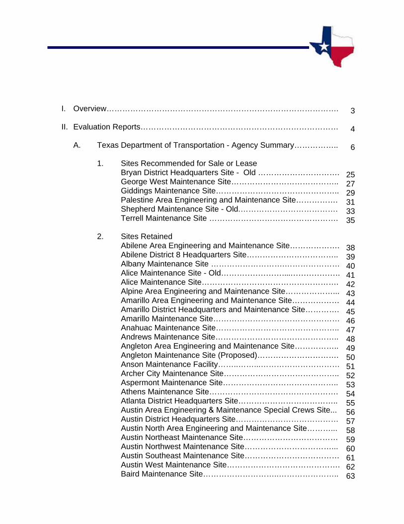
I. Overview…………………………………………………………………………….
II. Evaluation Reports…………………………………………………………………
A. Texas Department of Transportation - Agency Summary……………..
1. Sites Recommended for Sale or LeaseBryan District Headquarters Site - Old …………………………. George West Maintenance Site………………………………….. Giddings Maintenance Site……………………………………….. Palestine Area Engineering and Maintenance Site……………. Shepherd Maintenance Site - Old.………………………………. Terrell Maintenance Site ………………………………………….
2. Sites RetainedAbilene Area Engineering and Maintenance Site………………. Abilene District 8 Headquarters Site…………………………….. Albany Maintenance Site ……………………….………………… Alice Maintenance Site - Old……………………...……………….Alice Maintenance Site……………………………………………. Alpine Area Engineering and Maintenance Site………………... Amarillo Area Engineering and Maintenance Site……………… Amarillo District Headquarters and Maintenance Site…………. Amarillo Maintenance Site………………………………………… Anahuac Maintenance Site……………………………………….. Andrews Maintenance Site……………………………………….. Angleton Area Engineering and Maintenance Site…………….. Angleton Maintenance Site (Proposed)…………………………. Anson Maintenance Facility……..……...………………………… Archer City Maintenance Site…………………………………….. Aspermont Maintenance Site…………………………………….. Athens Maintenance Site…………………………………………. Atlanta District Headquarters Site……………………………….. Austin Area Engineering & Maintenance Special Crews Site... Austin District Headquarters Site………………………………… Austin North Area Engineering and Maintenance Site………... Austin Northeast Maintenance Site……………………………… Austin Northwest Maintenance Site……………………………... Austin Southeast Maintenance Site……………………………… Austin West Maintenance Site……………………………………. Baird Maintenance Site………………………..…………………..
3
4
6
25 27 29 31 33 35
38 39 40 41 42 43 44 45 46 47 48 49 50 51 52 53 54 55 56 57 58 59 60 61 62 63
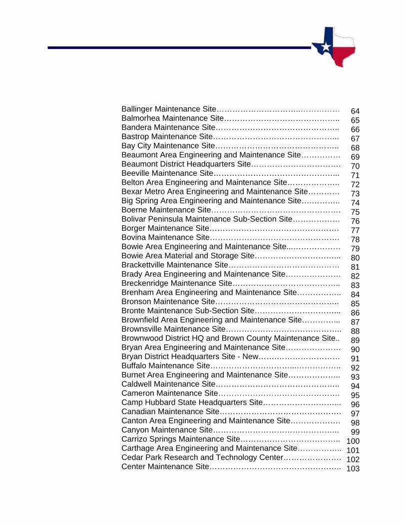
Ballinger Maintenance Site…………………………..…………… Balmorhea Maintenance Site…………………………………….. Bandera Maintenance Site……………………………………….. Bastrop Maintenance Site………………………………………... Bay City Maintenance Site……………………………………….. Beaumont Area Engineering and Maintenance Site…………… Beaumont District Headquarters Site……………………………. Beeville Maintenance Site………………………………………... Belton Area Engineering and Maintenance Site……………….. Bexar Metro Area Engineering and Maintenance Site………… Big Spring Area Engineering and Maintenance Site….……….. Boerne Maintenance Site…………………………………………. Bolivar Peninsula Maintenance Sub-Section Site……………… Borger Maintenance Site…………………………………………. Bovina Maintenance Site…………………………………………. Bowie Area Engineering and Maintenance Site...……………… Bowie Area Material and Storage Site…………………………... Brackettville Maintenance Site…………………………………… Brady Area Engineering and Maintenance Site………………… Breckenridge Maintenance Site………………………………….. Brenham Area Engineering and Maintenance Site…………….. Bronson Maintenance Site……………………………………….. Bronte Maintenance Sub-Section Site…………………………... Brownfield Area Engineering and Maintenance Site…………... Brownsville Maintenance Site…………………………………….. Brownwood District HQ and Brown County Maintenance Site.. Bryan Area Engineering and Maintenance Site………………… Bryan District Headquarters Site - New…….…………………… Buffalo Maintenance Site…………………………...…………….. Burnet Area Engineering and Maintenance Site……………….. Caldwell Maintenance Site……………………………………….. Cameron Maintenance Site………………………………………. Camp Hubbard State Headquarters Site………………………... Canadian Maintenance Site………………………………………. Canton Area Engineering and Maintenance Site………………. Canyon Maintenance Site………………………………………... Carrizo Springs Maintenance Site……………………………….. Carthage Area Engineering and Maintenance Site…………….. Cedar Park Research and Technology Center…………………. Center Maintenance Site…………………………………………..
64 65 66 67 68 69 70 71 72 73 74 75 76 77 78 79 80 81 82 83 84 85 86 87 88 89 90 91 92 93 94 95 96 97 98 99
100 101 102 103

Channing Maintenance Sub-Section Site………………………. Childress District 25 Headquarters Site….……………………… Clarendon Maintenance Site……………………………………… Clarksville Maintenance Site……………………………………... Claude Maintenance Site…………...…………………………….. Coleman Area Engineering and Maintenance Site…………….. Colorado City Maintenance Site…………………………………. Columbus Maintenance Site……………………………………... Comanche Area Engineering and Maintenance Site………….. Comstock Maintenance Sub-section Site………………..……... Conroe Area Engineering and Maintenance Site………………. Cooper Area Engineering and Maintenance Site ……………... Cooper Area Engineering and Maintenance Site (Proposed)… Corpus Christi District Headquarters Site……………………….. Corpus Christi Maintenance Site…………………………………. Corrigan Maintenance Storage Site……………………………... Corsicana Maintenance Site……………………………………... Cotulla Maintenance Site…………………………………………. Crane Maintenance Site………………………………………….. Crockett Maintenance Site……………………………………….. Cross Plains Material Storage Site………………………………. Crowell Maintenance Site…………………………………………. Cuero Maintenance Site…………………………………………... Cuero Material Storage Site………………………………………. Daingerfield Maintenance Site……………………………………. Dalhart Maintenance Site…………………………………………. Dallas Area Engineering and Maintenance Site………………... Dallas District Headquarters Site………………………………… Dallas Northside Area Engineering and Maintenance Site.…... Dallas Northwest Area Engineering and Maintenance Site…… Darrouzett Maintenance Site……………………………………... Decatur Area Engineering and Maintenance Site……………… Decatur Area Engineering and Maintenance Site - Old..….…... Del Rio Area Engineering and Maintenance Site………………. Del Rio Engineering and Storage Site…………………………… Dell City Maintenance Site………………………………………... Denton Maintenance Site…………………………………………. Devine Maintenance Site…………………………………………. Dewitt C. Greer Building Site……………………………………... Dickens Maintenance Site………………………………………… Dimmitt Maintenance Site…………………………………………
104 105 106 107 108 109 110 111 112 113 114 115 116 117 118 119 120 121 122 123 124 125 126 127 128 129 130 131 132 133 134 135 136 137 138 139 140 141 142 143 144
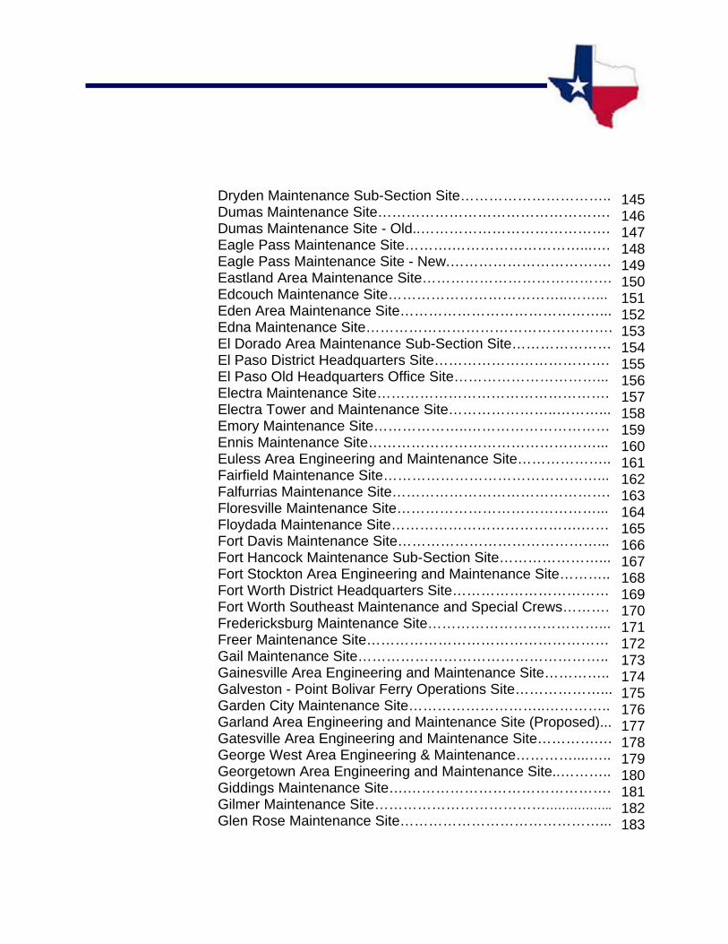
Dryden Maintenance Sub-Section Site………………………….. Dumas Maintenance Site…………………………………………. Dumas Maintenance Site - Old..…………………………………. Eagle Pass Maintenance Site……….………………………...….Eagle Pass Maintenance Site - New.……………………………. Eastland Area Maintenance Site…………………………………. Edcouch Maintenance Site………………………………..……... Eden Area Maintenance Site……………………………………... Edna Maintenance Site……………………………………………. El Dorado Area Maintenance Sub-Section Site………………… El Paso District Headquarters Site………………………………. El Paso Old Headquarters Office Site…………………………... Electra Maintenance Site…………………………………………. Electra Tower and Maintenance Site…………………..………... Emory Maintenance Site………………..………………………… Ennis Maintenance Site…………………………………………... Euless Area Engineering and Maintenance Site……………….. Fairfield Maintenance Site………………………………………... Falfurrias Maintenance Site………………………………………. Floresville Maintenance Site……………………………………... Floydada Maintenance Site………………………………….…… Fort Davis Maintenance Site……………………………………... Fort Hancock Maintenance Sub-Section Site…………………... Fort Stockton Area Engineering and Maintenance Site……….. Fort Worth District Headquarters Site…………………………… Fort Worth Southeast Maintenance and Special Crews………. Fredericksburg Maintenance Site………………………………... Freer Maintenance Site…………………………………………… Gail Maintenance Site…………………………………………….. Gainesville Area Engineering and Maintenance Site………….. Galveston - Point Bolivar Ferry Operations Site………………... Garden City Maintenance Site………………………..………….. Garland Area Engineering and Maintenance Site (Proposed)... Gatesville Area Engineering and Maintenance Site………….… George West Area Engineering & Maintenance…………....….. Georgetown Area Engineering and Maintenance Site..……….. Giddings Maintenance Site….……………………………………. Gilmer Maintenance Site…………………………………………….. Glen Rose Maintenance Site……………………………………...
145 146 147 148 149 150 151 152 153 154 155 156 157 158 159 160 161 162 163 164 165 166 167 168 169 170 171 172 173 174 175 176 177 178 179 180 181 182 183
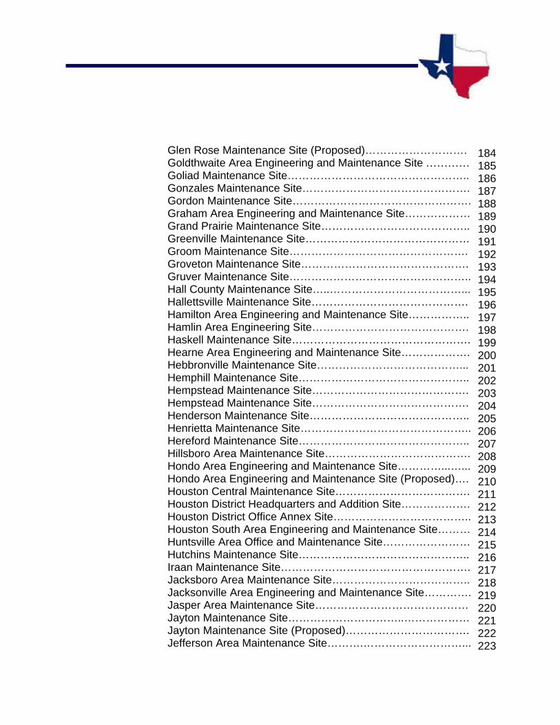
Glen Rose Maintenance Site (Proposed)………………………. Goldthwaite Area Engineering and Maintenance Site ………… Goliad Maintenance Site………………………………………….. Gonzales Maintenance Site………………………………………. Gordon Maintenance Site…………………………………………. Graham Area Engineering and Maintenance Site……………… Grand Prairie Maintenance Site………………………………….. Greenville Maintenance Site……………………………………… Groom Maintenance Site…………………………………………. Groveton Maintenance Site………………………………………. Gruver Maintenance Site………………………………………….. Hall County Maintenance Site…..………………………………... Hallettsville Maintenance Site……………………………………. Hamilton Area Engineering and Maintenance Site…………….. Hamlin Area Engineering Site……………………………………. Haskell Maintenance Site…………………………………………. Hearne Area Engineering and Maintenance Site………………. Hebbronville Maintenance Site…………………………………... Hemphill Maintenance Site……………………………………….. Hempstead Maintenance Site……………………………………. Hempstead Maintenance Site……………………………………. Henderson Maintenance Site…………………………………….. Henrietta Maintenance Site……………………………………….. Hereford Maintenance Site……………………………………….. Hillsboro Area Maintenance Site…………………………………. Hondo Area Engineering and Maintenance Site…………...…... Hondo Area Engineering and Maintenance Site (Proposed)…. Houston Central Maintenance Site………………………………. Houston District Headquarters and Addition Site………………. Houston District Office Annex Site……………………………….. Houston South Area Engineering and Maintenance Site……… Huntsville Area Office and Maintenance Site…………………… Hutchins Maintenance Site……………………………………….. Iraan Maintenance Site……………………………………………. Jacksboro Area Maintenance Site……………………………….. Jacksonville Area Engineering and Maintenance Site…………. Jasper Area Maintenance Site…………………………………… Jayton Maintenance Site…………………………..……………… Jayton Maintenance Site (Proposed)……………………………. Jefferson Area Maintenance Site……….………………………...
184 185 186 187 188 189 190 191 192 193 194 195 196 197 198 199 200 201 202 203 204 205 206 207 208 209 210 211 212 213 214 215 216 217 218 219 220 221 222 223

Johnson City Maintenance Site…………………………………… Junction Area Engineering and Maintenance Site………………. Junction Maintenance Site……………………………………….... Karnes City Maintenance Site……………………………………... Kaufman Area Engineering and Maintenance Site (Proposed) Kaufman Maintenance Site………………………………………... Keene Area Engineering and Maintenance Site………………… Kermit Maintenance Site…………………………………………… Kerrville Area Engineering and Maintenance Site………………. Kerrville Area Engineering and Maintenance Site (Proposed)… Kingsville Maintenance Site……………………………………….. Kountze Maintenance Site……………………………………….... La Grange Maintenance Site………....……………………………La Marque Area Engineering and Maintenance Site……………. La Pryor Maintenance Site…………………………………........... La Pryor Material Storage Site…………………………………..... Laguna Vista Maintenance Site…………………………............... Lamesa Maintenance Site…………………………………………. Lampasas Area Engineering and Maintenance Site……………. Laredo District Headquarters Site……………………………....... Leakey Maintenance Site………………………………………….. Leonard Maintenance Storage Site………………………………. Levelland Maintenance Site……………………………………….. Liberty Area Engineering and Maintenance Site………………... Linden Maintenance Site…………………………………………... Littlefield Area Engineering and Maintenance Site…………....... Livingston Area Engineering and Maintenance Site…………….. Llano Area Engineering and Maintenance Site………………….. Lockhart Maintenance Site……………………………………….... Lometa Area Material Storage Site……………………………….. Longview Maintenance Site……….............................................. Lubbock District Headquarters Site………………….................... Lubbock Maintenance Site……………………………………........ Lufkin District Headquarters Site…………………….................... Lufkin Maintenance Site……………………………………............ Madisonville Maintenance Site……………………………............ Marathon Maintenance Sub-Section Site………………………... Marfa Maintenance Site……………………………………………. Marlin Maintenance Site…………............................................... Marshall Area Engineering and Maintenance Site……..............
224 225 226 227 228 229 230 231 232 233 234 235 236 237 238 239 240 241 242 243 244 245 246 247 248 249 250 251 252 253 254 255 256 257 258 259 260 261 262 263

Mason Area Engineering and Maintenance Site……………….. Matador Maintenance Site………………………………….......... McCamey Maintenance Site………………………………........... McKinney Maintenance Site……............................................... Menard Area Maintenance Sub-Section Site………………….... Meridian Maintenance Site…………………………………......... Mertzon Maintenance Site……………………………………....... Mexia Maintenance Site…………………………………………... Midland Area Engineering and Maintenance Site………………Mineola Maintenance Site……………........................................ Mineral Wells Maintenance Site……………………………......... Mission Maintenance Site……………………………………….... Monahans Maintenance Site…………………………………...... Morton Maintenance Site………………………………................ Mount Pleasant Maintenance Site……………………………….. Mount Vernon Maintenance Site……………………................... Muleshoe Maintenance Site…………………………………........ Munday Maintenance Site……………....................................... Nacogdoches Area Engineering and Maintenance Site……..... Navasota Maintenance Site…………………………………........ New Boston Area Maintenance Site……………………………... New Braunfels Area Engineering and Maintenance Site……… Newton Area Maintenance Site…………………………………... Nocona Area Maintenance Site…………………………...…....... Noonday/Tyler South Maintenance Site…………………........... North Houston - Humble Area Engineering Maintenance Site...Northeast Houston Area Engineering and Maintenance Site.... Northeast Lubbock Maintenance Site…………………............... Northeast San Antonio Maintenance Site……………................ Northwest Houston Maintenance Site………………………….... Odessa District Headquarters and Maintenance Site………….. Old Pecos Maintenance and Storage Site………………………. Olney Area Maintenance Site…………………………………….. Orange Maintenance Site…………….…………………………… Ozona Area Maintenance Site…………………………………....Paducah Maintenance Site………………...……………………... Palestine Maintenance Site………………………………………. Pampa Area Engineering and Maintenance Site (Proposed)…. Panhandle Maintenance Site…………………………………..….Paris District Headquarters Site……………………….………….
264 265 266 267 268 269 270 271 272 273 274 275 276 277 278 279 280 281 282 283 284 285 286 287 288 289 290 291 292 293 294 295 296 297 298 299 300 301 302 303

Paris Maintenance Site……………………………...............…… Pearsall Maintenance Site……………………………….……….. Pecos Area Engineering and Maintenance Site…….………….. Pecos Area Engineering and Maintenance Site (Proposed)….. Perryton Maintenance Site……………………………….....……. Pharr District Headquarters Site…………………………..……... Pharr Maintenance Site…………………………………..……….. Pine Springs Maintenance Sub-Section Site………………..….. Plains Maintenance Site…………………………………….....…. Plainview Area Engineering and Maintenance Site……............ Pleasanton Maintenance Site……………………..………..……. Port Arthur Area Engineering and Maintenance Site………..…. Port Lavaca Area Maintenance Site……………...............…….. Post Maintenance and Regional Warehouse Site……..………. Presidio Maintenance Site……………………………….....…….. Quanah Maintenance Site………………………………..………. Ralls Maintenance Site…………………………………….....…... Raymondville Maintenance Site…………………………..……... Refugio Maintenance Site……………………………..............…. Rio Grande City Area Engineering and Maintenance Site…..… Rio Grande City Maintenance Site…………………………...….. Robert Lee Maintenance Site………………………………..…… Robstown Maintenance Site………………………………..…….. Roby Maintenance Site…………………...………………...…….. Rockport Maintenance Site…………………………………..…... Rocksprings Maintenance Site………………………………...…. Rockwall Maintenance Site…………………………………..…... Rosenberg Area Engineering and Maintenance Site………..… Rusk Maintenance Site……………………………………..…….. Saginaw City Maintenance Site……………………………....….. Saginaw Maintenance Site…………………………………..…… San Angelo Area Engineering Maintenance Site…..…………... San Angelo District Headquarters Site…………………......…… San Antonio District 15 Headquarters Site……..……..........….. San Augustine Area Engineering and Maintenance Site…….... San Benito Area Engineering and Maintenance Site……..…… San Isidro Maintenance Site……………………………....……... San Marcos Maintenance Site……………………………..…….. San Saba Area Engineering and Maintenance Site……......….. Sanderson Maintenance Site…………………………..........……
304 305 306 307 308 309 310 311 312 313 314 315 316 317 318 319 320 321 322 323 324 325 326 327 328 329 330 331 332 333 334 335 336 337 338 339 340 341 342 343

Schulenburg Sub-Section Maintenance Site………….….…….. Seguin Maintenance and Regional Warehouse Site….............. Seminole Maintenance Site………………………………..……... Seymour Maintenance Site………………………………......…... Shamrock Maintenance Site……………………………..……….. Shepherd Maintenance Site - New…………………….………... Sherman Area Engineering and Maintenance Site….…………. Sierra Blanca Maintenance Site…………………………....……. Silverton Maintenance Site…………………………........………. Sinton Maintenance Site…………………………...................…. Snyder Maintenance Site……………………..…………...……… Sonora Area Maintenance Site……………………..…….....…… Southeast Lubbock Maintenance Site…………………..………. Southwest San Antonio Maintenance Site …………….……….. Stanton Maintenance Site……………………………….………... Stephenville Area Engineering and Maintenance Site…..…….. Sterling City Maintenance Site……………………..…………...... Stowell Maintenance Site………………………………………..... Sugar Land Special Jobs Site……………………………….…… Sulphur Springs Maintenance Site……………...................…… Sweetwater Maintenance Site………………….....……………... Tahoka Maintenance Site………………………….....…………... Taylor Maintenance Site…………………………….....…………. Temple Maintenance Site……………………………..………….. Terlingua Maintenance Sub-Section Site……………….....……. Texarkana Area Engineering and Maintenance Site……….….. Throckmorton Maintenance Site……………………………...….. Tilden Maintenance Site………………………...................…….. Timpson Sub-Section Maintenance Site………….…………….. Tulia Maintenance Site……………………………….…………… Tyler District Headquarters Site…………………….……………. Tyler North Maintenance Site………………….......................…. Uvalde Maintenance Site…………………………….…………… Van Horn Maintenance Site………………………...…………….. Vega Maintenance Site…………………………………….……... Vernon Area Engineering and Maintenance Site…………....…. Victoria Area Engineering and Maintenance Site………….…… Waco Area Engineering and Maintenance Site………….....….. Waco District Headquarters Site…………………………….……
344 345 346 347 348 349 350 351 352 353 354 355 356 357 358 359 360 361 362 363 364 365 366 367 368 369 370 371 372 373 374 375 376 377 378 379 380 381 382
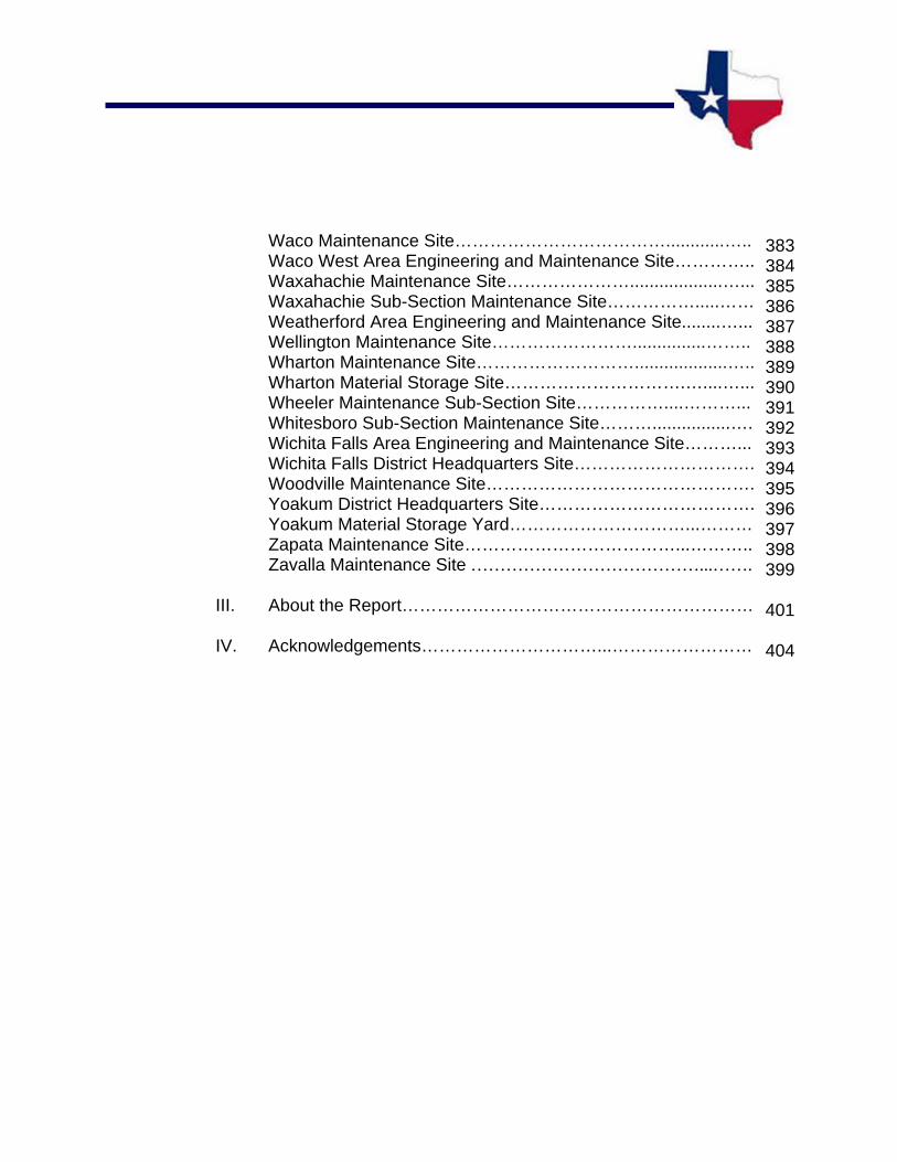
Waco Maintenance Site………………………………............….. Waco West Area Engineering and Maintenance Site………….. Waxahachie Maintenance Site…………………...................…... Waxahachie Sub-Section Maintenance Site…………….....…… Weatherford Area Engineering and Maintenance Site........…... Wellington Maintenance Site……………………...............…….. Wharton Maintenance Site………………………...................….. Wharton Material Storage Site………………………….…....…... Wheeler Maintenance Sub-Section Site……………....………... Whitesboro Sub-Section Maintenance Site………................…. Wichita Falls Area Engineering and Maintenance Site………... Wichita Falls District Headquarters Site…………………………. Woodville Maintenance Site………………………………………. Yoakum District Headquarters Site………………………………. Yoakum Material Storage Yard…………………………...……… Zapata Maintenance Site………………………………...……….. Zavalla Maintenance Site …………………………………...…….
III. About the Report……………………………………………………
IV. Acknowledgements…………………………...……………………
383 384 385 386 387 388 389 390 391 392 393 394 395 396 397 398 399
401
404

OVERVIEWOVERVIEWOVERVIEWOVERVIEW
3
AN OVERVIEW
CONTENTS
This report contains evaluations of state real property for the following agency:
Texas Department of Transportation
Agency Summaries
Each report begins with an agency summary containing the following:
Background/Authorities: The agency’s enabling legislation, operational mission, and real property
management procedure.
Real Property Assets: The agency’s real property holdings including function, location, size, physical
and legal characteristics.
GLO Analysis and Recommendations
Following the summary is an analysis of salient real property factors and the General Land Office’s (GLO) recommendations regarding future disposition of the property. Recommendations for sale or lease of the properties are based on the following:
an examination of appraisal data legal and physical limitations need for the property by other state agencies market conditions; and/or other factors influencing the value of the property to the state
Texas Facilities Commission Recommendations
Before publication, real property evaluation reports are submitted to the Texas Facilities Commission (TFC) to determine whether any reviewed properties are needed by other state agencies. Any TFC staff comments are included in the agency’s summary section of the report and are attached to the specific site analysis.

EEEEVVVVAAAALULULULUAAAATTTTIIIIOOOONNNN RRRREEEEPPPPOOOORRRRTTTTSSSS
TEXAS DEPARTMENT OF TRANSPORTATION AGENCY SUMMARY
6
Agency Summary
Background/Authorities
The Texas Highway Department was established by the Texas Legislature in 1917. The Department was established for administering federal funds for highway construction and maintenance. As the Department progressed, its responsibilities increased. In 1975 the Legislature merged the Department with the Texas Mass Transportation Commission. The new agency was assigned the State Department of Highways and Public Transportation, as sponsor of the Gulf Intracoastal Waterway.
The Legislature combined the State Department of Highways and Public Transportation, the Department of Aviation and the Texas Motor Vehicle Commission in 1991, to create what we now know as, the Texas Department of Transportation (TxDOT). TxDOT is governed by the five-member Texas Transportation Commission. The Commission is appointed by the Governor and serves a six-year overlapping term. The Commission appoints an executive director who is assisted by a deputy executive director, and four assistant executive directors.
The majority of TxDot’s activity is conducted in 25 geographical districts located throughout the state. Due to varying local conditions, as well as local transportation needs, decentralization of the Department is necessary. In addition, area offices have separate facilities in most counties to support routine highway maintenance.
The agency boasts twenty-seven divisions which are capable of providing a variety of technical specialty support functions. Additionally, there are fourteen agency offices that specialize in a variety of services. TxDot’s mission is to work with others to pro-vide safe and reliable transportation solutions for Texas.
Property Management The General Land Office (GLO) reviewed 369 sites totaling 3,854.64 acres. The properties inspected included district headquarters, maintenance and storage facilities, state administrative offices, and unimproved property designated for future projects. Agency leased properties and the state right-of-way, roadside parks, and information centers, were not evaluated in this report.
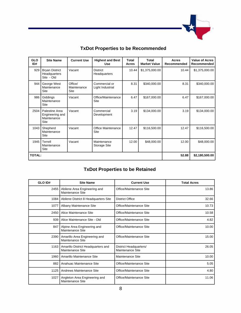
GLO Recommendations Currently, the GLO recommends selling the following TxDOT properties: Bryan District Headquarters, George West Maintenance Site, Giddings Maintenance Site, Palestine Maintenance Site, Shepherd Maintenance Site, and Terrell Maintenance Site.
7
Agency Comments All agency comments were incorporated into the evaluation.
8
TxDot Properties to be Recommended
TxDot Properties to be Retained
GLO ID#
Site Name Current Use Highest and Best Use
Total Acres
Total Market Value
Acres Recommended
Value of Acres Recommended
929 Bryan District Headquarters Site - Old
Vacant District Headquarters
10.44 $1,375,000.00 10.44 $1,375,000.00
944 George West Maintenance Site
Office/Maintenance Site
Commercial or Light Industrial
8.31 $340,000.00 8.31 $340,000.00
986 Giddings Maintenance Site
Vacant Office/Maintenance Site
6.47 $167,000.00 6.47 $167,000.00
2504 Palestine Area Engineering and Maintenance Site
Vacant Commercial Development
3.19 $134,000.00 3.19 $134,000.00
1945 TerrellMaintenance Site
Vacant Maintenance Storage Site
12.00 $48,000.00 12.00 $48,000.00
TOTAL: 52.88 $2,180,500.00
1043 Shepherd Maintenance Site
Vacant Office Maintenance Site
12.47 $116,500.00 12.47 $116,500.00
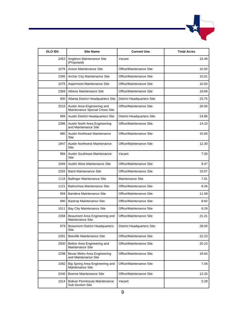
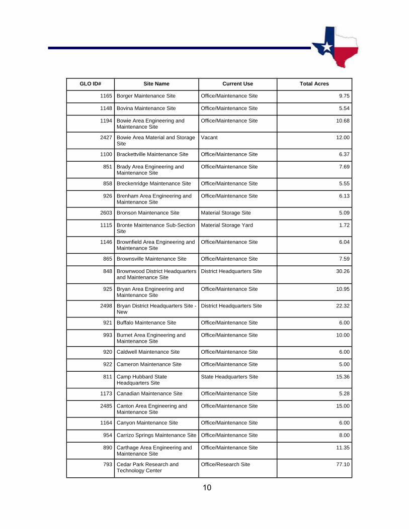
GLO ID# Site Name Current Use Total Acres
2455 Abilene Area Engineering and Maintenance Site
Office/Maintenance Site 13.86
1084 Abilene District 8 Headquarters Site District Office 32.66
1077 Albany Maintenance Site Office/Maintenance Site 10.73
2450 Alice Maintenance Site Office/Maintenance Site 10.58
939 Alice Maintenance Site - Old Office/Maintenance Site 4.82
847 Alpine Area Engineering and Maintenance Site
Office/Maintenance Site 10.00
2390 Amarillo Area Engineering and Maintenance Site
Office/Maintenance Site 15.00
1163 Amarillo District Headquarters and Maintenance Site
District Headquarters/Maintenance Site
26.05
1960 Amarillo Maintenance Site Maintenance Site 10.00
882 Anahuac Maintenance Site Office/Maintenance Site 5.05
1125 Andrews Maintenance Site Office/Maintenance Site 4.80
1027 Angleton Area Engineering and Maintenance Site
Office/Maintenance Site 11.06
9
GLO ID# Site Name Current Use Total Acres
2453 Angleton Maintenance Site (Proposed)
Vacant 15.49
1076 Anson Maintenance Site Office/Maintenance Site 10.00
2395 Archer City Maintenance Site Office/Maintenance Site 10.01
1075 Aspermont Maintenance Site Office/Maintenance Site 10.00
2369 Athens Maintenance Site Office/Maintenance Site 19.68
900 Atlanta District Headquarters Site District Headquarters Site 23.75
2515 Austin Area Engineering and Maintenance Special Crews Site
Office/Maintenance Site 26.50
989 Austin District Headquarters Site District Headquarters Site 24.86
2396 Austin North Area Engineering and Maintenance Site
Office/Maintenance Site 14.10
980 Austin Northeast Maintenance Site
Office/Maintenance Site 10.00
1947 Austin Northwest Maintenance Site
Office/Maintenance Site 12.30
994 Austin Southeast Maintenance Site
Vacant 7.00
1949 Austin West Maintenance Site Office/Maintenance Site 9.47
2255 Baird Maintenance Site Office/Maintenance Site 10.07
1116 Ballinger Maintenance Site Maintenance Site 7.01
1121 Balmorhea Maintenance Site Office/Maintenance Site 8.26
959 Bandera Maintenance Site Office/Maintenance Site 11.58
990 Bastrop Maintenance Site Office/Maintenance Site 8.92
1011 Bay City Maintenance Site Office/Maintenance Site 8.29
2358 Beaumont Area Engineering and Maintenance Site
Office/Maintenance Site 21.31
879 Beaumont District Headquarters Site
District Headquarters Site 28.00
2391 Beeville Maintenance Site Office/Maintenance Site 22.23
2500 Belton Area Engineering and Maintenance Site
Office/Maintenance Site 20.10
2298 Bexar Metro Area Engineering and Maintenance Site
Office/Maintenance Site 18.64
1082 Big Spring Area Engineering and Maintenance Site
Office/Maintenance Site 7.06
2340 Boerne Maintenance Site Office/Maintenance Site 12.25
1014 Bolivar Penninsula Maintenance Sub-Section Site
Vacant 0.28
10
GLO ID# Site Name Current Use Total Acres
1165 Borger Maintenance Site Office/Maintenance Site 9.75
1148 Bovina Maintenance Site Office/Maintenance Site 5.54
1194 Bowie Area Engineering and Maintenance Site
Office/Maintenance Site 10.68
2427 Bowie Area Material and Storage Site
Vacant 12.00
1100 Brackettville Maintenance Site Office/Maintenance Site 6.37
851 Brady Area Engineering and Maintenance Site
Office/Maintenance Site 7.69
858 Breckenridge Maintenance Site Office/Maintenance Site 5.55
926 Brenham Area Engineering and Maintenance Site
Office/Maintenance Site 6.13
2603 Bronson Maintenance Site Material Storage Site 5.09
1115 Bronte Maintenance Sub-Section Site
Material Storage Yard 1.72
1146 Brownfield Area Engineering and Maintenance Site
Office/Maintenance Site 6.04
865 Brownsville Maintenance Site Office/Maintenance Site 7.59
848 Brownwood District Headquarters and Maintenance Site
District Headquarters Site 30.26
925 Bryan Area Engineering and Maintenance Site
Office/Maintenance Site 10.95
2498 Bryan District Headquarters Site - New
District Headquarters Site 22.32
921 Buffalo Maintenance Site Office/Maintenance Site 6.00
993 Burnet Area Engineering and Maintenance Site
Office/Maintenance Site 10.00
920 Caldwell Maintenance Site Office/Maintenance Site 6.00
922 Cameron Maintenance Site Office/Maintenance Site 5.00
811 Camp Hubbard State Headquarters Site
State Headquarters Site 15.36
1173 Canadian Maintenance Site Office/Maintenance Site 5.28
2485 Canton Area Engineering and Maintenance Site
Office/Maintenance Site 15.00
1164 Canyon Maintenance Site Office/Maintenance Site 6.00
954 Carrizo Springs Maintenance Site Office/Maintenance Site 8.00
890 Carthage Area Engineering and Maintenance Site
Office/Maintenance Site 11.35
793 Cedar Park Research and Technology Center
Office/Research Site 77.10

11
GLO ID# Site Name Current Use Total Acres
1035 Center Maintenance Site Office/Maintenance Site 10.00
1170 Channing Maintenance Sub-Section Site
Office/Maintenance Site 3.31
2371 Childress District 25 Headquarters Site
District Headquarters Site 52.83
2359 Clarendon Maintenance Site Office/Maintenance Site 10.57
1223 Clarksville Maintenance Site Office/Maintenance Site 6.40
1166 Claude Maintenance Site Office/Maintenance Site 5.00
856 Coleman Area Engineering and Maintenance Site
Office/Maintenance Site 4.88
1083 Colorado City Maintenance Site Office/Maintenance Site 6.84
1000 Columbus Maintenance Site Office/Maintenance Site 6.92
853 Comanche Area Engineering and Maintenance Site
Office/Maintenance Site 10.19
1102 Comstock Maintenance Sub-Section Site
Leased 1.06
2252 Conroe Area Engineering and Maintenance Site
Office/Maintenance Site 15.40
1222 Cooper Area Engineering and Maintenance Site
Office/Maintenance Site 4.00
2482 Cooper Area Engineering and Maintenance Site (Proposed)
Vacant 14.85
933 Corpus Christi District Headquarters Site
District Headquarters Site 26.36
932 Corpus Christi Maintenance Site Office/Maintenance Site 13.98
1038 Corrigan Maintenance Storage Site
Maintenance Storage Site 4.55
2279 Corsicana Maintenance Site Office/Maintenance Site 13.92
950 Cotulla Maintenance Site Office/Maintenance Site 7.50
1124 Crane Maintenance Site Office/Maintenance Site 6.00
1037 Crockett Maintenance Site Office/Maintenance Site 11.81
1086 Cross Plains Material Storage Site
Material Storage Site 3.47
819 Crowell Maintenance Site Office/Maintenance Site 5.20
2452 Cuero Maintenance Site Office/Maintenance Site 9.75
1001 Cuero Material Storage Site Material Storage Site 4.77
901 Daingerfield Maintenance Site Office/Maintenance Site 8.00

12
GLO ID# Site Name Current Use Total Acres
2028 Dalhart Maintenance Site Office/Maintenance Site 12.00
2546 Dallas Area Engineering and Maintenance Site
Office/Maintenance Site 18.80
910 Dallas District Headquarters Site District Headquarters Site 31.29
909 Dallas Northside Area Engineer-ing and Maintenance Site
Office/Maintenance Site 13.00
2590 Dallas Northwest Area Engineer-ing and Maintenance Site
Staging Area 9.64
1177 Darrouzett Maintenance Site Office/Maintenance Site 1.12
2394 Decatur Area Engineering and Maintenance Site
Office/Maintenance Site 15.95
1206 Decatur Area Engineering and Maintenance Site - Old
Vacant 7.23
1104 Del Rio Area Engineering and Maintenance Site
Office/Maintenance Site 4.33
1107 Del Rio Engineering and Storage Site
Material Storage Site 19.80
837 Dell City Maintenance Site Office/Maintenance Site 4.90
911 Denton Maintenance Site Office/Maintenance Site 9.85
960 Devine Maintenance Site Office/Maintenance Site 5.00
810 Dewitt C. Greer Building Site Office Building 0.47
825 Dickens Maintenance Site Office/Maintenance Site 7.01
1140 Dimmitt Maintenance Site Office/Maintenance Site 10.02
1128 Dryden Maintenance Sub-Section Site
Storage Site 4.02
2297 Dumas Maintenance Site Office/Maintenance Site 12.00
1176 Dumas Maintenance Site - Old Vacant 3.72
955 Eagle Pass Maintenance Site Office/Maintenance Site 5.51
2628 Eagle Pass Maintenance Site - New
vacant 8.01
852 Eastland Area Maintenance Site Office/Maintenance Site 8.40
869 Edcouch Maintenance Site Office/Maintenance Site 4.60
1114 Eden Area Maintenance Site Maintenance Site 6.52
1002 Edna Maintenance Site Office/Maintenance Site 7.16
1110 El Dorado Area Maintenance Sub-Section Site
Office/Maintenance Site 8.53
2254 El Paso District Headquarters Site
District Headquarters Site 33.46
13
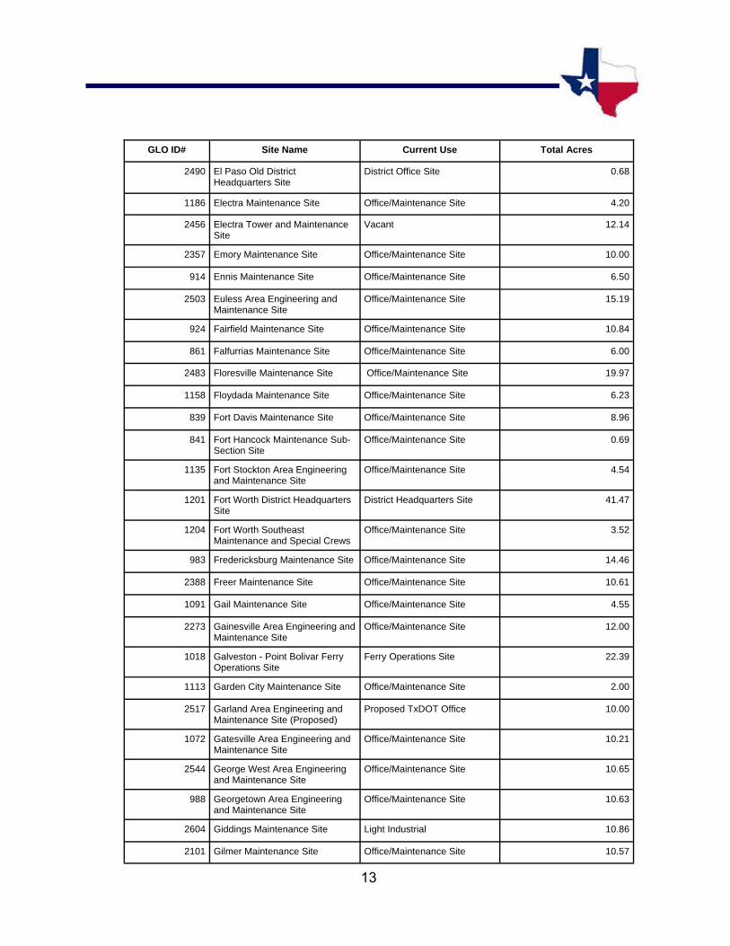
GLO ID# Site Name Current Use Total Acres
2490 El Paso Old District Headquarters Site
District Office Site 0.68
1186 Electra Maintenance Site Office/Maintenance Site 4.20
2456 Electra Tower and Maintenance Site
Vacant 12.14
2357 Emory Maintenance Site Office/Maintenance Site 10.00
914 Ennis Maintenance Site Office/Maintenance Site 6.50
2503 Euless Area Engineering and Maintenance Site
Office/Maintenance Site 15.19
924 Fairfield Maintenance Site Office/Maintenance Site 10.84
861 Falfurrias Maintenance Site Office/Maintenance Site 6.00
2483 Floresville Maintenance Site Office/Maintenance Site 19.97
1158 Floydada Maintenance Site Office/Maintenance Site 6.23
839 Fort Davis Maintenance Site Office/Maintenance Site 8.96
841 Fort Hancock Maintenance Sub-Section Site
Office/Maintenance Site 0.69
1135 Fort Stockton Area Engineering and Maintenance Site
Office/Maintenance Site 4.54
1201 Fort Worth District Headquarters Site
District Headquarters Site 41.47
1204 Fort Worth Southeast Maintenance and Special Crews
Office/Maintenance Site 3.52
983 Fredericksburg Maintenance Site Office/Maintenance Site 14.46
2388 Freer Maintenance Site Office/Maintenance Site 10.61
1091 Gail Maintenance Site Office/Maintenance Site 4.55
2273 Gainesville Area Engineering and Maintenance Site
Office/Maintenance Site 12.00
1018 Galveston - Point Bolivar Ferry Operations Site
Ferry Operations Site 22.39
1113 Garden City Maintenance Site Office/Maintenance Site 2.00
2517 Garland Area Engineering and Maintenance Site (Proposed)
Proposed TxDOT Office 10.00
1072 Gatesville Area Engineering and Maintenance Site
Office/Maintenance Site 10.21
2544 George West Area Engineering and Maintenance Site
Office/Maintenance Site 10.65
988 Georgetown Area Engineering and Maintenance Site
Office/Maintenance Site 10.63
2604 Giddings Maintenance Site Light Industrial 10.86
2101 Gilmer Maintenance Site Office/Maintenance Site 10.57

14
GLO ID# Site Name Current Use Total Acres
1200 Glen Rose Maintenance Site Office/Maintenance Site 4.91
2356 Glen Rose Maintenance Site (Proposed)
Road Material Storage Site 15.71
849 Goldthwaite Area Engineering and Maintenance Site
Office/Maintenance Site 11.77
942 Goliad Maintenance Site Office/Maintenance Site 3.95
2031 Gonzales Maintenance Site Office/Maintenance Site 11.87
1196 Gordon Maintenance Site Office/Maintenance Site 5.32
2042 Graham Area Engineering and Maintenance Site
Office/Maintenance Site 11.57
903 Grand Prairie Maintenance Site Vacant 9.88
2481 Greenville Maintenance Site Office/Maintenance Site 16.85
1161 Groom Maintenance Site Office/Maintenance Site 7.99
1048 Groveton Maintenance Site Office/Maintenance Site 7.13
1175 Gruver Maintenance Site Office/Maintenance Site 7.37
813 Hall County Maintenance Site Office/Maintenance Site 6.33
2387 Hallettsville Maintenance Site Office/Maintenance Site 9.52
1071 Hamilton Area Engineering and Maintenance Site
Office/Maintenance SIte 9.43
2296 Hamlin Area Engineering Site Office/Maintenance Site 0.32
1081 Haskell Maintenance Site Office/Maintenance Site 10.00
927 Hearne Area Engineering and Maintenance Site
Office/Maintenance Site 11.02
863 Hebbronville Maintenance Site Office/Maintenance Site 5.52
2370 Hemphill Maintenance Site Office/Maintenance Site 10.95
1013 Hempstead Maintenance Site Office/Maintenance Site 10.00
1028 Hempstead Maintenance Site - Old
Office/Maintenance Site 3.00
1057 Henderson Maintenance Site Office/Maintenance Site 5.00
2386 Henrietta Maintenance Site Office/Maintenance Site 13.37
1159 Hereford Maintenance Site Office/Maintenance Site 6.01
1068 Hillsboro Maintenance Site Office/Maintenance Site 12.03
974 Hondo Area Engineering and Maintenance Site
Office/Maintenance Site 5.33
2559 Hondo Area Engineering and Maintenance Site (Proposed)
Vacant 12.00
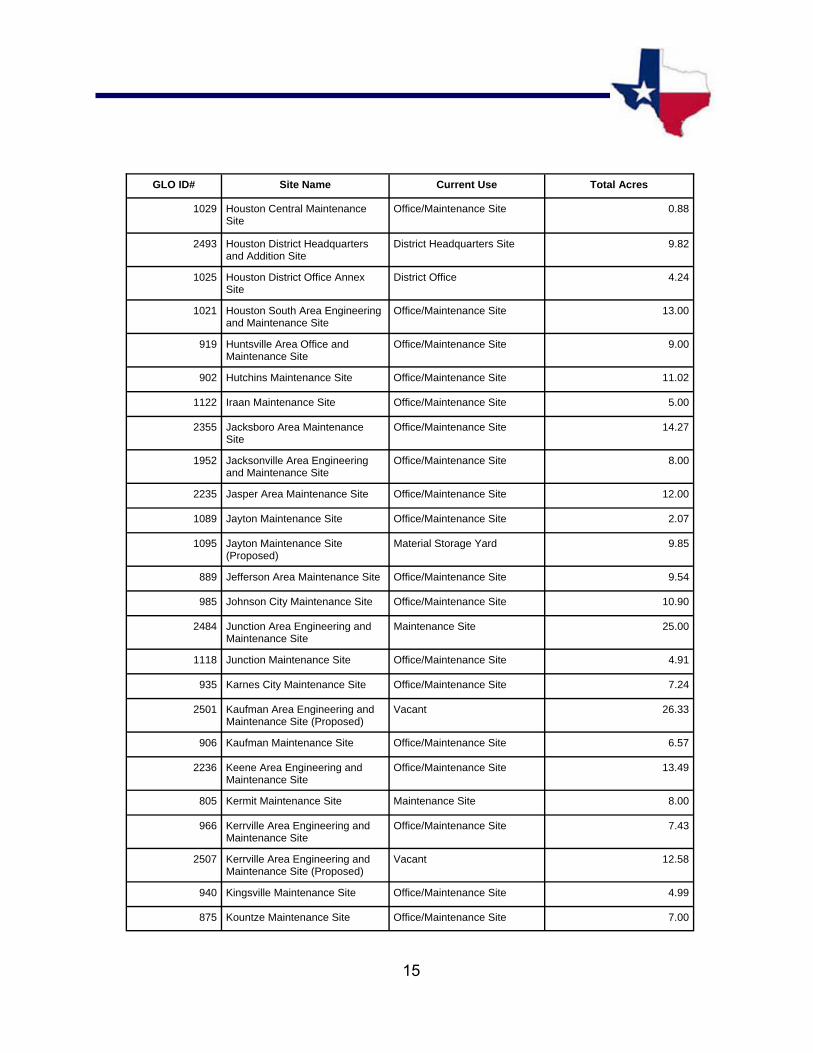
15
GLO ID# Site Name Current Use Total Acres
1029 Houston Central Maintenance Site
Office/Maintenance Site 0.88
2493 Houston District Headquarters and Addition Site
District Headquarters Site 9.82
1025 Houston District Office Annex Site
District Office 4.24
1021 Houston South Area Engineering and Maintenance Site
Office/Maintenance Site 13.00
919 Huntsville Area Office and Maintenance Site
Office/Maintenance Site 9.00
902 Hutchins Maintenance Site Office/Maintenance Site 11.02
1122 Iraan Maintenance Site Office/Maintenance Site 5.00
2355 Jacksboro Area Maintenance Site
Office/Maintenance Site 14.27
1952 Jacksonville Area Engineering and Maintenance Site
Office/Maintenance Site 8.00
2235 Jasper Area Maintenance Site Office/Maintenance Site 12.00
1089 Jayton Maintenance Site Office/Maintenance Site 2.07
1095 Jayton Maintenance Site (Proposed)
Material Storage Yard 9.85
889 Jefferson Area Maintenance Site Office/Maintenance Site 9.54
985 Johnson City Maintenance Site Office/Maintenance Site 10.90
2484 Junction Area Engineering and Maintenance Site
Maintenance Site 25.00
1118 Junction Maintenance Site Office/Maintenance Site 4.91
935 Karnes City Maintenance Site Office/Maintenance Site 7.24
2501 Kaufman Area Engineering and Maintenance Site (Proposed)
Vacant 26.33
906 Kaufman Maintenance Site Office/Maintenance Site 6.57
2236 Keene Area Engineering and Maintenance Site
Office/Maintenance Site 13.49
805 Kermit Maintenance Site Maintenance Site 8.00
966 Kerrville Area Engineering and Maintenance Site
Office/Maintenance Site 7.43
2507 Kerrville Area Engineering and Maintenance Site (Proposed)
Vacant 12.58
940 Kingsville Maintenance Site Office/Maintenance Site 4.99
875 Kountze Maintenance Site Office/Maintenance Site 7.00

16
GLO ID# Site Name Current Use Total Acres
1012 La Grange Maintenance Site Office/Maintenance Site 11.09
1020 La Marque Area Engineering and Maintenance Site
Office/Maintenance Site 19.89
957 La Pryor Maintenance Site Office/Maintenance Site 2.07
979 La Pryor Material Storage Site Material Storage Site 3.00
874 Laguna Vista Maintenance Site Office/Maintenance Site 7.96
1142 Lamesa Maintenance Site Office/Maintenance Site 6.10
857 Lampasas Area Engineering and Maintenance Site
Office/Maintenance Site 8.73
2368 Laredo District Headquarters Site District Headquarters Site 32.70
1103 Leakey Maintenance Site Office/Maintenance Site 4.90
2184 Leonard Maintenance Storage Site
Material Storage Site 5.00
1141 Levelland Maintenance Site Office/Maintenance Site 6.06
886 Liberty Area Engineering and Maintenance Site
Office/Maintenance Site 9.83
1956 Linden Maintenance Site Office/Maintenance Site 10.00
1151 Littlefield Area Engineering and Maintenance Site
Office/Maintenance Site 8.95
1050 Livingston Maintenance Site Office/Maintenance Site 15.04
981 Llano Area Engineering and Maintenance Site
Office/Maintenance Site 9.98
996 Lockhart Maintenance Site Office/Maintenance Site 5.93
850 Lometa Area Material Storage Site
Material Storage Site 3.84
2281 Longview Maintenance Site Office/Maintenance Site 15.00
1149 Lubbock District Headquarters Site
District Headquarters Site 16.53
1154 Lubbock Maintenance Site Vacant 2.00
1047 Lufkin District Headquarters Site District Headquarters Site 13.75
1036 Lufkin Maintenance Site Office/Maintenance Site 9.37
923 Madisonville Maintenance Site Maintenance Site 17.96
843 Marathon Maintenance Sub-Section Site
Office/Maintenance Site 2.07
840 Marfa Maintenance Site Office/Maintenance Site 3.35
1067 Marlin Maintenance Site Office/Maintenance Site 10.00

17
GLO ID# Site Name Current Use Total Acres
2393 Marshall Area Engineering and Maintenance Site
Office/Maintenance Site 18.08
982 Mason Area Engineering and Maintenance Site
Office/Maintenance Site 10.00
818 Matador Maintenance Site Office/Maintenance Site 7.00
1131 McCamey Maintenance Site Office/Maintenance Site 6.00
908 McKinney Maintenance Site Maintenance Site 14.48
1096 Menard Area Maintenance Sub-Section Site
Maintenance Sub-Section Site 5.62
1063 Meridian Maintenance Site Office/Maintenance Site 6.00
2257 Mertzon Maintenance Site Office/Maintenance Site 5.00
1070 Mexia Maintenance Site Office/Maintenance Site 6.71
1123 Midland Area Engineering and Maintenance Site
Maintenance Site 8.98
1989 Mineola Maintenance Site Office/Maintenance Site 10.00
1199 Mineral Wells Maintenance Site Maintenance Site 8.00
859 Mission Maintenance Site Maintenance Site 6.55
1126 Monahans Maintenance Site Office/Maintenance Site 6.65
1943 Morton Maintenance Site Office/Maintenance Site 10.00
892 Mount Pleasant Maintenance Site
Office/Maintenance Site 19.60
1942 Mount Vernon Maintenance Site Office/Maintenance Site 15.68
1137 Muleshoe Maintenance Site Office/Maintenance Site 5.00
820 Munday Maintenance Site Office/Maintenance Site 5.07
1034 Nacogdoches Area Engineering and Maintenance Site
Office/Maintenance Site 10.00
928 Navasota Maintenance Site Office/Maintenance Site 10.83
894 New Boston Area Maintenance Site
Office/Maintenance Site 10.65
2497 New Braunfels Area Engineering and Maintenance Site
Office/Maintenance Site 13.50
881 Newton Area Maintenance Site Office/Maintenance Site 5.84
1183 Nocona Area Maintenance Site Office/Maintenance Site 6.02
2392 Noonday/Tyler South Maintenance Site
Office/Maintenance Site 37.98

18
GLO ID# Site Name Current Use Total Acres
1019 North Houston -Humble Area Engineering Maintenance Site
Office/Maintenance Site 12.00
1016 Northeast Houston Area Engineering and Maintenance Site
Office/Maintenance Site 11.95
1144 Northeast Lubbock Maintenance Site
Office/Maintenance Site 16.88
949 Northeast San Antonio Maintenance Site
Maintenance Site 14.25
1017 Northwest Houston Maintenance Site
Office/Maintenance Site 6.69
1127 Odessa District Headquarters and Maintenance Site
District Headquarters Site 25.87
1134 Old Pecos Maintenance and Storage Site
Material Storage Site 2.78
1185 Olney Area Maintenance Site Office/Maintenance Site 5.28
2256 Orange Maintenance Site Office/Maintenance Site 9.76
1108 Ozona Area Maintenance Site Office/Maintenance Site 9.95
815 Paducah Maintenance Site Office/Maintenance Site 5.24
2496 Palestine Maintenance Site Office/Maintenance Site 15.64
2548 Pampa Area Engineering and Maintenance Site (Proposed)
Vacant 12.61
1174 Panhandle Maintenance Site Office/Maintenance Site 7.98
809 Paris District Headquarters Site District Headquarters Site 16.59
1211 Paris Maintenance Site Office/Maintenance Site 25.55
968 Pearsall Maintenance Site Office/Maintenance Site 9.80
1136 Pecos Area Engineering and Maintenance Site
Office/Maintenance Site 3.59
2428 Pecos Area Engineering and Maintenance Site (Proposed)
Storage 15.57
1168 Perryton Maintenance Site Office/Maintenance Site 4.95
862 Pharr District Headquarters Site District Headquarters Site 36.54
872 Pharr Maintenance Site Vacant 6.11
846 Pine Springs Maintenance Sub-Section Site
Office/Maintenance Site 5.93
1147 Plains Maintenance Site Office/Maintenance Site 5.01
1139 Plainview Area Engineering and Maintenance Site
Office/Maintenance Site 10.00
948 Pleasanton Maintenance Site Office/Maintenance Site 9.47
19
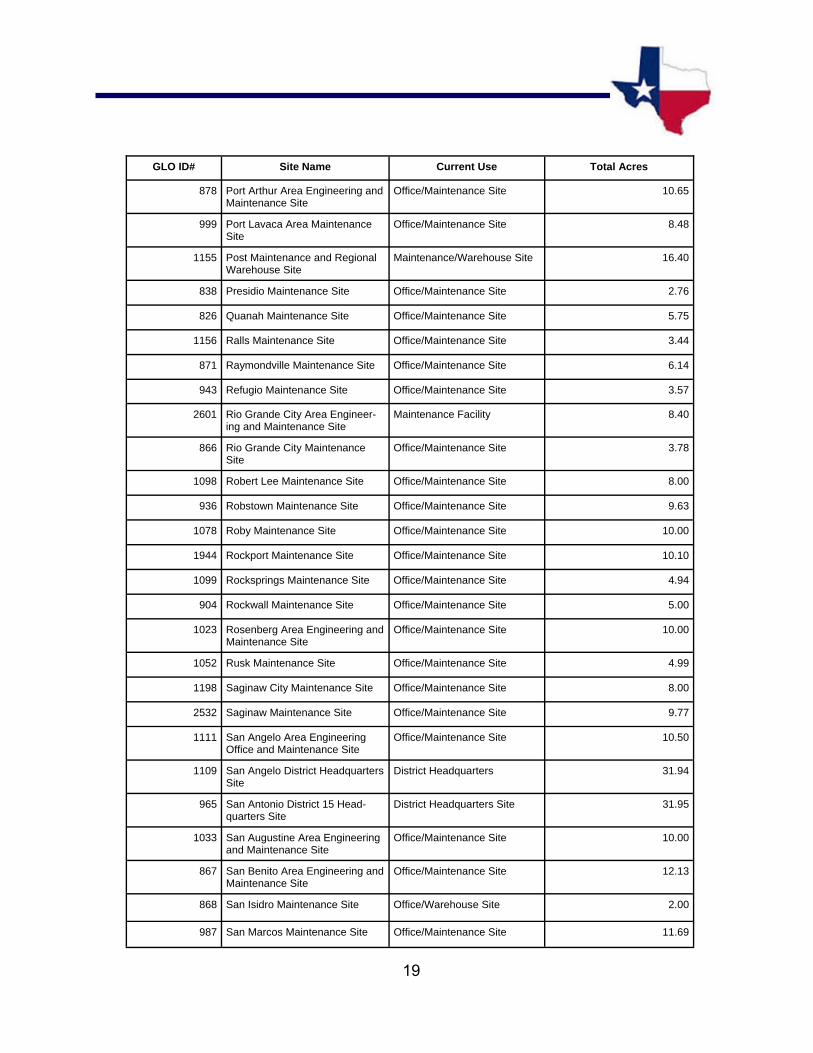
GLO ID# Site Name Current Use Total Acres
878 Port Arthur Area Engineering and Maintenance Site
Office/Maintenance Site 10.65
999 Port Lavaca Area Maintenance Site
Office/Maintenance Site 8.48
1155 Post Maintenance and Regional Warehouse Site
Maintenance/Warehouse Site 16.40
838 Presidio Maintenance Site Office/Maintenance Site 2.76
826 Quanah Maintenance Site Office/Maintenance Site 5.75
1156 Ralls Maintenance Site Office/Maintenance Site 3.44
871 Raymondville Maintenance Site Office/Maintenance Site 6.14
943 Refugio Maintenance Site Office/Maintenance Site 3.57
2601 Rio Grande City Area Engineer-ing and Maintenance Site
Maintenance Facility 8.40
866 Rio Grande City Maintenance Site
Office/Maintenance Site 3.78
1098 Robert Lee Maintenance Site Office/Maintenance Site 8.00
936 Robstown Maintenance Site Office/Maintenance Site 9.63
1078 Roby Maintenance Site Office/Maintenance Site 10.00
1944 Rockport Maintenance Site Office/Maintenance Site 10.10
1099 Rocksprings Maintenance Site Office/Maintenance Site 4.94
904 Rockwall Maintenance Site Office/Maintenance Site 5.00
1023 Rosenberg Area Engineering and Maintenance Site
Office/Maintenance Site 10.00
1052 Rusk Maintenance Site Office/Maintenance Site 4.99
1198 Saginaw City Maintenance Site Office/Maintenance Site 8.00
2532 Saginaw Maintenance Site Office/Maintenance Site 9.77
1111 San Angelo Area Engineering Office and Maintenance Site
Office/Maintenance Site 10.50
1109 San Angelo District Headquarters Site
District Headquarters 31.94
965 San Antonio District 15 Head-quarters Site
District Headquarters Site 31.95
1033 San Augustine Area Engineering and Maintenance Site
Office/Maintenance Site 10.00
867 San Benito Area Engineering and Maintenance Site
Office/Maintenance Site 12.13
868 San Isidro Maintenance Site Office/Warehouse Site 2.00
987 San Marcos Maintenance Site Office/Maintenance Site 11.69

20
GLO ID# Site Name Current Use Total Acres
855 San Saba Area Engineering and Maintenance Site
Office/Maintenance Site 6.00
1130 Sanderson Maintenance Site Office/Maintenance Site 9.35
1009 Schulenburg Sub-Section Maintenance Site
Maintenance Site 0.92
964 Seguin Maintenance and Regional Warehouse Site
Maintenance/Warehouse Site 23.88
1145 Seminole Maintenance Site Office/Maintenance Site 8.53
807 Seymour Maintenance Site Office/Maintenance Site 5.10
2360 Shamrock Maintenance Site Office/Maintenance Site 10.00
2591 Shepherd Maintenance Site - New
Office/Maintenance Site 11.73
2502 Sherman Area Engineering and Maintenance Site
Office/Maintenance Site 23.58
1946 Sierra Blanca Maintenance Site Office/Maintenance Site 10.00
817 Silverton Maintenance Site Office/Maintenance Site 5.40
2150 Sinton Maintenance Site Office/Maintenance Site 13.91
1079 Snyder Maintenance Site Office/Maintenance Site 10.00
1117 Sonora Area Maintenance Site Office/Maintenance Site 7.96
1143 Southeast Lubbock Maintenance Site
Office/Maintenance Site 9.00
953 Southwest San Antonio Mainte-nance Site
Office/Maintenance Site 10.73
1129 Stanton Maintenance Site Office/Maintenance Site 6.00
2220 Stephenville Area Engineering and Maintenance Site
Office/Maintenance Site 14.03
1112 Sterling City Maintenance Site Office/Maintenance Site 5.00
876 Stowell Maintenance Site Storage Site 5.00
2464 Sugar Land Special Jobs Site Special Jobs Site 19.85
2088 Sulphur Springs Maintenance Site
Office/Maintenance Site 15.00
1080 Sweetwater Maintenance Site Office/Maintenance Site 9.84
1138 Tahoka Maintenance Site Office/Maintenance Site 7.97
991 Taylor Maintenance Site Office/Maintenance Site 10.14
1064 Temple Maintenance Site Material Storage Site 6.00

21
GLO ID# Site Name Current Use Total Acres
831 Terlingua Maintenance Sub-Section Site
Office/Maintenance Site 7.84
895 Texarkana Area Engineering and Maintenance Site
Office/Maintenance Site 11.12
1188 Throckmorton Maintenance Site Office/Maintenance Site 8.17
963 Tilden Maintenance Site Office/Maintenance Site 8.09
1041 Timpson Sub-Section Maintenance Site
Material Storage Yard 3.00
1951 Tulia Maintenance Site Maintenance Site 10.00
1053 Tyler District Headquarters Site District Headquarters Site 14.71
1055 Tyler North Maintenance Site Maintenance Site 8.00
978 Uvalde Maintenance Site Office/Maintenance Site 12.03
835 Van Horn Maintenance Site Maintenance Site 5.99
1180 Vega Maintenance Site Office/Maintenance Site 2.75
1190 Vernon Area Engineering and Maintenance Site
Office/Maintenance Site 6.89
2225 Victoria Area Engineering and Maintenance Site
Office/Maintenance Site 12.50
2545 Waco Area Engineering and Maintenance Site
Office/Maintenance Site 18.88
1073 Waco District Headquarters Site District Headquarters Site 16.40
1065 Waco Maintenance Site Office/Maintenance Site 5.91
1069 Waco West Area Engineering and Maintenance Site
Office/Maintenance Site 7.07
905 Waxahachie Maintenance Site Office/Maintenance Site 7.37
915 Waxahachie Sub-Section Maintenance Site
Material Storage Site 2.50
1203 Weatherford Area Engineering and Maintenance Site
Office/Maintenance Site 11.67
821 Wellington Maintenance Site Office/Maintenance Site 5.14
997 Wharton Maintenance Site Office/Maintenance Site 9.00
1004 Wharton Material Storage Site Material Storage Site 3.90
822 Wheeler Maintenance Sub-Section Site
Office/Maintenance Site 2.07
1212 Whitesboro Sub-Section Maintenance Site
Material Storage Site 3.50
2339 Wichita Falls Area Engineering and Maintenance Site
Office/Maintenance Site 10.84
1184 Wichita Falls District Headquarters Site
District Headquarters Site 31.62
22
GLO ID# Site Name Current Use Total Acres
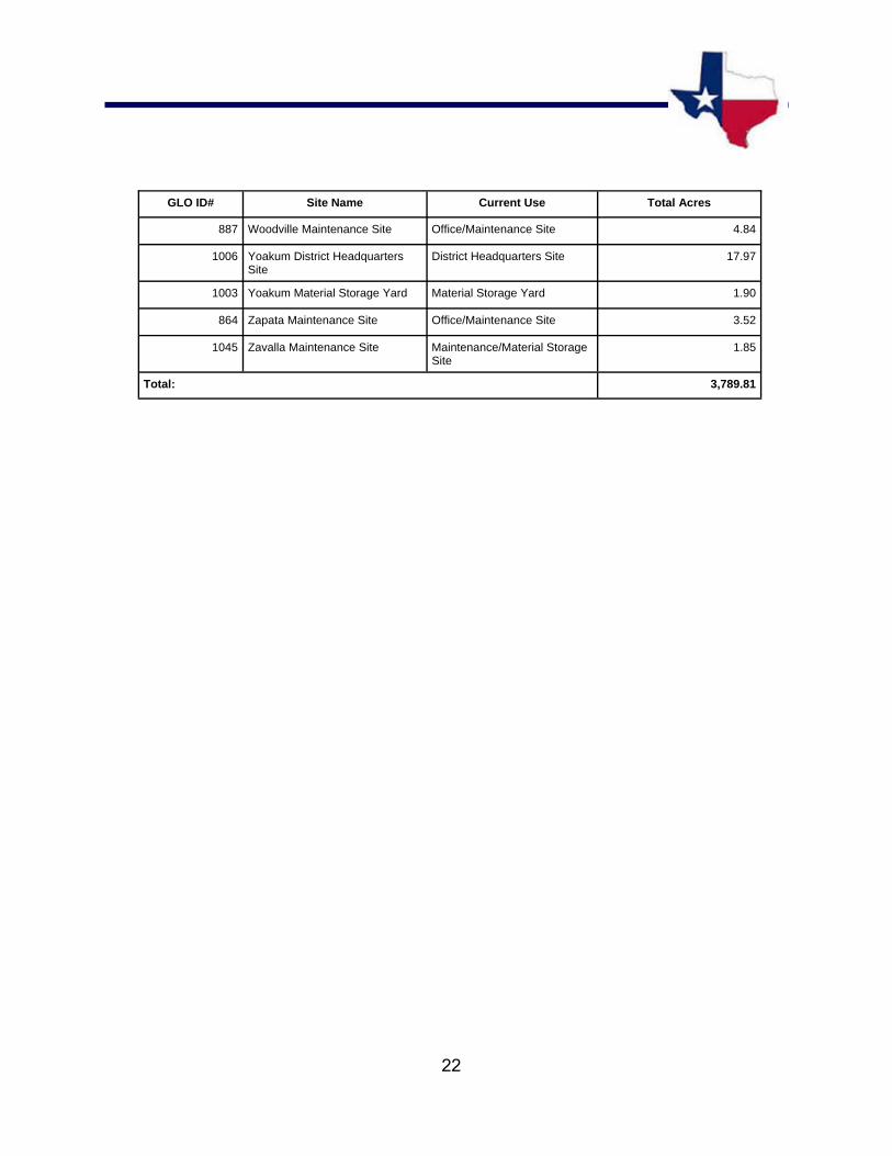
887 Woodville Maintenance Site Office/Maintenance Site 4.84
1006 Yoakum District Headquarters Site
District Headquarters Site 17.97
1003 Yoakum Material Storage Yard Material Storage Yard 1.90
864 Zapata Maintenance Site Office/Maintenance Site 3.52
1045 Zavalla Maintenance Site Maintenance/Material Storage Site
1.85
3,789.81 Total:

TEXAS DEPARTMENT OF TRANSPORTATION
PPPPRRRROOOOPPPPEEEERRRRTTTTIIIIEEEESSSS FFFFOOOORRRR SSSSAAAALLLLEEEE OOOORRRR LLLLEEEEAAAASSSSEEEE
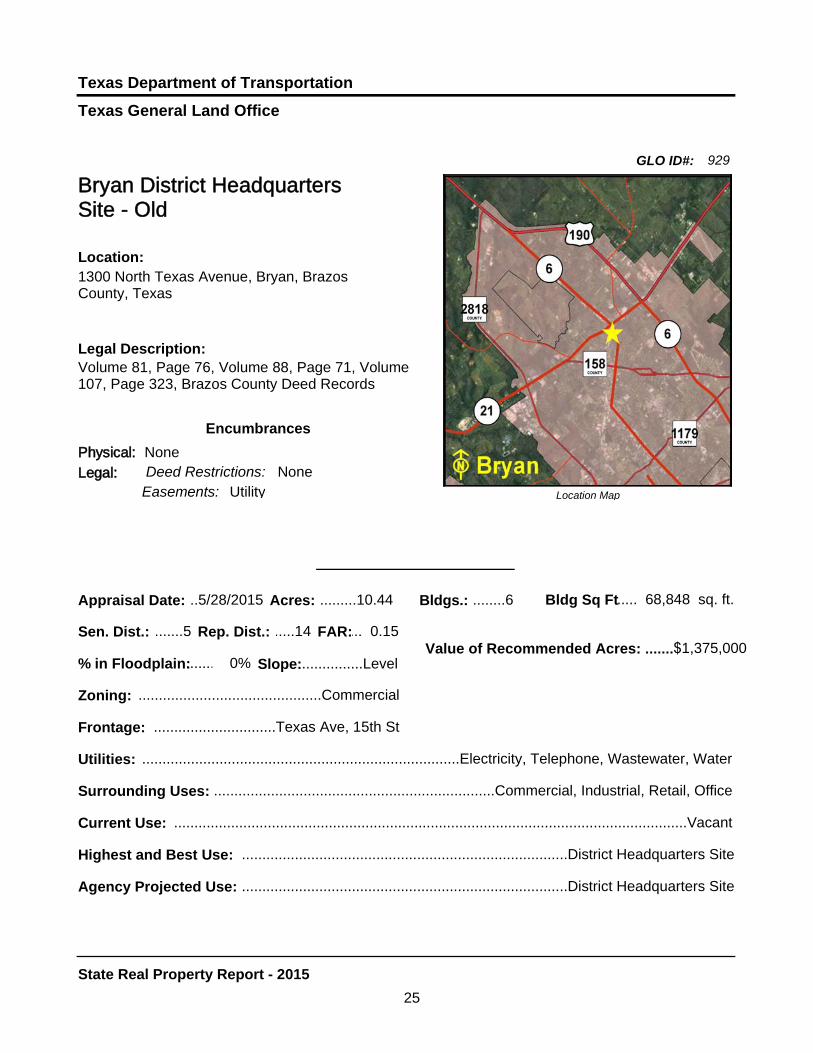
Texas General Land Office
Texas Department of Transportation
.......Value of Recommended Acres: .......$1,375,000
Bldg Sq Ft 68,848.....
Agency Projected Use: ................................................................................District Headquarters Site
Highest and Best Use: ................................................................................District Headquarters Site
Bryan District Headquarters Site - Old
Legal Description:Volume 81, Page 76, Volume 88, Page 71, Volume 107, Page 323, Brazos County Deed Records
Location Map
Location:1300 North Texas Avenue, Bryan, Brazos County, Texas
Sen. Dist.: .......5 Rep. Dist.: .....14
Appraisal Date: ..5/28/2015 Acres: .........10.44 Bldgs.: ........6 sq. ft.
FAR:... 0.15
Slope:...............Level
Zoning: .............................................Commercial
Frontage: ..............................Texas Ave, 15th St
Surrounding Uses: .....................................................................Commercial, Industrial, Retail, Office
Current Use: ..............................................................................................................................Vacant
Encumbrances
Legal:Physical: None
Deed Restrictions: None
% in Floodplain: 0%
Utilities: ..............................................................................Electricity, Telephone, Wastewater, Water
GLO ID#: 929
Easements: Utility
25
State Real Property Report - 2015
Texas General Land Office
Texas Department of Transportation
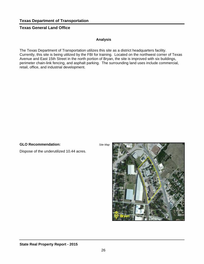
GLO Recommendation:
Dispose of the underutilized 10.44 acres.
The Texas Department of Transportation utilizes this site as a district headquarters facility. Currently, this site is being utilized by the FBI for training. Located on the northwest corner of Texas Avenue and East 15th Street in the north portion of Bryan, the site is improved with six buildings, perimeter chain-link fencing, and asphalt parking. The surrounding land uses include commercial, retail, office, and industrial development.
Site Map
Analysis
26
State Real Property Report - 2015
Texas Department of Transportation
.......Value of Recommended Acres: .......$340,000
Bldg Sq Ft........13,010
Agency Projected Use: ..............................................................................To Dispose of the Property
Highest and Best Use: .........................................................................Commercial or Light Industrial
Location Map
Sen. Dist.: .....21 Rep. Dist.: .....31
Appraisal Date: ..1/27/2015 Acres: .............8.31 Bldgs.: ........5 sq. ft.
FAR:.....0.03
Slope: .............Level
Zoning: ..............................................Residential
Frontage: ......................North Nueces, Milam St.
Surrounding Uses: .................................................................................................Residential, School
Current Use: ...................................................................................................Office/Maintenance Site
Texas General Land Office
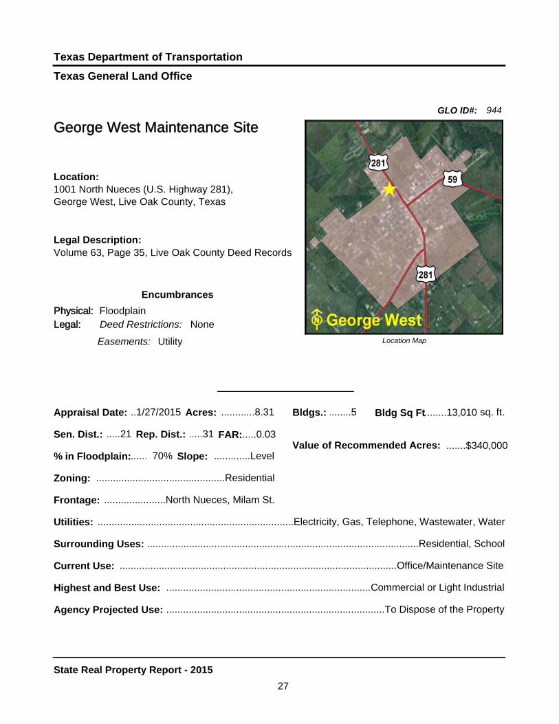
George West Maintenance Site
Location:1001 North Nueces (U.S. Highway 281), George West, Live Oak County, Texas
Legal Description:Volume 63, Page 35, Live Oak County Deed Records
Encumbrances
Physical: FloodplainLegal: Deed Restrictions: None
% in Floodplain: 70%
Utilities: ......................................................................Electricity, Gas, Telephone, Wastewater, Water
GLO ID#: 944
Easements: Utility
27
State Real Property Report - 2015

Texas General Land Office
Texas Department of Transportation
GLO Recommendation:
Dispose of the underutilized 8.31 acres.
The Texas Department of Transportation utilizes this site as an office and maintenance facility. It is located at the northwest corner of North Nueces (U.S. Highway 281) and Milam Street in George West. The site is improved with five buildings, perimeter chain-link fencing, and asphalt parking. The surrounding land uses include a school and residential development. The primary motivation for recommending the disposition of this site is that TxDot has secured property to build a new facility.
Site Map
Analysis
28
State Real Property Report - 2015
Texas General Land Office
Texas Department of Transportation
..........Value of Recommended Acres:.......$167,000
Bldg Sq Ft.........6,672
Agency Projected Use: ...................................................................................Office/Maintenance Site
Highest and Best Use: ...................................................................................Office/Maintenance Site
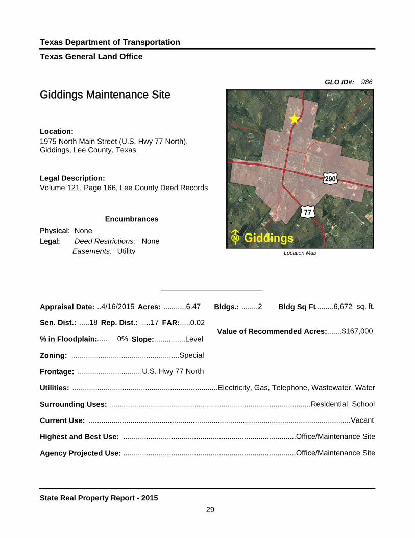
Giddings Maintenance Site
Legal Description:Volume 121, Page 166, Lee County Deed Records
Location Map
Location:1975 North Main Street (U.S. Hwy 77 North), Giddings, Lee County, Texas
Sen. Dist.: .....18 Rep. Dist.: .....17
Appraisal Date: ..4/16/2015 Acres: ...........6.47 Bldgs.: ........2 sq. ft.
FAR:.....0.02
Slope:...............Level
Zoning: ....................................................Special
Frontage: ...............................U.S. Hwy 77 North
Surrounding Uses: .................................................................................................Residential, School
Current Use: ..............................................................................................................................Vacant
Encumbrances
Legal:Physical: None
Deed Restrictions: None
% in Floodplain: 0%
Utilities: ......................................................................Electricity, Gas, Telephone, Wastewater, Water
GLO ID#: 986
Easements: Utility
29
State Real Property Report - 2015
Texas General Land Office
Texas Department of Transportation
GLO Recommendation:
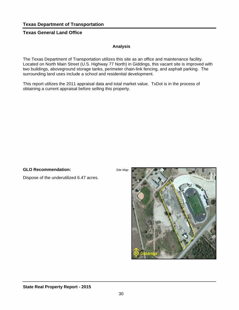
Dispose of the underutilized 6.47 acres.
The Texas Department of Transportation utilizes this site as an office and maintenance facility. Located on North Main Street (U.S. Highway 77 North) in Giddings, this vacant site is improved with two buildings, aboveground storage tanks, perimeter chain-link fencing, and asphalt parking. The surrounding land uses include a school and residential development.
This report utilizes the 2011 appraisal data and total market value. TxDot is in the process of obtaining a current appraisal before selling this property.
Site Map
Analysis
30
State Real Property Report - 2015
Texas General Land Office
Texas Department of Transportation
.......Value of Recommended Acres:.......$134,000
Bldg Sq Ft 12,377.....
Agency Projected Use: ...............................................................................Dispose Underutilized Site
Highest and Best Use: ...............................................................................Commercial Development
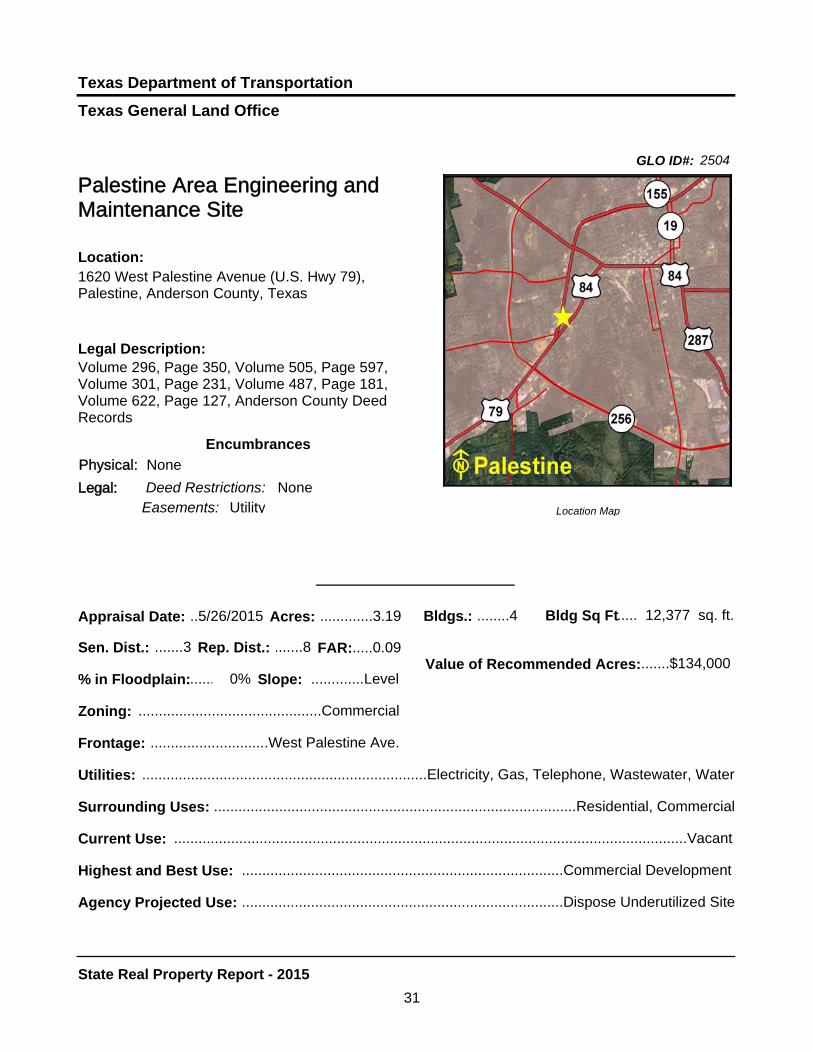
Palestine Area Engineering and Maintenance Site
Legal Description:Volume 296, Page 350, Volume 505, Page 597, Volume 301, Page 231, Volume 487, Page 181, Volume 622, Page 127, Anderson County Deed Records
Location Map
Location:1620 West Palestine Avenue (U.S. Hwy 79), Palestine, Anderson County, Texas
Sen. Dist.: .......3 Rep. Dist.: .......8
Appraisal Date: ..5/26/2015 Acres: .............3.19 Bldgs.: ........4 sq. ft.
FAR:.....0.09
Slope: .............Level
Zoning: .............................................Commercial
Frontage: .............................West Palestine Ave.
Surrounding Uses: .........................................................................................Residential, Commercial
Current Use: ..............................................................................................................................Vacant
Encumbrances
Legal:
Physical: None
Deed Restrictions: None
% in Floodplain: 0%
Utilities: ......................................................................Electricity, Gas, Telephone, Wastewater, Water
GLO ID#: 2504
Easements: Utility
31
State Real Property Report - 2015

Texas General Land Office
Texas Department of Transportation
GLO Recommendation:
Dispose of the underutilized 3.19 acres.
The Texas Department of Transportation utilized this property as an office and maintenance facility. Currently, the site is vacant. Located on West Palestine Avenue in Palestine, the property is improved with four buildings, perimeter chain-link fencing, and asphalt parking. The surrounding land uses include commercial and residential development.
The appraisal indicates the highest and best use is for commercial development.
Site Map
Analysis
32
State Real Property Report - 2015
Texas General Land Office
Texas Department of Transportation
........Value of Recommended Acres:........$116,500
Bldg Sq Ft.........9,250
Agency Projected Use:....................................................................................Office/Maintenance Site
Highest and Best Use:....................................................................................Office/Maintenance Site
Shepherd Maintenance Site - Old
Legal Description:Volume 204, Page 313, San Jacinto County Deed Records
Location Map
Location:10351 State Highway 150, Shepherd, San Jacinto County, Texas
Sen. Dist.: .......3 Rep. Dist.: .....18
Appraisal Date: ..5/12/2015 Acres: ...........12.47 Bldgs.: ........5 sq. ft.
FAR:.....0.02
Slope:.........Moderate
Zoning:...................................................Unzoned
Frontage:..................................................SH 150
Surrounding Uses: ...........................................................................Residential, School, Recreational
Current Use:................................................................................................................................Vacant
Encumbrances
Legal:
Physical: None
Deed Restrictions: None
% in Floodplain: 0%
Utilities:.......................................................................Electricity, Gas, Telephone, Wastewater, Water
GLO ID#: 1043
Easements: Utility
33
State Real Property Report - 2015

Texas General Land Office
Texas Department of Transportation
GLO Recommendation:
Dispose of the underutilized 12.47 acres.
The Texas Department of Transportation utilizes this site as an office and maintenance facility. Located on the north side of State Highway 150 in west central Shepherd, this vacant site is improved with five buildings, underground storage tanks, perimeter chain-link fencing, and asphalt parking. The surrounding land uses include a school, residential, and recreational development.
This report utilizes 2011 appraisal data and total market value. TxDot is in the process of obtaining a current appraisal before selling this property.
Site Map
Analysis
34
State Real Property Report - 2015

Texas Department of Transportation
.......Value of Recommended Acres: .........$48,000
0Bldg Sq Ft...............
Agency Projected Use: ...............................................................................Maintenance Storage Site
Highest and Best Use: ...............................................................................Maintenance Storage Site
Location Map
Sen. Dist.: .......2 Rep. Dist.: .......4
Appraisal Date: ..1/30/2015 Acres: ................12 Bldgs.: ........0 sq. ft.
FAR:.....0.00
Slope: .............Level
Zoning: .................................................Unzoned
Frontage: ..................................CR 233, CR 235
Surrounding Uses: ..........................................................................................Residential, Rangeland
Current Use: ..............................................................................................................................Vacant
Legal:
Texas General Land Office
Terrell Maintenance Site
Location:CR 233 (Colquitt Road) and CR 235, Terrell, Kaufman County, Texas
Legal Description:Volume 483, Page 76, Kaufman County Deed Records
Encumbrances
Physical: None
Deed Restrictions: None
% in Floodplain: 0%
Utilities: ......................................................................................................................Electricity, Water
GLO ID#: 1945
Easements: Utility
35
State Real Property Report - 2015

Texas General Land Office
Texas Department of Transportation
GLO Recommendation:
Dispose of the underutilized 12.00 acres.
The Texas Department of Transportation utilizes this site for maintenance storage. Located on CR 233 (Colquitt Road) and CR 235 in Terrell, the site is unimproved. The surrounding land uses includes rangeland and residential development. The site is underutilized and recommended for sale or lease.
Site Map
Analysis
36
State Real Property Report - 2015

TEXAS DEPARTMENT OF
TRANSPORTATION PROPERTIES TO BE
RETAINED
Texas General Land Office
GLO ID#: 2455Texas Department of Transportation
Location Map
......
.........
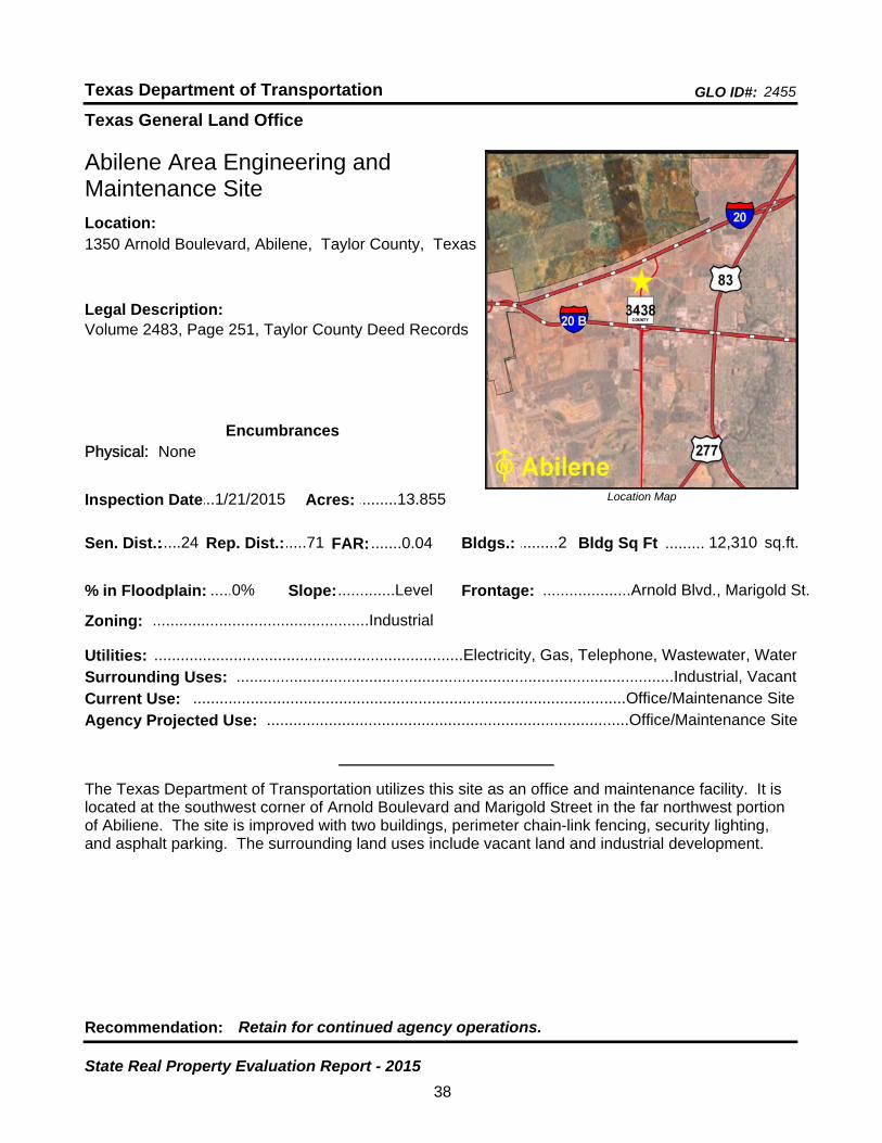
Abilene Area Engineering and Maintenance Site
Bldgs.: .........2
Legal Description:Volume 2483, Page 251, Taylor County Deed Records
Recommendation: Retain for continued agency operations.
The Texas Department of Transportation utilizes this site as an office and maintenance facility. It is located at the southwest corner of Arnold Boulevard and Marigold Street in the far northwest portion of Abiliene. The site is improved with two buildings, perimeter chain-link fencing, security lighting, and asphalt parking. The surrounding land uses include vacant land and industrial development.
sq.ft.Sen. Dist.:.....24
1350 Arnold Boulevard, Abilene, Taylor County, TexasLocation:
Rep. Dist.:.....71
Slope:.............Level
Zoning: .................................................Industrial
Inspection Date:...1/21/2015 Acres: .........13.855
Frontage: ....................Arnold Blvd., Marigold St.
Surrounding Uses: ...................................................................................................Industrial, Vacant
Current Use: ..................................................................................................Office/Maintenance Site
Bldg Sq Ft 12,310
Agency Projected Use: ..................................................................................Office/Maintenance Site
0%% in Floodplain:
EncumbrancesPhysical: None
Utilities: ......................................................................Electricity, Gas, Telephone, Wastewater, Water
FAR: .......0.04
38
State Real Property Evaluation Report - 2015

Texas General Land Office
GLO ID#: 1084Texas Department of Transportation
Location Map
......
.........
Abilene District 8 Headquarters Site
Bldgs.: .........8
Legal Description:Volume 544, Page 58, Taylor County Deed Records
Recommendation: Retain for continued agency operations.
The Texas Department of Transportation utilizes this site as a district headquarters. It is located at the northwest corner of the west service road (North Clack Street) of U.S. Highway 83/277 and FM 2404 (Old Anson Road) in the far north central portion of Abilene. The site is improved with eight buildings, an equipment storage, two parking canopies, exterior lighting, perimeter chain-link fencing, and asphalt parking. The surrounding land uses include residential and commercial development.
sq.ft.Sen. Dist.:.....24
4250 North Clack Street, Abilene, Taylor County, Texas
Location:
Rep. Dist.:.....71
Slope:.............Level
Zoning: ...............................................Agriculture
Inspection Date:...1/21/2015 Acres: ...........32.66
Frontage: ..........................N. Clack St., FM 2404
Surrounding Uses: ...........................................................................Commercial, Residential, Vacant
Current Use: ...................................................................................................................District Office
Bldg Sq Ft 77,662
Agency Projected Use: ..................................................................................................District Office
33%% in Floodplain:
EncumbrancesPhysical: Floodplain
Utilities: ......................................................................Electricity, Gas, Telephone, Wastewater, Water
FAR: .......0.05
39
State Real Property Evaluation Report - 2015

Texas General Land Office
GLO ID#: 1077Texas Department of Transportation
Location Map
......
..........
Albany Maintenance Site
Bldgs.: .........1
Legal Description:Volume 229, Page 892, Shackelford County Deed Records
Recommendation: Retain for continued agency operations.
The Texas Department of Transportation utilizes this site as an office and maintenance facility. It is located on North Gregg Street (U.S. Highway 283 North) in Albany. The site is improved with one building, aboveground storage tanks, perimeter chain-link fencing, and asphalt parking. The surrounding land uses include a cemetery, commecial, residential, and industrial development. Four acres of the site are undeveloped land but is being utilized for storage of equipment and road materials.
sq.ft.Sen. Dist.:.....28
1200 North Gregg Street (U.S. Highway 283 North), Albany, Shackelford County, Texas
Location:
Rep. Dist.:.....60
Slope:.............Level
Zoning: .................................................Unzoned
Inspection Date:.....2/3/2015 Acres: ...........10.73
Frontage: ..........North Gregg St. (U.S. Hwy 283)
Surrounding Uses: ......................................................Residential, Industrial, Cemetery, Commercial
Current Use: ..................................................................................................Office/Maintenance Site
Bldg Sq Ft 8,082
Agency Projected Use: ..................................................................................Office/Maintenance Site
0%% in Floodplain:
EncumbrancesPhysical: None
Utilities: ......................................................................Electricity, Gas, Telephone, Wastewater, Water
FAR: .......0.19
40
State Real Property Evaluation Report - 2015

Texas General Land Office
GLO ID#: 2450Texas Department of Transportation
Location Map
......
........
Alice Maintenance Site
Bldgs.: .........2
Legal Description:Volume 775, Page 395, Volume 740, Page 610, Jim Wells County Deed Records
Recommendation: Retain for continued agency operations.
The Texas Department of Transportation utilizes this site as an office and maintenance facility. It is located on North U.S. Highway 281 By-Pass in Alice. The site is improved with two buildings, aboveground storage tanks, perimeter chain-link fencing, and asphalt parking. Six acres are being utilized for storage of equipment and road material. The surrounding land is primarily vacant land.
sq.ft.Sen. Dist.:.....20
North U.S. Highway 281 By-Pass, Alice, Jim Wells County, Texas
Location:
Rep. Dist.:.....43
Slope:.............Level
Zoning:..................................................Unzoned
Inspection Date:...3/11/2015 Acres: .........10.582
Frontage: ...............North U.S. Hwy 281 By-Pass
Surrounding Uses: ....................................................................................................................Vacant
Current Use: ..................................................................................................Office/Maintenance Site
Bldg Sq Ft 14,450
Agency Projected Use: ..................................................................................Office/Maintenance Site
0%% in Floodplain:
EncumbrancesPhysical: None
Utilities: ..............................................................................Electricity, Telephone, Wastewater, Water
FAR: .......0.03
41
State Real Property Evaluation Report - 2015
Texas General Land Office
GLO ID#: 939Texas Department of Transportation
Location Map
......
........
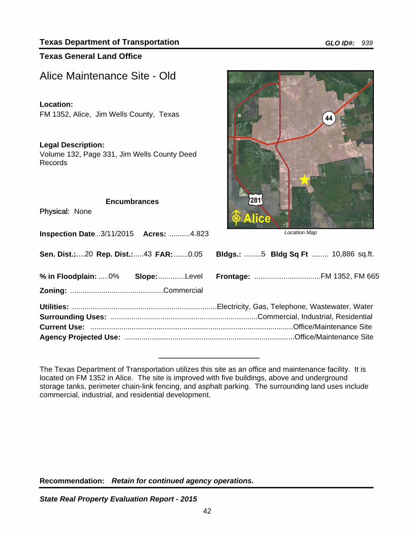
Alice Maintenance Site - Old
Bldgs.: .........5
Legal Description:Volume 132, Page 331, Jim Wells County Deed Records
Recommendation: Retain for continued agency operations.
The Texas Department of Transportation utilizes this site as an office and maintenance facility. It is located on FM 1352 in Alice. The site is improved with five buildings, above and underground storage tanks, perimeter chain-link fencing, and asphalt parking. The surrounding land uses include commercial, industrial, and residential development.
sq.ft.Sen. Dist.:.....20
FM 1352, Alice, Jim Wells County, TexasLocation:
Rep. Dist.:.....43
Slope:.............Level
Zoning: .............................................Commercial
Inspection Date:...3/11/2015 Acres: ...........4.823
Frontage: ................................FM 1352, FM 665
Surrounding Uses: .......................................................................Commercial, Industrial, Residential
Current Use: ..................................................................................................Office/Maintenance Site
Bldg Sq Ft 10,886
Agency Projected Use: ..................................................................................Office/Maintenance Site
0%% in Floodplain:
EncumbrancesPhysical: None
Utilities: ......................................................................Electricity, Gas, Telephone, Wastewater, Water
FAR: .......0.05
42
State Real Property Evaluation Report - 2015
Texas General Land Office
GLO ID#: 847Texas Department of Transportation
Location Map
......
.........
Alpine Area Engineering and Maintenance Site
Bldgs.: .........2
Legal Description:Volume 171, Page 721, Brewster County Deed Records
Recommendation: Retain for continued agency operations.
The Texas Department of Transportation utilizes this site as an office and maintenance facility. Located on North State Highway 118 in Alpine, the site is improved with two buildings, perimeter chain-link fencing, and asphalt parking. Five acres are being utilized for storage of equipment and road material. The surrounding land uses include rangeland, governmental, commercial, and residential development.
sq.ft.Sen. Dist.:.....19
2400 North State Highway 118, Alpine, Brewster County, Texas
Location:
Rep. Dist.:.....74
Slope:.............Level
Zoning: .............................................Commercial
Inspection Date:.11/13/2014 Acres: ................10
Frontage: .......................................North SH 118
Surrounding Uses: ............................................Governmental, Rangeland, Commercial, Residential
Current Use: ..................................................................................................Office/Maintenance Site
Bldg Sq Ft 15,004
Agency Projected Use: ..................................................................................Office/Maintenance Site
0%% in Floodplain:
EncumbrancesPhysical: None
Utilities: ......................................................................Electricity, Gas, Telephone, Wastewater, Water
FAR: .......0.03
43
State Real Property Evaluation Report - 2015
Texas General Land Office
GLO ID#: 2390Texas Department of Transportation
Location Map
......
........
Amarillo Area Engineering and Maintenance Site
Bldgs.: .........5
Legal Description:Volume 1927, Page 398, Randall County Deed Records
Recommendation: Retain for continued agency operations.
The Texas Department of Transportation utilizes this site as an office and maintenance facility. Located on the east side of Washington Street in Amarillo, the site is improved with five buildings, perimeter chain-link fencing, and asphalt parking. The surrounding land uses include industrial, commercial, and residential development.
sq.ft.Sen. Dist.:.....31
8401 South Washington Street, Amarillo, Randall County, Texas
Location:
Rep. Dist.:.....86
Slope:.............Level
Zoning: .................................................Unzoned
Inspection Date:...1/28/2015 Acres: ................15
Frontage:.....................................Washington St.
Surrounding Uses: .......................................................................Industrial, Commercial, Residential
Current Use: ..................................................................................................Office/Maintenance Site
Bldg Sq Ft 33,528
Agency Projected Use: ..................................................................................Office/Maintenance Site
0%% in Floodplain:
EncumbrancesPhysical: None
Utilities: ......................................................................Electricity, Gas, Telephone, Wastewater, Water
FAR: .......0.05
44
State Real Property Evaluation Report - 2015
Texas General Land Office
GLO ID#: 1163Texas Department of Transportation
Location Map
......
.........
Amarillo District Headquarters and Maintenance Site
Bldgs.: .........9
Legal Description:Volume 238, Page 5941, Potter County Deed Records
Recommendation: Retain for continued agency operations.
The Texas Department of Transportation utilizes this site as a district headquarters and maintenance facility. Located along the east site of Canyon Drive (IH 27) in the southern portion of Amarillo, the site is improved with nine buildings, asphalt parking, and perimeter chain-link fencing. The surrounding land uses include residential, commercial, and office development.
sq.ft.Sen. Dist.:.....31
5715 Canyon Drive (IH 27), Amarillo, Potter County, Texas
Location:
Rep. Dist.:.....87
Slope:.............Level
Zoning: .............................................Commercial
Inspection Date:...1/28/2015 Acres: .........26.048
Frontage: ...............................Canyon Dr. (IH 27)
Surrounding Uses: ............................................................................Residential, Commercial, Office
Current Use: ..........................................................................District Headquarters/Maintenance Site
Bldg Sq Ft 83,879
Agency Projected Use: .........................................................District Headquarters/Maintenance Site
0%% in Floodplain:
EncumbrancesPhysical: None
Utilities: ......................................................................Electricity, Gas, Telephone, Wastewater, Water
FAR: .......0.07
45
State Real Property Evaluation Report - 2015

Texas General Land Office
GLO ID#: 1960Texas Department of Transportation
Location Map
......
........
Amarillo Maintenance Site
Bldgs.: .........3
Legal Description:Volume 1852, Page 526, Potter County Deed Records
Recommendation: Retain for continued agency operations.
The Texas Department of Transportation utilizes this site as a maintenance facility. It is located on the south side of Loop 335 East in Amarillo. The site is improved with three buildings, perimeter chain-link fencing, and asphalt parking. The surrounding land uses include industrial and residential development.
sq.ft.Sen. Dist.:.....31
7700 North Loop 335 East, Amarillo, Potter County, Texas
Location:
Rep. Dist.:.....87
Slope:.............Level
Zoning:..................................................Unzoned
Inspection Date:...1/28/2015 Acres: ................10
Frontage:..................................N. Loop 335 East
Surrounding Uses: ............................................................................................Industrial, Residential
Current Use: .............................................................................................................Maintenance Site
Bldg Sq Ft 19,490
Agency Projected Use: ............................................................................................Maintenance Site
0%% in Floodplain:
EncumbrancesPhysical: None
Utilities: ......................................................................Electricity, Gas, Telephone, Wastewater, Water
FAR: .......0.05
46
State Real Property Evaluation Report - 2015
Texas General Land Office
GLO ID#: 882Texas Department of Transportation
Location Map
......
..........
Anahuac Maintenance Site
Bldgs.: .........3
Legal Description:Volume 117, Page 408, Chambers County Deed Records
Recommendation: Retain for continued agency operations.
The Texas Department of Transportation utilizes this site as an office and maintenance facility. Located on the west side of North Ross Sterling Avenue (FM 563) in Anahuac, the site is improved with three buildings, aboveground storage tanks, perimeter chain-link fencing, and asphalt parking. The surrounding land use is residential development.
sq.ft.Sen. Dist.:.......4
503 North Ross Sterling Avenue (FM 563), Anahuac, Chambers County, Texas
Location:
Rep. Dist.:.....23
Slope:.............Level
Zoning: .................................................Unzoned
Inspection Date:.....1/6/2015 Acres: ...........5.047
Frontage: ............N. Ross Sterling Ave (FM 563)
Surrounding Uses: .............................................................................................................Residential
Current Use: ..................................................................................................Office/Maintenance Site
Bldg Sq Ft 8,503
Agency Projected Use: ..................................................................................Office/Maintenance Site
0%% in Floodplain:
EncumbrancesPhysical: None
Utilities: ......................................................................Electricity, Gas, Telephone, Wastewater, Water
FAR: .......0.04
47
State Real Property Evaluation Report - 2015
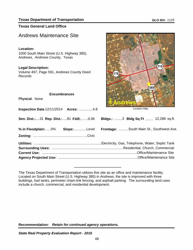
Texas General Land Office
GLO ID#: 1125Texas Department of Transportation
Location Map
......
........
Andrews Maintenance Site
Bldgs.: .........3
Legal Description:Volume 497, Page 591, Andrews County Deed Records
Recommendation: Retain for continued agency operations.
The Texas Department of Transportation utilizes this site as an office and maintenance facility. Located on South Main Street (U.S. Highway 385) in Andrews, the site is improved with three buildings, fuel tanks, perimeter chain-link fencing, and asphalt parking. The surrounding land uses include a church, commercial, and residential development.
sq.ft.Sen. Dist.:.....31
1000 South Main Street (U.S. Highway 385), Andrews, Andrews County, Texas
Location:
Rep. Dist.:.....81
Slope:.............Level
Zoning: ........................................................Civic
Inspection Date:.12/11/2014 Acres: ...............4.8
Frontage: ..........South Main St., Southwest Ave.
Surrounding Uses: ..........................................................................Residential, Church, Commercial
Current Use: ..................................................................................................Office/Maintenance Site
Bldg Sq Ft 12,288
Agency Projected Use: ..................................................................................Office/Maintenance Site
0%% in Floodplain:
EncumbrancesPhysical: None
Utilities: ......................................................................Electricity, Gas, Telephone, Water, Septic Tank
FAR: .......0.06
48
State Real Property Evaluation Report - 2015
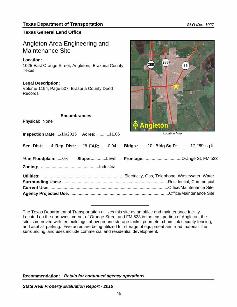
Texas General Land Office
GLO ID#: 1027Texas Department of Transportation
Location Map
......
........
Angleton Area Engineering and Maintenance Site
Bldgs.: .......10
Legal Description:Volume 1194, Page 507, Brazoria County Deed Records
Recommendation: Retain for continued agency operations.
The Texas Department of Transportation utilizes this site as an office and maintenance facility. Located on the northwest corner of Orange Street and FM 523 in the east portion of Angleton, the site is improved with ten buildings, aboveground storage tanks, perimeter chain-link security fencing, and asphalt parking. Five acres are being utilized for storage of equipment and road material.The surrounding land uses include commercial and residential development.
sq.ft.Sen. Dist.:.......4
1025 East Orange Street, Angleton, Brazoria County, Texas
Location:
Rep. Dist.:.....25
Slope:.............Level
Zoning: .................................................Industrial
Inspection Date:...1/16/2015 Acres: ...........11.06
Frontage: ..............................Orange St, FM 523
Surrounding Uses: ........................................................................................Residential, Commercial
Current Use: ..................................................................................................Office/Maintenance Site
Bldg Sq Ft 17,289
Agency Projected Use: ..................................................................................Office/Maintenance Site
0%% in Floodplain:
EncumbrancesPhysical: None
Utilities: ......................................................................Electricity, Gas, Telephone, Wastewater, Water
FAR: .......0.04
49
State Real Property Evaluation Report - 2015

Texas General Land Office
GLO ID#: 2453Texas Department of Transportation
Location Map
......
..................
Angleton Maintenance Site (Proposed)
Bldgs.: .........0
Legal Description:Book 01-017446, Brazoria County Deed Records
Recommendation: Retain for continued agency operations.
The Texas Department of Transportation utilizes this site as a proposed office and maintenance facility. Located just east of U.S. Highway 288 on the south side of FM 523 (SH 35 By-Pass) in the north portion of Angleton, the site is currently vacant with no buildings or improvements. The surrounding land uses include residential development. The agency plans to develop the site when funding becomes available.
sq.ft.Sen. Dist.:.....11
FM 523 (SH 35 By-Pass), Angleton, Brazoria County, Texas
Location:
Rep. Dist.:.....25
Slope:.............Level
Zoning: .................................................Unzoned
Inspection Date:...1/16/2015 Acres: ...........15.49
Frontage: ..................................FM 523, CR 341
Surrounding Uses: ................................................................................................Residential, Vacant
Current Use: .............................................................................................................................Vacant
Bldg Sq Ft 0
Agency Projected Use: .................................................................Proposed Office/Maintenance Site
30%% in Floodplain:
EncumbrancesPhysical: Floodplain
Utilities: ......................................................................Electricity, Gas, Telephone, Wastewater, Water
FAR: .......0.00
50
State Real Property Evaluation Report - 2015
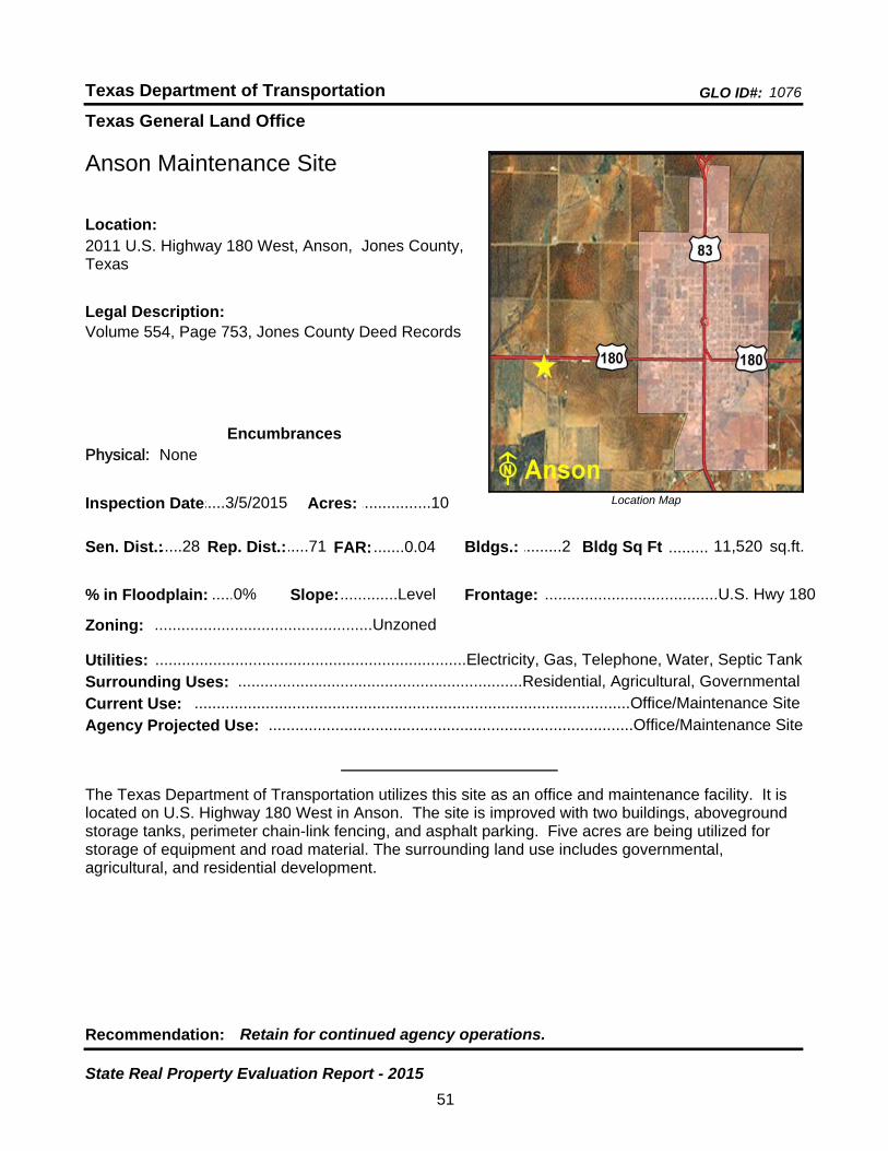
Texas General Land Office
GLO ID#: 1076Texas Department of Transportation
Location Map
......
.........
Anson Maintenance Site
Bldgs.: .........2
Legal Description:Volume 554, Page 753, Jones County Deed Records
Recommendation: Retain for continued agency operations.
The Texas Department of Transportation utilizes this site as an office and maintenance facility. It is located on U.S. Highway 180 West in Anson. The site is improved with two buildings, aboveground storage tanks, perimeter chain-link fencing, and asphalt parking. Five acres are being utilized for storage of equipment and road material. The surrounding land use includes governmental, agricultural, and residential development.
sq.ft.Sen. Dist.:.....28
2011 U.S. Highway 180 West, Anson, Jones County, Texas
Location:
Rep. Dist.:.....71
Slope:.............Level
Zoning: .................................................Unzoned
Inspection Date:.....3/5/2015 Acres: ................10
Frontage: .......................................U.S. Hwy 180
Surrounding Uses: ................................................................Residential, Agricultural, Governmental
Current Use: ..................................................................................................Office/Maintenance Site
Bldg Sq Ft 11,520
Agency Projected Use: ..................................................................................Office/Maintenance Site
0%% in Floodplain:
EncumbrancesPhysical: None
Utilities: ......................................................................Electricity, Gas, Telephone, Water, Septic Tank
FAR: .......0.04
51
State Real Property Evaluation Report - 2015
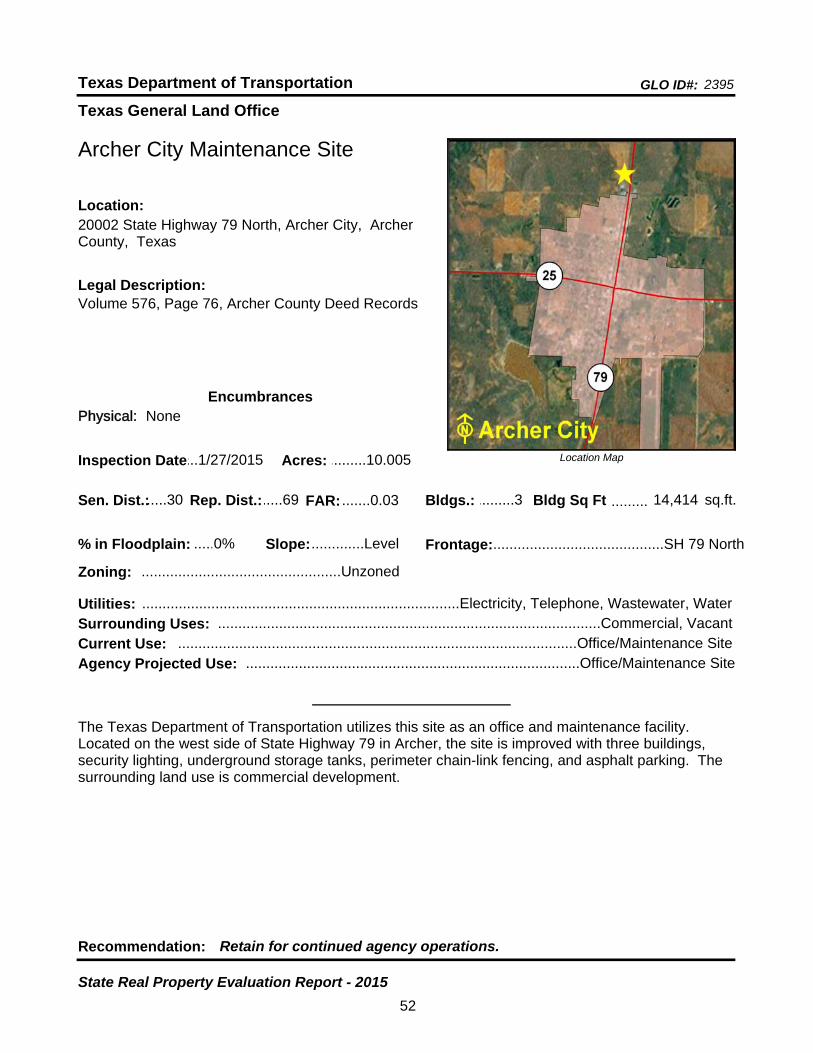
Texas General Land Office
GLO ID#: 2395Texas Department of Transportation
Location Map
......
.........
Archer City Maintenance Site
Bldgs.: .........3
Legal Description:Volume 576, Page 76, Archer County Deed Records
Recommendation: Retain for continued agency operations.
The Texas Department of Transportation utilizes this site as an office and maintenance facility. Located on the west side of State Highway 79 in Archer, the site is improved with three buildings, security lighting, underground storage tanks, perimeter chain-link fencing, and asphalt parking. The surrounding land use is commercial development.
sq.ft.Sen. Dist.:.....30
20002 State Highway 79 North, Archer City, Archer County, Texas
Location:
Rep. Dist.:.....69
Slope:.............Level
Zoning: .................................................Unzoned
Inspection Date:...1/27/2015 Acres: .........10.005
Frontage:..........................................SH 79 North
Surrounding Uses: ..............................................................................................Commercial, Vacant
Current Use: ..................................................................................................Office/Maintenance Site
Bldg Sq Ft 14,414
Agency Projected Use: ..................................................................................Office/Maintenance Site
0%% in Floodplain:
EncumbrancesPhysical: None
Utilities: ..............................................................................Electricity, Telephone, Wastewater, Water
FAR: .......0.03
52
State Real Property Evaluation Report - 2015
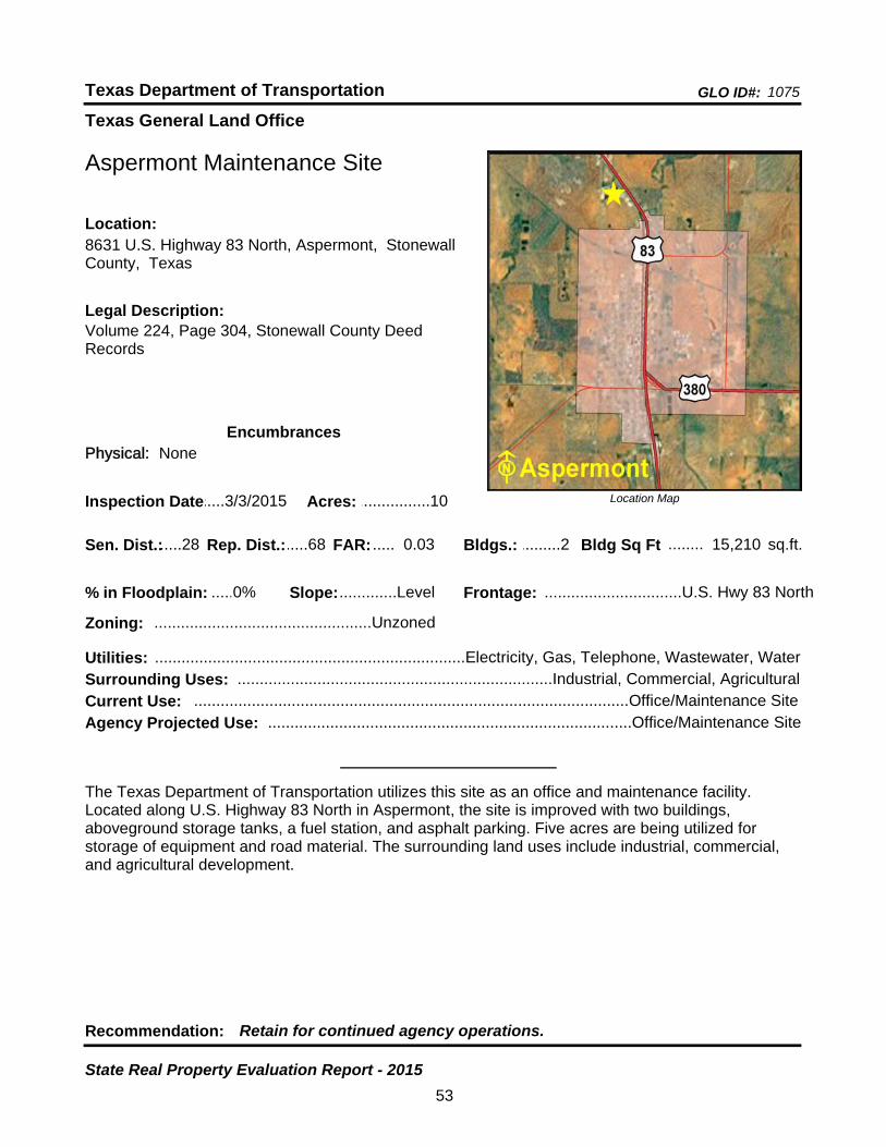
Texas General Land Office
GLO ID#: 1075Texas Department of Transportation
Location Map
......
........
Aspermont Maintenance Site
Bldgs.: .........2
Legal Description:Volume 224, Page 304, Stonewall County Deed Records
Recommendation: Retain for continued agency operations.
The Texas Department of Transportation utilizes this site as an office and maintenance facility. Located along U.S. Highway 83 North in Aspermont, the site is improved with two buildings, aboveground storage tanks, a fuel station, and asphalt parking. Five acres are being utilized for storage of equipment and road material. The surrounding land uses include industrial, commercial, and agricultural development.
sq.ft.Sen. Dist.:.....28
8631 U.S. Highway 83 North, Aspermont, Stonewall County, Texas
Location:
Rep. Dist.:.....68
Slope:.............Level
Zoning: .................................................Unzoned
Inspection Date:.....3/3/2015 Acres: ................10
Frontage: ...............................U.S. Hwy 83 North
Surrounding Uses: .......................................................................Industrial, Commercial, Agricultural
Current Use: ..................................................................................................Office/Maintenance Site
Bldg Sq Ft 15,210
Agency Projected Use: ..................................................................................Office/Maintenance Site
0%% in Floodplain:
EncumbrancesPhysical: None
Utilities: ......................................................................Electricity, Gas, Telephone, Wastewater, Water
FAR: ..... 0.03
53
State Real Property Evaluation Report - 2015
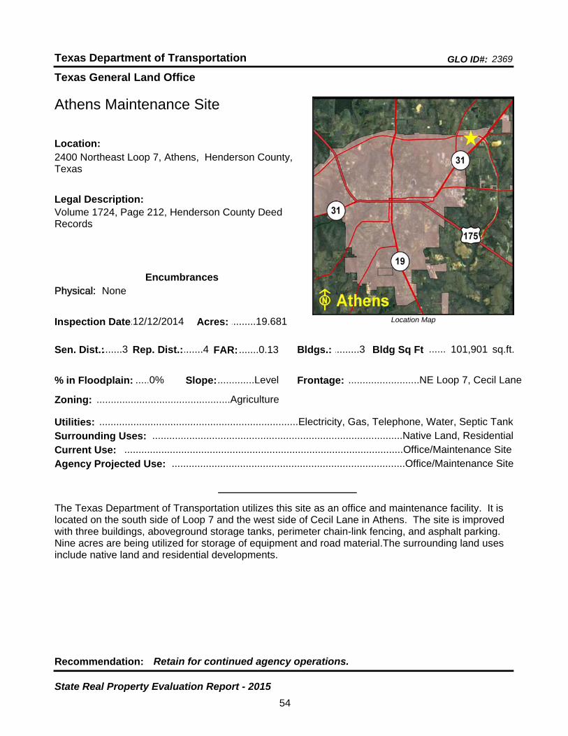
Texas General Land Office
GLO ID#: 2369Texas Department of Transportation
Location Map
......
......
Athens Maintenance Site
Bldgs.: .........3
Legal Description:Volume 1724, Page 212, Henderson County Deed Records
Recommendation: Retain for continued agency operations.
The Texas Department of Transportation utilizes this site as an office and maintenance facility. It is located on the south side of Loop 7 and the west side of Cecil Lane in Athens. The site is improved with three buildings, aboveground storage tanks, perimeter chain-link fencing, and asphalt parking. Nine acres are being utilized for storage of equipment and road material.The surrounding land uses include native land and residential developments.
sq.ft.Sen. Dist.:.......3
2400 Northeast Loop 7, Athens, Henderson County, Texas
Location:
Rep. Dist.:.......4
Slope:.............Level
Zoning: ...............................................Agriculture
Inspection Date:.12/12/2014 Acres: .........19.681
Frontage: .........................NE Loop 7, Cecil Lane
Surrounding Uses: ........................................................................................Native Land, Residential
Current Use: ..................................................................................................Office/Maintenance Site
Bldg Sq Ft 101,901
Agency Projected Use: ..................................................................................Office/Maintenance Site
0%% in Floodplain:
EncumbrancesPhysical: None
Utilities: ......................................................................Electricity, Gas, Telephone, Water, Septic Tank
FAR: .......0.13
54
State Real Property Evaluation Report - 2015

Texas General Land Office
GLO ID#: 900Texas Department of Transportation
Location Map
......
........
Atlanta District Headquarters Site
Bldgs.: .........8
Legal Description:Volume F-6, Page 279, Volume G-6, Page 238, Volume 876, Page 57, Volume 878, Page 77, Volume 1028, Page 537, Volume 1138, Page 509, Cass County Deed Records
Recommendation: Retain for continued agency operations.
The Texas Department of Transportation utilizes this site as a district headquarters facility. Located at the northeast corner of Main Street and Park Street in the eastern portion of Atlanta, the site is improved with eight buildings, chain and wood fencing, asphalt parking, and covered porches. The surrounding land uses include residential, commercial, and industrial development.
sq.ft.Sen. Dist.:.......1
701 East Main Street, Atlanta, Cass County, TexasLocation:
Rep. Dist.:.......9
Slope:.............Level
Zoning: .............................................Commercial
Inspection Date:...3/10/2015 Acres: .........23.748
Frontage: .........................East Main St., Park St.
Surrounding Uses: .......................................................................Industrial, Residential, Commercial
Current Use: ................................................................................................District Headquarters Site
Bldg Sq Ft 78,404
Agency Projected Use: ...............................................................................District Headquarters Site
20%% in Floodplain:
EncumbrancesPhysical: Floodplain
Utilities: ......................................................................Electricity, Gas, Telephone, Wastewater, Water
FAR: .......0.08
55
State Real Property Evaluation Report - 2015

Texas General Land Office
GLO ID#: 2515Texas Department of Transportation
Location Map
......
.........
Austin Area Engineering and Maintenance Special Crews Site
Bldgs.: .........5
Legal Description:Santiago Del ValleyGrant, A-24, Travis County Deed Records
Recommendation: Retain for continued agency operations.
The Texas Department of Transportation utilizes this site as an office and maintenance facility. It is located on South IH-35 in Austin. The site is improved with five buildings, perimeter chain-link security fencing, and asphalt parking. Fourteen acres are being utilized for storage of equipment and road material.The surrounding land uses include office, industrial, and residential development.
sq.ft.Sen. Dist.:.....25
9725 South IH-35, Austin, Travis County, TexasLocation:
Rep. Dist.:.....47
Slope:.............Level
Zoning: .................................................Unzoned
Inspection Date:...1/15/2015 Acres: .........26.498
Frontage: ..........................................South IH-35
Surrounding Uses: .................................................................................Office, Industrial, Residential
Current Use: ..................................................................................................Office/Maintenance Site
Bldg Sq Ft 38,740
Agency Projected Use: ..................................................................................Office/Maintenance Site
0%% in Floodplain:
EncumbrancesPhysical: None
Utilities: ......................................................................Electricity, Gas, Telephone, Wastewater, Water
FAR: .......0.03
56
State Real Property Evaluation Report - 2015

Texas General Land Office
GLO ID#: 989Texas Department of Transportation
Location Map
......
.......
Austin District Headquarters Site
Bldgs.: .......17
Legal Description:Volume 1447, Page 377, Travis County Deed Records
Recommendation: Retain for continued agency operations.
The Texas Department of Transportation utilizes this site as a district headquarters facility. Located on the southeast corner of IH-35 and Norwood Park Boulevard in the northeast part of Austin, the site is improved with 17 buildings, perimeter chain-link security fencing, and asphalt parking. The surrounding land uses include office, recreational, commercial, and industrial development.
sq.ft.Sen. Dist.:.....14
7901 IH-35 North, Austin, Travis County, TexasLocation:
Rep. Dist.:.....46
Slope:.............Level
Zoning: ..............................................Residential
Inspection Date:...1/14/2015 Acres: .........24.858
Frontage: ..................IH-35, Norwood Park Blvd.
Surrounding Uses: .........................................................Commercial, Office, Industrial, Recreational
Current Use: ................................................................................................District Headquarters Site
Bldg Sq Ft 126,764
Agency Projected Use: ...............................................................................District Headquarters Site
0%% in Floodplain:
EncumbrancesPhysical: None
Utilities: ......................................................................Electricity, Gas, Telephone, Wastewater, Water
FAR: ........0.12
57
State Real Property Evaluation Report - 2015
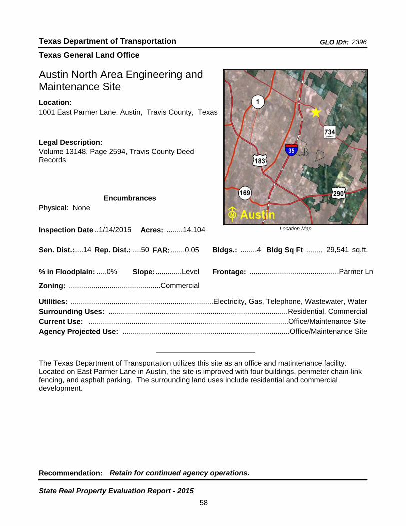
Texas General Land Office
GLO ID#: 2396Texas Department of Transportation
Location Map
......
........
Austin North Area Engineering and Maintenance Site
Bldgs.: .........4
Legal Description:Volume 13148, Page 2594, Travis County Deed Records
Recommendation: Retain for continued agency operations.
The Texas Department of Transportation utilizes this site as an office and matintenance facility. Located on East Parmer Lane in Austin, the site is improved with four buildings, perimeter chain-link fencing, and asphalt parking. The surrounding land uses include residential and commercial development.
sq.ft.Sen. Dist.:.....14
1001 East Parmer Lane, Austin, Travis County, TexasLocation:
Rep. Dist.:.....50
Slope:.............Level
Zoning: .............................................Commercial
Inspection Date:...1/14/2015 Acres: .........14.104
Frontage: ............................................Parmer Ln
Surrounding Uses: ........................................................................................Residential, Commercial
Current Use: ..................................................................................................Office/Maintenance Site
Bldg Sq Ft 29,541
Agency Projected Use: ..................................................................................Office/Maintenance Site
0%% in Floodplain:
EncumbrancesPhysical: None
Utilities: ......................................................................Electricity, Gas, Telephone, Wastewater, Water
FAR: .......0.05
58
State Real Property Evaluation Report - 2015

Texas General Land Office
GLO ID#: 980Texas Department of Transportation
Location Map
......
...........
Austin Northeast Maintenance Site
Bldgs.: .........1
Legal Description:Volume 7064, Page 2224, Volume 7096, Page 2232, Travis County Deed Records
Recommendation: Retain for continued agency operations.
The Texas Department of Transportation utilizes this site as an office and maintenance facility. It is located on FM 969 in northeast Austin. The site is improved with one building, aboveground storage tanks, perimeter chain-link fencing, and asphalt parking. Five acres are being utilized for storage of equipment and road material.The surrounding land uses include a church, agricultural, and residential development.
sq.ft.Sen. Dist.:.....14
8902 FM 969 East, Austin, Travis County, TexasLocation:
Rep. Dist.:.....46
Slope:.............Level
Zoning: ....................................................Special
Inspection Date:...1/13/2015 Acres: ................10
Frontage: .................................................FM 969
Surrounding Uses: ...........................................................................Residential, Church, Agricultural
Current Use: ..................................................................................................Office/Maintenance Site
Bldg Sq Ft 8,228
Agency Projected Use: ..................................................................................Office/Maintenance Site
0%% in Floodplain:
EncumbrancesPhysical: None
Utilities: ..............................................................................Electricity, Telephone, Water, Septic Tank
FAR: .......0.02
59
State Real Property Evaluation Report - 2015
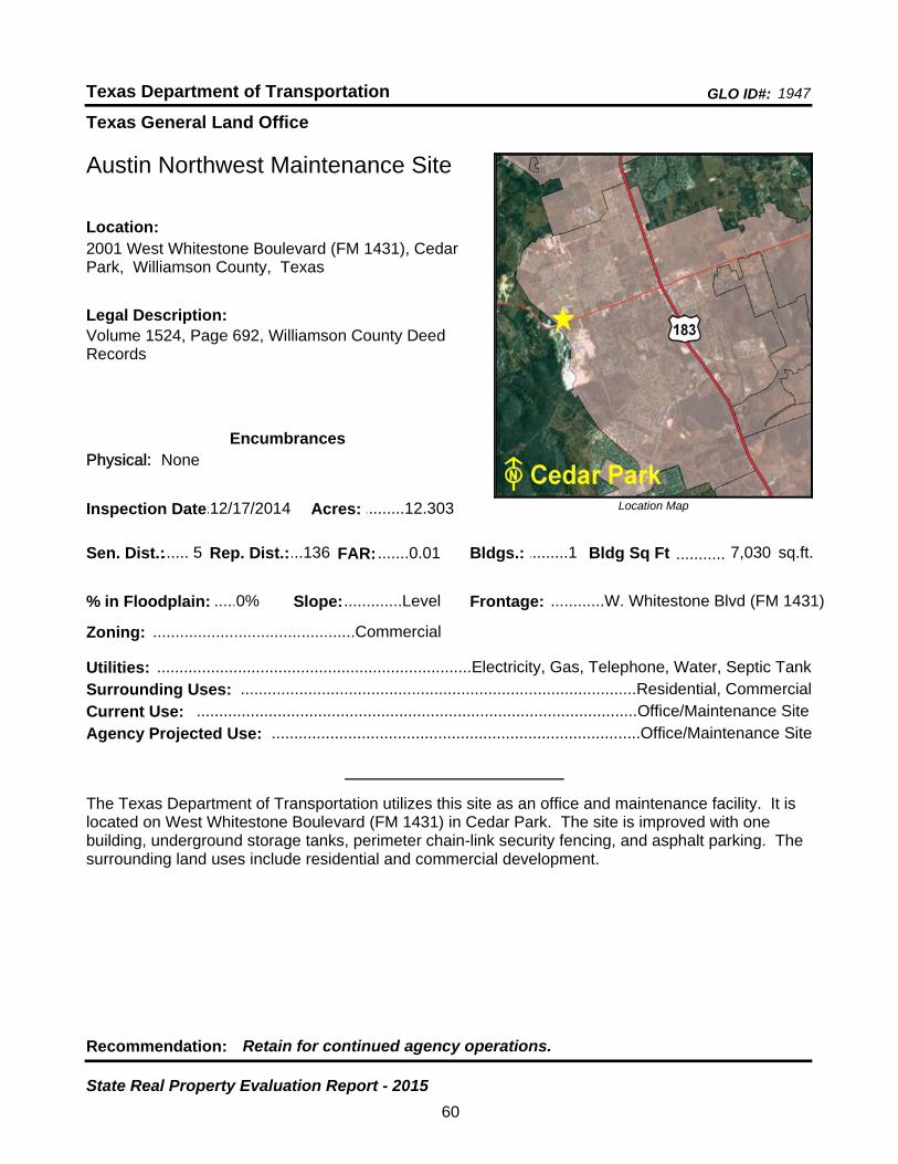
Texas General Land Office
GLO ID#: 1947Texas Department of Transportation
Location Map
......
...........
Austin Northwest Maintenance Site
Bldgs.: .........1
Legal Description:Volume 1524, Page 692, Williamson County Deed Records
Recommendation: Retain for continued agency operations.
The Texas Department of Transportation utilizes this site as an office and maintenance facility. It is located on West Whitestone Boulevard (FM 1431) in Cedar Park. The site is improved with one building, underground storage tanks, perimeter chain-link security fencing, and asphalt parking. The surrounding land uses include residential and commercial development.
sq.ft.Sen. Dist.:...... 5
2001 West Whitestone Boulevard (FM 1431), Cedar Park, Williamson County, Texas
Location:
Rep. Dist.:...136
Slope:.............Level
Zoning: .............................................Commercial
Inspection Date:.12/17/2014 Acres: .........12.303
Frontage: ............W. Whitestone Blvd (FM 1431)
Surrounding Uses: ........................................................................................Residential, Commercial
Current Use: ..................................................................................................Office/Maintenance Site
Bldg Sq Ft 7,030
Agency Projected Use: ..................................................................................Office/Maintenance Site
0%% in Floodplain:
EncumbrancesPhysical: None
Utilities: ......................................................................Electricity, Gas, Telephone, Water, Septic Tank
FAR: .......0.01
60
State Real Property Evaluation Report - 2015
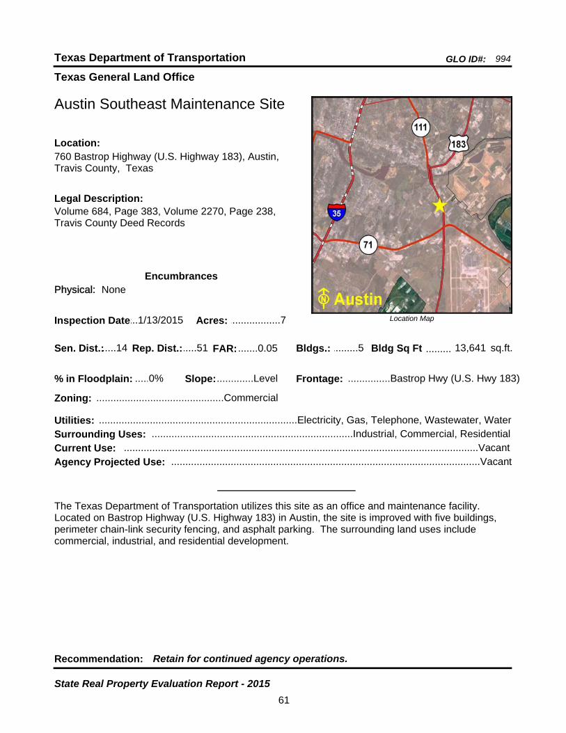
Texas General Land Office
GLO ID#: 994Texas Department of Transportation
Location Map
......
.........
Austin Southeast Maintenance Site
Bldgs.: .........5
Legal Description:Volume 684, Page 383, Volume 2270, Page 238, Travis County Deed Records
Recommendation: Retain for continued agency operations.
The Texas Department of Transportation utilizes this site as an office and maintenance facility. Located on Bastrop Highway (U.S. Highway 183) in Austin, the site is improved with five buildings, perimeter chain-link security fencing, and asphalt parking. The surrounding land uses include commercial, industrial, and residential development.
sq.ft.Sen. Dist.:.....14
760 Bastrop Highway (U.S. Highway 183), Austin, Travis County, Texas
Location:
Rep. Dist.:.....51
Slope:.............Level
Zoning: .............................................Commercial
Inspection Date:...1/13/2015 Acres: ..................7
Frontage: ...............Bastrop Hwy (U.S. Hwy 183)
Surrounding Uses: .......................................................................Industrial, Commercial, Residential
Current Use: .............................................................................................................................Vacant
Bldg Sq Ft 13,641
Agency Projected Use: .............................................................................................................Vacant
0%% in Floodplain:
EncumbrancesPhysical: None
Utilities: ......................................................................Electricity, Gas, Telephone, Wastewater, Water
FAR: .......0.05
61
State Real Property Evaluation Report - 2015
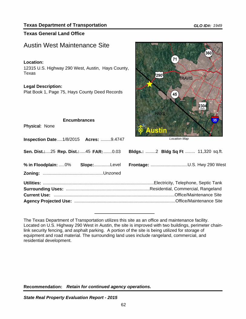
Texas General Land Office
GLO ID#: 1949Texas Department of Transportation
Location Map
......
........
Austin West Maintenance Site
Bldgs.: .........2
Legal Description:Plat Book 1, Page 75, Hays County Deed Records
Recommendation: Retain for continued agency operations.
The Texas Department of Transportation utilizes this site as an office and maintenance facility. Located on U.S. Highway 290 West in Austin, the site is improved with two buildings, perimeter chain-link security fencing, and asphalt parking. A portion of the site is being utilized for storage of equipment and road material. The surrounding land uses include rangeland, commercial, and residential development.
sq.ft.Sen. Dist.:.....25
12315 U.S. Highway 290 West, Austin, Hays County, Texas
Location:
Rep. Dist.:.....45
Slope:.............Level
Zoning: .................................................Unzoned
Inspection Date:.....1/8/2015 Acres: .........9.4747
Frontage: ..............................U.S. Hwy 290 West
Surrounding Uses: ....................................................................Residential, Commercial, Rangeland
Current Use: ..................................................................................................Office/Maintenance Site
Bldg Sq Ft 11,320
Agency Projected Use: ..................................................................................Office/Maintenance Site
0%% in Floodplain:
EncumbrancesPhysical: None
Utilities: ..........................................................................................Electricity, Telephone, Septic Tank
FAR: .......0.03
62
State Real Property Evaluation Report - 2015
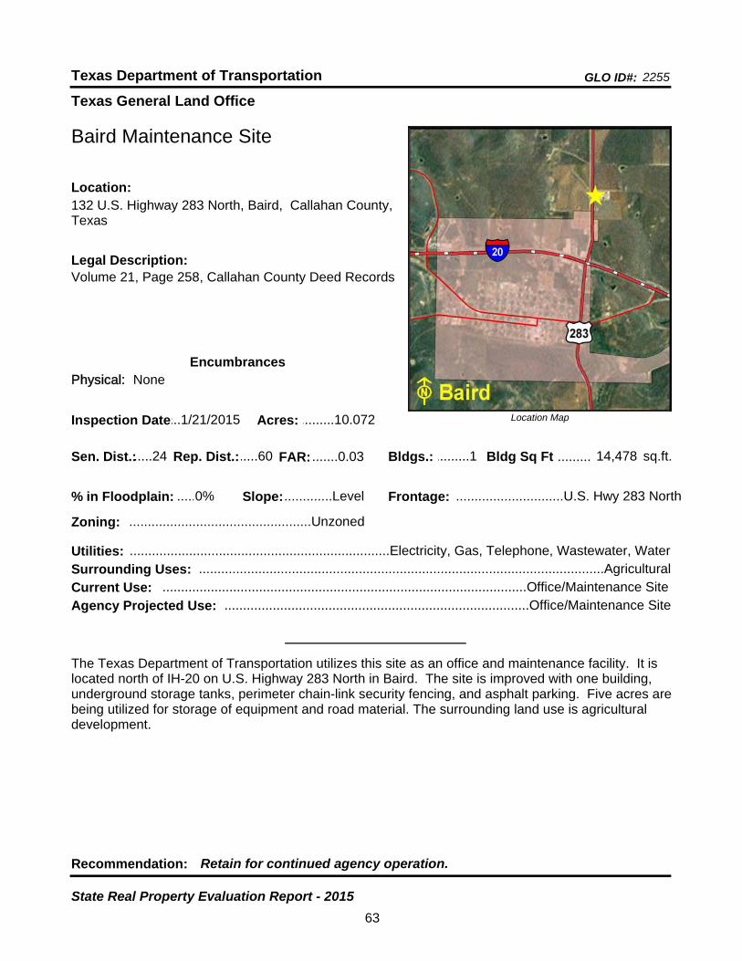
Texas General Land Office
GLO ID#: 2255Texas Department of Transportation
Location Map
......
.........
Baird Maintenance Site
Bldgs.: .........1
Legal Description:Volume 21, Page 258, Callahan County Deed Records
Recommendation: Retain for continued agency operation.
The Texas Department of Transportation utilizes this site as an office and maintenance facility. It is located north of IH-20 on U.S. Highway 283 North in Baird. The site is improved with one building, underground storage tanks, perimeter chain-link security fencing, and asphalt parking. Five acres are being utilized for storage of equipment and road material. The surrounding land use is agricultural development.
sq.ft.Sen. Dist.:.....24
132 U.S. Highway 283 North, Baird, Callahan County, Texas
Location:
Rep. Dist.:.....60
Slope:.............Level
Zoning: .................................................Unzoned
Inspection Date:...1/21/2015 Acres: .........10.072
Frontage: .............................U.S. Hwy 283 North
Surrounding Uses: .............................................................................................................Agricultural
Current Use: ..................................................................................................Office/Maintenance Site
Bldg Sq Ft 14,478
Agency Projected Use: ..................................................................................Office/Maintenance Site
0%% in Floodplain:
EncumbrancesPhysical: None
Utilities: ......................................................................Electricity, Gas, Telephone, Wastewater, Water
FAR: .......0.03
63
State Real Property Evaluation Report - 2015

Texas General Land Office
GLO ID#: 1116Texas Department of Transportation
Location Map
......
...........
Ballinger Maintenance Site
Bldgs.: .........2
Legal Description:Volume 312, Page 444, Runnels County Deed Records
Recommendation: Retain for continued agency operation.
The Texas Department of Transportation utilizes this site as a maintenance facility. It is located northeast of SH 158 along the west side of FM 2887 in Ballinger. The site is improved with two buildings, perimeter chain-link fencing, and asphalt parking. The surrounding land use includes rangeland, commercial, industrial, and residential development.
sq.ft.Sen. Dist.:.....28
FM 2887 North, Ballinger, Runnels County, TexasLocation:
Rep. Dist.:.....72
Slope:.............Level
Zoning: .................................................Unzoned
Inspection Date:...3/23/2015 Acres: .............7.01
Frontage: ...............................................FM 2887
Surrounding Uses: ....................................................Rangeland, Commercial, Residential, Industrial
Current Use: .............................................................................................................Maintenance Site
Bldg Sq Ft 8,838
Agency Projected Use: ............................................................................................Maintenance Site
0%% in Floodplain:
EncumbrancesPhysical: None
Utilities: ......................................................................Electricity, Gas, Telephone, Water, Septic Tank
FAR: .......0.02
64
State Real Property Evaluation Report - 2015

Texas General Land Office
GLO ID#: 1121Texas Department of Transportation
Location Map
......
...........
Balmorhea Maintenance Site
Bldgs.: .........2
Legal Description:Volume 277, Page 797, Reeves County Deed Records
Recommendation: Retain for continued agency operations.
The Texas Department of Transportation utilizes this site as an office and maintenance facility. Located on FM 2903 (Business IH-30) in Balmorhea, the site is improved with two buildings, underground storage tanks, perimeter chain-link fencing, and asphalt parking. Two acres are being utilized for storage of equipment and road material. The surrounding land use is rangeland.
sq.ft.Sen. Dist.:.....19
2261 FM 2903 (Business IH-10), Balmorhea, Reeves County, Texas
Location:
Rep. Dist.:.....74
Slope:.............Level
Zoning: .................................................Unzoned
Inspection Date:...11/5/2014 Acres: .............8.26
Frontage: ...................FM 2903 (Business IH-10)
Surrounding Uses: ................................................................................................Rangeland, Vacant
Current Use: ..................................................................................................Office/Maintenance Site
Bldg Sq Ft 6,480
Agency Projected Use: ..................................................................................Office/Maintenance Site
0%% in Floodplain:
EncumbrancesPhysical:
Utilities: ..............................................................................Electricity, Telephone, Wastewater, Water
FAR: .......0.01
65
State Real Property Evaluation Report - 2015

Texas General Land Office
GLO ID#: 959Texas Department of Transportation
Location Map
......
........
Bandera Maintenance Site
Bldgs.: .........6
Legal Description:Volume 188, Page 845, Bandera County Deed Records
Recommendation: Retain for continued agency operations.
The Texas Department of Transportation utilizes this site as an office and maintenance facility. Located along the east side of FM 3240 in Bandera, the site is improved with six buildings, perimeter chain-link fencing, and asphalt parking. A portion of the site is being utilized for storage of equipment and road material. The surrounding land uses include agricultural and commercial development.
sq.ft.Sen. Dist.:.....24
2018 FM 3240, Bandera, Bandera County, TexasLocation:
Rep. Dist.:.....53
Slope:.............Level
Zoning: .................................................Unzoned
Inspection Date:...4/28/2015 Acres: .......11.5788
Frontage: ...............................................FM 3240
Surrounding Uses: ........................................................................................Agricultural, Commercial
Current Use: ..................................................................................................Office/Maintenance Site
Bldg Sq Ft 13,397
Agency Projected Use: ..................................................................................Office/Maintenance Site
0%% in Floodplain:
EncumbrancesPhysical: None
Utilities: ..............................................................................Electricity, Telephone, Water, Septic Tank
FAR: .......0.03
66
State Real Property Evaluation Report - 2015
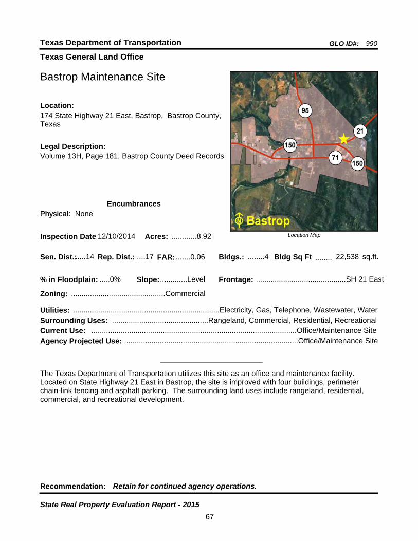
Texas General Land Office
GLO ID#: 990Texas Department of Transportation
Location Map
......
........
Bastrop Maintenance Site
Bldgs.: .........4
Legal Description:Volume 13H, Page 181, Bastrop County Deed Records
Recommendation: Retain for continued agency operations.
The Texas Department of Transportation utilizes this site as an office and maintenance facility. Located on State Highway 21 East in Bastrop, the site is improved with four buildings, perimeter chain-link fencing and asphalt parking. The surrounding land uses include rangeland, residential, commercial, and recreational development.
sq.ft.Sen. Dist.:.....14
174 State Highway 21 East, Bastrop, Bastrop County, Texas
Location:
Rep. Dist.:.....17
Slope:.............Level
Zoning: .............................................Commercial
Inspection Date:.12/10/2014 Acres: .............8.92
Frontage: ...........................................SH 21 East
Surrounding Uses: ..............................................Rangeland, Commercial, Residential, Recreational
Current Use: ..................................................................................................Office/Maintenance Site
Bldg Sq Ft 22,538
Agency Projected Use: ..................................................................................Office/Maintenance Site
0%% in Floodplain:
EncumbrancesPhysical: None
Utilities: ......................................................................Electricity, Gas, Telephone, Wastewater, Water
FAR: .......0.06
67
State Real Property Evaluation Report - 2015
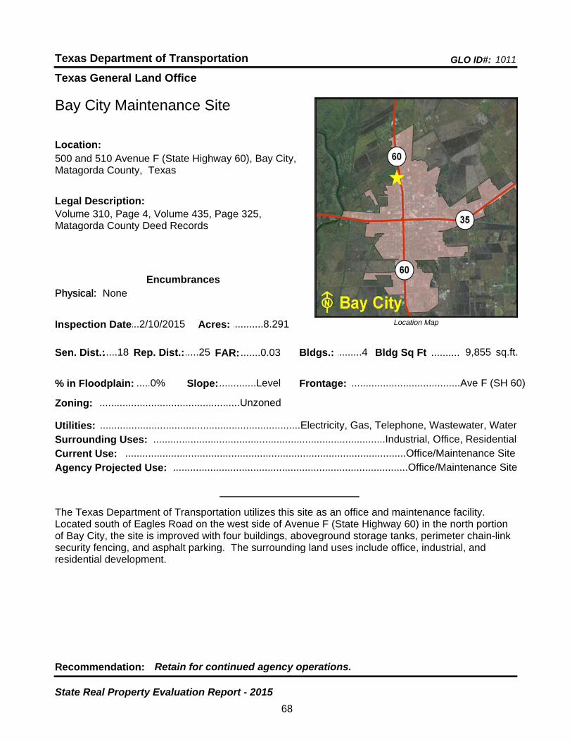
Texas General Land Office
GLO ID#: 1011Texas Department of Transportation
Location Map
......
..........
Bay City Maintenance Site
Bldgs.: .........4
Legal Description:Volume 310, Page 4, Volume 435, Page 325, Matagorda County Deed Records
Recommendation: Retain for continued agency operations.
The Texas Department of Transportation utilizes this site as an office and maintenance facility. Located south of Eagles Road on the west side of Avenue F (State Highway 60) in the north portion of Bay City, the site is improved with four buildings, aboveground storage tanks, perimeter chain-link security fencing, and asphalt parking. The surrounding land uses include office, industrial, and residential development.
sq.ft.Sen. Dist.:.....18
500 and 510 Avenue F (State Highway 60), Bay City, Matagorda County, Texas
Location:
Rep. Dist.:.....25
Slope:.............Level
Zoning: .................................................Unzoned
Inspection Date:...2/10/2015 Acres: ...........8.291
Frontage: ......................................Ave F (SH 60)
Surrounding Uses: .................................................................................Industrial, Office, Residential
Current Use: ..................................................................................................Office/Maintenance Site
Bldg Sq Ft 9,855
Agency Projected Use: ..................................................................................Office/Maintenance Site
0%% in Floodplain:
EncumbrancesPhysical: None
Utilities: ......................................................................Electricity, Gas, Telephone, Wastewater, Water
FAR: .......0.03
68
State Real Property Evaluation Report - 2015

Texas General Land Office
GLO ID#: 2358Texas Department of Transportation
Location Map
......
........
Beaumont Area Engineering and Maintenance Site
Bldgs.: .........5
Legal Description:File No. 96-9638934, Jefferson County Deed Records
Recommendation: Retain for continued agency operations.
The Texas Department of Transportation utilizes this site as an office and maintenance facility. Located between Tram Road and Chinn Lane along the east side of Eastex Freeway in Beaumont, the site is improved with five buildings and asphalt parking. Four acres are being utilized for storage of equipment and road material. The surrounding land use is commercial development.
sq.ft.Sen. Dist.:.......4
8450 Eastex Freeway, Beaumont, Jefferson County, Texas
Location:
Rep. Dist.:.....22
Slope:.............Level
Zoning: .................................................Industrial
Inspection Date:.....1/6/2015 Acres: ...........21.31
Frontage: ..........................................Eastex Fwy
Surrounding Uses: ............................................................................................................Commercial
Current Use: ..................................................................................................Office/Maintenance Site
Bldg Sq Ft 24,302
Agency Projected Use: ..................................................................................Office/Maintenance Site
0%% in Floodplain:
EncumbrancesPhysical: None
Utilities: ......................................................................Electricity, Gas, Telephone, Wastewater, Water
FAR: .......0.03
69
State Real Property Evaluation Report - 2015

Texas General Land Office
GLO ID#: 879Texas Department of Transportation
Location Map
......
.......
Beaumont District Headquarters Site
Bldgs.: .........8
Legal Description:Volume 1180, Page 491, Jefferson County Deed Records
Recommendation: Retain for continued agency operations.
The Texas Department of Transportation utilizes this site as a district headquarters. Located between Tram Road and Chinn Lane along the east side of Eastex Freeway (U.S. Highway 69) in Beaumont, the site is improved with eight buildings, aboveground storage tanks, and asphalt parking. The surrounding land uses include governmental and commercial development.
sq.ft.Sen. Dist.:.......4
8350 Eastex Freeway (U.S. Hwy 69), Beaumont, Jefferson County, Texas
Location:
Rep. Dist.:.....22
Slope:.............Level
Zoning: .................................................Industrial
Inspection Date:.....1/6/2015 Acres: ................28
Frontage: ...................Eastex Fwy (U.S. Hwy 69)
Surrounding Uses: ...................................................................................Commercial, Governmental
Current Use: ................................................................................................District Headquarters Site
Bldg Sq Ft 110,721
Agency Projected Use: ...............................................................................District Headquarters Site
0%% in Floodplain:
EncumbrancesPhysical: None
Utilities: ......................................................................Electricity, Gas, Telephone, Wastewater, Water
FAR: .......0.09
70
State Real Property Evaluation Report - 2015
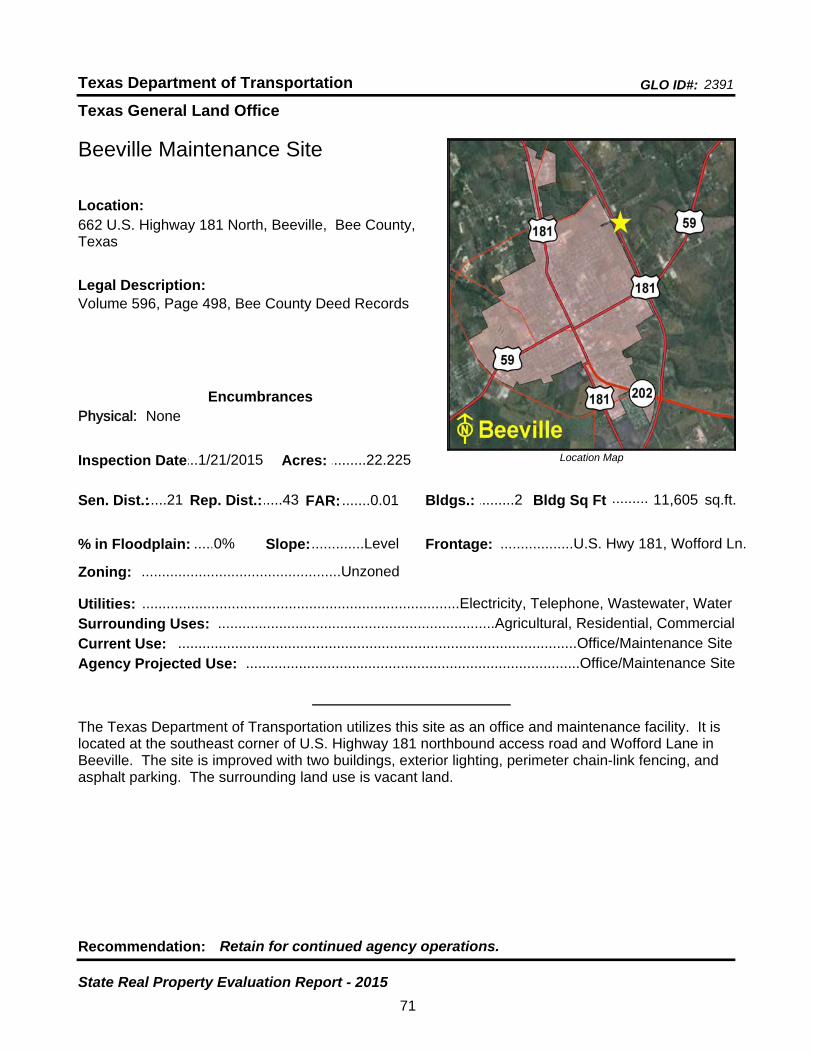
Texas General Land Office
GLO ID#: 2391Texas Department of Transportation
Location Map
......
.........
Beeville Maintenance Site
Bldgs.: .........2
Legal Description:Volume 596, Page 498, Bee County Deed Records
Recommendation: Retain for continued agency operations.
The Texas Department of Transportation utilizes this site as an office and maintenance facility. It is located at the southeast corner of U.S. Highway 181 northbound access road and Wofford Lane in Beeville. The site is improved with two buildings, exterior lighting, perimeter chain-link fencing, and asphalt parking. The surrounding land use is vacant land.
sq.ft.Sen. Dist.:.....21
662 U.S. Highway 181 North, Beeville, Bee County, Texas
Location:
Rep. Dist.:.....43
Slope:.............Level
Zoning: .................................................Unzoned
Inspection Date:...1/21/2015 Acres: .........22.225
Frontage: ..................U.S. Hwy 181, Wofford Ln.
Surrounding Uses: ....................................................................Agricultural, Residential, Commercial
Current Use: ..................................................................................................Office/Maintenance Site
Bldg Sq Ft 11,605
Agency Projected Use: ..................................................................................Office/Maintenance Site
0%% in Floodplain:
EncumbrancesPhysical: None
Utilities: ..............................................................................Electricity, Telephone, Wastewater, Water
FAR: .......0.01
71
State Real Property Evaluation Report - 2015

Texas General Land Office
GLO ID#: 2500Texas Department of Transportation
Location Map
......
.........
Belton Area Engineering and Maintenance Site
Bldgs.: .........3
Legal Description:Volume 695, Page 255, Bell County Deed Records
Recommendation: Retain for continued agency operations.
The Texas Department of Transportation utilizes this site as an office and maintenance facility. It is located on the northwest corner of Loop 121 and South Connell Street in Belton. The site is improved with three buildings, perimeter chain-link fencing, and asphalt parking. The surrounding land uses include civic, commercial, and residential development.
sq.ft.Sen. Dist.:.....24
410 West Loop 121, Belton, Bell County, TexasLocation:
Rep. Dist.:.....55
Slope:.............Level
Zoning: .............................................Commercial
Inspection Date:.12/15/2015 Acres: .............20.1
Frontage: ................Loop 121, South Connell St.
Surrounding Uses: ..............................................................................Residential, Commercial, Civic
Current Use: ..................................................................................................Office/Maintenance Site
Bldg Sq Ft 25,277
Agency Projected Use: ..................................................................................Office/Maintenance Site
0%% in Floodplain:
EncumbrancesPhysical: None
Utilities: ......................................................................Electricity, Gas, Telephone, Wastewater, Water
FAR: .......0.03
72
State Real Property Evaluation Report - 2015
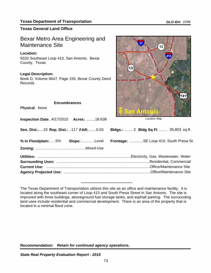
Texas General Land Office
GLO ID#: 2298Texas Department of Transportation
Location Map
......
........
Bexar Metro Area Engineering and Maintenance Site
Bldgs.: .........3
Legal Description:Book D, Volume 6647, Page 155, Bexar County Deed Records
Recommendation: Retain for continued agency operations.
The Texas Department of Transportation utilizes this site as an office and maintenance facility. It is located along the southeast corner of Loop 410 and South Presa Street in San Antonio. The site is improved with three buildings, aboveground fuel storage tanks, and asphalt parking. The surrounding land uses include residential and commercial development. There is an area of the property that is located in a minimal flood zone.
sq.ft.Sen. Dist.:.....19
9320 Southeast Loop 410, San Antonio, Bexar County, Texas
Location:
Rep. Dist.:...117
Slope:.............Level
Zoning: ...............................................Mixed-Use
Inspection Date:...4/17/2015 Acres: .........18.638
Frontage: .............SE Loop 410, South Presa St.
Surrounding Uses: ........................................................................................Residential, Commercial
Current Use: ..................................................................................................Office/Maintenance Site
Bldg Sq Ft 26,803
Agency Projected Use: ..................................................................................Office/Maintenance Site
5%% in Floodplain:
EncumbrancesPhysical: None
Utilities: .........................................................................................Electricity, Gas, Wastewater, Water
FAR: .......0.03
73
State Real Property Evaluation Report - 2015
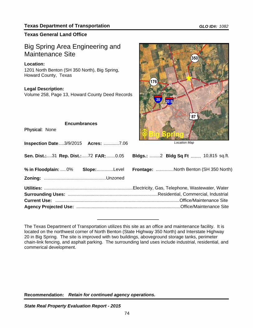
Texas General Land Office
GLO ID#: 1082Texas Department of Transportation
Location Map
......
........
Big Spring Area Engineering and Maintenance Site
Bldgs.: .........2
Legal Description:Volume 258, Page 13, Howard County Deed Records
Recommendation: Retain for continued agency operations.
The Texas Department of Transportation utilizes this site as an office and maintenance facility. It is located on the northwest corner of North Benton (State Highway 350 North) and Interstate Highway 20 in Big Spring. The site is improved with two buildings, aboveground storage tanks, perimeter chain-link fencing, and asphalt parking. The surrounding land uses include industrial, residential, and commerical development.
sq.ft.Sen. Dist.:.....31
1201 North Benton (SH 350 North), Big Spring, Howard County, Texas
Location:
Rep. Dist.:.....72
Slope:.............Level
Zoning: .................................................Unzoned
Inspection Date:.....3/9/2015 Acres: .............7.06
Frontage: ..............North Benton (SH 350 North)
Surrounding Uses: .......................................................................Residential, Commercial, Industrial
Current Use: ..................................................................................................Office/Maintenance Site
Bldg Sq Ft 10,815
Agency Projected Use: ..................................................................................Office/Maintenance Site
0%% in Floodplain:
EncumbrancesPhysical: None
Utilities: ......................................................................Electricity, Gas, Telephone, Wastewater, Water
FAR: .......0.05
74
State Real Property Evaluation Report - 2015

Texas General Land Office
GLO ID#: 2340Texas Department of Transportation
Location Map
......
Boerne Maintenance Site
Legal Description:Volume 496, Page 370, Kendall County Deed Records
Recommendation: Retain for continued agency operations.
The Texas Department of Transportation utilizes this site as an office and maintenance facility. It is located at the southeast corner of Main Street (U.S. Highway 87) and Pfeiffer Road in Boerne. The site is improved with one building, aboveground storage tanks, perimeter chain-link fencing, and asphalt parking. Seven acres are being utilized for storage of equipment and road material. The surrounding land uses include industrial and residential development.
Sen. Dist.:.....25
1375 North Main Street (U.S. Hwy 87), Boerne, Kendall County, Texas
Location:
Rep. Dist.:.....73
Slope:.............Level
Zoning: .................................................Industrial
Inspection Date:...2/12/2015 Acres: .........12.247
Surrounding Uses: ............................................................................................Industrial, Residential
Current Use: ..................................................................................................Office/Maintenance Site
Bldgs.: .........1 Bldg Sq Ft ........15,131 sq.ft.
Frontage: .N. Main St. (U.S. Hwy 87), Pfeiffer Rd
Agency Projected Use: ..................................................................................Office/Maintenance Site
0%% in Floodplain:
EncumbrancesPhysical: None
Utilities: ......................................................................Electricity, Gas, Telephone, Water, Septic Tank
FAR: .......0.04
75
State Real Property Evaluation Report - 2015
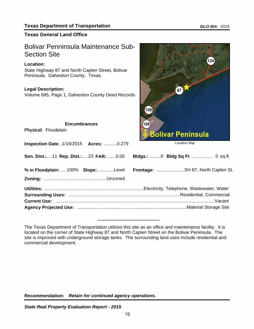
Texas General Land Office
GLO ID#: 1014Texas Department of Transportation
Location Map
......
.................
Bolivar Penninsula Maintenance Sub-Section Site
Bldgs.: .........0
Legal Description:Volume 695, Page 1, Galveston County Deed Records
Recommendation: Retain for continued agency operations.
The Texas Department of Transportation utilizes this site as an office and maintenance facility. It is located on the corner of State Highway 87 and North Caplen Street on the Bolivar Peninsula. The site is improved with underground storage tanks. The surrounding land uses include residential and commercial development.
sq.ft.Sen. Dist.:.....11
State Highway 87 and North Caplen Street, Bolivar Peninsula, Galveston County, Texas
Location:
Rep. Dist.:.....23
Slope:.............Level
Zoning: .................................................Unzoned
Inspection Date:...1/16/2015 Acres: ...........0.279
Frontage: ......................SH 87, North Caplen St.
Surrounding Uses: ........................................................................................Residential, Commercial
Current Use: .............................................................................................................................Vacant
Bldg Sq Ft 0
Agency Projected Use: ......................................................................................Material Storage Site
100%% in Floodplain:
EncumbrancesPhysical: Floodplain
Utilities: ..............................................................................Electricity, Telephone, Wastewater, Water
FAR: .......0.00
76
State Real Property Evaluation Report - 2015

Texas General Land Office
GLO ID#: 1165Texas Department of Transportation
Location Map
......
........
Borger Maintenance Site
Bldgs.: .........4
Legal Description:Volume 165, Page 446, and Page 449, Hutchison County Deed Records
Recommendation: Retain for continued agency operations.
The Texas Department of Transportation utilizes this site as an office and maintenance facility. Located at the southeast corner of South Cedar Street (State Highway 207) and FM 1551 in Borger, the site is improved with four buildings, exterior lighting, perimeter chain-link security fencing, and asphalt parking. The surrounding land uses inlcude agricultural, residential, and commercial development. A portion of the site is being utilized for storage of equipment and road material.
sq.ft.Sen. Dist.:.....31
2500 South Cedar Street (State Highway 207), Borger, Hutchinson County, Texas
Location:
Rep. Dist.:.....87
Slope:.............Level
Zoning: .............................................Commercial
Inspection Date:...1/13/2015 Acres: .............9.75
Frontage: ...................................South Cedar St.
Surrounding Uses: ....................................................................Agricultural, Residential, Commercial
Current Use: ..................................................................................................Office/Maintenance Site
Bldg Sq Ft 11,674
Agency Projected Use: ..................................................................................Office/Maintenance Site
0%% in Floodplain:
EncumbrancesPhysical: None
Utilities: ......................................................................Electricity, Gas, Telephone, Water, Septic Tank
FAR: .......0.03
77
State Real Property Evaluation Report - 2015
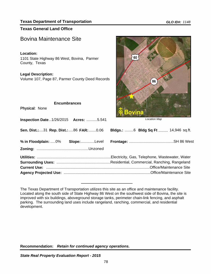
Texas General Land Office
GLO ID#: 1148Texas Department of Transportation
Location Map
......
.........
Bovina Maintenance Site
Bldgs.: .........6
Legal Description:Volume 107, Page 87, Parmer County Deed Records
Recommendation: Retain for continued agency operations.
The Texas Department of Transportation utilizes this site as an office and maintenance facility. Located along the south side of State Highway 86 West on the southwest side of Bovina, the site is improved with six buildings, aboveground storage tanks, perimeter chain-link fencing, and asphalt parking. The surrounding land uses include rangeland, ranching, commercial, and residential development.
sq.ft.Sen. Dist.:.....31
1101 State Highway 86 West, Bovina, Parmer County, Texas
Location:
Rep. Dist.:.....86
Slope:.............Level
Zoning: .................................................Unzoned
Inspection Date:...1/26/2015 Acres: ...........5.541
Frontage: ..........................................SH 86 West
Surrounding Uses: ...................................................Residential, Commercial, Ranching, Rangeland
Current Use: ..................................................................................................Office/Maintenance Site
Bldg Sq Ft 14,946
Agency Projected Use: ..................................................................................Office/Maintenance Site
0%% in Floodplain:
EncumbrancesPhysical: None
Utilities: ......................................................................Electricity, Gas, Telephone, Wastewater, Water
FAR: .......0.06
78
State Real Property Evaluation Report - 2015
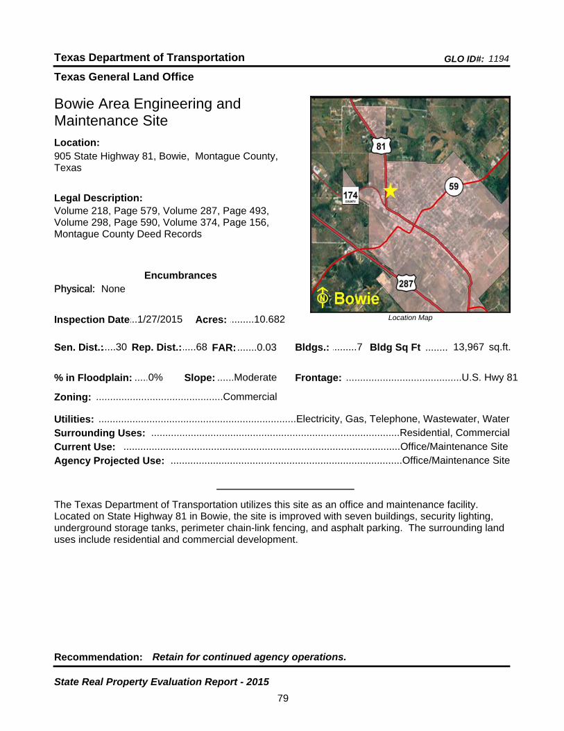
Texas General Land Office
GLO ID#: 1194Texas Department of Transportation
Location Map
......
........
Bowie Area Engineering and Maintenance Site
Bldgs.: .........7
Legal Description:Volume 218, Page 579, Volume 287, Page 493, Volume 298, Page 590, Volume 374, Page 156, Montague County Deed Records
Recommendation: Retain for continued agency operations.
The Texas Department of Transportation utilizes this site as an office and maintenance facility. Located on State Highway 81 in Bowie, the site is improved with seven buildings, security lighting, underground storage tanks, perimeter chain-link fencing, and asphalt parking. The surrounding land uses include residential and commercial development.
sq.ft.Sen. Dist.:.....30
905 State Highway 81, Bowie, Montague County, Texas
Location:
Rep. Dist.:.....68
Slope: ......Moderate
Zoning: .............................................Commercial
Inspection Date:...1/27/2015 Acres: .........10.682
Frontage: .........................................U.S. Hwy 81
Surrounding Uses: ........................................................................................Residential, Commercial
Current Use: ..................................................................................................Office/Maintenance Site
Bldg Sq Ft 13,967
Agency Projected Use: ..................................................................................Office/Maintenance Site
0%% in Floodplain:
EncumbrancesPhysical: None
Utilities: ......................................................................Electricity, Gas, Telephone, Wastewater, Water
FAR: .......0.03
79
State Real Property Evaluation Report - 2015
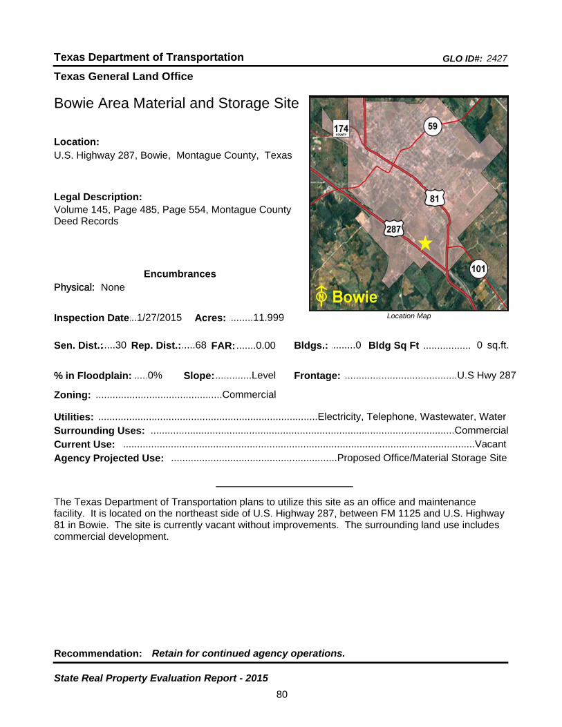
Texas General Land Office
GLO ID#: 2427Texas Department of Transportation
Location Map
......
.................
Bowie Area Material and Storage Site
Bldgs.: .........0
Legal Description:Volume 145, Page 485, Page 554, Montague County Deed Records
Recommendation: Retain for continued agency operations.
The Texas Department of Transportation plans to utilize this site as an office and maintenance facility. It is located on the northeast side of U.S. Highway 287, between FM 1125 and U.S. Highway 81 in Bowie. The site is currently vacant without improvements. The surrounding land use includes commercial development.
sq.ft.Sen. Dist.:.....30
U.S. Highway 287, Bowie, Montague County, TexasLocation:
Rep. Dist.:.....68
Slope:.............Level
Zoning: .............................................Commercial
Inspection Date:...1/27/2015 Acres: .........11.999
Frontage: ........................................U.S Hwy 287
Surrounding Uses: ............................................................................................................Commercial
Current Use: .............................................................................................................................Vacant
Bldg Sq Ft 0
Agency Projected Use: ...........................................................Proposed Office/Material Storage Site
0%% in Floodplain:
EncumbrancesPhysical: None
Utilities: ..............................................................................Electricity, Telephone, Wastewater, Water
FAR: .......0.00
80
State Real Property Evaluation Report - 2015
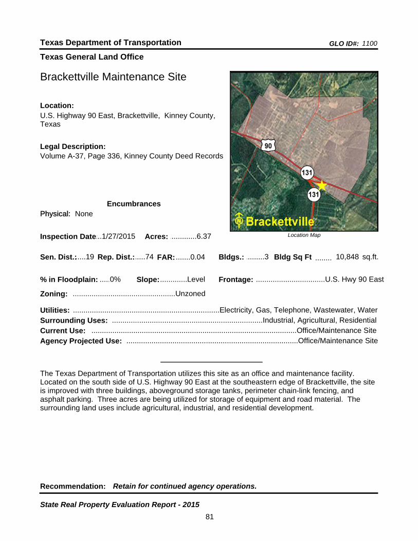
Texas General Land Office
GLO ID#: 1100Texas Department of Transportation
Location Map
......
........
Brackettville Maintenance Site
Bldgs.: .........3
Legal Description:Volume A-37, Page 336, Kinney County Deed Records
Recommendation: Retain for continued agency operations.
The Texas Department of Transportation utilizes this site as an office and maintenance facility. Located on the south side of U.S. Highway 90 East at the southeastern edge of Brackettville, the site is improved with three buildings, aboveground storage tanks, perimeter chain-link fencing, and asphalt parking. Three acres are being utilized for storage of equipment and road material. The surrounding land uses include agricultural, industrial, and residential development.
sq.ft.Sen. Dist.:.....19
U.S. Highway 90 East, Brackettville, Kinney County, Texas
Location:
Rep. Dist.:.....74
Slope:.............Level
Zoning: .................................................Unzoned
Inspection Date:...1/27/2015 Acres: .............6.37
Frontage: .................................U.S. Hwy 90 East
Surrounding Uses: ........................................................................Industrial, Agricultural, Residential
Current Use: ..................................................................................................Office/Maintenance Site
Bldg Sq Ft 10,848
Agency Projected Use: ..................................................................................Office/Maintenance Site
0%% in Floodplain:
EncumbrancesPhysical: None
Utilities: ......................................................................Electricity, Gas, Telephone, Wastewater, Water
FAR: .......0.04
81
State Real Property Evaluation Report - 2015
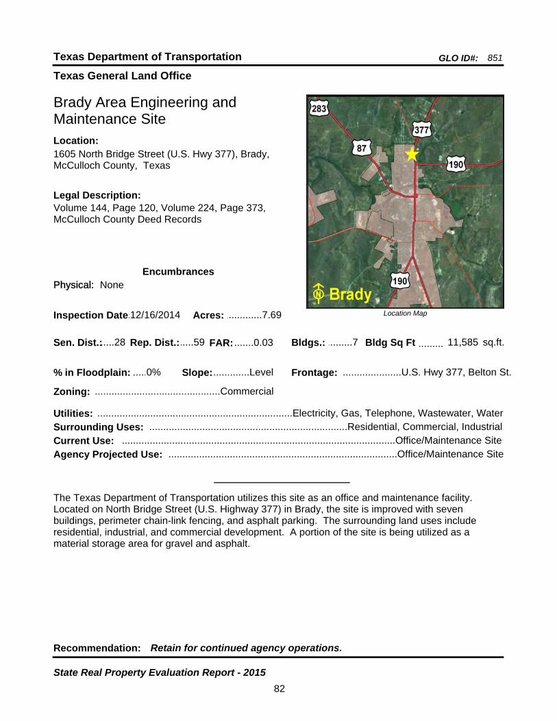
Texas General Land Office
GLO ID#: 851Texas Department of Transportation
Location Map
......
.........
Brady Area Engineering and Maintenance Site
Bldgs.: .........7
Legal Description:Volume 144, Page 120, Volume 224, Page 373, McCulloch County Deed Records
Recommendation: Retain for continued agency operations.
The Texas Department of Transportation utilizes this site as an office and maintenance facility. Located on North Bridge Street (U.S. Highway 377) in Brady, the site is improved with seven buildings, perimeter chain-link fencing, and asphalt parking. The surrounding land uses include residential, industrial, and commercial development. A portion of the site is being utilized as a material storage area for gravel and asphalt.
sq.ft.Sen. Dist.:.....28
1605 North Bridge Street (U.S. Hwy 377), Brady, McCulloch County, Texas
Location:
Rep. Dist.:.....59
Slope:.............Level
Zoning: .............................................Commercial
Inspection Date:.12/16/2014 Acres: .............7.69
Frontage: .....................U.S. Hwy 377, Belton St.
Surrounding Uses: .......................................................................Residential, Commercial, Industrial
Current Use: ..................................................................................................Office/Maintenance Site
Bldg Sq Ft 11,585
Agency Projected Use: ..................................................................................Office/Maintenance Site
0%% in Floodplain:
EncumbrancesPhysical: None
Utilities: ......................................................................Electricity, Gas, Telephone, Wastewater, Water
FAR: .......0.03
82
State Real Property Evaluation Report - 2015
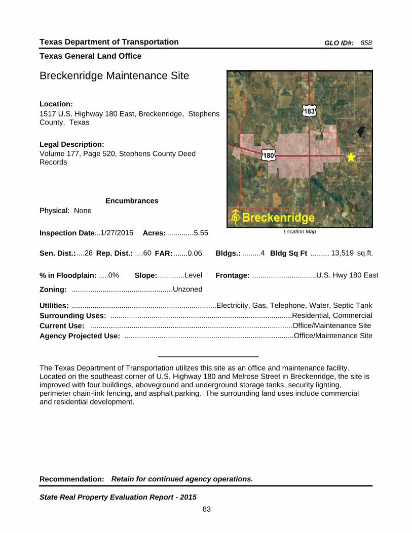
Texas General Land Office
GLO ID#: 858Texas Department of Transportation
Location Map
......
.........
Breckenridge Maintenance Site
Bldgs.: .........4
Legal Description:Volume 177, Page 520, Stephens County Deed Records
Recommendation: Retain for continued agency operations.
The Texas Department of Transportation utilizes this site as an office and maintenance facility. Located on the southeast corner of U.S. Highway 180 and Melrose Street in Breckenridge, the site is improved with four buildings, aboveground and underground storage tanks, security lighting, perimeter chain-link fencing, and asphalt parking. The surrounding land uses include commercial and residential development.
sq.ft.Sen. Dist.:.....28
1517 U.S. Highway 180 East, Breckenridge, Stephens County, Texas
Location:
Rep. Dist.:.....60
Slope:.............Level
Zoning: .................................................Unzoned
Inspection Date:...1/27/2015 Acres: .............5.55
Frontage: ...............................U.S. Hwy 180 East
Surrounding Uses: ........................................................................................Residential, Commercial
Current Use: ..................................................................................................Office/Maintenance Site
Bldg Sq Ft 13,519
Agency Projected Use: ..................................................................................Office/Maintenance Site
0%% in Floodplain:
EncumbrancesPhysical: None
Utilities: ......................................................................Electricity, Gas, Telephone, Water, Septic Tank
FAR: .......0.06
83
State Real Property Evaluation Report - 2015
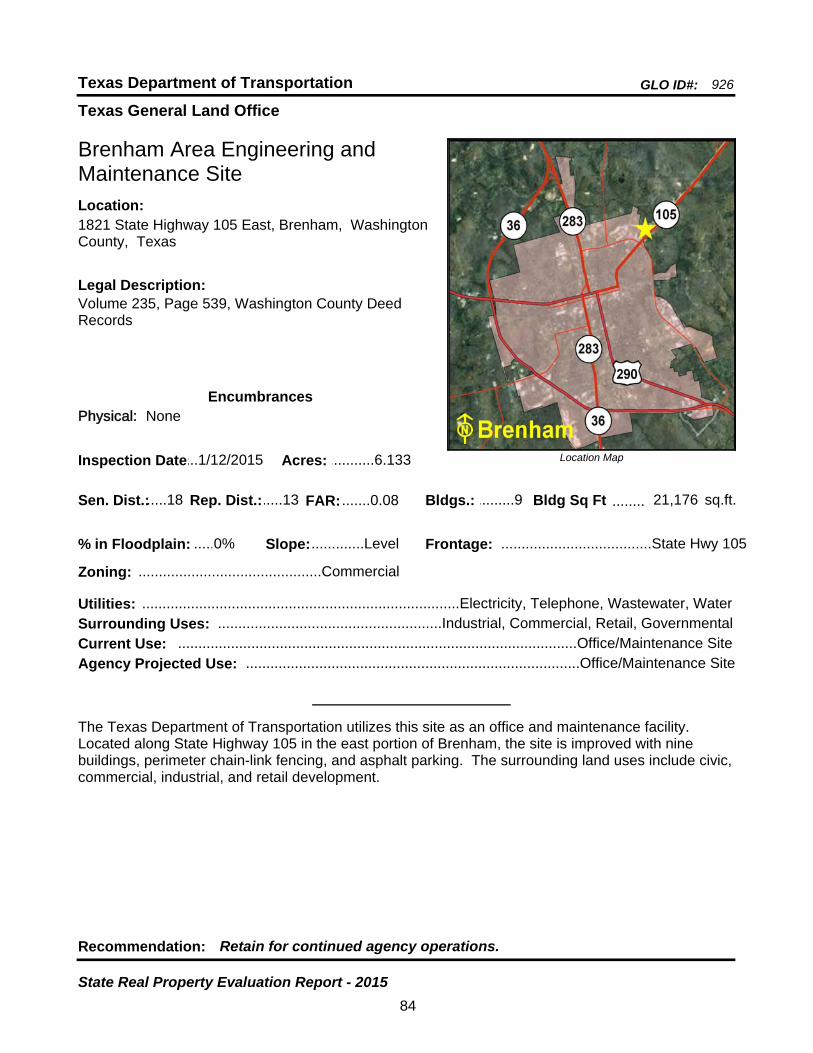
Texas General Land Office
GLO ID#: 926Texas Department of Transportation
Location Map
......
........
Brenham Area Engineering and Maintenance Site
Bldgs.: .........9
Legal Description:Volume 235, Page 539, Washington County Deed Records
Recommendation: Retain for continued agency operations.
The Texas Department of Transportation utilizes this site as an office and maintenance facility. Located along State Highway 105 in the east portion of Brenham, the site is improved with nine buildings, perimeter chain-link fencing, and asphalt parking. The surrounding land uses include civic, commercial, industrial, and retail development.
sq.ft.Sen. Dist.:.....18
1821 State Highway 105 East, Brenham, Washington County, Texas
Location:
Rep. Dist.:.....13
Slope:.............Level
Zoning: .............................................Commercial
Inspection Date:...1/12/2015 Acres: ...........6.133
Frontage: .....................................State Hwy 105
Surrounding Uses: .......................................................Industrial, Commercial, Retail, Governmental
Current Use: ..................................................................................................Office/Maintenance Site
Bldg Sq Ft 21,176
Agency Projected Use: ..................................................................................Office/Maintenance Site
0%% in Floodplain:
EncumbrancesPhysical: None
Utilities: ..............................................................................Electricity, Telephone, Wastewater, Water
FAR: .......0.08
84
State Real Property Evaluation Report - 2015
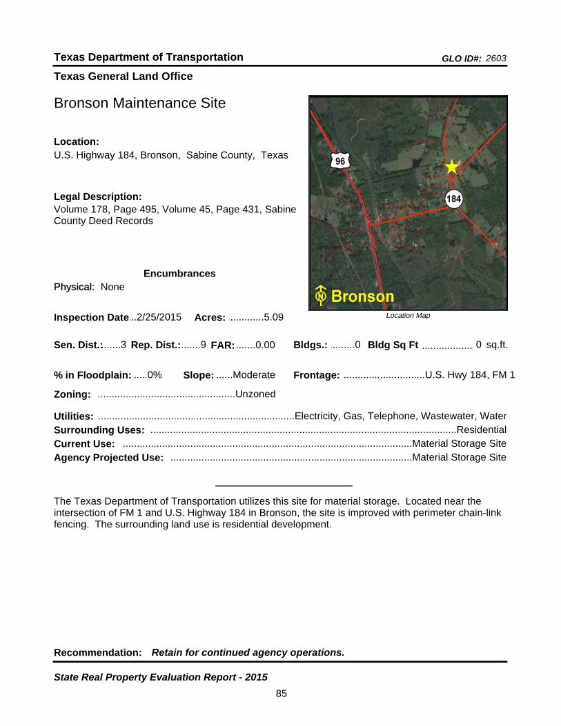
Texas General Land Office
GLO ID#: 2603Texas Department of Transportation
Location Map
......
..................
Bronson Maintenance Site
Bldgs.: .........0
Legal Description:Volume 178, Page 495, Volume 45, Page 431, Sabine County Deed Records
Recommendation: Retain for continued agency operations.
The Texas Department of Transportation utilizes this site for material storage. Located near the intersection of FM 1 and U.S. Highway 184 in Bronson, the site is improved with perimeter chain-link fencing. The surrounding land use is residential development.
sq.ft.Sen. Dist.:.......3
U.S. Highway 184, Bronson, Sabine County, TexasLocation:
Rep. Dist.:.......9
Slope: ......Moderate
Zoning: .................................................Unzoned
Inspection Date:...2/25/2015 Acres: .............5.09
Frontage: .............................U.S. Hwy 184, FM 1
Surrounding Uses: .............................................................................................................Residential
Current Use: .......................................................................................................Material Storage Site
Bldg Sq Ft 0
Agency Projected Use: ......................................................................................Material Storage Site
0%% in Floodplain:
EncumbrancesPhysical: None
Utilities: ......................................................................Electricity, Gas, Telephone, Wastewater, Water
FAR: .......0.00
85
State Real Property Evaluation Report - 2015

Texas General Land Office
GLO ID#: 1115Texas Department of Transportation
Location Map
......
...............
Bronte Maintenance Sub-Section Site
Bldgs.: .........1
Legal Description:Volume 60, Page 232, Volume 129, Page 81, Coke County Deed Records
Recommendation: Retain for continued agency operations.
The Texas Department of Transportation utilizes this site as a material storage yard. Located on the south side of State Highway 158 just past the intersection with U.S. Highway 277 in Bronte, the site is improved with one building and perimeter chain-link fencing. The surrounding land uses include residential and commercial development.
sq.ft.Sen. Dist.:.....28
State Highway 158, Bronte, Coke County, TexasLocation:
Rep. Dist.:.....72
Slope:.............Level
Zoning: .................................................Unzoned
Inspection Date:...3/23/2015 Acres: .............1.72
Frontage: .........................SH 158, U.S. Hwy 277
Surrounding Uses: ........................................................................................Residential, Commercial
Current Use: ......................................................................................................Material Storage Yard
Bldg Sq Ft 903
Agency Projected Use: .....................................................................................Material Storage Yard
0%% in Floodplain:
EncumbrancesPhysical: None
Utilities: .................................................Electricity, Gas, Telephone, Wastewater, Water, Septic Tank
FAR: .......0.01
86
State Real Property Evaluation Report - 2015
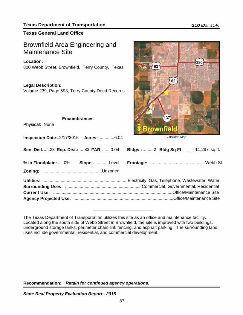
Texas General Land Office
GLO ID#: 1146Texas Department of Transportation
Location Map
......
.........
Brownfield Area Engineering and Maintenance Site
Bldgs.: .........2
Legal Description:Volume 239, Page 593, Terry County Deed Records
Recommendation: Retain for continued agency operations.
The Texas Department of Transportation utilizes this site as an office and maintenance facility. Located along the south side of Webb Street in Brownfield, the site is improved with two buildings, underground storage tanks, perimeter chain-link fencing, and asphalt parking. The surrounding land uses include governmental, residential, and commercial development.
sq.ft.Sen. Dist.:.....28
800 Webb Street, Brownfield, Terry County, TexasLocation:
Rep. Dist.:.....83
Slope:.............Level
Zoning: .................................................Unzoned
Inspection Date:...2/17/2015 Acres: .............6.04
Frontage: ..............................................Webb St.
Surrounding Uses: ...............................................................Commercial, Governmental, Residential
Current Use: ..................................................................................................Office/Maintenance Site
Bldg Sq Ft 11,297
Agency Projected Use: ..................................................................................Office/Maintenance Site
0%% in Floodplain:
EncumbrancesPhysical: None
Utilities: ......................................................................Electricity, Gas, Telephone, Wastewater, Water
FAR: .......0.04
87
State Real Property Evaluation Report - 2015
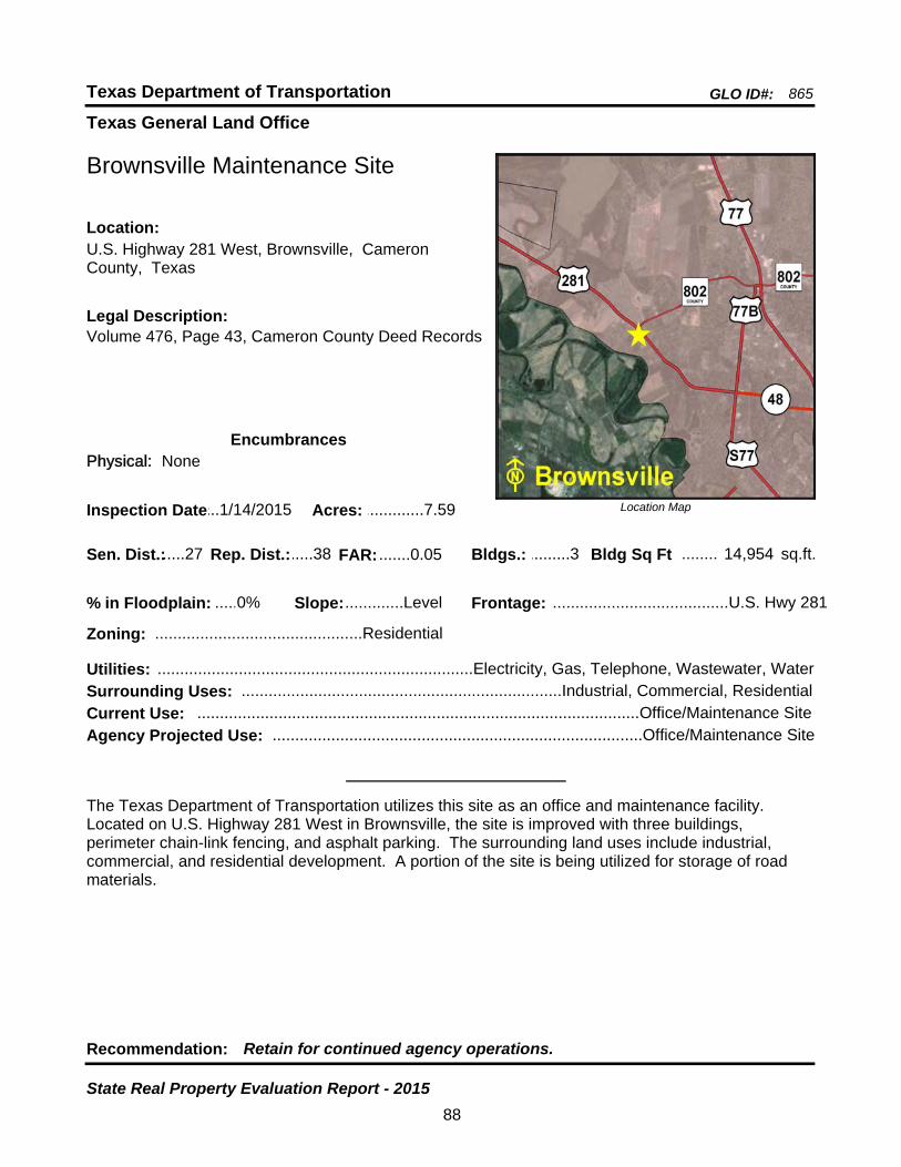
Texas General Land Office
GLO ID#: 865Texas Department of Transportation
Location Map
......
........
Brownsville Maintenance Site
Bldgs.: .........3
Legal Description:Volume 476, Page 43, Cameron County Deed Records
Recommendation: Retain for continued agency operations.
The Texas Department of Transportation utilizes this site as an office and maintenance facility. Located on U.S. Highway 281 West in Brownsville, the site is improved with three buildings, perimeter chain-link fencing, and asphalt parking. The surrounding land uses include industrial, commercial, and residential development. A portion of the site is being utilized for storage of road materials.
sq.ft.Sen. Dist.:.....27
U.S. Highway 281 West, Brownsville, Cameron County, Texas
Location:
Rep. Dist.:.....38
Slope:.............Level
Zoning: ..............................................Residential
Inspection Date:...1/14/2015 Acres: .............7.59
Frontage: .......................................U.S. Hwy 281
Surrounding Uses: .......................................................................Industrial, Commercial, Residential
Current Use: ..................................................................................................Office/Maintenance Site
Bldg Sq Ft 14,954
Agency Projected Use: ..................................................................................Office/Maintenance Site
0%% in Floodplain:
EncumbrancesPhysical: None
Utilities: ......................................................................Electricity, Gas, Telephone, Wastewater, Water
FAR: .......0.05
88
State Real Property Evaluation Report - 2015

Texas General Land Office
GLO ID#: 848Texas Department of Transportation
Location Map
......
........
Brownwood District Headquarters and Maintenance Site
Bldgs.: .........8
Legal Description:Volume 129, Page 188, Volume 139, Page 328, Brown County Deed Records
Recommendation: Retain for continued agency operations.
The Texas Department of Transportation utilizes this site as a district headquarters. It is located on U.S. Highway 183 North in Brownwood. The site is improved with eight buildings, security lighting, perimeter chain-link security fencing, aboveground storage tanks, and asphalt parking. The surrounding land uses include residential, agricultural, and commercial development.
sq.ft.Sen. Dist.:.....24
2495 U.S. Highway 183 North, Brownwood, Brown County, Texas
Location:
Rep. Dist.:.....60
Slope:.............Level
Zoning: .............................................Commercial
Inspection Date:.12/16/2014 Acres: ...........30.26
Frontage: .......................................U.S. Hwy 183
Surrounding Uses: ....................................................................Agricultural, Residential, Commercial
Current Use: ................................................................................................District Headquarters Site
Bldg Sq Ft 78,544
Agency Projected Use: ...............................................................................District Headquarters Site
0%% in Floodplain:
EncumbrancesPhysical: None
Utilities: ......................................................................Electricity, Gas, Telephone, Water, Septic Tank
FAR: ..... 0.06
89
State Real Property Evaluation Report - 2015

Texas General Land Office
GLO ID#: 925Texas Department of Transportation
Location Map
......
........
Bryan Area Engineering and Maintenance Site
Bldgs.: .......10
Legal Description:Volume 158, Page 243, Brazos County Deed Records
Recommendation: Retain for continued agency operations.
The Texas Department of Transportation utilizes this site as an office and maintenance facility. Located on the southwest corner of Tabor Road (F.M. 974) and Millberger Street in the north portion of Bryan, the site is improved with ten buildings, perimeter chain-link fencing, and asphalt parking. The surrounding land uses include residential development.
sq.ft.Sen. Dist.:.......5
2102 Tabor Road (F.M. 974), Bryan, Brazos County, Texas
Location:
Rep. Dist.:.....12
Slope:.............Level
Zoning: ...............................................Agriculture
Inspection Date:...5/28/2015 Acres: .........10.948
Frontage: .......................Tabor Rd, Millberger St.
Surrounding Uses: .............................................................................................................Residential
Current Use: ..................................................................................................Office/Maintenance Site
Bldg Sq Ft 37,302
Agency Projected Use: ..................................................................................Office/Maintenance Site
0%% in Floodplain:
EncumbrancesPhysical: None
Utilities: ..............................................................................Electricity, Telephone, Wastewater, Water
FAR: .......0.08
90
State Real Property Evaluation Report - 2015

Texas General Land Office
GLO ID#: 2498Texas Department of Transportation
Location Map
......
Bryan District Headquarters Site - New
Legal Description:Volume 3995, Page 222, Brazos County Deed Records
Recommendation: Retain for continued agency operations.
The Texas Department of Transportation utilizes this site as a new district headquarters facility. Located on the south side of the western frontage road of the North Earl Rudder Freeway (State Highway 6 East Bypass) in Bryan, the site is improved with three buildings, perimeter chain-link fencing, and asphalt parking. The surrounding land uses include a school, recreational, governmental, and residential development.
Sen. Dist.:.......5
2571 North Earl Rudder Freeway (SH 6 East Bypass), Bryan, Brazos County, Texas
Location:
Rep. Dist.:.....12
Slope:.............Level
Zoning: ...............................................Mixed-Use
Inspection Date:...5/19/2015 Acres: ...........22.32
Surrounding Uses: .................................................Recreational, Residential, School, Governmental
Current Use: ................................................................................................District Headquarters Site
Bldgs.: .........3 Bldg Sq Ft ...........54,549 sq.ft.
Frontage:...N. Earl Rudder Freeway, Texas Ave.
Agency Projected Use: ...............................................................................District Headquarters Site
0%% in Floodplain:
EncumbrancesPhysical: None
Utilities: ......................................................................Electricity, Gas, Telephone, Wastewater, Water
FAR: ..... 0.06
91
State Real Property Evaluation Report - 2015

Texas General Land Office
GLO ID#: 921Texas Department of Transportation
Location Map
......
.........
Buffalo Maintenance Site
Bldgs.: .........6
Legal Description:Volume 162, Page 540, Leon County Deed Records
Recommendation: Retain for continued agency operations.
The Texas Department of Transportation utilizes this site as an office and maintenance facility. It is located on the northwest side of East Commerce Street (U.S. Highway 79) in eastern Buffalo. The site is improved with six buildings, perimeter chain-link fencing, two underground fuel storage tanks, and asphalt parking. The surrounding land uses include agricultural, residential, and industrial development.
sq.ft.Sen. Dist.:.......5
2800 East Commerce Street (U.S. Hwy 79), Buffalo, Leon County, Texas
Location:
Rep. Dist.:.....57
Slope: ......Moderate
Zoning: .................................................Unzoned
Inspection Date:.....4/7/2015 Acres: ..................6
Frontage: ..............................East Commerce St.
Surrounding Uses: ........................................................................Residential, Agricultural, Industrial
Current Use: ..................................................................................................Office/Maintenance Site
Bldg Sq Ft 11,952
Agency Projected Use: ..................................................................................Office/Maintenance Site
0%% in Floodplain:
EncumbrancesPhysical: None
Utilities: ......................................................................Electricity, Gas, Telephone, Wastewater, Water
FAR: ..........0.05
92
State Real Property Evaluation Report - 2015
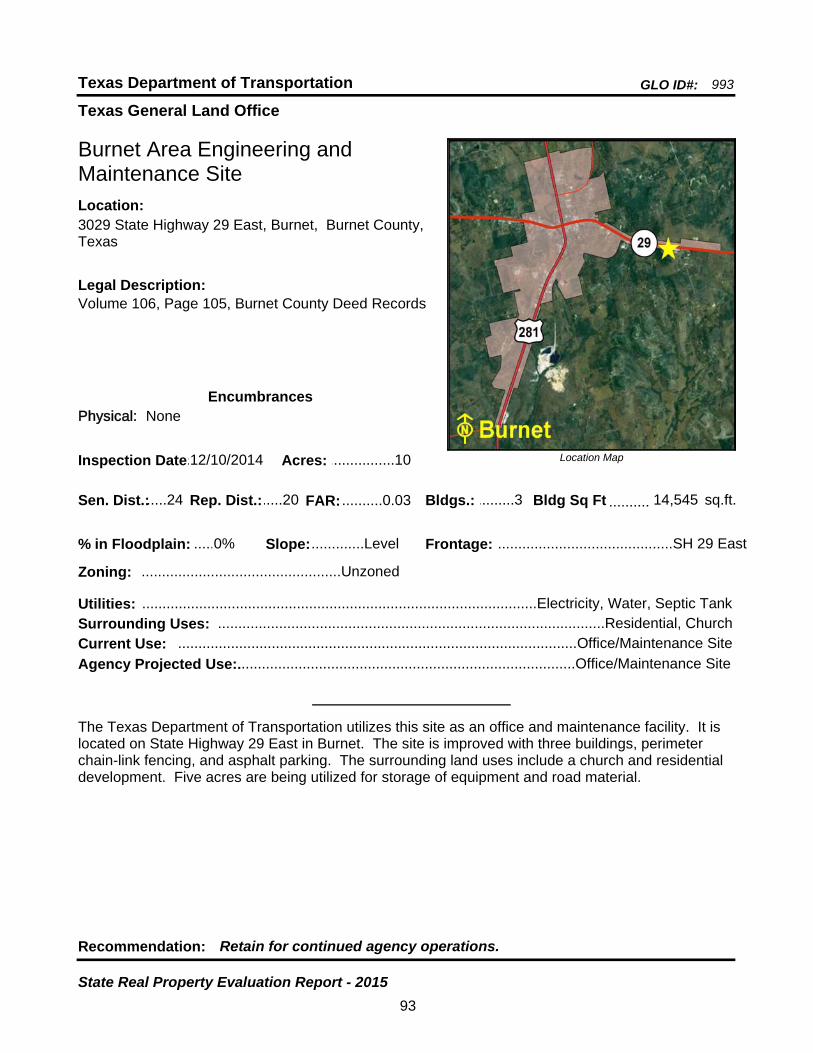
Texas General Land Office
GLO ID#: 993Texas Department of Transportation
Location Map
......
..........
Burnet Area Engineering and Maintenance Site
Bldgs.: .........3
Legal Description:Volume 106, Page 105, Burnet County Deed Records
Recommendation: Retain for continued agency operations.
The Texas Department of Transportation utilizes this site as an office and maintenance facility. It is located on State Highway 29 East in Burnet. The site is improved with three buildings, perimeter chain-link fencing, and asphalt parking. The surrounding land uses include a church and residential development. Five acres are being utilized for storage of equipment and road material.
sq.ft.Sen. Dist.:.....24
3029 State Highway 29 East, Burnet, Burnet County, Texas
Location:
Rep. Dist.:.....20
Slope:.............Level
Zoning: .................................................Unzoned
Inspection Date:.12/10/2014 Acres: ................10
Frontage: ...........................................SH 29 East
Surrounding Uses: ...............................................................................................Residential, Church
Current Use: ..................................................................................................Office/Maintenance Site
Bldg Sq Ft 14,545
Agency Projected Use:...................................................................................Office/Maintenance Site
0%% in Floodplain:
EncumbrancesPhysical: None
Utilities: .................................................................................................Electricity, Water, Septic Tank
FAR: ..........0.03
93
State Real Property Evaluation Report - 2015
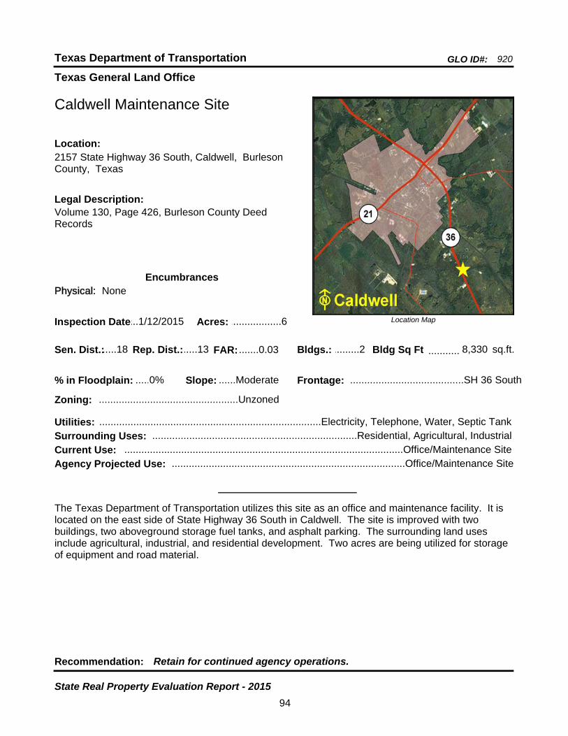
Texas General Land Office
GLO ID#: 920Texas Department of Transportation
Location Map
......
...........
Caldwell Maintenance Site
Bldgs.: .........2
Legal Description:Volume 130, Page 426, Burleson County Deed Records
Recommendation: Retain for continued agency operations.
The Texas Department of Transportation utilizes this site as an office and maintenance facility. It is located on the east side of State Highway 36 South in Caldwell. The site is improved with two buildings, two aboveground storage fuel tanks, and asphalt parking. The surrounding land uses include agricultural, industrial, and residential development. Two acres are being utilized for storage of equipment and road material.
sq.ft.Sen. Dist.:.....18
2157 State Highway 36 South, Caldwell, Burleson County, Texas
Location:
Rep. Dist.:.....13
Slope: ......Moderate
Zoning: .................................................Unzoned
Inspection Date:...1/12/2015 Acres: ..................6
Frontage: ........................................SH 36 South
Surrounding Uses: ........................................................................Residential, Agricultural, Industrial
Current Use: ..................................................................................................Office/Maintenance Site
Bldg Sq Ft 8,330
Agency Projected Use: ..................................................................................Office/Maintenance Site
0%% in Floodplain:
EncumbrancesPhysical: None
Utilities: ..............................................................................Electricity, Telephone, Water, Septic Tank
FAR: .......0.03
94
State Real Property Evaluation Report - 2015

Texas General Land Office
GLO ID#: 922Texas Department of Transportation
Location Map
......
..........
Cameron Maintenance Site
Bldgs.: .........6
Legal Description:Volume 286, Page 518, Milam County Deed Records
Recommendation: Retain for continued agency operations.
The Texas Department of Transportation utilizes this site as an office and maintenance facility. Located near the intersection of U.S. Highway 190 and North Travis Avenue (U.S. Highway 77) on the north side of Cameron, the site is improved with six buildings, loading docks, perimeter chain-link security fencing and gates, fuel tanks, two propane storage tanks, and asphalt parking. The surrounding land uses include civic, industrial, residential, and commercial development.
sq.ft.Sen. Dist.:.......5
3303 North Travis Avenue (U.S. Hwy 77), Cameron, Milam County, Texas
Location:
Rep. Dist.:.....20
Slope:.............Level
Zoning: .................................................Industrial
Inspection Date:...1/12/2015 Acres: ..................5
Frontage:................N. Travis Ave. (U.S. Hwy 77)
Surrounding Uses: ...............................................Residential, Industrial, Governmental, Commercial
Current Use: ..................................................................................................Office/Maintenance Site
Bldg Sq Ft 13,987
Agency Projected Use: ..................................................................................Office/Maintenance Site
0%% in Floodplain:
EncumbrancesPhysical: None
Utilities: ......................................................................Electricity, Gas, Telephone, Wastewater, Water
FAR: .......0.06
95
State Real Property Evaluation Report - 2015
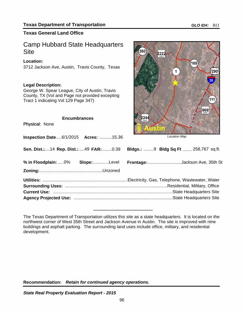
Texas General Land Office
GLO ID#: 811Texas Department of Transportation
Location Map
......
.......
Camp Hubbard State Headquarters Site
Bldgs.: .........9
Legal Description:George W. Spear League, City of Austin, Travis County, TX (Vol and Page not provided excepting Tract 1 indicating Vol 129 Page 347)
Recommendation: Retain for continued agency operations.
The Texas Department of Transportation utilizes this site as a state headquarters. It is located on the northwest corner of West 35th Street and Jackson Avenue in Austin. The site is improved with nine buildings and asphalt parking. The surrounding land uses include office, military, and residential development.
sq.ft.Sen. Dist.:.....14
3712 Jackson Ave, Austin, Travis County, TexasLocation:
Rep. Dist.:.....49
Slope:.............Level
Zoning:....................................................Unzoned
Inspection Date:.....6/1/2015 Acres: ...........15.36
Frontage:............................Jackson Ave, 35th St
Surrounding Uses: ....................................................................................Residential, Military, Office
Current Use: ..................................................................................................State Headquarters Site
Bldg Sq Ft 258,767
Agency Projected Use: .................................................................................State Headquarters Site
0%% in Floodplain:
EncumbrancesPhysical: None
Utilities: ......................................................................Electricity, Gas, Telephone, Wastewater, Water
FAR: ........0.39
96
State Real Property Evaluation Report - 2015
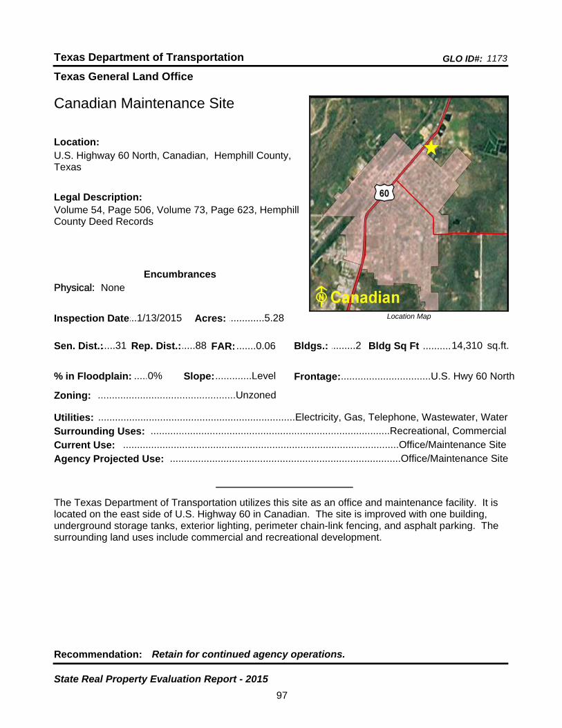
Texas General Land Office
GLO ID#: 1173Texas Department of Transportation
Location Map
......
..........
Canadian Maintenance Site
Bldgs.: .........2
Legal Description:Volume 54, Page 506, Volume 73, Page 623, Hemphill County Deed Records
Recommendation: Retain for continued agency operations.
The Texas Department of Transportation utilizes this site as an office and maintenance facility. It is located on the east side of U.S. Highway 60 in Canadian. The site is improved with one building, underground storage tanks, exterior lighting, perimeter chain-link fencing, and asphalt parking. The surrounding land uses include commercial and recreational development.
sq.ft.Sen. Dist.:.....31
U.S. Highway 60 North, Canadian, Hemphill County, Texas
Location:
Rep. Dist.:.....88
Slope:.............Level
Zoning: .................................................Unzoned
Inspection Date:...1/13/2015 Acres: .............5.28
Frontage:................................U.S. Hwy 60 North
Surrounding Uses: .....................................................................................Recreational, Commercial
Current Use: ..................................................................................................Office/Maintenance Site
Bldg Sq Ft 14,310
Agency Projected Use: ..................................................................................Office/Maintenance Site
0%% in Floodplain:
EncumbrancesPhysical: None
Utilities: ......................................................................Electricity, Gas, Telephone, Wastewater, Water
FAR: .......0.06
97
State Real Property Evaluation Report - 2015

Texas General Land Office
GLO ID#: 2485Texas Department of Transportation
Location Map
......
.........
Canton Area Engineering and Maintenance Site
Bldgs.: .........6
Legal Description:Volume 1655, Page 393, Van Zandt County Deed Records
Recommendation: Retain for continued agency operations.
The Texas Department of Transportation utilizes this site as an office and maintenance facility. Located just west of the intersection of IH-20 and FM 1255 in Canton, the site is improved with six buildings, aboveground storage tanks, perimeter chain-link fencing, and asphalt parking. The surrounding land use is residential development.
sq.ft.Sen. Dist.:.......2
IH 20 @ FM 1255, Canton, Van Zandt County, TexasLocation:
Rep. Dist.:.......2
Slope:.............Level
Zoning: .................................................Unzoned
Inspection Date:....12/9/2014 Acres: ................15
Frontage:.....................................IH 20, FM 1255
Surrounding Uses: ................................................................................................Residential, Vacant
Current Use: ..................................................................................................Office/Maintenance Site
Bldg Sq Ft 18,060
Agency Projected Use: ..................................................................................Office/Maintenance Site
0%% in Floodplain:
EncumbrancesPhysical: None
Utilities: ......................................................................Electricity, Gas, Telephone, Wastewater, Water
FAR: .......0.03
98
State Real Property Evaluation Report - 2015
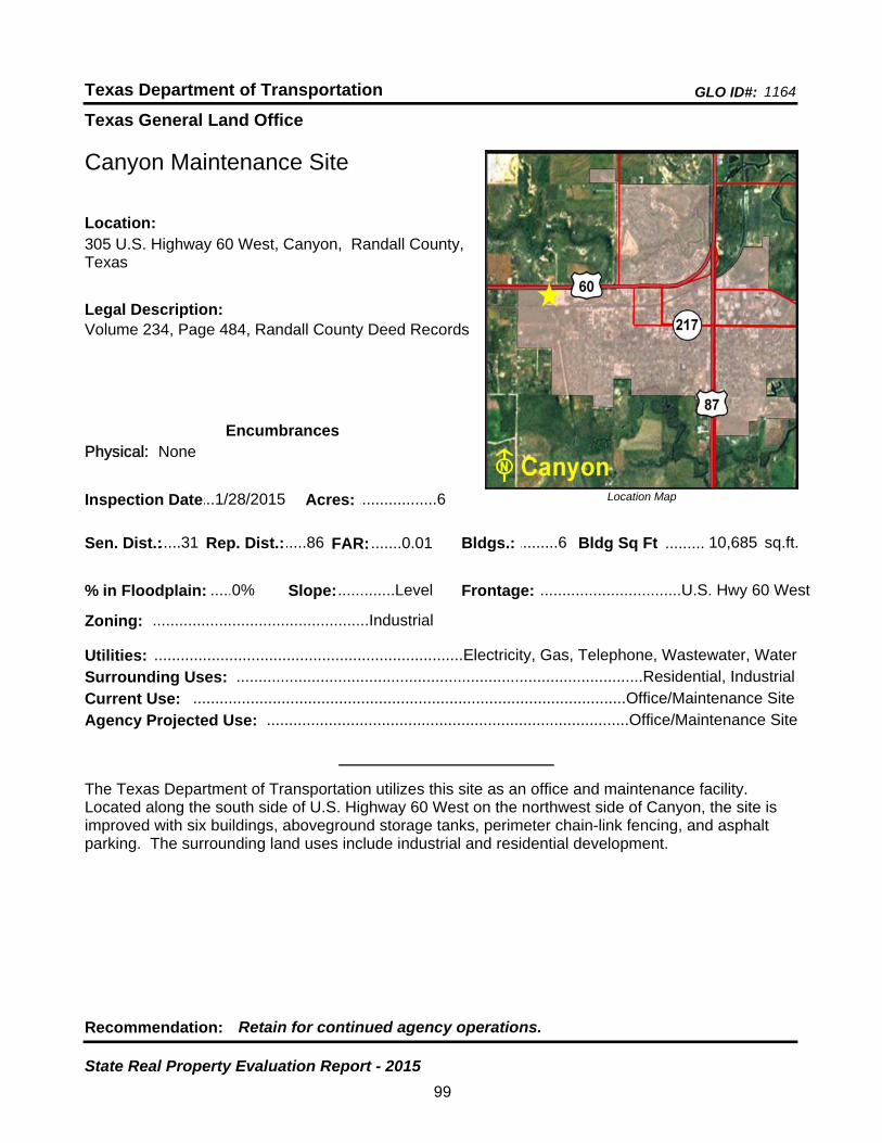
Texas General Land Office
GLO ID#: 1164Texas Department of Transportation
Location Map
......
.........
Canyon Maintenance Site
Bldgs.: .........6
Legal Description:Volume 234, Page 484, Randall County Deed Records
Recommendation: Retain for continued agency operations.
The Texas Department of Transportation utilizes this site as an office and maintenance facility. Located along the south side of U.S. Highway 60 West on the northwest side of Canyon, the site is improved with six buildings, aboveground storage tanks, perimeter chain-link fencing, and asphalt parking. The surrounding land uses include industrial and residential development.
sq.ft.Sen. Dist.:.....31
305 U.S. Highway 60 West, Canyon, Randall County, Texas
Location:
Rep. Dist.:.....86
Slope:.............Level
Zoning: .................................................Industrial
Inspection Date:...1/28/2015 Acres: ..................6
Frontage: ................................U.S. Hwy 60 West
Surrounding Uses: ............................................................................................Residential, Industrial
Current Use: ..................................................................................................Office/Maintenance Site
Bldg Sq Ft 10,685
Agency Projected Use: ..................................................................................Office/Maintenance Site
0%% in Floodplain:
EncumbrancesPhysical: None
Utilities: ......................................................................Electricity, Gas, Telephone, Wastewater, Water
FAR: .......0.01
99
State Real Property Evaluation Report - 2015
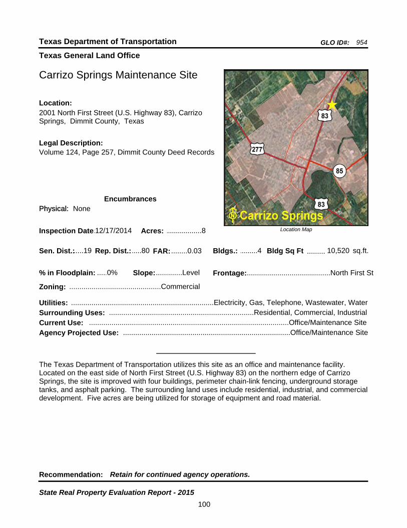
Texas General Land Office
GLO ID#: 954Texas Department of Transportation
Location Map
......
.........
Carrizo Springs Maintenance Site
Bldgs.: .........4
Legal Description:Volume 124, Page 257, Dimmit County Deed Records
Recommendation: Retain for continued agency operations.
The Texas Department of Transportation utilizes this site as an office and maintenance facility. Located on the east side of North First Street (U.S. Highway 83) on the northern edge of Carrizo Springs, the site is improved with four buildings, perimeter chain-link fencing, underground storage tanks, and asphalt parking. The surrounding land uses include residential, industrial, and commercial development. Five acres are being utilized for storage of equipment and road material.
sq.ft.Sen. Dist.:.....19
2001 North First Street (U.S. Highway 83), Carrizo Springs, Dimmit County, Texas
Location:
Rep. Dist.:.....80
Slope:.............Level
Zoning: .............................................Commercial
Inspection Date:.12/17/2014 Acres: ..................8
Frontage:.........................................North First St
Surrounding Uses: .......................................................................Residential, Commercial, Industrial
Current Use: ..................................................................................................Office/Maintenance Site
Bldg Sq Ft 10,520
Agency Projected Use: ..................................................................................Office/Maintenance Site
0%% in Floodplain:
EncumbrancesPhysical: None
Utilities: ......................................................................Electricity, Gas, Telephone, Wastewater, Water
FAR: ........0.03
100
State Real Property Evaluation Report - 2015
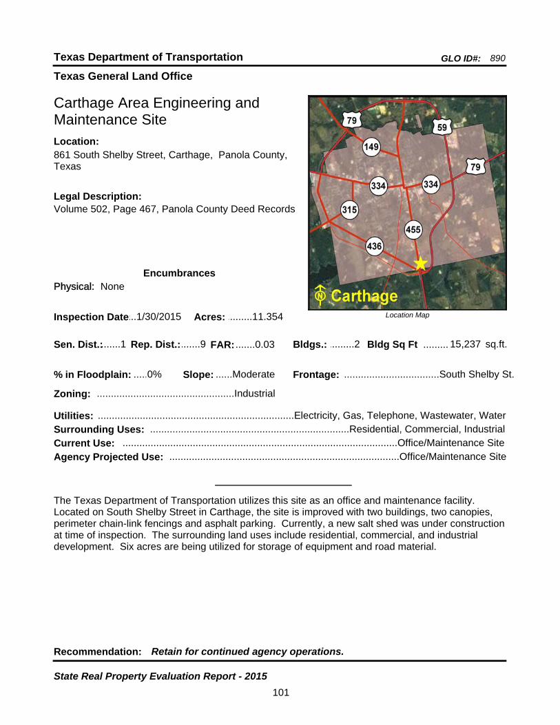
Texas General Land Office
GLO ID#: 890Texas Department of Transportation
Location Map
......
.........
Carthage Area Engineering and Maintenance Site
Bldgs.: .........2
Legal Description:Volume 502, Page 467, Panola County Deed Records
Recommendation: Retain for continued agency operations.
The Texas Department of Transportation utilizes this site as an office and maintenance facility. Located on South Shelby Street in Carthage, the site is improved with two buildings, two canopies, perimeter chain-link fencings and asphalt parking. Currently, a new salt shed was under construction at time of inspection. The surrounding land uses include residential, commercial, and industrial development. Six acres are being utilized for storage of equipment and road material.
sq.ft.Sen. Dist.:.......1
861 South Shelby Street, Carthage, Panola County, Texas
Location:
Rep. Dist.:.......9
Slope: ......Moderate
Zoning: .................................................Industrial
Inspection Date:...1/30/2015 Acres: .........11.354
Frontage: ..................................South Shelby St.
Surrounding Uses: .......................................................................Residential, Commercial, Industrial
Current Use: ..................................................................................................Office/Maintenance Site
Bldg Sq Ft 15,237
Agency Projected Use: ..................................................................................Office/Maintenance Site
0%% in Floodplain:
EncumbrancesPhysical: None
Utilities: ......................................................................Electricity, Gas, Telephone, Wastewater, Water
FAR: .......0.03
101
State Real Property Evaluation Report - 2015
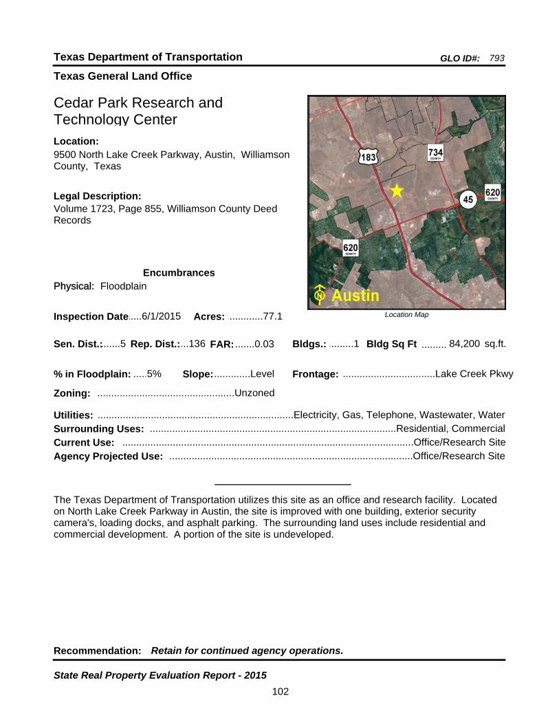
Texas General Land Office
GLO ID#: 793Texas Department of Transportation
Location Map
......
.........
Cedar Park Research and Technology Center
Bldgs.: .........1
Legal Description:Volume 1723, Page 855, Williamson County Deed Records
Recommendation: Retain for continued agency operations.
The Texas Department of Transportation utilizes this site as an office and research facility. Located on North Lake Creek Parkway in Austin, the site is improved with one building, exterior security camera's, loading docks, and asphalt parking. The surrounding land uses include residential and commercial development. A portion of the site is undeveloped.
sq.ft.Sen. Dist.:.......5
9500 North Lake Creek Parkway, Austin, Williamson County, Texas
Location:
Rep. Dist.:...136
Slope:.............Level
Zoning: .................................................Unzoned
Inspection Date:.....6/1/2015 Acres: .............77.1
Frontage: .................................Lake Creek Pkwy
Surrounding Uses: ........................................................................................Residential, Commercial
Current Use: ........................................................................................................Office/Research Site
Bldg Sq Ft 84,200
Agency Projected Use: .......................................................................................Office/Research Site
5%% in Floodplain:
EncumbrancesPhysical: Floodplain
Utilities: ......................................................................Electricity, Gas, Telephone, Wastewater, Water
FAR: .......0.03
102
State Real Property Evaluation Report - 2015

Texas General Land Office
GLO ID#: 1035Texas Department of Transportation
Location Map
......
.........
Center Maintenance Site
Bldgs.: .........2
Legal Description:Volume 624, Page 210, Shelby County Deed Records
Recommendation: Retain for continued agency operations.
The Texas Department of Transportation utilizes this site as an office and maintenance facility. Located on State Highway 7 in Center, the site is improved with two buildings, perimeter chain-link fencing, and asphalt parking. The surrounding land uses include timber production, commercial, and residential development. A portion of the site is being utilized for storage of equipment and road material.
sq.ft.Sen. Dist.:.......3
State Highway 7, Center, Shelby County, TexasLocation:
Rep. Dist.:.......9
Slope: ......Moderate
Zoning: .................................................Unzoned
Inspection Date:...2/24/2015 Acres: ................10
Frontage: .....................................................SH 7
Surrounding Uses: ....................................................................Residential, Commercial, Woodlands
Current Use: ..................................................................................................Office/Maintenance Site
Bldg Sq Ft 13,203
Agency Projected Use: ..................................................................................Office/Maintenance Site
0%% in Floodplain:
EncumbrancesPhysical: None
Utilities: ......................................................................Electricity, Gas, Telephone, Wastewater, Water
FAR: .......0.03
103
State Real Property Evaluation Report - 2015
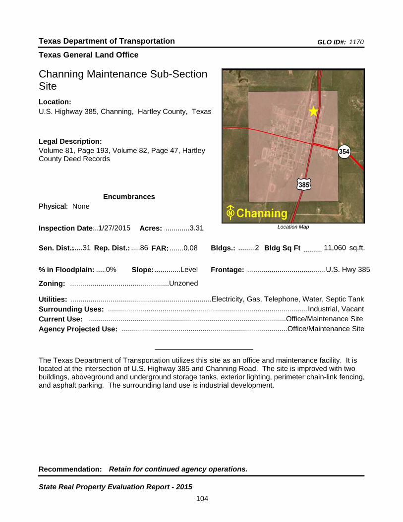
Texas General Land Office
GLO ID#: 1170Texas Department of Transportation
Location Map
......
.........
Channing Maintenance Sub-Section Site
Bldgs.: .........2
Legal Description:Volume 81, Page 193, Volume 82, Page 47, Hartley County Deed Records
Recommendation: Retain for continued agency operations.
The Texas Department of Transportation utilizes this site as an office and maintenance facility. It is located at the intersection of U.S. Highway 385 and Channing Road. The site is improved with two buildings, aboveground and underground storage tanks, exterior lighting, perimeter chain-link fencing, and asphalt parking. The surrounding land use is industrial development.
sq.ft.Sen. Dist.:.....31
U.S. Highway 385, Channing, Hartley County, TexasLocation:
Rep. Dist.:.....86
Slope:.............Level
Zoning: .................................................Unzoned
Inspection Date:...1/27/2015 Acres: .............3.31
Frontage: .......................................U.S. Hwy 385
Surrounding Uses: ...................................................................................................Industrial, Vacant
Current Use: ..................................................................................................Office/Maintenance Site
Bldg Sq Ft 11,060
Agency Projected Use: ..................................................................................Office/Maintenance Site
0%% in Floodplain:
EncumbrancesPhysical: None
Utilities: ......................................................................Electricity, Gas, Telephone, Water, Septic Tank
FAR: .......0.08
104
State Real Property Evaluation Report - 2015

Texas General Land Office
GLO ID#: 2371Texas Department of Transportation
Location Map
......
.........
Childress District 25 Headquarters Site
Bldgs.: .........6
Legal Description:Volume 373, Page 73, Childress County Deed Records
Recommendation: Retain for continued agency operations.
The Texas Department of Transportation utilizes this site as a district headquarters. It is located at the northwest corner of U.S. Highway 287 and County Road 9 in the west part of Childress. The site is improved with six buildings, perimeter chain-link fencing, security lighting, and asphalt parking. The surrounding land uses include civic, agricultural, and residential development.
sq.ft.Sen. Dist.:.....28
7599 U.S. Highway 287, Childress, Childress County, Texas
Location:
Rep. Dist.:.....68
Slope:.............Level
Zoning: .................................................Unzoned
Inspection Date:.12/18/2014 Acres: ...........52.83
Frontage: .............................U.S. Hwy 287, CR 9
Surrounding Uses: ................................................................Agricultural, Governmental, Residential
Current Use: ................................................................................................District Headquarters Site
Bldg Sq Ft 85,292
Agency Projected Use: ...............................................................................District Headquarters Site
2%% in Floodplain:
EncumbrancesPhysical: None
Utilities: ......................................................................Electricity, Gas, Telephone, Wastewater, Water
FAR: .......0.04
105
State Real Property Evaluation Report - 2015

Texas General Land Office
GLO ID#: 2359Texas Department of Transportation
Location Map
......
.........
Clarendon Maintenance Site
Bldgs.: .........3
Legal Description:Volume 32, Page 98, Donley County Deed Records
Recommendation: Retain for continued agency operations.
The Texas Department of Transportation utilizes this site as an office and maintenance facility. Located along the south side of U.S. Highway 287 in the west part of Clarendon, the site is improved with three buildings, perimeter chain-link fencing, an alarm system, and asphalt parking. The surrounding land use is residential development.
sq.ft.Sen. Dist.:.....31
3268 U.S. Highway 287, Clarendon, Donley County, Texas
Location:
Rep. Dist.:.....88
Slope:.............Level
Zoning: .................................................Unzoned
Inspection Date:...1/12/2014 Acres: ...........10.57
Frontage: .......................................U.S. Hwy 287
Surrounding Uses: .............................................................................................................Residential
Current Use: ..................................................................................................Office/Maintenance Site
Bldg Sq Ft 14,179
Agency Projected Use: ..................................................................................Office/Maintenance Site
0%% in Floodplain:
EncumbrancesPhysical: None
Utilities: ......................................................................Electricity, Gas, Telephone, Water, Septic Tank
FAR: .......0.03
106
State Real Property Evaluation Report - 2015
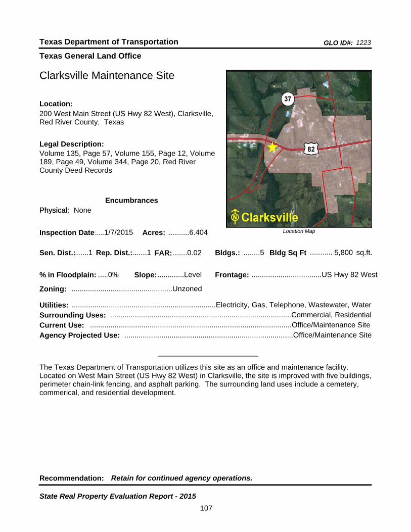
Texas General Land Office
GLO ID#: 1223Texas Department of Transportation
Location Map
......
...........
Clarksville Maintenance Site
Bldgs.: .........5
Legal Description:Volume 135, Page 57, Volume 155, Page 12, Volume 189, Page 49, Volume 344, Page 20, Red River County Deed Records
Recommendation: Retain for continued agency operations.
The Texas Department of Transportation utilizes this site as an office and maintenance facility. Located on West Main Street (US Hwy 82 West) in Clarksville, the site is improved with five buildings, perimeter chain-link fencing, and asphalt parking. The surrounding land uses include a cemetery, commerical, and residential development.
sq.ft.Sen. Dist.:.......1
200 West Main Street (US Hwy 82 West), Clarksville, Red River County, Texas
Location:
Rep. Dist.:.......1
Slope:.............Level
Zoning: .................................................Unzoned
Inspection Date:.....1/7/2015 Acres: ...........6.404
Frontage: ..................................US Hwy 82 West
Surrounding Uses: ........................................................................................Commercial, Residential
Current Use: ..................................................................................................Office/Maintenance Site
Bldg Sq Ft 5,800
Agency Projected Use: ..................................................................................Office/Maintenance Site
0%% in Floodplain:
EncumbrancesPhysical: None
Utilities: ......................................................................Electricity, Gas, Telephone, Wastewater, Water
FAR: .......0.02
107
State Real Property Evaluation Report - 2015
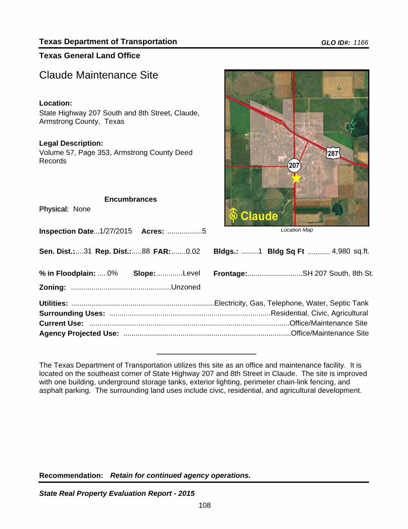
Texas General Land Office
GLO ID#: 1166Texas Department of Transportation
Location Map
......
...........
Claude Maintenance Site
Bldgs.: .........1
Legal Description:Volume 57, Page 353, Armstrong County Deed Records
Recommendation: Retain for continued agency operations.
The Texas Department of Transportation utilizes this site as an office and maintenance facility. It is located on the southeast corner of State Highway 207 and 8th Street in Claude. The site is improved with one building, underground storage tanks, exterior lighting, perimeter chain-link fencing, and asphalt parking. The surrounding land uses include civic, residential, and agricultural development.
sq.ft.Sen. Dist.:.....31
State Highway 207 South and 8th Street, Claude, Armstrong County, Texas
Location:
Rep. Dist.:.....88
Slope:.............Level
Zoning: .................................................Unzoned
Inspection Date:...1/27/2015 Acres: ..................5
Frontage:...........................SH 207 South, 8th St.
Surrounding Uses: ...............................................................................Residential, Civic, Agricultural
Current Use: ..................................................................................................Office/Maintenance Site
Bldg Sq Ft 4,980
Agency Projected Use: ..................................................................................Office/Maintenance Site
0%% in Floodplain:
EncumbrancesPhysical: None
Utilities: ......................................................................Electricity, Gas, Telephone, Water, Septic Tank
FAR: .......0.02
108
State Real Property Evaluation Report - 2015
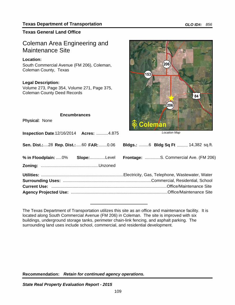
Texas General Land Office
GLO ID#: 856Texas Department of Transportation
Location Map
......
.........
Coleman Area Engineering and Maintenance Site
Bldgs.: .........6
Legal Description:Volume 273, Page 354, Volume 271, Page 375, Coleman County Deed Records
Recommendation: Retain for continued agency operations.
The Texas Department of Transportation utilizes this site as an office and maintenance facility. It is located along South Commercial Avenue (FM 206) in Coleman. The site is improved with six buildings, underground storage tanks, perimeter chain-link fencing, and asphalt parking. The surrounding land uses include school, commercial, and residential development.
sq.ft.Sen. Dist.:.....28
South Commercial Avenue (FM 206), Coleman, Coleman County, Texas
Location:
Rep. Dist.:.....60
Slope:.............Level
Zoning: .................................................Unzoned
Inspection Date:.12/16/2014 Acres: ...........4.875
Frontage: .............S. Commercial Ave. (FM 206)
Surrounding Uses: ...........................................................................Commercial, Residential, School
Current Use: ..................................................................................................Office/Maintenance Site
Bldg Sq Ft 14,382
Agency Projected Use: ..................................................................................Office/Maintenance Site
0%% in Floodplain:
EncumbrancesPhysical: None
Utilities: ......................................................................Electricity, Gas, Telephone, Wastewater, Water
FAR: .......0.06
109
State Real Property Evaluation Report - 2015

Texas General Land Office
GLO ID#: 1083Texas Department of Transportation
Location Map
......
...........
Colorado City Maintenance Site
Bldgs.: .........3
Legal Description:Volume 187, Page 357, Mitchell County Deed Records
Recommendation: Retain for continued agency operations.
The Texas Department of Transportation utilizes this site as an office and maintenance facility. It is located along the east side of State Highway 208 inside the city limits of Colorado City. The site is improved with three buildings, perimeter chain-link fencing, and asphalt parking. The surrounding land uses include rangeland, agricultural, and residential development.
sq.ft.Sen. Dist.:.....28
State Highway 208, Colorado City, Mitchell County, Texas
Location:
Rep. Dist.:.....83
Slope:.............Level
Zoning: .................................................Unzoned
Inspection Date:.....3/9/2015 Acres: .............6.84
Frontage: .................................................SH 208
Surrounding Uses: ......................................................................Residential, Rangeland, Agricultural
Current Use: ..................................................................................................Office/Maintenance Site
Bldg Sq Ft 6,802
Agency Projected Use: ..................................................................................Office/Maintenance Site
0%% in Floodplain:
EncumbrancesPhysical: None
Utilities: ......................................................................Electricity, Gas, Telephone, Water, Septic Tank
FAR: .......0.02
110
State Real Property Evaluation Report - 2015
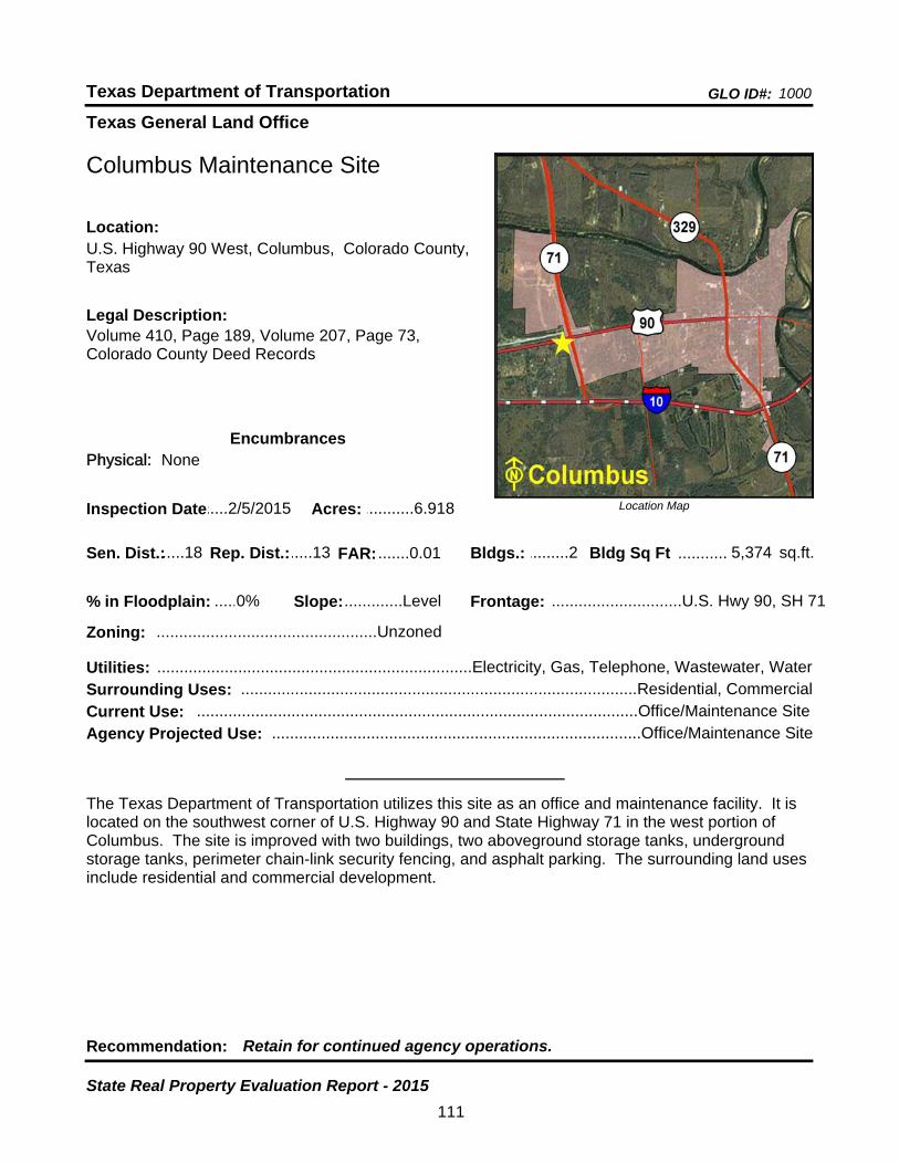
Texas General Land Office
GLO ID#: 1000Texas Department of Transportation
Location Map
......
...........
Columbus Maintenance Site
Bldgs.: .........2
Legal Description:Volume 410, Page 189, Volume 207, Page 73, Colorado County Deed Records
Recommendation: Retain for continued agency operations.
The Texas Department of Transportation utilizes this site as an office and maintenance facility. It is located on the southwest corner of U.S. Highway 90 and State Highway 71 in the west portion of Columbus. The site is improved with two buildings, two aboveground storage tanks, underground storage tanks, perimeter chain-link security fencing, and asphalt parking. The surrounding land uses include residential and commercial development.
sq.ft.Sen. Dist.:.....18
U.S. Highway 90 West, Columbus, Colorado County, Texas
Location:
Rep. Dist.:.....13
Slope:.............Level
Zoning: .................................................Unzoned
Inspection Date:.....2/5/2015 Acres: ...........6.918
Frontage: .............................U.S. Hwy 90, SH 71
Surrounding Uses: ........................................................................................Residential, Commercial
Current Use: ..................................................................................................Office/Maintenance Site
Bldg Sq Ft 5,374
Agency Projected Use: ..................................................................................Office/Maintenance Site
0%% in Floodplain:
EncumbrancesPhysical: None
Utilities: ......................................................................Electricity, Gas, Telephone, Wastewater, Water
FAR: .......0.01
111
State Real Property Evaluation Report - 2015

Texas General Land Office
GLO ID#: 853Texas Department of Transportation
Location Map
......
.........
Comanche Area Engineering and Maintenance Site
Bldgs.: .........6
Legal Description:Volume 268, Page 480, Volume 660, Page 187, Comanche County Deed Records
Recommendation: Retain for continued agency operations.
The Texas Department of Transportation utilizes this site as an office and maintenance facility. Located on North Austin Street (State Highway 16) in Comanche, the site is improved with six buildings, underground storage tanks, perimeter chain-link fencing, and asphalt parking. The surrounding land uses include a school, church, offices, and residential development. Four acres are being utilized for storage of equipment and road material.
sq.ft.Sen. Dist.:.....24
1502 North Austin Street (State Highway 16), Comanche, Comanche County, Texas
Location:
Rep. Dist.:.....59
Slope:.............Level
Zoning: .................................................Unzoned
Inspection Date:.12/16/2014 Acres: .........10.193
Frontage: ......................North Austin St. (SH 16)
Surrounding Uses: .......................................................................Office, Church, Residential, School
Current Use: ..................................................................................................Office/Maintenance Site
Bldg Sq Ft 14,121
Agency Projected Use: ..................................................................................Office/Maintenance Site
0%% in Floodplain:
EncumbrancesPhysical: None
Utilities: ......................................................................Electricity, Gas, Telephone, Wastewater, Water
FAR: .......0.03
112
State Real Property Evaluation Report - 2015
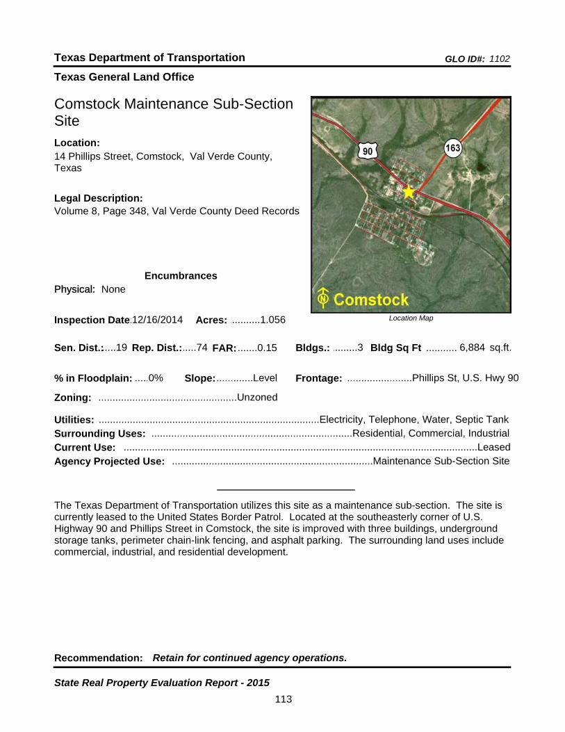
Texas General Land Office
GLO ID#: 1102Texas Department of Transportation
Location Map
......
...........
Comstock Maintenance Sub-Section Site
Bldgs.: .........3
Legal Description:Volume 8, Page 348, Val Verde County Deed Records
Recommendation: Retain for continued agency operations.
The Texas Department of Transportation utilizes this site as a maintenance sub-section. The site is currently leased to the United States Border Patrol. Located at the southeasterly corner of U.S. Highway 90 and Phillips Street in Comstock, the site is improved with three buildings, underground storage tanks, perimeter chain-link fencing, and asphalt parking. The surrounding land uses include commercial, industrial, and residential development.
sq.ft.Sen. Dist.:.....19
14 Phillips Street, Comstock, Val Verde County, Texas
Location:
Rep. Dist.:.....74
Slope:.............Level
Zoning: .................................................Unzoned
Inspection Date:.12/16/2014 Acres: ...........1.056
Frontage: .......................Phillips St, U.S. Hwy 90
Surrounding Uses: .......................................................................Residential, Commercial, Industrial
Current Use: .............................................................................................................................Leased
Bldg Sq Ft 6,884
Agency Projected Use: .......................................................................Maintenance Sub-Section Site
0%% in Floodplain:
EncumbrancesPhysical: None
Utilities: ..............................................................................Electricity, Telephone, Water, Septic Tank
FAR: .......0.15
113
State Real Property Evaluation Report - 2015

Texas General Land Office
GLO ID#: 2252Texas Department of Transportation
Location Map
......
.........
Conroe Area Engineering and Maintenance Site
Bldgs.: .........5
Legal Description:File No. 979-01-0527 through 0531, Montgomery County Deed Records
Recommendation: Retain for continued agency operations.
The Texas Department of Transportation utilizes this site as an office and maintenance facility. Located on the northeast corner of FM 3083 and FM 1484 in the north part of Conroe, the site is improved with five buildings, underground storage tanks, perimeter chain-link fencing, and asphalt parking. The surrounding land uses include recreational, industrial, and residential development. A portion of the site is being utilized for storage of equipment and road material.
sq.ft.Sen. Dist.:.......4
901 North FM 3083 East, Conroe, Montgomery County, Texas
Location:
Rep. Dist.:.....16
Slope:.............Level
Zoning: .................................................Unzoned
Inspection Date:...1/28/2015 Acres: .........15.398
Frontage: ..............................FM 3083, FM 1484
Surrounding Uses: ......................................................................Recreational, Residential, Industrial
Current Use: ..................................................................................................Office/Maintenance Site
Bldg Sq Ft 22,877
Agency Projected Use: ..................................................................................Office/Maintenance Site
0%% in Floodplain:
EncumbrancesPhysical: None
Utilities: ......................................................................Electricity, Gas, Telephone, Wastewater, Water
FAR: .......0.03
114
State Real Property Evaluation Report - 2015
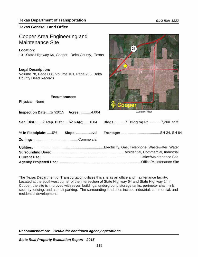
Texas General Land Office
GLO ID#: 1222Texas Department of Transportation
Location Map
......
...........
Cooper Area Engineering and Maintenance Site
Bldgs.: .........7
Legal Description:Volume 78, Page 608, Volume 101, Page 258, Delta County Deed Records
Recommendation: Retain for continued agency operations.
The Texas Department of Transportation utilizes this site as an office and maintenance facility. Located at the southwest corner of the intersection of State Highway 64 and State Highway 24 in Cooper, the site is improved with seven buildings, underground storage tanks, perimeter chain-link security fencing, and asphalt parking. The surrounding land uses include industrial, commercial, and residential development.
sq.ft.Sen. Dist.:.......2
131 State Highway 64, Cooper, Delta County, TexasLocation:
Rep. Dist.:.....62
Slope:.............Level
Zoning: .............................................Commercial
Inspection Date:.....1/7/2015 Acres: ...........4.004
Frontage: .......................................SH 24, SH 64
Surrounding Uses: .......................................................................Residential, Commercial, Industrial
Current Use: ..................................................................................................Office/Maintenance Site
Bldg Sq Ft 7,200
Agency Projected Use: ..................................................................................Office/Maintenance Site
0%% in Floodplain:
EncumbrancesPhysical: None
Utilities: ......................................................................Electricity, Gas, Telephone, Wastewater, Water
FAR: .......0.04
115
State Real Property Evaluation Report - 2015
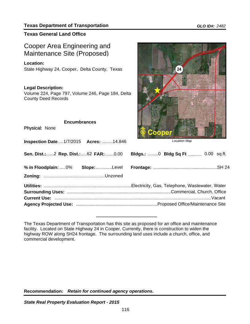
Texas General Land Office
GLO ID#: 2482Texas Department of Transportation
Location Map
......
...........
Cooper Area Engineering and Maintenance Site (Proposed)
Bldgs.: .........0
Legal Description:Volume 224, Page 797, Volume 246, Page 184, Delta County Deed Records
Recommendation: Retain for continued agency operations.
The Texas Department of Transportation has this site as proposed for an office and maintenance facility. Located on State Highway 24 in Cooper. Currently, there is construction to widen the highway ROW along SH24 frontage. The surrounding land uses include a church, office, and commercial development.
sq.ft.Sen. Dist.:.......2
State Highway 24, Cooper, Delta County, TexasLocation:
Rep. Dist.:.....62
Slope:.............Level
Zoning: .................................................Unzoned
Inspection Date:.....1/7/2015 Acres: .........14.846
Frontage: ...................................................SH 24
Surrounding Uses: ...................................................................................Commercial, Church, Office
Current Use: .............................................................................................................................Vacant
Bldg Sq Ft 0.00
Agency Projected Use: .................................................................Proposed Office/Maintenance Site
0%% in Floodplain:
EncumbrancesPhysical: None
Utilities: ......................................................................Electricity, Gas, Telephone, Wastewater, Water
FAR: .......0.00
116
State Real Property Evaluation Report - 2015

Texas General Land Office
GLO ID#: 933Texas Department of Transportation
Location Map
......
.......
Corpus Christi District Headquarters Site
Bldgs.: .........8
Legal Description:Volume 838, Page 18, Nueces County Deed Records
Recommendation: Retain for continued agency operations.
The Texas Department of Transportation owns and utilizes this site as a district headquarters. It is located at the southeast corner of South Padre Island Drive and Greenwood Drive in the southwest sector of Corpus Christi. The site is improved with eight buildings, perimeter chain-link fencing, underground storage tanks, and asphalt parking. The surrounding land use includes a church, governmental, commercial, and industrial development. A portion of the site is being utilized for storage of equipment and road material.
sq.ft.Sen. Dist.:.....20
1701 South Padre Island Drive, Corpus Christi, Nueces County, Texas
Location:
Rep. Dist.:.....32
Slope:.............Level
Zoning: .................................................Industrial
Inspection Date:.....2/3/2015 Acres: .........26.355
Frontage: ....S. Padre Island Dr., Greenwood Dr.
Surrounding Uses: .....................................................Commercial, Church, Industrial, Governmental
Current Use: ................................................................................................District Headquarters Site
Bldg Sq Ft 119,501
Agency Projected Use: ...............................................................................District Headquarters Site
0%% in Floodplain:
EncumbrancesPhysical: None
Utilities: ......................................................................Electricity, Gas, Telephone, Wastewater, Water
FAR: .......0.10
117
State Real Property Evaluation Report - 2015

Texas General Land Office
GLO ID#: 932Texas Department of Transportation
Location Map
......
...........
Corpus Christi Maintenance Site
Bldgs.: .........1
Legal Description:Volume 1490, Page 386, Nueces County Deed Records
Recommendation: Retain for continued agency operations.
The Texas Department of Transportation utilizes this site as an office and maintenance facility. It is located on North Padre Island Drive in Corpus Christi. The site is improved with one building, perimeter chain-link fencing, underground storage tanks, and asphalt parking. The surrounding land use is for agricultural development. Ten acres are being utilized for storage of equipment and road material.
sq.ft.Sen. Dist.:.....20
844 North Padre Island Drive, Corpus Christi, Nueces County, Texas
Location:
Rep. Dist.:.....34
Slope:.............Level
Zoning: .................................................Industrial
Inspection Date:.....2/3/2015 Acres: .........13.977
Frontage: ..........................North Padre Island Dr
Surrounding Uses: .............................................................................................................Agricultural
Current Use: ..................................................................................................Office/Maintenance Site
Bldg Sq Ft 9,113
Agency Projected Use: ..................................................................................Office/Maintenance Site
0%% in Floodplain:
EncumbrancesPhysical: None
Utilities: ......................................................................Electricity, Gas, Telephone, Wastewater, Water
FAR: .......0.01
118
State Real Property Evaluation Report - 2015

Texas General Land Office
GLO ID#: 1038Texas Department of Transportation
Location Map
......
...........
Corrigan Maintenance Storage Site
Bldgs.: .........1
Legal Description:Volume 179, Page 221, Polk County Deed Records
Recommendation: Retain for continued agency operations.
The Texas Department of Transportation utilizes this site as a maintenance storage facility. It is located on the west side of U.S. Highway 59 (South Home Street) in Corrigan. The site is improved with one building, perimeter chain-link fencing, and asphalt parking. The surrounding land uses include reseidential and commercial development. Three acres are being utilized for storage of equipment and road material.
sq.ft.Sen. Dist.:.......3
U.S. Highway 59 South (South Home Street), Corrigan, Polk County, Texas
Location:
Rep. Dist.:.....19
Slope: ......Moderate
Zoning: .................................................Unzoned
Inspection Date:...2/25/2015 Acres: .............4.55
Frontage: .............U.S. Hwy 59 (South Home St)
Surrounding Uses: ........................................................................................Residential, Commercial
Current Use: ...............................................................................................Maintenance Storage Site
Bldg Sq Ft 1,050
Agency Projected Use: ..............................................................................Maintenance Storage Site
0%% in Floodplain:
EncumbrancesPhysical: None
Utilities: ......................................................................Electricity, Gas, Telephone, Wastewater, Water
FAR: .......0.01
119
State Real Property Evaluation Report - 2015

Texas General Land Office
GLO ID#: 2279Texas Department of Transportation
Location Map
......
..........
Corsicana Maintenance Site
Bldgs.: .........4
Legal Description:Volume 1299, Page 94, Navarro County Deed Records
Recommendation: Retain for continued agency operations.
The Texas Department of Transportation utilizes this site as an office and maintenance facility. Located on the south side of State Highwat 31 and the west side of Navarro County Road SW 1000 in Corsicana, the site is improved with four buildings, aboveground storage tanks, perimeter chain-link fencing, and asphalt parking. The surrounding land uses include agricultural, residential, and commercial development.
sq.ft.Sen. Dist.:.....22
100 Navaro County Road SW 1000, Corsicana, Navarro County, Texas
Location:
Rep. Dist.:.......8
Slope:.............Level
Zoning: .................................................Unzoned
Inspection Date:...1/30/2015 Acres: .........13.922
Frontage: ..........................Navarro CR SW 1000
Surrounding Uses: ....................................................................Commercial, Residential, Agricultural
Current Use: ..................................................................................................Office/Maintenance Site
Bldg Sq Ft 14,925
Agency Projected Use: ..................................................................................Office/Maintenance Site
0%% in Floodplain:
EncumbrancesPhysical: None
Utilities: .................................................................................Electricity, Gas, Telephone, Wastewater
FAR: .......0.02
120
State Real Property Evaluation Report - 2015

Texas General Land Office
GLO ID#: 950Texas Department of Transportation
Location Map
......
.........
Cotulla Maintenance Site
Bldgs.: .........1
Legal Description:Volume 142, Page 209, La Salle County Deed Records
Recommendation: Retain for continued agency operations.
The Texas Department of Transportation utilizes this site as an office and maintenance facility. It is located on FM 468 in Cotulla. The site is improved with one building. Other improvements are underground storage tanks, perimeter chain-link fencing, and asphalt parking. The surrounding land use includes cemetery, industrial, and residential development. A portion of the site is undeveloped land.
sq.ft.Sen. Dist.:.....21
900 FM 468, Cotulla, La Salle County, TexasLocation:
Rep. Dist.:.....31
Slope:.............Level
Zoning: .............................................Commercial
Inspection Date:...1/15/2015 Acres: ...........7.498
Frontage: .................................................FM 468
Surrounding Uses: ...........................................................................Residential, Industrial, Cemetery
Current Use: ..................................................................................................Office/Maintenance Site
Bldg Sq Ft 13,881
Agency Projected Use: ..................................................................................Office/Maintenance Site
0%% in Floodplain:
EncumbrancesPhysical: None
Utilities: ......................................................................Electricity, Gas, Telephone, Wastewater, Water
FAR: .......0.04
121
State Real Property Evaluation Report - 2015
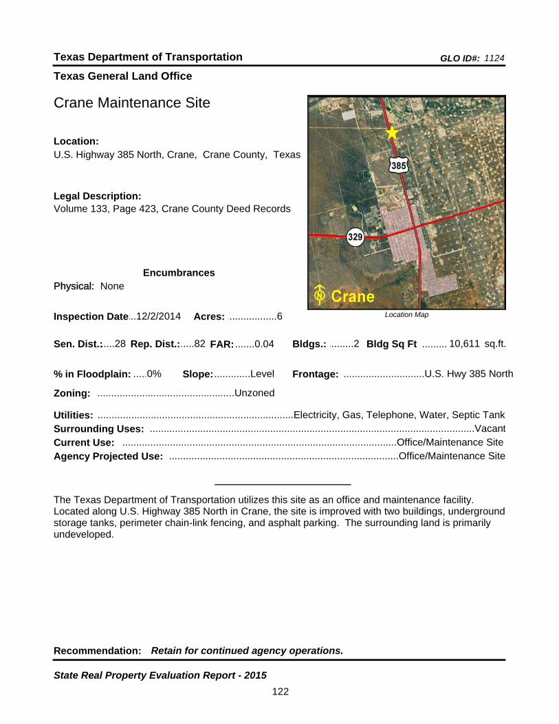
Texas General Land Office
GLO ID#: 1124Texas Department of Transportation
Location Map
......
.........
Crane Maintenance Site
Bldgs.: .........2
Legal Description:Volume 133, Page 423, Crane County Deed Records
Recommendation: Retain for continued agency operations.
The Texas Department of Transportation utilizes this site as an office and maintenance facility. Located along U.S. Highway 385 North in Crane, the site is improved with two buildings, underground storage tanks, perimeter chain-link fencing, and asphalt parking. The surrounding land is primarily undeveloped.
sq.ft.Sen. Dist.:.....28
U.S. Highway 385 North, Crane, Crane County, TexasLocation:
Rep. Dist.:.....82
Slope:.............Level
Zoning: .................................................Unzoned
Inspection Date:...12/2/2014 Acres: ..................6
Frontage: .............................U.S. Hwy 385 North
Surrounding Uses: ....................................................................................................................Vacant
Current Use: ..................................................................................................Office/Maintenance Site
Bldg Sq Ft 10,611
Agency Projected Use: ..................................................................................Office/Maintenance Site
0%% in Floodplain:
EncumbrancesPhysical: None
Utilities: ......................................................................Electricity, Gas, Telephone, Water, Septic Tank
FAR: .......0.04
122
State Real Property Evaluation Report - 2015
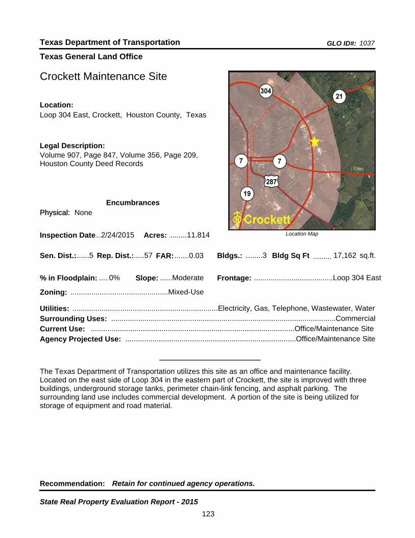
Texas General Land Office
GLO ID#: 1037Texas Department of Transportation
Location Map
......
.........
Crockett Maintenance Site
Bldgs.: .........3
Legal Description:Volume 907, Page 847, Volume 356, Page 209, Houston County Deed Records
Recommendation: Retain for continued agency operations.
The Texas Department of Transportation utilizes this site as an office and maintenance facility. Located on the east side of Loop 304 in the eastern part of Crockett, the site is improved with three buildings, underground storage tanks, perimeter chain-link fencing, and asphalt parking. The surrounding land use includes commercial development. A portion of the site is being utilized for storage of equipment and road material.
sq.ft.Sen. Dist.:.......5
Loop 304 East, Crockett, Houston County, TexasLocation:
Rep. Dist.:.....57
Slope: ......Moderate
Zoning: ...............................................Mixed-Use
Inspection Date:...2/24/2015 Acres: .........11.814
Frontage: ......................................Loop 304 East
Surrounding Uses: ............................................................................................................Commercial
Current Use: ..................................................................................................Office/Maintenance Site
Bldg Sq Ft 17,162
Agency Projected Use: ..................................................................................Office/Maintenance Site
0%% in Floodplain:
EncumbrancesPhysical: None
Utilities: ......................................................................Electricity, Gas, Telephone, Wastewater, Water
FAR: .......0.03
123
State Real Property Evaluation Report - 2015

Texas General Land Office
GLO ID#: 1086Texas Department of Transportation
Location Map
......
..................
Cross Plains Material Storage Site
Bldgs.: .........0
Legal Description:Volume 175, Page 443, Callahan County Deed Records
Recommendation: Retain for continued agency operations.
The Texas Department of Transportation utilizes this site for material storage. Located on the south side of State Highway 36 and the east side of FM 2287 in Cross Plains, the site is unimproved with only perimeter chain-link fencing and gates. The surrounding land uses include recreational and agricultural development.
sq.ft.Sen. Dist.:.....24
Intersection of SH 36 & FM 2707, Cross Plains, Callahan County, Texas
Location:
Rep. Dist.:.....60
Slope:.............Level
Zoning: .................................................Unzoned
Inspection Date:...2/20/2015 Acres: ...........3.471
Frontage: ...................................SH 36, FM 2287
Surrounding Uses: .......................................................................................Agricultural, Recreational
Current Use: .......................................................................................................Material Storage Site
Bldg Sq Ft 0
Agency Projected Use: ......................................................................................Material Storage Site
50%% in Floodplain:
EncumbrancesPhysical: Floodplain
Utilities: ..............................................................................Electricity, Telephone, Wastewater, Water
FAR: .......0.00
124
State Real Property Evaluation Report - 2015

Texas General Land Office
GLO ID#: 819Texas Department of Transportation
Location Map
......
.........
Crowell Maintenance Site
Bldgs.: .........5
Legal Description:Volume 108, Page 562, Foard County Deed Records
Recommendation: Retain for continued agency operations.
The Texas Department of Transportation utilizes this site as an office and maintenance facility. Located along North State Highway 6 in Crowell, the site is improved with five buildings, perimeter chain-link fencing, and asphalt parking. The surrounding land use includes agricultural development. A portion of the site is being utilized for storage of equipment and road material.
sq.ft.Sen. Dist.:.....28
3435 North State Highway 6, Crowell, Foard County, Texas
Location:
Rep. Dist.:.....69
Slope:.............Level
Zoning: .................................................Unzoned
Inspection Date:.....2/5/2015 Acres: ...............5.2
Frontage: ...........................................SH 6 North
Surrounding Uses: .............................................................................................................Agricultural
Current Use: ..................................................................................................Office/Maintenance Site
Bldg Sq Ft 12,543
Agency Projected Use: ..................................................................................Office/Maintenance Site
0%% in Floodplain:
EncumbrancesPhysical: None
Utilities: ......................................................................Electricity, Gas, Telephone, Wastewater, Water
FAR: .......0.06
125
State Real Property Evaluation Report - 2015
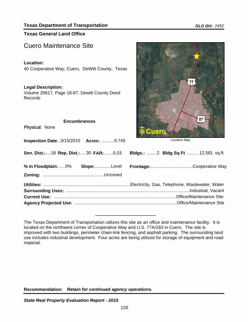
Texas General Land Office
GLO ID#: 2452Texas Department of Transportation
Location Map
......
.........
Cuero Maintenance Site
Bldgs.: .........2
Legal Description:Volume 20617, Page 18-87, Dewitt County Deed Records
Recommendation: Retain for continued agency operations.
The Texas Department of Transportation utilizes this site as an office and maintenance facility. It is located on the northwest corner of Cooperative Way and U.S. 77A/183 in Cuero. The site is improved with two buildings, perimeter chain-link fencing, and asphalt parking. The surrounding land use includes industrial development. Four acres are being utilized for storage of equipment and road material.
sq.ft.Sen. Dist.:.....18
40 Cooperative Way, Cuero, DeWitt County, TexasLocation:
Rep. Dist.:.....30
Slope:.............Level
Zoning: .................................................Unzoned
Inspection Date:...3/15/2015 Acres: ...........9.745
Frontage:..................................Cooperative Way
Surrounding Uses: ...................................................................................................Industrial, Vacant
Current Use: ..................................................................................................Office/Maintenance Site
Bldg Sq Ft 12,581
Agency Projected Use: ..................................................................................Office/Maintenance Site
0%% in Floodplain:
EncumbrancesPhysical: None
Utilities: ......................................................................Electricity, Gas, Telephone, Wastewater, Water
FAR: .......0.03
126
State Real Property Evaluation Report - 2015
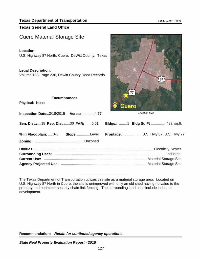
Texas General Land Office
GLO ID#: 1001Texas Department of Transportation
Location Map
......
..............
Cuero Material Storage Site
Bldgs.: .........1
Legal Description:Volume 138, Page 236, Dewitt County Deed Records
Recommendation: Retain for continued agency operations.
The Texas Department of Transportation utilizes this site as a material storage area. Located on U.S. Highway 87 North in Cuero, the site is unimproved with only an old shed having no value to the property and perimeter security chain-link fencing. The surrounding land uses include industrial development.
sq.ft.Sen. Dist.:.....18
U.S. Highway 87 North, Cuero, DeWitt County, TexasLocation:
Rep. Dist.:.....30
Slope:.............Level
Zoning: .................................................Unzoned
Inspection Date:...3/18/2015 Acres: .............4.77
Frontage: ...................U.S. Hwy 87, U.S. Hwy 77
Surrounding Uses: ................................................................................................................Industrial
Current Use: .......................................................................................................Material Storage Site
Bldg Sq Ft 432
Agency Projected Use: ......................................................................................Material Storage Site
0%% in Floodplain:
EncumbrancesPhysical: None
Utilities: ......................................................................................................................Electricity, Water
FAR: .......0.01
127
State Real Property Evaluation Report - 2015
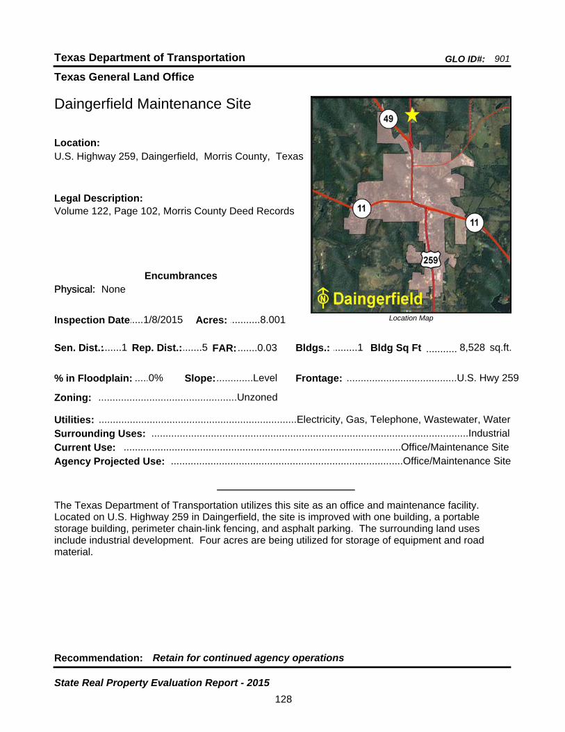
Texas General Land Office
GLO ID#: 901Texas Department of Transportation
Location Map
......
...........
Daingerfield Maintenance Site
Bldgs.: .........1
Legal Description:Volume 122, Page 102, Morris County Deed Records
Recommendation: Retain for continued agency operations
The Texas Department of Transportation utilizes this site as an office and maintenance facility. Located on U.S. Highway 259 in Daingerfield, the site is improved with one building, a portable storage building, perimeter chain-link fencing, and asphalt parking. The surrounding land uses include industrial development. Four acres are being utilized for storage of equipment and road material.
sq.ft.Sen. Dist.:.......1
U.S. Highway 259, Daingerfield, Morris County, TexasLocation:
Rep. Dist.:.......5
Slope:.............Level
Zoning: .................................................Unzoned
Inspection Date:.....1/8/2015 Acres: ...........8.001
Frontage: .......................................U.S. Hwy 259
Surrounding Uses: ................................................................................................................Industrial
Current Use: ..................................................................................................Office/Maintenance Site
Bldg Sq Ft 8,528
Agency Projected Use: ..................................................................................Office/Maintenance Site
0%% in Floodplain:
EncumbrancesPhysical: None
Utilities: ......................................................................Electricity, Gas, Telephone, Wastewater, Water
FAR: .......0.03
128
State Real Property Evaluation Report - 2015
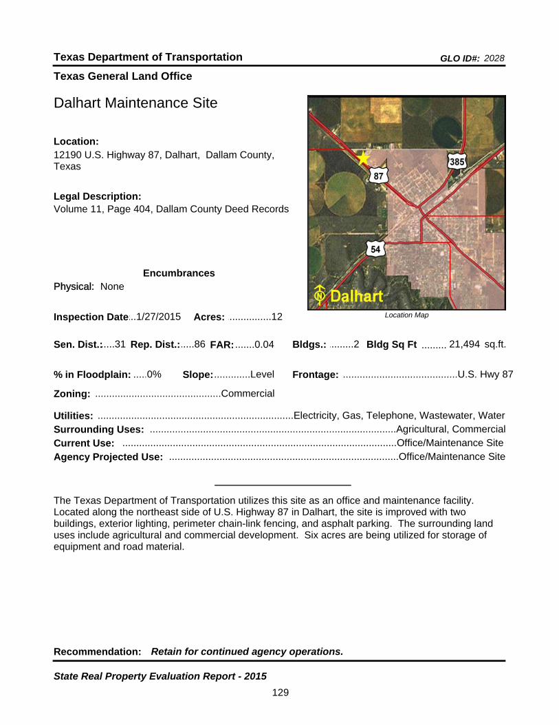
Texas General Land Office
GLO ID#: 2028Texas Department of Transportation
Location Map
......
.........
Dalhart Maintenance Site
Bldgs.: .........2
Legal Description:Volume 11, Page 404, Dallam County Deed Records
Recommendation: Retain for continued agency operations.
The Texas Department of Transportation utilizes this site as an office and maintenance facility. Located along the northeast side of U.S. Highway 87 in Dalhart, the site is improved with two buildings, exterior lighting, perimeter chain-link fencing, and asphalt parking. The surrounding land uses include agricultural and commercial development. Six acres are being utilized for storage of equipment and road material.
sq.ft.Sen. Dist.:.....31
12190 U.S. Highway 87, Dalhart, Dallam County, Texas
Location:
Rep. Dist.:.....86
Slope:.............Level
Zoning: .............................................Commercial
Inspection Date:...1/27/2015 Acres: ................12
Frontage: .........................................U.S. Hwy 87
Surrounding Uses: ........................................................................................Agricultural, Commercial
Current Use: ..................................................................................................Office/Maintenance Site
Bldg Sq Ft 21,494
Agency Projected Use: ..................................................................................Office/Maintenance Site
0%% in Floodplain:
EncumbrancesPhysical: None
Utilities: ......................................................................Electricity, Gas, Telephone, Wastewater, Water
FAR: .......0.04
129
State Real Property Evaluation Report - 2015
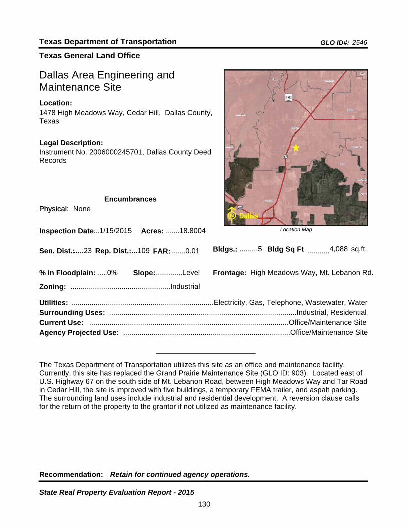
Texas General Land Office
GLO ID#: 2546Texas Department of Transportation
Location Map
......
Dallas Area Engineering and Maintenance Site
Legal Description:Instrument No. 2006000245701, Dallas County Deed Records
Recommendation: Retain for continued agency operations.
The Texas Department of Transportation utilizes this site as an office and maintenance facility. Currently, this site has replaced the Grand Prairie Maintenance Site (GLO ID: 903). Located east of U.S. Highway 67 on the south side of Mt. Lebanon Road, between High Meadows Way and Tar Road in Cedar Hill, the site is improved with five buildings, a temporary FEMA trailer, and aspalt parking. The surrounding land uses include industrial and residential development. A reversion clause calls for the return of the property to the grantor if not utilized as maintenance facility.
Sen. Dist.:.....23
1478 High Meadows Way, Cedar Hill, Dallas County, Texas
Location:
Rep. Dist.:...109
Slope:.............Level
Zoning: .................................................Industrial
Inspection Date:...1/15/2015 Acres: .......18.8004
Surrounding Uses: ............................................................................................Industrial, Residential
Current Use: ..................................................................................................Office/Maintenance Site
Bldgs.: .........5 Bldg Sq Ft ...........4,088 sq.ft.
Frontage: High Meadows Way, Mt. Lebanon Rd.
Agency Projected Use: ..................................................................................Office/Maintenance Site
0%% in Floodplain:
EncumbrancesPhysical: None
Utilities: ......................................................................Electricity, Gas, Telephone, Wastewater, Water
FAR: .......0.01
130
State Real Property Evaluation Report - 2015
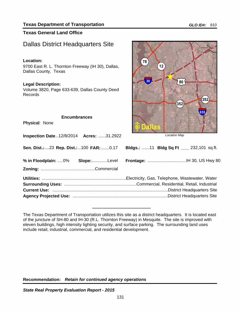
Texas General Land Office
GLO ID#: 910Texas Department of Transportation
Location Map
......
.......
Dallas District Headquarters Site
Bldgs.: .......11
Legal Description:Volume 3820, Page 633-639, Dallas County Deed Records
Recommendation: Retain for continued agency operations
The Texas Department of Transportation utilizes this site as a district headquarters. It is located east of the juncture of SH-80 and IH-30 (R.L. Thornton Freeway) in Mesquite. The site is improved with eleven buildings, high intensity lighting security, and surface parking. The surrounding land uses include retail, industrial, commercial, and residential development.
sq.ft.Sen. Dist.:.....23
9700 East R. L. Thornton Freeway (IH 30), Dallas, Dallas County, Texas
Location:
Rep. Dist.:...100
Slope:.............Level
Zoning: .............................................Commercial
Inspection Date:...12/8/2014 Acres: .......31.2922
Frontage: ................................IH 30, US Hwy 80
Surrounding Uses: ............................................................Commercial, Residential, Retail, Industrial
Current Use: ................................................................................................District Headquarters Site
Bldg Sq Ft 232,101
Agency Projected Use: ...............................................................................District Headquarters Site
0%% in Floodplain:
EncumbrancesPhysical: None
Utilities: ......................................................................Electricity, Gas, Telephone, Wastewater, Water
FAR: .......0.17
131
State Real Property Evaluation Report - 2015
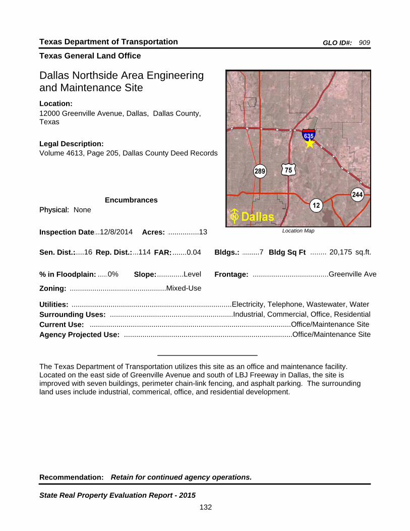
Texas General Land Office
GLO ID#: 909Texas Department of Transportation
Location Map
......
........
Dallas Northside Area Engineering and Maintenance Site
Bldgs.: .........7
Legal Description:Volume 4613, Page 205, Dallas County Deed Records
Recommendation: Retain for continued agency operations.
The Texas Department of Transportation utilizes this site as an office and maintenance facility. Located on the east side of Greenville Avenue and south of LBJ Freeway in Dallas, the site is improved with seven buildings, perimeter chain-link fencing, and asphalt parking. The surrounding land uses include industrial, commerical, office, and residential development.
sq.ft.Sen. Dist.:.....16
12000 Greenville Avenue, Dallas, Dallas County, Texas
Location:
Rep. Dist.:...114
Slope:.............Level
Zoning: ...............................................Mixed-Use
Inspection Date:...12/8/2014 Acres: ................13
Frontage: .....................................Greenville Ave
Surrounding Uses: ............................................................Industrial, Commercial, Office, Residential
Current Use: ..................................................................................................Office/Maintenance Site
Bldg Sq Ft 20,175
Agency Projected Use: ..................................................................................Office/Maintenance Site
0%% in Floodplain:
EncumbrancesPhysical: None
Utilities: ..............................................................................Electricity, Telephone, Wastewater, Water
FAR: .......0.04
132
State Real Property Evaluation Report - 2015

Texas General Land Office
GLO ID#: 2590Texas Department of Transportation
Location Map
............
Dallas Northwest Area Engineering and Maintenance Site
Bldgs.: .........0
Legal Description:Document No. 20080397092, Dallas County Deed Records
Recommendation: Retain for continued agency operations.
The Texas Department of Transportation has proposed this site for an office and maintenance facility. Located on the south side of State Highway 183 access road, between Peters Road and Maryland Drive, the site is unimproved. TxDot is currently using the site as a staging area. The surrounding land uses include industrial, commercial, and residential development.
sq.ft.
State Highway 183 and Peters Road, Irving, Dallas County, Texas
Location:
Slope:.............Level
Zoning: .................................................Industrial
Inspection Date:.12/10/2014 Acres: ...........9.639
Frontage: ..............................SH 183, Peters Rd.
Surrounding Uses: .......................................................................Commercial, Industrial, Residential
Current Use: ....................................................................................................................Staging Area
Bldg Sq Ft 0.00
Agency Projected Use: ..................................................................................Office/Maintenance Site
Sen. Dist.:.....16 Rep. Dist.: ...105
% in Floodplain: ...........0%
EncumbrancesPhysical: None
Utilities: ......................................................................Electricity, Gas, Telephone, Wastewater, Water
FAR: .......0.00
133
State Real Property Evaluation Report - 2015
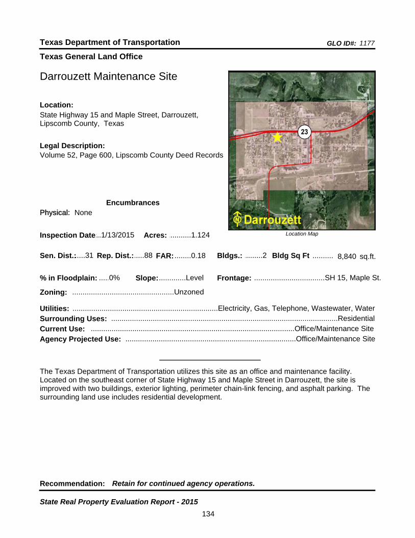
Texas General Land Office
GLO ID#: 1177Texas Department of Transportation
Location Map
......
..........
Darrouzett Maintenance Site
Bldgs.: .........2
Legal Description:Volume 52, Page 600, Lipscomb County Deed Records
Recommendation: Retain for continued agency operations.
The Texas Department of Transportation utilizes this site as an office and maintenance facility. Located on the southeast corner of State Highway 15 and Maple Street in Darrouzett, the site is improved with two buildings, exterior lighting, perimeter chain-link fencing, and asphalt parking. The surrounding land use includes residential development.
sq.ft.Sen. Dist.:.....31
State Highway 15 and Maple Street, Darrouzett, Lipscomb County, Texas
Location:
Rep. Dist.:.....88
Slope:.............Level
Zoning: .................................................Unzoned
Inspection Date:...1/13/2015 Acres: ...........1.124
Frontage: ..................................SH 15, Maple St.
Surrounding Uses: .............................................................................................................Residential
Current Use: ..................................................................................................Office/Maintenance Site
Bldg Sq Ft 8,840
Agency Projected Use: ..................................................................................Office/Maintenance Site
0%% in Floodplain:
EncumbrancesPhysical: None
Utilities: ......................................................................Electricity, Gas, Telephone, Wastewater, Water
FAR: ........0.18
134
State Real Property Evaluation Report - 2015
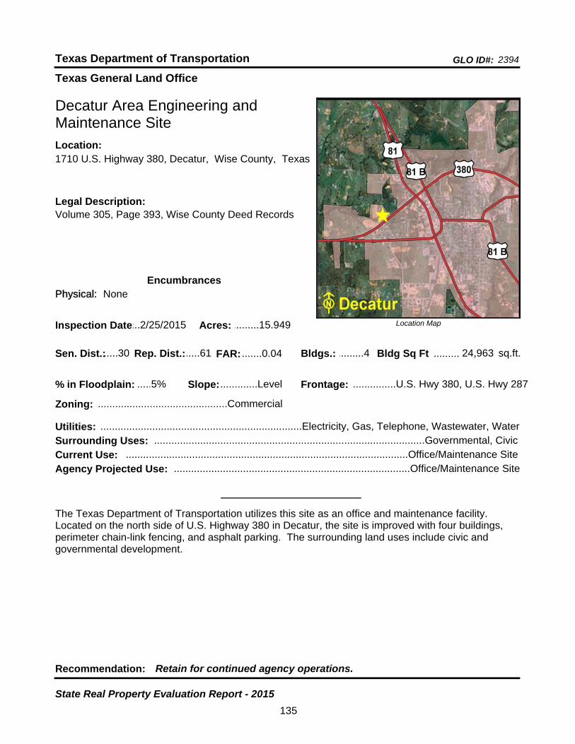
Texas General Land Office
GLO ID#: 2394Texas Department of Transportation
Location Map
......
.........
Decatur Area Engineering and Maintenance Site
Bldgs.: .........4
Legal Description:Volume 305, Page 393, Wise County Deed Records
Recommendation: Retain for continued agency operations.
The Texas Department of Transportation utilizes this site as an office and maintenance facility. Located on the north side of U.S. Highway 380 in Decatur, the site is improved with four buildings, perimeter chain-link fencing, and asphalt parking. The surrounding land uses include civic and governmental development.
sq.ft.Sen. Dist.:.....30
1710 U.S. Highway 380, Decatur, Wise County, TexasLocation:
Rep. Dist.:.....61
Slope:.............Level
Zoning: .............................................Commercial
Inspection Date:...2/25/2015 Acres: .........15.949
Frontage: ...............U.S. Hwy 380, U.S. Hwy 287
Surrounding Uses: ..............................................................................................Governmental, Civic
Current Use: ..................................................................................................Office/Maintenance Site
Bldg Sq Ft 24,963
Agency Projected Use: ..................................................................................Office/Maintenance Site
5%% in Floodplain:
EncumbrancesPhysical: None
Utilities: ......................................................................Electricity, Gas, Telephone, Wastewater, Water
FAR: .......0.04
135
State Real Property Evaluation Report - 2015

Texas General Land Office
GLO ID#: 1206Texas Department of Transportation
Location Map
......
.........
Decatur Area Engineering and Maintenance Site - Old
Bldgs.: .........5
Legal Description:Volume 5, Page 129, Volume 140 Pages 443, 444, 577, 580, Volumce 213, Page 510, Volume 216, Page 521, Wise County Deed Records
Recommendation: Retain for continued agency operations.
The Texas Department of Transportation utilizes this site as reserved for right-of-way for a new highway interchange. Currently, the Texas Department of Public Safety uses this site as a truck weigh and inspection station. Located at the southeast corner of U.S. Highway 81/287 and U.S. Highway 380 on North Sewell Road (Loop 357) in Decatur, the site is improved with five buildings, underground storage tanks, perimeter chain-link fencing, and asphalt parking. The surrounding land uses include residential and commercial development.
sq.ft.Sen. Dist.:.....30
701 North Sewell Rd (Loop 357), Decatur, Wise County, Texas
Location:
Rep. Dist.:.....61
Slope: ......Moderate
Zoning: .............................................Commercial
Inspection Date:...2/25/2015 Acres: .............7.23
Frontage: ..........U.S. Hwy 81/287, U.S. Hwy 380
Surrounding Uses: ........................................................................................Residential, Commercial
Current Use: .............................................................................................................................Vacant
Bldg Sq Ft 11,274
Agency Projected Use: ............................................................Hold Until Hwy Expansion Completed
0%% in Floodplain:
EncumbrancesPhysical: None
Utilities: ...........................................................................................Electricity, Gas, Telephone, Water
FAR: .......0.04
136
State Real Property Evaluation Report - 2015
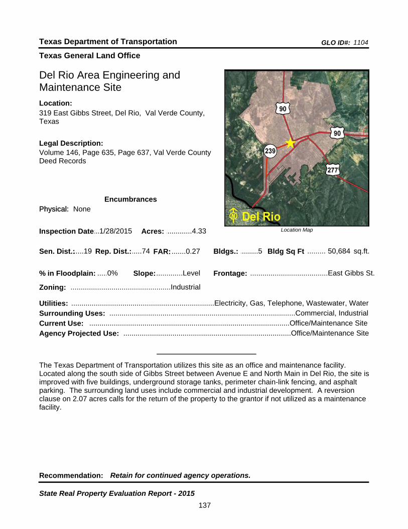
Texas General Land Office
GLO ID#: 1104Texas Department of Transportation
Location Map
......
.........
Del Rio Area Engineering and Maintenance Site
Bldgs.: .........5
Legal Description:Volume 146, Page 635, Page 637, Val Verde County Deed Records
Recommendation: Retain for continued agency operations.
The Texas Department of Transportation utilizes this site as an office and maintenance facility. Located along the south side of Gibbs Street between Avenue E and North Main in Del Rio, the site is improved with five buildings, underground storage tanks, perimeter chain-link fencing, and asphalt parking. The surrounding land uses include commercial and industrial development. A reversion clause on 2.07 acres calls for the return of the property to the grantor if not utilized as a maintenance facility.
sq.ft.Sen. Dist.:.....19
319 East Gibbs Street, Del Rio, Val Verde County, Texas
Location:
Rep. Dist.:.....74
Slope:.............Level
Zoning: .................................................Industrial
Inspection Date:...1/28/2015 Acres: .............4.33
Frontage: ......................................East Gibbs St.
Surrounding Uses: ...........................................................................................Commercial, Industrial
Current Use: ..................................................................................................Office/Maintenance Site
Bldg Sq Ft 50,684
Agency Projected Use: ..................................................................................Office/Maintenance Site
0%% in Floodplain:
EncumbrancesPhysical: None
Utilities: ......................................................................Electricity, Gas, Telephone, Wastewater, Water
FAR: .......0.27
137
State Real Property Evaluation Report - 2015
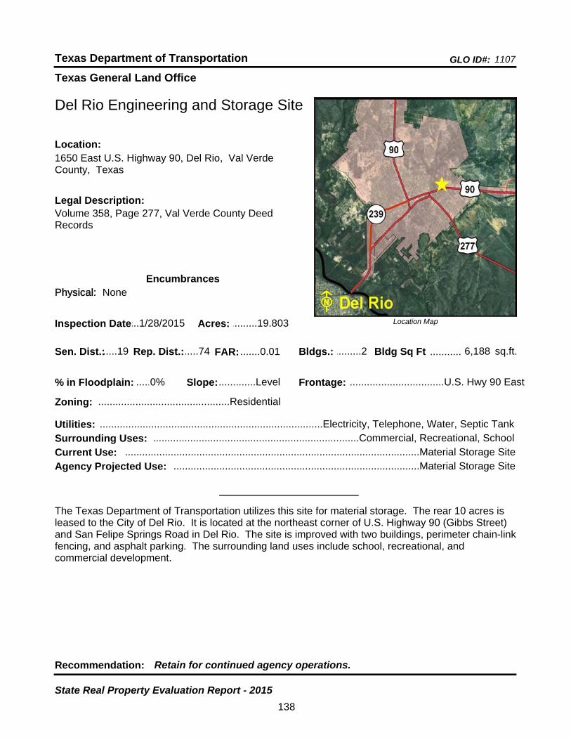
Texas General Land Office
GLO ID#: 1107Texas Department of Transportation
Location Map
......
...........
Del Rio Engineering and Storage Site
Bldgs.: .........2
Legal Description:Volume 358, Page 277, Val Verde County Deed Records
Recommendation: Retain for continued agency operations.
The Texas Department of Transportation utilizes this site for material storage. The rear 10 acres is leased to the City of Del Rio. It is located at the northeast corner of U.S. Highway 90 (Gibbs Street) and San Felipe Springs Road in Del Rio. The site is improved with two buildings, perimeter chain-link fencing, and asphalt parking. The surrounding land uses include school, recreational, and commercial development.
sq.ft.Sen. Dist.:.....19
1650 East U.S. Highway 90, Del Rio, Val Verde County, Texas
Location:
Rep. Dist.:.....74
Slope:.............Level
Zoning: ..............................................Residential
Inspection Date:...1/28/2015 Acres: .........19.803
Frontage: .................................U.S. Hwy 90 East
Surrounding Uses: ........................................................................Commercial, Recreational, School
Current Use: .......................................................................................................Material Storage Site
Bldg Sq Ft 6,188
Agency Projected Use: ......................................................................................Material Storage Site
0%% in Floodplain:
EncumbrancesPhysical: None
Utilities: ..............................................................................Electricity, Telephone, Water, Septic Tank
FAR: .......0.01
138
State Real Property Evaluation Report - 2015
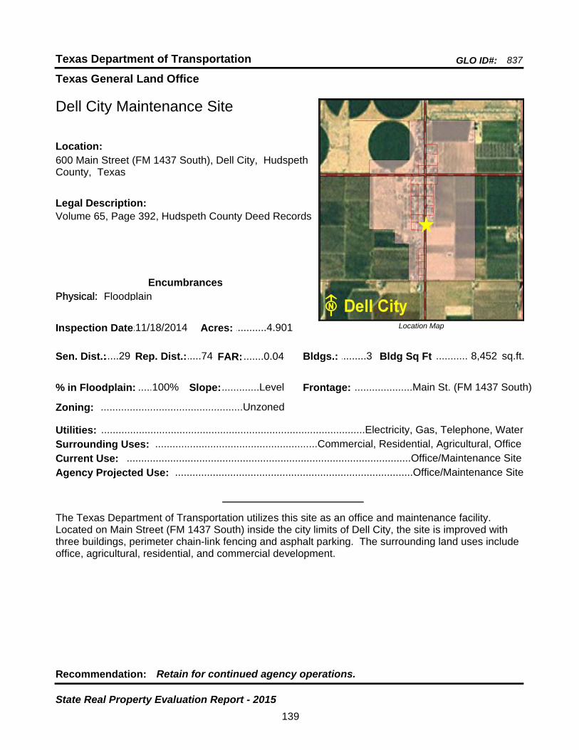
Texas General Land Office
GLO ID#: 837Texas Department of Transportation
Location Map
......
...........
Dell City Maintenance Site
Bldgs.: .........3
Legal Description:Volume 65, Page 392, Hudspeth County Deed Records
Recommendation: Retain for continued agency operations.
The Texas Department of Transportation utilizes this site as an office and maintenance facility. Located on Main Street (FM 1437 South) inside the city limits of Dell City, the site is improved with three buildings, perimeter chain-link fencing and asphalt parking. The surrounding land uses include office, agricultural, residential, and commercial development.
sq.ft.Sen. Dist.:.....29
600 Main Street (FM 1437 South), Dell City, Hudspeth County, Texas
Location:
Rep. Dist.:.....74
Slope:.............Level
Zoning: .................................................Unzoned
Inspection Date:.11/18/2014 Acres: ...........4.901
Frontage: ....................Main St. (FM 1437 South)
Surrounding Uses: ........................................................Commercial, Residential, Agricultural, Office
Current Use: ..................................................................................................Office/Maintenance Site
Bldg Sq Ft 8,452
Agency Projected Use: ..................................................................................Office/Maintenance Site
100%% in Floodplain:
EncumbrancesPhysical: Floodplain
Utilities: ...........................................................................................Electricity, Gas, Telephone, Water
FAR: .......0.04
139
State Real Property Evaluation Report - 2015
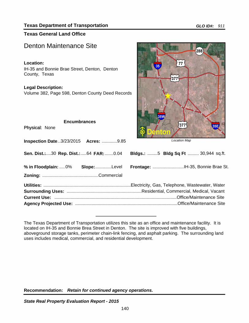
Texas General Land Office
GLO ID#: 911Texas Department of Transportation
Location Map
......
.........
Denton Maintenance Site
Bldgs.: .........5
Legal Description:Volume 382, Page 598, Denton County Deed Records
Recommendation: Retain for continued agency operations.
The Texas Department of Transportation utilizes this site as an office and maintenance facility. It is located on IH-35 and Bonnie Brea Street in Denton. The site is improved with five buildings, aboveground storage tanks, perimeter chain-link fencing, and asphalt parking. The surrounding land uses includes medical, commercial, and residential development.
sq.ft.Sen. Dist.:.....30
IH-35 and Bonnie Brae Street, Denton, Denton County, Texas
Location:
Rep. Dist.:.....64
Slope:.............Level
Zoning: .............................................Commercial
Inspection Date:...3/23/2015 Acres: .............9.85
Frontage: .........................IH-35, Bonnie Brae St.
Surrounding Uses: ............................................................Residential, Commercial, Medical, Vacant
Current Use: ..................................................................................................Office/Maintenance Site
Bldg Sq Ft 30,944
Agency Projected Use: ..................................................................................Office/Maintenance Site
0%% in Floodplain:
EncumbrancesPhysical: None
Utilities: ......................................................................Electricity, Gas, Telephone, Wastewater, Water
FAR: .......0.04
140
State Real Property Evaluation Report - 2015
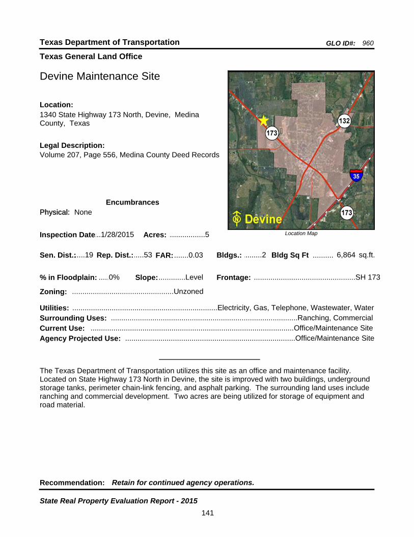
Texas General Land Office
GLO ID#: 960Texas Department of Transportation
Location Map
......
..........
Devine Maintenance Site
Bldgs.: .........2
Legal Description:Volume 207, Page 556, Medina County Deed Records
Recommendation: Retain for continued agency operations.
The Texas Department of Transportation utilizes this site as an office and maintenance facility. Located on State Highway 173 North in Devine, the site is improved with two buildings, underground storage tanks, perimeter chain-link fencing, and asphalt parking. The surrounding land uses include ranching and commercial development. Two acres are being utilized for storage of equipment and road material.
sq.ft.Sen. Dist.:.....19
1340 State Highway 173 North, Devine, Medina County, Texas
Location:
Rep. Dist.:.....53
Slope:.............Level
Zoning: .................................................Unzoned
Inspection Date:...1/28/2015 Acres: ..................5
Frontage: .................................................SH 173
Surrounding Uses: ..........................................................................................Ranching, Commercial
Current Use: ..................................................................................................Office/Maintenance Site
Bldg Sq Ft 6,864
Agency Projected Use: ..................................................................................Office/Maintenance Site
0%% in Floodplain:
EncumbrancesPhysical: None
Utilities: ......................................................................Electricity, Gas, Telephone, Wastewater, Water
FAR: .......0.03
141
State Real Property Evaluation Report - 2015
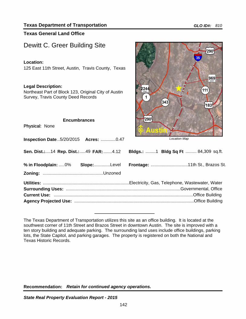
Texas General Land Office
GLO ID#: 810Texas Department of Transportation
Location Map
......
.........
Dewitt C. Greer Building Site
Bldgs.: .........1
Legal Description:Northeast Part of Block 123, Original City of Austin Survey, Travis County Deed Records
Recommendation: Retain for continued agency operations.
The Texas Department of Transportation utilizes this site as an office building. It is located at the southwest corner of 11th Street and Brazos Street in downtown Austin. The site is improved with a ten story building and adequate parking. The surrounding land uses include office buildings, parking lots, the State Capitol, and parking garages. The property is registered on both the National and Texas Historic Records.
sq.ft.Sen. Dist.:.....14
125 East 11th Street, Austin, Travis County, TexasLocation:
Rep. Dist.:.....49
Slope:.............Level
Zoning: .................................................Unzoned
Inspection Date:...5/20/2015 Acres: .............0.47
Frontage: ..............................11th St., Brazos St.
Surrounding Uses: .............................................................................................Governmental, Office
Current Use: .................................................................................................................Office Building
Bldg Sq Ft 84,309
Agency Projected Use: .................................................................................................Office Building
0%% in Floodplain:
EncumbrancesPhysical: None
Utilities: ......................................................................Electricity, Gas, Telephone, Wastewater, Water
FAR: .......4.12
142
State Real Property Evaluation Report - 2015
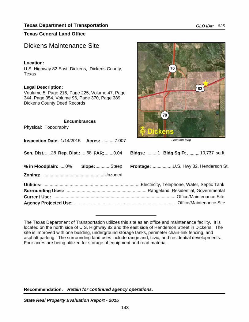
Texas General Land Office
GLO ID#: 825Texas Department of Transportation
Location Map
......
..........
Dickens Maintenance Site
Bldgs.: .........1
Legal Description:Voulume 5, Page 216, Page 225, Volume 47, Page 344, Page 354, Volume 96, Page 370, Page 389, Dickens County Deed Records
Recommendation: Retain for continued agency operations.
The Texas Department of Transportation utilizes this site as an office and maintenance facility. It is located on the north side of U.S. Highway 82 and the east side of Henderson Street in Dickens. The site is improved with one building, underground storage tanks, perimeter chain-link fencing, and asphalt parking. The surrounding land uses include rangeland, civic, and residential developments. Four acres are being utilized for storage of equipment and road material.
sq.ft.Sen. Dist.:.....28
U.S. Highway 82 East, Dickens, Dickens County, Texas
Location:
Rep. Dist.:.....68
Slope: ............Steep
Zoning: .................................................Unzoned
Inspection Date:...1/14/2015 Acres: ...........7.007
Frontage: ................U.S. Hwy 82, Henderson St.
Surrounding Uses: .................................................................Rangeland, Residential, Governmental
Current Use: ..................................................................................................Office/Maintenance Site
Bldg Sq Ft 10,737
Agency Projected Use: ..................................................................................Office/Maintenance Site
0%% in Floodplain:
EncumbrancesPhysical: Topography
Utilities: ..............................................................................Electricity, Telephone, Water, Septic Tank
FAR: .......0.04
143
State Real Property Evaluation Report - 2015
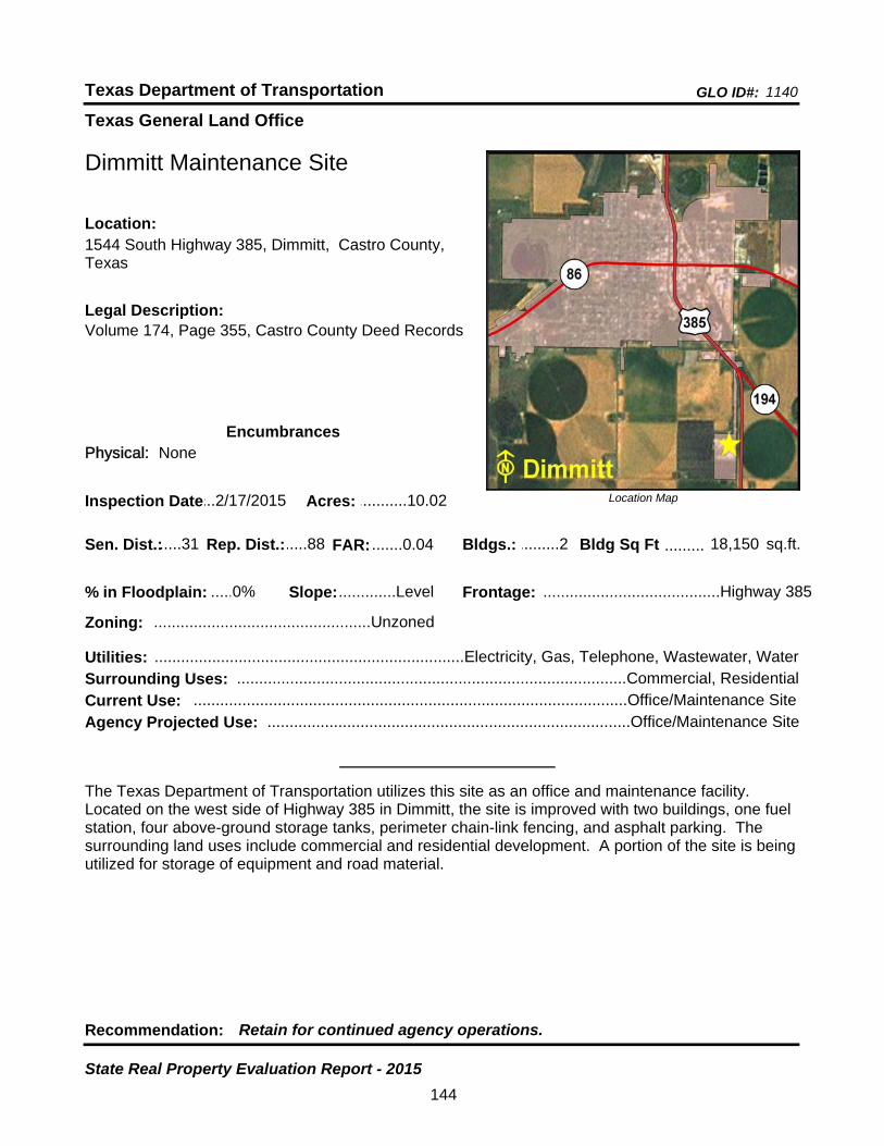
Texas General Land Office
GLO ID#: 1140Texas Department of Transportation
Location Map
......
.........
Dimmitt Maintenance Site
Bldgs.: .........2
Legal Description:Volume 174, Page 355, Castro County Deed Records
Recommendation: Retain for continued agency operations.
The Texas Department of Transportation utilizes this site as an office and maintenance facility. Located on the west side of Highway 385 in Dimmitt, the site is improved with two buildings, one fuel station, four above-ground storage tanks, perimeter chain-link fencing, and asphalt parking. The surrounding land uses include commercial and residential development. A portion of the site is being utilized for storage of equipment and road material.
sq.ft.Sen. Dist.:.....31
1544 South Highway 385, Dimmitt, Castro County, Texas
Location:
Rep. Dist.:.....88
Slope:.............Level
Zoning: .................................................Unzoned
Inspection Date:...2/17/2015 Acres: ...........10.02
Frontage: ........................................Highway 385
Surrounding Uses: ........................................................................................Commercial, Residential
Current Use: ..................................................................................................Office/Maintenance Site
Bldg Sq Ft 18,150
Agency Projected Use: ..................................................................................Office/Maintenance Site
0%% in Floodplain:
EncumbrancesPhysical: None
Utilities: ......................................................................Electricity, Gas, Telephone, Wastewater, Water
FAR: .......0.04
144
State Real Property Evaluation Report - 2015
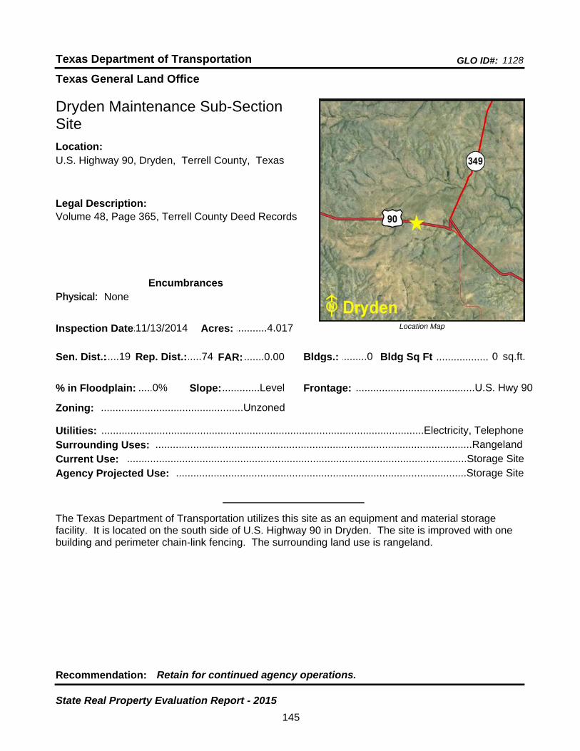
Texas General Land Office
GLO ID#: 1128Texas Department of Transportation
Location Map
......
..................
Dryden Maintenance Sub-Section Site
Bldgs.: .........0
Legal Description:Volume 48, Page 365, Terrell County Deed Records
Recommendation: Retain for continued agency operations.
The Texas Department of Transportation utilizes this site as an equipment and material storage facility. It is located on the south side of U.S. Highway 90 in Dryden. The site is improved with one building and perimeter chain-link fencing. The surrounding land use is rangeland.
sq.ft.Sen. Dist.:.....19
U.S. Highway 90, Dryden, Terrell County, TexasLocation:
Rep. Dist.:.....74
Slope:.............Level
Zoning: .................................................Unzoned
Inspection Date:.11/13/2014 Acres: ...........4.017
Frontage: .........................................U.S. Hwy 90
Surrounding Uses: .............................................................................................................Rangeland
Current Use: .....................................................................................................................Storage Site
Bldg Sq Ft 0
Agency Projected Use: ....................................................................................................Storage Site
0%% in Floodplain:
EncumbrancesPhysical: None
Utilities: ...............................................................................................................Electricity, Telephone
FAR: .......0.00
145
State Real Property Evaluation Report - 2015
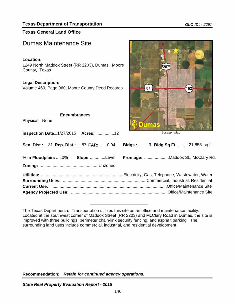
Texas General Land Office
GLO ID#: 2297Texas Department of Transportation
Location Map
......
.........
Dumas Maintenance Site
Bldgs.: .........3
Legal Description:Volume 469, Page 960, Moore County Deed Records
Recommendation: Retain for continued agency operations.
The Texas Department of Transportation utilizes this site as an office and maintenance facility. Located at the southwest corner of Maddox Street (RR 2203) and McClary Road in Dumas, the site is improved with three buildings, perimeter chain-link security fencing, and asphalt parking. The surrounding land uses include commercial, industrial, and residential development.
sq.ft.Sen. Dist.:.....31
1249 North Maddox Street (RR 2203), Dumas, Moore County, Texas
Location:
Rep. Dist.:.....87
Slope:.............Level
Zoning: .................................................Unzoned
Inspection Date:...1/27/2015 Acres: ................12
Frontage: .....................Maddox St., McClary Rd.
Surrounding Uses: .......................................................................Commercial, Industrial, Residential
Current Use: ..................................................................................................Office/Maintenance Site
Bldg Sq Ft 21,853
Agency Projected Use: ..................................................................................Office/Maintenance Site
0%% in Floodplain:
EncumbrancesPhysical: None
Utilities: ......................................................................Electricity, Gas, Telephone, Wastewater, Water
FAR: .......0.04
146
State Real Property Evaluation Report - 2015
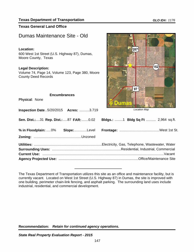
Texas General Land Office
GLO ID#: 1176Texas Department of Transportation
Location Map
......
..........
Dumas Maintenance Site - Old
Bldgs.: .........1
Legal Description:Volume 74, Page 14, Volume 123, Page 380, Moore County Deed Records
Recommendation: Retain for continued agency operations.
The Texas Department of Transportation utilizes this site as an office and maintenance facility, but is currently vacant. Located on West 1st Street (U.S. Highway 87) in Dumas, the site is improved with one building, perimeter chain-link fencing, and asphalt parking. The surrounding land uses include industrial, residential, and commercial development.
sq.ft.Sen. Dist.:.....31
600 West 1st Street (U.S. Highway 87), Dumas, Moore County, Texas
Location:
Rep. Dist.:.....87
Slope:.............Level
Zoning: .................................................Unzoned
Inspection Date:...5/20/2015 Acres: ...........3.719
Frontage: .........................................West 1st St.
Surrounding Uses: .......................................................................Residential, Industrial, Commercial
Current Use: .............................................................................................................................Vacant
Bldg Sq Ft 2,964
Agency Projected Use: ..................................................................................Office/Maintenance Site
0%% in Floodplain:
EncumbrancesPhysical: None
Utilities: ......................................................................Electricity, Gas, Telephone, Wastewater, Water
FAR: .......0.02
147
State Real Property Evaluation Report - 2015
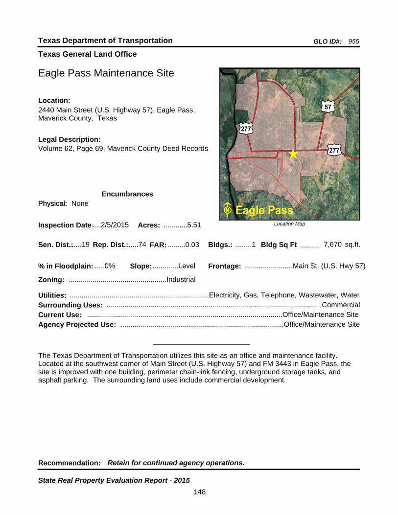
Texas General Land Office
GLO ID#: 955Texas Department of Transportation
Location Map
......
..........
Eagle Pass Maintenance Site
Bldgs.: .........1
Legal Description:Volume 62, Page 69, Maverick County Deed Records
Recommendation: Retain for continued agency operations.
The Texas Department of Transportation utilizes this site as an office and maintenance facility. Located at the southwest corner of Main Street (U.S. Highway 57) and FM 3443 in Eagle Pass, the site is improved with one building, perimeter chain-link fencing, underground storage tanks, and asphalt parking. The surrounding land uses include commercial development.
sq.ft.Sen. Dist.:.....19
2440 Main Street (U.S. Highway 57), Eagle Pass, Maverick County, Texas
Location:
Rep. Dist.:.....74
Slope:.............Level
Zoning: .................................................Industrial
Inspection Date:.....2/5/2015 Acres: .............5.51
Frontage: ........................Main St. (U.S. Hwy 57)
Surrounding Uses: ............................................................................................................Commercial
Current Use: ..................................................................................................Office/Maintenance Site
Bldg Sq Ft 7,670
Agency Projected Use: ..................................................................................Office/Maintenance Site
0%% in Floodplain:
EncumbrancesPhysical: None
Utilities: ......................................................................Electricity, Gas, Telephone, Wastewater, Water
FAR: .........0.03
148
State Real Property Evaluation Report - 2015
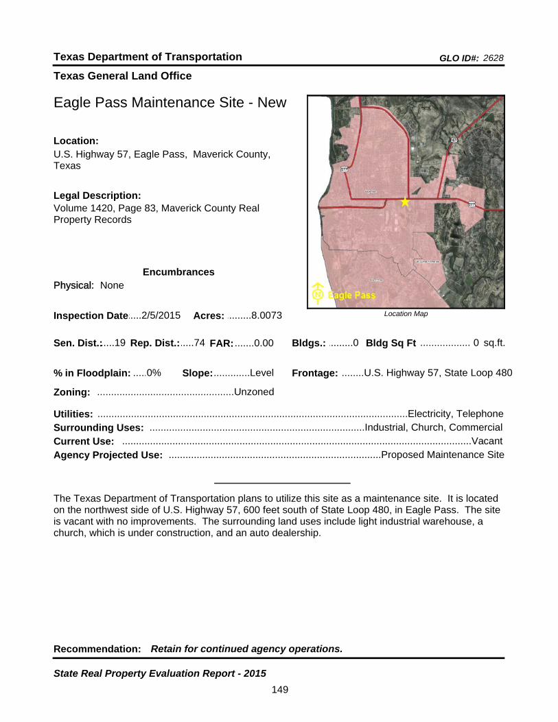
Texas General Land Office
GLO ID#: 2628Texas Department of Transportation
Location Map
......
..................
Eagle Pass Maintenance Site - New
Bldgs.: .........0
Legal Description:Volume 1420, Page 83, Maverick County Real Property Records
Recommendation: Retain for continued agency operations.
The Texas Department of Transportation plans to utilize this site as a maintenance site. It is located on the northwest side of U.S. Highway 57, 600 feet south of State Loop 480, in Eagle Pass. The site is vacant with no improvements. The surrounding land uses include light industrial warehouse, a church, which is under construction, and an auto dealership.
sq.ft.Sen. Dist.:.....19
U.S. Highway 57, Eagle Pass, Maverick County, Texas
Location:
Rep. Dist.:.....74
Slope:.............Level
Zoning: .................................................Unzoned
Inspection Date:.....2/5/2015 Acres: .........8.0073
Frontage: ........U.S. Highway 57, State Loop 480
Surrounding Uses: .............................................................................Industrial, Church, Commercial
Current Use: .............................................................................................................................Vacant
Bldg Sq Ft 0
Agency Projected Use: ............................................................................Proposed Maintenance Site
0%% in Floodplain:
EncumbrancesPhysical: None
Utilities: ...............................................................................................................Electricity, Telephone
FAR: .......0.00
149
State Real Property Evaluation Report - 2015
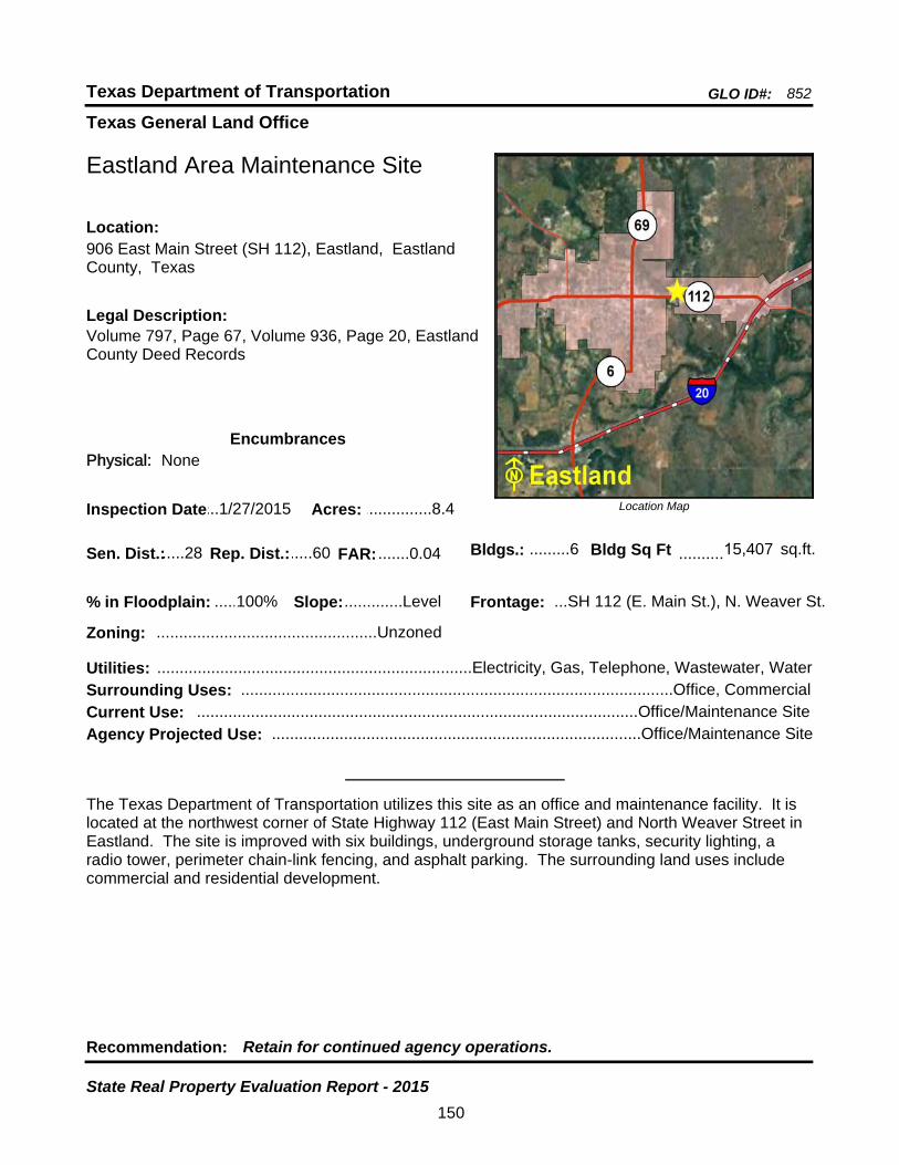
Texas General Land Office
GLO ID#: 852Texas Department of Transportation
Location Map
......
Eastland Area Maintenance Site
Legal Description:Volume 797, Page 67, Volume 936, Page 20, Eastland County Deed Records
Recommendation: Retain for continued agency operations.
The Texas Department of Transportation utilizes this site as an office and maintenance facility. It is located at the northwest corner of State Highway 112 (East Main Street) and North Weaver Street in Eastland. The site is improved with six buildings, underground storage tanks, security lighting, a radio tower, perimeter chain-link fencing, and asphalt parking. The surrounding land uses include commercial and residential development.
Sen. Dist.:.....28
906 East Main Street (SH 112), Eastland, Eastland County, Texas
Location:
Rep. Dist.:.....60
Slope:.............Level
Zoning: .................................................Unzoned
Inspection Date:...1/27/2015 Acres: ...............8.4
Surrounding Uses: ................................................................................................Office, Commercial
Current Use: ..................................................................................................Office/Maintenance Site
Bldgs.: .........6 Bldg Sq Ft ..........15,407 sq.ft.
Frontage: ...SH 112 (E. Main St.), N. Weaver St.
Agency Projected Use: ..................................................................................Office/Maintenance Site
100%% in Floodplain:
EncumbrancesPhysical: None
Utilities: ......................................................................Electricity, Gas, Telephone, Wastewater, Water
FAR: .......0.04
150
State Real Property Evaluation Report - 2015
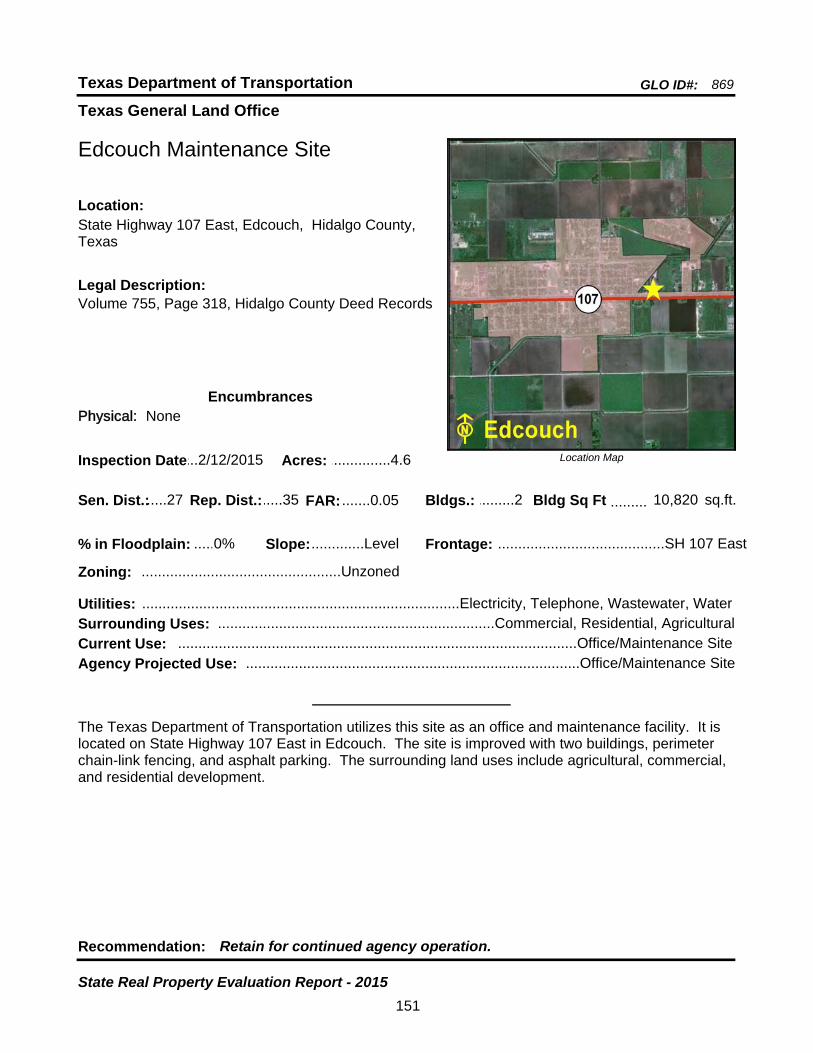
Texas General Land Office
GLO ID#: 869Texas Department of Transportation
Location Map
......
.........
Edcouch Maintenance Site
Bldgs.: .........2
Legal Description:Volume 755, Page 318, Hidalgo County Deed Records
Recommendation: Retain for continued agency operation.
The Texas Department of Transportation utilizes this site as an office and maintenance facility. It is located on State Highway 107 East in Edcouch. The site is improved with two buildings, perimeter chain-link fencing, and asphalt parking. The surrounding land uses include agricultural, commercial, and residential development.
sq.ft.Sen. Dist.:.....27
State Highway 107 East, Edcouch, Hidalgo County, Texas
Location:
Rep. Dist.:.....35
Slope:.............Level
Zoning: .................................................Unzoned
Inspection Date:...2/12/2015 Acres: ...............4.6
Frontage: .........................................SH 107 East
Surrounding Uses: ....................................................................Commercial, Residential, Agricultural
Current Use: ..................................................................................................Office/Maintenance Site
Bldg Sq Ft 10,820
Agency Projected Use: ..................................................................................Office/Maintenance Site
0%% in Floodplain:
EncumbrancesPhysical: None
Utilities: ..............................................................................Electricity, Telephone, Wastewater, Water
FAR: .......0.05
151
State Real Property Evaluation Report - 2015

Texas General Land Office
GLO ID#: 1114Texas Department of Transportation
Location Map
......
........
Eden Area Maintenance Site
Bldgs.: .........5
Legal Description:Volume 84, Page 309, Volume 64, Page 342, Concho County Deed Records
Recommendation: Retain for continued agency operations.
The Texas Department of Transportation utilizes this site as a maintenance facility. Located on the north side of West Broadway (U.S. Highway 87) in Eden, the site is improved with five buildings, perimeter chain-link fencing, and asphalt parking. The surrounding land uses include rangeland and commercial development. A portion of the site is undeveloped land. It is being utilized for storage equipment.
sq.ft.Sen. Dist.:.....28
1418 West Broadway (U.S. Hwy 87), Eden, Concho County, Texas
Location:
Rep. Dist.:.....72
Slope:.............Level
Zoning: .................................................Unzoned
Inspection Date:...3/16/2015 Acres: .............6.52
Frontage: ....................................US Highway 87
Surrounding Uses: ........................................................................................Rangeland, Commercial
Current Use: .............................................................................................................Maintenance Site
Bldg Sq Ft 10,896
Agency Projected Use: ............................................................................................Maintenance Site
0%% in Floodplain:
EncumbrancesPhysical: None
Utilities: ......................................................................Electricity, Gas, Telephone, Water, Septic Tank
FAR: .......0.04
152
State Real Property Evaluation Report - 2015
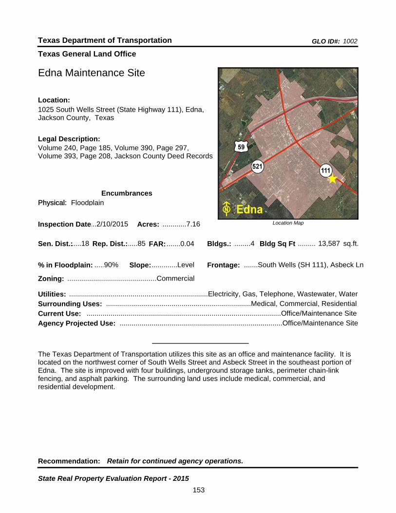
Texas General Land Office
GLO ID#: 1002Texas Department of Transportation
Location Map
......
.........
Edna Maintenance Site
Bldgs.: .........4
Legal Description:Volume 240, Page 185, Volume 390, Page 297, Volume 393, Page 208, Jackson County Deed Records
Recommendation: Retain for continued agency operations.
The Texas Department of Transportation utilizes this site as an office and maintenance facility. It is located on the northwest corner of South Wells Street and Asbeck Street in the southeast portion of Edna. The site is improved with four buildings, underground storage tanks, perimeter chain-link fencing, and asphalt parking. The surrounding land uses include medical, commercial, and residential development.
sq.ft.Sen. Dist.:.....18
1025 South Wells Street (State Highway 111), Edna, Jackson County, Texas
Location:
Rep. Dist.:.....85
Slope:.............Level
Zoning: .............................................Commercial
Inspection Date:...2/10/2015 Acres: .............7.16
Frontage: .......South Wells (SH 111), Asbeck Ln
Surrounding Uses: .........................................................................Medical, Commercial, Residential
Current Use: ..................................................................................................Office/Maintenance Site
Bldg Sq Ft 13,587
Agency Projected Use: ..................................................................................Office/Maintenance Site
90%% in Floodplain:
EncumbrancesPhysical: Floodplain
Utilities: ......................................................................Electricity, Gas, Telephone, Wastewater, Water
FAR: .......0.04
153
State Real Property Evaluation Report - 2015

Texas General Land Office
GLO ID#: 1110Texas Department of Transportation
Location Map
......
.............
El Dorado Area Maintenance Sub-Section Site
Bldgs.: .........1
Legal Description:Volume 86, Page 395, Volume 120, Page 385, Volume 195, Page 9, Schleicher County Deed Records
Recommendation: Retain for continued agency operation.
The Texas Department of Transportation utilizes this site as an office and maintenance facility. It is located along the north side of U.S. Highway 190 in El Dorado. The site is improved with one building, perimeter chain-link fencing, and asphalt parking. The surrounding land uses include rangeland, governmental, and residential development. Three acres are undeveloped, and being utilized for storage of equipment and road material. A reversion clause effects 2.98 acres, which calls for the return of the property to the county if not utilized by TxDOT.
sq.ft.Sen. Dist.:.....28
U.S. Highway 190, El Dorado, Schleicher County, Texas
Location:
Rep. Dist.:.....53
Slope:.............Level
Zoning: .................................................Unzoned
Inspection Date:...3/16/2015 Acres: .............8.53
Frontage: .......................................U.S. Hwy 190
Surrounding Uses: .................................................................Rangeland, Governmental, Residential
Current Use: ..................................................................................................Office/Maintenance Site
Bldg Sq Ft 984
Agency Projected Use: ..................................................................................Office/Maintenance Site
0%% in Floodplain:
EncumbrancesPhysical: None
Utilities: ..............................................................................Electricity, Telephone, Water, Septic Tank
FAR: .......0.01
154
State Real Property Evaluation Report - 2015

Texas General Land Office
GLO ID#: 2254Texas Department of Transportation
Location Map
......
.......
El Paso District Headquarters Site
Bldgs.: .......11
Legal Description:Book 2722, Page 1141, El Paso County Deed Records
Recommendation: Retain for continued agency operations.
The Texas Department of Transportation utilizes this site as a district headquarters. Located along Gateway Boulevard West in El Paso, the site is improved with eleven buildings, perimeter chain-link fencing, street and yard security lighting, five electric access gates, and asphalt parking. The surrounding land uses include industrial development.
sq.ft.Sen. Dist.:.....29
13301 Gateway Boulevard West, El Paso, El Paso County, Texas
Location:
Rep. Dist.:.....75
Slope:.............Level
Zoning: .................................................Unzoned
Inspection Date:...12/3/2014 Acres: .........33.457
Frontage: ....Gateway Blvd West, Bill Burnett Dr.
Surrounding Uses: ...................................................................................................Industrial, Vacant
Current Use: ................................................................................................District Headquarters Site
Bldg Sq Ft 112,098
Agency Projected Use: ...............................................................................District Headquarters Site
50%% in Floodplain:
EncumbrancesPhysical: None
Utilities: ......................................................................Electricity, Gas, Telephone, Wastewater, Water
FAR: .......0.08
155
State Real Property Evaluation Report - 2015
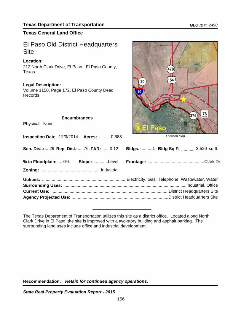
Texas General Land Office
GLO ID#: 2490Texas Department of Transportation
Location Map
......
...........
El Paso Old District Headquarters Site
Bldgs.: .........1
Legal Description:Volume 1150, Page 172, El Paso County Deed Records
Recommendation: Retain for continued agency operations.
The Texas Department of Transportation utilizes this site as a district office. Located along North Clark Drive in El Paso, the site is improved with a two-story building and asphalt parking. The surrounding land uses include office and industrial development.
sq.ft.Sen. Dist.:.....29
212 North Clark Drive, El Paso, El Paso County, Texas
Location:
Rep. Dist.:.....76
Slope:.............Level
Zoning: .................................................Industrial
Inspection Date:...12/3/2014 Acres: ...........0.683
Frontage: ...............................................Clark Dr.
Surrounding Uses: .....................................................................................................Industrial, Office
Current Use: ................................................................................................District Headquarters Site
Bldg Sq Ft 3,520
Agency Projected Use: ...............................................................................District Headquarters Site
0%% in Floodplain:
EncumbrancesPhysical: None
Utilities: ......................................................................Electricity, Gas, Telephone, Wastewater, Water
FAR: .......0.12
156
State Real Property Evaluation Report - 2015

Texas General Land Office
GLO ID#: 1186Texas Department of Transportation
Location Map
......
..........
Electra Maintenance Site
Bldgs.: .........2
Legal Description:Volume 652, Page 460, Wichita County Deed Records
Recommendation: Retain for continued agency operations.
The Texas Department of Transportation utilizes this site as an office and maintenance facility. Located along the east side of Bailey Street (State Highway 25 South) and the south side of Elm Street in Electra, the site is improved with two buildings, perimeter chain-link fencing, and asphalt parking. The surrounding land uses include residential and commercial development. Two acres are being utilized for storage of equipment and road material.
sq.ft.Sen. Dist.:.....30
1110 South Bailey Street (State Highway 25 South), Electra, Wichita County, Texas
Location:
Rep. Dist.:.....69
Slope:.............Level
Zoning: .................................................Unzoned
Inspection Date:.....2/5/2015 Acres: ...............4.2
Frontage: .......................South Bailey St (SH 25)
Surrounding Uses: ...........................................................................Residential, Commercial, Vacant
Current Use: ..................................................................................................Office/Maintenance Site
Bldg Sq Ft 6,312
Agency Projected Use: ..................................................................................Office/Maintenance Site
0%% in Floodplain:
EncumbrancesPhysical: None
Utilities: ......................................................................Electricity, Gas, Telephone, Wastewater, Water
FAR: .......0.03
157
State Real Property Evaluation Report - 2015
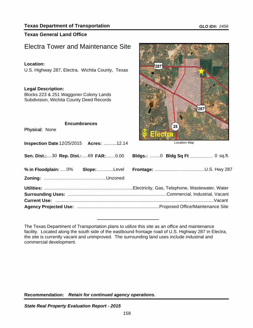
Texas General Land Office
GLO ID#: 2456Texas Department of Transportation
Location Map
......
..................
Electra Tower and Maintenance Site
Bldgs.: .........0
Legal Description:Blocks 223 & 251 Waggoner Colony Lands Subdivision, Wichita County Deed Records
Recommendation: Retain for continued agency operations.
The Texas Department of Transportation plans to utilize this site as an office and maintenance facility. Located along the south side of the eastbound frontage road of U.S. Highway 287 in Electra, the site is currently vacant and unimproved. The surrounding land uses include industrial and commercial development.
sq.ft.Sen. Dist.:.....30
U.S. Highway 287, Electra, Wichita County, TexasLocation:
Rep. Dist.:.....69
Slope:.............Level
Zoning: .................................................Unzoned
Inspection Date:.12/25/2015 Acres: ...........12.14
Frontage: .......................................U.S. Hwy 287
Surrounding Uses: ..............................................................................Commercial, Industrial, Vacant
Current Use: .............................................................................................................................Vacant
Bldg Sq Ft 0
Agency Projected Use: .................................................................Proposed Office/Maintenance Site
0%% in Floodplain:
EncumbrancesPhysical: None
Utilities: ......................................................................Electricity, Gas, Telephone, Wastewater, Water
FAR: .......0.00
158
State Real Property Evaluation Report - 2015
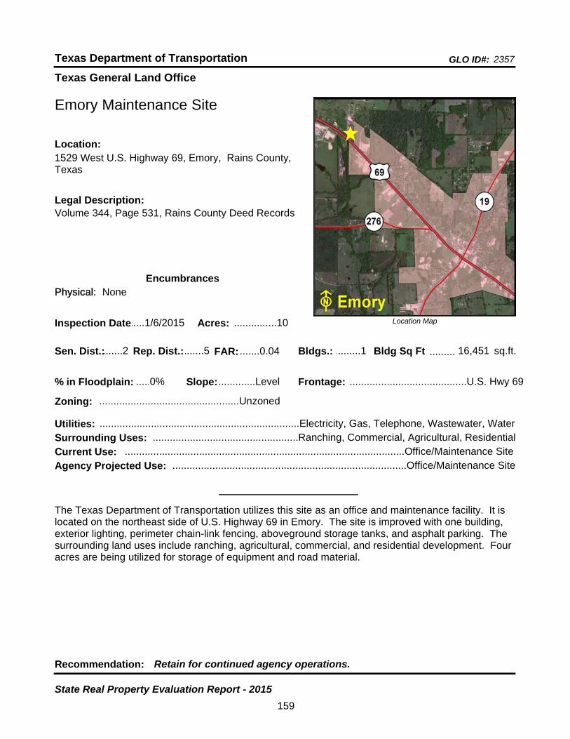
Texas General Land Office
GLO ID#: 2357Texas Department of Transportation
Location Map
......
.........
Emory Maintenance Site
Bldgs.: .........1
Legal Description:Volume 344, Page 531, Rains County Deed Records
Recommendation: Retain for continued agency operations.
The Texas Department of Transportation utilizes this site as an office and maintenance facility. It is located on the northeast side of U.S. Highway 69 in Emory. The site is improved with one building, exterior lighting, perimeter chain-link fencing, aboveground storage tanks, and asphalt parking. The surrounding land uses include ranching, agricultural, commercial, and residential development. Four acres are being utilized for storage of equipment and road material.
sq.ft.Sen. Dist.:.......2
1529 West U.S. Highway 69, Emory, Rains County, Texas
Location:
Rep. Dist.:.......5
Slope:.............Level
Zoning: .................................................Unzoned
Inspection Date:.....1/6/2015 Acres: ................10
Frontage: .........................................U.S. Hwy 69
Surrounding Uses: ...................................................Ranching, Commercial, Agricultural, Residential
Current Use: ..................................................................................................Office/Maintenance Site
Bldg Sq Ft 16,451
Agency Projected Use: ..................................................................................Office/Maintenance Site
0%% in Floodplain:
EncumbrancesPhysical: None
Utilities: ......................................................................Electricity, Gas, Telephone, Wastewater, Water
FAR: .......0.04
159
State Real Property Evaluation Report - 2015
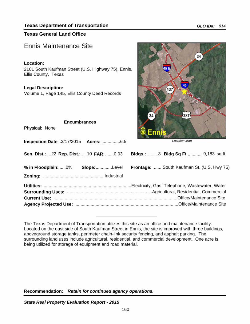
Texas General Land Office
GLO ID#: 914Texas Department of Transportation
Location Map
......
...........
Ennis Maintenance Site
Bldgs.: .........3
Legal Description:Volume 1, Page 145, Ellis County Deed Records
Recommendation: Retain for continued agency operations.
The Texas Department of Transportation utilizes this site as an office and maintenance facility. Located on the east side of South Kaufman Street in Ennis, the site is improved with three buildings, aboveground storage tanks, perimeter chain-link security fencing, and asphalt parking. The surrounding land uses include agricultural, residential, and commercial development. One acre is being utilized for storage of equipment and road material.
sq.ft.Sen. Dist.:.....22
2101 South Kaufman Street (U.S. Highway 75), Ennis, Ellis County, Texas
Location:
Rep. Dist.:.....10
Slope:.............Level
Zoning: .................................................Industrial
Inspection Date:...3/17/2015 Acres: ...............6.5
Frontage: .......South Kaufman St. (U.S. Hwy 75)
Surrounding Uses: ....................................................................Agricultural, Residential, Commercial
Current Use: ..................................................................................................Office/Maintenance Site
Bldg Sq Ft 9,183
Agency Projected Use: ..................................................................................Office/Maintenance Site
0%% in Floodplain:
EncumbrancesPhysical: None
Utilities: ......................................................................Electricity, Gas, Telephone, Wastewater, Water
FAR: .......0.03
160
State Real Property Evaluation Report - 2015
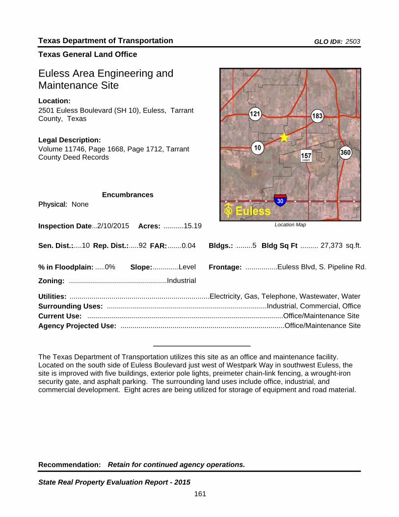
Texas General Land Office
GLO ID#: 2503Texas Department of Transportation
Location Map
......
.........
Euless Area Engineering and Maintenance Site
Bldgs.: .........5
Legal Description:Volume 11746, Page 1668, Page 1712, Tarrant County Deed Records
Recommendation: Retain for continued agency operations.
The Texas Department of Transportation utilizes this site as an office and maintenance facility. Located on the south side of Euless Boulevard just west of Westpark Way in southwest Euless, the site is improved with five buildings, exterior pole lights, preimeter chain-link fencing, a wrought-iron security gate, and asphalt parking. The surrounding land uses include office, industrial, and commercial development. Eight acres are being utilized for storage of equipment and road material.
sq.ft.Sen. Dist.:.....10
2501 Euless Boulevard (SH 10), Euless, Tarrant County, Texas
Location:
Rep. Dist.:.....92
Slope:.............Level
Zoning: .................................................Industrial
Inspection Date:...2/10/2015 Acres: ...........15.19
Frontage: ................Euless Blvd, S. Pipeline Rd.
Surrounding Uses: ................................................................................Industrial, Commercial, Office
Current Use: ..................................................................................................Office/Maintenance Site
Bldg Sq Ft 27,373
Agency Projected Use: ..................................................................................Office/Maintenance Site
0%% in Floodplain:
EncumbrancesPhysical: None
Utilities: ......................................................................Electricity, Gas, Telephone, Wastewater, Water
FAR: .......0.04
161
State Real Property Evaluation Report - 2015

Texas General Land Office
GLO ID#: 924Texas Department of Transportation
Location Map
......
.........
Fairfield Maintenance Site
Bldgs.: .........2
Legal Description:Volume 275, Page 210, Freestone County Deed Records
Recommendation: Retain for continued agency operations.
The Texas Department of Transportation utilizes this site as an office and maintenance facility. Located on the northwest side of U.S. Highway 84 West and the east side of Williford Street in Fairfield, the site is improved with two buildings, portable storage buildings, perimeter chain-link fencing, aboveground storage tanks, and asphalt parking. The surrounding land uses include commercial and residential development. A portion of the site has undeveloped land. It is being utilized for storage of equipment and road material.
sq.ft.Sen. Dist.:.......5
340 U.S. Highway 84 West, Fairfield, Freestone County, Texas
Location:
Rep. Dist.:.......8
Slope: ......Moderate
Zoning: .................................................Unzoned
Inspection Date:.....4/7/2015 Acres: .........10.841
Frontage: ...............U.S. Hwy 84, Williford Street
Surrounding Uses: ........................................................................................Commercial, Residential
Current Use: ..................................................................................................Office/Maintenance Site
Bldg Sq Ft 10,500
Agency Projected Use: ..................................................................................Office/Maintenance Site
5%% in Floodplain:
EncumbrancesPhysical: None
Utilities: ......................................................................Electricity, Gas, Telephone, Wastewater, Water
FAR: .......0.02
162
State Real Property Evaluation Report - 2015
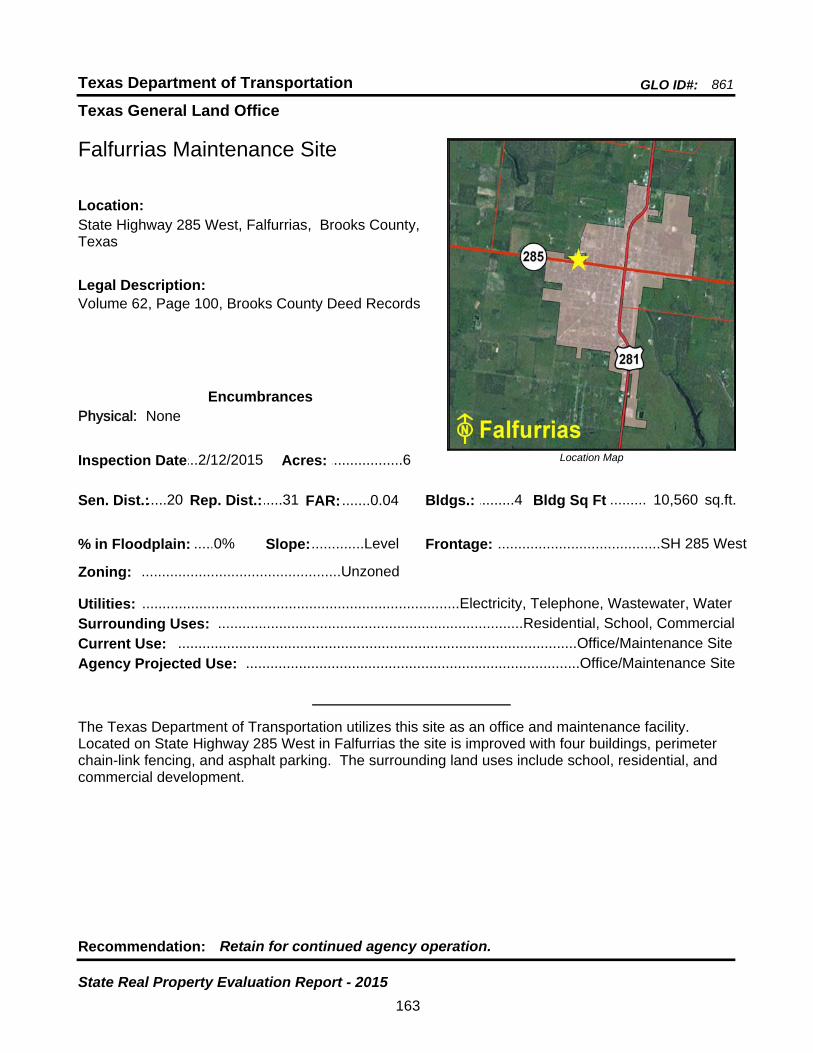
Texas General Land Office
GLO ID#: 861Texas Department of Transportation
Location Map
......
.........
Falfurrias Maintenance Site
Bldgs.: .........4
Legal Description:Volume 62, Page 100, Brooks County Deed Records
Recommendation: Retain for continued agency operation.
The Texas Department of Transportation utilizes this site as an office and maintenance facility. Located on State Highway 285 West in Falfurrias the site is improved with four buildings, perimeter chain-link fencing, and asphalt parking. The surrounding land uses include school, residential, and commercial development.
sq.ft.Sen. Dist.:.....20
State Highway 285 West, Falfurrias, Brooks County, Texas
Location:
Rep. Dist.:.....31
Slope:.............Level
Zoning: .................................................Unzoned
Inspection Date:...2/12/2015 Acres: ..................6
Frontage: ........................................SH 285 West
Surrounding Uses: ...........................................................................Residential, School, Commercial
Current Use: ..................................................................................................Office/Maintenance Site
Bldg Sq Ft 10,560
Agency Projected Use: ..................................................................................Office/Maintenance Site
0%% in Floodplain:
EncumbrancesPhysical: None
Utilities: ..............................................................................Electricity, Telephone, Wastewater, Water
FAR: .......0.04
163
State Real Property Evaluation Report - 2015

Texas General Land Office
GLO ID#: 2483Texas Department of Transportation
Location Map
......
........
Floresville Maintenance Site
Bldgs.: .........4
Legal Description:S. & J. Arocha Survey, A-1, Wilson County DeedRecords
Recommendation: Retain for continued agency operations.
The Texas Department of Transportation utilizes this site as an office and maintenance facility. Located on the northwest side of State Highway 97 in Floresville, the site is improved with four buildings, perimeter chain-link fencing and asphalt parking. The surrounding land uses include civic, agricultural, and residential development. Six acres are being utilized for storage of equipment and road material.
sq.ft.Sen. Dist.:.....21
317 State Highway 97 East, Floresville, Wilson County, Texas
Location:
Rep. Dist.:.....44
Slope:.............Level
Zoning: .................................................Unzoned
Inspection Date:.12/11/2014 Acres: ...........19.97
Frontage: ...........................................SH 97 East
Surrounding Uses: ..................................................................Agricultural, Residential, Civic, Vacant
Current Use: .............................................................................................................Maintenance Site
Bldg Sq Ft 13,096
Agency Projected Use: ............................................................................................Maintenance Site
31%% in Floodplain:
EncumbrancesPhysical: Floodplain
Utilities: ...........................................................................................Electricity, Gas, Telephone, Water
FAR: .......0.01
164
State Real Property Evaluation Report - 2015

Texas General Land Office
GLO ID#: 1158Texas Department of Transportation
Location Map
......
........
Floydada Maintenance Site
Bldgs.: .........2
Legal Description:Volume 158, Page 523, Floyd County Deed Records
Recommendation: Retain for continued agency operations.
The Texas Department of Transportation utilizes this site as an office and maintenance facility. Located at the northwest corner of the intersection of North 2nd Street (U.S. Highway 70) and West Price Street in Floydada, the site is improved with two buildings, perimeter chain-link fencing, and asphalt parking. The surrounding land uses include agricultural, commercial, and residential development. Two acres are being utilized for storage of equipment and road material.
sq.ft.Sen. Dist.:.....28
708 North 2nd Street (U.S. Highway 70), Floydada, Floyd County, Texas
Location:
Rep. Dist.:.....68
Slope:.............Level
Zoning: .................................................Unzoned
Inspection Date:...1/12/2015 Acres: ...........6.227
Frontage: ................North 2nd St. (U.S. Hwy 70)
Surrounding Uses: ....................................................................Commercial, Agricultural, Residential
Current Use: ..................................................................................................Office/Maintenance Site
Bldg Sq Ft 10,140
Agency Projected Use: ..................................................................................Office/Maintenance Site
0%% in Floodplain:
EncumbrancesPhysical: None
Utilities: ......................................................................Electricity, Gas, Telephone, Wastewater, Water
FAR: .......0.04
165
State Real Property Evaluation Report - 2015
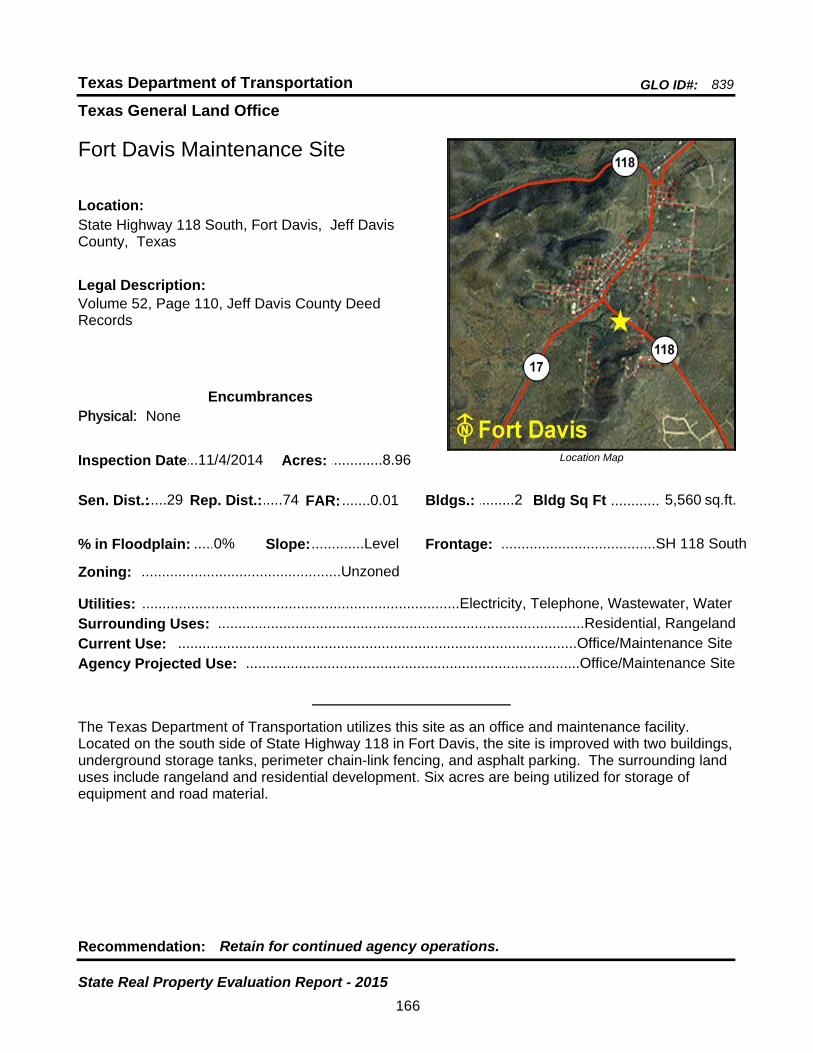
Texas General Land Office
GLO ID#: 839Texas Department of Transportation
Location Map
......
............
Fort Davis Maintenance Site
Bldgs.: .........2
Legal Description:Volume 52, Page 110, Jeff Davis County Deed Records
Recommendation: Retain for continued agency operations.
The Texas Department of Transportation utilizes this site as an office and maintenance facility. Located on the south side of State Highway 118 in Fort Davis, the site is improved with two buildings, underground storage tanks, perimeter chain-link fencing, and asphalt parking. The surrounding land uses include rangeland and residential development. Six acres are being utilized for storage of equipment and road material.
sq.ft.Sen. Dist.:.....29
State Highway 118 South, Fort Davis, Jeff Davis County, Texas
Location:
Rep. Dist.:.....74
Slope:.............Level
Zoning: .................................................Unzoned
Inspection Date:...11/4/2014 Acres: .............8.96
Frontage: ......................................SH 118 South
Surrounding Uses: ..........................................................................................Residential, Rangeland
Current Use: ..................................................................................................Office/Maintenance Site
Bldg Sq Ft 5,560
Agency Projected Use: ..................................................................................Office/Maintenance Site
0%% in Floodplain:
EncumbrancesPhysical: None
Utilities: ..............................................................................Electricity, Telephone, Wastewater, Water
FAR: .......0.01
166
State Real Property Evaluation Report - 2015
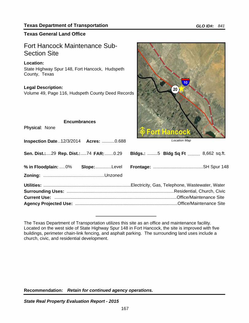
Texas General Land Office
GLO ID#: 841Texas Department of Transportation
Location Map
......
..........
Fort Hancock Maintenance Sub-Section Site
Bldgs.: .........5
Legal Description:Volume 49, Page 116, Hudspeth County Deed Records
Recommendation: Retain for continued agency operations.
The Texas Department of Transportation utilizes this site as an office and maintenance facility. Located on the west side of State Highway Spur 148 in Fort Hancock, the site is improved with five buildings, perimeter chain-link fencing, and asphalt parking. The surrounding land uses include a church, civic, and residential development.
sq.ft.Sen. Dist.:.....29
State Highway Spur 148, Fort Hancock, Hudspeth County, Texas
Location:
Rep. Dist.:.....74
Slope:.............Level
Zoning: .................................................Unzoned
Inspection Date:...12/3/2014 Acres: ...........0.688
Frontage: ........................................SH Spur 148
Surrounding Uses: ......................................................................................Residential, Church, Civic
Current Use: ..................................................................................................Office/Maintenance Site
Bldg Sq Ft 8,662
Agency Projected Use: ..................................................................................Office/Maintenance Site
0%% in Floodplain:
EncumbrancesPhysical: None
Utilities: ......................................................................Electricity, Gas, Telephone, Wastewater, Water
FAR: .......0.29
167
State Real Property Evaluation Report - 2015

Texas General Land Office
GLO ID#: 1135Texas Department of Transportation
Location Map
......
.........
Fort Stockton Area Engineering and Maintenance Site
Bldgs.: .........6
Legal Description:Volume 73, Page 124, Volume 158, Page 254, Volume 165, Page 347, Pecos County Deed Records
Recommendation: Retain for continued agency operations.
The Texas Department of Transportation utilizes this site as an office and maintenance facility. Located on East Dickinson Boulevard on the east side of Fort Stockton, the site is improved with six buildings, underground storage tanks, perimeter chain-link fencing, and asphalt parking. The surrounding land uses include residential, commercial, and industrial development.
sq.ft.Sen. Dist.:.....19
1207 East Dickinson Boulevard, Fort Stockton, Pecos County, Texas
Location:
Rep. Dist.:.....74
Slope:.............Level
Zoning: .............................................Commercial
Inspection Date:...12/2/2014 Acres: ...........4.536
Frontage: .............................East Dickinson Blvd
Surrounding Uses: ..........................................................Commercial, Industrial, Residential, Vacant
Current Use: ..................................................................................................Office/Maintenance Site
Bldg Sq Ft 14,056
Agency Projected Use: ..................................................................................Office/Maintenance Site
0%% in Floodplain:
EncumbrancesPhysical: None
Utilities: ......................................................................Electricity, Gas, Telephone, Water, Septic Tank
FAR: .......0.07
168
State Real Property Evaluation Report - 2015

Texas General Land Office
GLO ID#: 1201Texas Department of Transportation
Location Map
......
.......
Fort Worth District Headquarters Site
Bldgs.: .......19
Legal Description:Volume 2920, Page 218, Tarrant County Deed Records
Recommendation: Retain for continued agency operations.
The Texas Department of Transportation utilizes this site as a district headquarters facility. Located on Southwest Loop 820 in Fort Worth, the site is improved with 19 buildings, outdoor material storage area, asphalt parking, perimeter chain-link fencing, and two above-ground gas pumps. The surrounding land uses include residential, commercial, industrial, and office development.
sq.ft.Sen. Dist.:.....10
2501 Southwest Loop 820, Fort Worth, Tarrant County, Texas
Location:
Rep. Dist.:.....97
Slope:.............Level
Zoning: ...............................................Mixed-Use
Inspection Date:...2/10/2015 Acres: .........41.466
Frontage: ................SW. Loop 820, McCart Ave.
Surrounding Uses: ............................................................Residential, Commercial, Industrial, Office
Current Use: ................................................................................................District Headquarters Site
Bldg Sq Ft 186,383
Agency Projected Use: ...............................................................................District Headquarters Site
0%% in Floodplain:
EncumbrancesPhysical: None
Utilities: ......................................................................Electricity, Gas, Telephone, Wastewater, Water
FAR: .......0.10
169
State Real Property Evaluation Report - 2015
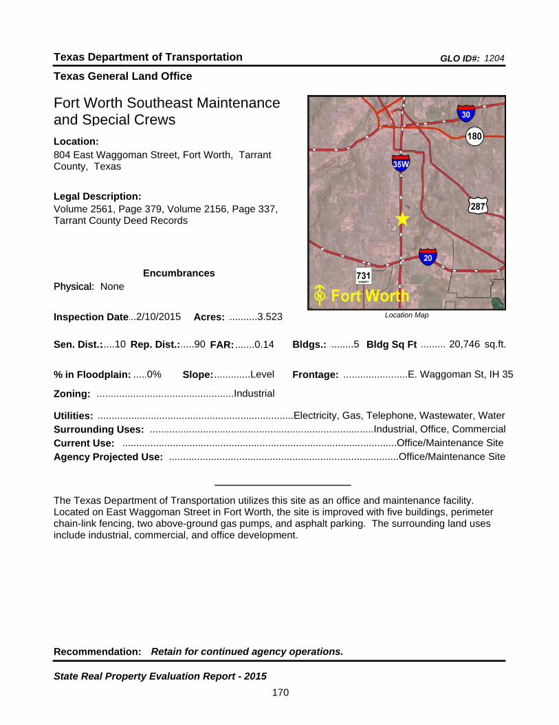
Texas General Land Office
GLO ID#: 1204Texas Department of Transportation
Location Map
......
.........
Fort Worth Southeast Maintenance and Special Crews
Bldgs.: .........5
Legal Description:Volume 2561, Page 379, Volume 2156, Page 337, Tarrant County Deed Records
Recommendation: Retain for continued agency operations.
The Texas Department of Transportation utilizes this site as an office and maintenance facility. Located on East Waggoman Street in Fort Worth, the site is improved with five buildings, perimeter chain-link fencing, two above-ground gas pumps, and asphalt parking. The surrounding land uses include industrial, commercial, and office development.
sq.ft.Sen. Dist.:.....10
804 East Waggoman Street, Fort Worth, Tarrant County, Texas
Location:
Rep. Dist.:.....90
Slope:.............Level
Zoning: .................................................Industrial
Inspection Date:...2/10/2015 Acres: ...........3.523
Frontage: .......................E. Waggoman St, IH 35
Surrounding Uses: ................................................................................Industrial, Office, Commercial
Current Use: ..................................................................................................Office/Maintenance Site
Bldg Sq Ft 20,746
Agency Projected Use: ..................................................................................Office/Maintenance Site
0%% in Floodplain:
EncumbrancesPhysical: None
Utilities: ......................................................................Electricity, Gas, Telephone, Wastewater, Water
FAR: .......0.14
170
State Real Property Evaluation Report - 2015
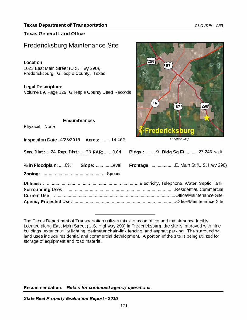
Texas General Land Office
GLO ID#: 983Texas Department of Transportation
Location Map
......
.........
Fredericksburg Maintenance Site
Bldgs.: .........9
Legal Description:Volume 89, Page 129, Gillespie County Deed Records
Recommendation: Retain for continued agency operations.
The Texas Department of Transportation utilizes this site as an office and maintenance facility. Located along East Main Street (U.S. Highway 290) in Fredericksburg, the site is improved with nine buildings, exterior utility lighting, perimeter chain-link fencing, and asphalt parking. The surrounding land uses include residential and commercial development. A portion of the site is being utilized for storage of equipment and road material.
sq.ft.Sen. Dist.:.....24
1623 East Main Street (U.S. Hwy 290), Fredericksburg, Gillespie County, Texas
Location:
Rep. Dist.:.....73
Slope:.............Level
Zoning: ....................................................Special
Inspection Date:...4/28/2015 Acres: .........14.462
Frontage: ...................E. Main St (U.S. Hwy 290)
Surrounding Uses: ........................................................................................Residential, Commercial
Current Use: ..................................................................................................Office/Maintenance Site
Bldg Sq Ft 27,246
Agency Projected Use: ..................................................................................Office/Maintenance Site
0%% in Floodplain:
EncumbrancesPhysical: None
Utilities: ..............................................................................Electricity, Telephone, Water, Septic Tank
FAR: .......0.04
171
State Real Property Evaluation Report - 2015
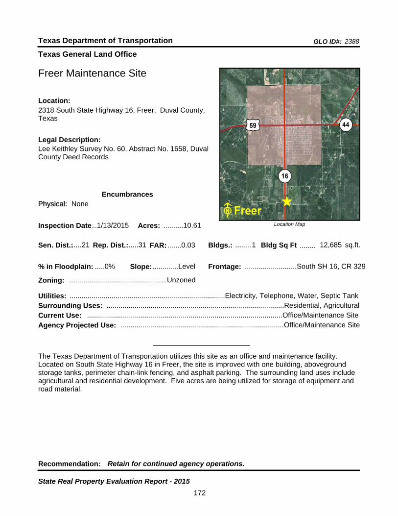
Texas General Land Office
GLO ID#: 2388Texas Department of Transportation
Location Map
......
........
Freer Maintenance Site
Bldgs.: .........1
Legal Description:Lee Keithley Survey No. 60, Abstract No. 1658, Duval County Deed Records
Recommendation: Retain for continued agency operations.
The Texas Department of Transportation utilizes this site as an office and maintenance facility. Located on South State Highway 16 in Freer, the site is improved with one building, aboveground storage tanks, perimeter chain-link fencing, and asphalt parking. The surrounding land uses include agricultural and residential development. Five acres are being utilized for storage of equipment and road material.
sq.ft.Sen. Dist.:.....21
2318 South State Highway 16, Freer, Duval County, Texas
Location:
Rep. Dist.:.....31
Slope:.............Level
Zoning: .................................................Unzoned
Inspection Date:...1/13/2015 Acres: ...........10.61
Frontage: ..........................South SH 16, CR 329
Surrounding Uses: .........................................................................................Residential, Agricultural
Current Use: ..................................................................................................Office/Maintenance Site
Bldg Sq Ft 12,685
Agency Projected Use: ..................................................................................Office/Maintenance Site
0%% in Floodplain:
EncumbrancesPhysical: None
Utilities: ..............................................................................Electricity, Telephone, Water, Septic Tank
FAR: .......0.03
172
State Real Property Evaluation Report - 2015
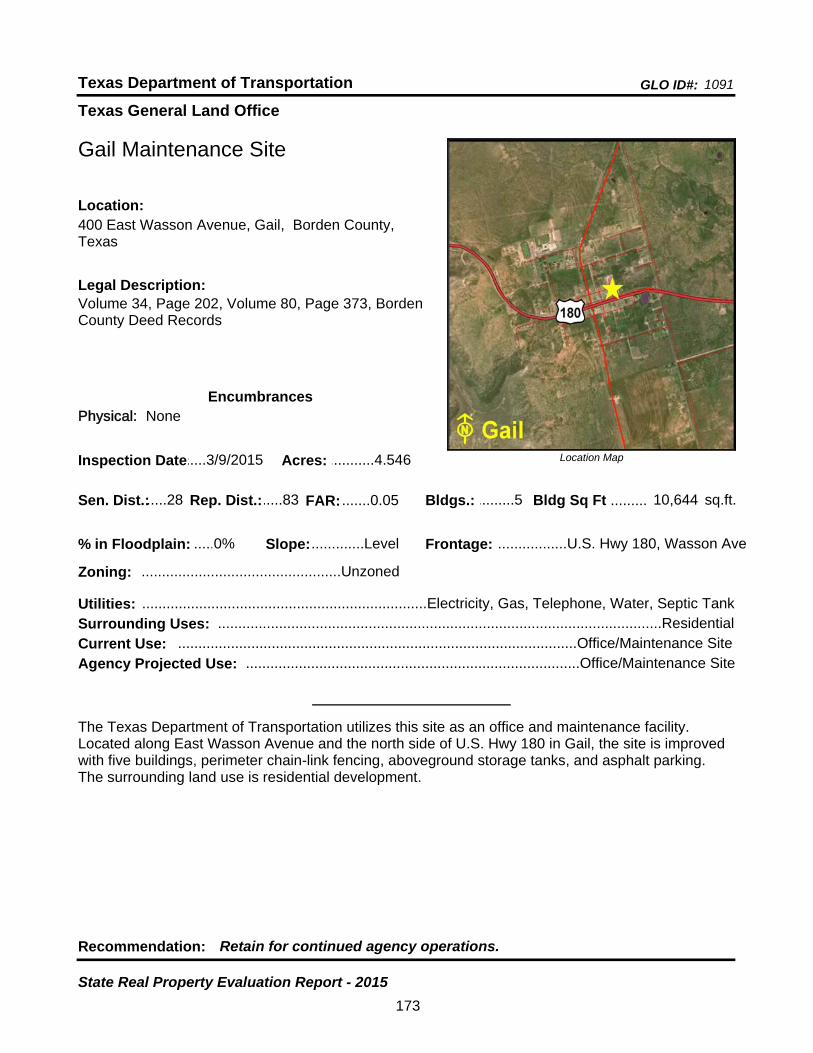
Texas General Land Office
GLO ID#: 1091Texas Department of Transportation
Location Map
......
.........
Gail Maintenance Site
Bldgs.: .........5
Legal Description:Volume 34, Page 202, Volume 80, Page 373, Borden County Deed Records
Recommendation: Retain for continued agency operations.
The Texas Department of Transportation utilizes this site as an office and maintenance facility. Located along East Wasson Avenue and the north side of U.S. Hwy 180 in Gail, the site is improved with five buildings, perimeter chain-link fencing, aboveground storage tanks, and asphalt parking. The surrounding land use is residential development.
sq.ft.Sen. Dist.:.....28
400 East Wasson Avenue, Gail, Borden County, Texas
Location:
Rep. Dist.:.....83
Slope:.............Level
Zoning: .................................................Unzoned
Inspection Date:.....3/9/2015 Acres: ...........4.546
Frontage: .................U.S. Hwy 180, Wasson Ave
Surrounding Uses: .............................................................................................................Residential
Current Use: ..................................................................................................Office/Maintenance Site
Bldg Sq Ft 10,644
Agency Projected Use: ..................................................................................Office/Maintenance Site
0%% in Floodplain:
EncumbrancesPhysical: None
Utilities: ......................................................................Electricity, Gas, Telephone, Water, Septic Tank
FAR: .......0.05
173
State Real Property Evaluation Report - 2015
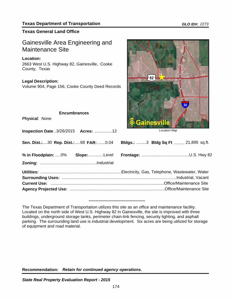
Texas General Land Office
GLO ID#: 2273Texas Department of Transportation
Location Map
......
.........
Gainesville Area Engineering and Maintenance Site
Bldgs.: .........3
Legal Description:Volume 904, Page 156, Cooke County Deed Records
Recommendation: Retain for continued agency operations.
The Texas Department of Transportation utilizes this site as an office and maintenance facility. Located on the north side of West U.S. Highway 82 in Gainesville, the site is improved with three buildings, underground storage tanks, perimeter chain-link fencing, security lighting, and asphalt parking. The surrounding land use is industrial development. Six acres are being utilized for storage of equipment and road material.
sq.ft.Sen. Dist.:.....30
2663 West U.S. Highway 82, Gainesville, Cooke County, Texas
Location:
Rep. Dist.:.....68
Slope:.............Level
Zoning: .................................................Industrial
Inspection Date:...3/26/2015 Acres: ................12
Frontage: .........................................U.S. Hwy 82
Surrounding Uses: ...................................................................................................Industrial, Vacant
Current Use: ..................................................................................................Office/Maintenance Site
Bldg Sq Ft 21,895
Agency Projected Use: ..................................................................................Office/Maintenance Site
0%% in Floodplain:
EncumbrancesPhysical: None
Utilities: ......................................................................Electricity, Gas, Telephone, Wastewater, Water
FAR: .......0.04
174
State Real Property Evaluation Report - 2015

Texas General Land Office
GLO ID#: 1018Texas Department of Transportation
Location Map
......
.........
Galveston - Point Bolivar Ferry Operations Site
Bldgs.: .........5
Legal Description:Volume 735, Page 573, Galveston County Deed Records
Recommendation: Retain for continued agency operations.
The Texas Department of Transportation utilizes this site as a ferry operation facility. Galveston portion is located north-northeast of the intersection of Seawall Boulevard and Ferry Road (State Highway 87) and Bolivar portion is located southwest of the intersection of Loop 108 and State Highway 87 in Galveston. The site is improved with five buildings, fencing, and asphalt parking. The surrounding land uses include commercial and residential development. A portion of the site has undeveloped land. It is being utilized for parking of vehicles awaiting ferry transport.
sq.ft.Sen. Dist.:.....11
1000 Ferry Road (State Highway 87), Galveston, Galveston County, Texas
Location:
Rep. Dist.:.....23
Slope:.............Level
Zoning: ..............................................Residential
Inspection Date:...1/16/2015 Acres: .........22.389
Frontage: ......Ferry Road (SH 87), Seawall Blvd.
Surrounding Uses: ........................................................................................Commercial, Residential
Current Use: ......................................................................................................Ferry Operations Site
Bldg Sq Ft 28,537
Agency Projected Use: ......................................................................................Ferry Operations Site
100%% in Floodplain:
EncumbrancesPhysical: Floodplain
Utilities: ......................................................................Electricity, Gas, Telephone, Wastewater, Water
FAR: .......0.03
175
State Real Property Evaluation Report - 2015
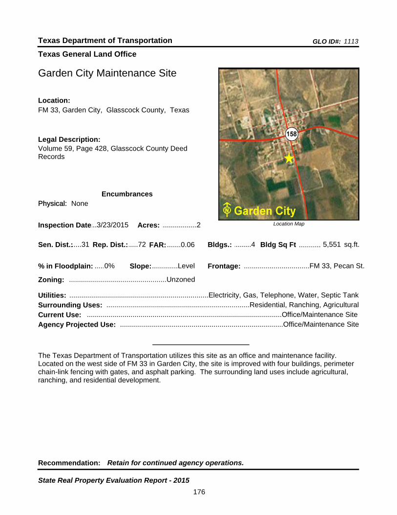
Texas General Land Office
GLO ID#: 1113Texas Department of Transportation
Location Map
......
...........
Garden City Maintenance Site
Bldgs.: .........4
Legal Description:Volume 59, Page 428, Glasscock County Deed Records
Recommendation: Retain for continued agency operations.
The Texas Department of Transportation utilizes this site as an office and maintenance facility. Located on the west side of FM 33 in Garden City, the site is improved with four buildings, perimeter chain-link fencing with gates, and asphalt parking. The surrounding land uses include agricultural, ranching, and residential development.
sq.ft.Sen. Dist.:.....31
FM 33, Garden City, Glasscock County, TexasLocation:
Rep. Dist.:.....72
Slope:.............Level
Zoning: .................................................Unzoned
Inspection Date:...3/23/2015 Acres: ..................2
Frontage: .................................FM 33, Pecan St.
Surrounding Uses: ........................................................................Residential, Ranching, Agricultural
Current Use: ..................................................................................................Office/Maintenance Site
Bldg Sq Ft 5,551
Agency Projected Use: ..................................................................................Office/Maintenance Site
0%% in Floodplain:
EncumbrancesPhysical: None
Utilities: ......................................................................Electricity, Gas, Telephone, Water, Septic Tank
FAR: .......0.06
176
State Real Property Evaluation Report - 2015

Texas General Land Office
GLO ID#: 2517Texas Department of Transportation
Location Map
......
.................
Garland Area Engineering and Maintenance Site (Proposed)
Bldgs.: .........0
Legal Description:Volume 2005-172, Page 340-343, Garland County Deed Records
Recommendation: Retain for continued agency operations.
The Texas Department of Transportation has proposed this site for an office and maintenance facility. Located between Country Club Drive and Centerville Road on the north side of State Highway 66 in Garland, the site is unimproved. The surrounding land uses include industrial and residential development. A reversion clause requires the return of the property to the grantor if not utilized as a maintenance site.
sq.ft.Sen. Dist.:.....16
State Highway 66, Garland, Dallas County, TexasLocation:
Rep. Dist.:...113
Slope:.............Level
Zoning: .................................................Industrial
Inspection Date:...12/8/2014 Acres: ................10
Frontage: ...................................................SH 66
Surrounding Uses: ............................................................................................Residential, Industrial
Current Use: ..................................................................................................Proposed TxDOT Office
Bldg Sq Ft 0
Agency Projected Use: .................................................................................Proposed TxDOT Office
0%% in Floodplain:
EncumbrancesPhysical: None
Utilities: ......................................................................Electricity, Gas, Telephone, Wastewater, Water
FAR: .......0.00
177
State Real Property Evaluation Report - 2015
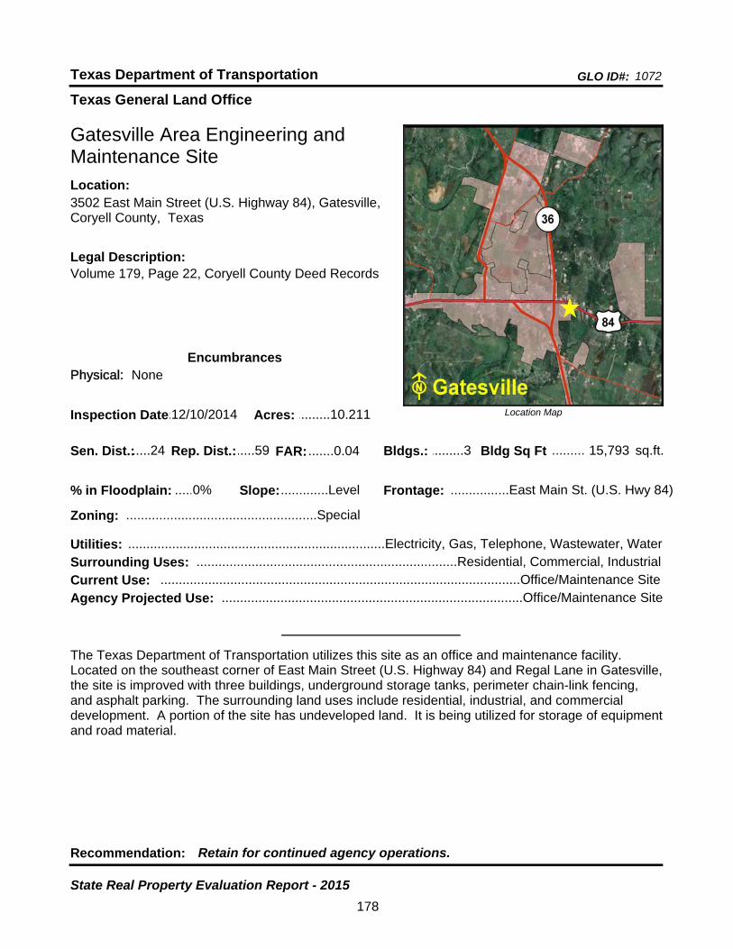
Texas General Land Office
GLO ID#: 1072Texas Department of Transportation
Location Map
......
.........
Gatesville Area Engineering and Maintenance Site
Bldgs.: .........3
Legal Description:Volume 179, Page 22, Coryell County Deed Records
Recommendation: Retain for continued agency operations.
The Texas Department of Transportation utilizes this site as an office and maintenance facility. Located on the southeast corner of East Main Street (U.S. Highway 84) and Regal Lane in Gatesville, the site is improved with three buildings, underground storage tanks, perimeter chain-link fencing, and asphalt parking. The surrounding land uses include residential, industrial, and commercial development. A portion of the site has undeveloped land. It is being utilized for storage of equipment and road material.
sq.ft.Sen. Dist.:.....24
3502 East Main Street (U.S. Highway 84), Gatesville, Coryell County, Texas
Location:
Rep. Dist.:.....59
Slope:.............Level
Zoning: ....................................................Special
Inspection Date:.12/10/2014 Acres: .........10.211
Frontage: ................East Main St. (U.S. Hwy 84)
Surrounding Uses: .......................................................................Residential, Commercial, Industrial
Current Use: ..................................................................................................Office/Maintenance Site
Bldg Sq Ft 15,793
Agency Projected Use: ..................................................................................Office/Maintenance Site
0%% in Floodplain:
EncumbrancesPhysical: None
Utilities: ......................................................................Electricity, Gas, Telephone, Wastewater, Water
FAR: .......0.04
178
State Real Property Evaluation Report - 2015
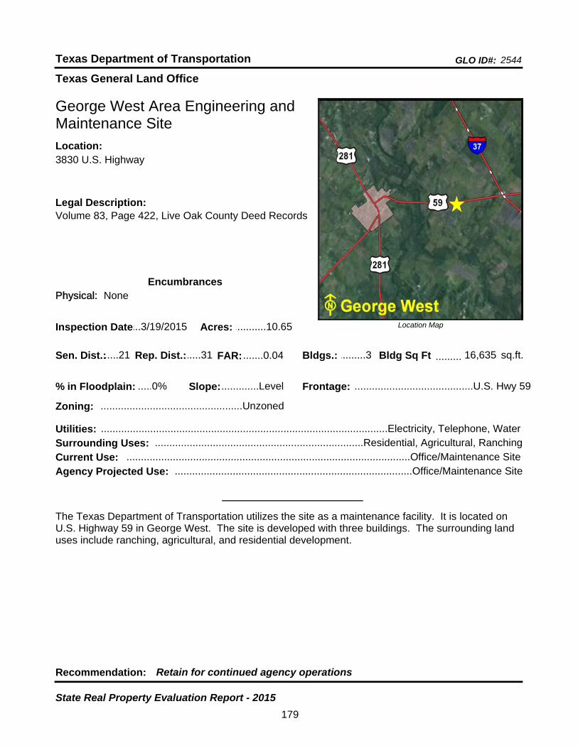
Texas General Land Office
GLO ID#: 2544Texas Department of Transportation
Location Map
......
.........
George West Area Engineering and Maintenance Site
Bldgs.: .........3
Legal Description:Volume 83, Page 422, Live Oak County Deed Records
Recommendation: Retain for continued agency operations
The Texas Department of Transportation utilizes the site as a maintenance facility. It is located on U.S. Highway 59 in George West. The site is developed with three buildings. The surrounding land uses include ranching, agricultural, and residential development.
sq.ft.Sen. Dist.:.....21
3830 U.S. Highway Location:
Rep. Dist.:.....31
Slope:.............Level
Zoning: .................................................Unzoned
Inspection Date:...3/19/2015 Acres: ...........10.65
Frontage: .........................................U.S. Hwy 59
Surrounding Uses: ........................................................................Residential, Agricultural, Ranching
Current Use: ..................................................................................................Office/Maintenance Site
Bldg Sq Ft 16,635
Agency Projected Use: ..................................................................................Office/Maintenance Site
0%% in Floodplain:
EncumbrancesPhysical: None
Utilities: ...................................................................................................Electricity, Telephone, Water
FAR: .......0.04
179
State Real Property Evaluation Report - 2015
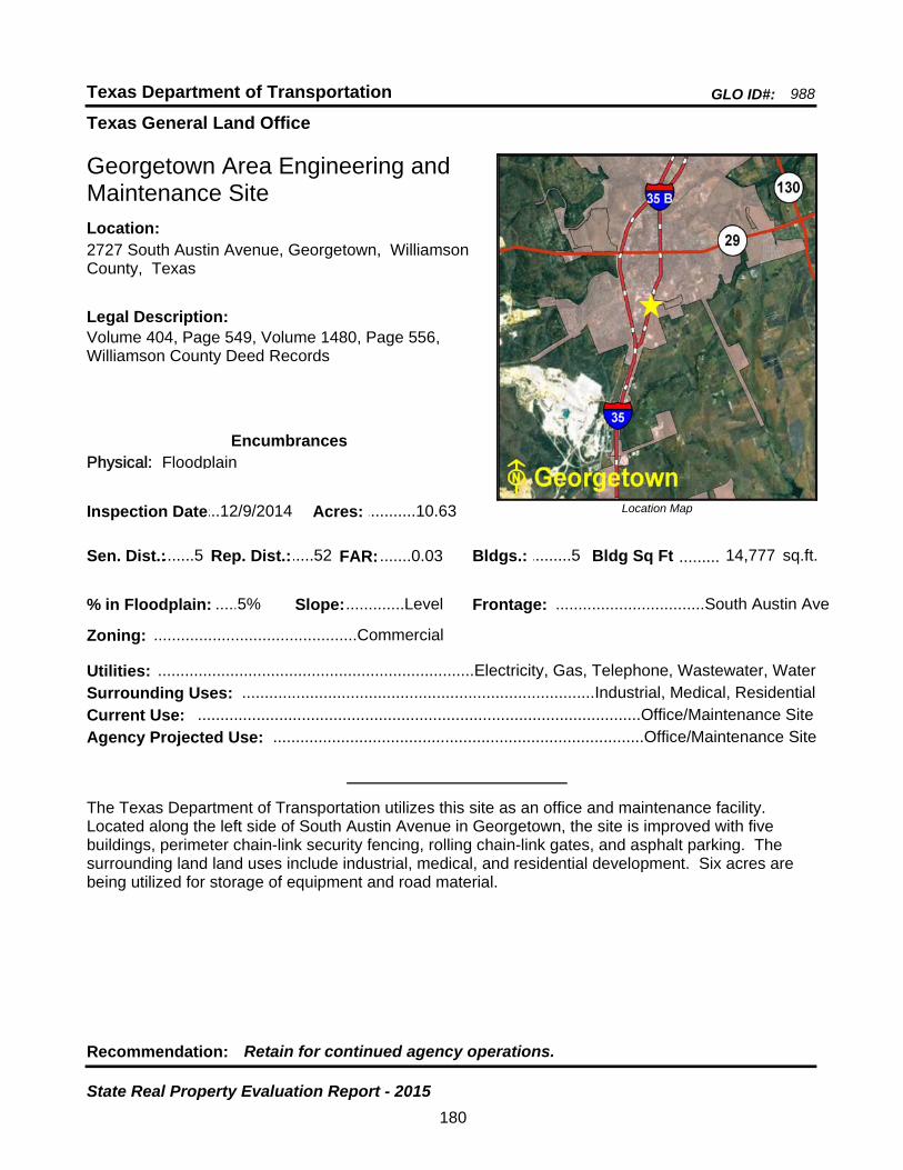
Texas General Land Office
GLO ID#: 988Texas Department of Transportation
Location Map
......
.........
Georgetown Area Engineering and Maintenance Site
Bldgs.: .........5
Legal Description:Volume 404, Page 549, Volume 1480, Page 556, Williamson County Deed Records
Recommendation: Retain for continued agency operations.
The Texas Department of Transportation utilizes this site as an office and maintenance facility. Located along the left side of South Austin Avenue in Georgetown, the site is improved with five buildings, perimeter chain-link security fencing, rolling chain-link gates, and asphalt parking. The surrounding land land uses include industrial, medical, and residential development. Six acres are being utilized for storage of equipment and road material.
sq.ft.Sen. Dist.:.......5
2727 South Austin Avenue, Georgetown, Williamson County, Texas
Location:
Rep. Dist.:.....52
Slope:.............Level
Zoning: .............................................Commercial
Inspection Date:...12/9/2014 Acres: ...........10.63
Frontage: .................................South Austin Ave
Surrounding Uses: ..............................................................................Industrial, Medical, Residential
Current Use: ..................................................................................................Office/Maintenance Site
Bldg Sq Ft 14,777
Agency Projected Use: ..................................................................................Office/Maintenance Site
5%% in Floodplain:
EncumbrancesPhysical: Floodplain
Utilities: ......................................................................Electricity, Gas, Telephone, Wastewater, Water
FAR: .......0.03
180
State Real Property Evaluation Report - 2015
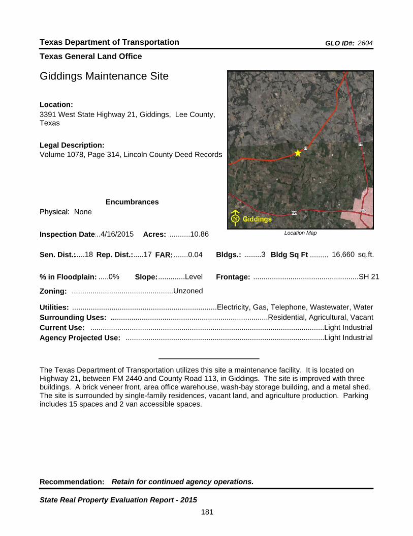
Texas General Land Office
GLO ID#: 2604Texas Department of Transportation
Location Map
......
.........
Giddings Maintenance Site
Bldgs.: .........3
Legal Description:Volume 1078, Page 314, Lincoln County Deed Records
Recommendation: Retain for continued agency operations.
The Texas Department of Transportation utilizes this site a maintenance facility. It is located on Highway 21, between FM 2440 and County Road 113, in Giddings. The site is improved with three buildings. A brick veneer front, area office warehouse, wash-bay storage building, and a metal shed. The site is surrounded by single-family residences, vacant land, and agriculture production. Parking includes 15 spaces and 2 van accessible spaces.
sq.ft.Sen. Dist.:.....18
3391 West State Highway 21, Giddings, Lee County, Texas
Location:
Rep. Dist.:.....17
Slope:.............Level
Zoning: .................................................Unzoned
Inspection Date:...4/16/2015 Acres: ...........10.86
Frontage: ...................................................SH 21
Surrounding Uses: ............................................................................Residential, Agricultural, Vacant
Current Use: .................................................................................................................Light Industrial
Bldg Sq Ft 16,660
Agency Projected Use: ................................................................................................Light Industrial
0%% in Floodplain:
EncumbrancesPhysical: None
Utilities: ......................................................................Electricity, Gas, Telephone, Wastewater, Water
FAR: .......0.04
181
State Real Property Evaluation Report - 2015

Texas General Land Office
GLO ID#: 2101Texas Department of Transportation
Location Map
......
.........
Gilmer Maintenance Site
Bldgs.: .........3
Legal Description:Volume 65, Page 954, Upshur County Deed Records
Recommendation: Retain for continued agency operations.
The Texas Department of Transportation utilizes this site as an office and maintenance facility. Located on U.S. Highway 271 North in Gilmer, the site is improved with three buildings, perimeter chain-link fencing, and asphalt parking. The surrounding land uses include residential and industrial development. Five acres are being utilized for storage of equipment and road material.
sq.ft.Sen. Dist.:.......1
2105 U.S. Highway 271 North, Gilmer, Upshur County, Texas
Location:
Rep. Dist.:.......7
Slope:.............Level
Zoning: .................................................Unzoned
Inspection Date:...1/27/2015 Acres: .........10.574
Frontage: .............................U.S. Hwy 271 North
Surrounding Uses: ............................................................................................Residential, Industrial
Current Use: ..................................................................................................Office/Maintenance Site
Bldg Sq Ft 12,638
Agency Projected Use: ..................................................................................Office/Maintenance Site
0%% in Floodplain:
EncumbrancesPhysical: None
Utilities: ......................................................................Electricity, Gas, Telephone, Wastewater, Water
FAR: .......0.03
182
State Real Property Evaluation Report - 2015
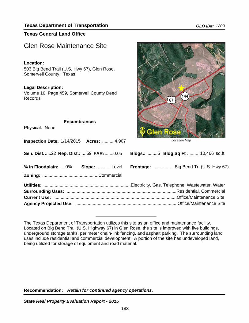
Texas General Land Office
GLO ID#: 1200Texas Department of Transportation
Location Map
......
.........
Glen Rose Maintenance Site
Bldgs.: .........5
Legal Description:Volume 16, Page 459, Somervell County Deed Records
Recommendation: Retain for continued agency operations.
The Texas Department of Transportation utilizes this site as an office and maintenance facility. Located on Big Bend Trail (U.S. Highway 67) in Glen Rose, the site is improved with five buildings, underground storage tanks, perimeter chain-link fencing, and asphalt parking. The surrounding land uses include residential and commercial development. A portion of the site has undeveloped land, being utilized for storage of equipment and road material.
sq.ft.Sen. Dist.:.....22
503 Big Bend Trail (U.S. Hwy 67), Glen Rose, Somervell County, Texas
Location:
Rep. Dist.:.....59
Slope:.............Level
Zoning: .............................................Commercial
Inspection Date:...1/14/2015 Acres: ...........4.907
Frontage: .................Big Bend Tr. (U.S. Hwy 67)
Surrounding Uses: ........................................................................................Residential, Commercial
Current Use: ..................................................................................................Office/Maintenance Site
Bldg Sq Ft 10,466
Agency Projected Use: ..................................................................................Office/Maintenance Site
0%% in Floodplain:
EncumbrancesPhysical: None
Utilities: ......................................................................Electricity, Gas, Telephone, Wastewater, Water
FAR: .......0.05
183
State Real Property Evaluation Report - 2015

Texas General Land Office
GLO ID#: 2356Texas Department of Transportation
Location Map
......
..................
Glen Rose Maintenance Site (Proposed)
Bldgs.: .........0
Legal Description:Volume 0052, Page 413, Somervell County Deed Records
Recommendation: Retain for continued agency operations.
The Texas Department of Transportation utilizes this site for road material storage. Located along the west side of State Highway 144 in Glen Rose, the site is improved with perimeter chain-link fencing and gates. The surrounding land uses include a church and agricultural development. There are no immediate plans to construct buildings on this site.
sq.ft.Sen. Dist.:.....22
5721 State Highway 144, Glen Rose, Somervell County, Texas
Location:
Rep. Dist.:.....59
Slope:.............Level
Zoning: .................................................Unzoned
Inspection Date:...1/14/2015 Acres: .........15.714
Frontage: .................................................SH 144
Surrounding Uses: ...............................................................................................Agricultural, Church
Current Use: .............................................................................................Road Material Storage Site
Bldg Sq Ft 0
Agency Projected Use: .............................................................................Road Material Storage Site
0%% in Floodplain:
EncumbrancesPhysical: None
Utilities: .........................................................................................................................................None
FAR: .......0.00
184
State Real Property Evaluation Report - 2015

Texas General Land Office
GLO ID#: 849Texas Department of Transportation
Location Map
......
...........
Goldthwaite Area Engineering and Maintenance Site
Bldgs.: .........5
Legal Description:Volume 73, Page 162, Volume 207, Page 453, Mills County Deed Records
Recommendation: Retain for continued agency operations.
The Texas Department of Transportation utilizes this site as an office and maintenance facility. Located on the east line of U.S. Highway 84 and U.S. Highway 183 in Goldthwaite, the site is improved with five buildings, underground storage tanks, perimeter chain-link fencing, and asphalt parking. The surrounding land uses include agricultural and commercial development. Six acres are being utilized for storage of equipment and road material.
sq.ft.Sen. Dist.:.....24
130 U.S. Highway 84 North, Goldthwaite, Mills County, Texas
Location:
Rep. Dist.:.....59
Slope:.............Level
Zoning: .................................................Unzoned
Inspection Date:.12/10/2014 Acres: ...........11.77
Frontage: .........................................U.S. Hwy 84
Surrounding Uses: ........................................................................................Commercial, Agricultural
Current Use: ..................................................................................................Office/Maintenance Site
Bldg Sq Ft 9,572
Agency Projected Use: ..................................................................................Office/Maintenance Site
0%% in Floodplain:
EncumbrancesPhysical: None
Utilities: ..............................................................................Electricity, Telephone, Water, Septic Tank
FAR: .......0.02
185
State Real Property Evaluation Report - 2015
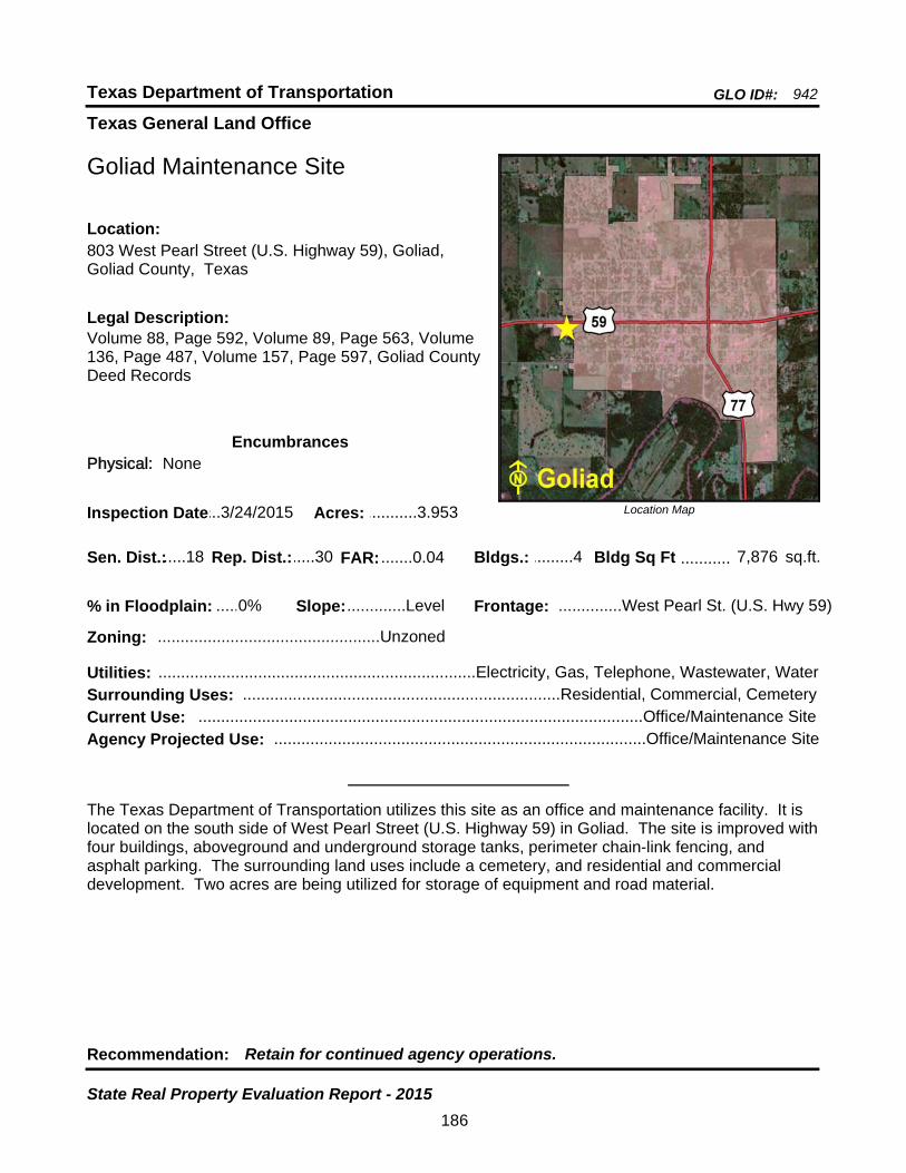
Texas General Land Office
GLO ID#: 942Texas Department of Transportation
Location Map
......
...........
Goliad Maintenance Site
Bldgs.: .........4
Legal Description:Volume 88, Page 592, Volume 89, Page 563, Volume 136, Page 487, Volume 157, Page 597, Goliad County Deed Records
Recommendation: Retain for continued agency operations.
The Texas Department of Transportation utilizes this site as an office and maintenance facility. It is located on the south side of West Pearl Street (U.S. Highway 59) in Goliad. The site is improved with four buildings, aboveground and underground storage tanks, perimeter chain-link fencing, and asphalt parking. The surrounding land uses include a cemetery, and residential and commercial development. Two acres are being utilized for storage of equipment and road material.
sq.ft.Sen. Dist.:.....18
803 West Pearl Street (U.S. Highway 59), Goliad, Goliad County, Texas
Location:
Rep. Dist.:.....30
Slope:.............Level
Zoning: .................................................Unzoned
Inspection Date:...3/24/2015 Acres: ...........3.953
Frontage: ..............West Pearl St. (U.S. Hwy 59)
Surrounding Uses: ......................................................................Residential, Commercial, Cemetery
Current Use: ..................................................................................................Office/Maintenance Site
Bldg Sq Ft 7,876
Agency Projected Use: ..................................................................................Office/Maintenance Site
0%% in Floodplain:
EncumbrancesPhysical: None
Utilities: ......................................................................Electricity, Gas, Telephone, Wastewater, Water
FAR: .......0.04
186
State Real Property Evaluation Report - 2015
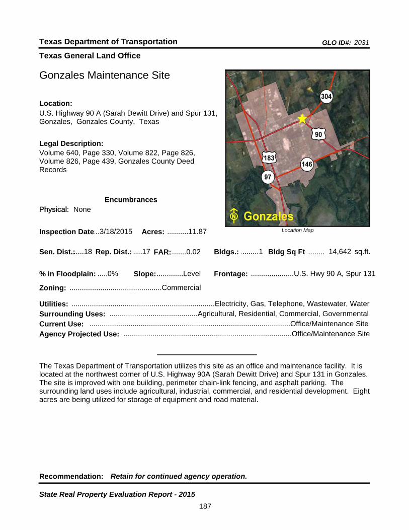
Texas General Land Office
GLO ID#: 2031Texas Department of Transportation
Location Map
......
........
Gonzales Maintenance Site
Bldgs.: .........1
Legal Description:Volume 640, Page 330, Volume 822, Page 826, Volume 826, Page 439, Gonzales County Deed Records
Recommendation: Retain for continued agency operation.
The Texas Department of Transportation utilizes this site as an office and maintenance facility. It is located at the northwest corner of U.S. Highway 90A (Sarah Dewitt Drive) and Spur 131 in Gonzales. The site is improved with one building, perimeter chain-link fencing, and asphalt parking. The surrounding land uses include agricultural, industrial, commercial, and residential development. Eight acres are being utilized for storage of equipment and road material.
sq.ft.Sen. Dist.:.....18
U.S. Highway 90 A (Sarah Dewitt Drive) and Spur 131, Gonzales, Gonzales County, Texas
Location:
Rep. Dist.:.....17
Slope:.............Level
Zoning: .............................................Commercial
Inspection Date:...3/18/2015 Acres: ...........11.87
Frontage: .....................U.S. Hwy 90 A, Spur 131
Surrounding Uses: ...........................................Agricultural, Residential, Commercial, Governmental
Current Use: ..................................................................................................Office/Maintenance Site
Bldg Sq Ft 14,642
Agency Projected Use: ..................................................................................Office/Maintenance Site
0%% in Floodplain:
EncumbrancesPhysical: None
Utilities: ......................................................................Electricity, Gas, Telephone, Wastewater, Water
FAR: .......0.02
187
State Real Property Evaluation Report - 2015