Embed Size (px)
Citation preview
LAND ADJACENT TO COLESHALL FARM/ SHEPPEY WAY/SCHOOL LANE, IWADE, KENT
Archaeological Evaluation Report January 2012
Prepared for: Hillreed Homes Limited, Hillreed House, 60 College Road
Maidstone, Kent ME15 6SJ
SWAT Archaeology The Office, School Farm Oast
Graveney Road Faversham, Kent, ME13 8UP
Email: [email protected] Tel.: 01795 532548 and 07885 700112
© SWAT Archaeology 2012 all rights reserved
Land adjacent to Coleshall Farm, Iwade, Kent Archaeological Evaluation Report
SWAT Archaeology Project No. IWA/EV/11 ii
Contents
Summary ................................................................................................................ iv
Acknowledgements ................................................................................................. vi
1INTRODUCTION ............................................................................................................... 1 1.1 Project Background....................................................................................... 1 1.2 Site Location, Topography and Geology ...................................................... 1
2ARCHAEOLOGICAL AND HISTORICAL BACKGROUND ......................................................... 2 2.1 Overview ....................................................................................................... 2 2.2 Previous Archaeological Work in the Area (Pre-Construct Archaeology
2005) ............................................................................................................. 2 2.3 Archaeological Desk-Based Assessment (CgMs Consulting) ..................... 3
3AIMS AND METHODS ...................................................................................................... 3 3.1 Introduction and General Objectives ............................................................ 3 3.2 Project Specific Objectives ........................................................................... 3 3.3 Fieldwork Methodology ................................................................................. 4 3.4 Monitoring ..................................................................................................... 4 3.5 Recording ...................................................................................................... 4 3.6 Health & Safety ............................................................................................. 5
4ARCHAEOLOGICAL RESULTS ............................................................................................. 6 4.1 Introduction ................................................................................................... 6 4.2 Stratigraphic Deposit Model ......................................................................... 6 4.3 Results and Interpretation............................................................................. 6
5FINDS ASSESSMENT....................................................................................................... 26 5.1 Introduction ................................................................................................. 26 5.2 Lithic Assessment ....................................................................................... 26 5.3 Ceramic Assessment .................................................................................. 27 5.4 Faunal Assessment .................................................................................... 28
6ENVIRONMENTAL ASSESSMENT .................................................................................... 29 6.1 Introduction ................................................................................................. 29
7DISCUSSION .................................................................................................................. 31 7.1 Archaeological Narrative ............................................................................. 31 7.2 Confidence Rating ...................................................................................... 37 7.3 Impact Assessment..................................................................................... 37
8CONCLUSION ................................................................................................................ 38
9ARCHIVE ....................................................................................................................... 38 9.1 Preparation and Deposition ........................................................................ 38 9.2 Summary of Site Archive ............................................................................ 38
10REFERENCES ................................................................................................................ 40 10.1 Bibliographic References ............................................................................ 40 10.2 Cartographic References ............................................................................ 41 10.3 Websites ..................................................................................................... 41
APPENDIX 1: KCC SUMMARY FORM ................................................................................. 42
APPENDIX 2: TRENCH CONTEXT SUMMARY TABLE ........................................................... 43
APPENDIX 3: CERAMIC ASSESSMENT ............................................................................. 137

Land adjacent to Coleshall Farm, Iwade, Kent Archaeological Evaluation Report
SWAT Archaeology Project No. IWA/EV/11 iii
List of Figures
1 Site Plan 2 Site Plan; Field 1 3 Site Plan; Field 2
4-9 Site Plans; evaluation trenches showing phasing 10-122 Phased Trench Plans
123 Field 1; Projected ditches for all archaeological periods 124 Field 2; Projected ditches for all archaeological periods
125a Field 1; Hotspots: Middle Neolithic 125b Field 2; Hotspots: Middle Neolithic 126a Field 1; Hotspots: Middle Bronze Age 126b Field 2; Hotspots: Middle Bronze Age 127a Field 1; Hotspots: Iron Age 127b Field 2; Hotspots: Iron Age 128a Field 1; Hotspots: Later Prehistoric Periods 128b Field 1; Hotspots: Later Prehistoric Periods 129a Field 1; Hotspots: Saxon 129b Field 2; Hotspots: Saxon 130a Field 1; Hotspots: Medieval 130b Field 2; Hotspots: Medieval 131a Field 1; Hotspots: All Archaeological Periods 131b Field 2; Hotspots: All Archaeological Periods 132 Field 1; Projected ditches (with PCA 2005)
List of Tables
Table 1 Bio-archaeological rapid assessment ......................................................................... 29 Table 2 Quantification of the Ceramic Assemblage .............................................................. 147
Land adjacent to Coleshall Farm, Iwade, Kent Archaeological Evaluation Report
SWAT Archaeology Project No. IWA/EV/11 iv
Summary
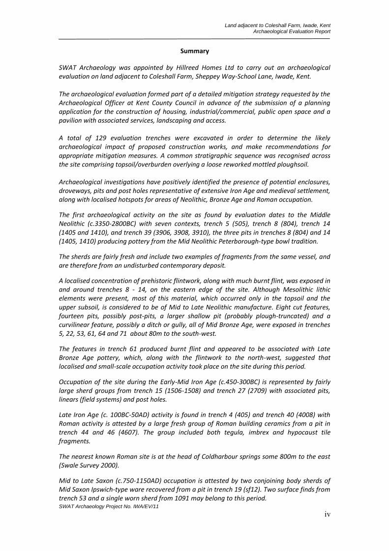
SWAT Archaeology was appointed by Hillreed Homes Ltd to carry out an archaeological evaluation on land adjacent to Coleshall Farm, Sheppey Way-School Lane, Iwade, Kent. The archaeological evaluation formed part of a detailed mitigation strategy requested by the Archaeological Officer at Kent County Council in advance of the submission of a planning application for the construction of housing, industrial/commercial, public open space and a pavilion with associated services, landscaping and access. A total of 129 evaluation trenches were excavated in order to determine the likely archaeological impact of proposed construction works, and make recommendations for appropriate mitigation measures. A common stratigraphic sequence was recognised across the site comprising topsoil/overburden overlying a loose reworked mottled ploughsoil. Archaeological investigations have positively identified the presence of potential enclosures, droveways, pits and post holes representative of extensive Iron Age and medieval settlement, along with localised hotspots for areas of Neolithic, Bronze Age and Roman occupation.
The first archaeological activity on the site as found by evaluation dates to the Middle Neolithic (c.3350-2800BC) with seven contexts, trench 5 (505), trench 8 (804), trench 14 (1405 and 1410), and trench 39 (3906, 3908, 3910), the three pits in trenches 8 (804) and 14 (1405, 1410) producing pottery from the Mid Neolithic Peterborough-type bowl tradition.
The sherds are fairly fresh and include two examples of fragments from the same vessel, and are therefore from an undisturbed contemporary deposit.
A localised concentration of prehistoric flintwork, along with much burnt flint, was exposed in and around trenches 8 - 14, on the eastern edge of the site. Although Mesolithic lithic elements were present, most of this material, which occurred only in the topsoil and the upper subsoil, is considered to be of Mid to Late Neolithic manufacture. Eight cut features, fourteen pits, possibly post-pits, a larger shallow pit (probably plough-truncated) and a curvilinear feature, possibly a ditch or gully, all of Mid Bronze Age, were exposed in trenches 5, 22, 53, 61, 64 and 71 about 80m to the south-west.
The features in trench 61 produced burnt flint and appeared to be associated with Late Bronze Age pottery, which, along with the flintwork to the north-west, suggested that localised and small-scale occupation activity took place on the site during this period.
Occupation of the site during the Early-Mid Iron Age (c.450-300BC) is represented by fairly large sherd groups from trench 15 (1506-1508) and trench 27 (2709) with associated pits, linears (field systems) and post holes.
Late Iron Age (c. 100BC-50AD) activity is found in trench 4 (405) and trench 40 (4008) with Roman activity is attested by a large fresh group of Roman building ceramics from a pit in trench 44 and 46 (4607). The group included both tegula, imbrex and hypocaust tile fragments.
The nearest known Roman site is at the head of Coldharbour springs some 800m to the east (Swale Survey 2000).
Mid to Late Saxon (c.750-1150AD) occupation is attested by two conjoining body sherds of Mid Saxon Ipswich-type ware recovered from a pit in trench 19 (sf12). Two surface finds from trench 53 and a single worn sherd from 1091 may belong to this period.
Land adjacent to Coleshall Farm, Iwade, Kent Archaeological Evaluation Report
SWAT Archaeology Project No. IWA/EV/11 v
Early Medieval to Medieval (c.1125-1350AD) occupation of the site is intense with over 20 contexts producing material of this phase from trenches 10, 15, 50, 53. The features include pits, post holes and linears (field systems). The pottery suggests settlement activity on site up to about c.1350AD and then ceasing.
This evaluation, carried out by SWAT Archaeology in August to October 2011 revealed occupation of the site from the Mid Neolithic (c.3350-2800BC) up to the medieval period (c.1350AD) when occupation seems to have ceased, confirming the presence of an archaeological resource that would be threatened by the present development proposals.

Land adjacent to Coleshall Farm, Iwade, Kent Archaeological Evaluation Report
SWAT Archaeology Project No. IWA/EV/11 vi
Acknowledgements
SWAT Archaeology would like to thank Hillreed Homes Ltd for commissioning the project. Thanks are also extended to Simon Mason, Principal Archaeological Officer Kent County Council for his advice and assistance, as well as Ben Croxford (Sites and Monuments Record Officer) of Kent County Council. Peter Cichy, Geoff Morley, James Madden, Dan Quinlan, Marcus Headifen, Richard Woolley assisted the author with the archaeological fieldwork. Site survey and illustrations were produced by James Madden and Jonny Madden of Digitise This.
Land adjacent to Coleshall Farm, Iwade, Kent Archaeological Evaluation Report
SWAT Archaeology Project No. IWA/EV/11 1
LAND ADJACENT TO COLESHALL FARM, SHEPPEY/SCHOOL LANE, IWADE, KENT
Archaeological Evaluation Report
1 INTRODUCTION
1.1 Project Background
Swale & Thames Archaeological Survey Company (SWAT) were contracted by Hillreed Homes Ltd to conduct an archaeological investigation of land between Coleshall Farm and School Lane in Iwade, Kent, (NGR) 589789 167310 (Fig. 1). This assessment has been undertaken following the preparation and submission of an Archaeological Desk-Based Assessment (CgMs Consulting 2008) in advance of submission of a planning application for the proposed redevelopment of the Site.
A planning application (PAN: SW/08/1127) for development of housing, employment up to 3000sqm, public open space and pavilion (up to 110sqm), with access from School Lane and Sheppey Way, including roads, cycle paths, footpaths, stream crossings, landscaping and ancillary works was submitted to Swale Borough Council whereby Kent County Council Heritage and Conservation (KCCHC), on behalf of Swale Borough Council, requested that a programme of archaeological works be undertaken in order to determine the possible impact of the development on any archaeological remains. The following condition was attached to the planning consent:
No development shall take place until the applicant, or their agents or successors in title, has secured the implementation of a programme of archaeological work in accordance with a written specification and timetable which has been submitted to and approved by the Local Planning Authority.
[Reason: To ensure that features of archaeological interest are properly examined and recorded]
This report was prepared following the submission of the Archaeological Desk-Based Assessment (CgMs Consulting 2008) and subsequent correspondence with Kent County Council (Heritage & Conservation) who requested that an archaeological evaluation be undertaken in order to determine the possible impact of the development on any archaeological remains. The results from this evaluation, presented herewith, will be used to inform Kent County Council of any further archaeological mitigation measures that may be necessary in connection with the development proposals.
The evaluation was undertaken in accordance with requirements set out within an Archaeological Specification (Kent County Council 2011) and in discussion with the Principal Archaeological Officer, Kent County Council. All fieldwork was carried out in accordance with relevant guidance given in the Institute for Archaeologist's Standard and Guidance for Archaeological Field Evaluation (2008).
The archaeological evaluation was conducted under the direction of Dr Paul Wilkinson (SWAT) between August and October 2011.
1.2 Site Location, Topography and Geology
The proposed development area is located to the east of Sheppey Way enclosed on the western extent by School Lane immediately south of the village of Iwade. The site is bounded to the north by
Land adjacent to Coleshall Farm, Iwade, Kent Archaeological Evaluation Report
SWAT Archaeology Project No. IWA/EV/11 2
domestic properties forming the current southern extent of Iwade and to the south by agricultural land and Coleshall Farm (Fig.1).
The Site, at approximately 17m above Ordnance Datum (AOD), lies on Head Gravels and London Clay (British Geological Survey 1:50,000 series, England and Wales Sheet 272, Chatham).
The development site measures approximately 11.2ha in size and was formally open fields bounded on al extents by mature shrubbery. Through the centre of the site, orientated on a meandering north-south alignment a small bisects the site forming Field 1 and Field 2, which have been used as a means of reference for this report (see below).
2 ARCHAEOLOGICAL AND HISTORICAL BACKGROUND
2.1 Overview
The specification produced by KCC highlights the importance of archaeological remains within the surrounding area; ‘Until recently little formal archaeological work has been carried out in the Iwade area, although some work was done in advance of the Iwade - M2 road improvements. Archaeological works carried out in response to the various phases of housing development in and around the village have considerably changed our understanding of the village and a number of sites have included significant archaeological remains. To the immediate north of the application site, the Pinks Corner developments have revealed evidence of Bronze Age, Iron Age and Romano-British occupation and burial, while work on Phase II at Church Mews has revealed late prehistoric features and two enclosures of medieval date’.
(2011:5) In fact a total of 41 sites are now listed on the KCC Historic Environment Record including Iron Age (KCC HER No. TQ 96 NW 103) and Bronze Age (KCC HER No. TQ 96 NW 102) field systems described below, Neolithic/Bronze Age cremation burials (KCC HER No. TQ 96 NW 111) and relatively extensive medieval settlement patterns (KCC HER No. TQ 96 NW 104, 109, 110). 2.2 Previous Archaeological Work in the Area (Pre-Construct Archaeology 2005)
An extensive archaeological narrative for the surrounding area is provided within the archaeological excavation report prepared by Pre-Construct Archaeology (Bishop & Bagwell 2005) for Hillreed Homes a summary of which is repeated here:
“Archaeological excavations conducted to the south of the village of Iwade. The story begins during the Later Mesolithic, when hunter-gatherers used a hollow created by a fallen tree to repair their microlithic toolkit. For the next 3,500 years or so the site was repeatedly visited, with people dropping occasional artefacts, but leaving us with little other evidence of their presence. An exception to this occurred around the middle of the Neolithic, when two pits were dug and filled with pottery and flintwork. During the Middle Bronze Age, evidence for a more ‘settled’ way of life increases, and by the Late Bronze Age a trackway and fields have been constructed across the site. These developments signal a new relationship with the land, a new form of land tenure and the beginnings at the site of explicit agricultural production. This new landscape was founded on and inhabited through strong ritualised principles, evidenced by numerous deliberately placed objects, including pottery, cremated human remains and even a bronze palstave. The agricultural landscape appears to have been abandoned shortly after the end of the Late Bronze Age, around 600BC, and there is a hiatus in evidence for occupation at the site until a new, enclosed farmstead is established during the Late Iron
Land adjacent to Coleshall Farm, Iwade, Kent Archaeological Evaluation Report
SWAT Archaeology Project No. IWA/EV/11 3
Age, around 100BC. The settlement indicates a return at the site to agricultural production and appears to have been structured according to prevalent principles of social organization and ways of viewing the world. It was abandoned around the time of the Roman Conquest, perhaps as a direct result of it, with only occasional visits, possibly by pastoralists, during the Roman period”.
2.3 Archaeological Desk-Based Assessment (CgMs Consulting)
A site specific Archaeological Desk-Based Assessment provided by Hillreed Homes and prepared by CgMs Consulting (2008) describes the archaeological and historical background to the site, summarized within the specification provided by KCC;
‘Results from the site immediately north indicate that later Mesolithic activity may be present in tree throw. Neolithic pits, Bronze Age settlement and fields, an Iron Age farmstead and a medieval droveway and field system may all extend into the site. Coleshall Farm is visible on eighteenth century maps of the area’.
(2011:5)
3 AIMS AND METHODS
3.1 Introduction and General Objectives
The general aim of the archaeological evaluation was to determine whether significant archaeological remains survive within the footprint of the proposed development and if so whether an alternative scheme can be designed or suitable mitigation measures can be accommodated. Particular attention was afforded to the general objectives mention herewith:
Clarify the presence/absence of any buried archaeological remains within the Site that may be threatened by development.
Identify, within the constraints of the evaluation, the date, character, condition and depth of any surviving remains within the Site.
Assess the degree of existing impacts to sub-surface horizons and to document the extent of archaeological survival of buried deposits.
Produce a report which will present the results of the evaluation in sufficient detail to allow an informed decision to be made concerning the Site’s archaeological potential and the scope of any future archaeological work.
The evaluation will establish whether any archaeological deposits existing on Site may be of sufficient importance to warrant preservation in situ.
To assess the likely impact of past land-uses and the possible presence of masking colluvial/alluvial deposits.
3.2 Project Specific Objectives
As well as general objectives several project specific questions have been raised, as detailed within the Specification (KCC 2011: 6):
Is there any further evidence of prehistoric farming and settlement in the development area?

Land adjacent to Coleshall Farm, Iwade, Kent Archaeological Evaluation Report
SWAT Archaeology Project No. IWA/EV/11 4
Is there any further evidence of Roman or medieval activity in the area?
How have impacts from farming and other modern land use affected the site’s archaeological potential?
What effects will development of the site have on its archaeological potential?
Is there opportunity to contribute to the environmental and geoarchaeological history of the area? 3.3 Fieldwork Methodology
The following methodology was proposed in order to meet the aims of the evaluation. All fieldwork was conducted in accordance with the methodology set out in the Specification (KCC 2011) and carried out in compliance with the standards outlined in the Institute for Archaeologists’ Standards and Guidance for Archaeological Evaluations (2008). A total of 128 test trenches were mechanically excavated using a 2m-wide toothless bladed bucket
according to a trench plan recommended by KCC. The total area for the test trenches was 4644m2, approximately 4.5 per cent of the area designated for development. Each trench was measured approximately 20m in length and 2m in width. Test pits were cut deeper into either end of each trench in order to investigate whether the brickearth covered any earlier features or sequences. Prior to and during excavation, the trenches were scanned to verify the absence of any underground services using a Cable Avoidance Tool (CAT). A total of 129 evaluation trenches were opened, investigated, recorded and backfilled during the 3 month programme of works (Figures 1 & 2). The project was assigned a unique SWAT Archaeology site code prior to the commencement of any works (Site Code IWA/EV/11).
Excavation of the evaluation trenches was carried out using a 360° mechanical excavator fitted with a toothless ditching bucket, removing the overburden to the top of the first recognisable archaeological horizon, under the constant supervision of an experienced archaeologist. Exposed surfaces were subsequently hand-cleaned to reveal features in plan and carefully selected cross-sections through the features were excavated to enable sufficient information about form, development date and stratigraphic relationships to be recorded without prejudice to more extensive investigations, should these prove to be necessary. All archaeological work was carried out in accordance with the specification issued by KCC. 3.4 Monitoring
Regular scheduled site monitoring visits were carried out by KCC with SWAT Archaeology throughout the duration of the fieldwork at which time aims, methodologies and initial results were discussed.
3.5 Recording
All recording was undertaken using SWAT Archaeology pro forma recording system. All archaeological features and deposits exposed in the evaluation trenches were hand cleaned and excavated to determine their nature, character and date.
A single context recording system was used to record the deposits. A full list is presented in Appendix 1. Layers and fills are recorded (100). The cut of the feature is shown [100]. Context numbers were assigned to all deposits for recording purposes and detailed on pro-forma SWAT context sheets; these are used in the report (in bold). Each number has been attributed to a specific trench with the
Land adjacent to Coleshall Farm, Iwade, Kent Archaeological Evaluation Report
SWAT Archaeology Project No. IWA/EV/11 5
primary number(s) relating to specific trenches (i.e. Trench 1, 101+, Trench 2, 201+, Trench 3, 301+ etc.). Plans of all features were made using a scale of 1:20, with sections recorded at 1:10. A full photographic record of all stages of the evaluation was kept, which included working shots showing constraints and conditions. A complete drawn record of the evaluation trenches comprises both plans and sections, drawn to appropriate scales (1:20 for plans, 1:10 for sections) was undertaken.
Photographs were taken as appropriate, providing a record of excavated features and deposits along with images of the overall trench to illustrate their location and context. The record also includes images of the overall Site. The photographic record comprises black and white, colour images and digital photography. A photographic register of all photographs taken is contained within the project archive.
Upon completion of mechanical excavation of the evaluation trenches, a pre-excavation plan generated using global positioning satellite (GPS) technology recording three dimensional points every 0.10m. For ease of working the site was subsequently excavated into two distinct areas, Field 1 encompassing the eastern extent of the site, Field 2, the western extent (see Fig. 1) All trenches, (excepting a number on the eastern area of the site) on agreement with the Archaeological Officer for Kent County Council, were backfilled following completion of the archaeological recording and necessary monitoring. 3.6 Health & Safety
All work was carried out in accordance with the Health and Safety at Work Act 1974, the Management of Health and Safety regulations 1992 and Health and Safety in Field Archaeology 1997, and all other relevant Health and Safety legislation, regulations and codes of practice in force at the time.
A Health and Safety Risk Assessment was produced by SWAT Archaeology (2011), which was read and understood by all staff attending the Site before groundwork commenced.
Land adjacent to Coleshall Farm, Iwade, Kent Archaeological Evaluation Report
SWAT Archaeology Project No. IWA/EV/11 6
4 ARCHAEOLOGICAL RESULTS
4.1 Introduction
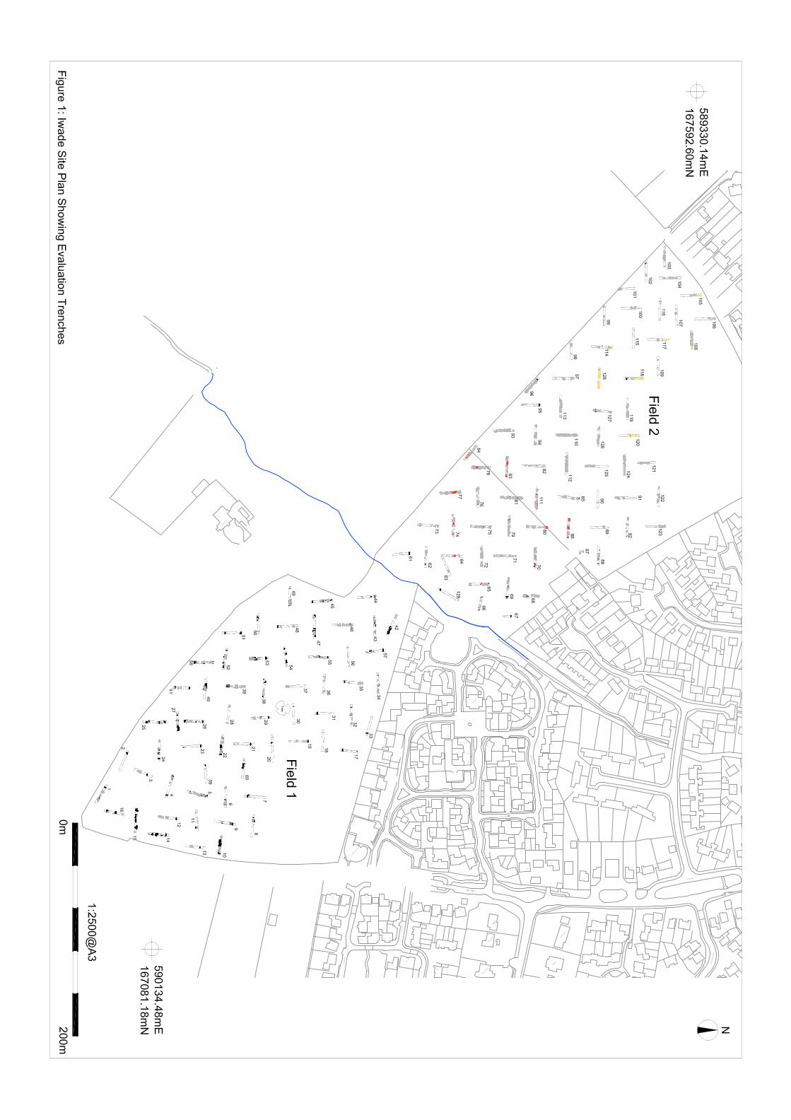
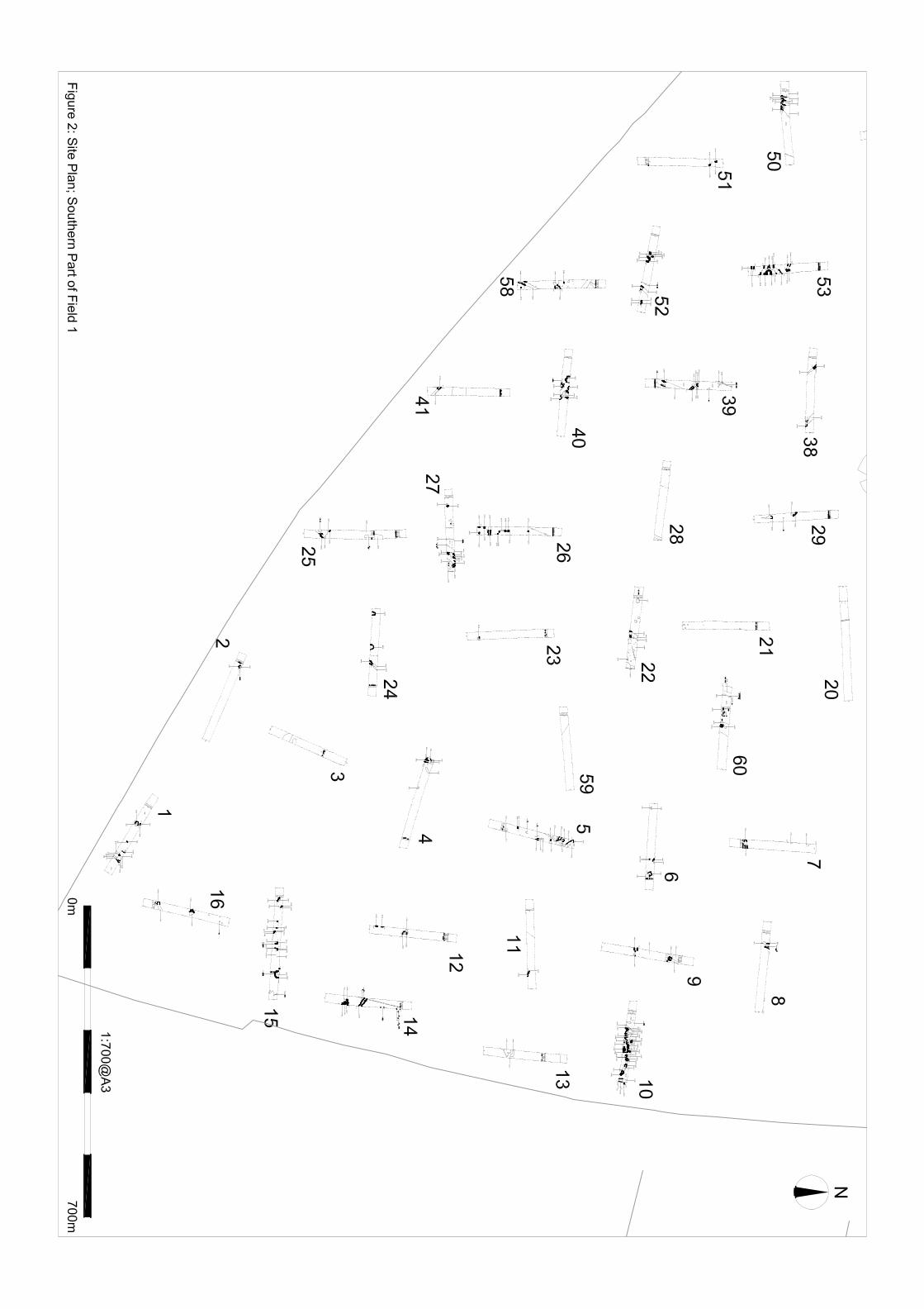
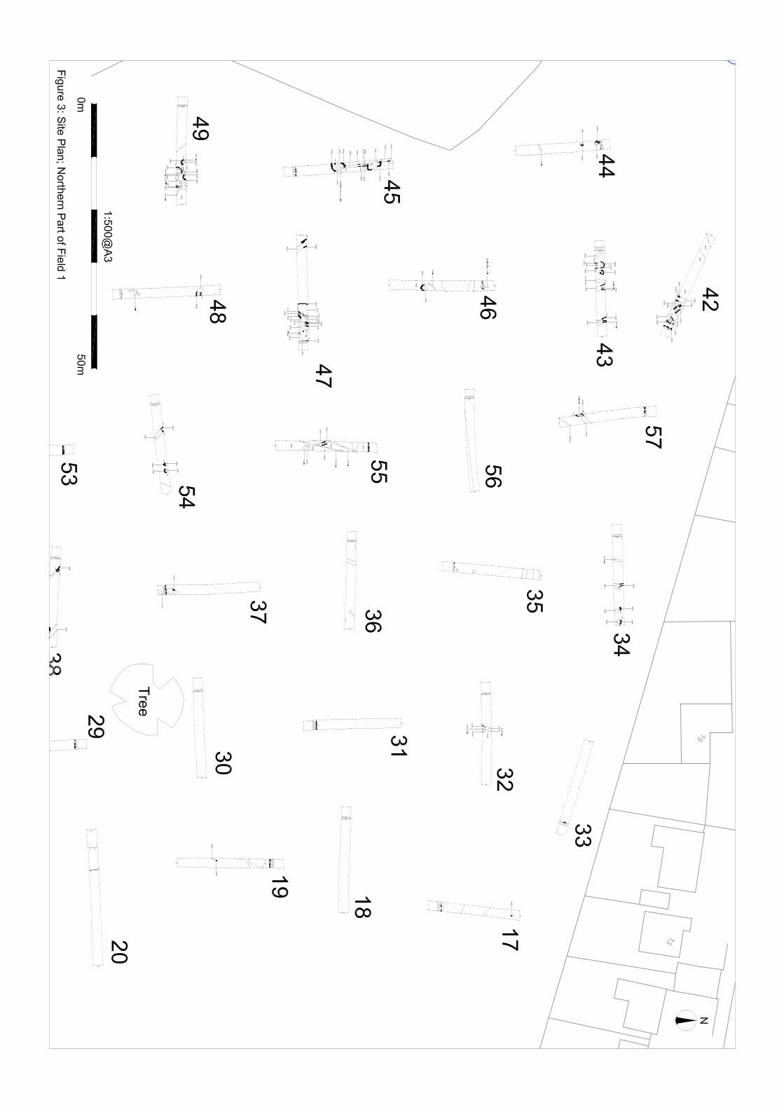
This section presents the results of the archaeological evaluation. Detailed descriptions of the trenches, including all stratigraphic sequences, are included in Appendix 2. Figures 1-3 presents the site and the trench locations while Figures 4-122 present individual phased trench plans. Figures 122 and 123 provide projected linear alignments with Figures 124-131 provides suggested archaeological hotspots for specific chronological periods.
For ease of reference the site has been divided into two distinct areas. The area to the east of School Lane (the western extent of the site) will be referred to as Field 1 while the area to the west of Sheppey Way (the eastern extent of the site) is referred to as Field 2.
4.2 Stratigraphic Deposit Model
A common stratigraphic sequence was recognised across the site comprising topsoil/overburden (001) overlying a loose reworked mottled ploughsoil (002). The ploughsoil comprised moderately dense mid orange brown silty clay that blended well with the underlying Loessic/colluvial brickearth that not only sealed the majority of archaeological deposits recorded on site, but also contained fragments of friable abraded pottery and charcoal. A clear line of horizon gave way to the natural geology where mechanical excavation ceased and careful examination and investigation for potential archaeological features was carried out. The thickness of the overburden varied, with the average depth of the modern layers equating to a depth of approximately 0.4-0.5m below the existing ground surface (c.15.5m AOD).
4.3 Results and Interpretation
4.3.1 Field 1
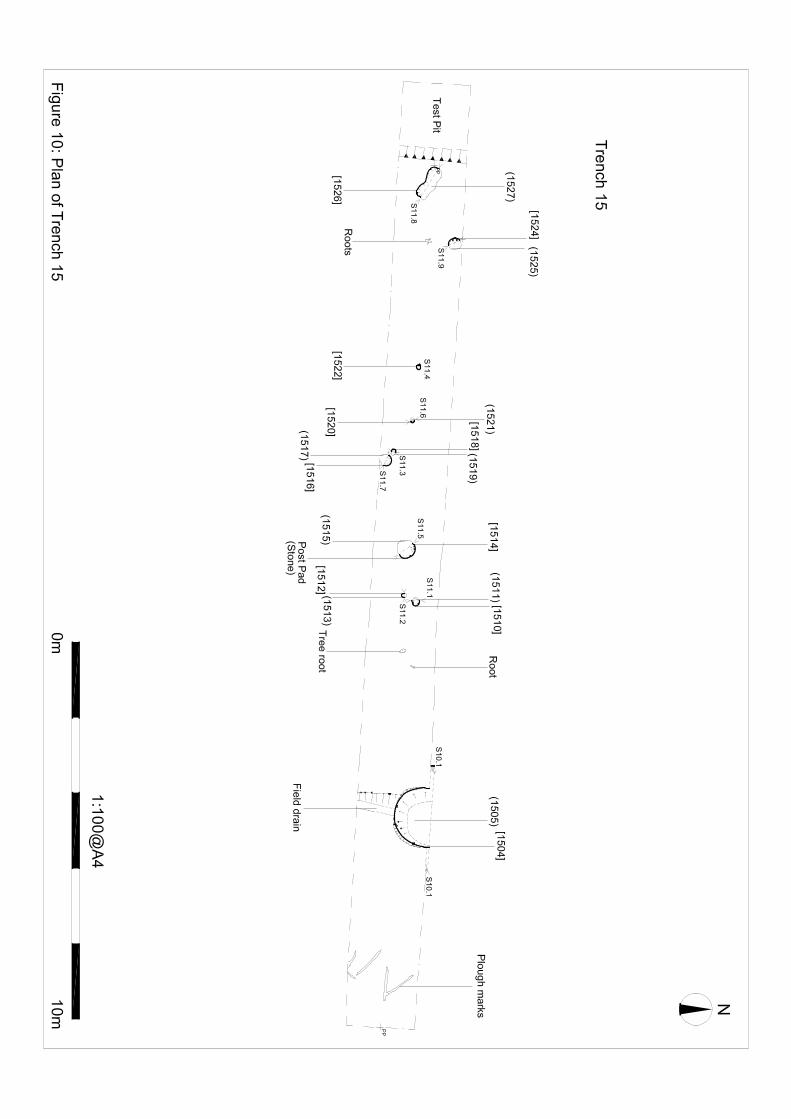
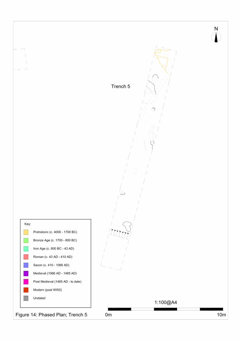
Field 1 is located within the eastern extent of the site bounded by Sheppey way to the east and Coleshall Farm to the south (Fig.2). This area measures approximately 5.5 ha is size and is separated from Field 2 by a small meandering stream. A total of 60 trenches were excavated within the area, each addressed below with accompanying illustrations provided on Figs. 10-57. Trench 4 Trench 4 (Figs. 2, 4 & 12) was located near the south-eastern corner of Field 1. The natural geology exposed along the length of the trench was brickearth (CRN 402). This mid brown orange, silt clay was present across the whole of Field 1. Above this was a mid brown yellow, clay silt subsoil layer (CRN 401) with very rare pottery and flint inclusions. This trench contained a north-north-east/south-south-west aligned ditch that measured 0.40m in depth, 0.6m in width and ≥1.8m in length. This ditch was filled by brown, silt clay with very occasional small sub-rounded flint, charcoal flecks and possible pottery fragments. These pottery fragments (three sherds) were of uncertain date but no later than c.1300 AD. Directly adjacent to the west of this ditch were two possible pits (CRNs 412 and 414) which both continued beyond the limit of excavation of the trench. One of these pits (CRN 414) contained a pottery sherd of uncertain date but likely to be c.1550-600 BC (Mid Bronze Age-Earliest Iron Age Period). Trench 5 Trench 5 (Figs. 2, 4 & 13) was located near the south-eastern corner of Field 1. The natural geology present was brickearth (CRN 502). Above this was a subsoil layer (CRN 501). Trench 5 contained a very shallow irregularly shaped pit (CRN 516) at its northern end. This pit measured 30mm in depth,

Land adjacent to Coleshall Farm, Iwade, Kent Archaeological Evaluation Report
SWAT Archaeology Project No. IWA/EV/11 7
≥1.80m in width and ≥2.0m in length and was filled by mid orange grey, clay silt (CRN 515) with inclusions of rare pebble and possible worked flint. This possible pit contained one pottery sherd dating from c.2000-1500 BC (Early Prehistoric Period). Directly to the south of this pit was a small possible post hole or small truncated pit (CRN 518) which measured 50mm depth, 0.50m width and 0.53m length. This feature was filled by mid grey orange, clay silt (CRN 517) with occasional charcoal inclusions. Adjacent to this feature was a probable tree throw measuring 0.65m depth, ≥1.25m width and ≥2.0m length. This feature was filled by mid orange yellow grey, clay silt (CRN 505) with occasional charcoal inclusions. This feature contained one pottery sherd dated to c.3050-2800 BC (Middle Neolithic Period). To the south of this feature was a small post hole (CRN 503) measuring 0.15m depth, 0.26m width and 0.26m length. This post hole was filled by mid yellow grey, clay silt (CRN 503). There was an additional probable post hole (CRN 508) towards the southern end of the trench measuring 0.13m depth, 0.30m width and 0.36m length. This post hole was filled by dark grey black, clay silt (CRN 507) with abundant charcoal inclusions. The rest if the trench contained some features caused by rooting (CRNs 510 and 512). One of which (CRN 512) contained one pottery sherd of uncertain date. Trench 8 Trench 8 (Figs. 2, 4 & 16) was located on the central eastern side of Field 1. The natural geology present was brickearth (CRN 802). Above this was a subsoil layer (CRN 801). Trench 8 contained one probable pit or ditch terminus (CRN 805) disturbed by some bioturbation activity. This feature measured 0.50m depth, 1.20m width and ≥1.25m length and was filled by mid grey yellow, silt clay (CRN 804) with occasional flint, charcoal, manganese nodule and pottery inclusions. It contained two pottery sherds dating the feature to probably c.3350-2800 BC (Middle Neolithic Period). An additional feature – a possible pit or ditch terminus - was identified in the south facing trench section at the eastern end of the trench (CRN 807). Trench 10 Trench 10 (Figs. 2, 4 & 18) was located on the central eastern side of Field 1. The natural geology present was brickearth (CRN 1002). Above this was a subsoil layer (CRN 1001). Trench 10 contained a large number of features. Those which have been dated have all been from the Medieval Period (c.1050-1400 AD). A number of features found in this trench were discrete features cutting the natural brickearth. At the eastern end of the trench was a north/south aligned ditch (CRN 1016) which measured 0.13m depth, 0.70m width and 1.88m length. This ditch was filled by mid grey brown, clay silt (CRN 1015). Directly to the east of this ditch was small post hole (CRN 1018) measuring 88mm depth, 0.33m width and 0.34m length and filled by mid grey brown, clay silt (CRN 1017). Trench 10 contained a slightly truncated curvilinear feature (CRNs 1010, 1012 and 1014). This feature contained pottery of uncertain date. Adjacent to the western terminus of this ditch were two post holes. The smaller of these post holes (CRN 1008) measured 60mm depth, 0.18m width and 0.23m length and was filled by mid grey brown, clay silt (CRN 1007). The larger of the two post holes (CRN 1006) was oval in shape and measured 60mm depth, 0.19m width and 0.54m length. It was filled by mid grey brown, clay silt (CRN 1005) and contained two pottery sherds providing a likely date of c.1200-1250 AD (Medieval Period). In the centre of the trench was a small ditch (CRN 1032) aligned north-north-west/south-south-east and measuring 0.20m depth, 0.24m width and ≥0.80m length. This ditch was filled by mid grey brown, clay silt (CRN 1031) with abundant shell and rare pottery fragments. This ditch was cut by a modern land drain and, therefore, has an uncertain relationship with the other features in the trench. However, this feature did contain two pottery sherds providing a likely date for the feature of c.1150-1200 AD (Early Medieval Period). This trench contained a number of intercutting pits. Pit CRN 1040 measured 99mm depth, 0.34m width and ≥0.73m length and was filled by dark grey brown, clay silt (CRN 1039). It contained three pottery sherds, providing a likely date of c.1200-1250 AD (probable Post Roman Period). This pit was

Land adjacent to Coleshall Farm, Iwade, Kent Archaeological Evaluation Report
SWAT Archaeology Project No. IWA/EV/11 8
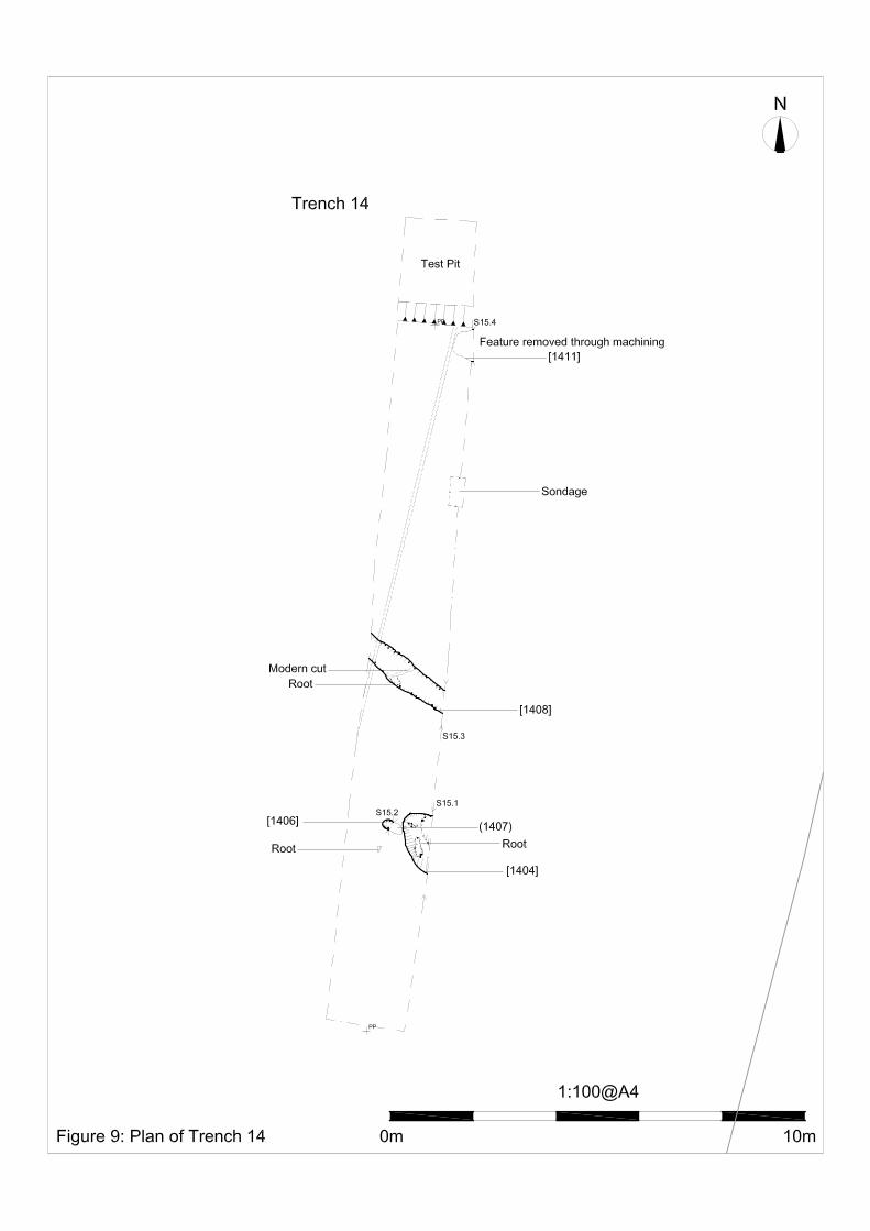
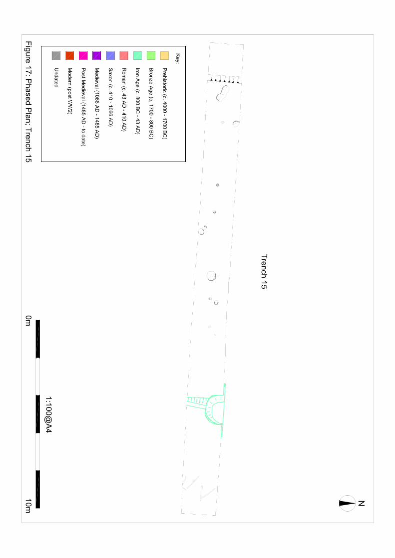
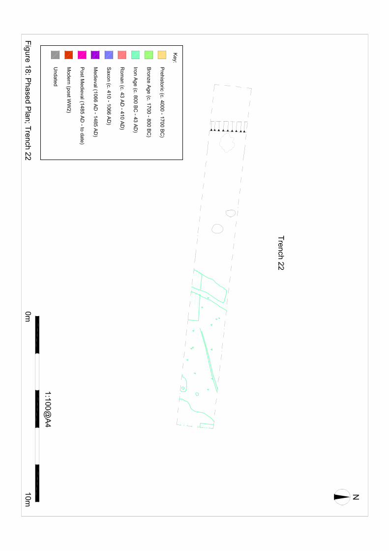
cut by a larger pit (CRN 1038). This pit (CRN 1038) measured 0.82m depth, 1.95m width and ≥1.63m length. It contained three fills. The lower fill (CRN 1037) was a mid brown grey, clay silt with occasional inclusions of charcoal, flint and pottery fragments. Above this fill was mid grey, clay silt (CRN 1035) with occasional inclusions of charcoal, shell and pottery fragments. The upper fill (CRN 1034) was a mid grey yellow, clay silt with occasional oyster shell and charcoal inclusions. Trench 10 also contained a pit complex (CRNs 1027, 1029 and 1030). Pit CRN 1030, being the main large pit, measured 0.40m depth, 3.68m width and ≥1.27m length. This pit contained mid grey brown, clay silt (CRN 1019) and produced 45 pottery sherds suggestion the feature dated from the Medieval Period (c.1175-1225 AD with later accretions between c.1250-1350 AD). This pit was cut by a modern land drain. Cutting through pit CRN 1030 was a very well defined post hole (CRN 1021) which measured ≥0.25m depth, 0.37m width and 0.46m length. This post hole was filled by mid grey brown, clay silt (CRN 1020) and contained 11 pottery sherds providing a likely date for the feature of c.1250-1275 AD (Medieval Period). Trench 14 Trench 14 (Figs. 2, 4 & 22) was located on the central eastern side of Field 1. The natural geology present was brickearth (CRN 1402). Above this was a subsoil layer (CRN 1401). Trench 14 contained a pit or possible ditch terminus (CRN 1404) which measured 0.90m depth, 1.75m width and ≥0.80m length. This feature was filled by mid grey, clay silt (CRN 1405) with occasional charcoal inclusions and contained three pottery sherds suggesting a date for the feature of c.3350-2800 BC (Early Prehistoric Period). Adjacent to this feature was a small oval pit or possible post hole remains (CRN 1406) which measured 0.10m depth, 0.20m width and 0.68m length. This feature was filled by mid grey, clay silt (CRN 1407) with occasional charcoal inclusions. Trench 14 also contained a north-west/south-east aligned ditch (CRN 1408) which measured 0.55m depth, 1.0m width and ≥2.0m length. This ditch was filled by two fills: the primary fill was mid orange grey, clay silt (CRN 1409) with occasional charcoal inclusions; the secondary fill was mid grey, clay silt (CRN 1410) with rare charcoal inclusions. Nine pottery sherds were obtained from this fill (CRN 1410) which provide the feature with a likely date of c.3350-2280 BC (Middle Neolithic Period). This feature was only identified post-machining in the east and west trench sections and so was heavily truncated. At the northern end of Trench 14 another feature (CRN 1411) was identified in the trench section (west facing section). This feature could have been a pit or ditch terminus. Trench 15 Trench 15 (Figs. 2, 4 & 23) was located near the south-eastern corner of Field 1. The natural geology present was brickearth (CRN 1502). Above this was a subsoil layer (CRN 1501). Trench 15 contained a possible storage pit (CRN 1504) which measured 1.80m depth, 2.70m width and ≥1.0m length. This possible pit was filled by several fills (CRNs 1505, 1506, 1528, 1529, 1507, 1508 and 1509). 247 pottery sherds were recovered from this pit, suggesting a likely date for the feature of c.400-300 BC (Early-Mid Iron Age). In addition to this pit, Trench 15 contained a small sub-oval possible pit (CRN 1526) and eight probable post holes of varying sizes (CRNs 1524, 1516, 1514, 1510, 1518, 1522, 1512 and 1520). Trench 22 Trench 22 (Figs. 2, 4, 5 & 27) was located just to the south of the centre of Field 1. The natural geology present was brickearth (CRN 2202). Above this was a subsoil layer (CRN 2201). Trench 22 contained a north-east/south-west aligned ditch (CRN 2204) which appeared to have a possible terminus at its north-eastern end. This ditch measured 0.45m depth, 1.10m width and ≥1.80m length. It was filled by mid grey, clay silt (CRN 2205) with occasional burnt flint and charcoal

Land adjacent to Coleshall Farm, Iwade, Kent Archaeological Evaluation Report
SWAT Archaeology Project No. IWA/EV/11 9
inclusions. This ditch contained four pottery sherds, which suggested a likely date of c.900-600 BC (Later Prehistoric Period). This ditch is likely to be related to the adjacent north-east/south-west aligned linear feature (CRN 2207). This feature, which measured 0.40m depth, 6.70m width and ≥1.80m length, was filled by light grey brown, clay silt (CRN 2206) with occasional burn flint, charcoal and worked flint inclusions. One pottery sherd was recovered from this feature of uncertain date and is likely to have been residual. This large linear feature appears to be the same as that found in Trench 27 (CRN 2718) and Trench 60 (CRN 6006) and may be a large shallow ditch or possible hollow way. Trench 27 Trench 27 (Figs. 2, 5 & 32) was located on the central southern side of Field 1. The natural geology present was brickearth (CRN 2702). Above this was a subsoil layer (CRN 2701). Trench 27 contained a large linear feature (CRN 2718), thought to be the same feature found in Trenches 22 (CRN 2207) and 60 (CRN 6006). In this trench this feature (CRN 2718) measured ≥0.30m depth, 6.0m width and ≥1.80m length and was filled by light grey brown, clay silt (CRN 2717). Into this large feature were cut two possible pits or possible tree boles (CRNs 2710 and 2712), one of which (CRN 2710) contained five pottery sherds, suggesting a date of c.400-300 BC (Early-Mid Iron Age Period). Two possible post holes (CRNs 2714 and 2716) were also cut into the large linear feature. These post holes did not contain any dateable material. Trench 34 Trench 34 (Figs. 2, 6 & 35) was located to the northern extent of Field 1. The natural geology present was brickearth (CRN 3402). Trench 34 contained a north/south aligned possible ditch (CRN 3405) measured 0.12m depth, 0.50m width and ≥1.80m length. This ditch was filled by mid yellow brown, silt clay (CRN 3404) with a spread of sub-rounded flint on the surface. It also contained one possible flint core and two pottery sherds of uncertain date, but which appear to be from the Later Prehistoric Period. To the east of this ditch was a north-north-west/south-south-east aligned feature (CRN 3409) of uncertain nature which may be the truncated remains of a ditch or natural feature. To the east of this feature was a small possible pit (CRN 3407) which measured 0.30m depth, 0.35m width and 0.75m length and was filled by dark grey brown, silt clay (CRN 3406) with frequent burnt flint but no dateable material. Trench 38 Trench 38 (Figs. 2, 5 & 37) was located near the centre of Field 1. The natural geology present was brickearth (CRN 3802). Above this was a subsoil layer (CRN 3801). Trench 38 contained two north-west/south-east aligned ditches, discrete from each other. One of these ditches (CRN 3805), which measured 0.52m depth, 0.45m width and ≥2.80m length, contained six sherds of pottery which were worn and probably residual and of uncertain date but appeared to be from the Early-Late Prehistoric Period. This ditch was filled by four fills (CRNs 3808, 3804, 3807 and 3806) with the pottery coming from the top fill CRN 3806). The other ditch in Trench 38 measured 0.37m depth, 1.35m width and ≥2.25m length and was filled by two fills (CRNs 3811 and 3809), neither of which produced any dating material. Trench 39 Trench 39 (Figs. 2, 5 & 38) was located just to the south of the centre of Field 1. The natural geology present was brickearth (CRN 3902). Above this was a subsoil layer (CRN 3901). Trench 39 contained a north-east/south-west aligned ditch (CRN 3905) which measured 0.28m depth, 0.99m width and ≥6.0 m length. This ditch was filled by mid grey brown, clay silt (CRN 3904) with occasional charcoal flint and pottery fragment inclusions. This ditch contained three pottery sherds providing a likely date of c.1200-1250 AD (Medieval Period). Just to the north of this feature was a north-west/south-east aligned ditch (CRN 3907) which measured 0.24m depth, 0.38m width and ≥2.8m length. This

Land adjacent to Coleshall Farm, Iwade, Kent Archaeological Evaluation Report
SWAT Archaeology Project No. IWA/EV/11 10
ditch was filled by mid yellow brown, clay silt (CRN 3906) with rare gravel inclusions. Three pottery sherds were recovered from this ditch suggesting a likely date of c.3350-2280 BC (Middle Neolithic Period). Directly adjacent to this ditch was a small oval pit, extending into the eastern limit of excavation which measured 0.18m depth, 0.40m width and ≥0.95m length. This small pit was filled by light yellow grey, clay silt (CRN 3908) with rare gravel inclusions. It contained two pottery sherds suggesting a likely date of c.3350-2280 BC (Middle Neolithic Period). Trench 40 Trench 40 (Figs. 2, 5 & 39) was located in the central southern area of Field 1. The natural geology present was brickearth (CRN 4002). Above this was a subsoil layer (CRN 4001). Trench 40 contained three pits and a ditch. One of these pits (CRN 4007) measured 0.95m depth, 1.18m width and ≥1.30m length. This probable cess-pit was filled by two fills: a basal fill (CRN 4013) which was orange green, clay silt with frequent cess deposits and an upper fill (CRN 4008) which was mid grey, clay silt with rare inclusions of daub, bone and pottery. This upper fill contained two pottery sherds of uncertain date and appeared to be residual. This cess-pit was cut by a north-west/south-east aligned ditch (CRN 4005) which measured 0.25m depth, 1.22m width and ≥3.10m length. This ditch was filled by mid grey, clay silt (CRN 4006) with rare daub and animal bone inclusions. This trench contained two other irregularly shaped probable pits (CRNs 4009 and 4011). Trench 42 Trench 42 (Figs. 2, 6 & 41) was located in the north-western corner of Field 1. The natural geology present was brickearth (CRN 4202). Above this was a subsoil layer (CRN 4201). Trench 42 contained a north-east/south-west aligned ditch (CRN 4209) which measured 0.32m depth, 1.00m width and ≥2.20m length. This ditch was filled by light grey brown, clay silt (4208) with rare gravel and burnt flint inclusions. Adjacent to this feature was a slightly curved, north-west/south-east aligned ditch (CRN 4211) which measured 0.31m depth, 0.85m width and ≥3.40m length. This ditch was filled by light grey brown, clay silt (CRN 4210) with rare gravel and burnt flint inclusions. These two ditches appear to be at right angles to one another and may be part of the same field system. Ditch CRN 4211 has an uncertain relationship with another ditch (CRN 4215) that is aligned north-east/south-west. Ditch CRN 4215 was left unexcavated but was clearly cut by another later ditch (CRN 4207). This later ditch measured 0.18m depth, 0.90m width and ≥1.8m length and was filled by mid-dark grey brown, clay silt (CRN 4206) with rare chalk fragments and pebbles. It contained one pottery sherd dated to the Post-Medieval Period. Ditch CRN 4211 was also cut by a post hole (CRN 4205) which appeared to be from the Post-Medieval or Modern Period but contained no datable material. Trench 44 Trench 44 (Figs. 2, 6 & 43) was located in the north-western corner of Field 1. The natural geology present was brickearth (CRN 4402). Above this was a subsoil layer (CRN 4401). Trench 44 contained two small, probably truncated pits or possible large post hole remains (CRN 4404 and 4406). The larger of these (CRN 4406) measured 0.22m depth, 0.60m width and 0.88m length and was filled by dark grey, clay silt (CRN 4407) with occasional CBM and charcoal inclusions. The other feature (CRN 4404) measured 60mm depth, 0.24 width and 0.28m length and was filled by dark grey, clay silt (CRN 4405) with occasional charcoal inclusions. This feature (CRN 4404) contained one fragment of roman brick and two fragments of roman roof tile, providing a date for this feature (if not residual) of c.150-275 AD (Mid Roman Period). Trench 46 Trench 46 (Figs. 2, 6 & 45) was located near the north-western corner of Field 1. The natural geology present was brickearth (CRN 4602). Above this was a subsoil layer (CRN 4601). Trench 46 contained one pit (CRN 4604) which measured 0.61m depth, 1.12m width and 1.18m length and was filled by mid yellow grey brown, clay silt (4603) with rare burnt flint, pebbles and charcoal inclusions. This pit
Land adjacent to Coleshall Farm, Iwade, Kent Archaeological Evaluation Report
SWAT Archaeology Project No. IWA/EV/11 11
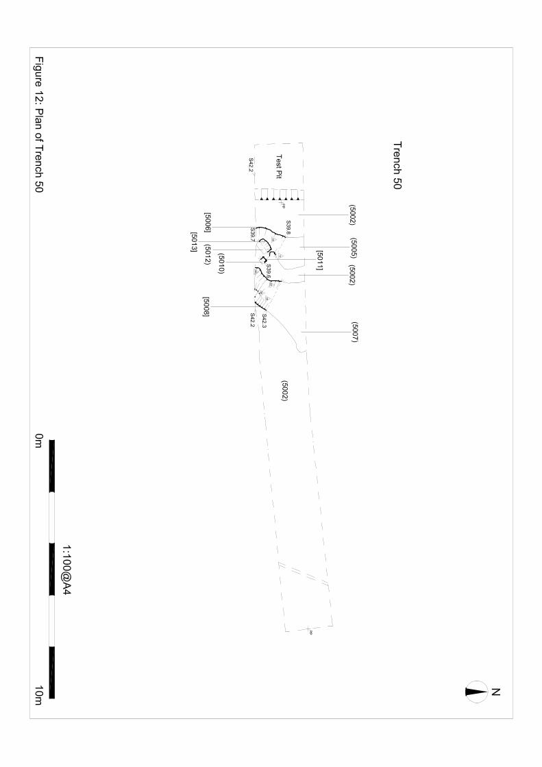
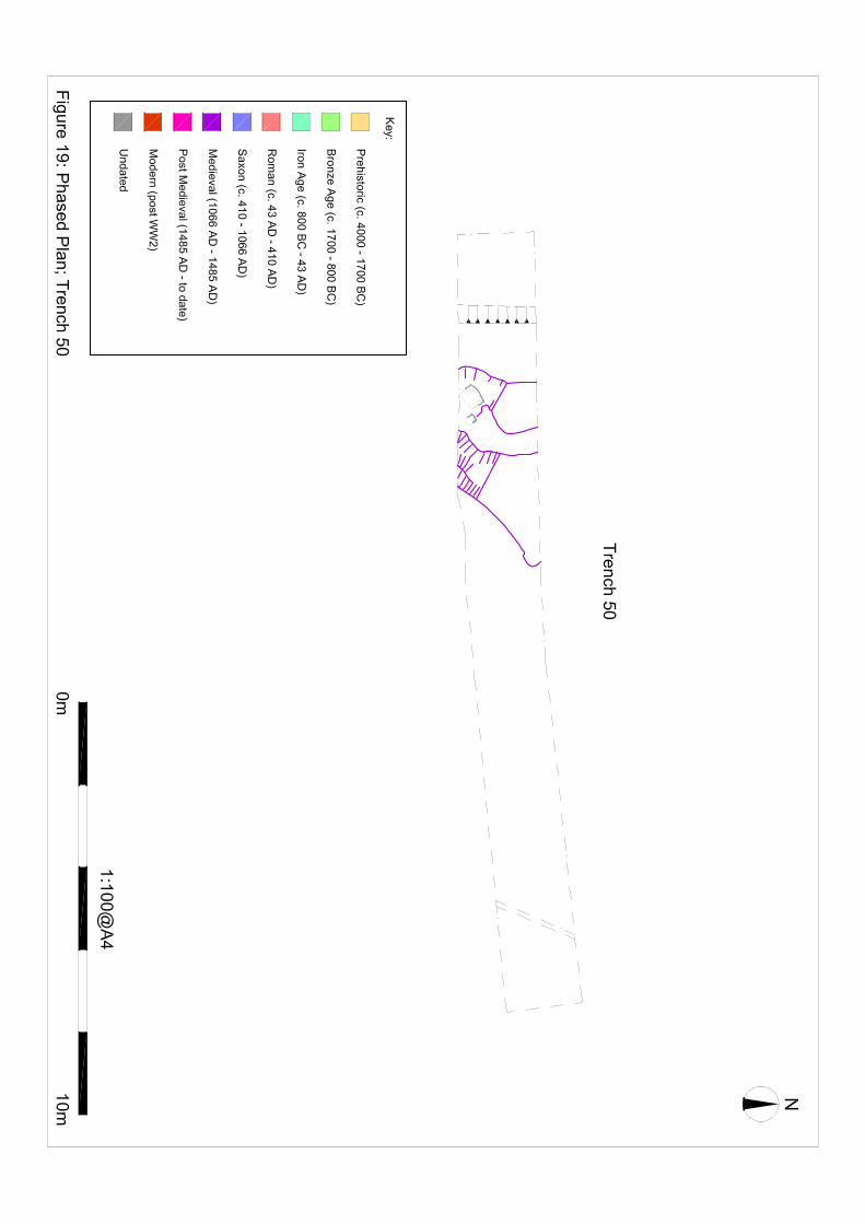
also contained two pottery sherds suggesting a likely date of c.575 – 700 AD (Early-Mid Saxon Period). Trench 47 Trench 47 (Figs. 2, 6 & 46) was located in the central western area of Field 1. The natural geology present was brickearth (CRN 4702). Above this was a subsoil layer (CRN 4701). Trench 47 contained a north-west/south-east aligned ditch (CRN 4706) which measured 0.43m depth, 1.38m width and ≥2m length. This ditch was filled by orange grey, clay silt (CRN 4707) with occasional charcoal and burnt flint inclusions. At the eastern end of the trench was a large irregular oval shaped pit (CRN 4710) which measured ≥1m depth, 4.5m width and ≥1.8m length and was filled by mid grey, clay silt (4711) with occasional charcoal and burnt flint inclusions. This large feature of uncertain use contained three pottery sherds suggesting a likely date of c.1550 – 1350 BC (Middle Bronze Age Period). This feature was cut or cut by (uncertain relationship) two possible post holes, the larger of which (CRN 4708) measured 0.18m depth, 0.21m width and 0.25m depth; the smaller (CRN 4712) measuring 0.13m depth, 0.10m width and 0.11m length. Both these post holes were filled by mid – dark grey, clay silt (CRNs 4709 and 4713 respectively) with occasional charcoal inclusions. Trench 48 Trench 48 (Figs. 2, 6 & 47) was located in the central western area of Field 1. The natural geology present was brickearth (CRN 4802). Above this was a subsoil layer (CRN 4801). Trench 48 contained one west-north-west/east-south-east aligned ditch (CRN 4806) which measured 0.33m depth, 0.78m width and ≥2.12m length. This ditch was filled by mid – dark grey brown, clay silt (CRN 4805) with rare inclusions of animal bone, daub, burnt flint, angular flint and slag. This ditch also contained one sherd of pottery dated to c.1150 – 1200 AD (Early Medieval Period). Trench 49 Trench 49 (Figs. 2, 6 & 48) was located in the central western area of Field 1. The natural geology present was brickearth (CRN 4903). Above this was a subsoil layer (CRN 4901). Trench 49 contained three well defined pits and one modern looking ditch. Pit CRN 4907 measured 0.48m depth, 0.74m width and 0.90m length and was filled by dark yellow brown, silt clay (CRN 4906) with occasional charcoal flecks and fragments and rare small angular flint. In addition this pit contained one fragment of animal bone, one fragment of burnt clay (of uncertain date) and one small iron nail (Small Find 25). Adjacent to this pit was another pit (CRN 4911) which measured 0.78m depth, ≥1.00m width and ≥1.25m length and was filled by dark grey brown, silt clay (CRN 4910) with occasional charcoal flecks and fragments, occasional bone, rare pottery sherds and one iron nail. This pit, thought to be a probable waste pit, contained two pottery sherds dated to c.1200 – 1250 AD (Medieval Period). This pit was cut by two modern field drains. Just to the north of this pit was another probable waste pit (CRN 4909) which measured 0.32m depth, 1.55m width and ≥0.58 length and was filled by dark grey brown, silt clay (CRN 4908) with frequent charcoal flecks and fragments, occasional bone, rare pottery fragments, one fragment of CBM and one iron nail. This pit contained two, probably residual pottery fragments of uncertain date but which appear to be from the Mid-Late Iron Age Period. To the east of these pits was a modern looking, shallow, north/south aligned ditch (CRN 4913) filled with a very dry and topsoil like fill (CRN 4912). Trench 50
Land adjacent to Coleshall Farm, Iwade, Kent Archaeological Evaluation Report
SWAT Archaeology Project No. IWA/EV/11 12
Trench 50 (Figs. 2, 5 & 49) was located towards the south-western edge of Field 1. The natural geology present was brickearth (CRN 5002). Above this was a subsoil layer (CRN 5001). Trench 50 contained a north-east/south-west aligned ditch (CRN 5008) which measured 0.38m depth, 1.28m width and ≥2.20m length. This ditch was filled by mid grey brown, clay silt (5007) with occasional oyster shell, animal bone and pottery fragment inclusions. This ditch contained 17 pottery sherds suggesting a likely date of c.1200 – 1225 AD (Medieval Period). Running parallel to the west was a linear feature (CRN 5006) which appeared on the surface to be a very similar feature to the ditch but when excavated appeared to be more like an oval shaped shallow pit. This pit measured 0.10m depth, 1.40m width and ≥2m length and was filled by mid brown grey, clay silt (topsoil-like) (CRN 5005) with frequent large cobbles and oyster shell. This feature contained 22 sherds of pottery suggesting a likely date for the feature of c.1200 – 1225 AD (Medieval Period). There was a shallow probable pit (CRN 5013) which measured 60mm depth, 0.40m width and 0.52m length. This probable pit was only revealed when the fill of pit CRN 5006 had been removed. Pits CRN 5013 and CRN 5006) have an uncertain stratigraphic relationship, both having the same fill properties. Trench 50 also contained a small rectangular post hole (CRN 5011) measuring 0.16m depth, 0.21m width and 0.28m length. This post hole also has an uncertain stratigraphic relationship with Pit CRN 5006, with this post hole only becoming visible when the fill of pit CRN 5006 had been removed. Trench 51 Trench 51 (Figs. 2, 5 & 50) was located towards the south-western edge of Field 1. The natural geology present was brickearth (CRN 5102). Above this was a subsoil layer (CRN 5101). Trench 51 contained two circular post holes (CRNs 5106 and 5108) of very similar size and identical fills (CRNs 5105 and 5107 respectively). Post hole CRN 5106 measured 40mm depth and 0.28m in diameter and was filled by dark grey brown, silt clay (CRN 5105) with occasional charcoal flecks and rare pottery (one fragment). The pottery sherd from this feature has been dated to c.1550 – 300 BC (Later Prehistoric Period). Trench 52 Trench 52 (Figs. 2, 5 & 51) was located towards the central southern area of Field 1. The natural geology present was brickearth (CRN 5202). Above this was a subsoil layer (CRN 5201). Trench 52 contained one ditch (CRN 5208) aligned north-east/south-west which measured 0.2m depth, 1.2m width and ≥2.2m length. This ditch was filled by grey brown, silt clay (5206) with very occasional charcoal flecks. To the east of this ditch was a possible stake hole (CRN 5221) which measured 0.19m depth and 0.20m in diameter and was filled by light grey brown, silt clay. It was unclear whether this was a genuine stake hole or a result of bioturbation. Adjacent to this feature was a possible small post hole (CRN 5205) which measured 0.17m in depth and 0.37m in diameter. This possible post hole was filled by grey brown, silt clay (CRN 5204) with occasional charcoal flecks. Towards the western end of the trench was another possible post hole (CRN 5216) which measured 0.14m depth, 0.4m width and 0.7m depth. This feature was filled by dark grey brown, silt clay (CRN 5215) with occasional charcoal flecks. Adjacent to this feature was a possible stake hole or feature caused solely by bioturbation (CRN 5218). Trench 52 also contained a well defined probable waste pit with cess deposit which measured 0.95m depth, 0.9m width and ≥0.9m length. This pit contained three fills (CRNs 5212, 5210 and 5209), a greenish basal fill (CRN 5212) and two distinct backfills. The top fill (CRN 5209) contained one pottery sherd dated to c.1050-1150 AD (Early Medieval Period). This basal fill of this pit appears to

Land adjacent to Coleshall Farm, Iwade, Kent Archaeological Evaluation Report
SWAT Archaeology Project No. IWA/EV/11 13
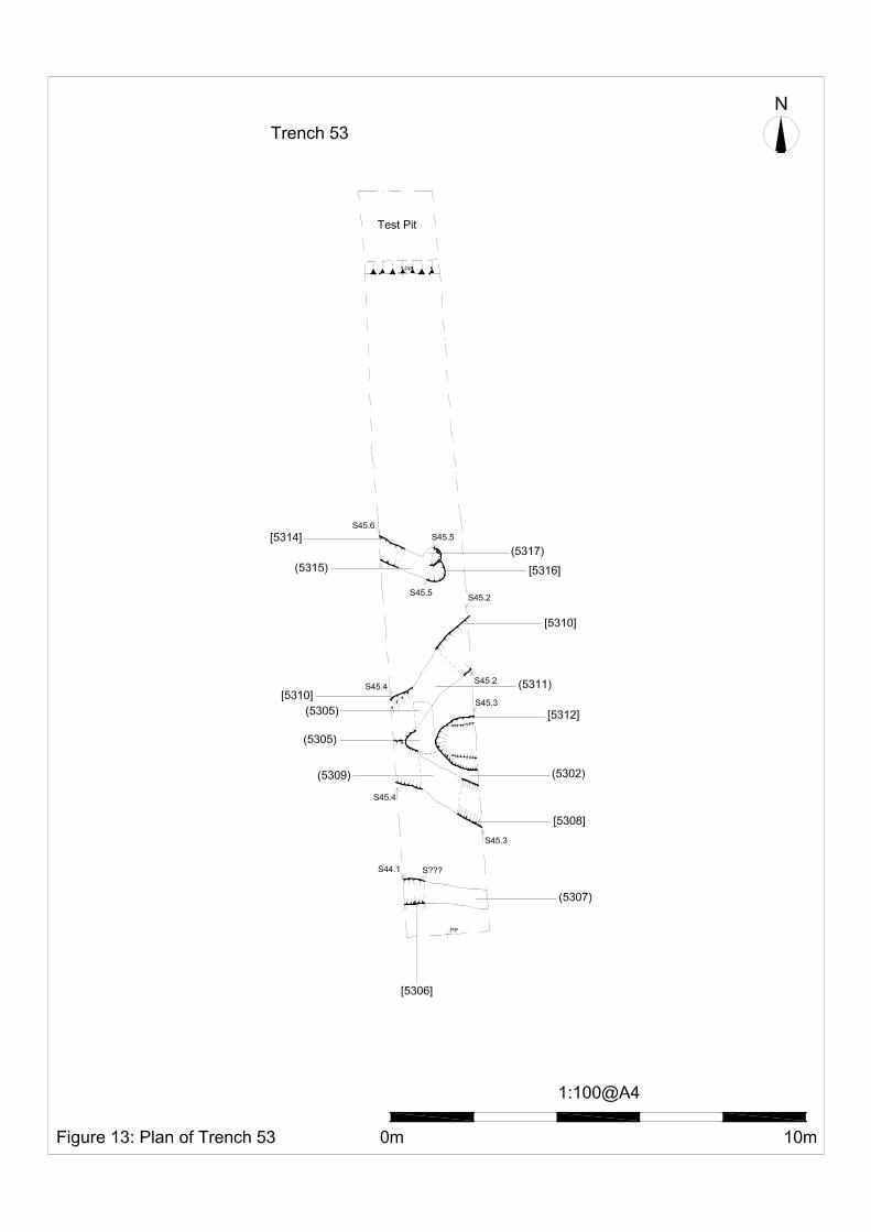
be cut by two post holes (CRNs 5213 and 5214) which are located opposite each other on either side of the base of the pit. Trench 53 Trench 53 (Figs. 2, 5 & 52) was located just to the west of the centre of Field 1. The natural geology present was brickearth (CRN 5302). Above this was a subsoil layer (CRN 5301). Trench 53 contained a north-west/south-east aligned ditch (CRN 5314) with a south eastern terminus which measured 0.33m depth, 0.81m width and ≥1.2m length. This ditch was filled by mid orange grey, clay silt (CRN 5315) occasional charcoal flecks. This ditch terminus was cut by a circular post hole (CRN 5116) which measured 0.22m depth and 0.45m in diameter. This post hole was filled by mid orange grey, clay silt (CRN 5317) occasional charcoal flecks. Another west/east aligned ditch (CRN 5306) was located at the southern end of Trench 53. This ditch measured 0.25m depth, 0.69m width and ≥1.8m length and was filled by mid orange grey, clay silt (CRN 5307) with occasional charcoal flecks. To the north of this ditch was another north-west/south-east aligned ditch (CRN 5308) which measured 0.40m depth, 1.25m width and ≥2m length. This ditch was filled by dark grey, clay silt (CRN 5309) with occasional charcoal inclusions and was truncated by another north-east/south-west aligned ditch (CRN 5310). This ditch (CRN 5310) measured 0.33m depth, 1.48m width and ≥2m length and was filled by dark grey, clay silt (CRN 5311) with occasional charcoal inclusions. Both these ditches (CRNs 5308 and 5310) were partially covered by a probable medieval dump layer (CRN 5305) and all three contexts contained pottery dating to c.1200 – 1250 AD (Medieval Period). Between the two ditches CRNs 5308 and 5310 was a pit or possible ditch terminus (CRN 5312) which measured 0.50m depth, 1.28m width and ≥0.95m length and was filled by orange grey, clay silt (CRN 5313) with occasional charcoal inclusions but no dating evidence. Trench 58 Trench 58 (Figs. 2, 5 & 56) was located near centre of the southern boundary of Field 1. The natural geology present was brickearth (CRN 5802). Above this was a subsoil layer (CRN 5801). Trench 58 contained a north-east/south-west aligned ditch (CRN 5808) with south western terminus. This ditch measured 0.20m depth, 0.90m width and ≥1.7m length and was filled by dark yellow brown, silt clay (5807) with frequent charcoal flecks and fragments and two fragments of burnt clay (undated). Just to the north of this ditch was a small possible stake hole (CRN 5806) which measured 0.15m depth, 70mm width and 90mm length. This stake hole was very circular and had a steep sided cut which narrowed towards the base and was thought to possibly be related to modern farming (such as an orchard or hops). There was another north-east/south-west aligned ditch (CRN 5810) located at the southern end of Trench 58. This ditch measured 0.2m depth, 0.75m width and ≥4m length and was filled by brown, silt clay (CRN 5809) with frequent chalk gravel, rare charcoal flecks and one small, worn fragment of roman brick thought to be residual.
4.3.2 Field 2
Field 2 is located within the western extent of the site bounded by School Lane to the west and Coleshall Farm to the south. This area measures approximately 5.7 ha is size and is separated from Field 1 by a small meandering stream. A total of 69 trenches were excavated within the area, each addressed below with accompanying illustration provided on Figs. 58-122.
Trench 62 Trench 62 (Figs. 3, 7 & 58) was located near the stream at the south-eastern end of Field 2. The natural geology present was clay (CRN 6203). There was a colluvial deposit found below the topsoil along most of the trench (CRN 6202) and also an alluvial deposit (CRN 6214) found at the eastern end (the down slope end) of the trench. These were recorded along the length of the south facing trench

Land adjacent to Coleshall Farm, Iwade, Kent Archaeological Evaluation Report
SWAT Archaeology Project No. IWA/EV/11 14
section. The alluvial deposit contained a pottery fragment that has been dated from between c.50 BC - 50 AD (Late Iron Age). Trench 62 contained several archaeological features including a north-east/south-west aligned ditch of approximately 0.55m depth, 0.95m width and ≥2.25m length (CRN 6213). Although unexcavated, the profile of this ditch was recorded in section (from the south facing trench section) and was seen to cut both the colluvium (CRN 6202) and alluvium (CRN 6214) deposits. This ditch contained a dark grey brown, silt clay fill (CRN 6212) with inclusions of sub rounded flint gravel and small stones. This trench also contained another north-east/south-west ditch (CRN 6211). This ditch was up to 60mm depth, 2.4m width and ≥2.5m length. It contained a mid grey brown, silt clay fill with inclusions of sub-rounded flint gravel and small stones (CRN 6210). This ditch may in fact be a double ditch or perhaps may be a natural feature filled with a colluvial deposit.
In addition this trench contained one possible post hole/small pit (CRN 6205) measuring 60mm depth, 0.17m width and 0.23m length. This feature contained a dark grey brown, silt clay fill (CRN 6204) with inclusions of occasional flint gravel. There was no dating evidence recovered from either of the features excavated in this trench.
Trench 64 Trench 64 (Figs. 3, 7 & 60) was located near the stream at the south-eastern end of Field 2. The natural geology present was clay (CRN 6405) and gravel deposits (CRN 6417). Trench 64 contained a possible post hole or small pit (CRN 6402) which measured 0.22m depth, 0.43m width and 0.85m length. This was filled by grey brown, silt clay (CRN 6401) with occasional charcoal flecks, moderate rounded and sub-rounded flint gravel and small stones. This feature continued beyond the limit of excavation and, therefore, could possibly be a ditch terminus. Adjacent to this feature was another small post hole or possible truncated pit (CRN 6404) which measured 0.15m depth, 0.63m width and 0.70m length. This was filled by grey brown, silt clay (CRN 6403) with moderate rounded and sub-rounded flints, rare charcoal flecks and very rare pottery fragments. This feature (CRN 6404) contained pottery fragments dating from between 1500 BC – 50 AD (Later Prehistoric Period). There was also another possible pit observed in the east facing section of the trench (CRN 6407) which measured 0.25m depth and 0.85m width (length unknown). This was filled by grey brown, silt clay (CRN 6406) with inclusions of occasional grit and gravel. Trench 64 also contained a linear aligned north-west/south-east (CRN 6409) which measured 0.70m width and 3m length. This linear was unexcavated but has the same alignment and surface dimensions as other excavated ditches in the vicinity. Another possible ditch aligned west/ east (CRN 6411) measured 0.30m depth, 0.7m width and ≥1.80m length. This feature was poorly defined at its eastern end and may be the same as ditch CRN 6413. A large possible ditch aligned north-west/south-east (CRN 6413) measured ≥0.20m depth, 2-4m width and ≥9m length and contained pottery fragments dating from between 1500 BC – 50 AD (Later Prehistoric Period). There was another ditch found at the far southern end of the trench (CRN 6415) which measured 0.50m depth, ≥0.65width and ≥1.2m length. This ditch has been dated from pottery fragments to c.1550-350 BC (Later Prehistoric Period). These ditches (CRNs 6411, 6413 and 6415) were filled by dark grey brown, silt clay with moderate rounded and sub-rounded flint inclusions. Trench 65 Trench 65 (Figs. 3, 7 & 60) was located near the stream at the south-eastern end of Field 2. The natural geology present was clay (CRN 6501) and gravel deposits (CRN 6509). A colluvial layer was also present (CRN 6502) found above the clay and below the topsoil at the southern end of the trench. No features were cut into this colluvial layer. A west/east aligned ditch terminus (CRN 6504) was present at the northern end of the trench. This measured 0.12m depth, 0.88m width and ≥1.5m length and has been dated from pottery fragments

Land adjacent to Coleshall Farm, Iwade, Kent Archaeological Evaluation Report
SWAT Archaeology Project No. IWA/EV/11 15
to 3350 – 2800 BC (Middle Neolithic Period). This trench also contained two possible post holes or small pits (CRNs 6506 and 6508). These two features appeared to be truncated by approximately 10 - 20mm and were poorly defined and very shallow. However, one of the possible features (CRN 6506) contained one pottery fragment which has been dated to between 600 BC – 350 BC (Early-Mid Iron Age). These features (CRNs 6504, 6506 and 6508) were filled by light grey brown, silt clay with moderate rounded and sub-rounded flint inclusions and small stones (CRNs 6503, 6505 and 6507 respectively). Trench 69 Trench 69 (Figs. 3, 7 & 60) was located in the small field sloping down to the stream at the south-eastern end of Field 2. The natural geology present was clay (CRN 6905) and gravel deposits (CRN 6908). This trench contained a north-west/south-east aligned ditch (CRN 6902) which measured 0.15m depth, 0.90m width and ≥2.0m length. This ditch was filled by grey brown, silt clay (6901) with moderate sub-rounded and rounded flint inclusions and occasional charcoal flecks. There was another north-west/south-east aligned ditch (CRN 6904) which measured 0.33m depth, 1.20-1.60m width and ≥6.0m length. This was filled by light grey brown, silt clay (6903) with moderate flint gravel inclusions and very occasional charcoal flecks and CBM fragments. The CBM material was dated to c.600-200 BC (Later Prehistoric Period). There was an uncertain feature (CRN 6907) which extended beyond the western limit of excavation of the trench. It measured 88.0m depth, 0.35m width and 0.40m length. This feature may have been a post hole, small pit or ditch terminus. Trench 70 Trench 70 (Figs. 3, 7 & 60) was located in the small field sloping down to the stream at the south-eastern end of Field 2. The natural geology present was clay (CRN 7001) and gravel deposits (CRN 7014). This trench contained a south-west/north-east aligned possible ditch (CRN 7003) which measured 0.18m depth, 0.65m width and ≥3.0m length. This trench also contained a large, west/east aligned irregular linear feature which measured 0.16m depth, 1.10m width and 4.95m length. This feature was bulbous in shape at its eastern terminus. Three investigatory slots were dug (CRNs 7005, 7007 and 7009) and one of these (CRN 7009) contained pottery that has been dated from between c.600-200 BC (Later Prehistoric Period). Trench 70 also revealed a north/south aligned possible ditch terminus (CRN 7011) which measured 20mm depth, 0.40m width and ≥1.40m length. All of the features in this trench were filled by grey brown, silt clay with moderate rounded and sub-rounded flint gravel with inclusions of rare charcoal flecks and rare pottery fragments. Trench 71 Trench 71 (Figs. 3, 7 & 60) was located in the small field sloping down to the stream at the south-eastern end of Field 2. The natural geology present was clay (CRN 7116) and natural gravel deposits (CRN 7122). There was also a poorly defined subsoil layer (CRN 7121) present being of mid yellow brown, clay silt with small very rare flint inclusions. Trench 71 contained a west/east aligned ditch (CRN 7102) which measured 0.37m depth, 1.50m width and 1.80m length. There was an upper fill of mid grey brown, silt clay with occasional burnt flint, angular and rounded stone inclusions. There was a lower fill of re-deposited brown orange clay with occasional burnt flint, angular and rounded stone inclusions. There was also a possible curved
Land adjacent to Coleshall Farm, Iwade, Kent Archaeological Evaluation Report
SWAT Archaeology Project No. IWA/EV/11 16
ditch (CRN 7107) which measured 0.30m depth, 0.30m width and ≥1.30m length. This was filled by mid orange brown clay with occasional flint and angular stone inclusions. This trench also contained a shallow pit (CRN 7109) which cut ditch CRN 7107 which measured 0.10m depth, 0.66m width and 0.66m length. This pit extended beyond the southern limit of excavation of the trench. This was filled by grey brown, silt clay with rare burnt flint, pottery fragments, angular and rounded stone. Pottery from this feature was dated to c.600–200 BC (Later Prehistoric Period). There was another possible pit present in this trench (CRN 7111) containing pottery, again dated to c.600–200 BC (Later Prehistoric Period). This feature extended beyond the western limit of excavation of the trench and it is possible that this may be a ditch terminus. This feature was filled by mid brown grey, silt clay (7110) with occasional angular and rounded stone, rare burnt flint and pottery fragments. This trench also contained a possible large ditch or large pit (CRN 7113) which measured 0.32m depth, approximately 9.0m width, and ≥1.80m length. Within this feature was a possible large pit that was left unexcavated (CRN 7120). An investigatory slot was dug into feature CRN 7113 and this revealed another cut of a probable pit (CRN 7115) which measured 0.52m depth. It was not possible to determine the relationship between these two cuts as both fills were identical. However, pottery found within CRN 7113 has been dated from c.800-600 BC (Earliest Iron Age Period) and pottery found within CRN 7115 has been dated from c.900-200 BC (Later Prehistoric Period). There was also considerable modern disturbance (including sharp sand) at the northern end of the trench which corresponds to the line of a gas main. Trench 72 Trench 72 (Figs. 3, 7 & 60) was located in the small field sloping down to the stream at the south-eastern end of Field 2. The natural geology present was clay (CRN 7201). There was a possible post hole (CRN 7203) which measured 0.17m depth, ≥0.35 width and ≥1.15 length and extended beyond the northern limit of excavation. This trench contained another post hole (CRN 7205) which measured 0.22m depth, 0.55 width and 0.95m length. This post hole had a packing ledge to the north and east. It was filled by dark grey brown, silt clay (CRN 7204) with occasional sub-rounded and rounded flint gravel and small stones, very occasional larger stones (up to 100mm diameter) and moderate charcoal flecks. One fragment of pottery was recovered and has been dated between c.600-200 BC (Later Prehistoric Period). There was another post hole present in this trench (CRN 7207) which measured 0.25m in diameter and 70mm depth. There was a possible pit (CRN 7209) which measured 0.11m depth, 0.47m width and 0.70m length. This feature, which may have been a natural feature was filled by dark brown, silt clay (7208) with very occasional flint grit inclusions. There was a possible pit or possible ditch terminus (CRN 7211) which measured 0.28m depth, ≥1m width and 2m length. This feature was filled by grey brown, silt clay with occasional rounded and sub-rounded flint gravel and small stones and very occasional charcoal flecks and moderate pottery fragments. These pottery fragments were dated to c.600-200 BC (Later Prehistoric Period). This feature was cut by a modern land drain. There was an irregularly shaped feature (CRN 7213) at the eastern end of the trench which was left unexcavated. This could have been a possible ditch intersection or perhaps just a spread within interface. There was a large north to south aligned ditch (CRN 7215 – same as 7220) in the middle of the trench which measured 0.65m depth, 1.40m width and ≥1.80m length (extending beyond the northern and southern limit of excavation of the trench). The primary fill of this ditch was brown, silt

Land adjacent to Coleshall Farm, Iwade, Kent Archaeological Evaluation Report
SWAT Archaeology Project No. IWA/EV/11 17
clay (CRN 7216) with occasional rounded and sub-rounded flint gravel and very occasional pottery fragments. The secondary fill of this ditch was very dark grey brown, silt clay (CRN 7214) with occasional rounded and sub-rounded flint gravel and small stones; moderate charcoal flecks; and frequent pottery fragments. Pottery fragments from both fills of this ditch were dated from c.600-350 BC (Early-Mid Iron Age Period). Trench 73 Trench 73 (Figs. 3, 7 & 60) was located in the small field sloping down to the stream at the south-eastern end of Field 2. The natural geology present was clay (CRN 7310) and natural gravel deposits (CRN 7312). Trench 73 contained the terminus of a possible ditch (CRN 7302) aligned north-west/south-east. This ditch measured 0.28m depth, 0.75m width and ≥1.90m length. This feature is probably related to another shallower ditch (CRN 7308) on the same alignment and indeed may be part of one single ditch. This second ditch (CRN 7308) measured 0.20m depth, 0.90m width and ≥0.50m length. Both ditches were filled with very similar material (dark yellow brown, silt clay with moderate rounded and sub-rounded flint inclusions) and no relationship was determined. Pottery fragments from ditch CRN 7302 were dated to c.1550-600 BC (Later Prehistoric Period). This trench also contained a heavily truncated feature that was most likely a possible ditch (CRN 7304). This was aligned south south-west/north north-east and measured 30mm depth, 0.20m width and 1.0m length. This was filled by grey brown, silt clay and contained pottery fragments dated to c.1550-600 BC (Later Prehistoric Period). There was a north-west/south-east aligned ditch (CRN 7306) present within this trench which measured 0.50m depth, 0.85m width and 2.0m length. This ditch was filled by grey brown, silt clay with inclusions of frequent rounded and sub-rounded flint, and very occasional charcoal flecks. Three pottery fragments were recovered and have been dated to c.800-600 BC (Earliest Iron Age Period). Ditches CRNs 7304 and 7306 run parallel to each other and enclose between them a band of flint-rich clay gravel (CRN 7311). Although this may merely be a band of natural gravel, it may have been utilised as a track-way. Trench 74 Trench 74 (Figs. 3, 7 & 60) was located in the small field sloping down to the stream at the south-eastern end of Field 2. The natural geology present was clay (CRN 7402) and natural gravel deposits (CRN 7401). There was a small pit (CRN 7407) which measured 0.50m depth and 0.90m width. This pit extended beyond the northern limit of excavation of the trench. This pit was filled by three fills. The basal fill (CRN 7406) was dark grey black, silt clay with very frequent charcoal and daub. The middle fill (CRN 7415) was dark grey brown, silt clay with occasional sub-angular flint pebbles. The top fill (CRN 7414) was grey brown, silt clay with occasional sub-rounded pebbles and rare charcoal. This pit (CRN 7407) cut a north/south aligned ditch (CRN 7405) which measured 0.41m depth, 3.70m width and ≥1.80m length. This ditch contained three fills (CRNs 7413, 7404 and 7403). The secondary fill (CRN 7404) was grey yellow, silt clay with frequent sub-rounded pebbles and cobbles and contained pottery dating from c.800-50 BC (Later Prehistoric Period).

Land adjacent to Coleshall Farm, Iwade, Kent Archaeological Evaluation Report
SWAT Archaeology Project No. IWA/EV/11 18
There were two ditches running parallel in a north-west/south-east alignment with south-eastern termini (CRN 7417 and 7419). Both extended beyond the northern limit of excavation of the trench. Both were filled by grey brown, silt clay with occasional sub-angular pebbles. However, these ditches produced no dating evidence. There was a north-north-west/south-south-east aligned ditch with northern terminus which measured 0.27m depth, 0.80m width and ≥0.70m length. This ditch contained a single fill (CRN 7408) with no finds. There were two other features identified in this trench but left unexcavated – a possible ditch (CRN 7421) at the far western end of the trench, aligned north-west/south-east and a possible curvilinear ditch (7423) at the far eastern end, aligned north-south. Trench 75 Trench 75 (Figs. 3, 7 & 60) was located in the small field sloping down to the stream at the south-eastern end of Field 2. The natural geology present was clay (CRN 7502) and natural gravel deposits (CRN 7501). Trench 75 contained a west-south-west/east-north-east aligned ditch (CRN 7506) which measured 0.55m depth 0.40m width and ≥1.90m length. This ditch was filled by mid grey brown, silt clay (CRN 7505) with occasional sub-angular gravel. Two sherds of pottery were obtained from this ditch and have been dated to c.800-600 BC (Earliest Iron Age Period). There was a curvilinear ditch (CRN 7509) excavated at the northern end of Trench 75. This ditch measured 0.30m depth, ≥1.10m width and ≥2.0m length. This ditch was filled with mid orange grey, ‘grainy clay’ with occasional gravel inclusions, but no pottery. There was a small probable post hole (CRN 7504) which measured approximately 80mm depth, 0.27m width and 0.31m length. This was filled by mid grey brown, silt clay with rare gravel inclusions but no dating evidence was obtained. This trench also contained three possible ditch termini (CRNs 7515, 7517 and 7519) which were unexcavated but appeared to be aligned north-west/south-east. In addition there was a further unexcavated ditch (CRN 7521) also aligned north-west/south-east. Trench 76 Trench 76 (Figs. 3, 7 & 60) was located in the small field sloping down to the stream at the south-eastern end of Field 2. The natural geology present was clay (CRN 7602) and natural gravel deposits (CRN 7601). There was a possible pit or possible ditch terminus (CRN 7604) which continued under the northern limit of excavation of the trench. This feature measured 0.22m depth, 1.10m width and ≥1.40 m length. This was filled by mid orange grey, silt clay (CRN 7603) with occasional pebbles and rare manganese nodules and burnt flint. This feature contained pottery which was of uncertain date. Trench 76 also contained three unexcavated ditches (CRNs 7606, 7608 and 7610) which were all aligned roughly north-west/south-east. Ditch CRN 7606 contained secure surface finds which have been dated to c.800-600 BC (Earliest Iron Age Period). Ditches CRNs 7608 and 7610 appeared well defined on the trench surface. Trench 77 Trench 77 (Figs. 3, 7 & 60) was located in the small field sloping down to the stream at the south-eastern end of Field 2. The natural geology present was clay (CRN 7702) and natural gravel deposits (CRN 7701).

Land adjacent to Coleshall Farm, Iwade, Kent Archaeological Evaluation Report
SWAT Archaeology Project No. IWA/EV/11 19
At the northern end of the trench there was an east-west aligned ditch (CRN 7704) which measured 0.45m depth, 0.90m width and ≥2.0m length. This ditch was filled by mid orange grey, silt clay (7703) with inclusions of occasional pebbles and rare burnt flint. In the centre of the trench was an east-north-east/west-south-west aligned ditch (7706) which measured 0.30m depth, 2.6m width and ≥2.0m length. This was filled by mid grey, silt clay (7707) with inclusions of frequent gravel and rare charcoal flecks. This feature has been dated from 13 pottery sherds to c.800-600 BC (Earliest Iron Age Period). This trench also contained two other linear features (CRNs 7713 and 7715) aligned north-west/south-east which were left unexcavated, one of which may have been a ditch intersection. There was also another possible ditch terminus (CRN 7709) at the northern end of the trench which was also left unexcavated. Trench 78 Trench 78 (Figs. 3, 7 & 60) was located on the brow of the small hill that slopes down to the stream at the south-eastern end of Field 2. The natural geology present was clay (CRN 7802) and natural gravel deposits (CRN 7801). Trench 78 contained a possible large east-west aligned (CRN 7806) which measured 0.23m depth, 3.18m width and ≥1.8m length. This ditch was filled by mid grey brown, silt clay (CRN 7805) with occasional angular and rounded flint gravel inclusions. To the south of this ditch was a possible small shallow pit or large post hole (CRN 7804) which measured 0.13m depth, 0.50m width and 0.78m length. This feature was filled by grey brown, silt clay (CRN 7803) with occasional angular and rounded flint gravel inclusions. This feature contained one pottery sherd dating to c.800-600 BC (Earliest Iron Age Period). This trench contained three further possible ditches that were left unexcavated: one east-west aligned ditch (CRN 7808), one north-west/south-east aligned ditch (CRN 7812) and one north-east/south-west aligned ditch (CNR 7814). Trench 80 Trench 80 (Figs. 3, 7 & 60) was located on the brow of the small hill that slopes down to the stream at the south-eastern end of Field 2. The natural geology present was clay (CRN 8002) and natural gravel deposits (CRN 8003). There was also a poorly defined subsoil layer present (CRN 8001). The southern half of Trench 80 contained five post holes and a small pit. Post hole CRN 8004 measured 0.18m depth, 0.28m width and 0.28m length and was filled by dark brown, clay silt (CRN 8005) with inclusions of occasional charcoal and daub. Six pottery sherds were recovered, dating this feature to c.800-600 BC (Earliest Iron Age Period). Adjacent to this post hole was another post hole (CRN 8006) which measured 0.17m depth, 0.29m width and 0.31m length. This post hole was filled by mid brown, clay silt (CRN 8007) with occasional charcoal inclusions. Directly to the north of this post hole was a possible pit (CRN 8008) which measured 0.18m depth, 0.55m width and 0.58m length. This post hole was filled by dark brown, clay silt (8009) with occasional charcoal and daub inclusions. This trench contained another post hole (CRN 8010) which measured 0.26m depth, 0.34m width and 0.38m length. Another post hole (CRN 8012) measured 0.17m depth, 0.25m width and 0.25m length and was filled by mid brown, clay silt (CRN 8013) with occasional charcoal inclusions. It also contained three pottery sherds, giving the feature a likely date of c.600-350 BC (Early-Mid Iron Age Period). Towards the centre of the trench there was another post hole measuring 0.31m depth, 0.32m width and 0.34m length. This post hole was filled by dark brown, clay silt (8015) with occasional charcoal and daub inclusions. It also contained ten pottery sherds, dating the feature to c.600-350 BC (Early-Mid Iron Age Period).

Land adjacent to Coleshall Farm, Iwade, Kent Archaeological Evaluation Report
SWAT Archaeology Project No. IWA/EV/11 20
This trench also contained a possible large pit (CRN 8016) which was not fully excavated but found to contain ten sherds of pottery providing a broad date range of c.800-200 BC (Later Prehistoric Period). The northern end of this trench was disturbed by a modern service cut (thought to be a gas main). Trench 81 Trench 81 (Figs. 3, 7 & 60) was located on the brow of the small hill that slopes down to the stream at the south-eastern end of Field 2. The natural geology present was clay (CRN 8102) and natural gravel deposits (CRN 8003). There was also a poorly defined subsoil layer present (CRN 8101). Trench 81 contained a number of curvilinear ditches as well as number of possible post holes, suggesting a possible structure could be in close proximately to the trench. Ditch CRN 8104 measured 0.13m depth, 0.52m width and ≥3.5m length and was filled by brown grey, clay silt (8105) with occasional gravel and burnt flint inclusions. Curved ditch CRN 8106, which measured 0.13m depth, 0.52m width and ≥3.0m length, appears to form a ring shape but continues under the eastern limit of excavation of the trench. This ditch was filled by brown grey, clay silt (8107) with occasional gravel inclusions. Curvilinear ditch CRN 8110 curves from a westward direction down to the south, running along the length of the trench until it is cut by a small pit (CRN 8132). Another linear (CRN 8134), also cut by pit CRN 8132, runs from this small pit southward and under the southern limit of excavation. Ditch CRN 8110 contained three pottery sherds, giving the feature a likely date of c.200-50 BC (Late Iron Age Period). Small pit CRN 8132 measured 0.20m depth, 0.80m width and 1.0m length. This feature appears too shallow to be a post hole, although the presence of daub indicates the possibility of a structure. Adjacent to this pit are two small probable post holes (CRNs 8112 and 8114) that were left unexcavated. In the centre of the trench, between two curvilinear ditches (CRNs 8104 and 8106), is a small post hole measuring 0.20m depth, 0.20m width and 0.20m length. To the north of ditch CRN 8104 are three more possible post holes (CRNS 8118, 8120 and 8122) that were left unexcavated. At the very northern end of the trench was a north-east/south-west aligned linear (CRN 8124), also left unexcavated. Trench 83 Trench 83 (Figs. 3, 7 & 60) was located on the brow of the small hill that slopes down to the stream at the south-eastern end of Field 2. The natural geology present was clay (CRN 8302) and natural gravel deposits (CRN 8303). There was also a poorly defined subsoil layer present (CRN 8301). Trench 83 contained a north-east/south-west aligned ditch (CRN 8304) which measured 0.28m depth, 1.40m width and ≥1.9m length. This ditch was filled by dark grey, clay silt (CRN 8305) with occasional charcoal inclusions. This feature contained two pottery sherds providing a likely date of c.1075-1125 AD (Early Medieval). There was another north-east/south-west aligned shallow linear (CRN 8306) which measured 80mm depth, 0.80m width and ≥1.9m length. Trench 84 Trench 84 (Figs. 3, 7 & 60) was located on the brow of the small hill that slopes down to the stream at the south-eastern end of Field 2. The natural geology present was clay (CRN 8402) and natural gravel deposits (CRN 8403). This trench contained one very large north-east/south-west aligned ditch (CRN 8411) which measured 1.10m depth, 2.35m width and ≥1.80m length. This ditch contained three fills. The basal fill (CRN 8415) was orange grey brown, silt clay with occasional gravel inclusions and had a maximum thickness of 0.50m. Above this was a dark grey black, clay silt fill (CRN 8414) with occasional gravel inclusions and a maximum thickness of 0.10m. Above this was a mid grey orange, clay fill (CRN 8413) with occasional gravel inclusions and a maximum thickness of 0.10m. The upper fill was mid yellow
Land adjacent to Coleshall Farm, Iwade, Kent Archaeological Evaluation Report
SWAT Archaeology Project No. IWA/EV/11 21
grey, silt clay (CRN 8412) with occasional gravel inclusions. Fifty-six pottery sherds were recovered from CRN 8414. This gave the ditch a likely date of c.100-50 BC (Mid-Late Iron Age Period). This trench also contained another ditch aligned north-east/south-west (CRN 8404) which measured 0.30m depth, 1.31m width and ≥1.80m length. This ditch was filled by brown grey, clay silt (8405) with occasional charcoal and flint inclusions (but no dating evidence). There was one other possible ditch present that was left unexcavated - a north/south aligned ditch (CRN 8408). Trench 85 Trench 85 (Figs. 3, 7 & 60) was located near the brow of the small hill that slopes down to the stream at the south-eastern end of Field 2. The natural geology present was clay (CRN 8502) and natural gravel deposits (CRN 8511). Trench 85 contained a number of amorphous sub-circular features, one of which was investigated (CRN 8504). This possible shallow pit measured 90mm depth, 1.0m width and 1.50m length and was filled by mid grey brown, clay silt (CRN 8503) with occasional angular and rounded stone. One pottery sherd was recovered from this feature and three small worn fragments of daub which, if not residual, suggest a possible date for this feature from c.1550-1350 BC (Later Prehistoric Period). Trench 93 Trench 93 (Figs. 3, 7 & 60) was located near the brow of the small hill that slopes down to the stream at the south-eastern end of Field 2. The natural geology present was clay (CRN 9302) and natural gravel deposits (CRN 9301). Trench 93 contained two possible north-west/south-east aligned ditches (CRNs 9304 and 9306), both with termini at their north-western ends. These ditches were both filled with grey brown, clay silt (CRNs 9303 and 9305 respectively) with angular and rounded gravel inclusions. Possible ditch CRN 9304 measured 0.10m depth, 0.70m width and ≥3.8m length. Possible ditch CRN 9306 measured 50mm depth, 0.48m width and ≥2.70m length. Whether these two features are actual cut ditches is uncertain with the rest of the trench and the surrounding trenches containing many amorphous features indicative of alluvial channels formed in a marshy environment. One pottery sherd was found of the surface of the trench and has a likely date of c.600-350 BC (Early-Mid Iron Age Period). Trench 94 Trench 94 (Figs. 3, 7 & 60) was located in the central south-western area of Field 2 (a large flat area). The natural geology present was clay (CRN 9401). This trench contained five possible features, all of rather amorphous shape thought to be natural features. Two of these features were investigated. At the western end of the trench there was a possible pit (CRN 9403) which measured 0.12m depth, ≥0.95m width and ≥2.30m length. This feature was filled by mid grey brown, clay silt (CRN 9402) with occasional angular and rounded gravel. Near the centre of the trench a possible ditch terminus (CRN 9405) was investigated. This measured 0.14m depth, 1.28m width and ≥1.60m length. This feature was mid grey brown, clay silt (CRN 9404) with angular and rounded flint gravel inclusions. One pottery sherd found on the surface of this feature has been dated to c.3350-2800 BC (Early Prehistoric Period). Trench 95 Trench 95 (Figs. 3, 7 & 60) was located in the central south-western area of Field 2 (a large flat area). The natural geology present was clay (CRN 9501).
Land adjacent to Coleshall Farm, Iwade, Kent Archaeological Evaluation Report
SWAT Archaeology Project No. IWA/EV/11 22
Trench 95 was characterised by large irregular patches of firm yellow brown, silt clay (CRN 9502) containing inclusions of occasional sub angular flint and rare burnt flint and CBM. These patches were thought to be simply water deposited silts in a low lying marshy landscape. Where investigated, this silt had a depth of 80mm. The interface (CRN 9503) was steep sided and had a flat base. Three small, fairly worn fragments of daub of uncertain date were recovered from this silt (CRN 9502). Trench 96 Trench 96 (Figs. 3, 7 & 60) was located in the central south-western area of Field 2 (a large flat area). The natural geology present was clay (CRN 9601). Like Trench 95, Trench 96 was characterised by many irregularly shaped silt patches (CRN 9602). In addition, it contained a possible ditch or former stream (CRN 9604) that was aligned north-east/south-west. This feature measured 0.4m depth, 2.1m width and ≥1.8m in length and may be the same feature found in Trench 113 (CRN 11308) and also possibly in Trench 126 (CRN 12604). This feature produced a number of possibly worked flints but no pottery. Trench 97 Trench 97 (Figs. 3, 7 & 60) was located in the central south-western area of Field 2 (a large flat area). The natural geology present was clay (CRN 9701). Trench 97 contained two linear features running parallel in a north-east/south-west alignment. These ditches (CRNs 9704 and 9706) appear to be post-medieval field boundaries with a number of CBM finds coming from the larger of the two ditches (CRN 9704). This larger ditch measured 0.27m depth, 1.1m width and ≥2.4m in length and was filled with dark grey brown, silt clay (CRN 9703) with rare sub-angular and rounded flint gravel as well as rare pottery, slag and coke fragments. This ditch (CRN 9704) has been dated to c.650 – 750 AD (Post-Medieval Period but with earlier residual material). Trench 98 Trench 98 (Figs. 3, 7 & 60) was located in the central south-western area of Field 2 (a large flat area). The natural geology present was clay (CRN 9801). This trench contained a curvilinear feature (CRN 9804) at its western end that was roughly aligned north/south (with a kink in the middle). This feature measured 0.15m depth, 0.9m width and ≥2m length and was filled with light yellow brown, silt clay with frequent iron staining but no other inclusions. It is thought to be a possible alluvial channel making up part of a former low lying marshy area. Below the topsoil was a layer of silt (CRN 9802) which was removed by machining but left in situ at the eastern end of the trench. This layer produced one sherd of pottery dated to c.1550 – 600 BC (Later Prehistoric Period). Trench 102 Trench 102 (Figs. 3, 7 & 60) was located in the far north-west corner of Field 2 (an area gently sloping down from the north). The natural geology present was clay (CRN 10202). Above this was a layer of light yellow brown, clay silt (CRN 10203) with inclusions of rare sub-angular gravel and rare burnt flint. This silt layer is thought to be a natural deposit (probable wind-blown) with the burnt flint being residual. This layer is present in most of the trenches in this northern part of Field 2 and will be here forth mentioned in the remaining trenches solely by CRN. This trench contained a shallow north-north-east/south-south-west aligned ditch (CRN 10205) which measured 0.14m depth, 1.78m width and 1.80m depth. This ditch was filled by mid grey brown, clay silt (CRN 10204) with inclusions of rare animal bone and pottery fragments as well as an animal tooth and a metal object (iron ring Small Find 32). The three pottery sherds that were recovered from this feature suggest a date of c.1200 – 1250 AD (Medieval Period). In addition, another ditch cut was identified within this excavation slot (CRN 10207) which is also aligned north-north-east/south-south-west. This ditch, thought to be a possible re-cut, measured 0.33m depth, 1.55m width and ≥1.8m length. It was filled by mid grey brown, clay silt (10206). There was a small pit or possible post hole (CRN 10209) found

Land adjacent to Coleshall Farm, Iwade, Kent Archaeological Evaluation Report
SWAT Archaeology Project No. IWA/EV/11 23
in this same excavation slot which measured 0.16m depth, 0.57m width and ≥0.18m length. This feature was filled by mid grey brown, clay silt (CRN 10208) with inclusions of rare animal bone one pottery fragment dated to c.1100 – 1150 AD (Early Medieval Period). Another probable post hole (CRN 10211) was present in this excavation slot which measured 0.22m depth, 0.26m width and ≥0.19m length (continuing under the limit of excavation). This feature was filled by mid grey brown, clay silt (CRN 10210) with inclusions of rare animal bone (no dating material). Trench 103 Trench 103 (Figs. 3, 7 & 60) was located in the far north-west corner of Field 2 (an area gently sloping down from the north). The natural geology present was clay (CRN 10302). Above this was a natural silt layer (CRN 10303). There was an irregularly shaped shallow possible pit (CRN 10304) present in the centre of the trench which measured 0.20m depth, 0.81m width and ≥1.78m length. This was filled by mid yellow grey, clay silt (CRN 10305) with inclusions of occasional charcoal. Adjacent to this possible pit was a north-east/south-west aligned ditch (CRN 10306) which measured 0.23m depth, 0.81m width and ≥2.32m length. This ditch was filled by mid-dark grey brown, clay silt (CRN 103 07) with inclusions of occasional charcoal. This ditch has been dated from two pottery sherds to c.1200 – 1225 AD (Medieval Period) Trench 105 Trench 105 (Figs. 3, 7 & 60) was located at the far northern most end of Field 2 (an area gently sloping down from the north). The natural geology present was clay (CRN 10502). Above this was a natural silt layer (CRN 10503). A north-east/south-west ditch (CRN 10504) was present in this trench measuring 0.22m depth, 0.70m width and ≥2.58m length. This ditch was filled by mid-dark, grey brown, clay silt (CRN 10505). There was another shallow, wide ditch present, aligned east-north-east/west-south-west, and measuring 0.23m depth, 2.66m width and ≥1.9m length. This ditch was filled by dark red grey brown, clay silt (10507) with inclusions of occasional daub and charcoal. This ditch may well be the same as a ditch found in Trench 106 (CRN 10604) which did contain dating material (see Trench 106 trench narrative). A surface find from this trench has been dated as a residual pottery sherd from the Later Prehistoric Period (c.1550 – 50 BC). Trench 106 Trench 106 (Figs. 3, 7 & 60) was located at the far northern most end of Field 2 (an area gently sloping down from the north). The natural geology present was clay (CRN 10602). Above this was a natural silt layer (CRN 10603). This trench contained a north-east/south-west ditch (CRN 10604) which measured 0.71m depth, 2.58m width and ≥2m length. This ditch was filled by mid-dark, grey brown, clay silt (CRN 10605) with inclusions of occasional charcoal and rare burnt flint. It also contained three pottery sherds thought to be residual – two being dated to c.1550 – 200 BC and the other being dated to c.1250 – 1350 AD. This trench also contained a modern rubbish pit (CRN 10606) which extended beyond the northern limit of excavation. Trench 108 Trench 108 (Figs. 3, 7 & 60) was located at the far northern most end of Field 2 (an area gently sloping down from the north). The natural geology present was clay (CRN 10802). Above this was a natural silt layer (CRN 10803). Trench 108 contained two features dated to the Early Prehistoric Period: a north-west/south-east aligned ditch (CRN 10804) and an irregular pit (CRN 10808). The ditch (CRN 10804) measured 0.35m depth, 1.98m width and ≥2.31m length and was filled by mid yellow grey, clay silt (10805) with inclusions of occasional angular flint gravel and charcoal. It contained one pottery sherd dated to c.2000 – 1700 BC (Early Prehistoric Period). The irregular pit (CRN 10808) measured 0.20m depth, ≥1.8m width and ≥2.7m length (feature continues under limit of excavation) and was filled by mid grey brown, clay silt (10809) with inclusions of occasional iron/manganese panning. It contained two pottery sherd dated to c.2000 – 1500 BC (Early
Land adjacent to Coleshall Farm, Iwade, Kent Archaeological Evaluation Report
SWAT Archaeology Project No. IWA/EV/11 24
Prehistoric Period). Two additional possible pits (CRN 10806 and 10812) were excavated (situated between the two dated features) but these did not contain any datable material. Two more similar looking possible pits (CRN 10814 and 10816) were left unexcavated. Trench 109 Trench 109 (Figs. 3, 7 & 60) was located at the northern end of Field 2 (an area gently sloping down from the north). The natural geology present was clay (CRN 10902). Above this was a natural silt layer (CRN 10903). An investigatory slot dug into this silt layer revealed concealed possible ditch cut (CRN 10912) measuring 0.16m depth and ≥0.7m width (length unknown). This possible ditch was filled by the silt layer (CRN 10903). Cutting through this silt layer was a probable post hole (CRN 10904) which measured 0.39m depth, 0.31m width and 0.32m length. This post hole was filled by mid – dark orange grey, clay silt (CRN 10905) with inclusions of occasional charcoal and iron panning. It also contained one pottery sherd dated to c.1550 – 600 BC (Later Prehistoric Period). This trench contained another probable post hole (CRN 10908) and two possible stake holes (CRN 10906 and 10910). The post hole (CRN 10908) measured 0.19m depth, 0.20m width and 0.20m length and was filled by mid grey brown, clay silt (10909) with inclusions of occasional charcoal. Two pottery sherds of uncertain date were found in possible stake hole CRN 10906 (a large date range of c.4000 – 50 BC has been suggested). Trench 110 Trench 110 (Figs. 3, 7 & 60) was located in the central area of Field 2 (a large flat area). The natural geology present was clay (CRN 11002). Trench 110 was characterised by large irregular patches of firm yellow brown, silt clay (CRN 11001) containing inclusions of occasional sub angular and rounded flint gravel and small stones. These patches, like those found in many trenches in this central area of Field 2, were thought to be simply water deposited silts in a low lying marshy landscape. Where investigated, this silt had a depth of 0.35m. Two sherds of pottery were found securely within one of these silt patches and have been broadly dated to the Prehistoric Period (c.1550 – 50 BC). Trench 111 Trench 111 (Figs. 3, 7 & 60) was located on the brow of the small hill that slopes down to the stream at the south-eastern end of Field 2. The natural geology present was clay (CRN 11102) and natural gravel deposits (CRN 11101). This trench contained a north-east/south-west aligned ditch (CRN 11104) measuring 0.23m depth, 1.10m width and ≥2.90m length. This ditch was filled by mid brown grey, silt clay (11105) with occasional sub-angular gravel inclusions. Two pottery sherds were recovered from this ditch and have been dated to c.150 – 200 AD (Mid Roman Period). Another possible ditch (CRN 11106) aligned north/south was left unexcavated as were several irregularly shaped possible pits (CRNs 11110, 11112, 11114 and 11116). Trench 113 Trench 113 (Figs. 3, 7 & 60) was located in the central area of Field 2 (a large flat area). The natural geology present was clay (CRN 11302). Above this was a natural silt layer (CRN 11303) which lay below a poorly defined subsoil layer (CRN 11301). There were two silt patches left unexcavated at the eastern end of this trench (CRNs 11314, 11316 and 11318). In the centre of the trench was a large amorphous feature (CRN 11312) which measured 0.38m depth, ≥1.37m width and ≥4.5m length. This feature was filled by mid orange grey, clay silt (CRN 11313) with occasional iron/manganese panning and one pottery fragment of uncertain but probable roman date. There were multiple linear features found at the western end of Trench 113, all aligned north-east/south-west. The largest ditch (CRN 11308) measured 0.33m depth, 1.82m width and ≥2.1m

Land adjacent to Coleshall Farm, Iwade, Kent Archaeological Evaluation Report
SWAT Archaeology Project No. IWA/EV/11 25
length and was filled by grey brown, clay silt (CRN 11309) with inclusions of occasional charcoal and iron panning. A post hole (CRN 11310) was found in the base of ditch CRN 11308. This measured 0.18m depth, 0.30m width and 0.30m length and was filled by mid grey brown, clay silt (11311) with occasional charcoal flecks. This post hole was under the fill of the ditch (CRN 11308). CRNs 11304 and 11306 were thought to be the possible remains of a former hedgerow. These features (CRNs 11304, 11306, 11308, 11310) were sealed below a large shallow hollow thought to be a natural feature (CRN 11320) that was filled by mid grey brown, clay silt with occasional iron panning. Trench 118 Trench 118 (Figs. 3, 7 & 60) was located in the central north-eastern area of Field 2 (a large flat area). The natural geology present was clay (CRN 11802). Above this was a natural silt layer (CRN 11803) which lay below a poorly defined subsoil layer (CRN 11801). This trench contained a north-east/south-west aligned possible ditch (CRN 11812) with a terminus at its south-western end. This ditch measured 0.22m depth, 0.72m width and ≥1.12m length but was thought to most likely be a natural feature and was only partially excavated. The northern half of the trench contained a number of features cut through the silt layer (CRN 11803). There was a probable post hole (CRN 11804) which measured 0.11m depth, 0.18m width and ≥90mm length which was filled by mid – dark grey, clay silt with occasional charcoal. Just south of this feature was a small pit (CRN 11806) that measured 0.12m depth, 0.55m width and 0.61m length and was filled by mid orange grey, clay silt and inclusions of occasional charcoal and iron/manganese nodules. This pit contained two sherds of pottery that were of uncertain date but likely to be from the Prehistoric Period (c.4000 – 50 BC). Another post hole (CRN 11808) that measured 0.18m depth, 0.28m width and 0.38m length was filled by mid grey, clay silt (11809) with occasional charcoal inclusions. This post hole contained one sherd of pottery, probably residual, of uncertain date but likely to be from the Late Iron Age Period. There was also a single possible stake hole (CRN 11810) present that measured 70mm depth, 0.11m width and 0.11 length and was filled by mid grey, clay silt (CRN 11811) with occasional manganese nodules. This possible stake hole contained eight scraps of pottery remains that were of uncertain date but likely to date from c.2000 -1500 BC (Early Prehistoric Period).
Land adjacent to Coleshall Farm, Iwade, Kent Archaeological Evaluation Report
SWAT Archaeology Project No. IWA/EV/11 26
5 FINDS ASSESSMENT
5.1 Introduction
The evaluation yielded a finds assemblage which includes material of prehistoric, Romano-British and medieval date. Finds were recovered from contexts in 54 of the 129 trenches excavated. All finds have been assessed with specialist comments presented below. Preliminary phasing of dateable features has been carried out using ceramic typological sequences suggesting up to seven distinctive phases (see below). 5.2 Lithic Assessment
5.3.1 Introduction
The struck lithic material from Iwade comprises a medium sized assemblage of approximately 65 pieces recovered from a wide variety of individual contexts. The site is in an area of considerable archaeological interest, not least that relating to the prehistoric periods. Analysis of the lithic material has the potential to significantly contribute to the stated specific aims of the archaeological work undertaken at Iwade. In particular, they will contribute to an understanding of the character, function, significance and date of any lithic-based activities, including the spatial organisation of such activities, as well as to questions relating to matters such as ceremonial or ritual behaviour.
5.3.2 Preliminary Results
Preliminary examination of the material indicates it is multi-period. It was noted that there was a small proportion of blades and debitage originating from a blade-based reduction strategy, indicating the presence of Mesolithic or Early Neolithic industries. Other contexts contained material originating from a more opportunistic, flake-based, reduction strategy, which would be more typical of Bronze Age or possibly even Iron Age industries. It is therefore desirable that the assemblage be examined in greater detail in order for its archaeological potential to be assessed.
5.3.3 Recommendations
It is therefore recommended that:
The assemblage is catalogued and classified by individual context according to a basic technological and typological scheme
A general overview of the material should be presented, including the chronological periods represented and a brief description of the characteristics of each industry
A brief consideration of contextual associations should be made, including the spatial distribution of the material, the degree of residuality and a description of key selected sub-assemblages
The archaeological significance of the material should be highlighted, including a statement of its potential to contribute to the further understanding of the nature and chronology of the activities identified during the project
A recommendation detailing any further work required should be included.
Land adjacent to Coleshall Farm, Iwade, Kent Archaeological Evaluation Report
SWAT Archaeology Project No. IWA/EV/11 27
5.3 Ceramic Assessment
5.3.1 Introduction
The initial analysis carried out on the ceramic assemblage (538 sherds) suggests at least seven (with an additional undefined prehistoric phase) primary phases of archaeological activity on site. With a total of 538 sherds the assemblage comprises approximately 49% (264 sherds) Early-Middle Iron Age (Phase 3) pieces, 22% to the Medieval period (Phase 7) and 17% associated with the Early Medieval period (Phase 6). Based on the distribution of the dating material, hotspots of activity have been suggested later in this report, with accompanying figures (Section 7.2) A summary of the findings are provided below with a full ceramic assessment included in Appendix 3.
5.3.2 Phase 1 - Middle Neolithic (c.3350-2800BC)
The first archaeological activity on the site dates to the Middle Neolithic (c.3350-2800BC) with three pits in trenches 8 (804) and 14 (1405, 1410) producing pottery from the Mid Neolithic Peterborough-type bowl tradition. The sherds are fairly fresh and include two examples of fragments from the same vessel. A localised concentration of prehistoric flintwork, along with much burnt flint, was exposed in and around trenches 8 - 14, on the eastern edge of the site. Although Mesolithic elements were present, most of this material, which occurred only in the topsoil and the upper subsoil, is considered to be of Mid to Late Neolithic manufacture. Eight cut features, fourteen pits, possibly post-pits, a larger shallow pit (probably plough-truncated) and a curvilinear feature, possibly a ditch or gully, were exposed in trenches 5, 22, 53, 61, 64 and 71 about 80m to the south-west. The features in test trench 61 produced burnt flint and appeared to be associated with Late Bronze Age pottery, which, along with the flintwork to the north-west, suggested that localised and small-scale occupation activity took place on the site during this period.
5.3.3 Phase 2 - Prehistoric (undefined)
A total of 36 severely reduced and small sized sherds have been retrieved form contexts within Trenches 5, 22, 53, 61, 64 and 71. The majority of these have been associated with the later prehistoric periods, with few sherds later than c. 300/200BC (Macpherson-Grant Appendix 3).
5.3.4 Phase 3 – Early-Mid to Mid Iron Age (c.450BC-300BC)
Intense activity on the site manifested itself in 429 sherds from 22 features from 13 trenches. Early Iron Age pottery (20 sherds) were found in a tight spatial cluster in Trenches 76, 77, 78, 80 whilst Early-Mid Iron Age is represented by a fairly large sherd group from Trench 15 and 27. The Mid to Late Iron Age is represented in Trenches 71, 74, 81, 84.
5.3.5 Phase 4 – Late Iron Age (c.100BC-AD50)
The Late Iron Age has sherds from four locations within Trenches 4, 40, 62.
5.3.6 Phase 5 – Early to Mid Romano-British (50-250AD)
Roman activity is attested by a large fresh group of Roman building ceramics from a pit in Trench 44. The group included both tegula, imbrex and hypocaust tile fragments. The nearest known Roman site is at the head of Coldharbour springs some 800m to the east.

Land adjacent to Coleshall Farm, Iwade, Kent Archaeological Evaluation Report
SWAT Archaeology Project No. IWA/EV/11 28
5.3.7 Phase 6 - Mid to Late Saxon (c.750-1150AD)
Mid to Late Saxon (c.750-1150AD) occupation is attested by two conjoining body sherds of Mid Saxon Ipswich-type ware recovered from a pit in Trench 19 (sf12).
5.3.8 Phase 7 - Early Medieval to Medieval (c.1125-1350AD)
Early Medieval to Medieval (c.1125-1350AD) occupation of the site is intense with over 20 contexts producing material of this phase from Trenches 10, 15, 50, 53. The features include pits, post holes and linears (field systems). The pottery suggests activity on site up to about c.1350AD and then ceasing.
5.3.9 Phase 8 – Post-Medieval (19th-20th century)
Three fragments of 19th-20th century pottery were included as part of the assemblage and are considered as later intrusive deposits.
5.3.10 The Pottery Corpus
538 pottery sherds ranging from Early Neolithic to Late Post-Medieval were retrieved from the evaluation phase of investigation. 39 sherds are loosely attributed to the prehistoric periods, labelled ‘Indeterminate’ at this stage of the assessment. Table 2 (Appendix 3) provides an overall quantification of the assessed ceramic assemblage, with the full assessment included as Appendix 3.
5.3.11 Recommendations
Recommendations for further assessment have been provided within Appendix 3 and are made with knowledge that additional archaeological work is considered likely, thus increasing the size and complexity of the overall assemblage. As a result recommendations have been taken into consideration when created archaeological ‘hotspots’ later in this report (Section 7.1).
5.4 Faunal Assessment
5.4.1 Introduction
Analysis of the faunal assemblage is, at present, ongoing. Faunal remains were incredibly scarce on site, so it is anticipated that little statistical data will be gained from such a small sample. That said, data are still being processed from the 18 bones recovered. A full assessment of all findings will be compiled to form part of the final report associated with this project, and will be included within any future publications.

Land adjacent to Coleshall Farm, Iwade, Kent Archaeological Evaluation Report
SWAT Archaeology Project No. IWA/EV/11 29
6 ENVIRONMENTAL ASSESSMENT
6.1 Introduction
6.1.1 Environmental samples taken
A rapid bio-archaeological assessment was undertaken by SWAT Archaeology in connection with ongoing archaeological investigations at Iwade. The examination included a rapid assessment of fossilised macro-remains (e.g. charcoal, and charred and waterlogged seeds) from four samples, to evaluate their potential for reconstructing local environmental conditions, and the economy and diet of the former inhabitants.
Sample number
Volume processed (L)
Charcoal Charred seeds
Waterlogged Seeds
Waterlogged Wood
Mollusca Bone Pot
Main taxa
(1009) A 4.5 1 1 - - 2 - - Triticum spp.(free-threshing wheat) Indeterminate grains
(1009) B 7 1 1 - - 1 - - Triticum spp.(free-threshing wheat) Hordeum vulgare (hulled barley) Anthemis cotula (stinking mayweed)
(5005) A 6 - 1 - - 2 - - Triticum spp.(free-threshing wheat) Avena spp. (oats) Indeterminate grains
(5005) B 6 - 1 - - 1 - - Triticum spp.(free-threshing wheat) Indeterminate grains
Table 1 Bio-archaeological rapid assessment
6.1.2 Bio-archaeological rapid assessment
Four bulk samples were assessed from two areas of archaeological features in Trenches 10 & 53. The bulk samples from (1009) and (5005) were processed by flotation using 1mm and 300micron mesh sieves. All ‘flots’ and residues were rapidly assessed by eye for the concentration of plant macrofossils, including charred wood and seeds, Mollusca and bone (Table 1). The presence of flecks of pottery was also noted. The flots were then scanned under a zoom stereo microscope at x7-45 magnification, and the concentration and state of preservation of the charred plant remains in each sample were recorded (Table 1). Preliminary identifications of the charred plant remains have been suggested with reference to comparative material and literature.
Land adjacent to Coleshall Farm, Iwade, Kent Archaeological Evaluation Report
SWAT Archaeology Project No. IWA/EV/11 30
6.1.3 Results and Interpretation
The assessment of the charred plant remains (seeds) indicated that all the flots contained the burnt residues of crop processing activities including cereal grains, mainly Triticum spp. (free-threshing wheat), Hordeum vulgare (hulled barley), Avena spp. (oats), and weed seeds. There were low-moderate amounts of identifiable remains in all the samples with variable but generally poor preservation (Table 1). Nevertheless, the charred plant remains may provide information both on crop husbandry and crop-processing activities at the site. Triticum spp. (free-threshing wheat), Hordeum vulgare (hulled barley), Avena spp. (oats) are all typical of Post-Roman charred cereal deposits while the presence of Anthemis cotula (stinking mayweed) in many of the samples suggests the cultivation of heavy clay soils in the vicinity of the site. In addition, charcoal was recorded in low quantities in all samples. Mollusca was recorded in low to moderate quantities in samples from (1009), but were absent in samples from (5005).
6.1.4 Recommendations
Concentration and preservation of the charred plant remains (seeds and wood) was low to moderate, however, as previously stated, these remains may provide sound information on Post Roman crop husbandary and crop processing activities on site. It is therefore recommended that samples are taken from all secure contexts in any future investigations so that a detailed investigation can be carried out.

Land adjacent to Coleshall Farm, Iwade, Kent Archaeological Evaluation Report
SWAT Archaeology Project No. IWA/EV/11 31
7 DISCUSSION
Archaeological investigations carried out on land south of Iwade in the summer of 2011 confirmed the continuation and survival of prehistoric and medieval agrarian settlement within the extent of the proposed development area. The archaeological evaluation has also highlighted hotspots of potential archaeological activity dating to the Neolithic, the Bronze Age, the Iron Age and the medieval periods. This section of the report provides an overall narrative of recent archaeological findings, and it should be noted that a by its very nature an evaluation serves to offer an insight, rather than a full archaeological record of the site, due to the limited evaluation window. Should further work be required, a greater understanding of the archaeological activity within the extents of the site will become available.
7.1 Archaeological Narrative
7.1.1 Overview
The archaeological activity in Field 1 and Field 2 has been assessed and for simplicity the various phases of prehistoric and historic periods have been mapped (Figs. 123-133) and described below. Field 1 has two areas of development, Areas 1 & 4, whilst Field 2 will be divided into two additional areas of development, Areas 2 & 3 (Fig. 133). Area 1 is situated on the most eastern part of the site in Field 1 and will initially comprise the construction of a temporary haul road leading on to the construction of a permanent access road (with housing) leading from the existing road called Sheppey Way to a newly built bridge across the stream, itself situated in the centre of the site and dividing the site in two halves. The extent of Area 1 is 4.519 ha, and of Area 4 about 0.948 ha. Field 1 has therefore an area of 5.467 ha. Area 1 is designated for housing and Area 4 is designated an Industrial Zone that will be developed later in the development programme. Field 2 is designated as housing with access roads (Areas 2 and 3. Fig. 133). The geology exposed in all trenches investigated in Field 1, (Trenches 1-60) comprises Head Brickearth (CRN 402) and is mid brown orange silty clay. Above this is a mid brown yellow clay silty subsoil capped by topsoil (Fig. 123). The thickness of the topsoil/subsoil overburden ranged from 250mm in Trench 10 at the eastern edge of Field 1 to 220mm in Trench 44 adjacent to the stream on the western edge of Field 1. In Field 2 (Fig.124) at the western edge of the development site the topsoil in Trench 102 is 90mm whilst the subsoil is 70mm. In Trench 129 on the edge of the stream the topsoil is 320mm, subsoil 50mm and the colluvium 560mm. The natural geology present was clay (CRN 6405) and gravel deposits (CRN 6417). Prior to the archaeological evaluation a walk-over was conducted on both fields, both for metal detecting and a lithic and other artefact collection. The metal detecting was disappointing with only modern material recovered. However, a number of lithic artefacts were recovered dating from the Middle Neolithic and Early Bronze Age (Appendix 3). The flint assemblage recovered from the evaluation trenches in both fields, although comparatively small, indicates that the fields, particularly the eastern half of the site (Field 1), has considerable potential for Neolithic archaeology (Fig. 125a), including pits and other ephemeral traces of occupation. Neolithic pits are comparatively uncommon and a recent review found only 143 examples recorded on the Kent Historic Environment Record (Garrow 2011 ). The artefacts and ecofacts contained within Neolithic pits have considerable potential to provide an insight into the economy and temporal patterns of occupation (Anderson-Whymark and Thomas 2011 ). It is important that Neolithic features are 100% excavated, and extensively environmentally sampled, to allow patterns of fragmentation, abrasion and refits to be identified. Recent excavations at
Land adjacent to Coleshall Farm, Iwade, Kent Archaeological Evaluation Report
SWAT Archaeology Project No. IWA/EV/11 32
Kilverstone exemplify the success of these excavation and analytical techniques (Garrow et al. 2005; Garrow 2006; Garrow et al. 2006).
7.1.2 Field 1
In Field 1 some 60 evaluation trenches were excavated and the investigation exposed potential field systems and settlement dated by pottery sherds from the Neolithic, Iron Age, and Medieval periods. The alignment of the different phases of field systems seem to change and may suggest there was not a continuum of settlement (Fig. 123). Neolithic The lithic assemblage from Field 1 contains artefacts from two broad archaeological periods: the Mesolithic and the Middle Neolithic (Phase 1) to early Bronze Age. The assemblage is described by period, below. Mesolithic Two possibly Mesolithic flints were identified in the assemblage. These comprise a uni-facial crested blade from ditch 3805 (fill 3804) and a fragmentary blade with parallel-sides and dorsal blade scars. These artefacts clearly derive from a blade-orientated industry producing very regular parallel-sided blades. This reduction strategy is most characteristic of the Mesolithic.
Middle Neolithic to Early Bronze Age With the exception of the two artefacts considered to date from the Mesolithic, the remainder of the assemblage originates from a flake-orientated industry that dates from the Middle Neolithic to early Bronze Age. The assemblage is dominated by un-retouched flakes of regular, broad, proportions, but also include two small tested nodules, each exhibiting a small number of flake scars, two end scrapers and a serrated blade. The latter exhibits an exceptionally fine serrated edge with silica gloss on the reverse of the teeth; this gloss reflects the processing of silica rich plants into fibres for cordage or textiles (Juel Jensen 1994; Hurcombe 2007). A small number of flints were recovered from features containing Middle Neolithic Peterborough Ware (pit/ditch 805, fill 804; ditch 1408, fill 1410; pit/ditch 4012) and others were recovered from possibly early prehistoric features (pit 516, fill 515; pit/ditch 1404, fill 1405; pit 3908, fill 3909; ditch 3910, fill 3911; pit/ditch 4011, fill 4012; pit 4009, fill 4010). Of particular interest are the evidence from Trenches 14, 39, and a number of undated ditches on the same alignment of a potential Neolithic (c.3350-2280BC) field system (Fig. 125a). The Neolithic ditch in Trench 14 was aligned north-west/south-east and measured 0.55m in depth, 1.0m wide, and the width of the evaluation trench. Nine pottery sherds were retrieved from the fill of the ditch and dated to c.3350-2280BC. The Neolithic ditch in Trench 39 was also orientated north-west/south-east and on the same alignment as the Neolithic ditch in Trench 14 some 150m away. Pottery sherds from the fill are also dated to c.3359-2280BC. The Neolithic alignment may continue to Trench 53 about 25m to the west. The undated ditch is again aligned north-west/south-east with the same type of fill and ends in a ditch terminus cut by a circular post hole, again undated.

Land adjacent to Coleshall Farm, Iwade, Kent Archaeological Evaluation Report
SWAT Archaeology Project No. IWA/EV/11 33
It is likely that the undated ditch in Trench 40 located to the south of Trench 39 could also be part of the same Neolithic field system as could the ditch in Trench 41, again undated, but on the same alignment and running parallel to the ditches in Trenches 14, 39, 53, 40. Neolithic and Early Prehistoric settlement activity is indicated by pits and postholes in Trench 5, and pits or ditch termini in Trenches 8, 14, 22, 34, 38, 39 and 51. The distribution of the trenches with Middle Neolithic or Early Prehistoric dating material is mainly focused in the south-west quadrant of Field 1. The dominant interpretation of the Neolithic period in Britain over the last decade or so has been one that suggests that the Neolithic population did not practice fully developed, formal agriculture. Instead, the Neolithic is said to be a period when Mesolithic people adopted some of the material symbols and the ideas of the Neolithic without fully embracing an agricultural lifestyle (Richard Bradley in British Archaeology, July 1996). The major transition to a farming economy is said to occur at a much later date, during the Middle Bronze Age around 1500 BC. Bronze Age Evidence for a Bronze Age field system and associated settlement has not been forthcoming in the evaluation, which is a surprise. Bronze Age activity is recorded in Trenches 4 and 47. In Trench 4 two pits were investigated, one of which contained pottery sherds dated to the Mid Bronze Age- Earliest Iron Age (c.1550-600BC). In Trench 47 (Fig. 126) a large feature of uncertain use cuts an earlier ditch (Neolithic or Bronze Age?), and contained three pottery sherds with a likely date of c.1550-1350BC (Middle Bronze Age). However, Prehistoric pottery dated to the Later Prehistoric Period may on further work be re-assigned to the Bronze Age. Trenches which include features dated to this period include Trench 34 where a north-south aligned ditch has been dated to the Later Prehistoric Period with another ditch of uncertain date is aligned north north-west/ south south-east. In the north-west quadrant of Field 1 Trench 42 has a ditch aligned north-east/south-west which may connect with a linear excavated by Pre-Construct Archaeology in 2005 (Fig. 132) in the adjacent field. The fill, undated is probably prehistoric, and by default Bronze Age, with burnt flint inclusions. In Trench 22 a large linear, some 6.70m wide runs almost north/south and was picked up in Trenches 27 and 60. The fill is light brown, clay silt with occasional burnt flint, charcoal and worked flint inclusions. The linear runs with parallel ditches for over 100m and may connect to a hollow way identified by Pre-Construct Archaeology to the north of Field 1 (Fig. 132). Pre-Construct Archaeology identified this feature as Medieval but the fill in Trenches 22, 27 and 60 suggest it may be of Bronze Age date reinforced by a single sherd of pottery now dated to the Bronze Age and the fact that in Trench 27 a large pit cutting into the fill of the hollow way contained five pottery sherds dating to the c.400-33BC (Early-Mid Iron Age). The areas covered by Bronze Age and later Prehistoric activity run through the centre of Field 1 and also in the north-west quadrant of Field 1 (Fig. 126). Iron Age
Land adjacent to Coleshall Farm, Iwade, Kent Archaeological Evaluation Report
SWAT Archaeology Project No. IWA/EV/11 34
As discussed, a large pit in Trench 27 cutting into the fill of the hollow way identified in Trenches 22, 27 and 60 has been dated by five pottery sherds to the Early-Mid Iron Age. Adjacent to the pit were two possible post holes without any dateable material (Fig. 127a). Trench 15 situated in the south east area of Field 1 revealed a large 2.70m wide storage pit from which were retrieved 247 pottery sherds dated to c.400-300BC (Early-Mid Iron Age). In addition to this pit there were at least eight post holes of varying sizes but not dated. Trench 40 located centre in the south-west area of Field 1 contained three pits and a ditch. One of these pits (CRN 4013) was probably a cess pit from which two sherds of pottery were retrieved. One of which has now been identified as Late Iron Age. The large storage pits and possible cess pits indicate settlement in the Iron Age. The associated ditches have not been identified as Iron Age or indeed any age due to a paucity of evidence. However, it is likely that the SMS investigation will reveal an Iron Age agricultural landscape with field systems, and settlement. The evidence of Iron Age occupation of the area is localised in the southern area of Field 1. Roman Roman building ceramics were retrieved from Trenches 44 and 46. In Trench 44 one fragment of Roman brick and two fragments of Roman roof tile were found as packing in a large post hole. In Trench 46 a piece of Roman tile was retrieved as a surface find. It is worth noting that other features in this trench produced pottery sherds dated to the Early-Mid Saxon Period (c.575-700AD). It is likely given the proximity of a Roman building to the east at Coldharbour Fleet, that Saxon settlers were robbing the defunct Roman building of spolia to pack the vertical posts holes of a Saxon timber building. Anglo-Saxon Only nine sherds of Anglo-Saxon pottery were retrieved from Field 1. Two sherds of Ipswich-type
ware (c.750-850AD) were retrieved from Trench 19 but may be residual in a late 9th-10th Anglo-Saxon context. The only feature in Trench 46, a pit infilled with a matrix of rare burnt flint, pebbles and charcoal inclusions contained two pottery sherds of Early-Mid Saxon Period (C.575-750). The finding of a posthole dated to the Early Saxon period in Trench 44 and packed with Roman building ceramics may suggest settlement of the site, and certainly any SMS work in the vicinity of Trench 44 will need to be mindful of uncovering a potential Anglo Saxon building situated adjacent to the stream on the western side of Field 1 (Fig. 129). Medieval The medieval period sees a peak of agricultural and settlement activity in Field 1 with a potential drove way, field systems and numerous post holes and rubbish pits (Fig. 129). The corpus of medieval pottery recovered, some 223 sherds, indicate dense settlement activity with most of the pot being kitchen wares - some with the hearth soot still adhering. The collection includes stewing pots, fire covers, dripping dishes, cooking pots, and large storage jars. Medieval field systems have been identified in Trenches 4, 10, 39, 48, 50 52, 53. These are clustered in the eastern and south central part of Field 1. Trench 4 in the south-eastern part of Field 1 has a ditch running north-north-east/south-south-west and dated by three sherds of pottery to date no later than c.1300AD.

Land adjacent to Coleshall Farm, Iwade, Kent Archaeological Evaluation Report
SWAT Archaeology Project No. IWA/EV/11 35
Trench 10 situated in the central eastern area of Field 1 has two ditches, one running north-south with an associated curvilinear ditch and post holes which has been dated to c.1200-1250AD. Another ditch aligned north-north-west/south-south-east dated by two pottery sherds c.1150-1200AD, and a further pit complex, again dated from c.1175-1350AD. Trench 39 situated south of centre in Field 1 has one ditch aligned north-east/south-west dated by three pottery sherds to c.1200-1250AD. Trench 48 central western area of Field 1 has one ditch aligned west-north west/east-south-east dated by pottery c.1150-1200AD. Trench 50 situated in the south west area of Field 1 had one ditch aligned north-east/south-west and dated by 17 pottery sherds c. 1200-1225AD. Trench 52 in the central south area of Field 1 has one ditch aligned north-east/south-west which was undated but impacted on by numerous post holes and pits including a waste pit which has been dated c.1050-1150AD. Trench 53 had three ditches overlaid by a large medieval dump dated by pottery too c.1200-1250AD. The medieval ditches exposed are probably elements of a medieval field system of small fields, the size of which is probably dictated by the use of the fixed mould-board plough which produced long narrow strips (furlongs) fanning out from a possible settlement. This tapered layout can be seen in the north-east/south-west alignment of ditches at Iwade, i.e. field boundaries in Trenches 39, 50 and 52, and probably Trench 4. The ‘squareness’ of the fields on the east-west alignment can be seen in the opposite alignment of west-north-west/east-south-east alignment of Trench 48 and the similar alignment of north-north-west/south-south-east in Trench 10. Fields thus formed can be either tapered strips or more often square plots, of which the prevalence in Kent is for square plots, perhaps more convenient for grazing cattle, a hypothesis reinforced by the common use of ditches in Kent as field divisions. As discussed, settlement in the medieval period is confirmed by the copious amounts of kitchen ware pottery retrieved from domestic pits and post holes in Trenches 10, 49, 50, 52 and 53 (Fig. 129).
7.1.3 Field 2
68 evaluation trenches were cut in Field 2. Of these only one had Neolithic features (Trench 65), fifteen (Trenches 69, 71, 72, 73, 74, 75, 76, 77, 78, 80, 81, 84, 108, 109 and 118) had proven Prehistoric features; one trench had Roman evidence (Trench 111); and five (Trenches 83, 97, 102, 103 and 106) had medieval features. Four trenches (Trenches 85, 93, 110 and 111) had residual pottery in contexts which therefore cannot be securely dated. A further 46 trenches were investigated with features that could not be dated (Fig. 124). Neolithic Trench 65 located near the stream at the south-eastern edge of Field 2 (Fig. 125b) revealed under the colluvial layer a west/east aligned ditch and terminus dated by pottery to the Middle Neolithic Period (3350-2800 BC). The trench also contained two possible post holes or small pits, one of which can be dated to the Early Iron Age (600 BC-350 BC). Prehistoric Prehistoric field systems and settlement evidence is focused on the eastern down slope towards the stream in Field 2 with a small area of further activity on the western edge of Field 2.

Land adjacent to Coleshall Farm, Iwade, Kent Archaeological Evaluation Report
SWAT Archaeology Project No. IWA/EV/11 36
Trenches 64, 71, 72, 73, 74, 75, 76 and 77 all grouped together on the south-eastern edge of Field 2, contained a plethora of field system and settlement evidence attested by numerous ditches, post holes and rubbish pits (Fig.128). Trench 64 contained at least three post holes and pits dated to the Later Prehistoric Period (1500 BC- 50 AD). The trench also revealed no less than four ditches, one of which aligned north-west/south-east and can be dated to the same period. Trenches 71, 72, 73, 74, 75, 76 and 77, contained evidence of eleven ditches all dated to the Later Prehistoric period and all aligned either north-west/south-east or north/south. Over 27 pits and post holes can also be dated to the Later Prehistoric Period. On the western edge of Field 2 three trenches 108, 109 and 118 also contained north-west/south-east aligned ditches, but here dated to the Early Prehistoric Period (c.2000-1700 BC). Pits and post holes associated with the ditches have been dated to both the Early and Later Prehistoric Periods. Iron Age The focus of Iron Age activity is on the higher down slope on the eastern edge of Field 2 (Fig. 127b). Five evaluation trenches, 77, 78, 80, 81 and 84 all contained features dated from the Earliest Iron Age (c.800-600 BC) to the Early to Mid Iron Age (c.600-350 BC) and Mid-Late Iron Age (c.100-50 BC) suggesting contemporary field systems and settlement. Trench 77 revealed a ditch aligned east-west and dated to the Early Iron Age by 13 sherds of pottery, and other ditches in this trench were aligned north-west/south-east and may be a ditch intersection and terminus. Trench 78 also revealed a large east-west aligned ditch, again dated by pottery to the Early Iron Age. The trench also included three further ditches which were not investigated. Trench 80 contained post holes and pits dated by a large amount of pottery to the Early-Mid Iron Age. The number of pits and post holes in this trench suggests settlement activity from the Early to Mid Iron Age. Trench 81 contained curvilinear ditches with inclusions of burnt daub in the fill, and post holes suggesting a possible structure dated by pottery sherds to the Late Iron Age (c.200-50 BC). Trench 84 contained a very large ditch aligned north-east/south-west, and 56 pottery sherds recovered from the fill date this feature to Mid-Late Iron Age. Two further ditches were not investigated. Roman Only one trench, Trench 111, contained any dating evidence of Roman activity. The trench contained a north-east/south-west aligned ditch dated by two pottery sherds to the Mid Roman Period (c.150-200AD). Saxon No Saxon activity was recorded in Field 2. Medieval

Land adjacent to Coleshall Farm, Iwade, Kent Archaeological Evaluation Report
SWAT Archaeology Project No. IWA/EV/11 37
Medieval activity is focused on the eastern area of Field 2 (Trenches 102, 103 and 106) with some post-medieval activity mid field at Trench 97 and some medieval down slope at Trench 83. It seems from the data that medieval activity in Field 2 is confined to ditched field systems, mostly aligned north-east/south-west with little indication of settlement in this part of the development site (Fig. 130b). Trenches 102, 103 and 106 contained ditches aligned north-north-east/south-south-west. Trench 102 is dated by three pottery sherds to the Medieval Period (C.1200-1250 AD). In Trench 103 the ditch is aligned north-east/south-west and dated by two pottery sherds to the Medieval Period (c.1200-1225 AD). Trench 106 contained a ditch aligned north-east/south-west and dated by one pottery sherd to c.1250-1350 AD. Trench 97 situated mid field on the western edge of Field 2 contained two ditches running parallel in a north-east/south-west alignment, and dated by pottery, slag and coke fragments to the post-medieval period. However, two pottery sherds dated to c.650-750 AD were found in situ and may suggest a post-medieval cut of an earlier ditch. The other ditch with medieval material is Trench 83 which again contained a ditch aligned north-east/south-west and dated by two pottery sherds to c.1075-1125 AD.
7.1.4 Summary
The archaeological evaluation on land adjacent to Coleshall Farm, south of Iwade near Sittingbourne has demonstrated the extensive and continued presence of archaeological activity dated to the prehistoric, Roman and medieval periods. The excavation of 129 evaluation trenches has positively identified have revealed the presence of potential enclosures, droveways, pits and post holes representative of extensive settlement similar, although somewhat earlier than the Late Iron Age farmstead to the north. It is possible that archaeological features represented within the proposed development area provided an earlier phase of Iron Age occupation which viewed with the Bronze Age field systems also recorded to the north provide the focus of continued occupation throughout the later prehistoric periods. In addition to this, hotspots for Neolithic and early medieval occupation has been recorded and subsequently represented within this report. The natural geology was encountered at a depth of approximately 0.4-0.5m below the existing ground level directly underlying a buried subsoil and ploughsoil. Cartographic regression suggests that the site has been relatively undisturbed throughout the past 150 years suggesting that truncation will be limited to occasional hedgerows and land drains. 7.2 Confidence Rating
This report supports a high degree of confidence that archaeological features or significant deposits within the trenches were recognised and recorded where present.
7.3 Impact Assessment
7.3.1 Existing Impacts
Existing impacts within the proposed development area largely focus around later 19th century and
20th century agricultural practices such as ploughing, low energy impacts from livestock and occasional localised drainage construction. Modern service trenches are also possible across the site and on the whole would be considered deep enough to truncate any surviving archaeological horizons, where they exist.

Land adjacent to Coleshall Farm, Iwade, Kent Archaeological Evaluation Report
SWAT Archaeology Project No. IWA/EV/11 38
It is assumed that chemical contamination (i.e. hydro carbons) is minimal although it must be stated at this point that this would be dependent on a soils investigation survey being carried out.
7.3.2 Proposed Impacts
Development proposals at the time of preparing this report comprised the construction of a domestic housing, industrial and/or commercial units along with associated access, service and landscaping. Existing external ground levels are currently set to a height of approximately 14.5-17.5m AOD, approximately 0.4-0.5m above the surviving natural clay. The construction of the proposed development will have an impact of at least 0.55m below the existing ground level, thus impacting on any surviving archaeological deposits that are present.
7.3.3 Suggested Mitigation
The purpose of the archaeological evaluation was to provide an assessment of the contextual archaeological record, in order to determine the potential survival of archaeological deposits that may be impacted upon during any proposed construction works.
Proposed construction works will have a significant impact to a level of at least 15m AOD, truncating upper levels of natural clay. As a result, any archaeological deposits present within the construction area will be destroyed. It is therefore recommended that a further phase of archaeological works is implemented, comprising preservation by record of any extant remains within the footprint of the proposed development. Wherever possible, preservation in situ may be considered depending on the final construction design.
It must be stated at this point that this is purely the opinion of the author and that final mitigation proposals will be decided in consultation with Swale Borough Council and their advisors at Kent County Council.
8 CONCLUSION
The evaluation has been successful in fulfilling the primary aims and objectives of the Specification. Natural gravel has been shown to survive at a depth between 0.4m and 0.5m below the existing ground level, with archaeological deposits being present across the full extent of the proposed development site.
This evaluation has therefore assessed the archaeological potential of land intended for development. The results from this work will be used to aid and inform the Archaeological Officer at Kent County Council of any further archaeological mitigation measures that may be necessary in connection with the development proposals.
9 ARCHIVE
9.1 Preparation and Deposition
The project archive was prepared in accordance with the guidelines outlined in Appendix 3 of Management of Archaeological Projects (English Heritage 1991) and in accordance with the Guidelines for the preparation of excavation archives for long term storage (UKIC 1990).
9.2 Summary of Site Archive
9.2.1 Quantity of Archaeological Material and Records
In addition to artefact assemblages mentioned above, the site archive comprises the following elements;
Land adjacent to Coleshall Farm, Iwade, Kent Archaeological Evaluation Report
SWAT Archaeology Project No. IWA/EV/11 39
A full archival catalogue will be prepared following receipt of final specialist assessments, which will be incorporated within a final report. Correspondence Photographs: 375 Digital photographs. 25 35mm slide photographs, colour & b/w. SWAT film nos. 11/242-365. Photocopies of Ordnance Survey and other maps: Drawings: 151 A3 permatrace site drawing, comprising trench plans and associated sections. Context Register including: Context Register Sheets (1200), Drawings Register Sheets (149), Photographic Register Sheets (56), Levels Sheets (x), Environmental Samples Register Sheets (18) and Context Sheets (1200).
9.2.2 Storage of Archaeological Material
The complete archaeological archive will be temporarily held by SWAT Archaeology until provision is made by Kent County Council for an adequate storage facility. The archive will be prepared in accordance with Guidelines for the preparation of excavation archives for long-term storage (UKIC 1990). Dr Paul Wilkinson MIfA

Land adjacent to Coleshall Farm, Iwade, Kent Archaeological Evaluation Report
SWAT Archaeology Project No. IWA/EV/11 40
10 REFERENCES
10.1 Bibliographic References
Allen, T. (2000) The Origins of the Swale: an archaeological interpretation. Archaeologia Cantiana 120, 169 - 186 Boyer, P. (2001) Area III, Iwade, Kent: an archaeological evaluation. Hertfordshire Archaeological Trust Unpublished Manuscript. Canterbury Archaeological Trust. 2002 Canterbury Archaeological Trust Interim Report 1998 - 2000: 34. Ferry Road, Iwade (TQ 9015 6770). Archaeologia Cantiana 122, 358. CgMs Consulting (2008) Land South of Iwade. Archaeological Desk Based Assessment Champion, T., Gamble, C., Sheenon, S. and Whittle, A. (1992) Prehistoric Europe. Academic Press. Dangerfield, J. (1973) Analysis of Brickearths and Associated Sediments from Kent. Institute of Geological Sciences Sedimentary Analysis Laboratory Internal Report, 47. Darvill, T. (1994) Prehistoric Britain. Devoy, R.J. 1980 Post Glacial Environmental Change and Man in the Thames Estuary: a synopsis. In: F.H. Thompson (Ed.) Archaeology and Coastal Change, 134 - 148. The Society of Antiquaries of London Occasional Paper (New Series) 1. Evans, J. G. (1976) The Environment of Early Man in the British Isles. Hasted, E. (1800) The Historical and Topographical Survey of the County of Kent, Vol. VI Housely, R. A., Gable, C. S., Street, M. and Pettitt, P. (1997) Radiocarbon evidence for the Lateglacial Human Recolonisation of Northern Europe. Proceedings of the Prehistoric Society 63, 25-54 Kent County Council (2011) Specification for an archaeological evaluation of land between Coleshall Farm and School Lane in Iwade Mudd, A (1984) The Excavation of a Later Bronze Age Site at Coldharbour Road, Gravesend Oxford Archaeological Uni. Archaeologia Cantiana 1994:363-410 Osborne-White, H. J. (1928) Memoir of the Geological Survey: explanation of Sheets 274 and 290. 65-67 Perkins, D. R. J. and Gibson, A. (1990) A Beaker Burial from Manston. Archaeologia Cantiana CVIII, 11-27 Preece, R. C. and Bridgland, D. R. (eds.) (1998) Late Quaternary Environmental Change in North-west Europe. Pryor, F.M.M. (1974) Excavation at Fengate, Peterborough, England: the First Report Toronto: Royal Ontario Mus Archaeol Monogr 3
Land adjacent to Coleshall Farm, Iwade, Kent Archaeological Evaluation Report
SWAT Archaeology Project No. IWA/EV/11 41
Pryor, F.M.M.(1978) Excavation at Fengate, Peterborough, England: the Second Report Toronto: Royal Ontario Mus Archaeol Monogr 5 Pryor, F.M.M.(1980) Excavation at Fengate, Peterborough, England: the Third Report Toronto and Leicester: Northants Archaeol Soc Archaeol Monogr 1/Royal Ontario Museum Archaeol Monogr, 6 Pryor, F.M.M.(1984) Excavation at Fengate, Peterborough, England: the Fourth Report Toronto and Leicester: Northants Archaeol Soc Archaeol Monogr 2/Royal Ontario Mus Archaeol Monogr, Pryor, F.M.M., (1998) Farmers in prehistoric Britain, Stroud: Tempus Books
10.2 Cartographic References
Ordnance Survey 1st Edition (1871-1890)
Ordnance Survey 2ndEdition (1897-1900)
Ordnance Survey 3rd Edition (1907-1923)
Ordnance Survey 4th Edition (1929-1952) Geological Survey of Great Britain, Sheet No. 272 Chatham
10.3 Websites
Exploring Kent’s Past (Kent HER) http://extranet7.kent.gov.uk/ExploringKentsPast/ Here’s History Kent http://www.hereshistorykent.org.uk/ Archaeological Data Service http://ads.ahds.ac.uk/ Kent Landscape Information System http://extranet7.kent.gov.uk/klis/home.htm Heritage Gateway http://www.heritagegateway.org.uk/gateway/ Archaeological Investigations Project http://csweb.bournemouth.ac.uk/aip/aipintro.htm

Land adjacent to Coleshall Farm, Iwade, Kent Archaeological Evaluation Report
SWAT Archaeology Project No. IWA/EV/11 42
APPENDIX 1: KCC SUMMARY FORM
Site Name: Land adjacent to Coleshall Farm Site Address: Sheppey Way/School lane, Iwade, Sittingbourne, Kent
Summary of discoveries: SWAT Archaeology was appointed by Hillreed Homes Ltd to carry out an archaeological evaluation on land adjacent to Coleshall Farm, Sheppey Way/School Lane, Iwade, Kent. The archaeological evaluation formed part of a detailed mitigation strategy requested by the Archaeological Officer at Kent County Council in advance of the submission of a planning application for the construction of housing, industrial/commercial, public open space and a pavilion with associated services, landscaping and access. A total of 129 evaluation trenches were excavated in order to determine the likely archaeological impact of proposed construction works, and make recommendations for appropriate mitigation measures. A common stratigraphic sequence was recognised across the site comprising topsoil/overburden overlying a loose reworked mottled ploughsoil. Archaeological investigations have positively identified the presence of potential enclosures, droveways, pits and post holes representative of extensive Iron Age and medieval settlement, along with localised hotspots for areas of Neolithic, Bronze Age and Roman occupation.
District/Unitary: Swale Borough Council Parish: Iwade Period(s): Neolithic, Bronze Age, Iron Age, Romano-British, Medieval, Post-Medieval
NGR (centre of site to nearest 1m): NGR 589789 167310 (11.2 hectares) (NB if large or linear site give multiple NGRs) Type of archaeological work (delete) Evaluation: Watching Brief Field Walking Documentary study Building recording Earthwork survey Excavation: Geophysical Survey Field Survey Geoarchaeological investigation Date of fieldwork (dd/mm/yy) From: August 2011 To: October 2011 Unit/contractor undertaking recording: SWAT Archaeology Geology: London Clay Title and author of accompanying report: Wilkinson P Land Adjacent to Coleshall Farm, Sheppey Way/School Lane, Iwade, Kent: An Archaeological Evaluation
Summary of fieldwork results (begin with earliest period first, add NGRs where appropriate) As above
(cont on attached sheet) Location of archive/finds: SWAT Archaeology, Faversham, Kent Contact at Unit: Dr Wilkinson Date: January 2012

Land adjacent to Coleshall Farm, Iwade, Kent Archaeological Evaluation Report
SWAT Archaeology Project No. IWA/EV/11 43
APPENDIX 2: TRENCH CONTEXT SUMMARY TABLE
Cells in blue represent natural geological deposits
Context
Number Type Interpretation Description Fill of
Filled
by Dating
Section
No
Plan
No
100 L Topsoil
Dark grey brown; silty clay; frequent rounded and sub-rounded flints
101 L Subsoil
102 C
Cut of possible medieval trackway/possible wheel rut
Straight linear 103 22.3 22.2
103 F Fill of possible trackway [102]
Mid brown grey, clay silt, rare charcoal, rare coke
102 22.3 22.2
104 C
Cut of possible prehistoric pit or probable tree bole
105 22.5 22.2
105 F Fill of possible trackway [102] 102 22.5 22.2
106 C Cut of possible post hole 107 22.4 22.2
107 F Fill of possible post hole [106] 106 22.4 22.2
108 L Brickearth (Nat.) 22.3 -
22.6 22.2
109 C Interface of probable rooting
110 22.6 22.2
110 F Fill of probable rooting [109] 109 22.6 22.2
111 C
Cut/interface of possible wheel rut of possible trackway
112 22.3 22.2
112 F Fill of cut/interface [111]
111 22.3 22.2
113 F
Natural brickearth with frequent manganese
22.6 22.2
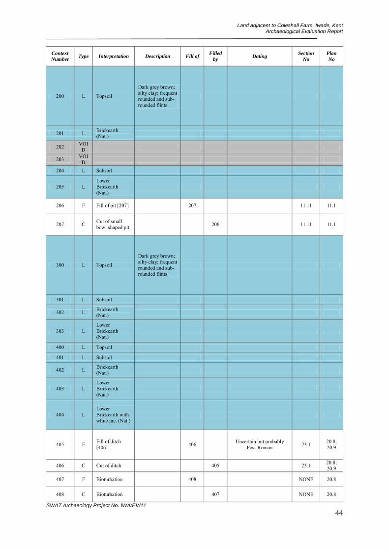
Land adjacent to Coleshall Farm, Iwade, Kent Archaeological Evaluation Report
SWAT Archaeology Project No. IWA/EV/11 44
Context
Number Type Interpretation Description Fill of
Filled
by Dating
Section
No
Plan
No
200 L Topsoil
Dark grey brown; silty clay; frequent rounded and sub-rounded flints
201 L Brickearth (Nat.)
202 VOID
203 VOID
204 L Subsoil
205 L Lower Brickearth (Nat.)
206 F Fill of pit [207] 207 11.11 11.1
207 C Cut of small bowl shaped pit 206 11.11 11.1
300 L Topsoil
Dark grey brown; silty clay; frequent rounded and sub-rounded flints
301 L Subsoil
302 L Brickearth (Nat.)
303 L Lower Brickearth (Nat.)
400 L Topsoil
401 L Subsoil
402 L Brickearth (Nat.)
403 L Lower Brickearth (Nat.)
404 L Lower Brickearth with white inc. (Nat.)
405 F Fill of ditch [406] 406 Uncertain but probably
Post-Roman 23.1 20.8; 20.9
406 C Cut of ditch 405 23.1 20.8; 20.9
407 F Bioturbation 408 NONE 20.8
408 C Bioturbation 407 NONE 20.8

Land adjacent to Coleshall Farm, Iwade, Kent Archaeological Evaluation Report
SWAT Archaeology Project No. IWA/EV/11 45
Context
Number Type Interpretation Description Fill of
Filled
by Dating
Section
No
Plan
No
409 F Bioturbation - tree bole 410 NONE 20.8
410 C Bioturbation - tree bole 409 NONE 20.8
411 F Fill of [412] 412 23.1 20.9
412 C Cut of possible pit 411 23.1 20.9
413 F Fill of [414] 414 Uncertain 23.2 20.9
414 C Cut of possible pit or ditch 413 23.2 20.9
415 F Fill of [406] or [412] 406/41
2? 22.1 NONE
500 L Topsoil
Dark grey brown; silty clay; frequent rounded and sub-rounded flints
501 L Subsoil
502 L Brickearth (Nat.)
503 F Fill of post hole [504] 504 21.3 21.1
504 C Cut of post hole 503 21.3 21.1
505 F Fill of probable tree throw [506] 506 Middle Neolithic 21.2 21.1
506 C Cut/interface of probable tree throw
505 21.2 21.1
507 F Fill of post hole [508] 508 21.5 21.1
508 C Cut of probable post hole 507 21.5 21.1
509 F Rooting 510 NONE 21.1
510 C Rooting 509 NONE 21.1
511 F Rooting 512 Uncertain NONE 21.1
512 C Rooting 511 NONE 21.1
513 VOID
514 VOID
515 F
Fill of probable shallow depression in natural brickearth [516]
516 Uncertain but probably Early Prehistoric 21.6 21.1

Land adjacent to Coleshall Farm, Iwade, Kent Archaeological Evaluation Report
SWAT Archaeology Project No. IWA/EV/11 46
Context
Number Type Interpretation Description Fill of
Filled
by Dating
Section
No
Plan
No
516 C
Interface of probable shallow depression
515 21.6 21.1
517 F Fill of shallow oval feature [518]
518 21.4 21.1
518 C
Possible cut of shallow or truncated pit or possible bioturbation
517 21.4 21.1
600 L Topsoil
Dark grey brown; silty clay; frequent rounded and sub-rounded flints
601 L Subsoil
602 L Brickearth (Nat.)
603 L Lower Brickearth (Nat.)
604 F Fill of possible pit [605] 605 9.16 22.1
605 C Cut of possible pit or possible tree bole
604 9.16 22.1
606 F Fill of possible stake hole [607] 607 9.17 22.1
607 C Cut of possible stake hole 606 9.17 22.1
608 F Fill of possible ditch terminus or oval pit [609]
609 9.18 22.1
609 C
Cut of possible ditch terminus or possible oval shaped pit
608 9.18 22.1
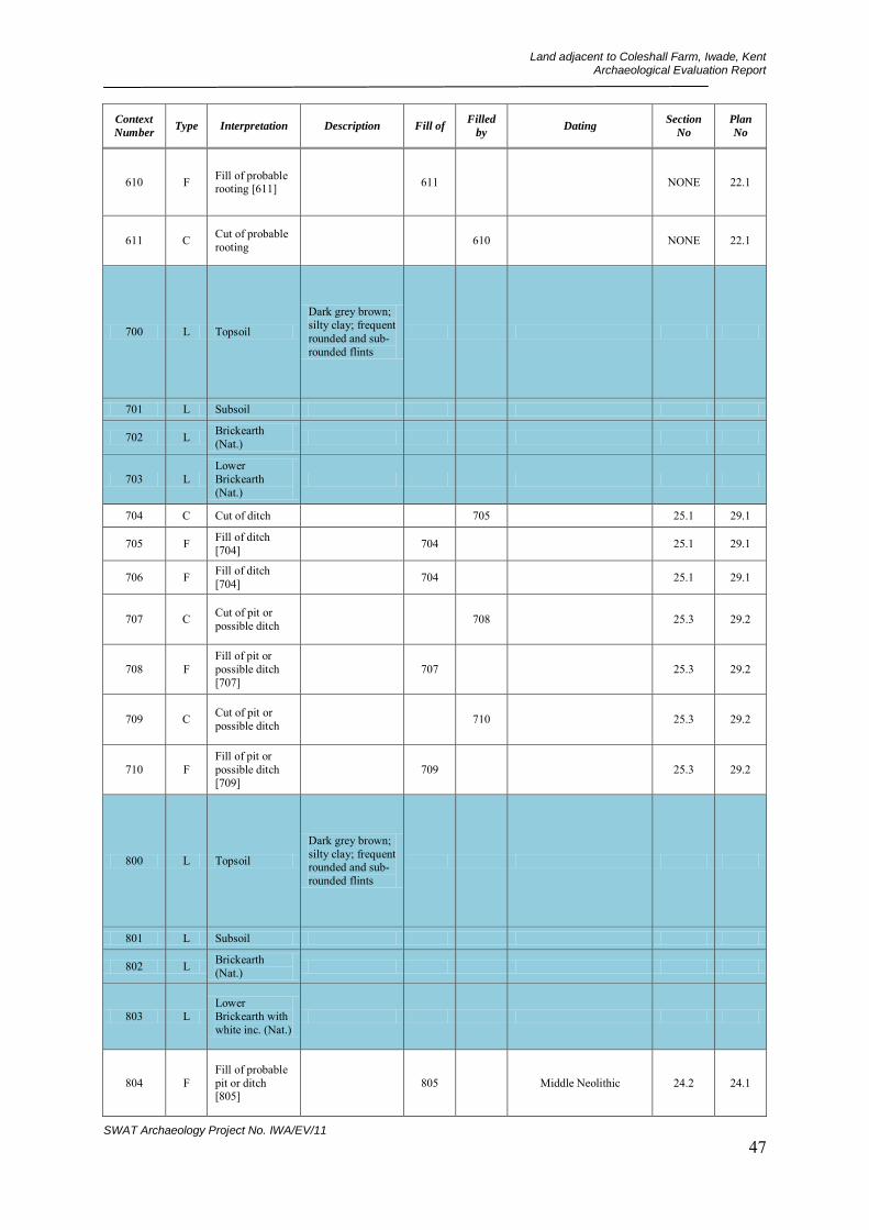
Land adjacent to Coleshall Farm, Iwade, Kent Archaeological Evaluation Report
SWAT Archaeology Project No. IWA/EV/11 47
Context
Number Type Interpretation Description Fill of
Filled
by Dating
Section
No
Plan
No
610 F Fill of probable rooting [611] 611 NONE 22.1
611 C Cut of probable rooting 610 NONE 22.1
700 L Topsoil
Dark grey brown; silty clay; frequent rounded and sub-rounded flints
701 L Subsoil
702 L Brickearth (Nat.)
703 L Lower Brickearth (Nat.)
704 C Cut of ditch 705 25.1 29.1
705 F Fill of ditch [704] 704 25.1 29.1
706 F Fill of ditch [704] 704 25.1 29.1
707 C Cut of pit or possible ditch 708 25.3 29.2
708 F Fill of pit or possible ditch [707]
707 25.3 29.2
709 C Cut of pit or possible ditch 710 25.3 29.2
710 F Fill of pit or possible ditch [709]
709 25.3 29.2
800 L Topsoil
Dark grey brown; silty clay; frequent rounded and sub-rounded flints
801 L Subsoil
802 L Brickearth (Nat.)
803 L Lower Brickearth with white inc. (Nat.)
804 F Fill of probable pit or ditch [805]
805 Middle Neolithic 24.2 24.1
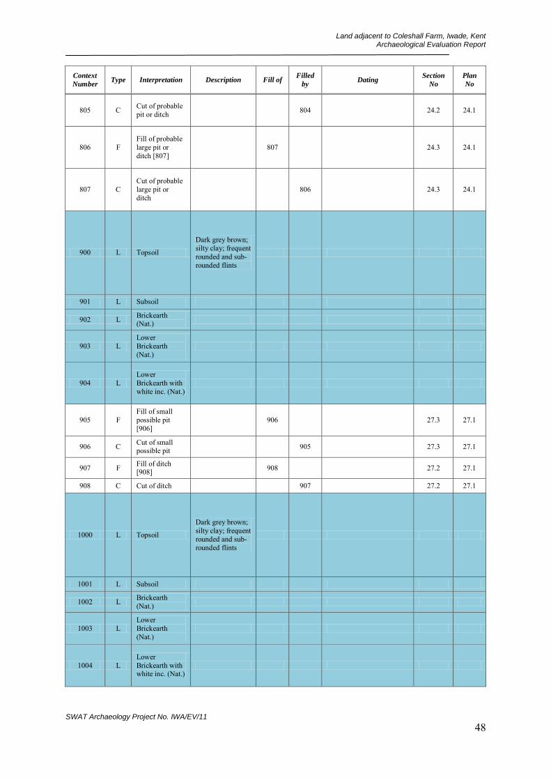
Land adjacent to Coleshall Farm, Iwade, Kent Archaeological Evaluation Report
SWAT Archaeology Project No. IWA/EV/11 48
Context
Number Type Interpretation Description Fill of
Filled
by Dating
Section
No
Plan
No
805 C Cut of probable pit or ditch 804 24.2 24.1
806 F Fill of probable large pit or ditch [807]
807 24.3 24.1
807 C Cut of probable large pit or ditch
806 24.3 24.1
900 L Topsoil
Dark grey brown; silty clay; frequent rounded and sub-rounded flints
901 L Subsoil
902 L Brickearth (Nat.)
903 L Lower Brickearth (Nat.)
904 L Lower Brickearth with white inc. (Nat.)
905 F Fill of small possible pit [906]
906 27.3 27.1
906 C Cut of small possible pit 905 27.3 27.1
907 F Fill of ditch [908] 908 27.2 27.1
908 C Cut of ditch 907 27.2 27.1
1000 L Topsoil
Dark grey brown; silty clay; frequent rounded and sub-rounded flints
1001 L Subsoil
1002 L Brickearth (Nat.)
1003 L Lower Brickearth (Nat.)
1004 L Lower Brickearth with white inc. (Nat.)
Land adjacent to Coleshall Farm, Iwade, Kent Archaeological Evaluation Report
SWAT Archaeology Project No. IWA/EV/11 49
Context
Number Type Interpretation Description Fill of
Filled
by Dating
Section
No
Plan
No
1005 F Fill of small shallow oval pit [1006]
1006 Medieval 9.7 18.1
1006 C Cut of small shallow oval pit 1005 9.7 18.1
1007 F Fill of post hole [1008] 1008 9.6 18.1
1008 C Cut of post hole 1007 9.6 18.1
1009 F Fill of ditch terminus [1010] 1010 Uncertain but probably
Post-Roman 9.5 18.1
1010 C Cut of curved ditch terminus 1009 9.5 18.1
1011 F Fill of curved ditch [1012] 1012 Uncertain but probably
Post-Roman 9.4 18.1
1012 C Cut of curved ditch 1011 9.4 18.1
1013 F Fill of ditch terminus [1014] 1014 Uncertain but probably
Post-Roman 9.3 18.1
1014 C Cut of ditch terminus 1013 9.3 18.1
1015 F Fill of N - S aligned ditch [1016]
1016 9.2 18.1
1016 C Cut of N - S aligned ditch 1015 9.2 18.1
1017 F Fill of probable post hole [1018] 1018 9.1 18.1
1018 C Cut of probable post hole 1017 9.1 18.1
1019 F Fill of shallow pit [1030] 1030 Medieval
9.11; 9.12; 19.2
18.1; 19.1
1020 F
Fill of small sub rectangular pit/possible large post hole [1021]
1021 Medieval 9.13; 9.14 19.1
1021 C
Cut of small rectangular pit/large post hole
1020 9.13; 9.15 19.1

Land adjacent to Coleshall Farm, Iwade, Kent Archaeological Evaluation Report
SWAT Archaeology Project No. IWA/EV/11 50
Context
Number Type Interpretation Description Fill of
Filled
by Dating
Section
No
Plan
No
1022 F Fill of curved ditch [1023] 1023 9.8 18.1
1023 C Cut of curved ditch 1022 9.8 18.1
1024 VOID
1025 VOID
1026 F Fill of possible shallow pit [1027]
1027 Medieval 9.9 18.1; 19.1
1027 C Cut of possible shallow pit 1026 9.9 18.1;
19.1
1028 F Fill of small oval pit [1029] 1029 Medieval 9.1 18.1;
19.1
1029 C Cut of small oval pit 1028 9.1 18.1;
19.1
1030 C Cut of shallow pit 1019
9.11; 9.12; 19.2
18.1; 19.1
1031 F Fill of ditch [1032] 1032 Early Medieval 9.15 18.1
1032 C Cut of ditch 1031 9.15 18.1
1033 VOID
1034 F Fill of pit [1038] 1038 26.1;
26.2 18.1; 28.2
1035 F Fill of pit [1038] 1038 26.1;
26.2 18.1; 28.2
1036 VOID
1037 F Fill of large pit [1038] 1038 Medieval 26.1;
26.2 18.1; 28.2
1038 C Cut of large pit 1034;1035;10
37 26.1;
26.2 18.1; 28.2
1039 F Fill of shallow pit [1040] 1040 Uncertain but probably
Post-Roman 26.1; 26.2
18.1; 28.2
1040 C Cut of shallow pit 1039 26.1;
26.2 18.1; 28.2
1041 F Fill of shallow pit [1042] 1042 26.2 NONE
1042 C Cut of shallow pit 1041 26.2 NONE
1100 L Topsoil
Dark grey brown; silty clay; frequent rounded and sub-rounded flints

Land adjacent to Coleshall Farm, Iwade, Kent Archaeological Evaluation Report
SWAT Archaeology Project No. IWA/EV/11 51
Context
Number Type Interpretation Description Fill of
Filled
by Dating
Section
No
Plan
No
1101 L Subsoil
1102 L Brickearth (Nat.)
1103 L Lower Brickearth (Nat.)
1104 L Lower Brickearth with white inc. (Nat.)
1105 F
Fill of Bioturbation/Root action of [1106]
1106 NONE 20.1
1106 C Bioturbation/Root action 1105 NONE 20.1
1200 L Topsoil
Dark grey brown; silty clay; frequent rounded and sub-rounded flints
1201 L Subsoil
1202 L Brickearth (Nat.)
1203 L Lower Brickearth with white inc. (Nat.)
1204 F Fill of possible post hole/stake hole [1205]
1205 20.4 20.2
1205 C Cut of possible post hole/stake hole
1204 20.4 20.2
1206 F Fill of possible post hole [1207] 1207 20.4 20.2
1207 C Cut of possible post hole 1206 20.4 20.2
1208 F
Fill of Bioturbation/natural feature [1209]
1209 20.5; 20.6 20.3

Land adjacent to Coleshall Farm, Iwade, Kent Archaeological Evaluation Report
SWAT Archaeology Project No. IWA/EV/11 52
Context
Number Type Interpretation Description Fill of
Filled
by Dating
Section
No
Plan
No
1209 C Interface of Bioturbation/natural feature
1208 20.5; 20.6 20.3
1300 L Topsoil
Dark grey brown; silty clay; frequent rounded and sub-rounded flints
1301 L Brickearth (Nat.)
1302 L Lower Brickearth with white inc. (Nat.)
1400 L Topsoil
Dark grey brown; silty clay; frequent rounded and sub-rounded flints
1401 L Subsoil
1402 L Brickearth (Nat.)
1403 L Lower Brickearth with white inc. (Nat.)
1404 C Cut of pit or ditch terminus 1405 15.1 16.1
1405 F Fill of pit or ditch terminus [1404]
1404 Uncertain but probably Early Prehistoric 15.1 16.1
1406 C Cut of oval pit or possible post hole remains
1407 15.2 16.1
1407 F Fill of oval pit or possible post hole [1406]
1406 15.2 16.1
1408 C Cut of ditch 1409;1410 15.3 16.1
1409 F Fill of ditch [1408] 1408 15.3 16.1
1410 F Fill of ditch [1408] 1408 Middle Neolithic 15.3 16.1
1411 C Cut of pit or ditch 1412 15.4 16.1

Land adjacent to Coleshall Farm, Iwade, Kent Archaeological Evaluation Report
SWAT Archaeology Project No. IWA/EV/11 53
Context
Number Type Interpretation Description Fill of
Filled
by Dating
Section
No
Plan
No
1412 F Fill of pit or ditch [1411] 1411 15.4 16.1
1500 L Topsoil
Dark grey brown; silty clay; frequent rounded and sub-rounded flints
1501 L Subsoil
1502 L Brickearth (Nat.)
1503 L Lower Brickearth with white inc. (Nat.)
1504 C Cut of ditch and/or pit
1505;1506;1507;1508;1509:1528;1
529
10.1 12.1; 13.1
1505 F Fill of feature [1504] 1504 10.1 12.1;
13.1
1506 F Fill of feature [1504] 1504 Early-Mid Iron Age 10.1 NONE
1507 F
Backfill/dump of burnt material of feature [1504]
1504 Early-Mid Iron Age 10.1 NONE
1508 F Fill of [1504] 1504 Early-Mid Iron Age 10.1 NONE
1509 F Fill of [1504] 1504 10.1 NONE
1510 C Cut of post hole 1511 11.1 12.1; 13.1
1511 F Fill of [1510] 1510 11.1 12.1; 13.1
1512 C Cut of post hole 1513 11.2 12.1; 13.1
1513 F Fill of post hole [1512] 1512 11.2 12.1;
13.1
1514 C Cut of large post hole 1515 11.5 12.1;
13.1
1515 F Fill of post hole [1514] 1514 11.5 12.1;
13.1
1516 C Cut of large post hole remains
1517 11.7 12.1
1517 F Fill of post hole [1516] 1516 11.7 12.1
1518 C Cut of post hole 1518 11.3 12.1; 13.1
1519 F Fill of post hole [1518] 1518 11.3 12.1;
13.1

Land adjacent to Coleshall Farm, Iwade, Kent Archaeological Evaluation Report
SWAT Archaeology Project No. IWA/EV/11 54
Context
Number Type Interpretation Description Fill of
Filled
by Dating
Section
No
Plan
No
1520 C Cut of stakehole 1521 11.6 13.1
1521 F Fill of stakehole [1520] 1520 11.6 13.1
1522 C Cut of post hole 1523 11.4 12.1: 13.1
1523 F Fill of post hole [1522] 1522 NONE NONE
1524 C Cut of post hole 1525 11.9 13.1
1525 F Fill of post hole [1524] 1524 11.9 13.1
1526 C Cut of oval pit 1527 11.8 13.1
1527 F Fill of oval pit [1526] 1526 11.8 13.1
1528 F Fill of feature [1504] 1504 10.1 NONE
1529 F Fill of feature [1504] 1504 10.1 NONE
1600 L Topsoil
Dark grey brown; silty clay; frequent rounded and sub-rounded flints
1601 L Subsoil
1602 L Brickearth (Nat.)
1603 L Lower Brickearth with white inc. (Nat.)
1604 F Fill of natural feature [1605] 1605 NONE 8.2
1605 C Interface of natural feature 1604 NONE 8.2
1606 F Fill of natural feature [1607] 1607 NONE 8.2
1607 C Interface of natural feature 1606 NONE 8.2
Land adjacent to Coleshall Farm, Iwade, Kent Archaeological Evaluation Report
SWAT Archaeology Project No. IWA/EV/11 55
Context
Number Type Interpretation Description Fill of
Filled
by Dating
Section
No
Plan
No
1700 L Topsoil
Dark grey brown; silty clay; frequent rounded and sub-rounded flints
1701 L Subsoil
1702 L Brickearth (Nat.)
1703 L Lower Brickearth (Nat.)
1704 L Lower Brickearth with white inc. (Nat.)
1705 F Fill of possible stakehole [1706]
1706 NONE 7.6
1706 C Cut of possible stakehole 1705 NONE 7.6
1800 L Topsoil
Dark grey brown; silty clay; frequent rounded and sub-rounded flints
1801 L Subsoil
1802 L Brickearth (Nat.)
1803 L Lower Brickearth (Nat.)
1804 L Lower Brickearth with white inc. (Nat.)
1900 L Topsoil
Dark grey brown; silty clay; frequent rounded and sub-rounded flints
1901 L Subsoil
1902 L Brickearth (Nat.)
1903 L Lower Brickearth (Nat.)
Land adjacent to Coleshall Farm, Iwade, Kent Archaeological Evaluation Report
SWAT Archaeology Project No. IWA/EV/11 56
Context
Number Type Interpretation Description Fill of
Filled
by Dating
Section
No
Plan
No
1904 F Fill of natural feature [1905] 1905 NONE 7.5
1905 C Cut of bioturbation feature
1904 NONE 7.5
2000 L Topsoil
Dark grey brown; silty clay; frequent rounded and sub-rounded flints
2001 L Subsoil
2002 L Brickearth (Nat.)
2003 L Lower Brickearth with white inc. (Nat.)
2100 L Topsoil
Dark grey brown; silty clay; frequent rounded and sub-rounded flints
2101 L Subsoil
2102 L Brickearth (Nat.)
2200 L Topsoil
Dark grey brown; silty clay; frequent rounded and sub-rounded flints
2201 L Subsoil
2202 L Brickearth (Nat.)
2203 L Lower Brickearth (Nat.)
2204 C Cut of ditch 2205 25.2 28.1
2205 F Fill of ditch [2204] 2204 Uncertain but probably
Later Prehistoric 25.2 28.1

Land adjacent to Coleshall Farm, Iwade, Kent Archaeological Evaluation Report
SWAT Archaeology Project No. IWA/EV/11 57
Context
Number Type Interpretation Description Fill of
Filled
by Dating
Section
No
Plan
No
2206 F
Fill of possible prehistoric hollow way [2207]
2207 U 25.5 28.1
2207 C Cut of possible prehistoric hollow way
2206 25.5 28.1
2300 L Topsoil
Dark grey brown; silty clay; frequent rounded and sub-rounded flints
2301 L Subsoil
2302 L Brickearth (Nat.)
2303 L Lower Brickearth with white inc. (Nat.)
2304 F Fill of nature feature [2305] 2305 NONE 7.4
2305 C
Interface of probable bioturbation feature
2304 NONE 7.4
2400 L Topsoil
Dark grey brown; silty clay; frequent rounded and sub-rounded flints
2401 L Subsoil
2402 L Brickearth (Nat.)
2403 F Fill of ditch [2405] 2405 7.2; 7.3 7.1; 8.1
2404 F Fill of ditch [2405] 2405 7.2; 7.3 7.1;
8.1?
2405 C Cut of NW-SE aligned ditch 2403;2
404 7.2; 7.3 7.1; 8.1
2406 F Fill of nature feature [2407] 2407 NONE 8.1
Land adjacent to Coleshall Farm, Iwade, Kent Archaeological Evaluation Report
SWAT Archaeology Project No. IWA/EV/11 58
Context
Number Type Interpretation Description Fill of
Filled
by Dating
Section
No
Plan
No
2407 C
Interface of probable bioturbation feature/tree bole
2406 NONE 8.1
2408 F Fill of nature feature [2409] 2409 NONE 8.1
2409 C
Interface of probable bioturbation feature/tree bole
2408 NONE 8.1
2500 L Topsoil
Dark grey brown; silty clay; frequent rounded and sub-rounded flints
2501 L Subsoil
2502 L Brickearth (Nat.)
2503 L Lower Brickearth (Nat.)
2504 L Lower Brickearth with white inc. (Nat.)
2505 F Fill of nature feature [2506] 2506 NONE 8.3
2506 C
Interface of probable bioturbation feature/tree bole
2505 NONE 8.3
2507 F Fill of nature feature [2508] 2508 NONE 8.3
2508 C
Interface of probable bioturbation feature/tree bole
2507 NONE 8.3
2509 F Natural brickearth NONE 8.3

Land adjacent to Coleshall Farm, Iwade, Kent Archaeological Evaluation Report
SWAT Archaeology Project No. IWA/EV/11 59
Context
Number Type Interpretation Description Fill of
Filled
by Dating
Section
No
Plan
No
2510 F Natural brickearth (with discolouration)
NONE 8.3
2600 L Topsoil
Dark grey brown; silty clay; frequent rounded and sub-rounded flints
2601 L Subsoil
2602 L Brickearth (Nat.)
2603 L Lower Brickearth with white inc. (Nat.)
2604 F Fill of bioturbation feature [2605]
2605 NONE 17.3
2605 C
Interface of bioturbation feature (probable animal burrow)
2604 NONE 17.3
2606 F Fill of bioturbation feature [2607]
2607 17.5 17.3
2607 C
Interface of bioturbation feature (probable animal burrow)
2606 17.5 17.3
2608 F
Fill of possible ditch/probable bioturbation feature [2609]
2609 17.6; 17.7 17.3
2609 C
Cut of possible ditch/probable bioturbation feature
2608 17.6; 17.7 17.3
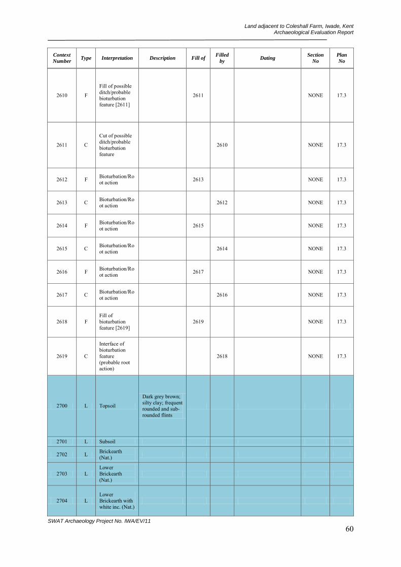
Land adjacent to Coleshall Farm, Iwade, Kent Archaeological Evaluation Report
SWAT Archaeology Project No. IWA/EV/11 60
Context
Number Type Interpretation Description Fill of
Filled
by Dating
Section
No
Plan
No
2610 F
Fill of possible ditch/probable bioturbation feature [2611]
2611 NONE 17.3
2611 C
Cut of possible ditch/probable bioturbation feature
2610 NONE 17.3
2612 F Bioturbation/Root action 2613 NONE 17.3
2613 C Bioturbation/Root action 2612 NONE 17.3
2614 F Bioturbation/Root action 2615 NONE 17.3
2615 C Bioturbation/Root action 2614 NONE 17.3
2616 F Bioturbation/Root action 2617 NONE 17.3
2617 C Bioturbation/Root action 2616 NONE 17.3
2618 F Fill of bioturbation feature [2619]
2619 NONE 17.3
2619 C
Interface of bioturbation feature (probable root action)
2618 NONE 17.3
2700 L Topsoil
Dark grey brown; silty clay; frequent rounded and sub-rounded flints
2701 L Subsoil
2702 L Brickearth (Nat.)
2703 L Lower Brickearth (Nat.)
2704 L Lower Brickearth with white inc. (Nat.)

Land adjacent to Coleshall Farm, Iwade, Kent Archaeological Evaluation Report
SWAT Archaeology Project No. IWA/EV/11 61
Context
Number Type Interpretation Description Fill of
Filled
by Dating
Section
No
Plan
No
2705 F Fill of possible ditch [2706] 2706 17.2;
17.8 17.1
2706 C Cut of possible ditch 2705 17.2;
17.8 17.1
2707 F Fill of nature feature [2708] 2708 NONE 8.4
2708 C
Interface of probable bioturbation feature/tree bole
2707 NONE 17.1
2709 F Fill of possible pit [2710] 2710 Early-Mid Iron Age 17.11 17.1
2710 C Cut of possible pit 2709 17.11 17.1
2711 F Fill of possible pit [2712] 2712 17.12 17.1
2712 C Cut of possible pit/possible tree bole
2711 17.12 17.1
2713 F Fill of possible post hole [2714] 2714 17.1 17.1
2714 C Cut of possible post hole 2713 17.1 17.1
2715 F Fill of possible post hole [2716] 2716 17.9 17.1
2716 C Cut of possible post hole 2715 17.9 17.1
2717 F Fill of linear feature [2718] 2718 NONE 8.4;
17.1
2718 C Cut of linear feature 2717 NONE 8.4;
17.1
2800 L Topsoil
Dark grey brown; silty clay; frequent rounded and sub-rounded flints
2801 L Subsoil
2802 L Brickearth (Nat.)

Land adjacent to Coleshall Farm, Iwade, Kent Archaeological Evaluation Report
SWAT Archaeology Project No. IWA/EV/11 62
Context
Number Type Interpretation Description Fill of
Filled
by Dating
Section
No
Plan
No
2803 L Lower Brickearth with white inc. (Nat.)
2900 L Topsoil
Dark grey brown; silty clay; frequent rounded and sub-rounded flints
2901 L Subsoil
2902 L Brickearth (Nat.)
2903 L Lower Brickearth (Nat.)
2904 L Lower Brickearth with white inc. (Nat.)
2905 F Fill of nature feature [2906] 2906 NONE 17.4
2906 C
Interface of probable bioturbation feature/tree bole
2905 NONE 17.4
2907 F Fill of nature feature [2908] 2908 NONE 17.4
2908 C
Interface of probable bioturbation feature/tree bole
2907 NONE 17.4
3000 L Topsoil
Dark grey brown; silty clay; frequent rounded and sub-rounded flints
3001 L Subsoil
3002 L Brickearth (Nat.)
3003 L Lower Brickearth with white inc. (Nat.)
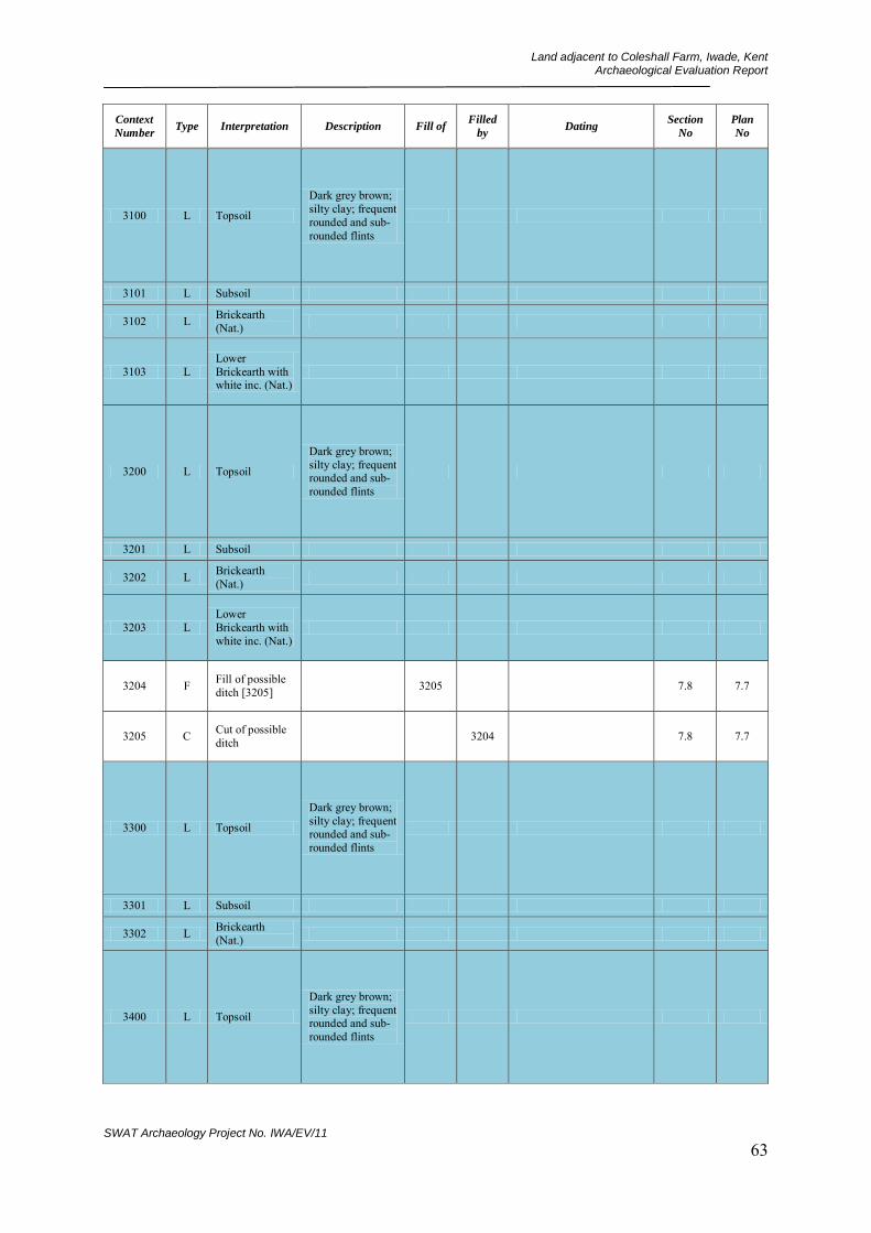
Land adjacent to Coleshall Farm, Iwade, Kent Archaeological Evaluation Report
SWAT Archaeology Project No. IWA/EV/11 63
Context
Number Type Interpretation Description Fill of
Filled
by Dating
Section
No
Plan
No
3100 L Topsoil
Dark grey brown; silty clay; frequent rounded and sub-rounded flints
3101 L Subsoil
3102 L Brickearth (Nat.)
3103 L Lower Brickearth with white inc. (Nat.)
3200 L Topsoil
Dark grey brown; silty clay; frequent rounded and sub-rounded flints
3201 L Subsoil
3202 L Brickearth (Nat.)
3203 L Lower Brickearth with white inc. (Nat.)
3204 F Fill of possible ditch [3205] 3205 7.8 7.7
3205 C Cut of possible ditch 3204 7.8 7.7
3300 L Topsoil
Dark grey brown; silty clay; frequent rounded and sub-rounded flints
3301 L Subsoil
3302 L Brickearth (Nat.)
3400 L Topsoil
Dark grey brown; silty clay; frequent rounded and sub-rounded flints

Land adjacent to Coleshall Farm, Iwade, Kent Archaeological Evaluation Report
SWAT Archaeology Project No. IWA/EV/11 64
Context
Number Type Interpretation Description Fill of
Filled
by Dating
Section
No
Plan
No
3401 L Lower Brickearth with white inc. (Nat.)
3402 L Brickearth (Nat.)
3403 L Lower Brickearth with white inc. (Nat.)
3404 F Fill of possible ditch [3405] 3405 Uncertain but probably
Later Prehistoric 30.5 30.1
3405 F Cut of possible ditch 3404 30.5 30.1
3406 F Fill of possible tree throw/pit [3407]
3407 30.3 30.1
3407 C Cut of possible tree throw/pit 3406 30.3 30.1
3408 F Fill of possible tree throw/pit [3409]
3409 30.4 30.1
3409 C Cut of possible tree throw/pit 3408 30.4 30.1
3410 F Fill of possible tree throw/pit [3407]
3407 30.3 30.1
3500 L Topsoil
Dark grey brown; silty clay; frequent rounded and sub-rounded flints
3501 L Subsoil
3502 L Brickearth (Nat.)
3503 L Lower Brickearth (Nat.)

Land adjacent to Coleshall Farm, Iwade, Kent Archaeological Evaluation Report
SWAT Archaeology Project No. IWA/EV/11 65
Context
Number Type Interpretation Description Fill of
Filled
by Dating
Section
No
Plan
No
3504 L Lower Brickearth with white inc. (Nat.)
3600 L Topsoil
Dark grey brown; silty clay; frequent rounded and sub-rounded flints
3601 L Subsoil
3602 L Brickearth (Nat.)
3603 L Lower Brickearth with white inc. (Nat.)
3700 L Topsoil
Dark grey brown; silty clay; frequent rounded and sub-rounded flints
3701 L Subsoil
3702 L Brickearth (Nat.)
3703 L Lower Brickearth with white inc. (Nat.)
3704 F Fill of nature feature [3705] 3705 NONE 30.2
3705 C
Interface of probable bioturbation feature/tree bole
3704 NONE 30.2
3800 L Topsoil
Dark grey brown; silty clay; frequent rounded and sub-rounded flints
3801 L Subsoil
3802 L Brickearth (Nat.)
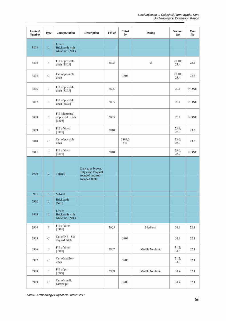
Land adjacent to Coleshall Farm, Iwade, Kent Archaeological Evaluation Report
SWAT Archaeology Project No. IWA/EV/11 66
Context
Number Type Interpretation Description Fill of
Filled
by Dating
Section
No
Plan
No
3803 L Lower Brickearth with white inc. (Nat.)
3804 F Fill of possible ditch [3805] 3805 U 20.10;
23.4 23.3
3805 C Cut of possible ditch 3804 20.10;
23.4 23.3
3806 F Fill of possible ditch [3805] 3805 20.1 NONE
3807 F Fill of possible ditch [3805] 3805 20.1 NONE
3808 F Fill (slumping) of possible ditch [3805]
3805 20.1 NONE
3809 F Fill of ditch [3810] 3810 23.6;
23.7 23.5
3810 C Cut of possible ditch 3809;3
811 23.6; 23.7 23.5
3811 F Fill of ditch [3810] 3810 23.6;
23.7 NONE
3900 L Topsoil
Dark grey brown; silty clay; frequent rounded and sub-rounded flints
3901 L Subsoil
3902 L Brickearth (Nat.)
3903 L Lower Brickearth with white inc. (Nat.)
3904 F Fill of ditch [3905] 3905 Medieval 31.1 32.1
3905 C Cut of NE - SW aligned ditch 3904 31.1 32.1
3906 F Fill of ditch [3907] 3907 Middle Neolithic 31.2;
31.3 32.1
3907 C Cut of shallow ditch 3906 31.2;
31.3 32.1
3908 F Fill of pit [3909] 3909 Middle Neolithic 31.4 32.1
3909 C Cut of small, narrow pit 3908 31.4 32.1

Land adjacent to Coleshall Farm, Iwade, Kent Archaeological Evaluation Report
SWAT Archaeology Project No. IWA/EV/11 67
Context
Number Type Interpretation Description Fill of
Filled
by Dating
Section
No
Plan
No
3910 F Fill of ditch [3911] 3911 Uncertain but probably
Early Prehistoric 31.4 32.1
3911 C Cut of NW-SE aligned ditch 3910 31.4 32.1
3912 F Fill of probable tree bole [3913] Unexcavated 3913 NONE 32.1
3913 C Cut/interface of probable tree bole
Unexcavated 3912 NONE 32.1
4000 L Topsoil
Dark grey brown; silty clay; frequent rounded and sub-rounded flints
4001 L Subsoil
4002 L Brickearth (Nat.)
4003 L Lower Brickearth (Nat.)
4004 L Lower Brickearth with white inc. (Nat.)
4005 C Cut of field gulley/ditch 4006 35.2 34.1
4006 F Fill of field gulley/ditch [4005]
4005 35.2 34.1
4007 C Cut of cess pit 4008;4013 35.1 34.1
4008 F Fill of cess pit [4007] 4007 U 35.1 34.1
4009 C Cut of shallow pit 4010 35.5 34.1
4010 F Fill of shallow pit [4009] 4009 35.5 34.1
4011 C Cut of oval pit or gulley/ditch terminus
4012 35.3 34.1
4012 F Fill of oval pit or gulley/ditch terminus [4011]
4011 35.3 34.1

Land adjacent to Coleshall Farm, Iwade, Kent Archaeological Evaluation Report
SWAT Archaeology Project No. IWA/EV/11 68
Context
Number Type Interpretation Description Fill of
Filled
by Dating
Section
No
Plan
No
4013 F Fill of cess pit [4007] 4007 Uncertain but probably
Post Roman 35.1 34.1?
4100 L Topsoil
Dark grey brown; silty clay; frequent rounded and sub-rounded flints
4101 L Subsoil
4102 L Brickearth (Nat.)
4103 L Lower Brickearth with white inc. (Nat.)
4104 C Cut of field gulley/ditch 4105 37.1 36.1
4105 F Fill of field gulley/ditch [4104]
4104 37.1 36.1
4200 L Topsoil
Dark grey brown; silty clay; frequent rounded and sub-rounded flints
4201 L Subsoil
4202 L Brickearth (Nat.)
4203 L Lower Brickearth with white inc. (Nat.)
4204 F Fill of post med post hole [4205] 4205 37.4 32.3
4205 C Cut of post med post hole 4204 37.4 32.3
4206 F Top fill of field boundary ditch [4207]
4207 Late Post-Medieval 37.5 32.3
4207 C Cut of post med field boundary ditch
4206;4212 37.5 32.3
4208 F Fill of ditch [4209] 4209 37.6 32.3
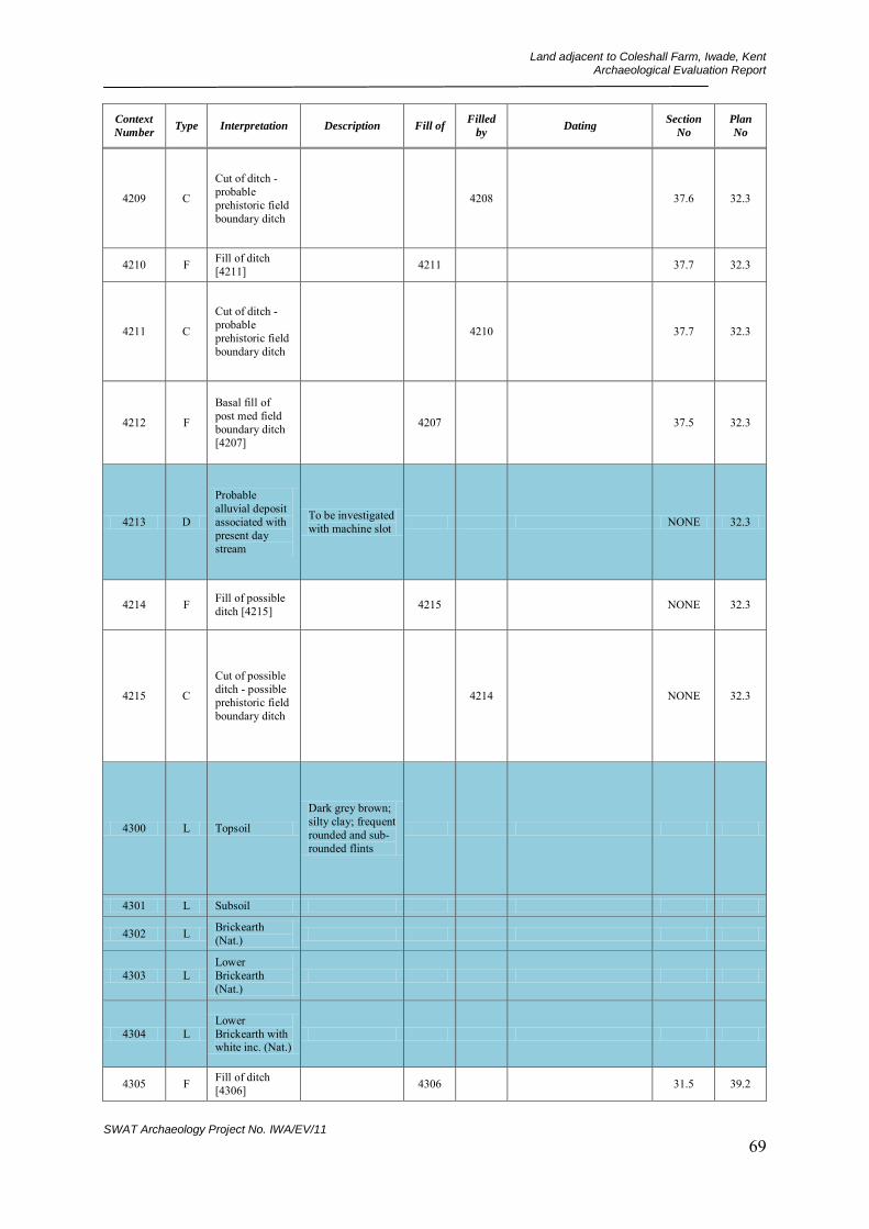
Land adjacent to Coleshall Farm, Iwade, Kent Archaeological Evaluation Report
SWAT Archaeology Project No. IWA/EV/11 69
Context
Number Type Interpretation Description Fill of
Filled
by Dating
Section
No
Plan
No
4209 C
Cut of ditch - probable prehistoric field boundary ditch
4208 37.6 32.3
4210 F Fill of ditch [4211] 4211 37.7 32.3
4211 C
Cut of ditch - probable prehistoric field boundary ditch
4210 37.7 32.3
4212 F
Basal fill of post med field boundary ditch [4207]
4207 37.5 32.3
4213 D
Probable alluvial deposit associated with present day stream
To be investigated with machine slot NONE 32.3
4214 F Fill of possible ditch [4215] 4215 NONE 32.3
4215 C
Cut of possible ditch - possible prehistoric field boundary ditch
4214 NONE 32.3
4300 L Topsoil
Dark grey brown; silty clay; frequent rounded and sub-rounded flints
4301 L Subsoil
4302 L Brickearth (Nat.)
4303 L Lower Brickearth (Nat.)
4304 L Lower Brickearth with white inc. (Nat.)
4305 F Fill of ditch [4306] 4306 31.5 39.2

Land adjacent to Coleshall Farm, Iwade, Kent Archaeological Evaluation Report
SWAT Archaeology Project No. IWA/EV/11 70
Context
Number Type Interpretation Description Fill of
Filled
by Dating
Section
No
Plan
No
4306 C Cut of NNW - SSE aligned ditch
4305 31.5 39.2
4307 F Fill of ditch [4308] 4308 31.6 39.2
4308 C Cut of N - S aligned ditch 4307 31.6 39.2
4309 F
Fill of probable pit/possible ditch terminus [4310]
4310 31.7 39.2
4310 C Cut of probable pit/possible ditch terminus
4309 31.7 39.2
4311 F Fill of large ditch [4312] 4312 31.8 39.2
4312 C Cut of large ditch 4311 31.8 39.2
4313 F Fill of large ditch terminus [4314]
4314 39.1 39.2
4314 C Cut of large ditch terminus 4313 39.1 39.2
4400 L Topsoil
Dark grey brown; silty clay; frequent rounded and sub-rounded flints
4401 L Subsoil
4402 L Brickearth (Nat.)
4403 L Lower Brickearth with white inc. (Nat.)
4404 C Cut of post hole remains 4405 37.2 36.3;
36.4
4405 F Fill of post hole [4404] 4404 37.2 36.3
4406 C Cut of oval pit 4407 37.3 36.3
4407 F Fill of oval pit [4406] 4406 Roman 37.3 36.3

Land adjacent to Coleshall Farm, Iwade, Kent Archaeological Evaluation Report
SWAT Archaeology Project No. IWA/EV/11 71
Context
Number Type Interpretation Description Fill of
Filled
by Dating
Section
No
Plan
No
4500 L Topsoil
Dark grey brown; silty clay; frequent rounded and sub-rounded flints
4501 L Subsoil
4502 L Brickearth (Nat.)
4503 L Lower Brickearth (Nat.)
4504 L Lower Brickearth with white inc. (Nat.)
4505 C Modern electricity trench
NONE NONE
4506 C Cut of field gulley/ditch 4507 49.6 48.1
4507 F Fill of field gulley/ditch [4506]
4506 46.6 48.1
4508 C Cut of field gulley/ditch 4507 49.2 -
49.4 48.1
4509 F Fill of field gulley/ditch [4508]
4508 49.2 - 49.4 48.1
4510 C Cut of large pit 4511 49.7 48.1
4511 F Fill of large pit [4510] 4510 49.7 48.1
4512 C Cut of oval pit 4513 49.2 48.1
4513 F Fill of oval pit [4512] 4512 49.2 48.1
4514 C Cut of oval shaped post hole
4515 49.4 48.1
4515 F Fill of post hole [4514] 4514 49.4 48.1
4600 L Topsoil
Dark grey brown; silty clay; frequent rounded and sub-rounded flints
4601 L Subsoil
4602 L Brickearth (Nat.)
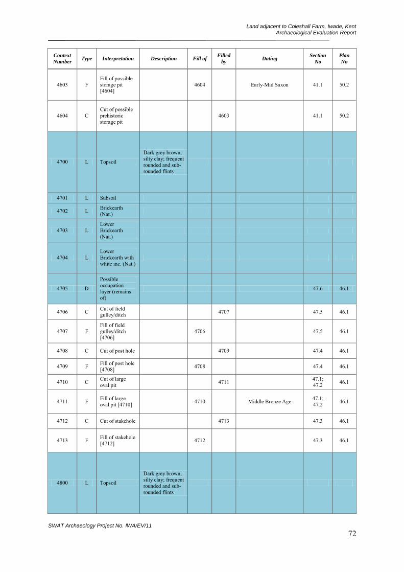
Land adjacent to Coleshall Farm, Iwade, Kent Archaeological Evaluation Report
SWAT Archaeology Project No. IWA/EV/11 72
Context
Number Type Interpretation Description Fill of
Filled
by Dating
Section
No
Plan
No
4603 F Fill of possible storage pit [4604]
4604 Early-Mid Saxon 41.1 50.2
4604 C Cut of possible prehistoric storage pit
4603 41.1 50.2
4700 L Topsoil
Dark grey brown; silty clay; frequent rounded and sub-rounded flints
4701 L Subsoil
4702 L Brickearth (Nat.)
4703 L Lower Brickearth (Nat.)
4704 L Lower Brickearth with white inc. (Nat.)
4705 D
Possible occupation layer (remains of)
47.6 46.1
4706 C Cut of field gulley/ditch 4707 47.5 46.1
4707 F Fill of field gulley/ditch [4706]
4706 47.5 46.1
4708 C Cut of post hole 4709 47.4 46.1
4709 F Fill of post hole [4708] 4708 47.4 46.1
4710 C Cut of large oval pit 4711 47.1;
47.2 46.1
4711 F Fill of large oval pit [4710] 4710 Middle Bronze Age 47.1;
47.2 46.1
4712 C Cut of stakehole 4713 47.3 46.1
4713 F Fill of stakehole [4712] 4712 47.3 46.1
4800 L Topsoil
Dark grey brown; silty clay; frequent rounded and sub-rounded flints
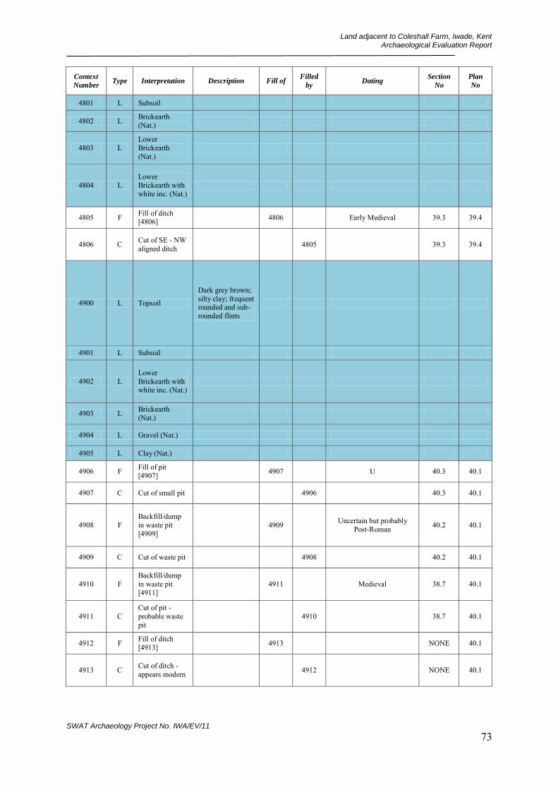
Land adjacent to Coleshall Farm, Iwade, Kent Archaeological Evaluation Report
SWAT Archaeology Project No. IWA/EV/11 73
Context
Number Type Interpretation Description Fill of
Filled
by Dating
Section
No
Plan
No
4801 L Subsoil
4802 L Brickearth (Nat.)
4803 L Lower Brickearth (Nat.)
4804 L Lower Brickearth with white inc. (Nat.)
4805 F Fill of ditch [4806] 4806 Early Medieval 39.3 39.4
4806 C Cut of SE - NW aligned ditch 4805 39.3 39.4
4900 L Topsoil
Dark grey brown; silty clay; frequent rounded and sub-rounded flints
4901 L Subsoil
4902 L Lower Brickearth with white inc. (Nat.)
4903 L Brickearth (Nat.)
4904 L Gravel (Nat.)
4905 L Clay (Nat.)
4906 F Fill of pit [4907] 4907 U 40.3 40.1
4907 C Cut of small pit 4906 40.3 40.1
4908 F Backfill/dump in waste pit [4909]
4909 Uncertain but probably Post-Roman 40.2 40.1
4909 C Cut of waste pit 4908 40.2 40.1
4910 F Backfill/dump in waste pit [4911]
4911 Medieval 38.7 40.1
4911 C Cut of pit - probable waste pit
4910 38.7 40.1
4912 F Fill of ditch [4913] 4913 NONE 40.1
4913 C Cut of ditch - appears modern 4912 NONE 40.1
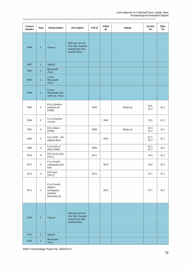
Land adjacent to Coleshall Farm, Iwade, Kent Archaeological Evaluation Report
SWAT Archaeology Project No. IWA/EV/11 74
Context
Number Type Interpretation Description Fill of
Filled
by Dating
Section
No
Plan
No
5000 L Topsoil
Dark grey brown; silty clay; frequent rounded and sub-rounded flints
5001 L Subsoil
5002 L Brickearth (Nat.)
5003 L Lower Brickearth (Nat.)
5004 L Lower Brickearth with white inc. (Nat.)
5005 F Fill of shallow probable pit [5006]
5006 Medieval 39.8; 42.2 42.1
5006 C Cut of shallow oval pit 5005 39.8 42.1
5007 F Fill of ditch [5008] 5008 Medieval 42.2;
42.3 42.1
5008 C Cut of SW - NE aligned ditch 5007 42.2;
42.3 42.1
5009 F Lower fill of ditch [5008] 5008 42.2;
42.3 42.1
5010 F Fill of post hole [5011] 5011 39.6 42.1
5011 C Cut of small rectangular post hole
5010 39.6 42.1
5012 F Fill of pit [5013] 5013 39.7 42.1
5013 C
Cut of small, shallow, rectangular, probably truncated, pit
5012 39.7 42.1
5100 L Topsoil
Dark grey brown; silty clay; frequent rounded and sub-rounded flints
5101 L Subsoil
5102 L Brickearth (Nat.)
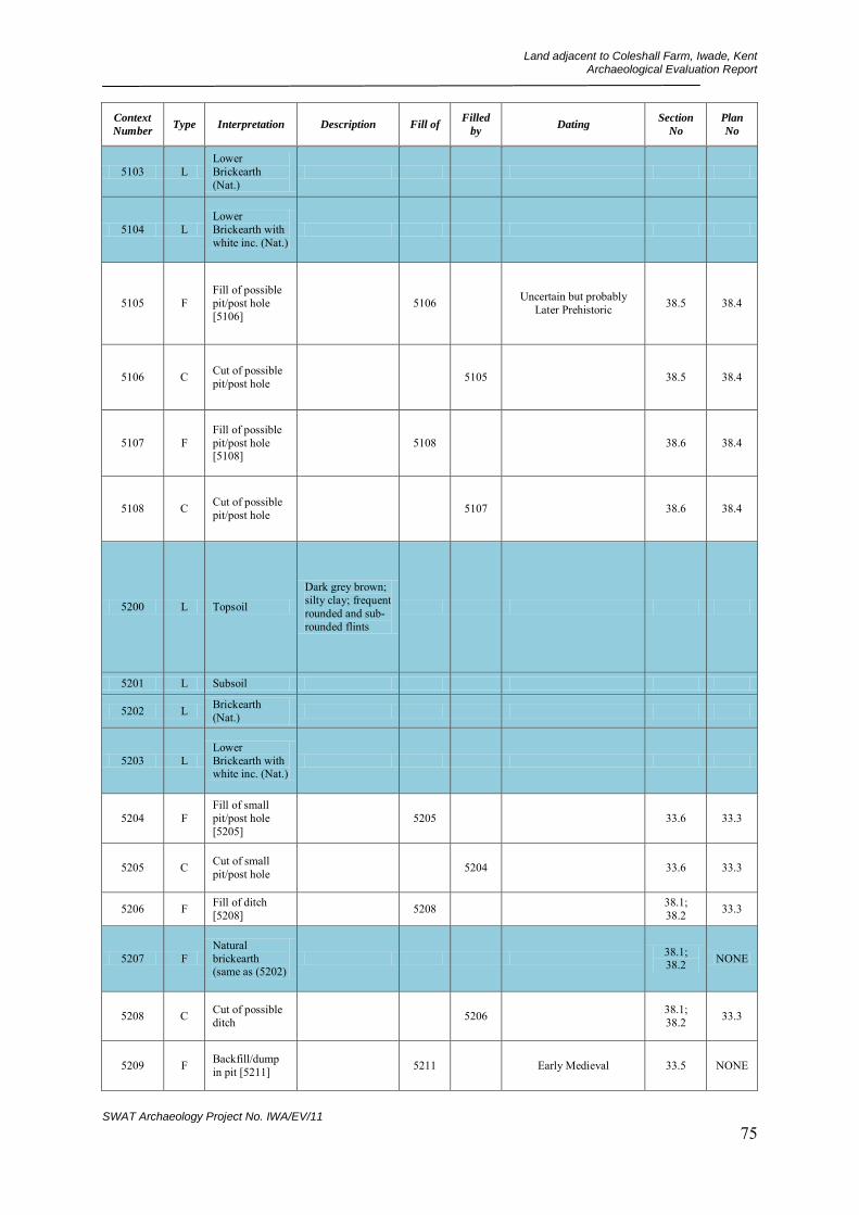
Land adjacent to Coleshall Farm, Iwade, Kent Archaeological Evaluation Report
SWAT Archaeology Project No. IWA/EV/11 75
Context
Number Type Interpretation Description Fill of
Filled
by Dating
Section
No
Plan
No
5103 L Lower Brickearth (Nat.)
5104 L Lower Brickearth with white inc. (Nat.)
5105 F Fill of possible pit/post hole [5106]
5106 Uncertain but probably Later Prehistoric 38.5 38.4
5106 C Cut of possible pit/post hole 5105 38.5 38.4
5107 F Fill of possible pit/post hole [5108]
5108 38.6 38.4
5108 C Cut of possible pit/post hole 5107 38.6 38.4
5200 L Topsoil
Dark grey brown; silty clay; frequent rounded and sub-rounded flints
5201 L Subsoil
5202 L Brickearth (Nat.)
5203 L Lower Brickearth with white inc. (Nat.)
5204 F Fill of small pit/post hole [5205]
5205 33.6 33.3
5205 C Cut of small pit/post hole 5204 33.6 33.3
5206 F Fill of ditch [5208] 5208 38.1;
38.2 33.3
5207 F Natural brickearth (same as (5202)
38.1; 38.2 NONE
5208 C Cut of possible ditch 5206 38.1;
38.2 33.3
5209 F Backfill/dump in pit [5211] 5211 Early Medieval 33.5 NONE

Land adjacent to Coleshall Farm, Iwade, Kent Archaeological Evaluation Report
SWAT Archaeology Project No. IWA/EV/11 76
Context
Number Type Interpretation Description Fill of
Filled
by Dating
Section
No
Plan
No
5210 F Backfill/dump in pit [5211] 5211 33.5 NONE
5211 C Cut of waste pit 5010 33.5: 38.3 33.4
5212 F Fill of pit [5211] 5211 33.5 NONE
5213 C Cut of possible stakehole NONE 33.4
5214 C Cut of possible stakehole 38.3 33.4
5215 F Fill of possible post pipe [5215] 5215 33.7 33.4
5216 C Cut of possible post hole 5219 33.7 33.4
5217 F Fill of possible stakehole [5218]
5218 33.8 33.4
5218 C Cut of possible stakehole 5217 33.7 33.4
5219 F Fill of possible post hole [5216] 5216 33.6 33.4
5220 F Fill of possible stakehole [5221]
5221 33.6 33.3
5221 C Cut of possible stakehole 5220 33.6 33.3
5300 L Topsoil
Dark grey brown; silty clay; frequent rounded and sub-rounded flints
5301 L Subsoil
5302 L Brickearth (Nat.)
5303 L Lower Brickearth (Nat.)
5304 L Lower Brickearth with white inc. (Nat.)

Land adjacent to Coleshall Farm, Iwade, Kent Archaeological Evaluation Report
SWAT Archaeology Project No. IWA/EV/11 77
Context
Number Type Interpretation Description Fill of
Filled
by Dating
Section
No
Plan
No
5305 D
Medieval dump layer overlaying all features in trench
Medieval 45.4 44.1
5306 C Cut of ditch/gulley 5307 45.1 44.1
5307 F Fill of ditch/gulley [5306]
5306 45.1 44.1
5308 C Cut of field ditch 5309 45.3;
45.4 44.1
5309 F Fill of field ditch [5308] 5308 Medieval 45.3;
45.4 44.1
5310 C Cut of field ditch/gulley 5311 45.2:
45.3 44.1
5311 F Fill of field ditch [5310] 5310 Medieval 45.2:
45.3 44.1
5312 C Cut of prehistoric pit 5313 45.3 44.1
5313 F Fill of prehistoric pit [5312]
5312 45.3 44.1
5314 C Cut of curvilinear ditch/gulley
5315 45.6 44.1
5315 F Fill of curvilinear ditch [5314]
5314 45.6 44.1
5316 C Cut of post hole 5317 45.5 44.1
5317 F Fill of post hole [5316] 5316 45.5 44.1
5400 L Topsoil
Dark grey brown; silty clay; frequent rounded and sub-rounded flints
5401 L Subsoil
5402 L Brickearth (Nat.)
5403 L Lower Brickearth (Nat.)
5404 L Lower Brickearth with white inc. (Nat.)
5405 VOID
5406 C Cut of post hole 5407 43.3 43.1
5407 F Fill of post hole [5406] 5406 43.3 43.1

Land adjacent to Coleshall Farm, Iwade, Kent Archaeological Evaluation Report
SWAT Archaeology Project No. IWA/EV/11 78
Context
Number Type Interpretation Description Fill of
Filled
by Dating
Section
No
Plan
No
5408 C Cut of oval shaped post hole
5409 43.4 43.1
5409 F Fill of post hole hole [5408] 5408 43.4 43.1
5410 C Cut of field gulley/ditch 5411 43.5 43.1
5411 F Fill of field gulley/ditch [5410]
5410 43.5 43.1
5500 L Topsoil
Dark grey brown; silty clay; frequent rounded and sub-rounded flints
5501 L Subsoil
5502 L Brickearth (Nat.)
5503 L Lower Brickearth (Nat.)
5504 L Lower Brickearth with white inc. (Nat.)
5505 F
Fill of probable rooting/tree bole feature [5506]
5506 41.2 50.1
5506 C Cut of probable rooting/tree bole feature
5505 41.2 50.1
5600 L Topsoil
Dark grey brown; silty clay; frequent rounded and sub-rounded flints
5601 L Subsoil
5602 L Brickearth (Nat.)
5603 L Lower Brickearth (Nat.)

Land adjacent to Coleshall Farm, Iwade, Kent Archaeological Evaluation Report
SWAT Archaeology Project No. IWA/EV/11 79
Context
Number Type Interpretation Description Fill of
Filled
by Dating
Section
No
Plan
No
5604 L Lower Brickearth with white inc. (Nat.)
5700 L Topsoil
Dark grey brown; silty clay; frequent rounded and sub-rounded flints
5701 L Subsoil
5702 L Brickearth (Nat.)
5703 L Lower Brickearth (Nat.)
5704 F Fill of ditch [5705] 5705 39.5 41.3
5705 C Cut of SW - NE aligned ditch 5704 39.5 41.3
5800 L Topsoil
Dark grey brown; silty clay; frequent rounded and sub-rounded flints
5801 L Subsoil
5802 L Brickearth (Nat.)
5803 L Lower Brickearth (Nat.)
5804 L Lower Brickearth with white inc. (Nat.)
5805 F Fill of stakehole [5806] 5806 NONE 30.7
5806 C Cut of stakehole 5805 NONE 30.7
5807 F Fill of possible ditch terminus [5808]
5808 30.8; 30.9 30.7
5808 C Cut of possible ditch terminus 5807 30.8;
30.9 30.7

Land adjacent to Coleshall Farm, Iwade, Kent Archaeological Evaluation Report
SWAT Archaeology Project No. IWA/EV/11 80
Context
Number Type Interpretation Description Fill of
Filled
by Dating
Section
No
Plan
No
5809 F Fill of ditch [5810] 5810 Uncertain but probably
Post-Roman 33.1: 33.2 30.7
5810 C Cut of ditch - probably modern
5809 33.1: 33.2 30.9
5811 F Fill of stakehole/bioturbation [5812]
5812 NONE 30.9
5812 C Cut of possible stakehole/possible bioturbation
5811 NONE 30.9
5900 L Topsoil
Dark grey brown; silty clay; frequent rounded and sub-rounded flints
5901 L Subsoil
5902 L Brickearth (Nat.)
5903 L Lower Brickearth (Nat.)
5904 L Lower Brickearth with white inc. (Nat.)
6000 L Topsoil
Dark grey brown; silty clay; frequent rounded and sub-rounded flints
6001 L Subsoil
6002 L Brickearth (Nat.)
6003 L Lower Brickearth (Nat.)
6004 C Cut of shallow curved gulley/ditch
6005 25.4 29.2
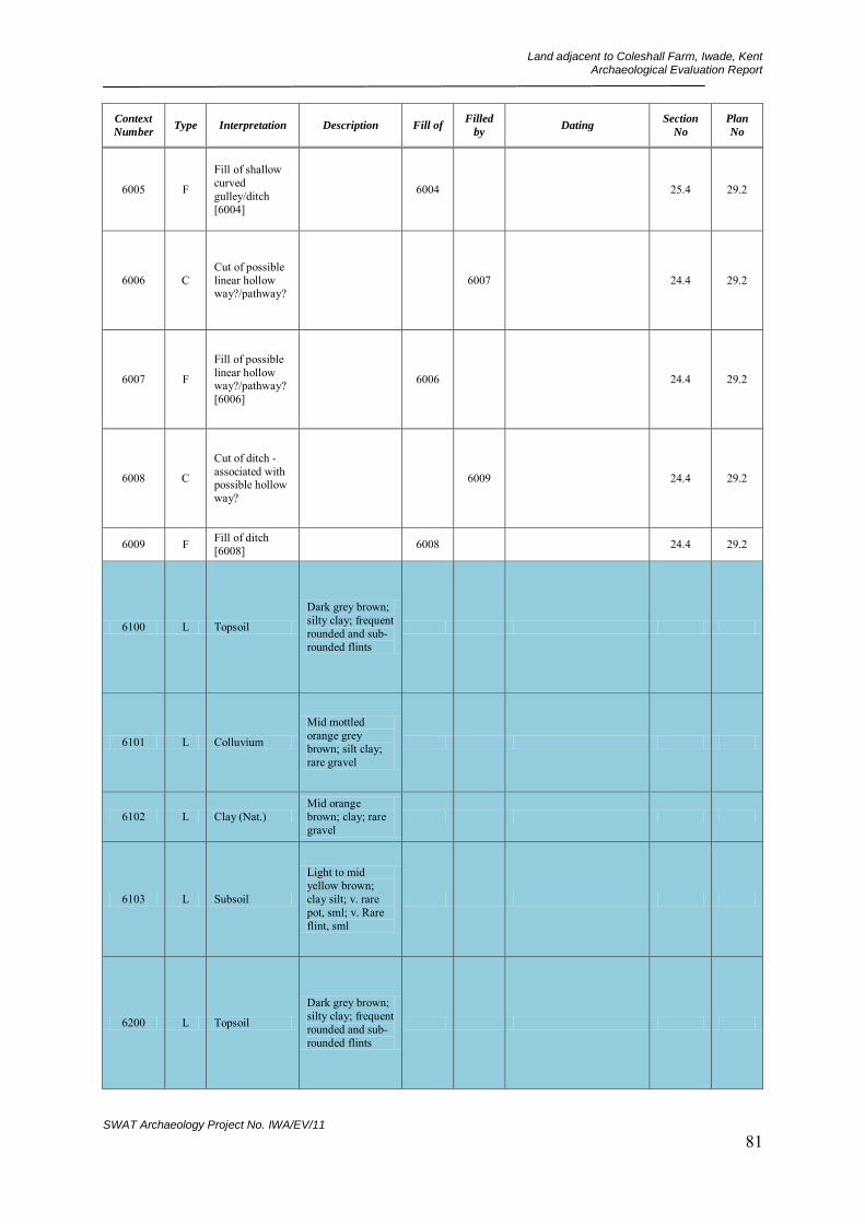
Land adjacent to Coleshall Farm, Iwade, Kent Archaeological Evaluation Report
SWAT Archaeology Project No. IWA/EV/11 81
Context
Number Type Interpretation Description Fill of
Filled
by Dating
Section
No
Plan
No
6005 F
Fill of shallow curved gulley/ditch [6004]
6004 25.4 29.2
6006 C Cut of possible linear hollow way?/pathway?
6007 24.4 29.2
6007 F
Fill of possible linear hollow way?/pathway? [6006]
6006 24.4 29.2
6008 C
Cut of ditch - associated with possible hollow way?
6009 24.4 29.2
6009 F Fill of ditch [6008] 6008 24.4 29.2
6100 L Topsoil
Dark grey brown; silty clay; frequent rounded and sub-rounded flints
6101 L Colluvium
Mid mottled orange grey brown; silt clay; rare gravel
6102 L Clay (Nat.) Mid orange brown; clay; rare gravel
6103 L Subsoil
Light to mid yellow brown; clay silt; v. rare pot, sml; v. Rare flint, sml
6200 L Topsoil
Dark grey brown; silty clay; frequent rounded and sub-rounded flints
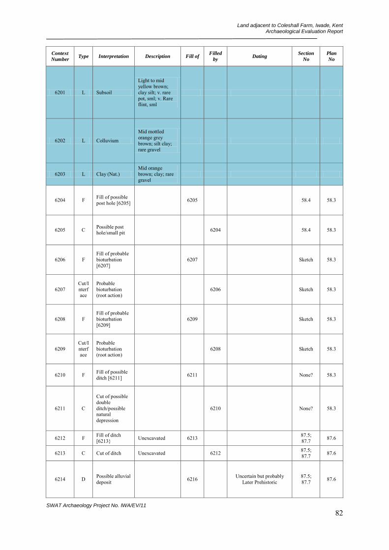
Land adjacent to Coleshall Farm, Iwade, Kent Archaeological Evaluation Report
SWAT Archaeology Project No. IWA/EV/11 82
Context
Number Type Interpretation Description Fill of
Filled
by Dating
Section
No
Plan
No
6201 L Subsoil
Light to mid yellow brown; clay silt; v. rare pot, sml; v. Rare flint, sml
6202 L Colluvium
Mid mottled orange grey brown; silt clay; rare gravel
6203 L Clay (Nat.) Mid orange brown; clay; rare gravel
6204 F Fill of possible post hole [6205] 6205 58.4 58.3
6205 C Possible post hole/small pit 6204 58.4 58.3
6206 F Fill of probable bioturbation [6207]
6207 Sketch 58.3
6207 Cut/Interface
Probable bioturbation (root action)
6206 Sketch 58.3
6208 F Fill of probable bioturbation [6209]
6209 Sketch 58.3
6209 Cut/Interface
Probable bioturbation (root action)
6208 Sketch 58.3
6210 F Fill of possible ditch [6211] 6211 None? 58.3
6211 C
Cut of possible double ditch/possible natural depression
6210 None? 58.3
6212 F Fill of ditch [6213} Unexcavated 6213 87.5;
87.7 87.6
6213 C Cut of ditch Unexcavated 6212 87.5; 87.7 87.6
6214 D Possible alluvial deposit 6216 Uncertain but probably
Later Prehistoric 87.5; 87.7 87.6
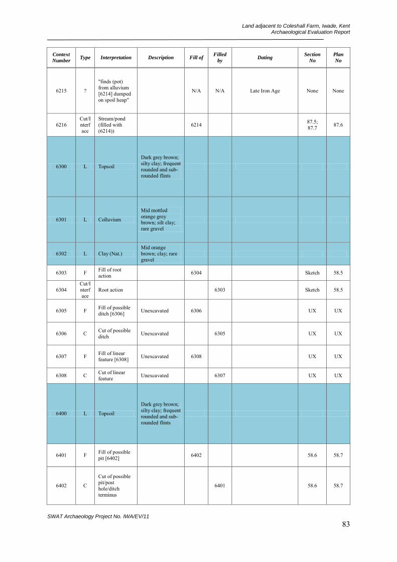
Land adjacent to Coleshall Farm, Iwade, Kent Archaeological Evaluation Report
SWAT Archaeology Project No. IWA/EV/11 83
Context
Number Type Interpretation Description Fill of
Filled
by Dating
Section
No
Plan
No
6215 ?
"finds (pot) from alluvium [6214] dumped on spoil heap"
N/A N/A Late Iron Age None None
6216 Cut/Interface
Stream/pond (filled with (6214))
6214 87.5; 87.7 87.6
6300 L Topsoil
Dark grey brown; silty clay; frequent rounded and sub-rounded flints
6301 L Colluvium
Mid mottled orange grey brown; silt clay; rare gravel
6302 L Clay (Nat.) Mid orange brown; clay; rare gravel
6303 F Fill of root action 6304 Sketch 58.5
6304 Cut/Interface
Root action 6303 Sketch 58.5
6305 F Fill of possible ditch [6306] Unexcavated 6306 UX UX
6306 C Cut of possible ditch Unexcavated 6305 UX UX
6307 F Fill of linear feature [6308] Unexcavated 6308 UX UX
6308 C Cut of linear feature Unexcavated 6307 UX UX
6400 L Topsoil
Dark grey brown; silty clay; frequent rounded and sub-rounded flints
6401 F Fill of possible pit [6402] 6402 58.6 58.7
6402 C
Cut of possible pit/post hole/ditch terminus
6401 58.6 58.7

Land adjacent to Coleshall Farm, Iwade, Kent Archaeological Evaluation Report
SWAT Archaeology Project No. IWA/EV/11 84
Context
Number Type Interpretation Description Fill of
Filled
by Dating
Section
No
Plan
No
6403 F Fill of possible pit/post hole [6404]
6404 Uncertain but probably Later Prehistoric 58.8 58.7
6404 C Possible pit/post hole 6403 58.8 58.7
6405 L Clay (Nat.) Mid orange brown; clay; rare gravel
6406 F Fill of possible pit [6407] 6407 58.6 None
6407 C Cut of possible pit 6406 58.6 None
6408 F Fill of possible ditch [6409] Unexcavated 6409 UX UX
6409 C Cut of possible ditch Unexcavated 6408 UX UX
6410 F Fill of possible ditch [6411] 6411 80.2 80.1
6411 C Cut of possible ditch 6410 80.2 80.1
6412 F Fill of possible ditch [6413] 6413 Uncertain but probably
Later Prehistoric 80.2 80.1
6413 C Cut of possible ditch 6412 80.2 80.1
6414 F Fill of possible ditch [6415] 6415 Uncertain but probably
Later Prehistoric Sketch 80.1
6415 C Cut of possible ditch 6414 Sketch 80.1
6416 F/D
Uncertain deposit/fill of linears [6413] [6415]
6413;6415 None None
6500 L Topsoil
Dark grey brown; silty clay; frequent rounded and sub-rounded flints

Land adjacent to Coleshall Farm, Iwade, Kent Archaeological Evaluation Report
SWAT Archaeology Project No. IWA/EV/11 85
Context
Number Type Interpretation Description Fill of
Filled
by Dating
Section
No
Plan
No
6501 L Clay (Nat.) Mid orange brown; clay; rare gravel
6502 L Colluvium
Mid mottled orange grey brown; silt clay; rare gravel
6503 F Fill of possible ditch terminus [6504]
6504 Middle Neolithic 63.6 63.5
6504 C Cut of possible ditch terminus 6503 63.6 63.5
6505 F
Fill of probable bioturbation or possible pit/post hole [6506]
6506 Early-Mid Iron Age ? 63.5
6506 C
Cut of probable bioturbation or possible pit/post hole
6505 ? 63.5
6507 F
Fill of probable bioturbation or possible pit/post hole [6508]
6508 ? 63.5
6508 C
Cut of probable bioturbation or possible pit/post hole
6507 ? 63.5
6509 D Gravel (Nat.)
Mottled brown, grey, yellow, white; gravel; within clay matrix
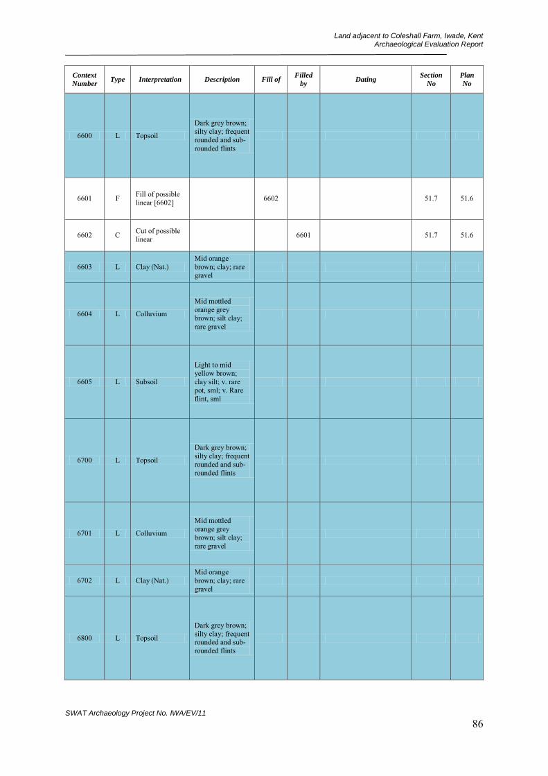
Land adjacent to Coleshall Farm, Iwade, Kent Archaeological Evaluation Report
SWAT Archaeology Project No. IWA/EV/11 86
Context
Number Type Interpretation Description Fill of
Filled
by Dating
Section
No
Plan
No
6600 L Topsoil
Dark grey brown; silty clay; frequent rounded and sub-rounded flints
6601 F Fill of possible linear [6602] 6602 51.7 51.6
6602 C Cut of possible linear 6601 51.7 51.6
6603 L Clay (Nat.) Mid orange brown; clay; rare gravel
6604 L Colluvium
Mid mottled orange grey brown; silt clay; rare gravel
6605 L Subsoil
Light to mid yellow brown; clay silt; v. rare pot, sml; v. Rare flint, sml
6700 L Topsoil
Dark grey brown; silty clay; frequent rounded and sub-rounded flints
6701 L Colluvium
Mid mottled orange grey brown; silt clay; rare gravel
6702 L Clay (Nat.) Mid orange brown; clay; rare gravel
6800 L Topsoil
Dark grey brown; silty clay; frequent rounded and sub-rounded flints

Land adjacent to Coleshall Farm, Iwade, Kent Archaeological Evaluation Report
SWAT Archaeology Project No. IWA/EV/11 87
Context
Number Type Interpretation Description Fill of
Filled
by Dating
Section
No
Plan
No
6801 D Gravel (Nat.)
Mottled brown, grey, yellow, white; gravel; within clay matrix
6802 C Modern bore hole 6802 Sketch 68.2
6803 F Fill of possible ditch terminus [6804]
6804 68.4 68.2
6804 C Cut of possible ditch terminus 6803 68.4 68.2
6805 F Fill of possible tree bole [6806] 6806 68.3 68.2
6806 Cut/Interface
Cut/interface of possible tree bole
6805 68.3 68.2
6807 F Fill of possible ditch [6808] Unexcavated 6808 None 68.2
6808 C Cut of possible ditch Unexcavated 6807 None 68.2
6809 F Fill of bore hole [6802] 6802 Late Post-Medieval None None
6810 L Clay (Nat.) Mid orange brown; clay; rare gravel
6900 L Topsoil
Dark grey brown; silty clay; frequent rounded and sub-rounded flints
6901 F Fill of possible ditch [6902] 6902 51.8 58.1
6902 C Cut of possible ditch 6901 51.8 58.1
6903 F Fill of ditch [6904] 6904 Uncertain but probably
Later Prehistoric 58.2 58.1
6904 C Cut of ditch 6903 58.2 58.1

Land adjacent to Coleshall Farm, Iwade, Kent Archaeological Evaluation Report
SWAT Archaeology Project No. IWA/EV/11 88
Context
Number Type Interpretation Description Fill of
Filled
by Dating
Section
No
Plan
No
6905 L Clay (Nat.) Mid orange brown; clay; rare gravel
6906 F Fill of possible pit [6907] 6907 51.9 58.1
6907 C Cut of possible pit 6906 51.9 58.1
6908 D Gravel (Nat.)
Mottled brown, grey, yellow, white; gravel; within clay matrix
6909 F Basal Fill of ditch [6904] 6904 Uncertain but probably
Later Prehistoric 58.2 58.1
7000 L Topsoil
Dark grey brown; silty clay; frequent rounded and sub-rounded flints
7001 L Clay (Nat.) Mid orange brown; clay; rare gravel
7002 F Fill of possible ditch [7003] 7003 68.6 68.5
7003 C Cut of possible ditch 7002 68.6 68.5
7004 F Fill of possible ditch [7005] 7005 68.7 68.5
7005 C Cut of possible ditch 7004 68.7 68.5
7006 F Fill of possible ditch [7007] 7007 68.8;
68.9 68.5
7007 C Cut of possible ditch 7006 68.8;
68.9 68.5
7008 F Fill of possible ditch [7009] 7009 Uncertain but probably
Later Prehistoric 68.9; 68.10 68.5
7009 C Cut of possible ditch 7008 68.9;
68.10 68.5
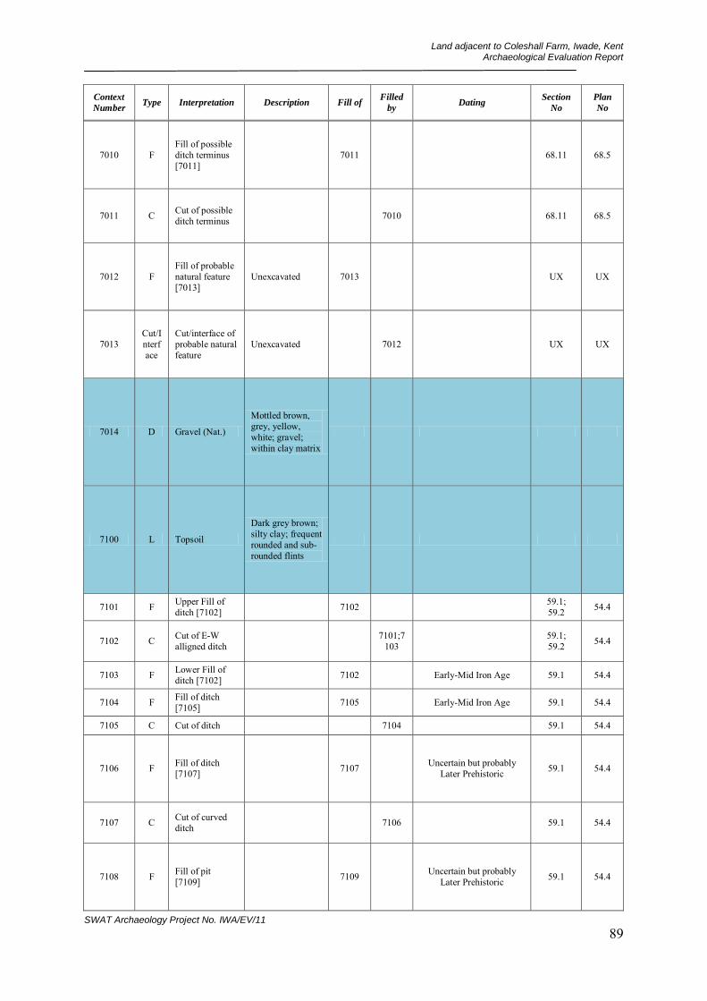
Land adjacent to Coleshall Farm, Iwade, Kent Archaeological Evaluation Report
SWAT Archaeology Project No. IWA/EV/11 89
Context
Number Type Interpretation Description Fill of
Filled
by Dating
Section
No
Plan
No
7010 F Fill of possible ditch terminus [7011]
7011 68.11 68.5
7011 C Cut of possible ditch terminus 7010 68.11 68.5
7012 F Fill of probable natural feature [7013]
Unexcavated 7013 UX UX
7013 Cut/Interface
Cut/interface of probable natural feature
Unexcavated 7012 UX UX
7014 D Gravel (Nat.)
Mottled brown, grey, yellow, white; gravel; within clay matrix
7100 L Topsoil
Dark grey brown; silty clay; frequent rounded and sub-rounded flints
7101 F Upper Fill of ditch [7102] 7102 59.1;
59.2 54.4
7102 C Cut of E-W alligned ditch 7101;7
103 59.1; 59.2 54.4
7103 F Lower Fill of ditch [7102] 7102 Early-Mid Iron Age 59.1 54.4
7104 F Fill of ditch [7105] 7105 Early-Mid Iron Age 59.1 54.4
7105 C Cut of ditch 7104 59.1 54.4
7106 F Fill of ditch [7107] 7107 Uncertain but probably
Later Prehistoric 59.1 54.4
7107 C Cut of curved ditch 7106 59.1 54.4
7108 F Fill of pit [7109] 7109 Uncertain but probably
Later Prehistoric 59.1 54.4
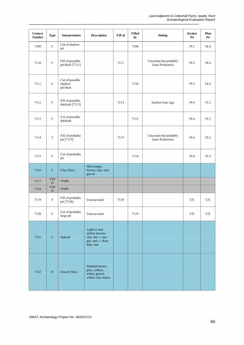
Land adjacent to Coleshall Farm, Iwade, Kent Archaeological Evaluation Report
SWAT Archaeology Project No. IWA/EV/11 90
Context
Number Type Interpretation Description Fill of
Filled
by Dating
Section
No
Plan
No
7109 C Cut of shallow pit 7108 59.1 54.4
7110 F Fill of possible pit/ditch [7111] 7111 Uncertain but probably
Later Prehistoric 59.3 54.4
7111 C Cut of possible shallow pit/ditch
7110 59.3 54.4
7112 F Fill of possible ditch/pit [7113] 7113 Earliest Iron Age 59.4 55.2
7113 C Cut of possible ditch/pit 7112 59.4 55.2
7114 F Fill of probable pit [7115] 7115 Uncertain but probably
Later Prehistoric 59.4 55.2
7115 C Cut of probable pit 7114 59.4 55.2
7116 L Clay (Nat.) Mid orange brown; clay; rare gravel
7117 VOID VOID
7118 VOID VOID
7119 F Fill of probable pit [7120] Unexcavated 7120 UX UX
7120 C Cut of probable large pit Unexcavated 7119 UX UX
7121 L Subsoil
Light to mid yellow brown; clay silt; v. rare pot, sml; v. Rare flint, sml
7122 D Gravel (Nat.)
Mottled brown, grey, yellow, white; gravel; within clay matrix

Land adjacent to Coleshall Farm, Iwade, Kent Archaeological Evaluation Report
SWAT Archaeology Project No. IWA/EV/11 91
Context
Number Type Interpretation Description Fill of
Filled
by Dating
Section
No
Plan
No
7200 L Topsoil
Dark grey brown; silty clay; frequent rounded and sub-rounded flints
7201 L Clay (Nat.) Mid orange brown; clay; rare gravel
7202 F Fill of uncertain feature [7203] 7203 63.1 58.9
7203 C Cut of uncertain feature 7202 63.1 58.9
7204 F Fill of post hole [7205] 7205 Uncertain but probably
Later Prehistoric 58.10 58.9
7205 C Cut of post hole 7204 58.10 58.9
7206 F Fill of pit/post hole [7207] 7207 58.12 58.9
7207 C Cut of pit/post hole 7206 58.12 58.9
7208 F Fill of possible pit [7209] 7209 58.11 58.9
7209 C Cut of possible pit 7208 58.11 58.9
7210 F Fill of possible pit/ditch terminus [7211]
7211 Uncertain but probably Later Prehistoric
63.3; 63.4 63.2
7211 C Cut of possible pit/ditch terminus
7210 63.3; 63.4 63.2
7212 F
Fill of possible ditch intersection/spread of interface [7213]
7213 None 63.2
7213 Interface
Uncertain feature possible ditch intersection or spread
7212 None 63.2

Land adjacent to Coleshall Farm, Iwade, Kent Archaeological Evaluation Report
SWAT Archaeology Project No. IWA/EV/11 92
Context
Number Type Interpretation Description Fill of
Filled
by Dating
Section
No
Plan
No
7214 F Second Fill of ditch [7215] 7215 Early-Mid Iron Age 68.1 63.7
7215 C Cut of large ditch terminus 7214;7
216 68.1 63.7
7216 F First Fill of ditch [7215] 7215 Early-Mid Iron Age 68.1 None
7217 F Fill of tree bole [7218] 7218 63.8 63.7
7218 Interface
Interface of tree bole 7217 63.8 63.7
7219 F Fill of ditch [7220] 7220 63.8 63.7
7220 C Cut of ditch 7219 63.8 63.7
7300 L Topsoil
Dark grey brown; silty clay; frequent rounded and sub-rounded flints
7301 F Fill of ditch [7302] 7302 Uncertain but probably
Later Prehistoric 51.3 51.1
7302 C Cut of possible ditch terminus 7301 51.3 51.1
7303 F Fill of ditch [7304] 7304 Uncertain but probably
Later Prehistoric 51.5 51.1
7304 C Cut of possible ditch 7303 51.5 51.1
7305 F Fill of ditch [7306] 7306 Earliest Iron Age 51.2 51.1
7306 C Cut of ditch 7305 51.2 51.1
7307 F Fill of possible ditch [7308] 7308 51.4 51.1
7308 C Cut of possible ditch 7307 51.4 51.1
7309 L Possible spread N/A N/A None 51.1
7310 L Clay (Nat.) Mid orange brown; clay; rare gravel
7311 L Possible track Flinty clay gravel N/A N/A UX UX
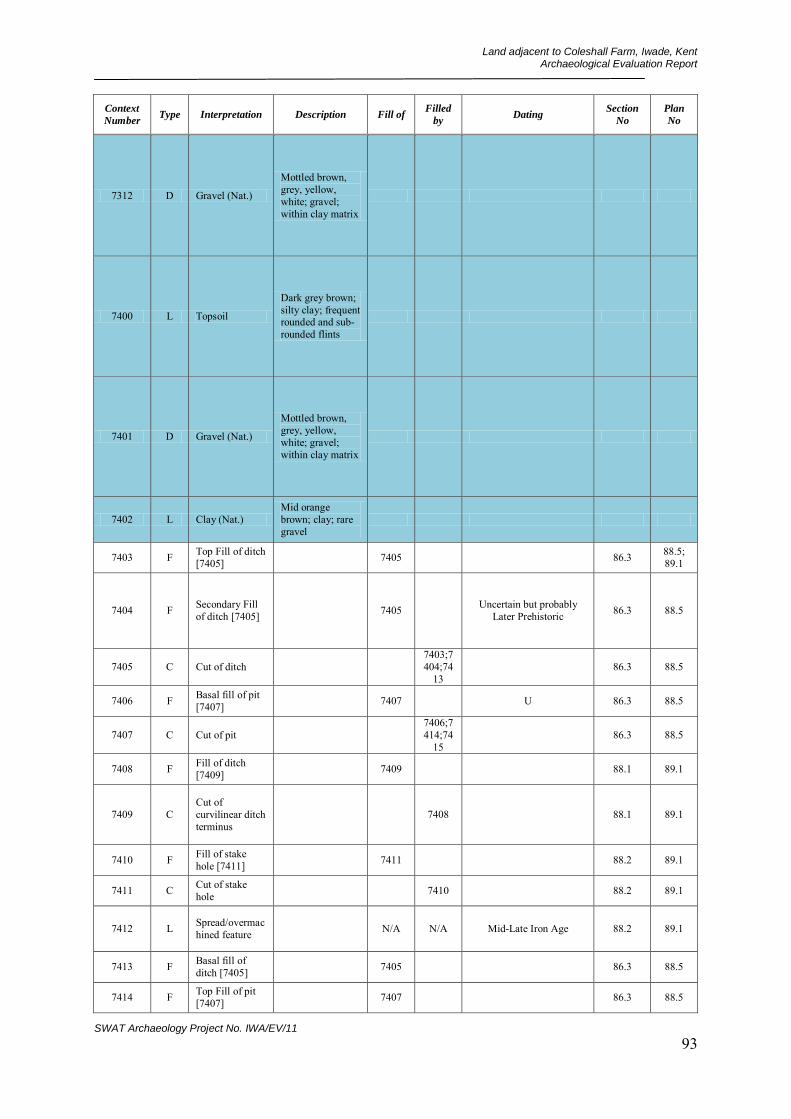
Land adjacent to Coleshall Farm, Iwade, Kent Archaeological Evaluation Report
SWAT Archaeology Project No. IWA/EV/11 93
Context
Number Type Interpretation Description Fill of
Filled
by Dating
Section
No
Plan
No
7312 D Gravel (Nat.)
Mottled brown, grey, yellow, white; gravel; within clay matrix
7400 L Topsoil
Dark grey brown; silty clay; frequent rounded and sub-rounded flints
7401 D Gravel (Nat.)
Mottled brown, grey, yellow, white; gravel; within clay matrix
7402 L Clay (Nat.) Mid orange brown; clay; rare gravel
7403 F Top Fill of ditch [7405] 7405 86.3 88.5;
89.1
7404 F Secondary Fill of ditch [7405] 7405 Uncertain but probably
Later Prehistoric 86.3 88.5
7405 C Cut of ditch 7403;7404;74
13 86.3 88.5
7406 F Basal fill of pit [7407] 7407 U 86.3 88.5
7407 C Cut of pit 7406;7414;74
15 86.3 88.5
7408 F Fill of ditch [7409] 7409 88.1 89.1
7409 C Cut of curvilinear ditch terminus
7408 88.1 89.1
7410 F Fill of stake hole [7411] 7411 88.2 89.1
7411 C Cut of stake hole 7410 88.2 89.1
7412 L Spread/overmachined feature N/A N/A Mid-Late Iron Age 88.2 89.1
7413 F Basal fill of ditch [7405] 7405 86.3 88.5
7414 F Top Fill of pit [7407] 7407 86.3 88.5

Land adjacent to Coleshall Farm, Iwade, Kent Archaeological Evaluation Report
SWAT Archaeology Project No. IWA/EV/11 94
Context
Number Type Interpretation Description Fill of
Filled
by Dating
Section
No
Plan
No
7415 F Middle Fill of pit [7407] 7407 86.3 88.5
7416 F Single Fill of ditch terminus [7417]
7417 86.3 88.5
7417 C Cut of ditch terminus 7416 86.3 88.5
7418 F Single Fill of gulley/ditch terminus [7419]
7419 88.4 88.5
7419 C Cut of gulley/ditch terminus
7418 88.4 88.5
7420 F Fill of ditch [7421] Unexcavated 7421 None 88.5
7421 C Cut of ditch Unexcavated 7420 None 88.5
7422 F Top Fill of linear [7423] Unexcavated 7423 None 89.1
7423 C Cut of linear Unexcavated 7422 None 89.1
7500 L Topsoil
Dark grey brown; silty clay; frequent rounded and sub-rounded flints
7501 D Gravel (Nat.)
Mottled brown, grey, yellow, white; gravel; within clay matrix
7502 L Clay (Nat.) Mid orange brown; clay; rare gravel
7503 F Fill of small post hole [7504] 7304 54.3 55.1
7504 C Cut of small post hole 7503 54.3 55.1
7505 F Fill of ditch [7506] 7506 Earliest Iron Age 54.1;
54.2 55.1
7506 C Cut of NE-SW alligned ditch 7505;7
507 54.1; 54.2 55.1
7507 F Lower Fill of ditch [7506] 7506 None 54.1
7508 F Fill of probable ditch [7509] 7509 U 53.8;
53.9 55.1

Land adjacent to Coleshall Farm, Iwade, Kent Archaeological Evaluation Report
SWAT Archaeology Project No. IWA/EV/11 95
Context
Number Type Interpretation Description Fill of
Filled
by Dating
Section
No
Plan
No
7509 C Cut of probable ditch 7508 53.8;
53.9 55.1
7510 F Fill of possible pit [7511] Unexcavated 7511 UX UX
7511 C Cut of possible pit Unexcavated 7510 UX UX
7512 F Fill of possible pit [7513] Unexcavated 7513 UX UX
7513 C Cut of possible pit Unexcavated 7512 UX UX
7514 F Fill of possible ditch terminus [7515]
Unexcavated 7515 UX UX
7515 C Cut of possible ditch terminus Unexcavated 7514 UX UX
7516 F Fill of possible pit or ditch terminus [7517]
Unexcavated 7517 UX UX
7517 C Cut of possible pit or ditch terminus
Unexcavated 7516 UX UX
7518 F Fill of possible pit or ditch terminus [7519]
Unexcavated 7519 UX UX
7519 C Cut of possible pit or ditch terminus
Unexcavated 7518 UX UX
7520 F Fill of probable ditch [7521] Unexcavated 7521 UX UX
7521 C Cut of probable ditch Unexcavated 7520 UX UX
7600 L Topsoil
Dark grey brown; silty clay; frequent rounded and sub-rounded flints

Land adjacent to Coleshall Farm, Iwade, Kent Archaeological Evaluation Report
SWAT Archaeology Project No. IWA/EV/11 96
Context
Number Type Interpretation Description Fill of
Filled
by Dating
Section
No
Plan
No
7601 D Gravel (Nat.)
Mottled brown, grey, yellow, white; gravel; within clay matrix
7602 L Clay (Nat.) Mid orange brown; clay; rare gravel
7603 F Fill of possible pit/possible tree bole [7604]
7604 U 53.10 69.1
7604 C Cit of possible pit/possible tree bole
7603 53.10 69.1
7605 F Fill of possible ditch terminus [7606]
Unexcavated 7606 Earliest Iron Age UX UX
7606 C Cut of possible ditch terminus Unexcavated 7605 UX UX
7607 F Fill of probable ditch [7608] Unexcavated 7608 UX UX
7608 C Cut of probable ditch Unexcavated 7697 UX UX
7609 F Fill of probable ditch or possible pit [7610]
Unexcavated 7610 UX UX
7610 Cut Cut of probable ditch or possible pit
Unexcavated 7609 UX UX
7700 L Topsoil
Dark grey brown; silty clay; frequent rounded and sub-rounded flints

Land adjacent to Coleshall Farm, Iwade, Kent Archaeological Evaluation Report
SWAT Archaeology Project No. IWA/EV/11 97
Context
Number Type Interpretation Description Fill of
Filled
by Dating
Section
No
Plan
No
7701 D Gravel (Nat.)
Mottled brown, grey, yellow, white; gravel; within clay matrix
7702 L Clay (Nat.) Mid orange brown; clay; rare gravel
7703 F
Top Fill of possible drainage ditch [7704]
7704 53.11; 59.6 72.1
7704 C Cut of of possible drainage ditch
7703;7705 53.11;
59.6 72.1
7705 F Basal Fill of ditch [7704] 7704 53.11;
59.6 None?
7706 C Cut of possible field boundary ditch
7707 72.2 72.3
7707 F Fill of possible field boundary ditch [7706]
7706 Earliest Iron Age 72.2 72.3
7708 F Fill of small oval feature [7709]
Unexcavated 7709 UX UX
7709 C
Cut of small oval possible pit or ditch terminus
Unexcavated 7708 UX UX
7710 F Fill of possible ring ditch [7711]
Unexcavated 7711 UX UX
7711 C Cut of possible ring ditch Unexcavated 7710 UX UX
7712 F Fill of probable ditch [7713] Unexcavated 7713 UX UX
7713 C Cut of probable ditch Unexcavated 7712 UX UX
7714 F Fill of possible ditch (corner) [7715]
Unexcavated 7715 UX UX

Land adjacent to Coleshall Farm, Iwade, Kent Archaeological Evaluation Report
SWAT Archaeology Project No. IWA/EV/11 98
Context
Number Type Interpretation Description Fill of
Filled
by Dating
Section
No
Plan
No
7715 C Cut of possible ditch (corner) Unexcavated 7714 UX UX
7800 L Topsoil
Dark grey brown; silty clay; frequent rounded and sub-rounded flints
7801 D Gravel (Nat.)
Mottled brown, grey, yellow, white; gravel; within clay matrix
7802 L Clay (Nat.) Mid orange brown; clay; rare gravel
7803 F Fill of small pit/large post hole [7804]
7804 Uncertain but probably Later Prehistoric 59.7 65.1
7804 C
Cut of small shallow pit/large post hole
7803 59.7 65.1
7805 F Fill of possible large shallow pit/ditch [7806]
7806 59.8 65.1
7806 C
Cut of possible possible large shallow pit/ditch
7805 59.8 65.1
7807 F Fill of possible ditch [7808] Unexcavated 7808 UX UX
7808 C Cut of possible ditch Unexcavated 7807 UX UX
7809 F Fill of possible ditch [7810] Unexcavated 7810 UX UX
7810 C Cut of possible ditch Unexcavated 7809 UX UX

Land adjacent to Coleshall Farm, Iwade, Kent Archaeological Evaluation Report
SWAT Archaeology Project No. IWA/EV/11 99
Context
Number Type Interpretation Description Fill of
Filled
by Dating
Section
No
Plan
No
7811 F Fill of possible ditch [7812] Unexcavated 7812 UX UX
7812 C Cut of possible ditch Unexcavated 7811 UX UX
7813 F Fill of possible ditch [7814] Unexcavated 7814 UX UX
7814 C Cut of possible ditch Unexcavated 7813 UX UX
7900 L Topsoil
Dark grey brown; silty clay; frequent rounded and sub-rounded flints
7901 D Gravel (Nat.)
Mottled brown, grey, yellow, white; gravel; within clay matrix
7902 L Clay (Nat.) Mid orange brown; clay; rare gravel
7903 F Fill of post hole [7904] 7904 71.1 70.1
7904 C Cut of post hole 7903 71.1 70.1
7905 F Fill of ditch terminus [7906] 7906 71.3 70.1
7906 C
Cut of ditch terminus (possible field boundary)
7905 71.3 70.1
7907 F Fill of post hole [7908] 7908 71.5 70.1
7908 C Cut of post hole 7907 71.5 70.1
7909 F Fill of post hole [7910] 7910 71.4 70.1
7910 C Cut of post hole 7909 71.4 70.1
7911 F Fill of pit [7912] 7912 71.2 70.1
7912 C Cut of pit 7911;7913 71.2 70.1
7913 F Lower Fill of pit [7912] 7912 71.2 70.1
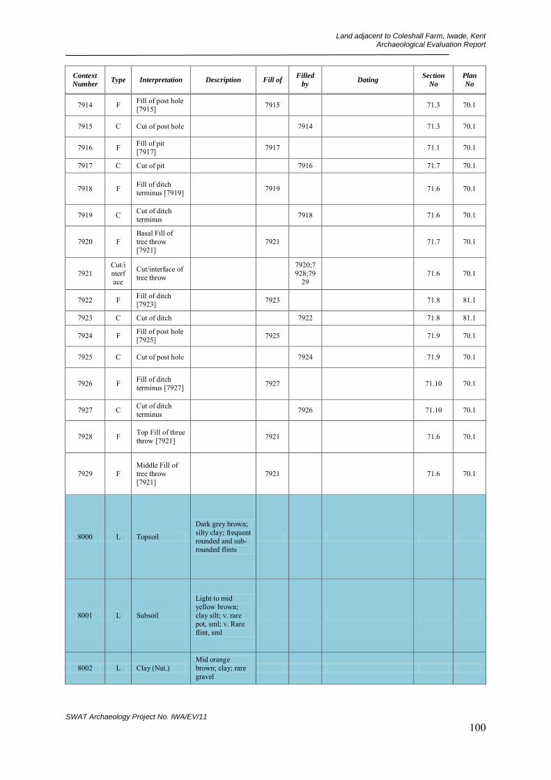
Land adjacent to Coleshall Farm, Iwade, Kent Archaeological Evaluation Report
SWAT Archaeology Project No. IWA/EV/11 100
Context
Number Type Interpretation Description Fill of
Filled
by Dating
Section
No
Plan
No
7914 F Fill of post hole [7915] 7915 71.3 70.1
7915 C Cut of post hole 7914 71.3 70.1
7916 F Fill of pit [7917] 7917 71.1 70.1
7917 C Cut of pit 7916 71.7 70.1
7918 F Fill of ditch terminus [7919] 7919 71.6 70.1
7919 C Cut of ditch terminus 7918 71.6 70.1
7920 F Basal Fill of tree throw [7921]
7921 71.7 70.1
7921 Cut/interface
Cut/interface of tree throw
7920;7928;79
29 71.6 70.1
7922 F Fill of ditch [7923] 7923 71.8 81.1
7923 C Cut of ditch 7922 71.8 81.1
7924 F Fill of post hole [7925] 7925 71.9 70.1
7925 C Cut of post hole 7924 71.9 70.1
7926 F Fill of ditch terminus [7927] 7927 71.10 70.1
7927 C Cut of ditch terminus 7926 71.10 70.1
7928 F Top Fill of three throw [7921] 7921 71.6 70.1
7929 F Middle Fill of tree throw [7921]
7921 71.6 70.1
8000 L Topsoil
Dark grey brown; silty clay; frequent rounded and sub-rounded flints
8001 L Subsoil
Light to mid yellow brown; clay silt; v. rare pot, sml; v. Rare flint, sml
8002 L Clay (Nat.) Mid orange brown; clay; rare gravel

Land adjacent to Coleshall Farm, Iwade, Kent Archaeological Evaluation Report
SWAT Archaeology Project No. IWA/EV/11 101
Context
Number Type Interpretation Description Fill of
Filled
by Dating
Section
No
Plan
No
8003 D Gravel (Nat.)
Mottled brown, grey, yellow, white; gravel; within clay matrix
8004 C Cut of post hole 8005 53.1 52.1
8005 F Fill of post hole [8004] 8004 Earliest Iron Age 53.1 52.1
8006 C Cut of post hole 8007 53.2 53.1
8007 F Fill of post hole [8006] 8006 53.2 52.1
8008 C Cut of pit 8009 53.3 52.1
8009 F Fill of pit [8008] 8008 53.3 52.1
8010 C Cut of post hole 8011 53.4 52.1
8011 F Fill of post hole [8010] 8010 53.4 52.1
8012 C Cut of post hole 8013 53.5 52.1
8013 F Fill of post hole [8012] 8012 Early-Mid Iron Age 53.5 52.1
8014 C Cut of post hole 8015 53.6 52.1
8015 F Fill of post hole [8014] 8014 Early-Mid Iron Age 53.6 52.1
8016 C Cut of large pit 8017 53.7 52.1
8017 F Fill of large pit [8016] 8016 Uncertain but probably
Later Prehistoric 53.7 52.1
8100 L Topsoil
Dark grey brown; silty clay; frequent rounded and sub-rounded flints
8101 L Subsoil
Light to mid yellow brown; clay silt; v. rare pot, sml; v. Rare flint, sml
8102 L Clay (Nat.) Mid orange brown; clay; rare gravel

Land adjacent to Coleshall Farm, Iwade, Kent Archaeological Evaluation Report
SWAT Archaeology Project No. IWA/EV/11 102
Context
Number Type Interpretation Description Fill of
Filled
by Dating
Section
No
Plan
No
8103 D Gravel (Nat.)
Mottled brown, grey, yellow, white; gravel; within clay matrix
8104 C Cut of ditch/gulley 8105 57.1 56.1
8105 F Fill of gulley/ditch [8104]
8104 57.1 56.1
8106 C Cut of gulley/ditch 8107 57.2 56.1
8107 F Fill of gulley/ditch [8106]
8106 57.2 56.1
8108 C Cut of post hole 8109 57.3 56.1
8109 F Fill of post hole [8108] 8108 57.3 56.1
8110 C Cut of curvilinear ditch 8111;8
128 82.2 82.1
8111 F Fill of curvilinear ditch [8110]
8110 Mid-Late Iron Age 82.2 82.1
8112 C Cut of post hole Unexcavated 8113 UX UX
8113 F Fill of post hole [8112] Unexcavated 8112 UX UX
8114 C Cut of post hole Unexcavated 8115 UX UX
8115 F Fill of post hole [8114] Unexcavated 8114 UX UX
8116 D Pathway silty deposit N/A N/A
8117 L Trample layer N/A N/A
8118 C Cut of post hole Unexcavated 8119 UX UX
8119 F Fill of post hole [8118] Unexcavated 8118 UX UX
8120 C Cut of post hole Unexcavated 8121 UX UX
8121 F Fill of post hole [8120] Unexcavated 8120 UX UX
8122 C Cut of post hole Unexcavated 8123 UX UX
8123 F Fill of post hole [8122] Unexcavated 8122 UX UX
8124 C
Cut of curvilinear feature (possible ditch)
Unexcavated 8125 UX UX

Land adjacent to Coleshall Farm, Iwade, Kent Archaeological Evaluation Report
SWAT Archaeology Project No. IWA/EV/11 103
Context
Number Type Interpretation Description Fill of
Filled
by Dating
Section
No
Plan
No
8125 F Fill of curvilinear ditch [8124]
Unexcavated 8124 UX UX
8126 C Cut of ditch Unexcavated 8127 UX UX
8127 F Fill of ditch [8126] Unexcavated 8126 UX UX
8128 F Fill of curvilinear ditch [8110]
8110 82.2 82.1
8129 F Fill of gulley/ditch [8130]
8130 82.3 82.1
8130 C Cut of gulley/ditch 8129 82.3 82.1
8131 F Fill of pit [8132] 8132 82.3;
82.4 82.1
8132 C Cut of shallow pit 8131 82.3;
82.4 82.1
8133 F Fill of gulley/ditch [8134]
8134 U 82.4 82.1
8134 C Cut of gulley/ditch 8133 82.4 82.1
8200 L Topsoil
Dark grey brown; silty clay; frequent rounded and sub-rounded flints
8201 L Subsoil
Light to mid yellow brown; clay silt; v. rare pot, sml; v. Rare flint, sml
8202 L Clay (Nat.) Mid orange brown; clay; rare gravel
8203 D? "Silty patches" Probable natural backfilled tree boles
N/A N/A
8204 C Cut of possible pathway 8205
8205 F Fill of possible pathway [8204] 8204
8206 C Cut of pit Unexcavated 8207
8207 F Fill of pit [8206] Unexcavated 8206

Land adjacent to Coleshall Farm, Iwade, Kent Archaeological Evaluation Report
SWAT Archaeology Project No. IWA/EV/11 104
Context
Number Type Interpretation Description Fill of
Filled
by Dating
Section
No
Plan
No
8208 C Cut of pit Unexcavated 8209
8209 F Fill of pit [8208] Unexcavated 8208
8300 L Topsoil
Dark grey brown; silty clay; frequent rounded and sub-rounded flints
8301 L Subsoil
Light to mid yellow brown; clay silt; v. rare pot, sml; v. Rare flint, sml
8302 L Clay (Nat.) Mid orange brown; clay; rare gravel
8303 D Gravel (Nat.)
Mottled brown, grey, yellow, white; gravel; within clay matrix
8304 C Cut of field gulley 8305 60.3 60.1
8305 F Fill of field gulley [8304] 8304 Early Medieval 60.3 60.1
8306 C Cut of shallow pathway/hollow 8307 60.2 60.1
8307 F Fill of shallow pathway/hollow [8306]
8306 60.2 60.1
8308 C Cut of pit Unexcavated 8309 UX UX
8309 F Fill of pit [8308] Unexcavated 8308 UX UX
8310 C Cut of pit Unexcavated 8311 UX UX
8311 F Fill of pit [8310] Unexcavated 8310 UX UX
8312 C Cut of pit Unexcavated 8313 UX UX
8313 F Fill of pit [8312] Unexcavated 8312 UX UX
8314 C Cut of pit Unexcavated 8315 UX UX

Land adjacent to Coleshall Farm, Iwade, Kent Archaeological Evaluation Report
SWAT Archaeology Project No. IWA/EV/11 105
Context
Number Type Interpretation Description Fill of
Filled
by Dating
Section
No
Plan
No
8315 F Fill of pit [8314] Unexcavated 8314 UX UX
8400 L Topsoil
Dark grey brown; silty clay; frequent rounded and sub-rounded flints
8401 L Subsoil
Light to mid yellow brown; clay silt; v. rare pot, sml; v. Rare flint, sml
8402 L Clay (Nat.) Mid orange brown; clay; rare gravel
8403 D Gravel (Nat.)
Mottled brown, grey, yellow, white; gravel; within clay matrix
8404 C Cut of field gulley/ditch 62.2 62.1
8405 F Fill of field gulley [8404] 8404 62.2 62.1
8406 C Cut of pit 62.3 62.1
8407 F Fill of pit [8406] 8406 62.3 62.1
8408 C Cut of field ditch or gulley Unexcavated None 62.1
8409 F Fill of field ditch or gulley [8408]
Unexcavated 8408 None 62.1
8410 D? "Silty patches" N/A N/A
8411 C Cut of large ditch
8412;8413;8414;841
5
97.1 98.1
8412 F Top Fill of ditch [8411] 8411 97.1 98.1
8413 F Fill of ditch [8411] 8411 97.1 98.1
8414 F Fill of ditch [8411] 8411 Mid-Late Iron Age 97.1 98.1
8415 F Basal fill of ditch [8411] 8411 97.1 98.1
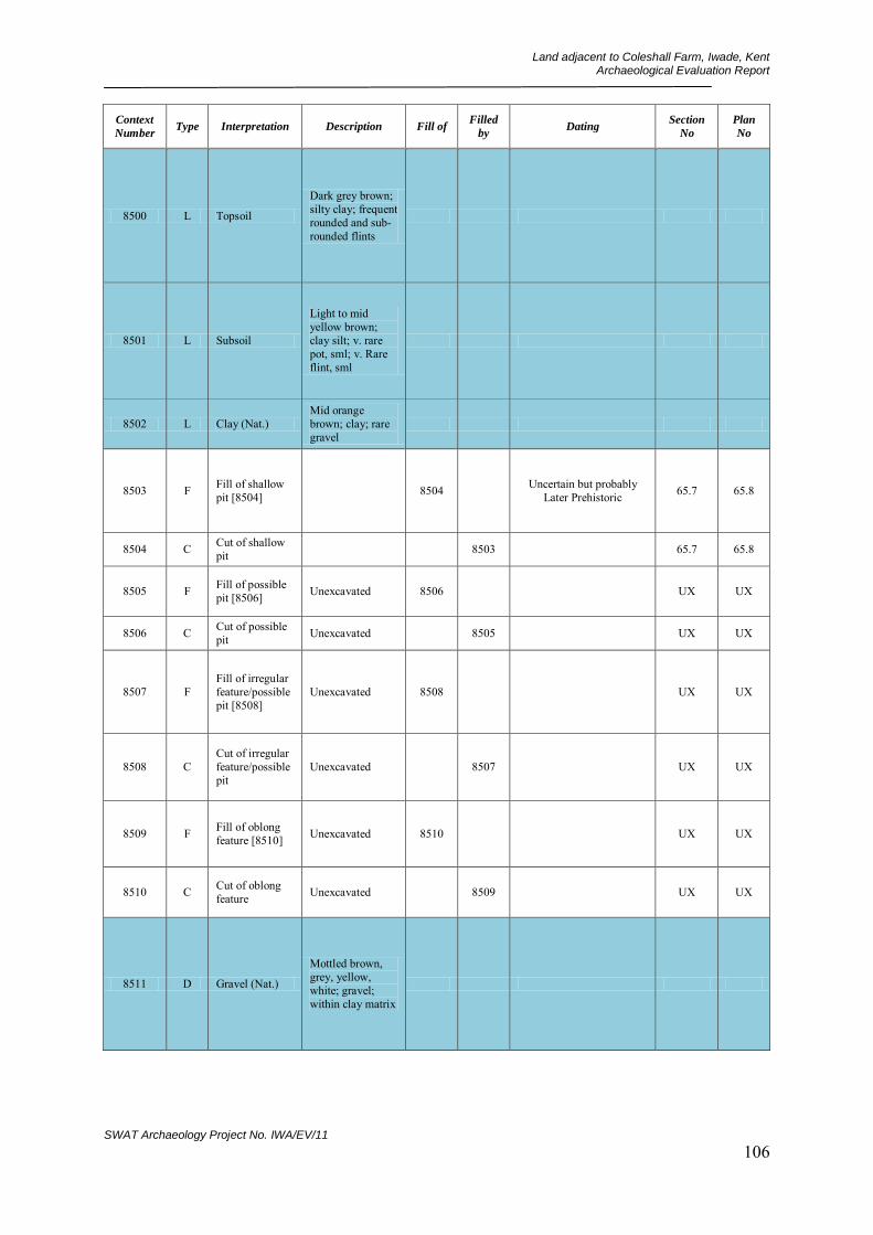
Land adjacent to Coleshall Farm, Iwade, Kent Archaeological Evaluation Report
SWAT Archaeology Project No. IWA/EV/11 106
Context
Number Type Interpretation Description Fill of
Filled
by Dating
Section
No
Plan
No
8500 L Topsoil
Dark grey brown; silty clay; frequent rounded and sub-rounded flints
8501 L Subsoil
Light to mid yellow brown; clay silt; v. rare pot, sml; v. Rare flint, sml
8502 L Clay (Nat.) Mid orange brown; clay; rare gravel
8503 F Fill of shallow pit [8504] 8504 Uncertain but probably
Later Prehistoric 65.7 65.8
8504 C Cut of shallow pit 8503 65.7 65.8
8505 F Fill of possible pit [8506] Unexcavated 8506 UX UX
8506 C Cut of possible pit Unexcavated 8505 UX UX
8507 F Fill of irregular feature/possible pit [8508]
Unexcavated 8508 UX UX
8508 C Cut of irregular feature/possible pit
Unexcavated 8507 UX UX
8509 F Fill of oblong feature [8510] Unexcavated 8510 UX UX
8510 C Cut of oblong feature Unexcavated 8509 UX UX
8511 D Gravel (Nat.)
Mottled brown, grey, yellow, white; gravel; within clay matrix
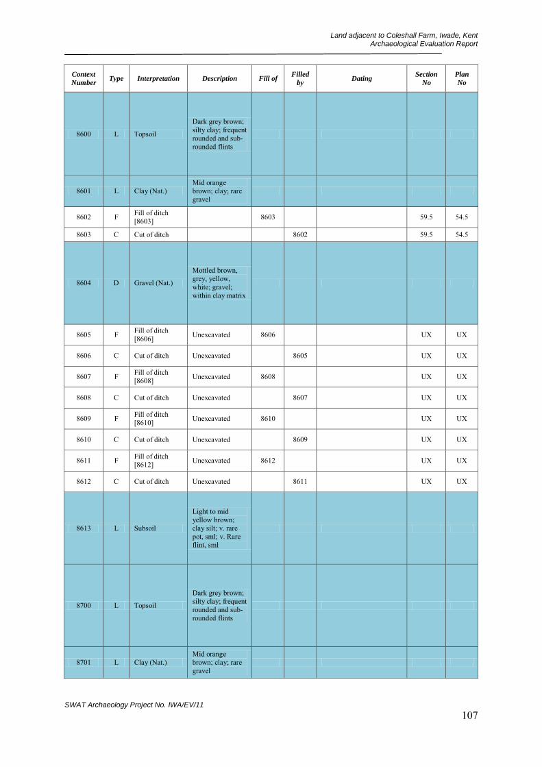
Land adjacent to Coleshall Farm, Iwade, Kent Archaeological Evaluation Report
SWAT Archaeology Project No. IWA/EV/11 107
Context
Number Type Interpretation Description Fill of
Filled
by Dating
Section
No
Plan
No
8600 L Topsoil
Dark grey brown; silty clay; frequent rounded and sub-rounded flints
8601 L Clay (Nat.) Mid orange brown; clay; rare gravel
8602 F Fill of ditch [8603] 8603 59.5 54.5
8603 C Cut of ditch 8602 59.5 54.5
8604 D Gravel (Nat.)
Mottled brown, grey, yellow, white; gravel; within clay matrix
8605 F Fill of ditch [8606] Unexcavated 8606 UX UX
8606 C Cut of ditch Unexcavated 8605 UX UX
8607 F Fill of ditch [8608] Unexcavated 8608 UX UX
8608 C Cut of ditch Unexcavated 8607 UX UX
8609 F Fill of ditch [8610] Unexcavated 8610 UX UX
8610 C Cut of ditch Unexcavated 8609 UX UX
8611 F Fill of ditch [8612] Unexcavated 8612 UX UX
8612 C Cut of ditch Unexcavated 8611 UX UX
8613 L Subsoil
Light to mid yellow brown; clay silt; v. rare pot, sml; v. Rare flint, sml
8700 L Topsoil
Dark grey brown; silty clay; frequent rounded and sub-rounded flints
8701 L Clay (Nat.) Mid orange brown; clay; rare gravel

Land adjacent to Coleshall Farm, Iwade, Kent Archaeological Evaluation Report
SWAT Archaeology Project No. IWA/EV/11 108
Context
Number Type Interpretation Description Fill of
Filled
by Dating
Section
No
Plan
No
8702 F Fill of shallow pit [8703] 8703 65.9 65.1
8703 C Cut of shallow pit 8702 65.9 65.1
8704 F Fill of probable ditch [8705] Unexcavated 8705 UX UX
8705 C Cut of probable ditch Unexcavated 8704 UX UX
8706 L Subsoil
Light to mid yellow brown; clay silt; v. rare pot, sml; v. Rare flint, sml
8800 L Topsoil
Dark grey brown; silty clay; frequent rounded and sub-rounded flints
8801 L Subsoil
Light to mid yellow brown; clay silt; v. rare pot, sml; v. Rare flint, sml
8802 L Clay (Nat.) Mid orange brown; clay; rare gravel
8803 D Gravel (Nat.)
Mottled brown, grey, yellow, white; gravel; within clay matrix
8804 C Cut of gulley (part of field system?)
8805 77.2 77.1
8805 F Fill of gulley [8804] 8804 77.2 77.1
8806 C Cut of possible pit 8807 77.4 77.1
8807 F Fill of possible pit [8806] 8806 77.4 77.1
8808 C Cut of gulley 8809 77.3 77.1
8809 F Fill of gulley [8808] 8808 77.3 77.1

Land adjacent to Coleshall Farm, Iwade, Kent Archaeological Evaluation Report
SWAT Archaeology Project No. IWA/EV/11 109
Context
Number Type Interpretation Description Fill of
Filled
by Dating
Section
No
Plan
No
8810 Cut/interface
"Silty patches" Unexcavated 8811 UX UX
8811 F Fill of [8810] Unexcavated 8810 None 77.1
8812 C Cut of linear silty patch Unexcavated 8813 UX UX
8813 F Fill of linear silty patch [8812]
Unexcavated 8812 UX UX
8900 L Topsoil
Dark grey brown; silty clay; frequent rounded and sub-rounded flints
8901 L Clay (Nat.) Mid orange brown; clay; rare gravel
8902 F Fill of shallow pit [8903] 8903 65.11 65.12
8903 C Cut of shallow pit 8902 65.11 65.12
8904 F Fill of possible pit [8905] Unexcavated 8905 UX UX
8905 C Cut of possible pit Unexcavated 8904 UX UX
9000 L Topsoil
Dark grey brown; silty clay; frequent rounded and sub-rounded flints
9001 L Clay (Nat.) Mid orange brown; clay; rare gravel
9002 F Fill of possible ditch terminus [9003]
9003 65.13 65.14
9003 C Cut of possible ditch terminus 9002 65.13 65.14
9100 L Topsoil
Dark grey brown; silty clay; frequent rounded and sub-rounded flints
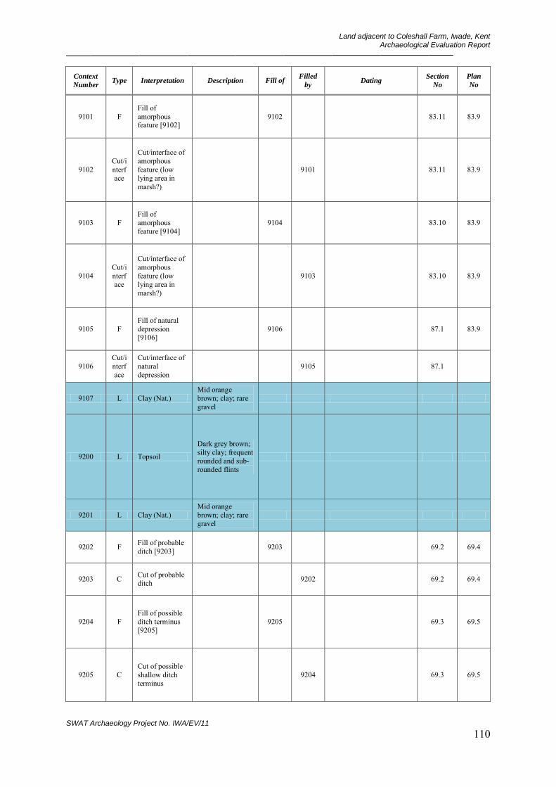
Land adjacent to Coleshall Farm, Iwade, Kent Archaeological Evaluation Report
SWAT Archaeology Project No. IWA/EV/11 110
Context
Number Type Interpretation Description Fill of
Filled
by Dating
Section
No
Plan
No
9101 F Fill of amorphous feature [9102]
9102 83.11 83.9
9102 Cut/interface
Cut/interface of amorphous feature (low lying area in marsh?)
9101 83.11 83.9
9103 F Fill of amorphous feature [9104]
9104 83.10 83.9
9104 Cut/interface
Cut/interface of amorphous feature (low lying area in marsh?)
9103 83.10 83.9
9105 F Fill of natural depression [9106]
9106 87.1 83.9
9106 Cut/interface
Cut/interface of natural depression
9105 87.1
9107 L Clay (Nat.) Mid orange brown; clay; rare gravel
9200 L Topsoil
Dark grey brown; silty clay; frequent rounded and sub-rounded flints
9201 L Clay (Nat.) Mid orange brown; clay; rare gravel
9202 F Fill of probable ditch [9203] 9203 69.2 69.4
9203 C Cut of probable ditch 9202 69.2 69.4
9204 F Fill of possible ditch terminus [9205]
9205 69.3 69.5
9205 C Cut of possible shallow ditch terminus
9204 69.3 69.5

Land adjacent to Coleshall Farm, Iwade, Kent Archaeological Evaluation Report
SWAT Archaeology Project No. IWA/EV/11 111
Context
Number Type Interpretation Description Fill of
Filled
by Dating
Section
No
Plan
No
9206 F Fill of possible pit/ditch [9207] Unexcavated 9207 UX UX
9207 C Cut of possible pit/ditch Unexcavated 9206 UX UX
9208 F Fill of possible pit/ditch [9209] Unexcavated 9209 UX UX
9209 C Cut of possible pit/ditch Unexcavated 9208 UX UX
9300 L Topsoil
Dark grey brown; silty clay; frequent rounded and sub-rounded flints
9301 D Gravel (Nat.)
Mottled brown, grey, yellow, white; gravel; within clay matrix
9302 L Clay (Nat.) Mid orange brown; clay; rare gravel
9303 F Fill of ditch terminus [9304] 9304 69.8 69.12
9304 C Cut of ditch terminus 9303 69.8 69.12
9305 F Fill of possible ditch terminus [9306]
9306 69.9 69.12
9306 C Cut of possible ditch terminus 9305 69.9 69.12
9307 F Fill of possible pit/ditch terminus [9308]
Unexcavated 9308 UX UX
9308 C Cut of possible pit/ditch terminus
Unexcavated 9307 UX UX

Land adjacent to Coleshall Farm, Iwade, Kent Archaeological Evaluation Report
SWAT Archaeology Project No. IWA/EV/11 112
Context
Number Type Interpretation Description Fill of
Filled
by Dating
Section
No
Plan
No
9309 F Fill of probable pit [9310] Unexcavated 9310 UX UX
9310 C Cut of probable pit Unexcavated 9309 UX UX
9311 F Fill of possible large pit [9312] Unexcavated 9312 UX UX
9312 C Cut of possible large pit Unexcavated 9311 UX UX
9313 F Fill of possible pit/ditch [9314] Unexcavated 9314 UX UX
9314 C Cut of possible pit/ditch Unexcavated 9313 UX UX
9400 L Topsoil
Dark grey brown; silty clay; frequent rounded and sub-rounded flints
9401 L Clay (Nat.) Mid orange brown; clay; rare gravel
9402 F Fill of possible pit [9403] 9403 69.10 69.13
9403 C Cut of possible pit 9402 69.10 69.3
9404 F Fill of possible pit/ditch terminus [9405]
9405 Uncertain but probably Early Prehistoric 69.11 69.14
9405 C Cut of possible pit/ditch terminus
9404 69.11 69.14
9406 F Fill of possible ditch [9407] Unexcavated 9407 UX UX
9407 C Cut of possible ditch Unexcavated 9406 UX UX
9408 F Fill of possible pit/ditch terminus [9409]
Unexcavated 9409 UX UX
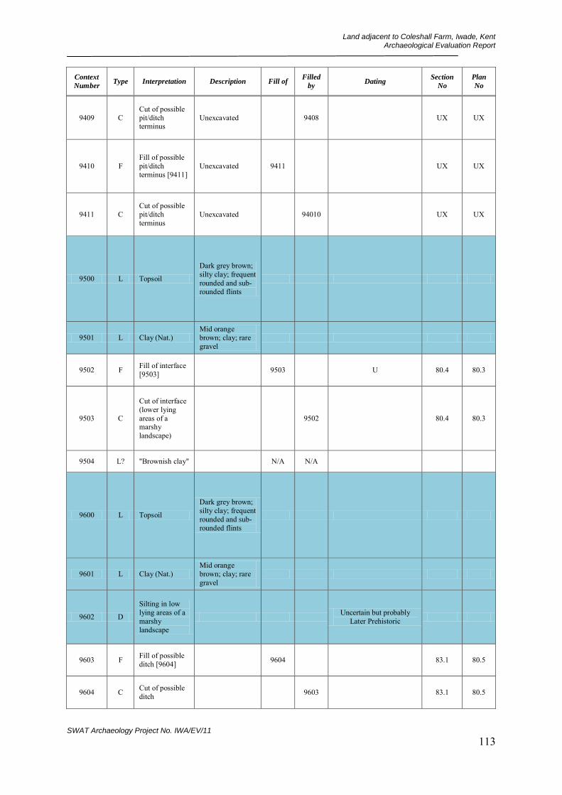
Land adjacent to Coleshall Farm, Iwade, Kent Archaeological Evaluation Report
SWAT Archaeology Project No. IWA/EV/11 113
Context
Number Type Interpretation Description Fill of
Filled
by Dating
Section
No
Plan
No
9409 C Cut of possible pit/ditch terminus
Unexcavated 9408 UX UX
9410 F Fill of possible pit/ditch terminus [9411]
Unexcavated 9411 UX UX
9411 C Cut of possible pit/ditch terminus
Unexcavated 94010 UX UX
9500 L Topsoil
Dark grey brown; silty clay; frequent rounded and sub-rounded flints
9501 L Clay (Nat.) Mid orange brown; clay; rare gravel
9502 F Fill of interface [9503] 9503 U 80.4 80.3
9503 C
Cut of interface (lower lying areas of a marshy landscape)
9502 80.4 80.3
9504 L? "Brownish clay" N/A N/A
9600 L Topsoil
Dark grey brown; silty clay; frequent rounded and sub-rounded flints
9601 L Clay (Nat.) Mid orange brown; clay; rare gravel
9602 D
Silting in low lying areas of a marshy landscape
Uncertain but probably Later Prehistoric
9603 F Fill of possible ditch [9604] 9604 83.1 80.5
9604 C Cut of possible ditch 9603 83.1 80.5
Land adjacent to Coleshall Farm, Iwade, Kent Archaeological Evaluation Report
SWAT Archaeology Project No. IWA/EV/11 114
Context
Number Type Interpretation Description Fill of
Filled
by Dating
Section
No
Plan
No
9700 L Topsoil
Dark grey brown; silty clay; frequent rounded and sub-rounded flints
9701 L Clay (Nat.) Mid orange brown; clay; rare gravel
9702 D
Silting in low lying areas of a marshy landscape
9703 F Fill of ditch [9704] 9704 Post-Medieval 68.12 80.6
9704 C Cut of ditch (field boundary - modern)
9703 68.12 80.6
9705 F Fill of possible field boundary ditch [9706]
9706 83.8 83.7
9706 C Cut of possible field boundary ditch
9705 83.8 83.7
9800 L Topsoil
Dark grey brown; silty clay; frequent rounded and sub-rounded flints
9801 L Clay (Nat.) Mid orange brown; clay; rare gravel
9802 D
Silting in low lying areas of a marshy landscape
Uncertain but probably Later Prehistoric
9803 F Fill of possible water course [9804]
9804 80.8 80.7
9804 Interface
Interface of possible water course
9803 80.7 80.6

Land adjacent to Coleshall Farm, Iwade, Kent Archaeological Evaluation Report
SWAT Archaeology Project No. IWA/EV/11 115
Context
Number Type Interpretation Description Fill of
Filled
by Dating
Section
No
Plan
No
9900 L Topsoil
Dark grey brown; silty clay; frequent rounded and sub-rounded flints
9901 L Clay (Nat.) Mid orange brown; clay; rare gravel
9902 L Natural silt layer
Found across large part of Field 2
9903 F Fill of possible tree bole [9904] 9904 83.2 80.11
9904 Interface
Interface of possible tree bole
9903 83.2 80.11
10000 L Topsoil
Dark grey brown; silty clay; frequent rounded and sub-rounded flints
10001 L Subsoil
Light to mid yellow brown; clay silt; v. rare pot, sml; v. Rare flint, sml
10002 L Clay (Nat.) Mid orange brown; clay; rare gravel
10003 L Natural silt layer
Found across large part of Field 2
10004 C Cut of circular gulley 10005 67.5;
67.7 76.1
10005 F Fill of circular gulley [10004] 10004 67.5;
67.7 76.1

Land adjacent to Coleshall Farm, Iwade, Kent Archaeological Evaluation Report
SWAT Archaeology Project No. IWA/EV/11 116
Context
Number Type Interpretation Description Fill of
Filled
by Dating
Section
No
Plan
No
10100 L Topsoil
Dark grey brown; silty clay; frequent rounded and sub-rounded flints
10101 L Subsoil
Light to mid yellow brown; clay silt; v. rare pot, sml; v. Rare flint, sml
10102 L Clay (Nat.) Mid orange brown; clay; rare gravel
10103 L Natural silt layer
Found across large part of Field 2
10104 C Cut of linear ditch 10105 66.1 76.3
10105 F Fill of ditch [10104] 10104 66.1 76.3
10200 L Topsoil
Dark grey brown; silty clay; frequent rounded and sub-rounded flints
10201 L Subsoil
Light to mid yellow brown; clay silt; v. rare pot, sml; v. Rare flint, sml
10202 L Clay (Nat.) Mid orange brown; clay; rare gravel
10203 L Natural silt layer
Found across large part of Field 2
10204 F Fill of ditch [10205] 10205 Medieval 65.2;65.3 65.4
10205 C Cut of large shallow ditch 10204 65.2;65.3 65.4
10206 F Fill of ditch [10207] 10207 65.2;65.3 65.4
10207 C Cut of large ditch 10206 65.2;65.3 65.4
Land adjacent to Coleshall Farm, Iwade, Kent Archaeological Evaluation Report
SWAT Archaeology Project No. IWA/EV/11 117
Context
Number Type Interpretation Description Fill of
Filled
by Dating
Section
No
Plan
No
10208 F Fill of pit/post hole [10209] 10209 Early Medieval 65.3 65.4
10209 C Cut of small pit/large post hole
10208 65.3 65.4
10210 F Fill of probable post hole [10211]
10211 65.2 65.4
10211 C Cut of probable post hole 10210 65.2 65.4
10300 L Topsoil
Dark grey brown; silty clay; frequent rounded and sub-rounded flints
10301 L Subsoil
Light to mid yellow brown; clay silt; v. rare pot, sml; v. Rare flint, sml
10302 L Clay (Nat.) Mid orange brown; clay; rare gravel
10303 L Natural silt layer
Found across large part of Field 2
10304 C Cut of shallow pit 10305 66.2 78.1
10305 F Fill of shallow pit [10304] 10304 66.2 78.1
10306 C Cut of medieval field gulley 10307 66.3 78.1
10307 F Fill of medieval field gulley [10306]
10306 Medieval 66.3 78.1
10400 L Topsoil
Dark grey brown; silty clay; frequent rounded and sub-rounded flints
Land adjacent to Coleshall Farm, Iwade, Kent Archaeological Evaluation Report
SWAT Archaeology Project No. IWA/EV/11 118
Context
Number Type Interpretation Description Fill of
Filled
by Dating
Section
No
Plan
No
10401 L Subsoil
Light to mid yellow brown; clay silt; v. rare pot, sml; v. Rare flint, sml
10402 L Clay (Nat.) Mid orange brown; clay; rare gravel
10403 L Natural silt layer
Found across large part of Field 2
10404 C Cut of large pit 10405 66.2 78.3
10405 F Fill of pit [10404] 10404 66.2 78.3
10406 C Cut of pit 10407 66.5 78.3
10407 F Fill of pit [10406] 10406 66.5 78.3
10408 C Cut of gulley terminus 10409 66.7 78.3
10409 F Fill of gulley [10408] 10408 66.7 78.3
10500 L Topsoil
Dark grey brown; silty clay; frequent rounded and sub-rounded flints
10501 L Subsoil
Light to mid yellow brown; clay silt; v. rare pot, sml; v. Rare flint, sml
10502 L Clay (Nat.) Mid orange brown; clay; rare gravel
10503 L Natural silt layer
Found across large part of Field 2
10504 C Cut of field gulley 10505 66.8 91.1
10505 F Fill of gulley [10504] 10504 66.8 91.1
10506 C Cut of shallow linear hollow 10507 66.9 91.1
10507 F Fill of linear feature [10506] 10506 66.9 91.1

Land adjacent to Coleshall Farm, Iwade, Kent Archaeological Evaluation Report
SWAT Archaeology Project No. IWA/EV/11 119
Context
Number Type Interpretation Description Fill of
Filled
by Dating
Section
No
Plan
No
10600 L Topsoil
Dark grey brown; silty clay; frequent rounded and sub-rounded flints
10601 L Subsoil
Light to mid yellow brown; clay silt; v. rare pot, sml; v. Rare flint, sml
10602 L Clay (Nat.) Mid orange brown; clay; rare gravel
10603 L Natural silt layer
Found across large part of Field 2
10604 C Cut of linear field ditch 10605 67.1 73.3
10605 F Fill of ditch [10604] 10604 U 67.1 73.3
10606 C Cut of modern rubbish pit Unexcavated 10607 UX 73.3
10607 F Fill of modern rubbish pit [10606]
Unexcavated 10606 UX 73.3
10608 D? "Natural brownish clay" 10609 None 73.3
10700 L Topsoil
Dark grey brown; silty clay; frequent rounded and sub-rounded flints
10701 L Subsoil
Light to mid yellow brown; clay silt; v. rare pot, sml; v. Rare flint, sml
10702 L Clay (Nat.) Mid orange brown; clay; rare gravel
10703 L Natural silt layer
Found across large part of Field 2
Land adjacent to Coleshall Farm, Iwade, Kent Archaeological Evaluation Report
SWAT Archaeology Project No. IWA/EV/11 120
Context
Number Type Interpretation Description Fill of
Filled
by Dating
Section
No
Plan
No
10704 C Cut of pit 10705 67.3 73.2
10705 F Fill of pit [10704] 10704 67.3 73.2
10706 C
Cut of abnormally large pit/possible quarry
10707 67.4 73.2
10707 F
Fill of abnormally large pit/possible quarry [10706]
10706 67.4 73.2
10800 L Topsoil
Dark grey brown; silty clay; frequent rounded and sub-rounded flints
10801 L Subsoil
Light to mid yellow brown; clay silt; v. rare pot, sml; v. Rare flint, sml
10802 L Clay (Nat.) Mid orange brown; clay; rare gravel
10803 L Natural silt layer
Found across large part of Field 2
10804 C Cut of hollow/pathway 10805 67.2 75.1
10805 F Fill of hollow/pathway [10804]
10804 Uncertain but probably Early Prehistoric 67.2 75.1
10806 C Cut of pit 10807 67.4 75.1
10807 F Fill of pit [10806] 10806 67.4 75.1
10808 C Cut of large quarry pit 10809 74.2 75.1
10809 F Fill of large pit [10808] 10808 Uncertain but probably
Early Prehistoric 74.2 75.1
10810 C Cut of stake hole 10811 74.4 75.1
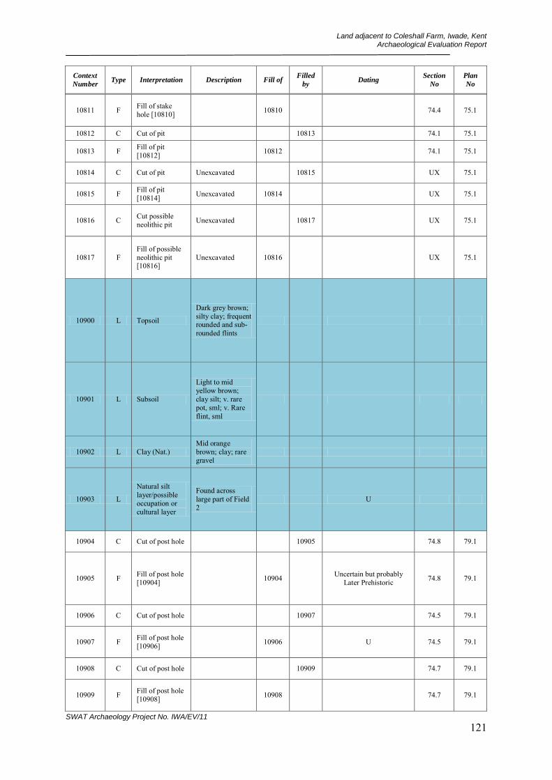
Land adjacent to Coleshall Farm, Iwade, Kent Archaeological Evaluation Report
SWAT Archaeology Project No. IWA/EV/11 121
Context
Number Type Interpretation Description Fill of
Filled
by Dating
Section
No
Plan
No
10811 F Fill of stake hole [10810] 10810 74.4 75.1
10812 C Cut of pit 10813 74.1 75.1
10813 F Fill of pit [10812] 10812 74.1 75.1
10814 C Cut of pit Unexcavated 10815 UX 75.1
10815 F Fill of pit [10814] Unexcavated 10814 UX 75.1
10816 C Cut possible neolithic pit Unexcavated 10817 UX 75.1
10817 F Fill of possible neolithic pit [10816]
Unexcavated 10816 UX 75.1
10900 L Topsoil
Dark grey brown; silty clay; frequent rounded and sub-rounded flints
10901 L Subsoil
Light to mid yellow brown; clay silt; v. rare pot, sml; v. Rare flint, sml
10902 L Clay (Nat.) Mid orange brown; clay; rare gravel
10903 L
Natural silt layer/possible occupation or cultural layer
Found across large part of Field 2
U
10904 C Cut of post hole 10905 74.8 79.1
10905 F Fill of post hole [10904] 10904 Uncertain but probably
Later Prehistoric 74.8 79.1
10906 C Cut of post hole 10907 74.5 79.1
10907 F Fill of post hole [10906] 10906 U 74.5 79.1
10908 C Cut of post hole 10909 74.7 79.1
10909 F Fill of post hole [10908] 10908 74.7 79.1
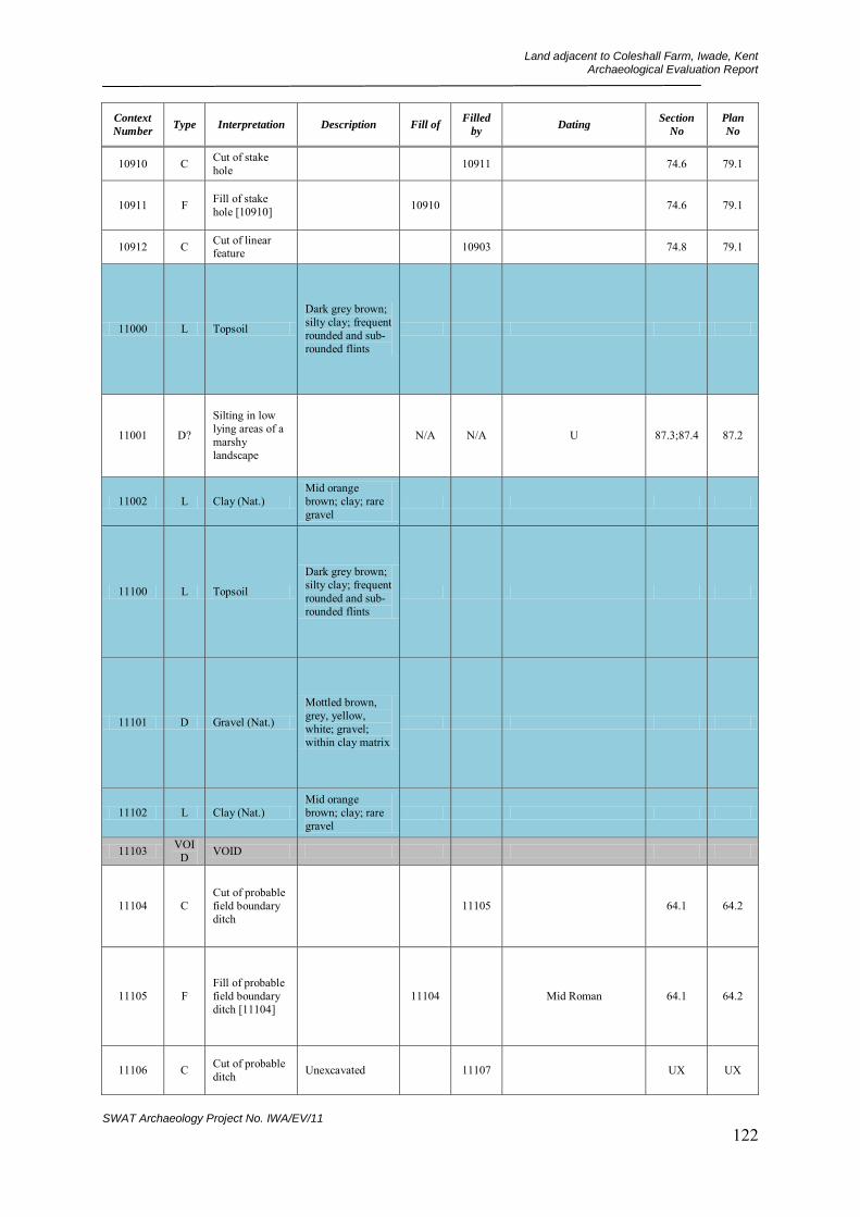
Land adjacent to Coleshall Farm, Iwade, Kent Archaeological Evaluation Report
SWAT Archaeology Project No. IWA/EV/11 122
Context
Number Type Interpretation Description Fill of
Filled
by Dating
Section
No
Plan
No
10910 C Cut of stake hole 10911 74.6 79.1
10911 F Fill of stake hole [10910] 10910 74.6 79.1
10912 C Cut of linear feature 10903 74.8 79.1
11000 L Topsoil
Dark grey brown; silty clay; frequent rounded and sub-rounded flints
11001 D?
Silting in low lying areas of a marshy landscape
N/A N/A U 87.3;87.4 87.2
11002 L Clay (Nat.) Mid orange brown; clay; rare gravel
11100 L Topsoil
Dark grey brown; silty clay; frequent rounded and sub-rounded flints
11101 D Gravel (Nat.)
Mottled brown, grey, yellow, white; gravel; within clay matrix
11102 L Clay (Nat.) Mid orange brown; clay; rare gravel
11103 VOID VOID
11104 C Cut of probable field boundary ditch
11105 64.1 64.2
11105 F Fill of probable field boundary ditch [11104]
11104 Mid Roman 64.1 64.2
11106 C Cut of probable ditch Unexcavated 11107 UX UX

Land adjacent to Coleshall Farm, Iwade, Kent Archaeological Evaluation Report
SWAT Archaeology Project No. IWA/EV/11 123
Context
Number Type Interpretation Description Fill of
Filled
by Dating
Section
No
Plan
No
11107 F Fill of probable ditch [11106] Unexcavated 11106 UX UX
11108 C Cut of possible pit Unexcavated 11109 UX UX
11109 F Fill of possible pit [11108] Unexcavated 11108 UX UX
11110 C Cut of possible pit Unexcavated 11111 UX UX
11111 F Fill of possible pit [11110] Unexcavated 11110 UX UX
11112 C Cut of possible pit Unexcavated 11113 UX UX
11113 F Fill of possible pit [11112] Unexcavated 11112 UX UX
11114 C Cut of possible pit/ditch Unexcavated 11115 UX UX
11115 F Fill of possible pit/ditch [11114]
Unexcavated 11114 UX UX
11116 C Cut of possible pit/ditch terminus
Unexcavated 11117 UX UX
11117 F
Fill of possible pit/ditch terminus [11116]
Unexcavated 11116 UX UX
11200 L Topsoil
Dark grey brown; silty clay; frequent rounded and sub-rounded flints
11201 L Subsoil
Light to mid yellow brown; clay silt; v. rare pot, sml; v. Rare flint, sml
11202 L Clay (Nat.) Mid orange brown; clay; rare gravel
11203 L Natural silt layer
Found across large part of Field 2

Land adjacent to Coleshall Farm, Iwade, Kent Archaeological Evaluation Report
SWAT Archaeology Project No. IWA/EV/11 124
Context
Number Type Interpretation Description Fill of
Filled
by Dating
Section
No
Plan
No
11204 C Cut of field gulley 11205 76.4 61.3
11205 F Fill of field gulley [11204] 11204 76.4 61.3
11206 C Cut of shallow hollow (silty patch)
Unexcavated 11207 UX 61.3
11207 F Fill of shallow hollow (silty patch) [11206]
Unexcavated 11206 UX 61.3
11208 C Cut of shallow hollow (silty patch)
Unexcavated 11209 UX 61.3
11209 F Fill of shallow hollow (silty patch) [11208]
Unexcavated 11208 UX 61.3
11210 C Cut of shallow hollow (silty patch)
Unexcavated 11211 UX 61.3
11211 F Fill of shallow hollow (silty patch) [11210]
Unexcavated 11210 UX 61.3
11212 C Cut of shallow hollow (silty patch)
Unexcavated 11213 UX UX
11213 F Fill of shallow hollow (silty patch) [11212]
Unexcavated 11212 UX UX
11214 C Cut of shallow hollow (silty patch)
Unexcavated 11215 UX UX
11215 F Fill of shallow hollow (silty patch) [11214]
Unexcavated 11214 UX UX
11300 L Topsoil
Dark grey brown; silty clay; frequent rounded and sub-rounded flints
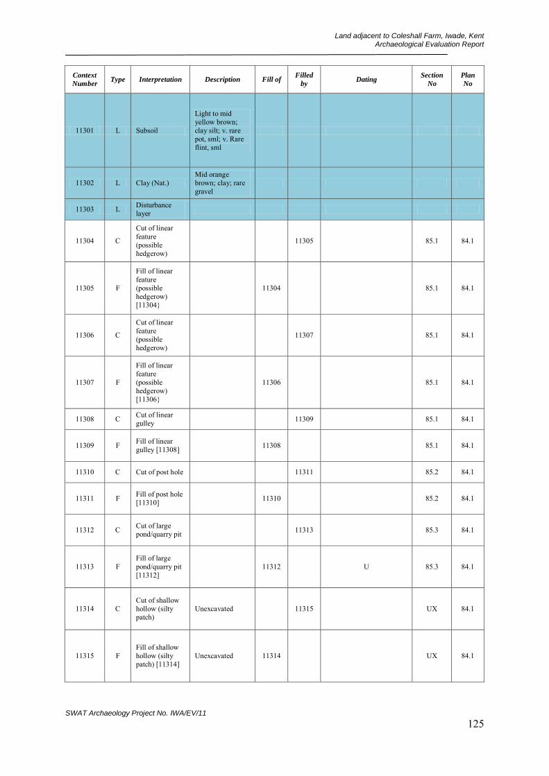
Land adjacent to Coleshall Farm, Iwade, Kent Archaeological Evaluation Report
SWAT Archaeology Project No. IWA/EV/11 125
Context
Number Type Interpretation Description Fill of
Filled
by Dating
Section
No
Plan
No
11301 L Subsoil
Light to mid yellow brown; clay silt; v. rare pot, sml; v. Rare flint, sml
11302 L Clay (Nat.) Mid orange brown; clay; rare gravel
11303 L Disturbance layer
11304 C
Cut of linear feature (possible hedgerow)
11305 85.1 84.1
11305 F
Fill of linear feature (possible hedgerow) [11304}
11304 85.1 84.1
11306 C
Cut of linear feature (possible hedgerow)
11307 85.1 84.1
11307 F
Fill of linear feature (possible hedgerow) [11306}
11306 85.1 84.1
11308 C Cut of linear gulley 11309 85.1 84.1
11309 F Fill of linear gulley [11308] 11308 85.1 84.1
11310 C Cut of post hole 11311 85.2 84.1
11311 F Fill of post hole [11310] 11310 85.2 84.1
11312 C Cut of large pond/quarry pit 11313 85.3 84.1
11313 F Fill of large pond/quarry pit [11312]
11312 U 85.3 84.1
11314 C Cut of shallow hollow (silty patch)
Unexcavated 11315 UX 84.1
11315 F Fill of shallow hollow (silty patch) [11314]
Unexcavated 11314 UX 84.1
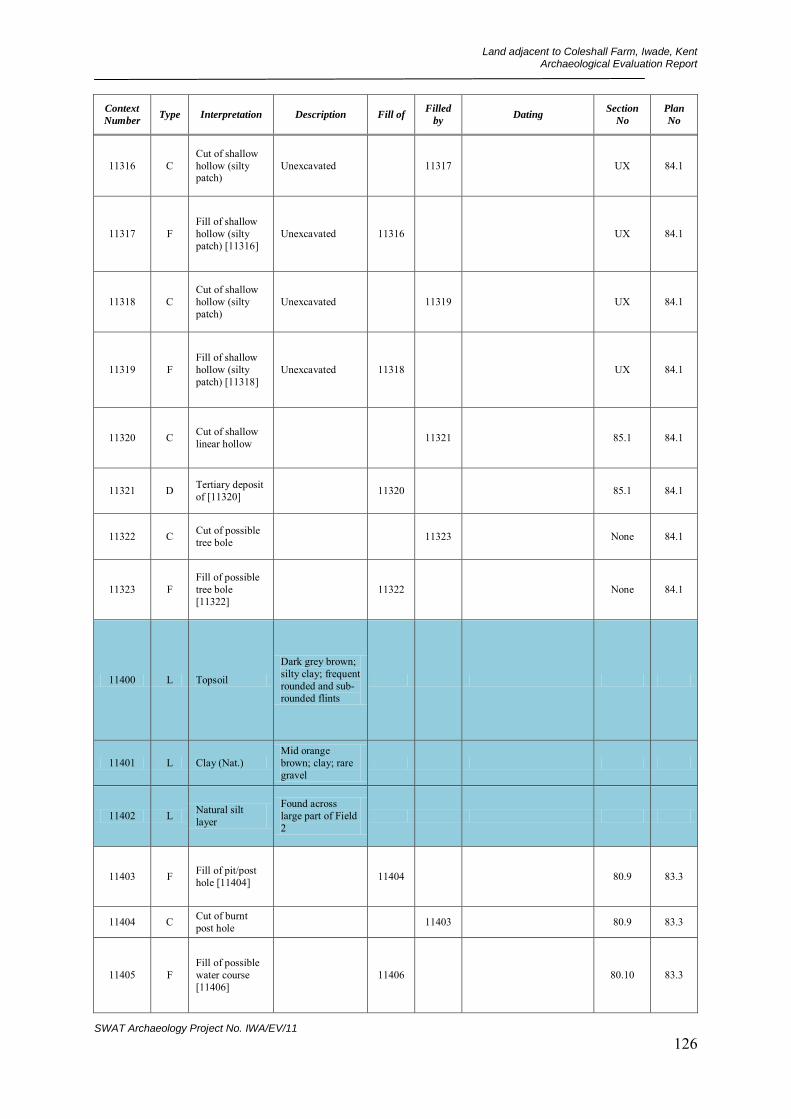
Land adjacent to Coleshall Farm, Iwade, Kent Archaeological Evaluation Report
SWAT Archaeology Project No. IWA/EV/11 126
Context
Number Type Interpretation Description Fill of
Filled
by Dating
Section
No
Plan
No
11316 C Cut of shallow hollow (silty patch)
Unexcavated 11317 UX 84.1
11317 F Fill of shallow hollow (silty patch) [11316]
Unexcavated 11316 UX 84.1
11318 C Cut of shallow hollow (silty patch)
Unexcavated 11319 UX 84.1
11319 F Fill of shallow hollow (silty patch) [11318]
Unexcavated 11318 UX 84.1
11320 C Cut of shallow linear hollow 11321 85.1 84.1
11321 D Tertiary deposit of [11320] 11320 85.1 84.1
11322 C Cut of possible tree bole 11323 None 84.1
11323 F Fill of possible tree bole [11322]
11322 None 84.1
11400 L Topsoil
Dark grey brown; silty clay; frequent rounded and sub-rounded flints
11401 L Clay (Nat.) Mid orange brown; clay; rare gravel
11402 L Natural silt layer
Found across large part of Field 2
11403 F Fill of pit/post hole [11404] 11404 80.9 83.3
11404 C Cut of burnt post hole 11403 80.9 83.3
11405 F Fill of possible water course [11406]
11406 80.10 83.3
Land adjacent to Coleshall Farm, Iwade, Kent Archaeological Evaluation Report
SWAT Archaeology Project No. IWA/EV/11 127
Context
Number Type Interpretation Description Fill of
Filled
by Dating
Section
No
Plan
No
11406 C Cut of possible water course 11405 80.10 83.3
11500 L Topsoil
Dark grey brown; silty clay; frequent rounded and sub-rounded flints
11501 L Clay (Nat.) Mid orange brown; clay; rare gravel
11502 L Natural silt layer
Found across large part of Field 2
11600 L Topsoil
Dark grey brown; silty clay; frequent rounded and sub-rounded flints
11601 L Subsoil
Light to mid yellow brown; clay silt; v. rare pot, sml; v. Rare flint, sml
11602 L Clay (Nat.) Mid orange brown; clay; rare gravel
11603 L Natural silt layer
Found across large part of Field 2
11604 C Cut of oval pit 11605 66.6 91.2
11605 F Fill of oval pit [11604] 11604 66.6 91.2
11700 L Topsoil
Dark grey brown; silty clay; frequent rounded and sub-rounded flints
11701 L Clay (Nat.) Mid orange brown; clay; rare gravel

Land adjacent to Coleshall Farm, Iwade, Kent Archaeological Evaluation Report
SWAT Archaeology Project No. IWA/EV/11 128
Context
Number Type Interpretation Description Fill of
Filled
by Dating
Section
No
Plan
No
11702 L Natural silt layer
Found across large part of Field 2
11703 F Fill of possible pit/possible tree bole [11704]
11704 83.5 83.4
11704 C Cut of possible pit/possible tree bole
11703 83.5 83.4
11705 F
Fill of possible ditch/possible water course [11706]
11706 83.6 83.4
11706 C Cut of possible ditch/possible water course
11705 83.6 83.4
11800 L Topsoil
Dark grey brown; silty clay; frequent rounded and sub-rounded flints
11801 L Subsoil
Light to mid yellow brown; clay silt; v. rare pot, sml; v. Rare flint, sml
11802 L Clay (Nat.) Mid orange brown; clay; rare gravel
11803 L Natural silt layer
Found across large part of Field 2
Uncertain but probably Later Prehistoric
11804 C Cut of post hole 11805 93.1 92.1
11805 F Fill of post hole [11804] 11804 93.1 92.1
11806 C Cut of pit 11807 93.2 92.1
11807 F Fill of pit [11806] 11806 U 93.2 92.1
11808 C Cut of post hole 11809 93.4 92.1

Land adjacent to Coleshall Farm, Iwade, Kent Archaeological Evaluation Report
SWAT Archaeology Project No. IWA/EV/11 129
Context
Number Type Interpretation Description Fill of
Filled
by Dating
Section
No
Plan
No
11809 F Fill of post hole [11808] 11808 U None 92.1
11810 C Cut of stake hole 11811 93.5 92.1
11811 F Fill of stake hole [11810] 11810 Uncertain but probably
Early Prehistoric None 92.1
11812 C Cut of probable natural linear feature
Not fully excavated 11813 None 92.1
11813 F Fill of probable natural linear feature [11812]
Not fully excavated 11812 None 92.1
11814 C Cut of probable natural linear feature
Not fully excavated 11815 93.7 92.1
11815 F Fill of probable natural linear feature [11814]
Not fully excavated 11814 93.7 92.1
11900 L Topsoil
Dark grey brown; silty clay; frequent rounded and sub-rounded flints
11901 L Clay (Nat.) Mid orange brown; clay; rare gravel
11902 F Fill of silty patch/possible ditch [11903]
11903 96.5 96.6
11903 C Cut of silty patch/possible ditch
11902 96.5 96.6
11904 F Fill of silty patch/possible ditch [11905]
Unexcavated 11905 UX UX
11905 C Cut of silty patch/possible ditch
Unexcavated 11904 UX UX

Land adjacent to Coleshall Farm, Iwade, Kent Archaeological Evaluation Report
SWAT Archaeology Project No. IWA/EV/11 130
Context
Number Type Interpretation Description Fill of
Filled
by Dating
Section
No
Plan
No
11906 F Fill of modern feature [11907] Unexcavated 11907 UX UX
11907 C Cut of modern feature Unexcavated 11906 UX UX
11908 F
Fill of silty patch/possible tree bole [11909]
Unexcavated 11909 UX UX
11909 C Cut of silty patch/possible tree bole
Unexcavated 11908 UX UX
11910 F Fill of modern feature [11911] Unexcavated 11911 UX UX
11911 C Cut of modern feature Unexcavated 11910 UX UX
12000 L Topsoil
Dark grey brown; silty clay; frequent rounded and sub-rounded flints
12001 L Subsoil
Light to mid yellow brown; clay silt; v. rare pot, sml; v. Rare flint, sml
12002 L Clay (Nat.) Mid orange brown; clay; rare gravel
12003 L Natural silt layer
Found across large part of Field 2
12004 C Cut of small shallow pit 12005 90.3 90.1
12005 F Fill of small shallow pit [12004]
12004 90.3 90.1
12006 C
Cut of geological periglacial crack
12007 90.4 90.1
12007 F Fill of natural feature [12006] 12006 90.4 90.1
Land adjacent to Coleshall Farm, Iwade, Kent Archaeological Evaluation Report
SWAT Archaeology Project No. IWA/EV/11 131
Context
Number Type Interpretation Description Fill of
Filled
by Dating
Section
No
Plan
No
12100 L Topsoil
Dark grey brown; silty clay; frequent rounded and sub-rounded flints
12101 L Clay (Nat.) Mid orange brown; clay; rare gravel
12102 F Fill of possible ditch terminus [12103]
12103 69.6 69.7
12103 C Cut of possible ditch terminus 12102 69.6 69.7
12104 F Fill of possible ditch terminus [12105]
Unexcavated 12105 UX UX
12105 C Cut of possible ditch terminus Unexcavated 12104 UX UX
12106 F Fill of possible irregular pit [12107]
Unexcavated 12107 UX UX
12107 C Cut of possible irregular pit Unexcavated 12106 UX UX
12108 F Fill of possible pit/ditch [12109]
Unexcavated 12109 UX UX
12109 C Cut of possible pit/ditch Unexcavated 12108 UX UX
12110 F Fill of possible pit/ditch [12111]
Unexcavated 12111 UX UX
12111 C Cut of possible pit/ditch Unexcavated 12110 UX UX
12200 L Topsoil
Dark grey brown; silty clay; frequent rounded and sub-rounded flints

Land adjacent to Coleshall Farm, Iwade, Kent Archaeological Evaluation Report
SWAT Archaeology Project No. IWA/EV/11 132
Context
Number Type Interpretation Description Fill of
Filled
by Dating
Section
No
Plan
No
12201 L Clay (Nat.) Mid orange brown; clay; rare gravel
12202 F Fill of possible curved ditch [12203]
12203 96.1 96.4
12203 C Cut of possible curved ditch 12202 96.1 96.4
12204 F
Fill of possible NW-SE allinged ditch [12205]
12205 96.2 96.3
12205 C Cut of possible NW-SE allinged ditch
12204 96.2 96.3
12206 F Fill of possible pit [12207] Unexcavated 12207 UX UX
12207 C Cut of possible irregular pit Unexcavated 12206 UX UX
12300 L Topsoil
Dark grey brown; silty clay; frequent rounded and sub-rounded flints
12301 L Subsoil
Light to mid yellow brown; clay silt; v. rare pot, sml; v. Rare flint, sml
12302 L Clay (Nat.) Mid orange brown; clay; rare gravel
12303 L Natural silt layer
Found across large part of Field 2
12304 C Cut/interface of tree throw 12305 93.9 61.2
12305 F Fill of tree throw [12304] 12304 93.9 61.2

Land adjacent to Coleshall Farm, Iwade, Kent Archaeological Evaluation Report
SWAT Archaeology Project No. IWA/EV/11 133
Context
Number Type Interpretation Description Fill of
Filled
by Dating
Section
No
Plan
No
12306 C Cut of possible pit Unexcavated 12307 UX 61.2
12307 F Fill of possible pit [12306] Unexcavated 12306 UX 61.2
12400 L Topsoil
Dark grey brown; silty clay; frequent rounded and sub-rounded flints
12401 L Natural silt layer
Found across large part of Field 2
12402 L Clay (Nat.) Mid orange brown; clay; rare gravel
12500 L Topsoil
Dark grey brown; silty clay; frequent rounded and sub-rounded flints
12501 L Subsoil
Light to mid yellow brown; clay silt; v. rare pot, sml; v. Rare flint, sml
12502 L Clay (Nat.) Mid orange brown; clay; rare gravel
12503 L Natural silt layer
Found across large part of Field 2
12504 C Cut of silty patch/shallow pit
12505 93.8 61.1
12505 F Fill of silty patch/shallow pit [12504]
12504 93.8 61.1
12506 C Cut of pit Unexcavated 12507 UX 61.1
12507 F Fill of pit [12506] Unexcavated 12506 UX 61.1
12508 C Cut of pit Unexcavated 12509 UX 61.1
12509 F Fill of pit [12508] Unexcavated 12508 UX 61.1
Land adjacent to Coleshall Farm, Iwade, Kent Archaeological Evaluation Report
SWAT Archaeology Project No. IWA/EV/11 134
Context
Number Type Interpretation Description Fill of
Filled
by Dating
Section
No
Plan
No
12510 C Cut of pit Unexcavated 12511 UX 61.1
12511 F Fill of pit [12510] Unexcavated 12510 UX 61.1
12512 C Cut of pit Unexcavated 12513 UX 61.1
12513 F Fill of pit [12512] Unexcavated 12512 UX 61.1
12600 L Topsoil
Dark grey brown; silty clay; frequent rounded and sub-rounded flints
12601 L Clay (Nat.) Mid orange brown; clay; rare gravel
12602 F
Fill of possible paleo-channel/possible ditch [12604]
12604 81.2 81.3
12603 F
Primary Fill of possible paleo-channel/possible ditch [12604]
12604 81.2 81.3
12604 C
Cut of possible paleo-channel/possible ditch
12602;12603 81.2 81.3
12605 L Natural silt layer
Found across large part of Field 2
N/A N/A 81.2 None
12606 L Lower silting layer N/A N/A 81.2 81.3
12607 F Fill of modern field boundary [12608]
Unexcavated 12608 UX 81.3
12608 C Cut of modern field boundary Unexcavated 12607 UX 81.3

Land adjacent to Coleshall Farm, Iwade, Kent Archaeological Evaluation Report
SWAT Archaeology Project No. IWA/EV/11 135
Context
Number Type Interpretation Description Fill of
Filled
by Dating
Section
No
Plan
No
12700 L Topsoil
Dark grey brown; silty clay; frequent rounded and sub-rounded flints
12701 L Natural silt layer
Found across large part of Field 2
12702 F Fill of ditch [12704] 12704 86.1 86.3
12703 F Fill of ditch [12704] Same as (12702) 12704 86.2 86.3
12704 C Cut of ditch 12702;12703 86.1;86.2 86.3
12705 F Fill of modern pond [12706] 12706 None 86.3
12706 C Cut of modern pond 12705 None 86.3
12707 L Clay (Nat.) Mid orange brown; clay; rare gravel
12800 L Topsoil
Dark grey brown; silty clay; frequent rounded and sub-rounded flints
12801 L Clay (Nat.) Mid orange brown; clay; rare gravel
12802 L Natural silt layer
Found across large part of Field 2
12900 L Topsoil
Dark grey brown; silty clay; frequent rounded and sub-rounded flints
12901 L Subsoil
Light to mid yellow brown; clay silt; v. rare pot, sml; v. Rare flint, sml
Land adjacent to Coleshall Farm, Iwade, Kent Archaeological Evaluation Report
SWAT Archaeology Project No. IWA/EV/11 136
Context
Number Type Interpretation Description Fill of
Filled
by Dating
Section
No
Plan
No
12902 L Colluvium
Mid mottled orange grey brown; silt clay; rare gravel
12903 L Clay (Nat.) Mid orange brown; clay; rare gravel

Land adjacent to Coleshall Farm, Iwade, Kent Archaeological Evaluation Report
SWAT Archaeology Project No. IWA/EV/11 137
APPENDIX 3: CERAMIC ASSESSMENT
A. Primary quantification : 538 sherds (weight : 5kgs.442gms) B. Period codes employed :
EP or LP = Early or Late Prehistoric EN = Early Neolithic MN = Middle Neolithic EBA = Early Bronze Age MBA = Middle Bronze Age MBA-LBA = Middle-Late Bronze Age transition LBA = Late Bronze Age EIA = Early Iron Age EIA-MIA>MIA = Early-Mid>Mid Iron Age MLS = Mid-Late Saxon EM-M = Early Medieval-Medieval transition M = Medieval PM = Post-Medieval
C. Context dating :
Trench 4 Context: 405 - 3 sherds (weight : 3gms) 1 sherd LP flint-tempered ware (slight preference, EIA-MIA>MIA, c.600-350/20 BC) 1 sherd LIA ‘Belgic’-style grog-tempered ware (c.25 BC/25-75 AD emphasis probably) 1 sherd EM NE Kent shell-tempered ware (c.1125/1150-1200 AD emphasis) Comment : Prehistoric sherd is small and moderately worn with rounded sherd edges. The LIA element is a minute bodysherd, fairly fresh, from a red-surfaced vessel. The EM bodysherd is small but only slightly worn. Likely date : Uncertain – but, if not residual/intrusive, no later than C13 AD Context: 413 - 1 sherd (weight : 1gm) 1 sherd EP or LP flint-tempered ware (slight preference MBA>EIA, c.1550-600 BC) Comment : Small bodysherd, worn overall. The mixed temper grades could occur as early as Early Neolithic but, initially, it is felt that the degree of fine temper present is closer to earlier-phase Later Prehistoric potting trends. Likely date : Uncertain – probably residual Trench 5 Context: SF 8 - 1 sherd (weight : 80gms) 1 sherd EIA-MIA>MIA flint and grog-tempered ware (c.400-300/250 BC probably) Comment : Large base sherd, sligbtly worn, even if a surface find – derived from an undisturbed contemporary deposit. Drawable : 1 coarseware jar base Likely date : Initially, c.400-250 BC Context: 505 - 1 sherd (weight : 1gm) 1 sherd probable MN Peterborough-type flint-tempered ware, c3350-2800 BC) Comment : Small bodysherd, slight unifacial wear externally, otherwise fairly fresh. The thin body wall and typically Middle Neolithic-type ‘squidged’ fabric matrix, strongly suggests that this element is of that date. Likely date : If not residual – c.3350-2800 BC Context: 511 - 1 sherd (weight : 9gms) 1 sherd MBA> MBA-LBA transition or EIA-MIA>MIA flint-tempered ware (slight preference 2nd.M, c.1550-1150 BC) Comment : Fairly small bodysherd, very heavily worn overall, very residual Likely date : Uncertain – probably residual Context: 515 - 4 sherds (weight : 6gms)
Land adjacent to Coleshall Farm, Iwade, Kent Archaeological Evaluation Report
SWAT Archaeology Project No. IWA/EV/11 138
3 scraps EP or LP flint-tempered ware (very slight preference EN>MN, possibly c.4000/3350-2800 BC) 1 sherd ? MN or EBA Collared Urn (very slight preference EBA, c.2000-1500 BC) Comment : First entry represented by scrappy bodysherds, highly worn and fragmentary, ill-sorted temper underpins the slight preference for a Neolithic date. Second entry is a fairly small thin-walled bodysherd with an even sparser degree of temper applied to a very poorly-mixed fabric. Thin-walled Middle Neolithic pottery does sometimes occur – particularly in combination with poorly prepared ‘squeezed’ fabrics – so this sherd could be of that date. However, this sherd also has an oxidised exterior – similar to Beakers and Collared Urns – and since poorly-mixed poorly-fired fabrics associated with thin-walls – a combination that degrades quickly – as here – in acidic soils or disturbed conditions, an EBA date is marginally preferred Likely date : Uncertain - possibly c.2000-1500 BC Trench 8 Context: 804 - 2 sherds (weight : 14gms) 2 sherds EN-MN flint-tempered ware (MN Peterborough-type ware preference, c.3350-2800 BC; same vessel) Comment : Two bodysherds, moderate-sized, slight unifacial damage externally – otherwise fairly fresh and almost certainly from a contemporary context. Likely date : c.3350-2800 BC probably Trench 10 Context: UN - 13 sherds (weight : 129gms) 4 sherds EM NE.Kent shell-tempered ware (c.1150-1200/1225 AD; 2 x same vessels) 1 sherd EM-M NE.Kent shell-tempered sandy ware (c.1175-1225/1250 AD emphasis = Context 1019) 4 sherds EM-M Canterbury Tyler Hill sandy ware (c.1175/1200-1225 AD emphasis; 3-4 same vessel; some = Context 1019) 3 sherds M Canterbury Tyler Hill sandy ware (c.1200-1225/1250 AD; 2-3 same vessel) 1 sherd M Canterbury Tyler Hill sandy ware (c.1275-1325/1350 AD) Comment : Small-fairly large sherds – largest among the earliest – but all fairly worn, the latter quite heavily – and all should be residual in-context. The latest is fairly fresh and from a small-diameter round-bodied jug. Two of the EM shelly ware sherds are conjoining fragments from a near-flat dripping-tray fragment – with barely any edge-lip but glazed on its upper surface which is (underglaze) decorated with an applied ridged strip. Drawable : 1 x EM shell-tempered ware dripping pan fragment Likely date : If these are not area-wide surface scatter and are not intrusive – c.1275-1325 AD or slightly later Context: SF 3 - 1 sherd (weight : 2gms) 1 sherd ? EM NW Kent shell-tempered fine sandy ware (c.1125/1150-1200 AD emphasis probably) Comment : Small bodysherd, fairly worn. The exterior surface has fine horizontal rilling – either from wiping the surface or, more probably, being finished on a turntable. The appearance is atypical of the finishes on most eastern Kentish EM shelly wares and is reminiscent of early ‘Dartford-type rilled ware’ types.. Likely date : Uncertain – but if not residual, c.1200-1250 AD Context: SF 5 - 1 sherd (weight : 27gms) 1 sherd M Canterbury Tyler Hill sandy ware (c.1200-1225/1250 AD) Comment : Moderate-sized thumbed jug base sherd, moderately worn – probably from an undisturbed contemporary deposit. Likely date : Probably c.1225-1250 AD Context: SF 6 - 1 sherd (weight : 20gms) 1 sherd EM-M Canterbury Tyler Hill sandy ware (c.1175/1200-1225 AD emphasis) Comment : Fairly large cooking-pot bodysherd, exterior sooted, only slightly worn and from an undisturbed contemporary context Likely date : c.1200-1225 AD or slightly later Context: 1005 - 2 sherds (weight : 6gms) 1 sherd EM NE Kent shell-tempered ware with sparse sand (c.1150-1175/1200 AD emphasis) 1 sherd EM-M NE.Kent shell-tempered ware with sparse sand (c.1175-1200/1225 AD emphasis) Comment : Both bodysherds, the earliest thicker-walled and more worn than the latter – which is a small fairly fresh and thinner-walled sherd. Likely date : c.1200-1250 AD
Land adjacent to Coleshall Farm, Iwade, Kent Archaeological Evaluation Report
SWAT Archaeology Project No. IWA/EV/11 139
Context: 1009 - 6 sherds (weight : 32gms) 2 sherds EM-M NE.Kent shell-tempered ware (c.1175-1200/1225 AD) 1 sherd M Canterbury Tyler Hill sandy ware (c.1225-1250/1275 AD) 1 sherd M N or W.Kent fine sandy ware (cf. London Highly Decorated style, c.1225-1300 AD probably) 1 sherd M Canterbury Tyler Hill sandy ware (c.1250-1275/1300 AD) 1 sherd M Canterbury Tyler Hill sandy ware (c.1250-1300/1350 AD probable emphasis) Comment : Small-medium-sized sherds, largest is the latest element. All 4 earliest entries are moderately worn – particularly the non-local jug bodysherd – and if the latest element is not intrusive, should be residual in-context. The latest element is uncertainly dated – it is fresh and fairly hard-fired which could suggest a date as late as the mid-C14 AD. However its manufacturing trends (pre-fused fabric coalescence, dull core colours) suggest a rather earlier dating. Drawable : 1 M jug rim Likely date : Uncertain – if not intrusive – c.1250-1300 AD or slightly later Context: 1011 - 1 sherd (weight : 2gms) 1 sherd M Canterbury Tyler Hill sandy ware (c.1225/1250-1275 AD) Comment : Small bodysherd, moderate unifacial wear externally – probably moderately residual Likely date : Uncertain – possibly c.1250-1300 AD or slightly earlier Context: 1013 - 13 sherds (weight : 41gms) 1 sherd EM-M NE.Kent shell-tempered ware with sparse sand (c.1150-1200/1225 AD) 8 sherds EM-M Canterbury Tyler Hill sandy ware (c.1175-1200/1225 AD; 2 x same vessels) 2 sherds M Canterbury Tyler Hill sandy ware (c.1175/1200-1225 AD emphasis; same vessel) 2 sherds M Canterbury Tyler Hill sandy ware (c.1225/1250-1275 AD) Comment : Mostly small-medium sized sherds, most body but including 2 rim scraps from the same vessel. The earliest element is fairly heavily worn and clearly residual. The 3 same-vessel elements vary in condition, earliest mostly larger and fresh, latest small and worn. Latest mid-century sherds are moderate-sized and fairly fresh. If these latter 2 are not intrusive – differences in condition among the earlier sherds are due to varying discard/seal histories. Likely date : Slightly uncertain – but if not intrusive c.1250-1275 AD or slightly earlier Context: 1019 - 45 sherds (weight : 393gms) 1 sherd ? MLS-LS N.Kent sandy ware (c.750/800-950 AD range possibly) 1 sherd EM NE.Kent shell-tempered ware (c.1125-1150/1175 AD emphasis probably) 8 sherds EM NE.Kent shell-tempered ware (c.1150-1200/1225 AD emphasis; 2-3 x same vessels) 1 sherd EM NE.Kent shell-tempered ware with sparse coarse sand (c.1150-1200/1225 AD) 2 sherds EM-M NE.Kent shell-tempered ware (c.1175-1200/1225 AD) 3 sherds EM-M N.Kent shell-tempered sandy ware (c.1175-1200/1225 AD; same vessel) 1 sherd EM-M Canterbury Tyler Hill sandy ware (c.1175-1200/1225 AD 3 sherds EM-M NE.Kent shell-tempered sandy ware (c.1175-1225/1250 AD emphasis = Context Tr.10 UN) 18 sherds M Canterbury Tyler Hill sandy ware (c.1175/1200-1225 AD; 2-3 x same vessels) 8 sherds M Canterbury Tyler Hill sandy ware (c.1200/1225-1250 AD; 7 same vessel) 1 sherd M Canterbury Tyler Hill sandy ware (c.1225-1250/1275 AD) 1 sherd M N or W.Kent fine sandy ware (cf. London Highly Decorated style, c.1225-1300 AD probably) 3 sherds M Canterbury Tyler Hill sandy ware (c.1250-1300/1325 AD probably; 2 same vessel) 2 sherds M Canterbury Tyler Hill sandy ware (c.1325-1350/1375 AD) 2 sherds M N/W Kent sandy ware with sparse shell (fossil shell, c.1325-1350/1375 AD probably) 1 sherd LPM English white porcelain (on-glaze decoration, hard paste, c.1775-1800/1825 AD emphasis probably; intrusive) Comment : Vari-sized assemblage, small-large sherds – the latter particularly among the later C12-mid C13 AD elements. The potential MLS sandy ware is in a different fabric, slightly finer than the associated Tyler Hill wares – and is small and more abraded. None of this earlier material is heavily worn but is more so than the near-fresh C14 AD elements. The later C13 AD sherds are less worn than the main earlier bulk, but are slightly more worn than the C14 AD elements. The differences in wear pattern suggest that the main later C12-earlier C13 AD component was probably deposited as one clearance-dump, with the context remaining open over a period of time to receive disparate discards over a period of time (there are rather too many later elements to suggest that they are all later intrusions). Drawable : 3 x EM jar rims, 1 EM-M early jug decorated bodysherd, 2 M rims – incl.1 cooking-pot Likely date : Slightly uncertain – initially, possibly a primary deposit between c.1175-1225 AD with later accretions between c.1250-1350 AD
Land adjacent to Coleshall Farm, Iwade, Kent Archaeological Evaluation Report
SWAT Archaeology Project No. IWA/EV/11 140
Context: 1020 - 11 sherds (weight : 100gms) 2 sherds EM-M NE.Kent shell-tempered ware (c.1175-1200/1225 AD) 9 sherds M Canterbury Tyler Hill sandy ware (c.1225-1250/1275 AD; same vessel) and : 1 rounded fragment daub (weight : 5gms) and 3 fragments of metal-working dross/re-fired ceramic (collective weight : 7gms) Comment : The earlier elements are small and variably worn, one with heavy unifacial wear – and residual in-context. The same-vessel sherds – cooking-pot rim and upper body fragments – are fresh and unworn and from an undisturbed contemporary deposit. Drawable : 1 neck-shoulder M cooking-pot part-profile Likely date : c.1250-1275 AD Context: 1026 - 1 sherd (weight : 11gms) 1 sherd M Canterbury Tyler Hill sandy ware (c.1225-1250/1275 AD) Comment : Moderate-sized, near-fresh, cooking-pot base sherd, lightly burnt post-loss – probably from an undisturbed contemporary deposit. Likely date : c.1250-1275 AD probably Context: 1028 - 3 sherds (weight : 26gms) 1 sherd EM-M NE.Kent shell-tempered ware (c.1175/1200-1225 AD) 2 sherds M Canterbury Tyler Hill sandy ware (c.1200/1225-1250 AD; same vessel) and : 2 fragments drossy re-fired ceramic/daub (weight : 12gms) Comment : The earliest sherd is small but fresh, the latest are moderate-sized, moderately worn. These are conjoining elements from a small jug. Although the latter is later dated, differences in condition between the two wares types may be due to their relative in-context positions, rather than the latest element being intrusive. Likely date : c.1225-1275 AD or slightly earlier. Context: 1031 - 2 sherds (weight : 9gms) 2 sherds EM NE.Kent shell-tempered ware (c.1150-1175/1200 AD emphasis) Comment :One small bodysherd, one fairly small cooking-pot base sherd, edges slightly worn Likely date : c.1150-1200 AD Context: 1033 - 1 sherd (weight : 9gms) 1 sherd EM NE.Kent shell-tempered ware with sparse sand (c.1125/1150-1200 AD emphasis probably) Comment : Moderate-sized base sherd, fairly worn edges, more leached internally than externally (cooking bi-product rather than wear). Not seriously residual Likely date : c.1175-1225 AD Context: 1037 - 1 sherd (weight : 42gms) 1 sherd EM-M NE.Kent shell-tempered ware with sparse sand (c.1150/1175-1200 AD emphasis probably) Comment : Fairly large shoulder sherd, moderately worn, from a decorated fire-cover (with sooted interior) Drawable : 1 shelly ware fire-cover fragment (should include reconstructed oa.form) Likely date : c.1200-1250 AD – or slightly earlier Context: 1039 - 3 sherds (weight : 40gms) 3 sherds EM NE.Kent shell-tempered sandy ware (c.1175-1200/1225 AD; same vessel, burnt) Comment : Three conjoining rim sherds, moderately worn, slightly warped and fabric beginning to go corky from inclusion in a fairly intense heat. Probably from an undisturbed contemporary context. Likely date : If not residual - c.1200-1250 AD Trench 13 Context: SF 2 - 1 sherd (weight : 58gms) 1 sherd LPM Late Normandy stoneware (c.1870-1940 AD range) Comment : Rim fragment from a large ‘margarine jar’, slightly chipped, otherwise fairly fresh. Likely date : Uncertain – if not residual possibly LC19-EC20 AD Trench 14 Context: 1405 - 3 sherds (weight : 4gms) 3 sherds MN Peterborough-type flint-tempered ware, c3350-2800 BC) Comment : Three small bodysherd scraps – all highly worn and fragmentary – one may have traces of close-set

Land adjacent to Coleshall Farm, Iwade, Kent Archaeological Evaluation Report
SWAT Archaeology Project No. IWA/EV/11 141
finger-pinched decoration Likely date : If not residual – c.3350-2800 BC probably Context: 1410 - 9 sherds (weight : 23gms) 9 sherds MN Peterborough-type flint-tempered ware (c.3350-2800 BC; 2 x same vessels) Comment : All small sherds, most are bodysherds, most are fairly fresh. Only one flake is more worn and could be residual in-context. Otherwise most have the appearance and condition indicating derivation from an undisturbed contemporary deposit. Drawable : 1 x decorated coarseware bowl rim Likely date : c.3350-2280 BC Trench 15 Context: 1506 - 176 sherds (weight : 1kg.769gms) 176 sherds EIA-MIA>MIA flint-tempered ware (c.400-350/300 BC; same vessel) Comment : Small-moderate sized sherds mostly, a few fairly large, fairly fresh but fabric rather soft and under-fired so sherd edges frequently slightly abraded. An undisturbed contemporary deposit. Likely date : c.400-300 BC Context: 1507 - 43 sherds (weight : 461gms) 15 sherds EIA-MIA>MIA flint-tempered ware (c.400-350/300 BC; 2 x same vessels) 22 sherds EIA-MIA>MIA flint and grog-tempered ware (c.400-350/300 BC; 1 x traces rustication) 4 sherds EA-MIA>MIA flint-tempered ware with profuse fine marl inclusions (c.400-350/300 BC; 2 x same vessels, 1 = Context 1508) 2 sherds EIA-MIA>MIA organic-tempered silty ware with sparse flint (c.400-350/300 BC; same vessel = Context 1508) Comment : Apart from the conjoining carinated fineware bowl sherds, all are bodysherds, vari-sized, small-fairly large. Two-three are seriously abraded – either because they were at plough/abrasion interface or residual in-context, 2 have fairly heavy unifacial wear, rest are fairly fresh. Interestingly both fineware angle-shouldered bowls represented have finely chalk-flecked fabrics (deliberately added or selected) – 1 with marl cntent intact,1 partially leached out. The organic-tempered vessel’s fabric is odd, soft and rather crumbly and superficially impractical. An undisturbed contemporary deposit 1 sherd re-fired Drawable : 1 x fineware carinated bowl shoulder Likely date : c.400-300 BC Context: 1508 - 28 sherds (weight : 760gms) 5 sherds EIA-MIA>MIA flint-tempered ware (c.400-350/300 BC) 2 sherds EIA-MIA>MIA flint and grog-tempered ware (c.400-350/300 BC) 1 sherd EIA-MIA>MIA grog and sparse flint-tempered ware with organic inclusions (c.400-350/300 BC) 15 sherds EA-MIA>MIA flint-tempered ware with moderate fine marl inclusions (c.400-350/300 BC; 2 x same vessels, 14 conjoining) 1 sherd EA-MIA>MIA flint-tempered ware with profuse fine marl inclusions (c.400-350/300 BC; = Context 1508) 2 sherds EIA-MIA>MIA organic-tempered silty ware with sparse flint (c.400-350/300 BC; same vessel = Context 1507) 2 sherds EM-M Canterbury Tyler Hill sandy ware (c.1175/1200-1225 AD; same vessel, intrusive) Comment : Small-large-sized sherds – the latter particularly applying to the coarseware part-profile. 1-2 sherds with fairly heavy unifacial wear, majority slightly worn (including the part-profile with chalk content leached). A few fairly small sherds fresh and unworn and late arrivals in-context. Technically a contemporary deposit – despite the LC12-EC 13 AD intrusion. The 2 EM-M sherds are moderate-sized, conjoining and near-fresh Drawable : 1 x fineware carinated bowl shoulder (different from 1507), 2 coarsewares (1 decorated part-profile, 1 decorated jar rim); 1 EM-M cooking-pot rim Likely date : c.400-300 BC with a c.1175-1225 AD intrusion Trench 19 Context: SF 12 - 2 sherds (weight : 26gms) 2 sherds MLS Ipswich-type ware (c.750-850 AD; same vessel) Comment : Fairly small bodysherds, only moderately worn – not necessarily residual Likely date : If not residual – c.750-850 AD – but could be residual in an LC9-C10 AD Late Saxon context
Land adjacent to Coleshall Farm, Iwade, Kent Archaeological Evaluation Report
SWAT Archaeology Project No. IWA/EV/11 142
Trench 22 Context: 2205 - 4 sherds (weight : 5gms) 3 sherds EN-MN or MBA>MBA>LBA transition flint-tempered ware (slight MN preference, c.4000/3350-2800 BC; same vessel) 1 sherd MBA>EIA flint-tempered ware (c.1550-600 BC) Comment : The first entry consists of small heavily abraded bodysherds from a thin-walled vessel with coarse-grade irregular temper – similar to the material from Trenches 8 and 14 - and a Middle Neolithic is likely. The later sherd is small and fairly fresh and fairly finely tempered. Although a placement anywhere between the dates given is possible – an EIA date is initially preferred. Likely date : Uncertain – possibly c.900-600 BC. Context: 2206 - 1 sherd (weight : 8gms) 1 sherd ? EIA-MIA>MIA flint-tempered fine sandy ware (c.600-350/200 BC) Comment : Small highly abraded bodysherd with few diagnostic attributes – however the general similarity in fabric type with the definite IA material from Context 1507-1508 suggests a similar date Likely date : Residual Trench 27 Context: 2709 - 5 sherds (weight : 9gms) 5 sherds EIA-MIA>MIA flint-tempered ware (c.600-350/200 BC; same vessel) Comment : Small-moderate sized bodysherds, rather crumbly, but basically near-fresh and from an undisturbed contemporary deposit. Sherds are from a fineware bowl/jar with traces of red-finished surfaces – possibly polychrome-decorated. Likely date : c.400-300 BC probably Trench 34 Context: 3404 - 2 sherds (weight : 2gms) 2 sherds EP or LP flint-tempered ware (slight preference MBA>EIA, c.1550-600 BC) Comment : Small bodysherds, fairly fresh – may be from an undisturbed contemporary deposit. Likely date : Uncertain – initially LP Trench 38 Context: 3804 - 6 sherds (weight : 3gms) 6 scraps EP/LP flint-tempered ware (slight pre-MIA-LIA preference, c.4000-200 BC range) Comment : Scraps, worn, probably residual Likely date : Uncertain – EP or LP Trench 39 Context: 3904 - 3 sherds (weight : 16gms) 1 sherd EM N.Kent sandy ware (c.1075/1100-1150 AD probably) 1 sherd EM NE.Kent shell-tempered ware (c.1125/1150-1175 AD) 1 sherd EM Kent shell-tempered ware (c.1175-1200/1225 AD) Comment : All 3 sherds fairly small – the first is an uncertainly allocated, but north Kentish sandy ware cooking-jar base, fairly worn – and probably residual in-context. The shelly ware sherds are both moderately worn. Drawable : 1 EM shell-tempered cooking-pot rim Likely date : Probably c.1200-1250 AD Context: 3906 - 3 sherds (weight : 5gms) 3 sherds MN Peterborough-type flint-tempered ware (c.3350-2800 BC) Comment : Two fairly small bodysherds and one small worn scrap. Former fairly fresh and should be from an undisturbed contemporary context. Likely date : c.3350-2280 BC Context: 3908 - 2 sherds (weight : 4gms) 2 sherds MN Peterborough-type flint-tempered ware (c.3350-2800 BC) Comment : Two bodysherds, thin-walled, slightly worn only – should be from an undisturbed contemporary context. Likely date : c.3350-2280 BC

Land adjacent to Coleshall Farm, Iwade, Kent Archaeological Evaluation Report
SWAT Archaeology Project No. IWA/EV/11 143
Context: 3910- 1 sherd (weight : 5gms) 1 sherd MN Peterborough-type flint-tempered ware (c.3350-2800 BC) Comment : Moderate-sized bodysherd, fairly heavy bifacial abrasion. Likely date : Probably residual – derived from Middle Neolithic horizon Trench 40 Context: 4008 - 2 sherds (weight : 5gms) 1 sherd LIA ‘Belgic’-style grog-tempered ware (c.75/50 BC-25 AD range probably) 1 sherd M Canterbury Tyler Hill sandy ware (c.1200-1225/1250 AD) Comment : Both sherds small, both fairly heavily abraded overall – probably from inclusion in ploughsoil - both should be residual Likely date : Probably residual Context: 4013 1 fragment fine-grained sandstone hone (weight : 511gms) – sub-square, lightly used both sides, 2 ends well-used and worn into flattened U-curves Likely date : Probably LC12-C13 AD, but could be earlier Trench 42 Context: 4206 - 1 sherd (weight : 2gms) 1 sherd LPM Pearl Ware (c.1785-1825 AD; burnt) Comment : Small bodysherd, lightly heat-crazed glaze. and : 1scrap PM roof-tile – LC17-C18 AD probably, worn; 1 sub-rund lump cke (weight :. Likely date : Residual - ? in a C19 or C20 AD context Trench 44 Context: 4407 1 fragment moderate-sized fragment Roman brick (weight : 332gms), near-fresh – superficially, unlikely to be residual. 2 large fragments Roman roof-tile (weight : 1kg.450gms), tegulae, chipped and edges worn Likely date : If not residual in a post-Roman context, possibly Mid Roman Trench 46 Context: Surface find 1 medium-sized fragment Roman brick (weight : 98gms) – slightly worn Likely date : If not residual – Early-Mid Roman Trench 50 Context: SF 10 - 2 sherds (weight : 102gms) 2 sherds EM NE.Kent shell-tempered sandy ware (c.1100-1150/1175 AD emphasis; same vessel = Context 5005) Comment : Fairly large pan or storage-jar base sherds, thick-walled, split, worn and with heavy unifacial damage – but need not be re-deposited Likely date : : c.1200-1225AD or slightly later Context: 5005 - 22 sherds (weight : 307gms) 8 sherds EM NE.Kent shell-tempered sandy ware (c.1100-1150/1175 AD emphasis; 7 same vessel = Context SF 10) 1 sherd EM NE.Kent shell-tempered ware (c.1125/1150-1175 AD probably) 4 sherds EM NE.Kent shell-tempered ware with sparse sand (c.1150/1175-1200 AD; 3 same vessel) 9 sherds EM-M NE.Kent shell-tempered ware (c.1175-1200/1225 AD; 2 x same vessel) and : 1 scrap daub (weight : 4gms) - rounded Comment : First 2, earliest, entries are represented by small-large sherds, with heavily abraded sherd edges and varying degrees of unifacial damage – the latter represented by the first set of same-vessel sherds - all from a large-diameter heavy thick-walled storage jar. Remaining sherds are mostly small and fairly worn or – in the case of the latest elements – moderate-sized and near-fresh. The socketed handle is complete, snapped off at the rim, slightly chipped with moderately worn sherd edges Drawable : 1 x socketed pan handle Likely date : c.1200-1225AD or slightly later
Land adjacent to Coleshall Farm, Iwade, Kent Archaeological Evaluation Report
SWAT Archaeology Project No. IWA/EV/11 144
Context: 5007 - 16 sherds (weight : 79gms) 1 sherd EM NE.Kent shell-tempered ware with sparse sand (c.1100-1150/1175 AD emphasis) 3 sherds EM Kent shell-tempered ware with sparse sand (c.1150/1175-1200 AD emphasis) 5 sherds EM-M NE.Kent shell-tempered ware (c.1175-1200/1225 AD; 3 same vessel) 3 sherds EM-M NE.Kent shell-tempered ware with sparse sand (c.1175-1200/1225 AD probably) 1 sherd EM-M NE.Kent shell-tempered ware (c.1175/1200-1225 AD) 1 sherd EM-M NE.Kent shell-tempered ware with sparse sand (c.1175/1200-1225 AD emphasis) Comment : Mostly coarseware bodysherds but includes 2 jar rims – the earliest entry has a slightly everted but damaged rim with fairly heavily worn edge damage, the other is later but has a fairly early hammerhead-type form and is more worn than the thin-walled oxidised sherds of LC12, more certainly, EC13 AD date. Latest elements near-fresh and should represent the latest discard arrivals. Drawable : 1 x coarseware jar rim Likely date : c.1200-1225 AD – or slightly later Trench 53 Context: Surface finds - 2 sherds (weight : 4gms) 2 sherds ? MLS-LS sandy ware (c.800/850-1050 AD possibly, same vessel) Comment : Two small conjoining bodysherds, only slightly worn (see Assessment below) Likely date : Initially, tentatively, possibly c.850-1050 AD Context: 5305 - 3 sherds (weight : 10gms) 1 sherd EP or LP flint-tempered ware (slight LP preference, c.1550-50 BC range; residual) 1 sherd EM NE.Kent shell-tempered ware (c.1100/1125-1175 AD emphasis) 1 sherd EM-M Canterbury Tyler Hill sandy ware (c.1175/1200-1225 AD probably) Comment : Prehistoric element small and worn. Later bodysherd elements larger, earliest smaller, latest moderate-sized, but both fairly worn. Likely date : If not residual, possibly c.1200-1250 AD Context: 5309 - 12 sherds (weight : 55gms) 12 sherds EM-M NE Kent shell-tempered ware with sparse coarse sand (c.1175/1200-1225 AD; same vessel = Context 5311) Comment : Small-moderate sized bodysherds, all only slightly worn and from an undisturbed contemporary discard deposit. Likely date : c.1200-1250 AD Context: 5311 - 23 sherds (weight : 329gms) 1 sherd EM NE.Kent shell-tempered ware with sparse sand (c.1125-1150/1175 AD emphasis) 22 sherds EM-M NE Kent shell-tempered ware with sparse coarse sand (c.1175/1200-1225 AD; same vessel = Context 5308) Comment : Small-very large sherds, latter mostly rim fragments, lower-body sherds lightly soot-stained - all only slightly worn and from an undisturbed contemporary discard deposit. Drawable : 1 x coarseware large jar rim-shoulder part-profile Likely date : c.1200-1250 AD Trench 61 Context: SF 3 - 1 sherd (weight : 3gms) 1 sherd LP flint-tempered ware (MBA>LBA or EIA-MIA>MIA alternatives, c.1550-800 or c.600-200 BC) Comment : Small fairly heavily worn bodysherd – possibly a slight preference for EIA-MIA>MIA Likely date : Uncertain – possibly c.350-250 BC Trench 64 Context: SF 4 - 3 sherds (weight : 25gms) 1 sherd ? EBA Collared Urn grog and flint-tempered ware (possibly c.2000-1550 BC) 2 sherds LP flint-tempered ware (slight preference MBA>MBA-LBA transition, c.1500-1150 BC) Comment : Difficult sherds – all moderate-sized but highly worn. First entry – on basis of fabric type and traces of oxidised external surface – more likely to be EBA Collared Urn than from any other period. Other sherds are from the same jar base and are placed into the second millennium on the basis of similar condition to the first sherd – and partly fabric type – but the allocation is not confident. Likely date : Uncertain
Land adjacent to Coleshall Farm, Iwade, Kent Archaeological Evaluation Report
SWAT Archaeology Project No. IWA/EV/11 145
Trench 71 Context: ? Surface finds - 9 sherds (weight : 58gms) 9 sherds EIA-MIA>MIA flint-tempered ware (c.600-200 BC probably; 7 same vessel Comment : Small-moderate-sized coarseware bodysherds, all with heavy bifacial wear Likely date : Uncertain – if not residual broadly c.600-200 BC Context: SF 16 - 2 sherds (weight : 8gms) 1 sherd ? MBA>MBA-LBA transition flint-tempered ware (c.1550-1150 BC) 1 sherd LBA>EIA flint-tempered ware (c.1150/800-600 BC emphasis probably) Comment : Both small bodysherds, the first entry fairly severely worn, the latest near-fresh. The first is from a thick-walled coarseware jar with fairly coarse tempering and a broad MBA date likely. The second sherd is thin-walled and has fairly profuse fine temper. Whilst this could be from an MBA-type fineware – there is a considerable difference in wear and therefore likely period – so that a first millennium BC date is preferred. Likely date : Probably between c.900-600 BC Context: SF 17 - 2 sherds (weight : 18gms) 2 sherds ? EBA Collared Urn grog-tempered ware (c.2000-1500 BC; same vessel) Comment : Both bodysherds, split and moderately worn. Although the fabric is fairly compact, it lacks the generally integrated well-sorted mix of natural clay and evenly-ground grog grains that LIA ‘Belgic’-style grogged wares generally have. In addition the faint traces of oxidization externally encourage an EBA placement. Likely date : Possibly derived from an EBA context Context: SF 18 - 2 sherds (weight : 16gms) 2 sherds ?EIA-MIA>MIA flint-tempered ware (c.600-350/200 BC; same vessel) Comment : Conjoining sherds from a jar with high-set angled shoulder and crudely finished rim – 1 small sherd, 1 fairly large. Slightly worn and chipped – may not be residual Drawable :1 coarseware jar rim Likely date : Slightly uncertain – initially, broadly as dated Context: 7103 - 4 sherds (weight : 71gms) 2 sherds EIA-MIA>MIA flint-tempered ware (c.600-200 BC range) 1 sherd EIA-MIA>MIA flint-tempered fine silty ware (c.500/450-300 BC emphasis probably) 1 sherd EIA-MIA>MIA Medway Valley flint-tempered glauconitic sandy ware (c.400/350-200 BC emphasis possibly) Comment : First entry consists of one small and one large bodysherd – both highly abraded. The silty ware element is small and only slightly worn and has neatly incised linear decoration. The glauconitic bodusherd is small and fairly worn Drawable : 1 x fineware bodysherd with horizontal incised-line decoration Likely date : Slightly uncertain – initially c.400-300 BC Context: 7104 - 4 sherds (weight : 24gms) 4 sherds EIA-MIA>MIA flint-tempered ware (c.600-350/200 BC emphasis; 1 rusticated) Comment : Three small worn scraps and one fairly small thick-walled coarseware bodysherd with finger-fluted surface finish externally. Likely date : Initially, c.600-350 BC Context: 7106 - 5 sherds (weight : 19gms) 6 sherds EIA>MIA flint-tempered ware (c.800/600-200 BC probable emphasis) Comment : Mostly small coarseware bodysherds but also one moderate-sized, fairly heavily abraded, 2-3 with only unifacial damage. Likely date : Uncertain – possibly broadly c.600-200 BC D. Assessment :
A medium-sized multi-period assemblage of 538 sherds (5kgs.442gms). Its pre-Iron Age sherds are frequently severely reduced, abraded and difficult to allocate material – but the assemblage also includes a number of unworn and clearly definable elements. The main Later Prehistoric assemblage is a useful single-period cluster of broadly contemporary fresh and worn, small and large discards. A little Late Iron Age material was present,
Land adjacent to Coleshall Farm, Iwade, Kent Archaeological Evaluation Report
SWAT Archaeology Project No. IWA/EV/11 146
together with a small quantity of Roman tile and brick. The small but not seriously worn Mid Saxon sherds are an unexpected element. Finally, apart from three Late Post-Medieval sherds – all other post-Roman material consist of a chronologically fairly compact group of later Early Medieval to Medieval sherds – with one or two unusual pieces. Overall, the recovered sherds provides the following period frequencies and implications :
PERIODS SHERDS IMPLICATIONS Modern LPM 3 Stray C19-EC 20 AD discards PM M 120 Continued occupation, possibly ceasing c.1350 AD EM 90 Occupation from c.1100/1125 AD LS MS 2 Activity between c.750-850 AD ES LR MR ER-MR ER B/ER LIA 2 Fringe-settlement discards/ploughsoils between c.50 BC-50 MIA-LIA MIA EIA-MIA 264 Occupation between c.450-300 BC EIA LBA-EIA EIA LBA-EIA LBA MBA EBA LN MN 18 Occupation/activity between c.3350-2800 BC EN Indeterminate 39 EP-type : 6; ? EP or LP : 17; LP-type : 13;? MLS-LS : 3 TOTAL 538
Table 2 Quantification of the Ceramic Assemblage Seven-eight clearly definable phases are represented: Phase 1 -Middle Neolithic – c.3350-2800 BC Seven contexts – Trench 5 (505), Trench 8 (804), Trench 14 (1405 and 1410) and Trench 39 (3906, 3908, 3910) produced coarsely flint-tempered sherds - all of Neolithic type. One, 1401, contained a rim from a thin-walled everted rim vessel with neat finger-tipped decoration on the outer face of the rim. The combination of fabric type, rim form and decoration confirm that it and, on the basis of fabric similarity, the rest of the material from these contexts belongs to the Mid Neolithic Peterborough-type bowl tradition (a simplified variant of Gibson 1986 Fig.7, 1) . The sherds from 1410, 3906, 3908 and 3910 are fairly fresh and, from 1410, include 2 examples of fragments from the same vessels, and are therefore from an undisturbed contemporary deposit. The sherds from the other contexts tend to be smaller and much more fragmentary – but should all stem from the same phase of activity. Phase 2 - Uncertainly defined Early Prehistoric-Later Prehistoric activity A number of contexts from Trenches 5, 22, 53, 61, 64 and 71 collectively produced 36 severely reduced and small-size sherds. Of these 3 from 515 and 3 from 2205 are more likely to be broadly of Earlier to Mid Neolithic date than later. One from 515, 1 from Trench 64 SF 4 and 2 from Trench 71 SF 17 are more likely to be from Early Bronze Age Collared Urns than earlier or later. One from 511, 1 from 2205 and 2 each from Trenches 64 and 71 are fairly certainly very broadly placeable between c.1550-600 BC – but no later. The remainder from other contexts could be placed anywhere between c.1500-50 BC. Summarising - some are probably but rather uncertainly Earlier Prehistoric – ie. pre-c.1500 BC, the remainder Later Prehistoric but with few sherds later than c.300/200 BC.
Land adjacent to Coleshall Farm, Iwade, Kent Archaeological Evaluation Report
SWAT Archaeology Project No. IWA/EV/11 147
Phase 3 -Early-Mid to Mid Iron Age – c.450-300 BC This phase is definitely present and principally represented by fairly large sherd-groups from Trench 15 contexts – 1506-1508 but also from Context 2709 (Trench 27). A particular aspect of this assemblage is that enough pottery has been recovered to indicate that, if the deliberate rustication of coarseware jar surfaces was a major potting trend within the community represented at Iwade – there should be a greater degree present. Instead there is only one sherd with probable traces of below-shoulder rustication and one – from Context 7104 – which has a different, finger-fluted, form of rustication. It is becoming increasingly clear from other regional assemblages that, although the rustication of coarsewares jars does continue sporadically into the earlier Mid Iron Age if not later – its floruit appears to be between c.600-400 or 350 BC. Its apparent low count therefore initially suggests a fifth-fourth, possibly early-third century, date rather than earlier. Confirming this likelihood are 4 main aspects : First – a large biconical jar part-profile decorated with spaced groups of 4-5 finger-tip impressions on its angled shoulder. Without a detailed review of parallels, its form is equivalent to material from a north-eastern French site – Hamblain-le-Pres (Pas-de-Calais area) and dated c.400-350 BC (Hurtrelle et.al. 1990, 158, 162-3 Figs.3, 5-6). Second – Both Context 1507-8 contained sherds from 2 well-made angle-shouldered fineware bowls, finely but fairly sparsely flint-tempered and using a fine profusely marl-flecked clay. Only the shoulders and part of the lower bodies are present but both are identical in fabric, form and finish – and clearly made at the same time by the same potter using the same batch of well-prepared clay. Although other, in this case coarseware, vessels from this assemblage have also been made using a marly clay, the quantity and obvious degree of careful clay selection and preparation is considerably less. The fineness of these 2 bowls and fine easily mouldable clay mix would have been similar to fabrics tempered with fine grog or crushed pot – and in this sense, together with their form, would have been similar to several purely grog-tempered fineware bowls from Hamblain-le-Pres (op.cit. 165 Nos.21-2). Although the latter have plain bases, and not foot-ringed, the form of the Iwade bowls is similar to foot-ringed examples from a recent CTRL site at White Horse Stone (Morris 2006, Fig 3.8b, WHS/63-4) and C-14 dated to the Mid Iron Age, c.400-200 BC. Third – is a small fineware sherd from 7104 in a fine sparsely flint-tempered silty fabric, decorated with carefully incised close-set horizontal lines and probably from the shoulder-neck panel of a jar or bowl. Although the sherd is rather too small for utterly confident allocation, as a type of decoration it has plentiful North French parallels, most of them dating to between c.450/400-350 BC. Fourth – there is a single worn sparsely flint-tempered sherd in a greensand fabric from 7104. Whilst, regionally, prehistoric greensand fabrics are normally associated with Mid Iron Age and later settlements, greensand clays were exploited in the Medway Valley during the Earliest Iron Age. There is no obvious reason why they did not continue to be used during the EIA-MIA period. The only likely difference is that they were – despite occasional finds of ‘travelled’ examples (cf.the Highstead Period 2 EIA cup, Couldrey 2006, Fig.72, 192) – not regularly exchanged or deliberately manufactured to trade until the MIA – and then more in association with its later S-profiled ‘curvilinear’ ceramic phase and the following MIA-LIA. The present sherd could be a stray from adjacent potential activity of this date – or it is contemporary with the material from Trench 15. At present – even though it is not directly contextually associated - it is felt that the dating applied to the Trench 15 material could still embrace this sherd. Summarising – to include the dating applied to the available forms, the apparently low count of rusticated vessels and the more EIA-MIA than MIA appearance of the assemblage – the material from Trench 15 at least can be initially placed to between c.400-300 BC. Phase 4 - Late Iron Age – c.100 BC-50 AD : One minute unworn scrap from Trench 4 Context 405 and another, marginally larger, from Trench 40 Context 4008 represent this period. The first is almost certainly a Conquest-period product, the soft fabric and worn condition of the second indicating a degree of activity, possibly agricultural, arguably from the mid first century BC onwards. Phase 5 - Early-Mid Roman – c.50-250 AD : Solely represented by brick and tile fragments from Trenches 44 and 46 (4607). The elements are either fairly, or very large, most fairly worn but not seriously. They obviously stem from, broadly, later first century or second century activity in the neighbourhood but whether they are derived from contemporary features or represent the bi-product of later, Mid Saxon or Early Medieval, robbing of decaying Roman buildings is uncertain.
Land adjacent to Coleshall Farm, Iwade, Kent Archaeological Evaluation Report
SWAT Archaeology Project No. IWA/EV/11 148
Phase 6 - Mid to Late Saxon – c.750-1150 AD Two conjoining bodysherds of Mid Saxon Ipswich-type ware were recovered from Trench 19 (SF 12) – moderately, but not seriously worn and, even if residual, from nearby occupation. The sherds are from a thick-walled round-bodied medium-diameter jar andare datable t between c.750-850 AD. In addition, three other sherds - two surface finds from Trench 53 and a single worn residual element from Context 1019 may belong in this period. They are all non-descript bodysherds, the first 2 conjoining, only slightly-moderately worn, and in a reduced non-Canterbury fabric. Whilst these could be Early Medieval, c.1050 AD-plus, it is clear that Canterbury products were one of the 2 main ware types supplying this Iwade settlement in the later twelfth century – and this was probably the case from the later eleventh century AD onwards, when a number of more localised later Saxon workshops lost some of their trade to better established or supported potteries. As a result these 3 sherds are felt to be earlier and – since Mid Saxon Ipswich ware has already been recorded from this site it is felt that they are more likely to be of this date. If so, their fairly even finish suggests a c.850-1050 AD date, rather than any earlier. Phase 7 - Early Medieval-Medieval – c.1125-1350 AD A total of 20 contexts produced material of this phase.- principally from Trench 10 (contexts UN, SF3,SF5-6, 1005, 1009, 1011, 1013, 1019, 1020, 1028, 1031, 1033, 1037), but also Trench 15 Context 1508, Trench 50 Contexts SF 10, 5005, 5007 and Trench 53 Contexts 5305, 5309 and 5311. Most contained only small quantities of pottery, in ones and twos but eight - 1009, 1013, 1019, 1020, 5005, 5007, 5309 and 5311 – contained larger assemblages. Practically all contexts – whether containing single or multi sherd assemblages – produced a mixture of both worn and fresh sherds. These all represent discards of rubbish into features that remained open for some time before being finally infilled. Very few – SF 6, 1011, 1031, 5309 and 5311 (with the exception of one sherd) - contained small or medium-large-sized solely near-fresh material apparently indicating discard and immediate seal. Reviewing the associated sherd-dating trends the following contexts can be placed with confidence into approximate 50-75 year phases : c.1150-1225 AD : Contexts 1031, 1033 c.1200-1250 AD : Contexts SF 3, SF 5-6, SF 10, 1005, 1037, 5005, 5007, 5305, 5308, 5311 c.1225-1275 AD : Context 1028 c.1250-1300 AD : Contexts 1009, 1011, 1013, 1020 c.1275-1350 AD : Context 1019 However, whilst the above sequence clearly signposts the chronological spread of occupation and indicates a peak of activity between c.1175-1250 AD, the associated dating is based only on likely latest-element discards – and technically ‘hides’ several useful aspects. First, that Contexts 5005 and 5007 contained markedly more worn material than its latest elements. Although the associated formal information is rather limited, one fairly simple and only slightly everted shelly ware jar rim and a number of highly abraded sherds from the basal zone of a large thick-walled shelly ware storage-jar all indicate occupation commencing within the first half of the twelfth century. At the moment, the recovered quantities indicate that activity prior to c.1125/1150 AD was limited, followed by a significant expansion during the second of the century. Second, that date emphasese for sherds from Context 1019 imply a main primary phase of deposition between c.1175-1225 AD followed by sporadic discards between c.1250-1350 AD. Compared with the earlier material, the few later thirteenth-fourteenth century sherds are only slightly worn or near-fresh – all suggesting derivation from a feature that remained open for a long time, at least 150 years, before final disuse and abandonment. In terms of fabric types – the dominant coarsewares are approximately equal proportions of east of Medway shell-tempered fabrics (both purely shelly and slightly or moderately sandy types) and Canterbury-sourced Tyler Hill sandy wares. In addition, two other sources are slimly represented by sherds from later twelfth century vessels – one from North or West Kent in a shell-tempered fine sandy ware and one in a non-local shell-tempered sandy ware – unsourced but probably central northern Kent. Chronologically, shelly wares appear to be the sole ware type acquired prior to c.1175 AD – when they began to be replaced by Canterbury products. The recovered range of non-local imported finewares is minimal – 2 small sherds from 2 different slip-decorated thirteenth century jugs, superficially similar to contemporary London products but made in North or West Kent. In terms of vessel types – kitchenwares predominate. Amongst the shelly wares these include medium-diameter cooking-pots, several large-diameter stewing-pots and the previously mentioned large storage-jar. The large fragments of stewing-pot rim from Context 5311 is reasonably well-paralleled amongst the late twelfth-early
Land adjacent to Coleshall Farm, Iwade, Kent Archaeological Evaluation Report
SWAT Archaeology Project No. IWA/EV/11 149
thirteenth century dated examples from Townwall Street, Dover (Cotter 2006, Fig.117) – as is a fragment of couvre de feu, or fire-cover from Context 1037 with stabbed and applied thumbed-strip decoration (Fig.1 and op.cit.Fig.118, 77-78) – the interior sooted from use. Another interesting find from Context 5005 is a complete handle from a socket-handled ‘frying-pan’ – its underside soot-stained from use. The type is early and was made as a short hollow tube to receive a wooden handle, the external lip of the handle decorated all round with light finger-tipping. Its condition in-context suggests a second-half twelfth century date – and this agrees with the current Early Medieval dating applied elsewhere to this vessel type (Blackmore and Pearce 2010, 58). Much more unexpected were Unstratified fragments from Trench 10. These consist of conjoining sherds forming part of an extremely shallow large shell-tempered dish, its straight edge slightly raised and with one decorative applied strip within beneath a fairly thick but patchy slightly green-tinged dark slate-grey glaze – its lead content oxidising and speckling the glaze white. The underside is uneven but essentially flat, un-glazed and moderately worn (Fig.2). Its flat base and straight side with shallow lipped edge and ‘interior’ glaze suggests that these sherds are from a dripping-dish. In the London area the likely start-date for this form is around c.1210 AD (Blackmore et.al.1985, Fig.8). Here the glaze quality and firing trends indicate a production date between c.1175-1225 AD. The recovered range of later Canterbury sandy ware products is more mundane – fragments from principally everted hammer-head rim cooking-pots, one small-diameter deep earlier thirteenth bowl with traces of glaze internally and a number of jug fragments. Amongst the latter – and chronologically useful – is a fragment from a late twelfth-early thirteenth century jug with a low raised cordon at the base of its neck decorated with fairly neat small ovoid impressions, not particularly remarkable in itself, but related to early Canterbury jugs recorded from Townwall Street, Dover and elsewhere (Cotter 2006, cf.Fig.112, 37). Although a few jug and other vessel fragments from Contexts 1009, 1019 indicate a degree of activity upto c.1350 AD – the majority of the Canterbury products are of thirteenth century date – and principally between c.1200-1250 or c.1275 AD. Phase 8 – Post-Medieval (19th and 20th Century) Three stray discarded sherds. E. Recommendations In view of the forthcoming excavation at this site it is too early to provide full recommendations for publication – but the following points are worth making : 1. The Middle Neolithic activity in the zone of Trenches 8, 14, 39 needs greater definition ceramically. 2. The potential, albeit tentative, of a Collared Urn phase of the EBA is interesting (cf.Trenches 64, 71) – and important if it stems from domestic occupation. 3. Greater definition of the Iron Age activity/settlement represented by the pottery from Trenches 15, 27 would be helpful – we need a clearer picture of the ceramic changes taking place towards the end of the EIA-MIA during the transition-phase into the beginning of the MIA. 4. Obviously, the degree of LIA and possible Roman activity represented by the slim LIA presence in Trenches 4, 40 and the large Roman tile and brick fragments frm Trenches 44, 46 requires greater definition, particularly the later – are the tiles C12-C13 AD imports for building purposes or from genuinely Roman features. 5. The prospect of further Mid, and possibly Late Saxon activity/occupation is stimulating – and the zone around Trench 19 needs further examination. 6. The Early Medieval-Medieval occupation from Trenches 10, 15, 50 and 53 is interesting but its ceramics are fairly well represented regionally, cf.the material from the recent Neats Court excavations. However, the beginning and end phases of this settlement/farmstead need better definition chronologically.
F. Bibliography Blackmore and Pearce 2010 : Blackmore, L., and Pearce, J., A Dated Type-series of London Medieval Pottery Part 5 : Shelly-sandy ware and the greyware industries, Museum of London Monograph 49 Cotter 2006 : Cotter, J., ‘The Pottery’ in Parfitt, K., et.al. Townwall Street, Dover, Excavations 1996, The Archaeology of Canterbury New Series 3, 121-254 Couldrey 2007 : Couldrey, P., 'The Pottery' in P.Bennett et.al.,Excavations at Highstead, Chislet, Kent, 1975-1977, The Archaeology of Canterbury New Series Volume IV, 101-171.
Land adjacent to Coleshall Farm, Iwade, Kent Archaeological Evaluation Report
SWAT Archaeology Project No. IWA/EV/11 150
Gibson 1986 : Gibson, A.M., Neolithic and Early Bronze Age Pottery, Shire Archaeology 43 (1986) Hurtrelle 1989 : Hurtrelle, J. et.al., Les debuts du second age du fer dans le Nord de la France, Gauheria 1 (1990)

SWAT Archaeology Project No. IWA/EV/11 151