Embed Size (px)
Citation preview
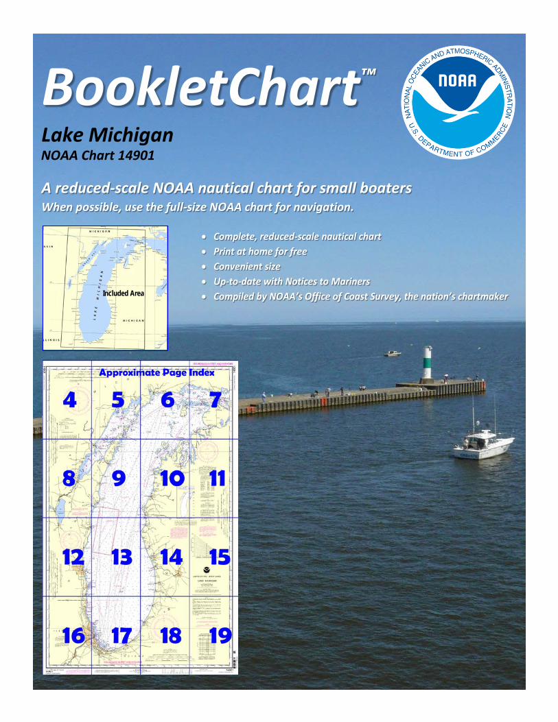
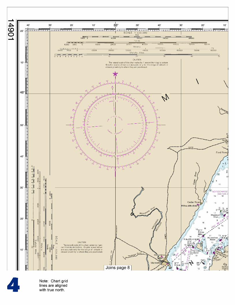
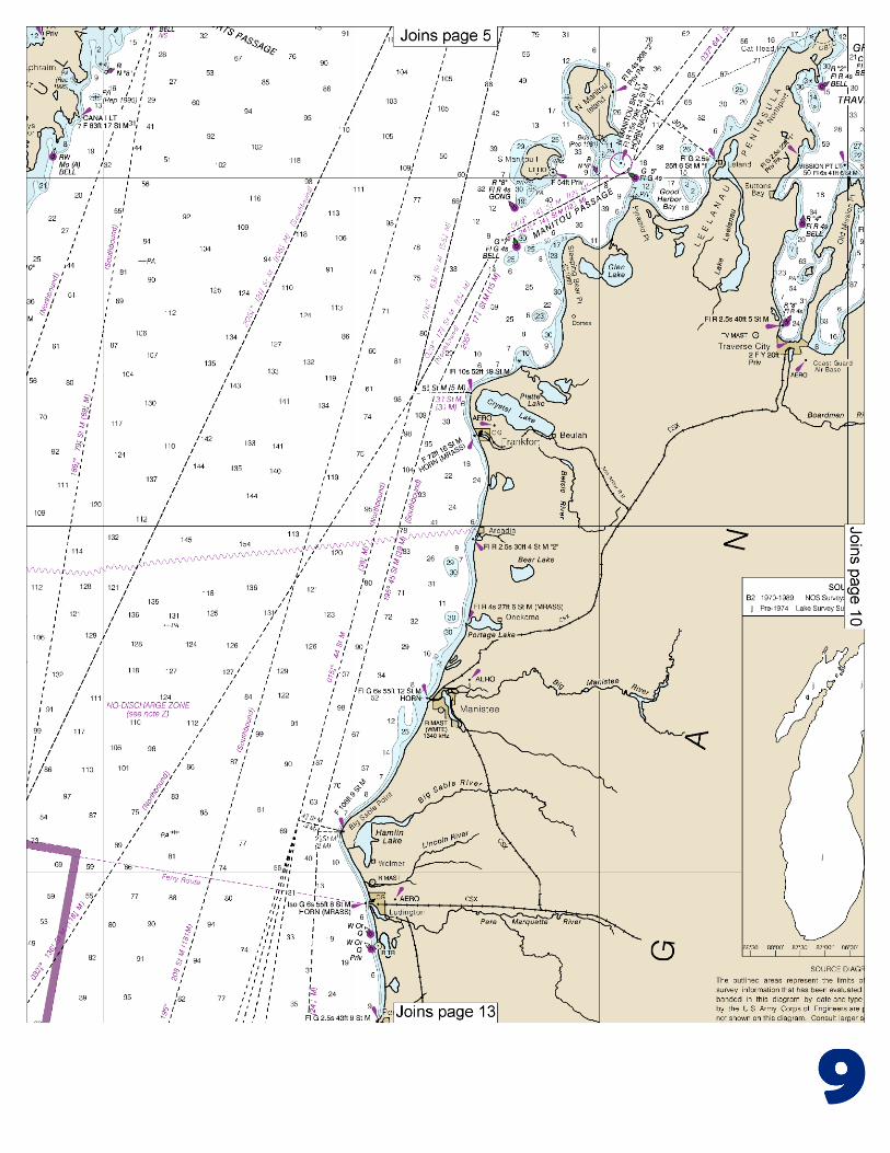
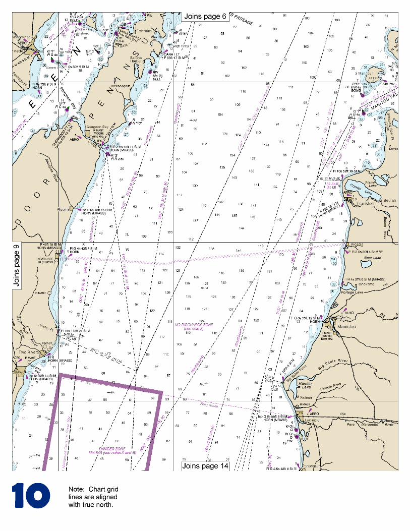
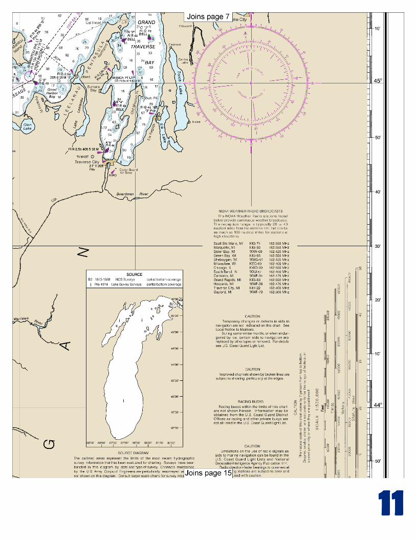
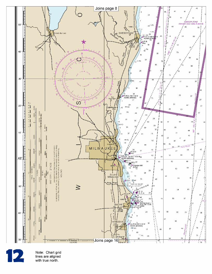
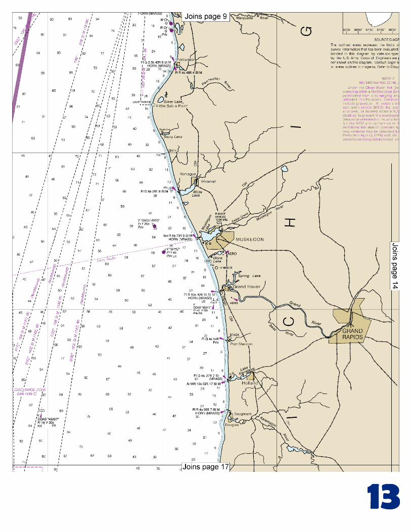
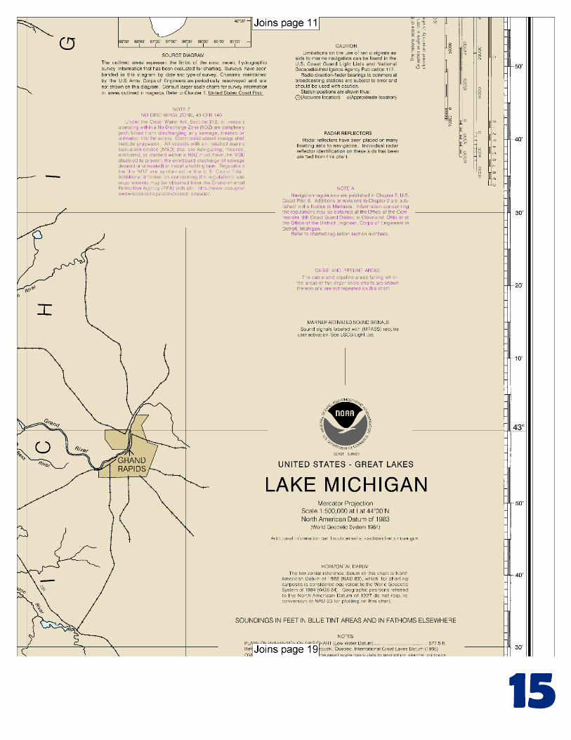
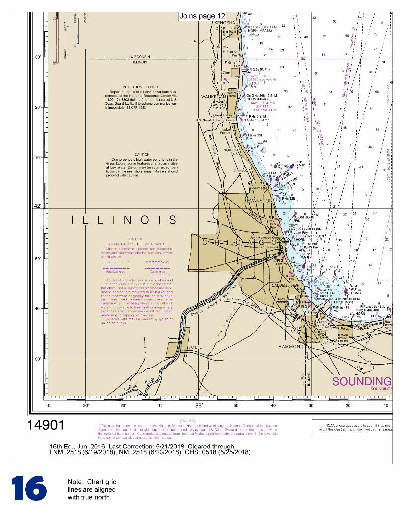
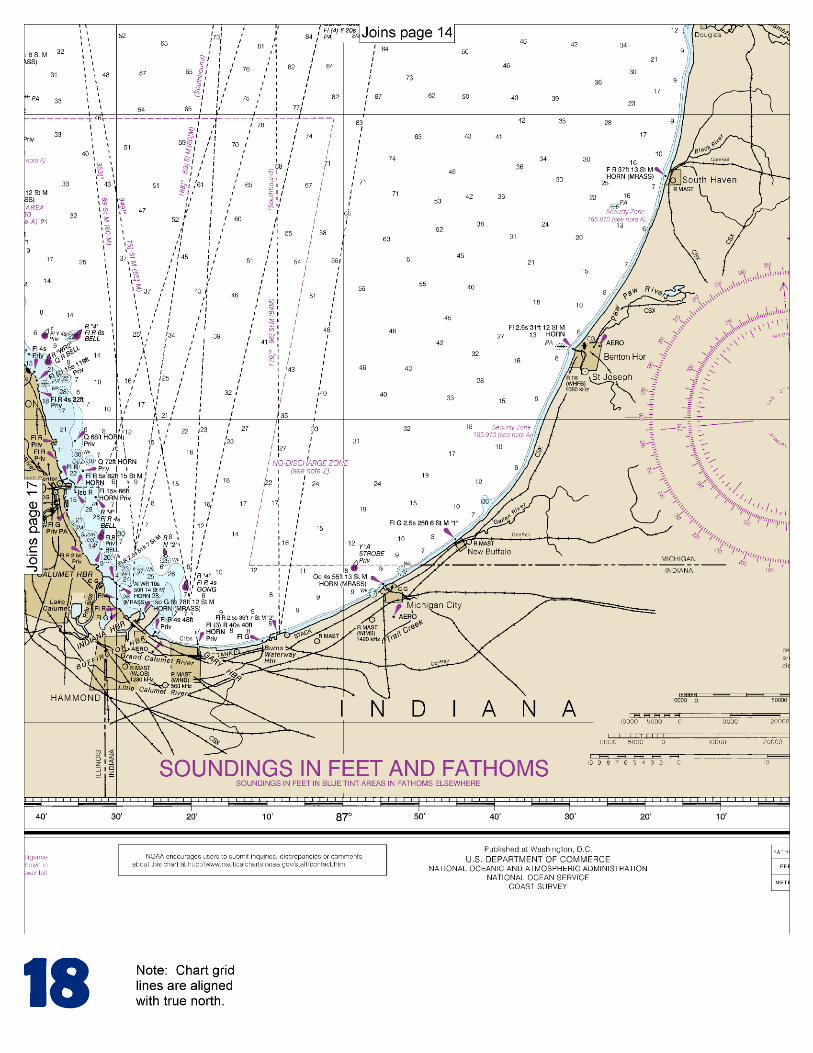
BookletChart™ Lake Michigan NOAA Chart 14901
A reduced-scale NOAA nautical chart for small boaters When possible, use the full-size NOAA chart for navigation.
Included Area
2
Published by the National Oceanic and Atmospheric Administration
National Ocean Service Office of Coast Survey
www.NauticalCharts.NOAA.gov 888-990-NOAA
What are Nautical Charts?
Nautical charts are a fundamental tool of marine navigation. They show water depths, obstructions, buoys, other aids to navigation, and much more. The information is shown in a way that promotes safe and efficient navigation. Chart carriage is mandatory on the commercial ships that carry America’s commerce. They are also used on every Navy and Coast Guard ship, fishing and passenger vessels, and are widely carried by recreational boaters.
What is a BookletChart?
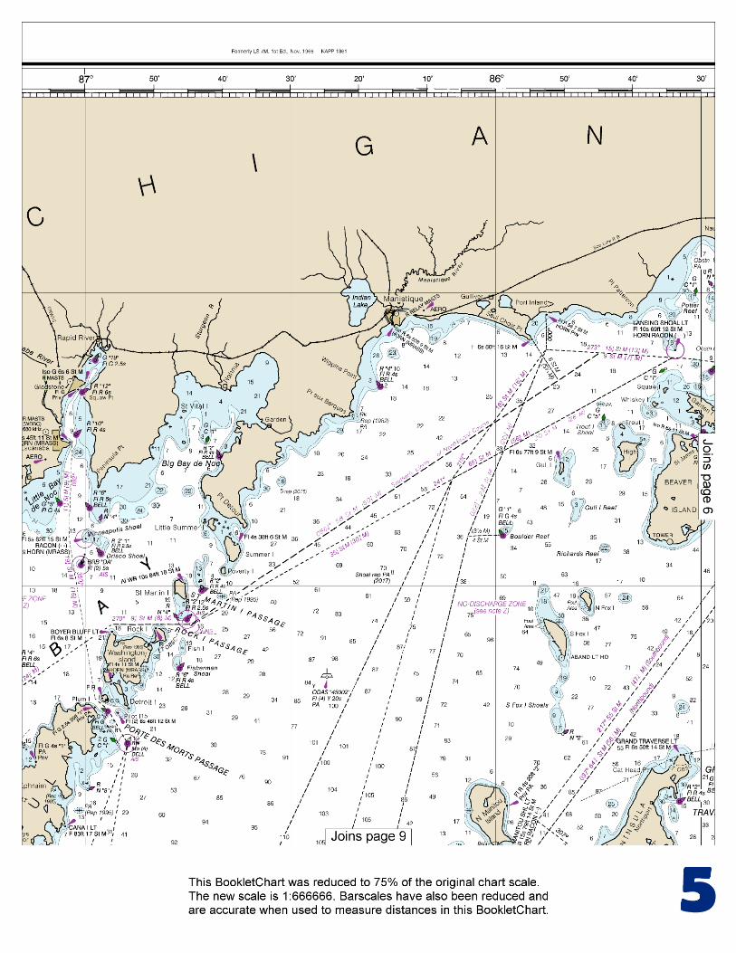
This BookletChart is made to help recreational boaters locate themselves on the water. It has been reduced in scale for convenience, but otherwise contains all the information of the full-scale nautical chart. The bar scales have also been reduced, and are accurate when used to measure distances in this BookletChart. See the Note at the bottom of page 5 for the reduction in scale applied to this chart.
Whenever possible, use the official, full scale NOAA nautical chart for navigation. Nautical chart sales agents are listed on the Internet at http://www.NauticalCharts.NOAA.gov.
This BookletChart does NOT fulfill chart carriage requirements for regulated commercial vessels under Titles 33 and 44 of the Code of Federal Regulations.
Notice to Mariners Correction Status
This BookletChart has been updated for chart corrections published in the U.S. Coast Guard Local Notice to Mariners, the National Geospatial Intelligence Agency Weekly Notice to Mariners, and, where applicable, the Canadian Coast Guard Notice to Mariners. Additional chart corrections have been made by NOAA in advance of their publication in a Notice to Mariners. The last Notices to Mariners applied to this chart are listed in the Note at the bottom of page 7. Coast Pilot excerpts are not being corrected.
For latest Coast Pilot excerpt visit the Office of Coast Survey website at http://www.nauticalcharts.noaa.gov/nsd/coastpilot_w.php?book=6
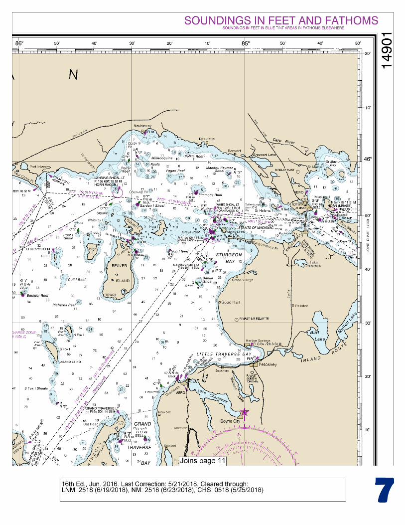
(Selected Excerpts from Coast Pilot) Lake Michigan is the third largest of the Great Lakes and is the only one entirely within the United States. The only natural outlet of the lake is at the north end through the Straits of Mackinac. At the south end of the lake, the Illinois Waterway provides a connection to the Mississippi River and the Gulf of Mexico. The north part of the lake has many islands and is indented by several bays; Green Bay and Grand Traverse Bay are
the largest. The shores in the south part of the lake are regular, and it has been necessary to construct artificial harbors. The shores in the north part of the lake are sparsely populated, while those in the south part are near the heart of the urban industrial area of the U.S. Midwest.
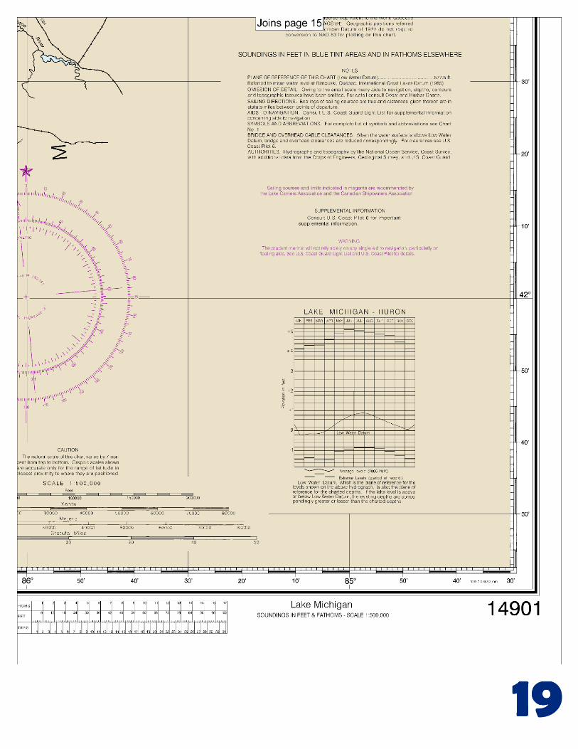
Fluctuations of water level.–The normal elevation of the lake surface varies irregularly from year to year. During the course of each year, the surface is subject to a consistent seasonal rise and fall, the lowest stages prevailing during the winter and the highest during the summer. Weather, Lake Michigan.–Gales are most likely from September through April, particularly in the fall. During this season gales blow 3 to 7 percent of the time; speeds of 28 knots or more occur from 12 to 20 percent of the time. Strong winds often blow out of the W and northwest, making east shore harbor entrances dangerous. The strongest measured over-the-lake wind was out of the west-southwest at 58 knots. Spring winds can blow strong, with winds of 28 knots or more about 4 to 8 percent of the time. They do slacken from their winter fierceness, with southerlies and southwesterlies becoming more frequent and northerlies less so as summer approaches. Strong winds are infrequent in summer and mostly associated with thunderstorms. S and southwest winds prevail particularly in the N; southeasterlies are also common in the S. Northerlies are a secondary wind. Pilotage.–The waters of Lake Michigan are Great Lakes undesignated waters; registered vessels of the United States and foreign vessels are required to have in their service a United States or Canadian registered pilot or other officer qualified for Great Lakes undesignated waters. Registered pilots for Lake Michigan are supplied by Western Great Lakes Pilots Association (See Appendix A for addresses.) Pilot exchange points are off Port Huron at the head of St. Clair River in about 43°05'30"N., 82°24'42"W. and at De Tour, MI, at the entrance to St. Marys River. Three pilot boats are at Port Huron; HURON BELLE has an international orange hull with an aluminum cabin, and HURON MAID and HURON LADY each have an international orange hull with a white cabin. The pilot boat at De Tour, LINDA JEAN, has a green hull and a white cabin. (See Pilotage, chapter 3, and 46 CFR 401, chapter 2.) Principal ports.–Most of the harbors on the east side of Lake Michigan are within the mouths of small rivers or in small lakes connected to Lake Michigan by an entrance channel. Parallel piers have been constructed at the mouths of these harbors to aid in carrying the bar into deeper water and to lessen the need for dredging in the harbor entrance. In addition, several harbors along this shore have been provided with stilling basins formed by breakwaters that converge to an entrance opening in deep water beyond the parallel piers. These basins dissipate the force of storm generated waves to prevent them from being conducted through the confined channels between the piers and into the harbors. The harbors on the west side of the lake are generally at the mouths of small rivers, the only large streams being the Fox and Menominee Rivers which empty into Green Bay. The entrances to the harbors are generally protected by parallel piers, and some have been provided with stilling basins. Some harbor entrances are protected by detached breakwaters. Outer harbors enclosed by breakwaters have been constructed at Calumet Harbor and Milwaukee. Entirely artificial harbors, with basins enclosed by piers and breakwaters, are at Burns International Harbor, Gary, Buffington, Indiana Harbor, Great Lakes, Waukegan, Port Washington, and Port Inland. The most important harbors in Lake Michigan are Muskegon, Calumet, Chicago, Milwaukee, Kenosha, and Green Bay. Drydocking facilities for deep-draft vessels are at Sturgeon Bay.
U.S. Coast Guard Rescue Coordination Center 24 hour Regional Contact for Emergencies
RCC Cleveland Commander
9th CG District (216) 902-6117 Cleveland, OH
G
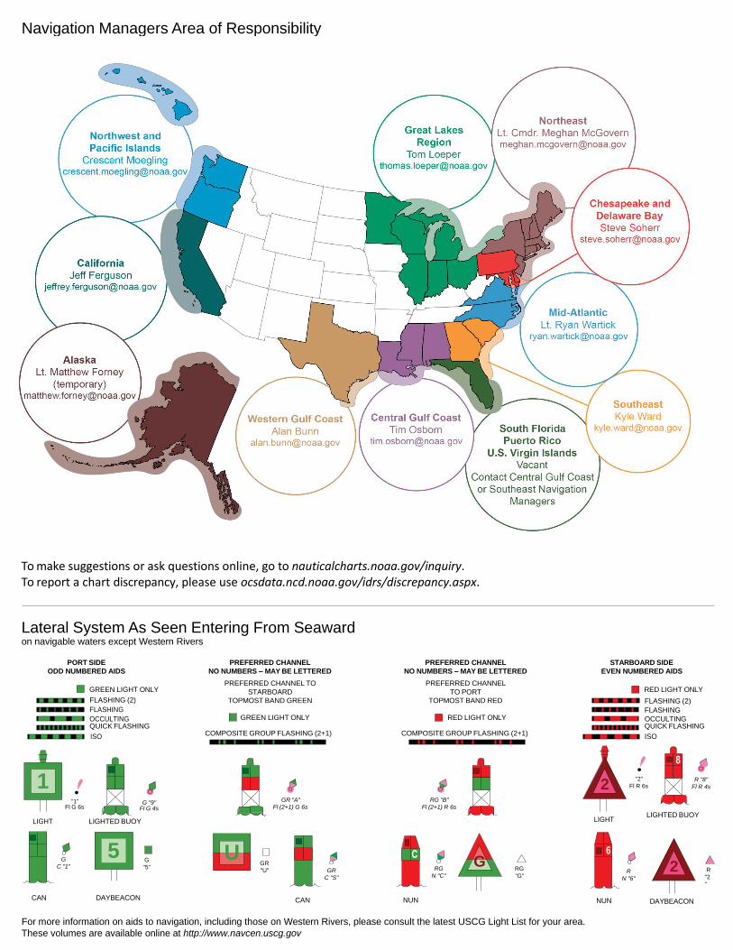
NOAA’s navigation managers serve as ambassadors to the maritime community. They help identify navigational challenges facing professional and recreational mariners, and provide NOAA resources and information for safe navigation. For additional information, please visit nauticalcharts.noaa.gov/service/navmanagers
To make suggestions or ask questions online, go to nauticalcharts.noaa.gov/inquiry. To report a chart discrepancy, please use ocsdata.ncd.noaa.gov/idrs/discrepancy.aspx.
Lateral System As Seen Entering From Seaward on navigable waters except Western Rivers
PORT SIDE
ODD NUMBERED AIDS
GREEN LIGHT ONLY
FLASHING (2)
PREFERRED CHANNEL
NO NUMBERS – MAY BE LETTERED
PREFERRED CHANNEL TO
STARBOARD
TOPMOST BAND GREEN
PREFERRED CHANNEL
NO NUMBERS – MAY BE LETTERED
PREFERRED CHANNEL
TO PORT
TOPMOST BAND RED
STARBOARD SIDE
EVEN NUMBERED AIDS
RED LIGHT ONLY
FLASHING (2)
FLASHING FLASHING
OCCULTING GREEN LIGHT ONLY RED LIGHT ONLY OCCULTING QUICK FLASHING QUICK FLASHING
ISO COMPOSITE GROUP FLASHING (2+1) COMPOSITE GROUP FLASHING (2+1) ISO
"1"
Fl G 6s
G "9"
Fl G 4s
GR "A"
Fl (2+1) G 6s
RG "B"
Fl (2+1) R 6s
"2"
Fl R 6s
8
R "8"
Fl R 4s
LIGHT
G
C "1"
LIGHTED BUOY
G
"5"
GR
"U"
GR
C "S"
RG
N "C"
RG
"G"
LIGHT
6
R
N "6"
LIGHTED BUOY
R
"2
"
CAN DAYBEACON
CAN NUN NUN
DAYBEACON
For more information on aids to navigation, including those on Western Rivers, please consult the latest USCG Light List for your area.
These volumes are available online at http://www.navcen.uscg.gov
Navigation Managers Area of Responsibility
Northeast
Lt. Meghan McGovern
Northwest and
Pacific Islands
Crescent Moegling
Great Lakes Region
Tom Loeper
Chesapeake and
Delaware Bay
Steve Soherr
California
Jeff Ferguson
[email protected] Mid-Atlantic
Lt. Ryan Wartick
Alaska
Lt. Timothy M. Smith
Western Gulf Coast
Alan Bunn
Central Gulf Coast
Tim Osborn
[email protected] South Florida
Puerto Rico
U.S. Virgin Islands
Michael Henderson
Southeast
Kyle Ward
2
2 C U 5
1


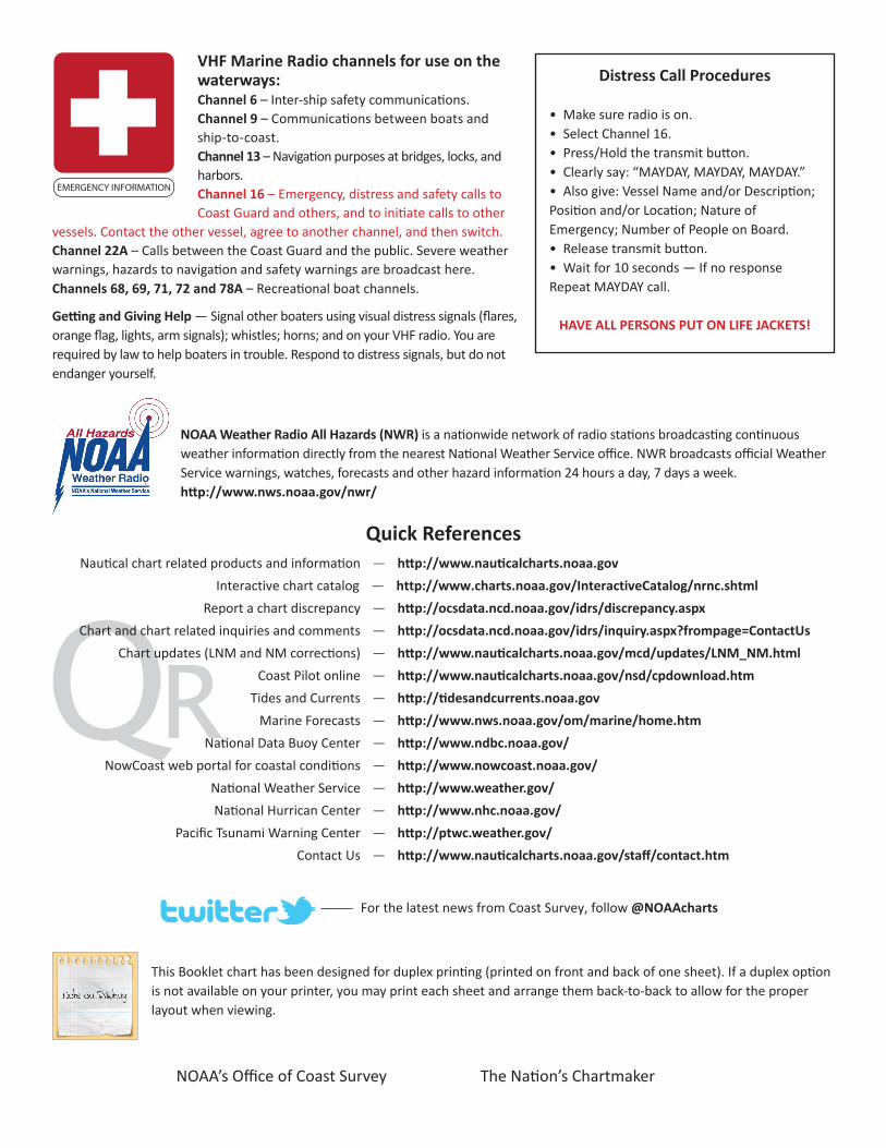
VHF Marine Radio channels for use on the waterways:Channel 6 – Inter-ship safety communications.Channel 9 – Communications between boats and ship-to-coast.Channel 13 – Navigation purposes at bridges, locks, and harbors.Channel 16 – Emergency, distress and safety calls to Coast Guard and others, and to initiate calls to other
vessels. Contact the other vessel, agree to another channel, and then switch.Channel 22A – Calls between the Coast Guard and the public. Severe weather warnings, hazards to navigation and safety warnings are broadcast here.Channels 68, 69, 71, 72 and 78A – Recreational boat channels.
Getting and Giving Help — Signal other boaters using visual distress signals (flares, orange flag, lights, arm signals); whistles; horns; and on your VHF radio. You are required by law to help boaters in trouble. Respond to distress signals, but do not endanger yourself.
EMERGENCY INFORMATION
Distress Call Procedures
• Make sure radio is on.• Select Channel 16.• Press/Hold the transmit button.• Clearly say: “MAYDAY, MAYDAY, MAYDAY.”• Also give: Vessel Name and/or Description;Position and/or Location; Nature of Emergency; Number of People on Board.• Release transmit button.• Wait for 10 seconds — If no responseRepeat MAYDAY call.
HAVE ALL PERSONS PUT ON LIFE JACKETS!
This Booklet chart has been designed for duplex printing (printed on front and back of one sheet). If a duplex option is not available on your printer, you may print each sheet and arrange them back-to-back to allow for the proper layout when viewing.
QR
Quick ReferencesNautical chart related products and information - http://www.nauticalcharts.noaa.gov
Interactive chart catalog - http://www.charts.noaa.gov/InteractiveCatalog/nrnc.shtmlReport a chart discrepancy - http://ocsdata.ncd.noaa.gov/idrs/discrepancy.aspx
Chart and chart related inquiries and comments - http://ocsdata.ncd.noaa.gov/idrs/inquiry.aspx?frompage=ContactUs
Chart updates (LNM and NM corrections) - http://www.nauticalcharts.noaa.gov/mcd/updates/LNM_NM.html
Coast Pilot online - http://www.nauticalcharts.noaa.gov/nsd/cpdownload.htm
Tides and Currents - http://tidesandcurrents.noaa.gov
Marine Forecasts - http://www.nws.noaa.gov/om/marine/home.htm
National Data Buoy Center - http://www.ndbc.noaa.gov/
NowCoast web portal for coastal conditions - http://www.nowcoast.noaa.gov/
National Weather Service - http://www.weather.gov/
National Hurrican Center - http://www.nhc.noaa.gov/
Pacific Tsunami Warning Center - http://ptwc.weather.gov/
Contact Us - http://www.nauticalcharts.noaa.gov/staff/contact.htm
NOAA’s Office of Coast Survey The Nation’s Chartmaker
For the latest news from Coast Survey, follow @NOAAcharts
NOAA Weather Radio All Hazards (NWR) is a nationwide network of radio stations broadcasting continuous weather information directly from the nearest National Weather Service office. NWR broadcasts official Weather Service warnings, watches, forecasts and other hazard information 24 hours a day, 7 days a week. http://www.nws.noaa.gov/nwr/