Embed Size (px)
Citation preview
BLACK RIVER NEEDS ASSESSMENT AND CAPITAL IMPROVEMENT PLANNING
KING COUNTY, WASHINGTON
TASK 3 – EVALUATE CRITICALITY OF SYSTEMS
TECHNICAL MEMORANDUM
JANUARY 2015

Page intentionally left blank
BLACK RIVER NEEDS ASSESSMENT AND CAPITAL IMPROVEMENT PLANNING
TASK 3 – EVALUATE CRITICALITY OF SYSTEMS TECHNICAL MEMORANDUM
JANUARY 2015

Page intentionally left blank
Black River Needs Assessment and Capital Improvement Planning Task 3 – Evaluate Criticality of Systems
King County, Washington iii January 2015
TABLE OF CONTENTS
3. EVALUATE CRITICALITY OF SYSTEMS ........................................................................................................1 3.1. GENERAL NOTES ..................................................................................................................................................... 1
3.1.1. NAVD88 DATUM ........................................................................................................................................... 1 3.2. HYDROLOGIC/HYDRAULIC CONDITIONS ........................................................................................................................ 1
3.2.1. EXTREME HIGH TIDE ......................................................................................................................................... 2 3.2.2. TYPICAL FLOOD CONDITIONS (12,000 CFS AT AUBURN) .......................................................................................... 2 3.2.3. EXTREME FLOOD CONDITIONS (18,800 CFS AT AUBURN) ........................................................................................ 2 3.2.4. SUMMARY ...................................................................................................................................................... 2
3.3. BRPS OPERATIONAL REQUIREMENTS .......................................................................................................................... 3 3.3.1. GREEN RIVER MANAGEMENT AGREEMENT ........................................................................................................... 3 3.3.2. AGENCY INVOLVEMENT IN FISH MIGRATION ISSUES ................................................................................................ 3
3.4. BRPS CONTROL STRATEGY (NORMAL OPERATIONS) ...................................................................................................... 4 3.5. CRITICALITY DETERMINATION ..................................................................................................................................... 5
3.5.1. PRIMARY COMPONENT CRITICALITY ..................................................................................................................... 6 3.5.2. SECONDARY COMPONENT CRITICALITY ................................................................................................................. 6 3.5.3. COMPONENT NEEDED FOR MAINTENANCE ............................................................................................................ 6
TABLES
TABLE 3-1 SUMMARY OF HYDROLOGICAL ANALYSIS .................................................................................................................. 2 TABLE 3-2 BRPS FLOW RESTRICTIONS PER GREEN RIVER MANAGEMENT AGREEMENT .................................................................... 3 TABLE 3-3 PUMP OPERATING LEVELS (NORMAL OPERATION) ..................................................................................................... 5 TABLE 3-4 STATION COMPONENTS AND CRITICALITY ................................................................................................................. 6
APPENDIX
HYDROLOGIC/HYDRAULIC CONDITIONS
Black River Needs Assessment and Capital Improvement Planning Task 3 – Evaluate Criticality of Systems
King County, Washington 1 January 2015
3. EVALUATE CRITICALITY OF SYSTEMS
3.1. GENERAL NOTES
The Task 3 effort identifies station components at the Black River Pump Station (BRPS) that are critical
for hydraulic conditions that result in high tailwater elevations and, in some cases, high inflow rates at the
BRPS. The criticality assessment of station components will assist King County in identifying priorities
and schedules for inspection and maintenance of critical equipment. It could also assist in setting
priorities and schedules for funding measures to address system needs as recommended in Task 2,
including equipment overhaul or replacement or taking precautions such as securing long-lead spare parts
for critical equipment.
This evaluation first reviews the hydraulic analysis conducted to estimate downstream water levels and
inflow rates to the BRPS under the selected hydraulic conditions. The criticality of each station
component is based on its ability to function under these hydraulic conditions and the level of need for it
to do so.
The evaluation then reviews the current operational strategy of the flood control pumps at the BRPS,
which is based on reducing upstream water levels in the Black River under normal operations. However,
the station is limited by an interagency agreement to only a fraction of its capacity when flood conditions
exist on the Green River downstream of the BRPS.
3.1.1. NAVD88 DATUM All elevations referenced in this report are NAVD88, the datum used for recording and managing Green
River water levels. However, the design drawings for this station, as well as the BRPS Operations
Manual, the station bubblers (for river level sensing), and the station’s pump control system, still use
NGVD29.
Conversion of vertical datum from NGVD29 to NAVD88 was determined using Corpscon Version 6.0.1,
a USACE datum conversion program, for two specific locations - at the location of USGS Gage
12113350 (Green River at Tukwila, WA) and at the location of the Black River Pump Station. To convert
an elevation from NGVD29 to NAVD88 at the USGS gage location, add 3.54 feet. To convert an
elevation from NGVD29 to NAVD88 at the Black River Pump Station location, add 3.55 feet.
3.2. HYDROLOGIC/HYDRAULIC CONDITIONS
The following hydraulic conditions were examined:
Extreme high tide (likely every year)
Typical flood conditions (roughly 12,000 cubic feet per second (cfs) at Auburn)
Extreme flood (roughly 18,800 cfs at Auburn)
The hydrologic/hydraulic analysis to determine the water level downstream of the BRPS and an
approximate inflow rate to the BRPS is included in the appendix to this technical memorandum. The
following sections summarize the results of this hydraulic analysis.
Black River Needs Assessment and Capital Improvement Planning Task 3 – Evaluate Criticality of Systems
King County, Washington 2 January 2015
3.2.1. EXTREME HIGH TIDE It was assumed that during non-flood periods, the tailwater elevation in the BRPS outlet channel will
roughly follow the tidal pattern of USGS Station 12113350 (Green River at Tukwila, WA). Based on a
review of tide records at this station since 1989, the analysis determined the following tailwater elevations
for the Green River Stage (NAVD88) corresponding to the annual extreme high tide:
Minimum: 11.65’
Maximum: 15.92’
Average: 13.39’
Median: 13.14’
Standard Deviation (sample): 1.15’
3.2.2. TYPICAL FLOOD CONDITIONS (12,000 CFS AT AUBURN) The FLO-2D hydraulic model (see appendix) that was developed for the Green River System Wide
Improvement Framework was used as the basis for determining the design elevations for the Typical
Flood Condition (12,000 cfs at Auburn) as well as the Extreme Flood (18,800 cfs at Auburn).
During flood events, reservoir outflow from Howard Hanson Dam is adjusted such that the total outflow
plus local inflows between the dam and the Auburn gage does not exceed the 12,000 cfs target flow
(corresponds to the median 0.5% annual exceedance probability (FLO-2D model). Based on these and
other conditions detailed in the appendix, it is estimated that the design water surface elevation
downstream of the BRPS is approximately 23.3 feet.
For this assessment, a FLO-2D model that assumed no overtopping of the levees along Green River was
used, which could have a significant impact on the Springbrook Creek flow. The estimate of the BRPS
inflow rate can therefore be based on the local Springbrook Creek inflow hydrograph, at 394 cfs.
3.2.3. EXTREME FLOOD CONDITIONS (18,800 CFS AT AUBURN) For the extreme flood condition, the model results from the median 0.2% annual exceedance probability
model were used. This model run included an 18,800 cfs peak flow rate at the Green River USGS gage at
Auburn. Based on these and other conditions detailed in the appendix, it is estimated that the design water
surface elevation downstream of the BRPS is approximately 27.5 feet.
The median 0.2% annual exceedance probability model included significant right bank levee overtopping
(2,220 cfs) that contributed to flows into Springbrook Creek and ultimately through the BRPS. The
Springbrook Creek hydrograph provided a contribution of 560 cfs for a total peak in flow to the BRPS of
2,780 cfs at extreme flood conditions.
3.2.4. SUMMARY Table 3-1 summarizes the hydrologic/hydraulic analysis performed for this criticality assessment.
Discharge limits listed are discussed in the following section.
Table 3-1 Summary of Hydrological Analysis
Green River Flow Condition
Estimated Inflow
Rate (cfs)
Downstream Water Surface
Elevation (NAVD88)
Discharge Limit
(cfs)
Extreme High Tide Varies 11.65 - 15.92 0 - 2,950 (no limit)
Typical Flood (12,000 cfs) 394 23.3 400
Extreme Flood (18,800 cfs) 2,780 27.5 400
Black River Needs Assessment and Capital Improvement Planning Task 3 – Evaluate Criticality of Systems
King County, Washington 3 January 2015
3.3. BRPS OPERATIONAL REQUIREMENTS
The primary function of the BRPS is to pump river water from the Black River to the Green River under
normal conditions as well as during flood conditions as defined by the Green River Management
Agreement. The secondary function of the BRPS is to provide for upstream and downstream fish
migration during their respective seasons. This section discusses the BRPS’s control strategy under flood
conditions.
3.3.1. GREEN RIVER MANAGEMENT AGREEMENT The Green River Management Agreement limits pumping during a stage III or IV flood on the Green
River to prevent the Green River from overtopping its levees, as shown in Table 3-2 (from the BRPS
Operations Manual, Draft, 2007). The operation of the Waukesha pumps (Pumps P3, P5, P6, P7, and P8)
is restricted as the flows at the Green River USGS gage at Auburn exceed 9,000 cfs, and at the Stage IV
conditions (referred to as the Typical Flood condition in this evaluation, at 12,000 cfs), and no Waukesha
pumps are to be in service. This also applies to the 18,800 cfs Extreme Flood condition that is being
considered in this criticality evaluation. Therefore, the criticality of the Waukesha pumps is actually
lowered with the limitation on the BRPS discharge in the Green River Management Agreement.
Table 3-2 BRPS Flow Restrictions per Green River Management Agreement
River Stage
Flows at Auburn
Gauge (cfs)
Maximum Allowable
Pumping (CFS) Possible Pump Combinations
II < 9,000 No Limit Any pump combination
III 9,000 2,945 All pumps running
9,500 2,900 P2, P4, and 5 Waukesha pumps (Turn off
P1)
10,000 2,400 P1, P2, P4 and 4 Waukesha pumps
10,500 1,900 P1, P2, P4 and 3 Waukesha pumps
11,000 1,400 P1, P2, P4 and 2 Waukesha pumps
11,500 900 P1, P2, P4 and 1 Waukesha pump
IV 12,000 400 or less P1, P2, and P4
18,800 400 or less P1, P2, and P4
The operation of the BRPS during extreme high tide conditions is not restricted by the Green River
Management Agreement. It appears that the designers of the station took high tide conditions into
consideration because the large pumps are designed for a static head of 9.5 feet. At extreme high tide,
these pumps start at a static head of 6.5 feet and stop at a static head of 9.8 feet. Therefore, the pump
station will continue to pump water downstream based on the flow levels upstream during high tide
conditions and without diminished capacity.
3.3.2. AGENCY INVOLVEMENT IN FISH MIGRATION ISSUES Several agencies have an interest in the BRPS from a fish migration standpoint. At the national level, the
National Marine Fisheries Service is concerned with anadromous fish. The U.S. Fish and Wildlife Service
has jurisdiction over threatened and endangered species as identified in the Endangered Species Act. The
entire Water Resource Inventory Area 9 is a salmon and steelhead listed species recovery area. At the
state level, the Washington Department of Fish and Wildlife has management and regulatory jurisdiction
Black River Needs Assessment and Capital Improvement Planning Task 3 – Evaluate Criticality of Systems
King County, Washington 4 January 2015
over fish and fish passage at the BRPS. At the county level, King County is the owner of the project and
the lead agency for implementing any recovery work in the Black River Watershed. For further discussion
of fish migration regulatory issues, see the Task 4 Technical Memorandum.
Some fish migration equipment is identified as critical because it is needed to maintain fish passage
during either the upstream (September-February) or downstream (April-June) migration periods.
However, the fish migration facilities can be either off or ineffective under the following conditions:
Downstream migration period: Low water level (Elevation 3.55 feet) upstream of the dam stops
the airlift pump from operation.
At all times: High water conditions downstream of the dam (Elevation 15.55 feet) will close SG1,
the 18-inch rotary valve downstream of the airlift pump discharge, and SG2, the 30” x 30” sluice
gate at the top of the fish ladder.
Flow through the Waukesha pumps will overwhelm any downstream fish migration capability, as
the high current produced by these pumps will greatly exceed the attractive current through the
fish ports in the forebay (See the Task 4 TM for further discussion of fish migration issues). For
this reason, P3 should not be operated during the downstream fish migration period (April-June)
if possible. However, if a Waukesha pump is needed to keep up with high Black River flow, then
it would be preferable to operate P3 rather than the other Waukesha pumps, which do not have
fish screens.
3.4. BRPS CONTROL STRATEGY (NORMAL OPERATIONS)
Normal operations at the BRPS apply whenever flows at the Auburn gage are less than 9,000 cfs, as
shown in Table 3-2, and the flood control pumps are operated to maintain specified Black River water
levels, depending on the inlet flow rate to the BRPS. By maintaining the specified upstream water levels
under normal conditions, the BRPS protects the upstream areas from flooding, as this maximizes the
storage capacity of the river channel, including the Springbrook Creek drainage.
Prior to discussing the BRPS control strategy under normal conditions, the following elevations of the
BRPS are provided, for a frame of reference for the Black River water surface elevations discussed in this
section:
The ground floor level of the Pump Station structure and the surrounding ground are at Elevation
28.55 feet.
The forebay floor level is Elevation -11.45 feet (i.e., 40 ft below the ground floor level).
The invert elevation of SG1, the Roto-valve, is 14.55 feet.
The invert elevation of SG2, the fishway sluice gate, is 17.43 feet.
The top of diking along the channel downstream from the discharge structure is Elevation
26.55 feet (approximate).
Riprap upstream of the BRPS reaches Elevation 17.55 feet along the forebay, approximately
9 feet lower than the dikes downstream of the pump station.
During normal operations, the pumping equipment at the BRPS is controlled to maintain upstream water
levels as shown in Table 3-3.
Black River Needs Assessment and Capital Improvement Planning Task 3 – Evaluate Criticality of Systems
King County, Washington 5 January 2015
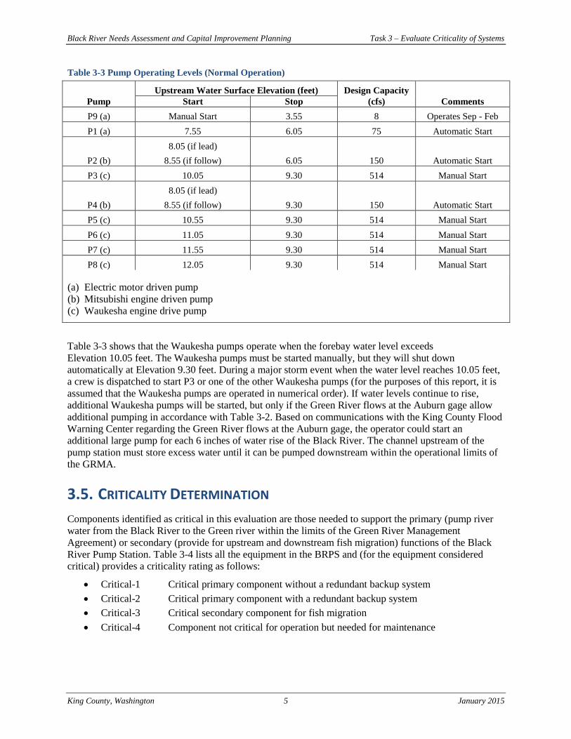
Table 3-3 Pump Operating Levels (Normal Operation)
Upstream Water Surface Elevation (feet) Design Capacity
Pump Start Stop (cfs) Comments
P9 (a) Manual Start 3.55 8 Operates Sep - Feb
P1 (a) 7.55 6.05 75 Automatic Start
P2 (b)
8.05 (if lead)
8.55 (if follow) 6.05 150 Automatic Start
P3 (c) 10.05 9.30 514 Manual Start
P4 (b)
8.05 (if lead)
8.55 (if follow) 9.30 150 Automatic Start
P5 (c) 10.55 9.30 514 Manual Start
P6 (c) 11.05 9.30 514 Manual Start
P7 (c) 11.55 9.30 514 Manual Start
P8 (c) 12.05 9.30 514 Manual Start
(a) Electric motor driven pump
(b) Mitsubishi engine driven pump
(c) Waukesha engine drive pump
Table 3-3 shows that the Waukesha pumps operate when the forebay water level exceeds
Elevation 10.05 feet. The Waukesha pumps must be started manually, but they will shut down
automatically at Elevation 9.30 feet. During a major storm event when the water level reaches 10.05 feet,
a crew is dispatched to start P3 or one of the other Waukesha pumps (for the purposes of this report, it is
assumed that the Waukesha pumps are operated in numerical order). If water levels continue to rise,
additional Waukesha pumps will be started, but only if the Green River flows at the Auburn gage allow
additional pumping in accordance with Table 3-2. Based on communications with the King County Flood
Warning Center regarding the Green River flows at the Auburn gage, the operator could start an
additional large pump for each 6 inches of water rise of the Black River. The channel upstream of the
pump station must store excess water until it can be pumped downstream within the operational limits of
the GRMA.
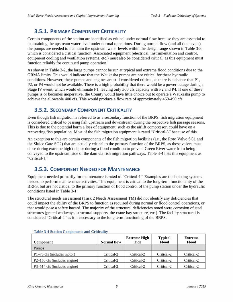
3.5. CRITICALITY DETERMINATION
Components identified as critical in this evaluation are those needed to support the primary (pump river
water from the Black River to the Green river within the limits of the Green River Management
Agreement) or secondary (provide for upstream and downstream fish migration) functions of the Black
River Pump Station. Table 3-4 lists all the equipment in the BRPS and (for the equipment considered
critical) provides a criticality rating as follows:
Critical-1 Critical primary component without a redundant backup system
Critical-2 Critical primary component with a redundant backup system
Critical-3 Critical secondary component for fish migration
Critical-4 Component not critical for operation but needed for maintenance
Black River Needs Assessment and Capital Improvement Planning Task 3 – Evaluate Criticality of Systems
King County, Washington 6 January 2015
3.5.1. PRIMARY COMPONENT CRITICALITY Certain components of the station are identified as critical under normal flow because they are essential to
maintaining the upstream water level under normal operations. During normal flow (and all tide levels)
the pumps are needed to maintain the upstream water levels within the design range shown in Table 3-3,
which is considered a critical function. Associated equipment (electrical, instrumentation and control,
equipment cooling and ventilation systems, etc.) must also be considered critical, as this equipment must
function reliably for continued pump operation.
As shown in Table 3-2, the large pumps cannot be run at typical and extreme flood conditions due to the
GRMA limits. This would indicate that the Waukesha pumps are not critical for these hydraulic
conditions. However, these pumps and engines are still considered critical, as there is a chance that P1,
P2, or P4 would not be available. There is a high probability that there would be a power outage during a
Stage IV event, which would eliminate P1, leaving only 300 cfs capacity with P2 and P4. If one of these
pumps is or becomes inoperative, the County would have little choice but to operate a Waukesha pump to
achieve the allowable 400 cfs. This would produce a flow rate of approximately 460-490 cfs.
3.5.2. SECONDARY COMPONENT CRITICALITY Even though fish migration is referred to as a secondary function of the BRPS, fish migration equipment
is considered critical to passing fish upstream and downstream during the respective fish passage seasons.
This is due to the potential harm a loss of equipment, such as the airlift compressor, could have on a
recovering fish population. Most of the fish migration equipment is rated “Critical-3” because of this.
An exception to this are certain components of the fish migration facilities (i.e., the Roto Valve SG1 and
the Sluice Gate SG2) that are actually critical to the primary function of the BRPS, as these valves must
close during extreme high tide, or during a flood condition to prevent Green River water from being
conveyed to the upstream side of the dam via fish migration pathways. Table 3-4 lists this equipment as
“Critical-1.”
3.5.3. COMPONENT NEEDED FOR MAINTENANCE Equipment needed primarily for maintenance is rated as “Critical-4.” Examples are the hoisting systems
needed to perform maintenance activities. This equipment is critical to the long-term functionality of the
BRPS, but are not critical to the primary function of flood control of the pump station under the hydraulic
conditions listed in Table 3-1.
The structural needs assessment (Task 2 Needs Assessment TM) did not identify any deficiencies that
could impact the ability of the BRPS to function as required during normal or flood control operations, or
that would pose a safety hazard. The majority of the structural deficiencies noted were corrosion of steel
structures (grated walkways, structural supports, the crane bay structure, etc.). The facility structural is
considered “Critical-4” as it is necessary to the long term functioning of the BRPS.
Table 3-4 Station Components and Criticality
Component Normal flow
Extreme High
Tide
Typical
Flood
Extreme
Flood
Pumps
P1–75 cfs (includes motor) Critical-2 Critical-2 Critical-2 Critical-2
P2–150 cfs (includes engine) Critical-2 Critical-2 Critical-2 Critical-2
P3–514 cfs (includes engine) Critical-2 Critical-2 Critical-2 Critical-2
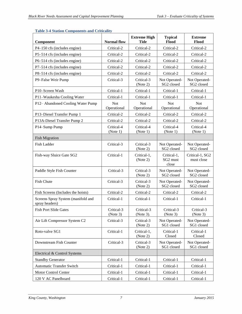
Black River Needs Assessment and Capital Improvement Planning Task 3 – Evaluate Criticality of Systems
King County, Washington 7 January 2015
Table 3-4 Station Components and Criticality
Component Normal flow
Extreme High
Tide
Typical
Flood
Extreme
Flood
P4–150 cfs (includes engine) Critical-2 Critical-2 Critical-2 Critical-2
P5–514 cfs (includes engine) Critical-2 Critical-2 Critical-2 Critical-2
P6–514 cfs (includes engine) Critical-2 Critical-2 Critical-2 Critical-2
P7–514 cfs (includes engine) Critical-2 Critical-2 Critical-2 Critical-2
P8–514 cfs (includes engine) Critical-2 Critical-2 Critical-2 Critical-2
P9–False Weir Pump Critical-3 Critical-3
(Note 2)
Not Operated-
SG2 closed
Not Operated-
SG2 closed
P10–Screen Wash Critical-1 Critical-1 Critical-1 Critical-1
P11–Waukesha Cooling Water Critical-1 Critical-1 Critical-1 Critical-1
P12– Abandoned Cooling Water Pump Not
Operational
Not
Operational
Not
Operational
Not
Operational
P13–Diesel Transfer Pump 1 Critical-2 Critical-2 Critical-2 Critical-2
P13A-Diesel Transfer Pump 2 Critical-2 Critical-2 Critical-2 Critical-2
P14–Sump Pump Critical-4
(Note 1)
Critical-4
(Note 1)
Critical-4
(Note 1)
Critical-4
(Note 1)
Fish Migration
Fish Ladder Critical-3 Critical-3
(Note 2)
Not Operated-
SG2 closed
Not Operated-
SG2 closed
Fish-way Sluice Gate SG2 Critical-1 Critical-1,
(Note 2)
Critical-1,
SG2 must
close
Critical-1, SG2
must close
Paddle Style Fish Counter Critical-3 Critical-3
(Note 2)
Not Operated-
SG2 closed
Not Operated-
SG2 closed
Fish Chute Critical-3 Critical-3
(Note 2)
Not Operated-
SG2 closed
Not Operated-
SG2 closed
Fish Screens (Includes the hoists) Critical-2 Critical-2 Critical-2 Critical-2
Screens Spray System (manifold and
spray headers)
Critical-1 Critical-1 Critical-1 Critical-1
Fish Port Slide Gates Critical-3
(Note 3)
Critical-3
(Note 3).
Critical-3
(Note 3)
Critical-3
(Note 3)
Air Lift Compressor System C2 Critical-3 Critical-3
(Note 2)
Not Operated-
SG1 closed
Not Operated-
SG1 closed
Roto-valve SG1 Critical-1 Critical-1,
(Note 2)
Critical-1
Closed
Critical-1
Closed
Downstream Fish Counter Critical-3 Critical-3
(Note 2)
Not Operated-
SG1 closed
Not Operated-
SG1 closed
Electrical & Control Systems
Standby Generator Critical-1 Critical-1 Critical-1 Critical-1
Automatic Transfer Switch Critical-1 Critical-1 Critical-1 Critical-1
Motor Control Center Critical-1 Critical-1 Critical-1 Critical-1
120 V AC Panelboard Critical-1 Critical-1 Critical-1 Critical-1
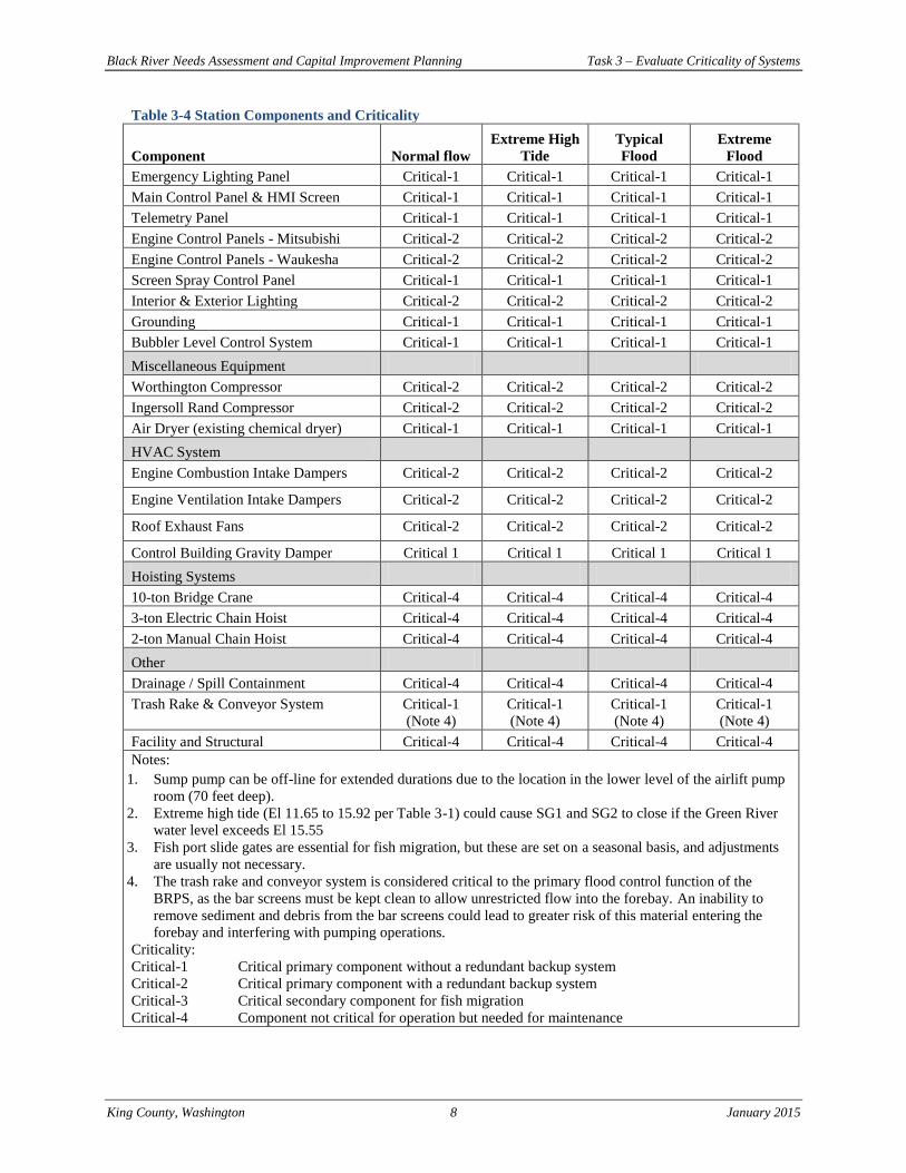
Black River Needs Assessment and Capital Improvement Planning Task 3 – Evaluate Criticality of Systems
King County, Washington 8 January 2015
Table 3-4 Station Components and Criticality
Component Normal flow
Extreme High
Tide
Typical
Flood
Extreme
Flood
Emergency Lighting Panel Critical-1 Critical-1 Critical-1 Critical-1
Main Control Panel & HMI Screen Critical-1 Critical-1 Critical-1 Critical-1
Telemetry Panel Critical-1 Critical-1 Critical-1 Critical-1
Engine Control Panels - Mitsubishi Critical-2 Critical-2 Critical-2 Critical-2
Engine Control Panels - Waukesha Critical-2 Critical-2 Critical-2 Critical-2
Screen Spray Control Panel Critical-1 Critical-1 Critical-1 Critical-1
Interior & Exterior Lighting Critical-2 Critical-2 Critical-2 Critical-2
Grounding Critical-1 Critical-1 Critical-1 Critical-1
Bubbler Level Control System Critical-1 Critical-1 Critical-1 Critical-1
Miscellaneous Equipment
Worthington Compressor Critical-2 Critical-2 Critical-2 Critical-2
Ingersoll Rand Compressor Critical-2 Critical-2 Critical-2 Critical-2
Air Dryer (existing chemical dryer) Critical-1 Critical-1 Critical-1 Critical-1
HVAC System
Engine Combustion Intake Dampers Critical-2 Critical-2 Critical-2 Critical-2
Engine Ventilation Intake Dampers Critical-2 Critical-2 Critical-2 Critical-2
Roof Exhaust Fans Critical-2 Critical-2 Critical-2 Critical-2
Control Building Gravity Damper Critical 1 Critical 1 Critical 1 Critical 1
Hoisting Systems
10-ton Bridge Crane Critical-4 Critical-4 Critical-4 Critical-4
3-ton Electric Chain Hoist Critical-4 Critical-4 Critical-4 Critical-4
2-ton Manual Chain Hoist Critical-4 Critical-4 Critical-4 Critical-4
Other
Drainage / Spill Containment Critical-4 Critical-4 Critical-4 Critical-4
Trash Rake & Conveyor System Critical-1
(Note 4)
Critical-1
(Note 4)
Critical-1
(Note 4)
Critical-1
(Note 4)
Facility and Structural Critical-4 Critical-4 Critical-4 Critical-4
Notes:
1. Sump pump can be off-line for extended durations due to the location in the lower level of the airlift pump
room (70 feet deep).
2. Extreme high tide (El 11.65 to 15.92 per Table 3-1) could cause SG1 and SG2 to close if the Green River
water level exceeds El 15.55
3. Fish port slide gates are essential for fish migration, but these are set on a seasonal basis, and adjustments
are usually not necessary.
4. The trash rake and conveyor system is considered critical to the primary flood control function of the
BRPS, as the bar screens must be kept clean to allow unrestricted flow into the forebay. An inability to
remove sediment and debris from the bar screens could lead to greater risk of this material entering the
forebay and interfering with pumping operations.
Criticality:
Critical-1 Critical primary component without a redundant backup system
Critical-2 Critical primary component with a redundant backup system
Critical-3 Critical secondary component for fish migration
Critical-4 Component not critical for operation but needed for maintenance
Black River Needs Assessment and Capital Improvement Planning Task 3 – Evaluate Criticality of Systems
King County, Washington 9 January 2015
APPENDIX—HYDROLOGIC/HYDRAULIC CONDITIONS Jay B Smith | Senior Project Engineer, Surface Water Group
Hydrologic data along with model simulations were reviewed to determine design tailwater elevations in
the outlet channel of the Black River Pump Station (BRPS) and estimated peak flow inflow rates
upstream of the BRPS for the following three hydrologic conditions:
Extreme high tide (likely every year)
Typical flood conditions (roughly 12,000 cfs at Auburn)
Extreme flood (roughly 18,800 cfs at Auburn)
EXTREME HIGH TIDE CONDITIONS
The establishment of the extreme high tide condition used NOAA Seattle Tide Station 9447130. Data was
extracted from this tidal station for the coincident period of river stage record for the USGS Gauge
12113350 (Green River at Tukwila WA), water year 1989 to the present. The maximum recorded annual
tidal stage and corresponding time was used to extract the Green River stage. All elevation data was
converted into NAVD88. During the period of maximum tide, the Green River flow was extracted at the
Auburn gauge (USGS Gauge 12113000) to check whether the tide happened to coincide with a flood
event and thus skew the recorded river stage at Tukwila. Due to tidal influence, flow is not recorded at the
Green River gauge at Tukwila. The lowest (1/14/1993) and the highest (1/1/1997) flow events and
corresponding stage at Green River were thrown out of the data set. Statistics were applied to the resulting
values to arrive at an expected annual Green River stage corresponding to extreme high tide summarized
below (all elevations expressed in NAVD88):
Green River Stage (NAVD88) Corresponding to Extreme High Tide:
Minimum: 11.65’
Maximum: 15.92’
Average: 13.39’
Median: 13.14’
Standard Deviation (sample): 1.15’
It was assumed that no runoff event occurs during this scenario, so peak inflow to the BRPS is zero.
TYPICAL FLOOD CONDITIONS AND EXTREME FLOOD CONDITIONS
The FLO-2D hydraulic model that was developed for the Green River System-Wide Improvement
Framework was used as the basis for determining the design elevations for these two flood conditions.
The hydraulic model development and results are documented in Appendix C of Tetra Tech (2014).
In support of the System-Wide Improvement Framework existing condition assessment (Tetra Tech
2014), numerous FLO-2D model runs were conducted for a range of hydrologic conditions and potential
levee failure conditions. For the BRPS assessment the “levee overtopping without breach” FLO-2D
model runs were used.
For the typical flood condition, the results from the Median 0.5% Annual Exceedance Probability (AEP)
FLO-2D model were used. This model run included a 12,600 cfs peak flow rate at the Green River USGS
gage at Auburn. During flood events, reservoir outflow from Howard Hanson Dam is adjusted such that
the total outflow plus local inflows between the dam and the Auburn gage does not exceed the 12,000 cfs
target flow. The Median 0.5% AEP flood event was considered a typical flood event because the Green
River peak flow rate was approximately equal to the 12,000 cfs target flow rate. The high degree of
regulation provided by Howard Hanson Dam results in the majority of the regulated hydrographs having
Black River Needs Assessment and Capital Improvement Planning Task 3 – Evaluate Criticality of Systems
King County, Washington 10 January 2015
peak flows at the 12,000 cfs target flow, although the total flood volumes vary widely. The Median 0.5%
AEP flood event had the highest volume of all the regulated hydrographs that had peak flows at Auburn
near 12,000 cfs. For this flood event, there was no right bank levee overtopping and therefore there was
no Green River flood flows conveyed into Springbrook Creek. Only local Springbrook Creek flows were
being conveyed in Springbrook Creek and through the BRPS.
For the extreme flood condition, the model results from the Median 0.2% AEP model were used. This
model run included an 18,800 cfs peak flow rate at the Green River USGS gage at Auburn. There was
significant right bank levee overtopping that contributed to right overbank inundation and conveyance of
Green River flood flows into Springbrook Creek and ultimately through the BRPS. From the FLO-2D
model output, it was possible to determine the magnitude of the peak flow rate conveyed in the
Springbrook Creek channel and floodplain immediately upstream of the BRPS, which was 2,220 cfs. This
does not include the contribution of the local Springbrook Creek hydrograph.
Springbrook Creek was not included in the FLO-2D model as a channel due to the lack of bathymetric
data. Instead, the elevations of the floodplain grid elements along the channel alignment were reduced to
match the approximate thalweg elevation of the channel alignment.
For each of the flood events, the local Springbrook Creek flow hydrograph was input to the FLO-2D
model as a local inflow hydrograph downstream of the BRPS. The hydrograph was input to the model at
Grid Element 306.
The design water surface elevations were extracted from the FLO-2D model at the floodplain grid
element located immediately downstream of the BRPS, which corresponded with floodplain grid element
171. It is recommended that the following design water surface elevations in the BRPS outlet channel be
used for the BRPS assessment:
23.3 feet (NAVD88) for the typical flood conditions.
27.5 feet (NAVD88) for the extreme flood conditions.
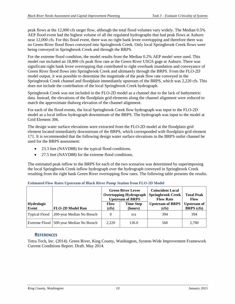
The estimated peak inflow to the BRPS for each of the two scenarios was determined by superimposing
the local Springbrook Creek inflow hydrograph over the hydrograph conveyed in Springbrook Creek
resulting from the right bank Green River overtopping flow rates. The following table presents the results.
Estimated Flow Rates Upstream of Black River Pump Station from FLO-2D Model
Green River Levee
Overtopping Hydrograph
Upstream of BRPS
Coincident Local
Springbrook Creek
Flow Rate
Total Peak
Flow
Hydrologic
Event FLO-2D Model Run
Flow
(cfs)
Time Step
(hours)
Upstream of BRPS
(cfs)
Upstream of
BRPS (cfs)
Typical Flood 200-year Median No Breach 0 n/a 394 394
Extreme Flood 500-year Median No Breach 2,220 136.0 560 2,780
REFERENCES Tetra Tech, Inc. (2014). Green River, King County, Washington, System-Wide Improvement Framework
Current Conditions Report. Draft. May 2014.