Embed Size (px)
Citation preview
Licence L8889/2015/1 Amendment Notice 5 IR-T07 Amendment Notice (Minor) v2.0 (July 2017)
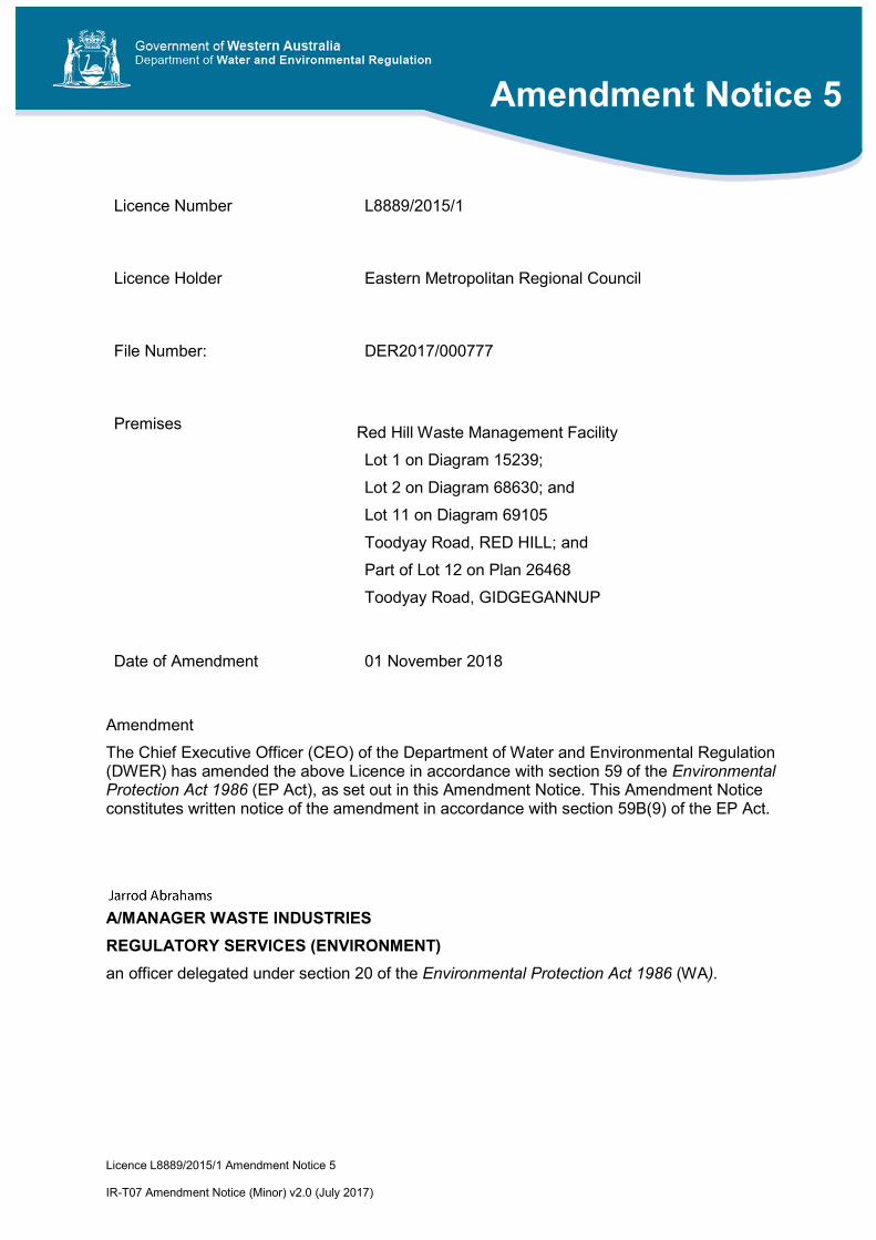
Licence Number L8889/2015/1
Licence Holder Eastern Metropolitan Regional Council
File Number: DER2017/000777
Premises Red Hill Waste Management Facility
Lot 1 on Diagram 15239;
Lot 2 on Diagram 68630; and
Lot 11 on Diagram 69105
Toodyay Road, RED HILL; and
Part of Lot 12 on Plan 26468
Toodyay Road, GIDGEGANNUP
Date of Amendment 01 November 2018
Amendment
The Chief Executive Officer (CEO) of the Department of Water and Environmental Regulation (DWER) has amended the above Licence in accordance with section 59 of the Environmental Protection Act 1986 (EP Act), as set out in this Amendment Notice. This Amendment Notice constitutes written notice of the amendment in accordance with section 59B(9) of the EP Act.
A/MANAGER WASTE INDUSTRIES
REGULATORY SERVICES (ENVIRONMENT)
an officer delegated under section 20 of the Environmental Protection Act 1986 (WA).
Amendment Notice 5

Licence L8889/2015/1 Amendment Notice 5 IR-T07 Amendment Notice (Minor) v2.0 (July 2017)
Definitions In this Amendment Notice, the terms in Table 1 have the meanings defined.
Table 1: Definitions
Term Definition
Amendment Notice 3 L8889/2015/1 Amendment Notice 3, granted 9 July 2018
ANCOLD Australian National Committee On Large Dams
Application Licence amendment application submitted by EMRC on the 10 September 2018 seeking Part V approval to amend Licence L8889/2015/1
Category/ Categories/ Cat.
Categories of Prescribed Premises as set out in Schedule 1 of the EP Regulations
Delegated Officer An officer delegated under section 20 of the EP Act
DWER Department of Water and Environmental Regulation
EMRC Eastern Metropolitan Regional Council
EPA Environmental Protection Authority
EP Act Environmental Protection Act 1986 (WA)
EP Regulations Environmental Protection Regulations 1987 (WA)
Existing Licence The Licence L8889/2015/1 issued under Part V, Division 3 of the EP Act and in force prior to the commencement of and during this Assessment, including Amendment Notices 1, 2, 3 and 4.
GCL Geosynthetic Clay Liner
HDPE High density polyethylene
HELP Hydrologic Evaluation of Landfill Performance
ICOLD International Commission on Large Dams
Licence The Licence L8889/2015/1 issued under Part V, Division 3 of the EP Act
Licence Holder/Licensee
Eastern Metropolitan Regional Council (EMRC)
m metres
mm millimetres
MS Ministerial Statement(s)

Licence L8889/2015/1 Amendment Notice 5 IR-T07 Amendment Notice (Minor) v2.0 (July 2017)
Term Definition
MS274 Ministerial Statement 274 dated 14 July 1992
OBE Operating Base Earthquake
Prescribed Premises has the same meaning given to that term under the EP Act.
Premises refers to the Premises to which this Amendment Notice applies, as specified at the front of this Notice.
QA/QC Quality Assurance and Quality Control
Red Hill WMF Red Hill Waste Management Facility
Risk Event as described in Guidance Statement: Risk Assessment
SEE Safety Evaluation Earthquake
Works refers to the Works specified in this Amendment Notice to be carried out at the Premises.

Licence L8889/2015/1 Amendment Notice 5 IR-T07 Amendment Notice (Minor) v2.0 (July 2017)
Amendment Notice This amendment is made pursuant to section 59 of the Environmental Protection Act 1986 (EP Act) to amend the Licence issued under the EP Act for a prescribed premises as set out below. This notice of amendment is given under section 59B(9) of the EP Act.
This notice is limited only to an amendment for Category 64 and 65 only in relation to a change to the construction and operation of one leachate pond (the leachate holding pond) originally approved under Amendment Notice 3 (dated 09 July 2018) of the Existing Licence. There are no proposed design changes to the evaporation ponds approved under Amendment Notice 3. Further no other changes to the aspects of the Existing Licence relating to Categories 12, 62 and 67A have been requested by the Licence Holder.
The Licence Holder has requested facilitation of a minor amendment, as such changes to licence format requested by the Licence Holder will be not be considered in this amendment, but may be requested as part of a future amendment and licence consolidation.
The following guidance statements have informed the decision made on this amendment:
Guidance Statement: Regulatory Principles (July 2015)
Guidance Statement: Setting Conditions (October 2015)
Guidance Statement: Decision Making (February 2017)
Guidance Statement: Risk Assessment (February 2017)
Guidance Statement: Environmental Siting (November 2016)
Amendment description On 10 September 2018 the Eastern Metropolitan Regional Council (EMRC) submitted an application to the Department of Water and Environmental Regulation (DWER) to amend Licence L8889/2015/1 for the Red Hill Waste Management Facility (Red Hill WMF)
The scope of the Application relates to the proposed change to the construction and operation of the leachate holding pond approved, under Amendment Notice 3 to the Licence, on 09 July 2018. Following the approval of the Amendment Notice 3 to construct and operate the leachate holding pond, EMRC required an expansion of the size of the pond (via deepening by three metres) in order to manage winter rainfall volume, as well as the excess leachate currently being stored in the decommissioned Class IV landfill cell.
The scope of the construction of the leachate holding pond in relation to the construction methods, construction quality assurance, liner suitability, liner installation and associated works, and operation of the holding pond are assessed within Amendment Notice 3 of the Licence and will not be duplicated in this assessment. This assessment relates to the review of water balance, stability assessment and design principles related to of the proposed increase of capacity of the leachate holding pond.
The Application also included a request to amend or modify ten conditions contained within Amendment Notice 3. Some of the requests are considered within the scope of this amendment, others are considered to be formatting changes and will not be updated as part of this amendment. It is preferred that these requests be considered as part of a future amendment application during which a licence consolidation may be undertaken concurrently.
Table 2 lists the documents and information provided with the Application, and that were submitted as part of the assessment process.

Licence L8889/2015/1 Amendment Notice 5 IR-T07 Amendment Notice (Minor) v2.0 (July 2017)
Table 2: Documents referred to as part of Amendment Notice 5 Application
Document/information description Date received
1 Licence Application Form (EMRC,10 September 2018)
The following attachments were included with the Application Form:
Attachment 3A – Red Hill Waste Management Facility Licence Amendment Application: Leachate Pond System Supporting Document (Talis, September 2018).
10 September 2018
2 Documents and information submitted as part of Amendment Notice 3 – as referenced in Table 2 of L8889/2015/1 Amendment Notice 3 (DWER, July 2018)
Held in DWER Records
Background
EMRC is licensed to construct and operate two (2) evaporation ponds and one (1) leachate holding pond to manage excess leachate and stormwater currently being stored in the decommissioned Class IV landfill cell, which also receives rainfall. Once the leachate is removed from the Class IV cell, the ponds are to be used to manage leachate generated within Class III cells at Red Hill WMF. Leachate management is undertaken in accordance with the Existing Licence conditions. Recent monitoring of the pond capacity indicates that the leachate pond system is close to or at capacity (Talis, 2018a).
The volume of leachate expected to be required to be managed by the ponds was initially thought to be up to 60,000 m3. The ponds were approved to be constructed on the south-eastern corner of the Premises within Lot 12 on Plan 26468, Toodyay Road, Gidgegannup, in a former clay stockpile area. The pond footprint has been cleared and pre-construction earthworks that have been undertaken include removal of the caprock beneath the footprint of the ponds by drilling and blasting.
Scope of works for construction
The scope of works for the construction of the pond will not vary from the scope of works proposed and granted in Licence Amendment Notice 3.
Pond design specifications
Pond sizing
The proposed amendment includes an increase of the approved operational capacity of Holding Pond 1 (approved in Amendment Notice 3) by deepening the base of the pond by three (3) metres (m) from its current approved basal depth.. The leachate holding pond design specifications are as follows:
Catchment area (construction) – 127.8 m length x 100 m width x 7.0 m height
Internal pond side slope – 1V:2.5H
Total Area – 12,780 m2 (operational – 12,217 m2)
Volume – 65,665 m3 (operational – 59,416 m3)
The operational capacity of the holding pond is proposed to be increased from 36,294 m3 to 59,416 m3. The combined operational capacity of all three ponds will increase from 64,504 m3 to 87,626 m3. Table 3 provides a breakdown on the pond sizing parameters, including catchment, approved operational capacity and the operational capacity proposed in this amendment.

Licence L8889/2015/1 Amendment Notice 5 IR-T07 Amendment Notice (Minor) v2.0 (July 2017)
Table 3: Pond sizing details
Pond Catchment area (m2) Approved Operational capacity (m3)
Proposed Operational capacity (m3)
Holding Pond 1 12,780 36,294 59,416
Evaporation Pond 1 15,053 20,363 20,363
Evaporation Pond 2 6,420 7,847 7,847
Total capacity of system 34,253 64,504 87,626
Note: Operation capacity assumes that a 500 mm freeboard is maintained within the capacity of the pond.
Water balance
EMRC are proposing to transfer the entire volume of leachate within the decommissioned Class IV Cell to the new leachate ponds, and subsequently evaporate it as soon as practicable. The reported volume of leachate within the Class IV landfill is currently estimated to be approximately 60,000m3 (15,000 m3 greater than the volume estimated for the water balance submitted in Amendment Notice 3). Annual rainfall and pan evaporation data have been used in an evaporation pond algorithm/model to evaluate timeframes for managing this volume of leachate.
Within the model the average and 90th percentile rainfall data was used (records from the Red Hill on-site weather station from 2006-2016 were used). Historical records of pan evaporation rates were sourced from the Perth Airport Weather Station (ID: 009021). The average and 90th percentile annual rainfall at Red Hill is reported as 843.3 millimetres (mm) and 940.9 mm, respectively; the annual of pan evaporation rate was reported as 2057.8 mm. The following additional factors were considered in the model:
500 mm operational freeboard;
No rainfall within an evaporation pond’s catchment area was lost to run-off;
The actual evaporation rate was assumed to be 80% of the potential pan evaporation rate; and
The evaporation areas were set at a conservative values, less than each operational pond area.
The model considered the volumes within the ponds for a given month including the initial leachate inputs/transfer from the Class IV Cell, the remaining leachate from the previous month, if any and the rainfall within the catchment area, using both the modelled average and 90th percentile rainfall data. No inputs of leachate from other infrastructure on-site was considered as part of the model so that EMRC could consider timeframes for managing and evaporating excess leachate currently stored in the decommission Class IV Cell. Based on the modelled results 60,000m3 of leachate could potentially evaporate within a 2-3 year period (no change from the estimation made as part of Amendment Notice 3).
Once the initial surplus has evaporated EMRC propose to use the new leachate ponds to manage all other existing and future leachate generated at the site in a centralised leachate management system; with the exception of leachate produced from Class IV cells which will be managed in the existing Class IV leachate pond. The estimated leachate generation volume generated from the Hydrologic Evaluation of Landfill Performance (HELP) model remains within the capacity of the proposed leachate pond system.

Licence L8889/2015/1 Amendment Notice 5 IR-T07 Amendment Notice (Minor) v2.0 (July 2017)
Stability assessment
The stability assessment (originally undertaken by Talis for Amendment Notice 3) was updated to assess the stability for the proposed amendment. Consistent with Amendment Notice 3, it is noted that the leachate ponds are not considered to be permanent features within the landform, and will be subsequently decommissioned during the post-closure period of the site when they are no longer required. A summary of the assessment is provided below:
Source: Stability Assessment of Evaporation Ponds at Red Hill Waste Management Facility, Letter report dated 27 August 2018 (Talis, 2018b);
The stability analysis program SLIDE 8.016 from RocScience was used to analyse the sections using the Bishop simplified and Morgenstern-Price for circular and non-circular forms of analysis;
Inputs included the site geotechnical investigation results, average wet season groundwater level (June to October) and information from the pre-construction earthworks undertaken in the pond footprint area. The model included the composite pond liner in place across the base and sides of the pond comprising an engineered clay attenuation layer, geosynthetic clay liner (GCL), and a 2 mm thick high density polyethylene (HDPE) geomembrane. The potential for basal heave and sub-surface cavities to impact on stability was assessed and subsequently screened out of the model.
The cross section ‘XSECT B’ (refer to updated Schedule 4 of proposed amendments in this notice – Design Drawing 1) has been re-analysed in its two component parts, the southern outer embankment and the northern embankment and cut slope;
The sections were analysed under non-operational conditions, operational conditions (pond full) and operational conditions with pseudo-static seismic loading. The pseudo-static seismic return periods considered were based on an ICOLD Total Risk Factor of 4 (Risk Rating = 1, Low). Based on the Risk Rating, ANCOLD Draft – guidelines for design of dams and appurtenant Structures for Earthquake – Table 2.1 recommended the following return periods be assessed:
1:500 - Operating Base Earthquake (OBE)
1:1000 – Safety Evaluation Earthquake (SEE)
A sensitivity analysis was also undertaken on the southern outer embankment under operational (pond full) conditions, utilizing undrained shear strength parameters, with a 20 percent reduction, to assess the potential effects of strain weakening during earthquake loading for both OBE and SEE scenarios.
For the limit state equilibrium analyses, a factor of safety of ≥1.5 was considered appropriate when using peak shear strength parameters under static loading. A factor of safety of ≥1.1 was adopted to assess earthquake loading for OBE conditions, and a factor of safety of ≥1.0 was adopted for SEE scenarios;
Calculated factors for safety under static loading for the two component parts modelled ranged from 1.568 to 2.429, and therefore in excess of the minimum acceptable value of 1.5, and are considered acceptable;
Calculated factors for safety under OBE pseudo-static loading, ranged from 1.144 to 1.572. Under sensitivity analysis for the outer embankment, calculated factors of safety ranged from 1.292 to 2.252. All calculated factors of safety were in excess of the minimum acceptable value of 1.1, and are considered acceptable; and

Licence L8889/2015/1 Amendment Notice 5 IR-T07 Amendment Notice (Minor) v2.0 (July 2017)
Calculated factors for safety under SEE pseudo-static loading ranged from 1.069 to 1.440. Under sensitivity analysis for the outer embankment, calculated factors of safety ranged from 1.195 to 2.018. All calculated factors of safety were in excess of the minimum acceptable value of 1.0, and are considered acceptable.
Groundwater
Average wet season groundwater level (between June and October) was based on groundwater monitoring (at monitoring bore locations 4D, SP36D, SP37D, SP38D, SP42D, SP43S, FMB1 and FMB3) undertaken by EMRC between 2012 and 2018. The wet season groundwater level used in the design of the proposed pond construction utilised data from monitoring bore locations (SP37D, SP38D, SP43S, FMB1 and FMB3). The data indicated that the base elevation of the proposed leachate holding pond is approximately 3.6 to 5.0 m above the wet season groundwater level.
Monitoring
Relevant monitoring currently undertaken on the Premises in accordance with the relevant Ministerial Statements (MS) and Existing Licence includes: leachate pond inspection and leachate monitoring, groundwater monitoring and surface water monitoring.
Regular leachate monitoring includes:
Inspection of leachate pond bund and liner integrity (every six months);
Inspection of ponds and surface water drains after major storm events to check integrity of bund walls and check that drainage lines are clear;
Inspection of leachate ponds, drainage pipework and pumps on a weekly basis which includes the following:
o Water level;
o Leachate quality (visual inspection of colour, odour, scum presence and surface litter etc.);
o Function of pipes and pumps; and
o Liner integrity (visual inspection for damage, breakage etc); and
Quarterly sampling and analysis of leachate quality.
Groundwater monitoring is conducted in accordance with Ministerial Statement 274 (MS274) at 47 groundwater monitoring locations across the Premises, at least twice a year. Surface water samples are collected from twelve (12) locations twice a year, or during flow events for relevant locations which don’t contain permanent water. An annual aquatic macroinvertebrate study is undertaken in surface water bodies surrounding the Premises.
Water samples that are collected are analysed for a range of organic and inorganic parameter and results are compared against historical trends to determine if activities undertaken at the Premises are affecting the quality of environmental receptors.

Licence L8889/2015/1 Amendment Notice 5 IR-T07 Amendment Notice (Minor) v2.0 (July 2017)
Legislative context – Part IV of the EP Act The Premises is currently subject to three Ministerial Statements (MS) under Part IV of the EP Act. In regulating the Premises under Part V, Division 3 of EP Act, DWER will seek to avoid duplication of requirements imposed under Part IV. Pursuant to section 59B(7) of the EP Act, DWER will also not amend a Part V licence to be contrary to, or otherwise than in accordance with, an implementation agreement or decision.
A summary of the respective Ministerial Statements is provided below:
MS 274 (15 July 1992) – Relates to the Red Hill Waste Management Facility Extension;
MS 462 (21 November 1997) – Relates to the establishment of Class IV waste disposal cells at the existing Red Hill Waste Management Facility; and
MS 976 (9 July 2014) – Relates to the proposal to construct and operate a resource recovery facility within the existing Red Hill Waste Management Facility, for the processing of waste to produce energy, using either anaerobic digestion or gasification technology.
MS274 and MS462 are the main Statements that relate to the construction, operation and post closure management of waste handling and landfilling aspects at the Red Hill Waste Management Facility. The scope of this amendment does not change the outcome of changes made to MS274 based on the scope of Amendment Notice 3.
Amendment history Table 4 provides the amendment history for L8889/2015/1.
Table 4: Licence amendment history
Instrument Issued Amendment
L8889/2015/1 17/03/2016 Construction of a green-waste processing hardstand pad and associated relocation of existing green-waste processing operations.
L8889/2015/1 06/09/2017 Amendment Notice 1 – approval to accept and bury PFAS contaminated solid waste in existing Class III landfill cells (Farm Stage 1 and 2 and Stage 15).
L8889/2015/1 01/05/2018 Amendment Notice 2 – approval to accept and store paint wastes and updates to landfill acceptance criteria for PFAS impacted solid wastes (Special Waste Type 3).
L8889/2015/1 09/07/2018 Amendment Notice 3 – construction and operation of three (3) leachate ponds (1 holding pond and 2 evaporation ponds) to manage excess leachate currently being stored in the decommissioned Class IV cell. Ultimately these ponds will be used to store and manage all other existing and future leachate generated from Class III landfill cells at the site in a centralised system.
L8889/2015/1 9/08/2018 Amendment Notice 4: construction of an eastern leachate storage pond for disposal of leachate by evaporation.
L8889/2015/1 01/11/2018 Amendment Notice 5 – (this assessment) increase of the capacity of leachate holding pond 1 by deepening the pond by 3 m.
Location and receptors The location of the leachate ponds in relation to residential and sensitive receptors is described in Amendment Notice 3 and is not relevant to the assessment of this proposed amendment.

Licence L8889/2015/1 Amendment Notice 5 IR-T07 Amendment Notice (Minor) v2.0 (July 2017)
Table 5 lists the relevant environmental receptors related to assessment of risk for the proposed amendment.
Table 5: Relevant environmental receptors
Environmental receptors Distance from Prescribed Premises
John Forrest National Park (bushland)
Lot 11664 on Plan 217947, Red Hill – Crown Reserve 7537
Located to the south and immediately adjacent to the boundary of Lot 11 and 2 of the Premises and approximately 650m to the south-west of the proposed leachate ponds.
Bushland
Lot 501 on Plan 40105, Parkerville
Lot 82 on Diagram 18309, Parkerville
Bushland is also located immediately adjacent to the boundary of Lot 1 and 12 of the Premises, and approximately 150m south of the proposed leachate ponds.
EMRC is the owner of the land.
Threatened / Priority Fauna – Mammals and Birds
Priority Fauna P4 (mammals) – mapped as being observed within Lot 1 of the Premises, in previously landfilled areas currently subject to rehabilitation. Fauna Survey date 29/10/2014.
Priority Fauna P4 (mammals) – mapped as being observed within Lot 1 of the Premises, in previously landfilled areas currently subject to rehabilitation. Fauna Survey date 18/05/2012.
Birds (Schedule 5 – Migratory birds protected under an international agreement); mapped as being observed within Lot 2 of the Premises, in previously landfilled areas currently subject to rehabilitation. Fauna Survey dates 29/10/2014 and 04/11/2015.
Birds (Schedule 3 – Fauna that is rare or is likely to become extinct as vulnerable fauna); mapped as being observed within Lot 2 of the Premises, in previously landfilled areas currently subject to rehabilitation. Fauna Survey dates 29/10/2014 and 04/11/2015.
Designated Area – Surface Water Area The entire Premises and surrounding land is mapped as proclaimed surface water area under the Rights in Water Irrigation Act 1914 named the “Swan River System”.
Susannah Brook (Significant Stream) Approximately 1 km to the north of the Premises boundary, 1.2 km from Farm Stage 1/2 Class III cells and 1.8km from the leachate ponds.
Related drainage lines (classed as minor, perennial watercourses) also run north-south of Susannah Brook; the closest is located approximately 250 m north of Farm Stage 1/2 and 920 m north of the leachate ponds, located within Lot 51 (1157) Toodyay Road, Gidgegannup.
Christmas Tree Creek (Watercourse - minor, perennial)
Approximately 370 m to the south of the Premises boundary, 680 m from the Stage 15 Class III cell and 450 m south of the leachate ponds. Christmas Tree Creek is a tributary of Jane Brook.
Flows towards the west and does not connect to or support aquatic life fit for human consumption.
The geological and hydrogeological characteristics of the Premises are described in Table 6 (as referenced in Amendment Notice 3 and Talis, 2018a).

Licence L8889/2015/1 Amendment Notice 5 IR-T07 Amendment Notice (Minor) v2.0 (July 2017)
Table 6: Geology and hydrogeology for the Premises
Environmental aspect Description
Geology The geology of the region is characteristic for that of the Yilgarn Craton, being dominated by granitic basement rocks with occasional intrusive dolerite dykes, weathered basement and weathered duplex soils. The latter consist broadly of ferruginous and lateritic gravels or lateritic hardpans, underlain by white and cream clays (referred to generally as the pallid zone) and with saprolite grits (clayey gravels and clays) overlying weathered basement.
The thickness of the various duplex soils and weathered zones can vary significantly across sites such as Red Hill.
The geology is not consistent with the attributes of a high or very high vulnerability aquifer, with very low permeable features.
Hydrogeology There are two distinct water bearing units underlying the site:
The upper unit comprises of a perched water table within shallow lateritic sediments, in low lying areas, which are present above pallid zone clays (impermeable layer of kaolinitic clays). Perched aquifers are reported to be limited in their lateral extent across the site and are considered to be ephemeral with flow occurring over and post winter.
The lower unit comprises the regional groundwater table within granite bedrock (fracture systems) or within extensive saprolite grits (porous, weathered bedrock). In places the watertable is semi-confined by pallid zone clays.
Based on the inferred regional groundwater contours in the bedrock (granite) aquifer, a groundwater divide extends across the northern part of the site (following topography); north of the divide groundwater flows north-west to west-northwest, and to the south of the divide flows are to the south-west to south. Groundwater flow rates vary from 2.5 x 10⁻⁶ m/s in narrow fracture zones within the bedrock, to 6x10⁻⁹ m/s in low permeability granite bedrock and clay units. Flow rates tested in the proposed Stage 15 extension, to the west of the leachate pond location, are 1.2x10⁻⁶ to 6.7x10⁻⁷ m/s (Crisalis, 2015).
The depth to groundwater varies across the site and is influenced by fracturing and jointing within the granite basement. As outlined in the ‘Amendment description’ section, groundwater levels beneath the construction footprint have been estimated to be between 3.6 and 5.0 m below the base elevation in the leachate holding pond.
Groundwater downgradient of the leachate pond area flows beneath residential land (Hidden Valley Estate) and John Forrest National Park. While there are no currently registered groundwater users downgradient of Lot 12 where the leachate ponds are located, groundwater within residential areas has the potential to be used for non-potable domestic supply.
Licence L8889/2015/1 Amendment Notice 5 IR-T07 Amendment Notice (Minor) v2.0 (July 2017)
Risk assessment Table 7 below describes the Risk Events associated with the proposed amendment consistent with the Guidance Statement: Risk Assessments, for both the construction and operational phases. Table 7 identify whether the emissions present a material risk to public health or the environment, requiring regulatory controls.
DWER has given consideration to the following aspects in its assessment of the proposed change to the leachate holding pond:
Siting of the proposed leachate ponds in relation to relevant environmental receptors;
Leachate holding pond design specifications and stability assessment;
Proposed operational controls and leachate management practices; and
Proposed groundwater and surface water monitoring program.
The risk assessment for construction of the pond (including earthworks to deepen the pond), and odour emissions during operation of the pond, are contained within Amendment Notice 3 and remain unchanged.
Licence L8889/2015/1 Amendment Notice 5 IR-T07 Amendment Notice (Minor) v2.0 (July 2017)
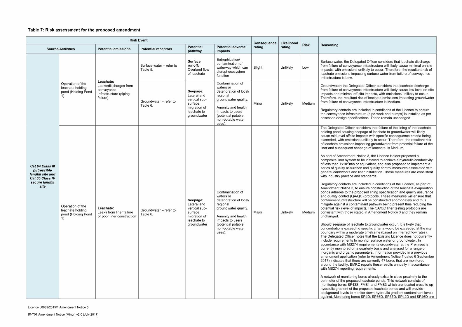
Table 7: Risk assessment for the proposed amendment
Risk Event Consequence rating
Likelihood rating
Risk Reasoning Source/Activities Potential emissions Potential receptors
Potential pathway
Potential adverse impacts
Cat 64 Class III putrescible
landfill site and Cat 65 Class IV secure landfill
site
Operation of the leachate holding pond (Holding Pond 1)
Leachate: Leaks/discharges from conveyance infrastructure (piping failure)
Surface water – refer to Table 5.
Surface runoff: Overland flow of leachate
Eutrophication/ contamination of waterway which can disrupt ecosystem function
Slight Unlikely Low
Surface water: the Delegated Officer considers that leachate discharge from failure of conveyance infrastructure will likely cause minimal on-site impacts, with emissions unlikely to occur. Therefore, the resultant risk of leachate emissions impacting surface water from failure of conveyance infrastructure is Low. Groundwater: the Delegated Officer considers that leachate discharge from failure of conveyance infrastructure will likely cause low-level on-site impacts and minimal off-site impacts, with emissions unlikely to occur. Therefore, the resultant risk of leachate emissions impacting groundwater from failure of conveyance infrastructure is Medium. Regulatory controls are included in conditions of the Licence to ensure the conveyance infrastructure (pipe-work and pumps) is installed as per assessed design specifications. These remain unchanged
Groundwater – refer to Table 6.
Seepage: Lateral and vertical sub-surface migration of leachate to groundwater
Contamination of waters or deterioration of local/ regional groundwater quality. Amenity and health impacts to users (potential potable, non-potable water uses).
Minor Unlikely Medium
Operation of the leachate holding pond (Holding Pond 1)
Leachate: Leaks from liner failure or poor liner construction
Groundwater – refer to Table 6.
Seepage: Lateral and vertical sub-surface migration of leachate to groundwater
Contamination of waters or deterioration of local/ regional groundwater quality. Amenity and health impacts to users (potential potable, non-potable water uses).
Major Unlikely Medium
The Delegated Officer considers that failure of the lining of the leachate holding pond causing seepage of leachate to groundwater will likely cause mid-level offsite impacts with specific consequence criteria being exceeded, with emissions unlikely to occur. Therefore, the resultant risk of leachate emissions impacting groundwater from potential failure of the liner and subsequent seepage of leacahte, is Medium. As part of Amendment Notice 3, the Licence Holder proposed a composite liner system to be installed to achieve a hydraulic conductivity of less than 1x10⁻⁹m/s or equivalent, and also proposed to implement a series of quality assurance and quality control measures associated with general earthworks and liner installation. These measures are consistent with industry practice and standards. Regulatory controls are included in conditions of the Licence, as part of Amendment Notice 3, to ensure construction of the leachate evaporation ponds adheres to the proposed lining specification and quality assurance and quality control (QA/QC) protocols. These measures will ensure that containment infrastructure will be constructed appropriately and thus mitigate against a contaminant pathway being present thus reducing the potential risk (level of impact). The QA/QC liner testing protocols are consistent with those stated in Amendment Notice 3 and they remain unchanged. Should seepage of leachate to groundwater occur, It is likely that concentrations exceeding specific criteria would be exceeded at the site boundary within a moderate timeframe (based on inferred flow rates). The Delegated Officer notes that the Existing Licence does not currently include requirements to monitor surface water or groundwater. In accordance with MS274 requirements groundwater at the Premises is currently monitored on a quarterly basis and analysed for a range or inorganic and organic parameters. Information provided in a previous amendment application (refer to Amendment Notice 1 dated 6 September 2017) indicates that there are currently 47 bores that are monitored around the facility. EMRC reports these results annually in accordance with MS274 reporting requirements. A network of monitoring bores already exists in close proximity to the perimeter of the proposed leachate ponds. This network consists of monitoring bores SP43S, FMB1 and FMB3 which are located cross to up-hydraulic gradient of the proposed leachate ponds and will provide background levels to monitor down-hydraulic gradient contaminant levels against. Monitoring bores SP4D, SP36D, SP37D, SP42D and SP46D are

Licence L8889/2015/1 Amendment Notice 5 IR-T07 Amendment Notice (Minor) v2.0 (July 2017)
Risk Event Consequence rating
Likelihood rating
Risk Reasoning Source/Activities Potential emissions Potential receptors
Potential pathway
Potential adverse impacts
located down-hydraulic gradient from the proposed leachate ponds. The Delegated Officer considers the existing monitoring network is suitable to monitor changes in groundwater conditions and quality with regard to potential discharge of leachate constituents from the proposed leachate ponds. The proposed licence amendment does not propose to alter or duplicate requirements covered under these existing Ministerial Statements (see above).
Leachate: Overtopping of pond
Surface water – refer to Table 5.
Surface runoff: Overland flow of leachate
Eutrophication/ contamination of waterway which can disrupt ecosystem function.
Slight Unlikely Low
Surface water: the Delegated Officer considers that over-topping of leachate ponds will likely cause minimal on-site impacts (due to the nature of land use onsite), with emissions unlikely to occur. Therefore, the resultant risk of leachate emissions impacting surface water from pond over-topping is Low. Groundwater: the Delegated Officer considers that over-topping of leachate ponds will likely cause low-level on-site impacts and minimal off-site impacts, with emissions unlikely to occur. Therefore, the resultant risk of leachate emissions impacting groundwater from pond over-topping is Medium. EMRC have advised that leachate levels in all ponds are monitored daily and a 500mm freeboard maintained at all times. Pumping infrastructure is in place to relocate leachate to other ponds should this be required to maintain the 500mm freeboard. EMRC have also proposed to construct diversion drains around the proposed leachate ponds which will capture stormwater run-off and divert to existing water collection ponds (refer to Amendment Notice 3), thus removing potential run-off into the new ponds to reduce the potential for Infiltration or uncontrolled release. All drains will be kept clear of any waste to ensure clear drainage and reduce the risk of contamination. Amendment Notice 3 included conditions that require EMRC to maintain a freeboard equal to, or greater than, 500mm on the leachate ponds, and a condition to maintain diversion drains around leachate ponds.
Operation of the leachate holding pond (Holding Pond 1)
Leachate: Overtopping of pond
Groundwater – refer to Table 6.
Seepage: Lateral and vertical sub-surface migration of leachate to groundwater
Contamination of waters or deterioration of local/ regional groundwater quality. Amenity and health impacts to users (potential potable, non-potable water uses).
Minor Unlikely Medium

Licence L8889/2015/1 Amendment Notice 5 IR-T07 Amendment Notice (Minor) v2.0 (July 2017)
Decision DWER has given regard to the relevant Ministerial Statements outlined in the ‘Legislative context – Part IV of the EP Act’ section to ensure that the decision and conditions for the proposed amended licence are not contrary to, or otherwise than in accordance with, an implementation agreement or decision of the Minister under Part IV of the EP Act.
Based on the Detailed Risk Assessment the Delegated Officer has determined to amend the Licence to authorise the increase of capacity of the leachate holding pond by deepening by 3 metres.
The following amendments are proposed to the Existing Licence:
Minimum separation distance to be maintained between the base of Leachate Holding Pond 1 and the highest recorded natural elevation of groundwater for construction.
Licence Holder’s comments The Licence Holder was provided with the draft Amendment Notice on 26 October 2018. The Licence Holder replied on 30 October 2018, indicating that EMRC was agreeable with the draft amendment and would waive the 21 day comment period. The final amendment is presented in the following Section.
Amendment 1. Condition G15 of the Licence is amended by the deletion of the text shown in strikethrough
below and the insertion of red text shown in underline below: G15 The report and engineering certification required by Condition G12 must be
accompanied by a Construction Quality Assurance (CQA) Validation Report that:
(a) is written and certified by the Geotechnical Inspection and Testing Authority that completed the construction quality assurance processes required by Table A, Table B and Table C in Schedule 4;
(b) certifies that the sub-grade and liner components are free of fault or defect, built to the design specification and fit for the intended purpose;
(c) assesses test results against minimum values in Table B and Table C in Schedule 4, including a summary of failures, corrective measures and retest results;
(d) demonstrates that athe minimum separation distances of 5m between the lowest elevation of respective leachate ponds specified in Condition G10 and the highest recorded natural elevation of groundwater was achieved at the time of construction, as supported by on-site groundwater monitoring data;
(e) includes progress photos; (f) includes copies of results of surveys and drawings of the final built
leachate ponds and surface water diversion bunds, (g) includes copies of results of surveys of inspections, monitoring and
testing results for the sub-grade preparation and liner installation; and (h) demonstrates compliance with Condition G10
2. Table A of Schedule 4 of the Licence is amended by the deletion of the text shown in strikethrough below and the insertion of the red text shown in underline below:

Licence L8889/2015/1 Amendment Notice 5 IR-T07 Amendment Notice (Minor) v2.0 (July 2017)
SCHEDULE 4
Table A – Infrastructure and Requirements
Column 1 Column 2 Column 3
Infrastructure/ Equipment
Requirements (design and construction) Site plan / drawing reference
Leachate ponds – General construction quality assurance processes
The following works shall be subject to construction quality assurance processes in accordance with Level 1 of the Australian Standard AS 3798- 2007 Guidelines on earthworks for commercial and residential developments:
(a) the removal of unsuitable material, prior to the placement of compacted fill at the base and/or side slopes of the leachate ponds; and
(b) leachate pond construction, including liner placement, in accordance with the requirements specified in this Table.
N/A
Leachate ponds – dimensions and general arrangement
The leachate ponds are to be located in accordance with the Design Drawings in this Schedule.
Design Drawings in
in this Schedule
1) General Arrangement Plan
3) and 4) Pond Cross Sections
The leachate ponds shall be constructed to ensure that the following minimum separation distances a of 5m is are achieved between the lowest elevation of respective the relevant leachate ponds and the highest natural elevation of groundwater recorded in surrounding monitoring bores:
3m separation distance for the Leachate Holding Pond (Pond 1); and
5m separation distance for Evaporation Pond 1 and 2 (Ponds 2 and 3).
Leachate ponds –configuration and liner permeability requirements
The liner configuration for each pond is to consist of the following:
(a) 500mm thick Engineered Clay Attenuation Layer using; overlain by a
(b) Geosynthetic Clay Liner (GCL) – hydraulic conductivity of ≤ 2.5 x 10⁻¹¹ m/s; overlain by a
(c) 2mm High Density Polyethylene (HDPE) Double Textured Geomembrane – hydraulic conductivity with a range from 1 x 10-14 to 1 x 10-15 m/s.
Design Drawings this Schedule
2) Typical Construction Sections and Details
Leachate ponds – Subgrade
The Licensee must design, excavate and construct the leachate ponds subgrade to achieve the following:
Design Drawings in
in this Schedule
1) General

Licence L8889/2015/1 Amendment Notice 5 IR-T07 Amendment Notice (Minor) v2.0 (July 2017)
Column 1 Column 2 Column 3
Infrastructure/ Equipment
Requirements (design and construction) Site plan / drawing reference
(a) formation surfaces shall be proof rolled with a 10 tonne dead-weight roller to prove the formations structural strength and capacity;
(b) unsuitable material shall be excavated and disposed of and filled with crushed rock material or similar;
(c) subgrade surface shall be constructed to the shape and levels as shown in the Design Drawings in this Schedule;
(d) during the whole of the compaction process the moisture content, at any point in the Lot, of the subgrade material shall be within ±2% of the optimum moisture content for that material;
(e) the completed subgrade layer shall be in a homogeneous uniformly bonded condition with no evidence of layering or disintegration;
(f) the completed subgrade surface shall be maintained in its conforming condition until construction commences and shall be watered as necessary to prevent shrinkage cracking, dusting or loosening of its surface;
(g) where material for a depth of 150mm below the subgrade surface contains more than 20% by mass of material retained on a 37.5mm sieve then that material shall be compacted as per provision (a) except that the vibratory pad-foot rolling shall be followed by no less than six (6) complete coverage by a fully ballasted 15 tonne rubber tyred roller; and
(h) the final surface shall be smooth and free from any sharp objects, stones, debris, water and desiccation cracks
Arrangement Plan
2) Typical Construction Sections and Details
3) and 4) Pond Cross Sections
Leachate ponds – 500mm thick Engineered Clay Attenuation Layer
The Licensee must design, excavate and construct a 500mm thick Engineered Clay Attenuation Layer to each leachate pond achieve the following:
(a) clay is to be moisture conditioned prior to placement as clay liner by thorough mixing and breaking down of clay clods, and where appropriate water addition, is required prior to placement and compaction;
(b) clay clods of greater than 300mm across shall not be placed prior to compaction;
(c) a vibratory sheepsfoot and/or padfoot roller or other suitable equivalent compaction plant shall be used for construction of the
Design Drawings in
in this Schedule
1) General Arrangement Plan
2) Typical Construction Sections and Details
3) and 4) Pond Cross Sections

Licence L8889/2015/1 Amendment Notice 5 IR-T07 Amendment Notice (Minor) v2.0 (July 2017)
Column 1 Column 2 Column 3
Infrastructure/ Equipment
Requirements (design and construction) Site plan / drawing reference
clay liner;
(d) the surface of compacted clay shall be sealed with a smooth roller after each lift. The smooth surface is then to be scarified and watered before the next lift of clay is placed;
(e) uncompacted lift thickness must not exceed 300mm;
(f) clay material shall have a moisture content, during and after compaction, within the range of optimum moisture content (OMC) -0% to +3% as determined by the methods of test within the Australian Standard AS 1289 5.2.1 Methods for testing of soils for engineering purposes, to >95% modified maximum dry density (MMDD);
(g) compacted clay liner shall and
(h) the final clay surface shall be protected from desiccation prior to geosynthetic placement. Surfaces containing desiccation cracks exceeding 12mm deep or exhibiting swelling, heaving or other similar conditions shall be replaced or reworked as per the above provisions.
Leachate ponds – Geosynthetic Clay Liner (GCL)
The Licensee must be design and construct a GCL to each leachate pond to achieve the following:
(a) GCL shall be a needle punched multi-layered system comprising two layers of geotextiles encapsulating a layer of dry bentonite;
(b) Overlying; and in contact with the Subgrade;
(c) Shall be securely anchored according to the specifications and dimensions as shown in the Design Drawings in Schedule 1;
(d) The seams shall have a minimum overlap of 300mm and shall be joined by the addition of bentonite powder, at a minimum of 0.3kg/m length of seam, unless the GCL has impregnated surfaces along sheet edges and is installed under the manufacturer’s guidelines; and
(e) Material properties meeting ‘minimum values’ as defined in Table B in this Schedule.
Design Drawings in
in this Schedule
1) General Arrangement Plan
2) Typical Construction Sections and Details
3) and 4) Pond Cross Sections
Licence L8889/2015/1 Amendment Notice 5 IR-T07 Amendment Notice (Minor) v2.0 (July 2017)
Column 1 Column 2 Column 3
Infrastructure/ Equipment
Requirements (design and construction) Site plan / drawing reference
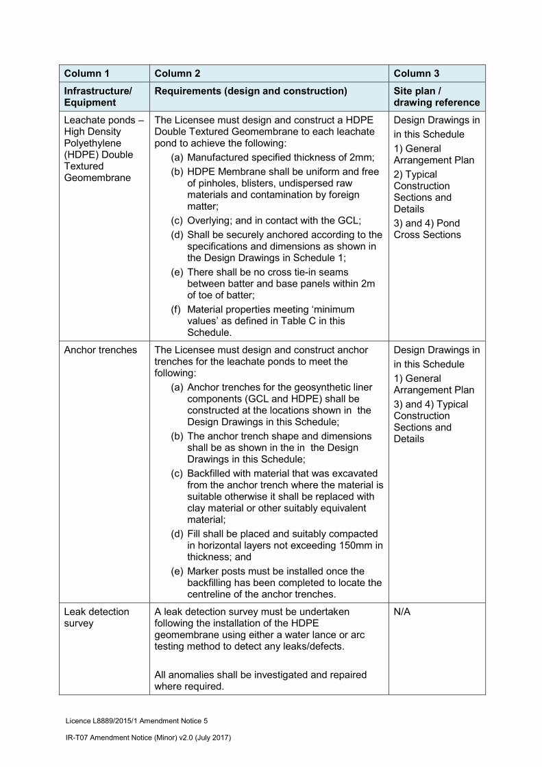
Leachate ponds – High Density Polyethylene (HDPE) Double Textured Geomembrane
The Licensee must design and construct a HDPE Double Textured Geomembrane to each leachate pond to achieve the following:
(a) Manufactured specified thickness of 2mm;
(b) HDPE Membrane shall be uniform and free of pinholes, blisters, undispersed raw materials and contamination by foreign matter;
(c) Overlying; and in contact with the GCL;
(d) Shall be securely anchored according to the specifications and dimensions as shown in the Design Drawings in Schedule 1;
(e) There shall be no cross tie-in seams between batter and base panels within 2m of toe of batter;
(f) Material properties meeting ‘minimum values’ as defined in Table C in this Schedule.
Design Drawings in
in this Schedule
1) General Arrangement Plan
2) Typical Construction Sections and Details
3) and 4) Pond Cross Sections
Anchor trenches The Licensee must design and construct anchor trenches for the leachate ponds to meet the following:
(a) Anchor trenches for the geosynthetic liner components (GCL and HDPE) shall be constructed at the locations shown in the Design Drawings in this Schedule;
(b) The anchor trench shape and dimensions shall be as shown in the in the Design Drawings in this Schedule;
(c) Backfilled with material that was excavated from the anchor trench where the material is suitable otherwise it shall be replaced with clay material or other suitably equivalent material;
(d) Fill shall be placed and suitably compacted in horizontal layers not exceeding 150mm in thickness; and
(e) Marker posts must be installed once the backfilling has been completed to locate the centreline of the anchor trenches.
Design Drawings in
in this Schedule
1) General Arrangement Plan
3) and 4) Typical Construction Sections and Details
Leak detection survey
A leak detection survey must be undertaken following the installation of the HDPE geomembrane using either a water lance or arc testing method to detect any leaks/defects.
All anomalies shall be investigated and repaired where required.
N/A

Licence L8889/2015/1 Amendment Notice 5 IR-T07 Amendment Notice (Minor) v2.0 (July 2017)
Column 1 Column 2 Column 3
Infrastructure/ Equipment
Requirements (design and construction) Site plan / drawing reference
Following repairs, the area shall be locally resurveyed to ensure the defect was not masking further defects in the adjacent areas.
Stormwater diversion drains
Stormwater diversion drains must be installed around the perimeter of the proposed leachate ponds to prevent surface water run-off from entering the leachate ponds.
All drains are to be kept clear of any waste to ensure clear drainage and reduce the risk of contamination.
N/A
Leachate conveyance pipework
PN 10/160mm pipe must be installed with joints electrofusion welded.
N/A
3. Design Drawings 1, 2, 3 and 4 of Schedule 4 of the Licence are replaced by the following
design drawings shown below:

Licence L8889/2015/1 Amendment Notice 5 IR-T07 Amendment Notice (Minor) v2.0 (July 2017)
Design Drawing 1 – General Arrangement Plan for Leachate Ponds
Source: Drawing No C-010 from Stability Assessment of Evaporation Ponds at Red Hill Waste Management Facility, Letter report dated 27 August (Talis 2018)

Licence L8889/2015/1 Amendment Notice 5 IR-T07 Amendment Notice (Minor) v2.0 (July 2017)
Design Drawing 2 – Typical Pond Construction Sections and Details
Source: Drawing No C-901 from Stability Assessment of Evaporation Ponds at Red Hill Waste Management Facility, Letter report dated 27 August (Talis 2018)

Licence L8889/2015/1 Amendment Notice 5 IR-T07 Amendment Notice (Minor) v2.0 (July 2017)
Design Drawing 3 – Pond Cross Sections – Sheet 1
Source: Drawing No C-020 from Stability Assessment of Evaporation Ponds at Red Hill Waste Management Facility, Letter report dated 27 August (Talis 2018)

Licence L8889/2015/1 Amendment Notice 5 IR-T07 Amendment Notice (Minor) v2.0 (July 2017)
Design Drawing 4 – Pond Cross Sections – Sheet 2
Source: Drawing No C-020 from Stability Assessment of Evaporation Ponds at Red Hill Waste Management Facility, Letter report dated 27 August (Talis 2018)
Licence L8889/2015/1 Amendment Notice 5 IR-T07 Amendment Notice (Minor) v2.0 (July 2017)
Appendix 1: Key documents
Document title In text ref Availability
1 Licence L8889/2015/1 L8889/2015/1
accessed at www.dwer.wa.gov.au
2 Licence L8889/2015/1 Amendment Notice 3 – 9 July 2018
L8889/2015/1 accessed at www.dwer.wa.gov.au
3 Ministerial Statement 274 MS 274 accessed at www.epa.wa.gov.au/ 4 Ministerial Statement 462 MS 462 accessed at www.epa.wa.gov.au/ 5 DER, July 2015. Guidance Statement:
Regulatory Principles. Department of Environment Regulation, Perth.
DER 2015a
accessed at www.dwer.wa.gov.au
6 DER, October 2015. Guidance Statement: Setting Conditions. Department of Environment Regulation, Perth.
DER 2015b
7 DER, August 2016. Guidance Statement: Licence Duration. Department of Environment Regulation, Perth.
DER 2016a
8 DER, November 2016. Guidance Statement: Risk Assessments. Department of Environment Regulation, Perth.
DER 2016b
9 DER, November 2016. Guidance Statement: Decision Making. Department of Environment Regulation, Perth.
DER 2016c
10 Crisalis International Pty Ltd & MS Groundwater Management Pty Ltd. 2015. Progress reports on investigation and monitoring of groundwater and remediation groundwater contamination to June 2015, Report prepared for Eastern Metropolitan Regional Council. Dated June 2015
Crisalis, 2015
DWER Records
11 Talis Consultants Pty Ltd. 2018a. Red Hill Waste Management Facility Licence Amendment Application – Leachate Pond System Suporting Documentation. Reference TW17064. Report prepared for Eastern Metropolitan Regional Council. September 2018.
Talis, 2018a
DWER Records (ref. A1718849)
12 Talis Consultants Pty Ltd. 2018b. Stability Assessment of Evaporation Ponds at Red Hill Waste Management Facility. Letter Report prepared for Eastern Metropolitan Regional Council. Dated 27 August 2018
Talis, 2018b
DWER Records (ref. A1718849)


![FY19 CEAR Reviewer Training PowerPoint Final...^ o ] î î &2676" •+RZ GR \RX SD\ IRU \RXU DQQXDO ILQDQFLDO VWDWHPHQW DXGLW" •+RZ PXFK GR \RX SD\ IRU RWKHU WUDLQLQJ SURJUDPV" •:KDW](https://img.pdfslide.us/doc/110x75/609647dd4047f242350c49d3/fy19-cear-reviewer-training-powerpoint-final-o-2676-arz.jpg)


![· )heuxdu\,q wkh 8qlwhg 6wdwhv ghfoduhg phdvohv zdv hudglfdwhg wkdqnv wr wkh 005 ydfflqh wzr ghfdghv odwhu wkh :ruog +hdowk 2ujdql]dwlrq kdv uhsruwhg](https://img.pdfslide.us/doc/110x75/5ea8937f9b9e8a037f7baefc/heuxduq-wkh-8qlwhg-6wdwhv-ghfoduhg-phdvohv-zdv-hudglfdwhg-wkdqnv-wr-wkh-005-ydfflqh.jpg)