Embed Size (px)
Citation preview
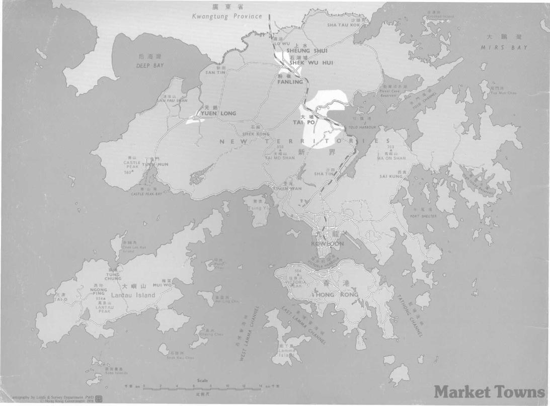
Kwangtung Province
:ography by Lands & Survey Department PWD© Hong Kong Government 1978
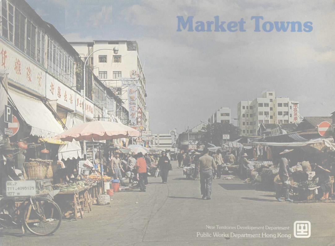
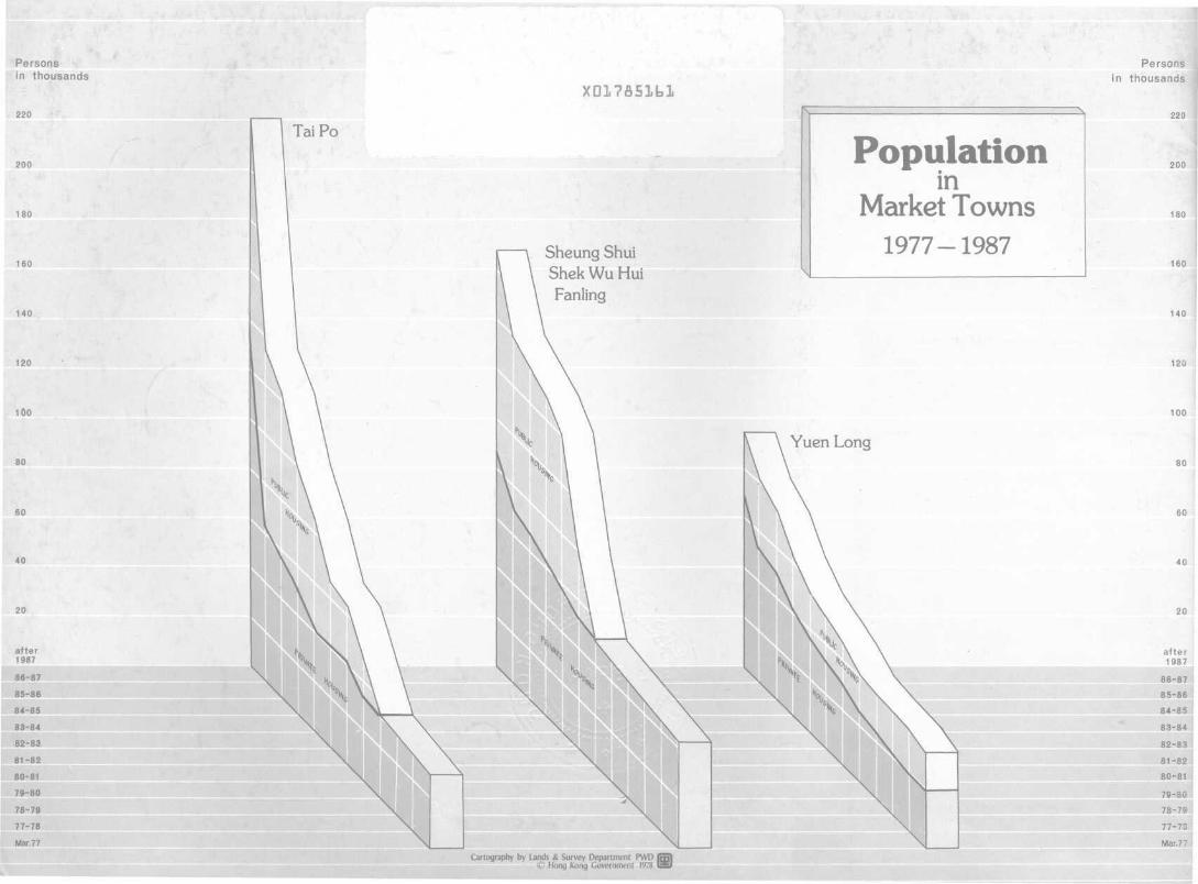
Market Towns
UNIVERSITY OF HONG KONGLIBRARY
Hong Kong Collectiongift from
N.T. Development Dept.Hong Kong
ContentsIntroduction
Tai Po
Fanling-Sheung Shui-Shek Wu Hui
Yuen Long
Introduction
ACC. NO.
DATE OF ACC.
CLASS NO.
AUTHOR NO. ; - ' - J
REBOUND
In 1972, Hong Kong's Executive Council gave its approvalto the adoption of a "Ten Year Housing TargetProgramme", which included proposals for the expansionof the three Market Towns— Tai Po, Fanling/Sheung Shui/
. 15 Shek Wu Hui and Yuen Long. Plans have now beendrawn up for the expansion of these Market Towns in the
25 New Territories so that ultimately they accommodatenearly half a million people .
Urban development in the New Territories is in fact takingplace on three distinct levels. The New Towns of Sha Tin,Tuen Mun and Tsuen Wan are the first ranking urbancentres. They are followed by the Market Towns, and thenthe smaller rural townships such as Cheung Chau, Mui O,Sai Kung and others.
The three Market Towns are being expanded anddeveloped as balanced townships, as self-contained aspossible, with all modern basic amenities.
At Tai Po and Yuen Long, the first two industrial estatesin Hong Kong are also being developed.
Although historically the Market Towns have always playeda significant role in the life of the New Territories, growthin recent years has been overshadowed by the rapid build-up in population within the three New Towns. However,with the drawing up of the latest plans, the scope ofdevelopment in the Market Towns has been increasedgreatly and they are likely to emerge once again asimportant centres in their own right.
The present population of the three Market Towns is about100,000 and the transition to fully balanced townshipshousing almost 500,000 people is the responsibility of theNew Territories Development Department (N.T.D.D.).Established within the Public Works Department in 1973 toplan and develop New Towns an<4 other rural centres inconsultation with the New Territories Administration, theDepartment is headed by a Director and staffed by teams oftown planners, engineers and architects.
, long
N
Metres
1 000 1500 2000
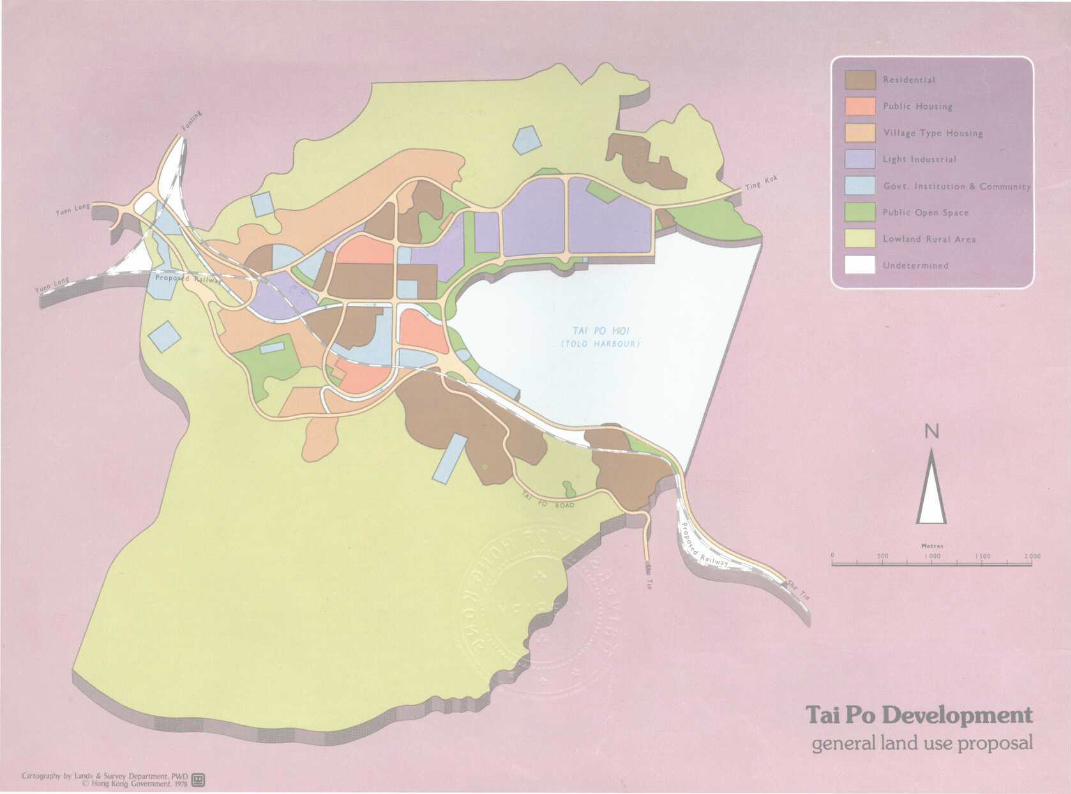
Tai Po Developmentgeneral land use proposal
Cartography by Lands & Survey Department, PWD (© Hong Kong Government, 1978 I
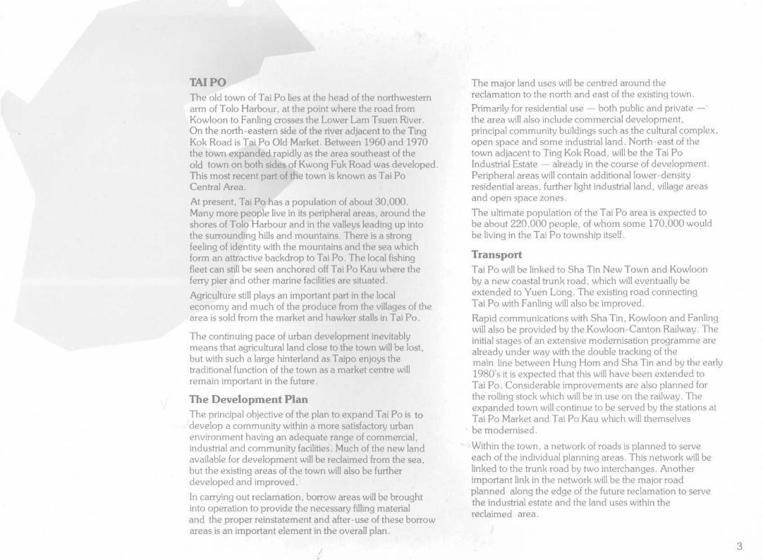
TAIPOThe old town of Tai Po lies at the head of the northwesternarm of Tolo Harbour, at the point where the road fromKowloon to Fanling crosses the Lower Lam Tsuen River.On the north-eastern side of the river adjacent to the TingKok Road is Tai Po Old Market. Between 1960 and 1970the town expanded rapidly as the area southeast of theold town on both sides of Kwong Fuk Road was developed.This most recent part of the town is known as Tai PoCentral Area.
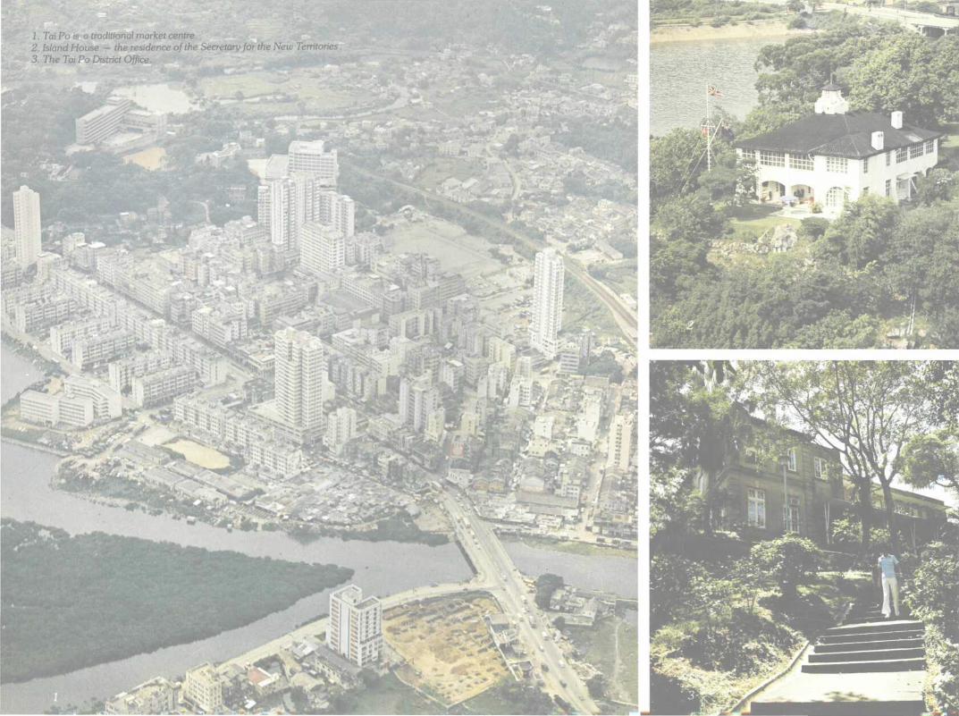
At present, Tai Po has a population of about 30,000.Many more people live in its peripheral areas, around theshores of Tolo Harbour and in the valleys leading up intothe surrounding hills and mountains. There is a strongfeeling of identity with the mountains and the sea whichform an attractive backdrop to Tai Po. The local fishingfleet can still be seen anchored off Tai Po Kau where theferry pier and other marine facilities are situated.
Agriculture still plays an important part in the localeconomy and much of the produce from the villages of thearea is sold from the market and hawker stalls in Tai Po.
The continuing pace of urban development inevitablymeans that agricultural land close to the town will be lost,but with such a large hinterland as Taipo enjoys thetraditional function of the town as a market centre willremain important in the future.
The Development PlanThe principal objective of the plan to expand Tai Po is todevelop a community within a more satisfactory urbanenvironment having an adequate range of commercial,industrial and community facilities. Much of the new landavailable for development will be reclaimed from the sea,but the existing areas of the town will also be furtherdeveloped and improved.
In carrying out reclamation, borrow areas will be broughtinto operation to provide the necessary filling materialand the proper reinstatement and after-use of these borrowareas is an important element in the overall plan.
The major land uses will be centred around thereclamation to the north and east of the existing town.Primarily for residential use — both public and private -the area will also include commercial development,principal community buildings such as the cultural complex,open space and some industrial land. North-east of thetown adjacent to Ting Kok Road, will be the Tai PoIndustrial Estate — already in the course of development.Peripheral areas will contain additional lower-densityresidential areas, further light industrial land, village areasand open space zones.
The ultimate population of the Tai Po area is expected tobe about 220,000 people, of whom some 170,000 wouldbe living in the Tai Po township itself.
TransportTai Po will be linked to Sha Tin New Town and Kowloonby a new coastal trunk road, which will eventually beextended to Yuen Long. The existing road connectingTai Po with Fanling will also be improved.
Rapid communications with Sha Tin, Kowloon and Fanlingwill also be provided by the Kowloon-Canton Railway. Theinitial stages of an extensive modernisation programme arealready under way with the double tracking of themain line between Hung Horn and Sha Tin and by the early1980's it is expected that this will have been extended toTai Po. Considerable improvements are also planned forthe rolling stock which will be in use on the railway. Theexpanded town will continue to be served by the stations atTai Po Market and Tai Po Kau which will themselvesbe modernised.
Within the town, a network of roads is planned to serveeach of the individual planning areas. This network will belinked to the trunk road by two interchanges. Anotherimportant link in the network will be the major roadplanned along the edge of the future reclamation to servethe industrial estate and the land uses within thereclaimed area.
1. Tai Po is a traditional market centre.2. Island House — the residence of the Secretary for the New Territories.3. The Tai Po District Office.
1. TaiPo Tau Village.2. A typical Hakka woman and her children
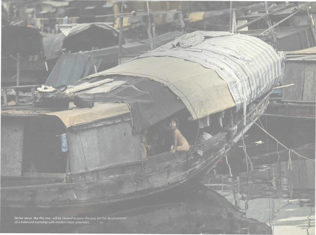
relax in the shade.3. The Yuen Chau Tsai squatter area which is
being cleared and re-developed.
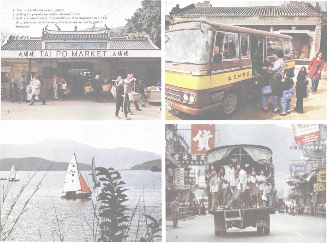
1. The Tai Po Market railway station.2. Sailing is a popular recreation around Tai Po.3 &4. Transport and communications will be improved in Tai Po.
At present, some of the remote villages are served by private \transport. * tfc A
TAI PO MARKI
Three main bus terminals are to be provided — one next toTai Po Market Railway Station and an other on reclaimedland. The third terminal will be incorporated within theindustrial estate, and certain housing estates may beprovided with sub-terminals to cater for local feederservices.
An extensive network of cycle tracks and pedestrian ways,separated from the major roads, will also be developed.
HousingThree public housing estates are planned for Tai Po, toaccommodate about 83,000 people.
Construction work on the first estate, for 30,000 people,has started and it should be occupied by the end of 1980.Land formation work for the estate is already in progressadjacent to Ting Kok Road. The second estate to providehomes for 30,000 people, will be located north of KwongFuk Road between Island House and the Police Bungalow.The last estate will be to the south of Tai Po Central Areaand will accommodate about 23,000 people.
Private residential development areas provided for in theplan are expected to house another 55,000 people. Theexisting residential areas have an estimated maximumpopulation capacity of 29,000. Developments in theperipheral areas, including low-density residential use insome of the borrow areas, are expected to accommodatethe balance of future population growth.
Industry and EmploymentSeveral areas have been set aside in the plan for thedevelopment of light industries, including service trades.
The Tai Po Industrial Estate now under development isexpected to provide better prospects for skilled workerswithin the community. Some workshop sites for small-scale service trades will be provided at appropriate locationswithin the high density residential areas. Commercialestablishments within the town will also provideemployment opportunities.
RecreationAs nearly 30 per cent of the population of the expandedtown will be under the age of 15, emphasis will be placedon the provision of an adequate range of recreationalfacilities linked together by the cycle track and footpathsystems.
The types of open space to be provided will range fromactive areas for organised games to landscaped picnic andviewing areas in the surrounding foothills.
A stadium and a swimming pool complex will be providedas well as riverside walks and waterfront open space.Weekend ferry trips to the Sai Kung Peninsula area areexpected to continue to increase in popularity, with theimproved ferry facilities at the Tai Po Kau being used moreintensively.Special emphasis has been placed on this aspect of thedevelopment and a comprehensive study on landscapingand recreational facilities is being undertaken torecommend and co-ordinate action that will enhance theenvironment of the new development.
One of the aims of the landscaping plan is to retain thepresent harmony between the town and the surroundingcountryside and harbour.
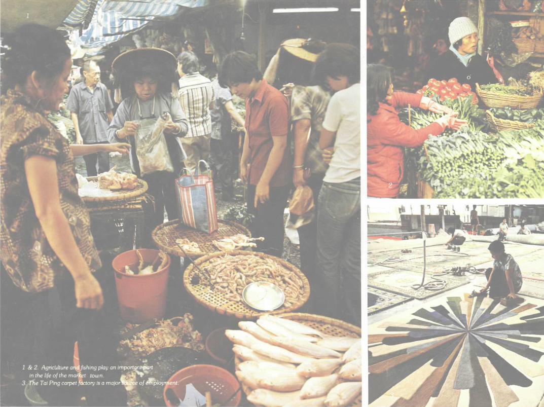
1 & 2. Agriculture ar^fishing p/ay ar
in the life of the market town.
importer) ̂ f»€i rt
m^H**"'e of arip/oyment.
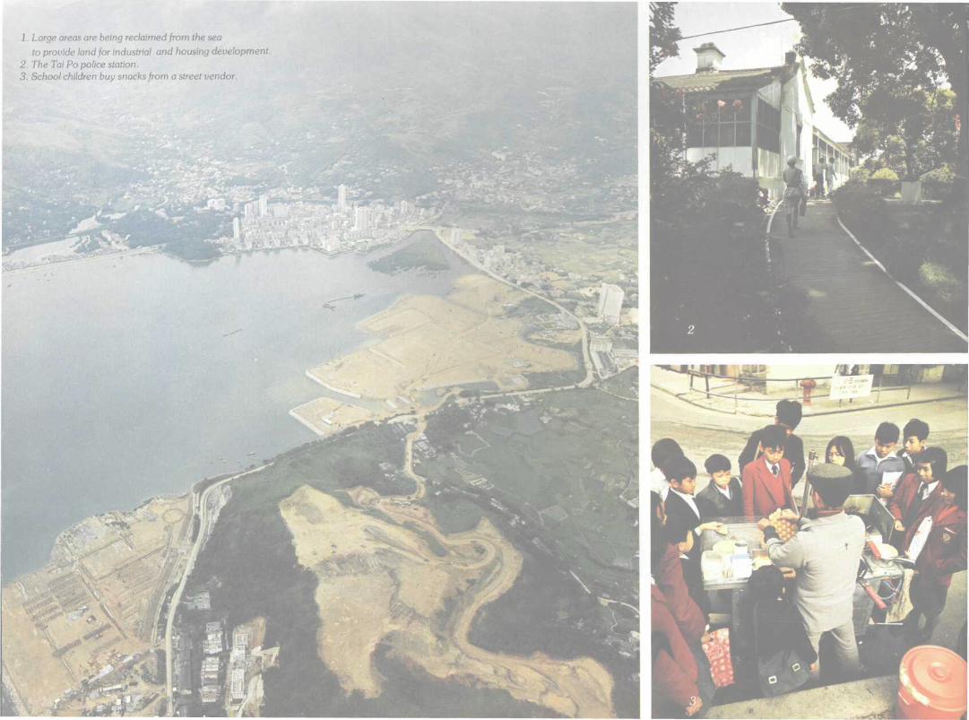
1. Large areas are being reclaimed from the seato provide land for industrial and housing development.
2. The Tai Po police station.3. School children buy snacks from a street vendor.
EducationThere are at present six secondary schools and sevenprimary schools in Tai Po. A new secondary school andtwo new primary schools will be provided within the publichousing estate in the first stage of Tai Po development,now in progress. Additional primary and secondary schoolswill be built in accordance with the Education Department'sprogramme. All planning areas will include site reservationsfor schools to ensure that every child receives a primaryschool education. From September 1978 every childentering secondary school will be assured of three years ofsecondary education.
Community FacilitiesTwo private clinics are now in operation at Tai Po and a sitefor a third government facility has been reserved adjacentto the central area. A site for a district hospital to meet long-term needs has also been reserved outside the main high-density <area of development.
The existing Tai Po police station will be retained on itspresent site but it. is likely that a new divisional station willbe required in the later stages of development.
The fire station in Ting Kok Road will be expanded to meetfuture requirements and a site for an ambulance depot hasbeen reserved.
Within the public housing estates, community halls or estatewelfare buildings will be provided to enable the SocialWelfare Department and voluntary agencies to workclosely with the people of Tai Po.
A cultural complex will also be built to serve Tai Po and thesurrounding area.
Estimated CostOver the 10-year development period, total expenditure inthe public sector for the expansion of Tai Po will be of theorder of $1,077 million at 1977 prices. Investment of asimilar magnitude is expected from private enterprise inproviding industries and private commercial and residentialbuildings.
The first stage of the work (Package 3) will cost about $90million. Formation of land and provision of services for apublic housing estate, as well as for sites for privatecommercial/residential development, are included in thisstage. Work for essential community facilities will also becarried out.
Sites will be available for disposal to the private sector forthe development of commercial/residential usesin late 1978.
11
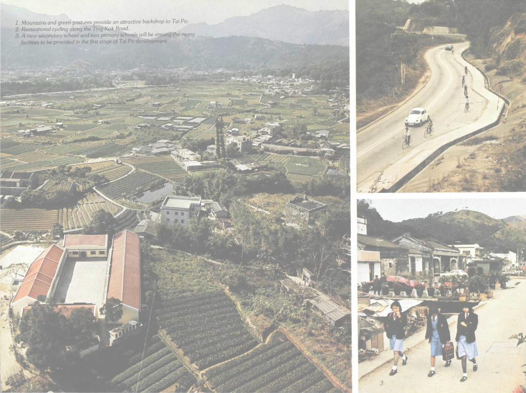
1. Mountains and green pastures provide an attractive backdrop to Tai Po.2. Recreational cycling along the Ting Kok Road.3. A new secondary school and two primary schools will be among the many
facilities to be provided in the first stage of Tai Po development.
Sheung Shui-Shek Wu Hui-Fanling Developmentgeneral land use proposal
250 500 750
i.identiai
1Public Housing
Village Type Housing
1 Light Industrial
Govt, Institution & Community
Public Open Space
Lowland Rural Area
Cartography by Lands & Survey Department PWD (© Hong Kong Government 1978 I
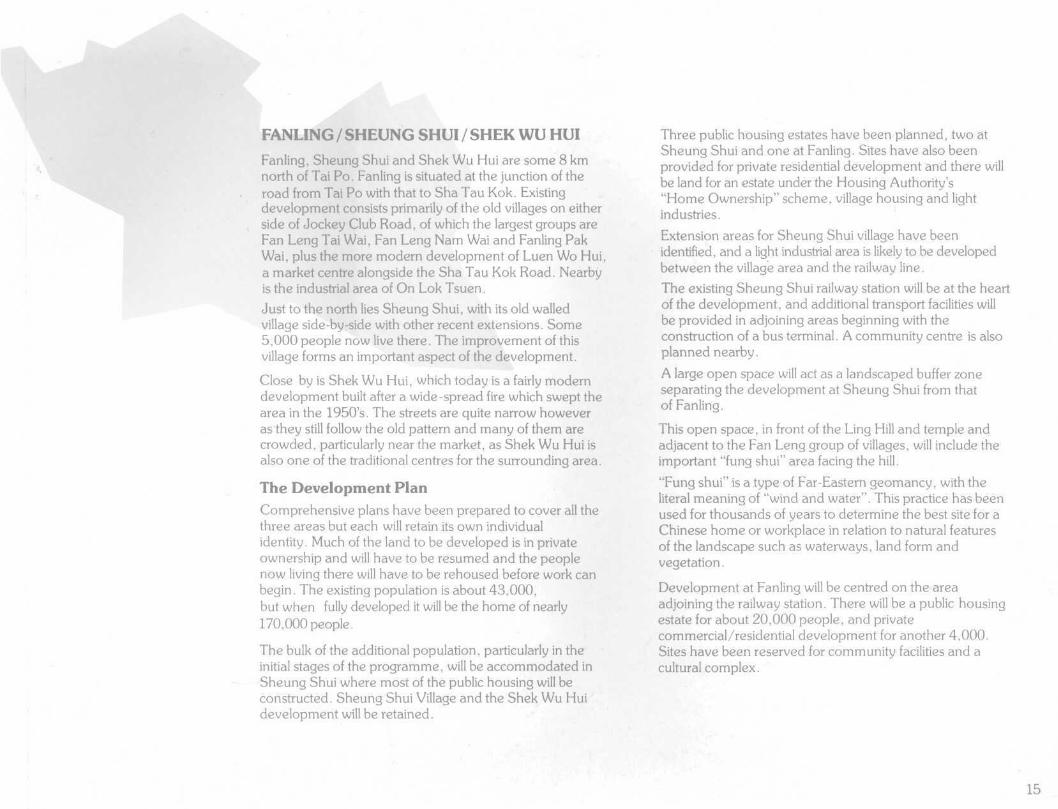
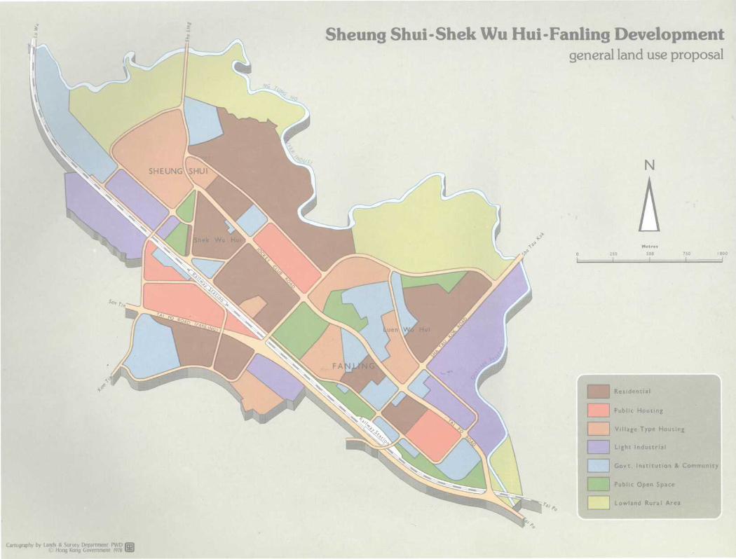
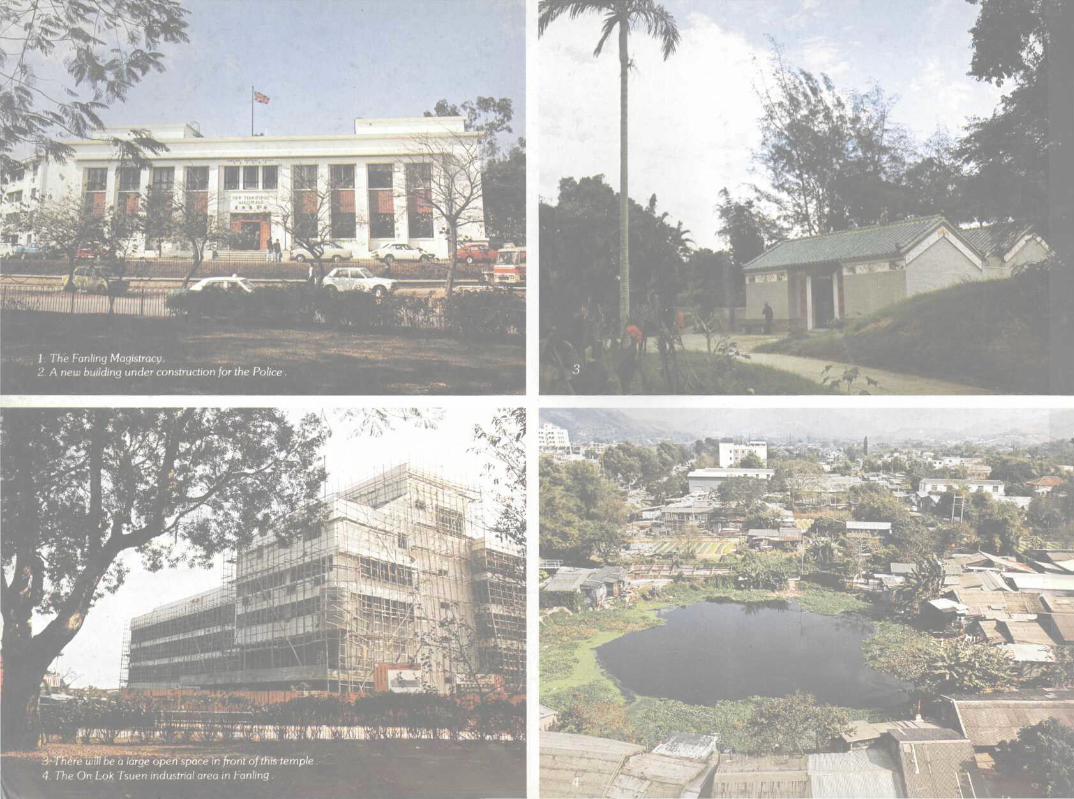
FANLING/SHEUNG SHUI/SHEK WU HUIFanling, Sheung Shui and Shek Wu Hui are some 8 kmnorth of Tai Po. Fanling is situated at the junction of theroad from Tai Po with that to Sha Tau Kok. Existingdevelopment consists primarily of the old villages on eitherside of Jockey Club Road, of which the largest groups areFan Leng Tai Wai, Fan Leng Nam Wai and Fanling PakWai, plus the more modern development of Luen Wo Hui,a market centre alongside the Sha Tau Kok Road. Nearbyis the industrial area of On Lok Tsuen.
Just to the north lies Sheung Shui, with its old walledvillage side-by-side with other recent extensions. Some5,000 people now live there. The improvement of thisvillage forms an important aspect of the development.
Close by is Shek Wu Hui, which today is a fairly moderndevelopment built after a wide-spread fire which swept thearea in the 1950s. The streets are quite narrow howeveras'they still follow the old pattern and many of them arecrowded, particularly near the market, as Shek Wu Hui isalso one of the traditional centres for the surrounding area.
The Development PlanComprehensive plans have been prepared to cover all thethree areas but each will retain its own individualidentity. Much of the land to be developed is in privateownership and will have to be resumed and the peoplenow living there will have to be rehoused before work canbegin. The existing population is about 43,000,but when fully developed it will be the home of nearly170,000 people.
The bulk of the additional population, particularly in theinitial stages of the programme, will be accommodated inSheung Shui where most of the public housing will beconstructed. Sheung Shui Village and the Shek Wu Huidevelopment will be retained.
Three public housing estates have been planned, two atSheung Shui and one at Fanling. Sites have also beenprovided for private residential development and there willbe land for an estate under the Housing Authority's"Home Ownership" scheme, village housing and lightindustries.
Extension areas for Sheung Shui village have beenidentified, and a light industrial area is likely to be developedbetween the village area and the railway line.
The existing Sheung Shui railway station will be at the heartof the development, and additional transport facilities willbe provided in adjoining areas beginning with theconstruction of a bus terminal. A community centre is alsoplanned nearby.
A large open space will act as a landscaped buffer zoneseparating the development at Sheung Shui from thatof Fanling.
This open space, in front of the Ling Hill and temple andadjacent to the Fan Leng group of villages, will include theimportant "fung shui" area facing the hill.
"Fung shui" is a type of Far-Eastern geomancy, with theliteral meaning of "wind and water". This practice has beenused for thousands of years to determine the best site for aChinese home or workplace in relation to natural featuresof the landscape such as waterways, land form andvegetation.
Development at Fanling will be centred on the areaadjoining the railway station. There will be a public housingestate for about 20,000 people, and privatecommercial/residential development for another 4,000.Sites have been reserved for community facilities and acultural complex.
15
1. Fan/ing, Sheung Shui and Shek Wu Hui are some 8 km north of Tai Po.2. "The Better Ole"restaurant near Fanling railway station.3. The Tai Po and Sheung Shui railway stations will be modernised. There, are
also plans for the double-tracking of the main line.
I
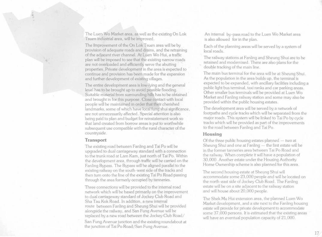
The Luen Wo Market area, as well as the existing On LokTsuen industrial area, will be improved.
The improvement of the On Lok Tsuen area will be byprovision of adequate roads and drains, and the retrainingof the adjacent river channel. At Luen Wo Hui, a trafficplan will be imposed to see that the existing narrow roadsare not overloaded and efficiently serve the abuttingproperties. Private development in the area is expected tocontinue and provision has been made for the expansionand further development of existing villages.
The entire development area is low-lying and the generallevel has to be brought up to avoid possible flooding.Suitable material from surrounding hills has to be obtainedand brought in for this purpose. Close contact with localpeople will be maintained in order that their cherishedlandmarks, some of which have local fung shui significance,are not unnecessarily affected. Special attention is alsobeing paid to plan and budget for reinstatement work sothat land created from borrow areas is put to worthwhilesubsequent use compatible with the rural character of thecountryside.
TransportThe existing road between Fanling and Tai Po will beupgraded to dual carriageway standard with a connectionto the trunk road at Lam Kam, just north of Tai Po. Withinthe development area, through traffic will be carried on theFanling Bypass. The Bypass will be aligned parallel to theexisting railway on the south-west side of the tracks andthen turn onto the line of the existing Tai Po Road passingthrough the area formerly occupied by tanneries.
Three connections will be provided to the internal roadnetwork which will be based primarily on the improvementto dual carriageway standard of Jockey Club Road andSha Tau Kok Road. In addition, a new internalroute between Fanling and Sheung Shui will be providedalongside the railway, and San Fung Avenue will bereplaced by a new road between the Jockey Club Road/San Fung Avenue junction and the existing roundabout atthe junction of Tai Po Road/San Fung Avenue.
An internal by-pass road to the Luen Wo Market areais also allowed for in the plan.
Each of the planning areas will be served by a system oflocal roads.
The railway stations at Fanling and Sheung Shui are to beretained and modernised. There are also plans for thedouble tracking of the main line.
The main bus terminal for the area will be at Sheung Shui.As the population in the area builds up, the terminal isexpected to be expanded, with ancillary facilities including apublic light bus terminal, taxi ranks and car parking areas.Other smaller bus terminals will be provided at Luen WoMarket and Fanling railway station and some may also beprovided within the public housing estates.
The development area will be served by a network offootpaths and cycle tracks which will be separated from themajor roads. This system will be linked to Tai Po by cycletracks which will be provided as part of the improvementsto the road between Fanling and Tai Po.
HousingOf the three public housing estates planned — two atSheung Shui and one at Fanling — the first estate will bein the former tanneries area between Tai Po Road andthe railway. When complete it will have a population of30,000. Another estate under the Housing AuthorityHome Ownership scheme is also planned for this area.
The second housing estate at Sheung Shui willaccommodate some 23,000 people and will be located onthe north-east side of Jockey Club Road. The Fanlingestate will be on a site adjacent to the railway stationand will house about 20,000 people.
The Shek Mu Hui extension area, the planned Luen WoMarket development, and a site next to the Fanling housingestate will provide for private development to accommodatesome 37,000 persons. It is estimated that the existing areaswill have an eventual population capacity of 21,000.
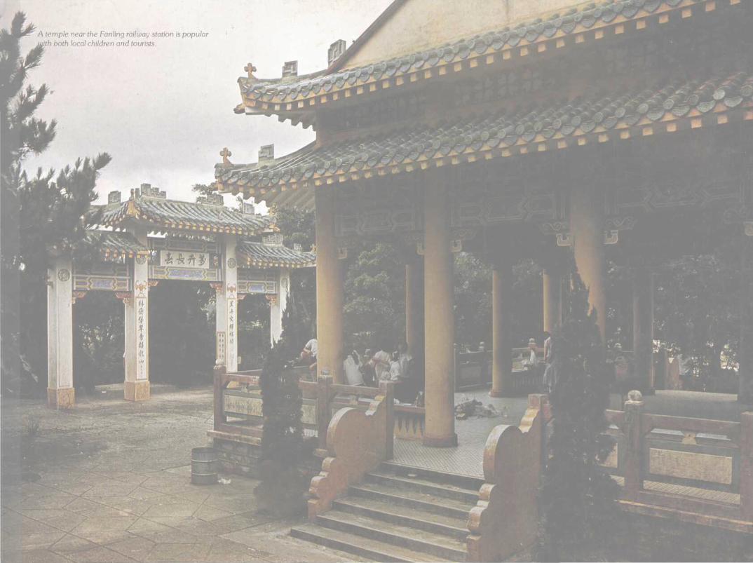
A temple near the Fanling railway station is popularmth both local children and tourists.
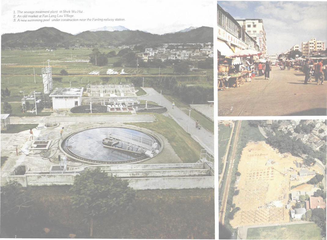
1. The sewage treatment plant at Shek Wu Hui.2. An old market at Fan Leng Lau Village.3. A new swimming pool under construction near the Fanling railway station.
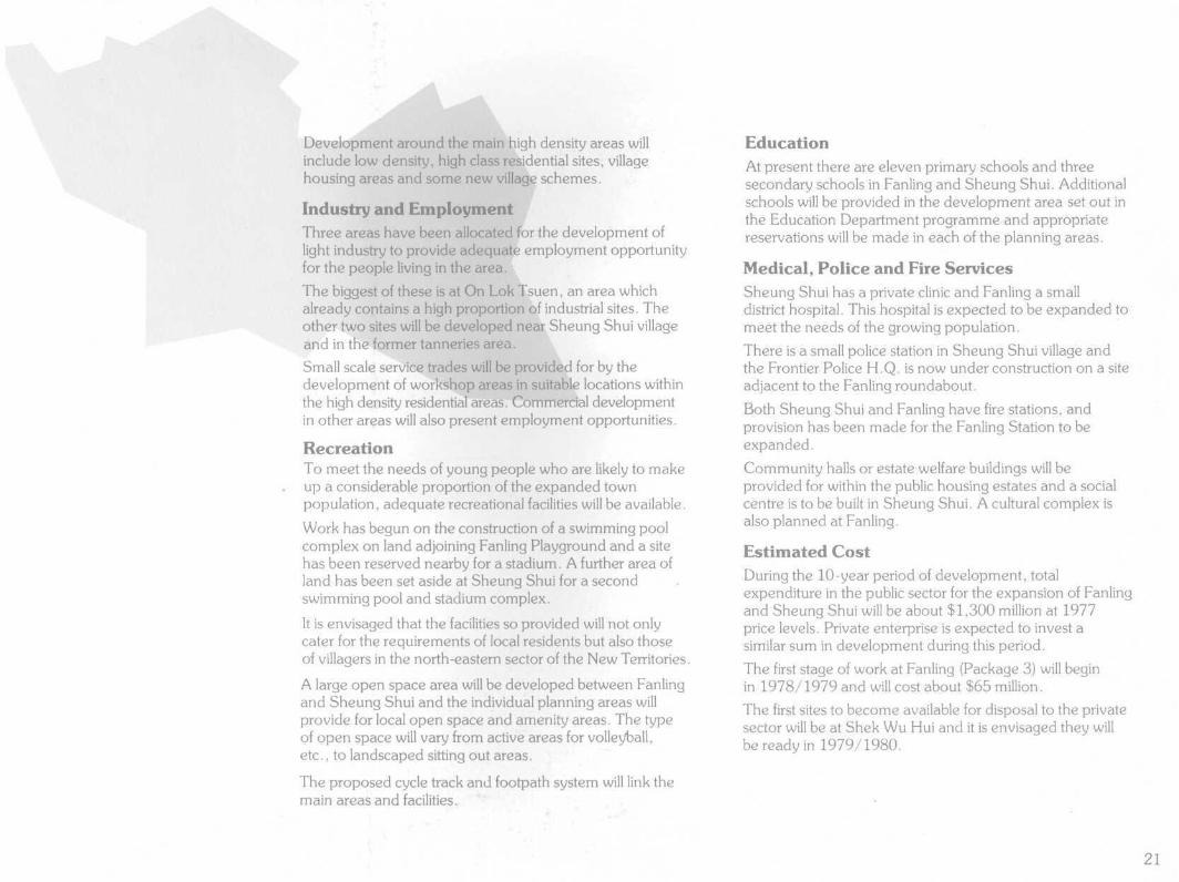
Development around the main high density areas willinclude low density, high class residential sites, villagehousing areas and some new village schemes.
Industry and EmploymentThree areas have been allocated for the development oflight industry to provide adequate employment opportunityfor the people living in the area.
The biggest of these is at On Lok Tsuen, an area whichalready contains a high proportion of industrial sites. Theother two sites will be developed near Sheung Shui villageand in the former tanneries area.
Small scale service trades will be provided for by thedevelopment of workshop areas in suitable locations withinthe high density residential areas. Commercial developmentin other areas will also present employment opportunities.
RecreationTo meet the needs of young people who are likely to makeup a considerable proportion of the expanded townpopulation, adequate recreational facilities will be available.
Work has begun on the construction of a swimming poolcomplex on land adjoining Fanling Playground and a sitehas been reserved nearby for a stadium. A further area ofland has been set aside at Sheung Shui for a secondswimming pool and stadium complex.
It is envisaged that the facilities so provided will not onlycater for the requirements of local residents but also thoseof villagers in the north-eastern sector of the New Territories.
A large open space area will be developed between Fanlingand Sheung Shui and the individual planning areas willprovide for local open space and amenity areas. The typeof open space will vary from active areas for volleyball,etc., to landscaped sitting out areas.
The proposed cycle track and footpath system will link themain areas and facilities.
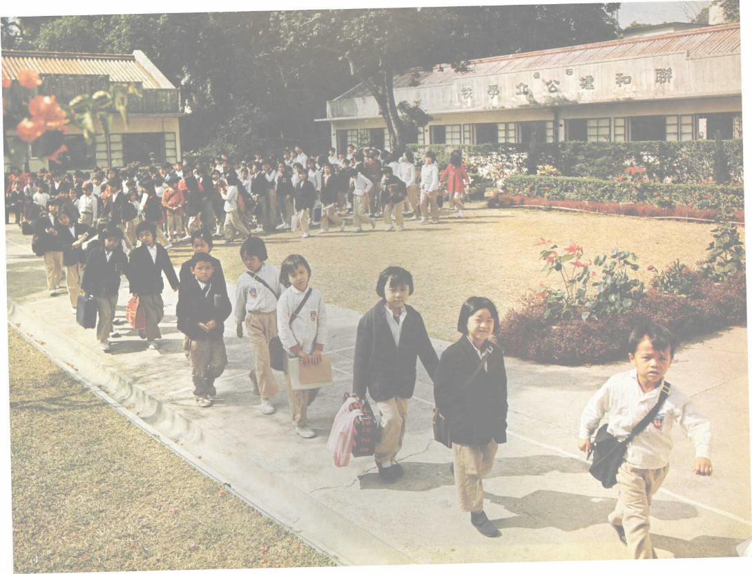
EducationAt present there are eleven primary schools and threesecondary schools in Fanling and Sheung Shui. Additionalschools will be provided in the development area set out inthe Education Department programme and appropriatereservations will be made in each of the planning areas.
Medical, Police and Fire ServicesSheung Shui has a private clinic and Fanling a smalldistrict hospital. This hospital is expected to be expanded tomeet the needs of the growing population.
There is a small police station in Sheung Shui village andthe Frontier Police H.Q. is now under construction on a siteadjacent to the Fanling roundabout.
Both Sheung Shui and Fanling have fire stations, andprovision has been made for the Fanling Station to beexpanded.
Community halls or estate welfare buildings will beprovided for within the public housing estates and a socialcentre is to be built in Sheung Shui. A cultural complex isalso planned at Fanling.
Estimated CostDuring the 10-year period of development, totalexpenditure in the public sector for the expansion of Fanlingand Sheung Shui will be about $1,300 million at 1977price levels. Private enterprise is expected to invest asimilar sum in development during this period.
The first stage of work at Fanling (Package 3) will beginin 1978/1979 and will cost about $65 million.
The first sites to become available for disposal to the privatesector will be at Shek Wu Hui and it is envisaged they willbe ready in 1979/1980.
21
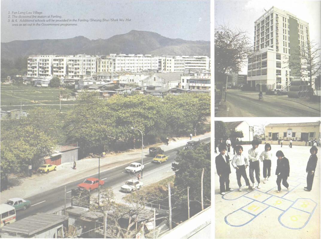
1. Fan Leng Lau Village.2. The divisional fire station at Fanling.3 & 4. Additional schools will be provided in the Fanling/Sheung Shui/Shek Wu Hui
area as set out in the Government programme.
\
N
Metres100 200 300 400 500
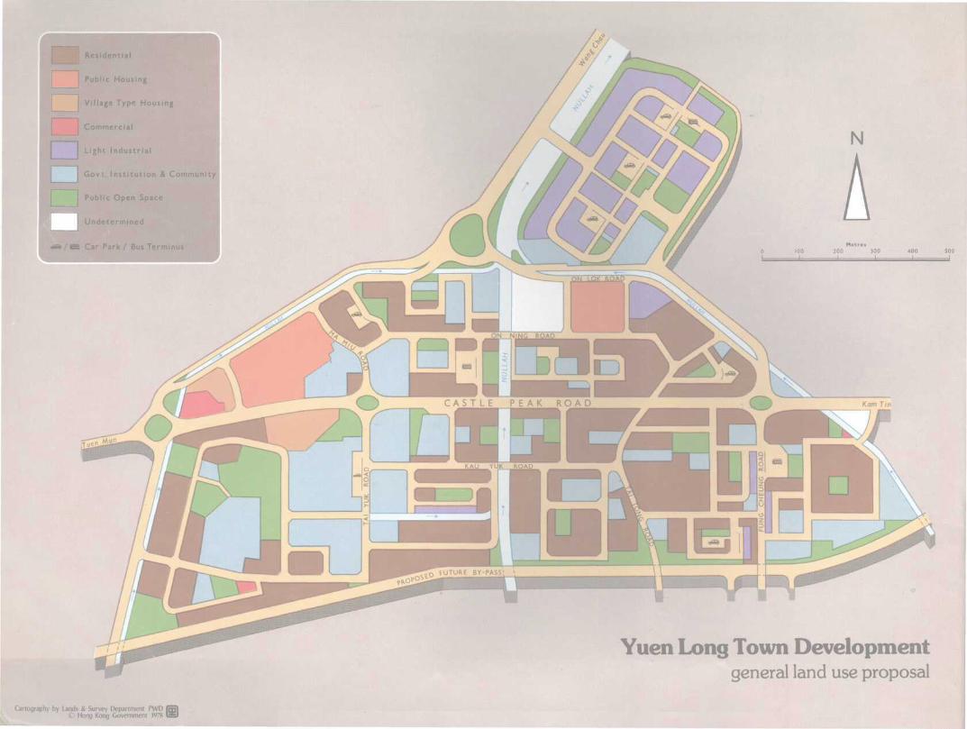
Yuen Long Town Developmentgeneral land use proposal
Cartography by Lands & Survey Department PWD (* Hong Kong Government 1978 \
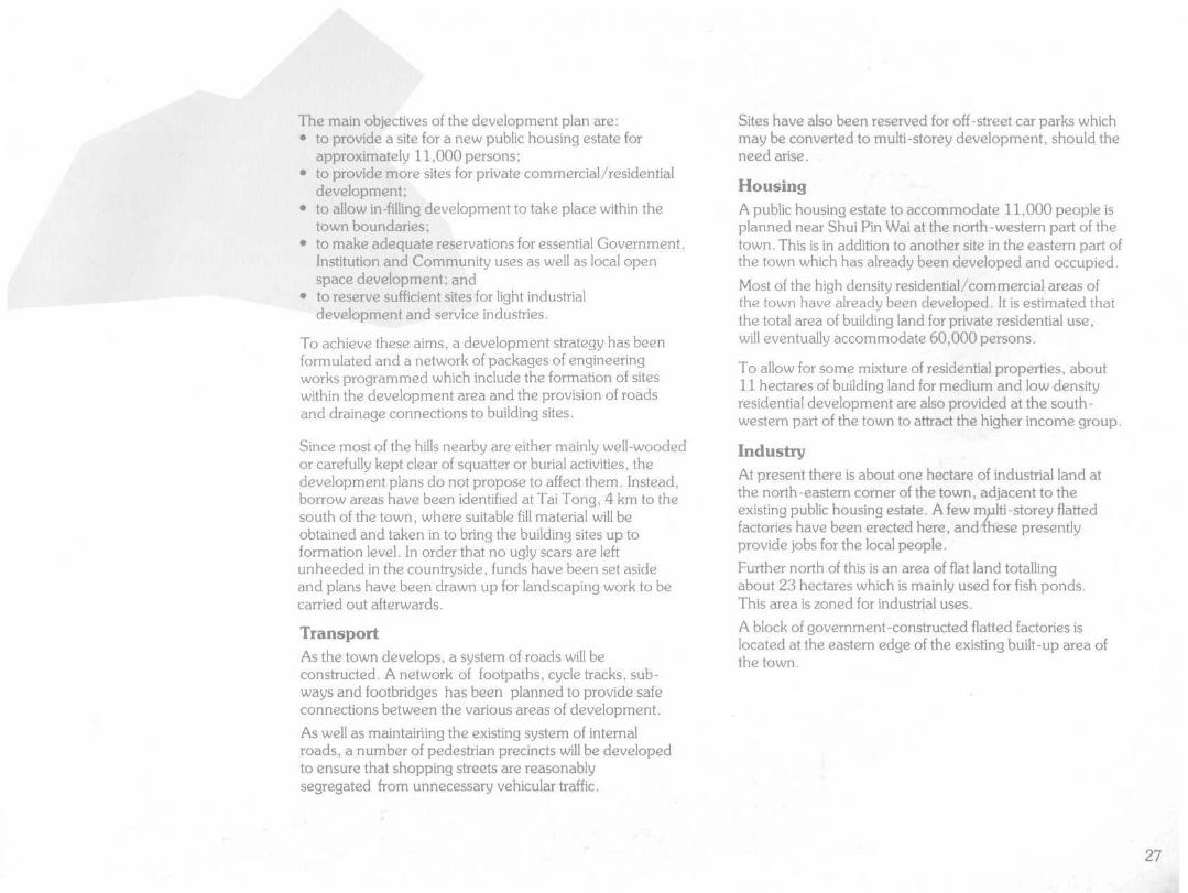
YUENLONGYuen Long occupies a strategic location in the middle of thelargest flood plain in the north-western part of the NewTerritories, and is the traditional market centre for theagricultural produce of the surrounding villages, farmlandsand fish ponds. Part of the old town may still be seento-day in the Kau Hui (Old Market) area.
It is 40 km by road from the existing urban areas ofKowloon, 22 km from the Tsuen Wan New Town, 6.5 kmfrom Tuen Mun New Town, 16 km from Sheung Shui(via San Tin) and Tai Po (via Lam Tsuen).
The planned development at Yuen Long will cover an areaof approximately 160 hectares.
Rapid development including the provision of infrastructureduring the past decade has resulted in an increase of thetown population to about 37,000 persons, mainly due toinflux from the surrounding countryside.
With further development of the town and its light industrialarea, a higher rate of population growth is envisaged. Itspresent population is expected to grow to an ultimatefigure of 95,000 in the next 10 to 15 years when all thebuilding land presently reserved for residential,commercial/residential uses and for public housing isdeveloped and occupied.
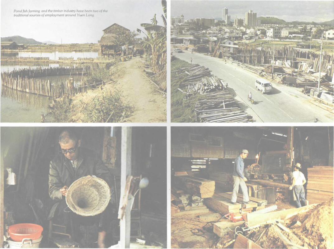
Over the years, the town has been providing the mainemployment opportunities for its hinterland population withits private-run wholesale marketing facilities and serviceindustries.
The influence of industrialisation has however spread to thisrelatively remote area and demand for proper industrialpremises has increased in recent years. This trend isexpected to continue in particular following the establishmentof labour-intensive light industrial/manufacturing sector.
Some 15 to 20 per cent of the future population isexpected to seek jobs in the labour-intensive light industrial/manufacturing sector. The proposed industrial estate atWang Chau, little more than a kilometre north of YuenLong town, will provide sites for special land-intensive typeindustries similar to those in the Tai Po Industrial estate.
The Development PlanWith the territory-wide population increase, the demandfor more building land for various urban uses, theimprovement of the New Territories Circular Road, thecompletion of the bulk of flood control schemes and othermajor public works projects, more systematic developmentof the town took place in accordance with planninglayouts in the mid '60s.
These planning layouts form the basis of the presentdevelopment plan of the market town. The principalobjective of the plan is to foster the growth of balancedcommunities with adequate commercial, industrialand community services in the further development andredevelopment of the area.
25
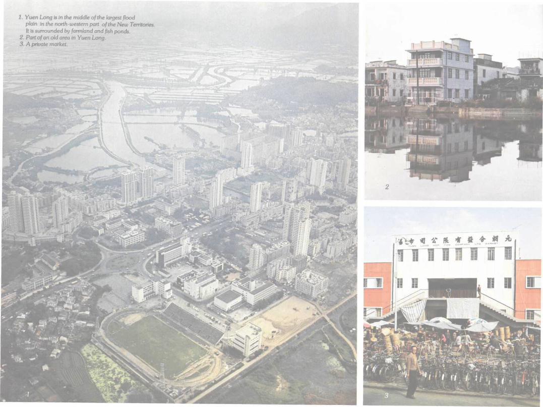
1. Yuen Long is in the middle of the largest floodplain in the north-western part of the New Territories.It is surrounded by /arm/and and fish ponds.
2. Part of an old area in Yuen Long.3. A private market.
.nnnnn
The main objectives of the development plan are:• to provide a site for a new public housing estate for
approximately 11,000 persons;• to provide more sites for private commercial/residential
development;• to allow in-filling development to take place within the
town boundaries;• to make adequate reservations for essential Government,
Institution and Community uses as well as local openspace development; and
• to reserve sufficient sites for light industrialdevelopment and service industries.
To achieve these aims, a development strategy has beenformulated and a network of packages of engineeringworks programmed which include the formation of siteswithin the development area and the provision of roadsand drainage connections to building sites.
Since most of the hills nearby are either mainly well-woodedor carefully kept clear of squatter or burial activities, thedevelopment plans do not propose to affect them. Instead,borrow areas have been identified at Tai Tong, 4 km to thesouth of the town, where suitable fill material will beobtained and taken in to bring the building sites up toformation level. In order that no ugly scars are leftunheeded in the countryside, funds have been set asideand plans have been drawn up for landscaping work to becarried out afterwards.
TransportAs the town develops, a system of roads will beconstructed. A network of footpaths, cycle tracks, sub-ways and footbridges has been planned to provide safeconnections between the various areas of development.
As well as maintaining the existing system of internalroads, a number of pedestrian precincts will be developedto ensure that shopping streets are reasonablysegregated from unnecessary vehicular traffic.
Sites have also been reserved for off-street car parks whichmay be converted to multi-storey development, should theneed arise.
HousingA public housing estate to accommodate 11,000 people isplanned near Shui Pin Wai at the north-western part of thetown. This is in addition to another site in the eastern part ofthe town which has already been developed and occupied.
Most of the high density residential/commercial areas ofthe town have already been developed. It is estimated thatthe total area of building land for private residential use,will eventually accommodate 60,000 persons.
To allow for some mixture of residential properties, about11 hectares of building land for medium and low densityresidential development are also provided at the south-western part of the town to attract the higher income group.
IndustryAt present there is about one hectare of industrial land atthe north-eastern corner of the town, adjacent to theexisting public housing estate. A few multi-storey flattedfactories have been erected here, andThese presentlyprovide jobs for the local people.
Further north of this is an area of flat land totallingabout 23 hectares which is mainly used for fish ponds.This area is zoned for industrial uses.
A block of government-constructed flatted factories islocated at the eastern edge of the existing built-up area ofthe town.
27
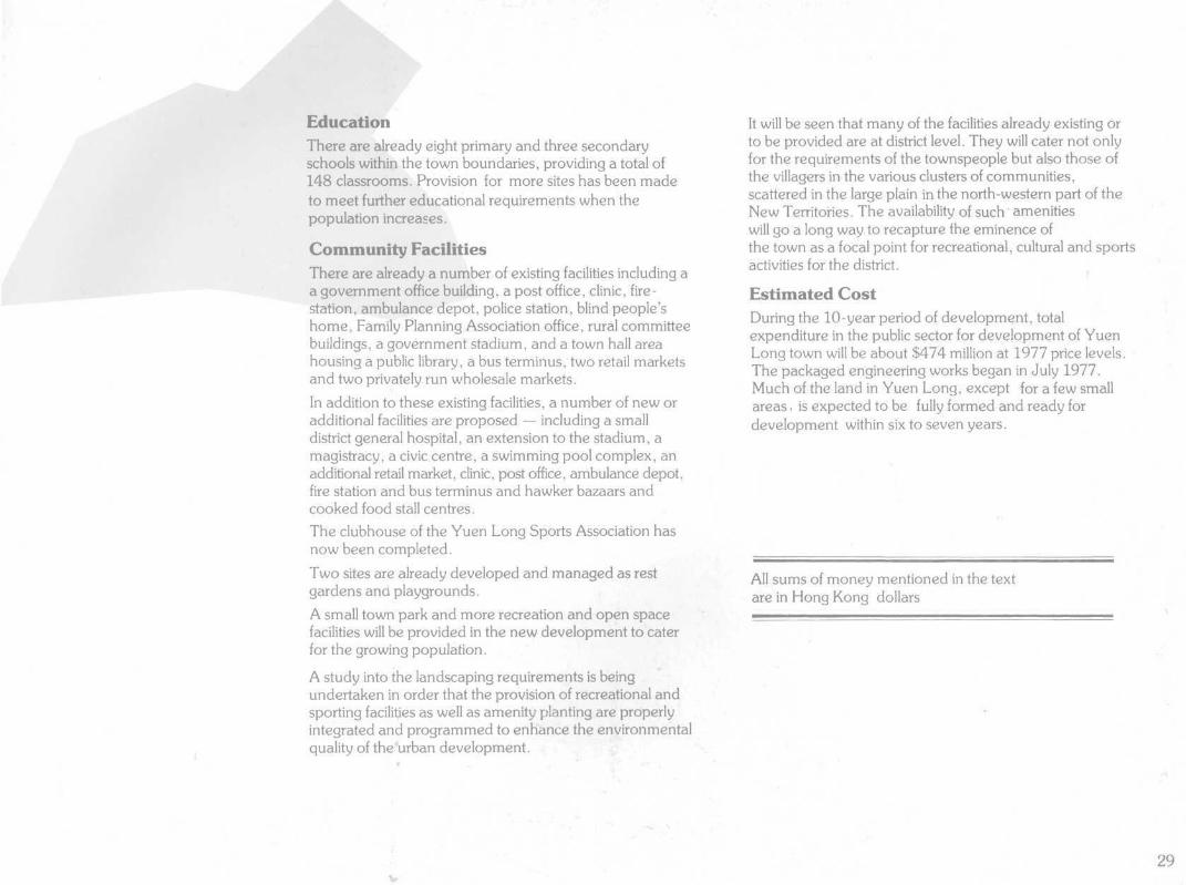
Pond fish farming and the timber industry have been two of thetraditional sources of employment around Yuen Long.
EducationThere are already eight primary and three secondaryschools within the town boundaries, providing a total of148 classrooms. Provision for more sites has been madeto meet further educational requirements when thepopulation increases.
Community FacilitiesThere are already a number of existing facilities including aa government office building, a post office, clinic, fire-station, ambulance depot, police station, blind people'shome, Family Planning Association office, rural committeebuildings, a government stadium, and a town hall areahousing a public library, a bus terminus, two retail marketsand two privately run wholesale markets.
In addition to these existing facilities, a number of new oradditional facilities are proposed — including a smalldistrict general hospital, an extension to the stadium, amagistracy, a civic centre, a swimming pool complex, anadditional retail market, clinic, post office, ambulance depot,fire station and bus terminus and hawker bazaars andcooked food stall centres.The clubhouse of the Yuen Long Sports Association hasnow been completed.
Two sites are already developed and managed as restgardens and playgrounds.
A small town park and more recreation and open spacefacilities will be provided in the new development to caterfor the growing population.
A study into the landscaping requirements is beingundertaken in order that the provision of recreational andsporting facilities as well as amenity planting are properlyintegrated and programmed to enhance the environmentalquality of the "urban development.
It will be seen that many of the facilities already existing orto be provided are at district level. They will cater not onlyfor the requirements of the townspeople but also those ofthe villagers in the various clusters of communities,scattered in the large plain in the north-western part of theNew Territories. The availability of such amenitieswill go a long way to recapture the eminence ofthe town as a focal point for recreational, cultural and sportsactivities for the district.
Estimated CostDuring the 10-year period of development, totalexpenditure in the public sector for development of YuenLong town will be about $474 million at 1977 price levels.The packaged engineering works began in July 1977.Much of the land in Yuen Long, except for a few smallareas, is expected to be fully formed and ready fordevelopment within six to seven years.
All sums of money mentioned in the textare in Hong Kong dollars
29
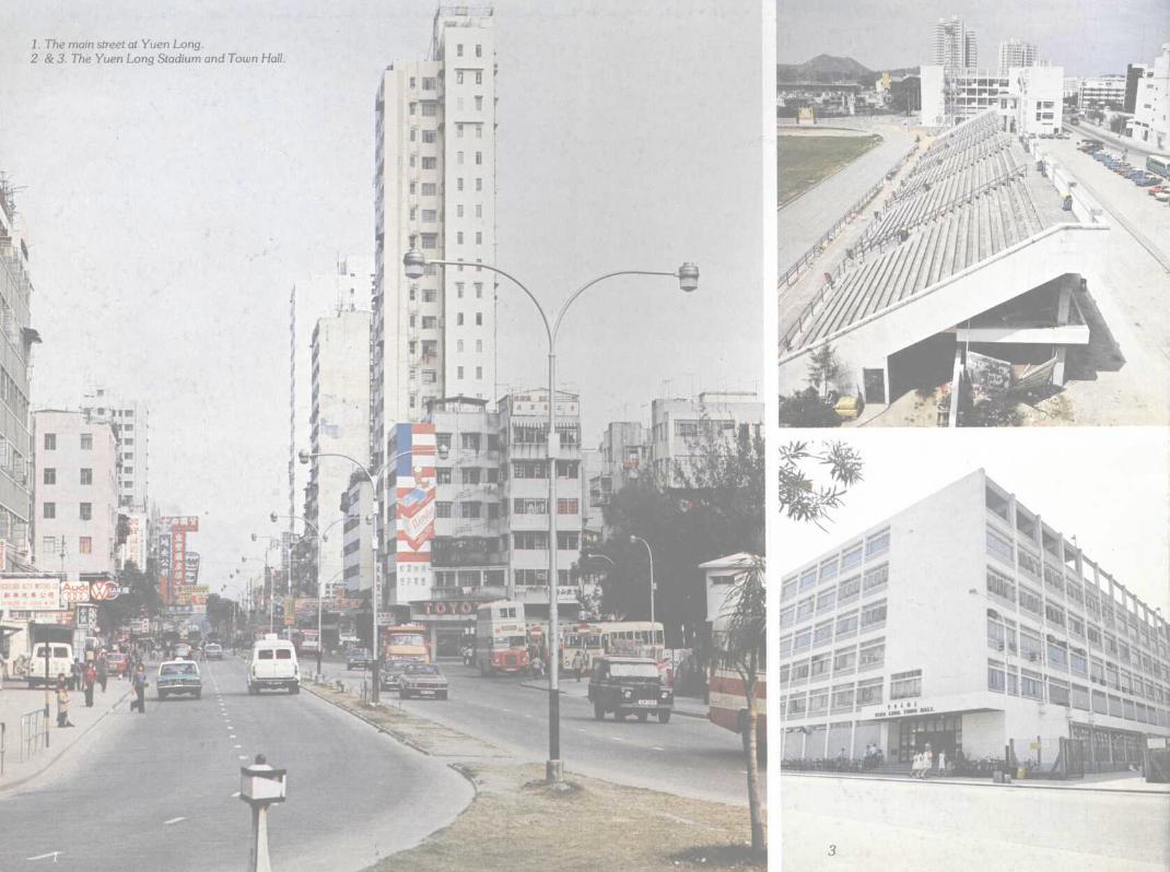
1. The main street at Yuen Long.2 &3. The Yuen Long Stadium and Town Hall
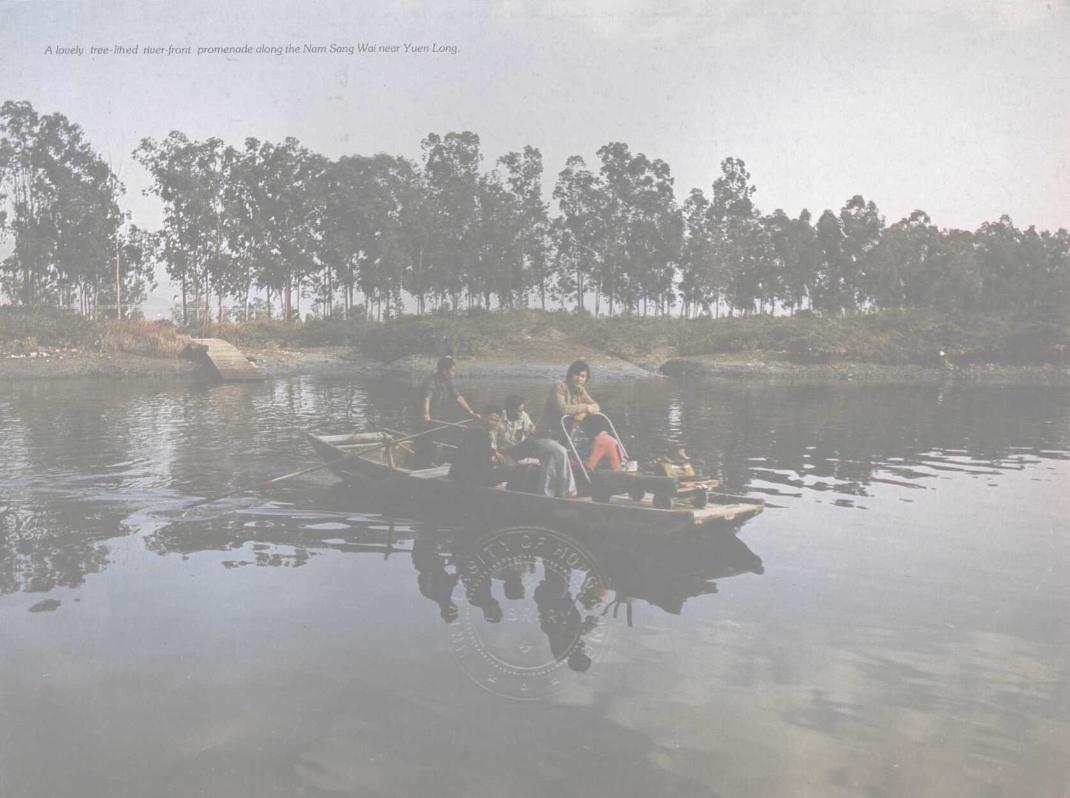
A lovely tree- lined river-front promenade along the Nam Sang Wai near Yuen Long.
XD17flSlbl
180
160
140
120
100
80
60
40
after1987
86-87
85-86
84-85
83-84
82-83
81-82
80-81
79-80
78-79
77-78
Mar. 77
TaiPo
Sheung ShuiShekWuHuiFanling
Populationin
Market Towns1977-1987
Yuen Long
Personsin thousands
220
180
Cartography by Lands & Survey Department PWD I© Hong Kong Government 1978 I
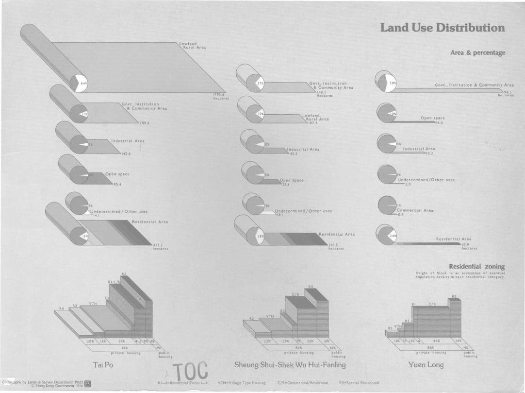
Land Use Distribution\Lowland
al Area
Area & percentage
jGovt., Institution& Community Area
ustr ial Area
1793.4hectares
\Govt., Institution\& Community Area
\Lowland\Rural Area
Industrial Area45.5
Govt., Institution & Community Area
^94,5
Indetermined/Other uses
ndetermined/ Other uses.1
e s e n t i a
_5BMkM
Area
\Undetermined /Other uses
Residentia*! Area
210.5hectares
Commercial Area0.7
Residential Area^37.9
hectares
TaiPo Sheung Shui-Shek Wu Hui-Fanling
Residential zoningHeight of block is an indication of eventualpopulation density in each residential category.
private housing publichousing
Yuen Long
O'to£/aphy by Lands & Survey Department PWD I© Hong Kong Government 1978 I
R.I— 4=Restdential Zones !—4 VTH==V!l}age Type Housing C/R=Commercial/Restdential RS^Speciai Residenttj
711.4095125 1281351Hong Kong. New Territories Develop-ment Dept.
Market towns. 1979.
DateDue
Borrower's DateNo. I Due
I
Date Due
& *Y?f
Borrower'sNo.
1281351
[HKP] 711.4095125 H77 m
XD17fiSlbl