Embed Size (px)
Citation preview

Kii
min
kijo
kiSu
omi -
Fin
land
Kuva: A. Peltola

ElämyKsiä KiiminKijoElla
Kiiminkijoki.fi
Kuva: V-M. M
urtovaara
Kuva: V-M. M
urtovaara
suomiFinland
napapiiriArctic Circle
VenäjäRussia
RuotsiSweden
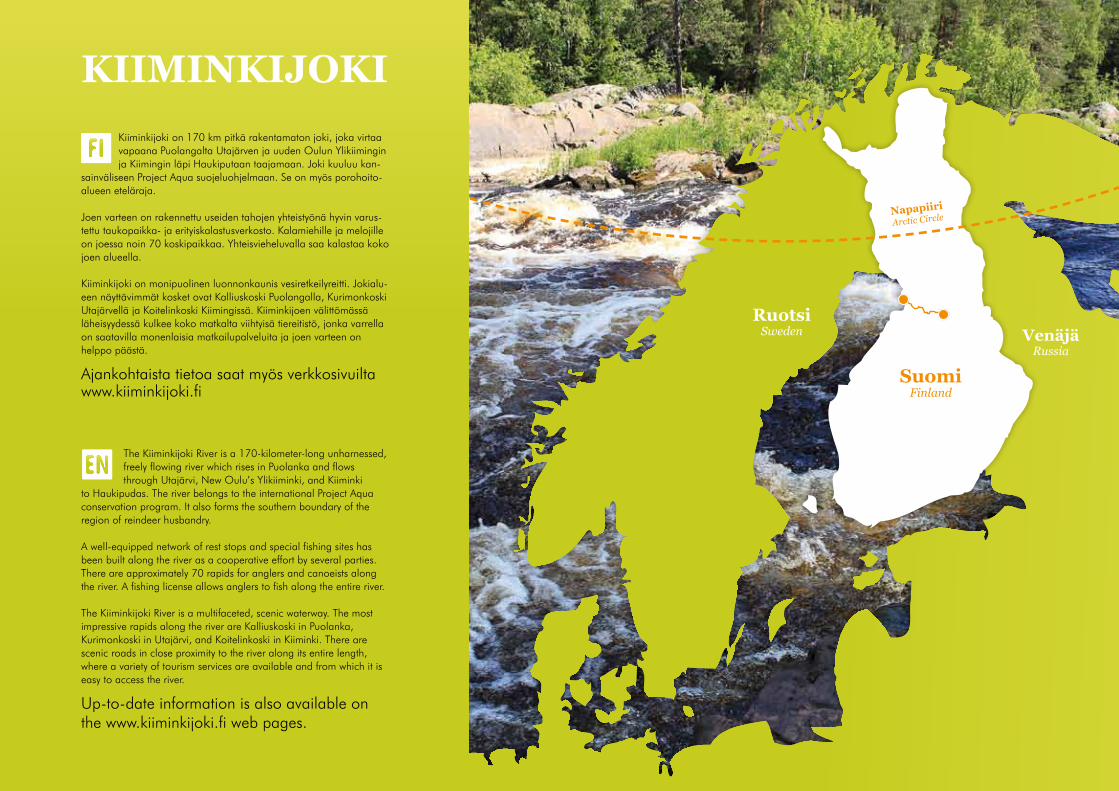
KiiminKijoKiKiiminkijoki on 170 km pitkä rakentamaton joki, joka virtaa vapaana Puolangalta Utajärven ja uuden Oulun Ylikiimingin ja Kiimingin läpi Haukiputaan taajamaan. Joki kuuluu kan-
sainväliseen Project Aqua suojeluohjelmaan. Se on myös porohoito-alueen eteläraja.
Joen varteen on rakennettu useiden tahojen yhteistyönä hyvin varus-tettu taukopaikka- ja erityiskalastusverkosto. Kalamiehille ja melojille on joessa noin 70 koskipaikkaa. Yhteisvieheluvalla saa kalastaa koko joen alueella.
Kiiminkijoki on monipuolinen luonnonkaunis vesiretkeilyreitti. Jokialu-een näyttävimmät kosket ovat Kalliuskoski Puolangalla, Kurimonkoski Utajärvellä ja Koitelinkoski Kiimingissä. Kiiminkijoen välittömässä läheisyydessä kulkee koko matkalta viihtyisä tiereitistö, jonka varrella on saatavilla monenlaisia matkailupalveluita ja joen varteen on helppo päästä.
Ajankohtaista tietoa saat myös verkkosivuilta www.kiiminkijoki.fi
The Kiiminkijoki River is a 170-kilometer-long unharnessed, freely flowing river which rises in Puolanka and flows through Utajärvi, New Oulu’s Ylikiiminki, and Kiiminki
to Haukipudas. The river belongs to the international Project Aqua conservation program. It also forms the southern boundary of the region of reindeer husbandry.
A well-equipped network of rest stops and special fishing sites has been built along the river as a cooperative effort by several parties. There are approximately 70 rapids for anglers and canoeists along the river. A fishing license allows anglers to fish along the entire river.
The Kiiminkijoki River is a multifaceted, scenic waterway. The most impressive rapids along the river are Kalliuskoski in Puolanka, Kurimonkoski in Utajärvi, and Koitelinkoski in Kiiminki. There are scenic roads in close proximity to the river along its entire length, where a variety of tourism services are available and from which it is easy to access the river.
Up-to-date information is also available on the www.kiiminkijoki.fi web pages.

Kiiminkijoki on suosittu vesiretkeilyreitti. Joella järjeste-tään mm. ohjattuja melontasafareita, melontakursseja, koskenlaskua kumilautalla ja koskiuintia.
Aloittelijan kannattaa vuokrata kanootti oppaineen joltakin tässä esitteessä mainitulta yritykseltä, seuralta tai osallistua ohjelmapalveluyritysten järjestämiin pal-veluihin. Kanoottiretkeily on yleisesti ottaen turvallinen harrastus, edellyttäen että vaaratekijät poistetaan.
Meloen matkailijalle avautuu aivan uusi, kaunis pers-pektiivi ja melonta on helpompaa kuin usein luullaan.
Utajärvellä sijaitsee neljän suuremman järven muodos-tama n. 10 km pituinen rauhallinen jakso. Suurimmat kosket (vaikeusluokka III) ovat Puolangan Kalliuskoski, Utajärven Kurimonkoski ja Kiimingin Koitelinkoski. Me-lontareitti sopii hyvin myös aloittelijalle, sillä suurimmat kosket voidaan helposti kiertää maitse. Keskikesällä melontaa vaikeuttaa ajoittainen vähävetisyys.
Reitti on leveä, mutta joki voi mutkitella. Helppoja esteitä, pientä aal-lokkoa. Kaaduttaessa eskimon teko ei tuota vaaraa. Uiminen sinänsä vaaratonta.
Reitti on leveä ja selvästi havaittavissa meloessa. Siinä on aallokkoa ja useita esteitä, jotka ovat kuitenkin helposti kierrettävissä. Lisäksi on pieniä stoppareita ja könkäitä, joista voi meloa ylitse, sekä akanvirtoja. Eskimon teko yleensä helppoa. Uiminen ei tavallisesti aiheuta mustel-mia vakavampaa vahinkoa.
Reitin löytäminen hankalaa melottaessa, mutta etukäteistarkastus rannalta auttaa reitin löytämisessä. Reitti on mutkikas ja vaatii taitavaa melomista. Aallokko on epäsäännöllistä ja korkeaa, esteiden kiertä-minen vaatii osaamista, mutta voi tuottaa vaikeuksia retkikalustolla. Akanvirrat voimakkaita. Stopparit ja könkäät voi meloa ylitse, mutta ne voivat tuottaa vaikeuksia jos käytössä ei ole sopivaa kalustoa. Uiminen koskessa ei yleensä aiheuta vakavaa loukkaantumisvaaraa ja pelasta-minen normaalisti helppoa.(Ylemmät luokat ovat vielä vaativampia, mutta Kiiminkijoesta ei III-luokkaa vaativampia koskia löydy)
Kansainvälinen koskiluokitus on tehty matalan veden korkeudelle.
Luokka I - helppo
Luokka II - vaikeahko
Luokka III - vaikea
mElonta- ja VEsiaKtiVitEEtit
Kansainvälinen koskiluokitus
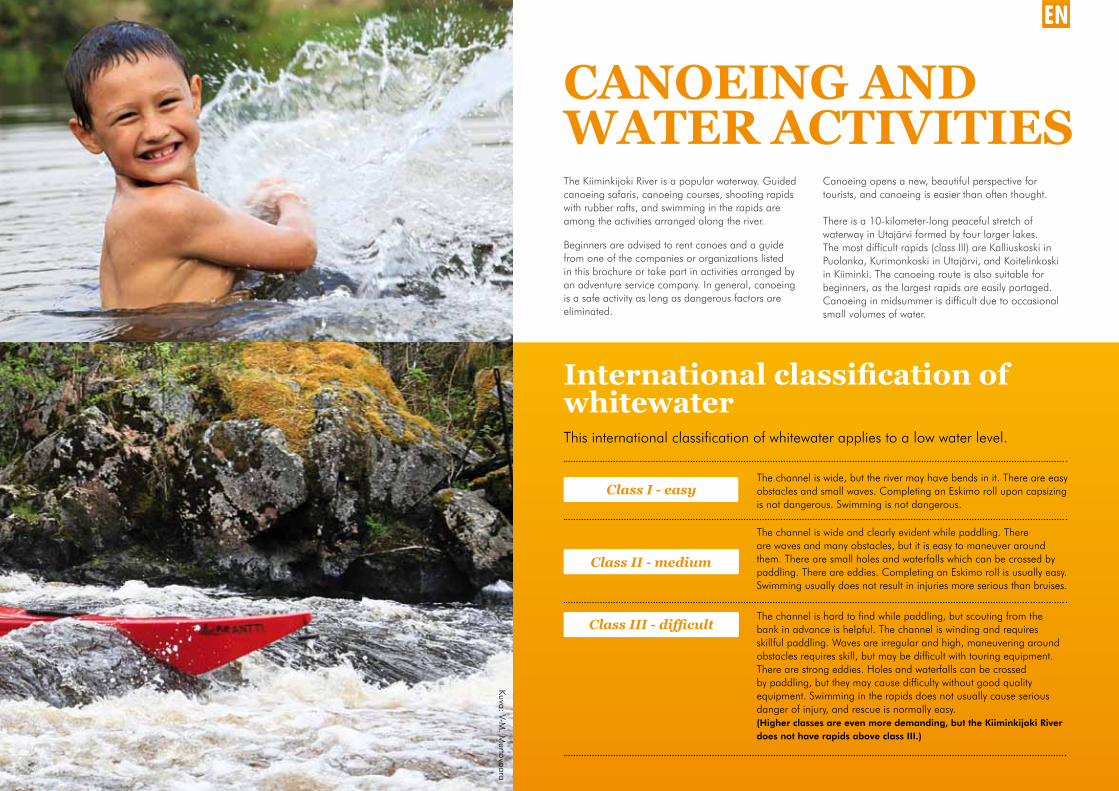
The Kiiminkijoki River is a popular waterway. Guided canoeing safaris, canoeing courses, shooting rapids with rubber rafts, and swimming in the rapids are among the activities arranged along the river.
Beginners are advised to rent canoes and a guide from one of the companies or organizations listed in this brochure or take part in activities arranged by an adventure service company. In general, canoeing is a safe activity as long as dangerous factors are eliminated.
Canoeing opens a new, beautiful perspective for tourists, and canoeing is easier than often thought.
There is a 10-kilometer-long peaceful stretch of waterway in Utajärvi formed by four larger lakes. The most difficult rapids (class III) are Kalliuskoski in Puolanka, Kurimonkoski in Utajärvi, and Koitelinkoski in Kiiminki. The canoeing route is also suitable for beginners, as the largest rapids are easily portaged. Canoeing in midsummer is difficult due to occasional small volumes of water.
The channel is wide, but the river may have bends in it. There are easy obstacles and small waves. Completing an Eskimo roll upon capsizing is not dangerous. Swimming is not dangerous.
The channel is wide and clearly evident while paddling. There are waves and many obstacles, but it is easy to maneuver around them. There are small holes and waterfalls which can be crossed by paddling. There are eddies. Completing an Eskimo roll is usually easy. Swimming usually does not result in injuries more serious than bruises.
The channel is hard to find while paddling, but scouting from the bank in advance is helpful. The channel is winding and requires skillful paddling. Waves are irregular and high, maneuvering around obstacles requires skill, but may be difficult with touring equipment. There are strong eddies. Holes and waterfalls can be crossed by paddling, but they may cause difficulty without good quality equipment. Swimming in the rapids does not usually cause serious danger of injury, and rescue is normally easy.(Higher classes are even more demanding, but the Kiiminkijoki River does not have rapids above class III.)
This international classification of whitewater applies to a low water level.
Class I - easy
Class II - medium
Class III - difficult
CanoEing and watER aCtiVitiEs
international classification of whitewater
Kuva: V-M. M
urtovaara

Kuva: A. Peltola


Kiiminkijoen melontareitin koski-luokitus on tehty matalan veden korkeudella. (Suluissa ilmoitettu luokka kertoo tulvaveden tilanteen.) Lisäksi käytetään yksittäisiä vaa-ranpaikkoja kuvaavia !-merkkejäThis classification of whitewater along the Kiiminkijoki River canoeing route applies to a low water level.(Classes given in parentheses indicate floodwater conditions.)In addition, exclamation points (!) are used to depict individual dangerous places.
! = vaarallinen paikka, jossa epäon-nistuminen ja siitä johtuvat seuraukset eivät taitavan melojan kannalta ole kovin todennäköisiä! = a dangerous place where errors and their consequences are not very probable for experienced paddlers.
! ! = vaarallinen paikka, jossa epäon-nistumisen riski ja epäonnistumisesta johtuvat kielteiset seuraukset ovat sellaiset, että kaikkien melojien on otettava ne hyvin vakavasti.! ! = a dangerous place where the risk of error and resulting negative consequences are such that all paddlers should take them seriously.
! ! ! = vaarallinen paikka, jossa vaara-tilanteen välttäminen on myös huippu-melojalle hyvin vaikeaa.! ! ! = a dangerous place where it is very difficult for even a very experienced paddler to avoid a dangerous situation.
Koskikuvausten yhteydessä on vain osa Kiiminkijoen varrella olevista tauko-paikoista.Only some of the rest stops along the Kiiminkijoki River are mentioned in connection with these whitewater descriptions.
0,0 km LähtöpaikkaPuolangan lomakylä
Puolanka vacation village.
3,5 km Virtalankoski, ILyhyt koski, pieni putous. Virtalankosken jälkeen Pieni Puutiojärvi ja Iso Puutiojärvi.
Short rapids and a small waterfall. After Virtalankoski there are two lakes: Pieni Puutiojärvi and Iso Puutiojärvi.
6,5 km Puutiokoski, I (II)Kivinen, vähävetinen koski, kesävedellä lasku-kelvoton. Vaala-Puolanka -tien (883) alitus.Oikealla rannalla laavu ja vasemmalla kota.
Rocky rapids with a small volume of water; cannot be navigated during summertime volumes of water. The channel passes under the Vaala-Puolanka highway (883) bridge. There is a lean-to on the right bank and a shelter on the left bank.
8,0 km Kärryskoski, I (II+)Väylä kosken oikeassa reunassa, pieni köngäs sillan alla. Kesävedellä laskukelvoton. Puolanka-Utajärvi -tien (837) alitus.
The channel follows the right edge of the rapids; there is a small waterfall under the bridge. The rapids cannot be navigated during summertime volumes of water. The channel passes under the Puolanka-Utajärvi highway (837) bridge.
9,0 km KivarinjärviJärven pohjoispäästä alkaa Kiiminkijoki. Kivarinjärven länsipuolella veneenlasku- ja taukopaikka; laavu, nuotiopaikka, wc.
The Kiiminkijoki River begins at the north end of the lake. There is a launching place and a rest stop with a lean-to, campfire site, and WC on the west side of Lake Kivarinjärvi.
11,0 km Kypäräkoski, INoin 500 m Kivarinjärven pohjoispuolisesta tiestä alaspäin. Koski laskee Vähä-Kivarin-järveen.
About 500 m downriver from the road on the north side of Lake Kivarinjärvi. The rapids flow into Lake Vähä-Kivarinjärvi.
12,0 km Seinäskoski, I (II)Vauhdikas, pitkä koski, kaksiosainen. Kesäve-dellä pohjakosketuksia, jopa kiinnijuuttumisia. Tulvalla leveät väylät.
Fast-flowing, long rapids in two sections. It is possible to touch bottom or even get stuck during summertime volumes of water. The channel is wide during floods.
13,5 km Vaamaskoski, II- (II)Kosken yläosassa pieni köngäs, jossa kapea laskuaukko. Loppuosa kivistä ja matalaa, pohjakosketuksia.
There is a small waterfall with a narrow channel at the upper end of the rapids. The lower end is rocky and shallow, with a possibility of touching bottom.
16,0 km NivanperäKuorejoki yhtyy oikealta.
Kuorejoki River enters from the right.
20,0 km Kalliuskoski, I (III-) !Kesävedellä koski on laskukelvoton, suositel-laan ohitettavaksi maitse. Tulvavedellä etukä-teistutkimus välttämätön. Kosken yläosassa köngäs, joka on laskettavissa kokeneelle me-lojalle. Keskiosa tasaisempaa. Kosken lopussa tulvavedellä kolme perättäistä stopparia. Retkimelojille suositus sivuuttaa koski maitse.
The rapids cannot be navigated during summertime volumes of water; portaging is recommended. Scouting is necessary during floods. There is a waterfall in the upper end of the rapids which can be navigated by an experienced paddler. The middle section is flatter. During floods there are three consecutive holes at the end of the rapids. Touring canoeists should portage the rapids. There is a lean-to, campfire site, and WC on the left bank.
32,0 kmTasaisen jokiosuuden jälkeen Tilanjoki yhtyy oikealta.
After a stretch of flat water, Tilanjoki River enters from the right.
33,0 km Kurimonkoski, II- (II+)Koski on kesävedellä matala ja kivinen. Tulvavedellä laskuväylä leveämpi. Etukäteis-tutkimus suositeltavaa. Retkimelojille suositus sivuuttaa koski maitse. Oikealla kosken alla kota, laavu, nuotiopaikka, wc.Noin 3 km Kurimonkosken jälkeen alkaa järviketju Kaihlanen - Hakojärvi - Haukilampi - Vesalanlampi - Juorkuna - Mätäsjärvi.
The rapids are shallow and rocky during summertime volumes of water. The channel is wider during floods. Advance scouting is recommended. Touring canoeists should portage the rapids. There is a shelter, lean-to, campfire site, and WC below the rapids on the right. About 3 km after Kurimonkoski is a chain of lakes: Kaihlanen - Hakojärvi - Haukilampi - Vesalanlampi - Juorkuna - Mätäsjärvi.
47,0 km Juorkunan kyläJuorkunan sillan jälkeen oikealla taukokota, wc.
After the Juorkuna bridge there is a shelter and WC on the right.
50,0 km Perjakankosket, IMätäsjärven ja Hamarijärven välinen helppo koski. Väylä keskellä, helposti havaittavissa. Maantiesilta.
There are easy rapids between Mätäsjärvi and Hamarijärvi. The channel in the middle is very evident. The channel passes under a highway bridge.
54,5 km Myllykoski, I (II-)Kosken niskalla väylä keskellä. Puolivälissä pieni kynnys, joka lasketaan suurimmasta aallosta keskioikealta. Loppuosa keskeltä. Myllysaaressa laavu, joen etelärannalla kota.
The channel is in the middle at the head of the rapids. Halfway through there is a small drop which should be navigated slightly right of center of the largest wave and after that down the middle. There is a lean-to on Myllysaari Island and a shelter on the south bank of the river.
Saarikoski, I (II)Seuraa Myllykoskea. Kosken niskalla saari, joka ohitetaan oikealta keskilinjassa. Kosken loppuosa lasketaan vasenta reunaa.
Follows Myllykoski. There is an island at the head of the rapids which should be bypassed on the right, along the middle of the right channel. The remainder of the rapids should be navigated along the left edge.
Vääräkoski, I (II)U-muotoinen koski, joka kääntyy oikealle. Niska matala, väylä keskellä. Lopussa väylä oikealla.
U-shaped rapids which turn to the right. The head is low and the channel is in the middle. The last section should be navigated along the right side.
56,0 km Paanakkakoski, ISuora, runsasvetinen koski. Nivalan autiotila vasemmalla rannalla, jokihaarat heti tilan alapuolelle.
Melontareittiselostus Description of the canoeing route
1
2

Straight rapids with a large volume of water. There is an abandoned Nivala farm on the left bank; the river branches immediately after the farm.
Laukkukoski, IMatala kivinen koski.
Shallow, stony rapids.
Peurakoski, ILyhyt nivamainen koski. Ennen vasemmalta tulevaa Leipiojaa on oikealla rannalla vuokrattavissa oleva saunamökki.
Short, strong-flowing rapids. Before Leipioja Creek enters from the left there is a rentable sauna hut on the right bank.
Lohikoski, I
62,0 km Jousikoski, IVähävetinen, kivinen koski. Väylä keskilinjassa. Pohjakosketuksia.
Rocky rapids with a small volume of water. The channel follows the middle of the rapids. There is a probability of touching bottom.
63,5 km Nivankoski, IVäylä edessä olevan saariston oikealta puolen. Matalaa. Nivankosken alapuolella noin 800 metrin päässä on saarien halkoma Someron-koski, jonka jälkeen taukopaikka näkyy jyrkästi vasemmalla: kota, laavu, nuotiopaikka, wc.
The channel bypasses the islands ahead on the right side. Shallow. About 800 m below Nivankoski, islands split Someronkoski, after which a rest stop is visible on the sharp left: a shelter, lean-to, campfire site, and WC.
70,5 km Isohuoseus, I (II)Koskenniskalla väylä on keskellä, jonka jälkeen koski kääntyy vasempaan. Koskessa on useita kynnyksiä. Kesävedellä vettä on niin vähän, että kanoottia joudutaan uittamaan kuivimpien kohtien yli. Tulvalla laskuväylä keskilinjassa, päävirtauksessa. Joki laskee jyrkkärantaiseen Huoseuslampeen.
The channel is in the middle at the head of the rapids, after which the rapids turn left. There are several drops in the rapids. There is so little water in the summer that canoes must be floated over the driest sections. During floods the channel is in the middle, along the main stream. The river empties into steep-banked Huoseuslampi Pond.
72,5 km Koirakoski, I (II-)Pitkä, mutkainen koskijakso. Väylä helposti nähtävissä. Loppuosalla väylä polveilee puolelta toiselle, matalaa. Tulvalla ei pohjakosketuksia.
A long, winding stretch of rapids. The channel is clearly evident. Near the end the channel is shallow and meanders from side to side. No touching bottom during floods. There is a slightly hidden lean-to on the right bank at the end of the rapids.
75,0 km Palokoski, ISuoralinjainen koski, lopussa matalaa, varotta-va lähellä pintaa olevia kiviä. Väylä keskellä.
Straight rapids, shallow at the end, care should be taken to avoid rocks near the surface. The channel is in the middle.
76,5 km Inninkoski, I (II)Koski on kolmiosainen. Yläosa laskee nis-kaltaan jyrkemmin kaartuen samalla jyrkästi vasempaan. Väylä on kapea ja kivinen. Keskiosa niskaltaan matalaa, väylä kaartaa voimakkaasti oikealla rannalle. Alempana on keskivirrassa suuri kallio, joka ohitetaan oikealta. Loppuosa matalaa, väylä vasemmas-sa reunassa siirtyen loppuosalla keskivirtaan. Matalaa ja pohjakosketuksia. Vasemmalla puolella kaksi erillistä taukopaikkaa, joissa laavu, nuotiopaikka ja wc.
The rapids have three sections. The upper section has a steeper head and turns sharply to the left. The channel is narrow and rocky. The middle section has a low head and the channel curves sharply to the bank on the right. Lower there is large rock in the middle of the stream which should be bypassed on the right. The rest is shallow; the channel is on the left edge and shifts to the middle at the end. Shallow, with a probability of touching bottom. There are two separate rest stops on the left side which have a lean-to, campfire site, and WC.
78,5 km Lamminkoski, I (II-)Kosken loppuosa s-mutkaa, jossa ajolinja ulkokurveissa. Paikoitellen matalaa. Länsipuo-lella kulttuurihistoriallisesti merkittävä Ylivuoton kyläalue.
The end consists of an S-curve with the route following the outer edges of the curves. Shallow in places. The culturally and historically significant village of Ylivuotto lies on the west side.
80,5 km Kultakoski, I (II-)Kolmiosainen helppo koski.
Easy rapids with three sections.
83,5 km Jauhokoski, I
87,5 km Leppikoski, IUomassa useita saaria, jotka ohitetaan vähän veden aikaan oikealta, lopussa pieni kynnys.
There are several islands in the channel which should be bypassed on the right when the volume of water is small. There is a small drop at the end.
88,0 km Ämmäkoski, I
89,0 km Myllykoski, IKosken jälkeen laavu vasemmalla.
After the rapids there is a lean-to on the left.
Merilän alakoski, IAjolinja vasemmalla.
The route follows the left side.
Inkakoski, IKosken ylittää maantiesilta. Ajolinja kosken niskalla oikeassa reunassa, sillan jälkeen keskelle. Pohjakosketuksia.
The rapids pass under a highway bridge. The route follows the head of the rapids along the right edge, shifting to the middle after the bridge. There is a probability of touching bottom.
90,0 km Alavuotonkoski, I
97,5 km Vehkakoski, I
98,5 km Uumakoski, I
104,5 km Jokikokonkoski, IKosken yläosassa vasemmalta rannalta vinosti ylävirtaan vanha ohjepato. Ajolinja niskalla oi-keasta reunasta. Väylä kääntyy jyrkästi vasem-malle, kiertäen kivikarikon ja kääntyen lopussa keskelle. Kosken kohdalla joen etelärannalla kulttuurihistoriallisesti merkittävä Joki-Kokon kyläalue. Vasemmalla rannalla laavu ja wc.
In the upper section of the rapids there is an old dam positioned diagonally upriver from the left bank. The route follows the head along the right edge. The channel turns sharply left, circling rocks, and finally
shifts to the middle. The culturally and historically significant village of Joki-Kokko is located on the south bank of the river at the rapids. There is a lean-to and WC on the left bank.
106,0 kmYlikiiminki-Hetekylä -tien (8361) sillan alitus.
The channel passes under the Ylikiiminki-Hetekylä highway (8361) bridge.
109,5 km Saarikoski, IAjolinja vasemmalta.
The route follows the left side.
114,5 kmPitkä rauhallinen jokiosuus. Nuorittajoki yhtyy oikealta ja joki kaartaa jyrkästi vasempaan.
A long, peaceful stretch of river. Nuorittajoki River enters from the right and the river curves sharply to the left.
119,0 km KirkkosaariKierretään vasenta reittiä. Koossaari, kierretään vasemmalta.
Bypassed along the left channel. Koossaari Island should be bypassed on the left.
121,5 km Jämsänkoski, I
123,0 km Juopulinkoski, I (II-)
Kosken niskalla saaria ja ruovikkoa, pääuoma helposti havaittavissa ruovikon keskellä. Väylä polveilee virran oikean reunan ja keskilinjan välissä.
There are islands and cane-grass at the head of the rapids, the main channel is clearly evident in the middle of the cane-grass. The channel meanders between the right edge and the middle of the stream.
124,5 km Ylikiimingin kirkonkylä, Kalliokoski, ISeuraa Juopulinkoskea. Alussa väylä oikeassa reunassa, josta kalliomuodostelman koh-dalla keskelle helposti havaittavaan kieleen. Kirkkosaari.
After Juopulinkoski. First the channel is on the right edge; at the rock formation it shifts to the middle to a clearly evident tongue. Kirkkosaari Island.
Palokoski, I (II-)Kosken alussa väylä vasemman rannan tuntumassa. Joki levenee ja koskessa useita kalliomuodostelmia sekä kaksi pientä saarta vasemmalla. Syvin väylä kiertää saaret vasem-malta. Kosken lopussa lähes koko joen
3

ylittävä kalliomuodostelma. Väylä molemmissa reunoissa.
At the beginning of the rapids the channel is near the left bank. The river widens and there are several rock formations in the rapids and two small islands on the left. The deepest channel bypasses the islands on the left. At the end of the rapids is a rock formation that nearly spans the entire river. There are channels on both sides.
128,5 km Ruuttikoski, IKosken niskalla saari, joka ohitetaan oike-alta. Seuraa suvanto, jonka jälkeen kosken loppuosa. Väylä lopussa olevassa kynnyksessä keskellä, josta vasemmalle suvantoon.
There is an island at the head of the rapids which should be bypassed on the right. After that there is still water followed by the remainder of the rapids. The channel passes through the middle of a drop at the end of the rapids and turns left toward still water.
129,5 km Aittokoski, I (II) !Koski on kaksiosainen. Yläosassa on saari, jonka vasemmalta ohittava väylä on padottu. Turvallinen laskuväylä oikeanpuoleisessa väy-lässä. Kosken niskalla koko uoman ylittää poh-japato, joka ohitetaan kantamalla kalusto sen yli. Seuraa mutka vasemmalle saaren taakse, jossa väylä vasemmassa reunassa. Joen ylittävä maantiesilta, jonka alla väylä kääntyy jyrkästi oikeaan reunaan, jota edelleen alas. Alaosassa väylä kosken oikeaa reunaa. Lopussa joki le-venee suvannoksi ja väylä mataloituu kiviseksi. Pohjakosketuksia ei voi välttää. Tulvavedellä laskuväylä koko kosken leveydeltä.
The rapids have two sections. There is an island in the upper section; the channel on the left side is dammed. The channel on the right side is safe to navigate. There is a submerged dam across the entire river at the head of the rapids; equipment must be carried over it. This is followed by a bend to the left behind an island, where the channel is on the left edge. The channel passes under a highway bridge; under the bridge the channel turns sharply to the right edge and continues downriver. The channel follows the right edge in the lower section of the rapids. At the end the river widens into still water and the channel becomes shallow and rocky. Touching bottom cannot be avoided. During floods the channel spans the entire river.
132,5 km Seluskankoski, I (II)Laskuväylä edessä olevan saaren vasenta uomaa. Niskalla karikko, jonka voi ohittaa molemmin puolin. Lopussa väylä keskellä sekä
pieni kynnys, jossa kapea kieli kivien välissä. Tulvalla koskessa muutama iso aalto. Saaressa oikealla rannalla laavu, nuotiopaikka, wc.
The channel follows the left side of the island ahead. There are rocks at the head, which can be bypassed on either side. At the end the channel is in the middle; there is a small drop with a narrow tongue between the rocks. During floods there are a few large waves in the rapids. There is a lean-to, campfire site, and WC on the island on the right bank.
138,0 km Mieskoski, I (II-)Kosken niskalla pieni kynnys, jossa väylä vasemmassa reunassa. Ajolinja jatkuu edelleen vasemmalle. Tulvalla mukavan kokoista aaltoa.
There is a small drop at the head of the rapids, where the channel is on the left edge. The route continues to the left. There are sizeable waves during floods.
Holapankoski, IEdessä olevan saaren vasemman puoleinen väylä. Laskureitti kosken vasemmassa reunassa. Oikean puoleinen väylä on kesällä laskukel-voton.
The channel bypasses the island ahead on the left. The channel follows the left edge of the rapids. The right side cannot be navigated in the summer.
Särkikoski, IHelppo vähävetinen koski, laskureitti keskilinjas-sa. Pohjakosketuksia.
Easy rapids with a small volume of water; the channel is in the middle. There is a probability of touching bottom.
lisakankoski, I (II-)Kosken niskalla väylä keskellä olevan karikon molemmin puolin. Loppuosa keskellä. Pohjakosketuksia.
At the head of the rapids the channel bypasses rocks in the middle on both sides. Thereafter the channel is in the middle. There is a probability of touching bottom.
142,0 km Pyykösenniva, (II-)Maantiesillan jälkeen laskureitti oikealle kier-täen oikealla olevan saaren. Tämän jälkeen matalaa. Vasemmalla rannalla taukopaikka ja koulu. Kosken loppuosa matalaa. Väylä
oikealla pienten saarten takana. Tulvalla lasku-reitti koko joen leveydeltä.
After the highway bridge the channel shifts to the right, bypassing the island on the right. Thereafter it is shallow. There is a rest stop and a school on the left bank. The rest of the rapids are shallow. The channel is on the right behind small islands. During floods the channel spans the entire river.
144,0 km Koitelinkoski, I (III-) !Koskialue muodostuu useista saarista, joiden välissä joki virtaa. Joki haarautuu kolmeen väylään, joista turvallisin kulkee keskimmäisen väylän, Tulikurkun (!), kautta. Ajoväylä keskireit-tiä. Heti Tulikurkun jälkeen tulevasta suvannosta jatketaan heikosti havaittavaa oikeanpuoleista reittiä, Lussinhaaraa, pitkin. Keskimmäisen ja vasemmanpuoleisen reitin loppuosilla on könkäitä, joita on vaikea laskea kanootilla kaa-tumatta. Lussinhaaran keskivaiheilla on pieni kynnys, jossa on tulvalla stoppari vasemmassa reunassa. Kosken lopussa pieni terävä kynnys, joka lasketaan aivan oikeasta reunasta. Tulvalla voimakkaita stoppareita ja laskureittiä voi suo-sitella ainoastaan kokeneille melojille ja siihen soveltuvalle kalustolle (aukkopeite tarpeen). Kesävedellä etuväylät kuivat. Kosken etukäteis-tutkimus suositeltavaa. Tulikurkun jälkeisestä pitkästä ja kapeasta Sahasaaresta. Koitelin-kosken muissa uomissa koko kosken ylittävät kalliokynnykset. Uomien yli riippusillat.Rantautumispaikka Sahasaaren läntinen reuna Tunnelmatuvan kohdalla ennen siltaa ja koskea, toinen vaihtoehto Lussinhaarassa tuvan kohdalla Sahasaaren itärannalla. Alueella useita nuotiopaikkoja.
The rapids area consists of several islands between which the river flows. The river branches into three channels; the middle channel, Tulikurkku (!), is the safest. The canoe route uses the center channel. Immediately after Tulikurkku is still water, after which the route continues along the unclearly discernible right channel, Lussinhaara. There are waterfalls at the ends of the middle and left channels which are hard to navigate with a canoe without capsizing. There is a small drop midway along Lussinhaara, with a hole on the left side during floods. At the end of the rapids there is a small, sharp drop which should be navigated along the rightmost edge. During floods there are strong holes and the channel can only be recommended for experienced paddlers with suitable equipment (opening covers are necessary). In the summer the front channels are dry. Advance scouting
of the rapids is recommended. After Tulikurkku is long, narrow Sahasaari Island. Koitelinkoski’s other channels contain rock ledges across their entire width. Suspension bridges span the channels. There is a landing place on the west edge of Sahasaari Island opposite the Tunnelmatupa cabin before the bridge and rapids; another alternative is in Lussinhaara on the east bank of Sahasaari Island opposite the cabin. There are several campfire sites in the area.
Laurinkoski, I (II)Ennen Laurinkoskea kaksi lyhyempää kos-kea, joissa laskureitti vasemmassa reunassa. Laurinkosken niskalla väylä on kallioiden välissä keskivirrassa. Oikeanpuoleisella rannalla mylly. Koski jatkuu erittäin kivisenä eikä selkeää laskureittiä ole. Kosken keski- ja loppuosassa kynnykset, jotka on ylitettävä kantamalla.
Before Laurinkoski there are two shorter rapids where the route follows the left edge. At the head of Laurinkoski the channel passes between rocks in the middle of the stream. There is a mill on the right bank. Thereafter the rapids are very rocky and there is no clearly evident channel. There are drops in the middle and end sections of the rapids over which equipment must be carried.
Koskelankoski, I
150,0 km Kiimingin kirkonkyläMaantiesillan vieressä laavu.
There is a lean-to next to the highway bridge.
152,0 km Vääräkoski, I (II)Niskaltaan koski kääntyy ensin oikeaan, ajoväy-lä keskioikealta. Vasemmalla laidalla ohjepato vinosti rannalla olevaa sahaa kohden. Ajoväylä keskioikealla, alaosassa keskellä. Lopussa joki kaartaa vasemmalle.
The head of the rapids first turns to the right; the route is right of center. There is a dam on the left side which extends diagonally toward a sawmill on the bank. The route is right of center, shifting to the middle in the lower section. At the end the river curves to the left.
154,5 km Mannilankoski, I (II-)Korkealla vedellä keskiväylää, kesävedellä oikeanpuoleinen reitti saaren takaa.
The channel is in the middle during high water; in the summer the channel is on the right side behind the island.
Viittanen, I
155,5 km Myllykoski, I
4

Lehtolankoski, I (II-)Koskessa saari, joka ohitetaan oikealta, keskilinjassa.
There is an island in the rapids which should be bypassed on the right, using the middle of the channel.
Hettikoski, IKoski on matala ja kivinen. Pohjakosketuksia ja kiviin takertumisia.
The rapids are shallow and rocky. There is a probability of touching bottom and getting caught in the rocks.
Tolpankoski, I (II-)Niskalla ajolinja vasemmalla, rantakallioiden vieressä. Ajolinja keskiväylään, josta ajolinja oikealle.
The route at the head is on the left next to rocks by the bank. The route shifts to the center, then to the right.
Kanniaisenkoski, I (II-)Ajolinja mutkittelee koskessa, reitti helposti löydettävissä.
The route winds through the rapids, but is clearly evident.
Venekoski, IAjoväylä vasemmassa reunassa.
The route is on the left edge.
Kontiokoski, IKosken niska keskeltä, jonka jälkeen edelleen keskilinjan vasenta puolta. Lopussa matalaa, pohjakosketuksia.
The head of the rapids should be navigated in the middle, after which the channel is left of center. The end is shallow with a probability of touching bottom.
160,5 km Ylikoski sekä Puitin niva, l
164,0 km Piimäkoski, IJouttennivan alapuolella kaksi saarta, Hanhi-saari ja Käpysaari, jotka voi korkealla vedel-lä kiertää mistä välistä tahansa. Kesävedellä melottava väylä Tamppikosken kautta.
There are two islands below Jouttenniva, Hanhisaari and Käpysaari, which can be bypassed anywhere during high water. During the summer the paddling channel goes via Tamppikoski.
Tamppikoski, I (II)Koski tekee s-mutkan oikealle. Ensimmäinen mutka ajolinja keskioikealla. Toisessa mut-kassa ajolinja keskellä pintakivien lomitse. Koski on kesävedelläkin runsasvetinen.
The rapids make an S-curve to the right. In the first bend the route is right of center. In the second bend the route is in the middle between surface rocks. The rapids have a large volume of water even in the summer.
Majavakoski, I (II)Niskalla ajolinja keskellä. Lopussa matalaa, väylä keskellä.
The route at the head is in the middle. The end is shallow; the channel is in the middle.
Peurakoski, IKosken kohdalla oleva saari on tulvalla laskettavissa molemmin puolin, kesävedellä vain vasen väylä auki!!
The island in the rapids can be bypassed on both sides during floods, but during the summer only the left channel is open!!
169,0 km Jalonkoski,l (II)Jalonkoskessa ajolinja keskellä, oikealle erkanee kapeampi väylä, Venäläisen väylä, joka on laskettavissa korkealla vedellä.
The route in Jalonkoski is in the middle. A narrower channel, Venäläisen väylä, exits to the right; it can be navigated during high water levels.
Rätykoski, I (II-)Suora, niskaltaan matala koski. Keskiosa vasenta reunaa, lopussa keskelle suurten pintakivien lomitse.
Straight rapids with a low head. In the middle secti-on the channel follows the left edge, shifting to the center between large surface rocks at the end.
Jäniskoski, I (II)Kurkelansaari ohitetaan vasemmalta saareen johtavan pukkisillan alta. Ajolinja keskellä. Kosken loppuosalla vasemmassa reunassa stoppari. Nelostien sillan alla ajoväylä oi-kean puoleisen siltapilarin vierestä. Lopussa koski mataloituu ja pohjakosketuksia ei voi välttää. Ajolinja lopussa oikealta. Mursun-rannan taukopaikka vasemmalla rannalla; laavu, nuotiopaikka, wc.
The channel bypasses Kurkelansaari Island on the left, passing under a wooden bridge to the island. The route is in the middle. There is a hole at the left edge at the end of the rapids. The route passes under a highway bridge (route 4), staying close to the right bridge pillar. At the end the rapids become shallow and touching bottom cannot be avoided. At the end the route is on the right. The Mursun-ranta rest stop is on the left bank: it has a lean-to, campfire site, and WC.
Sämppikoski, I (II)Rautatiesillan kohdalla ajolinja keskellä. Laskuväylä polveilee joen keskilinjassa hyvin havaittavissa. Pohjolan opiston kohdalla pie-ni Tavastinköngäs, missä suurempaa aaltoa. Oikealla rannalla on rantautumispaikka ja laavu, mihin melonnan voi lopettaa, sillä seuraava koski, Alakoski, on kesävedellä laskukelvoton.
The route is in the middle under the railway bridge. The channel meanders along the middle of the river and is very evident. There are larger waves at the small Tavastinköngäs Falls near the Pohjolan Opisto college. There is a landing place and lean-to on the right bank, where the canoe trip can be ended, since the following rapids, Alakoski, cannot be navigated during summertime volumes of water.
Alakoski, ITulvalla laskuväylä koko leveydeltään, kesävedellä laskukelvoton.
The route spans the entire width of the river during floods, but the channel cannot be navigated during summertime volumes of water.
182,0 km Oulu-Kemi -tien (847) siltaHaukiputaan kirkonkylä, rantautumispaikka vasemmalla kirkon rannassa.Iso-Miehikkään saari oikealla jokisuulla; laavu ja nuotiopaikka.
182.0 km Oulu-Kemi highway (847) bridge Haukipudas parish; there is a landing place on the left bank near the church. There is a lean-to and campfire site on Iso-Miehikäs Island on the right at the mouth of the river.
184,0 km Perämeri
184.0 km Gulf of Bothnia


Erityskoskikalastusalueet KalliuskoskiLuonnonkaunis erämaahenkinen koskialue Puolangan alueella. Hyvin varustettu laavupaikka etelärannalla komean könkään kohdalla. Rantautuminen vesiretkei-lijöille ehdottomasti sillan yläpuolella olevan suvannon etelärannalle sillan alapuolella olevan könkään takia. Kalastus on mahdollista joen molemmilta puolin.
KurimonkoskiErämaahenkinen koskialue Utajärven alueella. Hyvin varustettu laavupaikka pohjoisrannalla sekä kota koskialueen päättyessä pohjoisrannalla. Kalastus vain pohjoisrannalta, koskialue matalahko, hyvä kahlata. Rantautumispaikka ja hyvä vesillelaskupaikka sillan jälkeen pohjoisrannalla.
InninkoskiErämaahenkinen koskialue Ylikiimingin Ylivuoton kylän alueella. Kaksi hyvin varustettua laavupaikkaa. Kalastus joen länsirannalta. Koskialueet melko mata-lia, soveltuvat hyvin perhokalastukseen.
MyllykoskiLuonnonkaunis koski/suvantoalue Ylikiimingin Alavuo-ton kylän lähellä. Hyvin varusteltu laavupaikka joen länsirannalla. Soveltuu hyvin heittovapakalastukseen.
JokikokonkoskiYlikiimingin Jokikokon kylällä. Lyhyt koskialue soveltuu hyvin heittovapakalastukseen, kohteessa myös heitto-laituri. Vesiretkeilijöille hyvä kalastusreitti välillä Jokiko-konkoski - Ylikiiminki, jossa jokialueen pituus noin 20 km. Matkan varrella useita virta- ja nivapaikkoja.
JuopulinkoskiYlikiimingin kirkonkylän läheisyydessä oleva 800 m pitkä koskikalastusalue. Matala, hyvä kahlata, sovel-tuu perhokalastukseen.
AittokoskiYlikiimingin Vesalan kylän läheisyydessä oleva koski-kalastusalue, koskialueen pituus noin 1 km. Matala, soveltuu hyvin perhokalastukseen.
KoitelinkoskiErittäin kaunis koskialue Kiimingissä. Alueella useita saaria joihin pääsee riippusiltoja pitkin. Useita tulen-tekopaikkoja. Soveltuu erinomaisesti kalastuskohteeksi perheille. Kiiminkiin matkaa 4 km, Ouluun noin 24 km.
VenekoskiTunnettu koskikalastusalue Kiimingin Alakylän lähei-syydessä, koskialueen pituus noin 1,5 km. Hyvä kohde niin perhokalastajille kuin heittovapakalastajillekin. Koskesta saadaan useita merilohia vuosittain.
SämppikoskiHaukiputaan keskustan läheisyydessä oleva noin 3 km pitkä koskialue. Matala, soveltuu hyvin perho- sekä heittovapakalastukseen. Joen parasta lohenkalas-tusaluetta, koskesta saadaan kymmeniä merilohia ja meritaimenia vuosittain. Hyvin varusteltu laavupaikka joen pohjoisrannalla Santtusaaressa.
Kiiminkijokialue soveltuu hyvin rannalta tapahtu-vaan uistin- ja erityisesti perhokalastukseen kevyillä heittokalastusvälineillä. Joen leveys vaihtelee 15-90 metriin ja se on kahlattava, sopivankokoinen joki. Vesi on humuspitoinen ja siten väriltään ruskeahko. Kalojen ravintona on mm. monipuolinen hyönteistö.
Alkukesällä jokeen nousee meritaimenta (alamitta 50 cm) ja lohta (alamitta 60 cm). Lisäksi luontaisia kaloja ovat harjus (alamitta 35 cm), hauki ja ahven. Joessa on 10 erityiskalastuskoskea, joihin pyyntikau-della istutetaan touko-heinäkuun aikana runsaasti pyyntikokoista taimenta (alamitta 40 cm).
Kalastusluvat
Kiiminkijoella on käytössä yhteisviehelupa, joka oikeuttaa kalastamaan perholla ja uistimella kaikkia kalalajeja koko joen pääuomassa Puolangan Kiva-rinjärvestä Haukiputaan jokisuulle asti yhteensä noin 170 km:n matkalla.
Yhteisvieheluvan lisäksi 18-64 -vuotiailla pitää olla voimassa oleva valtion kalastuskortti. Alle 12-vuotias ei tarvitse kalastuslupia. Läänikohtainen vieheka-lastuskortti ei oikeuta kalastamaan Kiiminkijoessa, koska Kiiminkijoki on lohi- ja siikapitoinen virtavesi (kalastuslaki8§). Poikkeuksen muodostavat järvilaa-
jentumat (Kaihlanen, Hako-, Juorkuna-, Mätäs- ja Hamarinjärvi) Utajärven kunnassa.
Luvanmyyntipaikat
Alueella kalastuslupia myyvät tietyt huoltoasemat, kioskit, kauppaliikkeet ja matkailukohteet. Luvan-myyntipisteistä on luettelo kiiminkijoen verkkosivus-tolla www.kiiminkijoki.fi. Luvan voit myös hankkia sivustolta: www.kalastamaan.com.
Rauhoitukset ja valvonta
Kiiminkijoen kalastusalue on kieltänyt verkkokalas-tuksen Kiiminkijoen pääuomassa (Kivarinjärvestä merirajaan) avovedenaikana sunnuntaista klo 18.00 torstaihin klo 18.00. Sallittu verkon silmäkoon sol-muväli Kiiminkijoessa on 50 mm. Lohta ja taimenta ei saa pyytää verkoilla.
Kiiminkijoella sovelletaan kaikkia Suomen kalastus-lakiin perustuvia rajoituksia, alamittoja ja rauhoi-tusaikoja. Syöttikoukkukalastus on kielletty koski- ja virtauspaikoissa, alamittainen kala on laskettava viipymättä taikaisin veteen elvyttäen. Kalastusta koskevien säännösten ja määräysten noudattamista valvovat poliisi, kalastusviranomaiset ja kalastuksen valvojat.
Kalastus

The Kiiminkijoki River area is well suited for casting and especially fly-fishing from the banks of the river with a lightweight rod and reel. The width of the river varies between 15–90 meters and is suitably deep for wading. The water is light brown in color due to its humus content. The fish feed on a rich variety of insects.
Brown trout (minimum length 50 cm) and salmon (minimum length 60 cm) rise upriver in early summer. Other native fish include grayling (minimum length 35 cm), pike, and perch. The river contains 10 special fishing rapids which are stocked with a large amount of catchable-size trout (minimum length 40 cm) during the fishing season in May–July.
Fishing licenses
Fishing is allowed in the Kiiminkijoki River with a fishing license which allows anglers to catch all species of fish with a lure or fly along the 170-km main course of the river from Kivarinjärvi in Puolanka to the mouth of the river in Haukipudas.
In addition to a fishing license, 18–64-year-olds need to pay a national fishing management fee. Children under 12 years of age do not need a fishing license. A provincial lure fishing fee does not suffice for fishing in the Kiiminkijoki River, because the Kiiminkijoki River
is a salmon- and whitefish-rich running body of water (Fishing Act § 8). Lakes along the river (Kaihlanen, Hakojärvi, Juorkunajärvi, Mätäsjärvi, and Hamarinjärvi) in the municipality of Utajärvi are an exception.
License sales points
Fishing licenses are sold in the area by certain service stations, kiosks, shops, and tourism destinations. License sales points are listed on the Kiiminkijoki River web pages at www.kiiminkijoki.fi. A license can also be purchase online at www.kalastamaan.com.
Restrictions and enforcement
The Kiiminkijoki River fishing area has prohibited net fishing along the main course of the river (from Kivarinjärvi to the mouth of the river) during open water from 18:00 Sunday to 18:00 Thursday. The mesh size of nets used in the Kiiminkijoki River is 50 mm. Salmon and trout may not be caught with a net.
All restrictions, minimum sizes, and off-season periods based on Finland’s Fishing Act apply to the Kiiminkijoki River. Fishing with a baited hook and line is forbidden in rapids and strong-flowing sections of the river; undersized fish must be revived and released without delay. Fishing rules and regulations are enforced by the police, fishing authorities, and fishing wardens.
fishing
Special rapids fishing areasKalliuskoskiA scenic, wilderness rapids area in Puolanka. There is a well-furnished lean-to area on the south bank next to a beautiful waterfall. Because of the waterfall below the bridge, water travelers should definitely go ashore on the south bank of the still water above the bridge. It is possible to fish from both banks of the river.
KurimonkoskiA wilderness rapids area in Utajärvi. There is a well-furnished lean-to area on the north bank and a shelter on the north bank at the end of the rapids. Fishing is possible only from the north bank; the rapids are shallow and easy to wade. There is a place to land and a good launching place on the north bank below the bridge.
InninkoskiA wilderness rapids area in the village of Vuotto in Ylikiiminki. There are two well-furnished lean-to areas. Fishing is possible from the west bank of the river. The rapids areas are quite shallow and very suitable for fly-fishing.
MyllykoskiA scenic rapids/still water area near the village of Alavuotto in Ylikiiminki. There is a well-furnished lean-to area on the west bank of the river. Very suitable for fishing with a rod and reel.
JokikokonkoskiLocated in the village of Jokikokko in Ylikiiminki. The short rapids area is well suited for fishing with a rod and reel; there is also a fishing jetty on the bank. Water travelers will find the 20-km stretch of the river from Jokikokonkoski to Ylikiiminki good for fishing.
There are several strong-flowing stretches of river along the way.
JuopulinkoskiAn 800-meter-long rapids fishing area near Ylikiiminki parish. Shallow, easy to wade, and suitable for fly-fishing.
AittokoskiA rapids fishing area about 1 km long near the village of Vesala in Ylikiiminki. Shallow, very suitable for fly-fishing.
KoitelinkoskiA very beautiful rapids area in Kiiminki. There are several islands in the area which are accessible by suspension bridges. There are several campfire sites. Very suitable for fishing for the whole family. Only 4 km to Kiiminki and 24 km to Oulu.
VenekoskiA well-known rapids fishing area near the village of Alakylä in Kiiminki; the rapids are about 1.5 km long. A good place for both fly-fishers and anglers with rods and reels. Many salmon are caught here every year.
SämppikoskiThree-kilometer-long rapids near the center of Haukipudas. Shallow and very suitable for fly-fishing and fishing with a rod and reel. This is the river’s best salmon fishing area—tens of salmon and brown trout are caught in these rapids every year. There is a well-furnished lean-to area on Santtusaari Island on the north side of the river.

Askan erämajat +358 40 866 7817 Pudasjärventie 217, 89200 [email protected] www.aska.fi
Auhon Lomaranta +358 40 5573789 Pekkalantie 6, 89200 Puolanka [email protected]
Backwood Action +358 400 686 [email protected]
BEST WESTERN Hotel Samantta +358 8 34 34 24Välitie 1, 90830 [email protected]
EräkontioNäätämöntie 10, 90900 Kiiminki+358 40 [email protected]
Eventours +358 40 7611 466Mannenkatu 1, 90130 [email protected]
Go Arctic!+358 44 0224060Nahkatehtaankatu 6, 90100 [email protected]
Kiimingin Grilli+358 816 1097Isoahontie 1, 90900 [email protected]
Kiiminkijoen Virvatuli +358 40 719 1507Porkkalantie 82, 91300 [email protected]/veijopel
matKailupalVElut Tourism services 1
8
9
2
3
4
5
6
7
Yhteystiedot

10 18
11 19
12 20
13
16
21
14
17
24
22
15
25
23
a
a
B
B
C
C
d
d
E
E
f
f
g
g
Palvelut
Kivijärven Porokämppä+ 358 45 67 37 127Kivijärventie 1201, 91300 [email protected]
Koitelin Residenssi+358 40 570 2542Ylikyläntie 180, 90900 [email protected]
Konffa Oy+358 10 2926 500Kirkkokatu 7, 1 krs., 90100 [email protected]
Lomakoti Onnela+358 40 837 4445 Saarikankaantie 5, 90830 [email protected]
Maatilamatkailu Haarahiltunen+358 40 575 1052 Pikkuahontie 94, 91300 [email protected]
Matkakeskus Suppa+358 8 554 5500Jaakonjärventie 2, 91670 Rokua [email protected]
Ollikainen Oy+358 10 4254 700Terveystie 2, 90900 [email protected]
Oulun Matkailu Oy+358 400 439 [email protected]
Paljakka+358 8 755 120Paljakkakeskus, 89140 [email protected]
Pohjolan Kanootti+358 400 680 494 Melojantie 32 90830 Haukipudasjussi.riihinen@pohjolankanootti.fiwww.pohjolankanootti.fi
Puolangan Monipalvelu ja Caravan+358 500 282 884Pudasjärventie 1, 89200 [email protected]
Puolanka Camping+358 8751096Leiritie 1, 89200 [email protected]
Rekihovi+358 50 038 3678Perjakantie 19, 91630 [email protected]
Syötteen Eräpalvelut+358 50 5286441Oksanperäntie 32, 93280 Syö[email protected]
Virpiniemen Liikuntaopisto+ 358 8 5614 200Hiihtomajantie 27, 90810 [email protected]
Vuoton Joutsen Luontomatkailupalvelut+ 358 400 1830 35Puolangantie 2415, 91300 Ylikiiminki [email protected]
1 2 3 4 5 6 7 8 9 10 11 12 13 14 15 16 17 18 19 20 21 22 23 24 25
MajoitusLodging
KokouspalvelutMeeting services
Ohjelmapalvelu/ Ohjattu toimintaAdventure services Guided activities
JuhlatFestive occasions
Ruokailu RavintolaFood Restaurants
Matkailijan kaupalliset palvelutCommercial tourist services
Kaluston vuokrausEquipment rental

ERÄKONTIOEränkävijän paras kaveri
www.erakontio.fi
ElämyKsiä KiiminKijoEllaKiiminkijoki.fi


![[GBC Finlandin jäsentilaisuus 2013] Ilari Aho, Uponor Oy: Upororin toimitilauudistus](https://img.pdfslide.us/doc/110x75/54717545b4af9fa30a8b4bc7/gbc-finlandin-jaesentilaisuus-2013-ilari-aho-uponor-oy-upororin-toimitilauudistus.jpg)