Embed Size (px)
DESCRIPTION
As Reference Only
Citation preview
TRAFFIC STUDY REPORT
FOR
PROPOSED MIXED DEVELOPMENT AT MILE 18 OF JALAN KUCHING-SERIAN
OCTOBER 2013
Prepared For:
WACIS ENGINEERING CONSULTANT Lot 3008, No. 24/12, 1st Floor Hock Kui Commercial Centre
Jalan Tun Ahmad Zaidi Adruce 93150 Kuching, Sarawak
Prepared By:
L & P Associates 3rd Floor, Lot 2766, Block 10
Bormill Estate Commercial Centre Jalan Tun Ahmad Zaidi Adruce
93150 Kuching, Sarawak.
Proposed Mixed Development at Mile 18 of Jalan Kuching-Serian Traffic Study Report
i
Section Page
1.0 INTRODUCTION 1 - 1
1.1 Background 1 - 1
1.2 Objective of Study 1 - 1
1.3 The Study Area 1 - 1
2.0 AVAILABLE REFERENCES 2 – 1
3.0 SCOPE OF WORKS 3 - 1
4.0 EXISTING ROAD NETWORK AND TRAFFIC SURVEY 4 - 1
4.1 Existing Road Network 4 - 1
4.2 Existing Site Neighbourhood 4 - 1
4.3 Traffic Survey 4 - 1
5.0 PROPOSED DEVELOPMENT AND JUNCTION 5 - 1
5.1 Proposed Development 5 - 1
5.2 Proposed Site Access 5 -1
5.3 Option Consideration 5 -1
6.0 PROJECTED FUTURE TRAFFIC 6 - 1
6.1 Projection of Background Traffic 6 - 1
6.2 Projection of Traffic Generated from Adjacent Developments 6 - 1
6.3 Trip Distribution 6 - 1
6.4 Trip Assignment 6 - 3
6.5 Projected Future Peak Hour Traffic 6 - 3
7.0 CAPACITY ANALYSIS 7 - 1
7.1 Roadway Capacity Analysis 7 - 1
7.2 Junction Capacity Analysis 7 - 2 7.2.1 Unsignalised Junction Capacity Analysis 7 - 2 7.2.2 Signal Warrant Evaluation 7 -5 7.2.3 Signalised Junction Capacity Analysis 7 - 5
8.0 CONCLUSIONS AND RECOMMENDATIONS 8 - 1 Appendix A A-1
TABLE OF CONTENTS
Proposed Mixed Development at Mile 18 of Jalan Kuching-Serian Traffic Study Report
ii
LIST OF TABLES
Table Page
4.1 Conversion Factors to Passenger Car Unit (PCU) 4 – 2 6.1 Trip Generation from Proposed Development 6 – 2
6.2 Percentage of Trip Distribution 6 – 2 7.1 Summary of Multilane Roadway Capacity Analysis 7 – 2 7.2 Level-of-Service (LOS) Criteria for Unsignalised Junction 7 – 2 7.3 Summary of Unsignalised Intersection Capacity Analysis for
Right Turn 7 – 3 7.4 Summary of Unsignalised Intersection Capacity Analysis for U-turn (Option 1) 7 – 4 7.5 Summary of Unsignalised Intersection Capacity Analysis for Junction 1 (Option 2 - Unsignalised) 7 – 4 7.6 Level-of-Service (LOS) Criteria for Signalised Junction 7 – 5 7.7 Summary of Unsignalised Intersection Capacity Analysis for Junction 1 (Option 3 - Signalised) 7 – 7
Proposed Mixed Development at Mile 18 of Jalan Kuching-Serian Traffic Study Report
iii
LIST OF FIGURES
Figure Page
1.1 Locality Map 1 – 2
4.1 Existing Peak Hour Traffic in Year 2013 (vph) 4 – 3
4.2 Existing Peak Hour Traffic in Year 2013 (pcph) 4 – 4 5.1 Proposed Development Layout 5 – 2 5.2 Option 2 – Lane Configuration 5 – 3 5.3 Option 3 – Lane Configuration 5 – 4 5.4 Option 4 – Lane Configuration 5 – 4 6.1 Projected Peak Hour Traffic by Year 2023 (pcph) 6 – 4 6.2 Projected Peak Hour Traffic by Year 2023 (pcph) 6 – 5
7.1 Peak Hour Signal Warrant Evaluation for Junction 1 7 – 6
8.1 Proposed Conceptual Layout for Junction 1 8 – 4
Proposed Mixed Development at Mile 18 of Jalan Kuching-Serian Traffic Study Report
1 - 1
1.0 INTRODUCTION
1.1 Background
This traffic study is carried out in view of the needs to study and evaluate the impacts
of traffic generated from the “Proposed Mixed Development at Mile 18 of Jalan
Kuching-Serian” on the surrounding road network.
This traffic study report is submitted to present the justifications and findings of the
traffic assessment, as well as recommended mitigating measures which will be
presented in the later section of this report.
A copy of the key map and locality plan of the project site with respective to the
surrounding road network is enclosed in Figure 1.1.
1.2 Objective of Study
The objective of this study is to determine the feasibility of providing a right-turning
access at Mile 18 of Jalan Kuching-Serian for accessibility to the Proposed
Development. This report aims to present the finding of study that evaluates the
impacts of traffic with the provision of a new signalised traffic junction.
The main objective of this study is to examine the existing traffic conditions, and to
evaluate and assess future projected traffic using the road quantitatively and
qualitatively. The scope includes collection of existing peak hour traffic data,
projection of future traffic volumes, roadway and junction capacity analysis with the
consideration of the Proposed Development at Mile 18.
1.3 The Study Area
The study area is confined to the assessment of the traffic conditions at the proposed
new junction at Mile 18 of Jalan Kuching-Serian and the existing junctions in the
vicinity of the project site.
KUANG
MENJAU
PATUNG
TIJIRAK
SINJOK
Foot of Hill
MASAAN
KPG
SERIAN
BERATOK
Jong'sCrocodile
Farm
SK Siburan
Police
Police
Fisherman'sParkSeratau Mambong
KU
CHIN
G
-JA
LAN
TO KUCHING
KPG
KPG
KPG
DURAS SG. DUUHKPG
DURANDATAMAN
SIBURANTOWN
KPG
KPG
KPG
SIGAKPG
TO SERIAN
Shell Station
EMAS
FIGURE 1.1 - LOCALITY MAP
1 - 2
Proposed Mixed Development at Mile 18 of Jalan Kuching-Serian Traffic Study Report
Proposed Mixed Development at Mile 18 of Jalan Kuching-Serian Traffic Study Report
2 - 1
2.0 AVAILABLE REFERENCES
The following references have been used and referred to in this traffic study:
1. REAM G/L 10/2011 – “Guidelines for Traffic Impact Assessment”
2. “Trip Generation Manual” (TGM) prepared in 2010 by Highway Planning
Unit, Ministry of Works Malaysia.
3. “1985 Highway Capacity Manual (HCM)” published by Transportation
Research Board of National Research Council, Washington D.C..
4. “2000 Highway Capacity Manual (HCM)” published by Transportation
Research Board of National Research Council, Washington D.C..
Proposed Mixed Development at Mile 18 of Jalan Kuching-Serian Traffic Study Report
3 - 1
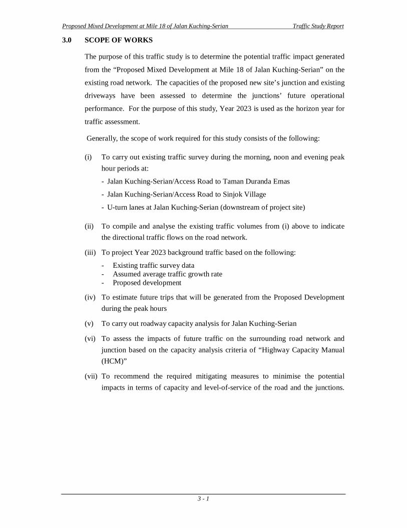
3.0 SCOPE OF WORKS
The purpose of this traffic study is to determine the potential traffic impact generated
from the “Proposed Mixed Development at Mile 18 of Jalan Kuching-Serian” on the
existing road network. The capacities of the proposed new site’s junction and existing
driveways have been assessed to determine the junctions’ future operational
performance. For the purpose of this study, Year 2023 is used as the horizon year for
traffic assessment.
Generally, the scope of work required for this study consists of the following:
(i) To carry out existing traffic survey during the morning, noon and evening peak hour periods at:
- Jalan Kuching-Serian/Access Road to Taman Duranda Emas
- Jalan Kuching-Serian/Access Road to Sinjok Village
- U-turn lanes at Jalan Kuching-Serian (downstream of project site)
(ii) To compile and analyse the existing traffic volumes from (i) above to indicate the directional traffic flows on the road network.
(iii) To project Year 2023 background traffic based on the following:
- Existing traffic survey data - Assumed average traffic growth rate - Proposed development
(iv) To estimate future trips that will be generated from the Proposed Development during the peak hours
(v) To carry out roadway capacity analysis for Jalan Kuching-Serian
(vi) To assess the impacts of future traffic on the surrounding road network and junction based on the capacity analysis criteria of “Highway Capacity Manual (HCM)”
(vii) To recommend the required mitigating measures to minimise the potential impacts in terms of capacity and level-of-service of the road and the junctions.
Proposed Mixed Development at Mile 18 of Jalan Kuching-Serian Traffic Study Report
4 - 1
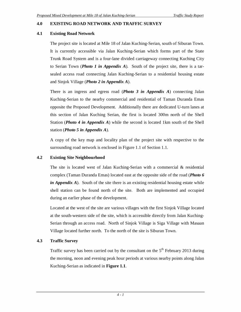
4.0 EXISTING ROAD NETWORK AND TRAFFIC SURVEY
4.1 Existing Road Network
The project site is located at Mile 18 of Jalan Kuching-Serian, south of Siburan Town.
It is currently accessible via Jalan Kuching-Serian which forms part of the State
Trunk Road System and is a four-lane divided carriageway connecting Kuching City
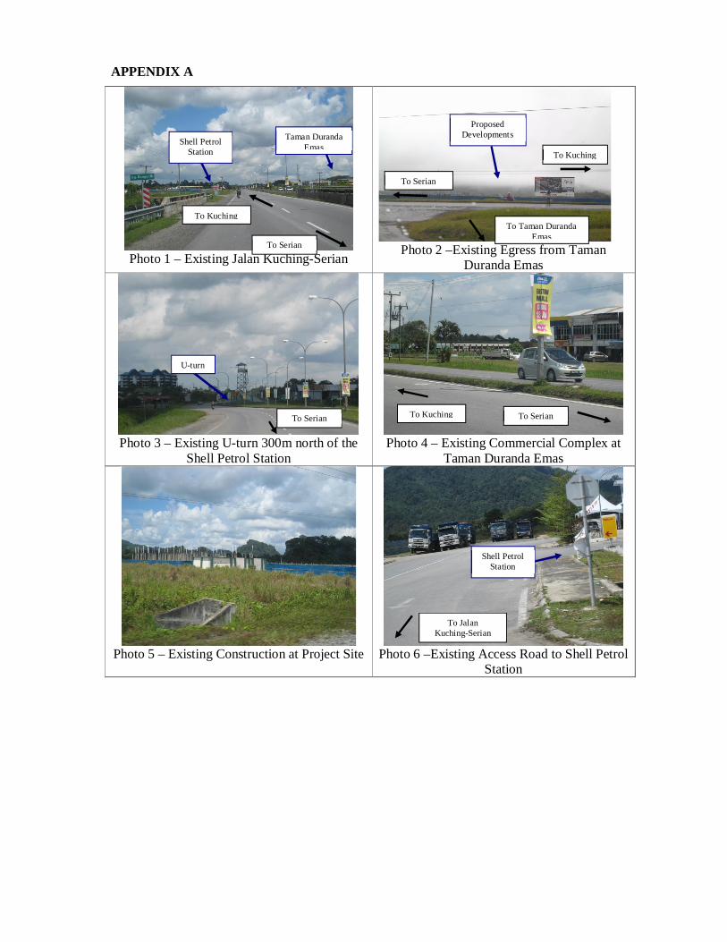
to Serian Town (Photo 1 in Appendix A). South of the project site, there is a tar-
sealed access road connecting Jalan Kuching-Serian to a residential housing estate
and Sinjok Village (Photo 2 in Appendix A).
There is an ingress and egress road (Photo 3 in Appendix A) connecting Jalan
Kuching-Serian to the nearby commercial and residential of Taman Duranda Emas
opposite the Proposed Development. Additionally there are dedicated U-turn lanes at
this section of Jalan Kuching Serian, the first is located 300m north of the Shell
Station (Photo 4 in Appendix A) while the second is located 1km south of the Shell
station (Photo 5 in Appendix A).
A copy of the key map and locality plan of the project site with respective to the
surrounding road network is enclosed in Figure 1.1 of Section 1.1.
4.2 Existing Site Neighbourhood
The site is located west of Jalan Kuching-Serian with a commercial & residential
complex (Taman Duranda Emas) located east at the opposite side of the road (Photo 6
in Appendix A). South of the site there is an existing residential housing estate while
shell station can be found north of the site. Both are implemented and occupied
during an earlier phase of the development.
Located at the west of the site are various villages with the first Sinjok Village located
at the south-western side of the site, which is accessible directly from Jalan Kuching-
Serian through an access road. North of Sinjok Village is Siga Village with Masaan
Village located further north. To the north of the site is Siburan Town.
4.3 Traffic Survey
Traffic survey has been carried out by the consultant on the 5th February 2013 during
the morning, noon and evening peak hour periods at various nearby points along Jalan
Kuching-Serian as indicated in Figure 1.1.
Proposed Mixed Development at Mile 18 of Jalan Kuching-Serian Traffic Study Report
4 - 2
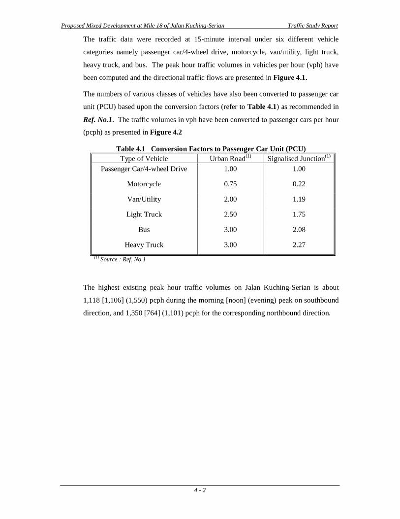
The traffic data were recorded at 15-minute interval under six different vehicle
categories namely passenger car/4-wheel drive, motorcycle, van/utility, light truck,
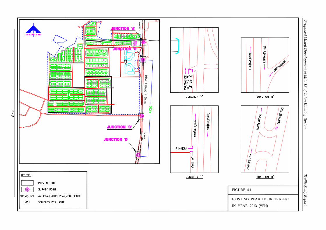
heavy truck, and bus. The peak hour traffic volumes in vehicles per hour (vph) have
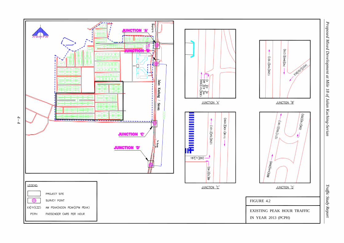
been computed and the directional traffic flows are presented in Figure 4.1.
The numbers of various classes of vehicles have also been converted to passenger car
unit (PCU) based upon the conversion factors (refer to Table 4.1) as recommended in
Ref. No.1. The traffic volumes in vph have been converted to passenger cars per hour
(pcph) as presented in Figure 4.2
Table 4.1 Conversion Factors to Passenger Car Unit (PCU) Type of Vehicle Urban Road(1) Signalised Junction(1)
Passenger Car/4-wheel Drive 1.00 1.00
Motorcycle 0.75 0.22
Van/Utility 2.00 1.19
Light Truck 2.50 1.75
Bus 3.00 2.08
Heavy Truck 3.00 2.27 (1) Source : Ref. No.1
The highest existing peak hour traffic volumes on Jalan Kuching-Serian is about
1,118 [1,106] (1,550) pcph during the morning [noon] (evening) peak on southbound
direction, and 1,350 [764] (1,101) pcph for the corresponding northbound direction.
4 - 3
EXISTING PEAK HOUR TRAFFIC
FIGURE 4.1
IN YEAR 2013 (VPH)
Proposed Mixed D
evelopment at M
ile 18 of Jalan Kuching-Serian Traffic Study Report
4 - 4
EXISTING PEAK HOUR TRAFFIC
FIGURE 4.2
IN YEAR 2013 (PCPH)
Proposed Mixed D
evelopment at M
ile 18 of Jalan Kuching-Serian Traffic Study Report
Proposed Mixed Development at Mile 18 of Jalan Kuching-Serian Traffic Study Report
5 - 1
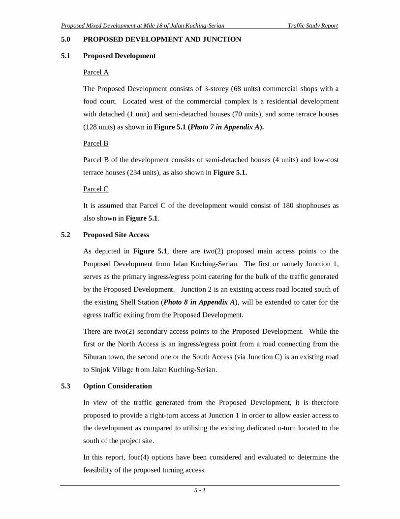
5.0 PROPOSED DEVELOPMENT AND JUNCTION
5.1 Proposed Development
Parcel A
The Proposed Development consists of 3-storey (68 units) commercial shops with a
food court. Located west of the commercial complex is a residential development
with detached (1 unit) and semi-detached houses (70 units), and some terrace houses
(128 units) as shown in Figure 5.1 (Photo 7 in Appendix A).
Parcel B
Parcel B of the development consists of semi-detached houses (4 units) and low-cost
terrace houses (234 units), as also shown in Figure 5.1.
Parcel C
It is assumed that Parcel C of the development would consist of 180 shophouses as
also shown in Figure 5.1.
5.2 Proposed Site Access
As depicted in Figure 5.1, there are two(2) proposed main access points to the
Proposed Development from Jalan Kuching-Serian. The first or namely Junction 1,
serves as the primary ingress/egress point catering for the bulk of the traffic generated
by the Proposed Development. Junction 2 is an existing access road located south of
the existing Shell Station (Photo 8 in Appendix A), will be extended to cater for the
egress traffic exiting from the Proposed Development.
There are two(2) secondary access points to the Proposed Development. While the
first or the North Access is an ingress/egress point from a road connecting from the
Siburan town, the second one or the South Access (via Junction C) is an existing road
to Sinjok Village from Jalan Kuching-Serian.
5.3 Option Consideration
In view of the traffic generated from the Proposed Development, it is therefore
proposed to provide a right-turn access at Junction 1 in order to allow easier access to
the development as compared to utilising the existing dedicated u-turn located to the
south of the project site.
In this report, four(4) options have been considered and evaluated to determine the
feasibility of the proposed turning access.
PROPOSED DEVELOPMENT LAYOUT
FIGURE 5.1
5 - 2
Proposed Mixed Development at Mile 18 of Jalan Kuching-Serian Traffic Study Report
PARCEL A
PARCEL B
PARCEL C
South Access
North Acce
ss
Junction 1
Junction 2
Junction C
Proposed Mixed Development at Mile 18 of Jalan Kuching-Serian Traffic Study Report
5 - 3
Option 1
There is no provision of right-turn access from Jalan Kuching-Serian and commuters
to the Proposed Development would need to make use of the existing U-turn located
downstream of Jalan Kuching-Serian.
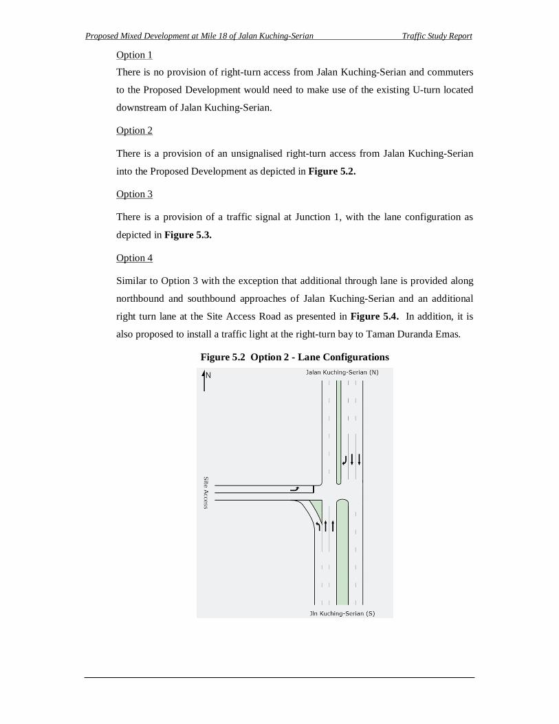
Option 2
There is a provision of an unsignalised right-turn access from Jalan Kuching-Serian
into the Proposed Development as depicted in Figure 5.2.
Option 3
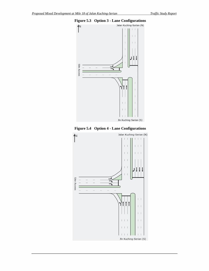
There is a provision of a traffic signal at Junction 1, with the lane configuration as
depicted in Figure 5.3.
Option 4
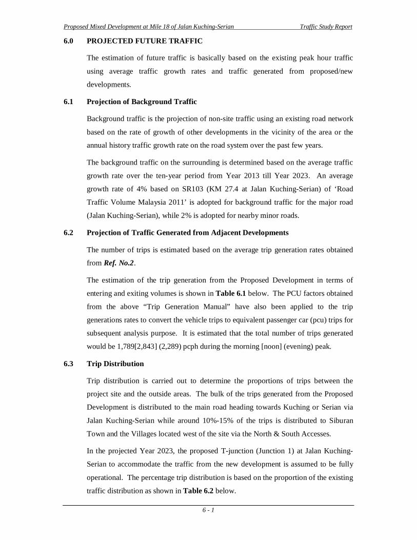
Similar to Option 3 with the exception that additional through lane is provided along
northbound and southbound approaches of Jalan Kuching-Serian and an additional
right turn lane at the Site Access Road as presented in Figure 5.4. In addition, it is
also proposed to install a traffic light at the right-turn bay to Taman Duranda Emas.
Figure 5.2 Option 2 - Lane Configurations
Proposed Mixed Development at Mile 18 of Jalan Kuching-Serian Traffic Study Report
5 - 4
Figure 5.3 Option 3 - Lane Configurations
Figure 5.4 Option 4 - Lane Configurations
Proposed Mixed Development at Mile 18 of Jalan Kuching-Serian Traffic Study Report
6 - 1
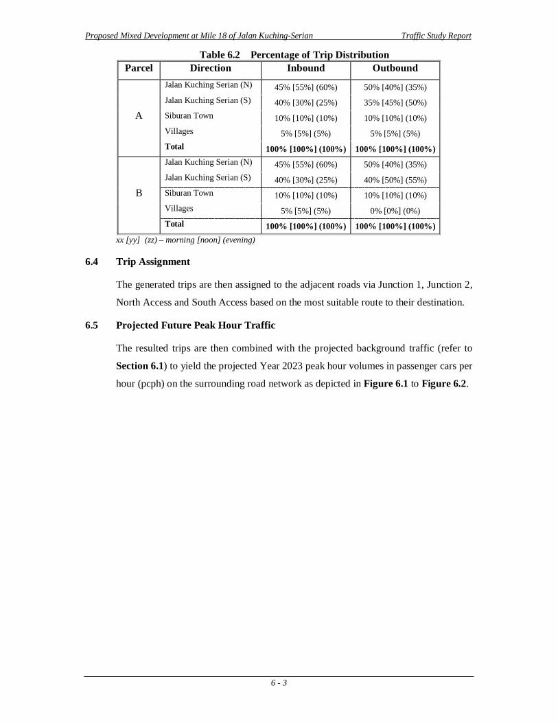
6.0 PROJECTED FUTURE TRAFFIC
The estimation of future traffic is basically based on the existing peak hour traffic
using average traffic growth rates and traffic generated from proposed/new
developments.
6.1 Projection of Background Traffic
Background traffic is the projection of non-site traffic using an existing road network
based on the rate of growth of other developments in the vicinity of the area or the
annual history traffic growth rate on the road system over the past few years.
The background traffic on the surrounding is determined based on the average traffic
growth rate over the ten-year period from Year 2013 till Year 2023. An average
growth rate of 4% based on SR103 (KM 27.4 at Jalan Kuching-Serian) of ‘Road
Traffic Volume Malaysia 2011’ is adopted for background traffic for the major road
(Jalan Kuching-Serian), while 2% is adopted for nearby minor roads.
6.2 Projection of Traffic Generated from Adjacent Developments
The number of trips is estimated based on the average trip generation rates obtained
from Ref. No.2.
The estimation of the trip generation from the Proposed Development in terms of
entering and exiting volumes is shown in Table 6.1 below. The PCU factors obtained
from the above “Trip Generation Manual” have also been applied to the trip
generations rates to convert the vehicle trips to equivalent passenger car (pcu) trips for
subsequent analysis purpose. It is estimated that the total number of trips generated
would be 1,789[2,843] (2,289) pcph during the morning [noon] (evening) peak.
6.3 Trip Distribution
Trip distribution is carried out to determine the proportions of trips between the
project site and the outside areas. The bulk of the trips generated from the Proposed
Development is distributed to the main road heading towards Kuching or Serian via
Jalan Kuching-Serian while around 10%-15% of the trips is distributed to Siburan
Town and the Villages located west of the site via the North & South Accesses.
In the projected Year 2023, the proposed T-junction (Junction 1) at Jalan Kuching-
Serian to accommodate the traffic from the new development is assumed to be fully
operational. The percentage trip distribution is based on the proportion of the existing
traffic distribution as shown in Table 6.2 below.
Proposed Mixed Development at Mile 18 of Jalan Kuching-Serian Traffic Study Report
6 - 2
Table 6.1 Trip Generated from Proposed Development
Land Use Independen
t Variable
Generation Rate (vph) PCU Outbound Site Trips (pcph)(1)
AM Peak PM Peak AM PM AM Peak PM Peak
Rate % Enter % Exit Rate % Enter % Exit Peak Peak Enter Exit Enter Exit Parcel A
Shophouse 68 units 5.17 62% 38% 7.57 47% 53% 1.11 1.09 230 141 250 282
Food Court 4 tsf 23.30 56% 44% 14.85 52% 48% 1.17 1.10 58 45 31 29
Terrace House 128 units 0.70 29% 71% 0.68 60% 40% 1.12 1.09 22 60 43 27 Semi-D /
Detached House 71 units 1.51 35% 65% 1.54 53% 47% 1.09 1.10 31 65 48 39
Parcel B
Terrace House 234 units 0.70 29% 71% 0.68 60% 40% 1.12 1.09 40 110 78 49 Semi-D /
Detached House 4 units 1.51 35% 65% 1.54 53% 47% 1.09 1.10 2 4 3 2
Parcel C
Shophouse 180 units 5.17 62% 38% 7.57 47% 53% 1.11 1.09 608 373 662 746
Total: 991 798 1115 1174
Land Use Independent Variable
Generation Rate (vph) PCU Outbound Site Trips (pcph)(1)
Noon Peak Noon Noon Peak
Rate % Enter % Exit Peak Enter Exit Parcel A
Shophouse 68 units 9.09 50% 50% 1.11 307 307
Food Court 4 tsf 31.19 53% 47% 1.11 66 59
Terrace House 128 units 0.79 59% 41% 1.10 56 37 Semi-D /
Detached House 71 units 1.78 55% 45% 1.11 66 51
Parcel B
Terrace House 234 units 0.79 59% 41% 1.10 102 67 Semi-D /
Detached House 4 units 1.78 55% 45% 1.11 4 3
Parcel C
Shophouse 180 units 9.09 50% 50% 1.11 859 859
Total: 1460 1383
vph - vehicles per hour PCU - passenger car unit pcph - passenger cars per hour (1) - assuming 5% traffic from commercial areas is from housing within the project site
Proposed Mixed Development at Mile 18 of Jalan Kuching-Serian Traffic Study Report
6 - 3
Table 6.2 Percentage of Trip Distribution Parcel Direction Inbound Outbound
A
Jalan Kuching Serian (N) 45% [55%] (60%) 50% [40%] (35%) Jalan Kuching Serian (S) 40% [30%] (25%) 35% [45%] (50%) Siburan Town 10% [10%] (10%) 10% [10%] (10%) Villages 5% [5%] (5%) 5% [5%] (5%) Total 100% [100%] (100%) 100% [100%] (100%)
B
Jalan Kuching Serian (N) 45% [55%] (60%) 50% [40%] (35%) Jalan Kuching Serian (S) 40% [30%] (25%) 40% [50%] (55%) Siburan Town 10% [10%] (10%) 10% [10%] (10%) Villages 5% [5%] (5%) 0% [0%] (0%) Total 100% [100%] (100%) 100% [100%] (100%)
xx [yy] (zz) – morning [noon] (evening)
6.4 Trip Assignment
The generated trips are then assigned to the adjacent roads via Junction 1, Junction 2,
North Access and South Access based on the most suitable route to their destination.
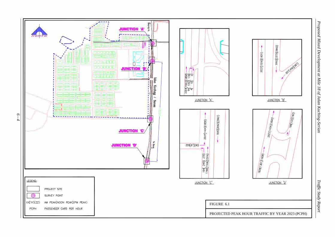
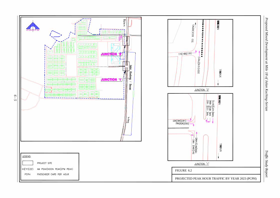
6.5 Projected Future Peak Hour Traffic
The resulted trips are then combined with the projected background traffic (refer to
Section 6.1) to yield the projected Year 2023 peak hour volumes in passenger cars per
hour (pcph) on the surrounding road network as depicted in Figure 6.1 to Figure 6.2.
6 - 4
PROJECTED PEAK HOUR TRAFFIC BY YEAR 2023 (PCPH)
FIGURE 6.1
Proposed Mixed D
evelopment at M
ile 18 of Jalan Kuching-Serian Traffic Study Report
6 - 5
PROJECTED PEAK HOUR TRAFFIC BY YEAR 2023 (PCPH)
FIGURE 6.2
TO SERIA
NJA
LAN
KU
CH
ING / SERIAN
TO SERIA
NJA
LAN
KU
CH
ING / SERIAN
TO
KU
CHIN
G
Proposed Mixed D
evelopment at M
ile 18 of Jalan Kuching-Serian Traffic Study Report
Proposed Mixed Development at Mile 18 of Jalan Kuching-Serian Traffic Study Report
7 - 1
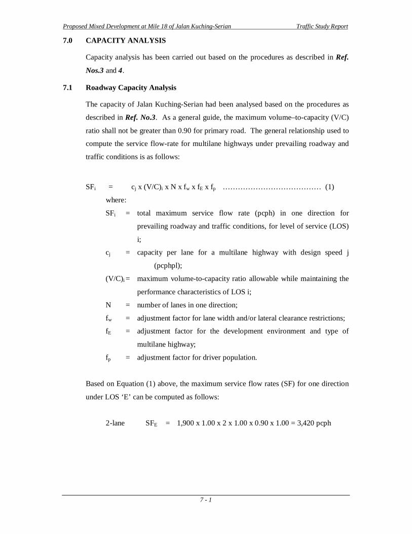
7.0 CAPACITY ANALYSIS
Capacity analysis has been carried out based on the procedures as described in Ref.
Nos.3 and 4.
7.1 Roadway Capacity Analysis
The capacity of Jalan Kuching-Serian had been analysed based on the procedures as
described in Ref. No.3. As a general guide, the maximum volume–to-capacity (V/C)
ratio shall not be greater than 0.90 for primary road. The general relationship used to
compute the service flow-rate for multilane highways under prevailing roadway and
traffic conditions is as follows:
SFi = cj x (V/C)i x N x fw x fE x fp ………………………………… (1)
where:
SFi = total maximum service flow rate (pcph) in one direction for
prevailing roadway and traffic conditions, for level of service (LOS)
i;
cj = capacity per lane for a multilane highway with design speed j
(pcphpl);
(V/C)i = maximum volume-to-capacity ratio allowable while maintaining the
performance characteristics of LOS i;
N = number of lanes in one direction;
fw = adjustment factor for lane width and/or lateral clearance restrictions;
fE = adjustment factor for the development environment and type of
multilane highway;
fp = adjustment factor for driver population.
Based on Equation (1) above, the maximum service flow rates (SF) for one direction
under LOS ‘E’ can be computed as follows:
2-lane SFE = 1,900 x 1.00 x 2 x 1.00 x 0.90 x 1.00 = 3,420 pcph
Proposed Mixed Development at Mile 18 of Jalan Kuching-Serian Traffic Study Report
7 - 2
Table 7.1 Summary of Multilane Roadway Capacity Analysis
Section
Traffic
Scenario
AM Peak Noon Peak PM Peak
NB SB V/C Ratio
NB SB V/C Ratio
NB SB V/C Ratio
NB SB NB SB NB SB
Jalan Kuching Serian
Existing 1,350 1,118 0.39 0.33 764 1,106 0.22 0.32 1,101 1,550 0.32 0.45
Bkgd 1,998 1,557 0.58 0.46 1,131 1,570 0.33 0.46 1,630 2,233 0.48 0.65
Bkgd+Site 2,397 2,003 0.70 0.59 1,684 2,373 0.49 0.69 2,041 2,902 0.60 0.85 pcph - passenger cars per hour V/C - volume-to-capacity ratio NB - northbound SB - southbound Bkgd - background
Jalan Kuching-Serian
The results of the multilane roadway capacity analysis in Table 7.1 denote that the
highest saturation level for the Jalan Kuching-Serian occurs along the southbound
direction during the evening peak, which has V/C ratio of 0.45 in Year 2013. By
Year 2023, the V/C ratio is expected to increase to 0.85 with the inclusion of the site-
generated traffic which is still within satisfactory level-of-service.
7.2 Junction Capacity Analysis
One of the main considerations in traffic flow analysis is the junction capacity
analysis. In most cases, bottlenecks occur at the meeting point of two or more roads,
where all the movements are waiting for their turns or required gaps to execute the
turning manoeuvres.
7.2.1 Unsignalised Junction Capacity Analysis
In this section, the existing right turn junction into Taman Duranda Emas, the existing
U-turn junction (Option 1) and the proposed Junction 1 (Option 2 - refer to Section
5.3 above) have been evaluated using the Unsignalised Junction Capacity Analysis
criteria.
Table 7.2 presents the LOS criteria for an unsignalised junction, which is determined
by the computed or measured control delay and is defined for each minor movement.
Table 7.2 Level-of-Service (LOS) Criteria for Unsignalised Junction Level of Service Average Control Delay (sec/veh)
A 0 – 10 B > 10 – 15 C > 15 – 25 D > 25 – 35 E > 35 – 50 F > 50
Proposed Mixed Development at Mile 18 of Jalan Kuching-Serian Traffic Study Report
7 - 3
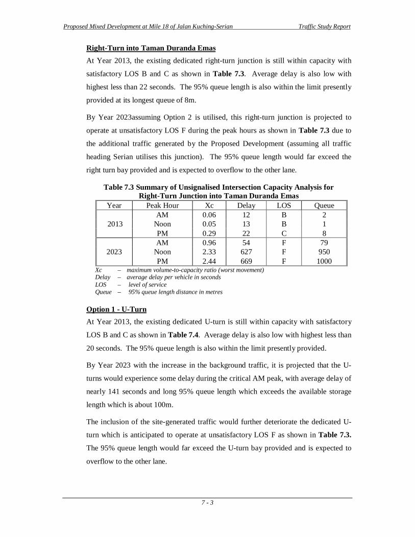
Right-Turn into Taman Duranda Emas At Year 2013, the existing dedicated right-turn junction is still within capacity with
satisfactory LOS B and C as shown in Table 7.3. Average delay is also low with
highest less than 22 seconds. The 95% queue length is also within the limit presently
provided at its longest queue of 8m.
By Year 2023assuming Option 2 is utilised, this right-turn junction is projected to
operate at unsatisfactory LOS F during the peak hours as shown in Table 7.3 due to
the additional traffic generated by the Proposed Development (assuming all traffic
heading Serian utilises this junction). The 95% queue length would far exceed the
right turn bay provided and is expected to overflow to the other lane.
Table 7.3 Summary of Unsignalised Intersection Capacity Analysis for Right-Turn Junction into Taman Duranda Emas
Year Peak Hour Xc Delay LOS Queue
2013 AM 0.06 12 B 2
Noon 0.05 13 B 1 PM 0.29 22 C 8
2023 AM 0.96 54 F 79
Noon 2.33 627 F 950 PM 2.44 669 F 1000
Xc – maximum volume-to-capacity ratio (worst movement) Delay – average delay per vehicle in seconds LOS – level of service Queue – 95% queue length distance in metres
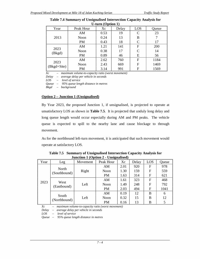
Option 1 - U-Turn At Year 2013, the existing dedicated U-turn is still within capacity with satisfactory
LOS B and C as shown in Table 7.4. Average delay is also low with highest less than
20 seconds. The 95% queue length is also within the limit presently provided.
By Year 2023 with the increase in the background traffic, it is projected that the U-
turns would experience some delay during the critical AM peak, with average delay of
nearly 141 seconds and long 95% queue length which exceeds the available storage
length which is about 100m.
The inclusion of the site-generated traffic would further deteriorate the dedicated U-
turn which is anticipated to operate at unsatisfactory LOS F as shown in Table 7.3.
The 95% queue length would far exceed the U-turn bay provided and is expected to
overflow to the other lane.
Proposed Mixed Development at Mile 18 of Jalan Kuching-Serian Traffic Study Report
7 - 4
Table 7.4 Summary of Unsignalised Intersection Capacity Analysis for U-turn (Option 1)
Year Peak Hour Xc Delay LOS Queue
2013 AM 0.53 19 C 23
Noon 0.24 13 B 7 PM 0.43 18 C 17
2023 (Bkgd)
AM 1.21 141 F 200 Noon 0.38 17 C 14 PM 0.89 46 E 56
2023 (Bkgd+Site)
AM 2.62 760 F 1184 Noon 2.43 669 F 1469 PM 3.14 991 F 1569
Xc – maximum volume-to-capacity ratio (worst movement) Delay – average delay per vehicle in seconds LOS – level of service Queue – 95% queue length distance in metres Bkgd – background
Option 2 – Junction 1 (Unsignalised)
By Year 2023, the proposed Junction 1, if unsignalised, is projected to operate at
unsatisfactory LOS as shown in Table 7.5. It is projected that unduly long delay and
long queue length would occur especially during AM and PM peaks. The vehicle
queue is expected to spill to the nearby lane and cause blockage to through
movement.
As for the northbound left-turn movement, it is anticipated that such movement would
operate at satisfactory LOS.
Table 7.5 Summary of Unsignalised Intersection Capacity Analysis for Junction 1 (Option 2 - Unsignalised)
Year Leg Movement Peak Hour Xc Delay LOS Queue
2023
North (Southbound) Right
AM 2.01 920 F 978 Noon 1.30 159 F 559 PM 1.63 314 F 621
West (Eastbound) Left
AM 1.61 323 F 468 Noon 1.49 248 F 792 PM 2.03 494 F 1041
South (Northbound) Left
AM 0.19 12 B 6 Noon 0.32 15 B 12 PM 0.16 13 B 5
Xc – maximum volume-to-capacity ratio (worst movement) Delay – average delay per vehicle in seconds LOS – level of service Queue – 95% queue length distance in metres
Proposed Mixed Development at Mile 18 of Jalan Kuching-Serian Traffic Study Report
7 - 5
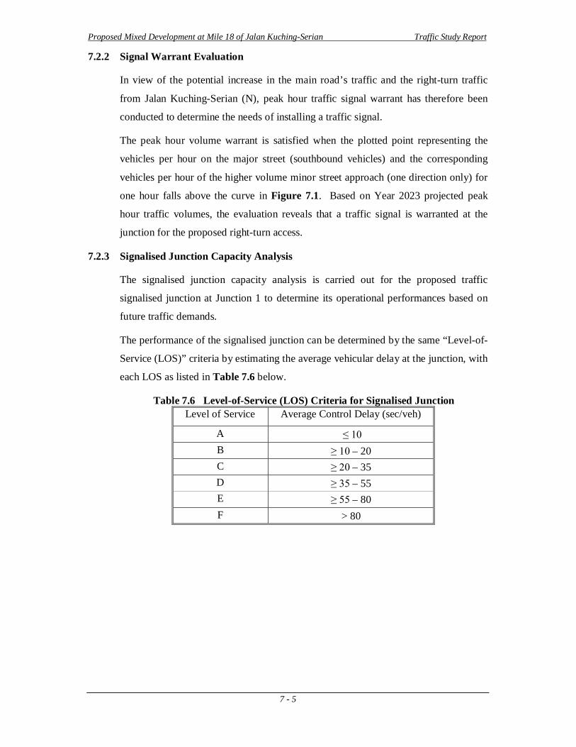
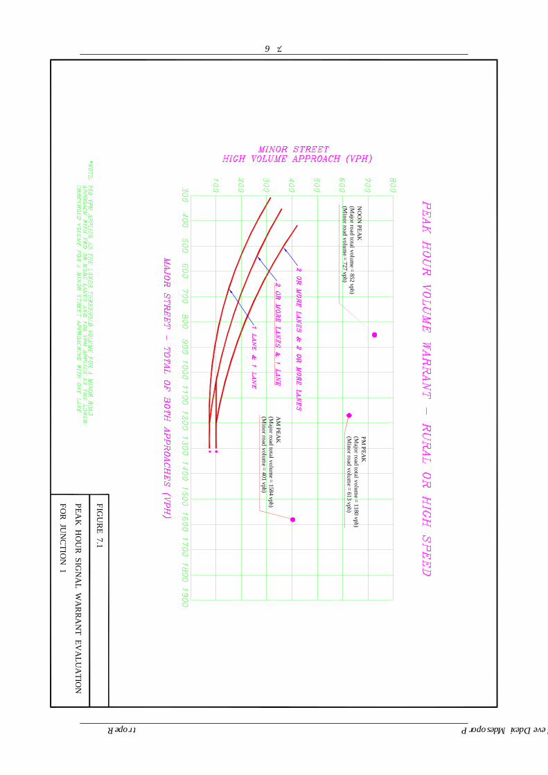
7.2.2 Signal Warrant Evaluation
In view of the potential increase in the main road’s traffic and the right-turn traffic
from Jalan Kuching-Serian (N), peak hour traffic signal warrant has therefore been
conducted to determine the needs of installing a traffic signal.
The peak hour volume warrant is satisfied when the plotted point representing the
vehicles per hour on the major street (southbound vehicles) and the corresponding
vehicles per hour of the higher volume minor street approach (one direction only) for
one hour falls above the curve in Figure 7.1. Based on Year 2023 projected peak
hour traffic volumes, the evaluation reveals that a traffic signal is warranted at the
junction for the proposed right-turn access.
7.2.3 Signalised Junction Capacity Analysis
The signalised junction capacity analysis is carried out for the proposed traffic
signalised junction at Junction 1 to determine its operational performances based on
future traffic demands.
The performance of the signalised junction can be determined by the same “Level-of-
Service (LOS)” criteria by estimating the average vehicular delay at the junction, with
each LOS as listed in Table 7.6 below.
Table 7.6 Level-of-Service (LOS) Criteria for Signalised Junction Level of Service Average Control Delay (sec/veh)
A ≤ 10 B ≥ 10 – 20 C ≥ 20 – 35 D ≥ 35 – 55 E ≥ 55 – 80 F > 80
7 - 6
PEAK
HO
UR
SIGN
AL W
AR
RA
NT EV
ALU
ATIO
N
FIGU
RE 7.1
FOR
JUN
CTIO
N 1
Proposed Mixed Development at Mile 18 of Jalan Kuching-Serian Traffic Study Report
AM
PEAK
(Major road total volum
e = 1584 vph)(M
inor road volume = 401 vph)
PM PEA
K(M
ajor road total volume = 1180 vph)
(Minor road volum
e = 613 vph)
NO
ON
PEAK
(Major road total volum
e = 852 vph)(M
inor road volume = 727 vph)
Proposed Mixed Development at Mile 18 of Jalan Kuching-Serian Traffic Study Report
7 - 7
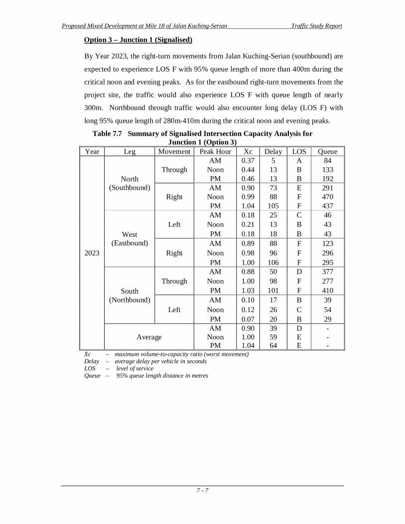
Option 3 – Junction 1 (Signalised)
By Year 2023, the right-turn movements from Jalan Kuching-Serian (southbound) are
expected to experience LOS F with 95% queue length of more than 400m during the
critical noon and evening peaks. As for the eastbound right-turn movements from the
project site, the traffic would also experience LOS F with queue length of nearly
300m. Northbound through traffic would also encounter long delay (LOS F) with
long 95% queue length of 280m-410m during the critical noon and evening peaks.
Table 7.7 Summary of Signalised Intersection Capacity Analysis for Junction 1 (Option 3)
Year Leg Movement Peak Hour Xc Delay LOS Queue
2023
North (Southbound)
Through AM 0.37 5 A 84
Noon 0.44 13 B 133 PM 0.46 13 B 192
Right AM 0.90 73 E 291
Noon 0.99 88 F 470 PM 1.04 105 F 437
West (Eastbound)
Left AM 0.18 25 C 46
Noon 0.21 13 B 43 PM 0.18 18 B 43
Right AM 0.89 88 F 123
Noon 0.98 96 F 296 PM 1.00 106 F 295
South (Northbound)
Through AM 0.88 50 D 377
Noon 1.00 98 F 277 PM 1.03 101 F 410
Left AM 0.10 17 B 39
Noon 0.12 26 C 54 PM 0.07 20 B 29
Average AM
Noon PM
0.90 1.00 1.04
39 59 64
D E E
- - -
Xc – maximum volume-to-capacity ratio (worst movement) Delay – average delay per vehicle in seconds LOS – level of service Queue – 95% queue length distance in metres
Proposed Mixed Development at Mile 18 of Jalan Kuching-Serian Traffic Study Report
7 - 8
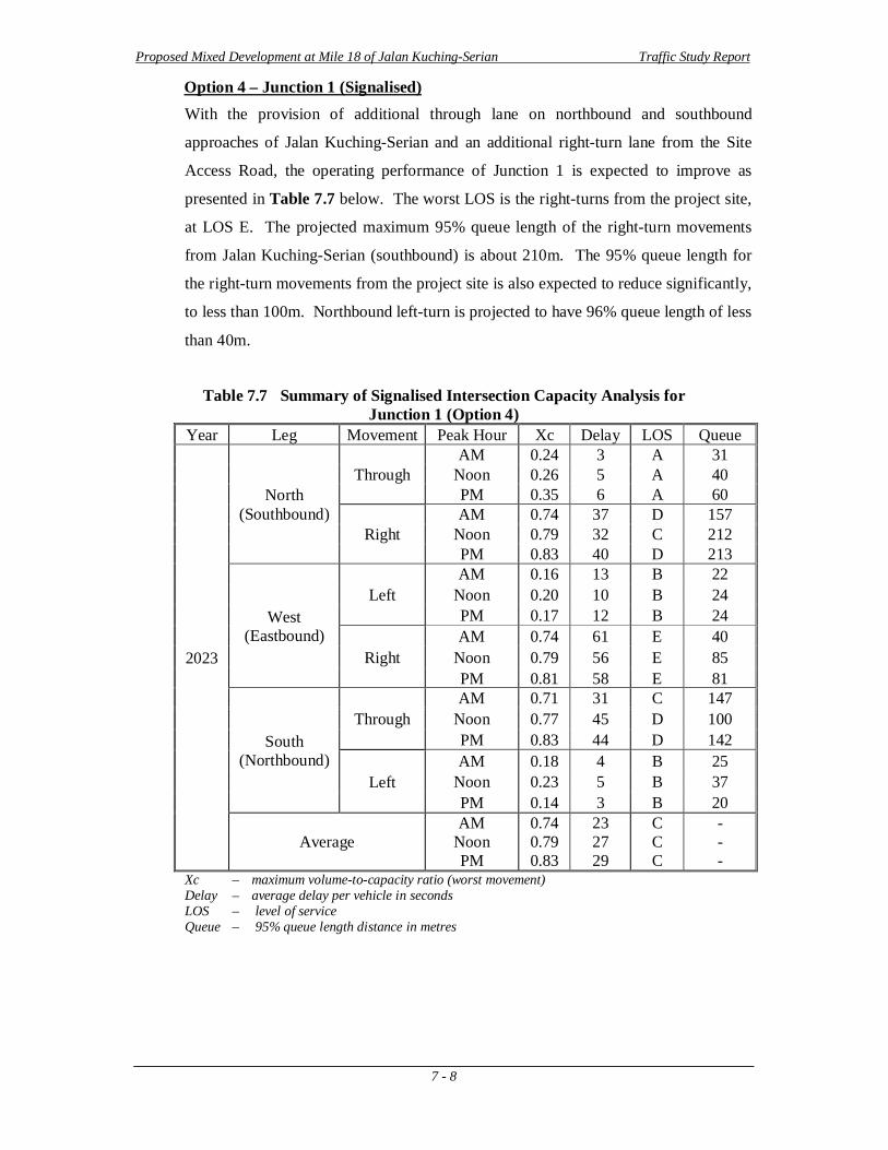
Option 4 – Junction 1 (Signalised) With the provision of additional through lane on northbound and southbound
approaches of Jalan Kuching-Serian and an additional right-turn lane from the Site
Access Road, the operating performance of Junction 1 is expected to improve as
presented in Table 7.7 below. The worst LOS is the right-turns from the project site,
at LOS E. The projected maximum 95% queue length of the right-turn movements
from Jalan Kuching-Serian (southbound) is about 210m. The 95% queue length for
the right-turn movements from the project site is also expected to reduce significantly,
to less than 100m. Northbound left-turn is projected to have 96% queue length of less
than 40m.
Table 7.7 Summary of Signalised Intersection Capacity Analysis for
Junction 1 (Option 4) Year Leg Movement Peak Hour Xc Delay LOS Queue
2023
North (Southbound)
Through AM 0.24 3 A 31
Noon 0.26 5 A 40 PM 0.35 6 A 60
Right AM 0.74 37 D 157
Noon 0.79 32 C 212 PM 0.83 40 D 213
West (Eastbound)
Left AM 0.16 13 B 22
Noon 0.20 10 B 24 PM 0.17 12 B 24
Right AM 0.74 61 E 40
Noon 0.79 56 E 85 PM 0.81 58 E 81
South (Northbound)
Through AM 0.71 31 C 147
Noon 0.77 45 D 100 PM 0.83 44 D 142
Left AM 0.18 4 B 25
Noon 0.23 5 B 37 PM 0.14 3 B 20
Average AM
Noon PM
0.74 0.79 0.83
23 27 29
C C C
- - -
Xc – maximum volume-to-capacity ratio (worst movement) Delay – average delay per vehicle in seconds LOS – level of service Queue – 95% queue length distance in metres
Proposed Mixed Development at Mile 18 of Jalan Kuching-Serian Traffic Study Report
7 - 9
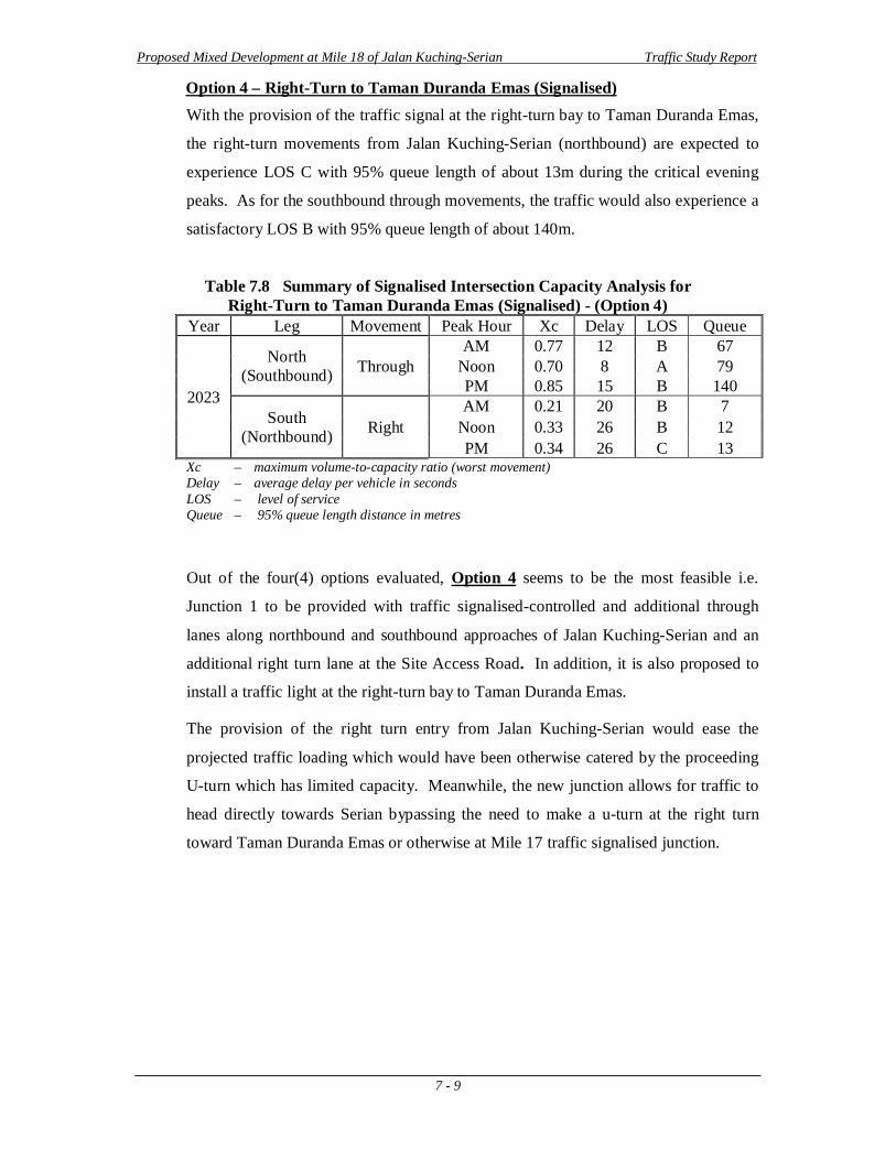
Option 4 – Right-Turn to Taman Duranda Emas (Signalised) With the provision of the traffic signal at the right-turn bay to Taman Duranda Emas,
the right-turn movements from Jalan Kuching-Serian (northbound) are expected to
experience LOS C with 95% queue length of about 13m during the critical evening
peaks. As for the southbound through movements, the traffic would also experience a
satisfactory LOS B with 95% queue length of about 140m.
Table 7.8 Summary of Signalised Intersection Capacity Analysis for Right-Turn to Taman Duranda Emas (Signalised) - (Option 4)
Year Leg Movement Peak Hour Xc Delay LOS Queue
2023
North (Southbound) Through
AM 0.77 12 B 67 Noon 0.70 8 A 79 PM 0.85 15 B 140
South (Northbound) Right
AM 0.21 20 B 7 Noon 0.33 26 B 12 PM 0.34 26 C 13
Xc – maximum volume-to-capacity ratio (worst movement) Delay – average delay per vehicle in seconds LOS – level of service Queue – 95% queue length distance in metres
Out of the four(4) options evaluated, Option 4 seems to be the most feasible i.e.
Junction 1 to be provided with traffic signalised-controlled and additional through
lanes along northbound and southbound approaches of Jalan Kuching-Serian and an
additional right turn lane at the Site Access Road. In addition, it is also proposed to
install a traffic light at the right-turn bay to Taman Duranda Emas.
The provision of the right turn entry from Jalan Kuching-Serian would ease the
projected traffic loading which would have been otherwise catered by the proceeding
U-turn which has limited capacity. Meanwhile, the new junction allows for traffic to
head directly towards Serian bypassing the need to make a u-turn at the right turn
toward Taman Duranda Emas or otherwise at Mile 17 traffic signalised junction.
Proposed Mixed Development at Mile 18 of Jalan Kuching-Serian Traffic Study Report
8 - 1
8.0 CONCLUSIONS AND RECOMMENDATIONS
General
This study is conducted to evaluate the traffic impacts resulting from the “Proposed
Mixed Development at Mile 18 of Jalan Kuching-Serian” on the existing road
network
Objectives
This traffic study is carried out in view of the needs to determine the feasibility of
providing a right-turning access at Mile 18 of Jalan Kuching-Serian for accessibility
to the Proposed Development. The study is done based on projected traffic volumes
at Year 2023.
Proposed Development and Site Access
The Proposed Development consists of 248 units of 3-storey commercial shops, a
food court, 1 unit of detached house, 75 units of semi-detached houses, 128 units of
terrace houses, and 234 units of low-cost terrace houses.
Two(2) proposed main access points will be provided to the Proposed Development
from Jalan Kuching-Serian i.e. Junction 1 which serves as the primary ingress access
and Junction 2 which caters for the egress traffic which is an existing access road
located south of the existing Shell Station. The North Access and South Access will
act as secondary access points to the Proposed Development from Siburan town and
nearby residential areas.
Option Consideration
It is proposed to provide a traffic signalised with the considerations of four(4) options as follows:
Option 1 - No provision of right-turn access from Jalan Kuching-Serian and commuters to the Proposed Development would need to make use of the existing U-turn located downstream of Jalan Kuching-Serian.
Option 2 - Provision of an unsignalised right-turn access from Jalan Kuching-Serian into the Proposed Development.
Option 3 - Provision of a traffic signalised junction from Jalan Kuching-Serian into the Proposed Development.
Option 4 – Similar to Option 3 with the exception that additional through lane is
provided along northbound and southbound approaches of Jalan Kuching-Serian. In
Proposed Mixed Development at Mile 18 of Jalan Kuching-Serian Traffic Study Report
8 - 2
addition, it is also proposed to install a traffic light at the right-turn bay to Taman
Duranda Emas.
Existing and Future Projected Traffic
Existing traffic survey has been carried out at existing junctions in the vicinity of the
project site during the peak hour periods. The background traffic for the road has
been estimated based on an average traffic growth rate of 4% for Jalan Kuching-
Serian, and 2% for the nearby connected roads.
It is estimated that the total number of outbound trips generated would be
1,789[2,843] (2,289) pcph during the morning [noon] (evening) peak.
Roadway Capacity Analysis It can be revealed from the capacity analysis results that the four-lane Jalan Kuching-
Serian is operating well below its full capacity in usage at Year 2013. By Year 2023,
the additional traffic expected is still within the carriageway operating limit.
Unsignalised Junction Capacity Analysis
Right-Turn into Taman Duranda Emas
The right turn analysis shows that the Year 2013 is operation at an acceptable LOS.
However, for Year 2023 the junction is expected to be overwhelmed by the additional
traffic from the Proposed Development and operate at an unsatisfactory LOS.
Option 1 – U-Turn
Option 1 maintains Jalan Kuching-Serian as it is, and looks into the what-if scenario
should commuters traverse to the U-turn south of the site. The critical U-turn
movement evaluated shows that the U-turn would operate at an unsatisfactory LOS in
Year 2023.
Option 2 – Junction 1
Option 2 looks into an unsignalised right-turn access into the Proposed Development.
It shows that high northbound through movement would produce unduly delay and
long queue for proposed right-turn access, and as such is not recommended to be
implemented.
Proposed Mixed Development at Mile 18 of Jalan Kuching-Serian Traffic Study Report
8 - 3
Signalised Junction Capacity Analysis
Option 3
Option 3 utilises a signalised junction instead, which is also warranted by the traffic
signal evaluation. The signalised capacity analysis for Junction 1 indicates that at
Year 2023 the junction is operating with an unsatisfactory LOS due to insufficient
capacity to fully cater for the additional traffic generated by the development
Option 4
Option 4 utilises a signalised junction in conjunction with additional through lanes
along Jalan Kuching-Serian and two right-turn lanes along Site Access Road. The
signalised capacity analysis for Junction 1 indicates that at Year 2023, the junction is
expected to operate within its capacity with a satisfactory LOS, and hence is
recommended to be implemented.
The exclusive right-turn bay to the Proposed Development is recommended to have
minimum storage length of 220m, whereas the left-turn bay is recommended to have
minimum storage length of 50m. Conceptual layout plan for Option 4 is presented in
Figure 8.1.
A C
B
EJALAN KUCHING - SERIAN
D
F
SHEL
L S
ITE
ACC
ESS
Sg. En
senggi
CURVE ROAD
SITE
AC
CES
S RO
AD
8 - 4
Proposed Mixed Development at Mile 18 of Jalan Kuching-Serian Traffic Study Report
FIGURE 8.1
PROPOSED CONCEPTUAL LAYOUT FOR NEW TRAFFIC SIGNAL JUNCTION
PROPOSED NEW TRAFFICSIGNALISED JUNCTION
A
B
C
D
To provide Traffic Signal Controlled Junction at Junction 1 at Mile 18 of JalanKuching-Serian with Three - Phase Signal
To provide exclusive right-turn bay (~245m) from JalanKuching-Serian to the Proposed Development
To provide exclusive left turn bay (~50m) from JalanKuching-Serian to the Proposed Development
To provide exclusive Left-Turn bay (~50m) along Site Access Road
-
-
-
-
E To provide Traffic Signalised Junction at the Right Turn bay to Taman Duranda Emaswhich is to be syncronized with Junction 1 and to provide Post Delineator
-
F To modify lane configuration at Junction 2 by connectingthe Curved Road with Shell Access Road
-
Proposed Mixed Development at Mile 18 of Jalan Kuching-Serian Traffic Study Report
8 - 5
Conclusions and Recommendations Based on the above findings, it can be concluded that Option 4 is the most feasible
option and is recommended to be implemented.
The recommendations have been summarised and highlighted below (Figure 8.1):
A. To provide Traffic Signal-Controlled at Junction 1 at Mile 18 of Jalan
Kuching-Serian with Three-Phase Signal
– to provide easier access into and out from the Proposed Developments
and neighbouring areas, which in turn divert much of the traffic from
utilising the proceeding U-turn south of Jalan Kuching-Serian and right-
turn at Taman Duranda Emas
– to provide additional through lanes along Jalan Kuching-Serian and two
right-turn lanes along Site Access Road to increase the intersection
capacity and reduce queue length
B. To provide exclusive right-turn bay (~245m) from Jalan Kuching-
Serian to the Proposed Development
– to prevent overflow of vehicles from the right-turn bay which will create
blockage to through traffic on main road
C. To provide exclusive left-turn bay (~50m) from Jalan Kuching-Serian to
the Proposed Development
– to prevent overflow of vehicles from the left-turn bay which will create
blockage to through traffic on main road
D. To provide exclusive left turn bay (~50m) along Site Access Road
– to prevent overflow of vehicles from the left-turn bay which will create
blockage to right turn traffic
E. To provide Traffic Signalised Junction at the Right Turn bay to Taman
Duranda Emas which is to be synchronized with Junction 1 and to
provide Post Delineator
– to facilitate the right-turn movements from main road to Taman Duranda
Emas
Proposed Mixed Development at Mile 18 of Jalan Kuching-Serian Traffic Study Report
8 - 6
– to dissuade egress movement from Junction 2 from utilizing right turn
movement which would be a traffic hazard due to the close proximity of
the two junctions
F. To modify the lane configuration at Junction 2 by connecting the Curve
Road to the Shell Access
– to minimize traffic conflicts and improve the junction’s safety
G. Monitoring the traffic flow patterns and conditions of the junctions
– to enhance the traffic signal phasing and timing from time to time (if
required) so as to optimize the traffic signal and also to facilitate traffic
movements at the junction
APPENDIX A
Photo 1 – Existing Jalan Kuching-Serian
Photo 2 –Existing Egress from Taman
Duranda Emas
Photo 3 – Existing U-turn 300m north of the
Shell Petrol Station
Photo 4 – Existing Commercial Complex at
Taman Duranda Emas
Photo 5 – Existing Construction at Project Site
Photo 6 –Existing Access Road to Shell Petrol
Station
To Serian
To Kuching
Taman Duranda Emas Shell Petrol
Station
Shell Petrol Station
To Jalan Kuching-Serian
To Serian
To Kuching
To Taman Duranda Emas
Proposed Developments
To Kuching To Serian To Serian
U-turn