Embed Size (px)
Citation preview
Ohio EPA319 Nonpoint Source Pollution
Grant Program April 2004
Kokosing Scenic River Watershed PlanOhio Department of Natural ResourcesDivision of Natural Areas & Preserves
Page I
Kokosing Watershed PlanEXECUTIVE SUMMARY
This watershed plan consists of four majorsections, Introduction, Natural Resource Inventory,Water Quality and Strategies.
The Introduction section describes projectbackground, mission and previous planning stud-ies. Watershed steering committee membership, theScenic Rivers law and governmental programsgeared towards assisting landowners with conser-vation projects are discussed. Justification and needfor conservation and protection activities isdesribed, particularly the economic benefits asso-ciated with “ecosystem services,” tourism and out-door recreation opportunity.
The Natural Resources Inventory consistsof a compliation of known data concerning landuse/cover, geology/soils, minerals, surface/groundwater, terrestial habitats, streams, lakes, floodplains,wetlands, faunal and floral diversity and rare spe-cies.
The Water Quality section includes aquatichabitat and water quality, water chemistrystormwater, Ohio Environmental ProtectionAgency use designations and impacts encounteredduring field sampling in 2003. Approximately 30%of streams in the watershed exhibited some degreeof impact, with the majority of impacts caused byriparian vegetation removal, range grazing, landdevelopment and stream channelization activities.Historical information and socio-economic andtransportation data is also included in this section,in an effort to analyize trends and predict futurestates.
Perhaps the most important section of thewatershed plan deals with strategies, which, if em-ployed, would restore or maintain ecosystem func-tions, quality of life and recreational opportunity.The goal of the Clean Water Act is:
“...To restore and maintain the chemical,physical, and biological integrity of thenation’s waters.”
If one studies the chemical, physical andbiological integrity of the Kokosing watershed, aprescription of restoration and preservation mana-gerial responses appears appropriate.
Strategy topics include livestock exclusionfencing in two subwatersheds and protection of highquality riparian areas through acquisition or con-servation easements from willing landowners. Wet-land and floodplain protection, wetland restorationand headwater stream identification are also notedstrategy topics. Management of storm water andimproving landowner and local governmentaldecisionmaking, spill response planning, increasingoutdoor recreation opportunity and environmentaleducation and awareness round out the section.
If you have any questions or comments re-garding this watershed plan, please contact:
Bob Gable, Scenic Rivers Group ManagerOhio Department of Natural ResourcesDivision of Natural Areas and Preserves1889 Fountain Sq. Ct., Bldg. F-1Columbus, OH [email protected]/265-6814
Page II
Kokosing Watershed PlanACKNOWLEDGEMENTS
Having served with the Ohio Departmentof Natural Resources (ODNR) for nearly fifteenyears, I have been exposed to, and have engaged in,many planning initiatives and processes on the lo-cal, regional, state and national level. My experi-ence taught me that, for a planning process or natu-ral resources initiative to be successful, one mustsell the concept to the affected interests (or com-munity) to achieve “buy-in.” So, I commenced withthe development of the watershed plan with theidea that I needed to obtain “buy-in” from the KnoxCounty community and Kokosing watershed land-owners to succeed in protecting the Kokosing StateScenic River and high quality habitats in its water-shed. But, and unexpectedly, the exact oppositeoccurred. I soon found that I didn’t need to obtain“buy-in” for the watershed plan or protection ofthe Kokosing; the community’s buy-in was alreadyin place. Instead of the community buying intoODNR’s vision, I found myself buying into theKnox County community and their vision of re-source protection and quality of life.
My task was an easy one. Section ManagerBob Gable and Scenic River Assistant Manager TimPeterkoski of the Scenic Rivers Program laid con-siderable groundwork in Knox County for my task.Earlier work by former Scenic Rivers Program em-ployee Yetty Alley during the scenic river designa-tion process assisted as well. In fact, some textfound in the watershed plan is taken verbatim (ornearly so) from the 1996 Kokosing State ScenicRiver Designation Study report. Morrow CountyWildlife Officer Dirk Cochran served as my “eyesand ears” in the Morrow County portion of the wa-tershed. ODNR retirees John Marshall, Bill Moody,Harold Bower, Howard Gratz, Jerry Scott and CindyBishop offered their advice and support as well.
Watershed steering committee members RobClendening, Siobhan Fennessey, Doug Givens,David Greer, Don Hawk, Eric Helt, Jim Henry,Steve Kauffman, Dick Mavis, Randy Pore, RichardStallard, Brian Bennick and Mark Ramser, ScenicRiver Advisory Council members Doug McLarnan,
Ray Heithaus and Gary Moore and Knox CountyPark District board members Susan Ramser andMark Bennett offered to assist with tasks (withoutmy asking), opened doors and established connec-tions to local groups and provided their most in-demand resource—their time. I can’t recall work-ing with a group of individuals who wear so manyhats, and donate so much time for the good of thecommunity.
The Knox County Board of Commission-ers, Alan Stockberger, Tom McLarnan and BobWise, deserve reconition for the donation of officespace and furniture and for their collective leader-ship and vision for Knox County.
A wise individual once told me that themost effective form of government is two neigh-bors talking; the second most effective form ofgovernment is the township level, the third mosteffective form of government is the county level,and so on. With this concept in mind, I feel quiteconfident with the Knox County community mov-ing forward with implementation of their KokosingWatershed Plan and quite comfortable knowing theKokosing River, its watershed and its future are insuch able and competent hands.
April 2004Kim BakerKokosing Watershed Planner
Page III
Kokosing Watershed Plan
ContentsEXECUTIVE SUMMARY..............................................................................................................I
ACKNOWLEDGEMENTS ......................................................................................................... II
INTRODUCTION .........................................................................................................................1
Purpose of this Management Plan ..........................................................................................1Project Background ..................................................................................................................1Mission of the Kokosing River Watershed Planning Project .................................................. 3Watershed Steering Committee ............................................................................................... 3Scenic River Advisory Council ................................................................................................. 4Previous Watershed Studies and Planning Documents ......................................................... 4Justification and Need ............................................................................................................ 10
Economic Benefits of Conservation/Protection ............................................................................................ 10Economic Benefits of Local Tourism ........................................................................................................... 10
Outdoor Recreation ................................................................................................................ 10
NATURAL RESOURCE INVENTORY..................................................................................... 17
Defining the Watershed .......................................................................................................... 17Land Use Characterization ..................................................................................................... 17Geology & Soils ....................................................................................................................... 18
Segment I: From Mount Vernon upstream- the headwaters ......................................................................... 18Segment II: Mount Vernon to Gambier - the Kokosing Gap ....................................................................... 25Segment III: Gambier to Howard- stream reversal ..................................................................................... 25Segment IV: Howard to Walhonding ......................................................................................................... 27
Minerals of Economic Interest .............................................................................................. 28Sand and Gravel Deposits .......................................................................................................31Oil & Gas Deposits .................................................................................................................31Surface Water...........................................................................................................................31GroundWater ...........................................................................................................................31
Ground Water Facilities: ............................................................................................................................. 33Terrestrial Habitat ................................................................................................................. 34Floodplains ............................................................................................................................. 34Plant Communities ................................................................................................................ 38Forest Communities .............................................................................................................. 38
Beech-Sugar Maple Forests .......................................................................................................................... 38Maple-Cottonwood-Sycamore Flood Plain Forests ....................................................................................... 38Mixed Mesophytic Forests ............................................................................................................................ 39Oak-Hickory Forests ................................................................................................................................... 39Hemlock-White Pine-Hardwood Forests ..................................................................................................... 39
Riverine Communities ........................................................................................................... 39Mixed Emergent Riverine Community ......................................................................................................... 39Water-willow Riverine Community .............................................................................................................. 39

Page IV
Kokosing Watershed PlanWetlands ................................................................................................................................. 40Headwater Streams ............................................................................................................... 42Invasive, Nonnative Species .................................................................................................. 42Natural Areas and Features .................................................................................................. 43
Knox Woods State Nature Preserve ............................................................................................................ 43Wildife ..................................................................................................................................... 43
Mammals ..................................................................................................................................................... 43Mammals Recorded for Knox or Adjacent Counties .................................................................................... 44Birds: ........................................................................................................................................................... 44Reptiles and Amphibians ............................................................................................................................ 46Amphibians Recorded for the Koksosing Watershed .................................................................................... 46Fishes ........................................................................................................................................................... 47Bivalve Molluscs .......................................................................................................................................... 47Aquatic Macroinvertebrates ......................................................................................................................... 50
Threatened, Rare, or Endangered Species ........................................................................... 56Plants .......................................................................................................................................................... 56Mammals ..................................................................................................................................................... 56Birds ............................................................................................................................................................ 56Fish ............................................................................................................................................................. 57Reptiles and Amphibians ............................................................................................................................ 59Unionid Molluscs ........................................................................................................................................ 59
WATER QUALITY ...................................................................................................................... 60
Aquatic Habitat and Water Quality ....................................................................................... 60Qualitative Habitat Evaluation Index (QHEI) ......................................................................................... 60
Aquatic Habitat and Water Chemistry ..................................................................................61Storm Water ................................................................................................................................................ 64
Aquatic Habitat and Relative Water Quality......................................................................... 65Index of Biological Integrity (IBI) ................................................................................................................ 65Modified Index of Well Being (MIwb) ........................................................................................................ 66Invertebrate Community Index (ICI) ............................................................................................................ 66Dams ........................................................................................................................................................... 68
IMPACTS AND THREATS........................................................................................................ 69
SOCIAL RESOURCE INVENTORY(HISTORICAL/ECONOMIC/SOCIAL/ CULTURAL RESOURCES) ................................. 69
History of Human Development of the Area ....................................................................... 69Native Americans .................................................................................................................. 69European Settlers ................................................................................................................... 72Transportation ........................................................................................................................ 73Resource Extraction .............................................................................................................. 74Economic Characteristics ...................................................................................................... 74Social and Cultural Resources ............................................................................................... 75Demographics ........................................................................................................................ 76

Page V
Kokosing Watershed PlanSTRATEGIES .............................................................................................................................. 77
Loss of Riparian Vegetation and Habitat .............................................................................. 77
Destabilization of Streambanks .............................................................................................81
Range Grazing (livestock encroachment) .............................................................................81
Stormwater & Flooding ......................................................................................................... 85
Loss of Wetland Habitat .........................................................................................................91
Groundwater........................................................................................................................... 96
Building Local Governmental and Landowner Capacity to Make Better Resource-basedDecisions ................................................................................................................................ 96
Agricultural Pressures ........................................................................................................... 96
Headwater Streams .............................................................................................................. 101
Pollution Containment .......................................................................................................... 101
Environmental Education, General Public Awareness of Kokosing Resources ................ 104
PLAN EVALATION, UPDATE AND REVISION .................................................................. 107
CONCLUSION .......................................................................................................................... 107
REFERENCES ........................................................................................................................... 108
Geographic Information System Vector and Raster Data .................................................. 113
Acronyms Reference List ..................................................................................................... 113
APPENDIX A: Zoning in Knox County .................................................................................... 114
Page VI
Kokosing Watershed Plan
FiguresFigure 1: Kokosing River Watershed ............................................................................................. 2Figure 2: 1975 Kokosing River Corridor Study ............................................................................. 5Figure 3: Kokosing Watershed Open Spaces, Protected Areas and Canoe Access Sites .......... 16Figure 4: Land Use Cover in the Kokosing Watershed ............................................................... 19Figure 5: Streams and Lakes of the Kokosing Watershed ..........................................................31Figure 6: Ground Water and Source Water Assessment and Protection Sites in the Water-
shed...............................................................................................................................................33Figure 7: Streams with Wooded Riparian Areas in the Kokosing Watershed............................ 35Figure 8: 100 Year Floodplain Areas in the Kokosing Watershed .............................................. 36Figure 9: Wetlands Areas in the Kokosing Watershed ............................................................... 40Figure 10: Impacts Encountered in the Kokosing Watershed ................................................... 70Figure 11: Knox County Economic Value.................................................................................... 75Figure 12: Projected Population Changes for Knox County ....................................................... 76Figure 13: Kokosing Watershed Integrity ................................................................................... 77Figure 14: Identified Stream Segments Eligible for Livestock Exclusion Fencing, North
Branch Headwaters Subwatershed ...................................................................................... 78Figure 15: Identified Stream Segments Eligible for Livestock Exclusion Fencing, Jelloway
Creek SubWatershed.............................................................................................................. 79Figure 16: Identified Stream Segments with Two or More Priority Attributes Eligible for Ripar-
ian Protection ......................................................................................................................... 82Figure 16: Identified Stream Segments with Two or More Priority Attributes Eligible for Ripar-
ian Protection (continued) ..................................................................................................... 83Figure 16: . Identified Stream Segments with Two or More Priority Attributes Eligible for Ripar-
ian Protection (continued) ..................................................................................................... 84Figure 17: Knox County Highly Erodible Soils ........................................................................... 87Figure 18: Wetlands Eligible for Protection Efforts, Delano Run Drainage .............................. 93Figure 19: Wetlands Eligible for Protection Efforts, Kokosing River below South Branch to .......
below Mile Run Subwatershed .............................................................................................. 92Figure 20:Wetland Restoration Potential, Kokosing River below South Branch to below Mile
Run and Kokosing River Headwaters Subwatersheds ......................................................... 94Figure 21: Potential Growth Area for Municipalities in the Watershed Based on Current ...........
Population Size ....................................................................................................................... 97Figure 22: Knox County Prime Farmland Soils and Soils of Local Importance ...................... 102

Page VII
Kokosing Watershed Plan
TablesTable 1: 2003 Kokosing Watershed Livestock Exclusion Fencing Projects ................................ 9Table 2: Outdoor Recreation Sites in the Kokosing Watershed .................................................. 12Table 3: Existing and Proposed Trails in the Kokosing Watershed ............................................ 13Table 4: Kokosing River Canoe Access Sites ............................................................................... 14Table 5: Land Cover in the Kokosing Watershed ........................................................................ 19Table 6: Land Cover in the Kokosing Watershed ....................................................................... 20Table 6: Land Cover in the Kokosing Watershed (continued) ....................................................21Table 6: Land Cover in the Kokosing Watershed (continued) ................................................... 22Table 6: Land Cover in the Kokosing Watershed (continued) ................................................... 23Table 7: Streams of the Kokosing Watershed ............................................................................. 28Table 8: Wooded Corridor Extent of Kokosing Tributaries ....................................................... 37Table 9: Wetlands of the Five Counties in the Kokosing Watershed ..........................................41Table 10: Birds of the Kokosing Watershed ................................................................................ 44Table 11: Fishes of the Kokosing Watershed (continued) .......................................................... 48Table 11: Fishes of the Kokosing Watershed............................................................................... 49Table 12: Macroinvertebrates of the Kokosing Watershed ........................................................ 50Table 12: Macroinvertebrates of the Kokosing Watershed (continued) .................................... 52Table 12: Macroinvertebrates of the Kokosing Watershed (continued) .................................... 53Table 13: Ohio EPA Macroinvertebrate Data for the Kokosing Watershed ............................ 54Table 13: Ohio EPA Macroinvertebrate Data for the Kokosing Watershed (continued) ........ 55Table 14: Natural Heritage Database Elements for the Kokosing Watershed ........................ 56Table 15: Segment Boundary QHEI Scores ............................................................................... 60Table 16: Herbicide Use for Counties in the Kokosing Watershed ............................................ 63Table 17: Ohio EPA Use Designation ......................................................................................... 67Table 18: Impacts Encountered in the Kokosing Watershed ..................................................... 69Table 19: Impacts by Subwatershed in the Kokosing Watershed ...............................................71Table 20: Mounds of the Kokosing Watershed ........................................................................... 73Table 21: Townships of the Kokosing Watershed ....................................................................... 76
Page 1
Kokosing Watershed Plan
INTRODUCTION
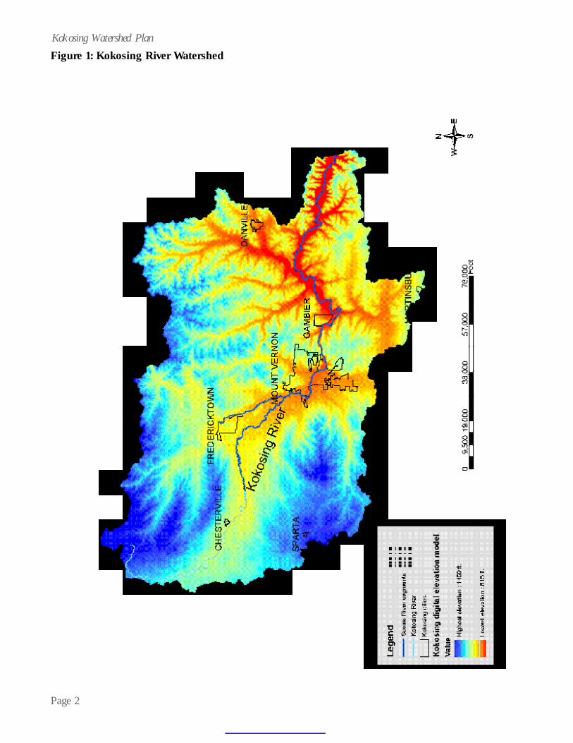
Thousands of years ago, the ancient moundbuilders settled in the Kokosing River valley. Theancient people found, as do present-day citizens,that the valley and its watershed harbor fertile soils,abundant wildlife and a rich quality of life. Due tothe presence of a healthy wooded corridor thatlandowners have maintained and erosion controlmeasures used by farmers, the Kokosing Riverretains exceptional water quality and speciesdiversity. However, the Kokosing watershed ischanging quickly. As Columbus suburbs continueto burgeon, threats to the Kokosing Riverwatershed have increased. Productive farmland isbeing subdivided for residential development, asmore people flock to share excellent quality of lifein the Kokosing River watershed (See Figure 1).
The Ohio Department of Natural Resources(ODNR), working with local government officials,organizations and citizens, embarked on a proactiveinitiative to draft a watershed plan for the Kokosing.In general, a watershed plan lists problems, prioritiesand activities that need to be addressed. The planwill serve to bring state dollars into the watershedto assist landowners with efforts to protect andmaintain it.
Purpose of this Management Plan
The purpose of the plan is to identify andreduce non point sources of pollution and toidentify and protect high quality habitat areas. Theplan will help guide the Division of Natural Areasand Preserves (DNAP) and other local governmentaland non-profit entities regarding decisions andactions that affect the Kokosing River and itstributaries. The decisions and actions include policyand procedure development and projects undertakenthat will facilitate the accomplishment of strategiesfound in the plan. The plan represents an analysisof environmental, recreational, socio-economical,and historical factors related to activities in thewatershed and outlines strategies to restore, enhanceand protect resources.
Endorsement of the plan by local partnersis indicated in the task matrices located under theStrategies Section. After the plan has been endorsedby the Ohio EPA and ODNR, the plan will bepresented to local officials in the watershed foradoption.
Project Background
The ODNR Division of Natural Areas andPreserves, with support from local legislators, localgovernment officials, Knox Regional PlanningCommission (RPC), Kenyon College, Soil and WaterConservation District (SWCD) staff and grassrootsorganizations, developed a grant proposal forsubmittal to the Ohio Environmental ProtectionAgency in 2002 to develop a watershed plan forthe Kokosing River. The Kokosing Watershed Planis unique since it occurs on a state designated scenicriver.
The Division of Natural Areas andPreserves uses three approaches in scenic riverprotection:
• Public project review plays a major role inriver preservation. The possibleenvironmental impact of the constructionof dams, bridges, roads or other publiclyfunded projects is carefully considered.ODNR has the authority to approve ordisapprove all publicly funded projects ondesignated scenic rivers outside municipalcorporation limits.
• Landowner assistance and education arevitally important components of riverprotection. Scenic river staff adviseslandowners about streamside protectiontechniques and provide technical assistancein river corridor restoration. Scenic riverdesignation does not affect private propertyrights.
• Water resource protection balances therelationship between the streamside forestbuffer, aquatic habitat and water quality.While the maintenance and improvement ofthe state’s water resources are the
Page 3
Kokosing Watershed Planresponsibility of the Ohio EnvironmentalProtection Agency (Ohio EPA), the mosteffective watershed protection involvescooperation among Ohio EPA, ODNR andlocal governments. To supplement thiseffort, The Division of Natural Areas andPreserves developed a stream qualitymonitoring and biological survey projectusing volunteers. Division staff also workswith federal, state and local agencies toreduce non point source pollution, whichcauses serious environmental damage torivers and streams.
Since the Ohio EPA has the responsibilityto manage and protect water resources, including theregulation of non point sources of pollution, OhioEPA agreed to offer a grant to the Division ofNatural Areas and Preserves to pursue developmentof a watershed plan for the Kokosing River.
Mission of the Kokosing River Watershed Plan-ning Project
As adopted through consensus by theKokosing River Watershed Steering Committeemembers in February 2003, the mission statementof the Kokosing River Watershed Plan is “To assistlandowners in conserving and managingKokosing River resources.”
Since most of the watershed is privatelyowned, the protection, restoration and enhancementof the Kokosing is fundamentally tied to those whoown the land in the watershed. The committeedecided against the use of specific adjectives todescribe the term “resources,” since the committeefelt that to sustain quality of life in the watershed, aholistic approach was needed to manage several typesof resources. The elements important to thecommittee include: farmland/agricultural resources,greenspace resources, historic and archaeologicalresources, recreational resources, ground water/surface water resources and biodiversity.
An information/education componentused to enhance public understanding of theproject included:
• Development of a web site dedicated tothe watershed plan;
• Development of various power pointpresentations for talks to interest groups(Farm Bureau, conservation clubs,gardens clubs, Lions, Rotary, Kiwanis,etc.);
• Development of a brochure insert fordistribution;
• One article/month in a local newspaperor newsletter;
• Radio spots on WMVO• Canoe floats (fish sampling and river
clean-up) and other “special events ”forpublic (government officials, FarmBureau, Owl Creek Conservancy,citizens);
• Networking with the community byparticipation in events or groups such ascommunity breakfasts, county fairs, U.S.Department of Agriculture (USDA) localworking group, Knox RPC
These types of activities will be on-goingduring the implementation phase of the project aswell, to further community awareness of the plan/project. This watershed plan will also be distributedto the Watershed Steering Committee, Scenic RiversAdvisory Council, local elected officials anddirectors/presidents of non-profit groups operatingin the watershed. The watershed plan is posted onthe Kokosing watershed plan web site.
Watershed Steering Committee
Members of the steering committeerepresented a diverse group of local governmentalofficials and advocacy members. All identifiedstakeholders in the community agreed to serve onthe committee and were active during the planningprocess. Steering members included:
• Dan Barker, Administrator, MorrowCountySWCD
• Brian Bennick, EnvironmentalDirector, Knox Department ofHealth

Page 4
Kokosing Watershed Plan• Rob Clendening, Administrator,
Knox County SWCD• Siobhan Fennessey, Professor,
Kenyon College• Doug Givens, Managing Director,
The Philander Chase Corporation• David Greer, Board Member, 4-H
Extension Advisory & Knox SWCDand Farmer
• Donald Hawk, President, KnoxFarm Bureau and Farmer
• Eric Helt, President, Knox Citizensfor Smart Growth and Famer
• Jim Henry, Engineer, Knox County• Steve Kauffman, Dairy Farmer• The Honorable Dick Mavis, Mayor,
City of Mount Vernon• Randy Pore, Secretary, Knox
RPC• Mark Ramser, President, Ohio
Cumberland Gas Development andReal Estate Developer
• Richard Stallard, President,Owl Creek Conservancy
Kim Baker served as chair and facilitatorof the steering committee.
Scenic River Advisory Council
The protection and preservation of adesignated scenic river depends heavily upon localinput and community involvement. The ScenicRivers Act requires a citizens’ advisory council,representing local officials, landowners andconservation organizations, be appointed for eachdesignated river. The council provides advice aboutlocal river protection and preservation concerns.Kokosing Scenic River Advisory Council membersinclude:
• Rich Cunningham, Educator• Frank DiMarco, Professional
Forester• David Greer, Farmer• Donald Hawk, Knox Farm Bureau• Ray Heithaus, Director, Brown
Family Environmental EducationCenter
• Jim Henry, Knox County Engineer• Doug McLarnan, College Township
Trustee• Gary Moore, Tree Farmer• Roger Yarman, Conservation Club
Member
Previous Watershed Studies and PlanningDocuments
While no previous watershed study has beenperformed on the Kokosing, the Knox CountyRegional Planning Commission performed a studyof the Kokosing and Mohican River Corridors in1974 and 1975 (See Figure 2). The study madeseveral recommendations, including purchasingscenic easements or properties within the rivers’corridors, improving local zoning to protect therivers and providing increased recreationalopportunity.
Additionally, The Kokosing River Study wasprepared in September 1997 by ODNR Division ofNatural Areas and Preserves staff. The studyincluded a criteria-based river assessment to ascertainwhether the Kokosing River met one of threecategories for designation under Ohio’s Scenic RiversLaw.
Ohio’s Scenic Rivers Law provides for threecategories of designation. Wild Rivers serve as riversthat are generally inaccessible, the flood plain isundeveloped, the river is free flowing and 75% ofthe adjacent corridor is forested to a depth of atleast 300 feet. Scenic River designation isrepresentative of a waterway that still retains muchof its natural character for the majority of its length.Shorelines are for the most part undeveloped, butthe river may exhibit signs of disturbances by humanactivities. The adjacent river corridor must beforested to a minimum depth of 300 feet for 25%of the stream’s length. Recreational Rivers are thoserivers that do not possess the same degree of naturalquality found in Wild or Scenic Rivers; yet warrantprotection due to unique cultural and/or important

Page 5
Kokosing Watershed PlanFigure 2: 1975 Kokosing River Corridor Study

Page 6
Kokosing Watershed Planhistorical attributes. The influence of humanactivity is much more apparent on rivers with thisclassification.
Ohio pioneered the river preservationmovement with the enactment of Senate Bill 345by the 107th General Assembly on February 28,1968. The Ohio Wild, Scenic, and RecreationalRivers Law, the first of its kind, predated theNational Wild and Scenic River Act. The purposeof establishing scenic rivers is to assist in theprotection and preservation of the few remainingnatural rivers in the state. The focus of Ohio’sScenic Rivers Program is the maintenance ofstreamside forested corridors wide enough to protectthe aquatic resources and suitable for the terrestrialcommunities dependent on forested riparianhabitats.
Designation of the Kokosing River underthe “scenic” classification was recommendedbeginning at the mouth of the river in CoshoctonCounty (RM 0.0) upstream to the Knox/MorrowCounty line (RM 41.1). Designation was alsorecommended for the North Branch of theKokosing River beginning at the confluence withthe Kokosing (RM 0.0) upstream to the confluenceof North Branch and East North Branch (RM 6.5).Together, these two segments total 47.6 miles. Therecommendations were based on the public supportreceived through local government resolutions, thedegree to which the scenic river criteria were met,and through qualitative judgment and othersubjective interpretations of data and information.
On November 4, 1997 the Director ofNatural Resources declared 41 miles of the mainstem of the Kokosing River as Scenic from itssouthern terminus upstream 41 miles. In addition,the North Fork of the Kokosing is also designatedfrom its confluence with the Kokosing upstream 6.5miles.
The Kokosing River lies within five countiesin Ohio: Ashland, Coshocton, Knox, Morrow andRichland. All five counties have made some levelof effort regarding regional planning initiatives.
Knox County developed its first county-basedcomprehensive plan in 1974. In 1996, the KnoxCounty/Mount Vernon Chamber of Commercesponsored an initiative known as “Focus 2100.”This initiative included a one-day conference opento all Knox County residents to discuss identificationof community strengths and areas of concern. Asan outgrowth of this Initiative, Knox Countyfinished its most current comprehensive plan, Focus2100, in 1998. Currently, the Knox RPC isundertaking an update and revision of Focus 2100.Several of the goals defined in Focus 2100 aregermane to the development of a watershed plan,as listed below:
• To increase outdoor recreation space by1,000 acres by the year 2005 to satisfycurrent needs, and by 2,000 acres by theyear 2020 to meet projected demand.
• To protect the natural resources andenvironmental assets of Knox County.
• To protect Knox County’s farms and ruralcharacter.
• To establish areas for residential growth ina manner consistent with desires to preservefarmland and rural character.
• To establish an effective and adequatelystaffed and funded planning organization inKnox County.
• To have organized, relevant, and up-to-dateinformation on Knox County land resourcesreadily available to local officials and thepublic.

Page 7
Kokosing Watershed Plan• To effectively guide overall development in
accordance with a plan for future land useand basic principles of wise land use.
• To develop and redevelop attractive,accessible, and viable commercial areas toserve the needs of Knox County residents.
• To identify (and reserve) areas especiallysuitable for industrial development andprovide adequate industrial sites for futureemployment needs.
• To identify and recognize historic resources.• To protect and enhance historic resources.• Promote historic resources.
Morrow County has yet to develop acomprehensive land use plan. However, a steeringcommittee, formed in 2003, nears competion of adraft plan. The City of Mansfield and RichlandCounty jointly created the Richland County RegionalPlanning Commission (RCRPC) in 1959 to undertakeregional planning. The organization carries on todaystill true to its original purpose — most notably inthe ongoing focus on issues that “affect thedevelopment of the Region as a whole” (RCRPC,2003).
The RCRPC has undertaken several specialprojects such as the development of stormwatermanagement and erosion control regulations forRichland County and the preparation of a FarmlandPreservation Plan. Both Ashland and CoshoctonCounties have completed comprehensive land useplans. Ashland County updated its ComprehensivePlan in 2000, which covers many topics includingfuture development patterns, quality of life andtransportation issues. Coshocton County beganupdating its plan, originally drafted in the early1970s, to reflect changing land use patterns anddemographics, in 2003. Some of the strategiesdrafted in the Coshocton plan include encouragingconservation of environmentally sensitive areas,promoting preservation of natural resources,developing, maintaining and improving the qualityof surface water resources and utilizing surfacewaters for recreational sites, where appropriate. Alltownships in the watershed, with the exception offive (three in Knox; two in Morrow), possess zoningregulations at the county or township level.
In 1998 and 1999, Knox County’sFarmland Preservation Taskforce met to evaluatethe state of agricultural production in Knox County,explore alternatives to unplanned development anddevelop recommendations for the preservation offar mlands in Knox County. Their eightrecommendations are as follows:
• Direct funding sources for a county-widevoluntary Purchase of Development RightsProgram.
• Knox County Planning Commission staffmember be given the duties ofadministrative suppor t for farmlandprotection programs and the FarmlandPreservation Board.
• Creation of a private countywide land trust.• Townships create comprehensive land use
plans that not only identify and addressresidential and commercial areas, but alsocritical masses of productive agriculturallands.
• All townships be educated on a program forcalculating the true Cost of CommunityServices before making any major land usedecision.
• Educate and encourage townships to createtheir own farmland protection programsthrough special agricultural zoning orPurchase of Development Rights (PDR)/Transfer of Development Rights (TDR)programs.
• Knox County Regional PlanningCommission and the Knox CountyCooperative Extension Office initiate aseries of continuing education seminars forlocal attorneys and tax accountants on thetax benefits of PDR programs.
• Joint committee be formed to look atincentives to revitalize and develop existingurban areas that are already serviced bypublic infrastructure and ser vices.Incentives would not only be considered forindustrial and commercial development butalso for the revitalization of residentialneighborhoods.

Page 8
Kokosing Watershed PlanSeveral governmental programs geared
toward assisting farmers, improving wildlife habitatand water quality andconserving soil resources areemployed in the Kokosingwatershed. Most notableprograms (with descriptionstaken verbatim from agencyweb sites) are:
• The Wetlands Reserve Program (WRP) is avoluntary program that provides technicaland financial assistance to eligiblelandowners to address wetland, wildlifehabitat, soil, water, and related naturalresource concerns on private lands in anenvironmentally beneficial and cost-effective manner. The program provides anopportunity for landowners to receivefinancial incentives to enhance wetlands inexchange for retiring marginal land fromagriculture.
• The Environmental Quality IncentivesProgram (EQIP) is a voluntary program thatprovides assistance to farmers and rancherswho face threats to soil, water, air, andrelated natural resources on their land.Through EQIP, the Natural ResourcesConservation Service (NRCS) providesassistance to agricultural producers in amanner that will promote agriculturalproduction and environmental quality ascompatible goals, optimize environmentalbenefits, and help farmers meetenvironmental requirements. In Farm Bill2002, additional points are awarded tofarmers who participate in the North Branchof the Kokosing and the Kokosing abovethe confluence the North Branch.
• The Wildlife Habitat Incentives Program(WHIP) is a voluntary program thatencourages creation of high quality wildlifehabitats that support wildlife populations.Through WHIP, the Natural ResourcesConservation Service (NRCS) providestechnical and financial assistance tolandowners and others to develop upland,
wetland, riparian, and aquatic habitat areason their property. Division of Wildlife alsoprovides technical assistance.
• Conservation Reserve Program (CRP)enables eligible owners or operators to placehighly erodible or other environmentallysensitive land into a 10-15 year contract.The participant, in return for annualpayments, agrees to implement aconservation plan approved by the localconservation district for converting highlyerodible cropland or other environmentallysensitive land to a long-term resourceconserving cover (i.e., eligible land must beplanted with a vegetative cover, such as,perennial grasses, legumes, fobs, shrubs, ortrees).
• Land and Water Conservation Fund(National Park Service pass-through toODNR Division of Real Estate and LandManagement) provides grants up to a 50percent reimbursement level for outdoorrecreation projects.
• NatureWorks (ODNR Division of RealEstate and Land Management) provides upto 75% reimbursement grants (statefunding) for acquisition, development orrehabilitation of public park and recreationareas. The agency must have proper control(title or at least a 15-year non-revocablelease) to be eligible for development orrehabilitation grant.
• Greenspace Preservation Grants (CleanOhio Fund, administered by Public WorksCommission) are awarded to localgovernmental or nonprofit entities forgreenspace protection. Special emphasis willbe given to projects that: protect habitat forrare, threatened or endangered species;preserve high quality wetlands and otherscarce natural resources; preservestreamside forests, natural stream channels,functioning floodplains, and other naturalfeatures of Ohio’s waterways; supportcomprehensive open space planning; secureeasements to protect stream corridors,which may be planted with trees or
Page 9
Kokosing Watershed Planvegetation to help reduce erosion andfertilizer/ pesticide runoff;
• Ohio Depar tment of Agriculture’sAgricultural Easement Donation Program(Clean Ohio Fund) allows landowners todonate an agricultural easement on theirfarm to the state, as well as to a county,municipality, township, or a charitableorganization such as a land trust, therebyrestricting development on farmland.Landowners may undertake any agriculturalactivity permitted under Ohio law, and theycan sell their farm or pass it along as a giftto others. A restriction prohibiting non-farmdevelopment travels with the land, and anew owner would never be able to developthe land for non-farm uses.
• Forest Legacy Grants (ODNR Division ofForestry) is a new program in developmentin Ohio that will identify and help protectenvironmentally important forests fromconversion to nonforest uses. The main toolused for protecting these important forestsis conservation easements. The Federalgovernment may fund up to 75% ofprogram costs, with at least 25% comingfrom private, state or local sources.
• The Knox SWCD and ODNR, DNAP havecollaborated to provide livestock exclusionfencing to local farmers. Funds are providedto the farmer for fencing materials. In
exchange for fencing, the farmers protectstreambanks from livestock encroachment.Access areas to the stream are planned withtechnical assistance from the SWCD. Thiswin-win program results in increased waterquality, restoration of riparian habitat andallows farmers to continue using streams forlivestock watering. Table 1 shows detailsof the program.
Other programs, such as Ohio EPA’s WaterResource Restoration Sponsorship Program(WRRSP) could be deployed in the watershed toprotect high quality habitats. The goal of theWRRSP is to abate the loss of ecological functionand biological diversity that jeopardizes the healthof Ohio’s water resources.
Justification and Need
Economic Benefits of Conservation/Protection
Streams and wetlands provide natural floodcontrol, trap sediments, maintain water supplies,recycle nutrients, maintain biological diversity,recharge groundwater, provide wildlife habitat andcorridors and afford people places to recreate.These “ecosystem services” help local governmentsreduce the costs of providing clean water andrecreational areas to the public. For instance,reservoirs and water treatment plants located in
Table 1: 2003 Kokosing Watershed Livestock Exclusion Fencing Projects
Drainage Buffer Fence Total Stream Area Buf Width Ac. (ft) Fence Type Other Practices Est. Cost
un-named > 1sq.mi 15 ft/side 0.2 640 woven wire crossing 1,960 Indianfield Run trib. > 1sq.mi 15 ft/side 0.6 1,760 barbed wire 2,640
Dowd Cr. > 1sq.mi 15 ft/side** 0.5 1,480 4 strand barbed 4,440 Dowd Cr. > 1sq.mi 15 ft/side 0.7 2,000 4 strand barbed 3,000
North Branch 97 sq.mi 25 ft/side 2.3 4,000 varies planned crossings 10,000 Headwater trib. To
Jelloway Cr. > 1sq.mi 15 ft/side 0.8 2,160 high tensile off stream water
source 7,524 Headwater trib. To
Jelloway Cr. > 1sq.mi 15 ft/side 0.4 1,120 high tensile crossing 3,328 ** one side constructed at this time. 2nd part of project pending. Total: 11,680

Page 10
Kokosing Watershed Planwatersheds with healthy streams and wetlandsrequire less dredging of marinas and reducedtreatment and filtration for water intake pipes thanin watersheds with degraded streams and wetlands.Streams and wetlands absorb significant amountsof rainwater and runoff before flooding, and slowwater down (which helps control erosion andsedimentation).
Economic Benefits of Local Tourism
The Kokosing watershed contains manyhistorical and pre-historic sites that serve as assetsto local tourism. Preserving the scenic beauty andhistoric assets in the watershed will ensure thattourism dollars continue flowing into the localeconomy. One of the more important local tourismopportunities is the emergence of interest in theAmish Culture, which provides enhancedopportunities for tourist travel with Amishsettlements located in Holmes, Knox, Coshocton andTuscarawas Counties. Also, since families are tendingto take shorter (yet more frequent day or weekend)trips to avoid traffic and high-risk destinations, localand regional tourism is increasing. Familiesundertaking day trips seek areas that providepastoral scenes and striking viewsheds, such as thosefound in the Kokosing watershed.
As indicated in the U.S. Fish and WildlifeService’s 2001 National Survey of Fishing, Hunting,and Wildlife-Associated Recreation, wildlife watchingis one of the most popular outdoor activities, withapproximately $724 million generated annually intrip-related expenditures for Ohio’s economy.Likewise, hunting and fishing expenditures generate$645 million and $904 million, respectively. Leisureresearch points to trends that wildlife watching andbicycling will continue to grow in popularity, dueto changing demographics. As more “babyboomers” retire, these individuals will enjoy morediscretionary time to recreate, possess disposableincome to spend on recreation and, as a group, tendto focus on maintaining a healthier/more fitness-based lifestyle. Thus, outdoor recreation areas willexperience greater visitation and pressure to providequality recreational experiences.
Recreation services can provide significantpositive local economic impacts. In 1996, the WayneNational Forest contracted a study to explore theimpact of recreation opportunity on the localeconomy. The authors of the study concluded thatthis recreational demand led to a $45,768,000 totaleconomic impact, with $24,971,000 total incomeimpact and 1,024 jobs either directly or indirectlyassociated with recreation services.
A 1994 study, “Travel and TourismEconomic Impacts,” conducted in 1996 byMarketVision Research Inc., shows a breakdownof economic outputs from tourism, business travel,and conventions (including outdoor and culturaltourism figures and expenditures such as travel,entertainment, lodging, and sightseeing). Theeconomic impact of local tourism was estimated at$21.51 million for 1996, according to the study.
Outdoor Recreation
Ohio’s water resources provideopportunities for a diversity of recreationalactivities. Ohio has approximately 44,000 miles ofrivers and streams and 133,000 acres of inland lakesand reservoirs. In 1990, the Ohio OutdoorRecreational Participation Study verified theimportance of water-based recreation by findingthat fishing, boating, swimming and beach activitieswere in the top 10 of the most frequentlyparticipated in activities.
Quality recreational experiences in activitiessuch as fishing, boating and/or swimming aredirectly related to the water quality. Because theKokosing River and its tributaries are a high qualityresource in a generally rural setting, it makes sensethat Knox and Morrow Counties have an abundanceof recreational opportunities to pursue.
In addition to the Kokosing River servingas a recreational resource, 1 to 2 percent of KnoxCounty and Morrow County is devoted to otherrecreational endeavors. Of Knox County’s 338,672total acres, 5,940 acres are comprised of parks andopen space. Morrow County contains a total of

Page 11
Kokosing Watershed Plan260,280 acres with 1,643 acres used for parks andopen space. While the citizens of Knox and MorrowCounties may perceive that their respective countiescontain large amounts of greenspace, both countiesactually rank low interms of percentageof outdoor recreationacreage given countyland size andpopulation.
This publicperception is basedon the amount ofundeveloped, privately held land in the watershedthat the public perceives as greenspace. However,with increasing residential and commercialdevelopment, more citizens in the watershed aregrowing aware of the need to preserve and protectgreenspace. The Knox Citizens for Smart Growthwas formed to advocate the need to protectgreenspace, far mland and quality of life.Additionally, The Owl Creek Conservancy, aprivate nonprofit organization, is “dedicated topreserving natural and agricultural lands in the KnoxCounty area through widespread private action, andworks with landowners for the public good tomaintain and to improve the quality of life bypreser ving woodland, wetlands, far mland,waterways, scenic vistas and wildlife habitats ofenvironmental, historic, and communityimportance.” The Owl Creek Conservancy hassecured conservation easements on wooded andriparian areas adjacent to the Kokosing.
No outdoor recreation areas occur in theKokosing River watershed within Richland County.Coshocton County contains a small amount ofoutdoor recreation area, due to the presence of landsowned and managed by the Muskingum WatershedConservancy District. Ashland County contains asmall portion (255 acres) of the Mohican MemorialState Forest that occurs in the watershed. One parkdistrict and one recreation district own land in thewatershed (Knox County Park District andFredricktown Recreation District). Park Districtsin Ashland, Morrow, Coshocton and RichlandCounties do not own any land in the watershed.
The Kokosing River watershed containsseveral recreational facilities. Table 2 lists alloutdoor recreation sites reported in the 2002Statewide Comprehensive Outdoor Recreation Plan(SCORP). Several additional sites not found in theSCORP are included as well. Table 3 shows existingand planned trails that occur, either partially orwholly, within the Kokosing River watershed.
Major recreational areas include theKokosing Lake Wildlife Area, making up 1,323 acresand the Knox Lake Wildlife Area, containing 761acres. A small portion of the Mohican State Forestlies within the northeastern corner of the watershed,and the Muskingum Watershed Conservancy owns1,495 acres in the lower portion of the Kokosing,managing these lands for hunting and hikingopportunities. More privately owned facilities thanpublic facilities exist, and the largest of these isApple Valley, covering 3,700 acres.
The Kokosing Gap Trail is a popularrecreational resource stretching more than 14 milesfrom Mount Vernon to Danvillealong the Kokosing River. TheCity of Mount Vernon recentlyexpanded the Kokosing GapTrail and has plans to link thetrail with other Mount Vernonmanaged park sites. Also in theconceptual planning stages is atrail linking the Kokosing Gap Trail that will trendthrough and outside the watershed to Centerburg,Ohio. Approximately 1.0 mile of the 4.54 mileMohican Valley Trail lies within the Kokosingwatershed. The Mohican Valley Trail links withthe Kokosing Gap Trail in Danville, and consistsof a multi-use trail for mountain bikes, horses andAmish buggies. About seven percent of availablerecreational area is water, with a large portionlocated at Knox Lake Wildlife Area and theKokosing Lake Wildlife Area, suitable for canoeingand boating, fishing and other water-orientedactivities. A 29 acre wooded area, Knox Woods, isdesignated as a state Nature Preserve by the OhioDepartment of Natural Resources. Adjacent toKnox Woods is the Knox Park District area, known
Page 12
Kokosing Watershed PlanTable 2: Outdoor Recreation Sites in the Kokosing Watershed
RECREATION SITE LAND (Acres)
WATER (Acres)
HIKE TRAILS (Miles)
BIKE TRAILS (Miles)
HUNT (Acres)
BOAT (Acres)
CANOES (for rent)
BACKPACK TRAILS (Miles)
FREDERICKTOWN COMMUNITY PARK 35 1 0 0 0 0 0 0 ARCH AVE.PARK 21 0 0 0 0 0 0 0 DAN EMMETT PARK 5 0 0 0 0 0 0 0 CAMP MCPHERSON 160 1 3 0 0 0 0 0 LAKE MARANATHA CAMP 79 2 3 0 52 2 6 0 APPLE VALLEY GOLF COURSE 203 2 0 0 0 0 0 0 CAMP ANDERSON 200 5 2 0 0 0 0 0 MOHICAN MEMORIAL STATE FOREST 5,109 0 25 0 4,800 0 0 25 DEERFIELD LANES 17 0 0 0 0 0 0 0 KOKOSING VALLEY CAMP & CANOE 100 2 40 KOKOSING WILDLIFE AREA 1,110 1 0 0 1,114 0 0 0 SUGARTREE FARMS 80 0 0 0 0 0 0 0 RUSTIC KNOLLS 98 2 3 0 0 0 0 0 RIVERSIDE PARK 18 0 0 0 0 0 0 0 PHILLIPS PARK 5 0 0 0 0 0 0 0 MOUNT VERNON COUNTRY CLUB 50 0 0 0 0 0 0 0 MERRIN MEMORIAL PARK 3 0 0 0 0 0 0 0 THE CAVES 25 0 0 0 0 0 0 0 MEMORIAL PARK 43 0 0 0 0 0 0 0 TOMAHAWK GOLF COURSE 50 2 0 0 0 0 0 0 KNOX WOODS 30 0 2 0 0 0 0 0 KNOX LAKE WILDLIFE AREA 266 495 0 0 0 495 2 0 KNOX CO.FISH & GAME ASSOC. 40 0 0 0 40 0 0 0 KNOX CO FAIRGROUNDS 66 1 0 0 0 0 0 0 IRISH HILLS GOLF COURSE 135 0 0 0 0 0 0 0 HIDDEN HILLS GOLF COURSE 30 1 0 0 0 0 0 0 HICKORY GROVE CAMPING 6 1 0 0 0 0 0 0 HIAWATHA GOLF COURSE 128 2 0 0 0 0 0 0 HIAWATHA COMMUNITY PARK 20 0 0 0 0 0 0 0 BROAD ACRES PRESBYTERIAN CAMP 86 0 2 0 0 0 0 0 WARNER PARK 1 0 0 0 0 0 0 0 FOUNDATION PARK 90 175 0 0 0 0 0 0 McDONALD PROPERTY 2 0 0 0 0 0 0 0 WOLF RUN REGIONAL PARK 267 1 0 0 0 0 0 0 MUSKINGUM WATERSHED CONSERVANCY DISTRICT 1,495 0 0 0 1,495 0 0 0 KNOX LANDFILL 68 VIADUCT PARK 0.5 McILVAINE PARK 0.5 RAMSER ARBORETUM 630 25 CAMP CORNISH 14 1

Page 13
Kokosing Watershed Plan
as Wolf Run Regional Park. Mount VernonNazarene University protects a 69-acre parcel as anature preserve.
In 2003, the Knox Park District wasawarded a Clean Ohio Fund GreenspacePreservation Grant to acquire a 2.0-acre parceladjacent to the Kokosing River. The ODNR ScenicRivers Program obtained a conservation easementover this parcel and is assisting the Knox ParkDistrict with restoration of riparian buffer on thisparcel. The City of Mount Vernon was alsoawarded several Clean Ohio Fund grants to protectKokosing River corridor parcels (at FoundationPark) and a 53-acre high quality (category three)wetland and Delano Run floodplain area, nowknown as the Blackjack Wetlands Preserve. TheOwl Creek Conservancy will hold a conservationeasement over the wetland preserve.
Facilities such as the bike trail and parksuse the river to visually/aesthetically enhance therecreational experience for their users. The canoelivery and wildlife areas provide for more direct useof the river. Conversely, the bike trail, parks andcanoe access sites provide users the chance toexperience the river, which in turn, leads to greaterappreciation and support for the protection of theKokosing State Scenic River. Thus, recreationalaccess and opportunity, if planned appropriately,can enhance support for the Kokosing River, whileprotecting unique habitats.
The Kokosing River has an adequate flowfor canoeing throughout the year on the lowerportion and fishing and hunting opportunities arewell known. Part of the Kokosing River lies in theMohawk Dry Reservoir flood area. Rapids, riffles,
rock outcroppings and an isolated appearance givethe Kokosing River its wilderness quality,particularly below Hazel Dell Road and MillwoodRoad Bridge at the gorge. A fair portion of theKokosing River is canoeable on a yearly basis,weather permitting.
Nearly all Ohio rivers and streams aredependant upon rainfall and tend to have low flowslate in the season that are not conducive to canoeingand/or recreational boating. Canoeing on the upperstretches of the Kokosing River, from theconfluence with the North Branch until it reachesHoward, is somewhat restricted by such seasonalvariations in river flow. According to ODNR,Division of Watercraft, the upper stretches of theKokosing River above the confluence with NorthBranch are considered non-paddleable and maypossess considerable logjams and portages.Examples of hazards in the upper stretches includethree dams that are northwest of Mount Vernon.One is located on North Branch, another one lieson the East Branch of the Kokosing.
Table 4 lists Kokosing River canoe accesssites, as provided by ODNR Division of Watercraft.It is important to note that most sites are
undeveloped for canoelaunching, so canoeistsshould exercisecaution and obtainpermission prior toaccessing the river viaprivate property.
The general feeling of isolation experiencedon most sections of the Kokosing River is greatlydiminished while canoeing through Mount Vernon
Table 3: Existing and Proposed Trails in the Kokosing Watershed
Trail Name Status Length in Miles Ohio to Erie Trail Existing, Planned Segments 13.90 3C Trail Planned 31.04 Ohio to Erie Trail Existing, Planned Segments 48.20 Kokosing Gap Trail Existing 14.74 Mohican Valley Trail Existing 4.54 Owl Creek Trail Planned 10.25
Page 14
Kokosing Watershed PlanTable 4: Kokosing River Canoe Access Sites
Description
Nearest Town
County
Park-
ing
Canoe Rental
Rest
Room
Water
Picnic
Riverside Park off SR36/229. Access
Left.
Mount Vernon
Knox
Yes
No
Yes
Yes
Yes
Memorial Park off
Mount Vernon Ave. Access River
Right.
Mount Vernon
Knox
Yes
No
Yes
Yes
Yes
Laymon Road Bridge. Canoe
access River Right.
Gambier
Knox
Yes
No
No
No
Yes
Big Run Road.
Canoe access River Right.
Gambier
Knox
Yes
No
No
No
Yes
Zion R. Bridge. Roadside Access
River Right.
Gambier
Knox
Yes
No
No
No
No
Pipesville Road
Canoe access River Right.
East of Howard
Knox
Yes
No
No
No
No
SR 715 to Riley Chapel Road.
East of
Millwood
Knox
Yes
No
No
No
No
SR715 to Twp. Rd. 366/423 Bridge (W.
of Walhonding at Mohican
confluence) Access River Right & Left.
North of
New-castle
Coshoc -ton
Yes
Yes
Koko. Valley Camp
& Canoe
No
No
No
Page 15
Kokosing Watershed Planbecause of the many bridge crossings, and urbanactivity; however, this is only temporary and theriver quickly returns to its wilderness atmosphereonce Mount Vernon is passed. The main stem ofthe Kokosing River from the Gambier area until itcombines with the Mohican and Walhonding Riversis generally canoeable year-round and relatively free
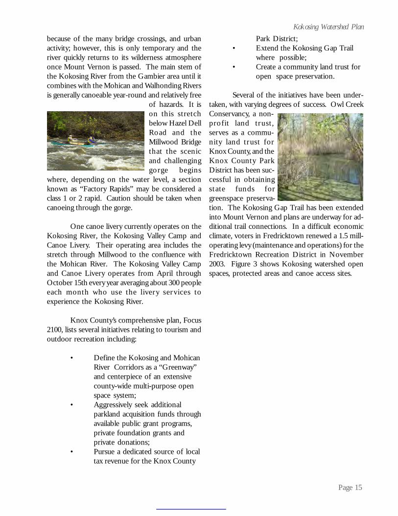
of hazards. It ison this stretchbelow Hazel DellRoad and theMillwood Bridgethat the scenicand challenginggorge begins
where, depending on the water level, a sectionknown as “Factory Rapids” may be considered aclass 1 or 2 rapid. Caution should be taken whencanoeing through the gorge.
One canoe livery currently operates on theKokosing River, the Kokosing Valley Camp andCanoe Livery. Their operating area includes thestretch through Millwood to the confluence withthe Mohican River. The Kokosing Valley Campand Canoe Livery operates from April throughOctober 15th every year averaging about 300 peopleeach month who use the livery services toexperience the Kokosing River.
Knox County’s comprehensive plan, Focus2100, lists several initiatives relating to tourism andoutdoor recreation including:
• Define the Kokosing and MohicanRiver Corridors as a “Greenway”and centerpiece of an extensivecounty-wide multi-purpose openspace system;
• Aggressively seek additionalparkland acquisition funds throughavailable public grant programs,private foundation grants andprivate donations;
• Pursue a dedicated source of localtax revenue for the Knox County
Park District;• Extend the Kokosing Gap Trail
where possible;• Create a community land trust for
open space preservation.
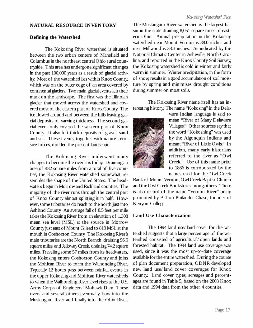
Several of the initiatives have been under-taken, with varying degrees of success. Owl CreekConservancy, a non-profit land trust,serves as a commu-nity land trust forKnox County, and theKnox County ParkDistrict has been suc-cessful in obtainingstate funds forgreenspace preserva-tion. The Kokosing Gap Trail has been extendedinto Mount Vernon and plans are underway for ad-ditional trail connections. In a difficult economicclimate, voters in Fredricktown renewed a 1.5 mill-operating levy (maintenance and operations) for theFredricktown Recreation District in November2003. Figure 3 shows Kokosing watershed openspaces, protected areas and canoe access sites.

Page 16
Kokosing Watershed PlanFigure 3: Kokosing Watershed Open Spaces, Protected Areas and Canoe Access Sites
Page 17
Kokosing Watershed Plan
NATURAL RESOURCE INVENTORY
Defining the Watershed
The Kokosing River watershed is situatedbetween the two urban centers of Mansfield andColumbus in the northeast central Ohio rural coun-tryside. This area has undergone significant changesin the past 100,000 years as a result of glacial activ-ity. Most of the watershed lies within Knox County,which was on the outer edge of an area covered bycontinental glaciers. Two main glacial events left theirmark on the landscape. The first was the Illinoianglacier that moved across the watershed and cov-ered most of the eastern part of Knox County. Theice flowed around and between the hills leaving gla-cial deposits of varying thickness. The second gla-cial event only covered the western part of KnoxCounty. It also left thick deposits of gravel, sandand silt. These events, together with nature’s ero-sive forces, molded the present landscape.
The Kokosing River underwent manychanges to become the river it is today. Draining anarea of 482 square miles from a total of five coun-ties, the Kokosing River watershed somewhat re-sembles the shape of the United States. The head-waters begin in Morrow and Richland counties. Themajority of the river runs through the central partof Knox County almost splitting it in half. How-ever, some tributaries do reach to the north just intoAshland County. An average fall of 8.5 feet per miletakes the Kokosing River from an elevation of 1,308mean sea level (MSL) at the source in MorrowCounty just east of Mount Gilead to 819 MSL at themouth in Coshocton County. The Kokosing River’smain tributaries are the North Branch, draining 96.6square miles, and Jelloway Creek, draining 74.2 squaremiles. Traveling some 57 miles from its headwaters,the Kokosing enters Coshocton County and joinsthe Mohican River to form the Walhonding River.Typically 12 hours pass between rainfall events inthe upper Kokosing and Mohican River watershedsto when the Walhonding River level rises at the U.S.Army Corps of Engineers’ Mohawk Dam. Theserivers and several others eventually flow into theMuskingum River and finally into the Ohio River.
The Muskingum River watershed is the largest ba-sin in the state draining 8,051 square miles of east-ern Ohio. Annual precipitation in the Kokosingwatershed near Mount Vernon is 38.0 inches andnear Millwood is 38.3 inches. As indicated by theNational Climatic Center in Asheville, North Caro-lina, and reported in the Knox County Soil Survey,the Kokosing watershed is cold in winter and fairlywarm in summer. Winter precipitation, in the formof snow, results in a good accumulation of soil mois-ture by spring and minimizes drought conditionsduring summer on most soils.
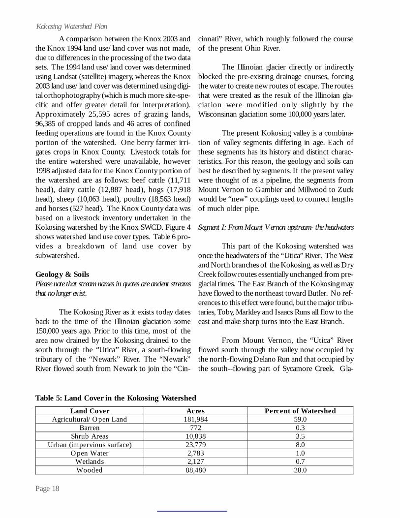
The Kokosing River name itself has an in-teresting history. The name “Kokosing” in the Dela-
ware Indian language is said tomean “River of Many DelawareVillages.” Other sources say thatthe word “Kokoshing” was usedby the Algonquin Indians andmeant “River of Little Owls.” Inaddition, many early historiansreferred to the river as “OwlCreek.” Use of this name priorto 1866 is corroborated by thenames used for the Owl Creek
Bank of Mount Vernon, Owl Creek Baptist Churchand the Owl Creek Bookstore among others. Thereis also record of the name “Vernon River” beingpromoted by Bishop Philander Chase, founder ofKenyon College.
Land Use Characterization
The 1994 land use/land cover for the wa-tershed suggests that a large percentage of the wa-tershed consisted of agricultural/open lands andforested habitat. The 1994 land use coverage wasused, since it was the most up-to-date coverageavailable for the entire watershed. During the courseof plan document preparation, ODNR developednew land use/land cover coverages for KnoxCounty. Land cover types, acreages and percent-ages are found in Table 5, based on the 2003 Knoxdata and 1994 data from the other 4 counties.
Page 18
Kokosing Watershed PlanA comparison between the Knox 2003 and
the Knox 1994 land use/land cover was not made,due to differences in the processing of the two datasets. The 1994 land use/land cover was determinedusing Landsat (satellite) imagery, whereas the Knox2003 land use/land cover was determined using digi-tal orthophotography (which is much more site-spe-cific and offer greater detail for interpretation).Approximately 25,595 acres of grazing lands,96,385 of cropped lands and 46 acres of confinedfeeding operations are found in the Knox Countyportion of the watershed. One berry farmer irri-gates crops in Knox County. Livestock totals forthe entire watershed were unavailable, however1998 adjusted data for the Knox County portion ofthe watershed are as follows: beef cattle (11,711head), dairy cattle (12,887 head), hogs (17,918head), sheep (10,063 head), poultry (18,563 head)and horses (527 head). The Knox County data wasbased on a livestock inventory undertaken in theKokosing watershed by the Knox SWCD. Figure 4shows watershed land use cover types. Table 6 pro-vides a breakdown of land use cover bysubwatershed.
Geology & SoilsPlease note that stream names in quotes are ancient streamsthat no longer exist.
The Kokosing River as it exists today datesback to the time of the Illinoian glaciation some150,000 years ago. Prior to this time, most of thearea now drained by the Kokosing drained to thesouth through the ‘’Utica’’ River, a south-flowingtributary of the “Newark” River. The “Newark”River flowed south from Newark to join the “Cin-
cinnati” River, which roughly followed the courseof the present Ohio River.
The Illinoian glacier directly or indirectlyblocked the pre-existing drainage courses, forcingthe water to create new routes of escape. The routesthat were created as the result of the Illinoian gla-ciation were modified only slightly by theWisconsinan glaciation some 100,000 years later.
The present Kokosing valley is a combina-tion of valley segments differing in age. Each ofthese segments has its history and distinct charac-teristics. For this reason, the geology and soils canbest be described by segments. If the present valleywere thought of as a pipeline, the segments fromMount Vernon to Gambier and Millwood to Zuckwould be “new” couplings used to connect lengthsof much older pipe.
Segment I: From Mount Vernon upstream- the headwaters
This part of the Kokosing watershed wasonce the headwaters of the “Utica” River. The Westand North branches of the Kokosing, as well as DryCreek follow routes essentially unchanged from pre-glacial times. The East Branch of the Kokosing mayhave flowed to the northeast toward Butler. No ref-erences to this effect were found, but the major tribu-taries, Toby, Markley and Isaacs Runs all flow to theeast and make sharp turns into the East Branch.
From Mount Vernon, the “Utica” Riverflowed south through the valley now occupied bythe north-flowing Delano Run and that occupied bythe south--flowing part of Sycamore Creek. Gla-
Table 5: Land Cover in the Kokosing WatershedLand Cover Acres Percent of Watershed
Agricultural/Open Land 181,984 59.0 Barren 772 0.3
Shrub Areas 10,838 3.5 Urban (impervious surface) 23,779 8.0
Open Water 2,783 1.0 Wetlands 2,127 0.7 Wooded 88,480 28.0

Page 19
Kokosing Watershed PlanFigure 4: Land Use Cover in the Kokosing Watershed

Page 20
Kokosing Watershed Plan
NARRATIVE Land Cover Type Acres Kokosing River headwaters to below S. Branch Kokosing R. Land Cover Type Acres Urban 128 Agriculture 16,769 Shrub 85 Wooded 6,077 Water 28 Wetland 211 Barren 0 23,298 Kokosing River below S. Branch to below Mile Run Land Cover Type Acres Urban 187 Agriculture 16,595 Shrub 171 Wooded 7,323 Water 85 Wetland 378 Barren 19 24,758 Kokosing River below Mile Run to above N. Branch Land Cover Type Acres Urban 1,850 Agriculture 207,304 Shrub 283 Wooded 26,127 Water 117 Wetland 80 Barren 7 235,768 North Branch Kokosing River headwaters to near St. Rt. 13 Land Cover Type Acres Urban 388 Agriculture 334,267 Shrub 479 Wooded 12,868 Water 169 Wetland 153 Barren 0 348,323 East Branch Kokosing River Land Cover Type Acres Urban 1,274 Agriculture 12,812 Shrub 490 Wooded 5,035 Water 514 Wetland 279 Barren 2 20,406
Table 6: Land Cover in the Kokosing Watershed

Page 21
Kokosing Watershed Plan
North Branch Kokosing River near St. Rt. 13 to Kokosing R.
Land Cover Type
Acres
[except East Branch] Urban 1,624 Agriculture 8,604 Shrub 263 Wooded 2,021 Water 236 Wetland 378 Barren 118 13,244 Kokosing River below N. Branch to above Dry Run Land Cover Type Acres Urban 2,065 Agriculture 5,158 Shrub 496 Wooded 2,999 Water 150 Wetland 0 Barren 78 10,947 Dry Creek Land Cover Type Acres Urban 2,436 Agriculture 10,157 Shrub 1,263 Wooded 7,756 Water 150 Wetland 33 Barren 106 21,901 Kokosing River below Dry Creek to above Big Run Land Cover Type Acres Urban 6,013 Agriculture 7,877 Shrub 1,247 Wooded 5,584 Water 140 Wetland 19 Barren 125 21,003 Big Run Land Cover Type Acres Urban 1,433 Agriculture 13,197 Shrub 877 Wooded 4,297 Water 72 Wetland 9 Barren 3 19,887
Table 6: Land Cover in the Kokosing Watershed (continued)

Page 22
Kokosing Watershed Plan
Indianfield Run Land Cover Type Acres Urban 255 Agriculture 5,236 Shrub 307 Wooded 1,630 Water 21 Wetland 2 Barren 1 7,452 Little Schenck Creek Land Cover Type Acres Urban 476 Agriculture 6,573 Shrub 357 Wooded 2,750 Water 43 Wetland 210 Barren 3 10,411 Schenck Creek [except Little Schenck Cr.] Land Cover Type Acres Urban 1,209 Agriculture 8,856 Shrub 979 Wooded 4,674 Water 65 Wetland 192 Barren 10 15,986 Kokosing River below Big Run to above Jelloway Cr. Land Cover Type Acres [except Indianfield Run & Schenck Cr.] Urban 1,776 Agriculture 9,458 Shrub 459 Wooded 10,576 Water 421 Wetland 7 Barren 128 22,825 Jelloway Creek [except E. Branch & L. Jelloway Cr.] Land Cover Type Acres Urban 883 Agriculture 16,931 Shrub 1,238 Wooded 9,182 Water 92 Wetland 9 Barren 17 28,352
Table 6: Land Cover in the Kokosing Watershed (continued)

Page 23
Kokosing Watershed Plan
East Branch Jelloway Creek Land Cover Type Acres Urban 704 Agriculture 5,224 Shrub 333 Wooded 4,782 Water 708 Wetland 0 Barren 1 11,753 Little Jelloway Creek Land Cover Type Acres Urban 2,291 Agriculture 5,579 Shrub 393 Wooded 3,675 Water 556 Wetland 9 Barren 32 12,535 Kokosing River below Jelloway Cr. to above Mohican R. Land Cover Type Acres Urban 983 Agriculture 7,539 Shrub 1,272 Wooded 10,454 Water 182 Wetland 161 Barren 123 20,714
Table 6: Land Cover in the Kokosing Watershed (continued)
cial deposits near Sycamore Road blocked this route.Water backed up to the north of the blockage untila new escape route was cut to the east.
This part of the Kokosing watershed is ex-tensively glaciated. The underlying Mississippianage sandstone is exposed in only a few places. Thearea was covered not only by the Illinoian glacia-tion, but also by the Wisconsinan glaciation some100,000 years later. Most surface deposits in thearea are of Wisconsinan age or younger. Glacialdeposits believed to be of Illinoian age are at thesurface north of Ankenytown and in the watershedof Toby Run. Illinoian deposits are present belowthe Wisconsinan in a deep cut along Granny Creekin Wayne Township.
Glacial deposits in the area include glacialtill, deposited by the ice itself and glacial meltwater
deposits laid down by water from the melting gla-ciers. Meltwater deposits are of two general types;outwash, deposited by flowing water and lacustrineof slackwater deposits that settled out of still orslowly moving water. Alluvial deposits along themajor streams were deposited in relatively recenttimes.
At the east end of this segment, Center Runenters the Kokosing from the north. This streamonce had a larger watershed that included the up-per reaches of the present Schenk Creek watershed.The valley was blocked by glacial debris in the vi-cinity of Wells Road. Water ponded north of theblockage until cutting a new valley to the east tojoin that of Little Schenk Creek near the intersec-tion of Gilchrist and O’Brien Roads.
The upper reaches of Schenk Creek con-nect through a sediment filled valley with the up-

Page 24
Kokosing Watershed Planper end of the Wannegan valley drainage into KnoxLake. There is no clear documentation that waterever flowed south through this connector, but soilmapping shows an area of water lain gravel nearthe present drainage divide. This may have been atemporary escape route for water from the meltingWisconsinan glacier.
This part of the watershed contains soilsformed in all of the materials listed above. Of great-est extent are soils formed in glacial till deposits.These are the dominant soils on upland positions.In general, they have steeper slopes than thewater-laid soils and thus have a higher potential forrunoff and sediment production. The increasinguse of these soils for row crops, especially corn andsoybeans, is increasing the amount of sediment pro-duced.
There are four major groups of till-derivedsoils in the area. The oldest are the Homewood(Hanover in Richland County) and Titusville soilsformed in Illinoian age till. Wooster and Canfieldsoils formed in the oldest Wisconsinan age till de-posits. Slightly younger are the Rittman andWadsworth soils, with the Amanda, Centerburg andBennington soils formed in the youngest till depos-its. Of these, Homewood, Wooster and Amandaare well drained; Titusville, Canfield, Rittman andCenterburg are moderately well drained; andWadsworth and Bennington are somewhat poorlydrained.
Homewood, Titusville, Wooster, Canfield,Rittman and Wadsworth soils all contain a densesubsoil layer called a fragipan. This layer, believedcaused by silica cementation, restricts water move-ment and to some extent, root development. It in-creases the potential for runoff by preventing waterfrom moving into the lower part of the soil. Oncethe pores above the fragipan are full of water, anyadditional rainfall will run off. The fragipan alsorestricts root penetration in dry periods, reducingthe volume of soil from which plants can extractwater. Controlling erosion is the main managementconcern on the till derived soils. Wetness is also a
problem on Bennington and Wadsworth soils, andin the more concave areas of the other soils.
No till planting is used as an erosion con-trol practice in corn and soybeans. This is helpingto compensate for the decreasing acreage of hayand pasture. Soils formed in outwash deposits laiddown by water from the melting glaciers are exten-sive in the major valleys. These soils generally havelower slopes and higher infiltration rates than thetill derived soils and are less likely to be a source ofsediment. They have porous substrata, which cancontribute to groundwater pollution. Ockley is thedominant soil formed in outwash in the upperKokosing valley. It is a deep, well-drained soil witha loamy upper part to hold nutrients and water anda gravelly lower part to provide drainage. Ockleysoils with slopes less than 6 percent dominate the“Green Valley” area of Knox County, an excellentfarming area.
Other soils formed in outwash include Chili,which is more acid than Ockley, Fox, which has gravelwithin 40 inches, and Bogart, which is moderatelywell drained. Limestone is an important compo-nent of the gravel underlying Ockley and Fox soils,while the gravel underlying Chili and Bogart soils isdominantly sandstone and igneous pebbles.
The outwash filled valleys are excellentground water reservoirs. They are also sources ofcommercially useable sand and gravel. The soils arewell suited to housing and other non-farm land uses,and conversion of farmland to other uses can beexpected to continue.
The dominant soil formed in lacustrine orlakebed deposits is Luray silty clay loam. This is adeep, dark colored, very poorly drained soil with siltytextures. It has a high organic matter content and isvery productive when adequately drained. Lakebeddeposits are not extensive in this part of theKokosing watershed. The largest areas are alongBlackjack Road south of Mt. Vernon--in an old val-ley connecting the west and north branches of theKokosing west of Fredricktown and in Wannegan

Page 25
Kokosing Watershed Plannorth and south drain to the east through tributar-ies of the older valley mentioned previously.
The dominate soils of the steep and verysteep sided slopes are Schaffenaker loamy sand andBrownsville channery silt loam. The Schaffenakersoil is moderately deep and well drained. It formedin residuum and colluvium from medium andcoarse-grained sandstone. These materials aremostly quartz with little feldspar or mica to weatherinto clay. As a result, Schaffenaker soils have weaklyexpressed subsoil. They are very acid and infertile.Tree growth is slow. Brownsville soils formed inresiduum and colluvium from fine-grained sand-stone and siltstone. They are deep and well drainedwith many rock fragments throughout. They arenot quite as droughty as Schaffenaker soils but treegrowth is still slow, especially on south facing slopes.
Above the Schaffenaker and Brownsvillesoils on shoulder slopes are the Loudonville soils.These soils consist of 20 to 40 inches of glacial tillover residuum from sandstone. Rock at this depthlimits rooting depth and moisture supplying capac-ity. Some roots, especially those of trees, penetratecracks in the rock. The well-drained, porous Tiogasoils are dominant on the narrow flood plain.
Segment III: Gambier to Howard- stream reversal
This segment of the Kokosing has a com-plex geologic history; some of which is difficult tovisualize today. This discussion is based primarilyon the work of Dr. Jane L. Forsythe, as recorded inChapter 6 of “The Geology of Knox County.” The“Utica” River, mentioned in Segment I had a majortributary which entered from the east near thepresent railroad crossing on Route 13 about 3 milesnorth of Utica. This stream started south ofLoudonville in what is now the Mohican River val-ley. At Greer, it turned southwestwardly through avalley paralleling Chapel road to Dowds Creek.Remnants of this valley are still very evident. Thestream then flowed south using the present valleysof Dowds and Jelloway Creeks to Howard. FromHoward, it continued southwest toward Gambierin the present Kokosing valley but flowing in the
Valley at the head of Knox Lake. The Luray soildominates all these areas.
Soils formed in recent stream deposits, oralluvium, are present on flood plains. Most floodplains in this part of the watershed are no widerthan a few hundred feet and are not much lowerthan the adjacent outwash terraces. Soils on theflood plains are much younger than those on otherparts of the landscape and do not have well de-fined subsoil layers. The dominant soil along thelarger streams is Tioga fine sandy loam. This deep,well-drained soil is loam and sandy loam in the up-per part and commonly is underlain by sand andgravel. Moisture shortages are common in extendeddry periods. All areas are subject to flooding, butfrequency and duration of flooding vary consider-able from area to area.
Shoals in silt loam is the dominant soil inthe narrower valleys. It is a deep, somewhat poorlydrained soil that is loamy in the upper part and hassand and gravel below three feet. Other commonsoils formed in alluvium are Lobdell, Sloan andMedway. Sloan soils are dark colored and verypoorly drained. Lobdell and Medway soils are mod-erately well drained. Medway soils have a dark sur-face layer high in organic matter and area very pro-ductive.
Segment II: Mount Vernon to Gambier - the KokosingGap
This is one of the younger segments of thepresent Kokosing valley. It formed when waterponded by the blockage of the “Utica” River backedup the valley of a west flowing tributary at the south-east corner of what is now Mount Vernon. Thewater broke over a divide into an east flowing stream,a tributary of the stream to be discussed in Seg-ment III. The water cut downward through theweakly consolidated sedimentary rocks to form thepresent, steep-sided valley. Rocks exposed in thevalley sides are the medium and coarse grainedBlack Hand and fine grained Logan sandstones, bothof which are Mississippian age. This portion ofthe Kokosing has little watershed. Areas to th
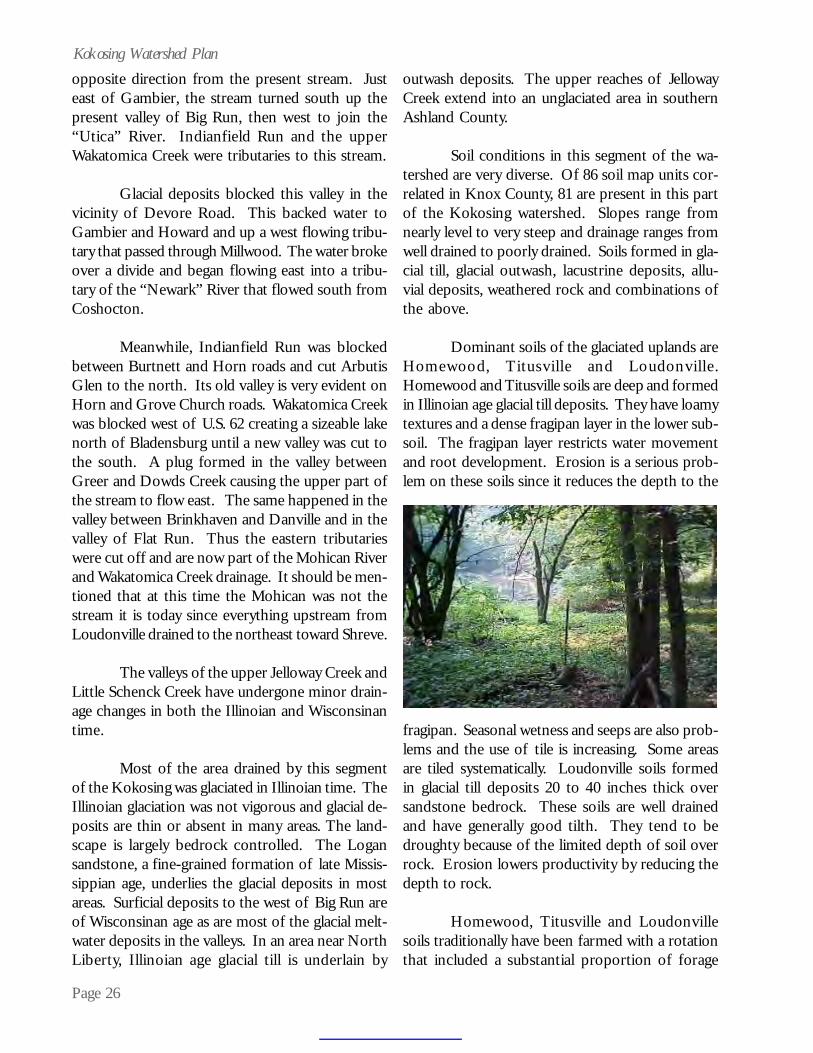
Page 26
Kokosing Watershed Planopposite direction from the present stream. Justeast of Gambier, the stream turned south up thepresent valley of Big Run, then west to join the“Utica” River. Indianfield Run and the upperWakatomica Creek were tributaries to this stream.
Glacial deposits blocked this valley in thevicinity of Devore Road. This backed water toGambier and Howard and up a west flowing tribu-tary that passed through Millwood. The water brokeover a divide and began flowing east into a tribu-tary of the “Newark” River that flowed south fromCoshocton.
Meanwhile, Indianfield Run was blockedbetween Burtnett and Horn roads and cut ArbutisGlen to the north. Its old valley is very evident onHorn and Grove Church roads. Wakatomica Creekwas blocked west of U.S. 62 creating a sizeable lakenorth of Bladensburg until a new valley was cut tothe south. A plug formed in the valley betweenGreer and Dowds Creek causing the upper part ofthe stream to flow east. The same happened in thevalley between Brinkhaven and Danville and in thevalley of Flat Run. Thus the eastern tributarieswere cut off and are now part of the Mohican Riverand Wakatomica Creek drainage. It should be men-tioned that at this time the Mohican was not thestream it is today since everything upstream fromLoudonville drained to the northeast toward Shreve.
The valleys of the upper Jelloway Creek andLittle Schenck Creek have undergone minor drain-age changes in both the Illinoian and Wisconsinantime.
Most of the area drained by this segmentof the Kokosing was glaciated in Illinoian time. TheIllinoian glaciation was not vigorous and glacial de-posits are thin or absent in many areas. The land-scape is largely bedrock controlled. The Logansandstone, a fine-grained formation of late Missis-sippian age, underlies the glacial deposits in mostareas. Surficial deposits to the west of Big Run areof Wisconsinan age as are most of the glacial melt-water deposits in the valleys. In an area near NorthLiberty, Illinoian age glacial till is underlain by
outwash deposits. The upper reaches of JellowayCreek extend into an unglaciated area in southernAshland County.
Soil conditions in this segment of the wa-tershed are very diverse. Of 86 soil map units cor-related in Knox County, 81 are present in this partof the Kokosing watershed. Slopes range fromnearly level to very steep and drainage ranges fromwell drained to poorly drained. Soils formed in gla-cial till, glacial outwash, lacustrine deposits, allu-vial deposits, weathered rock and combinations ofthe above.
Dominant soils of the glaciated uplands areHomewood, Titusville and Loudonville.Homewood and Titusville soils are deep and formedin Illinoian age glacial till deposits. They have loamytextures and a dense fragipan layer in the lower sub-soil. The fragipan layer restricts water movementand root development. Erosion is a serious prob-lem on these soils since it reduces the depth to the
fragipan. Seasonal wetness and seeps are also prob-lems and the use of tile is increasing. Some areasare tiled systematically. Loudonville soils formedin glacial till deposits 20 to 40 inches thick oversandstone bedrock. These soils are well drainedand have generally good tilth. They tend to bedroughty because of the limited depth of soil overrock. Erosion lowers productivity by reducing thedepth to rock.
Homewood, Titusville and Loudonvillesoils traditionally have been farmed with a rotationthat included a substantial proportion of forage

Page 27
Kokosing Watershed Plancrops. As livestock numbers decline, so does theacreage used for forage. The acreage of row crops,especially soybeans, is increasing--increasing the po-tential for erosion and the production of sediment.Fortunately, these soils are well adapted to conser-vation tillage and contour strip cropping, both ofwhich are effective in reducing erosion losses.
The dominant soils on outwash plains andterraces are Chili and Bogart. Chili soils formed inloamy glacial outwash deposits that contain somegravel. They are well drained and acidic. Moistureshortages can be expected in most years on Chiligravelly loam and in dry years on Chili silt loam. Inplaces, the Chili soils are present in a complex pat-tern with Homewood soils. Bogart soils are similarto Chili but are moderately well drained.
The moderately well drained Glenford,somewhat poorly drained Fitchville and very poorlydrained Luray soils are dominant in local lakebedsand on slackwater terraces. These soils have a highsilt content. They are potentially very productivebut Fitchville and Luray soils need artificial drain-age to reach this potential. These soils are veryerosive but because of their gentle slopes, they arenot a major source of sediment.
Some of the highest hills lack a covering ofglacial deposits. Some were never covered by icewhile others had a thin covering of glacial depositsremoved by geologic erosion. Dominant soils onthese hills are the moderately deep Gilpin and deepWestmoreland soils. Both are well drained andformed in residuum and colluvium from siltstoneand fine-grained sandstone. They have good tilthand are very acidic. These soils are erosive. Inaddition, the Gilpin soils tend to be droughty. Thesesoils are well suited to conservation tillage and stripcropping.
Dominant soils on the flood plains are thewell-drained Tioga, moderately well drained Lobdelland somewhat poorly drained Orville. These soilsare subject to occasional flooding. Streambank ero-sion is a problem in localized areas. The wider ar-eas are generally productive cropland but many of
the narrower flood plains are so divided by old chan-nels that it is not practical to farm them. Such ar-eas commonly serve as pasture.
Most dark colored soils in this part of Ohioare very poorly drained. Organic matter is not oxi-dized rapidly under wet conditions and accumulatesto give the soil a dark color. The Crane soils in theBig Run valley south of Gambier have a dark sur-face but are somewhat poorly drained. This wouldsuggest that the soils formed under native vegeta-tion in which grasses rather than trees were domi-nant. Grasses are more effective in returning or-ganic matter to the soil than trees. An area of grass-land or savannah vegetation similar to that in theoak openings of western Ohio likely existed in theBig Run valley.
Segment IV: Howard to Walhonding
The origin of this part of the Kokosing val-ley is not well documented. The most logical ex-planation is that blockage of the stream flowingsouthwest fromHoward causedwater to back upin the valley of awest flowingtributary thatpassed throughMillwood. Thewater broke overa divide into aneast flowingtributary to the“Newark” River that flowed south from Coshocton.In doing so, it cut a narrow, steep sided valley intothe Black Hand sandstone. The narrow section ex-tends from just west of Millwood to Zuck. East ofZuck, the valley is much wider.
Stout and Lamb indicate that the Teays age“Cambridge” River, a stream of considerable size,flowed west through the present Kokosing valleywest of Walhonding. Later, however, Stout, VerSteeg and Lamb projected the “Cambridge” Riverflowing south from Coshocton along the course ofthe later “Newark” and present Muskingum Rivers.

Page 28
Kokosing Watershed PlanA tributary called “Roscoe” Creek flowed east fromthe Knox County line. The valley of this streamforms the east end of the present Kokosing valley.
This segment of the Kokosing valley hasrelatively little watershed. The largest tributary isBrush Run which flows west parallel to the eastflowing Kokosing and seems to be a remnant ofthe drainage pattern that once flowed west. Twosmaller streams, Singer Run and Laurel Run, enterthe Kokosing just upstream from its confluence withthe Muskingum. These streams have very narrow,steep sided valleys. One branch of Laurel Rundrops about 40 feet in a waterfall east of McIlvainePark in Newcastle.
The dominant soils on the steep slopes bor-dering this part of the Kokosing valley areBrownsville and Westmoreland. These deep, well-drained soils formed in residuum and colluviumfrom fine-grained sandstone and siltstone primarilyof the Logan formation. They are used primarilyfor forestry. Shortages of moisture, especially onsouth facing slopes, limit tree growth. Erosion inlogging trails and access roads for oil wells can be asevere problem. Tree cover has minimized erosionlosses in most areas.
The dominant soils on the ridgetops to thenorth and south of the valley are Coshocton, Gilpinand Loudonville. Coshocton soils are deep andmoderately well drained. They formed in materialweathered from shale and siltstone of the Pottsvilleformation, the lowest member of the Pennsylva-nian system. These soils have high clay content inthe subsoil and are very acid. They are also veryerosive. Eroded areas do not have good tilth. Gilpinand Loudonville soils are moderately deep and welldrained. Both have sandstone at 20 to 40 inchesand tend to be droughty. The upper part of theLoudonville soils formed in glacial till while theGilpin soils formed entirely in material weatheredfrom sandstone and siltstone. Gilpin andLoudonville soils have loamy textures and gener-ally good tilth. Controlling erosion and conservingmoisture are the main concerns of management.The Homewood and Titusville soils are present in
scattered areas of deep glacial till in the Brush Rundrainage area.
The dominant soils on the flood plain ofthe Kokosing are Tioga and Landes. The Tiogasoils have proper-ties similar toTioga soils de-scribed previ-ously. Landessoils are unique.They are deep,well drainedsandy soils with adark surface layer up to 2 feet thick. The very largeorganic matter content would suggest the soilsformed under vegetation dominated by grasses. Thereason for these soils being present in the valleyfrom Zuck to Walhonding was not clear to thosemapping soils in the area.
Soils in this section of the flood plain aresubject to controlled flooding from the Mohawkdam. This limits their use to late planted row crops.Moisture shortages are common and stream bankerosion occurs in localized areas. Detailed soil in-formation is available in USDA-NRCS publishedsoil surveys for the five counties in the watershed.
Highly erodible lands in the watershed wasdetermined by using the NRCS list of highly erod-ible soils to query thematic mapper data in the wa-tershed geographic information system. Approxi-mately 94,739 acres of highly erodible soils wereindicated in the watershed. The amount of poten-tial soil loss in the watershed is relational to landuse type, slope, presence of highly erodible soils,vegetation cover and type and cropland conserva-tion measures. An estimate of the amount of po-tential soil loss in the watershed was not calculated,because of the inherent variability associated withestimating an accurate figure, given the attributeslisted in the preceeding sentence.
Minerals of Economic Interest
Glacial activity during the Illinoian andWisconsinan glaciation shaped and manipulated

Page 29
Kokosing Watershed Plan
Stream N ame
Ave. Fall in Feet
per M ile
Drains Sq. M i.
Flows Into
K okosing River
8.5
482
W alhonding River
Laurel Run
130.7
2.13
Kokosing River Singer Run*
20.5
1.16
Kokosing River
Brush Run
43
9.59
Kokosing River Honey Run
103
2.05
Kokosing River
Jelloway Creek
17.6
74.2
Kokosing River L ittle Jelloway Creek
32.2
19.5
Jelloway Creek
East Branch
23.5
10.46
Jelloway Creek Sapps Run
55.4
3.93
Jelloway Creek
Dowd Creek
38.6
5.48
Jelloway Creek Shadley Valley Creek
41.1
6.26
Jelloway Creek
Ireland Creek
45.3
3.41
Jelloway Creek
Barney Run
54.6
2.96
Kokosing River Schenck Creek
21.8
41.8
Kokosing River
Coleman Branch
36.7
6
Schenck Creek
L ittle Schenck Creek
33.6
16.23
Schenck Creek
M ud Run
113.3
0.95
Little Schenck Creek
Indianfield Run
27.4
11.1
Kokosing River Big Run
19
31.92
Kokosing River
Elliott Run
27.6
4.34
Big Run
W olf Run
72.8
3.33
Kokosing River Center Run
27.1
11.23
Kokosing River
Dry Creek
25.2
34.1
Kokosing River
Dry Run
51.4
6.16
Dry Creek
Armstrong Run
43.1
10.52
Kokosing River North Branch
15.8
96.7
Kokosing River
Job Run
23.2
8.52
N . Br. K okosing River East Branch
13.8
30.6
N . Br. K okosing River
Isaacs Run
24.9
4.59
E. Br. of N . Br. K okosing R. M arkley Run
34.6
6.56
E. Br. of N . Br. K okosing R.
Toby Run
39.2
4.49
E. Br. of N . Br. K okosing R.
Lost Run
32.1
6.16
N . Br. K okosing River
Granny Creek
30.9
12.68
Kokosing River Mile Creek
24.3
13.54
Kokosing River
South Branch
16.2
10.94
Kokosing River Sylvester Run
46.4
2.07
Kokosing River
Table 7: Streams of the Kokosing Watershed
* Intermittent stream

Page 30
Kokosing Watershed PlanFigure 5: Streams and Lakes of the Kokosing Watershed
Page 31
Kokosing Watershed Planover half of the Kokosing watershed. The scour-ing impact of the glaciers, the erosive action of themeltwater and the deposition of glacial materialsresulted in several beneficial features for the water-shed. One commercially beneficial feature in par-ticular is the outwash filled valleys that provide asource of sand and gravel.
Sand and Gravel Deposits
Eight sand and gravel mines have been per-mitted in the watershed since 1976 through theODNR Division of Mineral Resource Management(formerly the Division of Mines and Reclamation).The permits are valid for ten years and must beupdated annually with a map showing the past year’seffected boundaries and where the company intendsto mine over the coming year. There currently arefive active sand and gravel operations in the water-shed. All five are mining sand and gravel with theexception of one site near Millwood that is miningsilica sand (used in glass making). One inactiveoperation is located just north of Fredericktown.In addition, two other operations, one north ofFredericktown and one east of Gambier, have beenpermitted but have not been started at this time.
Oil & Gas Deposits
Oil and gas drilling in Ohio is concentrated,for the most part, in the eastern half of the state.Knox County contains the majority of oil and gaswells in the Kokosing River watershed. The welldepths range from 2600-4600 feet into the Clintonsandstone that formed in the Silurian period.Clinton sandstone serves as the most actively drilledzone in Ohio since 1965.
Surface Water
Perennial, intermittent and headwaterstreams, combined with lakes, ponds and wetlands,form the surface water features of the Kokosingwatershed. Table 7 shows major streams in the wa-tershed with approximate fall and drainage area.Streams and large lakes in the watershed are shownin Figure 5. Additional information on wetlands,
streams and impoundments are found in later dis-cussions. Estimated 10-year low flows (in cubicfeet per second) for the Kokosing River and its majortributaries are as follows:
• Kokosing River upstream of NorthBranch (6)
• Kokosing River at Mount Vernon (19)• Kokosing River at Millwood (48)• North Branch (3)• Jelloway Creek (3)• Dry Creek (2)• East Branch (2)• Big Run (1.9)
GroundWater
Glacial activity in the Kokosing watershedhas resulted in its being covered by varying thick-nesses of glacial till and outwash sand and gravel.Layers ranging from 25 feet to more than 300 feetare found west of the Kokosing river valley whilethe layer over the eastern two-thirds is generally lessthan 25 feet thick. A network of buried valleys crossKnox County and make up the major ground-waterresource. Public and private water supplies through-out the watershed are dependent on ground water.Yields of 100 to 500 gallons per minute can be ex-pected in the major valley that lies beneath thepresent day Kokosing River particularly fromFredericktown down past Mount Vernon to Utica.A larger part of the watershed relies on ground wa-ter supplies developed from sandstone and shaleformations where yields of 10 to 20 or more gal-lons per minute are available at depths ranging from60 to 290 feet. Ground water recharge rates rangefrom 8-10 inches per year, with ground water dis-charge rates of 8 inches per year. Figure 6 showsground water resources.
The invaluable, high-yield aquifers in theKokosing watershed are principally recharged fromdirect infiltration of precipitation. Permeability ofthe streambed varies from location to location, and,at times, the Kokosing River’s flow is augmentedby ground water (depending on the season and otherfactors). Pollution potential (DRASTIC) mapping
Page 32
Kokosing Watershed PlanFigure 6: Ground Water and Source Water Assessment and Protection Sites in the Watershed

Page 33
Kokosing Watershed Planavailable for the watershed indicates higher levelsof pollution potential, particularly in the buried val-ley located under the Kokosing River and its majortributaries. Therefore, it is imperative that land usedecisions regarding ground water recharge areas bemade carefully to consider the pollution potentialto the aquifers. Likewise, land use decisions shouldalso be made based on the impact to surface watersgiven the sometimes direct connection that overly-ing stream waters have to ground water.
In an effort to protect their precious groundwater resources, several well field protection planshave been drafted in the watershed. Well field pro-tection plans contain an inventory of potentialsources of groundwater contamination and protec-tive strategies that, if implemented, help protect adrinking water source from becoming contaminated.The implementation of well field protection plans
in the Kokosing watershedcan assist protection of theKokosing River and its tribu-taries. Among protectivestrategies noted in the Del-Co Water Company and Cityof Mount Vernon WellfieldProtection Plans are educa-tional outreach, floodplainmanagement and zoning or-dinances. Ohio EPA hasconducted and/or approvedSource Water Assessment
and Protection plans for public water systems inthe watershed, including City of Mount Vernon,Village of Martinburg, Del-Co Water Company,Herris Mobile Home Park, Morning View Care Cen-ter.
Several entities within the watershed havethe capacity to withdrawal large quantities of groundwater. Of the list below, Oglebay Norton Indus-trial Sand also withdraws surface water for its pro-cesses.
Ground Water Facilities:
Knox County Water & Sewer DistrictOglebay Norton Industrial Sand-Millwood
Tomahawk Golf CourseMount Vernon City Water SystemCuddy Farms, Inc.Small’s Sand & GravelMount Vernon Foundation ParkApple Valley Golf CourseFredricktown Village Water SystemMartinsburg Village Water System
One element cited as contributing to theoutstanding water quality of the Kokosing over theages is the contribution of ground water to streamflow. Thus, potential impacts from upper aquiferdewatering to the Kokosing base stream flow andseasonal high flows should be considered. WhileOhio and the eastern United States have enjoyedrelatively few “water rights” conflicts, water policyexperts predict increasing conflicts over water rightsnationwide. Recognizing the potential for waterconflicts and the need to maintain optimal flows forfish and wildlife resources, the Instream Flow Coun-cil (IFC), a consortium of fish and wildlife agenciesfrom the United States and Canada, developed prin-ciples for riverine resource stewardship. The IFCrecommends the maintenance of optimum streamflow to maintain natural ecological and morpho-logical functions of riverine resources. Rare spe-cies, such as the state threatened bluebreast darter(Etheostoma camurum), require seasonal floodingevents to maintain viable populations.
The Kokosing River is part of the “publictrust,” waters that are held “in trust” as navigationaland fisheries resources for all people to use reason-ably. The Division of Natural Areas and Preserves,owing to their responsibility to protect the KokosingRiver, has entered into a long-term monitoringproject with the U.S. Geological Survey to studythe effects of a well field development on KokosingRiver base flow. The well field, developed by Del-Co Water Company in 1999, pumps water out ofthe aquifer underlying the Kokosing for use in Co-lumbus suburbs and watersheds outside of theKokosing River watershed. No definitive resultsas to whether the wellfield has an impact onKokosing River baseflow are available at this time.Also, the Knox County Commissioners have passed

Page 34
Kokosing Watershed Plana resolution creating a regional water district, whichgives them some authority to deal with ground wa-ter withdrawals that leave the Kokosing watershed.
Terrestrial Habitat
Deciduous trees comprise the bank vegeta-tion along the Kokosing River. It should be noted,however, that conifers begin to mix in with the de-ciduous trees in the lower reaches of the river. Theamount of forested bank vegetation is one of theprimary criteria assessed when considering theKokosing River for scenic designation. The areaadjacent to at least 25 percent of the river’s length,considering both banks, should be forested outwardfrom the river to a depth of 300 feet or greater.This forested condition is paramount to the preser-vation of the native aquatic fauna and the protec-tion of the water quality values of the river. For-ested corridors not only provide habitat and travelcorridors for terrestrial species such as migratorybirds, deer and other wildlife, they also filter sedi-
ment and excess nutrientsfrom surface water flow.Trees and their roots alongthe riverbank help stabilizethe bank and protect prop-erty from spring ice flowsand debris during bank-full
flood events. The roots also provide in-stream coverfor aquatic species such as smallmouth bass. Leavesand other detritus serve as the primary food sourcethat drives the aquatic food chain. Shade from thetrees also serves to keep river temperatures coolerand more consistent, helping to maintain higheroxygen levels in the river and provide suitable con-ditions for native species reproduction.
A total of 27.5 percent of the mainstemKokosing River corridor from RM 0 to RM 41 isforested to a minimum depth of 300 feet. Whereless forest cover exists, the banks generally remainin a natural wooded condition of varying depths.The amount of corridor forested to at least 100 feetalong the mainstem of the Kokosing River is 56.1percent. The most heavily wooded corridor occurson the lower half of the river from RM 24 and be-
low with at least 30 and up to 43 percent forestedto a minimum of 300 feet. The section of riveraround Mount Vernon, from RM 25 to RM 29, con-tained the least amount of corridor with minimalto no corridor. The North Branch of the KokosingRiver, for at least the first 3.4 miles, is 17.4 percentforested to a minimum depth of 300 feet.
Within the riparian corridor, human activityis apparent to varying degrees along the length ofthe river. A total of 35 bridges cross the KokosingRiver from its headwaters to its mouth. Whilebridges disrupt the riparian corridor and detract fromthe river’s visually scenic qualities, they do providean opportunity to view the river and its wildlife in-habitants. In some cases, with the adjacent prop-erty owner’s permission, access is possible forlaunching canoes or for passive recreation activi-ties such as fishing or bird watching near the bridge.Roads paralleling the river also can detract fromthe scenic qualities of the river by subjecting riverusers to traffic noise and odors. Roads too close tothe river disrupt the corridor and natural drainagereducing the natural buffering from nonpoint pol-lutants that the wooded corridor provides. Theyalso increase the potential for hazardous materialsentering the river as a result of accidents. Roadmiles paralleling the river within 300 feet total 12.8along the Kokosing River. This represents 22 per-cent of the river’s total length.
As for the tributaries to the Kokosing, Fig-ure 7 and Table 8 describes the extent of thewooded corridor. Approximately 9,750,248 linearfeet of stream in the watershed contains forestedbuffer of varying widths.
Floodplains
The Kokosing River and many of its tribu-taries contain floodplains that have been mapped bythe Federal Emergency Management Agency(FEMA). Figure 8 shows the extent of 100-yearfloodplains in the watershed. FEMA identified19,951 acres (5% of total acreage) at risk from“100-year floods” in the watershed. A 100-yearflood has a one percent chance of occurring in any
Page 35
Kokosing Watershed PlanFigure 7: Streams with Wooded Riparian Areas in the Kokosing Watershed
Page 36
Kokosing Watershed PlanTable 8: Wooded Corridor Extent of Kokosing Tributaries
Stream Name length wooded corridor wooded corridor Kokosing River (miles) (miles) (percentage) Laurel Run 2.5 2.1 84.00% Singer Run 1.3 0.9 69.23% Brush Run 3.6 2.3 63.89% Honey Run 1.6 1.1 68.75% Jelloway Creek 13.2 7.9 59.85% Little Jelloway Creek 6.2 4 64.52%
East Branch 5.5 3.5 63.64% Sapps Run 3.3 2.1 63.64% Dowd Creek 3.4 1.4 41.18% Shadley Valley Creek 4.7 2.6 55.32%
Ireland Creek 2 1.4 70.00% Barney Run 2.1 1.8 85.71% Schenck Creek 12.2 9.5 77.87% Coleman Branch 4.2 2.1 50.00% Little Schenck Creek 7.9 4.5 56.96% Mud Run 0.7 0.53 75.71% Indianfield Run 7.3 4.8 65.75% Big Run 4.6 3 65.22% Elliott
Run 3.9 1.3 33.33%
Wolf Run 1.7 1.2 70.59% Center Run 3.4 1.7 50.00% Dry Creek 18.9 14.3 75.66% Dry Run 4.7 3.9 82.98% Armstrong Run 5.9 3.7 62.71% North Branch 26.6 17.1 64.29% Job Run 3.8 1.1 28.95% East Branch 5 3.3 66.00% Isaacs Run 4.4 1 22.73%
Markley Run 4.1 1.9 46.34%
Toby Run 3.4 1.5 44.12%
Lost Run 3.4 2.2 64.71% Granny Creek 9 7.2 80.00% Mile Creek 10 6.6 66.00% South Branch 9.7 5.6 57.73% Sylvester Run 3 1.3 43.33%

Page 37
Kokosing Watershed PlanFigure 8: 100 Year Floodplain Areas in the Kokosing Watershed

Page 38
Kokosing Watershed Plangiven year. Ohio and Knox County have a longhistory of damaging floods, and the NationalWeather Services has identified flooding as thenation’s leading weather-related killer. The last sig-nificant flood in the watershed occurred in June1998, and the Governor declared a State of Emer-gency in Knox, Coshocton and Richland Counties(among others). Center Run homeowners and in-frastructure were particularly hit hard by the flood-ing events in 1998.
Floodplains perform special “community”services, including filtering runoff, storing runoff,and providing wildlife habitat. The destruction ofriparian zones along streams and indiscriminate fill-ing of floodplains leads to increased flooding ofhomes and businesses, increased potential for pro-duction of disease-carrying insects, increased pol-lution of streams and increased potential of over-load of combined storm water and sanitary treat-
ment facilities. Thus,maintaining intactfloodplains lessens hu-man health risks and ad-verse impacts on wild-life habitat and commu-nity infrastructure.
Given the importance of floodplains, the KnoxRegional Planning Commission sponsored severalfloodplain management presentations for commis-sion members in 2003 and continues to work to-wards possible adoption of more stringent flood-plain regulations.
Plant Communities
The Kokosing River watershed lies withinthe Glaciated Appalachian Plateau. This region ofthe state encompasses a wide variety of natural habi-tats. Glacial activity many years ago heavily influ-enced the composition of the soil and the topogra-phy that makes this diversity of habitats possible.
Forest Communities
According to historical data from the earli-est land surveys, Beech-Sugar Maple forests on the
western end and Mixed Mesophytic forests on theeastern end dominated the watershed. The follow-ing descriptions outline the major forest commu-nity types found in the watershed. Approximately103,827 acres (34%) contain forested habitat in theKokosing watershed.
Beech-Sugar Maple Forests
The beech-sugar maple forest type is foundpredominantly in the western portion of the water-shed. However, this community type grades intoother community types such as oak-hickory, mixedmesophytic and maple-cottonwood-sycamore de-pending on the soils and topography and thereforecan be found throughout the watershed. These for-ests are generally dominated by beech and/or sugarmaple but they often contain associated species suchas shagbark hickory (Carya ovata), black walnut(Juglans nigra), white oak (Quercus alba), red oak(Quercus rubra), American elm (Ulmus americana),slippery elm (Ulmus rubra), tuliptree (Liriodendrontulipifera), black cherry (Prunus serotina), red maple(Acer rubrum), sugar maple (Acer saccharum), Ameri-can basswood (Tilia americana) and white ash(Fraxinus americana).
Maple-Cottonwood-Sycamore Flood Plain Forests
Species tolerant of seasonal flooding makeup this forest community that is most notable alongNorth Branch and the other tributaries in the west-ern portion of the watershed. Dominant speciesinclude soft maple, cottonwood and sycamore pri-marily but also include sandbar willow (Salix inte-rior), black willow (Salix nigra), hackberry (Celtisoccidentalis), American elm (Ulmus americana),honeylocust (Gleditsia triacanthos), boxelder (Acernegundo), silver maple (Acer saccharinum), Ohio buck-eye (Aesculus glabra), white ash (Fraxinus americana)and green ash (Fraxinus pennsylvanica).
Mixed Mesophytic Forests
Mixed mesophytic forests historically domi-nated the eastern portion of the watershed. This

Page 39
Kokosing Watershed Planforest type grades into other types of wet-mesic todry-mesic forest communities but generally thestands are dominated by combinations of beech(Fagus grandifolia), tuliptree (Liriodendron tulipifera),sugar maple (Acer saccharum), red maple (Acerrubrum), white oak (Quercus alba), red oak (Quercusrubra) and white ash (Fraxinus americana) with asso-ciated species of hickories (Carya spp.), black wal-nut (Juglans nigra), cucumbertree (Magnolia acuminata),black cherry (Prunus serotina), yellow buckeye(Aesculus octandra) and American basswood (Tiliaamericana).
Oak-Hickory Forests
Prevalent in the gorge area between MountVernon and Gambier, the oak-hickory forest typeis characterized by upland oaks and hickories. Spe-cifically, this forest type is dominated by shagbarkhickory (Carya ovata), pignut hickory (Carya glabra),bitternut hickory (Carya cordiformis), mockernuthickory (Carya tomentosa), white oak (Quercus alba),red oak (Quercus rubra) and black oak (Quercusvelutina). The oak-hickory community also gradesinto oak-pine communities on more exposed or moredisturbed sites.
Hemlock-White Pine-Hardwood Forests
Hemlock-white pine-hardwood forests gen-erally occur on valley slopes and bottoms. Examplesof this type of community can be found around theMillwood area in the Kokosing watershed. Hem-lock and/or white pine and hardwood species domi-nate this community over upland substrates. Domi-nant and associated species include white pine (Pinusstrobus), hemlock (Tsuga canadensis), Beech (Fagusgrandifolia), white oak (Quercus alba), red oak (Quercusrubra), tuliptree (Liriodendron tulipifera), black cherry(Prunus serotina), red maple (Acer rubrum), sugarmaple (Acer saccharum), white ash (Fraxinus americana)and possibly yellow birch (Betula alleghaniensis) andsweet birch (Betula lenta).
Riverine Communities
The following riverine communities arefound in the Kokosing watershed and throughout
most of eastern United States east of the Missis-sippi.
Mixed Emergent Riverine Community
This community type includes immersedplants as well as herbaceous plants on adjacent wetmud, sand or rock banks or bars. If the stand hasmore than half its cover in water-willow, it is clas-sified separately. Emergent riverine communitiesare found along the main channels of streams andin ponds and oxbows of flood plains that are usu-ally flooded annually. The composition of the com-munity varies depending on stream gradient, fre-quency and duration of floods, water and substratechemistry, current and historical human impacts andother factors. Predominant flowering species thatmay be found in this community type include broad-leaved cattail (Typha latifolia), bur-reed (Sparganiumeurycarpum), water-plantain (Alisma subcordatum), ar-rowheads (Sagittaria spp.), rice cutgrass (Leersiaoryzoides), sedges (Carex spp.), umbrella-sedges(Cyperus spp.), spike-rushes (Eleocharis spp.), bulrush(Scirpus atrovirens), rushes (Juncus spp.), lizard’s-tail(Saururus cernuus), smartweeds (Polygonum spp.), docks(Rumex spp.), swamp milkweed (Asclepias incarnata),fog-fruit (Lippia lanceolata), monkey-flower (Mimulusringens), water-willow (Justicia americana) and beggar-ticks (Bidens spp.).
Water-willow Riverine Community
Water-willow riverine communities occurthroughout Ohio in generally rocky riffles or instream margins. Water-willow (Justicia americana)makes up well over half the cover of these standsand often is the only species in a given patch. A fewspecies that may occur in limited association withwater-willow are lizard’s-tail (Saururus cernuus), sand-bar willow (Salix interior), smartweeds (Polygonumspp.), docks (Rumex spp.), dodder (Cuscuta gronovii),monkey flower (Mimulus ringens) and beggar ticks(Bidens spp.).Wetlands
When the first settlers came to Ohio, theyfound areas of shallow water or soggy soil filled
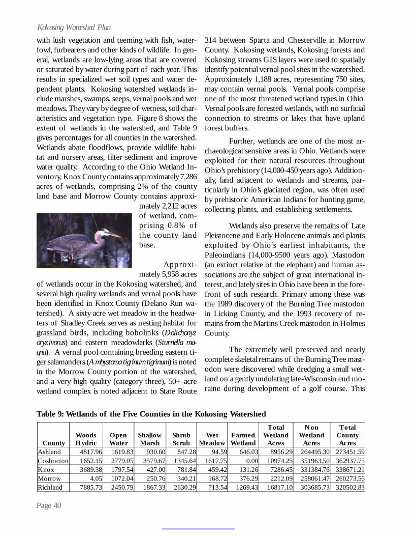
Page 40
Kokosing Watershed Planwith lush vegetation and teeming with fish, water-fowl, furbearers and other kinds of wildlife. In gen-eral, wetlands are low-lying areas that are coveredor saturated by water during part of each year. Thisresults in specialized wet soil types and water de-pendent plants. Kokosing watershed wetlands in-clude marshes, swamps, seeps, vernal pools and wetmeadows. They vary by degree of wetness, soil char-acteristics and vegetation type. Figure 8 shows theextent of wetlands in the watershed, and Table 9gives percentages for all counties in the watershed.Wetlands abate floodflows, provide wildlife habi-tat and nursery areas, filter sediment and improvewater quality. According to the Ohio Wetland In-ventory, Knox County contains approximately 7,286acres of wetlands, comprising 2% of the countyland base and Morrow County contains approxi-
mately 2,212 acresof wetland, com-prising 0.8% ofthe county landbase.
Approxi-mately 5,958 acres
of wetlands occur in the Kokosing watershed, andseveral high quality wetlands and vernal pools havebeen identified in Knox County (Delano Run wa-tershed). A sixty acre wet meadow in the headwa-ters of Shadley Creek serves as nesting habitat forgrassland birds, including bobolinks (Dolichonyzoryzivorus) and eastern meadowlarks (Sturnella ma-gna). A vernal pool containing breeding eastern ti-ger salamanders (Ambystoma tigrinum tigrinum) is notedin the Morrow County portion of the watershed,and a very high quality (category three), 50+-acrewetland complex is noted adjacent to State Route
314 between Sparta and Chesterville in MorrowCounty. Kokosing wetlands, Kokosing forests andKokosing streams GIS layers were used to spatiallyidentify potential vernal pool sites in the watershed.Approximately 1,188 acres, representing 750 sites,may contain vernal pools. Vernal pools compriseone of the most threatened wetland types in Ohio.Vernal pools are forested wetlands, with no surficialconnection to streams or lakes that have uplandforest buffers.
Further, wetlands are one of the most ar-chaeological sensitive areas in Ohio. Wetlands wereexploited for their natural resources throughoutOhio’s prehistory (14,000-450 years ago). Addition-ally, land adjacent to wetlands and streams, par-ticularly in Ohio’s glaciated region, was often usedby prehistoric American Indians for hunting game,collecting plants, and establishing settlements.
Wetlands also preserve the remains of LatePleistocene and Early Holocene animals and plantsexploited by Ohio’s earliest inhabitants, thePaleoindians (14,000-9500 years ago). Mastodon(an extinct relative of the elephant) and human as-sociations are the subject of great international in-terest, and lately sites in Ohio have been in the fore-front of such research. Primary among these wasthe 1989 discovery of the Burning Tree mastodonin Licking County, and the 1993 recovery of re-mains from the Martins Creek mastodon in HolmesCounty.
The extremely well preserved and nearlycomplete skeletal remains of the Burning Tree mast-odon were discovered while dredging a small wet-land on a gently undulating late-Wisconsin end mo-raine during development of a golf course. This
Table 9: Wetlands of the Five Counties in the Kokosing Watershed
County
Woods Hydric
Open Water
Shallow Marsh
Shrub Scrub
Wet Meadow
Farmed Wetland
Total Wetland
Acres
Non Wetland
Acres
Total County Acres
Ashland 4817.96 1619.83 930.60 847.28 94.59 646.03 8956.29 264495.30 273451.59 Coshocton 1652.15 2779.05 3579.67 1345.64 1617.75 0.00 10974.25 351963.50 362937.75 Knox 3689.38 1797.54 427.00 781.84 459.42 131.26 7286.45 331384.76 338671.21 Morrow 4.05 1072.04 250.76 340.21 168.72 376.29 2212.09 258061.47 260273.56 Richland 7885.73 2450.79 1867.33 2630.29 713.54 1269.43 16817.10 303685.73 320502.83
Page 41
Kokosing Watershed PlanFigure 9: Wetlands Areas in the Kokosing Watershed

Page 42
Kokosing Watershed Plansignificant find included the recovery of a portionof the mastodon’s intestinal contents, including forthe first time gut bacteria surviving in a dormantstate for 11,000 years. Although no stone tools wererecovered, some of the mastodon’s skeletal remainsshowed evidence of cut marks indicating that pre-historic American Indians butchered the animal.Continued archaeological investigations at suchsites are crucial to better understanding human in-teractions with these environments, past, presentand future.
The destruction of wetlands and stream ri-parian areas is likely to destroy the archaeologicalsites that are inextricably associated with them. Itis important to remember that where there are, orwere, wetlands and riparian areas, there are archaeo-logical sites that document over 10,000 years ofAmerican Indian prehistory in Ohio. Ohio’s earlysettlers also exploited wetlands. Many water-relatedhistoric archaeological sites exist in wetland areasand riparian areas. As these areas disappear, so doesthe prehistory and history of these people and thisState. Thus, protecting wetlands and riparian areasnot only provides for water quality and fish and wild-life habitat, but also protects our history. Addition-ally, with 16,497 acres of hydric soils indicated inthe watershed, a significant opportunity exists torestore wetland habitat on the landscape.
Headwater Streams
According to the Ohio EPA, “Headwaterstreams are the small swales, creeks and streamsthat are the origin of most rivers. These smallstreams join together to form larger streams andrivers or run directly into larger streams and lakes.Ohio EPA defines a headwater stream as a streamwith a watershed less than or equal to 20 squaremiles. Many streams and drainageways have a wa-tershed of less than one square mile. We refer tothese as primary headwater streams.” Headwaterstreams provide wildlife habitat, improve waterquality and abate floodflows. The Kokosing Riverwatershed has numerous headwater streams. Im-pacts to the headwater streams includechannelization, road culverting and denuding oftheir riparian fringes.
Invasive, Nonnative Species
According to the ODNR DNAP, “About one-quarter of the plants growing in Ohio originatedfrom other parts of the continent or world. Thesespecies, often called non-native, exotic or alien, werenot known to occur in Ohio prior to Europeansettlement in the mid 1700s. Some of Ohio’s inva-sive plants arrived here by accident, while otherswere introduced for agricultural use, erosion con-trol, horticulture, forage crops, medicinal use andfood for wildlife.” The most notorious invasiveplants found in the Kokosing watershed, accordingto DNAP, include:
· Garlic mustard (aggressively out-competesnative species in the understory of forestsand woodlands);
· Common and cut-leaved teasel (producemassive amounts of seed that can remainviable in the soil for several years andhave germination rates as high as 86%);
· Japanese knotweed (grows quickly andaggressively by extensive rhizomes andforms dense thickets that exclude nativevegetation and reduce wildlife habitat,represents a significant threat to riparianareas where it can spread easily as smallpieces of rhizome are washed downstreamand deposited to create new colonies).
· Multiflora rose (thickets of this rose cansuccessfully displace native plant species);
· Tree-of-heaven (sapling growth can reach3-4 feet a year and can outgrow nearly anynative tree, out competing natives forlight, roots give off a toxin that acts as aherbicide that can kill or inhibit thegrowth of other plants);
· Canada thistle (extensive root system ofCanada thistle allows it to out-competeand displace many native species)
· Amur, Morrow & Tartarian honeysuckles(these vigorous shrubs shade out nativevegetation, particularly in the woodlandunderstory and are able to out-competenative wildflowers for light and otherresources).
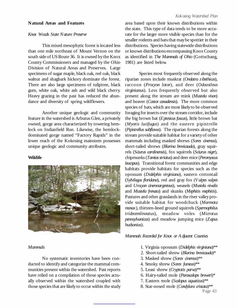
Page 43
Kokosing Watershed PlanNatural Areas and Features
Knox Woods State Nature Preserve
This mixed mesophytic forest is located lessthan one mile northeast of Mount Vernon on thesouth side of US Route 36. It is owned by the KnoxCounty Commissioners and managed by the OhioDivision of Natural Areas and Preserves. Largespecimens of sugar maple, black oak, red oak, blackwalnut and shagbark hickory dominate the forest.There are also large specimens of tuliptree, blackgum, white oak, white ash and wild black cherry.Heavy grazing in the past has reduced the abun-dance and diversity of spring wildflowers.
Another unique geologic and communityfeature in the watershed is Arbutus Glen, a privatelyowned, gorge area characterized by towering hem-lock on Indianfield Run. Likewise, the hemlock-dominated gorge named “Factory Rapids” in thelower reach of the Kokosing mainstem possessesunique geologic and community attributes.
Wildife
Mammals
No systematic inventories have been con-ducted to identify and categorize the mammal com-munities present within the watershed. Past reportshave relied on a compilation of those species actu-ally observed within the watershed coupled withthose species that are likely to occur within the study
area based upon their known distributions withinthe state. This type of data tends to be more accu-rate for the larger more visible species than for thesmaller rodents and bats that may be spottier in theirdistributions. Species having statewide distributionsor known distributions encompassing Knox Countyas identified in The Mammals of Ohio (Gottschang,1981) are listed below.
Species most frequently observed along theriparian zones include muskrat (Ondatra zibethicus),raccoon (Procyon lo tor), and deer (Odocoileusvirginianus). Less frequently observed but alsopresent along the stream are mink (Mustela vison)and beaver (Castor canadensis). The more commonspecies of bats, which are most likely to be observedforaging for insects over the stream corridor, includethe big brown bat (Eptesicus fuscus), little brown bat(Myotis lucifugus) and the eastern pipistrelle(Pipistrellus subflavus). The riparian forests along thestream provide suitable habitat for a variety of othermammals including masked shrews (Sorex cinereus),short-tailed shrews (Blarina brevicauda), gray squir-rels (Sciurus carolinensis), fox squirrels (Sciurus niger),chipmunks (Tamias striatus) and deer mice (Peromyscusleucopus). Transitional forest communities and edgehabitats provide habitats for species such as theopossum (Didelphis virginiana), eastern cottontail(Sylvilagus floridana), red and gray fox (Vulpes vulpesand Urocyon cinereoargenteus), weasels (Mustela nivalisand Mustela frenata) and skunks (Mephitis mephitis).Pastures and other grasslands in the river valley pro-vide suitable habitat for woodchuck (Marmotamonax), thirteen-lined ground squirrels (Spermophilustridecemlineatus), meadow voles (Microtuspennsylvanicus) and meadow jumping mice (Zapushudsonius).
Mammals Recorded for Knox or Adjacent Counties
1. Virginia opossum (Didelphis virginiana)** 2. Short-tailed shrew (Blarina brevicauda)* 3. Masked shrew (Sorex cinereus)** 4. Smoky shrew (Sorex fumeus)** 5. Least shrew (Cryptotis parva)** 6. Hairy-tailed mole (Parascalops breweri)* 7. Eastern mole (Scalopus aquaticus)** 8. Star-nosed mole (Condylura cristata)**
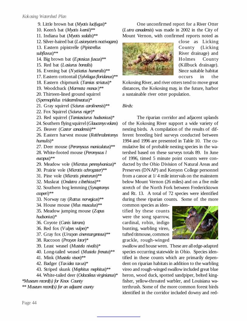
Page 44
Kokosing Watershed Plan 9. Little brown bat (Myotis lucifugus)*10. Keen’s bat (Myotis keenii)**11. Indiana bat (Myotis sodalis)**12. Silver-haired bat (Lasionycteris noctivagans)13. Eastern pipistrelle (Pipistrellussubflavus)**14. Big brown bat (Eptesicus fuscus)**15. Red bat (Lasiurus borealis)16. Evening bat (Nycticeius humeralis)**17. Eastern cottontail (Sylvilagus floridanus)**18. Eastern chipmunk (Tamias striatus)*19. Woodchuck (Marmota monax)**20. Thirteen-lined ground squirrel(Spermophilus tridecemlineatus)*21. Gray squirrel (Sciurus carolinensis)**22. Fox Squirrel (Sciurus niger)*23. Red squirrel (Tamiasciurus hudsonicus)*24. Southern flying squirrel (Glaucomys volans)25. Beaver (Castor canadensis)**26. Eastern harvest mouse (Reithrodontomyshumulis)*27. Deer mouse (Peromyscus maniculatus)**28. White-footed mouse (Peromyscus leucopus)**29. Meadow vole (Microtus pennsylvanicus)*30. Prairie vole (Microtis ochrogaster)**31. Pine vole (Microtis pinetorum)**32. Muskrat (Ondatra zibethicus)**32. Southern bog lemming (Synaptomyscooperi)**33. Norway ray (Rattus norvegicus)**34. House mouse (Mus musculus)**35. Meadow jumping mouse (Zapushudsonius)*36. Coyote (Canis latrans)36. Red fox (Vulpes vulpes)*37. Gray fox (Urocyon cinereoargenteus)**38. Raccoon (Procyon lotor)*39. Least weasel (Mustela nivalis)*40. Long-tailed weasel (Mustela frenata)**41. Mink (Mustela vison)**42. Badger (Taxidea taxus)*43. Striped skunk (Mephitus mephitus)**44. White-tailed deer (Odocoileus virginianus)*
*Museum record(s) for Knox County** Museum record(s) for an adjacent county
One unconfirmed report for a River Otter(Lutra canadensis) was made in 2002 in the City ofMount Vernon, with confirmed reports noted as
close as LickingCounty (LickingRiver drainage) andHolmes County(Killbuck drainage).Since suitable habitatoccurs in the
Kokosing River, and river otters tend to move greatdistances, the Kokosing may, in the future, harbora sustainable river otter population.
Birds:
The riparian corridor and adjacent uplandsof the Kokosing River support a wide variety ofnesting birds. A compilation of the results of dif-ferent breeding bird surveys conducted between1994 and 1996 are presented in Table 10. The cu-mulative list of probable nesting species in the wa-tershed based on these surveys totals 89. In Juneof 1996, timed 5 minute point counts were con-ducted by the Ohio Division of Natural Areas andPreserves (DNAP) and Kenyon College personnelfrom a canoe at 1/4 mile intervals on the mainstembelow Mount Vernon (26 miles) and on a five milestretch of the North Fork between Fredericktownand Rt. 13. A total of 72 species were identifiedduring these riparian counts. Some of the morecommon species as iden-tified by these countswere the song sparrow,cardinal, robin, indigobunting, warbling vireo,tufted titmouse, commongrackle, rough-wingedswallow and house wren. These are all edge-adaptedspecies occurring statewide in Ohio. Species iden-tified in these counts which are primarily depen-dent on riparian habitats in addition to the warblingvireo and rough-winged swallow included great blueheron, wood duck, spotted sandpiper, belted king-fisher, yellow-throated warbler, and Louisiana wa-terthrush. Some of the more common forest birdsidentified in the corridor included downy and red-

Page 45
Kokosing Watershed Plan
1. Great Blue Heron 22. Belted Kingfisher 45. House Wren 66. Yellow Warbler (Ardea herodias) (Ceryle torquata) (Troglodytes aedon) (Dendroica petechia) 2. Green Heron 23. Common Flicker 46. Carolina Wren 67. Kentucky Warbler (Butorides striatus) (Colaptes aurotus) (Thrythorus ludovicianus) (Oporornis formosus)
3. Canada Goose 24.Red-bellied Woodpecker 47. Blue-gray Gnatcatcher 68. Hooded Warbler
(Branta canadensis) (Melanerpes carolinus) (Polioptila caerulea) (Wilsonia citrina) 4. Mallard 25. Pileated Woodpecker 48. Eastern Bluebird 69. Prairie Warbler (Anas platyrhychos) (Dryocopus pileatus) (Sialia sialis) (Dendroica discolor)
5. Wood Duck 26.Red-headed Woodpecker 49. Wood Thrush 70. Louisiana Waterthrush
(Aix sponsa) (Melanerpes erthrocephalus) (Hyocichla mustelina) (Seiurus motacilla) 6. Turkey Vulture 27. Downy Woodpecker 50. Veery 71. Common Yellow-throat (Cathartes aura) (Picoides pubescens) (Catharus fuscenscens) (Geothylpis trichas) 7. Black Vulture 28. Hairy Woodpecker 51. American Robin 72.Rose-breasted Grosbeak (Coragyps atratus) (Dendrocopos villosus) (Turdus migratorius) (Pheucticus ludovicianus) 8. Cooper's Hawk 29. Eastern Kingbird 52. Gray Catbird 73. Northern Cardinal (Accipiter cooperii) (Tyannus verticalis) (Dumetella carolinensis) (Cardinalis cardinalis) 9. Red-tailed Hawk 30.GreatCrested Flycatcher 53. Northern Mockingbird 74. Indigo Bunting (Buteo jamaicensis) (Myiarchus crinitus) (Mimus polyglottos) (Passerina cyanea) 10. American Kestrel 31. Eastern Phoebe 54. Brown Thrasher 75. Rufous-sided Towhee (Falco sparverius) (Sayornis phoebe) (Toxostoma rufum) (Pipilo erythrophthalmus) 11. Spotted Sandpiper 32. Acadian Flycatcher 55. Cedar Waxwing 76. Song Sparrow (Actitis hypoleucous) (Empidonax virescens) (Bombycilla cedrorum) (Melospiza meoldia) 12. Killdeer 33. Willow Flycatcher 56. Starling 77. Field Sparrow (Characdrius vociferus) (Empidonax difficilis) (Sturnus vulgaris) (Spizella pusila) 13. Turkey 34. Eastern Wood Pewee 57. White-eyed Vireo 78. Chipping Sparrow (Meleagris gallopavo) (Contopus virens) (Vireo griseus) (Spizella passerina) 14. Rock Dove 35. Horned Lark 58. Yellow-throated Vireo 79. Eastern Meadowlark (Columba livia) (Eremophila alpestris) (Vireo flavifrons) (Sturnella magna) 15. Mourning Dove 36. Tree Swallow 59. Red-eyed Vireo 80. Red-winged Blackbird (Zenaida macroura) (Tachycineta bicolor) (Vireo olivaceus) (Agelaius phoeniceus) 16. Yellow-billed Cuckoo 37. Rough-winged Swallow 60. Warbling Vireo 81. Br.-headed Cowbird (Coccyzus americanus) (Stelgidopteryx serripennis) (Vireo gilvus) (Molothrus ater) 17. Barred Owl 38. Bank Swallow 61. Black & white Warbler 82. Common Grackle (Strix varia) (Riparia riparia) (Dendroica fusca) (Quiscalus quiscula) 18. Great Horned Owl 39. Barn Swallow 62. Blue-winged Warbler 83. Northern Oriole (Bub virginianus) (Hirundo rustica) (Vermivora pinus) (Icterus galbula) 19. Screech Owl 40. Blue Jay 63. Northern Parula 84. Orchard Oriole (Otus asio) (Cyannocitta cristata) (Parula americana) (Icterus spurius) 20. Chimney Swift 41. Common Crow 64. Cerulean Warbler (Chaetura pelagica) (Corvus brachyrhynchos) (Dendroica cerulea) 21.Ruby-throated Hummingbird 42. Carolina Chickadee
65. Yellow-throated Warbler
(Archilochus colubris) (Parus carolinensis) (Vireo flavifrons) 43. Tufted Titmouse 66. Yellow Warbler (Parus bicolor) (Dendroica petechia)
Table 10: Birds of the Kokosing Watershed
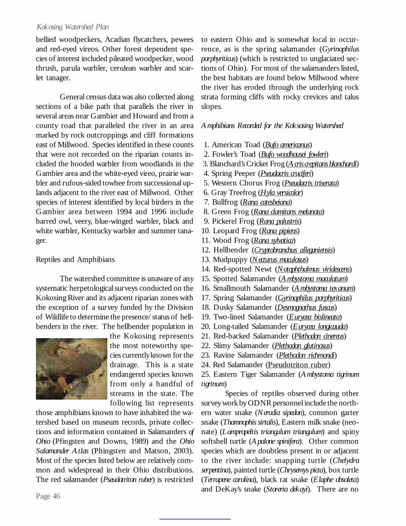
Page 46
Kokosing Watershed Planbellied woodpeckers, Acadian flycatchers, peweesand red-eyed vireos. Other forest dependent spe-cies of interest included pileated woodpecker, woodthrush, parula warbler, cerulean warbler and scar-let tanager.
General census data was also collected alongsections of a bike path that parallels the river inseveral areas near Gambier and Howard and from acounty road that paralleled the river in an areamarked by rock outcroppings and cliff formationseast of Millwood. Species identified in these countsthat were not recorded on the riparian counts in-cluded the hooded warbler from woodlands in theGambier area and the white-eyed vireo, prairie war-bler and rufous-sided towhee from successional up-lands adjacent to the river east of Millwood. Otherspecies of interest identified by local birders in theGambier area between 1994 and 1996 includebarred owl, veery, blue-winged warbler, black andwhite warbler, Kentucky warbler and summer tana-ger.
Reptiles and Amphibians
The watershed committee is unaware of anysystematic herpetological surveys conducted on theKokosing River and its adjacent riparian zones withthe exception of a survey funded by the Divisionof Wildlife to determine the presence/status of hell-benders in the river. The hellbender population in
the Kokosing representsthe most noteworthy spe-cies currently known for thedrainage. This is a stateendangered species knownfrom only a handful ofstreams in the state. Thefollowing list represents
those amphibians known to have inhabited the wa-tershed based on museum records, private collec-tions and information contained in Salamanders ofOhio (Pfingsten and Downs, 1989) and the OhioSalamander Atlas (Phingsten and Matson, 2003).Most of the species listed below are relatively com-mon and widespread in their Ohio distributions.The red salamander (Pseudotriton ruber) is restricted
to eastern Ohio and is somewhat local in occur-rence, as is the spring salamander (Gyrinophilusporphyriticus) (which is restricted to unglaciated sec-tions of Ohio). For most of the salamanders listed,the best habitats are found below Millwood wherethe river has eroded through the underlying rockstrata forming cliffs with rocky crevices and talusslopes.
Amphibians Recorded for the Koksosing Watershed
1. American Toad (Bufo americanus) 2. Fowler’s Toad (Bufo woodhousei fowleri) 3. Blanchard’s Cricket Frog (Acris crepitans blanchardi) 4. Spring Peeper (Pseudacris cruciferi) 5. Western Chorus Frog (Pseudacris triserata) 6. Gray Treefrog (Hyla versicolor) 7. Bullfrog (Rana catesbeiana) 8. Green Frog (Rana clamitans melanota) 9. Pickerel Frog (Rana palustris)10. Leopard Frog (Rana pipiens)11. Wood Frog (Rana sylvatica)12. Hellbender (Cryptobranchus alleganiensis)13. Mudpuppy (Necturus maculosus)14. Red-spotted Newt (Notophthalmus viridescens)15. Spotted Salamander (Ambystoma maculatum)16. Smallmouth Salamander (Ambystoma texanum)17. Spring Salamander (Gyrinophilus porphyriticus)18. Dusky Salamander (Desmognathus fuscus)19. Two-lined Salamander (Eurycea bislineata)20. Long-tailed Salamander (Eurycea longicauda)21. Red-backed Salamander (Plethodon cinereus)22. Slimy Salamander (Plethodon glutinosus)23. Ravine Salamander (Plethodon richmondi)24. Red Salamander (Pseudotriton ruber)25. Eastern Tiger Salamander (Ambystoma tigrinumtigrinum)
Species of reptiles observed during othersurvey work by ODNR personnel include the north-ern water snake (Nerodia sipedon), common gartersnake (Thamnophis sirtalis), Eastern milk snake (neo-nate) (Lampropeltis triangulum triangulum) and spinysoftshell turtle (Apalone spinifera). Other commonspecies which are doubtless present in or adjacentto the river include: snapping turtle (Chelydraserpentina), painted turtle (Chrysemys picta), box turtle(Terrapene carolina), black rat snake (Elaphe obsoleta)and DeKay’s snake (Storeria dekayi). There are no

Page 47
Kokosing Watershed Planstate or federally listed species of reptiles knownfor the Kokosing drainage. In 1995, a Blanding’sturtle (Emydoidea blandingi) was encountered in abackwater of the Kokosing just upstream from thejunction with the Mohican River. Whether this rep-resents an escaped specimen or a member of a dis-junct population is unknown at this time.
Fishes
The first recorded fisheries inventory in theKokosing drainage was a survey of Big JellowayCreek and its tributaries carried out by Parker,Williamson and Osburn of The Ohio State Univer-sity in 1898. The authors listed 36 species for thisdrainage including the bigeye chub (Notropis amblops)and hornyhead chub (Nocomis biguttatus); specieswhich are still present today. Table 11 containsfish species for the Kokosing watershed.
Milton B. Trautman and his contemporar-ies made a number of collections in the drainageprior to the 1951 publication of Trautman’s “TheFishes of Ohio.” Trautman and his students madeadditional collections in the Kokosing River duringthe 1960’s as part of the Central Ohio Stream Sur-vey. These records are included in Trautman’s 1981update of The Fishes of Ohio. Trautman recorded atotal of 59 species for the drainage.
The fish populations of the Kokosing Riverand several of its tributaries were intensively sur-veyed between 1981 and 1987 by Daniel L. Riceand Mark Barnes (ODNR) and George J. Phinney(Otterbein College). A total of 62 species wererecorded during these surveys including a previouslyundetected population of the state endangeredmountain brook lamprey (Ichthyomyzon greeleyi).
In 1987 the Ohio Environmental Protec-tion Agency’s Biological Assessment Section con-ducted a basin-wide inventory using electrofishingequipment. A total of 61 species (not includinghybrids) were identified during this survey. Newspecies of interest added to the drainage by OhioEPA include the r iver redhorse (Moxostomacarinatum), flathead catfish (Pylodictis olivaris) andspotted bass (Micropterus punctulatus).
Based on these surveys the number of spe-cies reported for the drainage now stands at 74 spe-cies. While this is less than the 85-86 species gen-erally attributed to be resident in Big Darby Creekin central Ohio, the fish community of the KokosingRiver appears to be intact. All of the species knownto have been present in the drainage historicallywith a few exceptions like the muskellunge (Esoxmasquinongy) are still present today. Included in thislist are a number of sensitive species such as themountain and least brook lampreys, hornyhead,river, bigeye and streamline chubs, rosyface and sil-ver shiners and the bluebreast and spotted darters.
Bivalve Molluscs
For reasons that are not entirely clear, theKokosing River appears to support only a very lim-ited bivalve fauna. While no intensive surveys havebeen conducted to date, the general lack of shellmaterial would indicate a lack of extensive mol-luscs beds as are found downstream in theWalhonding River. Even in the Mohican Riverwhere past pollution has eliminated much of thebivalve fauna, there is ample dead shell material totestify to their historic abundance and distributionsin this system. It is the presence of a large anddiverse molluscan fauna in the Walhonding Rivercoupled with the historic populations in theMohican River which makes their apparent short-age in the Kokosing River so puzzling. TheKokosing certainly has the water quality and thefish populations to support healthy populations ofbivalves.
At least six unionid bivalve species havebeen recorded for the Kokosing River. They in-clude the spike (Elliptio dilatata), fluted-Shell(Lasmigona costata), fatmucket (Lampsilis siliquoidea),plain pocketbook (Lampsilis cardium) and thesquawfoot (Strophitus undulatus). A new record forthe Kokosing was found in 2003 for the sharp-ridgedpocketbook (Lampsilis obata). All of these speciesare common throughout the state, with the excep-tion of the fluted-shell and the state endangeredsharp-ridged pocketbook. These species may beabundant in the proper habitat, appear to be intol-
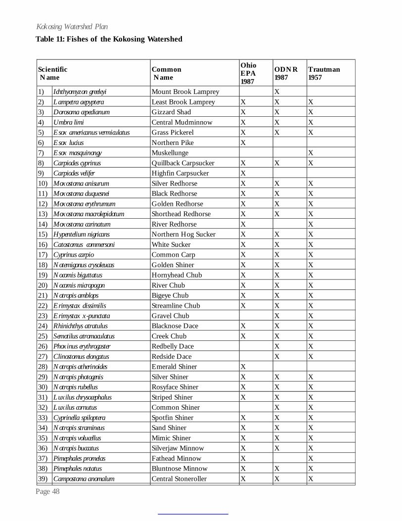
Page 48
Kokosing Watershed Plan
Scientific Name
Common Name
Ohio EPA 1987
ODNR 1987
Trautman 1957
1)
Ichthyomyzon greeleyi
Mount Brook Lamprey
X
2) Lampetra aepyptera
Least Brook Lamprey
X
X
X
3) Dorosoma cepedianum
Gizzard Shad
X
X
X
4) Umbra limi
Central Mudminnow
X
X
X
5) Esox americanus vermiculatus
Grass Pickerel
X
X
X
6) Esox lucius
Northern Pike
X
7) Esox masquinongy
Muskellunge
X
8) Carpiodes cyprinus
Quillback Carpsucker
X
X
X
9) Carpiodes velifer
Highfin Carpsucker
X
10) Moxostoma anisurum
Silver Redhorse
X
X
X
11) Moxostoma duquesnei
Black Redhorse
X
X
X
12) Moxostoma erythrumum
Golden Redhorse
X
X
X
13) Moxostoma macrolepidotum
Shorthead Redhorse
X
X
X
14) Moxostoma carinatum
River Redhorse
X
X
15) Hypentelium nigricans
Northern Hog Sucker
X
X
X
16) Catostomus commersoni
White Sucker
X
X
X
17) Cyprinus carpio
Common Carp
X
X
X
18) Notemigonus crysoleucas
Golden Shiner
X
X
X
19) Nocomis biguttatus
Hornyhead Chub
X
X
X
20) Nocomis micropogon
River Chub
X
X
X
21) Notropis amblops
Bigeye Chub
X
X
X
22) Erimystax dissimilis
Streamline Chub
X
X
X
23) Erimystax x-punctata
Gravel Chub
X
X
24) Rhinichthys atratulus
Blacknose Dace
X
X
X
25) Semotilus atromaculatus
Creek Chub
X
X
X
26) Phoxinus erythrogaster
Redbelly Dace
X
X
27) Clinostomus elongatus
Redside Dace
X
X
28) Notropis atherinoides
Emerald Shiner
X
29) Notropis photogenis
Silver Shiner
X
X
X
30) Notropis rubellus
Rosyface Shiner
X
X
X
31) Luxilus chrysocephalus
Striped Shiner
X
X
X
32) Luxilus cornutus
Common Shiner
X
X
33) Cyprinella spiloptera
Spotfin Shiner
X
X
X
34) Notropis stramineus
Sand Shiner
X
X
X
35) Notropis volucellus
Mimic Shiner
X
X
X
36) Notropis buccatus
Silverjaw Minnow
X
X
X
37) Pimephales promelas
Fathead Minnow
X
X
38) Pimephales notatus
Bluntnose Minnow
X
X
X
39) Campostoma anomalum
Central Stoneroller
X
X
X
Table 11: Fishes of the Kokosing Watershed
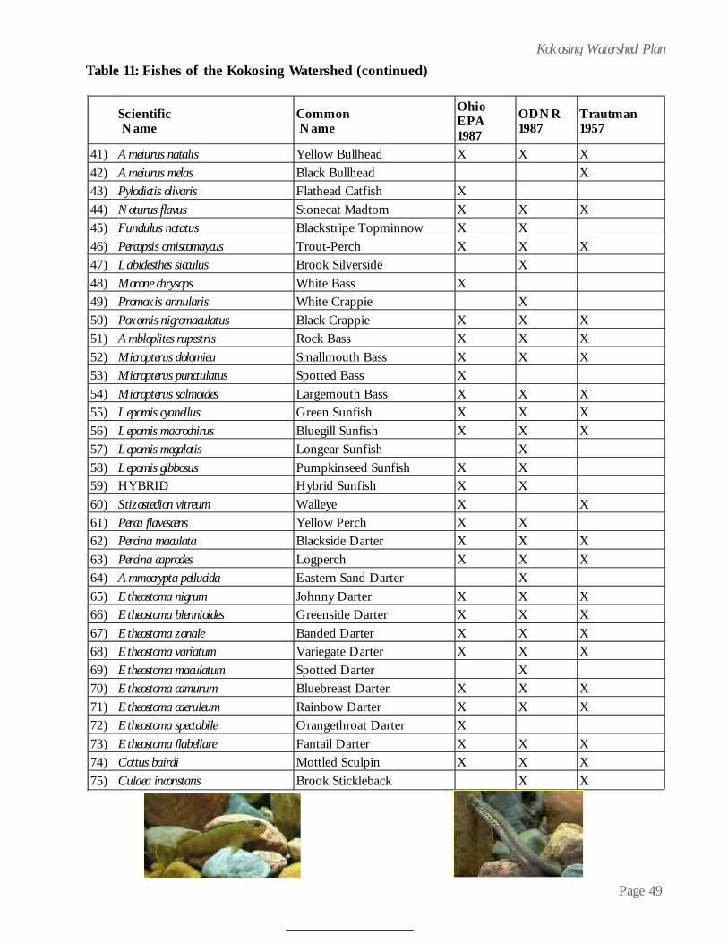
Page 49
Kokosing Watershed PlanTable 11: Fishes of the Kokosing Watershed (continued)
Scientific Name
Common Name
Ohio EPA 1987
ODNR 1987
Trautman 1957
41)
Ameiurus natalis
Yellow Bullhead
X
X
X
42) Ameiurus melas
Black Bullhead
X
43) Pylodictis olivaris
Flathead Catfish
X
44) Noturus flavus
Stonecat Madtom
X
X
X
45) Fundulus notatus
Blackstripe Topminnow
X
X
46) Percopsis omiscomaycus
Trout-Perch
X
X
X
47) Labidesthes sicculus
Brook Silverside
X
48) Morone chrysops
White Bass
X
49) Promoxis annularis
White Crappie
X
50) Poxomis nigromaculatus
Black Crappie
X
X
X
51) Ambloplites rupestris
Rock Bass
X
X
X
52) Micropterus dolomieu
Smallmouth Bass
X
X
X
53) Micropterus punctulatus
Spotted Bass
X
54) Micropterus salmoides
Largemouth Bass
X
X
X
55) Lepomis cyanellus
Green Sunfish
X
X
X
56) Lepomis macrochirus
Bluegill Sunfish
X
X
X
57) Lepomis megalotis
Longear Sunfish
X
58) Lepomis gibbosus
Pumpkinseed Sunfish
X
X
59) HYBRID
Hybrid Sunfish
X
X
60) Stizostedion vitreum
Walleye
X
X
61) Perca flavescens
Yellow Perch
X
X
62) Percina maculata
Blackside Darter
X
X
X
63) Percina caprodes
Logperch
X
X
X
64) Ammocrypta pellucida
Eastern Sand Darter
X
65) Etheostoma nigrum
Johnny Darter
X
X
X
66) Etheostoma blennioides
Greenside Darter
X
X
X
67) Etheostoma zonale
Banded Darter
X
X
X
68) Etheostoma variatum
Variegate Darter
X
X
X
69) Etheostoma maculatum
Spotted Darter
X
70) Etheostoma camurum
Bluebreast Darter
X
X
X
71) Etheostoma caeruleum
Rainbow Darter
X
X
X
72) Etheostoma spectabile
Orangethroat Darter
X
73) Etheostoma flabellare
Fantail Darter
X
X
X
74) Cottus bairdi
Mottled Sculpin
X
X
X
75) Culaea inconstans
Brook Stickleback
X
X

Page 50
Kokosing Watershed Planerant of pollutants and are becoming increasinglyscarce in some river systems in Ohio.
Aquatic Macroinvertebrates
In general, exceptional macroinvertebratecommunities were found during the 1987 Ohio EPAKokosing River Water Quality Study. The invertebratecommunity index (ICI) rating system was used toevaluate the invertebrate community of theKokosing River. ICI values ranged from 48 to 56and were within the levels necessary to meet ex-ceptional warmwater habitat criteria. Table 12 listsmacroinvertebrates recorded in the watershed.Table 13 lists Ohio EPA macroinvertebrate data.
Macroinvertebrate communities were evalu-ated at 17 stations from near the headwaters (RM49.8) to near the mouth (RM 1.5) in 1987. Thestation with the highest total mayfly(Ephemeroptera), stonefly (Plecoptera) andcaddisfly (Trichoptera) taxa richness (EPT), a mea-sure of the diversity of pollution sensitive taxa, wasupstream from Co. Rd. 35 (RM 11.6) with 27 taxa.There were two sites with an ICI of 38 (RMs 49.8
and 8.7), which is in thegood (rather than excep-tional) range, attributed tolittle or no water currentand poor placement of thetesting device. The lowerscores were not attributed
to lower water quality or degraded habitat.
Macroinvertebrate taxa collected in theKokosing River that are indicative of high qualitystreams in Ohio included the mayfly Serratelladeficiens at 17 sites between RMs 46.3 and 1.5,stoneflies of the genus Pteronarcys at RMs 11.6 and6.2, the caddisflies Psychomyia flavida at RMs 24.2and 6.2 and Leucotrichia pictipes at RM 28.6, the chi-ronomid midges Eukiefferiella devonica group at RM6.2 and the Rheotanytarsus distinctissimus group at 16sites between RMs 49.8 and 1.5 and also Subletteacoffmani at RMs 45.2, 35.0 and 11.6.
Odonata Species Collected for Knox County:
As part of the Ohio Odonata Survey, thefollowing 55 species (198 records) for Odonates(dragonflies and damselflies) are listed for KnoxCounty:
• Ophiogomphus rupinsulensis (Walsh), 1862- Rusty Snaketail - Family: Gomphidae• Gomphus fraternus (Say), 1839 - MidlandClubtail - Family: Gomphidae• Gomphus vastus Walsh, 1862 - CobraClubtail - Family: Gomphidae• Gomphus lividus Selys, 1854 - AshyClubtail - Family: Gomphidae• Gomphus quadricolor Walsh, 1862 - Rap-ids Clubtail - Family: Gomphidae• Arigomphus villosipes Selys, 1854 - UnicornClubtail - Family: Gomphidae• Stylogomphus albistylus (Hagen), 1878 -Least Clubtail - Family: Gomphidae• Basiaeschna janata (Say), 1839 - SpringtimeDarner - Family: Aeshnidae• Boyeria vinosa (Say), 1839 - Fawn Darner -Family: Aeshnidae• Anax junius (Drury), 1770 - Common GreenDarner - Family: Aeshnidae• Epiaeschna heros (Fabricius), 1798 -Swamp Darner - Family: Aeshnidae• Aeshna umbrosa Walker, 1908 - ShadowDarner - Family: Aeshnidae• Macromia illinoiensis illinoiensis Walsh,1862 - Illinois River Cruiser - Family: Macromiidae• Neurocordulia yamaskanensis (Provancher),1875 - Stygian Shadowdragon - Family: Corduliidae• Epitheca princeps Hagen, 1861 - PrinceBaskettail - Family: Corduliidae• Epitheca cynosura (Say), 1839 - CommonBaskettail - Family: Corduliidae• Perithemis tenera (Say), 1839 - EasternAmberwing - Family: Libellulidae• Celithemis eponina (Drury), 1773 - Hallow-een Pennant - Family: Libellulidae• Celithemis elisa (Hagen), 1861 - Calico Pen-nant - Family: Libellulidae• Libellula luctuosa Burmeister, 1839 -Widow Skimmer - Family: Libellulidae

Page 51
Kokosing Watershed Plan
Phylum Annelida: Leeches & Aquatic Worms Helobdella stagnalis Placobdella ornata Mooreobdella microstoma Helobdella triserialis Mooreobdella fervida Oligochaeta Phylum Cnidaria: Hydrazoans Hydra sp Phylum Crustacea: Isopods: Aquatic Sowbugs Lirceus sp Caecidotea sp Hyalella azteca Crangonyx sp Phylum Entoprocta: Bryozoans: Moss Animalcules Plumatella sp Urnatella gracilis Lophopodella carteri Phylum Hydrachnida: Water mites Hydracarina Phylum Mollusca: Bivalvia: Clams and Freshwater mussels Corbicula fluminea (Aquatic Clam)
Pisidium sp (Fingernail Clam) Sphaerium sp (Fingernail Clam)
Unionidae Lasmigona costata (Fluted Shell) Leptodea fragilis (Fragile Papershell)
Lasmigona complanata (White Heelsplitter) Phylum Mollusca: Gastropoda: Snails Cipangopaludina japonica Hydrobiidae Physella sp (Pouch Snail) Elimia sp (River Snail) Fossaria sp (Pond Snail) Ferrissia sp (Limpets) Gyraulus (Torquis) parvus (Orb Snail)
Helisoma anceps anceps (Orb Snail)
Phylum Nemertea: Horsehair worms Nematomorpha Phylum Platyhelminthes: Flatworms Turbellaria Phylum Porifera: Freshwater Sponges Spongillidae Eunapius fragilis Order Coleoptera: Beetles Ancyronyx variegata (Riffle Beetle)
Stenelmis sp (Riffle Beetle) Optioservus trivittatus (Riffle Beetle)
Dubiraphia vittata group (Riffle Beetle)
Optioservus svalis (Riffle Beetle) Dubiraphia sp (Riffle Beetle)
Dubiraphia bivittata (Riffle Beetle)
Optioservus fastiditus (Riffle Beetle) Macronychus glabratus (Riffle Beetle)
Dubiraphia quadrinotata (Riffle beetle)
Helichus sp (Water Penny) Psephenus herricki (Water Penny)
Laccophilus sp (Diving Beetle) Ectopria sp (Water Penny) Peltodytes sp (Crawling Water Beetle)
Hydroporus sp (Diving Beetle) Dineutus sp (Whirligig Beetle) Gyrinus sp (Whirligig Beetle)
Liodessus sp (Diving Beetle) Enochrus sp (Water Scavanger) Berosus sp (Water Scavanger)
Laccobius sp (Water Scavanger) Paracymus sp (Water Scavanger) Helophorus sp (Water Scavanger)
Tropisternus sp (Water Scavanger) Sperchopsis tesselatus (Water Scavanger)
Hydrobius sp (Water Scavanger)
Table 12: Macroinvertebrates of the Kokosing Watershed

Page 52
Kokosing Watershed PlanTable 12: Macroinvertebrates of the Kokosing Watershed (continued)
Order Decapoda: Crayfish and Amphipods Cambarus (Puncticambarus) robustus Orconectes sp Orconectes (Procericambarus)
rusticus Cambarus (Cambarus) bartonii cavatus (Scuds) Cambarus sp (Scuds) Orconectes (Crokerinus) sanbornii sanbornii Order Diptera: Mosquitoes and Flies Anopheles sp (Mosquito) Simulium sp (Black Fly) Hemerodromia sp (Dance Fly) Chrysops sp (Horsefly) Tabanus sp (Horsefly) Atherix lantha (Snipefly) Ephydridae (Shore Fly) Empididae (Dance Fly) Stratiomyidae (Soldier Fly) Limnophora discreta (Anthomyiid) Limonia sp (Cranefly) Tipula sp (Cranefly) Antocha sp (Cranefly) Hexatoma sp (Cranefly) Pilaria sp (Cranefly) Erioptera sp (Cranefly) Order Odonata: Dragonflies and Damselflies Basiaeschna janata Gomphus lividus Stylurus spiniceps Boyeria vinosa Gomphus quadricolor Macromia sp Gomphidae Ophiogomphus sp Macromia illinoiensis Neurocordulia obsoleta Neurocordulia yamaskanensis Somatochlora sp Gomphus sp Ophiogomphus mainensis Epitheca (Epicordulia) princeps Coenagrionidae (Damselfly) Hetaerina sp (Damselfly) Argia sp (Damsefly) Calopteryx sp (Damselfly) Order Plecoptera: Stoneflies Pteronarcys sp Acroneuria frisoni Agnetina capitata complex Paragnetina media Acroneuria internata Amphinemura delosa Order Trichoptera: Caddisflies Chimarra aterrima Neureclipsis sp Ceratopsyche slossonae Chimarra obscura Polycentropus sp Hydropsyche sp Psychomyia flavida Cheumatopsyche sp Hydropsyche bidens Polycentropodidae Ceratopsyche morosa group Hydropsyche depravata group Hydropsyche valanis Glossosoma sp Hydropsyche dicantha Hydropsyche venularis Protoptila sp Hydropsyche frisoni Macrostemum zebratum Hydroptila sp Hydropsyche orris Potamyia flava Leucotrichia pictipes Hydropsyche simulans Rhyacophila sp Neophylax sp Nectopsyche sp Pycnopsyche sp Oecetis sp Nectopsyche diarina Helicopsyche borealis Oecetis cinerascens Mystacides sepulchralis
Ceraclea sp Petrophila sp

Page 53
Kokosing Watershed PlanTable 12: Macroinvertebrates of the Kokosing Watershed (continued)
Order Diptera: Midges Ablabesmyia mallochi Nanocladuis (N.) sp Endochironomus sp
Ablabesmyia rhamphe group Nanocladius (N.) crassicornus (old) Endochironomus nigricans
Conchapelopia sp Thienemanniella sp Glyptotendipes (G.) sp Labrundinia pilosella Nanocladius (N.) minimus Polypedilum (P.) aviceps Natarsia species A (sensu Roback, 1978) Nanocladius (N.) spiniplenus Microtendipes pedellus group
Nilotanypus fimbriatus Orthocladius (O.) sp Thienemanniella n.sp 1 Polypedilum (Tripodura) halterale group Parakiefferiella n.sp 1 Parachironomus frequens
Rheopelopia paramaculipennis Parametriocnemus sp Parachironomus pectinatellae Paratendipes albimanus or P. duplicatus Telopelopia okoboji Zavrelimyia sp
Thienemannimyia group Nanocladius (N.) distinctus Phaenopsectra obediens group Rheocricotopus (Psilocricotopus) robacki Procladius sp Rheotanytarsus distinctissimus
group Cricotopus (C.) tremulus group Dicrotendipes sp Stenochironomus sp Polypedilum (Tripodura) scalaenum group Saetheria tylus Stictochironomus sp Cardiocladius obscurus Thienemanniella similis Polypedilum (P.) convictum Corynoneura sp Thienemanniella xena Polypedilum (P.) fallax group Tanytarsus sp Tvetenia discoloripes group Polypedilum (P.) illinoense Corynoneura lobata Chironomus (C.) decorus group Polypedilum (P.) laetum group Eukiefferiella gracei group Chironomus (C.) riparius group Dicrotendipes lucifer Cricotopus (C.) bicinctus Cryptochironomus sp Dicrotendipes simpsoni Paratanytarsus sp Dircotendipes neomodestus Tribelos jucundum Eukiefferiella devonica group Cricotopus (C.) trifascia group Cricotopus (C.) sp Ceratopogonidae (Biting Midge) Atrichopogon sp (Biting Midge) Dixella sp (Dixa Midge) Sublettea coffmani Tanytarsus Type 1 Tanytarsus guerlus group Cladotanytarsus vanderwulpi group 1 Pseudochironomus sp Rheotanytarsus exiguus group
Cladotanytarsus mancus group Xenochironomus xenolabis Stempellinella sp Microtendipes "caelum" (sensu Simpson & Bode, 1980) Cladotanytarsus sp Tanytarsus glabrescens group
Nanocladuis (N.) crassicornus or N. (N.) rectinervus
Parachironomus "abortivus" (sensu Simpson & Bode, 1980)
Corynoneura "celeripes" (sensu Simpson & Bode, 1980)
Hayesomyia senata/Thienemannimyia norena Glyptotendipes (Trichotendipes) amplus
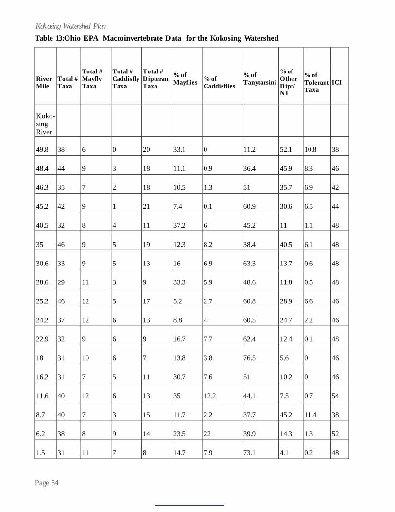
Page 54
Kokosing Watershed PlanTable 13:Ohio EPA Macroinvertebrate Data for the Kokosing Watershed
River Mile
Total # Taxa
Total # Mayfly Taxa
Total # Caddisfly Taxa
Total # Dipteran Taxa
% of Mayflies
% of Caddisflies
% of Tanytarsini
% of Other Dipt/NI
% of Tolerant Taxa
ICI
Koko-sing River
49.8
38
6
0
20
33.1
0
11.2
52.1
10.8
38
48.4
44
9
3
18
11.1
0.9
36.4
45.9
8.3
46
46.3
35
7
2
18
10.5
1.3
51
35.7
6.9
42
45.2
42
9
1
21
7.4
0.1
60.9
30.6
6.5
44
40.5
32
8
4
11
37.2
6
45.2
11
1.1
48
35
46
9
5
19
12.3
8.2
38.4
40.5
6.1
48
30.6
33
9
5
13
16
6.9
63.3
13.7
0.6
48
28.6
29
11
3
9
33.3
5.9
48.6
11.8
0.5
48
25.2
46
12
5
17
5.2
2.7
60.8
28.9
6.6
46
24.2
37
12
6
13
8.8
4
60.5
24.7
2.2
46
22.9
32
9
6
9
16.7
7.7
62.4
12.4
0.1
48
18
31
10
6
7
13.8
3.8
76.5
5.6
0
46
16.2
31
7
5
11
30.7
7.6
51
10.2
0
46
11.6
40
12
6
13
35
12.2
44.1
7.5
0.7
54
8.7
40
7
3
15
11.7
2.2
37.7
45.2
11.4
38
6.2
38
8
9
14
23.5
22
39.9
14.3
1.3
52
1.5
31
11
7
8
14.7
7.9
73.1
4.1
0.2
48

Page 55
Kokosing Watershed PlanTable 13:Ohio EPA Macroinvertebrate Data for the Kokosing Watershed (continued)
River Mile
Total # Taxa
Total # Mayfly Taxa
Total # Caddisfly Taxa
Total # Dipteran Taxa
% of Mayflies
% of Caddisflies
% of Tanytarsini
% of Other Dipt/NI
% of Tolerant Taxa
ICI
N. Br. Kokosing
11.6
40
12
5
14
4.2
3.1
53.6
38.2
10.6
46
6.2
37
8
9
10
37.2
24.4
19
19.1
0
50
4.8
40
11
7
9
47.6
17.8
12.6
19.7
1.6
52
2.1
30
9
5
11
73.2
5.3
13.1
7.3
0.2
46
• Libellula cyanea Fabricius, 1775 - EasternSpangled Skimmer - Family: Libellulidae• Libellula semifasciata Burmeister, 1839 -Painted Skimmer - Family: Libellulidae• Libellula pulchella Drury, 1770 - Twelve-spotted Skimmer - Family: Libellulidae• Libellula quadrimaculata Linnaeus, 1758 -Four-spotted Skimmer - Family: Libellulidae• Libellula lydia Drury, 1770 - CommonWhitetail - Family: Libellulidae• Sympetrum ambiguum (Rambur), 1842 -Blue-faced Meadowhawk - Family: Libellulidae• Sympetrum rubicundulum (Say), 1839 -Ruby Meadowhawk - Family: Libellulidae• Sympetrum vicinum (Hagen), 1861 - Yel-low-legged Meadowhawk - Family: Libellulidae• Sympetrum costiferum (Hagen), 1861 - Saf-fron-winged Meadowhawk - Family: Libellulidae• Leucorrhinia intacta Hagen, 1961 - Dot-tailed Whiteface - Family: Libellulidae• Pachydiplax longipennis (Burmeister), 1839- Blue Dasher - Family: Libellulidae• Erythemis simplicicollis Say, 1839 - East-ern Pondhawk - Family: Libellulidae• Pantala flavescens (Fabricius), 1798 - Wan-dering Glider - Family: Libellulidae• Tramea lacerata Hagen, 1861 - BlackSaddlebags - Family: Libellulidae• Calopteryx maculata (Beauvois), 1805 -
Ebony Jewelwing - Family: Calopterygidae• Hetaerina americana (Fabricius), 1798 -American Rubyspot - Family: Calopterygidae• Lestes inaequalis Walsh, 1862 - ElegantSpreadwing - Family: Lestidae• Lestes forcipatus Rambur, 1842 - SweetflagSpreadwing - Family: Lestidae• Lestes rectangularis Say, 1839 - SlenderSpreadwing - Family: Lestidae• Lestes vigilax Hagen, 1862 - SwampSpreadwing - Family: Lestidae• Argia apicalis (Say), 1839 - Blue-frontedDancer - Family: Coenagrionidae• Argia fumipennis violacea (Hagen), 1861 -Violet Dancer - Family: Coenagrionidae• Argia moesta (Hagen), 1861 - PowderedDancer - Family: Coenagrionidae• Argia sedula (Hagen), 1861 - Blue-ringedDancer - Family: Coenagrionidae• Argia tibialis (Rambur), 1842 - Blue-tippedDancer - Family: Coenagrionidae• Amphiagrion saucium (Burmeister), 1839 -Eastern Red Damsel• Nehalennia gracilis Morse, 1895 - Sphag-num Sprite - Family: Coenagrionidae• Chromagrion conditum (Hagen), 1876 -Aurora Damsel - Family: Coenagrionidae• Enallagma exsulans (Hagen), 1861 - StreamBluet - Family: Coenagrionidae

Page 56
Kokosing Watershed Plan• Enallagma antennatum (Say), 1839 - Rain-bow Bluet - Family: Coenagrionidae• Enallagma civile (Hagen), 1861 - FamiliarBluet - Family: Coenagrionidae• Enallagma basidens Calvert, 1902 - Double-striped Bluet - Family: Coenagrionidae• Enallagma aspersum (Hagen), 1861 - AzureBluet - Family: Coenagrionidae• Ischnura posita (Hagen), 1861 - FragileForktail - Family: CoenagrionidaeIschnura verticalis (Say), 1839 - Eastern Forktail -Family: Coenagrionidae
Threatened, Rare, or Endangered Species
There are no known federally endangeredspecies, either plant or animal, in the Kokosing Riverwatershed. The watershed does support five stateendangered and five state threatened species. TheOhio Division of Natural Areas and Preserves’Natural Heritage section not only tracks the occur-
rence of these state endangeredand threatened species but alsotracks potentially threatened, spe-cial interest species and other el-ements such as “Ohio’s BigTrees” and Great Blue HeronColonies. Natural Heritage ele-ments for the Kokosing River wa-
tershed represent 27 different plants, fish, birds andamphibians. More specific information on theseelements are presented in the discussions which fol-low each group. Table 14 shows the elements inlist form.
Plants
No plant species of federal status or con-cern have been recorded in the Kokosing River wa-tershed. State listed species include one endangeredand four threatened species. The state endangeredspecies, small purple fringed orchid (Platantherapsycodes), is found in wet, semi-shaded areas in neu-tral or subacidic substrates. The state threatenedspecies are the false hop sedge (Carex lupuliformis),Philadelphia panic grass (Panicum philadelphicum),
smooth rose (Rosa blanda), and woodland bulrush(Scirpus expansus). In addition, the watershed con-tains eight other Natural Heritage elements.
Mammals
There are no threatened or endangeredmammalian species known to occur in the KokosingRiver corridor at this time; however suitable habi-tat does occur in the corridor for the federally andstate endangered Indiana Bat (Myotis sodalis). Thisspecies utilizes riparian corridors throughout Ohioduring the summer months for feeding, resting andraising its young.
Birds
There are no federally listed species resi-dent within the corridor at this time. However, twopairs of state endangered bald eagles (Haliaeetusleucoephalus) are nesting onthe Kokosing River (belowMillwood) and at KnoxLake. A third pair of baldeagles has been observedon the Kokosing at Foun-dation Park in MountVernon, but no nest was ob-served in 2003. The state endangered Northernharrier (Circus cyaneus) is a winter resident of thewatershed. It is also possible that short-eared owls(Asio flammeus), a state listed breeding bird, couldoccur as a winter resident within the corridor. Theirpresence here is predicated on the existence of suit-able pasturelands and fallow fields. One uncon-firmed sighting of the Northern harrier was madein February 2003 on Muskingum Watershed Con-servancy lands near the confluence of the Mohicanand Kokosing Rivers.
Fish
There are no federally listed fish known forthe Kokosing River drainage. State endangered spe-cies found in the Kokosing River include the moun-tain brook lamprey (Ichthyomyzon greeleyi) and thespotted darter (Etheos toma maculatum). The
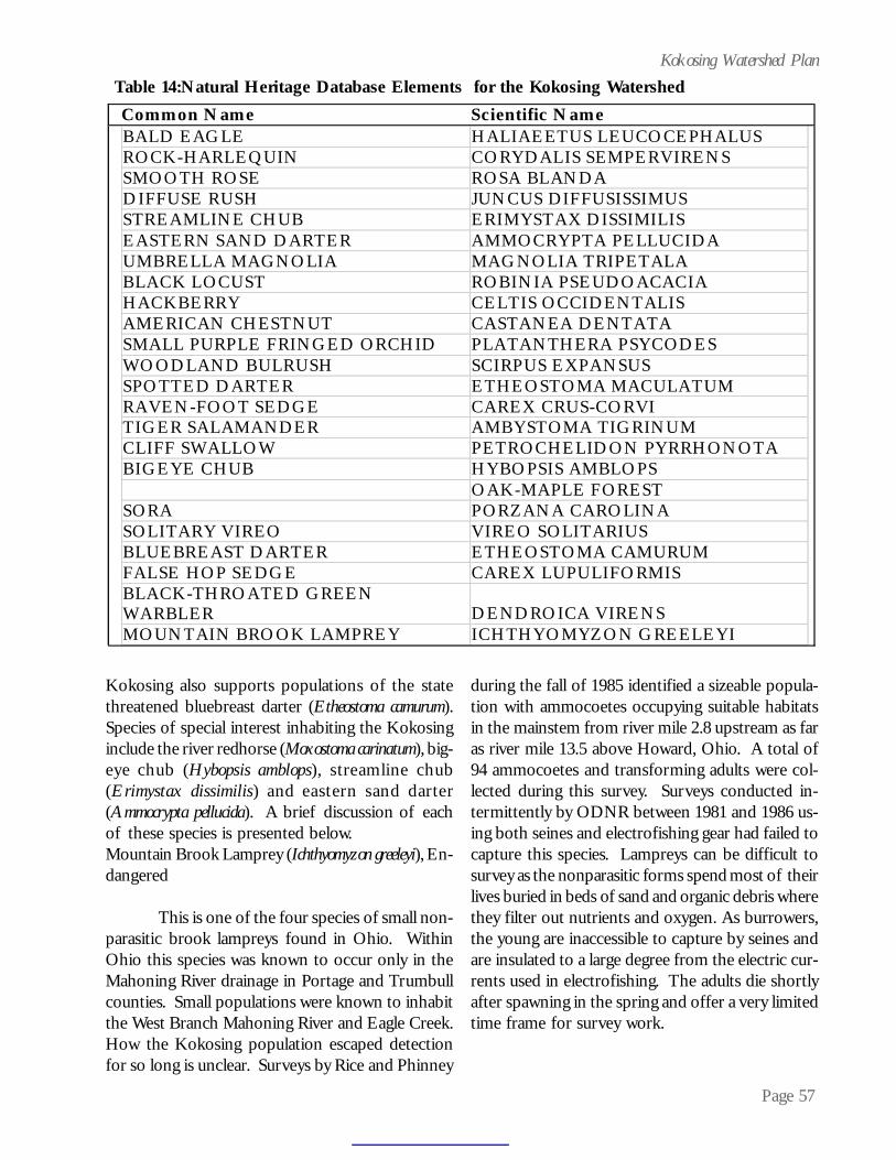
Page 57
Kokosing Watershed Plan
Kokosing also supports populations of the statethreatened bluebreast darter (Etheostoma camurum).Species of special interest inhabiting the Kokosinginclude the river redhorse (Moxostoma carinatum), big-eye chub (Hybopsis amblops), streamline chub(Erimystax dissimilis) and eastern sand darter(Ammocrypta pellucida). A brief discussion of eachof these species is presented below.Mountain Brook Lamprey (Ichthyomyzon greeleyi), En-dangered
This is one of the four species of small non-parasitic brook lampreys found in Ohio. WithinOhio this species was known to occur only in theMahoning River drainage in Portage and Trumbullcounties. Small populations were known to inhabitthe West Branch Mahoning River and Eagle Creek.How the Kokosing population escaped detectionfor so long is unclear. Surveys by Rice and Phinney
during the fall of 1985 identified a sizeable popula-tion with ammocoetes occupying suitable habitatsin the mainstem from river mile 2.8 upstream as faras river mile 13.5 above Howard, Ohio. A total of94 ammocoetes and transforming adults were col-lected during this survey. Surveys conducted in-termittently by ODNR between 1981 and 1986 us-ing both seines and electrofishing gear had failed tocapture this species. Lampreys can be difficult tosurvey as the nonparasitic forms spend most of theirlives buried in beds of sand and organic debris wherethey filter out nutrients and oxygen. As burrowers,the young are inaccessible to capture by seines andare insulated to a large degree from the electric cur-rents used in electrofishing. The adults die shortlyafter spawning in the spring and offer a very limitedtime frame for survey work.
Table 14:Natural Heritage Database Elements for the Kokosing Watershed Common Name Scientific Name
BALD EAGLE HALIAEETUS LEUCOCEPHALUS ROCK-HARLEQUIN CORYDALIS SEMPERVIRENS SMOOTH ROSE ROSA BLANDA DIFFUSE RUSH JUNCUS DIFFUSISSIMUS STREAMLINE CHUB ERIMYSTAX DISSIMILIS EASTERN SAND DARTER AMMOCRYPTA PELLUCIDA UMBRELLA MAGNOLIA MAGNOLIA TRIPETALA BLACK LOCUST ROBINIA PSEUDOACACIA HACKBERRY CELTIS OCCIDENTALIS AMERICAN CHESTNUT CASTANEA DENTATA SMALL PURPLE FRINGED ORCHID PLATANTHERA PSYCODES WOODLAND BULRUSH SCIRPUS EXPANSUS SPOTTED DARTER ETHEOSTOMA MACULATUM RAVEN-FOOT SEDGE CAREX CRUS-CORVI TIGER SALAMANDER AMBYSTOMA TIGRINUM CLIFF SWALLOW PETROCHELIDON PYRRHONOTA BIGEYE CHUB HYBOPSIS AMBLOPS OAK-MAPLE FOREST SORA PORZANA CAROLINA SOLITARY VIREO VIREO SOLITARIUS BLUEBREAST DARTER ETHEOSTOMA CAMURUM FALSE HOP SEDGE CAREX LUPULIFORMIS BLACK-THROATED GREEN WARBLER DENDROICA VIRENS MOUNTAIN BROOK LAMPREY ICHTHYOMYZON GREELEYI

Page 58
Kokosing Watershed PlanRiver Redhorse (Moxostoma carinatum), Special Con-cern
A species of larger rivers and streams, riverredhorse are present in small numbers in the lowersections of the mainstem. The Kokosing popula-tion is a likely extension of the population found inthe Walhonding River. Whether or not this speciesactually spawns in the Kokosing is unknown at thistime. This species requires clean gravel and cobblesubstrates for feeding and spawning. They are mostoften found in runs, flowing pools and at the basesof riffles where they feed on a variety ofmacroinvertebrates. Spawning occurs over gravelriffles in the spring of the year.
Bigeye Chub (Hybopsis amblops), Special Concern
A pool species inhabiting small streams tolarge rivers, bigeye chubs are sight feeders requir-ing relatively clear waters. Bigeyes are sensitive toincreasing water turbidity and have disappearedfrom many streams throughout Ohio due to silt-ation and increased turbidity levels. Once wide-spread throughout Ohio, bigeyes are now very lo-cal and greatly diminished in their distributions. TheKokosing River supports one of the largest remain-ing Ohio populations of this species. This popula-tion occupies the main channel from its junctionwith the Mohican River to upstream of MountVernon as far as river mile 31.7. The main popula-tion appears to be centered in the lower 20 milesbelow Mount Vernon.
Streamline Chub (Erimystax dissimilis), Special Con-cern
A species of medium-sized rivers andstreams, the streamline chub is sparingly distributedin the Kokosing River as far upstream as Howard,Ohio at river mile 11.3. Usually no more than 1-4individuals are captured on a given riffle at any onetime. Streamline chubs feed on bottom-dwellingmacroinvertebrates and are sensitive to siltation.They are most often collected over sand and gravelsubstrates at the bases of riffles and in chutes andruns. Elsewhere in the Muskingum basin this spe-cies is found in the lower Mohican, Walhonding andupper Muskingum rivers.
Eastern Sand Darter (Ammocrypta pellucida), SpecialConcern
A pool species requiring clean, stable sandysubstrates, the sand darter is another of the oncewidely distributed and common species whose dis-tribution and abundance has been greatly reducedby increasing turbidity levels and siltation of itshabitat. Sand darters are rare residents of the lowerKokosing River. On several occasions single indi-viduals have been collected from sandy substratesin the lower two miles of the river. These individu-als likely represent the uppermost extensions of thepopulations found in the Walhonding River thatprovides better habitat conditions for this species.Sand darters are also found in the lower mostreaches of the Mohican River and along the entirelength of the Muskingum River.
Spotted darter (Etheostoma maculatum), Endangered
This species has one of the most restrictedoccurrences of all the fish collected in the Kokosing.The Kokosing popu-lation appears to berestricted to a singleriffle (vicinity of Rt.715 and Zuck Road).Spotted Darters re-quire riffles havinglarge boulders andswift currents. In these swift riffles, spotted dartersare found under and around the larger rocks wherethe currents are deflected away from them. Thesehabitats are difficult to sample because of currentvelocities and the size of the rocks present in them.Efforts to catch this species in several other boul-der-strewn riffles (vicinity of Millwood, Ohio) thatappear to provide suitable habitat conditions, haveconsistently met with failure.
Bluebreast Darter (Etheostoma camurum), Threatened
Like the spotted darter, the bluebreast darteralso favors swift, rocky riffles but does not requirethe larger boulders favored by the spotted darter.This fact is reflected in the greater distribution of

Page 59
Kokosing Watershed Planthe bluebreastdarter in theK o k o s i n g .B l u e b r e a s tdarters havebeen taken inrocky r ifflesfrom theconfluence with the Mohican to as far upstream asBig Run Rd. (river mile 13.5). Elsewhere in theMuskingum Basin Bluebreast darters have beencollected in the lower Mohican River and theWalhonding River.
Reptiles and Amphibians
Hellbender (Cryptobranchus alleganiensis), Endangered
A large aquatic salamander restricted to theOhio River drainage system in Ohio and adjacentstates, this species inhabits medium to large sizedstreams having clean substrates and excellent wa-ter quality. It requires large flattened rocks in areasof moderate currents. Females lay and guard theireggs under these rock slabs, which also protect theyoung from potential predators. This species hasdisappeared from or declined in those streams thathave been impacted by excessive siltation and in-creased water turbidity or where pollution has de-graded the water quality. The Kokosing system sup-ports a modest population of this state endangeredanimal, as does the Mohican and Walhonding riv-ers.
Unionid Molluscs
In the summer of 2003, the first record everfor a state endangered mussel was recorded on theKokosing River mainstem, near Gambier. Lampsilisovata, sharp-ridged pocketbook, was positively iden-tified. The specimen consisted of a subfossil, mean-ing that historically, the Kokosing contained thisspecies. No live specimens were encountered.
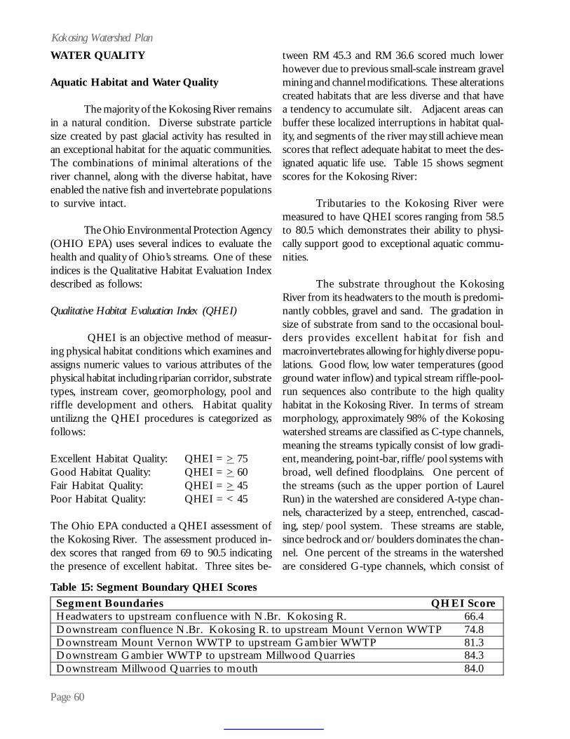
Page 60
Kokosing Watershed PlanWATER QUALITY
Aquatic Habitat and Water Quality
The majority of the Kokosing River remainsin a natural condition. Diverse substrate particlesize created by past glacial activity has resulted inan exceptional habitat for the aquatic communities.The combinations of minimal alterations of theriver channel, along with the diverse habitat, haveenabled the native fish and invertebrate populationsto survive intact.
The Ohio Environmental Protection Agency(OHIO EPA) uses several indices to evaluate thehealth and quality of Ohio’s streams. One of theseindices is the Qualitative Habitat Evaluation Indexdescribed as follows:
Qualitative Habitat Evaluation Index (QHEI)
QHEI is an objective method of measur-ing physical habitat conditions which examines andassigns numeric values to various attributes of thephysical habitat including riparian corridor, substratetypes, instream cover, geomorphology, pool andriffle development and others. Habitat qualityuntilizng the QHEI procedures is categorized asfollows:
Excellent Habitat Quality: QHEI = > 75Good Habitat Quality: QHEI = > 60Fair Habitat Quality: QHEI = > 45Poor Habitat Quality: QHEI = < 45
The Ohio EPA conducted a QHEI assessment ofthe Kokosing River. The assessment produced in-dex scores that ranged from 69 to 90.5 indicatingthe presence of excellent habitat. Three sites be-
tween RM 45.3 and RM 36.6 scored much lowerhowever due to previous small-scale instream gravelmining and channel modifications. These alterationscreated habitats that are less diverse and that havea tendency to accumulate silt. Adjacent areas canbuffer these localized interruptions in habitat qual-ity, and segments of the river may still achieve meanscores that reflect adequate habitat to meet the des-ignated aquatic life use. Table 15 shows segmentscores for the Kokosing River:
Tributaries to the Kokosing River weremeasured to have QHEI scores ranging from 58.5to 80.5 which demonstrates their ability to physi-cally support good to exceptional aquatic commu-nities.
The substrate throughout the KokosingRiver from its headwaters to the mouth is predomi-nantly cobbles, gravel and sand. The gradation insize of substrate from sand to the occasional boul-ders provides excellent habitat for fish andmacroinvertebrates allowing for highly diverse popu-lations. Good flow, low water temperatures (goodground water inflow) and typical stream riffle-pool-run sequences also contribute to the high qualityhabitat in the Kokosing River. In terms of streammorphology, approximately 98% of the Kokosingwatershed streams are classified as C-type channels,meaning the streams typically consist of low gradi-ent, meandering, point-bar, riffle/pool systems withbroad, well defined floodplains. One percent ofthe streams (such as the upper portion of LaurelRun) in the watershed are considered A-type chan-nels, characterized by a steep, entrenched, cascad-ing, step/pool system. These streams are stable,since bedrock and or/boulders dominates the chan-nel. One percent of the streams in the watershedare considered G-type channels, which consist of
Segment Boundaries QHEI Score Headwaters to upstream confluence with N.Br. Kokosing R. 66.4 Downstream confluence N.Br. Kokosing R. to upstream Mount Vernon WWTP 74.8 Downstream Mount Vernon WWTP to upstream Gambier WWTP 81.3 Downstream Gambier WWTP to upstream Millwood Quarries 84.3 Downstream Millwood Quarries to mouth 84.0
Table 15: Segment Boundary QHEI Scores

Page 61
Kokosing Watershed Planentrenched “gully” step/pool and low width/depthratio on moderate gradients. Channelized (straight-ened) streams in the watershed comprise the G-typechannels. G-type channels tend to be less stablethan their C-type and A-type counterparts.
Ohio EPA recently developed methodolo-gies for the evaluation for small primary headwaterhabitat streams (PHWH) with watershed areas lessthan 1 mi2 where existing methodologies, such asQHEI, are inadequate to properly characterize thestreams. For these small PHWH streams, a Head-water Habitat Evaluation Index (HHEI) has beendeveloped for use in assessing the habitat qualityto support aquatic life adapted to these systems(Ohio EPA, 2002). For purposes of determiningweighting factors for habitat quality utilizing theHHEI, weighting factor scores are determined asfollows:
Excellent Habitat Quality: HHEI = > 70Good Habitat Quality: HHEI = > 50Fair Habitat Quality: HHEI = > 30Poor Habitat Quality: HHEI = < 30
Note: Primary headwater stream impactswere not specifically identified or assessed duringwatershed plan fieldwork. Within the watershed ingeneral, more primary headwater streams have beenimpacted by tiling/culverting practices and urban-ization than intermittent and perennial streams.These smaller systems are easier to modify, are val-ued less by landowners and make up as much as 80percent of the total stream habitat in the water-shed.
Aquatic Habitat and Water Chemistry
Both the biological and chemical/physicalsampling conducted by the Ohio EPA in 1987 re-vealed little impact resulting from point source dis-charges in the Kokosing River study area. How-ever, they did observe some violations of chemicalwater quality standards (WQS). Violations of theiron WQS, noted throughout the mainstem and inthe North Branch, varied in severity from slightlyelevated to highly elevated concentrations. These
violations were attributed to natural backgroundconditions as well as runoff events but were notexpected to cause instream biological impacts. Vio-lations of the primary contact recreation WQS forfecal coliform occurred at 18 of the 25 sites sampledin 1987. Inputs from diffuse agricultural non-pointsource runoff were suggested as a potential cause.Additional sampling revealed fecal coliform WQSviolations also occurred downstream from theFredericktown wastewater treatment plant. The1987 study also concluded that there was no sig-nificant impact to the Kokosing River water chem-istry because of discharges from the Gambier waste-water treatment plant. However, after the 1987study, this plant was found to be operating improp-erly which resulted in action being taken to bringthe City of Gambier into compliance with theirNPDES permit. The 1987 study also concludedthat the Mount Vernon wastewater treatment plantappeared to be discharging a high quality effluent.
Mount Vernon, Gambier, Sparta, Danvilleand Fredericktown have upgraded their wastewa-ter treatment plants since the 1987 study. Addi-
tionally, the Villageof Martinsburg isinvestigating in-stallation of awastewater treat-ment system todeal with failingseptic tank sys-
tems in the village. The Village of Chesterville hasalso switched from individual septic tanks to awastewater collection system since Ohio EPA lastconducted sampling. The wastewater treatmentplants operated by Knox County that serve AppleValley and Pleasant View Acres subdivisions havenot experienced significant water quality dischargeviolations. Additionally, use of small wastewatertreatment package plants at New Hope, CountyEngineer’s compound and the Opportunity Centerhave been discountinued, with those areas tied intoMount Vernon’s wastewater system. Combined withKnox County’s plan to expend financial resourcesto make existing wasterwater instrastructure im-
Page 62
Kokosing Watershed Planprovements, point source discharges in theKokosing have been improving in quality and shouldcontinue to improve in the future.
The Morrow County Health Departmentresponded to 27 complaints concerning failing sep-tic systems in calendar year 2002, with 16 of thecomplaints resulting in verified failed systems. TheKnox County Health Department received 8 veri-fied complaints for failing septic systems in calen-dar year 2003. In general, areas adjacent to mu-nicipal corporation limits are serviced by publicwastewater systems. All rural areas are serviced byindividual property septic systems.
National Pollutant Discharge EliminationSystem permit holders within the watershed includethe Villages of Chesterville, Sparta, Fredericktownand Gambier, City of Mount Vernon, Knox CountyWater Department, Camp McPherson, HighlandBoard of Education, Del-Co Water Company, theOlen Corporation, Oglebay Norton IndustrialSands, Columbia Gas system, and Cooper EnergyServices. The watershed has been spared large spillsand contamination problems from previous andcurrent industrial and agricultural operations. NoNational Priority List (Superfund) sites occur in thewatershed, and only one Comprehensive Environ-mental Response, Compensation and Liability In-formation System site exists in the watershed. OhioEPA determined that no significant hazard existedat the site, American National Can, however.
The Ohio EPA Division of Emergency andRemedial Response (DERR) have investigated sev-eral hazardous or potentially hazardous incidentsin the watershed (three of which occurred at theAmerican National Can site). In 1996, Ohio EPAalso detected petroleum hydrocarbons in the shal-low aquifer underlying the BP Bulk Oil Facility(#69077) in Mount Vernon. This site was given alow priority by Ohio EPA, since the water supplyfor Mount Vernon and the Kokosing River werenot affected by the contamination found at BP. InJune of 2003, Ohio EPA-DERR investigated apotential spill at the East Knox School District busgarage, located near the Kokosing River. Bus main-
tenance has resulted in a small oil and grease re-lease into a ditch and storm drain. The school dis-trict abated the problem the same day that OhioEPA investigated the site. Scenic Rivers staff foundno signs of slicks, sheens or contamination in theKokosing River the next day.
According to the Ohio Department of Com-merce, Bureau of Underground Storage Tanks, 120registered underground storage tanks exist in thewatershed, and 18 suspected or confirmed under-ground storage tank releases have occurred in thewatershed and are under active investigation. Otherpotential sources for contamination include 12,class-five, shallow, underground injection wells andseven inactive/closed landfills. The largest closedlandfill in the county, Knox County Landfill, ap-pears to be meeting chemical limit parameters. Ad-ditionally, the Knox Soil and Water ConservationDistrict is currently designing a small, passive, wet-land treatment system to treat iron in the landfillleachate. Approximately 55 hazardous waste han-dlers regulated under the Resource Conservationand Recovery Act occur in the watershed.
Herbicide use by county is given in Table16 by acres treated, pounds used and rate of use(based on 1991 estimates). No misapplication ormisuse of herbicides was observed in the water-shed during field visits.
Section 6111.12(A)(2) of the Ohio RevisedCode specifically requires that the Ohio EPA es-tablish provision “ensuring that waters of excep-tional recreational and ecological value are main-tained as high quality resources for future genera-tions.” As such, in 2002, the Ohio EPA designatedthe Kokosing and North Branch of the Kokosingas a state resource water under water quality stan-dards. The Kokosing was designated because thesystem is among the very best within Ohio and sup-ports very diverse aquatic life and rare species. A70% set aside is implemented to preserve waterquality near existing condition, more stringent pol-lution controls are placed for new sources, and so-cial/economic justification is needed to lower wa-ter quality.
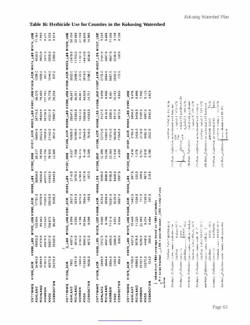
Page 63
Kokosing Watershed PlanTable 16: Herbicide Use for Counties in the Kokosing Watershed

Page 64
Kokosing Watershed PlanThe Total Maximum Daily Load (TMDL)
program, established under Section 303(d) of theClean Water Act, focuses on identifying and restor-ing polluted rivers, streams, lakes and other surfacewaterbodies. A TMDL is a written, quantitativeassessment of water quality problems in awaterbody and contributing sources of pollution.No TMDLs exist for any subwatersheds in theKokosing River. Ohio EPA’s 2002 Integrated Re-port, which includes a TMDL priority list, indicatesthat the Kokosing River, “downstream NorthBranch to upstream Jelloway Creek,” contains 5.4percent of large streams in nonattainment ofaquatic life use. Improvements made to municipalwastewater treatment in this stretch have partiallyabated this nonattainment, which relates to organicenrichment and lower dissolved oxygen concentra-tions. Additional strategies, such as establishmentof riparian wooded corridors would assist in abat-ing this nonattainment. Ohio EPA’s draft 2004 In-tegrated Water Quality Monitoring and Assessment Re-port (1/9/04) removes the Kokosing River (head-waters to upstream North Branch) from the cat-egory five (priority impaired waters) list in the303(d) list, due to errors in data reporting. No avail-able data shows impairment at any site in thatsubwatershed.
The Kokosing River, “upstream JellowayCreek to mouth” includes 37.5 percent ofnonattainment of aquatic life use for large streamsand 25 percent partial attainment of small streamsin this subwatershed. Reasons given for thenonattainment include upstream impoundments (i.e.Mohawk Dry Dam on the Wahonding), pasturedlands and other urban runoff. Obviously, theMohawk Dry Dam performs a great service todownstream residents in Coshocton, thus, the flowalteration that occurs on the Kokosing will con-tinue in the future. However, pastured lands andother urban runoff are sources of nonpoint sourcepollution that can be abated with implementationof strategies addressed later in this document.
The Integrated Report also indicates thatthe Kokosing River (headwaters to upstream NorthBranch) contains 75 percent of small streams that
achieve partial attainment of their aquatic life use.The North Branch of the Kokosing exhibits fullattainment of its aquatic life use. Ohio EPA’s 1996Ohio Water Resource Inventory 305(b) Report in-dicated that nutrient enrichment was the largestcause of impairment. The Kokosing River’s 305(b)identification number is Group 18.
Ohio EPA’s draft 2004 Integrated Water Qual-ity Monitoring and Assessment Report (1/9/04) lists theKokosing River, upstream of Jelloway Creek to themouth, as a category five, priority impaired water,in the 303(d) list.
Ohio EPA also regulates the discharge offill material in isolated wetlands and “waters of theUnited States,” through its isolated wetlands per-mit and 401 water quality certification. The U.S.Army Corps of Engineers also regulates the dis-charge of fill material through its Section 404 CleanWater Act permitting program. Within the last 10years, the Corps of Engineers has performed 15reviews and permits for the discharge of dredgedmaterial in the Kokosing watershed. 14 of theprojects were minor in nature and were permittedunder the Corps’ Nationwide Permit authorization.In 2003, the Corp of Engineers and Ohio EPA haveinvestigated three illegal channelizations and/ orfill projects in the watershed.
Storm Water
Storm water runoff can pollute streams,disrupt natural hydrogic regimes of streams andflood downstream neighbors. With an eye towardsplanning for future growth, and the resulting in-crease in storm water quantity, the Knox CountyRegional Planning Commission’s Storm Water Ad-visory Committee (SWAC) surveyed residents re-garding managing storm water. The mission state-ment of the committee, as accepted on May 16,2002, is to educate and to inform members of the SWACand the general public on the topic of storm water manage-ment and about the authorization in H.B. 549 for acountywide storm water plan. Survey results indicatedthat the public would more likely trust Ohio StateUniversity (OSU) extension agents, state agency
Page 65
Kokosing Watershed Planpersons or other farmers regarding informationabout storm water. Respondents awareness thatthe Kokosing was designated scenic was extremelyhigh, and more than 60% strongly agreed or agreedthat regulations are needed now to reduce stormwater pollution. Respondents showed majority sup-port for paying a fee to maintain water quality andapproximately 60% agreed that new developmentsshould pay higher fees while charging less fees toexisting lots for maintenance and resolution of ex-isting storm water problems.
The SWAC also recommended to the KnoxRPC to direct the drafting of regulations to includea comprehensive county storm water plan for newresidential, commercial or industrial developmentand personnel to manage, administer and enforcethe regulations. This was done coincidentally withpassage of Article III of the Subdivision Regula-tions, which deal with sediment and erosion con-trol and storm water management (as related tominor subdivisions). In December 2003, KnoxCounty Commissioners proactively approvedstormwater and sediment control regulations. TheKnox County Engineer estimates that 70% of ex-isting storm water management systems in theKokosing watershed occur on private property.Thus, to manage storm water appropriately, privateproperty owners will need to participate. The Cityof Mount Vernon is the only Phase II NPDES stormwater community in the watershed.
Aquatic Habitat and Relative Water Quality
The Ohio EPA uses several indices, as pre-viously mentioned, to evaluate the health and qual-ity of Ohio’s streams. Another one of these indi-ces is the Index of Biological Integrity described asfollows:
Index of Biological Integrity (IBI)
IBI is a means of objectively measuring andevaluating biological community performance basedon the number of fish species found, the presenceof certain indicator species, the numbers of indi-viduals found and other characteristics of the fishcommunity.
The Ohio EPA evaluated the KokosingRiver using the IBI assessment method and has cal-culated scores ranging between 38 and 58 with anaverage of 48.8. Values typically range from 12 to60 for streams in Ohio. In comparison, the IBI rat-ings for the Big and Little Darby Creeks range be-tween 36 and 58 with and average of 47. The val-ues for the Kokosing River indicate a stream waterquality that rates among the top in Ohio.
Ohio’s streams and rivers have seen signifi-cant changes since European settlement. Pre-settle-ment stream substrates consisted of cobbles andgravel that were free from clayey silts. This wasdue in large part to the fact that more than 95 per-cent of Ohio was wooded and the smaller streamshad permanent flow most of the year. Springs wereabundant and the water ran clear. Things began tochange, however, as the European settlers movedinto Ohio. About 24 million acres of forest existedin 1800 but was cut to 4 million by 1883. Popula-tion also increased rapidly from 3,000 in the 1700’sto over 3 million by 1880. The abrupt changes inland use and increased use has left many Ohiostreams still struggling to recover. Even as someof the more pronounced impacts from point sourcesof pollution are reduced, impacts from sources suchas combined sewer overflows, urban storm water,siltation of substrates and habitat degradation arebecoming more evident.
The Kokosing River has been less severelyimpacted than many other rivers in the state. It hasessentially intact physical features that provide forsome of the highest quality aquatic assemblages inOhio. The Ohio EPA assigns each water body inthe state one or moreaquatic life habitatuse designations.These designationsare based on the at-tributes of speciescomposition, diver-sity and functionalorganization thatare measured using the IBI described previously,the modified index of well being (MIwb) and the

Page 66
Kokosing Watershed Planinvertebrate community index (ICI) which are de-scribed as follows:
Modified Index of Well Being (MIwb)
MIwb is an objective method of measuringand evaluating fish community performance. Thismethodology is a measure of fish community abun-dance and diversity using numbers and weight in-formation.
Invertebrate Community Index (ICI)
The ICI is a method of evaluation appliedto macroinvertebrate community performance andcharacteristics.
Kokosing River segments have been assignedeither the exceptional warmwater or the warmwateruse designation by Ohio EPA.
The exceptional warmwater designation isfor waters that can support and maintain an excep-tional or unusual community of warmwater aquaticorganisms having a species composition, diversityand functional organization comparable to the sev-enty-fifth percentile of the identified reference sitesstatewide. The Kokosing River mainstem from itsconfluence with the North Branch of the Kokosingat river mile 29.7 to the confluence with the MohicanRiver at river mile 0.0 is under the exceptionalwarmwater designation. In addition, JellowayCreek, Little Jelloway Creek, East Branch ofJelloway Creek and Schenck Creek are also underthe exceptional warmwater designation.
The warmwater designation is for watersthat can support and maintain a balanced, integratedand adaptive community of warmwater aquaticorganisms having a species composition, diversityand functional organization comparable to thetwenty-fifth percentile of the identified referencesites within each of the following ecoregions: ErieOntario Lake Plain, Western Allegheny Plateau,Eastern Corn Belt. The Kokosing River upstreamof river mile 29.7 is designated warmwater habitat.
Tributaries also under the warmwater designationinclude the following: Laurel Run, Singer Run,Brush Run, Honey Run, Sapps Run, Dowd Creek,Shadley Valley Creek, Ireland Creek, Barney Run,Coleman Branch, Little Schenck Creek, Mud Run,Indianfield Run, Big Run, Elliott Run, Wolf Run,Center Run, Dry Creek, Dry Run, Armstrong Run,North Branch, Job Run, East Branch of NorthBranch, Isaacs Run, Markley Run, Toby Run, LostRun, Granny Creek, Mile Creek, South Branch,Sylvester Run. Kokosing stream designations areshown in Table 17.
Hydrologic unit codes, used to divide theKokosing into subwatersheds include the follow-ing (18 total). Acre figures are given for eachsubwatershed as well:
05040003-010-010-Kokosing River headwa-ters to below S. Branch Kokosing R.Subarea= 23,298 Acres05040003-010-020-Kokosing River below S.Branch to below Mile RunSubarea= 24,734 Acres05040003-010-030-Kokosing River belowMile Run to above N. BranchSubarea= 16,281 Acres05040003-020-010-North Branch KokosingRiver headwaters to near St. Rt. 13Subarea= 29,100 Acres05040003-020-020-East Branch KokosingRiverSubarea= 20,342 Acres05040003-020-030-North Branch KokosingRiver near St. Rt. 13 to Kokosing R. [exceptEast Branch]Subarea= 13,244 Acres05040003-030-010-Kokosing River below N.Branch to above Dry RunSubarea= 10,946 Acres05040003-030-020-Dry CreekSubarea= 21,810 Acres05040003-030-030-Kokosing River belowDry Creek to above Big RunSubarea= 21,000 Acres05040003-030-040-Big RunSubarea= 19,886 Acres
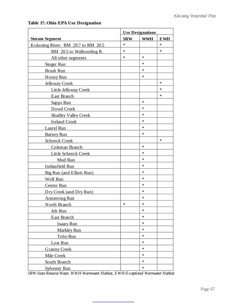
Page 67
Kokosing Watershed Plan
SRW-State Resource Water, WWH-Warmwater Habitat, EWH-Exceptional Warmwater Habitat
Table 17: Ohio EPA Use Designation Use Designations
Stream Segment
SRW WWH
EWH
Kokosing River: RM 29.7 to RM 20.5
*
*
RM 20.5 to Walhonding R.
*
*
All other segments
* *
Singer Run
*
Brush Run
*
Honey Run
*
Jelloway Creek
*
Little Jelloway Creek
*
East Branch
*
Sapps Run
*
Dowd Creek
*
Shadley Valley Creek
*
Ireland Creek
*
Laurel Run
*
Barney Run
*
Schenck Creek
*
Coleman Branch
*
Little Schenck Creek
*
Mud Run
*
Indianfield Run
*
Big Run (and Elliott Run)
*
Wolf Run
*
Center Run
*
Dry Creek (and Dry Run)
*
Armstrong Run
*
North Branch
* *
Job Run
*
East Branch
*
Isaacs Run
*
Markley Run
*
Toby Run
*
Lost Run
*
Granny Creek
*
Mile Creek
*
South Branch
*
Sylvester Run
*
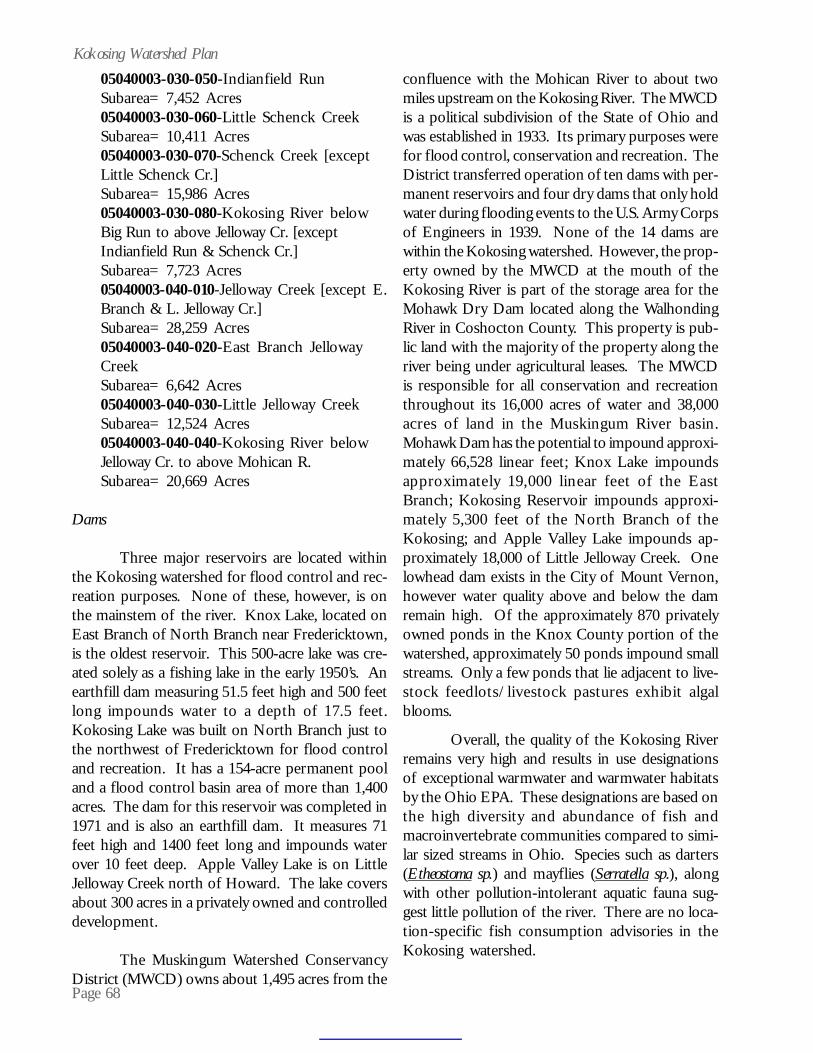
Page 68
Kokosing Watershed Plan05040003-030-050-Indianfield RunSubarea= 7,452 Acres05040003-030-060-Little Schenck CreekSubarea= 10,411 Acres05040003-030-070-Schenck Creek [exceptLittle Schenck Cr.]Subarea= 15,986 Acres05040003-030-080-Kokosing River belowBig Run to above Jelloway Cr. [exceptIndianfield Run & Schenck Cr.]Subarea= 7,723 Acres05040003-040-010-Jelloway Creek [except E.Branch & L. Jelloway Cr.]Subarea= 28,259 Acres05040003-040-020-East Branch JellowayCreekSubarea= 6,642 Acres05040003-040-030-Little Jelloway CreekSubarea= 12,524 Acres05040003-040-040-Kokosing River belowJelloway Cr. to above Mohican R.Subarea= 20,669 Acres
Dams
Three major reservoirs are located withinthe Kokosing watershed for flood control and rec-reation purposes. None of these, however, is onthe mainstem of the river. Knox Lake, located onEast Branch of North Branch near Fredericktown,is the oldest reservoir. This 500-acre lake was cre-ated solely as a fishing lake in the early 1950’s. Anearthfill dam measuring 51.5 feet high and 500 feetlong impounds water to a depth of 17.5 feet.Kokosing Lake was built on North Branch just tothe northwest of Fredericktown for flood controland recreation. It has a 154-acre permanent pooland a flood control basin area of more than 1,400acres. The dam for this reservoir was completed in1971 and is also an earthfill dam. It measures 71feet high and 1400 feet long and impounds waterover 10 feet deep. Apple Valley Lake is on LittleJelloway Creek north of Howard. The lake coversabout 300 acres in a privately owned and controlleddevelopment.
The Muskingum Watershed ConservancyDistrict (MWCD) owns about 1,495 acres from the
confluence with the Mohican River to about twomiles upstream on the Kokosing River. The MWCDis a political subdivision of the State of Ohio andwas established in 1933. Its primary purposes werefor flood control, conservation and recreation. TheDistrict transferred operation of ten dams with per-manent reservoirs and four dry dams that only holdwater during flooding events to the U.S. Army Corpsof Engineers in 1939. None of the 14 dams arewithin the Kokosing watershed. However, the prop-erty owned by the MWCD at the mouth of theKokosing River is part of the storage area for theMohawk Dry Dam located along the WalhondingRiver in Coshocton County. This property is pub-lic land with the majority of the property along theriver being under agricultural leases. The MWCDis responsible for all conservation and recreationthroughout its 16,000 acres of water and 38,000acres of land in the Muskingum River basin.Mohawk Dam has the potential to impound approxi-mately 66,528 linear feet; Knox Lake impoundsapproximately 19,000 linear feet of the EastBranch; Kokosing Reservoir impounds approxi-mately 5,300 feet of the North Branch of theKokosing; and Apple Valley Lake impounds ap-proximately 18,000 of Little Jelloway Creek. Onelowhead dam exists in the City of Mount Vernon,however water quality above and below the damremain high. Of the approximately 870 privatelyowned ponds in the Knox County portion of thewatershed, approximately 50 ponds impound smallstreams. Only a few ponds that lie adjacent to live-stock feedlots/livestock pastures exhibit algalblooms.
Overall, the quality of the Kokosing Riverremains very high and results in use designationsof exceptional warmwater and warmwater habitatsby the Ohio EPA. These designations are based onthe high diversity and abundance of fish andmacroinvertebrate communities compared to simi-lar sized streams in Ohio. Species such as darters(Etheostoma sp.) and mayflies (Serratella sp.), alongwith other pollution-intolerant aquatic fauna sug-gest little pollution of the river. There are no loca-tion-specific fish consumption advisories in theKokosing watershed.

Page 69
Kokosing Watershed PlanIMPACTS AND THREATS
Table 18 and Figure 10 summarize impacts(in linear feet) encountered in the Kokosing water-shed. Table 19 lists the main threats on asubwatershed basis. Impacts were inventoried dur-ing field work and were initially rendered on aerialphotography. Secondly, impacts were digitized aspolylines into a geographic information system(GIS). Finally, for each line digitized, up to threesources and three causes of impacts were added asattributes in the GIS.
SOCIAL RESOURCE INVENTORY(HISTORICAL/ECONOMIC/SOCIAL/CULTURAL RESOURCES)
History of Human Development of the AreaNative Americans
Approximately 609 sites of historical valueare present within the Kokosing watershed, with49 sites listed on the National Register of HistoricPlaces. The Ohio Historic Preservation Office,Ohio’s official historic preservation agency, is
Table 18: Impacts Encountered in the Kokosing Watershed
S o u rc es Im p acts % W a tersh e d Im p ac ts A gr icu ltu re 705 0 .01% C h an n e lizat io n A gricu ltu re 402 ,35 2 5 .75% C h an n e lizat io n D eve lo p m en t 68 ,2 53 0 .98% C o n stru ct io n 7 ,29 1 0 .10% N o n -ir r iga ted cro p p ro du c tion 62 ,4 56 0 .89% D red ge m in in g 11 ,0 74 0 .16% F eed lo t 7 ,95 2 0 .11% F illin g 518 0 .01% F lo w m o d ific at io n D eve lo p m en t 43 ,8 19 0 .63% H yd ro m o d ific at io n A gr icu ltu re 71 ,9 38 1 .03% H yd ro m o d ific at io n D eve lo p m en t 24 ,0 21 0 .34% H igh w ay B r id ge 302 0 .00% L an d D eve lo p m en t 2 ,21 5 0 .03% N atu ra l 356 0 .01% O n -s ite w astew a te r (sep tic ) 6 ,80 8 0 .10% O th e r 9 ,11 4 0 .13% R an ge G raz in g (en cro ach m en t) 245 ,97 4 3 .52% R ip ar ian V egeta t io n R em o val 916 ,41 9 13 .1 0% S tre am b an k d e stab iliz at io n 162 ,84 1 2 .33% U p stre am Im p o un dm en t 73 ,7 71 1 .05% U rb an R un o ff 13 ,0 11 0 .19% T o tal w ate rsh ed in lin e a r fe et (ap p ro x .) 3 ,66 1 ,27 2 T o ta l Im p ac ts in lin e a r fee t (ap p ro x .) 1 ,11 5 ,67 2 30 .4 7% C o u n ty b reak d o w n o f im p a cts (a cres ) A sh lan d 2 ,34 8 0 .76% C o sh o cto n 1 ,21 8 0 .39% K n o x 228 ,59 8 73 .9 2% M o rro w 67 ,0 84 21 .6 9% R ich lan d 9 ,98 3 3 .23% T o tal ac re s (app ro x .) 309 ,23 1 100 .00%
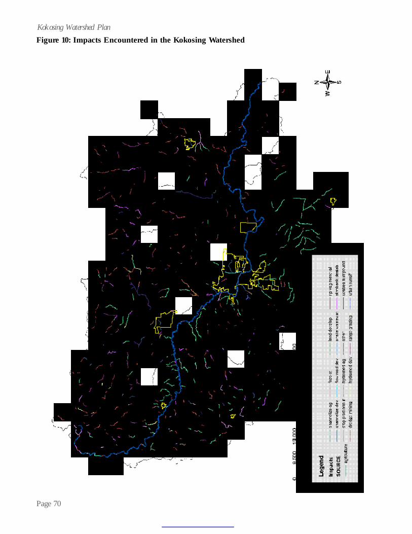
Page 70
Kokosing Watershed PlanFigure 10: Impacts Encountered in the Kokosing Watershed
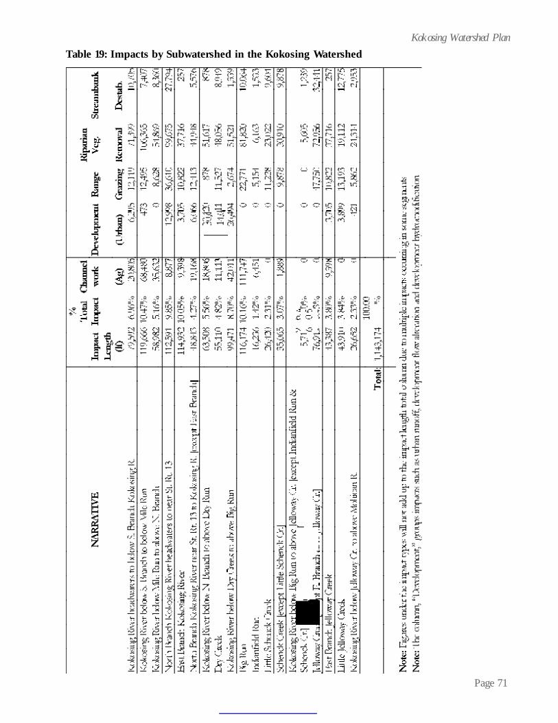
Page 71
Kokosing Watershed PlanTable 19: Impacts by Subwatershed in the Kokosing Watershed

Page 72
Kokosing Watershed Plancharged with identifying, evaluating and protectingimportant archeaological and historic sites in Ohio.The Kokosing watershed contains many relics fromearly cultures who lived in the area. Table 20 listssome of the more notable sites found in the Ohio’sHistorical Society’s Ohio Archeological Inventory.No locations are given for the mounds, due to se-curity concerns.
The earliest settlers of the area were theancient mound builders. Of the two distinct moundcultures, the Adena Culture found Knox County tobe desirable. The Adena inhabited Ohio from about1,000 B.C. to 100 A.D. Indications that theHopewell Culture existed are in the form of habi-tation sites, but these are rare. Nearly every areaof Knox County shows the influence of the Adenas.
The majority of the Adena mounds and enclosuresare located on points overlooking a river or stream,especially the Kokosing and its tributaries.
Most mounds and enclosures have beenobliterated as a result of urbanization, agriculturalpractices and excavations. These include theLarimore Group, the Blane Roberts Mound,Fredericktown Sand & Gravel Co. Mound, theHammond Mound, the Cemetery Mound, theKandel Works, the Staats Mound, the WobbeckeEnclosure and the Greer Fort. Three mounds haveremained unexcavated, and these are the RowleyMound, the Braddock Mound and the StackhouseMound.
The next inhabitants of Knox County werethe American Indians. The territory was mainly inpossession of the Delaware Nation, though not usedexclusively by this tribe. Several tribes of Ohio,including the Hurons, the Shawnees, the Mingos,and the Wyandots were generally on good termsand roamed freely across the boundaries of theDelawares. Several Delaware camps were locatedwithin Knox County prior to the War of 1812. Onewas along the Kokosing opposite the mouth ofCenter Run. Another was situated nearFredericktown.
The Kokosing River valley was utilized asa trade route for the Indians. This situation existedwithout much change until 1785 when theGreenville Treaty ceded a large portion of North-ern Ohio to the Americans. The Delawares, how-ever, were granted the right to live and hunt in theregion. The Greenville Treaty marked the start ofimmigration into the area by early pioneers and thedecline of the Indian dominance.
European Settlers
James Smith is thought to have been thefirst European to set foot in the area. In 1775 hewas captured by the Indians and remained with themfor about four years. He undoubtedly hunted inKnox County and is known to have traveled throughthe area on various occasions.
SITE NAME Gamble Mounds I & II Hammond Mound Staats Mound Cemetery Mound Hawn Mound Shipley Mound Higgins Fort Higgins Mound Liberty Township Works Bonar Mound Stackhouse Mound & Works Fredericktown Works Butler township Works Campbell Mound Loveridge Works Kaser-Parrott Mound Hammond Mound Fredericktown Sand & Gravel Co. Mound Rowley Mound Osborn Kame Clyde Black Earthworks Overholt Mound Kandel Works Weller Mound
Table 20: Mounds of the Kokosing Watershed
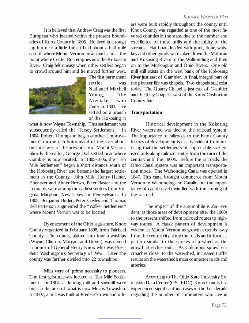
Page 73
Kokosing Watershed Plan
It is believed that Andrew Craig was the firstEuropean who located within the present bound-aries of Knox County in 1805. He lived in a roughlog hut near a little Indian field about a half mileeast of where Mount Vernon now stands and at thepoint where Center Run empties into the KokosingRiver. Craig felt uneasy when other settlers beganto crowd around him and he moved further west.
The first permanentsettler wasNathaniel MitchellYoung, “theAxemaker,” whocame in 1803. Hesettled on a branchof the Kokosing in
what is now Wayne Township. This settlement wassubsequently called the “Jersey Settlement.” In1804, Robert Thompson began another “improve-ment” on the rich bottomland of the river aboutone mile west of the present site of Mount Vernon.Shortly thereafter, George Dial settled near whereGambier is now located. In 1805-1806, the “TenMile Settlement” began a short distance south ofthe Kokosing River and became the largest settle-ment in the County. John Mills, Henry Hainer,Ebenezer and Abner Brown, Peter Baster and theLeonards were among the earliest settlers from Vir-ginia, Maryland, New Jersey and Pennsylvania. In1805, Benjamin Butler, Peter Coyles and ThomasBell Patterson augmented the “Walker Settlement”where Mount Vernon was to be located.
By enactment of the Ohio legislature, KnoxCounty organized in February 1808, from FairfieldCounty. The county, platted into four townships(Wayne, Clinton, Morgan, and Union), was namedin honor of General Henry Knox who was Presi-dent Washington’s Secretary of War. Later thecounty was further divided into 22 townships.
Mills were of prime necessity to pioneers.The first gristmill was located at Ten Mile Settle-ment. In 1804, a flouring mill and sawmill werebuilt in the area of what is now Morris Township.In 1807, a mill was built at Fredericktown and oth-
ers were built rapidly throughout the county untilKnox County was regarded as one of the most fa-vored counties in the state, due to the number andexcellence of these mills and durability of thestreams. Flat boats loaded with pork, flour, whis-key and other goods were taken down the Mohicanand Kokosing Rivers to the Walhonding and thenon to the Muskingum and Ohio Rivers. One oldmill still exists on the west bank of the KokosingRiver just east of Gambier. A final, integral part ofthe pioneer life was chapels. Two chapels still existtoday. The Quarry Chapel is just east of Gambierand the Riley Chapel is west of the Knox-CoshoctonCounty line.
Transportation
Historical development in the KokosingRiver watershed was tied to the railroad system.The importance of railroads to the Knox Countyhistory of development is clearly evident from no-ticing that the settlements of appreciable size ex-isted only along railroad routes from the turn of thecentury until the 1960’s. Before the railroads, theOhio Canal system was an important transporta-tion mode. The Walhonding Canal was opened in1847. This canal brought commerce from MountVernon to Walhonding and Cavallo, but the impor-tance of canal travel dwindled with the coming ofthe railroad.
The impact of the automobile is also evi-dent, as those areas of development after the 1960sto the present shifted from railroad routes to high-way routes. A classic pattern of development isevident in Mount Vernon as growth extends awayfrom the central city along the roads and it forms apattern similar to the spokes of a wheel as thegrowth stretches out. As Columbus sprawl en-croaches closer to the watershed, increased trafficresults on the watershed’s main connector roads andarteries.
According to The Ohio State University Ex-tension Data Center (OSUEDC), Knox County hasexperienced significant increases in the last decaderegarding the number of commuters who live in
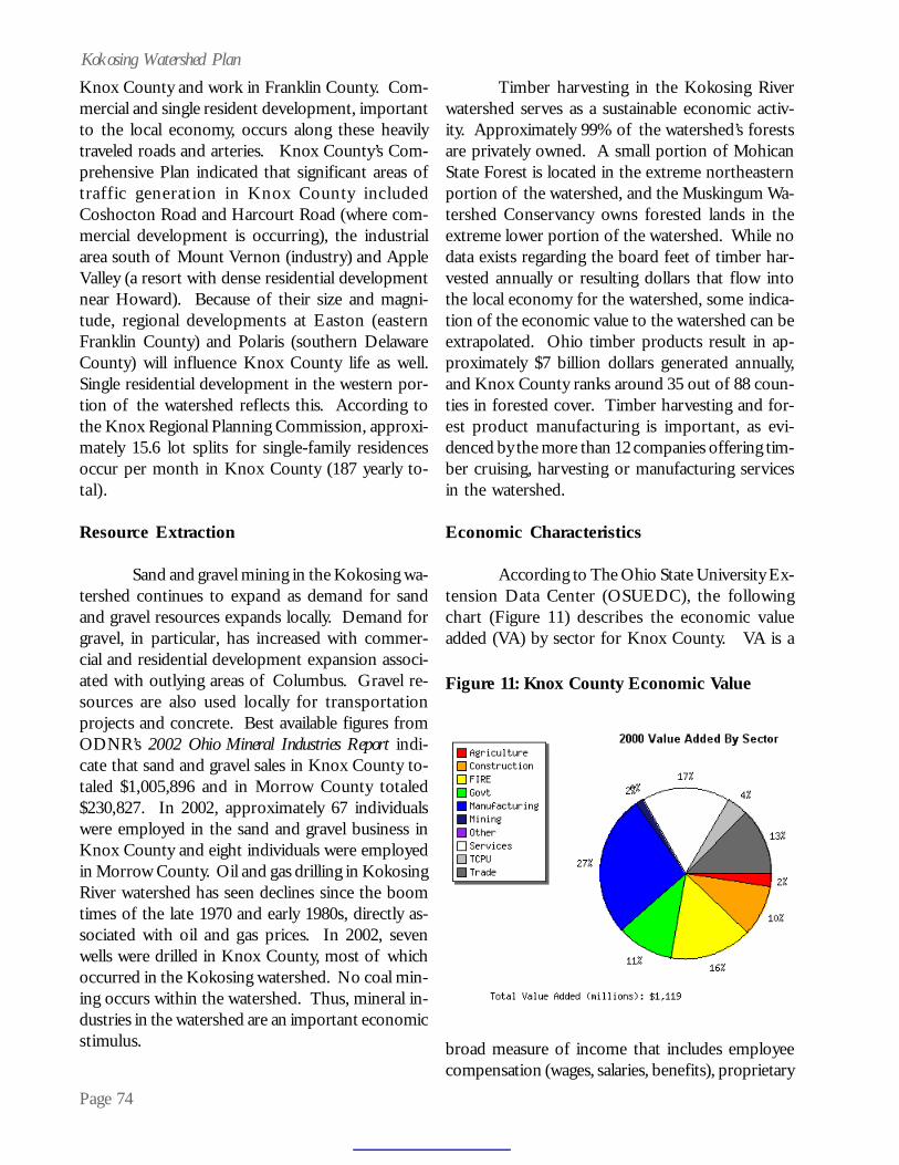
Page 74
Kokosing Watershed PlanKnox County and work in Franklin County. Com-mercial and single resident development, importantto the local economy, occurs along these heavilytraveled roads and arteries. Knox County’s Com-prehensive Plan indicated that significant areas oftraffic generation in Knox County includedCoshocton Road and Harcourt Road (where com-mercial development is occurring), the industrialarea south of Mount Vernon (industry) and AppleValley (a resort with dense residential developmentnear Howard). Because of their size and magni-tude, regional developments at Easton (easternFranklin County) and Polaris (southern DelawareCounty) will influence Knox County life as well.Single residential development in the western por-tion of the watershed reflects this. According tothe Knox Regional Planning Commission, approxi-mately 15.6 lot splits for single-family residencesoccur per month in Knox County (187 yearly to-tal).
Resource Extraction
Sand and gravel mining in the Kokosing wa-tershed continues to expand as demand for sandand gravel resources expands locally. Demand forgravel, in particular, has increased with commer-cial and residential development expansion associ-ated with outlying areas of Columbus. Gravel re-sources are also used locally for transportationprojects and concrete. Best available figures fromODNR’s 2002 Ohio Mineral Industries Report indi-cate that sand and gravel sales in Knox County to-taled $1,005,896 and in Morrow County totaled$230,827. In 2002, approximately 67 individualswere employed in the sand and gravel business inKnox County and eight individuals were employedin Morrow County. Oil and gas drilling in KokosingRiver watershed has seen declines since the boomtimes of the late 1970 and early 1980s, directly as-sociated with oil and gas prices. In 2002, sevenwells were drilled in Knox County, most of whichoccurred in the Kokosing watershed. No coal min-ing occurs within the watershed. Thus, mineral in-dustries in the watershed are an important economicstimulus.
Timber harvesting in the Kokosing Riverwatershed serves as a sustainable economic activ-ity. Approximately 99% of the watershed’s forestsare privately owned. A small portion of MohicanState Forest is located in the extreme northeasternportion of the watershed, and the Muskingum Wa-tershed Conservancy owns forested lands in theextreme lower portion of the watershed. While nodata exists regarding the board feet of timber har-vested annually or resulting dollars that flow intothe local economy for the watershed, some indica-tion of the economic value to the watershed can beextrapolated. Ohio timber products result in ap-proximately $7 billion dollars generated annually,and Knox County ranks around 35 out of 88 coun-ties in forested cover. Timber harvesting and for-est product manufacturing is important, as evi-denced by the more than 12 companies offering tim-ber cruising, harvesting or manufacturing servicesin the watershed.
Economic Characteristics
According to The Ohio State University Ex-tension Data Center (OSUEDC), the followingchart (Figure 11) describes the economic valueadded (VA) by sector for Knox County. VA is a
Figure 11: Knox County Economic Value
broad measure of income that includes employeecompensation (wages, salaries, benefits), proprietary
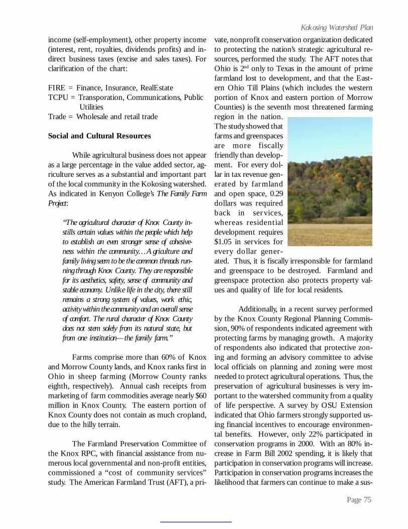
Page 75
Kokosing Watershed Planincome (self-employment), other property income(interest, rent, royalties, dividends profits) and in-direct business taxes (excise and sales taxes). Forclarification of the chart:
FIRE = Finance, Insurance, RealEstateTCPU = Transporation, Communications, Public
UtilitiesTrade = Wholesale and retail trade
Social and Cultural Resources
While agricultural business does not appearas a large percentage in the value added sector, ag-riculture serves as a substantial and important partof the local community in the Kokosing watershed.As indicated in Kenyon College’s The Family FarmProject:
“The agricultural character of Knox County in-stills certain values within the people which helpto establish an even stronger sense of cohesive-ness within the community…Agriculture andfamily living seem to be the common threads run-ning through Knox County. They are responsiblefor its aesthetics, safety, sense of community andstable economy. Unlike life in the city, there stillremains a strong system of values, work ethic,activity within the community and an overall senseof comfort. The rural character of Knox Countydoes not stem solely from its natural state, butfrom one institution—the family farm.”
Farms comprise more than 60% of Knoxand Morrow County lands, and Knox ranks first inOhio in sheep farming (Morrow County rankseighth, respectively). Annual cash receipts frommarketing of farm commodities average nearly $60million in Knox County. The eastern portion ofKnox County does not contain as much cropland,due to the hilly terrain.
The Farmland Preservation Committee ofthe Knox RPC, with financial assistance from nu-merous local governmental and non-profit entities,commissioned a “cost of community services”study. The American Farmland Trust (AFT), a pri-
vate, nonprofit conservation organization dedicatedto protecting the nation’s strategic agricultural re-sources, performed the study. The AFT notes thatOhio is 2nd only to Texas in the amount of primefarmland lost to development, and that the East-ern Ohio Till Plains (which includes the westernportion of Knox and eastern portion of MorrowCounties) is the seventh most threatened farmingregion in the nation.The study showed thatfarms and greenspacesare more fiscallyfriendly than develop-ment. For every dol-lar in tax revenue gen-erated by farmlandand open space, 0.29dollars was requiredback in ser vices,whereas residentialdevelopment requires$1.05 in services forevery dollar gener-ated. Thus, it is fiscally irresponsible for farmlandand greenspace to be destroyed. Farmland andgreenspace protection also protects property val-ues and quality of life for local residents.
Additionally, in a recent survey performedby the Knox County Regional Planning Commis-sion, 90% of respondents indicated agreement withprotecting farms by managing growth. A majorityof respondents also indicated that protective zon-ing and forming an advisory committee to adviselocal officials on planning and zoning were mostneeded to protect agricultural operations. Thus, thepreservation of agricultural businesses is very im-portant to the watershed community from a qualityof life perspective. A survey by OSU Extensionindicated that Ohio farmers strongly supported us-ing financial incentives to encourage environmen-tal benefits. However, only 22% participated inconservation programs in 2000. With an 80% in-crease in Farm Bill 2002 spending, it is likely thatparticipation in conservation programs will increase.Participation in conservation programs increases thelikelihood that farmers can continue to make a sus-
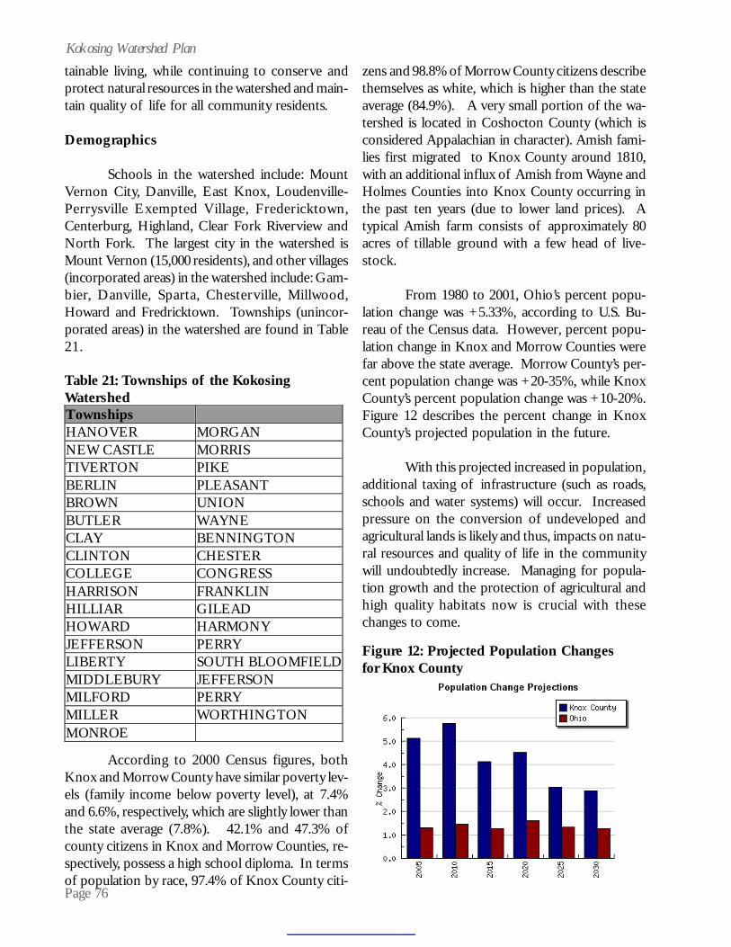
Page 76
Kokosing Watershed Plantainable living, while continuing to conserve andprotect natural resources in the watershed and main-tain quality of life for all community residents.
Demographics
Schools in the watershed include: MountVernon City, Danville, East Knox, Loudenville-Perrysville Exempted Village, Fredericktown,Centerburg, Highland, Clear Fork Riverview andNorth Fork. The largest city in the watershed isMount Vernon (15,000 residents), and other villages(incorporated areas) in the watershed include: Gam-bier, Danville, Sparta, Chesterville, Millwood,Howard and Fredricktown. Townships (unincor-porated areas) in the watershed are found in Table21.
zens and 98.8% of Morrow County citizens describethemselves as white, which is higher than the stateaverage (84.9%). A very small portion of the wa-tershed is located in Coshocton County (which isconsidered Appalachian in character). Amish fami-lies first migrated to Knox County around 1810,with an additional influx of Amish from Wayne andHolmes Counties into Knox County occurring inthe past ten years (due to lower land prices). Atypical Amish farm consists of approximately 80acres of tillable ground with a few head of live-stock.
From 1980 to 2001, Ohio’s percent popu-lation change was +5.33%, according to U.S. Bu-reau of the Census data. However, percent popu-lation change in Knox and Morrow Counties werefar above the state average. Morrow County’s per-cent population change was +20-35%, while KnoxCounty’s percent population change was +10-20%.Figure 12 describes the percent change in KnoxCounty’s projected population in the future.
With this projected increased in population,additional taxing of infrastructure (such as roads,schools and water systems) will occur. Increasedpressure on the conversion of undeveloped andagricultural lands is likely and thus, impacts on natu-ral resources and quality of life in the communitywill undoubtedly increase. Managing for popula-tion growth and the protection of agricultural andhigh quality habitats now is crucial with thesechanges to come.
According to 2000 Census figures, bothKnox and Morrow County have similar poverty lev-els (family income below poverty level), at 7.4%and 6.6%, respectively, which are slightly lower thanthe state average (7.8%). 42.1% and 47.3% ofcounty citizens in Knox and Morrow Counties, re-spectively, possess a high school diploma. In termsof population by race, 97.4% of Knox County citi-
Table 21: Townships of the KokosingWatershedTownships HANOVER MORGAN NEW CASTLE MORRIS TIVERTON PIKE BERLIN PLEASANT BROWN UNION BUTLER WAYNE CLAY BENNINGTON CLINTON CHESTER COLLEGE CONGRESS HARRISON FRANKLIN HILLIAR GILEAD HOWARD HARMONY JEFFERSON PERRY LIBERTY SOUTH BLOOMFIELD MIDDLEBURY JEFFERSON MILFORD PERRY MILLER WORTHINGTON MONROE
Figure 12: Projected Population Changesfor Knox County

Page 77
Kokosing Watershed PlanSTRATEGIES
The preceeding sections in this watershedplan highlighted past and present conservation andprotection activities, outdoor recreation trends,natural resources information, historical data, socio-economic and cultural aspects and water quality im-pacts. Given the information presented, where doesthe Kokosing River and its tributaries and wetlandsfall in the grand scheme? Figure 13 encapsulatesthe status of biological integrity of the KokosingRiver watershed and the management responsesappropriate for deployment based on the biologicalstatus. This figure is based Ohio EPA’s water qual-ity standards framework of designated uses and at-tainment. Currently, the Kokosing River watershedlies within a continuum that dictates restoration andpreservation as managerial responses.
OBJECTIVE SUMMARY:
Statement: Provide administrative leader-ship (one full time employee for three years) to sup-port the implementation of the Kokosing Water-shed Plan.
Specific Source(s) or Threat(s)
Loss of Riparian Vegetation and HabitatProblem Statement
Riparian vegetation serves as a critical com-ponent to the health of the Kokosing River and itstributaries. Riparian vegetation shades streams,thereby maintaining optimum temperatures foraquatic life. It traps sediment and pesticides fromadjacent land uses and thus, maintains water qual-ity. Stream-side vegetation serves as one of theforcing functions of the system, providing needednutrients and substrate for organisms such asmacroinvertebrate shredders, which form the baseof the stream’s food chain. Riparian vegetation alsoserves as habitat and migratory corridor for terres-trial species and provides an aesthetic view. Fi-nally, it helps stabilize the stream and abatesstormwater. Thus, the loss of a healthy ripariancorridor destabilizes the stream system.
Riparian vegetation removal in the NorthBranch Kokosing River headwaters to near StateRoute 13 to the Kokosing River subwatershed wasindicated on 99,675 linear feet of streams. Thissubwatershed showed one of the highest totals forlinear feet impacts from riparian vegetation removal,livestock access and streambank destabilization.Ohio EPA’s QHEI scores for the greater NorthBranch subwatershed were also slightly lower thanother subwatersheds, which is indicative of impactsfound during the 2003 field season. The JellowayCreek subwatershed contained approximately72,956 linear feet of riparian vegetation removalimpacts, ranking it third highest for this impact cat-egory. Figures 14 and 15 show areas in red eligiblefor livestock exclusion fencing (which includesstream crossings or off-stream water supply). Fenc-ing goals were based on the number of landowners
OVERALL PROJECT GOAL:
To improve and protect water resource qual-ity and quality of life in the Kokosing watershed byreducing nonpoint source pollution and protectinghigh quality areas and existing land uses.
Figure 13: Kokosing Watershed Integrity
Maximum
Minimum
MeasurementScale
Maximum Maximum
BiologicalIntegrity
MEASURABLE PARAMETERS OFWATERSHED HEALTH:BIOLOGICAL CRITERIA
Dead
SeverelyDe-
graded
Highly Degraded
Pristine
SubstantiallyAltered
LeastImpacted
KokosingWatershed
Irretriev-able
Preservation
Enhancement
Restoration
Quality State &Descriptors
Mgmt.Responses& Options
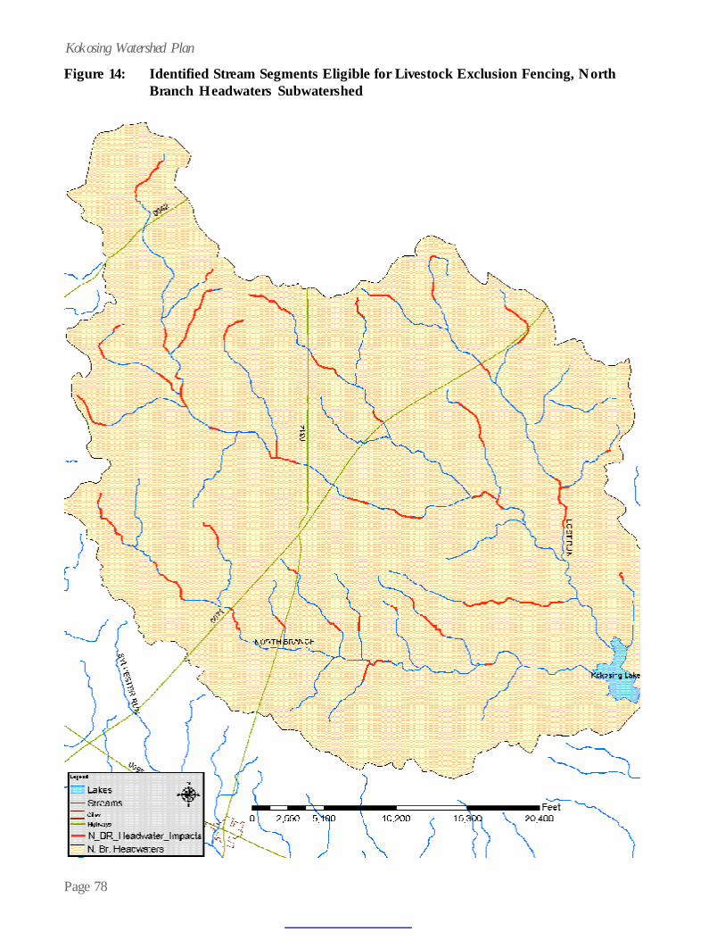
Page 78
Kokosing Watershed Plan
Figure 14: Identified Stream Segments Eligible for Livestock Exclusion Fencing, NorthBranch Headwaters Subwatershed

Page 79
Kokosing Watershed PlanFigure 15: Identified Stream Segments Eligible for Livestock Exclusion Fencing, Jelloway
Creek SubWatershed

Page 80
Kokosing Watershed PlanGoal: Restore riparian vegetation in the North Branch Kokosing River headwaters to near State Route13 subwatershed by approximately twenty percent (19,900 linear feet) and in the Jelloway Creeksubwatershed by approximately twenty-six percent (19,100 linear feet) by September 2007.
Task Description (objective)
Resources How Time Frame Performance Indicators
Livestock Exclusion Fencing
$30,000 Knox SWCD staff time DNAP staff time
DNAP will apply for 319 funds; Knox SWCD funds
November 2004-September 2007
10,000 linear feet of stream fenced. 386 tons of soil loss, 386 pounds of phosphorus and 774 pounds of nitrogen reduced. (North Br. Headwaters)
$58,000 Knox SWCD staff time DNAP staff time
DNAP will apply for 319 funds; Knox SWCD funds
November 2004-September 2007
19,100 linear feet of stream fenced (Jelloway Cr.). 738 tons of soil loss, 738 pounds of phosphorus and 1,478 pounds of nitrogen reduced.
Riparian corridor protection. Woody vegetation will re-establish once area is not mowed or cut.
$50,000 for conservation easements
DNAP will apply for 319 funds; Partners will apply for Clean Ohio Funds, EQIP funds, Seek donations, Mitigation funds; 319 funds to serve as matching dollars
November 2004-September 2007
9,900 linear feet of stream protected.
Educate community on value of riparian areas
ODNR stream team fact sheet on riparian areas (already published)
Write articles for Knox, Richland and Morrow SWCD newsletters; Distribute riparian area fact sheet at SWCD offices; add fact sheet to Kokosing web site
November 2004-September 2007
Number of hits on Kokosing web site; Number of inquiries or comments from readers of newsletters; Number of fact sheets distributed.

Page 81
Kokosing Watershed Planthe committee thought would participate. Withineach subwatershed, those areas with severe impactsare prioritized highest, followed by participant will-ingness and position in the landscape. The prob-lems statements found later in this section,streambank destabilization and range grazing, fol-low the same prioritization.
Protection of existing, high quality riparianhabitats that provide ecosystem and societal func-tions is of paramount importance in the watershed.A spatial analysis was conducted to acertain thosewooded riparian habitats that lie in designated 100year floodplains in the watershed. A ranking ofthese areas was developed, based on the presenceof attributes at the various sites. Attributes deemedimportant included: rare species located within 100feet of riparian area, unique geological feature, pres-ence of wetlands, overlays a SWAP area or con-tains archeaological resources. Societalfloodplainfunctions and wooded habitat are inher-ent on all of the sites identified. Figure 16 (whichis three pages) shows all of the site identified byrank. Those sites possessing two or more attributesare proposed for acquisition. A parcel layer in in-cluded in Figure 16, so that these priority sites areidentified to the parcel level.
Destabilization of StreambanksProblem Statement
Destabilization of streambanks cause nu-merous problems for streams, including increasedsediment and nutrients and substrate siltation. Ingeneral, the destabilization of streambanks in theKokosing is caused by riparian vegetation removal,stormwater and livestock access in streams. De-stabilized streambanks in the North BranchKokosing River headwaters to near State Route 13subwatershed were found on approximately 27,794linear feet of stream and were encountered on ap-proximately 32,441 linear feet of stream in theJelloway Creek subwatershed. Ohio EPA data sup-ports the 2003 field season findings, particularly onJelloway Creek. Please refer to Figures 14 and 15for maps of the stream segments eligible for fund-ing. During field work, stream segments were evalu-
ated for up to three sources and three causes ofimpacts. Where livestock had access to streams,invariably the loss of riparian vegetation and de-stabilization of streambanks was also encountered.
Thus, the strategies involving riparian veg-etation removal, destabilization of streambanks andlivestock encroachment are clearly interwined in thetwo subwatersheds. The watershed steering com-mittee wanted to ensure that all three of thesethreats were reasonably abated, thus the exclusionof livestock through fencing practices (and associ-ated crossings or off-stream water supply) wasdeemed most effective. The strategy was deemedmost effective, since the best management practicewas sound technically; the practice was cost-effec-tive and feasible; Knox SWCD and DNAP had pre-vious experience with a livestock exclusion pro-gram offered in the watershed in 2003; and supportfrom the agricultural community was present, basedon cooperator success with the livestock exclusionprogram offered in 2003. In fact, requests for live-stock exclusion assistance were more than doublethe amount of monies available in 2003. Note:Table 1 in the Introduction Section contains dataon the 2003 fencing program.
While other best management practices ex-ist to exclude livestock at certain times fromstreams, such as intensive pasture management,fencing places no further obligations of time or re-sources on the producer (other than routine main-tenance) once the fencing is in place. The matrixof activity and monies allocated for riparian veg-etation removal, streambank destabilization andlivestock exclusion are the same. Thus, a relativelysmall amount of money, $30,000 and $58,000, willabate three causes and three sources of impairmentin the two subwatersheds.
Range Grazing (livestock encroachment)Problem Statement
Livestock, when given unrestricted accessto streams, trample vegetation and damage soil onstream banks. Streams impacted by livestock en-croachment exhibit wide shallow channels with

Page 82
Kokosing Watershed PlanFigure 16: Identified Stream Segments with Two or More Priority Attributes Eligible forRiparian Protection
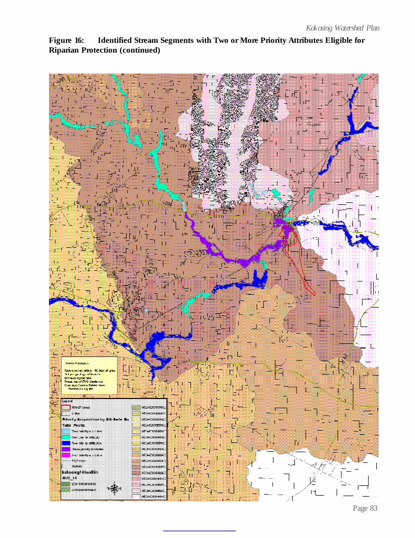
Page 83
Kokosing Watershed PlanFigure 16: Identified Stream Segments with Two or More Priority Attributes Eligible forRiparian Protection (continued)

Page 84
Kokosing Watershed PlanFigure 16: Identified Stream Segments with Two or More Priority Attributes Eligible forRiparian Protection (continued)
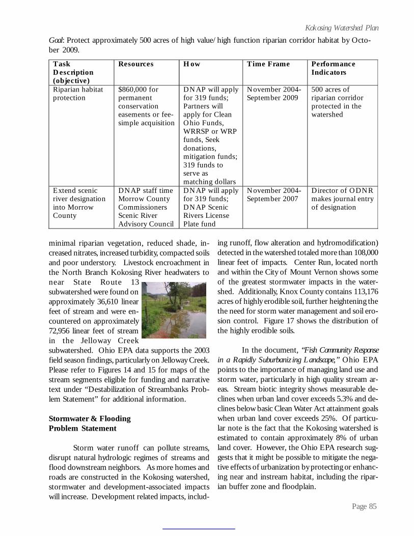
Page 85
Kokosing Watershed PlanGoal: Protect approximately 500 acres of high value/high function riparian corridor habitat by Octo-ber 2009.
Task Description (objective)
Resources How Time Frame Performance Indicators
Riparian habitat protection
$860,000 for permanent conservation easements or fee-simple acquisition
DNAP will apply for 319 funds; Partners will apply for Clean Ohio Funds, WRRSP or WRP funds, Seek donations, mitigation funds; 319 funds to serve as matching dollars
November 2004-September 2009
500 acres of riparian corridor protected in the watershed
Extend scenic river designation into Morrow County
DNAP staff time Morrow County Commissioners Scenic River Advisory Council
DNAP will apply for 319 funds; DNAP Scenic Rivers License Plate fund
November 2004-September 2007
Director of ODNR makes journal entry of designation
minimal riparian vegetation, reduced shade, in-creased nitrates, increased turbidity, compacted soilsand poor understory. Livestock encroachment inthe North Branch Kokosing River headwaters tonear State Route 13subwatershed were found onapproximately 36,610 linearfeet of stream and were en-countered on approximately72,956 linear feet of streamin the Jelloway Creeksubwatershed. Ohio EPA data supports the 2003field season findings, particularly on Jelloway Creek.Please refer to Figures 14 and 15 for maps of thestream segments eligible for funding and narrativetext under “Destabilization of Streambanks Prob-lem Statement” for additional information.
Stormwater & FloodingProblem Statement
Storm water runoff can pollute streams,disrupt natural hydrologic regimes of streams andflood downstream neighbors. As more homes androads are constructed in the Kokosing watershed,stormwater and development-associated impactswill increase. Development related impacts, includ-
ing runoff, flow alteration and hydromodification)detected in the watershed totaled more than 108,000linear feet of impacts. Center Run, located northand within the City of Mount Vernon shows someof the greatest stormwater impacts in the water-shed. Additionally, Knox County contains 113,176acres of highly erodible soil, further heightening thethe need for storm water management and soil ero-sion control. Figure 17 shows the distribution ofthe highly erodible soils.
In the document, “Fish Community Responsein a Rapidly Suburbanizing Landscape,” Ohio EPApoints to the importance of managing land use andstorm water, particularly in high quality stream ar-eas. Stream biotic integrity shows measurable de-clines when urban land cover exceeds 5.3% and de-clines below basic Clean Water Act attainment goalswhen urban land cover exceeds 25%. Of particu-lar note is the fact that the Kokosing watershed isestimated to contain approximately 8% of urbanland cover. However, the Ohio EPA research sug-gests that it might be possible to mitigate the nega-tive effects of urbanization by protecting or enhanc-ing near and instream habitat, including the ripar-ian buffer zone and floodplain.

Page 86
Kokosing Watershed Plan
Clearly, a critical juncture has been reached:protect the riparian cooridor and floodplain of theKokosing now, or watch measurable declines to bi-otic integrity and quality of life occur in the nearfuture. While the protection of 500 acres of highvalue/high functioning riparian corridor, as listedin a preceeding strategy, is laudable, the appropri-ate management of stormwater is an equally im-portant and complimentary aspect of water qualityprotection.
With an eye towards planning for futuregrowth, and the resulting increase in storm waterquantity, the Knox County Regional Planning Com-mission (RPC) formed a subcommittee, known as
Goal: Restore destabilized streambanks in the North Branch Kokosing River headwaters to near StateRoute 13 subwatershed by approximately thirty-six percent (10,000 linear feet) and in the Jelloway Creeksubwatershed by approximately fifty-nine percent (19,100 linear feet) by September 2007.
T a s k D e s c r i p t i o n ( o b j e c t i v e )
R e s o u r c e s H o w T i m e F r a m e P e r f o r m a n c e I n d i c a t o r s
L i v e s t o c k E x c l u s i o n F e n c i n g
$ 3 0 , 0 0 0 K n o x S W C D s t a f f t i m e .
D N A P w i l l a p p l y f o r 3 1 9 f u n d s ; K n o x S W C D f u n d s
N o v e m b e r 2 0 0 4 - S e p t e m b e r 2 0 0 7
1 0 , 0 0 0 l i n e a r f e e t o f s t r e a m f e n c e d . 3 8 6 t o n s o f s o i l l o s s , 3 8 6 p o u n d s o f p h o s p h o r u s a n d 7 7 4 p o u n d s o f n i t r o g e n r e d u c e d . ( N o r t h B r . H e a d w a t e r s )
$ 5 8 , 0 0 0 K n o x S W C D s t a f f
D N A P w i l l a p p l y f o r 3 1 9 f u n d s ; K n o x S W C D f u n d s
N o v e m b e r 2 0 0 4 - S e p t e m b e r 2 0 0 7
1 9 , 1 0 0 l i n e a r f e e t o f s t r e a m f e n c e d ( J e l l o w a y C r . ) . 7 3 8 t o n s o f s o i l l o s s , 7 3 8 p o u n d s o f p h o s p h o r u s a n d 1 , 4 7 8 p o u n d s o f n i t r o g e n r e d u c e d .
Goal: Restore streams in the North Branch Kokosing River headwaters to near State Route 13subwatershed by approximately twenty percent (19,900 linear feet) and in the Jelloway Creek subwatershedby approximately forty percent (19,100 linear feet) by September 2007.
T a s k D e s c r i p t i o n ( o b j e c t i v e )
R e s o u r c e s H o w T i m e F r a m e P e r f o r m a n c e I n d i c a t o r s
L i v e s t o c k E x c l u s i o n F e n c i n g
$ 3 0 , 0 0 0 K n o x S W C D s t a f f t i m e .
D N A P w i l l a p p l y f o r 3 1 9 f u n d s ; K n o x S W C D f u n d s D N A P G R F f u n d s
N o v e m b e r 2 0 0 4 -S e p t e m b e r 2 0 0 7
1 0 , 0 0 0 l i n e a r f e e t o f s t r e a m f e n c e d . 3 8 6 t o n s o f s o i l l o s s , 3 8 6 p o u n d s o f p h o s p h o r u s a n d 7 7 4 p o u n d s o f n i t r o g e n r e d u c e d . ( N o r t h B r . H e a d w a t e r s )
$ 5 8 , 0 0 0 K n o x S W C D s t a f f
D N A P w i l l a p p l y f o r 3 1 9 f u n d s ; K n o x S W C D D N A P G R F f u n d s
N o v e m b e r 2 0 0 4 -S e p t e m b e r 2 0 0 7
1 9 , 1 0 0 l i n e a r f e e t o f s t r e a m f e n c e d ( J e l l o w a y C r . ) . 7 3 8 t o n s o f s o i l l o s s , 7 3 8 p o u n d s o f p h o s p h o r u s a n d 1 , 4 7 8 p o u n d s o f n i t r o g e n r e d u c e d .
the Storm Water Advisory Committee (SWAC), inlate October 2001. The mission statement of thecommittee, as accepted on May 16, 2002, is to edu-cate and to inform members of the SWAC and the generalpublic on the topic of storm water management and aboutthe authorization in H.B. 549 for a countywide storm waterplan. The SWAC recommended to the Knox RPCto direct the drafting of regulations to include acomprehensive county storm water plan for newresidential, commercial or industrial developmentand personnel to manage, administer and enforcethe regulations. This was done coincidentally withpassage of Article III of the Subdivision Regula-tions, which deal with sediment and erosion con-trol and storm water management (as related to

Page 87
Kokosing Watershed PlanFigure 17: Knox County Highly Erodible Soils
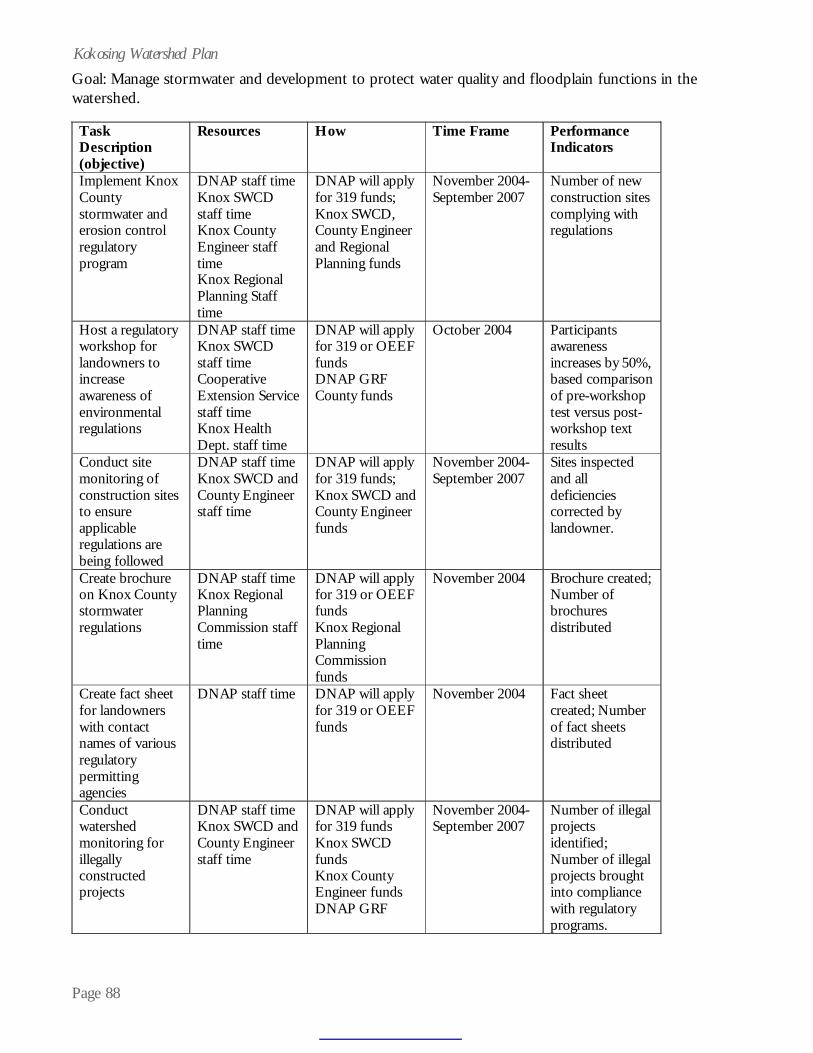
Page 88
Kokosing Watershed PlanGoal: Manage stormwater and development to protect water quality and floodplain functions in thewatershed.
Task Description (objective)
Resources How Time Frame Performance Indicators
Implement Knox County stormwater and erosion control regulatory program
DNAP staff time Knox SWCD staff time Knox County Engineer staff time Knox Regional Planning Staff time
DNAP will apply for 319 funds; Knox SWCD, County Engineer and Regional Planning funds
November 2004-September 2007
Number of new construction sites complying with regulations
Host a regulatory workshop for landowners to increase awareness of environmental regulations
DNAP staff time Knox SWCD staff time Cooperative Extension Service staff time Knox Health Dept. staff time
DNAP will apply for 319 or OEEF funds DNAP GRF County funds
October 2004 Participants awareness increases by 50%, based comparison of pre-workshop test versus post-workshop text results
Conduct site monitoring of construction sites to ensure applicable regulations are being followed
DNAP staff time Knox SWCD and County Engineer staff time
DNAP will apply for 319 funds; Knox SWCD and County Engineer funds
November 2004-September 2007
Sites inspected and all deficiencies corrected by landowner.
Create brochure on Knox County stormwater regulations
DNAP staff time Knox Regional Planning Commission staff time
DNAP will apply for 319 or OEEF funds Knox Regional Planning Commission funds
November 2004 Brochure created; Number of brochures distributed
Create fact sheet for landowners with contact names of various regulatory permitting agencies
DNAP staff time
DNAP will apply for 319 or OEEF funds
November 2004 Fact sheet created; Number of fact sheets distributed
Conduct watershed monitoring for illegally constructed projects
DNAP staff time Knox SWCD and County Engineer staff time
DNAP will apply for 319 funds Knox SWCD funds Knox County Engineer funds DNAP GRF
November 2004-September 2007
Number of illegal projects identified; Number of illegal projects brought into compliance with regulatory programs.

Page 89
Kokosing Watershed PlanGoal: Manage stormwater and development to protect water quality and floodplain functions in thewatershed (continued).
Task Description (objective)
Resources How Time Frame Performance Indicators
Educate City of Mount Vernon officials on importance of using good storm practices when permitting new subdivisions in city limits
DNAP staff time Knox SWCD and County Engineer staff time
DNAP will apply for 319 funds Knox SWCD funds Knox County Engineer funds
November 2004-October 2005
City of Mount Vernon officials awareness increased
Work with City of Mount Vernon to modify existing subdivision regulations to incorporate good storm practices
DNAP staff time Knox SWCD and County Engineer staff time
DNAP will apply for 319 funds Knox SWCD funds Knox County Engineer funds
October 2005-June 2006
Subdivision regulations changed to reflect stormwater practices
Perform low-level fly-over of North Branch to produce 2.0 foot contour mapping
Knox County Engineer staff time Village of Fredericktown staff time
Village of Fredericktown funds
January 2005-December 2006
Contour elevations delineated
Re-map 100 year floodplain areas in Knox County
Knox County Engineers staff time
Knox County Engineer funds Federal EMA funds ODNR Division of Water funds
January 2005-September 2006
New 100-year floodplain map adopted and approved by FEMA
Perform update to existing aerial photography of Knox County
Knox County Engineers staff time
Knox County Engineer funds Knox County Auditor Knox County Commissioners
January 2005-December 2006
New aerial photography available
Perform update of Knox County land use/land cover based on new aerial photography
DNAP staff time DNAP will apply for 319 funds
June 2005-August 2006
Updated land use/land coverage available, including impervious surfaces
Compare 2003 created land use/land cover GIS data with 2006 created land use/land cover to ascertain trends in urbanization
DNAP staff time DNAP will apply for 319 funds
August 2006-October 2006
Land use changes detected and information shared with local decisionmakers
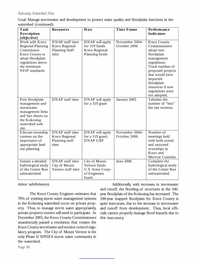
Page 90
Kokosing Watershed PlanGoal: Manage stormwater and development to protect water quality and floodplain functions in thewatershed (continued).
Task Description (objective)
Resources How Time Frame Performance Indicators
Work with Knox Regional Planning Commission Knox County to adopt floodplain regulations above the minimum NFIP standards
DNAP staff time Knox Regional Planning Staff time
DNAP will apply for 319 funds Knox Regional Planning funds
November 2004-October 2006
Knox County Commissioners adopt new floodplain management regulations. Track number of proposed projects that would have impacted floodplain resources if new regulations were not adopted.
Post floodplain management and stormwater management links and fact sheets on the Kokosing watershed web site
DNAP staff time DNAP will apply for a 319 grant
January 2005 Tabulate the number of “hits” the site receives.
Educate township trustees on the importance of appropriate land use planning
DNAP staff time Knox Regional Planning staff time
DNAP will apply for a 319 grant; DNAP GRF
November 2004-October 2006
Number of meetings held with both zoned and unzoned townships in Knox and Morrow Counties
Initiate a detailed hydrological study of the Center Run subwatershed
DNAP staff time City of Mount Vernon staff time
City of Mount Vernon funds U.S. Army Corps of Engineers funds
June 2006 Complete the hydrological study of the Center Run subwatershed
minor subdivisions).
The Knox County Engineer estimates that70% of existing storm water management systemsin the Kokosing watershed occur on private prop-erty. Thus, to manage storm water appropriately,private property owners will need to participate. InDecember 2003, the Knox County Commissionersunanimously passed a resolution that creates theKnox County stormwater and erosion control regu-latory program. The City of Mount Vernon is theonly Phase II NPDES storm water community inthe watershed.
Additionally, with increases in stormwaterand runoff, the flooding of structures in the 100-year floodplain of the Kokosing has increased. The100-year mapped floodplain for Knox County isquite inaccurate, due to the increase in stormwaterand runoff from development. Thus, local offi-cials cannot properly manage flood hazards due tothis inaccuracy.

Page 91
Kokosing Watershed PlanLoss of Wetland HabitatProblem Statement:
At the time of settlement, the Kokosing wa-tershed contained nearly 17,000 acres of wetlands(based on hydric soils). Nearly two-thirds of thoseoriginal wetlands have been destroyed, and manyof the remaining wetlands are threatened by devel-opment, due to their location in the watershed.Several high quality (category three) wetland com-plexes have been identified in the watershed andshould be preserved. In particular, wetland com-plexes in the Kokosing River below Dry Creek toabove Big Run subwatershed associated withDelano Run should be protected. Figure 18 showsthe wetlands extant in the Delano Run drainage.Additionally, the Kokosing River below SouthBranch to below Mile Run subwatershed containstwo large, category three wetlands with numerouswetland communities. Figure 19 shows these twosites.
Additionally, the loss of so many acres ofwetlands in the watershed translates into wetlandrestoration potential. Wetlands restored or pro-tected on the landscape perform many water qual-
ity benefits, including stormwater abatement, sedi-ment filtration, wildlife habitat and greenspace.Approximately 2,000 acres of hydric soils exhibitgood wetland restoration potential. Wetland resto-ration potential was determined using spatial analy-sis of mapped hydric soils, land use coverage andpresence of OWI wetlands. The restoration goalfor the watershed represents approximately 5% ofareas with good potential. The Kokosing Riverheadwaters to below South Branch and KokosingRiver below South Branch to below Mile Runsubwatersheds contains the largest amounts withof wetland restoration potential, with 432 and 376acres, respectively. Figure 20 shows wetland res-toration potential for these two subwatersheds.
While development will continue to occurin the watershed, it is important that any wetlandsdestroyed during development activities be miti-gated within the watershed. One illegal wetlandfill was encountered in Morrow County during the2003 field season. Landowners need to understandtheir responsibilities in applying for appropriatepermits before undertaking earthmoving activities
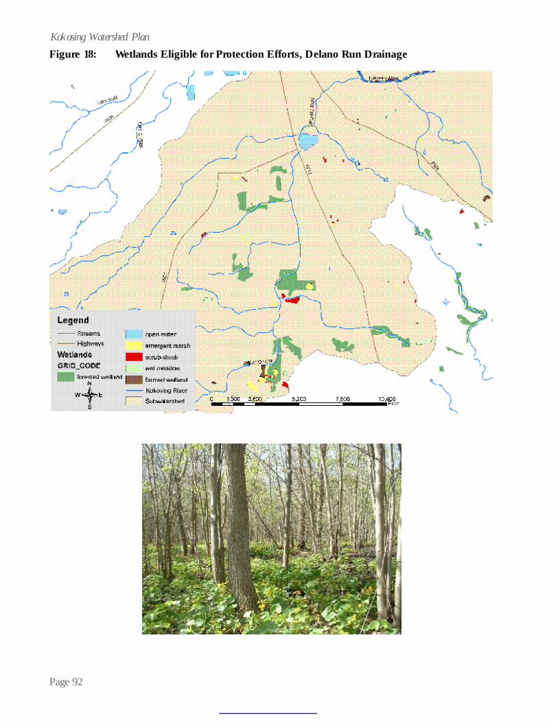
Page 92
Kokosing Watershed PlanFigure 18: Wetlands Eligible for Protection Efforts, Delano Run Drainage

Page 93
Kokosing Watershed PlanFigure 19: Wetlands Eligible for Protection Efforts, Kokosing River below South Branch to
below Mile Run Subwatershed

Page 94
Kokosing Watershed PlanFigure 20: Wetland Restoration Potential, Kokosing River below South Branch to
below Mile Run and Kokosing River Headwaters Subwatersheds

Page 95
Kokosing Watershed PlanGoal: Protect approximately 100 acres of wetlands in the Kokosing River below Dry Creek to aboveBig Run subwatershed and restore approximately 100 acres of wetlands in the Kokosing River belowSouth Branch to below Mile Run and Kokosing River Headwaters Subwatersheds by September 2009.
Task Description (objective)
Resources How Time Frame Performance Indicators
Wetland habitat protection.
$500,000 for permanent conservation easements or fee-simple acquisition
DNAP will apply for 319 funds; Partners will apply for Clean Ohio Funds, WRRSP or WRP funds, Seek donations, mitigation funds; 319 funds to serve as matching dollars
November 2004-September 2009
100 acres of wetlands protected in the subwatershed.
Wetland restoration
$200,000 for restoration of hydrology in hydric soil areas.
DNAP will apply for 319 funds; Partners will apply for Clean Ohio Funds, WRRSP or WRP funds, Seek donations, mitigation funds; Division of Wildlife private lands restoration funds, 319 funds to serve as matching dollars
November 2004-September 2009
100 acres of wetlands restored in the Kokosing watershed.
Create wetland mitigation in-lieu fee system for the watershed
$6,000 in staff time to generate document for submittal to MBRT
DNAP will apply for 319 funds
February 2005-September 2006
MBRT signatures on in-lieu fee document
Monitoring for illegal wetland fill activities
$6,000 in staff time
DNAP (GRF) November 2004-September 2007
Number of illegals found
Educate landowners, developers, real estate agents regarding environmental regulatory permitting requirements
$5,000 in staff time to develop and present workshop
Ohio EPA OEEF grant; DNAP (GRF)
2004 or 2005 Number of workshop participants.

Page 96
Kokosing Watershed PlanGroundwaterProblem Statement
One element cited as contributing to theoutstanding water quality of the Kokosing over theages is the contribution of ground water to streamflow. Thus, potential impacts from upper aquiferdewatering to the Kokosing base stream flow andseasonal high flows should be considered. Main-taining optimum flows in the river for fish and wild-life and stream stability is important. If additional,large water withdrawals occur in the upper aquiferunderlying the Kokosing, adverse impacts to theKokosing’s flow regime could result.
Additionally, the City of Mount Vernon’swater supply taps a large aquifer that lies belowthe upper aquifer. Thus, the aquifers should beprotected from not only a quantity standpoint, butalso a quality standpoint. Figure 21 shows poten-tial population growth based on current populationsize.
Building Local Governmental and LandownerCapacity to Make Better Resource-basedDecisionsProblem Statement
Local government officials aspire to makethe best decisions for their communities. A plethoraof geographically-based data exists to aid a localdecision maker in arriving at a reasoned decisionthat balances community needs, resource protec-tion and quality of life. It is also important to ac-knowledge the local township ordinances in effectin Knox County, which afford some protection tothe Kokosing River Appendix A contains an over-view of township zoning in Knox County. Thus,educating local officials regarding the benefits ofwetland, floodplain and stream protection, as it re-lates to local zoning, may prove beneficial.
Equally important is disseminating infor-mation to land owners so that they can make in-formed decisions regarding the use of their proper-ties. Oil and gas well production and timber har-vesting have a long history of activity in the water-
shed. Abandoned wells that are not capped prop-erly can serve as conduits for contamination ofdrinking water supplies.
The ODNR Division of Mineral ResourceManagement offers plugging services on these or-phaned wells, but most landowners are unaware ofthe free program. Additionally, many landownersmay not understand their rights as property ownerswhen negotiating with a company to harvest tim-ber or drill wells on their property. Some landown-ers have been disappointed by the damage left aftera resource extraction activity, and streams and wet-lands on these properties have been adversely im-pacted due to lack of use of best management prac-tices or avoidance measures.
Agricultural PressuresProblem Statement
For many years, the Kokosing State ScenicRiver has maintained exceptional water quality andspecies diversity, due to a healthy riparian corridorand good conservation measures practiced by farm-ers. However, the Kokosing watershed is chang-ing, and natural and agricultural resources threatshave increased. These threats can degrade the sub-strate and habitat needed by the Kokosing’s endan-gered species, decrease recreational fishing oppor-tunity and degrade the quality of life its citizensenjoy.
Since agriculture serves as a substantial andimportant part of the local community in theKokosing watershed and helps to maintain theKokosing’s high water quality, agricultural lands
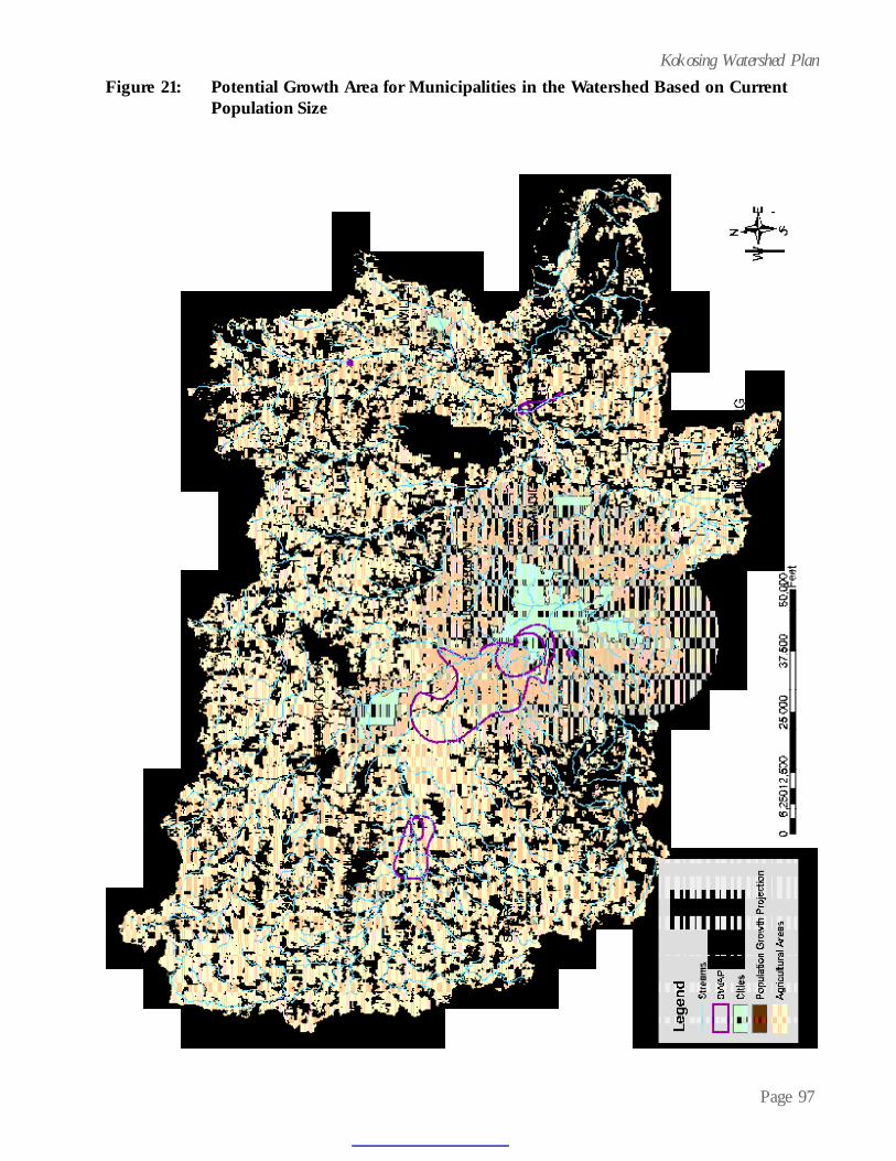
Page 97
Kokosing Watershed PlanFigure 21: Potential Growth Area for Municipalities in the Watershed Based on Current
Population Size

Page 98
Kokosing Watershed PlanGoal: Protect groundwater quantity and quality of the aquifer underlying the Kokosing River by monitor-ing water withdrawals, increasing public awareness of the importance of ground water quality, protect-ing the City of Mount Vernon’s well field and acquiring easements over 620 acres in the well field area bySeptember 2009.
T ask D escription (objective)
Resources H ow T im e Fram e Perform ance Indicators
M onitor the Del-Co well field w ithdrawal from the aquifer underlying the Kokosing R iver
$3,800 U .S.G.S. staff time DNAP staff time
DN AP Scenic R ivers License P late Fund
November 2004-Septem ber 2007
Annual m onitoring report completed and reviewed.
Assist the C ity of M ount Vernon w ill development of a Source W ater Area Protection P lan
DNAP staff time City of Mount Vernon staff time
DN AP w ill apply for 319 funds; C ity of M ount Vernon funds
June 2004-July 2005
Source W ater Area Protection P lan com pleted
Increase community understanding of the linkages between land use, individual landowner actions and ground water aquifer protection by creation of a brochure
DNAP staff time City of Mount Vernon staff time $5,000
DN AP w ill apply for O EEF or 319 funds
August 2004-August 2005
Brochure developed; N umber of brochures distributed
Post brochure on C ity of M ount Vernon’s and Kokosing watershed web sites
DNAP staff time City of Mount Vernon staff time
DN AP w ill apply for O EEF or 319 funds
August 2004-2005
Tabulate web hits on the ground water protection brochure on the web sites
Educate township trustees regarding the importance of protecting existing land uses in the C ity of M ount Vernon’s well field protection area
DNAP staff time City of Mount Vernon staff time
DN AP w ill apply for O EEF or 319 funds City of M ount Vernon funds
August 2005-Septem ber 2006
N umber of m eetings held. Current zoning standards upheld or changed to increase protection.
Acquire agricultural preservation easements and/or conservation easements on 620 acres in the City of Mount Vernon’s well field protection area
City of Mount Vernon time O wl Creek Conservancy time DNAP staff time
DN AP w ill apply for 319 funds C ity of M ount Vernon funds O wl Creek Conservancy funds C lean O hio funds W RRSP funds Homeland Security Funds
November 2004-Septem ber 2009
620 acres of land protected in the three applicable subwatersheds: N . Branch Kokosing between N. Branch & Dry Run; Kokosing below M ile Run & N. Branch

Page 99
Kokosing Watershed Plan
Task Description (objective)
Resources How Time Frame Performance Indicators
Create, support and maintain a geographic information system for the watershed
DNAP staff time DNAP will apply for 319 funds;
November 2004-September 2007
Data layers are kept up-to-date; new data layers added as created or acquired.
Provide technical assistance in the form of field visits, consultations, permit reviews and provide GIS data to local officials
DNAP staff time DNAP will apply for 319 funds;
November 2004-September 2007
Number of technical assistance activities performed
Provide GIS information either real time on a web site or by published cd or hard copy to officials, landowners and non-profit groups
DNAP staff time Kenyon College computer server space
DNAP will apply for 319 funds; Kenyon College will donate server space
November 2004-September 2007
Number of downloads on the web site or number of GIS products requested
Provide copies of sample timber sale leases and oil and gas leases for landowners to use to protect their properties
DNAP staff time $1,000 printing
DNAP will apply for 319 funds;
November 2004-September 2007
Number of sample contracts distributed
Place sample contracts on Kokosing web site for the public to access
DNAP staff time $1,000 for printing
DNAP will apply for 319 funds;
November 2004-September 2007
Number of downloads on the web site
Provide grant writing assistance to local governments and non-profit organizations to protect resources
DNAP staff time
DNAP will apply for 319 funds;
November 2004-September 2007
Number of assistance requests fulfilled Number/acreages protected or enhanced through grants
Make ODNR’s orphan well program available to landowners
DNAP staff time ODNR Division of Mineral Resource Management staff time
DNAP will apply for 319 funds
November 2004-September 2007
Number of fact sheets or brochures distributed
Update the Kokosing plan as appropriate
DNAP staff time DNAP will apply for 319 funds
November 2004-September 2007
Number of plan addendums
Goal: To increase the capacities of local governmental entities and watershed landowners to makeinformed decisions concerning protection of resources in the Kokosing watershed.

Page 100
Kokosing Watershed PlanGoal: Protect 9,000 acres of agricultural lands from inappropriate development by 2009 in theKokosing watershed.
Task Description (objective)
Resources How Time Frame Performance Indicators
Create a Knox County Agricultural Easement Purchase Program Supplement Fund (KCAEPPSF)
Knox SWCD staff time Knox County Commissioners Knox County RPC
Knox County Commissioners adopt resolution
November 2004-September 2007
Fund created; Acres of farmland protected from development.
Obtain agricultural easements on 2,000 acres of farmland
Knox County Commissioners Philander Chase Corporation Knox SWCD DNAP Knox County RPC
KCAEPPSF funds Clean Ohio funds Philander Chase funds NRCS funds DNAP will apply for 319 funds
November 2004-September 2009
Number of farmland acres under easement
Revise and review protective zoning for agricultural land uses language to distribute to township trustees
Knox County RPC time DNAP staff time
Knox County RPC
November 2004-September 2007
Number of townships that incorporate zoning language Acres of farmland protected
Perform a cost of community services study in 2007 to generate trends data relating to development versus farmland and open space land uses
Knox County Commissioners Knox County RPC
County funds Knox County RPC funds
2007 Distribute results to township trustees and local government officials

Page 101
Kokosing Watershed Planmust be protected from development. The KnoxCounty portion of the watershed contains acres ofprime farmland soils and soils of local importance(See Figure 22). With conversion of farmland toresidential development, the inevitable failing sep-tic tank threat to water quality surfaces. Likewise,the City of Mount Vernon and Knox County aqui-fers are located in agricultural areas. Since the aqui-fers serving these entities has maintained a highlevel of drinking water quality, it’s important to pro-tect the agricultural land use that exists above theaquifers.
The American Farmland Trust (AFT), a pri-vate, nonprofit conservation organization dedicatedto protecting the nation’s strategic agricultural re-sources, notes that Ohio is 2nd only to Texas in theamount of prime farmland lost to development, andthat the Eastern Ohio Till Plains (which includesthe western portion of Knox and eastern portionof Morrow Counties) is the seventh most threat-ened farming region in the nation.
Headwater StreamsProblem Statement
Headwater streams provide wildlife habi-tat, improve water quality and abate floodflows. TheKokosing River watershed has numerous headwa-ter streams. Impacts to the headwater streams in-clude channelization, road culverting and denud-ing of riparian fringes. While geographically refer-enced data exists for intermittent and perennial
streams in the watershed, no headwater stream dataexists.
In the document, “The Importance and Ben-efits of Primary Headwater Streams,” Ohio EPA indi-cates, “Primary headwater streams are like the cap-illary system of a blood supply network – just asthe health of the whole organism depends upon a
functioning capillarysystem, the health oflarger streams andrivers depend uponan intact primaryheadwater streamnetwork.” Sadly,headwater streamsare subject to higher
levels of destruction, because little value is placedon their importance, and their small size makes themeasy to fill and channelize.
For local and state units of government tomake informed decisions regarding the protectionof these small streams, a watershed-wide identifi-cation of headwater streams needs to take place.
Pollution ContainmentProblem Statement
As the Ben Franklin saying goes, “An ounceof prevention is worth a pound of cure.” How-ever, sometimes, accidents happen. While theKokosing has been spared large pollutant spills,
Goal:Using geographic information system technology, map headwater streams in the watershed.
Task D escription (objective)
Resources H ow T im e Fram e Perform ance Indicators
Use d igital aerial photography and contour mapping data to identify and digitize headwater streams in the watershed
DN AP staff time DNAP w ill apply for 319 funds;
November 2004-September 2007
Headwater streams are m apped; M apping information is shared with O D NR divisions, O hio EPA and local government units possessing regulatory authority over storm water
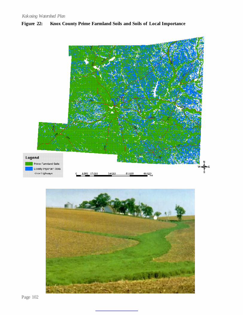
Page 102
Kokosing Watershed PlanFigure 22: Knox County Prime Farmland Soils and Soils of Local Importance

Page 103
Kokosing Watershed Plansmall spills that impact water quality have occurred.At present, no pollution containment plan has beendeveloped for the Kokosing, and this is problem-atic. Critical components of spill containmentinclude monitoring, response timeliness, access toareas conducive to barrier placement and notifica-tion of the right entities in the event of a spill.Appropriate pollution containment preparation,through the development of a spill plan, could pro-tect or minimize damage to the Kokosing River inthe future.
Lack of Open SpaceProblem Statement
While the citizens of Knox and MorrowCounties may perceive that their respective coun-ties contain large amounts of open space, bothcounties actually rank low in terms of percentage
Goal: To develop a spill containment plan for the Kokosing River by the end of 2005.
Task Description (objective)
Resources How Time Frame Performance Indicators
Identify spill containment access sites, obtain landowner permission for access and map sites in the Kokosing GIS
DNAP staff time Knox EMA staff time Scenic River Advisory Council
Knox EMA funds
June 2005 October 2005
Access areas identified, landowner permission obtain, areas mapped
Create contact list of agencies involved in spill clean-ups
DNAP staff time Knox EMA staff time
Knox EMA funds;
June 2005 October 2005
Contact list distributed to county offices, townships and fire departments
Hold a spill drill/exercise
DNAP staff time Knox EMA staff time Scenic River Advisory Council Local Fire Departments
Knox EMA funds;
October 2005 Critique of the drill outcome by participants
Add links and information to the Kokosing web site and Knox County Health Department web site with contact information for citizens to report spills, malfunctioning septic tanks, etc.
DNAP staff time Knox County Health Department
Knox County Health Department funds
October 2005 Contact list created on web sites. Tabulate number of complaints received annually.

Page 104
Kokosing Watershed PlanGoal: To increase outdoor recreation open space, opportunity and safety by 1,000 acres by September2007 in the watershed.
Task Description (objective)
Resources How Time Frame Performance Indicators
Acquire parcels or access easements for outdoor recreation activities
DNAP staff time Knox Park District staff time Fredericktown Recreation District
Clean Ohio funds NatureWorks funds LWCF funds Knox Park District Funds Private donations Fredericktown Recreation District
November 2004-September 2007
1,000 acres of outdoor recreation open space made available.
Build two additional canoe access sites on the Kokosing
DNAP staff time Knox Park District staff time
ODNR Division of Watercraft funds Division of Wildlife funds
November 2004-September 2007
Canoe access sites built at Foundation Park in Mount Vernon and at Knox Park District site.
Construct additional bikeways
DNAP staff time Knox Park District staff time
NatureWorks funds LWCF funds Private donations
November 2004-September 2007
Bikeways constructed
Increase boater safety by placing road name on each bridge crossing on the Kokosing River at canoeists’ eye level
DNAP staff time Knox Park District staff time Knox County Engineer staff time
County Engineer funds Knox Park District funds
September 2004-September 2005
Bridges labeled
of outdoor recreation acreage given county landsize and population. Of Knox County’s 338,672total acres, 5,871 acres are comprised of parks andopen space. Morrow County contains a total of260,280 acres with 1,643 acres used for parks andopen space. As users gain opportunity to experi-ence open space and explore natural areas, their ap-preciation and support for the protection of natu-ral resources increase. Thus, recreational accessand opportunity, if planned appropriately, can en-hance support for the Kokosing River and its uniquehabitats.
Environmental Education, General PublicAwareness of Kokosing ResourcesProblem Statement
As development projects increase in num-ber in the Kokosing watershed, threats to Kokosingresources will increase. One of the most effectivemeans of protecting water quality, habitat andunique habitats is to inform and educate the com-munity (i.e. general public) regarding ways that theycan personally protect and conserve natural re-sources.

Page 105
Kokosing Watershed PlanGoal: To raise awareness and appreciation for the protection of Kokosing watershed resources by engag-ing the public in environmental education and public participation processes.
Task Description (objective)
Resources H ow Time Frame Performance Indicators
Host an annual “Kokosing River Day” for the public
DNAP staff time Scenic River Advisory Council Knox SWCD Brown Family Environmental Education Center; Knox Park District Owl Creek Conservancy
DNAP will apply for 319 funds; Brown Family Environmental Education Center funds Knox SWCD funds; Knox Park District funds
June or July each year
Number of participants; Number of new scenic river volunteers
Host an annual “Kokosing River Clean-up Day”
DNAP staff time Scenic River Advisory Council Brown Family Environmental Education Center Mount Vernon Nazarene University Student Development Office; Knox Litter Prevention Office
DNAP will apply for 319 funds; Brown Family Environmental Education Center funds Mount Vernon Nazarene funds; Solid Waste District funds
September each year
Number of participants; Number of new scenic river volunteers
Stream quality monitoring, biological survey and aquatic education project
DNAP staff time Scenic River Advisory Council
DNAP will apply for 319 funds; DNAP GRF; DNAP Scenic Rivers License Plate Fund
May 2004-September 2007
Number of participants; Number of new scenic river volunteers
Host annual fish shocking demonstrations, canoe floats, etc. for citizens, elected officials and non-profit organizations
DNAP staff time Scenic River Advisory Council
DNAP will apply for 319 funds; DNAP GRF; DNAP Scenic Rivers License Plate Fund
May 2004-September 2007
Number of participants; Number of new scenic river volunteers
W ork with the Knox County Convention & Visitors Bureau (CVB) to create a natural and scenic treasures of Knox County map
DNAP staff time Knox CVB staff time
DNAP will apply for 319 funds; Knox County funds
February 2005-April 2005
Map printed and available for distribution; Map added to Conventions’ web site

Page 106
Kokosing Watershed Plan
Task Description (objective)
Resources How Time Frame Performance Indicators
Seek Ohio Scenic Byway Status for U.S. Route 62 and State Route 514 in the watershed
Knox County Commissioners staff time Knox County RPC staff time DNAP staff time
Knox County funds
June 2004-January 2005
Roads designated scenic byways by ODOT; Scenic byway signs erected
Host presentations regarding various environmental/ natural resource issues
DNAP staff time Citizens for Smart Growth Knox SWCD staff time Cooperative Extension staff time
DNAP will apply for 319 funds; Citizens for Smart Growth funds
January 2005-October 2007
Number of presentations held; Number of participants at presentations
Provide home owners with information concerning the proper operation and maintenance of septic systems
DNAP staff time Knox Health Department staff time
DNAP will apply for 319 funds Knox Health Department funds
January 2005-October 2007
Number of fact sheets distributed
Present an “Owl Creek Minute” on WMVO radio every month
DNAP staff Owl Creek Conservancy Citizens for Smart Growth Brown Family Environmental Education Center
DNAP will apply for 319 funds
January 2005-October 2007
Number of radio presentations made
Goal: To raise awareness and appreciation for the protection of Kokosing watershed resources by engag-ing the public in environmental education and public participation processes.
As quoted from the Ohio Environmental Edu-cation Fund Program Guidelines,
“Environmental education is the learningprocess whereby people acquire an awareness andscientific understanding of the natural and builtenvironment; attitudes that value the environ-ment; and skills for identifying and addressingenvironmental issues. When effective, it leads toparticipation in environmental decision makingand actions that result in a sustainable environ-ment, healthier people and livable communities.”
Additionally, nature-based tourism and lo-cal economic opportunities that help maintain com-
patible economic use of the Kokosing watershedwill help protect the river and its tributaries.
Page 107
Kokosing Watershed PlanPLAN EVALATION, UPDATE ANDREVISION
Evaluation is a necessarystep in a watershed plan-ning process. DNAP willassume tracking of theKokosing Watershed Planimplementation progress bycapturing and documentingall activities undertaken inthe plan. Close communi-cation, through quarterly orbi-annual meetings (asneeded) between DNAP
and watershed partners (Scenic Rivers AdvisoryCouncil and Kokosing Watershed Steering Commit-tee) will ensure that activities are documented ap-propriately. If other watershed stakeholders wishto participate in plan activities, they can (thoughnot as formal members of the steering committee).
DNAP will communicate the annual resultsof plan activities to the general public by postingresults on the Kokosing watershed plan web siteand public service announcements in local papers.Likewise, the continued participation of DNAPstaff on various regional planning committees willserve as an informal means of sharing results.Progress should be evident after the first quarter ofthe implementation grant, owing to the productivenature of the watershed partners. However, waterquality improvements associated with some of thestrategies will take time to monitor, and progressmay not be fully shown in a 1-3 year timeframe.Surrogates of water quality progress and other ac-tivities undertaken by watershed partners (but notcaptured in the plan) will also be documented inthe annual report to the community. Water qualitygoals are generally planned on a three year timeframe in the action plan; a more in-depth evalua-tion will take place as water quality data are madeavailable by further studies by the Ohio EPA(through their rotating basin approach or TMDLprogram). DNAP will seek general revenue fund-ing for a full-time, permanent position in the wa-tershed. DNAP tax check-off monies, Scenic Riv-ers license plate monies, various state and federal
grants and assistance from local partners will besought to fund the watershed plan long-term.
Formal revisions to the plan will be madewhen necessary. Additional interim plan amend-ments will be made if important opportunities ex-ist, and new data becomes available. The amend-ments will be developed by DNAP, reviewed bythe watershed steering committee and forwardedto Ohio EPA.
Lessons learned, such as techniques/activi-ties found to be especially effective (or ineffective)will be shared as well. Owing to the overwhelm-ing technical expertise and managerial experiencepossessed by DNAP and the watershed partners,substantive and methodological knowledge ofcounty, state and non-profit processes and programsappears more than adequate. DNAP will also keepall records and documents involved in the plan, asprescribed by Ohio Public Records Law.
CONCLUSION:
With the completion of this document, citi-zens of the Kokosing watershed have the rare op-portunity to prevent its degradation in the 21st cen-tury. The strategies presented here, if implemented,will prevent the Kokosing River from suffering thefate of other rivers such as the Olentangy Riverand Alum Creek.
It is the residents who live in harmony withand love their local water resources who are theonly people who can truly implement those actionsto avoid degradation and innappropriate develop-ment, leading to decreased biodiversity, loweredwater quality and loss of open space.
This plan is not a blueprint for success, butmerely a guidebook, providing direction from whichimportant ideas, plans and further strategies will de-velop. The ultimate goal, embraced by all thefriends of the river and its watershed, should notbe to slow its degradation, but to incrementally andindefinitely improve upon the remarkable resourcethat is the Kokosing.
Page 108
Kokosing Watershed PlanREFERENCES
American Farmland Trust. 2003. Knox County Costof Community Services Study. Columbus, Ohio.
Anderson, D. M. 1982. Plant Communities of Ohio:A Preliminary Classification and Description.Ohio Department of Natural Resources,Division of Natural Areas and Preserves.Columbus, Ohio.
Anonymous. 1992. The Story of Owl Creek Bankof Mount Vernon. The Historian 6(261): 10-13.
Ashland Regional Planning Commission. 2003. Personal Communication.
Barker III, J. F.; Boone, K. M.; Brown, L. C. KnoxCounty Water Resources, AEX-480.42. OhioState University Extension. Columbus,Ohio.
Bolton, M. 1997. 1987. Ohio EPA. Kokosing RiverMacroinvertebrate Survey. Summary preparedfor the Ohio Department of Natural Re-sources, Division of Natural Areas and Pre-serves. 9 June. Columbus, Ohio.
Bower, Harold. 2003. Personal Communication.
Burgess & Niple, Limited. 1975. A Study of theKokosing and Mohican River Corridors. Reportprepared for Knox County Regional Plan-ning Commission. April. Columbus, Ohio.
Burgess & Niple, Limited. 1974. Comprehensive Plan,Knox County, Ohio. Prepared for KnoxCounty Regional Planning Commission.November. Columbus, Ohio.
Cashell, D.; Haiker, B.; Hallfrisch, M.; Raab, J. 1995.Hydrogeologic Data Collection in the Vicinity ofDel-Co, Wayne Township, Knox County, Tech-nical Report of Investigations 95-11. OhioDepartment of Natural Resources, Divisionof Water, Water Resources Section. Colum-bus, Ohio.
City of Mount Vernon. 2000. Wellhead Protection Plan(draft).
Cochran, Dirk. 2003. Morrow County Planning Ini-tiative. Personal Communication. Ohio De-partment of Natural Resources. Division ofWildlife.
Coshocton Regional Planning Commission. 2003Personal Communication.
Crow, Dave. 2003. Personal Communication. OhioDepartment of Natural Resources. Divisionof Mines and Reclamation.
Del-Co Water Company. 1995. Hydrogeologic Studyof the Proposed Well Field Near Lucerne, KnoxCounty.
Del-Co Water Company. 2001. Wellhead ProtectionPlan.
Glotzhober, R.C. and D. McShaffrey (Editors). 2002. The Dragonflies and Damselflies of Ohio. Ohio Biological Survey Bulleting New Se-ries Volume 14 Number 2.
Heithaus, R. 1996. Kokosing River Watershed Maps.Kenyon College, Department of Biology.June. Gambier, Ohio.
Heithaus, R. 1996. Letter to Yetty Alley. KokosingRiver Riparian Corridor information pre-pared for the Ohio Department of NaturalResources, Division of Natural Areas andPreserves. 25 July. Columbus, Ohio.
Instream Flow Council. 2002. Instream Flows for Riv-erine Resource Stewardship. 410pp.
Kenyon College. The Family Farm Project. 2003(Internet).
Knox Regional Planning Commission. 2003. PublicKnowledge, Opinion, and Support Survey Results.
Knox Regional Planning Commission. 1998. Focus2100. Mount Vernon, Ohio.

Page 109
Kokosing Watershed PlanKnox Soil and Water Conservation District. 2003.
Ponds, Stream and Soils (GIS coverages).
Knox Soil and Water Conservation District. 1998.1998 Kokosing River Watershed LivestockInventory. 6pp.
Kriesel, Warren. 1996. The Economic Impacts ofOutdoor Recreation at the Wayne NationalForest, Ohio.
Lafferty, M. B., editor. 1979. Ohio’s Natural Heri-tage. Columbus, Ohio: The Ohio Academyof Science.
Lorey. 1976. History of Knox County, Ohio 1876-1976.Knox County Historical Society. MountVernon, Ohio. 1992
MarketVision Research Inc. 1996. Travel and Tourism Economic Impacts.
Meyer, July, et. al. 2003. Where Rivers Are Born: TheScientific Imperative for Defending small Streamsand Wetlands. 24pp.
Morrow County Health Department. 2003. PersonalCommunication.
Mosher, D. 1997. Letter to Yetty Alley. KokosingRiver Bivalve Species information preparedfor the Ohio Department of Natural Re-sources, Division of Natural Areas and Pre-serves. 3 June. Columbus, Ohio.
Muskingum Watershed Conservancy. MuskingumLakes, Its Our Nature, History & Rules. Bro-chure. New Philadelphia, Ohio.
Natural Resources Conservation Service. 2003.Farm Bill 2002. Environmental Quality Incen-tives Program.
Natural Resources Conservation Service. 2003.Farm Bill 2002. Wildlife Habitat IncentivesProgram.
Ohio Department of Agriculture. 2003. Clean OhioFund (Internet). Columbus, Ohio.
Ohio Department of Development. 2003. OhioCounty Profiles. Office of Strategic Research.Columbus, Ohio.
Ohio Department of Development. 2003. OhioCounty Indicators. Office of Strategic Re-search. Columbus, Ohio.
Ohio Department of Development. 2003. Ohio Ap-palachian Regional Commission Counties. Officeof Strategic Research. Columbus, Ohio.
Ohio Department of Development in conjunctionwith the Bureau of the Census, U.S. Depart-ment of Commerce. 1995. 1994 Estimatesof Ohio’s Population, Cities and Villages, Coun-ties, and State, (Comparative Tables 1990-1994).Office of Strategic Research. October. Co-lumbus, Ohio.
Ohio Department of Natural Resources. 2002.2002-2003 Natural Heritage Database RareNative Ohio Plants List. Division of NaturalAreas and Preserves. Columbus, Ohio.
Ohio Department of Natural Resources. 1996. Di-rectory of Ohio’s State Nature Preserves. Divi-sion of Natural Areas and Preserves. Co-lumbus, Ohio.
Ohio Department of Natural Resources. 2003. OhioForest Industries Facts. Division of Forestry.Columbus, Ohio.
Ohio Department of Natural Resources. 2003. Di-vision of Mineral Resource Management Oil &Gas Wells (GIS). Division of Mineral Re-source Management. Columbus, Ohio.
Ohio Department of Natural Resources. 2003. Di-vision of Mineral Resource Management Sandand Gravel Operations. Division of MineralResource Management. Columbus, Ohio.
Page 110
Kokosing Watershed PlanOhio Department of Natural Resources. 1995. Boat-
ing on Ohio’s Streams, Southeast Section. Divi-sion of Watercraft. Columbus, Ohio.
Ohio Department of Natural Resources. 2002. Di-vision of Watercraft Registration Statistics 1995-2002 (by county). Division of Watercraft.Columbus, Ohio.
Ohio Department of Natural Resources. 2000.Kokosing Lake Wildlife Area, Publication 74(R395). Division of Wildlife. Columbus,Ohio.
Ohio Department of Natural Resources. 2003. 2003Ohio Statewide Comprehensive Outdoor RecreationPlan. Division of Real Estate and LandManagement. Columbus, Ohio.
Ohio Department of Natural Resources. 1993.Knox Lake Dam, File No: 0324-001. Divi-sion of Water, Water Engineering Group.24 March. Columbus, Ohio.
Ohio Department of Natural Resources. 2000.Ground Water Resources of Richland CountyOhio, Report Division of Water. Columbus,Ohio.
Ohio Department of Natural Resources. 1988.Ground Water Resources of Coshocton CountyOhio, Division of Water. Columbus, Ohio.
Ohio Department of Natural Resources. 1991.Ground Water Pollution Potential of KnoxCounty Ohio, Report No. 23. Division ofWater. Columbus, Ohio.
Ohio Department of Natural Resources. 1991. N.Branch of Kokosing River Lake Dam, FileNo: 0424-002. Division of Water, WaterEngineering Group. Columbus, Ohio.
Ohio Department of Natural Resources. 2003. StateBedrock and Glacial Aquifer Map (GIS cover-age) Division of Water. Columbus, Ohio.
Ohio Department of Natural Resources. 2002. Useof Streamflow Records and Basin Characteristicsto Estimate Ground-Water Recharge Rates inOhio. Bulletin 46. Division of Water. Co-lumbus, Ohio.
Ohio Department of Natural Resources. 2003. WaterWithdrawal Facility Registration Program (da-tabase) Division of Water. Columbus, Ohio.
Ohio Department of Natural Resources. 2003.Kokosing Watershed Biotics (GIS coverage)Division of Natural Areas and Preserves.Columbus, Ohio.
Ohio Department of Natural Resources. 2003. 100Year Floodplain, 500 Year Floodplain and Flood-way Maps (GIS coverages) Division of Wa-ter. Columbus, Ohio.
Ohio Department of Natural Resources. 2003. LandUse/Land Cover, Aerials, Roads, Streams,Lakes, Counties, Protected Areas, Cities, Soils,Wetlands (GIS coverages) Division of RealEstate and Land Management. Columbus,Ohio.
Ohio Department of Natural Resources. 1991.Statewide River Inventory. Division of Natu-ral Areas and Preserves, Scenic Rivers Pro-gram. Columbus, Ohio.
Ohio Department of Natural Resources. 1960. Gaz-etteer of Ohio Streams, Report No. 12, OhioWater Plan Inventory. Division of Water.Columbus, Ohio.
Ohio Department of Natural Resources. Knox Lake.Division of Wildlife. Columbus, Ohio.
Ohio Department of Natural Resources. 1997. Physi-ographic Regions of Ohio. Division of Geo-logical Survey. Columbus, Ohio.
Ohio Department of Natural Resources. 2002. 2002Report on Ohio’s Mineral Industries. Divisionof Geological Survey. 109pp.
Page 111
Kokosing Watershed PlanOhio Department of Natural Resources. 1997.
Kokosing River Study: A Study of the KokosingRiver for Inclusion into Ohio’s Scenic Rivers Sys-tem. Columbus, Ohio. 71pp.
Ohio Department of Natural Resources. 2003. Digi-tal-elevation Model for Ohio and Portions ofKentucky, Indiana, Michigan, Pennsylvania andWest Virginia. Raster Dataset (GIS). Divi-sion of Geological Survey. Columbus, Ohio
.Ohio Historic Preservation Office. 2003. National
Register of Historic Places, Ohio Register of His-toric Places, Ohio Archeological Inventory (GIScoverages) Ohio Historical Society. Colum-bus, Ohio.
Ohio Environmental Protection Agency. 1996. OhioWater Resource Inventory, Executive Summary:Summary, Conclusions and Recommendations,E.T. Rankin, C.O. Yoder, and D. Mishne,(editors). Division of Surface Water, Moni-toring and Assessment Section. Columbus,Ohio.
Ohio Environmental Protection Agency. 1996. OhioWater Resource Inventory, Volume I: Summary,Status and Trends, E.T. Rankin, C.O. Yoder,and D. Mishne, (editors). Division of Sur-face Water, Monitoring and AssessmentSection. Columbus, Ohio.
Ohio Environmental Protection Agency. 1988. Bio-logical and Water Quality Study of the KokosingRiver and five tributaries-Morrow, Richland,Knox and Coshocton Counties, Ohio. Divisionof Water Quality Monitoring and Assess-ment, Surface Water Section. Columbus,Ohio.
Ohio Environmental Protection Agency. 2003.NPDES Permits for Ashland, Coshocton, Knox,Morrow & Richland Counties (Internet). Co-lumbus, Ohio.
Ohio Environmental Protection Agency. 2003. OhioSport Fish Consumption Advisory (Internet).Columbus, Ohio.
Ohio Environmental Protection Agency. 2003.Importance and Benefits of Headwater Streams.Columbus, Ohio.
Ohio Environmental Protection Agency. 2003.Nonpoint Source Impacts on Primary HeadwaterStreams. Columbus, Ohio.
Ohio Environmental Protection Agency. 2004. OhioEnvironmental Education Fund Program Guide-lines. (Internet).
Ohio Environmental Protection Agency. 2002.Antidegradation Classifications Assigned to Stateand National Scenic Rivers in Ohio under Pro-posed Rules, March 25, 2002. Division ofSurface Water. Columbus, Ohio.
Ohio Environmental Protection Agency. 2004.Draft. Integrated Water Quality Monitoring andAssessment Report. 70pp.
Ohio State University Extension Data Center. 2003.County Breakouts. (Internet).
Ohio State University Extension. 2003. The ExurbanChange Project. (Internet).
Ohio State University Extension. 2003. Ohio Farm-ers and Farm Environmental Policy. (Internet).
Ohio State University Extension. 2003. AgriculturalBest Management Practices. Fact sheet.
Ohio Water Quality Standards. Chapter 3745-1 ofthe Administrative Code.
Owl Creek Conservancy. 2003. (Internet).
Pfingsten, Ralph A. and Floyd L. Downs, eds. 1989.Salamanders of Ohio. Ohio Biological Sur-vey. Vol. 7 No. 2. 315 pp. plus plates.
Pfingsten, Ralph A. and Timothy O. Matson. 2003.Ohio Salamander Atlas. Ohio Biological Sur-vey Miscellaneous Contributions No. 9.32pp.

Page 112
Kokosing Watershed PlanRedmond, C.E. 1997. Geology and Soils of the Kokosing
Watershed. Report prepared for the OhioDepartment of Natural Resources, Divisionof Natural Areas and Preserves. Columbus,Ohio.
Richand Regional Planning Commission. 2003. Per-sonal Communication.
Rummel, C. 1992. The Adena Culture in Knox County,Ohio: Their Mounds and Enclosures. Reportprepared for seminar in Historical Research.Mount Vernon Nazarene College, MountVernon, Ohio.
Sachs, Howard, et. al. 2000. Life Along the Kokosing.Rural Life Center, Kenyon College, Gam-bier, Ohio.
U.S. Army Corps of Engineers. 1978. North Branchof Kokosing River Lake. Brochure.
U.S. Army Corps of Engineers. 2003. Permits Issuedin the Kokosing Watershed Since 1993. NorthRegulatory Section. Huntington, West Vir-ginia.
U.S. Army Corps of Engineers. 2002. RegulatoryGuidance Letter No. 02-2. Guidance on Com-pensatory Mitigation Projects for Aquatic ResourceImpacts Under the Corps Regulatory ProgramPursuant to Section 404 of the Clean Water Actand Section 10 of the Rivers and Harbors Actof 1899. 11pp.
U.S. Army Corps of Engineers. 1995. Federal Guid-ance for the Establishment, Use and Operationof Mitigation Banks. Federal Register, Vol-ume 60, Number 228.
U.S. Army Corps of Engineers. 2000. Federal Guid-ance on the Use of In-Lieu-Fee Arrangements forCompensatory Mitigation under Section 404 ofthe Clean Water Act and Section 10 of the Riv-ers and Harbors Act. 9 pp.
United States Census Bureau. 2003. State and CountyQuickFacts. (Internet).
United States Department of Agriculture. 1980.Soil Survey of Ashland County, Ohio. Soil Con-servation Service in cooperation with OhioDepartment of Natural Resources, Divisionof Lands and Soils, and Ohio AgriculturalResearch and Development Center. U.S.Government Printing Office.
United States Department of Agriculture. 2002.Soil Survey of Coshocton County, Ohio. SoilConservation Service in cooperation withOhio Department of Natural Resources,Division of Lands and Soils, and Ohio Ag-ricultural Research and Development Cen-ter. U.S. Government Printing Office.
United States Department of Agriculture. 1986.Soil Survey of Knox County, Ohio. Soil Con-servation Service in cooperation with OhioDepartment of Natural Resources, Divisionof Lands and Soils, and Ohio AgriculturalResearch and Development Center. U.S.Government Printing Office.
United States Department of Agriculture. 1993.Soil Survey of Morrow County, Ohio. SoilConservation Service in cooperation withOhio Department of Natural Resources,Division of Lands and Soils, and Ohio Ag-ricultural Research and Development Cen-ter. U.S. Government Printing Office.
United States Department of Agriculture. 1973.Soil Survey of Richland County, Ohio. Soil Con-servation Service in cooperation with OhioDepartment of Natural Resources, Divisionof Lands and Soils, and Ohio AgriculturalResearch and Development Center. U.S.Government Printing Office.
United States Department of Agriculture. 2003.Farm Bill 2002 (Internet).
United States Environmental Protection Agency.2003. List of Impaired Waters, Total MaximumDaily Loads. (Internet). Chicago. Illinois.
Page 113
Kokosing Watershed PlanUnited States Geological Survey. 2002. Stream-dis-
charge Data for the Kokosing River. Columbus,Ohio.
United States Geological Survey. 2000. Low FlowCharacteristics of Streams in Ohio Through Wa-ter Year 1997. Water Resources Investiga-tion Report 01-4140.
United States Department of the Interior, Fishand Wildlife Service and U.S. Departmentof Commerce, U.S. Census Bureau. 2002.2001 National Survey of Fishing, Hunting,and Wildlife-Associated Recreation.
Village of Martinsburg. 1998. Wellhead ProtectionManagement Plan.
ACRONYMS REFERENCE LIST
ACSI—Appalachian Clean Streams InitiativeAFT—American Farmland TrustAMD—Acid Mine DrainageAMDAT—Acid Mine Drainage Abatement and
Treatment PlanBAT—Best Available TechnologyBMP—Best Management PracticesC-1—Conservation DistrictCRP—Conservation Reserve ProgramDERR—Division of Emergency and Remedial
ResponseEQIP—Environmental Quality Incentives ProgramFEMA—Federal Emergency Management AgencyIBI—Index of Biotic IntegrityICI—Invertebrate Community IndexIFC—Instream Flow CouncilKRPC—Knox Regional Planning CommissionMCW—Monday Creek WatershedMIwb—Modified Index of Well BeingMTC—Main Thoroughfare Cooridor Overlay DistrictMWCD—Muskingum Watershed Conservancy
DistrictNPS—Non Point Source PollutionNRCS—Natural Resource Conservation ServiceODNR—Ohio Department of Natural ResourcesOEMA—Ohio Emergency Management AgencyOhio EPA—Ohio Environmental Protection AgencyOSUEDU—The Ohio State University Extension
Data CenterPHWH—Primary Headwater HabitatPDR—Purchase of Development RightsPND—Planned Neighborhood DistrictPUD— Planned Unit DevelopmentPUCD—Planned Unit Conservation DevelopmentQHEI—Quantitative Habitat Evaluation IndexRCRPC—Richland County Regional Planning
CommissionSWCD—Soil and Water Conservation DistrictTMDL—Total Maximum Daily LoadTDR—Transfer of Development RightsUS EPA—United States Environmental Protection
AgencyUSDA—United States Department of AgricultureWHIP—Wildlife Habitat Incentives ProgramWQS—Water Quality StandardsWRP—Wetlands Reserve ProgramWRRSP—Water Resource Restoration Sponsorship
ProgramWWH—Warm Water Habitat
GEOGRAPHIC INFORMATION SYSTEMVECTOR AND RASTER DATA
GIS layers acquired or created for the Kokosingwatershed include: land use/land cover (urban, forest,agriculture, water features, wetlands, barren and shrubhabitat), 14 digit watersheds, 11 digit watersheds, streams,100 year floodplains, 500 year floodplains, floodways,biotics (natural heritage database list of endangered/rarespecies), Ohio wetland inventory, stream buffers, streamswith wooded riparian habitat, Ohio historical inventory,national register of historic places, Ohio archeologicalinventory, Ohio historic districts, NPDES point sourcedischarge points, water withdrawal facility registrationprogram points (entities who withdrawal large amountsof water), Knox County parcel data, bedrock and gla-cial aquifer mapping, Knox County ortho-photography,soils, hydric soils, prime farmland soils, highly erodiblesoils, digital elevation model (elevations), counties, roads,highways, drinking water source protection areas, con-tour mapping, ecoregions, original vegetation of Ohio,underground storage tanks (UST), leaking USTs, oil andgas wells, sand and gravel mining operations, census data,dam points, townships, lakes, Knox County ponds, cit-ies, canoe access points, bike trails, protected lands, sce-nic river designated stream segments, stream impacts (bycause, source and severity), floodplain/riparian areas withhigh quality attributes, potential vernal pool habitats, slope,herbicide use, Ohio EPA potential contaminants pointsand climate.

Page 114
Kokosing Watershed PlanAPPENDIX A:Zoning in Knox County
Berlin Township: Berlin Township currently has aZoning Resolution adopted in 2001 but does not have acomprehensive plan. The Berlin Township Zoning Reso-lution contains some policies that indirectly protect theKokosing State Scenic River. The plan also referencesFocus 2100. The plan does reference streams and wa-tercourses but does not set specific standards for theirprotection. Cluster Residential Subdivisions are a verygood example on how to conserve open space, naturalfeatures and farmland, all of which contribute to theprotection of the Kokosing River. In cluster develop-ments, 50% of the developable acreage is set aside aspermanent open space or farmland. The township alsohas a restriction on the number of land subdivisions thatcan occur on a parcel of record after November 14,2001 within the Agricultural District. This limits theamount of farmland that can be converted to residentialdevelopment. The minimum lot sizes are two acres inthe Agricultural District, one acre in R-1 and 14,000 squarefeet (sq. ft.) in R-2 (only when centralized sewer is avail-able).
Brown Township: Brown Township currently has aZoning Resolution, adopted 1961 and amended and re-vised in 1983, 1985, 1991, 1996 and 1999, but does nothave a comprehensive plan. Natural resources are notreferenced within the document and there is no refer-ence to watercourses or streams. The minimum lot sizewithin the township for residential development is threeacres.
Butler Township: Butler Township is currently un-zoned.
ClintonTownship: Clinton Township currently has aZoning resolution adopted in January 1998 but does nothave a comprehensive plan. Natural resources are notreferenced within the document and specifically there isno reference to watercourses or streams. Minimum lotsize is two acres when sewers are unavailable and 10,000sq. ft. when centralized sewer is available. Clinton Town-ship does have a Planned Neighborhood District (PND)that could be used to protect natural resources but doesnot set out specific requirements. The zoning code alsocontains manufacturing districts, buisiness districts and aMain Thoroughfare Corridor Overlay District (MTC)that provides guidelines for development of a commer-cial district along the major thoroughfares of the town-ship. The Clinton Township Zoning Resolution allowsfor relatively high densities of development to occur.
College Township: College Township currently has aZoning resolution adopted June 1973 and amendedOctober 2000. The College Township Zoning Resolu-tion contains significant protections to natural resourcesand the Kokosing State Scenic River and references Fo-cus 2100. Many of the items in the resolution could beused as a model for other township within Knox Countythat wish to enhance their capacity to protect natural re-sources. The zoning resolution prohibits buildings orstructures from being erected on slopes greater than 20percent. The resolution establishes a 120-foot bufferzone along perennial streams and a minimum lot size ofone acre per dwelling unit. The Planned Unit Develop-ment (PUD) and Conservation Development classifica-tions require that 50 percent of the total acreage of thedevelopment is set aside as open space in R-1 and R-2districts and 80 percent within Ag districts.
Harrison Township: Harrison Township currently hasa Zoning Resolution, adopted July 1973 and amended in1984, 1990, 1996 and 2002 but does not have a compre-hensive plan. They are in the process of drafting a plancurrently. The Harrison Township Zoning Resolutiondoes mention the Kokosing River, but there is no refer-ence to watercourses or streams in general. HarrisonTownship has a Conservation District (C-1) that pro-tects the floodplain along the main stem of the KokosingRiver. The minimum lot size per dwelling unit is fiveacres for lots created after November 22, 1996 and oneacre for lots created before November 22, 1996.
Howard Township: Howard Township currently hasa Zoning Resolution adopted November 4, 1980 butdoes not have a comprehensive plan. Natural resourcesare not mentioned within the document and specificallythere is no mention of the words “watercourse” or“stream.” Howard Township does have a Conserva-tion District (C-1) classification to protect the public inregard to building in floodplains. The required lot areaper dwelling unit is not less than one acre when waterand sewer are unavailable and 12,000 square feet whensewer and water are available. In a PUD development20 percent of the total acreage of the development is tobe devoted to open space.
Liberty Township: Liberty Township currently has aZoning Resolution adopted on December 18, 1996 butdoes not have a comprehensive plan. Natural resourcesare not mentioned within the document and there is nomention of the words “watercourse” or “stream.” Lib-erty Township does have a Conservation District (C-1)classification to protect the public in regard to building
PDF created with pdfFactory trial version www.pdffactory.com

Page 115
Kokosing Watershed Planin floodplains. The required lot area per dwelling unit isnot less than two acres when water and sewer are un-available and 12,000 square feet when sewer and waterare available.
Monroe Township: Monroe Township currently has aZoning Code Book issued in 1958 and revised in 1976,1980, 1982, 1983, 1991, 1995 and 2002. The townshipdoes not have a comprehensive plan but references fo-cus 2100. Natural resources are mentioned throughoutthe document with specific references to maintaining thenatural beauty and natural flow of water through thetownship. Two zoning classifications, PUD and thePlanned Unit Conservation Development (PUCD), con-tain significant protections for natural resources andstreams. These classifications allow for flexibility in re-gard to lot size, lot setbacks and creative design to con-serve the attributes that a property may contain. Withinthe PUCD, jurisdictional wetlands are protected with a20-foot natural buffer and a building setback of 35 feet(measured from the edge of the designated wetland).Riparian buffers are provided for a width of not lessthan 120 feet, measured from the river or stream bank.Within the context of preserving natural resources theMonroe Township PUCD could be used as a model forall moderate to high-density development within KnoxCounty.
Morgan Township: Morgan Township currently has aZoning Resolution, adopted May 1971 and amendedJune 1989, but does not have a comprehensive plan.Natural resources are not referenced within the docu-ment and specifically there is no reference to watercoursesor streams. Morgan Township does have a C-1 classifi-cation to protect the public in regard to building in flood-plains. The required lot area per single-family dwellingunit is not less than two acres when water and sewer areunavailable and 12,000 sq. ft. when sewer and water areavailable. Morgan Township does not have a PUD zon-ing classification.
Morris Township: Morris Township Currently has aZoning Resolution adopted in January 1999. The im-portance of natural resources and farmland to the town-ship is referenced in the preamble of the resolution butthere are no specific standards outlining their protection.There is no reference to watercourses or streams in thedocument. Morris Township does have a Flood PlainOverlay District that affords enhanced protection tofloodplains. The minimum lot size within the townshipis 1 acre without centralized sewer and 10,000 sq. ft. when
centralized sewer is available. The township has a PUDdistrict which requires a minimum of 20 percent of theland to be reserved as common open space. In addi-tion, every property developed should be designed toabut the common open space.
Pike Township: Pike Township currently has a ZoningResolution adopted in 1995, revised in 1998, but doesnot have a comprehensive plan. There is no reference towatercourses or streams within the document. There isa floodplain district, which prohibits development in-consistent with the requirements for the conveyance offlood flows in order to minimize the expense and incon-venience to the public. The minimum lot size within thetownship is one acre.
Union Township Union Township is currently un-zoned.
Wayne Township: Wayne Township currently has aZoning Resolution adopted in 1986 but does not have acomprehensive plan. Natural resources are not referencedwithin the document and specifically there is no refer-ence to watercourses or streams. The minimum lot sizewithin the township is one acre.
City of Mount Vernon The City of Mount Vernoncurrently has a zoning code and subdivision regulationsbut does not have a comprehensive plan. There are noordinances that contain specific standards for the pro-tection of streams, riparian buffers, and/or natural re-sources. It is noted, however, that these are importantcommunity assets and due regard should be given totheir protection within subdivisions. Within the subdivi-sion regulations, there are some limited protections forwatercourses and floodplains (but they relate more tothe hazards of flooding rather than the health of thestream system). The City of Mount Vernon does have aTree Preservation Ordinance that gives some protectionto larger trees and woodlots within subdivision propos-als. The City of Mount Vernon allows for high-densitydevelopment with a minimum lot size of 8,000 sq. ft. ina traditional development. The Planned NeighborhoodDevelopment allows up to eight units per acre but hasno minimum lot size to allow for creative design for theprotection of open space or land for community facili-ties.
PDF created with pdfFactory trial version www.pdffactory.com

SR36
DRY CREEK
SCHENCK CREEK
BIG
RU
N
JELL
OW
AY
CR
EEK
IND
IAN
FIE
LD R
UN
LAU
RE
LR
UN
HON
EY R
UN
SR36
SR 3
SR 586
US
62
SR 715
SR
66
1
SR
308
SR
206
SR 229
US 62
7
1
8
6
5
4
3
2
MOUNT VERNON
GAMBIER
DANVILLE
Knox County CoshoctonCounty
Canoe Access Sites, Kokosing River
0 2 4 6 81Miles
Legend
Canoe Access
Streams
Highways
Kokosing River
Cities/Towns
ID
Description
Nearest Town
County
Park-
ing
Canoe Rental
Rest
Room
Water
Picnic
1
Riverside Park off SR36/229. Access Left.
Mount Vernon
Knox
Yes
No
Yes
Yes
Yes
2
Memorial Park off
Mount Vernon Ave. Access River Right.
Mount Vernon
Knox
Yes
No
Yes
Yes
Yes
3
Laymon Road Bridge. Access River Right.
Gambier
Knox
Yes
No
No
No
Yes
4
Big Run Road.
Access River Right.
Gambier
Knox
Yes
No
No
No
Yes
5
Pipesville Road.
Access River Right.
East of Howard
Knox
Yes
No
No
No
No
6
Millwood Road.
Access River Right.
Millwood Knox Yes No No No No
7
SR 715 to Riley Chapel
Road. Access River Right.
East of
Millwood
Knox
Yes
No
No
No
No
8
SR715 to Twp. Rd.
366/423 Bridge (W. of Walhonding at Mohican
confluence) Access River Right & Left.
North of
New-castle
Coshoc
-ton
Yes
Yes
Koko. Valley
Camp & Canoe
No
No
No