Embed Size (px)
Citation preview
Chapter 4: Scenic Resources Plan
Page 4-1
Chapter 4: Scenic Resources Plan
INTRODUCTION A decade ago, scenic quality was not an integral part of land use planning. However, with the amount of current development, the protection of scenic resources has become a necessary consideration.1 The Municipalities Planning Code (MPC) recognizes and accepts scenic resources, along with natural and historic resources, as worthy of consideration and protection.2 Scenic resources have always been an important issue for the Northern Federation, as they help define the Region’s rural character. The term “scenic resource,” is an umbrella or “catchall” category for many other resources such as natural and historic resources, and therefore some topics touched upon in this chapter are covered in more detail in the other plan chapters. This chapter focuses on protection efforts and what the Northern Federation can do to protect the scenic quality. In addition, this chapter examines what the municipalities in the
Northern Federation may do to deter the negative impacts on the visual setting. Chapter 9: Scenic Resources Inventory, identifies what the municipalities in the Northern Federation have already done to protect the scenic aesthetic. ORGANIZATION OF CHAPTER The Recommendations included in this chapter are organized as follows:
GOALS AND OBJECTIVES page 4-2 RECOMMENDATIONS page 4-2
General Recommendations for Scenic Resources page 4-2 Scenic Roadways page 4-3 Scenic Viewsheds page 4-9 Scenic Landforms page 4-10 Scenic Natural Features page 4-11 Scenic Man-Made Features page 4-12 Dark Skies page 4-13 Regional Impacts to Scenic Quality page 4-15 Other Tools To Promote Scenic Preservation page 4-20
CONCLUSION page 4-23
1 West Vincent Township Open Space and Recreation Plan states, “The analysis of landscape for its scenic quality has traditionally been left out of the land use planning process, partly because little threat was perceived, and partly because scenic beauty has been considered a measure of personal taste, difficult to assess objectively and more difficult to justify legally.” 1992, page 73. 2 Municipalities Planning Code, Section 107(a), scenic sites included in the definition of “Public Grounds”; Section 604(1) which states, in part, that the purpose of a zoning ordinances shall be designed to preserve scenic values; and Section 1103(a)(6) which states, in part, that any multimunicipal comprehensive plan should plan for the conservation and enhancement of scenic and aesthetic resources within the plan area.
Chapter 4: Scenic Resources Plan
Page 4-2
GOAL AND OBJECTIVES The following goal for the protection of scenic resources guides planning in the Region:
SCENIC RESOURCES GOAL: Identify and maintain the integrity of scenic resources that define the rural character of the Region. The focus of this Scenic Resources Plan is how to best achieve this goal and implement its related objectives. To help the reader understand how the recommendations in this Plan relate to the goal and objectives each recommendation is followed by one or more of the following objectives (the assigned number/letter) that corresponds to the recommendation. OBJECTIVES
4-A Define and identify resources that visually characterize the rural landscape of the Region, including scenic roads, scenic vistas, visual accents as well as visual intrusions on such resources.
4-B Maintain the quality of scenic resources by developing and implementing appropriate land use strategies and regulatory measures.
4-C Maintain the quality of scenic resources by implementing appropriate protection efforts and activities such as community education.
4-D Reduce the impact on the “Dark Skies” of the Region by closely regulating lighting standards in municipal ordinances.
SCENIC RESOURCE PROTECTION RECOMMENDATIONS Many of the protection efforts discussed throughout this chapter involve regulatory measures. Therefore, the action in the following recommendation, to update municipal Open Space, Recreation and Environmental Resources Plans, and the municipal ordinances will be a reoccurring theme throughout this chapter. General Recommendation For Scenic Resources
ACTION 4-1 Update municipal Open Space, Recreation and Environmental Resources Plans
(open space plans) in order to address the following, and then update municipal ordinances as needed to implement the findings of the updated open space plans: Development may have impacted the resources highlighted in the current plans. Legislation may have impacted a municipality’s ability to protect resources. Additional resources may have been recognized or identified since the plans were
completed.
Objective(s) addressed by Actions 4-1: 4-B.
Chapter 4: Scenic Resources Plan
Page 4-3
SCENIC ROADWAYS Scenic roadways are located throughout the Region and are important because they help retain the Region’s rural character. All of the municipalities within the Northern Federation have identified scenic roads in their respective open space, recreation and environmental resources plans (open space plans) even though the criteria or process used to define and identify them differ (see Chapter 9: Scenic Resources Inventory for more information). A roadway is considered scenic when it is either dependent on the land features but has an aesthetic element itself, or offers scenic views or features from the road. Several of the municipalities in the Northern Federation have separately identified these two types of scenic roadways in their open space plans. It may be necessary for a municipality to update its inventory of scenic roadways as continuing development may have impacted either the roadways themselves, or the viewsheds visible from the roadways. Another reason for a municipality to update its list of scenic roadways is if the open space plan or comprehensive plan lists almost every road as scenic. While the impulse to do so is understandable in such a picturesque region, identifying every roadway “scenic” can hinder the usefulness of this designation. The municipality will have less justification to protect a roadway from development because it is considered “scenic” if every road is designated as scenic. By updating the inventory of scenic roadways, the municipality can take the opportunity to prioritize or establish a grading system and therefore, use the designation more as a legitimate criteria for preservation.
DESIGNATING PROCESS To update their scenic roadways’ inventory, municipalities should consider the following process: 1. Municipal Tour - Tour the municipality (similar to an historic resources survey) looking for
roadways that are scenic because they follow natural features, or because they are vantage points for beautiful vistas. Participants should consider the municipality’s criterion that designates a roadway as scenic. East Nantmeal Township offers an example of “site selection criteria” in its 1993 open space plan to ascertain the aesthetic value of a scenic roadway during the inventory process. The criteria the township used is listed below:
What is the character of the roadway? What is the nature of the traffic? What is the character of the roadside? Are there any viewsheds/vistas? Are there any unique associations?
Chapter 4: Scenic Resources Plan
Page 4-4
West Vincent Township looked for the following attributes when identifying scenic roadways for its 1992 open space plan: The road segment is unpaved; The road is bordered by mature trees forming a canopy over it; The road is lined with stone walls, at least 100-feet in length; The road passes alongside or over a stream or pond; The road affords open views at vista points or across visually significant landscapes; and/or The road offers views of historic sites or settings.
2. Rank - After identifying scenic roadways, rank the overall roadway segment based on the
natural features, the viewsheds and the established criterion. (Using a three, five, or ten point scale) This will help the municipality prioritize roadways for preservation.
3. Map Development - Once the municipality compiles and ranks the data, a scenic roadways and viewsheds map should be developed.
Recommendations For Scenic Roadway Designation
ACTION 4-2 Update scenic roadways’ inventory by touring the municipalities with a list of
specific criteria or “site selection criteria.” Use a point system to rate the roadways and then map the findings. This may be done at the municipal level for the open space plans or the Northern Federation may decide to work together to inventory scenic roadways. If done on the municipal level, share the findings with surrounding townships, as roadways do not cease at municipal borders and the information may be useful to them.
Once the roadways have been identified, update municipal ordinances to guide
growth and development to areas less likely to impact the roadways rated or ranked as significant or most important.
Objective(s) addressed by Actions 4-2: 4-A and 4-B. ACTION 4-3 Explore the possibility of implementing a scenic overlay zoning district along the
township’s most significant scenic roads to protect viewsheds along scenic roads. For example, larger setbacks could be required, certain uses should be restricted in the overlay district, and where the open space design option is proposed, the open space should be located in the overlay district.
Objective(s) addressed by Actions 4-3: 4-B.
ROADWAY FUNCTIONAL CLASSIFICATION All nine of the municipalities in the Northern Federation have established functional classification for their roadways. Seven of the nine municipalities (East Coventry, East Nantmeal, East Pikeland, South Coventry, Wallace, Warwick and West Vincent) have linked their functional classifications to scenic roadways in their respective open space or comprehensive plans (see Chapter 9). As discussed in previous chapters, consistent terminology or definitions can help the Northern Federation move forward with planning efforts.
Chapter 4: Scenic Resources Plan
Page 4-5
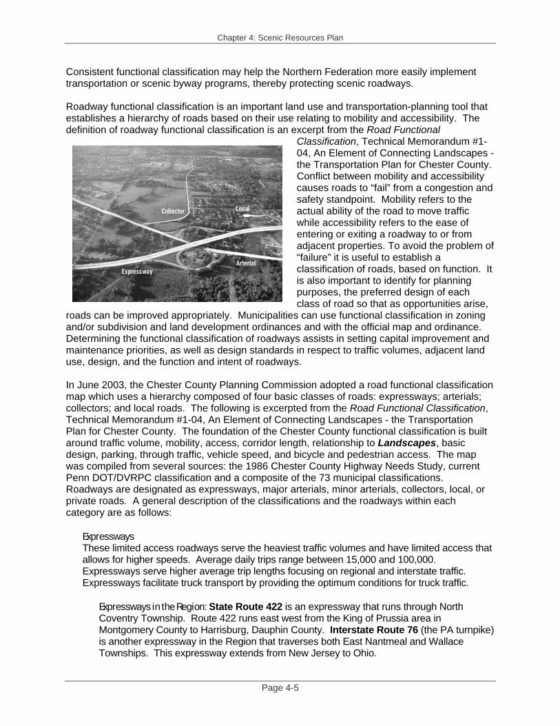
Consistent functional classification may help the Northern Federation more easily implement transportation or scenic byway programs, thereby protecting scenic roadways. Roadway functional classification is an important land use and transportation-planning tool that establishes a hierarchy of roads based on their use relating to mobility and accessibility. The definition of roadway functional classification is an excerpt from the Road Functional
Classification, Technical Memorandum #1-04, An Element of Connecting Landscapes - the Transportation Plan for Chester County. Conflict between mobility and accessibility causes roads to “fail” from a congestion and safety standpoint. Mobility refers to the actual ability of the road to move traffic while accessibility refers to the ease of entering or exiting a roadway to or from adjacent properties. To avoid the problem of “failure” it is useful to establish a classification of roads, based on function. It is also important to identify for planning purposes, the preferred design of each class of road so that as opportunities arise,
roads can be improved appropriately. Municipalities can use functional classification in zoning and/or subdivision and land development ordinances and with the official map and ordinance. Determining the functional classification of roadways assists in setting capital improvement and maintenance priorities, as well as design standards in respect to traffic volumes, adjacent land use, design, and the function and intent of roadways. In June 2003, the Chester County Planning Commission adopted a road functional classification map which uses a hierarchy composed of four basic classes of roads: expressways; arterials; collectors; and local roads. The following is excerpted from the Road Functional Classification, Technical Memorandum #1-04, An Element of Connecting Landscapes - the Transportation Plan for Chester County. The foundation of the Chester County functional classification is built around traffic volume, mobility, access, corridor length, relationship to Landscapes, basic design, parking, through traffic, vehicle speed, and bicycle and pedestrian access. The map was compiled from several sources: the 1986 Chester County Highway Needs Study, current Penn DOT/DVRPC classification and a composite of the 73 municipal classifications. Roadways are designated as expressways, major arterials, minor arterials, collectors, local, or private roads. A general description of the classifications and the roadways within each category are as follows:
Expressways These limited access roadways serve the heaviest traffic volumes and have limited access that allows for higher speeds. Average daily trips range between 15,000 and 100,000. Expressways serve higher average trip lengths focusing on regional and interstate traffic. Expressways facilitate truck transport by providing the optimum conditions for truck traffic.
Expressways in the Region: State Route 422 is an expressway that runs through North Coventry Township. Route 422 runs east west from the King of Prussia area in Montgomery County to Harrisburg, Dauphin County. Interstate Route 76 (the PA turnpike) is another expressway in the Region that traverses both East Nantmeal and Wallace Townships. This expressway extends from New Jersey to Ohio.
Chapter 4: Scenic Resources Plan
Page 4-6
Major Arterials These roads serve heavy volumes of traffic generally ranging between 10,000 and 60,000 trips per day. They provide a high degree of mobility, but offer more access than expressways. Major arterials link urban centers and usually consist of more than two lanes.
Major Arterials in the Region: State Route 100 is a major arterial that runs north south through the Region. It runs through North and South Coventry townships, West Vincent, and East Nantmeal townships. In addition, a small portion of Route 23, where Routes 724 and 23 merge in East Pikeland, is designated as a major arterial. Route 23 runs east west from Philadelphia to west of Lancaster.
Minor Arterials Arterials of this type also emphasize mobility and serve to link urban and rural centers, but their focus is more regional. They provide for traffic ranging from 8,000 to 20,000 trips per day with higher access than major arterials, but still have some access control.
Minor Arterials in the Region: Route 724 (through East Coventry, East Pikeland, East Vincent and North Coventry townships); Route 23 (through East Pikeland, East Vincent, South Coventry, and Warwick townships); Route 113 (through East Pikeland Township); a portion of Route 401 (through West Vincent Township); and Hanover Street In North Coventry are minor arterials.
Major Collector A major collector links residential and commercial areas by "collecting" traffic from residential areas and moving it to arterials. This road classification accommodates traffic averaging 4,000 to 10,000 trips per day.
Major Collectors in the Region: A small portion of Route 724, (just west of Laurelwood Road in North Coventry Township); the portion of Route 401 (through East Nantmeal and West Vincent townships); Kimberton Road and Cold Stream Road (through East Pikeland Township); Pughtown Road (through East Vincent, South Coventry and West Vincent townships); Keim Street (through North Coventry); Route 82 and Little Conestoga Road, (through Wallace Township).
Minor Collector A minor collector connects villages and multiple neighborhoods and is primarily for intra-municipal trips. This road classification accommodates traffic averaging 1,000 to 5,000 trips per day.
Minor collectors in the Region: Bethel Church, Ellis Woods Road, Sanatoga Road, Cedarville Road, School House Road, and Porters Mill Road in East Coventry Township; Route 345, and Fairview Road in East Nantmeal Township; Hares Hill Road, Wall Street, Mowere Road, Merlin Road, and Township Line Road in East Pikeland Township; Bridge Street, Stony Run Road, Elliswoods Road, New Street, and Park Road in East Vincent Township; Laurelwood Road, Cedarville Road, Keim Street, Harmonyville Road, Temple Road, Unionville Road, and W. Hoffecker Road in North Coventry Township; Harmonyville Road, Daisy Point Road, and Porters Mill Road in South Coventry; Fairview Road, Route 282, Marshall Road, Indiantown Road and Springton Road in Wallace Township; Pine Swamp Road, Harmonyville Road, and St. Peter’s Road in Warwick; and Saint Matthews Road in West Vincent.
Chapter 4: Scenic Resources Plan
Page 4-7
Local Local roads focus on access and often help to define the township’s unique character. Neighborhood and subdivision roads and roads that serve farms and estates are designated local roads; they provide direct access from residences. They are intended for very short distance travel and usually do not carry through trips. This road classification accommodates less than 1,500 trips per day. A majority of the roads and lanes within the Region fall under this category. All roads not otherwise noted are local roads.
During the study period, Chester County Planning Commission contacted all 73 municipalities by letter for input into this process. Both East Pikeland Township and North Coventry Township responded to the inquiry, however, neither fully accepted the County’s functional classification. The other municipalities in the Region did not return comment. The Region may want to revisit this issue to help transportation and scenic roadway planning by adopting consistent terms, either based on the County’s designations or developed from the municipal plans of Northern Federation members. In addition to examining functional classification, the Northern Federation may benefit from undertaking a regional transportation plan (comprehensive plan element). This work program may help with assessing other tools to protect scenic roads as well as function and mobility issues. Recommendations For Roadway Functional Classification
ACTION 4-4 Consider adopting the Chester County roadway functional classification (2003),
or at a minimum the Northern Federation could establish a regional roadway functional classification based upon municipal plans. This will enable municipalities in the Region to establish a consistent regional roadway classification to better protect scenic resources. Once adopted, update the municipal ordinances as needed to reflect the changes. Ensure that related design standards in each subdivision ordinance, such as right-of-way and street widths, grades, access and street alignments, are appropriate for their designated functional classification.
Objective(s) addressed by Actions 4-4: 4-A, 4-B, and 4-C. ACTION 4-5 Consider undertaking a regional transportation comprehensive plan element to
determine and prioritize, among other things, ways to protect scenic roadways. Objective(s) addressed by Actions 4-5: 4-A, 4-B. See ACTION 1-5
Chapter 4: Scenic Resources Plan
Page 4-8
SCENIC ROADWAY PROGRAMS There are several programs available to the Northern Federation to help maintain the scenic quality and character along the many roadways.
Adopt-A-Highway Program PennDOT’s Adopt-A-Highway Program can help the Region retain scenic quality. The program is set up to reduce litter and the overall cost of litter removal in Pennsylvania. Civic or volunteer groups sign a two-year program participation request with PennDOT to adopt a two-mile portion of state highway and promise to pick-up litter at least four times a year. PennDOT will provide complete safety training for volunteers as well as orange safety vests and highway warning signs to be used during litter pick-ups. The Department also provides trash bags and will pickup the bagged litter from the roadside. Volunteers must be at least eight years old, and adults must accompany participants under the age of 18. In return, PennDOT will post a sign along the highway giving the group credit for their efforts. According to PennDOT, more miles have been adopted through Pennsylvania’s Adopt-A-Highway Program than any other state in the nation. For more information, go to PennDOT’s website http://www.dot.state.pa.us/. The Great Pennsylvania Cleanup Program As part of the Keep Pennsylvania Beautiful initiative, the state has devised the Great Pennsylvania Cleanup Program. This program is a statewide community cleanup program to rid the highways, neighborhoods, trails, parks and open spaces of litter. The program asks communities to organize and conduct local cleanups - recruit volunteers, promote the event, and report the results for inclusion in statewide and national cleanup totals. For more information, go to http://www.depesf.state.pa.us/greatpacleanup/site/default.asp.
Recommendations For Scenic Roadway Programs
ACTION 4-6 Organize volunteers to participate in PennDOT’s Adopt a Highway Program and
the Great Pennsylvania Cleanup Program. Objective(s) addressed by Actions 4-6: 4-A, 4-B.
PennDOT’s Turn-back Program PennDOT offers an opportunity for municipalities to take more control over local roadways, which can help protect their scenic character. The PennDOT turn-back program allows for more local control of roads, although the municipality becomes financially responsible for their maintenance and repair. For example maintenance, road improvements, and snow plowing often occur in a timelier manner when undertaken at the municipal level. The turn-back program provides a one-time flat fee per mile to the municipality. The municipality will also receive annual liquid fuels funds for that road. The turn-back of state roads should only be considered if the roads are brought to a condition acceptable to the municipality.
ACTION 4-7 Consider “turning back” select scenic roads from state to municipal ownership for
more local control and preservation. Coordinate efforts with the Northern Federation.
Objective(s) addressed by Actions 4-7: 4-B.
Chapter 4: Scenic Resources Plan
Page 4-9
Scenic Byway Designation The PA Byway Program administered by PennDOT and an offspring of the National Scenic Byways Program,3 is designed to enhance and improve the visual impact, and maintian the natural resources and intrinsic qualities of designated roads. In addition, the program helps educate about Commonwealth history and culture and provides enhanced opportunities for funding in related programs. Any governmental entity can nominate a federal, state, or local road, or portion thereof, to PennDOT for consideration to the program. If the road is not a state maintained highway, a municipal or federal agency owner must first designate the route. Concurrence from PennDOT will designate the route a PA Byway. The Program encompasses several “Intrinsic Qualities:” Archaeological, Cultural, Historic, Natural, Recreational and Scenic. Therefore, the Byway Progam may apply to roadways or segments that include the resoucres that the Northern Federation is including in the umbrella term of ‘scenic’. For more information on the PA Byway Program go to http://www.dot.state.pa.us.
ACTION 4-8 Investigate the Pennsylvania Byway Program to determine if there are eligible
roadways within the Region. If so, nominate the roadway, or portion thereof, to PennDOT for consideration to the program.
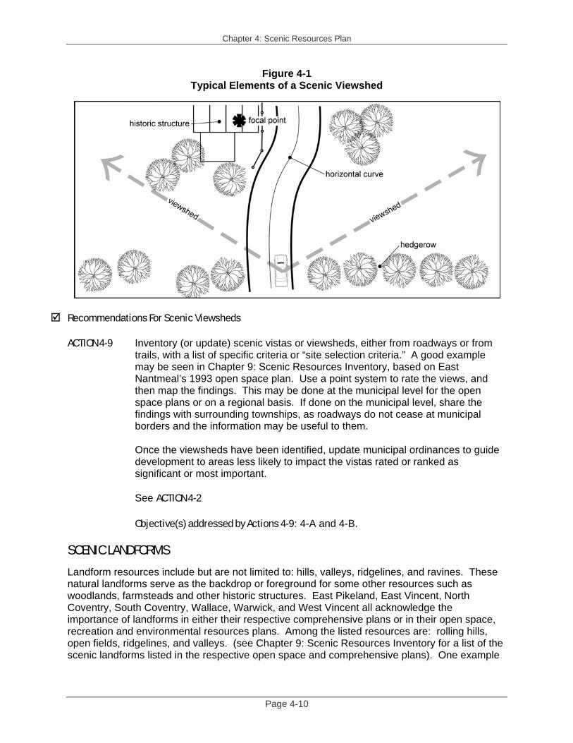
Objective(s) addressed by Actions 4-8: 4-C. SCENIC VIEWSHEDS A scenic viewshed, vista, or panorama is the broadest category of scenic resource because it encompasses essentially all of the other resources. A viewshed is scenic because it includes a beautiful, picturesque farmstead, woodland, or ridgeline (or all of them) within the sight distance. See Figure 4-1 for typical elements of a scenic viewshed and see Chapter 9: Scenic Resources Inventory for a list of the viewsheds listed in the respective open space plans and comprehensive plans. It is also a very sensitive resource and any development; especially that which is insensitive to design, the destruction of woodlands and other vegetation (clear-cutting), and inappropriate buffering/screening will interfere with viewsheds. Because the Region cannot preserve all scenic viewsheds or panoramas, it is important to preserve the most significant ones to retain the rural character.
For the municipalities that have not identified or updated their scenic viewsheds’ inventory, it may be helpful to follow the procedure listed above under Scenic Roadways. Ask people to tour the municipality looking for scenic viewsheds, rank them based on established criterion, and then map the findings.
3 Part of the U.S. Department of Transportation, Federal Highway Administration. The program is a grass-roots collaborative effort established to help recognize, preserve and enhance selected roads throughout the United States. Since 1992, the National Scenic Byways Program has provided funding for almost 1500 state and nationally designated byway projects in 48 states. The U.S. Secretary of Transportation recognizes certain roads as All-American Roads or National Scenic Byways based on one or more archeological, cultural, historic, natural, recreational and scenic qualities. For more information on the federal scenic byways program, visit www.byways.org.
Chapter 4: Scenic Resources Plan
Page 4-10
Figure 4-1 Typical Elements of a Scenic Viewshed
Recommendations For Scenic Viewsheds ACTION 4-9 Inventory (or update) scenic vistas or viewsheds, either from roadways or from
trails, with a list of specific criteria or “site selection criteria.” A good example may be seen in Chapter 9: Scenic Resources Inventory, based on East Nantmeal’s 1993 open space plan. Use a point system to rate the views, and then map the findings. This may be done at the municipal level for the open space plans or on a regional basis. If done on the municipal level, share the findings with surrounding townships, as roadways do not cease at municipal borders and the information may be useful to them.
Once the viewsheds have been identified, update municipal ordinances to guide
development to areas less likely to impact the vistas rated or ranked as significant or most important. See ACTION 4-2
Objective(s) addressed by Actions 4-9: 4-A and 4-B. SCENIC LANDFORMS Landform resources include but are not limited to: hills, valleys, ridgelines, and ravines. These natural landforms serve as the backdrop or foreground for some other resources such as woodlands, farmsteads and other historic structures. East Pikeland, East Vincent, North Coventry, South Coventry, Wallace, Warwick, and West Vincent all acknowledge the importance of landforms in either their respective comprehensive plans or in their open space, recreation and environmental resources plans. Among the listed resources are: rolling hills, open fields, ridgelines, and valleys. (see Chapter 9: Scenic Resources Inventory for a list of the scenic landforms listed in the respective open space and comprehensive plans). One example
Chapter 4: Scenic Resources Plan
Page 4-11
of a landform with regional significance is the gorge seen from Route 100 near Flowing Springs Road because of its scenic beauty and the location along a major roadway. Recommendation For Scenic Landforms
ACTION 4-10 Identify landforms of regional significance and guide development away from
such resources by updating municipal ordinances. Objective(s) addressed by Actions 4-10: 4-A and 4-B. SCENIC NATURAL FEATURES
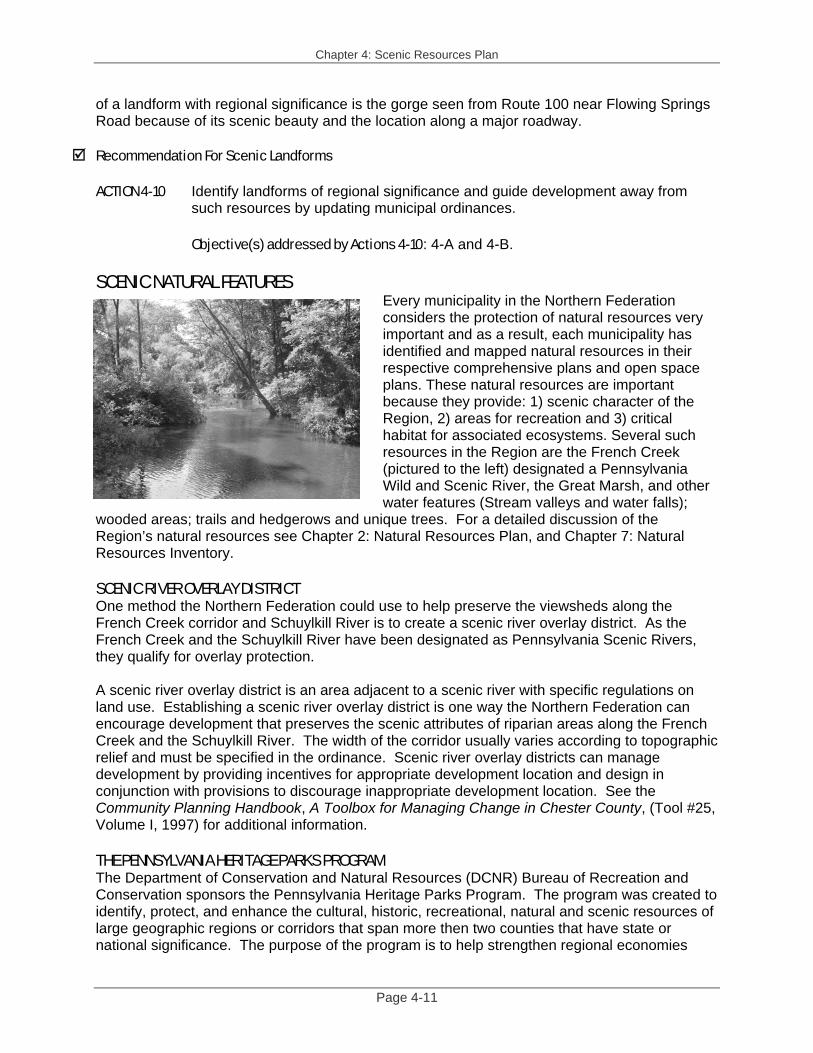
Every municipality in the Northern Federation considers the protection of natural resources very important and as a result, each municipality has identified and mapped natural resources in their respective comprehensive plans and open space plans. These natural resources are important because they provide: 1) scenic character of the Region, 2) areas for recreation and 3) critical habitat for associated ecosystems. Several such resources in the Region are the French Creek (pictured to the left) designated a Pennsylvania Wild and Scenic River, the Great Marsh, and other water features (Stream valleys and water falls);
wooded areas; trails and hedgerows and unique trees. For a detailed discussion of the Region’s natural resources see Chapter 2: Natural Resources Plan, and Chapter 7: Natural Resources Inventory. SCENIC RIVER OVERLAY DISTRICT One method the Northern Federation could use to help preserve the viewsheds along the French Creek corridor and Schuylkill River is to create a scenic river overlay district. As the French Creek and the Schuylkill River have been designated as Pennsylvania Scenic Rivers, they qualify for overlay protection. A scenic river overlay district is an area adjacent to a scenic river with specific regulations on land use. Establishing a scenic river overlay district is one way the Northern Federation can encourage development that preserves the scenic attributes of riparian areas along the French Creek and the Schuylkill River. The width of the corridor usually varies according to topographic relief and must be specified in the ordinance. Scenic river overlay districts can manage development by providing incentives for appropriate development location and design in conjunction with provisions to discourage inappropriate development location. See the Community Planning Handbook, A Toolbox for Managing Change in Chester County, (Tool #25, Volume I, 1997) for additional information. THE PENNSYLVANIA HERITAGE PARKS PROGRAM The Department of Conservation and Natural Resources (DCNR) Bureau of Recreation and Conservation sponsors the Pennsylvania Heritage Parks Program. The program was created to identify, protect, and enhance the cultural, historic, recreational, natural and scenic resources of large geographic regions or corridors that span more then two counties that have state or national significance. The purpose of the program is to help strengthen regional economies
Chapter 4: Scenic Resources Plan
Page 4-12
through increased tourism, creation of new jobs and stimulation of public and private partnerships for new investment opportunities. The Schuylkill River Corridor runs from Schuylkill County into Berks, Chester, and Montgomery Counties and into Philadelphia. DCNR designated the Schuylkill River Heritage Corridor as a State Heritage Park in 1995. The Schuylkill Corridor was designated as a National Heritage Area in 2000 (for more information go to National Park Service’s website: http://www.cr.nps.gov/heritageareas/FAQ/INDEX.HTM). The Schuylkill Heritage Corridor encompasses most of or all of: Warwick, North Coventry, South Coventry, East Coventry, East Vincent, East Pikeland and West Vincent townships. For more information go to DCNR’s website: http://www.dcnr.state.pa.us/brc/heritageparks/. Recommendation For Scenic Natural Features
ACTION 4-11 Investigate implementing a scenic river overlay district along the French Creek
and its tributaries and the Schuylkill River and its tributaries. See Chapter 2: Natural Resources Protection Plan for specific recommendations on natural features.
Objective(s) addressed by Actions 4-11: 4-B. SCENIC MAN-MADE RESOURCES Not all scenic resources are created by nature. Man-made features in context with the rural character of the Region, such as fences and walls, split rail and stone respectively, bridges, farmsteads and other historic structures, and villages offer additional scenic value to the Region. When repairing such structures, care should be taken to preserve the integrity and character. Although some of these resources may be difficult to protect, there are many available programs for historic resource protection. For a detailed discussion on historic resources and preservation efforts, see Chapter 3: Historic Resources Plan and Chapter 8: Historic Resources Inventory. Recommendation For Scenic Man-made Resources
ACTION 4-12 Adopt ordinance language to encourage property owners to preserve such
scenic resources as historic structures, bridges, stone walls, and fences and to keep them in good repair.
Objective(s) addressed by Actions 4-12: 4-B. ACTION 4-13 Investigate historic preservation options, such as historic overlay districts. See
Chapter 3: Historic Resources Plan, for specific recommendations on historic preservation.
Objective(s) addressed by Actions 4-13: 4-B.
Chapter 4: Scenic Resources Plan
Page 4-13
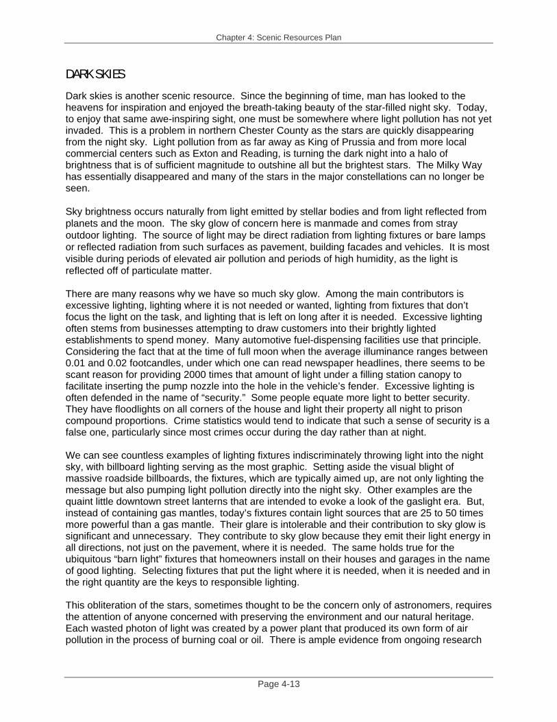
DARK SKIES Dark skies is another scenic resource. Since the beginning of time, man has looked to the heavens for inspiration and enjoyed the breath-taking beauty of the star-filled night sky. Today, to enjoy that same awe-inspiring sight, one must be somewhere where light pollution has not yet invaded. This is a problem in northern Chester County as the stars are quickly disappearing from the night sky. Light pollution from as far away as King of Prussia and from more local commercial centers such as Exton and Reading, is turning the dark night into a halo of brightness that is of sufficient magnitude to outshine all but the brightest stars. The Milky Way has essentially disappeared and many of the stars in the major constellations can no longer be seen. Sky brightness occurs naturally from light emitted by stellar bodies and from light reflected from planets and the moon. The sky glow of concern here is manmade and comes from stray outdoor lighting. The source of light may be direct radiation from lighting fixtures or bare lamps or reflected radiation from such surfaces as pavement, building facades and vehicles. It is most visible during periods of elevated air pollution and periods of high humidity, as the light is reflected off of particulate matter.
There are many reasons why we have so much sky glow. Among the main contributors is excessive lighting, lighting where it is not needed or wanted, lighting from fixtures that don’t focus the light on the task, and lighting that is left on long after it is needed. Excessive lighting often stems from businesses attempting to draw customers into their brightly lighted establishments to spend money. Many automotive fuel-dispensing facilities use that principle. Considering the fact that at the time of full moon when the average illuminance ranges between 0.01 and 0.02 footcandles, under which one can read newspaper headlines, there seems to be scant reason for providing 2000 times that amount of light under a filling station canopy to facilitate inserting the pump nozzle into the hole in the vehicle’s fender. Excessive lighting is often defended in the name of “security.” Some people equate more light to better security. They have floodlights on all corners of the house and light their property all night to prison compound proportions. Crime statistics would tend to indicate that such a sense of security is a false one, particularly since most crimes occur during the day rather than at night. We can see countless examples of lighting fixtures indiscriminately throwing light into the night sky, with billboard lighting serving as the most graphic. Setting aside the visual blight of massive roadside billboards, the fixtures, which are typically aimed up, are not only lighting the message but also pumping light pollution directly into the night sky. Other examples are the quaint little downtown street lanterns that are intended to evoke a look of the gaslight era. But, instead of containing gas mantles, today’s fixtures contain light sources that are 25 to 50 times more powerful than a gas mantle. Their glare is intolerable and their contribution to sky glow is significant and unnecessary. They contribute to sky glow because they emit their light energy in all directions, not just on the pavement, where it is needed. The same holds true for the ubiquitous “barn light” fixtures that homeowners install on their houses and garages in the name of good lighting. Selecting fixtures that put the light where it is needed, when it is needed and in the right quantity are the keys to responsible lighting. This obliteration of the stars, sometimes thought to be the concern only of astronomers, requires the attention of anyone concerned with preserving the environment and our natural heritage. Each wasted photon of light was created by a power plant that produced its own form of air pollution in the process of burning coal or oil. There is ample evidence from ongoing research
Chapter 4: Scenic Resources Plan
Page 4-14
that excessive and all-night lighting has an adverse effect on plant health and animal circadian4 rhythms. Further, excessive glare causes the needless slaughter of countless numbers of migrating birds annually.
And finally, there is the issue of the nuisances and sometimes the hazards to humans produced by excessive glare. People who live next to unthinking neighbors who have unshielded “barn lights” or floodlights on the side of their house, that remain on all night, have experienced the nuisance of having their yards flooded with light and their bedrooms lighted up throughout the night. Most of us have experienced being temporarily blinded by a bright light source along the side of the road and in our field of view as we are driving. It becomes clear that the problem is more far-reaching in northern Chester County than just dark skies.
It is not easy to put one’s finger on all of the sources of sky glow in our region because, as is the case with other forms of pollution, there are point sources and non-point sources. Unquestionably, the parking lot lights of shopping centers, automobile dealerships and athletic-field lighting, are point source contributors. But, the non-point-source polluters, e.g., street lighting, residential post lights and floodlights, and all other improperly applied, excessively lamped or misaimed outdoor light source, contributes incrementally to sky glow. Reversing the current trend of the-more-light-the-better has to start with public education and municipal legislation. The general public needs to be informed that wasting light and creating glare comes with a price. That price is wasted energy, the pollution created by generating that energy, visual annoyance, driving hazards, negative impacts on plants and animals and the destruction of an incredible natural resource, the night sky.
Municipalities can help preserve the scenic view of the night sky by establishing ordinance language that prevents glare and light pollution by requiring the use of reasonable lighting levels, luminaries that do not emit glare and light above the horizontal and automatic extinguishing of lighting when it is not needed. Recommendations For Continued Dark Skies
ACTION 4-14 Educate residents on the importance of dark skies protection through municipal
newsletters and websites.
Adopt ordinance language to diminish the impact of lighting, and promote dark skies. Municipalities can help preserve the scenic view of the night sky by establishing ordinance language that prevents glare and light pollution by requiring the use of reasonable lighting levels, luminaries that do not emit glare and light above the horizontal and automatic extinguishing of lighting when it is not needed. See ACTION 1-3 Objective(s) addressed by Actions 4-14: 4-B and 4-D.
4 Occurring or recurring about once per day.
Chapter 4: Scenic Resources Plan
Page 4-15
Require the following Minimum Standards for a Dark-Sky Friendly Lighting Ordinance:5 1. Adopt glare restrictions. 2. Adopt light-trespass limits. 3. Adopt illuminance levels. 4. Require cutoff, full cutoff or fully shielded fixtures for illuminating horizontal
surfaces. 5. Require municipal approval of lighting for vertical surfaces based on suitable
control of light pollution and glare. 6. Require that signs and billboards be lighted from fixtures mounted above
rather than below. 7. Adopt curfew provisions. 8. Adopt limits for safety/security all-night lighting. 9. Adopt fixture mounting height limits. 10. Require protection of poles from collision with vehicles. 11. Adopt minimum lighting information submission requirements. 12. Include provision for dealing with non-conforming lighting (zoning). 13. Adopt residential (low wattage) lighting restrictions. 14. Address both land development and zoning lighting issues.
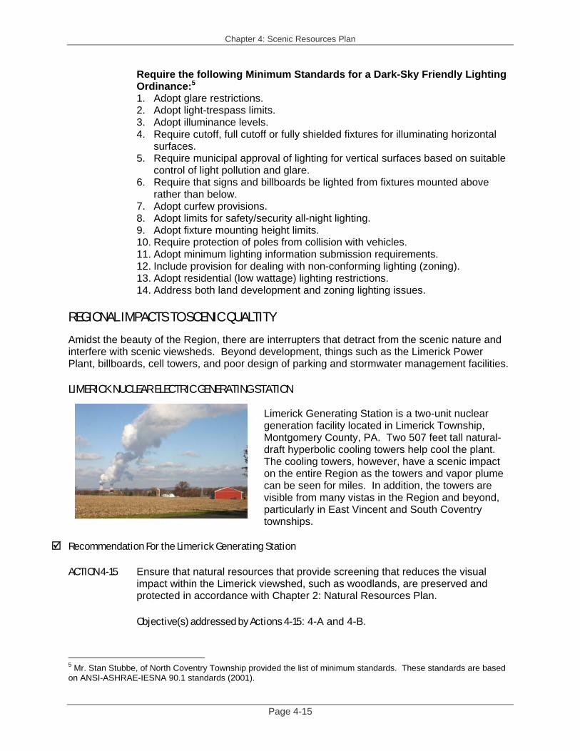
REGIONAL IMPACTS TO SCENIC QUALTITY Amidst the beauty of the Region, there are interrupters that detract from the scenic nature and interfere with scenic viewsheds. Beyond development, things such as the Limerick Power Plant, billboards, cell towers, and poor design of parking and stormwater management facilities. LIMERICK NUCLEAR ELECTRIC GENERATING STATION
Limerick Generating Station is a two-unit nuclear generation facility located in Limerick Township, Montgomery County, PA. Two 507 feet tall natural-draft hyperbolic cooling towers help cool the plant. The cooling towers, however, have a scenic impact on the entire Region as the towers and vapor plume can be seen for miles. In addition, the towers are visible from many vistas in the Region and beyond, particularly in East Vincent and South Coventry townships.
Recommendation For the Limerick Generating Station
ACTION 4-15 Ensure that natural resources that provide screening that reduces the visual
impact within the Limerick viewshed, such as woodlands, are preserved and protected in accordance with Chapter 2: Natural Resources Plan.
Objective(s) addressed by Actions 4-15: 4-A and 4-B.
5 Mr. Stan Stubbe, of North Coventry Township provided the list of minimum standards. These standards are based on ANSI-ASHRAE-IESNA 90.1 standards (2001).
Chapter 4: Scenic Resources Plan
Page 4-16
OUTDOOR ADVERTISING AND SIGNAGE Driving along the Pennsylvania Turnpike and Routes 100, 724, and 23 billboards and other outdoor advertising detract from the scenic beauty and hinder scenic viewsheds. While billboards offer an opportunity for merchants to advertise, the scenic cost can be high when there are too many signs too close together, when they block a scenic viewshed, or when they are allowed on inappropriate roadways. Billboards can make travelers feel like the road is a higher functional classification then it might actually be because the billboards are reminescent of the PA Turnpike or other major interstates. Therefore it is important to consider how the Northern Federation may limit the use and therefore, impact of billboards and other outdoor advertising. The Municipalities Planning Code (MPC) enables municipalities to regulate signage. It is important to develop or strengthen outdoor advertising (signage) regulations as a part of a municipal zoning ordinance to help prevent the inappropriate and overuse of such signs. In particular, billboard regulations can help preserve scenic views along roadways. PennDOT will not issue a permit for a billboard until the municipality grants a permit first. Therefore, municipalities with regulatory language in place will be able to allocate where billboards are most appropriate and where they would have the least scenic interference. In addition, PennDOT will only issue a permit if the proposed billboard is in a commercial or industrial district (a mixed use district too, if the district was originally commercial). Therefore, any residential or agricultural district is off-limits. Municipalities have control over how high a sign or billboard may be, the state has no height restriction, but will implement the local height regulations.6 In addition, municipalities may limit the size of the sign to a size smaller than what the state authorizes. While PennDOT does not have a minimum size requirement, it does have a maximum total billboard size regulation of 1,200 square feet, (which would be equivalent to a 20 X 30 sign, 600 square feet per side). Under PennDOT regulations no commercial advertising is allowed in the right-of-way or is permitted to hangover into the right-of-way. In addition, advertisers are not allowed to disturb natural features by painting on a rock or posting an advertisement on a tree. Billboards and other outdoor advertising is are not permitted on designated byways. Municipalities can also help preserve the scenic view of the night sky by establishing ordinance language requiring sign and billboard lighting to be confined to the sign or billboard, and to be extinguished at a reasonable hour. Recommendation For Outdoor Signage, Including Billboards and Advertising
ACTION 4-16 Adopt ordinance language to diminish the impact of outdoor signage, including
billboards and advertising. The municipality can control several aspects of outdoor signage, such as height limits, sign size and illumination. In addition, because billboards are only permitted in commercial or industrial districts (or a mixed use district if the district was originally commercial or industrial) a municipality may ensure that billboards are appropriately placed. PennDOT will not issue a permit for outdoor advertising unless the municipality first gives a
6 The state does however regulate the distance between billboards: in a borough or city there must be at least 100 feet between signs, in a township there must be at least 500 feet between signs. PennDOT’s general rule is five second viewing at the posted speed limit.
Chapter 4: Scenic Resources Plan
Page 4-17
local permit. While all nine municipalities in the Northern Federation have some signage standards in their respective ordinances, each municipality should review their ordinance provisions to determine if they can be strengthen to minimize the scenic impact of outdoor advertising.
Minimum Considerations for Signage and Outdoor Advertising: 7 1. Regulate the size of signs allowed by the zoning ordinance. 2. Regulate the number of signs allowed by the zoning ordinance. 3. Regulate the lighting of signs through the zoning ordinance (see Dark Skies above).
Objective(s) addressed by Actions 4-16: 4-A and 4-B.
ACTION 4-17 Investigate the PA Byways Program for appropriate roadway corridors to
eliminate the threat of billboards on those roadway segments as outdoor advertising is prohibited on designated scenic byways.
Objective(s) addressed by Actions 4-17: 4-C. CELLULAR COMMUNICATION (CELL) TOWERS Cell Towers seem to be a necessary component of the landscape these days. However, they can greatly impact scenic quality. While cell towers are not aesthetic in any environment, they appear even more startling when set against a rural or natural landscape. It is important to consider how the Northern Federation may limit the scenic impact of cell towers. Municipalities may regulate the location (by allowing only in appropriate zoning districts) and design (including height) of cell towers. The Northern Federation should require the design of the towers to be as consistent with a scenic landscape as possible. For instance, the municipalities may require the towers to be of a silo or flag pole design. It is important to realize that restricting the height of the towers too much can in the end mean that there are more of them in the area. Recommendation For Cell Towers
ACTION 4-18 Adopt ordinance language to diminish the impact of cell towers, or if the
municipality has already established regulatory language, review the municipal ordinances to determine if the language is consistent with the minimum standards that the Northern Federation recommends.
Minimum Considerations for Cell Towers:
1. Regulate the location of cell towers through the zoning ordinance. 2. Regulate the design of cell towers through the zoning ordinance. 3. Provide proof of ownership to the municipality. 4. Require a maintenance plan for the cell tower, the land surrounding the cell
tower and for the removal of the tower.
Objective(s) addressed by Actions 4-18: 4-A and 4-B. 7 We have included minimum standards which are suggestions that each municipality may consider as an acceptable minimum basis for natural, scenic, and agricultural resource protection.

Chapter 4: Scenic Resources Plan
Page 4-18
PARKING DESIGN ISSUES Parking design with a lack of screening and buffering can greatly impact the Region’s aesthetic quality. While parking is a necessary element of the planning process, design options may be used to enhance the overall effect. The Northern Federation may consider ways to implement design standards that would promote a natural design using native trees, plants and shrubs and other elements to reduce unfavorable impact on the rural character. There are several issues to consider, such as location, layout, surface treatment, and screening, buffering and landscaping to help promote more scenic parking areas. Ordinance language is the way to achieve good design. The language should be flexible enough to allow for innovative ideas, such as rear parking for a commercial use, without compromising minimum standards. Recommendation For Parking Design Issues
ACTION 4-19 Adopt ordinance language to diminish the impact of parking design that is
insensitive to the scenic aesthetic, or if the municipality has already established regulatory language, review the municipal ordinances to determine if the language is consistent with the minimum standards that the Northern Federation recommends.
Minimum Considerations for Parking Design: 1. Regulate the location, layout and type of parking in the zoning ordinance. 2. Allow for shared parking when appropriate to eliminate extra parking and
impervious coverage. 3. Regulate the design considerations, such as surface treatment, screening
buffering and landscaping in the zoning ordinance. Objective(s) addressed by Actions 4-19: 4-A and 4-B.
STORMWATER MANAGEMENT DESIGN ISSUES
Design is an important component to aesthetic stormwater management. While stormwater management facilities are an integral part of development, empty detention basins or lack of landscaping and buffering around them can affect scenic quality. There are ways to incorporate stormwater detention basins into the overall design to enhance the visual impact. It is possible to design a scenic stormwater detention pond that looks like a natural pond, as seen to the left in Valley Township. The alternative is a dry detention basis that has little scenic quality. Again, ordinance language is the way to achieve good design. The language should be flexible enough to allow for appropriate location, such as putting stormwater facilities in the open space, without compromising minimum standards.
Chapter 4: Scenic Resources Plan
Page 4-19
Recommendation For Stormwater Management Facility Design
ACTION 4-20 Adopt ordinance language to diminish the impact of stormwater management
design that is insensitive to the scenic aesthetic, or if the municipality has already established regulatory language, review the municipal ordinances to determine if the language is consistent with the minimum standards that the Northern Federation recommends.
Minimum Considerations for Stormwater Management Design: 1. Require that stormwater facilities be located in the open space as long as the
function is not compromised by the location. 2. Require, where possible, stormwater management facilities be designed to
replicate natural systems, such as ponds or wetlands. Objective(s) addressed by Actions 4-20: 4-A and 4-B.
UNDERGROUND UTILITIES Overhead cables and wires can greatly impact scenic quality. Installing electric, cable, telephone, and other utility lines underground will help control the visual impact of new development. However, the cost of such a strategy is high, and must be balanced with the technical capability to maintain and fix any problems with lines as they arise. One tool that municipalities may use is to write ordinance language to encourage the placement of utility lines underground where possible. Recommendation For Underground Utility Installation
ACTION 4-21 Adopt ordinance language to diminish the impact of overhead utilities, or if the
municipality has already established regulatory language, review the municipal ordinances to determine if the language is consistent with the minimum standards that the Northern Federation recommends.
Minimum Considerations for Underground Utility Installation: 1. Promote underground utility installation for new development in the zoning
ordinance. 2. Implement flexible standards to promote concept, while considering the
limitations, such as cost, for repair or maintenance. 3. Whether the concept will be used in rural areas only to maintain rural
character or all areas in the township. 4. Design underground utility districts. 5. Make provisions for emergency or unusual circumstances, which may allow
overhead utility installation for a temporary period of time. Objective(s) addressed by Actions 4-21: 4-A and 4-B.
Chapter 4: Scenic Resources Plan
Page 4-20
ABANDONDED BUILDINGS AND PROPERTY MAINTENANCE ISSUES Abandoned buildings, particularly industrial or commercial buildings as many of them front on major roadways, can have a significant impact on scenic quality. As old industrial sites can also be difficult to resell because of their size, the properties often become unsightly because they sit unoccupied or abandoned. The lots can get overrun with high grass and weeds, and debris, and the buildings can fall into disrepair. In addition, they are often prime targets for vandalism. Abandoned buildings indicate economic hardship and do not promote the serene, scenic quality that the Region promotes. Municipalities can try to mitigate the negative scenic impact from these issues by writing flexible reuse standards in the zoning ordinances and enforcing property maintenance ordinances. Recommendation For Abandoned Buildings and Property Maintenance Issues
ACTION 4-22 Consider adopting adaptive reuse provisions in the zoning ordinance to help
mitigate the impact of abandoned buildings. In addition, establish a property maintenance ordinance to prohibit out of control weeds, uncut grass (over a certain height), or “junk” (which must be specifically defined). These tools can help the municipality maintain its aesthetic quality. If a municipality has already established regulatory language, review the documents to determine if the language is consistent with the minimum standards that the Northern Federation recommends.
Minimum Considerations for Abandoned Buildings: 1. Allow for adaptive reuse provisions in the zoning ordinance in addition to the
adaptive reuse standards for historic structures. 2. Balance the loss of industrial or commercial space with the addition of
residential units and implications of such on tax revenue. 3. Allow for flexible use standards in the zoning ordinance so that a non-
industrial use may use an abandoned building (or a big box building that while not technically “abandoned,” is empty and difficult to reoccupy.)
Minimum Considerations for Property Maintenance Issues: 1. Require that grasses of a certain height be mowed. 2. Do not allow the accumulation of “junk” (however defined - cars, trash, litter,
broken glass, etc) on any property. Objective(s) addressed by Actions 4-22: 4-A and 4-B.
OTHER TOOLS TO PROMOTE SCENIC PRESERVATION CONSERVATION DEVELOPMENT Conservation development provides a means of both preserving open space and allowing development to be directed away from sensitive resources on the site. This tool therefore, may be used to help protect the scenic aesthetic as uses permitted in open space often include natural and historic resources, recreational facilities, and the continuation of existing agricultural uses. See Chapter 2, Natural Resources Plan for a list of municipalities in the Region that allow for TDR.

Chapter 4: Scenic Resources Plan
Page 4-21
Recommendations For Conservation Development
See ACTIONS 2-14 and 2-15 in Chapter 2. EASEMENTS OR LAND PURCHASE The preservation of open space and farmland can help retain scenic quality. Conservation easements are legal documents that limit certain activities on the land and conserve specific natural features or agricultural production that may in turn help preserve the scenic quality of the Region. Easements can be sold or donated by the legal landowner and must be accepted by a party (the “holder”) willing to hold and manage the easement. The state, county and non-profit organization land trusts, such as the French and Pickering Creeks Conservation Trust, are traditional holders of such easements. Local municipalities may also co-hold easements but may prefer purchase in-fee as the municipality would obtain ownership benefits. The easement holder is then responsible for enforcing the terms of the easement. This technique allows for the permanent protection of open space or agricultural land, by purchasing development rights, rather than the property. Conservation easements can be tailored for each property to protect wildlife habitat, farmlands, watersheds, historic sites, or other features. The majority of eased parcels are private property and are not open to the public without the specific permission of the landowner. However, the public does benefit from the scenic views of the property, protection of environmental resources, and the municipal tax savings realized by the limitations on new development. A second option to preserve open space to retain scenic character is through land purchase in fee simple. The parties most likely to purchase land would be non-profit organization land trusts or municipalities. The state and county may also purchase land for open space preservation, however efforts at this level of government often focus on providing grant money to help another entity (land trust or municipality) with funds to purchase. Because of the high cost of land, and the management responsibilities that are associated with owning land, the acquisition of parcels “in-fee” by a land trust or municipality is less common than the purchase of conservation easements. It is also unusual for a landowner to donate land in-fee as opposed to a conservation easement. An advantage to owning the land in-fee is that the land trust or municipality has full control over what happens on the property. For example, the land trust or municipality may choose to allow access to all the land by the public, which is a less likely scenario with property protected through conservation easements. The future use of the property for conservation purposes and enforcing the terms of the conservation easement agreement is not an issue on land trust or municipal owned property, but maintenance and liability costs to the land trust will be greater. There are many easement and grant programs available from a variety of sources to help with the preservation of open space and agricultural land. See Chapter 5: Recreation Resources Plan for open space grant programs and Chapter 6: Agricultural Resources Plan for agricultural conservation easement programs to preserve farmland. Recommendations For Easements or Land Purchases
See Actions 5-11 in Chapter 5 and ACTIONS 6-4 thru 6-7 in Chapter 6.
Chapter 4: Scenic Resources Plan
Page 4-22
EFFECTIVE AGRICULTURAL ZONING Effective agricultural zoning is a land management tool that municipalities can use to encourage the preservation of farmland, discourage conversion into non-agricultural uses, and discourage the establishment of land uses that are incompatible, or scenically incompatible with agricultural uses. See Chapter 6: Agricultural Resources Plan for more information on this subject. Recommendations For Effective Agricultural Zoning
See ACTIONS 6-21 thru 6-23 in Chapter 6. TRANSFER OF DEVELOPMENT RIGHTS (TDR) Transfer of Development Rights (TDR) is a way of preserving open space, natural resources, historic resources, and farmland in the Region. Therefore, a TDR program, implemented through the zoning ordinance, can help protect scenic resources in the Region. See Chapter 2: Natural Resources Plan for a list of municipalities in the Northern Federation that allow for TDR. Recommendation For Transfer of Development Rights (TDR)
See ACTION 2-17 in Chapter 2. COMMUNITY EDUCATION Informing the residents of the Region can be an effective way to continue a cultural heritage and to help promote the protection of scenic resources. Often these efforts are informal and can be done at either the municipal level or for more impact at the regional level. Ways to educate residents include activities such as: presentations from area experts; photographic or slide shows of scenic or historic features; tours of scenic or historic features; newsletter or website articles on such issues; or sponsoring programs such as East Vincent’s Environmental Advisory Council’s (EAC) Earth Day program. Once residents become aware of the value and importance of scenic resources they can become important stakeholders to protect them. Recommendation For Community Education Activities
ACTION 4-23 Continue to participate in, or consider participating in community education
activities such as the Chester County Parks and Recreation Department’s “Town Tours and Village Walks,” bridge tours, Earth Day programs, and newsletter/website updates.
Objective(s) addressed by Actions 4-23: 4-C.
Chapter 4: Scenic Resources Plan
Page 4-23
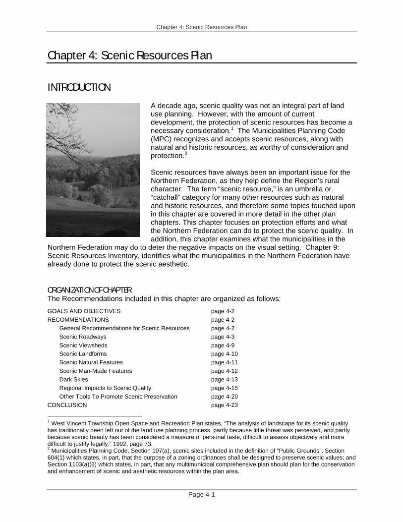
CONCLUSION Scenic resources include so many other resources, such as natural and historic resources. To best protect these resources in the Region, each municipality should develop consistent ordinance standards. Consistent terminology and definitions are essential for scenic resource protection at the regional level. In many cases, the municipalities have already implemented protection measures but each will want to review their ordinances to see if they achieve the minimum standards set out in this chapter. A complete summary of scenic resources recommendations is located in Chapter 1: Coordination and Implementation Plan. The numbers next to each recommendation above correspond to those in the Implementation Plan. Figure Sources Figure 4-1: Chester County Planning Commission, 2005 Photograph Sources Page 4-1: Mr. John Hoekstra, Watershed Director for Green Valleys Association and citizen-
at-large taskforce member with the Northern Federation. Chester County Planning Commission, 2003 and 2004.

Chapter 4: Scenic Resources Plan
Page 4-24
THIS PAGE INTENTIONALLY LEFT BLANK