Embed Size (px)
Citation preview

Nature-based solutions for local climate adaptation in the Basque Country
Klimatek Project 2016
Methodological guide for their identification and mapping.Donostia/San Sebastián case study.
INGURUMEN, LURRALDE PLANGINTZAETA ETXEBIZITZA SAILA
MINISTRY OF THE ENVIRONMENTTERRITORIAL PLANNING AND HOUSING


Nature-based solutions for local climate adaptation in the Basque Country
Klimatek Project 2016
INGURUMEN, LURRALDE PLANGINTZAETA ETXEBIZITZA SAILA
MINISTRY OF THE ENVIRONMENTTERRITORIAL PLANNING AND HOUSING
Methodological guide for their identification and mapping.Donostia/San Sebastián case study.
© Ihobe, Ingurumen Jarduketarako Sozietate Publikoa Ihobe, Environmental Management Agency
PUBLISHED BY:Ihobe, Environmental Management AgencyMinistry of the Environment, Territorial Planning and Housing - Basque Government
Alda. de Urquijo n.º 36-6.ª (Plaza Bizkaia) 48011 Bilbao
[email protected] I www.ihobe.eus www.ingurumena.eus
EDITION: OCTOBER 2017
CONTENTS: This document has been prepared by TECNALIA thanks to funding received as part of 2016 Call for applications for Klimatek I+B+G Grants to fund R&D, Innovation and demonstration projects in the field of adaptation to climate change.
FRONT COVER PHOTO: Courtyard of the "Hawaii" establishment in Calle Legazpi, Donostia/San Sebastián.
EDITORIAL TEAM
Tecnalia Research and InnovationLaura Gutiérrez/Gemma García/Igone García
In collaboration with Enea - Estrategias para la SostenibilidadAinhoa Gea /Ana Lopez
Our thanks to Donostia/San Sebastián City for the information provided and its involement in the project.
The contents of this document, in this edition, are published under licence: Recognition – Non Commercial – No Derivatives Works 3.0 Unported from Creative Commons (further information at http://creativecommons.org/licenses/by-nc-nd/3.0/deed.es_ES;)

index
01. Introduction . . . . . . . . . . . . . . . . . . . . . . . . . . . . . . . . . . . . . . . . . . . . . . . . . . . . . . . . . . . . . . . . . . . . . . . . . . . . . . . 04 1 .1 . Nature-based adaptation to climate change 1 .2 . What is understood by Nature-based Solutions 1 .3 . Efficient and effective Nature-based Solutions 1 .4 . Advances regarding Climate Change Adaptation in the Basque Country
02. Scope . . . . . . . . . . . . . . . . . . . . . . . . . . . . . . . . . . . . . . . . . . . . . . . . . . . . . . . . . . . . . . . . . . . . . . . . . . . . . . . . . . . . . . . . . 09 2 .1 . Objective of the Guide 2 .2 . The guide's target audience 2 .3 . Approach 2 .4 . Exploitation of the Nature-based Solutions mapping at local level
03. General recommendations for using the Guide . . . . . . . . . . . . . . . . . 12
04. Classification and characterisation of Nature-based Solutions in the context of the Basque Country . . . . . . . . . . . . . . . 18
05. Identifying and mapping the Nature-based Solutions at different scales . . . . . . . . . . . . . . . . . . . . . . . . . . . . . . . . . . . . . . . . . . . . . . . . . 29
06. Methodology . . . . . . . . . . . . . . . . . . . . . . . . . . . . . . . . . . . . . . . . . . . . . . . . . . . . . . . . . . . . . . . . . . . . . . . . . . . . . . 34 Work sequence for Nature-based Solutions to be considered
in urban planning
07. Case study: Climate Change Adaptation by means of Nature-based Solutions in the municipality of Donostia/San Sebastián . . . . . . . . . . . . . . . . . . . . . . . . . . . . . . . . . . . . . . . . . . . . . . . . . . . 45
Map of Nature-based Solutions in Donostia/San Sebastián Application of methodological sequence to the Área Romántica neighbourhood
Glossary of terms . . . . . . . . . . . . . . . . . . . . . . . . . . . . . . . . . . . . . . . . . . . . . . . . . . . . . . . . . . . . . . . . . . . . . . . . . . . . . . 58
Annex 1. Nature-based Solutions factsheets . . . . . . . . . . . . . . . . . . . . . . . . . . . . . . . . . . . . . . . . . . . . . . . 64

4
Introduction
01
1.1. Nature-based adaptation to climate changeAccording to the fifth and last Assessment Report of the Intergovernmental Panel on Climate Change (IPCC), the warming of the climate system is clear and human influence has been the dominant cause1 . This is a challenge that must be addressed not only from the global, but also the local perspective . Local policies must therefore respond to the challenge in a way that is coherent with the global level, but clearly taking into account their own and specific characteristics and circumstances .
Climate Change Adaptation is the complementary response to reducing the emission of greenhouse gases into the atmosphere .
There is growing recognition of the importance of adapting to climate change at all levels, that is embodied in a discourse flow, work plan and actions in the topic,
1 https://www .ipcc .ch/pdf/assessment-report/ar5/wg2/ar5_wgII_spm_es .pdf
which range from global climate negotiations in the framework of the United Nations to local adaptation plans in small municipalities, through the regional, national and supranational (such as the European Union) integration plans, programmes and strategies .
Adaptation is defined as the adjustment of a human or natural system in response to an expected or real climate stimulus and to its effects . This adjustment moderates the damage or exploits its possible benefits or opportunities:
— Moderating potential damage arising from the temperature increase, the sea-level rise and the extreme events or either drought or extreme rainfall .
— Harnessing the opportunities that may arise from the changes .

5
Different types of adaptation actions can be implemented in order to address the effects of climate change:
Anticipatory adaptation, coordinated between private and public entities, is considered to be more effective, economically more efficient, and allows the damage to be minimised and the opportunities derived from the global change to be maximised.
Climate Change Adaptation is a very complex field of work, where the private and public dimensions converge, where there are competences, responsibilities and need for coordination at all administrative levels - local, regional, national and European -, and where many sectors and stakeholders interact.
The Basque Government has planning and management responsibilities in a number of areas that are climate sensitive and, therefore, vulnerable to climate change. On the other hand, over 75% of the population live in urban environments, facing local and specific problems arising from the impact of the climate change. The urban metabolism, understood to be the energy flows and material cycles that circulate and supply cities and territories, is specifically affected by climate change. The effects of climate change impact many areas, services and sectors, where local authority planning and management could provide the solutions to minimise their vulnerability.
In the discussions on climate change adaptation at international level, there is a clear commitment to support measures that integrate nature in anthropized environments and also to strengthen the crucial role and adaptation potential of municipalities, due to their capacity for urban transformation and their citizens.
Green spaces and the renaturalization trend are seen as a driver for change, particularly in the urban core area of the municipalities, transforming impervious surfaces into pervious green areas. Nature-based Solutions seem to be an opportunity in the adaptation to climate change.
Many of the policies, plans and actions that form part of the municipal activities may currently be contributing to better readiness to the effects of climate change. It is therefore crucial to identify those policies, plans and actions, on-going or planned, that could potentially contribute to deploy a successful adaptation strategy.
1.2. What is understood by 'Nature-based Solutions'Even though there is no single definition of what is understood by Nature-based Solutions, in 2014 the European Commission published the "Towards an EU Research and Innovation policy agenda for Nature-Based Solutions & Renaturing Cities" prepared by a group of experts and which included the term Nature-Based Solutions (NBS). These are defined in that report as those interventions that:
— Are inspired by nature, and use the characteristics and processes of its complex systems, such as its ability to store carbon and regulate water flow, for example
— In order to help societies address a variety of the economic, social and environmental challenges in a sustainable way such as disaster risk reduction, improvement of human well-being and socially inclusive green growth.
Anticipatoryadaptation that includes proactive measures according toclimate changescenarios.
Adaptationdriven by theprivate sector. Autonomous adaptation that responds to the evolution of human or natural systems.
versus
versus
versus or
Complementary
Reactiveadaptation that is implemented in response to existing evidence or impacts.
Adaptation piloted by the authorities and public bodies.
Planned adaptation, deliberate and induced to face a specific riskor objective.

Nature-based solutions for local climate adaptation in the Basque Country
6
The report, likewise, reinforces the idea that the implementation of these solutions must be, in any event, energy and resource efficient and financially viable and always adapted to the local conditions of the urban environment in which they are located2. 3
Nature-based Solutions, in the context of this Guide, refer to those urban interventions from a broad perspective, which use nature - and its processes - to mitigate the effects of climate change and to foster the adaptation capacity of the municipality and its citizens.
These Nature-based Solutions include both micro-scale interventions in buildings, such as green roofs and facades, and other natural elements, blue and green infrastructures in public spaces, connected to parks and natural areas.
One of the main characteristics of the Nature-based Solutions is their multi-functionality, their capacity to provide multiple functions that go far beyond the scope and objective of climate change adaptation for which they may have been originally designed and to offer several collateral benefits in terms of environmental quality, human health and well-being, urban regeneration capacity, improving liveability, etc.
One of the main characteristics of the Nature-based Solutions is their multi-functionality, their capacity to provide multiple functions that go far beyond the scope and objective of climate change adaptation for which they may have been originally designed and to offer several collateral benefits in terms of environmental quality, human health and well-being, urban regeneration capacity, improving liveability, etc.
Furthermore, recent studies4, have shown that Nature-based Solutions may be more efficient in fighting climate change than engineering and technological solutions,
2 Taken from the report: "Towards an EU Research and Innovation policy agenda for Nature-Based Solutions & Renaturing Cities» Final Report of the Horizon 2020 Expert Group on ‘Nature-Based Solutions and Renaturing Cities’. 3 Madrid + Natural: http://www.madrid.es/UnidadesDescentralizadas/UDCMedios/noticias/2016/11Noviembre/08Martes/NotasdePrensa/M%C3%A1s%20natural/ficheros/M+N_dossier.pdf CONAMA-2016: http://www.conama2016.org/web/index.php 4 The European Conference "Nature-based Solutions to Climate Change in Urban Areas and their Rural Surroundings: Linkages between science, policy and practice" will take place from 17 to 19 November 2015 in Bonn, Germany.5 EC (2013). Communication from the commission to the European Parliament, the Council, the European Economic and Social Committee and the Committee of the Regions an EU Strategy on adaptation to climate change. COM/2013/0216 final, Bruselas.
both in terms of their investment costs, implementation and resource consumption, and in relation to the diversity of the benefits that they provide.
1.3. Efficient and effective 'Nature-based Solutions'As already argued, climate change adaptation must be seen as an anticipatory policy and, therefore, implicitly seeks to generate savings in the long term in order to avoid damages or reduce overspending on response actions. This anticipatory perspective does not necessarily require an increase in current investments, but rather spending the same, but in a different way. It is important to act now in order to save in the future, as from an economic point of view, it is more effective to anticipate and reduce the remediation costs, both in private sector (physical damages in industry, insurance costs, etc.) and in public investments (hospital expenditure, reconstructing damaged infrastructures, etc.). For example, for each euro invested in flood protection, €6 are saved by avoiding costs arising from the damage (EC, 2013)5.
In this regard, opting for Nature-based Solutions allows better optimisation of resources and effective implementation of the adaptation processes in inconomic terms in a resilient and innovative way.
Moreover, searching for synergies between different adaptation measures can also contribute to cutting costs and to increasing total benefits: i) for example, increasing pervious land combined with vegetation that may improve water run-off and thermal comfort simultaneously; ii) the

Methodological guide for their identification and mapping.Donostia/San Sebastián case study
7
development of multifunctional solutions such as, public spaces that can be used as storm-water sinks during heavy rainfall (A . Markandia, 20146; EEA, 20127) .
The Nature-based Solutions also have a strong synergy with the mitigation actions as they contribute to preserving or improving carbon sinks and to reducing the emissions caused by ecosystem loss and degradation . Some such examples include diversification of crops, reinforcing natural defences, such as dunes or wetlands, restoring ecosystems in general, etc .
1.4. Advances regarding Climate Change Adaptation in the Basque CountryThe Basque Country has a quite mature track record as regards climate change and adaptation, which has undergone different stages .
During the decade of the 2000s, a number of and applied research projects were promoted, whose analysis of the territorial reality of the Basque Country generated a valued knowledge base on vulnerability, risks and adaptation . One of those front-line projects was the K-Egokitzen "Climate Change: Impact and Adaptation". The main objective of this targeted research project8 was to design adaptation strategies for society (people, communities, etc .) and the natural systems in response to the climate change scenarios in the Basque Country, to minimise their effects and seize potential opportunities .
6 Anil Markandia, July 2014 Communication "Current challenges in the impacts and adaptation to climate change: Introduction to IPCC 5th Assessment WG2 Summary for Policy Makers" in BC3 Summer School Climate prediction for climate services: How the IPCC got involved in verifying the climate information . 7 EEA Report No 2/2012 . "Urban adaptation to climate change in Europe Challenges and opportunities for cities together with supportive national and European policies" .8 K-Egokitzen is a targeted research project, co-funded by the Ministry for the Environment, Territorial Planning, Agriculture and Fisheries of the Basque Country, by means of the ETORTEK programme of the Basque Regional Development Agency (SPRI), and the Ministry of Industry and Innovation in the framework of the Basque Science, Technology and Innovation Plan 2010 . 9 http://www .udalsarea21 .net10 http://www .udalsarea21 .net/Publicaciones/ficha .aspx?IdMenu=892e375d-03bd-44a5-a281-f37a7cbf95dc&Cod=1bf8d3dc-3d9a-43e1-a50f-ebc7150feedd&Idioma=es-ES&Tipo=11 http://www .udalsarea21 .net/Publicaciones/Ficha .aspx?IdMenu=892e375d-03bd-44a5-a281-f37a7cbf95dc&Cod=e9dcf80c-d20d-4193-9b6a-d494e08fefb8&Idioma=es-ES12 http://www .ingurumena .ejgv .euskadi .net/r4911293/es/contenidos/plan_programa_proyecto/plan_cambio_climatico/es_cc/adjuntos/pvlcc .pdf
In the next decade and based on the gathered evidence and results of those research projects, the first guides and manuals for climate change and adaptation to be considered in urban planning were published .
Udalsarea 21, the Basque Network of Municipalities for Sustainability9, represents, in turn, an important benchmark in this context, both statewide and internationally, and is an example of the interest that mitigation and adaptation arouses locally .
The Guide for the Elaboration of Local Climate Change Adaptation Plans, published by Udalsarea 21 in 201110, and the Manual of Urban Planning in the Basque Country Manual towards Climate Change Mitigation and Adaptation, published in 201211, in the context of Local Agenda 21, are example of this interest .
Both documents provide the keys to define criteria of the climate change adaptation and mitigation from an urban planning approach based on the analysis of future climate models in the Basque Country and their possible effects on the territory . Three basic impacts are considered: fluvial flooding, flooding and erosion due to sea level rise and the urban heat island .
Amongst all the adaptation initiatives implemented regionally in the Basque Country, one of the most relevant was the Basque Plan to Combat Climate Change 2008-201212, a trail-blazer which includes mitigation and adaptation among its priorities .
Nature-based solutions for local climate adaptation in the Basque Country
8
Currently, the policy regarding Climate Change Adaptation in the Basque Country is set by the Basque Climate Change Strategy 205013, approved in 2015 . It is the result of a long strategic focus process, involving numerous experts in climate change, including research teams from technology centres and the University of the Basque Country, alongside the different departments of the Basque Government, local councils and provincial councils, and civil society through different participation forums .
Nowadays, there are several municipalities that have already prepared their Local Adaptation Plans,
13 https://www .euskadi .eus/informacion/estrategia-vasca-de-cambio-climatico-2050/r49-11293/es/14 http://www .bc3research .org/15 http://www .cicenergigune .com/
i .e . Vitoria-Gasteiz and, more recently, Donostia/ San Sebastián .
In parallel, a number of other initiatives have been implemented, including setting up the BC3 Basque Centre for Climate Change14 - a centre of research excellence, and the CIC energiGUNE Energy Cooperative Research Centre1515.
The work continues today and particularly noteworthy is the Basque Government's scheme to support projects to boost climate change adaptation, which is represented by the KLIMATEK programme, which this Guide comes under .

9
2.1. Objective of the GuideThe objective of this guide is to provide local authorities with an easily replicable, coherent and clear methodology that allows them to identify and map both existing Nature-based Solutions and the potential for their deployment, as local climate change adaptation measures in the Basque Country .
In short, it aims to guide municipalities in the process to i) identify their current adaptation potential, considering in any case the available resources and ii) start their path towards adaptation (Action 20 of Klima 2050)16 .
The Nature-based Solutions Map of the Municipality of Donostia/San Sebastian, developed in the context of its Local Climate Change Adaptation plan, has been included as a pilot study used to strengthen the practical and demonstrative character of the Guide .
The guide has to be contextualised in the reflections and thinking in each municipality with regards to climate change, sustainability and resilience, and be considered either in the formulation of the strategies or "Local Climate Change Adaptation Pans" or inputs in their Town
16 https://www .euskadi .eus/informacion/estrategia-vasca-de-cambio-climatico-2050/r49-11293/es/
Planning and derived development instruments and/or wider Sustainability Plans . The Guide will allow the municipalities to:
— Identify their Natural Capital and their adaptation assets are, in other words, which natural measures are already adopted at local level that currently contribute to adaptation .
— Identify urban features and spaces that can potentially accommodate Nature-based Solutions.
— Establish priorities and concerted efforts on adaptation measures and actions in the most vulnerable areas and with greater deployment potential .
— Identify urban regeneration and new development areas that could accommodate Nature-based Solutions.
— Create synergies between current and future measures .
This Guide constitutes an important step in the progress towards the integration of adaptation in urban planning and management, increasing the resilience to climate change of systems, sectors, resources and vulnerable areas in the Basque Country .
02Scope

Nature-based solutions for local climate adaptation in the Basque Country
10
2.2. The Guide's target audienceThis guide is conceived as a consultation and guidance document aimed at any type of individual who must face the challenge of adapting to climate change, but mainly at:
— Local authorities. Local councils and any supporting agencies, which in the exercising of their duties could promote the renaturalization processes, more inclusive and resilient urban design .
— Academia, professionals and consultants, who have to conduct studies and diagnosis for the local authorities and their entities .
— Ecology groups and educational institutions, run environmental educational programmes raising awareness about the value of integrating nature into the urban environments .
— Private initiatives, in the case of projects where the developer is not a public administration, willing to incorporate nature-based solutions into their designs .
— General public, anyone who wishes to carry out a specific intervention on their property, so that they have a broad and integrated vision of the benefits that that small intervention may have on the surrounding area and on the municipality overall .
2.3. ApproachThis Guide provides an inclusive approach that, based on an integrated view of the municipality and supported by a global strategy, combines both the renaturing and regreening actions at city level (top-down approach) with also the equality valuable and effective site level interventions generally from private initiatives (bottom up) .17
In line with this approach, Nature-based Solutions are suggested at all levels of local intervention:
— At BUILDING - site level: Adaptation of the design
and construction, applicable to existing buildings and new regeneration and construction projects .
— At NEIGHBOURHOOD - district level: Adaptation of design and development of urban public space, applicable to existing zones and to new urban development and regeneration projects .
— At MUNICIPALITY level including its PERIURBAN areas, refers to interventions at city level, with special emphasis on those in the water network, transport infrastructures, natural areas, rural land and the coast .
With this approach, the Guide offers an alternative way of understanding intervention in the urban space by means of the inclusion of nature and its processes in urbanism, both in the planning and in urban regeneration and new developments .
2.4. Exploitation of the Nature-based Solutions mappingThe results of the Nature-based Solutions mapping have several readings and interpretations which could be exploited in different ways, to:
— Inform the decision-making, providing the necessary information and mechanisms to diagnose the Natural Capital and potential to deploy Nature-based Solutions at all levels of intervention (building, neighbourhood, city, etc .) . This diagnosis could be used, for example, as an input of the city master plans and urban development plans .
— Inform the urban development plans, i) for defining future developments e .g . zoning plans which establish design criteria for buildings and/or public spaces or ii) for identifying priority areas for action and intervention on consolidated urban land, e .g . Special Interior Reform Plans .
Methodological guide for their identification and mapping.Donostia/San Sebastián case study
11
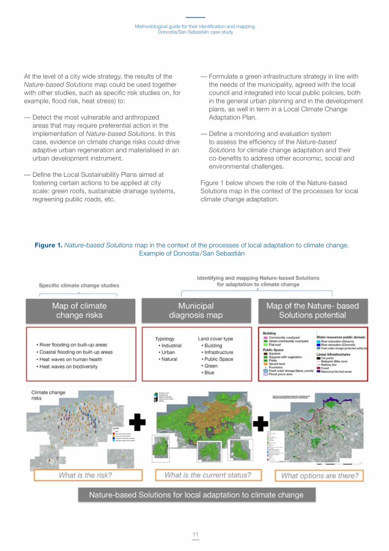
At the level of a city wide strategy, the results of the Nature-based Solutions map could be used together with other studies, such as specific risk studies on, for example, flood risk, heat stress) to:
— Detect the most vulnerable and anthropized areas that may require preferential action in the implementation of Nature-based Solutions. In this case, evidence on climate change risks could drive adaptive urban regeneration and materialised in an urban development instrument .
— Define the Local Sustainability Plans aimed at fostering certain actions to be applied at city scale: green roofs, sustainable drainage systems, regreening public roads, etc .
— Formulate a green infrastructure strategy in line with the needs of the municipality, agreed with the local council and integrated into local public policies, both in the general urban planning and in the development plans, as well in term in a Local Climate Change Adaptation Plan .
— Define a monitoring and evaluation system to assess the efficiency of the Nature-based Solutions for climate change adaptation and their co-benefits to address other economic, social and environmental challenges .
Figure 1 below shows the role of the Nature-based Solutions map in the context of the processes for local climate change adaptation .
Figure 1. Nature-based Solutions map in the context of the processes of local adaptation to climate change . Example of Donostia /San Sebastián

12
3.1. How this Guide is structuredThis Guide is structured in seven chapters .
— The first chapter (01 Introduction) introduces the concept of adaptation to climate change, at local level, based on ecosystems and nature and, in particular, the concept of Nature-based Solutions.
— The second chapter (02 Scope) sets out the objectives of the Guide, its approach, the target audience and briefly describes the possible exploitation of the results . The conceptual framework of nature-based adaptation is introduced and accompanied by a set of questions to be answered by the methodological sequence set out in Chapter —06 Methodology— What are the risks associated to climate change?, What is the current situation of the municipality in terms of land uses? and What options are there to adapt by means of Nature-based Solutions?
— The third chapter, (03 Recommendations for Using the Guide), aims to steer the municipalities of the Basque Country, which have to face the challenge of adaptation to climate change, in the application of this Guide by providing some keys and recommendation for use, according to their needs, resources and level of detail in which they want to go in this subject .
— The fourth chapter (04 Classification and
Characterisation of the Nature-based Solutions in the context of the Basque Country describes the Nature-based Solutions identified, classified and characterised according to their scale of implementation, the climate threats they are responding to and the economic, social and environmental co-benefits provided . Annex I includes factsheets for each Nature-based Solution .
— The fifth chapter (05 Identifying and mapping the Nature-based Solutions at different scales) sets out the information needs, data sources and available methods to produce inventories of the Nature-based Solutions and elements that can accommodate them locally .
— A sixth chapter (06 Methodology) sets out the work sequence for Nature-based Solutions to be considered in urban planning . It is a seven-phase methodological proposal, whose scope and content have to be in line with the type of municipality, their aspirations and the information and resources available .
— The seventh chapter (07 Case study: Climate Change Adaptation by means of Nature-based Solutions in Donostia/San Sebastián) includes a practical example of the application of the Guide .
Recommendations for using the Guide
03
Aspects to be considered for enhancing Natural Capital in climate change adaptation
13
— The Guide ends with a Glossary of basic climate change adaptation terms, with their most commonly accepted meanings and definitions by the scientific community .
As a companion tool to the Guide, Annex I includes factsheets for each of the Nature-based Solutions identified, summarising the information in Chapters 04 and 05, along with the guidelines to implement them .
3.2. Options for using this GuideThe Climate Change Adaptation process, just like any other planning process, can be taken to be a process in stages, which are implemented and enriched as a municipality acquires knowledge and embraces evidence with the potential to inform policy making .
A structure has been used in the Guide that is in line with the needs and characteristics of the different types of municipalities of the Basque Country, their aspirations, along with the availability of resources and information .
What is the way to embark on adapting climate change by means of Nature-based Solutions?A municipality that wants to embark on nature-based Climate Change Adaptation has to begin by:
— Familiarising itself with the Nature-based Solutions. It then needs to go to Chapter 04, followed by Annex I and consult the factsheets for each of the Nature-based Solutions selected in the context of the Basque Country .
— Analysing the information sources, data needs and the inventory methods to identify and map the Nature-based Solutions at local level set out in Chapter 05. It can therefore establish if it has the necessary information and resources to conduct this inventory .
Once the municipality has looked it into the Nature-based Solutions, how can it identify the adaptation potential?
A municipality that recognises climate threats, whether by using specific risk and vulnerability studies providing evidence of changes in climate parameters or by means of deliberate action to anticipate possible future changes, can opt to:
A) Delve further into a Nature-based Solution allowing the municipality to adapt to a specific threat . Each municipality may select the Nature-based Solutions from Chapter 04 that it considers most appropriate, according to its needs, possible policies underway, to the available information, etc . In this case, once the most appropriate Nature-based Solutions or Solution has been selected, the municipality should go directly to Chapter 05 and follow the guidelines to map them . For example, a municipality whose challenge is the risk of flooding due to supersaturation of the sewage and drainage systems , can analyse the potential of green roofs, to improve the management of rain water and surface runoff .
B) Analyse the global deployment potential of the Nature-based Solutions overall and define the strategies, plans and actions in order to integrate them in urban planning, as described in Chapter 06.
Two situations can occur, depending on the aspirations of each municipality, along with its resources and training readiness .
B.1) A municipality has the political commitment and interest, and has the desirable and necessary alphanumerical, spatial and cartography information and appropriate resources to implement the whole 7-phrase work sequence proposed in Chapter 06.
B.2) Conversely, if a municipality does not have the desirable or necessary resources or information or simply wishes to conduct an exploratory action, it may perform a Diagnostics of its Natural Capital, as indicated in Phase 5 of Chapter 6, based on the information on land use provided by the town planning and urban development plans, and the municipal thematic cartography, of the Provincial Councils or the Basque Government .
Nature-based solutions for local climate adaptation in the Basque Country
14
The information on land use and land cover is highly valuable and may act as the basis to initiate a nature-based adaptation process .
3.3. General Recommendations for use according to the type of municipality and its prevailing land use Given the diversity in terms of size and resources, prevailing types of land use and adaptation challenges, the casuistry of the municipalities of the Basque Country is unique and varied .
A series of generic recommendations regarding the application of the Guide is set out below, for different types of municipalities, districts or neighbourhoods within a single municipality, according to their land use and prevailing activities . Phase 4 of Chapter 06 describes the process to determine the typology of a municipality, district or neighbourhood .
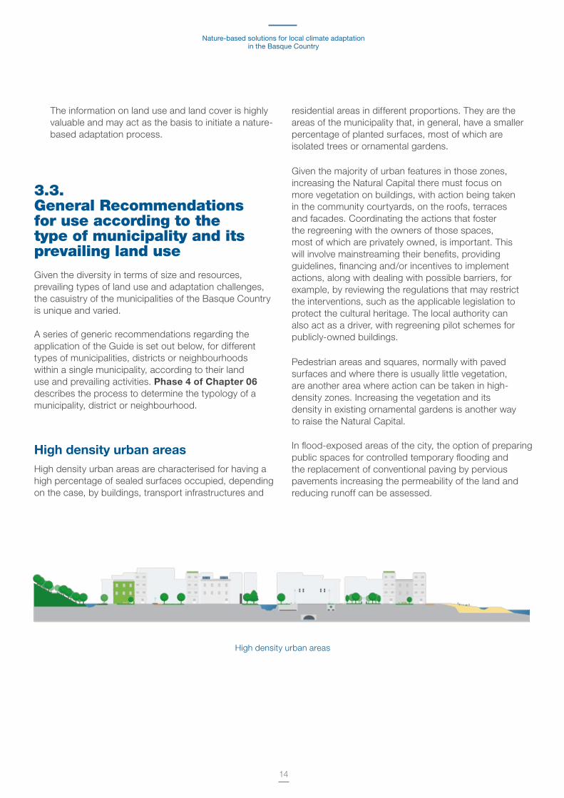
High density urban areasHigh density urban areas are characterised for having a high percentage of sealed surfaces occupied, depending on the case, by buildings, transport infrastructures and
residential areas in different proportions . They are the areas of the municipality that, in general, have a smaller percentage of planted surfaces, most of which are isolated trees or ornamental gardens .
Given the majority of urban features in those zones, increasing the Natural Capital there must focus on more vegetation on buildings, with action being taken in the community courtyards, on the roofs, terraces and facades . Coordinating the actions that foster the regreening with the owners of those spaces, most of which are privately owned, is important . This will involve mainstreaming their benefits, providing guidelines, financing and/or incentives to implement actions, along with dealing with possible barriers, for example, by reviewing the regulations that may restrict the interventions, such as the applicable legislation to protect the cultural heritage . The local authority can also act as a driver, with regreening pilot schemes for publicly-owned buildings .
Pedestrian areas and squares, normally with paved surfaces and where there is usually little vegetation, are another area where action can be taken in high-density zones . Increasing the vegetation and its density in existing ornamental gardens is another way to raise the Natural Capital .
In flood-exposed areas of the city, the option of preparing public spaces for controlled temporary flooding and the replacement of conventional paving by pervious pavements increasing the permeability of the land and reducing runoff can be assessed .
High density urban areas
Methodological guide for their identification and mapping.Donostia/San Sebastián case study
15
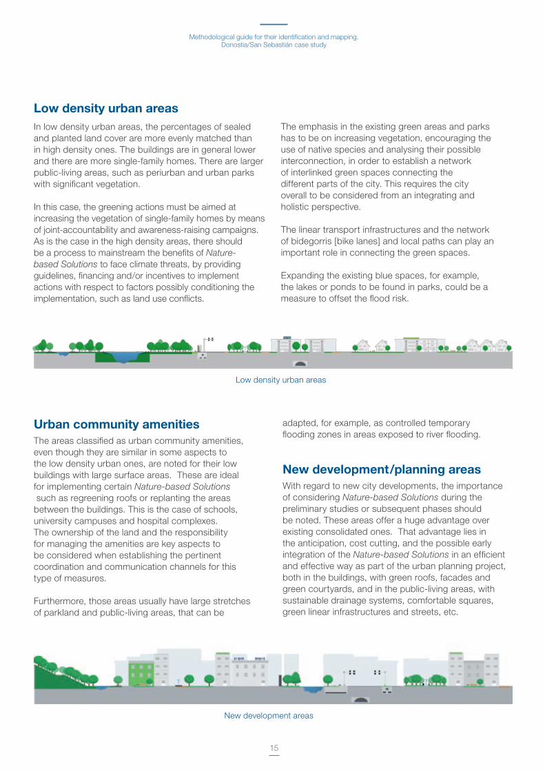
Low density urban areasIn low density urban areas, the percentages of sealed and planted land cover are more evenly matched than in high density ones . The buildings are in general lower and there are more single-family homes . There are larger public-living areas, such as periurban and urban parks with significant vegetation .
In this case, the greening actions must be aimed at increasing the vegetation of single-family homes by means of joint-accountability and awareness-raising campaigns . As is the case in the high density areas, there should be a process to mainstream the benefits of Nature-based Solutions to face climate threats, by providing guidelines, financing and/or incentives to implement actions with respect to factors possibly conditioning the implementation, such as land use conflicts .
The emphasis in the existing green areas and parks has to be on increasing vegetation, encouraging the use of native species and analysing their possible interconnection, in order to establish a network of interlinked green spaces connecting the different parts of the city . This requires the city overall to be considered from an integrating and holistic perspective .
The linear transport infrastructures and the network of bidegorris [bike lanes] and local paths can play an important role in connecting the green spaces .
Expanding the existing blue spaces, for example, the lakes or ponds to be found in parks, could be a measure to offset the flood risk .
Zonas de nuevos desarrollos
Low density urban areas
Urban community amenities The areas classified as urban community amenities, even though they are similar in some aspects to the low density urban ones, are noted for their low buildings with large surface areas . These are ideal for implementing certain Nature-based Solutions such as regreening roofs or replanting the areas between the buildings . This is the case of schools, university campuses and hospital complexes . The ownership of the land and the responsibility for managing the amenities are key aspects to be considered when establishing the pertinent coordination and communication channels for this type of measures .
Furthermore, those areas usually have large stretches of parkland and public-living areas, that can be
adapted, for example, as controlled temporary flooding zones in areas exposed to river flooding .
New development/planning areas With regard to new city developments, the importance of considering Nature-based Solutions during the preliminary studies or subsequent phases should be noted . These areas offer a huge advantage over existing consolidated ones . That advantage lies in the anticipation, cost cutting, and the possible early integration of the Nature-based Solutions in an efficient and effective way as part of the urban planning project, both in the buildings, with green roofs, facades and green courtyards, and in the public-living areas, with sustainable drainage systems, comfortable squares, green linear infrastructures and streets, etc .
New development areas

Nature-based solutions for local climate adaptation in the Basque Country
16
Rural areasThe characteristics and functionality of rural areas are different to urban ones and they account for a large surface area in many of the municipalities of the Basque Country . The rural areas have significant Natural Capital in the form of forests, protected areas and productive rural land . In this case, the actions, with regard to the existing Natural Capital, involve improving the status and management of the existing Nature-based Solutions, along with fostering their connectivity and accessibility . A significant part of the sealed surfaces in rural areas is occupied by transport linear infrastructures . Therefore, they offer a huge regreening potential as they can also
become linear parks or corridors to connect the more isolated green areas .
The most important policy here is the correct management of forest and farming land, with more responsible practices leading to the sustainable management of the resources, encouraging native biodiversity and the production of local products and food . In particular, as regards climate change adaptation, an increase of the water harvesting surfaces may minimise flooding risks downstream, where the water courses are generally more anthropized and have been channelled .
Industrial areasLIndustrial areas, usually located on the outskirts, can be considered as hinge, buffer or barrier peri-ubran areas between the rural and the more consolidated urban areas . In those areas, up to 50% of the total surface area of the non-sealed zone can be built on . Their characteristics include a sealed surface area generally occupied by high capacity linear transport infrastructures, i .e ., roads, motorways and railways and road traffic zones as car parks .
Industrial areas have large surface areas used as car parks for factories and shopping centres, with
potential to increase their permeability by means of pervious pavements .
Furthermore, these areas have commercial or industrial buildings that typically have flat roofs meaning a large total area with significant greening potential . In the same way as in the previous cases, establishing the pertinent communication channels when the urban feature is privately owned (technology parks, industrial associations, etc .), along with the appropriate motivations and incentives to foster the implementation of Nature-based Solutions, will be critical .
Industrial areas
Rural areas

Methodological guide for their identification and mapping.Donostia/San Sebastián case study
17
Coastal zonesThe coastline is an important asset for many municipalities of the Basque Country . In some cases, the beach and coastal zones are in more natural settings and, in other cases, they are fully integrated in the urban fabric . It can be argued that the latter are under the greatest immediate threat due to the impacts of climate change .
There are different Nature-based solutions that can be implemented along the coast, measures that are always aimed at preventing, mitigating or adapting the receding coastlines due to the rising sea level, along with the wave-related impacts .
Blue solutionsThe recommendations so far have focused on increasing vegetation in parts of the prevailing existing urban fabric according to the different types of municipalities, districts or neighbourhoods .
The role of blue solutions, i .e . Nature-based Solutions associated with water bodies and courses and which play a crucial role in climate change adaptation, should not be overlooked .
The urban features that can accommodate or be transformed into blue Nature-based Solutions, such as rivers, streams, lakes, ponds, wetlands, etc ., will be at different points of the municipality regardless of the typology . Analysing the potential to increase the renaturing of water courses and/or water storage areas, etc . must be considered as an asset to increase the Natural Capital of the municipality and as climate change adaptation measures .
Coastal zones
18
The introduction explains that there is no unequivocal and clear definition of what Nature-based Solutions are considered to be .
There is likewise no unequivocal, single standard identification and means of classification . Depending on the case, Nature-based Solutions are classified according to where they are implemented, based on the benefits they provide, to the threats of climate change to which they contribute, etc .
Given the lack of standard criteria, and taking into account the climate change adaptation context in the nature-based planning, which is addressed in this Guide, it has been considered appropriate to classify the Nature-based Solutions according to the scale of intervention and to characterise them on the basis of the climate threats to which they contribute, of the economic, social and environmental benefits and based on implementation criteria . The classification and characterisation criteria are set out in this chapter .
Classification and Characterisation of the Nature-based Solutions in the context of the Basque Country
04
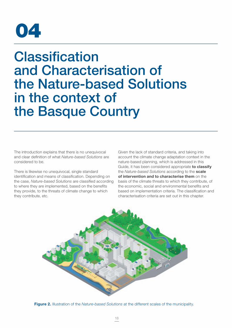
Figure 2. Illustration of the Nature-based Solutions at the different scales of the municipality .

19
Building-scale interventions
Stakeholders involved in their installation and maintenance: equipo de arquitectura, comunidades de propietarios, empresas de mantenimiento de instalaciones de edificaciones .
Process in which to consider it: refurbishing of pre-existing buildings, design of new buildings .
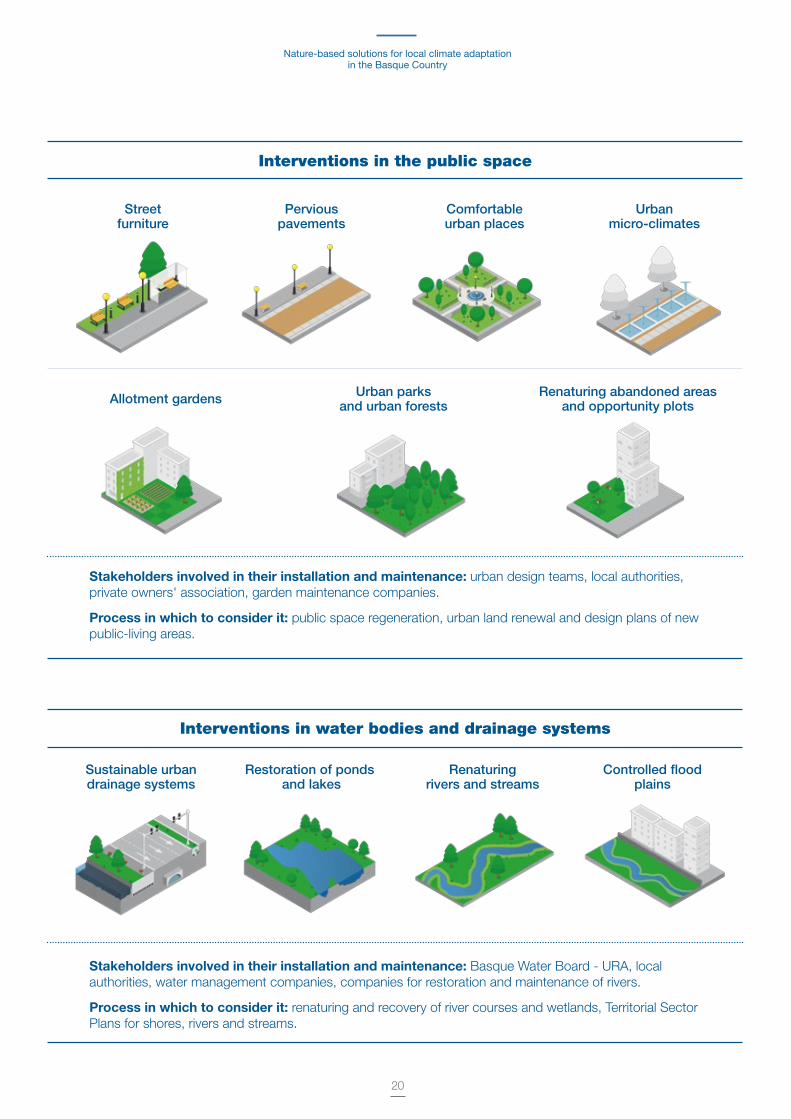
4.1. Classification of 'Nature-based Solutions'Nature-based Solutions have been classified according to the scale or scope of the intervention, at six levels:
— Building. Actions on rooftops, facades and community spaces of the buildings
— Public spaces. Actions in public-living areas, urban parks and other urban features of the public space .
— Water bodies and drainage systems.
— Linear transport infrastructures. Naturing actions for both high capacity (i .e . roads, railways, etc .) and streets .
— Natural areas and management of rural land. Actions to conserve and restore natural eco-systems and managing the rural land .
— Coastline/coast.
Green roofs: designing and fitting out the roofs of buildings
Green roofs (vegetation) In-height orchards Fresh rooftops Rainwater harvesting
Green facades Naturing community-use spaces
Green facades and vertical gardens
Actions in community courtyards
Regreening spaces between buildings
Nature-based solutions for local climate adaptation in the Basque Country
20
Stakeholders involved in their installation and maintenance: urban design teams, local authorities, private owners' association, garden maintenance companies .
Process in which to consider it: public space regeneration, urban land renewal and design plans of new public-living areas .
Interventions in the public space
Streetfurniture
Perviouspavements
Comfortableurban places
Urbanmicro-climates
Allotment gardens Urban parks and urban forests
Renaturing abandoned areasand opportunity plots
Stakeholders involved in their installation and maintenance: Basque Water Board - URA, local authorities, water management companies, companies for restoration and maintenance of rivers .
Process in which to consider it: renaturing and recovery of river courses and wetlands, Territorial Sector Plans for shores, rivers and streams .
Interventions in water bodies and drainage systems
Sustainable urbandrainage systems
Restoration of ponds and lakes
Renaturingrivers and streams
Controlled floodplains
Methodological guide for their identification and mapping.Donostia/San Sebastián case study
21
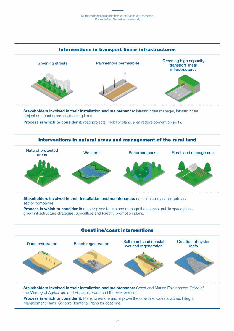
Stakeholders involved in their installation and maintenance: Coast and Marine Environment Office of the Ministry of Agriculture and Fisheries, Food and the Environment .
Process in which to consider it: Plans to restore and improve the coastline . Coastal Zones Integral Management Plans . Sectoral Territorial Plans for coastline .
Coastline/coast interventions
Dune restoration Beach regeneration Salt marsh and coastalwetland regeneration
Creation of oysterreefs
Stakeholders involved in their installation and maintenance: infrastructure manager, infrastructure project companies and engineering firms .
Process in which to consider it: road projects, mobility plans, area redevelopment projects .
Interventions in transport linear infrastructures
Greening streets Pavimentos permeablesGreening high capacity
transport linearinfrastructures
Stakeholders involved in their installation and maintenance: natural area manager, primary sector companies .Process in which to consider it: master plans to use and manage the spaces, public space plans, green infrastructure strategies, agriculture and forestry promotion plans .
Interventions in natural areas and management of the rural land
Natural protectedareas Wetlands Periurban parks Rural land management
Nature-based solutions for local climate adaptation in the Basque Country
22
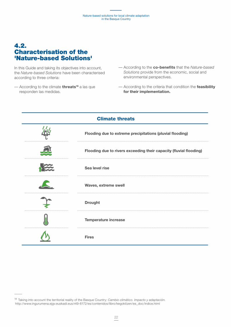
4.2. Characterisation of the 'Nature-based Solutions' In this Guide and taking its objectives into account, the Nature-based Solutions have been characterised according to three criteria:
— According to the climate threats18 a las que responden las medidas .
18 Taking into account the territorial reality of the Basque Country: Cambio climático. Impacto y adaptación. http://www .ingurumena .ejgv .euskadi .eus/r49-6172/es/contenidos/libro/kegokitzen/es_doc/indice .html
— According to the co-benefits that the Nature-based Solutions provide from the economic, social and environmental perspectives .
— According to the criteria that condition the feasibility for their implementation.
Climate threats
Flooding due to extreme precipitations (pluvial flooding)
Flooding due to rivers exceeding their capacity (fluvial flooding)
Sea level rise
Waves, extreme swell
Drought
Temperature increase
Fires

Methodological guide for their identification and mapping.Donostia/San Sebastián case study
23
Health and Quality of life19
19 Respiratory diseases, epidemics and other diseases related to a sedentary lifestyle: cardiovascular, colon and lung cancer, mental health and social problems .
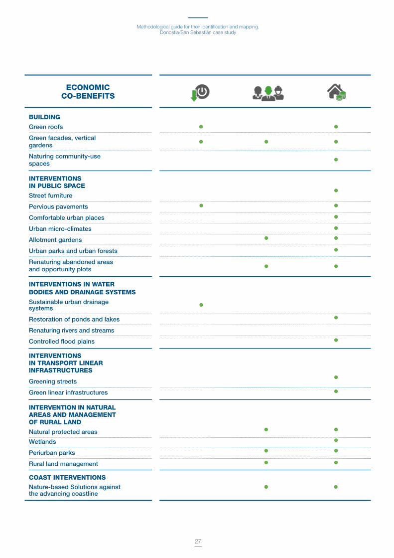
Co-benefits of the 'Nature-based Solutions'
Environmental
Regulation of the water cycle
Improvement of the water quality
Improvement of the soil quality, stability and erosion
Improvement of the air quality
Improvement of the noise quality and comfort
Biodiversity
Carbon storage
Recreation and environmental education Enhancing the space for social gathering
Regeneration of degraded areas and potential for reducing criminality
Improving the connectivity of urban spaces
Reducing energy consumption
Improvement of local employment
Increasing the value of land and property
Social
Economic
Initial investment
Maintenance requirements
Ownership of the land (public/private) and/or regulatory
Implementation criteria

Nature-based solutions for local climate adaptation in the Basque Country
24
CLIMATE THREATS
1
1
1
1
1
1
1
1
1 11 1 1 1
1 1
1
1
1
1
1
1
1
1 1
1
1
1
1
1
1
1
1 1
1 1 1
1
3
3
33
3
3
3
3
3 3
3
3
3 3
3
3
3 3
3
3 3
2
2
2
2
2 2
2
2
2 22 22 2
2
2
2 2
2 2
2
2
2
2
2
2
2
2
2
Each of the Nature-based Solutions are characterised in the following tables, according to the aforementioned criteria .
The table shows how each Nature-based Solution contributes to reducing the effects of the climate
threats dentified in the Basque Country . The intensity of this contribution is shown on a scale of:
3
Medium High
2
Very high
1
BUILDINGSGreen roofsGreen facades, vertical gardensNaturing community-use spaces
INTERVENTIONS IN PUBLIC SPACEStreet furniturePervious pavementsComfortable urban placesUrban micro-climatesAllotment gardensUrban parks and urban forestsRenaturing abandoned areas and opportunity plots
INTERVENTIONS IN WATER BODIES AND DRAINAGE SYSTEMSSustainable urban drainage systemsRestoration of ponds and lakesRenaturing rivers and streamsControlled flood plains
INTERVENTIONS IN TRANSPORT LINEAR INFRASTRUCTURESGreening streetsGreen linear infrastructures
INTERVENTION IN NATURAL AREAS AND MANAGEMENT OF RURAL LANDNatural protected areasWetlandsPeriurban parksRural land management
COAST INTERVENTIONSNature-based Solutions against the advancing coastline

Methodological guide for their identification and mapping.Donostia/San Sebastián case study
25
BUILDING
Green roofs
Green facades, vertical gardens
Naturing community-use spaces
INTERVENTIONS IN PUBLIC SPACE
Street furniture
Pervious pavements
Comfortable urban places
Urban micro-climates
Allotment gardens
Urban parks and urban forests
Renaturing abandoned areas and opportunity plots
INTERVENTIONS IN WATER BODIES AND DRAINAGE SYSTEMS
Sustainable urban drainage systems
Restoration of ponds and lakes
Renaturing rivers and streams
Controlled flood plains
INTERVENTIONS IN TRANSPORT LINEAR INFRASTRUCTURES
Greening streets
Green linear infrastructures
INTERVENTION IN NATURAL AREAS AND MANAGEMENT OF RURAL LAND
Natural protected areas
Wetlands
Periurban parks
Rural land management
COAST INTERVENTIONSNature-based Solutions against the advancing coastline
ENVIRONMENTAL CO-BENEFITS
Nature-based solutions for local climate adaptation in the Basque Country
26
SOCIAL CO-BENEFITS
BUILDING
Green roofs
Green facades, vertical gardens
Naturing community-use spaces
INTERVENTIONS IN PUBLIC SPACE
Street furniture
Pervious pavements
Comfortable urban places
Urban micro-climates
Allotment gardens
Urban parks and urban forests
Renaturing abandoned areas and opportunity plots
INTERVENTIONS IN WATER BODIES AND DRAINAGE SYSTEMS
Sustainable urban drainage systems
Restoration of ponds and lakes
Renaturing rivers and streams
Controlled flood plains
INTERVENTIONS IN TRANSPORT LINEAR INFRASTRUCTURES
Greening streets
Green linear infrastructures
INTERVENTION IN NATURAL AREAS AND MANAGEMENT OF RURAL LAND
Natural protected areas
Wetlands
Periurban parks
Rural land management
COAST INTERVENTIONS
Nature-based Solutions against the advancing coastline
Methodological guide for their identification and mapping.Donostia/San Sebastián case study
27
ECONOMIC CO-BENEFITS
BUILDING
Green roofs
Green facades, vertical gardens
Naturing community-use spaces
INTERVENTIONS IN PUBLIC SPACE
Street furniture
Pervious pavements
Comfortable urban places
Urban micro-climates
Allotment gardens
Urban parks and urban forests
Renaturing abandoned areas and opportunity plots
INTERVENTIONS IN WATER BODIES AND DRAINAGE SYSTEMS
Sustainable urban drainage systems
Restoration of ponds and lakes
Renaturing rivers and streams
Controlled flood plains
INTERVENTIONS IN TRANSPORT LINEAR INFRASTRUCTURES
Greening streets
Green linear infrastructures
INTERVENTION IN NATURAL AREAS AND MANAGEMENT OF RURAL LAND
Natural protected areas
Wetlands
Periurban parks
Rural land management
COAST INTERVENTIONS
Nature-based Solutions against the advancing coastline

Nature-based solutions for local climate adaptation in the Basque Country
28
A factsheet with the following information for each of the Nature-based Solutions has been prepared and is included in Annex I .
Scale of intervention
NAME OF THE NATURE-BASED SOLUTION
Implementation requirementsReference is made to the technical or other types of requirements, whether legislative, institutional, coordination, etc ., that must be met for the intervention to be successfully implemented .
Implementation conditioning factorsThose possible factors or conditioning factors that may, in some way, negatively impact the successful implementation of the intervention . For example, land use conflicts .
Information availability/Possible data sources
Desirable option:The most optimum information or data source considered to be for priority use or consultation .
Alternativa:In the absence of optimum or desirable information, reference is made here to possible alternatives that may be used to conduct the study .
Inventory methodThis section provides a brief description of the possible methods to carry out an inventory of the solution in question .
ReferencesA reference to a best practice in the Basque Country is included .
The figure indicates to what degree (low, medium or high) the solution contributes to reducing the threat .
Information of interest
Short description of the solution and how it is contributing to climate change adaptation at local level .
Photo. Image that illustrates a representative case in the context of the Basque Country.
Climate threats
Co-benefits

29
This chapter of the guide sets out the information needed to conduct an inventory of the Nature-based Solutions described in Chapter 04 on the envisaged intervention scales: building, public space, water bodies and drainage systems, transport and linear infrastructures, natural areas and management of rural land and the coast .
Establishing the capacity of a municipality to accommodate this type of solutions consists of identifying which ones are available in the municipality and enhancing them, which need to be modified or restored, which new areas could accommodate these solutions and, in the framework of this guide, what is the climate adaptation potential by means of Nature-based Solutions.
The mapping of Nature-based Solutions in the urban sphere consists of identifying the existing urban features20 with capacity to accommodate, or become, this type of solutions, for example: community courtyards that could be replanted, flat roofs which can be used as allotments or green roofs, sealed squares with the ability to be regreened, wasteland to be used as allotments, watercourses that may be enlarged to increase their capacity, streams and channels that can be regreened, etc .
20 Urban features taken to mean any feature available in the municipality which is likely to become or accommodate Nature-based Solutions . For example, flat roofs, squares, roads, that can be regreened .
Therefore, this chapter sets out, for each of the defined Nature-based Solutions, on the one hand, the possible information sources available to identify urban features that accommodate them or have capacity to accommodate them, and, on the other hand, guidelines for the information processing to quantify them .
The information sources are multiple and the complexity to obtain data may vary depending on the Nature-based Solution in question .
This guide seeks to set out the methodology to address the mapping of Nature-based Solutions and their consideration in urban planning for climate change adaptation .
For example, a simple way of identifying roof greening potential may involve a visual inspection using orthophotos or visualization software based on satellite photos . Even though this identification method is simple and accessible to any municipality given the availability of data, it may be inaccurate and highly tedious, particularly in the case of large municipalities . An important challenge is the need to categorise, catalogue and characterise the resources and capacities available in each municipality .
05Identifying and mapping 'Nature-based Solutions' at different scales
Nature-based solutions for local climate adaptation in the Basque Country
30
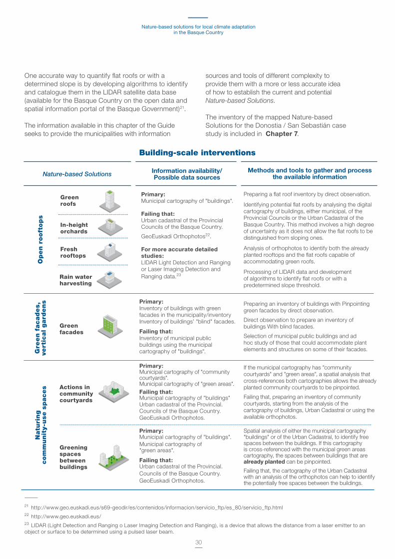
One accurate way to quantify flat roofs or with a determined slope is by developing algorithms to identify and catalogue them in the LIDAR satellite data base (available for the Basque Country on the open data and spatial information portal of the Basque Government)21 .
The information available in this chapter of the Guide seeks to provide the municipalities with information
21 http://www .geo .euskadi .eus/s69-geodir/es/contenidos/informacion/servicio_ftp/es_80/servicio_ftp .html22 http://www .geo .euskadi .eus/23 LIDAR (Light Detection and Ranging o Laser Imaging Detection and Ranging), is a device that allows the distance from a laser emitter to an object or surface to be determined using a pulsed laser beam .
sources and tools of different complexity to provide them with a more or less accurate idea of how to establish the current and potential Nature-based Solutions . The inventory of the mapped Nature-based Solutions for the Donostia / San Sebastián case study is included in Chapter 7 .
Primary:Municipal cartography of "buildings" .
Failing that:Urban cadastral of the Provincial Councils of the Basque Country .
GeoEuskadi Orthophotos22 .
For more accurate detailed studies:LIDAR Light Detection and Ranging or Laser Imaging Detection and Ranging data .23
Gre
en f
acad
es,
vert
ical
gard
en
sN
atu
rin
g
com
mu
nit
y-u
se s
paces
Primary:Inventory of buildings with greenfacades in the municipality/inventoryInventory of buildings’ "blind" facades .
Failing that:Inventory of municipal public buildings using the municipalcartography of "buildings" .
Primary:Municipal cartography of "community courtyards" . Municipal cartography of "green areas" .Failing that:Municipal cartography of "buildings"Urban cadastral of the Provincial .Councils of the Basque Country .GeoEuskadi Orthophotos .
Primary:Municipal cartography of "buildings" .Municipal cartography of "green areas" .
Failing that:Urban cadastral of the Provincial .Councils of the Basque Country .GeoEuskadi Orthophotos .
Preparing a flat roof inventory by direct observation .
Identifying potential flat roofs by analysing the digital cartography of buildings, either municipal, of the Provincial Councils or the Urban Cadastral of the Basque Country . This method involves a high degree of uncertainty as it does not allow the flat roofs to be distinguished from sloping ones .
Analysis of orthophotos to identify both the already planted rooftops and the flat roofs capable of accommodating green roofs .
Processing of LIDAR data and development of algorithms to identify flat roofs or with a predetermined slope threshold .
Preparing an inventory of buildings with Pinpointing green facades by direct observation .
Direct observation to prepare an inventory of buildings With blind facades .
Selection of municipal public buildings and ad hoc study of those that could accommodate plant elements and structures on some of their facades .
If the municipal cartography has "community courtyards" and "green areas", a spatial analysis that cross-references both cartographies allows the already planted community courtyards to be pinpointed .
Failing that, preparing an inventory of community courtyards, starting from the analysis of the cartography of buildings, Urban Cadastral or using the available orthophotos .
Spatial analysis of either the municipal cartography "buildings" or of the Urban Cadastral, to identify free spaces between the buildings . If this cartography is cross-referenced with the municipal green areas cartography, the spaces between buildings that are already planted can be pinpointed .
Failing that, the cartography of the Urban Cadastral with an analysis of the orthophotos can help to identify the potentially free spaces between the buildings .
Greenroofs
In-height orchards
Fresh rooftops
Rain water harvesting
Greenfacades
Actions in communitycourtyards
Building-scale interventions
Methods and tools to gather and process the available informationNature-based Solutions
Greeningspaces betweenbuildings
Information availability/ Possible data sources
Op
en r
ooft
op
s

Methodological guide for their identification and mapping.Donostia/San Sebastián case study
31
Primary:Municipal cartography of street furniture (benches, canopies, planters) .
Failing that:GeoEuskadi Orthophotos .
Quantifying and locating the street furniture elements existing in the municipality and study of their possible replacement .
Street furniture
Primary:Municipal cartography of "pavements" . Municipal cartography of "surface car parks" .Municipal cartography of "underground car parks" .
Failing that:GeoEuskadi Orthophotos .
Spatial analysis using the available cartography of "surface car parks" as possible areas in which to implement porous, pervious surfaces . In any event, this spatial analysis requires visual correction of the orthophoto .
The "underground car park" cartography will also allow those zones to be identified where the creation of pervious surfaces is not recommendable/possible .
Pervious pavements
Primary:Town and city planning, Master Plan (PGOU) - public-living areas" .Municipal cartography of "squares", "playgrounds" and "landscaped areas" .Municipal cartography of "green areas" and "landscaped areas" .Municipal cartography of "underground car parks" .
Failing that:GeoEuskadi Orthophotos .
Spatial analysis, using the available cartography of "public-living areas", "squares", "playgrounds" to quantify the potential available space for the intervention and design of comfortable squares and urban areas .
This cartography needs to be cross-referenced with the "green areas" and "landscaped areas" cartography in order to pinpoint the already planted area .
If that cartography is not available, an analysis of the orthophotos will allow the public-living areas to be identified that potentially could be designed using sustainability and comfort criteria .
Comfortable urban places
Primary:Municipal cartography of "fountains" and "ponds" .GeoEuskadi Orthophotos .
Inventory of "public fountains" and "ponds" using direct observation .
If municipal cartography of "fountains" and "ponds" exists, the inventory will be performed using a spatial analysis . This analysis may require visual adjustment using orthophotos .
Urban micro-climates
Primary:Municipal cartography of "urban vegetable gardens/orchards" .Inventory of potentially contaminated soil of the Basque Country .
Failing that:GeoEuskadi Orthophotos .
Inventory of urban vegetable gardens/orchards using the available municipal cartography and, failing that, using orthophotos .The following sequence will be deployed to identify possible areas to create future urban vegetable gardens:— Pre-selection of publicly-owned sites, in accordance
with accessibility criteria and availability of services (water and light) .
— Consultation of the potentially contaminated soil inventory to detect those sites not suitable for agricultural production .
Allotment gardens
Primary:Town and city planning, Master Plan (PGOU) .Municipal cartography of "open areas" . Municipal cartography of "urban forests" . Municipal cartography of "parks" .
Failing that:GeoEuskadi Orthophotos .
Preparation of an urban forests and park inventory using spatial analysis of the municipal "open areas", "urban forests" and "parks" cartography . This analysis may require visual adjustment using orthophotos .
Urban parks and urban forests
Primary:Town and city planning, Master Plan (PGOU) .GeoEuskadi Orthophotos .
Identification of wasteland and vacant areas or in disuse either using the Town and city planning, Master Plan (PGOU), by direct observation or orthophotos . In any event, this identification has to be validated using municipal urban planning technicians, along with possible specialist studies in that regard, as applicable .
Renaturing abandoned areas and opportunity plots
Intervention in the public space
Methods and tools to gather and process the available information
Nature-based Solutions
Information availability/ Possible data sources

Nature-based solutions for local climate adaptation in the Basque Country
32
Primary:Town and city planning, Master Plan (PGOU) .Cartography of the municipal sanitation and sewage network .
Failing that:Detailed-scale Digital Elevation Model (DEM) of the municipality .
Spatial analysis using the cartography of the municipal sanitation and sewage network .
Detecting possible network saturation hot points and areas that need greater relief as priority areas where to implement a sustainable urban drainage systems that foster better operating of the network .
A microbasin study using the detailed scale municipal DEM will allow those hot points to be pinpointed more precisely .
Sustainable urban drainage systems
Primary:Town and city planning, Master Plan (PGOU) - street map .Municipal cartography of "pedestrian streets" and "bidegorris" (bike lanes) . Municipal cartography of "trees" and "flowerbeds" .
Failing that:GeoEuskadi Orthophotos .
Primary:Municipal cartography of "road traffic areas" .
Failing that:GeoEuskadi Orthophotos .
Primary:Town and city planning, Master Plan (PGOU) - roads and railways Road networks of the Provincial Councils .GeoEuskadi Orthophotos .
Spatial analysis to identify "pedestrian areas" and "bidegorris" using the available municipal cartography .
The information will be cross-referenced with the "trees" and "flowerbeds" cartography to pinpoint those already planted streets
This analysis may require visual adjustment using orthophotos .
Spatial analysis using the available cartography of "road traffic areas" as possible areas in which to implement porous, pervious surfaces . In any event, this spatial analysis requires visual correction of the orthophoto and consultation with municipal technicians of the traffic and mobility department to pinpoint those areas in which it is not possible to implement the measures due to technical barriers .
Spatial analysis to identify high capacity transport infrastructure sections that may accommodate renaturing green interventions using the available cartography .This analysis may require visual adjustment using orthophotos .
Naturing of streets
Naturing of high capacity transport linear infrastruc- tures
Primary:Town and city planning, Master Plan (PGOU) .Municipal cartography of "water bodies", showing lakes and ponds .GeoEuskadi Orthophotos .
Inventory of water bodies corresponding to lakes and ponds using the available municipal cartography .
Failing that, identification of those bodies using orthophotos .
Restoration of ponds and lakes
Primary:Town and city planning, Master Plan (PGOU) .Municipal cartography of "water bodies", showing surface and underground urban rivers, canals, streams and gutters .Basque Government's cartography of the water network .
Inventory of water bodies of surface and underground urban rivers, canals, streams and gutters, either using municipal cartography or the Basque Government's cartography of the water network .
Consultation with URA to pinpoint those sections with a greater risk of flooding, whose restoration and renaturing may help to improve the water cycle of the municipality and the reduction of the food spot .
Renaturing riversand streams
Primary:Hazard and risk maps of the areas with potential significant flood risk (APSFR) of the Basque Country (URA) .
Spatial analysis to identify flood spots in a return period of 500 years or less using the hazard and risk cartography of the areas with potential significant flood risk (APSFR) of the Basque Country .
Controlled flood plains
Interventions in water bodies and drainage systems
Pervious paving
Interventions in transport linear infrastructures
Methods and tools to gather and process the available information
Methods and tools to gather and process the available information
Nature-based Solutions
Nature-based Solutions
Information availability/ Possible data sources
Information availability/ Possible data sources
Methodological guide for their identification and mapping.Donostia/San Sebastián case study
33
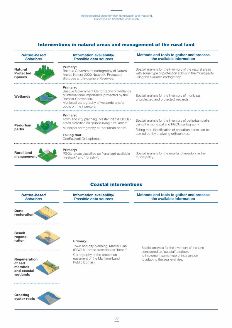
Primary:Basque Government cartography of Natural Areas, Natura 2000 Network, Protected Biotopes and Biosphere Reserves .
Primary:Town and city planning, Master Plan (PGOU) - areas classified as "beach" .
Cartography of the protection easement of the Maritime-Land Public Domain .
Spatial analysis for the inventory of the natural areas with some type of protection status in the municipality using the available cartography .
Spatial analysis for the inventory of the landconsidered as "coastal" available to implement some type of interventionto adapt to the sea level rise .
Natural ProtectedSpaces
Dune restoration
Primary:Basque Government Cartography of Wetlands of International Importance protected by the Ramsar Convention .Municipal cartography of wetlands and/or pools on the inventory .
Spatial analysis for the inventory of municipal unprotected and protected wetlands .
Wetlands
Beach regene- ration
Primary:Town and city planning, Master Plan (PGOU) - areas classified as "public-living rural areas"
Municipal cartography of "periurban parks" .
Failing that:GeoEuskadi Orthophotos .
Primary:PGOU-areas classified as "rural agri-available livestock" and "forestry" .
Spatial analysis for the inventory of periurban parks using the municipal and PGOU cartography .
Failing that, identification of periurban parks can be carried out by analysing orthophotos .
Spatial analysis for the rural land inventory in the municipality .
Periurban parks
Rural land management
Creating oyster reefs
Interventions in natural areas and management of the rural land
Coastal interventions
Regeneration of salt marshes and coastal wetlands
Methods and tools to gather and process the available information
Methods and tools to gather and process the available information
Nature-based Solutions
Nature-based Solutions
Information availability/ Possible data sources
Information availability/ Possible data sources

34
Chapter 05 provided recommendations to identify and map each of the Nature-based Solutions identified at the different scales .
In this Chapter, the goal is broader and the methodology outlined seeks to provide the municipalities with guidelines, not only to produce inventories of different Nature-based Solutions, as described in Chapter 05, but also a comprehensive methodological process that helps to define municipal strategies, define targets, prioritise interventions, in short, to address all the steps to implement a nature-based adaptation strategy .
The methodological sequence set out below seeks to be a response to the approach of the role of nature in climate change adaptation that is set out in Chapter 02 and which is illustrated in Figure 1 . In order to establish how the Nature-based Solutions can help a municipality on the adaptation path, it should first be established what climate change risks or threats are being faced and what the characteristics of the municipalities are, along with their baseline in order to be able to implement this type of solutions .
Such questions are: What is the risk? What is the current status of the municipality? and What adaptation options are there using Nature-based Solutions?
This chapter sets out a proposed work sequence which is in response to this question sequence, and which allows the Nature-based Solutions to be incorporated in the municipalities as part of an integral strategy and as an aspect to be considered in urban planning .
This work sequence has been applied in the municipality of Donostia/San Sebastián and the results and conclusions are set out in Chapter 07.
As has been previously discussed, the Nature-based Solutions can be addressed individually, meaning that a municipality can opt to implement this type of solutions in small interventions .
The developed methodology consists of a work sequence in seven main phases whose scope and content may be adapted to the type of municipality, its aspirations and the availability of resources and information . The methodology sequence is shown graphically in Figure 3 .
Methodology
06
Work sequence for Nature-based Solutions to be considered in urban planning

35
Figure 3. Work sequence to identify and map Nature-based Solutions at local level

Nature-based solutions for local climate adaptation in the Basque Country
36
The process must start by defining the objectives of the study and which will condition the level of aggregation of the analysis . These two phases are related and interdependent .
The second phase is the gathering the information available and its processing to achieve the objectives set . It is spatial information on the zoning, spatial distribution, classification of land use and urban features that will be used in each of the phases raised .
The fourth phase in the methodological sequence is dedicated to characterising the analysis units according to their typology . It can be based on the already established municipal criteria or according to the predominant land use in the Town and city planning or Master Plan . This characterisation is recommended as the Nature-based Solutions to be implemented will be different, for example, in urban areas and in rural areas . In the framework of this Guide, the classification performed is as follows: rural, industrial, high density urban, low density urban, urban community amenities and approach to planning areas to be developed/new developments . This classification is in line with a characteristic urban morphology with the capacity to accommodate different Nature-based Solutions.
Once the analysis units have been characterised, the fifth phase of the proposed methodology is the diagnosis of the potential and current Natural Capital based on the land cover in the analysis units . This phase consists of quantifying the land cover of the different analysis units into: building on sealed surface, transport infrastructures and public-living areas and not sealed by plants and by water bodies . This phase will establish what the municipality's baseline is regarding Natural Capital, compare the baseline status to the different areas of the municipality and establish intervention priorities .
The six phases are the cornerstone of the proposed methodology and consists of analysing the municipal capacity to deploy new Nature-based Solutions. This analysis implies identifying and quantifying aspects of the urban fabric able to accommodate Nature-based Solutions both at building and public space levels and at the municipal scale, based on the proposed information and data processing methods established in Chapter 05.
A final phase selects and prioritises the Nature-based Solutions for their implementation . The measures will be selected according to the adaptation needs, prior to which the climate change threats and vulnerability
of the municipality should be established . It is likewise important to identify and analyse possible determining factors to implement the measures that may be the effectiveness of the solutions by means of modelling, whether the spaces are public or privately owned, possible legal or regulatory implementation restrictions, economic requirements, etc .
Phase 1. Defining objectivesThe baseline is to define what the objective is of the study on the Natural Capital and the Nature-based Solutions of the municipality .
As discussed in Chapter 04, there are multiple benefits obtained from implementing Nature-based Solutions in the cities, and therefore the driving factors for a municipality to embark on the process to discover its Natural Capital and its Nature-based Solutions potential may be diverse . Some specific objectives that may act as a guide are as follows:
Objetivos generales— To define a nature-based strategy as a means of
adaptation to the effects of climate change .
— To increase the Natural Capital of the city to improve the comfort and the quality of life of the inhabitants of the municipality .
— To have information to integrate Nature-based Solutions in urban planning processes .
Objetivos específicos The direct objectives that can be obtained from applying this guide to the Donostia/San Sebastián case studied are as follows:
— To establish the baseline regarding the Natural Capital and define the generic intervention targets . The outcome of this objective is to establish the sealed surface ratios with respect to the unsealed of municipality and of its respective analysis units .
— To establish intervention priorities in the municipality, by comparing the current status of the different analysis units of the municipality, of the same urban typology .
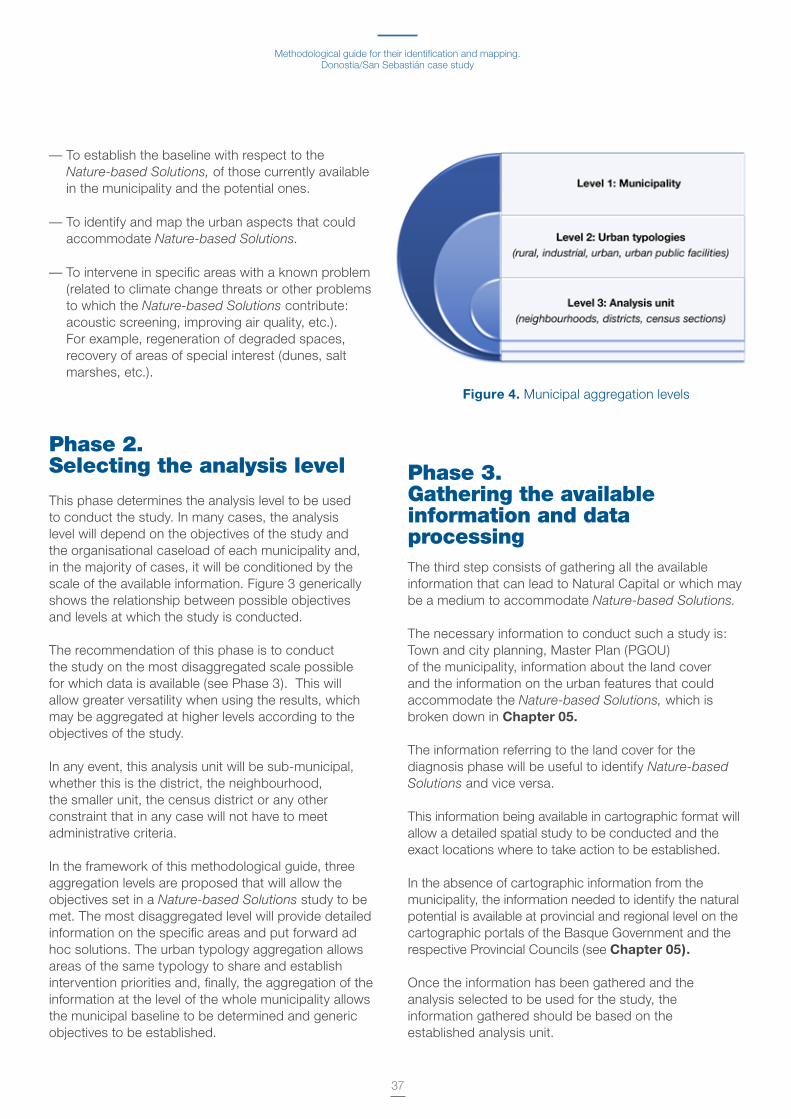
Methodological guide for their identification and mapping.Donostia/San Sebastián case study
37
— To establish the baseline with respect to the Nature-based Solutions, of those currently available in the municipality and the potential ones .
— To identify and map the urban aspects that could accommodate Nature-based Solutions .
— To intervene in specific areas with a known problem (related to climate change threats or other problems to which the Nature-based Solutions contribute: acoustic screening, improving air quality, etc .) . For example, regeneration of degraded spaces, recovery of areas of special interest (dunes, salt marshes, etc .) .
Phase 2. Selecting the analysis level
This phase determines the analysis level to be used to conduct the study . In many cases, the analysis level will depend on the objectives of the study and the organisational caseload of each municipality and, in the majority of cases, it will be conditioned by the scale of the available information . Figure 3 generically shows the relationship between possible objectives and levels at which the study is conducted .
The recommendation of this phase is to conduct the study on the most disaggregated scale possible for which data is available (see Phase 3) . This will allow greater versatility when using the results, which may be aggregated at higher levels according to the objectives of the study .
In any event, this analysis unit will be sub-municipal, whether this is the district, the neighbourhood, the smaller unit, the census district or any other constraint that in any case will not have to meet administrative criteria .
In the framework of this methodological guide, three aggregation levels are proposed that will allow the objectives set in a Nature-based Solutions study to be met . The most disaggregated level will provide detailed information on the specific areas and put forward ad hoc solutions . The urban typology aggregation allows areas of the same typology to share and establish intervention priorities and, finally, the aggregation of the information at the level of the whole municipality allows the municipal baseline to be determined and generic objectives to be established .
Phase 3. Gathering the available information and data processingThe third step consists of gathering all the available information that can lead to Natural Capital or which may be a medium to accommodate Nature-based Solutions.
The necessary information to conduct such a study is: Town and city planning, Master Plan (PGOU)of the municipality, information about the land cover and the information on the urban features that could accommodate the Nature-based Solutions, which is broken down in Chapter 05.
The information referring to the land cover for the diagnosis phase will be useful to identify Nature-based Solutions and vice versa .
This information being available in cartographic format will allow a detailed spatial study to be conducted and the exact locations where to take action to be established .
In the absence of cartographic information from the municipality, the information needed to identify the natural potential is available at provincial and regional level on the cartographic portals of the Basque Government and the respective Provincial Councils (see Chapter 05).
Once the information has been gathered and the analysis selected to be used for the study, the information gathered should be based on the established analysis unit .
Figure 4. Municipal aggregation levels
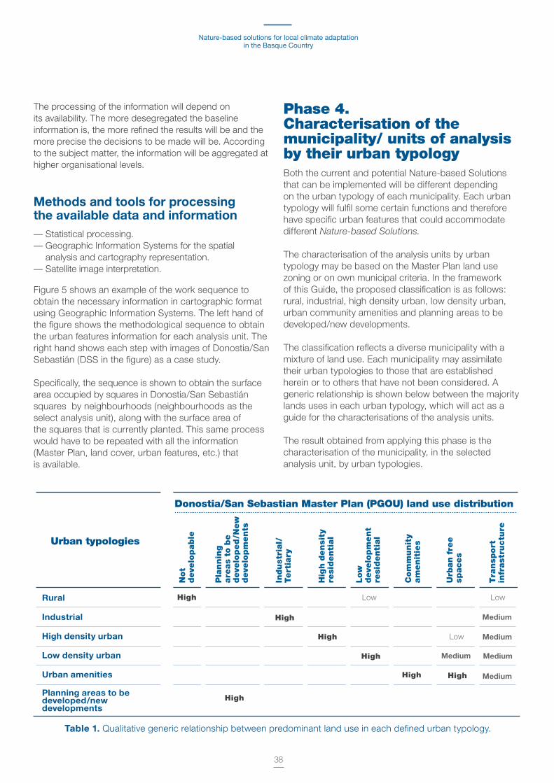
Nature-based solutions for local climate adaptation in the Basque Country
38
The processing of the information will depend on its availability . The more desegregated the baseline information is, the more refined the results will be and the more precise the decisions to be made will be . According to the subject matter, the information will be aggregated at higher organisational levels .
Methods and tools for processing the available data and information— Statistical processing . — Geographic Information Systems for the spatial
analysis and cartography representation . — Satellite image interpretation .
Figure 5 shows an example of the work sequence to obtain the necessary information in cartographic format using Geographic Information Systems . The left hand of the figure shows the methodological sequence to obtain the urban features information for each analysis unit . The right hand shows each step with images of Donostia/San Sebastián (DSS in the figure) as a case study .
Specifically, the sequence is shown to obtain the surface area occupied by squares in Donostia/San Sebastián squares by neighbourhoods (neighbourhoods as the select analysis unit), along with the surface area of the squares that is currently planted . This same process would have to be repeated with all the information (Master Plan, land cover, urban features, etc .) that is available .
Phase 4. Characterisation of the municipality/ units of analysis by their urban typologyBoth the current and potential Nature-based Solutions that can be implemented will be different depending on the urban typology of each municipality . Each urban typology will fulfil some certain functions and therefore have specific urban features that could accommodate different Nature-based Solutions.
The characterisation of the analysis units by urban typology may be based on the Master Plan land use zoning or on own municipal criteria . In the framework of this Guide, the proposed classification is as follows: rural, industrial, high density urban, low density urban, urban community amenities and planning areas to be developed/new developments .
The classification reflects a diverse municipality with a mixture of land use . Each municipality may assimilate their urban typologies to those that are established herein or to others that have not been considered . A generic relationship is shown below between the majority lands uses in each urban typology, which will act as a guide for the characterisations of the analysis units .
The result obtained from applying this phase is the characterisation of the municipality, in the selected analysis unit, by urban typologies .
Table 1. Qualitative generic relationship between predominant land use in each defined urban typology .
Donostia/San Sebastian Master Plan (PGOU) land use distribution
Urban typologies
Not
deve
lopable
Pla
nnin
g
are
as
to b
e
deve
loped
/New
deve
lopm
ents
Indust
rial/
Tert
iary
Hig
h d
ensi
ty
resi
denti
al
Low
deve
lopm
ent
resi
denti
al
Com
munit
y
am
enit
ies
Urb
an f
ree
spaces
Tra
nsp
ort
in
frast
ructu
re
Rural
Industrial
High density urban
Low density urban
Urban amenities
Planning areas to be developed/new developments
High
High
High
High
High
High High
Low Low
Low
Medium
Medium
Medium Medium
Medium

Methodological guide for their identification and mapping.Donostia/San Sebastián case study
39
Figure 5. Example of data processing methodological sequence (where DSS is Donostia/San Sebastián)

Nature-based solutions for local climate adaptation in the Basque Country
40
Phase 5. Diagnosis of the natural capital using land cover
The diagnosis phase aims to analyse the land cover of the study area to provide a preliminary idea both of the current Natural Capital and the potential elements available for Nature-based Solutions.
The current and potential Natural Capital of a municipality will be given by the currently available vegetation in the first of the cases and by the urban features and available space to accommodate this type of solutions in the second . Using the available cartography to establish the unsealed and sealed surface in the urban fabric and the elements making it up are the basis of this diagnosis .
This diagnostic phase therefore consists of analysing, quantifying the land cover of the different analysis units, differentiating, on the one hand, the sealed surface by i) building, ii) by transport infrastructures and iii) public-living areas and, on the other hand, the unsealed surface by iv) vegetation and v) by water bodies .
Once the information of the urban features of each type of land cover has been gathered, it needs to be processed to have the same per analysis unit, as specified in Phase 3.
If in Phase 4 the Master Plan (PGOU) land use classification has been used, there will an initial idea of the land cover . However, the land classification does not exactly match the type of cover, as, for example, an area rated as residential will be partly built and partly occupied by access roads, pavements, public-living areas, etc . If the diagnosis is to be refined, the type of land cover needs to be known .
However, in the cases where there is no detailed cartography of the different urban features, the Master Plan (PGOU) or the subsidiary regulations may be the basis for the diagnosis, considering that each land use will have a type of characteristic cover . A generic relationship between the defined urban typologies and land cover is shown below . As can be seen, the land cover relationship has been added to the relationship between land use and urban typologies in the previous phase (see Table 1) . In general, the relationship can be established that is shown between land use, urban typologies and land cover, which is set out in Table 2 .
Table 2. Qualitative generic relationship between land use, urban typology and land cover .
Master Plan PGOU land use Land cover
Sealed Not sealed
Urbantypologies
Rural
Industrial
High density urban
Low density urban
Urban amenities
Planning areas to be developed/new developments
High
High
High
High High
High Low Low
High Low
Medium
Medium
Not
deve
lopable
Pla
nnung a
reas
to
be d
eve
loped
/New
deve
lopm
ents
Indust
rial/
Tert
iary
Hig
h d
ensi
ty
resi
denti
al
Low
deve
lopm
ent
resi
denti
al
Com
munit
y am
enit
ies
Urb
an f
ree s
paces
Tra
nsp
ort
in
fraest
ructu
re
Buildin
gs
Lin
ear
infr
a-
est
ructu
res
Leis
ure
are
as
Blu
e
Gre
en
Low
High
High
High LowMedium Medium
High
Variable
depe
ndin
g on
the
Mun
icip
ality
Medium Medium
Medium Medium
Medium
Medium
Medium Medium Medium
Medium
Medium
Methodological guide for their identification and mapping.Donostia/San Sebastián case study
41
Once the land cover information per analysis unit is available, the information can be aggregated at different levels depending on the objective of the study . The type of results obtained for the diagnosis is set out below for each aggregation level and to achieve specific objectives . Even though the information is obtained at analysis unit level, which represents the highest level of desegregation, the logical decision-making sequence is to present the maximum aggregation level in the greatest details .
The results obtained from this diagnosis phase in each of the analysis level are shown below and are set out in graphic form in Figure 3 .
Municipal diagnosisThe total green surface of a municipality can be considered its current Natural Capital, while the total sealed surface can be considered as urban cover elements with renaturing potential.
The municipal land cover values are a starting point, with respect to which renaturing targets must be established, and a baseline scenario in order to measure the ensuing improvements from increasing the Natural Capital .
OBJECTIVE 1: Establish the potential and current Natural Capital of the municipality .
Furthermore, if a differentiation of the type of plant cover is made, an initial idea is obtained of the "quality of the Natural Capital", with quality being taken to be the capacity to respond to climate change threats, such as run-off harvesting, reducing temperature, etc . In this regard, the greater the plant density is, the greater its contribution in terms of climate change adaptation .
Diagnosis by urban typologiesEach urban typology has a certain configuration and elements . This means that land cover varies between different typologies . In the same way as the higher aggregation level, the land cover values for each urban typology allow renaturing objectives to be established and serve as a benchmark baseline to be used to measure the improvements
implemented . It likewise allows intervention priorities to be established between units of the same urban typology, acting, for example, as analysis units with less Natural Capital or with a greater sealed surface .
OBJECTIVE 2: Establish intervention priorities in the municipalities .
In the absence of any benchmark values regarding the optimum Natural Capital, the maximum, minimum and average land cover values of the analysis units of the same typology may be used as benchmark values with respect to which to establish targets, quantify them and measure improvements to increase the Natural Capital . For example, interventions can be prioritised in the areas or neighbourhoods that have a smaller green surface area than the average for the zones of that same type (See application to the Donostia/San Sebastián case study in Chapter 07) .
Diagnosis for a specific analysis unitOnce an area has been selected in which to intervene, the information obtained so far may be used for decision making and defining specific targets .
The land cover information of the area in which the intervention takes place provides, in the same way as in the previous cases, an idea about the current Natural Capital and an initial idea about the urban composition where renaturing can occur .
OBJECTIVE 3: Intervene in specific areas with known issues (related to climate change threats or other problems to which the Nature-based Solutions may provide answers) .
As has been previously discussed, if the Master Plan (PGOU) has been used to characterise the minor units (Phase 4), there is a quantified relationship between land use and cover . This relationship provides greater detail about the potential to increase the Natural Capital, as it is possible to establish for a specific land use which surface area is, for example, built on or occupied by transport
Nature-based solutions for local climate adaptation in the Basque Country
42
infrastructures, and which surface area is available to be renatured . (See application to the Donostia/San Sebastián case study in Chapter 07) .
Phase 6. Analysis of the 'Nature-based Solutions': available and potentialOnce the diagnosis phase has established the intervention priorities (either as a city level strategy, by urban typologies or as specific zones) and the land cover is known prior to establishing the elements on which to act, this phase consists of identifying specific urban features of the municipality that may accommodate the Nature-based Solutions that are identified in the Chapter 4 of this guide .
If the diagnosis phase provides a quantification of the current Natural Capital and the potential, the urban features available to accommodate Nature-based Solutions are quantified in this phase . For example, if in the diagnosis phase, the buildings or the recreational areas represent a potential for replanting or renaturing, in this phase they become "flat roofs on buildings" or "hard squares" available in each analysis unit that can really accommodate Nature-based Solutions.
This analysis implies:
— Identifying and quantifying elements of the urban fabric able to accommodate Nature-based Solutions on all scales .
— Identifying natural areas with potential to improve .
The proposed work sequence to carry out this mapping is as follows .
First, identify the elements or the urban fabric that can accommodate Nature-based Solutions, as indicated in Chapter 5, together with the necessary information and guidelines for their inventory and securing .
Each municipality may select the Nature-based Solutions that it deems most appropriate, according to its needs, from possible policies underway or from the available information . The Nature-based Solutions mapped
will depend, as in previous cases, on the available information or the resources available to obtain them .
Once the information on the urban features has been gathered, it needs to be processed to have the same per analysis unit, as specified in Phase 3 of the methodological process .
In the same way as in the diagnosis process, the mapping results of the Nature-based Solutions may be processed and aggregated in different ways according to the objectives of the studio . Possible results that are exemplified in the Donostia-San Sebastián pilot case study in Chapter 07 are set out below .
Mapping the municipal 'Natured-based Solutions'Nature-based Solutions can be obtained at the scale of the whole municipality . This type of result is interesting if the objective of the municipality is to implement greening strategies at municipal level . For example, harnessing all the wasteland of the municipality for its temporary use as vegetable gardens or the citizen awareness raising plan by fostering the greening of the community courtyards .
OBJECTIVE 1: To define Nature-based Solutions strategies at municipal scale
This level obtains the surface area of each urban element available for the implementation of Nature-based Solutions, and if the information has been processed geographically, there will also be a map with the location of the potential Nature-based Solutions.
Mapping the 'Nature-based Solutions' by urban typologiesIn the same way as the case of the diagnosis, the results of the Nature-based Solutions mapping can be aggregated for the analysis units of the same typology .
In the same way in the diagnostic phase, a comparison of the Nature-based Solutions per urban typology can be obtained .
Methodological guide for their identification and mapping.Donostia/San Sebastián case study
43
Mapping the 'Nature-based Solutions' for specific analysis unitsIn this case, the objective is the same as for the diagnosis, to establish the details of the Nature-based Solutions in specific areas and which allows decision making based on a known issue or on specific needs .
OBJECTIVE 2: To intervene in specific areas with known issues (related to climate change threats or other problems to which the Nature-based Solutions may respond)
Phase 7. Selecting and assessing the measuresDepending on the map and diagnosis results of the Nature-based Solutions potential, this phase will directly follow on and the aim will be to select the optimum adaptation measures, from among the alternatives identified in the previous phase, which have to be or may be incorporated in the Master Plan, or derivative instruments, in Local Climate Change Adaptation Plans or in other strategies of the municipality .
Climate change threats and risksThe first aspect to be taken into account to select the Solutions is to establish the climate change-related risks that the municipality is facing . Studies on exposure to climate change threats (river flood maps, thermal map, map of exposure to waves and rising sea level, etc .) will be useful, along with those studies on the vulnerability regarding the effects of climate change (sensitive population, age of the buildings, availability of green areas, etc .) . In so far as there are studies of this type, there will be an idea of the magnitude of the problem and the selection of the Nature-based Solutions may be more specific .
Should those detailed studies not be available, the Nature-based Solutions may be selected based on
qualitative knowledge of the existing threats or of other economic, social or environmental benefits that they wish to achieve through nature .
Assessment of the measures The first step is to select the most effective and appro- priate measures according to the specific adaptation needs of the municipality . The measures must be assessed based on:
A . The effectiveness of the possible Solutions, taken to be the contribution of the adaptation to the climate change measure in relation to the climate threats to which they are in response, in terms of:
— Decreasing in temperature and, therefore, reducing the heat island effect .
— Reducing the runoff from rainwater . — Mitigation of the impact or river flooding . — Mitigation of the effect of the flooding caused by
high tides and rising sea level .
B . The co-benefits that this type of Solutions may have for the urban environment, considering the economic, social and environmental dimensions .
The contribution of the Nature-based Solutions to the climate change threats and the economic, social and environmental co-benefits are set out qualitatively in Chapter 04. However, in the case of Nature-based Solutions and interventions of certain magnitude, a specific study may be necessary to establish their real effectiveness as a means of adapting to climate change . The analysis may be conducted from different perspectives:
— The monitoring of different water and thermal parameters (e .g . temperature, humidity, water table, runoff harvesting, etc .) by means of in situ measurements .
— The simulation with different water and thermal models that allow the behaviour of the solutions implemented to be simulated for different climate conditions .
— The assessment of the comfort perception of the users of certain spaces where the Nature-based Solutions have been implemented .

Nature-based solutions for local climate adaptation in the Basque Country
44
Figure 6 shows a thermal modelling example of a green facade . The colour grading shows the leeward temperature difference when using a green facade with respect to a conventional facade . The decrease achieved in the mean radiant temperature24 is up to 2 ºC, in the first metres of height and a drop of approximately 1 ºC up to the height of the green facade, the reduction of the mean radiant temperature drops when the wind speed increases .
Analysis of the implementation factorsApart from an ad hoc study of the technical feasibility of the possible Solutions, other aspects need to be assessed such as the need for initial investment, the maintenance costs, and possible constraints depending on the owners of the land and property and applicable urban development legislation .
In some cases, municipal bylaws may exist, for example, regarding modifying aspects of the facade, which many prevent the implementation of Nature-based Solutions. In those cases, it would be necessary to assess the possibility of amending the legislation to facilitate their implementation .
An important factor to be taken into consideration is the ownership of the urban element to be implemented, which in many cases, such as building interventions (community courtyards, green roofs, terraces, etc .), will be private . A success factor for the implementation
24 The mean radiant temperature is one of the variables that impact the thermal comfort of the people . It is defined as the uniform temperature of an imaginary black enclosure in which an occupant would exchange the same amount of radiant heat as in the actual non-uniform space . It is the sum of the temperatures of each of the elements multiplied by its apparent surface, seen from the perspective of the user, divided by the sum of the apparent surfaces .
of these measures is to establish the relevant communication channels (neighbours' associations, traders, etc .) . The perception of the owners, their motivation and constraints to implement Nature-based Solutions in their properties can thus be established and, indirectly, the benefits of the Nature-based Solutions regarding climate change to improve the quality of life can be mainstreamed . In Chapter 07, the experience implemented in a neighbourhood of Donostia/San Sebastián has been put to establishments and neighbourhood communities to discover their perception and readiness to green the community courtyards of the central zone .
Once the implementation factors of the measures have been assessed, the measures are then selected, preferably by means of a decision-making selection agreed and with the involvement of different stakeholders, levels and sector of the administration, including civil society and the general public .
This phase requires the involvement of qualified technical staff, architecture, engineering or landscape teams, capable of making the design operative and putting the Solutions into service .
Once the most appropriate measures have been selected to address the climate challenges raised, the strategy for their implementation, financing, temporality of the measures, people responsible, timeline, etc must be defined, along with their possible integration in the urban planning instruments .
Figure 6. Example of a thermal modelling of a green facade and its contribution to reducing temperature (Source: Tecnalia)

45
07Case study:Climate Change Adaptation by means of Nature-based Solutions in Donostia/San Sebastián
Map of Nature-based Solutions in Donostia/San Sebastián Applicationof methodological sequence to the Área Romántica neighbourhood
This chapter sets out the results applicable to the Donostia/San Sebastián case study following the structure of the Guide . The first part of the Chapter contains the inventory of Nature-based Solutions mapped as set out in Chapter 05.
The second part follows the methodological process of Chapter 06, with the comprehensive identification and mapping of Nature-based Solutions as a measure to adapt to climate change, in a specific neighbourhood of Donostia/San Sebastián located in the centre, the Área Romántica . The selection process of a specific priority intervention zone is exemplified, based on its exposure to climate change threats and the comparison with other zones of the same type . The implementation potential of Nature-based Solutions in Área Romántica was quantified and mapped and the real greening possibilities of the community courtyards were analysed in a session with the owners, neighbours and traders to discover their perception of and attitude towards the possible measure .
'Nature-based Solutions' map in Donostia/San SebastiánThose Nature-based Solutions identified in Chapter 04 mapped in Donostia-San Sebastián are the ones shown in the "Map of Current and Potential Nature-based Solutions of Donostia/San Sebastián" (see quantified values in Table 3) . The solutions have been identified
using the city's own municipal cartography, following the inventory method indicated in Chapter 05 except in specific cases where Basque Government information has been used .
Building-scale 'Nature-based Solutions' in Donostia/San SebastiánThe potential of building-scale Nature-based Solutions are mainly concentrated in urban type areas . Given the urban morphology and the configuration of the buildings, community courtyards predominate in high density urban areas, in neighbourhoods such as Gros and Centro, while private terraces are to be found in low-density area where single-family dwellings with garden predominate . In the case of community courtyards, barely 1% of the available surface is currently planted . Therefore, the potential to increase vegetation in this urban element is considerable and it is a greening option accepted by part of the general public . These are the conclusions reached during a workshop conducted in the Centro neighbourhood, which are set out in the second part of this chapter.
As regards the flat roofs, 38% of the total is in low density urban areas compared to 17% in high density areas . Proportionally, the greatest surface area of flat roofs is in industrial areas and if it is taken into account that the surface area of this urban typology in Donostia/San Sebastián does not account for 6% of the total .

Nature-based solutions for local climate adaptation in the Basque Country
46
The industrial and urban amenities areas have the greatest proportion of flat roofs, as the main type of buildings are industrial and service, which are a priori low and with a great flat surface area .
The type of renaturing on flat roofs (allotments, green roofs, rainwater harvesting, etc, see relevant datasheet of Chapter 04) will depend on the implementation factors discussed in Phase 7 of Chapter 06.
5
3 16 10 23 4 4
3 1 1 24
3 8 11 5 3
2 30 23 3
0 0 2 1
63 29 19 9
1 10 8 1
1 0 0 0 0 0
73 3 24 8 3 1
3
127 71 50 234 20 26
3 1 2 8 1
3 2 15 20 1
940 12 10 2
1018
1
1453 2 0 43 0 2
16 10 1
BUILDING
PUBLIC SPACE
INTERVEN-TIONS IN WATER BODIES/ FLOOD
INTERVEN-TIONS INLINEAR INFRA-STRUCTURES
NATURAL AREAS AND MANAGEMENT OF RURAL LAND
COAST
Rura
l
Indust
rial
Hig
h d
ensi
ty
urb
an
Low
densi
ty
urb
an
Urb
an
amenit
ies
Pla
nnin
g
areas
to
be
dev
elo
ped
/New
dev
elo
pm
ents
Communal courtyard (Ha)
Flat roof (Ha)
Private terraces (Ha)
Surface car parks (Ha)
Sealed squares (Ha)
Spaces of opportunity (Ha)
Urban parks and Urban forests (Ha)
Fountains (No.)
Ponds and lakes (Ha)
Rivers-Streams (Ha)
Plains sinks (Ha)
Road (Ha)
Railway (Km)
Bidegorri (Km)
forests Periurban (Ha)
Protected natural area (Ha)
Wetlands (Ha)
Productive rural land (Ha)
Coast (Ha)
Table 3. Surface area of each urban element with potential to accommodate Nature-based Solutions of each urban typology .

Methodological guide for their identification and mapping.Donostia/San Sebastián case study
47
'Nature-based Solutions' in the public space in Donostia/San SebastiánThe largest car park surface area is in low density urban areas . The percentage of car parks in industrial areas is 28%, which correspond to the parking areas of large shopping centres and industrial estates .
With respect to the sealed squares, the highest concentrations are in the low density and high density urban areas, with percentages of 53% and 40%, respectively . Thirty per cent of the current sealed square surface area is currently planted . Therefore, the improvement potential of this urban element is significant, also taking into account that the majority of the plants are ornamental . Improving the spaces involves increasing the green surface that they occupy, increasing the density of the existing vegetation, installing water features that refresh the atmosphere, etc .
The opportunity plots, which are currently not in use, are mainly in industrial areas and also high and low density urban areas . The greening options of those areas will depend on the time that the area will not be in use, so that the initial investment is adjusted, among other aspects . The creation of urban vegetable gardens may be an option with an initial low investment and low maintenance costs . On the other hand, the benefits obtained will be numerous (see "Allotment gardens" and "Renaturing Abandoned Plots and Opportunity Plots" factsheets in Chapter 04) .
The urban parks or urban forests are mainly located in industrial areas on the outskirts . Even so, Donostia/San Sebastián has large urban parks with a dense number of trees in the centre of the municipality . When the location of the urban parks is analysed, Miramón Park in an industrial area and Mount Urgul located in a high density area next to the city's old quarter are the ones with the largest surface area . The parks are Nature-based Solutions currently available in the municipality and the improvement options in this case include upkeep of their vegetation, extending their surface area as far as possible and connecting them with other green areas .
Ornamental fountains are mainly in high and low density urban areas with percentages of 50% and 40%, respectively . These Solutions imply energy consumption and water loss if not managed appropriately . However, it may be an effective Solution on one-off days where the temperature is expected to exceed specific values .
'Nature-based Solutions' in water bodies and drainage systems in Donostia/San SebastiánThe ponds and lakes are mainly in rural areas followed by urban amenities areas . Increasing the surface areas of the ponds and lakes means they can be used as storm water sinks and offsetting the risk of flooding in areas exposed to flooding .
With respect to the rivers and streams in the inventory, the greatest surface area percentage is in the rural area, with 65% of the total and 22% in high density areas as the River Urumea runs into the sea through neighbourhoods of this urban type .
The flood plain is the planned riverside park in the new Txomin Enea development . An intervention of this type is in response to a specific river flooding in the area . In the planning areas to be developed or new developments, the inclusion of the Nature-based Solutions can happen from the design phase and with the focus on a specific problem .
'Nature-based Solutions' in linear infrastructures in Donostia/San SebastiánThe greening of the linear infrastructures can contribute to the connection of the green areas of the city . As was discussed in the case of the parks, they can be connected using the bidegorris (bike lane) network within the urban fabric or using the roads or railways in the outskirts . The bidegorri network runs through the low and high density urban areas with percentages of 48% and 36% respectively and under 6% in the other types .
'Nature-based Solutions' in natural areas and management of the rural land in Donostia/San SebastiánPractically 100% of the elements referring to natural areas and management or rural land are concentrated in rural areas, except 14% of the wetlands concentrated in the industrial areas adjacent to the rural areas .
'Nature-based Solutions' map along the coast in Donostia/San SebastiánIn the case of Donostia/San Sebastián, the coastline is urban and is concentrated in high density urban areas of 56%, in low density of 36% and in urban amenities areas of 5% .

Nature-based solutions for local climate adaptation in the Basque Country
48
Nature-based Solutions Map current and potential of Donostia/San Sebastián
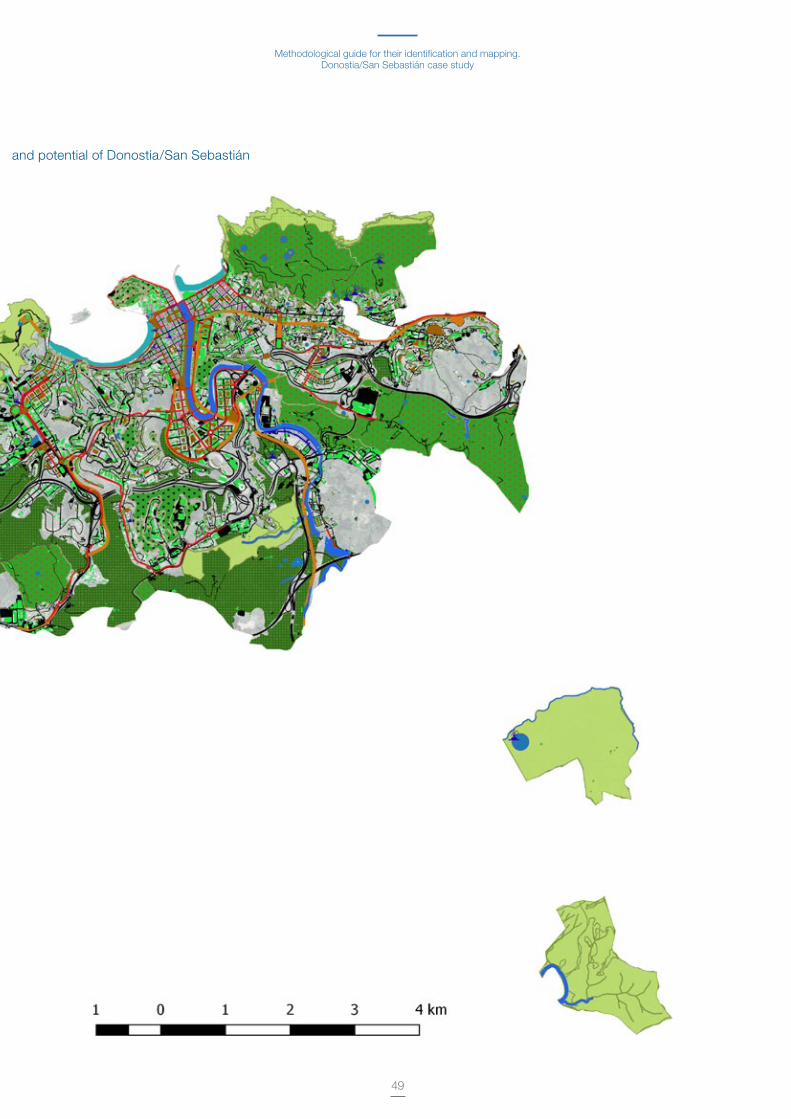
Methodological guide for their identification and mapping.Donostia/San Sebastián case study
49
Nature-based Solutions Map current and potential of Donostia/San Sebastián
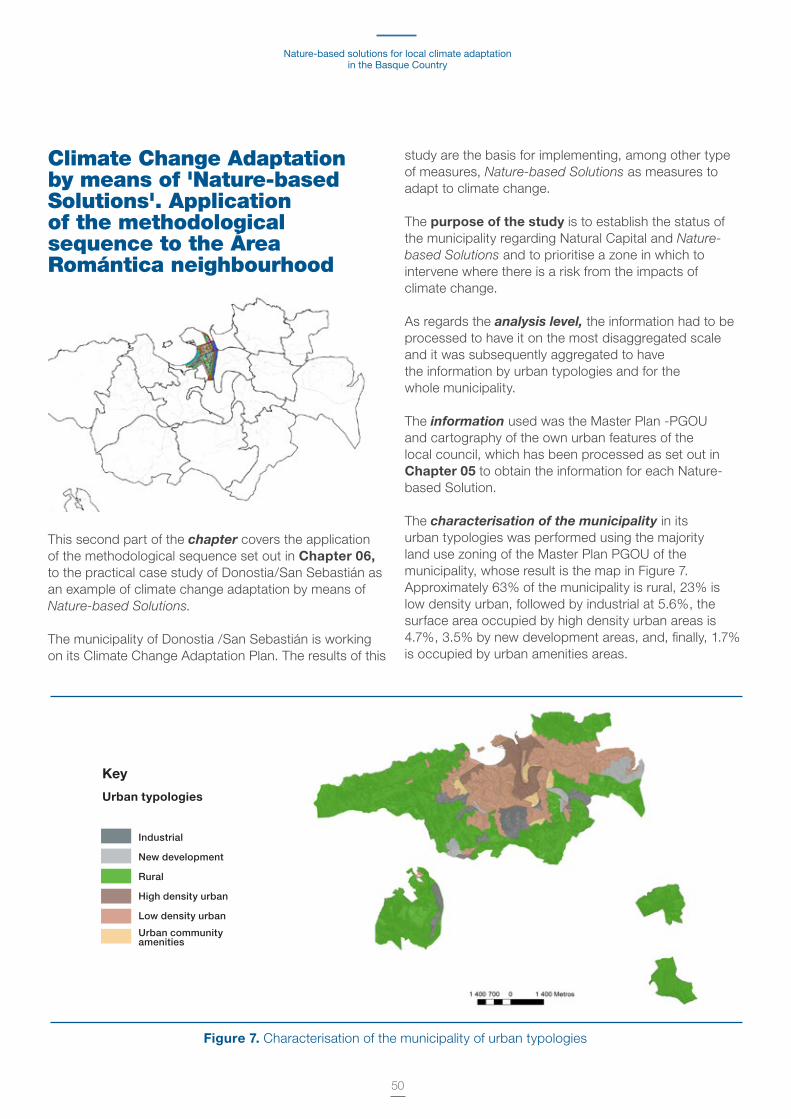
Nature-based solutions for local climate adaptation in the Basque Country
50
Climate Change Adaptation by means of 'Nature-based Solutions'. Application of the methodological sequence to the Área Romántica neighbourhood
This second part of the chapter covers the application of the methodological sequence set out in Chapter 06, to the practical case study of Donostia/San Sebastián as an example of climate change adaptation by means of Nature-based Solutions.
The municipality of Donostia /San Sebastián is working on its Climate Change Adaptation Plan . The results of this
study are the basis for implementing, among other type of measures, Nature-based Solutions as measures to adapt to climate change .
The purpose of the study is to establish the status of the municipality regarding Natural Capital and Nature-based Solutions and to prioritise a zone in which to intervene where there is a risk from the impacts of climate change .
As regards the analysis level, the information had to be processed to have it on the most disaggregated scale and it was subsequently aggregated to have the information by urban typologies and for the whole municipality .
The information used was the Master Plan -PGOU and cartography of the own urban features of the local council, which has been processed as set out in Chapter 05 to obtain the information for each Nature-based Solution .
The characterisation of the municipality in its urban typologies was performed using the majority land use zoning of the Master Plan PGOU of the municipality, whose result is the map in Figure 7 . Approximately 63% of the municipality is rural, 23% is low density urban, followed by industrial at 5 .6%, the surface area occupied by high density urban areas is 4 .7%, 3 .5% by new development areas, and, finally, 1 .7% is occupied by urban amenities areas .
Figure 7. Characterisation of the municipality of urban typologies
Key
Urban typologies
Industrial
New development
Rural
High density urban
Low density urban
Urban community amenities

Methodological guide for their identification and mapping.Donostia/San Sebastián case study
51
The results of the municipal diagnosis show that Donostia/San Sebastián currently has important Natural Capital with approximately 75% of its surface area
occupied by vegetation, principally in the form of forest and meadows, which are mainly in the rural area of the municipality .
Figure 8. Map of Donostia/San Sebastián land cover
Figure 9. Map of Donostia/San Sebastián planted land cover
Blue
Green
Public-living
Infrastructures
Buildings
Key
Key
Cover percentage
6.5%
8.6%
7%
74%
0.8%
Percentagein type of plant cover
Total surface area of planted cover: 74% of the total
43%
39%
0.2%
6%
5%
6%
Land cover
Vegetation land cover
TreeVegetable gardens/greenhousesMeadow/grass
Ornamental garden
Private garden
Woodland

Nature-based solutions for local climate adaptation in the Basque Country
52
However, the Natural Capital in the urban type areas varies with respect to the total of the municipality, as regards the percentage and type of vegetation (see Table 4) . The high density urban areas are highly sealed and in some neighbourhoods of this typology, such as Gros and Centro, the planted surface area does not even account for 5% of their total surface area . This planted surface area mainly consists of ornamental gardens with decreased capacity to adapt to climate change, in terms of reducing temperature and run-off harvesting .
When focusing on the diagnosis in the high density urban areas (see Figure 10 and Figure 11), it can be see that the land cover distribution varies from one neighbourhood to another, but the sealed surface is always greater than the planted area . This variation in the distribution of land cover can be seen in the planted cover and land cover threshold values for high density urban areas in Figure 12 and Figure 13, respectively . Those values are calculated using the maximum, minimum and average values of each land cover of the areas of the same typology .
Land cover by urban typology (% with respect to
the total surface area)Built
Transportinfrastruc-
tures
Leisureareas Planted Blue
Rural
Industrial
Low density urban
High density urban
Urban amenities
1
13
15
33
19
3
21
18
18
19
2
8
14
29
20
90
53
49
13
42
0 .5
1
-
8
1
Table 4. Land cover percentages for each urban typology of Donostia/San Sebastián
Figure 10. Comparative land cover map for high density urban areas
Figure 11. Comparative planted cover map for high density urban areas
Blue
Green
Public-living
Infrastructures
Buildings
Key Key
Woodland
Meadow/grass
Tree
Ornamentalgarden
Private garden
Veg gardens/greenhouses
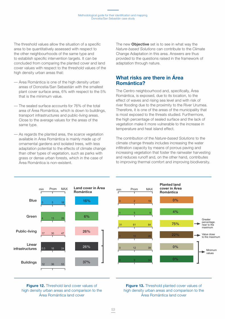
Methodological guide for their identification and mapping.Donostia/San Sebastián case study
53
The threshold values allow the situation of a specific area to be quantitatively assessed with respect to the other neighbourhoods of the same type and to establish specific intervention targets . It can be concluded from comparing the planted cover and land cover values with respect to the threshold values of the high density urban areas that:
— Área Romántica is one of the high density urban areas of Donostia/San Sebastián with the smallest plant cover surface area, 6% with respect to the 5% that is the minimum value .
— The sealed surface accounts for 76% of the total area of Área Romántica, which is down to buildings, transport infrastructures and public-living areas . Close to the average values for the areas of the same type .
— As regards the planted area, the scarce vegetation available in Área Romántica is mainly made up of ornamental gardens and isolated trees, with less adaptation potential to the effects of climate change than other types of vegetation, such as parks with grass or dense urban forests, which in the case of Área Romántica is non-existent .
The new Objective set is to see in what way the Nature-based Solutions can contribute to the Climate Change Adaptation in this area . Answers are thus provided to the questions raised in the framework of adaptation through nature .
What risks are there in Área Romántica?The Centro neighbourhood and, specifically, Área Romántica, is exposed, due to its location, to the effect of waves and rising sea level and with risk of river flooding due to the proximity to the River Urumea . Therefore, it is one of the areas of the municipality that is most exposed to the threats studied . Furthermore, the high percentage of sealed surface and the lack of vegetation make it more vulnerable to the increase in temperature and heat island effect .
The contribution of the Nature-based Solutions to the climate change threats includes increasing the water infiltration capacity by means of porous paving and increasing vegetation that foster the rainwater harvesting and reduces runoff and, on the other hand, contributes to improving thermal comfort and improving biodiversity .
Figure 12. Threshold land cover values ofhigh density urban areas and comparison to the
Área Romántica land cover
Figure 13. Threshold planted cover values ofhigh density urban areas and comparison to the
Área Romántica land cover
Land cover in Área Romántica
Planted land cover in Área Romántica
min Prom MAX min Prom MAX
0
4
17
0.5
12
5
13
30
16
36
18 0 2 15
1 5 9
31 61 84
Greaterpercentage.near to the maximum
Value closeto the maximum
Minimumvalues
1 10 26
0 12 39
0 9 34
16% 0%
0%
0%
4%
75%
22%
6%
26%
37%
26%
26
47
24
53
Blue
Green
Public-living
Linearinfrastructures
Buildings
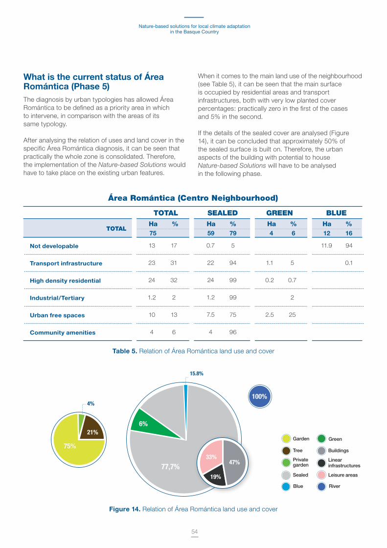
Nature-based solutions for local climate adaptation in the Basque Country
54
What is the current status of Área Romántica (Phase 5)The diagnosis by urban typologies has allowed Área Romántica to be defined as a priority area in which to intervene, in comparison with the areas of its same typology .
After analysing the relation of uses and land cover in the specific Área Romántica diagnosis, it can be seen that practically the whole zone is consolidated . Therefore, the implementation of the Nature-based Solutions would have to take place on the existing urban features .
When it comes to the main land use of the neighbourhood (see Table 5), it can be seen that the main surface is occupied by residential areas and transport infrastructures, both with very low planted cover percentages: practically zero in the first of the cases and 5% in the second .
If the details of the sealed cover are analysed (Figure 14), it can be concluded that approximately 50% of the sealed surface is built on . Therefore, the urban aspects of the building with potential to house Nature-based Solutions will have to be analysed in the following phase .
TOTAL
TOTAL
Ha % Ha % Ha % Ha % 75 59 79 4 6 12 16
SEALED GREEN BLUE
Área Romántica (Centro Neighbourhood)
Not developable
Transport infrastructure
High density residential
Industrial/Tertiary
Urban free spaces
Community amenities
13
23
24
1 .2
10
4
17
31
32
2
13
6
0 .7
22
24
1 .2
7 .5
4
5
94
99
99
75
96
1 .1
0 .2
2 .5
11 .9
5
0 .7
2
25
94
0 .1
Table 5. Relation of Área Romántica land use and cover
75%
21%
4%
Figure 14. Relation of Área Romántica land use and cover
Garden
Tree
Private garden
Sealed
Blue
Green
Buildings
Linear infrastructures
Leisure areas
River
15.8%
77,7%
6%
47%
19%
33%
100%
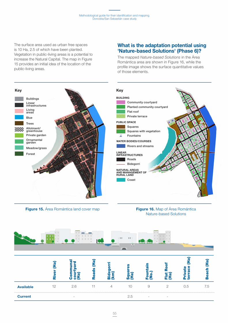
Methodological guide for their identification and mapping.Donostia/San Sebastián case study
55
The surface area used as urban free spaces is 10 Ha, 2 .5 of which have been planted . Vegetation in public-living areas is a potential to increase the Natural Capital . The map in Figure 15 provides an initial idea of the location of the public-living areas .
What is the adaptation potential using 'Nature-based Solutions' (Phase 6)?The mapped Nature-based Solutions in the Área Romántica area are shown in Figure 16, while the profile image shows the surface quantitative values of those elements .
Figure 15. Área Romántica land cover map Figure 16. Map of Área Romántica Nature-based Solutions
Available
Current
12 2 .6
-
11 4 10
2 .5
9
-
2
-
0 .5 7 .5
Riv
er
(Ha)
Com
munal
co
urt
yard
(H
a)
Road
s (H
a)
Bid
egorr
i
(km
)
Squar
es
(Ha)
Founta
in
(No.
)
Fla
t R
oof
(Ha)
Pri
vate
te
rrac
e (
Ha)
Beac
h (
Ha)
Buildings
Linear infrastructures
Living areas
Blue
Trees
Allotment/greenhouse
Private garden
Ornamental garden
Meadow/grass
Forest
Key Key
Community courtyard
Planted community courtyard
Flat roof
Private terrace
Squares
Squares with vegetation
Fountains
Rivers and streams
Roads
Bidegorri
Coast
BUILDING
PUBLIC SPACE
WATER BODIES/COURSES
LINEARINFRASTRUCTURES
NATURAL AREAS AND MANAGEMENT OF RURAL LAND

Nature-based solutions for local climate adaptation in the Basque Country
56
Implementation and assessment of the 'Nature-based Solutions' (Phase 7)The possible implementation of these solutions in Área Romántica requires a detailed study of the urban features that would accommodate those solutions and of the key aspects for their introduction, such as whether the ownership is public or private, the effectiveness of the solutions, the cost of the intervention or other factors to be taken into consideration .
In the specific case of Área Romántica, it would have to be taken into account whether there are possible restrictions for the greening of the squares if there is underground parking, for the greening of the roofs or the ownership of the community courtyards and specific actions for their greening if the buildings have a type of special status as they form part of the old quarter .
In the specific case of Área Romántica and in the framework of this study, a specific action was conducted to analyse the vegetation of the community courtyards, all of which are privately owned .
This action sought to work with the users of those courtyards to consider the possibility of including planted elements there .
Therefore, meetings were held with some of the local traders who have access to the community courtyards and who as the users would be key stakeholders to implement this measure .
The outcome of these meetings was that it was deemed appropriate to convene a session to address this matter and consult the main users on the possibility of implementing this section .
The block bordering on the Boulevard and Plaza de Gipuzkoa square and the Legazpi and Elkano streets was specifically chosen . On this block, the "La Casa de las Labores", an establishment opened in 1903, and very well-known in the city, allowed us to use a room regularly used for workshops and which overlooks the courtyard, to meet there with other traders and residents of the block . A work session was therefore organised by means of the invitation shown in Figure 17 .
During the session, the climate change adaptation plan in the pipeline in Donostia / San Sebastián, the "Nature-based Solution" concept, and specifically, the building-level measures, with special emphasis on
community courtyards, were explained to the traders and residents .
The aim of the session was to:
— Discover the perception both of traders and residents regarding the greening of courtyards
— And particularly to learn from the establishment about what the City Council can do to drive the greening of community courtyards .
Based on the discussion with traders and residents, the following conclusions were reached:
— The community courtyards of the Centro area of the city are compartmentalised and the majority of those "compartments" are accessible through the establishments . However, some of them may also be accessible through residents' associations .
Figure 17. Announcement of meeting with traders and residents for the consultation session about greening
the community courtyards .
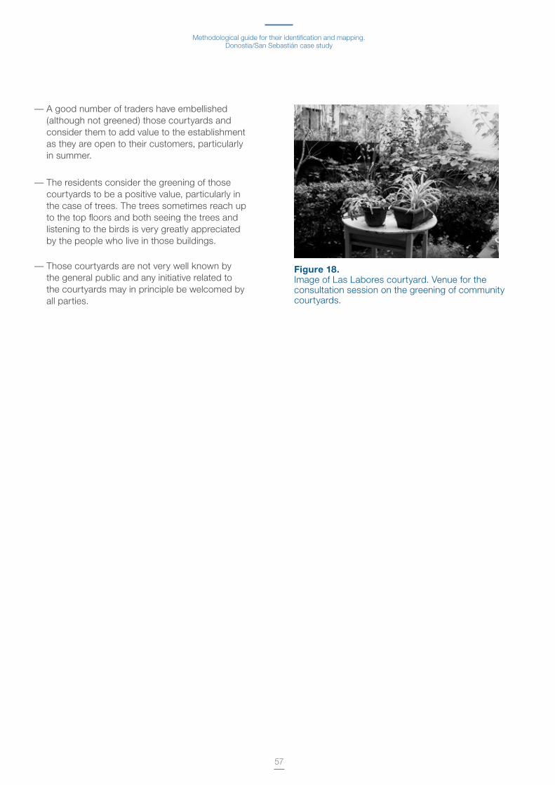
Methodological guide for their identification and mapping.Donostia/San Sebastián case study
57
— A good number of traders have embellished (although not greened) those courtyards and consider them to add value to the establishment as they are open to their customers, particularly in summer .
— The residents consider the greening of those courtyards to be a positive value, particularly in the case of trees . The trees sometimes reach up to the top floors and both seeing the trees and listening to the birds is very greatly appreciated by the people who live in those buildings .
— Those courtyards are not very well known by the general public and any initiative related to the courtyards may in principle be welcomed by all parties .
Figure 18. Image of Las Labores courtyard . Venue for the consultation session on the greening of community courtyards .
58
Glossary of terms
AdaptationAdjustment in natural or human systems in response to actual or expected climatic stimuli or their effects, which moderates harm or exploits beneficial opportunities . Various types of adaptation can be distinguished, including preventive and reactive, public and private, or autonomous and planned .
In some natural systems, human intervention may facilitate adjustment to expected climate and its effects .
— Incremental adaptation . Adaptation actions where the central aim is to maintain the essence and integrity of a system or process at a given scale .
— Transformational adaptation . Adaptation that changes the fundamental attributes of a system in response to climate and its effects .
Community-based adaptationLocal, community-driven adaptation . Community-based adaptation focuses attention on empowering and promoting the adaptive capacity of communities . It is an approach that takes context, culture, knowledge, agency and preferences of communities as strengths .
25 Secretariat of the Convention on Biological Diversity, 2009: Connecting Biodiversity and Climate Change Mitigation and Adaptation: Report of the Second Ad Hoc Technical Expert Group on Biodiversity and Climate Change. Montreal, Technical Series No . 41, 126 pp .
Ecosystem-based adaptationThe use of biodiversity and ecosystem services as part of an overall adaptation strategy to help people to adapt to the adverse effects of climate change . Ecosystem-based adaptation uses the range of opportunities for the sustainable management, conservation and restoration of ecosystems to provide services that enable people to adapt to the impacts of climate change . It aims to maintain and increase the resilience and reduce the vulnerability of ecosystems and people in the face of the adverse effects of climate change . Ecosystem-based adaptation is integrated in adaptation and development strategies (Secretariat of the Convention on Biological Diversity, 2009)25 .
Climate ChangeIImportant statistical change in the mean state of the climate or its variability, which persists for an extended period (typically decades or even longer) . Climate change may be due to natural internal processes or external forcings or persistent anthropogenic
changes in the composition of the atmosphere or in land use . It should be noted that the United Nations Framework Work Convention on Climate Change (UNFCCC), in its Article 1, defines climate change as: “a change of climate which is attributed directly or
59
indirectly to human activity that alters the composition of the global atmosphere and which is in addition to natural climate variability observed over comparable time periods" . The UNFCCC makes a distinction between climate change attributable to human activities altering the atmospheric composition and climate variability attributable to natural causes26 . See alos: Climate variability .
Adaptive capacityThe ability of a system to adjust to climate change (including climate variability and extreme changes) in order to moderate the potential damage, take advantage of opportunities or respond to negative consequences .
Co-benefitsThe positive effects that a policy or measure aimed at one given objective may have on other objectives, irrespective of the net effect on overall social welfare . Co-benefits are often subject to uncertainty and depend on local circumstances and implementation practices . Co-benefits are also referred to as ancillary benefits .
Disaster Severe alterations in the normal functioning of a community or a society due to hazardous physical events interacting with vulnerable social conditions, leading to widespread adverse human, material, economic or environmental effects that require immediate emergency response to satisfy critical human needs and that may require external support for recovery .
DesertificationLand degradation in arid, semi-arid and dry sub-humid areas resulting from various factors, including climatic variations and human activities . Desertification implies the reduction or loss of the biological or economic productivity and complexity or rainfed cropland, irrigated cropland, or range, pasture, forest and woodlands resulting from land use or from a process or combination of processes, including processes arising from human activities and habitation patterns, such as (i) soil erosion
26 http://www .ipcc .ch/pdf/assessmentreport/ar5/wg1/WG1AR5_SummaryVolume_FINAL_SPANISH .pdf27 United Nations Convention to Combat Desertification (UNCCD), 1994: Article 1: Use of terms . United Nations Convention to Combat Desertification . 17 June 1994: Paris, France .
caused by wind and/or water; (ii) deterioration of the physical, chemical, biological or economic properties of soil; and (iii) long-term loss of natural vegetation (UNCCD, 1994)27 .
EcosystemA functional unit consisting of living organisms, their non-living environment and the interactions within and between them . The components included in a given ecosystem and its spatial boundaries depend on the purpose for which the ecosystem is defined: in some cases they are relatively sharp, while in others they are diffuse . Ecosystem boundaries can change over time . Ecosystems are nested within other ecosystems, and their scale can range from very small to the entire biosphere . In the current era, most ecosystems either contain people as key organisms or are influenced by the effects of human activities on the environment .
Ecosystem approachA strategy for the integrated management of land, water and living resources that promotes conservation and sustainable use in an equitable way . An ecosystem approach is based on the application of scientific methodologies focused on levels of biological organisation, which encompass the essential structure, processes, functions and interactions of organisms and their environment . It recognises that humans, with their cultural diversity, are an integral components of many ecosystems . This approach requires adaptive management to deal with complex and dynamic nature of ecosystems and the uncertainty regarding the complete knowledge of their functioning . Priority targets are conservation of biodiversity and of the ecosystem structure and functioning, in order to maintain ecosystem services .
ScenarioA plausible description of how the future may develop based on a coherent and internally consistent set of assumptions about key driving forces (drivers) (for example, rate of technological changes, prices) and relationships . Scenarios are neither predictions nor forecasts, but are useful to provide a view of the implications of developments and actions .

Nature-based solutions for local climate adaptation in the Basque Country
60
Climate scenarioA plausible and often simplified representation of the future climate, based on an internally consistent set of climatological relationships that has been constructed for explicit use in investigating the potential consequences of anthropogenic climate change, often serving as input to impact models . Climate projections often serve as the raw material for constructing climate scenarios, but climate scenarios usually require additional information, such as the observed current climate .
28Plausible representation of the future consisting of future greenhouse gas predictions and of other pollutants based on our understanding of the impact in the atmospheric concentration of those gases in the global change .
Emission scenarioA plausible representation of the future development of emissions of substances that are potentially radiatively active (e .g . greenhouse gases, aerosols) based on a coherent and internally consistent set of assumptions about driving forces (such as demographic and socioeconomic development, technological change) and their key relationships . Concentration scenarios, derived from emission scenarios, are used as input to a climate model to compute climate projections . In IPCC (1992), a set of emission scenarios was presented, which were used as a basis for the climate projections in IPCC (1996) . These emission scenarios are referred to as the IS92 scenarios . In the IPCC Special Report on Emission Scenarios (Naki€enovi€ and Swart, 2000)29 the so-called SRES scenarios were published, some of which were used as a basis for the climates projections presented in Chapters 9 to 11 of IPCC (2001) and in Chapters 10 and 11 of IPCC (2007) . New emission scenarios for climate change, the four Representative Concentration Pathways, were developed for the last IPCC assessment report .
Integrated assessmentA method of analysis that combines results and models from the physical, biological, economic and social sciences, and the interactions among these components, in a consistent framework to evaluate the status and consequences of environment change and the policy responses to it .
28 TGCIA-IPPC, Task Group on Data and Scenario Support for Impact and Climate Analysis .29 Nakićenović, N ., and R . Swart (eds .), 2000: Special Report on Emissions Scenarios . A Special Report of Working Group III of the Intergovernmental Panel on Climate Change . Cambridge University Press, Cambridge, United Kingdom and New York, NY, USA, 599 pp .
Risk assessment The qualitative and/or quantitative scientific estimation of risks .
Evidence of climate changeStudies that, by means of analysing past records and current trends of certain climate or geophysical variables, pinpoint their abnormal evolution associated to the effects of climate change and therefore recording it .
ExposureThe presence of people, livelihoods, species or ecosystems, environmental services and resources, infrastructure or economic, social or cultural assets in places and settings that could be adversely affected .
StressorsEvents and trends, often not-climate related, that have an important impact on the exposed system and can increase vulnerability to climate-related risk .
Extreme weather eventAn event that is rare at a particular place and time of year . Definitions of rare vary, but an extreme weather event would normally be as rare or rarer than the 10th or 90th percentile of a probability density function estimated from observations . By definition, the characteristics of what is called extreme weather may vary from place to place in an absolute sense . When a pattern of extreme weather persists for some time, such as a season, it may be classified as an extreme climate event, especially if it yields an average or total that is itself extreme (e .g . drought or heavy rainfall over a season) .
Greenhouse gas (GHG)Greenhouse gases are those gaseous constituents of the atmosphere, both natural and anthropogenic, that absorb and emit radiation at specific wavelengths within the spectrum of terrestrial radiation emitted by the Earth's surface, the atmosphere itself and clouds . This property causes the greenhouse effect . Water vapour (H2O), carbon dioxide (CO2), nitrous oxide (N2O), methane (CH4) and ozone (O3) are greenhouse gases in the Earth’s atmosphere . Moreover, there are a number of entirely human-made greenhouse gases

Methodological guide for their identification and mapping.Donostia/San Sebastián case study
61
in the atmosphere, such as the halocarbons and other chlorine and bromine containing substances, dealt with under the Montreal Protocol . Beside CO2, N2O, and CH4, the Kyoto Protocol deals de Kyoto sulphur hexafluoride (SF6), hydrofluorocarbons (HFCs) and perifluorocarbons (PFCs) greenhouse gases .
Adaptive managementA process of iteratively planning, implementing and modifying strategies for managing resources in the face of uncertainty and change . Adaptive management involves adjusting approaches in response to observation of their effect and changes in the system on by resulting feedback effects and other variables .
Risk managementPlans, actions or policies implemented to reduce the likelihood and/or consequences of risks or to respond to consequences .
Disaster Risk Management (DRM)Processes for designing, implementing and evaluating strategies, polices and measures to improve the understanding of disaster risk, foster disaster risk reduction and transfer, and promote continuous improvement in disaster preparedness, response and recovery practices, with the explicit purpose of increasing human security, well-being, quality of life and sustainable development .
Impacts Effects on natural and human systems . In this report, the long-term impacts refer to the effects on the human and natural systems of extreme weather and climate events and of climate change . Impacts generally refer to effects on lives, livelihoods, health status, ecosystems, economic, social and cultural assets, services (including the environment) and infrastructure due to the interaction of climate changes or hazardous climate events occurring within a specific time period and the vulnerability of an exposed society or system . Impacts are also referred to as consequences and outcomes . The impacts of climate change on geophysical systems, including floods, droughts and sea level rise, are a subset of impacts called physical impacts .
FloodThe overflowing of the normal confines of a stream or other body of water, or the accumulation of water over areas not normally submerged . Floods include river (fluvial) floods, flash foods, urban floods, pluvial floods, sewer floods, coastal floods and glacial lake outburst floods .
Urban heat islandDome of warm air that forms in urban areas resulting in a relative warmth of a city compared with surrounding rural areas . It is associated to factors such as wind circulation, changes in surface albedo or less vegetation .
Mitigation (of climate change)Human intervention to reduce the sources or enhance the sinks of greenhouse gases .
Mitigation (of catastrophe and disaster risks)The lessening of the potential adverse impacts of physical hazards (including those that are human induced) through actions that reduce hazard, exposure and vulnerability .
Heat wave A period of abnormally and uncomfortably hot weather .
HazardThe potential occurrence of a natural or human-induced physical event or trend, or physical impact, that may cause loss of life, injury or other health impacts, as well as damage and loss to property, infrastructure livelihoods, service provision and environmental resources . In this report, the term hazard usually refers to climate-related physical events or trends or their physical impacts .
Climate prediction A climate prediction or climate forecast is the result of an attempt to produce (starting from a particular state of the climate system) an estimate of the actual evolution of the climate in the future, for example, at seasonal, year-on-year or decadal time scales . Because the future evolution of the climate system may be highly sensitive to initial conditions, such predictions are usually probabilistic in nature .

Nature-based solutions for local climate adaptation in the Basque Country
62
LikelihoodThe change of a specific outcome occurring, where this might be estimated probabilistically .
ProjectionPotential future evolution of a quantity or set of quantities, often computed with the aid of a model . Unlike prediction, projections are conditional on assumptions concerning, for example, future socioeconomic and technological developments that may or may not be realized .
Climate projection A climate project is the simulated response of the climate system to a scenario of future emission or concentration of greenhouse gases and aerosols, generally derived using climate models . Climate projections are distinguished from climate predictions by their dependence on the emission/concentration/radiative-forcing scenario used, which is in turn based on assumptions concerning, for example, future socioeconomic and technological developments that may or may not be realized .
Tipping pointA level of change in system properties beyond whole a system reorganises, often abruptly, and does not return to the initial state even if the drivers of the change are abated .
Disaster Risk Reduction (DRR)Denotes both a policy goal or objective, and the strategic and instrumental measures employed for anticipating future disaster risk; reducing existing exposure, hazard or vulnerability; and improving resilience .
Resilience The capacity of a socio-ecological system to cope with a hazardous event or disturbance, responding or reorganising in ways that maintain their essential function, identity and structure, while also maintaining the capacity for adaptation, learning and transformation (Artic Council, 2013)30 .
30 Arctic Council, 2013: Glossary of terms . In: Arctic Resilience Interim Report 2013. Stockholm Environment Institute and Stockholm Resilience Centre, Stockholm, Sweden .
RiskThe potential for consequences where something of human value (including humans themselves) is at stake and where the outcome is uncertain . Risk is often represented as probability of occurrence of hazardous events or trends multiplied by the consequences if these events occur . The report assesses climate-related risks .
Disaster riskThe likelihood of disaster within a specific time period .
DroughtA period of abnormally dry weather long enough to cause a serious hydrological imbalance . Drought is a relative term . Therefore, any discussion in terms of precipitation deficit must refer to the particular precipitation-related activity that is under discussion . For example, shortage of precipitation during the growing season impinges on crop production or ecosystem function in general (due to soil moisture drought, also termed agricultural drought), and during the runoff and percolation season primarily affects water supplies (hydrological drought) . Storage changes in soil moisture and groundwater are also affected by increases in actual evapotranspiration in addition to reductions in precipitation . A period with an abnormal precipitation deficit is defined as a meteorological drought . A megadrought is a very lengthy and pervasive drought, lasting much longer than normal, usually a decade or more .
Sensitivity The degree to which a system or species is affected, either adversely or beneficially, by climate variability or change . The effect may be direct (for example, a change in crop yield in response to a change in the mean, range or variability of temperature) or indirect (for example, damages caused by an increase in the frequency of coastal flooding due to sea level rise) .
Ecosystem servicesEcological processes or functions having monetary or non-monetary value to individuals or society at large . They are frequently classified as (i) support services, such as productivity or biodiversity maintenance, (ii)
Methodological guide for their identification and mapping.Donostia/San Sebastián case study
63
provisioning services such as food, fibre or fish, (iii) regulating services, such as climate regulation or carbon sequestration, and (iv) cultural services, such as tourism or spiritual and aesthetic appreciation .
Early Warning SystemThe set of capacities needed to generate and disseminate timely and meaningful warning information to enable individuals, communities and organisations threatened by a hazard to prepare to act promptly and appropriately to reduce the possibility of harm or loss .
SustainabilityA dynamic process that guarantees the persistence of natural and human systems in an equitable manner .
31 FEMP, RECC, & MMA . (n .d .) . Local Climate Change Strategy . Practical guide for municipalities to apply the local change climate strategy .32 Glossary of terms used in the IPCC Third Assessment Report .
VulnerabilityThe propensity or predisposition to be adversely affected . Vulnerability encompasses a variety of concepts including sensitivity or susceptibility to harm and lack of capacity to cope and adapt .
Climate vulnerability31 31 is the degree to which a system is exposed to climate risks, its sensibility to them and its adaptation capacity .
It is defined as the level to which a system is susceptible, or is not capable of withstanding, the adverse effects of climate change, including climate variability and extreme phenomena . The vulnerability is according to the nature, magnitude and speed of the climate variation to which a system is exposed, its sensitivity and its adaptation capacity32 .

64
' Nature-based Solutions' Factsheets
Annex I

65
Building-scale interventions
GREEN ROOFS
Implementation requirements
— The implementation of green solutions on roofs with a slope of up to 30 degrees is technically straightforward.
— The type of green solution will have to be adapted to the type of roof and building where it is going to be implemented. For example, vegetable gardens are appropriate for rooftops with terrace.
— Selection of the type of vegetation, which has to be adapted to the local climate conditions and species.
— Greater ease of deployment in industrial areas with rooftop availability than in high density urban areas, for example, old quarters of cities, expansion areas, etc.
Implementation of conditioning factors
— Requires significant initial investment, particularly if the Green rooftops, regardless of their type, are not integrated from the earliest design phases of the building.
— Costs associated to keeping the plant species healthy, replacement of plants and cleaning tasks.
— Ownership of the buildings and possible restrictions as their being listed under local byelaws.
— Technical restrictions associated to the slope of the roof and the available surface.
Information availability / Possible data sourcesDesirable option:— Municipal cartography of "buildings".Failing that:— Urban cadastral of the Provincial Councils
of the Basque Country. — GeoEuskadi Orthophotos. For more accurate detailed studies:— LIDAR data (Light Detection and Ranging
or Laser Imaging Detection and Ranging).
Inventory method— Preparing a flat roof inventory by direct
observation.
— Identifying potential flat roofs by analysing the digital cartography of buildings, either municipal, of the Provincial Council or the Urban Cadastral of the Basque Country. This method involves a high degree of uncertainty as it does not allow a distinction to be made between flat roofs and sloping ones.
— Analysis of orthophotos to identify both the already planted rooftops and the flat roofs capable of accommodating Green rooftops.
— Processing of LIDAR data and development of algorithms to identify flat roofs or with a predetermined slope threshold (> 30 degrees).
References
Copenhagen Green Roofs Strategy:
https://stateofgreen.com/en/profiles/city-of- copenhagen/solutions/green-roofs-in-copenhagen
Information of interest
Cities have great space potential on the rooftops.
As regards climate change adaptation, the design and fitting out of the rooftops according to natural criteria play an extremely key role both in improving the management of rainwater and in the mitigation of the heat island effect, by providing natural cooling. Their capacity to regulate the temperature of buildings — avoiding the loss of heat in winter and cooling them in summer — is recognised and leads to a 10% reduction in their energy consumption and that they are able to absorb up to 80% of rain water, thus cutting the risk of flooding due to saturation of the drainage networks. Green roofs also become places to get together and socialise and help to improve biodiversity.
Furthermore, the Green rooftops provide insulation that improves the management resources, by means of efficient material and energy consumption processes. In combination with energy production systems and
technologies (such as photovoltaic solar), it can create vital synergies in urban high density areas, by increasing their efficiency by reducing ambient temperature, providing heat and electricity to urban structures and narrowing the distance between the energy generation source and the consumption point. Furthermore, they have a key role in improving biodiversity by creating habitats and fostering high-rise ecological connectivity, and thus helping to set up community use and socialisation spaces.
Types of green rooftops:
Green Roofs (vegetation)
In-height orchards
Fresh rooftops: white and in
combined withrenewable
energy production systems
Rainwaterharvestingsystems
Co-benefits
Climate threats
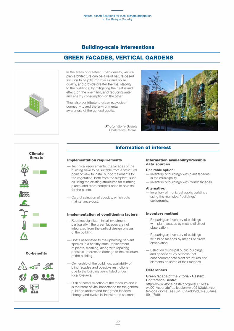
Nature-based Solutions for local climate adaptation in the Basque Country
66
Building-scale interventions
GREEN FACADES, VERTICAL GARDENS
Implementation requirements
— Technical requirements: the facades of the building have to be suitable from a structural point of view to install support elements for the vegetation, both from the simplest, such as using the existing structures for climbing plants, and more complex ones to hold soil for the plants.
— Careful selection of species, which cuts maintenance cost.
Implementation of conditioning factors
— Requires significant initial investment, particularly if the green facades are not integrated from the earliest design phases of the building.
— Costs associated to the upholding of plant species in a healthy state, replacement of plants, cleaning, along with repairing possible unforeseen damage to the structure of the building.
— Ownership of the buildings, availability of blind facades and possible restrictions due to the building being listed under local byelaws.
— Risk of social rejection of the measure and it is therefore of vital importance for the general public to understand that green facades change and evolve in line with the seasons.
Information availability/Possible data sources
Desirable option:— Inventory of buildings with plant facades
in the municipality. — Inventory of buildings with "blind" facades.
Alternative:— Inventory of municipal public buildings
using the municipal "buildings" cartography.
Inventory method
— Preparing an inventory of buildings with plant facades by means of direct observation.
— Preparing an inventory of buildings with blind facades by means of direct observation.
— Selection municipal public buildings and specific study of those that canaccommodate plant structures and elements on some of their facades.
References
Green facade of the Vitoria - Gasteiz Conference Centre:http://www.vitoria-gasteiz.org/we001/was/we001Action.do?aplicacion=wb021&tabla=contenido&idioma=es&uid=u25e08f9d_14a56aaea69__7fd9
In the areas of greatest urban density, vertical plan architecture can be a valid nature-based solution to help to improve air and noise quality, and provide greater thermal stability to the buildings, by mitigating the heat island effect, on the one hand, and reducing water and energy consumption on the other.
They also contribute to urban ecological connectivity and the environmental awareness of the general public.
Photo. Vitoria-Gasteiz Conference Centre.
Information of interestClimate threats
Co-benefits

Methodological guide for their identification and mapping.Donostia/San Sebastián case study
67
There is great potential in the design and fitting out of the community courtyards of buildings as well of the community private use space between buildings, whether according to nature-based criteria, particularly in the high density urban areas.
Naturing alternatives in community use spaces Both the community courtyards and the community private use spaces between buildings offer a considerable surface area where to install different blue and green elements, such as:
— Pervious pavements help to improve the surface runoff and therefore to reduce flooding from rain.
— Vegetation in different forms, in plant pots and planters to more or less dense wooded areas depending on the availability of land, that improve the air quality, mitigate the heat island effect, act as a noise barrier and foster ecological connectivity.
— Fountains and water features that freshen the atmosphere, mitigating the heat island effect.
— The vegetable gardens and fruit trees.
— The naturing of those spaces foster the enjoyment and social use of them, avoiding possible acts of vandalism and improving the quality of life of the users.
Building-scale intervention
NATURING COMMUNITY-USE SPACES
Implementation requirements
— Even though there are no specific technical requirements that limit its implementation, each intervention must be in line with the uses allowed above ground.
— A type of vegetation has to be selected that is most appropriate to the climate and local species.
Implementation of conditioning factors
— Requires significant initial investment and cooperation between different resident communities.
— There are associated maintenance costs (mainly cleaning and looking about the plant species, control of pests, etc.). Those costs have to be shared by different residents' association which requires a level of cooperation that should not be underestimated.
— Ownership of the buildings and possible restrictions due their being listed under local byelaws.
— Technical limitations: community courtyards with restricted access, limited available surface area, existence of underground courtyards.
Information availability/Possible data sourcesDesirable option:
— Municipal cartography of "buildings". — Municipal cartography of "green areas.
Alternative:
— Urban cadastral of the Provincial Councils of the Basque Country.
— GeoEuskadi Orthophotos.
Inventory method
— Spatial analysis of either the municipal "buildings" cartography or of the urban cadastral to identify the free spaces between buildings. If this cartography is cross-referenced against the municipal "green areas" cartography, the spaces between buildings that have already been planted can be pinpointed.
— Failing that, the cartography of the urban cadastral together with an analysis of the orthophotos can help to identify the potentially free spaces between buildings.
ReferencesChapter 7 of this Guide describes the intervention in community courtyards undertaken in the Área Romántica neighbourhood of Donostia / San Sebastián.
Photo. Communal courtyard in Área Romántica in Donostia / San Sebastián.
Community courtyard actions
Greening areas between buildings
Information of interestClimate threats
Co-benefits
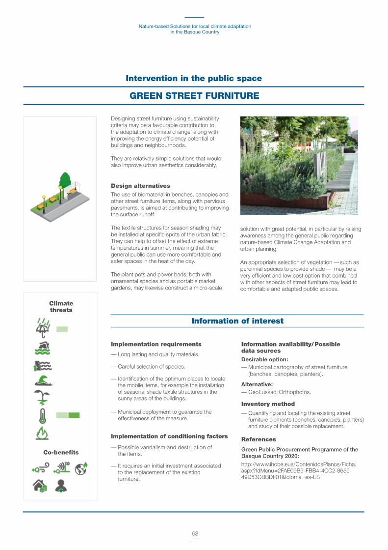
Nature-based Solutions for local climate adaptation in the Basque Country
68
Designing street furniture using sustainability criteria may be a favourable contribution to the adaptation to climate change, along with improving the energy efficiency potential of buildings and neighbourhoods.
They are relatively simple solutions that would also improve urban aesthetics considerably.
Design alternativesThe use of biomaterial in benches, canopies and other street furniture items, along with pervious pavements, is aimed at contributing to improving the surface runoff.
The textile structures for season shading may be installed at specific spots of the urban fabric. They can help to offset the effect of extreme temperatures in summer, meaning that the general public can use more comfortable and safer spaces in the heat of the day.
The plant pots and power beds, both with ornamental species and as portable market gardens, may likewise construct a micro-scale
solution with great potential, in particular by raising awareness among the general public regarding nature-based Climate Change Adaptation and urban planning.
An appropriate selection of vegetation — such as perennial species to provide shade — may be a very efficient and low cost option that combined with other aspects of street furniture may lead to comfortable and adapted public spaces.
Intervention in the public space
GREEN STREET FURNITURE
Implementation requirements
— Long lasting and quality materials.
— Careful selection of species.
— Identification of the optimum places to locate the mobile items, for example the installation of seasonal shade textile structures in the sunny areas of the buildings.
— Municipal deployment to guarantee the effectiveness of the measure.
Implementation of conditioning factors
— Possible vandalism and destruction of the items.
— It requires an initial investment associated to the replacement of the existing furniture.
Information availability/ Possible data sourcesDesirable option:— Municipal cartography of street furniture
(benches, canopies, planters).
Alternative:— GeoEuskadi Orthophotos.
Inventory method
— Quantifying and locating the existing street furniture elements (benches, canopies, planters) and study of their possible replacement.
References
Green Public Procurement Programme of the Basque Country 2020:
http://www.ihobe.eus/ContenidosPlanos/Ficha.aspx?IdMenu=2FAE09B5-FBB4-4CC2-8655-49D53CBBDF01&Idioma=es-ES
Information of interest
Climate threats
Co-benefits
Methodological guide for their identification and mapping.Donostia/San Sebastián case study
69
Interventions in the public space and in linear transport infrastructures
PERVIOUS PAVEMENTS
Implementation requirements— It is a relatively straightforward technology,
which becomes more effective if its implementation is widespread throughout the city.
— Pervious pavements is particularly viable for surface car parks, pedestrian streets, spaces between buildings, squares and children's playgrounds.
Implementation of conditioning factors— The implementation of porous and pervious
surfaces (even though it is based on relatively simple technology) is only viable if not located on underground amenities, such as car parks.
Information availability / Possible data sources
Desirable option:— Municipal cartography of "pavements".
— Municipal cartography of "surface car parks".
— Municipal cartography of "underground car parks".
Alternative:— GeoEuskadi Orthophotos.
Inventory method — Municipal cartography of road traffic areas
and surface car parks.
— Requires visual correction using orthophotos.
ReferencesMadrid +Natural Pervious Surfaces:
http://www.madrid.es/UnidadesDescentralizadas/ Sostenibilidad/EspeInf/EnergiayCC/04Cambi oClimatico/4c3Mad+Natural/Ficheros/08B4_ SuperficiesPerviouss.pdf
The use of pervious and porous surfaces considerably contribute to better as pavements is absorption of the runoff water and therefore a simple technology and with great outreach at help the city
to address the periods of urban level that when implemented extreme rain and their immediate impact such on a generalised scale in the city can as flooding, mainly due to rain.
Information of interestClimate threats
Co-benefits

Nature-based Solutions for local climate adaptation in the Basque Country
70
Intervention in the public space
COMFORTABLE URBAN PLACES
Implementation requirements
— The permeability and drainage possibilities condition the intervention (e.g. existence of underground car parks).
— Selection of adapted species.
Implementation of conditioning factors
— Maintenance costs.
— Existence of restrictions associated to protecting the urban heritage.
— To ensure the social acceptance of this type of measures, it is important to conduct an awareness raising campaign so that the public understands their benefits both against the effects of climate change and for the health, comfort and quality of life in general.
Information availability / Possible data sources
Desirable option:
— Master Plan PGOU "public-living areas". — Municipal cartography of "squares",
"playgrounds" and "landscaped areas".
— Municipal cartography of "green areas" and "landscaped areas.
— Municipal cartography of "underground car parks".
Alternative:
— GeoEuskadi Orthophotos.
Inventory method
— Spatial analysis, using the available cartography of "public-living areas", "squares", "playgrounds" to quantify the potential available space for the intervention and design of comfortable squares and urban areas.
— This cartography needs to be cross-referenced with the "green areas" and "landscaped areas" cartography in order to pinpoint the already planted area.
— If that cartography is not available, an analysis of the orthophotos will allow the public-living areas to be identified that potentially could be designed using sustainability and and comfort criteria.
References
Plaza General Latorre, Bilbao. Pilot
scheme in the context of the Life QUADMAP project:
http://www.quadmap.eu/wp-content/ uploads/2012/02/1049_INSBRUCK_QUADMAP_ TECNALIA_2-Modo-de-compatibilidad.pdf
The design and fitting out of comfortable public areas is an extremely relevant measure in Climate Change Adaptation and for sustainable urban development in general.
The naturing of public-living areas, such as hard squares, by introducing Nature-based Solution, replacing sealed surfaces by pervious pavements or the introduction of vegetation and wooded areas and water features, helps to improve the surface runoff and the mitigation of the heat island effect, at the same time that they become adapted spaces for the use and enjoyment of the general public.
Comfortable squares also become quality spaces, healthy and safe meeting places and the flagship of sustainable urban development.
Photo. Sound Island in Plaza General Latorre de Basurto (Bilbao).
Climate threats
Co-benefits
Information of interest
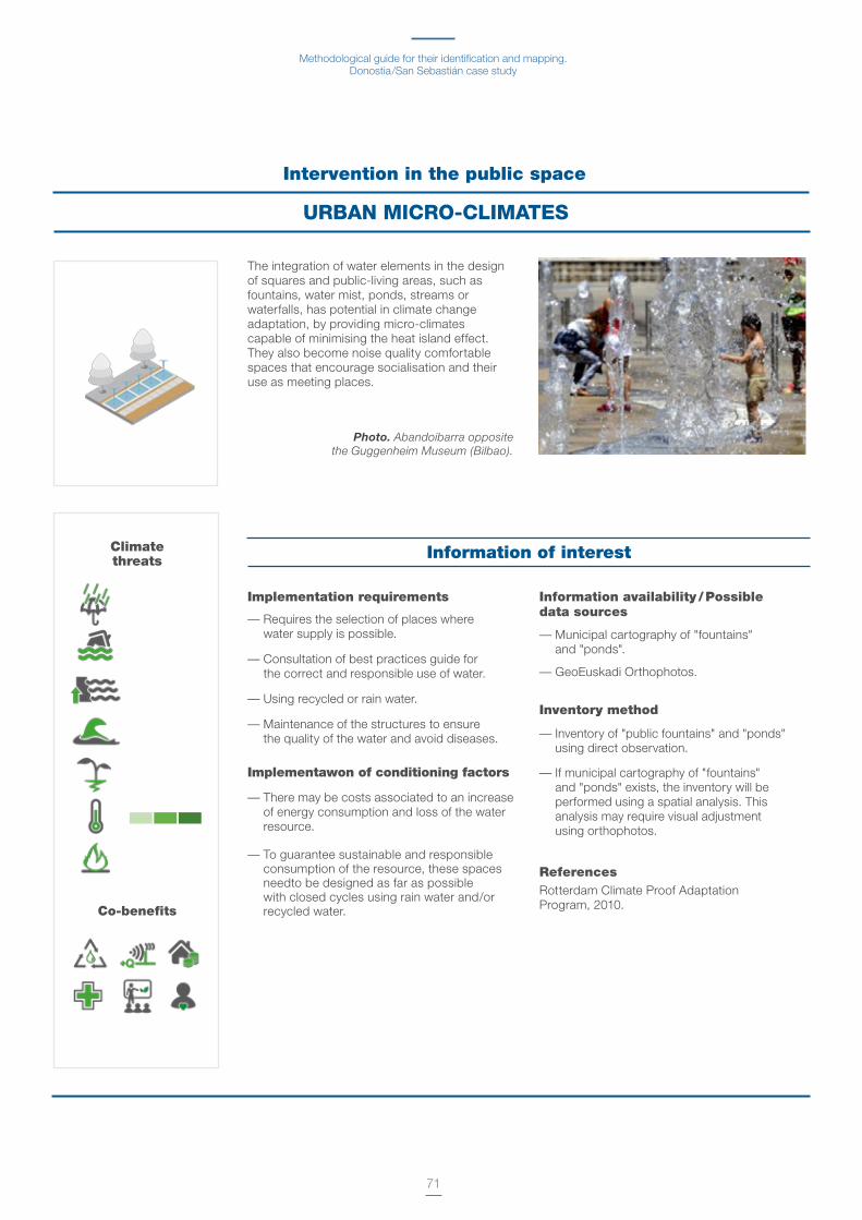
Methodological guide for their identification and mapping.Donostia/San Sebastián case study
71
Climate threats
Intervention in the public space
URBAN MICRO-CLIMATES
Implementation requirements
— Requires the selection of places where water supply is possible.
— Consultation of best practices guide for the correct and responsible use of water.
— Using recycled or rain water.
— Maintenance of the structures to ensure the quality of the water and avoid diseases.
Implementawon of conditioning factors
— There may be costs associated to an increase of energy consumption and loss of the water resource.
— To guarantee sustainable and responsible consumption of the resource, these spaces needto be designed as far as possible with closed cycles using rain water and/or recycled water.
Information availability / Possible data sources
— Municipal cartography of "fountains" and "ponds".
— GeoEuskadi Orthophotos.
Inventory method
— Inventory of "public fountains" and "ponds" using direct observation.
— If municipal cartography of "fountains" and "ponds" exists, the inventory will be performed using a spatial analysis. This analysis may require visual adjustment using orthophotos.
References Rotterdam Climate Proof Adaptation Program, 2010.
The integration of water elements in the design of squares and public-living areas, such as fountains, water mist, ponds, streams or waterfalls, has potential in climate change adaptation, by providing micro-climates capable of minimising the heat island effect. They also become noise quality comfortable spaces that encourage socialisation and their use as meeting places.
Photo. Abandoibarra opposite the Guggenheim Museum (Bilbao).
Co-benefits
Information of interest

Nature-based Solutions for local climate adaptation in the Basque Country
72
Interventions in the public space
ALLOTMENT GARDENS
The production of food in integrated spaces in the urban environment is a very versatile measure as urban agriculture can occur anywhere, from the rooftops and facades of the buildings, community courtyards and spaces between buildings, to public spaces, wasteland and periurban areas.
General descriptionIn climate change adaptation, they help to reduce the heat island impact, in particular, if they are located in buildings, either on roofs or in spaces between buildings or in community courtyards. They may also compatible to be used as controlled flooding areas in periods of extraordinary river surges.
Urban allotments are particularly feasible and appropriate when regenerating degraded and/or wasteland, by providing a temporary use of them.
From the environmental perspective, urban gardens enable composting, fostering the ecological connectivity in particular between the unconsolidated urban environment and the natural and non periurban environment.
From the social perspective, urban allotments have an urban revitalisation aspect, by means of more efficient harnessing of the public land for recreational and public-living activities and food production in response to the growing concern about the depletion of natural resources.
Urban allotments also further active citizen participation in community life, create a feeling of belonging in the neighbourhoods, reduce vandalism and foster awareness raising as regards conserving biodiversity, recycling and responsible consumption.
They also offer health benefits as urban allotments encourage people to eat fresh vegetables, food grown using organic farming techniques that do not contain pesticides or chemical elements and also raise the physical activity levels of the people who work in the gardens.
Types and specific characteristicsUrban agriculture can be implemented practically anywhere in the city from the rooftops and flat roofs or community courtyards and free spaces between the buildings to more outlying urban sites.
Photo. Urban vegetable garden in Getxo.
Climate threats
Co-benefits
Methodological guide for their identification and mapping.Donostia/San Sebastián case study
73
Implementation requirements
— Geographical factors for growing: slope of the land and preparation needs, orientation of the site (hours of sun), wind systems, run-off, etc.
— Urban zoning of the municipality: ownership of the land, compatibility with planning, land use (land classified as non developable), proximity to population centres and accessibility to the sites (existing infrastructures, public transport).
— Environmental conditioning factors of the site: Given that urban vegetable gardens are spaces for enjoyment, interaction of the users and public-living, it is important to access the environmental conditions to which the users will be subject (soil pollution, noise levels, thermal comfort and air pollution).
— Preparing the site by levelling the land and subsequent provision of earth. The availability of soil of the appropriate quality, natural earth for agricultural purposes, depends on building work being underway with surplus soilh. The need for soil to be brought in from outside sources for the vegetable gardens to get up and running may slow down the project.
— Their inclusion in local schools and homes for older people or with special needs means they can be used for therapeutic and educational purposes.
— Conserving the biodiversity of interest: priority is given to maintaining the biodiversity of interest or that is protected in terms of the location of urban allotments, as the initial criterion in the assessment procedure to set up allotments.
Implementation of conditioning factors
— It has to be guaranteed that the sites are not in "potentially polluted" locations which would not suitable for agricultural activities.
— Initial investment to prepare the sites: levelling the land and provision of soil, electricity and water supplies, availability of spaces to located auxiliary services (tool hut, toilets, public-living areas, etc.).
— Constraints associated to the urban zoning of the municipality.
— Contingency plan to avoid possible acts of vandalism during the implementation of the project, by means of restricting access to the allotments by means of fencing or hedges, for example.
— Social acceptance of the measure.
Information availability / Possible data sourcesDesirable option:
— Municipal cartography of "urban vegetable gardens/orchards".
— Inventory of potentially contaminated land of the Basque Country.
Alternative:— GeoEuskadi Orthophotos.
Inventory method
— Inventory of urban allotments/orchards using the available municipal cartography and, failing that, using orthophotos.
— The following sequence will be deployed to identify possible areas to create future urban orchards:
• Pre-selection of publicly-owned sites, in accordance with accessibility criteria and availability of services (water and light).
• Consultation of the potentially contaminated soil inventory to detect those sites not suitable for agricultural production.
References
Urban allotments in the municipality of Santurtzi (Bizkaia):
http://www.udalsarea21.net/BuenasPracticas/ Ficha.aspx?IdMenu=381395ad-9baa-4408-809e- a73e0a2ec092&Cod=8c92fae2-f3fd-45f2-92ea- 9d5e82dd2806&Idioma=es-ES
The School Allotment. Manual published by the Basque Government.
http://www.hezkuntza.ejgv.euskadi.eus/r43-2459/es/contenidos/informacion/dig_publicaciones_innovacion/es_edu_ambi/adjuntos/800001c_huerto_escolar_c.pdf
Information of interest

Nature-based Solutions for local climate adaptation in the Basque Country
74
Interventions in the public space
URBAN PARKS AND URBAN FORESTS
Implementation requirements
— Requires a careful selection of species well adapted to the land and local climate.
— Guarantee of public accessibility to those parks.
— Connectivity with other green areas of the municipality.
— Possibility of synergy with Sustainable Drainage Systems that will reduce the maintenance costs associated with the use of water for irrigation.
Implementation of conditioning factors
— Cost of initial investment to be assessed versus the life cycle.
— Possible incompatibility of the uses of the land in line with urban planning.
Information availability / Possible data sourcesDesirable option: — Master Plan PGOU.— Municipal cartography of "open areas". — Municipal cartography of "urban forests". — Municipal cartography of "parks".
Alternative:— GeoEuskadi Orthophotos.
Inventory method— Preparation of an urban forests and park
inventory using spatial analysis of the municipal "open areas", "urban forests" and "parks" cartography. This analysis may require visual adjustment using orthophotos.
ReferencesUdalsarea21 Notebook 20b: Sustainable Gardening Manual.http://www.udalsarea21.net/Publicaciones/Ficha.aspx?IdMenu=892e375d-03bd-44a5-a281-f37a7cbf95dc&Cod=ec1f62b8-a941-4c9a-9280-e4202e656a69&Idioma=es-ES&Tipo=
They are naturalised public spaces that form part of the urban fabric, are home to habitats for flora and fauna and are recreational, public-living and socialisation areas for the general public.
General descriptionParks, whether they are large wooded areas, small or linear, generally associated to the renaturing of transport infrastructures, are conceived as highly versatile urban intervention elements in relation to climate change adaptation and mitigation, sustainable urban development and resilience.
They help to regulate the climate (seques-tering carbon), the temperature (providing humidity to the atmosphere and shade and thus reducing the heat island effect) and the water cycle (reducing the surface runoff and the risk of rain flooding).
They likewise foster the maintenance of biodiversity, improve health (absorbing gas pollutants and particulates and mitigating
noise pollution) and wellbeing in general as spaces for outdoor physical exercise, recreation, socialisation and experiences to get back in contact with nature.
Indirectly, they help to cut the municipal costs associated to environmental management and health, they contribute to the appreciation of the land and properties in their catchment area.
They are a key urban hallmark and brand the place.
Photo. Europa Park (Bilbao).
Climate threats
Co-benefits
Information of interest
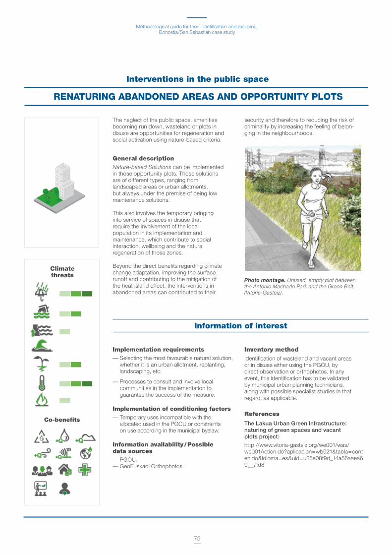
Methodological guide for their identification and mapping.Donostia/San Sebastián case study
75
The neglect of the public space, amenities becoming run down, wasteland or plots in disuse are opportunities for regeneration and social activation using nature-based criteria.
General descriptionNature-based Solutions can be implemented in those opportunity plots. Those solutions are of different types, ranging from landscaped areas or urban allotments, but always under the premise of being low maintenance solutions.
This also involves the temporary bringing into service of spaces in disuse that require the involvement of the local population in its implementation and maintenance, which contribute to social interaction, wellbeing and the natural regeneration of those zones.
Beyond the direct benefits regarding climate change adaptation, improving the surface runoff and contributing to the mitigation of the heat island effect, the interventions in abandoned areas can contributed to their
security and therefore to reducing the risk of criminality by increasing the feeling of belon-ging in the neighbourhoods.
Interventions in the public space
RENATURING ABANDONED AREAS AND OPPORTUNITY PLOTS
Photo montage. Unused, empty plot between the Antonio Machado Park and the Green Belt. (Vitoria-Gasteiz).
Information of interest
Implementation requirements— Selecting the most favourable natural solution,
whether it is an urban allotment, replanting, landscaping, etc.
— Processes to consult and involve local communities in the implementation to guarantee the success of the measure.
Implementation of conditioning factors— Temporary uses incompatible with the
allocated used in the PGOU or constraints on use according in the municipal byelaw.
Information availability / Possible data sources — PGOU.— GeoEuskadi Orthophotos.
Inventory method
Identification of wasteland and vacant areas or in disuse either using the PGOU, by direct observation or orthophotos. In any event, this identification has to be validated by municipal urban planning technicians, along with possible specialist studies in that regard, as applicable.
References
The Lakua Urban Green Infrastructure: naturing of green spaces and vacant plots project:
http://www.vitoria-gasteiz.org/we001/was/we001Action.do?aplicacion=wb021&tabla=contenido&idioma=es&uid=u25e08f9d_14a56aaea69__7fd8
Co-benefits
Climate threats

Nature-based Solutions for local climate adaptation in the Basque Country
76
Interventions in water bodies and drainage systems
SUSTAINABLE URBAN DRAINAGE SYSTEMS
Sustainable drainage systems are one of the most important urban adaptation measures to address intense precipitation phenomena.
The replacement of hard surfaces by pervious ones that facilitate the absorption of rain water is considered a very efficient solution in the management of the water cycle particularly in dense urban areas.
General descriptionSustainable drainage systems are taken to mean the set of measures that use nature and its processes (evaporation, infiltration and plant transpiration) to foster the natural infiltration of rain water and runoff from streets, public spaces and hard surfaces in general. The separate networks of wastewater and rainwater, pervious pavements, the restoration of streams and gutters, underground water storage, ponds, wetlands, plant roofs are some of the solutions that come under sustainable drainage systems. Sustainable drainage systems have numerous benefits, both regarding climate change adaptation, and economic, social and environmental ones.
Sustainable drainage systems reduce the impact of extreme rain events and storms, and therefore the risk of flooding, by relieving the volume of water entering the sanitation network. This fosters more rational water management and avoids possible pollution of this resource, due to saturation at the sanitation stations. The naturally filtered water can be used as a public-living or recreational element and to water adjacent parks and gardens, in order to lower the temperature on hot days.
These solutions have numerous environmental benefits, by helping to regulate the natural water cycle, keeping the land humid and fostering healthy vegetation in the city. They also offer social benefits as the design of the public space that is part of those drainage systems, turns it into attractive recreational and meeting areas.
Economically, they cut energy consumption and water treatment costs, reduce the impacts of floods and the costs associated to the losses and damages generated, and increase the value of the land and the properties in safer and healthy areas.
Photo-intervention in Avenida Gasteiz.(Vitoria-Gasteiz).
Climate threats
Co-benefits

Methodological guide for their identification and mapping.Donostia/San Sebastián case study
77
Implementation requirements— Different actions imply different levels of technical
and management implementation and complexity.
— Requires coordination between different departments of the local public authority: environment, urban planning, public space.
— The effectiveness of the sustainable drainage systems increases if their implementation is widespread throughout the urban infrastructure.
— Possibility of discharge into the sanitation network.
Implementation of conditioning factors
— Requires initial investment, even though they are more efficient measures, in medium-to-long economic terms, than the traditional wastewater infrastructures.
— Incompatibility with traditional sanitation networks in particular in the old quarters and high density consolidated urban areas.
— Constraints due to the existence of underground amenities.
— They are long-term implementation and deployment measures.
Information availability / Possible data sources
Desirable option:
— PGOU.— Cartography of the municipal sanitation and
sewage network.
For more accurate detailed studies:
— Detailed-scale Digital Elevation Model (DEM) of the municipality.
Inventory method— Spatial analysis using the cartography of the
municipal sanitation and sewage network.
— Detecting possible network saturation hot points of the network and areas that need greater relief, as priority areas to implement a sustainable drainage system to ensure better functioning of the network.
— A microbasin study using the detailed scale municipal DEM will allow those hot points to be pinpointed more precisely.
References — Urban reform of Avenida Gasteiz. Vitoria - Gasteiz.
— The Green and Blue Space Adaptation for Urban Areas and Eco Towns (GRaBS).
Information of interest
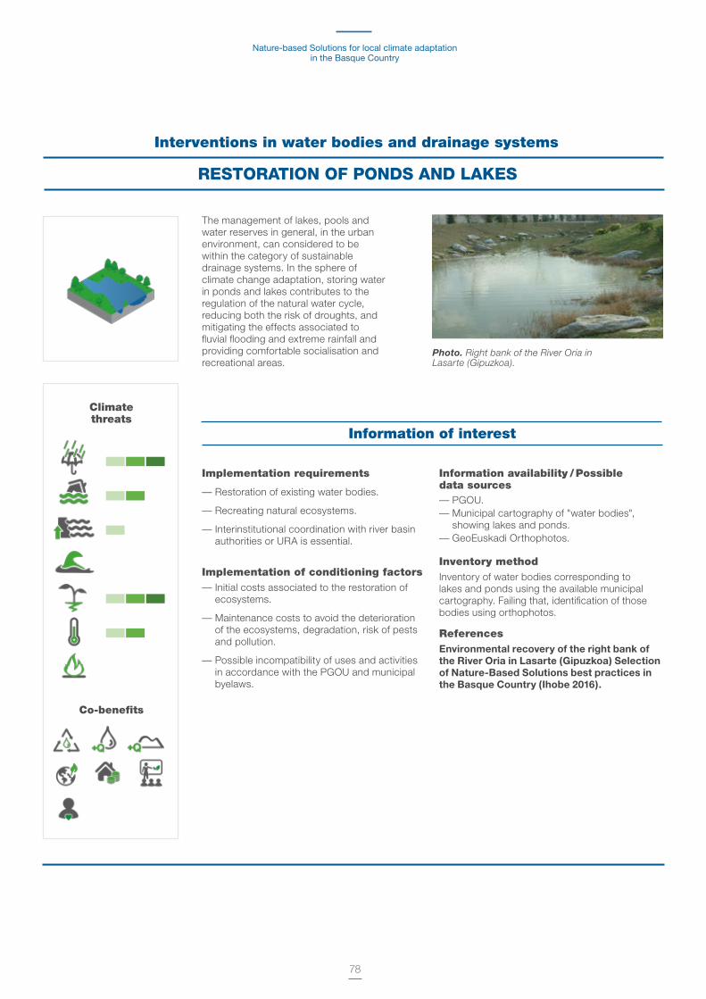
Nature-based Solutions for local climate adaptation in the Basque Country
78
Interventions in water bodies and drainage systems
RESTORATION OF PONDS AND LAKES
The management of lakes, pools and water reserves in general, in the urban environment, can considered to be within the category of sustainable drainage systems. In the sphere of climate change adaptation, storing water in ponds and lakes contributes to the regulation of the natural water cycle, reducing both the risk of droughts, and mitigating the effects associated to fluvial flooding and extreme rainfall and providing comfortable socialisation and recreational areas.
Photo. Right bank of the River Oria in Lasarte (Gipuzkoa).
Implementation requirements
— Restoration of existing water bodies.
— Recreating natural ecosystems.
— Interinstitutional coordination with river basin authorities or URA is essential.
Implementation of conditioning factors— Initial costs associated to the restoration of
ecosystems.
— Maintenance costs to avoid the deterioration of the ecosystems, degradation, risk of pests and pollution.
— Possible incompatibility of uses and activities in accordance with the PGOU and municipal byelaws.
Information availability / Possible data sources— PGOU.— Municipal cartography of "water bodies",
showing lakes and ponds. — GeoEuskadi Orthophotos.
Inventory methodInventory of water bodies corresponding to lakes and ponds using the available municipal cartography. Failing that, identification of those bodies using orthophotos.
ReferencesEnvironmental recovery of the right bank of the River Oria in Lasarte (Gipuzkoa) Selection of Nature-Based Solutions best practices in the Basque Country (Ihobe 2016).
Climate threats
Co-benefits
Information of interest

Methodological guide for their identification and mapping.Donostia/San Sebastián case study
79
Climate threats
Co-benefits
Interventions in water bodies and drainage systems
RENATURING RIVERS AND STREAMS
Implementation requirements— River restoration is a mature discipline and
the technical feasibility of this type of green solutions is guaranteed.
— Citizen safety never has to be compromised under any circumstances in the river restoration and renaturing.
— Interinstitutional coordination with river basin authorities or URA is essential.
— Requires high technical expertise.
Implementation of conditioning factors— Environmental restoration implies either viable
mature techniques with a high initial cost or a short-term return, growing in the medium and long term.
— Maintenance costs to control pests, particularly mosquitoes.
— Alignment with the Sectoral Provincial Management Plan of the Rivers and Streams of the Basque Country.
Information availability / Possible data sources
— Master Plan PGOU. — Municipal cartography of "water bodies",
showing surface and underground urban rivers, canals, streams and gutters.
— Basque Government's cartography of the water network.
Inventory method
Inventory of water bodies of surface and underground urban rivers, canals, streams and gutters, either using municipal cartography or the Basque Government's cartography of the water network.
Consultation with URA to pinpoint those sections with a greater risk of flooding, whose restoration and renaturing may help to improve the water cycle of the municipality and the reduction of the food spot.
ReferencesRiver Olaritzu storm-water sink. Vitoria-Gasteiz:
http://www.vitoria-gasteiz.org/we001/was/we001Ac-tion.do?aplicacion=wb021&tabla=contenido&idioma=es&uid=u_cf6b56a_152c99aa0a0__7e3eIntegral restoration in the Urdaibai biosphere reserve: Climate Change in the Basque Country. 22 Best Practices:
http://www.udalsarea21.net/Publicaciones/Ficha.aspx?IdMenu=892e375d-03bd-44a5-a281-f37a7cbf95dc&Cod=1848992b-2eef-4099-b949-5c17f2672552&Idioma=es-ES
Cities have great potential to recover the modified sections of their rivers and streams, and to reduce channelling by means of restoring their riverbanks. This renaturing process is a powerful climate change adaptation measure, as it contributes to the recovery of natural ecosystems, the regulation of the natural cycle and the reduction of the risk of flooding.
General descriptionTalking about renaturing rivers and streams is talking about the recovery of their original courses, as they have been modified in the vast majority of our cities to be able to create new infrastructures and amenities. However, the majority of the rivers and streams of the cities are either underground or channelled, and the riparian ecosystems have therefore disappeared.
The benefits of recovering the original routes of the watercourses are well known. It allows better regulation of the natural water cycle, by catching the residual rain water and thus helping to reduce the impact from flooding.
Yet beyond those direct benefits, restoring the river-banks allows the recovery of most riparian ecosys-tems, thus increasing the biodiversity in the urban environment, the ecological connectivity with other natural elements of the urban green infrastructure.
The renatured rivers and streams are elements that contribute to the quality of life of the citizens, by improving the urban landscape, fostering recreational areas and places for walking, improving the health of the users.
The city revitalisation around the greened rivers has been seen in numerous cities, from Seoul to London or Madrid.
Photo. River Olaritzu storm-water sink. Vitoria-Gasteiz.
Information of interest

Nature-based Solutions for local climate adaptation in the Basque Country
80
Ensuring the readiness of watercourses and river plains for their controlled flooding as a strategy to moderate the water flows at times of extreme precipitation is becoming one of the options chosen by the cities in their climate change adaptation process.
It is a particularly appropriate solution in areas at risk of flooding.
General descriptionControlled flood plains consist of the conscious design of pervious green areas and recreational areas on river plains as temporary flooding spaces to regulate the excess flows and their access to the drainage network, avoiding the collapse of the water treatment and sanitation networks.
Its role as a measure to mitigate the impact of the flooding is clear, but beyond that, the controlled flooding areas have an environmental function as the riparian vegetation improves local biodiversity and they are also zones for the use and enjoyment of the general public and they therefore have a clear social function.
From an economic perspective, the controlled flooding areas reduce the energy and water treatment costs, as they foster the natural infiltration of the water and they likewise reduce the costs associated to the flooding due to losses or material damages, and increase the value of the land in the adjacent urban areas that become safer areas and with a quality urban landscape.
Interventions in water bodies and drainage systems
CONTROLLED FLOOD PLAINS
Implementation requirements
— Interinstitutional coordination with river basin authorities or URA is essential.
— Requires high technical expertise to always ensure the flooding process is safe.
Implementation of conditioning factors
— High initial cost arising from the acquisition of land, detailed studies to establish the floodable areas, preparing the land that can involve hydraulic engineering work, etc.
— Possible conflict of uses and activities according to the PGOU.
Information availability / Possible data sources— Hazard and risk maps of the areas with
potential significant flood risk (APSFR) of the Basque Country (URA).
Inventory method— Spatial analysis to identify flood spots in a
return period of 500 years or less using the hazard and risk cartography of the areas with potential significant flood risk (APSFR) of the Basque Country.
ReferencesCrossing of floodwaters in the River Zadorra (Eskalmendi-Gamarra section) http://www.vitoria-gasteiz.org/we001/was/we001Ac-tion.do?aplicacion=wb021&tabla=contenido&idioma=es&uid=u_cf6b56a_152c99aa0a0__7e3d
Photo. Crossing of floodwaters in the River. Zadorra (Eskalmendi-Gamarra section).
Climate threats
Co-benefits
Information of interest
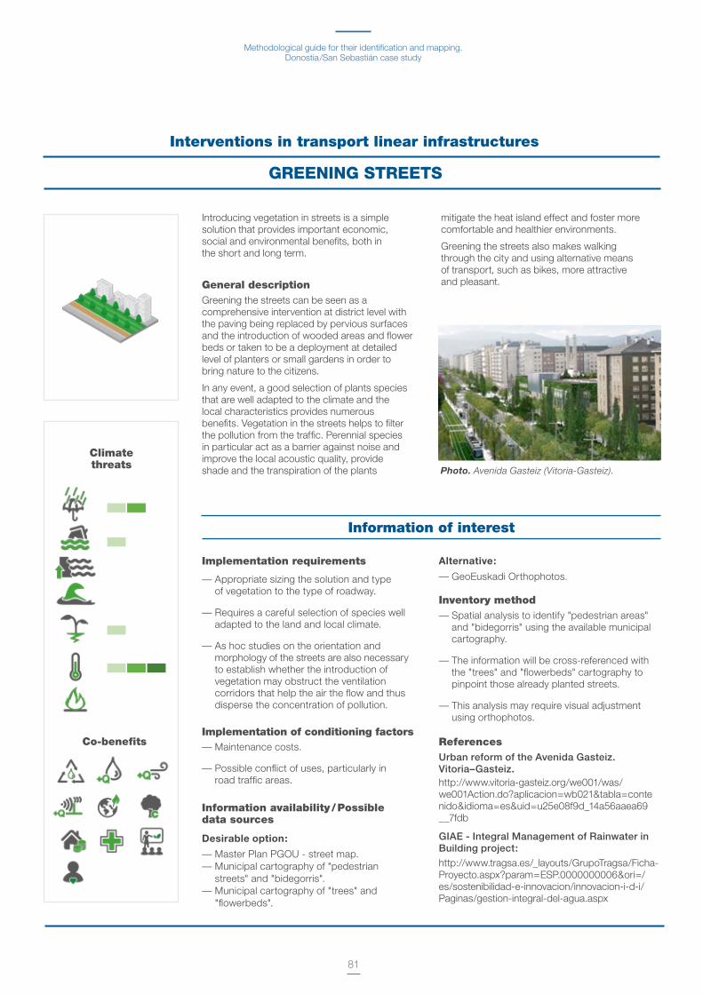
Methodological guide for their identification and mapping.Donostia/San Sebastián case study
81
Introducing vegetation in streets is a simple solution that provides important economic, social and environmental benefits, both in the short and long term.
General descriptionGreening the streets can be seen as a comprehensive intervention at district level with the paving being replaced by pervious surfaces and the introduction of wooded areas and flower beds or taken to be a deployment at detailed level of planters or small gardens in order to bring nature to the citizens.
In any event, a good selection of plants species that are well adapted to the climate and the local characteristics provides numerous benefits. Vegetation in the streets helps to filter the pollution from the traffic. Perennial species in particular act as a barrier against noise and improve the local acoustic quality, provide shade and the transpiration of the plants
mitigate the heat island effect and foster more comfortable and healthier environments.
Greening the streets also makes walking through the city and using alternative means of transport, such as bikes, more attractive and pleasant.
Interventions in transport linear infrastructures
GREENING STREETS
Photo. Avenida Gasteiz (Vitoria-Gasteiz).
Implementation requirements
— Appropriate sizing the solution and type of vegetation to the type of roadway.
— Requires a careful selection of species well adapted to the land and local climate.
— As hoc studies on the orientation and morphology of the streets are also necessary to establish whether the introduction of vegetation may obstruct the ventilation corridors that help the air the flow and thus disperse the concentration of pollution.
Implementation of conditioning factors— Maintenance costs.
— Possible conflict of uses, particularly in road traffic areas.
Information availability / Possible data sources
Desirable option:
— Master Plan PGOU - street map.— Municipal cartography of "pedestrian
streets" and "bidegorris". — Municipal cartography of "trees" and
"flowerbeds".
Alternative:
— GeoEuskadi Orthophotos.
Inventory method— Spatial analysis to identify "pedestrian areas"
and "bidegorris" using the available municipal cartography.
— The information will be cross-referenced with the "trees" and "flowerbeds" cartography to pinpoint those already planted streets.
— This analysis may require visual adjustment using orthophotos.
ReferencesUrban reform of the Avenida Gasteiz. Vitoria–Gasteiz.http://www.vitoria-gasteiz.org/we001/was/we001Action.do?aplicacion=wb021&tabla=contenido&idioma=es&uid=u25e08f9d_14a56aaea69__7fdb
GIAE - Integral Management of Rainwater in Building project:
http://www.tragsa.es/_layouts/GrupoTragsa/Ficha-Proyecto.aspx?param=ESP.0000000006&ori=/es/sostenibilidad-e-innovacion/innovacion-i-d-i/Paginas/gestion-integral-del-agua.aspx
Climate threats
Co-benefits
Information of interest

Nature-based Solutions for local climate adaptation in the Basque Country
82
The naturing of the high capacity linear infrastructure can become a means of urban revitalisation and resilient urban planning in increasingly denser and more population cities.
General descriptionPlanting vegetation along the roads, railways lines and the associated features, such as bridges, notably fosters biodiversity, by creating new habitats for flora and fauna, and creating corridors that contribute to the ecological connectivity between different urban green areas, until they become linear parks.
Around the high capacity infrastructures, there are usually vacant spaces in disuse, whose naturing would not only considerably improve the quality of the urban landscape
in those usually degraded places, but which can mean their coming into use in the form of walks and safer and more attractive sports and recreational zones.
Interventions in transport linear infrastructures
GREEN LINEAR INFRASTRUCTURES
Implementation requirements— Interinstitutional coordination with the
Provincial Councils in charge of the roads of the Basque Country, along with Euskotren and ADIF, in the case of railways, is essential.
Implementation of conditioning factors— Initial cost associated to the renaturing and
fitting out of the spaces adjacent to the infrastructures.
— Costs associated to the upkeep of the plant features to avoid their damaging the structures and leading to risks to traffic safety.
— Compliance of the road traffic and safety legislation relating to all jurisdictions (local, regional, national).
— Alignment with the Road Sectoral Provincial Plans in Bizkaia, Araba and Gipuzkoa.
— Technical constraints to ensure that the vegetation does not damage structures and be a risk to road traffic safety.
Information availability / Possible data sources— PGOU - roads and railways.
— Road networks of the Provincial Councils.
— GeoEuskadi Orthophotos.
Inventory method— Spatial analysis to identify high capacity
transport infrastructure sections that may accommodate renaturing green interventions using the available cartography.
— This analysis may require visual adjustment using orthophotos.
References— High Line of New York City. 2 km elevated
linear park built on a disused railway line. https://www.nuevayork.net/high-line
— Coulée verte René-Dumont in the city of Paris. 5 km linear park elevated 10 m high on a disused railway line. http://www.promenade-plantee.org
Photo. Bilbao tramway. Climate threats
Co-benefits
Information of interest

Methodological guide for their identification and mapping.Donostia/San Sebastián case study
83
Climate threats
Co-benefits
The recovery of the ecological functionality of the wetlands is a very effective adaptation measure and which provides important economic, social and environmental benefits.
General descriptionThe appropriate management of wetlands is a practice that even though it is not a new one, can be considered as a climate change adaptation measure with great potential as the wetlands act as sinks for floodwaters preventing rivers overflowing and, therefore, the risk of flooding and their impacts.
Yet, healthy and well restored wetlands offer many other environmental benefits and can contribute to improving the quality of the underground water in case on being over aquifers, foster the creation of habitats and contribute to biodiversity not only locally, but also globally.
Wetlands also offer great potential as places of recreation and public use, environmental education, bird watching and learning about the natural processes of the water cycle.
Interventions in natural areas and management of the rural land
WETLANDS
Implementation requirements— Initial investment associated to restoration
tasks.
— Careful fitness study in order to avoid pests, proliferation of alien species, etc.
Implementation of conditioning factors— The legal constraints set out in the
applicable legislation to manage and preserve natural areas. Nature Conservation of the Basque Country Act 16/1994, of 30 June.
— Wetland Areas Sectoral Provincial Plan: http://www.ingurumena.ejgv.euskadi.eus/r49- 564/es/contenidos/informacion/humedales_ capv/es_961/pts_humedales_c.html
Information availabilit y/ Possible data sources
— Basque Government Cartography of Wetlands of International Importance protected by the Ramsar Convention.
— Municipal cartography of wetlands and/or pools on the inventory.
— The Information System of the Nature of the Basque Country: http://www.ingurumena.ejgv.euskadi.eus/r49- u95a/es/contenidos/informacion/u95/es_def
— GeoEuskadi Orthophotos.
Inventory method— Spatial analysis for the protected wetland
inventory by consulting the protected wetlands and their conservation status according to the Basque Government official wetlands protected by the Ramsar convention and in the Natura Network, and the unprotected ones (wetlands/pools) at municipal level.
— The analysis can be completed by comparing the cartography with orthophotos.
ReferencesEnvironmental restoration of the Salburua Wetlands and recovery of their hydrological function:http://www.vitoria-gasteiz.org/we001/ was/we001Action.do?aplicacion=wb0 21&tabla=contenido&idioma=es&uid =u_cf6b56a_152c99aa0a0__7e3a
Photo. Salburua wetlands. (Vitoria-Gasteiz).
Information of interest

Nature-based Solutions for local climate adaptation in the Basque Country
84
Moving towards the configuration of a green infrastructure set up around the protected natural areas is considered to be a means of climate change adaptation that is able in turn to integrate other Nature-based Solutions.
Protected natural areas are ones that contain natural systems or features that are representative, unique, fragile, threatened or of special educational, geological, landscape, scientific or ecological interest. Furthermore, they are particularly dedicated to protecting and maintaining the biological diversity, the geodiversity and of the associated cultural and natural resources33.
General descriptionThe green infrastructure34 is conceived as a strategically planned infrastructure of natural and semi-natural areas and other environmental features designed and managed to offer a wide range of ecosystemic services, characterised by their multi-purpose and multi-scale nature.
Managing a green infrastructure around multi-scale and multi-purpose protected natural areas has great potential regarding climate change adaptation from two perspectives:
a) Due to the quality of ecosystemic services that those spaces provide, in particular, in particular regarding maintaining and regulating the water cycle and the carbon cycle.
b) As they act as a stable buffer element between the rural, periurban and urban area of the municipalities.
Protected Natural Areas (PNAs) are those places that, as they comply with certain objectives and requirements set out in the Conservation of the Nature of the Basque Country Act 16/1994, of 30 June, are covered by the protection provisions determined therein.
Special Trees: they are examples of the trees that due to their outstanding or extraordinary characteristics (size, age, history, beauty, situation, etc) deserve special protection.
Protected biotopes: these are usually small areas, and their creation seeks to protect the community ecosystems, biological features, areas of geological interest, along with specific sites of the natural environmental and formations noted for being unique, rare, of spectacular beauty or outstanding scientific interest that due to their rarity, fragility, importance or uniqueness deserve a special valuation. Pursuant to Act 16/94, Protected Biotopes are natural species that are referred to in basic legislation as natural reserves, natural monuments and protected landscapes.
Natural parks: natural parks are areas not notably transformed by human exploitation or occupancy, identifiable by the beauty of their landscapes, the representativeness of their ecosystems or the uniqueness of their flora, their fauna or their geomorphologic formations and which require, in order to make the organised harnessing of their natural resources and the public use compatible with conserving or recovering their educational, aesthetic or ecological values, of a preferential action of the public authorities.
Interventions in natural areas and management of the rural land
NATURAL PROTECTED AREAS
33 http://www.mapama.gob.es/es/biodiversidad/temas/espacios-protegidos/espacios-naturales-protegidos/ 34 http://ec.europa.eu/environment/nature/ecosystems/docs/GI-Brochure-210x210-ES-web.pdf
Photo. Upper Estuary of the River Oka (Bizkaia).
Climate threats
Co-benefits
Methodological guide for their identification and mapping.Donostia/San Sebastián case study
85
Ramsar wetlands of international importance: conservation of the wetlands "as habitat of water birds" but which has widened its scope in order to embrace all aspects of conservation and rational use of the wetlands, acknowledging that those ecosystems are extremely important for the global conservation of Biodiversity and the wellbeing of human communities.
Special Protection Areas (SPA) for birds of the Natura 2000 Network: they are places designated by the Basque Government where conservation methods are applied as regards their habitats in order to ensure the survival and breeding in their distribution areas of the species that appear in Annex I of Directive 74/409/EEC, as well as for migratory species not envisaged in Annex I but which regularly are to be found there.
Special Areas of Conservation (SAC) of the Natura 2000 Network: A Special Area of Conservation (SAC) is a place of community importance designated by the Basque Government Cabinet, in which the necessary conservation measures for natural habitats and/or the populations of the species for which the place has been designated to be maintained or re-established in a favourable conservation status.
Biosphere Reserves (UNESCO) The Biosphere Reserves of the MaB Programme are places of interest to be conserved due to their cultural and natural value, but which in turn are inhabited territories where the development function is of maximum importance.
Implementation requirements
— Requires supramunicipal multi-scale management: local interinstitutional coordination and coordination with provincial councils and Basque Government.
— It is fundamental to define the maintenance, conservation and protection objectives and find ways of harmonising different uses and different ecosystemic services.
— The configuration of a green infrastructure based on the protected natural areas requires land to be able to reserve areas for the connectivity and interlinking of those spaces, paths, greenways and ecological corridors.
Implementation of conditioning factors
— Conflicts of use due to the legal constraints set out in the applicable legislation to manage and conserve natural areas. Nature Conservation of the Basque Country Act 16/1994, of 30 June.
Information availability / Possible data sources— Basque Government cartography of Protected
Natural Areas (PNAs) of the Basque Country, Natura 2000 Network, Protected Biotopes and Biosphere Reserves.
— Municipal cartography of natural areas with protected status.
Inventory method— Identification of the natural areas of the municipality
using the available cartography.
— Consulting the possible existing studies on the state of conservation of the identified areas, their management plans and the allocated conservation and protection objectives.
— Identification of areas to connect and interlink those spaces, as would be the case of paths, greenways and ecological corridors.
References— Vitoria-Gasteiz’s Urban Green Infrastructure:
http://www.vitoria-gasteiz.org/wb021/http/contenidosEstaticos/adjuntos/eu/32/95/53295.pdf
— Project for the integral restoration and enhancing of the cultural and Natural Capital of the Upper Estuary of the River Oka.
Information of interest
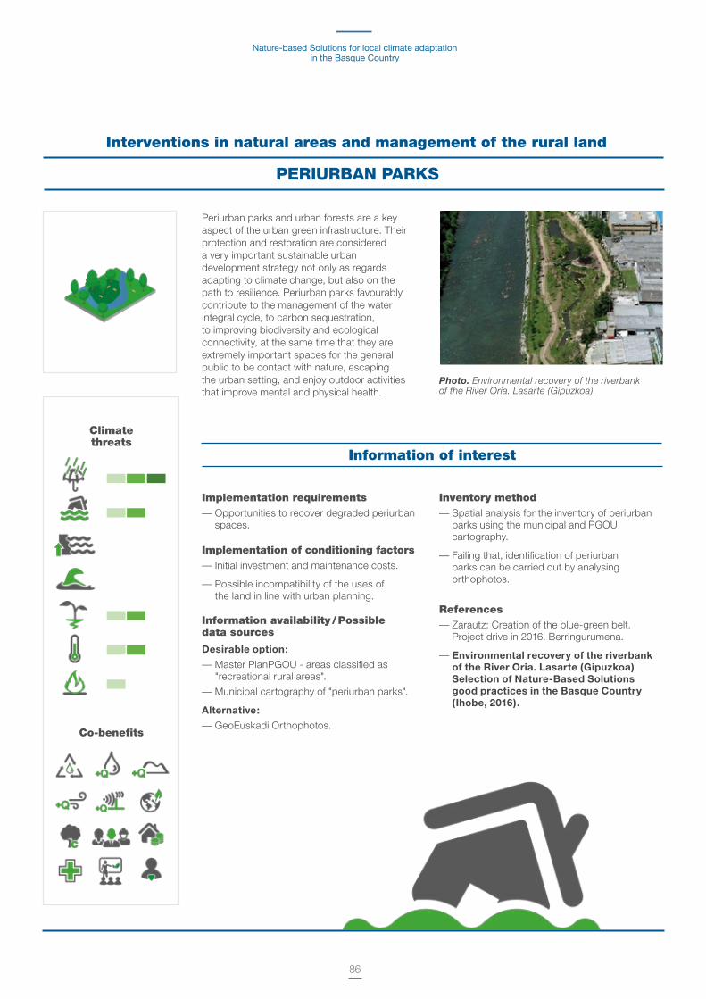
Nature-based Solutions for local climate adaptation in the Basque Country
86
Interventions in natural areas and management of the rural land
PERIURBAN PARKS
Implementation requirements— Opportunities to recover degraded periurban
spaces.
Implementation of conditioning factors— Initial investment and maintenance costs.
— Possible incompatibility of the uses of the land in line with urban planning.
Information availability / Possible data sources
Desirable option:
— Master PlanPGOU - areas classified as "recreational rural areas".
— Municipal cartography of "periurban parks".
Alternative:
— GeoEuskadi Orthophotos.
Inventory method— Spatial analysis for the inventory of periurban
parks using the municipal and PGOU cartography.
— Failing that, identification of periurban parks can be carried out by analysing orthophotos.
References— Zarautz: Creation of the blue-green belt.
Project drive in 2016. Berringurumena.
— Environmental recovery of the riverbank of the River Oria. Lasarte (Gipuzkoa) Selection of Nature-Based Solutions good practices in the Basque Country (Ihobe, 2016).
Periurban parks and urban forests are a key aspect of the urban green infrastructure. Their protection and restoration are considered a very important sustainable urban development strategy not only as regards adapting to climate change, but also on the path to resilience. Periurban parks favourably contribute to the management of the water integral cycle, to carbon sequestration, to improving biodiversity and ecological connectivity, at the same time that they are extremely important spaces for the general public to be contact with nature, escaping the urban setting, and enjoy outdoor activities that improve mental and physical health.
Photo. Environmental recovery of the riverbank of the River Oria. Lasarte (Gipuzkoa).
Climate threats
Co-benefits
Information of interest

Methodological guide for their identification and mapping.Donostia/San Sebastián case study
87
Strategies to manage rural land using sustainability criteria may contribute very favourably to local climate change adaptation.
Appropriate rural land management based on sustainability criteria of the farming and forestry activities helps to regulate the integral water cycle and ensures a healthy soil quality to foster biodiversity, stabilises the soil and stops erosions and strengthens the carbon sequestration capacity. Furthermore, rural land management limits the growth or the urban stain, fosters the upkeep of the rural world by stabilising its population and likewise increases the range of local products.
The actions that may be implemented on rural land are very diverse, ranging from the forestry management of the public forests, to regulations about construction and building criteria, without forgetting the taxation and subsidy instruments to develop forestry, livestock and farming activities.
In any event, all these measures have to be planned and designed from multi-functionality to:
— Contribute to improving the resistance and resilience of the rural environment to climate change.
— Improve the urban-rural connectivity.
— Aimed at managing strategic aspects such as flooding.
Beyond the management, ecological restoration actions may be carried out to improve the local biodiversity and increase the native vegetation.
In particular as regards forestry management for example, the variety of uses of the forest can have the consequence of increasing the resources achieved there, generate new uses or even new income sources. Woodland helps to regulate the local microclimate, improve the quality of the air and provide attractive public use spaces for the local population and also helps those people to improve their life.
Interventions in natural areas and management of the rural land
RURAL LAND MANAGEMENT
Photo. Amurrio Municipality.
Implementation requirements— Interinstitutional coordination.
— Coordination with the land-use planning and its instruments.
Implementation of conditioning factors— Economic barriers. The measure
requires initial investment and may therefore need funds from organisms outside the local council.
— Social barriers. Improving the vegetation of the municipality does not necessarily create social controversy a priori. However, it is important to ensure that the local population is duly informed and knows the reasons behind the
implementation of this action, along with its benefits to ensure social acceptance.
Information availability / Possible data sources— Master Plan PGOU - areas zoned as "rural
farming-livestock" and "forestry".
Inventory method— Identification of areas zoned as agri-livestock
and forestry in the Master Plan PGOU.
ReferencesMultifunctional and sustainable forestry management of the Amurrio public urban forests.
Climate threats
Co-benefits
Information of interest

Nature-based Solutions for local climate adaptation in the Basque Country
88
Avoiding the advancing of the coastline has been, historically, the most frequently adopted climate change adaptation measure35.
Climate change adaptation in coastal zones requires the deployment of coordinated global actions that benefit both the natural environment and society. A preventive approach based on planning, monitoring, assessment and the principles of the Integrated Coastal Zone Management (ICZM) is needed to achieve efficient and effective adaptation in coastal zones.
ICZM is the administration of the use of the coastal environmental assets, by means of an integrated and planning system, that ensure the quality of life, the conservation and recovery of the natural resources and ecosystems, in keeping with the interests of present and future generations36.
Coastal adaptation strategies and associated 'Nature-based Solutions'
Managed or controlled realignment: consists of creating buffer or transition areas, by means of depositing sedimentary material to stabilise the coast and mitigate the effect of the realignment. Dune restoration and beach regeneration would be two of the most common adaptation actions under this strategy.
Elevation can be considered a measure within that strategy that consists of raising the affected assets (buildings, infrastructures, etc.) using sand filling or other filling sedimentary material. It is a more viable measure for areas occupied by infrastructures that may easily be filled in: paths, roads, airports. Filling in is less viable in areas occupied by buildings.
Controlled realignment is appropriate for areas which have not been previously taken back by the sea, where the natural conditions have been maintained, or in regions without settlements and few infrastructures, as is the case of wetlands. The regeneration of coastal salt marshes and wetlands allow nature to take its course to a certain extent, while mitigating the effect of the rise in sea level.
Accommodation: it is a "no protection" option that as far as Nature-based Solutions are concerned would mainly consist of modifying the land use (e.g. aquiculture, desalination plants) and farming practices (e.g. salt tolerant species).
In the long term, it may involve the abandonment and relocation of the assets located in areas affected by flooding and erosion.
Protection this strategy consists of protecting the coastal zones from the rise in sea level in places where the realignment of the coastline would affect a large number of constructions, roads and other type of services. The protection techniques are classified in hard and soft. Using Nature-based Solutions is considered a soft engineering technique.
Coastal interventions
'NATURE-BASED SOLUTIONS' AGAINST THE ADVANCING COASTLINE
Dune restoration
Beach regeneration
Regeneration of salt marshes and coastal
wetlands
Creating oyster reefs
35 Klein, R.J.T., R.J. Nicholls, y Mimura, N., (1999). Coastal adaptation to climate change: Can the IPCC Technical Guidelines be applied? Mitigation and Adaptation Strategies for Global Change, 4 (3-4), 239-252. 36 Carvalho, V. y Rizzo, H. (1994). A zona costeira brasileira. Subsídios para uma avaliacao ambiental. Brasilia, Ministerio do Meio Ambiente. 211 pp.
Photo. Donostia/San Sebastián's new promenade.
Methodological guide for their identification and mapping.Donostia/San Sebastián case study
89
Implementation requirements— Studies of flood risk assessment and
predictions, rigorous and exhaustive, independently from the type of adaptation strategy chosen.
— Implementation in coordination with early warning system.
— Implementation in coordination with existing, drainage, sewage and wastewater systems.
— Setting up evacuation drills in case of flooding.
— Strict regulation of the risk areas.
— Modifying and restricting certain uses of land, constructive styles and urban planning legislative.
— Reviewing the protection easement of the Maritime-Terrestrial Public Domain to pre-empt changes in the sea level.
— Increase the connectivity of the different coastal ecosystems, both wetlands and salt marshes, and dune systems and beaches, and restoring those can be connections.
— Monitoring the measurements and their adjustment according to the evolution of the climate variables and their associated impacts.
Implementation of conditioning factors— Social rejection, mainly in areas where there is
greater economic activity.
— Maintenance costs. In the case of beach regeneration and dune restoration, a periodic contribution and availability of resource is needed, i.e., of appropriate sedimentary material which means an initial cost and maintenance costs, along with the environmental impact in the area where the resource is extracted.
Information availability / Possible data sources
— Master Plan PGOU-areas zoned as "beach".
— Cartography of the protection easement of the maritime-terrestrial public domain.
Inventory method — Spatial analysis for the inventory of the
land considered as "coast" available for the implementation of any type of adaptation intervention to the rise of sea level.
ReferencesEnvironmental regeneration of the coastline. Selection of Nature-Based Solutions good practices in the Basque Country. Ihobe 2016
— Refurbishing and managing the Gorliz Plentzia Beach (Bizkaia).
— Regenerating the salt-marshes of La Arena beach in Muskiz (Bizkaia).
Climate threats
Co-benefits
Information of interest
These include walls, dikes and temporary structures, along with the artificial contribution of sand, the restoration of the dune systems and the regeneration of salt marshes that mitigate the impact of erosive waves and on the other
hand, the vegetation to be found there allows sedimentary material to be retained. The cost of recovering those infrastructures would exceed that of the protection protection.


![EU Funding supporting nature-based solution projects in EU · NATURE-BASED SOLUTIONS Nature-Based Solutions (NBS) [the innovative approach] Nature-based solutions to societal challenges](https://img.pdfslide.us/doc/110x75/5ec64217195a893c9034edef/eu-funding-supporting-nature-based-solution-projects-in-eu-nature-based-solutions.jpg)