Embed Size (px)
Citation preview
Killala Community
Windfarm
Mullafarry, Killala,
County Mayo
Flood Risk Assessment
July 2017
Killala Community Windfarm Designated Activity Company Lisglennon, Killala, Co. Mayo, Ireland.
Jennings O’Donovan & Partners Limited, Consulting Engineers, Finisklin Business Park, Sligo. Tel.: 071 - 916 1416 Fax: 071 - 916 1080 e mail: [email protected]
Jennings O’Donovan & Partners Consulting Engineers Sligo
___________________________________________________________________________________________________________
________________________________________________________________________________ 5279 - Killala - Appendix G - FRA_PRINT_Rev2 i July 2017
JENNINGS O’DONOVAN & PARTNERS LIMITED. Project, Civil and Structural Consulting Engineers, FINISKLIN BUSINESS PARK,
SLIGO,
IRELAND.
Telephone (071) 91 61416
Fax (071) 91 61080
Email [email protected]
Web Site www.jodireland.com �
DOCUMENT APPROVAL
PROJECT Killala Community Wind Farm, Mullafarry, Killala, County Mayo
CLIENT / JOB NO
Killala Community Windfarm Designated Activity Company
5279
DOCUMENT TITLE Flood Risk Assessment
Prepared by Reviewed / Approved by
Document
Name
Michael Conroy Name
David Kiely
Date
June 2017
Signature
Signature
Date
July 2017
Signature
Signature
This report, and information or advice which it contains, is provided by JENNINGS O’DONOVAN & PARTNERS LIMITED solely for internal use and reliance by its Client in performance of JENNINGS O’DONOVAN & PARTNERS LIMITED’s duties and liabilities under its contract with the Client. Any advice, opinions, or recommendations within this report should be read and relied upon only in the context of the report as a whole. The advice and opinions in this report are based upon the information made available to JENNINGS O’DONOVAN & PARTNERS LIMITED at the date of this report and on current standards, codes, technology and construction practices as at the date of this report. Following final delivery of this report to the Client, JENNINGS O’DONOVAN & PARTNERS LIMITED will have no further obligations or duty to advise the Client on any matters, including development affecting the information or advice provided in this report. This report has been prepared by JENNINGS O’DONOVAN & PARTNERS LIMITED in their professional capacity as Consulting Engineers. The contents of the report do not, in any way, purport to include any manner of legal advice or opinion. This report is prepared in accordance with the terms and conditions of JENNINGS O’DONOVAN & PARTNERS LIMITED contract with the Client. Regard should be had to those terms and conditions when considering and/or placing any reliance on this report. Should the Client wish to release this report to a Third Party for that party's reliance, JENNINGS O’DONOVAN & PARTNERS LIMITED may, at its discretion, agree to such release provided that:
(a) JENNINGS O’DONOVAN & PARTNERS LIMITED written agreement is obtained prior to such release, and (b) By release of the report to the Third Party, that Third Party does not acquire any rights, contractual or otherwise, whatsoever against JENNINGS O’DONOVAN & PARTNERS
LIMITED and JENNINGS O’DONOVAN & PARTNERS LIMITED, accordingly, assume no duties, liabilities or obligations to that Third Party, and (c) JENNINGS O’DONOVAN & PARTNERS LIMITED accepts no responsibility for any loss or damage incurred by the Client or for any conflict of JENNINGS
O’DONOVAN & PARTNERS LIMITED’s interests arising out of the Client's release of this report to the Third Party.
Jennings O’Donovan & Partners Consulting Engineers Sligo
___________________________________________________________________________________________________________
________________________________________________________________________________ 5279 - Killala - Appendix G - FRA_PRINT_Rev2 ii July 2017
KILLALA COMMUNITY WINDFARM
FLOOD RISK ASSESSMENT
CONTENTS
1.0 INTRODUCTION ............................................................................................................. 3
1.1 GENERAL .......................................................................................................................... 3
1.2 SCOPE............................................................................................................................... 4
1.3 STATEMENT OF AUTHORITY ............................................................................................. 5
2.0 PLANNING GUIDELINES .............................................................................................. 6
3.0 PROPOSED DEVELOPMENT SITE .............................................................................. 8
3.1 PROPOSED DEVELOPMENT SITE .......................................................................................... 8
3.2 HAUL ROUTE OPTIONS ....................................................................................................... 8
4.0 FLOOD RISK REVIEW ................................................................................................. 10
4.1 APPROACH ...................................................................................................................... 10
4.2 FLUVIAL FLOOD RISK ...................................................................................................... 10
4.3 PLUVIAL FLOOD RISK ...................................................................................................... 13
4.4 GROUNDWATER FLOOD RISK............................................................................................ 14
4.5 AVAILABLE PREDICTIVE FLOOD RISK MAPPING ................................................................. 15
4.6 IMPACT OF DEVELOPMENT ON CURRENT FLOOD REGIME .................................................. 16
4.7 SUMMARY OF FLOOD RISK ............................................................................................... 16
5.0 HISTORY OF FLOODING ............................................................................................ 17
6.0 CONCLUSION ................................................................................................................ 18
Jennings O’Donovan & Partners Consulting Engineers Sligo
____________________________________________________________________________________________
_______________________________________________________________________
5279 - Killala - Appendix G - FRA_PRINT_Rev2 3 July 2017
1.0 INTRODUCTION
1.1 GENERAL
This Flood Risk Assessment Report has been prepared by Jennings O’Donovan &
Partners Limited for Killala Community Wind Farm Designated Activity Company to
assess flood risk associated with the EIA Development (as defined in Section 1 and 2 of
the REIS / EIAR).
The EIS Development consists of:
“A wind energy development comprising of five electricity generating wind
turbines, each with a rotor diameter not exceeding 103.2m, a hub height not
exceeding 73.5m and a blade tip height not exceeding 126m. The development
will include a meteorological mast not exceeding 82m in height, internal
underground electrical cabling, a 38kv substation building, an external
underground grid connection cable and ducting to the 110kv Tawnaghmore
Upper substation, associated grid substation works, associated site access roads
and ancillary site works including upgrades to the existing site access, a
temporary construction compound and haulage route works. The maximum
output capacity of the wind farm will be up to 18MW and has an intended
operational life of 25 years” (“the EIA Development”).
The Mayo County Development Plan 2014-2020 (“the CDP”) states that:
“It is an objective of the Council to restrict inappropriate development in areas at
risk of flooding (inland or coastal) as identified on flood risk maps, erosion and
other natural hazards or would cause or exacerbate such a risk at other locations.
As part of this, the Planning Authority shall require a Flood Risk Assessment
and/or a Landslide Risk Assessment for any new development” (Flooding and
Soil Erosion Policy FS—01).
As set out in the ‘Renewable Energy Strategy for County Mayo 2011 – 2020’:
“Renewable energy developments must comply with the provisions of the
DEHLG/OPW publication ‘The Planning System and Flood Risk Management:
Guidelines for Planning Authorities 2009’. Sites will be required to avoid areas of
flood risk and that where there is a strategic case for allowing development in
such areas, that these proposals be subject to the’ justification and sequential
tests’ in the Flood Risk Management Guidelines and assessed to ensure that
flood risk can be reduced and mitigated as appropriate”.
“flood risk assessments shall accompany planning applications for renewable
energy developments and these assessments shall be incorporated into the
process of making decisions on planning applications and planning appeals”.
Jennings O’Donovan & Partners Consulting Engineers Sligo
____________________________________________________________________________________________
_______________________________________________________________________
5279 - Killala - Appendix G - FRA_PRINT_Rev2 4 July 2017
In accordance with this strategy, a site-specific flood risk assessment has been carried
out for the EIA Development in consideration of the guidance document ‘The Planning
System and Flood Risk Management – Guidelines for Planning Authorities’1.
The assessment methodology involved researching and collating flood related information
from the following data sources:
• Base maps – Ordnance Survey of Ireland;
• Flood Hazard Maps and flooding information for Ireland, (www.floodmaps.ie);
• Office of Public Works (OPW);
• Geological Survey of Ireland (GSI) maps on superficial deposits;
• EPA hydrology maps;
• Western CFRAMS (Catchment Flood Risk Assessment & Management Study);
and
• Mayo County Development Plan 2014 – 2020.
1.2 SCOPE
This Flood Risk Assessment is based on the following:
• Department of Environment, Heritage and Local Government guidelines for
Planning Authorities covering Flood Risk Management (The Planning System and
Flood Risk Management: Guidelines for Planning Authorities 2009’)
• Risk of flooding to the Proposed Development Site and Haul Route Options
(where works are required) from flood flow from neighbouring watercourses.
• Risk of flooding resulting from rainfall.
• Risk of flooding from groundwater generated on the Proposed Development Site
and Haul Route Options (where works are required).
In addition to the above, the study also examined any possible impact the proposed
works may have on the existing drainage regime locally adjacent to the Proposed
Development Site and Haul Route Options (where works are required). The impacts
addressed under this heading comprise:
• The impact of surface water runoff on the flow regimes in neighbouring
watercourses.
• Loss of floodplain.
• Review of historical flood records.
1 Department of Environment, Heritage and Local Government, (2009). The Planning System and Flood Risk Management
– Guidelines for Planning Authorities.
Jennings O’Donovan & Partners Consulting Engineers Sligo
____________________________________________________________________________________________
_______________________________________________________________________
5279 - Killala - Appendix G - FRA_PRINT_Rev2 5 July 2017
1.3 STATEMENT OF AUTHORITY
Jennings O’Donovan & Partners Ltd. (“JOD”) Consulting Engineers, were commissioned
on behalf of Killala Community Windfarm DAC to carry out a Flood Risk Assessment of
the proposed EIA Development.
JOD has extensive experience in the development of wind farms from planning through
to construction. JOD have been active in the wind energy market in Ireland since 1998 as
engineering consultants for numerous completed wind farm projects varying from single
wind turbine installations to large scale development which extends to over 2,000MW of
power in Ireland.
This Flood Risk Assessment has been prepared by Mr. Michael Conroy of JOD, who has
undertaken numerous Flood Risk Assessments for projects throughout Ireland. Michael
has 7 years’ experience in the civil engineering and flooding sectors. He has obtained a
Bachelor’s Degree in Civil Engineering and is a Chartered Engineer. Michael previously
worked in the Flood Risk Assessment and Management section of the OPW, and was
involved in the Catchment Flood Risk Assessment and Management Studies (CFRAMS).
Jennings O’Donovan & Partners Consulting Engineers Sligo
____________________________________________________________________________________________
_______________________________________________________________________
5279 - Killala - Appendix G - FRA_PRINT_Rev2 6 July 2017
2.0 PLANNING GUIDELINES
In November 2009, the Department of Environment, Heritage and Local Government
issued a guidance document to planning authorities in relation to flood risk management,
titled ‘The Planning System and Flood Risk Management’. These guidelines set out the
policy on development and flood risk in Ireland and provide a framework for the integration
of flood risk assessment into the planning process. The objective is to ensure that flood
risk is considered at all stages of the planning process in order to:
• Avoid inappropriate development in areas at risk of flooding,
• Avoid new developments increasing flood risk elsewhere,
• Ensure effective management of residual risks for development permitted in
flood plains.
The guidelines set out a staged approach for the consideration of flood risk in relation to
developments as follows:
Stage 1: Flood risk identification – to identify whether there may be any flooding
or surface water management issues related to either the area of
regional planning guidelines, development plans and Local Area Plans
(LAP’s) or a proposed development site that may warrant further
investigation at the appropriate lower level plan or planning application
levels;
Stage 2: Initial flood risk assessment – to confirm sources of flooding that may
affect a plan area or proposed development site, to appraise the
adequacy of existing information and to scope the extent of the risk of
flooding which may involve preparing indicative flood zone maps.
Where hydraulic models exist, the potential impact of a development on
flooding elsewhere and of the scope of possible mitigation measures
can be assessed. In addition, the requirements of the detailed
assessment should be scoped; and
Stage 3: Detailed flood risk assessment – to assess flood risk issues in sufficient
detail and to provide a quantitative appraisal of potential flood risk to a
proposed or existing development or land to be zoned, of its potential
impact on flood risk elsewhere and of the effectiveness of any proposed
mitigation measures.
The guidelines classify developments into three vulnerability classes based on the
effects of flooding:
Jennings O’Donovan & Partners Consulting Engineers Sligo
____________________________________________________________________________________________
_______________________________________________________________________
5279 - Killala - Appendix G - FRA_PRINT_Rev2 7 July 2017
• Highly vulnerable development,
• Less vulnerable development,
• Water compatible development.
Electricity generation is classed as highly vulnerable infrastructure. The guidelines also
classify land areas into three flood zones based on the probability of flooding. Flood zones
are defined as follows in the guidelines:
• Zone A is at highest risk. In any one year, Zone A has a 1 in 100 year (1%)
chance of flooding from rivers and a 1 in 200 year (0.5%) chance of flooding
from the sea.
• Zone B is at moderate risk. The outer limit of Zone B is defined by the 1 in
1,000 year (or 0.1%) flood from rivers and the sea.
• Zone C is at low risk. In any one year, Zone C has less than 1 in 1,000 year
(<0.1%) chance of flooding from rivers, estuaries or the sea.
It is stated in the guidelines that during the identification of flood zones, no account should
be taken of any flood relief walls or embankments. In cases where there are insufficient
sites available to locate a development in the appropriate low flood risk zone, the
guidelines allow for consideration of sites within flood risk zones.
This report considers the flood risk of the proposed EIA Development in relation to Stages
1 and 2 of the staged approach outlined above.
Jennings O’Donovan & Partners Consulting Engineers Sligo
____________________________________________________________________________________________
_______________________________________________________________________
5279 - Killala - Appendix G - FRA_PRINT_Rev2 8 July 2017
3.0 PROPOSED DEVELOPMENT SITE
3.1 PROPOSED DEVELOPMENT SITE
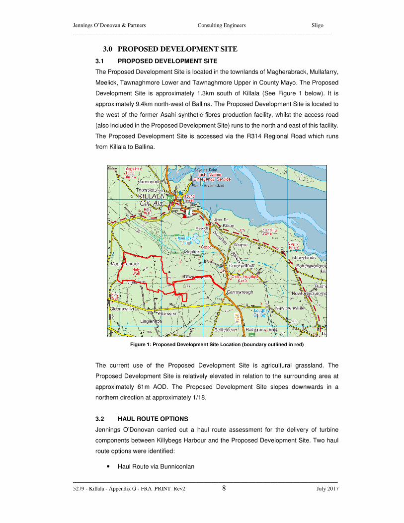
The Proposed Development Site is located in the townlands of Magherabrack, Mullafarry,
Meelick, Tawnaghmore Lower and Tawnaghmore Upper in County Mayo. The Proposed
Development Site is approximately 1.3km south of Killala (See Figure 1 below). It is
approximately 9.4km north-west of Ballina. The Proposed Development Site is located to
the west of the former Asahi synthetic fibres production facility, whilst the access road
(also included in the Proposed Development Site) runs to the north and east of this facility.
The Proposed Development Site is accessed via the R314 Regional Road which runs
from Killala to Ballina.
Figure 1: Proposed Development Site Location (boundary outlined in red)
The current use of the Proposed Development Site is agricultural grassland. The
Proposed Development Site is relatively elevated in relation to the surrounding area at
approximately 61m AOD. The Proposed Development Site slopes downwards in a
northern direction at approximately 1/18.
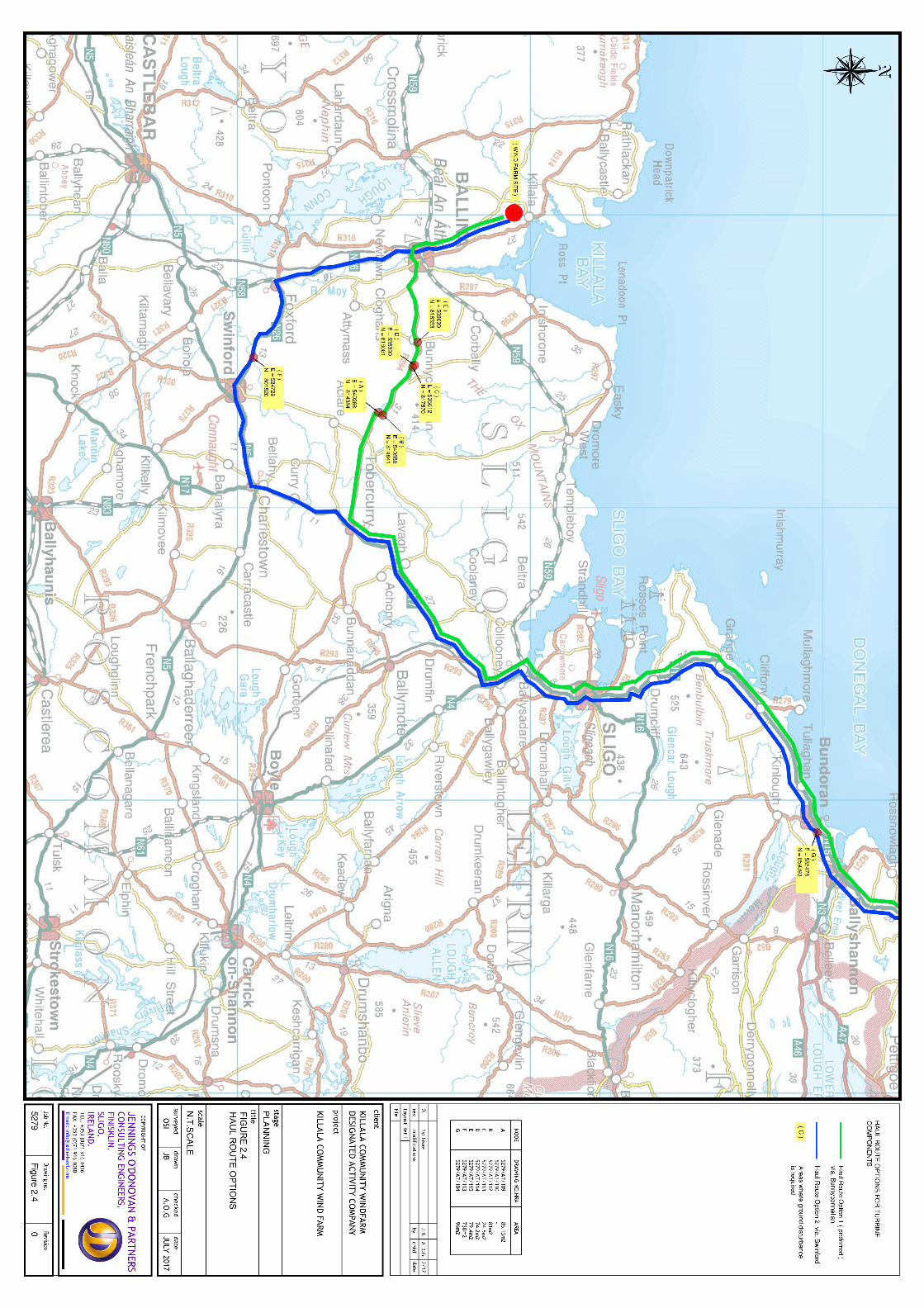
3.2 HAUL ROUTE OPTIONS
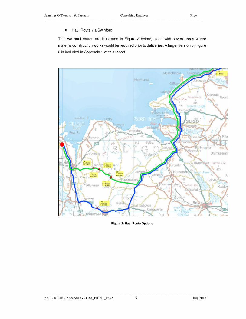
Jennings O’Donovan carried out a haul route assessment for the delivery of turbine
components between Killybegs Harbour and the Proposed Development Site. Two haul
route options were identified:
• Haul Route via Bunniconlan
Jennings O’Donovan & Partners Consulting Engineers Sligo
____________________________________________________________________________________________
_______________________________________________________________________
5279 - Killala - Appendix G - FRA_PRINT_Rev2 9 July 2017
• Haul Route via Swinford
The two haul routes are illustrated in Figure 2 below, along with seven areas where
material construction works would be required prior to deliveries. A larger version of Figure
2 is included in Appendix 1 of this report.
Figure 2: Haul Route Options
Jennings O’Donovan & Partners Consulting Engineers Sligo
____________________________________________________________________________________________
_______________________________________________________________________
5279 - Killala - Appendix G - FRA_PRINT_Rev2 10 July 2017
4.0 FLOOD RISK REVIEW
4.1 APPROACH
The risk of flooding to the Proposed Development Site and Haul Route Options shall be
assessed in relation to the following criteria:
• Fluvial Risk: Inundation from flow from neighbouring watercourses
• Pluvial Risk: Flooding due to direct rainfall
• Groundwater Risk: Flooding due to a high-water table
• History of Flooding
• Available Predictive Flood Risk Mapping
• Impact of presence of the proposed development on the existing flood risk regime
at the proposed site
4.2 FLUVIAL FLOOD RISK
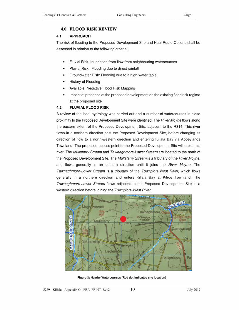
A review of the local hydrology was carried out and a number of watercourses in close
proximity to the Proposed Development Site were identified. The River Moyne flows along
the eastern extent of the Proposed Development Site, adjacent to the R314. This river
flows in a northern direction past the Proposed Development Site, before changing its
direction of flow to a north-western direction and entering Killala Bay via Abbeylands
Townland. The proposed access point to the Proposed Development Site will cross this
river. The Mullafarry Stream and Tawnaghmore-Lower Stream are located to the north of
the Proposed Development Site. The Mullafarry Stream is a tributary of the River Moyne,
and flows generally in an eastern direction until it joins the River Moyne. The
Tawnaghmore-Lower Stream is a tributary of the Townplots-West River, which flows
generally in a northern direction and enters Killala Bay at Kilroe Townland. The
Tawnaghmore-Lower Stream flows adjacent to the Proposed Development Site in a
western direction before joining the Townplots-West River.
Figure 3: Nearby Watercourses (Red dot indicates site location)
Jennings O’Donovan & Partners Consulting Engineers Sligo
____________________________________________________________________________________________
_______________________________________________________________________
5279 - Killala - Appendix G - FRA_PRINT_Rev2 11 July 2017
The Moyne Stream and the Medown Stream are located to the south of the Proposed
Development Site. The Moyne Stream flows generally in a north-eastern direction before
joining the Moyne River. The Medown Stream flows in a southern direction for a short
distance, before changing its direction of flow to a western direction and joining the
Magherabrack River. The Magherabrack River is located to the west of the Proposed
Development Site and flows in a northern direction, before changing to flow in a north-
western direction and joining the Cloonaghmore River which enters Killala Bay via
Rathfran Bay. The Rathowen-East Stream is also located to the west of the Proposed
Development Site, and flows in a south-western direction before joining the Magherabrack
River.
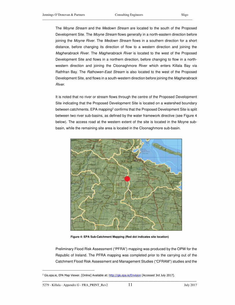
It is noted that no river or stream flows through the centre of the Proposed Development
Site indicating that the Proposed Development Site is located on a watershed boundary
between catchments. EPA mapping2 confirms that the Proposed Development Site is split
between two river sub-basins, as defined by the water framework directive (see Figure 4
below). The access road at the western extent of the site is located in the Moyne sub-
basin, while the remaining site area is located in the Cloonaghmore sub-basin.
Figure 4: EPA Sub-Catchment Mapping (Red dot indicates site location)
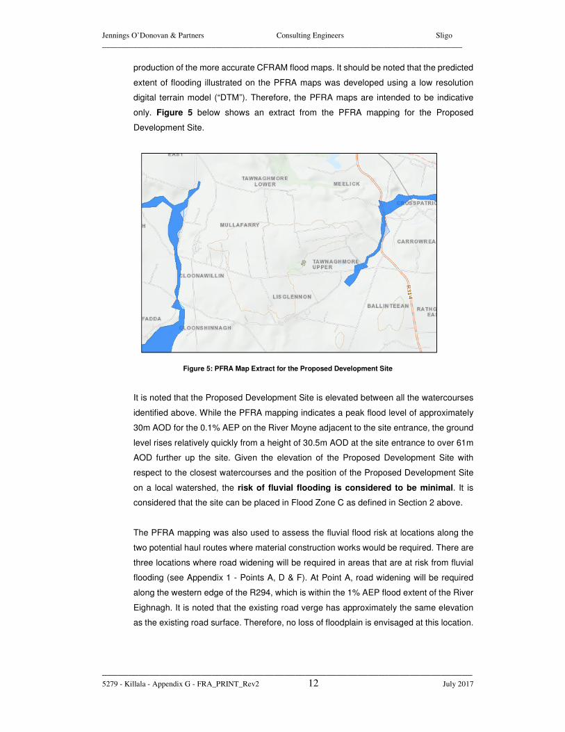
Preliminary Flood Risk Assessment (“PFRA”) mapping was produced by the OPW for the
Republic of Ireland. The PFRA mapping was completed prior to the carrying out of the
Catchment Flood Risk Assessment and Management Studies (“CFRAM”) studies and the
2 Gis.epa.ie, EPA Map Viewer. [Online] Available at: http://gis.epa.ie/Envision [Accessed 3rd July 2017].
Jennings O’Donovan & Partners Consulting Engineers Sligo
____________________________________________________________________________________________
_______________________________________________________________________
5279 - Killala - Appendix G - FRA_PRINT_Rev2 12 July 2017
production of the more accurate CFRAM flood maps. It should be noted that the predicted
extent of flooding illustrated on the PFRA maps was developed using a low resolution
digital terrain model (“DTM”). Therefore, the PFRA maps are intended to be indicative
only. Figure 5 below shows an extract from the PFRA mapping for the Proposed
Development Site.
Figure 5: PFRA Map Extract for the Proposed Development Site
It is noted that the Proposed Development Site is elevated between all the watercourses
identified above. While the PFRA mapping indicates a peak flood level of approximately
30m AOD for the 0.1% AEP on the River Moyne adjacent to the site entrance, the ground
level rises relatively quickly from a height of 30.5m AOD at the site entrance to over 61m
AOD further up the site. Given the elevation of the Proposed Development Site with
respect to the closest watercourses and the position of the Proposed Development Site
on a local watershed, the risk of fluvial flooding is considered to be minimal. It is
considered that the site can be placed in Flood Zone C as defined in Section 2 above.
The PFRA mapping was also used to assess the fluvial flood risk at locations along the
two potential haul routes where material construction works would be required. There are
three locations where road widening will be required in areas that are at risk from fluvial
flooding (see Appendix 1 - Points A, D & F). At Point A, road widening will be required
along the western edge of the R294, which is within the 1% AEP flood extent of the River
Eighnagh. It is noted that the existing road verge has approximately the same elevation
as the existing road surface. Therefore, no loss of floodplain is envisaged at this location.
Jennings O’Donovan & Partners Consulting Engineers Sligo
____________________________________________________________________________________________
_______________________________________________________________________
5279 - Killala - Appendix G - FRA_PRINT_Rev2 13 July 2017
At Point D, road widening will be required along the northern edge of the R294, which is
within the 1% AEP flood extent of the River Srafaungal. It is noted that the existing road
verge has a higher elevation than the existing road surface. Therefore, no loss of
floodplain is envisaged at this location. At Point F, a turning area will be required along
the north-western verge of the N26, adjacent to the River Moy. The 1% AEP flood extent
encompasses the south-eastern verge of the road, but does not extend to the north-
western verge, where the turning area will be constructed. Therefore, no loss of floodplain
is envisaged at this location. In summary, it is deemed that the proposed road widening
works will not add to the level of fluvial flood risk in the catchment.
4.3 PLUVIAL FLOOD RISK
As mentioned in Section 3 above, the Proposed Development Site is relatively elevated
in relation to the surrounding area at approximately 61m AOD. The Proposed
Development Site slopes in a northern direction at approximately 1/18. The proposed EIA
Development will increase the impermeable area of the Proposed Development Site and
therefore, surface water runoff from the Proposed Development Site will be increased.
This can present an increased risk of pluvial flooding on site and downstream if not
managed correctly.
As outlined in Chapter 7 of the EIAR, the average annual rainfall for this region is
1244.8mm, with a runoff rate of approximately 477mm/yr. The proposed drainage
techniques provide for source control of surface water generated on the impermeable
areas of the Proposed Development Site through the use of drainage ditches and
settlement ponds with buffered outfalls. The site surface water drainage system will be
designed to best practice to provide protection from pluvial flooding.
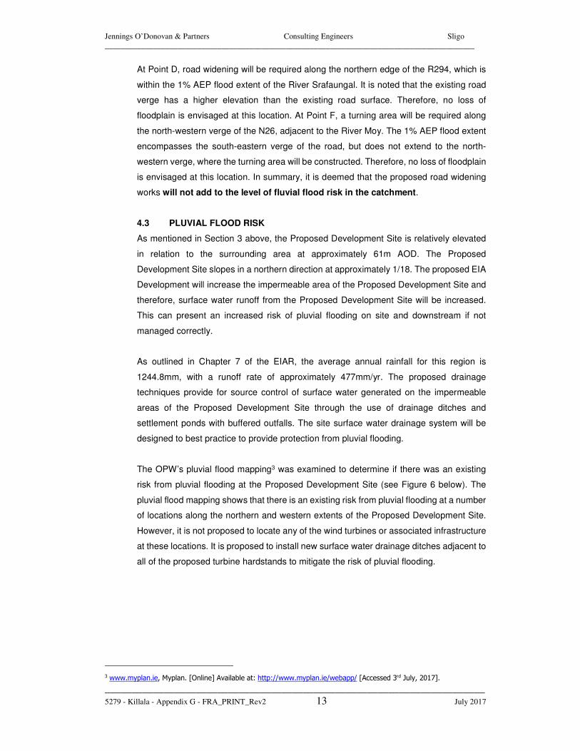
The OPW’s pluvial flood mapping3 was examined to determine if there was an existing
risk from pluvial flooding at the Proposed Development Site (see Figure 6 below). The
pluvial flood mapping shows that there is an existing risk from pluvial flooding at a number
of locations along the northern and western extents of the Proposed Development Site.
However, it is not proposed to locate any of the wind turbines or associated infrastructure
at these locations. It is proposed to install new surface water drainage ditches adjacent to
all of the proposed turbine hardstands to mitigate the risk of pluvial flooding.
3 www.myplan.ie, Myplan. [Online] Available at: http://www.myplan.ie/webapp/ [Accessed 3rd July, 2017].
Jennings O’Donovan & Partners Consulting Engineers Sligo
____________________________________________________________________________________________
_______________________________________________________________________
5279 - Killala - Appendix G - FRA_PRINT_Rev2 14 July 2017
Figure 6: Pluvial Flood Mapping for the Proposed Development Site
The use of SuDS techniques will ensure that the natural drainage patterns are replicated
and no negative impacts result from this development in terms of water quality or quantity.
The pluvial flood mapping was also used to determine if there was an existing risk from
pluvial flooding at locations along the two potential haul routes where material construction
works would be required. The pluvial flood mapping confirmed that none of the locations
where works are required are at risk from pluvial flooding.
4.4 GROUNDWATER FLOOD RISK
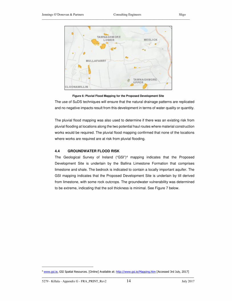
The Geological Survey of Ireland (“GSI”)4 mapping indicates that the Proposed
Development Site is underlain by the Ballina Limestone Formation that comprises
limestone and shale. The bedrock is indicated to contain a locally important aquifer. The
GSI mapping indicates that the Proposed Development Site is underlain by till derived
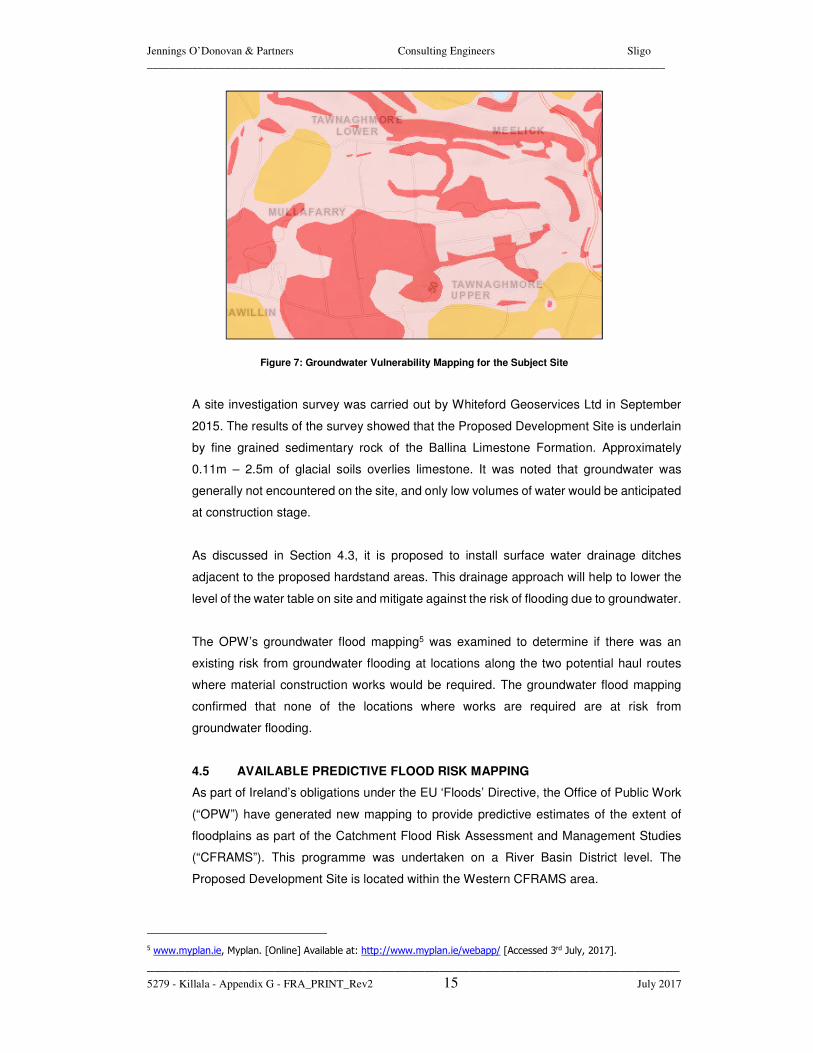
from limestone, with some rock outcrops. The groundwater vulnerability was determined
to be extreme, indicating that the soil thickness is minimal. See Figure 7 below.
4 www.gsi.ie, GSI Spatial Resources. [Online] Available at: http://www.gsi.ie/Mapping.htm [Accessed 3rd July, 2017]
Jennings O’Donovan & Partners Consulting Engineers Sligo
____________________________________________________________________________________________
_______________________________________________________________________
5279 - Killala - Appendix G - FRA_PRINT_Rev2 15 July 2017
Figure 7: Groundwater Vulnerability Mapping for the Subject Site
A site investigation survey was carried out by Whiteford Geoservices Ltd in September
2015. The results of the survey showed that the Proposed Development Site is underlain
by fine grained sedimentary rock of the Ballina Limestone Formation. Approximately
0.11m – 2.5m of glacial soils overlies limestone. It was noted that groundwater was
generally not encountered on the site, and only low volumes of water would be anticipated
at construction stage.
As discussed in Section 4.3, it is proposed to install surface water drainage ditches
adjacent to the proposed hardstand areas. This drainage approach will help to lower the
level of the water table on site and mitigate against the risk of flooding due to groundwater.
The OPW’s groundwater flood mapping5 was examined to determine if there was an
existing risk from groundwater flooding at locations along the two potential haul routes
where material construction works would be required. The groundwater flood mapping
confirmed that none of the locations where works are required are at risk from
groundwater flooding.
4.5 AVAILABLE PREDICTIVE FLOOD RISK MAPPING
As part of Ireland’s obligations under the EU ‘Floods’ Directive, the Office of Public Work
(“OPW”) have generated new mapping to provide predictive estimates of the extent of
floodplains as part of the Catchment Flood Risk Assessment and Management Studies
(“CFRAMS”). This programme was undertaken on a River Basin District level. The
Proposed Development Site is located within the Western CFRAMS area.
5 www.myplan.ie, Myplan. [Online] Available at: http://www.myplan.ie/webapp/ [Accessed 3rd July, 2017].
Jennings O’Donovan & Partners Consulting Engineers Sligo
____________________________________________________________________________________________
_______________________________________________________________________
5279 - Killala - Appendix G - FRA_PRINT_Rev2 16 July 2017
As set out in section 4.2, the Proposed Development Site was reviewed against the PFRA
mapping which confirmed that the Proposed Development Site is located within Flood
Zone C. As part of the PFRA mapping stage, the OPW identified a list of Areas of Further
Assessment (“AFA’s”). These areas were identified through the use of Geographical
Information Systems (GIS), which allowed receptors to be overlain on indicative flood
maps. Flood risk assessments were then carried out in each of the AFA’s as part of the
CFRAMS. It is noted that Killala was not identified as an AFA during the PFRA mapping
stage and therefore, a flood risk assessment was not carried out during the CFRAM’s
process. This indicates that flooding was not identified by the OPW as a significant issue
in the Killala area.
4.6 IMPACT OF DEVELOPMENT ON CURRENT FLOOD REGIME
All surface water runoff from the Proposed Development Site will be collected in a
dedicated drainage network. Sustainable Drainage Systems (“SuDS”) will be
implemented to provide elements of source control of surface water, attenuation of runoff
and water quality improvements. The site surface water drainage system will be designed
to best practice to provide protection from surface runoff due to direct rainfall. The
Proposed Development Site is not located in a floodplain, ensuring that the EIA
Development will not result in any loss of floodplain.
As discussed in Section 4.2, there are three locations where road widening will be required
in areas that are at risk from fluvial flooding (see Appendix 1 - Points A, D & F). However,
in each case the proposed works will not result in a loss of floodplain. Therefore, it is
deemed that the proposed road widening works will not add to the level of flood risk in the
catchment.
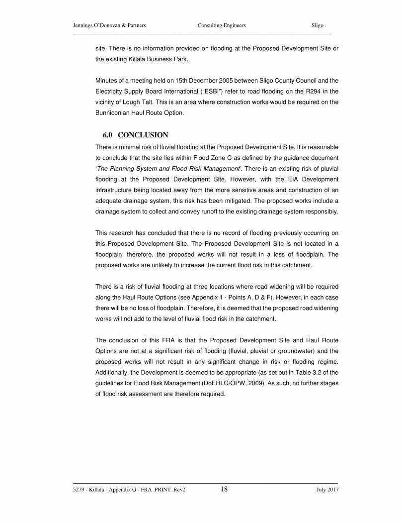
4.7 SUMMARY OF FLOOD RISK
Table 1 below provides a summary of the flood risk at the Proposed Development Site
and at locations along the Haul Route Options where construction works will be required.
Jennings O’Donovan & Partners Consulting Engineers Sligo
____________________________________________________________________________________________
_______________________________________________________________________
5279 - Killala - Appendix G - FRA_PRINT_Rev2 17 July 2017
Source Pathway Receptor Comment
Tidal Not applicable Land &
Infrastructure
The Proposed Development Site is over 1.5km from the coast and therefore, there is no risk of coastal flooding. There is no risk of coastal flooding at any of the locations that require construction works along the Haul Route Options.
Fluvial Overbank
Land & Infrastructure
The risk of fluvial flooding at the Proposed Development Site is minimal. There are three locations along the Haul Route Options where construction works will be required in areas at risk from fluvial flooding. However, there will be no loss of floodplain.
Pluvial Ponding of
Rainwater on site
Land & Infrastructure
There is an existing risk of pluvial flooding at the Proposed Development Site. However, it is proposed to install new surface water drainage ditches adjacent to all of the proposed turbine hardstands to mitigate the risk. There is no risk of pluvial flooding along the Haul Route Options.
Groundwater Rising
Groundwater Levels
Land & Infrastructure
Based on the GSI mapping, OPW mapping and site investigation, there is no apparent risk from groundwater flooding at the Proposed Development Site or along the Haul Route Options.
Table 1: Flood Risk Summary Table
5.0 HISTORY OF FLOODING
The OPW Flood Hazard Maps website6 was consulted in relation to available historical or
anecdotal information on flooding incidents in the vicinity of the Proposed Development
Site. This website includes all available flood records held by the OPW, local authorities
and other relevant state organisations such as the EPA.
Minutes of a meeting held on 13th April 2006 between Mayo County Council and the
Electricity Supply Board International (“ESBI”) refer to flooding in the Greenpark area of
Killala, stating that the road floods “once or twice a year due to high tides”. The Greenpark
Area is located on the northern side of Killala, and is not in close proximity to the subject
6 www.floodmaps.ie, National Flood Hazard Mapping. [Online] Available at: http://www.floodmaps.ie/View/Default.aspx
[Accessed on 3rd July 2017]
Jennings O’Donovan & Partners Consulting Engineers Sligo
____________________________________________________________________________________________
_______________________________________________________________________
5279 - Killala - Appendix G - FRA_PRINT_Rev2 18 July 2017
site. There is no information provided on flooding at the Proposed Development Site or
the existing Killala Business Park.
Minutes of a meeting held on 15th December 2005 between Sligo County Council and the
Electricity Supply Board International (“ESBI”) refer to road flooding on the R294 in the
vicinity of Lough Talt. This is an area where construction works would be required on the
Bunniconlan Haul Route Option.
6.0 CONCLUSION
There is minimal risk of fluvial flooding at the Proposed Development Site. It is reasonable
to conclude that the site lies within Flood Zone C as defined by the guidance document
‘The Planning System and Flood Risk Management’. There is an existing risk of pluvial
flooding at the Proposed Development Site. However, with the EIA Development
infrastructure being located away from the more sensitive areas and construction of an
adequate drainage system, this risk has been mitigated. The proposed works include a
drainage system to collect and convey runoff to the existing drainage system responsibly.
This research has concluded that there is no record of flooding previously occurring on
this Proposed Development Site. The Proposed Development Site is not located in a
floodplain; therefore, the proposed works will not result in a loss of floodplain. The
proposed works are unlikely to increase the current flood risk in this catchment.
There is a risk of fluvial flooding at three locations where road widening will be required
along the Haul Route Options (see Appendix 1 - Points A, D & F). However, in each case
there will be no loss of floodplain. Therefore, it is deemed that the proposed road widening
works will not add to the level of fluvial flood risk in the catchment.
The conclusion of this FRA is that the Proposed Development Site and Haul Route
Options are not at a significant risk of flooding (fluvial, pluvial or groundwater) and the
proposed works will not result in any significant change in risk or flooding regime.
Additionally, the Development is deemed to be appropriate (as set out in Table 3.2 of the
guidelines for Flood Risk Management (DoEHLG/OPW, 2009). As such, no further stages
of flood risk assessment are therefore required.

Jennings O’Donovan & Partners Consulting Engineers Sligo
____________________________________________________________________________________________
_______________________________________________________________________
5279 - Killala - Appendix G - FRA_PRINT_Rev2 19 July 2017
APPENDIX 1
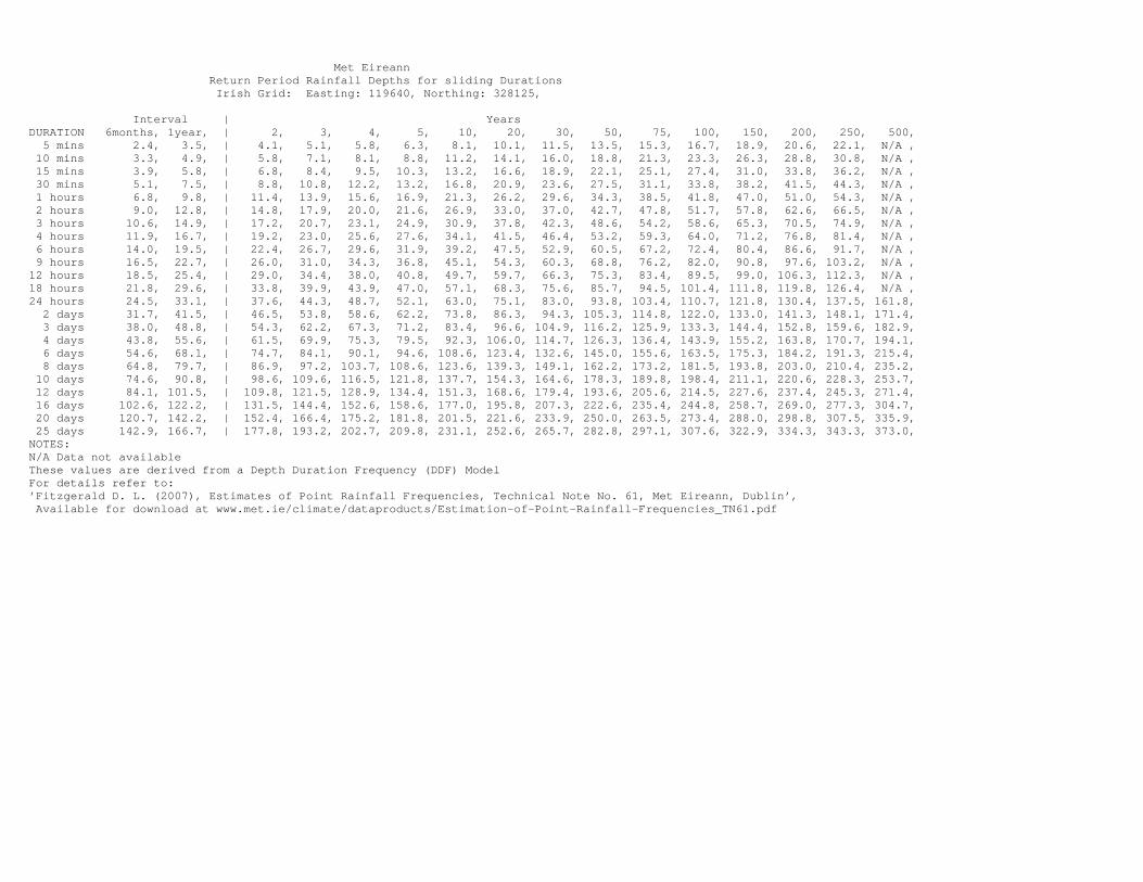
Met Eireann Return Period Rainfall Depths for sliding Durations Irish Grid: Easting: 119640, Northing: 328125,
Interval | YearsDURATION 6months, 1year, | 2, 3, 4, 5, 10, 20, 30, 50, 75, 100, 150, 200, 250, 500, 5 mins 2.4, 3.5, | 4.1, 5.1, 5.8, 6.3, 8.1, 10.1, 11.5, 13.5, 15.3, 16.7, 18.9, 20.6, 22.1, N/A , 10 mins 3.3, 4.9, | 5.8, 7.1, 8.1, 8.8, 11.2, 14.1, 16.0, 18.8, 21.3, 23.3, 26.3, 28.8, 30.8, N/A , 15 mins 3.9, 5.8, | 6.8, 8.4, 9.5, 10.3, 13.2, 16.6, 18.9, 22.1, 25.1, 27.4, 31.0, 33.8, 36.2, N/A , 30 mins 5.1, 7.5, | 8.8, 10.8, 12.2, 13.2, 16.8, 20.9, 23.6, 27.5, 31.1, 33.8, 38.2, 41.5, 44.3, N/A , 1 hours 6.8, 9.8, | 11.4, 13.9, 15.6, 16.9, 21.3, 26.2, 29.6, 34.3, 38.5, 41.8, 47.0, 51.0, 54.3, N/A , 2 hours 9.0, 12.8, | 14.8, 17.9, 20.0, 21.6, 26.9, 33.0, 37.0, 42.7, 47.8, 51.7, 57.8, 62.6, 66.5, N/A , 3 hours 10.6, 14.9, | 17.2, 20.7, 23.1, 24.9, 30.9, 37.8, 42.3, 48.6, 54.2, 58.6, 65.3, 70.5, 74.9, N/A , 4 hours 11.9, 16.7, | 19.2, 23.0, 25.6, 27.6, 34.1, 41.5, 46.4, 53.2, 59.3, 64.0, 71.2, 76.8, 81.4, N/A , 6 hours 14.0, 19.5, | 22.4, 26.7, 29.6, 31.9, 39.2, 47.5, 52.9, 60.5, 67.2, 72.4, 80.4, 86.6, 91.7, N/A , 9 hours 16.5, 22.7, | 26.0, 31.0, 34.3, 36.8, 45.1, 54.3, 60.3, 68.8, 76.2, 82.0, 90.8, 97.6, 103.2, N/A ,12 hours 18.5, 25.4, | 29.0, 34.4, 38.0, 40.8, 49.7, 59.7, 66.3, 75.3, 83.4, 89.5, 99.0, 106.3, 112.3, N/A ,18 hours 21.8, 29.6, | 33.8, 39.9, 43.9, 47.0, 57.1, 68.3, 75.6, 85.7, 94.5, 101.4, 111.8, 119.8, 126.4, N/A ,24 hours 24.5, 33.1, | 37.6, 44.3, 48.7, 52.1, 63.0, 75.1, 83.0, 93.8, 103.4, 110.7, 121.8, 130.4, 137.5, 161.8, 2 days 31.7, 41.5, | 46.5, 53.8, 58.6, 62.2, 73.8, 86.3, 94.3, 105.3, 114.8, 122.0, 133.0, 141.3, 148.1, 171.4, 3 days 38.0, 48.8, | 54.3, 62.2, 67.3, 71.2, 83.4, 96.6, 104.9, 116.2, 125.9, 133.3, 144.4, 152.8, 159.6, 182.9, 4 days 43.8, 55.6, | 61.5, 69.9, 75.3, 79.5, 92.3, 106.0, 114.7, 126.3, 136.4, 143.9, 155.2, 163.8, 170.7, 194.1, 6 days 54.6, 68.1, | 74.7, 84.1, 90.1, 94.6, 108.6, 123.4, 132.6, 145.0, 155.6, 163.5, 175.3, 184.2, 191.3, 215.4, 8 days 64.8, 79.7, | 86.9, 97.2, 103.7, 108.6, 123.6, 139.3, 149.1, 162.2, 173.2, 181.5, 193.8, 203.0, 210.4, 235.2, 10 days 74.6, 90.8, | 98.6, 109.6, 116.5, 121.8, 137.7, 154.3, 164.6, 178.3, 189.8, 198.4, 211.1, 220.6, 228.3, 253.7, 12 days 84.1, 101.5, | 109.8, 121.5, 128.9, 134.4, 151.3, 168.6, 179.4, 193.6, 205.6, 214.5, 227.6, 237.4, 245.3, 271.4, 16 days 102.6, 122.2, | 131.5, 144.4, 152.6, 158.6, 177.0, 195.8, 207.3, 222.6, 235.4, 244.8, 258.7, 269.0, 277.3, 304.7, 20 days 120.7, 142.2, | 152.4, 166.4, 175.2, 181.8, 201.5, 221.6, 233.9, 250.0, 263.5, 273.4, 288.0, 298.8, 307.5, 335.9, 25 days 142.9, 166.7, | 177.8, 193.2, 202.7, 209.8, 231.1, 252.6, 265.7, 282.8, 297.1, 307.6, 322.9, 334.3, 343.3, 373.0,NOTES:N/A Data not availableThese values are derived from a Depth Duration Frequency (DDF) ModelFor details refer to:’Fitzgerald D. L. (2007), Estimates of Point Rainfall Frequencies, Technical Note No. 61, Met Eireann, Dublin’, Available for download at www.met.ie/climate/dataproducts/Estimation-of-Point-Rainfall-Frequencies_TN61.pdf