Embed Size (px)
Citation preview
GLOBAL EXPRESSION OF INTEREST (EOI) NO. OIL /KGB/DRLG-10/KKD-7/10 DTD 01/05/2010
KG-BASIN PROJECT OIL INDIA LIMITED
(A Government of India Enterprise) GLOBAL EXPRESSION OF INTEREST (EOI) NO. OIL/ KGB/ DRLG-10/ KKD-7/10 FOR HIRING OF INTEGRATED DRILLING SERVICES FOR A PERIOD OF TWO YEARS OR DRILLING OF FOUR HPHT EXPLORATORY WELLS IN NELP-VI BLOCK: KG-ONN-2004/1 IN EAST GODAVARI DISTRICT OF ANDHRA PRADESH & YANAM DISTRICT OF PUDUCHERRY, INDIA PREAMBLE:
OIL INDIA LIMITED (OIL), a premier National Oil Company with its Headquarters at Duliajan, Assam, India, engaged in exploration, production & transportation of crude oil & natural gas is planning for drilling and testing of 12 Nos. of Exploratory Wells in NELP-VI block: KG-ONN-2004/1 in East Godavari district of Andhra Pradesh & Yanam district of Puducherry in East coast of India.
2.0 The Block KG-ONN-2004/1 of 549 SqKm area has been awarded by the Ministry of Petroleum & Natural Gas (MOP&NG), Govt. of India, under its New Exploration Licensing Policy (NELP) round VI, to the consortium of Oil India Limited (OIL), A Govt. of India Enterprise (with 90% stake as the Operator) & GeoGlobal Resources (GGR: Barbados) with 10% stake as the partner for the Block, for carrying out extensive & expeditious exploration for Petroleum & Natural Gas in the region. This 549 SqKm comprises of 511 SqKm on land area in the district of East Godavari, Andhra Pradesh (AP) and that of 38 Sq.Kms. in the district of Yanam, Puducherry (UT). 3.0 The location of the Block is given in Figure-1.
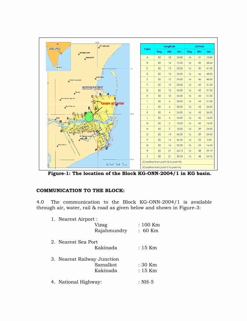
Figure-1: The location of the Block KG-ONN-2004/1 in KG basin. COMMUNICATION TO THE BLOCK: 4.0 The communication to the Block KG-ONN-2004/1 is available through air, water, rail & road as given below and shown in Figure-3:
1. Nearest Airport : Vizag : 100 Km Rajahmundry : 60 Km
2. Nearest Sea Port
Kakinada : 15 Km
3. Nearest Railway Junction Samalkot : 30 Km Kakinada : 15 Km
4. National Highway: : NH-5
Yanam at Center
ABC
D
FIH
JK
LM
N
PQ
R
S
E
G
O
Yanam at Center
ABC
D
FIH
JK
LM
N
PQ
R
S
Yanam at Center
ABC
D
FIH
JK
LM
N
PQ
R
S
E
G
O
E
G
E
G
E
G
O
(Coastline from point S to point A)
(Coastline from point Q to point R)
54.76481630.342182S
29.19481654.132182R
16.45331650.301682Q
2.00331646.501482P
24.00391646.501482O
24.00391618.00282N
16.00421618.00282M
16.00421624.00482L
36.00431624.00482K
36.00431628.00682J
51.00441628.00682I
51.00441654.001082H
31.50451654.001082G
31.50451624.001282F
48.00461624.001282E
48.00461624.001382D
41.00501622.001382C
58.64501615.201682B
10.84511634.821882A
Sec. Min. Deg. Sec. Min. Deg.
LatitudeLongitudePoints
Yanam at Center
ABC
D
FIH
JK
LM
N
PQ
R
S
E
G
O
Yanam at Center
ABC
D
FIH
JK
LM
N
PQ
R
S
Yanam at Center
ABC
D
FIH
JK
LM
N
PQ
R
S
E
G
O
E
G
E
G
E
G
O
(Coastline from point S to point A)
(Coastline from point Q to point R)
54.76481630.342182S
29.19481654.132182R
16.45331650.301682Q
2.00331646.501482P
24.00391646.501482O
24.00391618.00282N
16.00421618.00282M
16.00421624.00482L
36.00431624.00482K
36.00431628.00682J
51.00441628.00682I
51.00441654.001082H
31.50451654.001082G
31.50451624.001282F
48.00461624.001282E
48.00461624.001382D
41.00501622.001382C
58.64501615.201682B
10.84511634.821882A
Sec. Min. Deg. Sec. Min. Deg.
LatitudeLongitudePoints
Yanam at Center
ABC
D
FIH
JK
LM
N
PQ
R
S
E
G
O
Yanam at Center
ABC
D
FIH
JK
LM
N
PQ
R
S
Yanam at Center
ABC
D
FIH
JK
LM
N
PQ
R
S
E
G
O
E
G
E
G
E
G
O
(Coastline from point S to point A)
(Coastline from point Q to point R)
54.76481630.342182S
29.19481654.132182R
16.45331650.301682Q
2.00331646.501482P
24.00391646.501482O
24.00391618.00282N
16.00421618.00282M
16.00421624.00482L
36.00431624.00482K
36.00431628.00682J
51.00441628.00682I
51.00441654.001082H
31.50451654.001082G
31.50451624.001282F
48.00461624.001282E
48.00461624.001382D
41.00501622.001382C
58.64501615.201682B
10.84511634.821882A
Sec. Min. Deg. Sec. Min. Deg.
LatitudeLongitudePoints

(Besides the above, the Block has a good network of State & District Roads and a number of small townships as shown in Figure-2)
Figure-2: The location of the Block KG-ONN-2004/1 in KG basin with the available communication network. 5.0 In general, the entire block KG-ONN-2004/1 is thickly populated with villages and towns. About 20% of the area is covered by the river Godavari and about 30% of the area hosts coastal swamps & forests. Out of the 511 SqKm in East Godavari district of AP, 176.34 Sqkm covers parts of the Reserve forest area in the region. The 38 SqKm in the district of Yanam, Puducherry (UT) is thickly populated township. The entire Block has alluvial covers and a considerable portion of the non-forest part of the Block is covered with paddy fields, Mangroves, coconut grooves, cash crops and fish / prawn ponds etc. The surface logistics (due to major rivers, wildlife sanctuary, Reserve Forest etc.) in the Block is shown in Figure-3.

Figure-3: The Major Surface Logistics of the Block KG-ONN-2004/1 n KG basin. LOGISTICS OF THE BLOCK KG-ONN-2004/1: 6.0 The Block, at the coastal part of the KG basin, shares the major geomorphologic units of the KG basin like (i) Upland plains, (ii) Coastal plains and (iii) Recent flood and delta plains. The western upland plains present a topographic relief varying between 20 m and 200 m. The general gradient of the basin is towards east and southeast. The eastern coastal plain with a maximum width of 50 km includes landforms mainly of marine origin. The marine sediments rest in general on scoured surfaces and form bars, barrier islands and tidal flats further seaward. Linear ridges of sand bars are present parallel to the shoreline. The rivers are braided in the upper flood plain and meandering in the lower flood plain. The Godavari delta, where the Block lies, is lobate and partially effected by wave action. The Godavari river branches into three main distributaries in the lower delta plain and the sands are distributed by
Wildlife Sanctuary
Reserve Forest
Reserve Forest
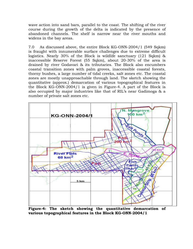
wave action into sand bars, parallel to the coast. The shifting of the river course during the growth of the delta is indicated by the presence of abandoned channels. The shelf is narrow near the river mouths and widens in the bay areas. 7.0 As discussed above, the entire Block KG-ONN-2004/1 (549 Sqkm) is fraught with innumerable surface challenges due to extreme difficult logistics. Nearly 30% of the Block is wildlife sanctuary (121 Sqkm) & inaccessible Reserve Forest (55 Sqkm), about 20-30% of the area is drained by river Godavari & its tributaries. The Block also encumbers coastal transition zones with palm groves, inaccessible coastal forests, thorny bushes, a large number of tidal creeks, salt zones etc. The coastal zones are mostly unapproachable through land. The sketch showing the quantitative (approx.) demarcation of various topographical features in the Block KG-ONN-2004/1 is given in Figure-4. A part of the Block is also occupied by major industries like that of RIL’s near Gadimoga & a number of private salt zones etc.
Figure-4: The sketch showing the quantitative demarcation of various topographical features in the Block KG-ONN-2004/1

SEISMIC DATA API IN THE BLOCK 8.0 No seismic data have been acquired by OIL in this Block. However, the seismic data received from previous operator has been found to be acquired with deployment various methods / by renowned geophysical contractors and with various vintages of equipment. In spite, only about 902 GLKM of data (as shown in the Figure-4) has been acquired in 11-campaigns of acquisition, starting from 1984 till 1995. The poor performance in seismic survey appears mainly due to the difficult logistics within the Block. Even though the data have been processed / reprocessed with modern state-of-the-art technology, the improvement in quality has only been marginal. This further implies the extent of difficulties expected in carrying out cost effective & meaningful data acquisition in the Block for further exploration for oil and gas. 9.0 Besides the surface, the near surface possesses difficulties due to swamps, sandy beeches, water bodies / fish ponds, major rivers / tidal creeks and other surface features as discussed, for effective exploration activities like traverse, transports, shot hole drilling and spread lay out for 2D/3D seismic survey , civil construction jobs for exploratory drilling and land acquisition etc.. 10.0 The subsurface with the expected high acoustic barriers at varying depths in the region e.g. compact Limestones / Volcanic seals/dykes / faults/ thin & shadowed reservoirs / expected shallow hazards due to gas charging, abnormal pressure regimes etc. are also major challenges to exploration for focused imaging to ascertain their role in hydrocarbon generation, migration & entrapment in the block as well as for subsequent drilling & production. 11.0. No exploratory wells have been drilled in this block. An exploratory well namely Polavaram-1 has been drilled in the vicinity (south-east corner but outside block boundary) of the block. The well Polavaram-1, drilled down to a depth of 2526m bottomed in Chintalapalli Shale (Cretaceous). Gas cut mud was encountered while drilling through Paslarapudi Formation of Late Paleocene to Early Eocene age in the interval 1924 to 2068 m. The lithology & hydrocarbon shows encountered in the well Polavaram-1 is given in Figure-5.
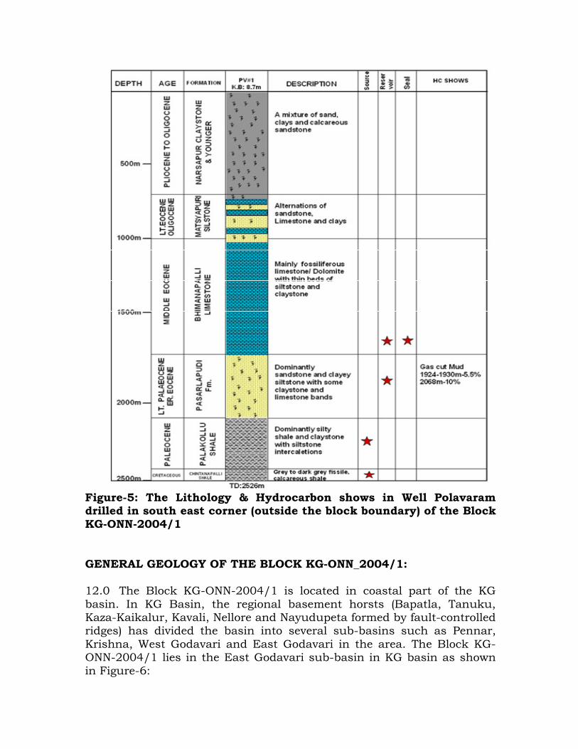
Figure-5: The Lithology & Hydrocarbon shows in Well Polavaram drilled in south east corner (outside the block boundary) of the Block KG-ONN-2004/1 GENERAL GEOLOGY OF THE BLOCK KG-ONN_2004/1: 12.0 The Block KG-ONN-2004/1 is located in coastal part of the KG basin. In KG Basin, the regional basement horsts (Bapatla, Tanuku, Kaza-Kaikalur, Kavali, Nellore and Nayudupeta formed by fault-controlled ridges) has divided the basin into several sub-basins such as Pennar, Krishna, West Godavari and East Godavari in the area. The Block KG-ONN-2004/1 lies in the East Godavari sub-basin in KG basin as shown in Figure-6:
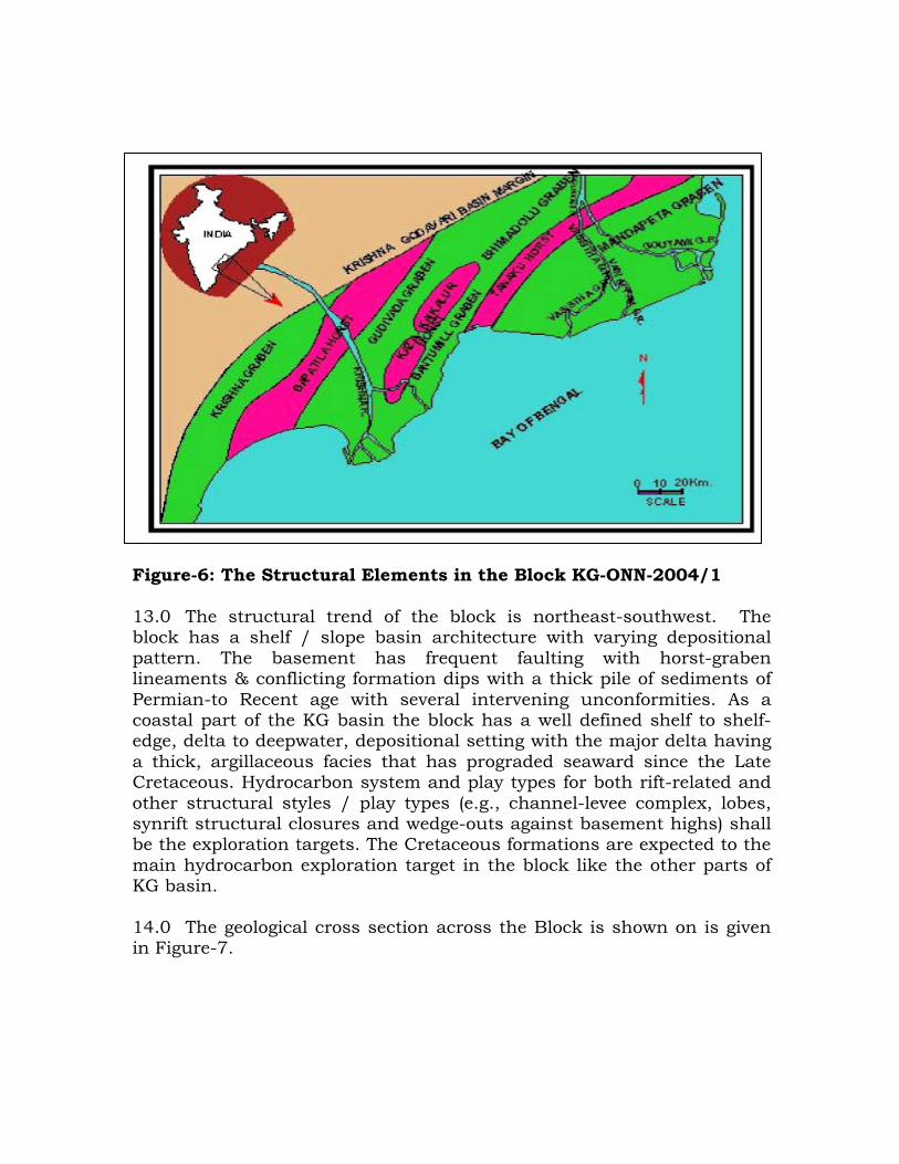
Figure-6: The Structural Elements in the Block KG-ONN-2004/1 13.0 The structural trend of the block is northeast-southwest. The block has a shelf / slope basin architecture with varying depositional pattern. The basement has frequent faulting with horst-graben lineaments & conflicting formation dips with a thick pile of sediments of Permian-to Recent age with several intervening unconformities. As a coastal part of the KG basin the block has a well defined shelf to shelf-edge, delta to deepwater, depositional setting with the major delta having a thick, argillaceous facies that has prograded seaward since the Late Cretaceous. Hydrocarbon system and play types for both rift-related and other structural styles / play types (e.g., channel-levee complex, lobes, synrift structural closures and wedge-outs against basement highs) shall be the exploration targets. The Cretaceous formations are expected to the main hydrocarbon exploration target in the block like the other parts of KG basin. 14.0 The geological cross section across the Block is shown on is given in Figure-7.

Figure-7: Geological cross section across the Block KG-ONN-2004/1 Reprocessing & Interpretation of KG 2D Seismic Data: 15.0 About 902 Km of 2D seismic data, collected from the previous operator, ONGC of the Block, were reprocessed by OIL with M/s CGG Veritas Mumbai. After initial processing and screening of data only 571 GLKM of data were found usable (leaving aside very short part line data, unrecoverable shots/records, data gaps etc.). Further LAS files from 5-wells viz. Mandapeta 1, Mandapeta 6, Endamaru 1, Polavaram 1, Kesankurrapalem1, drilled in the vicinity of the Block, were collected and were used for interpretation through RPS Energy, UK along with the CGG Veritas reprocessed Pre-stack Time Migrated 2D Seismic Data - 571.03 km, Original un-migrated and post-stack Time Migrated 2D Seismic Data -115 km, the DGH Basin Report, the DGH Block Report, inhouse prebid block evaluation reports and other published information. Based on the synthetics generated (Figure-8: Although Synthetics were generated for other wells, Seismic correlation was possible only with Polavaram-1 due to its proximity vis-à-vis the distance of other wells from the block; however other synthetics were used for guidance), the reflectors were identified for mapping as given in Figure-7 with the quality of tie. As it can be seen, the quality of tie has degraded significantly with depth.
Kavitam-
Drakhyaram High
Mastyapuri-
Palakollu Fault Zone
Palsarapudi
field
Block KG-ONN-2004/1
Kavitam-
Drakhyaram High
Mastyapuri-
Palakollu Fault Zone
Palsarapudi
field
Block KG-ONN-2004/1
RAJOULE FM
PLIOCENE & YOUNGER
GODAVARI CLAY
TIRUPATHI FM
MIOCENE TOP
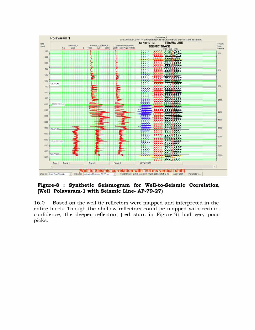
Figure-8 : Synthetic Seismogram for Well-to-Seismic Correlation (Well Polavaram-1 with Seismic Line- AP-79-27)
16.0 Based on the well tie reflectors were mapped and interpreted in the entire block. Though the shallow reflectors could be mapped with certain confidence, the deeper reflectors (red stars in Figure-9) had very poor picks.
Polavaram 1
(Well to Seismic correlation with 165 ms vertical shift)
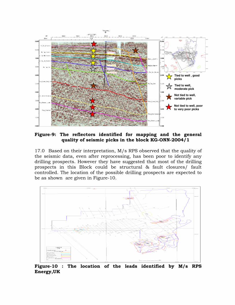
Figure-9: The reflectors identified for mapping and the general
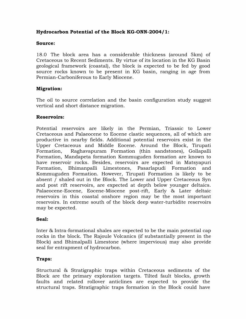
quality of seismic picks in the block KG-ONN-2004/1 17.0 Based on their interpretation, M/s RPS observed that the quality of the seismic data, even after reprocessing, has been poor to identify any drilling prospects. However they have suggested that most of the drilling prospects in this Block could be structural & fault closures/ fault controlled. The location of the possible drilling prospects are expected to be as shown are given in Figure-10.
Figure-10 : The location of the leads identified by M/s RPS Energy,UK
AT
_Y_32R
EP_
pad
AT_
Y_32R
EP_p
ad
A P100 11R
EP
AP10
0 11R
EP
AP
100 13RE
P
AP10
0 13REP
AP
100 25RE
P
AP100
25REP
AP
100 21R
EP
AP
100 21RE
P
AP
100 19RE
P
AP10
0 19R
EP
AP
100 09RE
P
AP
100 09RE
P
AP
100 17RE
P
AP
100 17RE
P
AP
100 07RE
P
AP10
0 07R
EP
AP
100 03RE
P
AP100 03R
EP
AP1
00 27R
EP
AP
100 27RE
P
AP 55
09RE
P
AP
55 0
9RE
P
AT 29A
REP
AT 29AREP
AP
79 21R
EP
AP79
21RE
P
AP
79 19R
EP
AP
79 19RE
P
AP84 18RREP
AP84 18RR
EP
A P79
27RE
P
AP79
27RE
P
AP 68 06REP
AP 68 06REP
AP79 23R
EP
AP7
9 23R
EP
AP86 08REP
AP86 08REP
AP
84 17RE
P
AP8
4 17R
EP
A P84 15R
EP
AP
84 15RE
P
AT 27BREP
AT 27BREP
AT
6A
RE
P
A
T 6
AR
EP
AP
79 25RE
P
AP 79
25REP
A
P84 17 RR
EP
AP84 1 7R
REP
AT 6CREP
AT 6CREP
AP100 02REP
AP100 02R EP
A T 37RE P
AT 37REP
AP 68 12REP
AP 68 12REP
AT
12
AR
EP
AT
12A
RE
P
AP55 08AREP
AP55 08AREP
AP100 10R EP
AP100 10REP
AP84 14REP
AP84 14REP
AP100 12REP
AP100 12REP
AP100 14R EP
AP100 14R EP
AP79 10REP
AP79 10R EP
AP 68 04REP
AP 68 04REP
AP100 04REP
AP100 04REP
AP
8 6 1
9RE
P
AP
86 19
RE
P
AP100 08REP
AP100 08REP
AP7 9 12REP
AP79 12REP
AT Y
28R
EP
AT Y
28RE
P
AT Y
30R
EP
AT Y 30R
EP
AT
Y 3
4RE
P
AT Y
34RE
P
AP79 0 8REP
AP79 08REP
AP
86 0
5RE
P
AP
8 6 0
5RE
P
AP
86 01
RE
P
AP
86 01R
EP
AP
45 01R
EP
AP
45 01RE
P
AP
6 3 1 3R
EP
AP
63 13 R
EP
AP
45 05R
EP
AP
45 05R
EP
AT Y 11REP
AT Y 11REP
AP
45 07R
EP
AP45 07R
EP
A
T Y 15REP
AT Y 15REP
AT Y 09REP
AT Y 09REP
AT Y 20R
EP
AT
Y 2
0RE
P
A T Y
24RE
P
AT Y
24RE
P
AT Y 19REP
AT Y 19REP
AT Y 23REP
AT Y 2 3REP
AT Y
18REP
AT Y 18R
EP
AT Y
16RE
P
AT Y 16R
EP
AT Y 17REP
AT Y 17REP
AT Y 25REP
AT Y 25REP
AT Y 12R
EP
AT Y
12R
EP
AT Y
14R
EP
AT Y
14REP
AP
8 6 0
3RE
P
AP
86 03
RE
P
AP49 36REP
AP49 36REP
AP
86 0
9RE
P
AP
8 6 09R
EP
AP5 5 02REP
AP55 02R EP
AP
68 0
5 RE
P
AP
68 0 5R
EP
AP
63 05
RE
P
AP
63 0
5 RE
P
AP
68 0
3RE
P
AP
68 03
RE
P
AP
63 0
3 RE
P
AP
63 0
3 RE
P
AP
68 1 9R
EP
AP
68 19R
EP
AP100 18REP
AP100 18REP
AP45 22REP
AP45 22REP
79-25
79-25
AP
45-03
AP
45- 03
AP45-06
AP45-06
AP
100-01
AP10
0-01
AP
63-1 1
AP
63-1
1
AP45-08
AP 45
-08
AP79-10R
AP79-10R
A P45- 13
AP45
-13
AP45-09
AP45
-09
AP
8 6-0 7
AP
8 6-07
A
T-1
2A
A
T- 1
2 A
A
T- 2
9A
AT-29A
AP
84-13
AP
84-13
AT
-4 1A
AT
-41A
AT-35A
AT-35A
AT
-Y-18
AT-Y
-18
AT -Y-15
AT-Y-15
AT
-Y-16
AT
-Y -16
AT -Y-25
AT-Y-25
AT- Y-20
AT-Y-20
AT-Y-26
AT-Y
-26
Endamaru_1
GS-17GS-17 1
Kesanakurupalem 1
KG 08
Mandapeta 01
Mandapeta 06
Polavaram_1
GS-29-1 Field
Endamaru Field
Mandapeta Field
Am alapuram Field
Gopavaram Field
Rangapuram Field
Sitaram puram Field
Bhimanpalli
Mummidavaram
Enugupalli Field
Bandamurulanka Field
601300 611300 621300 631300 641300 651300
1826300
1836300
1846300
1856300
1866300
601300 611300 621300 631300 641300 651300X/Y:
Meters
1826300
1836300
1846300
1856300
1866300
Tied to well , good picks
Tied to well, moderate pick
Not tied to well, variable pick
Not tied to well, poor to very poor picks
Hydrocarbon Potential of the Block KG-ONN-2004/1: Source: 18.0 The block area has a considerable thickness (around 5km) of Cretaceous to Recent Sediments. By virtue of its location in the KG Basin geological framework (coastal), the block is expected to be fed by good source rocks known to be present in KG basin, ranging in age from Permian-Carboniferous to Early Miocene. Migration: The oil to source correlation and the basin configuration study suggest vertical and short distance migration. Reservoirs: Potential reservoirs are likely in the Permian, Triassic to Lower Cretaceous and Palaeocene to Eocene clastic sequences, all of which are productive in nearby fields. Additional potential reservoirs exist in the Upper Cretaceous and Middle Eocene. Around the Block, Tirupati Formation, Raghavapuram Formation (thin sandstones), Gollapalli Formation, Mandapeta formation Kommuguden formation are known to have reservoir rocks. Besides, reservoirs are expected in Matsyapuri Formation, Bhimanpalli Limestones, Pasarlapudi Formation and Kommuguden Formation. However, Tirupati Formation is likely to be absent / shaled out in the Block. The Lower and Upper Cretaceous Syn and post rift reservoirs, are expected at depth below younger deltaics. Palaeocene-Eocene, Eocene-Miocene post-rift, Early & Later deltaic reservoirs in this coastal onshore region may be the most important reservoirs. In extreme south of the block deep water-turbidite reservoirs may be expected. Seal: Inter & Intra-formational shales are expected to be the main potential cap rocks in the block. The Rajoule Volcanics (if substantially present in the Block) and Bhimalpalli Limestone (where impervious) may also provide seal for entrapment of hydrocarbon. Traps: Structural & Stratigraphic traps within Cretaceous sediments of the Block are the primary exploration targets. Tilted fault blocks, growth faults and related rollover anticlines are expected to provide the structural traps. Stratigraphic traps formation in the Block could have

been greatly influenced by various depositional environment experienced by the basin which have been controlled by a series of rifting phases. Therefore, the expected sediments present in the block may include a vast range of geologic settings, such as coastal, delta, shelf-slope, wedges/onlaps etc. for suitable stratigraphic reservoirs. HYDROCARBON EXPLORATION ACTIVITIES IN BLOCK KG-ONN 2004/1: 19.0 The Block area was awarded under NELP Round VI, in the year 2006-2007. From the data collected from previous operator, it appears that they have undertaken at least 11-different campaigns (1984-1995) of 2D seismic data acquisition in the Block and has tried for meaningful data acquisition through a number of internationally reputed firms like GSI, CGG, Western Geophysical, PECC data Services, Prakla etc. by deploying different field techniques & different generation of equipment etc. ; in spite they could collect hardly about 1000 GLKM of 2D seismic data in the block leaving a side a large seismic data gap. The 2 D seismic coverage (Figure-11) in the block is of insufficient density and inadequate deep resolution. The overall seismic data quality has been poor for identification, interpretation and mapping of deeper pre-Tertiary horizons. The same data, collected were reprocessed by OIL with M/s CGG Veritas using Latest state-of-the-art technology, also reprocessed by the partner M/s GGR and was interpreted by M/s RPS Energy, UK. The results, however, still remained poor & speculative to yield any drilling prospects. Figure-11: Seismic Coverage in the Block KG-ONN-2004/1 & some
of the Wells drilled around (used in interpretation by M/s RPS Energy.
MANDAPETA WELLS 23 KMSMANDAPETA WELLS 23 KMS

The previous Operator has also not drilled even a single well inside the Block. The deep wells drilled around the Block are remote from the available seismic data to yield any meaningful calibration / well tie with seismic. Thus, the area remained poorly explored mainly due to difficult surface & near surface logistics. Drilling Commitment:
20.0 As per committed Minimum Work Program (MWP) along with other activities, the consortium needs to drill 12 (twelve) exploratory wells within February 2012. Out of the 12-wells, 2-Wells will be of 2000 m, 2-wells will be of 4000 m, 1-well will be of 4500 m and the remaining 7-wells will be of 5000 m depth. OIL is planning to drill the first few wells in the south-eastern part of the Block. Drilling Complications in nearby Wells: 21.0 The following information regarding drilling difficulties encountered near the Block area could be gathered:
• Loss circulation is common between 400m-1300m in Bhimanapalli limestone formation, partial to sometime total loss.
• Temperature Gradient is high: 3.2 degree centigrade per 100m between 100m to 1100m and increases to 3.6 degree centigrade per 100m from 3150m and below. BHT at 4000m can exceed beyond 170 degree centigrade. Very high temperature of 205 degree centigrade has been recorded in a well around a depth of 4845m.
• High Pressure: Within Mandapeta and Pasralpudi sandstone
formation, below 3000m, are high pressure zone. Also, many zones have pocket gases with high pressure. Wells deeper than 5000m are expected to encounter extreme temperature and pressure conditions.
• Additionally, due to its logistic difficulties/environmental considerations etc., there may be requirement of Directional Drilling with MWD/LWD applications.

WELL DETAILS Tentative casing Policy:
Hole Size (inches)
Depth (m)
Casing Size (inches)
Mud Wt (ppg)
Type of Mud
36 200 30” - Spud Mud
26” 600 20” 8.5 WBM
17.1/2” 2500 13.3/8” 10 WBM
12.1/4” 4000 9.5/8” 12 Polymer Mud
8.1/2” 5500 7” 15 High Temp Polymer Mud
5.7/8”(Contingent) 6000 4.1/2” 15 High Temp Polymer Mud
Expected Pressure Profile:
Pore Pressure Fracture Pressure Vertical Depth (m) (psig) (ppg) (psig) (ppg)
10.0 - - - -
2000.0 2999.62 8.80 5050.12 14.80
3000.0 5112.99 10.00 8445.29 16.50
4400.0 8998.87 12.00 13362.33 17.80
4500.0 9203.39 12.00 13666.02 17.80
4600.0 11759.88 15.00 14126.67 18.00
5000.0 12782.48 15.00 15559.81 18.24
5500.0 14060.73 15.00 17115.80 18.24
BROAD SCOPE OF SERVICES OF THIS EOI No. OIL/DRLG- / KKD-7/10 22.0 To invite Global Expression of Interest (EOI) for hiring of Integrated Drilling Services for a period of two years or for drilling 04 (Four) HP-HT Exploratory Wells with true vertical depths of maximum 5500m in NELP-VI block: KG-ONN-2004/1 in East Godavari district of Andhra Pradesh & Yanam district of Puducherry, India. The wells will be vertical as well as deviated. HPHT DEFINITION “HPHT Wells” means wells where bottom hole temperature are greater than 300 °F (150°C) and either the maximum anticipated pore pressure of any porous formation to be drilled through exceeds a hydrostatic gradient of 0.8 psi/ft (representing an
EMW of 1.85 SG or 15.4 ppg) or well head shut-in pressure in excess of 10000 psi. 23.0 The following services are required under this EOI:
1) Drilling Rig Package Services with crew:
Minimum 2500 HP, AC-SCR or VFD Rig suitable for drilling HPHT wells. The rig should be equipped with equipment suitable for drilling HPHT wells. The rig should be equipped with three 1600HP (min) mud pumps, TDS, LMSS (3 nos), Linear motion mud cleaner, centrifuges, 21.1/4” x 5M Double ram , 21.1/4” x 5 M annular BOPs, 13.3/8” x 15 M Double & single ram BOPs,13.3/8” x 10M Annular BOP, 15 M choke & kill manifold, Diverter etc.
2) Casing & Tubing Running-in with Torque Turn Services 3) Coring Services including supply of core barrels, core
heads with all accessories and handling tools 4) Liner hanger Services including supply of handling/setting
tools and liner hanger accessories. 5) Cold Casing Cutting Services 6) Drilling Fluids Services (including supply of complete line
of chemicals) 7) Drilling Waste Management including drill cutting drier
and dewatering system 8) Directional Drilling with MWD/LWD 9) Mud Logging Services 10) Cementing Services (including supply of cement &
complete line of chemicals/additives) 11) Bulk Handling Plant 12) Wire Line Logging & TCP 13) DST 14) Production Testing & well completion Services
24.0 DURATION OF CONTRACT: The duration of the contract shall be for a period of 2(two) years or completion of four (04) wells, which may be extended at the option of OIL for the additional wells at the same terms & conditions including increase in the scope of work as per Para 23.0 above. 25.0 QUALIFICATION AND EXPERIENCE OF THE PARTIES FOR SUBMISSION OF EOI:
I. Parties must have at least four of the following services in-house (owned by them). The parties must have provided these services to

at least two HPHT wells worldwide to E&P operators in last five years prior to this EOI:
i) Drilling Rig Package Services with crew ii) Liner hanger Services including supply of
handling/setting tools and liner hanger accessories iii) Drilling Fluids Services (including supply of complete
line of chemicals) iv) Directional Drilling with MWD/LWD v) Cementing Services (including supply of cement &
complete line of chemicals/additives) vi) Wire Line Logging & TCP vii) DST viii) Production Testing & well completion Services ix) Mud Logging Services
II. The parties may provide all the services as per Para 23.0 through in-house, if available or may participate in this EOI by pre-tender tie-ups (except the minimum four major services as mentioned in Para 25.0 (I) above to qualify) giving an undertaking to submit the valid agreement(s)/ MoUs with concerned reputed international party(s) (having requisite experience in relevant services & having financial strength), with specific reference to this project for the associated services.
III. In case of any tie-ups for any services except the requisite four
services as mentioned in 25.0 (I), the parties with whom tie-ups have been made, must have relevant experience and expertise in providing the services for drilling at least two HP-HT wells, to reputed Operators in E & P sectors during the last five years prior to this EOI.
IV. Party(s) must have a good track record, strong & sound QA/QC and Safety Environment Policies being practiced solidly across the organization.
V. The interested party(s) shall have HP-HT experienced personnel for the services.
VI. The Key Personnel of the Drilling rig must have at least two HPHT well drilling experience and should be conversant with the HPHT equipment. The key drilling personnel must have valid IWCF certificate, as applicable and must have H2S trained certificate.
VII. The wire line logging tools, Mud Motors, MWD & LWD, DST tools, Liner Hanger equipment and cement & mud additives to be used in
8.1/2” section should be rated to work at BHCT 320 deg F/BHST 450 deg F & 15,000 psi.
VIII. Party (ies) must be financially sound to provide such kind of
services. IX The prime bidder to provide experienced Personnel for proper co-
ordination with the Company Representative to ensure timely availability of individual tools/services and to supervise the overall daily operations.
Accordingly, EOI should be submitted broadly indicating brief details of the services with name/address of chosen allied services provider(s)/third party(s). Submission: Interested companies / firms / contractors / consortiums (national / international) meeting relevant experience and expertise as per Para 25.0 above are invited to submit their EOI for providing the above services.
Following information/documentary evidences (client’s certificates) must form a part of the EOI:
(i) Total No. of years of experience. (ii) Total No. of HP-HT wells undertaken in India & abroad as a
package or for any individual services & their details. (iii) Information on Integrated services provided to E&P operators
with name of clients and details of services. (iv) Parties to indicate the maximum temperature & pressure to
which the various tools, equipment, chemicals & additives will be capable to work.
However, any additional information (not spelt out by Oil India Limited in this document) furnished by the participating firm for correct assessment of the strength of the firm will be most welcome. i. TITLE OF OFFER: Integrated Drilling Services. ii. MOBILIZATION PERIOD FOR ENTIRE SERVICES PACKAGE: To be mobilized near to Kakinada(Andhra Pradesh), India v. COMPANY PROFILE: Brochures containing detail experience profile of the company(s).
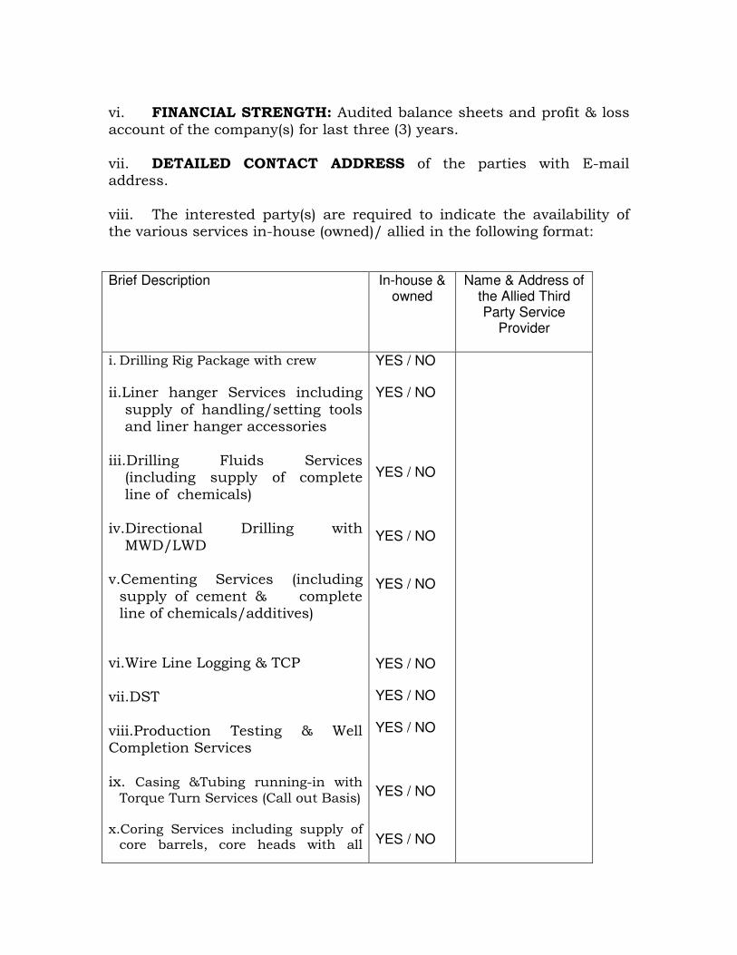
vi. FINANCIAL STRENGTH: Audited balance sheets and profit & loss account of the company(s) for last three (3) years. vii. DETAILED CONTACT ADDRESS of the parties with E-mail address. viii. The interested party(s) are required to indicate the availability of the various services in-house (owned)/ allied in the following format: Brief Description
In-house & owned
Name & Address of the Allied Third Party Service
Provider
i. Drilling Rig Package with crew
ii.Liner hanger Services including supply of handling/setting tools and liner hanger accessories
iii.Drilling Fluids Services (including supply of complete line of chemicals)
iv.Directional Drilling with MWD/LWD
v.Cementing Services (including supply of cement & complete line of chemicals/additives)
vi.Wire Line Logging & TCP vii.DST viii.Production Testing & Well Completion Services ix. Casing &Tubing running-in with Torque Turn Services (Call out Basis)
x.Coring Services including supply of core barrels, core heads with all
YES / NO YES / NO YES / NO YES / NO YES / NO YES / NO YES / NO YES / NO YES / NO YES / NO
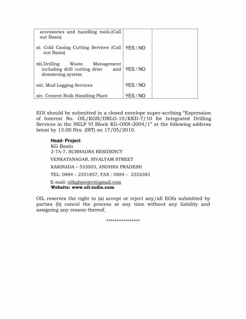
accessories and handling tools.(Call out Basis)
xi. Cold Casing Cutting Services (Call
out Basis)
xii.Drilling Waste Management
including drill cutting drier and dewatering system
xiii. Mud Logging Services xiv. Cement Bulk Handling Plant
YES / NO YES / NO YES / NO YES / NO
EOI should be submitted in a closed envelope super-scribing “Expression of Interest No. OIL/KGB/DRLG-10/KKD-7/10 for Integrated Drilling Services in the NELP VI Block KG-ONN-2004/1” at the following address latest by 13.00 Hrs. (IST) on 17/05/2010. Head- Project
KG Basin 2-7A-7, SUBHADRA RESIDENCY
VENKATANAGAR, SIVALYAM STREET
KAKINADA – 533003, ANDHRA PRADESH
TEL: 0884 – 2351857, FAX : 0884 – 2352383
E-mail: [email protected] Website: www.oil-india.com
OIL reserves the right to (a) accept or reject any/all EOIs submitted by parties (b) cancel the process at any time without any liability and assigning any reason thereof.
****************